Embed Size (px)
Citation preview
Draft EIR Whitehawk I & II Projects
November 2018
CHAPTER 3 – Project Description 3 - 1
3 PROJECT DESCRIPTION
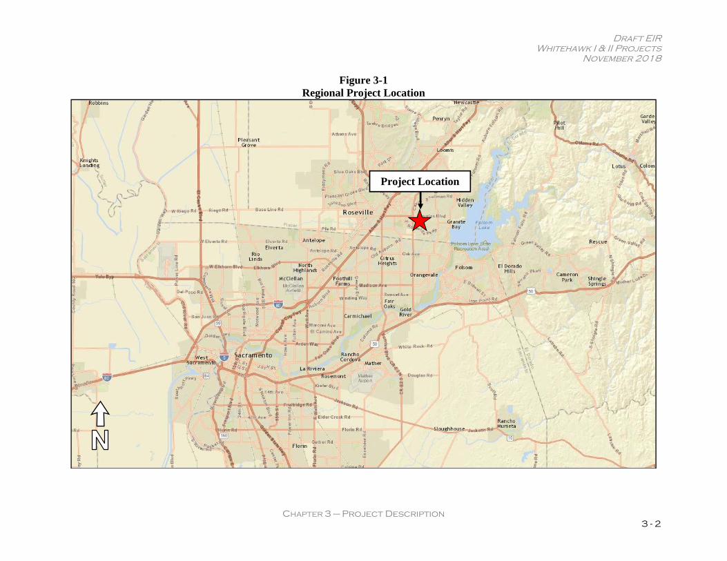
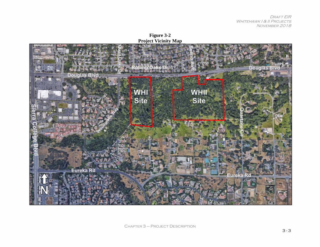
3.1 Introduction The Project Description chapter of the EIR provides a comprehensive explanation of the proposed projects in accordance with CEQA Guidelines. Pursuant to CEQA Guidelines Section 15124, all on- and off-site improvements associated with the projects are discussed. Please note that while this chapter provides an overall general description of the existing environmental conditions, a detailed discussion of the existing setting in compliance with CEQA Guidelines Section 15125 is also included in each technical chapter of this EIR. Section 15125 of CEQA Guidelines requires an EIR to include a description of the physical environmental conditions in the vicinity of the project, as they exist at the time the Notice of Preparation is published and from a local and regional perspective. Knowledge of the existing environmental setting is critical to the assessment of environmental impacts. Per CEQA Guidelines Section 15125, the description of the environmental setting shall not be longer than necessary to understand the potential significant effects of the project. 3.2 Project Location The proposed project sites are located on the south side of Douglas Boulevard, generally east of Sierra College Boulevard and west of Barton Road, within the Granite Bay Community Plan (GBCP) area of Placer County, California (see Figure 3-1 and Figure 3-2). The 18.09-acre Whitehawk I (WHI) project site is identified by Assessor’s Parcel Number (APN) 048-151-001, and the 32.97-acre Whitehawk II (WHII) project site is identified by APN 048-151- 061. The two project sites are located approximately 650 feet apart. A 18.7-acre parcel owned by the Mac Bride Family Trust is located between the WHI and WHII sites. 3.3 Project Setting and Surrounding Land Uses A description of the site characteristics and surrounding land uses for both WHI and WHII sites is provided below. Site Characteristics WHI Site The 18.09-acre WHI site has an elevation of approximately 270 feet above sea level; however, the topography of the site is variable primarily due to the presence of dredge tailings throughout the property.
Draft EIR Whitehawk I & II Projects
November 2018
CHAPTER 3 – Project Description 3 - 2
Figure 3-1 Regional Project Location
Project Location
Draft EIR Whitehawk I & II Projects
November 2018
CHAPTER 3 – Project Description 3 - 3
Figure 3-2 Project Vicinity Map
Draft EIR Whitehawk I & II Projects
November 2018
CHAPTER 3 – Project Description 3 - 4
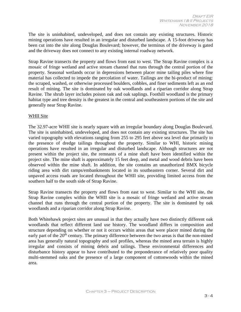
The site is uninhabited, undeveloped, and does not contain any existing structures. Historic mining operations have resulted in an irregular and disturbed landscape. A 15-foot driveway has been cut into the site along Douglas Boulevard; however, the terminus of the driveway is gated and the driveway does not connect to any existing internal roadway network. Strap Ravine transects the property and flows from east to west. The Strap Ravine complex is a mosaic of fringe wetland and active stream channel that runs through the central portion of the property. Seasonal wetlands occur in depressions between placer mine tailing piles where fine material has collected to impede the percolation of water. Tailings are the bi-product of mining: the scraped, washed, or otherwise processed boulders, cobbles, and finer sediments left as an end result of mining. The site is dominated by oak woodlands and a riparian corridor along Strap Ravine. The shrub layer includes poison oak and oak saplings. Foothill woodland is the primary habitat type and tree density is the greatest in the central and southeastern portions of the site and generally near Strap Ravine. WHII Site The 32.97-acre WHII site is nearly square with an irregular boundary along Douglas Boulevard. The site is uninhabited, undeveloped, and does not contain any existing structures. The site has varied topography with elevations ranging from 255 to 295 feet above sea level due primarily to the presence of dredge tailings throughout the property. Similar to WHI, historic mining operations have resulted in an irregular and disturbed landscape. Although structures are not present within the project site, the remnants of a mine shaft have been identified within the project site. The mine shaft is approximately 15 feet deep, and metal and wood debris have been observed within the mine shaft. In addition, the site contains an unauthorized BMX bicycle riding area with dirt ramps/embankments located in its southeastern corner. Several dirt and unpaved access roads are located throughout the WHII site, providing limited access from the southern half to the south side of Strap Ravine. Strap Ravine transects the property and flows from east to west. Similar to the WHI site, the Strap Ravine complex within the WHII site is a mosaic of fringe wetland and active stream channel that runs through the central portion of the property. The site is dominated by oak woodlands and a riparian corridor along Strap Ravine. Both Whitehawk project sites are unusual in that they actually have two distinctly different oak woodlands that reflect different land use history. The woodland differs in composition and structure depending on whether or not it occurs within areas that were placer mined during the early part of the 20th century. The primary difference between the two areas is that the non-mined area has generally natural topography and soil profiles, whereas the mined area terrain is highly irregular and consists of mining debris and tailings. These environmental differences and disturbance history appear to have contributed to the preponderance of relatively poor quality multi-stemmed oaks and the presence of a large component of cottonwoods within the mined area.

Draft EIR Whitehawk I & II Projects
November 2018
CHAPTER 3 – Project Description 3 - 5
Surrounding Land Uses The following section describes the surrounding land uses in the vicinity of the WHI and WHII sites. WHI The WHI site’s northern boundary is Douglas Boulevard. A medium-density single-family residential neighborhood has been developed north of the site across Douglas Boulevard. The Greyhawk I subdivision, accessed by Woodgrove Way, is located to the west, with an open space lot between the project site and adjacent Greyhawk homes along Woodgrove Way. Larger-lot (one to eight-acre parcels) single-family residential uses are located south of the site at the north end of Quail Lane and a radio antenna facility has been erected on one of the larger lots. The intervening parcel east of the site (the Mac Bride Parcel) is occupied by one single-family residence with various sheds and outbuildings. The WHII project site is located to the east of this parcel, 649 feet east of the WHI project site. There is a 300-foot scenic setback that prohibits residential uses adjacent to Douglas Boulevard along the northern edge of the site. WHII The WHII site’s general northern boundary is Douglas Boulevard with intervening parcels on the northwest and northeast portions of the site. The intervening parcels to the northwest are vacant and the intervening parcels to the northeast contain vacant land and a single-family residential structure utilized for both residential and commercial purposes. The project site abuts an 18.7-acre parcel with a single-family residence and a variety of sheds and outbuildings to the west. The WHI project site is located 649 feet west of this parcel. A medium-density single-family residential neighborhood has been developed north of the site across Douglas Boulevard. Single family homes and vacant, five-acre lots are located east of the site and accessed from Quartzite Circle. Larger-lot single-family residential uses are located south of the site along the north ends of Buddecke Place, Farschon Place, and Carriage Drive. 3.4 Project Objectives The following project objectives have been provided by the applicant.
1. Develop neighborhoods consistent with the GBCP’s Land Use discussion regarding Residential Opportunity Areas;
2. Reduce growth pressures on outlying areas of Placer County by efficiently utilizing the project sites to accommodate residential growth and development;
3. Provide for increased residential densities in areas containing available infrastructure, consistent with current area-wide infrastructure plans;
4. Plan for increased residential density to take advantage of the proximity of the project sites to region-serving arterials, available infrastructure, and to better support opportunities for transit;
Draft EIR Whitehawk I & II Projects
November 2018
CHAPTER 3 – Project Description 3 - 6
5. Provide a sufficient number of residential units within the project sites to support necessary improvements to local and regional public service facilities;
6. Provide well-designed residential communities in close proximity to retail and restaurants, jobs, and services;
7. Expand the existing trail network in the area to provide safe routes for walking and cycling to enable convenient and active travel as a part of daily activities;
8. Add to the diversity of housing choices that can support a full range of lifestyles in Granite Bay;
9. Provide for smaller lot sizes and increased lot coverage to promote the efficient use of land, energy, and water resources within a residential community;
10. Provide neighborhoods of single-story homes to minimize the potential for land use incompatibilities with existing adjacent lower density and residential development;
11. Create high-quality neighborhoods, complementing the natural setting with a mix of residential, open-space, and recreational amenities;
12. Preserve the unique character of Granite Bay by protecting the 300-foot landscape corridor along the south side of Douglas Boulevard;
13. Design and develop projects that minimize encroachment into the existing 100-year floodplain on the sites; and
14. Preserve existing riparian and oak woodland habitat on the project sites within permanent open space-zoned greenbelt areas.
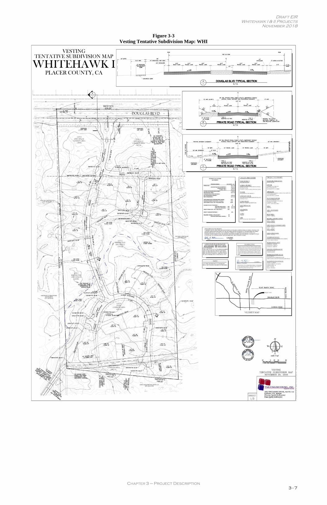
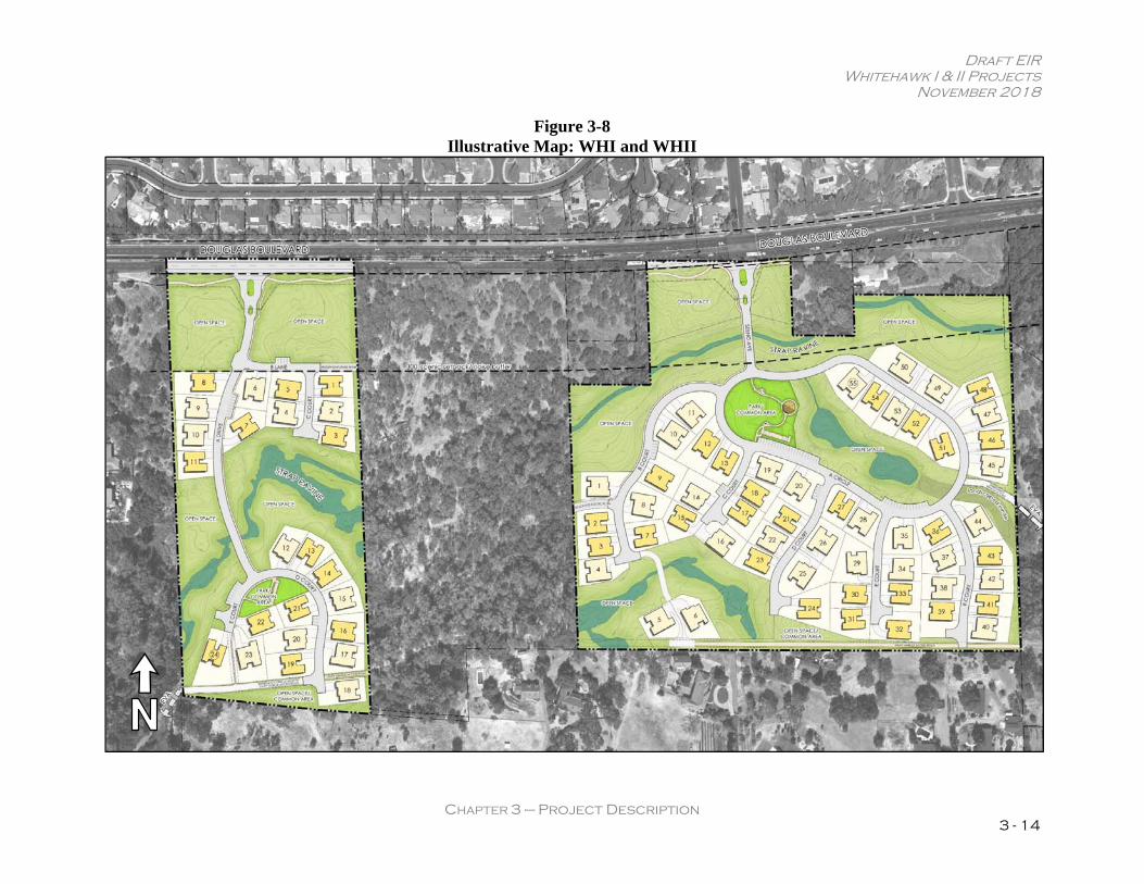
3.5 Project Components The WHI and WHII projects would include subdivision of the proposed project sites to develop a total of 79 single-family homes (see Figure 3-3 and Figure 3-4). The following project components are discussed below: Amendments to the GBCP; Rezone; proposed site uses; community design; access, roadways, parking, trails, and open space; utilities; off-site improvements; and requested/required entitlements.
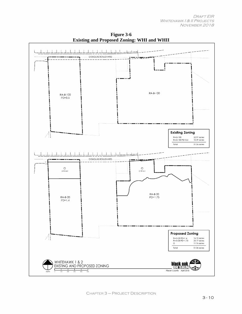
Community Plan Amendment and Rezone WHI The Placer County General Plan and the GBCP currently designate the northern 10.04-acre portion of the WHI site north of Strap Ravine as Rural Low Density Residential (0.9 – 2.3 Ac. minimum) (see Figure 3-5). The remaining 8.05-acre portion of the WHI site south of Strap Ravine is designated Rural Residential (2.3 – 4.6 Ac. minimum). The Placer County zoning designation for the site is Residential Agricultural, minimum Building Site of 100,000 square feet [sf], combining Planned Residential Development of 0.5 units per acre (RA-B-100 PD=0.5) (see Figure 3-6).
Draft EIR Whitehawk I & II Projects
November 2018
CHAPTER 3 – Project Description 3 - 7
Figure 3-3 Vesting Tentative Subdivision Map: WHI
Draft EIR Whitehawk I & II Projects
November 2018
CHAPTER 3 – Project Description 3 - 8
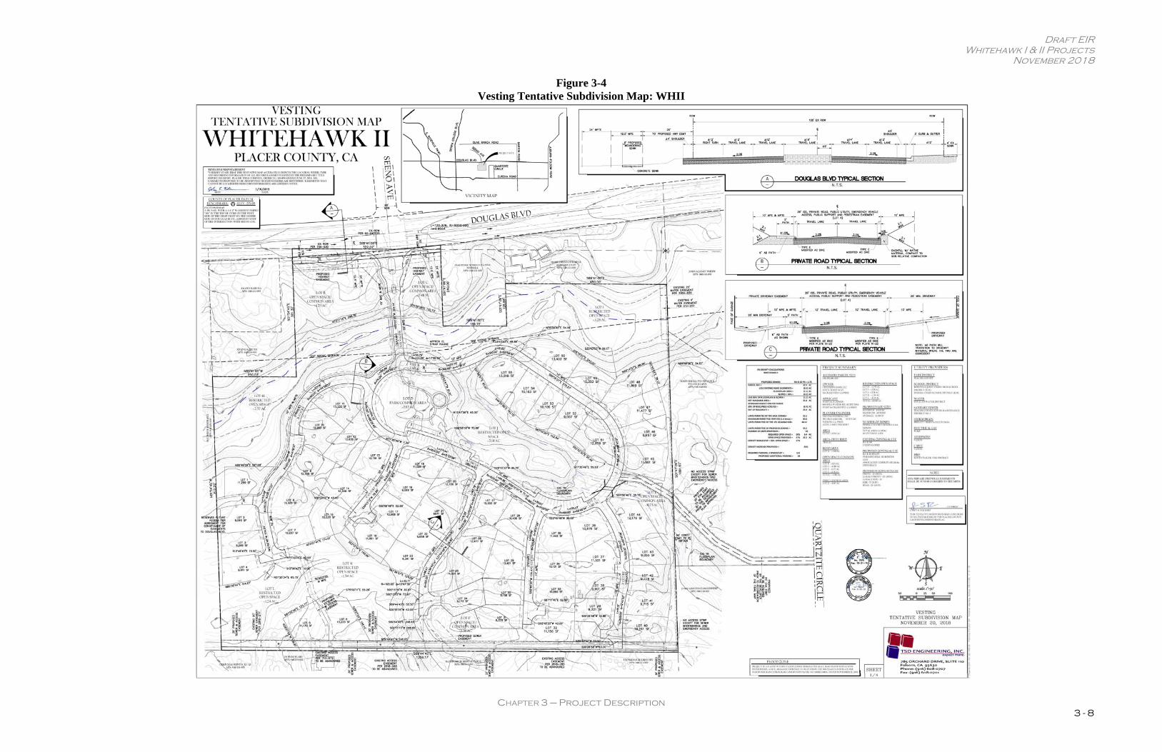
Figure 3-4 Vesting Tentative Subdivision Map: WHII
Draft EIR Whitehawk I & II Projects
November 2018
CHAPTER 3 – Project Description 3 - 9
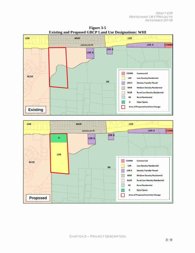
Figure 3-5 Existing and Proposed GBCP Land Use Designations: WHI
Existing
Proposed
Draft EIR Whitehawk I & II Projects
November 2018
CHAPTER 3 – Project Description 3 - 10
Figure 3-6 Existing and Proposed Zoning: WHI and WHII
Draft EIR Whitehawk I & II Projects
November 2018
CHAPTER 3 – Project Description 3 - 11
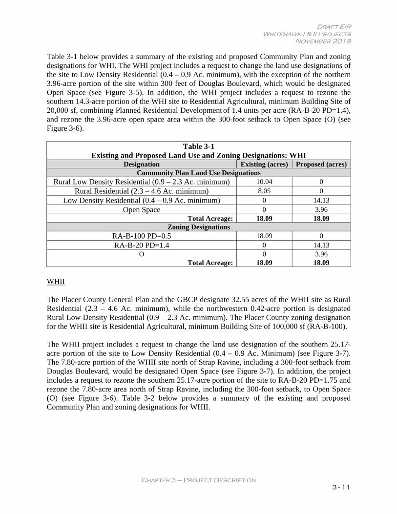
Table 3-1 below provides a summary of the existing and proposed Community Plan and zoning designations for WHI. The WHI project includes a request to change the land use designations of the site to Low Density Residential (0.4 – 0.9 Ac. minimum), with the exception of the northern 3.96-acre portion of the site within 300 feet of Douglas Boulevard, which would be designated Open Space (see Figure 3-5). In addition, the WHI project includes a request to rezone the southern 14.3-acre portion of the WHI site to Residential Agricultural, minimum Building Site of 20,000 sf, combining Planned Residential Development of 1.4 units per acre (RA-B-20 PD=1.4), and rezone the 3.96-acre open space area within the 300-foot setback to Open Space (O) (see Figure 3-6).
Table 3-1 Existing and Proposed Land Use and Zoning Designations: WHI
Designation Existing (acres) Proposed (acres) Community Plan Land Use Designations
Rural Low Density Residential (0.9 – 2.3 Ac. minimum) 10.04 0 Rural Residential (2.3 – 4.6 Ac. minimum) 8.05 0
Low Density Residential (0.4 – 0.9 Ac. minimum) 0 14.13 Open Space 0 3.96
Total Acreage: 18.09 18.09 Zoning Designations
RA-B-100 PD=0.5 18.09 0 RA-B-20 PD=1.4 0 14.13
O 0 3.96 Total Acreage: 18.09 18.09
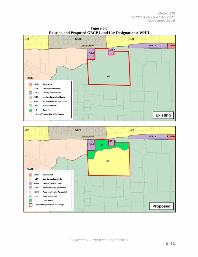
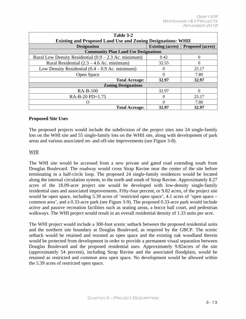
WHII The Placer County General Plan and the GBCP designate 32.55 acres of the WHII site as Rural Residential (2.3 – 4.6 Ac. minimum), while the northwestern 0.42-acre portion is designated Rural Low Density Residential (0.9 – 2.3 Ac. minimum). The Placer County zoning designation for the WHII site is Residential Agricultural, minimum Building Site of 100,000 sf (RA-B-100). The WHII project includes a request to change the land use designation of the southern 25.17-acre portion of the site to Low Density Residential (0.4 – 0.9 Ac. Minimum) (see Figure 3-7). The 7.80-acre portion of the WHII site north of Strap Ravine, including a 300-foot setback from Douglas Boulevard, would be designated Open Space (see Figure 3-7). In addition, the project includes a request to rezone the southern 25.17-acre portion of the site to RA-B-20 PD=1.75 and rezone the 7.80-acre area north of Strap Ravine, including the 300-foot setback, to Open Space (O) (see Figure 3-6). Table 3-2 below provides a summary of the existing and proposed Community Plan and zoning designations for WHII.
Draft EIR Whitehawk I & II Projects
November 2018
CHAPTER 3 – Project Description 3 - 12
Figure 3-7 Existing and Proposed GBCP Land Use Designations: WHII
Existing
Proposed
Draft EIR Whitehawk I & II Projects
November 2018
CHAPTER 3 – Project Description 3 - 13
Table 3-2 Existing and Proposed Land Use and Zoning Designations: WHII
Designation Existing (acres) Proposed (acres) Community Plan Land Use Designations
Rural Low Density Residential (0.9 – 2.3 Ac. minimum) 0.42 0 Rural Residential (2.3 – 4.6 Ac. minimum) 32.55 0
Low Density Residential (0.4 – 0.9 Ac. minimum) 0 25.17 Open Space 0 7.80
Total Acreage: 32.97 32.97 Zoning Designations
RA-B-100 32.97 0 RA-B-20 PD=1.75 0 25.17
O 0 7.80 Total Acreage: 32.97 32.97
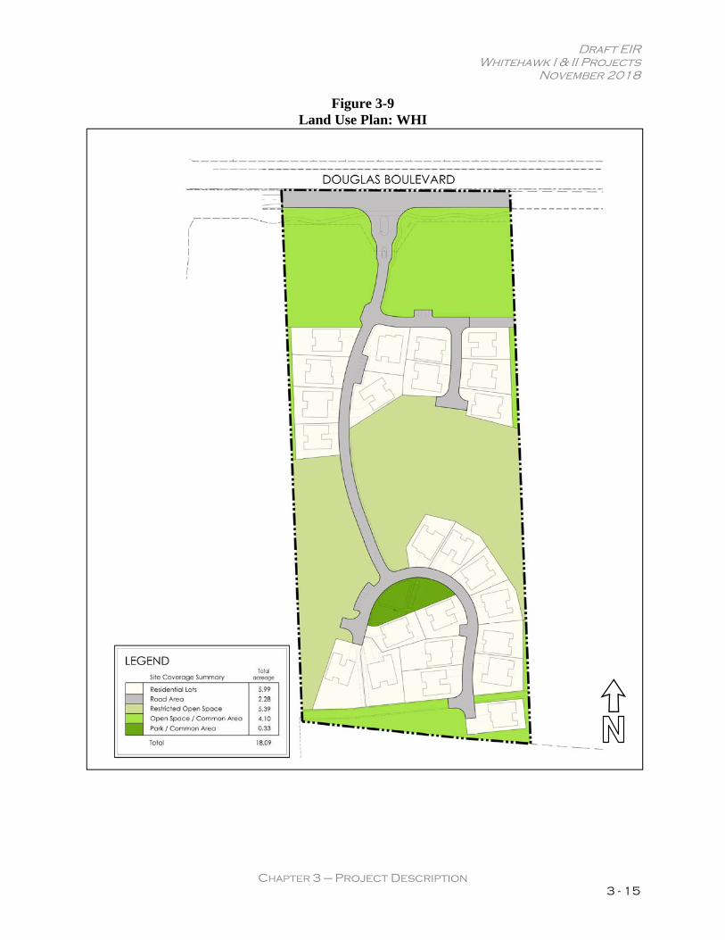
Proposed Site Uses The proposed projects would include the subdivision of the project sites into 24 single-family lots on the WHI site and 55 single-family lots on the WHII site, along with development of park areas and various associated on- and off-site improvements (see Figure 3-8). WHI The WHI site would be accessed from a new private and gated road extending south from Douglas Boulevard. The roadway would cross Strap Ravine near the center of the site before terminating in a half-circle loop. The proposed 24 single-family residences would be located along the internal circulation system, to the north and south of Strap Ravine. Approximately 8.27 acres of the 18.09-acre project site would be developed with low-density single-family residential uses and associated improvements. Fifty-four percent, or 9.82 acres, of the project site would be open space, including 5.39 acres of ‘restricted open space’, 4.1 acres of ‘open space – common area’, and a 0.33-acre park (see Figure 3-9). The proposed 0.33-acre park would include active and passive recreation facilities such as seating areas, a bocce ball court, and pedestrian walkways. The WHI project would result in an overall residential density of 1.33 units per acre. The WHI project would include a 300-foot scenic setback between the proposed residential units and the northern site boundary at Douglas Boulevard, as required by the GBCP. The scenic setback would be retained and rezoned as open space and the existing oak woodland therein would be protected from development in order to provide a permanent visual separation between Douglas Boulevard and the proposed residential uses. Approximately 9.82acres of the site (approximately 54 percent), including Strap Ravine and the associated floodplain, would be retained as restricted and common area open space. No development would be allowed within the 5.39 acres of restricted open space.
Draft EIR Whitehawk I & II Projects
November 2018
CHAPTER 3 – Project Description 3 - 14
Figure 3-8 Illustrative Map: WHI and WHII
Draft EIR Whitehawk I & II Projects
November 2018
CHAPTER 3 – Project Description 3 - 15
Figure 3-9 Land Use Plan: WHI
Draft EIR Whitehawk I & II Projects
November 2018
CHAPTER 3 – Project Description 3 - 16
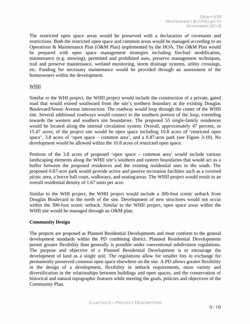
The restricted open space areas would be preserved with a declaration of covenants and restrictions. Both the restricted open space and common areas would be managed according to an Operations & Maintenance Plan (O&M Plan) implemented by the HOA. The O&M Plan would be prepared with open space management strategies including fire/fuel modification, maintenance (e.g. mowing), permitted and prohibited uses, preserve management techniques, trail and preserve maintenance, wetland monitoring, storm drainage systems, utility crossings, etc. Funding for necessary maintenance would be provided through an assessment of the homeowners within the development. WHII Similar to the WHI project, the WHII project would include the construction of a private, gated road that would extend southward from the site’s northern boundary at the existing Douglas Boulevard/Seeno Avenue intersection. The roadway would loop through the center of the WHII site. Several additional roadways would connect to the southern portion of the loop, extending towards the western and southern site boundaries. The proposed 55 single-family residences would be located along the internal circulation system. Overall, approximately 47 percent, or 15.47 acres, of the project site would be open space including 10.8 acres of ‘restricted open space’, 3.8 acres of ‘open space – common area’, and a 0.87-acre park (see Figure 3-10). No development would be allowed within the 10.8 acres of restricted open space. Portions of the 3.8 acres of proposed ‘open space – common area’ would include various landscaping elements along the WHII site’s southern and eastern boundaries that would act as a buffer between the proposed residences and the existing residential uses to the south. The proposed 0.87-acre park would provide active and passive recreation facilities such as a covered picnic area, a bocce ball court, walkways, and seating areas. The WHII project would result in an overall residential density of 1.67 units per acre. Similar to the WHI project, the WHII project would include a 300-foot scenic setback from Douglas Boulevard to the north of the site. Development of new structures would not occur within the 300-foot scenic setback. Similar to the WHII project, open space areas within the WHII site would be managed through an O&M plan. Community Design The projects are proposed as Planned Residential Developments and must conform to the general development standards within the PD combining district. Planned Residential Developments permit greater flexibility than generally is possible under conventional subdivision regulations. The purpose and objective of a Planned Residential Development is to encourage the development of land as a single unit. The regulations allow for smaller lots in exchange for permanently preserved common open space elsewhere on the site. A PD allows greater flexibility in the design of a development, flexibility in setback requirements, more variety and diversification in the relationships between buildings and open spaces, and the conservation of historical and natural topographic features while meeting the goals, policies and objectives of the Community Plan.
Draft EIR Whitehawk I & II Projects
November 2018
CHAPTER 3 – Project Description 3 - 17
Figure 3-10 Land Use Plan: WHII
Draft EIR Whitehawk I & II Projects
November 2018
CHAPTER 3 – Project Description 3 - 18
Community design features of the WHI and WHII projects are described below. WHI and WHII Single-family homes would be constructed within the WHI and WHII sites on padded and fenced lots. Within the WHI site, the minimum and maximum lot sizes would be 9,049 sf and 16,661 sf, respectively, with an average lot size of 10,869 sf. Within the WHII site, the minimum and maximum lot sizes would be 9,007 sf and 14,501 sf, respectively, with an average lot size of 10,999 sf. The configuration of a typical home within each lot would include a living area (approximately 2,760 to 3,246 sf), partially-covered rear patio (approximately 160 to 220 sf) and garage space for three vehicles (approximately 622 to 722 sf). Rear yards backing to open space would typically be fenced with open iron fencing, except when backing to another lot, where a six-foot decorative solid wood fence would be used to provide privacy. Each home would be single story and include a driveway with a minimum length of 20 feet from garage face to curb. Proposed Lot Coverage and Setbacks Per Sections 17.44.010 and 17.52.040 of the Placer County Code, Planned Residential Development projects are limited to site coverage restrictions of 25 percent maximum for lots 15,000 to 17,000 sf in size, 30 percent maximum for single-story residences on lots 10,000 to 15,000 sf, and 40 percent maximum for single-story residences on lots less than 10,000 sf. The proposed projects would require a Variance to increase the allowable building coverage to 50 percent for single-story residences on all of the proposed lots. Setback requirements within Planned Residential Developments are established by the project’s Conditional Use Permit. The proposed building setbacks would generally be as follows:
Front: 20 feet minimum to front-on garage doors, 10 feet to the front of a home (including roof eaves) (Note: corner lots shall only have one ‘front’);
Rear: 20 feet minimum; Sides: five feet minimum; and Streetside: 10 feet to side of home (including roof eaves).
Architectural and Design Features The WHI and WHII communities would feature California timeless and traditional home designs. The proposed projects would include a set of design guidelines (Whitehawk Architectural and Design Guidelines) which would establish standards for architectural design, building materials, colors, streetscape design, setbacks, massing, entry features, lighting, landscaping, fencing, and hardscapes. The Whitehawk Architectural and Design Guidelines, enforced by the projects’ Homeowners Association(s), would supplement the Placer County Design Guidelines Manual. Within both the WHI and WHII sites, landscaping would be drought-tolerant and emphasize native plant materials.
Draft EIR Whitehawk I & II Projects
November 2018
CHAPTER 3 – Project Description 3 - 19
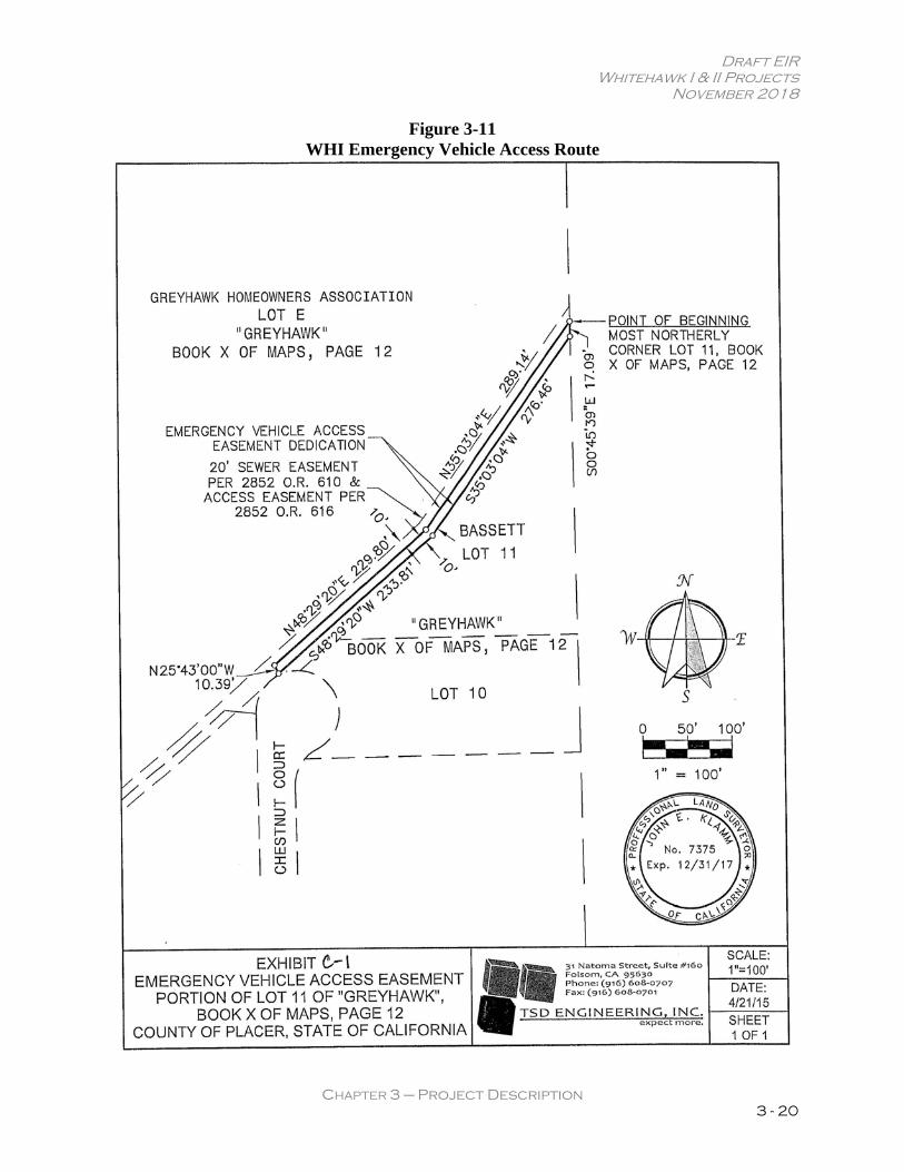
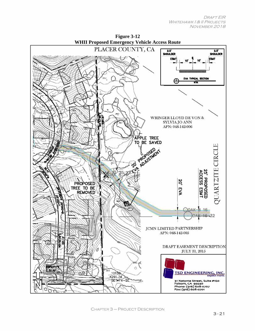
Affordable Housing The proposed single-family homes are proposed as market rate units. Pursuant to Placer County Housing Element Policy B-14, however, the WHI and WHII projects would be required to provide 10 percent of the units to be affordable, pay an in-lieu fee, or provide a comparable affordable housing measure(s) acceptable to the County to meet their affordable housing obligation in a manner acceptable to Placer County. The project applicant would be required to provide an affordable housing measure and submit an affordable housing plan to the County that details how the measure fulfills the project’s Affordable Housing obligation. Project Site Improvements Due to their common design, access, roadways, parking, trails, and open space will be described in the following section for both WHI and WHII. Access As noted previously, primary access to both projects would be from gated entries off Douglas Boulevard at the north end of each site. Because both projects are directly accessed off of a major arterial roadway, as defined by the GBCP, gated entryways are permitted. A new right-in, right-out only intersection would be constructed for WHI. WHII would be accessed with an extension into the project of the south leg of the existing signalized Douglas Boulevard/Seeno Avenue intersection. Douglas Boulevard is classified as a major arterial roadway and a scenic roadway in the GBCP. The WHI and WHII projects would dedicate additional right-of-way for Douglas Boulevard frontage improvements and minor widening. An off-site emergency vehicle access (EVA) would be provided at the southwest boundary of the WHI site, with a 20-foot access road over an existing sewer easement that would extend within a 25-foot, off-site easement for approximately 525 feet, connecting to Chestnut Court in the existing Greyhawk subdivision to the west (see Figure 3-11). In addition, an off-site EVA is planned for the east side of WHII, south of Lot 45. The 20-foot access road would extend within a 25-foot, off-site easement for approximately 500 feet east to Quartzite Circle, a privately-maintained public road southeast of the site (see Figure 3-12). Tube gates would be used where the EVAs meet the adjacent property lines. It should be noted that the proposed EVA routes would not conflict with any land use restrictions. The EVAs would be used for emergency vehicle access only and signage would be provided to demonstrate that the EVAs are not intended for public ingress/egress or private/public trail connection. Roadways From each of the entries on Douglas Boulevard, private roadways would extend south and provide access to the sites. The two-lane roadway sections would be 26 feet in width from back of curb to back of curb, with mountable AC dike curbs providing two 13-foot travel lanes. The roadway design would reflect the rural character of older Granite Bay neighborhoods such as Hidden Valley without sidewalks. The roadways would be privately owned and maintained by Homeowner’s Associations (HOAs).
Draft EIR Whitehawk I & II Projects
November 2018
CHAPTER 3 – Project Description 3 - 20
Figure 3-11 WHI Emergency Vehicle Access Route
Draft EIR Whitehawk I & II Projects
November 2018
CHAPTER 3 – Project Description 3 - 21
Figure 3-12 WHII Proposed Emergency Vehicle Access Route
Draft EIR Whitehawk I & II Projects
November 2018
CHAPTER 3 – Project Description 3 - 22
CON/SPAN-style bridges are planned over Strap Ravine. North of Lot 1 in WHI and between Lots 1 and 2 in WHII, 26-foot-wide access easements are provided to the property lines of the Mac Bride property located between WHI and WHII to accommodate potential future roadway connections. Parking Street parking would not be permitted along the interior roadways. Resident parking would be accommodated within three-car garages in each residential unit and guest parking will be accommodated on each of the residences’ driveways. In WHI, four parking bays located along the roadways would provide 24 additional parking spaces for guests. In WHII, six parking bays would provide 55 additional parking spaces. Trails Trail systems included in the WHI and WHII projects are described in the following sections. Douglas Boulevard Sidewalk/Bike Trail Consistent with the GBCP, the WHI and WHII projects would include an eight-foot-wide, concrete, Class I meandering sidewalk/bike trail along the south side of Douglas Boulevard. The trail along Douglas Boulevard would connect to existing and future trail segments east and west of the project sites. A split rail fence would be located south of the sidewalk/trail to separate the trail from the proposed open space. Other Trails A trail system of five-foot wide trails within the WHI and WHII neighborhoods would provide residents with a passive recreation amenity for walking and provide access among residential units, open space areas, and the proposed park areas. A five-foot wide, half-mile-long public trail within the WHI site will provide residents with a passive recreation amenity for walking and access among residential units, open space, and the park site. From the east-west sidewalk/bike trail along Douglas Boulevard, the five-foot trail would extend south over Strap Ravine to the southern portion of the site. Such segments of the trail would be located adjacent to the internal roadways. Along the southern end of the WHI site, a segment of the five-foot trail would extend south of Lot 24 to connect to the existing trail that currently ends at the western site boundary. The trail would connect to the existing trail within the Greyhawk subdivision located on the south side of Strap Ravine with connections to Streamside and Chestnut Courts. As shown in the GBCP, the trail is planned for a future extension to Eureka Road and Sierra College Boulevard. An easement between Lots 17 and 18 of WHI would allow for a future trail connection to and through the Mac Bride Family Trust property if/when the property is developed. A five-foot wide, 0.7-mile-long public trail would be constructed within the WHII site. From the east-west sidewalk/bike trail along Douglas Boulevard, the five-foot trail would extend south of
Draft EIR Whitehawk I & II Projects
November 2018
CHAPTER 3 – Project Description 3 - 23
the gated entryway, over Strap Ravine, and around the looped roadway. Segments of the five-foot trail would extend south along the courts to an east-west segment of five-foot trail along the southern boundary of the WHII site. A future trail segment between Lots 1 and 2 would link to the Mac Bride Family Trust property to the west if/when the property is developed. The five-foot wide trail within the WHI and WHII sites would be maintained by HOAs and would consist of a surface constructed of native materials such as compacted, decomposed granite or rock in an alignment cleared of brush and vegetation. Utilities Regional sewer trunk lines exist on portions of the WHI and WHII sites, but the proposed projects would include upsizing for certain segments of those lines, as well as the construction of additional utility infrastructure. Such infrastructure improvements are described below. Water System Both the WHI and WHII projects would include utility improvements along the project frontages to Douglas Boulevard. Both sites are located in the San Juan Water District. To serve the WHI project, an existing 16-inch waterline would be extended east from its current terminus at Douglas Boulevard and Woodgrove Way to the eastern project site boundary along Douglas Boulevard, a distance of 250 feet. From the extended 16-inch waterline within Douglas Boulevard, a new eight-inch water line would be extended south, into the project site at the site entry on Douglas Boulevard. The eight-inch water line would be placed within the proposed private roadway infrastructure. Should WHII be implemented without WHI, or prior to implementation of WHI, WHII would include the extension of the Douglas Boulevard water line by 1,700 feet, from the line’s existing terminus to the eastern boundary of the WHII site. From the 16-inch water line in Douglas Boulevard, eight- and 12-inch water lines would extend south into the WHII site within the proposed private roadways. It should be noted that because the WHI project would include extension of the existing water line by 250 feet to the eastern project boundary of the WHI site, should WHII be implemented following WHI, WHII would only be required to extend the Douglas Boulevard water line from the eastern boundary of the WHI property line to the eastern boundary of the WHII property line, a distance of 1,450 feet.
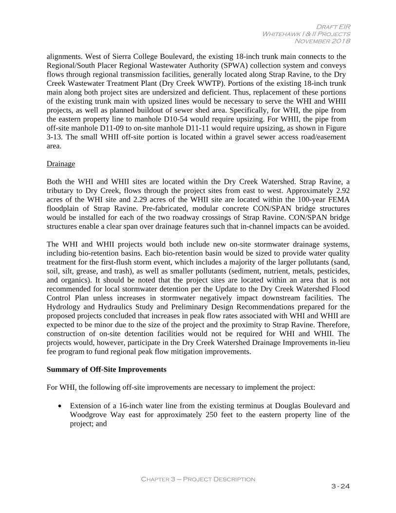
Sewer System Both WHI and WHII sites are located in Placer County Sewer Maintenance District No. 2 (SMD 2). All sewer improvements would be consistent with SMD 2 requirements and the South Placer Regional Wastewater and Recycled Water Systems Evaluation. An existing 18-inch trunk main, running east-west, is located along the southern boundary of both project sites within a 20-foot easement. Flows from the WHI and WHII projects would be conveyed to the 18-inch trunk main through new gravity lines that would follow the roadway
Draft EIR Whitehawk I & II Projects
November 2018
CHAPTER 3 – Project Description 3 - 24
alignments. West of Sierra College Boulevard, the existing 18-inch trunk main connects to the Regional/South Placer Regional Wastewater Authority (SPWA) collection system and conveys flows through regional transmission facilities, generally located along Strap Ravine, to the Dry Creek Wastewater Treatment Plant (Dry Creek WWTP). Portions of the existing 18-inch trunk main along both project sites are undersized and deficient. Thus, replacement of these portions of the existing trunk main with upsized lines would be necessary to serve the WHI and WHII projects, as well as planned buildout of sewer shed area. Specifically, for WHI, the pipe from the eastern property line to manhole D10-54 would require upsizing. For WHII, the pipe from off-site manhole D11-09 to on-site manhole D11-11 would require upsizing, as shown in Figure 3-13. The small WHII off-site portion is located within a gravel sewer access road/easement area. Drainage Both the WHI and WHII sites are located within the Dry Creek Watershed. Strap Ravine, a tributary to Dry Creek, flows through the project sites from east to west. Approximately 2.92 acres of the WHI site and 2.29 acres of the WHII site are located within the 100-year FEMA floodplain of Strap Ravine. Pre-fabricated, modular concrete CON/SPAN bridge structures would be installed for each of the two roadway crossings of Strap Ravine. CON/SPAN bridge structures enable a clear span over drainage features such that in-channel impacts can be avoided. The WHI and WHII projects would both include new on-site stormwater drainage systems, including bio-retention basins. Each bio-retention basin would be sized to provide water quality treatment for the first-flush storm event, which includes a majority of the larger pollutants (sand, soil, silt, grease, and trash), as well as smaller pollutants (sediment, nutrient, metals, pesticides, and organics). It should be noted that the project sites are located within an area that is not recommended for local stormwater detention per the Update to the Dry Creek Watershed Flood Control Plan unless increases in stormwater negatively impact downstream facilities. The Hydrology and Hydraulics Study and Preliminary Design Recommendations prepared for the proposed projects concluded that increases in peak flow rates associated with WHI and WHII are expected to be minor due to the size of the project and the proximity to Strap Ravine. Therefore, construction of on-site detention facilities would not be required for WHI and WHII. The projects would, however, participate in the Dry Creek Watershed Drainage Improvements in-lieu fee program to fund regional peak flow mitigation improvements. Summary of Off-Site Improvements For WHI, the following off-site improvements are necessary to implement the project:
Extension of a 16-inch water line from the existing terminus at Douglas Boulevard and Woodgrove Way east for approximately 250 feet to the eastern property line of the project; and
Draft EIR Whitehawk I & II Projects
November 2018
CHAPTER 3 – Project Description 3 - 25
Figure 3-13 Proposed Sewer Main Upsizing
Draft EIR Whitehawk I & II Projects
November 2018
CHAPTER 3 – Project Description 3 - 26
If not already completed, installation of a raised curb or median in the Douglas Boulevard/Woodgrove Way/Quail Oaks Drive intersection that will continue to permit eastbound and westbound left turns from Douglas Boulevard onto Quail Oaks Drive and onto Woodgrove Way, while prohibiting northbound and southbound through traffic across Douglas Boulevard as well as left turns onto Douglas Boulevard from either approach (see Mitigation Measure 14-2 in the Transportation and Circulation chapter of this EIR).
For WHII, the following off-site improvements are necessary to implement the project:
Extension of a 16-inch water line from the existing terminus at Douglas Boulevard and Woodgrove Way east for approximately 1,700 feet to the eastern property line of the project (assumes WHI is not developed);
Construction of a 20-foot unpaved emergency vehicle access within a 25-foot easement from eastern property line for approximately 500 feet east to Quartzite Circle;
Replacement of existing sewer main in the southern portion of the project site, between manhole D11-09 to site’s eastern property line, with an upsized line;
Striping and pavement, minor relocation or replacement of existing facilities, and improvements to Douglas Boulevard/Seeno Avenue intersection for construction of the southern leg of intersection;
Construction of the fourth leg of the traffic signal at the existing intersection of Douglas Boulevard and Seeno Avenue and traffic signal pole improvements located on the north side of Douglas Boulevard;
If not already completed, installation of a raised curb or median in the Douglas Boulevard/Woodgrove Way/Quail Oaks Drive intersection that will continue to permit eastbound and westbound left turns from Douglas Boulevard onto Quail Oaks Drive and onto Woodgrove Way, while prohibiting northbound and southbound through traffic across Douglas Boulevard, as well as left turns onto Douglas Boulevard from either approach (see Mitigation Measure 14-2 in the Transportation and Circulation chapter of this EIR); and
Lengthening of the westbound Douglas Boulevard left-turn lane approaching the Seeno Avenue intersection from the existing 220 feet to 300 feet (see Mitigation Measure 14-4[a] of Transportation and Circulation chapter of this EIR).
In addition, vehicle trips resulting from both the WHI and WHII projects would trigger the need for widening of Douglas Boulevard from Sierra College Boulevard to Cavitt Stallman Road South. It is anticipated that the second of the two projects to be developed would be responsible for the construction of this Douglas Boulevard widening improvement; however, if an intervening project triggers the need for the improvement and the improvement is constructed prior to development of the second Whitehawk project, the project’s obligation for construction of the improvement would be considered satisfied.
Draft EIR Whitehawk I & II Projects
November 2018
CHAPTER 3 – Project Description 3 - 27
Project Phasing and Construction Each project would be constructed in a single phase. Approximately 9.9 acres of the WHI site would be graded to construct the WHI project, and approximately 18.3 acres of the WHII site will be graded to construct the WHII project. Mass and fine grading will be required to implement the projects for streets, home sites, and trenching for installation of infrastructure. The WHI project will require import of approximately 22,280 cubic yards of fill material, and WHII will require approximately 63,760 cubic yards of fill material. Requested/Required Entitlements WHI The project applicant is requesting Placer County approval of the following entitlements for the WHI project:
General Plan Amendment/Community Plan Amendment (GBCP) for a portion of the site from Rural Low Density Residential (0.9 – 2.3 Ac. minimum parcel size) and Rural Residential (2.3 – 4.6 Ac. minimum parcel size) to Low Density Residential (0.4 – 0.9 Ac. minimum) and for the 300-foot setback area to Open Space;
Rezone to change Planned Development designation from 0.5 to 1.4 dwelling units per acre so that zoning changes from RA-B-100 PD=0.5 to RA-B-20 PD=1.4 and for the 300-foot setback area to Open Space;
Variance to lot coverage allowing up to 50 percent coverage for single-story residences, where 25 to 40 percent is normally allowed;
Conditional Use Permit to construct a Planned Residential Development; and Vesting Tentative Subdivision Map for the subdivision of 18.09 acres into a 24-lot
Planned Residential Development with seven open space and common area lots. WHII The project applicant is requesting Placer County approval of the following entitlements for the WHII project:
General Plan Amendment/Community Plan Amendment (GBCP) from Rural Residential (2.3 – 4.6 Ac. minimum parcel size) and Rural Low Density Residential (0.9 – 2.3 Ac. Minimum) to Low Density Residential (0.4 – 0.9 Ac. minimum) and to Open Space for the proposed open space area south of Douglas Boulevard, which includes the 300-foot setback area;
Rezone from RA-B-100 to RA-B-20 PD=1.75 and for the 300-foot setback area to Open Space;
Variance to lot coverage allowing up to 50 percent coverage for single-story residences, where 30 to 40 percent is normally allowed;
Conditional Use Permit to construct a Planned Residential Development; and
Draft EIR Whitehawk I & II Projects
November 2018
CHAPTER 3 – Project Description 3 - 28
Vesting Tentative Subdivision Map for the subdivision of 32.97 acres into a 55-lot Planned Residential Development with eleven open space and common area lots.
Other Agency Approvals The following actions, entitlements, and/or permits from other agencies are necessary to implement the proposed projects:
Section 404 Nationwide Permit (or Letter of Permission) (United States Army Corps of Engineers);
Section 7 Consultation (United States Fish and Wildlife Service and National Marine Fisheries Service);
Section 401 Water Quality Certification (Regional Water Quality Control Board – Central Valley Region);
Section 402 National Pollutant Discharge Elimination System Permit Approval (Regional Water Quality Control Board – Central Valley Region);
Streambed Alteration Agreement 1602 (California Department of Fish and Wildlife); and FEMA Conditional Letter of Map Revision (CLOMR).