Embed Size (px)
Citation preview

'f, -.\
\
.. .)
'~( .""-~ .
....)\
I >
).)
.-
J.,\
,J
'- .. < ' ...
,",
J- :-."- I"(..

SYMPOSIUM INTERNATIONAL SUR LES GISEMENTS ALLUVIAUX D'OR
INTERNATIONAL SYMPOSIUM ON ALLUVIAL GOLD PLACERS
SIMPOSIO INTERNACIONAL SOBRE YACIMIENTOS ALUVIALES DE ORO
THE GOLD PLACER OF TIPU AN I
Field guidebook, june, 9 to 11, 1991
by Gerard HERAIL & Giovanni VISCARRA
with the collaboration of :- Mireille Delaune- Michel Fomari- Victor Ramirez- Carlos Tompson
.... .a-"_,.... ··.. s.;, .. ~!: .... ~.r~..~ •. ~" ..• ~.:... .~,,"'." .•••.
1
' .. :'. -' - ,#,.:~.,
During the trip to the Tipuani River Valley, different types of fluviatil placer deposits,(active river beds, alluvial terraces, paleo channels), will be shown in the area between Guanayand Unutuluni.
This region is weIl known for the quantity of gold it has produced and still is producingas weIl as for the characteristics of the deposit. Records of gold mining in the area go back as faras into the period of the Incas. In 1562, the first colonial expedition led by Juan de Roda arrivedat Roman Playa. In 1580, exploitation reached upstream until Chuquini and in 1602 untilTipuani (Revilla 1988).
Early in the 19th century, first attempts in big scale mining were made by IldefonsoVillamil, who produced more than 150,000 ounces of gold from several areas upstream ofTipuani, from 1813 to 1833 and 1850 to 1866 (Revilla 1988). In those times, alluvial terraceswere exploited by means of a method called "banqueria" (a vertical shaft was driven to thebedrock and the productive gravel excavated from there lateraly) or in open air from the riverbanks.
Whereas the fust attempts of mechanization were made in 1840 with the use of waterpumps by J. Wheathey, an Irishman, heavy equipment was introduced only towards the end ofthe 19th century.
In 1898, the Incahuira Dredging Company brought machinery and a dredge to the KakaRiver. But it was the "Compaiiia Aramayo de Minas" which conducted major mining activitiesbetween 1936 and 1949, putting the main emphasis in the exploration and exploitation of the"nId channel" of the Paleotipuani.
Since 1952 (following the nationalization of the mines and the forced return of all goldconcessions held by Aramayo to the State on November 7) and until1961, the gold placers of theTipuani valley were exploited by groups controlled by the Banco Minero, which bought thegold. In 1961, the govemment anulled aIl previous licences and granted juridical personality tocooperatives, which in 1963 formed the "Federaci6n Regional de Cooperativas Aurfferas"(FERRECO), which is actually exploiting the Tipuani Valley placer deposits. In the beginning,the efforts of the cooperatives were concentrated on terraces and active river beds, whereas,since a few years, the exploitation of the "Old Channel" predominates.

.} ..l..A,••.~·_.·~..·,,·""'" _ •. " .....:..-.s..r~ ..._V.r""_,_..;·.~.,_, ~.- "'-"-, •• '.' ••.< ....~ ••••••
3
1. THE ITINERARY LA PAZ - TIPUANI (FIG.!)
The distance of 259 km is travelled in about 10 hours. Nevertheless, a stop-over is madein Guanay (228 km), where we spend the night. The trip takes us from the Altiplano (3500 4000 m) over the pass of La Paz ("La Cumbre", 4636 m) down into the hot areas of the Yungas(2000 - 500 m).
Leaving La Paz in a NNE direction, we pass through extensive fluvioglacial deposits ofthe La Paz FOlmation, consisting of grey to ochre silty clayed sediments of lacustrine origin,interbedded with fluviolacustrine sands and conglomerates.
The base of this formation has been dated at 5.5 ± 0,2 M. y. in Cota Cota (Lavenu et al.1988). The upper part of this formation conserves a layer of tuff, the Chijini Tuff, dated at 2.8 M.y. (Lavenu et al. 1988). This tuff outcrops on the right of the road, deformed by a normal fauIt.Overlaying the La Paz Formation appear morainic and fluvioglacial sediments of the Quaternary,and furthermore well conserved moraines at the bottom of the Chuquiaguillo Valley and itsslopes (beginning at km 8).
At the road stop of Chuquiaguillo, one observes on the right, at the bottom of theChuquiaguillo River, sorne minor mining operations for alluvial gold. This gold originates indisplaced material of the La Paz Formation as well as in moraines coming down from the waterparting. One of the reasons for the foundation of city of La Paz on October 20, 1548 by Alonsode Mendoza was the discovery of gold in the high valleys of the La Paz drainage basin.
Higher up towards the pass, outcrops of Devonian and Silurian slates (Lehman 1979,Martinez 1980) are crossed and once the pass is reached, one observes good outcrops of blackslates belonging to the Unda Formation (Silurian). Beginning our descent (km 23), we crossmore sandy sediments of the Llallagua Formation which overlays the Cancaiiiri Formation(Ashghillian) and is characterized by the presence of allochton blocks and gravel and by bigslope slidings. Afterwards we enter into a series of light-colored quartzite of the UpperOrdovician. Throughout the rest of the itinerary right down to the placers of Tipuani, following apretty narrow road, Ordovician terrains are traversed, like quartzites of the Upper Ordovician orlutites of the Middle Ordovician. An exception is the orthogranite of the Zongo-Yani batholite(of Eohercynian age), outcropping near the tunnel of Unduavi at km 39.
After the Unduavi tunnel, the road to Chuspipata (km 52) is less steep and followsthrough an area made up predominantly of Ordovician slates. From Chuspipata on and followinga narrow road down to the Yungas, we cross massive outcrops of quartzites (Upper Ordovician).Approaching Yolosa (fig. 1), after having travelled 81 km, the reliefbecomes less sharp and thevalleys open up. Sorne 250 to 300 metres above the actual Coroico River are remnants of oldvalley fillings showing thick red alterations. Tbese horizons could carry auriferous alluvialdeposits, as one observes beyond the bridge of Santa Barbara (km 92) on the left side of the road.
Going on, carrying on towards Caranavi more Middle Ordovician terrain is passed andnear Chorro (km 121) the presence of quartzites is marked by narrow gorges. Not until km 133has been passed, the valley of the Coroico River opens, the relief smoothes out and reddish soilsdeveloping over paleozoic rocks become frequent. From here on, we enter into the properCangalli Basin (fig. 2). Passed San Silverio (km 143), one observes (ahead to the left) at thehorizon, pyramid shaped reliefs made up by conglomerates of the Cangalli Formation which reston more rounded ground made up of slates.
The basin with the Cangalli Formation is bounded at its northeastern end by an importantoverthrust (the Main Andean Overthrust, Sempere et al. 1988), which caused the rising of

4
50 km ,
[1]' .8 .;.;.;.;.:.;..............
,1
Fig. 1. Simplified geol~glcal map of the area located between La Paz and Tipuanl(Complled from Martinez 1980, Tistl 1985, Hérall et al. 1988, Sempere et al. 1990).
1 - Eohercynian syntectonic orthogranite of Zongo, 2 - Triassic granodiorite of Illampu Huayna Potosi, 3 - Miocene granite, 4 - High and middle metamorphism zone boundary, 5-Ordovician, 6 - Silurian to Permian, 7 - Undifferentiated Cenozoic strata, 8 - Oligocene toPliocene (La Paz Formation, Aranjuez Formation...), 9 - Cangalli Formation, 10 - Glacialand fluvioglacial sediments (Quatemary), 11- Fluvial and lacustrine sediments(Quatemary). 12 - ltinerary of the fieldtrip

• .' .•. , J.' ~"'" ,,- , '.. " " .• ,.', ','
5
notable reliefs at the northeast and the isolation of the Tipuani Basin which developed to a"piggy-back basin" during Cenozoic times (Fornari et al. 1989).
From Caranavi to Guanay, the road stays in the Coroico Valley until its junction with theMapiri, Challana and Tipuani Rivers. AlI along this part of the road, we follow the strike of theandean structures, observing to the left, on the riverbank, pyramid-like reliefs of conglomeratesof the Cangalli Formation, resting on Ordovician slates. Locally, along the river, one observessmall-size goId workings, but intense mining activity begins only from the confluence of theCoroico River with the Mapiri River (km 224). The workings of gold washers("barranquilleros") along the riverbanks as well as open pit operations of mining cooperatives onalluvial terraces are especially dense from the confluence of the Challana with the Mapiri onuntil Guanay (km 228). In the same area, the stretch partly covered with vegetation between theroad and the Mapiri River is filled with waste from dredging the river bed and low terraces of theMapiri. These dredging operations were run in the entire zone of Teoponte and Guanay from1959 until1990, first by SAPI (Southamerican Placer Inc.), later by CODEMA (CooperativasdeI Mapiri).

'1 mI... 5D6~1
RIO
®
6
1 2_3~ 4ŒWl

7
2. THE CANGALLI FORMATION: GENERAL SEDIMENTOLOGICAL FEATURESAND CONTEXT OF SEDIMENTATION
The Cangalli Formation outcrops in the Tipuani-Mapiri basin (fig. 1) which covers sorne100 km in an SE-NW direction parallel to the andean structures. Towards the Northwest, thisbasin extends beyond Apolo, although without any sediments conserved, and towards theSoutheast beyond Coroico, thus reaching a total length of over 200 km. At the Northwest,. it islimited by the Serranfa of Carura, which is made up by Paleozoic series overthrusting thesubandean zone. In the Southeast, the Cangallf Formation, discordantly overlaying theOrdovician, extends into the principal va11eys descending from the Cordillera Real (from Southto North: Cha11ana, Tipuani and Mapiri rivers).
2.1. Sedimentological characterlstics.
The Cangalli Formation is detritic, consisting mainly of conglomerates deposited in afluviatil environment (Frochot 1901, Ahlfeld 1946, Sto11 1961, Freydanck 1965). However thereare numerous changes of facies (Hérail et al. 1986, Viscarra 1986, Hérail et al. 1989). Thesesediments fi11 a paleo-drainage system, which caused important variations in the sedimentationthickness (from 0 to 500 metres) and in the facies (fig. 2). Above the gorges of the paleo-valleyscoming from the Cordillera, we find fluviotorrential conglomerates with individual blocks up toseveral m3. Downstream, better-sorted fluviatil conglomerates change slowly ioto distal facies offlood plain, as for example downstream the Paleo-Mariapo (fig. 2). Nevertheless, no lacustrinefacies have been found in the Tipuani-Mapiri basin downstream, trapped behind the reliefc10sing the basin at the north, which means that this basirl never has been an endoreic one(Fornari et al. 1987).
The main part of the sediments belonging to the Cangalli Formation has been preservedat the bottom of the paleo-va11eys (Cha11ana, Tipuani, Mariapo and part of the Chimate-Mapirizone). This paleo-morphology controls the geometry and the structure of the sedimentary filling.At the bottom of·a paleo-valley, the sedimentation begins with very coarse and we11-roundedconglomerates (blocks with 0,8 to 1 m in diameter are frequent). This conglomerate rests directlyon the Ordovician substratum; the rocks are polished and one observes quite often pot-holes. The
.Fig. 2. The Tipuani basin: sedimentological and structural features
A - Geographicallocation. 1 - Tipuani-Mapiri basin (a: Cangalli Formation, b: erosional surfaceassociated to the filling of the basin), 2 - Plio-Quatemary basins of the south-occidentalpiedmont, 3 - Amazonian plain, 4 - Subandean belt., 5 - Cordillera Oriental, 6 - Main thrust ofthe Andean Front (the heavy rectangle indicates the location of the map of the Figure B).
B - The Cangalli Formation in the central part of the Tipuani-Mapiri basin. 1 - Boulder andcobble conglomerates, 2 - Gravels and sands, 3 - Silts and clays of flood plains, 4 - Main foldsand reverse faults. White, Ordovician bedrock.
C - Sections a-b, cod, e·f (location and legend: see B).
D - Grades of the present talweg and of the paleotalweg of the Tipuani River. 1 - Paleotalweg, 2- Present talweg, 3- Cangallf Formation, 4 - Ordovician.
E - Microfracturation and stress analysis in the Cangallf conglomerates (stereo nets 1, 2 and 3)and in the Quaternary high terrace of Paniagua (stereo net 4). Location of station: see figure B.Cyclographic projection of the striated fault planes with their slip vector. Orientation of thecalculated tensor: 1 - major principal stress axis 01; 2 - intermediate principal stress axis oz; 3 minor principal stress axis 03; Schmidt projection in the lower hemisphere.

8
sediment, in which trunks of trees have been preserved, contains clasts of the Ordovician seriesas weIl as intrusive rocks from the high parts of the Cordillera (fig. 1). The structure of thesediment changes towards the top of the series because of the widening of the valley whichpermits the river to deviate and to reduce its speed and its transport capacity. The sediment isstructurally characterized by channels filled with decreasing grain-size and well-imbricatedconglomerates. In vertical cross-sections, the individual channels are separated by layers ofpoorly-sorted conglomerates. They have a thickness of several metres to several tens of metresand form massive layers without signs of erosion at the basis and no remarkable granulometricchanges from bottom to top. These sediments are the result of the superposition of fiows, oneover the other, without any aquatic remobilization after deposition.
In summary, the serie consists of a succession of more or less complete decreasing grainsize sequences. Towards its top, the proportion of coarse conglomerates decreases with regard tothat of smaller gravel and sand. Nevertheless, the most important change is the decrease of thenumber and of the continuity of the high energy channels filled with blocks ranging from severalcentimeters up to one metre in diameter and which constitute the pay-streaks ("veneros").
Laterally, towards the margins of the paleo-valley, characteristic facies appear (fig. 3).
- Colluvial facies ("falderio"): they consist of poorly rounded blocks and gravels ofOrdovician slates in a red sandy-clayed matrix. These deposits are the result of a localtransport by gravity (for example slope slidings) or superficial wash-off. They haveformed in a low energy environment independent from the waters of the river.
- Swampy facies: they consist of layers of sand and clay (sometimes with floatinggravels) of a bluish grey color, which contain plant fragments (sometimes in liveposition). Small layers of lignite can be observed. On the riverbank, these clays areinterbedded with conglomerate layers, whereas at steep rocky riverbanks they are mixedwith colluvial material ("falderios"). The thickness of these facies can be of various tensof metres. In the Tipuani Valley, they are particularly weIl developed around Uanani andCarhuarani as weIl as in the lower parts of the Iscua River (fig. 4). The reconstitution offlow directions (for example in the area of the Iscua River), clearly shows (fig. 4) that thesediment and the transporting waters came mainly from the Paleotipuani and not fromthe slopes. These sediments were deposited in swampy areas caused by inundations ofthe Paleotipuani. Near Carhuarani, outcrop clayed and silty-clayed sediments whichcould have been deposited in a permanent lake.
The distribution of the different facies described above occurs under the specificarrangement of the valley at a certain time of its geological history and is subject to constantchanges as time goes on. At later stages of the infilling, more fine grained facies becomeimportant and particularly the channels appear more apart one from another due to the increasedwidth of the valley opened to the running water. In particular, sorne inherited geomorphologicalstructures of the Paleovalley may interfere with the surface of the rising new valley and maycause sorne local and momentaneous changes to the tracing of the riverbed. Thus (fig. 3C), whenthe level of the sedimentary filling reaches the lowest point of the surrounding slopes of thepaleo-valley, the waters may deviate and change the course of the river. A clear example of suchan event exists in the area of Molleterio-Chima (fig. 4).
The present top of the CangalH basin filling which can be seen, corresponds to an erosionsurface cutting the Paleozoic substratum in the surroundings of the basin. In the basin itself, thiserosion surface is covered by alluvial terraces of the Challana, Tipuani, Mapiri rivers, or by widespread alluvial fans (Chimate Formation) in areas not drained by rivers abundant in water andcoming from the high parts of the Cordillera. An example for such an area is extending to the

B
,~ > l!IIIilIJllI~ lMIfSl
Fig. 3: Different stages of the evolution of theTipuani paleovalley before (A) and during (B andC) the deposition of the Cangalli Formation(explanations in the text).
1 : SIope deposits ("falderfo"), 2 : Fluviatilesediments, 3 : Clays and silts deposited inswampy areas.

10
NW of the Mariapo river until the Mapiri river (Hérail et al. 1986, 1988). Undoubtedly,(althrough the problem has not been studied in detail) it is from this surface, ending the filling ofthe basin, that a thick horizon of weathering develops, resulting in the superposition of the socalled "Blue Cangalli" by the so-called "Red Cangalli".
2.2. The deformation of the Cangalli Formation.
The respective sediments were deposited in a system of paleovalleys which came intoexistence following the rise of the Eastern Cordillera. Deposition and capturing of the sedimentstook place after the rise of the Serranfa de Carura and the structuring of the Subandean, whichcaused the collapse of the drainage system.
The Serranfa de Carura closed the basin in the Northeast and trapped the sediments nowknown as Cangalli.
Throughout the basin, surface and underground observations at the basin scale enable us toreconstruct the tectonical deformation and to interpret its development. Thus we know that in itsactual position, the gradient of the paleo-valleys. is steeper than the present valleys. The bed ofthe Tipuani river (fig. 2), upstreams of Unuruluni, lays some 300 metres lower than the bottomof the paleochannel filled with the Cangalli Formation as to be seen in the mines of Unutuluni.Further downstream, in the area actually occupied by the big sandbanks of Tipuani, the bottomof the paleochannel is found at about 190 m of depth and in Cangalli at about 210 m of depth(ORSTOM-UMSA ined.). Compared with the gradient of the present Tipuani, which is in theorder of 0,3%, the gradient of the paleochannel is in the order of 4.5%, that does not correspondto an inclination for depositing sediments. The difference of gradients between the paleochanneland the present channel is the proof of orogenetic movements.
Deformation can be seen also in folding with strikes N120 - N130E, inverted faults strikingin the same direction, as well as corridors where the conglomerate has been heavily tectonized.This is evident through the visible frac turing of pebbles. The evaluation of the microtectonicaldata reveals that the conglomerates suffered a subhorizontal compression with an orientation ofabout N050E (fig. 2). The folds and inverted faults observed in the basin belong to the sameevent (Lavenu 1986, Hérail et al. 1987, 1988, Fornari et al. 1987).
The oldest alluvial levels, younger than the Cangallf Formation (high terraces of theTipuani River and the Chimate Formation) have not been affected by this deformation.
1
1
1
1
f

11
3. THE TIPUANI RIVER PALEOCHANNEL AND THE CANGALLI FORMATIONBETWEEN GUANAy AND UNUTULUNI (FIG. 2 AND 4)
Between Guanay and Unutuluni, the Cangalli Formation outcrops along the Tipuanivalley; at many places, good outcrops are easly accessed.
At many places, between Guanay and Tipuani, following the road, besides the Paleozoicwhich is part of the paleorelief that separates the Tipuani and Mariapo paleovalleys (fig. 2),"distal" sedimentary facies of the Cangalli Formation are also observed. These facies weredeposited, downstream, where the water had low energy, between two main rivers. In theAguada and Polopata area, these facies consist of fluviatile sediments which compriseconglomerate and interbedded clayish sands; the rocks dip gendy to the SW.
The conglomerates - which have been deposited in the axis of the paleovalley - outerop inthe left (S to SW) side of the road; they form pyramidal shaped reliefs with red cliffs,characteristic of the CangalH Formation. In the landscape, the position of the sediments filling adeep (almost 1,000 m in this place) paleovalley, excavated in the Ordovician bedrock, is clearlyobserved. From the Cerro Pil6n (1,425 m) the paleogeomorphology of the Tipuani valley can beobserved; also the present valley with mining workings.
On the descend towards Carhuarani (728 m) one can appreciate the importance of thedissection, which took place before and after the Cangalli Formation deposition. Along thisstretch, specifie facies of the Cangalli Formation outcrop, here represented by sedimentsdeposited in a low-energy environment. The sediments consist of conglomerates composed ofsmall, well-rounded clasts, locally interbedded with conglomerates, composed of very slightlyblunted clasts. The conglomerates overlay a suite of grey sands and silt, partIy clayed and,locally, containing "lignites". These facies can be oberved when crossing the Carhuarani River.The sediments are folded and form an assymetric syncline which trends N130E; thesouthwestem limb is vertical, at places overtumed or overthrusted by Ordovician slates.
In the stretch between Carhuarani, Suluplaya and Cangalli, facies of the same character areobserved; towards Cangalli the conglomerates progressively predominate. These materials alsoare deformed: small inverse faults trending N12DE-N13DE and dipping more than 20° to thesouthwest, are seen; antithetic fractures generally dip steeper (about 45° to the NE). Thedeformation is also marked by intense fracturing of the clasts. Such microtectonic facies areclearly observed on the right bank of the Tipuani River, just in the entrance of the gorge,downstream from Cangalli.
Before going down to the Tipuani River and before reaching the Cangalli village, in theslope that dominates the latter, one can see sorne features of the paleovalley's physiography,where the Cangalli Formation was deposited (fig. 5). At the village's level, the paleovalley is 600m wide and the paleoslopes have a rather steep gradient (almos 45°) similar to the gradient ofpresent slopes. The data obtained by VES (ORSTOM-UMSA) indicate that in this area thebottom of the paleovalley probably reaches its highest depth, about 225 m under the presentlevel of the river.
At many places between Cangalli and Unutuluni, for example in La Rinconada and inGritado-Chima (fig. 4), similar situations are observed. In the Unutuluni region the uplifting andthe post-CangalH dissection were very important and we can observe the paleogeomorphology ofthe pre-Cangalli valley and the structure of the sedimentary filling. In the Tujojahuira section(fig. 6), detailed observations show the geometry of the paleovalley which is rather narrow (notmore than sorne tenths of metres wide); it is also observed how the river couId wander and enterinto other openings (such as Copacabana) when the filling moved forward.

Fig. 4: The Cangalli Fonnation between Cangalli and Unutuluni.
N 1krTI
~~ Fluviatil and fluviotorrential congIomerates.
t:'\:>~{:>~l SIope deposits (congIomerates).
f{})~1 Undifferentiated remnants of the CangaIIi Formation.
1 .. 1Direction of the flow.
.,. , . ~ Reverse fauIts.é:/1..~ Sandy-eIayed sediments deposited in swampy environments. ~
1>- -<1 Syncline.
__.. -------0- 0

13
These structures are filled with conglomerates consisting of coarse boulders towards thebottom (up to several cubic metres in volume) and less coarse boulders towards the top. Thestructure of the sediments changes drastically. In the bottom of the paleocanyon, pay-streaks aresuperimposed; they correspond to bottom of channels of torrential regime, whereas towards thetop the channels are wider, with the widthldepth ratio considerably increased, and poor in gold.
In the hanging paleocanyon of Copacabana, this type of structure is repeated, though lessclearly and more difficult to observe.
100 m
A 0000000 00000000 oooooooooooooo~o~~ B'1 11111 ooooooooooooooooooo,o~ Will'0000000000000000000
0000000000000'00000000000000000000
'1I11111111111mn'1Q 0 000000000000 100 m00000000000 ~0000000000
000000000000000~ooooo'0000
o
Fig.5: The paleovalley ofthe Tipuani River inCangalU.
Geological simplifiedmap and transversalsection. For tbis section,VES are used.

·1~ Fig. 6: The paleovaUey of the Tipuani River in Tujojahuira seen from Unutuluni.
The morphology of the paleovalley filled by the Cangallf Formation can be seen. On the left (black arrow), the valley ofCopacabana. Thick Quaternary terraces overlay the Cangallf Formation; on the photograph, the Paniagua levelcorresponds to the oldest level of the terraces system of the Tipuani River.
A

15
4. QUATERNARY ALLUVIAL DEPOSITS IN THE TIPUANI RIVER BETWEENUNUTULUNI AND GUANAY; THEIR GOLD CONTENTS.
In this stretch of the river, the Quaternary deposits - if we exclude different types ofcolluvium - belong to fluviatile alluvium either in terraces or in the present bed of the river.
1) Terraces of the Tipuanl river.
Due to a deep dissection (more than three hundred metres in altitude difference betweenthe Paniagua apex and the present bed of the river), none of the terraces is continuous but thereare remnants of several hectares in extension. These terraces are thick but not extensive, with analluvium stratum commonly exceeding 30 m in thickness. This stratum includes a colluviumcover and small-sized, clayed sediments on the oldest horizons; the cover is barren and a few toten meters thick. Under this stratum, the conglomerate is organized in a classical way,comprising various superimposed systems of channel filling with clasts which are progressivelycoarser towards the bottom. Unlike the sediments of the Cangalli Formation, which is usuallyoverlain by the Quaternary alluvium, the Quaternary terraces contain clasts of granitic rockscoming from high parts of the Cordillera.
In the terraces, whatever their age may be, the vertical gold distribution follows the samemodel illustrated by the mineralized structure of terraces in the Montecarlo-La Rinconada region(Azevedo 1985). The 3,5-5.5 m thick cover contains less than 0.1 g/m3; in the underlying, 5-7 mthick, conglomeratic horizon, the goId content is of the order of 0.2 g/m3 whereas the 1.0-1.5 mthick basal conglomerate contains 0.6 g/m3. However, the lateral distribution of goId and itscontents vary according to the position in the bed of the river; consequently, the terraces are notequally mineralized.
2) The alluvial deposits of the present bed of Tipuanl river.
The reputation of Tipuani proceeds from the extraction of gold in this type of alluvium. Inthe eighties, these deposits were mined by means of shafts and pits, and have given a largequantity of gold.
They exhibit obviously similar features to those in the terraces. But in this material certaininvestigations are easier, for instance, dating of observed phenomena.
Dowmstream from La Rinconada, the Tipuani river traverses two unbeached zones, inTipuani and in Cangalli. The alluvial cover overlying either the Cangalli Formation or theOrdovician bedrock has a thickness of about ten metres. Taking as an example the alluvialdeposits mined in Cangallf, we observe that this material is composed of two main sequences(fig. 7):
- a lower sequence, which is about 5 m thick, consists of a conglomerate deposited inchannels of several metres in depth. In the sediment, boulders (50-60 cm in diameter) arepreserved and more numerous towards the bottom; there are also sorne gigantic (2-3 m indiameter) granitic boulders. The latter are generally present in the contact with the bedrockthoDgh, locally, higher up, but always in the bottom of the channels. In Cangallf, woodfragments collected in the basal sequence yield a C14 age of 9,810 ± 190 years BP (fig. 7).
- one or sorne upper sequences which discordantly overlay the described sedimentarystructures. In the bottom, they consist of a conglomerate with well-imbricated pebbles, whereastowards the top they go over to sand and silt which contain isolated pebbles. Wood fragmentssampled in the base of this sequence (fig. 7) yield a C14 age of 340 year BP. .

....- - -* O'l
.*\ \\ ,, \, ,, ,
• *,\ ...
... "... .......... ......
.~
1-__..1 • *
2
9[T110~ 1'~ 12[ * [--
6
p. mg10 100
1, 1 Il
1l. mm
... 2 4 6 a 10
11 ! 1 1 1 1
Au. 91m32 3 4 5
1
, , 1 1
2
Fig. 7: Sedimentology, goId contents and goId grain granulometry of the auriferous aIIuvium of th& Tipuani river bed andIower terraces in Tipuani (A) and Guanay (B).
1 : Terrains removed during the placers exploration, 2 : Silty cover, 3 : Silts and sands, 4 : Pebbles and boulders, 5 :Cyc10pean leucogranitic block, 6 : Cangalli Formation, 7 : Ordovician, 8 : Sample of C14 dating location, 9 : Location ofsamples for determining gold values, 10: Gold content, 11: Length of the bigger gold grain of each sample, 12: Weight ofthe bigger gold grain of each sample.
--- .------

17
The distribution and the features of goId reflect this dynamic change. The basal sedimentsof the lower sequence exhibit the highest gold contents (up to several grams per cubic meter) aswell as the largest and heaviest particles (fig. 7);towards the top, the gold content decreases(hundreds of milligrams per cubic meter) and the particles are smaller.
This pattern of sedimentary structure and of gold distribution persists downstream. In theneighbourhood of Guanay, the alluvial deposits, mined by the Merma Ltda. cooperative,constitute an example: one can observe that the basal sequence is also made up of asuperposition of channels (fig. 7). Those in contact with bedrock contain coarse pebbles andboulders. Wood fragments, dated by the C14 method yield 10,500 ± 150 years BP and 10,400 +150 years BP; there is no marked difference in age between basal channels and those whidicover them in condition that the observations are made in the inferior ensemble. In the describedcase, the upper sediments were removed to allow mining of the rich lower alluvium.
So it appears that the auriferous alluvial deposits, mined in the present bed of Tipuaniriver, and the lower terraces, at least downstream from Tipuani, were deposited about 10,000years ago, and quite rapidly. The more recent sediments are poorer in gold. Obviously, goldparticles may come down from upper to lower levels; however, the most compact horizons, thatoutcrop in this alluvium do not play a clear role of false bedrock. This fact suggests that goldwas deposited during different alluvial comings.
Upstream, in the gorge of Tipuani river, which drains the basin between Llipi andUnutuluni, it is much more difficult to observe the structure of the alluvial filling in the presentbed. However, punctual observations of the alluvial deposits directly overlying the bedrock canbe done in existing shafts. Here, the filling exceeds 30 m in thickness. The sediment consists of aconglomerate with very coarse boulders (at many places more than one cubic meter in volume)supported by pebbles and sand. In this sediment, tree trunks (a few to, local1y, 30 m long) weretrapped up. This fact suggests that the sediment was deposited during a period of huge floods.Three Cl21 ages were determined in the tree trunks: 33,800 years BP in the neighbourhood ofLlipi (750 m a.s.l.), 31990 ~ll~ years BP in Saiyuani (700 m a.s.l.) and 28,000 ± 600 years BPnear Unutuluni (610 m a.s.l.).
It is no possible to carry out detailed observations, especial1y on the thickness of thealluvial cover, in the deposit preserved in the gorge of Tipuani river. It appears that acontribution of an older • than that observed in Tipuani - mineralization existed. We cancertainly relate these different sediments to the main paleoclimatic changes that took place in theCordillera for the last thirty millenaries.

18
5. GENERAL CHARACTERlSTICS OF THE DETRITAL GOLD MINERALIZATIONIN THE TIPUANI BASIN.
In the deposits of the Tipuani basins, whatever their age may be, the gold appears as freegold grains with variable shape and size. The composition of the heavy mineraIs suite variesalong the Tipuani River.
1) The heavy minerais suite.
Opaque mineraIs (magnetite, ilmenite and pyrite) are prevailing among the heavy mineraIsin the deposits sampIed along the Tipuani River. Only the transparent fraction has beensystematically studied (fig. 8). Downstream, the Ordovician formations which containmineralized quartz veins, Sl.lpply espacially tourmaline, zircon (both detrital in the Ordovician),
®1110 11:-'"
,-v -,
::1-
1 ItUt~1 1IllII,k<@::;j, I~I· b~Jt~~5 r;'41J.
3
4
2
Fig. 8: Simplified section along the Tipuani valley and heavy minerais suite evolution in theTipuani river bed. In A: location of the samples.
1 : Zongo granite, 2 : High and medium metamorphism zone, 3 : Law metamorphism zone,4 : Paleozoic schists and sandstones, 5 : Neogene conglomerates (Cangalli Formation), 6 :Quatemary moraine.
Abreviations used in heavy mineraIs histograms :
An: Andalousite, S : Staurotide, Si: Sillimanite, D : Kyanite, G : Gamet, T : Tourmalin, Z :Zircon, A : Anatase, M : Monazite, C : Cassiterite, E : Epidote, H : Hornblende
.--~---- ._- ---- --
2
RIO TIPUANI
o
IIlpl
o
19
tlpuan!
•
o
rnerma '.10 JO cA lA 1 •
10 km
f.l.
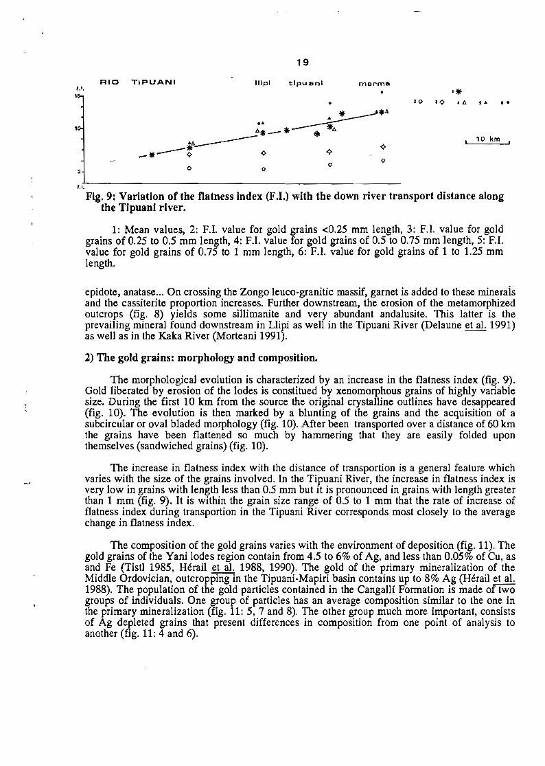
Fig. 9: Variation of the flatness index (F.I.) with the down river transport distance alongthe Tipuani river.
1: Mean values, 2: F.I. value for gold grains <0.25 mm length, 3: F.I. value for goldgrains of 0.25 to 0.5 mm length, 4: F.I. value for gold grains of 0.5 to 0.75 mm length, 5: El.value for gold grains of 0.75 to 1 mm length, 6: F.I. value for gold grains of 1 to 1.25 mmlength.
epidote, anatase... On crossing the Zongo leuco-granitie massif, gamet is added to these mineraIsand the cassiterite proportion increases. Further downstream, the erosion of the metamorphizedoutcrops (fig. 8) yields sorne sillimanite and very abundant andalusite. This latter is theprevailing mineraI found downstream in Llipi as weIl in the Tipuani River (Delaune et al. 1991)as weIl as in the Kaka River (Morteani 1991).
2) The gold grains: morphology and composition.
The morphologieal evolution is characterized by an increase in the flatness index (fig. 9).Gold liberated by erosion of the Iodes is constitued by xenomorphous grains of higWy variablesize. During the first 10 km from the source the original crystalline outlines have desappeared(fig. 10). The evolution is then marked by a blunting of the grains and the acquisition of asubcircular or oval bladed morphology (fig. 10). Mer been transported over a distance of 60 kmthe grains have been flattened so much by hammering that they are easily folded uponthemselves (sandwiehed grains) (fig. 10).
The increase in flatness index with the distance of transportion is a general feature whiehvaries with the size of the grains involved. In the Tipuani River, the increase in flatness index isvery low in grains with length less than 0.5 mm but it is pronounced in grains with length greaterthan 1 mm (fig. 9). It is within the grain size range of 0.5 to 1 mm that the rate of increase offlatness index during transportion in the Tipuani River corresponds most closely to the averagechange in flatness index.
The composition of the gold grains varies with the environment of deposition (fig. 11). Thegold grains of the Yani Iodes region contain from 4.5 to 6% of Ag, and less than 0.05% of Cu, asand Fe (Tistl 1985, Hérail et al. 1988, 1990). The gold of the primary mineralization of theMiddle Ordovician, outcropping in the Tipuani-Mapiri basin contains up to 8% Ag (Hérail et al.1988). The population of the gold particles contained in the Cangallf Formation is made of twogroups of individuals. One group of particles has an average composition similar to the one inthe primary mineralization (fig. 11: 5, 7 and 8). The other group much more important, consistsof Ag depleted grains that present differences in composition from one point of analysis toanother (fig. 11: 4 and 6).

20

21
Fig. 10: Morphology of the gold grains of the Tipuani valley.
+A and B: Gold grains from the quartz veins of the upper Ordovician. C: Flattened and
blunted gold grains from the aluvium of Tipuani area. D: Sandwiched gold grain from theweathered terrace of Paniagua (about 60 km of transport). E: Detail from D, in a: striae whichindicate a fluviatil transport. F: Detail from E; in the inner part of the striation marks createdduring transport crystalline outlines are revealed by corrosion during the stay in the weatheredprofile. Small neoformed crystals are present on the surface of the primary crystals revealedby the corrosion.
(Scale in micrometers).
%Au
85
90
95
100 1
'TERRACES Ihigh & middl.1
Fig. 11: Composition of the gold grains of Iodes of the Cordillera Real and of the placersof the Tipuani basin. Explanations in the text.
The gold grains, that are contained in the alluvia of the terraces of the Tipuani river, showvarying composition according to their position in the weathering profile. The grains 21 and 22(fig. 11) come from the bottom of a rniddle terrace of the Consata-Mapiri river, below theweathering profile. The composition of the core of grain 21 is comparable to that of the goldgrains of primary mineralizations of the Cordillera, whereas gold enriched rim is developed atthe periphery; grains 22 is much richer in gold and shows a marked zonation. Grains 23 and 24,coming from the most weathered alluvial of the same terrace level, have an average fineness ofmore than 990, without clear spatial composition differences, contrary to grain 25, collected in a

22
similar environment. Grains 26 and 27 come from the bottom of the oldest terrace and have beencollected below the weathering front; both grains have a high average fineness and show a clearrim effect, event when the composition of the core is very close to those of the gold grainscollected in the primary mineralization.
It appears that the most weathered alluvia of the terraces contain gold particles which showthe greatest depletion in silver as weIl as the clearest marks of corrosion (fig. 10). On the otherhand, below the level of weathering within the alluvials and also within the material of thepresent river beds, one observes gold grains with a great variety of Ag content.
An examination of gold grains collected from the present bed of Tipuani River shows thefollowing:
- The particles that have been collected upstream from outcrops of the Cangallf Formationand old terraces have the same composition as the gold grains of the primary mineralization (fig.11: 9, 10, 11). These particles do not show a silver depleted peripheral rim.
- The populations of particles that have been collected downstream from outcrops of theCangallf Formation and Quatemary alluvial terraces are very heterogeneous; they are formed bya mixture of individuaIs of different composition:
• Particles very poor in Ag. which present either a notable difference in compositionbetween the rim and the core (fig. 11: 15), or no marked difference in composition between theperiphery and the core (fig. 11: 14, 17 and 18).
• Particles (fig. 11: 19) that show strong variations of the Ag content, the core bearing acomposition similar to that of the primary mineralization. when the periphery is very rich in gold(fineness of about 999). This heterogeneity is also found on the scale of a sample such as thosethat have been collected in the Tipuani riverbed near Cangallf (fig. 11: 13 to 18).

23
REFERENCES
AHLFELD F.• 1946. Geologfa de Bolivia. Rev. Mus. La Plata (nueva ser.). sec Geol.. toma III.pp. 5-370. Buenos Aires.
AZEVEDO R.A. de. 1985. Estudio geol6gico-minero de la Rinconada. Tesis UMSA. 121p +anexos.
DELAUNE M.• FORNARI M.• HERAIL G.• VISCARRA G.• MIRANDA V., 1991. HeavymineraIs suites in the gold placers from the Cordillera Real and the Tipuani basin. Int.Symp. on Al. Gold Placers. Abstracts. 35-37.
FORNARI M .• HERAIL G .• vrSCARRA G.• LAUBACHER G. y ARGOLLO. J.• 1987.Sédimentation et structure du bassin de Tipuani-Mapiri: un témoin de l'évolution du frontamazonien des Andes du nord de la Bolivie. C. R. Acad. Sei. Paris. T 305 p. 1303-1308.
FREYDANCK H.G.• 1965. Los placeres auriferos al pie de la Cordillera Oriental de Bolivia. Inf.Ined. DANEGEO. 52 p.
FROCHOT M .• 1901. Les gisements de Tipuani. An. des Mines. ge ser.. 19.149-185.
HERAIL G.• ARGOLLO J.• FORNARI M .• LAUBACHER G. y vrSCARRA G.• 1986. Eldistrito de Tipuani. geologfa e historia. Chrysos. 1.2 p. 9-15.
HERAIL G.• FORNARI M .• vrSCARRA G.• LAUBACHER G. y ARGOLLO J.• 1987.Geodinâmica de una cuenca intramontana deI frente andino: la cuenca de Tipuani-Mapiri.X Congreso Geol6gico Argentino. Actas II. p. 93-96.
HERAIL G.. VISCARRA G.. 1988. El "Cauce Antiguo" deI do Tipuani: anâlisissedimentol6gico y tect6nico e implicaeiones para la prospecei6n minera. ORSTOM enBolivie. Informe n° 12. 14 P +2 mapas fuera de texto.
HERAIL G.• MIRANDA V.• FORNARI M.• 1988. Los placeres de oro de la regi6n de Mapiri ysus fuentes primarias. ORSTOM en Bolivia. Informe N° 16,30 p.
HERAIL G.• FORNARI M.• VISCARRA G., LAUBACHER G.• ARGOLLO J.. MIRANDA V.,1989. Geodynamic and gold distribution in the Tipuani-Mapiri Basin (Bolivia).Proceedings of the Intramontane Symposium on Intermontane Basins: Geology andResources. Chiang Mai. p. 342-352.
HERAIL G.• FORNARI M .• VISCARRA G.• MIRANDA V., 1990. Morphological and chemicalevolution of gold grains during the formatin of a polygenic fluviatile placer: the MioPleistocene Tipuani placer example (Andes. Bolivia). Chrono Rech. Min., 500, 41-49.
LAVENU A., 1986. Etude néotectonique de l'Altiplano et de la Cordillère Orientale des Andesboliviennes. Thèse Univ. Paris Sud. 434 p.
LAVENU A.• BONHOMME M .• VATIN-PERIGNON N.• DE PACHTERE P., 1989. Neogenemagmatism in the Bolivian Andes between 16° Sand 18° S: Stratigraphy and KlArgeochronology. J. of South Am. Earthe Sci., 2, 1, p. 34-47.
LEHMANN B.• 1979. Schichtgebundene Sn-Lagerstatten in der Cordillera Real/Bolivien. Berl.Geowss. Abh. (A), 14, 135 p.

24
MARTINEZ c., 1980. Géologie des Andes boliviennes. Structure et évolution de la chaînehercynienne et de la chaîne andine dans le nord de la Cordillère des Andes de Bolivie.Trav. Doc. ORSTOM, 119,352 p.
MORTEANI G., 1991. Grain size distribution and morphology of placer gold in the Rio Kakaarea, Bolivia. Its bearing on gravimetric concentration processes. Int. Symp. on AlI. GoldPlacers. 129-131.
REVILLA A., 1988. El distrito de Tipuani, geologfa e historia (parte III). Khrysos, 4, p. 6-16.
SEMPERE T., HERAIL G., OLLER J., 1988. Los aspectos estructurales y sedimentarios deIoroclino boliviano. V. Congr. GeoI. Chileno, A 127·A142.
SEMPERE T. HERAIL G., OLLER J., BONHOMME M., 1990. Late Oligocene-early Miocenetectonic crisis and related basins in Bolivia. Geology, 18, p. 946-949.
STOLL W.C., 1961. Tertiary channel gold deposits at Tipuani, Bolivia. Econ. GeoI. v. 56, p.1258-1264.
TISTL M., 1985. Die GoldlagerHitten der nordlichen Cordillera Real/Bolivien und ihrgeologischer Rahmen. Berliner Geowissenschaftliche Abhandlungen, Riehe NBand 65,93 p.
VISCARRA G., 1986. Geodinâmica y distribuci6n deI oro en una cuenca intramontana andina.Parte central de la Cuenca Cangallf: Regi6n de Tipuani-Mariapo. Tesis UMSA, 68 p. +anexos.
rJ4·
t,
.,..• ".~' ·",'r' .-,-. • •••'.- .•.• il -; ....••.• -~.y->~~."'•.
.. -.'. --r .. , ,~•.,- r_ ..~.. -"'::·_~.: --: ::~~~"V",,!,,.,...,~y~~'

Hérail Gérard, Viscarra G., Delaune Mireille
(collab.), Fornari Michel (collab.), Ramirez V.
(collab.), Tompson C. (collab.) (1991).
The gold placer of Tipuani : field guidebook,
June 9 to 11, 1991.
In : Symposium international sur les gisements
alluviaux d'or = International symposium on
alluvial gold placers = Simposio internacional
sobre yacimientos aluviales de oro. La Paz :
ORSTOM, 19 p.
Les Gisements Alluviaux d'Or : Symposium
International