Embed Size (px)
Citation preview

Community Development/Resource Agency
PLANNING SERVICES DIVISION
January 6, 2015 Placer County
Sheridan Community Plan

Prepared by:
Placer County Planning Services Division
Adopted by the Board of Supervisors:
January 6, 2015
Supercedes 1976 Sheridan General Plan

Acknowledgements Placer County Board of Supervisors Jack Duran, District 1 Robert M. Weygandt, District 2 Jim Holmes, District 3 Kirk Uhler, District 4 Jennifer Montgomery, District 5
Placer County Planning Commissioners Richard Roccucci, District 1 Ken Denio, District 2 Richard Johnson, District 3 Jeffrey Moss, District 4 Miner Gray III, District 5 Larry Sevison, At Large Wayne Nader, At Large
Sheridan Municipal Advisory Council Lee Bastien Adam Carpineta Jim Houck Turgay Ozcan Gene Whitehouse MAC Community Plan Subcommittee Joyce Brown Larry Brown Cindy Boyer Dave Davis Janet Davis Robin Davis Tom Davis Manuel Delgado Lynn Ference Curtis Ference Madeline Finch Pete Gonzalez Carl Greenhaw Teresa Griffith Brent Helm Jeanette Hicks Mark Hicks Lori Houck
MAC Subcommittee (con’t) Hal Irby Lindsay Irby Nancy Jennings Chris Ladeas Jonathan Lane Pamela Lane Philip Lane Johanna Lassaga Al Lassaga Jeana Lonzo Mary Mason Jim McMonagle Barbara Morrison John Murphy Lyla Ozcan Turk Ozcan Roger Patterson Vicki Patterson Linn Pickens Mike Pickens Lee Sampson John Schiedel Fran Schiedel Cathy Schmidt Joe Schmidt Elizabeth Sharp Johnny Sherfield Mennie Sherfield Brent Smith Meredith Smith Tim Smith Carol Starling Bob Steeg Douglas Stewart Pamela Thiers Chuck Wagner Pearl Wagner Jack Williams Penny Williams
Planning Services Division Michael J. Johnson, AICP; CDRA Director Loren Clark, Assistant CDRA Director Paul Thompson, Assistant CDRA Director EJ Ivaldi, Deputy Director of Planning Crystal Jacobsen, Supervising Planner Jen Byous, Senior Planner Christopher Schmidt, Senior Planner Kathi Heckert, Senior Board Commission Clerk Kally Kedinger-Cecil, Intern
Placer County Staff Joe Arsenith, Health and Human Services Dave Atkinson, Environmental Engineering Chris Brown, CDRA/GIS Andy Fisher, Parks Phil Frantz, Engineering and Surveying Andrew Gaber, Public Works Lindy Grey, Board of Supervisors Dave Harris, Placer County Sheriff Janelle Heinzler, Environmental Engineering Heather Knutson, Environmental Engineering Jennifer Merino, Board of Supervisors Debbie Poulsen, Museums Laura Rath, Environmental Health Karin Schwab, County Counsel Dave Snyder, Economic Development Kitty Thompson, CDRA
CalFire Jim Mathias, Battalion Chief
Caltrans Sam Jordan, P.E.
Placer County Air Pollution Control District Tom Thompson
Placer County Flood Control District Brian Keating
Western Placer Unified School District Kris Knutson Melissa Willis
Union Pacific Railroad Liisa L. Stark

Sheridan Community Plan TABLE OF CONTENTS
1. INTRODUCTION 1 1.1 Purpose of the Community Plan ...................................................................................... 2
1.2 Description of Study Area ................................................................................................. 4
1.3 Plan Update Process .......................................................................................................... 8
1.4 Community Priorities ....................................................................................................... 12
1.5 Community Vision ............................................................................................................ 16
1.6 Plan Assumptions ............................................................................................................. 16
1.7 General Community Goals and Policies ........................................................................ 18
1.8 Emerging Planning Issues................................................................................................ 22
2. POPULATION AND HOUSING 25 2.1 Population ......................................................................................................................... 25
2.2 Population Projection ...................................................................................................... 28
2.3 Housing .............................................................................................................................. 30 2.3.1 Housing Need ...................................................................................................... 34
3. LAND USE 37 3.1 Goals .................................................................................................................................. 38
3.2 Policies ............................................................................................................................... 39
3.3 Existing Conditions ........................................................................................................... 40
3.4 Land Use Districts ............................................................................................................. 41
3.4.1 Low-Density Residential (LDR) ............................................................................ 43 3.4.2 Medium-Density Residential (MDR) ..................................................................... 43 3.4.3 High-Density Residential (HDR) .......................................................................... 43 3.4.4 Rural Residential (RR) ......................................................................................... 43 3.4.5 Rural Estate (RE) ................................................................................................. 44 3.4.6 Agriculture/Timberland (AG) ................................................................................ 44 3.4.7 General Commercial (GC) ................................................................................... 45 3.4.8 Industrial (IND) ..................................................................................................... 45 3.4.9 Open Space (OS) ................................................................................................. 45
3.5 Zoning ................................................................................................................................ 48
3.6 Combining Districts .......................................................................................................... 50
3.6.1 Design Review (-Dc) ............................................................................................ 50 3.6.2 Town Center Commercial (-TC) ........................................................................... 51 3.6.2.1 Permitted Uses ................................................................................... 52 3.6.2.2 Live/Work Units .................................................................................. 54 3.6.2.3 Development Standards..................................................................... 55 3.6.3 Use Permit (-UP) .................................................................................................. 57 3.6.4 Agricultural (-AG) ................................................................................................. 57 3.6.5 Mineral Reserve (-MR) ......................................................................................... 58

TABLE OF CONTENTS Sheridan Community Plan
4. COMMUNITY DESIGN 59 4.1 Goals .................................................................................................................................. 63
4.2 Policies ............................................................................................................................... 64 4.2.1 Site Planning ........................................................................................................ 65 4.2.2 Highway Service District ...................................................................................... 66 4.2.3 Town Center Commercial District ........................................................................ 68 4.2.4 Residential Uses in Town Center District............................................................. 77 4.2.5 Business Park and Industrial Park Districts ......................................................... 82 4.2.6 Landscaping ......................................................................................................... 84 4.2.7 Parking ................................................................................................................. 85 4.2.8 Signs/Lighting ....................................................................................................... 87 4.2.9 Residential Design ............................................................................................... 88 4.2.10 Residential Subdivisions ...................................................................................... 91 4.2.11 Residential Subdivision Gating ............................................................................ 96 4.2.12 Secondary Dwelling Units .................................................................................... 97
5. NATURAL RESOURCES AND OPEN SPACE 99 5.1 Goals and Policies ............................................................................................................ 99
5.2 Sustainable Ecosystems ................................................................................................ 101
5.3 Conservation Planning .................................................................................................. 102
5.4 Fish and Wildlife ............................................................................................................. 104
5.5 Open Space/Natural Resource Areas .......................................................................... 107
5.6 Vegetation ....................................................................................................................... 108
5.7 Soils ............................................................................................................................... 111
5.8 Topography, Geology and Seismicity .......................................................................... 113
5.9 Hydrology ........................................................................................................................ 114
5.10 Floodplains ...................................................................................................................... 115
5.11 Groundwater .................................................................................................................. 116
5.12 Wetlands ......................................................................................................................... 116
5.13 Storm Water Management .......................................................................................... 116
5.14 Climate............................................................................................................................. 117
5.15 Air Quality ....................................................................................................................... 118
5.15.1 Goals and Policies ............................................................................................... 118
6. CULTURAL RESOURCES 121 6.1 Goal and Policies ............................................................................................................ 122
6.2 History of Sheridan ........................................................................................................ 122
6.3 Regulatory Framework .................................................................................................. 128
6.4 Cultural Resource Inventory ......................................................................................... 129
6.5 Preservation Incentives ................................................................................................. 133
6.5 Archeological Resources ............................................................................................... 135

Sheridan Community Plan TABLE OF CONTENTS
7. HEALTH AND SAFETY 137
7.1 Noise ................................................................................................................................ 137
7.1.1 Goals and Policies ................................................................................................. 142
7.2 Seismic Safety ................................................................................................................. 143 7.2.1 Goals and Policies ................................................................................................. 143
7.3 Fire Protection and Emergency Services .................................................................... 144
7.3.1 Goals and Policies ................................................................................................. 145
7.4 Flood Hazards ................................................................................................................. 147 7.4.1 Goals and Policies ................................................................................................. 147
8. CIRCULATION 151 8.1 Goals and Policies ......................................................................................................... 152
8.2 Complete Streets .......................................................................................................... 154
8.3 Existing Transportation System .................................................................................. 155
8.4 Existing Roadway Conditions ...................................................................................... 161
8.5 Alternative Transportation Systems .......................................................................... 162
8.6 Future Transportation System .................................................................................... 163
9. PARKS, RECREATION, AND TRAILS 167 9.1 Goals and Policies ......................................................................................................... 167
9.2 Existing Park Facilities .................................................................................................. 171
9.3 Potential Recreational Facilities ................................................................................. 173
9.4 Bikeways, Trails, and Pathways .................................................................................. 176
9.5 Bikeway, Trail, and Pathway Planning ....................................................................... 180
9.6 Bikeway, Trail, and Pathway Recommendations ..................................................... 182
9.7 Recreational Facility and Trail Funding ..................................................................... 185
10. PUBLIC SERVICES 187 10.1 Public Sanitary Sewer .................................................................................................. 188
10.1.1 Goals and Policies .......................................................................................... 188
10.2 Onsite Sewage Disposal ............................................................................................... 191 10.2.1 Goals and Policies .......................................................................................... 191
10.3 Water Service ................................................................................................................ 191
10.3.1 Goals and Policies .......................................................................................... 192
10.4 Schools ........................................................................................................................... 195 10.4.1 Goals and Policies .......................................................................................... 196
10.5 Law Enforcement Protection ...................................................................................... 197
10.5.1 Goals and Policies .......................................................................................... 197
10.6 Other Public Services ................................................................................................... 198 10.6.1 Library Services .............................................................................................. 198 10.6.2 Solid Waste/Recycling .................................................................................... 198 10.6.3 Other Utilities .................................................................................................. 199
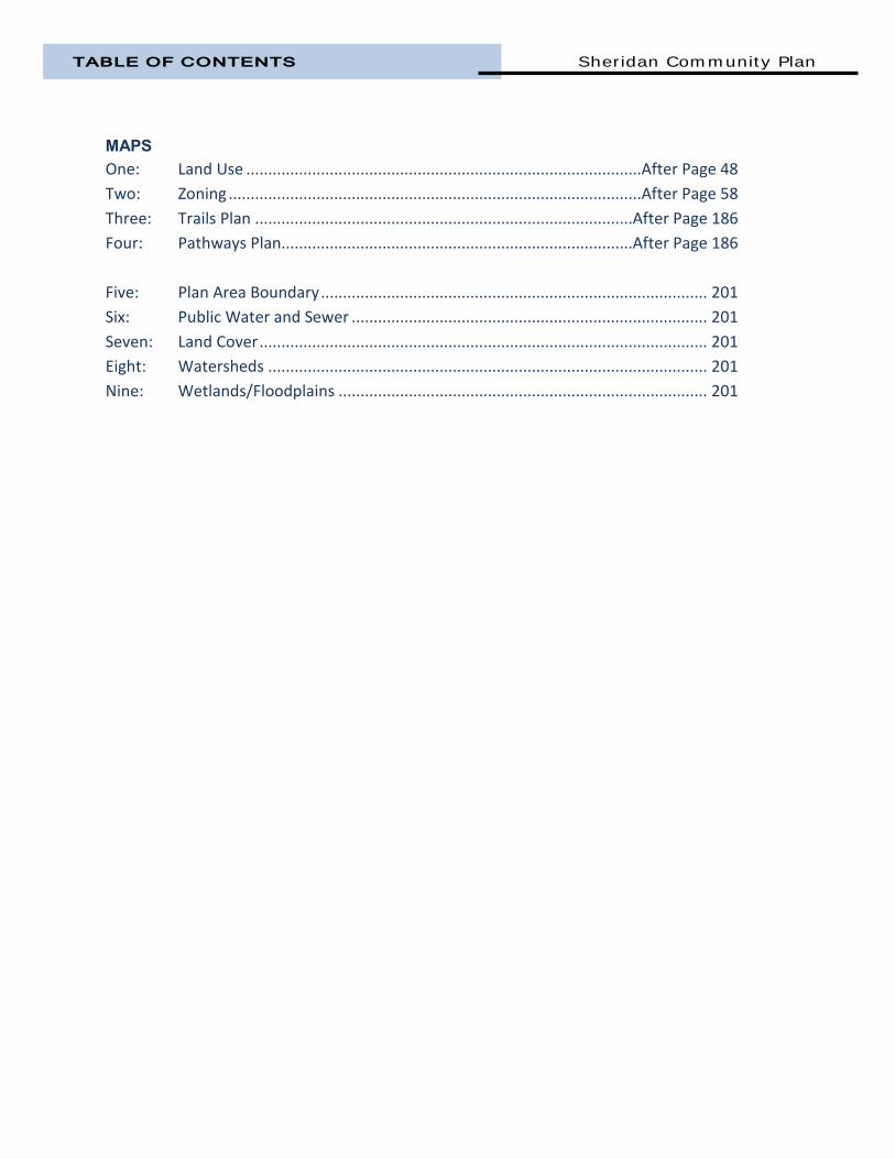
TABLE OF CONTENTS Sheridan Community Plan
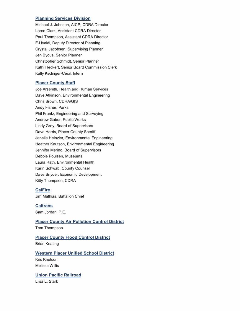
MAPS One: Land Use ..........................................................................................After Page 48
Two: Zoning ..............................................................................................After Page 58
Three: Trails Plan ......................................................................................After Page 186
Four: Pathways Plan................................................................................After Page 186
Five: Plan Area Boundary ........................................................................................ 201
Six: Public Water and Sewer ................................................................................. 201
Seven: Land Cover ...................................................................................................... 201
Eight: Watersheds .................................................................................................... 201
Nine: Wetlands/Floodplains .................................................................................... 201

CHAPTER ONE
INTRODUCTION


Sheridan Community Plan INTRODUCTION
Page | 1
1. Introduction The Sheridan General Plan, first adopted in 1976, set forth designated land uses and circulation patterns for growth and development of the community. It contained local policy direction to guide the community’s growth through 1990. Due to infrastructure constraints, there was minimal opportunity for development in the Community Plan area and the 1976 document had not been updated until this time. From an independent agricultural community to a major center of commerce serving the surrounding rural areas, to a residential satellite of Sacramento, Sheridan has gone through a number of growth phases which represent the community’s economic history and future. Recent infrastructure upgrades to allow for new development in Sheridan, the opening of the Highway 65 Bypass, and changing community desires attested to the need for a comprehensive update and reorganization of the Sheridan General Plan. This Sheridan Community Plan is a long-range vision and a land use strategy to guide growth and development of Sheridan through the year 2035. It is an attempt to capture the community’s aspirations and confront the challenges Sheridan faces. The purpose of the Community Plan is to give clear direction as to how physical development and land-use decisions should take place in Sheridan (also referred to as the “Plan area” throughout this document) to meet the current and future needs of its residents. It is also intended to reflect their collective aims and aspirations, as to the character of the area and the quality of life to be preserved and fostered within the community. The Plan also provides policy guidance to assist business interests in their decision to invest and grow in Sheridan. Finally, the Plan clarifies and assists in the delivery of public services. The Plan is developed based on an analysis of Sheridan’s physical and environmental conditions, and from extensive input from stakeholders, business owners, landowners and the community-at-large. This Plan consists of goals, objectives, policies, implementation measures, and design guidelines and standards to guide the Community’s development. It uses words, maps, and illustrations to describe the shared expectations for the types, location, and intensity of future development. Most importantly, the Community Plan, which is in compliance with the overall Placer County General Plan growth and development policies, ensures growth and development will be coordinated in an orderly manner. Upon adoption by the Placer County Board of Supervisors, this Plan replaced the original 1976 Sheridan General Plan.

INTRODUCTION Sheridan Community Plan
Page | 2
1.1 PURPOSE OF THE COMMUNITY PLAN The Sheridan Community Plan is the principal legislative tool for guiding future growth and
change in Sheridan. The Plan is an expression of the fundamental values and goals of the
community. It establishes directions for achieving a collective vision of what Sheridan should be.
As a community and region, we are in a time of significant change. Placer County is expected to
double in population over the next forty years. The way in which we manage the challenges of
population growth will be critical to the health and well-being of Sheridan.
This Community Plan is Sheridan’s second. The previous Community Plan was adopted in 1976
and was envisioned to manage growth through 1990. Although the 1976 Sheridan General Plan
allowed for a significant amount of new development around the townsite, infrastructure
constraints for public sewer and water limited the potential to accommodate the urban levels of
development contemplated at the time. Consequently, minimal growth has occurred.
Major reviews of the Community Plan document, typically undertaken every ten to twenty years,
recognize that circumstances can change, new issues can emerge, technology can advance, and
new information can surface. To remain relevant, a Community Plan needs to reflect and respect
what is important to the citizens of Sheridan.
While this Plan builds on the existing Community Plan and other planning documents, several
underlying principles have influenced its preparation. These include:
How to manage growth and change;
How to maximize the sustainable use and protection of resources;
How to provide transportation and mobility in a socially, economically and environmentally responsible way;
How to create a vibrant community; and,
How to integrate the interactions and outcomes of the various environmental, social and economic factors that shape Sheridan and the lives of its citizens.
This Plan is organized into a number of sections. The sections are linked by an overall policy and
action framework founded on the underlying principles of sustainability and livability. The Plan
includes:
A vision for the future;
The planning context;
Planning for environmental integrity in both the natural and built environment;
Planning for social well-being to meet basic needs and strengthening the community; and,
Planning for economic vibrancy.

Sheridan Community Plan INTRODUCTION
Page | 3
It is important to continually examine the trends and influences that are shaping and affecting
the community and to develop strategies that can influence, adapt to, and take advantage of
opportunities as they arise.
Community planning in Sheridan is undertaken in the context of local circumstances. Physical
and biological attributes, history, socio and economic trends, legislative requirements, and
regional priorities are considered.
Relevant Plans Affecting Sheridan The Sheridan Community
Plan must be consistent
with a hierarchy of policy
initiatives and legislation
at the state level. Goals
and policies found in
various planning
documents, most
importantly the Placer
County General Plan and
the 1976 Sheridan General
Plan, have been consulted
when preparing this Plan.
Policies and plans of
jurisdictions in proximity
to Sheridan such as Yuba
County and the cities of Lincoln and Wheatland provide additional information that has helped
guide this planning document as well.
Placer County General Plan
The Placer County General Plan (May 2013) provides specific goals, policies, and programs for
countywide development with which the Sheridan Community Plan as well as other community
plans throughout the county must comply. The Sheridan Community Plan policies are consistent
with the Placer County General Plan.
Placer County Design Guidelines/Placer County Rural Design Guidelines
The Design Guideline manuals are documents which can be used by developers, County staff and
others in working toward better design of the built environment. They establish design standards
which give the County and private property owners a tool to achieve the highest architectural,
functional, and environmental quality.
Figure 1.1.1: A number of planning documents feed into the Community Plan.
INTRODUCTION Sheridan Community Plan
Page | 4
Regional Transportation Plan
The Placer County 2035 Regional Transportation Plan (RTP) was developed in 2010 by the Placer
County Transportation Planning Agency. The 2035 RTP provides a clear vision of the Placer
region’s transportation goals, objectives, and policies and guides the long-range planning and
development of transportation projects within the Plan’s horizon.
Placer County Regional Bikeway Plan
The Placer County Regional Bikeway Plan was adopted by the Board of Supervisors in 2002 to
provide for a regional system of bikeways for transportation and recreation purposes. The focus
of the plan is on regional connectors and key routes providing access to activity centers such as
employment, shopping, schools, and public facilities such as parks and libraries.
1.2 DESCRIPTION OF THE STUDY AREA The Sheridan Community Plan
includes an area of 13,780 acres or
21.5 square miles. The boundaries
generally are the Bear River/Yuba
County to the north, Sutter County
on the west, Karchner Road on the
east, and Waltz and Nader roads
on the south. The area is located
1.27 miles north of the City of
Lincoln.
Sheridan has historically been a
trading point for farmers and
ranchers. Sheridan was first
settled in 1855 by E.C. (Eugene)
Rogers and was originally called “Union Shed” or simply “Shed.” It was at the “Shed” that wagon
teams laid in supplies to last during their journeys. The settlement became a market place and
town site at which the farmers of the area congregated for the purpose of selling their wheat,
oats and barley.
Sheridan greeted its first train from Sacramento, via Junction (now Roseville) and Lincoln in 1866.
A post office was established on July 10, 1868. The post office and town needed a name.
“Sheridan” was chosen in honor of Union General Philip Sheridan of Civil War fame. By 1869 the
town had been laid out in blocks, streets and lots and the surrounding agricultural areas
continued to flourish.
Figure 1.2.1: Historical market located on 13th Street near “H’ Street.

Sheridan Community Plan INTRODUCTION
Page | 5
On August 25, 1891, nearly the entirety of Sheridan’s business district burned down. Sheridan’s
promising future took a turn. Many of the businesses chose to relocate to Lincoln which was
burgeoning at the time.
In the late 1950’s a disease called ‘pear decline’ virtually brought the local fruit industry to a halt.
Pear decline and the ability of the large Central Valley farms to produce higher yields than the
small ranches in Placer County also contributed to the demise of Placer’s once thriving fruit
industry.
During the years following the decline of the fruit industry, the county supported an important
dairy industry with many of the county’s fruit ranches being converted to dairies. By 1961,
population in the town was approximately 250. According to published accounts, Sheridan at the
time had one general store, the post office, a hardware store, two gas stations with garages, one
second-hand store, one tavern, an old vacant warehouse, a modern school, three churches, one
turkey ranch, a roadside seasonal market, many old houses, cabins, and several new homes.
Sheridan’s growth mirrored the
growth of Placer County and other
Sacramento suburbs since 1970.
In particular, the construction of
public wells, a water distribution
system, sewage collection system,
and two wastewater treatment
ponds in 1973 led to a ‘boom’ in
home construction within the
townsite. Between 1970 and
1979, 52 residences were
constructed within the 1976
General Plan area’s boundaries.
That increased to 71 residences
constructed in the 1980-89 period
and 35 residences built since 1990. Until early 2012, there was a moratorium on new sewer
connections within the Sheridan townsite due to constraints at the waste water treatment plant.
Outside of the townsite there was a spurt in construction that started in the late 1980’s and
continued until the real estate market softened in 2007.
According to the 2010 Census, the Plan area’s population was 1,172 people. Over the past
several decades, growth in the Sacramento region, especially employment growth and housing
development, has been concentrated in south Placer County. Sheridan is well-located in this
context.
Figure 1.2.2: Homes in the townsite are typically on 50’ to 65’ lots.
INTRODUCTION Sheridan Community Plan
Page | 6
The Sacramento area has been one of the fastest growing regions in California. According to the
U.S. Census, the population of the Sacramento region (Placer, Sacramento, El Dorado and Yolo
counties) grew twice as fast as the rest of the state during the 2000-2010 period, adding 350,000
residents, an increase of 20 percent. As of April 1, 2010, the population of the Sacramento region
stood at 2.3 million. Placer County’s population was 348,432, growing nearly 40 percent since
2000, the second-highest growth rate in the state behind Riverside County. Forecasts completed
by the Sacramento Area Council of Governments show the Sacramento region growing to 3.35
million persons in 2035.
Residents have access to economic opportunities, jobs and services. Sheridan is close to
employment centers in Lincoln, Rocklin, Roseville, Marysville, and Sacramento. The access to
Highway 65, proximity to I-80, and proximity to more developed cities makes Sheridan attractive
to commuters. It offers a rural lifestyle characterized by the predominance of large lots outside
of the townsite, limited commercial development, affordable housing, high-quality schools, a
gateway to Camp Far West, and the prevalence of small agricultural and animal raising uses.
More affordable housing, at least during the recent boom period, made communities at the edge
of the Sacramento region grow at a faster pace than their metropolitan area as a whole.
However, infrastructure constraints and the large parcel size requirements in the rural portions of
the Community Plan area limited the amount of growth in Sheridan compared to surrounding
communities.
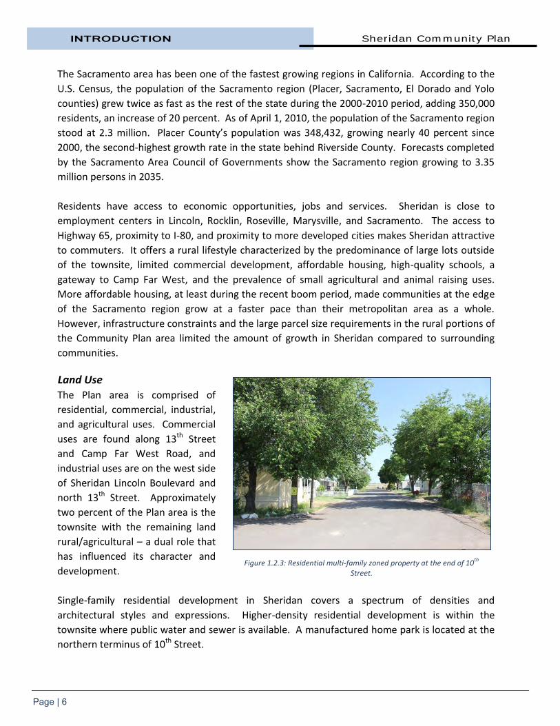
Land Use
The Plan area is comprised of
residential, commercial, industrial,
and agricultural uses. Commercial
uses are found along 13th Street
and Camp Far West Road, and
industrial uses are on the west side
of Sheridan Lincoln Boulevard and
north 13th Street. Approximately
two percent of the Plan area is the
townsite with the remaining land
rural/agricultural – a dual role that
has influenced its character and
development.
Single-family residential development in Sheridan covers a spectrum of densities and
architectural styles and expressions. Higher-density residential development is within the
townsite where public water and sewer is available. A manufactured home park is located at the
northern terminus of 10th Street.
Figure 1.2.3: Residential multi-family zoned property at the end of 10th
Street.

Sheridan Community Plan INTRODUCTION
Page | 7
The grid pattern of development that has defined the townsite is somewhat unique in Placer
County in that alleyways are used. However, the alleys aren’t utilized as in other communities.
There are few if any garages with access off the alley right-of-way. Car parking and driveways are
typically located at the front of the lots.
Large lot rural residential and agricultural uses surround the townsite. The land adjacent to the
new Highway 65/Riosa Road intersection is zoned Farming or Industrial. Much of this property is
owned by CALTRANS.
There are numerous vacant
parcels in the Plan area, many
used for farming or conservation
purposes, and 19 within the
townsite are available for
immediate development. Other
parcels have been developed at
less than permitted density and
could support additional
residential units without a land use
change.
Sheridan Lincoln Boulevard and
the Union Pacific Railroad rail line parallel each other running in a northwesterly direction
through the Community Plan area. Major roads in the Plan area are Riosa Road that runs east-
west and Camp Far West Road that originates in Sheridan and heads north before turning to the
east along the Bear River. Highway 65 connects to Interstate 80 to the south in Roseville and to
Highway 99 which heads north along the east side of the Sacramento Valley connecting to
Interstate 5 in Red Bluff. Terrain
The Plan area is characterized by gently rolling hills, ranging in elevation from 70 feet to 443 feet
above sea level.
Climate
Climatic conditions have played a significant role in the area's attractiveness as a place to live.
The Mediterranean climate is generally characterized by warm summers and mild winters.
Monthly averages of daily extreme temperatures range from 33°F minimum to 52°F maximum in
January to 58°F and 97°F in July. The annual rate of precipitation is approximately 20 to 25
inches. Approximately 90 percent of average annual rainfall occurs in the six-month period
extending from November to April. Prevailing winds are moderate and vary from moist clean
breezes from the south to drier winds from the north.
Figure 1.2.4: 13th
and H streets in the townsite.

INTRODUCTION Sheridan Community Plan
Page | 8
Vegetation
Vegetative cover in the Plan area includes very little natural type cover in the west to dense oak
woodlands in the east. The townsite has many tall Eucalyptus trees that have been planted for
shade. Outside of the townsite, the Plan area has a long history of agricultural use and related
activities including row crops, orchards and grazing. Grassland was likely always the dominant
vegetation community.
Local plant communities are varied and include typically ruderal annual grasses and forbs in range
lands and pastures, croplands or orchards, lawns and scattered native or non-native trees in
landscaped areas, vernal pools, and smaller areas of emergent or scrub shrub wetlands and
creeks.
Fish and Wildlife
Sheridan, with its rural residential and agricultural character, offers a natural wildlife habitat that
is rich and varied. Marsh complexes, annual grasslands, vernal pool complexes, orchards and
croplands support diverse natural communities of animals, birds, amphibians and reptiles
including numerous game species and migratory bird species.
Yankee Slough, south and east of the Plan area, supports a primarily introduced fishery including
mosquito fish, green sunfish, carp and bigscale logperch.
Existing agriculture and undeveloped areas in the Plan area provide potential habitat for species
identified as sensitive or special status by the California Department of Fish and Wildlife and the
U.S. Fish and Wildlife Service. Examples include northwestern pond turtle, giant garter snake,
northern harrier, Swainson’s hawk, loggerhead shrike, bank swallow, Conservancy fairy shrimp,
vernal pool fairy shrimp and western spadefoot toad.
1.3 PLAN UPDATE PROCESS The Sheridan Community Plan is the result of a collaborative consensus building process involving
the citizens of Sheridan, a Sheridan Municipal Advisory Council (MAC) Subcommittee Working
Group, Placer County staff, and various local agencies. The Sheridan MAC encouraged a high
level of public participation in the Community Plan update process in an effort to develop a
community consensus on hopes and expectations for the future of Sheridan.
The community considered the crucial issues confronting Sheridan. It built upon past planning
efforts, provided new technical information and analysis, and created multiple opportunities for
public input and guidance. A timeline of major activities can be found below.
On April 10, 2012, the Planning Services Division received preliminary direction from the Board of
Supervisors to explore options for an update to the Sheridan General Plan including modification

Sheridan Community Plan INTRODUCTION
Page | 9
of the Plan area’s boundary and studying the potential of relocating the Placer County
Fairgrounds Facility into the Sheridan area.
On April 11, 2012, County staff attended the Sheridan Municipal Advisory Council meeting to
outline to the MAC and the community the options under consideration and a draft timeline of
the update process.
The Placer County Board of Supervisors authorized Staff to update the Sheridan General Plan on
November 6, 2012. A two year work program with a strong public outreach effort was proposed
and approved. Immediately thereafter, a four page community survey was mailed to 436
property owners within the Sheridan MAC boundary area.
On November 28, 2012, a kick-off workshop was held at Stewart Hall in Sheridan with over 90
residents in attendance. Notice for the meeting was included in the community surveys mailed
to MAC-area property owners earlier in the month. Placer County planners and others were on
hand to explain the update process and hear initial public comments. Citizens also had the
opportunity to discuss with County staff any matters of importance related to the future of
Sheridan. Staff conducted a scenario planning exercise with break out groups to identify the best
areas to preserve and the most appropriate lands to develop and to answer the following
questions:
Does the community want the Community Plan area to expand?
What does your ideal future community look like?
Does the community want a Sheridan site to be considered for a Placer County
Fairgrounds relocation?
A Sheridan MAC subcommittee was formed to work with County staff to review proposed goals
and policies and updates to the 1976 General Plan document. The subcommittee consisted of
two MAC members and anyone from the public that wished to attend the monthly meetings. A
total of nine meetings were held, the first on December 19, 2012.
Based on input from this survey and community workshops, the Sheridan MAC Subcommittee
Working Group drafted a vision statement that formed the foundation of the Community Plan’s
goals and policies.
The Community Plan update process included an opportunities and constraints analysis. The
Placer County Planning Services Division and other departments reviewed relevant data and
prepared a Background Report that was released in December 2012.
The Background Report included an inventory of existing land uses, identification of vacant
parcels and development opportunities, existing conservation easements, and Williamson Act

INTRODUCTION Sheridan Community Plan
Page | 10
contract parcels. This analysis also identified existing and potential circulation corridors,
pedestrian and bicycle corridors, and areas subject to circulation conflicts.
A list of challenges was identified during the early stages of the Community Plan process and
strategies to overcome those challenges. These strategies form the foundation of the Plan’s
objectives, policies, implementation measures, and design guidelines and standards.
Expansion of Plan Area Boundary One of the items addressed by the Sheridan Subcommittee Working Group early on was the
question on whether to expand the Plan area boundaries. Community plans are often used by
municipalities to plan the future of a particular area at a finer level of detail than that provided by
the general plan. A community plan is a portion of the General Plan focusing on the issues
pertinent to a particular area or community within a city or county. It supplements the policies of
the General Plan, but may diverge from the issues contained in the General Plan into other
subjects viewed by the community as being of relevance.
The 1976 Sheridan General Plan included an area of 1,711 acres or 2.67 square miles. The
boundaries generally were Alder Lane to the north, the Highway 65 Bypass on the west,
Andressen Road to the east, and an unnamed tributary to Yankee Slough to the south.
The Subcommittee Working Group
debated the merits of keeping the
1976 General Plan area boundaries
as-is, expanding the boundary to
the west, expanding to include the
current Sheridan Municipal
Advisory Council boundary or a
hybrid expansion of the options
that were presented. Twenty-nine
Subcommittee members voted on
January 16, 2013 to recommend
that the plan area boundaries
expand to the MAC boundary,
minus the joint MAC area (24 in
favor of the MAC boundary, five
votes for other options. See Figure
1.3.1).
It was later decided that the Sheridan Community Plan should also include 1,178 acres owned by
the United Auburn Indian Community of the Auburn Rancheria between Karchner and Camp Far
Figure 1.3.1: Subcommittee voting results on Plan area expansion.

Sheridan Community Plan INTRODUCTION
Page | 11
West roads. These ten properties are within the “Joint MAC Area” that is represented by both
the Rural Lincoln MAC and the Sheridan MAC. Prior to adoption of the Community Plan, the
United Auburn Indian Community requested that their 1,178 acres not be included in the Plan
area and was removed.
New plan area boundaries are Bear River/Yuba County to the north, Sutter County to the west,
Waltz Road to the south, and generally Karchner Road to the east. It encompasses a total area of
13,780 acres.
Land Use Changes
During the planning process, Sheridan’s existing character as a predominately rural residential
community with smaller, distinct nodes of commercial and industrial uses was acknowledged and
then chosen for its future growth pattern. Therefore, minimal land use and zoning changes were
made as part of the Community Plan update.
Infill residential development is anticipated within the townsite to take advantage of existing
water and sewer capacity. There is also capacity for further residential development on larger
parcels outside of the townsite under current zoning that continues existing density patterns.
Changes have been made to allow for a mix of uses along 13th Street. A Highway Service zone
has been created at Riosa Road and Sheridan Lincoln Boulevard to provide commercial uses for
the convenience of Plan area residents and travelers along Highway 65. Further rezoning allows
additional business and industrial uses along Wind Flower Place.
Environmental Review During the Sheridan Community Plan preparation, an environmental analysis was undertaken to
identify potential environmental effects and allow for plan modifications, which either mitigated
or avoided potential environmental effects. The intent was to minimize the Plan’s environmental
effects while providing realistic Community growth and development opportunities. The
Sheridan Community Plan Initial Study and Negative Declaration (SCH #2013122066) analyzed the
potential environmental effects of the Community Plan and responded to potential
environmental issues.
By engaging in multiple phases of environmental analysis during the Community Plan process,
solutions to environmental issues in the form of policies, implementation measures, zoning
designations, and design standards have been woven into the fabric of the Sheridan Community
Plan. As such, a number of policies, implementation measures and design standards in this
Community Plan serve a dual purpose of implementing the Plan, as well as avoiding potential
environmental effects. These policies, implementation measures, zoning designations, and
design standards have been incorporated into this Plan to mitigate or avoid environmental effects
that might otherwise result from implementing the Community Plan.

INTRODUCTION Sheridan Community Plan
Page | 12
1.4 COMMUNITY PRIORITIES This Plan reflects the Community’s priorities of promoting balanced growth, and an overall vision
for Sheridan’s future. As a statement of the Sheridan’s priorities and vision, this Community Plan
serves as a guide for directing and coordinating planning decisions, and guiding physical changes
within the Plan area. As a guide for directing and coordinating Sheridan’s future, this Plan also
defines the desired character and quality of development, as well as directing the process for
how development should proceed. The goals, objectives, policies and implementation measures
in this Community Plan define the manner in which Sheridan’s priorities and vision are to be
achieved.
This section summarizes the key directions that the community has said it wants Sheridan to go in
the foreseeable future. Taken together, these directions constitute the vision inherent in this
Plan. Although the Community Plan consists of distinctive elements, these key directions
highlight the principal shared themes found in subsequent chapters. These directions arise from
public sentiment expressed in the Community Survey results, at the kick-off workshop, and the
deliberations of the MAC Subcommittee Working Group.
0
10
20
30
40
50
60
70
80
Tota
l Vo
tes
Identify the Types of Development That Should be Encouraged
4th Choice
3rd Choice
2nd Choice
Top Choice
Figure 1.4.1: Survey respondent’s priorities for Sheridan development.

Sheridan Community Plan INTRODUCTION
Page | 13
Community Survey A community survey was released in early November 2012 to gather input and provide a
participation method for those uncomfortable with public meetings or unable to attend the
workshop. It was mailed to all 436 property owners within the MAC boundary area. The survey
was also available on the County website. 97 surveys, or 22.2 percent, were returned.
County staff compiled and organized survey results to reveal trends and levels of support for
various policy directions.
The key question in the survey asked community residents to identify the types of development
they would most like to encourage in Sheridan. Respondents were asked to rank their top four
choices. The results are found in Figure 1.4.1.
Developing the existing townsite was identified as the top choice by survey respondents,
followed by allowing highway services along the new Highway 65, redevelopment of 13th Street
and encouraging new housing. Arts and Cultural facilities, affordable housing and encouraging
small housing units received the fewest votes.
Respondents were also given the opportunity to provide additional comments. The most
frequent issues noted by respondents involved law enforcement and marijuana growing. Other
repeated comments included a desire to clean-up blighted properties, maintain Sheridan’s rural
lifestyle, and a need for more sidewalks and curbs.
A vast majority of respondents felt that more visually attractive streets (i.e. street trees,
landscaping, and lighting) was the most needed improvement in Sheridan. Other top issues
voiced by residents included better sidewalks, nicer looking/higher quality commercial buildings,
and more/better shops and restaurants.
Community Kick-off Meeting On November 28, 2012, a Community Plan update kick-off meeting was held at Stewart Hall.
County staff was present at the meeting to explain the update process and receive public
comment. Property owners, residents, and all other interested parties were invited to attend and
given an opportunity to discuss the community’s goals and priorities.
After the general discussion, a breakout session was held where five smaller groups were asked
to discuss:
Their vision for Sheridan;
Whether the Plan area boundary should change;
Possible land use changes; and,
The potential for a Sheridan location for a relocated Placer County Fairgrounds.

INTRODUCTION Sheridan Community Plan
Page | 14
Facilitators at each table took notes and there were consistent themes and comments received
including:
“Keep it Rural”
“Retain Small Town Community Feel”
“Preserve Open Space”
“No Land Use Changes Outside of Townsite”
There was minimal support to relocate the fairgrounds to Sheridan. Residents expressed a desire
for additional services and shopping, and more streetlights and sidewalks. Residents did not
think Sheridan needed additional low-income or multi-family housing.
Residents were concerned about the visual appearance of Sheridan, including vacant buildings,
overgrown lots, unattractive storage on residential lots, and unregistered cars. Other feedback
included:
Infill development in townsite was seen as a positive
Small “tweaks” to land use should be considered
Redevelopment of 13th Street is a priority
General support for highway services at new Highway 65/Riosa Road interchange
Current residents should not pay for new growth
Key Directions for the Community The Subcommittee Working Group felt the workshops and surveys, based upon participation
rates, were a good starting point for establishing community direction, and therefore utilized
these results to draft the Community Plan’s vision, goals, objectives, policies and actions.
Key Directions for the Community Maintain Sheridan’s existing community character
Encourage infill development in the townsite
Protect agricultural uses and open space
Provide community services to meet the needs of all residents
Diversify and expand the economic base
Maintain Sheridan’s Existing Community Character
The residents of Sheridan have a strong interest in maintaining the character of their community
for years to come. The foremost priority heard during the workshop and gleaned from the

Sheridan Community Plan INTRODUCTION
Page | 15
Community Survey was to preserve Sheridan’s existing rural community character. The
preservation of Sheridan’s community character will require a variety of different approaches,
including protecting and promoting adaptive reuse of existing buildings, focusing development in
already-developed areas, creating design standards that ensure new development is in accord
with existing neighborhood character, protecting critical agricultural and habitat lands, and
promoting the local agricultural economy.
As part of retaining existing community character, Sheridan’s historic resources should be
protected. Historic preservation can play an important role in revitalizing an older community,
building civic pride, and retaining the sense of place and continuity with the community’s past.
Encourage Infill Development in the Townsite
The townsite should be a focus for the community’s economic life, vigor, educational, and social
activity. Vitality in the townsite can be pursued through a variety of initiatives, including infill
housing development, strategic expansion of the townsite grid, economic investment, promotion
of appropriate commercial development, and improvements to the public realm (i.e. parks and
streetscapes).
Protect Agricultural Uses and Open Space
Perhaps the most significant themes that surfaced throughout the update process is the need to
protect Sheridan’s open spaces, farmland, scenic vistas, and environmentally sensitive areas. As
with many communities in the region and Central Valley, any outward expansion translates into
the loss of productive farmland. To avoid expansion into productive farmland, the Sheridan
Community Plan increases development opportunities within the central core of the community,
and steers growth away from agricultural and rural areas by leaving existing large-lot zoning in
place.
Provide Community Services and Housing Choices to Meet the Needs of all Residents
Sheridan is a diverse community in terms of age, income, and education. Sheridan’s services,
facilities, and housing must keep pace with the population’s changing needs, including
maintaining its existing elementary school, public works and recreation facilities, providing a mix
of housing types, and providing critical support services such as police protection, fire, and health
clinics.
Diversify and Expand the Economic Base
Sheridan should pursue policies and regulations that encourage diversification and expansion of
its economic base in a manner consistent with the community’s character and desires. This will
generate benefits for the community, create more private sector job opportunities for residents,
and reduce the need for residents to travel for goods and services.

INTRODUCTION Sheridan Community Plan
Page | 16
1.5 COMMUNITY VISION The heart of the Community Plan, the Vision Statement, describes what the community seeks to
become; it gives the Plan a purpose and provides a foundation for change that is shared by
residents, homeowners, developers, business owners, elected officials, and County departments.
A vision statement captures what community members most value about their community, and
the shared image of what they want their community to be. It inspires community members to
work together to achieve the vision. A thoughtful vision statement is one of the elements needed
to form a forward-looking strategic framework that gives stakeholders the long-term-
comprehensive perspective necessary to make rational and disciplined tactical/incremental
decisions on community issues as they arise.
The Vision Statement is based on public input received at the November 28, 2012 public kick-off
meeting, results of the November 2012 community survey, and discussion at the first
subcommittee meeting on December 19, 2012. The following was approved by the
Subcommittee Working Group on January 16, 2013:
“Maintain the rural, small-town character of Sheridan by
managing growth, revitalizing the existing townsite, striving for
high-quality aesthetics, and providing for community development
needs to enhance the quality of life for current and future
residents.”
1.6 PLAN ASSUMPTIONS Plan assumptions, along with the goals and policies, form the foundation of any community
plan. Plan assumptions are statements of anticipated facts and trends based on the current
observations projected into the future. These assumptions provide a basis for planning
recommendations and give direction to future interpretations of the plan.
The following are the assumptions for the Sheridan Community Plan:
1. Residents of the Sheridan area locate here primarily because of the rural
surroundings and ancestral residences. Sheridan will remain a rural community
providing limited services for the residents and adjacent agricultural areas.
2. Population within the Sheridan planning area will continue to grow at a slower
rate than other parts of Placer County. The maximum overall build-out of the
Community Plan cannot exceed 7,187 residents based on current zoning and
infrastructure constraints.

Sheridan Community Plan INTRODUCTION
Page | 17
3. Redevelopment and reuse of vacant or underutilized property along the 13th
Street frontage will provide for an increase in small, neighborhood-type
commercial activities. This increase in commercial activities should not,
however, substantially affect the population growth through increased
employment. Therefore many residents’ needs for employment, and goods and
services will continue to be met through outlets and facilities in other parts of
the region.
4. The primary residential unit will continue to be the single family dwelling
constructed on both residential lots and larger agricultural acreage.
5. The need to protect and conserve agricultural lands and open space will
increase with a growing population. Land surrounding the Sheridan community
will be kept in open space/agriculture uses which will be consistent with the
proposed Placer County Conservation Plan (PCCP).
6. Existing water and wastewater infrastructure within Sheridan has limited
capacity to support existing zoning and therefore may need to be expanded
within the planning period.
7. Growth in the rural areas will be limited by sewer and water system capacities
and the agricultural lands which surround them.
8. The Sheridan Community Plan update process shall consider land use
alternatives separately from land ownership and tenure.
9. Land use around the Highway 65 Bypass could provide limited opportunities for
services.
10. Land use designations for “higher density” residential housing will occur within
or adjacent to the existing town site and where public services and utilities are
available.
11. The primary means of transportation through the year 2035 will be the
automobile. However, strong efforts will be made to encourage the use of
other non-auto forms of transportation such as walking and cycling and
studying ways to bring public transit into the Plan area.
12. Other than the planned Highway 65 Wheatland Bypass, new significant
roadways will not be necessary before the year 2035.
13. Continuing growth will be predicated on the provision of adequate supporting
infrastructure including roads, water, wastewater, schools and other public
services. It is the purpose of this plan to ensure that continuing growth will not
be detrimental to existing development service levels.

INTRODUCTION Sheridan Community Plan
Page | 18
1.7 GENERAL COMMUNITY GOALS AND POLICIES This Plan includes the goals, policies, standards, implementation programs, and the Land Use Diagram and Circulation Plan Diagram, which together constitute Placer County’s formal policies for land use, development, and environmental quality within the Plan area. The following definitions describe the nature of the statements of goals, policies, standards and implementation programs. They represent a common hierarchy of planning principles – going from the most general to the most specific.
Goal – an ultimate purpose of an effort stated in a way that is general in nature and immeasurable. It is a future result toward which planning and implementation measures are directed.
Policy – a specific statement that guides decision-making and indicates a commitment to a particular course of action. A policy is based on and helps implement a goal.
Standard – a specific, often quantified guideline, incorporated in a policy or implementation program, defining the relationship between two or more variables. Standards can often translate directly into regulatory controls.
Implementation Strategy or Implementation Program – the most specific of planning principles. It describes specific actions, programs, techniques or implementation measures that carry out a Plan policy.
Within this document, the following terms are used in reference to expected compliance of this plan. These terms are intended to have the following meaning with respect to compliance:
May, Encourage, or Recommend – it is desirable to comply with this guideline.
Should – it is highly encouraged and requires a convincing reason in order not to comply, in the opinion of the County, with this guideline.
Must or Shall – compliance is expected.
Figure 1.7.1: Hierarchy of Planning Principles.

Sheridan Community Plan INTRODUCTION
Page | 19
Goals and Policies
The goals described below are general in nature and basic to the entire Plan. Goals and policies related to specific aspects of the Plan are stated in other appropriate sections.
1. Promote the wise, efficient, and environmentally-sensitive use of land in Sheridan to
help meet the present and future needs of residents and businesses.
1.1 Provide transitional land uses or a landscaped buffer wherever necessary to
minimize the conflicts inherent to adjoining properties of different zoning
intensity, density, or adverse uses.
1.2 The County shall require that significant natural, open space, and cultural
resources be identified in advance of development and incorporated into site-
specific development project design.
1.3 Higher density development should be located within or adjacent to the
townsite where public infrastructure and services may be provided.
2. Create a balanced land use
pattern with an appropriate
mix of uses to accommodate
the rural lifestyle, resident
employment, service, and
social needs within Sheridan.
2.1 Implement land use
regulations that can
help broaden the tax
base while avoiding
inappropriate
businesses, big boxes,
heavy industry, etc.
2.2 Through the development review process, ensure that commercial and
industrial activities are compatible with surrounding land uses in terms of
visual appearance, traffic generation, noise, and air quality effects.
2.3 Encourage land uses and a development pattern which accommodates and
promotes alternative transportation modes.
2.4 Encourage a mix of housing choices that support a range of lifestyles in the
community, ranging from higher density within the townsite to larger parcels
in the more rural areas on the fringes of the Plan area.
Figure 1.7.2: Grasslands and vernal pools outside of the townsite.
INTRODUCTION Sheridan Community Plan
Page | 20
3. Take full advantage of Sheridan’s existing infrastructure.
3.1 Infill projects within the townsite and development that is contiguous to
existing development and that allows for cost-effective, orderly growth that is
compatible with existing land uses and potential future development is
favored.
3.2 New development shall emulate the best characteristics (e.g., form, scale and
general character) of existing adjacent neighborhoods.
3.3 New development shall provide appropriate infrastructure and meet County
service standards.
3.4 Enhance existing parks and recreation facilities to ensure that the
community’s current and future recreational needs are met.
4. Promote economic vitality through attracting commercial enterprises such as
neighborhood retail, restaurants, and services to Sheridan.
4.1 Provide highway commercial along Highway 65 to provide services for the
travelling public and residents of the Plan area without being a detriment to
the existing community. Commercial development should be centered at the
Riosa Road/Highway 65 intersection and not strung along the highway.
4.2 Support the development of mixed-use residential, commercial, office, and
live/work spaces along 13th Street.
5. Designate specific areas suitable for industrial development and reserve such lands
in a range or parcel sizes to accommodate a variety of industrial uses. Industrial use
types include, but are not limited to:
a) Warehousing, storage, manufacturing, production and assembly
b) Incubator or small-scale businesses
c) Campus-type business parks
d) Offices and business support services
5.1 Provide existing and potential light industrial and commercial development
with necessary infrastructure in appropriate areas for businesses, retail and
services, offices, and other appropriate business uses.
5.2 Ensure that an adequate supply of land designated for a range of commercial
and industrial uses is provided.
6. Guide new growth to minimize impact on Sheridan’s open space and small-town
rural character.
6.1 Any new growth in Sheridan should be designed to protect the Plan area’s
natural resources and preserve its existing character.

Sheridan Community Plan INTRODUCTION
Page | 21
6.2 The County shall not approve the development of isolated, remote, gated,
and/or walled residential projects.
7. Identify design standards
that will preserve existing
community character
including the preservation of
historic buildings.
7.1 Utilize design
standards that
capture the existing
character of the Plan
area and, where
appropriate, require
future buildings to
reflect a similar
character in terms of
height, bulk, relationship to the streetscape, and appropriate architectural
styles and building materials.
7.2 Undertake reasonable efforts to preserve and maintain structures identified
as historically significant.
8. Provide opportunities for a rural lifestyle that preserves the unique character of the
Plan area.
8.1 Support agricultural uses and animal-raising activities that are established to
ensure the continuation of an important lifestyle in the Plan area.
8.2 Encourage continued and increased agricultural activity on land conducive to
agriculture uses.
8.3 Creation of flag lots ((a parcel of land shaped like a flag, with a narrow strip
(“flag pole”) providing access to a right-of-way and the bulk of the property
(“flag” portion) containing no frontage)) is not allowed.
9. Engage citizens, businesses, and other groups in partnerships to actively implement
Sheridan’s vision.
9.1 Utilize the Municipal Advisory Council to sustain public input during the
implementation stage.
9.2 Use and consistently evaluate new involvement tools and technologies to
improve ways for individuals to receive information and provide input.
Figure 1.7.3: Historic Properties along Camp Far West Road.
INTRODUCTION Sheridan Community Plan
Page | 22
1.8 EMERGING PLANNING ISSUES The principles of sustainable development and healthy communities are two emerging planning
approaches which, among others, have influenced this Community Plan update. Sustainable
development and healthy community principles aim to improve and protect the quality of the
environment and enhance the quality of life and the welfare of all of the people in a community.
Like its conventional counterpart, sustainable local community planning takes place within the
legislative and policy context provided by the State and Federal governments. In the past,
environmental and social issues such as health were not considered as part of mainstream
community planning. Instead planners focused on a community’s physical systems. By the
1990s, a general consensus had emerged that environmental issues could not be managed in
isolation and that a new, holistic approach to municipal governance and community planning
with environmental issues at their core was needed. Growing concerns with water and air
quality, energy depletion, climate change, public health disasters, and loss of natural features
such as wetlands and woodlands, all conspired to put environmental issues into the mainstream
of planning practice.
Since the Community Plan was adopted in 1976, numerous State laws have moved environmental
issues to center stage in the planning field. The “smart growth” movement emerged in the
United States in the 1990s in reaction to the depredations of urban sprawl. Since 2005, the State
of California has responded to growing concerns over the effects of climate change by adopting a
comprehensive approach to addressing emissions in the public and private sectors. This
approach was officially initiated with the passage of the Global Warming Solutions Act of 2006
(AB 32), which requires the state to reduce its greenhouse gas emissions to 1990 levels by 2020.
Among many other strategies, it encourages local governments to reduce emissions in their
jurisdictions by 15 percent. AB32 compliance measures are certain to have implications to land
use planning and project design in the future.
California’s Sustainable Communities Planning Act (SB 375) was enacted in 2008 to help
California offset the environmental impacts of greenhouse gas emissions. By integrating
greenhouse gas reduction into existing community planning efforts, SB 375 aims to reduce
vehicle miles traveled through development of sustainable growth patterns and smart
transportation infrastructure. Vehicle miles traveled is one of the leading causes of greenhouse
gas emissions.
Additional State and Federal regulations in coming years are likely to require new implementation
measures to further protect and enhance the environment, promote energy and water
conservation, improve air quality, and promote consistency between transportation
improvements and state and local planned growth and economic development patterns.
Therefore, Community Plan goals, policies, and implementation mechanisms will likely evolve
over time to reflect new regulatory requirements.

Sheridan Community Plan INTRODUCTION
Page | 23
Sustainable community planning remains an emerging
paradigm. Many jurisdictions and regions have adopted
sustainability principles as the bases of their community
land use plans and have approached other planning
activities with a similar lens. Placer County is expected to
complete a Climate Action Plan as part of its next General
Plan update (2015). This Plan does not have stand-alone
sustainability or healthy community chapters. Because
health and sustainable design are such cross-cutting
issues, sustainable development considerations are
integrated within the individual chapters of this
Community Plan.
Sustainable building design, siting, construction, and
operation can have a significant positive effect on energy
and resource efficiency, reduction of waste and pollution
generation, and the health and productivity of a
building’s occupants over the life of the building.
The passage of AB 32 and other pivotal legislation and policy in California - such as the
establishment of statewide energy efficiency goals (AB 2021), the Governor’s Green Building
Executive Order, the California Energy Commission Integrated Energy Policy Report (2007), and
the CA Public Utilities Commission (CPUC) Strategic Plan (2008) - create an environment where
energy efficiency efforts are increasing through regulatory means.
Sustainable building design, construction, and operational techniques have become increasingly
widespread in commercial and residential building construction. National and regional systems
have been established to serve as guides and objective standards for green building practices.
The U.S. Green Building Council’s Leadership in Energy & Environmental Design (LEED)
certification program is the nationally accepted benchmark for green building design and
construction (see sidebar above). Green buildings help lower greenhouse gas emissions,
conserve energy and water, reduce storm water impacts, minimize waste, improve air quality,
preserve natural resources, and enhance human health. By using less energy, LEED-certified
buildings save money for families, businesses and taxpayers, and contribute to a healthier
environment for residents, workers, and the larger community.
What is LEED? LEED is a nationally accepted benchmark for the design, construction and operation of environmentally-friendly buildings. It promotes a whole-building approach to sustainability and encourages global adoption of sustainable building and development practices. LEED focuses on five areas: Sustainable Site Development Energy Efficiency Water Savings Materials Selection Indoor Environment Quality
Source: U.S. Green Building Council


CHAPTER TWO
POPULATION AND
HOUSING


Sheridan Community Plan POPULATION AND HOUSING
Page | 25
2. Population and Housing The purpose of this Population
and Housing section is to discuss
historic and projected population
growth and to determine present
and future housing needs in the
Sheridan Community Plan area,
with the ultimate goal of providing
adequate housing for all economic
segments of the community.
2.1 POPULATION Regional Population. The
Sacramento region’s population,
including Placer, El Dorado,
Sacramento and Yolo counties,
was 2,149,127 in 2010, and is expected to nearly double by 2050. In 2004, the Center for
Continuing Study of the California Economy (CCSCE) prepared long-term population, household,
and household income projections for the Sacramento Council of Governments (SACOG). CCSCE’s
population projections show the region reaching a population of 3.23 million people by 2030, and
3.95 million by 2050. This implies an average annual growth rate of 1.70 percent for the first 30
years, and 1.01 percent for the following twenty years.1
CCSCE also developed a range of job projections for the SACOG region. The middle projection
series has 1,445,100 jobs for the SACOG region in 2030 up from 965,500 jobs in 2003. The region
is projected to experience a 49.7 percent job increase between 2003 and 2030, which is higher
than the projected 39.5 percent statewide job gain and the 28.4 percent national job gain. The
number of added jobs is close to 500,000 during the period to 2030.
Table 2.1.1
Job, Population, and Household Projections- Sacramento Region
2000 2030 2050
Jobs 920,265 1,445,137 1,800,211
Households 712,866 1,209,216 1,445,678
Population 1,948,700 3,232,589 3,952,098
Source: Center for Continuing Study of the California Economy, 2004. 1 Center for Continuing Study of the California Economy, “Projects of Employment, Population, Households, and Household
Income in the SACOG Region for 2000 – 2050.” 2004.
Figure 2.0.1: Sheridan contains a mix of rural and higher density housing.

POPULATION AND HOUSING Sheridan Community Plan
Page | 26
Placer County Population. Placer County has been one of the fastest growing counties in
California. According to the U.S. Census, Placer County’s 2010 population was 348,432, growing
nearly 40 percent since 2000 when the population was 248,399, the second-highest growth rate
in the state behind Riverside County. In 1980, Placer County’s population was 117,247.
Sheridan Population. The population within the Sheridan Community Plan boundary is 1,172 as
of April 2010 according to the 2010 U.S. Census. In 2000 the population was 1,122, an increase of
4.5 percent over the previous Census.
Understanding population trends by age group (Table 2.1.2 below) can help allocate resources for
public infrastructure and services to meet the needs of the population.
Table 2.1.2 Population by Age in Plan Area
Cohort Male Female Total Percent
Under 5 years 34 30 64 5.5%
5 to 9 years 41 33 74 6.3%
10 to 14 years 36 52 88 7.5%
15 to 19 years 48 55 103 8.8%
20 to 24 years 44 21 65 5.5%
25 to 34 years 73 60 133 11.3%
35 to 44 years 70 70 140 11.9%
45 to 54 years 101 105 206 17.6%
55 to 59 years 45 47 92 7.8%
60 to 64 years 28 35 63 5.4%
65 to 74 years 47 44 91 7.8%
75 to 84 years 19 19 38 3.2%
85 years and over 4 11 15 1.3%
Total 590 582 1,172 100%
Source: 2010 U.S. Census

Sheridan Community Plan POPULATION AND HOUSING
Page | 27
Table 2.1.3 Race in Plan Area
Race Total Percent
White 858 73.2%
Hispanic or Latino 246 21.0%
Other 35 3.0%
American Indian 14 1.2%
Asian 12 1.0%
Black or African American 7 .6%
Total 1,172 100%
Source: 2010 U.S. Census
Figures 2.0.2 and 2.0.3: Townsite residences.

POPULATION AND HOUSING Sheridan Community Plan
Page | 28
2.2 SHERIDAN POPULATION PROJECTION Though it is difficult to develop population projections for future years, predicting future
population growth is critical for planning the expansion of community services and facilities.
Population trends are affected by numerous variables, including economic and demographic
shifts and other similar events. Local population projections have typically been based on a
community’s historical share of regional or county growth. These figures are only best estimates
and are derived from regional data which are disaggregated to the community level.
The table below provides the Land Use Policy Map maximum potential build-out for the Sheridan
Community Plan area. Based on current Land Use Designations and acreages of all properties
(developed and undeveloped), there is a potential of 2,492 housing units in the Plan area (there
are currently 424 housing units in the Plan area). Utilizing the current household size of 2.76
persons per household (2010 Census), the Land Use Plan has an ultimate population holding
capacity of 6,878 persons. Since many areas of Sheridan have been developed at less than
permitted density, the population of Sheridan will not reach the 6,878 level unless land use
changes are made in the future.
This build-out scenario provides the maximum build-out potential of the Community Plan area
based on current land use designations. Table 2.2.1 below does not account for properties that
have been developed at less density than allowed by their Land Use designation. In many
instances, maximum density permitted under a land use designation is not fully reached due to
the natural environment such as steep slopes and sensitive habitat areas, or lack of sewer and
water.
Table 2.2.1
Maximum Potential Build-Out According to Land Use Map
Zoning Acreage Total DU
General Commercial 19.4 194
Industrial 101.2 0
High Density Residential (4-10 DU/Ac) 74.0 740
Medium Density Residential (2-4 DU/Ac) 133.7 535
Low Density Residential (.4-2.3 Ac Min.) 62.9 157
Rural Residential (2.3-5 Ac. Min.) 841.0 365
Rural Estate (5-20 Ac Min.) 487.0 97
Agriculture/Timberland (10 Ac Min.) 1,126.7 112
Agriculture/Timberland (20 Ac Min.) 4,602.7 230
Agriculture/Timberland (80 Ac Min.) 4,984.5 62
Open Space 1,347.3 0
Total 13,780.4 2,492
Source: Placer County GIS Database, 2013

Sheridan Community Plan POPULATION AND HOUSING
Page | 29
In Sheridan there are several known constraints such as limited water and sewer availability that
will curb future development and population growth. Therefore, past growth rates cannot be
projected to estimate a future Sheridan population.
For the purpose of the Community Plan update, the maximum potential build-out was
determined using capacity analysis (with no specific build-out timeframe) based on the
Community Plan’s current zoning. As noted above, the build-out analysis shows unbuilt housing
units. These are units that could be built on undeveloped or under-developed parcels under
current zoning designations. In 2010, the number of housing units in the Plan area is 424, with an
average household size of 2.76 persons. These numbers imply the Plan area will reach a
maximum population of 6,878 at build-out based on current zoning.2
Two scenarios (Table 2.2.2 below) have been provided to predict the year 2035 population of the
Plan area. Community Plan Assumption No. 2 states Sheridan will “continue to grow at a slower
rate than other parts of Placer County.” The first “low-growth” scenario projects that ten percent
of unbuilt housing units (permitted by current land use designations and zoning) are constructed
by 2035. The second assumes a “high” development rate with one-quarter of the housing units
constructed. Both scenarios assume that there are no changes to the Land Use diagram to
permit higher densities. These projections are based on assumptions and not trends.
Table 2.2.2 Population Projections
Geographical Area Population
2000 1 Population
2010 1 Population 2035
Placer County 248,399 348,432 585,215 2
Unincorporated Area 100,725 108,153 122,089 2
Sheridan Plan Area 1,122 1,172 1,763 (low) 3
2,599(high) 3
1 2000 and 2010 US Census
2 SACOG Projections
3 County Projections
Sheridan’s resident population is expected to grow from 1,172 in 2010 to 1,763 in 2035 in the low
projection and 2,599 in the high projection. This is a corresponding growth rate of 50.4 or 121.8
percent increase in population over the 25 year period. During the 2000 to 2010 period, the
population of the Plan area increased by just 50 persons, or 4.5 percent.
2 Assumes 2010 household size of 2.76 and no zoning changes occur.

POPULATION AND HOUSING Sheridan Community Plan
Page | 30
It should be noted that Plan capacity or build-out is an imprecise estimate and depends on
specific assumptions about future density and pace of development and household size, which
may be more, or less, than actually occurs. These population projections should be looked at as
only an estimate of future population growth in Sheridan.
2.3 HOUSING As Placer County continues to
grow, the unincorporated areas,
including Sheridan, will absorb
growth from individuals and
families. Growth in Sheridan is
expected to be limited and to
follow the adopted Community
Plan.
Housing affordability will continue
to play an important role not only
in the community’s quality of life,
but also in its economy, health,
and sustainability.
The provision of a range of housing types that can accommodate people of different ages,
incomes, family structures, and physical and social needs is one of the fundamental elements of
creating a healthy and inclusive community. As Placer County continues to grow and as family
and household characteristics change, a range of housing will be needed to accommodate new
residents, meet the needs of an aging population and provide lifestyle choices.
GOALS
1. Provide sound and adequate housing to meet future needs anticipated in population projections for all economic segments of the community, while ensuring consistency with existing land uses.
2. Support the preservation and improvement of Sheridan’s existing residences.
Figure 2.3.1: 10th
Street.

Sheridan Community Plan POPULATION AND HOUSING
Page | 31
Housing Element Goals
Goal A: Provide new housing opportunities to meet the needs of existing and future Placer County residents in all income categories.
Goal B: Encourage construction and maintenance of safe, decent and sound affordable housing in the county.
Goal C: Promote housing opportunities that meet the specific needs of residents and workers in the Tahoe Basin of Placer County.
Goal D: Improve the county’s existing stock of affordable housing. Goal E: Preserve all at-risk units within the unincorporated County. Goal F: Meet the needs of special groups of county residents, including a growing
senior population, large families, single mothers, farm workers and persons with disabilities.
Goal G: Alleviate homelessness in the county through a variety of programs, including increased affordable housing opportunities and the provision of emergency shelter for all persons in need.
Goal H: Increase the efficiency of energy use in new and existing homes with a concurrent reduction in housing costs for Placer County residents.
Goal I: Assure equal access to sound, affordable housing for all persons regardless of age, race, religion, color, ancestry, national origin, sex, disability, familial status or sexual orientation.
Goal J: Ensure that Housing Element programs are implemented on a timely basis and progress of each program is monitored and evaluated regularly.
POLICIES
1. Provide a diversity of housing types, sizes and price levels that are attractive and meets the diverse needs of the community.
2. Stabilize and improve deteriorating residential areas and eliminate dilapidated housing conditions through continued enforcement of building and health codes.
3. Limit high and medium-density residential development to areas with available public services.
4. Encourage accessory dwelling units such as secondary units along alleyways and multi-generational quarters.
The goals, objectives and policies of the Placer County General Plan (PCGP) Housing Element
apply within the Plan area. This section includes more specific housing and population
information pertaining to Sheridan. The PCGP Housing Element was adopted on October 8,
2013 and certified by the California Department of Housing and Community Development on
November 22, 2013.

POPULATION AND HOUSING Sheridan Community Plan
Page | 32
Existing Condition. Based on a 2013 Land Use Study prepared from Placer County Assessor's
data, there are currently 424 housing units within the Sheridan Community Plan boundary. Table
2.3.1 illustrates the type of housing units in the Plan area.
Table 2.3.1
Sheridan Housing Types, 2013
Housing Type Housing Units
Single-family Dwelling 367
Multi-Family (2-4 units) 22
Mobile Home 35
TOTAL 424
Source: Placer County Assessor
The majority of the housing units
are single-family residential, with
87 percent of the total units being
of that type. Multiple units
represent approximately five
percent of the housing mix. The
remaining eight percent are
mobile home units, primarily in
the 10th Street mobile home park.
The predominance of single-
family housing units reflects the
primary demand in the Sheridan
area. This demand for the most
part is generated by people
migrating into the area with their
principle place of employment in
Sacramento County, the cities of
Roseville, Rocklin, Lincoln,
Marysville, Yuba City, or
elsewhere.
Figures 2.3.2 and 2.3.3: Townsite residential.

Sheridan Community Plan POPULATION AND HOUSING
Page | 33
Table 2.3.2
New Housing Units Recently Constructed in Plan Area
Year Number
2005 7
2006 3
2007 2
2008 0
2009 0
2010 0
2011 2
2012 1
2013 0
Source: County Building Division
Figures 2.3.4 and 2.3.5: New residence on H Street.

POPULATION AND HOUSING Sheridan Community Plan
Page | 34
2.3.1 Housing Need As mandated by the State of California, Placer County is required to demonstrate a commitment
to accommodate its fair share of affordable housing as determined by the appropriate regional
housing need. This regional housing needs allocation (RHNA) has been determined by the
Sacramento Area Council of Governments (SACOG) for the period between 2013 and 2021. The
RHNA process occurs every eight years.
The RHNA identifies not only the number of housing units Placer County must plan for, but also
the affordability level of those units. The RHNA allocation for all of unincorporated Placer County
is shown in the table below.
Table 2.3.1.1 Unincorporated Placer County Regional Housing Needs Allocation 2013-2021
Very Low Low Moderate Above
Moderate Total
RHNA Allocation 1,365 957 936 1,773 5,031
Percent of Total 27.1% 19.0% 18.6% 35.2% 100%
Source: 2013 Placer County Housing Element.
One of the most important aspects of the Housing Element is to identify sufficient sites and
provide land that is properly zoned to accommodate the County’s fair-share of the region’s
affordable housing needs. The intent of the allocations is to ensure that each agency provide
adequate sites and adequately zoned land to accommodate, at a minimum, the 5,031 affordable
units allocated to the County. Placer County must describe in its Housing Element how it will
provide capacity in its General Plan land use diagram and zoning for these 5,031 units within the
planning period.
The Resource Inventory section of the Housing Element identifies vacant land that is suitable and
available within unincorporated Placer County for higher-density residential development. The
Housing Element compares this inventory to the County’s RHNA-assigned need for new housing.
Demonstrating that the County has sufficient land zoned to meet the County’s fair-share of the
region’s affordable housing is essential for certification of the Housing Element by the California
Department of Housing and Community Development. Land deemed suitable for residential
development in the analysis includes:
Vacant sites zoned for residential use;
Vacant sites;
Sites zoned for nonresidential use that allows residential development;

Sheridan Community Plan POPULATION AND HOUSING
Page | 35
Residentially-zoned sites that are capable of being developed at a higher density; and,
Sites zoned for nonresidential use that can be redeveloped for, and as necessary, rezoned for residential use.
Based on County analysis, no sites in Sheridan met the above criteria to be included in the
Housing Element Land Inventory section.
Regional housing opportunities must be available to people of all economic backgrounds. The
Housing Element is one of the seven mandatory General Plan elements. All of the topics required
to be addressed in a Housing Element by state law are covered in the Placer County General Plan
Housing Element. The purpose of the Population and Housing section of the Sheridan
Community Plan is to address topics specific to the Plan area, which are of particular interest to
residents of Sheridan. The housing need identified below is for the Sheridan Community Plan
area and is based on the community’s projected population.
Table 2.3.1.2 Projected Sheridan Housing Need
Population 2010
Percent Growth
Population 2035
Pop. Increase 2010-2035
Avg. Household Size
No. of New Units Needed
1,172 89.8% 2,224 1,052 2.76 381 It is anticipated that the housing need will be close to the middle of the high and low population
projection figure found in Table 2.2.2. This projected mid-range growth rate would indicate a
demand for 381 additional housing units by the year 2035.
Figure 2.3.1.1: Larger lot residence east of the townsite.

LAND USE Sheridan Community Plan
Page | 24
CHAPTER THREE
LAND USE

Sheridan Community Plan LAND USE
Page | 37
3. Land Use The purpose of the Land Use
section is to provide goals and
policies that address the unique
land use issues of the Plan area
that are not included in the Placer
County General Plan.
Land use policies contribute
fundamentally to the character
and form of a community. A
community can define the type of
development it wants primarily
laid out in the Land Use and
Community Design sections of the
Community Plan.
Policy decisions about the community’s land use, including zoning code revisions, will directly
impact all other elements of this plan. Several key ideas recur throughout this chapter, including:
the protection of Sheridan’s unique landscape through the preservation of significant natural,
scenic, and agricultural lands; the importance of directing future growth towards infilling the
townsite; improving the community’s fiscal health through strategic land development; and the
need to guide new development in a manner that respects Sheridan’s history and existing
community character.
Permitted densities in land use districts are affected by policies of other sections, particularly the
Public Services chapter. Similarly, other portions of the Plan are directly affected by the Land Use
chapter. For example, the need for water and public sewer, park facilities, and circulation system
is based on the cumulative density identified by the location and size of the various land use
districts.
Land use policies are designed to prevent overuse of land and control intensity of use. The
overuse or overcrowding of individual sites with buildings, structures and/or accessory uses can
create environmental impacts such as excessive traffic, drainage problems, soil erosion, loss of
vegetation and other resources, and can destroy the open, rolling terrain, and natural
characteristics of a community.
The perception of land use intensity is generally identifiable by: population density, building
coverage, extent of impervious surfaces, public service requirements, traffic movement,
topography, natural hazards, fire safety, and natural resources.
Figure 3.0.1: Manufactured home community at the north end of 10th
Street.

LAND USE Sheridan Community Plan
Page | 38
3.1 GOALS
1. Promote the wise, efficient, and environmentally sensitive use of land in Sheridan to
help meet the present and future needs of residents and businesses.
2. Maintain and support agricultural uses such as orchards, farms, animal raising, and
large lot residential as the predominant land use on rural lands.
3. Create a balanced land use pattern with an appropriate mix of uses to help
accommodate resident employment, service, and social needs.
4. Encourage a land use mix and pattern which accommodates and promotes
alternative transportation modes for ease of access.
5. Take full advantage of Sheridan’s existing infrastructure.
6. Develop a land use diagram which recognizes known constraints in public services,
transportation facilities, and environmental conditions.
7. Support the development of mixed-use commercial, office, and live/work spaces
along 13th Street.
8. Identify key locations for business development and adopt land use regulations that
can help broaden the tax base while discouraging inappropriate businesses, big box
retail, heavy industrial uses, etc.
9. Designate specific areas suitable for industrial development and reserve such lands
in a range of parcel sizes to accommodate a variety of industrial uses. Industrial use
types include, but are not limited to:
a) Warehousing, storage, manufacturing, production and assembly
b) Incubator or small-scale businesses
c) Campus-type business parks
d) Offices and business support services
10. Guide new housing growth so as to minimize impact on Sheridan’s open space and
small-town rural character.
11. Utilize design standards that will preserve existing community character including
the preservation of historic buildings.
12. Encourage a mix of housing choices that support a range of lifestyles in the
community, ranging from higher density within the townsite to more rural on the
edges of the Plan area.
13. Continue the rural lifestyle that preserves the unique character of the Plan area.

Sheridan Community Plan LAND USE
Page | 39
3.2 POLICIES
1. Any new growth in Sheridan should be designed to protect the Plan area’s natural
resources and preserve its existing character.
2. Encourage infill projects that are contiguous to existing development and that allows
for cost-effective, orderly growth that is compatible with existing and potential
future development.
3. Provide ample opportunities for residents to live, learn, work, recreate, and shop in
Sheridan.
4. Ensure that an adequate supply of land designated for a range of commercial and
industrial uses is provided.
5. Provide land for light industrial and commercial development for clean businesses,
retail and services, professional offices, and other appropriate business uses.
6. Through the development review process, ensure that commercial and industrial
activities are compatible with surrounding land uses in terms of visual appearance,
traffic generation, noise, and air quality effects.
7. Provide for commercial uses at the Riosa Road/Highway 65 intersection to provide
services for the travelling public and residents of the Plan area without being a
detriment to the existing community. Commercial development should not be
strung along the highway.
8. Support agricultural uses and animal-raising activities that are established in
association with rural residential uses to ensure the continuation of an important
lifestyle in the Plan area.
9. Provide transitional land uses or a landscaped buffer wherever necessary to
minimize the conflicts inherent to adjoining properties of different zoning intensity,
density, or adverse uses.
10. New development shall provide appropriate infrastructure and meet County service
standards.
11. Establish guidelines and standards specifically for 13th Street to allow for a mix of
residential, commercial, professional office, and live/work uses.

LAND USE Sheridan Community Plan
Page | 40
3.3 EXISTING CONDITIONS This section summarizes key land
use conditions in the Plan area.
Current land use pattern:
Dominant land uses include
farm/agricultural lands (77.8
percent); conservation/open space
(9.8 percent); and, rural estate and
rural residential (9.6 percent). The
Plan area has a relatively small
amount of land (less than one
percent) designated as
commercial or industrial and a
small area of high/medium-density
residential (2.8 percent).
Generally, commercial uses are centered along 13th Street, industrial uses are located along Wind
Flower Place and the northern portions of 13th Street, higher density residential is located in the
townsite, multi-family residential is located at the terminus of 10th Street, and low-density
residential/agriculture land uses are found at the edge of the Plan area.
Land preservation priorities: Preservation of the community’s unique rural landscape is a key
priority in Sheridan. Thirty-six percent (4,925 acres) of the Plan area’s land currently enjoys
limited protection from development through the Williamson Act, and 1,347 acres, or 9.8 percent
of the community’s total land area, is permanently protected through conservation easements.
The continued protection of these significant land areas will help the community retain its rural
character, even as some growth occurs.
Need for focused development: Ultimately, the preservation of land in the Plan area must be
coupled with the development in appropriate areas of the community. More land can be
conserved if development is directed to the townsite where higher densities are possible due to
public infrastructure.
Directing growth to the townsite uses infrastructure in which public money has already been
invested. Development that is outside of these areas does not take full advantage of the
investment in public sewer and water facilities. The townsite and neighboring industrial district
have a variety of vacant sites that can provide development opportunities.
Need to protect community character: The Sheridan community takes pride in the historic
character of its developed areas. Even as development occurs, design standards (see Chapter 4,
Figure 3.3.1: Orchards are prevalent in areas south of the Bear River.

Sheridan Community Plan LAND USE
Page | 41
Community Design) can help to ensure that such new development is in accordance with the
character and needs of the community. Design standards can also be used to support the
development of well-connected neighborhoods.
The Community Plan helps to ensure that development is done in a way that enhances the entire
community. The objectives and strategies and the Land Use Plan Map discussed in the remainder
of this chapter provide a coherent framework for approaching Sheridan’s future land use and
reconciling the need to preserve land while supporting growth that benefits residents and
businesses alike.
3.4 LAND USE DISTRICTS The goals and policies of the
Sheridan Community Plan are
implemented in several ways and
with the use of different types of
planning tools. This section
identifies various categories of
land use (i.e. land use districts) as
the first step in implementation of
the Plan. The Plan designations
are then more specifically defined
through the adoption of precise
zoning of each parcel in the Plan
area. In all cases, the zoning of
property must be consistent with
the Plan. For this reason, the Zoning Map was prepared along with the Community Plan.
The usefulness of the Community Plan depends upon the degree to which its goals and policies
are implemented. Along with zoning ordinances, several other programs are necessary to
implement the Plan. Capital improvement programming at the County and service district level is
important, as will be the administration of subdivision ordinances, building codes, grading
ordinances, and design guidelines.
Decisions made by private landowners will have the greatest impact of all on the character of the
Plan area. The goals, policies, and implementation measures of this Plan will guide such decisions
and make possible higher-quality development in Sheridan.
The Plan area is comprised of residential, commercial, industrial, open space, and agricultural
uses. Nine land use designations are used to control and direct development. Table 3.4.1
provides a summary of the acreages for each of these land use categories.
Figure 3.4.1: Riosa Road at Sheridan Lincoln Boulevard.

LAND USE Sheridan Community Plan
Page | 42
Table 3.4.1
Distribution of Community Plan Land Use Districts
Land Use Plan
Designation Acreage Percentage of
Plan Area
Low Density Residential (.4-2.3 Ac Min.) LDR 62.9 .46%
Medium Density Residential (2-4 DU/Ac) MDR 133.7 .97%
High Density Residential (4-10 DU/Ac) HDR 74.0 .54%
Rural Residential (2.3-5 Ac. Min.) RR 841.0 6.1%
Rural Estate (5-20 Ac Min.) RE 487.0 3.5%
Agriculture/Timberland (10 Ac Min.) AG 1,126.7 8.2%
Agriculture/Timberland (20 Ac Min.) AG 4,602.7 33.4%
Agriculture/Timberland (80 Ac Min.) AG 4,984.5 36.2%
General Commercial GC 19.4 .14%
Industrial IND 101.2 .73%
Open Space O 1,347.3 9.8%
Total 13,780.4 100%
Source: Placer County GIS Database, 2013 The Land Use Map (located after Page 48) illustrates the various types and distribution of land
uses planned for Sheridan. It represents, in a general manner, the land use development
intentions of the community of Sheridan as expressed in this Community Plan. It is a broad,
collective vision created by residents during the outreach and planning process. With input from
the community, the County has created a development framework that focuses most new
development within and adjacent to the townsite.
The majority of new residential and commercial development will be selectively directed into
existing built areas. New infill and redevelopment within the townsite will have to abide by
sensitive design and density controls intended to preserve and enhance existing character.
Existing outlying farmlands, orchards, and habitat areas are predominantly shown on the map as
permanently preserved lands or as farmland with large lot size minimums.
The land use designation descriptions in the following sections, along with the Land Use Map,
provide a rational and orderly approach to land use and development by identifying the types
and nature of development allowed in particular locations throughout the community.

Sheridan Community Plan LAND USE
Page | 43
3.4.1 Low-Density Residential (LDR) In communities that are
surrounded by open space and
that are not experiencing much
growth, the edge of the townsite
can be a transition zone where
homes on small lots give way to
agricultural uses.
The Low Density Residential
designation covers 62.9 acres (.46
percent) of the Plan area. This
includes areas suitable for single-
family residential neighborhoods
ranging in density from 0.4 to 2.3
acres per dwelling unit. This
designation is primarily located adjacent to the townsite.
3.4.2 Medium Density Residential (MDR) The Medium Density Residential designation covers 133.7 acres (.97 percent) of the Plan area.
This designation is applied to much of the townsite area where some lower-density multifamily
residential development may be appropriate. The principal use of land is single-family
residential; provision is made for related recreational, religious, and educational facilities
normally required to provide the basic elements of a balanced and attractive residential area.
Residential density ranges from 2 to 4 dwelling units per acre.
3.4.3 High Density Residential (HDR) The High Density Residential designation covers 74 acres (.54 percent) of the Plan area. This
district encourages multiple family developments representing a broad variety of housing types.
It allows for residential neighborhoods to have grouped or clustered single-family dwellings,
mobile homes, duplexes, apartments, and other multifamily attached dwellings such as
condominiums, with a density ranging from 4 to 10 dwelling units per acre.
3.4.4 Rural Residential (RR) The Rural Residential designation covers 841 acres (6.1percent) of the Plan area and allows for a
density ranging from 2.3 to 5 acres per dwelling unit. This designation often serves the same
purpose as the Rural Estate district that allows agricultural and equestrian uses. Generally, the
smaller lot sizes that are allowed are a result of either the availability of public services,
particularly sewer and water, or soils and hydrologic conditions that would permit on-site sewage
disposal on smaller lots. The Rural Residential land use designation is used to maintain the rural
character of the Plan area.
Figure 3.4.1: Low-Density Residential is found north of the townsite along Camp Far West Road.

LAND USE Sheridan Community Plan
Page | 44
3.4.5 Rural Estate (RE) The Rural Estate designation covers 487 acres (3.5 percent) of the Plan area. A density ranging
from 5 to 20 acres per dwelling unit is permitted. This designation allows for the continued
operation and preservation of rural or agricultural uses in the Plan area. The country estates and
ranchettes help protect a rural lifestyle that many Sheridan residents desire to retain.
Agricultural uses that are allowed in this land use district include both small farm or hobby farm
use and small livestock and equestrian uses.
This designation typically includes areas unsuitable for smaller residential lot sizes due to
environmental constraints that may exist such as poor soil characteristics, presence of wetlands
or other important habitat, or infrastructure constraints such as a lack of adequate roadways.
3.4.6 Agriculture/Timberland (AG) This designation comprises 10,713
acres (77.7 percent) of the total
Plan area. Parcels sized 10 acres
and larger are included in the
Agricultural designation to retain
large enough parcels to support
continued agricultural use. It is
not intended that this district
provide a lower standard of
development than is authorized in
other districts.
Regulations for use, area, and
intensity of use are designed to
encourage and protect agricultural
endeavors within the Plan area.
Typical land uses allowed include:
tree farms, orchards, grazing,
pasture, hobby farms, wineries,
and row crops. Allowable
residential development in areas
designated Agriculture includes
one principal dwelling and one
secondary dwelling per lot,
caretaker/employee housing, and
farmworker housing.
Figures 3.4.2 and 3.4.3: Grazing land outside of the townsite.

Sheridan Community Plan LAND USE
Page | 45
3.4.7 General Commercial (GC) The General Commercial land use designation covers 19.4 acres (.14 percent) of the Plan area.
The commercial land uses are concentrated along 13th Street. Typical uses allowed include all
types of retail stores, restaurants, offices, service commercial uses, medical offices, and child care
facilities. Commercial land use districts also permit residential uses. For purposes of this Plan,
such residential uses within commercial zones, when allowed, may not exceed a density of 10
dwelling units per acre.
3.4.8 Industrial (IND) Industrial land uses are an
important component of
Sheridan’s economy and provide
needed jobs. The Industrial land
use designation covers 101.2 acres
(.73 percent) of the Plan area. The
Industrial designation is applied to
areas along Wind Flower Place
and “north” 13th Street. The
designation generally allows for a
wide range of activities including
offices, manufacturing, assembly,
wholesale distribution and
storage. If the industrially-zoned
land in the Plan area gets utilized, consideration should be given to rezoning additional land along
Wind Flower Place for business use.
3.4.9 Open Space (O) The Open Space designation
covers 1,347.3 acres (9.8 percent)
of the Plan area. It is applied to
lands owned by public and/or
private entities that have been
reserved for open space uses such
as mitigation and conservation
banks, watershed preservation,
wetlands, wildlife habitat and
corridors, lakes, trails, parks, and
similar uses. The focus is on the
preservation of natural open space
and restoration and enhancement
of native habitat.
Figure 3.4.4: Commercial and industrial properties on Wind Flower Place.
Figure 3.4.5: All but eight acres of the Silvergate Mitigation Bank, permanently protected from development, has been given an Open Space designation.

LAND USE Sheridan Community Plan
Page | 46
Sheridan Land Use Designations
The following land use designation descriptions for the Sheridan Community Plan Area are
derived from the allowed land use classifications in the Placer County General Plan. The mix and
distribution of these nine different land use designations are described below and shown on the
Land Use Map.
Table 3.4.2
Sheridan Land Use Designations
Land Use Designation Description
Low Density Residential (.4 – 2.3 units/acre)
The Low Density Residential district is intended to provide areas for residential development characterized by detached single-family homes and is typically located adjacent to the townsite where commercial and public services are located.
Medium Density Residential
(2 – 4 units/acre)
The Medium Density residential district is intended to provide areas for residential development characterized by detached single-family homes such as those found within the townsite or in standard subdivision form.
High Density Residential (4 – 10 units/acre)
This district provides areas for residential neighborhoods of single-family dwellings, multiple single-family dwellings on one lot, half-plexes, duplexes, apartments, and other multiple-family attached dwelling units such as condominiums.
Rural Residential (2.3 – 5 acre minimum)
This designation allows for the continued operation and preservation of rural or agricultural uses in the Plan area. Agricultural uses that are allowed include both small farm or hobby farm use and small livestock and equestrian uses. These parcels typically lack access to public sewer and water.
Rural Estate (5 – 20 acre minimum)
This designation allows for the continued operation and preservation of rural or agricultural uses. This designation also includes areas unsuitable for smaller residential lot sizes due to environmental and infrastructure constraints.

Sheridan Community Plan LAND USE
Page | 47
Agriculture/ Timberland
These designations identify lands set aside for the production of food, grazing and conservation uses. Parcel sizes 20 acres and larger are included in the Agriculture designation to retain large enough parcel sizes to support agricultural uses and to retain large single ownerships.
General Commercial
Characterized by office and retail uses (including restaurants) providing for small-scale, day-to-day convenience shopping and services for residents and travelers.
Industrial
The Industrial Zone District is intended for a wide range of industrial activities including manufacturing, assembly, wholesale distribution, and storage.
Open Space
This classification provides for land which is essentially unimproved and devoted to open space use, including areas for conservation of natural resources and habitat values, for protection of public health and safety. Outdoor recreation such as trails and agricultural uses are also allowed.
Figures 3.4.6 and 3.4.7: Ten and twenty acre minimum parcel sizes are found on
Riosa Road to the east of the townsite.

LAND USE Sheridan Community Plan
Page | 48
3.5 ZONING The Plan area contains ten base zoning districts. In addition to the base zone districts, there are also five combining districts (see Section 3.6). Table 3.5.1 identifies the zoning districts in the Plan area and provides their total acreages. This Community Plan introduced five new base zone districts to the expanded Plan area:
Residential-Agricultural (RA)
The Residential-Agricultural district is established to preserve and protect lands best suited for agricultural uses, while also designating land area for rural residential living that does not alter the general agricultural and open space character of the district. There are eight acres zoned Residential-Agricultural located within the SIlvergate Mitigation Bank site where the property owner retained the rights to construct three residences. The balance of the Silvergate site has Open Space zoning.
Highway Service (HS)
This new district with 6.2 acres is intended to provide commercial facilities for the traveling public along Sheridan Lincoln Boulevard and Highway 65. Commercial uses permitted are typically those types which directly serve automobile needs and provide basic convenience goods for both travelers and residents.
Business Park (BP)
The Business Park designation is intended to provide for the development of office, research, and limited manufacturing uses in high-visibility locations along Highway 65. Development in this 25.4 acre district is characterized by an absence of nuisances in a clean and aesthetically attractive setting.
Industrial Park (INP)
An Industrial Park designation on 33.6 acres allows for a wide range of industrial activities including manufacturing, assembly, wholesale distribution, and storage.
Open Space (O)
The Open Space areas with 1,347 acres protects important natural resources by limiting allowable land uses to low-intensity agricultural and public recreation uses. This designation has been applied to two conservation/mitigation banks that have been permanently protected from development through conservation easements.
Figure 3.5.1: This area east of Wind Flower Place has been rezoned to Industrial Park (INP).

Sheridan Community Plan LAND USE
Page | 49
Table 3.5.1
Acreage by Zoning District
Zoning District Acreage Percentage of
Plan Area
Neighborhood Commercial Combining District Use Permit, Design Corr.
(C1-UP-Dc)
.74 < .5%
General Commercial Combining District Design Corridor (C2-Dc) 5.0 < .5%
General Commercial Combining Town Center Commercial (C2-TC) 5.3 < .5%
Highway Service Combining Use Permit (HS-UP) 6.2 < .5%
Industrial Combining Agricultural (IN-AG) 42.3 < .5%
Industrial Park Combining Use Permit (INP-UP) 33.6 < .5%
Business Park Combining Use Permit (BP-UP) 25.4 < .5%
Residential Single-Family (RS) 98.4 .5%
Residential Single-Family, Building Site 6,000 sq.ft. Minimum
(RS-B-X-6,000 SQ.FT. MIN.)
31.5 < .5%
Residential Single-Family, Building Site 6,500 sq.ft. Minimum
(RS-B-X-6,500 SQ.FT. MIN.)
10.8 < .5%
Residential Single-Family, Combining Ag, Bldg. Site 20,000 sq.ft. Min.
(RS-AG-B-20)
33.7 < .5%
Residential Single-Family, Building Site 5 Acre Minimum
(RS-B-X 5 AC. MIN.)
12.2 < .5%
Residential-Multifamily, Density Limit 10 units/acre, Design Corridor
(RM-DL10-Dc)
23.9 < .5%
Residential-Agricultural, 2 Acre Minimum (RA-B-X 2 AC. MIN.) 8.0 < .5%
Farm, 4.6 Acre Minimum (F 4.6 AC. MIN.) 386.7 2.82.5%
Farm, 10 Acre Minimum (F-B-X 10 AC. MIN.) 1,126.4 8.2%
Farm, 20 Acre Minimum (F-B-X 20 AC. MIN.) 4,502.0 32.7%
Farm 40 Acre Minimum (F-B-X 40 AC. MIN.) 134.6 1%
Farm (F) 80 Acre Minimum (F-B-X 80 AC. MIN.) 5,125.6 37.2%
Farm (F) 80 Acre Minimum, Mineral Reserve (F-B-X-MR 80 AC. MIN.) 56.5 < .5%
Farm (F) 20 Acre Minimum, Mineral Reserve, Special Purpose
(F-B-X-MR-SP 20 AC. MIN.)
764.4 5.6%
Open Space (O) 1,347.3 9.8%
Total: 13,780.4 100%
Source: Placer County GIS Database, 2013

LAND USE Sheridan Community Plan
Page | 50
The table below indicates how Zoning Districts correspond to each of the Community Plan land
use designations.
Table 3.5.2 Zoning Compatibility
Community Plan Designations Compatible Zoning Districts
GENERAL COMMERCIAL General Commercial, Neighborhood Commercial, Residential Multi-Family, Highway Service
INDUSTRIAL Industrial, Industrial Park, Business Park
HIGH DENSITY RESIDENTIAL Residential Multi-Family, Residential Single-Family
MEDIUM DENSITY RESIDENTIAL Residential Single-Family
LOW DENSITY RESIDENTIAL Residential Single-Family, Residential Agriculture
RURAL RESIDENTIAL Residential Single-Family, Farm
RURAL ESTATE Residential Single-Family, Farm
AGRICULTURE/TIMBERLAND Residential Single-Family, Farm
OPEN SPACE Open Space, Farm
*Note: The maximum residential density permitted in the Sheridan Community Plan area is 10 dwelling units per acre.
3.6 COMBINING DISTRICTS Combining districts are established to provide specialized consideration of unique or sensitive
areas. The purpose of a combining district is to modify use and site development regulations to
address the specific circumstances presented by a site. Combining districts are applied to
property together with one of the other agricultural, residential, or commercial zoning districts to
highlight areas where important site, neighborhood, or area characteristics require particular
attention in project planning.
When added to a base zoning district, the standards established in the combining district may
require more or less restrictive regulations than allowed in the base zone. Except as noted,
allowed uses within the base district are also allowed within each applicable combining district
subject to approval of the same land use permit and level of review required in the Zoning
Ordinance.
3.6.1 Design Review (–Dc) Combining District The Design Review (–Dc) combining district provides special regulations to protect and enhance the aesthetic character of lands and buildings within public view; to protect historic buildings; to minimize any adverse impacts of conflicting land uses; and to provide special project review procedures for lands and uses which by their nature require special attention to landscaping, circulation, and or/energy conservation.

Sheridan Community Plan LAND USE
Page | 51
Within the Plan area, industrially-zoned properties along Wind Flower Place and north 13th
Street, General and Neighborhood Commercial properties outside of the Town Center Commercial combining district, and the Multi-Family Residential properties at the north end of 10th Street have the –Dc designation. 3.6.2 Town Center Commercial (–TC) Combining District The Town Center Commercial
(-TC) combining district along 13th
Street allows a variety of housing
types along with commercial uses
that cannot be achieved within a
standard commercially-zoned
district. Property so classified is
regulated on the Zoning Map by
both the underlying zone and the
–TC Combining District. As such,
not all of the uses allowed by the
underlying General Commercial
(C2) zoning district are permitted
in the district (see Table 3.6.2.1-2)
and there are district-specific
setback standards (see Table
3.6.2.3). Projects in the district
must also adhere to the design
guidelines contained in Chapter 4
of this Community Plan.
In the event of a conflict between
the provisions of the combining
district and the provisions of the
underlying zone, the provisions of
–TC district prevail. If the Town
Center Commercial combining
district is silent to any
development standard, the
development standard identified
in the underlying C2 zone district
prevails.
Figure 3.6.2.1: Development-ready land at the corner of 13th
and F streets.
Figure 3.6.2.2: Sheridan Cash Store and Sheridan Post Office on 13th
Street north of Riosa Road.

LAND USE Sheridan Community Plan
Page | 52
3.6.2.1 Permitted Uses in –TC District Many of the allowed uses within the base General Commercial district are also allowed within the
Town Center Commercial combining district subject to approval of the same land use permit and
level of review. The –TC District allows detached residential units and does not allow several
types of commercial uses however.
Single-family dwelling units are not a permitted use in the General Commercial zone district but
will be allowed in the combining district. The single-family dwellings may be detached or semi-
detached. Zero lot line housing is also permitted.
Table 3.6.2.1-1 Town Center Commercial Combining District
Allowed Land Uses Not Allowed in General Commercial Zone
Use Type
Residential Uses
Single-Family Dwellings
Including Zero-Lot Line Developments
Live/Work Units
Residential uses may include single-family detached, single-family attached, multifamily
residences such as apartments, lofts and condominiums, and residential and business mixed-use
including live/work dwellings (see Section 3.6.2.2).
Figure 3.6.2.1.1: The Sheridan Cash Store is located on a .85 acre parcel.

Sheridan Community Plan LAND USE
Page | 53
Table 3.6.2.1-2 Town Center Commercial Combining District
Disallowed Land Uses
Use Type
Manufacturing and Processing
Recycling Collection Stations
Recreation, Education and Public Assembly Uses
Golf Driving Ranges
Outdoor Commercial Recreation
Residential Uses
Mobile Home Parks
Retail Trade
Auto, Mobile Home, Vehicle and Parts Sales
Building Material Stores
Drive-in and Drive Thru Sales *
Service Uses
Construction/Contractors
Repair and Maintenance – Vehicle
Service Stations *
Storage, Mini-Storage Facilities
Storage Yards and Sales Lots
Storage of Petroleum Products for On-Site Use
Transient Lodging
Recreational Vehicle Parks
Transportation and Communications
Heliports
Vehicle Storage
*Allowed only at the corner of Riosa Road and 13th
Street. See Section 4.2.3 for more information.

LAND USE Sheridan Community Plan
Page | 54
3.6.2.2 Live/Work Units in –TC District A live/work unit in the Town Center Commercial district is subject to the requirements of this
section. Live/work units may be created through new construction or through the conversion of
existing commercial buildings that were designed, constructed, and received an occupancy
permit for such non-residential uses.
Development Standards
1. Neither the dwelling nor the work component of the live/work unit shall
be less than 25 percent of the total floor space of the live/work unit.
2. The dwelling portion of the unit shall be a minimum of 650 square feet.
The living space within the live/work unit shall include cooking space,
sanitary facilities, and sleeping space in compliance with all applicable
provisions of the County Code and any other applicable health, safety,
building and fire codes, ordinances, laws, rules, and regulations.
3. The living space within the live/work unit shall be contiguous with and an
integral part of the working space, with direct access between the two
areas, and not as a separate stand-alone dwelling unit; provided,
however, mezzanines and lofts may be used as living space, and living
and working space may be separated by corridors, hallways, interior
courtyards or similar private space. The living space within the live/work
unit shall not have a separate street address from the working space.
Where more than one live/work unit is proposed within a single building,
each live/work unit shall be separated from other live/work unit and
other uses in the building.
4. The dwelling unit and commercial space shall be under single ownership,
together in one structure. This does not preclude more than one
live/work unit in one structure.
5. Living and working spaces shall not be rented or sold separately.
6. The commercial square footage initially approved for live-work areas
within a unit shall remain commercial in nature and shall not be
converted to residential use with subsequent owners.
7. The work space shall be designed to allow activities compatible with
residential use with respect to noise, smoke, vibration, smell, electrical
interference and fire hazard.
8. Live/work units and buildings must comply with any requirements
imposed by the Building Services, Fire, Sheriff, and Environmental Health
departments intended to protect public health, safety, and welfare.
9. Live/work units are prohibited in retail strip center-type developments.

Sheridan Community Plan LAND USE
Page | 55
Business Practices
1. At least one resident in each live/work unit shall maintain a valid business
license for a business on the premises.
2. The commercial activity shall not have more than two employees or
regular assistants on the premises at one time (such employees may be in
addition to residents of the live/work dwelling employed or working in
the commercial activity portion of the use).
3. No outdoor storage of materials or equipment related to the business
activity shall be permitted.
4. The hours of operation for commercial uses shall be no earlier than 7:00
a.m. and no later than 10:00 p.m. daily.
Allowed Uses
1. A live/work unit is limited to those uses permitted in the base zoning
district in which the live/work unit is located.
Parking
1. For a live/work unit of less than 2,000 square feet, two parking spaces are
required for each unit. For a live/work unit greater than 2,000 square
feet in size, two parking spaces plus .5 parking spaces for each 1,000
square feet of work space is required.
2. Parking location and design shall comply with the requirements found in
Section 4.2.7.
Signage and Lighting
1. As allowed elsewhere in the combining district. See Section 4.2.3.
3.6.2.3 Development Standards for –TC District A combining district allows for modification of use, height, setbacks or other development
standards of the base district with which it is combined (in this case C2). The purpose of the –TC
is to establish more specific standards for development in order to implement the goals and
policies of this Community Plan and provide standards which are appropriate for the 13th Street
corridor.
Development in the –TC Combining District shall comply with the development standards in Table
3.6.2.3.

LAND USE Sheridan Community Plan
Page | 56
Table 3.6.2.3 Town Center Commercial Combining District Area, Height and Placement Requirements
Area/Design Features
Single-Family Detached or Live/Work Dwelling
Zero Lot Line Single Family
Attached Dwelling
Multi-Family Dwelling
Mixed-Use or
Commercial Structure
Minimum Lot Area 5,000 4,500 2,000 6,000 6,000
Maximum Density 8 units/acre 9 units/acre 10 units/acre 10 units/acre 10 units/acre
Minimum Lot Width 45’ (50’ max) 40’ (45’ max) 20’ 55’ 50’
Front Setback Min. 10’ 1 10’ 10’ 0’ 0’
Front Setback Max. 15’ 15’ 15’ 15’ 0’
Rear Setback 2 15’ 15’ 20’ 36’ 50’
Side Setback 5’ 10’ one side 5’ 10’ 0’
Building Height 30’ 30’ 30’ 45’ 45’
Parking Required Two-Car
Garage 3
Two-Car
Garage
One-Car
Garage
per Zoning
Ordinance
per Zoning
Ordinance
1 A front setback on a live/work dwelling unit may be reduced to zero.
2 Alley-accessed garages may be placed ten feet from rear property line.
3 For a live/work unit, a two car garage is required. For a Live/Work Unit greater than 2,000 square feet, a two car garage is required plus an additional .5 parking spaces for every 1,000 square feet of work space.
Figure 3.6.2.3: Selected setback requirements for –TC District.

Sheridan Community Plan LAND USE
Page | 57
3.6.3 Use Permit (–UP) Combining District As part of the Community Plan
update, several parcels have been
rezoned to Highway Service,
Business Park, or Industrial Park.
Each of these parcels has also
been given a –UP, Use Permit
combining district designation.
Combining districts are
established to provide specialized
consideration of unique or
environmentally sensitive areas.
The County recognizes that use of
these sites, due to the lack of
public water and waste water
west of Sheridan Lincoln Boulevard, requires special review to determine if the use proposed is
feasible, or through the imposition of development and use conditions, can be made feasible.
The requirements and standards that apply to land uses within the combining district are the
same as otherwise allowed for the applicable zone with which the –UP district is combined,
except that Conditional or Minor Use Permit approval is required for all uses. The Planning
Services Director determines, based on the proposed use, site and circumstances, whether a
Conditional Use Permit (heard by the Planning Commission) or a Minor Use Permit (heard by the
Zoning Administrator) is required.
The Planning Commission and Zoning Administrator are empowered to grant and deny
applications for Conditional and Minor Use Permits and to impose reasonable conditions upon
the granting of a permit. Conditions attached to conditional use permits may include provisions
concerning use, height, area, setbacks, parking, loading, signs, improvements, site design,
operation characteristics, land use compatibility, public services and facilities to serve the
development, time limits for commencing the construction or use authorized, and other
conditions the Planning Commission or Zoning Administrator may deem appropriate and
necessary.
3.6.4 Agriculture (–AG) Combining District The purpose of the Agriculture (–AG) combining district is to identify areas where parcel sizes and
neighborhood conditions are suitable for the raising and keeping of a variety of farm animals in
addition to household pets without compatibility problems with surrounding residential uses.
Figure 3.6.3.1: Several properties along Wind Flower Place have been rezoned for business and industrial use.

LAND USE Sheridan Community Plan
Page | 58
3.6.5 Mineral Reserve (–MR) Combining District The Mineral Reserve (–MR)
combining district identifies lands
that may contain valuable mineral
resources to protect the
opportunity for the extraction
and use of such resources from
other incompatible land uses. It
allows for the extraction of
mineral resources and the
reclamation of lands subsequent
to such extraction, so as to
maintain the economic viability of
mining while assuring that mining
activities do not detrimentally
impact the environment or
surrounding land uses.
Figure 3.6.5.1: The CEMEX/Patterson Aggregates property along the Bear River.
CHAPTER FOUR
COMMUNITY DESIGN


Sheridan Community Plan COMMUNITY DESIGN
Page | 59
4. Community Design The principles of design influence
the look and layout of a
community. It is an important
planning tool used to assist with
achieving a recognizable image for
the area, enhance its quality-of-
life, and promote greater
economic vitality through the
more efficient use of resources.
Community design encapsulates
the way places function and look
and addresses the complex
relationships among all of the
elements of built and unbuilt
spaces with a focus on:
Context and structure;
Connections between people and places;
The relationship between buildings and streets, parks, and other spaces which compose the public domain;
Patterns of movement;
Nature; and,
Human health.
Municipalities use design guidelines to direct the form and character of new development and
the redevelopment of existing buildings and sites. Design objectives and principles form an
integral part of Placer County’s land use planning and decision-making processes to achieve the
goal of high-quality and sustainable physical environments. They guide developers, builders,
planners, architects, landscape designers and engineers in project design.
Residents have expressed their desire to maintain Sheridan’s rural character while also
strengthening its economy. They also seek to manage new growth in a way that promotes
prosperity yet is sustainable over the long run. The Community Plan will help implement a vision
that values rural character.
Overall, Sheridan is an attractive community. There are opportunities to enhance visually
unattractive areas, improve its gateways, and to work with property and business owners to
encourage them to invest in and maintain their properties.
Figure 4.0.1: Sheridan Market at northwest corner of Riosa and Camp Far West roads.

COMMUNITY DESIGN Sheridan Community Plan
Page | 60
Sheridan has a strong foundation to build upon: the townsite is relatively compact (see Figure
4.0.2); it has an interconnected street system; there is suitable land and infrastructure capacity;
though finite, for residential, commercial and industrial expansion; and the school, parks and
convenience retail is within walking distance of most residents of the townsite. The Plan area is
composed of diverse parcel sizes that provide a range of living environments from the large
ranches on the outskirts to the higher density of the townsite.
Working agricultural land and natural
resource extraction historically drove
the economy in Sheridan. Sheridan
grew as a place to trade goods and
served as a transportation hub that
connected the land-based economy
to markets. Historically, Sheridan was
an economic, civic, cultural and social
center. Sheridan had many of the
characteristics that even today are
important attributes of attractive,
healthy places. Land was used
efficiently by clustering civic and
commercial-related uses in the
townsite and keeping farms and other
working lands on the periphery as
large swathes of land with little or no
development to interfere with
economic uses.
The existing development pattern and natural features of Sheridan will require a measure of
flexibility in the design review process for new development and redevelopment/revitalization
projects. As guidelines, these recommendations generally do not regulate with the same rigidity
as an ordinance. Rather, they encourage diverse architectural opportunities while maintaining an
overall design character and quality. However, they indicate the County’s intent regarding the
various components of design that fit into the community’s coordinated vision.
It is the purpose of this Community Design section to strengthen those features of the Plan area
which characterize the unique nature and identifying traits of Sheridan, and to specify standards
of site development for proposed projects which will implement the goals and policies of the
Community Plan.
Special attention is paid to the townsite area and to 13th Street. New residential subdivisions
within or adjacent to the Sheridan townsite will be required to expand the townsite’s original
Figure 4.0.2: The townsite is relatively compact.

Sheridan Community Plan COMMUNITY DESIGN
Page | 61
street grid pattern, relatively unique to Placer County, to the maximum extent possible. This will
assist in maintaining the special character of the community’s built environment.
By growing and revitalizing the historic townsite and ensuring that new growth and development
reinforce traditional patterns, Sheridan can protect the way of life that its residents treasure
while supporting economic growth and bringing new opportunities.
By focusing new development in
the townsite, Sheridan will also be
better able to meet the objective
of becoming a sustainable
community, while also
accommodating new residents
and businesses. Keeping the built
environment more compact and
avoiding building out into rural
and environmentally significant
lands can also reduce the need for
and cost of further extending
public infrastructure and make
walking and cycling more viable.
13th Street is historically Sheridan’s public gathering place. While much of the building fabric has
been removed over time, its location, zoning and remaining character allow this street to again
become a gathering place for the community that meets residents’ basic commercial and service
needs. New infill development and major renovations should enhance the “main street” feeling
by maintaining the street wall and by following the scale and articulation of the historic Sheridan
General Store building.
The majority of future growth in Sheridan will be focused within the townsite and residential
development on larger lots will continue to take place on a limited scale elsewhere. When
considering new development within established areas, acknowledging neighborhood character
is important. Building style, exterior finish, massing, and height, as well as tree preservation and
infrastructure capacity, are factors that impact effective integration. It is also important to
recognize that new approaches to building development and building styles can enhance
neighborhood vitality.
Figure 4.0.3: 13th
Street is the commercial hub of Sheridan and offers redevelopment opportunity.

COMMUNITY DESIGN Sheridan Community Plan
Page | 62
Key Design Principles Places for People To be loved, places must be safe, comfortable, varied and attractive. Vibrant places provide opportunities to both socialize and to relax.
Enrich the Existing Places should enrich the qualities of existing places. Whatever the scale, new developments should respond to and complement their settings.
Make Connections Places must be easy to get to and well integrated both physically and visually with their surroundings so all people can easily move around the community.
Work with the Landscape Places should use a site’s intrinsic resources – climate, landform, landscape, and ecology – to minimize energy use.
Mix Use and Forms Stimulating, enjoyable, and convenient places meet a variety of demands from the widest possible ranges of users, amenities, and social groups.
Manage the Investment For places to be successful, they must be economically viable, well managed, and maintained.
Design for Change
Places must be flexible enough to respond to future changes in use,
lifestyle, and demographics.
In addition to the community design principles contained in this Community Plan, other planning
documents should be consulted. The Placer County Rural Design Guidelines (1997) have been
developed for residential subdivisions (over four lots) where zoning is typically one acre or
greater and/or located in a predominantly rural area. In addition, the Placer County Design
Guidelines Manual (2003) and Landscape Design Guidelines (2013) should be referenced.
Where there is conflict between the Community Plan principles, Rural Design Guidelines, and
Placer County design guidelines documents, the principles of this Community Plan shall apply.

Sheridan Community Plan COMMUNITY DESIGN
Page | 63
4.1 GOALS There are a number of underlying goals that form the foundation of the Community Design section. These goals are based on the design principles above and input received from Sheridan residents through various forums such as surveys and public meetings.
1. Protect and preserve the unique rural character of the community and maintain the identity of Sheridan as a scenic, tranquil, family-oriented rural/residential community compatible with the area’s physical constraints and natural features.
2. Safeguard and preserve important views and natural habitat.
3. Implement zoning and subdivision controls which protect and preserve significant natural open space and cultural resources in the Sheridan community and enhance the established townsite area.
4. Require high-quality designs which are attractive, safe, functionally efficient, and committed to sustainable practices by incorporating energy-efficient technology.
5. Promote new development which is integrated, connected and related to the
existing land use and development pattern of Sheridan.
6. Allow for a variety of housing types and opportunities.
7. Provide a detailed set of design guidelines for landscaping, architecture,
lighting, and signage for non-residential development in the Plan area. Along
13th Street, require the design of new buildings that respect and complement
the character of existing historic resources.
8. Plan for appropriate infill development along 13th Street.
Figure 4.1.1: The Community Plan seeks to protect the rural character of Sheridan.

COMMUNITY DESIGN Sheridan Community Plan
Page | 64
4.2 POLICIES
1. Implement the design standards in this section to meet the specific goals of this Community Plan.
2. Through the design review process, apply design standards that promote the use of high-quality building materials, architectural and site designs, landscaping, signage, and amenities.
3. Through the design review process, encourage site and building designs that are in scale and compatible with adjacent development with respect to height, bulk, form, mass, and community character and do not severely impact important scenic views and vistas.
4. Require the dedication of sufficient road right-of-way as outlined in the Circulation chapter of the Plan and the Placer County Highway Deficiency Report but consider street designs which are safe, may be more rural in character, and have less impact on the environment.
5. Require development projects to comply with the Placer County Landscape Design Guidelines, Land Development Manual, and the specific design standards herein, as applicable.
6. Where possible, preserve native trees and support the use of native, drought tolerant plant materials in all revegetation/landscaping projects. Landscapes should be designed to help lower on-going maintenance efforts and costs.
7. Encourage the development of non-residential project designs that do not detract from the rural character of the Sheridan area.
8. Townsite residential expansion shall incorporate its tightly laid out street grid (with major axes oriented east-west); its regular rhythm of rectangular housing lots, and its surviving early buildings.
9. Landscaping shall be used to reduce visual impact of all structures. Natural vegetation should dominate where possible. The use of native plant materials is encouraged. Landscaping plans and raw materials provide an informal character and smooth transition between buildings, parking lots, adjacent roadways, and open areas.
10. Require construction of cycle and pedestrian trails as described in the Parks, Recreation, and Trails chapter.
11. Encourage and promote preservation of historic and/or unique, culturally and architecturally significant buildings.
12. Allow for a mix of uses (office, commercial, residential, and live/units) along
13th Street.
13. “Dark Sky” principles of lighting control shall be required in all new
development.

Sheridan Community Plan COMMUNITY DESIGN
Page | 65
4.2.1 Site Planning Successful communities can be identified by their character, the quality of the public and private
realm, ease of movement, and adaptability and diversity. The public realm comprises a number
of important components including public and open spaces, streets and streetscapes, schools,
and parks. These are key shared assets that bond people and places together. The private realm
includes the privately owned property not included in the public realm, and encompasses all the
developable area of a parcel.
Although the private realm is less visually prominent than the public realm, the Design Guidelines
contained in this section are intended to help strengthen the overall quality and character of
development in the Sheridan Community Plan area.
New development should also have minimal environmental impact. It is imperative to consider
how a new development will impact that which already exists in the area and to assess the
opportunities where Low Impact Development (LID) techniques can be implemented feasibly.
Low Impact Development is a practice that benefits water supply and contributes to water quality
protection.
Unlike traditional storm water management which collects and conveys storm water runoff
through drains, pipes and other conveyances to a centralized storm water facility or waterway,
LID takes a different approach by using site design and storm water management to maintain the
site’s pre-development runoff rates and volumes. The goal of LID is to mimic a site’s
predevelopment hydrology by using design techniques that infiltrate, filter, store, evaporate, and
detain runoff close to the source of rainfall.
Site Planning Policies
1) In considering applications for commercial, industrial, or office uses adjacent to residential areas, give due regard to the minimization of environmental, noise, pollution, and visual impacts.
2) Provide satisfactory access for automobiles, pedestrians, cyclists, and persons with disabilities.
3) Encourage increased setbacks and/or buffers where commercial areas abut residential zones.
4) Every effort shall be made to design projects so that noise-generating uses are buffered from adjoining residential uses.
5) All mechanical equipment shall be screened from public view.
6) All trash enclosures and storage areas shall be as unobtrusive as possible.
7) All storm water runoff shall be diverted around trash storage areas to minimize contact with pollutants.

COMMUNITY DESIGN Sheridan Community Plan
Page | 66
8) Trash and loading areas shall be located a sufficient distance and screened from residential lots to avoid creating a nuisance.
9) Planting and fencing shall be used to create a buffer between residences and service areas.
10) Increase the amount of evapotranspiration and infiltration where possible to reduce the burden on storm water infrastructure and to enhance the opportunity for ground water recharge such as utilizing permeable paving solutions or bioswales where appropriate and feasible.
11) Retain storm water volume on-site to reduce the occurrence of flash-runoff from large paved surfaces and to optimize using water on-site for landscaping instead of relying on irrigation.
4.2.2 Highway Service District Commercial uses are critical to Sheridan’s economic future. Commercially-zoned land
(Highway Service district) along Highway 65 may provide small retail shops, restaurants and
highway-oriented services to the traveling public and Sheridan residents. The 13th Street
commercial area will predominantly serve the needs of Sheridan’s residents. Uses include
cafes, personal services, groceries and specialty retail where mixed-use and live-work
development is encouraged. Big box retail is not envisioned anywhere in the Plan area.
Highway Service (HS) District Design Policies
1) All projects in the Highway Service district
are required to utilize
Craftsman/Farmhouse design. This
building style consists of a wood exterior,
low-moderate pitched gabled roof,
shutters, wide overhang eaves with
exposed roof rafters/beams/braces, and
either a stone or brick base.
2) Buildings shall be designed for viewing
from all sides. Appropriate massing and
architectural design treatment (wall/roof
articulation, doors, fenestration, masonry
detailing, character lighting) shall be
provided to avoid uninteresting expanses
of roof and wall facades.
3) The use of plain concrete block, glass
curtain wall, vinyl siding, metal siding, or
industrial-looking ribbed precise wall
panels is not permitted.
Figure 4.2.2.1: Sample commercial projects utilizing Craftsman/Farmhouse style.

Sheridan Community Plan COMMUNITY DESIGN
Page | 67
4) Distinctive building designs shall be provided at corner locations to
reinforce their visibility.
5) In a commercial plaza with multiple buildings, complementary architecture
treatment of individual buildings is required through recurring design
elements such as wall finish, material, and color.
6) Windowed areas should be maximized along street frontages and main
parking areas.
7) Corporate tenant architecture should be designed to fit the scale and
character of Sheridan.
Basic Massing/Design
The basic volume is a simple
rectangular form with gabled or
hipped roofs. Craftsman styling
includes a porch with a brick,
stone, or sided base and tapered
posts.
Elements
Exposed rafter tails.
Large entrance porch.
Open trelliswork or
pergolas are often found as
an addition or extension of
a porch.
Columns are usually square and can be full height. More commonly,
however, columns are half-size and placed on large bases of stone, block or
brick. A typical design is to have full tapered columns, in which the neck is
smaller than the base, or to have merely a tapered base and a square
column.
Large over-hanging roof eaves (generally greater than 24").
Exterior walls clad with horizontal clapboard, brick, shingle or stone and coordinated details, such as beam-end details, knee braces, window and door trims, etc.
Use of natural, local materials for chimneys, foundations, and porch piers.
Roofs
Gabled or hipped roofs are used. The long axis can be either perpendicular or parallel to the
street. Roof pitches are either 6 in 12 or 8 in 12, except for special gabled fronts which can use a
steeper roof pitch. Roofing material can be asphalt, wood shingle, tile, or metal for a more
Figure 4.2.2.2: A modern Craftsman design.

COMMUNITY DESIGN Sheridan Community Plan
Page | 68
modern Craftsman interpretation. Shed, gable and hipped roof dormers elaborate the style.
They can be functional to allow additional head-room on a second floor or can be merely
decorative and add light to an attic space.
Exterior Colors
Most Craftsman style structures are painted natural earth tones of brown, green, burgundy or
yellow. The main body of the building is typically the darker tone, while a lighter trim color acts as
an accent. Craftsman style structures should always be painted at least two tones. Numerous
accent colors may occur in small amounts. Most paint stores have a designated Craftsman style
or historic palette of colors from which to choose.
Buffering
A landscaped buffer must be provided wherever necessary to minimize the conflicts inherent to
adjoining properties of different zoning intensity, density, or adverse uses. The buffer area is
intended to provide noise abatement and an effective visual barrier between different land uses.
Buffers shall be a minimum width of 50 feet. The setting and selection of plants shall be such as
to assure securing eighty percent opacity within twelve months after the landscaping is begun. A
buffer may be reduced to not less than 25 feet where the buffer includes a combination of
features such as an eight-foot screening fence (lower if placed upon a berm), landscaped berms
with trees and shrubbery, and/or dense landscaping, with guarantees of proper, ongoing
landscaping maintenance.
4.2.3 Town Center Commercial Combining District (–TC), 13th Street Corridor There are vacant and
underutilized lots along 13th
Street, historically Sheridan’s
‘Main Street.’ There is limited
demand for new commercial
space in Sheridan however.
Allowing other types of uses is
imperative to infill and redevelop
13th Street. To encourage a mix of
residential, commercial,
professional office, and live/work
uses, the core of the 13th Street
corridor is given a –TC, Town
Center Commercial Combining
District designation (see
boundaries in Figure 4.2.3.6). This
Figure 4.2.3.1: The historic, yet vacant, Sheridan Cash Store anchors the 13th
Street corridor and provides a design aesthetic that should be repeated along the
street.

Sheridan Community Plan COMMUNITY DESIGN
Page | 69
allows modification of the underlying General Commercial district regulations allowing for a
different mix of permitted uses and special standards and guidelines.
New construction or substantial building renovations along 13th Street must be compatible with
the historic resources and traditional design of Sheridan. New construction is to utilize the basic
forms and elements of historic design and should draw inspiration from the historic architecture,
particularly the Sheridan Cash Store, resulting in a reflection of the dominant building patterns
and materials used historically in the community.
The Sheridan Cash Store sets the standard for the street and new sympathetic development
would reinforce the unique and special character of Sheridan. New structures that appear
excessively dissimilar to those found elsewhere in the townsite are not permitted, as are
structures that utilize a mix of architectural styles.
13th Street Design Policies
1) Place new buildings on the street front rather than behind a parking lot (Figure
4.2.3.2). The intent of the zero building setback is to invite pedestrian activity
and re-establish a sense of place. New infill buildings should recreate the
historic scale of the street and extend the street wall. The only exceptions to
the zero setback rule is at the corner of 13th Street and Riosa Road where gas
stations are allowed (see Figure 4.2.3.6).
2) No off-street parking spaces shall be located between a building front and 13th
Street.
3) Ground floor commercial/retail shall be oriented towards 13th Street. The
street front/elevation of a building should consist primarily of storefronts with a
minimum of 50 percent transparency (windows).
Figure 4.2.3.2: Off-street parking may be to the rear or side of a building but not in front.

COMMUNITY DESIGN Sheridan Community Plan
Page | 70
4) Principal building entries shall be oriented towards 13th Street.
5) Balconies, canopies, or canvas awnings may be used to protect covered
sidewalks (which may require an encroachment permit).
6) Street parking is allowed. Front yard parking is not allowed. See Parking
Section 4.2.7.
7) Provide bicycle racks to promote the use of bicycles.
8) Any fencing along 13th Street, i.e. to help screen parking lots, should consist of
iron fencing and brick piers. A six feet tall masonry wall and screening
landscaping is required around any exterior dumpster in the corridor.
9) Gas stations and retail trade or service uses which conduct business while
customers remain in their vehicles, such as drive-through facilities, shall be
limited to parcels at the corners of 13th Street and Riosa Road (see Figure
4.2.3.6). Screening, buffering, and sound mitigation shall be provided between
drive-through facilities and adjacent residential uses.
10) Commercial and mixed-use developments are encouraged to provide an outdoor
public amenity such as outdoor seating and dining. These public and semi-public
spaces, such as courtyards, sidewalk cafes, or plazas, shall be designed for
function, to enhance surrounding buildings and provide amenities for users in
the form of textured paving, landscaping, lighting, outdoor dining, benches,
fountains, etc.
Figures 4.2.3.3 and 4.2.3.4: New commercial development is encouraged to provide an outdoor public amenity.

Sheridan Community Plan COMMUNITY DESIGN
Page | 71
11) Enhanced streetscape treatment is
required along specific sections of the
13th Street corridor for all
development (see Figure 4.2.3.5).
Streetscape enhancements include a
six-foot concrete sidewalk, a
minimum two-foot decorative brick
paver strip, shade trees 25 to 30 feet
on center depending on species,
pedestrian-scaled historic light
standards 24 feet on center, and
street furniture where appropriate.
The decorative brick paving strip may
be substituted with turf in front of an
all-residential parcel.
12) Projects with multiple buildings shall
include pedestrian connections
between adjacent uses, structures and
parking areas. Buildings should be
complementary in design and shall
create a well-organized, accessible,
and functional site.
Figure 4.2.3.5: Enhanced streetscape is
planned for the 13th
Street corridor.

COMMUNITY DESIGN Sheridan Community Plan
Page | 72
Figure 4.2.3.6: 13th
Street corridor appropriate gas station/drive-through parcels, enhanced streetscape areas, and areas where diagonal parking is possible.

Sheridan Community Plan COMMUNITY DESIGN
Page | 73
Sheridan Cash Store Policies On August 14, 1989, the Board of Supervisors
voted to uphold a decision to deny the
demolition of the Sheridan Cash Store, a circa-
1879 structure located at 5740 13th Street.
Rehabilitation work should not destroy
distinguishing qualities of the original character
of the structure.
As such, restoration and reuse of the structure
for residential and/or commercial use shall
follow these guidelines:
1) Original architectural and decorative
features should be preserved,
maintained, and repaired.
2) Architectural features that have been
removed should be replaced based
upon their original design, materials,
proportion, and details.
3) Architectural features should be
repaired using compatible materials.
4) Architectural features should not be added to the building where none
originally existed.
Expansion of the structure shall follow these guidelines:
1) Additions should be compatible with the original building in scale,
proportion and rhythm of openings, size, and materials.
2) Additions should be of wood or brick construction.
3) When additions are constructed they should be designed to result in little
or no damage to the original walls and details at the rear of the building.
Connecting an original building with a wing should be via original door or
window openings.
4) Adding additional floors or stories to the building should only occur if the
addition will not be readily visible from the street or other major
pedestrian viewpoints. Roof additions should be set back from the main
facade. Roof forms should be consistent with the original building.
5) A side addition shall be setback from the street wall of the existing
structure.
Figure 4.2.3.7: Preservation of the Sheridan Cash Store has Board of Supervisors’ backing.

COMMUNITY DESIGN Sheridan Community Plan
Page | 74
Design Policies for New Construction Along 13th Street Replication of historic style is required on all facades within public view. Public view is defined as
being able to be viewed from anywhere on the street abutting a structure, including public
sidewalk areas where a structure is located. On a corner lot, both streets abutting the lot will be
applied in the definition of public view.
The design of new construction shall be consistent with significant architectural and historical
buildings in Sheridan. New construction should take into consideration the scale, design,
materials, color siting, orientation, and texture of the surrounding buildings in the 13th Street
corridor as well as adhere to current building code standards.
Elements
1) Design massing and facades shall be consistent with the street’s historic
scale. Typical buildings heights should be one-story and a maximum building
height of two stories. Building scale can be reduced through window
patterns, structural bays, roof overhangs, siding, awnings, moldings, fixtures,
and details.
2) Parapet walls may be used to add character to building facades.
3) For wide buildings, the 13th Street façade should be composed in 30 to 50
feet wide sections with an orderly relationship between elements to give the
appearance of an assemblage of smaller buildings.
4) Buildings at corners should receive special architectural treatment such as a
tower to create gateways into Sheridan. Additional measures to enhance the
pedestrian experience, such as chamfered corners and corner entrances with
extra architectural detail, should also be utilized.
5) There should be an orderly relationship between windows and storefronts,
i.e. punched window openings on a second floor with larger ground floor
storefront windows.
6) Architecture features such as doors, windows, siding and trim should be
proportioned as per a historic pattern.
Figure 4.2.3.8: New construction along 13th
Street should have a historic style.

Sheridan Community Plan COMMUNITY DESIGN
Page | 75
7) Diverse building facades are encouraged that utilize historic materials
including brick, shingle, native stone, or weathered wood-lap siding.
Decorative cornices should be provided on the primary façade(s).
8) Enhance the primary entrance through
canopies, architectural surrounds,
porticos or other design features
appropriate to the architectural style of
the building.
9) First floors should be a minimum of 14
feet in height.
Roofs
Roofs may be flat or sloped. Western false fronts
are encouraged, but blank parapet walls around
roofs are discouraged without architectural
decoration. The visible portion of sloped roofs
should be sheathed with a roofing material
having a texture meaningful at the pedestrian
scale, such as standing seam metal roofing,
decorative shingle, or tile.
Roof form should be consistent and integrated
into the building composition. The roof should
be designed to screen rooftop equipment.
Radical roof pitches, which create overly
prominent or out-of-character buildings, such as
A-frames or chalet style buildings, are not
permitted.
Exterior Colors
The dominant exterior color of new buildings should relate to the inherent color of the building’s
finish materials such as brick, stone, or wood. Large areas of intense white color should be
avoided. While subdued, earth-tone colors usually work best as a dominant overall color, a
brighter trim color might be appropriate.
Wherever possible, the number of contrasting colors appearing on the building exterior shall be
minimized. Depending on the overall color scheme, an accent color (not including fluorescent
colors) may be effective in highlighting the dominant color by providing contrast or by
harmonizing with the dominant color. Primary colors shall only be used to accent building
elements, such as door and window frames and architectural details.
Figures 4.2.3.9 and 4.2.3.10: Late-19th Century and early-20th
Century commercial buildings were simple vernacular
designs with a traditional storefront and clustered linearly along a street.

COMMUNITY DESIGN Sheridan Community Plan
Page | 76
Signage
Signage should have historic scale and character and also
comply with the requirements of the Placer County Sign
Ordinance and Zoning Ordinance.
A sign should not dominate the property or detract from the
building's appearance and the sign’s shape and appearance
should be integrated with the exterior forms, colors, and
materials of the building. The sign shape, size, and character
shall be similar to those specified in the County’s Historic
Design Guide.
Primary Signs. Fascia signs should be mounted flush and flat
to the building’s front elevation in the space above the top of
a storefront. Signs shall be placed so that architectural details
and ornamental features remain uncovered. Natural
materials like wood and metal are encouraged. Illumination
should be external. Internally illuminated box signs are not
permitted and signs shall not extend above an eave line or
parapet.
Side Wall Signs. Appropriate for retail properties. Size should
be no more than ten percent of a side wall. Signage may be
painted onto a brick side wall as was common in the early 20th
Century.
Window Sign. Any sign placed within a window facing the street or thoroughfare shall be
composed of applied letters or symbols. These signs shall not obscure the view of the interior of
the store. Neon or flashing signs are not permitted. No sign shall take up more than 30 percent
of the total window space; lettering must be proportional to overall window size. Gold, silver
leaf, or painted copy is appropriate.
Projecting Signs. Projecting signs may be mounted on the front building elevation along the first
floor level of the building near the primary entrance to a storefront. A covered sign may be
placed under a porch roof or awning. Projecting or hanging signs may not exceed six square feet
in area nor project more than two feet over public property. Wood either painted or etched with
appropriate weather treatment may be used. Spot lighting is appropriate.
Pole Signs. Along 13th Street, pole signs are only permitted at the corner of 13th Street and Riosa
Road.
Figures 4.2.3.11 thru 4.2.3.13: Signage should have historic scale and character.

Sheridan Community Plan COMMUNITY DESIGN
Page | 77
4.2.4 Residential Uses in –TC Town Center Commercial Combining District Strengthening Sheridan’s existing
assets and also helping reach its
broadest market potential is a
challenge Sheridan faces. Adding
new residents to the Plan area
will assist in increasing the
demand for additional retail and
services. Another way to bring
more vitality to 13th Street is to
encourage new mixed-use
development and live-work units.
Mixed-Use Development
The purpose of the Town Center
Commercial Combining District is
to encourage small-scale business
and residential uses consistent with the historic and rural character of Sheridan. Uses and
housing types are mixed or in close proximity to one another or mixed within the same property
and/or building.
Providing for a mix of uses along 13th Street serves to meet several Community Plan priorities
including locating additional services within the townsite, providing a variety of housing types,
allowing for new residential development, and encouraging the redevelopment of the 13th Street
corridor. The boundary of the Town Center Commercial Combining District is shown in Figure
4.2.3.6.
The Combining District is a mapped zoning district that imposes a set of requirements in addition
to, and sometimes different than, those of the underlying zoning district. In this case the
underlying zoning district is General Commercial (C2). Properties within the combining district
are placed simultaneously in the two zones, and the property may be developed only under the
applicable conditions and requirements of both zones.
The objective for this area is to develop a group of mixed-use developments that work together
to create a unified sense of place and purpose. Mixed-use and other buildings must adhere to
the design guidelines for the 13th Street corridor in order to maintain the historical and
commercial character of the district.
The Town Center Commercial Zoning Combining District permitted uses are set forth in Chapter
3, Land Use. Land uses in this area are intended to emphasize retail, restaurant and service uses
along with attached or detached residential uses. While mixed-use is encouraged, it is not
Figure 4.2.4.1: Vacant land along 13th
Street is an opportunity for new, mixed-use development.

COMMUNITY DESIGN Sheridan Community Plan
Page | 78
necessarily required. Single-family detached dwelling units are permitted subject to the design
policies in this chapter. Commercial-only structures or projects are also permitted.
Mixed-use development can be
horizontally or vertically integrated.
Horizontal mixed-use development
consists of two or more attached or
detached buildings of differing use
categories (e.g., residential and
commercial) within the same project
area. Vertical mixed-use development
consists of one or more different uses
placed over another use within the same
building (e.g., residential over
commercial).
The parcel and street configuration of
land within this focus area dictates that
development will be smaller and
potentially more incremental in nature.
Accordingly, parcels within each block
should be developed as one cohesive
project where possible. Access from
existing alleyways, once improved, will
permit rear vehicular access while
minimizing curb cuts along 13th Street.
Single-Family Dwellings
Detached, single-family dwellings are allowed along 13th Street but are discouraged for corner
sites. Smaller residential lots are appropriate along 13th Street with minimal front setbacks and
alleyway-accessed garages are favored.
Zero Lot Line. A zero lot line development is where houses on a common street frontage are
shifted to one side of their lot. This provides a greater usable yard space on each lot and also
narrower lots. These developments require that planning for all of the house locations be done
at the same time. Since the exact location of each house is predetermined, greater flexibility in
site development standards is possible while assuring that single dwelling character is
maintained.
The side building setback may be reduced to zero on one side of the house. This reduction does
not apply to the street side setback or to the interior side setback adjacent to lots that are not
Figures 4.2.4.2 and 4.2.4.3: Mixed-use development can come in a number of forms.

Sheridan Community Plan COMMUNITY DESIGN
Page | 79
part of the zero lot line development. The reduced setback may be located anywhere between
the lot line and the minimum setback required for the district. The remaining side yard setback
must meet the minimum required (see Table 3.6.2.3).
Attached/Semi-Attached Dwelling Units. Townhouse or rowhouse-type developments are
allowed and shall comply with the setback and other standards provided in Chapter 3 and the
design guidelines for single-family dwellings found in this section.
Multi-Family Dwellings. Apartment or
condominium buildings are allowed and
shall comply with the setback and
standards provided in Chapter 3 and the
design guidelines for commercial and
mixed-use buildings found in this section.
Residential Development Policies
New residential construction along 13th
Street should respect the historic scale of
Sheridan and follow a historical pattern
such as Craftsman bungalow or
Farmhouse. A project with multiple
dwellings should utilize a variety of façade
treatment variation and architectural
styles to provide visual interest.
Front porches are encouraged. Most
historic homes have front porches,
although some houses simply have a
stoop cover or no porch at all. The porch
size and decorative detail should vary
with the architectural style.
Low, yard defining picket fences are
encouraged to frame both the street and front yard and provide a visual separation between the
public and private realm.
Incorporate tall narrow windows in the design of a new residence especially on walls facing the
street. Window openings traditionally were tall and narrow-- usually two to three times taller
than they were wide. Historic windows were usually "double-hung"- divided into two moveable
window sashes that could be each opened separately. In large side walls, several windows
provided lighting. Some homes had bay windows.
Figures 4.2.4.4 and 4.2.4.5: New homes along 13th
Street are envisioned on smaller lots with a Craftsman or Farmhouse design.
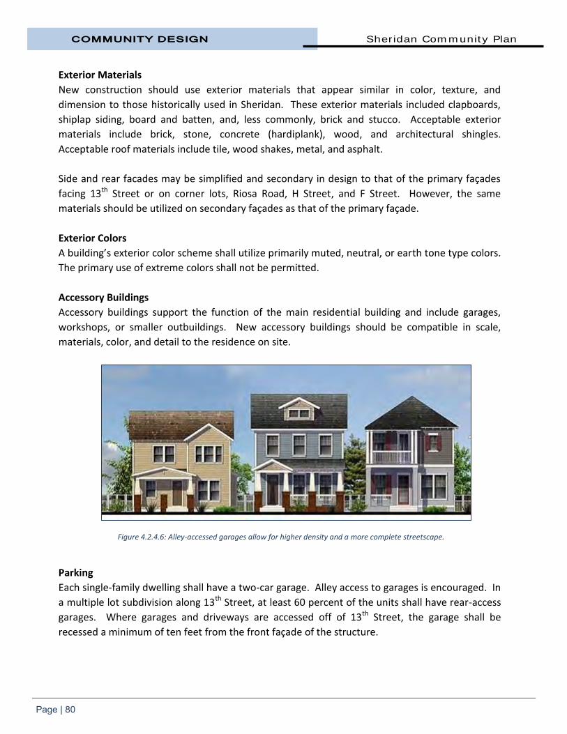
COMMUNITY DESIGN Sheridan Community Plan
Page | 80
Exterior Materials
New construction should use exterior materials that appear similar in color, texture, and
dimension to those historically used in Sheridan. These exterior materials included clapboards,
shiplap siding, board and batten, and, less commonly, brick and stucco. Acceptable exterior
materials include brick, stone, concrete (hardiplank), wood, and architectural shingles.
Acceptable roof materials include tile, wood shakes, metal, and asphalt.
Side and rear facades may be simplified and secondary in design to that of the primary façades
facing 13th Street or on corner lots, Riosa Road, H Street, and F Street. However, the same
materials should be utilized on secondary façades as that of the primary façade.
Exterior Colors
A building’s exterior color scheme shall utilize primarily muted, neutral, or earth tone type colors.
The primary use of extreme colors shall not be permitted.
Accessory Buildings
Accessory buildings support the function of the main residential building and include garages,
workshops, or smaller outbuildings. New accessory buildings should be compatible in scale,
materials, color, and detail to the residence on site.
Parking
Each single-family dwelling shall have a two-car garage. Alley access to garages is encouraged. In
a multiple lot subdivision along 13th Street, at least 60 percent of the units shall have rear-access
garages. Where garages and driveways are accessed off of 13th Street, the garage shall be
recessed a minimum of ten feet from the front façade of the structure.
Figure 4.2.4.6: Alley-accessed garages allow for higher density and a more complete streetscape.

Sheridan Community Plan COMMUNITY DESIGN
Page | 81
Live/Work Units
In order to bring more vitality to 13th Street,
live/work uses are encouraged in the Town
Center Commercial Zoning Combining
District. Live/work units blend ground-floor
retail or work space with living quarters
either to the rear or on upper floors.
Live/work units are defined in the County
Zoning Ordinance. This Community Plan sets
design and other standards for such
live/work units (see Section 3.6.2.2).
Live/work arrangements differ from home-
based businesses in that they require a
storefront, more space, or involve a more
intensive use than is usually allowed in a
strictly residential zone. For those who have
these needs, live/work units offer a
convenient and more affordable option than
owning and/or renting separate spaces.
Typical uses include art and craft work such
as ceramics, painting, photography; office
uses by architects, attorneys, consultants,
realtors, and owners of online commerce
businesses, and similar uses; medical offices;
one-on-one and group services such as music, art, and dance lessons, tutors, licensed counseling
and massage therapy, etc.; limited, brief, pet care services such as grooming (but not doggie day
cares or kennels); furniture refinishing/antique restoration; and hair salons, day spas, etc.
A live/work use is distinguished from a home occupation primarily in that a live/work use can
include employees who are not residents of the home, involve a greater number of customers,
can be located in a larger percentage of a home or accessory building, and can operate beyond
the days and hours prescribed for home occupations.
Figures 4.2.4.7 and 4.2.4.8: Live/work structure examples.

COMMUNITY DESIGN Sheridan Community Plan
Page | 82
Design Policies for Live/Work Units Town Center Commercial Zoning Combining District
New live/work units shall follow the design guidelines for 13th Street single-family residential
structures found in this section and the setback, parking, size, use restrictions and other
requirements contained in Chapter 3 also apply. Live/work units located at street level are
subject to the development standards for ground-floor retail or commercial establishments as
follows:
a) A minimum of 80 percent of a live/work structure's front facade at street level shall be occupied by nonresidential uses. Each unit shall have a pedestrian-oriented frontage that publicly displays the interior of the nonresidential areas of the building.
b) The signage requirements and restrictions for a commercial building
along 13th Street also apply to a live/work building.
c) Streetscape improvements are required.
4.2.5 Business Park and Industrial Park Districts Both the Commercial and
Industrial land use designations
provide for economic and job
opportunities in Sheridan.
Industrial land uses are primarily
located west of Sheridan Lincoln
Boulevard. Permitted uses on the
Industrial-zoned land include
manufacturing and processing,
warehousing, distribution, offices,
storage yards and some limited
retail and service uses.
Industrial uses have the potential
to impact immediate neighbors
and need to be sensitively
integrated with their surroundings. Key components such as access, building scale and design,
traffic generation, and visibility, together with an understanding of the proposed use, need to be
considered in their siting.
The purpose of the Business Park zone district is for the development of a mixture of light
industrial, office and commercial land uses in a campus-like setting along Highway 65. Unlike
within the Industrial Park district, no outdoor manufacturing or storage is allowed in a Business
Park zone district.
Figure 4.2.5.1: Industrial land use along Wind Flower Place.

Sheridan Community Plan COMMUNITY DESIGN
Page | 83
Business and Industrial Park Design Policies
1) No single architectural standard is required. Buildings should include a mix
of material types and textures. Encouraged building materials include
concrete, masonry block, wood frame or steel frame buildings with metal,
wood or stucco siding, or a mixture of these materials. Metal-sided
buildings are not permitted within the Business Park zone.
2) Building walls which are completely unarticulated are prohibited. Wall
articulation can include entry indentations or projections, indented, or
projected window glazing, vertical wall seams, and building facades with
varied front setbacks, roof overhangs or other similar structural features.
Landscaping and window glazing along the same plane as the wall surface
cannot replace building articulation.
3) Buildings shall maintain window transparency of 30 percent on the primary
façade facing a public road. Where feasible, building fronts within the
Business Park district should face Highway 65.
4) Roof-mounted equipment (i.e. air conditioners, fans, vents, etc.) shall be
screened by architectural elements such as parapets.
5) Loading and storage areas shall be
screened from public view either by
a fence or landscaped berm (Figures
4.2.5.2 and 4.2.5.3). Generally,
loading and unloading areas should
be situated to not face the street or
they should be located in the rear of
the building. Where loading and
unloading areas are located
perpendicular to the street frontage,
opaque wall screening shall be
placed between the front of the
building and the loading and the
unloading area.
6) All fencing shall be opaque with
landscaping. At a minimum, this is
to include the use of chain link
fencing with non-wooden slats.
Concrete block, brick, wood, or tilt-
up concrete panels with form-liner
articulation are preferred materials
where the fence is parallel to a
public street.
Figures 4.2.5.2 and 4.2.5.3: Solid fencing with landscaping or landscaped berms are the required screening methods in the
Industrial and Business Park zones.

COMMUNITY DESIGN Sheridan Community Plan
Page | 84
7) Mini-storage facilities shall provide solid exterior walls and significant
landscaping along their perimeter.
8) Landscape areas should represent 15 percent or more of the total land area
of a site. Landscape areas may include portions of the property which
contain high value habitat such as wetlands or native tree stands. Turf
areas should be limited in favor of drought tolerant ground cover and/or
shrubs.
9) Side and rear landscaping shall be designed to be aesthetically pleasing but
shall also be designed to screen outdoor activity areas, outdoor storage
areas, service areas including loading/unloading docks, waste storage bins,
and electrical or mechanical equipment.
4.2.6 Landscaping The streetscape helps to create a unified image and defined visual structure for an area. The
design of the streetscape should provide an attractive foreground for a property and a setting for
activity by creating an environment that is visually rich and satisfying and that complements the
property or development.
A high quality of landscape treatment which reflects the needs of both the site users and
passersby is required. Generally, natural features should be protected, trees shall be preserved
where possible, and Best Management Practices should be incorporated to achieve an
environmentally sustainable development. Landscaping should be used to reduce the visual
impact of all structures, fences and walls that are visible from public view.
Refer to the Placer County Landscape Design Guidelines, individual land use sections within this
chapter, and Section 4.2.13 for detailed design criteria for landscape requirements within the
Plan area. The Landscape Design Guidelines are intended to ensure that public places are
attractive, function efficiently, and provide an inviting and comfortable environment.
The focus of the County’s Landscape Design Guidelines is the streetscape, parking lots and non-
residential buildings, since these are most prevalent in the public's eye. However, the Guidelines
include general provisions that apply to all types of development, such as the use of water-
efficient plantings and irrigation systems, and even within the confines of a particular type of
development, flexibility is integrated into the concepts.

Sheridan Community Plan COMMUNITY DESIGN
Page | 85
4.2.7 Parking Site planning for commercial,
industrial and multi-family
residential projects should
minimize the visibility of parking
areas as much as possible through
their configuration including the
use of landscaping and grading.
This can be achieved by locating
parking to the rear or sides of
buildings and in areas that can be
appropriately screened from the
adjacent street and surrounding
properties. Parking Policies
1) Parking areas shall be
provided as required by
the Placer County Zoning
Ordinance.
2) Parking areas should be
organized into small units
separated by landscaping
and pedestrian facilities
to provide safe, attractive
pedestrian environments
and visual enhancement.
3) Shade trees shall be
provided on parking
islands, along street
edges and at other
locations wherever feasible, and shall be consistent with the shading
provisions of the Placer County Landscape Guidelines.
4) Convenient parking shall be provided for commercial areas without
affecting the character of major streetscapes. Parking areas should be
connected to the streetscape through pedestrian links.
5) Multi-family parking lots should be located to the rear to minimize visual
impacts. Where parking lots cannot be completely screened, they should
be landscaped or be placed behind a landscaped berm. If a berm is not
feasible, then a solid fence with landscaping shall be used.
Figure 4.2.7.1: Parking lot at the corner of Riosa and Camp Far West roads.
Figure 4.2.7.2: Landscaped areas should be incorporated throughout a site including the parking lot.

COMMUNITY DESIGN Sheridan Community Plan
Page | 86
6) Access points to parking areas shall be minimized to reduce their
potential impact on the surrounding streetscapes and to minimize
potential vehicular conflict.
Town Center Commercial Combining District Parking
1) Common, shared parking facilities are encouraged. Required parking may
be accommodated off-site in common, shared parking facilities through a
Use Permit.
2) Street parking is encouraged. Diagonal parking on the east side of 13th
Street is allowed.
3) No off-street parking spaces shall be located between a building front
and 13th Street, Riosa Road, F Street or H Street (see Figure 4.2.3.2).
4) Residential and Live/Work projects are required to meet the parking
requirements found in Section 3.6.2.
5) Commercial projects must meet the parking requirements contained in
the Placer County Zoning Ordinance.
6) Mixed-use developments consisting of both residential and non-
residential uses may be permitted a reduction in the parking spaces
based on the reasonable expectation that there would be staggered
parking demands between the two. Such reduction may be approved
through a Use Permit.
Figure 4.2.7.3: Parking lot at the corner of Riosa and Camp Far West roads.
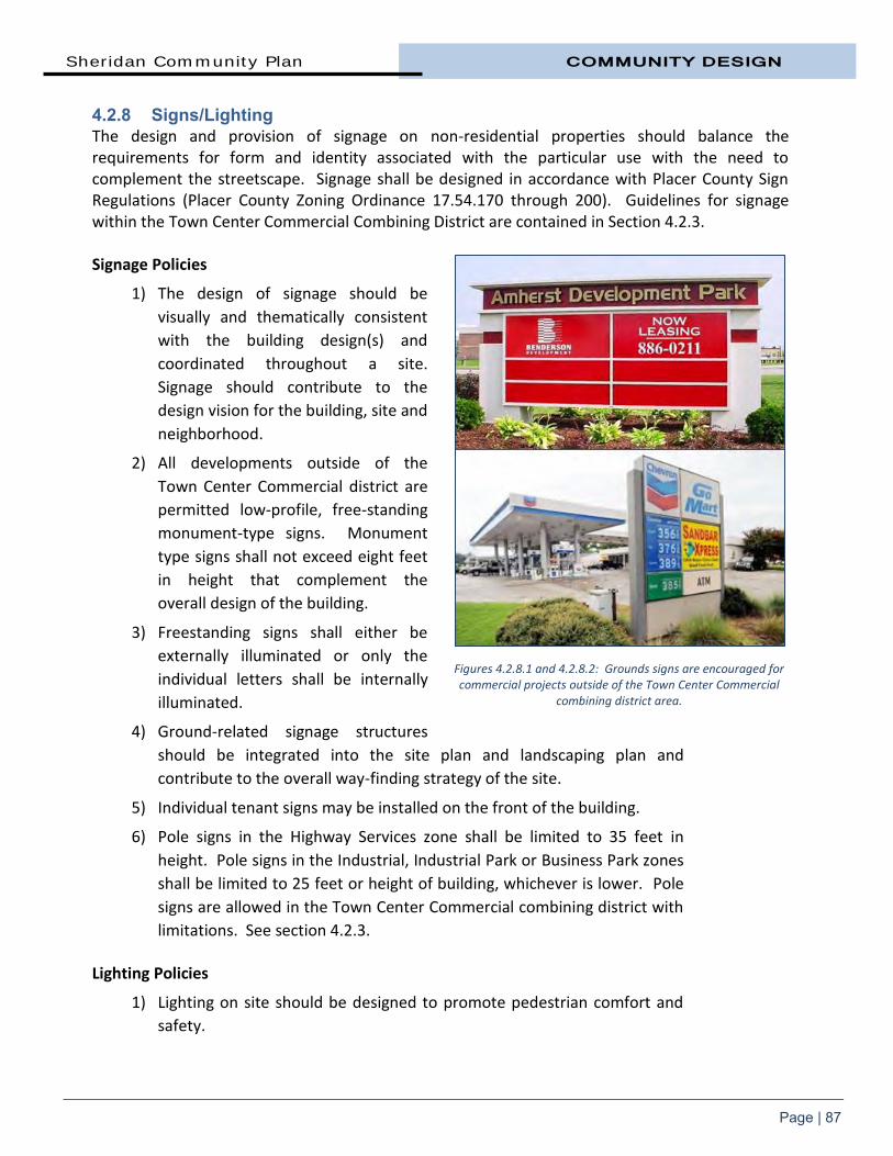
Sheridan Community Plan COMMUNITY DESIGN
Page | 87
4.2.8 Signs/Lighting The design and provision of signage on non-residential properties should balance the requirements for form and identity associated with the particular use with the need to complement the streetscape. Signage shall be designed in accordance with Placer County Sign Regulations (Placer County Zoning Ordinance 17.54.170 through 200). Guidelines for signage within the Town Center Commercial Combining District are contained in Section 4.2.3. Signage Policies
1) The design of signage should be
visually and thematically consistent
with the building design(s) and
coordinated throughout a site.
Signage should contribute to the
design vision for the building, site and
neighborhood.
2) All developments outside of the
Town Center Commercial district are
permitted low-profile, free-standing
monument-type signs. Monument
type signs shall not exceed eight feet
in height that complement the
overall design of the building.
3) Freestanding signs shall either be
externally illuminated or only the
individual letters shall be internally
illuminated.
4) Ground-related signage structures
should be integrated into the site plan and landscaping plan and
contribute to the overall way-finding strategy of the site.
5) Individual tenant signs may be installed on the front of the building.
6) Pole signs in the Highway Services zone shall be limited to 35 feet in
height. Pole signs in the Industrial, Industrial Park or Business Park zones
shall be limited to 25 feet or height of building, whichever is lower. Pole
signs are allowed in the Town Center Commercial combining district with
limitations. See section 4.2.3. Lighting Policies
1) Lighting on site should be designed to promote pedestrian comfort and
safety.
Figures 4.2.8.1 and 4.2.8.2: Grounds signs are encouraged for commercial projects outside of the Town Center Commercial
combining district area.

COMMUNITY DESIGN Sheridan Community Plan
Page | 88
2) Any night lighting shall be designed to reduce the impacts of glare, light
trespass and over-lighting; promote safety and security; and encourage
energy conservation. Generally, upward lighting shall only be permitted
if it is low intensity (50 watts or less) and it is either used to externally
illuminate a freestanding sign or it is used as accent lighting for
landscaping.
3) Lighting on individual buildings should be integrated into the
architecture.
4) Lighting shall be directed towards the ground and be designed to
minimize projection into adjacent properties and onto adjacent roads.
5) The height of light standards in parking areas shall not exceed 18 feet.
6) Energy-efficient technology should be used wherever possible.
7) Floodlights, unshielded wall pack units, other types of unshielded lights
and lights where the lens is visible outside of the light fixture is prohibited
in the Town Center Commercial combining district.
4.2.9 Residential Design
Sheridan developed incrementally since
the mid-1800s, resulting in a mix of
architectural styles. Many of the homes in
Sheridan are of the Modern-Ranch style
(ca. 1935-1975). This style was originated
in the mid-1930s by several creative
California architects. It gained popularity
during the 1940s to become the dominant
style throughout the country during the
following decades.
Ranch style is a one-story building with
low, silhouette, wide overhanging eaves
and a long, wide porch. Ranch design was
a conscious attempt to emphasize the
rambling horizontal form and an open
floor plan.
There is no single architectural style
required for new housing in the
Community Plan area. The focus is on a
high-quality residential environment. Infill
Figures 4.2.9.1 and 4.2.9.2: Typical ranch style homes in the townsite.

Sheridan Community Plan COMMUNITY DESIGN
Page | 89
and rural lot housing development is an opportunity to enhance Sheridan’s existing character.
Successful infill developments must take into consideration the capacity of public services to
accommodate change and the existing character of neighborhoods. Maintenance of
neighborhood character is of paramount importance when considering new developments within
established areas. Building style, exterior finish, massing, and height, and protection of existing
natural resources such as trees and drainages, are factors that impact on the ability of a new
development to integrate into established neighborhoods.
Residential Design Principles
1) Design homes to create an open and inviting street frontage with “eyes on the street.”
a) Porches or extended roof overhangs are encouraged at entries.
b) Avoid using driveways as the only pedestrian access from the street.
c) Fences along front property lines are strongly discouraged unless they are low.
d) Porches, windows, entries and living spaces should be oriented towards the street.
e) Corner buildings should respond to both street frontages with a frontal appearance along both sides.
2) Minimize visual prominence of garages and garage doors.
a) Subordinate the garage portion of the residence to entries and other building elements (see Figure 4.2.9.4).
b) Locate garages behind the front façade of homes whenever possible.
c) Avoid circular drives with large amounts of paving in front setback areas and more than one curb cut.
d) Encourage alleyway access to garages.
e) Utilize a side-loading garage to ensure that dwelling facades and landscaping, rather than garages and driveways, dominate the streetscape.
f) Along streets, the face of the garage shall be located a minimum of 20 feet from the edge of pavement of the roadway or the back of the sidewalk where sidewalks are present/required.

COMMUNITY DESIGN Sheridan Community Plan
Page | 90
3) Enhance neighborhood building patterns and forms.
a) Use building designs and architectural elements similar to and respectful of those in the immediate neighborhood.
b) Height, volume and bulk should be compatible with that of neighboring buildings.
c) New residences should have similar setbacks as adjacent residences.
4) Design multi-family projects to enhance the community.
a) Attached units should be designed to look like separate residences of a scale and character to existing residences in the neighborhood.
b) Design to have a street presence and create a similar scale to that of a lower-density residential neighborhood.
c) Use a combination of one and two-story forms rather than all two-story structures.
d) Provide balconies and other design features to break up large two-story building walls.
e) Include courtyards and gathering areas that are accessed by landscaped pedestrian walkways and paths.
f) Break large parking lots into smaller lots separated by buildings and landscaping.
g) Design garages and/or carports using forms and materials similar to the main structures.
Figure 4.2.9.4: Garages should be recessed from the front of the home or set off an alley within the townsite.

Sheridan Community Plan COMMUNITY DESIGN
Page | 91
4.2.10 Residential Subdivisions Planning for growth is essential for a community that wants the benefits associated with growth
while preserving its rural character. When development design and open space preservation are
decided one subdivision at a time, rural communities can lose their ability to choose the type and
location of development they want.
Subdivisions should be responsive to Sheridan’s rural nature. Working lands, farms, orchards and
rangelands are central to Sheridan’s heritage and economic future. Working lands are at the
heart of Sheridan’s distinctive rural character and the reason the townsite was settled in the first
place.
Sensitive areas such as wetlands, wildlife habitat and riparian areas are important from an
environmental perspective, but they also help create the special character of an area. They are
often important contributors to the local economy, providing ecosystem services like protecting
water quality, and supporting the health of working farmland and fisheries.
These guidelines are intended to encourage innovative residential developments and efficient
use of land in keeping with the wishes of the Sheridan community. The goal is that all subdivision
design and layout is suited to the particular site whether in the townsite, its periphery, or in a
more rural area.
The design standards in this section
are proposed as additional
implementation measures to those
required in Section 3.4 and the Placer
County Land Development Manual.
Townsite
The primary goal of townsite
subdivision guidelines is to maintain
the special character of the
neighborhood.
The Sheridan townsite was developed
with a distinct grid pattern with 400-
foot x 400-foot blocks. Other portions
of the Community Plan area have
mostly developed in a non-grid pattern
with larger lots. The original plat of
1911 created separately saleable
parcels; most of which are 25 feet x Figure 4.2.10.1: The townsite has a distinctive grid pattern along with
wide right-of-ways and alleys.

COMMUNITY DESIGN Sheridan Community Plan
Page | 92
190 feet. Original lots in the neighborhood were proportionately shorter along the street side
and rectangular in shape. Through lot consolidations, the average building site is around 10,000
square foot in area and lots 50 feet to 65 feet in width. The creation of alleys allowed service
vehicles to use the back half of the property.
This lot and block platting pattern has been reinforced by the alignment of buildings on the lots
within that grid. Thoroughfares are 80-foot right-of-way, wide for residential streets. Wide
streets and relatively deep lots contribute to a fairly consistent sense of ‘openness’ in the
neighborhood.
The surviving street grid, and its existing subdivision lines, is the strongest reminder of the
historical form of the townsite. Therefore, the pattern created by the Sheridan townsite grid
should be respected in all site planning decisions.
Townsite Subdivision Policies
1) Streets and roads shall be laid out to connect with existing streets and
where possible, expand the 400-foot x 400-foot block pattern with alleys.
The alignment of the existing street grid system shall be maintained to the
maximum extent feasible. New blocks, lots, and streets shall be organized
and aligned to connect new streets and alleys with adjoining, existing
streets and alleys.
2) A rectangular lot shape is preferred to a square one, as the rectangular lot
pattern is more in keeping with Sheridan.
3) Maintain the typical lot widths of 50 to 65 feet and the relatively uniform
spacing of buildings that occur along blocks.
4) When new roads are constructed:
a) curbs, gutters and sidewalks shall be installed
b) utilities shall be undergrounded
c) 80 feet right-of-way required
5) New alleys shall be paved and used for rear access to lots. Alleys shall have
a minimum of 20 feet of paved width with a minimum ten-foot driveway
apron to the face of the garage.
6) Cul-de-sacs are discouraged and flag lots are not permitted within the
townsite.
As an alternative to a cul-de-sac, a subdivider should provide a street stub. If the size of a
proposed subdivision does not allow for a complete block, then streets stubs shall be required at
certain locations to allow for future connections. The street stub shall be located so that future
development may connect to the street stubs in such a way to form a ‘standard’ Sheridan block

Sheridan Community Plan COMMUNITY DESIGN
Page | 93
of 400-feet by 400-feet (see Figure 4.2.10.2). Temporary vehicle turnaround areas to Placer
County standards may be required at the end of a street stub until such time as it is connected to
future development.
Creation of flag lots ((a parcel of land shaped like a flag, with a narrow strip (“flag pole”) providing
access to a right-of-way and the bulk of the property (“flag” portion) containing no frontage)) is
not allowed within the Plan area.
Figure 4.2.10.2: Subdivisions within or adjacent to the townsite shall continue and extend the grid street pattern.

COMMUNITY DESIGN Sheridan Community Plan
Page | 94
A loop lane (Figure 4.2.10.3 below) may be used as an alternative to a cul-de-sac.
A loop lane is a two-way street with a landscaped interior area that has a width of at least 75 feet.
Efforts should be made to provide connectivity of loop lanes to the traditional grid system.
Outside Sheridan Townsite
Rural Sheridan is valued by its residents and by those from outside the area for its natural beauty
and its agricultural and rural lifestyle. The diversity of the natural environment and variety of
environmental features remain today, primarily as a result of ongoing stewardship by local
residents and Placer County’s leadership in implementing environmental protection measures to
retain the rural character of the area and the health of its natural systems.
Figure 4.2.10.3: Loop lanes are an appropriate alternative to a cul-de-sac.
Figure 4.2.10.4: Flag lots such as in the center example are not permitted in the Plan area.

Sheridan Community Plan COMMUNITY DESIGN
Page | 95
Subdivision planning and
construction outside of the
townsite should be designed to
have a low impact on the
environment and be consistent
with the character of the
community.
A critical planning issue facing the
unincorporated areas of Placer
County is to devise a workable
balance between the desire to
develop suburban residential
acreages, rural home sites, and
large-lot suburban/rural
subdivisions (4.6+ acre lot size),
while at the same time not creating, or at least minimizing, conflicts between homeowners and
farmers. The value of rural land is recognized by the County in the General Plan and Subdivision
Ordinance which aim to protect and preserve the resources on these lands.
Non-Townsite Subdivision Policies
1) The number of lots permitted in a subdivision is dependent on the specific characteristics of the area, as well as the minimum lot area required by ordinance. However, the number of lots permitted by a zoning designation should be considered only as a maximum and is not a guarantee of the density that is allowed.
2) An overriding consideration in the design of any subdivision project shall be the conservation of the natural slope, the conservation of natural drainage channels and swales (since they serve in place of artificial drainage systems), the preservation of existing natural resources including wildlife habitat and trees, and preservation of cultural or historic resources.
3) Visibility of structures, preservation of natural land form and natural resources, topography, noise exposure, maintenance of rural quality and relationship to the surrounding properties, and access to transportation corridors and services shall all be considered in preparing subdivision designs. Subdivision density, or number of lots, will ultimately be determined by these factors.
4) Lots shall be adequate in size and shape to accommodate those primary and accessory uses which are in keeping with the particular residential characteristics of the specific location without: a) Creating a feeling of overcrowding.
Figure 4.2.10.5: Most properties outside of the townsite are zoned Farm with a minimum parcel size of 4.6 acres.

COMMUNITY DESIGN Sheridan Community Plan
Page | 96
b) Creating measurable negative environmental impacts which cannot be adequately mitigated.
c) Creating the need for variances.
5) Creation of flag lots is not allowed.
6) Street patterns shall be clear and understandable to promote ease of
orientation and convenient access.
Grading Policies
1) Mass grading shall not occur outside of commercial, industrial and high-density residential areas.
2) As required by the Placer County Grading Ordinance, all grading exceeding 250 cubic yards of material, and exceeding four feet in vertical height (cut or fill), shall require review and approval by Placer County. In addition, other grading activities may require a grading permit per Placer County Ordinance Sections 15.48.060 and 15.48.070.
Vegetation Removal/Landscaping Policies
1) Native tree removal shall be kept to a minimum and may be subject to prior approval by Placer County.
2) Every effort shall be made to preserve as much natural vegetation as possible.
3) Revegetation/landscaping plans shall emphasize the use of native and compatible, drought-tolerant plant materials. A revegetation plan shall be submitted and approved by Placer County for all disturbed areas.
4) All natural streams, drainage areas and floodplains shall be maintained in their natural state unless specific approval for modification is given by the County and other appropriate agencies and/or such work is necessary for maintenance of a free-flowing channel.
4.2.11 Residential Subdivision Gating To help preserve the rural character of Sheridan and promote interconnectivity between
neighborhoods, gated subdivisions are not allowed in the Community Plan area under any
circumstances. Individual properties and driveways may be gated however.

Sheridan Community Plan COMMUNITY DESIGN
Page | 97
4.2.12 Secondary Dwelling Units One way for a community to increase housing options in an existing neighborhood that is zoned
for single-family residences is by allowing property owners to build what are commonly called
granny flats. Secondary dwelling units are efficient to produce because they use existing land and
public infrastructure. Under State housing law, these second units are allowed on most
residentially-zoned lots. The County has the authority to regulate the size, setback, design, and
parking requirements for second units. Second units must have an adequate water supply and
sanitary (waste water) facilities.
Secondary dwelling units can serve several functions. For aging homeowners who need
assistance, they can provide caregiver or caretaker quarters. Secondary units also help stabilize
neighborhoods because they provide a source of income for homeowners. In addition, they
provide housing for elderly parents or adult children who could not otherwise afford to remain in
the community.
The Placer County Zoning Ordinance establishes standards for secondary dwelling units in
Sheridan. A secondary dwelling unit is defined as an additional self-contained living unit, either
attached to or detached from, the primary residential unit on a single lot. It has cooking, eating,
sleeping, and full sanitation facilities.
Secondary dwelling units are permitted with an Administrative Review Permit (ARP) in all
residential districts including the Farm (F) district subject to the following standards:
1) The lot contains an existing single-family dwelling.
2) If construction of a secondary unit is proposed on a vacant lot, elevations and floor plans for both the main unit and the secondary unit must be submitted for approval, along with a representative photograph of the main unit.
3) In zoning districts where the minimum lot area is 10,000 square feet or less, the minimum lot area for the lot containing the secondary unit must be 150 percent the minimum lot area for that specific zoning district.
4) Secondary dwellings on parcels smaller than one acre in size must either be attached to the primary unit or integrated with a detached accessory building (such as a garage).
5) The maximum floor area allowed for a secondary dwelling is to be based on the area of the lot as shown in Table 4.2.12 below.
6) The secondary dwelling must be architecturally compatible with the primary residence. For attached units, the appearance of the building should remain that of a single-family residence.
7) A secondary dwelling of 640 square feet or less must be provided one off-street parking space; a larger secondary dwelling shall be provided two spaces.

COMMUNITY DESIGN Sheridan Community Plan
Page | 98
8) Using existing/shared driveway connection to reduce potential vehicular conflicts on roadways is encouraged.
9) Encroachment permits and traffic fees are required for a new driveway connection serving a secondary dwelling.
Table 4.2.12 Maximum Floor Area Allowed for Second Units
Lot Area of Site Maximum Floor Area (sq. ft.)
Less than 1 acre 640
1 acre to 2.29 acres 840
2.3 to 4.59 acres 1,000
4.6 acres or more 1,200
Source: Placer County Zoning Ordinance, Section 17.56.200
Figure 4.2.12.1: Townsite residential

CHAPTER FIVE
NATURAL
RESOURCES AND
OPEN SPACE


Sheridan Community Plan NATURAL RESOURCES
Page | 99
5. Natural Resources and Open Space Sheridan’s natural setting is
characterized by rangeland,
orchards, cropland, wildlands,
undulating topography, natural
vegetation, and varied wildlife.
The area is thinly-populated and
relatively separated from the
rapidly urbanizing areas of south
Placer County.
Conservation of natural resources
is critical to the well-being and
survival of our own and future
generations. Without a healthy
environment, social well-being,
economic health, and sustainability of the Sheridan community are not possible.
Looking after the natural environment, and mitigating the impact of the built environment, is an
essential and shared responsibility between all levels of government, private interests, and the
community.
The following sections of the Plan focus on how the integrity of the natural environment – its
land, air, water, ecosystems, and biodiversity will be protected, restored, and maintained. It is
intended to guide the community in the long-term conservation and preservation of open space
lands and natural resources while protecting private property rights. 5.1 GOALS AND POLICIES GOALS
1. Preserve and protect the natural features and resources of the Plan area, which is essential to maintaining the quality of life within the community.
2. Protect the quality of air and water resources consistent with adopted federal, state, and local standards.
3. Ensure that land use planning contributes to the protection, improvement, and restoration of water resources and that all new development has a minimum impact on the established natural environment.
Figure 5.0.1: Grassland and wetland habitat in west Sheridan.

NATURAL RESOURCES Sheridan Community Plan
Page | 100
4. Implement sound storm water management practices and sustainable management practices to help ensure protection from flooding and erosion to maintain, and where feasible, improve water quality.
5. Work closely with state and federal agencies, watershed groups, and adjacent communities on watershed plans and strategies to provide a comprehensive approach to environmental planning.
6. Encourage public and private stewardship and partnerships directed to restoring, enhancing, and preserving the natural environment.
POLICIES
1. The natural resources and features of a site proposed for development shall be one of the planning factors determining the scope and magnitude of development.
2. Attention shall be given to protection of the natural regiment in the planning, environmental review, and completion of all subdivisions, land development, or land alteration projects.
3. Identify and preserve any rare, significant, or endangered environmental features and conditions.
4. Encourage the use of ecologically innovative techniques in future development.
5. Encourage the continued use of the Williamson Act or other similar measures to preserve productive agricultural lands.
6. All stream influence areas, including floodplains and riparian vegetation areas, shall be retained in their natural condition, while allowing for limited stream crossings for public roads, trails, and utilities.
7. Site-specific surveys shall be required prior to development to delineate wetlands and vernal pools in the Sheridan Community Plan area.
8. The standards of the Placer County Grading Ordinance and this Resources section of the Sheridan Community Plan shall be implemented for all projects in the Plan area.
9. New construction shall not be permitted within 100 feet of the centerline of permanent streams and 50 feet of intermittent streams, or within the 100 year floodplain, whichever is greater.
10. In implementing Best Management Practices, the County shall promote consideration of the concepts of low impact development, and sustainable technology, and current standards of the County to address the quantity and quality of storm water run-off released to any watercourse.
11. Continue to maintain and improve the environmental quality of the storm water management system within the townsite to improve watershed function.

Sheridan Community Plan NATURAL RESOURCES
Page | 101
12. Outside of the townsite, retain an open-channel storm water drainage system comprising watercourses, ditches, wetlands and other water retention and detention opportunities, to enhance water quality and environmental features.
13. Protect sensitive habitats such as wetlands, riparian areas, and oak woodlands against any significant disruption or degradation of habitat values. Utilize the following design and use regulations on parcels containing or in close proximity to these resources, excluding existing agricultural operations:
Structures shall be placed as far from the habitat as feasible; and,
Limit removal of native vegetation to the minimum amount necessary for structures, landscaping/gardens, driveways, parking lots, and where applicable, septic systems.
14. Individual sites and properties can contribute to the health of the environment by incorporating measures such as:
Using renewable energy sources such as solar or geothermal energy;
Planting additional trees in appropriate locations;
Managing storm water runoff using storm water best management practices;
Naturalizing landscapes with native, non-invasive species; and,
Installing ‘green roofs’ or light-colored roofs.
15. The County’s Tree Preservation Ordinance shall be implemented where applicable. 5.2 SUSTAINABLE ECOSYSTEMS A healthy ecosystem is vital to the well-being of the region and planet, a healthy human
community, and a vibrant economy. Native vegetation cleans the air, builds soils, and regulates
temperature. Wetlands clean and hold water essential for life and healthy soils support
biodiversity. Healthy creeks and streams support fish and other aquatic life. In addition, quiet,
natural places and opportunities for viewing and experiencing natural spaces contribute to the
quality of life within Sheridan.
Through the Placer County Open Space and Agricultural Conservation Program (Placer Legacy)
Placer County and its residents are considered to be leaders in the region in preserving and
protecting the natural environment. The preservation and enhancement of our natural heritage
was founded and depends on raising public awareness, gaining support, and encouraging citizens,
businesses, and institutions to conserve natural resources and restore the natural environment
for the well-being of future generations.

NATURAL RESOURCES Sheridan Community Plan
Page | 102
5.3 CONSERVATION PLANNING Placer County has adopted an ecosystem approach to conservation planning, which recognizes
the environment on a level with social and economic concerns and which promotes the principles
of sustainable development. The ecosystem approach responds to the dynamic, interrelationship
of all elements of a biophysical community, and the long-term management and related
monitoring policies that address not only individual, but cumulative impacts to achieve a
sustainable, healthy ecosystem.
The Natural Communities Conservation Plan (NCCP) Act of 1991 encourages local governments to
plan broad-scale, multi-species conservation in association with watershed and wetlands
protection. Placer County is pursuing both an NCCP and a Habitat Conservation Plan (HCP) under
the Federal Endangered Species Act for western Placer County including Sheridan. This plan,
termed the Placer County Conservation Plan (PCCP), includes a program designed to ensure the
continued conservation of threatened and endangered species in Placer County and to resolve
potential conflicts between economic development activities and the conservation and recovery
of sensitive species on non-Federal land. The goal of the PCCP is to integrate the land use needs
of Placer County’s growing human population with the natural systems and species found in the
Plan area.
The PCCP, now in its draft stage, proposes to establish in perpetuity development boundaries
(unlike an urban limit line) and is a method by which many smart growth objectives can be met.
It is a tool that will allow Placer County to manage its growth by balancing habitat preservation
with economic development and population growth. New development will be directed into
appropriate areas and away from non-urban areas. It will assist the County’s growth
management efforts by clearly identifying which lands are intended for urban use and which are
intended to remain agricultural or managed as habitat; promoting environmentally and fiscally
sustainable infill development; and strengthening the consistency between the cities’ and Placer
County’s land use plans and development policies.
Through the PCCP and a future updated General Plan that aligns land use, transportation,
housing, and greenhouse gas reduction planning efforts, there will be better integration of
sustainable urban planning and habitat conservation, using the impetus for habitat conservation
to promote more efficient urban forms.
The PCCP is an important part of the County’s Placer Legacy Open Space and Agricultural
Conservation Program and will help achieve key program goals, such as preserving the diversity
of natural plant and animal communities, and preserving agricultural land and open-space. Since
its adoption in 2000, twelve properties totaling 8,551 acres have been conserved through
acquisition or conservation easement through the Placer Legacy program. There are currently no
Placer Legacy properties located within the Plan area.

Sheridan Community Plan NATURAL RESOURCES
Page | 103
It is important to recognize that although sustainable development is an objective of
conservation planning, it extends further than just environmental management. Other aspects of
sustainable development are addressed within the Cultural Resources, Parks and Recreation,
Circulation, and Community Design sections of the Community Plan. Williamson Act and Agricultural Preserve Contracts The purpose of the Agricultural Preserve Program is the long term conservation of agricultural
and open space lands. The program enrolls land in Williamson Act or Farmland Security Zone
contracts whereby the land is restricted to agricultural, open space, or recreational uses in
exchange for reduced property tax assessments. Participation in the program is voluntary.
The California Legislature passed the Williamson Act in 1965 to preserve agricultural and open
space lands by discouraging premature and unnecessary conversion to urban uses. The Act
creates an arrangement whereby private landowners voluntarily contract with counties and cities
to restrict land to agricultural and open-space uses.
Agricultural contracts are a 10 year rolling term – and renew each year for another term unless
they are non-renewed by either the landowner or the County. In return, restricted parcels are
assessed for property tax purposes at a rate consistent with their actual use, rather than potential
market value.
Over 4,900 acres in the Plan area (32.9 percent) are currently enrolled in the Williamson Act
(under contract or have filed for non-renewal).
Table 5.3.1 Williamson Act Acreage in Plan Area
Williamson Act Status Acres
Non-Renewal 24.2
Under Contract 4,901.5
Total 4,925.7

NATURAL RESOURCES Sheridan Community Plan
Page | 104
5.4 FISH AND WILDLIFE The County’s General Plan policies
recognize that the local fish and
wildlife habitat within Placer
County is linked to and form part
of the larger regional and state
natural habitat system. The
County recognizes the need for
both environmental impact
reports and long-term monitoring
to ensure that development can
protect, maintain, enhance, and
restore biodiversity to achieve a
self-sustaining natural heritage
system.
The flora and fauna found in Sheridan are largely a reflection of soils, climate, and land use. The
area has a range of land uses, including residential, commercial, agricultural, and light industrial.
Terrestrial habitats in the Plan area include buildings and other structures, agricultural fields,
orchards, grasslands, and vernal pool and marsh complexes.
Wildlife tends to locate in those areas where they can find the essentials of survival and
reproduction, including foraging, nesting, and breeding habitats. Fish and other aquatic
organisms may be found in those areas that are suitable in terms of water quality, cover, and
other factors, and both fish and wildlife require the capacity to move freely between the
resources that they utilize and, in some cases, to migrate. Habitats that are compromised by
breaks in connectivity, such as roads, will inevitably produce fewer numbers and types of flora
and fauna.
Sheridan’s habitat types provide surface water, cover for small mammals and deer, trees for
raptors that may nest there, tree hollows for bats and cavity-nesting birds, and foraging
opportunities for the hawks and owls that hunt open lands and for egrets and herons that hunt
for fish and amphibians.
Structures and landscaped areas provide low-quality wildlife habitat, primarily exploited by those
species adapted to human disturbances. Barns and other outbuildings may provide habitat for
bats (big brown bat, Mexican free-tailed bat) and barn owls, while a variety of structures provide
nesting sites for swallows.
Figure 5.4.1: Rangeland on the south side of Riosa Road.

Sheridan Community Plan NATURAL RESOURCES
Page | 105
Agricultural land provides habitat
for small mammals and birds,
including many of the species
listed above. Once harvested,
agricultural fields provide foraging
opportunities for raptors, such as
northern harrier, white-tailed kite
and Swainson's hawk. Rice fields,
which are extensive in the western
portions of the Plan area and
along Camp Far West Road, pond
large areas of water and provide
good quality waterfowl and
wading bird habitat. Orchards may
provide cover and foraging habitat
for many bird species also
commonly found in woodlands and other habitats in the Plan area, however, mowing, plowing,
spraying, and harvesting are activities which will deter normal cover and foraging by bird species.
Vertebrate species observed, or expected to occur, in aquatic habitats in and around Sheridan
include beaver, river otter, muskrat, northern pond turtle, common garter snake, Pacific tree
frog, and bullfrog.
Aquatic habitats also support a resident warm water fishery including both introduced and native
species. Yankee Slough, south and east of the Plan area, supports a primarily introduced fishery
including mosquito fish, green sunfish, carp, and bigscale logperch.
Grasslands are important for burrowing rodents such as ground squirrels and gophers. Rodent
burrows, in turn, provide habitat for a variety of other species, including burrowing owls. The
diverse and abundant rodent community supports an assemblage of raptors that feed on them.
Wildlife use of non-native grasslands is similar to agricultural lands, providing habitat for a wide
variety of small mammals, songbirds, raptors, and reptiles. Mixed oak woodland provides high-
value wildlife habitat for a variety of bird species and some mammals.
Two state-listed species, Red-Bluff dwarf rush and Ahart’s dwarf rush, have limited potential to
occur in seasonally moist sites in annual grasslands in western Placer County. Other special-
status plants that may potentially occur in annual grasslands are depauperate milk-vetch, big-
scale balsamroot (Balsamorhiza macrolepis var. macrolepis), hispid bird’s-beak (Cordylanthus
mollis ssp. hispidus), stinkbells (Fritillaria agrestis), sylvan microseris (Microseris sylvatica), and
hoary navarretia (Navarretia eriocephala).
Figure 5.4.1: Rice fields along Camp Far West Road.

NATURAL RESOURCES Sheridan Community Plan
Page | 106
Special-status animals that may use annual grasslands for breeding or as visitors are western
spadefoot, northwestern pond turtle (Actinemys marmorata marmorata), giant garter snake
(Thamnophis gigas), northern harrier, Swainson’s hawk, ferruginous hawk (Buteo regalis),
American peregrine falcon, western burrowing owl (Athene cunicularia), loggerhead shrike
(Lanius ludovicianus), bank swallow (Riparia riparia), grasshopper sparrow (Ammodramus
savannarum), and tricolored blackbird. California tiger salamander has the potential to occur in
annual grasslands as visitors.
Vernal pools are important habitat
for migratory birds, and in the
spring, migrating waterfowl are
often observed feeding and resting
in Central Valley vernal pools. Five
special-status plants— Bogg’s Lake
hedge-hyssop (Gratiola
heterosepala), legenere (Legenere
limosa), dwarf downingia
(Downingia pusilla), Ahart’s dwarf
rush (Juncus leiospermus), and Red
Bluff dwarf rush (Juncus
leiospermus)— are known to occur
in vernal pools in western Placer
County. Other special-status plants
that may occur in vernal pools are depauperate milk-vetch (Astragalus pauperculus), pincushion
navarretia (Navarretia myersii), and Henderson’s bent grass (Agrostis hendersonii).
Vernal pool ecosystems provide breeding habitat for a variety of special-status animal species
including Conservancy fairy shrimp (Branchinecta conservatio), vernal pool fairy shrimp
(Branchinecta lynchi), vernal pool tadpole shrimp (Lepidurus packardi), and western spadefoot
(Scaphiopus hammondii). These shrimp species have evolved accelerated reproductive maturity
and high reproductive rates in response to the extreme environmental conditions that occur in
vernal pools. They can survive the desiccation phase in the form of cysts, which can withstand
high temperatures during the summer and remain viable in the soil for more than ten years.
Other birds, such as raptors (hawks, falcons, and kites) and a variety of songbirds, use vernal pool
complexes for foraging and as water sources. Burrowing owls may use burrows in mima mounds
in the surrounding annual grasslands. Many wildlife species use both the vernal pools and the
surrounding annual grassland habitat of the vernal pool complex. For example, many of the
typical vernal pool annual plants are pollinated by bee species that nest in the surrounding
uplands and forage in annual grasslands when the pools dry out.
Figure 5.4.2: Rice fields along Camp Far West Road.

Sheridan Community Plan NATURAL RESOURCES
Page | 107
5.5 OPEN SPACE/NATURAL RESOURCE AREAS These areas include lands for the preservation of plants and animals including habitat for fish and
wildlife species. Lands within open space areas perform an essential ecological function. They
sustain biodiversity by providing habitat for plants and animals and they clean the air and water.
The connectivity of natural open space areas is important for maintaining native vegetation
communities and providing corridors for wildlife. Preserving and enhancing these lands in their
natural state is essential to the overall health and functioning of the natural environment.
Open space/natural resource areas include such uses as ponds and lakes, hunting clubs,
conservation banks, private open space, and utility corridors. These open space lands, the
“Green System,” have a variety of functions.
Conservation banks are permanently protected lands that contain natural resource values. These
lands are conserved and permanently managed for species that are endangered, threatened,
candidates for listing as endangered or threatened, or are otherwise species-at-risk. They
function to offset adverse impacts to these species that occurred elsewhere, sometimes referred
to as off-site mitigation.
Figure 5.5.1: Open space areas.

NATURAL RESOURCES Sheridan Community Plan
Page | 108
There are two privately-owned conservation banks within the Plan area.
Table 5.5.1 Conservation Banks in Plan Area
Reserve Name Habitat Public Access? Ownership Acreage
Silvergate Between Wheatland and Riosa roads
Grassland, Vernal Pools, Marsh, Wetlands, Oak
Woodland
No Private 623
Yankee Slough Nader Road east of Sheridan Lincoln Blvd.
Oak Savannah, Riparian, Grassland
No Private 732
A third conservation bank borders the Plan area on the east. The 342-acre Sheridan East
conservation bank is located at the northeast corner of Riosa and Karchner roads along a
tributary to Yankee Slough. It contains grassland, vernal pools, marsh, wetlands, and oak
woodland.
932 acres to the south of the Plan area on the south side of Waltz Road and west of N. Dowd
Road are protected by conservation easements. Easements on the parcels enable the area to
remain in conservation use for floodwater conveyance, flood management, floodwater storage,
and habitat and/or agricultural conservation. The properties provide resting, breeding and
foraging habitat for a variety of wildlife including adequate nesting and perching sites for a
variety of birds.
5.6 VEGETATION Local plant communities are typically ruderal annual grasses and forbs in rangelands and
pastures, lawns, and scattered native or non-native trees in landscaped areas, vernal pools, and
smaller areas of emergent or scrub shrub wetlands and creeks. These habitat types provide
surface water, cover for small mammals and deer, trees for raptors that may nest there, tree
hollows for bats and cavity-nesting birds, and foraging opportunities for the hawks and owls that
hunt open lands and for egrets and herons that hunt for fish and amphibians.
Wildland fires are a potential threat to individuals and property in Sheridan. Although the
community has full fire service capabilities through local fire departments, the amount of
grassland habitat intermixed with residential land uses has the potential for significant fire
events.

Sheridan Community Plan NATURAL RESOURCES
Page | 109
Due to large parcel sizes in the area, particularly along the Nevada County border northeast of
Sheridan, oak woodlands are relatively intact and unfragmented, presumably facilitating wildlife
movement and migration.
Little or no riparian vegetation is present on Yankee Slough or its tributaries. Yankee Slough is
mostly channelized and serves as a drainage facility for agricultural runoff. Some of the largest
perennial freshwater marshes in Placer County are along Yankee Slough east of Highway 65.
Grassland
Valley grassland occurs around Sheridan, with vernal pools forming on hardpan soils. Although
this area has a long grazing history, most of its grassland terrain has not been severely disturbed
by discing or other intensive soil manipulation.
Plant species characteristic of annual grassland include slender wild oat (Avena fatua), ripgut
brome, soft chess, medusa-head (Taeniatherum caput-medusae), and foxtail barley (Hordeum
jubatum). Red-stemmed filaree (Erodium sp.) is a dominant non-native forb that was introduced
to California by Spanish missionaries in the sixteenth century. Other dominant non-native forbs
include rose clover (Trifolium hirtum), bur clover (Medicago polymorpha), little hop clover
(Trifolium dubium), storksbill (Erodium botrys), and dovefoot geranium (Geranium molle).
Despite the dominance of introduced species, dry annual grasslands are still home to many native
plant species, particularly native bulbs and early- or late-season annual wildflowers, such as
California poppy (Eschscholzia californica), popcornflower, rancher’s fire, common brodiaea,
Ithuriel’s spear (Triteleia laxa), winecup clarkia (Clarkia purpurea), johnny-tucks (Triphysaria
eriantha), common madia (Madia elegans), cream cups (Platystemon californicus), and gold
nuggets (Delosperma congestum). On poor, rocky soils, both native foothill bunchgrasses and
forbs are more abundant than in the long-grazed open grasslands of the County’s lowest
elevations. Characteristic grasses here include natives such as California melic (Melica
californica), squirreltail (Elymus elymoides), one-sided bluegrass (Poa secunda), purple
needlegrass (Nassella pulchra), and blue wildrye (Elymus glaucus), as well as non-natives such as
soft chess, hedgehog dogtail (Cynosurus echinatus), and ripgut brome. Vernal Pools
Vernal pools are unique and are among the most threatened wetland ecosystems in the state.
One estimate places loss of vernal pool habitat in California at up to 90 percent (United States
Environmental Protection Agency, 2012).
Vernal pools form in seasonally flooded depressions in annual grasslands under a combination of
specific climatic, soil, hydrologic, and topographic conditions. These conditions include a
Mediterranean climate, a restrictive subsurface layer impermeable to water infiltration on which
a shallow water table is perched during the wet season, and a microtopographic pattern of

NATURAL RESOURCES Sheridan Community Plan
Page | 110
shallow depressions in a level landscape. This set of characteristics distinguishes vernal pools
from other seasonal wetlands and perennial wetlands.
The strong seasonal rainfall, concentrated in the winter and spring months, fills the pools for a
portion of winter and spring. The pools dry out in summer, and the prolonged dry period
prevents the establishment of species typical of permanent wetlands and marshes. The mild
winter and spring temperatures allow plants and animals to grow and reproduce when the pools
are full.
Trees
The townsite has many tall
Eucalyptus trees for shade, a
distinctive feature compared to
the surrounding area, which is
generally treeless close to the
townsite and in the southern and
western portions of the Plan area.
There are significant oak
woodlands and orchards in the
eastern and northwest portions of
the Plan area respectively.
In 1991 the Placer County Board
of Supervisors adopted the Placer
County Tree Preservation Ordinance (Chapter 12, Article 12.16 Placer County Code). The
ordinance applies to all projects in Sheridan where discretionary permit approvals are required by
the County. Protected trees include all oaks and native trees greater than 6” in circumference
(measured 4.5” above ground), riparian trees, and trees of any species with a landmark tree
designation.
New development should preserve as much native vegetation on a parcel as possible. Great care
must also be exercised when work is conducted upon or around trees to be preserved.
Preventing disturbance within a tree’s Critical Root Zone (CRZ) is not difficult or expensive. The
Critical Root Zone is the area around a tree in which the roots necessary for the tree’s survival are
located. It includes large woody roots that transport nutrients and support the tree as well as the
smaller roots of varying sizes that absorb nutrients. These roots play an important role in the
tree’s health and survival. See Placer County’s Landscape Design Guidelines (2013) for further
information.
Figure 5.6.1: Tree line along Andressen Road.

Sheridan Community Plan NATURAL RESOURCES
Page | 111
5.7 SOILS Soils within the Community Plan area are predominantly Redding and Corning types. The soils in
this association occur on gently sloping terraces and strongly sloping sideslopes. They are mostly
developed in granitic alluvium and outwash from the Sierra Nevada Mountains. They are mostly
shallow, meeting with claypans or hardpans, and have medium runoff and moderate erosion
hazard. Permeability is very slow resulting in a severe limitation on the use of leach lines as a
method of sanitary sewage disposal. These soils are primarily used for annual rangeland with
some areas improved to irrigated pasture. Natural fertility is low and marginally suited for
cultivation.
Soils to the west of Highway 65 are of the San Joaquin series. This series consists of well drained
to moderately drained soils underlain by hardened, dominantly granitic alluvium. Permeability is
very slow and the soils are used for small grains, irrigates pasture, rice, and rangeland.
Two soils types do occur in the Community Plan area that are more receptive to agricultural uses.
These are the loamy alluvial lands which occur in an area at the northwest portion of the Plan
area. These soils are moderately well drained alluviums that occur adjacent to stream channels.
The soils are acceptable to irrigated crops and orchards, small grains, irrigated pasture and rice.
While hardpan may underlie the soil, it is at a depth which does not severely deter agricultural
uses.
Agricultural land is rated according to soil quality and irrigation status; the best quality land is
called Prime Farmland. The following Department of Conservation (DOC)-defined categories of
farmland exist within the Plan area:
Prime Farmland: Farmland with the best combination of physical and chemical features able to sustain long-term production of agricultural crops. This land has the soil quality, growing season, and moisture supply needed to produce sustained high yields. Land must have been used for production of irrigated crops at some time during the four years prior to the mapping date.
Unique Farmland: Farmland of lesser quality soils used for the production of the state's leading agricultural crops. This land is usually irrigated, but may include non-irrigated orchards or vineyards as found in some climatic zones in California. Land must have been cropped at some time during the four years prior to the mapping date.
Farmland of Local Importance: Land of importance to the local agricultural economy as determined by each county's board of supervisors and a local advisory committee.
The Placer County Natural Resources Conservation District also completed a survey of productive
soils for Placer County, and identified areas within the Plan area having prime soils. Major prime
soil areas exist in the northwest portion of the Plan area, north of Camp Far West Road, and along

NATURAL RESOURCES Sheridan Community Plan
Page | 112
Yankee Slough west of N. Dowd Road. The remainder is either Farmland of Local Importance or
“Other” (primarily developed parcels).
Figure 5.7.1: California Department of Conservation Farmland Classifications.
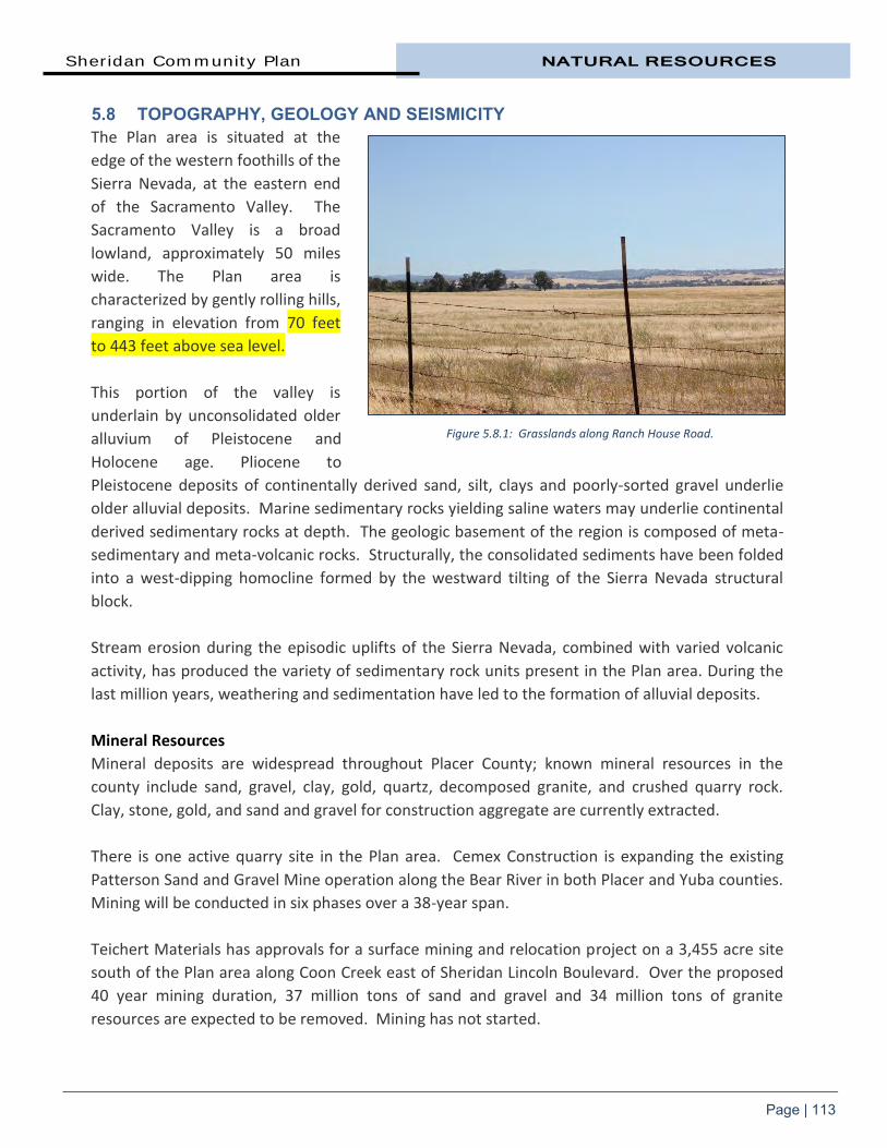
Sheridan Community Plan NATURAL RESOURCES
Page | 113
5.8 TOPOGRAPHY, GEOLOGY AND SEISMICITY The Plan area is situated at the
edge of the western foothills of the
Sierra Nevada, at the eastern end
of the Sacramento Valley. The
Sacramento Valley is a broad
lowland, approximately 50 miles
wide. The Plan area is
characterized by gently rolling hills,
ranging in elevation from 70 feet
to 443 feet above sea level.
This portion of the valley is
underlain by unconsolidated older
alluvium of Pleistocene and
Holocene age. Pliocene to
Pleistocene deposits of continentally derived sand, silt, clays and poorly-sorted gravel underlie
older alluvial deposits. Marine sedimentary rocks yielding saline waters may underlie continental
derived sedimentary rocks at depth. The geologic basement of the region is composed of meta-
sedimentary and meta-volcanic rocks. Structurally, the consolidated sediments have been folded
into a west-dipping homocline formed by the westward tilting of the Sierra Nevada structural
block.
Stream erosion during the episodic uplifts of the Sierra Nevada, combined with varied volcanic
activity, has produced the variety of sedimentary rock units present in the Plan area. During the
last million years, weathering and sedimentation have led to the formation of alluvial deposits.
Mineral Resources
Mineral deposits are widespread throughout Placer County; known mineral resources in the
county include sand, gravel, clay, gold, quartz, decomposed granite, and crushed quarry rock.
Clay, stone, gold, and sand and gravel for construction aggregate are currently extracted.
There is one active quarry site in the Plan area. Cemex Construction is expanding the existing
Patterson Sand and Gravel Mine operation along the Bear River in both Placer and Yuba counties.
Mining will be conducted in six phases over a 38-year span.
Teichert Materials has approvals for a surface mining and relocation project on a 3,455 acre site
south of the Plan area along Coon Creek east of Sheridan Lincoln Boulevard. Over the proposed
40 year mining duration, 37 million tons of sand and gravel and 34 million tons of granite
resources are expected to be removed. Mining has not started.
Figure 5.8.1: Grasslands along Ranch House Road.

NATURAL RESOURCES Sheridan Community Plan
Page | 114
Seismicity
The area is considered relatively seismically inactive and no active faults are known to exist within
the Plan area. There is potential for significant ground shaking as a result of seismicity associated
with potentially active, regional earthquake faults however.
The Coast Ranges to the west contain numerous active faults that are associated with the
northwest-trending San Andreas Fault system, including the Hayward and Calaveras faults. The
Coast Ranges-Sierran Block boundary zone, which follows the physiographic boundary between
the Coast Ranges and the Great Valley, contains potentially active “blind” thrust faults, such as
the Midland Fault. Based on the size of historical events and on the inferred segmentation of the
boundary zone, these “blind” thrust faults are capable of producing moderate to large
earthquakes. There are active faults located to the east of the project area, including the
Cleveland Hills and Carson Valley Faults, in addition to older faults (i.e., pre-Holocene in age, or
greater than 11,000 years before present) associated with the Foothill Fault System in the Sierra
Nevada foothills, such as the Bear Mountain and Melones fault zones.
5.9 HYDROLOGY The Plan area is primarily located
within the Bear River watershed.
The Bear River rises on the west
side of the Sierras just below Lake
Spaulding at the 5,500-foot
elevation and flows southwest 65
miles to its confluence with the
Feather River, draining portions of
Nevada, Placer, Sutter and Yuba
counties. The 292 square mile
watershed is 20 miles across at its
greatest width.
The upper Bear reaches eight
miles from the headwaters to the Drum Afterbay. Flowing out of the Drum Afterbay is the
Middle Bear, which enters Dutch Flat Reservoir where the waters of the Boardman Canal enter
after running through Alta Powerhouse. The Bear River continues to roughly parallel I-80. Just
before the Bear River flows into Rollins Reservoir, it merges with Steephollow Creek, the largest
tributary in the upper watershed. The Bear River discharges from Rollins Reservoir and flows
southwest into Lake Combie near Meadow Vista. The Bear River turns west and is fed by Wolf
Creek and then enters into Camp Far West Reservoir, the largest water body in the Bear River
watershed located north of the Plan area. The Bear joins the Feather River south of Yuba
City/Marysville.
Figure 5.9.1: Bear River at Highway 65.

Sheridan Community Plan NATURAL RESOURCES
Page | 115
One mile downstream of Camp Far West Dam, at River Mile 15, is a diversion dam operated by
the South Sutter Water District. The diversion dam moves Bear River water into the Sutter Water
District Aqueduct on the south side of the river. The aqueduct runs north to south on the
western edge of the townsite. Bear River subwatersheds in the Plan area include Sheridan
Catchment, Dalby Catchment, Lower Bear River West, and Yankee Slough (see Map Eight).
In the highest rainfall years, Bear River winter flows average 3,400 to 5,600 cfs (cubic feet per
second). In normal years, winter flows are 600–800 cfs. In the driest years, flows average only
20–65 cfs in winter months, down to 0 cfs in all other months. Bear River flow patterns are
typical of foothill streams with high winter and spring flows and very low summer and fall flows
and are regulated almost entirely by several storage reservoirs and numerous diversions.
The Bear River once supported substantial salmon and steelhead runs, but because of low flows
in the lower river below the South Sutter Irrigation District Diversion Dam, no self-sustaining
salmon runs presently exist, and the status of steelhead is unknown. However, the river does
support a popular fishery for rainbow and brown trout.
Main stem Yankee Slough is south of the townsite. Yankee Slough roughly parallels the Bear
River, originating in the rolling hills east of Sheridan. It flows into the Bear River and then to the
Sacramento River. The slough generally does not have trees along its banks. A portion of the
water flowing in Yankee Slough comes from the Camp Far West canal, affecting seasonal flows.
Due to the seasonal nature of precipitation, flow fluctuates significantly from the high flow
periods (October through May) to the dry summer months.
5.10 FLOODPLAINS Flooding occurs when the conveyance capacity of a channel is exceeded. This usually occurs from
above-average runoff caused by precipitation or snowmelt, but may also be the result of
manmade causes. Regional areas within Placer County subject to 100-year (1 percent chance)
and 500-year (0.2 percent chance) flooding are generally confined to the areas adjacent to the
county’s local rivers and streams. Map Nine shows the FEMA-designated 100-year floodplain in
the Sheridan area. There are other local drainages in the Sheridan area that also have 100-year
floodplains that have not been defined by FEMA. The 100-year floodplain is protected from
development by existing County regulations and policies within the Sheridan Community Plan.
In much of the Plan area, floodplains are narrow or insignificant. In areas of the Plan with flatter
topography, floodplains may have a more significant width with a shallow depth. As tributaries
converge, flooding becomes a more serious issue. Floodplains exist along drainages north and
south of Riosa Road at Andressen Road. Other floodplains are south of Dalby Road and at the
Dalby Road/Placer Road intersection. Additional information on flooding in the Plan area appears
in the Health and Safety chapter.
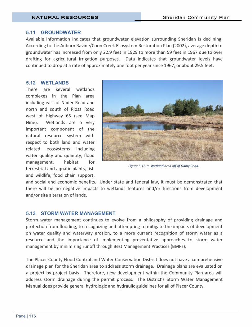
NATURAL RESOURCES Sheridan Community Plan
Page | 116
5.11 GROUNDWATER Available information indicates that groundwater elevation surrounding Sheridan is declining.
According to the Auburn Ravine/Coon Creek Ecosystem Restoration Plan (2002), average depth to
groundwater has increased from only 22.9 feet in 1929 to more than 59 feet in 1967 due to over
drafting for agricultural irrigation purposes. Data indicates that groundwater levels have
continued to drop at a rate of approximately one foot per year since 1967, or about 29.5 feet.
5.12 WETLANDS There are several wetlands
complexes in the Plan area
including east of Nader Road and
north and south of Riosa Road
west of Highway 65 (see Map
Nine). Wetlands are a very
important component of the
natural resource system with
respect to both land and water
related ecosystems including
water quality and quantity, flood
management, habitat for
terrestrial and aquatic plants, fish
and wildlife, food chain support,
and social and economic benefits. Under state and federal law, it must be demonstrated that
there will be no negative impacts to wetlands features and/or functions from development
and/or site alteration of lands.
5.13 STORM WATER MANAGEMENT Storm water management continues to evolve from a philosophy of providing drainage and
protection from flooding, to recognizing and attempting to mitigate the impacts of development
on water quality and waterway erosion, to a more current recognition of storm water as a
resource and the importance of implementing preventative approaches to storm water
management by minimizing runoff through Best Management Practices (BMPs).
The Placer County Flood Control and Water Conservation District does not have a comprehensive
drainage plan for the Sheridan area to address storm drainage. Drainage plans are evaluated on
a project by project basis. Therefore, new development within the Community Plan area will
address storm drainage during the permit process. The District’s Storm Water Management
Manual does provide general hydrologic and hydraulic guidelines for all of Placer County.
Figure 5.12.1: Wetland area off of Dalby Road.

Sheridan Community Plan NATURAL RESOURCES
Page | 117
To ensure the health of the watersheds surrounding Sheridan and in downstream communities,
storm water management is required for all new development projects to control both the
quality and quantity of storm water runoff. There are significant benefits in implementing
effective storm water management techniques, such as reducing erosion of watercourses,
avoiding downstream flash flooding, reducing siltation and sediment loading, promoting
watershed process protection, and ensuring that there is no destruction of aquatic, plant and
animal populations.
The County encourages the use of BMPs to achieve a “best fit” of design and technology to
promote environmentally sustainable development. To this end and the extent practicable, the
County will encourage the use of naturalized at-source measures such as bioswales to mitigate
the effects of storm water quantity and quality impacts on both surface and groundwater
resources.
All construction sites are required to utilize the most up-to-date practices to minimize the
introduction of silt and debris into natural watercourses including siltation fences and traps,
sediment ponds, and the application of fast growing grass or related seed to earth mounds or
bare-earth areas. For more information, see the principles contained in the Community Design
section and the Flood Hazards section in the Health and Safety chapter.
5.14 CLIMATE Sheridan lies within the Sacramento Valley Air Basin. The basin is bounded by the North Coast
Ranges on the west and the Northern Sierra Nevada Mountains on the east. The Mediterranean
climate of the Sacramento Valley has a hot, dry season during April through October; and a wet,
mild season from November through March. Mean monthly temperatures range from about 33.3
degrees Fahrenheit (January minimum) to 97.2 degrees Fahrenheit F (July maximum). Annual
precipitation is approximately 20 to 25 inches per year, with peak rainfalls occurring in December
through February. Prevailing winds are moderate and vary from moist clean breezes from the
south to drier winds from the north.
It is important to monitor the potential impacts of global climate change on Placer County.
Climate change is a global, national, regional, and local challenge. Changing climate conditions,
for example, with the potential to increase carbon dioxide concentrations that may lead to global
warming, could significantly change regional hydrology. Climate models estimate that the higher
temperatures resulting from increased carbon dioxide may warm the Sierra mountain ranges
resulting in reduced snow pack and higher winter surface water flow (more flooding potential),
lower spring/summer flow (less snow pack storage), and higher overall precipitation. These
effects would greatly impact water storage and conveyance systems, water needs and use, and
regional biological resources that have adapted to a different hydrology. Local governments
need to be prepared for and adapt to these changes, and work to mitigate and eliminate local
and regional emissions that contribute to climate change.

NATURAL RESOURCES Sheridan Community Plan
Page | 118
5.15 AIR QUALITY Air quality is an important resource in the Sheridan area. Clean air is not only healthier for
residents, it also has economic benefits by making the plan area a more attractive place to live
and work.
Sheridan is part of the Sacramento Federal Ozone Non-Attainment Area, which consists of
western Placer County, Sacramento and Yolo Counties and parts of El Dorado, Solano, and Sutter
Counties, all of which affect each other’s air quality. The Placer County Air Pollution Control
District (PCAPCD) works in conjunction with the other Air Pollution Control Districts and Air
Quality Management Districts of these contiguous jurisdictions, to develop plans to bring the
entire ozone non-attainment area into compliance.
Poor air quality in the region is attributed to emissions from human activities and natural sources,
as well as geography, local weather, and climate. Specific causes of poor air quality include those
caused by natural processes, as well as human activities that change the earth’s atmospheric
composition (through burning fossil fuels, etc.). Federal, state and regional agencies, such as the
PCAPCD, regulate air pollutants and contaminants that harm human health.
Regulations can include local rules, ordinances and policies, ambient monitoring, developing
permitting programs, enforcement activities, and establishing economic incentives to reduce air
pollution. One of the most effective ways of improving air quality in the plan area is by applying
the most recent standards and trends in air quality improvement to land use projects. By
consistently applying these standards, as well as the following goals and policies to projects
proposed within the plan area, the county will be making its own contribution towards improving
air quality within the Sheridan Community Plan area. 5.15.1 AIR QUALITY GOAL AND POLICIES The regulations found in this section apply to new development in Sheridan. Good land use
planning should be employed to insure that air quality in the community does not deteriorate,
and whenever practical, be improved. Appropriate air quality measures may be required as a
condition of approval for discretionary projects. GOALS
1. Integrate land use planning, transportation planning, and air quality planning to make the most efficient use of public resources and to create a healthier and more livable environment for the Plan area.
2. Reduce emission impacts to “sensitive receptors” (children, the elderly, persons afflicted with health issues) living in the Plan area.
3. Reduce the impacts of greenhouse gases and climate change through the review of land use projects within the Plan area.

Sheridan Community Plan NATURAL RESOURCES
Page | 119
POLICIES
1. Ensure that project air quality impacts are quantified using analysis methods and significance thresholds as recommended by the PCAPCD.
2. Ensure that projects which may have potential air quality impacts mitigate any of its anticipated emissions which exceed allowable emissions as established by the PCAPCD.
3. Ensure all air quality mitigation measures are feasible, implementable, and effective for individual projects and on a community-wide basis.
4. Encourage innovative mitigation measures and approaches to reduce air quality impacts by coordinating with the PCAPCD, project applicants, and other interested parties.
5. Work with the PCAPCD to reduce particulate emissions from project construction, grading, excavation, demolition, and other sources.
6. Encourage the use of pollution control measures such as landscaping, vegetation, and other materials which trap particulate matter or control pollution.
State Air Quality Regulations
In 2006, the California Legislature passed and Governor Schwarzenegger signed AB 32, the Global
Warming Solutions Act of 2006, which set 2020 greenhouse gas emissions reduction into law. It
directed the California Air Resources Board (ARB) to begin developing discrete early actions to
reduce greenhouse gases while also preparing a scoping plan to identify how best to reduce
greenhouse gas emissions in the state to 1990 levels by 2020. In 2004, the state produced almost
500 million metric tons of carbon dioxide. Reducing California’s greenhouse gas footprint to
meet AB 32 goals will require an approximately 29 percent cut in emissions below the levels the
state is currently projected to produce in 2020. ARB is currently determining how the AB 32 goals
will be reached. A variety of strategies, including sector-specific regulations, market mechanisms,
voluntary measures, fees, incentives, and other policies and programs are likely.
AB 32 marks a significant change in California’s energy policies. The reduction measures adopted
in 2011 to meet the 2020 target are expected to have wide-reaching impacts. California must
ensure that energy supplies keep pace with the growth while simultaneously reducing its
greenhouse gas footprint. Senate Bill 1078 introduced a Renewables Portfolio Standard (RPS)
with the goal of increasing the portion of electricity derived from renewable sources and sold to
retail customers to 20 percent by 2017. Initially designed to address California’s growing
dependence on natural gas for electricity generation, the RPS is also an important means for
meeting the state’s AB 32 greenhouse gas emission reduction goals.
Decisions affecting land use directly affect energy use and the consequent production of
greenhouse gases, primarily because of the strong relationship between where we live and work

NATURAL RESOURCES Sheridan Community Plan
Page | 120
and transportation needs. Significant efforts are necessary to reduce vehicle miles traveled to
meet the state’s emission reduction goals. Housing, transportation planning, and local
greenhouse gas reductions require local and regional approaches. At the time of this writing,
California’s metropolitan planning organizations, including SACOG, are involved with long-range
planning efforts to develop regional transportation plans that incorporate improved land use
decisions.
Transportation is the single largest contributor to California’s greenhouse gas emissions,
producing 39 percent of the state’s total emissions in 2004. California has long been regulating
the criteria pollutants from automobiles. On the local level, PCAPCD requires air pollution
sources to comply with applicable district rules and control measures. Projects will be required to
mitigate air quality emission impacts that exceed district-established standards.
Buildings consume more electricity than any other sector in California. About five billion square
feet of commercial building space accounts for 38 percent of the state's power use and more
than 25 percent of the state's natural gas consumption. (Source: The California Public Utilities
Commission, September 2010). During the development of California’s AB 32 implementation
process, building efficiency was identified as a sizable source of greenhouse gas emissions
reductions. State laws and standards are changing as
a result.
Every two years, the California Energy Commission
(CEC) releases an Integrated Energy Policy Report in
which it makes recommendations for energy policy in
the state, including changes to Title 24, the energy
efficiency portion of the building codes. The
standards are updated periodically to allow
consideration and possible incorporation of new
energy efficiency technologies and methods. In its
2007 report, CEC recommended adjusting Title 24 to
require net-zero-energy performance in residential
buildings by 2020 and in commercial buildings by 2030. The initiative to require net-zero-energy
buildings (ZNE) applies only to new construction.
The Energy Commission adopted the 2008 Standards on April 23, 2008. The 2008 Residential and
Non-Residential Compliance Manuals went into effect on January 1, 2010. Innovative
technologies and enhanced building design and operation practices are expected to dramatically
grow in use in the coming years.
What is Zero Net Energy? Properties which, on an annual basis, use no more energy from the utility grid than is provided by on-site renewable energy sources. These buildings use 50-70 percent less energy than comparable traditional buildings, and the remaining energy use comes from renewable sources, like solar panels or wind turbines incorporated into the facility itself.
Source: American Society of Heating, Refrigerating, and Air-Conditioning Engineers (ASHRAE)

CHAPTER SIX
CULTURAL
RESOURCES


Sheridan Community Plan CULTURAL RESOURCES
Page | 121
6. Cultural Resources Placer County has inherited a rich
legacy of cultural heritage
resources. Cultural resources are
defined as buildings, structures,
sites, features, or other artifacts
that may have archaeological,
historical, architectural, and/or
scientific importance. A number
of laws, regulations, and statutes
have been instituted at the
federal and state levels to provide
for the protection and
management of cultural
resources. The Placer County
General Plan has a number of policies protecting cultural resources.
Much of the county’s heritage is linked to its historical railroad and mining roots. The
preservation of Placer’s heritage is important for many reasons. Heritage resources are non-
renewable and once lost, can never be regained. A well-preserved heritage contributes to a
sense of permanence and continuity. The preservation of heritage resources provides a vital link
with the past and a foundation for planning the future, enabling these important assets to
continue to contribute to the identity, character, vitality, economic prosperity and quality-of-life
of the community as a whole.
Heritage is more than just old buildings and monuments. It also includes heritage trees, natural
features, and traditions that define the culture of a place. The definition of heritage has indeed
been broadened in recent years to include a diversity of resources, including tangible and
intangible.
Cultural resources are not necessarily restricted to structures such as buildings, groups of
buildings, monuments, bridges, fences and gates; sites associated with an historic event; natural
heritage features such as landscapes, woodlands, and riparian areas, streetscapes, flora and
fauna within a defined area, parks, scenic roadways and historic corridors; artifacts and
assemblages from an archaeological site or a museum; and traditions reflecting the social,
cultural, or ethnic heritage of the community. The adoption of the term “cultural resources”
reflects this evolution and promotes the need for a more holistic approach to heritage planning.
An important part of what makes Sheridan a special place is its unique built heritage. Built
heritage is the most common and most recognizable type of heritage resources and includes one
Figure 6.0.1: Circa-1875 Sheridan residence.

CULTURAL RESOURCES Sheridan Community Plan
Page | 122
or more significant buildings, structures, monuments, installations, or remains associated with
architectural, cultural, social, political, economic, or military history, and identified as being
important to a community. The preservation of the historical resources that represent this
history can help foster civic and neighborhood pride and lends to Sheridan’s character. 6.1 GOAL AND POLICIES The goal and policies which follow are intended to assure that future generations will have the
opportunity to form a sense of community pride and identify from the achievements of the
people that lived before them.
GOAL
1. Preserve all significant cultural resource sites to the maximum extent possible.
POLICIES
1. Emphasize protection and stabilization of existing cultural resource sites and features over removal or replacement.
2. Encourage retention, integration, and adaptive reuse of significant historical resources.
3. Encourage the listing of historical sites or structures on the Placer County, State Register of Historic Landmarks, and/or National Register of Historic Landmarks.
6.2 HISTORY OF SHERIDAN The economic development of western Placer County has been greatly influenced by its
resources: minerals, water, trees, soils, climate, and topography. Up until recent years, its three
major industries have always been mining, lumber, and agriculture. The Sheridan area has a rich
history.3 It began with the initial inhabitation by the Maidu Indians and continued through the
Gold Rush era when miners, farmers, and business moved into the area to seek their fortune.
Native Americans Indigenous people occupied the Sacramento Valley region and foothills of the Sierra Nevada for
thousands of years prior to the arrival of Euro-American settlers in the mid-1800s. The earliest
evidence of prehistoric human occupation of the area comes from a single, deeply buried site in
the bank of Arcade Creek, north of Sacramento, containing grinding tools and large, stemmed
projectile points. The points and grinding implements suggest an occupation date of sometime
between 6000 and 3000 B.C.
3 Much of the information in this section was compiled by Jerry Logan’s report, A History of Sheridan, Indian Era to
1980.
Sheridan Community Plan CULTURAL RESOURCES
Page | 123
Sheridan is within the ethnographic territory of the Penutian-speaking Nisenan, one of three
Maiduan-speaking tribelets inhabiting the northeastern half of the Sacramento Valley and the
adjoining western slopes of the Sierra Nevada. The Nisenan, also known as the Southern Maidu,
lived along the main stems and tributaries of the American, Yuba, and Bear Rivers, as well as the
lower reaches of the Feather River. Their territory extended from above the junction of the
Feather and Sacramento rivers on the north to a few miles south of the American River in the
south. The Sacramento River bounded the territory on the west and extended close to Lake
Tahoe in the east. The Nisenan Indians usually built their villages on low rises along streams. The
Valley Nisenan lived mainly along the Sacramento River in large villages with populations of
several hundred each. There have been at least nine distinct settlements identified along the
Bear River. Between there and the foothills, the grassy plains were largely unsettled, used mainly
as a foraging ground by both valley and hill groups.
The Spanish came to the Central Valley around 1769, and by 1776 the Miwok territory bordering
the Nisenan on the south had been explored by Jose Canizares. In 1808 Gabriel Moraga crossed
Nisenan territory, and in 1813 a major battle was fought between the Miwok and Spaniards near
the mouth of the Cosumnes River. Though the Nisenan appear to have escaped the removal of
tribes into the Spanish missions, they were not spared the ravages of diseases introduced by the
Europeans. In 1833 an epidemic, probably malaria or smallpox, raged through the Sacramento
Valley, killing an estimated 75 percent of the native population.
When John Sutter erected his fort at the present site of Sacramento, he had no problem getting
the few Nisenan survivors to settle nearby. The discovery of gold in 1848 near the Nisenan village
of Colluma (and present town of Coloma) drew thousands of miners into the area and led to the
widespread killing and virtual destruction of traditional Nisenan culture.
In the 1850s there were still accounts of Indian camps in the Sheridan area. But as groups they
were slowly breaking up and being absorbed into the white man’s economy, or retreating into
the remoter hills where they could try to hang onto their old customs. Reservations soon became
available, including in Auburn.
By the time of the Great Depression, no Nisenan remained who could remember the days before
the arrival of the whites.
Gold Rush History The earliest routes (trails) in western Placer County were formed by miners trying to get to the
gold fields on the American River and immigrants moving down from the Sierras along the Bear
River to reach the Sacramento Valley. Mining trails later became wagon roads.
High quality granite was quarried in and around Penryn, Rocklin, and Lincoln. A low grade of coal
was mined in Lincoln and was reportedly responsible for the discovery of clay in that area.

CULTURAL RESOURCES Sheridan Community Plan
Page | 124
Copper was mined north of Lincoln in the Mt. Pleasant, Thermalands, and Camp Far West areas.
Each of these minerals in turn became the mainstay of a local economy and contributed to the
growth of Sheridan, Lincoln, Rocklin, Penryn, and other communities.
Agriculture in western Placer County began about 1845 when Theodore Sigard planted wheat on
the south side of the Bear River. Claude Chana, who discovered gold on Auburn Ravine in 1848, is
credited with planting Placer County’s first fruit trees in 1846 along the Bear River flood plain. By
the 1850’s, a few enterprising men had realized it might be more profitable supplying fruits,
vegetables, and flour to the mining camps than actually working a claim.
Sheridan was first settled in
1855 by E.C. (Eugene) Rogers
and was originally called “Union
Shed” or simply “Shed.” The
name was derived from the
ranch house and its attached
shed which provided shelter to
the wagon freight teams and
travelers following the
Sacramento and Nevada Road.
At “Union Shed,” the road split
to four directions. One road ran
westerly toward Nicholaus;
another northwesterly to
Marysville via Kompton’s Crossing of the Bear River; one northeasterly towards Grass Valley via
McCourtney’s Crossing of the Bear River; and the fourth running easterly to Auburn via Danetown
(also known as Daneville, a few miles east of Sheridan at the present McCourtney and Fleming
roads). The “Shed” was approximately 1,000 feet to the south of the current Sheridan townsite.
Four or five years after its settlement, two stagecoaches passed the “Shed” daily and the number
of big freight teams during that period ranged from forty to sixty per day. Freight wagons and
stagecoaches could stop here and be sheltered from the rain or hot sun. Horses or oxen could
rest, drink water, and eat while the driver or passengers went inside to eat and drink. It was at
the “Shed” that these teams laid in supplies to last during their journeys, this settlement became
a market place at which the farmers of the area congregated for the purpose selling their wheat,
oats, and barley.
When Lincoln was founded and began to thrive in 1861, Rogers’ Shed lost some of it purpose.
The new railroad ended at Lincoln however, and any freight or passengers heading north of
Lincoln had to continue past the Shed by wagon or stagecoach, keeping Rogers in business.
Figure 6.2.1: Historical Marker, 13th
Street, February 2012.

Sheridan Community Plan CULTURAL RESOURCES
Page | 125
By 1865, the thriving little town surrounding the Shed boasted a public school, several trading
establishments, a post office, an express office, and one hotel. In 1868, the Shed and adjacent
buildings were burned.
The “Yuba Railroad” from Lincoln to Wheatland was completed in 1866. The first depot building
constructed at Sheridan was near the Shed. After the 1868 fire, the depot was moved some sixty
rods to the “village” where a small cluster of homes was developing. This site, across 13th Street
between G and H streets, where a main road and the new rail line converged, was a prime
location for a town or village. Mark Hopkins and his brother Mose owned over 1,000 acres in the
vicinity. Surveyors laid out a town plan and nine blocks had been staked out by 1871.
A post office was established on July 10, 1868. The post office and town needed a name.
“Sheridan” was chosen in honor of Union General Philip Sheridan of Civil War fame. Sheridan
was a trading point for a considerable population of farmers and ranchers. A flouring mill was
built in 1870 for Daniel Click near what would be the corner of ‘E’ Street and 13th Street. The mill
was steam-powered using wood from the foothills and well water. The capacity of the mill was
approximately 175 barrels of flour per day and utilized nearly all of the grain raised within a
radius of ten miles.
The old depot that was moved into town from the site of Roger’s Shed was replaced in 1874 with
a new depot provided by the railroad. In August of 1875 the old freight depot and woodshed
were destroyed by fire. A bridge across the Bear River to Wheatland was completed in December
1877.
By 1881, Sheridan boasted a population of 125 and counted among its commercial
establishments three stores, one drug store, two blacksmith shops, Click’s flour mill, one shoe
shop, two hotels and three saloons. The community was also home to two clergymen, one
doctor, one teacher, and two temperance organizations.
On August 25, 1891, nearly Sheridan’s entire business district burned down. The fire started in
the Parrott Hotel (previously named the Sheridan Hotel) that was located at the southeast corner
of Riosa Road and 13th Street. There was no fire department in a small unincorporated town like
Sheridan in the 1890s. Just one commercial building survived, the Sheridan Cash Store, which still
stands today.
Many merchants could not afford to rebuild and many of them left Sheridan for Lincoln or other
towns. Sheridan was never to be the social and commercial gathering spot it had been before the
railroad was built. Total collapse of the town was avoided by the survival of the flour mill
complex, the main warehouse, the general store, and a few small businesses outside the town
center. It continued to survive as an agricultural community providing homes and services to the
ranchers from surrounding areas.

CULTURAL RESOURCES Sheridan Community Plan
Page | 126
In contrast to Sheridan, Lincoln was growing steadily and attracting Sheridan residents and
businesses. The Gladding, McBean & Co. clay pottery was expanding rapidly. The population
decline through the 1890s was reflected in the number of school graduates in 1900: one.
The 1920s brought a wave of Russian immigrants to the Sheridan area. They had left Russia after
the political upheaval and religious persecution before and after the revolution there (1917-18).
Many settled in the San Francisco Bay area, saved money and then moved to the Central Valley.
The patriarch of this group was reported to be Max Popoff, whose son James was already living in
the Sheridan area. Most of these colonists were related to Popoff and belonged to the Sheridan
Molokan Church.
In the late 1950’s a disease called ‘pear decline’ virtually brought the industry to a halt. Pear
decline and the ability of the large Central Valley farms to produce higher yields than the small
ranches in Placer County also contributed to the demise of Placer’s once thriving fruit industry.
During the years following the decline of the fruit industry, the Placer County supported an
important dairy industry with many of the county’s fruit ranches being converted to dairies. By
1961, population in Sheridan was approximately 250. According to published accounts, Sheridan
at the time had one general store, the post office, a hardware store, two gas stations with
garages, one second-hand store, one tavern, an old vacant warehouse, a modern school, three
churches (one Russian), one turkey ranch, a roadside seasonal market, many old houses, cabins,
and several new homes.
Today, rather than orchards and farms, the Sheridan area has become a haven for people seeking
a “place in the country.” Homes and ranchettes are being built amongst old orchards, farms, and
ranches. Farmers are typically now growing rice or walnuts instead of wheat.
Railroad History In the 1860s, the
railroad came to
Placer County. The
Central Pacific
Railroad completed
track to Roseville in
1864 and to Auburn
in 1865. Sheridan
greeted its first train
from Sacramento to
Wheatland, via
Junction (now
Roseville) and Figure 6.2.2: Sheridan Station and freight warehouse. Oddfellows Hall, right. Circa-1900.
Image Courtesy of Placer County Museums

Sheridan Community Plan CULTURAL RESOURCES
Page | 127
Lincoln in 1866. This was the first segment of Southern Pacific’s Shasta Route through northern
California to Portland. It left the main line at Roseville and passed northward through Lincoln and
Sheridan serving the farming and clay industries. The railway extension from Lincoln north was
first called the Yuba Railroad. In 1868 the Central Pacific Railroad rescued the financially strapped
Southern Pacific and completed the line to Marysville in 1869. By the late 1870s the line
extended into Oregon.
By the early 1900s copper mining had entered the county. The 1910 State Mineralogist Report
defined the mining districts associated with western portion of Placer County at the time. The
Dairy Farm (Van Trent) district included the copper and gold mines in the region about eight miles
northeast of the Sheridan townsite. Amphibolite
and diabase are the prevailing formations in this
area. Active mines included Dairy Farm (copper),
Valley View (copper), and Bobtail (gold and copper).
In 1913, interests representing the American
Smelting and Refining Company (ASARCO)
purchased the Dairy Farm mine along the Bear
River northeast of Sheridan. Ore from the copper,
gold, and silver mine was hand sorted then brought
to a stockpile near Sheridan for transfer to the
Southern Pacific Railroad.
As mining activity increased, it became necessary to
improve shipping facilities at the mine. Previously,
wagon trains hauled the
copper ore to Sheridan for
shipment by rail to Bay
Area smelters. In 1914,
the Alta Construction
Company began
construction on a three-
foot gauge railroad from
the mine to just north of
Sheridan.
The sidings and spurs off
the Southern Pacific were
located just west of Lichty
Road. It was named Jester
after the owner of the land Figure 6.2.4: Dairy Farm Mine Transfer Yard. Southern Pacific Railway Right-of-Way
map left. 2010 aerial with parcel map, right.
Figure 6.2.3: Placer Herald, July 25, 1914.
Image Courtesy of Placer County Museums

CULTURAL RESOURCES Sheridan Community Plan
Page | 128
there. The unloading site featured an inclined narrow-gauge spur in the center with standard-
gauge tracks on each side below the loading chutes. The ore cars could release their loads down
chutes to the waiting Southern Pacific cars. The route from the mine to Sheridan covered
approximately 8.5 miles and ran roughly parallel to Camp Far West Road. Then it turned easterly
up a gentle grade and curved in a loop towards Van Trent along what is now McCourtney Road.
Dairy Farm Mine was the only producing copper mine in Placer County in 1915 and continued
until September 1917 when the entire plant shut down. In January 1918 the mining and railroad
equipment consisting of two locomotives and ten cars was sold and the right-of-way reverted to
the original owners. Little remains to mark its passing but the scarring from the transfer location
along the Southern Pacific rail line can be seen from aerials (see Figure 6.2.4). 6.3 REGULATORY FRAMEWORK A variety of California laws and local ordinances have been passed in the last few decades that
are designed to protect cultural resources. Key legislation is summarized below. Several
California public resource codes make it illegal to damage objects of historical or archaeological
interest on public or private lands or to disturb human remains.
Summary of California Laws Protecting Cultural Resources
California Environmental Quality Act ("CEQA") CEQA requires that all private and public activities not specifically exempted be evaluated against the potential for environmental damage, including effects on historical resources.
Health and Safety Code, Section 7052 (Stats. 1939, C.60:672) This code section establishes a felony penalty for mutilating, disinterring, or otherwise disturbing human remains, except by relatives.
Penal Code, Section 622.5 (Stats. 1939, D.90:1605, 5.1) This code provides misdemeanor penalties for injuring or destroying objects of historical or archaeological interest located on public or private lands.
Public Resources Code, Section 5097.5 (Stats. 1965, C.11362792) An additional code defines as a misdemeanor the unauthorized disturbance or removal of archaeological, historical, or paleontological resources located on public lands.
Public Resources Code, Section 5097.9 It is illegal to interfere with or cause severe or irreparable damage to any Native American cemetery, place of worship, religious or ceremonial site or sacred shrine.
Health and Safety Code, Ch. 1492 (SB 297) The Health and Safety Code requires that the Governor's Native American Heritage Commission be consulted whenever Native American graves are found. It makes it illegal to possess remains or artifacts taken from Native American graves. If human remains are discovered, all work is required to stop.
Public Resources Code, Sections 5024 and 5024.5 These code sections require State agencies to inventory and protect historical structures and objects under their jurisdiction. The State Historic Preservation Officer must be
consulted before any such structure or object is altered or sold.

Sheridan Community Plan CULTURAL RESOURCES
Page | 129
6.4 CULTURAL RESOURCE INVENTORY There are no local, state or federally-listed landmarks in the Community Plan area. A Historical,
Architectural, and Archaeological survey of unincorporated Placer County was completed in 1992.
The purpose of the survey was to identify properties that are important to the history of Placer
County, including Sheridan. The information obtained by such a survey provides unique insights
into a community's past, and can form the basis for making sound judgments in community
planning. Survey data can be used to create a preservation plan in which significant historic
resources are recommended for preservation. It can lead to an increased understanding and
public awareness of a community's historic landmarks and a greater commitment to preserving
them.
The survey undertaken by the professional consulting firms Ogden Environmental and Energy
Services, Archeological Services, Foothill Resources, and Steward/Gerike Consultants was
prepared for the Placer County Department of Museums. It identified one historical resource in
Sheridan, the Sheridan Cash Store, and five potential historical resources.
Table 6.4.1
Identified Historical Resources in Sheridan 5740 13th Street Sheridan Cash Store Description- One-story, false-front building with formal pediment, entablature, corbelling, with vaulted arches in an Italianate Classic revival style. Construction Date- 1879 Significance- The only identified commercial brick building remaining in Sheridan. The
structure was built by Oliver Perry Richardson and a partner named Sparks in 1879.
Source: Historical, Architectural, and Archaeological Resources of Placer County, 1992
Sheridan Cash Store Oliver Perry Richardson, a
wealthy landowner with many
properties, and a partner named
Sparks, built the brick store at its
present site at 5740 13th Street in
1879. The Placer Herald
newspaper reported in 1880 that
the store was named the
“Sheridan Cash Store.” On August
24, 1891, Sheridan’s entire
business district burned down.
Oral history accounts state that
the general store was the only
building to survive the disastrous
Figure 6.4.1: The Sheridan Cash Store, 5740 13th
Street.

CULTURAL RESOURCES Sheridan Community Plan
Page | 130
fire. The store was the center of community life as it housed a Wells Fargo office and Post Office.
This six-course American Bond
Brick structure has an Italianate
commercial false front consisting
of a stepped parapet with a
denticular cornice, which hides a
corrugated metal gable roof.
In April 1989, then owner of the
property Donald Rankin applied
to demolish the structure to
construct a retail plaza on the
site. The County’s Design/Site
Review Committee denied the
application and the applicant
appealed that decision to the
Board of Supervisors.
On August 14, 1989, the Board of Supervisors voted to uphold the decision to deny the
demolition of the 1879 structure. The date “1879” appears on the building to this day. The
building is currently vacant (Figures 6.4.1 and 6.4.2).
Development has caused historical properties to be lost over time. According to the 1992 survey,
the following have physical integrity, and may have historical importance. Research is
recommended to determine complete historical context.
Table 6.4.1 Historical Resources in Sheridan
4871-81 ‘H’ Street private residence Description- The 1-½ story house is composed as a side-gabled units with a central,
front-facing roof dormer and a full-width, dropped, hip-roofed front porch. Detailing includes eave and gable fascia and friezeboards, cornice returns and gable ornament. Construction Date: circa-1875
5415 Ranch House Road private residence
Description- This property consists of a main dwelling, five sheds, a shop and garage. Detailing includes boxed eaves and gables with friezeboards and molded gable fascia. Porch detailing includes lathe-turned posts and alternating spindlework and stick railing. Construction Date: circa-1875
Ranch House Road Sheridan Cemetery
Description- The Odd Fellows Sheridan Cemetery is located at the southern terminus of Ranch House Road. Zinc, marble and granite grave markers are primarily divided into
family named lots and date to as early as 1896. Potentially landmark trees on the site include Italian cypress and cedar.
Figure 6.4.2: Façade detail on Sheridan Cash Store.

Sheridan Community Plan CULTURAL RESOURCES
Page | 131
Ranch House Road concrete culvert
Description- This reinforced concrete culvert carries Ranch House Road over an unnamed seasonal stream. The deck of the culvert measures approximately 20 feet long by approximately 20 feet wide. Only one of the two concrete railings remains, the
other has been replaces with a wooden-post and galvanized steel guard rail. Construction Date: circa-1915
“Sheridan Jail” concrete bunker
Description- This reinforced structure is located near the corner of Wind Flower Place and Sheridan Lincoln Boulevard. The building was a holding cell, one of several jails constructed in outlying towns in the county. It was said to have a “dial, same as a on a safe, to open it.” The structure was relocated to its present location from the east side of Sheridan Lincoln Boulevard some time ago. The building is intact with two small grated windows and a door opening.
Construction Date: circa-1910
Source: Historical, Architectural, and Archaeological Resources of Placer County, 1992
Historical Resources in Sheridan
Sheridan Jail, Wind Flower Place 5415 Ranch House Road
Ranch House Road Culvert 4871-81 ‘H’ Street
Figures 6.4.3 thru 6.4.6: Historical resources in Sheridan.

CULTURAL RESOURCES Sheridan Community Plan
Page | 132
Sheridan Cemetery Quincy Stanclift, a settler from
Missouri working in Sheridan,
died after a short illness and was
buried on E.C. Rogers property,
located on a hill on the southern
outskirts of the townsite in 1857.
Family members of the Stanclift
family later moved to Sheridan
and also were buried on the plot.
It was the beginning of the
Sheridan Cemetery.
Most of the earliest residents of
the Sheridan area were buried at
Manzanita, Western Placer’s first
cemetery begun in the early
1850s. In 1888, the International
Order of Odd Fellows (IOOF)
bought two acres from Rogers,
adjacent to and east of the
Stanclift plot for a cemetery. This
opened the site to more of
Sheridan’s residents. The acre
holding the Stanclift plot was
deeded to the IOOF cemetery in
1906. The Stanclift-Rogers
gravestones are at the top of the
hill.
In 1921, the Russian Colony in Sheridan (estimated at 17 families) was refused permission to bury
one of its members in the IOOF cemetery. They formed their own cemetery on a one-acre site
north of the IOOF site.
In 1928, the three-acre IOOF cemetery was deeded to Public Cemetery District #1, later named
Placer County Cemetery District #1. The Russian cemetery, known as both the Russian Colony
Cemetery and the Sheridan Molokan Church Cemetery, was deeded to the Placer County
Cemetery District #1. Burials continue in the cemetery.
Figures 6.4.7 and 6.4.8: Sheridan Cemetery.

Sheridan Community Plan CULTURAL RESOURCES
Page | 133
6.5 PRESERVATION INCENTIVES A number of State and Federal financial and technical tools are available to help give new life to
historic properties. Programs assist in the restoration, maintenance, rehabilitation, and adaptive
reuse of historic resources. The Federal government offers rehabilitation tax credits to qualified
projects and properties.
California State Register – Besides the recognition of owning an historically significant property,
listing on the California Register may qualify the owner to benefit from historic preservation grants
and other preservation programs such as the Mills Act (see below). The rights and responsibilities of
owners of historic properties are the same as those of owners of non-historic properties. There are
no restrictions on the use, treatment, or transfer of private property.
If a resource meets the criteria for registration, it may be nominated by any individual, group, or local
government to any program at any time. Registered landmarks are eligible for directional markers
on State highways.
National Register – The National Register of Historic Places is the official list of the Nation's historic
places worthy of preservation. Authorized by the National Historic Preservation Act of 1966, the
National Park Service's National Register of Historic Places is part of a national program to coordinate
and support public and private efforts to identify, evaluate, and protect America's historic and
archeological resources.
Listing in the National Register of Historic Places provides formal recognition of a property’s
historical, architectural, or archeological significance based on national standards used by every
state. National Register listing places no obligations on private property owners. There are no
restrictions on the use, treatment, or transfer of private property. Residential homeowners do find
that property values increase when historic preservation standards are used in rehabilitating their
homes.
Federal Historic Preservation Tax Credit – A 20 percent income tax credit is available for the
rehabilitation of historic, income-producing buildings that are determined by the Secretary of the
Interior, through the National Park Service, to be “certified historic structures.” The California Office
of Historic Preservation and the National Park Service reviews the rehabilitation work to ensure that
it complies with the Secretary’s Standards for Rehabilitation.
Owner-occupied residential properties do not qualify for the federal rehabilitation tax credit. The
credit is only available to income-producing properties (commercial, industrial, agricultural, and
residential rentals), not for owner-occupied housing.
State Historical Building Code – The California Historical Building Code is a performance-based code
that recognizes older buildings often have additional needs in meeting fire and life safety

CULTURAL RESOURCES Sheridan Community Plan
Page | 134
requirements. Owners of qualified historic properties are entitled to use the State Historical Building
Code (SHBC) for rehabilitation of structures. The SHBC, found in the California Code of Regulations,
Title 24, Part 8, supplants the Uniform Building Code (UBC) and is particularly useful in code issues
related to requirements for plumbing, electrical, structural, seismic, fire safety, energy requirements,
and disabled access. The SHBC in most cases does not allow code standards to be waived. Instead,
the SHBC provides for alternative methods to achieve reasonable levels of safety.
Mills Act – The Historical Property Contract (Mills Act) Program provides property tax abatement to
qualified properties. The Mills Act Program is administered and implemented by local governments
(cities and counties) that establish their own criteria and determines how contracts will be
implemented in their jurisdiction. Local governments enter into contracts with owners of qualified
historic properties who actively participate in the restoration and maintenance of their historic
properties while receiving property tax relief. Owner-occupied family residences and income-
producing commercial properties may qualify for the Mills Act program. Placer County has not
adopted a Mills Act program.
California Heritage Fund Program – The California Heritage Fund grant program is funded under the
State Neighborhood Parks, Clean Water, Clean Air and Coastal Protection Bond Act of 2000. Grants
may be used for acquisition, rehabilitation, restoration, or interpretation projects and are available
for any product, facility or project designed to preserve a historic resource that is listed in or
determined eligible for listing in the National or state registers. This program requires a 50 percent
match from the grantee. The program is administered by the State Office of Historic Preservation,
and there are two grant funding cycles per year.
Placer County Register of Cultural and Historic Resources – Private property owners may seek
placement of their property on the Placer County Register. Section 15.60.010 of the Placer County
code provides for the protection, enhancement, perpetuation, and use of historic structures and/or
other cultural resources officially designated by the Board of Supervisors. The alteration,
reconstruction, demolition, or destruction in whole or part, of a designated cultural/historic resource
or a site in a designated cultural/historic district is prohibited unless permission is granted by the
Planning Services Director or their designee.
Ordinary maintenance and repair of any exterior feature of any structure on property listed in the
official register is permitted; however, such maintenance or repair may not involve a change in the
design or result in the modification, demolition, or removal of any architectural feature of the
property.
Preservation Easements/Acquisition of Property – Preservation easements on the facades of
buildings, or elsewhere on any site, or acquisition of property deemed valuable as a cultural/historic
resource, may be acquired by the County or an appropriate nonprofit group through purchase,
donation, or condemnation pursuant to California Civil Code § 815.

Sheridan Community Plan CULTURAL RESOURCES
Page | 135
Adopted in June 2000, the Placer Legacy Open Space and Agricultural Conservation program seeks
to protect and conserve open space, agricultural lands, and other resources. The program has been
developed to implement the goals and policies of the 1994 Placer County General Plan. One of the
key objectives of the program is to “retain important scenic and historic areas.”
Placer Legacy calls for an evaluation of historical resources and development of incentive-based
programs to protect these resources. Historical locations and structures that warrant protection are
to be identified and the County will seek to work with property owners and where appropriate,
willing sellers to protect these resources. Due to the rich cultural heritage present in the county,
there may be circumstances in which an acquisition solely for the purpose of protecting a unique
cultural/historical resource may be appropriate, particularly when that resource is immediately
threatened. To date, one historical property has been acquired, the Gould Park site in Cisco Grove,
which contains an historic stand of trees and two historic stone structures located on Hampshire
Rocks Road.
6.6 ARCHEOLOGICAL RESOURCES In order to prevent vandalism and unauthorized artifact collecting and to protect landowners from
trespass, the locations of cultural resources are kept confidential. California Government Code
Section 6254.10 exempts archaeological site information from the California Public Records Act,
which requires that public records be open to public inspection. Location information is restricted
and is not circulated as part of public documents, but is used for planning purposes only. The North
Central Information Center (NCIC), California State University at Sacramento maintains a record of
archaeological sites in Placer County including Sheridan. Records are available to qualified
researchers for use during the land development process. An on-the-ground archaeological field
survey was not performed as part of the Community Plan update.
Figure 6.6.1: 4871-81 ‘H’ Street


CHAPTER SEVEN
HEALTH AND
SAFETY


Sheridan Community Plan HEALTH AND SAFETY
Page | 137
7. Health and Safety The Health and Safety section establishes policies to protect the community from natural and
manmade hazards. It is intended to guide land use planning by providing pertinent data
regarding noise, seismic, fire, and flood hazards. The main purpose of this section is to provide
standards for reducing the risk of exposure to the hazards. When distilled, the rules are quite
simple: build above the floodwaters, where the fire fuel is low, and on stable ground. Law
enforcement protection is discussed in Chapter 10.
Natural hazards are processes such as earthquakes, flooding, and wildfires, and have been
occurring for thousands, even millions of years. These natural processes have played an essential
role in shaping the topography and landscape of Placer County, and become “hazards” when they
disrupt or otherwise affect the lives and property of people.
This section is closely linked to the Land Use and Natural Resources chapters of the Community
Plan. The Land Use section designates the general distribution of land uses within the Plan area,
as well as standards for population density and building intensity. To avoid unreasonable public
risk, the Land Use section must take into account the public safety hazard identification and
evaluation in the Health and Safety chapter. By limiting development density in areas that may
be subject to significant geologic and other safety hazards, the risk of loss of life and property can
be minimized. One of the purposes of the Natural Resources chapter is to preserve open space
for public health and safety, including areas that require special management and regulation
because of hazardous or special conditions (e.g., flood plains and high fire risk areas).
7.1 NOISE A Noise Element is a mandatory
component of General Plans
pursuant to the California
Government Code Section
65302(f). The Placer County
General Plan recognizes the
guidelines adopted by the Office of
Planning and Research pursuant to
Section 46050.1 of the Health and
Safety Code. The purpose of this
Noise chapter is to set forth
policies that regulate the ambient
noise environment and to protect
residents from exposure to
excessive noise.
Figure 7.1.1: Union Pacific crossing at Sheridan Lincoln Boulevard.

HEALTH AND SAFETY Sheridan Community Plan
Page | 138
Noise is primarily a concern with respect to noise sensitive land uses such as residences and
schools. Places of worship and meeting facilities are noise sensitive with respect to interior
conditions, but are generally not sensitive to exterior noise levels.
Noises vary widely in their source and volume ranging from individual occurrences such as a
“warning horn blast” from a passing train, to intermittent disturbances of overhead aircraft, to
fairly constant noise generated by vehicular traffic on highways.
The principle noise source in Sheridan is related to vehicular traffic on Highway 65 and the Union
Pacific railway crossing at Sheridan Lincoln Boulevard. Other noise sources include overflights
from the Lincoln airport and Beale Air Force Base and agricultural operations in and around the
Plan area. Noise produced by industrial or commercial activity has a negligible effect on the
community’s ambient noise environment.
The need for increased attention to noise in the planning process is a consequence of the
potential for continued elevation of ambient noise levels, the spread of noise producing activities
into formerly quiet areas, and heightened awareness of the impact of noise on human health.
Noise affects both physiological and psychological well-being. In addition to causing hearing loss,
noise interferes with activities such as communication, sleep, and thought. Noise can be a source
of great annoyance for many persons and may be a contributing factor in stress-related health
disorders.
The Noise Element in the General Plan provides a systematic approach to identifying and
appraising noise problems in the community, quantifying existing and projected noise levels,
addressing excessive noise exposure, and community planning for the regulation of noise.
The purpose of this section of the Sheridan Community Plan is to establish a policy framework for
the identification and reduction of potential noise sources. Noise, often described as unwanted
sound, can be an intrusive part of our daily lives. Therefore, it is important to determine critical
noise areas and provide a means to achieve noise-compatible land uses in the vicinity of existing
or planned noise producing sources.
Sound is defined as any pressure variation in the air that the human ear can detect. If the
pressure variations occur frequently enough, they can be heard and hence are called sound. The
decibel scale is used to measure sound. The hearing threshold is defined as 0 dB. Other sound
pressures are then compared to this reference pressure and a logarithm is taken to keep the
numbers in a practical range.
For planning purposes, noise is a measure using a weighted scale. Sound levels are then
expressed in terms of dBA. Community noise is commonly described in terms of the “ambient”
noise level, which is defined as the all-encompassing noise associated with a given environment;

Sheridan Community Plan HEALTH AND SAFETY
Page | 139
it usually is a composite of sounds from many sources, near and far. It is desirable to control
ambient noise level to reduce the adverse effects of noise.
A common statistical tool to measure ambient noise levels is the average or equivalent sound
level over the period of an hour. This average is expressed as Leq. A further refinement of the
community noise measurement process is the day-night average level (Ldn) which is based on a
24-hour noise level average, with weighting given to nighttime noise, given the increased
sensitivity to nighttime noise.
According to the State of California Office of Planning and Research General Plan Guidelines, an
acoustical study may be required in cases where these noise-sensitive land uses are located in an
area of 60 Community Noise Equivalent Level (CNEL) or greater. Any land use that is exposed to
levels higher than 65 CNEL will require noise attenuation measures.
Railroad Noise Rail operations on the Union
Pacific Railroad line contribute to
the ambient noise level in
Sheridan. According to Union
Pacific officials, between 20 and
25 freight trains per day pass
through Sheridan which consists
of one track that crosses Sheridan
Lincoln Boulevard at Wind Flower
Place. The passing of trains is
randomly distributed throughout
the day and nighttime hours and
speeds at the crossing range from
20 mph up to 65 mph.
Existing and planned residential development and other noise-sensitive land use development
within 1,000 feet of the Union Pacific line could be potentially exposed to unacceptable noise
levels associated with passing freight trains. Exposure to unacceptable noise levels can be
counteracted by the implementation of land use designs that factor in noise concerns. Berming,
landscaping, site planning, improvements to building facades, and windows or other effective
measures may be used to achieve required interior and exterior noise level standards. Policies in
this Chapter establish criteria for noise sensitive land uses to ensure that exposure to noise levels
will not exceed acceptable levels.
Figure 7.1.2: Union Pacific crossing at Sheridan Lincoln Boulevard.

HEALTH AND SAFETY Sheridan Community Plan
Page | 140
Traffic Noise Vehicular traffic on Highway 65, Sheridan Lincoln Boulevard, and Riosa Road is a contributor to
the ambient noise environment in Sheridan. Traffic noise depends on the speed of traffic, the
road surface type, and the percentage of truck traffic. The primary source of noise from
automobiles is high frequency tire noise, which increases with speed. There are also unpaved
roads in sparsely populated portions of the Plan area that can be both noisy and dusty when
traveled upon. In addition, trucks and automobiles produce engine and exhaust noise. Trucks
also generate wind noise. While tire noise from autos is generally located at ground level, truck
noise sources can be located as high as 10 to 15 feet above the roadbed due to tall exhaust stacks
and higher engine placement.
Along the Highway 65 bypass, soundwalls were not considered at isolated rural residences on
large lots because they did not meet the Caltrans/FHWA reasonableness criteria. Soundwalls for
rural and single family residences would not be reasonable from a cost perspective because the
cost of the soundwall per residence was too high.
Industrial and Commercial Noise Sources Noise is inherent at many
industrial, mining, or commercial
enterprises, even when the best
available acoustical technology is
applied. The noise levels within
an industrial facility are controlled
by Federal and State employee
health regulations (OSHA and Cal-
OCHA). Exterior noise levels are
governed by County ordinance.
Noise produced by industrial and
commercial sources has a
negligible effect on Sheridan’s
ambient noise environment.
New industrial development within
Sheridan could bring additional noise issues. Design review and site specific mitigation should be
identified and follow the guidelines set forth in this Chapter and elsewhere in the Community
Plan.
Figure 7.1.3: Light Industrial uses along Riosa Road.

Sheridan Community Plan HEALTH AND SAFETY
Page | 141
Agricultural Noise Sources There are active agricultural uses both within and adjacent to the Community Plan area. Due to
the wide array of equipment types and conditions under which that equipment is used in the
agriculture industry, noise generated by agricultural processes varies substantially.
Placer County adopted a Right-to-Farm Ordinance (Ord. 5.24.040) to reduce the loss of the
county’s commercial agricultural resources by limiting the circumstances under which agricultural
operations may be deemed to constitute a nuisance. The Ordinance in part reads:
No agricultural activity, operation, or facility, or appurtenances thereof, conducted or maintained for commercial purposes, and in a manner consistent with proper and accepted customs and standards, as established and followed by similar agricultural operations, shall be or become a nuisance, private or public, due to any changed condition in or about the locality, after the same has been in operation for more than one year if it was not a nuisance at the time it began.
Noise Nuisances Excessive sound and vibration are a serious hazard to the public health and welfare, safety, and
the quality of life. Placer County prohibits unnecessary, excessive, and offensive sounds. At
certain levels, such sounds become noise and are detrimental to the health and welfare of the
citizenry and, in the public interest, are systematically proscribed. Therefore, in 2004 the County
established local community standards for noise regulation (Ord. 5280-B, 2004) to work in
concert with and supplement Penal Code Section 370 (Public Nuisances) and Section 415
(Disturbing the Peace).
The Noise Ordinance set limits for sensitive receptors and made it unlawful for any person at any
location to create any sound that:
Causes exterior sound level when measured at the property line of any affected sensitive receptor to exceed the ambient sound level by five dBA; or,
Exceeds the sound level standards set forth in Table 7.1.1.
Table 7.1.1 Sound Level Standards (on-site)
Sound Level Descriptor Daytime (7 AM to 10 PM)
Nighttime (10 PM to 7 AM)
Hourly Leq, dB 55 45
Maximum Level (Lmax) dB 70 65
See Ordinance 5280-B, 2004 for additional information.

HEALTH AND SAFETY Sheridan Community Plan
Page | 142
7.1.1 GOALS AND POLICIES
GOAL
1. Provide for the health, safety and welfare of the Sheridan residents by providing a livable environment free from excessive noise.
POLICIES
1. Encourage the use of greenbelts or natural areas along roadways as a design feature of any development in order to mitigate noise impacts. In keeping with the rural character of the community, noise attenuation walls shall not be allowed in the Plan area. Other practical design-related noise mitigation measures should be integrated into the project as a means of achieving noise standards.
2. Ensure compliance with noise standards adopted in the General Plan Noise Element.
3. Avoid the interface of noise-producing and noise-sensitive land uses.
4. Where proposed non-residential land uses are likely to produce noise levels exceeding County performance standards of the General Plan at existing or planned noise-sensitive uses, an acoustical analysis shall be required as part of the environmental review process so that noise mitigation may be included in the project design. The requirements for the content of an acoustical analysis are contained in the General Plan.
5. The County shall employ procedures to ensure that noise mitigation measures required pursuant to an acoustical analysis are implemented in the project review process and, as may be determined necessary, through the building permit process.
6. Protect Placer County's agricultural resources from noise complaints that may result from routine farming practices through the enforcement of the Placer County Right-to-Farm Ordinance.
7. Projects proposed within Compatibility Zones C1, C2, and D of the Lincoln Regional Airport shall conform to the criteria set forth in Table LIN-6A of Chapter 6 of the Placer County Airport Land Use Compatibility Plans (2014).

Sheridan Community Plan HEALTH AND SAFETY
Page | 143
7.2 SEISMIC SAFETY The purpose of this section is to identify and appraise seismic hazards in the area and
recommend goals and policies to reduce the loss of life, injuries, damage to property, and
economic and social dislocations resulting from future seismic activity. Seismicity refers to an
area’s propensity for earthquakes. Seismicity can be evaluated based on the occurrence of faults,
both active and inactive. According to the 1977 Placer County Seismic and Safety Element, “the
fault history of Placer County began about 140 million years ago with the folding, crushing, and
faulting of marine sedimentary and volcanic deposits.”
The area is considered to be in a high geologic and seismic hazard category. Sheridan is within
Zone 3 in the Uniform Building Code, the second highest seismic risk category. The closest active
seismic source is the Foothill-Melones Fault System located along the Sierra Nevada Mountain
front. Faults within the System include the Cleveland Hills, Swain Ravine, Wolf Creek, and
Spenceville faults. The Spenceville Fault is located approximately four miles northeast of
Sheridan. Seismic activity has occurred on some of these faults within the last 100,000 years.
The maximum credible earthquake for the Foothill-Melones Fault System is thought to be a 6.5
Richter Magnitude event.
Under the Alquist-Priolo Earthquake Fault Zoning Act, a fault is considered “active” if evidence of
surface rupture in the last 11,000 years is identified. The only fault within the Foothills-Melones
Fault System identified as active is a portion of the Cleveland Hills Fault located near Oroville, 44
miles north of Sheridan. Fault rupture is not expected because there are no known active or
identified faults of any kind within the Plan area. The area would be subject to moderate ground
shaking on nearby and regional faults. 7.2.1 Goals and Policies
GOAL
1. Protect the lives and property of the citizens of the Sheridan area from unacceptable risk resulting from seismic and geologic hazards.
POLICIES
1. Maintain strict enforcement of seismic safety standards for new construction contained in the Uniform Building Code.
2. Review future developments using all available seismic data and considering recommendations from the Health and Safety Chapter of the Countywide General Plan Policy Document.
3. Require soils or geologic reports for construction or extensive grading in identified geologic hazard areas.

HEALTH AND SAFETY Sheridan Community Plan
Page | 144
7.3 FIRE PROTECTION AND EMERGENCY SERVICES Fire protection, police protection,
and emergency services are
among the most crucial of
community needs. The quality of
life within the community is
dependent on the adequacy of
these services.
Residents of Placer County are
well aware of the fire hazard
problem and the destruction that
uncontrolled wildfires can cause.
However, sensitive land use
planning and effective
development regulations can go a
long way toward reducing fire
hazard.
Fires can cause significant life, property, and environmental losses, and can occur in both urban
and rural settings. Urban fire hazards can be influenced by a variety of factors, including building
location and construction characteristics, access constraints, the storage of flammable and
hazardous materials, as well as inadequate supplies of fire suppression water, and response time
for fire suppression personnel. Fire-related hazards in rural areas generally result from the
development of residences in hillside or other areas with
dense vegetation.
The combination of highly flammable fuel and long dry
summers creates a significant natural hazard of large wildland
fires in many areas of Placer County. Wildland fire results in
death, injury, economic losses, and a large public investment
in firefighting efforts. Woodlands and other natural
vegetation are destroyed resulting in the loss of timber,
wildlife habitat, scenic quality and recreation. Soil erosion,
sedimentation of fisheries and reservoirs, and downstream
flooding can also occur.
Weather conditions, the type of construction, preventive
measures, and the extent of fire suppression services are the
chief factors which determine how far wildland fires spread.
Fire Safe Measures Discretionary permits for new development in fire hazard areas may be conditioned to include the following: Creation of defensible
space around structures Cleared fire breaks and
fuel breaks Long-term comprehensive
fuel management program Secondary emergency
access
Figure 7.3.1: Sheridan’s Fire Station, 4952 Riosa Road.

Sheridan Community Plan HEALTH AND SAFETY
Page | 145
The CDF Fire Hazard Severity Classification System was used to map the extreme, high, and
moderate fire hazard areas in Sheridan and throughout Placer County. While there are no
extreme hazard ratings, the entire portion of the Community Plan area east of Sheridan Lincoln
Boulevard is located in a ‘high’ hazard area. As development continues in this rural environment,
the fire protection needs change. The fire protection issues focus on survivability of structures in
the event of a major wildland/urban interface fire.
Fire safety standards adopted by the County include the Uniform Fire Code, National Fire Code,
Uniform Building Code and companion codes, and the Zoning Ordinance. In the Subdivision
Ordinance, the County already requires that special procedures be followed in fire hazard areas.
Subdivision proposals in high hazard areas may be required to assess wildfire potential and
construct and maintain fuel breaks or other needed mitigation measures.
7.3.1 Goal and Policies
GOAL
1. Protect the citizens of the Sheridan area from loss of life while protecting property and natural resources from fire.
POLICIES
1. Ensure that all proposed developments are reviewed for compliance with fire safety standards by the applicable fire district per the California Fire Code, fire district standards, and County ordinances.
2. Maintain strict enforcement of the Uniform Building Code and the Uniform Fire Code.
3. Continue a program whereby new development pays the cost of new capital improvements necessary to provide the fire district with new fire stations, equipment and apparatus necessary to maintain the desired level of service, and to serve new development in the Sheridan area.
4. Require the modification of vegetation around structures and developments as suggested by Fire Safe Standards.
Fire Agencies Placer County Fire and the California Department of Forestry and Fire Protection (CAL FIRE)
through its Nevada-Yuba-Placer County Unit cooperatively provide fire protection and emergency
response services to the Plan area. Initial response to the Sheridan area is provided by Fire
Station 70 located at 1112 Wise Road in Lincoln, seven miles from the Sheridan townsite. A
minimum of two full-time staff members are available at this station to provide fire protection
and emergency response services 24 hours a day. A minimum of four firefighting personnel are
present during fire season on two separate pieces of apparatus, generally May through early
November.

HEALTH AND SAFETY Sheridan Community Plan
Page | 146
Mutual aid with the City of Wheatland is in place under CAL FIRE’s dispatching system. Response
times from Placer County Fire agencies south of Lincoln into the Sheridan area have decreased
with the completion of the Highway 65 bypass.
Supplemental fire protection services are provided through the Placer County Fire’s volunteer fire
company based at 4952 Riosa Road near the corner of Sheridan Lincoln Boulevard. Response
times vary as volunteers do not stand by in the station, but wear pagers and respond when
called.
Currently, Placer County Fire/CAL FIRE provides commercial and residential structural fire
protection, wildland fire protection, rescue services, emergency hazardous materials services,
emergency medical services, advanced life support paramedic services and basic life support, and
a variety of other non-emergency related services.
Paramedic transportation response is provided by American Medical Response (AMR). An engine
from Placer County Fire/CAL FIRE Station 70 is also dispatched to medical emergencies.
Hospitals Sheridan is served by three high-
quality, comprehensive regional
hospitals. Rideout Memorial
Hospital, more commonly referred
to as RMH, is located in Marysville,
approximately 16 miles north of
Sheridan. It is a member of the
Fremont-Rideout Health Group
(FRHG) and is the only hospital in
the Yuba-Sutter area with an
emergency room, which is a Level
III trauma center.
Kaiser Permanente and Sutter
Roseville Medical Center in
Roseville have 24-hour emergency departments and trauma centers. Sutter Roseville is 18.6
miles south of Sheridan. Kaiser Permanente is slightly further at 20 miles. Each has undertaken
significant expansion and renovation projects in recent years. Sutter Auburn Faith Hospital is
located 20.5 miles east of Sheridan.
Figure 7.3.2: Sutter Roseville Medical Center.

Sheridan Community Plan HEALTH AND SAFETY
Page | 147
7.4 FLOOD HAZARDS Streams and riparian corridors form an integral part of the land and water-related ecosystem and
are a critical piece of Placer County’s overall open space network. It is the responsibility of the
County, in consultation with federal and state agencies, to ensure that the natural heritage
features, functions, linkages, and hazards associated with the watercourse corridors are
respected.
One of the most important flood control issues facing the County concerns regulation of
development in areas prone to flooding. In addition to the policies included in this Community
Plan, the Placer County General Plan has policies with respect to watercourse protection and
flood plain management. Development and site alteration is not permitted within a floodplain
given the risk to public health and safety and/or property damage. Placer County has adopted a
General Plan policy to “maintain natural conditions within the 100-year floodplain of rivers and
streams” (Policy 8.B.1).
Flood hazards are estimated by the area flooded by the maximum storm event expected over a
100-year period. The Federal Emergency Management Agency (FEMA) and Federal Insurance
Administration have assessed flood hazards for most major streams in the county. They have
prepared maps showing the areas with a one percent chance of being flooded in any year. These
areas are considered a part of the 100-year regulatory floodplain. These areas are usually low
lands adjoining a watercourse. In addition to the 100-year floodplains defined by FEMA, there
are other local drainageways within the Sheridan area that have 100-year floodplains. For
current flood control programs to be effective, it is important that the flood-carrying capacity of
streams and floodway areas not be impaired.
In much of the Sheridan Community Plan area, floodplains are narrow or insignificant. As
tributaries converge, flooding becomes a more serious issue west and south of the Plan area.
Floodplains exist along drainages north and south of Riosa Road at Andressen Road. Floodplains
are located south of Dalby Road, at the Dalby Road/Placer Road intersection, along the Bear
River, and a significant 100-year flood plain along Coon Creek.
7.4.1 Goal and Policies
GOAL
1. Protect the lives and property of the citizens of the Sheridan area from unacceptable risk resulting from flood hazards.

HEALTH AND SAFETY Sheridan Community Plan
Page | 148
POLICIES
1. Work closely with the Federal Emergency Management Agency (FEMA), the Central Valley Flood Protection Board, and the Placer County Flood Control and Water Conservation District in defining existing and potential flood problem areas.
2. Evaluate potential flood hazards in an area prior to the approval of any future development.
3. Land development projects should be designed to minimize potential loss of property and threat to human life caused by flooding.
4. Retain natural flow conditions within the 100-year floodplain of all streams except where work is required to maintain the stream's natural drainage characteristics as determined by Placer County Flood Control and Water Conservation District.
5. Discourage new construction within 100 feet of the centerline of permanent streams and 50 feet of intermittent streams, or within the 100 year floodplain, whichever is greater.
6. Identify existing stormwater and drainage issues in the community and work towards obtaining funds to implement corrective actions.
Flood Control Planning The Placer County Flood Control and Water Conservation District does not have a comprehensive
drainage plan for the Sheridan area to address storm drainage. Therefore, new development
within the Community Plan area will address storm drainage changes/impacts during the permit
process on a project-by-project basis. The District’s Storm Water Management Manual does
provide general hydrologic and hydraulic guidelines for all of Placer County.
Floodplain Management Climate change is expected to lead to a greater fraction of seasonal precipitation occurring as rain
rather than snow and sea levels will rise. These trends appear to be already established and, if
they continue as expected, they will put increasing stress on California’s flood management
system. Floodplain risk assessments and development constraints will likely be adjusted
accordingly. For example, the 100-year and 200- year flood events, calculated based on historical
flood events, may become larger for many watersheds, with long-term effects on National Flood
Insurance Program map ratings, flood insurance costs, floodplain development, and the economic
viability of floodplain communities.
Floodplain management involves two different aspects. The first is based on controlling building
in the floodplain and the second is based on controlling the changes that are made in the
floodplain. Controlling building in the floodplain is based on the assumption that it is better to
keep people away from the water rather than keeping the water away from the people. Specific
strategies for proper floodplain management include preventing new construction in designated

Sheridan Community Plan HEALTH AND SAFETY
Page | 149
floodplains or floodways. Impervious surfaces created by development, such as parking lots,
roads, and roofs, can substantially increase runoff within a watershed and also impede
floodwater flow.
The second element of floodplain management involves controlling what changes are made to
the stream channels and floodplains. One of the basic guidelines included in the General Plan is
that no floodplain clearing or channel improvement will be allowed along any stream without
appropriate approvals from the Department of Fish and Wildlife. These streams are designated
as natural streams and are to be open channels and are to remain in their natural state as much
as possible. The County’s Grading Ordinance has specific provisions which address the protection
of floodplains from any development activity which would alter the flood characteristics of the
stream. New California Requirements
Flood legislation passed in
October 2007 linked system-wide
flood management planning to
local land use planning in a direct
manner. The passage of Senate
Bill 5 requires that urban areas be
provided with at least 200-year
(0.5% annual chance) flood
protection as a condition for
further development. A 200-year
level of flood protection standard
appears to apply to all urban or
urbanizing portions of western
Placer County defined as areas
with existing populations
exceeding or projected to exceed 10,000 persons within 10 years. The Department of Water
Resources is developing criteria (Urban Level of Flood Protection Criteria) to guide local
jurisdiction compliance with this requirement for urban, urbanizing and rural areas.
The Central Valley Flood Protection Board’s Central Valley Flood Protection Plan (2012) describes
a vision for improving integrated flood management in the Sacramento-San Joaquin Valley. It
recommends actions that can be taken to reduce flood risks, and describes a framework for
implementing future improvements.
The impact from these efforts on the Sheridan Community Plan area is uncertain. The level of
flood protection for rural-agricultural areas is expected to remain unchanged.
Figure 7.4.1: Watershed sign along Sheridan Lincoln Boulevard.

HEALTH AND SAFETY Sheridan Community Plan
Page | 150
Bear River Levee Improvements are needed along
the Bear River levee north of
Sheridan. The levee (identified
as RD, 1001, Unit 3, Segment
246) is a non-urban project levee
on the left bank of the Bear River
in Yuba and Placer counties. The
segment extends from roughly
two miles east of Wheatland to
the confluence of the Bear River
and Yankee Slough. Levee
heights range from eight to 18
feet and slopes are typically 2:1
landside and 3:1 waterside.
The Bear River levee was constructed under the Flood Control Act of 1917 and a 1941 map shows
the levee as complete. Maps also show that levee sections west and east of Highway 65 were
completed to State Plan of Flood Control standards by 1955 and 1964 respectively. River levees
of this era were typically constructed of sandy soil dredged out of the rivers and dumped on the
natural silty soil levee areas adjacent to the rivers. It is considered unlikely that these levee fills
were significantly compacted when they were constructed. The Bear River levee’s foundation is
believed to consist of hydraulic mining debris which is predominantly sand with some silt and
gravel overlying gravel, silt, sand, and minor clay deposits of Pleistocene-age Sierran alluvial fans.
Analysis and history show the levee has a high potential for underseepage, through seepage, and
instability/breaches. Based on available information, levee erosion occurred during the 1986 and
1997 floods. Riverbank erosion occurred at two locations during the 1986 flood and a 75’ long
section eroded during the 1997 flood. Crown damage also occurred when a 4,858’ long segment
was overtopped during the 1997 flood. Breaches have also occurred along the levee in 1951 and
1993, but no documentation on their potential causes has been found. There are no
documented reports of underseepage, through seepage, or slope instability.
Figure 7.4.2: Bear River at Highway 65.

CHAPTER EIGHT
CIRCULATION


Sheridan Community Plan CIRCULATION
Page | 151
8. Circulation Circulation is one of the most
pervasive issues of the
Community Plan and is related to
land use, community design,
noise, air quality and
consumption. Transportation
issues affect not only the Plan
area, but also require
coordination with regional and
state agencies.
The purpose of this Circulation
chapter is to set forth goals,
policies and implementation
programs that will provide a transportation system that serves the future needs of the
community and has the following qualities:
Accommodates pedestrian, equestrian and cyclist needs
Establishes level of service goals
Retains and enhances rural and scenic qualities of the area
Accommodates new development projects
Reduces impacts on air quality
Improves safety
Balances local and county priorities
The transportation system plays a major role in shaping the form, character and growth of a
community. An orderly network of streets and pedestrian facilities are essential for the health
and welfare of a community. There is also a strong interaction between the availability of
adequate transportation facilities, and decisions about the direction of growth and the uses of
land along with their spatial distribution and density of development.
Maintaining a high quality of life within a community is largely dependent upon careful
coordination of land use and transportation planning. Highly desirable communities are those
where residents are effectively linking with local social and cultural resources, as well as shopping
and services by a transportation system that provides a high degree of mobility, supporting, but
not dominating the visual character of a community.
It is the purpose of this Circulation chapter to establish a safe transportation system that is
consistent with Sheridan’s character and needs in terms of the desired quality of life, sense of
Figure 8.0.1: Camp Far West Road.
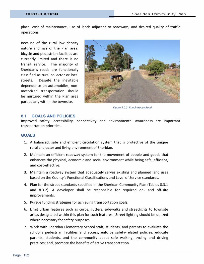
CIRCULATION Sheridan Community Plan
Page | 152
place, cost of maintenance, use of lands adjacent to roadways, and desired quality of traffic
operations.
Because of the rural low density
nature and size of the Plan area,
bicycle and pedestrian facilities are
currently limited and there is no
transit service. The majority of
Sheridan’s roads are functionally
classified as rural collector or local
streets. Despite the inevitable
dependence on automobiles, non-
motorized transportation should
be nurtured within the Plan area
particularly within the townsite. 8.1 GOALS AND POLICIES Improved safety, accessibility, connectivity and environmental awareness are important transportation priorities. GOALS
1. A balanced, safe and efficient circulation system that is protective of the unique
rural character and living environment of Sheridan.
2. Maintain an efficient roadway system for the movement of people and goods that
enhances the physical, economic and social environment while being safe, efficient,
and cost-effective.
3. Maintain a roadway system that adequately serves existing and planned land uses
based on the County’s Functional Classifications and Level of Service standards.
4. Plan for the street standards specified in the Sheridan Community Plan (Tables 8.3.1
and 8.3.2). A developer shall be responsible for required on- and off-site
improvements.
5. Pursue funding strategies for achieving transportation goals.
6. Limit urban features such as curbs, gutters, sidewalks and streetlights to townsite
areas designated within this plan for such features. Street lighting should be utilized
where necessary for safety purposes.
7. Work with Sheridan Elementary School staff, students, and parents to evaluate the
school’s pedestrian facilities and access; enforce safety-related policies; educate
parents, students, and the community about safe walking, cycling and driving
practices; and, promote the benefits of active transportation.
Figure 8.0.2: Ranch House Road.

Sheridan Community Plan CIRCULATION
Page | 153
POLICIES
1. Placer County shall require dedication and improvements of necessary on- and off-
site right-of-way at the time of development in accordance with the street
classification shown in Table 8.3.2.
2. The rights-of-way for roadways shall be wide enough to accommodate appropriate
road paving, trails, paths and bikeways, drainage, public utility services, and trees
and shrubs where appropriate with suitable separation between facilities.
3. The level of service (LOS) on major roadways (i.e. arterial and collector routes) and
intersections shall be at Level “C” or better during the A.M. and/or P.M. peak hour.
The first priority for available funding shall be the correction of potential hazards.
Land development projects shall be approved only if LOS “C” can be sustained on
the CIP roads and intersections after:
a. Traffic from approved projects has been added to the system.
b. Improvements funded by this program have been constructed. This will
result in temporary slippage of the LOS below the adopted standards until
adequate funding has been collected for the construction of CIP
improvements.
4. “Through” traffic that must pass through the community shall be accommodated in
a manner that will not encourage the use of residential or private roads.
5. Non-residential properties shall be interconnected to allow traffic to circulate freely
between such adjacent properties.
6. Park-and-Ride areas may be required at appropriate locations as conditions of
approval of development.
7. The County shall develop and administer a Capital Improvements Program (CIP) that
contains roadway improvements necessary to achieve level of service standards
defined in this Plan.
8. On-site and “frontage” improvements shall be required as conditions of approval for
all land development projects.
9. The CIP shall be constructed in response to buildout of the Community Plan area.
Traffic mitigation fees to fund the CIP described in this Plan shall be required as a
condition of approval for all land development projects within the Plan area.
10. As development of the Community Plan area occurs, public dedication of rights-of-
way shall be required for the roads, pathways, and bikeways identified in this
Community Plan. Construction of such roads, pathways, and bikeways shall be
required as conditions of approval placed on land development project approvals.
11. Land development projects shall be designed to minimize the number of access
points onto major roadways.

CIRCULATION Sheridan Community Plan
Page | 154
12. Incorporate ‘Complete Street’ infrastructure and design elements in all reconstruction or new construction of streets to create safe and inviting environments for all users.
13. Roadways shall be designed in a manner that:
Has regard for the safe movement of all users, including cyclists, pedestrians and motorists;
Is context sensitive having regard for existing and planned land uses, community design and needs, and funding availability; and,
Minimizes the disruption to natural areas.
14. The incorporation of cycling facilities will be considered in the rehabilitation and reconstruction of existing roadways, through the following measures:
Re-striping of roadways for bicycle lanes; and
Introducing multi-use trails or cycle paths.
15. Special streetscape improvements are required for 13th Street. See the Community Design section for details.
16. To help preserve the rural character of Sheridan, gated subdivisions are not allowed within the Plan area.
17. New development shall provide off-street parking for the required number of parking spaces, either on-site or in consolidated lots.
8.2 COMPLETE STREETS AB 1358, The California Complete Streets Act, impacts local
General Plans by mandating that beginning January 1, 2011,
any substantial revision of the Circulation Element, the
legislative body must modify the Circulation Element to plan
for a balanced, multimodal transportation network that
meets the needs of all users of the streets, roads, and
highways for safe and convenient travel in a manner that is
suitable to a community’s rural, suburban, or urban context.
AB 1358 places the planning, designing and building of
complete streets into the larger planning framework of the
General Plan by requiring jurisdictions to plan for
multimodal transportation networks. These principles are
also incorporated into Community Plan documents to
recognize that pedestrian, cycle, and transit modes are
integral elements of a transportation system. A complete
street in a rural area will look quite different from a
What is a Complete Street? Complete streets are designed and operated to enable safe access for all users. Pedestrians, cyclists, motorists and transit riders of all ages and abilities must be able to safely move along and across a complete street.
Creating complete streets means transportation agencies must change their orientation toward building primarily for cars. Instituting a complete streets policy ensures that transportation agencies routinely design and operate the entire right-of-way to enable safe access for all users.
Source: National Complete Streets
Coalition, 2010.

Sheridan Community Plan CIRCULATION
Page | 155
complete street in a highly urban area. But both are designed to balance safety and convenience
for everyone using the road.
Placer County is required to incorporate the elements of complete street into any new
construction or reconstruction of roadways. Complete street principles incorporated into this
Community Plan direct transportation planners and engineers to consistently design with all users
in mind, including drivers, movers of commercial goods, pedestrians, and cyclists as well as older
people, children, and people with disabilities.
Because complete streets features
are only required when streets are
newly built or reconstructed, their
cost is incorporated into budgeted
transportation projects. Complete
street elements that are used can
vary from project to project but the
goal is to achieve a connected
network that is safe and effective
for all modes of travel. The end
result is a connected system of
streets, roads, and highways that
provides continuous, safe and
convenient travel for all users.
8.3 EXISTING TRANSPORTATION SYSTEM The most prominent feature of the existing transportation network is the system of local and
regional roadways that serve the Community Plan area. This is obviously due to the
predominance of automobile travel in serving the community’s transportation needs. Sheridan’s
local roadway system is composed exclusively of two-lane, undivided streets.
The network of streets and highways that serve a community is ordered in a hierarchical fashion,
ranging from local streets intended to serve only adjacent land uses to freeways that are
intended to serve only long distance, high speed travel and provide no access to adjacent
properties. In between these two extremes are collector and arterial roadways.
There is an orderly network of roads in the Plan area. The County classifies a hierarchy of roads
based on their intended function and projected traffic levels they are to support.
Figure 8.2.1: A complete street accommodates all users.

CIRCULATION Sheridan Community Plan
Page | 156
The rural community road network, without conventional curbs, gutters and few sidewalks, are a
point of pride to Sheridan’s residents. They reaffirm a commitment to rural, country living. They
are a signature differentiation to the development in surrounding cities.
Roadways serve two conflicting purposes from a design standpoint: to provide mobility and to
provide access to adjacent land uses. High and constant speed is desirable for mobility, while
access to adjacent land uses is best accomplished at low speeds.
The functional classification of roadways serves to emphasize the functional design requirements
of a roadway. Local facilities emphasize the land access function and arterial roadways
emphasize a high level of mobility for through traffic and collector roadways offer a more
balanced service to both functions.
Only at the extremes of the functional classification system do roadways serve an exclusive
function: a private road serves a land access function only and does not serve any through traffic;
a freeway serves only through traffic and provides no land access function. Between these two
extremes, the functional classification of a roadway more realistically represents the function of a
roadway within a continuum between the land access emphasis of a local road and the higher
speed mobility emphasis of an arterial roadway.
A description of the roadway functional classifications within the Plan area is provided below.
State Highway Highways are multi-lane roadways that serve to move people and goods long distances at high speeds. No direct access to adjacent properties is allowed or provided. Rather, access is provided via access ramps (or signalized intersections such as at Highway 65 and Riosa Road) that connect to local and regional surface streets. Highway 65 connects the urbanized areas of Sacramento and Roseville with the cities of Lincoln, Wheatland, Marysville and Yuba City. The highway begins in Roseville at I-80 extending to the junction of SR 70 in Yuba County.
Thoroughfares Thoroughfares are special arterial roadways with greater access control designed to carry high volumes of traffic with limited travel delay. Such roadways are used as primary circulation routes to carry longer-distance, through-traffic. Sheridan Lincoln Boulevard is classified as a thoroughfare.
Rural Collector Roadways Rural collector roadways are intended to “collect” traffic from local streets and carry it to roadways higher in the street classification hierarchy (e.g., arterials). The public uses these roadways as secondary circulation routes, and they generally carry light to moderate traffic volumes. County standards for Rural Collector roadways, such as Andressen Road, Camp Far West Road, N. Dowd Road, Karchner Road, and Ranch House Road, call for a 60’ right-of-way and 32’ of pavement.

Sheridan Community Plan CIRCULATION
Page | 157
Local Streets Local streets make up the bulk of the circulation network in the community. Local streets provide direct access to abutting land, and access to the collector street system. Residents and the public use these streets for local circulation. They carry little, if any, through traffic, and generally carry very low traffic volumes and do not require wide lanes. On-street parking is generally allowed. The existing road system within the Sheridan townsite consists of roads with 80’ of right-of-way, unusually wide for residential streets in the county. Due to the residential character of the townsite, the speed limit is 25 miles per hour. The roads outside of the town are planned to remain as rural, two-lane roads.
Table 8.3.1 General Roadway Standards by Functional Class
Functional Class
Access Control
Typical Number of
Lanes
General ROW
Requirements
Minimum Interchange
Spacing Driveways Allowed
State Highways
Conventional 1 -2 miles Limited 2 – 4 --
Thoroughfare ½ mile Limited 4 – 6 120’ – 140’
Rural Arterial -- Limited 2 – 4 70’ – 84’
Rural Collector -- All Uses 2 60’ – 70’
Local -- All Uses 2 50’ – 60’
Source: Placer County General Plan Table 1-6 (2013)
The functional classification of a roadway does not necessarily indicate the existing conditions (i.e. interchange spacing, available right-of-way). Instead, the classification indicates the intended use and ultimate design of the roadway to accommodate the anticipated travel demand. In addition, the typical cross-section of the roadway does not necessarily mean that the roadway should be redesigned or widened to meet its typical cross section.
Figure 8.3.1: Not all roads in the Plan area are paved such as Nader Road
seen here.
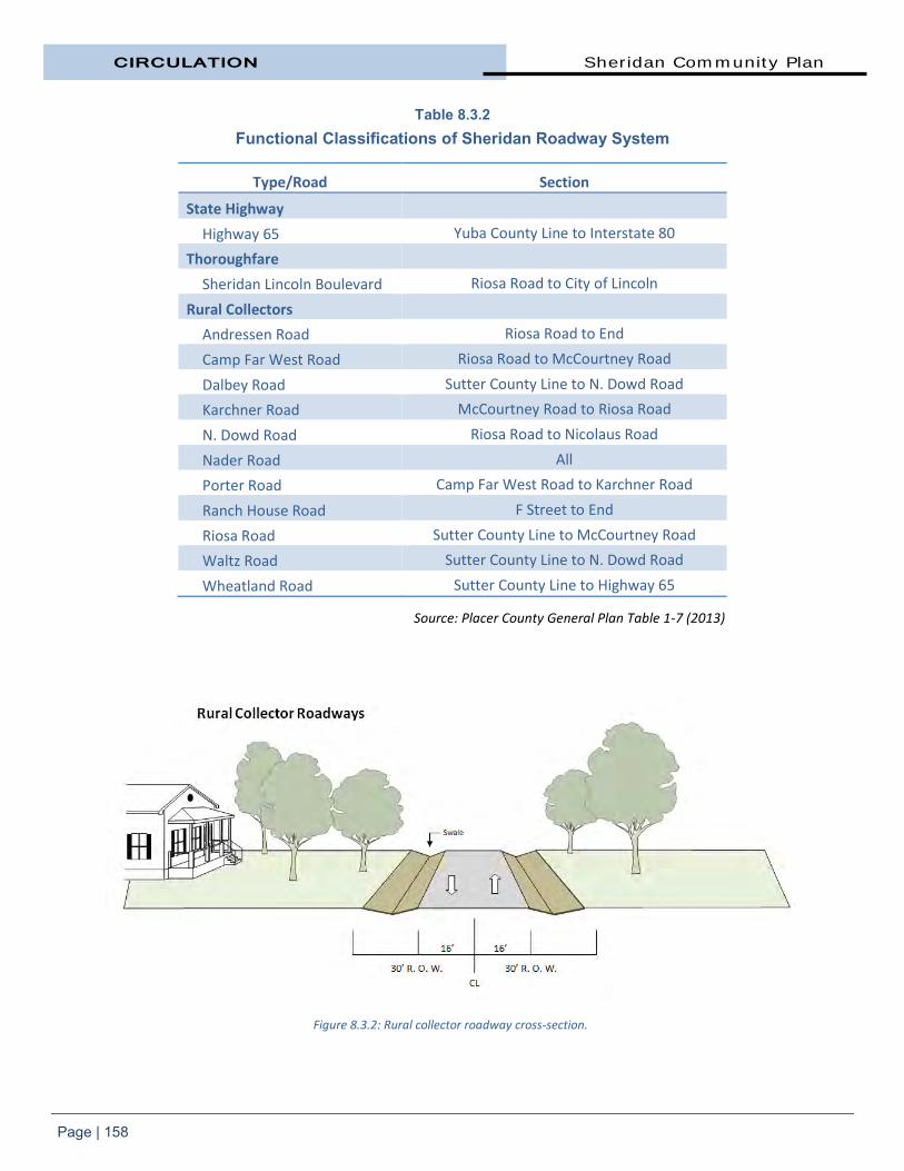
CIRCULATION Sheridan Community Plan
Page | 158
Table 8.3.2 Functional Classifications of Sheridan Roadway System
Type/Road Section
State Highway
Highway 65 Yuba County Line to Interstate 80
Thoroughfare
Sheridan Lincoln Boulevard Riosa Road to City of Lincoln
Rural Collectors
Andressen Road Riosa Road to End
Camp Far West Road Riosa Road to McCourtney Road
Dalbey Road Sutter County Line to N. Dowd Road
Karchner Road McCourtney Road to Riosa Road
N. Dowd Road Riosa Road to Nicolaus Road
Nader Road All
Porter Road Camp Far West Road to Karchner Road
Ranch House Road F Street to End
Riosa Road Sutter County Line to McCourtney Road
Waltz Road Sutter County Line to N. Dowd Road
Wheatland Road Sutter County Line to Highway 65
Source: Placer County General Plan Table 1-7 (2013)
Figure 8.3.2: Rural collector roadway cross-section.

Sheridan Community Plan CIRCULATION
Page | 159
Highway 65 “Lincoln Bypass”
Highway 65 is a north/south state
highway that connects Interstate
80 in Roseville to SR 70 south of
Marysville. It carries an average
of about 15,000 vehicles per day
through Sheridan where the
highway is two lanes.
Approximately half of the traffic
on old Highway 65 (now Sheridan
Lincoln Boulevard) has shifted to
the Highway 65 Bypass. Traffic on
Sheridan Lincoln Boulevard is
predominantly local traffic that
does not utilize the Bypass.
Phase 1 of the Lincoln Bypass was the construction of a four-lane segment from Industrial Avenue
to Nelson Lane and two lanes from Nelson Lane to just north of Sheridan. This Phase was
opened to traffic in October 2012. Phase 2-A is the construction of two additional lanes, making
it a full four-lane road from Industrial Avenue to N. Farm Road (between Waltz and Darby roads).
This phase is projected to be opened to traffic in late-2014. The final portion, Phase 2-B, is
estimated at approximately $30 million and not yet funded, and entails construction of the final
additional two-lane segment from N. Farm Road to Sheridan, completing a full four-lane
expressway.
The Riosa Road/Highway 65
intersection is at-grade and
signalized. There are no current
plans to construct an overpass
with on/off ramps at Riosa Road.
Riosa Road has been realigned
and connects to Sheridan Lincoln
Boulevard at what is now called
Wind Flower Place. The new
Riosa/Sheridan Lincoln Boulevard
intersection is stop controlled. Figure 8.3.4: New Riosa Road/Highway 65 intersection.
Figure 8.3.3: The Lincoln Bypass shifted Highway 65 to the west of the
townsite.

CIRCULATION Sheridan Community Plan
Page | 160
Dowd Road does not cross the new SR 65. A new Dowd frontage road has been constructed from
Dalby Road to Riosa Road. A cul-de-sac has been constructed at the end of the portion of Dowd
Road between the Bypass and Sheridan. This new dead end street is named Townview Court.
In 2014, the state decommissioned the old highway and transfer ownership of the current
Highway 65 over to Placer County. Old Highway 65 has been cul-de-sac’d north of Sheridan but
remains open south to Lincoln.
Riosa Road Improvements. This two-lane roadway is Sheridan’s primary access to Highway 65
and is designated as a rural collector roadway in the Placer County General Plan. Riosa Road
carries about 3,000 vehicles per day east of Highway 65. As a condition of approval for the
Patterson Sand and Gravel Mine expansion project, applicant Cemex contributed funding for both
roadway improvements and pavement reconstruction along the truck route between Highway 65
and the project site. Riosa Road was improved from 9th Street to a point between Camp Far West
and 13th Street. Completed in early-2014, the work included curbs and gutters on both sides of
the road, a five-foot sidewalk on the north side, drainage improvements, and installation of
landscaping.
Figure 8.3.5: 2013 Riosa Road improvement project.

Sheridan Community Plan CIRCULATION
Page | 161
8.4 EXISTING ROADWAY CONDITIONS Traffic operating conditions on streets and at intersections are quantified in terms of “level of service”, or LOS. LOS is a qualitative measure of the effect of a number of factors which include speed and travel time, traffic interruptions, freedom to maneuver, safety, driving comfort, and convenience and operating costs. LOS is expressed as a letter grade, ranging from LOS “A” to LOS “F” and representing progressively worsening traffic operating conditions. LOS “A” can be characterized as free-flow traffic conditions with little or no delay. LOS “F” on the other hand represents forced traffic flow conditions often characterized by excessive delays. LOS at intersections is quantified for a one-hour period- typically either the A.M. or P.M. peak hour.
To provide a foundation for assessing future traffic conditions in the Sheridan area, the existing
LOS for major roadways and intersections has been determined. The LOS at major intersections
is provided in the table below. LOS for an intersection is based on turning movements, lane
geometries, intersection control and hourly volumes. The majority of the Community Plan area
presently enjoys good traffic operating characteristics.
Tables 8.4.1 and 8.4.2
Existing Average Daily Traffic Volumes
Road/Section Cars/Heavy Trucks
Riosa Road, Camp Far West to Sheridan Lincoln 2,400/550
Riosa Road, Andressen to Karchner 1,400/550
Karchner Road, Riosa to Porter 200/550
Camp Far West, at Porter 300/550
Existing Level of Service
Intersection Level of Service AM/PM
Riosa Road/11th Street A/A
Riosa Road/Karchner Road A/A
Source: DKS Associates, 2004.
Figure 8.4.1: Typical rural collector road in Plan area.

CIRCULATION Sheridan Community Plan
Page | 162
8.5 ALTERNATIVE TRANSPORTATION SYSTEMS
Cycle and Pedestrian Cycle and pedestrian facilities are discussed in Section 9.4.
Bus Service There is no transit service in Sheridan currently, though there is an unmet transit need in the
area. Placer County Transit provides hourly bus service between Lincoln and Sierra College
fourteen times per weekday and ten times on Saturdays. Lincoln's Downtown Circulator
connects with Placer County Transit's Lincoln/Rocklin/Sierra College route daily at the Twelve
Bridges Transfer Point. Placer County Transit should consider expanding or developing transit
service in the Plan area.
Commuter Bus Placer County Transit provides
Placer Commuter Express (PCE), a
weekday commuter bus service,
transports riders from convenient
stops along the I-80 corridor
including stops in Rocklin and
Roseville to downtown
Sacramento.
Car Pool The nearest carpooling lot is
located on Industrial Boulevard at
Highway 65 in Lincoln.
Passenger Rail Amtrak. En route daily between Los Angeles and Seattle, the Coast Starlight train passes through
Sheridan connecting Los Angeles, the San Francisco Bay Area, Sacramento, Portland and Seattle.
Passengers can board the train at either Chico or Sacramento.
Commuter Rail. The Roseville-Lincoln-Marysville Passenger Feasibility Study (1997) defined a
plan for commuter rail service between Marysville and Sacramento. The Study concluded that
the service was technically feasible either as commuter rail, which would need to be funded
locally, or as intercity rail, funded as an extension of the Capital Corridor or San Joaquin service.
There are currently no plans for implementing commuter rail services in the corridor however.
Under the management of the Capital Corridor Intercity Joint Powers Authority, Amtrak has
operated the Capital Corridor rail service between Sacramento and San Jose, with one trip per
day to and from Colfax, stopping in Roseville, Rocklin, and Auburn since 1991.
Figure 8.5.1: Placer Commuter Express operates along the I-80 corridor.

Sheridan Community Plan CIRCULATION
Page | 163
Freight Rail. The Union Pacific
Railroad line bisects the Sheridan
Plan area and consists of one
track that crosses Sheridan
Lincoln Boulevard north of Riosa
Road on the western edge of the
townsite. According to Union
Pacific officials, between 20 and
25 freight trains per day pass
through Sheridan on the ‘East
Valley Line.’ The passing of
trains is randomly distributed
throughout the day and
nighttime hours and speeds on
the crossing range from 20 mph
up to 65 mph.
Airports The Plan area is served by the Sacramento International Airport for commercial flights. The
closest general aviation airport is within the City of Lincoln. 8.6 FUTURE TRANSPORTATION SYSTEM As has been noted in the Land Use chapter, significant growth is not anticipated within the Plan
area. It is also noted that the community’s vision is to “maintain the rural, small town character”
of Sheridan. An important determinant of Sheridan’s character is its roadway system.
This Community Plan’s approach to transportation is to balance community character and
circulation needs to minimize the intrusiveness of the area’s roadway system, and to provide
physical improvements to the roadway systems where it is necessary and environmentally
prudent to do so.
As with many communities, Placer County has experienced a gradual acceptance and adoption of
uniform improvement standards to be applied throughout the community. Although these
standards bring a uniformity of design to the various components of community infrastructure,
their implementation has the ability to erode the uniqueness of individual communities,
especially in the realm of public improvements such as roadways. This is evident in areas where new development has encroached into older settings, imposing typical suburban development standards without a clear plan for the end product.
Figure 8.5.2: Union Pacific rail crossing at Sheridan Lincoln Boulevard.

CIRCULATION Sheridan Community Plan
Page | 164
The result is typified by a rural street edge, characterized by a dirt, gravel or asphalt path and soft street shoulder suddenly interrupted by a portion of concrete curb and gutter with sidewalk. Since it is unlikely that the balance of the improvements will be made any time soon, the piecemeal implementation of such standards serves to disrupt the gentle, rural character that residents likely found more appealing in the first place. While it is important to provide movement of traffic within, as well as through Sheridan, this objective should not be permitted to compromise the more important objective of preserving the community’s essential character and the area’s natural environment.
Due to limited anticipated new growth, increasing the capacity of the existing road infrastructure
is not a major concern. Instead, preserving, maintaining, and improving what is already in place is
the focus of this Community Plan. Upgrades to the area’s roadway system using traditional traffic
engineering principles and standards will not fit well with the varying design features that make
up the character of the community.
Riosa Road Riosa Road is the primary east-west thoroughfare through the townsite. This two-lane roadway is
Sheridan’s primary access Highway SR 65. It is designated as a rural collector roadway in the
Placer County General Plan. Riosa Road carries about 3,000 vehicles per day east of SR 65.
The haul route for outbound haul trucks for Cemex/Patterson Sand and Gravel follows Camp Far
West Road south to Porter Road, Porter and Karchner Road south to Riosa Road, and Riosa Road
to Highway 65. Trucks then travel either northbound or southbound on Highway 65 to their
destination. Returning haul trucks and delivery vehicles travel the reverse of the outbound haul
route.
13th Street 13th Street has historically served as the “main street” of the townsite where the major
commercial and social activities were located. Special details for on-street parking and frontage
improvements are outlined in the Community Design chapter.
Figure 8.6.1: Sheridan townsite.

Sheridan Community Plan CIRCULATION
Page | 165
Sheridan Lincoln Boulevard After the Highway 65 bypass
opened, the state
decommissioned the old highway
and turned ownership over to
Placer County. It has been
renamed Sheridan Lincoln
Boulevard and is classified as a
thoroughfare by the County.
Long-term plans call for bike lanes
along the road between Sheridan
and the City of Lincoln. The
County will also allow a limited
number of driveway connections
to Sheridan Lincoln Boulevard.
Wheatland Bypass In 2000, Caltrans issued a Project Study Report that analyzed six alternative alignments for the
proposed Wheatland Bypass. After extensive public meetings, Caltrans identified a preferred
alternative (Figure 8.6.3) that would start at the northern end of the Lincoln Bypass in Placer
County, and proceed due north, crossing the Bear River on a new bridge to the east of the
existing Highway 65 alignment. It would bypass Wheatland to the east.
The Wheatland General Plan analysis assumes a four-lane Wheatland Bypass while the Yuba
County General Plan analysis assumes a two-lane bypass. In either case, the Bypass is not funded
and is not anticipated to be completed for at least 20 years.
Figure 8.6.2: Sheridan Lincoln Boulevard.
Figure 8.6.3: Proposed Highway 65
“Wheatland Bypass” alignment.


CHAPTER NINE
PARKS, RECREATION
AND TRAILS


Sheridan Community Plan PARKS AND RECREATION
Page | 167
9. Parks, Recreation, and Trails This chapter provides direction
for the development and
maintenance of parks, trails, and
recreational facilities. These
facilities are fundamental
buildings blocks of a community.
This chapter also establishes
standards for parks and trails to
ensure adequate recreational
facilities are available in Sheridan.
As development in the Plan area
occurs, the County will use this
chapter as a guide to require that
new development assists in the
implementation through the payment of mitigation fees, dedication of land, and construction of
public recreation facilities. The tools available to implement the plan are also included in this
chapter. It guides the County in identifying revenue and partners to assure adequate
maintenance and administration of facilities and recreational activities.
Sheridan is fortunate to have a broad range and number of open spaces though many are not
publicly accessible. These open spaces include pastures, working landscapes, gardens, and
conservation areas. There is opportunity to increase access to future permanent open space
lands.
9.1 GOALS AND POLICIES GOALS
1. Maintain recreational service level standards of the General Plan in order to meet
the park, trail, and open space needs of all segments of the population living in the
Sheridan Plan area.
2. Designate, protect, and conserve the natural resources of the area where such
resources can add to the variety of recreation activities in the area.
3. Identify and secure adequate and equitable funding to maintain and operate public
recreation areas, open space, and landscape areas.
4. Improve and expand the recreation facilities within the existing Sheridan Park and
Stewart Hall.
Figure 9.0.1: Sheridan Community Park, Camp Far West Road.

PARKS AND RECREATION Sheridan Community Plan
Page | 168
5. Work with sports leagues, the school district and other public agencies and the
private sector as partners in the provision of shared recreational facilities and team
sports, while the County remains focused on the maintenance of service levels for
park and trail facilities.
6. Ensure that new recreational development is consistent with adjacent land use, and
provides quality building sites for all required improvements.
7. Encourage and support non-vehicular transportation by providing a safe,
interconnected, accessible and visually appealing cycling and walking network.
8. Establish a pedestrian and bicycle friendly environment that includes both on- and
off-street pedestrian and bicycles facilities to encourage non-vehicular travel in the
community.
9. Integrate the community trail system with the countywide regional bicycle system.
10. Continue to develop safe walking/cycling routes-to-school options by linking parks,
the Sheridan School, neighborhoods, and commercial areas with appropriate trails
and pathway facilities.
11. Establish Class II Bike Path connections between the City of Lincoln to the south and
Wheatland to the north and between the future Teichert and Patterson/Cemex
open space facilities.
12. Provide safe and comfortable routes for walking within the townsite and cycling within the Plan area to encourage use of these modes of transportation, enable convenient and active travel as part of daily activities, reduce pollution, and meet the needs of all users of the streets.
POLICIES
1. Develop, operate and maintain park and trail facilities in accordance with park
standards contained in the General Plan.
2. Coordinate the development of trails and other recreation facilities with other public
agencies.
3. Continue to work with the Western Placer Unified School District to coordinate
infrastructure, including the shared use of lands and facilities for recreation and
community use.
4. Where legally appropriate and efficient, encourage developer-built public
recreational amenities.
5. Require the dedication of land, construction of recreational facilities, and/or
payment of fees, in accordance with applicable laws, in order to acquire and develop
public recreation facilities to maintain recreational service levels of the General Plan.

Sheridan Community Plan PARKS AND RECREATION
Page | 169
6. Require the proponents of new development to offer the dedication of multi-
purpose trail easements within project limits where necessary outside of the road
right of way consistent with the Community Plan Trail and Pedestrian Pathway maps
(Map Three and Four respectively), Placer County Bikeways Master Plan, and the
Placer County General Plan.
7. Require the proponents of new development to complete environmental review and
permitting of all park and trail facilities associated with a development project
unless deferral is specifically approved by the County.
8. Where recreational land dedication is required of new development projects, ensure
the dedication of land is in locations that are compatible with adjacent land use,
avoid restrictive topography, and do not pose excess regulatory or maintenance
burden.
9. Encourage compatible recreational uses near riparian areas along streams and
creeks where feasible.
10. To the extent possible, create trails through newly acquired open space and
preserves, consistent with the requirements of wildlife habitat.
11. Multiple use trails shall be open to all non-motorized trail use by pedestrians,
cyclists, and equestrians unless certain uses are excluded for safety or resource
protection purposes. The local trail system shall be connected to the regional public
trail system by the following considerations:
a. Incorporate logical linkages to the adopted trail networks identified in adjacent Community Plans and other trail planning documents;
b. Incorporate the Placer County Regional Bikeway Plan;
c. Consider recreational trail circulation on a regional level;
d. Promote consistency and unity between Community Plan trail elements in nomenclature, graphic formatting, and points of connection; and,
e. Provide common design standards where appropriate.
12. Trail locations depicted on the Community Plan Trail and Pathways maps are to be
considered diagrammatic corridors allowing the County some flexibility in the final
trail or pathway location in order to take into consideration topography, physical
barriers, regulatory challenges, privacy, and design considerations of the dedicating
land owner, as applicable.
13. The County shall pursue private, local, state and federal funds and grants to help
construct and/or improve parks, trails and pathways in the community.
14. Trails to be publicly maintained shall be funded through a dedicated funding source
such as a CSA Zone of Benefit, Lighting and Landscaping District, or similar
mechanism.

PARKS AND RECREATION Sheridan Community Plan
Page | 170
15. Review recreational facilities,
as necessary, to ensure they
are meeting current and
emerging needs.
16. Funding for improvement,
maintenance, operation, and
administration of public
recreation facilities should
be required prior to the
development of parks, trails,
landscaped areas, and
recreational facilities. The
funding sources should not
assume availability of County
General Fund support, but
should provide full funding
through one or more of the following methods:
a. Development fees paid by new private development.
b. Voter-approved assessment fees or special tax.
c. Grants.
d. Other legal and sustainable sources.
17. Consider a ballot measure to amend County Service Area #28 Zone of Benefit #6 to
provide an annual cost of living adjustment and provide maintenance funding for
any additional park facilities requested by the voters within Zone of Benefit #6.
18. The development of privately owned and maintained feeder trails should be
encouraged in lieu of public trail easements in areas that do not provide through
connection to identified nodes or have limited potential to serve the community as a
whole. Private trails that serve a specific neighborhood shall be maintained by a
Homeowner’s Association or other appropriate organization.
19. At such time as Park Dedication Fees are updated in association with County Code
Sections 15.34, 16.08.100 and 17.54.100 (D), the cost of trail acquisition and
construction associated with the full implementation of the Community Plan trails
network (for those portions outside of road rights-of-way) should be considered as a
component of the park facility standards.
Figure 9.1.1: Recreational facilities at Sheridan School.

Sheridan Community Plan PARKS AND RECREATION
Page | 171
9.2 EXISTING PARK FACILITIES Placer County supports a
comprehensive array of parks,
arts, recreation, leisure, and
cultural programs to a diverse
population with differing
recreational needs. In the past,
the County has relied on the
County General Fund, grants,
land dedication from developers,
park fees, volunteer
contributions, and dedicated
assessments to construct and
maintain its park system.
The mission of the Placer County
Parks and Grounds Division is to “provide construction, operation, and maintenance of Placer
County's parks, beaches, open space, landscaped grounds, and recreational trails for the use and
enjoyment of residents and guests of Placer County.” Placer County does not offer programs and,
therefore, relies on community partners to provide organized recreational activities. These
activities have been successfully and efficiently undertaken by cities, special districts, local school
districts, sports leagues, churches, and private recreation providers.
Ownership of the existing Sheridan Park and Stewart Hall was assumed by Placer County in 2013.
Prior to 2013, the park property was owned by Sheridan Recreation, Inc., a non-profit
corporation, and maintained by Placer County with funding from CSA 28 Zone of Benefit #6. As
owner, Placer County will continue operation and maintenance of Sheridan Park.
Rules and regulations governing Placer County-owned park and trail facilities are contained in
Chapter 12 of the Placer County Code.
School Facilities The Western Placer Unified School District serves the Sheridan community. While giving priority
to school activities, particularly during school hours, the outdoor facilities at the Sheridan
Elementary School are generally open to the public after school hours. In cases where school
districts utilize County funds in development of recreational facilities, formalized use agreements
are entered into that specify the rights of limited public access.
School facilities play an important role in family life and routine and serve a role in neighborhood
green space and recreation programming. In the calculation of Community Plan park facility
standards, schools that have facilities open to the public are counted.
Figure 9.2.1: Sheridan Community Park, Camp Far West Road.

PARKS AND RECREATION Sheridan Community Plan
Page | 172
Table 9.2.1
School Recreational Facilities in Sheridan
Sheridan Elementary School
4730 ‘H’ Street
Facilities: Two play fields, softball/baseball field, 1/8 mile track, two basketball courts, playground, and picnic facilities.
Park Facility Classifications Park classifications are used as a general guide to park planning and use. Active recreation refers
to sports such as softball, baseball, soccer, tennis and basketball. Passive recreation refers to
activities such as hiking, picnicking, and bird watching. Parks can be classified by type based
primarily on their size, function and character.
Table 9.2.2
Existing and Potential Recreational Facility Types in Sheridan
Mini-Park
Use: Usually includes play apparatus and turf areas. Area is considered a ‘pocket-park” if no play apparatus is provided. May include community gathering spaces.
Service Area: Local subdivision or civic area
Size: 1 to 2 acres
Location: Spaced throughout the community to serve neighborhoods. Playground may be private and maintained by a Homeowners Association.
Neighborhood Park
Use: Intended to meet primary recreation needs of the immediate or local neighborhood. Focus is on family and informal play needs of 5 to 17 year olds. Usually includes playground apparatus and areas for field and court games. Serves as a focal point for the neighborhood.
Service Area: 1/3 mile radius
Size: 2 to 15 acres
Location: Spaced throughout the community to serve neighborhoods. Can co-locate with elementary schools.
Conservation Area/Nature Preserve
Use: Protects natural environment, wildlife habitat and scenic quality rather than satisfying demand for recreation opportunities. Secondary, passive or active recreation uses can coexist with primary conservation function.
Service Area: Local area.
Size: 1 to 20+ acres
Location: Determined by existing natural features.

Sheridan Community Plan PARKS AND RECREATION
Page | 173
Sheridan has achieved the level of developed parkland to meet the General Plan standard service
level (5 acres of active and 5 acres of passive developed recreation area per 1,000 residents). The
Sheridan Park and Stewart Community Hall at 6005 Camp Far West Road provides four acres of
passive and active recreational amenities and a 300-person capacity hall facility. It is considered a
Neighborhood Park. Recreational facilities include a playground/tot lot, picnic area, and
basketball court. Stewart Hall is a large rectangular building (4,539 square feet) with a kitchen
and stage area. Some past uses include birthday parties, retirement parties, wedding receptions,
and baptisms.
9.3 POTENTIAL RECREATIONAL FACILITIES A portion of the survey taken prior to the Community Plan update focused on community desires
concerning parks and recreation. With minimal growth anticipated, development of new park
and recreation facilities ranks low on the list of Sheridan’s needs.
Survey respondents were also asked to rank the most needed improvements in Sheridan. Of
eleven choices, “more parks” ranked last. “Enhancements to existing parks” ranked fifth. “Better
sidewalks” and “bike paths/bike routes” ranked second and seventh respectively.
When asked the importance of “recreational opportunities,” fifteen percent said ‘not important’
while 35 percent said ‘important.’
The Sheridan Park serves the existing community well. There is undeveloped space on the park
property that presents opportunities for improvements at the current park site including
expansion of facilities and upgrades to existing facilities or new uses depending on future
demand/changing needs. The survey results indicate that the community desires improvements
to the existing Sheridan Park and Stewart Hall above the desire for new parks.
As development/redevelopment occurs in Sheridan, there is the potential for new recreation
facilities. These are likely to be one or more “mini-parks” or “play lots” that serve a residential
neighborhood or a “civic green space” that could be constructed along 13th Street.
Mini-parks are small open space areas that serve residential neighborhoods. These mini-parks, up
to an acre in size and strategically located in neighborhoods, provide recreational opportunities
within a short walking distance from homes. Mini-parks provide open space areas for passive
recreation, including a play area for small children, seating, and picnic areas.
Mini-parks would generally be developed with private funding as part of a new subdivision and
would generally be maintained by a property owners’ association.

PARKS AND RECREATION Sheridan Community Plan
Page | 174
Civic green spaces may include civic monuments, a historic building, and beautification areas in
Sheridan’s commercial area. Such a site could be developed or improved by a private owner or a
community group with a local civic organization responsible for funding the maintenance costs.
Facilities at a civic green space may include public art, water features, seating areas, picnic
facilities, and turf areas.
A number of additional conservation areas are likely within the Plan area through
implementation of the Placer County Conservation Plan. Once approved, the County would seek
protection of ~50,000 acres in high-growth western Placer County through an ecosystem-focused
strategy. Over the 50 year term of the PCCP a large portion of the Reserve Acquisition Area will
be permanently protected by conservation easements or by fee title acquisitions.
Figures 9.3.1 and 9.3.2: The Sheridan East Mitigation Bank is located on the edge of the Plan area at the corner of Karchner and Riosa roads. Public
access is not available.
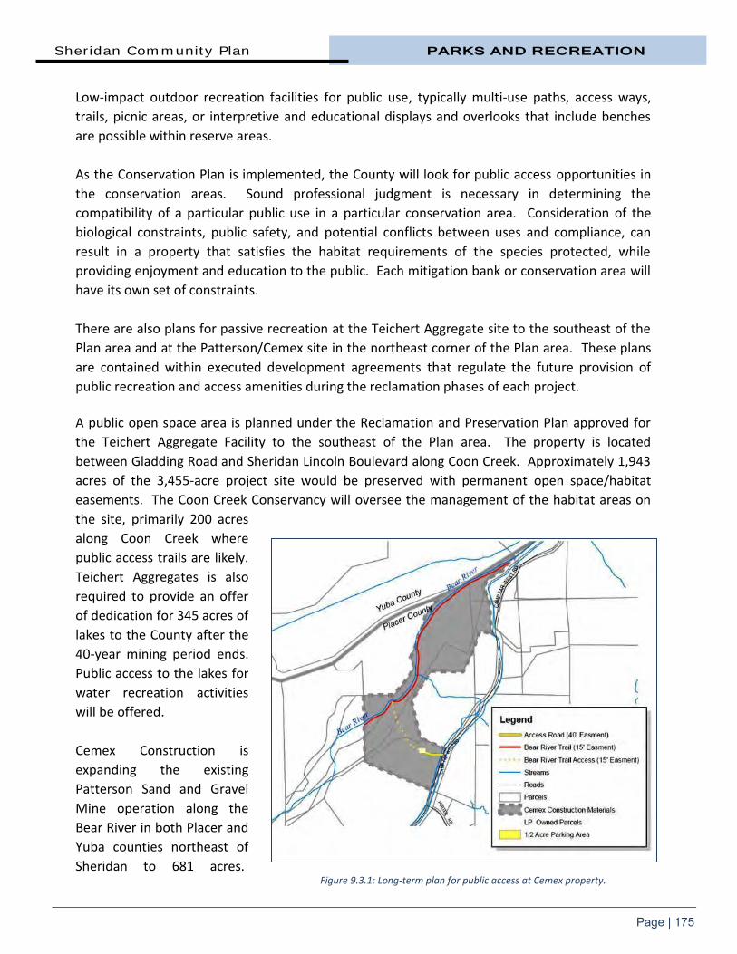
Sheridan Community Plan PARKS AND RECREATION
Page | 175
Low-impact outdoor recreation facilities for public use, typically multi-use paths, access ways,
trails, picnic areas, or interpretive and educational displays and overlooks that include benches
are possible within reserve areas.
As the Conservation Plan is implemented, the County will look for public access opportunities in
the conservation areas. Sound professional judgment is necessary in determining the
compatibility of a particular public use in a particular conservation area. Consideration of the
biological constraints, public safety, and potential conflicts between uses and compliance, can
result in a property that satisfies the habitat requirements of the species protected, while
providing enjoyment and education to the public. Each mitigation bank or conservation area will
have its own set of constraints.
There are also plans for passive recreation at the Teichert Aggregate site to the southeast of the
Plan area and at the Patterson/Cemex site in the northeast corner of the Plan area. These plans
are contained within executed development agreements that regulate the future provision of
public recreation and access amenities during the reclamation phases of each project.
A public open space area is planned under the Reclamation and Preservation Plan approved for
the Teichert Aggregate Facility to the southeast of the Plan area. The property is located
between Gladding Road and Sheridan Lincoln Boulevard along Coon Creek. Approximately 1,943
acres of the 3,455-acre project site would be preserved with permanent open space/habitat
easements. The Coon Creek Conservancy will oversee the management of the habitat areas on
the site, primarily 200 acres
along Coon Creek where
public access trails are likely.
Teichert Aggregates is also
required to provide an offer
of dedication for 345 acres of
lakes to the County after the
40-year mining period ends.
Public access to the lakes for
water recreation activities
will be offered.
Cemex Construction is
expanding the existing
Patterson Sand and Gravel
Mine operation along the
Bear River in both Placer and
Yuba counties northeast of
Sheridan to 681 acres. Figure 9.3.1: Long-term plan for public access at Cemex property.

PARKS AND RECREATION Sheridan Community Plan
Page | 176
Mining will be conducted in six phases over a 38-year span. At the completion of the mining
period in 2045, Cemex has agreed to make an irrevocable offer of dedication to the County for an
easement that would provide for a riverside trail within a 55-acre Bear River conservation
corridor and a ½ acre parking area.
9.4 BIKEWAYS, TRAILS, AND PATHWAYS Due to the distance from the
Sheridan community to most
services and employment centers,
vehicle use is and will continue to
be a part of most people’s daily or
weekly lives. However, improving
opportunities for walking and
cycling has a number of benefits,
including less reliance on the
automobile, cost savings for the
entire community, individuals and
families, improved natural and
built environments, health
protection, more lifestyle options,
and a strengthened sense of
community through daily
interactions with people.
Opportunities for horseback riding, hiking, and cycling are among the expected benefits of living
in a rural community and Sheridan offers a level topography that is ideal for these types of
facilities. Today, limited sidewalks and pathways exist in the townsite and bicyclists must share
roadways with motorists.
Walking, biking, or riding a horse, either for personal enjoyment, or simply to get from one place
to another, might often be regarded as recreational in nature. There are many important
transportation benefits to be realized as well, particularly from walking and cycling within and
between communities. Within the Plan area, some trails have been established on private
property and there is interest in creating trails within open space and preserves. There is also the
opportunity to connect to neighboring areas through on-street bikeways such as along Riosa
Road and Sheridan Lincoln Boulevard. This bikeways, trails and pathways section outlines a practical framework for the community’s goal of increasing non-motorized transportation and recreation options for all residents within Sheridan Plan area. Bikeways and trails typically serve two different circulation purposes:
Figure 9.4.1: Class III bikeways are prevalent on rural County roads.

Sheridan Community Plan PARKS AND RECREATION
Page | 177
1. Bikeways may be a linked network of on-street bikeways that provide local residents and visitors to the area a commuting alternative to the automobile as well as providing a recreational opportunity for bicyclists and pedestrians.
2. Pathways and Multiple Use Trails are valuable for commuting and transportation, but may also be a part of a network utilized for recreation and exercise. Trails along natural corridors, such as through parks and natural areas, are desirable routes because they provide a more scenic experience for the recreational user.
The Community Plan Trail Map (Map Three) depicts a long range vision for an interconnected
system of hiking, riding, and cycling trails suitable for safe recreation as well as transportation
and circulation. The proposed trail plan balances the need for a functional community network
with respect for private property and the funding needed for full implementation. Upon
completion, the network will encourage safe, comfortable and convenient ways for pedestrians
and bicyclists to travel throughout the Plan area and into surrounding communities.
The vision is realized by acquiring trail segments as opportunities are presented through
development and willing donors and completing missing sections of longer trails through capital
projects. Rules and regulations governing the use of County trails and bikeways are contained
within Chapter 12 of the Placer County Code. Trails and bikeways within this plan are classified as follows:
Class I Bikeway (Bike Path) provides a completely separated facility designed for the exclusive use of cycles and pedestrians with minimal crossflows by motorists. Motorized vehicles are not allowed on Class I Bike Paths. Class I bikeways should have a minimum 8 foot width of hard surfaced pavement with two foot graded shoulders on either side. Class I Bike Paths that are regional in nature should have a minimum 10-foot paved width. In some cases, a wider shoulder or separated native earth pathway would provide adjacent use for equestrians and those who prefer a native trail surface. Class I Bike Paths must be at least five feet from the edge of a paved roadway.
Class II Bikeway (Bike Lane) provides a restricted right-of-way designated for the exclusive or semi-exclusive use of cycles with through-travel by motor vehicles or pedestrians prohibited, but with vehicle parking and crossflows by pedestrians and motorists permitted. Class II Bike Lanes generally require a four-foot bike lane with a 6 inch white stripe separating the roadway from the bike lane. Class II Bike Lanes are typically maintained as a part of the road system by the Department of Public Works.
Class III Bikeway (Bike Route) provides a right-of-way designated by signs or permanent markings and shared with pedestrians and motorists. Roadways designated as Class III Bike Routes should have sufficient width to accommodate motorists, bicyclists, and pedestrians. Other than a street

PARKS AND RECREATION Sheridan Community Plan
Page | 178
sign, there are not special markings required for a Class III Bike Route. Class III Bike Routes are typically maintained as a part of the road system by the Department of Public Works.
Multiple Use Trails are designed to support pedestrian, cycle, and equestrian traffic. Motorized vehicles are not allowed on Multiple Use Trails. They are generally six feet in tread width but may be reduced in width to accommodate physical and easement restrictions. Widened turnout areas should be provided to allow comfortable passing. Depending on the stability of local soil conditions, Multiple Use Trails are constructed of native graded soil, decomposed granite (or similarly graded imported aggregate), or native soil treated with a stabilizing agent.
Pathways or concrete sidewalks are within the road right of way, generally four to six feet wide and running parallel to the road, intended for use by pedestrians. Pathway users may include but are not limited to: cyclists, non-motorized scooters, in-line skaters, roller skaters, wheelchair users (both non-motorized and motorized), walkers, and runners. Much of the townsite does not have pathways or sidewalks besides those recently constructed around the Sheridan Elementary School under the Safe Routes to School project.
For the purpose of this chapter, “bikeway” means Class I Bike Paths, Class II Bike Lanes, and/or
Class III Bike Routes collectively or interchangeably. Also for the purpose of this chapter, “cyclist”
means riders of non-motorized wheeled vehicles.
Figure 9.4.2: Multi-use trails accommodate pedestrian, cycle, and equestrian users.

Sheridan Community Plan PARKS AND RECREATION
Page | 179
Trail Classifications Typical bikeways and trails are schematically depicted below.
Figure 9.4.3: Bike and Trail Classifications.

PARKS AND RECREATION Sheridan Community Plan
Page | 180
Pathways Many of the roads within the townsite and all of the roads outside of the townsite do not have
pathways or sidewalks. The pathway or sidewalk, once a lost idea, is starting to make its way
back into suburban development because it connects neighborhoods, creating a healthier and
more livable community. The development of a limited pathway network in Sheridan, has the
support of community residents. The desire is for a congruent system that links the existing
pathways with each other creating a grid not unlike the street network. This network of
pathways is essential in moving people to and from various destinations as well as providing
additional recreational opportunities.
The proposed pathway network
would expand upon the Safe
Routes to School infrastructure
project. The $207,000 project
was completed in 2011 to make
streets surrounding the Sheridan
School more pedestrian/child-
friendly and increase
opportunities for residents to
lead more active lives. It was the
first Federal Safe Routes to
School project undertaken in
unincorporated Placer County.
The Sheridan Safe Routes to School Project entailed building multi-use paths on streets leading to
the school. Paths were constructed adjacent to the school perimeter on Camp Far West, 11th,
10th and H streets, and a bus loading area was installed as well as a four-way stop at the corner
of 10th Street and Riosa Road. A concrete walk from the school to the manufactured home park
at the end of 10th Street was added in 2013. 9.5 BIKEWAY, TRAIL, AND PATHWAY PLANNING AB 1358, The California Complete Streets Act, requires the County to plan for a balanced,
multimodal transportation network. Complete Streets are designed and operated to enable safe
access for all users. Pedestrians, bicyclists, motorists, and transit riders of all ages and abilities
must be able to safely move along and across a complete street. The Governor’s Office of
Planning and Research recommends that local jurisdictions view all transportation projects, new
or retrofit, as opportunities to improve safety, access, and mobility for all travelers and recognize
pedestrian, cycle, and transit modes as integral element of the transportation system.
In terms of on-street bikeways, wide, paved shoulders which are important to safe and efficient
cycling can be found along many County roads. However, shoulder conditions and widths can be
Figure 9.4.4: A Safe Routes to School Project was completed in 2011.
Sheridan Community Plan PARKS AND RECREATION
Page | 181
highly variable, and cyclists are likely to encounter sections with narrow or non-existent
shoulders along some routes. This may be generally acceptable on quiet back roads with low
traffic volumes and good visibility, but is not desirable for key connecting routes between
communities or major destinations.
The 1994 Placer County General Plan establishes policies for trails in the Transportation and
Circulation and the Recreational and Cultural Resources sections (sections 3 and 5, respectively).
It calls for establishment of “a safe, comprehensive and integrated system of facilities for non-
motorized transportation” (Transportation and Circulation Goal 3.D) and development of “a
system of interconnected hiking, riding, and cycling trails and paths suitable for active recreation
and transportation and circulation” (Recreational and Cultural Resources Goal 5.C).
The County has established several other General Plan policies pertaining to trails including:
Support development of a comprehensive and safe system of recreational and commuter cycle routes that provides connections between major employment and housing areas and between existing and planned bikeways;
Integrate public trail facilities into the design of flood control facilities and other public works projects whenever feasible;
Pursue all available sources of funding for the development and improvement of trails for non-motorized transportation;
Work with other public agencies to coordinate the planning and development of equestrian, pedestrian, and cycling trails;
Require the proponents of new development to dedicate rights-of-way and/or the actual construction of segments of the countywide trail system pursuant to trails plans contained in the County’s various community plans; and,
Encourage preservation of linear open space along rail corridors and other public easements for future use as trails.
The County’s primary objectives in establishing trails are to:
Provide safe, pleasant, and convenient travel by foot, horse, or cycle;
Provide connections between residential areas, the school, community buildings, parks and other community facilities;
Provide connections to state and city trails and regional recreational and natural resources outside of the county for the benefit of county residents.
To meet these objectives, the County must have:
Coordination within the transportation, natural resources, and recreational components of planning documents and capital improvement plans;
Coordination among the various government and private parties involved; and,
An implementation plan addressing priorities and funding for both the near and long-term.

PARKS AND RECREATION Sheridan Community Plan
Page | 182
The Parks Division of the Department of Facility Services coordinates trail planning, acquisition,
development, and management with appropriate jurisdictions including the cities and adjacent
counties. The Department of Public Works coordinates the planning and development of bike
routes and lanes within the road right-of-way including the conditioning of private development
requirements and management of capital improvement projects. 9.6 BIKEWAY, TRAIL, AND PATHWAY RECOMMENDATIONS The Bikeway, Trail and Pathway recommendations provides safe travel for pedestrians, cyclists,
and others, whether it’s a shared on-road facility or separated off-road facility. The goal is to
provide a safe alternative to the automobile that can provide convenient and efficient access
throughout the Plan area.
The proposed bikeway and trail routes, shown on the Community Plan Trail Map, create a vision
for a coordinated system of trails throughout Sheridan and beyond. There are currently no trails
or bikeways in the Plan area. However, the transfer of Sheridan Lincoln Boulevard (former
Highway 65) to the County will accommodate bicycle use along both shoulders. The roads in the
Sheridan area host groups of bicyclists drawn to the relatively low volume roads. The proposed
bikeway and trail system in Sheridan provides recreational, safety, and utilitarian component as
bikeways can provide an alternative mode of transportation. The long-range trails plan for
Sheridan provides for new or improved linkages between parks and natural areas, points of
interest, and neighboring communities.
Establishing a system of trails in an existing built community is a challenge. Sheridan was
developed around automobile transportation and pedestrian and bike facilities were secondary
considerations. The present popularity of cycling and walking as a mode of transportation and the
emphasis on active living and other current trends were not anticipated or planned. Pedestrian
connectivity in Sheridan is limited and is primarily provided on road shoulders.
From a regional perspective, facilities for cycling are of paramount interest due to their efficiency
as a travel mode over short, medium, and longer distances. Pedestrian travel, while still very
important, tends to be a much more localized form of non-motorized transportation and is, for
most people, a more practical option in or near urban areas where population density is higher
and trip lengths are relatively short.
The Placer County Regional Bikeway Plan, prepared by the Placer County Transportation Planning
Agency and adopted by the Board of Supervisors in 2002, provides a directory of both the existing
regional bikeways and proposed improvements to regional bikeways. The plan calls for the
creation of a Class II bike lane on the current Highway 65 from Lincoln to the Bear River with the
addition of appropriate signage and pavement markings.

Sheridan Community Plan PARKS AND RECREATION
Page | 183
The Sheridan MAC Subcommittee Working Group recommended additional Class II bike routes for
Camp Far West, Porter, Karchner, and Riosa roads. A bikeway on Camp Far West Road will
connect Sheridan to the planned public access facilities at the Cemex property. Riosa Road is
targeted for a Class III bikeway providing access to the east of Sheridan.
The Subcommittee recommended that at such time as the Placer County Regional Bikeway Plan is
updated, or other applicable trail plan is adopted, consideration should be given to creation of a
connected trail/bikeway network to serve northwest Placer County and to complete logical loop
extensions of the bikeways and trails depicted on the Sheridan Community Plan Trail Map.
Suggested routes include Karchner Road, McCourtney Road, and the along the Coon Creek
corridor. A route to connect Sheridan to Hidden Falls Regional Park was also recommended.
A multi-purpose trail is planned along the south side of the Bear River on the Cemex property.
Any extension of the trail along the Bear River outside of the Cemex property is a long-term
proposition. Trail easements along the river would only be acquired by willing sellers or donors
and only if funding becomes available.
Pathways The proposed pathways, shown on the Community Plan Pedestrian Pathways Map (Map Four),
provides recommendations for sidewalks and trails within the townsite. The Plan recommends
improvements that will upgrade the existing system where needed, fill in the missing gaps, and
connect to significant features such as the elementary school, Sheridan Park and Stewart
Community Hall, 13th Street, and residential areas.
The Subcommittee-recommended pathways for 10th and 12th streets, E and F streets, as well as
the I Street alley connecting to Stewart Hall with improvements to the existing crosswalk for
pedestrian safety at Camp Far West Road. The I Street alley pathway would provide a safe and
efficient route to Stewart Hall which serves as the evacuation center for the elementary school.
Pedestrian-safe landscaping and lighting should be included along the I Street alley pathway and
consideration should be given to a joint use/maintenance agreement with the school. In addition,
the subcommittee recommended that a more durable material such as concrete be used for all
pathway extensions. This was deemed to be more cost effective to maintain as well as more
visually attractive.

PARKS AND RECREATION Sheridan Community Plan
Page | 184
A list of proposed trails, bikeways, and pathways is provided in the tables below.
Table 9.6.1 Plan for Trail and Bikeway Improvements in Sheridan
Corridor Beginning Point End Point Length
Class II
Camp Far West Road Riosa Road Cemex Bear River Access 4.1 miles
Karchner Road Porter Road Riosa Road 2 miles
Porter Road Camp Far West Road Karchner Road .5 miles
Riosa Road Sheridan Lincoln Blvd. Karchner Road 2.1 miles
Sheridan Lincoln Blvd. Highway 65 City of Lincoln 7.6 miles
Multi-Purpose
Bear River Corridor Cemex Property Cemex Property 1.6 miles
Table 9.6.2
Plan for Multi-Use Pathways in Sheridan
Corridor Beginning Point End Point Length
10th Street I Street Alley E Street 2,032’
12th Street Riosa Road E Street 1,800’
Camp Far West Road I Street Alley Stewart Hall 613’
E Street 10th Street 12th Street 862’
F Street Sheridan Lincoln Blvd. 10th Street 1,275’
I Street Alley – School/Park Camp Far West Road 10th Street 900’

Sheridan Community Plan PARKS AND RECREATION
Page | 185
The alignments depicted on the Community Plan Trail and Pathways Maps are to be considered
diagrammatic corridors allowing some flexibility in the final trail location in order to take into
consideration topography, physical barriers, regulatory challenges, privacy, and design
considerations of the developer. In the case of multiple use trails that are not connected to
roadways, final trail alignments should be required to adhere to sound trail building principles for
the construction of sustainable trails that are not prone to erosion or require the excessive
removal of trees and other natural features.
9.7 RECREATIONAL FACILITY AND TRAIL FUNDING Sheridan Parks and Recreation District
The Improvement District (CSA 28 Zone of Benefit #06) provides funding for improvement and
maintenance of specific recreational facilities currently serving 395 parcels within Sheridan. The
District was established by the Board of Supervisors in 1987 following an assessment ballot
proceeding in accordance with the requirements of Article XIIID of the California Constitution
(“The Taxpayer’s Right to Vote on Taxes Act”) and the Landscape and Lighting Act of 1972. The
$47 fee per parcel raises $23,565 annually to pay for parks maintenance.
Without the provision of an annual cost-of-living adjustment in the existing Zone of Benefit
collection, this funding source will eventually become insufficient to meet its obligations. In order
to provide long term funding stability and provide maintenance for any additional park amenities
requested by the Sheridan Community, a vote would be needed to amend the allotted
assessments.
Park Dedication Fees (PDF’s)
Park Dedication Fees (PDF) is the collective term for in-lieu recreation mitigation fees collected
under two sections of state law, the Subdivision Map Act (“Quimby Fees”) and the Mitigation Fee
Act (“AB1600 Fees”), and enabled by ordinance passed by the Placer County Board of
Supervisors.
Since July 2004, the County has implemented Assembly Bill 1600 “The Mitigation Fee Act”
(Government Code section 66000 et seq.) through adoption of County Code Section 15.34 et seq.
While Quimby fees focus on the value of land dedication for active park facilities, the Mitigation
Fee Act generates funding for the cost of active and passive park development. Cities, Counties,
and special districts are allowed to collect AB1600 Fees. They are generally collected at the time
a residential building permit is issued.
Park Dedication Fees (PDF’s) are collected in 16 geographic areas throughout the county. Area
#11 collects fees generated within the Sheridan area. The boundaries do not legally bind the
funds to be strictly spent on amenities within the boundary, but serve as a guide in establishing a
nexus between payer and benefit. In order to ensure the land tenure and ongoing operation of

PARKS AND RECREATION Sheridan Community Plan
Page | 186
PDF funded amenities, only public agencies are allowed to apply for use PDF’s. A public process
of vetting proposals for PDF expenditure is made through the local MAC and Parks Commission
before the Board of Supervisors makes a final determination of PDF disposition. Standards for
reviewing and prioritizing PDF funding requests are recommended by the Parks Commission.
PDF’s are one-time fees (as opposed to ongoing assessments) intended for development of new
recreational amenities and major renovation of existing amenities in order to maintain service
levels of both active and passive recreation facilities as new development increases demand.
They are not to be used for ongoing maintenance. The current fee (September 2013) is $4,160
for a single-family dwelling and $3,030 for a multi-family dwelling. Fees are adjusted on July 1
annually. Any public agency that is a recreation provider is eligible to apply for use of Placer
County Park Dedication Fees. Agencies include Placer County, special districts, school districts,
and incorporated cities.
Countywide Capital Improvement Program
The Placer County Department of Public Works (DPW) developed a separate Capital Improvement
Program (CIP) within each benefit district in the county. Each CIP identifies roadway
improvements needed to serve the future transportation demands on the roadway system.
Projects identified in the CIP can be funded partially or wholly with fees collected through the
County’s traffic fee program. Frontage Improvements
Development projects are conditioned to fund and construct improvements for the portion of the
public road on which they front. This generally requires construction of the equivalent of up to
one lane and shoulder, which may include a bike lane and/or separated trail. Grants
Prior to enactment of the Mitigation Fee Act, exactions from new subdivisions were limited to the
value of park land. Development of active park facilities to keep up with service level standards
relied heavily on state and federal grant funding. A series of voter approved Park Bonds at the
state level provided consistent park development funding prior to 2009. In recent years,
however, the trend in active park development grants has focused on underserved and inner-city
communities reducing the availability of park grant funding in unincorporated Placer County.
Placer County has been successful in acquiring grant funding for acquisition and development of
passive recreation facilities throughout unincorporated areas of the County. The County’s
commitment to the Placer Legacy Open Space and Agricultural Conservation Program (Placer
Legacy) has leveraged over $4 Million in grant funding since the Placer Legacy’s inception in 2001.
Due to large parcel availability, most Placer Legacy acquisitions have been located in the Lincoln,
Garden Bar, and Big Hill Areas. The acquisition and development of Hidden Falls Regional Park
near Lincoln has provided residents with a large scale passive park in western Placer County.

CHAPTER TEN
PUBLIC SERVICES


Sheridan Community Plan PUBLIC SERVICES
Page | 187
10. Public Services The County and other agencies
provide a range of public services
to the community including law
enforcement, fire and emergency
medical services, library services,
schools, parks and recreational
facilities, water, sewer, and flood
control. Ensuring that these
facilities and services are provided
and maintained is an important
responsibility of the County and
others. This Community Plan
describes the existing public
services and infrastructure system
as well as infrastructure and
service improvements required to accommodate existing development and future growth. Fire
protection and recreational facilities are covered in other chapters.
An important first step of the Community Plan is to protect existing investments, which includes
identifying what systems are currently in place and their state or repair. Sheridan, particularly
within the townsite, is served by a comprehensive network of infrastructure and utilities that
supports its economic function and growth. Infrastructure and related services will be provided
in a coordinated, timely manner and maintained at a level that is financially sustainable to meet
the needs of the existing businesses and residents, as well as providing for limited future growth
as provided for in the Community Plan Land Use Diagram.
For the purposes of this Plan, public/quasi-public services includes sanitary sewer and water
supply, schools, law enforcement protection, other public services such as libraries and solid
waste disposal and, electric power distribution and transmission facilities, telecommunications
and other cabled services. These are provided by various government agencies, public bodies
and the private sector.
Figure 10.0.1: Sheridan’s first school was established in 1864.

PUBLIC SERVICES Sheridan Community Plan
Page | 188
10.1 PUBLIC SANITARY SEWER It is the purpose of this section to identify sewage disposal issues and limitations as they relate to
the Sheridan Community Plan area.
10.1.1 GOAL AND POLICIES GOAL
1. Require sanitary sewer facilities, both collection and treatment, which are sufficient to serve the Plan area’s proposed density of residential, commercial, and public/institutional uses in a way which protects the public and environment from adverse water quality or health impacts.
2. Facilitate the provision of reliable and cost-effective sanitary sewer services to residents in the County Service Area.
POLICIES
1. Allow annexations into the sewer service areas to developments where public connection to sanitary sewer systems can be provided as approved by the Board of Supervisors.
2. Require developments needing new connections to construct sanitary sewer collection facilities for their project which are adequately sized and located to provide sewer service which support development based on the permitted densities of the Land Use Element. Sanitary sewer collection systems shall be designed for gravity flow. The agency providing service may approve pumping service where gravity service is not achievable demonstrated through a site-specific engineering analysis.
3. Require all public sanitary sewer facilities to be designed and built to the current standards of the agency providing service.
4. Require developments needing new connections to pay their fair share of the cost for future public sanitary sewer facilities which support development based on the permitted densities of the Land Use Element. The fair share will be based on the demand for these facilities attributable to the new development.
5. Prior to acceptance of completed project improvements, require proponents of new development within a sewer service area to obtain written certification from the service provider that collection and treatment services are available.
6. Require pretreatment of commercial and industrial wastes prior to their entering community collection and treatment systems.

Sheridan Community Plan PUBLIC SERVICES
Page | 189
Sheridan Wastewater Treatment Plant During Sheridan’s early years,
homes had individual wells and
septic systems, mostly using
seepage pits. By the 1960s, the
majority of structures in Sheridan
had wells that were contaminated
by the seepage pits. The problem
generated a federal loan/grant
program and in 1973, led to the
construction of two public water
wells, a water distribution system,
sewage collection system and two
wastewater treatment ponds.
Once completed, mandatory
connection to both the sewer and
water system was initiated within
the townsite.
Between 1973 and 1983, several small sewer extensions were constructed and approximately 50
new homes were built in the community. Then, due to lack of capacity in the wastewater
treatment ponds, a self-imposed moratorium was placed on new connections to the sewer
system. The moratorium and the lack of land and soil for leach fields resulted in no new homes
built in the townsite since 1983 with exception of homes built where existing homes were
removed.
In 2002, Placer County converted the County Service Area (CSA) 28/Zone 6, Sheridan Wastewater
Treatment Plant (WWTP) to a full land disposal discharge plant without surface water discharge.
This was done in response to a Cease and Desist Order issued by the Central Valley Regional
Water Quality Board. Previously the WWTP was a combination land disposal and surface water
discharge plant. However, the WWTP had historically discharged most of its wastewater to land
through crop irrigation and had a permit for discharge of excess wastewater during wet weather
periods.
The wastewater treatment facilities were upgraded to provide a higher and more dependable
level of treatment. As part of the changes, the County decided to cease further discharge of
wastewater to surface waters and discharge all wastewater on land.
In 2005, the County applied for and received a Community Development Block Grant to assist the
CSA in correcting an Infiltration and Inflow (I/I) problem. I/I is groundwater that enters the
sewage system through cracked sewer pipes (infiltration) and surface water that enters the sewer
Figure 10.1.1.1: Treatment pond at Sheridan Wastewater
Treatment Plant.

PUBLIC SERVICES Sheridan Community Plan
Page | 190
through some inlet, such as an illegally connected rain gutter or rainfall runoff flowing over
manhole lids. That year, 60 separate locations in the public sewer system were repaired and
funds were made available for property owners to also repair their private upper laterals.
In 2006, the County constructed a new lined seasonal storage reservoir that provided sufficient
storage to contain the 100 year seasonal inflow and ceased discharge to surface waters. A
second grant was applied for and received in 2007 which repaired an additional 43 pipe locations,
completing the remainder of the repairs in the CSA.
A $1.47 million project that was completed in 2010 adding 5.4 acres of spray disposal capacity for
treated effluent with the majority of the repairs paid for by a small community wastewater grant.
The additional acreage now gives the facility 20 acres of spray disposal capacity. In addition, the
project included upgrades to the treatment plant, including upgraded pumps and controls, new
aerators, chlorine chemical feed pumps and related improvements to the pump stations, and
new, low-maintenance sprinklers.
At the present time, there are 184 equivalent dwelling units (EDUs) connected to an
approximately three-mile long sewer system in Sheridan.
The completed upgrades enable the plant to meet all state wastewater treatment standards and
allow approximately an additional 84 additional EDU sewer hook ups. Service is available for
individual connections on a first come, first serve basis.
Expansion of Public Sewer Annexations that are approved by the Board of Supervisors are allowed into the CSA.
Developers, joint ventures and individual property owners must extend the public sewer at the
owner’s expense based on the project requirements and applicable County ordinances and
standards. The public sewer design must be completed by a California registered civil engineer
and submitted to the responsible agency for plan checking and subsequent approval. After
construction of the sewer extension and upon acceptance of the improvements by the County,
the sewer line becomes public and maintenance then becomes the responsibility of the operating
agency.
In order for sewer service to be provided to a project, the project must verify that sufficient
wastewater treatment capacity and collection system capacity are available. The development
project is required to obtain a Sewer Will-Serve letter prior to sewer service. Once public sewer is
available and prior to issuance of a building permit(s), the developer/property owner will be
required to purchase a sewer permit(s). The developer/property owner will be responsible for
the cost of all private building sewer services, force mains and/or pumps. The agency providing
sewer collection service is subject to new restrictions at any time which could effectively reduce
the capacity of the system.

Sheridan Community Plan PUBLIC SERVICES
Page | 191
10.2 ONSITE SEWAGE DISPOSAL There is no public sewer system outside of the townsite including west of Sheridan Lincoln Boulevard. Future growth in this area, generally in the form of parcel maps, will continue to be served by septic systems unless required by Placer County Environmental Health Services to connect to the community sewer system. Sewer systems may be necessary for development of higher densities that generate high sewage flows or concentrate large quantities of sewage in limited areas. The ability to locate septic systems remains limited in some areas by shallow soils and may be a
constraint on development in the areas not served by sewers.
10.2.1 GOAL AND POLICIES GOAL
1. Require sanitary sewer facilities, both collection and treatment, which are sufficient to serve Plan area’s proposed density of residential, commercial, and public/institutional uses in a way which protects the public and environment from adverse water quality or health impacts.
POLICIES
1. Require commercial, industrial, and institutional projects to install and connect to a public sewer system.
2. Encourage residential subdivisions to install and connect to a public sewer system.
3. Where connection to public sewer is not required, permit onsite sewage disposal on parcels where all current regulations can be met and where parcels have the area, soils, and other characteristics which permit such disposal facilities without threatening surface or groundwater quality or present any other health hazards.
4. Require that the onsite treatment, development, operation, and maintenance of disposal systems comply with the requirements and standards of the County Division of Environmental Health and the Placer County Code.
5. The County shall continue use of technically-based criteria in review and approval of septic tank/leach field systems for rural development.
10.3 WATER SERVICE The primary water service area (Community Service Area 28/Zone 6) serves 184 connections on
209 acres within Sheridan’s townsite.
Residences and businesses not served with water by the water system receive water from private
wells, and in some cases, from agricultural water provided by Nevada Irrigation District.

PUBLIC SERVICES Sheridan Community Plan
Page | 192
10.3.1 GOALS AND POLICIES
GOALS
1. Provide an adequate quantity and quality of water to the Sheridan townsite area.
2. Supply the highest quality of water available and best service possible, meeting applicable federal and state water quality standards at fair and reasonable rates.
3. Maintain historic water use quantities necessary to support the allowable uses depicted in the Land Use and Zoning Maps of the Sheridan Community Plan, while balancing the requirement to reduce water usage by 20 percent from the baseline 10 year average per capita water usage required by State law.
4. Preserve Plan residents’ access to untreated canal and ditch water for agricultural, animal, and landscape uses.
POLICIES
1. Encourage the existing water service entities Community Service Area [CSA] 28/Zone 6) to develop the most effective water delivery and treatment systems possible.
2. Allow development only where an adequate water supply and distribution system is available to serve such development.
3. Work with the water districts to ensure that distribution systems are incrementally upgraded as the means become available to do so, either through new development activity or CSA-funded improvement projects.
4. Protect existing untreated canal and ditch water usage access rights for Sheridan residents.
5. Encourage the development and maintenance of the most cost-effective water treatment and delivery systems possible.
6. Encourage water conservation whenever possible and in accordance with state law and regulations, and local Ordinances. Although there is currently adequate water supply, the State law requires a reduction in the amount of water used per person. This law does not restrict new development, but new development must also meet the reduced water requirement on a per capita basis.
The Department of Facility Services has incrementally upgraded the public water system in
Sheridan as funding permits. The Sheridan water system currently consists of three public water
wells and a series of 4- and 6-inch distribution pipelines. Three wells provide drinking water,
while a fourth is only used to fill fire department tanker trucks. The existing water supply system
wells produce water that meets all federal and state drinking water standards without and
treatment, however, a disinfection system was installed as a precautionary measure.

Sheridan Community Plan PUBLIC SERVICES
Page | 193
By 1982, Sheridan had expanded to 200 residences and the sewer system was no longer in
regulatory compliance. As a result, in 1983, Placer County implemented a self-imposed building
moratorium in Sheridan, which was lifted in May 2011 due to completion of sewer system
improvements and approval of new sewer and water connection fees.
In 2014, the Placer County Department of Facility Services, Environmental Engineering Division
completed upgrades to the public water system. On June 26, 2008, the California Department of
Public Health (CDPH) performed a routine inspection of the Sheridan water system and noted
that Sheridan had insufficient source and storage capacity to meet current California Waterworks
Standards. To comply with State standards, the system is required to provide two times the
Maximum Day Demand (MDD) through a combination of source and storage capacity. Based on
the supply and demand evaluation performed by Placer County and the CDPH, the existing
system was 70 gallons per minute short of 2 MDD. The system also did not meet the minimum
State fire flow requirement of 1,500 GPM for two hours.
The $2.5 million water system upgrade project included the development of a new groundwater
well, water storage tank, pump station, supporting infrastructure, and distribution system piping.
Funding for the project was obtained from a number of sources including the California
Department of Housing and Community Development (HCD) Community Development Block
Grant Program (CDBG) and U.S. Department of Agriculture (USDA) Rural Utilities Services (RUS).
Water Connections Annexations are allowed into the CSA on a first come, first serve basis as approved by the Board
of Supervisors. The completion of the water upgrade project added capacity for an additional 84
EDUs.
Water Conservation New State legislation requires the reduction of water usage on a per capita basis from a baseline
ten year average per capita water usage. Implementation of this and other state and federal
regulations and legislation are increasing the cost of water supply to the consumer at the same
time reducing the water available for use by the consumer. Upcoming regulations and legislation
have the potential to further limit water usage by consumers as well as significantly increase the
anticipated costs associated with water delivery, which in turn have the potential to increase
water rates significantly.
Conservation is an important component of the water resource and Placer County recognizes that
all area municipalities have a responsibility in developing and implementing water conservation
strategies. Water conservation measures will ensure present and future generations have access
to a safe and abundant water supply, which will sustain life and ensure economic prosperity.
California water officials estimate that approximately 70 percent of water used at homes is for
landscaping, not for human use. The State has set a goal of reducing water usage by 20 percent

PUBLIC SERVICES Sheridan Community Plan
Page | 194
by 2020 and half-way to this target by 2015, which would reduce local per capita rates to 257 and
then 230 gallons per day.
State law requires local governments to establish "water budgets" for future developments and
conserve water by altering landscaping practices. AB 1881, the Water Efficient Landscape Act,
requires all California cities and counties to adopt water efficiency laws or allow a Sacramento-
crafted measure to take effect. The act set January 1, 2010 as the deadline for municipalities to
pass their own laws. Placer County is utilizing the State’s model ordinance but has not ruled out
collaborating with area jurisdictions to adopt a regional ordinance.
The provisions of AB 1881 apply to the following projects:
Landscapes that require a building permit, plan check or design review and are:
2,500 square feet or more (landscape area)
Owned by a public agency (parks, schools, County properties)
Private development (retail, industrial, commercial properties)
Developer-installed at single family and multi-family projects
Single-Family Home (non-developer):
5,000 square feet or more (landscape area)
Homeowner-provided (or contractor) single-family and multi-family
The new measures are designed to reduce water use for the yards and gardens of future homes,
businesses and government buildings. Future projects could meet water-saving requirements by
setting aside yard and garden space to native plants instead of turf. Other options include
greater use of recycled water for landscaping. Specifically, AB 1881 requires that new
landscapes:
Minimize overspray and runoff
Utilize landscape water budgets
Appropriately group plants based on water needs
Use automatic irrigation systems and schedules
Capture and retain storm water onsite where possible
The law does not require retrofitting at existing projects. Placer County will work with the State
of California and conservation authorities to promote conservation of water use through
education and promotion initiatives, and through the development of policies, where
appropriate.

Sheridan Community Plan PUBLIC SERVICES
Page | 195
10.4 SCHOOLS The Sheridan School has long been the center
of the community. Established as Norwich
School District in 1864, first classes were held
in the ballroom of “The Shed.” The Shed was
built by C.E. Rogers in 1857 and was later
called “Union Shed.”
Families were often reluctant to settle near
E.C. Rogers’s Shed in the late-1850s and early
1860s because there was no school. There
were schools in Lincoln, Manzanita, and Mt.
Pleasant but these were too distant for
children walking. Rogers wanted “reliable
family men in his employ” so he started a
school at the Shed in 1864.
Soon after, Rogers convinced the County
Supervisors that a public school was needed
in the area. The Shed was officially in the
Manzanita School District, so the Supervisors
created a new district out of the growing
northern part of that district. Rogers had the
district and school named Norwich, the name
of the Connecticut town where he was born.
In 1877 the citizens of Sheridan held an
election and decided to move the school into town. A subscription pledge was circulated to raise
funds for a new two-story building with two classrooms on the ground floor and a social hall on
the second floor (Figure 10.4.1). The new school opened in December 1877 on the nine-acre ‘H’
Street site of the current school. In 1880 the local school name was finally changed from
Norwich to Sheridan.
The wooden school house was replaced by a new tile building on the site in 1927 which
contained two classrooms, a library, teacher’s lounge, an office, as well as cloakrooms and
lavatories. In the early 1930’s, the school was designated a California demonstration school
where the latest experiments in progressive education were conducted.
By 1949, a wing was added to the school and in 1970 the entire building was replaced because it
failed to meet new State standards. Today’s Western Placer Unified School District’s Sheridan
Elementary School at 4730 ‘H’ Street serves northwestern Placer County.
Figure 10.4.1: Sheridan Elementary School Centennial Celebration program. Courtesy of Placer County Museums.

PUBLIC SERVICES Sheridan Community Plan
Page | 196
10.4.1 GOALS AND POLICIES GOALS
1. Provide the best possible educational facilities to the residents of Sheridan.
2. Update school facilities as necessary.
3. Increase the safety of children going to and from school.
4. Offer existing school facilities and grounds which are not presently needed for public general education uses to other agencies for educational purposes as determined by law through the Surplus Property process under the direction of the Board of Trustees of the Western Placer Unified School District.
POLICIES
1. County and school district personnel should continue to work together closely to monitor population increases in the area and to ensure that new school facilities are provided as needed. Adequate school facilities must be shown to be available, in a timely manner, before approval will be granted to new residential development.
2. New development in the area must, along with the State of California, continue to provide the funding necessary to meet the demand for new school facilities in a timely manner.
3. New school sites should be sited as close as possible to the townsite, and where roads and pedestrian paths provide the safest access to the sites.
4. Joint use of school facilities for recreation and other public uses which do not conflict with the primary educational use are to be encouraged.
5. Levy developer impact fees to the fullest extent possible and, if necessary and consistent with State law, adjust the fees annually to reflect the inflation factors.
School Attendance Areas Sheridan Elementary School’s attendance boundary extends to Karchner Road on the east and
Wise Road to the south and the county line to the north and west. It encompasses a large
unincorporated area of the county with minimal growth potential. Middle school students in the
Plan area attend Glen Edwards Middle School in Lincoln and high school students attend Lincoln
High School.
There are seven elementary schools in the Western Placer Unified School District. The possibility
of closing the Sheridan School due to declining enrollment and budget cuts has been discussed in
the past and is a possibility in the future. Existing schools are encouraged to be held by the
district and preserved for future use once demographic trends have cycled again, rather than
allow the sites to be sold and have to replace the land and buildings in the future.

Sheridan Community Plan PUBLIC SERVICES
Page | 197
10.5 LAW ENFORCEMENT PROTECTION The safety and security of
residents and properties is key
to maintaining social cohesion
and citizen involvement in civic
affairs. The law enforcement
needs for Sheridan are met by
the Placer County Sheriff’s
Office.
The Plan area utilizes Sheriff-
Coroner-Marshal public safety
services that provide law enforcement patrol, investigative follow-up, crime prevention,
community programs, emergency dispatch, civil services, court security, coroner services,
corrections and detention.
10.5.1 GOAL AND POLICIES
GOAL
1. Provide adequate law enforcement protection services through the Placer County
Sheriff’s office to deter increases in crime and to meet the growing demand for
services which the increasing population and commercial enterprises in the area
require.
POLICIES
1. Identify a means by which new development in the area can be charged with the
incremental increase in criminal justice services and costs which they generate.
2. Attempt to reduce response time and increase service levels through road
circulation system improvements.
3. Seek to maintain Sheriff’s Office staff levels at an acceptable level as determined by
the Board of Supervisors and County Executive's Office.
4. Consider public safety issues in all aspects of commercial and residential project
design.
Implementation
The Placer County Sheriff's Office currently provides services to the Sheridan area through the
Sheriff's South Placer Substation in Loomis. Based on standards contained in the 1994 Placer
County General Plan, target ratios are one deputy per 1,000 residents in the unincorporated
areas. The current ratio of deputies to residents is one per 1,142 people.
Figure 10.5.1: Placer County Sherriff serves the Sheridan community.

PUBLIC SERVICES Sheridan Community Plan
Page | 198
Target response times according to the General Plan are eight minutes in suburban areas and 15
minutes in rural areas. Due to budget/personnel constraints and rapid growth in portions of the
county, response times are not as rapid as they should be and are getting worse. It is
recommended that the County seek alternative means of funding an increased level of service
and that consideration be given to locating a Sheriff's substation in the area at some point in the
future.
10.6 OTHER PUBLIC SERVICES Additional Public Services are provided to the residents of the Plan area by Placer County and
others. For example, Municipal and Superior Courts are a County function as are Animal Control
and Agricultural Standardization and Weights and Measures. 10.6.1 Library Services Libraries provide a collection of resources for information, knowledge and learning. Libraries also
continue to serve as venues for community functions and events. Libraries are accessible to all
residents regardless of social, economic or physical status.
Sheridan does not contain a library. Placer County library services are available to residents
countywide. Eleven libraries are located throughout Placer County from Kings Beach to Granite
Bay. Residents also have access to Roseville and Lincoln libraries through reciprocal borrowing.
The closest library is the Twelve Bridges Library in Lincoln that opened in 2007.
10.6.2 Solid Waste/Recycling Recology Auburn Placer is responsible for the collection, processing, transfer and safe disposal of
waste generated by local residents. It is also responsible for collecting and transporting non-
residential waste to waste disposal sites. The private firm provides residential and commercial
garbage service, debris box service and recycling to residents and businesses in Unincorporated
Placer County.
The Western Placer Waste Management Authority, or WPWMA, operates the Western Regional
Sanitary Landfill, located near Highway 65 between the cities of Roseville and Lincoln. The
current space available will enable the landfill to accept waste well into the 21st Century. The
WPWMA is a regional agency established in 1978 through a Joint Exercise of Powers Agreement
between the County of Placer and the Cities of Roseville, Rocklin and Lincoln to acquire, own,
operate, and maintain a sanitary landfill site and all related improvements.
Recycling State Assembly Bill 939, passed in 1989, established a new direction for waste management in
the state with the creation of the CA Integrated Waste Management Board and set up a new
mandate for local jurisdictions to meet diversion goals. AB 939 mandated local jurisdictions to
meet solid waste diversion goals of 25 percent by 1995 and 50 percent by 2000.

Sheridan Community Plan PUBLIC SERVICES
Page | 199
As a result of AB 939, WPWMA designed and built a Material Recovery Facility, or MRF, to divert
solid waste from being disposed at the landfill. The MRF is a key element of the WPWMA
program to help Placer County communities meet California's mandated recycling goals.
Materials that cannot be recycled are taken to the landfill. Currently, the MRF diverts
approximately 40 percent of the material received from going to the landfill, helping Placer
County comply with a State-mandated recycling rate.
In late-2011, AB 341 was signed into law. It calls for waste reduction, recycling, and composting
in multi-family dwellings and commercial properties. The law also raises the state’s statewide
diversion goal from 50 percent to 75 percent by 2020.
10.6.3 Other Utilities In cooperation with appropriate agencies and the private sector, Placer County will ensure that all
development will have adequate infrastructure and utilities. Sheridan is well served by a
comprehensive network of utilities. Electric power distribution and transmission facilities,
telecommunications and other cabled services are provided by the private sector in Sheridan.
In accordance with Community Plan goals, infrastructure and related services are to be provided
in a coordinated, timely fashion and maintained at a level that is financially sustainable and meets
the needs of the existing community as well as the future growth.
GOALS
1. Work with utility providers to ensure that networks are established and phased to
serve new development in a timely and efficient manner.
2. Support energy initiatives that will enable Sheridan residents, businesses and
transportation systems to conserve energy and reduce their dependence on fossil
based energy sources by changing to alternative or renewable energy systems
including food scrap diversion from the landfill.
3. Underground overhead utility lines to the extent funds are available for this
purpose.
POLICIES
1. Local service power lines, telecommunications and other cabled services will be
located underground, where feasible and desirable.
2. Telecommunication facilities, satellite dishes and cellular antennas should be
designed and located to minimize visual impact in high profile and sensitive areas.
3. Encourage the implementation of innovative strategies to achieve energy
efficiencies.


Sheridan Community Plan MAPS
Page | 201
MAPS
Five ...............................................................Plan Area Boundary
Six .......................................................... Public Water and Sewer
Seven ......................................................................... Land Cover
Eight ......................................................................... Watersheds
Nine .......................................................... Wetlands/Floodplains