Embed Size (px)
Citation preview
The Tyndall coastal simulator
Mustafa Mokrech & Susan Hanson & Robert J. Nicholls & Judith Wolf & Mike Walkden &
Corentin M. Fontaine & Sophie Nicholson-Cole & Simon R. Jude & James Leake &
Peter Stansby & Andrew R. Watkinson & Mark D. A. Rounsevell & Jason A. Lowe &
Jim W. Hall
Received: 8 September 2009 /Accepted: 20 November 2009 /Published online: 24 December 2009# Springer Science+Business Media B.V. 2009
Abstract The threat of sea-level rise and climate changemeans that coastal managers are being increasingly asked tomake long-term assessments of potential coastal impactsand responses. In the UK, shoreline management planning(for flood and erosion hazards) and spatial planning nowtakes a 100 year perspective. An integrated frameworkacross a wide range of physical and social issues is requiredfor the assessment of coastal impacts and consequently formaking sound management decisions. This paper providesan overview of the development of the ‘Tyndall CoastalSimulator’ including the underlying philosophy that isbeing followed. The Simulator is based on a series oflinked climate models (CM) within a nested frameworkwhich recognises three spatial scales: (i) the global (GCM)scale; (ii) the regional scale and (iii) the Simulator Domain
(a physiographic unit, such as a coastal sub-cell). Withinthe nesting, the larger scale provides the boundaryconditions for the smaller scale. The models feed into eachother and describe a range of relevant processes: sea level,tides, surges, waves, sediment transport and coastalmorphology. Different climate scenarios, as well as therange of uncertainty, are being explored. Communication ofresults is a major issue and the Simulator includes adedicated GIS-based user interface that allows a wide rangeof queries of model outputs. The paper demonstrates thepossibility of developing an integrated framework that ismulti-scale and capable of linking various models in orderto simulate complex coastal processes and consequentlyallowing long-term assessments that are useful for settingfuture management plans.
M. Mokrech : S. Hanson : R. J. NichollsUniversity of Southampton,Southampton, UK
J. Wolf : J. LeakeProudman Oceanographic Laboratory,Liverpool, UK
M. WalkdenRoyal Haskoning UK Ltd,Exeter, UK
C. M. Fontaine :M. D. A. RounsevellUniversity of Edinburgh,Edinburgh, UK
P. StansbyUniversity of Manchester,Manchester, UK
A. R. WatkinsonUniversity of East Anglia,Norwich, UK
J. A. LoweUK Met Office Hadley Centre, University of Reading,Reading, UK
J. W. HallNewcastle University,Newcastle, UK
M. Mokrech : S. Hanson : R. J. Nicholls : S. Nicholson-Cole :S. R. Jude : P. Stansby : J. W. HallTyndall Centre for Climate Change Research,Norwich, UK
M. Mokrech (*)School of Civil Engineering and the Environment,University of Southampton,Highfield,Southampton SO17 1BJ, UKe-mail: [email protected]
J Coast Conserv (2011) 15:325–335DOI 10.1007/s11852-009-0083-6
Keywords Coastal simulation . Coastal management .
Risk assessment . Integrated assessment . Climate change
Introduction
Coastal zones have great social, economic and environ-mental importance. They attract settlements and economicactivity, and include natural habitats that provide valuableservices and functions. However, these coastal activities arevulnerable to climate and other changes, as recognisedinternationally (Nicholls et al. 2007) and nationally (Lee2001; Holman et al. 2005; Hall et al. 2006; Thorne et al.,2007). Consequently, coastal managers and engineers arebeing increasingly asked to make long-term assessments ofpotential coastal impacts and responses. In order to achievethis goal, it must be recognised that the coast is an integratedsystem, and interventions in one sector or area may adversely(or beneficially) influence the impacts elsewhere. In responseto this challenge, the Tyndall Centre for Climate ChangeResearch is supporting a project on a Coastal Simulator whichintegrates a range of coastal models to support long-termassessment and decision making.
In the UK, it is widely recognised that a universal “hold theline” coastal management policy in the face of increasingclimate pressures is unsustainable and future managementpolicies are likely to include more use of “managed realign-ment” and “no active intervention” options (DEFRA 2006;Leafe et al. 1998). Shoreline management planning (forflood and erosion hazards) and spatial planning thereforenow take a 100 year perspective allowing geomorphologicalresponse to climate change and management decisions to betaken into account. Determining a means for identifyingthese effects on the future evolution of the coast is the mainaim of the Tyndall Coastal Simulator.
Recognising the complexity of the coastal system, thebasic principle of the Simulator is to create a generic, inte-grated framework that links appropriate scenarios of climateand socio-economic changes with coastal processes. Usingthe framework, a series of linked models, capable ofsimulating these drivers and their consequences in terms ofchanging flood and erosion risk and ecosystem changes, canbe developed as a tool to investigate a range of managementoptions and their wider implications. Such an integratedmodel can also be useful as a platform for knowledgetransfer including communication and engagement with non-specialised stakeholders.
The development of the Coastal Simulator has takenplace in two phases and has involved ongoing consultationwith key stakeholders and continuous contact across allthe institutions involved in the project. In Phase 1 (2000–2006), most focus was on discrete scenarios of climatechange, while in Phase 2 (2006–2009) the focus is on
probability density functions of future climate scenarios anda more complete uncertainty analysis of its implications(Walkden et al. 2008).
This paper summarises the overall integrated frameworkused in the Coastal Simulator and how it is applied to link adiverse range of models, including climate prediction andcoastal processes. The ultimate goal is to provide integrativemodel outputs within a user-friendly Simulator interface.
Study area
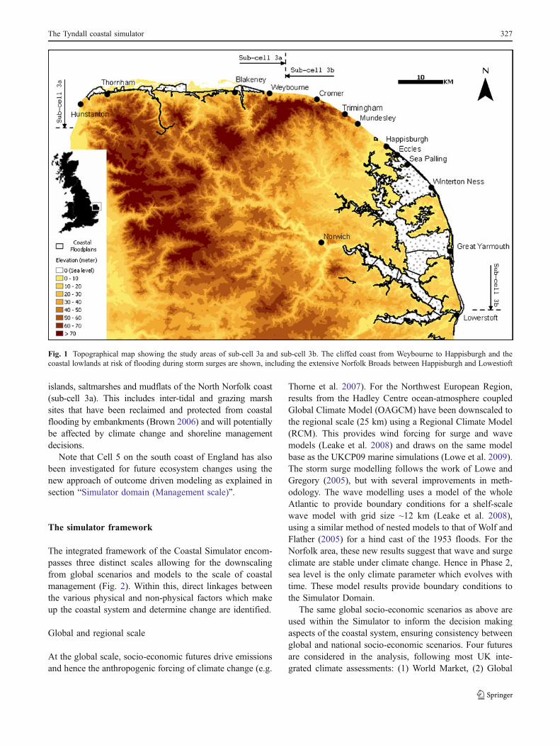
The Simulator has mainly been developed using the coastof Norfolk in East Anglia, UK (i.e. sub-cells 3a and 3b),(see Fig. 1) which illustrates many of the managementissues that affect the UK’s coasts including both socio-economic and ecological impacts.
Historically, the easily-eroded chalk and till cliffs (insub-cell 3b) have retreated at an average rate of up to1 m/yr (Clayton 1989), releasing large quantities of sand andgravel that have maintained beaches. The volume of sedimentreleased into the beaches by cliff and platform erosion variesaccording to the rate of recession, the cliff height andsediment content. The most sediment rich area is aroundTrimingham, where the cliffs are 60m high, and contain about75% of material suitable for beach building. Here a metre ofrecession releases over 45 m3 of beach material, per metre ofshoreline (additional material is released from the shoreplatform). In its natural state, it is estimated that erosionwould deliver around 350 thousand cubic metres of beachmaterial per year. This material is distributed along the shoreby wave action. A drift divide occurs between Sheringhamand Cromer resulting in the movement of sediment both tothe northwest and southeast: the southeast movementdominates. However, this process has been affected duringthe last century by shoreline management, with largestretches of the cliffs being protected, especially since the1950s. As a result, the natural supply of beach sediment hasbeen significantly reduced and substantial beach nourish-ment is now required at Sea Palling (see below).
Extreme flood events, such as the 1953 storm surge,have also progressively led to more protection of the low-lying land between Happisburgh and Lowestoft. This hasculminated in the construction of offshore breakwaters andrepetitive nourishment at Sea Palling where the averageannual nourishment rate is approximately 150 thousandcubic metres per year, around 43% of the natural (i.e.undefended) flux of beach sediment from the cliff.
In 2003, sub-cell 3b was estimated to have about 1,400properties within 100 m of the cliff-top and 20,000 propertiesin the coastal flood plain, including 3,000 non-residentialproperties (Dawson et al. 2009). In addition, there are areaswith significant biodiversity value in the spits, barrier
326 M. Mokrech et al.
islands, saltmarshes and mudflats of the North Norfolk coast(sub-cell 3a). This includes inter-tidal and grazing marshsites that have been reclaimed and protected from coastalflooding by embankments (Brown 2006) and will potentiallybe affected by climate change and shoreline managementdecisions.
Note that Cell 5 on the south coast of England has alsobeen investigated for future ecosystem changes using thenew approach of outcome driven modeling as explained insection “Simulator domain (Management scale)”.
The simulator framework
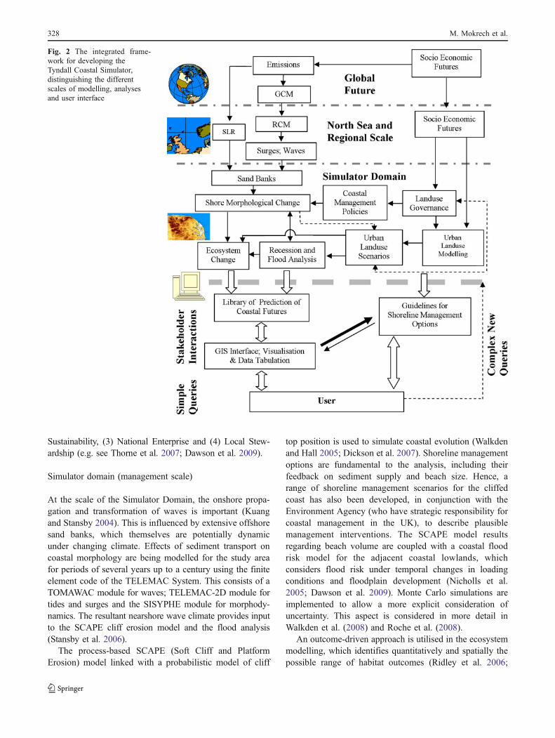
The integrated framework of the Coastal Simulator encom-passes three distinct scales allowing for the downscalingfrom global scenarios and models to the scale of coastalmanagement (Fig. 2). Within this, direct linkages betweenthe various physical and non-physical factors which makeup the coastal system and determine change are identified.
Global and regional scale
At the global scale, socio-economic futures drive emissionsand hence the anthropogenic forcing of climate change (e.g.
Thorne et al. 2007). For the Northwest European Region,results from the Hadley Centre ocean-atmosphere coupledGlobal Climate Model (OAGCM) have been downscaled tothe regional scale (25 km) using a Regional Climate Model(RCM). This provides wind forcing for surge and wavemodels (Leake et al. 2008) and draws on the same modelbase as the UKCP09 marine simulations (Lowe et al. 2009).The storm surge modelling follows the work of Lowe andGregory (2005), but with several improvements in meth-odology. The wave modelling uses a model of the wholeAtlantic to provide boundary conditions for a shelf-scalewave model with grid size ~12 km (Leake et al. 2008),using a similar method of nested models to that of Wolf andFlather (2005) for a hind cast of the 1953 floods. For theNorfolk area, these new results suggest that wave and surgeclimate are stable under climate change. Hence in Phase 2,sea level is the only climate parameter which evolves withtime. These model results provide boundary conditions tothe Simulator Domain.
The same global socio-economic scenarios as above areused within the Simulator to inform the decision makingaspects of the coastal system, ensuring consistency betweenglobal and national socio-economic scenarios. Four futuresare considered in the analysis, following most UK inte-grated climate assessments: (1) World Market, (2) Global
Fig. 1 Topographical map showing the study areas of sub-cell 3a and sub-cell 3b. The cliffed coast from Weybourne to Happisburgh and thecoastal lowlands at risk of flooding during storm surges are shown, including the extensive Norfolk Broads between Happisburgh and Lowestioft
The Tyndall coastal simulator 327
Sustainability, (3) National Enterprise and (4) Local Stew-ardship (e.g. see Thorne et al. 2007; Dawson et al. 2009).
Simulator domain (management scale)
At the scale of the Simulator Domain, the onshore propa-gation and transformation of waves is important (Kuangand Stansby 2004). This is influenced by extensive offshoresand banks, which themselves are potentially dynamicunder changing climate. Effects of sediment transport oncoastal morphology are being modelled for the study areafor periods of several years up to a century using the finiteelement code of the TELEMAC System. This consists of aTOMAWAC module for waves; TELEMAC-2D module fortides and surges and the SISYPHE module for morphody-namics. The resultant nearshore wave climate provides inputto the SCAPE cliff erosion model and the flood analysis(Stansby et al. 2006).
The process-based SCAPE (Soft Cliff and PlatformErosion) model linked with a probabilistic model of cliff
top position is used to simulate coastal evolution (Walkdenand Hall 2005; Dickson et al. 2007). Shoreline managementoptions are fundamental to the analysis, including theirfeedback on sediment supply and beach size. Hence, arange of shoreline management scenarios for the cliffedcoast has also been developed, in conjunction with theEnvironment Agency (who have strategic responsibility forcoastal management in the UK), to describe plausiblemanagement interventions. The SCAPE model resultsregarding beach volume are coupled with a coastal floodrisk model for the adjacent coastal lowlands, whichconsiders flood risk under temporal changes in loadingconditions and floodplain development (Nicholls et al.2005; Dawson et al. 2009). Monte Carlo simulations areimplemented to allow a more explicit consideration ofuncertainty. This aspect is considered in more detail inWalkden et al. (2008) and Roche et al. (2008).
An outcome-driven approach is utilised in the ecosystemmodelling, which identifies quantitatively and spatially thepossible range of habitat outcomes (Ridley et al. 2006;
Fig. 2 The integrated frame-work for developing theTyndall Coastal Simulator,distinguishing the differentscales of modelling, analysesand user interface
328 M. Mokrech et al.
Sutherland 2006). The approach addresses the uncertaintiesassociated with forecasts of future climate and incompleteknowledge and understanding of environmental processes.It is based on the premise that, despite an infinite number ofsea-level rise scenarios, these can be effectively reduced toa limited number of representative outcomes. The proba-bility of these outcomes is assessed in relation to the fullrange of scenarios. Probability distributions of sea-levelrise in conjunction with a range of coastal managementoptions are then used to predict intertidal habitat change; ifnew sea-level projections are developed, these are easilyincorporated. This approach has been explored using a casestudy site on the south coast of England (at Pennington incell 5) and is now being applied in sub-cell 3a.
Geomorphology is also important to habitat developmentbut process-based morphological models are seldom avail-able. To allow application of the Simulator to these areas,an outcome-driven geomorphic approach has been devel-oped which builds on results from the FutureCoast project(Burgess et al. 2002). It incorporates expert knowledge andunderstanding and identifies broad patterns of shorelinechange, such as narrowing of beaches and barriers, inresponse to changes in sea level and sediment supply. Itthen assigns a likelihood of occurrence to each possiblechange based on the understanding of the coastal system(Hanson et al. 2007).
An important element of the Simulator is the inclusionof the socio-economic dimension within the SimulatorDomain (Fig. 2) as this influences the magnitude of erosionand flood risk; key inputs relate to the socio-economic
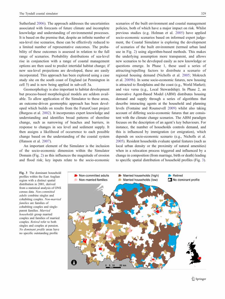
scenarios of the built environment and coastal managementpolicies, both of which have a major impact on risk. Whilstprevious studies (e.g. Holman et al. 2005) have appliedsocio-economic scenarios based on informed expert judge-ment, the Coastal Simulator is exploring the developmentof scenarios of the built environment (termed urban landuse in Fig. 2) using algorithm-based methods. This makesthe underlying assumption more transparent, and allowsnew scenarios to be developed easily as new knowledge orquestions emerge. In Phase 1, these used a series ofattracting/repelling factors to distribute a scenario ofregional housing demand (Nicholls et al. 2005; Mokrechet al. 2009b). In some socio-economic futures, new housingis attracted to floodplains and the coast (e.g., World Market);and vice versa (e.g., Local Stewardship). In Phase 2, aninnovative Agent-Based Model (ABM) distributes housingdemand and supply through a series of algorithms thatdescribe interacting agents at the household and planninglevels (Fontaine and Rounsevell 2009) whilst also takingaccount of differing socio-economic futures that are consis-tent with the climate change scenarios. The ABM paradigmfocuses on the description of an agent’s key behaviours. Forinstance, the number of households controls demand, andthis is influenced by immigration (or emigration), whichdepends on socio-economic scenario (e.g., Nicholls et al.2005). Resident households evaluate spatial features (such aslocal urban density or the proximity of natural amenities)when in a relocation process triggered and influenced by achange in composition (from marriage, birth or death) leadingto specific spatial distribution of household profiles (Fig. 3).
Fig. 3 The dominant householdprofiles within the East Anglianregion with a distinct spatialdistribution in 2001, derivedfrom a statistical analysis of ONScensus data. Non-committedadults combine singles andcohabiting couples. Non-marriedfamilies are families ofcohabiting couples and single-parent families. Marriedhouseholds group marriedcouples and families of marriedcouples. Retired refer to bothsingles and couples at pension.No dominant profile areas haveno specific outstanding profile
The Tyndall coastal simulator 329
Planning agents constrain these demands with detailed rules,again depending on the socio-economic scenario.
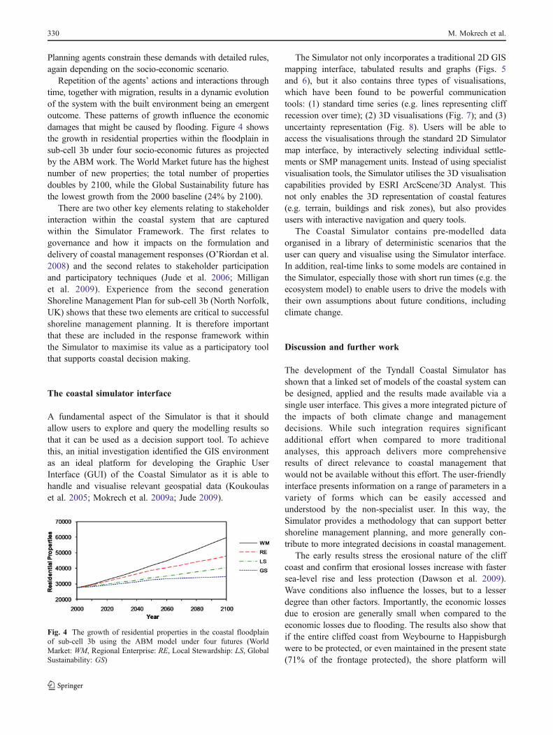
Repetition of the agents’ actions and interactions throughtime, together with migration, results in a dynamic evolutionof the system with the built environment being an emergentoutcome. These patterns of growth influence the economicdamages that might be caused by flooding. Figure 4 showsthe growth in residential properties within the floodplain insub-cell 3b under four socio-economic futures as projectedby the ABM work. The World Market future has the highestnumber of new properties; the total number of propertiesdoubles by 2100, while the Global Sustainability future hasthe lowest growth from the 2000 baseline (24% by 2100).
There are two other key elements relating to stakeholderinteraction within the coastal system that are capturedwithin the Simulator Framework. The first relates togovernance and how it impacts on the formulation anddelivery of coastal management responses (O’Riordan et al.2008) and the second relates to stakeholder participationand participatory techniques (Jude et al. 2006; Milliganet al. 2009). Experience from the second generationShoreline Management Plan for sub-cell 3b (North Norfolk,UK) shows that these two elements are critical to successfulshoreline management planning. It is therefore importantthat these are included in the response framework withinthe Simulator to maximise its value as a participatory toolthat supports coastal decision making.
The coastal simulator interface
A fundamental aspect of the Simulator is that it shouldallow users to explore and query the modelling results sothat it can be used as a decision support tool. To achievethis, an initial investigation identified the GIS environmentas an ideal platform for developing the Graphic UserInterface (GUI) of the Coastal Simulator as it is able tohandle and visualise relevant geospatial data (Koukoulaset al. 2005; Mokrech et al. 2009a; Jude 2009).
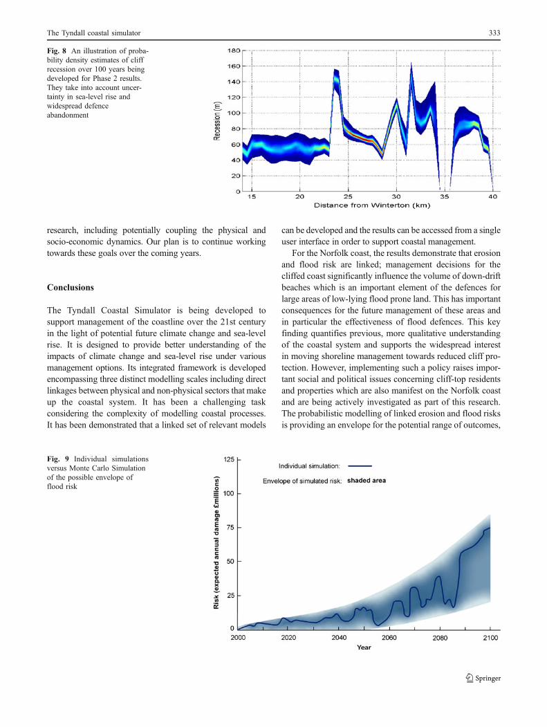
The Simulator not only incorporates a traditional 2D GISmapping interface, tabulated results and graphs (Figs. 5and 6), but it also contains three types of visualisations,which have been found to be powerful communicationtools: (1) standard time series (e.g. lines representing cliffrecession over time); (2) 3D visualisations (Fig. 7); and (3)uncertainty representation (Fig. 8). Users will be able toaccess the visualisations through the standard 2D Simulatormap interface, by interactively selecting individual settle-ments or SMP management units. Instead of using specialistvisualisation tools, the Simulator utilises the 3D visualisationcapabilities provided by ESRI ArcScene/3D Analyst. Thisnot only enables the 3D representation of coastal features(e.g. terrain, buildings and risk zones), but also providesusers with interactive navigation and query tools.
The Coastal Simulator contains pre-modelled dataorganised in a library of deterministic scenarios that theuser can query and visualise using the Simulator interface.In addition, real-time links to some models are contained inthe Simulator, especially those with short run times (e.g. theecosystem model) to enable users to drive the models withtheir own assumptions about future conditions, includingclimate change.
Discussion and further work
The development of the Tyndall Coastal Simulator hasshown that a linked set of models of the coastal system canbe designed, applied and the results made available via asingle user interface. This gives a more integrated picture ofthe impacts of both climate change and managementdecisions. While such integration requires significantadditional effort when compared to more traditionalanalyses, this approach delivers more comprehensiveresults of direct relevance to coastal management thatwould not be available without this effort. The user-friendlyinterface presents information on a range of parameters in avariety of forms which can be easily accessed andunderstood by the non-specialist user. In this way, theSimulator provides a methodology that can support bettershoreline management planning, and more generally con-tribute to more integrated decisions in coastal management.
The early results stress the erosional nature of the cliffcoast and confirm that erosional losses increase with fastersea-level rise and less protection (Dawson et al. 2009).Wave conditions also influence the losses, but to a lesserdegree than other factors. Importantly, the economic lossesdue to erosion are generally small when compared to theeconomic losses due to flooding. The results also show thatif the entire cliffed coast from Weybourne to Happisburghwere to be protected, or even maintained in the present state(71% of the frontage protected), the shore platform will
Fig. 4 The growth of residential properties in the coastal floodplainof sub-cell 3b using the ABM model under four futures (WorldMarket: WM, Regional Enterprise: RE, Local Stewardship: LS, GlobalSustainability: GS)
330 M. Mokrech et al.
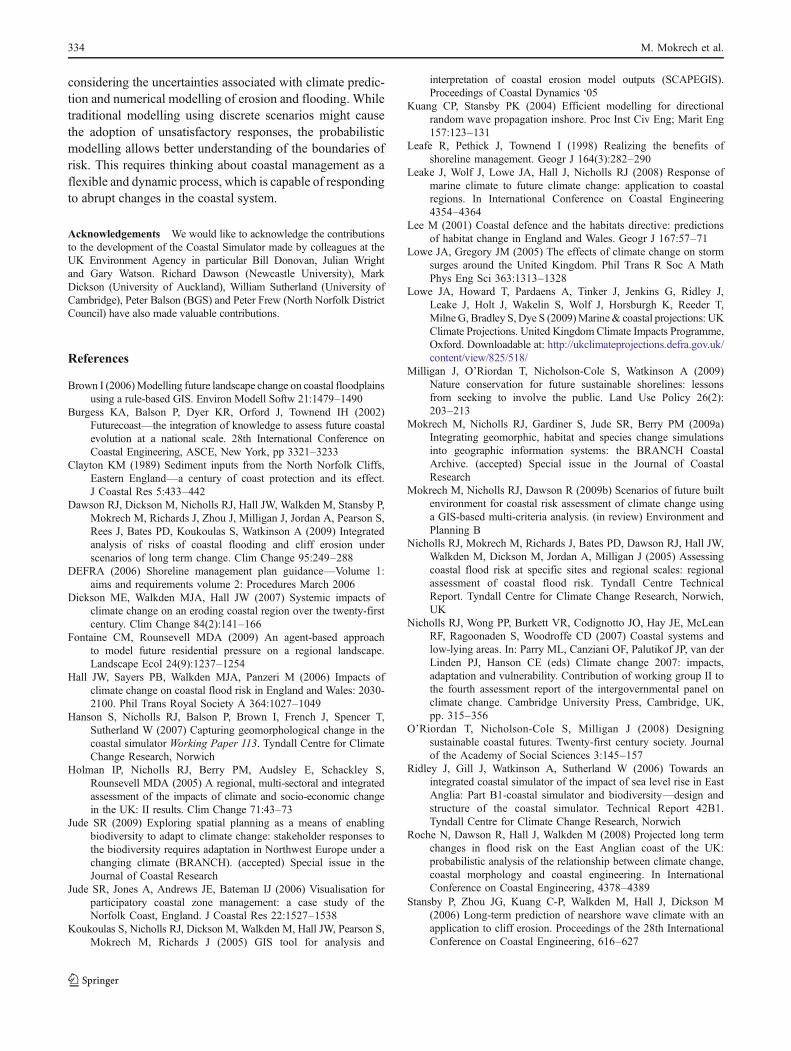
continue to lower in front of the cliffs, necessitatingcontinued investment in defence maintenance and upgrade.Furthermore, the downdrift beaches are already starved andwill continue to decline. This will increase the flood risk inthe low-lying areas as the likelihood of breaching increases,assuming that the flood defences are not upgraded. Lossesare also influenced by socio-economic scenarios, with thegreatest losses under the World Market future. In contrast, ifthe defences are removed along stretches of the cliffedcoast, the release of sediment as a result of erosionconsiderably reduces the expected economic damages fromflooding (Dawson et al. 2009). While Phase 1 climatic andcoastal morphological modelling provide a discrete realisa-tion of a coastal flood risk analysis for the given scenario,Phase 2 Monte Carlo simulations consider the varioussources of uncertainty and provide a range of realisationsrepresenting the distribution of coastal flood risk in sub-cell3b. The sketch in Fig. 9 provides an illustration of risk foran individual simulation and possible envelope of simulatedrisk realisations. This approach may lead to a better under-standing of the possible risks and may help planning futureresponses within a flexible management framework, whichis capable of responding to changes in the coastal system.
The outcome-driven modelling seems to have thepotential for dealing with a range of complex problemsassociated with considerable uncertainty by reducing theseproblems into a limited number of outcomes. This newapproach is effective for decision makers as it allows themto narrow their responses to a limited number of optionsconsidering the uncertainty and complexity associated withthe process. It also provides transparency and flexibility ofassigning and amending the probability of these outcomesif new sea-level projections are proposed.
The Phase 2 work has been mainly targeted at supportingbetter shoreline management planning at the sub-cell scale.However, the work offers much more potential both in termsof its individual components and the integrated SimulatorFramework. At the Simulator scale, two fundamental chal-lenges are apparent. Firstly, to extend the Simulator Domain toembrace multiple sub-cells will involve linking diversegeomorphic elements where our scientific understanding isoften more qualitative than quantitative. This would need toinclude the interaction between wave-dominated coasts andestuaries. Secondly, to link the results of the Simulator beyondshoreline management planning to all the decisions that areinfluenced by coastal change and flood risk requires further
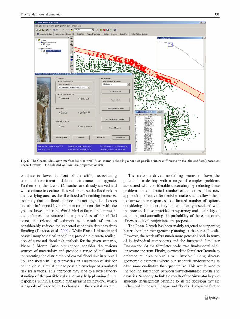
Fig. 5 The Coastal Simulator interface built in ArcGIS: an example showing a band of possible future cliff recession (i.e. the red band) based onPhase 1 results—the selected red dots are properties at risk
The Tyndall coastal simulator 331
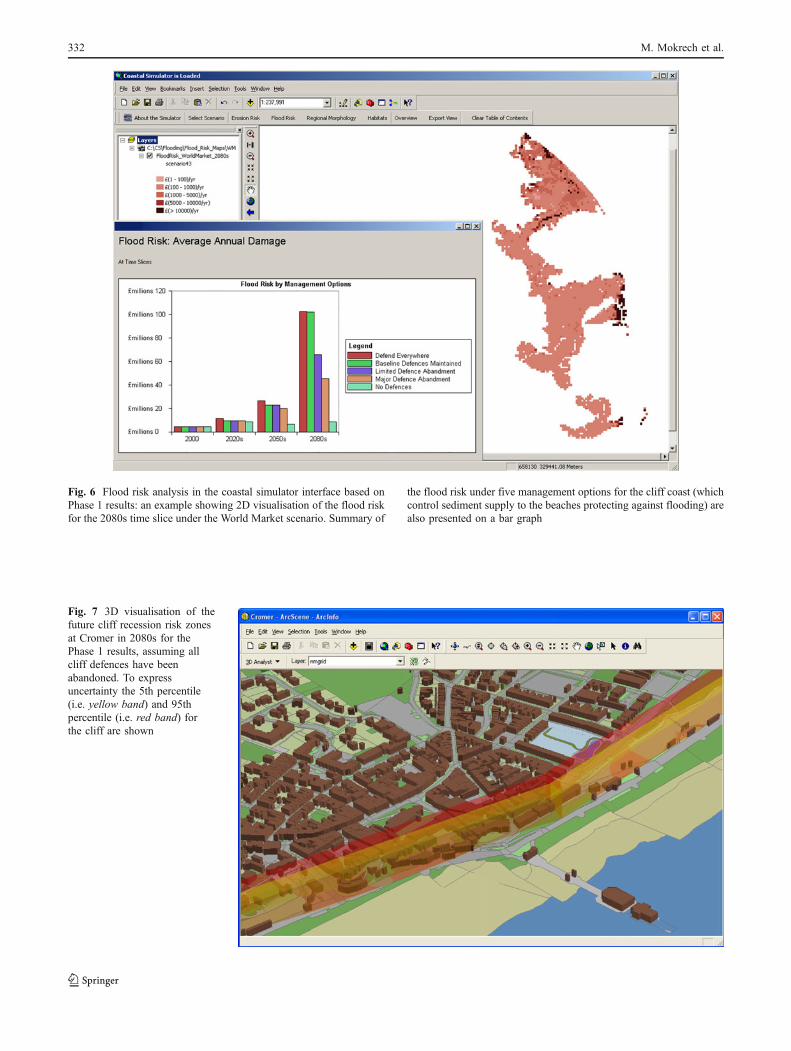
Fig. 7 3D visualisation of thefuture cliff recession risk zonesat Cromer in 2080s for thePhase 1 results, assuming allcliff defences have beenabandoned. To expressuncertainty the 5th percentile(i.e. yellow band) and 95thpercentile (i.e. red band) forthe cliff are shown
Fig. 6 Flood risk analysis in the coastal simulator interface based onPhase 1 results: an example showing 2D visualisation of the flood riskfor the 2080s time slice under the World Market scenario. Summary of
the flood risk under five management options for the cliff coast (whichcontrol sediment supply to the beaches protecting against flooding) arealso presented on a bar graph
332 M. Mokrech et al.
research, including potentially coupling the physical andsocio-economic dynamics. Our plan is to continue workingtowards these goals over the coming years.
Conclusions
The Tyndall Coastal Simulator is being developed tosupport management of the coastline over the 21st centuryin the light of potential future climate change and sea-levelrise. It is designed to provide better understanding of theimpacts of climate change and sea-level rise under variousmanagement options. Its integrated framework is developedencompassing three distinct modelling scales including directlinkages between physical and non-physical sectors that makeup the coastal system. It has been a challenging taskconsidering the complexity of modelling coastal processes.It has been demonstrated that a linked set of relevant models
can be developed and the results can be accessed from a singleuser interface in order to support coastal management.
For the Norfolk coast, the results demonstrate that erosionand flood risk are linked; management decisions for thecliffed coast significantly influence the volume of down-driftbeaches which is an important element of the defences forlarge areas of low-lying flood prone land. This has importantconsequences for the future management of these areas andin particular the effectiveness of flood defences. This keyfinding quantifies previous, more qualitative understandingof the coastal system and supports the widespread interestin moving shoreline management towards reduced cliff pro-tection. However, implementing such a policy raises impor-tant social and political issues concerning cliff-top residentsand properties which are also manifest on the Norfolk coastand are being actively investigated as part of this research.The probabilistic modelling of linked erosion and flood risksis providing an envelope for the potential range of outcomes,
Fig. 9 Individual simulationsversus Monte Carlo Simulationof the possible envelope offlood risk
Fig. 8 An illustration of proba-bility density estimates of cliffrecession over 100 years beingdeveloped for Phase 2 results.They take into account uncer-tainty in sea-level rise andwidespread defenceabandonment
The Tyndall coastal simulator 333
considering the uncertainties associated with climate predic-tion and numerical modelling of erosion and flooding. Whiletraditional modelling using discrete scenarios might causethe adoption of unsatisfactory responses, the probabilisticmodelling allows better understanding of the boundaries ofrisk. This requires thinking about coastal management as aflexible and dynamic process, which is capable of respondingto abrupt changes in the coastal system.
Acknowledgements We would like to acknowledge the contributionsto the development of the Coastal Simulator made by colleagues at theUK Environment Agency in particular Bill Donovan, Julian Wrightand Gary Watson. Richard Dawson (Newcastle University), MarkDickson (University of Auckland), William Sutherland (University ofCambridge), Peter Balson (BGS) and Peter Frew (North Norfolk DistrictCouncil) have also made valuable contributions.
References
Brown I (2006)Modelling future landscape change on coastal floodplainsusing a rule-based GIS. Environ Modell Softw 21:1479–1490
Burgess KA, Balson P, Dyer KR, Orford J, Townend IH (2002)Futurecoast—the integration of knowledge to assess future coastalevolution at a national scale. 28th International Conference onCoastal Engineering, ASCE, New York, pp 3321–3233
Clayton KM (1989) Sediment inputs from the North Norfolk Cliffs,Eastern England—a century of coast protection and its effect.J Coastal Res 5:433–442
Dawson RJ, Dickson M, Nicholls RJ, Hall JW, Walkden M, Stansby P,Mokrech M, Richards J, Zhou J, Milligan J, Jordan A, Pearson S,Rees J, Bates PD, Koukoulas S, Watkinson A (2009) Integratedanalysis of risks of coastal flooding and cliff erosion underscenarios of long term change. Clim Change 95:249–288
DEFRA (2006) Shoreline management plan guidance—Volume 1:aims and requirements volume 2: Procedures March 2006
Dickson ME, Walkden MJA, Hall JW (2007) Systemic impacts ofclimate change on an eroding coastal region over the twenty-firstcentury. Clim Change 84(2):141–166
Fontaine CM, Rounsevell MDA (2009) An agent-based approachto model future residential pressure on a regional landscape.Landscape Ecol 24(9):1237–1254
Hall JW, Sayers PB, Walkden MJA, Panzeri M (2006) Impacts ofclimate change on coastal flood risk in England and Wales: 2030-2100. Phil Trans Royal Society A 364:1027–1049
Hanson S, Nicholls RJ, Balson P, Brown I, French J, Spencer T,Sutherland W (2007) Capturing geomorphological change in thecoastal simulator Working Paper 113. Tyndall Centre for ClimateChange Research, Norwich
Holman IP, Nicholls RJ, Berry PM, Audsley E, Schackley S,Rounsevell MDA (2005) A regional, multi-sectoral and integratedassessment of the impacts of climate and socio-economic changein the UK: II results. Clim Change 71:43–73
Jude SR (2009) Exploring spatial planning as a means of enablingbiodiversity to adapt to climate change: stakeholder responses tothe biodiversity requires adaptation in Northwest Europe under achanging climate (BRANCH). (accepted) Special issue in theJournal of Coastal Research
Jude SR, Jones A, Andrews JE, Bateman IJ (2006) Visualisation forparticipatory coastal zone management: a case study of theNorfolk Coast, England. J Coastal Res 22:1527–1538
Koukoulas S, Nicholls RJ, Dickson M, Walkden M, Hall JW, Pearson S,Mokrech M, Richards J (2005) GIS tool for analysis and
interpretation of coastal erosion model outputs (SCAPEGIS).Proceedings of Coastal Dynamics ‘05
Kuang CP, Stansby PK (2004) Efficient modelling for directionalrandom wave propagation inshore. Proc Inst Civ Eng; Marit Eng157:123–131
Leafe R, Pethick J, Townend I (1998) Realizing the benefits ofshoreline management. Geogr J 164(3):282–290
Leake J, Wolf J, Lowe JA, Hall J, Nicholls RJ (2008) Response ofmarine climate to future climate change: application to coastalregions. In International Conference on Coastal Engineering4354–4364
Lee M (2001) Coastal defence and the habitats directive: predictionsof habitat change in England and Wales. Geogr J 167:57–71
Lowe JA, Gregory JM (2005) The effects of climate change on stormsurges around the United Kingdom. Phil Trans R Soc A MathPhys Eng Sci 363:1313–1328
Lowe JA, Howard T, Pardaens A, Tinker J, Jenkins G, Ridley J,Leake J, Holt J, Wakelin S, Wolf J, Horsburgh K, Reeder T,MilneG, Bradley S, Dye S (2009)Marine& coastal projections: UKClimate Projections. United Kingdom Climate Impacts Programme,Oxford. Downloadable at: http://ukclimateprojections.defra.gov.uk/content/view/825/518/
Milligan J, O’Riordan T, Nicholson-Cole S, Watkinson A (2009)Nature conservation for future sustainable shorelines: lessonsfrom seeking to involve the public. Land Use Policy 26(2):203–213
Mokrech M, Nicholls RJ, Gardiner S, Jude SR, Berry PM (2009a)Integrating geomorphic, habitat and species change simulationsinto geographic information systems: the BRANCH CoastalArchive. (accepted) Special issue in the Journal of CoastalResearch
Mokrech M, Nicholls RJ, Dawson R (2009b) Scenarios of future builtenvironment for coastal risk assessment of climate change usinga GIS-based multi-criteria analysis. (in review) Environment andPlanning B
Nicholls RJ, Mokrech M, Richards J, Bates PD, Dawson RJ, Hall JW,Walkden M, Dickson M, Jordan A, Milligan J (2005) Assessingcoastal flood risk at specific sites and regional scales: regionalassessment of coastal flood risk. Tyndall Centre TechnicalReport. Tyndall Centre for Climate Change Research, Norwich,UK
Nicholls RJ, Wong PP, Burkett VR, Codignotto JO, Hay JE, McLeanRF, Ragoonaden S, Woodroffe CD (2007) Coastal systems andlow-lying areas. In: Parry ML, Canziani OF, Palutikof JP, van derLinden PJ, Hanson CE (eds) Climate change 2007: impacts,adaptation and vulnerability. Contribution of working group II tothe fourth assessment report of the intergovernmental panel onclimate change. Cambridge University Press, Cambridge, UK,pp. 315–356
O’Riordan T, Nicholson-Cole S, Milligan J (2008) Designingsustainable coastal futures. Twenty-first century society. Journalof the Academy of Social Sciences 3:145–157
Ridley J, Gill J, Watkinson A, Sutherland W (2006) Towards anintegrated coastal simulator of the impact of sea level rise in EastAnglia: Part B1-coastal simulator and biodiversity—design andstructure of the coastal simulator. Technical Report 42B1.Tyndall Centre for Climate Change Research, Norwich
Roche N, Dawson R, Hall J, Walkden M (2008) Projected long termchanges in flood risk on the East Anglian coast of the UK:probabilistic analysis of the relationship between climate change,coastal morphology and coastal engineering. In InternationalConference on Coastal Engineering, 4378–4389
Stansby P, Zhou JG, Kuang C-P, Walkden M, Hall J, Dickson M(2006) Long-term prediction of nearshore wave climate with anapplication to cliff erosion. Proceedings of the 28th InternationalConference on Coastal Engineering, 616–627
334 M. Mokrech et al.

Sutherland WJ (2006) Predicting the ecological consequences of environ-mental change: a review of the methods. J Appl Ecol 43:599–616
Thorne C, Evans E, Penning-Rowsell E (eds) (2007) Future floodingand coastal erosion risks. Thomas Telford, London
Walkden MJA, Hall JW (2005) A predictive mesoscale model of softshore erosion and profile development. Coast Eng 52(6):535–563
Walkden M, Dickson M, Thomas J, Hall J (2008) Probabilisticsimulation of long term shore morphology of North NorfolkUK. In International Conference on Coastal Engineering 4365–4377
Wolf J, Flather R (2005) Modelling waves and surges during the 1953storm. Philos Trans R Soc 363:1359–1375
The Tyndall coastal simulator 335