Embed Size (px)
Citation preview

Upper Mississippi River Spill Response Plan & Resource Manual
Signatory Agencies:
Illinois Environmental Protection Agency Iowa Department of Natural Resources Minnesota Pollution Control Agency Missouri Department of Natural Resources Wisconsin Department of Natural Resources U.S. Coast Guard U.S. Environmental Protection Agency U.S. Fish and Wildlife Service U.S. Army Corps of Engineers Coordinated by: Upper Mississippi River Basin Association
December 2014 Public Access Version

PUBLIC ACCESS VERSION SPECIAL NOTICE
This is a special Public Access Version of the Upper Mississippi River Spill Response Plan and Resource Manual, and is thus suitable for broad dissemination. This version of the document includes the Spill Response Plan in its entirety, but omits certain portions of the Resource Manual due to security concerns. The omitted sections are listed in the Table of Contents. The Public Access Version is also maintained at www.umrba.org/hazspills/umrplan.pdf. Questions may be directed to the Upper Mississippi River Basin Association at 651-224-2880 or [email protected].
UMR Spill Plan [December 2014]

HOW TO REPORT A SPILL ON THE
UPPER MISSISSIPPI RIVER: An Emergency Action Field Guide for Oil, Fuel, and Hazardous Materials
Spill Notification Basics for All River Users
If you see a spill, it's important to report it immediately! Those responsible for a spill must know and comply with all local, state, and federal reporting requirements, which can vary by jurisdiction and product spilled. However, other people may encounter evidence of a spill on the river, such as oil sheen, and not know whether the spill has been reported. When in doubt, anyone who encounters a spill should notify the appropriate government authorities. This is easy to do and will help ensure a successful response.
ESSENTIAL 24-HOUR NOTIFICATION NUMBERS
Federal, state, and local authorities should all be notified of a spill. This can be done with just a few short calls. To alert federal authorities, call the National Response Center (NRC). It is also very important to directly notify the state where the spill appears to have originated, or that appears to be most affected, by calling that state’s “duty officer.” When in doubt, please call all potentially affected states. Local authorities should also be contacted via 911, particularly if there appears to be an immediate public health or safety risk.
Federal National Response Center 800-424-8802
State
Illinois Iowa Minnesota Missouri Wisconsin
217-782-7860 515-281-8694 800-422-0798 573-634-2436 800-943-0003
Local All Jurisdictions 911
INFORMATION TO REPORT
Be prepared to provide the following information, if known, when reporting a spill:
Location (river mile and/or general area) Apparent spill source and party responsible for spill Product spilled and estimated volume of product Any other notifications made Any response efforts currently underway
You may not have all of this information available. Don’t worry, just report what you know. Do not endanger yourself or others trying to obtain more information. SAFETY FIRST: PROCEED ACCORDING TO YOUR LEVEL OF TRAINING!
Spills present a variety of potential hazards. Do not endanger yourself or others by engaging in activities beyond your training. As a member of the general public, your primary duty is simply to report the spill as described above.
WHEN IN
DOUBT, NOTIFY!
If you see a spill, it’s important to report it immediately!
This document was prepared by the Upper Mississippi River Hazardous Spills Coordination Group. For additional copies, contact the Upper Mississippi River Basin Association at 651-224-2880 or visit www.umrba.org/hazspills.htm
April 2014
NOTE: Responders, Industrial Facility Staff, Government Personnel, and Other Response Professionals: See the reverse side of this document for more detailed reporting instructions and requirements on the River.

Detailed Procedures for the Upper Mississippi River (UMR) SPECIAL UMR NOTIFICATION PROTOCOL FOR STATE AND FEDERAL AGENCY STAFF
State and federal response and resource agencies have established a special notification protocol for use on the UMR. If you do not work for one of these agencies, simply calling the 24-hour notification numbers listed earlier in this document will be sufficient to trigger the protocol. However, if you do work for a state or federal agency, you should conduct your notifications in accordance with the following protocol: 1. First-aware state notifies, by phone, other potentially affected states
and appropriate federal response and natural resource agencies. 2. Once notified, each state is responsible for its own intrastate
notifications. 3. If a federal agency is first-aware, it notifies the state where the spill
occurred or the state being impacted. That state then proceeds as the first-aware state.
Additional numbers to implement the UMR notification protocol are:
Federal
U.S. Coast Guard Sector UMR U.S. EPA, Region 5 (IL, MN, WI) U.S. EPA, Region 7 (IA, MO) U.S. Dept. of the Interior (IL, MN, WI) U.S. Dept. of the Interior (IA, MO)
314-269-2332 312-353-2318 913-281-0991 215-266-5155 303-478-3373
State Use the appropriate 24-hour Duty Officer phone number listed on the reverse of this page.
SPECIAL CONSIDERATIONS WHEN RESPONDING TO SPILLS ON THE UMR
Responders need to be aware of the following when responding to a spill on the UMR:
It is a complex physical system including locks and dams, the main channel, side channels, and backwaters. As a result, flows and spill trajectories are variable and difficult to predict.
High-value natural resources are present on the UMR, including tremendous seasonal concentrations of migratory species, threatened and endangered species, and diverse habitats ranging from river bottom to floodplain forests.
The UMR is an important source for drinking water, industrial water use, and power plant cooling. Commercial and recreational vessels may need to be alerted for safety reasons; also, their operations may hinder
response efforts. Diverse potential pollution sources exist, including vessels, pipelines, railroads, highway crossings, fixed facilities, and
storm sewers and other outfalls. The UMR is a multi-jurisdictional river, and it serves as a border for counties, states, and federal agencies.
Resulting implications for responders include:
The need to be aware of potentially dangerous river conditions. Follow the UMR notification protocol to ensure all potentially affected jurisdictions are notified. Consult state and federal natural resource managers throughout the response. Physical factors, public safety considerations, and natural resource concerns may limit response options – this applies to
in situ burning and chemical countermeasures as well as mechanical removal.
HOW YOU CAN PREPARE IN ADVANCE
An actual emergency is no time to learn about spill response. Here are some things you can do in advance to maximize your effectiveness in responding to spills:
Familiarize yourself with this emergency action guide, your own agency/company plan, and the UMR Spill Response Plan. Refresh your memory periodically. Encourage your co-workers to do the same.
Make a list of additional local phone numbers for notification purposes — e.g., the non-911 numbers for local authorities, numbers for any nearby drinking water operators, etc. Keep those numbers with this guide.
Customize/supplement this guide in other ways that will enhance its utility to you. Know the limits of your training and experience. Keep current with refresher training.
ABOUT THE UMR SPILL RESPONSE PLAN
The UMR Hazardous Spill Response Plan and Resource Manual is designed to coordinate state and federal agency response to spills on the interstate UMR. It establishes several UMR-specific protocols and policies, including the UMR notification protocol outlined in this guide. It also includes appendices listing response resources, sensitive human and natural resources, and potential spill sources. Information about the UMR Plan is available from the Upper Mississippi River Basin Association at 651-224-2880 or www.umrba.org/hazspills.htm.

PREAMBLE Preparation and maintenance of the Upper Mississippi River Spill Response Plan and Resource Manual, originally published in 1991, is a collaborative effort among five states and four federal agencies under the auspices of the Upper Mississippi River Basin Association (UMRBA) and through the Upper Mississippi River Hazardous Spills Coordination Group (UMR Spills Group). The Upper Mississippi Spill Response Plan and Resource Manual is not intended to supplant any other local, state, regional, or national response or contingency plans. Rather, it is designed to address some of the unique circumstances that may arise in coordinating spill response on the Upper Mississippi River. The Response Plan and Resource Manual is a unique, River-focused tool and information source for first responders and contingency planners. It addresses the commercially navigable mainstem of the Upper Mississippi River from Minneapolis, Minnesota to the Ohio River confluence at Cairo, Illinois. It is the intent of the UMR Spills Group to update the Upper Mississippi River Spill Response Plan and Resource Manual on a periodic basis to ensure its currency. As such, a comprehensive review and update will be completed every three years. Routine updates will be done every six months to address any inaccuracies and minor changes as needed. The Public Access Version of the plan is available at www.umrba.org/hazspills/umrplan.pdf. Should users of this document discover any errors or outdated information, they are asked to notify UMRBA using the corrections and updates form provided on page G-5. For further information about the plan, please contact UMRBA at:
Upper Mississippi River Basin Association 415 Hamm Building 408 St. Peter Street Saint Paul, Minnesota 55102 Phone: 651-224-2880 Fax: 651-223-5815 Email: [email protected]
UMR Spill Plan [December 2014]

UMR Spill Plan [December 2014]

UPPER MISSISSIPPI RIVER SPILL RESPONSE PLAN AND RESOURCE MANUAL
TABLE OF CONTENTS
INTRODUCTION
Background ............................................................................................................................................................................. i Purpose of the Plan ............................................................................................................................................................. i Geographic Scope ................................................................................................................................................................ i Authority .................................................................................................................................................................................. i Relationship to Other Plans and Protocols ................................................................................................................ ii
SPILL RESPONSE PLAN
I. Role of Private and Public Organizations in Upper Mississippi River Spill Response ........... 1
II. General Response Protocol for Spills to the Upper Mississippi River ........................................... 11
III. Interstate Notification Protocol for Spills to the Upper Mississippi River .................................. 16 Spill Notification Roster ........................................................................................................................................ 19
IV. Key Upper Mississippi River Response Considerations, Techniques, and Tools ...................... 23
V. Upper Mississippi River Response Policies .................................................................................................. 28
Incident Command System Implementation Protocol Addressing State and Federal Responders .......................................................................................................................................... 29 Policy on In Situ Burning and Chemical Oil Spill Treating Agents ....................................................... 32 Policy on Bioremediation ...................................................................................................................................... 34 Policy on Vessel Detainment ............................................................................................................................... 35 Policy on Coordination with the U.S. Army Corps of Engineers ........................................................... 36 Oiled Wildlife Response ........................................................................................................................................ 37 Policy on Volunteers ............................................................................................................................................... 40
VI. Exercising, Drills, and Training ........................................................................................................................... 42
RESOURCE MANUAL
Note: The Resource Manual is not included in its entirety in the Public Access version of the Upper Mississippi River Spill Response Plan. Those portions not included are indicated below.
Section A: River Information and Locational Resources
Upper Mississippi River Miles by 50-Mile Segments ................................................................................... A-1 Counties along the Upper Mississippi River .................................................................................................... A-2 Upper Mississippi River Mile Points of County Lines ................................................................................... A-4 Upper Mississippi River Locks and Dams ......................................................................................................... A-6 U.S. Army Corps of Engineers District Boundaries ........................................................................................ A-8 U.S. Army Corps of Engineers District Hydraulics Contacts ...................................................................... A-9 U.S. Coast Guard Sector Boundaries .................................................................................................................. A-10 U.S. EPA Regional Boundaries .............................................................................................................................. A-11 Cultural and Historic Resource State Contacts ............................................................................................... A-12
UMR Spill Plan [December 2014]

Section B: Spill Response, Clean-Up, and Related Resources
Location and Type of Spill Containment Equipment on the Upper Mississippi River (not included) ...................................................................................................................................................... B-1 Boat Accesses on the Upper Mississippi River ............................................................................................... B-12 State Hazardous Materials Disposal Requirements .................................................................................... B-50 Oil Spill Liability Trust Fund .................................................................................................................................. B-53
Section C: Sensitive Human and Wildlife Resources
Public Water Supply Intakes along the Upper Mississippi River (not included) .................................... C-1 Sensitive/Critical Fish and Wildlife Habitat of the Upper Mississippi River ........................................ C-10 National Wildlife Refuges along the Upper Mississippi River .................................................................. C-11 U.S. Fish and Wildlife Service Contacts .............................................................................................................. C-13
Section D: Potential Sources of Spills and Related Resources
Upper Mississippi River Terminals Handling Oil or Chemicals (not included) .................................... D-1 Commodities Transported by Barge on the Upper Mississippi River (Calendar Year 2013) ........ D-8 Upper Mississippi River Shipping Companies ................................................................................................ D-10 Barge Fleeting Areas along the Upper Mississippi River (not included) ............................................... D-12 Facilities Discharging to the Upper Mississippi River .................................................................................. D-14 Railroad Tracks Along the Upper Mississippi River ...................................................................................... D-27 Pipeline Crossings on the Upper Mississippi River (not included) .......................................................... D-30 Highway and Railroad Crossings on the Upper Mississippi River (not included).............................. D-38 Selected Tributaries to the Upper Mississippi River ..................................................................................... D-41 Coal Ash Impoundment Sites Along the Upper Mississippi River .......................................................... D-44
Section E: Regional and Local Resources
Public Hazardous Materials Teams ..................................................................................................................... E-1 County Emergency Management Agencies along the Upper Mississippi River ............................... E-3
Section F: In Situ Burning and Chemical Oil Spill Treating Agents
In Situ Burn Checklist ................................................................................................................................................ F-1 Chemical Oil Spill Treating Agents (COSTAs) ................................................................................................. F-5 Potential Effectiveness of ISB ................................................................................................................................ F-12 ISB Relationship to Other Countermeasures and Potential Environmental Tradeoffs ................... F-13 Proposed Guidelines for ISB in Marshes ........................................................................................................... F-14 Air Monitoring Guidelines for Human Health Impacts of ISB .................................................................. F-16 Public Notification for ISB ....................................................................................................................................... F-28 Ecological Considerations for ISB ........................................................................................................................ F-29 Safety and Health Considerations and By-products of ISB ....................................................................... F-31 Operational Considerations for Conducting ISB ........................................................................................... F-33
Section G: Other Resources
Acronyms ..................................................................................................................................................................... G-1 Corrections and Updates Form ............................................................................................................................ G-5
UMR Spill Plan [December 2014]

INTRODUCTION
UMR Spill Plan [December 2014]

i
Background The Mississippi River flows along ten states on the journey from its headwaters in northern Minnesota to the Gulf of Mexico. Activities on the river upstream can affect the quantity and quality of the river downstream. Likewise, activities on one side can affect the river uses on the other side. The same holds true for spills of oil or other hazardous substances. Since the river is constantly flowing, any river segment adjacent to or downstream from a spill could be affected by that spill. The river is thus a shared resource, requiring dependable stewardship and coordination by the bordering states. The coordination of quick notification and response by all parties is essential to minimize the damage from hazardous substance spills. To help prevent and respond to spills on the Upper Mississippi River, the five states bordering the Upper Mississippi River (Illinois, Iowa, Minnesota, Missouri, and Wisconsin) and four federal agencies (U.S. Environmental Protection Agency, U.S. Coast Guard, U.S. Fish and Wildlife Service, and U.S. Army Corps of Engineers) meet periodically as the Upper Mississippi River Hazardous Spills Coordination Group (UMR Spills Group) to discuss common problems, propose solutions, reach agreements, and coordinate activities. While prevention of spills is the primary goal of these agencies, effective response to spills is an equally important and necessary goal. Purpose of the Plan Realizing the importance of rapid notification and a coordinated response to spills on the Upper Mississippi River, the UMR Spills Group member agencies have jointly produced this Upper Mississippi River Spill Response Plan and Resource Manual (UMR Spill Plan). The UMR Spill Plan is designed to provide the first responder and the on-scene coordinator with the information necessary to make informed decisions. The Response Plan component sets out the procedures for notification and response by state and federal agencies in conjunction with existing plans. The Resource Manual provides reference information about the river, spill containment equipment, sensitive human and wildlife resources, and potential sources of spills. Geographic Scope The geographic scope of the UMR Spill Plan is the commercially navigable mainstem Upper Mississippi River (UMR), from Minneapolis, Minnesota to the Ohio River confluence at Cairo, Illinois. Authority The UMR Spill Plan is a product of the interagency UMR Spills Group. The state and federal members of the UMR Spills Group have adopted the plan under a Memorandum of Agreement (MOA). Under this MOA, the signatories agree to coordinate their responses on the UMR in accordance with the protocols found in the UMR Spill Plan. Signatories also agree to participate in periodically updating the UMR Spill Plan. Additionally, the UMR Spill Plan is referenced by the Region 5 Regional/Area Contingency Plan (RCP/ACP) and the Region 7 Integrated Contingency Plan (ICP). As such, the UMR Spill Plan represents the policy of both Regions regarding the River.
UMR Spill Plan [December 2014]

ii
Relationship to Other Plans and Protocols The UMR Spill Plan is a working contingency plan that supplements state emergency response plans, regional/area contingency plans, and the National Contingency Plan (NCP). As such, the UMR Spill Plan is consistent with the Region 5 RCP/ACP and the Region 7 ICP and is in compliance with all requirements of the NCP, the National Response Framework (NRF), and the National Incident Management System (NIMS). Further, the UMR Spill Plan is designed to function alongside the sub-area plans in place along the River – i.e., Minneapolis-St. Paul, Quad Cities, Greater St. Louis, and Great River sub-areas. Additionally, the UMR Spill Plan and Resource Manual links to pool-specific geographic response plans, as described in Section IV. See Figure 1 for a diagram of these relationships among contingency plans. Figure 1: Relationship of UMR Spill Plan to Other Contingency Plans
Additionally, the Upper Mississippi River notification protocol described in Section III does not replace or override other existing notification protocols or requirements (e.g., notification of the National Response Center per the NCP). Rather, this River-specific protocol is in place to speed and enhance communication among the agencies involved in response on the Upper Mississippi River.
UMR Spill Response Plan and Resource
Manual
National Contingency Plans and Tools National Contingency Plan
National Response Framework
National Incident Management System
Sub-area Contingency Plans
Mpls.-St. Paul
Quad Cities
St. Louis
Great River
UMR Geographic Response Plans
Pool 7
Pool 10
Pool 13
Pool 19
Regional Contingency
Plans Region 5 RCP/ACP
Region 7 ICP
UMR Spill Plan [December 2014]

SPILL RESPONSE PLAN
UMR Spill Plan [December 2014]

1
I. ROLE OF PRIVATE AND PUBLIC ORGANIZATIONS IN UPPER MISSISSIPPI RIVER SPILL RESPONSE
The UMR Spill Plan is designed to be consistent with standard approaches to response including those outlined in the NCP, NRF, and NIMS. There are also numerous legal and programmatic requirements that govern private entities’ roles in spill planning and response. The following text describes the roles of public and private organizations in spill response in a generalized fashion that is consistent with the aforementioned plans and requirements. It is within the context of these roles that the River-specific protocols and procedures described in the UMR Spill Plan are established. Prevention and Response Preplanning The responsibility for preventing spills and preplanning response to a spill generally lies with the party storing, transporting, or using the material. Local, state, and federal entities are responsible for writing and implementing effective regulations covering storage, transport, use, and spill prevention and response plans. Some of their programs require permits or specify in detail the preventive measures and preplanning which is required of users, transporters, and storers. Some of these government programs also include inspections to verify adequacy of preventive measures. In the most extreme circumstances, government agencies are authorized to intervene to prevent a spill from occurring. Most of the preventive actions and response preplanning required by governmental programs focus on protection of the public's safety and on response at the site of a potential spill. Actions related to preplanning environmental protection and preventing off-site impacts are also required of major facilities. Response to Public Safety and Property Threats Caused by Spills When a spill poses public safety and property threats via potential fires, explosions, toxic clouds, or other means, local officials are usually in command of the incident. The party responsible for the incident is required to cooperate with and aid local police and fire agencies, but typically does not direct or implement the firefighting, evacuation, or other first responses to the spill. The actions typically are taken minutes to hours from the onset of the spill. If highly specialized activities such as off-loading tank cars or repackaging hazardous chemicals are required, the responsible party may implement the actions under the general direction of the local public safety incident commander. In most states, the role of state agencies in public safety response during the early stages of an incident is to advise local incident commanders to the extent possible. During major incidents state and federal authorities may be able to provide additional assistance to the incident commander at the scene by conducting sampling and analysis, providing specialized contractors or equipment, offering detailed advice, or serving other support functions. Seldom will state or federal authorities assume command from a local incident commander for short term on-site public safety related issues. Response to Environmental and Health Threats Caused by Spills A number of state and federal statutes and regulations require responsible parties to investigate and remedy environmental and health threats caused by their spills. Often these actions take place at locations distant from the spill’s source itself. They usually begin somewhat later than does the public safety protection response, but they can go on for a much longer period of time. The actions can include things like placing containment and recovery booms and pads; sampling runoff and rivers; excavating soil;
UMR Spill Plan [December 2014]

2
doing hydrogeological investigations; air sampling; retrieving, cleaning, and rehabilitating affected wildlife; closing drinking water intakes; and providing an alternate water supply. Generally in a major incident the environmental and health protection actions that are conducted by the responsible party are overseen by state or federal authorities, not the local commander. Local police and fire personnel are, however, often asked to assist. Sometimes a responsible party is unable or unwilling to adequately or quickly undertake the environmental and health protection actions required by state or federal authorities. In those cases state or federal authorities can assume a more direct role. Typically, this is done by using agency personnel or hiring cleanup contractors to stop the release and/or clean up the oil/hazardous substances. These tasks are accomplished using government funds, such as state or federal Superfunds or the federal Oil Spill Liability Trust Fund. The costs of these direct government actions and damage to natural resources will usually be recovered later from the responsible party. The decision to assume governmental control of environmental and health follow-up to an incident usually hinges on the severity of the incident, the cost and duration of required actions, and the resources available to the involved state. General Roles of Agencies and Other Entities Involved in UMR Spill Response Table 1 briefly summarizes the roles of government agencies and other entities most likely to be engaged in hazardous spill response on the Upper Mississippi River. However, the table does not include all potential entities nor all potential roles in response. For more information, please consult the Region 5 Regional Contingency Plan/Area Contingency Plan (RCP/ACP), the Region 7 Integrated Contingency Plan, and individual entity’s websites per the links embedded in Table 1. Those agencies labeled with an asterisk (*) are signers of the Memorandum of Agreement for Spill Response on the Upper Mississippi River.
UMR Spill Plan [December 2014]
3
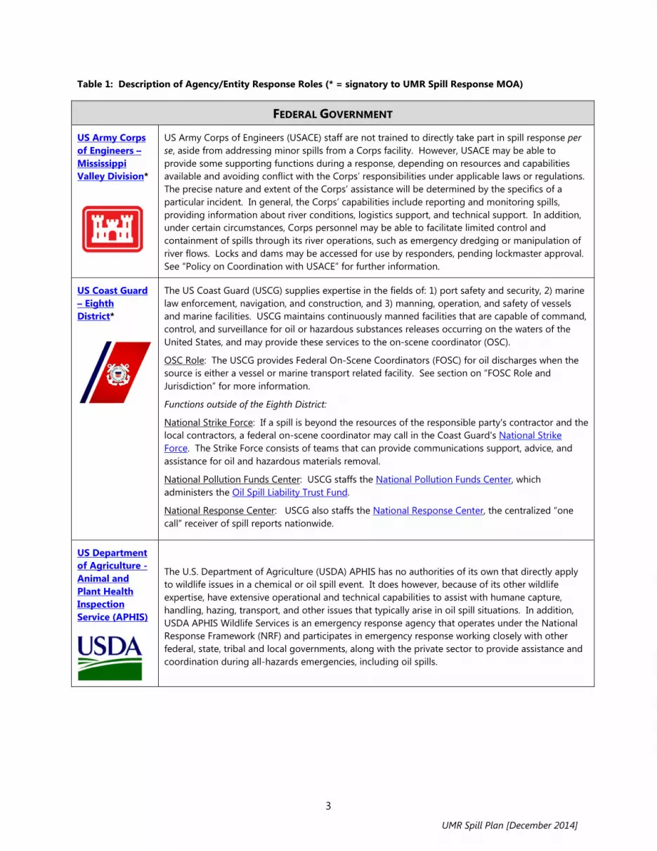
Table 1: Description of Agency/Entity Response Roles (* = signatory to UMR Spill Response MOA)
FEDERAL GOVERNMENT
US Army Corps of Engineers – Mississippi Valley Division*
US Army Corps of Engineers (USACE) staff are not trained to directly take part in spill response per se, aside from addressing minor spills from a Corps facility. However, USACE may be able to provide some supporting functions during a response, depending on resources and capabilities available and avoiding conflict with the Corps’ responsibilities under applicable laws or regulations. The precise nature and extent of the Corps’ assistance will be determined by the specifics of a particular incident. In general, the Corps’ capabilities include reporting and monitoring spills, providing information about river conditions, logistics support, and technical support. In addition, under certain circumstances, Corps personnel may be able to facilitate limited control and containment of spills through its river operations, such as emergency dredging or manipulation of river flows. Locks and dams may be accessed for use by responders, pending lockmaster approval. See “Policy on Coordination with USACE” for further information.
US Coast Guard – Eighth District*
The US Coast Guard (USCG) supplies expertise in the fields of: 1) port safety and security, 2) marine law enforcement, navigation, and construction, and 3) manning, operation, and safety of vessels and marine facilities. USCG maintains continuously manned facilities that are capable of command, control, and surveillance for oil or hazardous substances releases occurring on the waters of the United States, and may provide these services to the on-scene coordinator (OSC).
OSC Role: The USCG provides Federal On-Scene Coordinators (FOSC) for oil discharges when the source is either a vessel or marine transport related facility. See section on “FOSC Role and Jurisdiction” for more information.
Functions outside of the Eighth District:
National Strike Force: If a spill is beyond the resources of the responsible party's contractor and the local contractors, a federal on-scene coordinator may call in the Coast Guard's National Strike Force. The Strike Force consists of teams that can provide communications support, advice, and assistance for oil and hazardous materials removal.
National Pollution Funds Center: USCG staffs the National Pollution Funds Center, which administers the Oil Spill Liability Trust Fund.
National Response Center: USCG also staffs the National Response Center, the centralized “one call” receiver of spill reports nationwide.
US Department of Agriculture - Animal and Plant Health Inspection Service (APHIS)
The U.S. Department of Agriculture (USDA) APHIS has no authorities of its own that directly apply to wildlife issues in a chemical or oil spill event. It does however, because of its other wildlife expertise, have extensive operational and technical capabilities to assist with humane capture, handling, hazing, transport, and other issues that typically arise in oil spill situations. In addition, USDA APHIS Wildlife Services is an emergency response agency that operates under the National Response Framework (NRF) and participates in emergency response working closely with other federal, state, tribal and local governments, along with the private sector to provide assistance and coordination during all-hazards emergencies, including oil spills.
UMR Spill Plan [December 2014]

4
FEDERAL GOVERNMENT (Continued)
US Department of Commerce-National Oceanic and Atmospheric Administration
While National Oceanic and Atmospheric Administration (NOAA) response-related activities are primarily coastal and Great Lakes-focused, it can provide support to Mississippi River spills through the Scientific Support Coordinators (SSCs). An SSC can provide scientific advice to support operational decisions that will protect the environment effectively, mitigate collateral harm, and facilitate environmental recovery. The SSC advises on other technical issues (as requested by the OSC) after consulting with the appropriate NOAA hazardous materials resources or other federal, state, or academic networks. This includes considering advice from the trustee agencies, and any divergent opinions. Additionally, NOAA Weather Service offices provide water forecasting and hydrologic information which may be valuable in a response.
US Environmental Protection Agency – Region 5* and Region 7*
The US Environmental Protection Agency (US EPA) is responsible for providing expertise regarding environmental effects of pollution and environmental pollution control techniques. US EPA will also: 1) assist USCG in hazardous materials incidents, 2) advise the OSC of the degree of hazard a particular release poses to public health and safety, and 3) coordinate scientific support, including environmental assessment. OSC Role: US EPA provides Federal On-Scene Coordinators (FOSC) when an incident is from a source other than a vessel or marine transportation facility. Geographically, US EPA Region 5 has jurisdiction on the Mississippi River in Minnesota, Wisconsin, and Illinois; US EPA Region 7 has jurisdiction on the Mississippi River in Iowa and Missouri. See section on “FOSC Role and Jurisdiction” for more information.
US Fish and Wildlife Service– Midwest Region*
The US Fish and Wildlife Service (USFWS) is responsible for the conservation and management of lands and waters within the National Wildlife Refuges along the UMR, migratory birds, federally-listed threatened and endangered species, and inter jurisdictional fishes, and the supporting habitats for these species. USFWS shares with state natural resource agencies joint responsibilities for overseeing any activity that involves the handling of wildlife. USFWS is also a trustee bureau of the U.S. Department of the Interior with Natural Resource Damage Assessment and Restoration (NRDAR) authorities to restore or replace natural resources injured or lost due to spills of oil or releases of hazardous substances. USFWS fulfills these NRDAR responsibilities by working with co-trustees (e.g., states) and responsible parties as a distinct process coordinated with the emergency response itself.
During a response, USFWS (via the Refuge Manager, District Manager, or designee) will establish a response protocol delineating specific roles and responsibilities of Refuge personnel. In general, Refuge personnel can provide responders with specific information on fish, wildlife, and habitat resources within the Refuge, will provide recommendations for preventing or minimizing spill impacts to Refuge resources, and will consult on the best locations for response staging areas and access points within Refuge boundaries.
USFWS environmental contaminants biologists have spill response and NRDAR authority for the protection and restoration of trust resources. Environmental Contaminants biologists will implement the USFWS Contingency Plan and the Region 3 Cross Programmatic Spill Response Plan to support and provide assets to Refuge personnel as needed and requested by the Refuge. Environmental Contaminants biologists can open a Pollution Removal Funding Authorization (PRFA) with the USEPA or USCG to provide funding to support the USFWS response if needed. Environmental Contaminants biologists can also help fill Incident Command System (ICS) roles in spill response as requested by the FOSC and the Refuge including Wildlife Branch operations and Environmental Unit activities.
UMR Spill Plan [December 2014]

5
FEDERAL GOVERNMENT (Continued)
Federal Emergency Management Agency
The Federal Emergency Management Agency (FEMA) requires the development, evaluation, and exercise of all-hazard contingency plans for all FEMA-funded jurisdictions at state and local levels. SARA Title III plans are often annexes of the all-hazard plan. FEMA monitors and provides technical assistance regarding public sector emergency response training and planning for incidents involving hazardous materials. In a response, FEMA provides advice and assistance to the lead agency on coordinating relocation assistance and mitigation efforts with other federal agencies, state and local governments, and the private sector. If the President declares a disaster or emergency, FEMA coordinates all federal assistance, including temporary housing. The OSC coordinates with the Federal Coordinating Officer in situations where both authorities are active. FEMA's National Emergency Support Team and Regional Emergency Response Teams provide coordination of federal response in situations of unique national significance, such as commercial nuclear power plant or nuclear weapons accidents and catastrophic natural disasters.
STATE GOVERNMENT
Illinois Department of Natural Resources
The Illinois Department of Natural Resources (IL DNR) Office of Law Enforcement supports the Department's programs designed to protect Illinois' natural and recreational resources. Conservation Police Officers (CPO) or Game Wardens are vested with full state-wide police authority and are trained as law enforcement professionals. Although CPOs have full police authority in the enforcement of all Illinois Compiled Statutes, their enforcement mission is to focus upon those laws and activities associated with natural resource protection and recreational safety.
As a natural resource trustee, the IL DNR works with USFWS and other co-trustees to assess damages to restore natural resources (as circumstances allow) lost or injured due to spill. Data acquired are used to determine the extent of damage to natural resources, to develop restoration or replacement strategies, and to develop and submit a claim for damages to the Responsible Party to implement the most appropriate restoration actions.
Illinois Emergency Management Agency
The Illinois Emergency Management Agency (IEMA) coordinates the state's disaster mitigation, preparedness, response and recovery programs and activities, functions as the State Emergency Response Commission, and maintains a 24-hour Communication Center and State Emergency Operations Center (SEOC). The SEOC acts as lead in crisis/consequence management response and operations to notify, activate, deploy and employ state resources in response to any threat or act of terrorism. IEMA assists local governments with multi-hazard emergency operations plans and maintains the Illinois Emergency Operations Plan.
Illinois Environmental Protection Agency*
The Illinois Environmental Protection Agency (IL EPA) Office of Emergency Response (OER) protects the health and safety of the citizens of Illinois during emergency incidents involving the release of oil, hazardous materials or other contaminants, while stabilizing, minimizing or eliminating the environmental consequences to the land, air or waters of the state. The Emergency Operations Unit (EOU), within OER, coordinates IL EPA’s response to environmental emergencies and ensures that any environmental contamination is cleaned up. The EOU provides many services to other agencies and the public in the form of: 1) technical information about identification, chemical properties, toxicity and potential dangers of a given hazardous material, 2) monitoring or testing of air, water, soil or containers, 3) advice about containment of hazardous materials; restoration of the environment, including cleanup objectives; evacuation recommendations; and disposal or treatment of hazardous materials, 4) oversight to assure completeness of cleanup actions taken by responsible parties, documenting violations of the Illinois Environmental Protection Act for possible legal action, and 5) professional personnel, technical assistance and equipment to assist public safety officials.
UMR Spill Plan [December 2014]

6
STATE GOVERNMENT (Continued)
Iowa Department of Natural Resources*
The Iowa Department of Natural Resources (IA DNR) Field Offices provides technical assistance to local, state, and federal response agencies, regulated industries, other responsible parties, and interested public during an incident. The Field Offices can also initiate appropriate enforcement action.
As a natural resource trustee, the IA DNR works with USFWS and other co-trustees to assess damages to restore natural resources (as circumstances allow) lost or injured due to spill. Data acquired are used to determine the extent of damage to natural resources, to develop restoration or replacement strategies, and to develop and submit a claim for damages to the responsible party to implement the most appropriate restoration actions.
Minnesota Department of Agriculture
The Minnesota Department of Agriculture (MDA) is the lead state agency authorized to respond to most agricultural or chemical releases in Minnesota. The MDA’s agricultural chemical emergency incident response staff consists of a four-person team based in St. Paul. Additional emergency response support is provided by eleven regional MDA agricultural chemical investigation staff members located in outstate Minnesota. In response to a spill event, MDA will work in support of local responders. When the incident transitions from public safety concerns to environmental protection, MDA will then oversee the responsible party’s cleanup efforts.
Minnesota Department of Natural Resources
The Minnesota Department of Natural Resources (MN DNR) is co-trustee with the MPCA for the state’s natural resources, and a co-trustee with the USFWS concerning the management of migratory birds and other resources. MN DNR is charged with control of all state-owned lands, parks, timber, waters, minerals, and wildlife in Minnesota. This includes the protection, preservation, and propagation of the fish and wildlife of the state. In response to a spill event, MN DNR personnel (conservation officers, biologists, and managers) may have responsibilities including: 1) notify all necessary MN DNR personnel and establish a response protocol describing the role of responders, 2) coordinate effort with other responding trustees, such as MPCA and the USFWS, 3) provide responders with specific fish and wildlife habitat information for an incident; the MN DNR will also consult with the responders as to the best locations for staging and recovery areas as well as access points, 4) provide responders with critical habitat information for state-listed threatened and endangered species as well as information on sensitive natural communities and special concern species found in the area of an incident, 5) provide responders with technical assistance and expertise on potential effects of oil and hazardous substances on fish and wildlife and their habitat, and 6) coordinate wildlife rescue and rehabilitation efforts with USFWS.
As a natural resource trustee, MN DNR works with USFWS and other co-trustees to assess damages to restore natural resources (as circumstances allow) lost or injured due to spill. Data acquired are used to determine the extent of damage to natural resources, to develop restoration or replacement strategies, and to develop and submit a claim for damages to the responsible party to implement the most appropriate restoration actions.
UMR Spill Plan [December 2014]

7
STATE GOVERNMENT (Continued)
Minnesota Department of Public Safety, Division of Homeland Security and Emergency Management
Minnesota Department of Public Safety, Division of Homeland Security and Emergency Management (HSEM) helps to coordinate activities before, during, and after emergencies through partnerships with local, state, federal, and private agencies. The Director of HSEM serves as the state Coordinating Officer and the Governor's Authorized Representative for all presidential declared disasters and emergencies. HSEM also organizes long-term disaster recovery efforts, coordinates local government emergency planning, authorizes use of chemical assessment teams (CATs), and reviews emergency operations plans for compliance. County Emergency managers work directly with HSEM and can provide Emergency Operation Centers (EOCs) and other resources.
Minnesota Pollution Control Agency*
The Minnesota Pollution Control Agency (MPCA) is the lead agency for state response to most oil and hazardous substance incidents in Minnesota. For agricultural chemical incidents in the state, the Minnesota Department of Agriculture is the lead agency. MPCA will be in support of local command unless asked to join unified command. MPCA will monitor cleanup progress by the responsible party (RP), and evaluate cleanup results for adequacy of environmental protection. If there is no RP known or available, or if the RP is unable or unwilling to complete the cleanup, then the state through the MPCA may take over cleanup using contractors.
Missouri Department of Natural Resources*
The Missouri Department of Natural Resources (MDNR) Environmental Emergency Response Section (EER) unit may respond to the scene of an environmental emergency if requested by a local authority, the party responsible for the spill, other governmental agencies, or at the discretion of the department. A response to the scene may be warranted if the party responsible for the release has not been identified or is not addressing the situation properly. While on scene the EER unit may provide technical advice or, if necessary, hire a contractor and direct cleanup efforts. MDNR EER staff may conduct some cleanups. Cleanup costs and penalties may be recovered from those responsible for the incident.
MDNR is capable of collecting and analyzing environmental water, air, and soil samples. The state also maintains instrumentation for conducting real-time air monitoring. MDNR EER operates specially designed emergency response vehicles throughout the state, including one located in the St. Louis area. These vehicles carry protective clothing, monitoring equipment, communications equipment, and containment and cleanup supplies for small spills. Watercraft are also available, including an environmental emergency response boat that can be mobilized to the St. Louis area. All of this equipment and these personnel are accessible 24 hours a day by calling 573-634-2436.
The MDNR Director is the Natural Resources Trustee for releases governed by OPA in the state of Missouri.
UMR Spill Plan [December 2014]

8
STATE GOVERNMENT (Continued)
Wisconsin Department of Natural Resources*
The Wisconsin Department of Natural Resources (WDNR) has Regional Spill coordinators and county/area Conservation Wardens that that are also first responders. Wisconsin DNR Wardens have law enforcement authority and are the DNR agency liaison with the County Sheriff, local Fire Departments, and the County emergency managers.
During a spill response, appropriate WDNR staff will be contacted (local biologists, technicians, law enforcement officers, Wildlife Health, Regional Spill Coordinators, and Public Affairs) and a response protocol established delineating specific roles and responsibilities of each program. WNDR determines what level of response, if any, is necessary to protect and respond to potentially threatened or injured fish, wildlife, and sensitive environments. If appropriate, WDNR personnel will contact the On-Scene Coordinator (OSC) to request participation in the spill response. Local WDNR staff, along with USFWS personnel, will ensure that resources at risk are clearly identified and communicated to the OSC and will participate in the ICS command structure, as necessary. The USFWS and WDNR have joint responsibilities for overseeing any activity that involves the handling of wildlife and the WDNR’s Wildlife Rehabilitation Liaison will coordinate with area wildlife rehabilitators as necessary. The WDNR’s Wildlife Veterinarian will provide veterinary support and expertise as necessary.
The Department is the lead coordinating agency for Emergency Support Function 10 (Oil and Hazardous Materials) as part of the Wisconsin Response Plan. The primary responsibility of ESF 10 is to ensure that the state has a coordinated response to releases of oil and other hazardous materials that pose a threat to public health and safety and the environment. Each DNR region has a spill coordinator specifically trained to help responsible parties, response agencies and other DNR staff when a spill occurs.
If a responsible party is unable or unwilling to provide adequate response, WDNR has the authority to identify, locate, monitor, contain, remove or dispose of the hazardous substance or take any other emergency action which it deems appropriate under the circumstances. In addition, the department may enter any property, premises or place at any time for the purpose of taking removal or other emergency action if the entry is necessary to prevent increased damage to the air, land or waters of the state. Notice is not required if the delay would result in imminent risk to public health, safety or the environment. WDNR can then seek cost recovery for costs incurred to providing those services.
As a natural resource trustee, WDNR works with USFWS and other co-trustees to assess damages to restore natural resources (as circumstances allow) lost or injured due to spill. Data acquired are used to determine the extent of damage to natural resources, to develop restoration or replacement strategies, and to develop and submit a claim for damages to the responsible party to implement the most appropriate restoration actions.
Wisconsin Division of Emergency Management
In Wisconsin, county emergency managers organize under a regional manager within the Wisconsin Division of Emergency Management (WEM), which is under the Wisconsin Department of Military Affairs.
UMR Spill Plan [December 2014]

9
STATE GOVERNMENT (Continued)
National Guard Civil Support Teams
The function of the civil support teams (CSTs) is to assess a suspected weapons of mass destruction (WMD) attack, advise civilian responders on appropriate actions through on-site testing and expert consultation, and facilitate the arrival of additional state and federal military forces. There are currently 55 CSTs – one per state/territory and two in California. Each CST is composed of 22 people, 7 officer and 15 enlisted, from both the Army and Air National Guard, with a variety of specialties. Assigned vehicles include a command vehicle, operations van, a communications vehicle called the Unified Command Suite, an Analytical Laboratory System van, and other general purpose vehicles. The CST normally deploys using its assigned vehicles, but can be airlifted if required. As the CST is on standby 24/7, the advanced echelon will deploy within 90 minutes of notification and the rest of the team within three hours. This quick response gives the CST the ability to support the incident commander with critical information rapidly. The CST Commander can advise the incident commander as to the type and level of hazard present, possible courses of action, and additional National Guard assets that are available.
LOCAL GOVERNMENT
County Emergency Management Agencies
During the response and recovery stages of an event, the county emergency management agency acts as a liaison between federal, state, and local units of government to promote speedy access to emergency resources and recovery funding. See Resource Manual Section E for a list of county emergency management agencies bordering the Upper Mississippi River.
Police, Fire, Sheriff, and Hazmat Teams
Local units of government typically have the primary role in protecting the public's safety and property from a spill through police and fire department response. During the initial stages of an incident, when life and safety issues are paramount, local officials (Fire/Police/Sheriff) will typically be in charge of the response to an incident until such time that they decide to enter into a unified command. Public hazmat teams, typically based in larger municipalities (see Resource Manual Section E) may assist with response. These teams will not perform cleanup work, but will rather stabilize public safety threats during incidents and turn incidents over to responsible parties or to the state/federal agencies for cleanup.
UMR Spill Plan [December 2014]

10
PRIVATE SECTOR
Responsible Party
The spiller, or responsible party (RP), has the primary responsibility to conduct spill cleanup, following the procedures listed in the facility response plan. The first response action of the RP is making notification of an incident to appropriate other responders of the incident, according to law and the RP's own response plan. The RP conducts whatever response actions are necessary and for which their personnel are trained and equipped. The RP is required to have authorized and qualified individuals available 24 hours a day to respond to a spill. The RP should also have sufficient funds available to cover the cost of pollution response to the limit of liability for the vessel or facility. As the priorities of an incident evolve, they often include off-site and environmental concerns. The RP has the lead role in responding to these concerns, under the oversight of state or federal agencies. The RP is also liable for restoring or replacing natural resources which may be injured or lost due to the spill, and should coordinate with the natural resource trustees (via the NRDAR Liaison) as part of the NRDAR process. The RP will be placed at the command level of the response organization to represent their interests and to help coordinate assets and response actions. The RP should conduct inquiries into the cause of an incident. This is often done with the participation or oversight of state or federal agencies such as the Occupational Safety and Health Administration or the Department of Transportation. The RP should conduct a critique of their response to an incident and revise prevention, preparedness, and response measures accordingly. If the responsible party does not respond properly, the state or federal On-Scene Coordinator shall take appropriate response actions and should notify the responsible party of their potential liability for response costs incurred by the On-Scene Coordinator pursuant to state and federal law.
Cooperatives and CAER Groups
Spill response cooperatives and Community Awareness and Emergency Response (CAER) groups support spill response capacity through activities including arranging training and exercises for their members, developing shared equipment caches and mutual aid pacts, and area planning. A primary benefit of these groups is that they allow emergency planners and emergency responders to meet and network for mutual benefit in advance of an incident. On the UMR, there is one fully functioning CAER-type organization, Wakota CAER, which operates on the river in southern Twin Cities metro area and maintains response equipment caches along the river. Spill response cooperatives have also been established in the Red Wing, Lake City, Winona, and Bettendorf areas on the UMR. These cooperatives also possess some spill response equipment.
UMR Spill Plan [December 2014]

11
II. GENERAL RESPONSE PROTOCOL FOR SPILLS TO THE UPPER MISSISSIPPI RIVER
All spill incidents are unique in that the type of spill, location, time, and other environmental and human factors will vary for each incident. Since response procedures cannot be developed for every spill scenario, this protocol outlines the basic procedures that are to be used by state and federal personnel in responding to environmental and health threats presented by spills to the Upper Mississippi River (UMR). Due to the remoteness of most areas of the river, this protocol outlines the coordination which is deemed desirable by all in order to mitigate the effects of a spill. As previously stated, this protocol is designed to be consistent with the National Contingency Plan (NCP), National Response Framework (NRF), and National Incident Management System (NIMS) – while providing additional information and direction to enhance the effectiveness of response on the UMR. In particular, while recognizing the federally-focused procedures and jurisdictions described in the NCP, this UMR protocol also acknowledges that response on the River is most likely to be led initially at the local level, evolving to state or federal oversight dependent on the particular circumstances of the incident. Notification Spill notification and updates will be given to neighboring and downstream states and to federal agencies in accordance with the procedures outlined in the UMR Spill Notification Protocol. See Section III- Interstate Notification Protocol for details. This protocol does not override the need for spills to be reported to the National Response Center, per the NCP. Rather, the UMR protocol is intended to both accelerate initial communication among agencies and provide a method of ongoing communication during a response. Initial Investigation An initial spill report may be received by the local police or fire department, state or federal agencies, and/or the National Response Center. Regardless of which agency receives the first call, the state where the spill occurs is responsible for determining if an investigation is warranted and, as needed, assuring it is initiated. The investigation may be led by the state where the spill occurred, a neighboring state, U.S. EPA, or U.S. Coast Guard, depending upon which agency is readily available or has the necessary resources. When a spill from an unknown source is discovered on the river, neighboring states will confer and agree on which state will determine the need for an investigation. Determination of Necessary Spill Response Activities In general, oversight and emergency response to a spill is encouraged at the most local level of government which has the necessary resources available. Moreover, a spiller or other responsible party is expected to provide all resources to complete an effective response and cleanup. However, certain incidents may justify the involvement of state and/or federal response agencies. Factors to be considered in determining the appropriate level of effort of a response include: size of the spill
type of material that is spilled
UMR Spill Plan [December 2014]

12
location of the spill
exposure/damage potential of vulnerable populations (human and environmental) and property
willingness and ability of the spiller to respond
cost of spill clean-up and containment compared to the effectiveness expected and the damage reduction anticipated
availability of responding agencies capabilities
media/political interest An investigating state/federal agency will determine the extent of the spill and whether further response is necessary. This determination may be done by sending staff to the incident site or by receiving information via telephone reports from local police, fire, health, or environmental officials. The investigating agency will determine to the best of its ability the source of the spill, size of the spill, type of material spilled, the area affected, and the movement of the spill. The investigating agency will determine the necessary initial response and will expeditiously inform the designated coordinating state agency of its findings and actions to that point. When a response justifies a continuing on-scene presence by a state or federal agency, an incident command system shall be established and the incident commander shall confer with the appropriate state and federal on-scene coordinators. The incident command systems established pursuant to this plan shall recognize that the pre-designated federal on-scene coordinators have ultimate authority and responsibility. See the Incident Command System Implementation Protocol in Section V for further details. If a spill warrants it, the state or federal on-scene coordinator may request activation of the Regional Response Team(s). The degree of involvement and specific activities of the Regional Response Team(s) will be decided by their respective co-chairs. If responsible parties are not apparent, or if the scope of the needed response is beyond their ability, or if the responsible party's response is insufficient, then the use of government funds to respond should be implemented by the incident commander and on-scene coordinators, depending upon their funding authority in a specific instance. Requests for federal assistance should be made through the states, or Native American tribes, unless the incident commander is the federal on-scene coordinator or his/her representative. Federal On-Scene Coordinator (FOSC) Role and Jurisdiction The federal on-scene coordinator (FOSC) directs federal response efforts and coordinates all other federal efforts at the scene of a discharge or release. The FOSC may monitor local, tribal state, or private actions to remove a discharge and may provide technical assistance to local, tribal, state or responsible party personnel. If a response action is being conducted through local, tribal, state, or responsible party efforts, the FOSC will ensure adequate oversight. If local, tribal, or state agencies, or the responsible party cannot or will not initiate action to eliminate the threat, or if the removal is not being conducted properly, the FOSC should advise the government agency or responsible party and take appropriate actions to mitigate or remove the threat or discharge.
UMR Spill Plan [December 2014]

13
The FOSC can also access the Oil Spill Liability Trust Fund in cases where the responsible party has not been identified or cannot/is not immediately paying response costs. These funds can be used to reimburse other government agencies (state, local, tribal) through an FOSC-authorized Pollution Removal Funding Authorization. U.S. EPA and U.S. Coast Guard share the responsibility as pre-designated federal on-scene coordinators for the Upper Mississippi River, as follows: Per U.S. EPA/U.S. Coast Guard memoranda of understanding, the Coast Guard serves as the
FOSC for all commercial vessel incidents and marine transportation related facilities (MTRs), regardless of location.
Per the National Contingency Plan, U.S. EPA shall serve as the FOSC in all other federal responses on the UMR. This responsibility is divided between Regions 5 and 7 as follows:
o Region 5 will provide an FOSC for spills on the mainstem of the Upper Mississippi River totally within the State of Minnesota and where Minnesota, Wisconsin, or Illinois are the first principal responding state.
o Region 7 will provide FOSCs for spills on the mainstem of the Upper Mississippi River when either Missouri or Iowa are the principal first responding state.
Resources permitting, the Coast Guard will investigate/respond as first federal official on-scene to all reported spills along the Upper Mississippi River. However, another federal or state agency may be the incident-specific on-scene coordinator (OSC) or first federal official on-scene. Spill Mitigation, Containment, and Clean-up The incident commander or on-scene coordinator will oversee spill mitigation efforts underway when he/she arrives at the scene or will initiate mitigation efforts using readily available resources. Many terminals on the river have small amounts of equipment that can be used for immediate spill containment. In addition, there are cooperation agreements among industries on several portions of the river that can provide individual facilities with access to larger quantities of spill containment and clean-up equipment. Most state and federal agencies working on the Upper Mississippi River have little or no spill containment or clean-up equipment other than the equipment of contractors under their control. See the list of available spill containment equipment on pages B-1 to B-13 of the Resource Manual for more information. If the responsible party has assumed liability for the spill, the on-scene coordinator will work with the responsible party to mitigate the spill. If the responsible party is not known or is not willing or able to clean up the spill, the on-scene coordinator will pursue the options available to use government funds to hire a clean-up contractor. The on-scene coordinator will then direct the contractor in mitigation and clean-up efforts. If the spill is beyond the resources of the responsible party's contractor and the local contractors, the federal on-scene coordinator may call in the Coast Guard's National Strike Force. The Strike Force consists of teams that can provide communications support, advice, and assistance for oil and hazardous materials removal. The teams have expertise in ship salvage, damage control, diving, and removal techniques and methodology. They are equipped with specialized containment and removal equipment
UMR Spill Plan [December 2014]

14
and have rapid transportation available. The Gulf Strike Team, based in Mobile, Alabama, and the Atlantic Strike Team, based in Fort Dix, New Jersey, are the most likely Strike Force resources to be mobilized in response to a spill on the Upper Mississippi River. See the Strike Team phone numbers listed under “Additional Resources” in the notification protocol. Spill mitigation will be conducted so as to minimize the risk to public safety and the environment. Evacuation of communities, closure of water intakes, and other public safety measures will be implemented by the appropriate local, state, or federal agency in accordance with appropriate emergency response plans. In consultation with the designated on-scene U.S. Fish and Wildlife Service or state biologist, the on-scene coordinator will attempt to protect critical fish and wildlife habitat of the river. See pages C-13 to C14 of the Resource Manual for a list of Fish and Wildlife Service contacts for each pool of the river. Press Releases and Public Information During an incident, it is essential that the emergency public information organization and activity be recognized as a coherent system and emergency information be released from a single point to ensure consistency and authenticity. Spill updates will be given to the media at intervals determined by the incident commander. Press releases will be coordinated with the affected local communities, states, and federal on-scene coordinator. To facilitate dialogue with the media in an oil or hazardous material incident, the incident commander may appoint an information officer or establish a joint information center (JIC). The JIC is the single point to co-locate representatives from agencies and organizations to handle public information needs, help control rumors, and limit multiple release points for information about the incident. The JIC structure is designed to work equally well for large or small responses and can expand or contract to meet the needs of the incident. Under the Incident Command/Unified Command systems (ICS/UCS), the JIC is led by the Information Officer (IO), named by the Incident Commander. See the National Response Team (NRT) website for more information on the JIC model. Incident Closure Once the incident is over the on-scene coordinator (OSC) for the lead agency will send an incident closure notice to state and federal agencies with whom the OSC has engaged during the response. The on-scene coordinator may request incident reports from other agencies to provide a complete picture of the incident. When appropriate, enforcement action will be taken against the responsible party if known. If local, state, or federal agencies incurred costs due to the spill, cost recovery action will be considered. Any agency intending to initiate a cost recovery action should notify all other agencies on the notification roster as to their intent. Interested agencies can then coordinate their activities. Critique OSHA regulation 1910.120 provides for including a critique of a response and follow-up in an organization's emergency response plan. A critique can be a valuable tool in assessing how well a plan met the needs of responding agencies during an actual incident and can provide the basis for making important modifications and improvements to the plan. Following an incident that results in the implementation of the UMR Spill Plan, any responding agency can request that the lead state or federal agency for the incident arrange for a critique. The lead agency will then consult with the other organizations that responded to the incident, and if the majority agrees to
UMR Spill Plan [December 2014]

15
participate, will proceed to make arrangements for a critique. If local agencies were involved in the response, they will also be asked to participate in the critique. The incident commander for the particular response, whether from a local, state, or federal agency, should chair the critique. If a unified command was used for the incident, the lead officials from each level of government will decide among themselves who should chair the critique. The lead agency for the response should provide a summary of the critique to the Upper Mississippi River Hazardous Spills Coordination Group for the evaluation of changes and improvements in the UMR Spill Plan.
UMR Spill Plan [December 2014]

16
III. INTERSTATE NOTIFICATION PROTOCOL FOR SPILLS TO THE UPPER MISSISSIPPI RIVER
As described in the Introduction, this River-specific protocol is in place to speed and enhance communication among the agencies involved in response on the Upper Mississippi River. It does not replace or override other existing protocols or notification requirements (e.g., notification of the National Response Center per the NCP), but rather augments these in light of the need for rapid, targeted, inter-jurisdictional coordination on the Upper Mississippi River. It also establishes a procedure for continued communication over the duration of an incident. All UMR spill response MOA signatories have agreed to utilize this notification protocol as part of their response to spills on the Upper Mississippi River. Applicability This spill notification protocol applies to all state and federal agencies which have signed the implementing MOA. 1) Each state will be represented by only one contact or coordinating agency who will represent
and assume the "state" role for purposes of this protocol. It is assumed that this agency will be one which is responsible for environmental emergency response to a spill on the Upper Mississippi River. The coordinating agencies are listed in the spill notification roster.
2) Each federal agency will be represented by only one contact point per federal region for purposes of receiving notifications and updates. The contact points are listed in the spill notification roster.
Initial Notification The state which first becomes aware of a spill should confirm that notification to the National Response Center, via call or online form, has been completed and initiate the UMR notification protocol. Under the UMR protocol, when a spill to the Upper Mississippi River occurs, it is the responsibility of the first-aware state to notify other potentially affected states and appropriate federal response and natural resource agencies. A state is to consider itself as first-aware if it has not previously been notified of the spill according to this protocol. Should a federal agency become first-aware of a spill, it will notify the state where the spill occurred (if known) or the state being impacted. That state will then be responsible for notifications according to this protocol. The initial notification protocol is as follows: 1) All spills are to be reported.
a. Notification of spills likely to impact adjoining states is to be made by voice immediately. The notification is made to the coordinating agency via the 24-hour number listed in the notification roster in this manual.
b. Notification of incidental spills or spills that are far upstream of the notification recipient should be made during first available working hours by voice or email utilizing the contact information provided in the notification roster in this manual. The first-aware state should use its best judgment as to what is an incidental spill. Some factors that may affect this decision are i) the location of the spill relative to water intakes,
UMR Spill Plan [December 2014]

17
sensitive/critical fish and wildlife habitat, and major cities, and/or ii) the type and amount of material involved. In addition, news interest/coverage may make an otherwise environmentally insignificant spill into one of which other states and federal agencies should be made aware. If there is any doubt as to the significance of the spill, notification should be made.
2) Each state is responsible for its own intrastate notifications, such as those to other agencies within state government, local jurisdictions, and water supply intakes.
3) When a spill originates within a state, that state will be the designated coordinating state unless another state agrees to take over that responsibility (perhaps because of the greater involvement by the second state in the spill response). When the spill occurs in or affects the UMR at a boundary between two states, these states will decide during initial notification as to which state will be the designated coordinating state.
Figure 2: UMR Spill Notification Protocol
Updates Informal daily updates will be made to adjacent and downstream states by the designated coordinating state if the response is state-lead or by the federal on-scene coordinator (FOSC) if the response is federally-led. A federal OSC may negotiate with a state to provide daily updates if the federal OSC maintains close communications and provides the necessary information to that designated coordinating state. 1) It is suggested that updates be emailed daily at a regular time which will meet agency management
and public information needs, although urgent information should be sent immediately.
2) A state or federal agency which responds in any way to a spill is to update the designated coordinating state or federal OSC on its activity and findings daily. The reports should contain a
First Aware State
Confirm NRC notification & initiate UMR protocol
State(s) and Federal Agencies Likely Impacted
Phone notification
Internal Notifications
Other state/federal agnecies
Local jurisdictions
Water supply inakes
Other river users
Incidental Spill or State(s) and Federal Agencies
Downstream
Phone or email notification
Internal Notifications
Other state/federal agnecies
Local jurisdictions
Water supply inakes
Other river users
UMR Spill Plan [December 2014]

18
summary of all activity by that state/agency since its last report, including lab analyses and maps if appropriate. The reports should also list what future actions that state or agency plans to undertake.
3) When the designated coordinating state or federal OSC determines that daily updates are no longer
necessary, this should be communicated via a final update. It should be labeled prominently as “FINAL” and state why the updates are being discontinued.
UMR Spill Plan [December 2014]

19
Spill Notification Roster This roster is to be used for notification and status report purposes. The list contains primary contacts, which include the five Upper Mississippi River basin states, the U.S. Environmental Protection Agency, U.S. Army Corps of Engineers, U.S. Coast Guard, and U.S. Fish and Wildlife Service. The primary contacts are those agencies that should receive first notice of a spill to the river. Additional key contacts, including downstream states and numerous federal agencies and offices are also included. Note that other river contact information can be found in the Resource Manual. The call roster includes a business hour number for the primary response/coordinating agency, a 24-hour number for the agency that accepts the initial spill reports, and an email contact where available. The telephone number for the primary coordinating agency is used for interstate or interagency coordination during business hours. The 24-hour number is used for initial spill reporting for spills which may affect interstate waters. The email contact is used for other notifications or updates to state or federal agencies. Note that the emails are for individual UMR Spills Group members.
PRIMARY CONTACTS Illinois Coordinating Agency
Illinois Environmental Protection Agency Emergency Operations Unit
217-782-3637
24-hour Illinois Emergency Management Agency 217-782-7860 Email Roger Lauder [email protected] Iowa Coordinating Agency
Iowa Department of Natural Resources 515-281-8694
24-hour Iowa Department of Natural Resources 515-281-8694 Email Joe Sanfilippo [email protected] Minnesota Coordinating Agency
Minnesota Pollution Control Agency Emergency Response Team
651-757-2161
24-hour Minnesota Department of Public Safety 1-800-422-0798 or 651-649-5451 Email Dorene Fier-Tucker [email protected] Missouri Coordinating Agency
Missouri Department of Natural Resources 573-526-3315
24-hour Missouri Department of Natural Resources 573-634-2436 Email Rick Gann [email protected] Wisconsin Coordinating Agency
Wisconsin Department of Natural Resources 800-943-0003
24-hour Wisconsin Emergency Management 800-943-0003 Email Tom Kendzierski [email protected]
UMR Spill Plan [December 2014]

20
PRIMARY CONTACTS (Continued)
National Response Center - Washington, D.C. Business Hours National Response Center 1-800-424-8802 24-hour National Response Center 1-800-424-8802 Online Form www.nrc.uscg.mil U.S. Department of the Army, Army Corps of Engineers - Vicksburg, MS Business Hours Mississippi Valley Division 601-634-5821 24-hour Jim Hannon (cell) 601-831-2383 (See pp. A-6, A-7, and A-9 for Army Corps of Engineers’ district and lock and dam contacts.) U.S. Environmental Protection Agency - Region 5, Chicago Coordinating Office
Emergency and Enforcement Response Branch 312-353-2318
24-hour Emergency and Enforcement Response Branch 312-353-2318 U.S. Environmental Protection Agency - Region 7, Kansas City Coordinating Office
Emergency Response Program 913-551-7756
24-hour Emergency Response Program 913-281-0991 U.S. Coast Guard – Sector UMR - St. Louis, MO Business Hours Sector UMR 314-269-2500 24-hour Sector UMR 1-866-360-3386 or 314-269-2332 U.S. Fish and Wildlife Service - Twin Cities Regional Office [Note: The Fish and Wildlife Service contact numbers listed below should be used only to report, or consult on, a spill that has already been reported to the National Response Center hotline (800-424-8802). Discussions with Fish and Wildlife Service personnel will under no circumstances constitute Natural Resource Trustee notification under OPA, CERCLA, or the NCP.]
Coordinating Office None — use 24-hour number below in all instances 24-hour DOI Regional Environmental Officer for
Region V (includes IL, MN, and WI) DOI Regional Environmental Officer for Region VII (includes IA and MO)
215-266-5155 303-478-3373
ADDITIONAL CONTACTS
National Pollution Funds Center – Washington, D.C. Business Hours National Pollution Funds Center 703-872-6000 24-hour Command Duty Officer (CDO)
Team 1 (includes Iowa and Missouri)
Team 4 (includes Illinois, Minnesota, and Wisconsin)
202-494-9118
708-872-6067
703-872-6088
UMR Spill Plan [December 2014]

21
ADDITIONAL CONTACTS (Continued)
Arkansas Business Hours Department of Emergency Management 1-800-322-4012 24-hour Department of Emergency Management 1-800-322-4012 Kentucky Business Hours Department for Environmental Protection 502-564-2380 24-hour Department for Environmental Protection 1-800-928-2380 Tennessee Business Hours Emergency Management Agency 1-800-258-3300 24-hour Emergency Management Agency 1-800-258-3300 U.S. Coast Guard - Eighth District, New Orleans Coordinating Office Eighth District Command Center 504-589-6225 24-hour Eighth District Command Center 504-589-6225 U.S. Coast Guard - St. Paul, MN Business Hours Marine Safety Detachment 612-725-1871 24-hour Sector UMR 1-866-360-3386 or 314-269-2332 U.S. Coast Guard - Quad Cities Business Hours Marine Safety Detachment 309-782-0627 24-hour Sector UMR 1-866-360-3386 or 314-269-2332 U.S. Coast Guard - Memphis, TN Business Hours Sector Lower Mississippi River 1-866-777-2784 24-hour Sector Lower Mississippi River 1-866-777-2784 U.S. Coast Guard - Paducah, KY Business Hours Marine Safety Unit 270-442-1621 24-hour Sector Ohio Valley 1-800-253-7465 U.S. Coast Guard - Louisville, KY Business Hours Sector Ohio Valley 502-779-5422 24-hour Sector Ohio Valley 1-800-253-7465 U.S. Coast Guard, Atlantic Strike Team - Fort Dix, NJ Business Hours Atlantic Strike Team 609-724-0008 24-hour Atlantic Strike Team 609-724-0008 U.S. Coast Guard, National Strike Force - Elizabeth City, NC Business Hours National Strike Force 252-331-6000 24-hour National Strike Force 252-331-6000
UMR Spill Plan [December 2014]

22
ADDITIONAL CONTACTS (Continued)
U.S. Department of Agriculture – Animal and Plant Health Inspection Service - Fort Collins, CO Business Hours Wildlife Services 970-266-6363 or 877-303-6363 24-hour Wildlife Services 970-266-6363 or 877-303-6363 U.S. Department of the Interior - Philadelphia, PA (Regional Environmental Officer for Region 5) Business Hours Office of Environmental Policy & Compliance 215-597-5378 24-hour Office of Environmental Policy & Compliance 215-266-5155 U.S. Department of the Interior - Denver, CO (Regional Environmental Officer for Region 7) Business Hours Office of Environmental Policy & Compliance 303-445-2500 24-hour Office of Environmental Policy & Compliance 303-478-3373
(See pp. C-13 and C-14 for Fish and Wildlife Service field-level contacts.) U.S. Department of Commerce, National Oceanic and Atmospheric Administration - Cleveland, OH Business Hours Scientific Support Coordinator 216-522-7760 24-hour NOAA Hazmat Duty Officer (Seattle) 206-526-6317 U.S. Department of Commerce, National Weather Service Business Hours Regional Warning & Prep Meteorologist,
Kansas City 816-426-3239
24-hour National Weather Service Forecast Offices (unlisted numbers)
Minneapolis, Minnesota 612-361-6671 Milwaukee, Wisconsin 414-965-5063 Davenport, Iowa 563-386-4110 Des Moines, Iowa 515-270-4501 Chicago, Illinois 815-834-0651 St. Louis, Missouri 314-447-1887 24-hour River Forecast Center (Minneapolis) 612-361-6660 612-361-6664
UMR Spill Plan [December 2014]

23
IV. KEY UPPER MISSISSIPPI RIVER RESPONSE CONSIDERATIONS, TECHNIQUES, AND TOOLS
Upper Mississippi River Physical Characteristics, Boundaries, and Jurisdictions The Mississippi River flows 2,348 miles from the headwaters at Lake Itasca in northern Minnesota to the mouth at the Gulf of Mexico in Louisiana. The Mississippi River and its tributaries drain approximately 40 percent of the conterminous United States. The average discharge of the Mississippi River to the Gulf of Mexico is 420 billion gallons per day. The Mississippi River is divided into two general hydrologic regions — the Upper Mississippi Region and the Lower Mississippi Region. The Upper Mississippi Region includes the northern 1300 miles of the river in the states of Minnesota, Wisconsin, Iowa, Illinois, and Missouri. The Lower Mississippi Region includes the 1000 miles of river that flow between Missouri, Kentucky, Arkansas, Tennessee, Mississippi, and Louisiana. The boundary between the two regions is the Ohio River confluence at Cairo, Illinois. The UMR Spill Plan addresses the commercially navigable mainstem of the Upper Mississippi River from Minneapolis, Minnesota to the Ohio River confluence at Cairo, Illinois. The average discharge of the Upper Mississippi River at Cairo is about 121 billion gallons per day. This is approximately 30 percent of the total discharge of the Mississippi River into the Gulf of Mexico. The tributary contributing the greatest flow to the Upper Mississippi River is the Missouri River, with an average discharge of 48 billion gallons per day. Other major tributaries to the Upper Mississippi River include the Minnesota, St. Croix, Wisconsin, Illinois, and Kaskaskia Rivers. Above the Quad Cities the UMR has a complex floodplain structure including the main channel, side channels, backwaters, and impounded areas. Further downstream there is less channel diversity, and levees separate much of the river from its floodplain. River flows are impacted by the degree of channel diversity. Flow velocities also vary dependent on flow volume, which increases downstream as tributaries enter and can be dramatically impacted by precipitation events or lack of precipitation. Seasonal cycles also affect flow velocity and volume (e.g., typically higher in spring and lower in fall). Additionally, winter ice formation is also a consideration for response. Further, the Upper Mississippi River falls within and sits at the border of variety of agency jurisdictions. This includes five states, two US EPA regions, USCG, USFWS, USACE, National Park Service, and various local jurisdictions. Multiple agencies within a single state may also be involved. As a result, any given location on the River may fall under the jurisdiction of multiple agencies at multiple levels of government. Natural Resources and Human Uses The commercially navigable portion of the Upper Mississippi River extends from Minneapolis, Minnesota to the Ohio River confluence — a total of approximately 856 river miles. This portion of the Upper Mississippi River is a major transportation artery linking the Midwest to U.S. and foreign markets. Industrial and agricultural commodities are shipped by barge on the waterway through a series of 29 locks and dams that maintain a 9-foot deep channel in the river. Over 100 million tons of commodities are shipped annually on the Upper Mississippi River.
UMR Spill Plan [December 2014]

24
Besides being a commercial transportation corridor, the Upper Mississippi River is a major wildlife and recreational resource. In fact, the Upper Mississippi River is the only inland river in the United States serving under federal law as both a federal commercial navigation project and a major national wildlife refuge complex. Specifically, the UMR was recognized by Congress as “a nationally significant ecosystem and a nationally significant commercial navigation system” in the Water Resources Development Act of 1986. In addition, the Upper Mississippi River Floodplain Wetlands were recognized in January 2010 by the Ramsar Convention as a Wetland of International Importance. The UMR hosts many wildlife species, including over 300 migratory bird, 150 fish, 50 mammal, and 30 mussel species. In addition, the UMR provides critical habitat for 36 federally-listed or candidate species of rare, threatened or endangered plants and animals. Approximately 300,000 floodplain acres are within the National Wildlife Refuge System, and states manage roughly 140,000 additional acres. Its abundant natural resources help draw over 12 million people annually to fish, swim, boat and recreate on the UMR. Recreational activity on the Upper Mississippi River System, which includes the Illinois River and other navigable tributaries, has been estimated to involve direct and indirect expenditures of more than $1.2 billion annually. Water-based recreational opportunities abound on the river and its backwaters. On the Upper Mississippi River alone there are over 380 boat harbors, access points, and marinas. The Upper Mississippi River is also an important water supply. A total of 72 facilities including 23 municipalities, as well as numerous industries, hydropower plants, and fish and wildlife refuges take water from the river. Additionally, over 300 facilities discharge wastewater to the Upper Mississippi River, including industrial facilities and municipal sewage treatment plants. Considerable ground transportation and industrial infrastructure is also present in along the river, including highways, rail lines, pipelines and fuel storage/transfer facilities. General Response Considerations and Implications As a result of the UMR’s physical characteristics, natural resources, human uses, and multiple jurisdictions, responders need to be aware of the following when responding to a spill on the River:
It is a complex physical system including locks and dams, the main channel, side channels, and backwaters. As a result, flows and spill trajectories are variable and difficult to predict.
High-value natural resources are present on the UMR, including tremendous seasonal concentrations of migratory species, threatened and endangered species, and diverse habitats ranging from river bottom to floodplain forests.
The UMR is an important source for drinking water, industrial water use, and power plant cooling.
Commercial and recreational vessels may need to be alerted for safety reasons; also, their operations may hinder response efforts.
Diverse potential pollution sources exist, including vessels, pipelines, railroads, highway crossings, fixed facilities, and storm sewers and other outfalls.
The UMR is a multi-jurisdictional river, and it serves as a border for counties, states, and federal agencies.
UMR Spill Plan [December 2014]

25
Further, resulting implications for responders include: The need to be aware of potentially dangerous river conditions.
Follow the UMR notification protocol to ensure all potentially affected jurisdictions are notified.
Consult state and federal natural resource managers throughout the response.
Physical factors, public safety considerations, and natural resource concerns may limit response options – this applies to in situ burning and chemical countermeasures as well as mechanical removal.
Response Tactics: Limitations and Opportunities Equipment Availability/Response Time A limited amount of response equipment is pre-positioned and readily available for use on the UMR. This results in part from an uneven distribution of population along the approximately 850 miles of navigable UMR where there are handful of large population centers, several mid-size cities and smaller towns, and many miles of relatively remote areas. As a result, most of the pre-positioned equipment is to be found at facilities and largely in the Twin Cities and St. Louis areas. Terminals and spill response cooperatives also maintain small amounts of response equipment in some areas on the river. However, for the majority of river miles, no equipment is present nearby and response time to these areas is likely to be substantial. This situation, coupled with significant flow velocities in the river’s main channel, can make timely and effective spill response on the UMR particularly challenging. Booming In the river’s main channel, swift currents and debris makes boom deployment and maintenance extremely challenging, particularly for containment and collection booming. If boom is deployed for these purposes, smaller diameter boom (e.g., six inch) should be employed and deployment angles reduced. Devices such as “boom vane” and “boom deflectors” may assist with fast water deployment, and secure anchoring is critical. Responders should seek to identify opportune areas for collection (e.g., slack water areas, bends in the river), while being aware of sensitive resources which may reside in such areas. In some cases, protective deflection or exclusion booming may be the only viable option on the main channel. Slower-flowing side channels and backwaters may be more amenable to containment and collection booming, though care must be taken in response as these are often areas where high value natural resources are located. See the Inland Response Tactics Manual and the US Coast Guard’s Field Guide for Oil Spill Response in Fast Water for more information on boom deployment. Also, site-specific response strategies have been developed for the Twin Cities and St. Louis areas, as well as for UMR Pools 7, 10, 13, and 19, which include very specific recommendations for boom deployment. See the section on Geographic Response Plans and Response Strategies below. Skimmers In the UMR’s main channel, the effectiveness of skimmers is limited due to challenges with access, rapid current, and debris. However, they may be more effective in slower water areas, including side channels and backwaters. USCG’s vessel of opportunity skimming system (VOSS) may provide for main channel skimming and has been successfully tested on Illinois River. Therefore, it could potentially be used on the UMR. However, the VOSS does require fairly significant time for deployment, both to be brought to the region and then to be affixed to an appropriate vessel. See the Inland Response Tactics Manual and the US Coast Guard’s Field Guide for Oil Spill Response in Fast Water for more information on the use of skimmers.
UMR Spill Plan [December 2014]

26
Use of Barges in Response A unique consideration for commercially navigable waterways such as the UMR is the potential for barges to be deployed in the containment, collection, and/or deflection of spilled product, essentially using barges as boom. This approach may provide for a rapidly-deployable and effective approach on some areas of the UMR. Generally, bow and stern anchors are required to maintain the desired position. Vessels can be cascaded similar to boom in order to move oil in the desired direction. Similar to boom deployment, the vessel should be anchored at an angle to the current to be effective. Barges can also be used as work platforms for spill response equipment. Of course, communication and coordination with individual operators offering to supply barges is necessary to confirm conditions and duration of use. See Section D for a list of shippers operating on the UMR. Lock and Dam Operations There are 29 navigation lock and dam structures on the UMR. With the exception of Upper St. Anthony Falls and Lock & Dam 19, these are low-head structures with minimal storage and are not designed for flood control. Rather, the intent of these dams is to maintain the 9-foot navigation channel within a relatively narrow band of pool elevation. Therefore, the ability of UMR locks & dams to hold back water and spilled product during an incident is quite limited. Most UMR dams utilize a combination of roller and Tainter gates, allowing for limited manipulation of flow across the dam, particularly in light of potential scouring issues. While recognizing these limitations, USACE has offered to assist where possible in response (see “Policy on Coordination with the U.S. Army Corps of Engineers” and contact persons on pages A-6, A-7, and A-9) and may be able to aid response in some cases by providing limited modifications of lock and dam settings/operations. Examples of these limited actions may include small drawdowns to pull product out of off-channel areas and changing gate settings to reduce velocity in a particular area to facilitate recovery. In Situ Burning and Chemical Oil Spill Treating Agents The use of in situ burning (ISB) and chemical oil spill treating agents (COSTAs) is expected to be very limited on the Upper Mississippi River. All five states, local authorities, and federal agencies with jurisdiction on the Upper Mississippi River advocate the used of mechanical cleanup (e.g., containment boom, skimmers, sorbent pads) as primary spill response methods. Use of ISB and COSTAs should only be considered when mechanical methods are not feasible or have not been successful. Even then, certain restrictions and approval process apply. See “Policy on In Situ Burning and Chemical Oil Spill Treating Agents” and Resource Manual Section F for more information. Key Regional Planning and Response Tools Upper Mississippi River Response DVD As a companion to the UMR Spill Plan, a UMR Response DVD has been created, incorporating many of the resources listed below, including Inland Sensitivity Atlas maps, geographic response plans, sub area plans, and regional contingency plans. This DVD provides the most complete collection of UMR planning and response tools available, and allows for navigation among these tools. Copies of the DVD can be obtained by contacting UMRBA at 651-224-2880. Region 5 Regional Response Team (RRT Website) The Region 5 RRT website brings together many of the resources described here in an interactive, linked format. See www.rrt5.org. UMR Pool Geographic Response Plans and Site-Specific Response Strategies Geographic response plans (GRPs), including site-specific response strategies and initial incident action plan (IAP) templates, have been created for UMR Pools 7, 8, 10, 13, and 19. These GRPs are provided on
UMR Spill Plan [December 2014]

27
compact discs and also include contact lists, pool descriptions and Inland Sensitivity Atlas Maps. Additionally, site-specific response strategies have been developed for the Mississippi River in the Twin Cities and the greater St. Louis area. The sites specific response strategies are available in compact disc format (St. Louis only), within the Inland Sensitivity Atlas, as part of the UMR response DVD. Copies can be obtained by contacting UMRBA at 651-224-2880. Habitat-Specific Response Fact Sheets and NEBA Fact Sheets Fact sheets specific to riverine and riparian vegetated habitats have been developed to aid responders in selection of response techniques. Also available are fact sheets originally developed to accompany net environmental benefit analysis (NEBA) workshops. These NEBA fact sheets provide a summary of response considerations for general types of inland waterway habitats (e.g., vegetated shoreline) and species (e.g., freshwater mussels). All fact sheets are available at www.umrba.org/spillplans.htm as well as on the Region 5 RRT website. Inland Response Tactics Manual This manual of response tactics for inland waterways includes text and visual illustrations of numerous response tactics. It was originally adapted from the Alaska Clean Seas manual in order to be applicable in more moderate climates and has now been augmented with additional inland response tactics. The manual is available on the UMRBA website at http://www.umrba.org/spillplans.htm. US EPA Region 5 Inland Sensitivity Atlas This GIS-based mapping product covers the entire inland area of the Region 5 states (Illinois, Indiana, Michigan, Minnesota, Ohio, and Wisconsin) and was designed specifically for use by regional spill planners and responders. Maps contain both potential spills sources (e.g., oil storage facilities, pipelines) and sensitive features/areas (e.g., water intakes, sensitive species, parks and other managed lands). Maps extend one county into bordering states and include the bordering counties of the UMR. Atlases are available in DVD format with one or more DVD per state, depending on the density of features and size of the state. Relevant contingency plans for the area are also included on each DVD. Contact Ann Whelan of US EPA Region 5 at 312-886-7258 or [email protected] for more information. Also see information on the UMRBA website at http://www.umrba.org/isa.htm. UMR Early Warning Monitoring Network UMR-based public water suppliers, industries, and other partners have supported efforts to establish an “early warning monitoring network” on the UMR which would serve to provide advanced warning of a spill event via continuous monitoring installations. Currently, data from the installation just upstream of the Quad Cities is available at http://wqdatalive.com/public/269.
UMR Spill Plan [December 2014]

28
V. UPPER MISSISSIPPI RIVER RESPONSE POLICIES
UMR Spill Plan [December 2014]

29
Incident Command System Implementation Protocol Addressing State and Federal Responders
Federal law requires implementation of a site-specific incident command system at all emergencies involving hazardous substances by the senior emergency response official responding (29 CFR 1910.120 and 40 CFR 311). The specific regulatory language suggests a seniority hierarchy increasing from local, to state, to federal. Yet, often it makes more sense for senior local or state officials to command because they have committed, effectively command, and are most familiar with the resources immediately available. Flexibility was the basis of past practice and has worked well. To maintain that flexibility and comply with current law, contingency plans must reflect this in writing. At the same time it must be recognized that federal and state responders are charged by law with specific authorities and responsibilities in certain emergency situations that cannot be subsumed. The following is suggested language for Regional and Area Contingency Plans; interregional contingency plans such as the Upper Mississippi River Spill Response Plan; state contingency plans; and, potentially, for local plans that, if incorporated, allows for more flexibility in compliance with 29 CFR 1910.120 (q)(3) than if this issue is not specifically addressed in such documents. This protocol does not commit any parties adopting it to do anything not already required by federal law. AN INCIDENT COMMAND SYSTEM (ICS) SHALL BE ESTABLISHED AT ALL INCIDENTS INVOLVING HAZARDOUS SUBSTANCES BY THE SENIOR ON-SCENE OFFICIAL OF THE FIRST RESPONSE ORGANIZATION TO ARRIVE AT AN INCIDENT. The ICS should be based on the organization, terminology, and procedures recommended by the National Fire Academy1 and applied in a broad sense to include all hazard control and mitigation response organizations including responsible parties; private responders; and local, state, and federal agencies. All such entities participating in a response are required by federal law to implement an intra-organizational ICS and integrate it with the overall ICS (29 CFR 1910.120 or 40 CFR 311). The ICS established will have as the Incident Commander (IC) the most senior on-scene official with the expertise, capability, and determination to be the commander. The IC can be from a local unit of government or from a county, state, or federal agency, as long as he/she has the expertise, capability, determination, and authority. This protocol recognizes that typically, but not necessarily, the IC will change as the incident progresses from being primarily a public safety problem, with the local fire chief as IC, to an environmental incident, with a state or federal person as the IC. The following procedures specify a determinate yet flexible means of establishing the role of federal and state responders in an ICS. Single Jurisdictional Area Affected When the incident involves and affects only a single local geographical jurisdiction, the organizational structure of the ICS will be determined by the established local contingency plan. This may involve single or multiple agency involvement. In all situations, one person shall act as either an Incident Commander in sole charge or, when functioning as an Operations Chief, will implement the action plan of a Unified Command. In such instances, responding state and federal officials, who might otherwise be considered the senior competent emergency response official at the site, shall either: 1. Identify themselves to the Incident Commander and integrate themselves into the established ICS per
the Incident Commander's direction, usually as a technical specialist to an operations group supervisor or as an operations group supervisor; or
UMR Spill Plan [December 2014]
30
2. Join an existing Unified Command or request that the Incident Commander establish a Unified Command; or
3. Assume the Incident Command role when required by federal or state law, or when an existing
Incident Commander agrees to such a transition, or when no ICS has been established. The ICS transfer of command or initial assumption of command protocols shall be used. Multiple Jurisdictional Areas Affected When the incident involves and affects multiple local geographical jurisdictions or areas not covered by local emergency response organizations, the state or federal competent senior official at the site shall: 1. Preferably join an existing Incident Command or Unified Command as described above; or 2. Establish a Unified Command for an encompassing ICS if none exists; or 3. Assume Incident Command and establish an ICS incorporating existing local efforts as operations
section branches or otherwise as appropriate. Local, State, Federal Interaction When not specifically prescribed, a Unified Command consisting of local, state, and federal senior competent emergency response officials at the site shall be the preferred approach to integrating several levels of government into an ICS. Where state law specifies incident command assignment, it shall take precedence over this protocol with respect to those state and local organizations to which it applies. Federal jurisdiction specified in CERCLA, OPA, or the RCP2 shall take precedence over this protocol. Seniority Seniority, as discussed in 29 CFR 1910.120 (q)(3)(i)3, is ranked according to competency and breadth of responsibility for purposes of this plan. Competency will be determined by meeting the requirements of 29 CFR 1910.120 (q)(6)(v).4 All officials meeting the competency criteria are senior to those who do not, unless specifically charged with overriding authority applicable to the specific incident situation by state or federal law. Breadth of responsibility will be considered to increase from most local to state to federal. However, this protocol encourages the establishment of the ICS at the most local level practicable to assure the earliest implementation of a unified response strategy. Post-Emergency Operations This protocol is intended only to apply during the emergency phase of a response to which 29 CFR 1910.120 (q) applies. However, use of an incident command system throughout a response and cleanup is encouraged. _______________________________
UMR Spill Plan [December 2014]

31
1 One set of common terminology and procedures is vital to the efficient functioning of an ICS in an emergency. While no widely accepted ICS is specifically designed for hazardous materials response, the National Fire Academy (NFA) system is workable, widely accepted, and recommended by the Federal Emergency Management Agency. The NFA ICS is designated as the preferred ICS for purposes of this protocol until a more widely accepted system is available.
2 CERCLA is the Comprehensive Environmental Response, Compensation, and Liability Act, commonly known as
Superfund; OPA is the Oil Pollution Act of 1990; and the RCP is the Regional Contingency Plan adopted pursuant to 40 CFR 300.210.
3 29 CFR 1910.120 (q)(3)(i) "The senior emergency response official responding to an emergency shall become the
individual in charge of a site-specific Incident Command System (ICS). All emergency responders and their communications shall be coordinated and controlled through the individual in charge of the ICS assisted by the senior official present for each employer.”
4 29 CFR 1910.120 (q)(6)(v) "On scene incident commander. Incident commanders, who will assume control of the
incident scene beyond the first responder awareness level, shall receive at least 24 hours of training equal to the first responder awareness level and in addition have competency in the following areas and the employer shall so certify:
(A) Know and be able to implement the employer's incident command system. (B) Know how to implement the employer's emergency response plan. (C) Know and understand the hazards and risks associated with employees working in chemical protective
clothing. (D) Know how to implement the local emergency response plan. (E) Know of the state emergency response plan and of the Federal Regional Response Team. (F) Know and understand the importance of decontamination procedures.”
UMR Spill Plan [December 2014]
32
Policy on In Situ Burning and Chemical Oil Spill Treating Agents This policy is applicable to the commercially navigable waters of the Upper Mississippi River, including backwaters, except for those areas that are covered by a Sub-Area Contingency Plan (SACP). Sub-Area Planning Committees may develop specific policies for in situ burning and other countermeasures, as long as they are consistent with local, state, and federal regulations. Oil spill responders have a limited number of techniques available to them that will minimize environmental impacts and facilitate effective cleanup. These include mechanical methods, the use of certain chemical oil spill treating agents, and in situ burning. All five states, local authorities, and federal agencies with jurisdiction over the Upper Mississippi River advocate the use of mechanical containment and cleanup as primary spill response methods. These methods include the use of absorbent pads, containment boom, skimmers, and similar equipment. In general, the use of dispersants is not promoted within the boundaries of the Region 5 or Region 7 Regional Response Teams (RRTs). General Policy The Federal On-scene Coordinator (FOSC) has the authority to utilize, or approve, any actions necessary to prevent, or substantially reduce, the threat to human life. This includes, but is not limited to, the use of chemical and oil spill treating agents (COSTAs) and in situ burning (ISB) (see 40 CFR 300.910(d)). The FOSC will inform the affected RRTs as well as the RRT representatives of any affected states of these actions. Other interested parties such as natural resource trustees should be informed as appropriate. When there is no longer an immediate threat to human health and welfare, the use of COSTAs and/or ISB will be evaluated on a case by case basis, and is to be conducted in accordance with the remainder of this policy. COSTA Procedure For COSTAs the approving authority is the Federal On-Scene Coordinator (FOSC) when the FOSC has obtained the concurrence of both the Regional Response Team EPA co-chair and the affected state representative, and, to the maximum extent practicable, consulted with the federal natural resource trustees' representatives on the RRT (40 CFR 300.305(e) and 40 CFR 300.910(b)). ISB Procedure In situ burning, for the purposes of this guidance, is defined as the ignition of spilled oil that will burn due to its intrinsic properties, and does not include the adding of a separate burning agent to initiate or sustain the burn. The addition of burning agents requires the COSTA procedure approval because such agents are considered to be in the same category as COSTAs. In situ burning can be performed on the open water and near or on shore. The use of in situ burning in these guidelines is not for disposal purposes; rather, it is a response technique to be employed when an oil slick has the potential to spread and contaminate additional areas. It is also considered as a cleanup technique for oiled shoreline habitats such as wetlands, where it is used in conjunction with other cleanup methods. For in situ burns (ISB) on the Upper Mississippi River, the approving authority designated by this policy is the local Incident Commander (or Unified Command as applicable) and the State On-Scene Coordinator (SOSC), who may need to obtain internal permission.
UMR Spill Plan [December 2014]

33
A. If the proposed burn is on a local, state, tribal, or federally owned or managed natural resource area, the concurrence of the land owner/manager must be obtained.
B. Because state or federally listed threatened or endangered species, migratory birds, managed natural
resource areas, or other natural resources could be affected, all responders and trustees share interest in timely and effective removal of spilled oil in ways that protect natural resources and the public's safety. Local incident commanders and state and federal on-scene coordinators shall consider the size, nature, and location of a spill, and the type and proximity of resources, and shall, to the maximum extent practicable, consult with state and federal, and, as appropriate, tribal, trustees before deciding to conduct in situ burning. It is the expectation of the members of the Region 5 and Region 7 RRTs that, except in extraordinary cases, a local incident commander or state or federal on-scene coordinator shall contact appropriate trustees before proceeding with any proposed in situ burn.
In addition, whenever the time available permits, the views of the FOSC should be sought and considered. Because the time frame for making decisions regarding ISB is often very short, guidelines are included in Section F of the Resource Manual to assure that the most significant issues are considered. This decision-making methodology for burning is approved by the Upper Mississippi River Hazardous Spills Coordination Group, Region 5 Regional Response Team, and Region 7 Regional Response Team. Special Policy for FOSC-Directed Burns In situ burns overseen by a Region 5 FOSC follow the COSTA procedure (above) as a matter of RRT policy. The Region 5 RRT has established ISB Guidelines to facilitate the approval process. Region 5 federal burns are governed by the Region 5 ISB Guidelines, the NCP, and state and local regulations. Burns overseen by an SOSC or other parties in Region 5 must be in compliance with state and local regulations. Note that the Region 5 ISB Guidelines do not grant pre-approval to conduct an in situ burn. Rather, they are intended to provide consistent guidance throughout the region to facilitate decision-making on whether or not to conduct a burn during a spill incident. Region 7 has also developed policy and guidelines for in situ burning, as well as COSTAs. Region 7 burns are governed by the Region 7 ISB Guidelines, the NCP and state and local regulations. It is Region 7 policy that all burns in Region 7 must comply with local, state, and federal regulations. Consistent with both the Region 5 and Region 7 ISB policies, it is the Upper Mississippi River policy that all burns on the Upper Mississippi River must comply with local, state, and federal regulations. The FOSC is authorized to use any countermeasure without requesting permission if he or she believes its use is necessary to prevent or substantially reduce a hazard to human life (40 CFR 300.910 (d)). SOSCs may have similar authority under applicable state laws and regulations.
UMR Spill Plan [December 2014]

34
Policy on Bioremediation Because the Upper Mississippi River Spill Response Plan and Resource Manual is designed to provide the first responder and on-scene coordinator with information necessary to make informed decisions in the initial phases of response, bioremediation guidelines are not included in this plan. Bioremediation takes extended periods of time to reduce contaminant mass. It is usually applied to terrestrial environments, including, potentially, riverine shoreline. It is unlikely that oversight of such a project would involve a first responder or on-scene coordinator during the first phase of a response. In the unlikely event that a first responder, on-scene coordinator, or responsible party proposes to use bioremediation measures on or in the navigable waters of the Mississippi River, the National Contingency Plan, subpart J, and state officials should be consulted for authorities, restrictions, and approvals.
UMR Spill Plan [December 2014]

35
Policy on Vessel Detainment In the course of investigating and responding to spills of oil or hazardous substances, it may be necessary to detain vessels. Federal authority to detain vessels for pollution response investigations in ports subject to the jurisdiction of the United States and on the navigable waters of the United States rests with the U.S. Coast Guard Captain of the Port (COTP). The COTP is authorized to: a. order a vessel to operate or anchor in a particular manner if the COTP has reasonable cause to believe
that the vessel does not comply with any regulation or applicable law (33 USC 1223, Ports and Waterways Safety Act);
b. investigate any incident which affects or may affect the safety or environmental quality of the ports,
harbors, or navigable waters of the United States (33 USC 1227, Ports and Waterways Safety Act); and c. board and inspect any vessel, except public vessels, to enforce the oil and hazardous substance
liability provisions of the Federal Water Pollution Control Act (33 USC 1321, Oil Pollution Act). Known or suspected violations of federal pollution prevention requirements by vessels should be reported to the appropriate COTP. For incidents on the Upper Mississippi River from mile 0.0 up to mile 109.9, notify the Sector Ohio Valley in Louisville, Kentucky. For incidents on the Upper Mississippi River at mile 109.9 and above, notify the Sector Upper Mississippi River in St. Louis, Missouri. See Spill Notification Call Roster pages 20-21 for contact information.
UMR Spill Plan [December 2014]

36
Policy on Coordination with the U.S. Army Corps of Engineers The U.S. Army Corps of Engineers has a wide range of responsibilities on the Upper Mississippi River, including operation and maintenance of the commercial navigation system, management of Corps-owned lands, and flood damage reduction and flood response. Given its diverse river-related missions, the Corps has a variety of resources, capabilities, and expertise that could facilitate spill response on the Upper Mississippi River. This policy outlines the types of assistance that may be available from the Corps and the appropriate procedures for requesting that assistance. The Corps administers its Upper Mississippi River projects and programs through the St. Paul, Rock Island, and St. Louis Districts, all of which are under the command of the Mississippi Valley Division in Vicksburg, Mississippi. (See p. A-8 for a map showing boundaries among the three districts.) In letters dated between November 2001 and February 2002, the Commanders of the three UMR districts each indicated that the Corps “stands ready to respond and assist the federally designated on-scene incident commander” in the event of a major spill on the Upper Mississippi River. However, that assistance is limited by the Corps’ resources and capabilities and must not conflict with the Corps’ responsibilities under applicable laws or regulations. The precise nature and extent of the Corps’ assistance will, of course, be determined by the specifics of a particular incident. In general, the Corps’ capabilities include reporting and monitoring spills, providing information about river conditions, logistics support (including communications and other site resources), and contracting and technical support. In addition, under certain circumstances, Corps personnel may be able to facilitate control and containment of spills through its river operations, such as emergency dredging or manipulation of river flows. However, spill responders should be aware of the following limitations: The Corps’ ability to modify river flows to facilitate spill response is generally quite limited. For
example, there is very little storage capacity in the UMR pools; thus, the Corps cannot typically hold water behind the navigation dams.
All assistance rendered by the Corps must not conflict with the Corps’ responsibilities under applicable laws or regulations. Top priorities include the protection of public health and safety and public infrastructure.
Corps personnel are trained only to the level necessary to respond to a spill from a Corps facility and thus do not have the training needed to respond directly to a major spill event.
If the Corps provides assistance in response to the request of a federally designated on-scene incident commander, the Corps will compile all costs of providing that assistance and will seek reimbursement from the responsible party.
Corps Coordination Contacts
Contact the appropriate lockmaster (pp. A-6 and A-7) for site-specific assistance and information.
Contact the appropriate District Hydraulics Branch (p. A-9) for requests for changes to dam gate settings, and river level and flow projections.
UMR Spill Plan [December 2014]

37
Oiled Wildlife Response The purpose of this section is to guide the organization and coordination of government agencies, responsible party, and oil spill response organizations response to reports of oiled wildlife on the Upper Mississippi River. Upon discovery of oiled wildlife or significant threat of oiling, emergency response personnel should notify the Regional Environmental Officer for the U.S. Department of the Interior, state wildlife resource agencies, the U.S. Fish and Wildlife Service, and the U.S. Department of Agriculture Wildlife Services. See Spill Notification roster, pages 19 to 22. The Incident Commander should request the services of these agencies to assist the response in addressing oiled wildlife needs identified below which may be applicable for the incident. The responsible party for the spill is obligated to provide for the wildlife response. Wildlife resource agencies are obligated to track and document their expenses during a spill incident and may apply for funding from the U.S. Coast Guard’s Oil Spill Trust Liability Fund. Information resulting from Wildlife Branch operations should be coordinated with natural resource damage assessment (NRDA) efforts, if NRDA has been initiated by the natural resource trustees. The NRDA process is separate from response actions, including wildlife recovery; however, coordination of response planning and field observations with NRDA allows for an overall more effective and efficient resolution of natural resource issues at spill sites. ICS - Wildlife Branch with the Operations Section A scalable Wildlife Branch within the Operations Section should be established as part of an incident-specific ICS structure. As soon as feasible and necessary, state and federal wildlife resource agencies should designate a Branch Director and Group Supervisors to direct the operational activities for the Wildlife Branch. These operational activities are outlined below. The Wildlife Branch will follow standard ICS rules and forms and the Incident Command is responsible for addressing all resource needs identified by the Branch Director necessary to implement approved wildlife response operations. All wildlife branch operations must be covered by a spill specific health and safety plan to protect the responders. Animal welfare and animal ethics apply to emergency spill response. It is important to establish direct communication and coordination protocols between the Wildlife Branch and the Environmental and Situation Units of the Planning Section to ensure proper documentation and reporting of field observations (e.g., numbers, species, and locations of impacted wildlife) to continually inform planning decisions for subsequent operational periods. Similar protocols should be established to get the same information on a timely basis to the natural resource trustees if NRDA has been initiated. Request for interviews from the media should be coordinated through an incident-specific public information officer. Reconnaissance Tasks for reconnaissance operations are to identify and determine the locations of oiled wildlife, along with the movement patterns of other wildlife that may become oiled. This may include the use of aircraft, watercraft, and vehicles. Predetermined search areas and routes plus the use of GIS will aid in the efficiency of the reconnaissance crews. Information and data gathered by this activity and associated forms may be used by the Environmental and Situation Units in the Planning Section and/or integrated into the Wildlife Branch to help plan wildlife avoidance and/or recovery operations. A Reconnaissance and Recovery Group may be established by the Wildlife Branch Director to fulfill these responsibilities. Hazing and Deterrents Hazing or deterrent operations are designed to mitigate the threat posed by wildlife use patterns that may cause oiling. Commercial vendors retained by the responsible party or the U.S. Department of
UMR Spill Plan [December 2014]

38
Agriculture Wildlife Services may carry out hazing or deterrent operations, as determined by the Wildlife Branch Director. The U.S. Department of Agriculture Wildlife Services maintains readiness to use advanced methods to haze and deter wildlife. It may be advisable to establish a separate Wildlife Hazing Group to carry out these specialized operations in close coordination with oil collection and recovery operations. Recovery The tasks for the recovery operations are to capture oiled wildlife for transport back to the rehabilitation facility. Recovery operations may include capture with hand nets or other techniques such as pharmaceuticals, rocket nets, traps, and other advanced methods. Recovery operational tasks may be assigned and accomplished by contractors working for the responsible party or by state and/or federal wildlife resource agencies. In particular, the U.S. Department of Agriculture Wildlife Services maintains readiness to use advanced methods to capture wildlife. All captures should be documented on approved forms using an agreed upon coordinate system along with tagging the cages or carriers. Decontamination procedures should be used on the capture tools, cages, and carriers for re-use. All recovery operations must be closely coordinated with Law Enforcement agents from state and federal wildlife resource agencies to ensure compliance with applicable laws and regulations. A Reconnaissance and Recovery Group may be established by the Wildlife Branch Director to fulfill these responsibilities. Transport The tasks for the transport operations are to safely and humanely move the captured wildlife from the recovery crews in approved carriers and vehicles to the rehabilitation facility. The may require stabilization of captured wildlife and triage to move the highest priority animals into care. This may also include euthanasia procedures as supervised by a qualifying professional. The transport operations may include tasks suitable for the use of volunteers. Wildlife transport operations may be implemented by the Reconnaissance and Recovery Group established by the Wildlife Branch Director. Rehabilitation Oiled wildlife rehabilitation expertise may be available from local, regional, or national vendors. If oiled wildlife rehabilitation is required, the Wildlife Branch Director may establish a Rehabilitation Group to assist the responsible party in obtaining wildlife rehabilitation services. The Group Supervisor will be responsible for ensuring all rehabilitation operations follow applicable State and Federal regulations. Permits and special rules are required from state and federal officials for wildlife care, and may vary by state. It may be necessary for the rehabilitation facility to construct or provide extended holding cages for after the initial emergency treatment until the animal is healthy for release back into the wild. The rehabilitation facility operations may include tasks suitable for the use of volunteers. USFWS’ Best Practices for Migratory Bird Care During Oil Spill Response should be consulted for additional information regarding rehabilitation operations, including techniques for the prevention of oiling of birds, as well as good practices for cleaning, caring for, and releasing recovered birds. Release Back into the Wild The release operation requires planning to avoid wildlife from returning to the oiled environment and to meet all applicable state and federal permits and rules. The release operations should be designed as not to promote disease transmission into wild populations. Released animals may be tagged for tracking. Release operations are typically implemented through the Rehabilitation Group.
UMR Spill Plan [December 2014]

39
Salvage and Morgue It is unlawful to pick up and transport dead migratory birds according to state and federal laws. Other state rules may apply to picking up dead wildlife. Accordingly, all salvaging operations must be closely coordinated with Law Enforcement agents from state and federal wildlife resource agencies, as well as any natural resource damage assessment representatives coordinating with the response. All dead wildlife should be documented on forms with chain of custody forms, photographs and coordinates for the location. Dead wildlife specimens need to be properly wrapped and tagged to preserve the evidence and for potential chemical testing. Dead wildlife specimens are to be transported to a facility that can properly store them in a freezer or refrigerator for later custody by wildlife resource agency Law Enforcement personnel. Wildlife salvage operations may be completed by the Reconnaissance and Recovery Group, or through a specifically-assigned Wildlife Salvage Group, as established by the Wildlife Branch Director.
UMR Spill Plan [December 2014]

40
Policy on Volunteers The use of volunteers is not anticipated to be a frequent component of spill response on the UMR. However, situations may arise that are large enough in scope, unique enough in impact, and/or draw in public involvement such that the use of volunteers will need to be considered. As such, this policy addresses major considerations related to the potential use of volunteers in UMR spill response. Please also see the National Response Team’s Use of Volunteers: Guidelines for Oil Spills and the National Contingency Plan for more information regarding the use of volunteers. Limitations; Benefit-Risk Tradeoff The willingness of volunteers, both technically trained and from the public at large, to assist in response is both recognized and appreciated. However, in most oil or hazardous substance incidents on the UMR, the possible roles for volunteers are likely quite limited due to factors including the following: 1) most UMR spills have been small enough in scale such that they have not required resources and staff beyond that of professional private sector and government agency responders, 2) the river’s physical characteristics (large water volume, fast flow, challenging access, etc.) present significant safety hazards, and 3) much of the river is distant from population centers which might supply volunteers. Additionally, federal agencies are generally prohibited from accepting volunteer services per 31 USC §1342, except in emergencies involving the safety of human life or the protection of property. Therefore, the decision to employ volunteers must take into account the benefits that might be gained against safety and liability considerations, as well as legal restrictions on the use of volunteers. The Incident Commander must make the decision regarding the use of volunteers on a case-by-case basis, weighing the interests of the local volunteer community and the benefits of volunteer efforts against health and safety concerns, resources needed for volunteer supervision and training, liability concerns, and other relevant issues. As stated above, it is expected that in the large majority of UMR incidents, this will likely result in a decision not to use volunteers. However, should the Incident Commander choose to employ volunteers, the considerations described in the following sections must be addressed. Integration of Volunteers within ICS The use of volunteers must be integrated into the incident command structure. When the Incident Commander approves the use of volunteers, he/she should establish either: 1) a volunteer coordinator within the Resource Unit of the Planning Section (smaller scale volunteer efforts), or 2) a full Volunteer Unit in the Planning Section (larger scale volunteer efforts). Volunteers should only be deployed through direct written tasking from the Incident Commander via the incident action plan (IAP) process. The Incident Commander must also consider coordination with local government units and how local emergency operation plans affect the participation of volunteers (see list of county emergency management agencies in Resource Manual Section E). Affiliated vs. Unaffiliated Volunteers When use of volunteers is determined to be appropriate, the use of affiliated volunteers (i.e., those having a pre-existing relationship with a non-governmental organization or community-based organization engaged in response/relief) is preferred to the use of unaffiliated volunteers. Additionally, per MOU, the Corporation for National and Community Service (CNCS) can assist USCG and US EPA in developing and supporting an unaffiliated volunteer management program.
UMR Spill Plan [December 2014]

41
Scope of Volunteer Activities As noted in the NCP, volunteers generally should not be used for physical removal of oil contaminated materials. Typically, volunteers should be used for minimal risk activities (e.g., data entry, assisting with lodging, distributing information, etc.). However, there may be circumstances under which volunteers may be used for higher risk activities such as certain oiled wildlife cleaning activities but only if they have received proper training and personal protective equipment. Training Volunteers must be trained to perform the tasks they are asked to do. An inexperienced or untrained volunteer must not be assigned to perform a task requiring training and/or experience. Moreover, federal and state laws require employees (including volunteers) working on sites exposed to hazardous substances, health hazards, or safety hazards to receive training meeting state and federal requirements before they are permitted to engage in hazardous waste operations that could expose them to hazardous substances, safety, or health hazards. While volunteers may have received training and certifications at previous spills, they must have current certifications requisite to the desired volunteer position and may need to undergo new, or refresher training. This may cause delays in assignment if the volunteer has to be trained at the spill site, but it will avoid needless injuries.
UMR Spill Plan [December 2014]

42
VI. EXERCISING, DRILLS, AND TRAINING The Upper Mississippi River Hazardous Spills Coordination Group strongly supports exercises, drills, and trainings to maintain and enhance spill response effectiveness on the Upper Mississippi River. The Group has, and will continue to, organize and participate in such activities along the River. In particular, the Group emphasizes broad participation in the planning and execution of these events, in order to build partnerships and enhance communication among various levels of government and the private sector. The Group also seeks to address emerging issues and response resource constraints in designing training and exercises.
UMR Spill Plan [December 2014]

RESOURCE MANUAL
UMR Spill Plan [December 2014]

RESOURCE MANUAL
The Resource Manual contains reference information on the river and information on spill response and clean-up resources, sensitive human and wildlife resources, potential sources of spills, and public hazardous materials teams. Where possible, information in the manual is referenced by river mile. River mile 0 of the Upper Mississippi River is located at the confluence of the Ohio and Mississippi Rivers. River miles increase upstream to Minneapolis, Minnesota where the commercially navigable portion of the river ends at river mile 856. References to right and left bank are from the descending perspective. Some portions of the Resource Manual also refer to river pools. Pools are named for the lock and dam at their downstream end. Thus, for example, Pool 2 is the impounded area immediately above Lock and Dam 2. Information in the Resource Manual is generally presented in geographic order, beginning at the head of navigation in Minneapolis, Minnesota and ending at the confluence with the Ohio River in Cairo, Illinois. River mile locations for facilities in this manual were derived from a multitude of sources. Some of the river miles are accurate to within a tenth of a mile. Other river miles are accurate to within one or two miles depending on the source. The river mile locations are provided so that the spill responders can get an idea of the facilities and resources in their area. This manual is not meant to be the definitive source of facility location information on the river.
UMR Spill Plan [December 2014]

RESOURCE MANUAL
Section A: River Information and Locational References
UMR Spill Plan [December 2014]

A-1
UMR Spill Plan [December 2014]

A-2
UMR Spill Plan [December 2014]

A-3
UMR Spill Plan [December 2014]

A-4
Upper Mississippi River Mile Points of County Lines
River Mile* State County/County 857.9 LDB MN Anoka/Hennepin
850.5 LDB MN Hennepin/Ramsey
845.3 RDB MN Hennepin/Dakota
841.9 RDB MN Dakota/Ramsey
835.7 RDB MN Ramsey/Dakota
833.1 LDB MN Ramsey/Washington
811.6 LDB MN/WI Washington/Pierce
807.1 RDB MN Dakota/Goodhue
779.3 LDB WI Pierce/Pepin
773.2 RDB MN Goodhue/Wabasha
763.4 LDB WI Pepin/Buffalo
741.9 RDB MN Wabasha/Winona
721.8 LDB WI Buffalo/Trempealeau
713.0 LDB WI Trempealeau/La Crosse
701.0 RDB MN Winona/Houston
691.3 LDB WI La Crosse/Vernon
673.8 RDB MN / IA Houston/Allamakee
667.6 LDB WI Vernon/Crawford
637.3 RDB IA Allamakee/Clayton
630.7 LDB WI Crawford/Grant
600.6 RDB IA Clayton/Dubuque
580.6 LDB WI / IL Grant/Jo Daviess
567.0 RDB IA Dubuque/Jackson
548.9 LDB IL Jo Daviess/Carroll
532.8 RDB IA Jackson/Clinton
524.7 LDB IL Carroll/Whiteside
511.5 LDB IL Whiteside/Rock Island
506.6 RDB IA Clinton/Scott
469.5 RDB IA Scott/Muscatine
448.8 RDB IA Muscatine/Louisa
448.8 LDB IL Rock Island/Mercer
425.6 RDB IA Louisa/Des Moines
425.5 LDB IL Mercer/Henderson
395.9 RDB IA Des Moines/Lee
390.6 LDB IL Henderson/Hancock
UMR Spill Plan [December 2014]

A-5
Upper Mississippi River Mile Points of County Lines (Continued)
River Mile* State County/County 361.5 RDB IA / MO Lee/Clark
351.0 RDB MO Clark/Lewis
347.3 LDB IL Hancock/Adams
328.5 RDB MO Lewis/Marion
312.4 LDB IL Adams/Pike
306.1 RDB MO Marion/Ralls
297.4 RDB MO Ralls/Pike
275.4 LDB IL Pike/Calhoun
258.1 RDB MO Pike/Lincoln
236.4 RDB MO Lincoln/St. Charles
217.9 LDB IL Calhoun/Jersey
208.5 LDB IL Jersey/Madison
195.5 RDB MO St. Charles/St. Louis
182.3 LDB IL Madison/St. Clair
171.2 LDB IL St. Clair/Monroe
79.4 LDB IL Jackson/Union
75.2 RDB MO Perry/Cape Girardeau
55.4 LDB IL Union/Alexander
47.8 RDB MO Cape Girardeau/Scott
25.9 RDB MO Mississippi/Scott * LDB = Left Descending Bank RDB = Right Descending Bank
UMR Spill Plan [December 2014]

A-6
Upper Mississipipi River Locks and Dams (Operated by the U.S. Army Corps of Engineers)
Lock Name River Mile Address Waterbody
Emergency Phone
Contact Phone
Upper St. Anthony Falls
853.7 RDB
1 Portland Ave. Minneapolis, MN 55401-2528
Mississippi River
612-333-5336 612-333-5336
Lower St. Anthony Falls
853.4 RDB
1 Portland Ave. Minneapolis, MN 55401-2528
Mississippi River
612-332-6864 612-332-3660
Lock & Dam 1 847.6 RDB
5000 W River Pkwy. Minneapolis, MN 55417-1681
Mississippi River
612-724-2971 612-724-2971
Lock & Dam 2 815.2 RDB
1350 Dam Rd. Hastings, MN 55033-1145
Mississippi River
651-437-3150 651-437-3150
Lock & Dam 3 796.9 RDB
4330 Lock & Dam Rd. Welch, MN 55089-9644
Mississippi River
651-388-5794 651-388-5794
Lock & Dam 4 752.8 LDB
Main St. Alma, WI 54610-0325
Mississippi River
608-685-4421 608-685-4421
Lock & Dam 5 738.1 RDB
12554 Hwy 61 Minnesota City, MN 55959-9756
Mississippi River
507-689-2101 507-689-2101
Lock & Dam 5A 728.5 LDB
W679 State Hwy 35 Fountain City, WI 54629-7214
Mississippi River
507-452-2789 507-452-2789
Lock & Dam 6 714.1 LDB
W24055 Lock and Dam Rd. Trempealeau, WI 54661-0406
Mississippi River
651-290-5964 651-290-5964
Lock & Dam 7 702.5 RDB
33018 US Hwy 61 La Crescent, MN 55947-3404
Mississippi River
651-290-5186 651-290-5186
Lock & Dam 8 679.2 LDB
Near WI Hwys 35 & 56 Genoa, WI 54632-0265
Mississippi River
651-290-5035 651-290-5035
Lock & Dam 9 647.9 LDB
24545 State Hwy 35 Eastman, WI 54626-9723
Mississippi River
608-874-4311 608-874-4311
Lock & Dam 10 615 RDB
5 Lock and Dam Ln. Guttenberg, IA 52052-0849
Mississippi River
563-252-1261 563-252-1261
Lock & Dam 11 583 RDB
11 Lime St. Dubuque, IA 52001
Mississippi River
563-582-1204 563-582-1204
Lock & Dam 12 556.7 RDB
12401 N Riverview Bellevue, IA 52031
Mississippi River
319-872-3314 563-872-3314; 563-872-4919
Lock & Dam 13 522.5 LDB
4999 Lock Rd. Fulton, IL 61252
Mississippi River
815-589-3313; 815-589-2144
815-589-3313; 815-589-2144
Lock & Dam 14 493.3 RDB
25549 182nd St. Pleasant Valley, IA 52767
Mississippi River
563-332-0907; 309-794-4359
563-332-0907; 309-794-4359
Lock & Dam 15 482.9 LDB
Rodman Ave., Rock Island Arsenal Rock Island, IL 61201
Mississippi River
309-794-5266 309-794-5266; 309-794-5810
Lock & Dam 16 457.2 LDB
33109 102nd Ave. W Muscatine, IA 52761-9204
Mississippi River
309-537-3191 309-537-3191; 309-537-3412
Lock & Dam 17 437.1 LDB
173 Lock and Dam Rd. New Boston, IL 61272
Mississippi River
309-587-8125 309-587-8125; 309-587-8579
Lock & Dam 18 410.5 LDB
N 1675th St. Gladstone, IL 61437
Mississippi River
309-873-2246 309-873-2246
Lock & Dam 19 364.3 RDB
525 N Water St. Keokuk, IA 52632
Mississippi River
319-524-2631 319-524-2631; 319-524-0691
UMR Spill Plan [December 2014]

A-7
Upper Mississipipi River Locks and Dams (Operated by the U.S. Army Corps of Engineers)
(Continued)
Lock Name River Mile Address Waterbody
Emergency Phone
Contact Phone
Lock & Dam 20 343.2 RDB
N Front St. Canton, MO 63435
Mississippi River
573-288-3320 573-288-3320; 573-288-2100
Lock & Dam 21 324.9 LDB
W Lock and Dam Rd. Quincy, IL 62301
Mississippi River
217-222-0918 217-222-0918; 217-222-0352
Lock & Dam 22 301.2 RDB
Riverview Dr. New London, MO 63459
Mississippi River
573-221-0294 573-221-0294; 573-221-6463
Lock & Dam 24 273.4 RDB
350 N First St. Clarksville, MO 63336-0038
Mississippi River
573-242-3524 573-242-3524
Lock & Dam 25 241.4 RDB
10 Sandy Slough Rd. Winfield, MO 63389
Mississippi River
636-566-8120; 636-630-5803
636-566-8120
Melvin Price Locks & Dam 26
200.5 RDB
1 Lock and Dam Way East Alton, IL 62024-2400
Mississippi River
608-874-4311 636-899-1543; 618-462-1713
Locks 27 (Chain of Rocks)
185.5 LDB
3291 W 20th St. Granite City, IL 62040-1227
Mississippi River, Chain of Rocks Canal
563-252-1261 618-452-7107
UMR Spill Plan [December 2014]
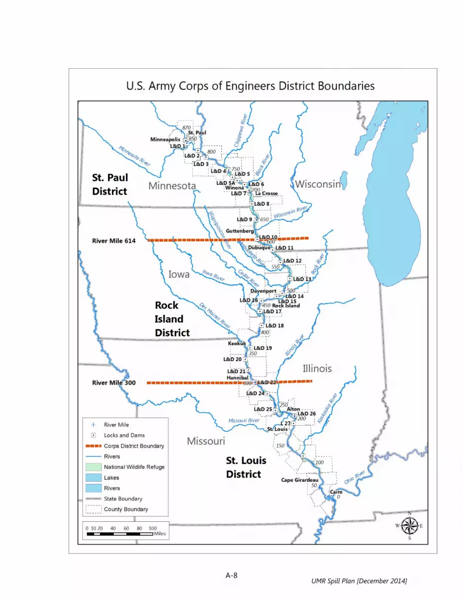
A-8 UMR Spill Plan [December 2014]
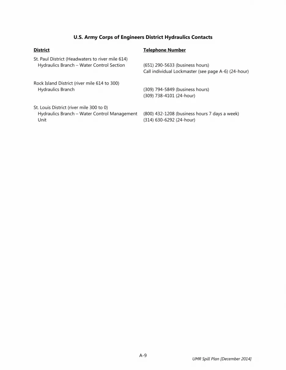
A-9
U.S. Army Corps of Engineers District Hydraulics Contacts District Telephone Number
St. Paul District (Headwaters to river mile 614) Hydraulics Branch – Water Control Section
(651) 290-5633 (business hours) Call individual Lockmaster (see page A-6) (24-hour)
Rock Island District (river mile 614 to 300) Hydraulics Branch
(309) 794-5849 (business hours) (309) 738-4101 (24-hour)
St. Louis District (river mile 300 to 0) Hydraulics Branch – Water Control Management
Unit
(800) 432-1208 (business hours 7 days a week) (314) 630-6292 (24-hour)
UMR Spill Plan [December 2014]
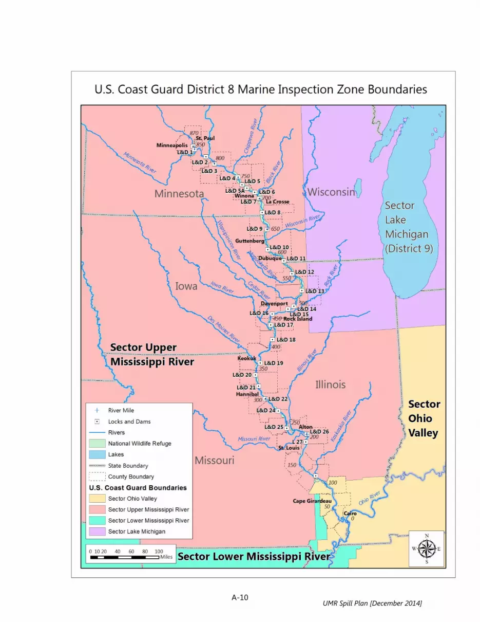
A-10
UMR Spill Plan [December 2014]

A-11 UMR Spill Plan [December 2014]

A-12
Upper Mississippi River Hazardous Spills Coordination Group Cultural and Historic Resource Contacts
State Contacts ILLINOIS
Illinois Historic Preservation Agency Primary Contact Information Other Key Contacts
Amy Martin, Director/SHPO Illinois Historic Preservation Agency 1 Old State Capitol Plaza Springfield, IL 62701-1512 Phone: 217-785-9045 Fax: 217-524-7525 Email: [email protected] Website: www.state.il.us/hpa/ps/
Deputy: Mike Jackson Phone: 217-785-5031 Email: [email protected]
Deputy: Anne Haaker Phone: 217-785-5027 Email: [email protected]
Archaeologist: Joe Phillippe Phone: 217-785-1279 Email: [email protected]
Resources: Historic and Architectural Resources Geographic Information System (HAARGIS) www.illinoishistory.gov/ps/haargis.htm
IOWA
State Historical Society of Iowa Primary Contact Information Other Key Contacts
Mr. Steve King, SHPO State Historical Society of Iowa Iowa Department of Cultural Affairs 600 East Locust Street Des Moines, IA 50319 Phone: 515-281-4013 Fax: 515-242-6498 Email: [email protected] Website: www.iowahistory.org/historic-preservation/
(None identified)
Resources: (None identified)
UMR Spill Plan [December 2014]
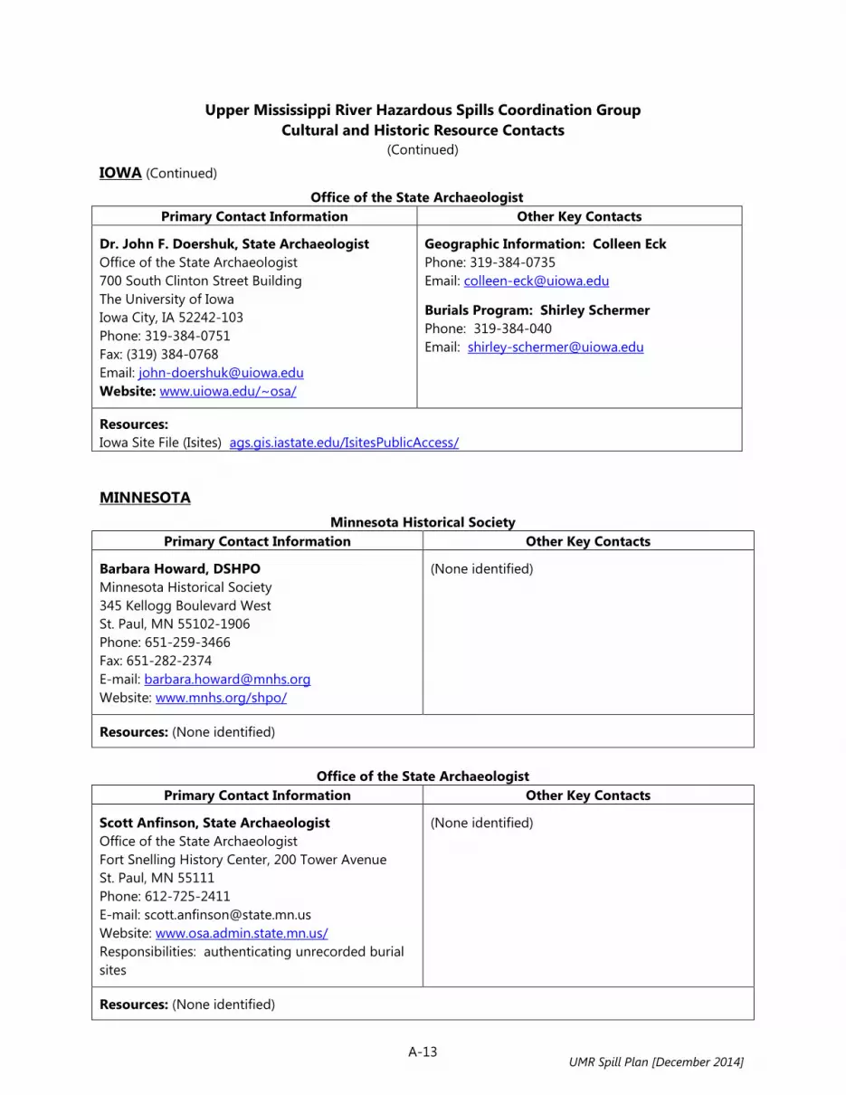
A-13
Upper Mississippi River Hazardous Spills Coordination Group Cultural and Historic Resource Contacts
(Continued)
IOWA (Continued)
Office of the State Archaeologist Primary Contact Information Other Key Contacts
Dr. John F. Doershuk, State Archaeologist Office of the State Archaeologist 700 South Clinton Street Building The University of Iowa Iowa City, IA 52242-103 Phone: 319-384-0751 Fax: (319) 384-0768 Email: [email protected] Website: www.uiowa.edu/~osa/
Geographic Information: Colleen Eck Phone: 319-384-0735 Email: [email protected]
Burials Program: Shirley Schermer Phone: 319-384-040 Email: [email protected]
Resources: Iowa Site File (Isites) ags.gis.iastate.edu/IsitesPublicAccess/ MINNESOTA
Minnesota Historical Society Primary Contact Information Other Key Contacts
Barbara Howard, DSHPO Minnesota Historical Society 345 Kellogg Boulevard West St. Paul, MN 55102-1906 Phone: 651-259-3466 Fax: 651-282-2374 E-mail: [email protected] Website: www.mnhs.org/shpo/
(None identified)
Resources: (None identified)
Office of the State Archaeologist
Primary Contact Information Other Key Contacts
Scott Anfinson, State Archaeologist Office of the State Archaeologist Fort Snelling History Center, 200 Tower Avenue St. Paul, MN 55111 Phone: 612-725-2411 E-mail: [email protected] Website: www.osa.admin.state.mn.us/ Responsibilities: authenticating unrecorded burial sites
(None identified)
Resources: (None identified)
UMR Spill Plan [December 2014]
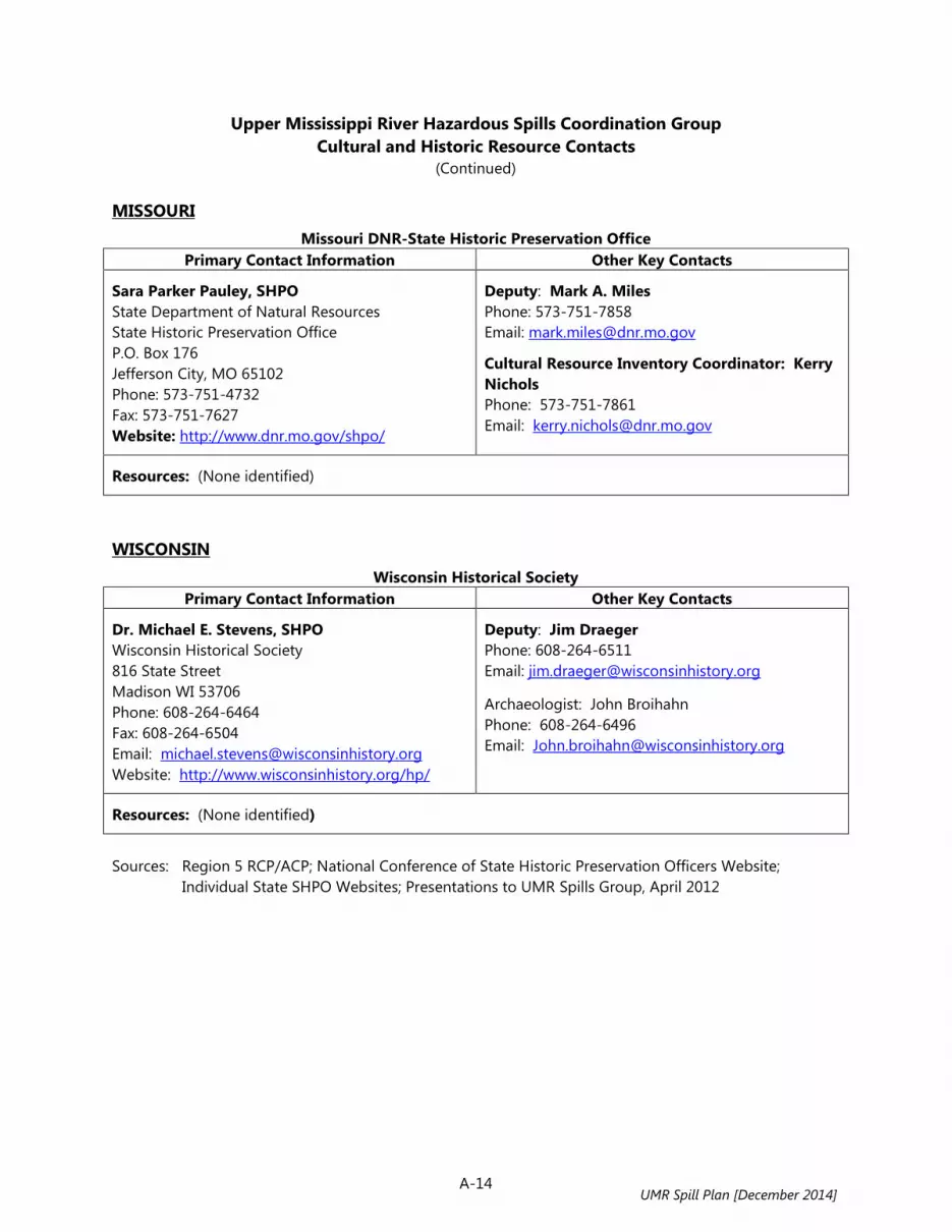
A-14
Upper Mississippi River Hazardous Spills Coordination Group Cultural and Historic Resource Contacts
(Continued)
MISSOURI Missouri DNR-State Historic Preservation Office
Primary Contact Information Other Key Contacts
Sara Parker Pauley, SHPO State Department of Natural Resources State Historic Preservation Office P.O. Box 176 Jefferson City, MO 65102 Phone: 573-751-4732 Fax: 573-751-7627 Website: http://www.dnr.mo.gov/shpo/
Deputy: Mark A. Miles Phone: 573-751-7858 Email: [email protected]
Cultural Resource Inventory Coordinator: Kerry Nichols Phone: 573-751-7861 Email: [email protected]
Resources: (None identified)
WISCONSIN
Wisconsin Historical Society Primary Contact Information Other Key Contacts
Dr. Michael E. Stevens, SHPO Wisconsin Historical Society 816 State Street Madison WI 53706 Phone: 608-264-6464 Fax: 608-264-6504 Email: [email protected] Website: http://www.wisconsinhistory.org/hp/
Deputy: Jim Draeger Phone: 608-264-6511 Email: [email protected]
Archaeologist: John Broihahn Phone: 608-264-6496 Email: [email protected]
Resources: (None identified)
Sources: Region 5 RCP/ACP; National Conference of State Historic Preservation Officers Website;
Individual State SHPO Websites; Presentations to UMR Spills Group, April 2012
UMR Spill Plan [December 2014]
RESOURCE MANUAL
Section B: Spill Response, Clean-Up, and Related Resources
UMR Spill Plan [December 2014]

B-12
Boat Accesses on the Upper Mississippi River River Mile*
Facility Name and Address Phone Waterbody Ramp Dock
Fuel
Lift
871 RDB
Mississippi River - Point Park E River Park Champlin, MN
763-421-2820 Mississippi River
X
866.3 LDB
Mississippi River - Coon Rapids 9750 Egret Blvd NW Coon Rapids, MN
763-757-4700 Mississippi River
X
863.1 RDB
Brooklyn Park 83rd Ave N, at River Park Brooklyn Park, MN
651-296-6157 Mississippi River
X
860.3 RDB
Brooklyn Center Access I-94 / 694 & Hwy 252 Brooklyn Center, MN
763-569-3300 Mississippi River
X
860.3 LDB
Mississippi River - I-694 E River Rd, S of I-694 Fridley, MN
763-757-3920 Mississippi River
X
857.7 RDB
Camden Park Boat Ramp Soo Ave N, S of 37th Ave NE Minneapolis, MN
612-230-6400 Mississippi River
X
Upper St. Anthony Falls Pool (river mile 857.6 to 853.4)
855 LDB
Boom Island Park Public Access S of Plymouth Ave Bridge W of Sibley St. Minneapolis, MN
651-296-6157 Mississippi River
X
Pool 1 (river mile 853.4 to 847.6) (No Boat Accesses)
Pool 2 (river mile 847.6 to 815.2)
846.6 LDB
Hidden Falls Regional Park MN
Mississippi River
X
845 RDB
Fort Snelling State Park MN
Mississippi River
X
844.8 LDB
Watergate Marina 2500 Crosby Farm Rd. St. Paul, MN
651-695-3780 Mississippi River
X X X X
843.1 RDB
Pool & Yacht Club (Marina) 1600 Lilydale Rd. Lilydale, MN
651-455-3900 Mississippi River
X
842.1 RDB
Lilydale 950 Lilydale Rd. Lilydale, MN
651-437-3191 Mississippi River
X
UMR Spill Plan [December 2014]

B-13
Boat Accesses on the Upper Mississippi River (Continued)
River Mile*
Facility Name and Address Phone Waterbody Ramp Dock
Fuel
Lift
Pool 2 (river mile 847.6 to 815.2) - continued
840.3 RDB
Saint Paul Yacht Club, Upper Harbor (Marina) 375 W Water St. St. Paul, MN
651-292-8964 Mississippi River
X X
839.6 RDB
Saint Paul Yacht Club, Lower Harbor (Marina) 100 Yacht Club Rd. St. Paul, MN
651-292-8964 Mississippi River
X
832.5 RDB
South St. Paul Access Off Verderosa Ave. South Saint Paul, MN
651-306-3690 Mississippi River
X
832.2 LDB
Mississippi River – Newport 21st St. Newport, MN
651-459-5677 Mississippi River
X
830.6 RDB
Twin City Marina 4455 E 66th St. Inver Grove Heights, MN
651-455-9110 Mississippi River
X X
830.3 RDB
River Heights Marina, Inc. 4455 E 66th St. Inver Grove Heights, MN
651-455-4974 Mississippi River
X X X X
829.5 LDB
St. Paul Park Public Ramp 7th Ave, at Lion's Levee Park St. Paul Park, MN
651-459-9785 Mississippi River
X
829.3 LDB
Willie's Hidden Harbor (Marina) 388 9th Ave. St. Paul Park, MN
651-459-9571 Mississippi River
X X X X
826 RDB
River Grove Harbor (Marina) 3985 E 102nd St. Inver Grove Heights, MN
651-455-6273 Mississippi River
X X
822 LDB
Grey Cloud Park and Access On Lower Grey Cloud Island on S Grey Cloud Trail, 1.5 mi S of 103rd St. Cottage Grove, MN
651-458-3400 Spring Lake, Mississippi River
X
820.2 RDB
Mississippi River Public Access - Spring Lake Hilary Path, N of Hwy 42 Township of Nininger, MN
651-296-6157 Spring Lake, Mississippi River
X
UMR Spill Plan [December 2014]

B-14
Boat Accesses on the Upper Mississippi River (Continued)
River Mile*
Facility Name and Address Phone Waterbody Ramp Dock
Fuel
Lift
Pool 3 (river mile 815.2 to 796.9)
814.3 RDB
Jaycee Park Access Lock and Dam Rd. Hastings, MN
651-480-6175 Mississippi River
X
814.2 LDB
Hub's Landing and Marina 6 Spiral View Loop Rd. Hastings, MN
651-755-6540 Mississippi River
X X
814 LDB
King's Cove Marina 1 King's Cove Dr. Hastings, MN
651-480-8900 Mississippi River, Conley Lake
X X X X
813.3 RDB
Hastings Marina 1111 E 1st St. Hastings, MN
651-437-9621 Mississippi River; Vermillion River
X X X X
811.5 LDB
Leo's Landing (Marina) 137 Front St. Prescott, WI
715-262-5998 Mississippi River
X X
811.4 LDB
Point St. Croix Marina 101 S Front St. Prescott, WI
715-262-3161 Mississippi River
X X
811.2 LDB
Prescott Public Boat Launch 2nd St. Prescott, WI
715-262-5544 Mississippi River
X
811 LDB
Miss-Croix Yacht Harbor (Marina) 451 S 2nd St. Prescott, WI
715-480-0406 Mississippi River
X X X
804 RDB
North Lake Public Access On North Lake, 190th St Way Township of Welch, MN
651-296-1151 North Lake; Twin Lakes
X
800 RDB
Treasure Island Marina On Sturgeon Lake, 5734 Sturgeon Blvd, Township of Welch, MN
800-222-7077 Sturgeon Lake
X X
800 LDB
Diamond Bluff Landing 4th St. Diamond Bluff, WI
Mississippi River
X
798.5 RDB
Sturgeon Lake Public Access Sturgeon Lake Rd, 2.1 mi upstream of Lock & Dam 3 4330 E Co Rd 18 Welch, MN
507-695-6341 Sturgeon Lake
X
UMR Spill Plan [December 2014]

B-15
Boat Accesses on the Upper Mississippi River (Continued)
River Mile*
Facility Name and Address Phone Waterbody Ramp Dock
Fuel
Lift
Pool 4 (river mile 796.9 to 752.8)
792.8 LDB
Mr. Sippi N1415 830th St. Hager City, WI
715-792-2992 Wisconsin Channel
X
792.7 LDB
Trenton Township Boat Landing 825th St. Trenton, WI
262-675-6009 Wisconsin Channel
X
791.4 RDB
Ole Miss Marina at Bay Point Park (Marina) 1429 Levee Rd. Red Wing, MN
651-764-2047 Mississippi River
X X X
791.2 RDB
Red Wing Marina At Bay Point Park and Levee Rd. Red Wing, MN
651-388-8995 Mississippi River
X X
790.9 LDB
Harbor Bar Docks, Inc. (Marina) N673 825th St. Hager City, WI
715-792-2417 Mississippi River
X
790.8 LDB
Trenton Island Yacht Club (Marina) N671 825th St. Hager City, WI
715-792-2035 Mississippi River
X
790.6 LDB
Island Campground and Marina N650 825th St. Hager City, WI
715-222-1808 Mississippi River
X X
790.3 RDB
Bay Point Municipal Park At Bay Point Dr and Levee Rd. Red Wing, MN
651-385-3674 Mississippi River
X
789 RDB
Bill's Bay Marina 430 Nymphara Ln. Red Wing, MN
651-388-0481 Mississippi River
X X
788.7 RDB
Colville Park Public Access 515 Nymphara Red Wing, MN
651-388-4781 Mississippi River
X
788.5 RDB
Ole Miss Marina at Colville Park (Marina) 490 Nymphara Red Wing, MN
651-764-2047 Mississippi River
X
786.8 LDB
Bay City Village Park Lake Pepin Blvd. Bay City, WI
715-594-3862 Lake Pepin, Mississippi River
X
780 LDB
Maiden Rock Campground Park St., Maiden Rock, WI
715-448-2205 Lake Pepin, Mississippi River
X
UMR Spill Plan [December 2014]
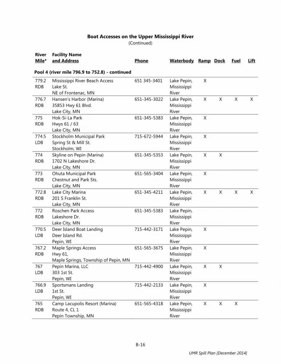
B-16
Boat Accesses on the Upper Mississippi River (Continued)
River Mile*
Facility Name and Address Phone Waterbody Ramp Dock
Fuel
Lift
Pool 4 (river mile 796.9 to 752.8) - continued
779.2 RDB
Mississippi River Beach Access Lake St. NE of Frontenac, MN
651 345-3401 Lake Pepin, Mississippi River
X
776.7 RDB
Hansen's Harbor (Marina) 35853 Hwy 61 Blvd. Lake City, MN
651-345-3022 Lake Pepin, Mississippi River
X X X X
775 RDB
Hok-Si-La Park Hwys 61 / 63 Lake City, MN
651-345-5383 Lake Pepin, Mississippi River
X
774.5 LDB
Stockholm Municipal Park Spring St & Mill St. Stockholm, WI
715-672-5944 Lake Pepin, Mississippi River
X
774 RDB
Skyline on Pepin (Marina) 1702 N Lakeshore Dr. Lake City, MN
651-345-5353 Lake Pepin, Mississippi River
X X
773 RDB
Ohuta Municipal Park Chestnut and Park Sts. Lake City, MN
651-565-3404 Lake Pepin, Mississippi River
X
772.8 RDB
Lake City Marina 201 S Franklin St. Lake City, MN
651-345-4211 Lake Pepin, Mississippi River
X X X X
772 RDB
Roschen Park Access Lakeshore Dr. Lake City, MN
651-345-5383 Lake Pepin, Mississippi River
770.5 LDB
Deer Island Boat Landing Deer Island Rd. Pepin, WI
715-442-3171 Lake Pepin, Mississippi River
X
767.2 RDB
Maple Springs Access Hwy 61, Maple Springs, Township of Pepin, MN
651-565-3675 Lake Pepin, Mississippi River
X
767 LDB
Pepin Marina, LLC 303 1st St. Pepin, WI
715-442-4900 Lake Pepin, Mississippi River
X X
766.9 LDB
Sportsmans Landing 1st St. Pepin, WI
715-442-2133 Lake Pepin, Mississippi River
X
765 RDB
Camp Lacupolis Resort (Marina) Route 4, CL 1 Pepin Township, MN
651-565-4318 Lake Pepin, Mississippi River
X X X
UMR Spill Plan [December 2014]

B-17
Boat Accesses on the Upper Mississippi River (Continued)
River Mile*
Facility Name and Address Phone Waterbody Ramp Dock
Fuel
Lift
Pool 4 (river mile 796.9 to 752.8) - continued
763.5 LDB
Chippewa River Landing RM 2.0 of Chippewa River Great River Rd. Nelson, WI
608-685-6222 Chippewa River
X
760.3 LDB
US FWS Indian Slough Landing State Rd 25 Nelson, WI
507-454-7351 UMR Refuge Winona Dist.
Indian Slough, Mississippi River
X
760.3 LDB
US FWS Beef Slough Landing State Rd 25 Nelson, WI
507-454-7351 UMR Refuge Winona Dist.
Beef Slough X
760.3 LDB
US FWS Mississippi River Access State Rd 25 Nelson, WI
507-454-7351 UMR Refuge Winona Dist.
Big Lake X
760.3 LDB
US FWS Pontoon Slough Landing State Rd 25 Nelson, WI
507-454-7351 UMR Refuge Winona Dist.
Pontoon Slough
X
760.3 LDB
Nelson-Trevino Bottoms State Natural Area Access State Rd 25 Nelson, WI
507-454-7351 UMR Refuge Winona Dist.
Indian Slough
X
760. 5 RDB
Mississippi Parkside Marina 829 W 3rd St. Wabasha, MN
651-565-3809 Mississippi River
X X X X
759.4 RDB
Wabasha Marina & Boatyard 1009 E Main St. Wabasha, MN
651-565-4747 Mississippi River
X X X
757 RDB
Wilcox Landing Public Access On Robinson Lake, T-341 County of Wabasha, MN
507-285-7176 Robinson Lake
X
755.3 LDB
Buffalo River Landing Rieck Lake Park Alma, WI
507-454-7351 UMR Refuge Winona Dist.
Buffalo River, Buffalo Slough
X
755.1 LDB
Rieck's Lakeside Park Rieck Lake Park Alma, WI
608-685-3330 Buffalo Slough, Buffalo River
X
754.5 RDB
Peterson Lake Landing On Peterson Lake, N Co Rd 24 1.5 mi N of Lock & Dam 4 County of Wabasha, MN
507-454-7351 UMR Refuge Winona Dist.
Peterson Lake
X
UMR Spill Plan [December 2014]

B-18
Boat Accesses on the Upper Mississippi River (Continued)
River Mile*
Facility Name and Address Phone Waterbody Ramp Dock
Fuel
Lift
Pool 4 (river mile 796.9 to 752.8) - continued
754 LDB
Alma Marina 125 Beach Harbor Rd. Alma, WI
608-685-3333 Mississippi River
X X X
753.7 LDB
Tank Pond Landing Beach Harbor Rd. Alma, WI
608-685-3330 Beef Slough X
Pool 5 (river mile 752.8 to 738.1)
752.8 RDB
Pioneer Campsite Resort (Marina) 130 Pioneer Dr. Wabasha, MN
651-565-2242 Peterson Lake
X
751.8 LDB
Dairyland Power Landing 500 Old St Hwy 35 Alma, WI
608-785-9994 Mississippi River
X
751.7 LDB
Alma WI DNR Landing S Main St. Alma, WI
608-685-6222 Mississippi River
X
748 LDB
Great River Harbor (Marina) S 2221 Hwy 35 Alma, WI
608-248-2454 Belvedere Slough
X X X
747.7 RDB
US FWS Half Moon Public Access Half Moon Landing & W Newton Township of Minneiska, MN
507-454-7351 UMR Refuge Winona Dist.
Half Moon Lake
X
747 RDB
Goose Lake Public Access 125th St. 1.0 mi upstream of Weaver, MN
651-296-1151 Goose Lake X
747 LDB
Belvidere Slough Landing Co. Rd. OO Belvidere, WI
608-785-9994 Pomme de Terre Slough
X
744.8 RDB
Weaver Landing Hwy 61 Weaver, MN
507-454-7351 UMR Refuge Winona Dist.
Weaver Bottoms
X
744.3 LDB
Buffalo City 10th Street Landing W 10th St. Buffalo City, WI
608-248-2262 Pomme de Terre Slough
X
743 LDB
Upper Spring Lake Landing S River Rd. Buffalo City, WI
608-685-6222 Spring Lake X
742 RDB
Minneiska Public Landing Schell Hill Rd. Minneiska, MN
507-457-6335 Spring Lake, Mississippi River
X
UMR Spill Plan [December 2014]

B-19
Boat Accesses on the Upper Mississippi River (Continued)
River Mile*
Facility Name and Address Phone Waterbody Ramp Dock
Fuel
Lift
Pool 5 (river mile 752.8 to 738.1) - continued
741 LDB
Lower Spring Lake Landing River Rd & Spring Lake Landing Belvidere, WI
608-685-6222 Spring Lake X
Pool 5A (river mile 738.1 to 728.5)
738.6 LDB
Whitman Dam Wildlife Area Kamrowski Rd. Downstream of Lock & Dam 5 Milton, WI
608-685-6222 Truedale Lake
X
737.8 RDB
Bass Camp Resort (Marina) 12895 Rolbiecki St. Township of Rollingstone, MN
507-689-2856 Mississippi River
X X
735.7 LDB
Merrick State Park Access Park St / S 2954 State Rd 35 Milton, WI
608-687-4936 Fountain City Bay
X
735.4 LDB
Merrick State Park South Access Park St / S 2965 State Rd 35 Milton, WI
608-687-4936 Fountain City Bay - Mississippi River
X
733 LDB
Fountain City Boat Dock Liberty St. Fountain City, WI
608-687-7481 Mississippi River
X
732 LDB
Fountain City Lower Landing Mill St. Fountain City, WI
608-687-7481 Mississippi River
X
730.5 RDB
Minnesota City Boat Club (Marina) 5 Dike Rd. Township of Rollingstone Minnesota City, MN
507-689-2412 Crooked Slough
X X X
730.2 RDB
US FWS Bob Verchota Landing Harbor Dr. Township of Rollingstone Prairie Island Rd. Winona, MN
507-454-7351 UMR Refuge Winona Dist.
Polander Lake
X
728.8 RDB
Upper McNally Landing Lock & Dam 5A Dike Winona, MN
507-454-7351 UMR Refuge Winona Dist.
Polander Lake
X
UMR Spill Plan [December 2014]

B-20
Boat Accesses on the Upper Mississippi River (Continued)
River Mile*
Facility Name and Address Phone Waterbody Ramp Dock
Fuel
Lift
Pool 6 (river mile 728.5 to 714.3)
728.5 RDB
Latsch Prairie Island Park Access Prairie Island Rd. Winona, MN
507-457-8258 Straight Slough
X
728.2 LDB
Breezy Pt. Marina W 656 Breezy Pt. Ln. Fountain City, WI
608-687-4774 Mississippi River
X X
728 RDB
Prairie Island Campground Access 1120 Prairie Island Rd. Winona, MN
507-452-4501 Straight Slough
X
726 LDB
Latsch Island East Hwy 54 Buffalo, WI
608-685-6285 Mississippi River
X
726 LDB
Dick's Marina / Winona Municipal Harbor Dicks Marina Rd. Latsch Island, WI
507-452-3809 Mississippi River
X X X
725.7 LDB
Latsch Island Park and Landing Old Duke Rd, Latsch Island Winona, MN
507-457-8234 Mississippi River
X
724.9 RDB
Winona Yacht Club (Marina) 24 Laird St. Winona, MN
507-454-5590 Mississippi River
X X X
724.7 RDB
St. Charles St. Public Access St. Charles St. Winona, MN
507-452-8550 Mississippi River
X
723.7 RDB
E 5th St. Boat Landing E 5th St. Winona, MN
507-452-8550 Mississippi River
X
720.9 RDB
Homer Boat Ramp Hwy 14 / 61 Homer, MN
507-457-6335 Mississippi River
X
719.4 LDB
Trempealeau National Wildlife Refuge Access Refuge Rd. Trempealeau, WI
608-539-2311 Trempealeau River
X
718 RDB
KOA Campground Ramp Hwy 61 across from Trempealeau Bay County of Winona, MN
507-454-2851 Mississippi River
X
UMR Spill Plan [December 2014]

B-21
Boat Accesses on the Upper Mississippi River (Continued)
River Mile*
Facility Name and Address Phone Waterbody Ramp Dock
Fuel
Lift
Pool 6 (river mile 728.5 to 714.3) - continued
717.6 LDB
Perrot State Park S Park Rd. 2 mi upstream of Lock & Dam 6 Trempealeau, WI
608-534-6409 Trempealeau River
X
717.6 LDB
Trempealeau River Canoe Launch (Carry-In) S Park Rd. Trempealeau, WI
608-534-6409 Trempealeau River
X
Pool 7 (river mile 714.3 to 702.5)
714.3 LDB
Sunset Bay Marina 24056 Lock and Dam Rd. Trempealeau, WI
608-534-6033 Mississippi River
X X X
714 LDB
WI DNR Trempealeau Public Landing Peninsula Dr. Trempealeau, WI
608-685-6222 Mississippi River
X
713.8 LDB
Larry's Landing Lake Rd. Trempealeau, WI
608-534-7771 Mississippi River
X
713.4 LDB
Second Lake Access Lake Rd. Trempealeau, WI
608-685-6222 Second Lake X
713.4 LDB
Third Lake Access North Lake Rd. Trempealeau, WI
608-685-6222 Third Lake, Round Lake, Big Marsh Lake
X
713.4 LDB
Third Lake Access South Lake Rd. Trempealeau, WI
608-685-6222 Third Lake, Round Lake, Big Marsh Lake
X
713 LDB
US FWS Long Lake Landing Lake Rd 1.9 mi downstream of Trempealeau, WI
608-779-2399 UMR Refuge La Crosse Dist.
Long Lake, Big Marsh Lake
X
713 LDB
US FWS Round Lake Landing Birch Ln. 1.9 mi downstream of Trempealeau, WI
608-779-2399 UMR Refuge La Crosse Dist.
Round Lake, Big Marsh Lake
X
712 LDB
US FWS Lone Tree Landing Downstream of Trempealeau, WI
608-779-2399 UMR Refuge La Crosse Dist.
Big Marsh Lake, Mississippi River
X
UMR Spill Plan [December 2014]

B-22
Boat Accesses on the Upper Mississippi River (Continued)
River Mile*
Facility Name and Address Phone Waterbody Ramp Dock
Fuel
Lift
Pool 7 (river mile 714.3 to 702.5) - continued
709 LDB
Lytles Landing Canoe Launch (Carry-In) Lytle Rd. Onalaska, WI
608-534-6409 Black River X
708 LDB
Brice Prairie Walk-In Access (Carry-In) Co Rd ZB Onalaska, WI
608-783-4958 Lake Onalaska
X
707.1 RDB
Dakota Public Access Riverview Dr. Dakota, MN
507-457-6335 Mississippi River
X
707 LDB
US FWS Brice Prairie Landing Off Co Rd ZB Onalaska, WI
507-452-4232 Lake Onalaska
X
705.2 RDB
Dresbach Park Park Rd. Dresbach, MN
507-643-6327 Mississippi River
X
704.5 LDB
Schafer's Boat Livery W 7221 N Shore Ln. Onalaska, WI
608-781-3100 Black River, Lake Onalaska, Mississippi River
X
704 LDB
Great River State Park Access Off Sunset Vista Rd. Onalaska, WI
608-534-6409 Lake Onalaska
X
703.8 LDB
La Crosse Sailing Club (Marina) 3600 Lakeshore Dr. La Crosse, WI
608-781-2226 Lake Onalaska
X X
703.4 LDB
Fishermans Road Fishermans Rd. La Crosse, WI
608-789-7557 Black River
703.2 LDB
Fisherman's Walkdown Fishermans Rd., French Island La Crosse, WI
608-781-9533 Black River X
702.8 LDB
Ist Ave Access - Onalaska Ist Ave. Onalaska, WI
608-781-9560 Black River X
702.6 LDB
Sias Isles Boat Landing Irvin St. Onalaska, WI
Black River X
UMR Spill Plan [December 2014]

B-23
Boat Accesses on the Upper Mississippi River (Continued)
River Mile*
Facility Name and Address Phone Waterbody Ramp Dock
Fuel
Lift
Pool 8 (river mile 702.5 to 679.2)
702.1 RDB
Pool 8 / Upper I-90 Access Off I-90, E of Hwys 14 and 61 S of Winona, MN
651-296-1151 Mississippi River
X
702 LDB
Lower Dike Landing Bayshore Dr & Spillway Dr. Campbell, WI
608-785-9770 La Crosse County Facility
French Slough
X
702 LDB
Upper Dike Landing Bayshore Dr & Spillway Dr. Campbell, WI
608-785-9770 La Crosse County Facility
Lake Onalaska
X
702 LDB
US FWS Fisherman's Road Landing Fisherrmans Rd. La Crosse, WI
608-781-9533 Black River X
701.8 RDB
Lower I-90 Landing Off I-90, E of Hwys 14 and 61 S of Winona, MN
608-779-2399 UMR Refuge La Crosse Dist.
Mississippi River
X
700.5 LDB
Black's Cove Marina 2003 Rose St (Hwy 53) La Crosse, WI
608-781-1212 Black River X
700.5 LDB
Best Western Midway Hotel (Marina) 1835 Rose St. La Crosse, WI
608-781-7000 Black River X
700 LDB
Richmond Bay Landing Goddard Pl. La Crosse, WI
Richmond Bay
699.7 LDB
Logan St. Landing La Crosse, WI
608-789-7533 Black River
699.6 LDB
Clinton St. Landing La Crosse, WI
608-789-7533 Black River
699.6 LDB
Veterans Freedom Park Boat Ramp Clinton St & Boathouse Dr. La Crosse, WI
608-789-7557 Black River X
699.6 LDB
Catgut Marina 136 Clinton St. La Crosse, WI
608-317-1517 Black River X
699.5 LDB
French Island Yacht Club (Marina) 132 Marina Dr. La Crosse, WI
608-782-4092 Black River X
699.5 LDB
North Bay Marina 127 Marina Dr. La Crosse, WI
608-791-3838 Black River X X X X
UMR Spill Plan [December 2014]

B-24
Boat Accesses on the Upper Mississippi River (Continued)
River Mile*
Facility Name and Address Phone Waterbody Ramp Dock
Fuel
Lift
Pool 8 (river mile 702.5 to 679.2) - continued
699.4 LDB
American Boat Club (Marina) 605 1/2 Copeland Park Dr. La Crosse, WI
608-304-1365 Black River X
698.7 RDB
Sportsmen's Landing Hwys 61 & 14 La Crescent, MN
651-649-5451 W Channel, Mississippi River
X
698.2 RDB
South Bay Marina 621 Park Plaza Dr. La Crosse, WI
608-304-1365 Mississippi River
X X X
697.2 RDB
La Crosse Pettibone Boat Club (Marina) 600 S Petttibone Dr. La Crosse, WI
608-784-7743 Mississippi River
X X
696.7 LDB
La Crosse Municipal Boat Harbor, Inc. (Marina) 1500 Houska Dr. La Crosse, WI
608-782-7077 Mississippi River
X X X
695.8 LDB
Green Island Ramp 2312 S 7th St. La Crosse, WI
608-789-7533 Swift Creek, Mississippi River
X
695 LDB
La Crosse Access Hanifl Rd. La Crosse, WI
608-789-7533 Mississippi River
X
695 LDB
Chut's Landing (Marina) 2700 S 15th St. La Crosse, WI
608-788-1588 Bluff Slough X
694 RDB
Root River - Hwy 64 Access Brownsville, MN
507-206-2841 Root River X
692.8 LDB
Goose Island Boat Ramp 2 Goose Island Park Rd. Shelby, WI
608-785-9770 La Crosse County Facility
Wigwam Slough
X
692.5 LDB
Goose Island Boat Ramp 3 Goose Island Park Rd. Shelby, WI
608-785-9770 La Crosse County Facility
Running Slough
X
692 LDB
Goose Island Boat Ramp 1 Goose Island Park Rd. Shelby, WI
608-785-9770 La Crosse County Facility
Wigwam Slough
X
691 LDB
Hunters Point Boat Landing Co Hwy Gi Bergen, WI
608-785-9770 La Crosse County Facility
Wigwam Slough
X
691 LDB
Bergen Access Great River Rd. Bergen, WI
Running Slough
X
UMR Spill Plan [December 2014]

B-25
Boat Accesses on the Upper Mississippi River (Continued)
River Mile*
Facility Name and Address Phone Waterbody Ramp Dock
Fuel
Lift
Pool 8 (river mile 702.5 to 679.2) - continued
688.3 RDB
Wildcat Park Access Off MN Hwy 26 0.4 mi downstream of Brownsville, MN
507-895-6341 Mississippi River
X
686 LDB
Water's Edge Dock & Motel (Marina) 201 N Pearl St. Stoddard, WI
608-457-2126 Mississippi River
X X X
685.5 LDB
Stoddard Park Landing Forest Ln. Village of Stoddard, WI
608-457-2136 Mississippi River
X
681 RDB
Pool 8 / Renno Public Access Of MN Route 26 Township of Brownsville, MN
Mississippi River
X
679.4 LDB
Engh's Boat Livery (Marina) N 165 WI Hwy 35 Genoa, WI
608-689-2394 Mississippi River
X X
Pool 9 (river mile 679.2 to 647.9)
679 LDB
Mississippi River - Lock & Dam #8 Great River Rd. Genoa, WI
Mississippi River
X
677.8 LDB
Dairyland Power Plant Access Off Great River Rd. Genoa, WI
608-788-4000 Thief Slough X
677 RDB
Millstone Landing Hwy 26 3 mi upstream of New Albin, IA
563-873-3423 UMR Refuge McGregor Dist.
Reno Bottoms, Minnesota Slough, Hayshore Lake
X
676 RDB
Visgers Landing Hwy 26 2 mi upstream of New Albin, IA
563-873-3423 UMR Refuge McGregor Dist.
Visgers Lake, Ice Haul Slough, Minnesota Slough
X
675 LDB
US COE Bad Axe Landing Great River Rd. Genoa, WI
Bad Axe River, Mississippi River
X
673.5 RDB
Pool Slough Wildlife Area New Albin, Iowa Township, IA
Pool Slough X
UMR Spill Plan [December 2014]

B-26
Boat Accesses on the Upper Mississippi River (Continued)
River Mile*
Facility Name and Address Phone Waterbody Ramp Dock
Fuel
Lift
Pool 9 (river mile 679.2 to 647.9) - continued
673.4 RDB
IA DNR New Albin Access Army Rd. New Albin, IA
515-281-3449 Minnesota Slough, Lost Slough
X
672.5 LDB
Victory Boat Landing Great River Rd. Wheatland, WI
608-648-3583 Town of Wheatland clerk
Mississippi River
X
671.4 LDB
Violet R R Access Violet Rd. Wheatland, WI
608-648-3583 Town of Wheatland clerk
Mississippi River
X
671.2 LDB
Blackhawk County Park Boat Ramp Blacktop Rd. Wheatland, WI
608-637-5485 Mississippi River
X
671 LDB
Blackhawk Upper Access Blacktop Rd. Wheatland, WI
608-637-5485 Mississippi River, Battle Slough
X
670.5 LDB
Blackhawk Park Wheatland, WI
608-637-5485 Battle Slough
X
670.4 LDB
Blackhawk Park South - Green Lake Wheatland, WI
608-637-5485 Green Lake, Mississippi River
X
670.3 LDB
Blackhawk Park Wheatland, WI
608-637-5485 Peck Lake X
669.7 LDB
Earl's Boat Landing 1 mi N of De Soto, WI
608-648-3630 Peck Lake, Green Lake
X
669.3 LDB
Mississippi & Sports Recreation (Marina) E870 Ghelf De Soto, WI
608-648-3630 De Soto Bay X
667.3 LDB
De Soto Access Great River Rd. De Soto, WI
608-648-2700 Mississippi River
X
665.4 LDB
US FWS Winneshiek Slough Landing WI Route 82 Freeman, WI
563-873-3423 UMR Refuge McGregor Dist.
Winneshiek Slough
X
663.5 RDB
Lansing Marina 590 N Front St. Lansing, IA
563-538-4474 Mississippi River
X X
UMR Spill Plan [December 2014]

B-27
Boat Accesses on the Upper Mississippi River (Continued)
River Mile*
Facility Name and Address Phone Waterbody Ramp Dock
Fuel
Lift
Pool 9 (river mile 679.2 to 647.9) - continued
663.4 LDB
US FWS Big Slough Landing WI Route 82 Freeman, WI
563-873-3423 UMR Refuge McGregor Dist.
Mississippi River, Lafayette Slough
X
662.4 RDB
S&S Houseboat Rentals (Marina) 990 S Front St. Lansing, IA
563-538-4454 Mississippi River
X X X
662 RDB
Village Creek Area Access Off Lansing Harpers Rd. Lansing, IA
515-281-3449 Mississippi River; Village Creek
X
661 LDB
Rush Creek State Natural Area Access Great River Rd. Freeman, WI
608-266-2621 Winneshiek Slough
X
660.5 RDB
Power Plant Access Great River Rd. Lansing, IA
Mississippi River
X
658 LDB
Ferryville Landing Market Freeman, WI
Lake Winneshiek
X
656 RDB
Lansing Township Access River View Rd. Township of Lansing, IA
Mississippi River
X
654.2 RDB
IA DNR Heytman's Station Landing Heytman Dr. (at power plant) 6 mi downstream of Lansing, IA
515-281-3449 Mississippi River
X
653 LDB
US FWS Cold Springs Landing Great River Rd. Seneca, WI
563-873-3423 UMR Refuge McGregor Dist.
Winneshiek Lake
X
651.2 LDB
Lynxville Public Landing River Rd. Lynxville, WI
Mississippi River
X
651 LDB
Withey's Campground Access (Marina) 309 Spring St. Lynxville, WI
608-874-4422 Mississippi River
X
649.5 LDB
Mississippi River State Hwy 35 Seneca, WI
Mississippi River
X
648 RDB
Below Dam No. 9 Off Great River Rd. Township of Taylor, IA
Mississippi River
X
UMR Spill Plan [December 2014]

B-28
Boat Accesses on the Upper Mississippi River (Continued)
River Mile*
Facility Name and Address Phone Waterbody Ramp Dock
Fuel
Lift
Pool 10 (river mile 647.9 to 615.1)
647.1 LDB
Vard Landing State Hwy 35 Eastman, WI
Mississippi River
X
646.9 LDB
Gordon's Bay Landing Gordon's Bay Rd of Hwy 35 Eastman, WI
608-785-9994 Mississippi River
X
646.3 RDB
Harpers Ferry Public Launch Unnamed St off of 1st St. Harpers Ferry, IA
515-281-5145 Harpers Slough
X
646.2 RDB
Babe's Boat Landing (Marina) 243 N 1st St. Harpers Ferry, IA
563-586-4521 Harpers Slough
X X X
646.1 RDB
End of the Line Boat Marina 219 N 1st St. Harpers Ferry, IA
563-586-2475 Harpers Slough
X
646 RDB
Brown's Riverside Court & Marina 137 N 1st St. Harpers Ferry, IA
563-586-2607 Harpers Slough
X
645.9 RDB
Delphey Brothers Marina, Inc. 113 S First St. Harpers Ferry, IA
319-586-2382 Harpers Slough
X X
644.3 LDB
Sioux Coulee Wayside Great River Rd. Eastman, WI
Mississippi River
X
644 RDB
Lund's Landing (Marina) 751 Hwy 364 Approx. 3 mi S of Harpers Ferry, IA
563-586-2187 Harpers Slough
X X
643.1 LDB
Frenchman's Landing 28741 Frenchmans Landing Dr. Eastman, IA
608-874-4563 Mississippi River
X
643 RDB
Nobels Island Hwy 364 3.2 mi downstream of Harpers Ferry, IA
515-281-6158 Harpers Slough
X
643 RDB
Allamakee Co. Roadside Access Hwy 364 Harpers Ferry, IA
Harpers Slough
X
639 LDB
Ambrough Slough Landing Hwy K Prairie Du Chien, WI
563-873-3423 UMR Refuge McGregor Dist.
Ambrough Slough
X
UMR Spill Plan [December 2014]

B-29
Boat Accesses on the Upper Mississippi River (Continued)
River Mile*
Facility Name and Address Phone Waterbody Ramp Dock
Fuel
Lift
Pool 10 (river mile 647.9 to 615.1) - continued
638.6 LDB
Greymore Lake / Ambrough Landing Ambro Rd. Prairie Du Chien, WI
608-326-0233 Ambrough Slough
X
638.2 LDB
Winneshiek Marina 32785 Co Rd K Prairie du Chien, WI
608-326-2888 Gremore Lake
X X X X
637.6 RDB
Yellow/Mississippi River Access Hwy 76, Pikes Peak State Park, McGregor, IA
515-281-6158 Mississippi River
X
637.4 RDB
Yellow River Access Hwy 76, Pikes Peak State Park McGregor, IA
515-281-6158 Mississippi River
X
636.3 RDB
Clayton Co. Roadside Area Hwy 76 Marquette, IA
Mississippi River
X
635.7 LDB
Marina Ramp N St. Feriole Dr. Prairie Du Chien, WI
608-326-6406 Marais de Sainte Feriole
X
635.6 LDB
Prairie du Chien Marina 301 N St. Feriole Dr. Prairie du Chien, WI
608-326-8032 Marais de Sainte Feriole
X X
635.5 LDB
North Water St. Landing N Water St. Prairie Du Chien, WI
608-326-6406 E Channel Mississippi River
X
635.3 LDB
Fisher St. Access Fisher St. Prairie Du Chien, WI
608-326-6406 E Channel Mississippi River
X
634.7 RDB
Lady Luck Casino (Marina) 98 Waters St. Marquette, IA
563-873-3531 Mississippi River
X X X
633.5 RDB
McGregor Marina Riverfront and Main St. McGregor, IA
563-873-9613 Mississippi River
X X
633.5 LDB
Lockwood Street Access W Lockwood St. Prairie Du Chien, WI
608-326-6406 E Channel Mississippi River
X
633.2 LDB
Big River Campground On Pickerel Slough, N Arrowhead Ln. Prairie du Chien, WI
608-326-2712 Mississippi River
X
629.5 LDB
Glen Lake Ramp Wyalusing State Park Wyalusing, WI
608-996-2261 Wyalusing Lake
X
UMR Spill Plan [December 2014]

B-30
Boat Accesses on the Upper Mississippi River (Continued)
River Mile*
Facility Name and Address Phone Waterbody Ramp Dock
Fuel
Lift
Pool 10 (river mile 647.9 to 615.1) - continued
627.8 LDB
Wyalusing Public Access Co. Rd. X Wyalusing, WI
608-723-2711 Mississippi River
X
627 RDB
IA DNR Sny-Mcgill Access Great River Rd. Pikes Peak State Park 6.5 mi downstream of McGregor, IA
563-873-2341 Wyalusing Slough
X
624.7 RDB
Clayton Mississippi River Access Front St. Clayton, IA
Mississippi River
X
624 LDB
Bagley Bottoms Boat Landing Off S Willow Ln. Bagley (Wyalusing), WI
563-873-3423 McGregor District office Refuge
Glass Lake X
622.4 LDB
River of Lakes Resort 132 Packer Dr. Bagley, WI
608-996-2275 Jay's Lake X X X
622 LDB
Jay's Lake Landing Pine Ln. 1.5 mi S of Bagley, WI
507-895-6341 Jay's Lake X
621.2 RDB
Willies Landing Mallard Ln. Township of Garnavillo, IA
Mississippi River
X
619.9 RDB
Frenchtown Boat Access On Frenchtown Lake 26254 Mississippi Rd. Elkader, IA
563-245-1516 Frenchtown Lake
X
618.2 LDB
Glen Haven Public Landing Rock School Rd. Glen Haven, WI
608-794-2640 E Channel Mississippi River
X
616.5 RDB
IA DNR Bussey Lake Landing Mississippi Rd. Guttenberg, IA
Mississippi River
X
616.3 RDB
Winegar Works Marina Marina Rd. Guttenberg, IA
563-252-2050 Mississippi River
X X X
Pool 11 (river mile 615.1 to 583.0)
614.7 RDB
Landing 615 (Marina) 703 S River Park Dr. Guttenberg, IA
563-252-1717 Mississippi River
X X X
UMR Spill Plan [December 2014]

B-31
Boat Accesses on the Upper Mississippi River (Continued)
River Mile*
Facility Name and Address Phone Waterbody Ramp Dock
Fuel
Lift
Pool 11 (river mile 615.1 to 583.0) - continued
614.5 RDB
Guttenberg Marina 502 S 1st St. Guttenberg, IA
563-252-1161 Mississippi River
X X
613 LDB
Schleicher's Landing 7110 Closing Dam Rd. Cassville, WI
608-725-5216 Cassville Slough
X
612.2 RDB
Camp Hide-A-Way Ramp Off of Great River Rd (Hwy 52) Guttenberg, IA
563-252-1305 Mississippi River
X
607.8 RDB
IA DNR Turkey River Boat Landing Oak Rd 7 mi downstream of Guttenberg, IA
563-873-2341 Mississippi River / Turkey River
X
607.7 LDB
Power and Light Landing At Nelson Dewey Generating Station 11999 Co Rd W Cassville, WI
608-725-5112 Mississippi River
X
607 LDB
Cassville City Park Car Ferry Wyota St and W Front St. Cassville, WI
608-725-5180 Mississippi River
X
606.4 LDB
Riverside Park Boat Ramp Off Hwy 133 on to Crawford St. Cassville, WI
608-725-5855 Mississippi River
X
605.8 LDB
Eagle's Roost Resort (Marina) On Jack Oak Slough 1034 Jack Oak Rd. Cassville, WI
608-725-5553 Jack Oak Slough, Mississippi River
X
603.6 RDB
Lowell's Landing (Marina) 112 Clark St. North Buena Vista, IA
563-245-2422 Mississippi River
X X
601.7 LDB
Bertom Lake Public Access Far-Nuff Rd. Cassville, WI
563-873-3423 McGregor District office Refuge
Coalpit Slough
X
598.9 LDB
McCartney Landing Co. Rd. N Waterloo, WI
608-723-2711 McCartney Lake
X
596.8 LDB
Lynn Hollow Access 4801 Lynn Hollow Ln. Potosi, WI
563-873-3423 McGregor District office Refuge
Spring Lake X
UMR Spill Plan [December 2014]

B-32
Boat Accesses on the Upper Mississippi River (Continued)
River Mile*
Facility Name and Address Phone Waterbody Ramp Dock
Fuel
Lift
Pool 11 (river mile 615.1 to 583.0) - continued
596 RDB
Finley's Landing 24500 Finley's Landing Rd. Sherrill, IA
319-552-1571 Mississippi River
X
592.3 LDB
Potosi Public Access S Main St. Potosi, WI
Mississippi River
X
591 LDB
Grant River Recreation Area (in slough) 2 mi downstream of Potosi, WI
608-822-3501 Mississippi River
X
589.5 RDB
Mud Lake Park Access Off Mud Lake Rd. 6 mi upstream of Dubuque, IA
563-552-2746 Mississippi River
X
589.5 RDB
Hawkeye Boat Marina 22500 Golf Lake Rd. upstream of Dubuque, IA
563-552-2303 Mississippi River
X X X
583.1 LDB
Pool 11 Access Eagle Point Rd. Jamestown, WI
608-822-3501 Mississippi River
X
Pool 12 (river mile 583.0 to 556.7)
582 RDB
Hawthorne Street Municipal Boat Ramp Lake St. Dubuque, IA
563-589-4250 Mississippi River
X
582 RDB
Dubuque Marina and Yardarm 121 Shiras Ave Exd. Dubuque, IA
563-582-3653 Mississippi River
X X X X
580.9 RDB
Schmitt Harbor (Marina) 1801 Admiral Sheehy Dr. Dubuque, IA
563-589-4391 Mississippi River
X
580.7 RDB
Dubuque Yacht Basin (Marina) 1630 E 6th St (on Schmitt Island) Dubuque, IA
563-588-9564 Mississippi River
X X X
579.8 RDB
Port of Dubuque Marina 450 E 3rd St. Dubuque, IA
563-589-4263 Mississippi River
X X X
579.5 LDB
East Dubuque Municipal Ramp N of Hwy 20 bridge East Dubuque, IL
815-747-3416 Mississippi River
X
579 LDB
Mid-Town Marina 285 5th St PO Box 145 East Dubuque, IL
815-747-3310 Mississippi River
X X X
UMR Spill Plan [December 2014]

B-33
Boat Accesses on the Upper Mississippi River (Continued)
River Mile*
Facility Name and Address Phone Waterbody Ramp Dock
Fuel
Lift
Pool 12 (river mile 583.0 to 556.7) - continued
578 LDB
Snyder Bent Prop Marina and Lounge 780 Harbor Dr. East Dubuque, IL
815-747-8860 Mississippi River
576.5 LDB
Frentress Lake Marine Center (Marina) 830 W Gill Rd. East Dubuque, IL
815-747-3155 Frentress Lake
X X
573.8 RDB
Massey Marina 9526 Massey Marina Ln. Dubuque, IA
563-556-7055 Molo Slough
X X
566.5 LDB
Ferry Landing (Marina) Ferry Landing Rd. Galena, IL
815-777-1050 Harris Slough
X
561 LDB
Chestnut Mountain Resort (Marina) 8700 W Chestnut Rd. Galena, IL
815-777-1320 Yonkers Lake
X
559.5 RDB
Spruce Creek Harbor and Marina 30711 396th Ave. Bellevue, IA
563-652-3783 Mississippi River
X X
558.6 LDB
Blanding Landing Public Use Area 5720 S River Road Hanover, IL
563-582-0881 Mississippi River
X
Pool 13 (river mile 556.7 to 522.5)
556.5 RDB
Bellevue Public Ramp Riverview Dr. Bellevue, IA
563-872-5830 Mississippi River
X
556.2 RDB
Point Pleasant Boat Landing (Marina) 907 Riverview St. Bellevue, IA
563-872-4205 Mississippi River
X X X
556.1 RDB
Shady Haven Camper Park and Marina 911 S Riverview St. Bellevue, IA
563-872-4204 Mississippi River
X X X
555.7 RDB
Bellevue Research Station Access 24143 Hwy 52 Bellevue, IA
563-872-4976 Mississippi River
X
553 RDB
Pleasant Creek Public Use Area 11995 Hwy 52 Bellevue, IA
563-582-0881 Mississippi River
X
551.3 LDB
Savanna Army Depot Access 18935 B Street Savanna, IL
815-273-8312 Crooked Slough
X
UMR Spill Plan [December 2014]

B-34
Boat Accesses on the Upper Mississippi River (Continued)
River Mile*
Facility Name and Address Phone Waterbody Ramp Dock
Fuel
Lift
Pool 13 (river mile 556.7 to 522.5) - continued
540 LDB
Miller's Hollow 16327 N Route 84 (At Palisades State Park) Savanna, IL
815-273-2731 Miller's Lake
X
540 LDB
Lazy River Marina 6850 Marina Rd. Savanna, IL
815-273-2851 Miller's Lake
X
537.5 LDB
Marquette Park Municipal Landing Wayne King Dr, (Turn W off US Hwy 52, cross RR) Savanna, IL
815-273-4487 Mississippi River
X
536.8 LDB
Savanna Marina 1 Main St. (Turn W off US Hwy 52, bear left) Savanna, IL
815-273-2955 Mississippi River
X X X
536.8 LDB
Savanna Marina 1 Main St. Savanna, IL
815-273-2955 Mississippi River; Plum River
X X
535.7 RDB
North Boat Access On Town Lake, N end of Elk St. (Just W of US Hwy 52 on 207th Ave.) Sabula, IA
563-687-2772 Mississippi River, Town Lake
X
535.5 RDB
Homeport Marina 515 River St. Sabula, IA
563-687-2793 Mississippi River
X X X
534.8 RDB
Island City Harbor (Marina) 305 South Ave. Sabula, IA
563-687-2825 Mississippi River
X X X
534.4 RDB
South Sabula County Park Access 1516 South Ave. (US Hwy 52 to Sabula, turn or continue S on South Ave. to end) Sabula, IA
563-652-3783 Lower Sabula Lake; Mississippi River
X
531.1 LDB
Big Slough Access Off Route 84 and Four Mile Rd. (Turn W from IL Hwy 84 onto Four Mile Rd, travel 1 mi.) Thomson, IL
309-794-4524 Mississippi River
X
530.4 LDB
Paradise Harbor 4202 N Hwy 84 Savanna, IL
815-273-2851 Mississippi River
X
UMR Spill Plan [December 2014]
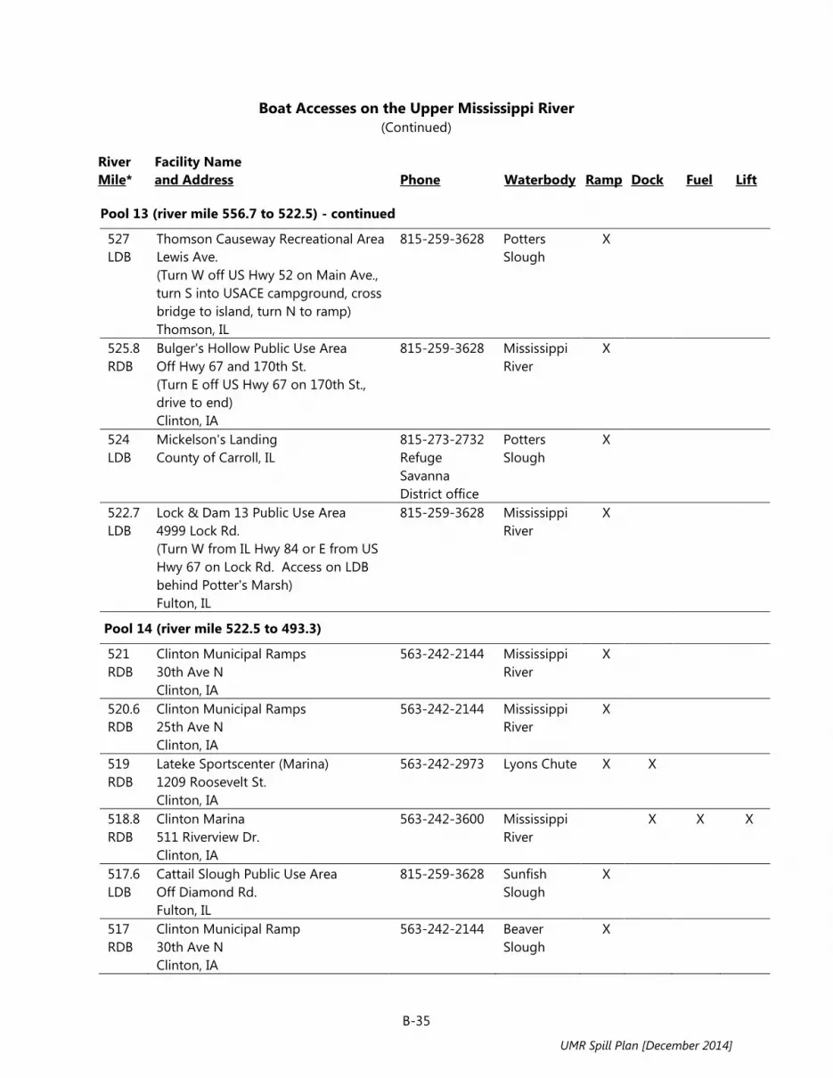
B-35
Boat Accesses on the Upper Mississippi River (Continued)
River Mile*
Facility Name and Address Phone Waterbody Ramp Dock
Fuel
Lift
Pool 13 (river mile 556.7 to 522.5) - continued
527 LDB
Thomson Causeway Recreational Area Lewis Ave. (Turn W off US Hwy 52 on Main Ave., turn S into USACE campground, cross bridge to island, turn N to ramp) Thomson, IL
815-259-3628 Potters Slough
X
525.8 RDB
Bulger's Hollow Public Use Area Off Hwy 67 and 170th St. (Turn E off US Hwy 67 on 170th St., drive to end) Clinton, IA
815-259-3628 Mississippi River
X
524 LDB
Mickelson's Landing County of Carroll, IL
815-273-2732 Refuge Savanna District office
Potters Slough
X
522.7 LDB
Lock & Dam 13 Public Use Area 4999 Lock Rd. (Turn W from IL Hwy 84 or E from US Hwy 67 on Lock Rd. Access on LDB behind Potter's Marsh) Fulton, IL
815-259-3628 Mississippi River
X
Pool 14 (river mile 522.5 to 493.3)
521 RDB
Clinton Municipal Ramps 30th Ave N Clinton, IA
563-242-2144 Mississippi River
X
520.6 RDB
Clinton Municipal Ramps 25th Ave N Clinton, IA
563-242-2144 Mississippi River
X
519 RDB
Lateke Sportscenter (Marina) 1209 Roosevelt St. Clinton, IA
563-242-2973 Lyons Chute X X
518.8 RDB
Clinton Marina 511 Riverview Dr. Clinton, IA
563-242-3600 Mississippi River
X X X
517.6 LDB
Cattail Slough Public Use Area Off Diamond Rd. Fulton, IL
815-259-3628 Sunfish Slough
X
517 RDB
Clinton Municipal Ramp 30th Ave N Clinton, IA
563-242-2144 Beaver Slough
X
UMR Spill Plan [December 2014]

B-36
Boat Accesses on the Upper Mississippi River (Continued)
River Mile*
Facility Name and Address Phone Waterbody Ramp Dock
Fuel
Lift
Pool 14 (river mile 522.5 to 493.3) - continued
513.6 LDB
Albany Boat Access 2nd Ave N and Water St. Albany, IL
309-887-4308 Mississippi River
X
512.2 RDB
Comanche Marina, Inc. 115th Ave. Camanche, IA
563-259-1514 Mississippi River
X X
512 RDB
Camanche Municipal Ramps 5th Ave. Camanche, IA
563-259-8446 Mississippi River
X
511.9 RDB
Camanche Municipal Ramps 6th Ave. Camanche, iA
563-259-8446 Mississippi River
X
511.8 RDB
Camanche Municipal Ramps 8th Ave. Camanche, IA
563-259-8446 Mississippi River
X
510.8 RDB
Camanche Municipal Ramp Swan Slough Camanche. IA
563-259-8446 Swan Island Channel
X
507.8 RDB
Rock Creek Marina and Campground 3942 291st St. Camanche, IA
563-847-7202 Rock Creek X X X
507.5 LDB
Jim Hass Boat Landing (Marina) 21808 River Rd. N, Cordova, IL
309-654-2410 Mississippi River
X
503.5 LDB
Cordova Public Ramp #2 Cordova, IL
309-654-2620 Mississippi River
X
503.3 RDB
Princeton Public Use Area 1 mi upstream of Princeton, IA
563-652-3132 Steamboat Slough
X
503.3 LDB
Leisure Harbor Inn 701 Main St. Cordova, IL
309-654-2233 Mississippi River
X
503.1 LDB
The Boathouse (Marina) 501 Main Ave. Cordova, IL
309-654-2515 Mississippi River
X X
502.8 LDB
White's Bait Cordova, IL
309-794-9111 Mississippi River
X
502.5 RDB
Princeton Beach Marina 203 River Dr., PO Box 408 Princeton, IA
563-289-5024 Mississippi River
X X
502.4 RDB
Kernan's Riverview Restaurant (Marina) 333 River Dr. Princeton, IA
319-289-3879 Mississippi River
X
UMR Spill Plan [December 2014]

B-37
Boat Accesses on the Upper Mississippi River (Continued)
River Mile*
Facility Name and Address Phone Waterbody Ramp Dock
Fuel
Lift
Pool 14 (river mile 522.5 to 493.3) - continued
502.3 RDB
Princeton Municipal Boat Ramp Washington St & River Dr. Princeton, IA
563-289-5315 Mississippi River
X
500.2 LDB
Rock Island County Port Byron, IL
n/a Mississippi River
X
497.7 LDB
Port Byron Municipal Courtesy Dock 120 N Main St. Port Byron, IL
309-523-3705 Mississippi River
X
497.2 RDB
LeClaire Municipal Courtesy Dock LeClaire, IA
563-289-4242 Mississippi River
X
496.3 LDB
Shuler's Shady Grove Rapids City, IL
309-496-2321 Mississippi River
X
495.7 RDB
Captain's Quarters Drystack Marina 1211 Canal Shore Dr. SW, LeClaire, IA
563-289-5050 Mississippi River
X X X
494.7 RDB
Green Gables Marina, Inc. 2315 Canal Shore Dr. SW LeClaire, IA
563-289-5652 Mississippi River
X X X X
Pool 15 (river mile 493.3 to 482.9)
493 RDB
LeClaire Boat Ramp LeClaire, IA
563-589-3229 Mississippi River
X
493 LDB
Illinewek Public Ramp 1st St. East Moline, IL
309-496-2620 Mississippi River
X
491.8 LDB
Hampton 6th St. Ramp 6th St. Hampton, IL
309-496-9123 Mississippi River
X
489.8 LDB
Island Marina On Campbell's Slough 15806 Hwy 84 N East Moline, IL
309-752-1536 Mississippi River
X X
488.3 LDB
Moline Municipal Ramp (East) 5500 River Dr. Moline, IL
309-797-0787 Mississippi River
X
488.1 LDB
Marquis Harbor (Marina) 4801 River Dr. Moline, IL
563-588-9564 Mississippi River
X X
486.5 LDB
Moline Municipal Ramp (West) 2600 River Dr. Moline, IL
309-797-0787 Mississippi River
X
UMR Spill Plan [December 2014]

B-38
Boat Accesses on the Upper Mississippi River (Continued)
River Mile*
Facility Name and Address Phone Waterbody Ramp Dock
Fuel
Lift
Pool 15 (river mile 493.3 to 482.9) - continued
485.6 RDB
Bettendorf Municipal Ramp 12th St. Bettendorf, IA
563-359-1651 Mississippi River
X
484.1 RDB
Lindsay Park Yacht Club (Marina) Foot of Mound St., PO Box 3484 Davenport, IA
563-324-0370 Mississippi River
X X X X
483.4 RDB
Quad City Marine (Marina) 935 E River Dr. Davenport, IA
563-762-9372 Mississippi River
X X
483 LDB
Lock & Dam 15 Access Moline, IL
n/a Mississippi River
X
Pool 16 (river mile 482.9 to 457.2)
482.4 RDB
LeClaire Park Public Ramp Main St. Davenport, IA
563-326-7766 Mississippi River
X
481.6 RDB
Marquette St. Public Access Marquette St. Davenport, IA
563-326-7766 Mississippi River
X
480.5 RDB
Credit Island Municipal Landing River Dr. Davenport, IA
563-326-7766 Mississippi River
X
480 LDB
Rock Island Boat Club (Marina) 1706 Mill St. Rock Island, IL
309-788-9412 Mississippi River
X
480 LDB
Rock Island Boat Club (Marina) 1706 Mill St. Rock Island, IL
309-788-9412 Mississippi River
X
479.9 LDB
Sunset Park Ramps 18th Ave, and Sunset Park Dr. Rock Island, IL
309-788-7275 Mississippi River
X
479.5 LDB
Rock island Sunset Marina 1309 Mill St. Rock Island, IL
309-793-3498 Lake Potter to Mississippi River
X
479.2 RDB
Walter Buese Public Ramp S Concord St. Davenport, IA
563-326-7726 Mississippi River
X
477.8 RDB
Davenport Inland Harbor (Marina) 4440 S Concord St. Davenport, IA
563-326-0365 Mississippi River
X
UMR Spill Plan [December 2014]

B-39
Boat Accesses on the Upper Mississippi River (Continued)
River Mile*
Facility Name and Address Phone Waterbody Ramp Dock
Fuel
Lift
Pool 16 (river mile 482.9 to 457.2) - continued
474.9 RDB
Dodge Access County of Scott, IA
563-263-4337 Mississippi River
X
473 RDB
Buffalo Municipal Ramp Buffalo, IA
563-381-2226 Mississippi River
X
473 LDB
Kelly's Landing (Andalusia Harbor) (Marina) 1 Andalusia Harbor, PO Box 377 Andalusia, IL
309-236-3006 Andalusia Slough
X X X
471.9 RDB
Buffalo Shores Park Access 1433 W Front St. Buffalo, IL
563-381-2900 Mississippi River
X
471.5 LDB
Ducky's Lagoon (Marina) 13515 W 78th Ave. Taylor Ridge, IL
309-798-2423 Andalusia Slough
X X X
470.1 LDB
Andalusia Slough Public Use Area On Andalusia Slough, Hwy 92 Andalusia, IL
563-263-7913 Mississippi River
X
469 LDB
Public Use Area Hwy 92 E of Loud Thunder Forest Preserve County of Rock Island, IL
309-795-1040 Mississippi River
X
468.2 RDB
Clark's Ferry Federal Recreation Area Montpelier, IA
563-263-7913 Mississippi River
X
468 RDB
Clark's Ferry Access Montpelier, IA
563-263-7913 Mississippi River
X
467 LDB
Loud Thunder Forest Preserve Public Ramp On Andalusia Slough Illinois City, IL
309-795-1040 Andalusia Slough
X
464.6 RDB
Shady Creek Federal Recreation Area Hwy 22 1.5 m upstream of Fairport, IA
563-263-7913 Mississippi River
X
463.2 RDB
Fairport Landing Marina 2142 Water St. Fairport, IA
563-264-8660 Mississippi River
X X X
462.7 RDB
Izaak Walton League Ramp Fairport, IA
563-649-2288 Mississippi River
X
461.9 RDB
Fairport Public Use Area Hwy 22 Fairport, IA
563-263-0241 Mississippi River
X
UMR Spill Plan [December 2014]

B-40
Boat Accesses on the Upper Mississippi River (Continued)
River Mile*
Facility Name and Address Phone Waterbody Ramp Dock
Fuel
Lift
Pool 16 (river mile 482.9 to 457.2) - continued
461.8 RDB
Fairport Public Use Area Hwy 22 Fairport, IA
563-263-0241 Mississippi River
X
Pool 17 (river mile 457.2 to 437.1)
455.5 RDB
Muscatine Municipal Boat Harbor 110 Harbor Dr. Muscatine, IA
563-263-0241 Mississippi River
X
455.2 RDB
Muscatine Public Access Muscatine, IA
563-263-0241 Mississippi River
X
455.2 LDB
Mississippi River Gas Dock County of Rock Island, IL
309-537-3119 Mississippi River
X
449.8 LDB
Blanchard Island Public Use Area County of Rock Island, IL
309-794-4523 Blanchard Chute
X
446.8 LDB
Crosses Corner Public Use Area County of Mercer, IL
815-625-2968 Mississippi River
X
446.6 RDB
Kilpeck Landing Public Use Area Downstream of Louisa Generating Station and Muscatine, IA
563-263-7913 Mississippi River
X
442.8 RDB
Flaming Prairie Recreation County of Louisa, IA
319-523-8381 Mississippi River
X
441 RDB
Port Louisa E of 120th St and G Ave. Township of Port Louisa, IA
319-523-6982 Mississippi River
X
Pool 18 (river mile 437.1 to 410.5)
435 RDB
Toolesboro Access County of Louisa, IA
319-523-8319 Mississippi River
X
433.7 RDB
Ferry Landing Public Use Area At mouth of Iowa River County of Louisa, IA
319-263-7913 Mississippi River
X
433 LDB
Sturgeon Bay Park Municipal Landing 1st St. New Boston, IL
309-587-8181 Mississippi River
X
432.9 LDB
New Boston Ramp End of Hwy 17 New Boston, IL
309-587-8181 Mississippi River
X
43.8 LDB
Thebes Municipal Ramp Front St. Thebes, IL
n/a Mississippi River
X
427.3 LDB
Keithsburg Municipal Ramp Keithsburg, IL
309-374-2311 Mississippi River
X
UMR Spill Plan [December 2014]

B-41
Boat Accesses on the Upper Mississippi River (Continued)
River Mile*
Facility Name and Address Phone Waterbody Ramp Dock
Fuel
Lift
Pool 18 (river mile 437.1 to 410.5) - continued
427.2 LDB
Keithsburg Municipal Ramp Keithsburg, IL
309-374-2311 Mississippi River
X
424.1 LDB
Riverview Access Area Keithsburg, IL
n/a Mississippi River
X
422.8 LDB
Big River State Forest Putney Landing On Campbell Slough Oquawa Township, IL
309-374-2496 Campbell Slough
X
422 RDB
Hawkeye Dolbee Access Lake Rd, 3 mi upstream of Kingston, IA
319-753-8260 Huron Chute X
417.4 LDB
Delabar State Park Access 1.4 mi N of Oquawka, IL
309-374-2496 Mississippi River
X
416 RDB
Casey Barrow Landing End of 180th St. County of Des Moines, IA
319-753-8260 Mississippi River
X
415.8 LDB
Oquawka Municipal Ramp and Harbor (Marina) Foot of Schuyler St. Oquawka, IL
309-867-3481 Mississippi River
X X
415.2 LDB
Pier 415 Marina 216 Marina Dr,. Oquawka, IL
309-867-2315 Mississippi River
X X X
Pool 19 (river mile 410.5 to 364.2)
410.1 LDB
IL DNR Henderson Creek Access County of Henderson, IL
309-374-2496 Mississippi River
X
409 RDB
Tama Beach Public Access Tama Rd at 65th St. Burlington, IA
319-753-8260 Otter Slough
X
404.5 RDB
Bluff Harbor Marina 800 N Front St. Burlington, IA
319-753-2590 Mississippi River
X X X
404.1 RDB
Burlington Municipal Landing Between Columbia and Court Sts. Burlington, IA
n/a Mississippi River
X
403.9 RDB
Burlington Municipal Landing Market St. Burlington, IA
n/a Mississippi River
X
401 LDB
Ellison Creek County of Henderson, IL
n/a Shokokon Slough
X
UMR Spill Plan [December 2014]

B-42
Boat Accesses on the Upper Mississippi River (Continued)
River Mile*
Facility Name and Address Phone Waterbody Ramp Dock
Fuel
Lift
Pool 19 (river mile 410.5 to 364.2) - continued
400.2 LDB
Shokokon Access On Shokonon Slough Shokonon, IL
309-374-2496 Shokokon Slough
X
397.8 RDB
Sullivan Slough River Access Sullivan Slough Rd. S of Burlington, IA
319-753-8260 Mississippi River
X
390.3 LDB
Dallas City Municipal Ramp Spruce St. Dallas City, IL
217-852-3713 Mississippi River
X
390.2 LDB
Dallas City Municipal Ramp Spruce St. Dallas City, IL
217-852-3713 Mississippi River
X
389.3 RDB
Green Bay Access Area 2112 Green Bay Rd. Green Bay, IA
319-463-7673 Mississippi River
X
384 RDB
Willow Patch Municipal Ramp 10 E Limits Fort Madison, IA
319-372-7700 Mississippi River
X
383.6 RDB
Captain Kirk's Marina 902 4th St., PO Box 524 Fort Madison, IA
319-372-6477 Mississippi River
X X
383.5 RDB
Riverview Marina 318 Riverview Dr. Fort Madison, IA
319-372-7700 Mississippi River
X X X
379.8 RDB
Ortho Public Ramp Ortho Rd. Fort Madison, IA
319-463-7673 Mississippi River
X
376.8 LDB
Nauvoo Boat Ramp N Sycamore Haven Dr. Nauvoo, IL
217-453-2587 Mississippi River
X
376.4 RDB
Heron Bend Conservation Area 2652 Hwy 61 County of Lee, IA
319-463-7673 Mississippi River
X
375 RDB
Riverview Municipal Park Water St at Main St. Montrose, IA
319-463-5533 Mississippi River
X X
369.3 LDB
Larry Creek Access County of Hancock, IL
217-654-2229 Mississippi River
X
UMR Spill Plan [December 2014]

B-43
Boat Accesses on the Upper Mississippi River (Continued)
River Mile*
Facility Name and Address Phone Waterbody Ramp Dock
Fuel
Lift
Pool 20 (river mile 364.2 to 343.2)
364 LDB
Montebello State Park Access Hamilton, IL
217-847-2936 Mississippi River
X
363 RDB
Southside Boat Club Railroad & Cedar St. Keokuk, IA
319-524-7122 Mississippi River
X
359.3 RDB
Alexandria Ramp Alexandria, MO
660-727-3283 Mississippi River
X
359.2 LDB
Warsaw Boat Landing Water St. Warsaw, IL
217-256-3214 Mississippi River
X X
347.7 RDB
Fenway Landing Public Use Area Hwy 61 4.5 mi N of Canton, MO
217-228-0890 Mississippi River
X
Pool 21 (river mile 343.2 to 324.9)
342.5 RDB
Canton Municipal Ramp Bland St at Front St. Canton, MO
573-288-5581 Mississippi River
X
340.9 LDB
Bear Creek Public Use Area On Canton Chute, County Rd 2450N County of Adams, IL
217-228-0890 Canton Chute
X
331.4 LDB
Canton Chute Public Use Area Opposite Deadman Island Upstream of Quincy, IL
217-228-0890 Canton Chute, Mississippi River
X
327.7 LDB
Kesler Park Ramps Chestnut and Bonansinga Sts. Quincy, IL
217-223-7703 Quincy Bay X
327.7 LDB
Art Keller Marina Quinsippi Island Quincy, IL
217-228-9227 Quincy Bay X X
327 LDB
Quincy Ramp Hampshire St. Quincy, IL
217-223-7703 Mississippi River
X
326.9 LDB
Clad Adams Bicentennial Park Front St. Quincy, IL
217-223-7703 Mississippi River
X
326.5 LDB
South Side Boat Club 640 S Front St. Quincy, IL
217-222-1187 Mississippi River
X
UMR Spill Plan [December 2014]

B-44
Boat Accesses on the Upper Mississippi River (Continued)
River Mile*
Facility Name and Address Phone Waterbody Ramp Dock
Fuel
Lift
Pool 22 (river mile 324.9 to 301.2)
324 .6 LDB
Lock & Dam 21 Public Access Quincy, IL
217-228-0890 Mississippi River
X
320 RDB
Northeast Missouri Power Access County of Marion, MO
573-769-2107 Mississippi River
X
309.2 LDB
John Hay Public Use Area East Hannibal, IL
217-228-0890 Mississippi River
X
308.9 RDB
Nipper Marina 101 Broadway Hannibal, MO
573-221-0154 Mississippi River
X X X
Pool 24 (river mile 301.2 to 273.4)
301 RDB
Lock and Dam 22 Public Access County of Ralls, MO
573-221-0294 Mississippi River
X
296.4 LDB
Cincinnati Landing Access County of Pike, IL
636-899-2600 Mississippi River
X
294 RDB
DuPont Reservation Conservation Area Ashburn, MO
573-248-2530 Missouri DoC
Mississippi River
X
288 LDB
Willow North Public Access County of Pike, IL
217-285-4364 Mississippi River
X
284.3 LDB
Two Rivers North Access (Marina) County of Pike, IL
573-242-3524 Mississippi River
X X
283.7 RDB
Louisiana River Front Park South Carolina St. Louisiana, MO
573-248-2530 Missouri DoC
Mississippi River
X
283.2 LDB
Two Rivers Marina Near Hwy 54 bridge County of Pike, IL
217-437-2321 Mississippi River
X X X X
280.6 LDB
Gosline Public Access County of Pike, IL
217-285-4364 Mississippi River
X
277.1 RDB
Calumet Creek Access Hwy 79 4 mi N of Clarksville, MO
573-882-9880 Mississippi River
X
276 RDB
Silo Access Area 3 mi N of Clarksville, MO
573-882-9880 Mississippi River
X
273.6 LDB
Pleasant Hill Access County of Calhoun, IL
618-465-6676 Mississippi River
X
UMR Spill Plan [December 2014]

B-45
Boat Accesses on the Upper Mississippi River (Continued)
River Mile*
Facility Name and Address Phone Waterbody Ramp Dock
Fuel
Lift
Pool 25 (river mile 273.4 to 241.4)
273.4 RDB
Lock and Dam 24 Service Access Clarksville, MO
573-242-3524 Mississippi River
X
273.2 RDB
Clarksville Boat Club 310 N 1st St. Clarksville, MO
573-242-9693 Mississippi River
X
273 LDB
Pleasant Hill Pump Station Access County of Calhoun, IL
618-465-6676 Clarksville Slough
X
271.8 RDB
Port Marmac County of Pike, MO
573-242-3336 Mississippi River
X
265.3 LDB
Rip Rap Landing #1 Off Route 96 N of Mozier, IL
618-376-3303 Mississippi River
X
260.4 LDB
Mozier Landing Access County Rd 2 County of Calhoun, IL
618-232-1218 Mississippi River
X
258.5 LDB
Hamburg Access Water St. Hamburg, IL
618-232-1258 Mississippi River
X
258.4 RDB
Hamburg Ferry Public Access Hwy P County of Pike, MO
573-898-5905 Mississippi River
X
257.7 RDB
Timberlake Marina 40 N River Rd. Elsberry, MO
573-898-2077 Mississippi River / Westport Chute
X X X
254.1 LDB
Red Landing 3 mi S of Hamburg, IL
618-376-3303 Mississippi River
X
251 RDB
Hurricane Public Access County of Lincoln, MO
636-899-2600 Mississippi River
X
249.2 RDB
Lincoln County N of Foley, MO
n/a Mississippi River
X
246.2 LDB
Turner Landing Off Hwy 2 County of Calhoun, IL
618-883-2524 Mississippi River
X
245 RDB
Foley Public Access Parkers Landing, MO
636-528-6300 Mississippi River
X
243 LDB
Cockrell Hollow Access Area County of Calhoun, IL
Batchtown Lake
X
241.5 RDB
Port of Winfield 502 Pillsbury Rd. Winfield, MO
314-566-6573 Mississippi River
X
UMR Spill Plan [December 2014]

B-46
Boat Accesses on the Upper Mississippi River (Continued)
River Mile*
Facility Name and Address Phone Waterbody Ramp Dock
Fuel
Lift
Pool 26 (river mile 241.4 to 202.9)
236.4 RDB
Cuirve Island Conservation Area Dalbow Rd. Old Monroe, MO
573-248-2530 Missouri DoC
Cuivre River
X
231.7 RDB
Riverbend Marina 2407 Hwy C County of St. Charles, MO
636-946-2073 Mississippi River
X X X X
231.4 RDB
Two Branch Marina 2021 Hwy C County of St. Charles, MO
636-946-2628 Mississippi River
X X X
230.3 RDB
McCann Landing/Karmill Woods Harbor Peruque, MO
636-949-3373 Mississippi River
X
227.2 RDB
Riverside Harbor 600 Kampville Dr. Kampville, MO
636-946-5535 Dardenne Slough
X
226 RDB
South Shore Marina 1014 Urna Dr. St. Charles, MO
636-250-4344 Dardenne Slough
X
225.5 RDB
Yacht Club of St. Louis (Private) 105 Lake Village Dr. St. Charles, MO
636-250-4435 Dardenne Slough
X
224.8 RDB
Lake Center Marina 498 Lake Center St. Charles, MO
636-250-7500 Dardenne Slough
X X X
223.5 RDB
Eagles Landing Marina 800 Wilson Rd. St. Charles, MO
636-250-4480 Dardenne Slough
X X
223 LDB
Calhoun County Grafton, IL
n/a Mississippi River
X
222.7 RDB
Woodland Marina 125 Harbor Dr. St. Charles, MO
636-250-3446 Dardenne Slough
X X X X
222.4 RDB
North Shore Yacht Club (Marina) 601 N Shore Dr. St. Charles, MO
636-250-4520 Mississippi River / Dardenne Slough
X
222.1 RDB
Polestar Harbor (Marina) 6171 Hwy V St. Charles, MO
66-250-3008 Mississippi River / Dardenne Slough
X X X
UMR Spill Plan [December 2014]

B-47
Boat Accesses on the Upper Mississippi River (Continued)
River Mile*
Facility Name and Address Phone Waterbody Ramp Dock
Fuel
Lift
Pool 26 (river mile 241.4 to 202.9) - continued
222 RDB
Port Charles Marine (Marina) 6247 Hwy V St. Charles, MO
636-250-2628 Mississippi River / Dardenne Slough
X X X X
221.7 RDB
The Duck Club (Private) 6257 Hwy V St. Charles, MO
636-250-4321 Mississippi River
X
219 RDB
Club Sherwood Marina 29 Sherwood Harbor Dr. Portage Des Sioux, MO
636-250-4400 Mississippi River
X X
218.3 LDB
Pohlman Slough N of Grafton, IL
618-376-3303 Mississippi River
X
212.9 RDB
Venetian Harbor (Marina) 1 Venetian Dr. Portage Des Sioux, MO
636-899-0940 Mississippi River
X X X
212.7 RDB
Sioux Yacht Club (Private) (Marina) Portage Des Sioux, MO
636-899-1830 Mississippi River
X
212.5 RDB
Palisades Yacht Club, LLC (Marina) 1670 River View Dr. Portage Des Sioux, MO
636-899-1093 Mississippi River
X X X
212.5 RDB
My River Home Boat Harbor, Inc. (Marina) 1545 Riverview Dr. Portage Des Sioux, MO
636-899-0903 Mississippi River
X X X X
211.4 RDB
Valley Sailing Association (Private) (Marina) N Hwy 94 Portage Des Sioux, MO
314-303-2510 Mississippi River
X
209.2 LDB
Piasa Harbor Marina 10815 Lockhaven Road Godfrey, IL
618-466-7501 Piasa Chute X X X X
207.9 RDB
Spatterdock Lake Public Access Alta Villa Place, MO
636-899-2600 Brick House Slough
X
206.6 RDB
Dresser Island Public Access Hwy 94 Brick House Slough, MO
573-248-2530 Missouri DoC
Brick House Slough
X
205.5 RDB
Alta Villa Public Access Brick House Slough West Alton, MO
636-899-2600 Mississippi River, Brick House Slough
X
UMR Spill Plan [December 2014]

B-48
Boat Accesses on the Upper Mississippi River (Continued)
River Mile*
Facility Name and Address Phone Waterbody Ramp Dock
Fuel
Lift
Pool 26 (river mile 241.4 to 202.9) - continued
204.5 RDB
Harbor Point Yacht Club (Private) 280 Jamie Circle West Alton, MO
636-899-1513 Mississippi River
X
203.1 RDB
Lincoln Shields Public Access West Alton, MO
636-899-2600 Mississippi River
X
Lock and Dam 26 to Lock 27 (river mile 202.9 to 185.0)
202.3 LDB
Alton Marina 1 Henry St. Alton, IL
618-462-9860 Mississippi River
X X X
200.7 RDB
Harris Park Access Area West Alton, MO
618-462-3580 Mississippi River
X
194.9 LDB
Lewis and Clark State Park Access Wood River, IL
n/a Mississippi River
X
189.4 LDB
Chain of Rocks Access County of Madison, IL
n/a Mosenthein Chute
X
Lock 27 to Cairo, IL (river mile 185.0 to 0.0)
182.8 LDB
Venice City Access Bremmen Ave. Venice, IL
618-877-2114 Mississippi River
X
165.9 LDB
Monroe County Levee Rd. Columbia, IL
618-939-8681 Mississippi River
X
158.6 RDB
Hoppie's Marina Kimmswick, MO
Mississippi River
X
149.7 RDB
Jefferson County Hugs Landing Rd. Crystal City, MO
636-797-5334 Mississippi River
X
140.5 RDB
Truman Access County of Jefferson, MO
636-458-2236 Mississippi River
125.4 RDB
Ste. Genevieve Township Little Rock Road Township of Ste. Genevieve, MO
n/a Mississippi River
X
122.1 RDB
Marina De Gabouri 1 Marina Drive, PO Box 168 Ste. Genevieve, MO
573-883-5599 Mississippi River
X X X
109.4 LDB
Chester Public Ramp Chester, IL
618-826-5114 Mississippi River
X
UMR Spill Plan [December 2014]

B-49
Boat Accesses on the Upper Mississippi River (Continued)
River Mile*
Facility Name Address Phone Waterbody Ramp Dock
Fuel
Lift
Lock 27 to Cairo, IL (river mile 185.0 to 0.0) - continued
79.8 LDB
Grand Tower Boat Ramp Grand Tower, IL
618-565-2415 Mississippi River
X
66.6 RDB
Trail of Tears Park Boat Ramp 429 Moccasin Springs Rd. Jackson, MO
573-290-5268 Mississippi River
X
39.6 RDB
Scott County N Water St. Commerce, MO
563-326-8643 Mississippi River
X
* LDB = Left Descending Bank RDB = Right Descending Bank Source: Upper Mississippi River Basin Association, unpublished data prepared for the U.S. Environmental
Protection Agency’s Region 5 Inland Sensitivity Mapping Project, January 2009, August 2011, and July 2013.
UMR Spill Plan [December 2014]

B-50
State Hazardous Materials Disposal Requirements
Non-RCRA Regulated Debris and Soil
(See also following pages for additional disposal
regulations/options) RCRA Hazardous Debris and Soil
List of Emergency Response Contractors
Illinois
- Debris and soil above cleanup objectives are special waste and must go to special waste landfill (permit, manifesting, and licensed waste hauler required)
- Clean debris and soil can go to sanitary landfill
- Permits expedited through IEPA Emergency Response
- Illinois has one RCRA landfill, several incinerators and other RCRA treatment facilities
- Permits expedited through IEPA Emergency Response
- Available verbally from IEPA
Iowa
- Must go to permitted sanitary landfill
- IDNR prior approval required
- Iowa does not have a RCRA program
- No RCRA disposal facilities in Iowa
- Available from IDNR
Minnesota
- Expedite through MPCA spills and emergency response team
- Expedite through MPCA spills and emergency response team
- Available from MPCA
Missouri
- Go to sanitary landfill
- Special waste permits required
- Must go to RCRA facility
- Spiller must determine if RCRA hazardous
- Duty officer will assist on request
Wisconsin
- May go to engineered solid waste landfill
- On site containment may be considered
- In state treatment or disposal preferred
- No RCRA disposal site
- RCRA treatment, storage available
- Available from WDNR
UMR Spill Plan [December 2014]

B-51
State Hazardous Materials Disposal Requirements (Continued)
Petroleum Contaminated Water Land Farming Pesticides and Fertilizers
Illinois
- NPDES permit required for all direct discharges including storm sewers
- Local approval required for discharge to sanitary sewer
- Possible, demonstration permit necessary, significant containment and monitoring required
- Recovered liquids and solids may be applied to agricultural land according to label application rates. Permission needed of IEPA or IL Dept. of Agriculture
Iowa
- Can discharge to storm or sanitary sewer with approval from IDNR and POTW
- Allowed if IDNR criteria followed
- Recovered liquids and solids may be applied to agricultural land at normal rates, with approval by IDNR
Minnesota
- MPCA spills staff may authorize emergency discharges, may require treatment before discharge
- Guidance available for petroleum contaminated soil
- Permit needed for more than 10 cubic yards
- Regulated by MN Dept. of Agriculture
Missouri
- Emergency discharge authorization may be granted for decanting, may go to POTW with their approval
- Various remedial technologies considered on a site-specific basis
- NPDES permit required
- Contact the Water Pollution Control Program at 573-751-1300
- Recovered materials may be used as product in accord with MO Department of Agriculture
- Waste disposed as a RCRA or special waste
- Contact the Hazardous Waste Program at 573-751-3176
Wisconsin
- WPDES permit probably required
- Emergency discharge may be authorized to prevent an emergency condition threatening public health, safety, or welfare
- Guidance available for petroleum contaminated soil
- Recovered materials may be applied to agricultural lands per label instructions. Guidance available from WI Dept. of Agriculture
UMR Spill Plan [December 2014]

B-52
State Hazardous Materials Disposal Requirements (Continued)
Petroleum Contaminated Soils Open Burning
Illinois
- Generic permits available at some landfills
- See debris and soil and land farming discussions
- Allowed with permission for oil production spill residues when weather threatens environmental damage
- Considerations are proximity to residences, visibility on roads, and atmospheric dispersion conditions
Iowa
- Excavated soil may be incinerated at an approved incinerator, land-applied at a permitted sanitary landfill, or land-farmed on property with the approval of the owner as long as IDNR criteria are followed
- Generally prohibited
- Variance possible through IDNR
Minnesota
- May be incinerated at approved incinerator
- May be land-farmed following guidelines and permit rules
MPCA spills and emergency response team authorized to approve oil spill burning after consultation with local officials and DNR approval.
Missouri
- Virgin material spill debris can go to sanitary landfill if not RCRA waste
- May be treated by alternate technologies on a site-specific basis
- NPDES permits and generic permits available
- Debris must not contain any free liquids
- Contact the Solid Waste Management Program at 573-751-5401
- Permission of Air Pollution Control Program (573-751-4817) and local fire officials required
- Considerations are proximity to populated areas and ozone exclusion zones
- Overseen by SOSC
Wisconsin
Guidance available for spills, see RCRA hazardous waste. Land farming, bio piles, and asphalt incorporation are options.
- Generally prohibited
- Variance/exemption includes: burning of explosive or dangerous material with no other safe means of disposal, burning at rural or isolated solid waste disposal sites outside the SE Wisconsin Intrastate AQCR which may have a written exemption under s. NR 506, burning of special waste where permits are obtained from WDNR, burning of gaseous or liquid waste in a manner approved by WDNR. Must comply with all local and state fire protection regulations.
IDNR Iowa Department of Natural Resources POTW Publicly Owned Treatment Works IEPA Illinois Environmental Protection Agency RCRA Resource Conservation and Recovery Act MPCA Minnesota Pollution Control Agency WDNR Wisconsin Department of Natural Resources NPDES National Pollution Discharge Elimination System
UMR Spill Plan [December 2014]

B-53
Oil Spill Liability Trust Fund The following text is adapted from information found on the United States Coast Guard’s National Pollution Funds Center (NPFC) website at www.uscg.mil/npfc/. For more information regarding the Oil Spill Liability Trust Fund (OSLTF), including forms and claims instructions, please go to www.uscg.mil/npfc/ or contact the NPFC at 703-872-6000. Funding of Oil Spills Under the Oil Spill Liability Trust Fund The Oil Spill Liability Trust Fund (OSLTF) is a billion-dollar fund established to help pay removal costs and damages resulting from oil spills or substantial threats of oil spills to navigable waters of the United States. The OSLTF is used only for costs not directly paid by the polluter, also referred to as the responsible party (RP). Additionally, the fund can be used to pay costs to respond to "mystery spills," for which the source has not been identified. The OSLTF has two major components:
The Emergency Fund is available for Federal On-Scene Coordinators (FOSCs) to respond to oil discharges and for Federal natural resource trustees to initiate natural resource damage assessments. The Emergency Fund is capitalized by an annual $50 million apportionment from the OSLTF.
The remaining Principal Fund balance is used to pay claims and to fund appropriations by Congress to Federal agencies to administer the provisions of OPA and support research and development.
The United States Coast Guard's National Pollution Funds Center (NPFC), in Arlington, Virginia, manages use of the OSLTF. Who Can Access the Fund? Federal On-Scene Coordinators (FOSCs) can obtain immediate access to a funding account and ceiling for incident response through a web application managed by the NPFC. Other Federal, State, Local, and Indian tribal government agencies assisting the FOSC can get reimbursable funding authority via an FOSC-approved Pollution Removal Funding Authorization (PRFA). NPFC works with the FOSCs and the agencies to put PRFAs in place. Natural resource trustees (as designated by the President of the United States, state, territorial governor, or Indian tribal governing authority) have several tools for accessing the OSLTF to pay for natural resource assessments and restoration. Other claimants (individuals, corporations, and government entities) can submit claims for uncompensated removal costs and OPA damages (listed below) caused by the oil spill to the NPFC if the RP does not satisfy their claims. NPFC adjudicates the claims and pays those with merit. What Can the Fund be Used for?
Federal Removal Costs, which include payment to cleanup contractors (Oil Spill Response Organizations [OSROs]), overtime for government personnel, equipment used in removal operations (generally at established standard rates or lease costs), testing to identify the type and source of oil, disposal of recovered oil and oily debris, and preparation of associated cost documentation.
UMR Spill Plan [December 2014]

B-54
Other Claims for costs and damages as specified in OPA:
Uncompensated removal costs,
Natural resource damages (NRD),
Real/personal property,
Loss of profits,
Loss of subsistence use of natural resources,
Loss of government revenues,
Increased costs of government services, and
Claims from RPs asserting a defense to liability. Limitations to Accessing the OSLTF The following conditions must be met in order for OSLTF funds to be used: The discharge (or substantial threat of discharge) must be into or on the navigable waters of the
United States or adjoining shorelines or the Exclusive Economic Zone (EEZ).
The discharge (or substantial threat of discharge) must be oil, which can include petroleum, fuel oil, sludge, oil refuse, and oil mixed with wastes other than dredged spoil; however, it cannot include any substance which is specifically listed or designated as a hazardous substance under Comprehensive Environmental Response, Compensation, and Liability Act (CERCLA).
In general, the maximum amount available from the OSLTF per incident is $1 billion or the balance in the OSLTF, whichever is less, and:
o Funding for Federal removal (including response to a substantial threat) and natural resource damage pre-assessment activities is limited to the funds available in the OSLTF Emergency Fund, which receives an apportionment of $50 million on October 1st of each fiscal year (another $100 million can also be advanced from the OSLTF Principal Fund if necessary).
o Natural resource damage claims are limited to a maximum of $500 million per incident.
UMR Spill Plan [December 2014]

RESOURCE MANUAL
Section C: Sensitive Human and Wildlife Resources
UMR Spill Plan [December 2014]

C-10
Sensitive/Critical Fish and Wildlife Habitat of the Upper Mississippi River
The Upper Mississippi River and its floodplain constitute a complex, ever-changing ecosystem. An extensive network of river lakes, backwater wetlands, ponds, sloughs and floodplain forest combines with main and side channels to provide valuable habitat for fish and wildlife, including numerous state and federally listed endangered and threatened species. State and federal agencies have long recognized the unique and irreplaceable habitat the Upper Mississippi River and its floodplain provide. Many state-owned Scientific Natural Areas, Preserves, and Wildlife Management Areas are located along the river. Also bordering and encompassing portions of the river are several National Wildlife Refuges (see maps on pages C-11 and C-12). One of these - the Upper Mississippi River National Wildlife and Fish Refuge (UMR NWFR) - consists of some 200,000 acres of aquatic, floodplain, and island habitat. The UMR NWFR’s non-contiguous holdings extend from Wabasha, Minnesota to Rock Island, Illinois, a distance of more than 280 miles. The Upper Mississippi Refuge receives approximately 3.5 million visits annually, making it the most frequently visited National Wildlife Refuge in the United States. Shallow backwater areas, which provide essential habitat for fish, furbearers, waterfowl, shorebirds, and raptors, are generally regarded as the most valuable habitat. However, the relative importance of all Upper Mississippi River habitat types varies seasonally or even daily due to the changing life history needs - and resulting distribution patterns - of fish and wildlife species, as well as to the variable nature of the river itself. Waterfowl and shorebirds concentrate by the tens of thousands at numerous locations along the river in spring and fall migrations, during which time they may be particularly vulnerable from a population standpoint to oil or hazardous substances spills. Eagles and other raptors forage extensively along the river year round and may themselves be adversely affected by feeding on prey which have been affected by a spilled substance. The use of deep, shallow, flowing, and calm water habitats by fish species varies with their wintering, spawning, and nursery needs. The concentrating effects of locks and dams and wing dams may put large numbers of fish at risk as spilled materials move downriver. Mussel beds, many consisting of threatened or endangered species, and other aquatic invertebrate populations are particularly vulnerable to spills due to their relative immobility and sensitivity to toxic agents. The most dramatic, readily observable spill effect - i.e., oiling and/or toxicity-related mortality to fish and wildlife - is often short-lived. However, similar, more subtle effects on aquatic invertebrate communities and emergent and submerged aquatic vegetation beds may result in the reduction of an area's habitat value and foodchain productivity for months or years following a spill event. Both state and federal biologists and conservation officers have responsibilities for fish and wildlife management and conservation throughout the Upper Mississippi River region. Pages C-13 and C-14 list U.S. Fish and Wildlife Service personnel who can assist spill response coordinators in identifying and protecting critical fish and wildlife resources in the event of a spill on the river. Due to the continually changing nature of the Upper Mississippi and its resources, it is imperative that natural resource personnel be notified early in the spill response process in order to provide the best possible assistance.
UMR Spill Plan [December 2014]

C-11
UMR Spill Plan [December 2014]

C-12
UMR Spill Plan [December 2014]

C-13
Divisions of the U.S. Fish and Wildlife Service (Service) with natural resource responsibilities along the Upper Mississippi River include Ecological Services, Refuges and Wildlife, Fisheries Assistance, and Law Enforcement. Personnel from each of these divisions are located in a variety of field stations along the river, and are available to assist an On-Scene Coordinator in identifying and protecting fish and wildlife resources during spill response. In the event of a spill in the river, personnel from the following Service field stations have responsibility for the designated river pool(s). (See maps on pp. C-11 and C-12 for pool locations. Pool numbers correspond to the number of the lock and dam at the downstream end of the pool. Locks and dams are identified by numbers on the pp. C-11 and C-12 maps.) NOTE: During business hours, U.S. Fish and Wildlife field-level contacts may be reached at the office
phone numbers listed below. After hours, they may be contacted using home or cell numbers, or through the following 24-hour numbers for the Department of the Interior Regional Environmental Officers: 215-266-5155 for spills in Illinois, Minnesota, and Wisconsin and 303-478-3373 for spills in Iowa and Missouri.
Pools Primary Contact Alternate Contact Pools 1–3 Elissa Buttermore
612-725-3548 x2205 office 919-602-9869 cell Twin Cities Ecological Services Field Office 4101 American Blvd. East Bloomington, MN 55420 612-725-3548
Dave Warburton Twin Cities Ecological Services Field Office 612-725-3548 x2203 office 612-600-6772 cell
Pools 4–6 Mary Stefanski, Winona District Manager 507- 494-6229 office 507-450-4649 cell 507-864-3758 home Upper Mississippi River National Wildlife and Fish Refuge Winona District 51 East 4th Street, Room 203 Winona, MN 55987 507-454-7351
Curt McMurl, Winona District Assistant Manager Upper Mississippi River National Wildlife and Fish Refuge 507-494-6213 office 507-450-1253 cell 618-946-0395 home
Pools 7–8 AND Trempealeau National Wildlife Refuge
Jim Nissen, La Crosse District Manager 608-779-2385 office 608-780-7301 cell 507-895-8510 home Upper Mississippi River National Wildlife and Fish Refuge La Crosse District N5727 County Road Z Onalaska, WI 54650 608-779-2399
Kendra Niemec, La Crosse District Assistant Manager Upper Mississippi River National Wildlife and Fish Refuge 608-779-2386 office 239-560-4866 cell 239-560-4866 home
Pools 9–11 Rich King, McGregor District Manager 563-873-3423 ext 12 office 608-387-2083 cell Upper Mississippi River National Wildlife and Fish Refuge McGregor District 401 Business Hwy 18N McGregor, IA 52157 563-873-3423
Vacant, McGregor District Assistant Manager Upper Mississippi River National Wildlife and Fish Refuge 563-873-3423 office
UMR Spill Plan [December 2014]

C-14
Pools Primary Contact Alternate Contact Pools 12–14 Ed Britton, Savanna District Manager
815-273-2732 office 815-541-4598 cell Upper Mississippi River National Wildlife and Fish Refuge Savanna District 7071 Riverview Road Thomson, IL 61285 815-273-2732
Russ Engelke, Savanna District Assistant Manager Upper Mississippi River National Wildlife and Fish Refuge 815-273-2732 office 815-541-1385 cell
Pools 15–16 Vacant Rock Island Ecological Services Field Office 1511 47th Avenue Moline, IL 61265 Phone: 309-757-5800
Vacant Rock Island Ecological Services Field Office 309-757-5800
Pools 17–19 Cathy Henry, Refuge Manager 319-523-6982 office 309-791-1619 cell 319-729-2059 home Port Louisa National Wildlife Refuge 10728 County Road X61 Wapello, IA 52653 319-523-6982
Ron Knopik, Assistant Refuge Manager Port Louisa National Wildlife Refuge 319-523-6982 office 309-791-2863 cell 563-519-2132 home
Pools 20–25 Jason Wilson, Refuge Manager 573-847-2333 office 573-754-2576 cell 573-560-2109 home Great River and Clarence Cannon National Wildlife Refuges 37599 County Road 206 Annada, MO 63330 573-847-2333
Candace Chambers, Assistant Refuge Manager Great River and Clarence Cannon National Wildlife Refuges 573-847-2333 office 573-754-2431 cell 573-754-6636 home
Pools 25–27 John Mabery, Refuge Manager 618-883-2524 office 217-602-1748 cell 618-498-7009 home Two Rivers National Wildlife Refuge HC 82, Box 107 Brussels, IL 62013 618-883-2524
Jason Wilson, Refuge Manager Great River and Clarence Cannon National Wildlife Refuges 573-847-2333 office 573-754-2576 cell 573-560-2109 home
Open River to Cairo, IL
Jason Wilson, Refuge Manager 573-847-2333 office 573-754-2576 cell 573-560-2109 home Great River and Clarence Cannon National Wildlife Refuges 37599 County Road 206 Annada, MO 63330 573-847-2333
Candace Chambers, Assistant Refuge Manager Great River and Clarence Cannon National Wildlife Refuges 573-847-2333 office 573-754-2431 cell 573-754-6636 home
UMR Spill Plan [December 2014]

RESOURCE MANUAL
Section D: Potential Sources of Spills and Related Resources
UMR Spill Plan [December 2014]

D-8
Commodities Transported by Barge on the Upper Mississippi River (Calendar Year 2013)
Lock Coal Petroleum Chemicals Crude
Materials
Primary Manufactured
Goods Farm
Products Manufacturing
Equipment Waste
Material Other Upper St. Anthony
Lower St. Anthony
L&D 1
L&D 2
L&D 3
L&D 4
L&D 5
L&D 5A
L&D 6
L&D 7
L&D 8
L&D9
L&D 10
L&D 11
L&D 12
L&D 13
L&D 14
L&D 15
L&D 16
L&D 17
L&D 18
UMR Spill Plan [December 2014]

D-9
Commodities Transported by Barge on the Upper Mississippi River (Calendar Year 2013) (Continued)
Lock Coal Petroleum Chemicals Crude
Materials
Primary Manufactured
Goods Farm
Products Manufacturing
Equipment Waste
Material Other L&D 19
L&D 20
L&D 21
L&D 22
L&D 24
L&D 25
L&D 26/ Melvin Price
L&D 27
Source: U.S. Army Corps of Engineers. 2012 LPMS Summary of Lock Statistics by River Basin. Navigation Data Center. Online. Available. <http://www.navigationdatacenter.us/lpms/lpms.htm>
Tonnage Key
<100,000 <500,000 <1,000,000 <5,000,000 <10,000,000 <15,000,000 <20,000,000 <25,000,000
UMR Spill Plan [December 2014]

D-10
Upper Mississippi River Shipping Companies
Name Phone # Address Web River Mile American Boat Company 618-337-8877 189 American Grain St.
Cahokia, IL 662206 www.americanmillingco.com 176-177 LDB
Brennan Marine, Inc. 608-782-3670 P.O. Box 2557 820 Bainbridge St. LaCrosse, WI 54603
www.brennanmarineinc.com 698-699 (French Island)
Canton Marine Towing Co., Inc.
573-288-4486 1506 Wyaconda Ave. Canton, MO 63435
N/A 340-341 RDB (not on river)
Cargo Carriers, A Business of Cargill, Inc.
952-742-6763 952-221-6265 (after hours)
P.O. Box 5608 Minneapolis, MN 55440-5608
www.ccibarge.com 853-854 RDB (not on river)
Ceres Consulting, LLC. 618-271-7903 3808 Cookson Road East St. Louis, IL 62201
www.ceresbarge.com 181-182 LDB (not on river)
Columbia Marine Service 618-281-2992 2 Davis St Ferry Rd. East Carondelet, IL 62240
N/A 171 LD
Eagle Marine Industries, Inc.; Eagle Marine Transport, LLC
618-875-1153 1 Riverview Ave. Sauget, IL 62201
N/A 176-177 LDB
Gateway Dredging & Contracting, LLC
636-665-5180 1777 Hwy 79 S. Old Monroe, MO 63369
www.gdcstl.com 237-238 RDB (not on river)
Hall Towing, Inc. 319-372-3078 1618 20th St. Fort Madison, IA 52627
www.halltowing.com 382 RDB
Heartland Barge Management, LLC.
618-281-4515 252 Southwoods Center Columbia, IL 62236
www.heartlandbarge.com 165-166 LDB (not on river)
Humboldt Boat Service 314-381-9969 300 Humboldt Ave. St. Louis, MO 63147
www.humboldtboat.com 185-186 RDB
Luhr Bros., Inc. 618-281-4106 P.O. Box 50 250 Sand Bank Road Columbia, IL 62236
www.luhr.com 166-167 LDB (not on river)
Material Sales Co., Inc. 314-436-1541 920 S 2nd St. St. Louis, MO 63102
N/A 177-178 RDB
Norman Bros., Inc. 618-465-6455 322 State St. Alton, IL 62002
N/A 203-204 LDB
Osage Marine Services, Inc.
314-421-3575 750 E. Davis St. St. Louis, MO 63111
N/A 172-173 RDB
SCF Lewis & Clark Fleeting, LLC.
618-876-1116 2801 Rock Rd. Granite City, IL 62040
www.lewisandclarkmarine.com
185-186 (on canal)
SCF Marine Inc., A Seacor Holdings Inc., Co.
314-436-7556 717 N 1st St., Suite 600 St. Louis, MO 63102
www.seacorholdings.com 179 RDB
SCF Liquids 314-827-3369 727 N 1st St., Suite 600 St. Louis, MO 63102
www.seacorholdings.com 180 RDB
Southern Illinois Transfer, Inc.
618-826-2015 1038 State St. Chester, IL 62233
www.sitransfer.com 109-110 LDB (not on river)
UMR Spill Plan [December 2014]
D-11
Source: The Waterways Journal “Inland River Guide,” St. Louis, MO, 2013
UMR Spill Plan [December 2014]

D-14
Facilities Discharging to the Upper Mississippi River
River Mile
Bank Facility Location Type Description NPDES Permit
NPDES Type
Contact Phone
857 RDB Xcel Energy Riverside Generating Plant
Minneapolis, MN Nuclear Energy
Plant
Direct Discharge to
Miss. MN0000892 Major 800-895-4999
856.5 RDB GAF Materials Minneapolis, MN Roofing
Manufacturer
Direct Discharge to
Miss. MN0002119
Non-Major
612-529-9121
856.2 RDB Northern Metals, LLC Minneapolis, MN Recycling
Center
Direct Discharge to
Miss. MN0063380
Non-Major
612-529-9221
855 RDB Centerpoint Energy Minneapolis, MN Natural Gas Distribution
Direct Discharge to
Miss. MN0063126
Non-Major
612-372-4727
854.1 RDB Northern Natural Gas Company
Minneapolis, MN Pipeline
Company
Direct Discharge to
Miss. MN0050041
Non-Major
952-887-1709
847.7 LDB St. Paul CSO Public Works St. Paul, MN Water, Sewer Direct
Discharge to Miss.
MN0025470 Non-Major
651-266-9700
841.3 LDB Nexeo Solutions, LLC St. Paul, MN Chemical Products Supplier
Lagoon to Miss. MN0053988 Non-Major
651-227-3440
840.2 LDB Xcel Energy High Bridge Generating Plant
St. Paul, MN Nuclear Energy
Plant
Direct Discharge to
Miss. MN0000884 Major 800-895-4999
839.6 LDB St. Paul Municipal Storm Water
St. Paul, MN Stormwater
Mgmt.
Direct Discharge to
Miss. MN0061263 Major 651-266-6234
838.4 RDB St. Paul Pioneer Press and Dispatch
St. Paul, MN Newspaper
Printing
Direct Discharge to
Miss. MN0054577
Non-Major
651-222-1111
836.4 LDB Flint Hills Resources - Pine Bend
St. Paul, MN Pipeline
Company
Direct Discharge to
Miss. MN0064696
Non-Major
651-438-1331
836 LDB Metropolitan Wastewater Treatment Plant
St. Paul, MN WWTP Direct
Discharge to Miss.
MN0029815 Major 651-602-1269
832.2 LDB Newport Terminal Corp. Newport, MN Petroleum Bulk
Terminal
Direct Discharge to
Miss. MN0058637
Non-Major
651-459-5588
829.9 LDB St. Paul Park Refining Co., LLC
St. Paul Park, MN Petroleum Bulk
Terminal Lagoon to Miss. MN0000256
Non-Major
651-459-9771
823.7 RDB CF Industries, Pine Bend Terminal
Rosemount, MN Bulk Terminal Discharge to Spring Lake
MN0069418 Non-Major
651-437-6191
818.7 LDB Cottage Grove WWTP Cottage Grove, MN
WWTP Direct
Discharge to Miss.
MN0029904 Major 651-602-1269
818.1 LDB 3M Cottage Grove Center Cottage Grove, MN
Chemical Products Supplier
Direct Discharge to
Miss. MN0001449 Major 651-458-2153
813.7 RDB Metropolitan Council - Hastings WWTP
Hastings, MN WWTP Direct
Discharge to Miss.
MN0029955 Major 651-602-1000
810.8 LDB Prescott WWTP Prescott, WI WWTP Direct
Discharge to Miss.
WI0022403 Non-Major
715-262-5544
UMR Spill Plan [December 2014]

Facilities Discharging to the Upper Mississippi River
(Continued)
D-15
River Mile Bank Facility Location Type Description NPDES
Permit NPDES Type
Contact Phone
800 RDB Prairie Island Welch, MN WWTP Discharge to
Sturgeon Lake MN0061336
Non-Major
651-385-2554
798 RDB Xcel Energy - Prairie Island
Welch, MN Nuclear Energy
Plant Lagoon to Miss. MN0004006 Major 800-895-4999
790.2 RDB Red Wing WWTP Red Wing, MN WWTP Direct
Discharge to Miss.
MN0024571 Major 651-385-3600
789.5 RDB Xcel Energy - Red Wing Generating Plant
Red Wing, MN Nuclear Energy
Plant
Direct Discharge to
Miss. MN0000850
Non-Major
800-895-4999
780.1 RDB Maiden Rock WWTP Maiden Rock, WI WWTP Direct
Discharge to Miss.
WI0032361 Non-Major
715-448-2608
773 RDB Federal Mogul Powertrain Systems
Lake City, MN Motor Vehicle
Parts and Accessories
Direct Discharge to
Miss. MN0001147
Non-Major
248-354-7700
772 RDB Lake City WWTP Lake City, MN WWTP Piped to Miss. MN0024571 Major 651-345-3711
766.7 LDB Pepin WWTP Pepin, WI WWTP Direct
Discharge to Miss.
WI0022811 Non-Major
715-442-2461
751.8 LDB Alma WWTP Alma, WI WWTP Direct
Discharge to Miss.
WI0022101 Non-Major
989-463-6506
751.5 LDB Dairyland Power Coop Power Plant
Alma, WI Nuclear Energy
Plant
Direct Discharge to
Miss. WI0040223 Major 608-788-4000
732.5 RDB Minnesota City WWTP Minnesota City, MN
WWTP Direct
Discharge to Miss.
MN0069817 Non-Major
732.1 LDB Fountain City WWTP Fountain City, WI WWTP Direct
Discharge to Miss.
WI0024040 Non-Major
608-687-7481
726.2 RDB Cytec Engineered Materials Inc.
Winona, MN Chemical
Technologies
Direct Discharge to
Miss. MN0003441
Non-Major
973-357-3100
724.7 RDB RTP Co. Winona, MN Engineered
Thermoplastic Compounds
Direct Discharge to
Miss. MN0053350
Non-Major
507-454-6900
723.6 RDB Peerless Chain Co. Winona, MN Chain
Manufacturing Plant
Direct Discharge to
Miss. MN0001325
Non-Major
800-873-1916
723 RDB City of Winona Main WWTP
Winona, MN Municipal
WWTP Wetlands to
Miss. MN0030147 Major 507-457-8207
714 LDB Trempealeau WWTP Trempealeau, WI Municipal
WWTP Lagoon to Miss. WI0020966
Non-Major
608-534-6434
704 LDB Metallics, Inc. Onalaska, MN Metal Coating
Plant
Direct Discharge to
Miss. WI0054500
Non-Major
608-781-5200
700.5 RDB La Crescent WWTP La Crescent, MN Municipal
WWTP
Direct Discharge to
Miss. MN0020621
Non-Major
507-895-2595
699.5 LDB French Island Plant La Crosse, WI Electric Power
Generation Lagoon to Miss. WI0070785
Non-Major
800-895-4999
696.9 LDB La Crosse WWTP La Crosse, WI Municipal
WWTP
Direct Discharge to
Miss. WI0029581 Major 608-789-7330
UMR Spill Plan [December 2014]

Facilities Discharging to the Upper Mississippi River
(Continued)
D-16
River Mile Bank Facility Location Type Description NPDES
Permit NPDES Type
Contact Phone
688.5 RDB Brownsville WWTP Brownsville, MN Municipal
WWTP
Direct Discharge to
Miss. MN0053562
Non-Major
507- 482- 6732
685.5 LDB Stoddard WWTP Stoddard, WI Municipal
WWTP
Direct Discharge to
Miss. WI0028304
Non-Major
608-457-2136
679.6 LDB Genoa WWTP Genoa, WI Municipal
WWTP
Direct Discharge to
Miss. WI0022284
Non-Major
262-279-6472
667.5 LDB Desoto WWTP De Soto, WI Municipal
WWTP
Direct Discharge to
Miss. WI0029793
Non-Major
608-648-2111
662.2 RDB City of Lansing WWTP Lansing, IA Municipal
WWTP
Direct Discharge to
Miss. IA0024597
Non-Major
563-538-4757
660 RDB Lansing Power Station Lansing, IA Electric Power
Generation Lagoon to Miss. IA0003735 Major 800-255-4268
657.7 RDB Ferryville WWTP Ferryville, WI Municipal
WWTP
Direct Discharge to
Miss. IA0020974
Non-Major
608-734-3624
650.6 LDB Valley Ridge Clean Water Commission WWTP
Lynxville, WI Municipal
WWTP
Direct Discharge to
Miss. WI0036854
Non-Major
608-874-4698
646 RDB Harpers Ferry STP Harpers Ferry, IA Municipal
WWTP
Direct Discharge to
Miss. IA0070564
Non-Major
641 RDB Luster Heights Camp Harpers Ferry, IA Correctional
Facility
Direct Discharge to
Miss. IA0065986
Non-Major
563-586-2115
634.9 RDB Marquette WWTP Marquette, IA Municipal
WWTP Tributary To
Miss. IA0059463
Non-Major
563-873-3735
633.4 LDB Prairie du Chien WWTP Prairie du Chien, WI
Municipal WWTP
Direct Discharge to
Miss. WI0020257 Major 608-326-8534
632.9 RDB City of McGregor WWTP McGregor, IA Municipal
WWTP
Direct Discharge to
Miss. IA0028614
Non-Major
563-873-3795
631.6 RDB DNR Pikes Peak State Park WWTP
McGregor, IA Municipal
WWTP Tributary To
Miss. IA0075400
Non-Major
563-873-2341
622.6 LDB Bagley WWTP Bagley, WI Municipal
WWTP
Direct Discharge to
Miss. WI0060771
Non-Major
608-996-2769
619.9 RDB Pattison Sand Co., LLC. Clayton, IA Industrial Sand
Production IA0080624
Non-Major
563-964-2861
614.5 RDB City of Guttenberg WWTP Guttenberg, IA Municipal
WWTP
Direct Discharge to
Miss. IA0022284
Non-Major
563-252-1161
607.8 LDB WPL Nelson Dewey Generating Station
Cassville, WI Coal Powered
Electricity Generation
Direct Discharge to
Miss. WI0002381
Non-Major
800-255-4268
606.1 LDB DTE Stoneman Generating Station
Cassville, WI Coal Powered
Electricity Generation
Direct Discharge to
Miss. WI0002020
Non-Major
608-725-5141
605.9 LDB Cassville WWTP Cassville, WI Municipal
WWTP Tributary To
Miss. WI0021423
Non-Major
608-725-5180
599.2 LDB City of Balltown - North WWTP
Balltown, IA Municipal
WWTP Tributary To
Miss. IA0076911
Non-Major
UMR Spill Plan [December 2014]

Facilities Discharging to the Upper Mississippi River
(Continued)
D-17
River Mile Bank Facility Location Type Description NPDES
Permit NPDES Type
Contact Phone
599.2 LDB City of Balltown - South WWTP
Balltown, IA Municipal
WWTP Tributary To
Miss. IA0076929
Non-Major
592.1 LDB Potosi-Tennyson Sewage Commission WWTP
Potosi, WI Municipal
WWTP Wetlands to
Miss. WI0021547
Non-Major
608-763-2830
588 LDB Dickeyville WWTP Dickeyville, WI Municipal
WWTP Tributary To
Miss. WI0023817
Non-Major
608-568-3151
585.2 RDB John Deere Public Works Dubuque, IA
Farm Equipment
Manufacturing Plant
Lagoon to Miss. IA0000051 Major 563-589-5151
581.8 RDB Systems Bio Industries Inc.
Dubuque, IA Food
Preparation
Direct Discharge to
Miss. IA0002984
Non-Major
563-588-6244
581.4 RDB Dubuque Greyhound Park and Casino
Dubuque, IA Casino Direct
Discharge to Miss.
IA0080223 Non-Major
563-582-3647
580.2 RDB Dubuque Power Plant Dubuque, IA Coal Powered
Electricity Generation
Direct Discharge to
Miss. IA0001761
Non-Major
800-255-4268
580 RDB Grand River Center Dubuque, IA Convention
Center
Direct Discharge to
Miss. IA0077399
Non-Major
563-690-4500
579.4 LDB East Dubuque WWTP East Dubuque, IL Municipal
WWTP
Direct Discharge to
Miss. IL0025186
Non-Major
563-213-1058
578 RDB Dubuque WWTP Dubuque, IA Municipal
WWTP
Direct Discharge to
Miss. IA0044458 Major 563-589-4176
576 LDB RH Stewart Properties East Dubuque, IL Real Estate
Leasing Lagoon to Miss. IL0078204
Non-Major
815-747-3258
560.8 LDB Chestnut Mountain Resort Galena, IL Recreational
Resort
Direct Discharge to
Miss. IL0048879
Non-Major
815-777-1320
556 RDB City of Bellvue WWTP Bellevue, IA Municipal
WWTP
Direct Discharge to
Miss. IL0029009
Non-Major
563-872-4329
554 RDB DNR Bellevue State Park Bellevue, IA Park WWTP Direct
Discharge to Miss.
IA0066010 Non-Major
563-872-4019
549.5 LDB Savanna Army Depot Activity
Savanna, IL Ammunition
Supplies Discharge to Buffalo Lake
IL0027049 Non-Major
815-273-8312
539.9 LDB Mississippi Palisades State Park
Savanna, IL Park WWTP Discharge to Buffalo Lake
IL0053937 Non-Major
815-273-2731
536.8 LDB City of Savanna WWTP Savanna, IL Municipal
WWTP Discharge to
Savanna Slough IL0020541
Non-Major
815-273-2251
534.6 RDB City of Sabula WWTP Sabula, IA Municipal
WWTP
Direct Discharge to
Miss. IA0032867
Non-Major
563-687-2420
527.6 LDB Thomson Municipal WWTP
Thomson, IL Municipal
WWTP
Direct Discharge to
Miss. IL0073890
Non-Major
815-259-3700
520 RDB Clinton WWTP Clinton, IA Municipal
WWTP
Direct Discharge to
Miss. IA0035947 Major 563-242-2144
519.5 LDB City of Fulton WWTP Fulton, IL Municipal
WWTP
Direct Discharge to
Miss. IL0028860
Non-Major
815-589-2616
UMR Spill Plan [December 2014]

Facilities Discharging to the Upper Mississippi River
(Continued)
D-18
River Mile Bank Facility Location Type Description NPDES
Permit NPDES Type
Contact Phone
517.3 RDB ADM Polymer Clinton, IA Plastic
Materials and Resins
Discharge to Beaver Slough
IA0082279 Non-Major
563-242-1121
517.3 RDB ADM Clinton Cogeneration Plant
Clinton, IA Coal Powered
Electricity Generation
Discharge to Beaver Slough
IA0080543 Non-Major
563-242-1121
514.5 RDB ADM Corn Processing Clinton, IA Wet Corn
Milling Discharge to
Beaver Slough IA0003620
Non-Major
563-242-1121
514.2 LDB Village of Albany SD WWTP
Albany, IL Municipal
WWTP
Direct Discharge to
Miss. IL0023302
Non-Major
309-887-4064
514.2 RDB Sethness Products Co. Clinton, IA Cane Sugar
Refining Discharge to
Beaver Slough IA0000183
Non-Major
888-772-1880
514 RDB Darling International Inc. Clinton, IA Animal and Marine Fats
Oils
Discharge to Beaver Slough
IA0000914 Non-Major
563-242-9200
513.3 RDB M L Kapp Generating Station
Clinton, IA Electric Power
Generation Discharge to
Beaver Slough IA0001759
Non-Major
800-255-4268
512.8 RDB Vertex Chemical Corp. Clinton, IA Industrial Inorganic Chemicals
Discharge to Beaver Slough
IA0068101 Non-Major
563-243-2000
510.5 RDB City of Camanche WWTP Camanche, IA Municipal
WWTP
Direct Discharge to
Miss. IA0021261
Non-Major
563-259-9410
510.1 RDB ACC Chemical Co. and Getty Chemical Co.
Camanche, IA Chemical Products Supplier
Direct Discharge to
Miss. IA0073407
Non-Major
509.4 LDB 3M Cordova Cordova, IL Plastic
Materials and Resins
Direct Discharge to
Miss. IL0003140 Major 309-654-2291
506.5 LDB Quad Cities Nuclear Power Plant
Cordova, IL Nuclear Energy
Plant
Direct Discharge to
Miss. IL0005037 Major 800-483-3220
502.8 RDB City of Princeton WWTP Princeton, IA Municipal
WWTP
Direct Discharge to
Miss. IA0033227
Non-Major
563-289-5315
502 LDB Cordova WWTP Cordova, IL Municipal
WWTP Lagoon to Miss. IL0025356
Non-Major
309-654-2620
499 LDB Village of Port Byron WWTP
Port Byron, IL Municipal
WWTP Lagoon to Miss. IL0023507
Non-Major
309-314-2140
497.2 RDB City of LeClaire MS4 LeClaire, IA Stormwater
System
Direct Discharge to
Miss. IA0078824
Non-Major
563-289-4242
495.4 RDB City of LeClaire WWTP LeClaire, IA Municipal
WWTP
Direct Discharge to
Miss. IA0022012
Non-Major
563-289-4242
491.2 RDB Americold - Bettendorf Plant #80562
Bettendorf, IA Refrigerated Warehouse and Storage
Direct Discharge to
Miss. IA0073695
Non-Major
563-332-4300
490.3 RDB City of Panorama Park MS4
Pleasant Valley, IA
Stormwater System
Direct Discharge to
Miss. IA0078948
Non-Major
563-343-5207
490.2 LDB East Moline WWTP East Moline, IL Municipal
WWTP Discharge to Sugar Creek
IL0028550 Major 309-752-1580
489.7 RDB MidAmerican Energy - Riverside Generating Station
Bettendorf, IA Coal Powered
Electricity Generation
Direct Discharge to
Miss. IA0003611 Major 888-427-5632
UMR Spill Plan [December 2014]

Facilities Discharging to the Upper Mississippi River
(Continued)
D-19
River Mile Bank Facility Location Type Description NPDES
Permit NPDES Type
Contact Phone
489.6 LDB East Moline WTP East Moline, IL Municipal WTP Direct
Discharge to Miss.
IL0037745 Non-Major
309-752-1580
488.7 RDB Alcoa, Inc. Bettendorf, IA
Metals Engineering
and Manufacturing
Direct Discharge to
Miss. IA0003395 Major 563-459-2000
487.1 RDB Amoco Oil - Bettendorf Terminal
Bettendorf, IA Petroleum Bulk
Stations and Storage
Direct Discharge to
Miss. IA0001198
Non-Major
563-355-8876
484.8 LDB John Deere Seeding and Cylinder
Moline, IL
Farm Equipment
Manufacturing Plant
Direct Discharge to
Miss. IL0003000
Non-Major
309-765-7310
484.4 LDB North Slope WWTP Moline, IL Municipal
WWTP Discharge to
Sylvan Slough IL0029947 Major 309-524-2000
480 RDB City of Davenport WWTP Davenport, IA Municipal
WWTP
Direct Discharge to
Miss. IA0076261
Non-Major
563-326-7877
476 RDB Blackhawk Fleet, LLC Davenport, IA Water
Transportation Systems
Direct Discharge to
Miss. IA0075604
Non-Major
563-381-8753
475.5 RDB TexPar Energy, LLC Davenport, IA Petroleum Bulk
Stations and Storage
Direct Discharge to
Miss. IA0001180
Non-Major
608-779-6580
475.4 RDB Flint Hills Resources - Pine Bend
Davenport, IA Petroleum Bulk
Stations and Storage
Direct Discharge to
Miss. IA0082490
Non-Major
563-324-3766
474.6 RDB Lafarge North America Davenport, IA Cement Quarry Direct
Discharge to Miss.
IA0063525 Non-Major
563-323-2751
473.8 RDB City of Buffalo WWTP Buffalo, IA Municipal
WWTP
Direct Discharge to
Miss. IA0020080
Non-Major
563-381-2226
473.7 LDB City of Andalusia WWTP Andalusia, IL Municipal
WWTP Lagoon to Miss. IL0021202
Non-Major
309-798-2215
473.1 RDB City of Buffalo MS4 Buffalo, IA Stormwater
System
Direct Discharge to
Miss. IA0078760
Non-Major
563-381-2226
471.9 RDB Camp Abe Lincoln Blue Grass, IA RV Parks and
Campsites
Direct Discharge to
Miss. IA0067059
Non-Major
563-381-3053
468.6 RDB Village of Montpelier SD Montpelier, IA Municipal
WWTP
Direct Discharge to
Miss. IA0073890
Non-Major
467.5 RDB CIPCO - Fair Station Muscatine, IA Coal Powered
Electricity Generation
Lagoon to Miss. IA0001562 Non-Major
319-366-8011
465.5 RDB Riverview Subdivision Package Plant
Muscatine, IA Municipal
WWTP
Direct Discharge to
Miss. IA0077453
Non-Major
453.7 RDB Grain Processing Corp. Muscatine, IA Grain Milling Lagoon to Miss. IA0003441 Non-Major
563-264-4265
453 RDB Muscatine Water and Power Generation
Muscatine, IA Coal Powered
Electricity Generation
Lagoon to Miss. IA0001082 Major 563-263-2631
UMR Spill Plan [December 2014]

Facilities Discharging to the Upper Mississippi River
(Continued)
D-20
River Mile Bank Facility Location Type Description NPDES
Permit NPDES Type
Contact Phone
452.4 RDB Natural Gas Pipeline Company of America
Rock Island, IL Natural Gas
Transmission
Direct Discharge to
Miss. IL0079120
Non-Major
713-369-9000
449.9 RDB Monsanto Co. Muscatine, IA Pesticides and
Agricultural Chemicals
Direct Discharge to
Miss. IA0000205 Major 563-263-0093
447.7 RDB MidAmerican Energy - Louisa Generating Station
Muscatine, IA Coal Powered
Electricity Generation
Lagoon to Miss. IA0063282 Major 888-427-5632
432.2 LDB New Boston WWTP New Boston, IL Municipal
WWTP
Direct Discharge to
Miss. IL0074926
Non-Major
309-587-8181
414.7 LDB City of Galesburg WTP Oquawka, IL Municipal WTP Discharge to
Prairie Slough IL0078638
Non-Major
309-345-3649
403.5 RDB Matteson Marine Service, Inc.
Burlington, IA Freight
Shipping
Direct Discharge to
Miss. IA0075035
Non-Major
319-754-5318
403.4 RDB City of Burlington WWTP Burlington, IA Municipal
WWTP
Direct Discharge to
Miss. IA0043079 Major 319-753-8157
399 RDB Burlington Generating Station
Burlington, IA Electric Power
Generation
Direct Discharge to
Miss. IA0001783 Major 800-255-4268
390 LDB Dallas City WWTP Dallas City, IL Municipal
WWTP
Direct Discharge to
Miss. IL0028312
Non-Major
217-852-3575
383.7 RDB City of Fort Madison WWTP
Fort Madison, IA Municipal
WWTP
Direct Discharge to
Miss. IA0027219 Major 319-372-5421
382 RDB The Kensington Fort Madison, IA Residential
Care
Direct Discharge to
Miss. IA0077143
Non-Major
319-372-4233
379 RDB Chevron Chemical Plant Fort Madison, IA Nitrogenous
Fertilizer Manufacturing
Direct Discharge to
Miss. IA0003387
Non-Major
319-372-6012
375.8 LDB Nauvoo WWTP Nauvoo, IL Municipal
WWTP
Direct Discharge to
Miss. IL0062391
Non-Major
217-453-2587
375.7 RDB City of Fort Madison WWTP
Fort Madison, IA Municipal
WWTP
Direct Discharge to
Miss. IA0081001
Non-Major
319-372-5421
375 RDB City of Montrose WWTP Montrose, IA Municipal
WWTP
Direct Discharge to
Miss. IA0030848
Non-Major
319-463-5533
375 LDB Nauvoo WWTP Nauvoo, IL Municipal
WWTP
Direct Discharge to
Miss. IL0023531
Non-Major
217-453-2587
373.1 LDB Nauvoo Colusa High School
Nauvoo, IL Elementary
and Secondary Schools
Direct Discharge to
Miss. IL0060453
Non-Major
217-453-2231
370.7 RDB Hendricks River Logistics, LLC
Keokuk, IA Marine Cargo
Handling Lagoon to Miss. IA0063045
Non-Major
319-524-6841
369 RDB Sandusky Mobile Home Village
Keokuk, IA Package Plant Direct
Discharge to Miss.
IA0065391 Non-Major
319-524-5355
UMR Spill Plan [December 2014]
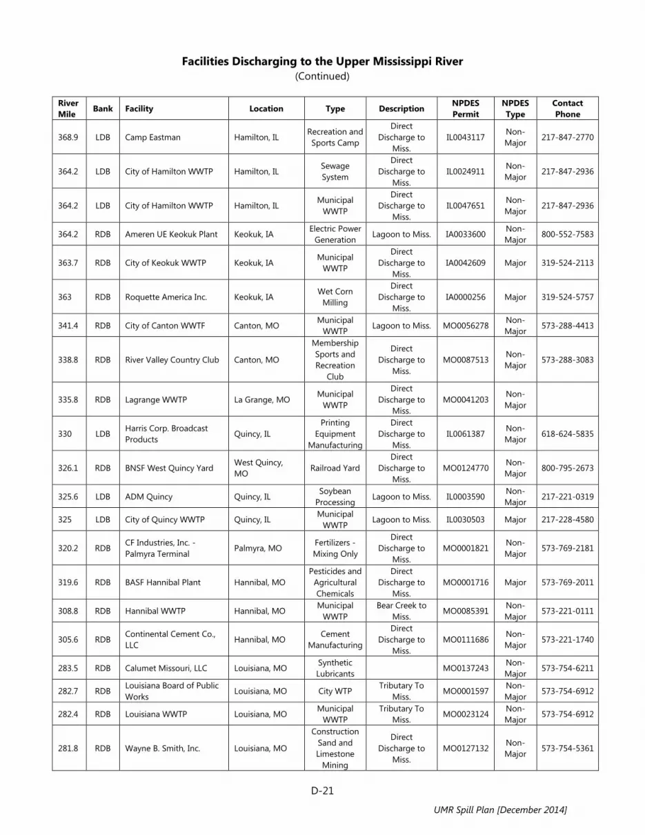
Facilities Discharging to the Upper Mississippi River
(Continued)
D-21
River Mile Bank Facility Location Type Description NPDES
Permit NPDES Type
Contact Phone
368.9 LDB Camp Eastman Hamilton, IL Recreation and Sports Camp
Direct Discharge to
Miss. IL0043117
Non-Major
217-847-2770
364.2 LDB City of Hamilton WWTP Hamilton, IL Sewage System
Direct Discharge to
Miss. IL0024911
Non-Major
217-847-2936
364.2 LDB City of Hamilton WWTP Hamilton, IL Municipal
WWTP
Direct Discharge to
Miss. IL0047651
Non-Major
217-847-2936
364.2 RDB Ameren UE Keokuk Plant Keokuk, IA Electric Power
Generation Lagoon to Miss. IA0033600
Non-Major
800-552-7583
363.7 RDB City of Keokuk WWTP Keokuk, IA Municipal
WWTP
Direct Discharge to
Miss. IA0042609 Major 319-524-2113
363 RDB Roquette America Inc. Keokuk, IA Wet Corn
Milling
Direct Discharge to
Miss. IA0000256 Major 319-524-5757
341.4 RDB City of Canton WWTF Canton, MO Municipal
WWTP Lagoon to Miss. MO0056278
Non-Major
573-288-4413
338.8 RDB River Valley Country Club Canton, MO
Membership Sports and Recreation
Club
Direct Discharge to
Miss. MO0087513
Non-Major
573-288-3083
335.8 RDB Lagrange WWTP La Grange, MO Municipal
WWTP
Direct Discharge to
Miss. MO0041203
Non-Major
330 LDB Harris Corp. Broadcast Products
Quincy, IL Printing
Equipment Manufacturing
Direct Discharge to
Miss. IL0061387
Non-Major
618-624-5835
326.1 RDB BNSF West Quincy Yard West Quincy, MO
Railroad Yard Direct
Discharge to Miss.
MO0124770 Non-Major
800-795-2673
325.6 LDB ADM Quincy Quincy, IL Soybean
Processing Lagoon to Miss. IL0003590
Non-Major
217-221-0319
325 LDB City of Quincy WWTP Quincy, IL Municipal
WWTP Lagoon to Miss. IL0030503 Major 217-228-4580
320.2 RDB CF Industries, Inc. - Palmyra Terminal
Palmyra, MO Fertilizers - Mixing Only
Direct Discharge to
Miss. MO0001821
Non-Major
573-769-2181
319.6 RDB BASF Hannibal Plant Hannibal, MO Pesticides and
Agricultural Chemicals
Direct Discharge to
Miss. MO0001716 Major 573-769-2011
308.8 RDB Hannibal WWTP Hannibal, MO Municipal
WWTP Bear Creek to
Miss. MO0085391
Non-Major
573-221-0111
305.6 RDB Continental Cement Co., LLC
Hannibal, MO Cement
Manufacturing
Direct Discharge to
Miss. MO0111686
Non-Major
573-221-1740
283.5 RDB Calumet Missouri, LLC Louisiana, MO Synthetic Lubricants
MO0137243 Non-Major
573-754-6211
282.7 RDB Louisiana Board of Public Works
Louisiana, MO City WTP Tributary To
Miss. MO0001597
Non-Major
573-754-6912
282.4 RDB Louisiana WWTP Louisiana, MO Municipal
WWTP Tributary To
Miss. MO0023124
Non-Major
573-754-6912
281.8 RDB Wayne B. Smith, Inc. Louisiana, MO
Construction Sand and Limestone
Mining
Direct Discharge to
Miss. MO0127132
Non-Major
573-754-5361
UMR Spill Plan [December 2014]

Facilities Discharging to the Upper Mississippi River
(Continued)
D-22
River Mile Bank Facility Location Type Description NPDES
Permit NPDES Type
Contact Phone
281 RDB Dyno Nobel, Inc. - Nitrogen Division
Louisiana, MO Nitrogenous
Fertilizer Manufacturing
Direct Discharge to
Miss. MO0105783 Major 573-754-4501
280.9 RDB Missouri Chemical Works Louisiana, MO Industrial Organic
Chemicals
Direct Discharge to
Miss. MO0000311 Major 573-754-6211
274.9 RDB Holcim (US) Inc. Clarksville, MO Cement
Manufacturing Lagoon to Miss. MO0000159
Non-Major
573-242-3571
272 RDB Clarksville WWTP Clarksville, MO Municipal
WWTP Tributary To
Miss. MO0039632
Non-Major
573-242-3336
241.5 RDB US Army Corps of Engineers
Winfield, MO Federal
Government WWTP
Direct Discharge to
Miss. MO0029955
Non-Major
636-566-8120
233.5 RDB O'Fallon WTP O'Fallon, MO City WTP Direct
Discharge to Miss.
MO0129623 Non-Major
636-379-7605
226.2 RDB Mississippi River WWTP Saint Charles, MO
Regional WWTP
Direct Discharge to
Miss. MO0058343 Major 636-250-4600
225.1 RDB Yacht Club of St. Louis Saint Charles, MO
Amusement and Recreation
Services
Direct Discharge to
Miss. MO0101303
Non-Major
636-250-4435
221.8 RDB Duck Club Marina Saint Charles, MO
Amusement and Recreation
Services
Direct Discharge to
Miss. MO0111627
Non-Major
636-250-4333
18 LDB Grafton WWTP Grafton, IL Municipal
WWTP
Direct Discharge to
Miss. IL0029025
Non-Major
217 LDB Raging Rivers Waterpark Grafton, IL Amusement
Park Rice Hollow
Creek to Miss. IL0067971
Non-Major
618-786-2345
215.5 LDB New Plaza Chautauqua WWTP
Elsah, IL Hotels and
Lodging Houses
Direct Discharge to
Miss. IL0076350
Non-Major
213.9 LDB Principia College WWTP Elsah, IL School WWTP Direct
Discharge to Miss.
IL0045462 Non-Major
618-374-2131
212.6 RDB Portage Des Sioux Portage Des Sioux, MO
Municipal WWTP
Direct Discharge to
Miss. MO0107328
Non-Major
209.9 LDB Lockhaven Country Club Dow, IL
Membership Sports and
Amusement Club
Direct Discharge to
Miss. IL0044971
Non-Major
618-466-2441
209.5 RDB Ameren Missouri Sioux Energy Center
West Alton, MO Coal Powered
Electricity Generation
Direct Discharge to
Miss. MO0000353 Major 800-552-7583
207.8 LDB City of Godfrey WWTP Godfrey, IL Municipal
WWTP Tributary To
Miss. IL0036421 Major 618-466-3334
204.2 LDB Illinois American Water Co. - Alton Plant
Alton, IL Water Supply Direct
Discharge to Miss.
IL0000299 Non-Major
855-705-8435
201.4 LDB Alton Steel, Inc. Alton, IL Steel and Iron
Mill Lagoon to Miss. IL0000612 Major 618-463-4490
199.5 LDB East Alton, WTP East Alton, IL Water Supply Old Wood River
to Miss. IL0051357
Non-Major
618-259-4646
UMR Spill Plan [December 2014]

Facilities Discharging to the Upper Mississippi River
(Continued)
D-23
River Mile Bank Facility Location Type Description NPDES
Permit NPDES Type
Contact Phone
198.8 LDB Koch Nitrogen - Wood River Terminal
East Alton, IL Special
Warehousing and Storage
Old Wood River to Miss.
IL0070173 Non-Major
316-828-8705
198 LDB BP Products North America Inc. - Wood River Terminal
Wood River, IL Petroleum Bulk
Stations and Storage
Lagoon to Miss. IL0000035 Non-Major
618-254-7630
197.7 LDB City of Wood River WWTP Wood River, IL Municipal
WWTP
Direct Discharge to
Miss. IL0031852 Major 618-251-3100
197 LDB PremCor Hartford Distribution Center
Hartford, IL Petroleum Bulk
Stations and Storage
Tributary To Miss.
IL0001244 Non-Major
210-345-4665
196.8 LDB Equilon Enterprises LLC - Hartford Terminal
Hartford, IL Petroleum Bulk
Stations and Storage
Direct Discharge to
Miss. IL0076465
Non-Major
618-255-1111
196.6 LDB City of Hartford CSO Hartford, IL Municipal
WWTP
Direct Discharge to
Miss. IL0021423
Non-Major
618-251-2680
196.3 LDB Marathon Pipeline LLC Hartford, IL Marine Cargo
Handling
Direct Discharge to
Miss. IL0079669
Non-Major
618-254-1112
196.3 LDB National Maintenance and Repair
Hartford, IL Marine and Rail Repair
Services
Direct Discharge to
Miss. IL0068055
Non-Major
618-254-7451
195.4 LDB Phillips 66 Co. Hartford, IL Petroleum Bulk
Stations and Storage
Cahokia Channel to
Miss. IL0071803
Non-Major
618-251-2800
193.5 RDB Bissel Point WWTP St. Louis MSD
St. Louis, MO Municipal
WWTP Lagoon to Miss. MO0025178 Major 314-633-9000
190.1 LDB Chain of Rocks Recycling and Disposal
Granite City, IL Refuse
Systems Chouteau
Slough to Miss. IL0075523
Non-Major
618-797-6805
190 RDB Chain of Rocks WTP St. Louis, MO Water Supply Direct
Discharge to Miss.
MO0000604 Non-Major
314-633-9000
185 RDB St. Louis Disposal Solutions
St. Louis, MO Refuse
Systems Dardenne
Creek to Miss. MO0136786
Non-Major
314-381-2600
185 RDB Norfolk Southern Railway Co. - Luther Yard
St. Louis, MO Railroad Yard Lagoon to Miss. MO0115568 Non-Major
314-679-1870
183.4 LDB Metro East SD CSOS East St. Louis, IL Municipal
WWTP
Direct Discharge to
Miss. IL0028592
Non-Major
618-452-9400
183.3 LDB Centerpoint Energy - Mississippi River Transmission
Venice, IL Coal Powered
Electricity Generation
Ditch to Miss. IL0078794 Non-Major
713-207-1111
182.8 LDB IDOT District 8 Venice Pump Station
Venice, IL Water Supply Direct
Discharge to Miss.
IL0071765 Non-Major
618-346-3110
182.4 LDB Ameren Missouri - Venice Plant
Venice, IL Coal Powered
Electricity Generation
Direct Discharge to
Miss. IL0000175
Non-Major
800-552-7583
182.1 RDB Kiesel Co. - Kiesel Marine St. Louis, MO Petroleum Bulk
Stations and Storage
Direct Discharge to
Miss. MO0111805
Non-Major
314-351-5500
181.6 RDB St. Louis Terminals Corp. St. Louis, MO Municipal
WWTP
Direct Discharge to
Miss. MO0113328
Non-Major
314-241-9600
UMR Spill Plan [December 2014]

Facilities Discharging to the Upper Mississippi River
(Continued)
D-24
River Mile Bank Facility Location Type Description NPDES
Permit NPDES Type
Contact Phone
181 LDB Illinois American Water Co. - East St. Louis Facility
East St. Louis, IL Water Supply Direct
Discharge to Miss.
IL0000281 Non-Major
855-705-8435
180.5 RDB Trigen Ashley Power Plant St. Louis, MO Combination
Utilities
Direct Discharge to
Miss. MO0000345
Non-Major
314-621-3550
179.2 RDB American River Transportation Co.
St. Louis, MO Marine Cargo
Handling
Direct Discharge to
Miss. MO0134741
Non-Major
866-574-9690
178.8 LDB East St. Louis CSOS East St. Louis, IL Sewage System
Direct Discharge to
Miss. IL0033472
Non-Major
618-482-6843
177.6 RDB Kinder Morgan - St. Louis St. Louis, MO Petroleum Bulk
Stations and Storage
Direct Discharge to
Miss. MO0136891
Non-Major
314-776-6629
177.5 LDB Veolia ES Technical Solutions LLC
Sauget, IL Refuse
Systems Tributary To
Miss. IL0071552
Non-Major
618-271-2804
177.4 LDB Joint American Bottoms and Sauget TRT Facility
Sauget, IL Municipal
WWTP
Direct Discharge to
Miss. IL0065145
Non-Major
618-337-1710
177 LDB ConocoPhillips Co. East St. Louis Terminal
East St. Louis, IL Petroleum Bulk
Stations and Storage
Direct Discharge to
Miss. IL0069477
Non-Major
580-767-7473
176 RDB JD Streett and Co. Inc. St. Louis, MO Petroleum Bulk
Stations and Storage
Direct Discharge to
Miss. MO0121169
Non-Major
314-432-6600
173.6 LDB Dupo WWTP Dupo, IL Municipal
WWTP
Direct Discharge to
Miss. IL0026441
Non-Major
618-286-3280
172.7 LDB Ingram Barge Co. East Carondelet, IL
Marine Cargo Handling
Direct Discharge to
Miss. IL0072303
Non-Major
615-298-8200
172.5 RDB Louisiana Dock Co. St. Louis, MO Marine Cargo
Handling
Direct Discharge to
Miss. MO0001601
Non-Major
314-544-7645
171.8 RDB MSD, Lemay WWTP Lemay, MO Municipal
WWTP
Direct Discharge to
Miss. MO0025151 Major 314-638-7470
171.4 RDB Mapico, Inc. St. Louis, MO Inorganic Pigments
Tributary To Miss.
MO0117307 Non-Major
314-544-1400
168.7 RDB Jefferson Barracks Marine SVCS
St. Louis, MO Marine
Gasoline Service
Direct Discharge to
Miss. MO0119733
Non-Major
314-894-3805
162 RDB MSD, Lower Meramec WWTP
St. Louis, MO Municipal
WWTP Lower Meremec
River to Miss. MO0100978
Non-Major
314-768-6260
161.7 RDB Ameren Missouri - Meramec Energy Center
St. Louis, MO Coal Powered
Electricity Generation
Lagoon to Miss. MO0000361 Major 800-552-7583
159 RDB Kimmswick WWTP Kimmswick, MO Municipal
WWTP
Direct Discharge to
Miss. MO0106461
Non-Major
636-464-7407
156.5 RDB Glaize Creek SD Barnhart, MO Municipal
WWTP
Direct Discharge to
Miss. MO0056162 Major 636-464-3230
153.5 RDB Teamsters Local 688 Pevely, MO RV Parks and
Campsites
Direct Discharge to
Miss. MO0046736
Non-Major
636-475-5375
UMR Spill Plan [December 2014]

Facilities Discharging to the Upper Mississippi River
(Continued)
D-25
River Mile Bank Facility Location Type Description NPDES
Permit NPDES Type
Contact Phone
151.1 RDB Herculaneum WWTP Herculaneum, MO
Municipal WWTP
Joachim Creek to Miss.
MO0027111 Non-Major
145.8 RDB River Cement Co. (DBA Buzzi Unicem USA)
Festus, MO Cement
Manufacturing Cliffdale Hollow
to Miss. MO0000035
Non-Major
636-937-7601
145 RDB LaRoche Industries Crystal City Nitrogen
Festus, MO Nitrogenous
Fertilizer Manufacturing
Direct Discharge to
Miss. MO0000817 Major 636-931-8100
140.4 RDB Ameren Missouri - Rush Island Center
Festus, MO Coal Powered
Electricity Generation
Lagoon to Miss. MO0000043 Major 800-552-7583
139.2 RDB Holcim (US) Inc. - Ste. Genevieve Plant
Bloomsdale, MO Cement
Manufacturing Tributary To
Miss. MO0133787 Major 636-524-8170
127.4 RDB Tower Rock Stone Company
Ste. Genevieve, MO
Crushed and Broken
Limestone
Direct Discharge to
Miss. MO0135399
Non-Major
573-883-7415
126.9 RDB Chemical Lime Co. Ste. Genevieve, MO
Lime Manufacturing
Direct Discharge to
Miss. MO0124044 Major 573-883-3001
125.5 LDB Kellogg Terminal Modoc, IL Marine Cargo
Handling Tributary To
Miss. IL0079545
Non-Major
618-284-7287
123 RDB Ste. Genevieve WWTP Ste. Genevieve, MO
Municipal WWTP
N Gobouri Creek to Miss.
MO0052159 Non-Major
573-883-5400
120.4 RDB Bigfield Terminal Ste. Genevieve, MO
Inland Water Freight
Transportation Lagoon to Miss. MO0129186
Non-Major
109.3 LDB City of Chester WTP Chester, IL Municipal WTP Direct
Discharge to Miss.
IL0001066 Non-Major
618-826-3315
107 LDB Chester WWTP Chester, IL Municipal
WWTP
Direct Discharge to
Miss. IL0072931 Major 618-826-2414
98.2 LDB Kinder Morgan Bulk Terminals
Rockwood, IL Port and Harbor
Operations
Direct Discharge to
Miss. IL0060674
Non-Major
713-369-8758
81.9 LDB Ameren Corp. Grant Tower Power Station
Grand Tower, IL Coal Powered
Electricity Generation
Direct Discharge to
Miss. IL0000124 Major 800-552-7583
69.5 RDB Proctor and Gamble Paper Products
Jackson, MO Paper Mill Tributary To
Miss. MO0044121 Major 573-651-9200
54 RDB Cape Rock WTP Cape Girardeau, MO
Municipal WTP Direct Discharge to Miss.
MO0000116 Non-Major
573-339-6357
50.3 RDB Cape Girardeau WWTP Cape Girardeau, MO
Municipal WWTP
Direct Discharge to Miss.
MO0050580 Major 573-339-6357
50 RDB Biokyowa Cape Girardeau, MO
Medicinal, Botanical
Manufacturing
Direct Discharge to Miss.
MO0102474 Non-Major
573-335-4849
49.8 RDB Buzzi Unicem USA - Cape Girardeau
Cape Girardeau, MO
Cement Manufacturing
Direct Discharge to Miss.
MO0000809 Major 573-335-5591
48.7 RDB SE Missouri Regional Airport
Scott City, MO Marine Cargo
Handling
Direct Discharge to Miss.
MO0120421 Non-Major
573-334-6230
48 RDB Missouri Fibre Corp. Scott City, MO Wood
Products
Direct Discharge to Miss.
MO0120642 Non-Major
573-264-4699
UMR Spill Plan [December 2014]

Facilities Discharging to the Upper Mississippi River
(Continued)
D-26
River Mile Bank Facility Location Type Description NPDES
Permit NPDES Type
Contact Phone
44.2 RDB Enterprise Products Scott City, MO
Pipeline Transfer of Petroleum Products
Direct Discharge to Miss.
MO0119300 Non-Major
573-264-3544
Acronyms:
CSO: Combined Sewer Overflow MS4: Municipal Separate Storm Sewer System MSD: Metropolitan Sewer District NPDES: National Pollutant Discharge Elimination System SD: Sanitary (Sewer) District WTP: (Drinking) Water Treatment Plant WWTP: Wastewater Treatment Plant
Source:
The data listed in the above table was compiled from the EPA Envirofacts Facility Registry Service (FRS) in June 2014. See: http://www.epa.gov/enviro/html/fii/fii_query_java.html
UMR Spill Plan [December 2014]
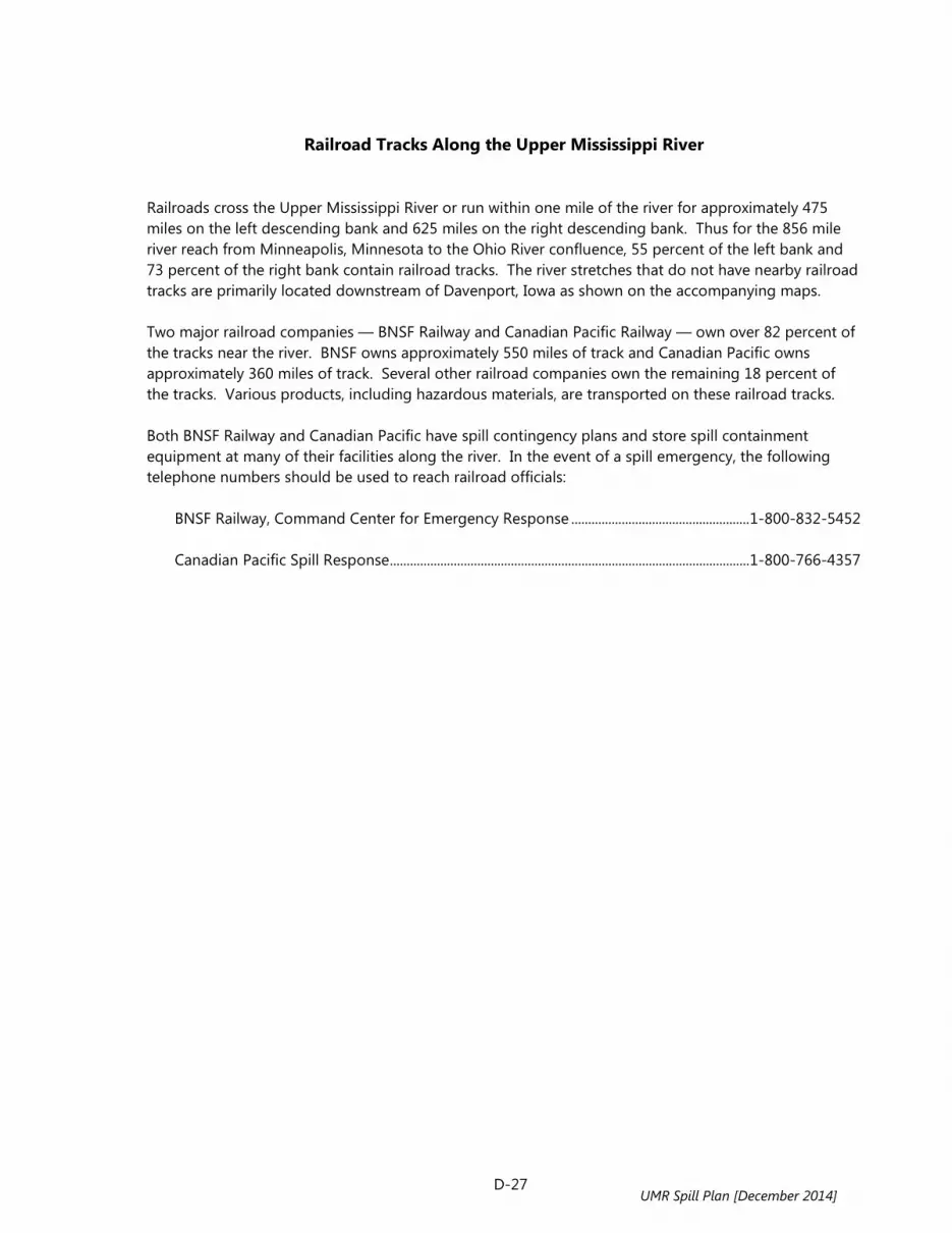
D-27
Railroad Tracks Along the Upper Mississippi River Railroads cross the Upper Mississippi River or run within one mile of the river for approximately 475 miles on the left descending bank and 625 miles on the right descending bank. Thus for the 856 mile river reach from Minneapolis, Minnesota to the Ohio River confluence, 55 percent of the left bank and 73 percent of the right bank contain railroad tracks. The river stretches that do not have nearby railroad tracks are primarily located downstream of Davenport, Iowa as shown on the accompanying maps. Two major railroad companies — BNSF Railway and Canadian Pacific Railway — own over 82 percent of the tracks near the river. BNSF owns approximately 550 miles of track and Canadian Pacific owns approximately 360 miles of track. Several other railroad companies own the remaining 18 percent of the tracks. Various products, including hazardous materials, are transported on these railroad tracks. Both BNSF Railway and Canadian Pacific have spill contingency plans and store spill containment equipment at many of their facilities along the river. In the event of a spill emergency, the following telephone numbers should be used to reach railroad officials: BNSF Railway, Command Center for Emergency Response ..................................................... 1-800-832-5452 Canadian Pacific Spill Response ........................................................................................................... 1-800-766-4357
UMR Spill Plan [December 2014]

D-28 UMR Spill Plan [December 2014]

D-29
UMR Spill Plan [December 2014]

D-41
Selected Tributaries to the Upper Mississippi River
Tributary Name Enters UMR at
River Mile* Stream
Length** (Miles) Drainage Area*** (Square Miles)
Rice Creek, MN 861.8 LDB 28.7 111 Shingle Creek, MN 857.8 RDB 11.2 29 Minnesota River, MN 844.0 RDB 359.4 1,183 St. Croix River, WI 811.5 LDB 173.1 680 Big River, WI 804.9 LDB 12.8 21 Vermillion River, MN 795.6 RDB 59.2 147 Cannon River, MN 794.6 RDB 118.6 393 Rush River, WI 780.6 LDB 50.9 167 Wells Creek, MN 777.7 RDB 28.4 41 Chippewa River, WI 763.4 LDB 196.1 723 Buffalo (Beef) River, WI 754.5 LDB 70.0 228 Zumbro River, MN 750.2 RDB 64.7 154 East Indian Creek, MN 745.0 RDB 16.3 20 Whitewater River, MN 743.0 RDB 18.2 36 Pleasant Valley Creek, MN 722.0 RDB 10.5 45 Trempealeau River, WI 717.0 LDB 82.6 360 Tank Creek, WI 711.8 LDB 4.9 34 Shingle Creek, WI 710.2 LDB 5.5 34 Black River, WI 708.4 LDB 192.1 528 La Crosse River, WI 698.2 LDB 61.5 169 Root River, MN 693.7 RDB 81.8 253 Bad Axe River, WI 675.2 LDB 4.0 11 Upper Iowa River, IA 671.1 RDB 156.2 368 Village Creek, IA 662.0 RDB 23.7 73 Rush Creek, WI 659.5 LDB 15.7 53 Copper Creek, WI 655.6 LDB 4.1 27 Du Charme Creek, WI 644.4 LDB 7.2 58 Paint Creek, IA 640.7 RDB 33.2 85 Yellow River, IA 637.6 RDB 53.5 195 Wisconsin River, WI 631.7 LDB 435.6 1,671 Sny Magill Creek, IA 627.1 RDB 10.3 36 Turkey River, IA 608.2 RDB 153.2 426 Grant River, WI 593.0 LDB 44.9 98 Platte River, WI 588.3 LDB 48.2 159 Little Maquoketa River, IA 586.4 RDB 30.3 86 Catfish Creek, IA 577.7 RDB 3.4 54 Menominee River, IL 574.5 LDB 11.6 31 Little Menominee River, IL 570.7 LDB 13.6 44 Sinsinawa River, IL 569.1 LDB 21.2 49 Tetes Des Morts Creek, IA 567.4 RDB 17.6 48
UMR Spill Plan [December 2014]

D-42
Selected Tributaries to the Upper Mississippi River (Continued)
Tributary Name Enters UMR at
River Mile* Stream
Length** (Miles) Drainage Area*** (Square Miles)
Galena River, IL 565.1 LDB 50.1 123 Smallpox Creek, IL 563.1 LDB 16.1 32 Maquoketa River, IA 548.7 RDB 150.0 412 Apple River, IL 545.3 LDB 55.0 123 Plum River, IL 536.6 LDB 46.6 118 Elk River, IA 528.3 RDB 21.7 77 Silver Creek, IA 526.4 RDB 5.2 44 Johnson Creek Diversion Ditch, IL 522.1 LDB 26.5 66 Otter Creek, IL 522.1 LDB 11.9 23 Rock Creek, IA 507.0 RDB 14.2 26 Sodus Creek, IA 507.0 RDB 4.0 26 Wapsipinicon River, IA 506.7 RDB 299.7 903 Duck Creek, IA 487.7 RDB 21.3 64 Rock River, IL 479.1 LDB 215.1 769 Copperas Creek, IL 450.8 LDB 32.2 73 Iowa River, IA 434.0 RDB 323.7 904 Edwards River, IL 431.4 LDB 73.9 253 Pope Creek, IL 427.7 LDB 58.3 162 Hawkeye-Dolbee Diversion Channel, IA 422.1 RDB 4.2 26 Yellow Spring Creek, IA 410.4 RDB 1.8 27 Henderson Creek, IL 409.9 LDB 64.8 190 Flint Creek, IA 405.3 RDB 35.4 117 Skunk River, IA 396.0 RDB 93.2 217 Devils Creek, IA 377.6 RDB 14.1 23 Sheridan Creek, IL 372.4 LDB 10.6 19 Larry Creek, IL 369.3 LDB 4.0 24 Chaney Creek, IL 364.9 LDB 11.7 22 Des Moines River, IA / MO 361.5 RDB 429.7 1,461 Fox River, MO 353.5 RDB 105.9 295 Bear Creek, IL 341.0 LDB 44.1 162 Wyaconda River, MO 337.3 RDB 50.7 113 Rock and Ursa Creek Diversion Ditch, IL 336.3 LDB 24.4 37 Durgens Creek, MO 331.5 RDB 22.6 43 Fabius River Diversion, MO 321.0 RDB 6.4 21 North River, MO 320.9 RDB 81.4 235 South River, MO 320.7 RDB 18.4 49 Mill Creek, IL 318.2 LDB 23.8 51 Hadley-McCraney Diversion Channel, IL 296.7 LDB 4.7 54 Salt River, MO 284.3 RDB 75.0 325
UMR Spill Plan [December 2014]

D-43
Selected Tributaries to the Upper Mississippi River (Continued)
Tributary Name Enters UMR at
River Mile* Stream
Length** (Miles) Drainage Area*** (Square Miles)
Noix Creek, MO 282.3 RDB 13.4 45 Buffalo Creek, MO 280.9 RDB 14.1 48 Ramsey Creek, MO 265.1 RDB 17.7 74 Bryants Creek Diversion Channel, MO 260.7 RDB 18.1 84 Bobs Creek, MO 238.1 RDB 24.3 42 Peruque Creek, MO 233.5 RDB 44.0 81 Dardenne Creek, MO 227.4 RDB 40.2 164 Illinois River, IL 220.0 LDB 273.6 1,416 Piasa Creek, IL 209.4 LDB 29.7 99 Wood River, IL 199.3 LDB 2.6 27 Missouri River, MO 195.5 RDB 594.4 2,835 Cahokia Creek Diversion Channel, IL 195.0 LDB 4.9 21 Chain of Rocks Canal, IL 184.1 LDB 8.7 94 Prairie duPont Creek, IL 174.3 LDB 20.4 67 River Des Peres Drainage Channel, MO 172.1 RDB 6.2 27 Meramec River, MO 160.8 RDB 229.1 892 Fountain Creek, IL 156.4 LDB 30.1 91 Joachim Creek, MO 151.5 RDB 36.9 133 Kaskaskia River, IL 117.7 LDB 304.9 818 Marys River, IL 106.6 LDB 42.3 121 Apple Creek, MO 75.2 RDB 47.3 180 Indian Creek, MO 69.0 RDB 12.0 42 Castor River Diversion Channel, MO 48.8 RDB 35.0 118 Cache River, IL 12.9 LDB 92.1 181
* LDB = Left Descending Bank RDB = Right Descending Bank ** Estimated stream length using National Hydrography Dataset (NHD) and including only the named
main branch of the stream within the UMR states. *** Estimated drainage area using NHD 12-digit hydrologic unit code (HUC) watersheds intersecting the
streams along the above defined lengths.
UMR Spill Plan [December 2014]

D-44
UMR Spill Plan [December 2014]

D-45
Coal Ash Impoundment Sites Along the Upper Mississippi River
River Mile* Facility Name, Address, and Phone Number Parent Company Address 8.0 RDB Minnesota River
Black Dog Power Station 1400 E Black Dog Rd. Burnsville, MN 55337 800-895-4999
Xcel Energy 414 Nicollet Mall Minneapolis, MN 55401
607.7 LDB Nelson Dewey Generating Station 11999 Co. Rd. VV Casssville, WI 53806 800-255-4268
Alliant Energy 4902 N Biltmore Ln., Ste 1000 Madison, WI 53718-2148
660.0 RDB Lansing Power Station 2320 Power Plant Dr. Lansing, IA 52151 800-255-4268
Alliant Energy 4902 N Biltmore Ln., Ste 1000 Madison, WI 53718-2148
586.0 RDB John Deere Dubuque 18600 S John Deere Rd. Dubuque, IA 52001 563-589-5151
Deere & Company World Headquarters 1 John Deere Pl. Moline, IL 61265
513.4 RDB ADM Clinton Power Plant 1251 Beaver Channel Pkwy. Clinton, IA 52732 563-242-6073
Archer Daniels Midland Co. 4666 Faries Pkwy. Decatur, IL 62526
492.3 RDB Riverside Generating Station 6001 State St. Bettendorf, IA 52722 888-427-5632
MidAmerican Energy Co. PO Box 657 Des Moines, IA 50306-0657
467.6 RDB Fair Station 3800 Hwy. 22 W Montpelier, IA 52759 319-366-8011
Central Iowa Power Cooperative PO Box 2517 Cedar Rapids, IA 52406-2517
453.0 RDB Muscatine Generating Station 1700 Industrial Connector Rd. Muscatine, IA 52761 563-263-2752
City of Muscatine 215 Sycamore St. Muscatine, IA 52761
403.6 RDB Burlington Generating Station 4282 Sullivan Slough Rd. Burlington, IA 52601 800-255-4268
Alliant Energy 4902 N Biltmore Ln., Ste 1000 Madison, WI 53718-2148
281.0 RDB Hercules Missouri Power Plant 11083 Hwy. D Louisiana, MO 63353 859-815-3333
Ashland Inc. 50 E. RiverCenter Blvd. - PO Box 391 Covington, KY 41012-0391
42.7 RDB Illinois River
Pearl Station Rt. 100 S Pearl, IL 62361 217-829-4291
Illinois Rural Electric Cooperative 2 S. Main St. - PO Box 80 Winchester, IL 62694
UMR Spill Plan [December 2014]

D-46
Coal Ash Impoundment Sites Along the Upper Mississippi River
(Continued) River Mile* Facility Name, Address, and Phone Number Parent Company Address 209.5 RDB Sioux Power Station
8501 N State Rt. 94 West Alton, MO 63386 800-552-7583
Ameren Missouri PO Box 790352 St. Louis, MO 63179-0352
199.9 LDB Wood River Power Station 3200 East Broadway Alton, IL 62002 618-433-0115
Homefield Energy Office 1500 Eastport Plaza Dr. Collinsville, IL 62234
161.9 RDB Meramec Power Station 8200 Fine Rd. St. Louis, MO 63129 800-552-7583
Ameren Missouri PO Box 790352 St. Louis, MO 63179-0352
138.8 RDB Rush Island Power Station 100 Big Hollow Rd. Festus, MO 63028 800-552-7583
Ameren Missouri PO Box 790352 St. Louis, MO 63179-0352
19.5 LDB Kaskaskia River
Baldwin Energy Complex 10901 Baldwin Rd. Baldwin, IL 62217 618-785-2294
Homefield Energy Office 1500 Eastport Plaza Dr. Collinsville, IL 62234
* All river miles are for the Upper Mississippi River, unless otherwise indicated.
UMR Spill Plan [December 2014]
RESOURCE MANUAL
Section E: Regional and Local Resources
UMR Spill Plan [December 2014]

E-1
Public Hazardous Materials Teams (Note: Listed below are Level A public sector hazardous materials teams that include some portion of the Upper Mississippi River within their response area. No Illinois-based teams are included in this list. Requests for hazmat team assistance in Illinois should be directed to the Illinois Emergency Management Agency at 217-782-7860).
Name
Location
Upper Mississippi River Response Area*
24-hour Telephone
St. Paul Fire Department
St.Paul, MN Ramsey, Washington, and Dakota Counties, MN
651-649-5451 (Minnesota State Duty Office)
Chippewa Falls/ Eau Claire Fire Departments
Chippewa Falls and Eau Claire, WI
Pierce, Pepin, northern Buffalo, and northern Trempealeau Counties, WI
800-943-0003 (Wisconsin Emergency Management)
Winona Fire Department
Winona, MN Winona County, MN 507-454-6100 (Winona County Sheriff’s Department)
La Crosse Fire Department
La Crosse, WI southern Buffalo, southern Trempealeau, La Crosse, Vernon, and Crawford Counties, WI; Allamakee County, IA
800-943-0003 (Wisconsin Emergency Management)
Rochester Fire Department
Rochester, MN Goodhue, Wabasha, Winona, and Houston Counties, MN
651-649-5451 (Minnesota State Duty Office)
Madison Fire Department
Madison, WI Grant County, WI 800-943-0003 (Wisconsin Emergency Management)
Linn County Hazmat Team
Cedar Rapids, IA
Clayton County, IA 319-398-3911
Dubuque Fire Department
Dubuque, IA Dubuque County, IA 563-589-4415
Bettendorf Fire and Rescue
Bettendorf, IA City of Bettendorf; portion of Scott County, IA (east of Hwy 67)
563-344-4015
UMR Spill Plan [December 2014]

E-2
Public Hazardous Materials Teams (Continued)
Name
Location
Upper Mississippi River Response Area*
24-hour Telephone
Davenport Fire Department
Davenport, IA Jackson, Clinton, and Scott Counties, IA
563-326-7979
Muscatine Fire Department
Muscatine, IA Muscatine and Louisiana Counties, IA
563-263-9922
Burlington Fire Department
Burlington, IA City of Burlington, IA and Des Moines County
563-753-8373
Fort Madison Fire Department
Fort Madison, IA
Lee County, IA 319-372-7700
Keokuk Fire Department
Keokuk, IA Lee County, IA 319-524-1642
St. Charles and Warren Counties HazMat Response Teams
St. Charles, MO St. Charles County, MO 636-928-7569
St. Louis County Hazardous Materials Team
St. Louis, MO St. Louis County, MO 314-428-1133 North County 636-394-5442 Central County
St. Louis City Fire Department
St. Louis, MO City of St. Louis, MO Mouth of Missouri River to Mouth of Meramec River on the UMR
314-533-3810
Jefferson County Emergency Management Agency
Hillsboro, MO Jefferson County, MO 636-797-5381
* Includes entire city or county unless listed otherwise noted.
UMR Spill Plan [December 2014]

E-3
County Emergency Management Agencies along the Upper Mississippi River (Listed by State Upstream to Downstream)
State County Name Phone Address MN Anoka County Dispatch: (763) 421-4760
Main: (763) 323-6150 2100 3rd Avenue Anoka, MN 55303
MN Hennepin County Dispatch: (612) 596-0254 Main: (612) 596-0252
1600 Prairie Drive Medina, MN 55340-5421
MN Ramsey County Hotline: (651) 297-1304 (9:00 AM-4:30 PM) Main: (651) 643-8378
2099 University Av. W., Suite 201 St Paul, MN 55104-3431
MN Washington County Main: (651) 430-7938 15015 62nd St. N Stillwater, MN 55082
MN Dakota County Emergency Preparedness
Main: (651) 438-4703 1580 Highway 55 Hastings, MN 55055
MN Goodhue County Main: (651) 388-1181 Alt: (651) 267-2640
430 West 6th Street Red Wing, MN 55066
MN Wabasha County Main: (651) 565-3069 848-17th Street East Wabasha, MN 55981-5033
MN Winona County Main: (507) 457-6498 201 W 3rd St Winona, MN 55987
MN Houston County Main: (507) 725-5249 Manager: (507) 725-5834
Courthouse, 306 S Marshall St., Suite 2008 Caledonia, MN 55921
WI Pierce County Main: (715) 273-6751 Emergency: (715) 273-5051
Courthouse Annex Room 503 414 W. Main St. PO Box 805 Ellsworth, WI 54011
WI Pepin County Main: (715) 672-8897 24-hour (715) 672-5944
740 7th Ave West Durand, WI 54736
WI Buffalo County Main: (608) 685-6298 407 South Second Street PO Box 494 Alma, WI 54610-0494
WI Trempealeau County Main: (715) 538-2311 36245 Main St. PO Box 67 Whitehall, WI 54773
WI La Crosse County Main: (608) 789-4811 Alt: (608) 785-9634
333 Vine St. La Crosse, WI 54601
WI Vernon County Main: (608) 637-5266 318 Fairlane Dr. Suite 5 Viroqua, WI 54665
WI Crawford County Main: (608) 326-0266 224 N. Beaumont Rd. Prairie du Chien, WI 53821
WI Grant County Main: (608) 723-7171 Dispatch: (608) 723-2157
1000 N. Adams St. PO Box 506 Lancaster, WI
UMR Spill Plan [December 2014]

E-4
County Emergency Management Agencies along the Upper Mississippi River (Continued)
State County Name Phone Address IA Allamakee County Main: (563) 568-4233 110 Allamakee St.
Waukon, IA 52172 IA Clayton County Main: (563) 245-3004 600 Gunder Rd. NE, Suite 13
PO Box 464 Elkader, IA 52043-0464
IA Dubuque County Main: (563) 589-4170 14928 Public Safety Way Dubuque, IA 52002-8216
IA Jackson County Main: (563) 652-7036 Cell: (563) 542-3911
201 W. Platt Maquoketa, Iowa 52060
IA Clinton County Main: (563) 242-5712 Courthouse, 612 North 2nd Street P.O. Box 2957 Clinton IA 52733-2957
IA Scott County Main: (563) 484-3050 1100 E. 46th St. Davenport, IA 52807
IA Muscatine County Main: (563) 264-6003 312 East Fifth Street Muscatine, Iowa 52761
IA Louisa County Director: (319) 750-1128 12635 County Rd G56 Wapello, Iowa 52653
IA Des Moines County Main: (319) 753-8206 512 N. Main St. Suite 1 Burlington, IA 52601
IA Lee County Main: (319) 372-4124 811 Avenue E P.O. Box 240 Fort Madison, IA 52627
IL Jo Daviess County Emergency and Disaster Preparedness
Main: (815) 777-0263 Toll free: (877) 777-0263
9483 US Hwy 20 West PO Box 318 Galena, IL 61036
IL Carroll County ESDA Director: (815) 631-8844 301 North Main Street Mt. Carroll, IL 61053
IL Whiteside County ESDA Main: (815) 772-4044 400 N. Cherry St. Morrison , IL 61270
IL Rock Island Main: (309) 799-5166 6120 78th Ave Milan, IL 61264
IL Mercer County /Community Emergency Response Team
Main: (309) 582-3759 S1007 NW 3rd St. Aledo, IL 61231
IL Henderson County Main: (309) 867-2780 PO Box 308 Oquawka, IL 61469
IL Hancock County ESDA Main: (217) 357-2115 1006 Wabash Carthage, IL 62321
IL Adams County Main: (217) 277-2005 222 N 52nd St. Quincy, IL 62035
IL Pike County /Sheriff Director: (217) 285-5550 204 E Adams St. Pittsfield, IL 62363
UMR Spill Plan [December 2014]

E-5
County Emergency Management Agencies along the Upper Mississippi River (Continued)
State County Name Phone Address IL Calhoun County ESDA Main: (618) 576-2733 HCR 61, Box 48
Hardin, IL 62047 IL Jersey County/Jerseyville
ESDA Main: (618) 498-6881 114 N. Washington
Jerseyville, IL 62052 IL Madison County Main: (618) 692-0537 101 E. Edwardsville Rd., Suite 260
Wood River, IL 62095 IL St. Clair County Main: (618) 825-2750 110 W. Washington
Belleville, IL 62220 IL Monroe County Main: (618) 939-8681
ext. 231 100 S. Main St. Waterloo, IL 62298
IL Randolph County Main: (618) 826-5000 ext. 227
2515 State St. Chester, IL 62233
IL Jackson County 24-Hour: (618) 684-3137 1001 Walnut St. Murphysboro, IL 62966
IL Union County Main: (618) 697-0760 301 W. Mississippi St. Jonesboro, IL 62952
IL Alexander County/Cairo Main: 618-306-3282 2000 Washington Ave Cairo, IL 62914
MO Clark County Coordinator: (660) 727-2512
250 N Morgan Kahoka, MO 63445
MO Lewis County Coordinator: (573) 248-4789
202 N Highland St. Ewing, MO 63440
MO Marion County Emergency Services
Main: (573) 221-1121 Dispatch: (573) 221-1806
3246 Hwy. 61 Hannibal, MO 63401
MO Ralls County Coordinator: (573) 822-9736 Dispatch: (573) 985-1911
PO Box 246 Perry, MO 63462
MO Pike County Coordinator: (573) 754-0151
13055 Pike 133 Louisiana, MO 63353
MO Lincoln County Coordinator: (636) 528-6300
250 W. College St. Troy, MO 63379
MO St. Charles County Main (24-hour pager): (636) 949-3023
301 N 2nd St. Rm 280 St. Charles, MO 63301
MO St. Louis County Police Office of Emergency Management
Main: (314) 628-5400 14847 Ladue Bluffs Crossing Dr. Chesterfield, MO 63017
MO Jefferson County Main: (636) 797-5381 Jefferson County Courthouse 300 Main St. Hillsboro, MO 63050
MO Ste. Genevieve Coordinator: (573) 883-0263
295 Brooks Dr. Ste. Genevieve, MO 63670
MO Perry County Main: (573) 547-4000 406 N. Spring St. Perryville, MO 63775
UMR Spill Plan [December 2014]

E-6
County Emergency Management Agencies along the Upper Mississippi River (Continued)
MO Cape Girardeau Main: (573) 204-0911 #1 Barton Square
Jackson, MO 63755 MO Scott County Main: (573) 545-3549 131 S. Winchester St., PO Box 431
Benton, MO 63736 MO Mississippi County Daytime: (573) 683-2111
Evening: (573) 683-1782 PO Box 369 Charleston, MO 63834
UMR Spill Plan [December 2014]

RESOURCE MANUAL
Section F: In Situ Burning and Chemical Oil Spill Treating Agents
UMR Spill Plan [December 2014]

In Situ Burn Checklist
F-1
The following checklist will assist OSCs at any level to ensure that reasonable decisions are made on the use of ISB on the Upper Mississippi River. ISB Decision Tree Step 1: Site Conditions and Desirability • Access routes to the scene? • Locational information to include: River mile or latitude/longitude or other precise geographical
description? • Material, amount, size, age, phase, condition of spill? • Environmental conditions: air temperature, wind speed, lake/river current speed, wave heights,
water temperature, ice conditions? • Will the use of ISB prevent or reduce further damage by the spill? • Is mechanical containment and recovery adequate? If so, explain why burning is being considered. • Ecological factors such as environmentally sensitive areas? See page F-29 for Ecological
Considerations. Step 2: Feasibility • Can worker safety be reasonably assured? • Can the fire be contained? If not, should not burn. • Are environmental conditions favorable? Wind speeds less than 20 knots (23 mph, 34 feet/sec),
currents less than 3/4 of a knot (0.9 mph, 1.3 feet/sec), and waves less than 3 feet? If not, then probably should not conduct the burn.
• Will the smoke plume lower the visibility enough to adversely impact transportation via air, water, or land?
• Are atmospheric conditions very stable (i.e., winds are light and fog or low stratus clouds are present)? Then, the smoke plume will likely be more difficult to disperse and you might not want to burn unless there will be no human impact.
• Is the oil burnable? Recommended thicknesses are 2 to 3 mm for fresh crude oil, 3 to 5 mm for diesel and weathered crude, and 5 to 10 mm for emulsions and bunker C. Water-in-oil emulsions containing more than 30 to 50% water are difficult to ignite and support combustion. Most oils readily burn if the water content is less than 25%. Most crude oils require an evaporative loss of less than 30% to burn.
• Residues: The removal of burn residues should be considered since the potential exists for undefined levels of environmental impacts even with a successful burn. See pages F-34 and F-35 for additional information.
• Is the product ignitable without adding a burning agent? COSTA procedure approval is required for use of burning agents.
The term "burning agents" means those additives that, through physical or chemical means, improve the combustibility of the materials to which they are applied. It is recommended that, when addition of a burning agent is being evaluated, first consideration be given to the more environmentally friendly products such as kerosene or jet fuel "A" before considering the more environmentally hostile products such as gasoline or diesel. • Is the product gasoline or other light petroleum product? If so, both mechanical techniques and ISB
are still viable options. However, due to the greater risk of flammable hazard, uncontrolled sources
UMR Spill Plan [December 2014]

In Situ Burn Checklist (Continued)
F-2
of ignition should be removed from the area, only intrinsically safe equipment should be used on the site, and combustible gas indicators should be used to monitor for flammable vapors.
• Is the area forested or are conditions very dry? If so, then it may not be safe to burn. • If in a marsh or wetlands area see pages F-14 to F-15. • Are adequate fire boom, towboats, and igniters available? • Is adequate helicopter/monitoring equipment available? • Can notices to mariners, aircraft, and populations be issued in time? • Can personnel and equipment be mobilized in time? • Can authorization be secured in time?
See pages F-33 to F-35 for information operational considerations : open water burning, inland environment burning, ice conditions, fire boom, ignition, oil thickness, weathering, emulsification, and burn residues. Step 3: Acceptability • Distance between burn and human population? • Will ambient PM-10, averaged over 1 hour, near humans, be above 150 micrograms per cubic
meter? If so, evacuate or shield them, or do not conduct the burn. Generally, burning should not be conducted if human population centers exist within 6 miles downwind of the burn or 3 miles in other directions. These distances are only a rule of thumb - they may be longer or shorter depending on the circumstances of the case. In general, a safety margin of 45 degrees of arc on either side of the wind vector should be allowed to account for wind shifts. This means that burning is not recommended if there is a human population center within 6 miles from the burn measured along the wind direction and expanded 45 degrees on either side of the wind direction. A 3 mile safety margin is recommended in other directions. Other considerations include: • Does the landowner concur with the decision to burn? • Are there cultural, historical, or archaeological resources that could be affected by the burn? If so,
probably should not burn. • Does the proposed burn area contain state or federal threatened or endangered species
populations or their critical habitats? If so, and the proposed burn appears likely to result in greater overall injury to those species or habitats than other response actions, including "no action", the state and federal natural resource trustees will likely object to it.
Step 4: Authorization and Conditions • Are forecasted weather conditions favorable? • The Site Safety Plan should be reviewed to ensure that ISB is adequately addressed. • Unified Command authority to start, proceed, limit, or halt the burn must be recognized. • Conduct trial burn to evaluate smoke plume drift and dispersion. • Burn extinguishing measures are available? • Public notification. See page F-28 for guidelines on Public Notification. • A written description of the incident and burn plan should be provided to the OSC and other
pertinent players.
UMR Spill Plan [December 2014]
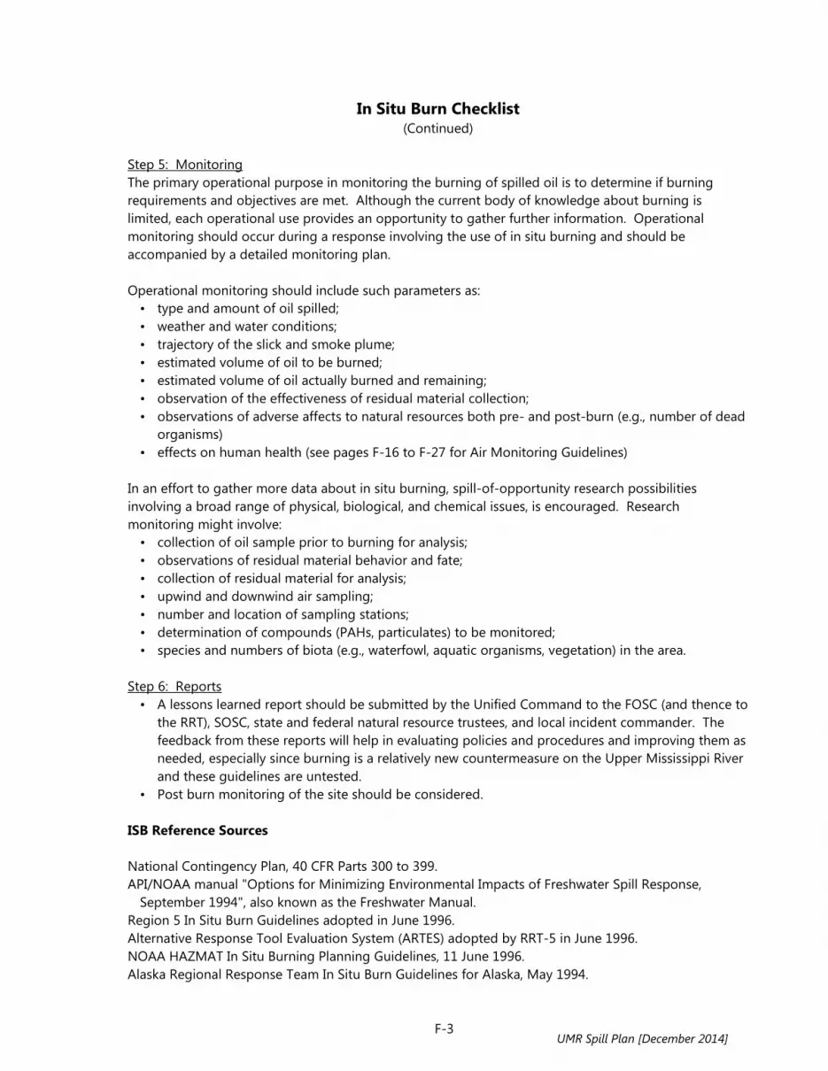
In Situ Burn Checklist (Continued)
F-3
Step 5: Monitoring The primary operational purpose in monitoring the burning of spilled oil is to determine if burning requirements and objectives are met. Although the current body of knowledge about burning is limited, each operational use provides an opportunity to gather further information. Operational monitoring should occur during a response involving the use of in situ burning and should be accompanied by a detailed monitoring plan. Operational monitoring should include such parameters as: • type and amount of oil spilled; • weather and water conditions; • trajectory of the slick and smoke plume; • estimated volume of oil to be burned; • estimated volume of oil actually burned and remaining; • observation of the effectiveness of residual material collection; • observations of adverse affects to natural resources both pre- and post-burn (e.g., number of dead
organisms) • effects on human health (see pages F-16 to F-27 for Air Monitoring Guidelines)
In an effort to gather more data about in situ burning, spill-of-opportunity research possibilities involving a broad range of physical, biological, and chemical issues, is encouraged. Research monitoring might involve: • collection of oil sample prior to burning for analysis; • observations of residual material behavior and fate; • collection of residual material for analysis; • upwind and downwind air sampling; • number and location of sampling stations; • determination of compounds (PAHs, particulates) to be monitored; • species and numbers of biota (e.g., waterfowl, aquatic organisms, vegetation) in the area.
Step 6: Reports • A lessons learned report should be submitted by the Unified Command to the FOSC (and thence to
the RRT), SOSC, state and federal natural resource trustees, and local incident commander. The feedback from these reports will help in evaluating policies and procedures and improving them as needed, especially since burning is a relatively new countermeasure on the Upper Mississippi River and these guidelines are untested.
• Post burn monitoring of the site should be considered. ISB Reference Sources National Contingency Plan, 40 CFR Parts 300 to 399. API/NOAA manual "Options for Minimizing Environmental Impacts of Freshwater Spill Response,
September 1994", also known as the Freshwater Manual. Region 5 In Situ Burn Guidelines adopted in June 1996. Alternative Response Tool Evaluation System (ARTES) adopted by RRT-5 in June 1996. NOAA HAZMAT In Situ Burning Planning Guidelines, 11 June 1996. Alaska Regional Response Team In Situ Burn Guidelines for Alaska, May 1994.
UMR Spill Plan [December 2014]

In Situ Burn Checklist (Continued)
F-4
S.L. Ross Environmental Research Ltd., Alaska Clean Seas, Alaska Department of Environmental Conservation, In Situ Burning: A Valuable Tool for Oil Spill Response, April 1995
Regional Response Team 2 - In Situ Burning Decision Flow Chart, DRAFT 11/12/96. Regional Response Team 6, In Situ Burn Decision Tree.
UMR Spill Plan [December 2014]

Chemical Oil Spill Treating Agents (COSTAs)
F-5
What a Responder Needs to Know to Consider Use of a COSTA Except for specific circumstances (i.e. to prevent or substantially reduce a hazard to human life in accordance with 40 CFR 300.910 (c)) the use of chemical oil spill treating agents (COSTAs) will be considered on a case-by-case basis. Chemical oil spill treating agents include dispersants, herding agents, emulsion treating agents, solidifiers, elasticity modifiers, shoreline cleaning agents, shoreline pre-treatment agents, oxidation agents, and bioremediation agents. In general, the use of dispersants is not promoted within the boundaries of the Region 5 or Region 7 Regional Response Teams (RRTs). Regarding other non-dispersant COSTA, Region 7 has no pre-approvals in place. Region 5 has a pre-approval in place for the test use of the elasticity modifier product, ELASTOL. Additionally, the use of the NOCHAR A610 solidifier product contained in booms, sock, and pillows is also approved for use in Region 5. No approval is in place for use of uncontained solidifier products. Note that both ELASTOL and NOCHAR were removed from the National Product Schedule in 1996, and, therefore, neither may be used except as provided for in the National Contingency Plan (40 CFR 300.910 9 paragraph (c)). Consistent with the National Contingency Plan (NCP), in situations when a human hazard is not present, the federal on-scene coordinator (FOSC) must receive the concurrence of the U.S. Environmental Protection Agency (USEPA) Regional Response Team (RRT) representative(s), and the RRT representative of the affected state(s) to use any chemical product. The FOSC must also consult with the Department of Interior (DOI) and Department of Commerce (DOC) natural resource trustees, where practicable, before authorizing the use of a chemical product. Any on-scene coordinator (OSC) or responder must comply with applicable local, state, and federal regulations. Note that the FOSC is authorized to use any chemical product without requesting permission if he or she believes its use is necessary to prevent or substantially reduce a hazard to human life (40 CFR 300.910 (c)). If a chemical product is used under these circumstances, the FOSC must notify the USEPA RRT representative and the state(s) RRT representative of its use as soon as possible. This policy should be applicable to any OSC whether local, state, or federal. General COSTA show stoppers: • Is the product on the National Product Schedule? If not, then it should not be used except as
noted in 40 CFR 300.910 (c). • Are all players in agreement on its use? If not, then it should not be used. These players shall
include the Local Incident Commander, FOSC, SOSC, and the State and Federal natural resource trustees.
• COSTAs require RRT approval. COSTA Decision Tree The following information is excerpted from the API/NOAA manual "Options for Minimizing Environmental Impacts of Freshwater Spill response, 1994.
UMR Spill Plan [December 2014]

Chemical Oil Spill Treating Agents (COSTAs) (Continued)
F-6
Dispersants Objective: To remove floating oil from the water surface and disperse it into the water column, to reduce impacts to sensitive shoreline habitats and animals that use the water surface. Description: Specially formulated products that contain surface-active agents are sprayed at concentrations of about 5 percent of the oil onto the slicks by aircraft or from boats. The products can be applied undiluted or mixed with water. The dispersants reduce the oil/water surficial tension and decrease the energy needed for the slick to break into small particles and mix into the water column. Some physical energy is needed to mix the dispersant into the oil and treated oil into the water. Applicable Habitat Types: Open water and large rivers with sufficient depth and volume for mixing. When to Use: When the impact of the floating oil has been determined to be greater than impacts resulting from mixing of oil into the water column. Biological Constraints: Not suitable in shallow water depths where the dispersed oil could affect benthic resources. The dispersed oil must not affect water intakes. Environmental Effects: May increase effects on water-column organisms, particularly plankton and larval fish. Dispersion will only be partially effective, so some water surface impacts will still occur. Other Limitations: Effective application needs enough wind, but not too much (generally less than 25 knots). Dispersants are not too effective after approximately 12 hours due to weathering of oil and increased viscosity. In general, lighter petroleum products are more dispersible than heavier products. Dispersants should not be used if water intakes are nearby. For aerial application of dispersants the visibility should be 3 miles or better, the ceiling should be 1000 feet or higher, and the wind speed should be 25 knots or lower. Emulsion treating agents Objective: To break or destabilize emulsified oil into separate oil and water phases. Can also be used to prevent emulsion formation. Description: Emulsion treating agents are water-soluble surfactants that are applied to emulsified oil at low concentrations (0.1-2 percent). They can be injected into skimmer reservoirs to break the emulsion so that excess water can be separated from recovered oil. They also can be sprayed (similar to dispersants) directly onto slicks to break or prevent emulsions.
UMR Spill Plan [December 2014]

Chemical Oil Spill Treating Agents (COSTAs) (Continued)
F-7
Applicable Habitat Types: On all water environments where emulsified oil is present. When to Use: For recovered oil, where storage capacities are very limited, to separate the oil and water so that the water can be treated and discharged. On floating slicks, when formation of emulsified oil has or could reduce skimmer efficiency. Biological Constraints: Unknown at this time. Environmental Effects: Because this is a new application approach, there are very little data available on which to evaluate environmental effects. Effective dosages are 1-2 orders of magnitude lower than dispersants. There are concerns about application to slicks on how treatment might change the physical or chemical properties of the oil, whether the oil will be more readily dispersed, and how the treated oil will behave upon contact with birds, mammals, and shorelines. Elasticity Modifiers (visco-elastic agents, elastimers, viscosity modifying agents) Objective: To impart visco-elastic properties to treated oil and increase skimming rates. Description: Chemical agent is applied as a liquid spray or a slurry onto the oil in the proper dosage. Treated oil is rendered visco-elastic, but still fluid, gelatinous, or semisolid; there is no chemical change in the oil. The primary purpose is to increase the efficiency in removal rates by skimmers. Increases the recovery by drum skimmers, but can clog weir-type skimmers. Applicable Habitat Types: On all water environments where oil can be contained for recovery with skimmers. Not for use adjacent to wetlands or debris because of an increase in adhesive behavior of the treated oil. When to Use: When recovery efficiency of skimmers needs to be increased. Must be used in conjunction with booming or other physical containment. Not for use on heavy oils which are already highly viscous. Biological Constraints: Not suitable for vegetated shores or where there is extensive debris mixed in the oil. Should be avoided when birds or other wildlife that may be more adversely impacted by the treated oil can not be kept away from the treated oil. Environmental Effects: May enhance the smothering effect of oil on organisms. Thus, the treatment should be considered only where recovery of the treated oil is likely.
UMR Spill Plan [December 2014]

Chemical Oil Spill Treating Agents (COSTAs) (Continued)
F-8
Herding Agents Objective: To collect or herd oil into a smaller area and thicker slick, thus increasing recovery. Also can be used to herd oil away from sensitive areas. Description: Chemical agents which are insoluble surfactants and have a high spreading pressure are applied in small quantities (1-2 gallons per lineal mile) to the clean water surrounding the edge of a fresh oil slick. They contain the oil, prevent spreading, but do not hold the spill in place. Hand-held, vessel-mounted, or aircraft systems can be used. Must be applied early in spill, when oil is still fluid. Applicable Habitat Types: On all water environments. When to Use: Potential use for collection and protection. For collection, use to push slicks out from under docks and piers where it has become trapped, or in harbors, where the equipment is readily accessible for use early in the spill. For protection, in low-current areas, use to push slicks away from sensitive resources, such as wetlands. Not effective in fast currents, rough seas, or rainfall. Biological Constraints: Not suitable for use in very shallow water or fish spawning areas. Environmental Effects: Direct acute toxicity to surface layer organisms, though available products vary greatly in their aquatic toxicity. Solidifiers Objective: To change the physical state of spilled oil from a liquid to a solid. Description: Chemical agents (polymers) are applied to oil at rates of 10-45 percent, solidifying the oil in minutes to hours. Various broadcast systems, such as leaf blowers, water cannons, or fire suppression systems, can be modified to apply the product over large areas. Can be applied to both floating and stranded oil. Applicable Habitat Types: All water environments, bedrock, sediments, and man-made structures. When to Use: When immobilization of the oil is desired, to prevent re-floating, penetration into the substrate, or further spreading. However, full solidification may not occur unless the product is mixed well with the oil, and may result in a mix of solid and untreated oil. Generally not used on spills of heavy oil because the product cannot be readily mixed into viscous oils.
UMR Spill Plan [December 2014]
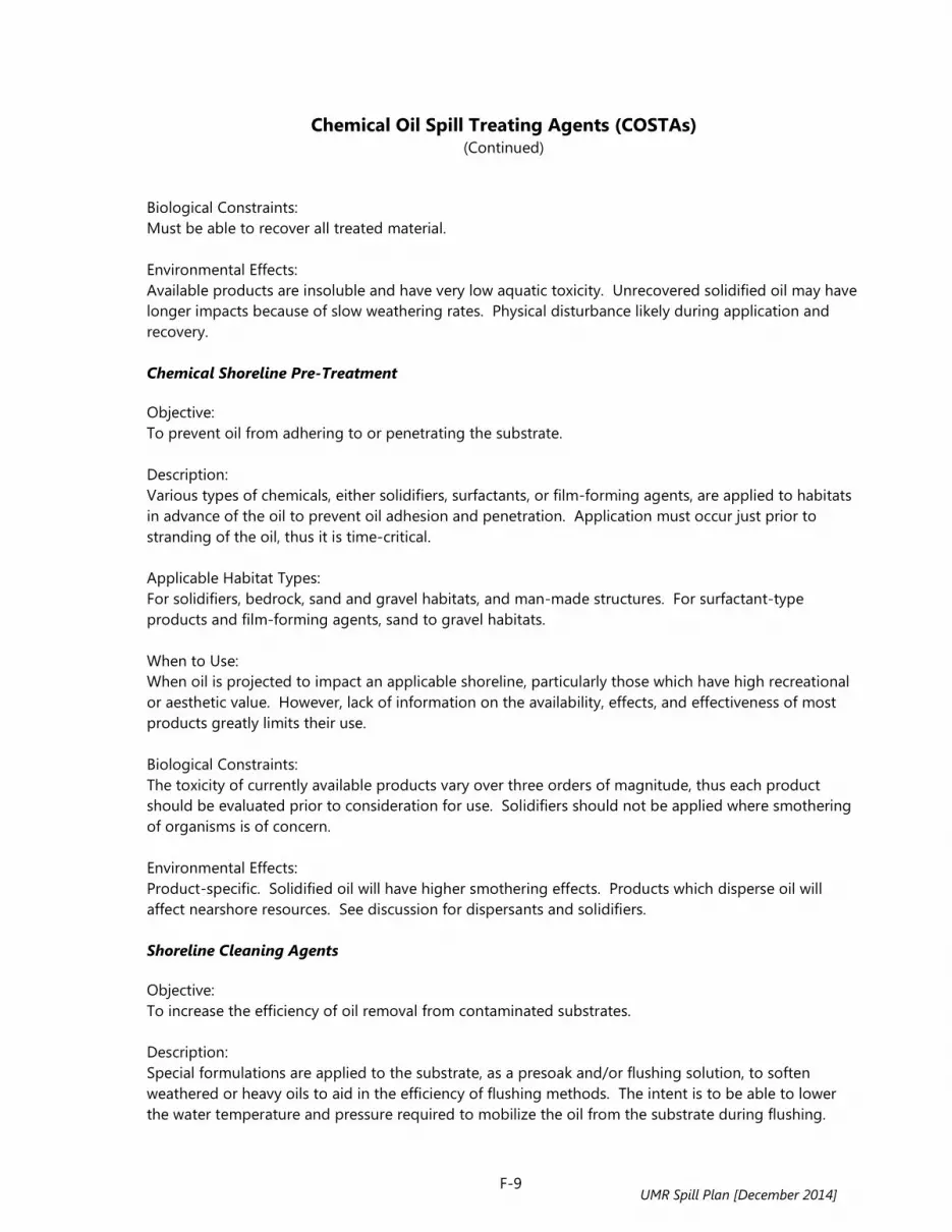
Chemical Oil Spill Treating Agents (COSTAs) (Continued)
F-9
Biological Constraints: Must be able to recover all treated material. Environmental Effects: Available products are insoluble and have very low aquatic toxicity. Unrecovered solidified oil may have longer impacts because of slow weathering rates. Physical disturbance likely during application and recovery. Chemical Shoreline Pre-Treatment Objective: To prevent oil from adhering to or penetrating the substrate. Description: Various types of chemicals, either solidifiers, surfactants, or film-forming agents, are applied to habitats in advance of the oil to prevent oil adhesion and penetration. Application must occur just prior to stranding of the oil, thus it is time-critical. Applicable Habitat Types: For solidifiers, bedrock, sand and gravel habitats, and man-made structures. For surfactant-type products and film-forming agents, sand to gravel habitats. When to Use: When oil is projected to impact an applicable shoreline, particularly those which have high recreational or aesthetic value. However, lack of information on the availability, effects, and effectiveness of most products greatly limits their use. Biological Constraints: The toxicity of currently available products vary over three orders of magnitude, thus each product should be evaluated prior to consideration for use. Solidifiers should not be applied where smothering of organisms is of concern. Environmental Effects: Product-specific. Solidified oil will have higher smothering effects. Products which disperse oil will affect nearshore resources. See discussion for dispersants and solidifiers. Shoreline Cleaning Agents Objective: To increase the efficiency of oil removal from contaminated substrates. Description: Special formulations are applied to the substrate, as a presoak and/or flushing solution, to soften weathered or heavy oils to aid in the efficiency of flushing methods. The intent is to be able to lower the water temperature and pressure required to mobilize the oil from the substrate during flushing.
UMR Spill Plan [December 2014]

Chemical Oil Spill Treating Agents (COSTAs) (Continued)
F-10
Applicable Habitat Types: On any habitat where water flooding and flushing procedures are applicable. When to Use: When the oil has weathered to the point where it will not flow using warm to hot water. This approach may be most applicable where flushing decreases in effectiveness as the oil weathers. Biological Constraints: The released oil should be recoverable rather than dispersed into the water column. Use may be restricted where suspended sediment concentrations are high, adjacent to wetlands, and near sensitive nearshore resources. Environmental Effects: If more oil is dispersed into the water column, there could be more oil sorbed onto suspended sediments and transferred to nearshore habitats, particularly along sheltered shorelines. Nutrient Enrichment Objective: To speed the rates of natural microbial degradation of oil by addition of nutrients (generally nitrogen and phosphorus). Description: Nutrients are applied to the habitat in one of several methods: soluble inorganic formulations which are dissolved in water and applied as a spray, requiring frequent applications; slow-release formulations which are applied as a solid and designed to slowly dissolve; and oleophilic formulations which adhere to the oil itself, thus they are sprayed directly on the oiled areas. Applicable Habitat Types: Could be used on any habitat type where safe access is allowed. When to Use: On moderately to heavily oiled substrates, after other techniques have been used to remove as much oil as possible; on lightly oiled shorelines where other techniques are destructive or not effective; and where nutrients are a limiting factor in natural degradation. Most effective on diesel-type and medium oils that do not have large amounts of high-molecular weight, slowly degrading components. Less effective where oil residues are thick. Not considered for gasoline spills which will be completely removed by evaporation at faster time frames than microbial degradation. Biological Constraints: Not suitable in shallow water or restricted waterbodies where nutrient overloading may lead to eutrophication, or where toxicity of nutrients, particularly ammonia, is of concern. Contact toxicity of oleophilic formulations may restrict areas of direct application. Toxicity tests should be evaluated carefully, as other chemicals in the product could be toxic to aquatic organisms.
UMR Spill Plan [December 2014]

Chemical Oil Spill Treating Agents (COSTAs) (Continued)
F-11
Environmental Effects: Very little information available on effects in freshwater. Natural Microbe Seeding Objective: To speed the rates of microbial degradation of oil by addition of nutrients and microbial products. Description: Formulations containing hydrocarbon-degrading microbes and fertilizers are added to the oiled area. The argument is made that indigenous organisms will be killed by the oil or not able to degrade the oil, so new microbial species need to be added to speed the process of biodegradation. Applicable Habitat Types: Could be used on any habitat type where safe access is allowed. Biological Constraints: Not suitable in shallow water or restricted waterbodies where nutrient overloading may lead to eutrophication, or where toxicity of nutrients, particularly ammonia, is of concern. Toxicity tests should be evaluated carefully, as other chemicals in the product could be toxic to aquatic organisms. Environmental Effects: Very little information available on effects in freshwater. When to Use: On moderately to heavily oiled substrates, after other techniques have been used to remove as much oil as possible; on lightly oiled shorelines where other techniques are destructive or not effective; and where nutrients are a limiting factor in natural degradation. Most effective on diesel-type and medium oils that do not have large amounts of high-molecular weight, slowly degrading components. Less effective where oil residues are thick. Not considered for gasoline spills which will be completely removed by evaporation at faster time frames than degradation.
UMR Spill Plan [December 2014]
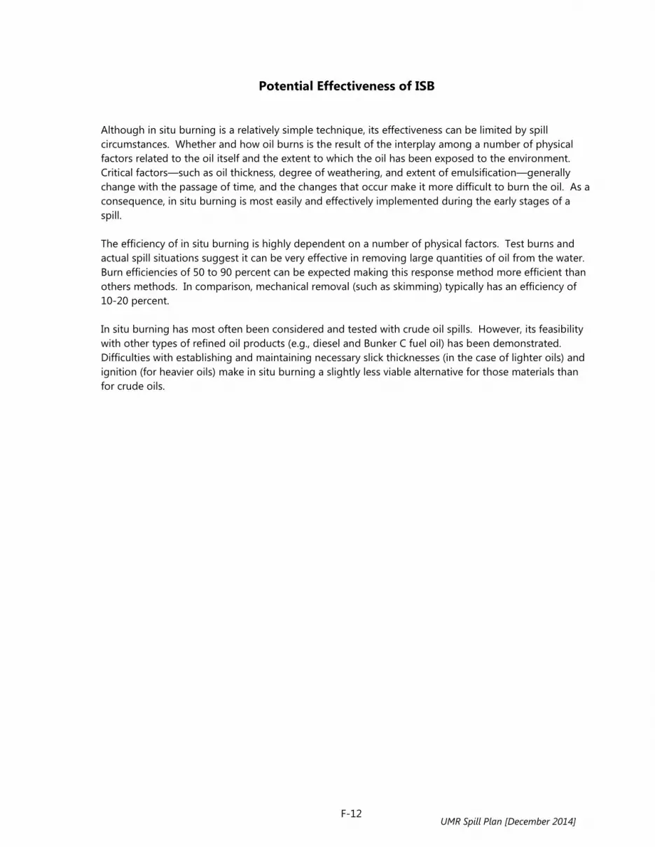
Potential Effectiveness of ISB
F-12
Although in situ burning is a relatively simple technique, its effectiveness can be limited by spill circumstances. Whether and how oil burns is the result of the interplay among a number of physical factors related to the oil itself and the extent to which the oil has been exposed to the environment. Critical factors—such as oil thickness, degree of weathering, and extent of emulsification—generally change with the passage of time, and the changes that occur make it more difficult to burn the oil. As a consequence, in situ burning is most easily and effectively implemented during the early stages of a spill. The efficiency of in situ burning is highly dependent on a number of physical factors. Test burns and actual spill situations suggest it can be very effective in removing large quantities of oil from the water. Burn efficiencies of 50 to 90 percent can be expected making this response method more efficient than others methods. In comparison, mechanical removal (such as skimming) typically has an efficiency of 10-20 percent. In situ burning has most often been considered and tested with crude oil spills. However, its feasibility with other types of refined oil products (e.g., diesel and Bunker C fuel oil) has been demonstrated. Difficulties with establishing and maintaining necessary slick thicknesses (in the case of lighter oils) and ignition (for heavier oils) make in situ burning a slightly less viable alternative for those materials than for crude oils.
UMR Spill Plan [December 2014]

ISB Relationship to Other Countermeasures and Potential Environmental Tradeoffs
F-13
Relationship to Mechanical and Other Response Methods Spill prevention is the first line of defense in spill response planning, however, acceptance of the probability that a spill can and will occur is essential to successful preparedness. Burning will be considered as a possible response option only when mechanical containment and recovery response methods are incapable of controlling the spill alone. While physical containment and mechanical removal of spilled oil is the primary objective of any response, prudent planning dictates the consideration of alternative countermeasures. Summary of Potential Tradeoffs Relevant to ISB As is the case with all response methods, the environmental tradeoffs associated with in situ burning are situation dependent and cannot be considered independently from operational tradeoffs. In situ burning can offer important advantages over other response methods in specific cases, and may not be advisable in others depending on the overall mix of circumstances. Advantages • In certain areas where other techniques may not be possible or advisable due to the physical
environment (e.g., ice conditions or wetlands) or the remoteness of the region, burning may represent one of the few viable response choices besides no action.
• In situ burning may prevent or significantly reduce the extent of shoreline impacts, including exposure of sensitive biological resources, wildlife habitats, and the oiling of high value recreational or commercial beaches.
• The magnitude of a spill may overwhelm the containment and storage equipment deployed or available for a region, necessitating the consideration of other methods in an overall response strategy.
• Burning can rapidly remove a large volume of oil from the surface of the water, reducing the magnitude of subsequent environmental impacts of stranded oil.
Disadvantages • Large quantities of highly visible black smoke is generated that may adversely affect human and
other exposed populations downwind. • There may be the potential for mortalities and other adverse biological impacts from localized
temperature elevations at the water surface. Although this would be expected to occur in a relatively small area, in specific bodies of water at specific times of the year, affected populations may be large enough or important enough to represent reasons for not considering burning as a cleanup technique. Adverse impacts from temperature elevation should be considered relative to the toxic effects of the spill if burning is not employed.
• The longer-term effects of burn residues on exposed biological populations has not been investigated. It is not known whether these materials represent a significant source of toxicity.
• In situ burning must be carefully controlled in order to maintain worker safety and to prevent unintended environmental impacts.
• There is a relatively short window of opportunity to use burning after a spill occurs prior to the oil weathering and losing its flammable characteristics.
UMR Spill Plan [December 2014]

Proposed Guidelines for ISB in Marshes
F-14
Based on the available data on effectiveness and effects of burning on oiled marshes, the following guidelines are proposed: • Make sure that it is possible to contain and control the fire; it is not as easy to put out a fire in
vegetation as it is with oil contained in a fireproof boom. • Impacts to below ground vegetation are likely to be lower if there is a water layer between the oil
and the substrate. • A standing water layer of just a few inches may get hot enough to kill shallow roots anyway,
however, little information is available regarding this effect. • Burning of oiled woody wetland vegetation (compared to grasses and sedges) should not be
considered. • Not enough is known about seasonal effects on the ability of burned, oiled vegetation to recover,
yet burning in late fall to early spring, when the vegetation is dormant and before production of new growth seems to be the best time.
• If it can be done with minimal impacts, heavy accumulations of oil should be removed using other methods, to reduce the amount of burn residues which may cause long-term impacts to both vegetation and animals returning to the habitat.
• Light fuels oils and crudes burn more efficiently and generate less residues, which should reduce the potential for long-term impacts.
• Burning of oil trapped in ice appears to have the least environmental impacts because the burn area is contained, the plants are dormant, and the above-ground vegetation is dead.
• There is some concern that burning of muddy substrates could alter their physical properties (i.e., make them hard) thus degrading their biological productivity.
• Every wetland is different in terms of the type of wetland, the species growing there, the condition (optimal or marginal for species use), and the known or estimated tolerances of that type of system to physical and chemical disturbances. Biologists or botanists should be consulted prior to the use of burning as a cleanup technique in a wetland.
• Mechanical or manual alternatives to in situ burning may compact oil into sediments, where it persists longer. Therefore, the relative damages from different response options should be weighed carefully.
ISB in Wetland Habitats There are few studies on the relative effects of burning oiled wetlands compared to other techniques or natural recovery and most of the experience is derived from estuarine habitats. However, in situ burning in wetlands can be effective since it can remove a large quantity of oil with a minimum of physical disturbance. The type of wetland vegetation and the season of the year along with many other factors will dictate whether burning is feasible in a particular wetland. Refuge managers have historically conducted prescribed burns of wetlands to rejuvenate wetlands that have accumulated high litter loads, generate green vegetation or open spaces to attract wildlife, release nutrients for re-cycling, and to restore habitats in areas that were historically subject to frequent wildfires to their natural conditions. The presence of oil in a wetland may have two important effects: the high BTU of the oil may increase the temperature and heat penetration of the burn, and there is often an oil residue which can cause toxicity. However, the experiences of fire ecologists and practitioners can greatly contribute to the development of guidelines for burning wetlands as a spill-response strategy.
UMR Spill Plan [December 2014]

Proposed Guidelines for ISB in Marshes (Continued)
F-15
Guidance is being developed for specific types of wetlands such as: • Wooded swamps • Fresh-to-brackish impoundment marshes • Great Lakes coastal marshes • Upper Mississippi River marshes (lock and dam pools) • Riparian wetlands • Inland freshwater marshes • Potholes
For now, based on discussions with refuge staff with fire management duties, the following general considerations for use were developed:
Pros • Where access is limited or mechanical/manual removal has the potential to cause more damage by
equipment and trampling, burning can rapidly remove oil from sensitive areas. • It provides a response option when no others are acceptable, or where likely oil residues will be
unacceptably high with other options, including natural recovery. • It rapidly removes oil from the habitat when there is a time-critical element, such as a short-term
change in the physical conditions which will likely cause loss of containment and further spreading, or a seasonal increase in wildlife use, such as arrival of large numbers of migratory waterfowl.
Cons • Burning can cause substantial initial plant damage because the above-ground vegetation is
removed. • Burning can cause long-term impacts to vegetation, especially if the fire is so hot that the below-
ground plant parts are killed. • There is a potential for burning to increase oil penetration into the substrate, when there is no
standing water. • Any animals present and unable to escape (such as gastropods on clean vegetation above the
oiled area) will be killed.
UMR Spill Plan [December 2014]

Air Monitoring Guidelines for Human Health Impacts of ISB
F-16
In situ burning may affect two groups of people: the workers conducting the burn (the responders), a fairly homogeneous group of young, healthy adults, and the general public, which is much more heterogeneous and includes individuals who are more susceptible to toxic agents. The basic premises and possible monitoring options for each group are discussed below. Monitoring for Responders The responders, i.e., the workers assigned to conduct the in situ burn, are likely to be healthy and physically fit adults. Responders' locations will vary with the nature of the burn and the stage at which it is conducted. Most of the time they are expected to be upwind of the slick and the smoke plume. However, at times they may be downwind of the evaporating slick and therefore be exposed to volatile organic compound (VOCs). Responding crews may also be downwind and near the burning oil where they can be exposed to combustion products. Responders may be exposed to VOCs from the evaporating slick, similar to what is expected during skimming operations, and to combustion by-products from the burning oil: carbon dioxide, carbon monoxide, nitrogen dioxide, sulfur dioxide, particulates, and other combustion products. Air concentration of those substances depends on many variables, and we can expect substantial variability. Responders may be exposed to levels of gases and particulates above the permissible occupational exposure limits, and should therefore be provided with personal protective equipment and be trained in its proper use. In reality, responders' exposure is likely to be intermittent, and will vary greatly depending on location, weather conditions, and assigned tasks. Overall exposure duration is expected to vary from minutes to several hours. Sampling Purpose Sampling the responders' exposure level should serve several purposes, among them: • Characterize exposures and hazards associated with the operation to provide better protection; • Compliance with OSHA requirements, per 29 CFR 1910.134 b.(8)1 and 29 CFR 1910.120.q.3.(ii)2; • Data collection for scientific purposes.
Air sampling should not substitute for workers' protection and safe work practices. Responders should be protected from overexposure regardless of monitoring and air sampling. Exposure Limit Exposure limits for responding personnel should be based on occupational exposure guidelines (see Table 1) such as OSHA's Permissible Exposure Limits (PEL) or applicable State standards. Exposure to the general public should not exceed the National Ambient Air Quality Standards (NAAQS).
1 Regulations concerning respiratory protection 2 Regulations concerning Hazardous Waste Operations and Emergency Response (HAZWOPER)
UMR Spill Plan [December 2014]
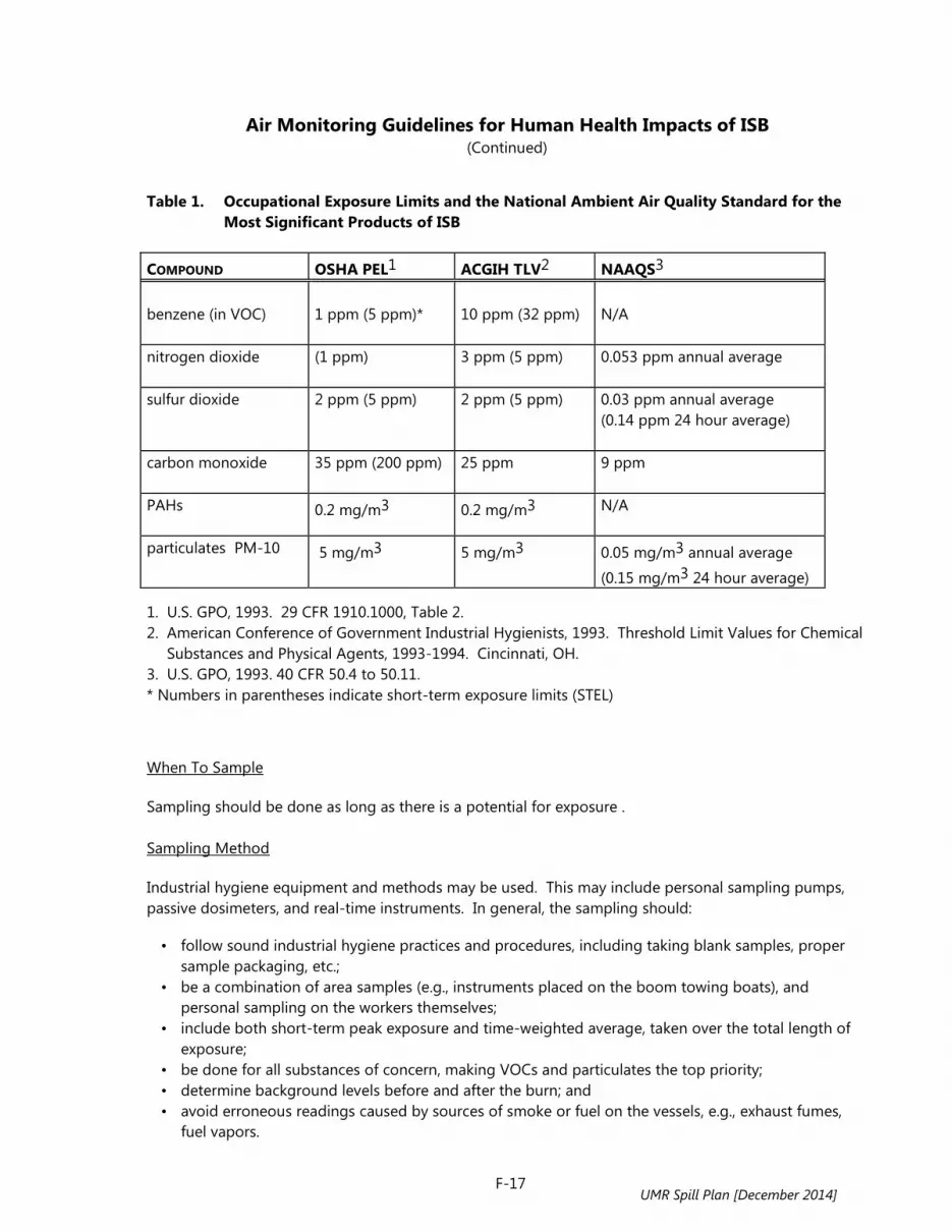
Air Monitoring Guidelines for Human Health Impacts of ISB (Continued)
F-17
Table 1. Occupational Exposure Limits and the National Ambient Air Quality Standard for the Most Significant Products of ISB
COMPOUND OSHA PEL1 ACGIH TLV2 NAAQS3 benzene (in VOC)
1 ppm (5 ppm)*
10 ppm (32 ppm)
N/A
nitrogen dioxide
(1 ppm) 3 ppm (5 ppm) 0.053 ppm annual average
sulfur dioxide
2 ppm (5 ppm) 2 ppm (5 ppm) 0.03 ppm annual average (0.14 ppm 24 hour average)
carbon monoxide
35 ppm (200 ppm) 25 ppm 9 ppm
PAHs
0.2 mg/m3 0.2 mg/m3 N/A
particulates PM-10
5 mg/m3 5 mg/m3 0.05 mg/m3 annual average
(0.15 mg/m3 24 hour average)
1. U.S. GPO, 1993. 29 CFR 1910.1000, Table 2. 2. American Conference of Government Industrial Hygienists, 1993. Threshold Limit Values for Chemical
Substances and Physical Agents, 1993-1994. Cincinnati, OH. 3. U.S. GPO, 1993. 40 CFR 50.4 to 50.11. * Numbers in parentheses indicate short-term exposure limits (STEL)
When To Sample Sampling should be done as long as there is a potential for exposure . Sampling Method Industrial hygiene equipment and methods may be used. This may include personal sampling pumps, passive dosimeters, and real-time instruments. In general, the sampling should: • follow sound industrial hygiene practices and procedures, including taking blank samples, proper
sample packaging, etc.; • be a combination of area samples (e.g., instruments placed on the boom towing boats), and
personal sampling on the workers themselves; • include both short-term peak exposure and time-weighted average, taken over the total length of
exposure; • be done for all substances of concern, making VOCs and particulates the top priority; • determine background levels before and after the burn; and • avoid erroneous readings caused by sources of smoke or fuel on the vessels, e.g., exhaust fumes,
fuel vapors.
UMR Spill Plan [December 2014]

Air Monitoring Guidelines for Human Health Impacts of ISB (Continued)
F-18
Protection Responders should use safe operating procedures such as staying upwind of the burn and the slick as much as possible and keeping safe distances from the fire. Responders should use respiratory protection and protective clothing as needed. It should be emphasized that safety risks such as heat and cold stress, falling overboard, or vessel collisions are just as real as chemical exposure, and more acutely dangerous. Responders should receive safety training that should include description of the hazards involved, precautions to be taken, and proper use of the safety equipment. Monitoring for General Public The general public usually includes people of all ages. It also includes individuals with allergies and with respiratory, cardiovascular, and other diseases. The vulnerability of these individuals to combustion by-products may be much greater than that of the responders. The distance between the general public and the burning site may vary greatly, depending on the specifics of the burn. The operational guidelines suggest six miles when the wind blows toward shore. However, burns may be conducted closer than six miles if conditions permit. Similarly, a burn may be inappropriate at six miles or a greater distance, if conditions are unfavorable. Several miles downwind of the burn, levels of vapors evaporating from the slick and gaseous by-products form the fire are expected to be near background levels. Particulate level is the main concern. Based on data from experimental burns and from computer models, the level of particulates in the center of the
plume three miles downwind of the burn is expected to be around 150 µg/m3 (McGrattan et al. 1993). If the burning is conducted according to the operational guidelines suggested above, PM-10 levels six
miles away from the burn should be significantly lower than 150 µg/m3 in the center of the plume, and much lower than that at ground level. Concentrations at any one location will depend on specific atmospheric conditions at the time of the burn. Visual Observations Visual observations should be conducted to track plume direction and height, and to verify that the smoke behaves as predicted by the weather reports. Observations from ships and aircraft should continue as long as the burning takes place. Monitoring Considerations In situ burn is a relatively new response technique. There are legitimate concerns about exposure to the smoke plume by the general public and environment. In order to make decisions concerning the continuation of an in situ burn, it is advisable to collect information concerning concentrations of smoke particulates of 10 µm (PM-10) or less. Monitoring should be established when there is reason to believe that the weather conditions and/or location of the burn could produce a situation in which the general public or sensitive environments could be affected by fallout from the smoke plume. Depending on circumstances, the burn may be monitored by qualitative assessment (i.e., visual observation) and/or by quantitative methods that employ air sampling.
UMR Spill Plan [December 2014]

Air Monitoring Guidelines for Human Health Impacts of ISB (Continued)
F-19
Exposure Limits Exposure limits for the general public should be based on the National Ambient Air Quality Standards, which is used by EPA for air quality control. The standard for respirable particulates 10 µm in diameter and smaller (PM-10) is shown in Table 1. To err on the side of safety, this Upper Mississippi River policy
adopts an action level of a 150 µg/m3 average over one hour. Concentrations above this level should result in operational measures to control the rate of burn/smoke formation. Sampling Limitations In general, air sampling should not be regarded as a requirement for conducting in situ burning but as an option if the situation warrants. Sampling should not be used as the means to determine whether the public is adequately protected: the public should be protected regardless of air sampling. We believe that such protection may be achieved by adhering to operational guidelines. Sampling, however, may be valuable by providing feedback information to the OSC, by increasing the comfort level of both those conducting the burn and those potentially exposed to it, and by collecting data that may be of value for future in situ burning. Trends are more important than a single number. The readings of a real time particulate monitor may fluctuate widely, depending on nearby activity such as passing cars or smoke from fireplaces in nearby houses. A single reading may be misleading. Averaging the concentration readings over a period of time (e.g., 15 minutes) should provide an indication of the trend, that is, whether particulates concentration goes up or remains steady. Visual observations coupled with sampling that could provide the general trend of particulate concentration should be useful in ascertaining the effect of the burn on exposure of the general population to particulates. It is also important to state clearly the limitations and shortcomings of sampling data. These data should be interpreted correctly, and the numbers should be presented with the associated uncertainty and possible interferences and inaccuracies. Otherwise, the numbers may not mean much or, worse yet, be misleading. Sampling Sampling may be conducted for several reasons: 1. To assess exposure levels at different points, in order to provide immediate feed back to the OSC,
and to verify visual observations of plume behavior. 2. Validation of air dispersion models 3. To satisfy other scientific or historical data collection needs Based on previous experience, the concentration of gases in the plume would drop to below the exposure limit within several hundred yards of the burn. Particulate concentration in the center of the plume may remain above the level of concern for several miles downwind. Sampling of particulates should therefore be the main effort. When To Sample Sampling is an option that may be exercised anytime during the burn. It may be desirable when there is a potential for exposure (even if it is expected to be below the limit). Therefore, sampling may be done
UMR Spill Plan [December 2014]

Air Monitoring Guidelines for Human Health Impacts of ISB (Continued)
F-20
when the plume drifts over a populated area, over natural resources, or for scientific data collection, at various locations downwind of the burning site. Since the purpose of this sampling is to monitor in situ burning effects on sensitive populations, there is no need to require it when there is no reason to believe that a sensitive population will be affected. If the smoke plume is expected to be carried away from population centers or sensitive areas, sampling should not be required. Sampling Equipment Sampling equipment should be: • Portable, easily deployable, and available when needed; • Sensitive, accurate, and precise enough to provide meaningful data; • If possible, provide real-time readings for immediate feedback and, in addition, have the capability
to log readings over several hours, to get the average concentration over an extended period of time.
Real-time particulate samplers are commercially available from several manufacturers. In addition, sampling pumps using filter media may be deployed at various locations. Their data, which is not real time, may be used for exposure assessment, model validation, and to provide information for future in situ burning. Recommended Air Monitoring Equipment for ISB The primary health concern for in situ burning is the evolution of particulates from the burning of crude oil, fuel products or other hydrocarbons. Secondly, within the first several hours of the burn, the generation of volatile organic compounds (VOCs) and polynuclear aromatic hydrocarbon's (PAHs) vapors could be additional health and safety concerns in the immediate area. Air monitoring is an important tool in communicating risks involved to the public at an emergency response. If it is determined that a burn will be conducted and there is risk of exposure to a human population center, then air monitoring should be completed (see pages 16 to 19). The Responsible Party (RP) may conduct air monitoring in conjunction with a burn, either independently or with government oversight. The air monitoring results should be immediately reviewed and assessed to determine the effectiveness of the burn and to address any public health concerns. The U.S. EPA Region 5 and Region 7 Emergency Response Branches and their contractors, along with the U.S. EPA Environmental Response Team (ERT) and United States Coast Guard Strike Teams, are often called in emergencies to conduct perimeter and on site air monitoring. The U.S. EPA regional offices maintain a 24 hour readiness along with contractor support to provide air monitoring equipment at an emergency response. Equipment arrival time would depend on the mobilization time to the scene from the Regional Office. For a spill on the upper Mississippi this would translate to 3 to 10 hours. The Federal On-Scene Coordinator (FOSC) can mobilize additional air monitoring resources from the ERT or from the USCG Strike Teams. The State Emergency Response Coordinator, or local HAZMAT team, can also mobilize air monitoring resources during an emergency. The ERT in Edison, New Jersey, is on call 24 hours and is equipped and specialized in supporting OSC's in conducting air monitoring. The ERT can mobilize to the site within 12 to 24 hours after being notified
UMR Spill Plan [December 2014]

Air Monitoring Guidelines for Human Health Impacts of ISB (Continued)
F-21
by a FOSC to support air monitoring activities. The United States Coast Guard maintains the Strike Teams to provide assistance to the OSC during an emergency. The Strike Teams are equipped and trained to provide air monitoring, safety monitoring, and other assistance to the OSC as needed. The Strike Teams can mobilize to the site in 12- 24 hours to provide air monitoring assistance. During an incident when in situ burning is being evaluated, and humans could be exposed to the smoke plume, it is recommended that the Incident Commanders plan to have air monitoring set up prior to and during the burn event. The U.S. EPA and its contractors would immediately mobilize staff and equipment to monitor for particulates using Real Time Aerosol Monitors (RAMs). In addition, carbon monoxide, carbon dioxide, and VOCs can be monitored directly at the burn location. The U.S. EPA Region 5 and 7 offices and their contractors maintain air monitoring equipment to support these operations. It is recommended that direct reading instrumentation be used to monitor the effectiveness and potential health concerns during a burn. The data should be evaluated, assessed and communicated to the workers and to the public as soon as the results become available. The Real-Time Aerosol Monitors (RAMS), Mini Real-Time Aerosol Monitors (Mini-RAMS), or equivalents, serve as valuable tools to access the particulates in a plume which could impact humans during an in situ burn. The current guidelines for safe levels of particulates are a PM-10 (particulate matter less than 10 microns) concentration of less than 150 micrograms per cubic meter. The proposed Clean Air Act Amendments may change the PM-10 standard. The RAM and Mini-RAM instruments will directly read a measure of the total particulate in milligrams per cubic meter and give real time data for monitoring the particulates in air. The instruments can be used to screen residential areas during an in situ burn so that particulate concentrations can be monitored and the risk to the public and on-site workers may be assessed. The RAMS and Mini-RAMS have been used successfully at tire fires, train derailments involving flaring of hydrocarbons, and other chemical fires where an observable plume is seen. In addition to the above instruments, the U.S. EPA would mobilize a photo ionization detector, explosimeter, and a portable gas chromatograph to monitor volatile emissions directly at the source of the burn. The U.S. EPA maintains portable gas chromatographs, colorimetric tubes, and fixed sampling pumps, to monitor volatile emissions, PAHs, particulates, carbon monoxide and carbon dioxide during an in situ burn. The air monitoring equipment described in the following table can be mobilized to an emergency by calling the U.S. EPA Regional Office or the National Response Center. U.S. EPA Region 5 (24 hour Spill line) 312-353-2318 ( Minnesota, Wisconsin, Illinois) U.S. EPA Region 7 (24 hour Spill Line) 913-281-0991 (Iowa and Missouri) National Response Center 800-424-8802 (Manned by USCG can tie into USEPA regional Office or USCG Office)
UMR Spill Plan [December 2014]

Air Monitoring Guidelines for Human Health Impacts of ISB (Continued)
F-22
The State Emergency Response Section or Local HAZMAT team can also mobilize air monitoring equipment to the scene. Both can be contacted through the State Emergency Response telephone numbers found in the Notification Section of the UMR Spill Plan (see pages 6-7). Another resource for air monitoring equipment can be vendors, such as industrial hygiene subcontractors, who rent air monitoring equipment. These vendors can make equipment available within 24 hours of an incident. The NOAA Scientific Support Team can also provide air monitoring resources from its field office at Louisiana State University. This resource can be activated through the NOAA Scientific Support Coordinator for the Great Lakes and Inland Rivers in Cleveland, Ohio. The purchase price of the mini-RAM is $1,400 and the RAM is $6,700. Table 2 shows the current inventory of air monitoring capabilities for in situ burning in U.S. EPA Regions 5 and 7.
UMR Spill Plan [December 2014]
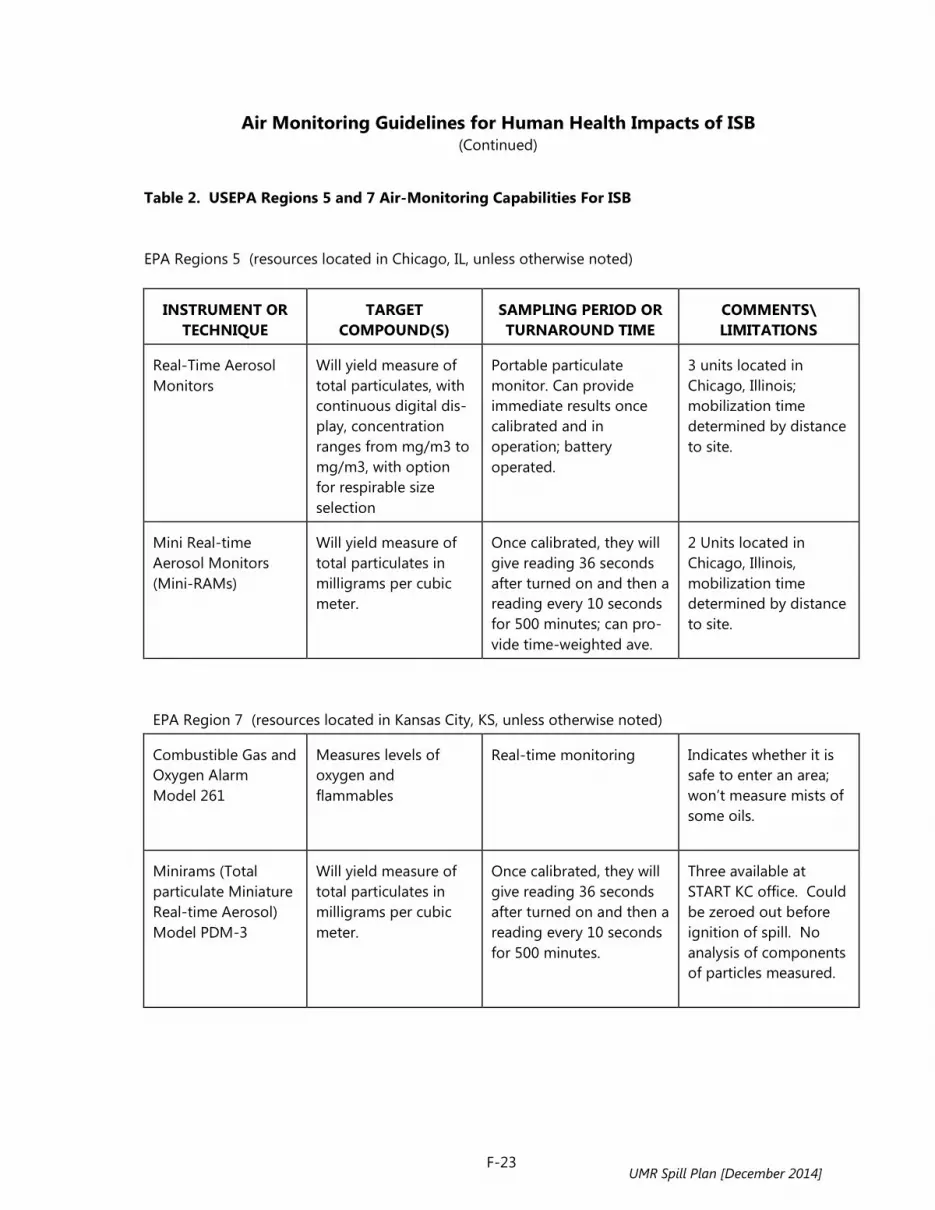
Air Monitoring Guidelines for Human Health Impacts of ISB (Continued)
F-23
Table 2. USEPA Regions 5 and 7 Air-Monitoring Capabilities For ISB
EPA Regions 5 (resources located in Chicago, IL, unless otherwise noted)
INSTRUMENT OR
TECHNIQUE
TARGET
COMPOUND(S)
SAMPLING PERIOD OR TURNAROUND TIME
COMMENTS\ LIMITATIONS
Real-Time Aerosol Monitors
Will yield measure of total particulates, with continuous digital dis- play, concentration ranges from mg/m3 to mg/m3, with option for respirable size selection
Portable particulate monitor. Can provide immediate results once calibrated and in operation; battery operated.
3 units located in Chicago, Illinois; mobilization time determined by distance to site.
Mini Real-time Aerosol Monitors (Mini-RAMs)
Will yield measure of total particulates in milligrams per cubic meter.
Once calibrated, they will give reading 36 seconds after turned on and then a reading every 10 seconds for 500 minutes; can pro-vide time-weighted ave.
2 Units located in Chicago, Illinois, mobilization time determined by distance to site.
EPA Region 7 (resources located in Kansas City, KS, unless otherwise noted) Combustible Gas and Oxygen Alarm Model 261
Measures levels of oxygen and flammables
Real-time monitoring
Indicates whether it is safe to enter an area; won’t measure mists of some oils.
Minirams (Total particulate Miniature Real-time Aerosol) Model PDM-3
Will yield measure of total particulates in milligrams per cubic meter.
Once calibrated, they will give reading 36 seconds after turned on and then a reading every 10 seconds for 500 minutes.
Three available at START KC office. Could be zeroed out before ignition of spill. No analysis of components of particles measured.
UMR Spill Plan [December 2014]

Air Monitoring Guidelines for Human Health Impacts of ISB (Continued)
F-24
Table 2 continued
INSTRUMENT OR
TECHNIQUE
TARGET
COMPOUND(S)
SAMPLING PERIOD OR TURNAROUND TIME
COMMENTS\ LIMITATIONS
Gilian Personal Sampling Pumps HFS Air Sampling Systems
Capable of sampling for wide range of compounds, including PAHs.
Sample duration of at least 4 hours necessary, longer for some compounds.
START has access to 15 and there are 15 at EPA Region 7. A realistic startup is 48 hours after notice, because of need for charging and calibrat- ion, and purchase of unique sampling trains, which include absor- bent tubes, cassettes, filters and microimpinger traps.
Draeger Tubes
Region has tubes for H2S, CO, CO2, TPHs, SO2, benzene, toluene and xylenes. No PAH tube on market.
Real-time results that are quasi-quantitative.
Almost instantaneous results. EPA also has Sensidyne kits, which will give similar results.
OVAs
Provides concentrations of unidentified total volatiles.
Gives real-time results of total volatiles.
3 OVAs in KC START office, 2 in St. Louis; it does not provide chemical-specific results
HNu
Provides analysis of total volatiles present; some limitations in reading, compounds depending on span in photo-ionization detection (PID) lamp.
Gives real-time results of total volatiles.
3 Hnu’s in KC START office, 2 in St. Louis; use limited in wet conditions; soot during burn would likely coat lamp, making it unusable. No chemical-specific results.
UMR Spill Plan [December 2014]

Air Monitoring Guidelines for Human Health Impacts of ISB (Continued)
F-25
Table 2 continued
INSTRUMENT OR
TECHNIQUE
TARGET
COMPOUND(S)
SAMPLING PERIOD OR TURNAROUND TIME
COMMENTS\ LIMITATIONS
TVA-1000
Analysis of total volatiles, with both flame ionization detector and photo-ionization detector.
Gives real-time results of total volatiles. Can be set for 8-hour exposure mode.
2 Available in KC START office; lamp of PID less exposed to moisture and soot, so of a little more use than Hnu.
Monitox
Designed for confined space, rather than ambient sampling. Only H2S and HCN available.
Designed to show whether threshold levels of gases exist.
2 of each in KC START office.
Polyurethane foam (PUF) samplers
Could be used to collect volatile and semivolatile samples; use on PAHs in region been very limited.
Sampling durations of several hours -- up to 3 days -- are standard.
Eight are regularly available in Kansas City, but more are available from other regions. Require power source.
PM-10 Air Samplers
Will measure particles of <10 microns.
Sampling durations of several hours are required.
Require power source; is a radioactive element involved.
Single Point Monitor from MDA Scientific
Inorganics, including ammonia, hydrogen cyanide and sulphuric acid
The SPM is designed to work with specific key, and cassette, which must be kept frozen. They are not kept on hand by START. Acquisition time would be 48 hours.
The setup time and limitation of sampling to such analytes as cyanides, acids and amines makes its use during any in situ burn response unlikely.
UMR Spill Plan [December 2014]

Air Monitoring Guidelines for Human Health Impacts of ISB (Continued)
F-26
Table 2 continued
INSTRUMENT OR
TECHNIQUE
TARGET
COMPOUND(S)
SAMPLING PERIOD OR TURNAROUND TIME
COMMENTS\ LIMITATIONS
Summa Canisters
Summas can be used to collect a wide range of volatile compounds, but they do not lend themselves to collection of semi-volatiles, particularly PAHS, which stick to the inside of the canister.
Sampling periods vary from minutes to several hours. 24-hour analytical turnarounds are possible.
Real-time applications must be tied to presence of Mobile Laboratory or use of portable GC, such as Photovac. Not applicable to nonvolatiles.
Portable Gas Chromatograph, Photovac
Volatile Compounds
Estimated 2-3 hours after arrival at spill.
The Photovac has been used primarily to analyze head space samples from soil in the region. It has the potential to analyze air samples collected in Summa canisters, but it is necessary to extract samples collected from Summas. It does not lend itself to analysis of semi-VOCs.
EPA Mobile Lab
Can measure volatiles from samples collected from air, water or soil.
Will ultimately be capable of prompt turn- around of field samples collected in Summas or soil-gas bottles. The Lab is currently being retrofitted and updated.
Mobile Lab must be driven to spill site; it will require four ad- ditional hours to calibrate equipment. Some extractions will require 24-48 hours. Could be used for samples containing VOCs, semi-VOCs, PCBs and PAHs.
UMR Spill Plan [December 2014]

Air Monitoring Guidelines for Human Health Impacts of ISB (Continued)
F-27
Sampling Location Sampling location should be based on priority concerns, with the first priority given to population centers downwind of the burn. For scientific data collection, (e.g., model validation) we recommend that samplers be placed at different distances from the burn to collect particulate concentration data at ground level. Data collected would be extremely valuable for future burns. If it is determined that sampling is needed, real-time particulate samplers (PM-10) should be positioned on: 1) the shoreline, at the expected centerline of the plume; 2) at the population center of concern; and 3) in several locations in the vicinity of the population downwind of the burn. PM-10 samplers which can operate for more than eight hours, can collect PM-10 reading before the burn commences, (to gather background data during the burn), during the actual burn, to assess the burn effect; and, if possible, after the burn is over, to collect post-burn readings. Sampling results should be relayed to the FOSC. If it is established that the readings exceed the level of concern, the FOSC will be so advised. Other Sampling Considerations 1. Area background readings should be taken before and after the burn to determine baseline levels. 2. EPA and regional air monitoring stations may be able to assist by providing historical data, and by
conducting air sampling during the burn itself.
UMR Spill Plan [December 2014]

Public Notification for ISB
F-28
Notification of the public of an impending burn is critical to the overall success of an in situ burn effort. The notification, coordinated through the joint information center, should focus on conveying the following messages: • Burning is a simple, well understood, and controlled practice. • Strict health and environmental criteria are being used in deciding whether or not to burn. • Burning is being conducted because it presents the opportunity for greater health and
environmental protection than could be achieved by other spill response methods or no response. • Health and environmental precautions will accompany burning. • The burns will be carried out by specially trained personnel and will be closely monitored. • The public will be notified of each burn before or as it begins.
Public notification can be initiated through radio/TV broadcasts, and broadcasts to mariners. If necessary, local government and state emergency service personnel with access to established public warning systems and authority to use them can facilitate this notification. Materials to educate the public and media about burning, its risks, tradeoffs with other countermeasures should be developed ahead of time and available for dissemination during the burn. This material would cover the trade-offs involved in choosing response countermeasures, and relate the risks of in situ burning to better known risks (i.e. forest fires). Distribution of this information can be through the agencies’ public affairs offices prior to a spill and through a joint information center established during a spill. Suggested Public Notice for ISB At (time) on (date), a release of oil occurred at (location). Following an evaluation of the situation, local, state, and federal officials have determined that burning the oil in place is the safest and most effective way to protect the public health and environment. The burn will be conducted under controlled conditions to ensure that the fire will not threaten the public, property, or environment. The decision to burn was made after considering strict health and environmental criteria. Officials have determined that the burning will present an opportunity for greater health and environmental protection than can be achieved by using other spill response methods, including not responding. Health and environmental precautions will accompany the burning. The burns will be carried out by specially trained personnel and will be closely monitored. The burn will begin at approximately (time), and the public will be advised when the burn is complete. Questions should be directed to (person or organization) at (telephone number).
UMR Spill Plan [December 2014]

Ecological Considerations for ISB
F-29
Open Water ISB Potential ecological impacts of open water in situ burning have not been extensively discussed or studied. Conclusions are based on documented physical effects observed in the laboratory and at limited test burns. The surface area affected by in situ burning is likely to be small relative to the total surface area and depth of a given body of water. This does not necessarily preclude adverse ecological impacts, particularly if rare or sensitive species use the waters in question. Organisms that may be affected by in situ burning include those that use the uppermost layers of the water column, those that might come into contact with residual material, and possibly some benthic (bottom-dwelling) plants and animals. Direct Temperature Effects Burning oil on the surface of the water could adversely affect those organisms at or near the interface between oil and water, although the area affected would presumably be relatively small. Observations during large-scale burns using towed containment boom did not indicate a temperature impact on surface waters. Thermocouple probes known to be in the water during the Newfoundland burn showed no increase in water temperatures during the burn (NOBE Facts, January 1994). It appears that the length of time the burning layer resides over a given water surface may be too brief to change the temperature due to the fact the ambient temperature water is continually being supplied below the oil layer as the boom is towed. Surface Microlayer Role and importance of the surface microlayer - The surface of the water represents a unique ecological niche called the “surface microlayer,” which has been the subject of many recent biological and chemical studies. Although most studies of the microlayer have been conducted in the marine environment, the results can also be applied to the freshwater environment. The microlayer, variously defined but often considered to be the upper millimeter or less of the water surface, is a habitat for many sensitive life stages of aquatic organisms, including eggs and larval stages of fish and crustaceans, and reproductive stages of other plants and animals. The microlayer also is a substrate for microorganisms and, as such, is often an area of elevated microbial population levels and metabolic activity. Potential effects of burning on the surface microlayer - The ecological importance of the surface microlayer and the potential impacts to it from burning activities have been discussed in the different, but related, context of ocean incineration. The Office of Technology Assessment (1986) noted in an evaluation of the technique,
…given the intermittent nature of ocean incineration, the relatively small size of the affected area, and the high renewal rate of the surface microlayer resulting from new growth and replenishment from adjacent areas, the long-term net loss of biomass would probably be small or non-existent.
Despite the obvious differences between shipboard incineration of hazardous wastes and surface burning of spilled oil, the above rationale is applicable to in situ burning. Accordingly, potential impacts to the ecologically important surface microlayer are, to some extent, offset by the presumably short-lived nature of the burn and its associated residual material.
UMR Spill Plan [December 2014]

Ecological Considerations for ISB (Continued)
F-30
Environmental Toxicological Considerations Although many studies to define the physical and chemical characteristics that result from in situ burning have been performed, there has been little research on potential ecological effects. To address some of these information shortfalls, Environment Canada coordinated a series of studies to determine if in situ burning resulted in water column toxicity beyond that attributable to allowing the slick to remain on the surface of the water. While these studies centered on the Newfoundland in situ burn field trials conducted in August, 1993, they also included laboratory tests to investigate potential effects in a more controlled environment. Toxic effects were evaluated using three standard marine test organisms: sand dollar, oyster, and fish. In both the laboratory and the field experiments, sensitive toxic endpoints in these organisms were studied in the three situations of no oil, no burning; oil on water, no burning; and oil on water, burned. Results from the laboratory and field studies indicated that although toxicity increased in water samples collected below burning oil on water, this increase was generally no greater than that caused by the presence of an unburned oil slick on water. Chemical analyses performed in conjunction with the biological tests reflected low hydrocarbon levels in the water samples. In addition to water column samples, the residues remaining after the laboratory and Newfoundland field burns will be subjected to aquatic toxicity testing. Beyond the direct impacts caused by high temperatures, the by-products of in situ burning may be toxicologically significant. Although analysis of water samples collected from the upper 20 cm of the water column immediately following a burn of crude oil yielded relatively low concentrations of total petroleum hydrocarbons (1.5 ppm), compounds that have low water solubility or that associate with floatable particulate material tend to concentrate at the air-water interface (U.S. EPA 1986). Strand and Andren (1980) noted that aromatic hydrocarbons in aerosols originate from combustion associated with human activities, and that these compounds accumulate in the surface microlayer until absorption and sedimentation remove them. Burn residues could be ingested by fish, birds, mammals, and other organisms, and may also be a source for fouling of gills, feathers, and fur. However, these impacts would be expected to be much less severe than those manifested through exposure to a large, uncontained oil spill. Contamination is likely to be local in scale affecting certain unique populations and organisms that use surface layers of the water column at certain times to spawn or feed. In crafting an effective and protective response strategy, these effects should be weighed against effects resulting from alternative actions.
UMR Spill Plan [December 2014]

Safety and Health Considerations and By-Products of ISB
F-31
Safety of Response Personnel The safety of personnel during both ignition and burn phases of large amounts of combustible liquids on the surface of the water presents some unique safety concerns for workers and response personnel. Many of these concerns are addressed in greater detail in operationally oriented references and include, but are not limited to the following:
Fire Hazard - Care must be taken that the burn be controlled at all times to ensure the safety of personnel and property. This precludes burning at sources such as tankers, ships, or tank farms unless means are taken to ensure that the flame cannot propagate from the burn location to the source. Ignition Hazard - Personnel and equipment involved in ignition of the oil slick must be well coordinated. Weather and sea conditions need to be kept in mind and adequate safety distances be kept at all times. Specialized ignition equipment, unknown fire behavior and uncertain flash-points introduce safety risks. Vessel Safety - Burning at sea may involve the use of several vessels operating in close proximity, perhaps at night or in conditions of poor visibility. These conditions are hazardous by nature and generally require training and close coordination. Maneuverability while towing boom or positioning other containment equipment will require skilled personnel. Training - Training of personnel to operate equipment for in situ burning should be developed to minimize the risk of injury and accident. Training should meet all applicable OSHA regulations and guidelines.
Response personnel working in close proximity to the burn may be exposed to levels of gases and particulates that may require the use of personal protective equipment. Training for burn personnel should include proper use of use of personal protective equipment which may be used to minimize inhalation of, and skin contact with, combustion by-products. Exposure limits such as OSHA's PELs (Permissible Exposure Limits) are applicable to this group of typically healthy adults. Other hazards can include the exposure of personnel to extreme heat conditions, smoke and fumes; working under time constraints or extended periods of time. Personnel involved with burning operations must be well briefed on the plan of operations, with safety stressed, and must be notified of all changes from the approved burn plan. The need for burning must be constantly evaluated and should be reconsidered if conditions (e.g., weather, operations, equipment) pose a threat or danger to human health and safety, or facilities. As more knowledge is gained from burning, it is most likely that additional safety concerns will be identified. General Public Health Considerations Burning oil produces a visible smoke plume containing smoke particulates, combustion gases, unburned hydrocarbons, residue left at the burn site and other products of combustion. It also results in the evaporation and release of volatile compounds from the oil. Public health concerns relate to the chemical content of the smoke plume and the downwind deposition of particulates. It should be noted that not burning an oil spill also introduces its own air quality concerns. Analysis of the physical behavior of
UMR Spill Plan [December 2014]

Safety and Health Considerations and By-Products of ISB (Continued)
F-32
spilled oil has shown that 50 percent of a light crude oil spill can evaporate fairly readily, and it is the acutely toxic lighter fractions of a crude oil mix that quickly move into the atmosphere. Results of recent burn tests indicate that in situ burning does not yield significant emissions above that expected for similar types of combustion such as forest fires. Many human health experts feel that the most significant human health risk resulting from in situ burning is inhalation of the fine particulate material that is a major constituent of the smoke produced. An early assessment of health concerns attributable to the Kuwaiti oil fires identified the less than 10-micron particulate matter as representing the greatest health hazard in that situation. The extent to which these particles present a health risk during an in situ burn depends on the concentration and duration of exposure. It is important to remember that particulates in these concentrations are so small that they do not settle readily. They will be carried by the prevailing wind over large distances, over which their concentrations will rapidly decline. Polynuclear aromatic hydrocarbons (PAHs) are a group of hydrocarbons produced during in situ burning. They are found in oil and oil smoke, where their relative concentration in the latter tend to be higher than in the oil itself. Possible carcinogenicity of some members make this group a serious health concern, although it is generally long-term exposure to the higher molecular-weight PAHs that is the basis for concern. Sulfur dioxide (SO2) and nitrogen dioxide (NO2) are eye- and respiratory tract irritants that are produced by oil combustion. Concentrations of PAHs decline downwind as smoke from the fire is diluted by clean air. The concentrations of other by-products of burning oil (i.e., combustible gases) also decline downwind. Burning should not be allowed if downwind human populations are at risk. The downwind extent of human risk has not been empirically determined although it is an area of very active research. There are no exposure standards for respirable particles generated by a burn that could be applied directly to determine safe downwind distances. Atmospheric dispersion models, if available for the specific area, could be utilized to help refine potential downwind exposures. If models are not available, whenever possible, a small pilot burn could be conducted before a larger burn in order to gauge the effectiveness of the ambient conditions to disperse the smoke and gasses resultant from the burned material. Because wind direction meanders under most circumstances, no population should be within a 45° arc to either side of the wind direction. Local wind and weather events (e.g., air stability class, lake breezes, and frontal passages) must be considered when determining downwind directions. By-products By-products of in situ burning exist because no combustion process is completely efficient in oxidizing a given source material. Besides the normal results of burning, CO2, H2O, and an assortment of other sulfur and nitrogen residues, a wide range of intermediate combustion products are generated. Although the exact mix of burn residues varies, by products can be categorized into three groups: unburned oil, airborne components, and combustion residues.
UMR Spill Plan [December 2014]

Operational Considerations for Conducting ISB
F-33
Open Water Burning An open-water in situ burning technique most likely to be used would involve the use of boats towing fire resistant booms that could be used to contain the spilled oil and keep it from spreading. The boom, attached to the boats by towing lines, would be towed such that it forms a U shape. The open end of the U is maneuvered through the oil slick, and a "boomfull" of oil is collected. The boom is towed away from the main slick and the oil is ignited. During the burning the boom is pulled in such a way as to slowly advance ahead to ensure that the oil is concentrated at the back end of the boom and to maintain maximum thickness. A burn can be terminated by letting the oil layer thin out by releasing one end of the boom. After the oil is consumed the process is repeated. Other techniques may include containing the oil continuously spilling from a burning oil rig, or placing fire boom around a tanker that caught fire. Burning in Other Inland Environments Although it is widely held that in situ burning does take place in the inland zone, little technical information exists on techniques and impacts of burning in environments other than open water. In most cases these involve burning in ice conditions and in wetlands and the results are varied and anecdotal. Burning in Ice/Winter Conditions - Containment is almost always required to maintain the minimum 2-3 mm thickness necessary to burn oil. Ice edges can act as natural barriers, and as long as the oil is of sufficient thickness, combustion is possible. However, wind and/or low currents may be necessary to herd the oil into sufficient thickness along the edge. Oil trapped under the ice may also accumulate in sufficient thicknesses along leads in broken ice resulting in favorable conditions for burning. Test burns in a 1986 Esso wave basin showed burning efficiencies of up to 90% where moderate winds herded the oil into long narrow leads. Burning in other lead geometries and along brash ice resulted in less efficient burns. Arctic studies have also shown it is possible to ignite and burn fresh, weathered, and emulsified oil at temperatures as low as -35°C. It is important to note that an in situ burn in broken ice is not easily extinguished once ignited Burning oil in snow conditions is similar to burning oil on water since as the snow melts during the burn it can form a meltwater pool upon which the oil continues to burn. Certain conditions such as wind, snow properties, and concentration of the oil in the snow all can impact the success of the burn. Burn efficiencies of 90-99% have been shown during field studies and actual spills. Oil/snow mixtures of up to 75% can be ignited with a diesel or gasoline soaked rag. [This section was from Detection of Oil in Ice and Burning Oil Spills in Winter Conditions, PROSCARAC, Inc., March 1992] Fire Resistant Boom The application of in situ burning requires the physical collection and containment of oil to maximize the efficiency of the burning process and to provide a means to control the burn. Generally, this is accomplished by the use of a fire boom or some type of fire resistant containment. If fire boom or other fire containment devise is not available and/or the equipment to deploy the boom is unavailable or inadequate, approval for use of in situ burning may be denied.
UMR Spill Plan [December 2014]

Operational Considerations for Conducting ISB (Continued)
F-34
Ignition Heavy oils require longer heating times and a hotter flame to ignite compared to lighter oils. Many ignition sources can supply sufficient heat. These include pyrotechnic igniters, laser ignition systems, and aerial ignition systems. Pyrotechnic devices have been successfully used to ignite floating oil slicks under a range of environmental conditions. Disadvantages to their use are associated with safety, shelf life, availability, speed of deployment, and cost (Spiltec, 1987). Laser ignition, while a promising technique, remains experimental in nature with drawbacks associated with difficulties in beam focusing from the air, wind effects during oil preheating, energy requirements, and cost. Aerial ignition systems using gelled gasoline dropped from helicopters appear to be a more viable technique applicable in a range of environmental conditions. Whichever method is used considerations of safety and efficiency must enter into the decision process. Oil Thickness In general, oil slicks can be effectively burned if they are consistently 2 to 3 mm thick. This number can vary with oil viscosity and degree of weathering, with more viscous and more weathered oils requiring a considerably thicker layer of oil (estimated to be nearly 10 mm). Also, burn efficiencies increase as thickness of the slick increases. This consideration, therefore, implies that spilled oil must be contained by some means (fire resistant boom, ice, etc.) in order to prevent oil spreading and the resultant thinning of surface layers. Effects of Weathering Weathered oil requires a longer ignition time and higher ignition temperatures. However, igniting weathered oil is generally not a problem with most ignition sources because they have sufficient temperature and burn time to ignite most oils. Weathering, as it affects the ability to burn oil, is currently under study in laboratory and field experiments. Effects of Emulsification The effect of water content on oil ignition is thought to be similar to that of weathering, in that it decreases ignitability and combustibility. However, oil containing some water can be ignited and burned. The controlling factor in the combustion of emulsions is the removal of water, which is accomplished either through the boiling of the water out of the emulsion, or by breaking the emulsion thermally or chemically. The effect of emulsions on the ability to burn oil is currently under study in laboratory and field experiments. Unburned Oil and Solid Burn Residues Although in situ burning has the potential for removing a large proportion of the mass of an oil spill from the water surface, some of the source material will not be consumed and will remain as a concern. Similarly, combustion residues, described as stiff, taffy-like material will remain after the burn. Provisions for the removal of these materials must be made as the potential exists for undefined levels of shoreline impacts even with a successful burn.
UMR Spill Plan [December 2014]

Operational Considerations for Conducting ISB (Continued)
F-35
Although sinking of burn residues has seldom been observed in test burns, a slight increased in density relative to the original oil has been observed. In the 1991 explosion and burning of the tanker Haven off Genoa, Italy, burn residues were thought to have sunk. Reliable estimates of the amount of oil actually burned were not possible, but the tanker was laden with 141,000 tons of Iranian heavy crude, and very little remained in the wreck following the accident and fire. It was reported that several surveys during 1991 confirmed that there was sunken oil offshore and along the coast. The sunken oil is now thought to have resulted from the extraordinary heating of the contained product inside the cargo holds of the vessel. This oil basically under went a crude distillation, in which lighter components were driven off and a denser—and in this case, heavier than sea water—material remained. It should be emphasized that the circumstances specific to this situation should not be used as the basis for generalization in all burning scenarios.
UMR Spill Plan [December 2014]

RESOURCE MANUAL
Section G: Other Resources
UMR Spill Plan [December 2014]

G-1
Acronyms ACP Area Contingency Plan AST Atlantic Strike Team ATSDR Agency for Toxic Substances and Disease Registry CAA Clean Air Act CAER Community Awareness and Emergency Response CERCLA Comprehensive Environmental Response, Compensation, and Liability Act CFR Code of Federal Regulations COPT Captain of the Port CWA Clean Water Act DHS Department of Homeland Security DNR Department of Natural Resources DO Dissolved Oxygen DOA Department of Agriculture DOC Department of Conservation DOT Department of Transportation DPS Department of Public Safety DRAT (USCG) District Response Advisory Team EHS Extremely Hazardous Substance EIS Environmental Impact Statement EMAC Emergency Management Assistance Compact EMC Emergency Management Committee EO Executive Order EOC Emergency Operations Center EOP Emergency Operation Plan EPA Environmental Protection Agency EPCRA Emergency Planning and Community Right-to-Know Act of 1986 (SARA Title III) ESA Endangered Species Act ESF Emergency Support Function (annex to the Federal Response Plan) EWMN (Upper Mississippi River) Early Warning Monitoring Network FD Fire Department FEMA Federal Emergency Management Agency FOSC Federal On-Scene Coordinator FRP Facility Response Plan FRP Federal Response Plan FY Fiscal Year GAO Government Accountability Office GIS Geographic Information System GLC Great Lakes Commission GPS Global Positioning System GRP Geographic Response Plan GSA U.S. General Services Administration
UMR Spill Plan [December 2014]

G-2
Acronyms (Continued)
HAZWOPER Hazardous Waste Operations and Emergency Response Standard HHS U.S. Department of Health and Human Services H.R. House of Representatives HSEM Homeland Security and Emergency Management HUC Hydrologic Unit Code IC Incident Commander ICS Incident Command System IO Information Officer ISA Inland Sensitivity Atlas JIC Joint Information Center L&D Lock(s) and Dam LDB Left Descending Bank MARAD U.S. Maritime Administration MMS Minerals Management Service MNRG Midwest Natural Resources Group MRC Mississippi River Commission MVD (USACE) Mississippi Valley Division MVP (USACE) St. Paul District MVR (USACE) Rock Island District MVS (USACE) St. Louis District NAS National Academies of Science NCP National Contingency Plan NEBA Net Environmental Benefit Analysis NEPA National Environmental Policy Act NGRREC National Great Rivers Research and Education Center NGO Non-Governmental Organization NIMS National Incident Management System NIOSH National Institute for Occupational Safety and Health NOAA National Oceanic and Atmospheric Administration NPDES National Pollution Discharge Elimination System NPFC National Pollution Fund Center NPS National Park Service NRC National Response Center NRCS Natural Resources Conservation Service NRDA Natural Resources Damage Assessment NRT National Response Team NSF National Strike Force NWR National Wildlife Refuge OMB Office of Management and Budget OPA Oil Pollution Act of 1990
UMR Spill Plan [December 2014]

G-3
Acronyms (Continued)
ORSANCO Ohio River Valley Water Sanitation Commission OSC On-Scene Coordinator OSHA Occupational Health and Safety Administration OSLTF Oil Spill Liability Trust Fund OSRO Oil Spill Removal Organization PCA Pollution Control Agency PHMSA Pipeline and Hazardous Materials Safety Administration PL Public Law PPE Personal Protective Equipment PREP National Preparedness for Response Exercises Program PRFA Pollution Removal Funding Authorization QA/QC Quality Assurance/Quality Control RCP Regional Contingency Plan RCRA Resource Conservation and Recovery Act RDB Right Descending Bank RIFO (USFWS) Rock Island Field Office RM River Mile RMP Risk Management Plan RP Responsible Party RRT Regional Response Team SARA Superfund Amendments and Reauthorization Act SAV Submersed Aquatic Vegetation SCAT Shoreline Cleanup Assessment Technique SDWA Safe Drinking Water Act SEMA State Emergency Management Agency SERC State Emergency Response Commission SHPO State Historic Preservation Officer SONS Spill of National Significance SOSC State On-Scene Coordinator SPCC Spill Prevention Control and Countermeasure SSC Scientific Support Coordinator T&E Threatened and Endangered TMDL Total Maximum Daily Load TRANSCAER Transportation Community Awareness and Emergency Response TSS Total Suspended Solids UCS Unified Command System UMR Upper Mississippi River UMRBA Upper Mississippi River Basin Association UMRCC Upper Mississippi River Conservation Committee UMRNWFR Upper Mississippi River National Wildlife and Fish Refuge
UMR Spill Plan [December 2014]
G-4
Acronyms (Continued)
USACE U.S. Army Corps of Engineers USCG U.S. Coast Guard USDA U.S. Department of Agriculture USFWS U.S. Fish and Wildlife Service USGS U.S. Geological Survey WQ Water Quality WQEC (UMRBA) Water Quality Executive Committee WQTF (UMRBA) Water Quality Task Force WQS Water Quality Standard
UMR Spill Plan [December 2014]

G-5
Upper Mississippi River Spill Response Plan and Resource Manual
Corrections and Updates Information contained in The Upper Mississippi River Response Plan and Resource Manual reflects currently available information that has been verified when possible. Because information contained within the Plan and Manual will change over time, the document will be updated periodically to reflect these changes. If you are aware of changes or errors, or if you can provide additional information, please take the opportunity to inform us. Your information will be incorporated into the next version of the Response Plan and Resource Manual. Thank you for your assistance. Correction Additional Information (Please check one) Section of Plan or Manual Page # (s) Correction / Information Please use additional pages, if necessary. Name Telephone # Date Information Provided
Please return to: Upper Mississippi River Basin Association
415 Hamm Building 408 St. Peter Street St. Paul, MN 55102
Phone: 651-224-2880 Fax: 651-223-5815
UMR Spill Plan [December 2014]