Embed Size (px)
Citation preview
Notices6029 -- 6148/20
ADMIRALTYNOTICES TO MARINERS
Weekly Edition 5117 December 2020
(Published on the ADMIRALTY website 07 December 2020)
CONTENTS
I Explanatory Notes. Publications List
II ADMIRALTY Notices to Mariners. Updates to Standard Nautical Charts
III Reprints of NAVAREA I Navigational Warnings
IV Updates to ADMIRALTY Sailing Directions
V Updates to ADMIRALTY List of Lights and Fog Signals
VI Updates to ADMIRALTY List of Radio Signals
VII Updates to Miscellaneous ADMIRALTY Nautical Publications
VIII Updates to ADMIRALTY Digital Services
For information on how to update your ADMIRALTY products using ADMIRALTY Notices toMariners, please refer to NP294 How to Keep Your ADMIRALTY Products Up--to--Date.
Mariners are requested to inform the UKHO immediately of the discovery of new or suspecteddangers to navigation, observed changes to navigational aids andof shortcomings in bothpaperand digital ADMIRALTY Charts or Publications.
The H--Note App helps you to send H--Notes to the UKHO, using your device’s camera, GPS andemail. It is available for free download on Google Play and on the App Store.
TheHydrographic Note Form (H102) should be used to forward this information and to report anyENC display issues.
H102A should be used for reporting changes to Port Information.
H102B should be used for reporting GPS/Chart Datum observations.
Copies of these forms can be found at the back of this bulletin and on the UKHO website.
The following communication facilities are available:NMs on ADMIRALTY website: Web: admiralty.co.uk/msiSearchable Notices to Mariners: Web: www.ukho.gov.uk/nmwebsearchUrgent navigational information: e--mail: [email protected]
Phone: +44(0)1823 353448+44(0)7989 398345
Fax: +44(0)1823 322352H102 forms(see back pages of this Weekly Edition)
e--mail: [email protected]: UKHO, Admiralty Way, Taunton,
Somerset, TA1 2DN, UKAll other enquiries/information e--mail: [email protected]
Phone: +44(0)1823 484444 (24/7)
Crown Copyright 2020. All rights Reserved. Permission is not required to make analogue or PDF copiesof these Notices, but such copies may not be sold without the permission of the UKHO. For permission tosell copies of the Notices or to make (non--PDF) digital copies please [email protected]
I
1.2
GUIDANCE NOTES FOR THE USE OF ADMIRALTY NOTICES TO MARINERSON THE UKHO WEBSITE
The Weekly Notices to Mariners (NM) updates for paper Charts and Publications can be accessed via admiralty.co.uk/msi or the searchable NM Website www.ukho.gov.uk/nmwebsearch The latest digital NM Weekly update is available 10 days prior to the paper publication date; there are no subscription fees for access to the UKHO Notices to Mariners Website.
NB: The NM database includes historical NM data from 1 January 2000, for NMs prior to 2000 the Cumulative List of Notices to Mariners (NP234B-00) must be used.
Software required:
Adobe Acrobat Reader (Version 6.0 or later). Reader software can be obtained direct from the Adobe website (www.adobe.com).
SEARCHABLE NOTICES TO MARINERS
Enter the www.ukho.gov.uk/nmwebsearch website and select the search option that you require following the on screen instructions:
Search NMs by - Chart Number onlySearch NMs by - Chart Number + Previous NM Number/YearSearch NMs by - Chart Number + Between Previous and Present DatesSearch for Single NM by NM Number/Year
To view the NM, NM Note or full-colour NM Blocks, click on the relevant link.
NOTICES TO MARINERS ON-LINE
Enter the admiralty.co.uk/msi website, and then select Notices to Mariners. This will give you access to the following range of Notice to Mariners services:
- ADMIRALTY NM Web Search- Weekly NMs- NM Block, Notes and Diagrams- Annual NMs- Cumulative NM List
FURTHER GUIDANCE NOTES
For further details of the online NM facilities please see the NM Guidance Notes on the website, additional detail includes:
File content and descriptionPC and printer specifications
CUSTOMER SERVICE
If you experience any difficulties, please contact the UKHO Customer Services Team in the UK on:
Tel: +44 (0) 1823 484444 (office hours Monday-Friday 6am-10pm GMT and an on call service for emergency permits operated 24/7)Email: [email protected]
Our Singapore team can also be contacted outside of UK hours on:Tel: +65 6424 4200
Wk51/20
ADMIRALTY NOTICES TO MARINERS
Planning for the future
Plan with ADMIRALTY Maritime Data Solutions, brought to you by the United Kingdom Hydrographic Office.
© Crown Copyright 2020. All rights reserved. Correct at the time of publishing.
Admiralty Way, Taunton, Somerset TA1 2DN, United KingdomTelephone +44 (0)1823 484444 [email protected] gov.uk/ukho
Find out more about our market-leading ADMIRALTY Maritime Data Solutions:
admiralty.co.uk
are trademarks of the Secretary of State for Defenceand
Wk51/20
I
1.4
EXPLANATORY NOTES Dating Weekly Notices are dated for the Thursday appropriate to the week that the printed version is despatched from the UKHO. They are available earlier from the UKHO website.
Section I - Publications List At the beginning of the Publications List is an index of ADMIRALTY Charts affected by the Publications List. Thereafter there are a number of standard lists which contain details and announcements concerning charts and publications relevant for the particular Weekly Notice. Full details of how to use the various lists contained in Section I are available in NP294.
Special Announcements and Errata are occasionally included at the end of this Section.
Section IA - Temporary and Preliminary (T&P) Notices A list of T&P Notices in force (along with a list of those cancelled during the previous month), is included in the Weekly NM each month (see below).
Section IB - Current Nautical Publications Information about Publications including the current edition numbers is included in the Weekly NM at the end of March, June, September and December.
Section II - Updates to Standard Nautical Charts The notices in Section II give instructions for the updating of standard nautical charts and selected thematic charts in the ADMIRALTY series. Geographical positions refer to the horizontal datum of the current edition of each affected chart which is stated in the notice alongside the appropriate chart number. Positions are normally given in degrees, minutes and decimals of a minute, but may occasionally quote seconds for convenience when plotting from the graduation of some older-style charts. Where Leisure Products are referred to different horizontal datums from the standard nautical charts for that geographical area, positions in the notices cannot be plotted directly on these products. Bearings are true reckoned clockwise from 000° to 359°; those relating to lights are from seaward. Symbols referred to are those shown in NP5011. Depths and heights are given in metres or fathoms and/or feet as appropriate for the chart being updated (abbreviated where necessary to m, fm and ft respectively). Blocks and notes accompanying notices in Section II are placed towards the end of the section.
T&P Notices. These are indicated by (T) or (P) after the notice number and are placed at the end of Section II. They are printed on one side of the paper in order that they may be cut up and filed. To assist in filing, the year is indicated after the notice number and an in-force list is published monthly. Information from these notices is not included on charts before issue; charts should be updated in pencil on receipt. Associated diagrams are reproduced with Blocks at the end of Section II.
Original Information. A star (*) adjacent to the number of a notice indicates that the notice is based on original information.
Section III - Navigational Warnings NAVAREA I Navigational Warnings in force at the specified time quoted in the header are reprinted in Section III. It is recommended that this reprint should be kept in a file or book, followed by subsequent weekly reprints. Only the most convenient ADMIRALTY Chart is quoted. The full text of all Warnings in force is included in Weeks 1, 13, 26 and 39 each year.
Section IV - Sailing Directions Updates to all Sailing Directions are given in Section IV of ADMIRALTY Notices to Mariners. Those in force at the end of the year are reprinted in NP247(2) Annual Summary of ADMIRALTY Notices to Mariners Part 2. A list of updates in force is published in Section IV of the Weekly Edition quarterly. Full details of how to keep Sailing Directions up-to-date can be found in NP294 How to Keep Your ADMIRALTY Products Up-to-Date.
In 2018, the UKHO began the process of removing AIS and Racon information from ADMIRALTY Sailing Directions, as this is held in greater detail within ADMIRALTY Radio Signals publications. During this transition, AIS and Racon information will be removed from new editions of each Sailing Direction volume, and AIS and Racon information present in existing Sailing Direction volumes will no longer be updated. For accurate, up-to-date information on AIS and Racons, refer to ADMIRALTY Radio Signals publications.
Section V - Lights Updates to all the List of Lights are given in Section V and may be published in an earlier edition than the chart-updating notice. The entire entry for each light updated will be printed (including minor changes) and an asterisk (*) will denote which column contains a change. In the case of a new light, or where a new sequence is added below the main light, an asterisk (*) will appear under all columns. All Section V entries are intended to be cut out and pasted into the appropriate volume. It is emphasised that the List of Lights is the primary source of information on lights and that many alterations, especially those of a temporary but operational nature, are promulgated only as updates to the List of Lights. Light positions should be regarded as approximate and are intended to indicate the relative positions of lights only. Charts should be consulted for a more authoritative position. When a light is affected by a separate chart-updating notice, its Light List number is always included in the relevant text contained in Section II. The range of a light is normally the nominal range, except when the responsible authority quotes luminous or geographical range - see special remarks for ranges used by each country.
Wk51/20
a
b
Wk51/20
I
denotes chart available in the ADMIRALTY Raster Chart Service series.
1.6
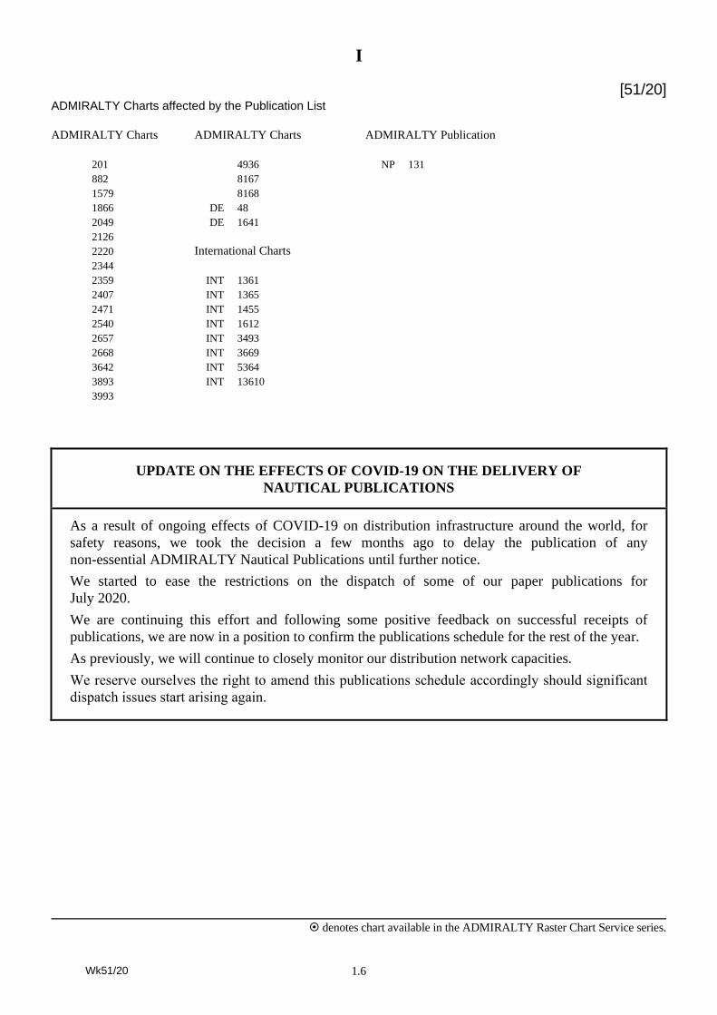
[51/20] ADMIRALTY Charts affected by the Publication List
ADMIRALTY Charts ADMIRALTY Charts ADMIRALTY Publication
201 4936 NP 131
882 8167
1579 8168
1866 DE 48
2049 DE 1641
2126
2220 International Charts
2344
2359 INT 1361
2407 INT 1365
2471 INT 1455
2540 INT 1612
2657 INT 3493
2668 INT 3669
3642 INT 5364
3893 INT 13610
3993
UPDATE ON THE EFFECTS OF COVID-19 ON THE DELIVERY OF
NAUTICAL PUBLICATIONS
As a result of ongoing effects of COVID-19 on distribution infrastructure around the world, for
safety reasons, we took the decision a few months ago to delay the publication of any
non-essential ADMIRALTY Nautical Publications until further notice.
We started to ease the restrictions on the dispatch of some of our paper publications for
July 2020.
We are continuing this effort and following some positive feedback on successful receipts of
publications, we are now in a position to confirm the publications schedule for the rest of the year.
As previously, we will continue to closely monitor our distribution network capacities.
We reserve ourselves the right to amend this publications schedule accordingly should significant
dispatch issues start arising again.
Wk51/20
I
denotes chart available in the ADMIRALTY Raster Chart Service series.
1.7
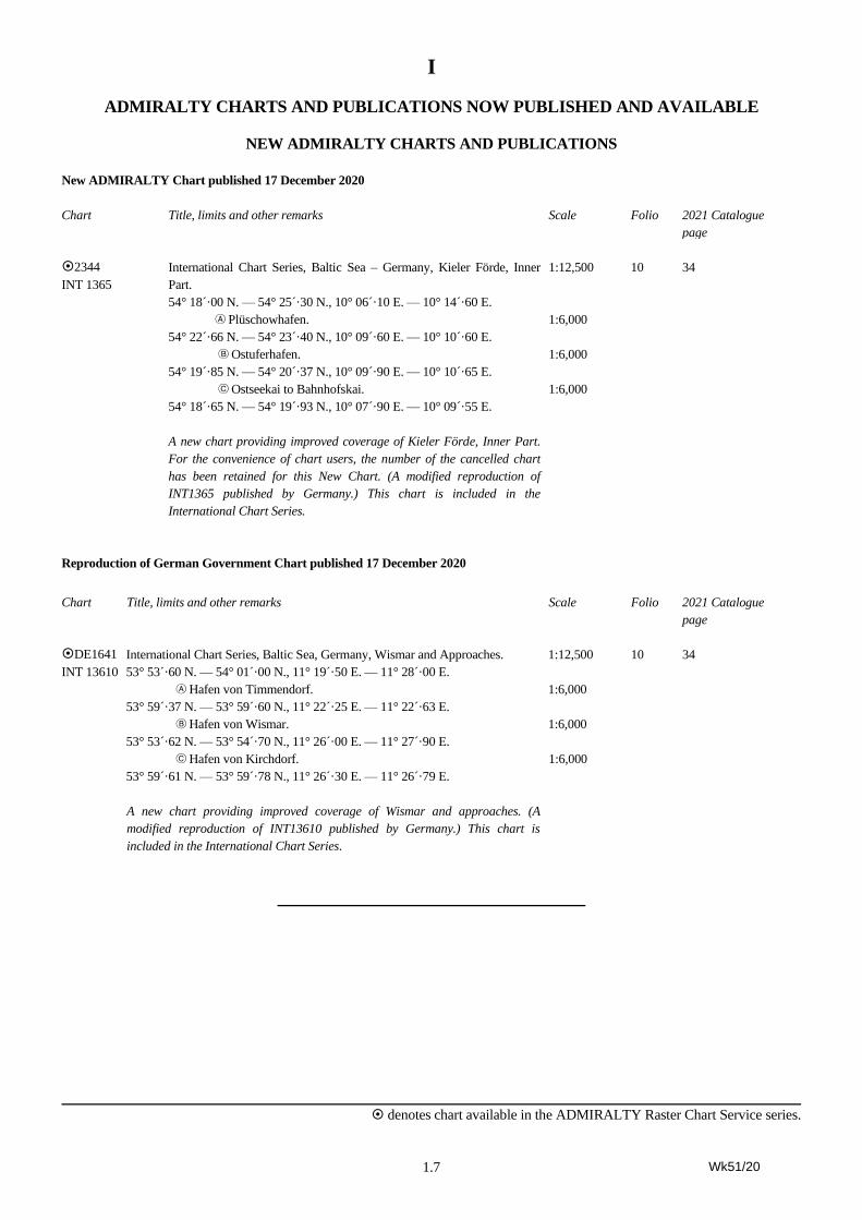
ADMIRALTY CHARTS AND PUBLICATIONS NOW PUBLISHED AND AVAILABLE
NEW ADMIRALTY CHARTS AND PUBLICATIONS
New ADMIRALTY Chart published 17 December 2020
Chart Title, limits and other remarks Scale Folio 2021 Catalogue
page
2344
INT 1365
International Chart Series, Baltic Sea – Germany, Kieler Förde, Inner
Part.
54° 18´·00 N. — 54° 25´·30 N., 10° 06´·10 E. — 10° 14´·60 E.
A Plüschowhafen.
54° 22´·66 N. — 54° 23´·40 N., 10° 09´·60 E. — 10° 10´·60 E.
B Ostuferhafen.
54° 19´·85 N. — 54° 20´·37 N., 10° 09´·90 E. — 10° 10´·65 E.
C Ostseekai to Bahnhofskai.
54° 18´·65 N. — 54° 19´·93 N., 10° 07´·90 E. — 10° 09´·55 E.
A new chart providing improved coverage of Kieler Förde, Inner Part.
For the convenience of chart users, the number of the cancelled chart
has been retained for this New Chart. (A modified reproduction of
INT1365 published by Germany.) This chart is included in the
International Chart Series.
1:12,500
1:6,000
1:6,000
1:6,000
10 34
Reproduction of German Government Chart published 17 December 2020
Chart Title, limits and other remarks Scale Folio 2021 Catalogue
page
DE1641
INT 13610
International Chart Series, Baltic Sea, Germany, Wismar and Approaches.
53° 53´·60 N. — 54° 01´·00 N., 11° 19´·50 E. — 11° 28´·00 E.
A Hafen von Timmendorf.
53° 59´·37 N. — 53° 59´·60 N., 11° 22´·25 E. — 11° 22´·63 E.
B Hafen von Wismar.
53° 53´·62 N. — 53° 54´·70 N., 11° 26´·00 E. — 11° 27´·90 E.
C Hafen von Kirchdorf.
53° 59´·61 N. — 53° 59´·78 N., 11° 26´·30 E. — 11° 26´·79 E.
A new chart providing improved coverage of Wismar and approaches. (A
modified reproduction of INT13610 published by Germany.) This chart is
included in the International Chart Series.
1:12,500
1:6,000
1:6,000
1:6,000
10 34
Wk51/20
I
denotes chart available in the ADMIRALTY Raster Chart Service series.
1.8
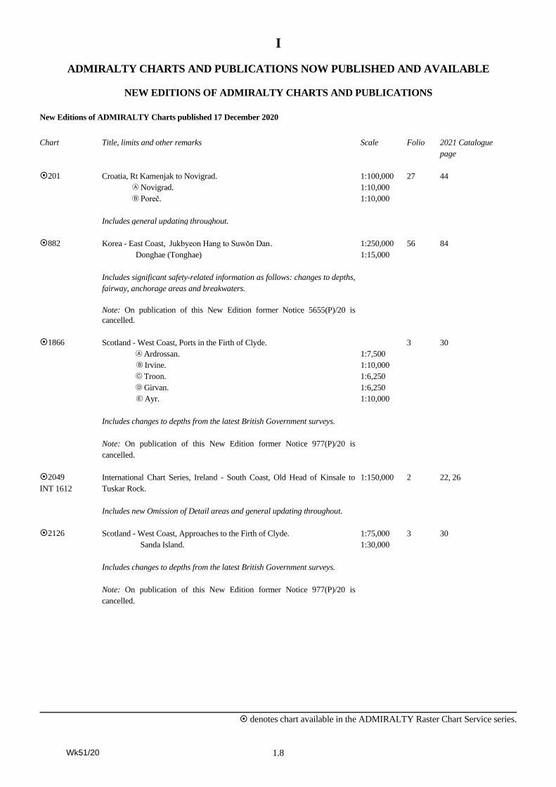
ADMIRALTY CHARTS AND PUBLICATIONS NOW PUBLISHED AND AVAILABLE
NEW EDITIONS OF ADMIRALTY CHARTS AND PUBLICATIONS
New Editions of ADMIRALTY Charts published 17 December 2020
Chart Title, limits and other remarks Scale Folio 2021 Catalogue
page
201 Croatia, Rt Kamenjak to Novigrad.
A Novigrad.
B Poreč.
Includes general updating throughout.
1:100,000
1:10,000
1:10,000
27 44
882 Korea - East Coast, Jukbyeon Hang to Suwŏn Dan .
Donghae (Tonghae)
Includes significant safety-related information as follows: changes to depths,
fairway, anchorage areas and breakwaters.
Note: On publication of this New Edition former Notice 5655(P)/20 is
cancelled.
1:250,000
1:15,000
56 84
1866 Scotland - West Coast, Ports in the Firth of Clyde.
A Ardrossan.
B Irvine.
C Troon.
D Girvan.
E Ayr.
Includes changes to depths from the latest British Government surveys.
Note: On publication of this New Edition former Notice 977(P)/20 is
cancelled.
1:7,500
1:10,000
1:6,250
1:6,250
1:10,000
3 30
2049
INT 1612
International Chart Series, Ireland - South Coast, Old Head of Kinsale to
Tuskar Rock.
Includes new Omission of Detail areas and general updating throughout.
1:150,000 2 22, 26
2126 Scotland - West Coast, Approaches to the Firth of Clyde.
Sanda Island.
Includes changes to depths from the latest British Government surveys.
Note: On publication of this New Edition former Notice 977(P)/20 is
cancelled.
1:75,000
1:30,000
3 30
Wk51/20
I
denotes chart available in the ADMIRALTY Raster Chart Service series.
1.9
ADMIRALTY CHARTS AND PUBLICATIONS NOW PUBLISHED AND AVAILABLE
NEW EDITIONS OF ADMIRALTY CHARTS AND PUBLICATIONS
New Editions of ADMIRALTY Charts published 17 December 2020 (continued)
Chart Title, limits and other remarks Scale Folio 2021 Catalogue
page
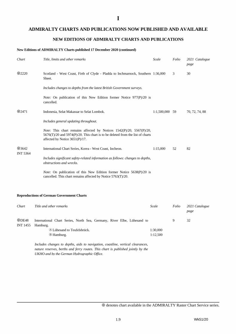
2220 Scotland - West Coast, Firth of Clyde - Pladda to Inchmarnock, Southern
Sheet.
Includes changes to depths from the latest British Government surveys.
Note: On publication of this New Edition former Notice 977(P)/20 is
cancelled.
1:36,000 3 30
2471 Indonesia, Selat Makassar to Selat Lombok.
Includes general updating throughout.
Note: This chart remains affected by Notices 1542(P)/20, 5567(P)/20,
5676(T)/20 and 5974(P)/20. This chart is to be deleted from the list of charts
affected by Notice 3651(P)/17.
1:1,500,000 59 70, 72, 74, 88
3642
INT 5364
International Chart Series, Korea - West Coast, Incheon.
Includes significant safety-related information as follows: changes to depths,
obstructions and wrecks.
Note: On publication of this New Edition former Notice 5638(P)/20 is
cancelled. This chart remains affected by Notice 5763(T)/20.
1:15,000 52 82
Reproductions of German Government Charts
Chart Title and other remarks Scale Folio 2021 Catalogue
page
DE48
INT 1455
International Chart Series, North Sea, Germany, River Elbe, Lühesand to
Hamburg.
A Lühesand to Teufelsbrück.
B Hamburg.
Includes changes to depths, aids to navigation, coastline, vertical clearances,
nature reserves, berths and ferry routes. This chart is published jointly by the
UKHO and by the German Hydrographic Office.
1:30,000
1:12,500
9 32
Wk51/20
I
denotes chart available in the ADMIRALTY Raster Chart Service series.
1.10
ADMIRALTY CHARTS AND PUBLICATIONS NOW PUBLISHED AND AVAILABLE
NEW EDITIONS OF ADMIRALTY CHARTS AND PUBLICATIONS
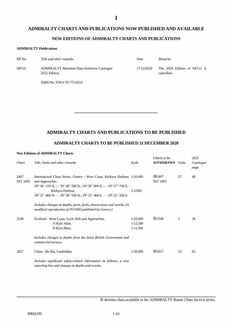
ADMIRALTY Publications
NP No. Title and other remarks Date Remarks
NP131 ADMIRALTY Maritime Data Solutions Catalogue
2021 Edition.
ISBN No: 978-0-70-772-0210
17/12/2020 The 2020 Edition of NP131 is
cancelled.
ADMIRALTY CHARTS AND PUBLICATIONS TO BE PUBLISHED
ADMIRALTY CHARTS TO BE PUBLISHED 31 DECEMBER 2020
New Editions of ADMIRALTY Charts
Chart
Title, limits and other remarks
Scale
Charts to be
WITHDRAWN
Folio
2021
Catalogue
page
2407
INT 3493
International Chart Series, Greece - West Coast, Kérkyra Harbour
and Approaches.
39° 36´·150 N. — 39° 40´·200 N., 19° 50´·000 E. — 19° 57´·760 E.
Kérkyra Harbour.
39° 37´·460 N. — 39° 38´·100 N., 19° 53´·460 E. — 19° 55´·350 E.
Includes changes to depths, ports, fouls, obstructions and wrecks. (A
modified reproduction of INT3493 published by Greece.)
1:10,000
1:5,000
2407
INT 3493
27 48
2540 Scotland - West Coast, Loch Alsh and Approaches.
A Kyle Akin.
B Kyle Rhea.
Includes changes to depths from the latest British Government and
commercial surveys.
1:20,000
1:12,500
1:12,500
2540 5 30
2657 China - Bo Hai, Caofeidian.
Includes significant safety-related information as follows: a new
reporting line and changes to depths and wrecks.
1:50,000 2657 52 82
Wk51/20
I
denotes chart available in the ADMIRALTY Raster Chart Service series.
1.11
ADMIRALTY CHARTS AND PUBLICATIONS TO BE PUBLISHED
ADMIRALTY CHARTS TO BE PUBLISHED 31 DECEMBER 2020
New Editions of ADMIRALTY Charts (continued)
Chart
Title, limits and other remarks
Scale
Charts to be
WITHDRAWN
Folio
2021
Catalogue
page
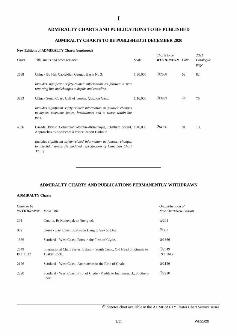
2668 China - Bo Hai, Caofeidian Gangqu Basin No 3.
Includes significant safety-related information as follows: a new
reporting line and changes to depths and coastline.
1:30,000 2668 52 82
3993 China - South Coast, Gulf of Tonkin, Qinzhou Gang.
Includes significant safety-related information as follows: changes
to depths, coastline, jetties, breakwaters and to works within the
port.
1:16,000 3993 47 76
4936 Canada, British Columbia/Colombie-Britannique, Chatham Sound,
Approaches to/Approches à Prince Rupert Harbour .
Includes significant safety-related information as follows: changes
to intertidal areas. (A modified reproduction of Canadian Chart
3957.)
1:40,000 4936 91 108
ADMIRALTY CHARTS AND PUBLICATIONS PERMANENTLY WITHDRAWN
ADMIRALTY Charts
Chart to be
WITHDRAWN
Main Title
On publication of
New Chart/New Edition
201 Croatia, Rt Kamenjak to Novigrad. 201
882 Korea - East Coast, Jukbyeon Hang to Suwŏn Dan. 882
1866 Scotland - West Coast, Ports in the Firth of Clyde. 1866
2049
INT 1612
International Chart Series, Ireland - South Coast, Old Head of Kinsale to
Tuskar Rock.
2049
INT 1612
2126 Scotland - West Coast, Approaches to the Firth of Clyde. 2126
2220 Scotland - West Coast, Firth of Clyde - Pladda to Inchmarnock, Southern
Sheet.
2220
Wk51/20
I
denotes chart available in the ADMIRALTY Raster Chart Service series.
1.12
ADMIRALTY CHARTS AND PUBLICATIONS PERMANENTLY WITHDRAWN
ADMIRALTY Charts (continued)
Chart to be
WITHDRAWN
Main Title
On publication of
New Chart/New Edition
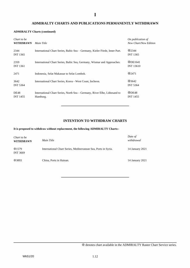
2344
INT 1365
International Chart Series, Baltic Sea – Germany, Kieler Förde, Inner Part. 2344
INT 1365
2359
INT 1361
International Chart Series, Baltic Sea, Germany, Wismar and Approaches. DE1641
INT 13610
2471 Indonesia, Selat Makassar to Selat Lombok. 2471
3642
INT 5364
International Chart Series, Korea - West Coast, Incheon.
3642
INT 5364
DE48
INT 1455
International Chart Series, North Sea – Germany, River Elbe, Lühesand to
Hamburg.
DE48
INT 1455
INTENTION TO WITHDRAW CHARTS
It is proposed to withdraw without replacement, the following ADMIRALTY Charts:-
Chart to be
WITHDRAWN
Main Title
Date of
withdrawal
1579
INT 3669
International Chart Series, Mediterranean Sea, Ports in Syria. 14 January 2021
3893 China, Ports in Hainan. 14 January 2021
Wk51/20
I
denotes chart available in the ADMIRALTY Raster Chart Service series.
1.13
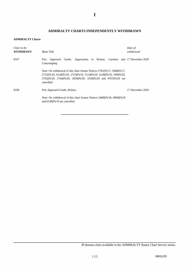
ADMIRALTY CHARTS INDEPENDENTLY WITHDRAWN
ADMIRALTY Charts
Chart to be
WITHDRAWN
Main Title
Date of
withdrawal
8167 Port Approach Guide, Approaches to Rizhao, Lanshan and
Lianyungang.
Note: On withdrawal of this chart former Notices 5781(P)/17, 5848(P)/17,
2725(P)/18, 6128(P)/18, 2723(P)/19, 5114(P)/19, 6149(P)/19, 209(P)/20,
2762(P)/20, 2764(P)/20, 3029(P)/20, 3359(P)/20 and 4767(P)/20 are
cancelled.
17 December 2020
8168 Port Approach Guide, Rizhao .
Note: On withdrawal of this chart former Notices 2668(P)/18, 4904(P)/18
and 6149(P)/19 are cancelled.
17 December 2020
Wk51/20
2.1
II
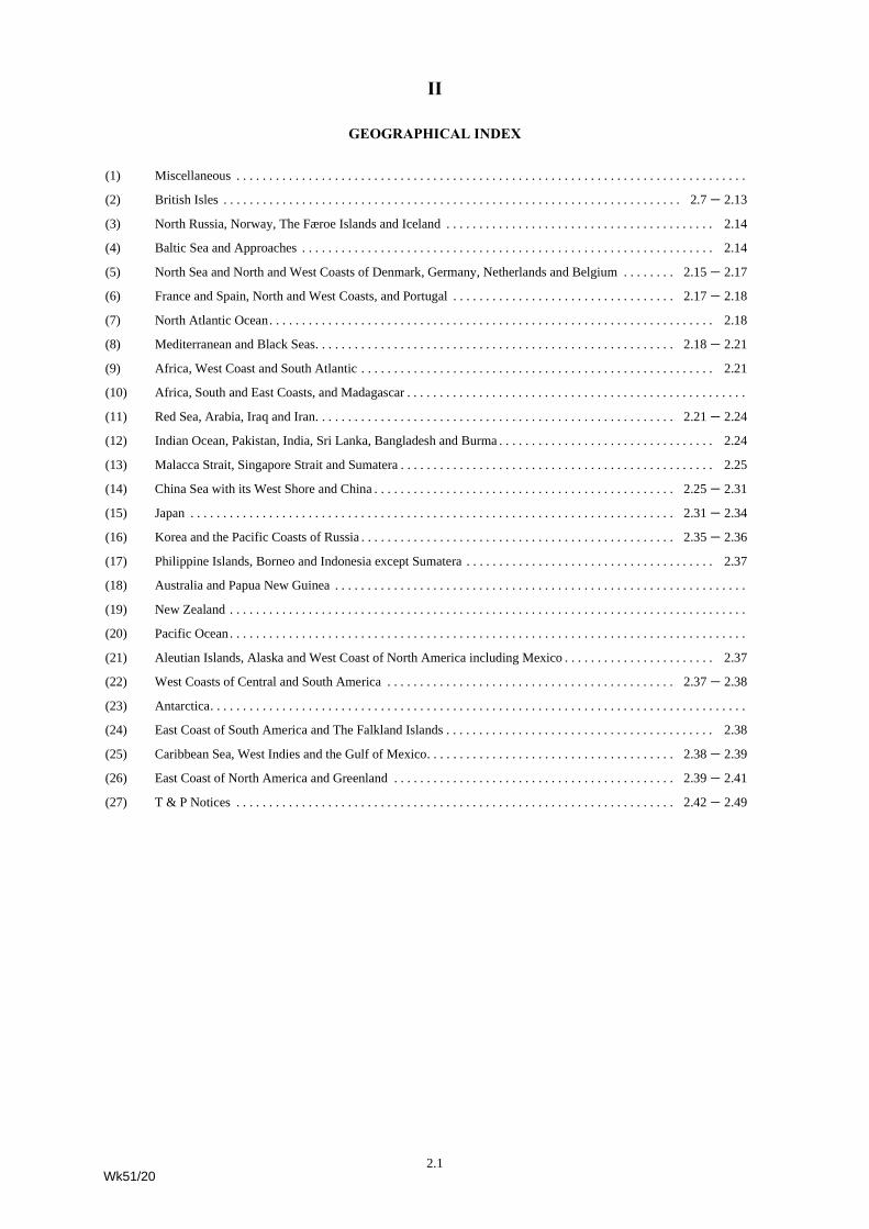
GEOGRAPHICAL INDEX
(1) Miscellaneous . . . . . . . . . . . . . . . . . . . . . . . . . . . . . . . . . . . . . . . . . . . . . . . . . . . . . . . . . . . . . . . . . . . . . . . . . . . . . .
(2) British Isles . . . . . . . . . . . . . . . . . . . . . . . . . . . . . . . . . . . . . . . . . . . . . . . . . . . . . . . . . . . . . . . . . . . . . . 2.7 – 2.13
(3) North Russia, Norway, The Færoe Islands and Iceland . . . . . . . . . . . . . . . . . . . . . . . . . . . . . . . . . . . . . . . . . 2.14
(4) Baltic Sea and Approaches . . . . . . . . . . . . . . . . . . . . . . . . . . . . . . . . . . . . . . . . . . . . . . . . . . . . . . . . . . . . . . . 2.14
(5) North Sea and North and West Coasts of Denmark, Germany, Netherlands and Belgium . . . . . . . . 2.15 – 2.17
(6) France and Spain, North and West Coasts, and Portugal . . . . . . . . . . . . . . . . . . . . . . . . . . . . . . . . . . 2.17 – 2.18
(7) North Atlantic Ocean. . . . . . . . . . . . . . . . . . . . . . . . . . . . . . . . . . . . . . . . . . . . . . . . . . . . . . . . . . . . . . . . . . . . 2.18
(8) Mediterranean and Black Seas. . . . . . . . . . . . . . . . . . . . . . . . . . . . . . . . . . . . . . . . . . . . . . . . . . . . . . . 2.18 – 2.21
(9) Africa, West Coast and South Atlantic . . . . . . . . . . . . . . . . . . . . . . . . . . . . . . . . . . . . . . . . . . . . . . . . . . . . . . 2.21
(10) Africa, South and East Coasts, and Madagascar . . . . . . . . . . . . . . . . . . . . . . . . . . . . . . . . . . . . . . . . . . . . . . . . . . . .
(11) Red Sea, Arabia, Iraq and Iran. . . . . . . . . . . . . . . . . . . . . . . . . . . . . . . . . . . . . . . . . . . . . . . . . . . . . . . 2.21 – 2.24
(12) Indian Ocean, Pakistan, India, Sri Lanka, Bangladesh and Burma . . . . . . . . . . . . . . . . . . . . . . . . . . . . . . . . . 2.24
(13) Malacca Strait, Singapore Strait and Sumatera . . . . . . . . . . . . . . . . . . . . . . . . . . . . . . . . . . . . . . . . . . . . . . . . 2.25
(14) China Sea with its West Shore and China . . . . . . . . . . . . . . . . . . . . . . . . . . . . . . . . . . . . . . . . . . . . . . 2.25 – 2.31
(15) Japan . . . . . . . . . . . . . . . . . . . . . . . . . . . . . . . . . . . . . . . . . . . . . . . . . . . . . . . . . . . . . . . . . . . . . . . . . . 2.31 – 2.34
(16) Korea and the Pacific Coasts of Russia . . . . . . . . . . . . . . . . . . . . . . . . . . . . . . . . . . . . . . . . . . . . . . . . 2.35 – 2.36
(17) Philippine Islands, Borneo and Indonesia except Sumatera . . . . . . . . . . . . . . . . . . . . . . . . . . . . . . . . . . . . . . 2.37
(18) Australia and Papua New Guinea . . . . . . . . . . . . . . . . . . . . . . . . . . . . . . . . . . . . . . . . . . . . . . . . . . . . . . . . . . . . . . .
(19) New Zealand . . . . . . . . . . . . . . . . . . . . . . . . . . . . . . . . . . . . . . . . . . . . . . . . . . . . . . . . . . . . . . . . . . . . . . . . . . . . . . .
(20) Pacific Ocean . . . . . . . . . . . . . . . . . . . . . . . . . . . . . . . . . . . . . . . . . . . . . . . . . . . . . . . . . . . . . . . . . . . . . . . . . . . . . . .
(21) Aleutian Islands, Alaska and West Coast of North America including Mexico . . . . . . . . . . . . . . . . . . . . . . . 2.37
(22) West Coasts of Central and South America . . . . . . . . . . . . . . . . . . . . . . . . . . . . . . . . . . . . . . . . . . . . 2.37 – 2.38
(23) Antarctica. . . . . . . . . . . . . . . . . . . . . . . . . . . . . . . . . . . . . . . . . . . . . . . . . . . . . . . . . . . . . . . . . . . . . . . . . . . . . . . . . .
(24) East Coast of South America and The Falkland Islands . . . . . . . . . . . . . . . . . . . . . . . . . . . . . . . . . . . . . . . . . 2.38
(25) Caribbean Sea, West Indies and the Gulf of Mexico. . . . . . . . . . . . . . . . . . . . . . . . . . . . . . . . . . . . . . 2.38 – 2.39
(26) East Coast of North America and Greenland . . . . . . . . . . . . . . . . . . . . . . . . . . . . . . . . . . . . . . . . . . . 2.39 – 2.41
(27) T & P Notices . . . . . . . . . . . . . . . . . . . . . . . . . . . . . . . . . . . . . . . . . . . . . . . . . . . . . . . . . . . . . . . . . . . 2.42 – 2.49
Wk51/20
II
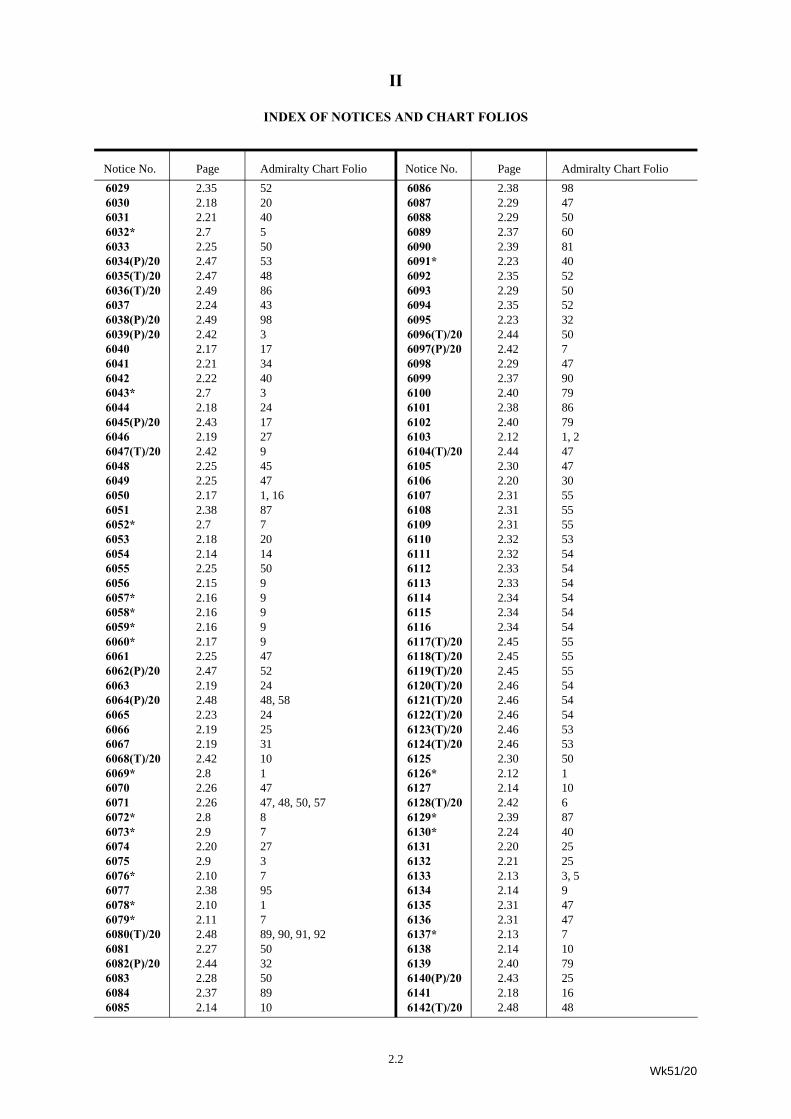
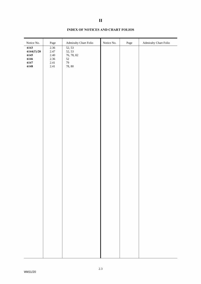
INDEX OF NOTICES AND CHART FOLIOS
Notice No. Page Admiralty Chart Folio Notice No. Page Admiralty Chart Folio6029 2.35 526030 2.18 206031 2.21 406032* 2.7 56033 2.25 506034(P)/20 2.47 536035(T)/20 2.47 486036(T)/20 2.49 866037 2.24 436038(P)/20 2.49 986039(P)/20 2.42 36040 2.17 176041 2.21 346042 2.22 406043* 2.7 36044 2.18 246045(P)/20 2.43 176046 2.19 276047(T)/20 2.42 96048 2.25 456049 2.25 476050 2.17 1, 166051 2.38 876052* 2.7 76053 2.18 206054 2.14 146055 2.25 506056 2.15 96057* 2.16 96058* 2.16 96059* 2.16 96060* 2.17 96061 2.25 476062(P)/20 2.47 526063 2.19 246064(P)/20 2.48 48, 586065 2.23 246066 2.19 256067 2.19 316068(T)/20 2.42 106069* 2.8 16070 2.26 476071 2.26 47, 48, 50, 576072* 2.8 86073* 2.9 76074 2.20 276075 2.9 36076* 2.10 76077 2.38 956078* 2.10 16079* 2.11 76080(T)/20 2.48 89, 90, 91, 926081 2.27 506082(P)/20 2.44 326083 2.28 506084 2.37 896085 2.14 10
6086 2.38 986087 2.29 476088 2.29 506089 2.37 606090 2.39 816091* 2.23 406092 2.35 526093 2.29 506094 2.35 526095 2.23 326096(T)/20 2.44 506097(P)/20 2.42 76098 2.29 476099 2.37 906100 2.40 796101 2.38 866102 2.40 796103 2.12 1, 26104(T)/20 2.44 476105 2.30 476106 2.20 306107 2.31 556108 2.31 556109 2.31 556110 2.32 536111 2.32 546112 2.33 546113 2.33 546114 2.34 546115 2.34 546116 2.34 546117(T)/20 2.45 556118(T)/20 2.45 556119(T)/20 2.45 556120(T)/20 2.46 546121(T)/20 2.46 546122(T)/20 2.46 546123(T)/20 2.46 536124(T)/20 2.46 536125 2.30 506126* 2.12 16127 2.14 106128(T)/20 2.42 66129* 2.39 876130* 2.24 406131 2.20 256132 2.21 256133 2.13 3, 56134 2.14 96135 2.31 476136 2.31 476137* 2.13 76138 2.14 106139 2.40 796140(P)/20 2.43 256141 2.18 166142(T)/20 2.48 48
2.2Wk51/20
II
INDEX OF NOTICES AND CHART FOLIOS
Notice No. Page Admiralty Chart Folio Notice No. Page Admiralty Chart Folio6143 2.36 52, 536144(T)/20 2.47 52, 536145 2.40 76, 78, 826146 2.36 526147 2.41 796148 2.41 78, 80
2.3Wk51/20
II
INDEX OF CHARTS AFFECTED
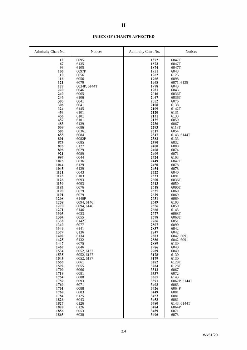
Admiralty Chart No. NoticesAdmiralty Chart No. Notices
12 609567 613594 6105
106 6097P110 6056116 6056121 6079127 6034P, 6144T220 6046240 6065246 6106305 6041306 6041324 6145454 6101456 6101457 6101483 6129509 6086583 6036T655 6084801 6082P873 6085876 6127896 6029921 6089994 6044
1025 6036T1044 61291045 61291121 60431123 61031126 60931130 60931183 60761190 60791191 60791208 6140P1258 6094, 61461270 6094, 61461271 61461303 60331304 60551338 6142T1340 60771349 61411379 61361402 61341425 61321447 60751467 60461534 6052, 61371535 6052, 61371543 6052, 61371555 60611592 60551700 60661719 60811754 60881759 60931760 60711761 60881768 60831784 61251826 60431827 61261828 61261856 60531863 6030
Admiralty Chart No. Notices
1872 6047T1873 6047T1874 6047T1951 60431962 61251965 60981968 6071, 61251978 60431981 60432016 6036T2047 6036T2052 60762108 61382109 6142T2120 61312131 61332135 60502236 60672293 6118T2317 60542347 6143, 6144T2382 61332390 60322400 60882408 60742409 60712424 61032449 6047T2450 60782454 60782522 60402523 60912600 6036T2613 60502618 6096T2625 60692629 60692631 60692649 61032656 60502666 61452677 6068T2678 6068T2766 60512807 60902837 60422847 60422883 6042, 60912886 6042, 60912889 61302986 60402989 60403178 61303179 61303282 6128T3284 6128T3312 60673337 60723365 61433391 6062P, 6144T3403 60633426 6064P3449 60813452 60813453 60813480 6143, 6144T3484 6064P3489 60713496 6073
Admiralty Chart No. Notices
2.4Wk51/20
II
INDEX OF CHARTS AFFECTED
Admiralty Chart No. Notices
3497 60733558 6035T3666 6029, 60923736 60313754 6080T3788 60423790 60423809 6064P3811 6064P3939 60493989 6070, 6087, 6104T4033 60484248 6038P4404 61454405 61454416 6064P4471 6064P4473 6064P4508 60714509 60714748 61484763 61484765 61004766 61394768 61394769 61024792 61474801 6080T4810 6080T4920 6080T4951 60994954 60994975 6080T5521 60438040 6045P8082 6039P8265 6140P
GermanChart No. Notices
DE 7 6059DE 20 6059DE 44 6060DE 50 6057DE 87 6057DE 90 6058DE 91 6058DE 103 6057
IndianChart No. Notices
IN 31 6037
JapaneseChart No. Notices
JP 10 6109JP 65 6119TJP 67 6110JP 104 6111, 6112, 6113, 6114, 6115JP 106 6121T, 6122TJP 123 6120TJP 132 6111, 6112, 6113, 6114, 6115JP 137A 6122TJP 139 6107
Admiralty Chart No. Notices
Wk51/20
Admiralty Chart No. Notices
JP 141 6112, 6113, 6114, 6116JP 145 6118TJP 153 6122TJP 226 6124TJP 1146 6120TJP 1155B 6108JP 1155A 6117TJP 1169 6107JP 1180 6118TJP 1227 6123T
InternationalChart No. Notices
INT 404 6145INT 405 6145INT 508 6071INT 509 6071INT 553 6071INT 554 6064PINT 756 6037INT 801 6080TINT 810 6080TINT 1045 6057INT 1062 6043INT 1063 6103INT 1297 6068TINT 1298 6068TINT 1300 6134INT 1302 6138INT 1315 6085INT 1412 6057INT 1413 6057INT 1424 6059INT 1452 6060INT 1460 6059INT 1461 6058INT 1462 6058INT 1473 6056INT 1474 6047TINT 1477 6056INT 1480 6047TINT 1507 6079INT 1508 6079INT 1554 6073INT 1558 6052, 6137INT 1559 6052, 6137INT 1560 6076INT 1561 6076INT 1563 6126INT 1565 6073INT 1607 6043INT 1613 6103INT 1642 6043INT 1702 6078INT 1703 6078INT 1705 6050INT 1732 6069INT 1759 6141INT 1802 6040INT 1840 6040INT 1841 6040INT 2813 6041INT 2814 6041INT 3216 6063INT 3549 6065INT 3660 6106INT 4180 6036T
JapaneseChart No. Notices
2.5
II
INDEX OF CHARTS AFFECTED
Admiralty Chart No. Notices
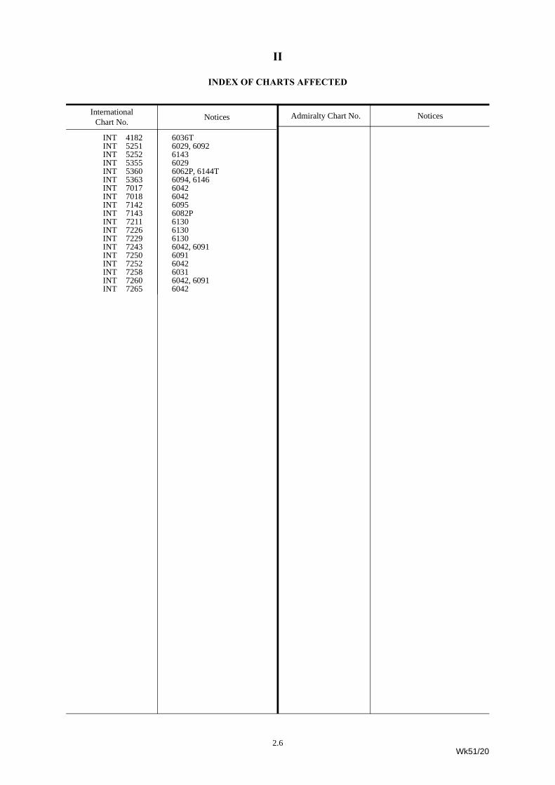
INT 4182 6036TINT 5251 6029, 6092INT 5252 6143INT 5355 6029INT 5360 6062P, 6144TINT 5363 6094, 6146INT 7017 6042INT 7018 6042INT 7142 6095INT 7143 6082PINT 7211 6130INT 7226 6130INT 7229 6130INT 7243 6042, 6091INT 7250 6091INT 7252 6042INT 7258 6031INT 7260 6042, 6091INT 7265 6042
InternationalChart No. Notices
Admiralty Chart No. Notices2.6Wk51/20
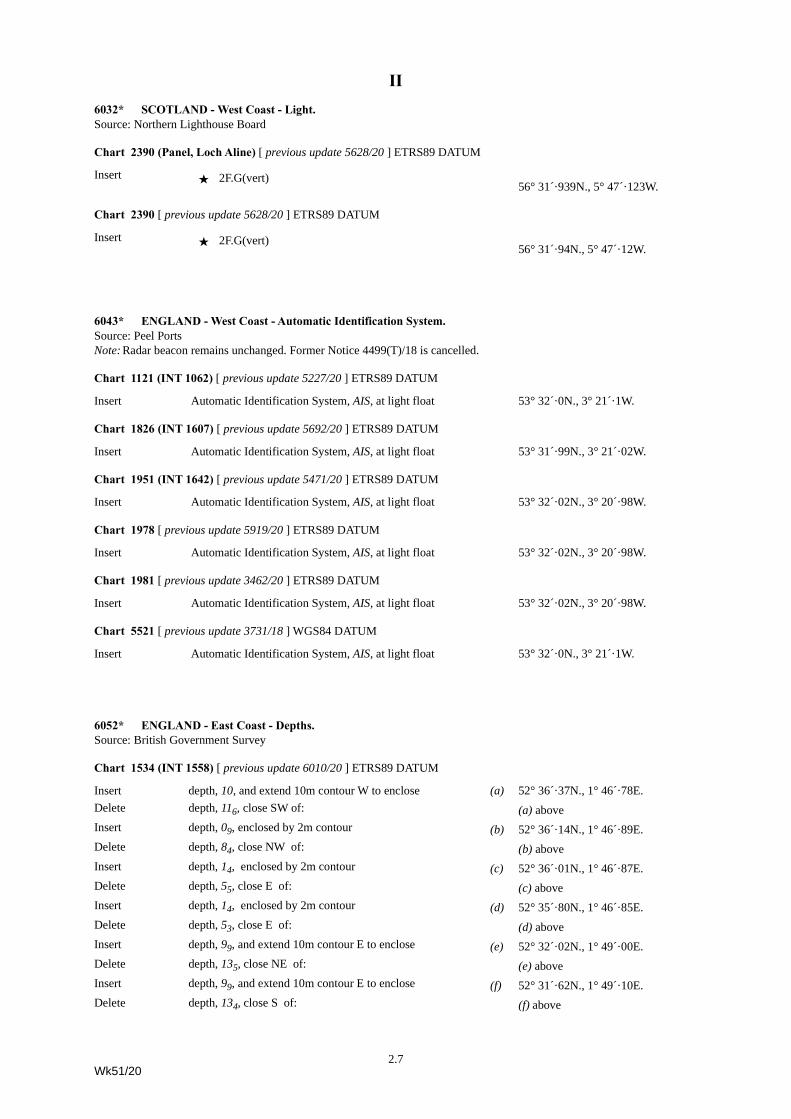
II6032* SCOTLAND - West Coast - Light.Source: Northern Lighthouse Board
Chart 2390 (Panel, Loch Aline) [ previous update 5628/20 ] ETRS89 DATUM
Insert · 2F.G(vert)56° 31´·939N., 5° 47´·123W.
Chart 2390 [ previous update 5628/20 ] ETRS89 DATUM
Insert · 2F.G(vert)56° 31´·94N., 5° 47´·12W.
6043* ENGLAND - West Coast - Automatic Identification System.Source: Peel PortsNote: Radar beacon remains unchanged. Former Notice 4499(T)/18 is cancelled.
Chart 1121 (INT 1062) [ previous update 5227/20 ] ETRS89 DATUM
Insert Automatic Identification System, AIS, at light float 53° 32´·0N., 3° 21´·1W.
Chart 1826 (INT 1607) [ previous update 5692/20 ] ETRS89 DATUM
Insert Automatic Identification System, AIS, at light float 53° 31´·99N., 3° 21´·02W.
Chart 1951 (INT 1642) [ previous update 5471/20 ] ETRS89 DATUM
Insert Automatic Identification System, AIS, at light float 53° 32´·02N., 3° 20´·98W.
Chart 1978 [ previous update 5919/20 ] ETRS89 DATUM
Insert Automatic Identification System, AIS, at light float 53° 32´·02N., 3° 20´·98W.
Chart 1981 [ previous update 3462/20 ] ETRS89 DATUM
Insert Automatic Identification System, AIS, at light float 53° 32´·02N., 3° 20´·98W.
Chart 5521 [ previous update 3731/18 ] WGS84 DATUM
Insert Automatic Identification System, AIS, at light float 53° 32´·0N., 3° 21´·1W.
6052* ENGLAND - East Coast - Depths.Source: British Government Survey
Chart 1534 (INT 1558) [ previous update 6010/20 ] ETRS89 DATUM
Insert depth, 10, and extend 10m contour W to enclose (a) 52° 36´·37N., 1° 46´·78E.Delete depth, 116, close SW of: (a) aboveInsert depth, 09, enclosed by 2m contour (b) 52° 36´·14N., 1° 46´·89E.Delete depth, 84, close NW of: (b) aboveInsert depth, 14, enclosed by 2m contour (c) 52° 36´·01N., 1° 46´·87E.Delete depth, 55, close E of: (c) aboveInsert depth, 14, enclosed by 2m contour (d) 52° 35´·80N., 1° 46´·85E.Delete depth, 53, close E of: (d) aboveInsert depth, 99, and extend 10m contour E to enclose (e) 52° 32´·02N., 1° 49´·00E.Delete depth, 135, close NE of: (e) aboveInsert depth, 99, and extend 10m contour E to enclose (f) 52° 31´·62N., 1° 49´·10E.Delete depth, 134, close S of: (f) above
2.7Wk51/20
II
Chart 1535 (INT 1559) [ previous update 5960/20 ] ETRS89 DATUM
Insert depth, 99, and extend 10m contour E to enclose (a) 52° 32´·02N., 1° 49´·00E.Delete depth, 135, close NE of: (a) aboveInsert depth, 99, and extend 10m contour E to enclose (b) 52° 31´·62N., 1° 49´·10E.Delete depth, 134, close S of: (b) aboveInsert depth, 10, enclosed by 10m contour 52° 30´·52N., 1° 49´·73E.
Chart 1543 [ previous update 5960/20 ] ETRS89 DATUM
Insert depth, 14, and extend 2m contour SW to enclose (a) 52° 36´·01N., 1° 46´·87E.Delete depth, 56, close E of: (a) aboveInsert depth, 99, and extend 10m contour E to enclose 52° 32´·02N., 1° 49´·00E.
depth, 10, and extend 10m contour E to enclose (b) 52° 30´·52N., 1° 49´·73E.Delete depth, 124, close N of: (b) above
6069* ENGLAND - South Coast - Legend.Source: Queen’s Harbour Master, Portsmouth
Chart 2625 [ previous update New Edition 01/10/2020 ] ETRS89 DATUM
Insert legend, Works in progress (2020), orientated NW/SE, centred on: 50° 47´·240N., 1° 06´·274W.
Chart 2629 [ previous update New Edition 01/10/2020 ] ETRS89 DATUM
Insert legend, Works in progress (2020), orientated NW/SE, centred on: 50° 47´·271N., 1° 06´·294W.
Chart 2631 (INT 1732) [ previous update 5962/20 ] ETRS89 DATUM
Insert legend, Works in progress (2020), orientated NW/SE, centred on: 50° 47´·242N., 1° 06´·276W.
6072* ENGLAND - East Coast - Depths.Source: Port of London Authority
Chart 3337 (Panel B, Thames Tidal Barrier) [ previous update 5547/20 ] ETRS89 DATUM
Insert depth, 45, and extend 5m contour S to enclose 51° 29´·882N., 0° 02´·092E.depth, 55 51° 29´·867N., 0° 02´·119E.depth, 51 (a) 51° 29´·884N., 0° 02´·208E.
Delete depth, 58, close SE of: (a) aboveInsert depth, 51 51° 29´·814N., 0° 02´·729E.
(b) 51° 29´·792N., 0° 02´·743E.Delete depth, 58, close N of: (b) above
Chart 3337 [ previous update 5547/20 ] ETRS89 DATUM
Insert depth, 45, and extend 5m contour S to enclose 51° 29´·882N., 0° 02´·092E.depth, 51 51° 29´·884N., 0° 02´·208E.depth, 57 51° 29´·814N., 0° 02´·729E.
6052* ENGLAND - East Coast - Depths. (continued)
2.8Wk51/20
II
6073* ENGLAND - East Coast - Depths.Source: ABP Humber
Chart 3496 (INT 1565) (Panel A, Hull Docks Eastern Part) [ previous update 5523/20 ] ETRS89 DATUM
Insert depth, 49, and extend 5m contour N to enclose (a) 53° 44´·311N., 0° 18´·126W.Delete depth, 54, close E of: (a) aboveInsert depth, 43, and extend 5m contour N to enclose (b) 53° 44´·295N., 0° 17´·882W.Delete depth, 54, close SE of: (b) aboveInsert depth, 27 (c) 53° 44´·257N., 0° 17´·799W.Delete depth, 4, close SE of: (c) aboveInsert depth, 46, and extend 5m contour N to enclose (d) 53° 44´·256N., 0° 17´·661W.Delete depth, 61, close N of: (d) aboveInsert depth, 66, and extend 7m contour N to enclose 53° 44´·319N., 0° 17´·657W.Replace depth, 81, with depth, 77 53° 44´·325N., 0° 17´·542W.
depth, 68, with depth, 61 53° 44´·256N., 0° 17´·452W.depth, 78, with depth, 73 53° 44´·250N., 0° 17´·226W.
Chart 3497 (INT 1554) [ previous update 5615/20 ] ETRS89 DATUM
Insert depth, 49, and extend 5m contour N to enclose (a) 53° 44´·31N., 0° 18´·13W.Delete depth, 54, close E of: (a) aboveInsert depth, 27, and extend 5m contour N to enclose (b) 53° 44´·26N., 0° 17´·80W.Delete depth, 4, close SE of: (b) aboveInsert depth, 77 53° 44´·32N., 0° 17´·54W.
6075 IRELAND - East Coast - Light.Source: Dublin Port Company Notice 50/20
Chart 1447 (Panel A, Port of Dublin) [ previous update 5595/20 ] ETRS89 DATUM
Amend light to, Fl.G.4s 53° 20´·702N., 6° 12´·287W.
2.9Wk51/20
II
6076* ENGLAND - East Coast - Spoil grounds.Source: CEFAS
Chart 1183 (INT 1561) [ previous update 5685/20 ] ETRS89 DATUM
Insert limit of spoil ground, pecked line, joining: 51° 53´·88N., 1° 49´·82E.51° 53´·79N., 1° 50´·45E.51° 52´·21N., 1° 49´·84E.51° 52´·31N., 1° 49´·20E.
Delete former limit of spoil ground, pecked line, joining: 51° 53´·09N., 1° 49´·62E.51° 53´·03N., 1° 50´·04E.51° 52´·37N., 1° 49´·78E.51° 52´·43N., 1° 49´·35E.
Chart 2052 (INT 1560) [ previous update 5777/20 ] ETRS89 DATUM
Insert limit of spoil ground, pecked line, joining: 51° 53´·88N., 1° 49´·82E.51° 53´·79N., 1° 50´·45E.51° 52´·21N., 1° 49´·84E.51° 52´·31N., 1° 49´·20E.
Delete former limit of spoil ground, pecked line, joining: 51° 53´·09N., 1° 49´·62E.51° 53´·03N., 1° 50´·04E.51° 52´·37N., 1° 49´·78E.51° 52´·43N., 1° 49´·35E.
6078* ENGLAND - South Coast - Depths.Source: sv Cerys Line
Chart 2450 (INT 1703) [ previous update 5945/20 ] ETRS89 DATUM
Insert depth, 51 (a) 50° 20´·34N., 1° 33´·17W.Delete depth, 58, close NE of: (a) above
Chart 2454 (INT 1702) [ previous update 5945/20 ] ETRS89 DATUM
Insert depth, 51 (a) 50° 20´·34N., 1° 33´·17W.Delete depth, 58, close NE of: (a) above
2.10Wk51/20
II
6079* ENGLAND - East Coast - Submarine pipeline.Source: Premier OilNote: Former Notice 1766(P)/20 is cancelled.
Chart 121 [ previous update 5245/20 ] ETRS89 DATUM
Insert submarine pipeline, È, joining:54° 02´·35N., 0° 26´·42E.54° 01´·84N., 0° 25´·75E.54° 01´·65N., 0° 25´·53E.53° 57´·57N., 0° 22´·27E.53° 47´·18N., 0° 14´·94E.53° 45´·53N., 0° 14´·02E.53° 43´·77N., 0° 13´·99E.53° 42´·91N., 0° 13´·51E.53° 42´·52N., 0° 13´·02E.53° 42´·02N., 0° 12´·11E.
Chart 1190 (INT 1508) [ previous update 5182/20 ] ETRS89 DATUM
Insert submarine pipeline, È, joining:53° 39´·76N., 0° 07´·50E.53° 42´·21N., 0° 12´·53E.53° 42´·88N., 0° 13´·48E.53° 43´·82N., 0° 14´·01E.53° 45´·44N., 0° 14´·00E.53° 46´·51N., 0° 14´·55E.53° 57´·91N., 0° 22´·51E.54° 01´·71N., 0° 25´·59E.54° 02´·35N., 0° 26´·42E.
Chart 1191 (INT 1507) [ previous update 5558/20 ] ETRS89 DATUM
Insert submarine pipeline, È, joining:54° 02´·35N., 0° 26´·42E.54° 01´·59N., 0° 25´·48E.53° 57´·62N., 0° 22´·31E.
2.11Wk51/20
II
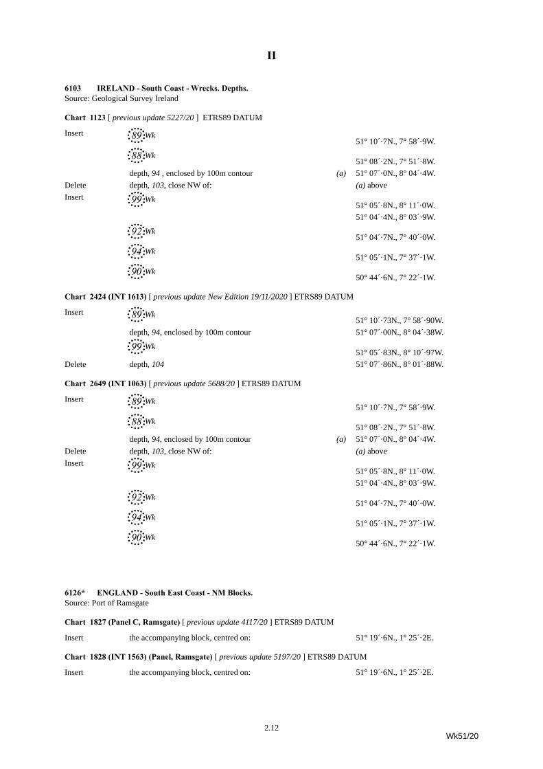
6103 IRELAND - South Coast - Wrecks. Depths.Source: Geological Survey Ireland
Chart 1123 [ previous update 5227/20 ] ETRS89 DATUM
Insert 89,Wk51° 10´·7N., 7° 58´·9W.
88,Wk51° 08´·2N., 7° 51´·8W.
depth, 94 , enclosed by 100m contour (a) 51° 07´·0N., 8° 04´·4W.Delete depth, 103, close NW of: (a) aboveInsert 99,Wk
51° 05´·8N., 8° 11´·0W.51° 04´·4N., 8° 03´·9W.
92,Wk51° 04´·7N., 7° 40´·0W.
94,Wk51° 05´·1N., 7° 37´·1W.
90,Wk50° 44´·6N., 7° 22´·1W.
Chart 2424 (INT 1613) [ previous update New Edition 19/11/2020 ] ETRS89 DATUM
Insert 89,Wk51° 10´·73N., 7° 58´·90W.
depth, 94, enclosed by 100m contour 51° 07´·00N., 8° 04´·38W.
99,Wk51° 05´·83N., 8° 10´·97W.
Delete depth, 104 51° 07´·86N., 8° 01´·88W.
Chart 2649 (INT 1063) [ previous update 5688/20 ] ETRS89 DATUM
Insert 89,Wk51° 10´·7N., 7° 58´·9W.
88,Wk51° 08´·2N., 7° 51´·8W.
depth, 94, enclosed by 100m contour (a) 51° 07´·0N., 8° 04´·4W.Delete depth, 103, close NW of: (a) aboveInsert 99,Wk
51° 05´·8N., 8° 11´·0W.51° 04´·4N., 8° 03´·9W.
92,Wk51° 04´·7N., 7° 40´·0W.
94,Wk51° 05´·1N., 7° 37´·1W.
90,Wk50° 44´·6N., 7° 22´·1W.
6126* ENGLAND - South East Coast - NM Blocks.Source: Port of Ramsgate
Chart 1827 (Panel C, Ramsgate) [ previous update 4117/20 ] ETRS89 DATUM
Insert the accompanying block, centred on: 51° 19´·6N., 1° 25´·2E.
Chart 1828 (INT 1563) (Panel, Ramsgate) [ previous update 5197/20 ] ETRS89 DATUM
Insert the accompanying block, centred on: 51° 19´·6N., 1° 25´·2E.
2.12Wk51/20
II
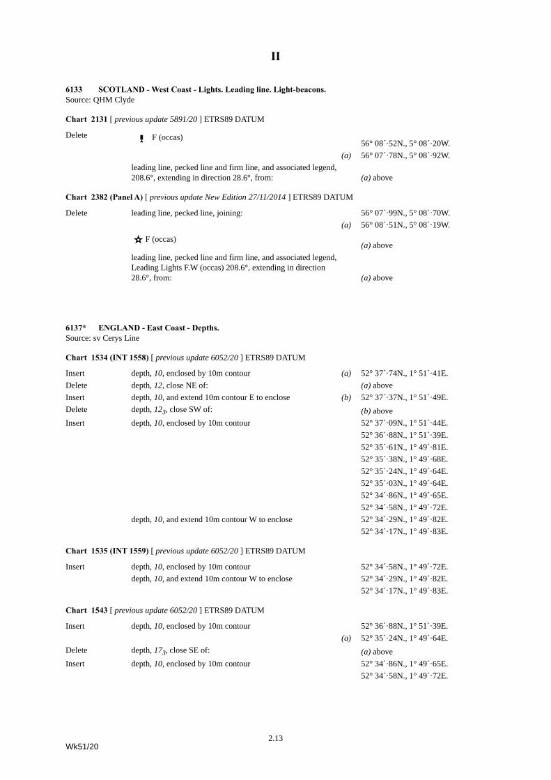
6133 SCOTLAND - West Coast - Lights. Leading line. Light-beacons.Source: QHM Clyde
Chart 2131 [ previous update 5891/20 ] ETRS89 DATUM
Delete T F (occas) 56° 08´·52N., 5° 08´·20W.
(a) 56° 07´·78N., 5° 08´·92W.leading line, pecked line and firm line, and associated legend, 208.6°, extending in direction 28.6°, from: (a) above
Chart 2382 (Panel A) [ previous update New Edition 27/11/2014 ] ETRS89 DATUM
Delete leading line, pecked line, joining: 56° 07´·99N., 5° 08´·70W.(a) 56° 08´·51N., 5° 08´·19W.
¶ F (occas) (a) above
leading line, pecked line and firm line, and associated legend, Leading Lights F.W (occas) 208.6°, extending in direction 28.6°, from: (a) above
6137* ENGLAND - East Coast - Depths.Source: sv Cerys Line
Chart 1534 (INT 1558) [ previous update 6052/20 ] ETRS89 DATUM
Insert depth, 10, enclosed by 10m contour (a) 52° 37´·74N., 1° 51´·41E.Delete depth, 12, close NE of: (a) aboveInsert depth, 10, and extend 10m contour E to enclose (b) 52° 37´·37N., 1° 51´·49E.Delete depth, 123, close SW of: (b) aboveInsert depth, 10, enclosed by 10m contour 52° 37´·09N., 1° 51´·44E.
52° 36´·88N., 1° 51´·39E.52° 35´·61N., 1° 49´·81E.52° 35´·38N., 1° 49´·68E.52° 35´·24N., 1° 49´·64E.52° 35´·03N., 1° 49´·64E.52° 34´·86N., 1° 49´·65E.52° 34´·58N., 1° 49´·72E.
depth, 10, and extend 10m contour W to enclose 52° 34´·29N., 1° 49´·82E.52° 34´·17N., 1° 49´·83E.
Chart 1535 (INT 1559) [ previous update 6052/20 ] ETRS89 DATUM
Insert depth, 10, enclosed by 10m contour 52° 34´·58N., 1° 49´·72E.depth, 10, and extend 10m contour W to enclose 52° 34´·29N., 1° 49´·82E.
52° 34´·17N., 1° 49´·83E.
Chart 1543 [ previous update 6052/20 ] ETRS89 DATUM
Insert depth, 10, enclosed by 10m contour 52° 36´·88N., 1° 51´·39E.(a) 52° 35´·24N., 1° 49´·64E.
Delete depth, 173, close SE of: (a) aboveInsert depth, 10, enclosed by 10m contour 52° 34´·86N., 1° 49´·65E.
52° 34´·58N., 1° 49´·72E.
2.13Wk51/20
II
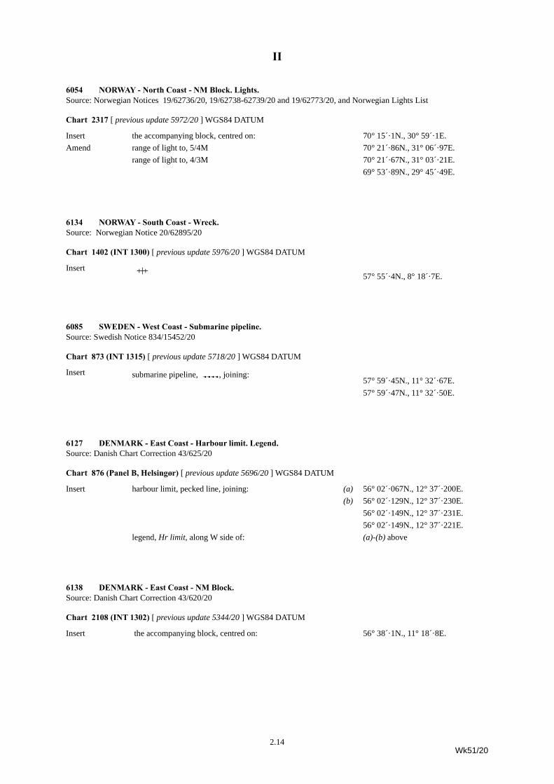
6054 NORWAY - North Coast - NM Block. Lights.Source: Norwegian Notices 19/62736/20, 19/62738-62739/20 and 19/62773/20, and Norwegian Lights List
Chart 2317 [ previous update 5972/20 ] WGS84 DATUM
Insert the accompanying block, centred on: 70° 15´·1N., 30° 59´·1E.Amend range of light to, 5/4M 70° 21´·86N., 31° 06´·97E.
range of light to, 4/3M 70° 21´·67N., 31° 03´·21E.69° 53´·89N., 29° 45´·49E.
6134 NORWAY - South Coast - Wreck.Source: Norwegian Notice 20/62895/20
Chart 1402 (INT 1300) [ previous update 5976/20 ] WGS84 DATUM
Insert ^ 57° 55´·4N., 8° 18´·7E.
6085 SWEDEN - West Coast - Submarine pipeline.Source: Swedish Notice 834/15452/20
Chart 873 (INT 1315) [ previous update 5718/20 ] WGS84 DATUM
Insert submarine pipeline, È, joining:57° 59´·45N., 11° 32´·67E.57° 59´·47N., 11° 32´·50E.
6127 DENMARK - East Coast - Harbour limit. Legend.Source: Danish Chart Correction 43/625/20
Chart 876 (Panel B, Helsingør) [ previous update 5696/20 ] WGS84 DATUM
Insert harbour limit, pecked line, joining: (a) 56° 02´·067N., 12° 37´·200E.(b) 56° 02´·129N., 12° 37´·230E.
56° 02´·149N., 12° 37´·231E.56° 02´·149N., 12° 37´·221E.
legend, Hr limit, along W side of: (a)-(b) above
6138 DENMARK - East Coast - NM Block.Source: Danish Chart Correction 43/620/20
Chart 2108 (INT 1302) [ previous update 5344/20 ] WGS84 DATUM
Insert the accompanying block, centred on: 56° 38´·1N., 11° 18´·8E.
2.14Wk51/20
II
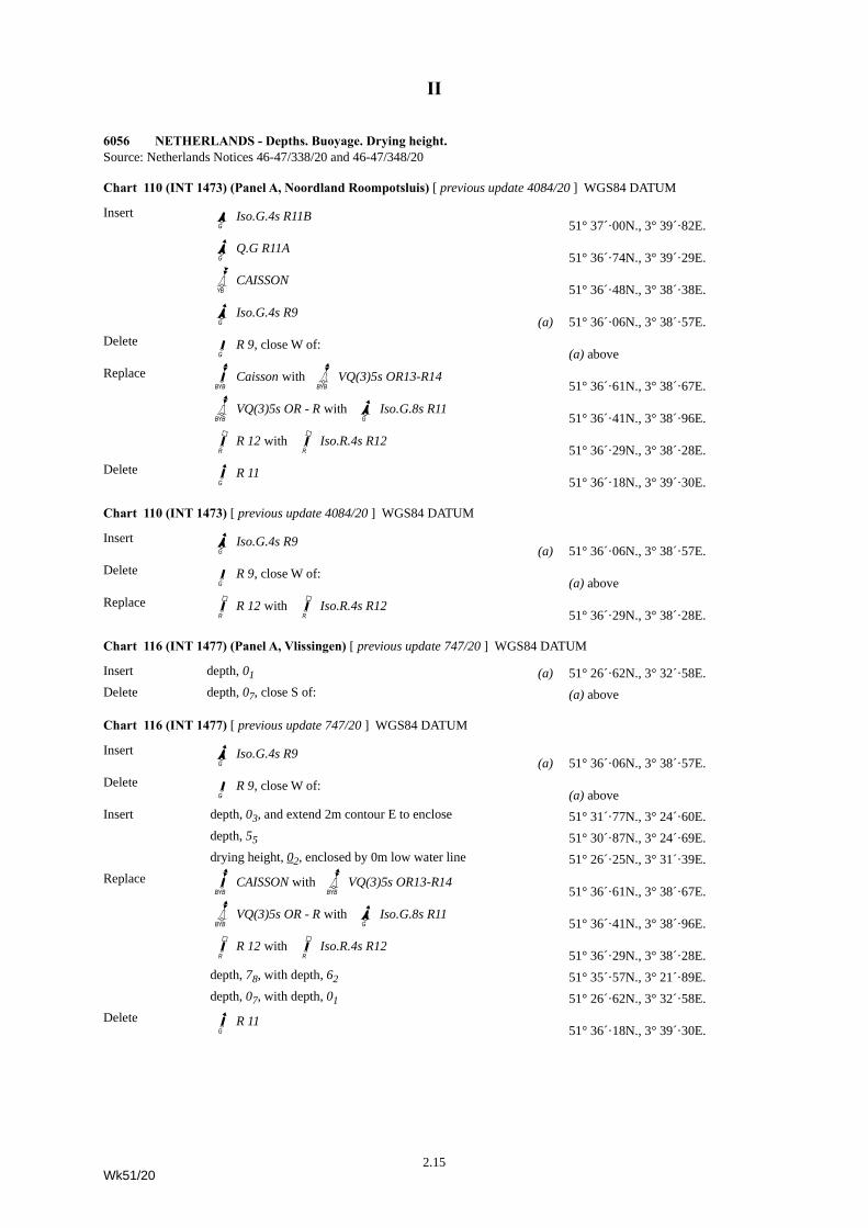
6056 NETHERLANDS - Depths. Buoyage. Drying height.Source: Netherlands Notices 46-47/338/20 and 46-47/348/20
Chart 110 (INT 1473) (Panel A, Noordland Roompotsluis) [ previous update 4084/20 ] WGS84 DATUM
Insert IbIso.G.4s R11B51° 37´·00N., 3° 39´·82E.
Ib]Q.G R11A51° 36´·74N., 3° 39´·29E.
GVqCAISSON51° 36´·48N., 3° 38´·38E.
Ib]Iso.G.4s R9(a) 51° 36´·06N., 3° 38´·57E.
Delete JbR 9, close W of:(a) above
Replace JrWCaisson with GWrVQ(3)5s OR13-R1451° 36´·61N., 3° 38´·67E.
GWrVQ(3)5s OR - R with I]bIso.G.8s R1151° 36´·41N., 3° 38´·96E.
J\dR 12 with Jd\Iso.R.4s R1251° 36´·29N., 3° 38´·28E.
Delete Jb]R 1151° 36´·18N., 3° 39´·30E.
Chart 110 (INT 1473) [ previous update 4084/20 ] WGS84 DATUM
Insert I]bIso.G.4s R9(a) 51° 36´·06N., 3° 38´·57E.
Delete JbR 9, close W of:(a) above
Replace J\dR 12 with J\dIso.R.4s R1251° 36´·29N., 3° 38´·28E.
Chart 116 (INT 1477) (Panel A, Vlissingen) [ previous update 747/20 ] WGS84 DATUM
Insert depth, 01 (a) 51° 26´·62N., 3° 32´·58E.Delete depth, 07, close S of: (a) above
Chart 116 (INT 1477) [ previous update 747/20 ] WGS84 DATUM
Insert Ib]Iso.G.4s R9(a) 51° 36´·06N., 3° 38´·57E.
Delete JbR 9, close W of:(a) above
Insert depth, 03, and extend 2m contour E to enclose 51° 31´·77N., 3° 24´·60E. depth, 55 51° 30´·87N., 3° 24´·69E. drying height, 02, enclosed by 0m low water line 51° 26´·25N., 3° 31´·39E.
Replace JWrCAISSON with GrWVQ(3)5s OR13-R1451° 36´·61N., 3° 38´·67E.
GWrVQ(3)5s OR - R with Ib]Iso.G.8s R1151° 36´·41N., 3° 38´·96E.
J\dR 12 with Jd\Iso.R.4s R1251° 36´·29N., 3° 38´·28E.
depth, 78, with depth, 62 51° 35´·57N., 3° 21´·89E. depth, 07, with depth, 01 51° 26´·62N., 3° 32´·58E.
Delete Jb]R 1151° 36´·18N., 3° 39´·30E.
2.15Wk51/20
II
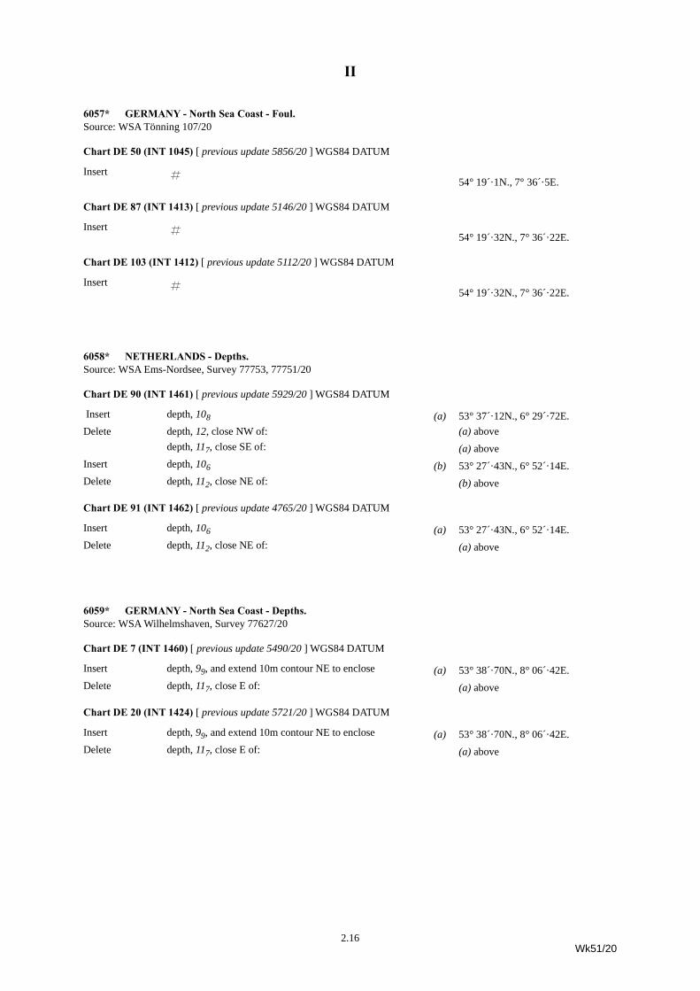
6057* GERMANY - North Sea Coast - Foul.Source: WSA Tönning 107/20
Chart DE 50 (INT 1045) [ previous update 5856/20 ] WGS84 DATUM
Insert « 54° 19´·1N., 7° 36´·5E.
Chart DE 87 (INT 1413) [ previous update 5146/20 ] WGS84 DATUM
Insert « 54° 19´·32N., 7° 36´·22E.
Chart DE 103 (INT 1412) [ previous update 5112/20 ] WGS84 DATUM
Insert « 54° 19´·32N., 7° 36´·22E.
6058* NETHERLANDS - Depths.Source: WSA Ems-Nordsee, Survey 77753, 77751/20
Chart DE 90 (INT 1461) [ previous update 5929/20 ] WGS84 DATUM
Insert depth, 108 (a) 53° 37´·12N., 6° 29´·72E.Delete depth, 12, close NW of: (a) above
depth, 117, close SE of: (a) aboveInsert depth, 106 (b) 53° 27´·43N., 6° 52´·14E.Delete depth, 112, close NE of: (b) above
Chart DE 91 (INT 1462) [ previous update 4765/20 ] WGS84 DATUM
Insert depth, 106 (a) 53° 27´·43N., 6° 52´·14E.Delete depth, 112, close NE of: (a) above
6059* GERMANY - North Sea Coast - Depths.Source: WSA Wilhelmshaven, Survey 77627/20
Chart DE 7 (INT 1460) [ previous update 5490/20 ] WGS84 DATUM
Insert depth, 99, and extend 10m contour NE to enclose (a) 53° 38´·70N., 8° 06´·42E.Delete depth, 117, close E of: (a) above
Chart DE 20 (INT 1424) [ previous update 5721/20 ] WGS84 DATUM
Insert depth, 99, and extend 10m contour NE to enclose (a) 53° 38´·70N., 8° 06´·42E.Delete depth, 117, close E of: (a) above
2.16Wk51/20
II
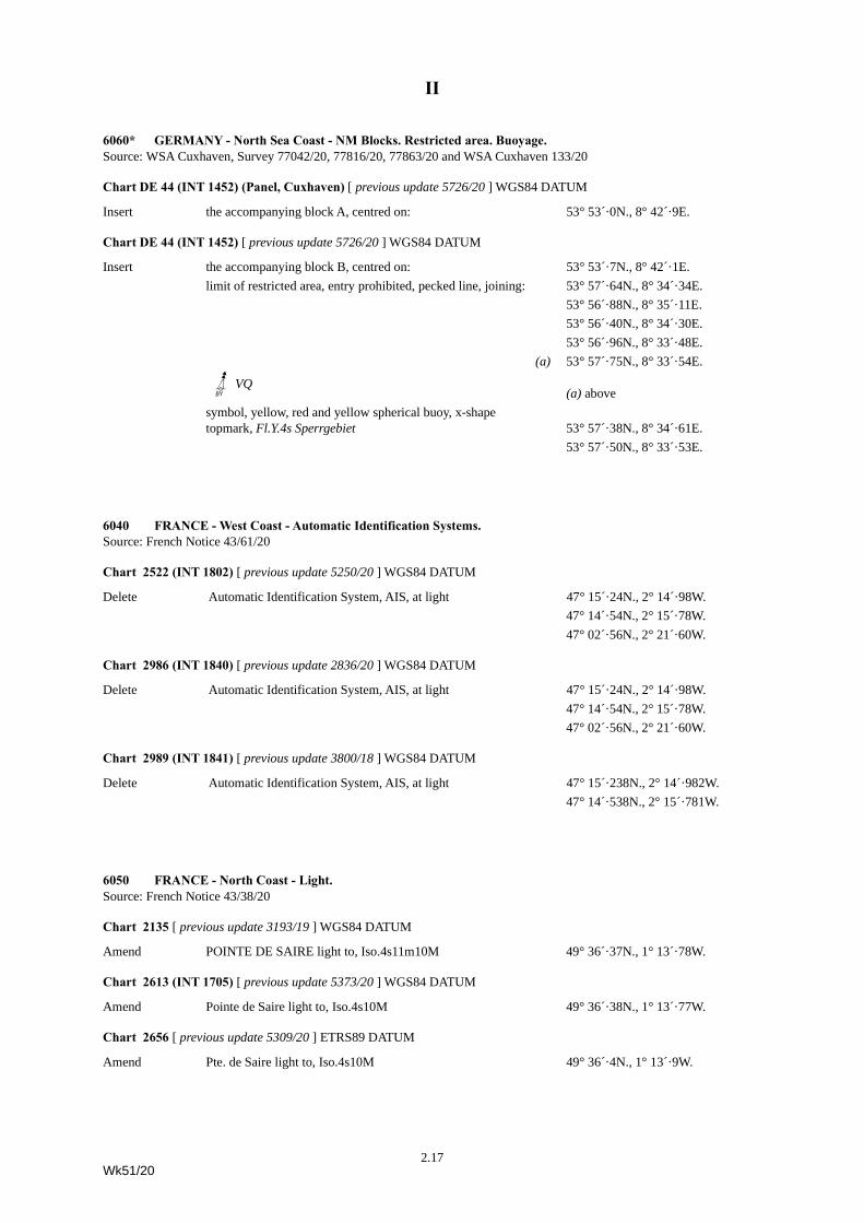
6060* GERMANY - North Sea Coast - NM Blocks. Restricted area. Buoyage.Source: WSA Cuxhaven, Survey 77042/20, 77816/20, 77863/20 and WSA Cuxhaven 133/20
Chart DE 44 (INT 1452) (Panel, Cuxhaven) [ previous update 5726/20 ] WGS84 DATUM
Insert the accompanying block A, centred on: 53° 53´·0N., 8° 42´·9E.
Chart DE 44 (INT 1452) [ previous update 5726/20 ] WGS84 DATUM
Insert the accompanying block B, centred on: 53° 53´·7N., 8° 42´·1E.limit of restricted area, entry prohibited, pecked line, joining: 53° 57´·64N., 8° 34´·34E.
53° 56´·88N., 8° 35´·11E.53° 56´·40N., 8° 34´·30E.53° 56´·96N., 8° 33´·48E.
(a) 53° 57´·75N., 8° 33´·54E.
GUmVQ(a) above
symbol, yellow, red and yellow spherical buoy, x-shape topmark, Fl.Y.4s Sperrgebiet 53° 57´·38N., 8° 34´·61E.
53° 57´·50N., 8° 33´·53E.
6040 FRANCE - West Coast - Automatic Identification Systems.Source: French Notice 43/61/20
Chart 2522 (INT 1802) [ previous update 5250/20 ] WGS84 DATUM
Delete Automatic Identification System, AIS, at light 47° 15´·24N., 2° 14´·98W.47° 14´·54N., 2° 15´·78W.47° 02´·56N., 2° 21´·60W.
Chart 2986 (INT 1840) [ previous update 2836/20 ] WGS84 DATUM
Delete Automatic Identification System, AIS, at light 47° 15´·24N., 2° 14´·98W.47° 14´·54N., 2° 15´·78W.47° 02´·56N., 2° 21´·60W.
Chart 2989 (INT 1841) [ previous update 3800/18 ] WGS84 DATUM
Delete Automatic Identification System, AIS, at light 47° 15´·238N., 2° 14´·982W.47° 14´·538N., 2° 15´·781W.
6050 FRANCE - North Coast - Light.Source: French Notice 43/38/20
Chart 2135 [ previous update 3193/19 ] WGS84 DATUM
Amend POINTE DE SAIRE light to, Iso.4s11m10M 49° 36´·37N., 1° 13´·78W.
Chart 2613 (INT 1705) [ previous update 5373/20 ] WGS84 DATUM
Amend Pointe de Saire light to, Iso.4s10M 49° 36´·38N., 1° 13´·77W.
Chart 2656 [ previous update 5309/20 ] ETRS89 DATUM
Amend Pte. de Saire light to, Iso.4s10M 49° 36´·4N., 1° 13´·9W.
2.17Wk51/20
II
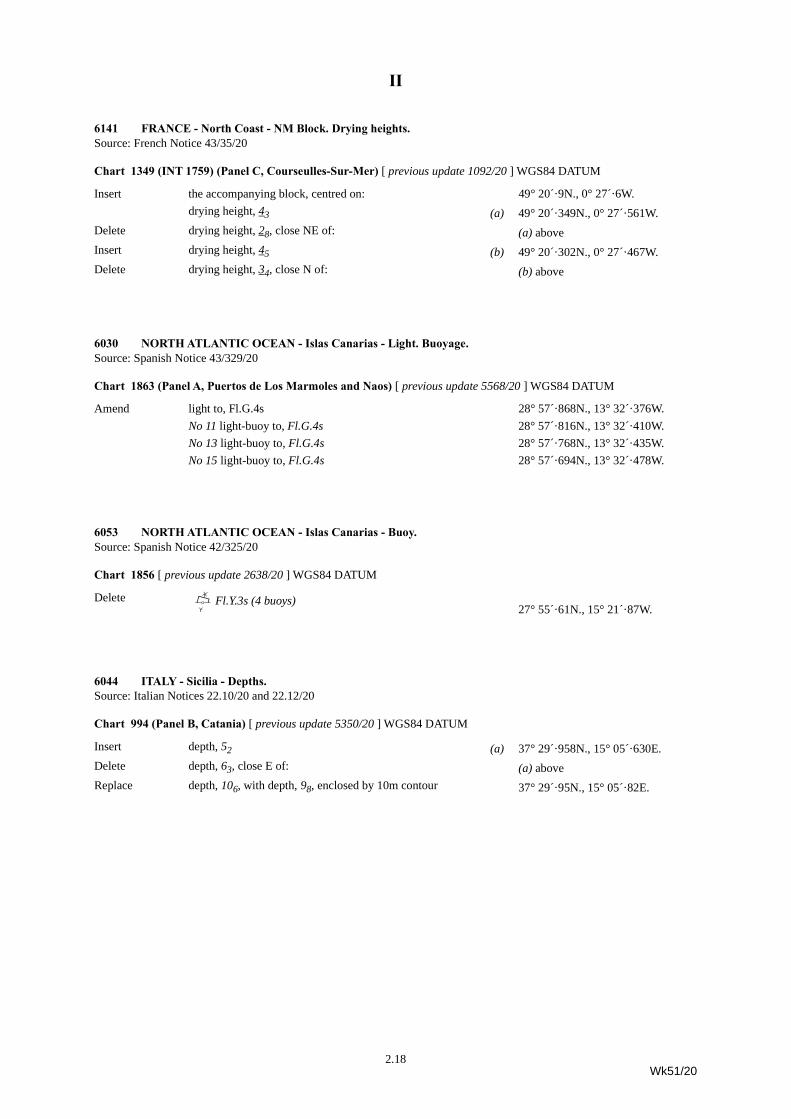
6141 FRANCE - North Coast - NM Block. Drying heights.Source: French Notice 43/35/20
Chart 1349 (INT 1759) (Panel C, Courseulles-Sur-Mer) [ previous update 1092/20 ] WGS84 DATUM
Insert the accompanying block, centred on: 49° 20´·9N., 0° 27´·6W.drying height, 43 (a) 49° 20´·349N., 0° 27´·561W.
Delete drying height, 28, close NE of: (a) aboveInsert drying height, 45 (b) 49° 20´·302N., 0° 27´·467W.Delete drying height, 34, close N of: (b) above
6030 NORTH ATLANTIC OCEAN - Islas Canarias - Light. Buoyage.Source: Spanish Notice 43/329/20
Chart 1863 (Panel A, Puertos de Los Marmoles and Naos) [ previous update 5568/20 ] WGS84 DATUM
Amend light to, Fl.G.4s 28° 57´·868N., 13° 32´·376W.No 11 light-buoy to, Fl.G.4s 28° 57´·816N., 13° 32´·410W.No 13 light-buoy to, Fl.G.4s 28° 57´·768N., 13° 32´·435W.No 15 light-buoy to, Fl.G.4s 28° 57´·694N., 13° 32´·478W.
6053 NORTH ATLANTIC OCEAN - Islas Canarias - Buoy.Source: Spanish Notice 42/325/20
Chart 1856 [ previous update 2638/20 ] WGS84 DATUM
Delete B;fFl.Y.3s (4 buoys)27° 55´·61N., 15° 21´·87W.
6044 ITALY - Sicilia - Depths.Source: Italian Notices 22.10/20 and 22.12/20
Chart 994 (Panel B, Catania) [ previous update 5350/20 ] WGS84 DATUM
Insert depth, 52 (a) 37° 29´·958N., 15° 05´·630E.Delete depth, 63, close E of: (a) aboveReplace depth, 106, with depth, 98, enclosed by 10m contour 37° 29´·95N., 15° 05´·82E.
2.18Wk51/20
II
6046 ITALY - East Coast - Wrecks.Source: Italian Notice 22.15/20
Chart 220 [ previous update 3263/20 ] WGS84 DATUM
Delete ´ 44° 08´·7N., 12° 38´·2E.44° 06´·7N., 12° 41´·9E.
Chart 1467 [ previous update 4562/20 ] WGS84 DATUM
Delete ´ 44° 08´·62N., 12° 38´·12E.44° 06´·69N., 12° 41´·82E.
6063 TUNISIA - Wreck.Source: French Notice 43/144/20
Chart 3403 (INT 3216) [ previous update 6091/19 ] WGS84 DATUM
Insert ´PA34° 38´·0N., 11° 17´·6E.
6066 SPAIN - Mediterranean Sea Coast - Automatic Identification System. Virtual aid to navigation. Buoy.Source: Spanish Lights corrections 43/20 and Spanish Notice 47/369/20
Chart 1700 [ previous update 2155/20 ] WGS84 DATUM
Insert Automatic Identification System, AIS, at light-buoy, out of position (a) 37° 44´·2N., 0° 41´·6W.
Replace symbol, Virtual aid to navigation, isolated danger topmark, V-AIS, out of position, with GoYFl(2)5s, out of position
(a) above
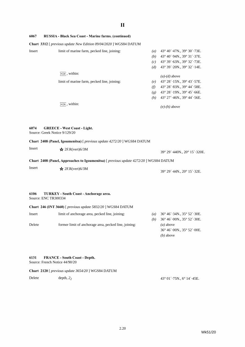
6067 RUSSIA - Black Sea Coast - Marine farms.Source: Russian Notices 44/4084-4085/20
Chart 2236 [ previous update 3645/19 ] WGS84 DATUM
Insert Ì 43° 40´·1N., 39° 31´·7E.43° 28´·2N., 39° 44´·7E.
2.19Wk51/20
II
Chart 3312 [ previous update New Edition 09/04/2020 ] WGS84 DATUM
Insert limit of marine farm, pecked line, joining: (a) 43° 40´·47N., 39° 30´·73E.(b) 43° 40´·94N., 39° 31´·37E.(c) 43° 39´·63N., 39° 32´·73E.(d) 43° 39´·20N., 39° 32´·14E.
Ì, within:(a)-(d) above
limit of marine farm, pecked line, joining: (e) 43° 28´·15N., 39° 43´·57E.(f) 43° 28´·83N., 39° 44´·58E.(g) 43° 28´·19N., 39° 45´·66E.(h) 43° 27´·46N., 39° 44´·56E.
Ì, within:(e)-(h) above
6074 GREECE - West Coast - Light.Source: Greek Notice 9/129/20
Chart 2408 (Panel, Igoumenítsa) [ previous update 4272/20 ] WGS84 DATUM
Insert ¶ 2F.R(vert)6/3M39° 29´·440N., 20° 15´·320E.
Chart 2408 (Panel, Approaches to Igoumenítsa) [ previous update 4272/20 ] WGS84 DATUM
Insert ¶ 2F.R(vert)6/3M39° 29´·44N., 20° 15´·32E.
6106 TURKEY - South Coast - Anchorage area.Source: ENC TR300334
Chart 246 (INT 3660) [ previous update 5832/20 ] WGS84 DATUM
Insert limit of anchorage area, pecked line, joining: (a) 36° 46´·34N., 35° 52´·30E.(b) 36° 46´·00N., 35° 52´·30E.
Delete former limit of anchorage area, pecked line, joining: (a) above36° 46´·00N., 35° 52´·00E.(b) above
6131 FRANCE - South Coast - Depth.Source: French Notice 44/90/20
Chart 2120 [ previous update 3654/20 ] WGS84 DATUM
Delete depth, 22 43° 01´·75N., 6° 14´·45E.
6067 RUSSIA - Black Sea Coast - Marine farms. (continued)
2.20Wk51/20
II
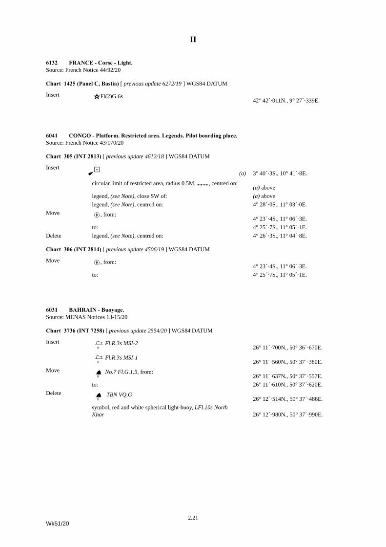
6132 FRANCE - Corse - Light.Source: French Notice 44/92/20
Chart 1425 (Panel C, Bastia) [ previous update 6272/19 ] WGS84 DATUM
Insert ¶Fl(2)G.6s42° 42´·011N., 9° 27´·339E.
6041 CONGO - Platform. Restricted area. Legends. Pilot boarding place.Source: French Notice 43/170/20
Chart 305 (INT 2813) [ previous update 4612/18 ] WGS84 DATUM
Insert ¼{ (a) 3° 40´·3S., 10° 41´·8E.
circular limit of restricted area, radius 0.5M,Ç, centred on:(a) above
legend, (see Note), close SW of: (a) abovelegend, (see Note), centred on: 4° 28´·0S., 11° 03´·0E.
Move Â, from:4° 23´·4S., 11° 06´·3E.
to: 4° 25´·7S., 11° 05´·1E.Delete legend, (see Note), centred on: 4° 26´·3S., 11° 04´·8E.
Chart 306 (INT 2814) [ previous update 4506/19 ] WGS84 DATUM
Move Â, from:4° 23´·4S., 11° 06´·3E.
to: 4° 25´·7S., 11° 05´·1E.
6031 BAHRAIN - Buoyage.Source: MENAS Notices 13-15/20
Chart 3736 (INT 7258) [ previous update 2554/20 ] WGS84 DATUM
Insert BdFl.R.3s MSI-2 26° 11´·700N., 50° 36´·670E.
BdFl.R.3s MSI-126° 11´·560N., 50° 37´·380E.
Move CbNo.7 Fl.G.1.5, from:26° 11´·637N., 50° 37´·557E.
to: 26° 11´·610N., 50° 37´·620E.Delete Cb TBN VQ.G
26° 12´·514N., 50° 37´·486E.symbol, red and white spherical light-buoy, LFl.10s North Khor 26° 12´·980N., 50° 37´·990E.
2.21Wk51/20
II
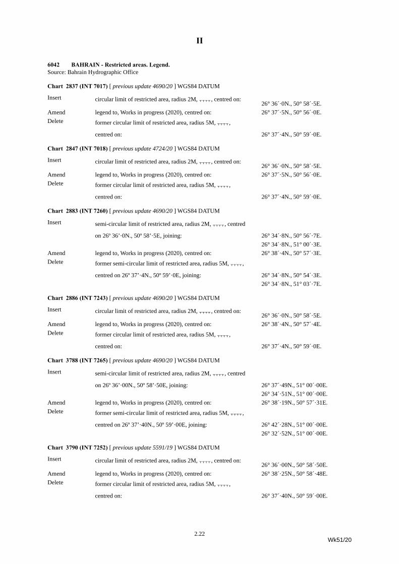
6042 BAHRAIN - Restricted areas. Legend.Source: Bahrain Hydrographic Office
Chart 2837 (INT 7017) [ previous update 4690/20 ] WGS84 DATUM
Insert circular limit of restricted area, radius 2M,Ç, centred on:26° 36´·0N., 50° 58´·5E.
Amend legend to, Works in progress (2020), centred on: 26° 37´·5N., 50° 56´·0E.Delete former circular limit of restricted area, radius 5M,Ç,
centred on: 26° 37´·4N., 50° 59´·0E.
Chart 2847 (INT 7018) [ previous update 4724/20 ] WGS84 DATUM
Insert circular limit of restricted area, radius 2M,Ç, centred on:26° 36´·0N., 50° 58´·5E.
Amend legend to, Works in progress (2020), centred on: 26° 37´·5N., 50° 56´·0E.Delete former circular limit of restricted area, radius 5M,Ç,
centred on: 26° 37´·4N., 50° 59´·0E.
Chart 2883 (INT 7260) [ previous update 4690/20 ] WGS84 DATUM
Insert semi-circular limit of restricted area, radius 2M,Ç, centred
on 26º 36’·0N., 50º 58’·5E, joining: 26° 34´·8N., 50° 56´·7E.26° 34´·8N., 51° 00´·3E.
Amend legend to, Works in progress (2020), centred on: 26° 38´·4N., 50° 57´·3E.Delete former semi-circular limit of restricted area, radius 5M,Ç,
centred on 26º 37’·4N., 50º 59’·0E, joining: 26° 34´·8N., 50° 54´·3E.26° 34´·8N., 51° 03´·7E.
Chart 2886 (INT 7243) [ previous update 4690/20 ] WGS84 DATUM
Insert circular limit of restricted area, radius 2M,Ç, centred on:26° 36´·0N., 50° 58´·5E.
Amend legend to, Works in progress (2020), centred on: 26° 38´·4N., 50° 57´·4E.Delete former circular limit of restricted area, radius 5M,Ç,
centred on: 26° 37´·4N., 50° 59´·0E.
Chart 3788 (INT 7265) [ previous update 4690/20 ] WGS84 DATUM
Insert semi-circular limit of restricted area, radius 2M,Ç, centred
on 26º 36’·00N., 50º 58’·50E, joining: 26° 37´·49N., 51° 00´·00E.26° 34´·51N., 51° 00´·00E.
Amend legend to, Works in progress (2020), centred on: 26° 38´·19N., 50° 57´·31E.Delete former semi-circular limit of restricted area, radius 5M,Ç,
centred on 26º 37’·40N., 50º 59’·00E, joining: 26° 42´·28N., 51° 00´·00E.26° 32´·52N., 51° 00´·00E.
Chart 3790 (INT 7252) [ previous update 5591/19 ] WGS84 DATUM
Insert circular limit of restricted area, radius 2M,Ç, centred on:26° 36´·00N., 50° 58´·50E.
Amend legend to, Works in progress (2020), centred on: 26° 38´·25N., 50° 58´·48E.Delete former circular limit of restricted area, radius 5M,Ç,
centred on: 26° 37´·40N., 50° 59´·00E.
2.22Wk51/20
II
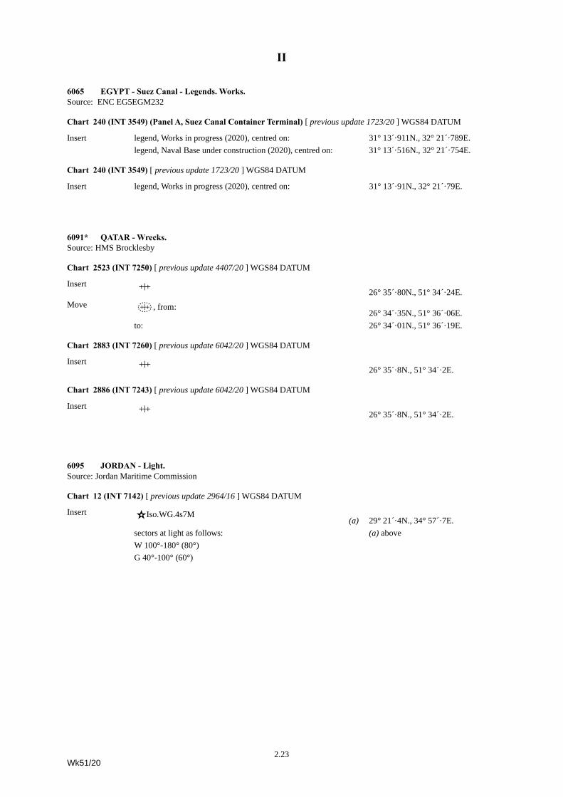
6065 EGYPT - Suez Canal - Legends. Works.Source: ENC EG5EGM232
Chart 240 (INT 3549) (Panel A, Suez Canal Container Terminal) [ previous update 1723/20 ] WGS84 DATUM
Insert legend, Works in progress (2020), centred on: 31° 13´·911N., 32° 21´·789E.legend, Naval Base under construction (2020), centred on: 31° 13´·516N., 32° 21´·754E.
Chart 240 (INT 3549) [ previous update 1723/20 ] WGS84 DATUM
Insert legend, Works in progress (2020), centred on: 31° 13´·91N., 32° 21´·79E.
6091* QATAR - Wrecks.Source: HMS Brocklesby
Chart 2523 (INT 7250) [ previous update 4407/20 ] WGS84 DATUM
Insert ^ 26° 35´·80N., 51° 34´·24E.Move ´, from:
26° 34´·35N., 51° 36´·06E.to: 26° 34´·01N., 51° 36´·19E.
Chart 2883 (INT 7260) [ previous update 6042/20 ] WGS84 DATUM
Insert ^ 26° 35´·8N., 51° 34´·2E.
Chart 2886 (INT 7243) [ previous update 6042/20 ] WGS84 DATUM
Insert ^ 26° 35´·8N., 51° 34´·2E.
6095 JORDAN - Light.Source: Jordan Maritime Commission
Chart 12 (INT 7142) [ previous update 2964/16 ] WGS84 DATUM
Insert ¶Iso.WG.4s7M(a) 29° 21´·4N., 34° 57´·7E.
sectors at light as follows: (a) aboveW 100°-180° (80°)G 40°-100° (60°)
2.23Wk51/20
II
6130* UNITED ARAB EMIRATES - Buoyage.Source: ADNOC and MENAS
Chart 2889 (INT 7211) [ previous update 5610/20 ] WGS84 DATUM
Insert GWrQ(3)10s BT124° 39´·7N., 53° 07´·7E.
GXsQ(9)15s BT524° 39´·0N., 53° 01´·5E.
GUmQ BT624° 40´·9N., 53° 04´·4E.
Chart 3178 (INT 7226) [ previous update 4695/20 ] WGS84 DATUM
Insert GXsQ(9)15s BT424° 33´·94N., 53° 00´·60E.
GXsQ(9)15s BT524° 39´·04N., 53° 01´·53E.
GUmQ BT624° 40´·89N., 53° 04´·37E.
GWrQ(3)10s BT124° 39´·69N., 53° 07´·69E.
GWrQ(3)10s BT224° 34´·98N., 53° 09´·99E.
GVqQ(6)+LFl.15s BT324° 31´·33N., 53° 06´·05E.
GUmQ B124° 24´·20N., 53° 04´·85E.
GXsQ(9)15s B524° 22´·55N., 53° 02´·29E.
GXsQ(9)15s B424° 19´·10N., 53° 01´·68E.
GVqQ(6)+LFl.15s B324° 16´·12N., 53° 07´·22E.
Chart 3179 (INT 7229) [ previous update 5610/20 ] WGS84 DATUM
Insert GUmQ BT624° 40´·89N., 53° 04´·37E.
GsXQ(9)15s BT524° 39´·04N., 53° 01´·53E.
GXsQ(9)15s BT424° 33´·94N., 53° 00´·60E.
GUmQ B124° 24´·20N., 53° 04´·85E.
GXsQ(9)15s B524° 22´·55N., 53° 02´·29E.
GXsQ(9)15s B424° 19´·10N., 53° 01´·68E.
6037 BANGLADESH - Building. Pilot boarding places.Source: Indian Notice 20/201/20
Chart IN 31 (INT 756) [ previous update 5377/20 ] WGS84 DATUM
Insert symbol, Harbour Masters’s office 21° 59´·3N., 90° 16´·7E.
ÂGround B (Rough Weather) 21° 41´·0N., 90° 15´·0E.
ÂGround A (Fair Weather)21° 21´·1N., 90° 02´·4E.
2.24Wk51/20
II
6048 SINGAPORE - Depth.Source: MPA and UKHO
Chart 4033 [ previous update New Edition 08/10/2020 ] WGS84 DATUM
Replace depth, 116, with depth, 115 1° 17´·290N., 103° 42´·030E.
6033 CHINA - East Coast - Light-beacon.Source: Chinese Notice 41/1492/20
Chart 1303 [ previous update 5887/20 ] CGCS 2000 DATUM
Delete TÜl Mo(C)Y.12s13m3M Cefeng 30° 24´·53N., 121° 58´·99E.
6049 CHINA - South Coast - Buoyage.Source: Chinese Notice 41/1496/20
Chart 3939 [ previous update 5330/20 ] CGCS 2000 DATUM
Insert BöFl(2+1)R.6s B0 21° 29´·05N., 109° 03´·15E.
Move BdFl(3)R.10s B2, from:21° 29´·06N., 109° 03´·25E.
to: 21° 28´·91N., 109° 03´·44E.
CbFl(2)G.6s B3, from: 21° 28´·75N., 109° 03´·48E.
to: 21° 28´·70N., 109° 03´·44E.
6055 CHINA - East Coast - Works.Source: Chinese Notice 41/1502(T)/20
Chart 1304 [ previous update 5897/20 ] CGCS 2000 DATUM
Insert legend, Works in progress (2020), centred on: 29° 58´·88N., 121° 50´·51E.
Chart 1592 [ previous update 4457/20 ] WGS84 DATUM
Insert legend, Works in progress (2020), centred on: 29° 58´·84N., 121° 50´·57E.
6061 CHINA - South Coast - Buoyage.Source: Chinese Notice 41/1495/20
Chart 1555 [ previous update 5658/20 ] CGCS 2000 DATUM
Insert G;fMo(O)Y.12s No 1321° 30´·2N., 112° 13´·7E.
G;fMo(O)Y.12s Zhongguangheshi No 1 21° 30´·2N., 112° 17´·3E.
G;fMo(O)Y.12s No 321° 27´·1N., 112° 17´·2E.
2.25Wk51/20
II
6070 VIETNAM - Wreck. Light.Source: ENC VN320026
Chart 3989 [ previous update 5916/20 ] WGS84 DATUM
Insert ´ 17° 38´·0N., 106° 33´·1E.Amend light to, Fl(3+1)16s20m18M 17° 42´·1N., 106° 29´·5E.
6071 TAIWAN - NM Block. Depths. Rocks.Source: UKHO
Chart 1760 [ previous update 5895/20 ] WGS84 DATUM
Insert depth, 91, and extend 100m contour E to enclose 23° 22´·8N., 119° 48´·5E.depth, 94, and extend 100m contour W to enclose 23° 28´·0N., 119° 55´·8E.depth, 84, and extend 100m contour E to enclose (a) 23° 25´·0N., 119° 47´·0E.
Delete depth, 102, close E of: (a) aboveInsert depth, 95, enclosed by 100m contour (b) 23° 25´·1N., 119° 52´·7E.Delete depth, 112, close SW of: (b) aboveInsert depth, 104 (c) 23° 27´·4N., 119° 52´·3E.Delete depth, 120, close NE of: (c) aboveInsert depth, 129 (d) 23° 09´·3N., 119° 50´·3E.Delete depth, 159, close W of: (d) aboveReplace depth, 25, with depth, 22 23° 17´·8N., 119° 40´·7E.
depth, 265, with seabed type, R, with depth, 22, with seabed type, R 23° 16´·9N., 119° 44´·7E.
Chart 1968 [ previous update 5895/20 ] WGS84 DATUM
Insert depth, 95, enclosed by 100m contour 23° 25´·1N., 119° 52´·7E.depth, 95, and extend 100m contour SW to enclose 23° 03´·0N., 119° 42´·0E.depth, 75 (a) 23° 05´·9N., 119° 41´·2E.
Delete depth, 89, close SW of: (a) aboveInsert depth, 73 (b) 23° 00´·1N., 119° 36´·7E. Delete depth, 77, close S of: (b) aboveInsert depth, 94, enclosed by 100m contour 23° 03´·7N., 119° 49´·8E.Replace depth, 265, with seabed type, R, with depth, 22, with seabed
type, R 23° 16´·9N., 119° 44´·7E.
2.26Wk51/20
II
Chart 2409 [ previous update 5895/20 ] WGS84 DATUM
Insert the accompanying block, centred on: 23° 10´·0N., 119° 45´·2E.depth, 91, enclosed by 100m contour 23° 22´·78N., 119° 48´·46E.depth, 95, enclosed by 100m contour 23° 25´·12N., 119° 52´·69E.depth, 73, and extend 100m approximate contour SE to enclose 23° 00´·13N., 119° 36´·69E.depth, 104 (a) 23° 27´·35N., 119° 52´·30E.
Delete depth, 120, close N of: (a) aboveInsert depth, 71 (b) 23° 16´·67N., 119° 57´·01E.Delete depth, 83, close SE of: (b) aboveInsert depth, 74 (c) 23° 00´·20N., 119° 34´·85E.Delete depth, 91, close E of: (c) aboveInsert depth, 96, enclosed by 100m contour (d) 23° 21´·11N., 119° 48´·72E.Delete depth, 124, close NE of: (d) aboveInsert depth, 94, and extend 100m contour W to enclose (e) 23° 27´·99N., 119° 55´·80E.Delete depth, 106, close N of: (e) aboveInsert depth, 84, and extend 100m contour E to enclose (f) 23° 25´·00N., 119° 47´·00E.Delete depth, 102, close E of: (f) above
Chart 3489 (INT 553) [ previous update 5774/20 ] WGS84 DATUM
Insert depth, 94, enclosed by 100m contour 23° 03´·7N., 119° 49´·8E.depth, 129 (a) 23° 09´·3N., 119° 50´·3E.
Delete depth, 159, close W of: (a) aboveInsert depth, 75, and extend 100m contour E to enclose (b) 23° 05´·9N., 119° 41´·2E.Delete depth, 122, close S of: (b) aboveInsert depth, 95, and extend 100m contour W to enclose (c) 23° 25´·1N., 119° 52´·7E.Delete depth, 115, close W of: (c) aboveReplace depth, 265, with seabed type, R, with depth, 22, with seabed
type, R 23° 16´·9N., 119° 44´·7E.
Chart 4508 (INT 508) [ previous update 5916/20 ] WGS84 DATUM
Replace depth, 159, with depth, 129 23° 09´·3N., 119° 50´·3E.
Chart 4509 (INT 509) [ previous update 5115/20 ] WGS84 DATUM
Replace depth, 159, with depth, 129 23° 09´·3N., 119° 50´·3E.
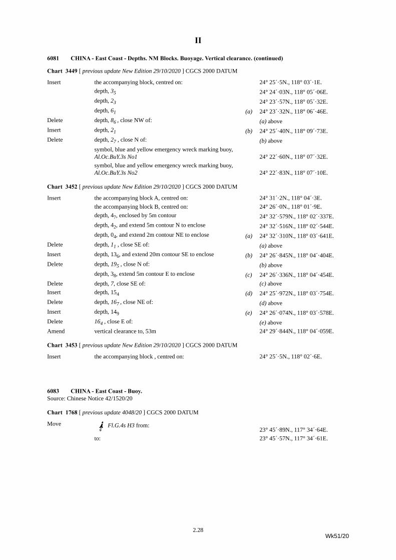
6081 CHINA - East Coast - Depths. NM Blocks. Buoyage. Vertical clearance.Source: Chinese Chart 14291
Chart 1719 [ previous update 5632/20 ] CGCS 2000 DATUM
Insert depth, 92 , and extend 10m contour NE to enclose (a) 24° 30´·80N., 118° 13´·13E.Delete depth, 95 , close SW of: (a) aboveInsert depth, 54 (b) 24° 30´·79N., 118° 13´·92E.Delete depth, 76 , close SW of: (b) above
6071 TAIWAN - NM Block. Depths. Rocks. (continued)
2.27Wk51/20
II
Chart 3449 [ previous update New Edition 29/10/2020 ] CGCS 2000 DATUM
Insert the accompanying block, centred on: 24° 25´·5N., 118° 03´·1E.depth, 35 24° 24´·03N., 118° 05´·06E.depth, 23 24° 23´·57N., 118° 05´·32E.depth, 61 (a) 24° 23´·32N., 118° 06´·46E.
Delete depth, 86 , close NW of: (a) aboveInsert depth, 21 (b) 24° 25´·40N., 118° 09´·73E.Delete depth, 27 , close N of: (b) above
symbol, blue and yellow emergency wreck marking buoy, Al.Oc.BuY.3s No1 24° 22´·60N., 118° 07´·32E.symbol, blue and yellow emergency wreck marking buoy, Al.Oc.BuY.3s No2 24° 22´·83N., 118° 07´·10E.
Chart 3452 [ previous update New Edition 29/10/2020 ] CGCS 2000 DATUM
Insert the accompanying block A, centred on: 24° 31´·2N., 118° 04´·3E.the accompanying block B, centred on: 24° 26´·0N., 118° 01´·9E.depth, 47, enclosed by 5m contour 24° 32´·579N., 118° 02´·337E.depth, 42, and extend 5m contour N to enclose 24° 32´·516N., 118° 02´·544E.depth, 04, and extend 2m contour NE to enclose (a) 24° 32´·310N., 118° 03´·641E.
Delete depth, 11 , close SE of: (a) aboveInsert depth, 136, and extend 20m contour SE to enclose (b) 24° 26´·845N., 118° 04´·404E.Delete depth, 195 , close N of: (b) above
depth, 38, extend 5m contour E to enclose (c) 24° 26´·336N., 118° 04´·454E.Delete depth, 7, close SE of: (c) aboveInsert depth, 154 (d) 24° 25´·972N., 118° 03´·754E.Delete depth, 167 , close NE of: (d) aboveInsert depth, 149 (e) 24° 26´·074N., 118° 03´·578E.Delete 164 , close E of: (e) aboveAmend vertical clearance to, 53m 24° 29´·844N., 118° 04´·059E.
Chart 3453 [ previous update New Edition 29/10/2020 ] CGCS 2000 DATUM
Insert the accompanying block , centred on: 24° 25´·5N., 118° 02´·6E.
6083 CHINA - East Coast - Buoy.Source: Chinese Notice 42/1520/20
Chart 1768 [ previous update 4048/20 ] CGCS 2000 DATUM
Move I]bbFl.G.4s H3 from:23° 45´·89N., 117° 34´·64E.
to: 23° 45´·57N., 117° 34´·61E.
6081 CHINA - East Coast - Depths. NM Blocks. Buoyage. Vertical clearance. (continued)
2.28Wk51/20
II
6087 VIETNAM - Lights.Source: ENC VN320019
Chart 3989 [ previous update 6070/20 ] WGS84 DATUM
Amend light to, Fl(2+1)10s202m20M 18° 47´·8N., 105° 57´·4E.light to, Fl.4s35m20M 18° 15´·9N., 106° 07´·4E.
6088 CHINA - East Coast - Virtual aid to navigation.Source: Chinese Notice 42/1514/2020
Chart 1754 [ previous update 5657/20 ] WGS84 DATUM
Insert symbol, Virtual aid to navigation, isolated danger topmark, V-AIS 26° 18´·0N., 120° 17´·2E.
Chart 1761 [ previous update 5795/20 ] WGS84 DATUM
Insert symbol, Virtual aid to navigation, isolated danger topmark, V-AIS 26° 18´·0N., 120° 17´·2E.
Chart 2400 [ previous update 5899/20 ] CGCS 2000 DATUM
Insert symbol, Virtual aid to navigation, isolated danger topmark, V-AIS 26° 18´·04N., 120° 17´·19E.
6093 CHINA - East Coast - Virtual aids to navigation.Source: Chinese Notices 42/1508-1509/2020
Chart 1126 [ previous update 5639/20 ] CGCS 2000 DATUM
Insert symbol, Virtual aid to navigation, isolated danger topmark, V-AIS 29° 45´·27N., 122° 27´·19E.
Chart 1130 [ previous update 4959/20 ] CGCS 2000 DATUM
Insert symbol, Virtual aid to navigation, isolated danger topmark, V-AIS 29° 56´·82N., 122° 12´·14E.
Chart 1759 [ previous update 5639/20 ] CGCS 2000 DATUM
Insert symbol, Virtual aid to navigation, isolated danger topmark, V-AIS 29° 45´·3N., 122° 27´·2E.
6098 VIETNAM - Wreck.Source: VMS-North Notice 181/20
Chart 1965 [ previous update 4338/20 ] WGS84 DATUM
Insert ´PA20° 45´·93N., 107° 28´·13E.
2.29Wk51/20
II
6105 SOUTH CHINA SEA - Note.Source: UKHO
Chart 94 [ previous update 5399/19 ] UNDETERMINED DATUM
Insert the accompanying note, AUTOMATIC IDENTIFICATION SYSTEMS, centred on: 17° 17´·5N., 114° 50´·5E.
6125 CHINA - South Coast - Buoyage. Automatic Identification Systems.Source: Chinese Notice 42/1522/20
Chart 1784 [ previous update 5754/20 ] CGCS 2000 DATUM
Insert G;fMo(O)Y.12s SQ1(a) 22° 40´·27N., 116° 12´·46E.
G;fMo(O)Y.12s SQ2(b) 22° 41´·39N., 116° 16´·03E.
G;fMo(O)Y.12s SQ3(c) 22° 42´·52N., 116° 19´·77E.
G;fMo(O)Y.12s SQ4(d) 22° 38´·22N., 116° 19´·80E.
G;fMo(O)Y.12s SQ5(e) 22° 37´·01N., 116° 16´·19E.
G;fMo(O)Y.12s SQ6(f) 22° 35´·77N., 116° 12´·46E.
Automatic Identification System, AIS, centred on: (a)(b) (c) (d) (e) (f)
Chart 1962 [ previous update 5757/20 ] WGS84 DATUM
Insert G;fMo(O)Y.12s SQ122° 40´·3N., 116° 12´·5E.
G;fMo(O)Y.12s SQ222° 41´·4N., 116° 16´·0E.
G;fMo(O)Y.12s SQ322° 42´·5N., 116° 19´·8E.
G;fMo(O)Y.12s SQ422° 38´·2N., 116° 19´·8E.
G;fMo(O)Y.12s SQ522° 37´·0N., 116° 16´·2E.
G;fMo(O)Y.12s SQ622° 35´·8N., 116° 12´·5E.
Chart 1968 [ previous update 6071/20 ] WGS84 DATUM
Insert G;fMo(O)Y.12s22° 40´·3N., 116° 12´·5E.22° 42´·5N., 116° 19´·8E.22° 38´·2N., 116° 19´·8E.22° 35´·8N., 116° 12´·5E.
2.30Wk51/20
II
6135 VIETNAM - Rock.Source: ENC VN250016 and UKHONote: Certain copies only
Chart 67 [ previous update 5784/20 ] WGS84 DATUM
Insert . 10° 53´·3N., 102° 48´·9E.
6136 MALAYSIA - Peninsular Malaysia, East Coast - Buoy.Source: Marine Department, Malaysia Notice 228/20
Chart 1379 (Panel A, Kuantan Port) [ previous update 3792/20 ] WGS84 DATUM
Amend light-buoy to, Fl(2)10s 3° 57´·807N., 103° 27´·308E.
Chart 1379 [ previous update 3792/20 ] WGS84 DATUM
Amend light-buoy to, Fl(2)10s 3° 57´·81N., 103° 27´·31E.
6107 JAPAN - Honshū - Wreck.Source: Japanese Notice 46/844/20
Chart JP 139 [ previous update 4060/20 ] WGS84 DATUM
Insert ^PA36° 12´·7N., 136° 06´·3E.
Chart JP 1169 [ previous update 3392/20 ] WGS84 DATUM
Insert ^PA36° 12´·7N., 136° 06´·3E.
6108 JAPAN - Honshū - Depths.Source: Japanese Notice 46/845/20
Chart JP 1155B [ previous update 2926/20 ] WGS84 DATUM
Insert depth, 119 (a) 37° 59´ 24·8"N., 139° 13´ 08·6"E.Delete depth, 11, close E of: (a) above
6109 JAPAN - Honshū - Buoy. Automatic Identification System.Source: Japanese Notice 46/846/20
Chart JP 10 [ previous update 5417/20 ] WGS84 DATUM
Delete Df (Y Lt) and associated Automatic Identification System,
AIS 40° 58´·70N., 141° 11´·75E.
2.31Wk51/20
II
6110 JAPAN - Honshū - Buoy.Source: Japanese Notice 46/848/20
Chart JP 67 [ previous update 961/20 ] WGS84 DATUM
Delete Gf(Y Lt)35° 29´ 25·1"N., 139° 45´ 35·4"E.
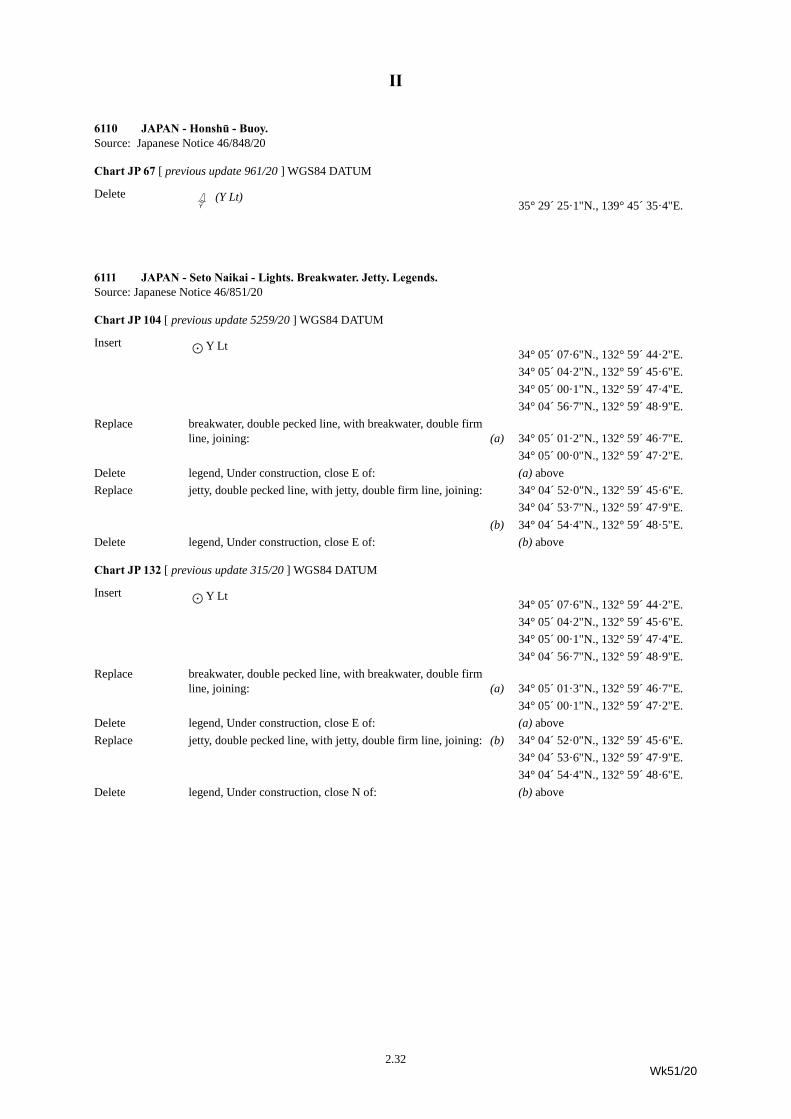
6111 JAPAN - Seto Naikai - Lights. Breakwater. Jetty. Legends.Source: Japanese Notice 46/851/20
Chart JP 104 [ previous update 5259/20 ] WGS84 DATUM
Insert è Y Lt 34° 05´ 07·6"N., 132° 59´ 44·2"E.34° 05´ 04·2"N., 132° 59´ 45·6"E.34° 05´ 00·1"N., 132° 59´ 47·4"E.34° 04´ 56·7"N., 132° 59´ 48·9"E.
Replace breakwater, double pecked line, with breakwater, double firm line, joining: (a) 34° 05´ 01·2"N., 132° 59´ 46·7"E.
34° 05´ 00·0"N., 132° 59´ 47·2"E.Delete legend, Under construction, close E of: (a) aboveReplace jetty, double pecked line, with jetty, double firm line, joining: 34° 04´ 52·0"N., 132° 59´ 45·6"E.
34° 04´ 53·7"N., 132° 59´ 47·9"E.(b) 34° 04´ 54·4"N., 132° 59´ 48·5"E.
Delete legend, Under construction, close E of: (b) above
Chart JP 132 [ previous update 315/20 ] WGS84 DATUM
Insert è Y Lt34° 05´ 07·6"N., 132° 59´ 44·2"E.34° 05´ 04·2"N., 132° 59´ 45·6"E.34° 05´ 00·1"N., 132° 59´ 47·4"E.34° 04´ 56·7"N., 132° 59´ 48·9"E.
Replace breakwater, double pecked line, with breakwater, double firm line, joining: (a) 34° 05´ 01·3"N., 132° 59´ 46·7"E.
34° 05´ 00·1"N., 132° 59´ 47·2"E.Delete legend, Under construction, close E of: (a) aboveReplace jetty, double pecked line, with jetty, double firm line, joining: (b) 34° 04´ 52·0"N., 132° 59´ 45·6"E.
34° 04´ 53·6"N., 132° 59´ 47·9"E.34° 04´ 54·4"N., 132° 59´ 48·6"E.
Delete legend, Under construction, close N of: (b) above
2.32Wk51/20
II
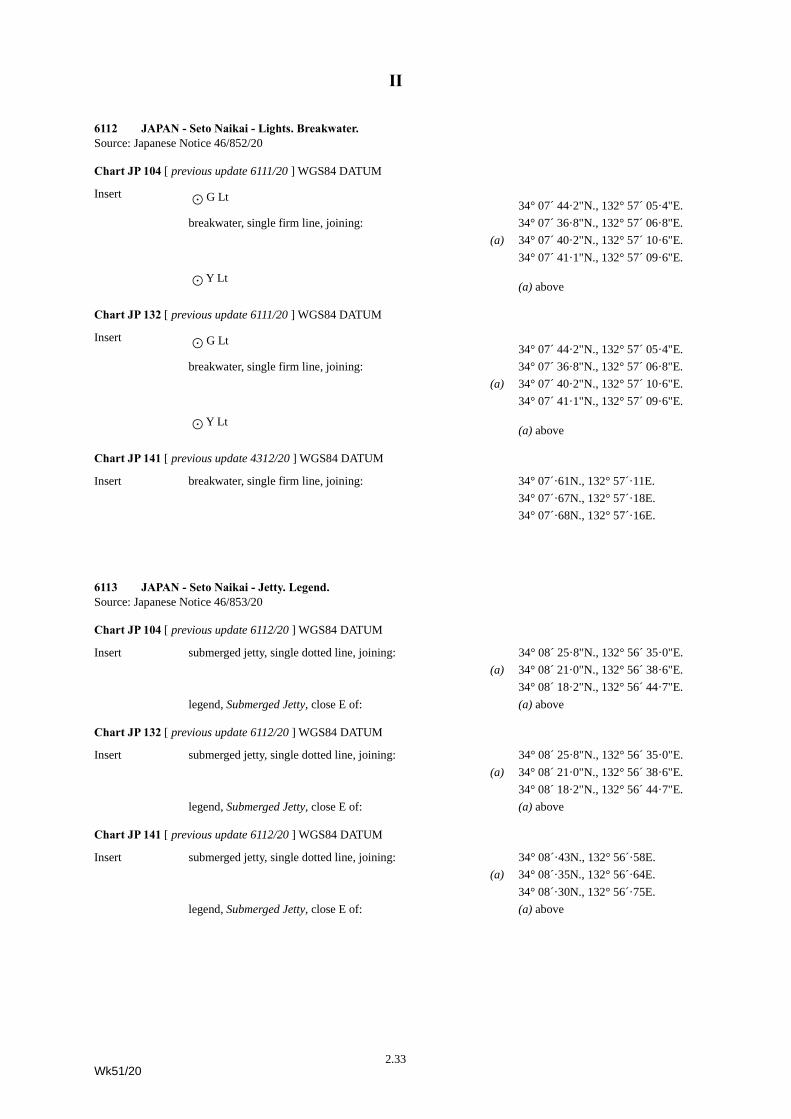
6112 JAPAN - Seto Naikai - Lights. Breakwater.Source: Japanese Notice 46/852/20
Chart JP 104 [ previous update 6111/20 ] WGS84 DATUM
Insert è G Lt34° 07´ 44·2"N., 132° 57´ 05·4"E.
breakwater, single firm line, joining: 34° 07´ 36·8"N., 132° 57´ 06·8"E.(a) 34° 07´ 40·2"N., 132° 57´ 10·6"E.
34° 07´ 41·1"N., 132° 57´ 09·6"E.
è Y Lt(a) above
Chart JP 132 [ previous update 6111/20 ] WGS84 DATUM
Insert è G Lt34° 07´ 44·2"N., 132° 57´ 05·4"E.
breakwater, single firm line, joining: 34° 07´ 36·8"N., 132° 57´ 06·8"E.(a) 34° 07´ 40·2"N., 132° 57´ 10·6"E.
34° 07´ 41·1"N., 132° 57´ 09·6"E.
è Y Lt(a) above
Chart JP 141 [ previous update 4312/20 ] WGS84 DATUM
Insert breakwater, single firm line, joining: 34° 07´·61N., 132° 57´·11E.34° 07´·67N., 132° 57´·18E.34° 07´·68N., 132° 57´·16E.
6113 JAPAN - Seto Naikai - Jetty. Legend.Source: Japanese Notice 46/853/20
Chart JP 104 [ previous update 6112/20 ] WGS84 DATUM
Insert submerged jetty, single dotted line, joining: 34° 08´ 25·8"N., 132° 56´ 35·0"E.(a) 34° 08´ 21·0"N., 132° 56´ 38·6"E.
34° 08´ 18·2"N., 132° 56´ 44·7"E.legend, Submerged Jetty, close E of: (a) above
Chart JP 132 [ previous update 6112/20 ] WGS84 DATUM
Insert submerged jetty, single dotted line, joining: 34° 08´ 25·8"N., 132° 56´ 35·0"E.(a) 34° 08´ 21·0"N., 132° 56´ 38·6"E.
34° 08´ 18·2"N., 132° 56´ 44·7"E.legend, Submerged Jetty, close E of: (a) above
Chart JP 141 [ previous update 6112/20 ] WGS84 DATUM
Insert submerged jetty, single dotted line, joining: 34° 08´·43N., 132° 56´·58E.(a) 34° 08´·35N., 132° 56´·64E.
34° 08´·30N., 132° 56´·75E.legend, Submerged Jetty, close E of: (a) above
2.33Wk51/20
II
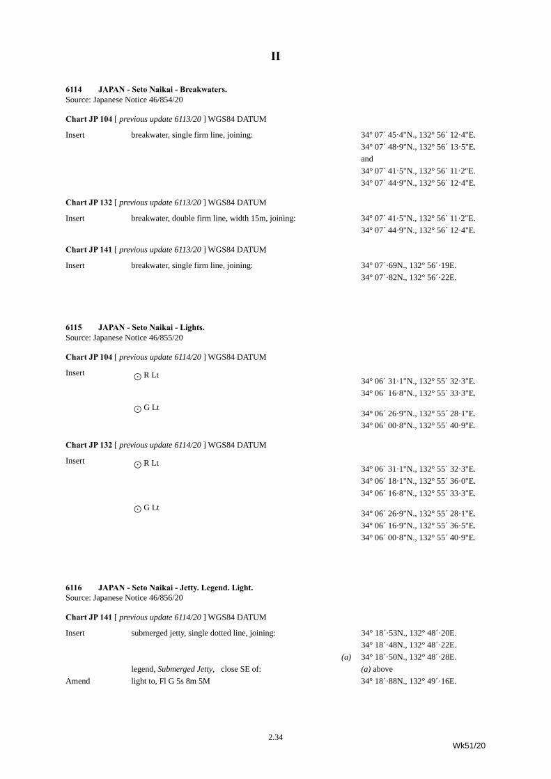
6114 JAPAN - Seto Naikai - Breakwaters.Source: Japanese Notice 46/854/20
Chart JP 104 [ previous update 6113/20 ] WGS84 DATUM
Insert breakwater, single firm line, joining: 34° 07´ 45·4"N., 132° 56´ 12·4"E.34° 07´ 48·9"N., 132° 56´ 13·5"E.and34° 07´ 41·5"N., 132° 56´ 11·2"E.34° 07´ 44·9"N., 132° 56´ 12·4"E.
Chart JP 132 [ previous update 6113/20 ] WGS84 DATUM
Insert breakwater, double firm line, width 15m, joining: 34° 07´ 41·5"N., 132° 56´ 11·2"E.34° 07´ 44·9"N., 132° 56´ 12·4"E.
Chart JP 141 [ previous update 6113/20 ] WGS84 DATUM
Insert breakwater, single firm line, joining: 34° 07´·69N., 132° 56´·19E.34° 07´·82N., 132° 56´·22E.
6115 JAPAN - Seto Naikai - Lights.Source: Japanese Notice 46/855/20
Chart JP 104 [ previous update 6114/20 ] WGS84 DATUM
Insert è R Lt34° 06´ 31·1"N., 132° 55´ 32·3"E.34° 06´ 16·8"N., 132° 55´ 33·3"E.
è G Lt34° 06´ 26·9"N., 132° 55´ 28·1"E.34° 06´ 00·8"N., 132° 55´ 40·9"E.
Chart JP 132 [ previous update 6114/20 ] WGS84 DATUM
Insert è R Lt34° 06´ 31·1"N., 132° 55´ 32·3"E.34° 06´ 18·1"N., 132° 55´ 36·0"E.34° 06´ 16·8"N., 132° 55´ 33·3"E.
è G Lt34° 06´ 26·9"N., 132° 55´ 28·1"E.34° 06´ 16·9"N., 132° 55´ 36·5"E.34° 06´ 00·8"N., 132° 55´ 40·9"E.
6116 JAPAN - Seto Naikai - Jetty. Legend. Light.Source: Japanese Notice 46/856/20
Chart JP 141 [ previous update 6114/20 ] WGS84 DATUM
Insert submerged jetty, single dotted line, joining: 34° 18´·53N., 132° 48´·20E.34° 18´·48N., 132° 48´·22E.
(a) 34° 18´·50N., 132° 48´·28E.legend, Submerged Jetty, close SE of: (a) above
Amend light to, Fl G 5s 8m 5M 34° 18´·88N., 132° 49´·16E.
2.34Wk51/20
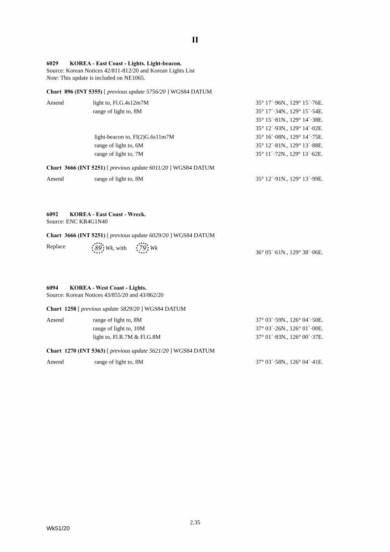
II
6029 KOREA - East Coast - Lights. Light-beacon.Source: Korean Notices 42/811-812/20 and Korean Lights ListNote: This update is included on NE1065.
Chart 896 (INT 5355) [ previous update 5756/20 ] WGS84 DATUM
Amend light to, Fl.G.4s12m7M 35° 17´·96N., 129° 15´·76E.range of light to, 8M 35° 17´·34N., 129° 15´·54E.
35° 15´·81N., 129° 14´·38E.35° 12´·93N., 129° 14´·02E.
light-beacon to, Fl(2)G.6s11m7M 35° 16´·08N., 129° 14´·75E. range of light to, 6M 35° 12´·81N., 129° 13´·88E. range of light to, 7M 35° 11´·72N., 129° 13´·62E.
Chart 3666 (INT 5251) [ previous update 6011/20 ] WGS84 DATUM
Amend range of light to, 8M 35° 12´·91N., 129° 13´·99E.
6092 KOREA - East Coast - Wreck.Source: ENC KR4G1N40
Chart 3666 (INT 5251) [ previous update 6029/20 ] WGS84 DATUM
Replace 89, Wk, with 79, Wk36° 05´·61N., 129° 38´·06E.
6094 KOREA - West Coast - Lights.Source: Korean Notices 43/855/20 and 43/862/20
Chart 1258 [ previous update 5829/20 ] WGS84 DATUM
Amend range of light to, 8M 37° 03´·59N., 126° 04´·50E.range of light to, 10M 37° 03´·26N., 126° 01´·00E.light to, Fl.R.7M & Fl.G.8M 37° 01´·83N., 126° 00´·37E.
Chart 1270 (INT 5363) [ previous update 5621/20 ] WGS84 DATUM
Amend range of light to, 8M 37° 03´·58N., 126° 04´·41E.
2.35Wk51/20
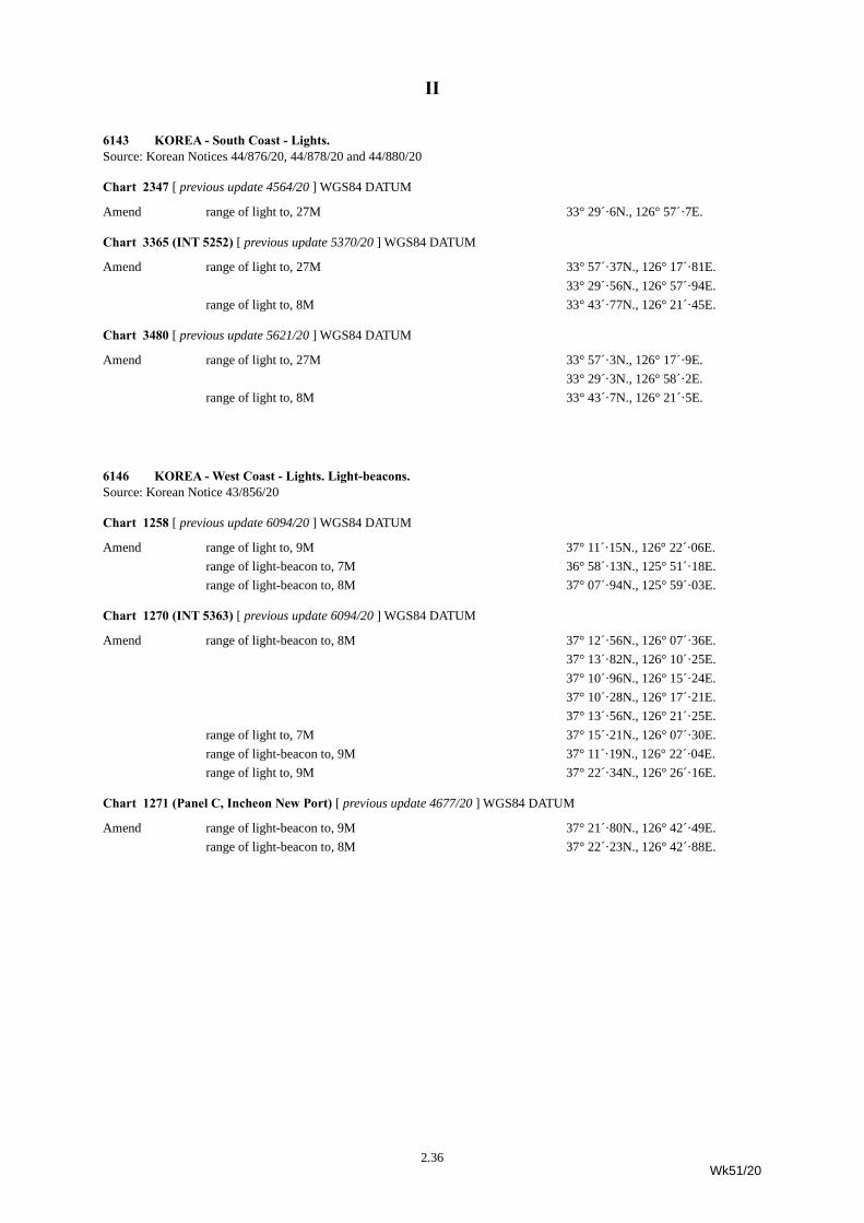
II
6143 KOREA - South Coast - Lights.Source: Korean Notices 44/876/20, 44/878/20 and 44/880/20
Chart 2347 [ previous update 4564/20 ] WGS84 DATUM
Amend range of light to, 27M 33° 29´·6N., 126° 57´·7E.
Chart 3365 (INT 5252) [ previous update 5370/20 ] WGS84 DATUM
Amend range of light to, 27M 33° 57´·37N., 126° 17´·81E.33° 29´·56N., 126° 57´·94E.
range of light to, 8M 33° 43´·77N., 126° 21´·45E.
Chart 3480 [ previous update 5621/20 ] WGS84 DATUM
Amend range of light to, 27M 33° 57´·3N., 126° 17´·9E. 33° 29´·3N., 126° 58´·2E.
range of light to, 8M 33° 43´·7N., 126° 21´·5E.
6146 KOREA - West Coast - Lights. Light-beacons.Source: Korean Notice 43/856/20
Chart 1258 [ previous update 6094/20 ] WGS84 DATUM
Amend range of light to, 9M 37° 11´·15N., 126° 22´·06E.range of light-beacon to, 7M 36° 58´·13N., 125° 51´·18E.range of light-beacon to, 8M 37° 07´·94N., 125° 59´·03E.
Chart 1270 (INT 5363) [ previous update 6094/20 ] WGS84 DATUM
Amend range of light-beacon to, 8M 37° 12´·56N., 126° 07´·36E.37° 13´·82N., 126° 10´·25E.37° 10´·96N., 126° 15´·24E.37° 10´·28N., 126° 17´·21E.37° 13´·56N., 126° 21´·25E.
range of light to, 7M 37° 15´·21N., 126° 07´·30E.range of light-beacon to, 9M 37° 11´·19N., 126° 22´·04E.range of light to, 9M 37° 22´·34N., 126° 26´·16E.
Chart 1271 (Panel C, Incheon New Port) [ previous update 4677/20 ] WGS84 DATUM
Amend range of light-beacon to, 9M 37° 21´·80N., 126° 42´·49E.range of light-beacon to, 8M 37° 22´·23N., 126° 42´·88E.
2.36Wk51/20
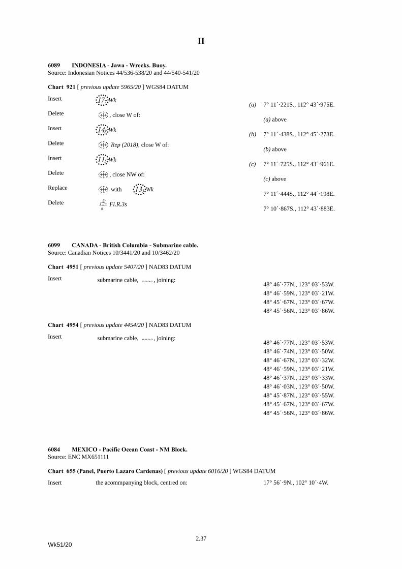
II
6089 INDONESIA - Jawa - Wrecks. Buoy.Source: Indonesian Notices 44/536-538/20 and 44/540-541/20
Chart 921 [ previous update 5965/20 ] WGS84 DATUM
Insert 17Ó,Wk(a) 7° 11´·221S., 112° 43´·975E.
Delete ´, close W of: (a) above
Insert 14(,Wk(b) 7° 11´·438S., 112° 45´·273E.
Delete ´ Rep (2018), close W of: (b) above
Insert 11%,Wk(c) 7° 11´·725S., 112° 43´·961E.
Delete ´, close NW of: (c) above
Replace ´ with 13#,Wk7° 11´·444S., 112° 44´·198E.
Delete B\dFl.R.3s7° 10´·867S., 112° 43´·883E.
6099 CANADA - British Columbia - Submarine cable.Source: Canadian Notices 10/3441/20 and 10/3462/20
Chart 4951 [ previous update 5407/20 ] NAD83 DATUM
Insert submarine cable, É, joining:48° 46´·77N., 123° 03´·53W.48° 46´·59N., 123° 03´·21W.48° 45´·67N., 123° 03´·67W.48° 45´·56N., 123° 03´·86W.
Chart 4954 [ previous update 4454/20 ] NAD83 DATUM
Insert submarine cable, É, joining:48° 46´·77N., 123° 03´·53W.48° 46´·74N., 123° 03´·50W.48° 46´·67N., 123° 03´·32W.48° 46´·59N., 123° 03´·21W.48° 46´·37N., 123° 03´·33W.48° 46´·03N., 123° 03´·50W.48° 45´·87N., 123° 03´·55W.48° 45´·67N., 123° 03´·67W.48° 45´·56N., 123° 03´·86W.
6084 MEXICO - Pacific Ocean Coast - NM Block.Source: ENC MX651111
Chart 655 (Panel, Puerto Lazaro Cardenas) [ previous update 6016/20 ] WGS84 DATUM
Insert the acommpanying block, centred on: 17° 56´·9N., 102° 10´·4W.
2.37Wk51/20
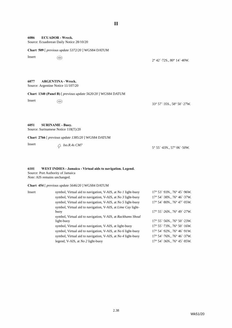
II
6086 ECUADOR - Wreck.Source: Ecuadorean Daily Notice 28/10/20
Chart 509 [ previous update 5372/20 ] WGS84 DATUM
Insert ´ 2° 42´·72S., 80° 14´·40W.
6077 ARGENTINA - Wreck.Source: Argentine Notice 11/107/20
Chart 1340 (Panel B) [ previous update 5620/20 ] WGS84 DATUM
Insert ´ 33° 57´·35S., 58° 50´·27W.
6051 SURINAME - Buoy.Source: Surinamese Notice 118(T)/20
Chart 2766 [ previous update 1385/20 ] WGS84 DATUM
Insert DdIso.R.4s CM75° 55´·43N., 57° 06´·50W.
6101 WEST INDIES - Jamaica - Virtual aids to navigation. Legend.Source: Port Authority of JamaicaNote: AIS remains unchanged.
Chart 454 [ previous update 5646/20 ] WGS84 DATUM
Insert symbol, Virtual aid to navigation, V-AIS, at No 1 light-buoy 17° 53´·93N., 76° 45´·96W.symbol, Virtual aid to navigation, V-AIS, at No 3 light-buoy 17° 54´·38N., 76° 46´·37W.symbol, Virtual aid to navigation, V-AIS, at No 5 light-buoy 17° 54´·80N., 76° 47´·05W.symbol, Virtual aid to navigation, V-AIS, at Lime Cay light-buoy 17° 55´·26N., 76° 49´·27W.symbol, Virtual aid to navigation, V-AIS, at Rackhams Shoal light-buoy 17° 55´·56N., 76° 50´·23W.symbol, Virtual aid to navigation, V-AIS, at light-buoy 17° 55´·73N., 76° 50´·16W.symbol, Virtual aid to navigation, V-AIS, at No 6 light-buoy 17° 54´·92N., 76° 46´·91W.symbol, Virtual aid to navigation, V-AIS, at No 4 light-buoy 17° 54´·76N., 76° 46´·37W.legend, V-AIS, at No 2 light-buoy 17° 54´·36N., 76° 45´·85W.
2.38Wk51/20
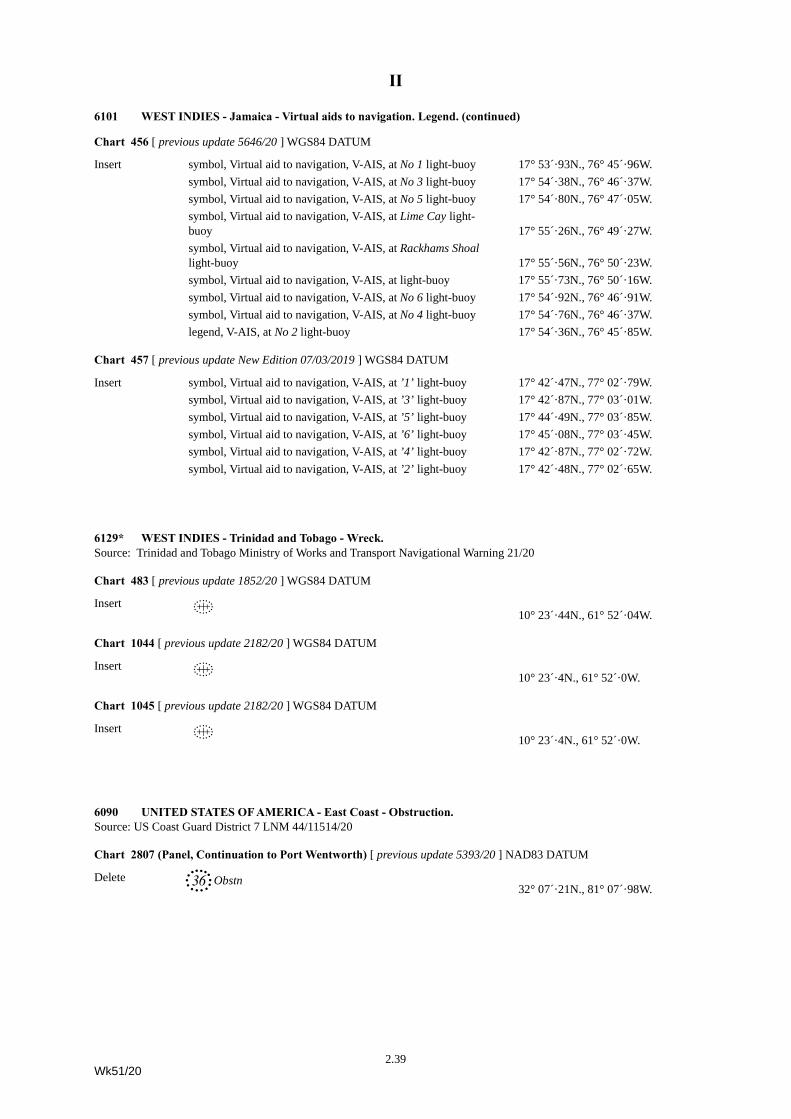
II
Chart 456 [ previous update 5646/20 ] WGS84 DATUM
Insert symbol, Virtual aid to navigation, V-AIS, at No 1 light-buoy 17° 53´·93N., 76° 45´·96W.symbol, Virtual aid to navigation, V-AIS, at No 3 light-buoy 17° 54´·38N., 76° 46´·37W.symbol, Virtual aid to navigation, V-AIS, at No 5 light-buoy 17° 54´·80N., 76° 47´·05W.symbol, Virtual aid to navigation, V-AIS, at Lime Cay light-buoy 17° 55´·26N., 76° 49´·27W.symbol, Virtual aid to navigation, V-AIS, at Rackhams Shoal light-buoy 17° 55´·56N., 76° 50´·23W.symbol, Virtual aid to navigation, V-AIS, at light-buoy 17° 55´·73N., 76° 50´·16W.symbol, Virtual aid to navigation, V-AIS, at No 6 light-buoy 17° 54´·92N., 76° 46´·91W.symbol, Virtual aid to navigation, V-AIS, at No 4 light-buoy 17° 54´·76N., 76° 46´·37W.legend, V-AIS, at No 2 light-buoy 17° 54´·36N., 76° 45´·85W.
Chart 457 [ previous update New Edition 07/03/2019 ] WGS84 DATUM
Insert symbol, Virtual aid to navigation, V-AIS, at ’1’ light-buoy 17° 42´·47N., 77° 02´·79W.symbol, Virtual aid to navigation, V-AIS, at ’3’ light-buoy 17° 42´·87N., 77° 03´·01W.symbol, Virtual aid to navigation, V-AIS, at ’5’ light-buoy 17° 44´·49N., 77° 03´·85W.symbol, Virtual aid to navigation, V-AIS, at ’6’ light-buoy 17° 45´·08N., 77° 03´·45W.symbol, Virtual aid to navigation, V-AIS, at ’4’ light-buoy 17° 42´·87N., 77° 02´·72W.symbol, Virtual aid to navigation, V-AIS, at ’2’ light-buoy 17° 42´·48N., 77° 02´·65W.
6129* WEST INDIES - Trinidad and Tobago - Wreck.Source: Trinidad and Tobago Ministry of Works and Transport Navigational Warning 21/20
Chart 483 [ previous update 1852/20 ] WGS84 DATUM
Insert ´ 10° 23´·44N., 61° 52´·04W.
Chart 1044 [ previous update 2182/20 ] WGS84 DATUM
Insert ´ 10° 23´·4N., 61° 52´·0W.
Chart 1045 [ previous update 2182/20 ] WGS84 DATUM
Insert ´ 10° 23´·4N., 61° 52´·0W.
6090 UNITED STATES OF AMERICA - East Coast - Obstruction.Source: US Coast Guard District 7 LNM 44/11514/20
Chart 2807 (Panel, Continuation to Port Wentworth) [ previous update 5393/20 ] NAD83 DATUM
Delete 36, Obstn32° 07´·21N., 81° 07´·98W.
6101 WEST INDIES - Jamaica - Virtual aids to navigation. Legend. (continued)
2.39Wk51/20
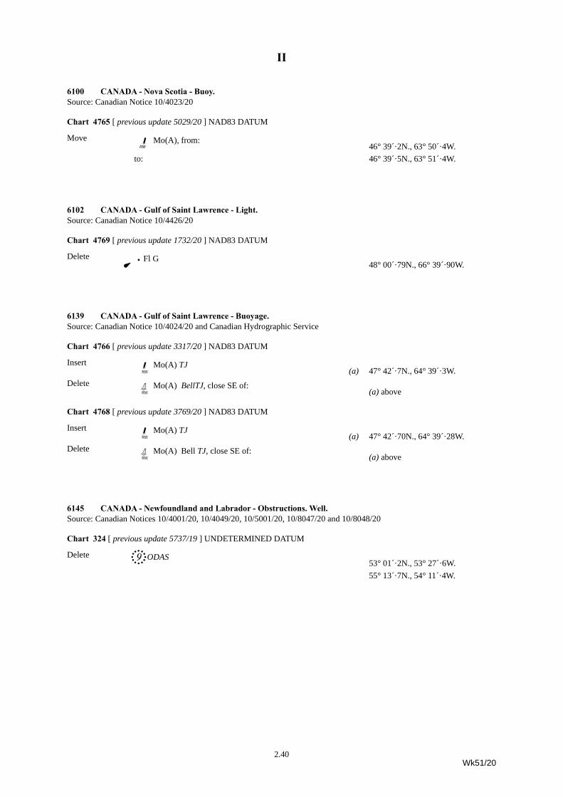
II
6100 CANADA - Nova Scotia - Buoy.Source: Canadian Notice 10/4023/20
Chart 4765 [ previous update 5029/20 ] NAD83 DATUM
Move JpMo(A), from:46° 39´·2N., 63° 50´·4W.
to: 46° 39´·5N., 63° 51´·4W.
6102 CANADA - Gulf of Saint Lawrence - Light.Source: Canadian Notice 10/4426/20
Chart 4769 [ previous update 1732/20 ] NAD83 DATUM
Delete ã{ Fl G48° 00´·79N., 66° 39´·90W.
6139 CANADA - Gulf of Saint Lawrence - Buoyage.Source: Canadian Notice 10/4024/20 and Canadian Hydrographic Service
Chart 4766 [ previous update 3317/20 ] NAD83 DATUM
Insert JwMo(A) TJ(a) 47° 42´·7N., 64° 39´·3W.
Delete HwMo(A) BellTJ, close SE of: (a) above
Chart 4768 [ previous update 3769/20 ] NAD83 DATUM
Insert JwMo(A) TJ(a) 47° 42´·70N., 64° 39´·28W.
Delete HwMo(A) Bell TJ, close SE of: (a) above
6145 CANADA - Newfoundland and Labrador - Obstructions. Well.Source: Canadian Notices 10/4001/20, 10/4049/20, 10/5001/20, 10/8047/20 and 10/8048/20
Chart 324 [ previous update 5737/19 ] UNDETERMINED DATUM
Delete 9+ ODAS53° 01´·2N., 53° 27´·6W.55° 13´·7N., 54° 11´·4W.
2.40Wk51/20
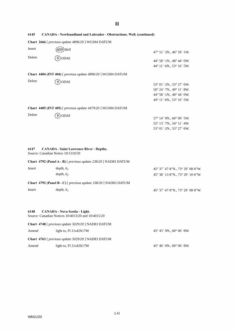
II
Chart 2666 [ previous update 4896/20 ] WGS84 DATUM
Insert 609-Well 47° 51´·3N., 46° 59´·1W.
Delete 9+ ODAS44° 58´·1N., 48° 44´·0W.44° 11´·6N., 53° 16´·5W.
Chart 4404 (INT 404) [ previous update 4896/20 ] WGS84 DATUM
Delete 9+ ODAS53° 01´·2N., 53° 27´·6W.50° 24´·7N., 49° 11´·8W.44° 58´·1N., 48° 44´·0W.44° 11´·6N., 53° 16´·5W.
Chart 4405 (INT 405) [ previous update 4479/20 ] WGS84 DATUM
Delete 9+ ODAS57° 14´·9N., 60° 00´·5W.55° 13´·7N., 54° 11´·4W.53° 01´·2N., 53° 27´·6W.
6147 CANADA - Saint Lawrence River - Depths.Source: Canadian Notice 10/1310/20
Chart 4792 (Panel A - B) [ previous update 238/20 ] NAD83 DATUM
Insert depth, 61 45° 37´ 47·8"N., 73° 29´ 08·8"W.depth, 62 45° 38´ 13·8"N., 73° 29´ 10·6"W.
Chart 4792 (Panel B - C) [ previous update 238/20 ] NAD83 DATUM
Insert depth, 61 45° 37´ 47·8"N., 73° 29´ 08·8"W.
6148 CANADA - Nova Scotia - Light.Source: Canadian Notices 10/4013/20 and 10/4015/20
Chart 4748 [ previous update 5029/20 ] NAD83 DATUM
Amend light to, Fl 21s42ft17M 45° 45´·9N., 60° 06´·8W.
Chart 4763 [ previous update 5029/20 ] NAD83 DATUM
Amend light to, Fl 21s42ft17M 45° 46´·0N., 60° 06´·8W.
6145 CANADA - Newfoundland and Labrador - Obstructions. Well. (continued)
2.41Wk51/20
II
6039(P)/20 ENGLAND - West Coast - Automatic Identification System.
Source: Peel Ports1.
2. Radar beacon remains unchanged.
Chart affected - 8082
6097(P)/20 ENGLAND - East Coast - Depth.
Source: fpv Morven 1. A depth of 9·1m exists in position 52° 42´·56N., 1° 50´·42E.2. This change will be included in a New Edition of Chart 106 to be published 10th December 2020.
(ETRS89 DATUM)
Chart affected - 106
6128(T)/20 SCOTLAND - Shetland Islands - Buoy.
Source: Scottish Sea Farms Ltd1. An unlit wave survey buoy has been deployed, until further notice, in position 60° 24´·47N., 1° 04´·96W.2. Mariners are advised to navigate with caution in the area.
(ETRS89 DATUM)
Charts affected - 3282 - 3284
6068(T)/20 POLAND - Buoyage.
Source: Polish Notice 43-44/584(T)/201. The following light-buoys have been moved:
(WGS84 DATUM)
Charts affected - 2677 (INT 1297) - 2678 (INT 1298)
6047(T)/20 BELGIUM - Buoy.
Source: Belgian Notice 22/302(T)/201. A North cardinal light-buoy, Q JDN, has been temporarily established in position 51° 13´·60N., 2° 51´·40E.
(WGS84 DATUM)
Charts affected - 1872 - 1873 (INT 1480) - 1874 (INT 1474) - 2449
Update Feature Position Insert Automatic Identification System, AIS, at light float 53° 32´·02N., 3° 20´·98W.
Designation Character Former Position New Position 9 Fl.G.4s 53° 40´·33N., 14° 31´·21E. 53° 40´·50N., 14° 30´·98E.10 Fl.R.4s 53° 40´·38N., 14° 31´·32E. 53° 40´·55N., 14° 31´·09E.
2.42Wk51/20
II
6045(P)/20 FRANCE - West Coast - Automatic Identification Systems.
Source: French Notice 43/61/201.
Chart affected - 8040
6140(P)/20 ITALY - Sardegna - Traffic separation schemes. Anchorage areas.
Source: Italian Notices 22.3/20, 22.18/20 and 23.5/201. *Changes to traffic separation schemes and anchorage areas have taken place in the approaches to Cagliari
(39° 09´·51N., 9° 06´·57E.) and Pontile ENICHEM Sud Terminal (39° 09´·54N., 9° 02´·69E.). These changes were implemented on 21 September 2020.
2. *The limits of the traffic separation scheme in the approaches to the Pontile ENICHEM Sud Terminal are now as follows:a)A traffic separation zone has been established joining the following positions:
b)A traffic lane for inbound traffic has been established between the separation zone in 2a. above and a line joining the following positions:
c)A traffic lane for outbound traffic has been established between the separation zone in 2a. above and a line joining the following positions:
3. *Details of the changes to the traffic separation scheme in the approaches to Cagliari will be included when available.4. *A new anchorage area ‘Mike’ has been established, bounded by the following positions:
5. Mariners are advised to navigate with caution in the area and consult the local port authorities for the latest information.6. Charts will be updated when full details are available.7. Former Notice 5631(P)/20 is cancelled.
*Indicates new or revised entry.(WGS84 DATUM)
Charts affected - 1208 - 8265
Update Feature Position Delete Automatic Identification System, AIS, at light 47° 15´·24N., 2° 14´·98W.
47° 14´·54N., 2° 15´·78W.
39° 08´·45N., 9° 04´·54E.39° 09´·00N., 9° 03´·62E.
39° 09´·14N., 9° 03´·73E.39° 08´·59N., 9° 04´·66E.
39° 08´·88N., 9° 03´·48E.39° 08´·33N., 9° 04´·40E.
39° 10´·00N., 9° 04´·40E.39° 09´·30N., 9° 05´·35E.39° 08´·90N., 9° 04´·45E.39° 09´·40N., 9° 03´·70E.
2.43Wk51/20
II
6082(P)/20 JORDAN - Port development. Lights. Buoyage.
Source: Jordan Maritime Commission1. Port developments are completed within Aqaba New Port in the vicinity of 29° 21´·64N., 34° 58´·00E.2. New lights have been established. The most significant are as follows:
3. For full details, see Admiralty List of Lights, Volume D.4. The following light-buoys have been established:
5. Mariners are advised to navigate with caution in the area.6. These and other changes will be included in a New Edition of Chart 801 to be published early 2021.
(WGS84 DATUM)
Chart affected - 801 (INT 7143)
6096(T)/20 TAIWAN - Depths.
Source: Taiwanese Notice 81(T)/201. Depths less than 14m exist between the following positions:
2. Mariners are advised to navigate in caution in the area.(WGS84 DATUM)
Chart affected - 2618
6104(T)/20 VIETNAM - Wreck.
Source: VMS-North Notice 193(T)/201. A wreck has been reported in position 16° 55´·6N., 107° 13´·0E.2. Mariners are advised to navigate with caution in the area.
(WGS84 DATUM)
Chart affected - 3989
Characteristic Light Type Position Oc.G.4s26m12M Leading light Front 29° 21´·60N., 34° 58´·27E.Oc.G.4s29m12M Leading light Rear 29° 21´·60N., 34° 58´·29E.Iso.WG.4s18m7M Sector light 29° 21´·45N., 34° 57´·67E.
Characteristic Designation Buoy Type Position Q N14A-2 North Cardinal 29° 21´·61N., 34° 57´·72E.VQ(9)10s N14A-1 West Cardinal 29° 21´·54N., 34° 57´·63E.
24° 17´·40N., 120° 29´·37E.24° 17´·46N., 120° 29´·49E.
2.44Wk51/20
II
6117(T)/20 JAPAN - Honshū - Submarine pipeline.
Source: 46/5589(T)/201. Submarine pipeline laying works are taking place, until 19 March 2021, within an area bounded by the following positions:
(WGS84 DATUM)
Chart affected - JP 1155A
6118(T)/20 JAPAN - Honshū - Works.
Source: Japanese Notice 46/5590(T)/201. Oceanographic survey works are taking place until, 30 June 2021, within a 2M radius centred on position
38° 22´·7N., 138° 42´·8E.2. The works will be carried out by a small autonomous vessel.3. Mariners are advised to navigate with caution in the area.
(WGS84 DATUM)
Charts affected - 2293 - JP 145 - JP 1180
6119(T)/20 JAPAN - Honshū - Dredging area. Works. Submarine pipeline.
Source: Japanese Notice 46/5591(T)/201. Dredging works are taking place, until 24 March 2021, within an area bounded by the following positions:
2. A submarine discharging pipeline will be laid in the dredging area.(WGS84 DATUM)
Chart affected - JP 65
37° 56´ 53·0"N., 139° 03´ 53·3"E.37° 56´ 51·0"N., 139° 03´ 59·0"E.37° 55´ 37·0"N., 139° 03´ 32·0"E.37° 55´ 38·0"N., 139° 03´ 27·0"E.
40° 33´ 53·1"N., 141° 29´ 31·1"E.40° 33´ 50·5"N., 141° 29´ 33·0"E.40° 33´ 30·4"N., 141° 30´ 11·2"E.40° 33´ 22·2"N., 141° 30´ 46·9"E.40° 33´ 09·8"N., 141° 30´ 49·5"E.40° 32´ 38·3"N., 141° 31´ 16·5"E.40° 32´ 40·2"N., 141° 31´ 21·0"E.40° 32´ 44·7"N., 141° 31´ 24·8"E.40° 32´ 56·1"N., 141° 31´ 16·8"E.40° 33´ 10·7"N., 141° 31´ 29·1"E.40° 33´ 15·0"N., 141° 31´ 02·1"E.40° 33´ 24·4"N., 141° 30´ 52·0"E.
2.45Wk51/20
II
6120(T)/20 JAPAN - Seto Naikai - Obstructions.
Source: Japanese Notice 46/5592(T)/201. Obstructions exist in the following positions:
(WGS84 DATUM)
Charts affected - JP 123 - JP 1146
6121(T)/20 JAPAN - Seto Naikai - Rock.
Source: Japanese Notice 46/5593(T)/201. A rock, which covers and uncovers, exists on and in the vicinity of a line joining the following positions:
(WGS84 DATUM)
Chart affected - JP 106
6122(T)/20 JAPAN - Seto Naikai - Rocks.
Source: Japanese Notice 46/5594(T)/201. An underwater rock exists in position 34° 19´ 23·2"N., 134° 16´ 47·9"E.2. A rock which covers and uncovers exists in position 34° 17´ 42·1"N., 134° 16´ 55·5"E.
(WGS84 DATUM)
Charts affected - JP 106 - JP 137A - JP 153
6123(T)/20 JAPAN - Kyūshū - Depths.
Source: Japanese Notice 46/5596(T)/201. Depths less than charted exist in the following positions:
(WGS84 DATUM)
Chart affected - JP 1227
6124(T)/20 JAPAN - Nansei Shotō - Light-beacon. Buoy.
Source: Japanese Notice 46/5599(T)/201. The Muki light-beacon in position 26° 08´·71N., 127° 37´·26E. has been destroyed.
34° 37´ 03·2"N., 135° 25´ 23·6"E.34° 37´ 07·5"N., 135° 25´ 28·7"E.34° 36´ 51"N., 135° 25´ 36"E.
34° 14´·03N., 134° 25´·63E.34° 14´·12N., 134° 25´·93E.
Depth Position 10·4m 33° 37´ 00·6"N., 130° 23´ 37·3"E.10·3m 33° 36´ 58·7"N., 130° 23´ 38·9"E.10·3m 33° 36´ 57·4"N., 130° 23´ 38·7"E.
2.46Wk51/20
II
2. A west cardinal pillar light-buoy, Q(9) 15s (temp), has been established in position 26° 08´·72N., 127° 36´·95E.3. Former Notice 4816(T)/20 is cancelled.
(WGS84 DATUM)
Chart affected - JP 226
6034(P)/20 KOREA - South Coast - Lights.
Source: Korean Lights List1. Numerous changes to range of lights have taken place southwest of Geojedo, between positions
34° 42´·65N., 128° 10´·55E. and 34° 40´·91N., 128° 37´·59E.2. Refer to Admiralty List of Lights Vol M, for latest information.3. These changes will be included in a New Edition of Chart 127 to be published early 2021.
(WGS84 DATUM)
Chart affected - 127
6062(P)/20 KOREA - South Coast - Lights. Breakwater.
Source: Korean Chart 2526 and Korean Lights List1. Numerous changes to ranges of lights have taken place in the approaches to Gwangyang Hang. 2. Breakwater construction has been completed and light, Fl.R.4s24m11M, has been established in position
34° 45´·22N., 127° 45´·73E.3. Refer to ADMIRALTY List of Lights Vol M, for latest information.4. These changes will be included in a New Edition of Chart 3391 to be published early 2021.
(WGS84 DATUM)
Chart affected - 3391 (INT 5360)
6144(T)/20 KOREA - South Coast - Buoy.
Source: Korean Notice 44/911/201. A special light-buoy, Fl(5)Y.20s ODAS, has been temporarily established in position 34° 24´·75N., 127° 56´·27E.
(WGS84 DATUM)
Charts affected - 127 - 2347 - 3391 (INT 5360) - 3480
6035(T)/20 PHILIPPINE ISLANDS - Luzon - Wreck.
Source: NavPhil 139/201. A dangerous wreck has been reported in approximate position 13° 46´·38N., 120° 59´·02E.2. Mariners are advised to navigate with caution in the area.
(WGS84 DATUM)
Chart affected - 3558
6124(T)/20 JAPAN - Nansei Shotō - Light-beacon. Buoy. (continued)
2.47Wk51/20
II
6064(P)/20 PHILIPPINE ISLANDS - Sulu Sea - Submarine cable.
Source: NAMRIA NAVPHIL 135/201. A submarine cable is being laid, joining the following positions:
2. Charts will be updated when full details are available.(WGS84 DATUM)
Charts affected - 3426 - 3484 (INT 554) - 3809 - 3811 - 4416 - 4471 - 4473
6142(T)/20 BRUNEI - Scientific instruments.
Source: Brunei Notice 48(T)/201. Subsurface scientific instruments are to be deployed in the following positions:
2. Mariners are advised to navigate with caution in the area.(WGS84 DATUM)
Charts affected - 1338 - 2109
6080(T)/20 CANADA - British Columbia - Restricted area.
Source: Canadian Notice 10/1005/201. A trial voluntary protection zone for shipping has been established off the West Coast of Haida Gwaii in effect until 31
October 2021, bounded by the following positions:
2. For more information please see Canadian Notice to Mariners bulletin 10/20, Western Edition, dated 30 October 2020, Notice 1005. This can be accessed at https://www.notmar.gc.ca/monthly-mensuel-en.php.( NAD27 DATUM)
Charts affected - 3754 - 4801 (INT 801) - 4810 (INT 810) - 4920 - 4975
8° 43´·67N., 123° 22´·88E.8° 45´·02N., 123° 24´·92E.8° 48´·54N., 123° 26´·70E.8° 50´·58N., 123° 28´·28E.8° 54´·60N., 123° 27´·49E.9° 04´·09N., 123° 19´·29E.9° 06´·87N., 123° 21´·13E.9° 15´·53N., 123° 22´·02E.9° 17´·80N., 123° 23´·34E.9° 20´·62N., 123° 23´·60E.9° 22´·38N., 123° 22´·96E.9° 25´·01N., 123° 20´·74E.
Designation Position ADCP 1 4° 51´·18N., 114° 19´·61E.ADCP 2 5° 00´·16N., 114° 42´·02E.
54° 13´·41N., 134° 30´·44W.54° 15´·39N., 133° 04´·81W.51° 56´·16N., 131° 17´·76W.51° 24´·60N., 132° 03´·99W.52° 18´·62N., 133° 20´·82W.53° 11´·11N., 134° 16´·26W.53° 44´·01N., 134° 32´·52W.
2.48Wk51/20
II
6038(P)/20 CHILE - Northern Coasts - Works. Berths. Anchor berths. Pilot boarding place.
Source: Chilean Notice 10/76/201. Berth construction within Talcahuano Naval Port have been completed between positions 36° 41´·530S., 73° 06´·193W.
and 36° 41´·755S., 73° 06´·050W.2. Berth construction within Talcahuano Fishing Port have been completed between positions 36° 42´·628S., 73° 06´·488W.
and 36° 42´·860S., 73° 06´·487W.3. The following designations of anchorage berths have been changed as follows:
4. The limits of pilot boarding area, 36° 42´·179S., 73° 00´·161W., have been amended to the following positions:
5. These changes will be included in New Edition 4248 to be published early 2021.6. Chart 4247 will be updated by Notice to Mariners.
(WGS84 DATUM)
Chart affected - 4248
6036(T)/20 WEST INDIES - Leeward Islands - Wreck.
Source: French Notice 43/17(T)/201. A wreck, depth unknown, is reported to exist in position 18° 09´·5N., 62° 57´·3W.2. Mariners are advised to navigate with caution in the area.
(WGS84 DATUM)
Charts affected - 583 - 1025 (INT 4182) - 2016 (INT 4180) - 2047 - 2600
Former designation New designation Position ‘A’ ‘Z’ 36° 41´·917S., 72° 59´·317W.‘B’ ‘Y’ 36° 41´·917S., 73° 00´·250W.
36° 42´·117S., 73° 00´·383W.36° 42´·117S., 72° 59´·750W.36° 42´·317S., 72° 59´·750W.36° 42´·317S., 73° 00´·383W.
2.49Wk51/20
To accompany Notice to Mariners 6105/20
On Chart 94
AUTOMATIC IDENTIFICATION SYSTEMSAIS transmitters on aids to navigation are notshown on this chart. V-AIS will be shown. Fordetails, see ADMIRALTY List of RadioSignals.
Wk51/20
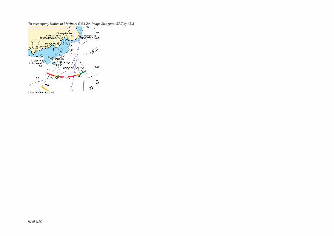
To accompany Notice to Mariners 6054/20. Image Size (mm) 57.7 by 63.3
Wk51/20
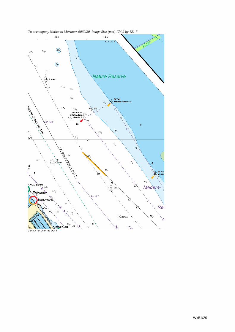
To accompany Notice to Mariners 6060/20. Image Size (mm) 174.2 by 121.7
Wk51/20
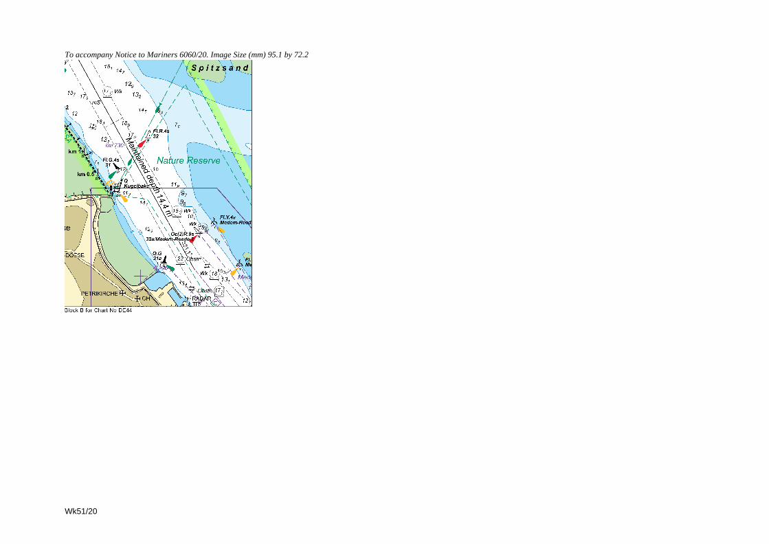
To accompany Notice to Mariners 6060/20. Image Size (mm) 95.1 by 72.2
Wk51/20
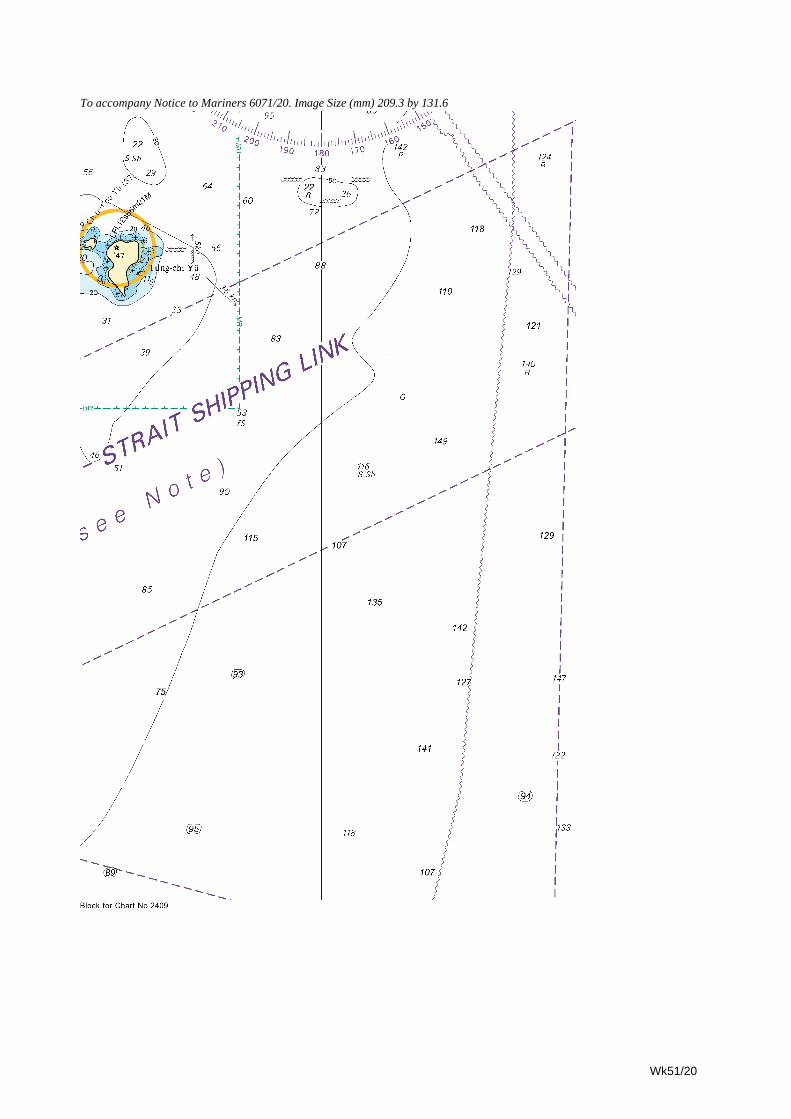
To accompany Notice to Mariners 6071/20. Image Size (mm) 209.3 by 131.6
Wk51/20
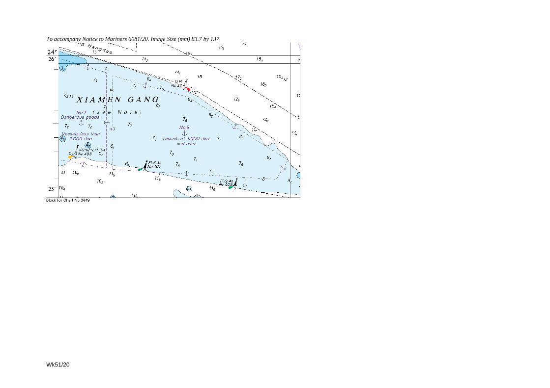
To accompany Notice to Mariners 6081/20. Image Size (mm) 83.7 by 137
Wk51/20
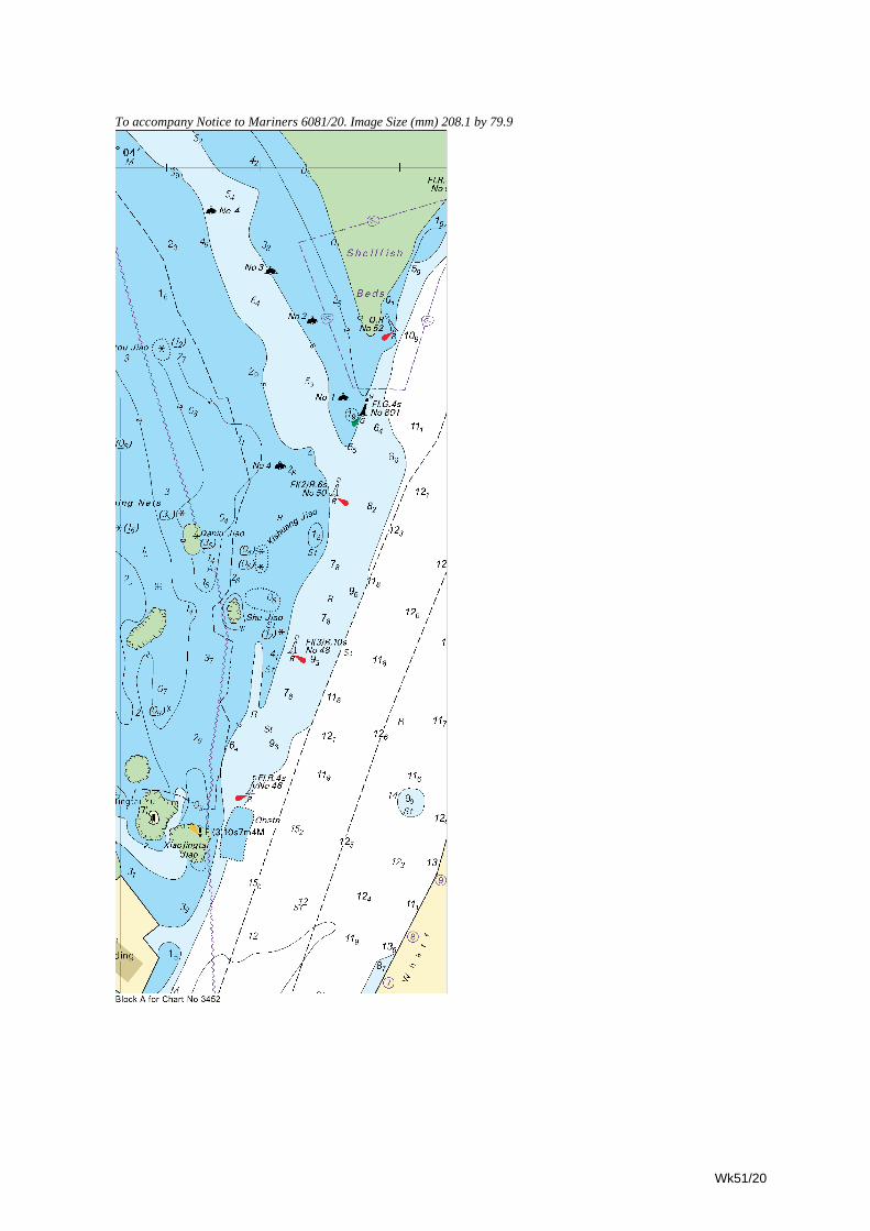
To accompany Notice to Mariners 6081/20. Image Size (mm) 208.1 by 79.9
Wk51/20
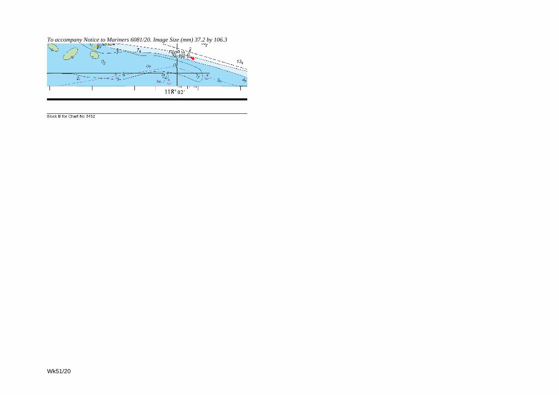
To accompany Notice to Mariners 6081/20. Image Size (mm) 37.2 by 106.3
Wk51/20
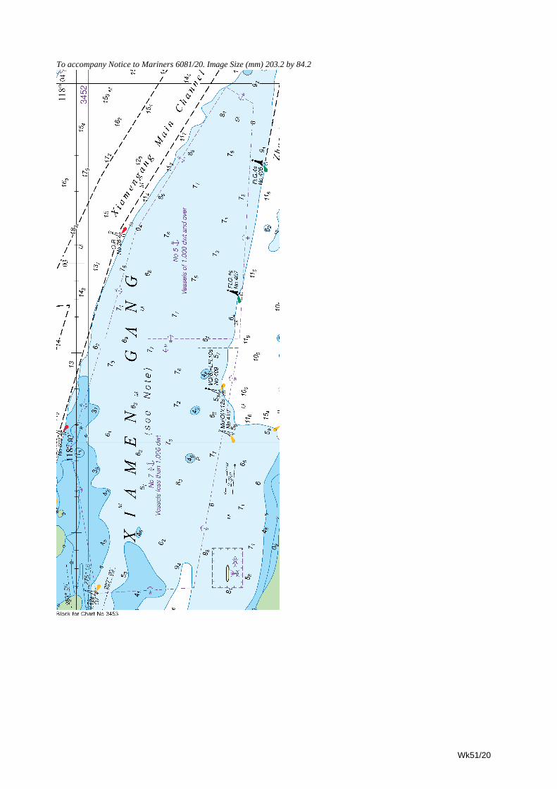
To accompany Notice to Mariners 6081/20. Image Size (mm) 203.2 by 84.2
Wk51/20
To accompany Notice to Mariners 6084/20. Image Size (mm) 64.4 by 45.6
Wk51/20
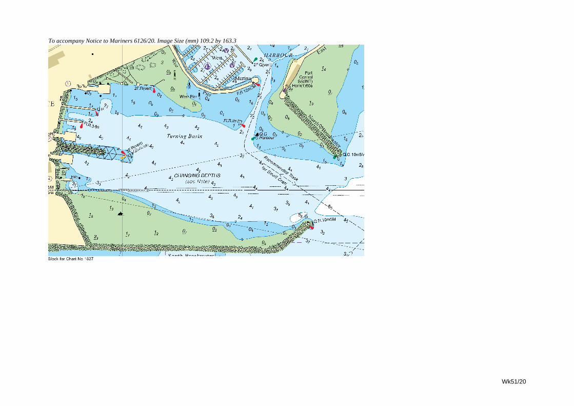
Wk51/20
To accompany Notice to Mariners 6126/20. Image Size (mm) 109.2 by 163.3
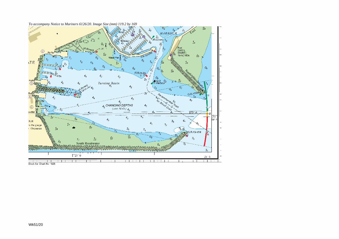
To accompany Notice to Mariners 6126/20. Image Size (mm) 119.2 by 169
Wk51/20
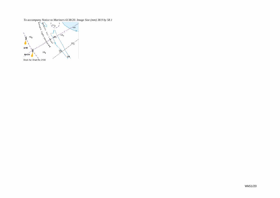
Wk51/20
To accompany Notice to Mariners 6138/20. Image Size (mm) 38.9 by 58.1
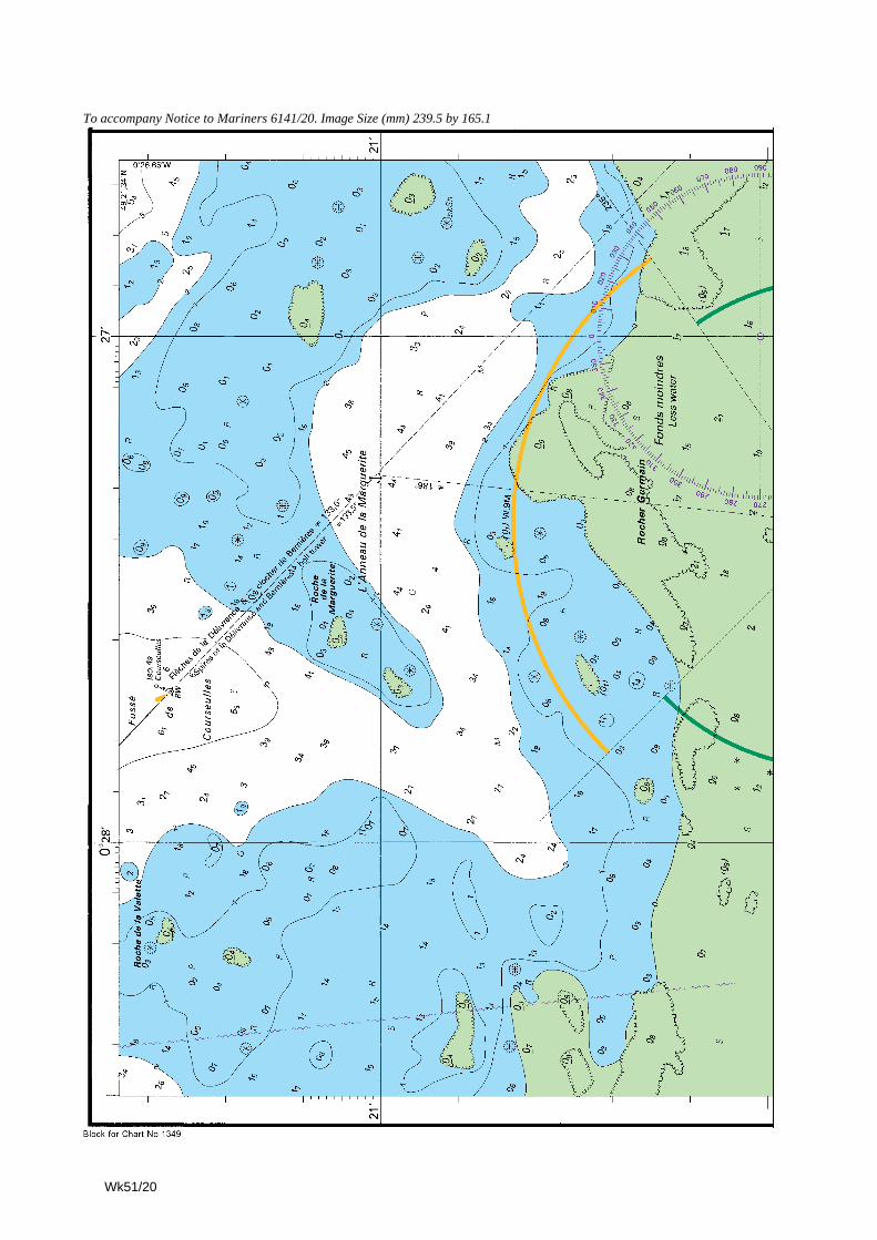
To accompany Notice to Mariners 6141/20. Image Size (mm) 239.5 by 165.1
Wk51/20
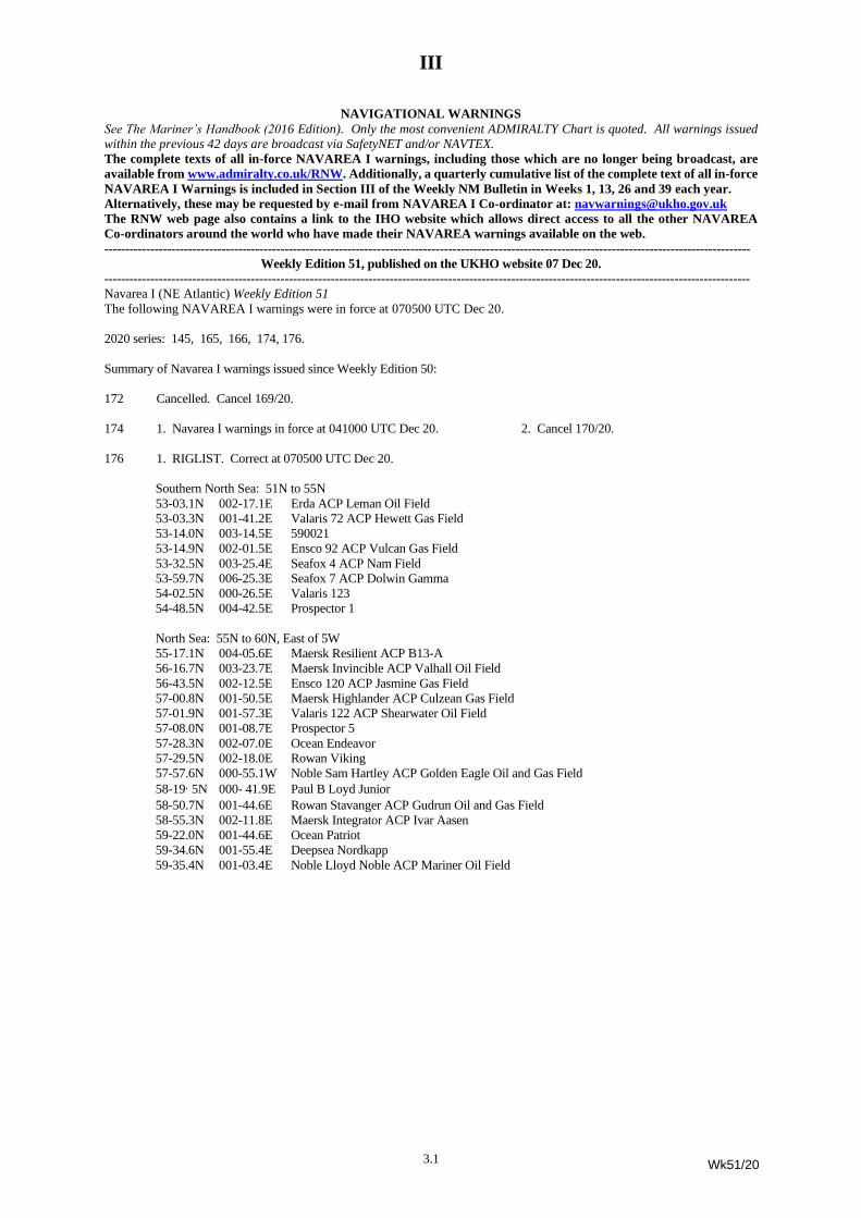
III
3.1
NAVIGATIONAL WARNINGS
See The Mariner’s Handbook (2016 Edition). Only the most convenient ADMIRALTY Chart is quoted. All warnings issued
within the previous 42 days are broadcast via SafetyNET and/or NAVTEX.
The complete texts of all in-force NAVAREA I warnings, including those which are no longer being broadcast, are
available from www.admiralty.co.uk/RNW. Additionally, a quarterly cumulative list of the complete text of all in-force
NAVAREA I Warnings is included in Section III of the Weekly NM Bulletin in Weeks 1, 13, 26 and 39 each year.
Alternatively, these may be requested by e-mail from NAVAREA I Co-ordinator at: [email protected]
The RNW web page also contains a link to the IHO website which allows direct access to all the other NAVAREA
Co-ordinators around the world who have made their NAVAREA warnings available on the web.
----------------------------------------------------------------------------------------------------------------------------------------------------------
Weekly Edition 51, published on the UKHO website 07 Dec 20.
----------------------------------------------------------------------------------------------------------------------------------------------------------
Navarea I (NE Atlantic) Weekly Edition 51
The following NAVAREA I warnings were in force at 070500 UTC Dec 20.
2020 series: 145, 165, 166, 174, 176.
Summary of Navarea I warnings issued since Weekly Edition 50:
172 Cancelled. Cancel 169/20.
174 1. Navarea I warnings in force at 041000 UTC Dec 20. 2. Cancel 170/20.
176 1. RIGLIST. Correct at 070500 UTC Dec 20.
Southern North Sea: 51N to 55N
53-03.1N 002-17.1E Erda ACP Leman Oil Field
53-03.3N 001-41.2E Valaris 72 ACP Hewett Gas Field
53-14.0N 003-14.5E 590021
53-14.9N 002-01.5E Ensco 92 ACP Vulcan Gas Field
53-32.5N 003-25.4E Seafox 4 ACP Nam Field
53-59.7N 006-25.3E Seafox 7 ACP Dolwin Gamma
54-02.5N 000-26.5E Valaris 123
54-48.5N 004-42.5E Prospector 1
North Sea: 55N to 60N, East of 5W
55-17.1N 004-05.6E Maersk Resilient ACP B13-A
56-16.7N 003-23.7E Maersk Invincible ACP Valhall Oil Field
56-43.5N 002-12.5E Ensco 120 ACP Jasmine Gas Field
57-00.8N 001-50.5E Maersk Highlander ACP Culzean Gas Field
57-01.9N 001-57.3E Valaris 122 ACP Shearwater Oil Field
57-08.0N 001-08.7E Prospector 5
57-28.3N 002-07.0E Ocean Endeavor
57-29.5N 002-18.0E Rowan Viking
57-57.6N 000-55.1W Noble Sam Hartley ACP Golden Eagle Oil and Gas Field
58-19·5N 000- 41.9E Paul B Loyd Junior
58-50.7N 001-44.6E Rowan Stavanger ACP Gudrun Oil and Gas Field
58-55.3N 002-11.8E Maersk Integrator ACP Ivar Aasen
59-22.0N 001-44.6E Ocean Patriot
59-34.6N 001-55.4E Deepsea Nordkapp
59-35.4N 001-03.4E Noble Lloyd Noble ACP Mariner Oil Field
Wk51/20
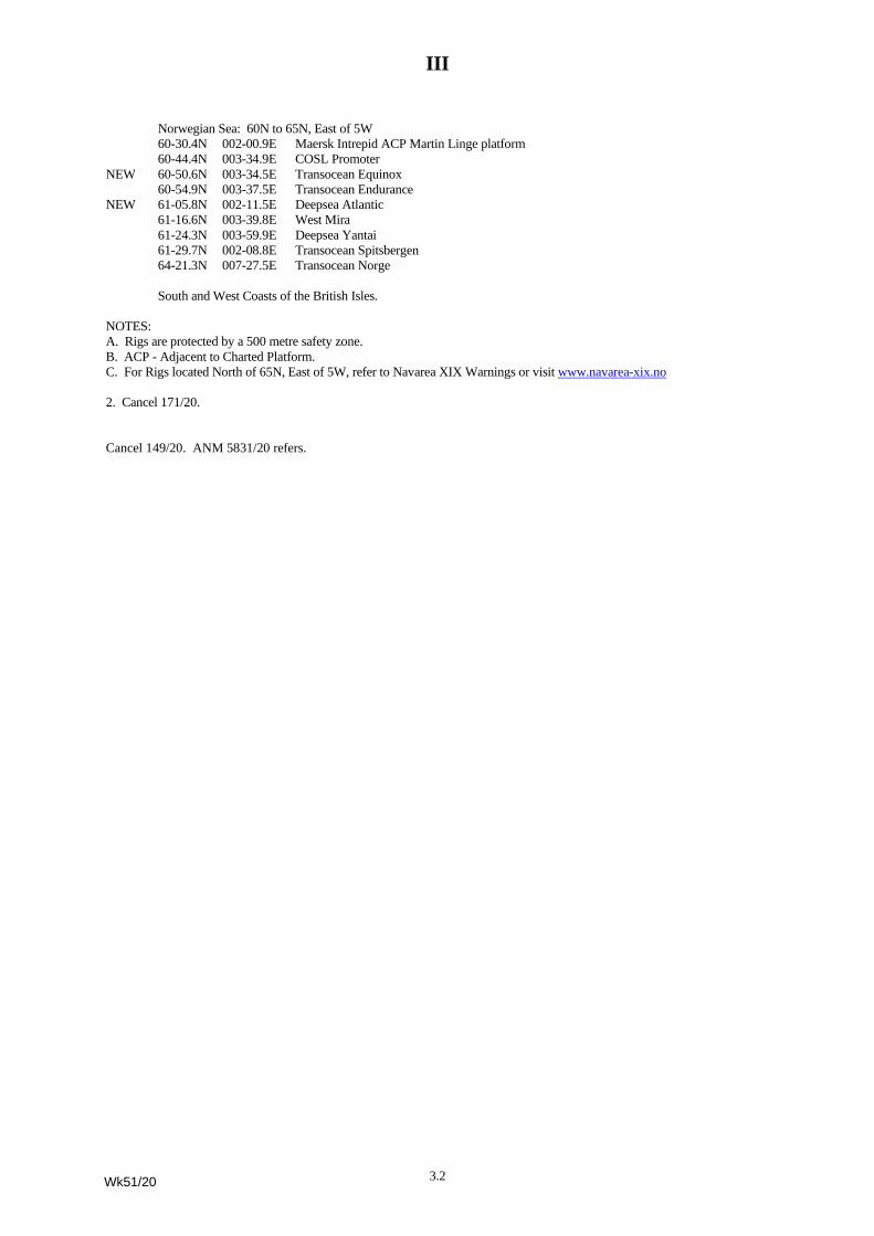
III
3.2
Norwegian Sea: 60N to 65N, East of 5W
60-30.4N 002-00.9E Maersk Intrepid ACP Martin Linge platform
60-44.4N 003-34.9E COSL Promoter
NEW 60-50.6N 003-34.5E Transocean Equinox
60-54.9N 003-37.5E Transocean Endurance
NEW 61-05.8N 002-11.5E Deepsea Atlantic
61-16.6N 003-39.8E West Mira
61-24.3N 003-59.9E Deepsea Yantai
61-29.7N 002-08.8E Transocean Spitsbergen
64-21.3N 007-27.5E Transocean Norge
South and West Coasts of the British Isles.
NOTES:
A. Rigs are protected by a 500 metre safety zone.
B. ACP - Adjacent to Charted Platform.
C. For Rigs located North of 65N, East of 5W, refer to Navarea XIX Warnings or visit www.navarea-xix.no
2. Cancel 171/20.
Cancel 149/20. ANM 5831/20 refers.
Wk51/20
IV
4.1
[51/20]UPDATES TO ADMIRALTY SAILING DIRECTIONS
NP5 South America Pilot Volume 1(2017 Edition)
Brazil -- Approaches to Baía de Guanabara --Ilha Redonda — Traffic regulations;
approach route
220
After Paragraph 7.34 3 line 5 Insert:
Approach Route. A mandatory one--way routeexists for vessels exceeding 24 m LOA and 100 gtapproaching from SW or operating between IlhasCagarras (7.43) and Ilha Redonda (7.120).
Brazilian Notice 19/S104/20[NP5--No 115--Wk 51/20]
NP7A South America Pilot Volume 4(2018 Edition)
Colombia -- East of Puerto Barranquilla —Marine nature reserve
248
After Paragraph 9.65 1 line 6 Insert:
Marine nature reserve9.65a
1 Parque Nacional Natural Isla de Salamanca(110167N 743075W) lies along the S side of anunnamed bay, E of La Barra (110720N 745110W)(9.90). Entry into this area is affected by numerousrestrictions and prohibitions. For further details, consultthe local authorities.
GB Chart 2261 Ed.11 (2020) Panel A[NP7A--No 61--Wk 51/20]
Colombia -- Rio Magdalena -- Puerto Barranquilla— Directions; anchorage
252
Paragraph 9.92 2 lines 1--6 Delete
GB2261 Ed.11 (2020) Panel C[NP7A--No 62--Wk 51/20]
NP13 Australia Pilot Volume 1 (2020 Edition)
Western Australia -- Dampier Archipelago --Stag Marine Terminal — Terminal
227
Paragraph 6.20 1--2 Replace by:
1 Position and function. Stag Marine Terminal(201631S 1161657E) consists of a mooringsuperbuoy and a lighted production platform, 1 mile S.Vessels between 25 000 and 150 000 dwt can beaccommodated at the facility. A cautionary areasurrounds the facility.
2 Terminal operator. Jadestone Energy (Australia)Pty Ltd, 1 William Street, Perth, Western Australia,6000.
Website. www.jadestone--energy.com
Australian Notice 21/857/20; UKHO[NP13--No 9--Wk 51/20]
NP14 Australia Pilot Volume 2 (2019 Edition)
New South Wales -- Sydney Harbour --Goat Island — Directions; light sector
337
Paragraph 12.148 4 line(s) 6--12 Replace by:
The bridge red lights indicate its centre and point ofgreatest clearance. At night, the white sector(2803--2817) of Goat Island Directional Light(335106S 1511193E), exhibited from the NE endof the island, leads under the bridge in deeper water.
Paragraph 12.148 5 line(s) 1--3 Delete
Australian Notice 21/846/20 [NP14--No 8--Wk 51/20]
NP15 Australia Pilot Volume 3 (2018 Edition)
Australia -- Queensland -- Rockhampton —Directions; wreck
196
Paragraph 5.222 6 line(s) 7--8 Delete
Australian Notice 21/851/20 [NP15--No 59--Wk 51/20]
NP19 Baltic Pilot Volume 2 (2018 Edition)
Sweden -- East coast -- Oskarshamn — Limitingconditions; controlling depth
170
Paragraph 4.125 1 line(s) 4--5 Replace by:
…of 110 m, and the inner harbour which is swept to ageneral depth of about 68 m.
Swedish Notice 829/15365/20[NP19--No 115--Wk 51/20]
Wk51/20
IV
4.2
NP20 Baltic Pilot Volume 3 (2019 Edition)
Sweden -- East coast -- Gulf of Bothnia --Galtfjärden — Directions; light buoys
354
Paragraph 9.61 6 line(s) 6--7 Replace by:
Sof Själgrynnorna (600988N183325E), an areaof islets and foul ground, marked on its SE side bylight buoys (starboard hand).
Swedish Notice 829/15357/20[NP20--No 70--Wk 51/20]
NP30 China Sea Pilot Volume 1 (2018 Edition)
Vietnam -- South--east coast -- Vinh Dinh --Vinh Tan — Depths; anchorages
174
Paragraph 5.161 1--2 Replace by:
1 General Information. A harbour (111797N1084847E) enclosed by two breakwaters, from whichlights are exhibited, serves a power stationpredominantly with coal, located in the NW part ofVinh Dinh (5.160).
Controlling depth. The channels and depths aresubject to frequent change. Local authorities should beconsulted for the latest information.
Pilotage. Pilots board in the vicinity of 111765N1085400E.
2 Development. Works are in progress (2017) NE ofthe harbour.
Directions. The harbour is approached betweenMui Sung Trau (5.160) and Banc de Breda (5.160),noting the dangerous wrecks 1¼ miles S, 2¼ miles SEand 3 miles ESE of Mui Sung Trau. The track thenleads W, passing N of Banc de Breda, through abuoyed channel to the harbour entrance, from wherethe berths can be approached directly.
Anchorages V 7 to V 10, centred on 111776N1085203E, are situated S of the buoyed channel.
Berths. The harbour consists of three berths and asmall jetty.
Vietnamese Notice V1/171/20[NP30--No 165--Wk 51/20]
Vietnam -- Gulf of Tonkin -- Cua Viet — Pilotage
197
After Paragraph 6.26 2 line 10 Insert:
Pilotage. The pilot boards in an area centred on165580N 1071330E.
Vietnamese Notice 175/20 [NP30--No 164--Wk 51/20]
NP32B China Sea Pilot Volume 4 (2020 Edition)
South Korea -- West coast -- Incheon Hang —Obstructions
208
Paragraph 6.148 1 line(s) 3--4 Replace by:
Numerous obstructions and fish havens are located withinthe anchorage.
Pratique is not granted by radio. Quarantineinspection is available between sunrise and sunset.
Korean Chart 3469 Ed.2 (2020)[NP32B--No 3--Wk 51/20]
NP38 West Coast of India Pilot (2019 Edition)
India -- West coast -- Gulf of Kachchh -- North ofKºlubhºr Tºpu — Directions; wreck
264
After Paragraph 9.16 6 line 4 Insert:
Clear of a dangerous wreck (223392N693539E), position approximate, thence:
Indian Notice 20/199/20 [NP38--No 36--Wk 51/20]
NP47 Mediterranean Pilot Volume 3(2020 Edition)
Italy -- East coast -- Approaches to Ravenna —Prohibited area
503
After Paragraph 12.122 1 line 3 Insert:
A prohibited area, marked by a light buoy (special),exists with a radius of 5 cables centred on 442262N122695E.
Portolano P8 (2020) [NP47--No 6--Wk 51/20]
NP49 Mediterranean Pilot Volume 5(2020 Edition)
Egypt -- Mediterranean Sea --MØnº’ Al IskandarØyah — Arrival information;
anchorages
105
Paragraph 3.80 2 line(s) 4--8 Replace by:
Three berths in the North Waiting Area (311050N295115E); radii of 140 m. A wreck, marked by alight buoy (special), lies between berths NA 1 andNA 2.
Two berths in the South Waiting Area (311050N295170E), radii of 185 m.
ENC EG5EGM18 [NP49--No 3--Wk 51/20]
Wk51/20
IV
4.3
NP54 North Sea (West) Pilot (2018 Edition)
Scotland -- East Coast -- Firth of Tay -- Dundee —Development
74
After Paragraph 3.153 1 line 8 Insert:
Development3.153a
1 Significant demolition and construction works are inprogress (2020) in the vicinity of Caledon East Wharf(3.155) and Prince Charles Wharf (3.155).
Port of Dundee Notice 31/20 [NP54--No 36--Wk 51/20]
NP57B Norway Pilot Volume 2B (2017 Edition)
Sør--Trøndelag -- Trondheimsleia -- Værøyan —Directions; light sector
253
Paragraph 6.113 6 lines 1--6 Replace by:
6 At night the track leads NE in a white sector(2196--2381), astern, of Kyrhaug Light and a whitesector (0339--0468), ahead, of Værøyan Light,noting that Meklakken and Nordklakken lie within theVærøyan Light white sector at extreme range, andAustklakken lies within the Kyrhaug Light white sector.
Norwegian Notice 19/62816/20[NP57B--No 75--Wk 51/20]
Sør--Trøndelag -- Nordfjorden -- Råkvågen —Directions; light
268
Paragraph 6.250 2--4 Replace by:
2 NNW of Grønnskjærflua (634425N 95918E),part of shoal ground extending ENE fromBessholmen, and:
SSE of Søtvikflua (634502N 95764E), markedby an iron perch, thence:
NNW of Bjørvikflua (634518N 100152E),marked by an iron perch, thence:
NNW of foul ground (634593N 100343E)fronting Hardbaken where HardbaknesskjæretLight (post, 7 m in height) is exhibited.
3 Thence the track continues between NNE and NEin mid channel to the head of the fjord.
At night, the track passing NNW of Håøya leadsENE in a white sector (2017--2248), astern, ofFlesagalten Light.
4 The track passing between Håøya and Bessholmenleads NE in a white sector (2307--2341), astern, ofFlesagalten Light.
Norwegian Notice 19/62811/20[NP57B--No 76--Wk 51/20]
NP58B Norway Pilot Volume 3B (2018 Edition)
Øst--Finnmark -- Laksefjorden -- Henrikholmen —Directions; light sectors
348
Paragraph 11.105 1--3 including existing Section IV NoticeWeek 27/20 Replace by:
1 Clearing lines:The line of bearing more than 0183 of the sectorlimit of Store Finnkjerka Light (705892N270869E) (11.90), changing from white to red,clears WNW of the shore bank in the vicinity ofTrottviknæringen (705592N 270620E).
2 The line of bearing 1983 of the sector limit ofHenrikholmen Light (704652N 264398E)(11.104), changing from green to red, clearsESE of Kartøya (705024N 264680E).
Paragraph 11.106 2 line(s) 4 For (1823--1888) Read(1836--1889)
Norwegian Notice 19/62734/20; Norwegian LL 951300[NP58B--No 60--Wk 51/20]
Øst--Finnmark -- Laksefjorden -- Henrikholmen —Directions; light sector
350
Paragraph 11.116 2 line(s) 4--6 Replace by:
This danger is covered by the green sector(0171--0188) of Henrikholmen Light (704652N264398E) (11.104).
Norwegian Notice 19/62734/20; Norwegian LL 951300[NP58B--No 61--Wk 51/20]
Øst--Finnmark -- Lakesfjorden -- Bondøyskjær —Directions; light sector
350
Paragraph 11.120 1 line(s) 1 For 2005 Read 1988
Norwegian Notice 19/62740/20; Norwegian LL 952700[NP58B--No 62--Wk 51/20]
Øst--Finnmark -- Langfjorden -- Langfjordskjær —Directions; light sector
359--360
Paragraph 11.183 1 line(s) 3 For (195--250) Read(1971--2477)
Paragraph 11.183 2 line(s) 3 For (195--250) Read(1971--2477)
Norwegian Notice 19/62814/20; Norwegian LL 959300[NP58B--No 63--Wk 51/20]
Øst--Finnmark -- Kongsfjorden —Directions; light sector
367
Paragraph 12.21 6 line(s) 2 For 2598--2756 Read2616--2628
Norwegian Notice 19/62735/20[NP58B--No 57--Wk 51/20]
Wk51/20
IV
4.4
Øst--Finnmark -- Varangerfjordan -- Karlebotn —Directions; light sector
380
Paragraph 12.119 3 line(s) 7 For 084--0915 Read0836--0900
Norwegian Notice 19/62810/20[NP58B--No 58--Wk 51/20]
Øst--Finnmark -- Varangerfjordan -- Kjøfjorden —Directions; light sector
381
Paragraph 12.128 1 line(s) 4 For 1655--1755 Read1686--1757
Paragraph 12.128 2 line(s) 4--6 Replace by:
...depth of 89 m, thence:
Norwegian Notice 19/62739/20[NP58B--No 59--Wk 51/20]
NP63 Persian Gulf Pilot (2018 Edition)
Bahrain -- Approaches to the Port of Bahrain —Prohibited area
200
Paragraph 8.14 1--2 including existing Section IV NoticeWeeks 29/19 and 41/19 Replace by:
1 Anchoring and trawling are prohibited within 200 mof the Bahrain spur of the FOG (Fibre Optic Gulf)cable laid N from MØnº’ al Manºmah to the vicinity of262109N 503292E, thence to the main run of thecable through the Persian Gulf.
2 Anchoring is also prohibited within 200 m ofsubmarine cables, one leading initially NE from JuzurAmwaj (261751N 503987E) and several leadinginitially ENE from a spur close to the root of KhalifaBin Salmºn Port breakwater. See 1.36.
3 Navigation is prohibited within 2 miles of adangerous wreck (263593N 505848E), whichforms part of an underwater dive site; othersubmerged structures may lie within the area.
MENASNotices 17/19, 18/19, 140/19, 151/19, 154/19 and155/19; Correction Bahrain HO
[NP63--No 114--Wk 51/20]
NP68 East Coast of the United States PilotVolume 1 (2018 Edition)
New York -- Sandy Hook Bay --Leonardo US Naval Ammunition Depot —
Traffic regulations; security zone
207
Paragraph 7.77 2--3 Replace by:
2 Depths. The channel and turning basin have aproject depth of 137 m (45 ft) except for 107 m (35 ft)around Nos 2 and 3 Piers. For the latest controllingdepths the charts and port authority should beconsulted.
3 Restricted area. The installations of the depot andTerminal Channel are surrounded by a restricted area.
See Appendix VI for definitions of restricted areas.
US Notice 41/12324/20 [NP68--No 42--Wk 51/20]
Appendix V -- Code of Federal RegulationsTitle 33 — Navigation and Navigable Waters
243
Subpart F §165.130 Sandy Hook Bay, New Jersey --Security Zone Delete
US Notice 41/12324/20 [NP68--No 43--Wk 51/20]
NP70 West Indies Pilot Volume 1 (2018 Edition)
Dominican Republic -- South coast --Puerto La Cana — Directions; leading lights
188
Paragraph 8.30a 2 existing Section IV Notice week 22/19Replace by:
2 Directions. The terminal is approached from S inwaters clear of dangers.
CBM leading lights:Front light (182652N 691532W).Rear light (about 1¼ cables from front light).
The alignment (355) of these lights leads N to theCBM.
UKHO [NP70--No 44--Wk 51/20]
Wk51/20
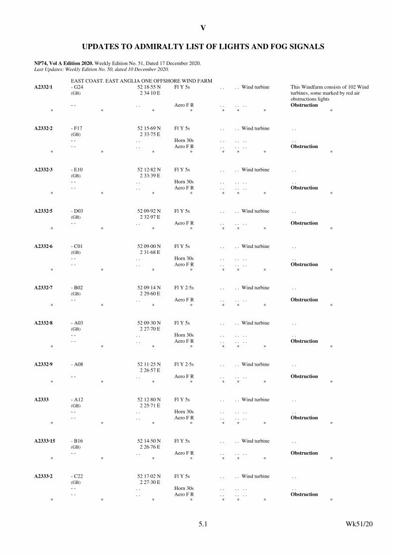
V
UPDATES TO ADMIRALTY LIST OF LIGHTS AND FOG SIGNALS
NP74, Vol A Edition 2020. Weekly Edition No. 51, Dated 17 December 2020.Last Updates: Weekly Edition No. 50, dated 10 December 2020.
EAST COAST. EAST ANGLIA ONE OFFSHORE WIND FARM
A2332·1 - G24(GB)
52 18·55 N2 34·10 E
Fl Y 5s . . . . Wind turbine This Windfarm consists of 102 Wind turbines, some marked by red air obstructions lights
- - . . Aero F R . . . . . . Obstruction* * * * * * * *
A2332·2 - F17(GB)
52 15·69 N2 33·75 E
Fl Y 5s . . . . Wind turbine . .
- - . . Horn 30s . . . . . . . .
- - . . Aero F R . . . . . . Obstruction* * * * * * * *
A2332·3 - E10(GB)
52 12·82 N2 33·39 E
Fl Y 5s . . . . Wind turbine . .
- - . . Horn 30s . . . . . . . .
- - . . Aero F R . . . . . . Obstruction* * * * * * * *
A2332·5 - D03(GB)
52 09·92 N2 32·97 E
Fl Y 5s . . . . Wind turbine . .
- - . . Aero F R . . . . . . Obstruction* * * * * * * *
A2332·6 - C01(GB)
52 09·00 N2 31·68 E
Fl Y 5s . . . . Wind turbine . .
- - . . Horn 30s . . . . . . . .
- - . . Aero F R . . . . . . Obstruction* * * * * * * *
A2332·7 - B02(GB)
52 09·14 N2 29·60 E
Fl Y 2·5s . . . . Wind turbine . .
- - . . Aero F R . . . . . . Obstruction* * * * * * * *
A2332·8 - A03(GB)
52 09·30 N2 27·70 E
Fl Y 5s . . . . Wind turbine . .
- - . . Horn 30s . . . . . . . .
- - . . Aero F R . . . . . . Obstruction* * * * * * * *
A2332·9 - A08 52 11·25 N2 26·57 E
Fl Y 2·5s . . . . Wind turbine . .
- - . . Aero F R . . . . . . Obstruction* * * * * * * *
A2333 - A12(GB)
52 12·80 N2 25·71 E
Fl Y 5s . . . . Wind turbine . .
- - . . Horn 30s . . . . . . . .
- - . . Aero F R . . . . . . Obstruction* * * * * * * *
A2333·15 - B16(GB)
52 14·50 N2 26·76 E
Fl Y 5s . . . . Wind turbine . .
- - . . Aero F R . . . . . . Obstruction* * * * * * * *
A2333·2 - C22(GB)
52 17·02 N2 27·30 E
Fl Y 5s . . . . Wind turbine . .
- - . . Horn 30s . . . . . . . .
- - . . Aero F R . . . . . . Obstruction* * * * * * * *
Wk51/205.1
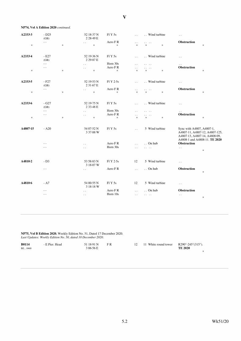
V
NP74, Vol A Edition 2020 continued.
A2333·3 - D25(GB)
52 18·37 N2 28·49 E
Fl Y 5s . . . . Wind turbine . .
- - . . Aero F R . . . . . . Obstruction* * * * * * * *
A2333·4 - E27(GB)
52 19·36 N2 29·87 E
Fl Y 5s . . . . Wind turbine . .
- - . . Horn 30s . . . . . . . .
- - . . Aero F R . . . . . . Obstruction* * * * * * * *
A2333·5 - F27(GB)
52 19·53 N2 31·67 E
Fl Y 2·5s . . . . Wind turbine . .
- - . . Aero F R . . . . . . Obstruction* * * * * * * *
A2333·6 - G27(GB)
52 19·75 N2 33·48 E
Fl Y 5s . . . . Wind turbine . .
- - . . Horn 30s . . . . . . . .
- - . . Aero F R . . . . . . Obstruction* * * * * * * *
A4807·15 - A20 54 07·52 N3 37·88 W
Fl Y 5s . . 5 Wind turbine Sync with A4807, A4807·1, A4807·11, A4807·12, A4807·125, A4807·13, A4807·14, A4808·09, A4808·1 and A4808·11. TE 2020
- - . . Aero F R . . . . On hub Obstruction
- - . . Horn 30s . . . . . . . .*
A4810·2 - D3 53 58·83 N3 18·07 W
Fl Y 2·5s 12 5 Wind turbine . .
- - . . Aero F R . . . . On hub Obstruction*
A4810·6 - A7 54 00·55 N3 18·18 W
Fl Y 5s 12 5 Wind turbine . .
- - . . Aero F R . . . . On hub Obstruction
- - . . Horn 10s . . . . . . . .*
Wk51/205.2
NP75, Vol B Edition 2020. Weekly Edition No. 51, Dated 17 December 2020.Last Updates: Weekly Edition No. 50, dated 10 December 2020.
B0114BE, , 0460
- E Pier. Head 51 18·91 N3 06·56 E
F R 12 11 White round tower R290°-245°(315°).TE 2020
*
Wk51/205.2
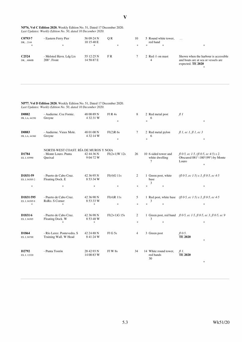
V
NP76, Vol C Edition 2020. Weekly Edition No. 51, Dated 17 December 2020.Last Updates: Weekly Edition No. 50, dated 10 December 2020.
C0793·7DK, , 2144
- Eastern Ferry Pier 56 09·24 N10 15·40 E
Q R 10 5 Round white tower, red band
. .
* * * * * * * *
C2524DK, , 6060B
- Melsted Havn. Ldg Lts 208°. Front
55 12·25 N14 58·87 E
F R 7 2 Red % on mast4
Shown when the harbour is accessibleand boats are at sea or vessels are expected. TE 2020
*
Wk51/205.3
NP77. Vol D Edition 2020. Weekly Edition No. 51, Dated 17 December 2020.Last Updates: Weekly Edition No. 50, dated 10 December 2020.
D0882FR, LA, 44350
- Audierne. Coz Fornic. Groyne
48 00·89 N4 32·31 W
Fl R 4s 8 2 Red metal post6
fl 1
* * *
D0883FR, LA, 44360
- Audierne. Vieux Mole. Groyne
48 01·00 N4 32·14 W
Fl(2)R 6s 7 2 Red metal pylon6
fl 1, ec 1, fl 1, ec 3
* * *
NORTH-WEST COAST. RÍA DE MUROS Y NOIA
D1784ES, I, 03990
- Monte Louro. Punta Queixal
42 44·36 N9 04·72 W
Fl(2+1)W 12s 26 10 6-sided tower and white dwelling7
fl 0·5, ec 1·5, (fl 0·5, ec 4·5) x 2.Obscured 081°-180°(99°) by Monte Louro
*
D1831·59ES, I, 04305·2
- Puerto de Cabo Cruz. Floating Dock. E
42 36·95 N8 53·34 W
Fl(4)G 11s 2 1 Green post, white base3
(fl 0·5, ec 1·5) x 3, fl 0·5, ec 4·5
* * * * * * * *
D1831·595ES, I, 04305·8
- Puerto de Cabo Cruz. RoRo. S Corner
42 36·90 N8 53·33 W
Fl(4)R 11s 5 1 Red post, white base3
(fl 0·5, ec 1·5) x 3, fl 0·5, ec 4·5
* * * * * * * *
D1831·6ES, I, 04305
- Puerto de Cabo Cruz. Floating Dock. W
42 36·98 N8 53·48 W
Fl(2+1)G 15s 2 1 Green post, red band3
fl 0·5, ec 1·5, fl 0·5, ec 3, fl 0·5, ec 9
* * * * *
D1864ES, I, 04700
- Río Lerez. Pontevedra. S Training Wall. W Head
42 24·88 N8 41·24 W
Fl G 5s 4 3 Green post fl 0·5.TE 2020
*
D2792ES, I, 12220
- Punta Tostón 28 42·93 N14 00·83 W
Fl W 8s 34 14 White round tower, red bands30
fl 1.TE 2020
*
Wk51/205.3
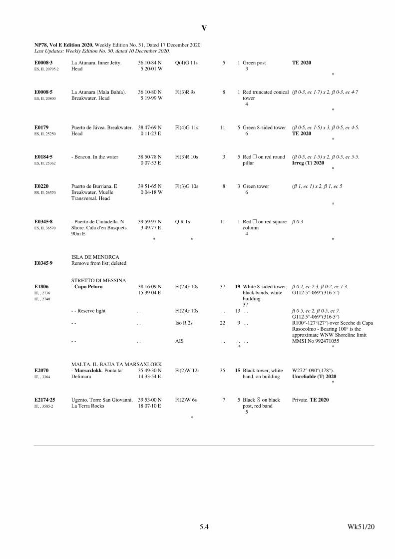
V
NP78, Vol E Edition 2020. Weekly Edition No. 51, Dated 17 December 2020.Last Updates: Weekly Edition No. 50, dated 10 December 2020.
E0008·3ES, II, 20795·2
La Atunara. Inner Jetty. Head
36 10·84 N5 20·01 W
Q(4)G 11s 5 1 Green post3
TE 2020
*
E0008·5ES, II, 20800
La Atunara (Mala Bahía). Breakwater. Head
36 10·80 N5 19·99 W
Fl(3)R 9s 8 1 Red truncated conicaltower4
(fl 0·3, ec 1·7) x 2, fl 0·3, ec 4·7
*
E0179ES, II, 25250
Puerto de Jávea. Breakwater.Head
38 47·69 N0 11·23 E
Fl(4)G 11s 11 5 Green 8-sided tower6
(fl 0·5, ec 1·5) x 3, fl 0·5, ec 4·5.TE 2020
*
E0184·5ES, II, 25362
- Beacon. In the water 38 50·78 N0 07·53 E
Fl(3)R 10s 3 5 Red & on red round pillar
(fl 0·5, ec 1·5) x 2, fl 0·5, ec 5·5.Irreg (T) 2020
*
E0220ES, II, 26570
Puerto de Burriana. E Breakwater. Muelle Transversal. Head
39 51·65 N0 04·18 W
Fl(3)G 10s 8 3 Green tower6
(fl 1, ec 1) x 2, fl 1, ec 5
*
E0345·8ES, II, 36570
- Puerto de Ciutadella. N Shore. Cala d'en Busquets. 90m E
39 59·97 N3 49·77 E
Q R 1s 11 1 Red & on red square column 4
fl 0·3
* * *
ISLA DE MENORCA
E0345·9 Remove from list; deleted
STRETTO DI MESSINA
E1806IT, , 2736
IT, , 2740
- Capo Peloro 38 16·09 N15 39·04 E
Fl(2)G 10s 37 19 White 8-sided tower, black bands, white building37
fl 0·2, ec 2·3, fl 0·2, ec 7·3.G112·5°-069°(316·5°)
- - Reserve light . . Fl(2)G 10s . . 13 . . fl 0·5, ec 2, fl 0·5, ec 7.G112·5°-069°(316·5°)
- - . . Iso R 2s 22 9 . . R100°-127°(27°) over Secche di CapaRasocolmo - Bearing 100° is the approximate WNW Shoreline limit
- - . . AIS . . . . . . MMSI No 992471055* *
MALTA. IL-BAJJA TA MARSAXLOKK
E2070IT, , 3364
- Marsaxlokk. Ponta ta' Delimara
35 49·30 N14 33·54 E
Fl(2)W 12s 35 15 Black tower, white band, on building
W272°-090°(178°).Unreliable (T) 2020
*
E2174·25IT, , 3585·2
Ugento. Torre San Giovanni.La Terra Rocks
39 53·00 N18 07·10 E
Fl(2)W 6s 7 5 Black # on black post, red band5
Private. TE 2020
*
Wk51/205.4
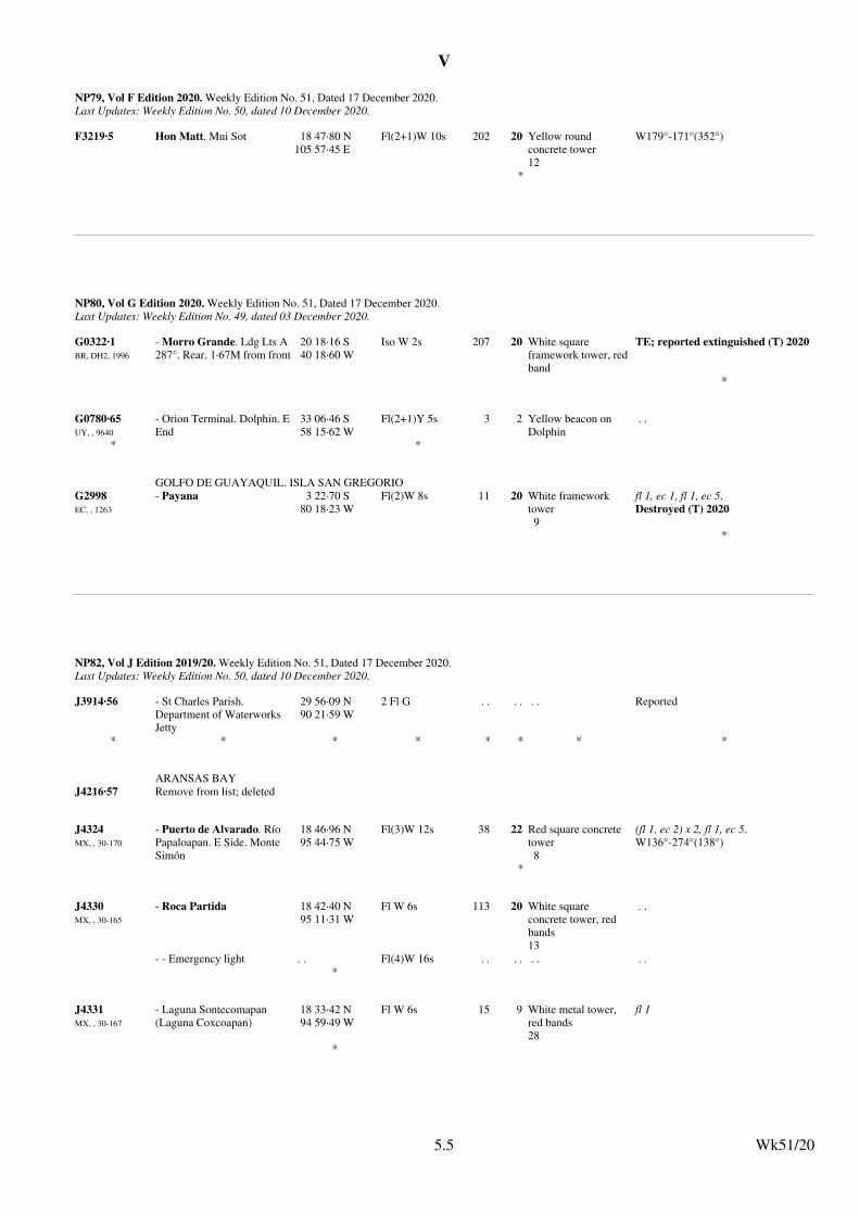
V
NP79, Vol F Edition 2020. Weekly Edition No. 51, Dated 17 December 2020.Last Updates: Weekly Edition No. 50, dated 10 December 2020.
F3219·5 Hon Matt. Mui Sot 18 47·80 N105 57·45 E
Fl(2+1)W 10s 202 20 Yellow round concrete tower12
W179°-171°(352°)
*
Wk51/205.5
NP80, Vol G Edition 2020. Weekly Edition No. 51, Dated 17 December 2020.Last Updates: Weekly Edition No. 49, dated 03 December 2020.
G0322·1BR, DH2, 1996
- Morro Grande. Ldg Lts A 287°. Rear. 1·67M from front
20 18·16 S40 18·60 W
Iso W 2s 207 20 White square framework tower, redband
TE; reported extinguished (T) 2020
*
G0780·65UY, , 9640
- Orion Terminal. Dolphin. EEnd
33 06·46 S58 15·62 W
Fl(2+1)Y 5s 3 2 Yellow beacon on Dolphin
. .
* *
GOLFO DE GUAYAQUIL. ISLA SAN GREGORIO
G2998EC, , 1263
- Payana 3 22·70 S80 18·23 W
Fl(2)W 8s 11 20 White framework tower9
fl 1, ec 1, fl 1, ec 5.Destroyed (T) 2020
*
Wk51/205.5
NP82, Vol J Edition 2019/20. Weekly Edition No. 51, Dated 17 December 2020.Last Updates: Weekly Edition No. 50, dated 10 December 2020.
J3914·56 - St Charles Parish. Department of Waterworks Jetty
29 56·09 N90 21·59 W
2 Fl G . . . . . . Reported
* * * * * * * *
ARANSAS BAY
J4216·57 Remove from list; deleted
J4324MX, , 30-170
- Puerto de Alvarado. Río Papaloapan. E Side. Monte Simón
18 46·96 N95 44·75 W
Fl(3)W 12s 38 22 Red square concrete tower 8
(fl 1, ec 2) x 2, fl 1, ec 5.W136°-274°(138°)
*
J4330MX, , 30-165
- Roca Partida 18 42·40 N95 11·31 W
Fl W 6s 113 20 White square concrete tower, red bands13
. .
- - Emergency light . . Fl(4)W 16s . . . . . . . .*
J4331MX, , 30-167
- Laguna Sontecomapan (Laguna Coxcoapan)
18 33·42 N94 59·49 W
Fl W 6s 15 9 White metal tower, red bands28
fl 1
*
Wk51/205.5
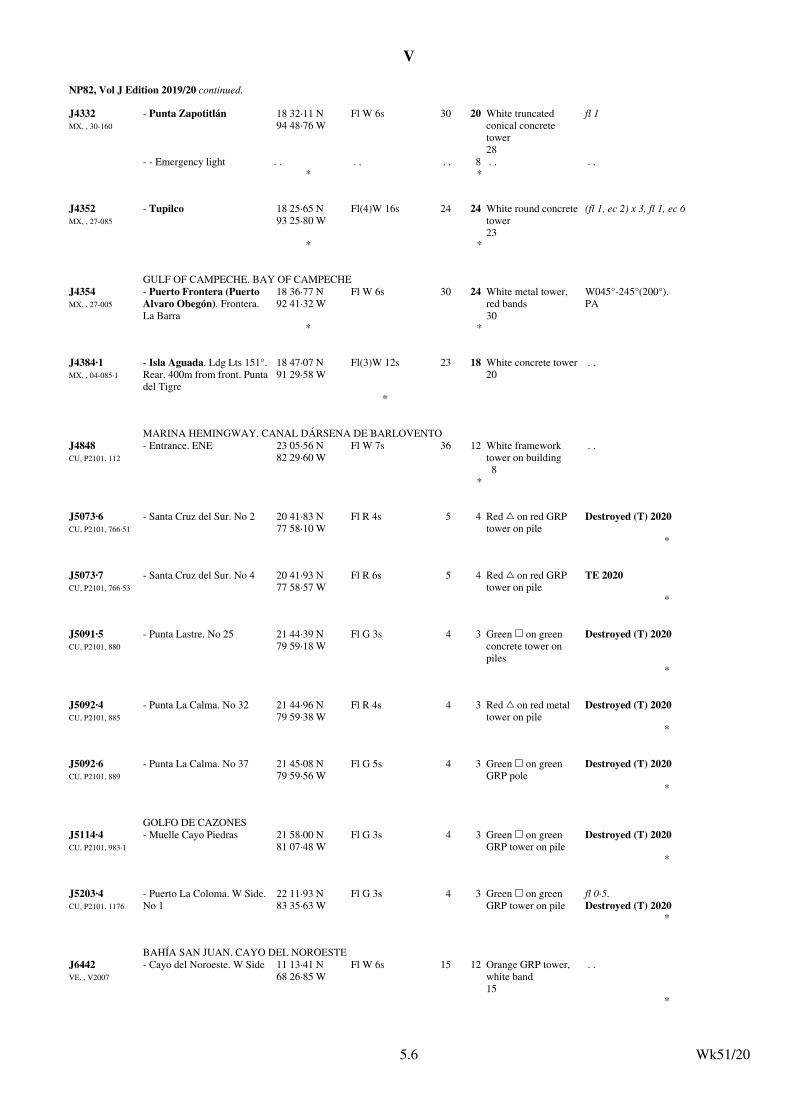
V
NP82, Vol J Edition 2019/20 continued.
J4332MX, , 30-160
- Punta Zapotitlán 18 32·11 N94 48·76 W
Fl W 6s 30 20 White truncated conical concrete tower28
fl 1
- - Emergency light . . . . . . 8 . . . .* *
J4352MX, , 27-085
- Tupilco 18 25·65 N93 25·80 W
Fl(4)W 16s 24 24 White round concretetower23
(fl 1, ec 2) x 3, fl 1, ec 6
* *
GULF OF CAMPECHE. BAY OF CAMPECHE
J4354MX, , 27-005
- Puerto Frontera (Puerto Alvaro Obegón). Frontera. La Barra
18 36·77 N92 41·32 W
Fl W 6s 30 24 White metal tower, red bands30
W045°-245°(200°).PA
* *
J4384·1MX, , 04-085·1
- Isla Aguada. Ldg Lts 151°.Rear. 400m from front. Puntadel Tigre
18 47·07 N91 29·58 W
Fl(3)W 12s 23 18 White concrete tower20
. .
*
MARINA HEMINGWAY. CANAL DÁRSENA DE BARLOVENTO
J4848CU, P2101, 112
- Entrance. ENE 23 05·56 N82 29·60 W
Fl W 7s 36 12 White framework tower on building8
. .
*
J5073·6CU, P2101, 766·51
- Santa Cruz del Sur. No 2 20 41·83 N77 58·10 W
Fl R 4s 5 4 Red % on red GRP tower on pile
Destroyed (T) 2020
*
J5073·7CU, P2101, 766·53
- Santa Cruz del Sur. No 4 20 41·93 N77 58·57 W
Fl R 6s 5 4 Red % on red GRP tower on pile
TE 2020
*
J5091·5CU, P2101, 880
- Punta Lastre. No 25 21 44·39 N79 59·18 W
Fl G 3s 4 3 Green & on green concrete tower on piles
Destroyed (T) 2020
*
J5092·4CU, P2101, 885
- Punta La Calma. No 32 21 44·96 N79 59·38 W
Fl R 4s 4 3 Red % on red metal tower on pile
Destroyed (T) 2020
*
J5092·6CU, P2101, 889
- Punta La Calma. No 37 21 45·08 N79 59·56 W
Fl G 5s 4 3 Green & on green GRP pole
Destroyed (T) 2020
*
GOLFO DE CAZONES
J5114·4CU, P2101, 983·1
- Muelle Cayo Piedras 21 58·00 N81 07·48 W
Fl G 3s 4 3 Green & on green GRP tower on pile
Destroyed (T) 2020
*
J5203·4CU, P2101, 1176
- Puerto La Coloma. W Side.No 1
22 11·93 N83 35·63 W
Fl G 3s 4 3 Green & on green GRP tower on pile
fl 0·5.Destroyed (T) 2020
*
BAHÍA SAN JUAN. CAYO DEL NOROESTE
J6442VE, , V2007
- Cayo del Noroeste. W Side 11 13·41 N68 26·85 W
Fl W 6s 15 12 Orange GRP tower, white band15
. .
*
Wk51/205.6
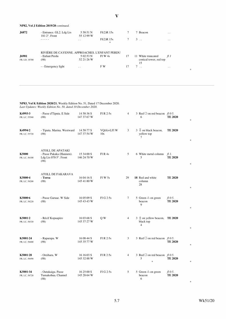
V
NP82, Vol J Edition 2019/20 continued.
J6872 - Entrance. GL2. Ldg Lts 181·2°. Front
5 58·51 N55 12·99 W
Fl(2)R 15s 7 7 Beacon . .
- - - - - . . Fl(2)R 15s 7 3 . . . .*
RIVIÈRE DE CAYENNE. APPROACHES. L'ENFANT PERDU
J6901FR, LD, 18700
- Enfant Perdu(FR)
5 02·53 N52 21·26 W
Fl W 4s 17 11 White truncated conical tower, red top15
fl 1
- - Emergency light . . F W 17 7 . . . .*
Wk51/205.7
NP83, Vol K Edition 2020/21. Weekly Edition No. 51, Dated 17 December 2020.Last Updates: Weekly Edition No. 50, dated 10 December 2020.
K4993·3FR, LC, 55560
- Passe d'Tiputa. E Side(FR)
14 58·36 S147 37·67 W
Fl R 2·5s 4 3 Red & on red beacon6
fl 0·5.TE 2020
*
K4994·2FR, LC, 55720
- Tiputa. Marina. Westward(FR)
14 58·77 S147 37·54 W
VQ(6)+LFl W 10s
3 3 " on black beacon, yellow top7
TE 2020
*
ATOLL DE APATAKI
K5000FR, LC, 56100
- Passe Pakaka (Haniuru). Ldg Lts 070·5°. Front(FR)
15 34·00 S146 24·70 W
Fl R 4s 5 6 White metal column5
fl 1.TE 2020
*
ATOLL DE FAKARAVA
K5000·4FR, LC, 58200
- Torea(FR)
16 04·16 S145 41·80 W
Fl W 5s 29 18 Red and white column28
TE 2020
*
K5000·6FR, LC, 58220
- Passe Garuae. W Side(FR)
16 05·09 S145 43·43 W
Fl G 2·5s 7 5 Green % on green beacon9
fl 0·5.TE 2020
*
K5001·2FR, LC, 58320
- Récif Kopuapiro(FR)
16 03·68 S145 37·27 W
Q W 4 3 ) on yellow beacon, black top4
TE 2020
*
K5001·24FR, LC, 58400
- Raparapa. W(FR)
16 08·44 S145 35·77 W
Fl R 2·5s 3 3 Red & on red beacon fl 0·5.TE 2020
*
K5001·28FR, LC, 58490
- Oreihara. W(FR)
16 16·03 S145 32·88 W
Fl R 2·5s 4 3 Red & on red beacon5
fl 0·5.TE 2020
* *
K5001·34FR, LC, 58720
- Outukaiga. Passe Tumakohua. Channel(FR)
16 25·00 S145 28·64 W
Fl G 2·5s 5 5 Green % on green beacon6
fl 0·5.TE 2020
*
Wk51/205.7
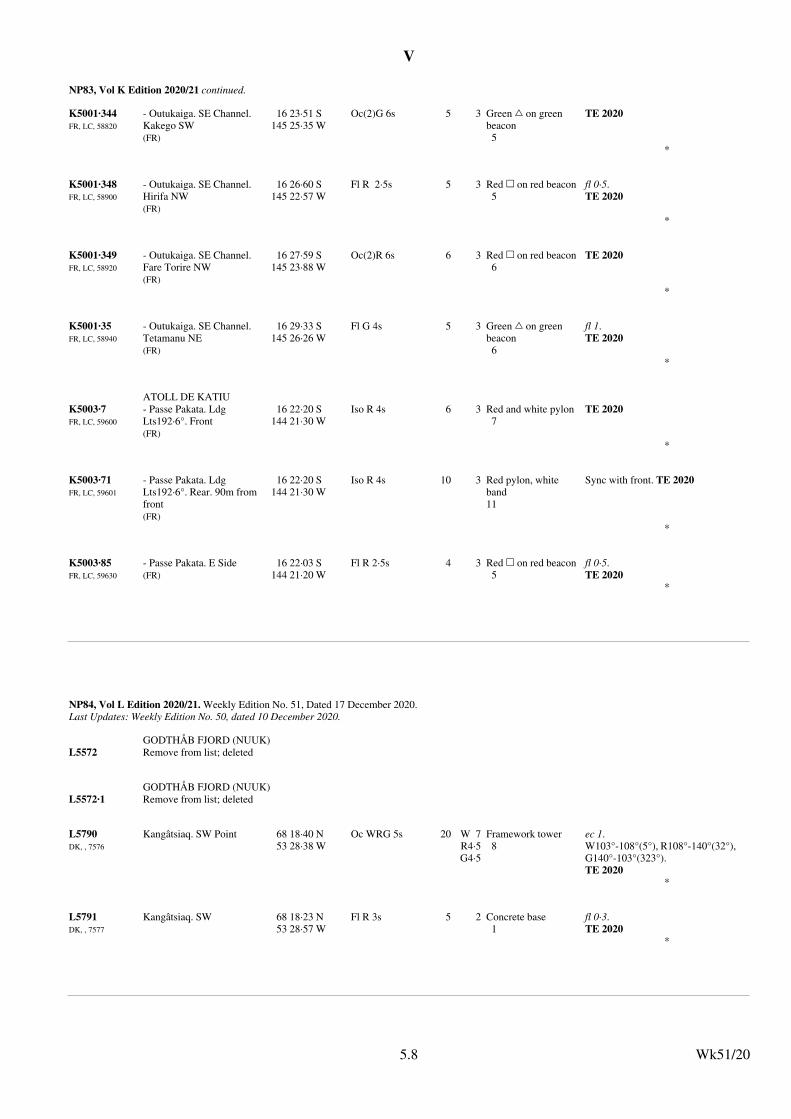
V
NP83, Vol K Edition 2020/21 continued.
K5001·344FR, LC, 58820
- Outukaiga. SE Channel. Kakego SW(FR)
16 23·51 S145 25·35 W
Oc(2)G 6s 5 3 Green % on green beacon5
TE 2020
*
K5001·348FR, LC, 58900
- Outukaiga. SE Channel. Hirifa NW(FR)
16 26·60 S145 22·57 W
Fl R 2·5s 5 3 Red & on red beacon5
fl 0·5.TE 2020
*
K5001·349FR, LC, 58920
- Outukaiga. SE Channel. Fare Torire NW(FR)
16 27·59 S145 23·88 W
Oc(2)R 6s 6 3 Red & on red beacon6
TE 2020
*
K5001·35FR, LC, 58940
- Outukaiga. SE Channel. Tetamanu NE(FR)
16 29·33 S145 26·26 W
Fl G 4s 5 3 Green % on green beacon6
fl 1.TE 2020
*
ATOLL DE KATIU
K5003·7FR, LC, 59600
- Passe Pakata. Ldg Lts192·6°. Front(FR)
16 22·20 S144 21·30 W
Iso R 4s 6 3 Red and white pylon7
TE 2020
*
K5003·71FR, LC, 59601
- Passe Pakata. Ldg Lts192·6°. Rear. 90m from front(FR)
16 22·20 S144 21·30 W
Iso R 4s 10 3 Red pylon, white band11
Sync with front. TE 2020
*
K5003·85FR, LC, 59630
- Passe Pakata. E Side(FR)
16 22·03 S144 21·20 W
Fl R 2·5s 4 3 Red & on red beacon5
fl 0·5.TE 2020
*
Wk51/205.8
NP84, Vol L Edition 2020/21. Weekly Edition No. 51, Dated 17 December 2020.Last Updates: Weekly Edition No. 50, dated 10 December 2020.
GODTHÅB FJORD (NUUK)
L5572 Remove from list; deleted
GODTHÅB FJORD (NUUK)
L5572·1 Remove from list; deleted
L5790DK, , 7576
Kangâtsiaq. SW Point 68 18·40 N53 28·38 W
Oc WRG 5s 20 W 7R4·5G4·5
Framework tower8
ec 1.W103°-108°(5°), R108°-140°(32°), G140°-103°(323°).TE 2020
*
L5791DK, , 7577
Kangâtsiaq. SW 68 18·23 N53 28·57 W
Fl R 3s 5 2 Concrete base1
fl 0·3.TE 2020
*
Wk51/205.8
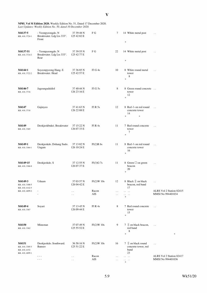
V
NP85, Vol M Edition 2020. Weekly Edition No. 51, Dated 17 December 2020.Last Updates: Weekly Edition No. 50, dated 10 December 2020.
M4137·5KR, 410, 3724·1
- Yeonpyeongdo. N Breakwater. Ldg Lts 333°. Front
37 39·48 N125 42·82 E
F G 7 14 White metal post . .
*
M4137·51KR, 410, 3724·2
- Yeonpyeongdo. N Breakwater. Ldg Lts 333°. Rear
37 39·55 N125 42·77 E
F G 22 14 White metal post . .
*
M4144·1KR, 410, 3722·2
Soyeonpyeong Hang. E Breakwater. Head
37 36·85 N125 42·57 E
Fl G 4s 10 8 White round metal tower8
. .
*
M4146·7KR, 410, 3716
Jageunguduldol 37 40·44 N126 23·16 E
Fl G 5s 8 8 Green round concretetower12
. .
*
M4147KR, 410, 3718
Gajinyeo 37 41·63 N126 22·88 E
Fl R 5s 12 8 Red % on red round concrete tower14
. .
* *
M4149KR, 410, 3365
Deokjeokbukri. Breakwater 37 15·22 N126 07·33 E
Fl R 4s 11 7 Red round concrete tower7
. .
*
M4149·1KR, 410, 3364·1
Deokjeokdo. Dohang Sudo. Ungam
37 13·82 N126 10·24 E
Fl(2)R 6s 11 8 Red % on red round concrete tower16
. .
*
M4149·15KR, 410, 3366·8
Deokjeokdo. S 37 12·55 N126 07·37 E
Fl(3)G 7s 11 8 Green & on green beacon20
. .
*
M4149·3KR, 410, 3308·5
KR, 410, 4142·5
KR, 410, 4699·2
Uduam 37 03·57 N126 04·42 E
Fl(2)W 10s 12 8 Black # on black beacon, red band17
. .
- . . Racon . . . . . . ALRS Vol 2 Station 82415
- . . AIS . . . . . . MMSI No 994401034*
M4149·4KR, 410, 3367
Soyari 37 13·45 N126 09·44 E
Fl R 4s 8 7 Red round concrete tower15
. .
*
M4150KR, 410, 3362
Mineotan 37 07·49 N125 55·52 E
Fl(2)W 10s 9 7 # on black beacon, red band8
. .
* *
M4151KR, 410, 3305·5
KR, 410, 4152
KR, 410, 4699·1
Deokjeokdo. Southward. Banseo
36 58·16 N125 51·22 E
Fl(2)W 10s 16 7 # on black round concrete tower, red band23
. .
- - - . . Racon . . . . . . ALRS Vol 2 Station 82417
- - - . . AIS . . . . . . MMSI No 994401036*
Wk51/205.9
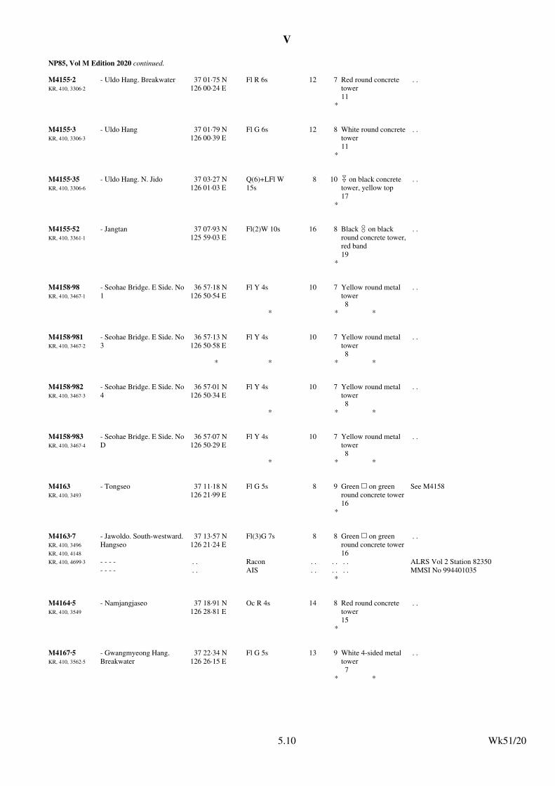
V
NP85, Vol M Edition 2020 continued.
M4155·2KR, 410, 3306·2
- Uldo Hang. Breakwater 37 01·75 N126 00·24 E
Fl R 6s 12 7 Red round concrete tower11
. .
*
M4155·3KR, 410, 3306·3
- Uldo Hang 37 01·79 N126 00·39 E
Fl G 6s 12 8 White round concretetower11
. .
*
M4155·35KR, 410, 3306·6
- Uldo Hang. N. Jido 37 03·27 N126 01·03 E
Q(6)+LFl W 15s
8 10 " on black concrete tower, yellow top17
. .
*
M4155·52KR, 410, 3361·1
- Jangtan 37 07·93 N125 59·03 E
Fl(2)W 10s 16 8 Black # on black round concrete tower,red band19
. .
*
M4158·98KR, 410, 3467·1
- Seohae Bridge. E Side. No 1
36 57·18 N126 50·54 E
Fl Y 4s 10 7 Yellow round metal tower8
. .
* * *
M4158·981KR, 410, 3467·2
- Seohae Bridge. E Side. No 3
36 57·13 N126 50·58 E
Fl Y 4s 10 7 Yellow round metal tower8
. .
* * * *
M4158·982KR, 410, 3467·3
- Seohae Bridge. E Side. No 4
36 57·01 N126 50·34 E
Fl Y 4s 10 7 Yellow round metal tower8
. .
* * *
M4158·983KR, 410, 3467·4
- Seohae Bridge. E Side. No D
36 57·07 N126 50·29 E
Fl Y 4s 10 7 Yellow round metal tower8
. .
* * *
M4163KR, 410, 3493
- Tongseo 37 11·18 N126 21·99 E
Fl G 5s 8 9 Green & on green round concrete tower16
See M4158
*
M4163·7KR, 410, 3496
KR, 410, 4148
KR, 410, 4699·3
- Jawoldo. South-westward. Hangseo
37 13·57 N126 21·24 E
Fl(3)G 7s 8 8 Green & on green round concrete tower16
. .
- - - - . . Racon . . . . . . ALRS Vol 2 Station 82350
- - - - . . AIS . . . . . . MMSI No 994401035*
M4164·5KR, 410, 3549
- Namjangjaseo 37 18·91 N126 28·81 E
Oc R 4s 14 8 Red round concrete tower15
. .
*
M4167·5KR, 410, 3562·5
- Gwangmyeong Hang. Breakwater
37 22·34 N126 26·15 E
Fl G 5s 13 9 White 4-sided metal tower7
. .
* *
Wk51/205.10
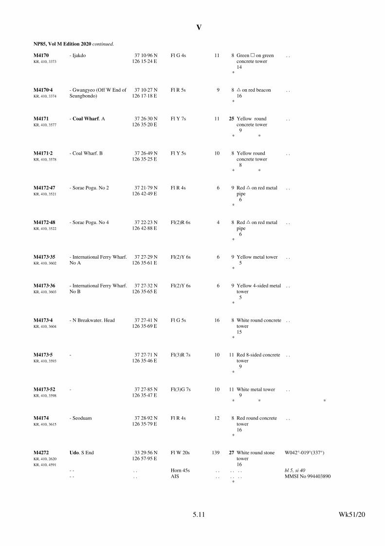
V
NP85, Vol M Edition 2020 continued.
M4170KR, 410, 3373
- Ijakdo 37 10·96 N126 15·24 E
Fl G 4s 11 8 Green & on green concrete tower14
. .
*
M4170·4KR, 410, 3374
- Gwangyeo (Off W End of Seungbondo)
37 10·27 N126 17·18 E
Fl R 5s 9 8 % on red beacon16
. .
*
M4171KR, 410, 3577
- Coal Wharf. A 37 26·30 N126 35·20 E
Fl Y 7s 11 25 Yellow round concrete tower9
. .
* *
M4171·2KR, 410, 3578
- Coal Wharf. B 37 26·49 N126 35·25 E
Fl Y 5s 10 8 Yellow round concrete tower8
. .
* *
M4172·47KR, 410, 3521
- Sorae Pogu. No 2 37 21·79 N126 42·49 E
Fl R 4s 6 9 Red % on red metal pipe6
. .
*
M4172·48KR, 410, 3522
- Sorae Pogu. No 4 37 22·23 N126 42·88 E
Fl(2)R 6s 4 8 Red % on red metal pipe6
. .
*
M4173·35KR, 410, 3602
- International Ferry Wharf. No A
37 27·29 N126 35·61 E
Fl(2)Y 6s 6 9 Yellow metal tower5
. .
*
M4173·36KR, 410, 3603
- International Ferry Wharf. No B
37 27·32 N126 35·65 E
Fl(2)Y 6s 6 9 Yellow 4-sided metaltower5
. .
*
M4173·4KR, 410, 3604
- N Breakwater. Head 37 27·41 N126 35·69 E
Fl G 5s 16 8 White round concretetower15
. .
*
M4173·5KR, 410, 3593
- 37 27·71 N126 35·46 E
Fl(3)R 7s 10 11 Red 8-sided concrete tower9
. .
*
M4173·52KR, 410, 3598
- 37 27·85 N126 35·47 E
Fl(3)G 7s 10 11 White metal tower 9
. .
* * *
M4174KR, 410, 3615
- Seoduam 37 28·92 N126 35·79 E
Fl R 4s 12 8 Red round concrete tower16
. .
*
M4272KR, 410, 2620
KR, 410, 4591
Udo. S End 33 29·56 N126 57·95 E
Fl W 20s 139 27 White round stone tower16
W042°-019°(337°)
- - . . Horn 45s . . . . . . bl 5, si 40- - . . AIS . . . . . . MMSI No 994403890
*
Wk51/205.11
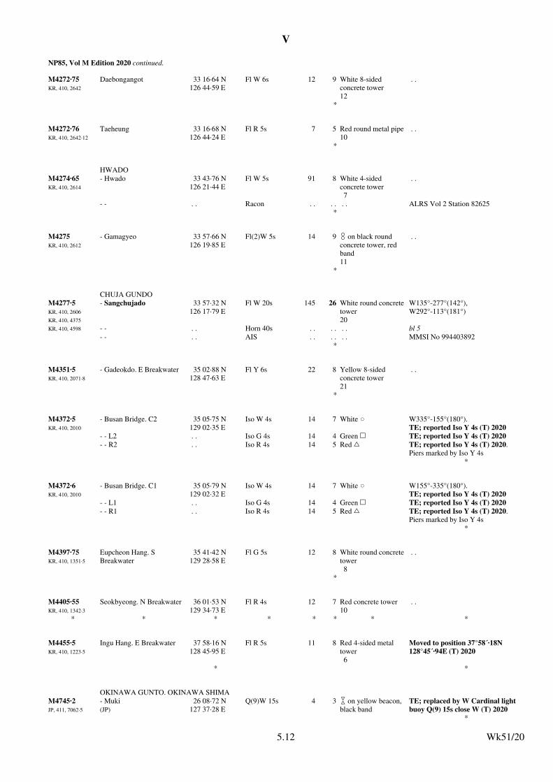
V
NP85, Vol M Edition 2020 continued.
M4272·75KR, 410, 2642
Daebongangot 33 16·64 N126 44·59 E
Fl W 6s 12 9 White 8-sided concrete tower12
. .
*
M4272·76KR, 410, 2642·12
Taeheung 33 16·68 N126 44·24 E
Fl R 5s 7 5 Red round metal pipe10
. .
*
HWADO
M4274·65KR, 410, 2614
- Hwado 33 43·76 N126 21·44 E
Fl W 5s 91 8 White 4-sided concrete tower 7
. .
- - . . Racon . . . . . . ALRS Vol 2 Station 82625*
M4275KR, 410, 2612
- Gamagyeo 33 57·66 N126 19·85 E
Fl(2)W 5s 14 9 # on black round concrete tower, red band11
. .
*
CHUJA GUNDO
M4277·5KR, 410, 2606
KR, 410, 4375
KR, 410, 4598
- Sangchujado 33 57·32 N126 17·79 E
Fl W 20s 145 26 White round concretetower20
W135°-277°(142°), W292°-113°(181°)
- - . . Horn 40s . . . . . . bl 5- - . . AIS . . . . . . MMSI No 994403892
*
M4351·5KR, 410, 2071·8
- Gadeokdo. E Breakwater 35 02·88 N128 47·63 E
Fl Y 6s 22 8 Yellow 8-sided concrete tower21
. .
*
M4372·5KR, 410, 2010
- Busan Bridge. C2 35 05·75 N129 02·35 E
Iso W 4s 14 7 White v W335°-155°(180°).TE; reported Iso Y 4s (T) 2020
- - L2 . . Iso G 4s 14 4 Green & TE; reported Iso Y 4s (T) 2020
- - R2 . . Iso R 4s 14 5 Red % TE; reported Iso Y 4s (T) 2020. Piers marked by Iso Y 4s
*
M4372·6KR, 410, 2010
- Busan Bridge. C1 35 05·79 N129 02·32 E
Iso W 4s 14 7 White v W155°-335°(180°).TE; reported Iso Y 4s (T) 2020
- - L1 . . Iso G 4s 14 4 Green & TE; reported Iso Y 4s (T) 2020
- - R1 . . Iso R 4s 14 5 Red % TE; reported Iso Y 4s (T) 2020. Piers marked by Iso Y 4s
*
M4397·75KR, 410, 1351·5
Eupcheon Hang. S Breakwater
35 41·42 N129 28·58 E
Fl G 5s 12 8 White round concretetower8
. .
*
M4405·55KR, 410, 1342·3
Seokbyeong. N Breakwater 36 01·53 N129 34·73 E
Fl R 4s 12 7 Red concrete tower10
. .
* * * * * * * *
M4455·5KR, 410, 1223·5
Ingu Hang. E Breakwater 37 58·16 N128 45·95 E
Fl R 5s 11 8 Red 4-sided metal tower6
Moved to position 37°58´·18N 128°45´·94E (T) 2020
* *
OKINAWA GUNTO. OKINAWA SHIMA
M4745·2JP, 411, 7062·5
- Muki(JP)
26 08·72 N127 37·28 E
Q(9)W 15s 4 3 $ on yellow beacon, black band
TE; replaced by W Cardinal light buoy Q(9) 15s close W (T) 2020
*
Wk51/205.12
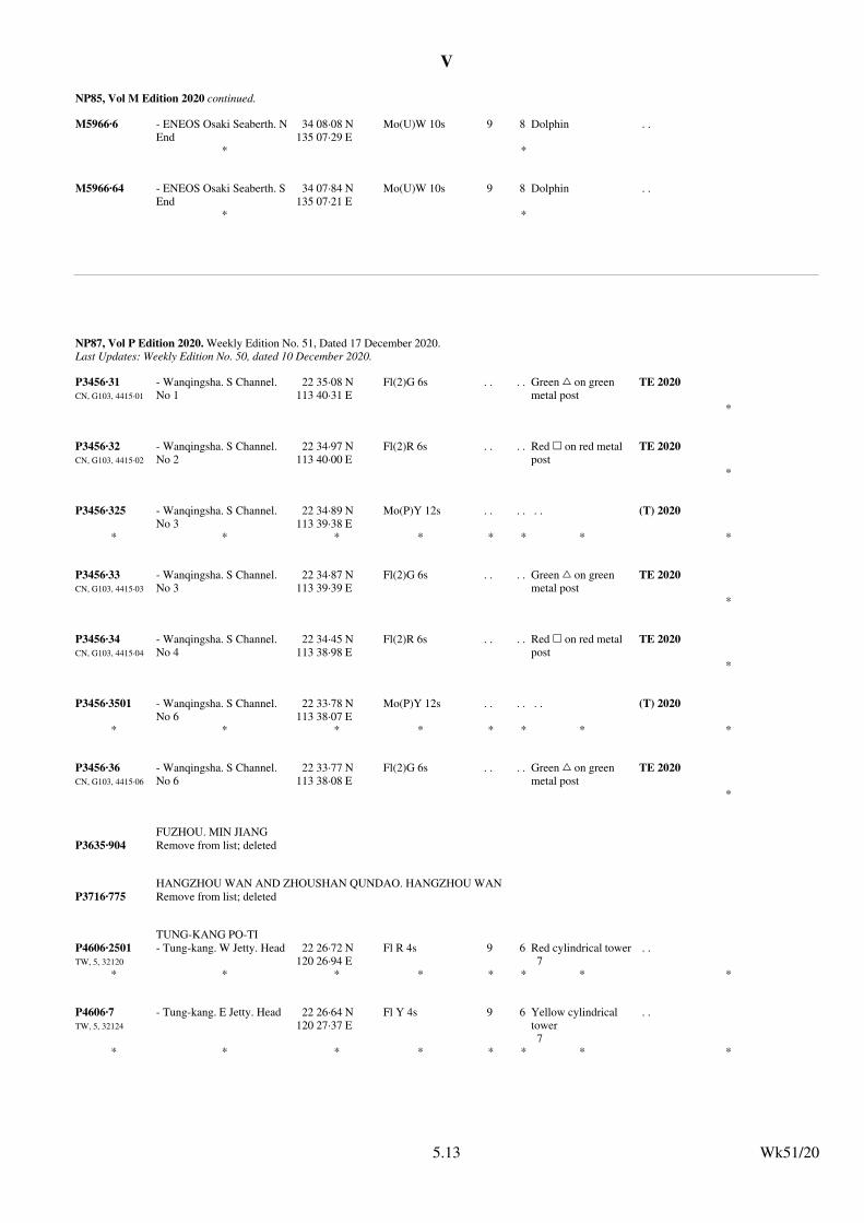
V
NP85, Vol M Edition 2020 continued.
M5966·6 - ENEOS Osaki Seaberth. N End
34 08·08 N135 07·29 E
Mo(U)W 10s 9 8 Dolphin . .
* *
M5966·64 - ENEOS Osaki Seaberth. S End
34 07·84 N135 07·21 E
Mo(U)W 10s 9 8 Dolphin . .
* *
Wk51/205.13
NP87, Vol P Edition 2020. Weekly Edition No. 51, Dated 17 December 2020.Last Updates: Weekly Edition No. 50, dated 10 December 2020.
P3456·31CN, G103, 4415·01
- Wanqingsha. S Channel. No 1
22 35·08 N113 40·31 E
Fl(2)G 6s . . . . Green % on green metal post
TE 2020
*
P3456·32CN, G103, 4415·02
- Wanqingsha. S Channel. No 2
22 34·97 N113 40·00 E
Fl(2)R 6s . . . . Red & on red metal post
TE 2020
*
P3456·325 - Wanqingsha. S Channel. No 3
22 34·89 N113 39·38 E
Mo(P)Y 12s . . . . . . (T) 2020
* * * * * * * *
P3456·33CN, G103, 4415·03
- Wanqingsha. S Channel. No 3
22 34·87 N113 39·39 E
Fl(2)G 6s . . . . Green % on green metal post
TE 2020
*
P3456·34CN, G103, 4415·04
- Wanqingsha. S Channel. No 4
22 34·45 N113 38·98 E
Fl(2)R 6s . . . . Red & on red metal post
TE 2020
*
P3456·3501 - Wanqingsha. S Channel. No 6
22 33·78 N113 38·07 E
Mo(P)Y 12s . . . . . . (T) 2020
* * * * * * * *
P3456·36CN, G103, 4415·06
- Wanqingsha. S Channel. No 6
22 33·77 N113 38·08 E
Fl(2)G 6s . . . . Green % on green metal post
TE 2020
*
FUZHOU. MIN JIANG
P3635·904 Remove from list; deleted
HANGZHOU WAN AND ZHOUSHAN QUNDAO. HANGZHOU WAN
P3716·775 Remove from list; deleted
TUNG-KANG PO-TI
P4606·2501TW, 5, 32120
- Tung-kang. W Jetty. Head 22 26·72 N120 26·94 E
Fl R 4s 9 6 Red cylindrical tower7
. .
* * * * * * * *
P4606·7TW, 5, 32124
- Tung-kang. E Jetty. Head 22 26·64 N120 27·37 E
Fl Y 4s 9 6 Yellow cylindrical tower7
. .
* * * * * * * *
Wk51/205.13
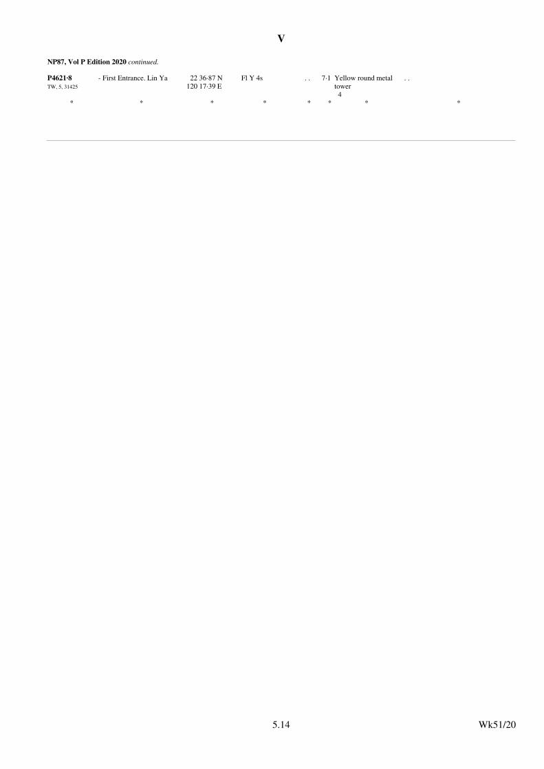
V
NP87, Vol P Edition 2020 continued.
P4621·8TW, 5, 31425
- First Entrance. Lin Ya 22 36·87 N120 17·39 E
Fl Y 4s . . 7·1 Yellow round metal tower4
. .
* * * * * * * *
Wk51/205.14
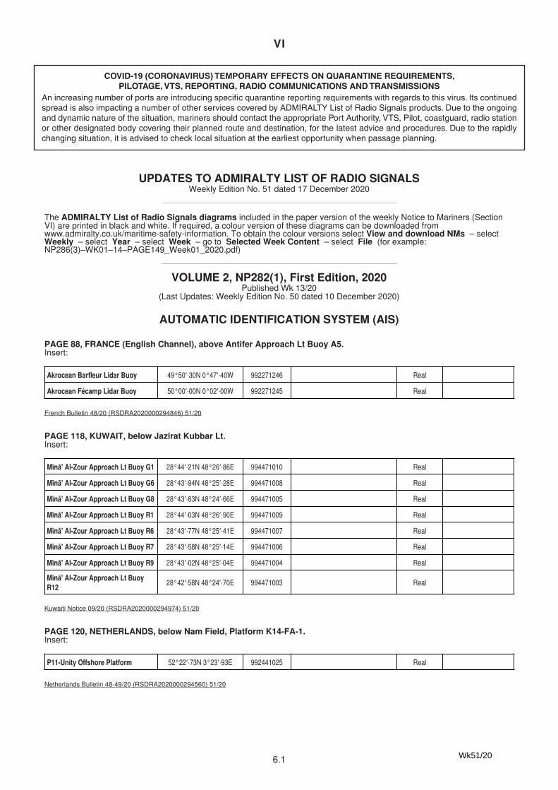
VI
6.1
COVID-19 (CORONAVIRUS) TEMPORARY EFFECTS ON QUARANTINE REQUIREMENTS, PILOTAGE, VTS, REPORTING, RADIO COMMUNICATIONS AND TRANSMISSIONS
An increasing number of ports are introducing specific quarantine reporting requirements with regards to this virus. Its continued spread is also impacting a number of other services covered by ADMIRALTY List of Radio Signals products. Due to the ongoing and dynamic nature of the situation, mariners should contact the appropriate Port Authority, VTS, Pilot, coastguard, radio station or other designated body covering their planned route and destination, for the latest advice and procedures. Due to the rapidly changing situation, it is advised to check local situation at the earliest opportunity when passage planning.
VI
6.1
UPDATES TO ADMIRALTY LIST OF RADIO SIGNALSWeekly Edition No. 51 dated 17 December 2020
The ADMIRALTY List of Radio Signals diagrams included in the paper version of the weekly Notice to Mariners (SectionVI) are printed in black and white. If required, a colour version of these diagrams can be downloaded fromwww.admiralty.co.uk/maritime-safety-information. To obtain the colour versions select View and download NMs – selectWeekly – select Year – select Week – go to Selected Week Content – select File (for example:NP286(3)–WK01–14–PAGE149_Week01_2020.pdf)
Akrocean Barfleur Lidar Buoy 49°50′·30N 0°47′·40W 992271246 Real
Akrocean Fécamp Lidar Buoy 50°00′·00N 0°02′·00W 992271245 Real
French Bulletin 48/20 (RSDRA2020000294846) 51/20
Mīnā' Al-Zour Approach Lt Buoy G1 28°44′·21N 48°26′·86E 994471010 Real
Mīnā' Al-Zour Approach Lt Buoy G6 28°43′·94N 48°25′·28E 994471008 Real
Mīnā' Al-Zour Approach Lt Buoy G8 28°43′·83N 48°24′·66E 994471005 Real
Mīnā' Al-Zour Approach Lt Buoy R1 28°44′·03N 48°26′·90E 994471009 Real
Mīnā' Al-Zour Approach Lt Buoy R6 28°43′·77N 48°25′·41E 994471007 Real
Mīnā' Al-Zour Approach Lt Buoy R7 28°43′·58N 48°25′·14E 994471006 Real
Mīnā' Al-Zour Approach Lt Buoy R9 28°43′·02N 48°25′·04E 994471004 Real
Mīnā' Al-Zour Approach Lt BuoyR12
28°42′·58N 48°24′·70E 994471003 Real
Kuwaiti Notice 09/20 (RSDRA2020000294974) 51/20
P11-Unity Offshore Platform 52°22′·73N 3°23′·93E 992441025 Real
Netherlands Bulletin 48-49/20 (RSDRA2020000294560) 51/20
Fiji -12 -13 20 Dec 2020 1400h14 Nov 2021 1400h13 Nov 2022 1400h12 Nov 2023 1400h10 Nov 2024 1400h9 Nov 2025 1400h
17 Jan 2021 1400h16 Jan 2022 1400h15 Jan 2023 1400h14 Jan 2024 1400h12 Jan 2025 1400h18 Jan 2026 1400h
OAG (RSDRA2020000294611) 51/20
VOLUME 2, NP282(1), First Edition, 2020Published Wk 13/20
(Last Updates: Weekly Edition No. 50 dated 10 December 2020)
AUTOMATIC IDENTIFICATION SYSTEM (AIS)
PAGE 88, FRANCE (English Channel), above Antifer Approach Lt Buoy A5.Insert:
PAGE 118, KUWAIT, below Jazīrat Kubbar Lt.Insert:
PAGE 120, NETHERLANDS, below Nam Field, Platform K14-FA-1.Insert:
LEGAL TIME
PAGE 216, Fiji.Delete entry and replace by:
Wk51/20
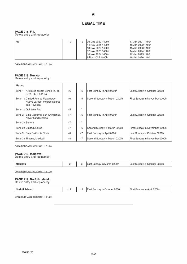
VI
6.2
VI
6.1
UPDATES TO ADMIRALTY LIST OF RADIO SIGNALSWeekly Edition No. 51 dated 17 December 2020
The ADMIRALTY List of Radio Signals diagrams included in the paper version of the weekly Notice to Mariners (SectionVI) are printed in black and white. If required, a colour version of these diagrams can be downloaded fromwww.admiralty.co.uk/maritime-safety-information. To obtain the colour versions select View and download NMs – selectWeekly – select Year – select Week – go to Selected Week Content – select File (for example:NP286(3)–WK01–14–PAGE149_Week01_2020.pdf)
Akrocean Barfleur Lidar Buoy 49°50′·30N 0°47′·40W 992271246 Real
Akrocean Fécamp Lidar Buoy 50°00′·00N 0°02′·00W 992271245 Real
French Bulletin 48/20 (RSDRA2020000294846) 51/20
Mīnā' Al-Zour Approach Lt Buoy G1 28°44′·21N 48°26′·86E 994471010 Real
Mīnā' Al-Zour Approach Lt Buoy G6 28°43′·94N 48°25′·28E 994471008 Real
Mīnā' Al-Zour Approach Lt Buoy G8 28°43′·83N 48°24′·66E 994471005 Real
Mīnā' Al-Zour Approach Lt Buoy R1 28°44′·03N 48°26′·90E 994471009 Real
Mīnā' Al-Zour Approach Lt Buoy R6 28°43′·77N 48°25′·41E 994471007 Real
Mīnā' Al-Zour Approach Lt Buoy R7 28°43′·58N 48°25′·14E 994471006 Real
Mīnā' Al-Zour Approach Lt Buoy R9 28°43′·02N 48°25′·04E 994471004 Real
Mīnā' Al-Zour Approach Lt BuoyR12
28°42′·58N 48°24′·70E 994471003 Real
Kuwaiti Notice 09/20 (RSDRA2020000294974) 51/20
P11-Unity Offshore Platform 52°22′·73N 3°23′·93E 992441025 Real
Netherlands Bulletin 48-49/20 (RSDRA2020000294560) 51/20
Fiji -12 -13 20 Dec 2020 1400h14 Nov 2021 1400h13 Nov 2022 1400h12 Nov 2023 1400h10 Nov 2024 1400h9 Nov 2025 1400h
17 Jan 2021 1400h16 Jan 2022 1400h15 Jan 2023 1400h14 Jan 2024 1400h12 Jan 2025 1400h18 Jan 2026 1400h
OAG (RSDRA2020000294611) 51/20
VOLUME 2, NP282(1), First Edition, 2020Published Wk 13/20
(Last Updates: Weekly Edition No. 50 dated 10 December 2020)
AUTOMATIC IDENTIFICATION SYSTEM (AIS)
PAGE 88, FRANCE (English Channel), above Antifer Approach Lt Buoy A5.Insert:
PAGE 118, KUWAIT, below Jazīrat Kubbar Lt.Insert:
PAGE 120, NETHERLANDS, below Nam Field, Platform K14-FA-1.Insert:
LEGAL TIME
PAGE 216, Fiji.Delete entry and replace by:
VI
6.2
Mexico
Zone 1 All states except Zones 1a, 1b,2, 2a, 2b, 3 and 3a
+6 +5 First Sunday in April 0200h Last Sunday in October 0200h
Zone 1a Ciudad Acuna, Matamoros,Nuevo Laredo, Piedras Negrasand Reynosa
+6 +5 Second Sunday in March 0200h First Sunday in November 0200h
Zone 1b Quintana Roo +5 *
Zone 2 Baja California Sur, Chihuahua,Nayarit and Sinaloa
+7 +6 First Sunday in April 0200h Last Sunday in October 0200h
Zone 2a Sonora +7 *
Zone 2b Ciudad Juarez +7 +6 Second Sunday in March 0200h First Sunday in November 0200h
Zone 3 Baja California Norte +8 +7 First Sunday in April 0200h Last Sunday in October 0200h
Zone 3a Tijuana, Mexicali +8 +7 Second Sunday in March 0200h First Sunday in November 0200h
OAG (RSDRA2020000294611) 51/20
Moldova -2 -3 Last Sunday in March 0200h Last Sunday in October 0300h
OAG (RSDRA2020000294611) 51/20
Norfolk Island -11 -12 First Sunday in October 0200h First Sunday in April 0200h
OAG (RSDRA2020000294611) 51/20
PAGE 219, Mexico.Delete entry and replace by:
PAGE 219, Moldova.Delete entry and replace by:
PAGE 219, Norfolk Island.Delete entry and replace by:
Japanese Notice 46/846/20 (RSDRA2020000293141) 51/20
(former update 30/20)Korean Notice 47/1012/20 (RSDRA2020000287698) 51/20
(former update 30/20)Korean Notice 47/1012/20 (RSDRA2020000287698) 51/20
VOLUME 2, NP282(2), First Edition, 2020Published Wk 13/20
(Last Updates: Weekly Edition No. 50 dated 10 December 2020)
AUTOMATIC IDENTIFICATION SYSTEM (AIS)
PAGE 176, JAPAN.Nohejioki Ocean Observation Site.Delete entry
PAGE 178, KOREA, SOUTH.Busan New Port Virtual Depth 14.1m.Delete entry
PAGE 178, KOREA, SOUTH.Busan New Port Virtual Depth 15.1m.Delete entry
Wk51/20
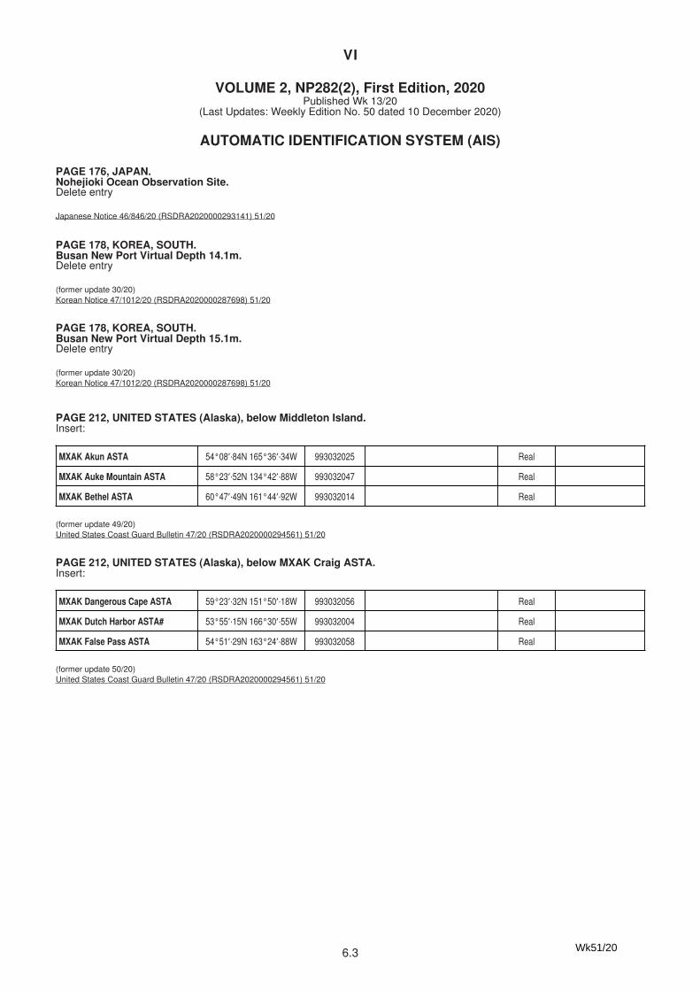
VI
6.3
VI
6.2
Mexico
Zone 1 All states except Zones 1a, 1b,2, 2a, 2b, 3 and 3a
+6 +5 First Sunday in April 0200h Last Sunday in October 0200h
Zone 1a Ciudad Acuna, Matamoros,Nuevo Laredo, Piedras Negrasand Reynosa
+6 +5 Second Sunday in March 0200h First Sunday in November 0200h
Zone 1b Quintana Roo +5 *
Zone 2 Baja California Sur, Chihuahua,Nayarit and Sinaloa
+7 +6 First Sunday in April 0200h Last Sunday in October 0200h
Zone 2a Sonora +7 *
Zone 2b Ciudad Juarez +7 +6 Second Sunday in March 0200h First Sunday in November 0200h
Zone 3 Baja California Norte +8 +7 First Sunday in April 0200h Last Sunday in October 0200h
Zone 3a Tijuana, Mexicali +8 +7 Second Sunday in March 0200h First Sunday in November 0200h
OAG (RSDRA2020000294611) 51/20
Moldova -2 -3 Last Sunday in March 0200h Last Sunday in October 0300h
OAG (RSDRA2020000294611) 51/20
Norfolk Island -11 -12 First Sunday in October 0200h First Sunday in April 0200h
OAG (RSDRA2020000294611) 51/20
PAGE 219, Mexico.Delete entry and replace by:
PAGE 219, Moldova.Delete entry and replace by:
PAGE 219, Norfolk Island.Delete entry and replace by:
Japanese Notice 46/846/20 (RSDRA2020000293141) 51/20
(former update 30/20)Korean Notice 47/1012/20 (RSDRA2020000287698) 51/20
(former update 30/20)Korean Notice 47/1012/20 (RSDRA2020000287698) 51/20
VOLUME 2, NP282(2), First Edition, 2020Published Wk 13/20
(Last Updates: Weekly Edition No. 50 dated 10 December 2020)
AUTOMATIC IDENTIFICATION SYSTEM (AIS)
PAGE 176, JAPAN.Nohejioki Ocean Observation Site.Delete entry
PAGE 178, KOREA, SOUTH.Busan New Port Virtual Depth 14.1m.Delete entry
PAGE 178, KOREA, SOUTH.Busan New Port Virtual Depth 15.1m.Delete entry
VI
6.3
MXAK Akun ASTA 54°08′·84N 165°36′·34W 993032025 Real
MXAK Auke Mountain ASTA 58°23′·52N 134°42′·88W 993032047 Real
MXAK Bethel ASTA 60°47′·49N 161°44′·92W 993032014 Real
(former update 49/20)United States Coast Guard Bulletin 47/20 (RSDRA2020000294561) 51/20
MXAK Dangerous Cape ASTA 59°23′·32N 151°50′·18W 993032056 Real
MXAK Dutch Harbor ASTA# 53°55′·15N 166°30′·55W 993032004 Real
MXAK False Pass ASTA 54°51′·29N 163°24′·88W 993032058 Real
(former update 50/20)United States Coast Guard Bulletin 47/20 (RSDRA2020000294561) 51/20
MXAK Hoonah ASTA 58°07′·70N 135°25′·99W 993032046 Real
MXAK Kaktovik ASTA 70°07′·60N 143°36′·96W 993032027 Real
MXAK Karluk ASTA 57°34′·34N 154°27′·35W 993032038 Real
MXAK Kodiak ASTA 57°47′·34N 152°26′·04W 993032016 Real
MXAK Kotzebue ASTA 66°54′·06N 162°35′·37W 993032029 Real
MXAK Latouche Mountain ASTA 59°59′·01N 147°54′·54W 993032051 Real
MXAK McCord ASTA 57°07′·60N 153°08′·26W 993032057 Real
MXAK Naked Island ASTA 60°38′·75N 147°20′·57W 993032050 Real
MXAK Nelson Lagoon ASTA 56°00′·30N 161°10′·63W 993032037 Real
MXAK Nome ASTA 64°33′·91N 165°26′·02W 993032019 Real
MXAK North Berners ASTA 58°51′·17N 135°04′·16W 993032048 Real
MXAK Point Hope ASTA 68°20′·97N 166°44′·21W 993032031 Real
MXAK Point Lay ASTA 69°44′·58N 163°00′·59W 993032030 Real
MXAK Point Pigot ASTA 60°49′·07N 148°22′·74W 993032052 Real
MXAK Prudhoe ASTA 70°13′·32N 148°25′·17W 993032006 Real
MXAK Sand Point ASTA 55°18′·97N 160°23′·20W 993032045 Real
(former update 50/20)United States Coast Guard Bulletin 47/20 (RSDRA2020000294561) 51/20
MXAK Spiridon Mountain ASTA 57°43′·24N 153°45′·80W 993032049 Real
MXAK St George No 1 ASTA 56°34′·32N 168°40′·26W 993032054 Real
MXAK St George No 2 ASTA 56°35′·97N 169°32′·50W 993032055 Real
MXAK St Paul ASTA 57°07′·41N 170°16′·25W 993032053 Real
Continued on next page
PAGE 212, UNITED STATES (Alaska), below Middleton Island.Insert:
PAGE 212, UNITED STATES (Alaska), below MXAK Craig ASTA.Insert:
PAGE 212, UNITED STATES (Alaska), below MXAK Haines ASTA.Insert:
PAGE 212, UNITED STATES (Alaska), below MXAK Savoonga ASTA.Insert:
Wk51/20
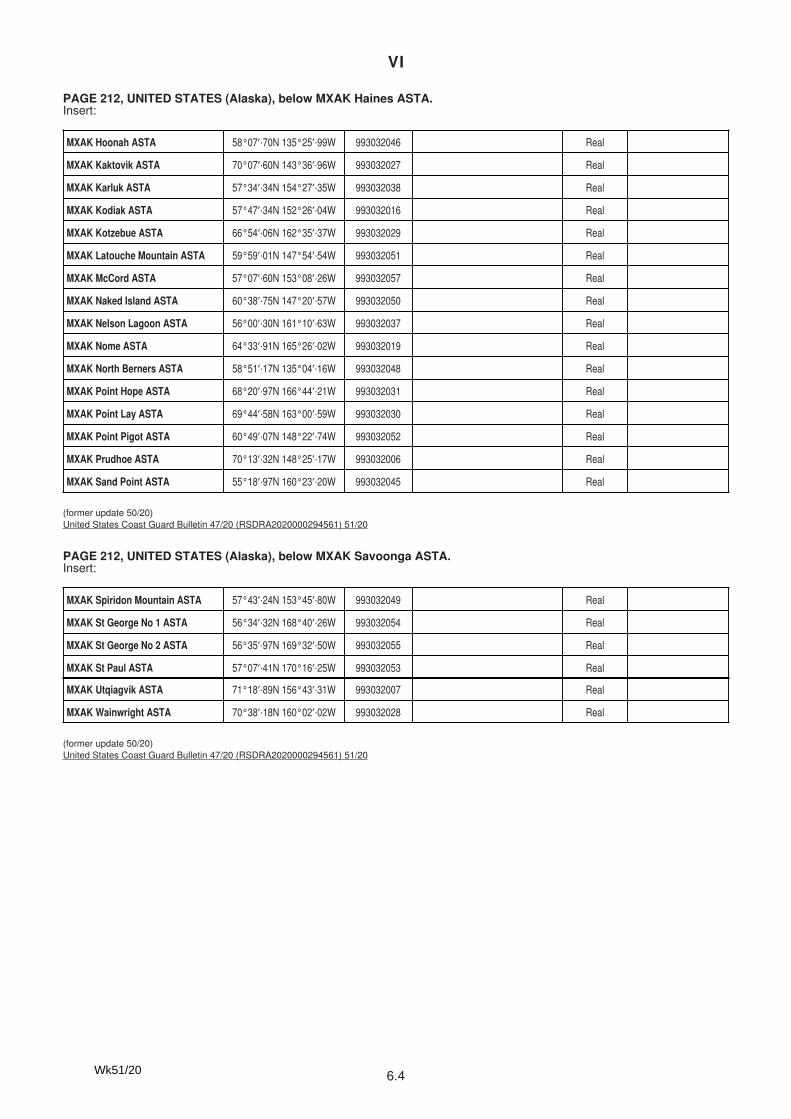
VI
6.4
VI
6.3
MXAK Akun ASTA 54°08′·84N 165°36′·34W 993032025 Real
MXAK Auke Mountain ASTA 58°23′·52N 134°42′·88W 993032047 Real
MXAK Bethel ASTA 60°47′·49N 161°44′·92W 993032014 Real
(former update 49/20)United States Coast Guard Bulletin 47/20 (RSDRA2020000294561) 51/20
MXAK Dangerous Cape ASTA 59°23′·32N 151°50′·18W 993032056 Real
MXAK Dutch Harbor ASTA# 53°55′·15N 166°30′·55W 993032004 Real
MXAK False Pass ASTA 54°51′·29N 163°24′·88W 993032058 Real
(former update 50/20)United States Coast Guard Bulletin 47/20 (RSDRA2020000294561) 51/20
MXAK Hoonah ASTA 58°07′·70N 135°25′·99W 993032046 Real
MXAK Kaktovik ASTA 70°07′·60N 143°36′·96W 993032027 Real
MXAK Karluk ASTA 57°34′·34N 154°27′·35W 993032038 Real
MXAK Kodiak ASTA 57°47′·34N 152°26′·04W 993032016 Real
MXAK Kotzebue ASTA 66°54′·06N 162°35′·37W 993032029 Real
MXAK Latouche Mountain ASTA 59°59′·01N 147°54′·54W 993032051 Real
MXAK McCord ASTA 57°07′·60N 153°08′·26W 993032057 Real
MXAK Naked Island ASTA 60°38′·75N 147°20′·57W 993032050 Real
MXAK Nelson Lagoon ASTA 56°00′·30N 161°10′·63W 993032037 Real
MXAK Nome ASTA 64°33′·91N 165°26′·02W 993032019 Real
MXAK North Berners ASTA 58°51′·17N 135°04′·16W 993032048 Real
MXAK Point Hope ASTA 68°20′·97N 166°44′·21W 993032031 Real
MXAK Point Lay ASTA 69°44′·58N 163°00′·59W 993032030 Real
MXAK Point Pigot ASTA 60°49′·07N 148°22′·74W 993032052 Real
MXAK Prudhoe ASTA 70°13′·32N 148°25′·17W 993032006 Real
MXAK Sand Point ASTA 55°18′·97N 160°23′·20W 993032045 Real
(former update 50/20)United States Coast Guard Bulletin 47/20 (RSDRA2020000294561) 51/20
MXAK Spiridon Mountain ASTA 57°43′·24N 153°45′·80W 993032049 Real
MXAK St George No 1 ASTA 56°34′·32N 168°40′·26W 993032054 Real
MXAK St George No 2 ASTA 56°35′·97N 169°32′·50W 993032055 Real
MXAK St Paul ASTA 57°07′·41N 170°16′·25W 993032053 Real
Continued on next page
PAGE 212, UNITED STATES (Alaska), below Middleton Island.Insert:
PAGE 212, UNITED STATES (Alaska), below MXAK Craig ASTA.Insert:
PAGE 212, UNITED STATES (Alaska), below MXAK Haines ASTA.Insert:
PAGE 212, UNITED STATES (Alaska), below MXAK Savoonga ASTA.Insert:
VI
6.4
MXAK Utqiagvik ASTA 71°18′·89N 156°43′·31W 993032007 Real
MXAK Wainwright ASTA 70°38′·18N 160°02′·02W 993032028 Real
(former update 50/20)United States Coast Guard Bulletin 47/20 (RSDRA2020000294561) 51/20
Fiji -12 -13 20 Dec 2020 1400h14 Nov 2021 1400h13 Nov 2022 1400h12 Nov 2023 1400h10 Nov 2024 1400h9 Nov 2025 1400h
17 Jan 2021 1400h16 Jan 2022 1400h15 Jan 2023 1400h14 Jan 2024 1400h12 Jan 2025 1400h18 Jan 2026 1400h
(former update 49/20)OAG (RSDRA2020000294611) 51/20
Mexico
Zone 1 All states except Zones 1a, 1b,2, 2a, 2b, 3 and 3a
+6 +5 First Sunday in April 0200h Last Sunday in October 0200h
Zone 1a Ciudad Acuna, Matamoros,Nuevo Laredo, Piedras Negrasand Reynosa
+6 +5 Second Sunday in March 0200h First Sunday in November 0200h
Zone 1b Quintana Roo +5 *
Zone 2 Baja California Sur, Chihuahua,Nayarit and Sinaloa
+7 +6 First Sunday in April 0200h Last Sunday in October 0200h
Zone 2a Sonora +7 *
Zone 2b Ciudad Juarez +7 +6 Second Sunday in March 0200h First Sunday in November 0200h
Zone 3 Baja California Norte +8 +7 First Sunday in April 0200h Last Sunday in October 0200h
Zone 3a Tijuana, Mexicali +8 +7 Second Sunday in March 0200h First Sunday in November 0200h
OAG (RSDRA2020000294611) 51/20
Moldova -2 -3 Last Sunday in March 0200h Last Sunday in October 0300h
OAG (RSDRA2020000294611) 51/20
Norfolk Island -11 -12 First Sunday in October 0200h First Sunday in April 0200h
OAG (RSDRA2020000294611) 51/20
LEGAL TIME
PAGE 272, Fiji.Delete entry and replace by:
PAGE 275, Mexico.Delete entry and replace by:
PAGE 275, Moldova.Delete entry and replace by:
PAGE 275, Norfolk Island.Delete entry and replace by:
Wk51/20
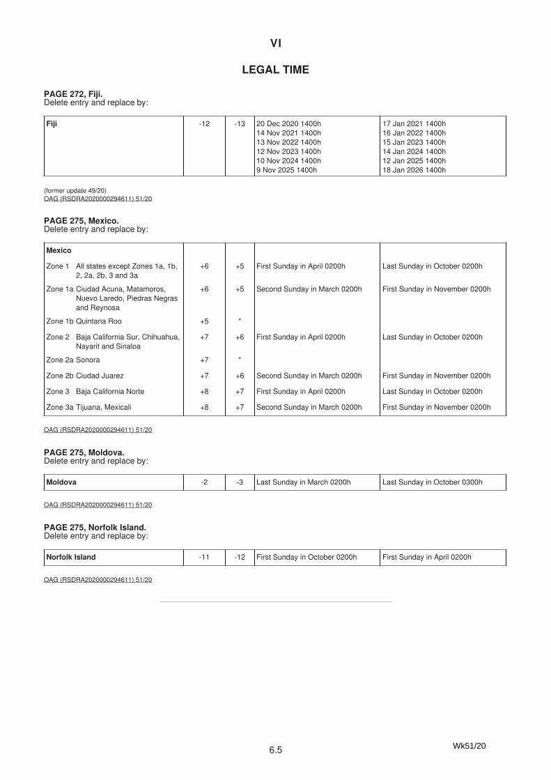
VI
6.5
VI
6.4
MXAK Utqiagvik ASTA 71°18′·89N 156°43′·31W 993032007 Real
MXAK Wainwright ASTA 70°38′·18N 160°02′·02W 993032028 Real
(former update 50/20)United States Coast Guard Bulletin 47/20 (RSDRA2020000294561) 51/20
Fiji -12 -13 20 Dec 2020 1400h14 Nov 2021 1400h13 Nov 2022 1400h12 Nov 2023 1400h10 Nov 2024 1400h9 Nov 2025 1400h
17 Jan 2021 1400h16 Jan 2022 1400h15 Jan 2023 1400h14 Jan 2024 1400h12 Jan 2025 1400h18 Jan 2026 1400h
(former update 49/20)OAG (RSDRA2020000294611) 51/20
Mexico
Zone 1 All states except Zones 1a, 1b,2, 2a, 2b, 3 and 3a
+6 +5 First Sunday in April 0200h Last Sunday in October 0200h
Zone 1a Ciudad Acuna, Matamoros,Nuevo Laredo, Piedras Negrasand Reynosa
+6 +5 Second Sunday in March 0200h First Sunday in November 0200h
Zone 1b Quintana Roo +5 *
Zone 2 Baja California Sur, Chihuahua,Nayarit and Sinaloa
+7 +6 First Sunday in April 0200h Last Sunday in October 0200h
Zone 2a Sonora +7 *
Zone 2b Ciudad Juarez +7 +6 Second Sunday in March 0200h First Sunday in November 0200h
Zone 3 Baja California Norte +8 +7 First Sunday in April 0200h Last Sunday in October 0200h
Zone 3a Tijuana, Mexicali +8 +7 Second Sunday in March 0200h First Sunday in November 0200h
OAG (RSDRA2020000294611) 51/20
Moldova -2 -3 Last Sunday in March 0200h Last Sunday in October 0300h
OAG (RSDRA2020000294611) 51/20
Norfolk Island -11 -12 First Sunday in October 0200h First Sunday in April 0200h
OAG (RSDRA2020000294611) 51/20
LEGAL TIME
PAGE 272, Fiji.Delete entry and replace by:
PAGE 275, Mexico.Delete entry and replace by:
PAGE 275, Moldova.Delete entry and replace by:
PAGE 275, Norfolk Island.Delete entry and replace by:
Wk51/20
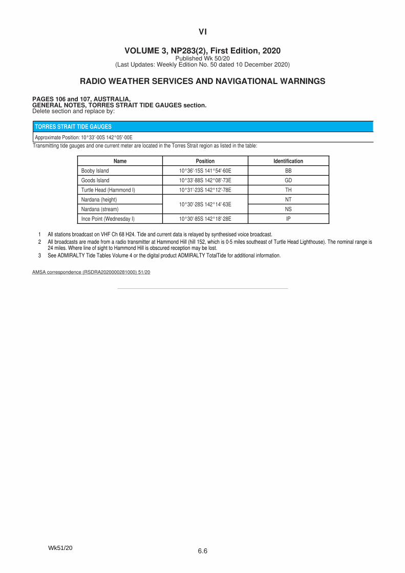
VI
6.6
VI
6.5
VOLUME 3, NP283(2), First Edition, 2020Published Wk 50/20
(Last Updates: Weekly Edition No. 50 dated 10 December 2020)
TORRES STRAIT TIDE GAUGES
Approximate Position: 10°33′·00S 142°05′·00E
Transmitting tide gauges and one current meter are located in the Torres Strait region as listed in the table:
Name Position Identification
Booby Island 10°36'·15S 141°54'·60E BB
Goods Island 10°33'·88S 142°08'·73E GD
Turtle Head (Hammond I) 10°31'·23S 142°12'·78E TH
Nardana (height)10°30'·28S 142°14'·63E
NT
Nardana (stream) NS
Ince Point (Wednesday I) 10°30'·85S 142°18'·28E IP
1 All stations broadcast on VHF Ch 68 H24. Tide and current data is relayed by synthesised voice broadcast.2 All broadcasts are made from a radio transmitter at Hammond Hill (hill 152, which is 0·5 miles southeast of Turtle Head Lighthouse). The nominal range is
24 miles. Where line of sight to Hammond Hill is obscured reception may be lost.3 See ADMIRALTY Tide Tables Volume 4 or the digital product ADMIRALTY TotalTide for additional information.
AMSA correspondence (RSDRA2020000281000) 51/20
RADIO WEATHER SERVICES AND NAVIGATIONAL WARNINGS
PAGES 106 and 107, AUSTRALIA,GENERAL NOTES, TORRES STRAIT TIDE GAUGES section.Delete section and replace by:
VI
1
VOLUME 6, PART 1, NP 286(1), First Edition, 2020Published Wk 36/20
––––––––––––––––––(Last Updates: Weekly Edition No. 42 dated 15 October 2020)
PAGE 438, UNITED KINGDOM, TEES AND HARTLEPOOL, Vessel Traffi c Service, below TRAFFIC CONTROL SIGNALS section.Insert:
PORT VISIT NOTIFICATION:(1) To ensure the smooth and effi cient running of the Port and to comply with Regulations, a Port Visit Noti cation must be provided at least 24h in advance of a vessel’s ETA, with the exception of voyages of less than 24h, which must be noti ed as soon as possible. (2) It is expected that this noti cation will be received by Tees VTS via email, with a CERS (Consolidated European Reporting System) Workbook attached. The CERS Workbook is in Excel format and is for use in conjunction with the UK Maritime and Coastguard Agency’s Consolidated European System for the submission of SafeSeaNet compliant voyage noti cations relating to maritime vessel voyages visiting UK ports. This system has been implemented to capture data on vessel movements, dangerous cargoes, vessel safety, security information and the disposal of waste within European waters. (3) As a minimum, the vessel, voyage and port speci c sections must be completed prior to initial submission to Tees VTS. The port speci c section has been modi ed to capture all the pre-arrival information required for arrival at the Ports of Tees and Hartlepool. (4) Any further sections of the CERS Workbook, once completed by the vessel and/or shipping agent, must be re-submitted to Tees VTS, who will then forward them to the UK Maritime Coastguard Agency’s Consolidated European System. This noti cation must be emailed to Tees VTS at [email protected] and the appropriate Port Service Provider as follows:
(a) Pilots: [email protected](b) Svitzer Marine: [email protected](c) SMS Towage: [email protected](d) Tees Foyboatmen: [email protected](e) Hartlepool Foyboatmen: [email protected]
(5) Subsequent updates to the information must be sent to Tees VTS, who will update all Port Services accordingly.
PD Teesport Limited Notice 14/20, (RSDRA2020000283725), 51/20
––––––––––––––––––––––––––––––
VOLUME 6, PART 6, NP 286(6), First Edition, 2020Published Wk 3/20
––––––––––––––––––(Last Updates: Weekly Edition No. 50 dated 10 December 2020)
PAGE 5, CHINA, BASUO, Pilots, PROCEDURE, section (3).Delete and replace by:
(3) Pilot boards in the following positions:(a) No 1: 19°07′·18N 108°36′·23E(b) No 2: 19°06′·25N 108°34′·00E(c) No 3: 19°03′·50N 108°32′·50E(d) No 4: 19°04′·50N 108°32′·80E
(Former update 16/20)
Chinese Notice 16/548/20, (RSDRA2020000102958), 51/20
PAGE 43, CHINA, GAOLAN, Pilots, PROCEDURE, section (2).Delete and replace by
(2) Pilot boards in the following positions:(a) No 1: 21°47′·70N 113°15′·40E (large and medium sized vessels)(b) No 2: 21°50′·20N 113°14′·00E(c) No.3: 21°53′·50N 113°11′·50E(d) No 4: 21°53′·50N 113°12′·80E(e) 21°52′·31N 113°04′·06E (waiting and typhoon anchorage)
(Former update 3/20)
Chinese Notice 16/537/20, (RSDRA2020000102958), 51/20
PAGE 137, CHINA, YANGPU, Hai-Nan Tao, Pilots, PROCEDURE, section (2).Delete and replace by:
(2) Pilot boards in the following positions:(a) Circle of radius 1 n mile (Quarantine anchorage No 1) centred on position
19°51′·00N 108°56′·28E(b) Circle of radius 1 n mile (Quarantine anchorage No 2) centred on position
19°49′·00N 108°56′·28E(c) Circle of radius 1 n mile (Quarantine anchorage No 3) centred on position
19°47′·00N 108°56′·28E(d) No 1: 19°48′·80N 109°04′·20E(e) No 3: 19°45′·00N 109°07′·30E (Anchorage No 8)(f) No 5: 19°44′·40N 109°02′·60E(g) No 6: 19°40′·80N 109°08′·80E (Anchorage No 13)(h) No 7: 19°50′·50N 109°08′·00E(i) No 8: 19°46′·81N 109°02′·00E (Anchorage No 5)(j) No 9: 19°43′·61N 109°08′·20E (Anchorage No 10)
(Former update 3/20)
Chinese Notice 16/546/20, (RSDRA2020000102958), 51/20
PAGE 159, CHINA, ZHUHAI, including Gaolan and Jiuzhou, Pilots, PROCEDURE section (3) (e).Delete and replace by:
(e) Vessels entering Gaolan:(i) No 1: 21°47′·70N 113°15′·40E (large and medium sized vessels)(ii) No 2: 21°50′·20N 113°14′·00E(iii) No.3: 21°53′·50N 113°11′·50E(iv) No 4: 21°53′·50N 113°12′·80E(v) 21°52′·31N 113°04′·06E (waiting and typhoon anchorage)
Chinese Notice 16/537/20, (RSDRA2020000102958), 51/20
Wk51/20
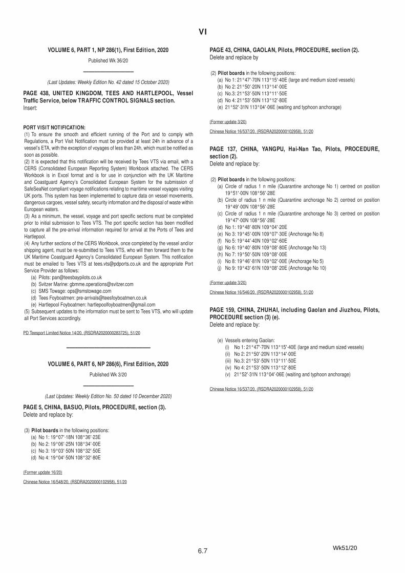
VI
6.7
VI
1
VOLUME 6, PART 1, NP 286(1), First Edition, 2020Published Wk 36/20
––––––––––––––––––(Last Updates: Weekly Edition No. 42 dated 15 October 2020)
PAGE 438, UNITED KINGDOM, TEES AND HARTLEPOOL, Vessel Traffi c Service, below TRAFFIC CONTROL SIGNALS section.Insert:
PORT VISIT NOTIFICATION:(1) To ensure the smooth and effi cient running of the Port and to comply with Regulations, a Port Visit Noti cation must be provided at least 24h in advance of a vessel’s ETA, with the exception of voyages of less than 24h, which must be noti ed as soon as possible. (2) It is expected that this noti cation will be received by Tees VTS via email, with a CERS (Consolidated European Reporting System) Workbook attached. The CERS Workbook is in Excel format and is for use in conjunction with the UK Maritime and Coastguard Agency’s Consolidated European System for the submission of SafeSeaNet compliant voyage noti cations relating to maritime vessel voyages visiting UK ports. This system has been implemented to capture data on vessel movements, dangerous cargoes, vessel safety, security information and the disposal of waste within European waters. (3) As a minimum, the vessel, voyage and port speci c sections must be completed prior to initial submission to Tees VTS. The port speci c section has been modi ed to capture all the pre-arrival information required for arrival at the Ports of Tees and Hartlepool. (4) Any further sections of the CERS Workbook, once completed by the vessel and/or shipping agent, must be re-submitted to Tees VTS, who will then forward them to the UK Maritime Coastguard Agency’s Consolidated European System. This noti cation must be emailed to Tees VTS at [email protected] and the appropriate Port Service Provider as follows:
(a) Pilots: [email protected](b) Svitzer Marine: [email protected](c) SMS Towage: [email protected](d) Tees Foyboatmen: [email protected](e) Hartlepool Foyboatmen: [email protected]
(5) Subsequent updates to the information must be sent to Tees VTS, who will update all Port Services accordingly.
PD Teesport Limited Notice 14/20, (RSDRA2020000283725), 51/20
––––––––––––––––––––––––––––––
VOLUME 6, PART 6, NP 286(6), First Edition, 2020Published Wk 3/20
––––––––––––––––––(Last Updates: Weekly Edition No. 50 dated 10 December 2020)
PAGE 5, CHINA, BASUO, Pilots, PROCEDURE, section (3).Delete and replace by:
(3) Pilot boards in the following positions:(a) No 1: 19°07′·18N 108°36′·23E(b) No 2: 19°06′·25N 108°34′·00E(c) No 3: 19°03′·50N 108°32′·50E(d) No 4: 19°04′·50N 108°32′·80E
(Former update 16/20)
Chinese Notice 16/548/20, (RSDRA2020000102958), 51/20
PAGE 43, CHINA, GAOLAN, Pilots, PROCEDURE, section (2).Delete and replace by
(2) Pilot boards in the following positions:(a) No 1: 21°47′·70N 113°15′·40E (large and medium sized vessels)(b) No 2: 21°50′·20N 113°14′·00E(c) No.3: 21°53′·50N 113°11′·50E(d) No 4: 21°53′·50N 113°12′·80E(e) 21°52′·31N 113°04′·06E (waiting and typhoon anchorage)
(Former update 3/20)
Chinese Notice 16/537/20, (RSDRA2020000102958), 51/20
PAGE 137, CHINA, YANGPU, Hai-Nan Tao, Pilots, PROCEDURE, section (2).Delete and replace by:
(2) Pilot boards in the following positions:(a) Circle of radius 1 n mile (Quarantine anchorage No 1) centred on position
19°51′·00N 108°56′·28E(b) Circle of radius 1 n mile (Quarantine anchorage No 2) centred on position
19°49′·00N 108°56′·28E(c) Circle of radius 1 n mile (Quarantine anchorage No 3) centred on position
19°47′·00N 108°56′·28E(d) No 1: 19°48′·80N 109°04′·20E(e) No 3: 19°45′·00N 109°07′·30E (Anchorage No 8)(f) No 5: 19°44′·40N 109°02′·60E(g) No 6: 19°40′·80N 109°08′·80E (Anchorage No 13)(h) No 7: 19°50′·50N 109°08′·00E(i) No 8: 19°46′·81N 109°02′·00E (Anchorage No 5)(j) No 9: 19°43′·61N 109°08′·20E (Anchorage No 10)
(Former update 3/20)
Chinese Notice 16/546/20, (RSDRA2020000102958), 51/20
PAGE 159, CHINA, ZHUHAI, including Gaolan and Jiuzhou, Pilots, PROCEDURE section (3) (e).Delete and replace by:
(e) Vessels entering Gaolan:(i) No 1: 21°47′·70N 113°15′·40E (large and medium sized vessels)(ii) No 2: 21°50′·20N 113°14′·00E(iii) No.3: 21°53′·50N 113°11′·50E(iv) No 4: 21°53′·50N 113°12′·80E(v) 21°52′·31N 113°04′·06E (waiting and typhoon anchorage)
Chinese Notice 16/537/20, (RSDRA2020000102958), 51/20
Wk51/20
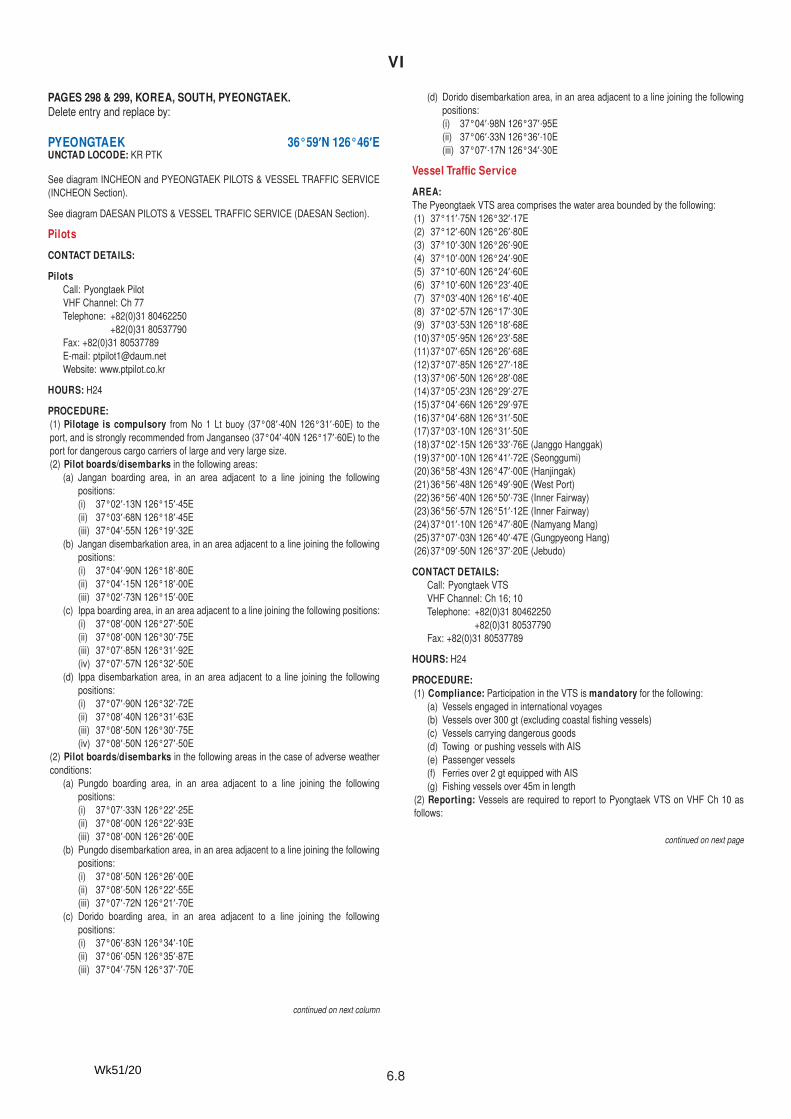
VI
6.8
VI
2
PAGES 298 & 299, KOREA, SOUTH, PYEONGTAEK.Delete entry and replace by:
PYEONGTAEK 36°59′N 126°46′EUNCTAD LOCODE: KR PTK
See diagram INCHEON and PYEONGTAEK PILOTS & VESSEL TRAFFIC SERVICE (INCHEON Section).
See diagram DAESAN PILOTS & VESSEL TRAFFIC SERVICE (DAESAN Section).
PilotsCONTACT DETAILS:
PilotsCall: Pyongtaek PilotVHF Channel: Ch 77Telephone: +82(0)31 80462250 +82(0)31 80537790Fax: +82(0)31 80537789E-mail: [email protected]: www.ptpilot.co.kr
HOURS: H24
PROCEDURE:(1) Pilotage is compulsory from No 1 Lt buoy (37°08′·40N 126°31′·60E) to the port, and is strongly recommended from Janganseo (37°04′·40N 126°17′·60E) to the port for dangerous cargo carriers of large and very large size.(2) Pilot boards/disembarks in the following areas:
(a) Jangan boarding area, in an area adjacent to a line joining the following positions:(i) 37°02′·13N 126°15′·45E(ii) 37°03′·68N 126°18′·45E(iii) 37°04′·55N 126°19′·32E
(b) Jangan disembarkation area, in an area adjacent to a line joining the following positions:(i) 37°04′·90N 126°18′·80E(ii) 37°04′·15N 126°18′·00E(iii) 37°02′·73N 126°15′·00E
(c) Ippa boarding area, in an area adjacent to a line joining the following positions:(i) 37°08′·00N 126°27′·50E(ii) 37°08′·00N 126°30′·75E(iii) 37°07′·85N 126°31′·92E(iv) 37°07′·57N 126°32′·50E
(d) Ippa disembarkation area, in an area adjacent to a line joining the following positions:(i) 37°07′·90N 126°32′·72E(ii) 37°08′·40N 126°31′·63E(iii) 37°08′·50N 126°30′·75E(iv) 37°08′·50N 126°27′·50E
(2) Pilot boards/disembarks in the following areas in the case of adverse weather conditions:
(a) Pungdo boarding area, in an area adjacent to a line joining the following positions:(i) 37°07′·33N 126°22′·25E(ii) 37°08′·00N 126°22′·93E(iii) 37°08′·00N 126°26′·00E
(b) Pungdo disembarkation area, in an area adjacent to a line joining the following positions:(i) 37°08′·50N 126°26′·00E(ii) 37°08′·50N 126°22′·55E(iii) 37°07′·72N 126°21′·70E
(c) Dorido boarding area, in an area adjacent to a line joining the following positions:(i) 37°06′·83N 126°34′·10E(ii) 37°06′·05N 126°35′·87E(iii) 37°04′·75N 126°37′·70E
continued on next column
(d) Dorido disembarkation area, in an area adjacent to a line joining the following positions:(i) 37°04′·98N 126°37′·95E(ii) 37°06′·33N 126°36′·10E(iii) 37°07′·17N 126°34′·30E
Vessel Traffi c ServiceAREA:The Pyeongtaek VTS area comprises the water area bounded by the following:(1) 37°11′·75N 126°32′·17E(2) 37°12′·60N 126°26′·80E(3) 37°10′·30N 126°26′·90E(4) 37°10′·00N 126°24′·90E(5) 37°10′·60N 126°24′·60E(6) 37°10′·60N 126°23′·40E(7) 37°03′·40N 126°16′·40E(8) 37°02′·57N 126°17′·30E(9) 37°03′·53N 126°18′·68E(10) 37°05′·95N 126°23′·58E(11) 37°07′·65N 126°26′·68E(12) 37°07′·85N 126°27′·18E(13) 37°06′·50N 126°28′·08E(14) 37°05′·23N 126°29′·27E(15) 37°04′·66N 126°29′·97E(16) 37°04′·68N 126°31′·50E(17) 37°03′·10N 126°31′·50E(18) 37°02′·15N 126°33′·76E (Janggo Hanggak)(19) 37°00′·10N 126°41′·72E (Seonggumi)(20) 36°58′·43N 126°47′·00E (Hanjingak)(21) 36°56′·48N 126°49′·90E (West Port)(22) 36°56′·40N 126°50′·73E (Inner Fairway)(23) 36°56′·57N 126°51′·12E (Inner Fairway)(24) 37°01′·10N 126°47′·80E (Namyang Mang)(25) 37°07′·03N 126°40′·47E (Gungpyeong Hang)(26) 37°09′·50N 126°37′·20E (Jebudo)
CONTACT DETAILS:Call: Pyongtaek VTSVHF Channel: Ch 16; 10Telephone: +82(0)31 80462250 +82(0)31 80537790Fax: +82(0)31 80537789
HOURS: H24
PROCEDURE:(1) Compliance: Participation in the VTS is mandatory for the following:
(a) Vessels engaged in international voyages(b) Vessels over 300 gt (excluding coastal shing vessels)(c) Vessels carrying dangerous goods(d) Towing or pushing vessels with AIS(e) Passenger vessels(f) Ferries over 2 gt equipped with AIS(g) Fishing vessels over 45m in length
(2) Reporting: Vessels are required to report to Pyongtaek VTS on VHF Ch 10 as follows:
continued on next page
Wk51/20
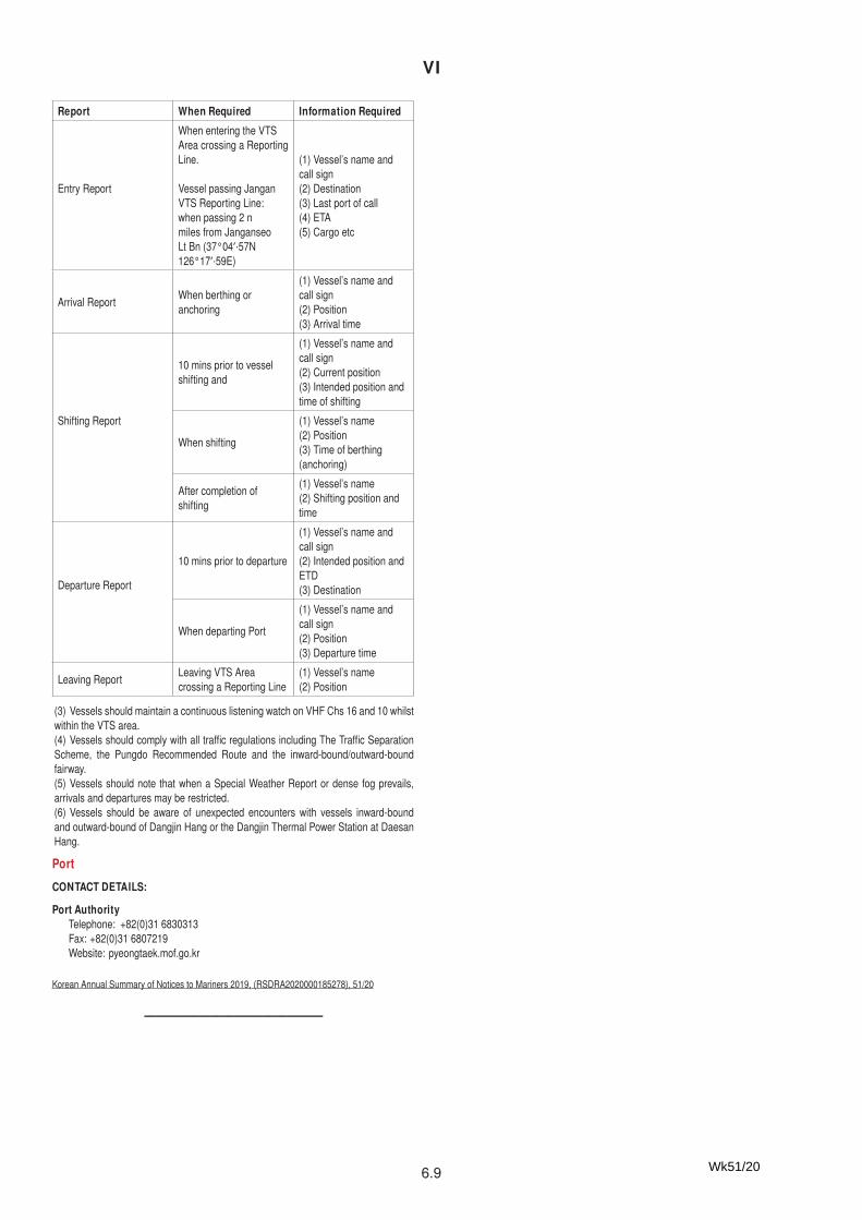
VI
6.9
VI
2
PAGES 298 & 299, KOREA, SOUTH, PYEONGTAEK.Delete entry and replace by:
PYEONGTAEK 36°59′N 126°46′EUNCTAD LOCODE: KR PTK
See diagram INCHEON and PYEONGTAEK PILOTS & VESSEL TRAFFIC SERVICE (INCHEON Section).
See diagram DAESAN PILOTS & VESSEL TRAFFIC SERVICE (DAESAN Section).
PilotsCONTACT DETAILS:
PilotsCall: Pyongtaek PilotVHF Channel: Ch 77Telephone: +82(0)31 80462250 +82(0)31 80537790Fax: +82(0)31 80537789E-mail: [email protected]: www.ptpilot.co.kr
HOURS: H24
PROCEDURE:(1) Pilotage is compulsory from No 1 Lt buoy (37°08′·40N 126°31′·60E) to the port, and is strongly recommended from Janganseo (37°04′·40N 126°17′·60E) to the port for dangerous cargo carriers of large and very large size.(2) Pilot boards/disembarks in the following areas:
(a) Jangan boarding area, in an area adjacent to a line joining the following positions:(i) 37°02′·13N 126°15′·45E(ii) 37°03′·68N 126°18′·45E(iii) 37°04′·55N 126°19′·32E
(b) Jangan disembarkation area, in an area adjacent to a line joining the following positions:(i) 37°04′·90N 126°18′·80E(ii) 37°04′·15N 126°18′·00E(iii) 37°02′·73N 126°15′·00E
(c) Ippa boarding area, in an area adjacent to a line joining the following positions:(i) 37°08′·00N 126°27′·50E(ii) 37°08′·00N 126°30′·75E(iii) 37°07′·85N 126°31′·92E(iv) 37°07′·57N 126°32′·50E
(d) Ippa disembarkation area, in an area adjacent to a line joining the following positions:(i) 37°07′·90N 126°32′·72E(ii) 37°08′·40N 126°31′·63E(iii) 37°08′·50N 126°30′·75E(iv) 37°08′·50N 126°27′·50E
(2) Pilot boards/disembarks in the following areas in the case of adverse weather conditions:
(a) Pungdo boarding area, in an area adjacent to a line joining the following positions:(i) 37°07′·33N 126°22′·25E(ii) 37°08′·00N 126°22′·93E(iii) 37°08′·00N 126°26′·00E
(b) Pungdo disembarkation area, in an area adjacent to a line joining the following positions:(i) 37°08′·50N 126°26′·00E(ii) 37°08′·50N 126°22′·55E(iii) 37°07′·72N 126°21′·70E
(c) Dorido boarding area, in an area adjacent to a line joining the following positions:(i) 37°06′·83N 126°34′·10E(ii) 37°06′·05N 126°35′·87E(iii) 37°04′·75N 126°37′·70E
continued on next column
(d) Dorido disembarkation area, in an area adjacent to a line joining the following positions:(i) 37°04′·98N 126°37′·95E(ii) 37°06′·33N 126°36′·10E(iii) 37°07′·17N 126°34′·30E
Vessel Traffi c ServiceAREA:The Pyeongtaek VTS area comprises the water area bounded by the following:(1) 37°11′·75N 126°32′·17E(2) 37°12′·60N 126°26′·80E(3) 37°10′·30N 126°26′·90E(4) 37°10′·00N 126°24′·90E(5) 37°10′·60N 126°24′·60E(6) 37°10′·60N 126°23′·40E(7) 37°03′·40N 126°16′·40E(8) 37°02′·57N 126°17′·30E(9) 37°03′·53N 126°18′·68E(10) 37°05′·95N 126°23′·58E(11) 37°07′·65N 126°26′·68E(12) 37°07′·85N 126°27′·18E(13) 37°06′·50N 126°28′·08E(14) 37°05′·23N 126°29′·27E(15) 37°04′·66N 126°29′·97E(16) 37°04′·68N 126°31′·50E(17) 37°03′·10N 126°31′·50E(18) 37°02′·15N 126°33′·76E (Janggo Hanggak)(19) 37°00′·10N 126°41′·72E (Seonggumi)(20) 36°58′·43N 126°47′·00E (Hanjingak)(21) 36°56′·48N 126°49′·90E (West Port)(22) 36°56′·40N 126°50′·73E (Inner Fairway)(23) 36°56′·57N 126°51′·12E (Inner Fairway)(24) 37°01′·10N 126°47′·80E (Namyang Mang)(25) 37°07′·03N 126°40′·47E (Gungpyeong Hang)(26) 37°09′·50N 126°37′·20E (Jebudo)
CONTACT DETAILS:Call: Pyongtaek VTSVHF Channel: Ch 16; 10Telephone: +82(0)31 80462250 +82(0)31 80537790Fax: +82(0)31 80537789
HOURS: H24
PROCEDURE:(1) Compliance: Participation in the VTS is mandatory for the following:
(a) Vessels engaged in international voyages(b) Vessels over 300 gt (excluding coastal shing vessels)(c) Vessels carrying dangerous goods(d) Towing or pushing vessels with AIS(e) Passenger vessels(f) Ferries over 2 gt equipped with AIS(g) Fishing vessels over 45m in length
(2) Reporting: Vessels are required to report to Pyongtaek VTS on VHF Ch 10 as follows:
continued on next page
VI
3
Report When Required Information Required
Entry Report
When entering the VTS Area crossing a Reporting Line.
Vessel passing Jangan VTS Reporting Line: when passing 2 n miles from Janganseo Lt Bn (37°04′·57N 126°17′·59E)
(1) Vessel’s name and call sign(2) Destination(3) Last port of call(4) ETA(5) Cargo etc
Arrival Report When berthing or anchoring
(1) Vessel’s name and call sign(2) Position(3) Arrival time
Shifting Report
10 mins prior to vessel shifting and
(1) Vessel’s name and call sign(2) Current position(3) Intended position and time of shifting
When shifting
(1) Vessel’s name(2) Position(3) Time of berthing (anchoring)
After completion of shifting
(1) Vessel’s name(2) Shifting position and time
Departure Report
10 mins prior to departure
(1) Vessel’s name and call sign(2) Intended position and ETD(3) Destination
When departing Port
(1) Vessel’s name and call sign(2) Position(3) Departure time
Leaving Report Leaving VTS Area crossing a Reporting Line
(1) Vessel’s name(2) Position
(3) Vessels should maintain a continuous listening watch on VHF Chs 16 and 10 whilst within the VTS area.(4) Vessels should comply with all traffi c regulations including The Traffi c Separation Scheme, the Pungdo Recommended Route and the inward-bound/outward-bound fairway.(5) Vessels should note that when a Special Weather Report or dense fog prevails, arrivals and departures may be restricted.(6) Vessels should be aware of unexpected encounters with vessels inward-bound and outward-bound of Dangjin Hang or the Dangjin Thermal Power Station at Daesan Hang.
PortCONTACT DETAILS:
Port AuthorityTelephone: +82(0)31 6830313Fax: +82(0)31 6807219Website: pyeongtaek.mof.go.kr
Korean Annual Summary of Notices to Mariners 2019, (RSDRA2020000185278), 51/20
––––––––––––––––––––––––––––––
Wk51/20
VII
7.1
UPDATES TO MISCELLANEOUS ADMIRALTY NAUTICAL PUBLICATIONS
There are no updates to miscellaneous Nautical Publications this week
UPDATE ON THE EFFECTS OF COVID--19 ON THE DELIVERY OFNAUTICAL PUBLICATIONS
As a result of ongoing effects of COVID--19 on distribution infrastructure around the world, forsafety reasons,we took the decision a fewmonths ago to delay the publicationof anynon--essentialADMIRALTY Nautical Publications until further notice.
We started to ease the restrictions on the dispatch of some of our paper publications for July 2020.
We are continuing this effort and following some positive feedback on successful receipts ofpublications, we are now in a position to confirm the publications schedule for the rest of the year.
As previously, we will continue to closely monitor our distribution network capacities.
We reserve ourselves the right to amend this publications schedule accordingly should significantdispatch issues start arising again.
Wk51/20
VIII
8.1
Wk 51/20
ADMIRALTY DIGITAL SERVICES 1. ENC / ECDIS and AVCS
a) Safety Notice
For a graphical way to establish that the ECDIS is correctly displaying the new symbols introduced in IHO S-52 Presentation Library
Edition 4.0 the mariner can check ECDIS Chart 1. ECDIS Chart 1 is a legend of the entire set of symbols that may be used within an
ENC and is installed on all type-approved ECDIS systems. See iho.int for further information. ECDIS Systems have been required to
use Presentation Library edition 4.0 since 1st September 2017 and previous editions are no longer SOLAS compliant.
b) ENCs temporarily withdrawn from AVCS
To review a cumulative list of ENCs temporarily withdrawn from AVCS, please visit the ‘Updates’ tab on:
admiralty.co.uk/AVCS
c) ENC Readme.txt file
The README.TXT file located within the ENC_ROOT folder on the latest AVCS discs contains important safety related information
relating to the use of ENCs in ECDIS. The file is also available on the support tab at admiralty.co.uk/avcs.
This file is updated on a regular basis and should be consulted to ensure that all related issues are taken into consideration.
d) Temporary & Preliminary Notices to Mariners (T&P NMs) in ENCs
The use of T&P NM information is considered an essential part of keeping navigational charts up to date.
The latest confirmed status of T&P NM information in the ENCs that are available in ADMIRALTY services is shown in the ENC-
T&P-NM-Status.pdf file in the INFO folder on the service media and at: admiralty.co.uk/ENC-TP-NMs
ADMIRALTY Information Overlay (AIO) shows ADMIRALTY paper T&Ps where they are not already included in the ENCs. Most
countries now include temporary information in their ENCs.
Further guidance can be found in the INFO folder on AIO discs.
e) Important notice regarding AVCS CD Service
Because of the limit to data volume that can be fitted onto a disc, AVCS Base and Update CDs are no longer available to download as
ISO files from the UKHO FTP site. For those customers who prefer to update their ECDIS with base and update datasets, we will
continue to provide them in V01X01 format as .zip files. These may be downloaded and unzipped to load into ECDIS as normal. AVCS
DVD ISO files are not affected.
For more information, please contact your ADMIRALTY Chart Agent.
f) Important notice for users of AVCS and ARCS Online Updating Services (AVCS OUS and ARCS OUS)
The email service for AVCS OUS was withdrawn at the end of February 2019 due to technology infrastructure changes at UKHO.
Email calls to AVCS OUS will receive an auto-response that asks the customer to resubmit their data request online by http. Please
contact your ADMIRALTY Distributor if support is required for use of the http service.
Due to the technology updates at UKHO, the ARCS Online Updating Service was withdrawn in July 2019.
2. ADMIRALTY Products Supporting Digital Navigation
i. ADMIRALTY ENC and ECDIS Maintenance Record (NP133C). This publication is designed to hold paper records on ENC
and ECDIS maintenance to assist information management and support inspections. Please note that V2.0 is the current
edition.
ii. ADMIRALTY Guide to ENC Symbols Used in ECDIS (NP5012). A companion to the ADMIRALTY Guide to Symbols and
Abbreviations Used on Paper Charts, NP5011. The 2nd edition of NP5012 includes the changes highlighted in the new S-52
standards and the new presentation library 4.0.
iii. ADMIRALTY Guide to the Practical Use of ENCs (NP231). Supports ECDIS training on the interpretation and use of ENC
data.
VIII
8.2
Wk 51/20
iv. ADMIRALTY Guide to ECDIS Implementation, Policy and Procedures (NP232). Provides clear guidance for any individual
or organisation responsible for the introduction of ECDIS, in particular those involved in the development of detailed ECDIS
operating procedures.
3. ADMIRALTY Digital Publications (ADP)
ADMIRALTY Sailing Directions: Removal of AIS and Racons
In 2018, the UKHO began the process of removing AIS and Racon information from ADMIRALTY Sailing Directions, as this is held in
greater detail within ADMIRALTY Radio Signals publications. During this transition, AIS and Racon information will be removed
from new editions of each Sailing Direction volume, and AIS and Racon information present in existing Sailing Direction volumes will
no longer be updated. For accurate, up-to-date information on AIS and Racons, refer to ADMIRALTY Radio Signals publications.
ADP V19 is available on the ADP Weekly Update DVD.
The UKHO only supports ADP V18 and V19. Users of older versions of ADP should upgrade to a supported version at their earliest
convenience. ADP V18 and V19 are the only versions that allow users to receive tidal updates as they are made available.
ADMIRALTY TotalTide (ATT): German Tidal Stations predicted on LAT
The TotalTide application computes predictions for all German tidal stations based on Lowest Astronomical Tide (LAT).
Mariners using charts which refer to Mean Low Water Springs (MLWS) in German waters, must deduct 0.5m from all predicted tidal
heights for these ports before applying them to the depths on those charts to determine the correct predicted depth of water. This advice
will also be contained in the ‘Notes’ tab on the Prediction Windows in TotalTide for each German tidal station.
For information: Please note that there will not be a 2021 ADP release.
Historically we have made new versions of the ADP software available at the end of each year however, there will be no commercial
release of ADP this year. Regular changes/improvements have been made throughout the year and therefore there is no value in issuing
a new Software version.
The supported ADP versions continue to remain at V18 and V19.
The ADP software and the Data updates can still be downloaded from weekly ADP and AENP Update DVDs.
Users can also download ADP directly on the Distributors FTP Site at ftp://ukho.gov.uk
For information: Ensure that Activation Key Requests and Update Data Requests for ADP are sent to [email protected]
4. ADMIRALTY e-Nautical Publications (AENP)
There is currently an e-Reader 1.3 enabling users to read Digital copies of our Sailing Directions paper publications.
A new e-Reader 1.4 was released to the Channel on 01/10/2020. This version 1.4 has got the same functionalities as the current version
1.3 but is more performant and user-friendly. While the current 1.3 version can be used on Windows 7 and 8.1 Operating Systems (OS),
the e-Reader 1.4 can only be used on Windows 8.1 and 10 OS, to follow the Microsoft guidelines of withdrawing support for Windows
7 OS.
This e-Reader 1.4 offers users a new alternative to the planned retirement of the ADMIRALTY Gateway.
To enable users to activate this new application, users might need to delete one e-Reader application from their Fleet Manager Licences
if the maximum 3 allowed has been reached.
Both the e-Readers 1.3 and 1.4 are supported at the UKHO.
The e-Reader 1.4 software and the Data updates can be downloaded from weekly ADP Update and Software DVDs.
Users can also download the e-Reader 1.4 software directly on the Distributors FTP Site at ftp://ukho.gov.uk
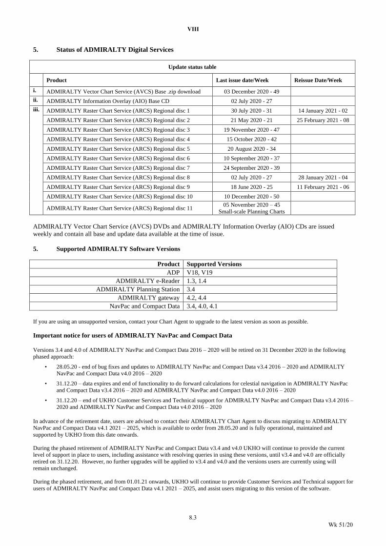
VIII
8.3
Wk 51/20
5. Status of ADMIRALTY Digital Services
Update status table
Product Last issue date/Week Reissue Date/Week
i. ADMIRALTY Vector Chart Service (AVCS) Base .zip download 03 December 2020 - 49
ii. ADMIRALTY Information Overlay (AIO) Base CD 02 July 2020 - 27
iii. ADMIRALTY Raster Chart Service (ARCS) Regional disc 1 30 July 2020 - 31 14 January 2021 - 02
ADMIRALTY Raster Chart Service (ARCS) Regional disc 2 21 May 2020 - 21 25 February 2021 - 08
ADMIRALTY Raster Chart Service (ARCS) Regional disc 3 19 November 2020 - 47
ADMIRALTY Raster Chart Service (ARCS) Regional disc 4 15 October 2020 - 42
ADMIRALTY Raster Chart Service (ARCS) Regional disc 5 20 August 2020 - 34
ADMIRALTY Raster Chart Service (ARCS) Regional disc 6 10 September 2020 - 37
ADMIRALTY Raster Chart Service (ARCS) Regional disc 7 24 September 2020 - 39
ADMIRALTY Raster Chart Service (ARCS) Regional disc 8 02 July 2020 - 27 28 January 2021 - 04
ADMIRALTY Raster Chart Service (ARCS) Regional disc 9 18 June 2020 - 25 11 February 2021 - 06
ADMIRALTY Raster Chart Service (ARCS) Regional disc 10 10 December 2020 - 50
ADMIRALTY Raster Chart Service (ARCS) Regional disc 11 05 November 2020 – 45
Small-scale Planning Charts
ADMIRALTY Vector Chart Service (AVCS) DVDs and ADMIRALTY Information Overlay (AIO) CDs are issued
weekly and contain all base and update data available at the time of issue.
5. Supported ADMIRALTY Software Versions
Product Supported Versions
ADP V18, V19
ADMIRALTY e-Reader 1.3, 1.4
ADMIRALTY Planning Station 3.4
ADMIRALTY gateway 4.2, 4.4
NavPac and Compact Data 3.4, 4.0, 4.1
If you are using an unsupported version, contact your Chart Agent to upgrade to the latest version as soon as possible.
Important notice for users of ADMIRALTY NavPac and Compact Data
Versions 3.4 and 4.0 of ADMIRALTY NavPac and Compact Data 2016 – 2020 will be retired on 31 December 2020 in the following
phased approach:
• 28.05.20 - end of bug fixes and updates to ADMIRALTY NavPac and Compact Data v3.4 2016 – 2020 and ADMIRALTY
NavPac and Compact Data v4.0 2016 – 2020
• 31.12.20 – data expires and end of functionality to do forward calculations for celestial navigation in ADMIRALTY NavPac
and Compact Data v3.4 2016 – 2020 and ADMIRALTY NavPac and Compact Data v4.0 2016 – 2020 • 31.12.20 – end of UKHO Customer Services and Technical support for ADMIRALTY NavPac and Compact Data v3.4 2016 –
2020 and ADMIRALTY NavPac and Compact Data v4.0 2016 – 2020
In advance of the retirement date, users are advised to contact their ADMIRALTY Chart Agent to discuss migrating to ADMIRALTY
NavPac and Compact Data v4.1 2021 – 2025, which is available to order from 28.05.20 and is fully operational, maintained and
supported by UKHO from this date onwards.
During the phased retirement of ADMIRALTY NavPac and Compact Data v3.4 and v4.0 UKHO will continue to provide the current
level of support in place to users, including assistance with resolving queries in using these versions, until v3.4 and v4.0 are officially
retired on 31.12.20. However, no further upgrades will be applied to v3.4 and v4.0 and the versions users are currently using will
remain unchanged.
During the phased retirement, and from 01.01.21 onwards, UKHO will continue to provide Customer Services and Technical support for
users of ADMIRALTY NavPac and Compact Data v4.1 2021 – 2025, and assist users migrating to this version of the software.
VIII
8.4
Wk 51/20
Important notice for users of ADMIRALTY e-Navigator Planning Station and ADMIRALTY gateway
All versions of ADMIRALTY e-Navigator Planning Station and ADMIRALTY gateway will be retired on 29 January 2021 in the
following phased approach:
• 01.05.20 – no new users of ADMIRALTY e-Navigator Planning Station and ADMIRALTY gateway accepted into service
• 29.01.21 – ADMIRALTY e-Navigator Planning Station and ADMIRALTY gateway deactivated, end of availability of
functionality and product updates and user support materials
• 26.02.21 – end of UKHO Customer Services support for ADMIRALTY e-Navigator Planning Station and ADMIRALTY
gateway
During this period UKHO will continue to provide the current level of support to ADMIRALTY Planning Station and ADMIRALTY
gateway users, including chart updates, until the products are officially retired. However, no further upgrades will be applied to
ADMIRALTY Planning Station and ADMIRALTY gateway and the versions users are currently using will remain unchanged.
In advance of the retirement date, users are advised to contact their ADMIRALTY Chart Agent to discuss migration plans and options for
alternative products and services to meet their needs.
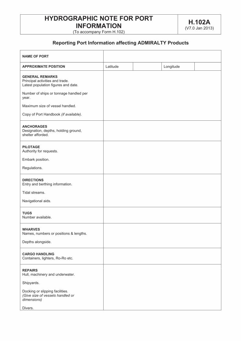
HYDROGRAPHIC NOTE FOR PORT INFORMATION
(To accompany Form H.102)
H.102A(V7.0 Jan 2013)
Reporting Port Information affecting ADMIRALTY Products
NAME OF PORT
APPROXIMATE POSITION Latitude Longitude
GENERAL REMARKS
Principal activities and trade. Latest population figures and date.
Number of ships or tonnage handled per year.
Maximum size of vessel handled.
Copy of Port Handbook (if available).
ANCHORAGES
Designation, depths, holding ground, shelter afforded.
PILOTAGE
Authority for requests.
Embark position.
Regulations.
DIRECTIONS
Entry and berthing information.
Tidal streams.
Navigational aids.
TUGS
Number available.
WHARVES
Names, numbers or positions & lengths.
Depths alongside.
CARGO HANDLING
Containers, lighters, Ro-Ro etc.
REPAIRS
Hull, machinery and underwater.
Shipyards.
Docking or slipping facilities.(Give size of vessels handled or dimensions)
Divers.
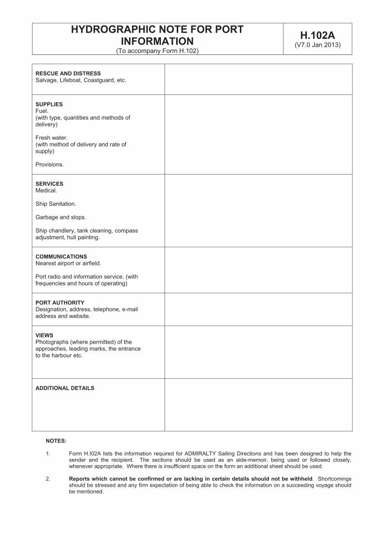
HYDROGRAPHIC NOTE FOR PORT INFORMATION
(To accompany Form H.102)
H.102A(V7.0 Jan 2013)
RESCUE AND DISTRESS
Salvage, Lifeboat, Coastguard, etc.
SUPPLIES
Fuel.(with type, quantities and methods of delivery)
Fresh water. (with method of delivery and rate of supply)
Provisions.
SERVICES
Medical.
Ship Sanitation.
Garbage and slops.
Ship chandlery, tank cleaning, compass adjustment, hull painting.
COMMUNICATIONS
Nearest airport or airfield.
Port radio and information service. (with frequencies and hours of operating)
PORT AUTHORITY
Designation, address, telephone, e-mail address and website.
VIEWS
Photographs (where permitted) of the approaches, leading marks, the entrance to the harbour etc.
ADDITIONAL DETAILS
NOTES:
1. Form H.I02A lists the information required for ADMIRALTY Sailing Directions and has been designed to help thesender and the recipient. The sections should be used as an aide-memoir, being used or followed closely,whenever appropriate. Where there is insufficient space on the form an additional sheet should be used.
2. Reports which cannot be confirmed or are lacking in certain details should not be withheld. Shortcomingsshould be stressed and any firm expectation of being able to check the information on a succeeding voyage shouldbe mentioned.
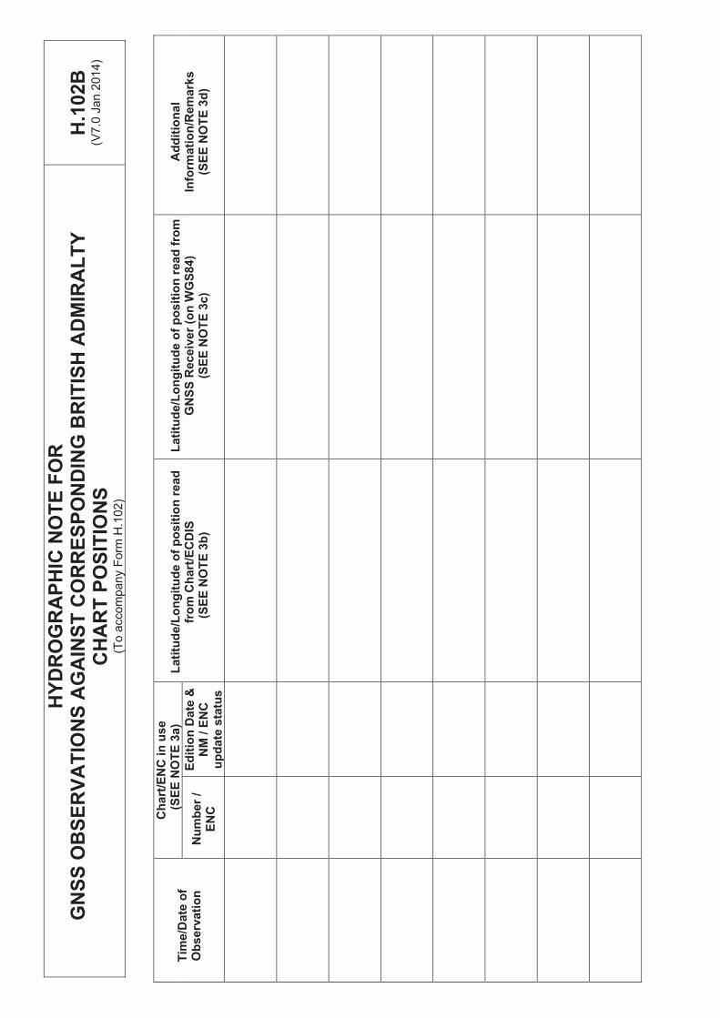
HY
DR
OG
RA
PH
IC N
OT
E F
OR
GN
SS
OB
SE
RV
AT
ION
S A
GA
INS
T C
OR
RE
SP
ON
DIN
G B
RIT
ISH
AD
MIR
AL
TY
C
HA
RT
PO
SIT
ION
S
(To a
ccom
pany F
orm
H.1
02)
H.1
02B
(V7
.0 J
an
201
4)
Ch
art
/EN
C in
use
(SE
E N
OT
E 3
a)
Tim
e/D
ate
of
Ob
se
rva
tio
n
Lati
tud
e/L
on
git
ud
e o
f p
osit
ion
read
fro
m
GN
SS
Rec
eiv
er
(on
WG
S8
4)
(SE
E N
OT
E 3
c)
Ad
dit
ion
al
Info
rmati
on
/Rem
ark
s
(SE
E N
OT
E 3
d)
La
titu
de
/Lo
ng
itu
de
of
po
sit
ion
re
ad
fr
om
Ch
art
/EC
DIS
(S
EE
NO
TE
3b
) N
um
ber
/ E
NC
Ed
itio
n D
ate
&N
M / E
NC
u
pd
ate
sta
tus
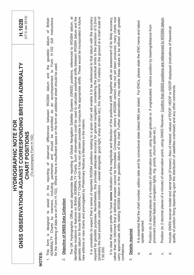
HY
DR
OG
RA
PH
IC N
OT
E F
OR
GN
SS
OB
SE
RV
AT
ION
S A
GA
INS
T C
OR
RE
SP
ON
DIN
G B
RIT
ISH
AD
MIR
AL
TY
C
HA
RT
PO
SIT
ION
S
(To a
ccom
pany F
orm
H.1
02)
H.1
02B
(V7
.0 J
an
201
4)
NO
TE
S:
1.
This
fo
rm
is
desig
ned
to
assis
t in
th
e
report
ing
of
observ
ed
diffe
rences
betw
een
WG
S84
datu
m
and
the
geodetic
datu
m
of
British
AD
MIR
ALT
Y
Chart
s
by
mariners
, in
clu
din
g
yachts
men
and
should
be
subm
itte
d
as
an
accom
panim
ent
to
Form
H
.102
(full
instr
uctio
ns
fo
r th
e r
endering o
f data
are
on F
orm
H.1
02).
W
he
re t
he
re is in
su
ffic
ien
t sp
ace
on
the
fo
rm a
n a
dd
itio
na
l sh
ee
t sh
ou
ld b
e u
sed.
2.
Ob
jecti
ve o
f G
NS
S D
ata
Co
llecti
on
The U
K H
ydro
gra
phic
Off
ice w
ould
appre
cia
te t
he
re
po
rtin
g o
f G
lob
al
Na
vig
atio
n S
ate
llite
Syste
ms (
GN
SS
) p
ositio
ns,
refe
ren
ce
d t
o W
GS
84 d
atu
m,
at
identifiable
locations o
r fe
atu
res o
n B
ritish A
DM
IRA
LT
Y C
hart
s.
Such o
bserv
ations c
ould
be u
sed t
o c
alc
ula
te p
ositio
nal shifts
betw
een W
GS
84 d
atu
m a
nd t
he
ge
od
etic d
atu
m f
or
those B
ritish A
DM
IRA
LT
Y C
ha
rts w
hic
h it
ha
s n
ot
ye
t b
ee
n p
ossib
le t
o c
om
pu
te t
he
ap
pro
pria
te s
hifts
. T
hese
would
be incorp
ora
ted in f
utu
re
ne
w e
ditio
ns o
r new
chart
s a
nd p
rom
ulg
ate
d b
y P
relim
ina
ry N
otice
s t
o M
arin
ers
in
th
e in
terim
.
It i
s u
nre
alis
tic t
o e
xpect
that
a s
eries o
f re
port
ed W
GS
84 p
ositio
ns r
ela
ting t
o a
giv
en c
hart
will
enable
it
to b
e r
efe
renced
to
th
at
da
tum
with
th
e a
ccu
racy
required f
or
geodetic p
urp
oses.
Nevert
hele
ss,
this
pro
vid
es a
dequate
accura
cy f
or
genera
l navig
ation,
consid
ering t
he p
ractical
limits t
o t
he
pre
cis
ion
of
0.2
mm
(p
rob
ably
the b
est
possib
le u
nder
ideal conditio
ns –
ve
sse
l a
lon
gsid
e,
go
od
lig
ht,
sh
arp
div
ide
rs e
tc),
th
is r
ep
rese
nts
10
me
tre
s o
n t
he
gro
un
d a
t a
ch
art
sca
le o
f 1:5
0.0
00.
It is c
lear
that
users
pre
fer
to h
ave s
om
ein
dic
atio
n o
f th
e m
ag
nitu
de
an
d d
ire
ctio
n o
f th
e p
ositio
na
l sh
ift,
to
ge
the
r w
ith
an
asse
ssm
en
t o
f its lik
ely
accu
racy,
rath
er
than b
e i
nfo
rmed t
hat
a d
efinitiv
e a
nsw
er
cannot
be f
orm
ula
ted.
Consequently,
where
a W
GS
84 v
ers
ion h
as n
ot
yet
been p
roduced,
many c
hart
s n
ow
ca
rry a
ppro
xim
ate
shifts
rela
ting W
GS
84 d
atu
m t
o t
he
ge
od
etic d
atu
m o
f th
e c
ha
rt.
Fu
rth
er
ob
se
rva
tio
ns m
ay e
na
ble
th
ese
va
lue
s t
o b
e r
efin
ed
with
gre
ate
r co
nfidence.
3.
Deta
ils r
eq
uir
ed
a.
It is e
ssential th
at
the c
hart
num
ber,
ed
itio
n d
ate
an
d its
co
rre
ction
al sta
te (
late
st
NM
) a
re s
tate
d.
Fo
r E
NC
s,
ple
ase
sta
te t
he E
NC
nam
e a
nd late
st
u
pd
ate
ap
plie
d.
b.
Positio
n (
to 2
decim
al pla
ces o
f a m
inu
te)
of
ob
se
rva
tio
n p
oin
t, u
sin
g c
ha
rt g
raticu
le o
r, if
un
gra
du
ate
d,
rela
tive
po
sitio
n b
y b
ea
rin
g/d
ista
nce
fro
m
pro
min
ent
chart
ed f
eatu
res (
navig
atio
n lig
hts
, tr
ig.
poin
ts, ch
urc
h s
pire
s e
tc.)
.
c.
Positio
n (
to 2
decim
al pla
ces o
f a m
inu
te)
of
ob
se
rva
tio
n p
oin
t, u
sin
g G
NS
S R
ece
ive
r. C
on
firm
th
at
GN
SS
po
sitio
ns a
re r
efe
ren
ce
d t
o W
GS
84
da
tum
.
d.
Inclu
de G
NS
S r
eceiv
er
model and a
eri
al ty
pe
(if k
no
wn
). A
lso
of in
tere
st:
va
lue
s o
f P
DO
P,
HD
OP
or
GD
OP
dis
pla
ye
d (
ind
ica
tio
ns o
f th
eo
retica
l qualit
y o
f positio
n f
ixin
g d
ependin
g u
pon t
he d
istr
ibution o
f sate
llite
s o
verh
ead)
and a
ny o
ther
com
ments
.
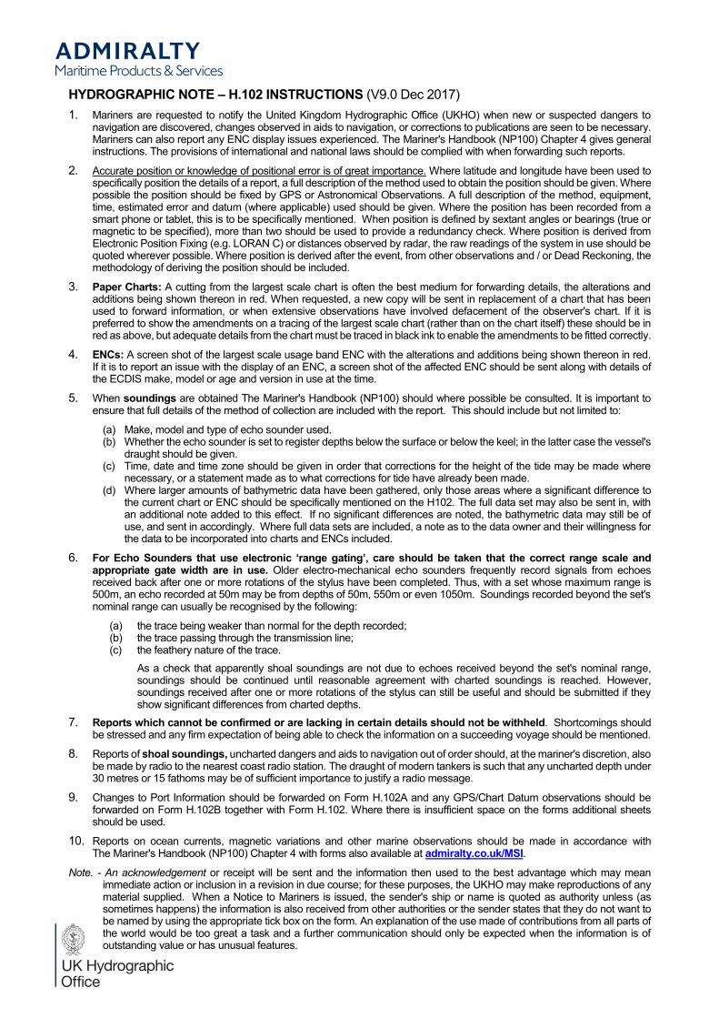
HYDROGRAPHIC NOTE H.102 INSTRUCTIONS (V9.0 Dec 2017)1. Mariners are requested to notify the United Kingdom Hydrographic Office (UKHO) when new or suspected dangers to
navigation are discovered, changes observed in aids to navigation, or corrections to publications are seen to be necessary.Mariners can also report any ENC display issues experienced. The Mariner's Handbook (NP100) Chapter 4 gives general instructions. The provisions of international and national laws should be complied with when forwarding such reports.
2. Accurate position or knowledge of positional error is of great importance. Where latitude and longitude have been used to specifically position the details of a report, a full description of the method used to obtain the position should be given. Where possible the position should be fixed by GPS or Astronomical Observations. A full description of the method, equipment, time, estimated error and datum (where applicable) used should be given. Where the position has been recorded from a smart phone or tablet, this is to be specifically mentioned. When position is defined by sextant angles or bearings (true or magnetic to be specified), more than two should be used to provide a redundancy check. Where position is derived from Electronic Position Fixing (e.g. LORAN C) or distances observed by radar, the raw readings of the system in use should be quoted wherever possible. Where position is derived after the event, from other observations and / or Dead Reckoning, the methodology of deriving the position should be included.
3. Paper Charts: A cutting from the largest scale chart is often the best medium for forwarding details, the alterations and additions being shown thereon in red. When requested, a new copy will be sent in replacement of a chart that has been used to forward information, or when extensive observations have involved defacement of the observer's chart. If it is preferred to show the amendments on a tracing of the largest scale chart (rather than on the chart itself) these should be in red as above, but adequate details from the chart must be traced in black ink to enable the amendments to be fitted correctly.
4. ENCs: A screen shot of the largest scale usage band ENC with the alterations and additions being shown thereon in red. If it is to report an issue with the display of an ENC, a screen shot of the affected ENC should be sent along with details ofthe ECDIS make, model or age and version in use at the time.
5. When soundings are obtained The Mariner's Handbook (NP100) should where possible be consulted. It is important to ensure that full details of the method of collection are included with the report. This should include but not limited to:
(a) Make, model and type of echo sounder used.(b) Whether the echo sounder is set to register depths below the surface or below the keel; in the latter case the vessel's
draught should be given.(c) Time, date and time zone should be given in order that corrections for the height of the tide may be made where
necessary, or a statement made as to what corrections for tide have already been made.(d) Where larger amounts of bathymetric data have been gathered, only those areas where a significant difference to
the current chart or ENC should be specifically mentioned on the H102. The full data set may also be sent in, with an additional note added to this effect. If no significant differences are noted, the bathymetric data may still be ofuse, and sent in accordingly. Where full data sets are included, a note as to the data owner and their willingness for the data to be incorporated into charts and ENCs included.
6. F be taken that the correct range scale and appropriate gate width are in use. Older electro-mechanical echo sounders frequently record signals from echoes received back after one or more rotations of the stylus have been completed. Thus, with a set whose maximum range is 500m, an echo recorded at 50m may be from depths of 50m, 550m or even 1050m. Soundings recorded beyond the set's nominal range can usually be recognised by the following:
(a) the trace being weaker than normal for the depth recorded;(b) the trace passing through the transmission line;(c) the feathery nature of the trace.
As a check that apparently shoal soundings are not due to echoes received beyond the set's nominal range, soundings should be continued until reasonable agreement with charted soundings is reached. However, soundings received after one or more rotations of the stylus can still be useful and should be submitted if they show significant differences from charted depths.
7. Reports which cannot be confirmed or are lacking in certain details should not be withheld. Shortcomings should be stressed and any firm expectation of being able to check the information on a succeeding voyage should be mentioned.
8. Reports of shoal soundings, uncharted dangers and aids to navigation out of order should, at the mariner's discretion, also be made by radio to the nearest coast radio station. The draught of modern tankers is such that any uncharted depth under 30 metres or 15 fathoms may be of sufficient importance to justify a radio message.
9. Changes to Port Information should be forwarded on Form H.102A and any GPS/Chart Datum observations should be forwarded on Form H.102B together with Form H.102. Where there is insufficient space on the forms additional sheets should be used.
10. Reports on ocean currents, magnetic variations and other marine observations should be made in accordance withThe Mariner's Handbook (NP100) Chapter 4 with forms also available at admiralty.co.uk/MSI.
Note. - An acknowledgement or receipt will be sent and the information then used to the best advantage which may mean immediate action or inclusion in a revision in due course; for these purposes, the UKHO may make reproductions of any material supplied. When a Notice to Mariners is issued, the sender's ship or name is quoted as authority unless (as sometimes happens) the information is also received from other authorities or the sender states that they do not want to be named by using the appropriate tick box on the form. An explanation of the use made of contributions from all parts of the world would be too great a task and a further communication should only be expected when the information is of outstanding value or has unusual features.
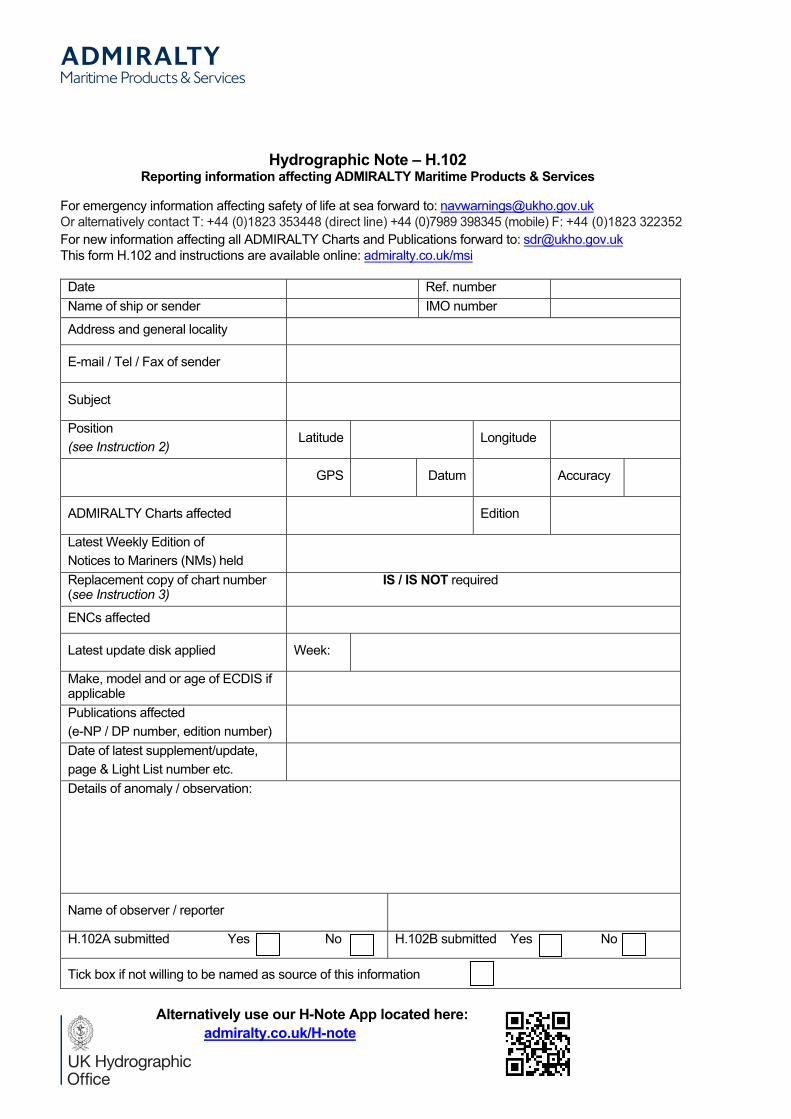
Hydrographic Note H.102Reporting information affecting ADMIRALTY Maritime Products & Services
For emergency information affecting safety of life at sea forward to: [email protected] alternatively contact T: +44 (0)1823 353448 (direct line) +44 (0)7989 398345 (mobile) F: +44 (0)1823 322352For new information affecting all ADMIRALTY Charts and Publications forward to: [email protected] form H.102 and instructions are available online: admiralty.co.uk/msi
Date Ref. numberName of ship or sender IMO number
Address and general locality
E-mail / Tel / Fax of sender
Subject
Position(see Instruction 2)
Latitude Longitude
GPS Datum Accuracy
ADMIRALTY Charts affected Edition
Latest Weekly Edition of Notices to Mariners (NMs) heldReplacement copy of chart number(see Instruction 3)
IS / IS NOT required
ENCs affected
Latest update disk applied Week:
Make, model and or age of ECDIS if applicablePublications affected (e-NP / DP number, edition number)Date of latest supplement/update, page & Light List number etc.Details of anomaly / observation:
Name of observer / reporter
H.102A submitted Yes No H.102B submitted Yes No
Tick box if not willing to be named as source of this information
Alternatively use our H-Note App located here:admiralty.co.uk/H-note