Embed Size (px)
Citation preview

Indian and Northern Affairs Canada
Affaires 1nd1ennes et du Nord Canada
YUKON GEOLOGY Volume 3
EOCENE
CJ D D D
Fluviol sediments, ondesite and basalt
Rhyolilic ash flow luffs
Rhyolilic crystol lilhic luffs
Rhyolile flows ond porphyry !dome)
PALEOZOIC
D Phyllite, chert and orgil!ite
Canada
/ /
/
~
Faull
Mineralization
0 500m

COVER: The GREW CREEK deposit, discovered by Al Carlos in 1983, is hosted by Eocene felsic volcanic tuffs and sedimentary rocks. The epithermal gold-silver deposit is located in a pull-apart basin within the Tintina Fault zone. Geological reserves are estimated to be 772,012 tonnes grading 8.9 g/t Au and 33.6 g/t Ag with a cut-off grade of 0.2 g/t Au.
Exploration and Geological Services Division of Northern Affairs Program, Yukon Region, invites readers to write and inform us of their language preference with respect to Yukon Exploration and Yukon Geology Reports, and other geotechnical reports prepared by the Division. Please write to:
Exploration and Geological Services Division N orthem Affairs Pro gram 200 Range Road Whitehorse, Yukon YlA 3Vl
La Division de !'exploration et des services geologiques du Programme des Affairs du Nord, dans la region du Yukon, invite ses lectuers a lui €crire et a lui communiquer dans quelle langue ils prefereraient recevoir !es rapports sur !'exploration et la geologie du Yukon, et !es autres rapports gOOtechniques prepares par la Division. Vueillez vous adresser a:
la Divisioin de l'exploration et des services gOOlogiques Programme des Affaires du Nord Affaires indiennes et du Nord Canada 200 Range Road Whitehorse, Yukon YIA 3Vl

YUKON GEOLOGY
Volume 3
Exploration and Geological Services Division Mineral Resources Directorate Northern Affairs Program, Yukon Indian and Northern Affairs Canada
Edited by T .J. Bremner, Mineral Deposit Geologist
Published under the authority of the Hon. Tom Siddon, P.C., M.P., Minister of Indian Affairs and Northern Development Whitehorse, 1992
QS-Y082-000-EE-Al
"Minister of Supply and Services Canada 1992. Available in Canada through
Associated Bookstores and Other booksellers
Primarily available from Exploration and Geological Services Indian and Northern Affairs Canada
200 Range Road, Whitehorse Yukon, Canada, YlA 3Vl
or by mail from Canadian Government Publishing Centre
Supply and Services Canada Ottawa, Canada KIA OS9
Catalogue no. R71-40/3E ISBN 0-662-19598-1
It is recommended that reference to this report be made in the following form:
INAC, (1992). Yukon Geology Volume 3, 1992; Exploration and Geological Services Division, Yukon, Indian and Northern Affairs Canada.

PREFACE
This third volume of Yukon Geology represents the culmination of approximately five years of geoscientific research sponsored and funded by Exploration and Geological Services Division (EGSD), Northern Affairs Program, Yukon Region. Under the Northern Mineral Policy, Indian and Northern Affairs Canada has the responsibility to develop and maintain the geoscientific database in Yukon Territory. In support of this policy, EGSD has assisted the authors through direct funding or by logistical support during the field season. Although the papers in this volume cover a wide range of topics, the majority have direct implications for mineral exploration in Yukon.
We sincerely thank the authors for their contributions and a final note of thanks is personally directed to Trevor Bremner, Mineral Deposit Geologist, EGSD, for his tremendous effort in bringing this publication together.
S.R. Morison Chief Geologist Exploration and Geological Services Division Northern Affairs Program Yukon Region

LOCATION OF PAPERS
132°

CONTENTS Page
I. K.D. RIDGWAY, P.G. DECELLES, A.R. CAMERON and A.R. SWEET: Cenozoic Syndepositional Sedimentation and Strike-Slip Basin Development along the Denali Fault System, Yukon Territory. 1
2. G.M. YEO: Phosphorites, Ironstones, and Secondary Phosphates in Mid-Cretaceous Flysch of the Blow Trough, Northern Yukon. . . . . . . . . . . . . . . . . . . . . . . . . . . . . . . . . . . . . . . . . . . . . . . . . . 27
3. A. GERMANN, G. FRIEDRICH and R. SCHATTNER: Ore Mineralogy and Formation Conditions of Vein and Replacement-Type Pb-Zn-Ag Occurrences, Logan and YP Properties, Rancheria District Yukon, Canada. . . . . . . . . . . . . . . . . . . . . . . . . . . . . . . . . . . . . . . . . . . . . . . . . . . . . . . . 37
4. A. HALL and T. LIVERTON: Trace Ammonium in Granites of the Southern Yukon and its Petrogenetic Significance . . . . . . . . . . . . . . . . . . . . . . . . . . . . . . . . . . . . . . . . . . . . . . . . . . . . . . . . . 45
5. T. LIVERTON: Tin Bearing Skams of the Thirtymile Range, N.T.S. Sheet 105 C 9: A Progress Report. 52
6. J.R. DICKIE and F.J HEIN: A Pliensbachian Submarine Slope and Conglomeratic Gully-Fill Succession: Richthofen to Conglomerate Formation Transition (Laberge Group), Brute Mountain, Yukon. . . . . . . . 71
7. L. STROINK and G. FRIEDRICH: Gold Sulphide Quartz Veins in Metamorphic Rocks as a Possible Source for Placer Gold in the Livingstone Creek Area, Yukon Territory, Canada. . . . . . . . . . . . . . . 87
8. V. LEYSON: The Sedimentology of Pleistocene Deposits Associated with Placer Gold Bearing Gravels in the Livingstone Creek Area, Yukon Territory. . . . . . . . . . . . . . . . . . . . . . . . . . . . . . . . . . . . . 99
9. D.S. EMOND and T. LYNCH: Geology, Minerology and Geochemistry of Tin and Tungsten Veins, Breccias and Skarns, McQuesten River Region (115 P (North) and 105 M 13), Yukon. . . . . . . . . . . 133
10. J.R. DICKIE, A.M. GRIST and R.A. DONELICK: Differential Uplift Across the Coast Plutonic Complex-Northern Stikine Terrane Contact, Yukon: Preliminary Evidence From Apatite Fission-Track Thermocbronometry. . . . . . . . . . . . . . . . . . . . . . . . . . . . . . . . . . . . . . . . . . . . . . . . 160
11. D.S. EMOND: Petrology and Geochemistry of tin and Tungsten Mineralized Plutons, McQuesten River Region, Central Yukon. . . . . . . . . . . . . . . . . . . . . . . . . . . . . . . . . . . . . . . . . . . . . . . . . . 167
12. A. PLOUFFE and L.E. JACKSON, Jr.: Drift Prospecting for Gold in the Tintina Trench. . . . . . . . . . . 196
13. J.K. MORTENSEN and P. VON GAZA: Application of Landsat TM Thermal Imagery to Structural Interpretations of the Tintina Trench in West-Central Yukon Territory. . . . . . . . . . . . . . . . . . . . . 214
14. A.B. CHRISTIE, J.L. DUKE and RALPH RUSHTON: Grew Creek Epithermal Gold-Silver Deposit, Tintina Trench, Yukon, (105K/02). . . . . . . . . . . . . . . . . . . . . . . . . . . . . . . . . . . . . . . . . . . 223
15. J.K. MORTENSEN, B.E. NESBITT and R. RUSHTON: Preliminary Observations on the Geology and Geochemistry of Quartz Veins in the Klondike District, West Central Yukon. . . . . . . . . . . . . . . . . 260
16. U. GLASMACHER and G. FRIEDRICH: Volcanic-Hosted Epithermal Gold-Sulphide Mineralization and Associated Enrichment Processes, Sixtymile River Area, Yukon Territory, Canada. . . . . . . . . . . . . 271
17. U. GLASMACHER and G. FRIEDRICH: Gold-Sulphide Enrichment Processes in Mesotbermal Veins of the Sixtymile River Area, Yukon Territory, Canada. . . . . . . . . . . . . . . . . . . . . . . . . . . . . . . . 292
18. K.-H. HOYMANN and G. FRIEDRICH: Gold and Sulphide Mineralization in the Hunker Creek Area, Yukon Territory, Canada. . . . . . . . . . . . . . . . . . . . . . . . . . . . . . . . . . . . . . . . . . . . . . . . 312
CENOZOIC SYNTECTONIC SEDIMENTATION AND STRIKE-SLIP BASIN DEVEWPMENT AWNG THE DENALI FAULT SYSTEM, YUKON TERRITORY
K.D. Ridgway and P.G. DeCelles, Dept. of Geological Sciences,
University of Rochester, Rochester, New York
14627
and
A.R. Cameron and A.R. Sweet Geological Survey of Canada
Institute of Sedimentary and Petroleum Geology 3303-33rd St, NW Calgary, Alberta
T2A 2L7
RIDGWAY, K.D., DE CEU.ES, P. G., CAMERON, A.R., and SWEET, A.R., 1992. Cenozoic syntectonic sedimentation and strike-slip basin development along the Denali fault system, Yukon Territory. In: Yukon Geology, Vol. 3; Exploration and Geological Services Division, Yukon, Indian and Northern Affairs Canada, p.1-26
ABSTRACT
This is a multidisciplinary study which combines sedimentology and sedimentary petrology, palynology, organic petrology and structural analysis of the middle Cenozoic Amphitheatre Formation in the St. Elias Mountains, and documents syntectonic deposition in strike-slip basins along the Denali fault system. The outcrops of the Amphitheatre Formation can be divided into two discrete basins: the northern Burwash basin and the southern Bates Lake basin.
Sedimentological analysis of the Burwash basin identified fault-controlled depocenters which allowed the development of several different types of non-marine depositional environments in close proximity. Palynology and organic petrology data indicate that the Amphitheatre Formation is diachronous and spans the Eocene-Oligocene boundary.
Light-mineral Provenance studies of sandstones, clast-counts in conglomerates and paleocurrenJ analyses suggest that the Wrangellia and Yukon Crystalline Terranes were sources for the Amphitheatre Formation in the Burwash basin. In contrast, preliminary work suggests that Wrangellia and possibly the Gravina-Nutzotin Terrane may have been important sources for the Amphitheatre Fonnation in the Bates Lake basin.
Structural data combined with geologic mapping indicate a predominance of strike-slip deformation during and after deposition of the Amphitheatre Formation in the Burwash basin. The presence of syndepositionalfaults with subhorizontal slickensides indicates that strike-slip deformation occurred during deposition of the Amphitheatre sediments. The Burwash basin contains structures indicative of both contractional and strike-slip deformation, whereas the Bates Lake basin contains structures indicative of both extensional and strike-slip deformation. The change in structural style between the two basins suggests that the Amphitheatre Formation may have been deposited in transpressional as well as transtensional tectonic settings along individual segments of the Denali fault system during the middle Cenozoic.
- 1 -

RESUME
Cette erude multidisciplinaire combine la sedimentologie, la petrologie sedimentaire, la palynologie, la petrologie organique et I 'analyse structurale de la formation d 'Amphitheatre du Cenozafque moyen dans les monts St. Elias et on y documente le depot syntectonique dans les bassins de decrochement le long du systeme de Denali. Les affeeurements de la formation d 'Amphitheatre peuvent erre repartis comme appartenant a deux bassins discrets : le bassin septentrional de Burwash et le bassin meridional du Lac Bates.
L 'analyse sedimentologique du bass in de Burwash a permis d 'identifier /es di!pocentres limit es par des failles oil ont pu se former en erroite proximire plusieurs types diffirents de milieux de sedimentation non marins. Les donnees palynologiques et de pi!trologie oprganique indiquent que la formation d 'Amphitheatre est diachrone et chevauche la limite Eocene-Oligocene.
Des etudes de la provenance des mineraux clairs des gres, des denombrements des fragments dans les conglomerats et des analyses des paleocourants suggerent que les terranes Wrangellia et Cristal/in du Yukon constituaient les sources pour la fonnation d 'Amphitheatre dans le bass in de Burwash. Par contraste, des travaux preliminaires suggerent que la Wrangellia et le terrane de Gravina-Nutzotin ont pu constituer des sources importantes pour lafonnation d'Amphitheatre dans le bassin du Lac Bates.
Les donnees structurales combinees aux donnees de la cartographie geologique indiquent une predominance de deformations de decrochement pendant et apres le dipOt de la formation d'Amphitheatre dans le bassin de Bunvash. La presence de failles contetnporaines de la sedimentation avec surfaces de friction subhorizontales indique que la defortnation par dicrochement s 'est produite pendant le dip6t des sediments de la fom1ation d 'Amphitheatre. Le bass in de BurWash renfenne des structures indicatives de deformations par contraction et par dicrochement a/ors que le bassin du Lac Bates renferme des structures indicatives de difonnations par extension et par dicrochement. Le changement de style structural d'un bassin a l'autre suggi!re que la formation d'Atnphitheatre peut avoir ere mise en place dans des cadres tectoniques de transpression ainsi que de transtension le long de segments individuels du systeme de Denali au Cinozoi'que moyen.
INTRODUCTION
Middle Cenozoic coarse-grained sedimentary rocks, collectively referred to as the Amphitheatre Formation, were deposited in several small basins along or near the ShakwakDalton and Duke River segments of the Denali fault system in the eastern St. Elias Mountains (Fig. 1). The Amphitheatre Formation forms a narrow, discontinuous belt approximately 350 km long, following the southwest side of the ShakwakDalton fault (Campbell and Dodds, 1982a, 1982b). Because of their age, textural and compositional immaturity and proximity to the fault, it is possible that sedimentary rocks of the Amphitheatre Formation record much of the Cenozoic tectonic history of the eastern St Elias Mountains and the Denali fault system. Our ongoing study, combined with observations by Eisbacher and Hopkins (1977), strongly suggests that Amphitheatre sedimentation was coeval with movement on the Denali fault system. In addition, later folding and faulting of the Amphitheatre Formation indicates post-Amphitheatre deformation along the strike-slip system. The Amphitheatre Formation consists of 350 - 1100 m of conglomerate, sandstone, shale and coal (Read and Monger, 1976) and is considered an overlap assemblage because it was deposited across several juxtaposed, accreted terranes which comprise the eastern St. Elias Mountains (Fig. 1). The Amphitheatre Formation thus contains the only sedimentary record of middle Cenozoic movement on the Denali fault system, as well as the post-accretionary history of the terranes in southwest Yukon.
- 2
SEDIMENTOLOGY
The outcrops of the Amphitheatre Formation that we have studied can be divided into two discrete areas with contrasting petrofacies, structures and sedimentological characteristics. Each area represents the remnant of a separate basin. We refer to the .northern area as the Butwash basin and the southern area as the Bates Lake basin.
Sedimentological data indicate that the Amphitheatre Formation is characterized by (I) abrupt and localized facies changes both laterally and vertically; (2) markedly different lithostratigraphies within the Burwash basin, suggesting the existence of small (!O's km), discrete, fault-controlled depocenters; (3) abrupt changes in local paleocurrent direction within fault-controlled depocenters; and (4) ample evidence of syndepositional tectonism, including intraformational unconfonnities, syndepositional faults, angular scree deposits and boulder conglomerates (Ridgway et al., 1989; Cole et al., 1989; Eisbacher and Hopkins, 1977). These characteristics are common in strike-slip tectonic settings, where multiple source areas are tectonically transported along the basin margins and sedimentation is synchronous with deformation of the basin.
Northern Area - Burwash Basin
The Burwash basin is approximately 35 km long (Fig. 2) and can be differentiated into three depocenters which are

Figure 1: Regional geologic setting of the Amphitheatre Formation (black areas) in the Yukon Territory. The Amphitheatre Formation was deposited in several small basins along or near the Denali fault system in the eastern St. Elias Mountains. The Amphitheatre Formation, an overlap assemblage, overlies the Wrangellia Terrane in the northern part of the study area and the Alexander Terrane in the southern area. A - Burwash basin, B- Bates Lake basin, ORF - Duke River Fault, DFS -Denali Fault, GNB - Gravina-Nutzotin Belt, BRF - Border Range Fault, HF - Hubbard Fault, FF -Fairweather Fault. Modified from Campbell and Dodds, 1982a; 1982b.
defined by unique lithostratigraphies and distinctive depositional sequences. The unique stratigraphies representing individual depocenters cannot be correlated across major faults within the basin and are best exposed at the Mount Hoge, Amphitheatre Mountain and Cement Creek measured section localities (Fig. 2) (Ridgway et al., 1989).
Mount Hoge Depocenter
The Mount Hoge depocenter is the southernmost depocenter in the Burwash basin. It is located on the north flank of Mount Hoge at the southwest basin margin, and is characterized by proximal gravel-dominated fluvial deposits with poorly developed overbank facies. At Mt Hoge, the Amphitheatre Formation consists of sheet-like packages of clastsupported conglomerate 30-40 m thick, separated by 8 to 10-m thick units of interbedded sandstone and coal (Fig. 3-4).
- 3
Conglomerate clast sizes range from pebble to cobble. Conglomerate lithofacies are established on the basis of trough and planar cross-stratification, crude horiwntal stratification, and imbrication. Laterally extensive, sheet-form conglomerates showing sharp vertical separations between overbank and channelized facies suggest deposition on wet alluvial fans (Ethridge, 1985; Fraser and Suttner, 1986). Paleocurreot data indicate paleodrainage toward the west-northwest (Fig. 2).
Amphitheatre Mountain Depocenter
The next depocenter north of the Mount Hoge depocenter is the Amphitheatre Mountain depocenter (Fig. 2). It is characterized by proximal gravel-dominated fluvial deposits with well-developed overbank facies. At Amphitheatre Mountain, the basin fill consists of lenticular conglomerate packages 40 m thick, separated by well-developed sandstone, mudstooe and coal packages ranging in thickness from 30 to 40 m (Fig. 5). In addition, the conglomerate packages grade laterally into finer-grained overbank facies (Fig. 6). The lack of extensive channel scouring, the well-developed channel-bar deposits (Fig. 7), and thick channel deposits that are laterally equivalent to. coal deposits suggest deposition on a broad braidplain with well-established channel systems and perennial flow. This fluvial system may have been the central trunk stream into which more proximal, basin-margin streams discharged. Paleocurrent data indicate paleodrainage toward the west.
Cement Creek Depocenter
The Cement Creek depocenter is the northernmost depocenter in the Burwash basin (Fig. 2). Distal sandstonedominated braided stream, lacustrine/fan-delta, and meandering stream deposits predominate. The stratigraphic sequence is characterized by three lower, 100 m thick, trough crossbedded, conglomerate and coarse sandstone units which are overlain by 40m of mudstone and very fine-grained sandstone (probably lacustrine). These grade upward into laterally persistent (200 to 250 m wide) fine to medium-grained sandstone units of fan-delta affinity. This package is in tum overlain by a 50m thick unit of upward-fining, coarse to conglomeratic sandstone packages which were probably deposited by meandering streams (Fig. 8-9). Paleocurrent data indicate paleodrainage toward the south.
Southern Area - Bates Lake Basin
Initial work in the Bates Lake basin (Fig. 10) indicates that these sediments are characterized by abrupt changes in facies. However, confinement of depositional systems to specific fault-bounded depocenters, as is typical of the Burwash basin, has not been documented to date. Outcrops studied along the eastern basin margin (Fig. 11-12) (e.g. BL! and BL2 on Fig. IO) consist of approximately 1,000 m of coarse, proximal alluvial-fan deposits which form an overall upward-fining sequence. Paleodrainage was toward the south-

PALEOCURRENT DATA
......__ PEBBLE IMBRICATION
- TROUGH CROSS-STRATIFICATION [ill ,.,......
AMPHITHEATER FM.
\HIGHEST STRAT. MEASUREMENT
'7\owEST STRAT. MEASUREMENT x x
OUTCROPS
FAULT
SYNCLINE
ANTtlltNE
modified from Campbtll and Dodds (1982)
Figure 2: Location of stratigraphic sections measured in the Burwash basin. Map shows major folds and faults and outcrops of the Amphitheatre Formation based on Campbell and Dodds' (1982a; 1982b) maps. Leader lines connect clusters of paleocurrent arrows (from trough cross-strata and pebble imbrications) to their respective localities.
southwest. Outcrops along the southwest basin margin (Fig. 13)(e.g. WC2 on Fig. 10) consist predominantly of lenticular, coarse to medium-grained sandstones, encased in mudstones and siltstones which were probably deposited in a distal, axial fluvial system.
PALYNOLOGY AND ORGANIC PETROGRAPHY
Ongoing palynology and coal petrography studies document diachronous filling of the Burwash basin, spanning the Eocene-Oligocene boundary (Ridgway et al., 1989). The palynology and coal petrography support the model of localized fault-controlled depocenters within the Burwash basin. Owing to the structural complexities in ancient strikeslip basins, it becomes important to document the chronology and distribution of sediment packages in different parts of individual basins to understand the history of basin development. Our current interpretation of specific fault-bounded depocenters in the Burwash basin and the documentation of specific pollen and coal-type domains within these depocenters
indicates the sediment packages become younger toward the basin center. This in tum suggests that the Burwash basin closely resembles the pull-apart model of strike-slip basin development (Crowell, 1974; Aydin and Nur, 1982; Mann et al., 1983). The pull-apart model constrains the oldest sediment to the perimeter of the basin, with sediments becoming progressively younger toward the center of the basin owing to structural enlargement of the basin with time. Studies of pollen types and coals in the Bates Lake basin are in progress.
Palynology
Palynological data indicate that the Amphitheatre Formation in the Burwash basin spans the Eocene-Oligocene boundary, which is marked by a global temperature decline. The global temperature decline resulted in a shift from angiosperrndominated to gymnosperm-dominated forest types.
In the Burwash basin, the change in forest character is documented by an angiosperm-dominated temperate deciduous
- 4 -
70 """ v:;i\ "ti'
"'' '<$> \ti'
'"' tllll:I' ~ , .. "'' ...
'" tol
... "' ;.: .......... : .. ·_.· .... ,,, ... ~ '" "'
"' "' ... 0 0 0 0 0 0
0 0 0 0
00~0000
oQb. °"°<::::7' •o 0 0 0 0
0 0 0 0
0 0 0 0
0 0 0 0 0 0 0
0 0 0 0
0 llOU '" M F c PCB
110
~
"' ~
A
A
~
,---,-, 0 40
70 MPS
'" ' "' M
"'' ,,, ''" ,,,
c PCB \
0'4o MPS
Figure 3: Measured stratigraphic section of the Amphitheatre Formation near Mount Hoge. Columns stack from left to right. Scale in meters on all measured sections. See Table 1 for explanation of lithofacies codes. Grain sizes: F - fine sand; M - medium sand; C - coarse sand; VC - very coarse sand; P - pebble; C - cobble; B - boulder. MPS = maximum particle size in cm.
pollen spectrum at the Mount Hoge and Cement Creek depocenters (Fig. 14) (see Fig. 2 for map locations), which contrasts with subtemperate, dominantly coniferous, forest pollen at the Amphitheatre Mountain depocenter (Fig. 14).
The difference in pollen dominances and the inferred forest character between depocenters suggest that Mount Hoge
and Cement Creek localities on the perimeter of the basin are slightly older than the Amphitheatre Mountain locality in the more central part of the basin.
The oldest distinctive genus documented to date is Platycarva from the Cement Creek depocenter. In North America, Platycarva has mostly been found in Eocene rocks
- 5 -

Figure 4: Typical exposures of the Mount Hoge depocenter consist of 30 to 40 m thick units of highly scoured, clast-supported conglomerate (A) that are separated by 8 to 10 m thick units of interbedded sandstone and coal (B). Two-man tent (arrow) for scale. DRF: Duke River Fault, WL: WrangeU Lavas.
(Tschudy and Scott, 1969, p.350), but Frederiksen and Christopher (1978) have recorded this genus in the upper Paleocene of South Carolina. The youngest distinctive genus is Carophyllaceae from the upper 10 meters of exposure at Amphitheatre Mountain. The oldest documentation of CarophyUaceae is from the middle Oligocene of New Zealand (MuUer, 1981). Wiggins (1976) has also recognized CarophyUaceae in the weU-dated middle Oligocene rocks of Cook Inlet, Alaska.
Organic Petrography
Petrographic studies of coal document the same change in the character of plant communities as recorded in the palynology studies, corresponding to the global temperature decline across the Eocene-Oligocene boundary. Petrographically. the coals of the three depocenters have low inertinite macerals ( < 6 % ) and most have high percentages of huminite macerals ( > 85 % ) (Fig.15). The huminite occurs in two distinctive populations correlated with the two different types of forest vegetation (Fig. 16). Coals at Mount Hoge (MINFILE 115G 011) and Cement Creek (MINFILE 115G 028) have more eu-ulminite B relative to eu-ulrninite A, whereas the trend is reversed at the Amphitheatre Mountain depocenter (MINFILE 115G 012)(Fig. 16). Eu-ulminite A macerals are typical of subtemperate, conifer-dominated coal swamps (e.g. Amphitheatre Mountain), whereas eu-ulminite B and densinite are more typical of temperate, angiospermdominated coal swamps (e.g. Mount Hoge, Cement Creek). This change from temperate to subtemperate coal swamps with time probably resulted from the temperature decline across the Eocene-Oligocene boundary.
- 6
PROVENANCE
An ongoing objective of this study is to develop a better understanding of the relationship between the terranes comprising the eastern St. Elias Mountains, the Yukon Crystalline Terrane to the east, and the displacement history of individual segments of the Denali fault system which separate these terranes. The immature petrographic composition of the Amphitheatre Formation, combined with paleodrainage analysis, should be a very sensitive recorder of the relationship between the timing of fault movement and resultant sedimentation.
Several terranes are possible source areas for the Amphitheatre Formation (Fig. 1). The Wrangellia Terrane, which composes the Kluane Range, is a late Paleozoic terrane consisting of submarine volcanic-arc rocks, overlain by Triassic subaerial and submarine mafic volcanic rocks and shallow marine sedimentary rocks (Read and Monger, 1976; Campbell and Dodds, 1982a). The Alexander Terrane, which underlies the Icefield Ranges, is an early Paleozoic terrane consisting of carbonate, pelitic and volcanic rocks that are complexly deforrned and metamorphosed to greenschist facies (Campbell and Dodds, 1982a). The Gravina-Nutzotin Terrane is an Upper Jurassic to Lower Cretaceous tlysch basin composed of interbedded sandstone and shale (Eisbacher, 1976). The Yukon Crystalline Terrane, in the northern part of the study area, consists of high-grade metamorphosed Paleozoic rocks (Tempelman-Kluit, 1976; Mortensen and Jilson, 1985). All of these terranes are locally intruded by younger granitic rocks.
Sandstone Petrology
The detrital compositions of sandstones are directly related to the tectonic setting of the source area. Dickinson and Suczek (1979) used ternary diagrams to demonstrate the distinctiveness of detritus derived from different tectonic settings. In strike-slip settings, where source-area terranes of different rock types are juxtaposed along the basin margins, it may be informative to plot variables that characterize specific terranes. For example, the high-grade metamorphic rocks of the Yukon Crystalline Terrane would be the nearest "highvolume" source of polycrystalline quartz, whereas the volcanic rocks of the Wrangellia Terrane would be the nearest "highvolume" source of plagioclase and lithic volcanic and sedimentary rock fragments.
This "high-volume" sediment source characterization is not entirely satisfactory because of geological complexities at the local scale. For example, a local Cretaceous diorite intrusion within the volcanic-rich Wrangellia Terrane could easily have sourced part of the Amphitheatre Formation. To avoid misinterpretations due to local anomalous sources, we are collecting and analyzing sandstone samples on a basin-wide scale. A basin-wide data base should homogenize local source influences within the dominant source signature. Another complication is the possible former presence of supracrustal rocks above the metamorphic core of the Yukon Crystalline

__,
70 0000000
§ 0 o I 06060696
' • • ' . . I
0 0
o\,'o\.'O)'O>O"
0 0 0 0 0 0 0
0 0 0 0 0 0
0 0
"' 00
'"'" "'° "II
0 0 0 0 0
0 0 0 0 0 0 0 0 0
0 0 0 0 0
0 0 0 0 0 0 0 0 0
0 0 0 0 0
0 0 0 0 0 0 0 0
MUDFMCVCPCB
140 jo0
o0
o0
o0
o0
\
'""' ..,. ... "''. -<==='" ... -==
"'"'"' ,. .... "'"'"' ~ .. ~ .,
........ ~:.·
'" "' "' ,,1:1 ""'
"' ... "'
"' "'
... ... '"'
0 0 0 0 0 0 0 0 0 70 Io o o o o
MUDFMCVCPCB
210
A
0 0 0 0 0 0 0 0
0 0 0 0
0 0 0 0 0 0
ll'li:I 1#11 ~
~ w:i '#I ~
"""'1:1• l:IWlllM ... "A-~~' ~""--0\11'11 ~111¥:1~
W.i lri\1' "'' W\ ~ ...
0 0
...... ..... ..... "" ""
140 MUD f M C VC P C B
280 0 0 0 0 0 0 0 0 0
0 0 0 0 0
0 0 0 0 0
MUD f M C VC P C B
350 000000
0 0 0 0 0 0
Al~0:0!
0 0 0 0 0
0 0 0 0 0
0 0
0 0 0 0
0 0
280 !00000000
MUD f M ( VC P ( B
410- '«'T •" Q ti
...J
...J w CJ z < a:
A
- • <J ;:
0 .. 0 <;}
<J J ~ I'.) ti
-
-
a ~ <'.!, '1J <)
I ;; a a' o ; ~ "OJ <
w ::c
-<O " 0 0 \) 0 0)
0 0 _,o a Q Q
(>09\) Q <! -
{] <)()\)
-<IJ~'>o'ili!, 0
0
-i 0
0
0
0
0
0
0
0 0
0 0
0 0
0
0 0 0 0 0
0 0 0 0 c
!:: ::c a. :::!: <
350 I o o o o I MUD f M C VC P ( B
Figure 5: Measured stratigraphic section of the Amphitheatre Formation near Amphitheatre Mountain. Columns stack from left to right. See Table I and Figure 3 for explanation of lithofacies codes and grain sizes.

Figure 6: Individual amalgamated channels within channel complex interbedded with finer-grained facies at the Amphitheatre Mountain depocenter. Dall sheep (arrow) for scale. C - coarse, channel conglomerate; S - trough, cross-bedded sandstone; FG - finer-grained overbank deposits.
Terrane and the Coast Plutonic Complex. These hypothetical supracrustal rocks are now completely eroded, but may have supplied sediment to the structural basins associated with the Denali fault system during the middle Cenozoic. If this is the case, any sediment contributed to the structural basins by the "supracrustals" should have contained a large component of metamorphic grains (e.g. Qp; Lm) by Eocene time based on studies (Tempelman-Kluit, 1976, p.1355; Mortensen and Jilson, ·1985) which indicate that by the Late Triassic the entire eugeoclinal assemblage in the Yukon Crystalline Terrane (including the allochthonous Permian and older rocks) had undergone strong deformation and metamorphism. Therefore, any possible sediment contributed by the former supracrustal rocks would resemble the schists, gneisses, quartzites, and granitic rocks presently being eroded in the Yukon Crystalline Terrane and should not result in any gross misinterpretation.
Several trends are apparent in our preliminary sandstone petrology data. On QFL diagrams (Fig. l 7a) sandstone compositions suggest mixing of continental block detritus (from sources rich in Q and F) and arc orogen detritus (from sources rich in F and L) in the Burwash basin. Together with paleocurrent data (Fig. 2) the petrologic data suggest that the most likely source for this particular sandstone composition is a mixture of sediments derived from Wrangellia and the Yukon Crystalline Terranes. Sandstones from the Bates Lake basin have QFL compositions that suggest a predominantly arc-orogen source (Fig. 17b). Combined with the southsouthwestward paleocurrent data (Fig. 10), the Bates Lake petrologic data indicate derivation from Wrangellia and possibly the Gravina-Nutzotin Terrane.
On QpPK diagrams, sandstone compositions in both the Burwash and Bates Lake basins show marked enrichment in plagioclase (Fig. 18a,b) which, combined with paleocurrent
Figure 7: Well-developed foresets in channel-bar complex exposed at the Amphitheatre Mountain depocenter. Person (arrow) for scale.
data, suggests that the plagioc!ase-rich volcanic rocks of Wrangellia may have been the dominant source terrane during the filling of these basins.
Conglomerate Clast-Count Data
The identification of clast types in conglomerates within the Amphitheatre basins is an important tool for recognizing possible source areas. Because conglomerates are deposited in environments close to the source area, they accurately record source-area compositions. Clast-count data from the Amphitheatre conglomerates exposed in the Burwash basin indicate a predominance of local sources within the Wrangellia Terrane (Fig. 19). The conglomerates are dominated by metabasalts (Fig. 20), meta-pelites and meta-tuffs (Fig. 21). We have field inspected and identified several potential source rocks in the Kluane Range (Wrangellia Terrane), including the Hasen Creek .and Station Creek Formations (PennsylvanianPermian), the Nikolai volcanics (Triassic), and the Kluane Range intrusions (Cretaceous). Eisbacher and Hopkins (1977) suggested that the volcanic clasts in the Amphitheatre conglomerates were derived from Tertiary volcanic rocks (e.g. Mount Nansen - Eocene) which overlie parts of the metamorphic core of the Yukon Crystalline Terrane. At this stage in this study, we cannot rule out Eisbacher and Hopkins' interpretation. However, the coarseness of the conglomerates, abundant evidence for syndepositional faulting and syntectonic unconformities (see Structural Geology section), and the close proximity of the Wrangellia Terrane, finger the Wrangellia Terrane as a more likely source for the high volume of volcanic clasts in the Amphitheatre conglomerates. Future geochemical analysis of the volcanic clasts in the conglomerates may help to pinpoint their source rocks.
The relative abundance of high-grade metamorphic clasts in conglomerate in the Cement Creek depocenter parallels the greater abundance of polycrystalline quartz in the sandstones from Cement Creek. Both trends indicate that a minor
- 8 -

1 10 0 0 0 220 330 440 -0 0 <'<9'". 0 0 0
* -0 0
* :~
* = 540 ----1 * *
.. ,,..,. I * = I
~ I
* = I I - I
* I
·~ Qi =~ ...,. Q
.~ ·.x.: 0 0 0
0 0 .~ 0 0 0
0 0
0 0 0 ~
~ 0 0
0 0 0 ·-"'-· 0 0
.~wo<> ~ 0 0 -.,,,,.. 0 0
Q -~ ... - ... ~ .. _ ...... ... A ... ...
0 0 0 ... ...
0 0 , .. ...
I 0 0 0 . ..
.. 0 0 ... ... 0 0 0 't-:-:x.;
·~ '27 "''" •• 0 0 0 0 •• • ...
0 -::er. "' ~ ... 0 0 0 0 0 0
* ... 0 0
* '"' 0 0 0 -*
... ~ # 0 0 0
* c:;;....o 0 0 ~
* 0 no 1 10 rll 220 O'?o 330
6'to 440 6'2'o MPS MPS MPS MPS MPS
Figure 8: Measured stratigraphic section of the Amphitheatre Formation near Cement Creek. Colunms stack from left to right. See Table I and Figure 3 for explanation of lithofacies codes and grain sizes.
component of the sediments deposited in the Cement Creek area was sourced from the high-grade metamorphic rocks of the Yukon Crystalline Terrane.
STRUCTURAL GEOLOGY AND BASIN DEVELOPMENT
A salient problem addressed by this study concerns the displacement histories of the Shakwak-Dalton and Duke River faults during and after Amphitheatre deposition. Most regional studies of the Denali fault system in the Yukon Territory and adjacent Alaska (Forbes et al., 1973a, 1973b, 1974; Eisbacher, 1976; Lanphere, 1978; Clague, 1979; Stout and Chase, 1980; Nokleberg et al., 1985; Plafker et al., 1989) indicate 300 - 400 km of displacement within a vaguely
constrained time interval from Late Cretaceous to Recent. Regional mapping in the study area by Campbell and
Dodds (1978, 1982) and Read and Monger (1976) suggests that the major displacement was probably younger than early Late CretaceQus but older than Miocene. It appears certain that the Amphitheatre Formation was deposited during, and later deforrned by, movements along these major strike-slip faults. Moreover, steeply-<lipping slivers of Amphitheatre Formation rocks occur along the Shakwak-Dalton fault zone, indicating that further movement occurred during or after Amphitheatre deposition (Read and Monger, 1976).
In order to sort out the complicated relationships between the various fault systems and the Amphitheatre Fomiation, we are mapping the Amphitheatre Formation at a scale of 1 :20,000. Detailed mapping of the Amphitheatre Formation
- 9 -

Figure 9: The stratigraphic succession at Cement Creek is characterized by three lower, 100 m thick conglomerate and coarse sandstone units (A), overlain by a 40 m-thick mudstone unit (B) which grades upward into laterally persistent fine to medium-grained sandstones (C). Exposure in photo is approximately 300 meters thick. Numerous sills (S) have intruded the lower part of the section.
is addressing the following questions: (1) What is the trend of deformation within the Amphitheatre in different parts of the basin(s) and how does it relate to the major regional strike-slip faults? (2) Are the present faulted Amphitheatre basin margins artefacts of post-Amphitheatre deformation or did these faulted margins actively control Amphitheatre sedimentation? This facet of the study is improving current understanding of fault movements between Late Cretaceous and Pliocene time, and indicates controls on basin development along the Denali fault system. Results to date indicate that obvious structural differences exist between the Burwash and Bates Lake basins.
Burwash Basin
The Burwash basin is characterized by: (1) fault-bounded margins which strike at oblique angles to the major strike-slip faults in the area; (2) right-stepping en echelon folds (Cement Creek area); (3) steeply dipping strata in local areas; and (4) intraformational unconformities (Sheep Creek area) and syndepositional faults (Amphitheatre Mountain area). These characteristics commonly are associated with basins developed in transpressional strike-slip settings (Lowell, 1972; Wilcox et al., 1973; Christie-Blick and Biddle, 1985).
Figure 22 is a geologic sketch map, completed during the summer of 1989, of the Amphitheatre Formation along the southern margin of the Burwash basin. This part of the basin displays contractional defonnation. The southwest basin margin is an eastward trending asymmetric anticline, exposed along transect A-A'. The south limb is very gentle, whereas the north limb dips steeply and is truncated by a fault.
Several different structural styles are present in the small part of the basin mapped in Figure 22. A three-fold hierarchy of faults is present in this part of the Burwash basin; regional first-order faults, intra-basinal second-order faults, and syndepositional third-order faults. For example, at location B the "basement'' rocks for this particular basin (e.g. Pv) have been juxtaposed against the Amphitheatre Formation along a set of conjugate high-angle NW-SE striking second-order faults (Fig. 23). In contrast, the structural style at location C is dominated by high-angle, NE-SW third-order syndepositional faults (Fig. 24). Slickenside orientation data (Figs. 25-26) indicate that at least the latest movements on the faults at both locations B and C have been primarily horiwntal. Additional evidence that the basins were proximal to areas of active deformation includes boulder conglomerate deposits at
Amphitheatre Mountain (Fig. 27) and Sheep Creek. Comparison between the dominant NNW dip of bedding
south of the major fault which parallels Granite Creek (a firstorder fault, taken from Campbell and Dodds, 1982a) and the dominant SW dip of bedding north of the major fault suggests that fault-bounded segments of the basin may have acted as independent blocks and undergone different deformational histories. These contrasting structural histories should be identifiable as unique structural domains by field mapping.
Bates Lake Basin
In contrast to the Burwash basin, the Bates Lake basin is characterized by: (1) predominantly flat-lying strata; (2) little evidence of folding; (3) depositional onlap of the basin margins; and (4) numerous NE-SW striking faults which do not appear to rotate bedding. Initial work in the Bates Lake basin suggests that this basin has many of the characteristics of transtensional strike-slip basins, such as extensional structures (mainly normal faults) and a lack of en echelon folds (Wilcox et al., 1973; Harding et al., 1985; Christie-Blick and Biddle, 1985).
Figure 28 is a geologic sketch map of the southwest margin of the Bates Lake basin, located at the south end of Bates Lake (Fig. 10). The map demonstrates the extensional nature of this part of the basin. Note that the Amphitheatre Formation is exposed in two small graben within older "basement" rocks (e.g. locations A and B). The individual graben appear to have been rotated differentially, the rocks in the northernmost graben having a northeast dip and the rocks in the southwest graben having west-southwest dips. Clearly, this structural configuration of the Bates Lake basin is much different from that of the Burwash basin.
SUMMARY
Several lines of evidence indicate that deposition of middle Cenozoic coarse-grained sediments in small basins along or near the Shakwak-Dalton and Duke River segments of the Denali fault system was coeval with movement on the Denali fault system. This ongoing multi-disciplinary study of the Amphitheatre Formation is the first comprehensive study of
10 -

',_., ~ : \
\ I \ ' \ I \ \ \
\ \
' '
\ \ \ I \ \ \ \ \
\~\ "~'' (,, \-'~,
1·" '.; \\ 1-·' \,,....,,
',_ \ \ ,, . \ \. ,,
. \ \ ,, ·., ' ,, '\' '~, · .. \, \ ,,
\. ' ' '\ ,,
[i\]J
/'" x --.\---' ' ,,
' ,,
' ,,, ',, ,, \~ ,,, '\
\
AMPHITHEATER FM. OUTCROPS
FAULT ANTICLINE
SYNCLINE
lo'RANGELL DIKE
0 1 Okm
' ' ' ' I
,(\' ..,. ' '<,,.
/
\:·~ ~ t ' I ' f\ \ BATES
"- 1 \\ I \L1'AKE ·. ~ .L-,,'
r I
\ I l I I I l I I
\ ' ' ' '
\
\ \
' ' '
Figure 10: Location of stratigraphic sections studied in the Bates Lake basin. Map shows major folds and faults and outcrops of Amphitheatre Formation based on Campbell and Dodds' (1982a; 1982b) maps. Leader lines connect clusters of paleocurrent arrows (from trough cross-stratification and pebble imbrication) to their respective localities.
- 11 -

70 0.
0 0
0 0 0
0 0
0 0 0
0 0
0 0 0
0 0
0 0 0
0 0
0 0 0 0 0 qr
0 0
0 0
0 0 0
0 0
0
Q 0 0 0
0 0
0 0 0 90 0 0 0 0 0
0 0 0 0 0
0 0 0 0 0
\ 0 0 0
0 0 0 0 0
0 0
Q 0 0
0 0 0
0 0 0 0 0 0 0 0
0 0 0 Q ~ 70 0 0
rT"1 rri C.VMVPB 0 .. ( V H v p 8 ' 40 L F ( MPS L F ( MPS
Figure 11: Measured stratigraphic section of the lower Amphitheatre Formation near the eastern margin of the Bates Lake basin. The section is dominated by 20 to 25 m thick units of pebble to boulder conglomerate. Columns stack from left to right. See Table 1 and Figure 3 for explanation of lithofacies codes and grain sizes.
these basins and sheds new ·light on the middle Cenozoic history of the eastern St Elias Mountains and the Denali fault system.
Sedimentological analysis of the Amphitheatre basins documents characteristics common to nonmarine strike-slip basins such as: (1) fault-controlled depocenters; (2) abrupt and localized facies changes; and (3) abrupt changes in local paleocurrent directions within each depocenter. The faultcontrolled depocenters allowed several different types of depositional environments to exist in close proximity to each other within individual basins. Braided stream, wet alluvial fan, fan-delta, lacustrine and meandering stream deposits all occur within the Burwash basin, which is only 35 km in length and 5 km wide (Ridgway et al., 1989; Cole et al., 1989). The recognition and further documentation of wet alluvial-fan deposits may help clarify the depositional enigmas pointed out by Eisbacher (1978), Eisbacher and Hopkins (1977), and Long
(1981) in Cenozoic rocks within the Canadian Cordillera intermontane basins. The intimate association of coarse elastics and coals, the lack of proximal alluvial-fan facies, and the non-conformity of the fluvial conglomerates to documented modem braided-stream deposits may be explained by a wet alluvial-fan depositional model.
Palynology and coal petrography document diachronous filling of the Burwash basin, which spanned the EoceneOligocene boundary. The global temperature decline at the Eocene-Oligocene boundary resulted in a change in forest character from temperate, angiosperm-dominated to subtemperate, gymnosperm (mainly coniferous)-dominated. Distinctive pollen and coal type domains within individual faultbounded depocenters support the current interpretation of a pull-apart basin model for the Burwash basin.
Light-mineral provenance studies of sandstones and clasttypes in conglomerates, combined with paleocurrent analyses, are helping to identify the possible source terranes for the Amphitheatre sediments. Our data suggest mixed continental block and arc-orogen sources of sand and gravel for the Burwash basin. The most likely candidates are the Wrangellia Terrane (for the volcanic lithic grains) and the Yukon Crystalline Terrane (for the high-grade metamorphic lithic grains). Meta-basalt, meta-pelite and meta-tuff are the most common conglomerate clast types in the Burwash basin and, combined with paleocurrent analyses, suggest local sources within the Wrangellia Terrane. The presence of local uplifted sources along the fault-bounded Amphitheatre basin margins, and evidence for syndepositional tectonism, supports a strike-slip origin for these basins.
Structural data indicate a predominance of strike-slip deformation during and after deposition of the Amphitheatre Formation in the Burwash basin. We have mapped high-angle faults of several orders including syndepositional faults which indicate strike-slip deformation during deposition of the Amphitheatre sediments. Second-order faults form a conjugate set of high-angle faults with subhorizontal slickensides indicating a predominance of oblique strike-slip fault movement.
The Burwash basin contains structures indicative of both contractional and strike-slip deformation, which is characteristic of basins developed in transpressional strike-slip settings.
Initial structural mapping in the Bates Lake basin indicates a graben and horst structural configuration along the basin margin, suggesting a major component of extensional deformation. The Amphitheatre Formation is exposed in small, faultbounded graben bordered by older basement rocks along the Bates Lake basin margin. The Bates Lake basin has structures indicative of both extensional and strike-slip deformation, which is characteristic of basins developed in transtensional strike-slip settings.
ACKNOWLEDGEMENTS
Initial reconnaissance and logistical support for this study were provided by Indian and Northern Affairs Canada
- 12 -

Figure U: Measured stratigraphic section of the upper Amphitheatre Formation near the eastern margin of the Bates Lake basin. The section is dominated by 10 m thick units of pebble conglomerate which fine-upward. Columns stack from left to right. See Table 1 and Figure 3 for explanation of lithofacies codes and grain sizes.
(DIANO). A grant from the American Chemical SocietyPetroleum Research Fund #23279-ACS-C to PGD provided continued support for the research. Additional partial funding for KDR was provided by the American Association of Petroleum Geologists, American Geological Institute Minority Participation Program, American Indian Science and Engineering Society, Geological Society of America, Antoinette Lierman Medlin Scholarship Award (G.S.A.-Coal Division) and Sigma Xi. Tomasz Jerzykiewicz (Geological Survey of Canada) first called our attention to the strike-slip basins of the
Denali Fault. We especially thank Trevor Bremner and Steve Morison (DIANO) for their interest in the project and valuable assistance during the reconnaissance stages of the study. Parks Canada (Kluane National Park) allowed us access to the exposures in the Bates Lake Basin. Archer, Cathro & Associates (1981) Ltd, on behalf of All-North Resources Ltd, provided KDR with shelter and many warm meals at their Wellgreen camp during the rainy 1988 field season. We thank Grant Smith (GSC) for reviewing the manuscript.
- 13 -

Figure 13: Measured stratigraphic section of the Amphitheatre Formation near the southwestern margin of the Bates Lake basin near Wolverine Creek. Columns stack from left to right. The seetion is dominated by sandstone lenses 2 to 3 m thick, which fine upward and are encased in mudstones. See Table 1 and Figure 3 for explanation of lithofacies codes and grain sizes.
- 14 -

80
D MT. HOGE
~ CEMENT CREEK
D AMPHITHEATRE MTN. 60
... Cl
A - Taxodiaceae- ., 0 40 ..
Cupressaceae ., "" B Bisaccate Pollen
c Miospores (Mainly Laevigatiosporites)
20 D Boreal Angiosperms
E Temperate Deciduous
F Other Angiosperms
(Mainly Tricolpate Pollen) 0 A B c D E F
Figure 14: Histogram of the entire pollen spectrum documented for the Burwash basin. Percentages of coniferous pollen types are represented in columns A and B. Percentages of angiosperm pollen types are represented in columns D, E and F. Note the dramatic increase in coniferous pollen types at the Amphitheatre Mountain section relative to the Mount Hoge and the Cement Creek sections. Plots represent analysis of 23 fine-grained samples.
- 15 -

D MT. HOGE
- CEMENT CREEK
I> I AMPHITHEATRE MTN.
--E E
-c
"' " ~ "' a..
HUMINITE
Figure 15: Histogram of maceral types in coal (lignite) from the Burwash basin.
- 16 -
IN ERTi NI TE LIPTINITE

D MT. HOGE -f1T7l Li.'.J.J
CEMENT CREEK
AMPHITHEATRE MTN.
50
40
~ e 30 E -c: CD 0 .... CP 20
Q.
10
0 Eu-
ulminite A
Eu-
ulminite B
Densinite Other
huminite
Figure 16: Histograms of individual components of the huminite maceral group for each section in the Burwash basin. Euulminite A is believed to be the decomposition product of conifer wood whose cell walls are commonly impregnated with resin, wax and/or tannins. Eu-ulminite B is the decomposition product of non-coniferous angiosperm wood whose cell walls lack abundant impregnating substances. Densinite is the decomposition product of plants low in lignin and rich in cellulose, a characteristic of the angiosperm woods. Note the enrichment of eu-ulminite A, suggesting conifer-rich coal swamps at the Amphitheatre Mountain section, relative to eu-ulminite B and densinite rich coals located at the Mount Hoge and Cement Creek measured sections, correlating with angiosperm-rich palynomorph assemblages.
- 17 -

A)
•
Figure 17: Ternary diagrams showing petrographic modal compositions of sandstones from the Amphitheatre Formation. A) Burwash basin; • = Mount Hoge, o = Amphitheatre Mountain, • = Cement Creek; B) Bates Lake basin; Q = total quartz (including chert); F = total feldspar (including plagioclase and K-spar); L = unstable lithic fragments. See Figure 2 and Figure 10 for specific locations. Each point represents a modal analysis based on 450 count.s per slide.
A) B)
• •
• • • • • ..
Figure 18: Ternary diagrams showing petrographic modal compositions of sandstones from the Amphitheatre Formation. A) Burwash basin; o = Amphitheatre Mountain, • = Cement Creek, • = Mount Hoge; B) Bates Lake basin; Qp = polycrystalline quartz; P = plagioclase; K = potassium feldspar. See Figure 2 and Figure 10 for specific locations. Each point represents a modal analysis based on 450 counts per slide.
- 18 -

~
"'
CEMENT CREEK MOUNT HOGE AMP HI THEATER MTN. AMPHITHEATER MTN. SOUTHWEST CANYON SOUTHEAST CANYON
100 100 100 100 .. N:219 .. N:202 "' N=203 "f N:210
lh -.. .. .. 60
40 40 40 ~ 40
10 10 10 !>..'\.~ L
10
0 v " p s MF v M p s MF v M p s MF v " p s MF
STRAT LEVEL 342m STRAT. LEVEL 8911 STRAT. LEVEL 172m STRAT. LEVEL 180ni
100 100 100 100 .. n N:224 .. ... =206 " N:200 .. ~ N-'200
§. 60 ~ 60 § 60 e ~ 60
-g 40 I ~ 40 ~ 40
~ ~ 40
" " 10 20 20 20
0 v " p s MF v M p s MF v M p s MF v " p s MF
STRAT. LEVEL 252m STRAT. LEVEL 45111 STRAT. LEVEL 133111 STRAT. LEVEL 13Sm
100 . 100 100 .. - N~211 " N:201 "f N-c207
§ 60 e e ~ 60 ~ 60
~ 40 ~ 40 . ~ 40
10 r-i /0 20
v M p s "' 0
v M p s MF 0 v " p s MF
STRAT. LEVEL 162m STRAT. LEVEL 110111 STRAT. LEVEL esm
100 100 .. n N:202 .. f N=19~
~ 60 ~ 60
~ 40 ~ 40
20 20
I I ~":!: ~ ' v M p s MF
0 v M p s MF
STRAT. LEVEL 1Sm STRAT. LEVEL 9m
Figure 19: Clast-count data from the Amphitheatre Formation at four sections in the Burwash basin. n = number of clasts counted; STRAT.LEVEL = location of clast count on measured section; V = volcanic clast; M = metamorphic clast (cross-hatched = meta-sedimentary)(blank = high-grade metamorphic); P = plutonic clast; S = sedimentary clast; MF = fine-grained mafic clast See text for discussion.

Figure 20: Photomicrograph of a typical meta-basalt conglomerate clast of the Amphitheatre Formation from the Burwash basin. Field of view is 2 mm.
Figure 21: Photomicrograph of a typical welded-luff conglomerate clast of the Amphitheatre Formation from the Burwash basin. Field of view is 2 mm.
- 20 -

Nw
Os
/_
(
Kgd
Os
Os
/ : / .
_,,/ I / .·
/,.,.-/ Pv (
metres
1000
K E y
Nw Wrangell Lavas !Miocene to Pliocene)
Os Amphitheater Fm.
Kgd Kluane Range Intrusives lgranodioritel
Pv Station Creek Fm. !Pennsylvanian to {7) Earliest Permian)
Fault {high angle)
-··-·· Syndepositional fault
'-./" Formational contact __J__ Strike and dip of bedding
--d- Overturned bedding
_,.-·?- ... Strea111
el Horizontal bedding
Figure 22: Geologic sketch map of the Amphitheatre Formation along the southern margin of the Burwash basin. See text for explanation.
- 21 -

• •
• •
• •
• • • •
• • •
•
Figure 23: Equal-area projection of poles to 2° faults in the Burwash basin. The steeply dipping faults trend NW-SE. The dark line is the acute bisector of the two conjugate fault populations.
• • • •
• •
• • • •
• •
Figure 25: Equal-area projection of slickenside orientations from 2° faults in the Burwash basin. This array demonstrates a large component of horiwntal displacement as well as a smaller component of vertical displacement.
•
•
• • • ••
•
Figure 24: Equal-area projection of poles to 3 ° syndepositional faults in the Burwash basin. The steeply dipping faults trend northeast-southwest.
• • • ' ~
• • ... ... • •
• •
• •
Figure 26: Equal-area projection of slickenside orientations on 3 ° syndepositional faults in the Burwash basin. This array indicates a large component of subhoriwntal displacement.
- 22 -

Figure 27: 30-m-thick monomictic boulder conglomerate composed of granodiorite clasts, some of which are up to 5 meters in diameter, exposed in the Burwash basin. Granodiorite clasts are uncommon in conglomerates lower in the section, indicating that a granodioritic source terrane was rapidly exposed along the Butwash basin. Hammer (arrow) for scale.
TABLE 1
0 Gch Gravel, clast-supported. ~ Granodiorite I basalt breccia
horizontal stratification 8 I~~~ I Coal
Gcmi Gravel. clast-supported. 0 Volcanic-ash rich layer massive, imbrication
[ill ~ Conglomerate lenses • Gcp Gravel, clast-supported,
~ planar cross-stratification \Sandstone lenses
CJ . St Sand, trough cross-stratification ~ Plant fragments
El . Sr Sand, ripple stratification ~ Covered
D . Sm Sand, massive l* **I Volcanic sill
D Sh Sand, horizontal stratification El Logs
8 Fsm Silt, mud - massive El -Burrows
~ Granodiorite breccia B Siltstone Drape
Table 1: Lithofacies code for measured sections in the Amphitheatre Formation, Yukon Territory.
- 23 -

\ \
.. ···\ \ Os \ \
\ \
\ Unmapped \
\ \
' ' Os
'
Os
E:Owb
--1.-
-..../"'
J...
+
Os
27 ~
Unmapped
K E y
Amphitheater Fm.
Cambrian-Ordovician (greywacke-gabbro assemblage)
Fault lhigh angle)
Downthrow (relative) (bars)
Formation contact
Strike and dip of bedding
Outcrop limit
Antiform
0 1000
metres
Figure 28: Geologic sketch map of the southwest margin of the Bates Lake basin demonstrating the extensional nature of this part of the basin. See text for explanation.
- 24 -

REFERENCES
AYDIN, A. and NUR. A., 1982. Evolution of pull-apart basins and their scale dependence. Tectonics, vol. 1, p. 91-105.
CAMPBEU, R.B. and DODDS, C.J., 1978. Operation St. Elias, Yukon Territory. Geological Survey of Canada, Paper 78-IA, p. 35-41.
CAMPBEU, R.B. and DODDS, C.J., 1982a. Geology of southwest Kluane Lake map area, Yukon Territory (115G&F, Ei1), 1:125,()()(). Geological Survey of Canada, Open File 829.
CAMPBELL, R.B. and DODDS, C.J., 1982b. Geology of the southwest Dezadeash map area, Yukon Territory (115A), 1:125,()()(). Geological Survey of Canada, Open File 831.
CHRISTIE-BL/CK, N. and BIDDLE, K.T. (eds.), 1985. Strike-slip deformation, basin formation, and sedimentation. Society of Economic Paleontologists and Mineralogists, Special Publication No. 37, p. 127-141.
CLAGUE, J.J., I979. The Denali fault system in southwest Yukon Territory - a geologic hazard? Geological Survey of Canada Paper 79-IA, p. I69-I78.
COLE, R.B., RIDGWAY, K.D. and DeCEUES, P. G., I989. Late stage deposition within a Cenozoic strike-slip basin: fluvial/basa/tlpyroclastic transitions, St. Elias Mountains, Yukon Territory, Canada. Geological Society of America Abstracts with Programs, p. A128.
CROWEU, J.C., I974. Origin of late Cenozaic basins in southern California. In: Tectonics and Sedimentation; Society of Economic Paleontologists and Mineralogists, Special Publication No. 22, p. I 90-204.
DICKINSON, W.R. and SUCZEK, C.A., I979. Plate tectonics and sandstone compositions. American Association of Petroleum Geologists Bulletin, Vol. 63, p. 2164-2I82.
EISBACHER, G.H., I976. Sedimentology of the Dezadeash jlysch arui its implications for strike-slip faulting along the Denali Fault, Yukon Territory and Alaska. Canadian Journal of Earth Sciences, Vol. I3, p. 1495-I5I3.
EISBACHER, G.H., I978. Vertical accretion during high-gradient progradation of fluvial systems. In: Fluvial Sedimentology, A.D. Miall, (ed.); Canadian Society of Petroleum Geologists, Memoir No.JO, p. 850.
EISBACHER, G.H. and HOPKINS, S.L., I977. Mid-Cenozaic paleogeomorphology and tectonic setting of the St. Elias Mountains, Yukon Ten·itory. Geological Survey of Canada, Paper 77-IB, p. 319-335.
EWRIDGE, F.G., I985. Modern alluvial fans atuffan deltas. In: Recognition of Fluvial Depositional Systems and their Resource Potential. SEPM Short Course No. 19, p. IOI-126.
FORBES, R.B., TURNER, D.L., STOUT,J.H. and SMIW, T.E., I973a. Cenozaic offset along the Denali Fault. EOS abstracts, 54, p. 495.
FORBES, R.B., TURNER, D.L., SMIW, T.E., STOUT, J.H. and WEBER, F.R., 1973b. The Denali fault offset problem. In: United States Geological Survey Alaskan program, I973; U.S. Geological Survey Circular 683, p. 46.
FORBES, R.B., SMITH. T.E. and TURNER, D.L., I974. Comparative petrology and structure of the Maclaren, Ruby Range and Coast Range belts: implications for offset along the Denali Fault. Geological Society of America, Abstracts with Programs, Vol. 6, p. I76.
- 25 -

FRASER, G.S. and SUITNER, L.J., I986. Alluvial fans and fan deltas - a guide to exploration for oil and gas. International Human Resources Development Corp., Boston, I99 p.
FREDERIKSEN, N. 0. and CHRISTOPHER, R.A., I978. Taxonomy and biostratigraphy of late Cretaceous and Paleogene triatriate pollen from South Carolina. Palynology, Vol. 2, p. I I 3-145.
HARDING, T.P., VIERBUCHEN, R. C. and CHRISTIE-BLICK, N., I985. Structural styles, plate-tectonic settings, and hydrocarbon traps of divergent (transitional) wrench faults. In: Strike-Slip Deformation, Basin Formation, and Sedimentation, K. T. Biddle and N. Christie-Blick (eds.); Society of Economic Paleontologists and Mineralogists, Special Publication No.37, p. 5I-77.
LANPHERE, M.L., I978. Displacement history of the Denali fault system, Alaska and Canada. Canadian Journal of Earth Sciences, Vol. I5, p. 8I5-822.
LONG, D.J.F., I 98I. Dextral strike-slip faults in the Canadian Cordillera and depositional environments of related fresh-water intermontane coal basins. In: Sedimentation and Tectonics- in Alluvial Basins. A.D. Miall, (ed.); Geological Association of Canada Special Paper 23, p. I54-186.
LOWEU, J.D., 1972. Spitsbergen Tertiary orogenic belt and the Spitsbergenfracture wne. Geological Society of America Bulletin, Vol. 83, p. 309I-3102.
MANN, P., HEMPTON, M.R., BRADLEY, D.C. and BURKE, K., I983. Development of pull-apart basins. Journal of Geology, Vol. 91, p. 529-554.
MORTENSEN, J.K. and JILSON, G.A., I985. Evolution of the Yukon-Tanana terrane: evidence from southeastern Yukon Territory. Geology, Vol. 13, p. 806-810.
MULLER, J., I981. Fossil pollen records of extant angiosperms. The Botanical Review, v.47, p.1-47.
NOKLEBERG, W.J., JONES, D.L. and SILBERLING, N.J., 1985. Origin and tectonic evolution of the Maclaren and Wrangellia terranes, Eastern Alaska Range, Alaska. Geological Society of America Bulletin, Vol. 96, p. 1251-1270.
PLAFKER, G., BLOME, C.D. and SlLBERLlNG, N.J., I989. Rei11terpretation of lower Mesowic rocks on the Chilkut Peninsula, Alaska, as a displaced fragmeflt of Wrangellia. Geology, Vol. I 7, p. 3-6.
READ, P.B. and MONGER, J. W. H., 1976. Pre-Cenozoic volcanic assemblages of the Kluane and Alsek Ranges, southwestern Yukon Territory. Geological Survey of Canada, Open File 381, 97 p.
RIDGWAY, K.D., CAMERON, A.R., SWEET, A.R. arulDeCELLES, P. G., I989. Evolution of a strike-slip basin as de.fined by sedimentology, palynology, wul organic petrology, St. Elias Mountains, Yukon Territory, Canada. Geological Society of America, Abstracts with Programs, p. A50.
STOUT, J.H., and CHASE, C. G., I980. Plate kinematics of the Denali fault system. Canadian Journal of Earth Sciences, Vol. 17, p. I527-I537.
TEMPELMAN-KLU/T, D.J., 1976. The Yukon Crystalline Terrane: enigma in the Canadian Cordillera. Geological Society of America Bulletin, Vol. 87, p. 1343-1357.
TSCHUDY, R.H., and SCOTT, R.A.,(eds.}, 1969. Aspects of Palynology,John Wiley and Sons, New York, 5IO p.
WIGGINS, V.D., 1976. Fossil oculata pollen from Alaska. Geoscience and Man, Vol. I5, p. 51-76.
WILCOX, R.E., HARDING, T.P., and SEELY, D.R., 1973. Basic wrench tectonics. American Association of Petroleum Geologists Bulletin, Vol. 57, p. 74-96.
- 26 -

PHOSPHORITES, IRONSTONES, AND SECONDARY PHOSPHATES IN MIDCRETACEOUS FLYSCH OF THE BWW TROUGH, NORTHERN YUKON
Gary M. Yeo Geology Department,
Acadia University,· Wolfville, Nova Scotia
BOP lXO
YEO, G.M., 1992. Phosphorites, ironstones and secondary phosphates in mid-Cretaceous Flysch of the Blow Trough, Nonhern Yukon. ln: Yu/am Geology, Vol.3; Exploration and Geological Services Division, Yukon, Indian and Nonhern Affairs Canada, p.27-36
ABSTRACT
The Blow River Fonnation was deposited in the Blow Trough, a nonh-trending, middle Cretaceous downwarp near the junction of the Western Canada Seaway and the Brooks and Sverdrup Basins. At Rapid Creek, the Blow River Fonnation comprises a 380 m cyclic succession of thick, silty, siderite-phosphate pellet packstone and intrafonnational boulder-pebble conglomerate lenses interbedded with grey, laminated siltstone and sideritic siltstone. These rocks rest conformably on grey shale with thinferruginous siltstone beds, and are overlain conformably by grey siltstone with chen pebbles and siderite concretions. To the west, the formation thickens dramatically, as the ironstone-bearing member inteifingers with and overlies dark grey shales and thin sandstones. To the east, it thins, passing into 160 m ofinterbedded shale and sideritic shale at Boundary Creek. Facies changes indicate a elastic source to the west. Early Albian ammonites and charcoal fragments are locally common. The widespread iron and phosphorous-rich hemipelagic sequence is an important regional marker, and is best known for the variety of secondary phosphate minerals (MINF!LE 117A 027)/ound as nodules or along .fractures related to Eocene folding.
The Blow River fonnation contains about 7 x Id' tonnes of P,05 • This major deposit (MINF!LE 117A 027)falls between the peak global episodes ofphosphogeneris in the Callovian and Campanian, and, like them, corresponds to the late stage of a global anoxia. Unlike most phosphorites, this is a high latitude deposit.
RESUME
La fonnation de Blow River a ete deposee dans la depression de Blow, un flechissement du Cretace mayen d'orientation nord pres de la jonction du passage marin de l'Ouest canadien et des bassins de Brooks et de Sverdrup. Au ruisseau Rapid, la formation de Blow River se compose d 'une succession cyclique de paclcrtone a granules de siderite et phosphate, epais et silteux avec lentil/es intrafonnationnelles de conglomerat de blocs et de galets. interstratijiees de siltstone feuillete et de siltstone sideritique gris d 'une epaisseur de 380 m. Ces roches reposent en concordance sur le shale gris avec minces couches de siltstone ferrugineux et sont recouvertes en concordance par un siltstone gris a galets de chert et a concretions de siderite. A l'ouest, laformaJion s'epaissit de manii!re saisissante alors que le membre renfennant Jes roches sedimentaires ferrugineuses forme des interdigitations avec des shales gris /once et des gri!s minces qu 'il recouvre egalement. A I 'est, elle s 'amincit pour passer a 160 m de shale et de shale sideritique interstratijies au ruisseau Boundary. Le changement defacii!s indique la presence d'une source de materiaux clastiques a l'ouest. Par endroits les ammonites et /es fragments de charbon de bois de l'Albien precoce sont communs. La sequence hemipelagique riche en fer et en phosphore repandue constitue un important repi!re regional et est des mieux connues pour la grande variete de ses mineraux phosphates secondaires presents sous fonne de nodules ou le long de .fractures associees au plissement de l'Eocene.
La formation de Blow River renferme environ 7 x J(/:_ tonnes de P:.01' Ce depot majeur se situe entre les episodes de pointe globaux de phosphogeni!se au Callovien et au Campanien, et comme ceux-ci, il correspond au dernier stade d'anoxie globale. A /'oppose de la plupan des depots de phosphorites, celluici constitue un depot de hautes latitudes.
- 27 -

INTRODUCTION
The rocks described in this report are part of a thick flyschoid sedimentary package deposited in the northern Yukon in middle Cretaceous time. The ironstone-phosphorite bearing unit is informally called the Blow River formation. It is preserved in a north-trending lowland area which lies between the Richardson and Barn Mountains and links the Old Crow Basin with the Mackenzie Bay area of the Beaufort Shelf. This area was the site of a major, north-trending tectonic depression developed during the Columbian Orogeny, known as the Blow Trough (Young et al., 1976) or Rapid Depression (Norris and Yorath, 1981). The regional geology has been described by Young (1972; 1977), Young and others (1976), and Norris and Yorath (1981). The secondary minerals in the Blow River Formation (MINFILE J17A 027)(Robertson, 1982) have attracted considerable attention from mineralogists and collectors. Locally common invertebrate fossils, including the pelecypod Inoceramus ex gr. I. anglicus-cadottensis and the ammonite ?Sonneratia sp., indicate that the Blow River formation is early Albian or younger (J.A. Jeletzky in Young, 1977).
The Blow River formation is unusual in many respects. (1) Phosphorites and ironstones are not commonly closely associated with each other. (2) Most phosphorites are believed to accumulate in tectonically stable settings in low latitudes, but this deposit accumulated in a tectonically active depression at high latitudes. (3) Although the secondary minerals are clearly related to their host rocks, the conditions under which they formed are not clear. In an attempt to resolve these problems, H.G. Ansell of the Geological Survey of Canada, and the writer, visited well-known exposures of the Blow River formation in July, 1988. The two exposures are located on Cross Cut Creek, a tributary of Rapid Creek (Fig. 1), and on the Big Fish River.
GEOLOGICAL SETTING OF THE BLOW RIVER FORMATION
Tectonics
Blow Trough (Young et al., 1976) is a structurally controlled mid-Cretaceous depression that developed near the junction of the Western Canada lntracratonic Seaway and the southern margin of the Amerasian Basin. It lies between Cache Creek High and the RomanzoffUplift-Keele-Old Crow Landmass, the easternmost elements of the Brooks Range fold and thrust belt. It links the southwest-trending Keele-Kandik Trough and the southeast-trending Peel Trough with the Beaufort Shelf.
Blow Trough (Rapid Depression) developed in response to late Mesozoic dextral movement on the Kaltag-Porcupine Fault System (Norris and Yorath, 1981), in turn accomodating dextral transcurrent movement on the Tintina-Kaltag Fault system, and resulting ultimately from an increased spreading rate at the mid-ocean ridge separating the Pacific and Farallon
plates. This movement also resulted in north-directed thrusting and uplift of the Brooks Range. This tectonic activity in the northern Cordillera was accompanied by the deposition of elastic sediments in the foredeep of Colville Basin to the north and Blow Trough to the east.
Structure
The chief structural feature of northern Porcupine Plateau is the Rapid Fault Array, a family of steeply dipping, anastomosing northwest to northeast-trending faults which fan northward from the two major faults of northern Yukon, the dextral Kaltag-Porcupine Fault and the Yukon thrust fault (Norris, 1974 in Young, 1977; Norris and Yorath, 1981). Recent mapping by Lane (1988) indicates that the faults are predominantly west-directed thrust faults, rather than normal faults as interpreted by earlier workers. These faults cut Paleocene strata (Reindeer Formation) and hence were active in early Tertiary time (Norris and Yorath, 1981, Lane, 1988). Mid-Cretaceous facies changes between adjacent fault blocks of the Rapid Fault Array, and consistency of stratigraphy within each block (Young, 1977) indicate that many of the faults of the Rapid Fault Array are re-activated Cretaceous structures. Within the blocks of the Rapid Fault Array, strata as young as the early Paleocene upper Moose Channel formation are folded about north- trending axes. (Folding affects rocks as young as Norris' (1981) map unit Tmc3, but not Tak. The younger unit Tak is faulted, but not folded.)
Hence, the la"test deformation event recorded in the Rapid Depression is east-west compression which occurred during Paleocene to Eocene time (Lane, 1988). The northerly orientation of the early Tertiary structures is most likely controlled by early Cretaceous extensional(?) features which also controlled Cretaceous sedimentation patterns in Blow Trough. Offset of the Shaktolik Formation and granitic intrusions of the Koyukuk Basin of Alaska suggests up to 130 km of dextral displacement on the Kaltag-Porcupine Fault system during the Late Cretaceous or Early Tertiary. In the Rapid Depression, this movement was accomodated by the east-west folding and thrusting outlined above.
Stratigraphy
During the Jurassic and Early Cretaceous (to early Neocomian), widespread epicontinental mudrocks of the Kingak and Husky formations and sandstones and siltstones of the Bug Creek Group and Porcupine River Formations were shed north and west across the area. These rocks are up to 1600m thick in the Richardson Mountains-Mackenzie delta area (Young et al, 1976). They lie disconformably on older strata.
The Jurassic-Early Cretaceous rocks are overlain conformably to disconformably (Norris, 1983) by transgressive, late Neocomian marine mudstones of the Martin Creek Formation and Unit Kmc (Norris, 1981; equivalent to the "upper shale-siltstone division" which Young et al (1976) interpreted to be Barremian). Lithofacies distributions (Young
- 28 -

IV
'°
0 20 40 60 80 100
metres
CROSSCUT CREEK, YUKON
E
~\ \!\,
'\, \l
<l f 70
lllilll GJ ~ R""1 ~
l• I
" -
silty sho1e with thin Fe-siltstone beds
shale, Fe-silt•tone. thin P-sondstone
silty shale with Fe concretions ond chert pebbles
poroconolomerote with slumr:> folds
orthoconolomero te
epigenetic phosphate mineroh1
fractures
N
'
•
, .. Q>
EIEAUFo~r llA
.. "-/
.. ..... "'
o~{r-4
Figure 1. Map of Crosscut Creek, a tributary of Rapid Creek, where phosphate minerals were first found in 1962. Of thirty-two phosphate minerals recognized in these rocks, Rapid Creek is the type locality for seven.
et al, 1976) indicate that these elastics were also shed northwesterly. By this time, Blow Trough was an actively subsiding feature.
Regressive, coarse-grained marine elastics of the Aptian Mt Goodenough Formation ("lower shale" and "upper sandstone" divisions of Young, 1977) conformably to disconformably overlie unit Kmc and Martin Creek Formation rocks (Norris, 1983). Lithofacies distributions (Young et al, 1976) and limited sediment dispersal data (Young, 1973) suggest that these sediments were mostly shed westward from the North American craton. In the upper part of this interval, an increase in lithic fragments and a shift in sediment dispersal from an easterly to a westerly source marks a transition from epicontinental to flyschoid sedimentation (Young, 1973; Norris and Yorath, 1981).
The Mt Goodenough Formation is overlain unconformably (Norris and Yorath, 1981, Fig. 7) to conformably (Norris, 1983) by a sequence of flyschoid Albian mudstones, sandstones and conglomerates, here called the Rapid Creek Group. These rocks are described below.
The Rapid Creek Group is disconforrnably overlain (Norris, 1983) by transgressive Cenomanian mudstones of the Boundary Creek Formation.
The Boundary Creek Formation is disconformably overlain by a wedge of Maestrichtian, molassoid sandstones and siltstones, the Moose Channel Formation (Norris, 1983). This unit thickens northward, and marks a major, non-marine progradation (Norris and Yorath, 1981).
The Moose Channel Formation is conformably overlain by non-marine, coal-bearing Paleocene mudstones of the Reindeer Formation (Young et al, 1976; Norris, 1983).
Rapid Creek Group
The name Rapid Creek Group is here proposed for the thick sequence of flyschoid elastics between the mudrocks of the Mt Goodenough Formation (Upper sandstone and upper siltstone divison of Jeletzky, 1971; Young 1972, 1974 and others) and the Boundary Creek Formation in northern Richardson Mountains. These strata have been variously called the upper Aptian to lower Albian flysch (Jeletzky, 1971), the Aptian-Alhian flysch sequence (Young, 1972), the Albian flyschoid phase (Young, 1973; Norris and Yorath, 1981), or the Aptian-Albian flysch division (Young et al, 1976). Robertson (1980, 1982) proposed the name Rapid Creek Formation for this succession, but Young (1977) and Norris (1981, 1983) have shown that at least three units of formation rank can be recognized within it.
The Rapid Creek Group includes three map units, Ksr, Krr and Kbr distinguished by Norris (1981). The unit of chief interest here is unit Kbr, informally called the Blow River Formation. The other two are described briefly.
The Rapid Creek Group is correlative to the south with the Sans Sault Formation and Fort St John Group in the northern part of the Interior Seaway (Mannville and Blairmore equivalents). To the northwest it correaltes with the Fortress Mountain, Torok, Oumalik and Topagarok Formations of
Colville Basin, north of the Brooks Range Uplift. It also correlates to the northeast with the Christopher Formation of the Sverdrup Basin. All of these middle Cretaceous strata were deposited during a period of global transgression (e.g. Haq et al. 1987).
Unit Ksr
Norris' (1981) map unit Ksr, informally called Skull Ridge Formation, corresponds lithologically to subunit A of Young's (1977) map unit K4b. It is best exposed at Skull Ridge, where polymictic orthoconglomerates overlain by sandstones form impressive cliffs. Clast compositions suggest a source to the southwest (Lane, 1988). According to Young (1977), this unit is about 550m thick. The Skull Ridge Formation is restricted to the west side of Blow Trough. It rests conformably on extensive grey-black shale with quartz sandstone and ironstone, chert pebble orthoconglomerate, and diamictite of the Mount Goodenough Formation (Unit K4a of Young, 1977).
Unit Krr
Norris' (1981) map unit Krr, informally called Rat River Formation, corresponds lithologically to subunit B of Young's (1977) Unit K4b. It comprises mainly grey sandstones and siltstones, the fine-grained distal facies equivalents of the Skull Ridge Formation on the east side of Blow Trough. Like the latter, the Rat River Formation conformably overlies shales of the Mount Goodenough Formation.
Blow River Formation
Norris' (1981) map unit Krb, informally called Blow River Formation, corresponds lithologicallyto Young's (1977) Units K4c and K4d. It comprises interbedded siderite ironstone and shale with sandstone and conglomerate. Found throughout Blow Trough, it overlies and interfingers westward with the Skull Ridge and Rat River Formations. It is overlain disconforrnably by grey shales of the Boundary Creek Formation. The easternmost exposures of the Blow River Formation, in the Big Fish River area, are relatively thin and comprise pelagic clay shale and siderite ironstone. Exposures of the Blow River Formation on Cross Cut Creek, the best known of several phosphate mineral locations in this unit, are described below.
CROSS CUT CREEK
Stratigraphy
On Cross Cut Creek the Blow River Formation is represented by 358m of interbedded dark grey silty shale, sideritic siltstone and phosphorite granule sandstone (Robertson, 1982). Beds of intraformational para- and orthoconglomerate are common in the lower part of the
- 30 -
ironstone- and phosphorite-bearing interval. Both sandstones and conglomerates are lenticular (Fig. 1). These rocks overlie a thick unit of pale grey silty shale with siderite concretions and scattered black chert pebbles, interpreted to be the Mt Goodenough Formation. They are overlain by light grey silty shale with thin, rusty weathering, sideritic siltstone beds. Robertson (1980) interpreted these to belong to the Boundary Creek Formation. Alternately, they may be a shaly upper member of the Blow River Formation, as suggested by Norris (1981).
A detailed section through the lower part of the succession on Cross Cut Creek (Fig. 2) shows that deposition of massive and laminated siltstones interbedded with massive, planar and ripple-laminated sandstones was interrupted episodically by scouring and deposition of silty pebble-boulder paraconglomerates. Internally deformed, laminated, intraformational siltstone blocks in the conglomerate are up to 6m across. These conglomerates also contain rounded grey chert pebbles, possibly derived from the underlying Mt Goodenough Formation. Some of the paraconglomerates pinch out laterally over a few hundred metres and infill channels up to 14 m deep in the rhythmically deposited elastic sequence. ~ipple lamination in sandstone beds suggests local northwesterly sediment transport, hut slump folds overturned towards the east indicate an easterly paleoslope.
Well preserved fossils are rare in the Blow River Formation. Ammonite impressions ?Sonneratia were observed locally, and fragments of charcoal were found in the lower part of the unit.
Structure
The style of deformation observed on Rapid Creek is consistent with that described farther west in Blow Trough by Lane (1988). In the vicinity of its tributary, Cross Cut Creek, Rapid Creek flows northward along the hinge of a north plunging syncline. Bedding at Cross Cut Creek is gently folded about north-trending axes. A minor, east-dipping reverse fault is exposed about 250m upstream on Cross Cut Creek. A comparable fault is exposed immediately upstream from the phosphate showings. Small-scale synthetic and antithetic duplex thrusts are common. Two sets of steeply dipping fractures are developed. North-trending fractures which lie subparallel to regional fold axes are generally not mineralized. East-trending fractures which lie normal to local fold axes commonly contain secondary phosphate minerals (Fig. 3).
Secondary Mineralization
The Blow River Formation is best known for the secondary minerals, chiefly phosphates, found as veins and breccia fillings in the Rapid Creek area (MINFILE 117 A 027)(Fig. 1), and as nodules further east at Big Fish River (Robertson, 1982). Thirty-two phosphate minerals have been identified, and of these, about half a dozen are unique to the Blow River Formation. The best known is lazulite, Yukon's
~ r'' I
-:;:~ - iZ · •. _z~~:z
•
.• 2
2
----~-~
I 0
I
8 <I -6-S "
Figure 2. Graphic log of a section through the lower (western) part of the Crosscut Creek exposure of the Blo\V River formation. Thin to mediumbedded dark grey shale, phosphatic sandstone and siderite ironstone alternate with paraconglomerates
31 -
containing slump folds and reworked intraformational fragments. The shales, sandstones and ironstones are interpreted. as starved basin deposits; the paraconglomerates are inferred to be base-of-slope slump deposits.

N
s
Figure 3. Contoured lower hemisphere stereonet plots of poles to bedding, and fractures containing phosphate minerals at the Crosscut Creek location. Contour interval is I % • The plot indicates that the mineralized fractures are perpendicular to the poles to bedding, and were probably formed during Early Tertiary regional folding.
official gemstone. Most of the work on the Blow River Formation has
focused on the secondary phosphate minerals (Campbell, 1962; Coleman and Robertson, 1981; Mandarino and Sturman, 1976; Mandarino, Sturman and Corlett, 1971; 1978; Robertson, 1980; 1982; Sturman and Mandarino, 1976; Sturman, Mandarino and Corlett, 1977; Sturman, Mandarino, Mrose and Dunn, 1981; Sturman, Peacor and Dunn, 1981). Of these authors, only Robertson (1980; 1981; 1982) paid much attention to the host rocks and the controls on the secondary mineralization.
DISCUSSION
Depositional Setting of the Cross Cut Creek Member
Robertson (1980; 1982) inferred the Blow River Formation to be a shallow marine deposit, based on what be interpreted as coarsening-upward cycles at Cross Cut Creek. However, only the basal contacts of the conglomeratic beds are scoured, and the cycles fine rather than coarsen upward (Figures I and 2). There is no other evidence for a shallow water setting. The predominance of mudrock, scarcity of current structures, fossils, or trace fossils, all suggest that the
Blow River Formation is a deep water deposit, as Young (1973; 1977), Young and others (1976) have argued.
The Blow River beds on Cross Cut Creek can be interpreted according to Mutti and Ricci Lucchi's (1972; 1975) turbidite facies classification as Facies D (base-cut-out Bouma sandstones), Facies F (chaotic slump deposits), and Facies G (pelagic muds). This assemblage is probably a slope facies association (Mutti and Ricci Luccbi, 1972; 1975) deposited on or near the base of an east-facing submarine slope. The existence of such submarine bathymetric relief is consistent with active subsidence of Blow Trough during the middle Cretaceous.
Robertson (1980; 1982) interpreted the elastic sediments to have been derived from the east. Altbough local ripple lamination lends some support to this interpretation, regional easterly thinning of the Rapid Creek elastics, east-verging slump folds at Cross Cut Creek and elsewhere, (Young, 1977), sparse regional paleocurrent data (Young, 1973), and facies changes, especially the eastward-increasing proportion of chemical sediment, all indicate a source to the west or southwest.
Deposition of the Phosphorite Beds
It is widely believed phosphorites result from upwelling of nutrient-rich waters along basin margins in middle to low latitudes, an interpretation first developed by Kazakov (1937 in Gulbrandsen, 1969). Although most known phosphorites were deposited in low latitudes (Cook and McElhinny, 1979), there is no compelling reason why upwelling should be restricted by latitude. Investigations of global paleocirculation patterns (Curtis and Parrish, 1982) show that in the midCretaceous, as at present, a high pressure cell was centred over the North Pole and the prevailing winds were easterly, parallel to the coastline. Under such conditions, surface waters will flow offshore, due to Ekman transport. Hence, the Blow River Trough, a re-entrant on the southern margin of the Arctic Basin, was a potential upwelling area in the midCretaceous (Fig. 4).
The phosphorite beds at Cross Cut Creek are allochthonous phosphate granule sands. The phosphate granules most likely formed diagenetically in a shelf environment further west in Blow Trough and were mechanically concentrated and carried down slope by turbidity currents.
Phosphorite preservation should be favoured by anoxic conditions since in well-oxygenated waters, phosphate-rich organic matter is swiftly decomposed and the phosphorus is rapidly recycled. Although it has been argued that anoxic conditions are not necessary for phosphogenesis (Arthur and Jenkyns, 1981)) there is a striking temporal correspondence between phosphogenesis and anoxic events (Fig. 5). Arthur and Jenkyns' argument was based on the fact that no major phosphorite deposit was known to correspond with the global Aptian-Albian anoxic event. The Blow River phosphorite was deposited during this interval, however, and it is a substantial
32 -

accumulation, conta1mng roughly 7 billion tonnes of P,O, according to data of Young (1977).
The relationship between anoxia and phosphogenesis may be a "chicken and egg" problem. Anoxic conditions would inhibit decomposers and recycling of phool'horus in the marine system, thus favouring preservation of phosphatic organic-rich sediments. Upwelling of phosphorus would result in dramatically increased biological productivity near the surface (e.g. present-day offshore Peru). A well known effect of increased organic productivity is increased biological oxygen demand in the water column, and expansion of the oxygen minimum zone. This might lead to the onset of an oceanic anoxic event. Reduced phosphorus upwelling due to the burial and removal of phospate sediment from the system, active circulation under anoxic conditions, or perhaps a change in ocean circulation patterns (e.g. El Nino), could have resulted in a decrease in biological productivity, decreased biological oxygen demand, contraction of the oxygen minimum, and the end of an oceanic anoxic event.
Deposition of the Ironstone
As the Rapid Creek Group thins eastward, the proportion of ironstone increases, reaching a maximum in the Big Fish River area (Young et al, 1976). Such an accumulation of chemical sediment is typical of elastic-starved basins. Precipitation of primary siderite requires low Eh, high P co2,and low S (Bemer, 1971 ). While anoxic conditions would result in reducing, C02-enriched waters, the concentration of dissolved iron in sea water is typically very low, and organic-rich sediments should generate quantities of H2S. With sufficient dissolved iron, pyrite precipitation is favoured. However, siderite precipitation is common under diagenetic conditions. Abundant pyritic nodules in shale in the Big Fish River area indicate that diagenetic conditions there favoured pyrite, as opposed to siderite. Hence it is unlikely that the siderite ironstone beds formed diagenetically in that part of the basin. Like the phosphorite beds, siderite must have formed diagenetically elsewhere in the basin, and was reworked into the beds in which it is now found. The high P co2 and low Eh conditions of anoxia should have favoured such siderite precipitation.
Phosphorites and sideritic ironstones rarely occur together, because the conditions under which siderite and phosphate minerals form are incompatible. In the presence of dissolved calcium, a major constituent of phosphate minerals, calcite rather than siderite should precipitate (Bemer, 1971). Both minerals could precipitate sequentially, however. Resedimentation of authigenic siderite and phosphate grains, formed under different diagenetic conditions in the same part of the basin, probably accounts for the association between siderite ironstone and phosphorite beds in the Blow River Formation.
:?::.'.~ Lond area ~ Prevollino wind
_ Potenffol upwelllnc;i
North polor LomD•rt •quol-ono• mid Cr•toc10111 (Smith 1t GI, 1911)
Pol1091ovropby (Perry 11 al, 19811
Pol10-c1rculolion {Curtl• ond Porrl•h, 1912)
Figure 4. Unlike the Blow River Formation, most known phosphorites were deposited in low latitudes, probably in response to upwelling of nutrient-rich waters and increased biotic productivity. This figure shows there is no reason why phosphorite deposition should should be restricted to low latitudes, as the rim of the Arctic Basin was a potential area of upwelling during the midCretaceous.
Emplacement of the Secondary Minerals
The epigenetic phosphates and associated minerals are clearly related to their unusual host rocks. Robertson (1982) identified four phosphate mineral assemblages, each associated with a particular host rock type. Veins are most common in the more competent phosphorite beds. Poles to mineralized fractures are perpendicular to the domain of poles to gently folded bedding, indicating that the fractures are extensional cross-fractures related to regional folding (Fig. 3) which, as pointed out above, affects rocks as young as Eocene (Lane, 1988). This Early Tertiary compression probably also mobilized the relatively low temperature fluids which precipitated the secondary minerals (Robertson, 1982).
CONCLUSIONS
(a) The Blow River ironstones and phosphorites are distal, deep water deposits, not shallow water deposits.
- 33 -

Stage Rel. sea level Anoxic events Pelagic Phosphorite Ironstone Ma. C isotopes deposits
"T""-t-~~-r-~--::,.--~--t-y---~~~~--1~...-.....-~+-~-'--.....-~+-~~~~-+65 Mao
Cmp San Can .. Tur
"' 0 Cen
• u Al~ 0 .. A I • ..
Brm u Hou Vig Ber
O.t
T4---.... R
'//l!///llA..•11*!1///////!I
3 ll
Corg ACCUM 1013G/Y
7 10e 109 1<JO rare
Tonnes P2o5
....... oltndftt
(after Arthur and Jen~yns, 1981)
85
105
125
145
165
185
Figure 5. Strongly reducing conditions such as the Oceanic Anoxic Events (OAE"s) which occurred repeatedly throughout the Mesozoic, favour accumulation and preservation of organo-sedimentary deposits including phosphorites. Major phosphorite deposits including the Blow River Formation appear to be associated with such anoxic events. There is no clear association with sea level changes.
(b) Penecontemporaneous reworking of deep water sediments suggests continued tectonism in Blow Trough during the early Albian.
(c) Anoxic conditions, as well as upwelling, favoured deposition of the phosphorites in Blow Trough.
(d) The precipitation of phosphate minerals at Cross Cut Creek was controlled by the composition and competence of the host rocks and by early Cenozoic folding.
ACKNOWLEDGEMENTS
This investigation was suggested by I. Jonasson, and carried out jointly with Gary Ansell of the Geological Survey of Canada, Ottawa. Field work for this project was supported by the Exploration and Geological Services Division, Indian and Northern Affairs Canada, in Whitehorse. Field support was provided by L. Lane, Institute for Sedimentary and Petroleum Geology, Calgary.
- 34 -

REFERENCES
ARTHUR, M.A. and JENKYNS, H. C., 1981. Phosphorites and paleooceanography. Oceanologica Acta, 1981; Proceedings of the 26th International Geological Congress, Geology of Oceans Symposium, Paris, July 7 - 17, 1980, p. 83-96.
BERNER, R.A., 1971. Principles of Chemical Sedimentology. McGraw-Hill, 223 p.
CAMPBELL, F.A., 1962. Lazulitefrom Yukon, Canada. American Mineralogist, Vol.47, p. 157-160.
COLEMAN, L. C. and ROBERTSON, B. T., 1981. Nahpoite, Na,JlP04 , a new mineral from the Big Fish River area, Yukon Territory. Canadian Mineralogist, Vol. 19, p. 373-376.
COOK, P.J. and McELHJNNY, M. W., 1979. A re-evaluation of the spatial and temporal distribution of sedimentary phosphate deposits in the light of plate tectonics. Economic Geology, Vol. 74, p. 315-330.
GULBRANDSEN, R.A., 1969. Physical and chemical factors in the formation of marine apatite. Economic Geology, Vol. 64, p. 365-382.
HAQ, B. U., HARDENBOL, J. mul VAIL, P.R., 1987. Chronology of fluctuating sea levels since the Triassic. Science, Vol. 235, p. 1156-1167.
JELE1ZKY, J.A., 1971. Stratigraphy,facies and paleogeography of Mesowic rocks of northern and westcentral Yukon. Jn: Report of Activities, 1970, Part A; Geological Survey of Canada Paper 71-lA, p.203-221.
LANE, L.S., 1988. The Rapid Fault Array: afoldbelt in Arctic Yukon. In Current Research, Part D, Geological Survey of Canada, Paper 88-lD, p. 95-98.
MANDARINO, J.A. and STURMAN, B.D., 1976. Kulanite, a new barium iron aluminum phosphate from the Yukon Territory, Canada. Canadian Mineralogist, Vol. 14, p. 127-131.
MANDARINO, J.A., STURMAN, B.D., and CORLETT, M.l., 1977. Penikisite, the magnesium analogue of kulanite, from Yukon Territory. Canadian Mineralogist, Vol. 15, p. 396-398.
MANDARINO, J.A., STURMAN, B.D., and CORLETT, 1978. Satterlyite, a new hydroxyl-bearing ferrous phosphate.from the Big Fish River area, Yukon Territory. Canadian Mineralogist, Vol. 16, p. 127-131.
MUm, E., and RICCI LUCCHJ, F., 1975. Turbidites andfacies associations. In: Examples of Turbidite Facies and Facies Associations from Selected Formations of the Northern Appenines. Field Trip Guidebook A-11; International Sedimentological Congress IX, Nice, p. 21-36.
NORRIS, D. K., 1981. Blow River and Davidson Mountains. Geological Survey of Canada, Map l 516A.
NORRIS, D. K., 1983. Geotectonic Correlation Chart 1532A - Operation Porcupine Area.
NORRIS, D.K., and YORATH, C.J., 1981. The North American Plate from the Arctic Archipelago to the Romanzoff Mountains. In: The Ocean Basins and Margins, Vol. 5. The Arctic Ocean, A.E.M Nairn, M. Churkin and G. G. Stehli, (eds); Plenum Press, New York and London, p. 37-103.
PARRISH, J. T., and CURITS, R.L., 1982. Atmospheric circulation, upwelling, and organic-rich rocks in the Mesozoic and Cenozaic eras. Paleogeography, Paleoclimatology, Paleoecology, Vol. 40, p. 31-66.
ROBERTSON, B. T., 1980. Stratigraphic setting of some new and rare phosphate minerals in the Yukon Territory. Unpublished M.Sc. thesis, University of Saskatchewan, Saskatoon.
- 35 -

ROBERTSON, B.T., 1981. The geology of the Rapid Creek-Big Fish River phosphatic iron formation, northern Richardson Mountains, Yukon. In: Yukon Geology and Exploration 1979-80, Exploration and Geological Services Division, Yukon, Indian and Northern Affairs Canada, p. 115.
ROBERTSON, B. T., 1982. Occurrence of epigenetic phosphate minerals in a phosphatic iron-formation, Yukon Territory. Canadian Mineralogist, Vol. 20, p. 177-187.
STURMAN, B.D., and MANDARINO, J.A., 1976. Baricite, the magnesium analogue of vivianite, from Yukon Territory, Canada. Canadian Mineralogist, Vol. 14, p. 403-406.
STURMAN, B.D., MANDARINO, J.A., and CORLETT, M.l., 1977. Maricite, a sodium iron phosphate from the Big Fish River area, Yukon Territory, Canada. Canadian Mineralogist, Vol. 15, p. 396-398.
STURMAN, B.D., MANDARINO, J.A., ROSE, M.E., and DUNN, P.J., 1981. Gormanite, Fe'+ ,Al4(P0,)4(0H)6,2H,O, the ferrous analogue of souzalite, and new data for souzalite. Canadian Mineralogist, Vol. 19, p. 381-387.
STURMAN, B.D., PEACOR, D.R., and DUNN, P.J., 1981. Wicksite, a new mineral.from northeastern Yukon Territory. Canadian Mineralogist, Vol. 19, p. 377-380.
YOUNG, F. G., 1972. Cretaceous stratigraphy between Blow and Fish Rivers, Yukon Territory. Report of Activities, Part A; Geological Survey of Canada Paper 72-1A, p. 229-235.
YOUNG, F. G., 1973. Mesozoic epicontinental,jl.yschoid and molassoid depositional phases of Yukon's North Slope. Jn: Canadian Arctic Geology, J.D. Aitkin and D.J. Glass (eds); Proceedings of the Geological Association of Canada-Canadian Society of Petroleum Geologists Symposium on Geology of the Canadian Arctic, Saskatoon, p. 181-202.
YOUNG, F. G., 1977. The mid-Cretaceous flysch and phosphaticironstone sequence, northern Richardson Mountains, Yukon Territory. Jn: Report of Activities, 1977, Part C; Geological Survey of Canada, Paper 77-1C, p. 67-74.
YOUNG. G. G., MYHR, D. W., and YORATH, C.J., 1976. Geology of the Beaufort-Mackenzie Basin. Geological Survey of Canada, Paper 76-11.
- 36 -

ORE MINERAWGY AND FORMATION CONDITIONS OF VEIN AND REPLACEMENT-TYPE PB-ZN-AG-OCCURRENCES,
WGAN AND YP PROPERTIES, RANCHERIA DISTRICT YUKON, CANADA
Albrecht Germann Gunther Friedrich,
and Robert Schatbter
Institute of Mineralogy and Economic Geology Aachen University of Technology
Wiillnerstr. 2, 5100 Aachen Aachen, Germany
GERMANN, A., FRIEDRICH, G., and SCHA1TNER, R., 1992. Ore mineralogy and formation conditions of vein and replacement-type Pb-Zn-Ag occurrences, Logan and YP properties, Rancheria District, Yukon. In: Yukon Geology, Vol. 3; Exploration and Geological Services Division, Yukon, Indian and Northern Affairs Canada, p.37-44
ABSTRACT
The Logan (MINFILE 105B 099) and YP (MINFILE 105B 001) zinc-lead-silver deposits are located in the Rancheria District, Yukon Territory. These deposits and numerous other occurrences occur in veins and breccia zones which cut elastic sedimentary rocks of Proterozoic and Palaeozoic age, alongfral:ture zones cross-cutting Cretaceous granites and Eocene volcanic dykes of ma.fie and felsic composition, and form replacement bodies in Pa/aeowic carbonates. At the Logan and YP deposits, four phases of mineralization can be distinguished. The main sulphide minerals are spha/erite, galena, pyrrhotite, pyrite, chalcopyrite and arsenopyrite. Silver is mostly confined to galena, but also occurs in tennantite-freibergite group minerals, stannite, Pb-Ag-Bi-sulphosalts of the matildite-galena series and lillianite homologues.
Arsenopyrite geothermometry using the method of Kretschmar and Scott (1976) returned maximum formation temperatures of 465" - 490"C at YP and 335" - 385"C at Logan. Microthermometric investigations of fluid inclusions in quartz associated with the YP mineralization showed formation pressures corresponding to a depth of 2500 m.
Fluid inclusion data from quartz suggest that mineralization at YP and Logan is caused by a mixture of magmatic and metamorphic fluids. The fluid inclusions have low salinities of 3-4 weight per cent NaCl equivalent, an unusually low value for fluids whidi have separated from acid magmas. The metamorphic fluids may have been derived from metamorphic dewatering of Palaeowic sediments.
RESUME Les gisements Logan et YP de plomb, zinc et argent sont situis dans le di.strict de Rancheria (territoire
du Yukon). Ces gisements et de nombreux autres indices mineralises prennent lafonne de zones de veines et de bri?che recoupant des roches sedimentaires clastiques du Protirozotque et du Paleozofque le long de wnes de fractures recoupant des granites du Cretaci! et des dykes mafiques et felsiques de /'Eocene, et fonnent des masses de remplacement dans des carbonates paJeozoi'ques. Aux gisements Logan et YP, quatre phases de miniralisation peuvent etre distinguees. "Les principaux miniraux sulfurb sont la spha/erite, la galene, la pyrrhotine, la pyrite, la chalcopyrite et I' arsenopyrite. L 'argent n 'est pas confine a la galene, mais est igaJement present dans Jes minbaux du groupe tennantite-freibergite, dans la stannite, dans /es sulfosels de Pb-Ag-Bi de la serie matildite-galene et dans /es homo/agues de la lillianite.
l'erude geothermometrique de l'arsenopyrite par la methode de Kretschmar et Scott (1976) a indique des temperatures maximales de formation comprises entre 465 et 490 °C au YP et entre 335 et 385 °C au Logan. Les etudes microthennomitriques des inclusions fluid.es dans le quartz associe a la mineralisation YP ont indique des pressions de formation correspondant ii une profondeur de 2500 m.
Les donnies sur Jes inclusions fluid.es dans le quartz suggi?rent qu 'aux gisements YP et Logan la miniralisation a ere causee par un melange de fluides magmatiques et mitamorphiques. Les inclusions fluides presentent de faibles salinites de 3 a 4 pourcent d'equivalent de NaCl en poids, des valeurs inhabituellement faibles pour des fluides s 'er ant separes de magmas acides. Les flu ides metamorphiques peuvent avoir e1e derives de l'assi!chement mitamorphique des sediments paliozoiques.
- 37 -

INTRODUCTION
This work follows several studies initiated by Indian and Northern Affairs Canada in the Rancheria area (e.g., Abbott, 1984; Amukun & Lowey, 1987; Lowey & Lowey, 1986). The present study focuses on the mineralogy of the Logan (105B 099) and YP (105B 001) lead-zinc-silver occurrences, and its genetic implications.
GEOLOGICAL SETTING
The Cassiar Platform and the Slide Mountain Terrane are the two main tectonic units in the Rancheria District (Tempelman-Kluit, 1979, 1981; Wheeler, 1987; Fig.!). The Logan and YP occurrences occur within the Cassiar Platform, which includes slightly metamorphosed and folded Proterozoic and Palaeozoic siliciclastic and carbonate rocks. The sedimentary rocks which host the Pb-Zn-Ag mineralization belong to the Atan Group, deposited during the Cambrian in a continental margin setting (Tempelman-Kluit, 1979). The lower part of the Atan Group consists of quartzite, sandstone and phyllite (Boya Formation), and the upper part consists of massive marble (Rosella Formation; Fritz, 1980). During the Late Jurassic and Early Cretaceous, the Slide Mountain and other terranes, representing ancient island arcs, back-arcs and fore-arcs, drifted against the North American continent from the west, and were abducted over the autochthonous strata of the continental margin.
The subduction and abduction processes resulted in partial melting and the emplacement of widespread granitic and granodioritic plutons. The Cassiar and Marker Lake Batholiths are the most important of these in the study area (Fig. I).
Continued transpressive subduction caused major northwest-southeast trending dextral strike-slip faults during the late Cretaceous and early Tertiary and led to the development of an east-west joint system (Lowey & Lowey, 1986; Abbott, 1984). Mafic and felsic dykes which intrude Cretaceous plutonic rocks or Proterozoic and Palaeowic sedimentary rocks are probably related to strike-slip faulting and jointing.
Lowey & Lowey (1986) and Abbott (1984) suggested that the Pb-Zn-Ag mineralization is genetically related to fluoritebearing felsic porphyry dykes. Sinclair (1987) distinguished two types of porphyries. Type I porphyries are characterized by varying amounts of fluorite and sericite while type II porphyries contain up to 5 vol. % of primary topaz and tourmaline. The chemical composition of these intrusive rocks resembles that of A-type granites which are the product of final magmatism in orogenic belts or of magmatism at rift zones within shield areas (Pitcher, 1982). Abbott (1984) and Sinclair (1987) considered the Tertiary volcanism to be genetically related to deep-reaching Cretaceous and Tertiary shift faults. Quaternary basalts of the Rancheria Valley are younger than the mineralization.
LOGAN PROPERTY (MINFILE IOSB 099)
The Logan deposits occur in a fault zone which strike about 060° and dips about 70° NW. Mineralization occurs as massive veins up to several metres thick, as impregnations in tectonic breccias, and as stockworks in highly brecciated zones. Four phases of mineralization have been identified:
Phase I minerals include sphalerite I, pyrrhotite and arsenopyrite I (Figs 2 & 3). The sphalerite 1 contains traces of Sn.
Phase II is characterized by Cu-bearing minerals such as chalcopyrite, stannite, fahlore (tetrahedrite) and galena, PbAg-Bi-sulphosalts and pyrrhotite. Chalcopyrite occurs along fractures in phase I minerals and as minute inclusions in sphalerite 1 ("chalcopyrite disease" after Barton, 1978), which are most abundant near chalcopyrite veinlets.
Phase II. galena is significantly enriched in silver and bismuth (up to 4.25 wt. % Ag and 9.18 wt. % Bi); mean values are 1.3 wt. % Ag and 2. 74 wt. % Bi. Pb-Ag-Bisulphosalts of the matildite-galena solid solution series or lillianite homologues (Fig. 4) occur as exsolutions in galena. They are also found along cracks in other minerals, especially sphalerite (Fig. 5), or along grain boundaries (Fig. 6). Sulphosalt minerals contain up to 9 wt % Ag and are therefore important Ag carriers at Logan. Stannite (0. 7 wt. % Ag), chalcopyrite (0.15 wt. % Ag) and minor fahlore of the freibergite-tennantite solid solution series also contain elevated levels of silver. Stannite occurs mainly along cracks within sphalerite I (Fig. 5).
Phase III is characterized by Sb-bearing minerals such as jamesonite and galena with maximum Sb-values of 0. 8 % . Galena of phase III has average Sb/Bi ratios of 0.235, compared to galena of phase II which has a Sb/Bi ratio of 0.0056. Minor emplectite (CuBiS2) and sulphosalts are the Bibearing minerals. Cubanite exsolved from chalcopyrite during cooling, in the form of lamellae or as xenomorphic crystals. Phase III also saw the continued formation of stannite and fahlore and the onset of precipitation of iron-poor sphalerite, marcasite, second generation pyrite and arsenopyrite.
Phase JV probably reflects mobilization and cataclasis of pre-existing minerals. Pyrrhotite has been altered to pyrite and marcasite as described by Ramdohr (1975) in other localities. Galena formed during phase IV is poor in silver and bismuth, and sphalerite is Fe-poor. Arsenopyrite 2 occurs as idiornorphic c(ystals which replace the earlier formed ore minerals. Siderite is restricted to phase IV mineralization and occurs mainly near mafic dykes. Minor amounts of chalcocite also formed during phase IV. Chalcocite, limonite, bomite, digenite and covellite are primarily supergene products.
The Logan deposit shows a distinct vertical mineral zonation. In the upper mineralized levels, pyrite 1 occurs instead of pyrrhotite. Chalcopyrite and arsenopyrite increase with depth. These changes reflect a downward increase in the temperature of mineralization.
Amukun & Lowey (1987) mentioned the occurrence of colourless cassiterite in a brocciated felsic dyke. This mineral was not found during our present study.
38 -

Slide Mtn. Terrane
Slide Mtn. Terrane
@ 1";/);.
Gravel /
I) "
Creek Stock
+ +
+ + + +
+ + + + Marker Lake
Bath~lit.h + + +
+
Cabin Creek Stock
LOGAN Property
Cassiar Platform
Figure I. Rancheria District: Location of Logan and YP areas and reconnaissance geology (after Wheeler, 1987).
YP (LORD) PROPERTY (MINFILE IOSB 001)
On the YP property, veins, breccia zones and replacement bodies in limestone are associated with a north-trending zone of steeply dipping quartz-feldspar-porphyries dated at 52 ± 3 Ma (Abbott, 1984; Sinclair, 1987). Mineralization at YP also
consists of four phases: Phase I is dominated by sphalerite 1 (Fig. 7), arsenopyrite
1 and pyrrhotite. Pyrite 1 is restricted to the upper levels, pyrrhotite to the lower levels.
Phase II is characterized by an increase of copper causing the already described "chalcopyrite disease" (Barton, 1978)
- 39 -

Logan - Property
Mineral
Pyrrhotite
Phase I Phase II Phase Ill Phase IV Oxidation Phase
Arsenopyri!e_=I t: ~-~~iliiiiiiii~I:= Pyrite I * I
Sphalerite _l_~'-----r: ---~ Chalcopyrite -+---'L__ -~' ---+-
··-,-----
Cubanite I ----~
---+--=-=~,,~~~11~r~~~~~~~ Stannite 1 ~ !
:::1
:~:nite j-;=···==E~-~ii ~~~:~===-----Galena ___ : 1 I
Pb-Ag-Bi-Sulfo-salts 1 • ____ _
Pyrite 2 1 1 -: -~-· --+-_ ______j_______ - -t-
Ar sen opy rite 2 [ __ J ___ ,_: --·-l'----~-----Sphalerite 2 : : --:- 1
E-~p1·;~-tit~-- i-1 : - ~ :--Marcasite l ~: ---~-·~)- .. Siderite __ ~~- 1 ~ -===_l,~~~~~~~,::= Covellite __ __l_ ___ J_ ;-' ----~--~ __
: I : j -- t--- 1 --
' ' Bornite ---- ' ' -·----+ ---+-
' ' .~~---~
Chalcocite Limonite
Figure 2. Diagram showing precipitation sequence of oreminerals at Logan; (* pyrite occurs instead of pyrrhotite in the upper levels).
Figure 3. Intergrowth of sphalerite I (spl, with chalcopyrite disease) arsenopyrite I (apyl) and galena (go); sphalerite 2 (sp2) as fissure filling in arsenopyrite I (apyl) is partly replaced by arsenopyrite 2 (apy2); (plane polarized light).
which grades in the upper levels of the mineralization into a 11 pyrrhotite disease". Its intensity increases in the vicinity of pyrrhotite veinlets, indicating formation by replacement. Larger chalcopyrite grains of phase 2 contain small starshaped sphalerite exsolutions (Fig. 8). Stannite, galena,
Pb3Bi2S6 Llllianlte Pb.,Bi2S7
Pb6Bi2S9 Heyrovskyite
Pb11 Bi 2s14
Figure 4. Position of the Logan area sulphosalts of Logan in the system Ag2S-Bi2S3-Pb2S2 (Craig, 1967).
Figure 5. Stannite (sta) and sulphosalts (ssa) as fissure fillings in sphalerite I; (x nicols).
fahlore of the freibergite-tenuantite solid solution series, bismuthinite and native bismuth also crystallized during phase II. Sulphosalts of the matildite-galena solid solution series or lillianite homologues frequently observed in the Logan deposit, were not identified. Silver values in galena of the YP
- 40 -

Figure 6. Sulphosalts (ssa) replacing chalcopyrite (cpy) on cracks in sphalerite 1 (spl) (x nicols).
VP PROPERTY
Mineral Phase 1 Phase- 11- i Phase- ,1-l~IV f Oxidation Phase
----- -r----- . Arsenopyrite 1 __
I _, __ _
Sphalerite
---------
Pyrrtiotite
~00~~ t--- _: - ----~L-1 Fa~;ore _
-------- -
' Stannite
1---- ------' ----
~I
l='_""_m"~
utturnte
-----opyrtte 2 I
Pyrite 2
i -___ L__ ----
---------- j
I t-! ------+---
- -;-------
Marcasite
Siderite
Limonite
-
Figure 7. Diagram showing precipitation sequence of oreminerals in YP; (* pyrite occurs instead of pyrrhotite in the upper levels).
occurrence reach a maximum of 2. 8 weight per cent Ag, which is lower than at Logan. The highest Bi content is 15.84 weight per cent. A characteristic feature of phase II mineralization in the YP deposit is the presence of native Bi at grain boundaries or as inclusions in other ore minerals, preferentially in galena and chalcopyrite (Fig. 8).
Figure 8. Galena (gn) with inclusions of native bismuth (Bi) intergrown with chalcopyrite (cpy. with stars\laped sphalerite), pyrrhotite (po) and sphalerite 1 (spl), (plane polarized light).
During Phase III the precipitation of galena and native Bi continued. The existence of different generations of galena is indicated by differing Sb/Bi ratios in galena. While galena crystals of Phase. II have Sb/Bi ratios near 0.004, galena of Phase III has ratios of 0.41.
As at Logan, Phase IV resulted from mobilization of preexisting minerals. Idiomorphic arsenopyrite 2, pyrite 2, marcasite, galena and siderite belong to this phase. Marcasite and pyrite form the fine-grained alteration products of pyrrhotite ("intermediate product" after Ramdohr, 1975), and also occur as larger crystals along fissures. Idiomorphic pyrite 2 sometimes replaces the "intermediate product", and is thus the youngest sulphide mineral.
Limonite was the only weathering product observed. Fumeaux & White (1983) reported gold concentrations up to 15.26 ppm in drill core. Native gold and gold-bearing minerals were not found in the present study. Microprobe data obtained from arsenopyrite, pyrrhotite and pyrite were below the detection limit of 0.1-0.15 weight per cent Au. The distribution of gold is assumed to be very erratic.
TEMPERATURE AND PRESSURE CONDITIONS DURING MINERALIZATION AT LOGAN AND YP
Temperature determinations using the arsenopyrite geothermometer (after Kretschmar & Scott (1976)) indicate that formation temperatures at YP differ from those at Logan. At Logan, Phase 1 mineralization formed at temperatures between 385°C and 435°C; at YP, between 465°C and 490'C (Fig. 9). The high temperatures of hydrothennal mineralization at YP reflect the presence of the quartz-feldspar porphyry nearby.
The chalcopyrite disease of sphalerite 1, typical of phase II mineralization at Logan and YP, forms at temperatures of
- 41 -

700
650
600
u 550 . "' ~ => Ci 500 ~
" Q.
E " I-
450
400
350
asp+ PY
o VP-Property
o Logan-Property
asp+ po+ L
asp+ PY+ L
'I 1 asp
I 'po <----i pyl I I I I I I
FeAs0.9sU +As '-~'--_.,_-~,___-~L<-~~-'-'-~~--'
28 29 30 31 32 33 34 35 36 37 38 39 40
Atomic 'Y. Arsenic in Arsenopyrile
Figure 9. Formation temperature of arsenopyrite 1 from Logan and YP properties, using the arsenopyrite thermometer (after Kretschmar and Scott (1976)).
200' - 400°C (Barton, 1987). The star-shaped sphalerite crystals in chalcopyrite, which have been observed only in samples from the YP deposit, indicate that the chalcopyrite formed at temperatures higher than 400°C (Sugaki, 1985). Chalcopyrite can exsolve such a considerable amount of Zn only at these temperatures. Therefore temperatures in YP appear to have been higher than 400°C during Phase II. Formation temperatures during phase II, obtained from microthermometric investigations of fluid inclusions in quartz, were also higher than 400°C.
Solid solution in the system PbS-AgBiS2 is complete at temperatures above 215°C (Van Hook, 1960; Craig, 1967). The common association of matildite and galena, which is also present at Logan and YP, is believed to represent exsolution at a solvus with a crest of 215.±15°C (Craig, 1967). According to Malakhov ( 1969) the ratio Sb/Bi based on the weight per cent of both elements in galena principally reflects the temperature of crystallimtion of the galena. Very low
ratios of less than 0.6 Sb/Bi are characteristic of high temperature galena which formed at 200° - 300"C. At Logan the Sb/Bi ratios of Phase II galena are around 0.0056, while at YP they are around 0.0042, indicating that in both study areas, the lower temperature limit of Phase II was between 200° and 215'C.
The Sb/Bi ratio in galena of Phase III and IV indicates a formation temperature between 140° and 220°C (Malakhov, 1969). At Logan, cubanite was found in one Phase III sample. According to Borchert (1938) chalcopyrite exsolves cubanite at temperatures between 250° and 300°. This indicates an upper temperature limit of about 250°C for Phase III mineralimtion.
Fluid inclusion data from quartz at YP indicate mineral precipitation at pressures of 800 to 1000 bar. This corresponds to a depth of about 2500 m. According to Malakhov (1969) the bismuth content of galena increases with depth. Galena from Logan generally has a lower Bi content than galena from YP, indicating that mineralimtion at Logan precipitated at a shallower level and/or at lower temperatures.
DISCUSSION AND CONCLUSIONS
The high formation temperatures of the YP and Logan PbZn-Ag occurrences and cataclastic deformation of the ore minerals suggest a close relationship to faulting and magmatism. Tectonic movements opened percolation pathways for hydrothermal fluids. Fractures, joint systems and breccia zones controlled the distribution of the different occurrences, and the size and shape of each deposit depends largely on the composition of the surrounding rocks. At Logan the host rock consists of granite, which deformed in a brittle manner, resulting in the opening of wide vein or breccia structures favorable for ore precipitation. In incompetent phyllite or schist, plastic deformation dominates and fracture zones are too small to contain larger ore bodies of economic value. Fracture-controlled dykes can sometimes act as barriers for the hydrothermal solutions, leading to major ore accumulations adjacent to the dykes.
At the YP deposit, the surrounding rock includes different types of carbonates, which were replaced by acid hydrothermal solutions thus forming sulphide accumulations.
At both YP and Logan, four separate phases of mineralization can be distinguished. The first consists of sphalerite, arsenopyrite and Fe-sulfides, the second of chalcopyrite, fahlore, stannite, galena and Pb-Ag-Bisulphosalts, the third includes different Bi-bearing minerals and galena and the fourth includes siderite, galena and other sulfides which formed by remobilimtion of earlier-formed minerals.
The chalcopyrite disease of sphalerite is common in both deposits. Between 200' and 400°C, iron in sphalerite reacts with the copper ions of percolating hydrothermal fluids and forms chalcopyrite which replaces sphalerite in form of minute inclusions. During this process the iron content in sphalerite decreases. In areas of less intense chalcopyrite disease as at
- 42 -
YP, the iron content of sphalerite may reach 17 weight per cent. At Logan where sphalerite I is frequently replaced by chalcopyrite, the iron content of the sphalerite decreases to 5 weight per cent. The fact that the chalcopyrite disease is most intense in the vicinity of chalcopyrite veinlets, indicates it is formed by replacement and not by exsolution.
The antimony content of sulphides from Logan and YP is very low, while bismuth is a major constituent especially in galena and sulphosalts. According to Malakhov ( 1968), elevated bismuth values in galena are typical of deposits which formed at high temperatures.
Pure galena can contain a maximum of 0.6 mole % Ag2S at 600°C (Van Hook, 1960). At room temperature the solubility of silver in galena is almost negligible. Nevertheless the Ag-solubility in galena can be strongly increased by the presence of bismuth and/or antimony (Van Hook, 1960; Hoda & Chang, 1975; Amcoff, 1976). According to Van Hook (1960) solubility in the system PbS-AgBiS:, is complete above 215°C. Even at room temperature it is about 8 mole % . The reason for the good solubility of AgBiS:, in PbS is the easily performed six-fold co-ordination of bismuth (Povarennykh, 1971). With decreasing temperature, sulphosaltsofthe system Ag-Pb-Bi-(Cu)-S can exsolve from galena. This has been observed in galena from the Logan property. At YP where the Ag-content is generally lower, silver appears to be completely dissolved in galena together with bismuth, yielding no sulphosalts on cooling. Excess bismuth has been exsolved as native bismuth.
While the precipitation sequence of the ore minerals and the formation temperature has been determined, the origin of the metals is still uncertain. Sinclair (1987) proposed that the mafic dykes and fluorite and topaz-bearing quartz-feldsparporphyries which are contemporaneous with the mineralization at YP are evidence of a magmatic origin. As already mentioned, cassiterite was found in a brecciated felsite dyke on the Logan property. Nevertheless no fluorite has been found in the gangue of the mineral deposits, and low-salinity fluids occur as inclusions in quartz which is cogenetic with the sulphides. These fluid inclusions are not consistent with a
magmatic origin. The increased heat flow related to the intrusion of the dykes may have formed major convective systems extending outward into the Palaeozoic sedimentary rocks, which include black shales rich in sulfides. The extent to which these rocks are involved in mobilization and ore formation is still an open problem. Sulphur isotopic analysis is expected provide further evidence about the mineraliz.ation process.
The Rancheria area deposits show significantly higher formation temperatures than those at Keno Hill, 354 km north of Whitehorse, where structurally and mineralogically similar Pb-Zn-Ag occurrences occur (Keno Hill: 250" -3Hl°C, Lynch, 1989; Logan: 385'-435°C; YP: 465°-490"C). This higher formation temperature led to higher bismuth and lower antimony contents in the Rancheria occurrences. Distinct lateral zonation, which is typical of the Keno Hill area, was not observed at Rancheria. On the other hand vertical zoning, less developed at Keno Hill, is typical for YP and Logan.
ACKNOWLEDGEMENTS
The mineralogical studies of selected Ag-Zn-Pb deposits of the Rancheria District were carried out under the Canada/Germany Science and Technology Exchange Agreement, which was organized by the Geological Survey of Canada (GSC) and the Federal Institute for Geosciences and Mineral Resources (BGR). Thanks are due to the German Ministry of Research and Technology for financial support and to the German Research Foundation (DFG) for sponsoring our research projects in the Yukon. We also wish to thank the Department of Indian and Northern Affairs, Whitehorse, Yukon for scientific help and logistic assistance, and Cordilleran Engineering who provided ore-samples from the Logan occurrence and gave the pennission to visit their prospects. Many thanks are due to M. Stammers for his hospitality and for sharing much information about the geology and mineraliz.ation during our stay on the Logan property. Finally we gratefully acknowledge very valuable discussions of D. Sinclair (GSC) and P. Herzig (RWTH Aachen).
REFERENCES
ABBOIT, G., 1984. Silv~r bearing veins and replacement deposits of the Rancheria District. Jn: Yukon Exploration and Geology 1983; Exploration and Geological Services Division, Yukon, Indian and Northern Affairs Canada, p. 34-41.
AMCOFF, 0., 1976. The solubility of silver and antimony in galena. Neues Jahrbuchfur Mineralogie, Monatshejte, p. 247-261.
AMUKUN, S.E. and LOWEY, G. W., 1987. Geology of the Sab Lake (105 B 7) and Meister Lake (105 B 8) niap-areas, RancheriaDistrict, southeast Yukon, Canada. Exploration and Geological Services Division, Yukon, Indian and Northern Affairs Canada, Open File Report 1987-1.
BARTON, P.B., 1987. Some ore textures involving sphaleritefrom the Furutobe mine, Akita Prefecture, Japan. Mining Geology, Vol. 28, p. 293-300.
- 43 -

BORCHERT, H., 1934. Uber Entmischungen im System Cu-Fe-Sund ihre Bedeutung als geologisches Thermometer. Chemie der Erde, Vol. 9, p. 145-172.
CRAIG, J.R., 1967. Phase relations and mineral assemblages in the Ag-Bi-Pb-S system. Mineralium Deposita, Vol. 1, p. 278-306.
FURNEAUX, B. and WH11E G.E., 1983. Assessment Report 091501. Unpublished assessment report on YP claims for Butler Mountain Minerals Corp. (data published in LOWEY & LOWEY, 1986).
FRIIZ, W.H., 1980. Two new formations in the Lower Cambrian Atan Group, Cassiar Mountains, northcetllral British Columbia. In: Current Research, Part B; Geological Survey of Canada, Paper 80-lB, p. 217-225.
HODA, S.N. and CHANG, L.L. Y., 1975. Phase relations in the systems PbS-Ag,S-Sb,S, and PbS-Ag,SBi,S,. American Mineralogist, Vol. 60, p. 621-633.
KLEPACKI, D. W., 1983. Stratigraphic and structural relations of the Milford, Kaslo and Slocan Groups, Goat Range, Lardeau and Nelson map-areas, British Columbia. In: Curretll Research, Part A, Geological Survey of Canada, Paper 83-lA, p. 229-233.
KRETSCHMAR, U. and SCOTT, S.D., 1976. Phase relations involving arsenopyrite in the system Fe-As-S and their application. Canadian Mineralogist, Vol. 14, p. 364-386.
LOWEY, G. W. and LOWEY, J.F., 1986. Geology of Spencer Creek (105 B 1) and Daughney Lake (105 B 2) map areas, Rancheria District, southeast Yukon, Canada. Exploration and Geological Services Division, Yukon, Indian and Northern Affairs Canada, Open File Report 1986-1, 110 p.
LYNCH, J. V.G., 1989. Large scale hydrothermal zaning reflected in the tetrahedrite-freibergite solid solution, Keno Hill Ag-Pb-Zn District, Yukon. Canadian Mineralogist, Vol. 27, p. 383-400.
MALAKHOV, A.A., 1968. Bismuth and antimony in galenas as indicators of some conditions of ore formation. Geochemistry InternatiOnal, Vol. 5, p. 1055-1068.
NEDA CHI, M., TAKEUCHI, T., YAMAOK4, K. and TANIGUCHI, M., 1973. Bi-Ag-Pb-S minerals.from Agenosawa mine, Akita Prefecture, northeastern Japan. Tohoku University, Scientific Reports, Third Series, Vol. 1211, p. 69-80.
PITCHER, W.S., 1982. Granite type and tectonic environment. In: Hsu, K.J., Mountain Building Processes; London, New York, Academic press.
POV ARENNYKH, A.A., 1971. Crystallography of complex sulfides of arsenic, antimony and bismuth. Society of Mining Geologists of Japan, Special Issue, Vol. 2, p. 42-46.
RAMDOHR, P., 1975. Die Ervnineralien und ihre Verwachsungen. Akademie Verlag, Berlin, 1277 p.
SINCLAIR, W.D., 1987. A compilationofK-Ar-ages. In: Radiogenicageand Isotopic Studies, Hunt, P.A. and Roddick, J.C., 1987,(eds); Geological Survey of Canada, Paper 87-2, p. 185.
SUGAKl, A., KITAKAZE, A.and KOJIMA, S., 1987. Bulk compositions of intimate intergrowths of chalcopyrite and sphalerite and their genetic implications. Minera~ium Deposita, Vol. 22, p. 26-32.
1EMPELMAN-KLUIT, D.J., 1979. Transported cataclasite, ophiolite and granodiorite in Yukon: evidence of arc-continent collision. Geological Survey of Canada, Paper 79-14, 27 p.
1EMPELMAN-KLUIT, D.J., 1981. Geologyandmineraldepositsofsouthern Yukon. In: Yukon Geology and Exploration, 1979-1980; Exploration and Geological Services Division, Yukon, Indian and Northern Affairs Canada, p. 7-31.
VAN HOOK, H.J., 1960. The ternary system Ag,S-Bi,S3-PbS. Economic Geology, Vol. 55, p. 759-788.
WHEELER, J. 0., 1987. Tectonic assemblage map of the Canadian Cordillera and adjacent parts of the USA. Geological Survey of Canada, Open File 1565.
- 44 -

TRACE AMMONIUM IN GRANITES OF THE SOUTHERN YUKON AND ITS PETROGENETIC SIGNIFICANCE
A. Hall and T. Liverton Department of Geology,
Royal Holloway and Bedford New College, University of London, Egham, Surrey, U.K.
TW200EX
HALL, A. and LIVERTON, T., 1992. Trace ammonium in granites of the southern Yu/am and its petrogenetic significance. In: Yukon Geology; Vol. 3, Exploration and Geological Services Division, Yukon, Indian and Northern Affairs Canada, p.45-51
ABSTRACT
This reconnaissance study compares the ammonium content of some granites from the southern Yukon with granites in other regions. Analyses show a slight variation in ammonium content between individual intrusions. but there appears to be no correlation between NH4 content and granite type.
All analysed specimens showed low ammonium contents when compared with granites from other regions. This ammonium deficiency in the original magma is taken as evidence that magma was uncontaminated by sedimentary wall rocks at the level of emplacement.
RESUME
Dans cette etude de reconnaissance la teneur en ammonium de certains granites du Yukon meridional est comparee a celle de granites d 'autres regions. Les analyses montrent une Iegere variation de la teneur en ammonium entre diverses intrusions individuelles, mais il ne semble exister aucune correlation entre la teneur en NH" et le type de granite.
Tous les echantillons analyses prisentaient de faibles teneurs en ammonium comparativement a celles de granites provenant d'autres regions. Cet appauvrissement en ammonium du magma original indique que le magma n 'etait pas contamine par des roches sedimentaires encaissantes au niveau de l 'emplacement.
INTRODUCTION
The ammonium ion occurs as a trace constituent of many rocks and minerals. In fresh granites it occurs as a constituent of feldspars and micas, in isomorphous substitution for potassium. In weathered or hydrothermally altered granites, it may also be present in secondary phyllosilicate alteration products.
The ultimate source of primary ammonium is believed to be the nitrogenous organic matter originally present in sediments. Nitrogen from this source can be retained throughout diagenesis and metamorphism, and can be incorporated in granitic magma by anatexis or assimilation. The possibility therefore exists that nitrogen (i.e. the ammonium ion) in granites could be useful as a tracer to indicate the degree of sedimentary involvement in granite petrogenesis. The evidence on this point has up to now been rather equivocal. Hall ( 19 87) found that in the Caledonian granites of the northern British Isles there is no correlation
- 45
between NH, contents and the 87Sr/86Sr initial ratios of different intrusions. In contrast, the Variscan granites of southern Britain show quite a good correlation between NH, content, initial 87Sr/86Sr ratio and the peraluminosity of the granites in different intrusions (Hall, 1988). Analytical data are available for only a few other granites, mostly in Europe and Japan, and wide variations in ammonium content have been found, from z.ero to more than 100 parts per million. This study was therefore carried out to see what level of ammonium was present in the granites of an area in northwest Canada, and whether the NH, contents in that area showed any significant variation.
The plutons examined for this reconnaissance study are currently receiving attention as part of a study of tin/tungsten skam-type mineralization in the Thirtymile Range (Liverton, work in progress). Figure I shows the various bodies and sample locations. Table 2 gives the precise location of the samples in UTM 1000-metre grid coordinates.

N.
60"30' N
60°00' N
Figure 1.
+ +
+
ORK•
105C-9
. ...,, ·>"::>
SW THIRTYMILE
U CD I{)
0 0 10 20
Kilome1r!s
LEGEND CRETACEOUS
Cassiar Batholith = Quartz monzonite
Seagull S Hake botholiths, Thirtymile and Ork stocks= granite.
Southwest 8t Northwest Thirtymile stocks: gab:bro to hornblende gronodiorite
JURASSIC
Diorite
rl L.J
Fl GI
PALAEOZOIC to MESOZOIC
Foliated diorite to granodiorite
Quartz monzonite and granodiorite
Geology ofter Poole, Roddick S Green (1960), Mulligon ( 1963) 8 Abbot1 (1981)
Sample localities are shown as dots Sa faults as heavy lines.
60°3d N
Quartz monzonite
Gabbro 8 ultra basics
THE SEAGULL-THIRTYMILE PLUTONIC
SUITE, CASSIAR BATHOLITH S. DIORITES.
- 46 -

THE INTRUSIONS STUDIED: SUMMARY OF MINERALOGY AND GEOCHEMISTRY
The Seagull and Hake batholiths are NW-SE elongated plutons with an outcrop length of 85 km. The Thirtymile and Southwest Thirtymile stocks are intrusions of under 8 km length, which outcrop 20 km further to the NW. These plutons intrude a tectonically imbricated, mainly siliciclastic platformal sequence of Middle Paleozoic age. These sedimentary rocks form part of the Yukon Cataclastic Complex, which represents the western edge of the Omineca Belt in the Northern Cordillera. Metamorphic rocks of the T eslin suture zone outcrop immediately west of the SW Thirtymile stock (Fig. !).
The Seagull batholith, Hake batholith and Thirtymile stock show linear major and trace element trends in whole-rock composition, and a regular progression in mica composition through the various plutonic facies, from biotite in the least evolved granite..'i to zinnwaldite in quartz-rich leucogranites. A IOI ±4.6 Ma whole-rock Sr-isotopic age determined from the Thirtymile stock (Liverton, unpublished data) is comparable to published ages for the Seagull batholith (Gabrielse et al., 1980; Sinclair, 1978), supporting the hypothesis that these intrusions comprise a single intrusive suite. The Thirtymile and Ork stocks have receive-cl the most attention because of their close spatial relationship to Sn/W mineralization (MINFILE 105C 038,054).
The Southwest Thirtymile (SWTM) stock, which is comparatively mafic and contains gabbro, diorite and hornblende granodiorite, was also included in the study. It is considered to be part of a different plutonic suite and may be older than the Seagull-Thirtymile biotite granites, i.e. related to other Jurassic-Cretaceous diorites of the southern Yukon, although tectonic considerations would place the undeformed stocks at no older than Early Cretaceous. A brief description of each pluton follows:
Thirtymile Stock:
The roughly elliptical 7 km long Thirtymile stock exhibits four texturally recognizable tacies:
Porohyry: This exists as isolated bodies up to 1 km in length,
enclose.d in either even-grained or megacrystic facies. It has prominent phenocrysts of euhedral oscillatory-zoned plagioclase, microperthite (sometimes rapakivi textured and up to 25 mm long) and euhedral hornblende with round or subhedral quartz (up to 5 mm) in a fine-grained quartz-2 feldspar-biotite groundmass. Modal hornblende content is 0.8 % and modal biotite ranges up to 6.5 % .
Even-grained and megacrystic facies: These are granites of similar composition, the principal
difference being the presence of perthite megacrysts. Biotite is the principal mafic mineral present and only rare secondary muscovite has been observed. An 87Sri"'Sr ratio of 0. 707 has
been calculated using measured whole rock isotopic ratios for the megacrystic facies (work in progress).
Li-mica topaz leucogranite: This is a marginal facies of the Thirtymile stock. It also
exists as dykes and sills in the surrounding country-rocks and crops out again as the barely exposed Ork stock 4.5 kilometres tc the south. The rock has a higher plagioclase content than the biotite granites and a texture dominated by large round quartz phenocrysts. Zinnwaldite is the mica in this facies. Interstitial fluorite is common. The extreme Rb/Sr ratio of the Li-mica leucogranite and its depleted Ba content are obvious from the data summarized. This facies is considered to be the result of extreme fractionation in a cupola above a buried portion of the batholith, and its high F content is apparently responsible for observed F metasomatism in the nearby skam deposits. Opaque minerals are not plentiful in any of these granites: the few tenths of 1 % present in the first three facies are mainly ilmenite with little magnetite, although occasional pyrite is seen.
Hake Batholith:
The Hake batholith consists of very coarse-grained biotite granite with a grain size sometimes exceeding 10 mm, which often displays mantled (rapakivi) perthitic feldspar. Some specimens are porphyritic, with centimetre-sized aggregates of potash and plagioclase feldspars containing smaller aggregates of fine biotite. Large round quartz grains are found in this variety.
Seagull Batholith:
The granite of this pluton is much finer grained and is comparatively even-grained. Round quartz phenocrysts dominate the texture of some specimens. Biotite is the only mafic mineral present and slight alteration to Li-mica is occasionally visible. Tourmaline and fluorite are common accessory minerals. In the eastern region of the batholith granophyre is present, with occasional zones containing prominent quartz- and topaz-bearing miarolitic cavities.
Southwest Thirtymile:
This stock has two principal components recognizable in outcrop. A mafic body which is barely exposed at surface forms the southeast part of the stock consists mostly of diorite containing up to 21 % modal hornblende. Minor gabbro containing pyroxene variably altered to hornblende and biotite occurs at its northwest extremity. The western part of the stock is a well-exposed body of quartz-diorite to granodiorite which contains centimetre-sized enclaves of the gabbro.
Average analyses, with selected trace element contents and CIPW normative corundum are presented in Table 1 for each of the plutons. The granites of the Seagull-Thirtymile suite as a whole are characterized by a very slightly peraluminous composition, relatively high sodium (often > 3.5 % Na,O), and
47 -
biotite alone as the most usual ferromagnesian constituent.
COUNTRY ROCKS:
The Ork stock intrudes white to grey calcitic and dolomitic marble. The Southwest Thirtymile stock intrudes quartzite, grey slate and phyllonite. The Hake batholith intrudes siliciclastic lithologies and one major marble unit, and the Seagull batholith intrudes mostly siliceous sediments. No lithologies with significant organic content were noted within 3 km of any of these intrusions. The Thirtymile stock intrudes chert, black slaty mylonite and quartzite. Some organic matter (or graphite) is possibly present in the slaty mylonite: where mineral veins cut pelitic rocks which overlie skam at the nearby Mindy prospect, a distinct bleached selvedge is produced in otherwise unaltered rock, indicating the presence of a readily oxidized phase.
ANALYTICAL METHOD
The method of analysis consisted of three stages: (1) cold digestion in HF for 7 days; (2) separation of ammonia by distillation after the addition of excess KOH; and (3) colorimetric measurement of the separated ammonia as the indophenol blue complex (Mann, 1963). At the low levels of ammonium present in the analysed rocks, the reproducibility of the results is rather poor, being approximately ± 25 % of the amount stated.
RESULTS OF ANALYSIS FOR AMMONIUM
The analytical results are presented in Table 2. The average ammonium content varies from pluton to pluton, but the differences are small compared to the internal variation, so one cannot necessarily infer a different ammonium content for the parent magma of each pluton.
The normal (i.e. biotite-bearing) facies of the Thirtymile pluton has the lowest ammonium content of all, with an average of only 1.2 ppm, but higher levels occur in two of the Li-mica bearing samples (3.1· and 8.5 ppm). There is no consistency. however, since a third Li-mica-bearing sample has low ammonium content, not much different from the biotite-granites (1.8 ppm). It seems possible that hydrothermal processes may have played a part in the development of the Li-mica facies, in which case the ammonium content of two of the samples may be due to its hydrothermal redistribution, and the low values of the biotite-bearing facies may be more representative of the original magma composition.
Biotite granite of the Hake batholith, with a mean ammonium content of 3.5 ppm, is consistently richer in ammonium than that of the Thirtymile stock, and it seems reasonable to infer in this case that the Hake magma was more ammonium-rich. Biotite granite of the Seagull batholith is also relatively ammonium-rich compared to that of the Thirtymile stock, but the values are also much more variable. It should be noted that the Seagull samples were collected mainly from locations near the border of the batholith, in contrast to the
Hake samples which came from the interior. The Southwest Thirtymile stock has an ammonium content in the same range as the other granitic rocks, despite its more mafic composition.
The mean ammonium content of all the analysed rocks is 3.1 parts per million. If the three mafic samples are excluded, the average for the granites alone is 3.0 parts per million.
DISCUSSION
Table 3 shows the average ammonium content of granites from various other parts of the world. The Yukon granites have a far lower ammonium content than any other granites which has yet been analysed. The ammonium ion is expected to be more variable than other trace element constituents of granitic magmas, since it is ultimately derived from sedimentary organic matter which is very unevenly distributed in the crust. However, a level of approximately 30 ppm NH, seems to be typical of granites, and levels much above or below this must be considered unusual.
The ammonium content of any particular granite is determined initially by the ammonium content of the material in the magmatic· source region, and can subsequently be modified by processes occurring during and after emplacement of the granite. The nature of the source material is the major variable which determines the ammonium content. For an Stype granite (i.e. one with predominantly sedimentary source material), an organic component in the source material is both feasible and likely, since ammonium resulting from the decay of organic matter in sediments is readily incorporated in silicate minerals during diagenesis and metamorphism. For an I-type granite (i.e. one with predominantly igneous source material), an organic source component is less likely but not impossible. If, as proposed by many authors, the calc-alkaline magma suite was derived from the partial melting of subducted oceanic crust, a small sedimentary component can be envisaged. In fact, subducted sediment is not the only possible source of nitrogen, because ammonium has been shown to be present in spilitized basalts and diabases (Hall, 1989), and subducted ocean-floor igneous rocks could play a significant part in the recycling of nitrogen.
In terms of the S- and I-type classification, the status of the granites studied here is rather ambiguous. There are no muscovite granites, which are normally characteristic of an Stype paragenesis, .but high levels of B, Li and F inferred from the mineralogy of some of the contact facies and minor intrusions tend to be characteristic of S-type granites elsewhere. The initial 87Sr/86Sr ratio of 0. 707 for the megacrystic facies of the Thirtymile stock is too high for an entirely I-type magma, but not as high as those of undisputed S-type granites. It would be most reasonable to infer a mixed source. If the ammonium contents of these magmas had been high, there would be no problem about postulating the existence of N-rich lithologies within a mixed protolith, but a low ammonium content is not evidence that sedimentary material was absent in the source region. A magma source region in the lower crust containing sediments of sufficiently
- 48 -

great age or of sufficiently high metamorphic grade might have contained very little ammonium even though its lithologies were predominantly sedimentary.
In addition to the NH, content of the magmas and their source region, one must also take account of the various possibilities for ammonium gain or loss at the level of intrusion. These include contamination of the magma by country rocks during emplacement, loss of magma volatiles if emplacement was near enough to the surface, and postmagmatic hydrothermal activity.
There is no field or petrographic evidence for large scale contamination, and without such contamination it would be difficult to cause a large change in the ammonium content of a magma body. However, small scale contamination could have increased the ammonium content if the contaminants included organic-rich sedimentary rocks. Both the low ammonium contents of the granites and the scarcity of suitable country rocks suggest that contamination was not a factor in determining the ammonium content of these intrusions.I.as of magma volatiles is more difficult to evaluate. There is no direct evidence for emplacement of the granites at a very shallow depth, and the they lack intrusive features such as ring
dykes which would indicaate near-surface emplacement. The Seagull Batholith does contain miarolitic cavities, but closed miarolitic cavities would not necessarily have permitted anunonium to be lost. In a previous study (Hall and Neiva, 1990), pegmatites which presumably formed by water exsolution from granitic magmas were found to have NH4/K ratios very similar to those of coexisting aplites and granites, suggesting that the exsolution of magmatic water was not sufficient to cause ammonium loss.
Hydrothermal activity is the process most likely to modify the ammonium content of granitic rocks, and elsewhere it has been observed to cause large increases (Hall, 1988; Bencini and Hall, 1988). Among the Yukon granites described here, the most likely to have been affected hy hydrothermal activity are those of the Thirtymile stock, and the highest ammonium content recorded here is indeed in a topaz-rich Li-mica granite. Even so, the concentration is still low compared to hydrothermally altered granites from other regions - for example the greisenized granites from Cornwall contain up to 300 ppm of ammonium (Hall, 1988) - and ammonium anomalies do not appear to be a reliable indicator of hydrothermal mineralization in these granites.
REFERENCES:
BENCINI, A. and HALL, A., I988. A reconnaissance study of ammonium content in rocks of the Tuscan granitic province. Periodico di Mineralogia, Vol. 57, p. 67I-674.
GABRIELSE, H., 1EMPELMAN-KLU/T, D.J., BLUSSON, S.L. and CAMPBELL, R.B., I980. MacMillan River. Geological Survey of Canada, Map I398A.
HALL, A., I987. The ammonium content ofCaledonian granites. Journal of the Geological Society of London, Vol. I44, p. 67I-674.
HALL, A., I988. The distribution of ammonium in the granites of south-west England. Journal of the Geowgical Society of London, Vol. I44, p. 37-4I.
HALL, A., I989. Ammonium in spilitized basalts of southwest England and its implications for the recycling of nitrogen. Geochemical Journal, Vol. 23, p. I9-23.
HALL, A. and NEIVA, A.M.R., I990. Distribution of the ammonium ion in pegmatites, aplites and their minerals from central northern Portugal. Mineralogical Magazine, Vol. 54, p. 455-461.
JUNGE, F., SELTMANN, R. and STIEHL, G., I989. Nitrogen isotope characteristics of breccias, granitoids and greisens from eastern Erzgebirge tin ore deposits (Sadisdorf: Altenberg), G.D.R. Proceedings of the 5th Working Meeting "Isotopes in Nature", Leipzig, p. 32I-332.
MANN, L. T., 1963. Spectrophotometric determination of nitrogen in total micro-Kjeldahl digests. Analytical Chemistry, Vol. 35, p. 2179-2I82.
SINCLAIR, W.D., I978. Molybdenum, tungsten and tin deposits and associated granitoid intrusions in the northern Canadian Cordillera and adjacent parts of Alaska. In: Mineral deposits of the northern Cordillera; J. Morin (ed.); Canadian Institute of Mining and Metallurgy, Special Volume 37, p. 2I6-233.
URANO, H., I97I. Geochemical and petrological study on the origins of metamorphic rocks and granitic rocks by determination of.fixed ammoniacal nitrogen. Journal of Earth Sciences, Nagoya University, Vol. I9, p. I-24.
- 49 -

Table l. Analyse.. Mftlll \alues ror the Seagull-Thlrtymlle granlles, and selected specimens from the SW Thlrlymlle stock.
Plwon - - Thi~ Thirtymilc Balholitba Balbolith$ SW Thirtymik SW TbirtymiJc SW Tbi.rtymiJc SW Thirtymilc
Facics or Mean of Mean of Mean of M~<>C Mean of ~nf 08/18-3 0812D-4 0812D-6 08/2D-2 - -(7) Mcg.111-cf)'Slic E- Li-mica (5) Hake (II) """"' {Diorilc) (Diorltc) (G.bbro) (Gabbro)
(8) graimd (l I) (10)
SiO; 72.10 75.19 76.97 75.61 76.04 16.50 ro.61 59.39 S0.93 S4.22
Al,O, 13.(16 13.00 12.49 14.21 12.57 12-45 16.22 16.36 13.18 14.07
Fe,_O, 2.63 1.78 1.28 0.59 1.76 1.53 6.66 6.36 11.40 9.46
M10 0.41 O.!l 0.07 O.OI 0.23 0.08 2.90 2.70 7.83 S.93
coo 1.17 0.92 0.00 0.12 0.71 0.56 S.90 4.86 ,_,, 1.96
N~O 3.50 "'' 3.67 5.12 3.10 3.23 3.48 4.15 2.S4 3.01
K,O "" 4.89 4.83 4.07 5.07 5.03 2.81 4.30 2.76 3.81
Ti~ 0.40 0.24 0.12 0.01 O.>J 0.12 0.64 0.48 0.88 0.75
MnO 0.05 0.04 0.03 0.00 0.03 0.12 0.10 0.11 0.18 0.15
P~O, 0.10 0.07 O.OJ 0.01 0.05 0.03 o.w 0.29 0.48 0.40
TOTAL 99.57 100.04 100.09 99.80 99.76 99.65 99.56 99.03 99.97 99.76
LOI 1.15 0.69 2.>J 0.85
,, 123 71 21 I 46 16 "' 961 615 627
Rb 304 391 497 lllll1 424 499 " 102 10 "' Sb 111 318 90 " 192 123 1643 1499 (146 1006
z, 270 (63 129 49 lffl 191 91 81 31 44
Nb " " 72 77 63 70 6 • 3 4
CIPWCOR 0.22 0.15 0.21 l.19 0.81 0.75 0.00 0,00 0.00 0.00
CIPW COR = Nonnative corun<han.
- 50 -

TABLE2. Ammonium contents of granites and related rocks.
Specimen NTS UTM NH.+ Petrographic map sheet coordinates (ppm) comments
Thirtymile pluton
HPG 105C-9 407309 I. I Porphyry 97129-1 105C-9 415286 1.1 Even-grained facies TOR 105C-9 408303 2.0 Megacrystic facies 97128-5 105C-9 411292 0.7 Megacrystic facies 97-26-3 105C-9 419280 1.4 I,,i-mica border facies 97126-3 (repeat) 105C-9 419280 1.8 Li-mica border facies 97128-4 105C-9 420279 8.5 Li-mica facies sill 78123-1 105C-9 429235 3.1 Li-mica facies, Ork stock
Hake batholith
08117-1 105C-9 589123 2.5 Granite porphyry 08117-2 105C-8 638030 2.3 Granite, coarse-grained 08117-3 105C-8 636055 5.2 Granophyre 08117-5 105C-8 634084 3.1 Granite, coarse-grained 08/21-3 105C-8 630925 2.7 Granite, coarse-grained 08/21-14 105C-8 614938 4.3 Granite, coarse-grained
Seagull batholith
07 /21-2 105B-3 800042 5..5 Granophyre, near contact 08/21-2 105B-3 800630 2.9 Micro granite 07 /30-1 105B-4 534765 3.5 Micro granite 07 /30-4 105B-4 539759 1.9 Micro granite 08/02-1 105B-4 557728 1.9 Granite, porphyry
Southwest Thirtymile Stock
08/18-3 105C-9 396119 4.3 Diorite, fine-grained 08/20-4 105C-10 371138 3.5 Diorite, coarse-grained 08/20-2 105C-9 388131 2.4 Gabbro, fine-grained
TABLE 3. Ammonium content of Yukon granites compared to those of other regions.
Region Mean NH,+ No. of Reference (ppm) specimens
Yukon 3 18 This paper Elba, Italy 13 15 Bencini & Hall, 1988 Germany 29 9 Junge et al., 1989 Japan 31 20 Urano, 1971 British Isles 33 35 Hall, 1987 N. Portugal 159 10 Hall & Neiva, 1990
- 51 -

TIN-BEARING SKARNS OF THE THIRTYMILE RANGE, N.T.S. SHEET 105 C 9: A PROGRESS REPORT
Tim Liverton Royal Holloway and Bedford New College,
University of London, Egham, Surrey,
U.K. TW20 OEX
LIVERTON, T., 1990. Tin-bearing skarns of the Thirtymile Range: a progress repon. In: Yukon Geology, Vol. 3, Exploration and Geological Services Division, Yukon, Indian and NonhemA.ffairs Canada,p.52-70
ABSTRACT
This repon summarizes the resuhs of geological mapping of the Thirtymile Range, Sheet 105 C 9, and an investigation of tin skarns at the Mindy (MINFILE 105C 054) and Ork (MINFILE 105C 038) prospects. The Thirtymile range is a tectonic melange of Upper Palaeozoic and (3) siliciclastic and carbonate sediments, the more competent members of which survive as sheared and brecciated disrupted units or phacoids surrounded by highly foliated uhramylonite of slaly appearance. These have been defonned by later low angle thrusting, moderate angle faulting and extensional faulting and have been intruded by Mid Cretaceous granitic plutons. Tin-tungsten-boron-jluorine-bearing skarns have fonned in the aureoles of the granites. A granitic stock about 6 km in diameter which occurs nonh of the Thirtymile Range, a smaller granite at the Ork prospect fun her south, and the fluorine-boron mineralized skarns at the Ork and Mindy prospects were mapped in detail. Initial petrographic and analytical work shows that the Mindy skarn horizons are predominantly pure diopside-andradite or diopside-actinolite ±pyrrhotite!arsenopyrite assemblages, with complex retrograde assemblages containing magnetite, magnesium borate(fluoride and cassiterite/tin borate mineralization. The Ork showing contains abundant fluorite and axinite but little metallic mineralization. Mapping indicates that extensional faulting played an imponant role in control of the tin-tungsten mineralization at the Mindy prospect.
RESUME
Ce rappon resume les resultats de la canographie geologique de la chafne Thirtymile sur lafeuille 105 C 9 et d'une titude des skarns stanniferes dans /es zones d'interet Mindy et Ork. La chafne Thirtymile est un melange tectonique de sediments du Paleozolque superieur, de sediments siliciclastiques (3) et de sediments carbonates dont les membres les plus competents persistent sous forme d'unites penurbees ou phacolaes cisaillees et brechijiees entourees d 'ultramylonite tres feuilletee d 'apparence ardoiseuse. Elles ont ere difonnees par un ulterieur charriage a faible angle d 'incidence. par la fonnation de failles ii un angle modere et par la fonnation de failles de distension en plus d'avoir ere pentitrees par des plutons granitiques au Crtitace moyen. Des skarns renfennant de l'erain, du tungstene, du bore et dufluor se sont formes dans /es aureoles des granites. Un petit massif intrusif de granite d'un diametre d'environ 6 km situe au nord de la chafne Thirtymile, une masse de granite plus petite dans la zone d'interet Ork plus loin au sud et les skarns mineralises en fluor et en bore des zones Ork et Mindy ont fa it l 'obj et d 'une cartographie detaillee. Les travaux petrographiques et analytiques initiaux indiquent que les horizons skamijies de la zone Mindy sont des assemblages principalement purs de diopside et andradite ou de diopside et actinolite ± pyrrhotine et arsenopyrite avec des assemblages retrogrades complexes renfermant des mineralisations en magnetite, en borate/fluorure de magnesium et en cassiterite/borate d'etain. L 'indice mineralise Ork renferme en abondance de la fluorine et de l'axinite mais peu de mineralisation merallique. La canographie indique que la formation de failles de distension ajoue un role imponant dans la determination de la mineralisation en erain et en tungstene dans la zone Mindy.
- 52 -

INTRODUCTION
The Thirtymile Range is located between the Wolf and Nisutlin Rivers 25 miles ( 40 km) northeast of Teslin and is found on the west half of Yukon NTS map 105 C 9. This study is based on 13 weeks of fieldwork in the central and northern parts of the Thirtymile Range, between 1987 and 1989. The work focused on areas around the Ork (MINFILE 105C 038) and Mindy (MINFILE 105C 054) prospects and the granitic stock 9 km to the north (Fig. I). It forms part of a larger study of regional geology, tectonics and metallogeny of the Thirtymile Range: in particular the petrology and geochemistry of the Cretaceous grarntlc intrusions, differentiates and "specialized" fluorine-rich facies, their metamorphic aureoles and the tin-tungsten or base metal prospects within them. Distinctly anomalous amounts of boron and fluorine minerals were noted in the assessment work filed by various companies working on prospects in the area (Mindy, Mindy 3 and Ork). The distribution of these elements and their relation to the tin mineralization is an important part of the present study.
This paper describes field geology and the limited petrographic and analytical data obtained to date. Detailed coordinates are given for the localities discussed, based on the 1000 m Universal Transverse Mercator grid covering map sheets 105 C 9 and 10.
REGIONAL GEOLOGY
The Thirtymile Range encompasses an unstudied area of Paleozoic metasedimentary rocks (Englishman's Group) which are intruded by Mesozoic granitoids similar to those of the Hake and Seagull Batholiths to the SE (a significant tin province). The region lies immediately east of the Teslin Suture Zone (Fig. 2), the boundary between the Intermontane Belt (Mesozoic volcanic and sedimentary rocks) and the Omineca Crystalline Belt (Paleozoic metasedimentary rocks intruded by Mesozoic to Cenozoic intermediate to felsic plutons). The Teslin Suture is the root zone for nappe structures thrust to the NE. The Englishman's Group rocks are probably derived from the Teslin Suture Zone.
The Englishman's Group is a tectonic melange according to the definition of Raymond (1984). It consists of Upper Paleozoic and (?)Mesozoic siliciclastic and carbonate cataclasites, which lie between the Teslin Suture Zone and sedimentary rocks of the Cassiar Platform. Disruption of the sediments forming the cataclasites prevents the tracing of individual lithologic units along strike for more than 5 km.
Tempelman-Kluit (1979, p. 20) considered that cataclasis in the Teslin Suture Zone occurred between the Late Triassic and Early Jurassic and involved blocks from both the Stikine Terrane and North America, while transport of allochthons took place during the late Early Cretaceous. In the case of the Englishman's Group, low angle thrust faulting, probably during the Early Cretaceous, juxtaposed different allochthonous units; then the thrust planes were gently folded,
either by compression or as a result of non-planar thrust geometry.
Later steep, east and ENE-trending extensional faults caused relatively minor vertical displacements within the mylonitic sequence. These faults are believed to have controlled the emplacement of mid-Cretaceous granitic plutons (Armstrong, 1988; Sinclair, 1983). The stocks of the Thirtymile Range form the NW limit of the tin district, which also includes the Seagull and Hake batholiths.
Mulligan (1963) divided the Englishman's Group metasediments into a lower carbonate unit and an upper unit (the cataclasites of this study) of "slate, quartzite and chert with minor ai:kose and conglomerates", the cataclastic nature of the allochthon not being recognized at that time. Lithologies range from highly sheared quartzite/arkose and marble, to phyllonite, mylonite and ultramylonite. Middle Mississippian macrofossils are reported from the lower carbonate unit (Mulligan, 1963), but the exact structural relationship between this and the adjacent cataclasites is unknown - they could be separated by either high angle reverse or low angle thrust faults.
Regional correlation is problematic; the Englishman's Group could still be part of the Omineca Crystalline Belt. Two interpretations have been suggested:
(a) The elastic sequence generally resembles the DevonoMississippian sequence mapped by Gordey (1982) in the Indigo Lake map sheet to the northeast, although some units of the mylonitic sequence (the phyllonites) are more easily correlated with the Klondike Schist of Gordey's allochthon. The phyllonites could represent tectonic slices or inclusions as described by Raymond (1984).
(b) Templeman-Kluit (1979) suggested that arkoses of the Englishman's Group might be the protolith for the mylonites found in the McNeil Klippe, which lies 60 km to the NE. The present work recognizes the Englishman's Group as a totally disrupted mylonitic sequence and suggests a direct correlation with the McNeil Klippe.
Where limestone occurs in the aureoles around the granitic plutons it is metamorphosed to skam and marble which at some localities carry significant tin-tungsten-arsenic mineralization.
GEOLOGY OF THE THIRTYMILE RANGE
During this study, the mylonitic siliciclastic sequence which represents the upper part of Mulligan's (1963) Unit 3, was mapped, along with two of five granitic stocks of the Thirtymile Range (Fig. 3). Coordinates given pertain to the 1000 metre UTM grid shown on 1: 50, 000 scale map sheets 105 C 9, 10. The following map units were identified (see sketch of mylonite stratigraphy, Fig. 5 and cross section, Fig. 4):
Unit A, The topographically lowest unit consists of quartzite which forms outcrops and felsenmeer on ridges east of the Mindy prospect. Like all quartzite (phacoid) units within the
- 53 -

"' ,.
HAKE 60° 30' N
Wolf Lake I 250,000 Sheet
'V101r1ly Quaternary
BATHOLITH
n w
LJ ~
PIL!ons - granitic and diori!e (Rom)
ENGLISHMAN'S GROUP
Sandstone, s1 Its tone, chert, or kose
Limestone
o Km 10
Jurassic to Cretaceous
Miss1ss1ppion
o mi 10
THIRTYMILE RANGE, YUKON LOCATION MAP SHOWING ADJACENT BATHOLITHS AND MINERAL PROSPECTS g GEOLOGY SIMPLIFIED FROM MULLIGAN (1963) G.S.C MEM 326 AND POOLE, ~ RODDICK AND GREEN (1960) GS.C. MAP 10-1960 ~I T.L Dec 1988
Figure 1. Location map and regional geology.
Devonian -M1ss1ss1pp1on seds
+ MINERAL PROSPECTS
I. Bar I Smeg (Pb, Zn, Ag)
2. Mindy (Sn, W)
3. Ork ( W, Sn)
4. Mindy 3 (Pb, Zn, As)
5. 1
6. DU
7. Jc 8. Crescent Lake (Zn}
,,,,,,,,~c,.,, :::;;;:::: o~o,,
: : : : : : : : : : : : : : • o,.. '••·············· ................. ................... .................... O/Q'I",..
. ~)Hit.4~:: [)T ~. ~.,,
eo.,,..s-
.......... ·········
......... ··········
CASSI AR
BA THO LI TH ·········· ·········· ·········· .......... .......... .......... .......... ...... ... . .. ....... . .......... .......... !: : : : : : : :': .......... .......... ·········· .......... .......... ·········· ·········· .......... .......... .......... .......... .......... ·········· .......... .......... .......... ·········· ··········

"' "'
GRANITIC PLUTONS
G!J GJ r.c1 ~
Lote Cretaceous lo Early Tertiary
Early lo Mid Cretaceous
Late Triassic to Early Cretaceous
SEDIMENTS AND VOLCANICS
~
El ~ E3 0
Triassic lo Jurassic
Mi5sissippion to Triassic lKlondike a Englishman's)
(An'{il a Sylvester)
Cambrian lo Mississippian (Selwn Basin)
Proterozoic {Windermere)
Generalised from Tipper, Woodsworth and Gobrielse ( 1981).
T Liverton, January 1989.
Figure 2. Tectonic setting.
£OM E'
E'
YUKON ....
B.C.
~ 50 ~ 100 150
TJ
KILOMETRES

v. ~
4j0 "' '----, .....
~ " ~ ............ , 10
5 ) __ .,, 5 ri.-> .... ~ [!!} nuaternary Till, alluvium
____./ (]] Cretaceous L~111ica leucogranite
m Hegacrystic g'te
r,~ /' KILOMETRE [2J Hicrogranite
12
t 0 2 ----- 10
r--"1'-\ ·"' I \ r7l "a ~" , ~'"· I NOT I L!J Porphyry /- 7 ' 0 \~ \ MAPPED (
\ ~( "~ '1• • ~, 11 <;- \~ 10
\\ '-, / [Ij Mid Slaty mylonite ~6 \ /-\ ..__
o a I / \ \ ,.., / a I I 10 (.-.- \ .... } ITJ Palaeozoic: Slaty mylonite
~ .... ,,,- ..._, ;' 0 ri'"l . . \ I "2...s -, / U.TJ1. Grid Zone a m LlJ Hiss. O.uartz1te I /_ \ __ I ,____ ,;
I I I
60°40'1 N " - I f ,...__,,.
I NOT I I I I \ I MAPPED I \ \ I \ l I '\ I 10
10 \ I \ I \ / ' /
, _ _,
Thlrtymi~
Creek 0.5 Km west
~
GEOLOGY
, __ __
Figure 3. Geology of the Thirtymile Range.
..... \ 10
I I
I v ---,, ' .
( ...... 10 ~
/ ,--- . __ ,,,,,,, -,
m
60°45'
Marble
Phyllonite
Fault Thrust
Fault Mode:rate angle ext.
Fault High angle definite Inferred broken
Contact ~ Sheet dip
Plunge of crenulation in mylonites
10 i i~ ::. ~~
·~ •• "'• "' ~ ~
~ ~ 0
1osci9
Ll!_Jll
~
n•n· t INDEX TO NTS SHEETS 105(
9 AND 10
T.liverton December 1989

u. __,
A
CROSS SECTION THROUGH THE THIRTYMILE RANGE FACING NNW
F
/ Ork A' -~-2- ;::,.._ ~ I
/> ~ 3 - / 9' ~2---- --;-:_-::.-- / ', ti2oC 5 -- -- -- / '-, 120Q A.SL 7 /-, / ---=---- // 9 ', _....,..,-;;,gmystic granite below? 1 Megitrystic ', _,..,...
/ Granite: belov '-- ----/ ----./
/
Figure 4. Cross section through the Thirtymile Range.
Please refer to detailed mop for legend and location of section line .
0 KM
T.Llverton, January 1990
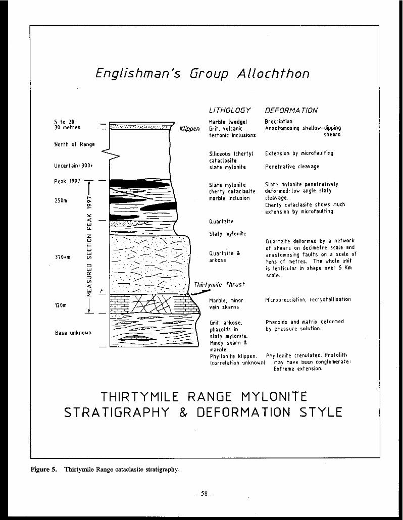
Englishman's Group Allochthon
LITHOLOGY DEFORMA TION
5 to 20 Marble lwedgel Brecciation 30 metres '.': : .. ·.· · .. ·:. ·. :·~ .... : .... ;· : ·. :·· :·. Klippen Grit, volcanic
tectonic inclusions Anastomosing shallow-dipping
shears
North of Range
Uncertain: 300+
Peak 1997 -l ..... "' 250m "' ~ "' <( UJ Q.
z Q I-u UJ Vl 370+m
D UJ er :::> Vl <( UJ L l:
120m _!
Base unknown
THIRTY MILE STRATIGRAPHY &
Figure 5. Thirtymile Range cataclasite stratigraphy.
Siliceous lchertyl cataclasite slate mylonite
Slate mylonite cherty cataclasite marble inclusion
Q.uartzite
Slaty mylonite
O.uartzite & arkose
Thirtymi/e Thrust --Marble, minor vein skarns
Grit, arkose, phacoids in slaty mylonite. Mindy skarn & marble.
Extension by microfaulting
Penetrative cleavage
Slate mylonite penetratively deformed: low angle slaty cleavage. Cherty cataclasite shows much extension by microfaulting.
Quartzite deformed by a network of shears on decimetre scale and anastomosing faults on a scale of tens of metres. The whole unit is lenticular in shape over 5 Km scale.
Mier ob rec ci a tio n, re er y stall is ation
Phacoids and matrix deformed by pressure solution.
Phyllonite klippen. Phyllonite crenulated. Protolith (correlation unknown] may have been conglomerate:
Extreme extension.
RANGE MYLONITE DEFORMATION STYLE
- 58 -

YG YG
MINDY DDH4 ,f SAWN BO. CORE
CC =Calcite Px =Pyroxene
36.5mm diameter
BG =Brown garnet G =Green landradite) garnet YG =Yellow garnet Aspy=Arsenopyrite
ORK AREA 424235 COMPARISON OF CATACLASTIC TEXTURE 0 100
mm
POLISHED SLAB
IN BRECCIATED, SHEARED MARBLE AT THE ORK AUREOLE WITH SKARN FROM THE MINDY PROSPECT.
T.l1Yericn, March 1990
Figure 6. Cataclastic texture in marble, Ork aad Mindy Showings.
mylonites, this one shows considerable small-scale shearing. A low aagle pressure solution (PS) cleavage is visible in places.
Unit B. This sequence adjacent to the Mindy prospect consists of mylonitic, silty metasediments containing clasts and phacoids of quartzite and arkose from a few centimetres to several metres across. In outcrop, the dominant foliation is a metamorphic pressure-solution cleavage which dips at a shallow angle. The only evidence of bedding is grading in the disrupted sandy layers, which is recogniz.able in thin section and oriented at a few degrees to the PS cleavage. One major and several minor rnarble/skam layers occur in Unit B at the Mindy prospect. The main mineralized (lower) skarn varies considerably in thickness along strike, as indicated by diamond drill hole intersections, and appears boudinaged on a scale of several hundred metres. This marble may not correlate with either the major carbonate unit to the northwest or the minor marble unit found about 750 m to the west.
Unit C. Below Peale 1997 in the main range (UTM Coordinates 443248), quartzite which possibly correlates with
unit (A) is overlain by thick white calcite marble. The marble consists of totally recrystallized calcite grains 2 to 5 mm in size, and lacks sedimentary structures. A section measured down the northeast spur of this peak traversed a true thickness of 120 metres. Cliff exposures on the north side of the peak reveal that the marble is extensively brecciated down to a centimetre scale. Exposures west of the Ork prospect show a striking cataclastic texture (Fig. 6). Minorwollastonite-veined skams are developed within the unit. The cliff exposure north of Peale 1997 shows a strong, nearly horizontal foliation developed in a 3 m thick diopside-rich zone at the top of the marble, and chevron folding in the lowest metre or two of overlying quartzite. These features are inferred to indicate a thrust faulted contact which postdates the main cataclasis of the Englishman's Group. To the west, a fault truncates the top of the marble at a moderate angle and the marble thins rapidly toward the south.
Unit D. This consists of 290 m of massive quartzite, overlain by 80 m of intercalated quartzite and slate mylonite. The quartzite is brecciated and cut by small shears spaced every few decimetres throughout the succession. The slaty rocks are
- 59 -

0 UTM rr. CiRIO
PORPHYRY
THIRTYMILE
Figure 7. Facies map of the Thirtymile stock.
mylonitic and have a chaotic cleavage or foliation which shows abrupt variations in dip up to 30". The attitude of this foliation is not reflected in the sheet dip of the lithologic units: the tectonic cleavage is likely deflected around phacoids of more competent rock, which are on a scale of tens of metres.
Unit E. Above unit D, some 240 m of intercalated massive chert, cherty mylonite and slate mylonite are exposed on the northeast spur of Peak 1997. A five-metre thick tectonic slice of marble exposed on the spur 80 metres northeast of the peak is also assigned to this unit. On the northwest spur, the thickness of individual "chert" units varies from JO to 105 metres. A marble/calc-silicate hornfels unit 4.5 km northwest of the peak occurs in a possibly equivalent chert/mylonite sequence.
Unit F. In the northwest part of the map area (360330), slaty mylonite is overlain by a grit unit. Whether this represents a separate elastic unit structurally and stratigraphically higher than unit B is uncertain. At UTM 365329, sheared intermediate volcanic rocks form a tectonic inclusion within this grit at (365329).
0
PLUTON
Unit G. At location 350340, a thin marble overlies the grit and rapidly thickens toward the NE, from 5 m to over 20 m. East of the Mindy showing (UTM 475266 & 490247), highly deformed phyllonites overlie the Unit A quartzite. These show many open disharmonic folds on a decimetre scale, with sheet dips varying from 8' SW to 30'E between individual exposures. They are lithologically similar to the thick phyllonite sequence that outcrops west of Thirtymile Lake (105 C 15, UTM 270420) and might represent tectonic inclusions of Big Salmon Complex metamorphic rocks within the Mississippian sequence; however their position within the general mylonite stratigraphy is uncertain.
INTRUSIONS
Two granite intrusions have been mapped in the Thirtymile Range: a small poorly exposed leucogranite at the Ork prospect, and the Thirtymile Pluton, a roughly elliptical exposure 8 km across (Fig. 7). A low angle dip at the western contact of the Thirtymile Pluton suggests that the present exposures on the centre ridge may be within 400 vertical metres of the original roof. The Thirtymile Pluton is
- 60 -
considered to be an apophysis of a large batholith that may underlie the whole range. In order of emplacement, the various facies which make up the Thirtymile Pluton are:
(a) Porphyry mingled with tonalite or diorite, which exists as isolated remnants within microgranite.
(b) Microgranite (equigranular).
(c) Megacrystic granite, which forms more than half of the exposed pluton.
(d) Leucocratic topaz and fluorite-bearing microgranite, which occurs as a marginal facies in the main stock, as adjacent sills in the overlying metasediments, and forms a stock and dykes at the Ork prospect to the south (UTM 429236, 435248, 438237).
Porphyry
At the west limit of exposure in the map-area (UTM 407309) the predominant lithology is porphyritic. The texture is frequent! y dominated by euhedral to subhedral equant quartz phenocrysts, some with their margins intergrown with the grains of the groundmass. Anhedral to euhedral singletwinned perthite phenocrysts 4 to 10 mm long often occur in clusters with very little quartz between (a cumulus texture) and occasionally show rapakivi texture. Plagioclase is finer grained (2 to 4 mm), subhedral to rarely euhedral, and often shows both albite and carlsbad-albite twinning and oscillatory zoning. Rare subhedral hornblende xenocrysts, often altered to biotite and chlorite, are up to 3 mm long. Deep brown biotite, often chloritized and very ragged, forms phenocrysts up to 2 mm in size, and smaller (0.5 mm) grains in the groundmass. The micas contain some euhedral zircon inclusions and are occasionally intergrown with anhedral monazite. Occasional clusters of biotite, very fragmented hornblende (0.5 mm), monazite, pyrite and apatite are seen. Monazite is common in the groundmass as anhedral grains up to 0.8 mm, and allanite is also common, forming subhedral to euhedral crystals up to 1 mm long. Quartz and K-feldspar form the bulk of the groundmass. Quartz is the most common mineral in the groundmass, forming grains of approximately 0.5 mm across which poikilitically enclose the feldspar. The porphyry frequently contains rounded enclaves of dark grey fine grained tonalitic rock up to 0.5 metres across, which in tum enclose centimetre-sized darker rounded dioritic enclaves. Similar enclaves have been interpreted as clear evidence of magma mixing (Chandra Kumar, 1988; Vernon, 1983; Vernon, Etheridge and Wall, 1988).
East of this exposure the intrusion consists entirely of tonalite. Enclaves of tonalite are found in both the microgranite and megacrystic granite at widely separated locations, so the porphyry-tonalite body is considered to be the earliest intrusion.
Microgranite
The microgranite consists of perthite (30-40 % ), plagioclase (10-15 %) and quartz (40-55 %). The texture varies from fine grained (0.2 to 0.5 mm) to more coarse-grained and porphyritic. Chloritized, dark biotite occurs in small amounts, generally 1 % or less and rarely up to 5 % . Accessory minerals include occasional fluorite, monazite, zircon, allanite and pyrite. At the southern contact, the equigranular microgranite is red due to alteration, the feldspars are extensively sericitized and kaolinized and the micas are altered to sericite and opaque minerals. Blocks of microgranite occur in megacrystic granite near their contact.
Megacrystic Granite
This is a coarse grained facies with 6-15 mm potash feldspar megacrysts. The megacrysts are subhedral, microperthitic and often zoned, some zones being altered to a red sericite-iron oxide mixture. Plagioclase feldspars are finer grained (I to 8 mm), and show normal zoning and frequently cloudy cores. Zoning is optically distinct, and microprobe analysis indicates compositions of An5 in the groundmass and a variation from An47 in the cores of quartz phenocrysts to An28 in the rims. Quartz is usually anhedral and occurs in phenocrysts up to 5 mm across. Deep red-brown biotite flakes up to 2 mm across have very ragged margins and often contain numerous apatite inclusions and very fine grained zircons surrounded by pleochroic halos up to 0.05 mm across. Biotite forms occasional pseudomorphs after hornblende also occurs as clusters up to 4 mm diameter. Groundmass crystals 0.5-l mm in size make up less than 50% of the rock. Accessory minerals include apatite, monazite, zircon, allanite (occasional 2· mm euhedral crystals) and, less commonly, pyrite and interstitial topaz or fluorite. Alteration is ubiquitous, but is limited to slight kaolinization of feldspars, particularly perthite. Mineral proportions vary from: perthite 30-40 % ; plagioclase 20-10 % ; quartz 40-45 % and micas < 1 to 5 % . Occasional centimetre-sized miarolitic cavities containing quartz and tourmaline occur close to the margins of the pluton.
Leucocraticzinnwaldite-topaz-fluoritehearingmicrogranite
This rock has a striking texture: equant quartz phenocrysts 2 to 4 mm across octur in a groundmass dominated by 1 mm subhedral to euhedral plagioclase. Some plagioclase crystals are poikilitically enclosed in quartz. At some localities, perthite feldspar predominates in the groundmass. Between 1 and 15 % of the rock consists of pale lithium mica, which is present as anhedral, often skeletal phenocrysts 1 to 4 mm across. Accessory minerals are rarely included in this mica. Proportions of the other minerals vary greatly between localities (K feldspar 10 to 50 % , plagioclase 60 to 30 % ). Topaz is a common interstitial mineral and may constitute 3 % of the rock by volume. Fluorite is also common in this facies. Schorl, apatite and allanite are occasional accessories.
61 -

Surprisingly, the K-feldspar is the only mineral showing slight alteration. Where they form sills, (as at 421279), rocks of this facies show a preferred orientation of plagioclase laths (flow banding). Although no intrusive rocks are evident on the east side of the Thirtymile Range at the Mindy prospect, rocks of this facies are the probable source of the fluorine in the skarns.
Greisens, miarolitic cavities
At the southeast corner of the Thirtymile stock the microgranite is cut by greisen veins up to 1 cm wide and spaced about 10 cm apart. The greisen veins consist of topaz, quartz and zinnwaldite. Miarolitic cavities up to 0.5 metres long were observed in the adjacent small body of leucocratic micro granite.
Lamprophyres
One hornblende lamprophyre dyke a few metres wide cuts homfels at the southwest contact of the main stock (392290).
Ork Stock
The intrusion in this region resembles the leucocratic topaz-bearing microgranite of the Thirtymile Stock to the north. Four exposures were sampled between the contact and a point 250 metres to the north. The northernmost exposure shows a texture characterized by subhedral equidimensional quartz phenocrysts of 2-4 mm across, and finer (0.5 mm) albite which makes up about 40 % of the rock by volume. Ragged anhedral grains of pale (lithium?) mica enclose the smaller feldspars and make up less than 2 % of the rock.
Closer to the contact the intrusion is slightly finer grained (1 - 3 mm) and contains less quartz (30%). Both potash feldspar (45%) and albite (25%) are evident, but only occasional mica phenocrysts are present. A few crystals of topaz were noted in a specimen taken from the contact. The contact with the calc-silicates is very sharp and can be seen on the scale of a thin section. Both potash feldspar (50 % ) and al bite ( 40 % ) are found within 3 cm of the calc-silicate contact.
In the contact zone, fine-grained untwinned plagioclase feldspar with fluorite occurs both interstitial to and included in the feldspars over a 2 cm width, forming a possible endoskam. Zircon is present as occasional tiny euhedral crystals. Included in the fluorite are nordenskioldine (?) and tiny, high relief inclusions producing brilliant purple haloes. Titanite was identified in thin section in the fluorite zone. The presence of crystals which fluoresce under ultraviolet light suggests that some of the titanite is be the malayaite variety. Massive vesuvianite occurs in 10 mm long crystals which include some fluorite. A few millimetres of fibrous cebollite (normally an alteration product of melilite) mark the transition to coarse marble (8 mm grain size), occuring within half a metre of the contact. Also found at the contact are two-metre wide pegmatite dykes consisting of 20 cm green orthoclase
microperthite with coarse violet rmca (zinnwaldite?) and quartz.
West of the exposed granite is a cliff exposure of two cataclastic marble layers separated by aphanitic calc-silicate homfels. The hornfels has abundant vertical fractures filled with axinite crystals up to 20 mm long. The upper carbonate is a sheared breccia with grey calcite phacoids with carbonate pressure shadows surrounded by diopside marble. In the lower marble unit, epidote and axinite have developed around many of the calcite clasts.
Three smaller topaz-bearing aplite bodies occur northeast and east of the "Ork" contact. Based on limited outcrop, these appear to be dykes 5 to JO metres wide. The easternmost dyke lies immediately above (north of) tin-tungsten soil anomalies reported by the JC Syndicate.
STRUCTURE
(1) Thrust Faults.
The upper surface of marble unit (C) is at least partly bounded by a low-angle thrust fault. This structure may be gently warped and correspond to a fault underlying a klippe of phyllonite at location UTM 475266. Many other low angle faults probably exist, but the mylonite stratigraphy does not permit these to be traced.
(2) Extensional faults.
Figure 3 shows steep east to northeast-trending faults, probably extensional, which cut the entire sequence but usually show vertical displacements of less than 50 metres. Good field evidence exists for many of the faults shown, the remainder being inferred from airphoto interpretation. Only one fault noticeably offsets the granite facies, and some are traceable as zones of close-spaced joints extending into the intrusion. It is suggested that the faulting immediately preceded intrusion of the granite.
Where the southernmost of two east-west faults is exposed immediately northwest of the Mindy showing (UTM 459240) is exposed, carbonate breccia is locally converted to diopsidepyrrhotite-(scheelite) skam, indicating that the fault zone has acted as a conduit for hydrothermal fluids.
The thick marble unit (C) is partly or completely bounded to the west by a fault dipping about 45°SW (UTM425232). The north-south faults are probably related to granite emplacement.
At the Mindy prospect, micro-faulting abounds: nearvertical normal fitul ts cut the upper skam every few metres. Most of the faults are downthrown to the west a few centimetres to a metre.
(3) Fields The outcrop pattern of the major lithologic units indicates
a gentle warping of the mylonitic sequence with sheet dips of up to ten degrees. Small-scale structures suggestive of later folding are not evident.
62
MINERALIZATION
The Mindy Prospect, UTM 463237 (MINFILE toSC 054)
Although granite is not exposed at surface, it probably occurs at a shallow depth below the Mindy showing. An exotic skam mineralogy is present. Fig. 8 shows the outcrop geology of the Mindy prospect, and a longitudinal section through it. Two skam/marble horizons occur in outcrop. An upper unit of calc-silicate homfels and skam about 2 m thick is exposed in a cliff. The hornfels shows alternating bands of birefringent, sector-twinned red grossular garnet and diopside grading to a central skam of massive garnet with coarse vesuvianite. The coarse skam contains scheelite crystals up to 5 mm across (visual estimate <0.3 % W03). The exposures show abundant metre-spaced, small-scale, extensional faults with 10-50 cm of movement, downthrown to the southwest. Thin sections show fracturing normal to the layering and some re-crystallization of the fracture cleavage fabric is evident. The upper horizon is considerably more aluminous than the pure calcite marble of the lower horiwn (maximum values of 0.13% MgO, 0.65% FeO and 3.30% MnO were obtained from microprobe analyses of calcite from the lower layer). Kwak (1987) classified such skarns as bimetasomatic, implying transfer of Al and Si from surrounding pelite, and Ca in the opposite direction, across an original limestone/pelite contact.
The lower skarn-marble horizon is up to 15 metres thick in surface exposures and can be traced discontinuously along strike in exposures and float for 1100 metres (see Fig. 8). From south to north the skam mineralogy changes as follows:
( 1) Di opside-actino Ii te-humi te-fl uori te-pyrrhoti te exposure).
(surface
(2) Massive marble with vein skarns of pale brown garnetarsenopyrite and green (pure andrandite) gamet-diopsidefluoborite. In diamond drill core the marble is tectonically thickened to 80 metres and contains prograde vein skams up to a metre thick. The massive marble consists of wollastonite ± garnet and the vein skams consist mainly of andradite-arsenopyrite.
3) Massive magnetite-diopside-vesuvianite-gamet-epidotecassiterite-pyrrhotite-chalcopyrite skam, with highly variable proportions of the above minerals. This skam contains several rare borates:
vonsenite a Fe+ 3 (Fe-,- 3 ,Sn+ 4 )02 B0 3 to Mg2(Fe+3,sn+4)02.B03 series, hulsite - a Mg,(Fe+3,Sn")B04 to Fe"(Fe~2,Sn+ 4)B05 series, and fluoborite - Mg3B03(F, OH),.
Other borate minerals have yet to be positively identified. (Surface exposure and diamond drill core: see Fig. 9).
4) Impure marble with bands of diopside-pistaciteclinozoisite-scapolite (surface exposures).
The skarns comprise prograde pyroxene-andradite or calcite-scapolite rich assemblages which have been replaced by actinolite, then later by phlogopite- or epidote/chlorite-rich retrograde skarn containing significant tin. The mineralized assemblages show successive replacement by magnetite, fluorite, cassiterite, vonsenite and hulsite then fluoborite. Magnetite-rich sections have a very low sulphide content.
Between and below the skams, a succession of metresized phacoids of grit and subarkose occur in a pelitic matrix, intercalated with cherty cataclasite. Jn outcrop, bedding is obliterated by pressure solution cleavage, but can it be recognized in thin section from grading, and lies at a low angle to the flat-lying cleavage. Cleavages in some of the sandy layers show some recrystallization, indicating that the cleaveage formed prior to thermal metamorphism. Cordierite is developed in pelitic layers.
Two types of significant microstructures are recognized: pervasive pressure solution stripes in the pelite and quartzite, which cut the shailow-dipping (up to 15°) lithologic contacts at a low angle, and less common, steeply-dipping fractures containing fluorite and tounnaline which cut brecciated quartzite below the lowest skarn. The low-angle cleavage is related to regional mylonite formation (c.f. Byrne, 1984: S2). The steeply-dipping fractures are believed to be related to the high-angle east-west extensional faults, which probably formed the conduit for metasomatizing and mineralizing fluids at the Mindy prospect.
In Australia, Kwak and Askins (1981) demonstrated that quartz-cassiterite lodes may exist beneath skarn tin deposits, provided there is adequate vertical separation between the granite contact and the skam. There appears to be good potential for drill targets of this type beneath the Mindy prospect. Newmont's drill logs from the Mindy prospect (Nebocat and Oneschuck, 1981) described several "bleached zones" in silty mylonite above the lower skam, and bleaching can still be seen around fractures in surviving remnants of the core. Kwak (1987) attributed such bleaching of graphitebearing sediments above skams to oxidation of the sediment by rising CaC1 2 rich solutions associated with skam formation.
Diamond drill core (hole 4) shows a phacoid of calcite marble surrounded by diopside skarn, and 1nassive andradite where the foliation curves around it. Away from the phacoid, wollastonite layers define the foliation. A strikingly similar texture is seen in sheared, brecciated marble at the Ork aureole, where calcite-rich phacoids occur in a more magnesian matrix (UTM 425234)(Fig. 6). The textural evidence suggests that at least some of the magnesian skarns at Mindy may reflect the chemistry of the marble after the layers were dismembered and redistributed by cataclasistic processes. Formation of the main skam minerals then required only the addition of silica, and in places iron.
Table I shows that prograde skam pyroxenes have variable MgO/FeO ratios but are predominantly diopside.
63 -

0 100 Dots indicate skarn float TARN
METRES
4 5 8 7
/1 LONGITUDINAL SECTION FACING SE
MINDY PROSPECT
Figure 8. Geology of the Mindy prospect.
- 64 -
MINDY Upper skarn outcrop at UTM 464239
R.L. 1575
A'
6_J
0 100
METRES

Mineralized skarns have erratic MgO/FeO ratios on a centimetre scale, and pyroxene compositions range from diopside to ferrosalite, reflecting iron introduction during mineraliz.ation. Garnets (table 2) are andradite and vary only in iron and manganese content. No significant amounts of MgO or A1 20 3 were noted. Skarn mineral paragenesis is summarized in Table 3.
DISCUSSION:
Granites
Four gramt1c facies were observed: porphyryldiorite, even-grained microgranite, megacrystic biotite granite and highly leucocratic topaz-fluorite granite. The globular mafic enclaves noted in the porphyry facies are considered clear evidence of magma mixing early in the intrusion process. The porphyry could represent remnants of a linear intrusion controlled by an east-west extensional fault that preceded the main granite emplacement. The model for tin granites proposed by Plimer (1987) involves passive introduction of water-poor magma in regional extensional shear zones, and the formation of a pressure-quenched carapace which allows internal crystalliz.ation of the intrusion. Fluid release by hydro-fracturing and repeated hydrothermal activity introduces mineralization to the aureole and causes the development of porphyritic textures and oscillatory zoning of feldspars in the outermost phase of the pluton. Such features are characteristic of the Thirtymile stock.
The low angle of the intrusive contacts around the Thirtymile stock indicates that roof of the pluton may lie less than a few hundred metres below the central ridge of the Thirtymile Range. The leucocratic facies may therefore represent a highly differentiated facies in the roof of a cupola.
A metasomatic subsolidus origin was proposed by Stone and Exley (1985) for fluorine-rich granite in the Cornubian Batholith. However, such a concentration of fluorine in Thirtymile Stock can be explained by extreme differentiation. This would be consistent with the occurrence of the fluorinerich facies as frequent small sills and dykes. The occurrence of biotite mostly as interstitial grains, as in the microgranite and megacrystic facies, is cited by Plimer (1987) as evidence of high fluorine fugacity. Future research will investigate whole rock major and trace-element chemistry, and the mica chemistry of the various facies, particularly with regard to the elements Mg, Li, Fe2+, Fe3+, Cl, F, and Sn. The degree of specialization of the facies and the tin content in the granite will also be examined (see Henderson and Martin, 1989; Scott, 1988).
Skarn Mineralogy
The classification of Sn and W skarns by Kwak (1987) can be applied to the skams in the Thirtymile Range. The following features of Kwak's type II-2a skams are relevant to the Mindy skams:
(a) Tin skarns can be both magnetite and silicate-rich if associated with high B and F.
(b) Tungsten and most tin skarns have high pyrrhotite to pyrite ratios.
(c) There is no correlation between the tin content of skams and the magnetite or sulphide content. However, if a magnetite-rich assemblage does occur, it hosts 75% of the tin.
(d) Tin and tunsten show an inverse relationship. The upper skarn at the Mindy deposit contains scheelite but no tin minerals and would conform to Kwak's magnesian bimetasomatism type (type II) as it grades from massive vesuvianite skam through garnet to calc-silicate hornfels and petite. Kwak also noted that the type of Fe-bearing skam minerals formed varies with oxygen fugacity. Where an early, oxygen-rich fluid, presumably derived from a magnetite series granite interacts with graphite-free marble, an andradite garnet skarn is the result. If oxygen fugacity is low due to reduction of the fluid by graphite, a Ca-Fe pyroxene and either grossularite or anorthitic plagioclase is formed. In the main carbonate/skam section of the Mindy prospect, where the original carbonate was mostly pure calcite, prograde andradite (vein) skarns are found. At the northern limit of exposure, where relict carbonates are almost black, a more varied mineralogy has resulted. K wale (1987) also noted that if the original sediments contain graphite, the reduction of fluids released during skam formation produces bleached zones. In the upper Mindy skarn, where thin carbonate layers are tectonically interlayered with pelitic cataclasites, bleaching occurs adjacent to cross-cutting veins, indicating oxidation by fluids exhausted by the metasomatism.
Based on Kwak's table of mineral assemblages (Kwak, 1987: table 8.2) the Mindy deposit belongs to the oxidized magnetite type. The retrograde borate-rich skarn assemblages of the mineralized lower horizon possibly reflect a magnesian marble protolith in that limited area.
Extensional Faulting
The Mindy prospect lies immediately south of an eastwest fault. This fault probably controlled the mineralization by providing a conduit for fluid rising from the buried pluton. Continued tectonism during contact metamorphism probably allowed the operation of a continuous crack-seal mechanism described by Bucher-Nurminen (1989), and minerals were deposited along small-scale fractures. This hypothesis is supported by the following evidence:
(a) An exposure of the east-west fault on the ridge 750 m west of Mindy tarn shows a calcite breccia partly replaced by pyroxene and mineralized with pyrrhotite and
- 65 -

FIELD LOG Mylonite with folded quartz layers
Pink & green C.S.H.F. Fractured LS.H.F.
Diopside skarn - some actinolite rich sections. Dissem. Aspy
41 OS 4141
from 48.73 - 48.79 so 12
White C.S.H.F. - tourmaline in tiny fractures, Po in 5 - 30mm selvedges. Some 20cm diopside skarn bands 5145
Vesuvianite - diopside - calcite skarn with irregular garnet masses over 1Scm intervals. Some 4mm Po blebs
SAMPLES
47.07 - 47.60
MINERALOGY ASSA Y,Sn (Newmont)
:: 47.67 - 47.74 Scapolite. salite to ferrosatite, chlor., epidoh!
• 41.73 - 41.79
- 50.24 - 50.30
= 50.94 - 51.10 / - 51.55 - 51.62
Diopside, fluoborite Anorthite, chlorite, diopside to salite & actinolite veins
- 54.14 - 54.20 Px undetermined calcite fluoborite
60.20 ~ 0 --=~
- 59.61. - 59.71 • 60.DO - 60.011 - 60.50 - 60.57
Ferrosalite, calcite, andradite Andradite, Px undetermined, calcite, fluoborite
Pale green diopside skarn 0.5 - lmm grainsiz@. Some 1cm garnet bands
Oiopside skarn to Bmm grainsize,
62.60
"me zoned 8mm garnet'. {
3::l~:ijiii@Skarn Brecciated
mm 64.60
Pure white, massive marble O.Smm grainsize
67.35 67.8)
White to green C.S.H.F. 7'-· 65
Haematite veins, hulsite - ma,g.c__J,.s"'.6"-5
Marble
Magnetite veining Pale green CS.HJ.
Diopside - calcite skarn with garnet masses to 10mm.
Vesuvianite (10mm crystals] from 81.75 - 82.40
71.28
79.25
- 61.00 - 61.05
.. 62.12 - 62.11 - 62.60 - 62.70
Diopside to salite
Coarse diopside to salite
- 63.86 - 63.93 Coarse andradite, calcite, diopside to salite "" 64.07 - 64.11
) = 64.70 - 64.79
~ Q - 66.80 - 66.117
- 67.JS - 67.46 Magnetite, diopside
713 -
- 74.5
- 75.07 - 75.14
= 77.20 - 77.30
,. 78.211 - 78.32 - 711.67 - 78.72
+ - 19.66 - 79.70
-i.. • ID.SS - ID.64 Oiopside
X • 11.45 - 111.53 Vesuvianite, diopside, calcite veining i-
Mylonite cherty appearance 8166 ).. =•m_,..,,Fig. 7
MINDY DOH 81-3
Figure 9. Field and drill section through the Mindy prospect.
- 66 -

scheelite, indicating fluid transfer up the fault to a level some hundreds of metres higher than the Mindy.
(b) Cherty mylonite in the deepest drill core from Mindy shows fractures mineralized with pyrrhotite or tourmaline and fluorite, which cut the near horizontal pressure solution fabric at a steep angle.
(c) The gamet-vesuvianite skam is highly fractured in places, indicating hydraulic fracturing probably followed primary skam development.
(d) Many small, zoned retrograde skam veins are developed along fractures in the marble.
CONCLUSIONS
The Thirtymile Range consists of cataclasites derived from Middle Palaeozoic to Mesozoic siliciclastic and carbonate sediments which have been deformed by:
(1) cataclasis and transposition in broad shear zones.
(2) low angle thrust faulting, the full extent of which is unknown.
(3) high-angle extensional faults striking east-west, which predate the emplacement of mid-Cretaceous granitic plutons. Some movement appears to have continued during emplacement of the granite.
(4) moderate-angle normal faults striking north-south, which appear to be contemporaneous with granite emplacement.
Skams formed in the aureoles of the granites contain tintungsten-boron-fluorine mineralization. Carbonate units (mega-boudins) in the cataclasite sequence formed a stratigraphic control on the location of mineraliz.ation.
Extensional tectonics are believed to have controlled the granite emplacement and provided the conduits for movement
of tin- and tungsten-mineralizing fluids in the overlying sediments. Small-scale movement on the faults continued during mineralization, allowing successive mineralization of steeply dipping veins in carbonate megaboudins by a fracturereaction-seal mechanism. Tin and tungsten-bearing stockworks may well exist within the extensional fault systems.
On the east side of the Range, at the Mindy prospect (MINFILE IOSC 054), very coarse skam is developed with a highly variable mineralogy. Boron and fluorine are associated with the later stages of mineralization. Scheelite is confined to the upper (bimetasomatic) skam unit, and the first retrograde sk~m assemblage at the southwest limit of the main skam, where no tin is evident. There is clearly an inverse relationship between the occurrence of W and the occurrence of Sn.
On the west side of the range, homfels more than 100 m thick is sporadically developed in cataclastic dolomite but coarse skam is absent. At the Ork prospect (MJNFILE 105C 38), boron occurs as axinite along micro-fractures in the homfels, and fluorine occurs as fluorite at the granite contact. The JC syndicate documented, but did not adequately test, geochemical anomalies in the Ork area. The 100 metre thick carbonate section which overlies the "specialized" granitic stock is mostly covered by glacial drift and appears to have excellent exploration potential for tin and tungsten deposits.
ACKNOWLEDGEMENTS
The Exploration and Geological Services Division of the Department of Indian Affairs and Northern Development provided the majority of helicopter time and other support for this fieldwork. Encouragement and useful discussion were provided by J;G. Abbott, S.R. Morison, T. Bremner and J.A. Morin. Supervision has been provided by Dr Ken McClay and Dr D.H.M. Alderton. Much assistance was given by Dr A. Hall, Dr G. Marriner, Ian Gill and Grahame Lawes at the Royal Holloway and Bedford New College, University of London.
REFERENCES
ARMSTRONG, R.L., 1988. Mesowic and early Cenowic magmatic evolution of the Canadian Cordillera. In: Clark, S.P., Burchfiel, B., and Suppe, J., (eds), Processes in continental lithospheric deformation. Geological Society of America Special Paper 218.
BUCHER-NURMINEN, K., 1989. Reaction veins in marbles formed by a fracture-reaction-seal mechanism. Eur. Journal of Mineralogy, Vol. 1, p. 701-714.
BYRNE, T., 1984. Early deformation in melange terranes of the Ghost Rocks formation, Kodiak Islands, Alaska. In: Raymond, L.A. (ed.), Melanges: their nature, origin and significance. Geological society of America, Special Paper 198, p. 21-51.
CHANDRA KUMAR, S., 1988. Microgranular enclaves in granitoids: agents of magma mixing. Journal of Southeast Asian Earth Sciences, Vol. 2, p. 109-121.
- 67 -

CHAPPEU, B. W., WHITE, A.J.R. and WYBORN, D., 1987. The importance of residual source material (restite) in granite petrogenesis. Journal of Petrology, Vol. 28, p. I I I I-I 138.
DAWSON, K.M. and DICK, L.A., 1978. Regional metallogeny of the Northern Cordillera: tungsten and base-metal bearing skarns in southeastern Yukon and southwestern MacKenzie. In: Current Research, Part A; Geological Survey of Canada, Paper 78-IA, p. 287-292.
DIDIER, J., I 987. Contribution of enclave studies to the understanding of origin and evolution of granitic magmas. Geologische Rundschau, Vol. 76, p. 41-50.
GORDEY, S.P., 1981. Stratigraphy, structure and tectonic evolution of Southern Pelly Mountains in the Indigo Lake area, Yu/am Territory. Geological Survey of Canada; Bulletin 318, 44 p.
HENDERSON, C.M.B. and MARTIN, J. S., I 989. Compositional relations in Li-micas from S. W. England and France: an ion- and electron- microprobe study. Mineral Magazine, Vol. 53, p. 427-449.
KWAK, T.A.P., 1987. W-Sn skarn deposits and related granitoids. Developments in Economic Geology, Vol. 24, Elsevier, 451 p.
KWAK, T.A.P. and ASKINS, P. W., 1981. Geology and genesis of the F-Sn-W (-Be-Zn) skarn (wrigglite) at Moina, Tasmania. Economic Geology, Vol. 76, p. 439-467.
KWAK, T.A.P. and NICHOLSON, M., 1988. Szaibelyite andfluoboritefrom the St. Dizier Sn-borate skarn deposit, NW Tasmania, Australia. Minetal Magazine, Vol. 52, p. 713-716.
KWAK, T.A.P. and TAN, T.H., 1981. The geochemistry ofwning in skarn minerals at the King Island (Dolphin) mine. Economic Geology, Vol. 76, p. 468-497.
MUUIGAN, R., 1963. Geology of Tes/in map area, Yukon Territory. Geological Survey of Canada Memoir 326, 96 p.
NEBOCAT, J., 1981. Unpublished drill logs and assessment report, Newmont Exploration of Canada Limited.
PL/MER, F.R., 1987. Fundamental parameters for the formation of granite-related tin deposits. Geologische Rundschau, vol. 76, p. 23-40.
RAYMOND, L.R., 1984. Melanges: their nature, origin and significance. Geological Society of America, Special Paper 198, 170 p.
SCOTT, K.M., 1988. Phyllosilicate and rutile compositions as indicators of Sn specialization in some southeastern Australian granites. Mineralium Deposita, Vol. 23, p. 159-165.
STONE, M. and EXLEY, C. S., 1985. High heat production granites of southwest England and their associated mineralization: a review. In: High heat production (HHP) granites, hydrothennal circulation and ore genesis; Institute of Mining and Metallurgy, London, p. 571-593.
1EMPELMAN-KLUIT, D.J., 1979. Transported cataclasite, ophiolite and granodiorite in Yukon: evidence of arc-continent collision. Geological Survey of Canada, Paper 79-14,. 27 p.
VERNON, R.H., 1983. Restite, xenoliths and microgranitoid enclaves in granites. Journal and Proceedings of the Royal Society of New South Wales, Vol. 116, p. 77-103.
VERNON, R.H., ETHERIDGE, M.A. and WAU, J. V., 1988. Shape and microstructure ofmicrogranitoid enclaves: indicators of magma mingling and flow. Lithos, Vol. 22, p. 1-11.
- 68 -

TABLE 1: PYROXENE ANALYSES (Microprobe).
The range shown is for the lowest and highest silica analyzed in the one thin section. The number of analyses per section is shown in brackets.
(1) Pyroxene-dominated skarns with little or no mineralization:
DIOPSIDE TO SALITE PYROXENE:
SAMPLE SIO, Cao MgO FeO MnO
50.94 (4) From 55.4 26.3 16.5 1.8 0.5 to 55.l 25.6 15.7 2.2 0.2
61.00 (6) From 55.9 26.5 15.8 2.5 0.3 to 52.4 25.4 9.1 12.6 1.3
62.12(8) From 55.8 26.7 15.7 1.9 0.3 to 53.0 25.3 9.5 11.4 1.5
67.35 (4) From 55.9 26.3 15.7 1.8 0.5 to 54.6 26.7 15.4 2.8 0.6
80.55 (13) From 56.4 26.7 16.2 1.2 0.2 to 54.9 26.5 15.2 2.7 0.4
81.45 (16) From 56.7 27.2 16.3 to 55.3 26.9 16.3 I.I 0.2
(2) Skams with mostly garnet or retrograde assemblages and significant mineralization:
SALITE TO FERROSALITE PYROXENE:
47.67 (4) From 52.8 24.7 10.2 9.8 1.0 to 51.5 24.1 6.6 17.0 1.2
51.55 (4) From 56.l 26.l 15.9 1.5 0.4 to 54.6 25.9 12.3 6.7 0.6
52.05 (I) 51.9 22.7 9.1 15.0 I.I 59.64 (2) From 52.l 24.3 6.5 15.5 2.5
to 51.0 24.5 6.1 16.9 2.2 63.86 (7) From 54.9 27.1 14.8 1.6 0.4
to 53.4 25.1 12.0 7.5 1.8
TABLE 2: GARNET ANALYSES (Microprobe)
ANDRADITE:
59.64 (2) From 38.l 35.4 0.0 17.1 . 1.4 to 38.1 35.I 17.2 1.2
60.00 (11) From 38.0 34.7 21.7 1.3 to 37.0 34.7 22.6 0.8
63.86 (I) 37.0 34.l 25.9 0.7
- 69 -

TABLE 3: SKARN MINERAL PARAGENESIS
Stage I 2 3a
Pyroxene Gamet Vesuvianite Sea polite Calcite Feldspar Actinolite Chlo rite Epidote Axinite Magnetite ------?-----Pyrrhotite Chalcopyrite Arsenopyrite Cassiterite Fluorite Vonsenite Hulsite Fluoborite Szaibelyite
1 = Primary (prograde) skam, including vein skams. 2 = First retrograde skam 3a = Hydrous retrograde alteration 3b = Main tin mineralization 3c = Late fluorine mineralization
- 70 -
3b 3c

A PLIENSBACHIAN SUBMARINE SWPE AND CONGWMERATIC GULLY-FILL SUCCESSION:
RICHTHOFEN TO CONGWMERATE FORMATION TRANSITION (LABERGE GROUP), BRUTE MOUNTAIN, YUKON
John R. Dickie Centre for Marine Geology,
Dalhousie University Halifax, Nova Scotia
B3H3J5
and
Frances J. Hein Geology Deparbnent University of Calgary
Calgary, Alberta T2N 1N4
DICKIE, J.R., and HEIN, F.J., 1992. A Pliensbachian submarine slope and conglomeratic gully-fill succession: Richthofen to Conglomerate Fonnation transition (Laberge Group), Brute Mountain, Yukon. In: Yu/am Geology, Vol. 3; Exploration and Geological Services Division, Indian and Northern Affairs Canada, p. 71-86
ABSTRACT
The diachronous Richthofen-Conglomerate Formation transition separates lithostratigraphic subunits of the Jurassic Laberge Group, Whitehorse Trough. The contact is superbly exposed on the west flank of Brute Mountain, south-central Yukon. This succession of Pliensbachian marine shales, sandstones and conglomerates records submarine gully and slope apron progradation. Distal prodelta shales and sandstones, cong/omeratic chute/gully fill sequences, slope shales and slope conglomerates were deposited from the Middle Pliensbachian to the Early Toarcian.
Submarine chutes fed coarse elastic detritus past the shelf-break and across the slope. Ponding of coarse-grained mass flows built an onlap wedge against the slope.followed by deposition of mud turbidites and pelagic sediments. A rise in relative sea level continued during the deposition of the entire succession, suggesting the intercalated sequencefonned as a result of variations in the rate of elastic input. The Brute Mountain succession is entirely of deep marine origin, typical of Laberge Group exposures elsewhere in the Whitehorse Trough.
Collision between the allochthonous Lewes River Arc and the cratonic margin of North America occurred during the Late Triassic. The final stages of convergence led to closure of the Whitehorse Trough seaway in the Middle Jurassic. Laberge Group strata record this closure. Brute Mountain exposures of late Early Jurassic age indicate that deep basin conditions existed at least into the Toarcian. Slope turbidite and pelagic sedimentary rocks place additional constraints on the timing of arc-continent collision. Significant shoaling of the Whitehorse Trough seaway apparently did not occur until after deposition of the Brute Mountain sequences.
RESUME
La transition diachrone de la formation de Richtofen a lafonnation de Conglomerate separe des sousunites lithostratigraphiques du groupe jurassique de Laberge dans la depression de Whitehorse. Le contact est magni.fiquement mis a nu sur le jlanc occidental du mont Brute dans la partie mbidionale centrale du Yukon. Cette succession de shales, de gri!s et de cong/omerats marins du Pliensbachien revi!le la pro gradation sous-marine de ravins et d 'une plaine alluviale. Des shales et des gri!s prodeltarques distawc, des sequences de comblement cong/omeratique d'entailles et de ravins, des shales de talus et des conglomerats de talus ont ete deposes du Pliensbachien moyen au Toarcien precoce.
- 71 -

Des emailles sous-marines acheminaient des debris clastiques au-delil de la rupture de pente et sur le talus. L 'accumulation d'ecoulements en masse de granulometrie grossiere a construit un biseau d'aggradation contre le talus apres quoi ii ya eu depOt de turbidites vaseuses et de sedimems pelagiques. Une elevation du niveau relatif des mers s 'est poursuivie pendant le depot de toute la succession, ce qui suggere que la sequence intercalee dolt sa formation a des variations des taux d 'apport en materiaux detritiques.
Le succession du mont Brute, entierement d'origine marine profonde, est caracteristique des a.ffleuremems du groupe de Laberge ailleurs dans la depression de Whitehorse. Les unites intercalees consistent en sequences superposees de conglomerat et de shale.
La collision de l'allochtone de l'arche de Lewes River et de la marge cratonique de l'Amerique du Nord s 'est produite au Trias tardif. Les derniers stades de convergence ont mene a la fermeture du passage marin de la depression de Whitehorse au Jurassique moyen. Cette fermeture est documentee dans les couches du groupe de Laberge. Les affleuremems datant de la.fin du Jurassique precoce au mont Brute indiquent que des conditions de bassin profond se sont prolongees au mains jusqu 'au Toarcien. Des turbidites de talus et des roches sedimentaires pelagiques limitent davantage dans le temps la collision arccontinent. fl n 'ya apparemment eu diminution importante de la profondeur dans le passage marin de la repression de Whitehorse qu 'apres le depot des sequences du mont Brute.
INTRODUCTION
Brute Mountain is situated approximately 9 km south of Carcross and 4 km east of Bennett Lake in Carcross map area (105D-2), southern Yukon. The Brute Mountain locality lies north of the southern extremity of the Whitehorse Trough in Yukon (Fig. 1). It exhibits excellent outcrop exposure of the contact between two Lower Jurassic formations of the Hettangian to Bajocian Laberge Group within the Whitehorse Trough. This Pliensbachian to Toarcian succession consists of (!)a basal 80+ m thick argillaceous unit consisting of finely interbedded greywacke and grey-black silty mudstone; (2) 208 m of thick, massive, polymictic pebble to cobble conglomerate, grading laterally to volcanic litharenite and epiclastic (tuffaceous) greywacke that interdigitates with Unit (1) along-strike; (3) an upper, 80 m thick argillaceous succession of very fmely laminated, very fme-grained sandstone and silty mudstone couplets associated with internally graded cherty mudstone; and (4) an overlying, laterally extensive sequence of massive pebble-cobble conglomerate 180 m thick (Figs. 2; 3).
An Early Jurassic age was determined from ammonite biochronozones. This, combined with its sedimentologic character, identified the Brute Mountain section as part of the Jurassic Laberge Group. In particular, the Richthofen and Conglomerate Formations of Tempelman-Kluit (1985) are represented. As part of a sedimentologic analysis of the Laberge conglomerates (e.g. Dickie and Hein, 1988; Dickie, 1989), the Brute Mountain study serves to (1) document diachroneity across the contact separating the Richthofen and Conglomerate Formations of the Laberge Group; (2) describe Jurassic deep-sea sediment mobiliz.ation and transport dynamics in terms of process and depositional environment; and (3) provide evidence for a deep Anvil Ocean (i.e. seaway between the Lewes River Arc and the Jurassic North American passive margin) prior to Middle Jurassic overriding of the cratooic margin by a volcanic arc terrane (TempelmanKluit, 1979).
Alaska
Whitehorse Trough '
Crystalline
500 Belt
Scale (km)
Figure 1. Location of Brute Mountain within the Whitehorse Trough. The Omineca Crystalline Belt, lntermontane Belt and Coast Plutonic Complex are depicted.
Brute Mountain stratigraphy and sedimentology was studied through detailed (bed-by-bed) and regional reconnaissance mapping. F acies stacking trends were tested by Harper's (1984) modified Markov Chain Analysis, involving statistical weighting of high probability facies transitions. The results were subsequently tested by the iterative proportional fitting method of Turk (1979). High probability facies sequences, thus determined, were interpreted in terms of flow mechanisms and environment. Maximum
- 72 -

Figure 2. Brute Mountain exposure of the Laberge Group. Units 1-4 are depicted, as is the intercalated margin of Unit (2) where it fines laterally from conglomerate to sandstone. Units 1 and 3 are part of the Richthofen Formation, whereas Units 2 and 4 represent the Conglomerate Formation.
particle size (MPS) and bed thickness (Bth) trends, plotted against stratigraphic height, revealed how sequences fit within larger successions (megasequences) depicting temporal flow competence variations. Moving averages of MPS and Bth data assisted in separating large (i.e. sequence and megasequence) progradation/regression trends from bed-scale perturbations.
JURASSIC WHITEHORSE TROUGH EVOLUTION
The Mesozoic Whitehorse Trough is a northwest-trending, asymmetric, remnant forearc basin (Tempelman-Kluit, 1979; Morrison, 1981; Hansen, 1987; 1988). This basin extends from northern British Columbia into south-central Yukon. Situated between the Omineca Crystalline Belt to the east and Coast Plutonic Complex to the west, the Whitehorse Trough delimits the northern extent of the lntermontane Belt of the Canadian Cordillera. Whitehorse Trough strata and allochthonous terranes to the west are separated from autochthonous North American lithotectonic assemblages in the east by the Teslin Suture Zone (Fig. 4).
Coarse-grained conglomerates and associated facies of the Early Jurassic Laberge Group record forearc evolution during the final stages of arc-continent collision. The Lewes River volcanic arc (northern Stikine Terrane?) appears to have collided initially in the Latest Triassic (e.g. Monger et al.. 1982). Basin fill characteristics of the Whitehorse Trough western belt (Wheeler, 1961) support a probable RhaetianHettangian collision (Dickie, 1989). Convergence between the arc terrane and the mioge.oclinal edge of North America was oblique (Hansen, 1987; 1988), typical of most plate collisions (Fitch, 1972). Tectonic transport of forearc slivers proceeded in the direction of the transverse component of oblique convergence (c.f. Fitch, 1972; Beck, 1983). The resulting arcward-stepping, dextral transpressive faults (Hansen, 1987; 1988) suggest that the accretionary complex abutted the continental margin, overriding the subduction trench in the process. Mechanical flexure of the basin between colliding blocks contributed to the development of the basin and longterm subsidence of the forearc.
Arc-continent collision led to tectonic incision and exhumation (uplift) of the arc plutons. Laberge conglomerate
- 73 -

180 m 4
80 'll 3
208 m 2
80 ~. + 1 ~~---'o
Figure 3. Generalized stratigraphy of the Brute Mountain section. Units 1-4 are shown (refer to Fig. 2). Ammonite biochronozones, defined from col1ections taken from organic shales, were used to define relative ages of strata.
petrographic evolution documents a progressive unroofing and dissection of the arc through a vertical decrease in volcanic clasts (e.g. basalt-andesite; saussurite; augite porphyry; agglomerate) and a concomitant increase in arc-derived plutonic clasts (e.g. megacrystic, lightly to non-foliated homblende-biotite granodiorite; pink, megacrystic quartz monzonite; quartz diorite; leucogranite) (Dickie, 1989).
SEDIMENTOLOGY OF THE BRUTE MOUNTAIN SUCCESSION
Unit (1): Lower Argillite
Argillaceous strata, consisting of non-graded sandstonemudstone couplets (Figs 5a-b; facies 4.1) and subordinate graded sequences (facies 4.2), reflect cyclic alterations offinegrained bedload (distal, lower regime hyperpycnal flows) and suspension fallout of silt and clay. Graded beds display partial Bouma (1962) sequences (Fig. 5c). T" and T"' sequences are abundant, while truncated T' and T"" sequences are less common. Graded sandstone beds are capped by either T" division mudstones or hemipelagite (rarely siliceous mudstone). Graded sandstones are the product of medium concentration, sandy turbidity currents. Synsedimentary compressional faults and folds are typical of steep-gradient systems. Downslope slip caused deformation of unconsolidated to semi-consolidated interbedded sand and mud.
Ammonites collected by the first author (identified by H. Tipper, Geological Survey of Canada) from Unit (I) shale (GSC Loe. No. C-117413) include Amaltheus c.f. stokesi, Fucinoceras ~·, and Protogrammoceras (?). This collection places these strata in the Lower Kunae Zone of the late Middle Pliensbachian (Tipper, 1989, pers. comm.). Preserved organic debris occurs with authigenic pyrite horizons. Zoophycos trace fossils indicate poorly oxygenated, organicrich bottom sediments. Unidentified, subvertical tubular burrows were formed as suspension feeders burrowed through unconsolidated turbidite sand.
Non-graded, variably stratified very fine-grained sandstones oycur interbedded with organic-rich mudstones. Facies, sequences and Zoophycos trace fossils categorize this shale unit as being of distal prodeltalshelfbreak to upper slope origin (Frey and Pemberton, 1984). Submarine mass-flow beds and slide deformation suggest a fairly steep gradient system. These features are commonly associated with steeper gradients typical of continental slopes. Unit (I) shales were likely deposited in a distal prodelta-upper slope environment.
Unit (2): Lower Conglomerate
Unit (2), dominated by polymictic pebble-cobble (to boulder) conglomerate (Fig. 5d), overlies and laterally interfingers with Unit (1) shales. Graded-stratified (Fig. 6), clast-supported (ungraded), matrix-supported (coarse-tail) normally graded, and matrix-supported (coarse-tail) inversely
74 -

N
\-------'...,___-/
0 300
km
Figure 4. Northern Cordilleran terranes prior to 450 km of dextral strike-slip along the Tintina Fault (after Tempelman-Kluit, 1979). Reconstruction to present conditions may be reached by matching X-X' and Y -Y'. T erranes are depicted as: TI -Yukon Tanana Terrane; ST-Stikine Terrane (subdivided into Lewes River Arc (arc) and possible northern Stikinia; N-known exposures of Nisling Terrane; NAC-North American Craton; TSZ-Teslin Suture Zone. Hachures represent (small) present eastern extent of Cordilleran deformation and (large) Mesozoic deformation belt.
graded conglomerate form the dominant facies (facies 9.1, 10.2, I 1. 1 and 11.2, respectively). Unit (2) also contains lesser pebbly sandstone (facies 8.1), massive sandstone (facies 6.1), upper regime plane bed sandstone (facies 5.1), and combined-flow origin wavy stratified sandstone (facies 5.3).
Unit (2) coarse-grained facies are almost invariably of
mass-flow origin, primarily representing cohesive and cohesionless debris flow sediment transport mechanisms. Graded-stratified conglomerate (facies 9.1) formed during velocity fluctuations in high-concentration, turbulent flows. Flows expanded laterally from cohesionless gravel dispersions and experienced frictional effects from the bounding chute walls. Internal organization of conglomerate beds extends from a disorganized core to graded-stratified (organized) margins.
Markov Chain Analysis (Harper, 1984) revealed two highprobability fa,cies sequences. These consist of (1) turbidite sandstone-cohesionless debris flow conglomeratehyperconcentrated flow pebbly sandstone (Figs. 7; 8), and (2) ungraded sandstone/mudstone-upperplane bed sandstone-wavy stratified sandstone-ungraded sandstone/mudstone (cyclic relationship). Sequence-scale trends (i.e. lO's m thick), observed in MPS and Bth plots, (Fig. 9) are representative of prograding mass flows.
Sequence 1 sandy turbidites preceded cohesionless debris plugs, perhaps being a product of flow dilution and gravitational bedload separation. Subsequent cohesive flows, possibly due to chute side-wall collapse, followed existing bathymetric contours (slide scars), yet true channelization is not evident. Mudstone rip-up clasts, which exhibit an a-b plane-parallel (relative to bedding) fabric, suggest erosion by turbulent flows. Orientation of clasts and their positions within beds indicates that slowing flows lost erosive energy, leaving clasts suspended above the bed by a combination of turbulence and dispersive pressure. Oriented clasts within cohesive flows may have experienced migration away from the high shear stresses generated along the base of the flow. Sequence 2 exhibits a predominance of bedload transport over mass transport. Storm waves modified suspended sediment during frictional freezing of thin, short periodicity turbidity flows. Storm surge entrainment of sand preceded cyclic resedimentation to a deeper water zone near storm wavebase. Wavy stratified sandstone is a product of combined flow (oscillatory storm currents and unidirectional mass-flow) and serves as an estimate of storm wavebase. Storm-generated structures in deep-water facies imply a fetch sufficiently large that larger storm waves (i.e. lowered wavebase) can be generated before impinging the coast.
Megascqucnce characteristics (Fig. 9) document the aggradation of mass-flow conglomerate sequences. These grade northwestward into sandstones and, eventually, into Unit (1) shales. To the southeast, conglomerate forms a monOtonous stacked succession lacking shale interbeds. Channels are not evident; scouring of the substrate was minimal. The succession represents stacked mass-flow chute or gully fill sequences, combined to form a slope onlap wedge.
Unit (3): Upper Argillite
Unit (3) contains rare ungraded sandstonelmudstones (facies 4.1). Graded successions containing truncated turbidite
- 75 -

Figure Sa. Heterolithic facies 4.1, consisting of interbedded, ungraded sandstone and mudstone. Hammer for scale.
Figure Sb. Load-deformed ripple trains in ungraded sandstone-mudstone. Graded sandstone bands lie immediately above the lens cap.
- 76 -

Figure Sc. Partial Bouma sequence in medium-grained sandstone. Ta and Tb divisions are marked. Rapid sediment loading caused load-injection of mudstone tongues (arrows) into the overlying sandstone during rapid fluid expulsion.
Figure Sd. Clast-supported cobble-boulder conglomerate (facies 10.2) with lens cap for scale. Note medium-gr.tined to megacrystic biotite-homblende granodiorite (pale clasts). A subangular clast of interbedded cross-stratified sandstone/black mudstone lies to the immediate upper left of the lens cap. This indicates certain cohesionless debris flows obviously possessed erosive turbulent energy, yet such clasts are exceedingly rare at this locality and tend to be restricted to the base of Unit (2).
- 77 -

Figure 6. Graded-stratified conglomerate (facies 9.1). A: basal zone of massive, clast-supported conglomerate (cohesionless dispersion/ debris flow); B: medial zone of planar-stratified gravel; C: upper zone, containing upper plane-beds in medium-grained sandstone.
divisions are abundant, yet tend to be fine-grained and thin. Banded, cherty mudstone (to siltstone) is abundant higher in the section. While thinly bedded mudstones are locally massive, Tu mud turbidite divisions (Stow and Shanmugam, 1980) are abundant.
Banded mudstone was deposited by low-concentration turbidity currents and possible pelagic fallout. Authigenic pyrite is common, and tends to be associated with ammonitebearing horizons. Planar pyritic and organic laminae formed along a highly reducing, oxygen poor and (seawater) sulphaterich substrate.
Ammonites from Unit (3) (GSC Loe. No. 117414), including Protogrammoceras paltum, Protogrammoceras aff. pectinatum, Tiltonoceras aff. propinguum and Tiltonoceras facetum(?) belong to the Carlottense biochronozone of the uppermost Pliensbachian (H. Tipper, 1989, pers. comm.). Burrows are rare, but possible Zoophycos suggests a deep, poorly oxygenated environment. Locally, Nereites trace fossils occur. These are typical of bathyal settings which are
frequently overrun by turbidity currents (Frey and Pemberton, 1984),
Deep marine trace fossils, pelagic fauna (ammonites). and extremely distal mass-flow processes (mud turbidites and associated facies) indicate a slope (to rise?) system.
Unit (4): Upoer Conglomerate
Sequential stacking of clast-supported and matrixsupported conglomerate has created a conglomerate lithozone that is traceable along strike for over 5 km (Hart and Pelletier, 1989). A statistically significant facies stacking order is not present. Instead, vertical facies arrangements tend to be chaotic. MPS and Bth trends show fining and bed-thickening upward trends, indicative of ponding of mass flow gravels across the slope (Fig. 10). The lateral persistence of both individual beds and the entire conglomerate lithozone (Unit 4) combined with chaotic vertical ordering of mass-flow facies suggests a slope-apron interpretation.
- 78 -

1 - I ' ~
2 B m D . ' ----- ------ ,.
1C 2
i-:ICHLY SIGNlf'C1\'·lT p..::0.001
s·::_~r,1:=-1CANT 0.001<p<0.05
SIGr,1 1F:C/.NT 0.05<p<C ·o
Figure 7. Statistically weighted facies transitions defining high-probability sequences. Sequence 1 shows a cyclic relationship between ambient prodelta shale sedimentation, later overrun by upper regime, plane-bedded sandstone and wavy-stratified (storm wavebase) sandstone. Sequence 2 defines a marginally significant succession between truncated turbidites, cohesionless debris floworigin conglomerate, and pebbly sandstone (submarine hyperconcentrated flows).
DISCUSSION AND CONCLUSIONS
Sinemurian to Toarcian beds of the Conglomerate Formation overlie Hettangian to Pliensbachian (and Bajocian) Richthofen Formation shales throughout the Whitehorse Trough. Tempelrnan-Kluit (1985) described these units as formations of the Laberge Group, yet the units are strongly intercalated. They occur as laterally-equivalent lithozones, reflecting contemporaneous deposition of (coarse-grained) axial and (fine-grained) marginal portions of steep-gradient, masstransport dominated submarine fans (Dickie, 1989). Lateral shifts in the locus of deposition, combined with variable sediment supply rates, created lithologic variability without a significant change in the environment of deposition. The intercalated and diachronous nature of the contact between these conglomerates and shales is well exposed at Brute Mountain. This stratigraphic relationship is inherent to the
Laberge Group depositional systems as a whole. Thus, lithostratigraphic units may only have environmental significance in a very local sense.
Sedimentary facies, sequences and megasequences suggest that the Brute Mountain succession formed through an advancing prodelta lohe (Unit !), entrenchment of a conglomeratic chute network (Unit 2), coarse-grained sediment "starvation" during chute/ gully abandonment, continued deposition of deeper-water shales during a marine highstand (Unit 3), and ponding of mass flow gravel against the slope (Unit 4) (Fig. 11).
Based on the thickness of Unit (2) and the age range of Kunae and Carlottense ammonite zones (3.2 Ma) it is estimated that gravel accumulated at a rate of approximately 6.5 cm per thousand years. Considering that Unit (2) massflow conglomerates are typically 1-3 m thick, this low sedimentation rate suggests net bypass of the upper slope rather than accumulation in chutes. These conduits (chutes or shallow gullies) funnelled sediment deeper into the basin, preventing local buildup of gravel. Unit (3) shales document the cessation of coarse-grained sediment transport. These facies reflect even deeper marine conditions than those represented by Unit (2). Continued sea level rise coincided with a diminished gravel supply.
The Brute Mountain succession responded to continued marine transgression throughout the Middle to Late Pliensbachian. Stacking of Units 1-4 suggests variability in sediment supply rates, as opposed to transgressive and regressive control. No evidence exists for vertical shallowing; instead, facies indicate balanced sedimentation-subsidence rates. Gravel deprivation (Units 1 and 3) was compensated by continued deep-water, fine-grained processes.
Eustatic sea level charts for the Early to Middle Jurassic (Haq et al., 1987) show similarities to the trends expressed in the Brute Mountain section. However, long-term eustatic trends do not agree with these observed in the Whitehorse Trough, and coeval sections studied elsewhere in the basin exhibit a proriounced deviation from those of Brute Mountain (Dickie, 1989). While slope facies successions cannot be readily compared to shelf systems tracts, it must be possible to identify similar relationships (i.e. transgressive/ regressive) in slope basins where shelves are minimal or lacking. Bounding disconformities should be equivalent to confonnable offlap successions in a slope setting (c.f. Haq et al., 1987).
A relative sea level rise due to tectonic subsidence is invoked to explain the depositional characteristics of the Brute Mountain succession. Sediment supply rates varied as a result of tectonic changes in the arc source area and possibly as a result of the activation of new feeder systems. The upper slope was an area of net sediment bypass until the Earliest Toarcian (Unit 4). At that time, gravel mass flows constructed a elastic apron parallel to the arc.
The presence of deep marine (i.e. slope) facies at Brute Mountain shows that a deep basin existed throughout the Pliensbachian and into the Toarcian. Thus, closure of the intervening seaway (Anvil Ocean - Whitehorse Trough)
- 79 -

8.1
10.2
Figure 8. Schematic diagram showing the genetic interpretation of Sequence 2. 1: Facies 8.1 pebbly sandflow (hyperconcentrated) proceeds along a slide gully cut by the preceding mass flow. 2: The slide generates turbulence, homogenizing the flow and resulting in gravity-winnowing of fmes (runout turbidite). 3: Incipient slide scar. 4: Cohesionless debris flow later overruns the turbidite apron.
- 80 -

-E -1-J:
180
' < 160
140 -
120
(!} 100
w J:
80
60> '
40
20
0 0
LOWER BRUTE MOUNTAIN CONGLOMERATE
1
' , A
40 0 40 0 40 0 40
MPS (cm) Bth (m)
Figure 9. MPS and Bth trends for Lower Brute Mountain conglomerate (Unit2). Mass-flow progradational sequences (Sl-S4) are shown. The thick-bedded conglomerates of sequences 1-4 form an upward-fining and bed-thinning megasequence (IA) and an aggradational megasequence ( 4C). Plots, left to right, show raw and smoothed (3-point moving average) data for MPS (left two plots) and Bth (right two plots).
- 81 -
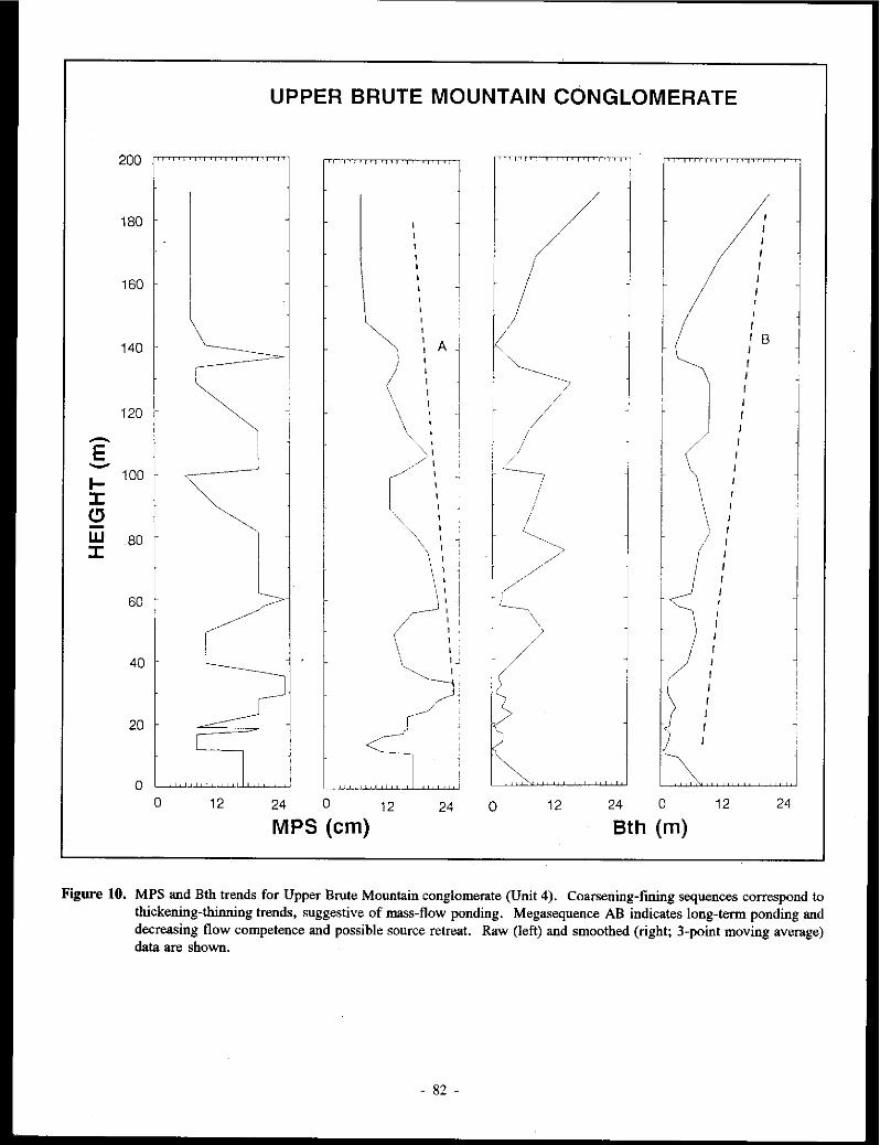
UPPER BRUTE MOUNTAIN CONGLOMERATE
200
120
-E -I- 100
J: (!)
w 80 J:
60
180
160
140
40
20
0
/ / /
~ I
' I
I /B l 1
// A I ' I ' ' ~ ) ~/
r I I
~ ' \ / r \ I
\ / r •• '
I '• I L (/\ '
/ ' / '\ ... I \
\ I ~~ / • I
/ \ I I
\ 1 !~ ' I ' ' '< ". r-1',, 1·-~\ '\ I
( I I \ I
(/ I
\~'. ( I r
; r ) r , > r r_
} I
~j 'i r
0 12 24 0 12 24 0 12 24 0 12 24
MPS (cm) 8th (m)
Figure 10. MPS and Bth trends for Upper Brute Mountain conglomerate (Unit 4). Coarsening-fining sequences correspond to thickening-thinning trends. suggestive of mass-flow ponding. Megasequence AB indicates long-tenn ponding and decreasing flow competence and possible source retreat. Raw (left) and smoothed (right; 3-point moving average) data are shown.
- 82 -

rel a tivc sea level between the Lewes River Island Arc and the North American continent did not produce the shallowing-upward successions expected of an infilling basin during this time. Significant closure of the Anvil Ocean basin and the start of arc obduction (c.f. Tempelman-Kluit, 1979) did not produce distinctive features in the stratigraphic record of the Whitehorse Trough until the Middle Jurassic.
Figure 11.
- - - - ------------~---_-_-_-
Subsidence
Schematic diagram depicting the general onlap relationship of the Brute Mountain succession. 1-3 represent successive sequences stacked against the upper slope, below the shelf break. Time series A-C (A is oldest) shows the general response to uplift and erosion in the sourceland coupled with tectonic subsidence across the slope and rise. Marine transgression continued during the cessation of coarse-grained input (Unit 3). (See text for additional discussion.)
ACKNOWLEDGEMENTS
The first author would like to thank Tom Pinkerton for able assistance in the field. Dr. Howard Tipper (Geological Survey of Canada) kindly identified ammonites collected by the first author. Craig Hart (Aurum Geological Consultants) released preprint copies of maps and was very informative during fascinating discussions on the geology of the Montana Mountain region. Funding and logistical support for the Brute Mountain :stuJy was through Exploration and Geological Services, Northern Affairs, Yukon, Canada, and a Northern Studies grant to J. Dickie.
REFERENCES
BECK Jr., M. E., 1983. On the mechanism of tectonic transport in zones of oblique subduction. Tectonophysics, Vol. 93, p. 1-11
BOUMA, A.H., 1962. Sedimentology of some Flysch Deposits: A Graphic Approach to Facies Interpretation. Elsevier: Amsterdam, 168 p.
COLEMAN, J.M., 1976. Deltas: Processes of deposition and models for exploration. Continuing Education Publication Company, Inc., lllinois, 102 p.
DICKIE, J.R., 1989. Sedimentary response to arc-continent transpressive tectonics: Laberge conglomerates (Jurassic), Whitehorse Trough, Yukon Territory. Unpublished M.Sc. thesis, Dalhousie University, Halifax, Nova Scotia, 3·65 p.
DICKIE, J.R. and HEIN, F.J., 1988. Facies and depositional setting of Laberge conglomerates (Jurassic), Whitehorse Trough, Yukon. Jn: Yukon Geology, Vol. 2; Exploration and Geological Services Division, Yukon, Indian and Northern Affairs Canada, p. 26-32.
FITCH, T.J., 1972. Plate convergence, trans current faults, and internal deformation adjacent to Southeast Asia and the western Pacific. Journal of Geophysical Research, Vol. 77, p. 4432-4461.
FREY, R. W. and PEMBERTON, S.G., 1984. Tracefossilfacies models. In: Facies Models, R.G. Walker, (ed.); Geoscience Canada Reprint Series 1, p. 189-207.
- 83 -

HANSEN, V.L., 1987. Structural, metamorphic, and geochronologic evolution of the Teslin Suture Z.One, Yukon: Evidence for Mesowic oblique convergence outboard of the North American Cordillera. Unpublished Ph.D. thesis, University of Southern California, Los Angeles, California, 261 p.
HANSEN, V.L., 1988. A model for terrane accretion: Yukon-Tanana and Slide Mountain Terranes, northwest North America. Tectonics, Vol. 7, p. 1167-1177.
HAQ, B. Q., HARDENBOL, J., and Vail, P.R., 1987. Chronology of fluctuating sea levels since the Triassic. Science, Vol. 235, p. 1156-1166.
HARPER, C.W. (Jr.), 1984. Improved methods offacies sequence analysis. In: Fades Models, R.G. Walker, (ed.); Geoscience Canada Reprint Series I, p. 11-13.
HART, C.J.R. and PELLETIER, K.S., 1989. Geology of Carcross (J05D/2) and part of Robinson (105D/7) map areas. Exploration and Geological Services Division, Yukon, Indian and Northern Affairs, Canada, Open File 1989-1, 84 p.
MONGER, J. W.H., PRICE, R.A. and 1'EMPELMAN-KLUIT, D.J., 1982. Tectonic accretion and the origin of the two major metamorphic and plutonic welts in the Canadian Cordillera. Geology, Vol. 10, p. 70-75.
MORRISON, G. W., 1981. Setting and origin of skarn deposits in the Whitehorse Copper Belt, Yukon. Unpublished Ph.D. dissertation, University of Western Ontario, 306 p.
STOW, D.A. V. and SHANMUGAM, G., 1980. Sequence of structures in fine-grained turbidites; comparison of recent deep-sea and ancient flysch sediments. Sedimentary Geology, Vol. 25, p. 23-42.
1'EMPEl.MAN-KLU/T, D.J., 1979. Transported cataclasite, ophioliteand granodioritein Yukon: Evidence of arc-continent collision. Geological Survey of Canada, Paper 79-14, 27 p.
1'EMPELMAN-KLUIT, D.J., 1985. Maps of Laberge (JOSE) and Carmacks (1151) map-areas. Geological Survey of Canada, Open File 1101.
TURK, G., 1979. Transition analysis of structural sequences. Discussion and reply. Geological Society of America Bulletin, Vol. 90, p. 989-991.
WHEELER, 1.0., I96I. Whitehorse map-area, Yukon Territory J05D. Geological Survey of Canada, Memoir 312, I56 p.
- 84 -

Table 1. Swnmary facies table for Laberge conglomerates and associated lithofacies.
Class I: Facies 1.1: Process:
Class 2: Facies 2.1: Process:
Class 3: Facies 3.1: Process:
Facies 3.2: Process:
Class 4: Facies 4.1: Process:
*Subfacies 4.1.1: Process:
*Subfacies 4. 1.2: Process:
Facies 4.2: Process:
*Subfacies 4.2.1: Process:
Facies 4.3: Process:
Class 5: Facies 5.1: Process:
*Subfacies 5 .1.1: Process:
Facies 5.2: Process:
Facies 5.3: Process:
Class 6: Facies 6.1: Process:
Micritic Limestone Micrite to Floatstone Chemical precipitation of carbonate
elastic limestone Calcarenite to rudite Bedload transport; winnowing
Mudstone Red, desiccated silty mudstone Suspension deposition of mud; minor tractional transport of silt to fine sand (cyclic); waning turbulent mass-flow; dehydration of mud; caliche development
Red, bioturbated silty mudstone Suspension deposition of mud (submarine); minor tractional transport of silt to fine sand under oscillatory flow; waning turbulent mass-flow; bioturbation by marine organisms
Heterolithic Facies Non-graded, interbedded sandstone-mudstone Cyclic alt~ration of bedload sand transport with hemipelagic fallout. Minor current drift across ripple tops. Bioturbation indicates moderately anaerobic conditions
Non-graded sandstone; mudstone veneer Cyclic alteration of bedload transport with carbonaceous mud fallout. Ripple drift indicates bedform aggradation
Convolute sandstone-mudstone Fluidization of interbedded facies; slide folding of facies 4-1; ductile deformation followed by brittle failure
Graded, interbedded sandstone-mudstone Waning moderate to low-concentration turbidity currents
Graded siltstone-mudstone Low-concentration turbidity currents; sorting of silt grains clay floes in the subviscous flow layer (grading)
Interbedded sandstone-carbonaceous mudstone Alternating upper plane bed or turbulent mass-flow of sand or, rarely, bedform migration (trough cross-sets) and fallout of organic mud
Stratified sandstone Planar stratified sandstone Upper regime plane bed flow; rarely lower plane bed deposition
Graded, planar-stratified sandstone Frictional freezing of thin, sandy turbidity currents
Low-angle stratified sandstone Bidirectional upper regime flow across an inclined surface
Wavy stratified sandstone Rapid deposition through frictional freezing of thin, sandy turbidity currents under oscillatory flow influence (combined flow origin)
Massive sandstone Non-graded to normally graded sandstone High concentration turbidity currents; grain flow
- 85 -

Class 7: Facies 7.1: Process:
*Subfacies 7. I. I: Process:
Facies 7.2: Process:
*Subfacies 7.2.1: Process:
Facies 7.3: Process:
Class 8: Facies 8.1: Process:
Facies 8.2: Process:
Facies 8.3: Process:
Class 9: Facies 9.1: Process:
Facies 9.2: Process:
Class 10: Facies 10.1: Process:
Facies 10.2: Process:
Facies 10.3: Process:
Class 11: Facies I I. I: Process:
Facies 11.2: Process:
Class 12: Facies 12.1: Process:
*Subfacies 12.1.1: Process:
Cross-stratified sandstone Trough cross-stratified sandstone Lower regime bedload transport
Vortex ripple-stratified sandstone Reversing-flow bedload transport
Planar-tabular cross-stratified sandstone Bedload transport, migration of linear crested ripples
Cross-bedded sandstone-mudstone Cyclic waning bedload, alternating bedform migration and abandonment
Hummocky cross-stratified sandstone Combined flow (storm suspension and bedload traction)
Pebbly sandstone Massive pebbly sandstone Waning, semi-cohesive turbulent flow
Trough cross-bedded pebbly sandstone Cyclically waning bedload transport of sand and gravel; migration of large-amplitude sinuous crested bed forms
Low-angle stratified pebbly sandstone Scour filling by basal lag gravel; migration of sinuous crested bedforms under very shallow flow conditions
Graded-stratified conglomerate Graded-stratified conglomerate Alternating suspension/traction deposition in high concentration turbidity flows experiencing velocity fluctuation
Planar-tabular cross-bedded conglomerate Upper regime bedload gravel transport; waning flow avalanche foreset grading
Clast-supported conglomerate Openwork conglomerate Bedload transport of gravel; gradual waning flow-winnowing of matrix
Massive to normally graded conglomerate Cohesionless debris flow, low- or high-concentration turbidity flow (see text)
Boulder conglomerate Cohesionless, turbulent flow; rolling, saltation
Matrix-supported conglomerate Normally graded conglomerate Hyperconcentrated flow
Inverse( y graded conglomerate Cohesive debris flow
Non-welded tu ff Crystal tuff/tuffaceous sandstone Subaqueous and subaerial pyroclastic flows; epiclastic equivalents
Calcareous tuff/tuffaceous sandstone Turbulent ash flow across carbonate lagoon facies
- 86 -

GOLD-SULPHIDE QUARTZ VEINS IN METAMORPHIC ROCKS AS A POSSIBLE SOURCE FOR PLACER GOLD IN THE LIVINGSTONE CREEK AREA,
YUKON TERRITORY, CANADA
L. Stroink
and
G. Friedrich
Institute of Mineralogy and Economic Geology Aachen University of Technology
Wiillnerstr. 2, 5100 Aachen Aachen, Germany
STROINK, L., and FKIEDRICH, G., J992. Gold-sulphide quartz veins in metamorphic rocks as a possible source for placer gold in the Livingstone Creek area, Yukon Territory, Canada. Jn: Yukon Geology, Vol. 3; Exploration and Geological Services Division, Yukon, Indian and Northern Affairs, Canada, p.87-98
ABSTRACT
The Livingstone Creek area is located JOO km northeast of Whitehorse, Yukon Territory, Canada. Hydrothermal gold-sulphide mineralization (MJNFILE JOSE OOJ) occurs in quartz-carbonate veins and veinlets which cut Paleozoic metamorphic rocks of the Tes/in Suture Zone. The metamorphic rocks are also cut by Cretaceous(?) feldspar-porphyry dykes with an average thickness of 2 m.
The mineralization appears to be structurally controlled by NNE-strildng faults and a set of NNWtrending joints. The vein minerals consist of gold, py~ite, chalcopyrite, galena, hessitelstuetzite, tetradymite, Au-Ag tellurides, tennantite, hematite, pyrrhotite, quartz, and carbonate. Gold occurs as: (J) "free gold" in cracks and interstices of quartz gangue (2) inclusions in galena, usually rimmed by hessite (3) minute grains associated with chalcopyrite and galena in aggregates of coarse grained pyrite (4) individual grains or fracture fillings in iron hydroxides.
The coarse-grained gold in Livingstone Creek appears to be derived from gold-quartz veins in the metamorphic bedrock. This is indicated by: (1) similar silver and mercury contents in primary and placer gold (2) identical trace element composition of galena from gold-quartz veins and galena inclusions in placer gold (3) similar telluride mineral assemblages in both in gold-quartz veins and placer gold grains (4) similar homogenization temperatures and salinities in.fluid inclusions from both gold-quartz veins and placer nuggets.
A limited amount of gold appears to have fonned by supergene leaching and precipitation. This kind of goM. occurs as irregular-shaped grains in the stream placers and in iron hydroxide along fractures in quartz veins. Relative to the primary gold it is enriched in silver and mercury.
RESUME
La region du ruisseau Livingstone est situee ii JOO km au nord-est de Whitehorse (territoire du Yukon) au Canada. II y a mineralisation hydrothermale en or et en sulfures dans des veines et veinules de quartz et carbonate dans les roches metamorphiques paleozoiques de la zone de suture de Teslin. Les roches metamorphiques sont egalement recoupees par des dykes de feldspath et porphyre du Cretace (?) d 'une epaisseur moyenne de deux metres.
La mineralisation semble structuralement definie par unefaille d'orientation NNE et un ensemble de diaclases d'orientation NNW. L 'assemblage de mineraux des veines consiste en or, pyrite, chalcopyrite, galene, hessite/stuetzite, tetradymite, tellurures d'Au et d'Ag, tennantite, hematite, pyrrhotine, quartz et carbonate. L 'or prend lafonne : J) d'•or libre• dans des fissures et interstices de la gangue de quartz, 2) d'inclusions dans la galene, habituellement entourees de hessite, 3) de minuscules grains associes a la chalcopyrite et ii la gaJene dans des agregats de pyrite de granulomerrie grossiere et 4) de grains individuels ou de remplissage de fractures dans des hydroxydes de fer.
- 87 -

L 'or de granulometrie grossiere dans le ruisseau Livingstone semble provenir de veines de quartz aurifere dans le socle rocheux metamorphique, ce qui est indique par 1) des teneurs en argent et en mercure similaires dans l'or primaire et dans l'or placerien, 2) des compositions identiques en elements a l'etat de traces dans la galene des veines de quartz et or et dans la galene des inclusions dans l'or placerien, 3) des assemblages de tellurures mint!raux similaires dans les veines d'or et quanz et dans les grains d'or placerien et 4) des temperatures d'homogeneisation et des salinites similaires des inclusions jluides provenant des veines d'or et quanz et des pepites plact!riennes.
Une quantite limitie d'or semble s'etrefonnee par lixiviation et precipitation secondaires. Ce type d'or prend laforme de grains deformes irregulieres dans les depots alluvionnaires des cours d'eau et dans les fractures avec hydroxyde de fer dans /es veines de quanz. II est enrichi en argent et en mercure par raport a l'or primaire.
INTRODUCTION
The Livingstone Creek placer gold camp is located approximately 100 km northeast of Whitehorse at latitude 61"19'N and longitude 134°17'W on N.T.S. map sheet 105 E 8 (Fig. 1). It comprises eight tributaries of the South Big Salmon River. The first discovery of placer gold was in 1898. In the first decade of the following century the Livingstone placer area became a booming camp with an estimated production of about $1,000,000.00 in gold (Bostock, 1938). From an economic standpoint, Livingstone Creek bas been the most important creek in the camp, and placer gold deposits are still being mined.
The geology and placer gold deposits of the Livingstone Creek area were first described by McConnell (1901). Regional geological mapping was carried out by Bostock and Lees between 1929 and 1934 (Laberge sheet; Map 372A) and by Tempelman-Kluit (1978,1979). Hansen (1986a,b) described the tectonic setting in detail.
The origin of placer gold of the Livingstone Creek was unknown for a long time. Bostock (1938) supposed quartz veins in the metamorphic bedrock were possible contributors of the gold. A 1983 assay of dump material beside a small mineral occurrence on the north side of Livingstone Creek (MINFILE 105E 001) assayed up to 1.58 opt Au, 16.6 opt Ag and 9.9% Pb (Archer, Catbro & Associates (1981) Ltd internal report, 1986). Visible gold, however, has not previously been reported.
This paper describees the paragenesis of gold-quartz veins in relation to placer deposits in the Livingstone Creek area. It is based on data obtained by chemical and mineralogical investigations of gold-bearing quartz-carbonate veins and placer deposits. Field work was carried out during an eight week period in 1986 as part of the Canada/Germany Science and Technology Exchange program.
REGIONAL GEOLOGY
Cataclastic rocks of the Teslin Suture Zone (TSZ) underlie the area. The TSZ is interpreted as the fundamental boundary between eastern autocbtbonous rocks of the ancient North American Craton and allochthonous terranes to the west (Tempelman-Kluit, 1979). Cataclastic rocks of the TSZ are divided into three assemblages. The Nisutlin Allocbtbon, a
- 88
Alaska/
I
"''/ . I
I \> '
1...-, l., . .L. ' T.
(.,..._,.. KILJ'-'ElRES
)
YUKON\ \~··· ';
T E R R I T 0 R Y\
• LIVINGSTON ,,., ,.,...,, CREEK
British (olumbia
Figure 1. Location of the study area.
''°
schist-quartzite assemblage is derived from a protolith of synorogenic elastics with interlayered intermediate volcanics. The Anvil Allochthon is a sheared opbiolite complex consisting of basalt, gabbro and peridotite. The Simpson Allocbthon consists of granitic cataclasites (Tempelman-Kluit, 1979). TSZ rocks were metamorphosed to greenschist or amphibolite facies in Late Triassic to Mid-Jurassic time (Tempelman-Kluit, 1979). The silicate mineral assemblage records maximu~ temperatures of 625°C, and pressures to 8 kbars (Hansen, 1986).
LOCAL GEOLOGY Bedrock in the study area consists of southwest-dipping
metamorphic rocks, intruded by two unmetamorphosed

' - ......... \?,-1 ,, .... 1,...,,.,> ',,!,-... '\' ,, 1- - ' ' /-,..,/, ... 1-1,
............. ':'~, ... ,_ ,"',,1;-1 ....... ,;-,1 I ..... 1' ....._I '\ -I ' ,, ,, J _,, I ... J -...--''I I I ,, I_..,. ':.. /
• I' I ,.,-','
- 89 -
'O .. > ~ .. "' .Q
~ -:; .. u...
[Z] ...: ~
'ii r= 2
"' .. -... -~ .. " er .. "' -"' :c u
V1
6
'O .. E
" "' "' .!!. -:; .. u...
[tj
"' .. -·;;; 0
-;:. E
"C .. ~ .. ,.., ..
--'
lJ
~ .. a. "' "C a; u...
r= 0
:;:: .. . ~ .. ~ .. r= :f .Q a.. ' ..
I-
' " <
B
"' .. "' "' ·a;
"' r= .. "' "' u 0 :;:: .Q ·;: :;;; 0 a. :c E ..., <
~[8
"' .. -... -~ .. " er u
:;:: ·;:; ·;: .. V1
"' .. -·;;; 0 -;:. E
"' " . 2 ~ Vi
..: a. ~ .. -:§
,.., ,.., ~ ~ .. ..
"C "C r= r=
" " 0 0 .Q .Q
0 0 .. .. "' "'
[lJ [LJ
"' .. "' N -~ .. " er
"' " 0 .. u .. u
:f

feldspar-porphyry dykes (Fig. 2). Exposure is poor, with good outcrops confined to the narrow canyon-like valleys of Livingstone Creek and Summit Creek, and to the ridges north,south and west of the two creeks.
Three distinct lithologic units are recognized. Unit 1 consists of siliceous tectonites derived from sedimentary and/or volcanic protoliths, and is assigned to the Nisutlin Allochthon. Unit 1 rocks are subdivided into five subunits. From west to east these are: (I) sericitic quartzite and metagreywacke; (2) siliceous mylonite intercalated with quartz-mica schist and lenses of silica-rich marble; (3) micaceous quartzite; (4) quartz-chlorite schist and (5) undifferentiated quartzite and mica-schist. The Unit 1 schists and quartzites are generally fine grained and consist mostly of quartz and sericite with minor sodic plagioclase, potassium feldspar. chlorite, biotite, epidote, clinozoisite, actinolite and carbonate, and accessory zircon, rutile, pyrite and magnetite.
Unit 2 is a metavolcanic unit of layered mylonite, chloritic gneiss and amphibolite. It is interpreted as part of the Anvil Allochthon, separated from Unit 1 by a NNW-trending fault zone. The layered mylonite consists of Mg-rich chlorite, epidote, clinozoisite, amphibole (barroisite and tschermakite), potassium feldspar, quartz, oligoclase, calcite, biotite and sericite. Amphibole (tscherrnakite) and plagioclase (oligoclase) are the main components of the dark green, medium-grained amphibolites. Minor components include epidote, iron-rich chlorite, garnet, sphene, clinozoisite and quartz. The Unit 2 amphibolites have a mafic igneous composition, and have been metamorphosed to upper greenschist or lower amphibolite grade. According to Spry's (1969) classification, cataclastic rocks in the study area range from protomylonites to mylonites and ultramylonites.
Unit 3 rocks are northwest-trending hornblende-feldspar porphyry dykes with an average thickness of two metres. The porphyritic texture is produced by phenocrysts of euhedral plagioclase (18 ± 0.4%) up to 2 cm in size, amphibole (hastingsite,(34 ± 1.3%) and biotite (3 ± 0.5%) in" finegrained groundmass (45%). Their chemical composition suggests that they are banakites. They are most likely subvolcanic equivalents of the Late Cretaceous Cannacks Group volcanics (Glasmacher, 1989).
PRIMARY MINERALIZATION
Gold and sulphide minerals occur in quartz-carbonate veins and veinlets. The veinlets crosscut sheared micaceous quartzite of Unit 1 and are generally confined to NNWstriking joints. They are best exposed in Summit Creek valley. The main sulphide minerals in the veinlets are pyrite, pyrrhotite and chalcopyrite. Galena, gold, Bi-tellurides and hematitite occur to a lesser extent.
The major lode occurrence is a gold-quartz vein on the Horseshoe claim north of Livingstone Creek (MINFILE JOSE 001). Average thickness of the vein is about 70 cm. The mineral assemblage consists of gold, pyrite, galena, chalcopyrite, tennantite, Au-Ag tellurides, hessite/stuetzite, quartz and minor carbonate gangue.
Gold forms visible grains in cracks and interstices of quartz gangue (Fig. 3) and inclusions of microscopic scale in galena (Fig. 4). It also occurs as relict particles in iron hydroxide (Fig. 5) and newly formed along microfractures (Fig. 6). Petrologic and electron microprobe studies reveal distinct differences in morphology and composition between gold grains from unoxidized and partly oxidized vein material.
Individual gold grains in quartz gangue and in unoxidized galena (Figs. 3, 4) reach 0.2 cm in diameter and commonly exhibit smooth grain boundaries. The silver and mercury contents in gold of this type of gold range from 13 to 16 weight per cent Ag (modal value 14%) and 0.2 to 0.9 weight per cent Hg (modal value 0.2%)(Figs. 11, 12). The average Au:Ag ratio is 5.9.
Relict gold particles found in iron hydroxides are characterized by corroded grain boundaries (Fig. 5) and similar chemical composition to those gold grains described above. In contrast, gold on fractures in iron hydroxides occurs as irregular shaped particles (Fig. 6). These irregular fracture-hosted particles show significantly higher silver values (16 to 23 weight per cent) and mercury (2 lu 4 weight per cent)(Figs. 11, 12). The Au/Ag ratio decreases to an average value of 3.8.
Telluride minerals found in quartz veinlets of lower Summit Creek valley and in the Horseshoe quartz vein include hessite (Ag2Te), stuetzite (Ag5_,Te3), Au-Ag tellurides of varying composition close to ideal petzite (Au-Ag3Te,), and tetradymite (Bi2Te,S).
Silver tellurides are restricted to the Horseshoe quartz vein. They usually occur as microscopic inclusions in unweathered galena, occasionally forming small rims around enclosed gold grains (Fig. 4). The silver tellurides contain between 57 and 62 weight per cent silver, and have been identified as hessite and/or stuetzite. Gold is below the detection limit (<0.2 %).
Gold-silver tellurides have a restricted distribution and can only be identified by electron microprobe analysis. They occur either as small inclusions ( < 3µ.) in galena and pyrite, or intergrown with Bi-tellurides in quartz gangue. Figure 14 shows the compositions of the Au-Ag tellurides.
Bismuth tellurides have been found in quartz-carbonate veinlets cutting metamorphic rocks of the lower Summit Creek valley, where they are associated with pyrite, chalcopyrite, pyrrhotite and gold. They occur ( 1) as inclusions in pyrite, partly intergrown with galena and chalcopyrite (2) in quartz gangue intergrown with chalcopyrite or hematite (3) as individual phases in quartz gangue. The bismuth telluride crystals are generally anhedral with a maximum grain sizes of about 0.2 nun. The average composition of the bismuth tellurides (57.5 weight per cent Bi; 34.98 weight per cent Te; 4.48 weight per cent S) corresponds to tetradymite (Bi2Te,S).
Pyrite is ubiquitous in quartz-carbonate veins and veinlets.It fotms euhedral crystals in the quartz carbonate veins or is disseminated and intergrown with rutile in highly silicified metamorphic wall rocks. Microprobe analyses indicate that both kinds of pyrite contain Jess than 0.11 weight per cent gold.
90 -

Figure 3. Interstital gold in quartz gangue (Horseshoe claim).
Figure 4. Gold rimmed by hessite, fonning inclusions in galena.
Galena in gold-quartz veins generally forms coarse aggregates up to 2 cm in size. It often contains inclusions of gold which are usually rimmed by hessite (Fig. 4). Fracturesin galena are healed by tennantite and chalcopyrite. In the veinlets, galena occurs as small inclusions or along microfractures in pyrite. Microprobe analyses reveal traces of silver (average 0.41 weight per cent) and bismuth (average 0.74 weight per cent). Antimony has not been detected.
Chalcopyrite usually occurs as subhedral to anhedral crystals or as coarse grained aggregates intergrown with or cementing pyrite and galena. In minor amounts it is associated with hematite or occurs with galena along small fractures in pyrite.
Tennantite is exclusively intergrown with chalcopyrite in quartz gangue or along cracks in galena. It has an average arsenic content of 17.9 weight per cent. Traces of antimony (0.35 weight per cent), bismuth (1.0 weight per cent), silver (0.13 weight per cent) and mercury (0.08 weight per cent)
Figure 5. Gold rimmed by hessite, forming inclusions in galena.
Figure 6. Gold along fractures in iron hydroxide, Horseshoe claim.
have also been detected. Hematite is common in veinlets of Summit Creek valley
as needle-like crystals up to I mm in size. Hematite also occurs as symplectic intergrowths with chalcopyrite associated with pyrite. It also replaces fine disseminated magnetite in the metamorphic host rocks.
Coarse grained quartz is the main gangue mineral. Fluid inclusion data are presented in Fig. 15. Homogenization temperatures from primary fluid inclusions in quartz from the Horseshoe vein range from 110°C to 200°C with a maximum at 150"C (Blum. 1987). Salinities are about 4.5 weight per cent NaCl equivalent.
Wallrock alteration near mineralized veins includes pyritization, kaolinitization, dolomitization, sericitization, and chloritization. Quantitative studies of element enrichment and depletion in altered metasedimeotary and volcanic rocks demonstrate elevated levels of gold and arsenic in altered wallrocks. Close to a NNE-trendiog fault zone, pyritized,
- 91 -

/04
103
10 2
10 2
10 3
Amphibole
Plogioclose
Fresh
Biotite
Quartz
Au As
Altered
Figure 7. Element enrichment and depletion in altered feldspar porphyry.
kaolinized and sericitized porphyry dykes also show considerably increased levels of gold and arsenic (Fig. 7). The positive correlation between arsenic and gold allows arsenic to be used as a "pathfinder" element in this area. Mercury might also be used as a pathfinder element, as goldsilver alloys in the Horseshoe quartz vein contain up to 4 eight per cent mercury.
Figure 8. lntergrown galena and tetradymite, enclosed in placer gold grains from Livingstone Creek.
Quartz
Pyrite
Gold
Au-Ag-Hg-alloys
Hessite
Stuetzite
Au-Ag-Tellurides
Tetradymite
Galena
Pyrrhotite
Chalcopyrite
Tennantite
Hematite
PAAAGENETIC SEQUENCE
Early '-'"
----------
Figure 9. Paragenetic sequence for primary mineralization.
PLACER DEPOSITS
Alluvium in Livingstone Creek contains a heavy mineral assemblage which includes gold, galena, pyrite, arsenopyrite, cassiterite, cinnabar, epidote, garnet, hematite, ilmenite, pyrite, tourmaline, rutile, zircon and magnetite. Free gold particles consist of gold nuggets (grain size from 4. 75 to > 29 mrn), "jewellery gold" (grain size from 1.7 to 3.4 mm) and fine gold (grain size < 1.7 mm). Individual gold grains vary considerably in shape and internal structure. Four main types are recognized (Friedrich and Wiechowski, 1987): (I) Rounded gold grains, sometimes flat, with a smooth surface. Limonite is rare, usually confined to embayments in the
- 92 -

Krennerrte I AuAg! e
Calaverife Au Te2
Hontbrayite Au2 Te3
so
Te
I I
I
I I
I
I
I I
Ag Te
!-fessite Ag2 Te
I
I
Au so Ag
Figure 10. Minerals in the Au-Ag-Te system. Tie lines are indicated by natural mineral assemblages. (After Cabri, 1965). Dots indicate telluride minerals of the Livingstone Creek area.
surface. Larger nuggets often consist of an aggregate of gold leaves which are believed to have accreted during alluvial transport. (2) Flat, frequently elongated gold grains with smooth surfaces and rounded edges, characterized by dendritic growth structure. (3) Irregular gold grains with rugged or partly rounded surfaces, often intergrown with quartz. Irregular grains are rimmed with limonite, especially near embayments. (4) Thin flakes of gold with a smooth to verrucose surface and occasional curved rims.
Many gold nuggets contain inclusions of galena intergrown with tetradymite (Fig. 8), as well as hessite (Ag2Te) and stuetzite (Ag,.,Te,).
Microprobe data reveal that the chemical composition of
individual gold grains does not vary significantly, except for the mercury content. Fig. 11 shows the frequency distribution of silver values in placer gold grains. The outer rims generally return very low silver values due to leaching. The frequency distribution pattern of silver shows a range of values from 4-19 weight per cent, with a maximum at 12 weight per cent. There is no apparent correlation between silver content and grain size or shape of gold. The mercury content varies from <0.2 to 2.92 weight per cent (modal value 0.2 weight per cent) in primary gold grains and within individual gold nuggets (Fig. 12). Considerably higher mercury values (2-4 weight per cent) are found in irregular gold grains which are inferred to have a supergene origin.
- 93 -

Ag distribution in primary gold and p/acergold
25
n 20
15
10
5
0 5 10 15 20
Ag (wt.-o/o)
- Gold in Quartz - Gold in Galena D Placergold
Figure 11 Frequency distribution of silver in placer gold and in vein gold from the Horseshoe claim.
Trace element compositions of galena inclusions in placer gold grains are shown in Fig. 13. Antimony is below detection limit. Average bismuth values range from 0.4 to 0.8 weight per cent and the silver content does not exceed 0.5 weight per cent.
Hessite and stuetzite inclusions in placer gold grains show slightly variable Ag/Te ratios (1. 7 to I. 9). The gold content of the inclusions is very low and varies from 0.3 to 2 weight per cent. The composition of the Te-bearing minerals (including Au-Ag-Te inclusions in placer gold grains) is shown in Fig. 14.
Most of the placer gold deposits formed by physical transport and gravity concentration. Minor dissolution, migration, and reprecipitation of gold, however, is suggested by gold grains with silver-depleted rims.
DISCUSSION
The paragenetic sequence shown in Fig. 9 is defined by
cross cutting relationships and replacement textures. The first stage of mineralization deposited milky quartz, coarse-grained pyrite, gold hessite, stuetzite, galena (!), and gold-silver tellurides. Later fracturing allowed earlier sulphides like galena and pyrite to be partially replaced or enclosed by chalcopyrite, galena (II), tetradymite, pyrrhotite and tennantite. Hematite formed last, as indicated by its lack of replacement textures, and massive hematite veinlets which crosscut earlier quartz-sulphide veinlets.
Assumptions about the temperature of mineralization are based on the occurrence and stability of Au-Ag-Te minerals. At temperatures above I 70'C, compositions within the sylvanite-petzite-hessite field (Fig. 10) form the metastable gamma-phase (Cabri, 1965). The ganuna phase breaks down at temperatures bylow 120°C forming stuetzite associated with bessite and petzite. The coexistence of stuetzite, hessite and other tellurium minerals with end-menber petzite in the Horseshoe vein indicates that the earliest telluride minerals were deposited at temperatures above l 70"C.
- 94 -

Hg-distribution in primary gold and placergold
30
n 25
20
15
10
5
0 0 5 10 15 20 25 30
Hg/x 0,1 (wt.-%)
- Gold In quartz
illilliiill Gold In Fe-hydroxide
- Gold In galena r'"1 L.ccJ Placergold
Figure 12 Frequency distribution of mercury in placer gold, and in vein gold from the Horseshoe claim.
Oxidized material from the gold-bearing quartz vein north of Livingstone Creek contains numerous1iny grains of visible gold. Relict gold particles in the iron hydroxide have a similar composition to the gold in unoxidized quartz and galena and show corroded grain boundaries due to partial dissolution. They are inferred to be residual.
Irregular-shaped gold particles in iron hydroxide-filled fractures are believed to have formed entirely as a result of supergene leaching and precipitation. Relative to gold grains in quartz gangue and galena, supergene gold is enriched in silver and mercury.
CONCLUSIONS
Comparison of gold and gold-silver tellurides from placer deposits and the Horseshoe vein suggests that most of the placer gold in Livingstone Creek is derived from gold-bearing quartz veins which crosscut the metamorphic bedrock. The following evidence supports this conclusion: (1) The vein and
placer gold have very similar chemical composition (Fig. 11, 12); (2) galena inclusions in placer gold grains and primary galena in the gold quartz vein have identical trace element compositions (Fig. 13); (3) a similar suite oftelluride minerals is associated with both the placer and vein occurrences; (4) Fluid inclusions in primary gold-quartz intergrowths in placer nuggets and in gold-quartz veins show similar patterns of homogenization temperatures (Fig. 15). Gold telluride compositions and fluid inclusion evidence shows that the veins were deposited from low-salinity epithermal fluids at a temperature of l 70-200°C and a shallow or moderate depth. The age of the veins is unknown but they clearly post-date Late Cretaceous porphyry dykes in the area.
Gold is enriched in altered wallrocks along a NNEtrending fault, and there is a strong correlation between primary gold and arsenic.
Some gold grains in Livingstone Creek and in iron hydroxide-filled fractures in quartz show evidence of supergene leaching and redeposition. Gold grains of inferred
- 95 -

1
Sb Bi
35
Fig. 13(1) Relative distribution of silver and bismuth m galena from gold-bearing quartz vein on the Horseshoe claim.
2
Sb s;
35
Fig. 13(2) Relative distribution of silver and bismuth in galena inclusions in placer gold.
supergene ongm are distinguished by their irregular morphology and considerably higher silver and mercury content.
Au
Au
Krennerite
Calaverlte
AuTe2
Monlbraylte _;
Au2Te3
Krermen1e
Te
Sylvanlte
AuAgTe2
o"
.... Petzlte _,,,o• AuAg
3Te
2
50
Au . Ag alloys
Te
Sylvanite
AuAgTe2 o"
50
Au • Ag alloys
.. .. .. ..
Empresslt.
¥ AgTe
50 Stuetzlte
Empressile
/AgTe
50
1
Ag
2
Figure 14. Composition of Ag- and Au-Ag- tellurides (triangles) from (1) gold bearing-quartz vein on the Horseshoe claim, and (2) telluride inclusions in placer gold.
ACKNOWLEDGEMENTS
This project was part of the Canada/Gennany Science and Technology Exchange Agreement organized by the Geological Survey of Canada and the Federal Institute for Geosciences and Mineral Resources (BGR). It received extensive support
- 96 -

Homogenization temperatures in primary gold and p/acergold
12
10
8
n s
4
2
100 200
Th ( C)
- Placergold - Primary gold l 300
Figure 15. Homogenization temperatures of fluid inclusions in quartz-gold intergrowths from (!) gold-bearing quartz vein on the Horseshoe claim, (2) placer deposits.
from the German Ministry of Research and Technology and from the Exploration and Geological Services Division of Indian and Northern Affairs Canada, Whitehorse. We would like to thank J. Morin, G. Abbott, S. Morison and U.
Glasmacher for their help and guidance. Many thanks go also to M. Fuerstner and R. Asachuck for the permission to work on their claims and for their hospitality and cooperation in the field. Trevor Bremner reviewed the manuscript.
REFERENCES
BLUM, M., 1987. Vergleichende mikrothennometrische Untersuchungen an Flussigkeitseinschlussen in Quarzen des Livingstone Gebietes, Yukon Territorium, Kanada. Unpubl. repo11, RWTH Aachen, 56 p.
BOSTOCK, H.S., 1931. The mining industry of Yukon-Selected.field reports of the G.S.C. (1898-1933). Geological Survey of Canada, Memoir 284, p. 620-631.
BOSTOCK, H.S., and LEES, E.J., 1938. Laberge map-area, Yukon. Geological Survey of Canada Memoir 217.
- 97 -

BOYLE, R. W., 1979. The geochemistry of gold and its deposits. Geological Survey of Canada, Bulletin 280, p. 584.
GABRI, L.J., 1965. Phase relations in the Au-Ag-Te system and their mineralogical significance. Economic Geology, Vol. 60, p. 1570-1605.
FRIEDRICH, G., and W/ECHOWSKI, A., 1987. Microprobe studies on alluvial gold, Livingstone Creek, Yukon Territory, Canada. Unpublished paper, RWTH Aachen, Germany, 18 p.
GLASMACHER, U., 1990. Petrogenetische und metallogenetische Entwicklung ausgewiihlter Gebiete im Yukon-Tanana Terrane und Stikine Terrane (Yukon Territorium, Kanada) w/lhrend der Oberkreide und des Alttertiiirs. Unpublished PhD thesis, Aachen University of Technology.
HANSEN, V.L., /986a. Preliminary structural and kinematic analysis of mylonitic rocks of the Teslin Suture Z.One, 105 E, Yukon. In: Yukon Geology, vol. /;Exploration and Geological Services Division, Yukon, Indian and Northern Affairs, Canada, p. 119-124.
HANSEN, V.L., !986b. Petrotectonic study of the Teslin Suture Z.One, Yukon. A progress report. In: Yukon Geology, Vol. 1; Exploration and Geological Services Division, Yukon, Indian and Northern Affairs, Canada, p. 125-130.
MCCONNEU, R.G., 1901. Salmon River gold fields, including Livingstone and neighbouring placer creeks, Yukon Territory. In: H.S. Bostock, (ed.), Selected field reports of the Geological Survey of Canada, 1898-1933, Memoir 284, p. 37-48.
SPRY, A., 1969. Metamorphic textures. Pergamon Press, Oxford, p. 352.
STROINK, L., 1987. Geology, Petrology and Mineralizat.ion of Livingstone Creek, Yukon Territory, Canada. Unpublished Diploma-thesis, Aachen Technical University, p. 150.
TEMPELMAN-KLUIT, D., 1978. Reconnaissance geology, Laberge map area, Yukon. In: Current Research, Part A, Geological Survey of Canada, Paper 78-IA, p. 61-66.
TEMPELMAN-KLUIT, D., 1979. Transported cataclasite, ophiolite and granodiorite in Yukon. Evidence of Arc-Continent Collision. Geological Survey of Canada, Paper 79-14.
- 98 -
THE SEDIMENTOWGY OF PLEISTOCENE DEPOSITS ASSOCIATED WITH PLACER GOLD BEARING GRAVELS IN THE LIVINGSTONE
CREEK AREA, YUKON TERRITORY
Vic Levson B. C. Geological Survey
553 Superior St Victoria, B. C.
VSV 1X4
LEYSON, V., 1992. The sedimentology of Pleistocene deposits associated with placer gold bearing gravels in the Livingstone Creek area, Yukon Territory. Jn: Yukon Geology, Vol. 3; Exploration and Geological Services Division, Yukon, Indian and Nonhern 4ffairs Canada, p.99-132
ABSTRACT
Due to the depletion of traditional economic gold placer deposits in unglaciated areas of the Yukon, the study of the relationship of placer gravels to overlying glacial sediments in ice covered regions is imponant to future exploration activities. The Livingstone Creek area in south central Yukon has supponed placer mining operations for over 90 years. Present activity is centred on gold-bearing gravels buried by thick Pleistocene glacial deposits. The placer gravels are associated with coarse interglacial stream and gulch deposits and they are overlain by fine grained, proximal, glaciolacustrine sediments.
During the last glaciation, damming of gold-bearing, high gradient interglacial tributary stream channels by main valley ice caused rapid environmental changes. Depositional processes dominated over erosion in the ice-marginal lakes, and thick sequences of fine grained suspension deposits, debris flow sediments, and deltaic sands and gravels accumulated. In addition, when glaciers expanded and overrode the area, these thick deposits protected the underlying placer. gravels from sub glacial erosion and dilution. Sub glacial tills were probably deposited by lodgement, melt out and flow. During deglaciation, ice-marginal sedimentation again dominated. Post-glacial streams later cut through the glacial sediments and re-exposed the gold bearing gravels.
Stratigraphic, sedimentologic and geomorphic evidence from the Livingstone Creek area suggests that small tributary valleys, oriented transverse to the former direction of ice flow in the adjacent main valleys, lvould make good exploration targets in regions of new placer interest.
RESUME L 'etude de la relation entre les graviers alluvionnaires et les sediments glaciaires sus-jacents dans les
regions recouvertes de glace est importante pour les activites futures d'exploration en raison de l'epuisement des classiques gisements rentables d'or placerien dans les regions non glaciees du Yukon. L 'or placerien est exploite depuis plus de 90 ans dans la region du ruisseau Livingstone dans la panie meridionale centrale du Yukon. Actuellement, les activites sont centrees sur les graviers auriferes enfouis sous d'epais depots glaciaires du Pleistocene. Les graviers alluvionnaires sont associes a des depots de cours d 'eau et de ravins interglaciaires d grains grossiers et ils sont recouverts de sediments glaciolacustres proximaux a grains fins.
Pendant la derniere glaciation, l'endiguement d'affluents interglaciaires ii forte pente par la glace de vallees principales a entraine de rapides changements environnementaux. Les processus de depot, plutOt que l'bosion, ant ete dominants dans les lacs de marges glaciaires et d'epaisses sequences de depots a grains fins en suspension, de sediments de coulees de debris et de sables et graviers deltai'q_ues se sont accumulees. De plus. lorsque les glacier se sont agrandis et ant chevauche la region, ces epais depots ont protege de !'erosion et de la dilution les graviers alluvionnaires sous-jacents. Les tills subglaciaires ont probablement ere deposes sur le fond, par la Jonte et l 'ecoulement. Pendant la deglaciation, la sedimentation a1.a marges glaciaires a de nouveau domine. Les cours d'eau postglaciaires ont plus lard entaille les sediments glaciaires et de nouveau mis a nu les graviers auriferes.
Les indications stratigraphiques, sedimentologiques et geomo1]Jhologiques dans la region du ruisseau Livingstone suggerent que les vallees de petits affeuents orientees pe1]Jendiculairement al 'ancienne direction de l 'ecoulement de la glace dans les vallees principales adjacentes constitueraient de bonnes cibles d'exploration dans les regions d'interet pour les nouveaux gisements alluvia1.a.
- 99 -

INTRODUCTION Yukon placer deposits have produced more than 11
million ounces (342 million grams) of gold since 1885 (Debicki, 1983). Record productions have occurred in recent years, with 1987-1990 ranked as the four best years in the last 72 (Latoski, 1991). In 1989, the highest production since 1917 was recorded: 165 571 crude ounces (5 151 510 million grams), valued at over Cdn $57 .6 million (Latoski, 1991). Most placer mining activities in the Yukon have traditionally been in unglaciated regions such as the Klondike, Indian River and Sixtymile River areas but economic placer deposits also exist in glaciated areas, and generate about 25 % of the total placer gold production (LeBarge, 1990). The focus of this study, an important placer occurrence in the Livingstone Creek area, is at least 125 km inside the limit of Pleistocene glacial advances (Hughes et. al., 1969). The reason for the preseIVation of the placer gravels in this area is unknown, although it has been suggested that they occur in valleys oriented perpendicular to the regional flow direction of Pleistocene glaciers (Bostock and Lees, 1938). Detailed stratigraphic and sedimentologic relationships of the placer gravels to the overlying glacial deposits were previously undocumented.
The objectives of this study were to investigate the sedimentary properties of the glacial sediments overlying the placer gold bearing deposits in the Livingstone area in order to document: (1) the stratigraphic and sedimentologic characteristics of the glacial sediments, (2) any relationship of these characteristics to the preservation of the gold bearing gravels, and (3) any unique features that might be used to identify potential exploration targets in other glaciated regions.
Placer gold was first discovered in the Livingstone Creek area (Figure 1) in 1898 and in the first forty years of activity the camp produced more than $1,000, OOOin gold (Bostock and Lees, 1938). The area continued to produce gold over the next fifty years. Seven of the creeks had active operations between 1978 and 1990 which produced more than 3300 ounces of gold, a total value of about $1.3 million (Debicki, 1983; LeBarge, 1990; Latoski, 1991). Mining activities were observed on three creeks in the area during this study.
STUDY AREA
The Livingstone Creek area is located about 80 km northeast of Whitehorse (Figure 1, inset) and has two dirt airstrips and a winter road for access. Virtually all the gold production in the area has come from several small creeks that flow down the eastern slopes of the Big Salmon Range into the South Big Salmon River (Figure 1 ). Good exposures on Martin, Livingstone and Summit Creeks were the focus of this study. The creeks head in broad, shallow, glaciated basins that narrow into steep gradient canyons where the streams enter the main valley. A narrow, bedrock-walled valley along the eastern edge of the South Big Salmon River valley is responsible for the sharp northward diversions of Livingstone and Summit Creeks from their otherwise westerly drainage (Figure 1).
Studied Section
D Semenof Hills Block
0 Whitehorse Trough
5 km
""'- ....... BIG ...
y,kon Territory
"., L. .__.____,,,~. 30°
I
i ' ' ' ' .> ' ' ' ' '
J RANGE::
D Teslin Suture Zone
0 Omineca Crystalline Belt
Figure 1. Locations of studied sections and bedrock geology of Livingstone Creek area.
Peaks on the Big Salmon Range rise to elevations of about 2000 m; Mt. Black (2158 m) at the SE end of the range is the highest mountain in the region (Figure 1). The Livingstone Creek area is separated from the Teslin River valley by the Semenof Hills. Several north-south trending valleys, such as between Moose and Boswell Mountains, cross the hills.
The gold-bearing gravels at the three creeks studied directly overlie bedrock. They are poorly exposed due to mining activity which has undercut the sections, resulting in the collapse of the overlying glacial deposits. This same collapse produced the fresh exposures in the upper part of the sections described in this paper (Figures 2 to 5).
PREVIOUS WORK
Few detailed studies of this nature have been carried out on placer deposits in glaciated parts of the Yukon. Morison (1983, 1984), however, provided a sedimentologic description of placer gold sediments and associated deposits in the glaciated Clear Creek basin. He concluded that placer deposits buried below till were preserved because the area is located near the limits of glaciation where subglacial erosion was decreased. The glacial sediments were probably deposited by mainly nonerosional processes such as meltout and resedimentation (Morison, 1984). Similar studies of placer deposits have recently been conducted in northwest British
- 100 -

MARTIN CREEK SECTION
C Si S I I
0
10
30
40
50
covered
p c b I I
3b
3a
4 f
4e 4d 4c 4a & 4b
2e & f
2d
2c
2b
2a
1 b - 1 d
1 a - poorly exposed
•
Sediment Type
Sedimentary Structures
DIAMICTON [
Clas! supported
Matrix supported
POORLY SORTED GRAVEL
WELL SORTED GRAVEL
SANDS
SILTS AND SANDS
SILTS AND CLAYS
~ Planar crossts::;;Sj stratification
~ Trough crossg::&J stratification
~ Convoluted ~ strat1f1cat1on
Horizontally laminated
Sandy intrabeds and minor ripple bedding
Contacts:
[Sharp
Conformable Gradational
Erosional
~ Loaded
Figure 2. Composite stratigraphic column of the main Martin Creek section.
- IOI -

Figure 3. Detailed sedimentologic log of unit 2 at the Martin Creek section. Refer to Figure 2 for explanation of lithologic symbols.
- 102 -

c Si S p c b
1 6
4c
J 4b 1 4
1 2
1 0 3c
8
0 ·~:·~:·~:-~:-~:-~:-~:-~:-'. ·:.:·:..:·:..:·:..:·:..:·:..:-:..:·:..:· '...:·'...:·'...:·'...:·7..:·'...:·'...:·'...:·'...:· : .. , .. : .. : .. : ... : .. : ... : ... ,""':,""': ,""':,""':,""':,""':,""':,""':
Creek Section c si s 3 and 4a·f I I
1 8
Pebble Fabrics
't ..
v1 .. 124°; 4.5° s1- o.sa
p c b
41
4e
4d
..
+
,; v~
Figure 4. Detailed sedimentologic log of units 3a to 4f at the Martin Creek section. Rose diagrams and corresponding equal area density plots are shown for units 3b and 3c. VI parallels the axis of maximum clustering of the a-axes of blade and prolate shaped clasts. Si is the normalized eigenvalue corresponding to the VI eigenvector. Refer to Figures 2 and 3 for explanation of symbols.
- 103 -

'""' E ..... Ii) Ii)
Ql
"' "" u ·~ ..:::: r-
'""' E .....,, Ii) Ii) Ql
"' .::.: u
..:::: r-
20
1 0
0
20
1 0
0
... -.-.-.-... -... -... -... -. . . ... ... . . . ... .,
C Si S I I
C Si S I I
.,
Summit Creek
UNIT 7: diamicton; massive; clast to matrix supported; unsorted to poorly sorted; poorly exposed.
UNIT 6: pebble to cobble gravels; beds dip 23-31° NE (055'); open work and· matrix filled beds; lower contact erosional and dips gently (5') NE.
UNIT 5: sandy gravel; horizontal bedding to gently inclined planar crossbedding; poorly sorted; clasts mainly angular to subangular; minor horizontally laminated silt and fine sand beds; lower contact erosional and dips gently (5°) NE.
UNIT 4: pebble gravel; beds dip 15-20' NE (052°); clast supported; mainly openwork; moderately to well sorted; clasts mainly angular to subangular.
UNIT 3: sands; horizontally stratified; well to very well sorted; strata 0.1-10 cm !hi.ck; minor granule beds; some planar and trough cross-bedding; dropstones
UNIT 2: coarse gravel; clast supported; poorly sorted; 60-80% clasts, subangular to subrounded, up to boulder size; matrix sandy; disorganized fabric; poorly exposed; lower contact covered.
Covered interval.
UNIT 1: schist; vertical foliation; minor quartz veins and fracturing.
D C b I I
Livingstone Creek Section
:"1b :"1b :"1b
D c b I I
UNIT 5: diamicton; massive; matrix supported; silty mud matrix; 20·40% clasts, up to bouder sized, subangular to subrounded, striations common; light brown color; minor sorted sand lenses; poorly exposed.
UN IT 4: diamicton; as above except sandy silt matrix and dark grey
UNIT 3: silts and clays; parallel laminated; intense folding; pebble breccia intrabeds of very angular, local lithology; rounded erratics common as dropstones but rare in intrabeds; minor oxidized sands.
UNIT 2: gravels; horizontal bedding; clast supported; matrix filled; clasts up to boulder sized, well rounded to sub rounded; poorly to moderately sorted; some imbricated, cobble breccia beds of local schist; minor open work pebble gravel and trough cross-bedded sands.
UNIT 1: bedrock; blocky quartzite and schist; vertical foliation; silicified with abundant pyrite crystals oriented parallel to foliation; numerous near vertical quartz veins
Figure S. Composite stratigraphic columns for the Summit Creek and Livingstone Creek sections. See Figures 2 and 3 for explanation of symbols.
- 104 -

Columbia, just south of the Yukon border (Levson, 1991; Levson and Kerr, 1991) and in central British Columbia (Levson and Giles, 1990; Levson, 1991).
Glacial features and surficial deposits in the area were mapped by Hughes (1968), and Klassen and Morison (1987). Surficial deposits in the area are mainly thin till and colluvium. An irregular glaciofluvial complex occurs in the South Big Salmon Valley near the mouth of Martin Creek (Klassen and Morison, 1987). The prominent valley that diverts the westerly flow of Livingstone and Summit Creeks is an ice-marginal channel (Hughes, 1968). Indicators of former ice flow direction, mapped by Hughes (1968) and Klassen and Morison (1987), suggest that glaciers flowed north along the low valleys that cross the Semenof Hills into the South Big Salmon River Valley in the Livingstone Creek area.
BEDROCK GEOLOGY
The Livingstone Creek area occurs within the Teslin Suture Zone (Figure 1), which is separated from the Semenof Hills Block, to the west, by the Big Salmon Fault (Tempelman-Kluit, 1980 and 1984). This fault closely parallels the South Big Salmon River in the area directly west of the studied sections (Figure 1). Local bedrock in the drainage basins of the investigated creeks is dominantly dark green, cataclastic, fine grained amphibolite and amphibolitic greenstone that grades into massive, melanocratic, dioritic to quartz dioritic hornblende augen gneiss. These rocks belong to the Anvil allochthonous assemblage and are associated with muscovite-quartz schist and muscovite quartzite of the Nisutlin assemblage (Tempelman-Kluit, 1984). Outcrops close to the Martin Creek section are dark, fine grained, strongly foliated and faulted greenstone and schist with some soft, strongly altered (kaolinitic?) and silicified zones (Figure 6a). Quartz veins are conspicuous throughout. Schist and quartzite are exposed at the base of the Summit Creek and Livingstone Creek sections. Quartz veins are present at both locations and are particularly numerous at Livingstone Creek, where the bedrock is also strongly silicified and pyritized. A belt of sheared granodiorite extends north from Livingstone Creek across the headwaters of Summit Creek (Bostock and Lees, 1938).
The Omineca Crystalline Belt occurs just east of the study area in the eastern Big Salmon mountains, the headwaters of the South Big Salmon River (Figure I). Rocks outcropping in this area include Middle Cretaceous biotite granite, dolomite, siltstone, quartzite and shale of the Paleozoic Hogg and Nasina Formations, and granodiorite gneiss with intercalated micaquartz schist of the Proterozoic and Lower Cambrian Ketza Group (Tempelman-Kluit, 1984).
Phyllite, greywacke, chert, chert conglomerate, and limestone of the Boswell Formation outcrop directly west of the study area in the Semenof Hills Block. Volcanic rocks of the Semenof and Open Creek Formations occur further to the east and south. Even further southeast, beyond the Teslin River, the Whitehorse Trough (Figure I) is dominated by
shale, greywacke and conglomerate of the Laberge Group with minor limestone (the Hancock Member)(Tempelman-Kluit, 1984). The Whitehorse Trough is the most probable source of rounded monzonite, granodiorite and syenite erratics found in the study area, and their presence indicates long distance ice transport. Two small bodies of porphyritic granodiorite and monwnite intrude Whitehorse Trough rocks directly south of the study area (Bostock and Lees, 1938).
SECTION DESCRIPfIONS AND INTERPRETATIONS
Martin Creek Section
Two sections were described at Martin Creek. A summary of the sequence of deposits exposed at the main Martin Creek Section (units 1 to 4) is provided in Figure 2. Unit 5 is exposed further down valley in a shallow exposure about 140 m in length which is referred to as the west Martin Creek section (Appendix!). Detailed sedimentologic logs of units 2 and 3 at the main section are provided in Figures 3 and 4, respectively. A complete description of the Martin Creek Sections is provided in Appendix I.
Unit 1 The lowest exposed sediments at Martin Creek (units la
to Id; Figure 2 and Appendix 1) are poorly sorted, coarse, mainly clast-supported gravels (Figure 6b). Lithologic analyses indicate that a high proportion of the clasts are derived from the local drainage basin (Figure 7) and some very angular clasts have come from the bedrock di rec ti y upstream of the section. Several gradationally interbedded facies are recognized: (1) Clast supported, with matrix-filled gravels dominant (Figure 6c). These gravels are poorly sorted, containing clay to boulder sized materials. They are structureless with a disorganized fabric and contain numerous angular clasts. (2) A second gravel facies, better sorted, with more rounded clasts, and minor open work beds (Figure 6d). Some beds exhibit weak imbrication and crude, sub-horizontal stratification due to variations in clast size and sorting between beds. Sorting is generally poor, but a few pebble beds are moderately well sorted. Stratified clay, silt, sand and pebbly sands occur around some clasts (Figure 6d). Clasts are mainly rounded to subrounded. (3) The coarsest beds in unit 1 contain clasts up to 1 m in diameter, which occur in disorganized clusters surrounded by sorted beds of finer material (Figure 6e). Pebble and pebbly sand beds generally occur downstream of the clusters whereas pebble to cobble beds occur upstream. A weak imbrication is locally developed. (4) Gravel facies grade into massive, matrix to clast-supported diamicton beds (eg. unit le Appendix I; Figure 61). The shape and size ranges of clasts in the diamictons are similar to gravels of facies 1 above but the diamictons contain a much higher proportion of matrix.
The massive structure, high matrix component, and the presence of angular clasts in the poorly sorted gravels (facies
- 105 -

Figure 6. Bedrock and unit I gravels at Martin Creek. Paleo-flow is from left to right in all cases. (a) Local bedrock outcrop with a highly altered and silicified zone on the right in sharp contact with fine grained melanocratic rocks on the left. The outcrop has abundant quartz veins, is about I m high, and is overlain by gravel tailings.
Fig. 6(h). Poorly sorted coarse gravels typical of unit I. Rod is 1.5 m long.
- 106 -

Fig. 6(c). Structureless, clast-supported, matrix filled gravels (facies I).
Fig. 6(d). Poorly to moderately sorted, clast-supported gravels with crude horizontal stratification and imbrication (facies 2). Note the open-work bed at the top and the finer gravel surrounding the cobble at the left. Scale in centimetres.
- 107 -

Fig. 6(e). Disorganized cobble and boulder cluster with an accumulation of coarse pebbles and small cobbles up flow (right) and mainly small to medium pebbles in the lee of the cluster. Pick is 65 cm long.
Fig. 6(0. Massive, matrix- to clast-supported debris flow deposits (facies 4) in unit le.
1) and diamicton beds (facies 4) suggest deposition by massflow processes. The large clast size and poor sorting indicate high energy flows with rapid deposition. Massive. poorly sorted sediments with a frne matrix, disorganized fabric and gradational bed contacts are typical of debris flow deposits (Fisher, 1971; Bull, 1972; Harvey, 1984; Kochel and Johnson, 1984; Wells, 1984).
Matrix support and higher mud contents in some facies 4 beds suggest that some flows were viscous and that clasts were supported by the cohesive strength of the matrix. Smeared and vertically slickensided clay coatings on clasts in some diamicton beds (unit le, Appendix 1) probably result from confined, vertical movement of the clasts through a highly viscous matrix. In contrast, the lower matrix content of some grave II y facies I beds suggests deposition from flows in which clasts remained mostly in contact with each other. Similar deposits with few fines and a massive, ungraded character were interpreted by Larsen and Steel (1978) and Burgisser (1984) as gravelly debris flows. Particles were probably suspended in these flows by buoyancy and grain to grain contact rather than by the cohesive strength of the matrix. These grain support mechanisms are typical of gravelly debris flows (Pierson, 1981; and Burgisser, 1984).
Better sorting and the presence of more rounded clasts and open-work beds suggests that some beds in unit I (facies 2) may have been deposited by more fluvial-dominated processes. Crude, sub-horizontal stratification has been well documented in shallow, gravelly, braided streams (Boothroyd and Ashley,
- 108 -
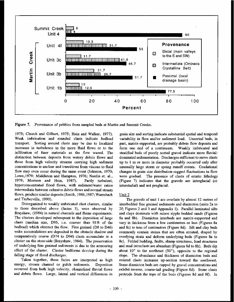
Summit Creek Unit 4
Unit 41 31. 7
"' CD CD
Unit 3c .... (.)
c: - Unit 3b .... ... ::;:
Unit 1 b
0 20 40
55
41.6 46.7
51.7
60
Percent
[]
•
90
Provenance Distal (main valleys to the S and SW)
Intermediate (Omineca Crystalline Belt)
Proximal (local drainage basin)
77.5
80 100
Figure 7. Provenance of pebbles from sampled beds at Martin and Summit Creeks.
1975; Church and Gilbert, 1975; Hein and Walker, 1977). Weak imbrication and rounded clasts indicate bedload transport. Sorting around clasts may be due to localized increases in turbulence in the more fluid flows or to the infiltration of fmer materials as the flow waned. The distinction between deposits from watery debris flows and those from high velocity streams carrying high sediment concentrations is unclear and transitions from viscous to fluid flow may even occur during the same event (Johnson, 1970; Lowe,1979; Middleton and Hampton, 1976; Nardin et. al., 1979; Morison and Hein, 19S7). Partly turbulent, hyperconcentrated flood flows, with sediment/water ratios intermediate between cohesive debris flows and normal stream flows, produce similar deposits (Smith, 19S6, 19S7; Waresbach and Turberville, 1990).
Disorganized to weakly imbricated clast clusters, similar to those described above (facies 3), were observed by Brayshaw, (19S4) in natural channels and flume experiments. The clusters developed subsequent to the deposition of large clasts (median size, 095, i.e. coarser than 95 % of the bedload) which obstruct the flow. Fine grained (OS to 046) wake accumulations are deposited in the obstacle shadow and comparatively coarse (074 to 094) clasts accumulate in a cluster on the stoss-side (Brayshaw, 19S4). The preservation of underlying fine grained sediments is due to the armouring effect of the cluster. Cluster bedforms develop during the falling stage of flood discharges.
Taken together, these facies are interpreted as high energy, stream channel or gulch sediments. Deposition occurred from both high velocity, channelized fluvial flows and debris flows. Large, lateral and vertical differences in
grain size and sorting indicate substantial spatial and temporal variability in flow and/or sediment load. Unsorted beds, in part, matrix-supported, are probably debris flow deposits and form one end of a continuum. Weakly imbricated and stratified beds of poorly sorted gravel indicate more fluvialdominated sedimentation. Discharges sufficient to move clasts up to 1 m or more in diameter probably occurred only after unusually lar~e storm or spring runoff events. Gradational changes in grain size distribution suggest fluctuations in flow were gradual. The presence of clasts of erratic lithology (Figure 7) indicates that the gravels are interglacial (or interstadial) and not preglacial.
Unit2 The gravels of unit 1 are overlain by almost 12 metres of
interbedded fine grained sediments and diamicton (units Za to 2f; Figures 2 and 3 and Appendix 1). Parallel laminated silts and clays dominate with minor ripple bedded sands (Figures Sa and Sb). Oiamicton interbeds are matrix-supported and vary in thickness from a few centimetres or less (Figures 8a and Sc) to tens of centimetres (Figure Sd). Silt and clay beds commonly contain stones that are often striated, draped by overlying strata and deform underlying beds (Figures Sa to Sc). Folded bedding, faults, slump structures, load structures and mud intraclasts are abundant (Figures Sd to Sh). Beds dip about 10° to the northeast (50'), opposite to the regional slope. The abundance and thickness of diamicton beds and striated clasts increases up-section toward the southwest. Some diamicton beds are capped by gravel concentrations and exhibit inverse, coarse-tail grading (Figure Sd). Some clasts protrude fron\ the tops of the beds (Figures Sd and Sf). In
- 109 -

diamicton beds in the lower part of the unit (eg. unit 2a). numerous pebble to cobble sized clasts occur in a silty clay matrix. Many of the stones are angular and derived from the local bedrock.
Deposits similar to those in unit 2 are typical of proximal glaciolacustrine environments (Ashley, 1988; McCabe and Eyles, 1988). Parallel-laminated clay and silt beds and ripplebedded sands are interpreted as quiet water suspension and density underflow deposits. The abundance of striated clasts, inferred to be dropstones, indicate the proximity of ice. Interbeds of matrix-supported diamicton are interpreted as debris flow deposits. Modern debris flow sediments have characteristics similar to those described above (Bull, 1972; Kochel and Johnson, 1984). Massive, disorganized, matrixsupported diam.ictons with sharp, non-erosional lower contacts were interpreted as debris flow deposits by Harvey (1984) and Wells (1984). Clasts that project above bed tops are characteristic of viscous debris flows (Johnson, 1970; Nardin et. al., 1979) and imply a high matrix strength. The presence of inverse grading als'o suggests a debris flow origin for these deposits (Fisher, 1971 and Lowe, 1979). This interpretation is further supported by the occurrence of recumbent and overturned isoclinal folds inferred to be flow structures, abundant evidence of loading, and numerous inclusions of silt and clay which are interpreted as rip up clasts (Figures 8e and 81).
The upslope dip of beds, indicates that the flows were derived from a high surface to the southwest, probably a glacier in the main valley. This is also suggested by an increase in abundance and thickness of diamicton beds toward the southwest. Instability in the ice-marginal lake sediments is indicated by abundant folds and faults. Normal faults (Figures 8c and 89), common in unit 2 (Figures 3 and 8), probably developed as a result of movement in the adjoining glacier.
The fine grained matrix of the debris flows likely originated by intraformational slumping of the unstable silts and clays (Figure 8h). The abundant local, angular stones in some diamicton beds in the lower part of the unit were probably eroded by the glacier shortly before incorporation in the debris flows. Similarly, large clasts transported by the glacier were undoubtedly incorporated in the flows. Textural inversions, characterized by angular and/or large clasts in a fine grained matrix, are typical of sediments produced by mixing of deposits from two different environments (Folk, 1980). Similar, texturally inverted, matrix-rich conglomerates and granule sandstones with associated loading, slumping and faulting, were interpreted by Larsen and Steel (1978) as subaqueously resedimented deposits of mixed debris flow and lacustrine origin. Diamicton beds formed by gravitational flows of coarse grained material over fine grained glaciolacustrine sediments should typify ice-marginal deltaic environments (Cohen, 1983 ). The pronounced and widespread upvalley dip of beds in unit 2 is consistent with the interpretation of an ice-marginal deltaic or pro-deltaic depositional environment.
Gravel concentrations capping some diamicton beds (eg.
Figure 8d) probably result from winnowing by bottom currents or subaerial exposure. Periodic traction deposition is indicated by minor ripple and cross-bedded sand, pebbly sand and pebbly gravel beds. The increase in thickness of diamicton beds and traction deposits up section indicates a gradual infilling of the ice-marginal lake. The upward increase in the total number of erratic and striated clasts suggests the increased influence of glacier expansion in the main valley.
Unit 3 Unit 3 is dominated by matrix-supported diamicton
(Figure 9a). The lower part of the unit (unit 3a; Figures 2 and 4 and Appendix I) exhibits weak, horizontal stratification due to textural variations in the diamicton and the presence of numerous silt and fine sand beds and laminae. Load structures and folded laminae are common.
Almost five metres of dense, massive diamicton (Figure 9b) with numerous striated and glacially shaped clasts and polished subhorizontal partings occurs in the middle of unit 3 (unit 3b; Figure 2). Small lenses of silt, clay and sand near the top of unit 3b commonly exhibit compressive deforrnation structures such as thrust faults, reverse faults, folds and subhorizontal shear zones (Figure 9c). Slickensides on shear zones (Figure 4) trend 110° to 150°, approximately parallel to the South Big Salmon River valley. The lower contact of unit 3b is gradational.
Unit 3c consists of about 7 m of sandy, loosely consolidated diamicton interbedded with silt, sand and gravel (Figure 9b). Diamicton beds are matrix to clast-supported (Figure 9d) with the total clast and sand content increasing towards the top of the unit. Massive or horizontally stratified sand and silt beds and trough cross-stratified sand and gravel lenses are common throughout the unit (Figure 9e).
Diamicton beds in unit 3a are interpreted as debris flow deposits. The presence of folded laminae believed to be flow folds support this interpretation. Load structures and deformed bedding indicate that the diamictons were deposited rapidly over unconsolidated sediments. The horizontal stratification, fine grain size and excellent sorting of the silt and sand beds suggests that they are main! y lacustrine sediments. The abundance of silty laminae and the association of these se<liments with the underlying glaciolacustrine deposits suggests that the debris flows were dominantly subaqueous. Similar stratified diamictons with silt and sand laminae were interpreted as ice-marginal, subaqueous debris flows by Boulton (1968), Evenson et al. (1977), Eyles (1987) and Levson and Rutter (1988).
The diamicton in unit 3b is interpreted as a subglacial till probably deposited by lodgment processes. The sedimentary characteristics of the diamicton are typical of lodgment til1s (Dreimanis, 1988). Partings, faults and shear zones probably formed at or near the sliding base of an overriding glacier. This is supported by the orientation of slickensides parallel to the inferred direction of former ice flow down the South Big Salmon River valley. Pebble fabric data from the upper part of unit 3b (Figure 4) also support this interpretation. The long axes of pebbles have a strong (SI = 0.75) preferred
110 -

Figure 8. Proximal glaciolacustrine sediments of Unit 2 at Martin Creek. (a) Parallel-laminated silts and clays with thin intrabeds of diamicton and ripple-bedded fine sand and numerous dropstones.
Fig. 8(b). Deformed strata under dropstone in unit 2b. Note: I cm thick fine sand bed below scale and diamicton bed at top.
- 11 l -

Fig. 8(c). Normal fault in interbedded diamicton and fines.
Fig. 8(d). Reversely graded debris flow deposits in laminated silts and clays. Note: gravel concentration at top of diamicton bed above small scale bar.
- 112 -

Fig. 8(e). Folded silt and clay intraclasts within diamicton bed.
Fig. 8(1). Large mud intraclast in diamicton bed (above and right of scale) and mud drapes over clasts protruding from the top of the lower diamicton bed.
- 113 -

Fig. 8(g). Abundant nonnal faults in unit 2c.
Fig. 8(h). Intrafonnational slump structure.
- 114 -

Figure 9. Sedimentary characteristics of units J and 4 at Martin Creek. (a) Matrix-supported diamicton with weak textural stratification in unit 3a.
orientation (VI = 126°) parallel to the trend of slickensides and the main valley (Figure 4). Pebbles at the base of unit Jb have a relatively weak (SI = 0.62) preferred orientation at right angles (Vl = 047°) to the trend of the main valley but parallel to the Martin Creek valley (Figure 4). This suggests that the lower part of unit Jb may have a debris flow origin similar to the underlying diamicton of unit 3a.
The large number of clasts of erratic lithology in unit Jb also supports a glacial origin. The provenance of the clasts indicates a substantial input of debris from glaciers which originated in the main valleys to the south and, to a lesser degree, in tributary valleys to the southwest. The higher percentages of clasts derived from the Omineca Crystalline Belt in overlying units (Figure 7) may reflect the increased influence of an inset tributary glacier that likely originated in the Big Salmon Range and flowed down the upper South Big Salmon River valley.
The high clast content and sandy texture of the diamictons in unit Jc is typical of debris flow deposits that have been washed during one or more cycles of resedimentation (Lawson,1979; 1981a; and 1981b). The weak (SI = 0.58)
Fig. 9(b). Massive diamicton of unit Jb grading up into unit Jc and unconformably overlain by unit 4.
preferred orientation of pebbles in unit Jc (Figure 4) is also typical of debris flow deposits. Lenses and beds of sorted material are interpreted as fluvial sediments deposited between debris flow events. Lawson (1979) found that thin layers of sand and silt often separate diamictons deposited by individual flows. A decrease in the number of striated clasts and increased sorting toward the top of the unit probably reflects greater domiriance of fluvial activity. All of unit 3c occurs in a wide ( > 50 m), trough-shaped body which is interpreted as a broad channel that presumably developed along the ice margin during deglaciation.
Unit4 Unit 4 consists of about 12 m of mainly horizontally
stratified gravels (Figures 9b, 9f, and 9h). Beds of open-work, poorly sorted, cobble to boulder gravel are interbedded with poorly to moderately sorted, matrix-filled, pebbly gravel and sand beds (Figure 91). Some lenses of well sorted. horizontally stratified and planar and trough cross-stratified sand lenses also occur (Figure 9g). Lower bed contacts are commonly erosional. The lower contact of unit 4 is
- 115 -

Fig. 9(c). Subhorizontal shear zones and compressively de.formed strata (arrows are 1 cm long and point to a sample reverse fault) at the top of unit Jb.
unconformable and forms a large scour (Figure 9h) similar in size and shape to the channel shaped lower contact of unit Jc. Deposits of this type are typical of gravelly, proximal, braided rivers in glacial environments (Rust, 1972; Church and Gilbert, 197S; Boothroyd and Ashley, 197S).
Crude horizontal stratification is commonly formed in longitudinal bars which characterize gravel-bed braided streams (Smith, 1974). Scoured lower bed contacts and sharp variations in grain size distribution are typical of ice-marginal streams where large variations in discharge occur and sedimentation is highly episodic (Church and Gilbert, 197S). The similar size and shape of the lower contacts of units J and 4, suggests that unit 4 was deposited in the same ice-marginal channel as unit 3c. During deposition of unit 4, however, fluvial processes dominated over, or eroded any evidence of, debris flow sedimentation.
UnitS In an area of highly irregular or hummocky topography
directly south of the main Martin Creek Section, shallow exposures reveal a complexly interbedded series of diamicton, gravel and sand beds described here as unit S (Appendix 1).
Although the lower contact is not exposed, unit S apparently overlies unit J and is laterally equivalent to unit 4.
At the SW end of the exposure (Figure !Oa) a large trough shaped unit of diamicton (unit Sa, Appendix 1) is conformably overlain by large scale trough cross-stratified sands (unit Sb). The NE limb of the trough grades into crudely stratified gravel, sand and diamicton beds (unit 5c) that dip upstream (NE) as much as J0°. These beds are conformably overlain by bouldery gravel (unit 5d). Strata in unit 5d are folded into a large (about JO m wide) wedge-shaped feature (with beds dipping 60-80° in opposing directions). This is interpreted as a collapse structure (Figure !Ob). The section here is capped by large troughs of well stratified sand and gravel (unit 5e). Folds and normal faults are common and increase in intensity towards the base of the unit (Figure !Oc). At the NE end of the exposure, closest to the main Martin Creek Section, sand and gravel beds (unit 51) dip about 20° downstream (Figure !Od). They are unconformably overlain by interbedded and convoluted diamicton, gravel and sand beds (unit Sg) that dip 20° upstream (Figure lOd).
Unit 5 is interpreted as an ice-marginal glaciofluvial complex. The unusually large and sharp changes in grain
- 116 -

Fig. 9(d). Sand bed and matrix to clast-supported diamicton at base of unit 3c.
size, sorting, bedding dip and dip direction support this interpretation. The presence of closely juxtaposed sorted deposits ranging from silts and sands to boulder gravels is typical of proximal glaciofluvial sediments (Boulton and Eyles, 1979; De Jong and Rappol, 1983). Large scale trough crossstratification is interpreted as channel-fill bedding. The associated sands and gravels are inferred to be glaciofluvial sediments that infilled small ice-marginal channels. Diamicton and poorly sorted gravel beds were probably deposited by resedimentation processes. Such processes are common in ice-marginal environments (Lawson, 1979, 1981a, 1981b and 1982). The abundance of deformation structures is also typical of ice contact deposits (Schwan and Van Loon, 1979; and Hambrey, 1984). Normal faults and collapse structures probably formed as a result of melting of underlying or adjacent ice. The irregular and hummocky topography are also strongly suggestive of an ice contact origin. The stratigraphic position and surface expression of these sediments suggests that they were deposited along the ablating margin of the last glacier to occupy the area.
Livingstone Creek Section
A stratigraphic column and brief unit descriptions for the Livingstone Creek Section are provided in Figure 5. The general stratigraphy of the section is very similar to the Martin Creek Section and is not discussed in detail here.
The gravels immediately overlying the bedrock are coarse, poorly sorted and clast-supported. They exhibit weak horizontal bedding with minor open work pebble gravel and trough cross-bedded sand layers. Although most clasts are well rounded to subrounded some beds are dominated by very angular clasts of local origin. These gravels are similar to the gravel facies of unit I at Martin Creek. They are also interpreted as high energy stream channel and gulch sediments deposited by channelized fluvial flows and gravelly debris flows.
Parallel-laminated silts and clays with numerous erratic dropstones and pebble intrabeds in unit 3 are similar to those exposed in unit 2 at Martin Creek. They exhibit sedimentary structures typical of proximal glaciolacustrine sediments (Ashley, 1988). Intense folding of some silt and clay beds indicates remobilization of the lake sediments. Intrabeds of local, brecciated gravel with some rounded erratic clasts in a clay matrix were probably deposited by subaquatic debris flows that mixed pre-existing gravels with the finer lake sediments (Larsen and Steel, 1978). The lensoid shape of the beds and presence of soft-sediment intraclasts indicates that the flows were erosive.
The presence of lake sediments at similar stratigraphic positions in the Martin and Livingstone Creek valleys supports the interpretation that a glacier, flowing down the South Big Salmon River valley, blocked the tributaries and caused small ice-marginal lakes to form. Instability of the local bedrock slopes was probably caused by the presence of the lake water and the movement of the adjacent glacier, resulting in mass movements of local materials into the lake. This would explain the dominance of local, angular clasts in the pebble intrabeds.
The diamicton units capping the Livingstone Creek Section (Figure 5) are not well exposed. They are matrixsupported and contain numerous striated clasts suggesting a glacial origin. Units 4 and 5 have stratigraphic and sedimentary characteristics similar to units 3a and 3b at Martin Creek and may also have been deposited, respectively, as debris flows and subglacial tills. The upward decrease in sand content may be due to a vertical progression from resedimented deposits to mainly till deposited directly by ice (Levson and Rutter, 1988).
Swnmit Creek Section
Bedrock (unit 1) at the Summit Creek section (Figure 5) is overlain by clast-supported, disorganized, coarse gravels (Figure lla) similar to unit 1 at Martin Creek. These gravels are also interpreted as stream channel and debris flow
- 117 -

Fig. 9(e). Sandy diamicton with numerous stratified sand and gravel lenses near top of unit 3c.
Fig. 9(1). Horizontally stratified, pebble to boulder gravels of unit 4 with erosional lower contact. Large boulders on right are nearly 1 m in diameter.
- 118 -

Fig. 9(g). Well sorted and cross-stratified sands interbedded with pebbly sands in a trough-shaped lens at the base of unit 4.
Fig. 9(h). Pronounced basal scour and channel shape of unit 4 gravels.
- 119 -

Figure 10. Ice-marginal, glaciofluvial deposits (unit 5) at the Martin Creek west exposure. (a) Diamicton of unit Sa overlain by channel sands and gravels (unit Sb).
Fig. lO(b). Collapse structure in poorly sorted coarse gravel (beds dip towards photo center from both sides) (unit Sd) overlain by channel sands and gravels (unit Se).
- 120 -

Fig. lO(c) Faults and folds at the base of unit Se.
Fig. lO(d) Beds with opposing dip directions in ice-contact sand and gravel deposits of units Sf (right) and Sg (left).
- 121 -

deposits. They are overlain by horizontally stratified sands (Figure ll b) which are interpreted as glaciolacustrine sediments. The lateral continuity of be.ds, uniform grain size, rarity of channelized features and presence of dropstones supports this interpretation.
Units 4 to 6 (Figures 5 and I le) consist of clastsupported, well stratified, mainly open work, pebble to cobble gravels. A few boulder beds also occur. Planar cross-beds, dipping up to 31 ° to the northeast (opposite to the regional slope), dominate units 4 and 6 (Figures l le and lld). Individual cross strata are traceable for more than 5 m and are interpreted as deltaic foresets. Jn contrast to the good sorting and mainly open work structure of units 4 and 6, unit 5 gravels are poorly sorted and matrix-filled (Figure I le). They exhibit horizontal to gently inclined planar bedding and are interbedded with parallel laminated silts and sands (Figures lie and lie). Pronounced erosional surfaces separate unit 5 from units 4 and 6 (Figure lie).
The deposits of unit 5 are interpreted as delta front and pro-delta sediments, with the poorly sorted sandy gravels d~positOO by slumping and turbidity currents and the fine grained sediments representing quiet water sedimentation. Cohen (1983) interpreted similar interbedded fine grained and gravelly sediments in an ice-marginal deltaic sequence as the product of alternating foreset and bottom-set deposition induced by shifting sources of discharge and sediment supply.
The up-valley dip direction of bedding in units 4 to 6 indicates a debris source to the southwest in the South Big Salmon River valley. The only plausible explanation for this is that a glacier occupied the main valley and debris was washed from the ice surface or along the ice margin into the Summit Creek valley. This interpretation, combined with the presence of the delta and pro-delta sediments, indicates that an ice-dammed lake occupied the Summit Creek valley. Again, the presence of glaciolacustrine sediments in adjacent valleys at stratigraphically similar positions strongly supports this interpretation.
Clasts in units 4 to 6 are angular to subangular (Figure llf) and up to 90% are locally derived (Figure 7), indicating that local bedrock was eroded by the ice or its meltwater and the clasts were transported only a short distance before being redeposited in the ice-marginal deltaic complex. The dominance of open-work beds of widely varying grain size is indicative of high and variable discharges typical of proximal glaciofluvial deposits. Changes from foreset (units 4 and 6) to pro-delta (unit 5) sedimentation indicate that the lake level must have fluctuated. Such variations are typical of icedammed lakes (Ashley, 1988). A rise in lake level must have occurred after deposition of unit 4 to allow for the deposition of the pro-delta sediments of unit 5. The prominent erosional surface separating units 4 and 5 probably formed as a result of slumping induced by the higher lake level. Progradation of unit 6 over unit 5 resulted in a sharp contact between the prodelta (bottom set) sediments and the overlying delta front (foreset) beds.
The origin of the diamicton and poorly sorted gravel (unit 7) at the top of the section can not be determined due to poor
exposure and inaccessibility. The poor sorting and high matrix component suggest that these sediments may be debris flow deposits or till, although a proximal glaciofluvial component is also likely.
SUMMARY
The coarse, dominantly local gravels exposed at the base of the Martin (unit 1), Livingstone (unit 2) and Summit (unit 2) Creek sections are interpreted as interglacial stream or gulch gravels. Concentrated fluvial and debris flow sedimentation likely occurred in response to unusually high storm or spring runoff events. The advance of a glacier down the South Big Salmon River valley resulted in damming of the channelized flows that deposited the underlying gravels. Icemarginal lak~s formed in each of the tributary valleys. Parallel-laminated clays, silts and sands were deposited in the ice dammed lakes along with debris flow deposits derived mainly from the ice margin (units 2 and 3a at Martin Creek and unit 3 at Summit Creek, and units 3 and 4 at Livingstone Creek). Ice-rafted debris and deformation structures characterize these sediments and are typical of proximal glaciolacustrine deposits. At Summit Creek a thick glaciofluvial delta complex (units 4 to 6) developed in the lake ponded in that valley.
As the glacier in the South Big Salmon River valley expanded, the lakes diminished in size and debris flow sedim.entation increased until the area was overridden by ice. A thick till (unit 3b at Martin Creek, unit 5 at Livingstone Creek and unit 7 (?) at Summit Creek) was deposited at the base of the glacier. During deglaciation, a glaciofluvial complex developed along the ice margin in the Martin Creek area. Sedimentation occurred in an ice-marginal channel and was initially dominated by debris flow deposits (unit 3c). Glaciofluvial activity gradually increased in importance and eventually deposited a thick sequence of gravel (unit 4). Elsewhere the ice-marginal deposits developed an irregular glaciofluvial complex (unit 5). The series of meltwater channels that extend from south of Martin Creek to well north of Summit Creek, formed along the side of the South Big Salmon Valley in association with the ice-marginal deposits. Postglacial river erosion has incised through all of the overlying glacial deposits and has re-exposed the gold bearing gravels that have been mined throughout the twentieth century.
DISCUSSION
Damming of ice-marginal lakes in the all of the tributary valleys studied may have been critical for the preservation of the older gold bearing deposits. The lakes provided a quick transition from the subaerial stream gulch environment to a mainly depositional, quiet water environment. Sedimentation in the lakes was dominated by suspension settling, ice rafting, turbidity current, and debris flow processes. These processes are mostly depositional and none were sufficiently erosive to remove the underlying, coarse, interglacial gravels.
122 -

Figure 11. Surrunit Creek Section. (a) Poorly sorted, disorganized gravel (facies I) in unit 2.
Fig. ll(b). Horizontally stratified bottom set sands (unit 3) overlying unit 2 gravels and unconformably overlain by unit 4 gravels. The top of the 1.5 m long rod is near the top of unit 2.
- 123 -
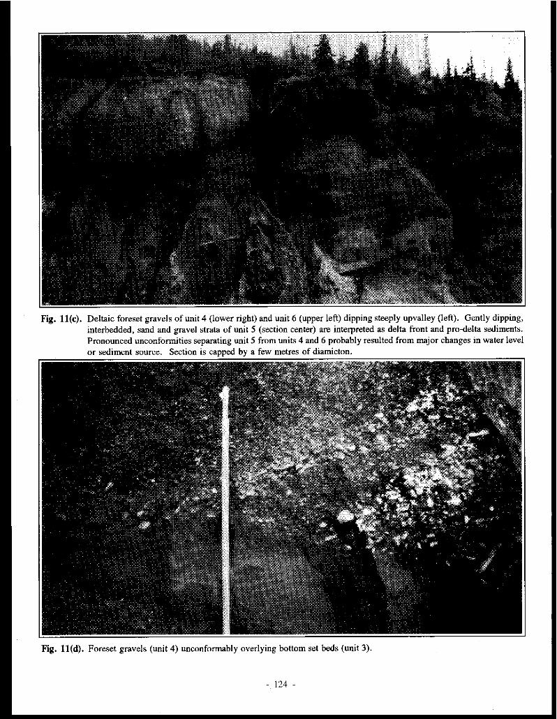
Fig. ll(c). Deltaic foreset gravels of unit 4 (lower right) and unit 6 (upper left) dipping steeply upvalley (left). Gently dipping, interbedded, sand and gravel strata of unit 5 (section center) are interpreted as delta front and pro-delta sediments. Pronounced unconformities separating unit 5 from units 4 and 6 probably resulted from major changes in water level or sediment source. Section is capped by a few metres of diamicton.
Fig. ll(d). Foreset gravels (unit 4) unconformably overlying bottom set beds (unit 3).
- 124 -

Fig. ll(e). Poorly sorted sediment-flow deposits of unit 5 (centre).
Fig. 11(1). Angular clasts in open-work bed typical of units 4 and 6.
- 125 -
Glaciolacustrine sediments overlie the interglacial gravels at all three of the studied sites and, at Livingstone and Martin Creeks, they are especially thick and have a high silt and clay content. The cohesive nature and low permeability of these fine grained sediments would also have acted to resist the erosive power of ice-marginal and subglacial meltwaters .
If ice-marginal lakes had not developed in the tributary valleys, the gold bearing sediments may have been eroded by meltwaters from the advancing glaciers. Such a situation might have occurred, for example, if glaciers developed in the Big Salmon Range to the east, and flowed into these valleys prior to the arrival of glaciers in the South Big Salmon Valley. Meltwater from the glaciers to the east would have had a free outlet and could have deeply eroded the gold bearing gravels. Discharges in these meltwater streams would potentially have been of much higher magnitude than normally encountered in the drainage basins in nonglacial times. In addition, as glaciers advanced down the tributary valleys, substantial erosion by the ice could have occurred.
During glacial advances, erosion of the gold-bearing gravels by the overriding glaciers was minimal, probably for two reasons. First, the gravels were buried by a thick sequence of glaciolacustrine, glaciofluvial and ice-marginal debris flow deposits. Second, these deposits accumulated in narrow and deep valleys that were oriented transverse to the regional direction of ice flow. The sediments within the tributary valleys were thus protected from ice erosion by the high bedrock walls flanking the valleys. The dominance of depositional over erosive processes in similar topographic situations has been observed in several other areas (egs. Games and Bergerson, 1977; Haldorsen, 1982, Levson and Rutter, 1986).
During deglaciation, glaciofluvial activity resulted in the deposition of a thick sequence of sand and gravel deposits and erosion of a meltwater channel system along the ice margin.
The meltwater channels are incised partly into bedrock and probably removed or disrupted any underlying placer deposits. It is unlikely that any of the gravels deposited during deglaciation are gold bearing.
CONCLUSIONS
Three factors that contributed to the preservation of gold bearing gravels in tributary valleys in the Livingstone Creek region are: (!) Glaciers did not flow down the tributary valleys before ice occupied the main valley. This prevented the erosion of older deposits by water and ice moving down the valleys. (2) Ice-marginal lakes formed in the tributary valleys during the early stages of glaciation causing depositional processes to predominate. (3) The valleys are oriented transverse to the former regional direction of ice flow thus minimizing direct erosion by ice. As a result of these factors, the transverse valleys became depositional sinks, and erosion of the gold bearing deposits by glaciers and glacial meltwaters was minimal, both immediately prior to and, during glaciation. The recognition of areas with similar glacial histories may be important for the identification of potential exploration targets in other placer gold regions in glaciated terrains.
ACKNOWLEDGEMENTS Funding and technical support for this research was
provided by the Exploration and Geological Services Division of the Mineral Resources Directorate, Yukon Region. The study was directed by S. R. Morison of that division. Sections were examined with the kind permission of placer lease holders D. Gonder, M. Fuerstner and R. Asuchak. Mr D. Gonder generously offered the use of his placer camp for the duration of the study. Field assistance and lithologic studies were ably carried out by Bill LeBarge.
REFERENCES
ASHLEY, G.M. 1988. Classification of Glaciolacustrine sediments. In: Genetic classification of glacigenic deposits; R.P. Goldthwait and and C. L. Malsch (eds), Balkema, Rotterdam, p. 243-260.
BOOTHROYD, J.C. and ASHLEY, G.M. 1975. Processes, bar morphology, and sedimentary structures on braided outwashfans, northeastern gulf of Alaska. Jn: Glaciofluvial and glaciolacustrine sedimentation, A. V. Jopling and B. C. McDonald (eds); Society of Economic Paleontologists and Mineralogists, Special Publication 23, p. 193-222.
BOSTOCK H.S. and LEES E.J. J938. Laberge map area, Yukon. Geological Survey of Canada, Mem. 217.
BOULTON, G.S. 1968. Flow tills and related deposits on some Vestspitzbergen glaciers. Journal of Glaciology, Vol. 7, p. 391-412.
BOULTON, G.S., and EYLES, N. 1979. Sedimentation by valley glaciers, a model and genetic classification. Jn: Moraines and varves, C.M. Schluchter, (ed); Balkema Press, Rotterdam, p. 11-25.
BRAYSHAW, A. C., 1984. Characteristics and origins of cluster bedforms in coarse-grained alluvial channels. Jn: Sedimentology of gravels and conglomerates, E.H. Koster and R.J. Steel (eds); Canadian Society of Petroleum Geologists, Memoir 10, p. 77-85.
- 126 -

BULL, W.B. 1972. Recognition of alluvial fan deposits in the stratigraphic record. In: Recognition of ancient sedimentary environments, J.K. Rigby and Wm. K. Hamblin,(eds); Society of Economic Paleontologists and Mineralogists, Special Publication 16. p. 63-83.
BURGISSER, H.M. 1984. A unique mass flow marker bed in a Miocene stream flow molasse sequence, Switzerland. In: Sedimentology of gravels and conglomerates, E.H. Koster and R.J. Steel (eds); Canadian Society of Petroleum Geologists, Memoir 10, p. 147-163.
CHURCH, M.A., and GILBERT, R. 1975. Proglacial fluvial and lacustrine environments. In: Glaciofluvial and glaciolacustrine sedimentation, A. V. Jopling and B. C. McDonald (eds); Society of Economic Paleontologists and Mineralogists, Special Publication 23, p. 22-100.
COHEN, J. M. 1983. Subaquatic mass flows in a high energy ice-marginal deltaic environment and problems with the idetllification of flow tills. In: Tills and related deposits, E.B. Evenson, C.H. Schluchter and J. Rabassa (eds); Proceedings of the INQUA Symposia on the genesis and lithology of Quaternary deposits, A.A. Balkema (ed); Rotterdam, p. 255-267.
DEB/CK/ R.L. 1983. Yukon Placer Mining Industry, 1978-1982. Exploration and Geological Services Division, Yukon, Indian and Northern Affairs Canada, 203 p.
DE JONG, M. G. G. and RAPPOL, M. 1983. Ice-marginal debris flow deposits in western Allgau, southern West Germany. Boreas, Vol. 12, p. 57-70.
DRE/MANIS, A. 1988. Tills: their genetic terminology and classification. In: Genetic classification of glacigenic deposits, R.P. Goldthwait and C.L. Marsch (eds); Balkema, Rotterdam, p. 17-83.
EVENSON E.B., DRE/MANIS A. and NEWSOME, J. W. 1977. Subaquatic flow tills: a new interpretation for the genesis of some laminated till deposits. Boreas, Vol. 6, p. 115-133.
EYLES, N., 1987. Late Pleistocene debris flow deposits in large glacial lakes in British Columbia and Alaska. Sedimentary Geology, Vol. 53, p. 33-71.
FISHER, R. V., 1971. Features of coarse grained, high concentration fluids and their deposits. Journal of Sedimentary Petrology, Vol. 41, p. 916-927.
FOLK, R.L., 1980. Petrology of sedimentary rocks. Hemphill Publishing Company, Austin, Texas. 184 p.
HAMBREY, M.J., 1984. Sedimentary processes and buried ice phenomena in the pro-glacial areas of Spitsbergen glaciers. Journal of Glaciology, Vol. 30, p. 116-119.
HARVEY, A.M. 1984. Debris flows andfluvial deposits in Spanish Quaternary alluvial/ans: implications for fan morphology. In: Sedimentology of gravels and conglomerates, E.H. Koster and R. J. Steel (eds); Canadian Society of Petroleum Geologists, Memoir 10, p. 123-132.
HEIN, F.J. and WALKER R. G., 1977. Bar evolution and development of stratification in the gravelly braided Kicking Horse River, B. C. Canadian Journal of Earth Sciences, Vol. 14, p. 562-572.
HUGHES, 0.L. 1968. Glacial map of Yukon Territory. Geological Survey of Canada Map 1968-6, scale 1:1,000,000.
HUGHES, O.L., CAMPBEU, R.B. MULLER, J.E. and WHEELER, J.O. 1969. Glacial limits and flow pattenzs, Yukon Territory, south o/65 degrees north latitude. Geological Survey of Canada, Paper 68-34.
JOHNSON, A.M., 1970. Physical Processes in Geology. Freeman, Cooper ami Company, San Francisco, 577p.
KLASSEN, R. W. 1987. The Tertiary-Pleistocene stratigraphy of the Liard Plain, southeastern Yukon Territory. Geological Survey of Canada, Paper 86-17.
- 127 -

KLASSEN, R. W. and MORISON, S.R. 1987. Sutficial Geology, Laberge, Yukon Territory. Geological Survey of Canada, Map 8-1985, scale 1 :250,()()().
KOCHEL, R. C. and JOHNSON, R.A., 1984. Geomorphology and sedimentology of humid-temperate alluvial fans, central Virginia. In: Sedimentology of gravels and conglomerates, E.H. Koster and R. J. Steel, (eds), Canadian Society of Petroleum Geologists, Memoir JO, p. 109-122.
LARSEN, V. and STEEL, R.J., 1978. The sedimentary history of a debris flow dominated alluvial fan: a study of textural inversion. Sedimentology, Vol. 25, p. 37-59.
LATOSKI, D.A., 1991. An overview of the Yukon Placer Mining Industry 1989 and 1990. In: Yukon Placer Mining and Exploration, 1985 to 1988, W.P. Lebarge and S.R. Morison (eds); Exploration and Geological Services Division, Yukon, Indian and Northern Affairs Canada, p. V-IX.
LEBARGE, W.P. 1990. Yukon placer mining industry 1985-1988: an overview. In: Yukon Placer Mining Industry 1989-1990, A.R. Waroway andD.A. Latoski (eds); Exploration and Geological Services Division, Yukon, Indian and Northern Affairs Canada, p. 111-VJI.
LAWSON, D. E., 1979. A sedimentological analysis of the western terminus of the Matanuska Glacier, Alaska. United States Army Cold Regions Research and Engineering Laboratory, Hanover, NH, Report 79-9.
LAWSON, D.E., 1981a. Distinguishing characteristics of diamictons at the margin of the Matanuska Glacier, Alaska. Annals of Glaciology, Vol. 2, p. 78-84.
LAWSON, D.E., 1981 b. Sedimentological characteristics and classification of depositional processes and deposits in the glacial environment. United States Army Cold Regions Research and Engineering Laboratory, Hanover, NH, Report 81-27.
LAWSON, D.E., 1982. Mobilization, movement a1ui deposition of active subaerial sediment flows, Matanuska Glacier, Alaska. Journal of Geology, Vol. 90, p. 279-300.
LEVSON, V.M. 1991. Geologic controls on alluvial gold mining in the Cariboo District, British Columbia, Canada. In: Alluvial Mining; Elsevier Science Publishers for Institute of Mining and Metallurgy, London, England, p. 245-267.
LEVSON, V.M. 1992. Quaternary geology of the Atlin area (104NIJJW, 104N/12E). In: Geological Fieldwork 1991, B. C. Ministry of Energy, Mines and Petroleum Resources, Paper 1992-1, p. 375-390.
LEVSON, V.M., and GILES, T.R., 1991. Stratigraphy and geologic settings of gold placers in the Cariboo Mining District (9;fA,B,G,H). In: Geological Fieldwork 1990; B.C. Ministry of Energy, Mines and Petroleum Resources, Paper 1991-1, p. 331-344.
LEVSON, V.M., and KERR, D.K., 1992. Sutficial geology and placer gold settings of the Atlin - Surprise Lake area, NTS 104N/JJ ,12. B. C. Ministry of Energy, Mines and Petroleum Resources, Open File 1992-7; 1 :50 ()(}() scale map.
LEVSON, V.M., and RUTTER, N. W., 1986. A facies approach to the stratigraphic analysis of Late Wisconsinan sediments in the Portal Creek area, Jasper National Park, Canada. Geographie physique et Quaternaire, Vol. 40, p. 129-144.
LEVSON, V.M., and RUTTER, N. W., 1988. A lithofacies analysis and interpretation of depositional environments of montane glacial diamictons, Jasper, Alberta, Canada. In: Genetic classification of glacigenic deposits, R.P. Goldthwait and C. L. Marsch (eds), Balkema, Rotterdam, p. 117-140.
LOl\>2'.', D.R., 1979. Sediment gravity flows: their classification and some problems of application to natural flows and deposits. In: Geology of continental slopes, O.H. Doyle and 0. H. Pilkey (eds). Society of Economic Paleontologists and Mineralogists, Special Publication 27, p. 75-82.
- 128 -

MIDDLETON, G. V. and HAMPTON, M. A. 1976. Subaqueous sediment transport and deposition by sediment gravity flows. In: Marine sediment transport and environmental management, D.J. Stanley and D.J.P. Swift (eds); John Wiley and Sons, p. 197-218.
MORISON, S.R., 1983. A sedimentologicdescription of Clear Creekfluviatilesediments, 115 P, Central Yukon. In: Yukon Exploration and Geology 1982, Exploration and Geological Services Division, Yukon, Indian and Northern Affairs Canada, p. 50-54.
MORISON, S.R., 1984. Placer deposits of Clear Creek drainage basin 115 P, central Yukon. In: Yukon Exploration and Geology 1982; Exploration and Geological Services Division, Yukon, Indian and Northern Affairs Canada, p. 88-93.
MORISON, S.R. and HEIN, F.J., 1987. Sedimentology of the White Channel Gravels, Klondike area, Yukon Territory: fluvial deposits of a confined valley. Society of Economic Paleontologists and Mineralogists, Special Publication 39, p. 205-216.
NARIJIN, T.R., HEIN, F.J., GORSLINE, D.S., and EDWARIJS, B.D., 1979. A review of mass movement processes, sediment and acoustic characteristics, and contrasts in slope and base-of-slope systems versus canyon-Jan-basin floor systems. Jn: Geology of continental slopes, O.H. Doyle and 0. H. Pilkey (eds); Society of Economic Paleontologists and Mineralogists, Special Publication 27, p. 61-73.
PIERSON, T. C., I 981. Dominant particle support mechanisms in debris flows at Mt. Thomas, New Zealand, and implications for flow mobility. Sedimentology, Vol. 28, p. 49-60.
RUST, B.R., 1972. Structure and processes in a braided river. Sedimentology, Vol. 18, p. 221-245.
SCHWAN, J., and VAN LOON, A.J., 1979. Structural and sedimentological characteristics of a Weichselian kame terrace at Sonderby Klint, Funen, Denmark. Geologie en Mijnbouw, Vol. 58, p. 305-319.
SMITH, G.A., 1986. The influence of explosive volcanism on fluvial sedimentation: the Deschutes Formation (Neogene) in central Oregon. Journal of Sedimentary Petrology, Vol. 57, p. 613-629.
SMITH, G.A., I 987. Coarse grained non-marine volcaniclastic sediments. Terminology and deposition processes. Geological Society of America Bulletin, Vol. 97, p. 1-JO.
SMITH, N.D., 1974. Sedimentology and bar formation in the upper Kicking Horse River, a braided outwash stream. Journal of Geology, Vol. 82, p. 205-223.
TEMPELMAN-KLUIT, D., 1980. Highlights of.fieldwork in Laberge and Carmacks map areas, Yukon Territory. Geological Survey of Canada, Paper 80-JA, p. 357-362.
TEMPELMAN-KLUIT, D., 1984. Geology, Laberge (JOSE) and Carmacks (1151), Yukon Territory. Geological Survey of Canada, Open File 1101.
WARESBACK, D.B., and TURBEVILLE, B.N., 1990. Evolution of a Plio-Pleistocene volcanogenic-alluvial fan: the Puye Fortnation, Jemez Mountains, New Mexico. Geological Society of America Bulletin, Vol. 102, p. 298-314.
WELLS, N.A., 1984. Sheet debrisflowandsheetflood conglomerates in Cretaceous cool-maritme alluvial fans, South Orkney Islands, Antarctica. Jn: Sedimentology of gravels and conglomerates, E. H. Koster and R.J. Steel, (eds); Canadian Society of Petroleum Geologists, Memoir JO, p. 133-145.
- 129 -

Appendix 1. Martin Creek Section Description
Main Section
Unit la: Bouldery gravel: 6.7 m thick; very poorly sorted; clast-supported; 50% boulders up to 1 min diameter, 20% cobbles, 20% pebbles and 10% silt to coarse sand; clasts mainly subangular to subrounded; some poorly defined pebble to cobble gravel lenses, generally about 25 cm thick and 100 cm wide, poorly to moderately sorted; disorganized fabric; strong oxidation in basal 2 m; unit is poorly exposed; lower contact covered.
Unit lb: Boulder-cobble gravel: 3.5 m thick; clast-supported, matrix-filled; some crude horizontal to low angle stratification; beds are poorly defined with gradational boundaries on all sides; 50% cobble and pebble beds increasing towards the top; beds generally 25 to 50 cm thick (P28 R17); boulders occur in disorganized clusters and beds up to 2 m thick with a clast size distribution similar to unit la; sorting generally poor except for a few pebble beds with an open work to sandy matrix; sorted layers of laminated clay, silt and sand and pebbly sands (Figure 6d) occur around some clasts with thicker sorted layers below the clast; clasts mainly rounded to subrounded (especially boulders and cobbles) but some angular, local clasts of quartzite and schist; weak imbrication locally developed; some oxidized patches and heavily altered clasts; lower contact covered.
Unit le: Diamicton: up to 3.5 m thick; lens shaped; massive; mainly clast-supported with a silty sand matrix; a few pockets of matrix-supported diamicton and poorly sorted cobble or pebble gravel; 60 to 80% clasts; disorganized fabric; oxidation patchy; shape and size range of clasts similar to unit lb; some clasts have 1 - 2 mm thick, smeared and polished silt and clay coatings; slickensides weak and near vertical; lower contact gradational and irregular.
Unit ld: Boulder-cobble gravel: similar to, and laterally continuous with, unit lb; discontinuous lenses and beds up to about 1.5 m thick; lower contact gradational to erosional.
Unit 2: lnterbedded clay. silt. sand and diamicton: 11.85 m thick; Silt and clay beds: 5 - 50 cm thick, parallel laminated, locally with numerous dropstones that deform underlying laminae, minor convoluted laminae and flaser bedding, lower contacts generally sharp and planar, upper contacts mainly gradational. Diamicton beds: generally 10 - 60 cm thick although thin (lcm) intrabeds are also common; generally matrix-supported; matrix silty to silty sand commonly with angular inclusions of laminated silts and clays (Figure 81); clay, silt and sand laminae and intrabeds are common and often are folded (Figure 8e); clasts are mainly small to large pebbles; total clast content 50 - 70% near the base of the unit to 10-20% near the top, some clasts striated, mostly subrounded and subangular although angular clasts locally dominate; beds are mainly ungraded or normally graded; clasts at the base of the diamicton beds commonly deform underlying sediments and clasts at the top commonly protrude into, and are draped by, overlying strata (Figure 81). Sands: Some fine to medium sand beds with parallel laminae; cross laminae and ripple bedding and minor pebbly sand beds occur. Minor irregular pebble gravel layers; some normal faults. Thickness and abundance of diamicton layers increases towards the SW. Contacts between beds are mainly conformable except for loading and deformation structures at the base of some diamicton beds. Lower contact of unit dips steeply (25° - 30°) to the west (220° - 295°) at the SW end of section and is marked by a 20 cm thick layer of sheared (fractured and slickensided) clay, silt and gravel (probably due to "recent" slumping). At the NE end of the section beds consistently dip about 10° to the NE (50°). The lower contact at the NE end of the section is covered. Near the section centre the contact is inaccessible but appears conformable, and unit 2 is locally interbedded with unit 1.
Unit 2a: Diamicton: 1.0 m thick; beds mainly 10 - 20 cm thick, clast to matrix-supported, matrix silty sand, total clast content 50 - 70%. 60% of clasts clasts are angular, siliceous, rocks of local origin, some beds inversely graded and capped by gravel concentrations (Figure 8d), lower contacts loaded. Silts and clays as above.
Unit 2b: Silt. clay. sand and diamicton: 4.25 m thick; silts and clays with some fine saod laminae ( < 0.1 mm to 0.5 cm thick), abundant dropstones; numerous thin ( < 1 - 10 cm) granular to pebbly diamicton beds, commonly with flow folds and silt/clay intraclasts; minor ripple bedded sands with silts infilling ripple troughs; thickness of diamicton beds and sand laminae increases towards the top of the unit; minor normal faulting (Figure 8c) near top of unit (dip 49°, dip direction 245°); bed contacts mainly conformable except for small scale load structures.
Unit 2c: Silts and clays: 2.0 m thick; thinly laminated silts and clays with few diamicton beds; number of diamicton beds and sand laminae increase towards the top of the unit; abundant normal faults in lower half (Figure 8g).
- 130 -

Unit 2d: Silts and fine sands: 3.6 m thick; thinly to thickly laminated silts and fine sands with little clay; diamicton beds 2-5 cm thick except for one 30 cm thick bed; matrix silty clay in thickest beds, otherwise silty sand; numerous silt and sand laminae (partings) in diamicton beds; numerous dropstones in upper part; contacts distinct and conformable.
Unit 2e: Diamicton: 0. 7 m thick; matrix-supported; matrix silty sand; clasts pebble to small cobble sized, mostly subangular with abundant striations; numerous rounded mud clasts; total clast content 30 - 40%; lower contact gradational and indistinct.
Unit 2f: Pebbly sands and silts: 0. 75 m thick; parallel laminae with intense small scale folding; abundant load structures, especially in the upper half of the unit where stratification is very indistinct.
Unit 3a: Diamicton interbedded with silt and fine sand: 2.5 m thick; diamicton matrix-supported with a silty sand matrix (figure 9a); clasts up to cobble size, subangular to rounded; diamicton beds are 20 to 50 cm thick and contain numerous discontinuous sand laminae; bedding is horizontal but is weakly defined; it is due to textural and color banding in the diamicton, and is enhanced by the sand and silt beds; horizontal laminae within sand and silt beds are generally discontinuous and highly deformed (loaded and folded); some polished and lineated (sheared?) surfaces occur in the upper part of the unit; lower contact is gradational.
Unit 3b: Diamicton: 4.5 m thick; matrix-supported, silty clay to silty sand matrix; dense; polished sub-horizontal partings are common in clay rich areas. Clasts mainly medium to large pebbles, cobbles and boulders rare, mainly subangular to subrounded, numerous striated and glacially shaped clasts, total clast content 20 - 40%; unit oxidizes readily resulting in mottling with grey, recently exposed diamicton occurring in patches on the dominantly brown, weathered surface. Small ( < 20 cm thick), poorly defined, irregular, lenses of silt, clay and sand occur in the upper part of the diamicton; the lenses commonly exhibit compressive deformation structures such as thrust faults, reverse faults, folds and subhorizontal shear zones; slickensides on shear zones trend 110° to 150°. Lower contact gradational.
Unit Jc: Diamicton interbedded with silt, sand and gravel: Diamicron: (Figure 9d) matrix- to clast-supported, matrix silty sand to sand, little silt or clay; loosely consolidated; clasts pebble to cobble sized, subangular to subrounded, striated clasts common at base but decrease in abundance up section, 50 - 80 % total clast content; sand and gravel content increases towards the top of the unit; beds 5 cm to 1.5 m thick. Sands and silts: beds 2 - 10 cm thick; massive to crudely horizontally stratified; minor ripple bedding and convoluted laminae; some irregular clay inclusions; trough cross-laminated sand (and gravel) lenses 2-10 cm thick and 10 - 100 cm wide occur throughout the unit (Figure 9e); moderately to very well sorted; beds laterally continuous for up to several metres before grading into diamictop. Gravels: occur in thin beds and lenses with horizontal to gently inclined planar bedding and some trough cross-bedding; poorly to moderately sorted, clasts mainly granule to medium pebble in size; lower contacts locally erosional. All of unit 3c occurs in a broad (50 m wide) troughshaped body. Beds generally are near horizontal and contacts are diffuse, irregular and locally exhibit load structures. Lateral variations in sorting and stratification are common, especially in the lower part of this unit where horizontal and cross-stratified sands and pebbly sands locally dominate.
Unit 4a: Gravels: 0.6 m thick; open-work bouldery gravel fining up into matrix-filled pebbly gravel; poorly to very poorly sorted; clast-supported; crude horizontal stratification marked by pebbly beds about 10 cm thick; fabric disorganized to weakly imbricated [a(p), a(i)] indicating paleoflow to the NW (320'); some diamicton intraclasts; trough-shaped, erosional lower contact.
Unit 4b: Boulder gravel: 0.5 m thick; clast-supported, clasts large pebbles to boulders; open work; oxidized.
Unit 4c: Pebble gravel: 1. 7 m thick; clast-supported; matrix filled; poorly to moderately sorted; horizontal stratification due to very large pebble to small cobble open work beds about 20 cm thick; unit fines up into trough cross stratified sands and pebbly sands.
Unit 4d: Boulder gravel: 0.8 m thick; same as unit 4b.
Unit 4e: Pebbly gravels and sands: 2.0 m thick; horizontally stratified; gravels clast-supported, matrix filled and moderately sorted; sands horizontally laminated with some trough cross laminae; unit grades laterally into well to very well sorted, trough and planar cross-stratified, fine to medium sands and horizontal and planar cross-stratified sands and pebbly sands (Figure 9g); lower contact erosional.
- 131 -

Unit 4f: Large pebble to boulder gravel: 8.4 m thick; crude horiwntal stratification; clast-supported; matrix filled with some lenses of open-work, oxidiz.ed gravel; some well sorted pebbly layers with weak planar cross bedding; blade shaped clasts common; mostly rounded to subrounded; poorly to moderately sorted; sorting and stratification are poorer to the NE and SW; this unit is in almost vertical contact with diamicton of unit 3 to the NE.
West Section
Unit 5: Complexly interbedded sand. gravel and diamicton: (Note: This unit is exposed only at the west exposure of the Martin Creek Section.) The unit thickness varies laterally from about I to I 0 m. At the SW end of the section the unit is dominated by a large trough of diamicton (unit 5a) overlain by sands (unit 5b). Unit 5a grades upstream into interbedded gravel, sand and gravelly diamicton (units 5c and 5d) over a distance of about 50 m. These sediments are overlain by two large troughs of sand and gravel (unit 5e), and they grade laterally (upstream) into interbedded diamicton, gravel and sand (unit 5g) unconformably underlain by sand and gravel.
Unit 5a: Sandy diamicton: up to 5 m thick; 70-80% clasts; unsorted to poorly sorted; interbedded with well stratified sand lenses; weak, large scale (20 m wide), trough shaped, cross bedding; lower contact covered.
Unit 5b: Fine to coarse sands and oebbly sands: 3 m thick; moderately to very well sorted; large scale trough crossstratification as above (channel-fill bedding); lower contact conformable.
Unit 5c: Interbedded gravel. sand and diamicton: 9 m thick; gravels are pebble to cobble siz.ed, clasts supported, poorly sorted, disorganized and have a silty sand matrix; sands and pebbly sands are poorly to well sorted and massive or planar cross-stratified; diamicton is matrix-supported and gravelly; gravel grades laterally and vertically into diamicton; the unit is crudely bedded with horizontal beds at the base; beds dip 25-30° up-valley (025°) in the middle of the unit; lower contact covered.
Unit 5d: Boulderv gravel: about 3 m thick; poorly sorted, clast-supported, some open work beds and vertically oriented clasts; beds dip (60-80°) in opposing directions to form a wedge about 10-15 m wide and 3-5 m high; these beds can be traced up-valley into nearly horizontal bedding; lower contact conformable.
Unit 5e: Interbedded sands and gravels: 3-6 m thick; sands fine to coarse, well sorted and parallel-laminated; minor silt beds occur with sands; gravels are pebble to boulder-siz.ed, clast-supported, matrix-filled and poorly sorted; unit occurs in two large (20 -30 m wide) trough-shaped bodies at the top of the section; deformation (folding and normal faulting) increases towards the base; lower contact erosional.
Unit 5f: Sands. pebbly sands and pebble gravels: 2-5 m thick (unit thickens to the NE); well to poorly sorted; planar crossstratified; beds dip about 20° downstream (250°); lower contact covered.
Unit 5g: Diamicton. gravel and sand: about 5 m thick; diamicton sandy, matrix to clast-supported; similar to unit 3c above; interbedded gravels are clast-supported, matrix-filled to open-work, and mainly pebble sized except for a large bouldery bed at the top of the unit; sands are planar cross-laminated, well to moderately well sorted; some pebbly sands; beds dip 20° upstream (070°) and unconformably overlie beds of opposing dips in unit 5f; beds in the centre of the unit are convoluted; the proportion of diamicton initially increases to the SW (downstream) and then decreases as the unit grades laterally into unit Sd; lower contact erosional.
- 132 -

GEOWGY, MINERAWGY AND GEOCHEMISTRY OF TIN AND TUNGSTEN VEINS, BRECCIAS AND SKARNS, MCQUESTEN RIVER REGION
(115 P (NORTH) AND 105 M 13), YUKON
Diane Emond Exploration and Geological Services Division
Indian and Northern Affairs Canada 200 Range Road
Whitehorse, Yukon Y1A3Vl
Teresa Lynch (n~ Potter) 21161 de Vincennes
Ste-Foy, P.Q. G1W2ES
EMOND, D.S. and LYNCH, T., 1990. Geology, mineralogy and geochemistry of tin and tungsten veins, breccias and skarns, McQuesten River region (115P(north)and105 M 13), Yukon. Jn: Yukon Geology, Vol. 3; Exploration and Geological Services Division, Yukon, Indian and Northern Affairs Canada, p. 133-159
ABSTRACT
Tin and tungsten-bearing veins, breccias and skarns occur in a 60 km long belt trending west from Keno Hill to the Tintina Fault. They are hosted by mid-Cretaceous felsic intrusions, or adjacent metasedimentary rocks of Upper Precambrian to Mississippian age. Tin occurrences are mainly associated with two-mica granites in the southern part of the belt, while the tungsten lodes are more commonly associated with biotite-homb/ende granitoids. Tin- and silver-bearing veins are associated with the central granite phase of a zoned intrusion in the northwest part of the belt (the Syenite Range). The zoned intrusion ranges in composition from tourmaline orbicula.r granite to granite to quartz monzonite to syenite.
Most skarns are tungsten-dominant, whereas most breccias and veins are tin-bearing. The skarns are calcic and reduced. Three stages of skarn mineral formation and associated minerals are recognized: (1) isochemical contact metamophism, including diopside, grossular, wollastonite, and tremolite; (2) metasomatic skarn fonnation including andradite, idocrase, hedenbergite, axinite, and some sulphide minerals; and (3) retrograde alteration including actinolite, chlorite, clinozoisite, epidote, calcite, biotite, scheelite, cassiterite and sulphide minerals. Sulphide minerals are mostly minor, with pyrrhotite and pyrite predominant.
Breccias, veins and sheeted veins of tin and tungsten occur in steeply dipping tabular bodies close to felsic intrusions. The veins consist of quartz, tounnaline or chlorite. Tin-bearing veins and breccias contain all three gangue minerals plus pyrrhotite, pyrite, spha/erite, chalropyrite, arsenopyrite and galena. Tungsten is only found in quartz (-orthoclase) veins which rontain minor pyrite and molybdenite.
Sheeted vein systems consist of three mineral assemblages: (1) quartz-orthoclase-scheelite, (2) quartzorthoclase-cassiterite, and (3) tounnaline-cassiterite. The first assemblage is present both in the endo- and exocontact of felsic intrusions, whereas the second and third occur further away from the granite in metasedimentary rocks which generally lie outside the thermal aureole of the intrusion.
Breccia clasts consist of quartzite, schist, and/or vein fragments (quartz, tounnaline, or chlorite). The breccias are either clast-supported with a matrix of rock flour, or matrix-supported with a matrix (groundmass) of crystalline quartz, tounnaline or chlorite similar to vein material.
Geochemical studies of the McQuesten River occurrences indicate that: (1) Some properties are exclusively tin or tungsten properties, but others rontain both metals. There is a positive correlation between tungsten and tin in some tin-bearing rocks. (2) Silver is common in veins and skarns which contain over 50 ppm Sn. (3) Gold occurs in significant quantities in most skarns and in several veins. (4) There is a positive correlation between gold and bismuth in the skarns. Bismuth can be used as a pathfinder for gold in these skarns.
- 133 -

RESUME
On trouve des veines, des bri!ches et des skarns renfermant de l'etain et du tungsti!ne dans une zone d'une longueur de 60 km s 'alwngeant vers l'oues/ depuis la colline Keno jusqu'il la faille de Tzntina. Ils se situent a l'interieur d'intrusions felsiques du Cretace moyen ou dans les roches sediementaires metamorphisees adjacentes datant du Pricambrien superieur au Mississippien. Les indices mineralises en etain sont principalement associh aux granites a deux micas de la partie miridionale de la zone alors que les .filons de tungstene sont plus couramment associis aux granitoi"des d biotite et hornblende. Les veines renfermant de l 'itain et de I 'argent sont associies a la phase granitique centrale d'une intrusion zonee dans la partie occidentale de la zone (la chafne Syenite). La composition de /'intrusion zonee passe du granite orbiculaire a tourmaline au granite a la monzonite quartzique a la syinite.
La plupart des skarns renferment principa/ement du tungsti!ne a/ors que la plupart des bri!ches et des veines renfemient de l 'itain. Les skarns sont calciques et reduites. Trois stades defonnation de miniraux et de mineraux associes dans les skarns ont ete reconnus : 1) metamorphisme topochimique de contact (incluant diopside, grenat grossulaire, wollastonite et tremolite), 2) formation de skarn metasomatique (incluant andratite, idocrase, hedenbergite, axinite et certains mineraux suljures) et 3) alteration retrograde (incluant actinolite, ch lo rite, zoiSite monoclinite, ipidotite, calcite, biotite, scheelite, cassitirite et miniraux sulfures). Les mineraux su/fures sont principalement presents en quantiles mineures, la pyrrhotine et la pyrite et ant les principaux. On trouve des breches, des veines et des group es de ft Ions separes de steriles renfermant de l 'i!tain et du tungstene dans des masses tabulaires d 'un fort pendage iJ proximite des intrusions felsiques. Les veines se composent de quartz, de tounnaline ou de chlorite, Les veines stanniferes et tungstl!niferes renfennenl toutes trois miniraux de gangue en plus de pyrrhotine, de pyrite, de sphalerite, de cha/copyrite, d'arsenopyrite et de ga/ene. Le tungsti!ne n 'est present que dans !es veines de quartz (-orthoclase) qui renferment des quantites mineures de pyrite et de molybdenite.
Les reseaux de fiwns separes de steriles consistent en trois assemblages de mineraux : 1) quartzorthoclase-scheelite, 2) quartz-orthoclase cassiterite et 3) tourma/ine-cassiterite. Le premier de ces assemblages est present dans Les intrusions felsiques des ct>tis intirieur et exterieur du contact alors que les deuxieme et troisii!me se retrouvent plus loin du granite dans !es roches sedimentaires metamorphisees qui se trouvent generalement ii /'exterieur de /'aureole thermique de /'intrusion.
Les fragments des bri!ches consistent en quartzite, en schiste et/ou en fragments de veines (quartz, tourmaline ou chlorite). Les breches sont soit iJ base de fragments avec une matrice de poussii!re de roche, soit a base de matrice avec une matrice (pdte) de quartz cristallin, de tounnaline ou de chlorite similaires aux materiaux des veines.
Les etudes geochimiques des indices mineralises de la riviere McQuesten indiquent 1) qu 'ii existe une correlation positive entre la presence du tungstl!ne et de l 'itain dans certaines roches stanniferes. Certaines propriitis sont exclusivement stannifires ou exclusivement tungsteniferes, mais dans d 'autres l 'on trouve les deux metaux. 2) L 'argent est commun dans les veines et dans les skarns renfermant plus de 50 ppm de Sn. 3) II ya des quantiles importantes d'or dans la plupart des skarns et dans plusieurs veines. 4) JI existe une correlation positive entre la presence de l'or et du bismuth dans !es skarns. Le bismuth peut etre utilise comme element indiquant la presence d'or dans ces ska.ms.
INTRODUCTION
The McQuesten River - Mayo region is one of the most intensely mineralized in the northern Cordillera. Placer gold has been mined since the tum of the century mainly from Haggart, Highet, Johnson, Clear, Duncan and Swede Creeks. Silver-lead veins (MINFILE 105M 001 etc.) have been mined in the Keno and Galena Hill district since 1913, producing over 6.4 billion grams of silver (Watson 1986). Tin and tungsten lodes occur in a west-trending belt extending from the western edge of the Keno-Galena Hill district to the Tintina Fault (Figs. 1 and 2), and represent a different component of the same metallogenic event (i.e., deposits related to Cretaceous intrusions). The most notable deposit is the RAY GULCH tungsten skarn (MINFILE 1060 027) with probable
and possible reserves of 5.4 million tonnes of 0.82% W03
(Lennan 1986). Following a study of the Oliver Creek tin-silver breccias
(MINFILE 115P 030)(Emond, 1985), the authors visited most of the tin and tungsten occurrences in 1985 (Emond 1986, INAC 1989). Lynch completed a B.Sc. research paper on the petrography of these occurrences (Potter 1987). This paper sununarires the detailed mineralogy, geochemistry and distribution of metals in the mineral occurrences. The McQuesten occurrences have been previously explored mainly for tin and tungsten, but this new geochemical data indicates local enrichment in gold.
- 134 -

I
100 200 300
kilometres
iofter Woods.,orh et ol 1989)
I ) I
I
(_J Cretaceous Plutor11c Suites
Hmeral Depos•ts
Figure 1. Location of the McQuesten River region m Yukon. Also outlines mid-Cretace.ous felsic plutonic suites (after Woodsworth et al. 1989).
GEOLOGICAL SETTING
Tin- and tungsten-bearing veins, breccias and skams occur in a 30 x 60 km belt that trends east from the Tintina Fault in the McQuesten River region (Fig. 1). They are closely associated with mid-Cretaceous plutons along the same trend, and occur in both the plutonic rocks and in Late Proterozoic to Mississippian metasedimentary rocks of the Late Precambrian to Early Cambrian Hyland Group ("Grit Unit"), the Ordovician-Silurian Road River Formation, and the Mississippian Keno Hill Quartzite (Bostock 1946 and 1964, etc). The only prominent large scale structure is the ENEtrending McQuesten Anticline. A strong foliation which strikes east-northeast cuts the metasedimentary rocks (Boyle 1965, Fig. 2).
The mid-Cretaceous plutons (83 to 108 Ma: biotite -Kl Ar, Stevens et al. 1982) are small epizonal felsic intrusions with associated coeval lavas (85 Ma, whole rock, Kl Ar, Hunt and Roddick 1987, Fig. 2). The felsic intrusive rocks (Emond
1992) belong to the post- to syn- collisional bimodal Selwyn Plutonic Suite, and are bounded by and may grade into the more alkaline Tombstone Plutonic Suite to the northwest (Fig. l; Woodsworth et al. 1989). The lavas are most likely the northwestemmost exposure of the South Fork Volcanics (Gordey 1988).
The plutonic rocks are generally bimodal, "S" type, reduced granitoids, with biotite-muscovite (two-mica) granites main! y confined to the southern part of the belt, and biotitehomblende granite, quartz monwnite, and granodiorite further north. At the north end of this belt, the rocks are more alkaline: a large stock zoned from homblende-biotite syenite to quartz monzonite to granite towards the core has fractionally crystallized in situ (Abercrombie 1990, Emond 1992). Contact aureoles of biotite homfels, andalusite porphyroblast hornfels, calc-silicate rocks and tourmalinite are common where pelitiC metasedimentary rocks were intruded.
Each mineral occurrence is related to a particular type of granitoid (Fig. 2). Tin (-silver) occurrences are associated with evolved two-mica granites in the southern and northwestern part of the belt, while tungsten (-gold) occurrences are associated with less evolved biotite-homblende granite, quartz monzonite and granodiorite throughout the belt (Emond 1992). In the southern part of the belt, where tungsten skarns are associated with biotite-hornblende granite, they are commonly polymetallic. The mineral associations in the McQuesten Plutonic Suite differ from those in the Selwyn Plutonic Suite. Tin-rich occurrences are more common in the McQuesten area, where they are associated with two-mica granites. Tungsten occurrences in the McQuesten area are associated with biotite-homblende granitoids, but larger and more numerous tungsten deposits occur in the Sel""'Yn Mountains where they are associated with two-mica granites (Anderson, 1988).
STYLES OF MINERALIZATION AND MINERALOGY
There are two main styles of tin and tungsten mineralization: (1) skams, and (2) veins and/or breccias (Emond 1986). Detailed descriptions of individual properties mentioned here are published in Yukon Exploration 1988. Petrography of the mineral occurrences is discussed separately below.
1. Skarns
Both the Hyland Group and the Road River Formation contain thin layers of marble and dolomite which pinch and swell along strike. These units form calcic skams on the margins of intrusions. At the OLIVER CREEK (MINFILE 1 lSP 030) tin occurrence, calcareous diorite intercalated with Hyland Group rocks is also skarnified. Tin skarn occurs at OLIVER CREEK (MINFILE 115P 030) and BOULDER CREEK (115P 048). Tungsten skarn occurs at SCHEELITE DOME (MINFILE I 15P 004), LUGDUSH (MINFILE 115P
- 135 -

~
"' °'
63"45'
ua•oo· 137°30'
CRETACEOUS
f:::;:;l:j Felsic volunic rocks
•::=-I Granih pluton, dykes tundifferentiatedl
c::::::J Two-nl1ci1 gr011nit•
~ 1-lot'n_bltndt-biotite quartz ~granite. gnnodionte
= ~ Srenitt
moozonite,
t .. ;::•1 l'ISSJSSPP1AN 'Keno Hill O.uartzite'
~ ORDOVICIAN to SILURIAN 'Ro1d River Fm' ~ -t•sedi111enhry rocks
CJ UPPER PROTEROZOIC to LOWER CAMBRIAN 'Grit Unit' nietasedi11enhry rock$
0 s 10
kilometres
~ foliation
Fault
........-- Thrust fault + Antidine
137°00' 136•30'
MINERAL OCCURRENCES
A lugdush H;iiltin
B Tee K Jabberwock
Sn ark Rhosgobel
D Boulder Crtek H Pukelman
Sunshim:o Creek West N Z.til
Sunshine Creek East P Wayne (just oft m;apJ
G Oliver Creek
H Schl!elite Dome
I Joumbir•
Figure 2. Geology and mineral occurrences, McQuesten River region. Plutonic phases are also distinguished where known.
136•00·
136°00' 115-P: 105-M
+ Tin t-silverl
A Tungsten (-gold!
63°45'
• Sih•er-lead-zint I or gatd
0 B•rite

009), RHOSGOBEL (MINFILE 115P 012) and RAY GULCH (MINFILE 106D 027)(1.ennan 1986). Tin-tungsten skam occurs at SNARK (MINFILE 115P 008b)(Fig. 2). These mineral occurences are documented in Table 1 in terms of host rock, associated intrusion, skam mineral assemblage, size and geochemistry.
The best assays from the tungsten skams came from SCHEELITE DOME (MINFILE 115P 004), where a 4 m chip sample of drill core contained 3620 ppm W and 2080 ppb Au. The best assays from tin skams came from the OLIVER CREEK showing (MINFILE 115 P 030), where a 1. 7 m drill intersection contained 0.9% Sn and 4 ppm Ag.
The skams show. a typical three-stage evolutionary pattern: (1) isochemical contact metamorphism accompanying crystallization of the magma; (2) metasomatic skarn formation accompanying crystallization of the magma and evolution of the ore fluid; and (3) retrograde alteration and continued ore deposition with the final cooling of the system (Einaudi et al. 1981). Table 2 places the skam minerals in their respective evolutionary stages and summarizes the petrographic characteristics of the McQuesten River occurrences, such as mineral abundance, colour, grain size, form and alteration.
Stage 1. Isochemical Contact Metamornhism In this prograde stage, metamorphic re.actions involve
changes in the amount of volatile components only. such as oxygen, carbon dioxide and water. Otherwise, on the scale of an outcrop. the system remains isochemical. Minerals from this stage in McQuesten area skams consist mainly of diopside, grossular, wollastonite, and tremolite. Diopside is the most common mineral, occurring in both the tin and tungsten skams. Grossularite occurs mostly in the tin skams, while wollastonite is mainly restricted to the tungsten skams. These iron-poor calcium-magnesium-aluminum silicates reflect the original limestone and dolomite host rocks. Though this stage was not a mineralizing event, the porosity increase resulting from the fracturing and volatile loss during intrusion probably controlled the later emplacement of the economic minerals (Einaudi et al. 1981).
Stage 2. Metasomatic Skam Formation The metasomatic minerals are formed by magmato
hydrothermal processes which, unlike the previous metamorphic ones, produce changes in the amounts of nonvolatile components, such as calcium, iron, silica and boron (Einaudi et al. 1981). Minerals from this stage in McQuesten skams include andradite, idocrase, hedenbergite and axinite. Complex skarns result from the overprinting of stage 2 on stage 1 assemblages. Minerals show iron enrichment trends (Emond 1985) due to infiltration of iron, silica and boron-rich magmatic fluids into the fractured host rock. Minor amounts of sulphides (pyrite, pyrrhotite, chalcopyrite, sphalerite and galena) were also deposited during this stage. Tin in the BOULDER CREEK (MINFILE 115P 012) tin skarn is inferred to be locked up in the andradite or axinite as no cassiterite was observed.
Stage 3. Retrograde Alteration Retrograde minerals are formed by the final cooling of the
system and the incursion of meteoric water, and typically reflect the composition of original skarn silicates, but modified by leaching of Ca, and the introduction of volatiles (Einaudi et al. 1981). Hydrous phases are typically formed. Minerals from this stage in McQuesten area skarns include actinolite, chlorite, clinozoisite, epidote, calcite and biotite. Scheelite precipitates at this stage, and calcium is released in solution (Figs. 3a and 3b). Cassiterite also precipitates at this stage as tin is released from calc-silicate minerals. Sulphide minerals continue to precipitate and reach a peak during retrograde alteration. The retrograde chlorite-actinolite-pyrrhotite-pyritecassiterite skarn (Fig. Jc) associated with chlorite-cassiterite breccias at OLIVER CREEK (MINFILE 115P 030) is an example of the importance of the retrograde stage in producing an economically viable tin prospect. At the PUKELMAN (MINFILE 115P 013) sheeted quartz-scheelite vein occurrence, scheelite occurs with retrograde biotite in homfels, particularly in less calcic, more pelitic layers in the host rock.
Petrographic studies show clinozoisite and actinolite replacing diopside, and epidote and calcite replacing garnet. Actinolite also replaces idocrase and axinite. Fluorite is not abundant in the McQuesten area skarns, although some occurs locally in biotite homfels.
Fluorite with abundant muscovite signals the onset of greisenization, an important retrograde alteration which improves the economic viability of tin deposits. In this area, only the OLIVER CREEK (MINFILE 115P 030) occurrence shows minor .fluorite-sericite-chlorite alteration. Most of the skams in the McQuesten region have not reached this stage.
Textures Many of the tin and tungsten skarns are banded, with
alternating 1-2 mm wide layers composed of quartz-orthoclase and diopside-clinozoisite ( ± wollastonite or tremolite; Fig. 3d). This banding reflects the early regional metamorphic fabric. The foliation is believed to have exerted physical and chemical controls on the skarn mineralogy and textures (Fig. 3d). Only the coarse grained garnet-axinite-idocrase tin skam at BOULDER CREEK (MINFILE 115P 048) is unfoliated.
Hornfels Homfels is defined as fme-grained, non-foliated rock
composed of a mosaic of equidimensional grains with no preferred direction (Turner 1968). In the McQuesten River region, homfelsed rocks occur within _the contact aureole of the granitoid intrusions. They are composed of quartz, biotite, muscovite and actinolite, and are weakly foliated. Homfels at the RHOSGOBEL property (MINFILE 115P 012) contains scheelite, and is intercalated with diopside-tremolite-biotitescheelite skarn. The skam-homfels contact is sharp, and scheelite and sulphides are preferentially concentrated in the homfels. Scheelite crystals occur in lens-shaped clusters associated with biotite. Scheelite concentrations run as high as 5% in hornfels, and 1-2 % in skam.
137 -

Figure 3a. Actinolite (dark)-quartz (light)-scheelite skam from SCHEELITE DOME (MINFILE 115P 004).
Figure 3b. Quartz-orthoclase-wollastonite (white) skam cut by quartz-actinolite-scbeelite (dark) vein and envelope, SCHEELITE DOME (MINFILE I ISP 004).
Tounnalinite Tourmalinite also occurs in the contact aureoles of
intrusions, and is most common near tin and tungsten
Figure 3c. Actinolite (dark), pyrrhotite (light-reflective), and cassiterite (microscopic) in skam from OLIVER CREEK (MINFILE I !SP 030).
Figure 3d. Banded quartz-orthoclase (white) assemblage alternating with diopside (grey)-rich assemblage, SCHEELITE DOME (MINF!LE I ISP 004).
showings. Pervasive tourmaline alteration occurs in micaquartz schist, where the mica is altered to tourmaline, leaving alternating quartz and tourmaline layers on a millimetre to
- 138 -

centimetre scale. Sphene crystals approximately 0.1 mm long form 2-3 % of the rock, and up to 2 % topaz occurs locally.
Summary of Skams Petrographic analysis shows that skams of the McQuesten
River region incorporate features of both reduced and oxidized ska ms as defined by Einaudi et al. ( 1981). Due to the predominance of pyrrhotite over pyrite and pyroxene over garnet, and the presence of some biotite and hornblende as retrograde minerals, they are appear to resemble Einaudi's reduced skams. However, retrograde minerals common in oxidized skarns are also present, suggesting the onset of retrograde alteration was accompanied by an increase in oxidation state.
Temperatures typical of early skam formation range from S00-600"C, and retrograde skarns form at 300-4SO"C (Einaudi et al. 1981). Newberry (1980) suggested that calcium released during breakdown of pyroxene and garnet during retrograde alteration contributes to tungsten precipitation. This is supported by the observation that biotite and sphene are closely associated in McQuesten River skarns. Cale-silicate gangue predominates over opaque minerals. in contrast to the sulphide or iron oxide replacement skams which contain only minor amounts of low temperature calc-silicate minerals. Only the tin skam at OLIVER CREEK and the tungsten skam at SCHEELITE DOME contain massive sulphides, and these consist mainly of pyrrhotite, a low sulphur species (Fig. 3c).
The following three major evolutionary stages were involved in formation of the McQuesten River skams: (I) Formation of a metamorphic aureole and local reaction skarns accompanying magma intrusion and expulsion of connate and ground water. (2) Melt crystallization and exchanges of components between the magmatic fluid and carbonate host rocks. Later stages of prograde skam formation show an iron enrichment trend in the silicates which is reflected by the development of hedenbergite and axinite. (3) Cooling of the system and influx of meteoric water, leading to retrograde alteration of the skam and homfels. This is a very important stage in metal deposition.
(2) Breccias and Veins
Breccias, veins and sheeted veins conta1mng tin and tungsten occur near the contacts of dykes and plutons with the metasedimentary rocks. They are especially common in the cupola region of the pluton. Sheeted veins in some cases extend from the pluton several hundred metres into the country rock. Breccias commonly grade into stockwork or veins, and have many of the characteristics of veins (Emond 198S). Most veins and breccias dip steeply and are fault or joint controlled (Fig. 4a).
The breccias forrn two main types: (1) rock flour breccias, consisting of quartzite or schist fragments in a matrix of finely ground quartzite (Fig. Sa); and (2) crystalline matrix breccias, consisting of a combination of quartzite (or schist) and/or vein material fragments in a matrix of vein minerals
(Figs. Sb-d). The crystalline matrix breccias include three general types based on the dominant matrix mineral, which can be either quartz, tourmaline or chlorite.
Vein types are also defined by the same three dominant minerals. The three vein assemblages in order of paragenesis are: (a) quartz (± tourmaline, orthoclase, cassiterite, scheelite, topaz; (Fig. Sb)); (b) tourmaline (± sulphides, cassiterite; (Fig. Sc)); and (c) chlorite (± cassiterite, sulphides, biotite, muscovite; (Fig. Sd)). Calcite also forms crosscutting veins and breccias (Fig. Sa), but these are generally unmineralized.
Table 3 summarizes the tin and tungsten breccia/vein occurrences, including associated pluton, host rock, matrix or gangue, fragments, and geochemistry. The highest grade tinsilver breccia/vein occurrence is the OLIVER CREEK showing (MINFILE llSP 030), where a !. 7 m drill intersection assayed 0.9% Sn and 4 ppm Ag. The highest grade tungsten-gold sheeted vein occurrence is the PUKELMAN showing (MINFILE llSP 013) where a 4 m chip sample of drill core contained 3620 ppm W and 2080 ppb Au.
Rock Flour Breccias Rock flour breccias consist of 70-9S % angular to
subrounded quartzite, schist, and/or tourmalinite fragments ( < S cm) in a finely comminuted matrix of quartz, tourmaline, muscovite, chlorite and occasional biotite (silt to sand size). Up to 5 % cassiterite occurs in the matrix, and minor euhedral pyrite cubes occur locally. Other sulphide minerals are uncommon, except where chlorite or tourmaline veins are present. Topaz occurs with tourmaline, quartz and cassiterite in biotitized rock flour hreccia, and limonite staining is common.
These breccias are common in fault zones and are not always mineralized. However, many are tin-bearing where crystalline-matrix breccias and/or veins are also present and on close examinatiori, many of these accompanying breccias and veins also prove to contain rock flour (Table 3).
Rock flour hreccia zones are closely associated with chlorite breccias at OLIVER CREEK (MINFILE ! ISP 030). These zones vary from a few centimetres to 15 m wide and
were probably originally tectonic but were rebrecciated by pneumatolytic-hydrothermal processes accompanying the deposition of cassiterite (Emond 198S).
Crystalline Matrix Breccias and Veins Crystalline matrix breccias are commonly vein-like in
form, with similar mineralogy and texture to the veins. They consist of 30 to 70 % angular to subrounded fragments ( < S cm) of quartzite, schist, tourrnalinite and vein material (Figs. Sb-d). The breccias are matrix-supported with an average of 60% matrix, (mostly quartz, tourmaline and chlorite as separate phases). Veins associated with tin or tungsten showings usually occur in steeply-dipping to vertical sheeted sets, and are mainly confined to joints in the quartzite or the associated intrusion. Textures in matrix or vein material include comb-textured quartz and orthoclase. T ourrnaline and
139 -

Figure 4a. Steeply dipping quartz-ortboclase-scheelite sheeted veins cutting homfelsed, jointed metasedimentary rocks adjacent to the Pukelman quartz monzonite stock.
Figure 4b. Cassiterite crystals (small dark grey patches, at tip of pencil < 2 mm) on joint surface of grey quartzite, JABBERWOCK (MINFILE l 15P 051).
- 140 -

Figure 4c. Radiating tourmaline needle aggregates (black clots) with microscopic cassiterite on joint surfaces of Keno Hill quartzite with quartz veins, JOUMBIRA(MINFILE IOSM 031).
chlorite occur locally in radiating aggregates in veins. Veins at OLIVER CREEK (MINFILE I ISP 030) are zoned, with chlorite-cassiterite-sulphide cores and quartz margins. Oxidation of iron and manganese, and kaolinization of matrix and vein material occurs near surface.
The crystalline matrix breccias are locally heavily stained with limonite. Cassiterite crystals, crystal aggregates and fragmented crystals occur disseminated in the matrix or in vugs, forming up to 10% of the breccia. The crystals are anhedral to euhedral, display elbow twinning, and form aggregates up to I cm wide. Sulphides are rare, except at OLIVER CREEK (llSP 030), MAHTIN (MINFILE llSP 007), and ZETA (MINFILE I ISP 047).
Quartz crystalline-matrix breccias and quartz veins Quartz crystalline matrix breccias are predominantly tin
and silver-bearing, and occur mainly at SUNSHINE CREEK WEST and EAST (MINFILE 11SP 03la,b), and TEE (MINFILE I ISP 008a)(Fig. Sb). They can be extensive; the SUNSHINE CREEK WEST breccia (MINFILE ! ISP 03 la) is exposed over 200 m, and varies from 1 to 10 m wide. Up to IS% of the rock consists of open space. Tourmaline is common as an accessory phase, as an alteration of adjacent wallrocks (tourmalinite), and as fragments in breccias.
Sheeted quartz veins containing scheelite and gold occur mainly at PUKELMAN (MINFILE I ISP 013)(Fig. 4a), within and on the margins of the Pukelman Stock. Most veins are 0.5 to I.S cm thick, but some reach 7 cm, and contain up to
10 % scheelite. Molybdenite and pyrite are accessory minerals. Minor quartz stockwork containing molybdoscheelite and scheelite cut metasedimentary rocks at SCHEELITE DOME (MINFILE USP 004).
Relatively "dry" sheeted veins at JABBERWOCK (MINFILE I ISP OSI) contain cassiterite with only minor orthoclase (Fig. 4b). Orthoclase is a common accessory mineral in breccias (SUNSHINE CREEK (MINFILE I ISP 031), TEE (MINFILE 11SP 008a), MARTIN (MINFILE 11SP 007) and sheeted veins (both cassiterite-bearing at JABBERWOCK (MINFILE I ISP OSI), and scheelite-bearing at PUKELMAN (MINFILE llSP 013).
Tourmaline-dominant crystalline-matrix breccias and veins Tourmaline-dominant breccias occur at OLIVER CREEK
(MINFILE '11SP 030)(Fig. Sc) and JABBERWOCK (MINFILE llSP OSI), and veins occur at ZETA (MINFILE I ISP 047). Pyrrhotite, pyrite, chalcopyrite and cassiterite are commonly associated with the tourmaline, along with stibnite, stannite, arsenopyrite, jamesonite and boulangerite at ZETA (Abercrombie 1990). Tourmaline also occurs as a common accessory in the granitoid rocks. At ZETA, the granite core of the zoned syenite stock contains fist-sized, tourmaline-rich orbicules. At OLIVER CREEK, intergranular granite- and aplite-hosted tourmaline is of similar composition to that from early tourmaline breccias, indicating their genesis from magmatic solutions derived from the associated granite plug (Emond 198S).
- 141 -

Figure Sa. Rock flour breccia with some calcite (white) stockwork (and breccia), OLIVER CREEK. Fragments are mostly quartzite.
Tourmaline also occurs in sheeted veins in the Keno Hill Quartzite and in crosscutting rhyodacite dykes at JOUMBIRA (MINFILE IOSM 031) on Mt. Haldane. On the "FED showing" needle aggregates of tourmaline occur in relatively "dry" joints of the quartzite (Fig. 4c). Nearby, on the "PRO" showing, thin tourmaline veins cut a heavily sericitized and locally tourmalinized dyke. Cassiterite and fluorite occur within the tourmaline veinlets, mostly along and parallel to the margin of the 2 m wide dyke. At OLIVER CREEK, tourmaline forms steeply-dipping, millimetre size veinlets in quartzite. The veinlets are spaced several centimetres apart.
Chlorite breccias and veins Chlorite breccias and veins are confined to the OLIVER
CREEK occurrence (Fig. Sd). The chlorite matrix locally contains sphalerite, chalcopyrite, pyrite, pyrrhotite and rare galena. Cassiterite and silver are common. Due to the fine grain size, the silver mineralogy is unknown. The chlorite is a dark green, iron-rich variety and occurs in both radiating aggregates and in equant habits. Accesssory minerals are up to 5 mm in diameter. Several periods of brecciation and chlorite and cassiterite crystallization are generally evident.
Swnmary of Petrography
Tin and tungsten occurrences in the McQuesten River region are subdivided into (I) skams and (2) breccias and/or veins. Most skams are tungsten-dominated, whereas most breccias and veins are tin-bearing.
The skams are calcic and reduced, and show evidence of a three stage evolution: (!) isochemical contact metamorphism of limestone to form diopside, wollastonite, tremolite and grossular garnet; (2) metasomatic formation of hedenbergite, andradite, axinite and sulphides; and (3) retrograde hydrolysis and formation of actinolite, clinozoisite,
epidote, chlorite, sulphides and calcite. Scheelite, cassiterite and most sulphides are associated with the retrograde stage.
Early rock flour breccias were followed by crystallinematrix breccias and veins with the following mineral paragenesis: (I) quartz(± orthoclase, cassiterite or scheelite); (2) tourmaline(± cassiterite and iron-sulphides); (3) chlorite (± cassiterite, sulphides, epidote, muscovite, biotite); (4) calcite, topai, fluorite; (5) limonite, manganese oxide, kaolinite. Stages 2 and 3 are similar to the second and third stages of skarn mineral formation and indicate a similar genesis.
GEOCHEMISTRY During property investigations, representative rock
samples including grab and chip samples were collected from mineral showings. Samples include mineralized wallrock, wallrock adjacent to' veins, barren skam and mineralized skam. Bondar-Clegg & Co. Ltd of Vancouver carried out 33 element ICP analysis of more than 110 samples. Elements analysed include Au, Sb, As, Ba, Cd, Cs, Cr, Co, Eu, Hf, Ir, Fe, La, Mo, Ni, Rb, Sc, Se, Ag, Ta, Th, W, U, Yb, Zn, Cu, Pb, F, Bi, Li, Sn and Nb. Appendix I lists analyses for Sn, W, Ag, Au, Pb, Zn, Cu, As, Sb, Bi, and F only.
The main problems addressed by this study are: (I) What are the relationships between tin and tungsten? (2) What are the relationships between tin/tungsten and precious metals? (3) ls bismuth a pathfinder element for gold?
The following discussion considers veins and breccias separately from skarns, and examines variations in the elements tin, tungsten, gold, silver and bismuth. Geochemical variations are displayed on two types of diagrams: (!) two metal plots (XY plots) where all samples are plotted to see if .there is a correlation between the two metals; and (2) frequency diagrams (histograms) where all samples are plotted to study the variation in content of one metal.
Tin-Tungsten Relationship Figure 6 is a plot of tungsten versus tin. It shows that
some rocks are exclusively tin-rich, while other rocks are exclusively tungsten-rich. A third group of tin-rich samples (enclosed by dashed line) shows a general increase in tungsten with increasing tin content, although most samples with significant amounts of tungsten contain no tin.
Figure 7 is a frequency diagram which shows tungsten variation in samples from tin exploration targets. The figure shows that over 80 % of these samples contain less than SO ppm W. However, significant tungsten occurs in veins at JOUMBIRA (MINFILE IOSM 031) and ZETA (MINFILE I ISP 047)(up to 3600 ppm), and in skam at SNARK (MINFILE I ISP 008b)(up to 3270 ppm).
Figure 8 is a frequency diagram which shows tin variation in samples from tungsten exploration targets. It shows that over 80% of these samples have less than 2S ppm Sn. Significant tin occurs in skam at SCHEELITE DOME (MINFILE I ISP 004)(920 ppm) and LUGDUSH (MINFILE I ISP 009).
- 142 -

Figure Sb. Quartz-matrix breccia, SUNSHINE CREEK WEST (MINFILE ll5P 031). Rounded mica schist fragments with comb-textured quartz matrix.
Figure Sc. Tourmaline-matrix breccia with quartz vein (white) and tourmaline vein (black) fragments, OLIVER CREEK (MINFILE 115P 030).
- 143 -

Figure Sd. Full view of thin section of chlorite-matrix breccia with quartzite (black) and chlorite vein (grey) fragments, OLIVER CREEK (MINFILE llSP 030). .
Tin and Tungsten versus Precious Metals
a) Tin versus Silver A plot of tin versus silver (Fig. 9) shows that most
skams contain no silver. A substantial group of number of mostly vein samples contain significant silver, but no correlation between tin and silver is evident. A gap in this random distribution exists: samples with less than SO ppm tin contain little to no silver. Rocks containing over SO ppm tin are more likely to contain some silver.
Figure 10 is a frequency diagram showing silver variation. Two groupings are evident in the data and represent: (i) tin exploration targets, and (ii) tungsten exploration targets. Almost 80% of the samples contain less than S ppm Ag. Also, almost all samples containing appreciable silver are from tin exploration targets. Samples from tungsten properties contain no silver. Properties containing significant silver include tin veins at ZETA (MINFILE llSP 047) up to 1060 ppm), TEE (MINFILE I ISP 008a)(SOO ppm), SUNSHINE CREEK (MINFILE llSP 031) and OLIVER CREEK (MINFILE I ISP 030)(30 ppm); and some silver is contained in the tin skam at SNARK (MINFILE I ISP 008b).
bl Tin versus Gold The plot of tin versus gold (Fig. 11) shows that most
skams contain gold. However, there is no direct relationship between the amount of tin and the amount of gold. Some tinmineralized rock is gold-bearing and some is not.
c) Tungsten versus Gold The plot of tungsten and gold (Fig. 12) also shows that
most skams contain gold. Many of the veins (mostly the tinbearing type) contain no gold. The diagram shows a random distribution indicating that tungsten has no direct correlation with gold.
dl Gold Variation
The gold frequency diagram (Fig. 13) divides samples into: (I) tin exploration targets, and (2) tungsten exploration targets. More than 3S % of the samples contain significant gold (>2S ppb). Gold is important in the WAYNE goldtungsten occurrence (MINFILE !OSM 029)(up to 22 700 ppb), the SCHEELITE DOME (MINFILE 11SP 004) and TEE (115P 008a) tungsten skarns (2080 ppb), and in the PUKELMAN (MINFILE USP 013) tungsten sheeted veins (7630 ppb). · Gold is also important and was previously unrecognized in tin (-tungsten) skam at SNARK (115P 008b)(3670 ppb), TEE, and MARTIN (MINFILE ! ISP 007); and in tin-bearing veins at TEE (940 ppb). To stress the significance of these gold values: three Sm chip samples (15 m total width) across the SN ARK tin-tungsten skam assayed 2227 ppb Au (0.065 oz/t) along with 1210 ppm Wand 951 pp Sn.
- 144 -

10000
' 10000 100000
Figure 6. Graph of tungsten against tin.
< l JS s: 10: 10: 10~ 40t• '00 60l 70( BCO 9C·O ·ooo lC·OO lMO 4COO
W!ppml
Figure 7. Frequency diagram of tungsten variation in samples from tin exploration targets.
,,,
< S lO 50 IQ(· 100 lM 400 5CO 600 JCO ~00 9C0 IJOC
Snlppml
Figure 8. Frequency diagram of tin variation in samples from tungsten exploration targets.
el Gold versus Bismuth The plot of gold versus bismuth (Fig. 14) demonstrates
that most gold-bearing skams contain bismuth, and that there is a strong positive correlation between gold and bismuth. Many veins also contain bismuth, but no positive correlation between gold and bismuth is evident.
(104/a) 100 000 ~
11~/al 10 000 ~
x
x
I 1 000 x
~ v' • x
x
i;:'.-~ xx
x x
"' x x
•
•
x x
x x
~
x \litin
• Sk•rn
x x
"' Ag(ppmJ
Figure 9. Graph of tin versus silver.
x
x
, 000 2 000
The frequency diagram for bismuth (Fig. 15) shows that over 70 % of the samples contain less than JO ppm Bi, and over 25 % contain anomalous bismuth (up to 450 ppm at WAYNE (MINFILE 105M 029), and 264 ppm at SUNSIDNE CREEK (MINFILE 115P 031)). The strong correlation indicated by the gold-bismuth plot (Fig. 14) suggests that skams containing anomalous bismuth have a good gold potential. Most of the skams contain high gold, except LUGDUSH (MINFILE 115P 009)(208 ppm Bi) which bad only slightly anomalous values. The bismuth values at LUGDUSH suggest that the gold potential of this property should be re-evaluated.
Summary of Geochemical Results
(1) There is a positive correlation between tungsten and tin in some tin-bearing samples. Tungsten is evident in the ZETA (MINFILE 115P 047) and JOUMBIRA (MINFILE 105M 031) tin veins, and at the SNARK (MINFILE 115P 008b) tin (-tungsten) skam properties. There is some tin at the SCHEELITE DOME (MINFILE ll5P 004) and LUGDUSH (MINFILE 115P 009) tungsten skam properties.
- 145 -

"
.. I ~ Tin Propwties
~Tungsten Properties
"
;'. ~
" I ~
I " ff ~·
" J ~- ! $
!II ~- ~
~
! • !II . ~ : ;' ;'
" " " •. "
<5 10 25 50 100 200 300 400 500 600 700 800 90(1 1000 1100
AgCppm)
Figure 10. Frequency diagram of silver variation in samples from tin exploration targets and tungsten exploration targets.
11w.1 100 ooo
• Sooro
Figure 11. Graph of tin versus gold.
Figure 12. Graph of tungsten versus gold.
"
z 0
J ,,
"
~ Ton P•opt"d1t"s
[3 Tungsten Prop•rhf!s
' - ' , - , - - - - ~ Au(ppbl
1D 000 2D DOD JO 000
! ! i ' ~ -
Figure 13. Frequency diagram of gold variation in samples from tin exploration targets and tungsten exploration targets.
- 146 -
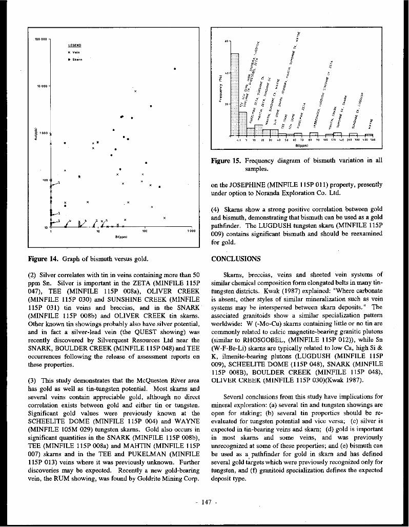
100 oao
K V•in
• Skarn
•
10 000.
• .. •
• ::: l 000
~ • • • ., . •
• •
• • .,
'"" v' ., •
., ., •
I--'
i/' l ''/' ., .,
...--' / ' '" '" '"" 1000
Bi(ppml
Figure 14. Graph of bismuth versus gold.
(2) Silver correlates with tin in veins containing more than SO ppm Sn. Silver is important in the ZETA (MINFILE I ISP 047), TEE (MINFILE I ISP 008a), OLIVER CREEK (MINFILE I ISP 030) and SUNSHINE CREEK (MINFILE llSP 031) tin veins and breccias, and in the SNARK (MINFILE llSP 008b) and OLIVER CREEK tin skarns. Other known tin showings probably also have silver potential, and in fact a silver-lead vein (the QUEST showing) was recently discovered by Silverquest Resources Ltd near the SN ARK, BOULDER CREEK (MINFILE I ISP 048) and TEE occurrences following the release of assessment reports on these properties.
(3) This study demonstrates that the McQuesten River area has gold as well as tin-tungsten potential. Most skarns and several veins contain appreciable gold, although no direct correlation exists between gold and either tin or tungsten. Significant gold values were previously known at the SCHEELITE DOME (MINFILE I ISP 004) and WAYNE (MINFILE IOSM 029) tungsten skams. Gold also occurs in significant quantities in the SNARK (MINFILE I ISP 008b), TEE (MINFILE llSP 008a) and MAHTIN (MINFILE 11SP 007) skarns and in the TEE and PUKELMAN (MINFILE 11SP 013) veins where it was previously unknown. Further discoveries may be expected. Recently a new gold-bearing vein, the RUM showing, was found by Goldrite Mining Corp.
I I
<1 s 10 w 10 40 so 60 ;o
6i(ppm)
! §
I f i '
~ l
§ ff ' .
J! ! J
eo 90 100 110 140 100 loo ~oo 'oo
Figure 15. Frequency diagram of bismuth variation in all samples .
on the JOSEPHINE (MINFILE I ISP 011) property, presently under option to Noranda Exploration Co. Ltd .
( 4) Skams show a strong positive correlation between gold and bismuth, demonstrating that bismuth can be used as a gold pathfinder. The LUGDUSH tungsten skam (MINFILE 11SP 009) contains significant bismuth and should be reexamined for gold.
CONCLUSIONS
Skams, breccias, veins and sheeted vein systems of similar chemical composition form elongated belts in many tin-1\mgsten districts. Kwak (1987) explained: "Where carbonate is absent, other styles of similar mineralization such as vein systems may be interspersed between skam deposits. 11 The associated granitoids show a similar specialization pattern worldwide: W (-Mo-Cu) skams containing little or no tin are commonly related to calcic magnetite-bearing granitic plutons (similar to RHOSGOBEL, (MINFILE llSP 012)), while Sn (W-F-Be-Li) skarns are typically related to low Ca, high Si & K, ilmenite-bearing plutons (LUGDUSH (MINFILE llSP 009), SCHEELITE DOME (I ISP 048), SNARK (MINFILE llSP 008B), BOULDER CREEK (MINFILE llSP 048), OLIVER CREEK (MINFILE IISP 030)(Kwak 1987).
Several conclusions from this study have implications for mineral exploration: (a) several tin and tungsten showings are open for staking; (b) several tin properties should be reevaluated for tungsten potential and vice versa; (c) silver is expected in tin-bearing veins and skarn; (d) gold is important in most skams and some veins, and was previously unrecognized at some of these properties; and (e) bismuth can be used as a pathfinder for gold in skam and has defined several gold ~rgets which were previously recognized only for tungsten, and (t) granitoid specialization defines the expected deposit type.
- 147 -

ACKNOWLEDGMENTS
Much appreciation goes to J .A. Morin who suggested the project, advised the author, provided advice on presentation of the geochemistry, and technically reviewed the paper. Thanks are extended to J.G. Abbott for his constructive comments, and to S.R. Morision for his encouragement. High quality drafting was provided by Drafting Services, N orthem Affairs Program.
REFERENCES
ABERCROMBIE, S. M. 1990. Petrology, geochronometry and economic geology: The 'Zeta tin-silver prospect, Arsenic Ridge, west-central Yukon (115 P 14 and 116 A 3). Unpublished M.Sc. Thesis, University of British Columbia, Vancouver, B. C.
ANDERSON, R. G., 1988. An overview of some Mesowic and Tertiary plutonic suites and their associated mineralization in the northern Canadian Cordillera. Jn: Recent Advances in the Geology of Granite Related Mineral Deposits, R. P. Taylor and D.F. Strong (eds); Canadian Institute of Mining and Metallurgy, Special Volume 39, p. 96-113.
BOSTOCK, H.S., 1946. Geology, Mayo area, Yukon Territory. Geological Survey of Canada, Map 890a.
BOSTOCK, H.S., 1964b. Geology, McQuesten River, Yukon Territory. Geological Survey of Canada, Map 1143A.
BOYLE, R. W., 1965. Geology, geochemistry and origin of the lead-zinc-silver deposits of the Keno Hill - Galena Hill area, Yukon Territory. Geological Survey of Canada, Bulletin 111, 302 p.
EJNAUDI, M. T., MEINERT, L.D. and NEWBERRY, R.J., 1981. Skarn deposits. In: Seventy-Fifth Anniversary Volume, B.J. Skinner, (ed.); Economic Geology, p. 317-391.
EMOND, D.S., 1985. Geology, mineralogy and petrogenesis of tin-bearing breccialveins at Oliver Creek, McQuesten River Area, Yukon. Unpublished M.Sc. thesis, Carleton University, Ottawa.
EMOND, D.S., 1986. Tin and tungsten veins and skarns in the McQuesten River area, central Yukon. In: Yukon Geology, Vol. I.; Exploration and Geological Services Division, Yukon, Indian and Northern Affairs Canada, p. 113-118.
EMOND, D.S., 1992. Petrology and geochemistry of tin and tungsten mineralized plutons, McQuesten River region, Central Yukon. This volume.
GORDEY, S.P., 1988. The South Fork volcanics: mid-Cretaceous caldera fill tu.ifs in east-central Yukon. In: Current Research, Part E; Geological Survey of Canada, Paper 88-JE, p. 13-18.
HUNT, P.A. and RODDICK, J.C., 1987. A compilation of K-Ar ages, Report 17. In: Radiogenic Age and isotopic Stadies: Report 1; Geological Survey of Canada, Paper 87-2, p. 188.
KWAK, T.A.P., 1987. W-Sn Skarn Deposits and Related Metamorphic Skarns and Granitoids. Elsevier Scientific Publishers B. V., 451 p.
LENNAN, W.B., 1986. Ray Gulch tungsten skarn deposit. In: Mineral Deposits of Northern Cordillera, J.A. Morin (ed.); CIM Special Volume 37, p. 245-254.
NEWBERRY, R.J., 1980. The geochemistry of tungsten deposition in skarn deposits: afield and theoretical approach. Geological Society of America, Abstracts with Programs, Vol. 12, p. 492.
- 148 -

POTIER, T., 1987. Petrography of tin and tungsten occurrences and an electron microprobe mineralogical study of tourmaline from the McQuesten River area, Yukon Territory. Unpublished B.Sc. Research Paper, University of Alberta, Edmonton, Alberta.
STEVENS, R.P., LACHANCE, G.R. and DELABIO, R.N., 1982. Age determinations and geological studies. K-Ar isotopic ages, Report 16; Geological Survey of Canada, Paper 82-2, 56 p.
WAT.SON, K. W., 1986. Silver-lead-zinc deposits of the Keno Hill-Galena Hill area, central Yukon. In: Yukon Geology, Vol. 1; Exploration and Geological Services Division, Yukon, Indian and Northern Affairs Canada, p. 83-88.
WOODSWORIB, G.J., ANDERSON, R.G., BROOKFIELD, A. and TERCIER, P., 1989. Distribution of Proterozaic to Miocene plutonic suites in the Canadian Cordillera. Geological Survey of Canada, Open File 1982, 6 maps.
ABBREVIATIONS USED IN TABLES
GRAN granite GT garnet GRDI granodiorite HB hornblende QZIT quartzite ID idocrase QZMZ quartz monzonite JAM jamesonite pp porphyry LI limonite RHY rhyolite KA kaolinite RYOD rhyodacite KSP K feldspar SYEN syenite MN manganese oxide VN vein MO molybdenite VNQZ vein quartz MO-SCH molybdoscheelite AC actinolite MU muscovite ASP arsenopyrite OR orthoclase AX axinite PH pblogopite Bl biotite PL plagioclase BOUL boulangerite PR pyrrhotite CB carbonate PY pyrite cc calcite QZ quartz CL chlorite RKFL rock flour CO,COR corundum SCH scheelite CP chalcopyrite SER sericite CT cassiterite SL sphalerite DI diopside STAN stannite EP epidote sx sulphide minerals FL fluorite TO tourmaline FS feldspar TOP topaz GL galena TR tremolite GOE goethite WO wollastonite
- 149 -

Table 1. Skarn occurrences, iocJnding skarn from vein properties (location map in Fig. 1).
Properl)' Name Host Rock Associated Mineral BestAssay Minfile No. Pluton Assemblages This Study Locatiuu (stages) (earlier)
Tungsten Skams:
LUG DUSH Hyland Gp Bl-MU GRAN DI-PL-OR-CO- Best grab: 115P009 (Grit Unit) Stock (mega- QZ-CC-HB-PR- 2050ppm W,
A crystic PP) HB-SC 8000ppm Zn (800 X I 5 0-200 m area, 0.1 % W03; highest grab 2.18% WO,)
SC HE ELITE Hyland Gp HB-BIGRAN W0-01-ICC-QZ- 4mChip: DOME stock (PP) OR-PL(+/-G1) 3620ppm W,
USP 004 Dl-AC-TR-QZ- 2080ppb Au H CC-OR-Bl-SC (6.67 git Au
over3 m; 4800ppm W over 1.5 m)
RHOSGOBEL Hyland Gp Bl-HBQZMZ QZ-01-AC-PL- Best grab: llSPOU Stock (PP) Bl-SC 2630ppm W
L QZ-01-0R-WO-BI-SC
WAYNE Keno Hill MU-BIRHY? Dl-AC-ICC-QZ- Drill core: 10SM029 Quartzite Dyke (PP) SC 22 700 ppb Au (5 km E of Mt Haldane) TR-ICC-QZ-DI 696 ppm W
p 450 ppm Bi
Tin Skams:
TEE Hyland Gp HB-BI GRDI AC-QZ-PR-CP- Grab: llSP 008a Stock. PY-AX 845 ppm Sn
B 740 ppb Au 2.38% Zn 0.22% Cu 16 ppm Ag
SN ARK Hyland Gp MU-BIRYOD AC-QZ-EP-AX- Avg 3 grab 115P008b Dyke GL-PR-l'P-SL- over 15 m:
c PY-SCH 2227 ppb Au 28 ppm Ag 1210ppm W 951 ppm Sn 5553 ppm Cu 3740ppm Zn
BOULDER CREEK Hyland Gp Bl-MU GRAN AX-CC-AC-ID- Avg 5 chip llSP 048 Stock GT-PL-EP-QZ over 25 m
D exposure, 10-15 m
thick: 1036 ppm Sn
OLIVER CREEK Hyland Gp Bl-MU GRAN AC-ICL-CC-DI- Drill core; 115P030 QZ-EP-PR-PY- 0.9% Sn,
G SCH-JCT 4 ppm Ag over 1.7 m
- 150 -

Skam from Vein Properties
MAH TIN Hyland Gp Bl-HBQZMZ DI-CC-GT -QZ Grab from USP 007
J Stock: IOX 4 m unit: 450 ppb Au 130 ppm Sn
DI-TR-QZ-CC- Grab of -AS-PR-CP float:
340ppb Au J60 ppm W S70 ppm Cu 531 ppm As
SUNSHINE Hyland Gp BI-MU GRAN Dl-TR-BI-QZ- low metal CREEK EAST OR-SCAP values USP 03Ia
F
- 151 -

Table 2. Mineralogy or tin and tungsten 1karn1, McQunten R!wr region.
Mineral Abun- '"' """" Ha.bit rn.gn..lk .._, ... Othtt .. ~ (mm)
ISOCHEMICAL
STAGE
Diopside 25-40% 0.1-2 Pale brown to ttcen ~aggrepta Cleavage& at 90°, Rcp)aQeid by clinozoiai1c Mail oomrnon. isoch::niical.
moden.lc birefringence llild ad.iDOlitc InimOO in both Sn. &. W 1bms
Orollsula.rilc lt).(0% O.S-2 Light brown Dolooohotnl. oft= Isotropic or llIIOIDal.0\16 Oecut11 with axinite. idocra&e Ott=""'°'
""""""' isotropic extinctipn & diopiide in Sn sb.ms. Re-pbuled by cal.cilc & ~Ole-
Wollaatonilc 30-ro• 0.1-0.25 ColOTk:M Fibrous, radiatin& Fibrous babit, low Oocun with quartz, M=-......... bircfrlngcnoe liip & diopsidG in W1bms
Tremolilc >J-30% 0.1-1.0 Colorless Prismatic to IDhc:dni.l 120" cleiavsges QCQlf8. with d.iopside FOUDJ in W & Au-bearin& sbms
"""" lt>-40% 0.1-1.S Color leas Anh:dn.J, often stn.inod Low bircfringcnce & n:lief Forrm intcrlockin& IDOtlaic Frond in almost 11111kam ~lap; man:
with orthoclaec: ~re no mmscmatic minenls have bcCn introduoed
°""""""' 5-15% 0.1-0.S Colorless """"'"' Lack of twinning, biaxial Foord with quartz Common in Sn & W sb.m usemblap
Calcite ,_,,. 3.0 {apprmi:..) Colorless Elonia1c prisms Growth twinning, high OocutS with axinite., gam&, Occurt1 in Sn ab.rm in this 1tage.
~oolout11 -Conmd= >J-30% 0.1-0.3 Color lees G....wu Low birefringence, uniaxia1 Associated with Ran:. Only fouid in one. thin lllldiro from J...uci1U8h. - negative, S<llmtimcll biax., dkipgide, quartz & calcite
u. N
high relief in a W-bcaring sb.m
METASOMATIC STAGE
Scapolilc 5-15% 0.1-0.3 Colorlcu, with a Anb:dral aggregates Low birefringenee, Oocut8 with biolilc Rare. Feud in OD!y ~ l!CdiPD from Sur..blm c-k
mottled appc:111·anoe uniaxial~ mid diopsidc:
Axlnitc . 30-40% 1-4 Colorlc$8 to lighl brown Eumiral, wedgo-1bapcd • Axc-h:ad. 1hape. low Oocut8 with pm=l &: ......... ..,,,, bircffia&enc:c idocruc. Rc:plaord by
IClinolilc & ~
....... 5-30% 1-2 Light brQv.on ~iom.l, Bl~ anamalou5 intcifcmii.e Oocun with axinile & $Qmctimr:e difficult to di9tinguish .............. oolout11, high relief pmc:l in Sn 1b.m11 f~""""
Andtadite 10-(()% O.S-2 Light brown ~ral,subto Isotropic or anomalCllll Oocut8 with axinite., idocrase., Commooly ~ ·UO.bie IO diatinguiah
....,,,i isotropic: extinction diopidc: in tin lb.me. from mdtaditc, b4 assumed both the
Al & Fc--rid!. ~ may exist
Pyri• 1-2% O.S-4 L ..... Anhcdral, disseminated "°'""'' Auoc. with c:linozoiaile, Unoommoo, minor in Sn & W lb.me
,.n~ ..... d.iopidc, wollutoniie, & otla
Pynhot.itc <S% 0.5·1.5 c....,, brown Anh:dml d.iucmiDated Stron&IY anilotropic Anoo. with oth:t 1ulpbides Mail c:<mDlOD. ll\llpbidc: minc:ral in •bms
Chalcopyrite 1-2% O.S-1 Bllffy ~llow ~ dinemim.tod T unish, -itly anifatropic Assoc:. with oth:t 1ulphidcf N~~
Sphll.Jcrlte <,. 0.1·1 Gny Anheidral 11.ggreg1tcs """°"' Auoc. with oth:r sulphidctl N~~
''"'"' <,. 1-3 While lo li&.hl P'C)" Anheidral, diss. & ""inlets bO!ropic: Aeoo. with oth:r sulpbii:L=8 N~~

Mineral A bun· '"' Colo• Habit D~tlc AslOdatlon Olher
da~ {mm)
RETROGRADE
STAGE
Actinolite up to 65% 0.1-1 Light green Acicular, fibrous aggn::gates Green oolOW', habit, plcochroic Replaces diopside, axinite Very common in Sn & W 8kamil
Clinozoisite 5-20% O.l-1 Colorless to light brown Anh::dral rna.~:leS Anomalous blue interfen::nce Replaces diopside, forms Quite oommon, especially •I
to light gn:en ~1- haloes around sulphides at thew~ OOCWTeDOC
"'""' 5-40% 0.1-0.5 Pak: g1"eJl, moderately Anhodral aggregates, Green color, hidt n:.licf, RcplaCC8 pm::t & axinite, Quite common
pleochroic stubby prismatic moderate b~f~ & associated with sulphides
Calcite 5-10% O.S-2 Colorless Anbodral High bin::frlngence Rcplaocs 1:amet, wollastonite Very common
axinite, idocra8(:, diopside
Phlogopite up to 30% 0.2-0.6 Co\orJee.s Radiating buOOJee. Very hidt birefrin&= Occurs with calcite Rare-sccn in Sn abm
""'""""' '""'" u!!Cmbl.aie
Hombk.nde 2-5% 0.!-0.5 Plcochroic in shades of Anhodral-subhcdral, 120" cleavsie, &teen colour RcplaCC8 diopside when:: Not common. in Sn & W &kams
"'"" prismatic actinolite is absem
Biotite S-35% 0.1-1 Pleochroic in 8hade5 of PI.aty Brown-gn::cn col<JU!', perfect Associated with sulphidell & Oocurs in sb.rm in contact with hmM> cleavages scbe.elite biot.ite hornfels.
Schoelit<: 1-3% 0.2-2 Sugary-brown Anh::dral disseminated Grainy appearance, high n::lief Ooours with diopsidelactinolite, Found in W skams .,.... sulphide.s & biotite
-v,
"'

Table 3. Breccia and/or Vein Occurrences (for location map, see Fig. 2).
Property Name Host Rock Associated Matrix-Gangue FragmBlts Best Assay
Minfile No. Plutoo Minerals This Study
Location (%Matrix) (earlier)
Tin·Silver Breccias:
TEE Hyland Gp HB-BIGRDI QZ-OR angular to 0.1 to 1.5 m wide zone, over 150 m
I ISP 008a Stock (S0-70%) subrounded, long, avg six grabs from six trenches
B 10% open sp. 1-S mm QZIT, 300 ppb Au, 139 ppm Ag, 1724 ppm Pb,
<3% CT mod-poor 1485 ppm Zn, 105 ppm Sn, 167 ppm Cu sorting
SUNSHINE Hyland Gp Bl-MU GRAN QZ-OR-TO subangular to I-IO m wide, 200 m long, avg IO grabs
CREEK Stock (o0-70%) sub rounded at 20 m intervals along length: 308.5 ppm Sn,
WEST CT < 5 cm QZIT 877 ppm Pb, 263 ppm Cu, I 740 ppm As
115P03la <15%open mod-poor Other grab: 67 ppm Ag; Other grab:l20 ppb
E spaces sorting Au, 600 ppm Sn, 900 ppm Pb; (Cominco drill int: 7.6 m 0.28% Sn)
SUNSHINE Hyland Gp Bi-MU GRAN QZ-TO-OR angular to l to 5 m wide, IO m
CREEK Stock, <1% CT sub angular long, avg 2 grab
EAST RHYOD Dyke (20-SO%) <2 cmQZIT, sam: 2350 ppm Sn, - llSP 03lb No open TO,VNQZ 23 ppm Ag
"' ... F space mod-poor sorting
OLIVER CREEK Hyland Gp Bl-MU GRAN Rock Flour angular to (Drill core: Over 3.7 m
I ISP 030 (10-30%); sub rounded 0.94% Sn & 11.83 g/t Ag;
G Crystalline: 1-4 cm QZIT, Over 0.95 m 2.45 % Sn &
CL; TO; QZ;, SCH, VN mat, 2.1 git Ag - Billiton CC; MU; BI; mod-poor Canada)
KA (20-SO%) sorting <S% CT SL,CP,PY,PR,GL
MAH TIN QZMZ, HB-BIQZMZ TO-ASP-PY; angular to 1 X 15 m zone: Best grab 7 ppm Ag,
!ISP 007 Hyland Gp QZ-OR-SER-Rock subrounded, 1650 ppm Cu, 130 ppm Sn, 130 ppb Au,
I Flour; < 3 cmQZMZ, 299 ppm Sb; < 100 ppm Ag -QZ-CC-TO-SER- mod sorting (Best grab - < 100 ppm Ag:
ASP-PY-STIB- Billiton Metals Canada)
CP veinlets

Table 3 (continued)
Property Name Host Rock Associated Matrix-Gangue Fragments Best Assay :Minfile No. Pluton Minerals This Study Location (%Matrix) (earlier)
Tin-Silver Veins, Sheeted Veins
JOUMBIRA Keno Hill Bl-QZRYOD TO-CT-FL, Sheeted veins PRO showing: Grab 1200 ppm llSM 031 Quartzite (PP), BI-MU QZ-MU, in joints Sn & 798 ppm W;
I GRAN QZ-TO-MU-SL- FED showing: Grab 740 ppm PY-ASP Sn & 1460 ppm W;
QZ-SL-PY-GL Vein Fortune Ck showing: Grab 10 000 ppm Zn, 1500 ppm Sn 283 ppm W, 15 ppm Ag
JABBERWOCK Hyland Gp BI-HBRYOD OR-QZ-CT Sheeted veins Avg 2 grab samples 9450 ppm llSP OSI (PP) in joints Sn
K
ZETA Syenite HB-BI SYEN, TO-MU-ASP-PY- Greisen vein ( < 1 km long zone, 150 m str. llSP 047 QZMZ,GRAN JAM-BOUL-CT- length, 50 m depth, 2 m avg
N STAN width; Shallow - 103-137 git
"' Ag; Deeper - 686-1234 git
V> Ag; Avg Sn throughout-0.1 % with up to 0 .6 % Sn locally (Noranda) Recent drill indicated silver reserves: 98 248 tonnes of 557.8 git Ag - Danra Resources)
Tungsten-gold Sheeted Veins
PUKELMAN Hyland Gp, BI-HBQZMZ QZ-OR-SCH Sheeted veins Grab 7630 ppb Au, 6100 ppm USP 013 QZMZ in joints W (200 x 200 m zone outlined)
M - 9 samples avg 0.05% WOJ (Cathro);
QZ-ASP-GL Grab of QZ-SX vein in HNFLS 19.3 git Au, 227.6 git Ag, 4.48% Pb)(Bema)
Abbreviations: see Appendix 2

-u.
°'
Appendix 1. Hand sample description and geochemical analyses of mineralized rock.
Sample No. Sn w Ag
BOULDER CREEK (MINF1LE USP 048) E-85-01 1050 11 <5
--02 746 <2 <5 --03 1500 5 <5 -04 1000 3 <5 --05 885 <2 <5 -06 68 4 <5 -200 510 4 <5
TEE (MINFILE USP 008a)
Au
8 <5 <5 <5 <5 12
<6
Pb
69 35 18 20 26 39 32
Zn
510 <200
320 290 440
<200 250
E-85-07 845 46 16 <5 230
11
740 32 23,800 6700 4600 3400 4300 3000 3100 1300 210
--08 40 5 100 1770 --09 285 50 470 2.50% -10 10
485 220 73 84
110 57
<5 86
3 13 18 3
35 94 21
<2
8 680 -11 <5
57 16
180 500
63 <5 18
23 150 -12 160 3500 -13 18 280 -14 593 4600 -15 942 420 -16 73 82 <200
<200 1100
-17 9 78 -18 6 19 1460
SNARK (MINF1LE llSP 008b) E-85-19 1800 160
-20 1030 200 -21 22 3270
55 28
<5
SCHEELITE DOME (MINF1LE USP 004)
3670 821
2190
E-85-22 920 53 <5 613 -23 12 67 <5 33 -24 9 3620 <5 2080 -25 <5 81 <5 44 -26 <5 28 <5 22 -27 <5 22 <5 20
E-85-28 <5 8 <5 11 -29 8 1410 <5 120
JABBERWOCK (MINF1LE USP OSl) E-85-30 160 10 <5 7
31 140 31 6 <6 32 <5 5 <5 <5 33 60 <3 29 11 34 77 13 <5 <II 35 9500 2 <5 <5 36 9400 13 <5 13 37 240 < 12 60 130 38 9.32% 38 <5 <7
20 14 18
4000 7000
220
10 5900 30 <200 16 330 46 <200 72 220
152 <200 114 <200 240 400
240 <200 24 <200 44 <200
7300 11.81% 100 2800 45 600 32 <200
9400 430 84 <200
Cu
7 3 2 2 2
42 4
2200 89
390 196 300 490 145 87
164 22
6 92
6900 9200
560
1680 38
176 16 49 22
8 126
12 11 15
1510 34 42 24 24 14
As
5 5 6 5 6
132 84
15 962
2910 117 97
6370 325
1740 1760 296
16 145
1130 6840
23
836 40
9 50 52 74 17 II
2800 328 69
254 11400
96 357
16900 801
Sb
1.6 1.7 3.3 5-5 1.3 7.0
44.4
0.9 29.7
133.0 6.3 2.3
56.9 10.0 89.5 55.3 11.0 1.2
20.2
8.9 4.9 5.3
2.4 I.I 5.2 5.0 1.2
11.0 7.6 5.7
3.0 4.0 1.6
10.0 6.8 1.4 1.7
26.0 1.9
Bi
<l <l <l <l <l <l <l
44 <l
8 4
<l 8
<I <l <I <l <l <l
136 36
116
32 2
54 <l <l <l <l
4
<l <l <l <l
4 4 4
90 8
F
510 470 580 490 420 970 400
550 530 650 430 760 580 240 340 430 870 130 470
350 330 220
340 550 210 350 240 24
370 240
340 550 210 80 75
180 130 510 330
Description
Ophicalcite: CC-PH-CL-OR (-AX-QZ) skam GT-CC-AC-AX-SCH skam AX-GT-EP-CC (-QZ-AC-PL-SCH) skam ID-GT-CC-EP-AC-QZ-AX skam AX-CC-AC-ID-GT-PL skam QZ stockwork and breccia Gametite: 60% GT, 25% DI, 10% AX, CC, AC
QZ-OR-AC-ID-CC-DI (-TOP-OL-PR-PY-SL-CP-AX) QZ breccia and stockwork QZ brcccia and stockwork cutting skam QZ breccia with SER QZ-OR-EP-AC (-SL-PY) skam QZ-OR (-CT) breccia QZ-OR (-C'l) breccia QZ-OR (-Cl) breccia QZ-OR (-C'l) breccia QZ-OR (-C'l) breccia QZ-OR-WOL-EP-SER(-SX) skam QZ-OR (-CT) breccia
AC-ID-QZ-EP (-SCH-PY-AX-OT-CC) skam EP-AC-CC-QZ-ID (-SCH-PY-PR-CP-SL-AX) skam EP-CC-AC-GT (-SCH-AX) skam
Dl-CC-QZ-OR-AC (-PR-SCH) skam QZ-KSP-PR-TO-Ml.J grciscn vein DI-CC-QZ-CL-AC-SCH-PR-CP-GL (-PY) skam DI-WOL-QZ-CC (-PY) skam WOL-DI-QZ-OR-CC-PL (-PR-PY-SCH) skam QZ-CC (-SCH) stockwork WOL-DI-QZ-CC-CL-OR (-SCH) skam Dl-AC-QZ-CC-CL (-SCH-PR-SL-CP) skam
QZ-MU-TO-PY rock flour breccia Tourmalinitc: 65 % TO, QZ, MU (PY) QZ vein & tourmalinite (dissem. PY) QZ (-SL-CP-GL-PY) vein ASP pods & SCOR in QZ (-PY) vein CT on joints of muse. quartzite Tourmalinized (QZ-TO-CT) rock flour breccia QZ vein with GL, ASP in FS-BI porphyry CT-OR in fractures of quartzite

-"' _,
Appendix l (continued) Sample No. Sn w
STERLING (MINF1LE llSP 010) E-85-39 1600 <2
40 185 9 41 42 43
115 40 83
12 4
<2
Ag
<5 23
<5 6
<5
Au
<5 <8 <5 <5 <5
JOUMBIRA (MINFILE IOSM 031)(Fed Shomng) E-85-45 175 20 <5 <5
46 195 19 <5 <5 47 740 51 <5 <5 48 48 1460 <5 <5 49 50 51 52 53 55
37 355
28 410
23 14
100 22
9 14 13
453
<5 <5 <5 <5 <5 <5
<5 <7 <5
5 <5 <7
JOUMBIRA (MINF1LE IOSM 031)(Creek Shomng) 56 24 12 <5 <5
E-85-57 <5 3 <5 <5 58 59
61 62 63
32 <5
11 1500
<5
JOUMBIRA (South)
17 377
7 283
5
64 <5 <2 65 <5 <2
JOUMBIRA (Pro Shomng) 60 59 31 99 100
101 102
6 1100
1200 <5
10 17
798 3
MAIITIN (MINF1LE llSP 007) E-85-66 130 < 120
67 68 69 70 71 72
12 <5 30
9 215 130
6 <25
3 160
< 13 4
<5 <5
<5 15 7
5 <5
<5 <5
7
<5 <5
7
<5 <5 <5 <5 <5 <5
<6 <5
<5 < 10 <5
18 <5
<5 <5 <5
<5 <5
130
170 230
42 340
82 450
Pb
260 2600
45 660 260
32 32 48 14 19 9
78 16 45 13
39 10 56 10
18 58 68
10 10
21 33 51
15 12
32
59 42 26 20 37 38
Zn
240 1300
<200 5700 270
<200 270 210
<200 <200 <200 1200
<200 520 220
<200 <200 <200 <200
310 15000 <200
340 <200
<200 1200
<200
<200 <200
<200
<200 260 270
<200 290 280
Cu
8 48 4
54 7
6 9 9 5 6 5 7 4
II 5
14 4
14 29
10 37
3
134 160
6 12 5
5 2
As
36 2510
113 169
16
37 684
1140 303 348 245
13 118 254 748
349 53
2960 52
1210 8120
108
60 226
193 411
1290
1060 35
1650 >30000
700 1550 220 >30000 44 119
870 531 115 17700 122 86
Sb
2.4 34.2
1.3 3.8 2.1
0.9 1.0 1.5 0.9 1.0 0.8 1.7 0.8 1.5 I.I
1.4 0.5 3.9 1.0
1.4 18.0
1.7
0.7 0.7
1.2 0.6 2.2
1.0 0.7
299.0
5.8 42.9
2.9 3.6
114.0 17.0
Bi
<1 <I <1 <1 <I
<I <1 <I <I <I
2 <I <1 <1 <I
<1 <1 <I <1
<1 34
2
<I <1
<I 4 4
4 2
26
30 108 <1 20 34 24
F
60 150 230 250 140
100 110 110 160 55
130 130 140 85
130
870 180
1600 160
530 650 140
210 110
130 370 470
300 120
630
420 800 310 470
USO 680
Description
QZ (-TO) vein Limonitic rock flour (-TO) breccia TO veinlets within QZ vein Rock flour breccia QZ vein with CL pods & veinlets
QZ vein with TO in joints in quartzite QZ vein in quartzite QZ vein in quartzite LI stained QZ-TO vein in quartzite QZ vein in quartzite QZ vein with TO filled fractures QZ-SL vein QZ vein with TO-SER along fractures Fractured, limonitized quartzite QZ-TO veins in quartzite
SER-FS veins in quartzite QZ (-Bl-FS) vein QZ-FS (-SER) veins in quarzite QZ-FS veins with greisen envelopes
in quartzite QZ vein with MU selvage QZ-TO-MU-CT (-PY-ASP-SL) vnlts in porph dyke QZ-MU stockwork with FS veins
Amphibolite QZ-CB veins
TO veinlets in quartzite QZ porphyry dyke TO-CT veinlets in QZ porphyry dyke,
QZ-MU filled vugs QZ-MU vein with TO in fractures TO-MU greisen vein
QZ-FS vein cut by TO (-ASP-PY -CT) veinlcts and TO breccia
Dl-TR-QZ-CC (-PR-CP-ASP-PY) •kam AC-QZ (-ASP-PY) •kam DI-CC-ID-AC (-QZ) skam with PR veinlets Dl-TR-QZ-CC (-PR-CP) •kam QZ-CC-FS (-PY-ASP-CP) vein DI-QZ-PL-HB-CC (-SPH) •kam

-v. 00
Sample No. So W BARNEY (MINFILE USP OSS) E·85-73 <5 21
74 <5 13 ~ <5 3 M <5 4 77 <5 6
Ag
<5 <5 <5 <5 <5
RHOSGOBEL (MINFILE USP 012) E-85-78 <5 <2
79 <5 2 80 81 82 83 84
<5 <5 <5 <5 <5
<2 2630
40 9
1340
<5 <5 <5 <5 <5 <5 <5
PUKELMAN (MINFILE USP 013) E-85-85 17 14 ~ <5 6 n <5 5 88 89 90 91 92 93
<5 <5 <5 <5 <5 <5
100 46 15
924 6100 3560
LUGDUSH (MINFILE USP 009) E-85-94 130 2050
95 <5 60 96 97 98
45 28 13
76 140
7
ZETA (MINFILE USP 047) E-85-103 140 8
104 105 106 107 108 109 HO Ill ll2
610 480 500 600 450 550 <5 <5 510
<30 <2
2300 <2 <2 <2
<20 25 24
<5 <5 <5 <5 <5 <5 <5 <5 <5
<5 <5 <5 <5 13
<5 40
2.99"/t 3.12°/t 8.10"/t 7.19'/t 9.10"/t
IO <5 20
ll3 120 121 152 153
<5 17
<5
3 <5
2900 700
7 <5 4 <5
<2 30.74'/t 3600 26. 77'/t
Au
<5 73 42 35 98
<5 7 7
12 <5 <5 71
<5 <5 14
160 647
21 616
7630 57
70 <5 28
<5 <5
Pb
70 14
133 26 20
26 14 10 54 30 26 21
IO 24 5
II 19 15 6
ll 5
IO 64 48 18
148
<5 34 34 690
nd"' 4700 nd 5200 nd > 10000 nd > 10000 nd > 10000
<22 500 < 13 260
33 310
<9 <7 <9 nd nd
67 164 220
1.42% 2100
Zn
<200 <200 <200 <200 <200
<200 <200 <200 <200 <200 <200 <200
<200 <200 <200 <200 <200 <200 <200 <200 <200
330 460 440 390
<200
<200 HOO
85 57
121 86
225 <200 <200 3000
<200 <200 <200
151 92
Cu
30 14 13 18 13
26 26
4 6
14 5
16
II 14 6 8
12 16 16 28 ,14
6 43 10 6 6
52 340 210
1320 320 260 104 53 IO
133
As
169 529 296 258
1050
16 11 14 7
30 8 9
151 986
1790 341
7580 82
232 89 26
17 ll 12 5 6
996 16600 3.2% 6.1 %
3.34% 2.01 % 1.16%
1160 339 864
20 97 4 69
57 178 720 3.26% 260 4.83%
Sb
10.0 25.9 42.8 32.8
187.0
I.I 1.6 1.9 1.9 1.8 2.0 0.7
3.5 1.4 1.3 4.1 8.2 4.2 2.4 3.0 0.8
1.3 0.4 1.8 0.6 1.0
20.7 507.0
0.70% 0.92% 3.64% 2.56% 1.09% 693.0 329.0 312.0
110.0 51.0 87.5
2.45% 0.51 %
Bi
<1 <I <1 <1 <I
<I <I <I <1 <I
2 2
<I <I <1
2 IO
<1 10 64 <I
208 84 2 2
20
<l 6
18 5
12 18 4
<I <l <I
<1 <I <l 88 64
F
580 200 170 270 170
1100 780 190 300 680 290 320
900 440 550 950 970 710
1800 1300 3600
8000 3600 1050 -460
100
1250 1800 830
1100 950 900 520 150
1150 2200
340 770 650
1600 1150
Description
Grciscnized quartzite Brecciated quartzite Brecciated quartzite QZ breccia Brecciated quartzite
Bl quartzite BI schist with PY -QZ pod, minor SCH QZ-AC-Dl-PL (-SL) •kam DI-QZ-AC-PL (-SCH) skam Bl quartzite with TO-QZ veins QZ-Dl-AC-PL-BJ (-OR-SL) skam QZ-PL-PH-01-CC-AC (-SCH) skam cut by QZ-SCH vein
TO-BI (-CT-TOP) rock flour breccia BI quartzite with QZ veinlets QZ breccia cutting BI homfels QZ-FS veinlets in FS granite porphyry QZ-MO-PY vein in quartz monzonite QZ vein in BI quartzite BI-QZ schist cut by QZ-FS(-SCH) veins Sheeted QZ-FS-SCH veins in BI quartzite BI homfels and QZ-Bl-AC-OR (-SCH) skam
Dl-PL-QZ-CC-HB (-SCH) skam (float) Tourmalinite: 80% TO, OR, QZ DJ-OR-QZ-CC-HB (-SCH) •kam DJ-COR(20% )-QZ-OR-CC-PL (-PR-SCH) skam QZ vein with minor MO-SCH
Syenite with TO (-PY-Cl) veins QZ(-LJ-TO-PY-ASP) vein Radiating tourmaline in pods in granite LI-stained TO (-SX) vein TO-QZ (-SX) breccia Tourntinilized qranite: 10-20% TO, CT, PR QZ-TO (-SX) vein FS porphyritic syenite with TO HB-QZ syenite with TO veinlets LI-SCOR stained QZ (-ASP-PY-TO) vein in
quartz monzonite TO (-PY} veins in quartzite TO-QZ-(-Cf) veins in greywacke SER veinlets in joints of quartzite TO (-QZ-MU-CT-SX) brcccia TO (-QZ-SX) vein

-"' '<>
Ap-clix l (continued) Sample No. Sn W Ag ZETA (MINF1LE llSP 047)(East Showing)
114 5 2 <5 115 <5 3 <5 116. 117 118
<5 <5 10
6 5 3
<5 <5 <5
Au
<7 <6 <9 <7 <9
SUNSHINE CREEK WEST (MINFILE llSP 031a) E-85-122 120 21 22 93
123 124
125
126 127 128
129 130
131 132 141 142
600 265
500
425 265 205
235 185
160 550
7 375
49 11
26
26 10 27
24 18
23 11
3 29
67 <5
<5
8 <5
5
<5 19
<5 <5 <5 <5
76 11
8
6 9
11
14 120
33 13 12 12
SUNSHINE CREEK EAST (MINFILE llSP 03lb) E-85-133 340 26 <5 <6
134 3400 20 l 8 26 135 1300 66 28 15 136. 200 14 <5 <5 137 38 5 <5 <5 138 110 16 <5 9 139 66 18 <5 <5
WAYNE (MINFILE 105M 029) E-85-143 < 5 696
144 10 120 145 9 16 147 <5 5
<5 <5 <5 <5
22700 1150 2250
18
Pb
84 60 57
123 80
1900
900 340
600
910 900 760
950 280
1810 330
14 59
86 116 800 30 53 41 15
66 92
101 109
nd: not detected (for Au - detection limit is 0.002 oz/ton) o/t: ounces per ton
Zn
320 410 250
<200 <200
<200
<200 <200
<200
<200 <200 <200
<200 <200
<200 220 720 200
<200 <200 <200 <200 <200 <200 <200
Cu
27 35 52 32 22
101
220 145
149
120 380 360
290 185
310 490 ,250
88
167 110 330 168 22
290 450
PY, CP, SL
<200 <200 <200
490
410 76
137 4
As
134 124 137 69 66
2340
3460 1180
1140
1760 2220 1810
1280 1600
1940 426
14 298
537 741
2400 51 60 55 18
50 89
204 18
Sb
111.0 78.5
177.0 51.8 88.2
80.l
55.5 40.3
33.3
27.4 62.9 63.9
34.6 32.7
103.0 29.0
2.5 14.0
8.0 21.4 15.0 5.0
13.0 15.0 4.9
22.8 28.8 80.2 3.1
Bi
<l <l <l <l <l
86
130 4
8
26 16 26
38 4
44 12
<l 4
12 140 264
12 2
12 10
450 22 34 <l
F
800 680 740 680 740
300
720 770
610
290 470 670
370 670
560 720
1200 1500
440 740
1000 200 330
1950 1700
220 870
1650 190
Description
CT-SER-LI in joints of SER quartzite CT-SER-LI in joints of SER quartzite CT-SER-LI in joints. of SER quartzite CT-SER-LI in joints of SER. quartzite CT-SER-LI in joints of SER quartzite
QZ-TO (-SL) breccia and stockwork (0-20 m from SSW end of trench)
QZ-TO (-SL) breccia (20-40 m) Tounnalinite: 55% TO, 40% QZ,
iron oxides (40-60 m) QZ breccia with TO veinlets and
tounnalinite (60-80 m) QZ-TO breccia (at 75 m, grab) TO-CL-QZ ( -EP) breccia (80-100 m) QZ breccia & stockwork, TO alteration &
veins (100-120 m) TO-QZ breccia (120-140 m) LI-stained QZ breccia with tourmalinite
(140-160 m) QZ breccia (160-180 m) QZ breccia (180-200 m) LI-MN-stained quartzite & BI schist CL-QZ schist with TO band
GOE veins in quartzite QZ brcccia with TO veins QZ-TO (-CT-LI) breccia TO vcinlets in quarti:itc AC (-CL-CI) veinlets in BI quartzite JJI schist with TO veins Tounnalinitc: 85% TO, 10% QZ, 3% TOP, CC,
QZ-DI-CZ-AC-CC (-SL-PY-SCH) skarn AC-TR-DI-QZ (-PY) skarn QZ-DI-TR·BI (·PY-SCH) skarn skarn with QZ-SL-PY

DIFFERENTIAL UPLIFT ACROSS THE COAST PLUTONIC COMPLEXNORTHERN STIKINE TERRANE CONTACT, YUKON:
PRELIMINARY EVIDENCE FROM APATITE FISSION-TRACK THERMOCHRONOMETRY
by
John R. Dickie Centre for Marine Geology
Dalhousie University IWifax, Nova Scotia Canada BJH 3JS
Alexander M. Grist Fission Track Research Laboratory
Department of Earth Sciences Dalhousie University IWifax, Nova Scotia
Canada BJH 3JS
and
Raymond A. Donelick Fission Track Research Laboratory
Department of Earth Sciences Dalhousie University Halifax, Nova Scotia
Canada BJH 3JS
DICKIE, J.R., GRIST, A.M., and DONELICK, R.A., 1992. Differential uplift across the Coast Plutonic Complex-Northern Stikine Terrane contact, Yukon: preliminary evidence from apatite fission-track thermochronometry. In: Yukon Geology, Vol. 3; Exploration and Geological Services Division, Yukon. Indian and Northern Affairs Canada, p.160-166
ABSTRACT
Six fission-track analyses were conducted on samples taken across a fault in the Takhini Hotsprings area, Yukon. The results indicate that samples taken on the east side of the fault cooled through 100°C at 104.4 ± 11.9 Ma, while the samples taken on the west side of the fault cooled through 100°C at 63.9 ± 8.5 Ma. Differential uplift and faster erosion on the west side of the fault between the mid-Cretaceous and the Early Paleocene couid account for this difference in cooling history. This fault forms the approximate western edge of the Whitehorse Trough, and is marked by a dramatic change in the isopach of Jurassic and Triassic sedimentary and volcanic rocks which form a thin veneer over rocks of the Coast Plutonic Complex on the west side, and a very thick sedimentary sequence on the east side where basement rocks are not seen. Based on these observations, the fault is infe"ed to be a major wne of crustal weakness which could form the boundary between the Northern Stlkine Terrane and the Coast Plutonic Complex in southern Yukon.
Similar results were obtained in a previous study of samples collected across the Llewellyn Fault Zone, which forms the boundary between the Northern Stikine Te"ane and rocks of the Nisling Terrane and Coast Plutonic Complex in northwest B. C.
- 160 -

RESUME
On a soumis ii /'analyse des traces de fission dans /'apatite six echantilkms recueillis le long d'un transect recoupant un prolongement septentrional de la wne fail/ee de Llewellyn au Yukon. Les echantillons recueillis dans la zone intramontagneuse presentaient une histoire de refroidissement dijferente de celle des echantillons recueillis dans l' acjacent complexe plutonique cfJtier. Les premiers se sont refroidis jusqu 'ii une temperature de JOO °C ii ya 104,4 ±11 ,9 Ma et /es derniers ont alleint cel/e meme temperature ii y a 63 ,9 ±8,5 Ma. Des resultats similaires obtenus pour des echantillons recueil/is sur la zone faillee de Llewellyn dans le nord-ouest de la Colombie-Britannique indiquent une disparite regionale dans /'evolution thermique auxfaibles temperatures de la zone intramontagneuse et du complexe plutonique cOtier. Un soulevement differentiel menant a une erosion plus rapide du cote occidental de la zone faillee pendant l 'intervalle d'envlron 104 a 64 Ma pourrait expliquer cette dlsparite dans /es histoires thermiques. Sousforme d'une zone crusta/e affaiblie, la zonefaillee de Llewellyn semb/e avoir facilite un soulevement differentiel des roches du complexe plutonique cotier et des roches de l 'adjacente zone intramontagneuse du Cretace moyen au Cretace tardif et au Paleocene precoce.
INTRODUCTION
Apatite fission-track techniques have revealed significantly different low-temperature cooling histories for rocks on either side of the Llewellyn Fault system in northwest British Columbia (e.g., Donelick and Dickie 1990). The Llewellyn Fault is a major crustal break which separates rocks of the Northern Stikine Terrane from the Nisling Terrane and the Coast Plutonic Complex (Fig. 1). The low-temperature thermal histories of samples taken across this structural boundary near the south end of Tagish Lake, British Columbia, are summarized by Donelick (1986, 1988), Donelick and Miller (1986), and Donelick and Dickie (1990). New results presented here show a similar change in lowtemperature cooling history across a fault in southern Yukon. These results have important tectonic implications: we suggest that the observed difference in thermal history between rocks of the Northern Stikine Terrane and the Coast Plutonic Complex is due to differential uplift which occurred between the mid-Cretaceous and the Early Paleocene.
The study area lies approximately 20 km north of Whitehorse (Fig. 1). The samples were taken along a northeast-southwest transect across a north-trending fault zone which separates rocks of the Upper Triassic Lewes River Group from a thick sequence of Lower Jurassic Laberge Group elastics, east of Takhini Hotsprings (Fig. 2).
GENERAL GEOLOGY
Two te:ctonic belts of the northern Cordillera are considered in this study. The Coast Plutonic Complex is a northwest-trending linear batholith comprised of Late Cretaceous to Eocene epizonal calc-alkaline plutons. It lies west of the Northern Stikine Terrane which, in southern Yukon, is predominantly represented by volcanic and sedimentary rocks of the Whitehorse Trough.
Mesozoic rocks of the Whitehorse Trough include (a) Carnian to Late Norian (to Hettangian?) calc-alkaline plagioclase- and augite-phyric volcanic flows, breccias and
IV
/_ Study Area
50 km
Figure I. Study location map. The Northern Stikine Terrane (IB), Coast Plutonic Complex (CPC), Allin Terrane (AT) and Nisling Terrane (NS) are depicted. The location of the Llewellyn Fau!tTally-Ho Shear system (dashed line) is based on data from Doherty and Hart ( 19 8 8), Hart and Radloff (1990) and Mihalynuk and Mountjoy (1990).
pyroclastics, volcanogenic sandstone, black argillite, and limestone of the Lewes River Group (e.g., Tozer 1958, Wheeler 1961, Hart and Radloff 1990), (b) Hettangian to Bajocian polymictic conglomerate, sandstone and argillite of the Laberge Group (e.g., Wheeler 1961, Dickie 1989, Hart and Radloff 1990, Dickie and Hein in press), (c) OxfordianKimmeridgian (Hart and Radloff 1990) to Albian chert-pebble conglomerate, sandstone and coal of the Tantalus Formation (Lowey and Hills, 1988), and (d) Cretaceous andesitic to rhyolitic volcanic rocks.
161 -

The Whitehorse Trough sedimentary and volcanic rocks were deposited on the leading edge of the allochthonous Stikine Terrane during a Jurassic arc-continent collision (e.g., Tempelman~K!uit 1979, Dickie and Hein 1988, Dickie and Hein in press). They are now juxtaposed against quartzofeldspathic hiotite-muscovite schist, quartzite, and marble of the Nisling Terrane (e.g., Wheeler and McFeely 1987, Hansen 1990, Hart and Radloff 1990) which form the basement to the Jurassic arc, but probably not to the forearc basin. Nisling rocks were originally classified by Caimes (1916) as the Yukon Group and were later described as part of the Yukon Crystalline Terrane by Tempelman-Kluit (1976, 1979), and are intruded by igneous rocks of the Coast Plutonic Complex.
Whitehorse Trough developed as a fore-arc basin from Late Triassic to the Middle Jurassic (Tempelman-Kluit 1979, Dickie 1989, Dickie and Hein in press), aod a plutonic belt formed along the western basin margin. These arc plutons range in composition from quartz diorite to granite and have yielded Late Triassic to Early Jurassic radiometric ages (e.g., Tempelman-Kluit and Waoless 1975, Morrison et al. 1979, Doherty and Hart 1988, Johnson 1988, Hart and Radloff 1990, Hart and Armstrong, unpublished data). TriassicJurassic radiometric dates (U /Pb method) from clasts of the Laberge Group conglomerate, and northeast to soutbeastdirected paleocurrents in the Jurassic basin-fill substantiate a link between this plutonic belt and the adjacent basin in the early Mesozoic (Hart, Dickie and Armstrong, unpublished data and in prep.). Plutons of the younger Coast Plutonic Complex follow the same trend as the Triassic-Jurassic plutons, but are much more numerous immediately west of the TriassicJurassic plutonic belt.
In northwest B.C. the Llewellyn Fault system separates Nisling Terrane metamorphic rocks to the west from the Whitehorse Trough to the east (e.g., Hart aod Radloff 1990). Dickie and Hein (in press) suggest that in the southernmost Yukon, the Tally-Ho Shear Zone forms a similar boundary between Nisling Terrane metamorphic basement rock and younger rift-related transitional to oceanic crust flooring the Whitehorse Trough. This transition between continental and oceanic crust in many island arcs is a zone of mechanical weakness, subject to failure in the form of fore-arc transform fault zones (Turcotte et al. 1977).
The Llewellyn Fault and Tally-Ho Shear Zone are described in detail by Hart and Radloff (1990) and Mihalynuk and Mountjoy (1990). Hart and Radloff (1990) aod Radloff et al. (1990) described evidence for two phases of deformation along the Tally-Ho Shear Zone: (a) penetrative, semi-ductile structures, indicative of Triassic sinistral transcurrent motion at a mid-crustal level, and (b) non-penetrative, brittle structures, indicative of Late Cretaceous dextral transcurrent motion at a shallow crustal level. The Tally-Ho Shear Zone is inferred to represent a more deeply exposed part of the same fault system which provides a record of the more ductile Triassic deformation, whereas the Llewellyn Fault to the south exhibits late Cretaceous brittle deformation textures which overprinted the older, ductile fabrics. The Tally-Ho Shear
Zone is offset from the Llewellyn Fault at the Yukon-B.C. border along a northeast-trending strike-slip fault (Hart and Radloff 1990). The Tally-Ho Shear Zone has been traced north as far as Fish Lake, where it is overridden by the Ibex Thrust.
Like the Llewellyn Fault and Tally-Ho Shear Zone, the fault near Takhini Hot Springs which forms the subject of this study appears to form the boundary between the Northern Stikine Terrane and the Nisling Terrane/Coast Plutonic Complex. The three faults show a number of similarities, including: (a) a north to northwest trend, (b) semi-ductile deformational features overprinted by brittle fractures within Triassic Lewes River Group sandstone and argillite (c) sheared black argillite containing veinlets of chalcopyrite with malachite, galena, tetrabedrite aod argentite (Dickie, unpublished data), and (d) location along the western margin of the Whitehorse Trough, indicated by coastal deposits of the Lewes River and Laberge Groups (Dickie 1989) and a dramatic decrease in the thickness and extent of Laberge Group strata west of the fault.
Late Cretaceous volcanic rocks cap the Takhini Hotsprings fault at its north end (Wheeler 1961, Tempelman-Kluit 1984), and constrain the timing of its last significaot lateral movement.
The Tally-Ho Shear Zone has been traced north as far as Fish Lake. A northeast-trending fault similar to the one which connects the Llewellyn Fault with the Tally-Ho Shear Zone would have to be invoked in order to link the Takhini Hotsprings-area fault with the north end of the Tally-Ho system.
METHODS Six samples were collected for fission-track
geochronology from an area near Takhini Hotspring (Fig. 2). All samples were collected at a constant elevation of 900 m above sea level. Sample locations are shown in Figure 2 and are summarized in Table I. The sample suite represents: (a) two samples from sedimentary and pyroclastic Lewes River Group strata close to a late Cretaceous granitic pluton of the Coast Plutonic Complex (Wheeler 1961), (b) two samples
_from sedimentary Lewes River Group strata nearer to the west side of the fault, and (c) two samples from sedimentary Laberge Group strata on the east side of the structure depicted in Figures 2 and 3. Full details regarding the mineral separation techniques, sample preparation procedures, and analytical methods employed for the fission-track analyses are presented in Donelick (1986, 1988). In this paper, each fission-track age is interpreted as the time when its sample cooled through the I OO'C crustal isotherm. This interpretation results from the limited degree of fission-track annealing present in the apatites, revealed by relatively long mean etchable track lengths (e.g., Naeser and Forbes 1976, Green et al. 1986). Apatite fission-track ages were m"easured for all samples, which are labelled YT-I to YT-6 (Fig. 2). It is convenient to consider the fission track data obtained for rocks exposed west and east of the fault in the study area separately (Fig. 2).
162 -

0 '" 1D '"
61°00'
N
I
~ Upper Cretaceous volcanic rocks
~ Lower Jurassic Laberge Group
f::~:I Upper Triassic Lewes River Group
60°45
0 0 0
"' '"
4 km
Figure 2. Detailed study location map showing the generalized outcrop patterns in the vicinity of Takhini Hotspring. The large solid line is the fault under study, which is believed to form the east boundary of the Coast Plutonic Complex, similar to the Llewellyn Fault in Northern B.C. Sample localities at 900 m elevation above sea level are depicted as YT-I to YT-6.
Fault
Figure 3. Summary cross-section of the sampling transect.
RESULTS
Fission-track ages for samples YT-I to YT-6, with error bars of one standard deviation, are plotted against relative distance from the fault (refer to Fig. 2 for localities). Notice that rocks on either side of the fault return significantly different cooling ages.
Although no previous work has been published on the low-temperature thermal history of the Coast Plutonic Complex in southern Yukon, relevant studies on the southern part of the Coast Plutonic Complex exist (e.g., Harrison et al. 1979; Parrish 1982, 1983; Donelick and Dickie 1991). These studies primarily document the large-scale cooling of much of the Cordillera following latest Cretaceous to Eocene
compressive orogeny. Donelick and Dickie (1991) published the first detailed low-temperature history of this plutonic belt in the northern Cordillera. These results from northwestern British Columbia show cooling ages through the IOO"C crustal isotherm of 63.7 ± 4.9 Ma to 48.3 ± 4.6 Ma with a mean age of 53.9 ± 4.6 Ma. No plutons of the Coast Plutonic Complex were sampled for fission-track thermochronometry in southern Yukon. It is expected, however, that rocks of the Lewes River Group directly overlying rocks of the Coast Plutonic Complex would have experienced a very similar lowtemperature cooling history, whereas rocks separated from the Coast Plutonic Complex by a major fault might have a different low-temperature cooling history.
Samples YT- I to YT-4 were collected from the Lewes River Group on the west side of the fault zone. These revealed latest Cretaceous to early Paleocene cooling ages, ranging from 67.7 ± 6.9 Ma to 61.8 ± 12.1 Ma (Table 2), providing a mean fission-track age of 63. 9 ± 8.5 Ma. These results are slightly older than, but similar to, the results of Donelick (1986, 1988) and Donelick and Dickie (1990) for northwestern British Columbia.
Samples YT-5 and YT-6 are clasts collected from Laberge Group conglomerate east of the fault. These samples yielded I00°C cooling ages of 113.0 ± 10.0 Ma and 95.8 ± 10.5 Ma respectively (Table 2), providing a mean fission-track age of 104.4 ± 11.9 Ma. As a comparison, two conglomerate samples collected from the Laberge Group beside Tagish Lake and analysed by Donelick (1986, 1988) yielded apatite fissiontrack ages of 98.1 ± IO. I Ma and 100.0 ± 11.0 Ma.
DISCUSSION AND CONCLUSIONS
The fission-track results are consistent with west-side up displacement across the fault in the study area between about 100 Ma and 60 Ma. This coincides with the intrusion of the Coast Plutonic Complex in this part of the Cordillera (e.g., Tempelman-Kluit and Wanless 1975, Hart and Radloff 1990) and may reflect a mechanical response to inhomogeneous thermal expansion across an existing crustal weakness. Uppermost Cretaceous volcanic rocks capping the northern part of the fault are consistent with this model. We believe that uplift across this boundary ceased immediately prior to the emplacement of those volcanic flows.
These fission-track results suggest that both in Yukon and in Northern British Columbia, the Whitehorse Trough and the adjacent Coast Plutonic Complex experienced significantly different low-temperature cooling histories. If the interpreted vertical movement on the major terrane-bounding faults between about I 00 Ma and 60 Ma is related to the intrusion of the Coast Plutonic Complex, then these faults and associated splays are of interest for their economic potential, as the faults would have acted as conduits for hot fluids associated with the intrusions. Many hydrothermal fluids would contain sufficient heat to anneal fission tracks in wall-rock apatite. Because rocks east of the fault consistently return 100 Ma fission-track ages, post-100 Ma mineralizing events could be modelled on
163 -

the -basis of "reset" fission-track ages.
ACKNOWLEDGEMENTS
Support for this project was supplied through a research agreement between JRD and Exploration and Geological
Services Division, Yukon, Indian and Northern Affairs Canada. The authors gratefully acknowledge the use of facilities at the Dalhousie Fission Track Research Laboratory and to the Centre for Marine Geology. We would also like to express our sincere gratitude to Chief Geologist Steve Morison at Northern Affairs, and to Erwin Kreft at Takhioi Hotsprings.
REFERENCES
CAIRNES, D.D. 1916. Wheaton District, Southern Yukon. Supplement to Geological Survey of Canada. Memoir 31, Summary Report for 1915.
DOHERTY, R.A. and HART, C.J.R. 1988. Preliminary geology of Fenwick Creek (J05D/3) and Alligator Lake (105D/6) map areas. Exploration and Geological Services Division, Indian and Northern Affairs Canada, Open File 1988-2.
DONEL/CK, R.A. 1986. Mesozoic-Cenozoic thermal evolution of the At/in Terrane, Whitehorse Trough, and Coast Plutonic Complex.from At/in, British Columbia to Haines, Alaska as revealed by fission track geothennometry techniques. Unpublished M.Sc. thesis, Renssalaer Polytechnic Institute, Troy, New York. 167p.
DONEL/CK, R.A., 1988. Etchablefission track length reduction in apatite: Experimental observations, theory and geological applications. Unpublished Ph.D. thesis, Renssalaer Polytechnic Institute, Troy, New York. 414 p. DONEL/CK, R.A., and MILLER, D.S. 1986. Low-temperature geothnnometry of the Coast Plutonic Complex, Whitehorse Trough and Atlin Terrane.from Atlin, B.C. to Haines, AK. Geological Society of America, Abstracts with Programs, Vol. 18, p. 102.
DONEL/CK, R.A., and DICKIE, J.R. 1991. Low-temperature thermal history of the Coast Plutonic Complex and Intermontane Belt, northwest British Columbia (104M,N). In: Geological Fieldwork 1990; British Columbia Ministry of Energy, Mines and Petroleum Resources, Paper 1991-I, p. 139-144.
DICKIE, J.R. 1989. Sedimentary response to arc-continent transpressive tectonics: The Laberge Conglomerates (Jurassic), Whitehorse Trough, Yukon Territory. Unpublished M.Sc. thesis, Dalhousie University, Halifax, Nova Scotia. 361 p.
DICKIE, J.R., and HEIN, F.J., in press. Conglomeratic submarine fans of the Jurassic Laberge Group, Whitehorse Trough, Yukon: New constraints on an arc-continent collision model. Canadian Journal of Earth Sciences.
DICKIE, J.D., and HEIN, F.J. 1988. Laberge conglomerates, Yukon: Evidence of a Late Triassic-Jurassic arc-continent collision. Geological Association of Canada, Abstracts with Programs. p. A32.
GREEN, P.F., DUDDY, l.R., GLEADOW, A.J. W., LASLETT, G.M. and TINGATE, P.R. 1986. Thermal annealing of fission tracks in apatite - a qualitative description. Chemical Geology (Isotope Geoscience Section), Vol. 59, p. 237-253.
HANSEN, V.L. 1990. Yukon-Tanana terrane: A partial acquittal. Geology, Vol. 18, p. 365-369
HARRISON, T.M., ARMSTRONG, R.L., NAESER, C. W. and HARAKAL, J.E., 1979. Geochronology and thermal history of the Coast Plutonic Complex, near Prince Rupert, British Columbia. Canadian Journal of Earth Sciences, Vol. 16, p. 400-410.
- 164 -

HART, C.J.R., and RADLOFF, J.K. 1990. Geology of Whitehorse, Alligator Lake, Fenwick Creek, Carcross and parts of Robinson map areas (105D/ll,6,3,2,7). Exploration and Geological Services Division, Yukon, Indian and Northern Affairs Canada, Open File 1990-4.
JOHNSON, S. 1988. The tectonic setting of the Aishihik batholith, southwesten Yukon. Jn: Yukon Geology Volume 2, Exploration and Geological Services Division, Yukon, Indian and Northern Affairs Canada, p. 37-41.
LOWEY, G. W., and HD.LS, L. V., 1988. Lithofacies, petrology and environments of deposition, Tantalus Formation (Lower Cretaceous) Indian River area, west-central Yukon. Canadian Society of Petroleum Geologists Bulletin, Vol. 36, p. 296-310.
MIHALYNUK, M.B. and MOUNTJOY, K.J. 1990. Geology of the Tagish Lake area (104M/8, 9E). British Columbia Ministry of Energy, Mines and Petroleum Resources, Geological Fieldwork 1989, Paper 1990-1, p. 181-196.
MORRISON, G. W., GODWIN, C.l. and ARMSTRONG, R.L. 1979. Interpretation of isotopic ages and 87Sr!"Sr initial ratios for plutonic rocks in the Whitehorse map-area, Yukon. Canadian Journal of Earth Sciences, Vol. 16. p. 1988-1997.
PARRJSH, R.R. 1982. Cenozoic thermal and tectonic history of the Coast Mounlainsof British Columbia as revealed by fission-track and geological data and quantitative thermal nwdels. Unpublished Ph.D. thesis, University of British Columbia, 166 p.
PARRISH, R.R., 1983. Cenozaic thermal evolution and tectonics of the Coast Mountains of British Columbia - Fission track dating, apparent uplift rates, and patterns of uplift. Tectonics, Vol. 2, p. l501-631.
RADLOFF, J.K., HART, C.J.R. and HANSEN, V.L. 1990. Late Triassic sinistral translation on the TallyHo Shear Z.One, Yukon. Geological Society of America, Abstracts with programs, Vol. 22, p. 76-77.
TEMPELMAN-KLUIT, D.J. 1976. The Yukon Crystalline Terrane; enigma of the Canadian Cordillera. Geological Society of America Bulletin, Vol. 87, p. 1343-1357.
TEMPELMAN-KLUIT, D.J. 1979. Transported cataclasite, ophiolite and granodiorite in Yukon: evidence of arc-continent collision. Geological Survey of Canada, Paper 79-14.
TEMPELMAN-KLUIT, D.J. 1984. Maps of Laberge (105E) and Carmacks (ll51) map areas, with legends. Geological Survey of Canada, Open File IIOJ.
TEMPELMAN-KLUIT, D.J., and WANLESS, R.K. 1975. Potassium-Argon age determinations of metamorphic and plutonic rocks in the Yukon Crystalline Terrane. Canadian Journal of Earth Sciences, Vol. 12, p. 1895-1909.
TOZER, E.T. 1958. Stratigraphy of the Lewes River Group (Triassic}, Central Laberge area, Yukon Territory. Geological Survey of Canada, Bulletin 43.
TURCOTTE, D.L., AHERN, J.C. and BIRD, J.M. The stale of stress at continental margins. Tectonophysics, Vol. 42, p. 1-28.
WHEELER, J. 0. 1961. Whitehorse map-area, Yukon Territory (J05D). Geological Survey of Canada, Memoir 312.
WHEELER, J. 0., and McFeely, P. 1987. Tectonic assemblage map of the Canadian Cordillera and adjacent parts of the United States of America. Geological Survey of Canada, Open File 1565.
- 165 -

Table 1. Summary of Sample Lithologies and Locations
Sample Lithology Longitude
YT-I unwelded andesite tuff 135"28' YTc2 aphyric andesite1 135"27' YT-3 granite' 135"24' YT-4 volcanogenic sandstone 135"22' YT-5 hornblende granodiorite' 135°15' YT-6 augite-phyric andesite2 135°13'
'Clasts in the uppermost Lewes River Group conglomerate 2Clasts in the Laberge Group conglomerate
Table 2. Summary of Apatite Fission-track Results
Sample ... N p," N
YT-1 3.06E+05 129 l.12E+06 474 YT-2 2.13E+OS 73 7.92E+05 271 YT-3 1.17E+05 34 4.40E+05 128 YT-4 2.13E+OS 137 7.33E+05 471 YT-5 4.49E+05 75 l.19E+06 199 YT-6 5.23E+05 282 1.17E+06 632
'in units of H>6 trackslcm2
"pass or fail at the 95 % confidence level for Chi1
... 4.25E+06 4.25E+06 4.2SE+06 4.25E+06 4.21E+06 4.21E+06
Latitude
60°49' 60°50' 60°51' 60°51' 60"52' 60"53'
N GrainsCh.i2Tes~
5300 169.0289PASS 5300 t53.0931PASS 5300 121.1447PASS 5300 226.0711PASS 3450 l23.9354PASS 3450 2010.5127PASS
Czeta calibration factor 110 ± 3.0 (ewnples YT-1 to YT-4) and 121.8 ± 6.0 (samples YT-5 and YT-6) relative to neutron dooimeter glass standard CNt. Error given is 1 standard deviation.
Fission-track Age (Ma)
63.3 ± 6.6
62.7 ± 8.5 61.8 ± 12.1 67.7 ± 6.9 95.8 ± 13.9 113 ± 10.0
- 166 -

PETROWGY AND GEOCHEMISTRY OF TIN AND TUNGSTEN MINERALIZED PLUTONS, MCQUESTEN RIVER REGION,
CENTRAL YUKON
Diane S. Emond Exploration and Geological Services Division
Indian and Northern Affairs Canada 200RangeRd
Whitehorse, Yukon YlA 3Vl
EMOND, D.S., 1992. Petrology and geochemistry of tin and tungsten mineralized plutons, McQuesten River region, Central Yulam. Jn: Yukon Geology Vol. 3; Exploration and Geological Services Division, Yukon, Indian and Northern Affairs Canada, p.167-195
ABSTRACT
Mid-Cretaceous plutons in the McQuesten River region intrude Upper Proterowic to Mississippian miogeoclinal metasedimentary rocks of Selwyn Basin. They form a belt trending east from the 1intina Trench which can be roughly subdivided into two parallel belts. Plutonic rocks fall into three main groups: (1) biotite-muscovite (two-mica) granite in the southernmost belt which follows the trend of the McQuesten Anticline; (2) biotite-hornblende quartz monwnite, granite and granodiorite in the northern belt which follows the thrust faulted contact of the Hyland Group (Grit Unit) with the Road River Formation; and (3) hornblende-biotite syenite and associated quartz syenite, quartz monwnite, granite and tourmaline-orbicular granite along the north edge of the northern belt.
Tin-silver breccias veins and skams are spatially associated with the two-mica granites, while tungstengold skarns and sheeted veins are associated with biotite-hornblende granite, quartz monzonite and granodiorite. The concentrically wned syenite intrusion in the northern belt (ZETA) includes all the plutonic phases (two-mica granite, biotite-hornblende granitoids, and hornblende-biotite syenitoids), and links them cogenetically through the fractional crystallization process. The ZETA tin-silver veins (MINFILE 115P 047) are associated with the tourmaline orbicular granite, which is the most evolved phase of the concentrically wned ZETA syenite intrusion.
Petrologic and geochemical variation between the three main rock groups is consistent with plutonic rocks of the belt being cogenetic, the two-mica granite being the most evolved phase. Trace and rare earth element variations further suggest that the entire McQuesten plutonic suite formed from melted sedimentary rocks, and that fractionation accounts for the evolution of the individual rock types and their associated mineral deposits.
Plutons in the McQuesten region resemble those of the Selwyn and Tombstone Plutonic Suites. They are post- to syntectonic, roughly circular in shape, and intrude miogeoclinal metasedimentary rockr of ancient North America. They show a concentric zonation .and are surrounded by contact aureoles. The intrusive suite is bimodal, with a southern belt consisting of evolved two-mica granites and a northern belt consisting of less evolved biotite-hornblende granites. Lavas associated with the plutons are believed to be coeval.
The two main igneous types in each belt have been compared in detail. Both types are petrographically similar in that they contain quartz, plagioclase, K feldspar, microperthitic orthoclase and a range of accessory minerals including apatite, zircon, allanite, titanite and tourmaline.
Distinguishingfeatures typical of the two-mica granites include their more quartz-rich nature, a more restricted potassium feldspar to plagioclase ratio, and a more common myrmekitic texture. Minerals in the two-mica granite generally have a more subhedralform and the biotite shows reddish brown pleochroism. The biotite-hornblende granitoids are distinguished by accessory dark green to brown pleochroic hornblende and dark brown pleochroic clinopyroxene. The biotite has chocolate brown pleochroism and an unusually large number of inclusions. The accessory minerals titanite, allanite and magnetite appear to be more abundant in the biotite-homblende rocks. Red-brown biotite, pale green hornblende and beige clinopyroxene occur in the less abundant syenites, along with minor nepheline and enhanced amounts of magnetite and titanite.
Chemically, the rocks are subalkaline (two-mica and biotite-hornblende rocks) to alkaline (syenite).
- 167 -

The two-mica granites are characterized-by normative corundum, higher alkalies and lower amounts of iron, calcium and magnesium than the biotite-lwrnb/ende rocks. The biotite-hornblende granites are distinguished by higher amounts of normative clinopyroxene, and the syenites by normative nepheline. Na20!K,O, Na20/K,O!Ca0 and Rb/Ba/Sr ratios are similar to other S-type granites.
McQuesten region biotite-hornblende granodiorites are chemically distinguished from those of the Selwyn and Tombstone Suites by their peraluminous composition, lower modal quartz content, and higher iron to alkalies and magnesium ratios. Equivalent rocks of the Tombstone Plutonic Suite contain aegirineaugite indicating an A-type origin. In the McQuesten region, tungsten is associated with the biotitehornblende rocks, whereas in the Selwyn area it is associated with two-mica granites.
RESUME
Des plutons du Cretace moyen penetrent, dans la region de la r1v1ere McQuesten, les roches sedimentaires metamorphisees miogeoclinales du bassin de Selwyn datant du Proterozoi(Jue superieur au Mississippien. /ls fonnent une zone s'allongeant vers l'est depuis le sillon de Tintina et qui peut grossierement etre subdivisee en deux zones para/Ieles. ll existe trois grands groupes de roches: 1) granite il biotite et muscovite (deux micas) dans la wne la plus meridiona/e qui suit /'orientation de l'anticlinal de McQuesten, 2) monzonite quartzique a biotite et hornblende, granite et granodiorite dans la wne septentrionale qui longe le contact par faille chevauchante entre le groupe de Hyland (unite de grit) et la formation de Road River et 3) syenite a hornblende et biotite et syenite quartzique associee, monwnite quartzique, granite et granite orbiculaire a tounnaline le long de la bordure de la zone septentrionale.
Les veines de breche et les skarns stanniferes et argentiferes sont spatialement associes aux granites a deux micas a/ors que les skarns et /es groupes de jilons separes de steriles renfermant du tungstene et de ['or sont associes au granite a biotite et hornblende. a la monzonite quartzique et a la granodiorite. L 'intrusion de syenite a zonation concentrique de la zone septentrionale (ZETA) englobe routes les phases plutoniques (granite a deux micas, granitoiGes a biotite et hornblende et syenitordes a hornblende et biotite) et les associe cogenetiquement les unes aux autres par le process us de la cristallisation fractionee. Les veines stanniferes et argentiferes ZETA sont associees au granite oprbiculaire a tounnaline qui constitue la phase la plus evoluee de I 'intrusion de syenite a zonation concentrique ZET~.
Les variations petrologiques et geochimiques entre les trois groupes confinnent le caractere cogenetique des roches plutoniques de la zone, le granite a deux micas constituant la phase la plus evoluee. Les variations de la composition en elements a l 'erat de traces et en terres rares suggerent de plus que tout I' ensemble de la wne plutonique de McQuesten s 'est forme a partir de roches sMimentaires fondues et que le.fractionnement explique I' evolution des types individuels de roches ainsi que les depots de mineraux qui leurs sont associes.
Les plutons de la region de McQuesten sont quelque peu similaires aux suites plutoniques de Selwyn et de Tombstone. /ls sont contemporains du tectonisme, ou posterieurs a ce dernier, de fonne approximativement circulaire et penetrent /es roches sedimentaires metamorphisee.s miogeoclinales de l'ancienne Amtrique du Nord. fl presentent une zonation concentrique et sont entoures d'aureoles de contact. La suite intrusive est bimodale, comportant une zone 1neridionale qui consiste en granites a deux micas evolues et une zone septentrionale qui consiste en granites a hiotite et hornblende mains evolues. Les laves associees aux plutons seraient contemporaines.
Les deu.x principaux types de roches ignees de chaque zone ont ete compares de manifre detaillee. Les deux types sont petrographiquement simi/aires dufait qu'ils renferment du quartz, du plagioclase, du feldspath potassique, de l'orthoclase microperthitique et une gamme de mineraux accessoires incluant ['apatite, le zircon, l'allanite, la titanite et la tourmaline.
Parmi Jes caracreristique.s distinctives -!)piques des granites a deux micas mentionnons leur teneur plus elevee en quartz, un rapport feldspath potassique sur plagioclase moindre et une structure plus couramment mynnekitique. Les mineraux dans le granite a deux micas presentent generalement une fonne davantage hypidiomorphe et la biotite presente un pleochroi:Sme brun rougedtre. Les granitoilles a biotite et hornblende se distinguent par Ia presence de hornblende pleochroique vert fonce a brune et de clinopyroxene pleochroi(jue brun. La biotite presente un pleochroiSme brun chocolat et un nombre inhabituellement eteve d 'inclusions. Les miniraux accessoires que sont la titanite, l 'allanite et la magnetite semblent plus abondants dans les roches a biotite et hornblende. Les syenites. qui constituent les membres les moins abondants de ces suites. renferment de Ia biotite rouge-brun, de la hornblende vert pille et du clitwpyroxene beige. Panni les minerau.x accessoires mentionnons la nepheline, et des quantites accrues
- 168 -

de magnetite et de- titanite. Chimiquement, Jes roches sont de subalcalines (roches ii deux micas et ii biotite et hornblende) ii
alcalines (syenite). Les granites a deux micas sont caracterises par la presence de corindon nonnatif, par des alcalinites plus elevees et par des quantites moindres de fer, de calcium et de magnesium que celles presentes dans les roches a biotite et hornblende. Les granites a biotite et hornblende Se distinguent par des quantiles plus grandes de clinopyroxene normatif et les syenites par lapresence de nepheline normative. Les rapports Na,OIK,O, Na,OIK,O/CaO et Rb/Ba/Sr sont similaires ii ceux des autres granites de type S.
Les granodiorites a biotite et hornblende de la region de McQuesten se distinguent chimiquement de celles des suites de Selwyn et de Tombstone par leur composition hyperalumineuse, leur teneur moindre en quartz modal et leurs rapporls fer sur metaux alcalins et magnesium plus ezeves. Les roches equivalentes de la suite plutonique de Tombstone renferment de /'augite aegyrinique, ce qui indique une origine de type A. Dans la region de McQuesten, le tungstene est associe aux roches a hornblende et biotite alors que dans la region de Selayn il est associe aux granites a deux micas.
INTRODUCTION
Felsic plutons form a 30 x 150 km belt that trends east from Tintina Trench to Mayo Lake (30 km east of Keno Hill) in central Yukon (Fig. I). They are mid-Cretaceous and intrude Upper Proterozoic to Mississippian metasedimentary rocks of the North American miogeocline. These plutons include over 20 stocks and plugs, and abundant dykes, many with associated metallic mineral occurrences and deposits. Keno and Galena Hill silver-lead-zinc veins have produced over 6 400 tonnes (206 million ounces) of silver since 1913 (Watson 1986), and are genetically related to the Mayo Lake Batholith(distal; Lynch 1988). Pluton-proximal mineralization includes the Ray Gulch skarn (MINFILE 106D 027) which has probable and possible reserves of5.4 million tonnes grading 0.82% W03 (Lennan 1986). In the McQuesten River region, eleven plutons are directly associated with tin-tungsten-silvergold veins, breccias and/or skarns (Fig. 2; Emond and Lynch 1992; Emond 1986, 1985, 1983).
Mid-Cretaceous, felsic plutons in the northern Canadian Cordillera post-tectonically intrude folded miogeoclinal sedimentary rocks of the Foreland Fold and Thrust Belt (the Omineca Crystalline Belt) and adjoining ductilely deformed metasedimentary rocks of Yukon Tanana Terrane which overlie the continental crust of ancestral North America. Local studies by Anderson and others have resulted in the naming of several plutonic suites based partly on geographic location, and partly on intrusion characteristics (Fig. l; Woodsworth et al. 1989).
The McQuesten plutonic belt is part of the Selwyn Plutonic Suite of eastern Yukon. In the southeast part of the Selwyn Plutonic Suite (in the Selwyn Mountains), tungstencopper (zinc) skarn deposits are as.sociated with peraluminous, two-mica plutons (Anderson 1988). These deposits include MacTung (MINFILE 1050 002), with defined geologic reserves of 32 million tonnes grading 0.92 % W03 (Atkinson and Baker 1986); and the Cantung (NWT) deposit, which produced nearly 39 000 tonnes W03 to the end of 1982 (Sinclair 1986).
The Tombstone Plutonic Suite intrudes folded and thrusted passive continental margin carbonate and elastic rocks (Anderson 1988) in the Tombstone Mountains (Fig. 1). It
shows similarities to the Selwyn Plutonic Suite. However, several Late Proterozoic periods of extension in this area probably thinned the crust substantially (Thompson and Eisbacher 1984), resulting in more alkalic compositions and minor mafic phases. Vein, breccia, skarn, and disseminated U-Th-Sb-W-Mo-Sn-Ag-Au and base metal occurrences are associated with these plutons. Plutons in the northwestern part of the McQuesten River region were previously included in the Tombstone Plutonic Suite.
Little information is available on the granites in the Mayo-McQuesten area (Abercrombie 1990, Sinclair 1986, Kuran 1982). This report provides descriptions of the petrology and ge.ochemistry of the McQuesten plutons, and comparisons with the well-documented Selwyn and Tombstone Suites. Additional information about mid-Cretaceous plutonism in the northern Cordillera will assist in interpretation of related mineral deposits.
GEOLOGIC SETTING
The McQuesten River region lies in Selwyn Basin, within the Omineca Crystalline Belt of the Canadian Cordillera. North American miogeoclinal rocks of the Late ProterozoicEarly Cambrian Hyland Group (formerly known as the Grit Unit) were thrust northward onto Ordovician to Silurian Road River Formation and Mississippian Keno Hill Quartzite (Wheeler and Mcfeely 1987, Eisbacher 1981, Bostock 1946 and 1964) during Late Triassic to Early Jurassic arc-continent collision. Thrusting formed a prominent east-northeast-striking cataclastic foliation, as well as the McQuesten Anticline, the limbs of which dip north and south at a shallow angle (Boyle 1965; Fig. 2).
Felsic intrusions were emplaced in the metasedimentary rocks of the ancient continental margin_ in the mid-Cretaceous (83 to 108 Ma; biotite, K/Ar, Stevens et al. 1982) and coeval lavas were extruded (85 Ma; whole rock, K/Ar, Hunt and Roddick 1987; Fig. 2). Igneous rocks from the McQuesten River region have high initial Sr isotope ratios (generally over 0.71; Abercrombie 1990; Sinclair 1986) indicating addition of radiogenic Sr from sialic Precambrian crust.
- 169

I I
I
I I
I
,' 4 I '
Jrf ; ,31 ! .............. _
'<t YUKON -
-""'~/ 5 aJ.\) I •
~ 0 0 -;,.::, /TOMBSTONE l._
x= ?'_.... r<.. \ () O XI '\ tJ '\\ \)~<,"._~~.. \ \'-:'.:") / \ , rs> <1-• / \.)-; o\ \·xx\,""¢~~~ ,~o''."' \
a ~ c;) \ ~~ ~~ i:iY..'..._\, ( "'~ ~ \,.. '··.~"· x:..( ~c~ , -v. -v. 0 I I ·;,,, ' x,,,><. NORTHWEST ~ <,. I ,.,_·.~: * '- 'J TERRITORIES
\ ,A ~· 1\\\' ~...... •. ', '. \ \\\lXo \ "'' \.
\\ \ 0 x '7 \01 ~"'- ,, \ .............. , '1 ~~ \ \ ~o
0
'•~ SELW
/'
\ \ \ x xx 1"' O ~ YN \ ~ x I • \:l'x x "
\ \ x ~~ \ \ x 'i>\' .· x o"'~-l-~ \ ,' \ \ ~ \ \ , .,.,c' .,'!/ \ (
\ \ \ '~ I ··. • ., KLUANE--..\ \ \ ~ \ I \\"' ~~ x 1 <Y. \ ·-'\....- \ \a ~ \ I \h • l o \ ? \ \ '-· \ I C<.G::, .{ANru,0 , "'o \
'--..c"'I .~ \ ~ \WHITEHORS<i6l \"'- '\) ~ ~ ~~f ! \ 1 ,\ \XO x.;\LJo x\x ~ '~-\
_ \ x" • x 0 \ o x ~ ~ 1J • • xt5f'ef:l I ~ x o{/o ~ cxWJ \ - \ \O~ ",~l\) De::; \' ()~ 7~, ~ \
1 '- - _;:.t...\"'O x\\\ o '\ - I I ~ .J(~ '" -..,__...,~
\
BRITISH \ ...._ x I ( COLUMBIA \ CAS ~ '- , X j "
\ V"' \ ------::- ( ---- --l
0 100 200 300 G:=::> Plutons !undivided)
kilometres = Two-mica granitoids
-) Mid-Cretaceous Plutonic Suites ~ Transitional (hornblende-I biotite
(_ granitoids
x Small Pluton - !Biotite-l hornblende granitoids
(after Woodsworlh et al. 1989)
Figure 1. Location of the McQuesten River region and of mid-Cretaceous plutonic suites in Yukon (after Woodsworth et al. 1989).
- 170 -

~ _,
1311°00' 137030·
r.
63°45'
138°00' 137°30·
CRETACEOUS
1~mrnrn Felsit volcanic rocks
•-::=:! Granite ptuton. dyku (undifferentiated)
c::::::::J Two-m1ci1 granite
~ Horn_blende-biotite quartz monzonite, ~ Qr;m1te, gr41nodior1te
r-'-::'.;'.:~ Syenite
t••::·.1 HISSISSIPPIAN 'Keno Hill 0.uartzite'
~ ORDOVICIAN to SILURIAN 'Road River Fm' Ld 111eh.1edi111enhry rocks
II UPPER PROTEROZOIC to LOWER CAMBRIAN L___j 'Grit Unit' 111.ton1di111ent011ry rocks
0 5 1?
kilometres
"" Foli<1tion
F<1ult
..........- Thrust fault + Anticline
137°00'
137°00'
136°30' 136°00'
63°45'
136°30' 136°00'
115-P: 105-M
MINERAL OCCURRENCES
A Lugdush Mah tin f Tm (-silver!
B Tee K Jabberwock & Tungsten (-goldl
Sn ark Rhosgobel • Silver-le0id-:rinc I or gold
0 Boulder Creek M Pukelman O 80irite
Sunshine Crnk West N Zeta
Sunshine Creek E:0ist P Wayne (just off map)
G Oliver Creek
H Scheelite 011me
I Jo11mbir0i
Figure 2. Geology and mineral occurrence map, McQuesten River region. Also shows distribution of two-mica granites, biotite-homblende granitoids, homblende-biotite syenites).

Field relations and regional geology show that the plutons were emplaced at a high level in Precambrian to Paleozoic sialic crust after a period of major deformation related to
arc-continent collision. However, the coincidence of the suite along the McQuesten Anticline may indicate that some crustal warping was due to plutonism, and large batholiths may underlie the area.
CHARACTERISTICS OF INTRUSIONS
Stocks and plugs in the McQuesten River region outline two east-trending belts, a southern belt which follows the trend of the McQuesten Anticline, and a northern belt which follows the thrust faulted contact of the Hyland Group with the Road River Formation (Fig. 2).
Many of the intrusions are circular to subcircular in plan, and contacts with the surrounding metasedimentary rocks are discordant. Mineral foliation in the intrusions is restricted to and concordant with pluton margins. Xenoliths are uncommon except for large roof pendants in an intrusion near Minto Lake (Fig. 2) and fine grained diorite inclusions in some dykes. Contacts are sharp and in most cases plutons remain coarse grained to their margins, except the LUGDUSH (MINFILE 11SP 009)1 stock which has a fine-grained rim. Around the intrusions are contact aureoles of andalusite and/or biotite homfels, calc-silicate homfels, quartzite and minor tourmalinite.
Dykes are scattered through the metasedimentary rocks, and sheeted dyke systems also follow regional fault trends. One system in the MARTIN (MINFILE ! ISP 007) area trends east-southeast, and another between JABBERWOCK (MINFILE llSP OSI) and PUKELMAN (MINFILE 11SP 013) trends north to north-northwest. Dykes also occur in the contact zones, both inside and outside the plutons. These dykes include tourmaline and muscovite-bearing aplites found in the endocontact zone at OLIVER CREEK (MINFILE I !SP 030).
Intrusions are heterogeneous and commonly zoned from a more mafic rim to a more felsic core. This zoning is observed at ZETA (MINFILE I !SP 047)(granite rimmed by syenite), SUNSHINE CREEK (MINFILE 11SP 03 l)(granite rimmed by granodiorite), LUGDUSH (MINFILE I ISP 009)(granite rimmed by dacite), BOULDER CREEK (MINFILE I ISP 048) and TEE (MINFILE I ISP 008a)(the BOULDER CREEK granite may be rimmed by the TEE granodiorite). Contacts between the zones vary from sharp to gradational. Rocks are medium to coarse-grained, and textures range from porphyritic to glomeroporphyritic, megacrystic and seriate.
There are three main groups of rocks. Biotite-muscovite ("two-mica") granite occurs in the southern belt (SUNSHINE CREEK (MINFILE 11SP 031), BOULDER CREEK (MINFILE I ISP 048), LUGDUSH (MINFILE I ISP 009), OLIVER CREEK (MJNFILE ! !5P 030) and JOUMBIRA (MINFILE !OSM 031)). Biotite-hornblendequartz-monzonite, granite, and granodiorite are found mainly in the northern belt (at PUKELMAN (MINFILE llSP 013), RHOSGOBEL
(MINFILE I !SP 012), MARTIN (MINFILE I ISP 007), TEE (MINFILE I !SP 008a) and SCHEELITE DOME (MINFILE llSP 004)). Homblende-biotitesyenite, quartz syenite, quartz monzonite, granite and tourmaline orbicular granite (ZETA (MINFILE llSP 047) zoned stock), and syenite dykes (MARTIN (MINFILE 11SP 007)), are confined to the northern belt. Intermediate and mafic rocks are rare.
PETROGRAPHY
Mineralogy and chemical compos1hon separate the McQuesten plutonic belt into the three groupings described above. The following summary is based on petrographic descriptions of SO samples of igneous rocks. Table I lists petrographic characteristics. Table 2 lists_ estimates of the mineral modes. Rocks were named according to Streckeisen (1973, Fig. 3).
(1) Two-mica Granite
Biotite-muscovite granite varies from allotriomorphic to
hypidiomorphic granular and from equigranular to seriate or porphyritic. It contains mainly quartz and plagioclase, and locally K feldspar phenocrysts. Quartz and plagioclase are commonly glomerophyric, and K feldspar and quartz are megacrystic at LUGDUSH (MINFILE I ISP 009). Myrmekite is common, especially in dyke rocks. Alteration includes sericitiz.ation of plagioclase, chloritization of biotite, and some microcliniz.ation and minor epidotiz.ation of the groundmass. Plagioclase varies from oligoclase to andesine and commonly shows concentric zoning. Inclusions of apatite, biotite and plagioclase occur in some plagioclase cores. Alkali feldspar phenocrysts consist of microperthitic orthoclase. Microcline is abundant in the groundmass of the JOUMBIRA (MINFILE !OSM 031) plug, and is probably secondary. Quartz is strained, embayed, and has formed around phenocrysts. Interstitial biotite and muscovite consist of ragged, bent flakes. They occur both as separate grains and intergrown with each other. Pleochroic red-brown to light yellow biotite predominates. The biotite contains zircon inclusions with radiation haloes and minor apatite. Some muscovite is a fine grained alteration product, but other separate, medium sized grains appear primary (interstitial). It is pleochroic in shades of pink, clear and pale blue. Accessory minerals generally comprise less than 1 % of the rock and include apatite, zircon, tourmaline, fluorite, monazite, opaques and titanite. Euhedral to subhedral apatite is particulary abundant in the SUNSHINE CREEK (MINFILE llSP 031) stock where it reaches up to several per cent. Primary, concentrically-zoned tourmaline is abundant in the OLIVER CREEK (MINFILE I ISP 030) plug, with orange-brown cores and blue rims (Emond l 98S). Titanite occurs only in the SNARK (MINFILE I ISP 008b) dyke. Associated fine to medium-grained porphryitic to equigranular dykes include aplite, rhyodacite and quartz latite. Quartz, plagioclase and K feldspar occur as phenocrysts, and minor biotite and muscovite ocCur in the groundmass. Quartz amgydules are found at SUNSHINE CREEK EAST
- 172 -

McO.uesten River Area
• two-mira granite • biotite-hornblende granite + hornblende-biotite syenlte to granite !ZET Al x altered/metasomatized granite e open symbol: mode + rlosed symbol: norm
Nahanni and Anvil Area Granites (Anderson 19881 - - - two-mica granites - · - hornblend -biotite granites
Figure 3. Quartz-orthoclase-plagioclase triangular diagram for felsic plutonic rocks of the McQuesten River region. Modes and normative composition are shown with the outline of the Streckeisen (1973) classification. Also shown is the outline of granitoids from the Selwyn Plutonic Suite (after Anderson 1988).
(MINFILE llSP 03lb). Dykes are albitized, sericitized and tourmalinized at JOUMBIRA (MINFILE IOSM 031) and OLIVER CREEK (MINFILE llSP 030), and sericitized and silicified at SUNSHINE CREEK (MINFILE llSP 031).
(2) Hornblende-Biotite Granite, Quartz Monzonite and Granodiorite
These rocks generally contain up to 20 % less modal quartz than the two-mica granites (Fig. 3). The hornblendebiotite granitoids are mainly hypidiomorphic and idiomorphic granular (locally allotriomorphic granular) and porphyritic. As well as normal phenocrysts 'of quartz, plagioclase and alkali feldspar, they contain perthitic K feldspar megacrysts, and quartz "clots" and glomerophyrs. Quartz phenocrysts commonly have square cross sections. Groundmass consists of perthite, plagioclase, hornblende, biotite and quartz in varying proportions. Myrmekite was not obsetved in these rocks. Alteration includes sericitization and microclinization of plagioclase, chloritization of biotite and hornblende, biotitization and epidotization of hornblende, uralitization of
clinopyroxene, and minor secondary ·carbonate. Plagioclase consists of slightly more calcic andesine, with
more oscillatory zoning than in the two-mica granite. Alkali feldspar is mostly perthitic orthoclase, with minor replacement microcline. Quartz is strained.
Biotite and hornblende are interstitial and commonly intergrown. Biotite is more abundant than hornblende, and bas higher absorption and cleaner edges than biotite in the two-mica granite. Pleochroism varies from chocolate brown to light yellowish brown at PUKELMAN (MINFILE ! ISP 013) and RHOSGOBEL (MINFILE I ISP 012), to reddish brown at TEE (MINFILE llSP 008a) and SCHEEL!TE DOME (MINFILE I ISP 004). Hornblende is mostly light brownish green to pale yellow, and also pinkish green and light bluish green, except at PUKELMAN and RHOSGOBEL, where it is grass green to pale yellow. Some hornblende is poikilitic, and some zoned. Up to 2 % beige to clear pleochroic augite occurs with the hornblende and biotite.
Euhedral to subhedral accessory minerals include allanite, titanite, apatite, zircon, magnetite and other opaques. Locally, several percent titanite is associated with mafic minerals. Allanite is commonly twinned and has chlorite overgrowths.
Dykes are fine to coarse grained and porphyritic, with phenocrysts of plagioclase, perthite, quartz, hornblende and biotite. Composition varies mostly from quartz latite to latite. Alteration includes mainly chloritization of hornblende and some sericitization of plagioclase, but albite, carbonate, muscovite, epidote and tourmaline also occur as alteration minerals in places. Rare biotite-phyric lamprophyre occurs near SCHEEL!TE DOME (MINFILE llSP 004).
(3) Hornblende (-Biotite) Syenite, Quartz Syenite, Quartz Monzonite and Granite
These rocks form a zoned intrusion (ZETA; MINFILE I ISP 047), in the Syenite Range. According to Abercrombie (1990), the modal composition of these rocks varies from syenite at the rim through quartz syenite and granite to tourmaline orbicular granite in the core. The present study showed variation from syenite to low-quartz quartz monzonite to quartz monzonite to tourmaline orbicular granite. Textures range from equigranular to porphyritic, with euhedral alkali feldspar phenocrysts.
In the syenite, plagioclase and hornblende are intersitial or occur along fractures. Nepheline occurs in the syenite as a late magmatic mineral along grain boundaries, and is commonly scarred by inclusion tracks. Late magmatic overgrowths of hornblende occur on clinopyroxene. A myrmekitic texture occurs along the margins of perthite phenocrysts. Alteration consists of K feldspathization of plagioclase, biotitization of hornblende, and late calcite.
The central part of the intrusion is perthite and plagioclase-phyric quartz monzonite to equigranular granite with a core of tourmaline orbicular granite. "Epitactic'' texture, an interg'rowth of K feldspar. tourmaline, interstitial quartz and sericitic plagioclaOO, is common in the orbicules
- 173 -

Cao %
FeO %
MgO %
18
14
1.5
0. 5
-
c
c
c
' •
•
'
•
•
.
•
•
' '
• •
' '
•
•
.
60
'
'i • .. • .
• . • . . ' .. ... ••
. . . . ' ' '
•
• • ··-• . . . .
' ' ' '
• •• ••
•• . . • . .
' ' ' '
• • • •• .. •
~ .. '
70
• - • • 0_10 .,
MnO .. % •
0 05 •
-•
K20 • % 6 • • • ...
• • -
• 4.0 Na 20
- %
3.0 • • • •• • • - •
• OJ
• •
"' O.l • • P2Ds • % •
0 I
• 0.6
Ti0 2 .( % • •
0.4 • •
. . 60 70 BO
Si0 2 %
McOuesten River Area
two-mica granite • biotite-hornblende granite • hornblende-biotite syenite to granite !ZETA)
.
80
Figure 4a. Harker diagrams for felsic plutonic rocks of the McQuesten River region. (a) Major elements vs SiO,.
- 174 -
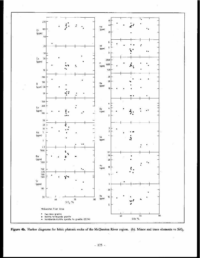
- 175 -

which range up to 10 cm or more in diameter. Up to 1 % tourmaline also occurs disseminated in the granite. The tourmaline includes both brown to black and blue to clear pleochroic varieties. Up to 2 % muscovite occurs as free grains and as sericitic alteration of feldspar. Cassiterite is intergrown with the tourmaline.
Both the quartz monzonite and the quartz syenite (Abercrombie 1990) contain approximately 5 % modal quartz and lie compositionally and spatially between the syenite and the quartz monzonite to granite core.
Petrographically, the homblende-biotitesyenite and quartz monzonite resemble the biotite-homblende granitoids, and the granite resembles the two-mica granites (see sections 1 and 2). Points of similarity include mineral morphology and pleochroism. Alkali feldspar is perthite, and plagioclase is oligoclase or andesine. Hornblende predominates over biotite, and has strong absorption with dark green-brown to red-brown to yellow-green pleochroism, with a bright green variety in the granite. Biotite also shows strong absorption, with dark redbrown to light yellow-brown pleochroism in the syenite, and chocolate brown to light yellow-brown pleochroism in the granite. Up to 5 % of the rock consists of medium to light brown pleochroic clinopyroxene, probably augite. Inclusionrich augite cores are commonly overgrown by hornblende with a similar orientation. Euhedral to subhedral accessory minerals include tourmaline, muscovite, allanite, titanite, cassiterite, apatite, zircon and rutile. After tourmaline in the tourmaline-rich granite, allanite (up to 1 % ) is the most abundant accessory mineral. Tounnaline, muscovite and cassiterite occur mainly in the orbicular granite. According to Abercrombie (1990), the syenite and quartz syenite contain magmatic epidote, indicating lithostatic pressure of crystallization greater than 8 kbar (Zen and Hammerstrom, 1984).
Quartz-plagioclase porphyry dykes occur just inside the contact of the syenite intrusion at ZETA (MINFILE 115P 047). The dykes contain round quartz phenocrysts, and both biotite and muscovite are present. Greisenization, including abundant sericitization and tourmalinization, is common, especially near the tourmaline-rich tin-silver veins. Radiating aggregates of tourmaline needles, which locally make up more than 10 % of the rock, are associated with cassiterite.
Sheeted porphyry dykes, including hornblende syenite, latite and quartz latite, occur near a homblende-biotite intrusion at MARTIN (115P 007). Phenocrysts consist mostly of alkali feldspar, plagioclase and hornblende, with minor quartz and biotite. Accessory minerals include augite and titanite, and minor zircon, apatite, epidote and calcite.
GEOCHEMISTRY
Twenty-five samples of plutons and dykes associated with tin and tungsten mineralization, some from each of the three groups of rocks outlined above, were analysed for major, minor, trace and some rare earth elements (Table 2).
Generally CIPW normative mineralogy is similar to modal estimates (Fig. 3). The two-mica granite, biotite-hornblende
granite, and homblende-biotite syenite are geochemically distinct. The more evolved phases from the core of the ZETA (MINFILE l 15P 047) syenitic intrusion are similar to the hornblende-biotite granitoids and two-mica granites from the rest of the region. The phases grade from hornblende-biotite syenite to quartz monzonite to biotite-hornblende granite to two-mica granite. Harker diagram variation trends are irregular, although some useful patterns were recognized (Fig. 4). Some exceptions to trends noted below may be significant to individual plutons, but are not discussed here. All rocks are peraluminous (Shand index A/CNK = molar Al20 3/(Ca0 + Na,0 + K,O) greater than 1.0), but the two-mica granites have a slightly higher ratios (greater than I.I; Fig. 5) than the hornblende-biotite granitoids.
In the following paragraphs, the term 'averdge' as applied to granite, granodiorite, syenite, etc. is based on analytical data published by Cox et al. (1979).
(1) Two-mica Granites
The two-mica granites are peratuminous, with higher SiO,, K,O and P,O,, and lower Fe,O,. MnO, MgO, CaO and Na,0 than 'average' granite. Analyses indicate 1.86 to 2.59 % normative corundum and 2.34 to 4.09% hypersthene (Fig. 6). The sum of normative albite, orthoclase and quartz ("Differentiation Index" (D.I.) of Thornton and Tuttle, 1960) makes up 82 to 89 % of the calculated norm, and normative anorthite ranges from 4.32 to 10.07%. Normative quartz, plagioclase and orthoclase are subequal, with slightly higher quartz. Average compositions are shown in Table 3. Harker diagram patterns are regular: Si02 and Na,0 (and trace elements Rb, 'Be, Sb, B, Cs, Au and Y) increase; and Al20 3,
CaO, Fe,O,. FeO, MgO and Ti02 (as well as Ba, Hf and Sr) decrease (Fig. 4a and 4b). This indicates that fractional crystallization probably controlled the formation of these granites. Analyses resemble those of low calcium, low magnesium, high potassium calc-alkaline granitoids (White and Chappell 1983). They also are similar in SiO,. Al,O,. TiO,. MnO and P,o, content to the "tin granites" of the Seward Penninsula (Hudson and Arth 1983), but higher in K20, lower in Fe,03 and Na,0, and slightly lower in MgO and FeO.
(2) Hornblende-biotite Granitoids
Homblende-biotite granite, quartz monzonite and granodiorite have levels of Si02, Ti02 , CaO, MgO, MnO and P20 5 similar to 'average' granodiorite, but much higher amounts of K20 (Sb and Sr), and lower Na,0, Al,O,. Fe,O,, Be, Au and Y (Fig. 4a and 4h). They are less evolved than the two-mica granites, with lower SiCi, Na20+ K20 versus Fe-oxides, MgO, Cao, Rb, Y and Nb (Figs. 5, 7, 8 and Table 3), and higher levels of Ca, Fe and Mg oxides, Tio,. MnO, Al20,. Sr, Ba,- Sb, As and Ba/Rb (Fig. 9, Table 3). Other distinguishing features include a lower D.l. (70 to 81 % ), highernormative pyroxene (3.42 to 9.43 % hypersthene, up to 4.03 % diopside), and zero normative corundum except at TEE (MINFILE l 15P 008a) and SCHEELITE DOME
- 176 -

10
"' ~ C1 E ro
V1
~ 5 0
~
"' -" E :J :z
0.5
....... , ..... Metaluminous I Peraluminous
I I I I I I
,I" two-mica granite
1.0 1.5
Molar A/CNK
Figure 5. Shand Index diagram (histogram of molar Al20 3/(Ca0 + Na,O+ K,O).
10 - McO.uesten River Area
;". ~ • two-mica granite c • biotite-hornblende granite
..c ~ • hornblende-biotite syenite to granite !ZETAJ 3 x 0
"' ~
~ ~ 5 0
"" E • er w u • z • >" . • w > • ~-o ... :>:: E er ~
• 0 ~ 2- • z c 2 • • 0
4 u ' ' ' ' 55 60 65 70 75
Si02
Figure 6. Normative clinopyroxene and corundum vs SiO,.
(MINFILE llSP 004)(up to 0.89%). Internal variations are shown by Harker diagrams (Figs. 4a and 4b). SiO,, K20 and Na,O increase, and CaO, FeO, MnO and Ti02 decrease. Trace elements are less variable than in the two-mica granites.
(3) ZETA Zoned Intrusion (Syenite-Quartz MonzoniteGranite)
The D.l. for these rocks varies from 67 to 77%. A/CNK values are all surprisingly high, ranging from 1.09 to 1.15. Hornblende (-biotite) syenite is characterized by nonnative and modal nepheline, olivine, very minor corundum, and no pyroxene (Table 3). Modal Si02 and Na,0 resemble 'average' syenite, but A120 3, CaO, K20 and P20 5 are more similar to 'average' phonolite, except for FeO which is at least 1 % higher, and Ti02 which is slightly lower.
The quartz monzonite is characterized by 12. 8S %
nonnative hypersthene and 2. 9 % diopside, and also has the highest normative magnetite and ilmenite of all rocks analysed . Its composition is mostly intermediate between the syenite and granite, although it has the lowest D.l. of the three. Chemically it is also similar to the homhlende-biotite granitoids.
The tourmaline orbicular granite in the core of the ZETA intrusion is not strictly comparable with the other granitoids, due to the high silica (78.5%) and boron (28SO ppm) content associated with the large orbicules (analysis not shown in Table 2). However, the interstitial granitic material resembles the two-mica granite in modal and trace element composition (Fig. 3). It appears to be slightly more evolved than the twomica granite. The tourmaline orbicular granite shows several notable features when compared to other granitoids: (I) severe depletion of Ba, (2) depletion of Ce, Dy, F, Ga, Au, Hf, Nd, Sr and Y, and (3) enrichment in Sb.
Variation from syenite to quartz monzonite to granite corresponds to Harker trends, with increasing Si02 and decreasing MnO, but little variation in trace elements. Variation from syenite to quartz monzonite is marked by an increase in Si02, Cao, Fe,03 , FeO, MgO, P,o, and Ti02 and the trace elements Cs, Cr and F, and a sharp decrease in Na,0, K20, Sb, As, B and Au. Variation from quartz monzonite to granite is marked by a decrease in Si02, CaO, Fe,O,. FeO, MgO, P,O, and Ti02 , and an increase in Na,0, B, Ga and Au. The variation in Ca, Fe, Mg, P and Ti is probably due to pyroxene, apatite and sphene fractionation .
Compared to both the two-mica and homblende-biotite granitoids, the zoned syellite to quartz monzonite to granite intrusion contains similar amounts of As, Ba, F, Ga, Sr and Y, slightly higher amounts of Be, Sb, B, Ce, Cs, Dy, Hf and Nd; and slightly lower values of Cr and Au (Fig. 4b and Table 3). The quantities of Be, B, Ce, Cs and Dy in the ZETA intrusion rocks are similar to those in the highly evolved phases of the two-mica granites.
Rb-Ba-Sr Relationships
The two-mica granite is significantly enriched in Rb with respect to Ba and Sr compared to the homblende-biotite granite, with the core of the SUNSHINE CREEK (MINFILE llSP 031) intrusion being the most enriched (Fig. 9). The Ba/Sr and Ba/Rb ratio increases in the hornblende-biotite granites and syenites from the less evolved PUKELMAN, RHOSGOBEL (MINFILE 11SP 012) and ZETA (MINFILE I ISP 047) intrusions, through the MAHTIN (MINFILE I ISP 007) intrusions, to the more evolved TEE (MINFILE I ISP 008a) and SCHEELITE DOME (MINFILE 115P 004) intrusions. The latter intrusions have similar Ba/Sr and Ba/Rb ratios to the least evolved of the two-mica granites.
RARE EARTH ELEMENTS
The following rare earth elements (REE's) were analysed: La, Ce, Nd, Sm, Eu, Gd, Tb, Dy, Yb and Lu (Table 2).
- 177 -

M
McQuesten River Area
• two-mica granite • biotite-hornbtende granite • hornblende-biotite syenite to granite (ZETA)
Selwyn Plutonil Suite Granites (Anderson, 1988) - - - two-mica granite -·-hornblende-bearing granite
Figure 7. AFM diagram (triangular, Na,O+K20 vs Fe,03 +Fe0 vs MgO).
K2 0
Na20 '----------------------~ Cao
McQuestl"n River Area
• two-mica granite • b1otrte-hornbleride gr;rnite • hornblende-biotite syenite to granite (ZETAI
Selwyn Plutonic Suite Granites (Anderson 1968) --- two-mica granite - · - hornblende-bearing granite
Figure 8. Na20-K20-Ca0 triangular diagram.
Rb
' I \ I ' \ I I I '- I ',/
HcO.uesten River Area
• two-mica granite • biotite-hornbl1rnde granite + hornb\ende-biotite syenite to granite (ZETA!
Selwyn Plutonic Suite Granite - -- two-mica granite --- hornblende bearing granite
Figure 9. Rb-Ba-Sr triangular diagram (ratios of ppm quantities).
Chondrite normalized graphs were used as an aid to interpretation (Fig. JO). However, due to the detection limits of Eu and Gd (2 ppm and 200 ppm, respectively), the graphs are abnormal, with a positive Gd anomaly but no negative Eu anomaly.
All patterns have negative slopes showing light rare earth (LREE) enrichment, and lower abundances of heavy rare earths (HREE). The following rock types are listed in decreasing order of LREE enrichment: (1) two-mica granite from LUGDUSH (MINFILE J 15P 009); (2) two-mica granite from the rim of SUNSHINE CREEK (MINFILE ll5P 031), syenite and quartz monzonite from ZETA (MINFILE J 15P 047), hornblende-biotite granodiorite from TEE (MINFILE J 15P 008a), hornblende-biotite granite from RHOSGOBEL (MINFILE ll5P 012) and PUKELMAN (MINFILE ll5P 013), and two-mica granite from the core of SUNSHINE CREEK (MINFILE J 15P 031); (3) two-mica rhyodacite dyke from JOUMBIRA (JOSM 031), sericitized dacite rim of LUGDUSH (MINFILE I ISP 009)(hornblende-biotite), and rhyodacite dykes from SN ARK (MINFILE I ISP 008b), ZETA (MINFILE .I ISP 047), SUNSHINE CREEK WEST (MINFILE 11SP 031) and WAYNE (MINFILE IOSM 029). The third group shows less LREE enrichment and slightly more HREE depletion. The rim of the SUNSHINE CREEK pluton is enriched in LREE relative to the core. This is explained by fractionation of apatite, which forms more than
- 178 -

0.'
Fig. lOa
'·' Lo Co
Fig. lOh
60 Eo a; Tb o,
Chondrite-nonnalized rare earth element diagram: East Ridge.
SUNSHINE CREEK ._ __ .. gr.nit. l<•nlr•ll -·-·egranite1rinil ,. ,. Sun sh n• Crook E•st rhyodwte dyko
.. Sun<h ne Creek We•t rhyodacit• dyke
---+ granit• \cent"ll
YO L•
Chondrite-normalized rare earth element diagram: Sunshine Creek.
2 % of the rim. Most phases of the zoned syenite to granite intrusion at ZETA are similar, but the orbicular granite is relatively depleted m HREE, an indication of its highly evolved nature.
:
---.. ·•. '
~~?:~.._~:~:~ ... < - - - --°', ·, . -..__ ' .,'.'. .... -..... _ '
\..._'-._,_..,._. _____ : >·' . -..
HT HALOA~ - SCHHllTE OOHE .---.. SCHEELITE OCW'tf g"n1t• -·-·• JOUt181AA gr•nitt {ttotrtll ,. & JOOHSIA• rhyod1cito dyke + + J00t181RA rhyod1c~t dykt +----+WAYNE rhyod°'ih dylct
Lo Co So Eu Gd Tb o,
Fig. lOc Chondrite-normalized rare earth element diagram: Mt. Haldane & Scheelite Dome.
::_: .. \ \./EST RIOGE
a-----11 JADBERWOCK rhjodadt• d'k• .----·· RHOSG08El qu.rtz rlloniomte ., .. . .o. PUKELHAN quirt> '"on>on1te + .,_ LUGOUSH gra~;te l<entrall +---. LUtiCUSH d3"t~ porph1ry I rim)
'. ~'*;,~~J \ d lO "-~3f:~;:.::_S-:-!-~'~ :;;
"
0.' Lo Co
Fig. lOd Chondrite-nonnalized rare earth element diagram: West Ridge.
INCOMPATIBLE AND RARE EARTH VARIATION AS AN AID TO TECTONIC INTERPRETATION
Pearce et al. (1984) used trace element variations to distinguish between granites from different tectonic settings. They defined a granite as any plutonic rock containing more
- 179 -

""'
coo
SYEMITE RANGE (ZETAI It---.. Tourmiline granih lcentrall e-- _ e O.uartz Mon~onite I rim I
4. • Syenite (rim, drill cortJ +·. + Cir~nile lcenlral) .._... -·+Rhyodarit. d1ke
Fig. lOe. Chondrite-normalized rare earth element diagrams from Syenite Range (Zeta).
than S % modal quartz. The following four groups of granites were established: (I) ocean ridge (ORG), (2) volcanic arc (VAG), (3) within plate (WPG), and (4) collision (COLG) granites. These groups were further subdivided according to their precise setting: for instance the latter group was divided into syn- and post-COLG's. "Using ORG-normalized geochemical patterns and element-Si02 plots .. . most granite groups exhibit distinctive trace element characteristics ... Post-collision granites present the main problem of tectonic classification, since their characteristics depend on the thickness and composition of the lithosphere involved in the collision event and on the precise timing and location of magmatism. Provided they are coupled with a consideration of geological constraints, however, studies of trace element compositions can clearly help in the elucidation of post-Archean tectonic settings." (Pearce et al. 1984, p. 9S6).
Elements included in the diagrams are restricted to those thought to behave incompatibly during fractionation of MORB to felsic composition. The rare earth elements are represented by Ce, Sm and Yb. In the diagrams, the elements are plotted in order of increasing incompatibility during MORB genesis (from Yb to Rb). Flat patterns (near unity) reflect granite with a simple genetic history: derived from convecting upper mantle, derived from a basalt parent by fractional crystalliz.ation, or unaffected by crustal melting, assimilation or volatile-dominated processes. Deviations from these flat patterns indicate a more complex genetic history for the granite.
ORO-normalized diagrams for the McQuesten plutonic rocks are shown in Figures l la-e. Some examples of collision and volcanic arc granites from Pearce et al. (1984) are shown
in Figures llf-h. The McQuesten rocks show patterns similar to "collision" and Chilean "volcanic arc" granites. All of the samples have very high values which are 30 to 90 times the norm, (a feature typical of evolved granites), high Rb and Th compared to Ta and Nb, with Th to Ta ratios ranging from S:l to SO:l (typical of "crust-dominated" plutons), and a general increase in the trace elements from Yb to Rb. Several patterns also show negative Ba anomalies, and/or positive Ce and Sm anomalies with respect to adjacent elements, another "crust-dominated" feature.
Negative Ba anomalies are characteristic of two-mica granites at SUNSHINE CREEK (MINFILE llSP 031) and LUGDUSR (MINFILE I !SP 009). The rim of the SUNSHINE CREEK (MINFILE I !SP 031) pluton is similarly depleted in barium with respect to the core. This is consistent with Ba depletion in the magma at a late stage in the differentiation process. The syenite from ZETA (MINFILE llSP 047) shows a pattern similar to the other granites, but without the Ba anomaly. The hornblende-biotite granites show a consistent decrease from Rb to Ba to Th, or a slight positive Ba anomaly.
Positive Ce and Sm anomalies occur in the two-mica granite at LUGDUSH (MINFILE llSP 009), but are absent in the centre of the SUNSHINE CREEK (MINFILE I ISP 031) stock. The latter is probably due to apatite crystallization in the rim causing depletion of LREE in the residual magma. Positive Ce and Sm are also associated with in hornblende-biotite granite at SCHEELITE DOME (MINFILE 115P 004), TEE (MINFILE 115P 008a) and MARTIN (MINFILE llSP 007).
Some positive Zr anomalies are present in homblende-biotite granites at RHOSGOBEL (MINFILE I ISP 012), PUKELMAN (MINFILE llSP 013) and SCREELITE DOME (MINFILE 115P 004), and in tourmaline orbicular granite and dyke rock from ZETA (MINFILE llSP 047). This can be explained by accumulation of zircon crystals at more mafic compositions (Pearce et al. 19 84).
Rornblende-biotite syenite and granite from ZETA (MINFILE llSP 047), MARTIN (MINFILE 11SP 007), PUKELMAN (MINFILE 11SP 013) and RROSGOBEL (MlNFILE I ISP 012)(the northern belt), have a lesser Th:Ta ratio, and are richer in Nb than other granites (both homblende-biotite and two-mica granites), indicating a less crust-dominated origin.
A rhyodacite dyke and the central two-mica granite plug at JOUMBIRA (MINFILE !OSM 031), and the dacite rim of LUGDUSH (MlNFILE I ISP 009) each show a positive Ba anomaly, very low Yanda slight Zr anomaly. The positive Ba and low Y could be due to alteration, since the feldspar is commonly sericitized.
The general similarities in these trace element patterns and abundances suggest that melted sedimentary rocks formed the entire McQuesten plutonic belt. Even rocks which show evidence of alteration or metasomatism in thin section show strikingly similar trace element patterns.
- 180 -

100
lO
Fig. Ua.
100
..
Fig. Uc.
East Ridge .... - ....,. TEE gr1nodiorite •- -- SNARi< rhyoduit1 dyke. . •· • • • • .t. MAH TIN !1tite. dyke
+ MAHTIN 9r1nite (ctntrilll .... ---• MAHTIN l1tih dyke
Scheetite Dome, Mt Haldane
._ - - SCHEELITE DOME granite •--- JOUMBIRA gramte (centratl • "'JOUMBIRit. rhyod1cite dyke
·+ JOUMBIRA rhyodacite dyk! .,_._·•WAYNE rhyodacite dykt
Figure U. Ocean Ridge-normalized diagrams for trace elements (normalized according to values given by Pearce et al. (1984)) for felsic plutonic rocks from the McQuesten
100
lO
Fig. Uh.
lOO
lO
Fig. Uc.
Sunshine Creek
- - - 9r;m1h (central) .._ ___ grilnih (riml
·• Sunshine Creek E1st rhyodacite dyke · + Sunshine Creek Wnt rhyodacite dyke
..... - • 9r1nih (~entr11)
.•
West Ridge
---. JABBERWOCK rhyodatite dyke •--- RHOSGOBEL qu1rtz monionite
· "'PUKELMAN qu1rtz monzonite · ·· + LUG DUSH granite (central)
t-· -·• LUGOUSH d1dh porphyry lrin)
,, /\ ,, \
'I ~ " .
River region. (a) East Ridge, (b) Sunshine Creek, (c) Mt Haldane and Scheelite Dome; (d) West Ridge.
- 181 -

""
10
Fig. lle.
co "' 0
" "' w 0
"'
100
10
1.0
0.1
K10 Rb
!Pearce
Fig. llg.
Ba Th Ta Nb
et al. 19841
Syenite Range !Zeta)
-- -•Tourmaline granite (centrall •----- O.uutz Mofrzonih (rim)
... Syenite lrim, drill [Orel ·+Granite (central)
.,_ - • Rhyodacite dyke
/'
Ce
). j\
Syn-collision Granites
Tibet
Yunnan
S.W. England
Barousse
1\ /'I \
'\ \ \\ \ ~·.
'--: Hf Zr Sm y Yb
Figure 11. Ocean Ridge-normalized diagrams for trace elements (normalized according to values given by Pearce et al. (1984)) for felsic plutonic rocks
co "' 0
" "' w 0
"'
100 Post-collision Granites Vedrette di Ries
O.uerigut
Nov ate
10 Oman
0.1+-~~~-~~-~-~-~~-~-~~
K20 Rb Ba Th Ta Nb Ce Hf Zr Sm Y Yb
!Pearce et al. 1964)
Fig. llf.
co
"' 0
" "' w 0
"'
100
10
" I I I I A
I \ I \ I ·\-. I \
\ l. \ v I
I I I I
Volcanic Arc Granite
Oman
Newfoundland
Jamaica
Chile
\ I
--------\ ', ,.--'I ,.,,,., \ I \ 1.0 -t---'-7'---',.-....._,,.,.----';,------
\ /\ \..... // '
'./ '
K20 Rb Ba Th · Ta Nb Ce Hf Zr Sm Y Yb
IPearce et al. 1964)
Fig. llh.
from the McQuesten River region. (e) Syenite Range (Zeta); and examples from Pearce et al. (1984): (t) Post-collision granites, (g) Syn-collision granites, and (h) Volcanic arc granites.
- 182 -

Trace Element Variation Diagrams used in Tectonic htterpretation
Pearce et al. (1984) were able to discriminate further between ocean ridge (ORG), volcanic arc (V AG), within plate (WPG) and collision (COLG) granites by graphing Y, Yb, Rb, Ta and Nb versus SiO,. and also Nb vs Y, Ta vs Yb, Rb vs Y +Nb, and Rb vs Yb+ Ta. McQuesten area samples plot mostly in the field of collision granites, but some show compositional similarity to within-plate granites. Calculated ratios of Y, Yb, Rb and Ta versus Si(),, as well as the ratios Ta vs Yb and Rb vs Yb+Ta plot mostly within the COLG and VAG fields as expected (Fig. 12)'. However, Y vs SiO,. and Nb vs Y diagrams show that samples from SUNSHINE CREEK (MINFILE Jl5P 031), ZETA (MINFILE Jl5P 047) and LUGDUSH (MINFILE ll5P 009) have WPG affinities. Niobium is somewhat high compared to COLG, and samples plotted on an Nb vs Si02 graph almost all lie in the WPG and ORG fields (Fig. 12b). Most samples on the Rb vs Y +Nb diagram plot in the syn-COLG and V AG fields, but several fall near or within the WPG field (Fig. 12c).
Whalen et al. ( 1987) used Ga/ Al ratios, various major element ratios and Y, Ce, Nb and Zr as discriminants in distinguishing A-type granites from M-, I- and S-type granites. Similar plots were made using analyses of McQuesten area plutonic rocks (Fig. 13). Two-mica granites mostly show Ga/Al ratios typical of I- and S-type granites, but a few plutons such as SUNSHINE CREEK (MINFILE ll5P 031) have higher ratios more typical of fractionated felsic granites (Whalen et al., 1987). The biotite-hornblende granites gave lower (K,0 + N11zO)/CaO and FeO/MgO ratios (Fig. 13a, b). Also K20 + N11zO, Zr, Ce and Zn values in some samples are higher than for most regular I- and S-type granites, again explainable by fractionation. Nb values are all higher than land S-types (Fig. 13c). Diagrams using the sum of Zr, Nb, Ce and Yon the abscissa were used similarly to Ga/Al plots. Due to high Nb and Y content, the samples plotted out of the field of OGT (unfractionated M-, I- and S-type granites), slightly toward the A type average (Fig. 13d). Most major element ratios, including FeO/MgO, (K,0 + Na20)/Ca0, and Rb/Ba, plotted outside the OGT field. These granites are not believed to have an A-type origin, but it appears that fractionation has played an important role in their formation.
COMPARISON WITH SELWYN AND TOMBSTONE PLUTONIC SUITES
Intrusive phases similar to those in the McQuesten region occur in the Selwyn and Tombstone Plutonic Suites (Anderson 1987, 1988; Pigage and Anderson 1985). Composite and zoned syenites in the Selwyn Mountains are documented by Smit et al. (1985) and similar rocks in the Tombstone Mountains are documented by Anderson (1987).
Overall similarities Points of overall geological similarity are listed in Table
4, and are summarized below: (1) The intrusions are post- to syn-tectonic. (2) They intrude upper Proterozoic to Jurassic, miogeoclinal metasedimentary host rocks. (3) They have a subcircular form indicative of forceful emplacement. ( 4) They have formed contact aureoles with andalusite and biotite (typical of shallow emplacement). (5) Some intrusions, especially syenitic plutons at Emerald Lake and in the Tombstone Range, show concentric zoning indicative of fractional crystallization in situ. (6) Each suite has bimodal characteristics, with the southernmost intnisions consisting oftwo-mica granite, and the northernmost intrusions consisting of less evolved biotite-hornblende granite. Bimodal characteristics of the Selwyn Plutonic Suite were documented by Anderson (1983). (7) Coeval volcanic rocks and dykes accompany the intrusions, for example the South Fork Volcanics in the Tay River area.
Petrographic similarities Petrographic analysis shows the following similarities
between the three different plutonic suites. (1) Modal compositions show that the two-mica granites are more quartzrich, and more restricted in K feldspar:plagioclase ratio than the hornblende-biotite granites. McQuesten area granites are similar to the Nahanni and Anvil area granites as shown in Fig. 3, although batholiths in the Nahanni-Flat River area show less variation between phases, and include a "transitional phase" of two-mica granite with minor hornblende (Anderson 1988). (2) Igneous texture varies from hypidiomorphic to allotriomorphic granular in the two-mica granite, to hypidiomorphic and idiomorphic granular in biotite-hornblende granite. (3) Feldspar and quartz phenocrysts show similar morphology. Microperthitic orthoclase megacrysts are characteristic. (4) Biotite is ubiquitous as an accessory mineral. Other distinctive accessory minerals include muscovite in the two-mica granites, hornblende and mi_nor clinopyroxene in the biotite-hornblendegranites, and nepheline in the syenites. (5) Biotite has chocolate brown pleochroism in biotite-hornblende granites compared to reddish brown in the two-mica granites. Hornblende is a darker green to brown compared to pale green in the two-mica granites, and clinopyroxene is dark brown, compared to beige in the twomica granites. (6) Other accessory minerals include apatite, zircon, allanite, titanite, and tourmaline. Monazite occurs mainly in the two-mica granites. Titanite, allanite and magnetite are mostly associated with the homblende-biotite granites. Magnetite and titanite are confined to the syenite. (7) Inclusions of zircon and allanite in biotite are more abundant in the hornblende-biotite granite. (8) Myrmekitic (or granophyric) texture is particularly common in the two-mica granites.
Anderson (1988) described two-mica granites with minor hornblende, confined mainly to large batholiths in the southeastern part of the Selwyn Plutonic Suite, as "transitional". Their chemistry is intermediate between the hornblende-biotite and two-mica granites. Uncommon but
183 -

100--- WPG + ORG (a-c)
-
'
VAG, COLG, ORG(d)
- -• . ., •• •
-- • • •
~+-~~~,,~~~~.-.~~~-.-~~------,
N IO N 10 7S
Fig. 12a.
1000 syn-COLG
x
xx x WPG 100 Jiii. -E a. a. -.a a:
10 YAG ORG
10 100 1000
Y +Nb(ppm)
Fig. 12c.
Figure 12. Trace element diagrams for indicating tectonic origin of granites (fields as defined by Pearce et al. (1984)): (a) Y vs SiO,, (b) Nb vs Si02, (c) Rb
100
• • • • • • • •
• I WPG + ORG (b) : • +----- ~--- ---~ ~---·------
•
VAG, COLG, ORG (a, c, d)
~+-~~~~~~~-~,~~~-.-,~~------,1
IO ea 10 11
Fig. 12b.
SI01 (%) McQUHten River ArH
• TWO - MICA GRANITE • BIOTITE - HORNllLENDE GRANITE t HORt11LENDE - BIOTITE SYENITE
TO GRANITE (ZETA)
1000 syn-COLG
100 WPG -E a. a. - YAG .a
a: 10 ORG
1.0 10
Yb+ Ta(ppm)
Fig. 12d.
vs Y +Nb, (d) Rb vs Yb +Ta; Terms: WPG=
100
within plate granites; ORG = ocean ridge granites; V AG = volcanic arc granites; COLG = collision granites.
- 184 -

Trace Element Variation Diagrams used in Tectonic Interpretation
Pearce et al. (1984) were able to discriminate further between ocean ridge (ORG), volcanic arc (V AG), within plate (WPG) and collision (COLG) granites by graphing Y, Yb, Rb, Ta and Nb versus SiO,, and also Nb vs Y, Ta vs Yb, Rb vs Y +Nb, and Rb vs Yb+ Ta. McQuesten area samples plot mostly in the field of collision granites, but some show compositional similarity to within-plate granites. Calculated ratios of Y, Yb, Rb and Ta versus Si Ci, as well as the ratios Ta vs Yb and Rb vs Yb+Ta plot mostly within the COLG and VAG fields as expected (Fig. 12)2• However, Y vs SiO,, and Nb vs Y diagrams show that samples from SUNSHINE CREEK (MINFILE 115P 031), ZETA (MINFILE 115P 047) and LUGDUSH (MINFILE 115P 009) have WPG affinities. Niobium is somewhat high compared to COLG, and samples plotted on an Nb vs Si02 graph almost all lie in the WPG and ORG fields (Fig. 12b). Most samples on the Rb vs Y +Nb diagram plot in the syn-COLG and V AG fields, but several fall near or within the WPG field (Fig. 12c).
Whalen et al. (1987) used Ga/ Al ratios, various major element ratios and Y, Ce, Nb and Zr as discriminants in distinguishing A-type granites from M-, I- and S-type granites. Similar plots were made using analyses of McQuesten area plutonic rocks (Fig. 13). Two-mica granites mostly show Ga/Al ratios typical of I- and S-type granites, but a few plutons such as SUNSHINE CREEK (MINFILE l15P 031) have higher ratios more typical of fractionated felsic granites (Whalen et al., 1987). The biotite-hornblende granites gave lower (K20 + Na,0)/CaO and FeO/MgO ratios (Fig. 13a, b). Also K20 + Na,O, Zr, Ce and Zn values in some samples are higher than for most regular I- and S-type granites, again explainable by fractionation. Nb values are all higher than land S-types (Fig. 13c). Diagrams using the sum of Zr, Nb, Ce and Y on the abscissa were used similarly to Ga/ Al plots. Due to high Nb and Y content, the samples plotted out of the field of OGT (unfractionated M-, I- and S-type granites), slightly toward the A type average (Fig. 13d). Most major element ratios, including FeO/MgO, (K,0 + Na,0)/CaO, and Rb/Ba, plotted outside the OGT field. These granites are not believed to have an A-type origin, but it appears that fractionation has played an important role in their formation.
COMPARISON WITH SELWYN AND TOMBSTONE PLUTONIC SUITES
Intrusive phases similar to those in the McQuesten region occur in the Selwyn and Tombstone Plutonic Suites (Anderson 1987, 1988; Pigage and Anderson 1985). Composite and zoned syenites in the Selwyn Mountains are documented by Smit et al. (1985) and similar rocks in the Tombstone Mountains are documented by Anderson (1987).
Overall similarities Points of overall geological similarity are listed in Table
4, and are summarized below: (!) The intrusions are post- to syn-tectonic. (2) They intrude upper Proterozoic to Jurassic, miogeoclinal metasedimentary host rocks. (3) They have a subcircular form indicative of forceful emplacement. ( 4) They have formed contact aureoles with andalusite and biotite (typical of shallow emplacement). (5) Some intrusions, especially syenitic plutons at Emerald Lake and in the Tombstone Range, show concentric zoning indicative of fractional crystallization in situ. (6) Each suite has bimodal characteristics, with the southernmost intrusions consisting oftwo-mica granite, and the northernmost intrusions consistiilg of less evolved biotite-homblende granite. Bimodal characteristics of the Selwyn Plutonic Suite were documented by Anderson (1983). (7) Coeval volcanic rocks and dykes accompany the intrusions, for example the South Fork Volcanics in the Tay River area.
Petrographic similarities Petrographic analysis shows the following similarities
between the three different plutonic suites. (1) Modal compositions show that the two-mica granites are more quartzrich, and more restricted in K feldspar:plagioclase ratio than the homblende-biotite granites. McQuesten area granites are similar to the Nahanni and Anvil area granites as shown in Fig. 3, although batholiths in the Nahanni-Flat River area show less variation between phases, and include a "transitional phase' of two-mica granite with minor hornblende (Anderson 1988). (2) Igneous texture varies from hypidiomorphic to allotriomorphic granular in the two-mica granite, to hypidiomorphic and idiomorphic granular in biotite-hornblende granite. (3) Feldspar and quartz phenocrysts show similar morphology. Microperthitic orthoclase megacrysts are characteristic. (4) Biotite is ubiquitous as an accessory mineral. Other distinctive accessory minerals include muscovite in the two-mica granites, hornblende and mi_nor clinopyroxene in the biotite-homblende granites, and nepheline in the syenites. (5) Biotite has chocolate brown pleochroism in biotite-homblende granites compared to reddish brown in the two-mica granites. Hornblende is a darker green to brown compared to pale green in the two-mica granites, and clinopyroxene is dark brown, compared to beige in the twomica granites. (6) Other accessory minerals include apatite, zircon, allanite, titanite, and tourmaline. Monazite occurs mainly in the two-mica granites. Titanite, allanite and magnetite are mostly associated with the homblende-biotite granites. Magnetite and titanite are confmed to the syenite. (7) Inclusions of zircon and allanite in biotite are more abundant in the homblende-biotite granite. (8) Myrmekitic (or granophyric) texture is particularly common in the two-mica granites.
Anderson ( 1988) described two-mica granites with minor hornblende, confined mainly to large batholiths in the southeastern part of the Selwyn Plutonic Suite, as "transitional". Their chemistry is intermediate between the homblende-biotite and two-mica granites. Uncommon but
183 -
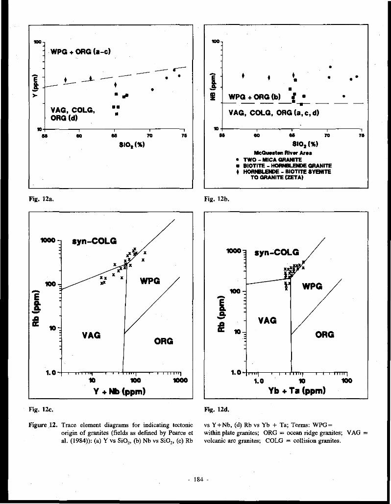
---· WPG + ORG(a-c) -- --
VAG, COLG, ORG (d)
• . ~ •• •
- .---- • • •
~+----...,------,.------.-,----,,
H ~ U ~ n 8101(%)
Fig. 12a.
10 100 1000
Y +Nb(ppm)
Fig. 12c.
Figure 12. Trace element diagrams for indicating tectonic origin of granites (fields as defined by Pearce et al. (1984)): (a) Y vs Si02, (b) Nb vs SiO,, (c) Rb
-i !I
• • • • •
~PG + ORG (b) __ £ _;_ VAG, COLG, ORG (a, c, d)
• •
•
• •
~+----~,--~-,.-------,--~,
u ~ u ~ n
Fig. 12b.
8101 ('JI.) McQ-.., River ArH
• TWO - MICA GRANITE • BIOTITE - -.ENDE GRANITE + HORt11LENDE - BIOTITE SYENITE
TO GRANITE (ZETA)
1. 0 -trmr-r--,--ri'm;rr-----r--r-r-rTTTT'!
1.0 10 100
Yb+ Ta (ppm)
Fig. 12d.
vs Y +Nb, (d) Rb vs Yb + Ta; Terms: WPG =
within plate granites; ORG = ocean ridge granites; V AG = volcanic arc granites; COLG = collision granites.
- 184 .

0 .. 0 ' -
100-
q_, 10-t----, A .. .-----~ .. ·v® 0 * • .. • . s CD ~ ... ~:
I • ...!--, __
•1 I
-e--M * 1+-~~~.~~,~~-,~~~,~~-,
0 3 8 I 12 18
Ga/Al x 10 000
Fig. 13a. (K20+Na,0)/Ca0 vs Ga/Al*IOOOO
10+--~ ·-----A
jJ2-® ••• I :
*• ,,--s • * * =:;::::::::::-1
I t•-;-M 1- ••
0.1+-~-'-,~~-~.~~~~-~,~~,
0 3 8 I 12 18 Ga/Al x 10 000
McQuesten River Area
• TWO - MICA GRANITE • BIOTITE - HORteLENDE GRANITE t HORNBLENDE - BIOTITE SYENITE
TO GRANITE (ZETA)
Fig. 13b. FeOIMgO vs Gal Al*IOOOO
Figure 13. Trace element diagrams for indication of petrogenesis (fields of OGT=unfractionated M, I and S granites;
100·
50· • - :t• •*--A E • a. a. • -:I I
• I •
I S, "®CD L.--' I 10 -.
' 0 3 8
Ga/Al x 10 000
Fig. 13c. Nb vs Ga/Al*IOOOO;
0 ..
75-
tlO
~ 45--~ z 30 +
q,, lil: -
18- FG (I)@,
OGT S~f 1.:.i • 0 ' --,_ : ••
/ I f r
0M200 - - -Zr+Nb+Ce+Y
McOuNten River Area • TWO - MICA GRANITE
18
-• BIOTITE - HORNBLENDE GRANITE • HORNBLENDE - BIOTITE SYENITE
TO GRANITE (ZETA)
Fig. 13d. (K20+ Na,0)/CaO vs Zr+ Nb+Ce+ Y.
and FG =fractionated granites as defined by Whalen et al. (1987)). Average M, I, S and A types are shown by their respective letters; while fractionated I and S types are circled.
- 185 -

Apparently similar rocks occur in the McQuesten region, for instance on the margin of the LUGDUSH (MINFILE l 15P 009) stock. This is a medium grained biotite-quartz-feldspar porphyry which contains sericite and chlorite pseudomorphs after hornblende, and has a composition intermediate between the two major granite types.
Petrographic characteristics of the McQuesten area rocks which are not recognized in the Selwyn Plutonic Suite include glomerophyric quartz and plagioclase, most notably in the two-mica granite, tourmaline orbicules (such as at ZETA (MINFILE 115P 047)), and microclinization and albitization of feldspar. These characteristics may indicate that the McQuesten granites are slightly more evolved.
Geochemical similarities McQuesten area rocks show geochemical similarities to
the Selwyn and Anvil suites (Gordey and Anderson, in press; Anderson 1988). (1) The two-mica granites contain normative corundum, while the hornblende-biotite granites contain normative clinopyroxene and little or no nonnative corundum. The syenites contain normative nepheline. (2) The two-mica and hornblende-biotite granites form two subalkaline groups, the former containing more than 70% silica and the latter, less than 67 % silica (Fig. 14). The syenite and quartz monzonite are alkaline, similar to the Tombstone syenite. (3) The rocks are mainly subalkaline to calc-alkaline, and from hornblende-biotite to two-mica granite the composition shifts toward higher alkalis and lower Fe and Mg (Fig. 7). (4) The rocks have similar Na,O to K20 ratios which plot in the field of S-type granites. (5) They have similar Na,O to K20 to CaO ratios. Alkalis increase and calcium decreases from the hornblende-biotite to the two-mica granites (Fig. 8). (6) They have similar Rb-Ba-Sr relationships, except that some of the Selwyn two-mica granites have higher Rb values. Differences:
There are some notable differences between the McQuesten granites and rocks of the Selwyn and Tombstone Suites. (1) Biotite-hornblende granites of the McQuesten region have a lower ratio of modal quartz to alkali feldspar and plagioclase than those in the Selwyn and Anvil regions (Fig. 3). (2) The McQuesten rocks are all peraluminous, whereas in the Selwyn and Anvil plutonic suites only the hornblende-biotite granite is metaluminous, and only the two-mica granite is peraluminous. (3) The McQuesten granites contain more iron compared to alkalis and magnesium (Fig. 7). (4) Unlike rocks of the Tombstone Suite which contain aegirine-augite, the McQuesten syenite and quartz monzonite intrusions entirely lack A-type characteristics.
DISCUSSION
Plutonic rocks in the McQuesten River region are generally bimodal, with two-mica granites in the south and bomblende-biotite granitoids and syenitoids in the north. There is a broad transition from hornblende-bearing nepheline syenite, to poorly evolved hornblende-bearing,
clinopyroxene-normative biotite quartz monzonite, to granite, to more evolved, peraluminous, corundum-normative muscovite-bearing biotite granite (Fig. 3). The coexistance of all three of the above phases in the ZETA (MINFILE 115P 047) zoned intrusion suggests they form a comagmatic suite. This is supported by Rb-Ba-Sr trends. A primary trend of Ba enrichment is observed in the less evolved biotite-homblende granites, and a secondary trend of Rb enrichment is seen in the more evolved two-mica granites. This is consistent with differentiation trends for felsic magmatic suites (Bouseily and Sokkary 1975). All phases of the McQuesten Plutonic Suite show similar patterns of trace elements (normalized to ocean ridge granite), providing further evidence of a comagmatic origin. These trace element patterns are doubly useful in that they have not been affected by alteration processes. The patterns recognized include high Ba and Th with respect to Ta and Nb, high Ce and Sm values with respect to adjacent elements, and an increase in abundance of trace elements from Yb to Rb. These trace element patterns are typical of collision and volcanic arc granites with a "crust-dominated" source. Other trace elements ar~ consistent with this interpretation, except for slightly elevated Nb and Y values which are more typical of granite originating within a plate. The original magmas were probably melts of, or melts contaminated by, sialic lower crustal material. Rb/Sr ratios greater than 0. 71 reported by Abercrombie (1990), and Kuran (1982) support this conclusion.
Crustal trace element patterns such as a lower Th:Ta ratio and higher Nb values are more characteristic of the two-mica granites and the hornblende-biotite granitoids of the southern belt than of hornblende-biotite granitoids of the northern McQuesten belt. The hornblende-biotite granitoids in the south even have positive Ce and Sm anomalies, whereas those in the north do not.
High Rb and negative Ba anomalies indicate the highly evolved nature of the two-mica granites in the southern belt. Lower Rb and less negative Ba anomalies are apparent in- the less evolved biotite-hornblende phase, especially in the north.
Two-mica granites from the McQuesten region have typical S-type characteristics. For instance, they are peraluminous, have K,O greater than Na20 (Fig. 15), relatively low Ti02, and FeO greater than Fe,03 (Fig. 16). However, the biotite-homblende granitoids contain less Si02
and show petrographic features (e.g., darker, chocolate brown biotite) more similar to 'I-type' granites of the Selwyn Plutonic Suite (Gordey and Anderson, in press). Any A-type characteristics, i.e. a few high Ga/Al ratios and high Zr+Nb+Ce+ Y values (due to high Nb and Y), are likely due to fractionation of S-, or I-type magmas.
Major metals are also partitioned between the two main igneous phases in the McQuesten River region. Tin-(silver) mineralization is associated with the two-mica granite at OLIVER CREEK (MINFILE 1lSP030), SUNSHINE CREEK (MINFILE 115P 031), BOULDER CREEK (MINFILE 115P 048) and JOUMBIRA (M!NFILE 105M 031) in the southern belt, and ZETA (MINFILE ll5P 047) in the northern belt, while tungsten (-gold) mineralization is associated with
186 -

Na
K20 (D/o)
15 - McQ.ueshn River Area
12-
9-
6-
3 -
55
-..\\~e '''"" • two-mica granite :-..¥-" :-+.a'"'' • biatite-hornble.nde granite a ~'Oa'\ • hornblende-biotih syenih. to granite !ZETAI 'i>
•
' 60
Selwyn P.S. transitional
----~ ( granite
I- • • ........... --.... • 1 • .......-- \
I .. ..v····,.,...--: ·" \ I • : . > _..,,.,, ·.: ' .......... I • .,. .. \... . ...... r...... ' ............ ·· .... · )
Selwyn P~ ~:~t~;J--~ ----_; : bearing qranite ' Se!1o1.yn two-mica
x qranrte
' 65
Si0 2
' 70
' 75
Figure 14. Na,0+ K20 vs Si02 of McQuesten River plutonic rocks. Outline of composition of granites from the Selwyn Plutonic Suite (after Anderson 1988) is also shown.
biotite-hornblende granite at PUKELMAN (MINFILE 115P 013) and RHOSGOBEL (MINFILE l 15P 012) in the northern belt and at SCHEELITE DOME (MINFILE 115P 004) and LUGDUSH (MINF!LE l !5P 009) in the southern belt (Emond, 1992). The LUGDUSH (MINFILE 115P 009) pluton is mainly a two-mica granite, but it is rimmed with sericitized hornblende-biotite dacite which formed the associated W skam. At SCHEELITE DOME (MINFILE 115P 004), TEE (MINFILE 115P 008a) and SNARK (MINFILE l 15P 008b) the tungsten skarns associated with biotite-hornblende granite also contain sulphide minerals and tin.
Metallic minerals help to characterize the McQuesten plutonic suite as a unique entity, distinct from the Selwyn and Tombstone plutonic suites. Numerous tin showings occur in the McQuesten belt, and its tungsten deposits are associated with biotite-hornblende rocks, whereas the southeast part of the Selwyn Plutonic Suite contains larger and more numerous tungsten deposits which are associated with two-mica granites (Anderson, 1988).
The Selwyn Plutonic Suite postdated the arc-continent collision (Tempelman-Kluit 1981, 1979). The magmas which formed these rocks are commonly believed to have formed by relaxation of isotherms associated with post-collision crustal thickening causing melting of the lower crust. However, it is also possible that these magmas were formed by low angle east-dipping subduction originating west of the 'Stikine arc' (Tempelman-Kluit 1979) causing melting of the lower crust or the 'downgoing slab'. Formation by subduction could possibly explain the bimodal distribution of the Selwyn intrusions and
Field 1of 1 type granites
Field of l type granites
6 ' ' ' 'l ' '
4- • C)~ -------;::;:__ ~ "' / / ~· z 2-
// -- ...... __ . _____ ---0 ' ' ' ' ' ' '
0 2 4 6 8 K20
McO.uesten River Area
• two-mica granite • biotite-hornblende granite • hornblend~-biotite syenite to granite !ZETAJ
Figure 15. Plot of Na,O vs K,O for I and S type granites.
Fe203 FeO
15
1.0 -
McQ.uesten River Arei
• two-mici grinite • biotite-hornblen~ grinite + hornblende-biotite syenite to granite !ZETA)
.. .. . •
' ' ' 55 60 65 10 10
Figure 16. F0i03/Fe0 vs Si02 of McQuesten River plutonic rocks showing oxidized and reduced granitoid classification.
also some of their 'I' type characteristics. The presence of syenite along the north edge of the
McQuesten region links rocks of the McQuesten region to the syenites and' A' type granites in the Tombstone Mountains to the northwest. There, a different intrusive suite was emplaced as a result of e~tensive Proterozoic crustal thinning and a difference in the composition of the lower crust (Anderson 1987). Since the granitoid rocks in the northern McQuesten region lack 'A' type characteristics, they have been included in the Selwyn Plutonic Suite, and may mark the southern margin of thinned crust. Syenites in the McQuesten region show a close relationship to the granites, particularly at the ZETA property (MINFILE l 15P 047) where the syenites and granites appear to be differentiation products of a single magma.
- 187 -
SUMMARY
Plutonic rocks of the McQuesten River region are comagmatic and consist mainly of hornblende syenite, biotite-hornblende granite and two-mica granite. Small plutons were forcefully emplaced at a high level in the crust and fractionally crystallized in place. The plutonic rocks form two east-trending belts: a northern belt with more mafic biotitehornblende granitic and syenitic rocks, and a southern belt with more felsic biotite-muscovite (two-mica) granites. The two-mica granite, which crystallized from the most evolved and therefore volatile-rich (i.e., boron-rich) melt, is associated with tin-silver veins and skarns. The less evolved biotite-hornblende granite is associated with tungsten-gold skams and veins.
The McQuesten Plutonic Belt is broadly similar to the Selwyn Plutonic Suite in its geometry and bimodal character. Differences in chemistry and metallization, however, indicate that the McQuesten intrusions are more highly evolved.
ACKNOWLEDGMENTS The author appre.ciates the time, energy and expertise
spent by J.A. Morin, W.D. Sinclair, and J.G. Abbott in critical review of the paper. Special thanks are due to S.R. Morison and J.A. Morin for their encouragement and provision of office facilities. Thanks are also to due to S. Abercrombie for interesting discussion of her thesis material, and to L. Pigage for providing further geochemical data on granites of the Anvil area. The drafting services of Northern Affairs, Whitehorse are also greatly appreciated.
REFERENCES
ABERCROMBIE, S.M. 1990. Petrology, geochronometry and economic geology: The z.eta tin-silver prospect, Arsenic Ridge, west-central Yukon (115 P 14 and 116 A 3). Unpublished M.Sc. Thesis, University of British Columbia, Vancouver, B. C.
ANDERSON, R. G., 1987. Plutonic rocks in the Dawson map area, Yukon Territory. In Current Research, Part A, Geological Survey of Canada, Paper 87-IA, p. 689-697.
ANDERSON, R. G., 1988. An overview of some Mesowic and Tertiary plutonic suites and their associated mineralization in the northern Canadian Cordillera. In: Recent Advances in the Geology of Granite Related Mineral Deposits, R.P. Taylor and D.F. Strong (eds.); Canadian Institute of Mining and Metallurgy, Special Volume 39, p. 96-113.
ATKINSON, D. and BAKER, D.J., 1986. Recent developments in the geologic understanding ofMacTung. In: Mineral Deposits of Northern Cordillera, J.A. Morin, (ed.); CIM Special Volume 37, p. 234-244.
BOSTOCK, H.S., 1946. Geology, Mayo area, Yukon Territory. Geological Survey of Canada, Map 890A.
BOSTOCK, H.S., 1964. Geology, McQueste11 River, Yukon Territory. Geological Survey of Canada, Map 1143A.
BOUSE/LY (EL), A.M. and SOKKARY (EL), A.A., 1975. The relation between Rb, Ba and Sr in granitic rocks. Chemical Geology, Vol. 16, p. 207-219.
BOYLE, R. W., 1965. Geology, geochemistry and origin of the lead-zinc-silver deposits of the Keno Hill - Galena Hill area, Yukon Territory. Geological Survey of Canada, Bulletin 111, 302 p.
COX, K. G., BELL, J.D. and PANKHURST, R.J., 1979. The Interpretation of Igneous Rocks. George Allen & Unwi11 Ltd, London, 450 p.
EISBACHER, G.H., 1981. Sedimentary tectonics and glacial record in the Windennere Supergroup, Mackenzie Mountains, northwestern Canada. Geological Survey o} Canada, Paper, p. 80-27.
EMOND, D.S., 1983. Geology of the EPD stanniferous breccia deposit, McQuesten area, 115 P, Yukon. In: Yukon Exploration and Geology 1982; Exploration and Geological Services Division, Yukon, Indian and Northern 4/fairs Canada, p. 26-33.
EMOND, D.S., 1985. Geology, mineralogy and petrogenesis of tin-bearing breccia/veins at Oliver Creek, McQuesten River Area, Yukon. Unpublished M.Sc. thesis, Carleton University, Ottawa, Ontario.
- 188 -

EMOND, D.S., 1986. Tin and tungsten veins and skarns in the McQuesten River area, central Yukon. In Yukon Geology, Vol. 1; Exploration and Geological Services Division, Yukon, Indian and Northern Affairs Canada, p. 113-118.
EMOND, D.S. and LYNCH, T., 1992. Geology, mineralogy and geochemistry of tin and tungsten veins, breccias and skarns, McQuesten River area (115 P (north) and 105 M 13), Yukon. In: Yukon Geology Volume 3; Exploration and Geological Services Division, Yukon, Indian and Northern Affairs Canada (this volume).
GORDEY, S.P. and ANDERSON, R. G., in press. Evolution of the northern Cordilleran miogeocline, Nahanni map area (105 I), Yukon Territory and District of McKenzie. Geological Survey of Canada, Memoir.
HUDSON, T. and ARm, J. G., 1983. Tin granites of Seward Peninsula, Alaska. ·Geological Society of America Bulletin, Vol. 94, p. 768-790.
HUNT, P.A. and RODDICK, J.C., 1987. A compilation of K-Ar ages, Report 17. In: Radiogenic Age and Isotopic Studies: Report 1; Geological Survey of Canada, Paper 87-2, p. 188.
KURAN, V.M., GODWIN, C.I. and ARMSTRONG, R.L., 1982. Geology and geochronometry of the Scheelite Dome tungsten-bearing skarn property, Yukon Territory. Canadian Institute of Mining and Metallurgy Bulletin, Vol. 75, p. 137-142.
LENNAN, W.B., 1986. Ray Gulch tungsten skarn deposit. In: Mineral Deposits of Northern Cordillera, J.A. Morin, (ed.); Canadian Institute of Mining and Metallurgy, Special Volume 37, p. 245-254.
LYNCH, J. V. G., 1989. Hydrothermal wning in the Keno Hill Ag-Pb-Zn vein system, Yukon: A study in structural geology, mineralogy, fluid inclusions, and stable isotope geochemistry. Unpublished Ph.D. Thesis, University of Alberta, Edmonton, Alberta, 218 p.
PEARCE, J.A., HARRIS, N.B. W. and TINDLE, A.G., 1984. Trace element discrimination diagrams for the tectonic interpretation of granitic rocks. Journal of Petrology, Vol. 25, p. 956-983.
PJGAGE, L. C. and ANDERSON, R. G., 1985. The Anvil plutonic suite, Faro, Yukon Territory. Canadian Journal of Earth Sciences, Vol. 22, p. 1204-1216.
SINCLAIR, W.D., 1986. Molybdenum, tungsten and tin deposits and associated granitoid intrusions in the northern Canadian Cordillera and adjacent parts of Alaska. In: Mineral Deposits of Northern Cordillera, J.A. Morin, (ed.); Canadian Institute of Mining atul Metallurgy, Special Volume 37, p. 216-233.
SMIT, H., ARMSTRONG, R.L., and VAN DER HEYDEN, P., 1985. Petrology, chemistry and radiogenic isotope (K-Ar, Rb-Sr, and U-Pb) study of the Emerald Lake pluton, eastern Yukon Territory. In: Current Research, Part B, Geological Survey of Canada, Paper 85-JB, p. 347-359.
STEVENS, R.P., LACHANCE, G.R. and DELABIO, R.N., 1982. Age determinations and geological studies, K-Ar isotopic ages, Report 16. Geological Survey of Canada, Paper 82-2, 56 p.
STRECKEISEN, A.L., 1973. Classificationofplutonicrocks. Geotimes, Vol. 18,p. 26-30.
TEMPELMAN-KLU/T, D.J., 1979. Transported cataclasite, ophioliteand granodiorite in Yukon. Evidence of arc-continent collision. Geological Survey of Canada, Paper 79-14, 27 p.
TEMPELMAN-KLUJT, D.J., 1981. Geology of the southern Yukon. Jn: Yukon Geology a1ul Exploration 1979-80; Exploration a1ul Geological Services Division, Yukon, Indian and Northern Affairs Canada, p. 8-31.
- 189 -

THOMPSON, R. /. and EISBACHER, G. H., 1984. Late Proterozaic rift assemblages, northern Canadian Cordillera. Geological Society of America, Abstracts with Programs, Vol. 16, p. 336.
THORNTON, C.P. and TUTILE, O.F., 1960. Chemistry of igneous rocks - I, Differentiation Index. American Journal of Science, Vol. 258, p. 664-684.
WAT.S'ON, K. W., 1986. Silver-lead-zinc deposits of the Keno Hill-Galena Hill area, central Yukon. In: Yukon Geology Volume 1; Indian and Northern '1ffairs Canada, Northern Affairs Program, Exploration and Geological Services Division, Yukon, p. 83-88.
WHALEN, J.B., CURRIE, K.L., and CHAPPELL, B.W., 1987. A-type granites: geochemical characteristics, dicrimination and petrogenesis. Contributions to Mineralogy and Petrology, Vol. 95, p. 407-419.
WHEELER, J.O. and MCFEELY, P., 1987. Tectonic assemblage map of the Northern Cordillera. Geological Survey of Canada, Open File 1565.
WH/1E, A.J.R. and CHAPPEU, B. W., 1983. Granitoid types and their distribution in the Lachlan Foid Belt, southeastern Australia. In: Circum-Pacific Plutonic Terranes (J.A. Roddick, ed.); Geological Society of America, Memoir 159, p. 21-34.
WOODSWORTH, G.J., ANDERSON, R.G., BROOKFIEW, A. and.1ERCIER, P., 1989. Distribution of Proterozaic to Miocene plutonic suites in the Canadian Cordillera. Geological Survey of Canada, Open File 1982, 6 maps.
ZEN, E. and HAMMARSTROM, J.M., 1984. Magmatic epidote and its petrologic significance. Geology, Vol. 12, p. 515-518.
Appendix 1. Abbreviations (used in tables).
ALL,AL allanite NOS nosean AP apatite OP opaque minerals AN anatase OR orthoclase BI biotite PL plagioclase COR corundum PX pyroxene CAN cancrinite QZ quartz CPX clinopyroxene RU rutile DI diopside SPH sphene FL fluorite TO tourmaline GT garnet ZR zircon HB hornblende DAC dacite KSP K feldspar GRAN granite MEL melanite GRAN OD! granodiorite MON monazite QZMZ quartz monzonite MT magnetite RHYODAC rhyodacite MU muscovite SY syenite NE nepheline
1. In this report, the mineral property name is also used when referring to the associated pluton.
2. Due to space constraints, some of these diagrams have been omitted.
- 190 -

Table 1. Petrology of Plutonic Rocks of the McQuesten River Area'
TWO-MICA HORNBLENDE- HORNBLENDE-GRANITE BIOTITE (BIOTITE)
GRANITE SYENITE
MAIN QZ, PL(OI- QZ, PL(An), KSP, PL(OI-MINERALS An), KSP KSP An), HB
ESSENTIAL Bl>MU Bl>HB HB> >Bl MINERALS
BIOTITE reddish- to chocolate chocolate orange-brown brown to It brown to elk to It yellow yellow-brown red brown to brown -minor rusty It yellow
brown
HORNBLENDE none It brownish dk green-green to brown to red-yellow-clear brown to to grass green yellow-green - also pinkish clear, It bluish green)
ACCESSORY AP, ZR, MON, ALL, AP, ZR, ALL, RU, AP, MINERALS TO (OP, SPH) SPH (OP-MT) ZR, SPH, NE
TEXTURES allotrio- to hypidio- to idio- to hypidiomorphic idiomoiphic hypidiomorphic granular, granul3.r, granular myrmekite, smooth edges myrmekite, ragged edges (mica), strained porphyritic to (mica), strained quartz, quartz equigranular embayed quartz, glomophyrs, KSP quartz giomophyrs, megacrysts and megacrystic KSP, clots equigranular to poikiioiitic & seriate to zoned HB, porphyritic porphyritic
ALTERATION ser. of PL ser. of PL biol. of HB chi. of BI chi. of BI & HB ural. of PX perth. of KSP microcl. of PL perth. of HB microcl. of KSP biot. of HB carbonate epidote epidot. of HB
carbonate albitization ural. of PX
1 Abbreviations: see Appendix I.
- 19I -

:;; "'
Table 2. Major-li!lement, nor11111.Uw mlnft'ai and modal eompo11ltion or sampltt from the McQunten Granite Belt
Auoclal<d
Mineral
-~ Sample No.
(New)
IWd<T"" -Mlnerab
Major Oxidn(wt '.l>)
Sl02 A~03 F.,O, F.O MaO eao No,O K,O TIO,
PJO!
M"O LOI
To4al
molar A/CNK DIFFINDEX
CIPWNORMS Q
c OR AB AN NE DI HY MT
IL FA EN
"' WOLL EN{DP)
>S(DP)
OL OL (FOK) OL (FAY)
LUGDUSH LUGDUSH
Core Rim 242 237
(12) (II)
GRAN DAC Bl Bl·MU
70.61
14.20 0.67 2.00 o.oo 1.36 3.12 4.99 O.S2
0.28 0.06 O.Ol
99.21
l.>J
29.16
1.86
29.48
26.40 4.91
4.09 0.83 0.9' 0.22 1.49
2.59
(HB?)
68.46 lS.46
0.9' 2.25 0.99 2.S4. 3.08 4.19
0.45
0.16 0.06 1.40
100.61
1.23
24.1'1 0.97
28.30 2<>.06 II.SS
S.8S 1.00
0.85 0.12 2.46 3.39
TEE
SWd< >J3 (I)
GRDI
Bl-HB
65.25 14.98 l.>J 3.>J l.87 3.49 2.22 4.51 O.S3 0.23 0.00 0.00
"·"' 1.28
23.2Jl
0.6' 26.6' 18.78
IS.81
9.43 1.37 1.00 0.18
4.65 4.77
SUNSHINE SUNSIDNE CREEK Central
281,2 (23,'.24) GRAN
Bl· MU
13.99 13.70
0.42 1.22
0.32 0.94 3.04 4.16 0.24
0.16 0.04 0.70
99.68
1.23
34.97
1.96
28.10 25.72
4.32
2.S2 O.Sl
0.46 0.12 0.00 1.72
CREEK Stock
279 (22)
GRDI BI-MU
70.39
14.42 0.63 1.80
0.57 1.49
2.65
4.9' 0.47 0.25 0.03 1.10
98.77
1.31
3J.S2 2.S6
29.42 22.42 S.1S
3.74 0.76 0.89
0.19 1.41
2.32
SUNSHINE SCHEELITE JOUMBIRA JOUMBIRA
CREEK DOME Dy .. 27S (>J)
RYOD Bl(HB?)
72.54
14.26 0.3S
J.10 0.40
1.21 2.86
S.37 0.32 0.21 0.03 1.00
99.66
32.14 2.04
31.73 24.1'1 4.63
2.34 0.4' 0.00 0.16 0.99 1.34
208 (3)
GRAN Bl-HB
65.40
IS.38
0.94 2.75 1.71 2.97 2.00 4.80
0.51
0.16 0.08 0.70
98.01
1.27
21.65 0.89
28.3<> 22.00
13.68
8.18
I.IS
0.96 0.12 4.25
3.92
""' 219 (S)
GRAN
BI-MU
72.23 13.00
O.S3
I.SS
0.71 1.76 2.>J 4.18 0.32 0.14 0.03 0.90
98.16
1.40
38.03
2.S9
24.70
18.61
7.81
3,90 0.65 0.00
' 0.11 1.76 2.13
Dyk• 244 (13)
RYOD Bl-HB
70.61
IS.3S
0.65 0.75 0.37
2.IS
2.84 4.41 0.19 0.09 0.01
1.10
98.53
1.3S
31.66
2.21 26.0S 24.03 ro.01
2.94 0.42 0.3<> 0.07 0.92 1.42
MARTIN
""' 227
(7)
GRAN
HB-81
"·"' 14.05 t.12 3.3S 2.21
3.S3 2.3<> S.46 0.54 0."1 0.119 O.Ol
98.96
l.llll
19.11
32.26 19.96
11.61
3.77 8.SI
1.40
1.02
0.15 4.SI 4.00
1.91 0.98 0.87
MAIITIN
Dyk• 221 (6)
GRAN HB-BI
66.72 15.24 0.89 1.40
l.31 3.02 2.83
6.78 0.48
0.18 o.os J.10
99.99
1.03
16.49
40.116 23.94 8.85
4.03 3.42 0.70 0.91 0.14 2.06 !.3S 2.116 1.19 0.77
RHOSGL PUKELMAN
23S (9)
QZMZ HB·BI
65.56 lS.54 0.78 3.>J 1.47 3.40
2.89 S.55 o.ss 0.24 0.10 0.90
100.19
1.12
17.'.24
32.79 24.4S 13.03
1.87 7.01 I.2.1 1.04 0.18 3.23 3.78 0.94 0.43 O.SO
236 (10)
QZMZ HB-8I
64.82
14.89
0.90 2.0l 1.16 2.07 2.0l 5.35 0.51 0.23 0.119 l.>J
97.71
1.13
19.01
31.61 23.69
12.25
0.81 ..... t.16
0.96 0.18
;.11 3.13 o ... 0.17 0.23
ZETA
M""" "" (19)
SY HB (Bl)
58.04 19.37
1.30 3.15 0.98 2.67 4.14 1.S2 0.43
O.>J 0.12
0.90
98.82
J.11
0.04 44.43 30."7 11.93 2.19
!.39 0.81 0.15
S.62 1.70 3.91
ZETA
....... " 256 (16)
QZMZ HB-8I
61.67
lS.82
1.72 3.40 3.SS 3.74
2.92 5.81 0.69
0.32
0.11 O.Ol
JOO.SS
1.09
8.34
34.33
24.70 12.90
2.90 12.85
l.'9 t.31 0.25 1.96 4.88 1.48 0.87
0.53
ZETA
c ....
"' (17)
GRAN
HB-BI
65.27 lS.n
l.S1 2.lO 1.2' 2.63 3.llll S.77 O.SO 0.23 0.09 0.90
99.21
I.IS
16.W
0.17 34.09 26.06 IJ.S4 •
7.119 1.16
0.94 0.18
3.ll 3.98

-"' w
Table l. (oontlnued)
AslOdated Mineral
Occurrence Sample No.
(New)
Rock Type
LUGDUSH LUGDUSH
-MlnmU1
""' 242 (12)
GRAN BI
Minor Elemenb (ppm)
UupCatlon• .. c. Rb s. Kb/Sr
Rare Earth Elemenb La c. Nd Sm Tb
Dy
High Valena! Olllon•
1100
14
"" 315
0.90
100
200 61
10.0 <I
3
Th 41.0 u 4.8 Hf 6 Ta Nb 52 y 29
Ga II • >I z, w M• Th/U
Othet Metah Au (ppb) .. Sb .. C• Zo
"' .. F
<500 <2 <2
8.S
14
<5 0.3
5 150
<200 5.2 7.6
550
Rim 237
(ll)
DAC Bl-MU (HB'!)
2100
11 I., 510
0.27
34
72 26
4.4 <I
2
14.0 4.7
25 7
>I >I
<500
<2 <2
3.0
10 <5
0.6 II
l>I <200
5.5 4.8
450
TEE SUNSIUNE SUNSIHNE SUNSHINE SCHEELITE JOUMBIRA. JOUMBIRA. MAIITIN MAHTIN RHOSGL
Slock >13 (I)
GRDJ BI-HB
2100
16 210
455 0.46
" 110
" 7.8
2
27.0 9.2
<I 23
15 19
35 <500
<2 <2
2.93
"' <5 0.8
16 140
<200 11.0 5.0
900
CREEK CREEK CREEK DOME Central
281,2 (23,24) GRAN BI-MU
500 30
"" 162.5 2.21
42 105
28 6.2
<I 3
31.0 14.8 4 4
38
44 15•
" <500 6
2•
2.1
16 <5
0.2*
<I IW
<>IO 4.9
12.2 llW
Stn<k 279 (22)
GRDI Bl-MU
1100
16 350
74 1ro 45 9.4
"'·' 12.0 6 4
39
24 IS
<500
<2 <2
3.3
12
<5 0.2
<I I30
<200 7.0 7.7
1300
Dyke
275 (>I)
RYOD Bl(lffi?)
990
IO 310 145
2.!4
35 73
28 5.5
<I 3
35.0 8.8 4
2 24 39 18
" <500 <2 <2
4.0
18 7
2.1
131 86
210 3.4 6.1
4lll
'"' m GRAN Bl-HB
2500
11 190 475
0.4
40
97.0 19
6.6 <I
3
>I.O 9.1 4
I
25
18
<I 15
680
11 <2
2.>I
9 7 0.6
<3 !OJ
<>JO
11.0 5.1
900
PI,, 219
(5)
GRAN BT-MU
2300 14
150 305
0.49
23
48.0 19.0 3.3
<I 2
12.0
5.4
5 <I 19
<5 >I 25
<500 <2 <2
2.n
<5 <5
0.9 0.9
IOI 810
3.9
3.9 6>1
Dyko 244 (13)
RYOD BI-HB
3200
4 l>I ,.,
0.32
28 ., II 2.4
<I <I
12.0 4.1
<I 16
<5 59
IS <500
<2 <2
2.92
<5 O.S
0.5 15
230
1.4
2.9
280
r1,, 227 (7)
GRAN HB-BI
1100
16 260
4>1 0.62
49
Jjj)
32 7.2
26.0 7.2 4
<I 21
25 <IO
>I <500
<2 <2
3.61
9 7 1.0
n 150
<200 13.0
6.5
1000
Dyk• '21
(6)
GRAN HB-BI
>JOO 15
JOO 515
O.S8
64 110
42 8.2
<I 3
29.0
5.0 6 I
24 2S
<IO 2S
<500 <2 <2
5.8
<5 1.8
13 130
<>IO 8.3
7.4 660
235 ~)
QZMZ HB-81
1<'10 15
240
"' 0.43
43
79 37 6.6
<I 3
19.0 7.3
2 37 18
10 2S
150 <2 <2
2.0J
28 <5
0.7 4
l>I <200
9.5 6.7
1300
PUKF.I.
236 (10)
QZMZ HB-BI
1200 12
210
5>1 o . .,
39 79 33
5.9 <I
3
17.0
8.2 4 2
29 18
"' "' <500 23
<2 2.07
' <5 0.6
19
98 <ll!O
7.1 6.7
850
ZETA
-·· 264
(19)
SY HB (Bn
1700
16 320
655 0.49
62
l>I 45 8.4 2
28.0 5.6
7
42 37 10
14' <500
<2 <2
5
6 <5
2.7
12
<50 <200
3.8 9.2
840
ZETA
....... 256 (16)
QZMZ HB-BI
1roo 32
3lll 525
0.61
71 Ill!
39 8.9
<I 4
51.8 13.0 6
2 39 38
10 50
<500 13
<2 3.98
<S <S
1.6 6
130
<200 11.0
II~
1250
ZETA
°"' 2'8 (17)
GRAN HB-BI
1roo lll
310 495
0.63
66
!JO 46
8.6 <I
3
51.3 10.0 7
42 33
14
" <500 <2 <2
5.13
<5 1.8
110 <200
6.9
9.9 1050
Anal~ieii were perfwmed by Bondar-Clegg & Comp1my Ltd., North Van(ll)Uver u~lng mainly the following methods: I) major and minor elemenb • D.C. Plasma (alMt Tltrlmetrlc for Fe<>; and Gravimetric ror U>tis on Ignition); l) ~ elemenl3 - Neutron Actlvatlvn (and alMt X-ray nuorescenc:e for Sr, Y, Ga and In; D.C. Plasma ror Ge; Turbldlmetrlc ror Cl; and Atomic Absorption for Be).
Abbre'Yiatioos: see Appendix I

Table 3. Average composition or Granllold Rocks In the McQueften River Area
Two-Mb Granite
n•41
MAJOR OXIDE ANALVSl!'S {Wf 'k)
810,. 71.80 (70.39-73.99) AliO, 13.98 (13.00-14.42)
Fe:,Ol 0.56 (0.42-0.67) FeO l .64 (1.22-2.00) MgO 0.55 (0.32-0.71) CaO 1.38 (0.94-1.49)
Na.O 2.75 (2.Z0.3.12) JC.O 4.73 (4.18-4.99) TIO, 0.38 (0.24-0.52)
PiO• 0.25 (0.14-0.28) MnO 0.04 (0.03-0.06)
-..AtCNK DIFF INDEX
CIIWNORMS Q
c OR AB AN
NE DI HY MT IL FA EN .. WOLL EN{DP)
FS(IJP)
OL OL(FOR) OL(FAY)
MINOR ELEMENTS (PPM): Large CaUons
Ba c. Rb ,, Rb/Sr
Rare Earth Elementll
La Co Nd Sm Tb Dy
High Valence Cation' Th u
"' Ta Nb y
"" B z, w Mo Th/U
Other Metals Au (ppb)
Ag Sb .. c, Zo Sc .. F
1.28 (1.20-1.40)
33.42 (29.16-38.03) 2.24 (1.86-2.59)
27.92 (24.70-29.48) 23.29 (18.61-26.40) 5.10 {4.32-7.81)
3.56 (2.52-4.09) 0.69 (O.:SJ-0.83) 0.73 (0.46-0.98)
0.16 (0.11-0.22) l.37 (0.80-1.76) 2.19 (1.72-2.59)
1550 (S00.2300)
18 (14-30)
280 (1:50-360)
261 (162.5-315)
1.2 (0.49-2.21)
49 (23-100)
"' (48-200)
39 (19-fi7)
7.2 (3.3-10.0) <I (<1-1)
3 (2-4)
31.0 (12-41)
9.2 {4.8·14.8)
(4-~
(< 1-4)
37 (19-52)
25 (<5-44)
17 (11-24) 34 {l5-75)
<500
2 ( <2-6)
<2 (<'2-2)
4.03 (2. J-8.5)
ll {<5-16)
<5 0.4 (0.2-0.9)
27 {< 1-101)
140 (120-IJU)
280 (<2-810)
5.2 (3.9--7.0)
7.8 {3.9-12.2)
900 (550-1300)
Homblende-Bkltlte Quartz Monzonlte, Granite
•••
6S.so (64,82-ti6. nl IS.OJ (14.05-15.54)
0.97 (0.78-1.20) 2. 78 (1.40-3.20) 1.62 (1.16-2.21) 3.23 (2.97·3.53)
2.61 {2.n-2.89) 5.41 (4.51-6.78) 0.52 (0.48-0.55)
0.21 (0.18-0.24)
0.08 (0.05-0.10)
I.IS (l.03-l.28)
19.46 (16.49-23.28) 0.26 (0-0.89)
31.96 (26.65-40.06) 22.14 (18.78-24.45) 12.54 (8.85-15.81)
l.75 (0-4.03)
6.66 (3.42-9.3) l.17 (0.70-1.40) 0.98 (0.91-1.04)
0.16 (0.12-0.18) 3.S7 (2.06-4.65) 3.:59 (1.3:5-4.77) 0.88 (0-2.06)
0.46 (O-l.19) 0.40 (0-0.87)
19'0 (1200-2700)
l4 (11-16)
235 (190-300)
490 (420-555)
.48 (0.40-0.62)
48 {39+64)
" (79-120)
33 (19-42)
7.0 (S.9-8.2)
<I (< 1-1)
3 (2-3)
23.0 (17-29)
7.7 (5.0-9.2)
' (3-6)
I {< 1-2)
26 (21-37)
'" (15-25)
<JO (< 10-20)
23 05·35) <500 (<.50:).750)
6 (<2-23)
<2 3.211 (2.07-5.80)
13 (6-28)
<5 (<S-7)
0.9 (0.6-L8)
12 (<3-22)
133 (98-IM)
<'.lllO 10.0 (7.1·13.0)
6.2 {5.0-7.4)
940 (660-1300}
'Wh=n n> I, the fit!lt valuc ill the m::an; this is followed by the~. in p11renthc8Cs. 194 -
HornblendeBloll~
Syenlte n=l
58.04 19.37
1.30 3.15 0.98 2.67
4.14 1.52 0.43 O.lll 0.12
I.II
0.04
44.43 30.97 11.93 2.19
1.39 0.81 0.15
5.62
'·"' 3.91
1700
" 3lll 6S5
0.49
62
1211
" 8.4 2
3
2ll.O 5.6 7
2 42 37 JO
145 <500
<2 <2
5
6 <5
2.7
12 di
<'.lllO 3.8 9.2
840

Table 4. Comparison of plutonlc roclu of the McQuesten arl\ll with the Selwyn and Tombstone Plutonlc Suites
GEOLOGICAL SETTING
INTRUSION CHARACTER· ISTICS
PHASES
ACCESSORY MINERALOGY
TEXTL'RES
ALTERATIO!'i' MINERALS
ASSOCIATED MINERAL DEPOSITS
GEOCHEMISTRY
Abbreviations: see Appendix 1
MCQUESTEN
Late ProterOLOic to Miss. mclased. rx
Zoo.d, nearby coeval voles, contact a~lcs, roof prndante., subcircular, hc!Croge:neo.is, 8locka, plugs, dykcti
I) QZ-rich folsic (bi-mu granite}
2) feb.ic (hh-bi quartz monz, granodi, granite)
3) QZ-poor fehiic (hb-bi (hb-bi sycnite, quartz monzonite 10 granite)
U MU, Bl, AP, ZR, TO, MON
2) Bl, HB, AL, SPH, AP, ZR, CPX, MT
3) HB, Bl, AL, SPH AP, ZR,RU,NE,Cf,TO
allotriom. to hypid. gran. l!Criale, porph., megaciyslic, glomeropbyric, mynnekitc, microperthite
chlor., ser., microclinii..,ep., calc., albit., umli1.
Sn-Ag veins, skams assoc. wilh two-mica granite W-Au sli:am & veins assoc. wilh hb-bi granite; Ag-Pb-Zn veins distal to plutons
I] Corurdum norm > 70% SiO, (70-75) K,O > Na.,O
2) CPX norm.
< 70% SiOi (64-66)
3) ~E Lo COR nonn. (from syenite 10 granite)< ro % SiOz (58)
PeralurninoU5 (hb-beari.ng -lower Shand Ind.
Subalkal~ (minor al.lralin:)
Cale-alkaline (2-mica granitchigher alkalis, km'Cr Fe, Mg)
SELWYN
Late Prolerazoic to Miss. mc\lised, & meta.vol. rocks
Zoned, composite, overlain by coeval volca, subcircular, heterogencoos, batholiths, plugs, stocks, dykes
I) QZ-rich felsic (hb-free bi-mu granite to granodi.
la) Tran:iitional variety ~tween I) an:l 2: a two-mica granite with minor hb.
2) folsic (hh-bi granite, granodi, quartz syc.nite)
3) QZ-poor fcl&ic (hb-bi (hb-bi alkali feldspar syenite to syenite Lo qtz syenite to qlL monLonite to
granite)
L) MU, 91, GT, TO, AP, AL, ZR, AN, MON, HB, CPX
2) Bl, HB, MT, SPH, AP, Al,TO,ZR,CPX
3) HB, Bl, SPH, MT, AP, ZR, AL
hypid. gran., cquigran, seriate, megaCT)'Slic,
mynnekite microperthite
chlor., ser,, ep., calc., sphe.,.., saussur.
large W-0.. &kams assoc. 1•:ilh two-mica granite 0..-Mo-Fe-As-Zn (Au-W) skam &
vein showings assoc, with hb-bi granite
1) Corundum norm silicic, high K, low Ca & Mg,
2) CPX norm, !OW<::r
norm. oonmfum & silica, higher cafemic, Ti(\,MnO,Sr,Ba,l.a, Y,KIRb, BatRb,lower salic oxides, D.l.,Rb,Rb/Sr,K!Ba
Per· 10 metalum. (hb-bearing -]o..,,'Cr Shand Index)
SubaU:alin: (minor alkalin:}
Cale-alkaline (2-mi"" granitehigh:cr alkalis, lcm.'Cr Fe, Mg)
- 195 -
TOMBSTONE
M. ProterOLoic to JutaSsic metascd. ix. Zou.:: of suspect Late Pr<Mro:zoic extension.
subcircular to
circular, post-tectonic, oogenetlc dykes &. vol<;anics
1) DO two-mica granite
2) siliooous fehiic (hb-bi monzogranite)
3) QZ-poor felsic (hb ± bi alkali to feldspa:r syeni(';)
4) Mafic to lnterm:d. (Subordinate)(hb-clinopyroxc:nite, hb-diorite, tinguaite, bi-mcmzonite)
2) HB, BI
3) HB, Bl, SPH, FL, AEGrR.INE-AUGITE, />.ff, MEL, AP, CAN, NOS, NE
equigranu!ar, m:ogacryslic, porph., granophyric, graphic granite, mynnekite, microperlhite
F, U, Th_ Sb, W, Sn, Mo, Ag, Au, base metal; sulphides oiissem. & veins,
J) QZ or NE nomi.
Alkaline lo suhalkaline

DRIFT PROSPECTING FOR GOLD IN THE TINTINA TRENCH
by
Alain Plouffe Geological Survey of Canada
601 Booth St Ottawa, Ontario
KlA OE8
and
Lionel E. Jackson, Jr. Geological Survey of Canada
100 West Pender St Vancouver, B.C.
V6B 1R8
Geological Survey of Canada Contribution #38389
PLOUFFE, A., and JACKSON, L.E., 1992. Drift prospecting for gold in the Tintina Trench. In: Yukon Geology, Vol. 3; Exploralion and Geological Services Division, Yukon, Indian and Nonhern Affairs Canada, p.196-213
ABSI'RACT
Two tills and related deposits are the products of al least two ice advances over the Tintina Trench near Ross River, Yukon Territory. These ice advances are termed the McConnell and pre-McConnell glaciations. Erosional remnants provide evidence of the pre-McConnell glacialion and indicale that the ice was flowing to the west or nonhwest. 1he onset of McConnell glaciation was marked by an early ice advance out of the Lapie River valley, which was followed by a general ice flow toward the west or nonhwest along the Tintina Trench. During the retreat of the McConnell glacier, an ice tongue advanced up the Lapie River valley, blocking the drainage and forming a glacial lake.
To develop and apply drift prospecting techniques in the Tintina Trench, 204 till samples were collected over the study area. 1he silt plus clay size fraction was analysed for Au and the clay fraction was analysed for 30 elements. Only the Au, Ag, Hg and Sb results are discussed in this paper. 1he geochemical dala for till down-ice from the Grew Creek Au-Ag mineralizaiion (MINFILE 105K 009) show a dispersal train for gold, but not for path.finder elements such as Ag, As, Hg and Sb. A possible relalionship between Au and Teniary volcanic rocks is illustrated. However, closer-spaced samples would have to be taken to verify this hypothesis, since the length of the Au dispersal train is about 500 m, much smaller than the sampling interval.
RESUME
Dew: tills et les sidiments qui s 'y rattachent Ont ere produits par un moins deux avances glaciaires dans la depression de Tintina dans la region de Ross River au Territoire du Yukon. Ces deux avances sont appelties glacia1ions de McConnell et pre-McConnell. Les seuls evidences de la Glaciation pre-McConnell sont des rest ants d 'erosion selon lesquels la glace se serait ecoultie hors de la valltie de la Riviere Lapie et au point culminant de cette glaciation l 'ecoulement etait generalement vers le nord-ouest et l 'ouest dans la dipression de 1intina. Pendant la retrait de ce lobe glaciaire, une langue de glace s'est avande en remontant la pente dans la vallee de la Riviere Lapie Ce qui crea un lac glaciaire dans cette meme valltie.
Deux cent quatre echantillons de till ont ere ramasses de far;on a develop per et appliquer Jes techniques de prospection ii l'aide de sediments glaciaires dans la depression de 1intina. Lafraction silt et argile a ere analysee pour une serie de 30 elements. Seuls les resultats pour I 'Ag, As, Hg et Sb son/ discutes dans cet anicle. Les donnees geochimiques permellent de de.finir un train de dispersion d •or, ma is pas d 'argent, d 'arsenic. de mer cure ou d 'antimoine. en aval glaciare d 'une mineralisation d 'argent et d 'or au Ruisseau
- 196 -

Grew (MINFILE 105K 009). Une relation possible entre /'or et /es roches volcaniques Tettiaire est illus tree. Cependant, un echantillonage plus serre serait necessaire pour verifier cette hypothese puisque le train de dispersion d'or possede une longeur d'environ 500 m, c'est-Q-dire une longeur beaucoup plus courte que la distance entre chacun des echantillons.
INTRODUCTION
The discovery of a Tertiary epithennal gold-silver prospect (MINFILE !05K 009) in the Tintina Trench, Yukon Territory, has raised interest in the potential for analogous deposits buried by drift elsewhere along this structurally controlled depression (e.g. Duke, 1986; Duke and Godwin, 1986; Jackson et al., 1986). Jackson et al. (1986) cited circumstantial evidence linking the occurrence of placer gold, ice flow directions and Tertiary volcanics along the Tintina Trench. This relationship could not be tested by conventional exploration techniques (e.g. bedrock mapping, bedrock geochemistry, geophysics) because of the locally thick and fairly continuous glacial drift cover. For that reason, a drift prospecting study was carried out. The study conducted during the summer of 1987 consisted of three components: (!) a detailed study of the Quaternary geology of the area, including stratigraphy; (2) identification of ice flow configurations through the investigation of glacial dispersal of rock fragments; and (3) the interpretation of reconnaissance geochemical mapping of gold. This paper reports the results of the drift prospecting study.
SETTING
The study area (Fig. I) is a narrow band centred on the Tintina Trench extending from Wolverine and Finlayson Lakes to just southeast of the town of Faro. It includes parts of Quiet Lake, Finlayson Lake and Tay River NTS map sheets (105F, !05G and !OSK respectively). Two major roads cross the area: the Robert Campbell Highway, along which most of the till sampling has been done, and the Canal Road. Tintina Trench is bounded by the Pelly Mountains to the southwest and the Pelly and Macmillan Plateaus to the northeast. Differences in elevation between Tintina Trench and the surrounding terrain are significant. Elevations in the Trench range from 760 to 910 m, with a few high areas reaching 1070 m. The Pelly Mountains range in elevation from 1220 to 1830 m, with the highest peak reaching 2353 m in the Wolverine Lake area. Plateau surfaces vary in elevation from 910 to 1370 m.
Economic Geology
Several bedrock mineral occurrences and placer gold deposits have been found in the study area from exploration work conducted by private companies and prospectors. Most of the detailed exploration has occurred around the Grew Creek gold-silver prospect (MINFILE !OSK 009) located halfway between the towns of Faro and Ross River. Rocks
preserved in a graben at Grew Creek consist of felsic volcanic and volcaniclastic units overlain by interbedded coarse elastic sediments, basaltic flows and basaltic volcaniclastic beds (Duke, 1986; Duke and Godwin, 1986). Two zones of mineralization have been defined on the property: the Main and Tam Zones. Intensive silicic and argillic hydrothennal alteration characterize Grew Creek mineralized rocks. High grade gold and silver mineralization occurs in chalcedonic quartz and K-feldspar veins which were intruded during volcanism (Duke and Godwin, 1986). Although both gold and silver are enriched in samples from boreholes, mineralized outcrops are characterized by high gold levels only (T. Christie, oral presentation, Geoscience Forum, Whitehorse, Yukon, 1988).
PREVIOUS WORK
MJJlliple glaciations in Yukon were first proposed by Bostock (1934) in the Carmacks area. Later, Bostock (1966) described two series of end moraines and other glacial deposits related to four different glacial stages: (I) the youngest McConnell glaciation (Wisconsinan age), (2) the more extensive Reid glaciation (Illinoian(?), Hughes, 1987), and (3) the oldest two pre-Reid glaciations. On the basis of air photo interpretation.and limited ground observations, Hughes et al. (1969) reported that the Cordilleran Ice Sheet flowed west to northwest over the study area during the McConnell glaciation. Campbell (1967) gave the name "Selwyn Lobe" to this sector of the Cordilleran Ice Sheet. Hughes et al. (1969) suggested that: "a stage of alpine glaciation preceded the McConnell advance in mountainous areas lying within the limits of the ice sheet." Duke-Rodkin et al. (1986) reconstructed the profile of the Selwyn Lobe using the inferred McConnell age moraines and ice marginal channels associated with nunataks in the Glenlyon and Tay River map areas (105L and 105K). Jackson (1989) described the paleoglaciology of the Selwyn Lobe and the Quaternary stratigraphy of parts of the study area. He also mapped the regional Quaternary geology of the Pelly Mountains and Tintina Trench area (Jackson, 1986a; 1986b; 1987). Ward (1989) reported on the Quaternary stratigraphy and history of an area that extends along the Pelly River in Glenlyon and Cannacks map-areas.
QUATERNARY STRATIGRAPHY
The two most complete stratigraphic sections (Section 076 and 044) are exposed in the deeper valleys of the study area, i.e. the Pelly 'and Lapie River valleys. Other sections reveal key information for the Quatemary history. These sections are described below.
- 197 -

-'° 00
,) 41 i
N
t
-..,
LEGEND
076--11 stratigraphic section
locations
sample locations
~-major roads
0 5 10 15 20 km
---~-"'-' r ........... ~ "' J <..,.,.~ ;=;-..... ,......- ..._....., o.,, '--~~----)" IA y--...,'\:~""° «.,.~ . .,,, I ~ I t
~ I ~ 4
"' f 1l .}J
Figure 1. Location map of study area showing major stratigraphic sections and sample locations.
c;7
~ ....... ""'- _.,,. .......
"' '-<....
~'·~ ~~ ... .+~
'•..-' \
"'
Section 076
This section is exposed along the Pelly River, 3 km due east of the town of Ross River (Fig. 1). Access is possible by helicopter or by motorized canoe. It has been reported by Jackson (1989) and is equivalent to his section 14686S-1.
The lowest unit exposed at this section is till deposited prior to McConnell glaciation (Fig. 2). It is overlain by glaciolacustrine sediments and horizontally stratified gravels. The gravel sequence coarsens upward, suggesting that it was deposited in front of the advancing glacial ice during McConnell glaciation. The overlying unit is the McConnell age till which is overlain essentially by the same sequence of sediments as below it: glaciolacustrine sediments and stratified gravels. These glaciolacustrine sediments are confined to the Pelly River valley and are omnipresent in sections along the river downstream from the town of Ross River. The stratified gravel above these glaciolacustrine sediments is tentatively identified as outwash gravel deposited in front of the retreating McConnell glacier on the basis of stratigraphic correlation with other exposures of outwash gravel along the Pelly River. At the top of the section, the White River Tephra (Lerbekmo et al., 1975) is exposed in a well sorted fine sand and silt unit thought to be eolian in origin.
Erratics in pre-McConnell and McConnell tills at this section include a large amount of metasediments and elastic sediments with rare ultramafic, quartz and calcareous clasts. These lithologies are interpreted as being derived from allochthons to the southeast (Tempelman-Kluit, 1977, Maps 105F and G). Since clast lithologies in the two tills are similar, ice flow directions were probably toward the west to northwest in the Pelly River valley during pre-McConnell and McConnell glaciations.
Fabrics have been measured in both tills at this section (Fig. 2 and Table 1). The a-axes of clasts are dominantly oriented northwest-southeast in the pre-McConnell till. Pebbles in the McConnell till at this site do not have an obvious preferred orientation (Table 1). This divergent orientation probably results from reworking of the drift by gravity flow after its deposition.
Section 044
Section 044 is exposed along the Lapie River, about 8 km southwest of the town of Ross River (Fig. I). A bush road connects the top of the section with the Campbell Highway. The section was first reported by Jackson (1989), and is equivalent to his section 7686S-2.
As illustrated in Figures 2 and 3, the stratigraphy at this section is very similar to that exposed in Section 076 along the Pelly River. The oldest unit exposed is a poorly sorted, clastsupported, bouldery gravel, which is thought to be alluvial in origin. The interpretation of this unit is complicated by its relatively small exposure. A sharp erosional contact separates this gravel from the overlying pre-McConnell till. The contact between the till and the overlying outwash gravel sequence is
abrupt. The outwash deposit is characterized by numerous beds of gravel, sand and diamicton. These beds of diamicton are thought to be gravity flow deposits because they are draped over the underlying units. Two cycles were defined in the outwash gravel without any major break between the two: a fining upward sequence going from the base of the unit to the middle of it, and a coarsening upward sequence in the upper part. This suggests that these gravels were deposited during retreat of the pre-McConnell glacier and advance of the McConnell ice or simply during fluctuations of the retreating pre-McConnell ice front. They are overlain by one to two metres of McConnell till. Finally, the section is capped by another two metres of outwash gravel and sand. White River Tephra is exposed at the top of the section in colluvium.
Clastic sedimentary and metasedimentary rocks are in the same ratio and by far the most abundant lithologies in both tills at this section. These lithologies indicate a provenance to the east or soqtheast (Tempelman-Kluit, 1977, Maps 105F and G) during McConnell and pre-McConnell glaciations.
Four till fabrics were measured at this section (Fig. 3 and Table 1). Pebble orientations seem to be parallel and transverse to the ice flow direction inferred from till lithologies. Clasts may have been transported with the a-axes parallel to the . ice-movement direction re-oriented after deposition due to deformation by the active glacier (Boulton, 1970; Amark, 1986).
Section 038
This section is exposed along the South Canol Road at the front of the Pelly Mountains (Fig. I). At this section, the McConnell till reaches a thickness of 18 metres and is overlain .by 25 metres of ice-contact gravels (Fig. 4). Abrupt contacts and rapid grain size variation between individual beds, and abundant faulting characterize the ice-contact gravels at this section.
Till pebble lithologies were identified at three levels (Fig. 4). Lithologies are mostly elastics with variable proportions of calcareous and metasedimentary clasts. The lowest part of the till is enriched in calcareous sedimentary clasts and depleted in metasedimentary clasts compared to the upper part. This stratigraphic change in lithologies within the same till unit could be explained by two hypotheses:
(1) Ice might always have flowed parallel to the Tintina Trench, and the dominance of calcareous clasts in the lower portion simply reflects local bedrock. In other words, changes in clast lithologies could simply reflect flow lines in the glacier.
(2) On the other hand, the lower portion of the till, which is mostly enriched in calcareous sediment, might have been deposited by a valley glacier which flowed out of Lapie River valley where the major sources of calcareous bedrock are located (Tempelman-Kluit, 1977, Map 105F).
- 199

SYMOO!...S f-=:-=:-=: ~ laminated clay
E:::J laminated silt with minor clay
f-:·~·~·-:J 1aminated silt and sand
CX:WPC!S abrupt
gradational
40
30
20
10 ......................... ....................... ........................ ................... .......................... 0
........................... .........................
Horizontally bedded to massive gravel McConnell Till
tt·:t:-~-~-1 F:::~
E;;;~ Pre-McConnell Till
W erosional
F-076-1
+
Figure 2. Stratigraphic column of section 076 with equal-area stereographic plots of long axes of stones (50 measurements in each case). See text for description.
- 200 -

--- White River Tephra
~ Laminated sand mHJ Massive diamicton
Pebbly gravel crudely bedded
McConnell Till
~ ~
Bouldery gravel crudely bedded to massive
Pre-McConnell Till
abrupt ./'V'v' erosional
F-044-2 F-044-3
Lapie River
(m)
0
Figure 3. Stratigraphic column of section 044 with equal-area stereographic plots of long axes of stones (50 measurements in each case).
The greater abundance of metasediments in the upper part of the till could indicate a provenance from the Tintina Trench (Tempelmao-Kluit, 1977, Maps 105F and G).
Till fabrics were measured at each of the three pebble sampling sites (Fig. 5 and Table !). lf clast a-axes are parallel to ice flow direction (which was the case for most
fabrics measured in the McConnell till in the Tintina Trench), the till fabrics indicate an initial ice flow out of Lapie River valley, followed by flow parallel to the Tintina Trench. This supports hypothesis (2). However, the possibility remains that the a-axes in the lower fabrics are perpendicular to the ice flow direction, whereas the a-axes in the upper fabric are
- 201 -

SYMBOLS FOR COLUMN
~ ~
~ ~
Horizontally bedded cobbly gravel
Horizontally bedded pebbly gravel
;L Fault
Planar stratified coarse sand with minor pebbles
McConnell Till
Abrupt contact
SYMBOLS FOR PEBBLE COUNTS (pie d!agramsl
~ Calcareous sediments
Clastlc sediments
~ Metasediments
C=:J Others (mostly quartz)
(m) Lapie River - 038
40
:;.::·:x+::·:· .......... 30
::::::::::::::
20 Covered AAAAAAAA A.A.AAAAAA AAAAAAAA A44AA.A.AA AAAAAAAA
10 .AAA.AA.AAA AAAAAAA.A. AA.A.AAA AA A.A.AA.A AAA AAAAAAAA AAAAAAA.A. AAAAAAA.A.
0 AAA.A.AA.A.A
Figure 4. Composite stratigraphic column of section 038 with pie diagrams representing percentages of each lithology at three levels in till.
- 202 -

La.pie River - 038
F-038-3
0
+O
0
Figure 5. Equal-area stereographic plots of long axes of stones at section 038 (50 measurements in each case). Fabric locations are the same as pebble counts (see Figure 4).
- 203 -

SVMOOLS
EJ r:=:=:-:l ~
E
Laminated and reworked clay
Laminated and reworked si It and fine sand
Planar and cross stratified fine and medium sand
CXJ:.ITPC!S abrupt
~erosional
~ L.:.:.:.;.:J
Planar and cross stratified coarse sand
Horizontally bedded pebbly gravel
McConnell Till
gradational
Lapie River valley
(m)
30
20
10
0
·..:..·..:..· 0
•
Figure 6. Stratigraphic column of section 032 with equal-area stereographic plot of long axes of stones (30 measurements).
- 204 -

parallel to it. Clas! a-axes transverse to ice flow direction have been reported by Arnark (1986) and Boulton (1970), among others.
Section 032
Section 032 is located along the South Cano! Road in the Pelly Mountains (Fig. 1). The stratigraphy exposed at this section is depicted in Figore 6. About 4 m of McConnell age till is exposed at the bottom of this section. A single till fabric analysis reveals that elongated clasts have a preferred orientation parallel to the Lapie River valley (Fig. 6 and Table 1). A few cobbles of South-Fork Volcanics were recovered from the till. These could have been derived from outcrops of South-Fork Volcanics in the Macmillan Plateau (Gordey, 1988) or from unconsolidated sediments in the Tintina Trench (Plouffe, 1989). The till is overlain by stratified sand aud gravels. A paleocurrent toward the west-southwest was measured on planar-cross stratified laminations in a well sorted sand bed. Pebbles of Tertiary rhyolite with a provenance to the northeast in the Tintina Trench (Tempelman-Kluit, 1977, Map !05F) were found in these gravels. Glaciolacustrine silt and clay overlie the gravels. These have been reworked by gravity flow; primary laminations are rare and discontinuous.
The stratified gravels are interpreted as subaqueous outwash fan deposits in a glacial lake which was dammed by ice advancing up Lapie River valley, based upon their stratigraphic position beneath glaciolacustrine sediments and their topographic location below the lowest possible outlet for the glacial lake. The water level elevation of this glacial lake was controlled by the ice dam, and the water drainage divide between the Lapie and Rose Rivers which is located higher in the Pelly Mountains at about 1080 m; gravels at this section are at about 945 m.
QUATERNARY IDSTORY
The only clue about conditions prior to the pre-McConnell glacier event comes from the lowest gravels exposed at Section 044, which indicate a period of fluvial aggradation. Information gathered from the on! y two exposures of preMcConnell till in the area unequivocally indicate that ice flowed toward the west to northwest during the pre-McConnell glaciation. Occurrences of pre-McConnell till are probably erosional remnants, and most of the drift was stripped off during the following glacial event. During deglaciation a glacial lake formed in the Pelly River valley and lasted for a long enough period of time to accumulate the thick sequences of laminated silt and clay now exposed at Section 076 (Fig. 2). During that time, areas adjacent to the Pelly River valley were characterized by glaciofluvial aggradation (Jackson, 1989). As part of the paraglacial processes (Jackson et al., 1982), major streams such as the Pelly River evolved from braided to meandering as the sediment load decreased (Jackson, 1989).
Assuming a-axes in Section 038 till fabrics are parallel to ice flow directions, a valley glacier flowed northward out of the Lapie River valley at the onset of McConnell glaciation.
However, more field information is needed to verify this hypothesis. At the peak of the McConnell glaciation, ice flow in the Selwyn Lobe was west to northwest over the area, as indicated by till lithologies and till fabrics. At the end of the McConnell glaciation, an ice tongoe advanced up the Lapie River valley from part of the Selwyn Lobe which still occupied Tintina Trench, blocking the Lapie River drainage and damming a glacial lake at about 1040 m, as estimated from the highest occurrence of glaciolacustrine sediments (Jackson, 1989). This is documented by clasts of South Fork Volcanics found in. the McConnell till and Tertiary rhyolites in McConnell gravel, which were transported at least 9 km up valley from the mountain front.
Late glacial events were essentially the same for preMcConnell and McConnell glaciations. During the retreat of the McConnell glacier, a glacial lake forrned in the Pelly River valley under conditions similar to the pre-McConnell glacial retreat (Jackson, 1989).
TILL GEOCHEMISTRY SAMPLING AND ANALYSIS
In order to achieve the primary objective (drift prospecting study), 204 till samples were collected during the 1987 field season (Fig. 1). Samples were collected with the aid of a pick and shovel from river bank sections, road cuts, old trenches and hand dug pits. Care was taken to collect samples below the postglacial solum. In areas of easy access, like along the Campbell Highway, the distance between till samples averages 2 km.
Laboratory Procedures
Dry sieving was performed on till samples to separate the silt plus clay size fraction ( <63 1tm). The clay fraction ( <2 1tm) of till samples was separated by centrifuge, using standard procedures of the sedimentary laboratory of the Geological Survey of Canada. Determination of the silt/clay ratio was done by pipette analysis as described by Folk (1968). Till samples were wet sieved in order to separate the 125 to 250 I'm size fraction. Heavy minerals were separated from this size range fraction with a shaking table and methylene iodide (s.g. 3.3) in the laboratory of Overburden Drilling Management Ltd., Nepean, Ontario. Geochemical analyses on clay and silt plus clay size fractions were done by Acme Analytical Laboratories Ltd., Vancouver, B.C. The clay fraction was analysed for Ag, As and Sb by JCP/MS (inductively coupled plasma mass spectrometry) after a hot (HCl-HN03-H,0) acid leach using 0.5 g samples and Hg was analysed by flameless atomic absorption. The highest concentrations of most metals are found in the clay size fraction of oxidized till because (1) phyllosilicates have a primary metal enrichment within their structure, and (2) metals released by weathering oflabile minerals are scavenged by colloidal particles such as clay minerals, oxides and hydroxides (Shilts, 1984). The <631tm fraction was analysed for gold by atomic absorption using I 0 g samples with a detection limit of I ppb. The silt plus clay size fraction was
- 205 -

analysed for gold, since Dilabio (1985) demonstrated that gold is preferentially enriched in the fine fractions of oxidized till. In the case of unoxidized till, such as samples collected from the measured sections, "gold is most abundant in grain size fractions that reflect the grain size of the glacially liberated and comminuted native gold and oxide or sulfide host minerals' (Dilabio, 1985). At Grew Creek (M!NFILE 105K 009), the only well known Au mineralization in the area, gold occurs in bed.rock as native particles with an average diameter of 7.5 µm (J.L. Duke, pers. comm., 1988). Consequently, assuming similar mineralization elsewhere into the Tintina Trench, it is likely that in unoxidized till gold is concentrated in the silt and finer size fractions. Using coarser fractions for analysis would dilute the gold content and reduce any anomaly contrast. Heavy minerals were analysed for Au by neutron activation at Bondar-Clegg & Co. Ltd, Ottawa, Ontario. The clay size fraction was also analysed for base metals and heavy minerals for a series of gold pathfinder elements; these results are discussed in Plouffe (1989).
RESULTS AND DISCUSSION
Several methods a_re presented in the literature to calculate a threshold for geochemical exploration (see Rose et al., 1979; Sinclair, 1974). However in this case, because of the scale of the geochemical survey, the 90th percentile was considered anomalous. In the case of Au in the silt plus clay size fraction of till, the 90th percentile is equivalent to 7 ppb.
Au in the silt plus clay size fraction of till
Textural analyses were performed on a series of samples to verify any possible relationships between the Au and silt contents, i.e. to determine if gold was preferentially concentrated in the silt size fraction compared to the clay size fraction. As illustrated in Figure 7, the correlation between the variables is very low. It is concluded that (1) size distribution of the < 63 µm fraction does not affect gold values in this case, and (2) Au must be present in the clay fraction, probably bound as complexes to oxides, hydroxides and/or clay minerals (see Boyle, 1979; Boyle et al., 1975). At this point, there is a lack of data to indicate if gold in the silt plus clay size fraction is detrital and/or chemically remobilized. Detailed work on gold particles recovered from this fraction (e.g. fineness) could clarify whether their mode of transportation was detrital or chemical.
Forty-seven till samples were analysed twice in order to estimate the precision of the analytical method. These samples were chosen at random throughout the entire set of 204 samples. Results obtained after the first and second analyses are depicted in Figure 8 (using a graphic technique modified from Shilts, 1975). Vertical shading indicates values above background ( > 7 ppb or 90th percentile) after the first analysis; horizontal shading indicates values above background after the second analysis. Samples which returned anomalous values from both analyses are in the cross-hatched field. Finally, background samples are represented by dots in the
clear field. Also shown in Figure 8 is a slope of 1, which is used here as a fast way to verify the precision of the analytical method. Since several samples plot well off the line, one can say that the precision is low. Samples falling in the crosshatched field are most likely related to true anomalies. However, samples in the vertical and horizontal fields are not necessarily false anomalies because the analytical method has a poor precision. The poor precision of the analytical method for the silt plus clay size fraction is attributable to (1) heterogeneity of the samples, and (2) most measurements, even anomalous ones, are close to the detection limit of 1 ppb (Thompson and Howarth, 1976). Consequently, in order to evalua~e whether a high value is worth following up or not, its spatial location with respect to other anomalies, geological setting and reproducibility should all be considered.
Transport distance of anomalous concentrations of gold in till
In the Grew Creek area, where at least two mineralized zones are known, detailed till sampling was conducted to determine the distance of transport of anomalous concentrations of gold from the source of mineralization (Fig. 9). Assuming that the dispersal train depicted in Figure 9 is derived from a unique source, i.e. the Main Zone, a single sample collected 250 m from the mineralization would have been recognized as anomalous (above the 90th percentile or 7 ppb) compared to the samples within the entire area. Furthermore, if the 75th percentile is declared anomalous (5 ppb), mineralization could be recognized as far away as 500 m. From these data, it is concluded that mineralization similar to Grew Creek might remain undetected with the sample interval of 2 km employed along the Campbell Highway. Any serious Au prospecting for epithermal deposits similar to Grew Creek along the Tintina Fault requires a till sample interval ,;;; 500 m measured parallel to ice flow direction. More work is required in order to define the width of the gold dispersal train at Grew Creek. This would help define a reliable sampling interval measured perpendicular to ice flow direction.
Au geochemical map
A geochemical map for gold in the silt plus clay size fraction is depicted in Figure JO. High gold values are concentrated in the northwestern part of the study area between Ketza River and Grew Creek. The Grew Creek goldsilver deposit is well reflected in this size fraction of till, as indicated by a series of anomalies directly over and northwest of the Tarn and Main Zones (Fig. 9). Anomalies were also detected near gold occurrences reported by Kindle (1946; p.24) (MINFILE 105F 044,045) along the Lapie River. Abundant high values occur over and in proximity to Tertiary felsic and intermediate volcanic bedrock mapped by Tempelman-Kluit (1977) along the Tintina Fault Zone (MINFILE 105F 062,075,076). They represent a good prospecting target for buried hydrothermal systems similar to
- 206 -

.
1.5 2.5 3.5 4.5 5.5
silt/clay
Figure 7. Correlation graph of Au content and silt/clay ratio of the silt plus clay size fraction of till (C.C. = correlation coefficient).
!/) ·~
~ a \j i:::
N ,.....,
-8. P.. ~
.i!
20
15
10
5
0 0
v
- _, . ;/' • "
~ •4 ~ I
' 5 10
' ' I I I I
I/
N=47 ,
,
I
4
' I '
15 20 25 30 35 40 45 50 55 60
EID. (ppb) 1st analysis
Figure 8. Graph showing results of duplicate analyses (using a graphic technique modified from Shilts (1975).
- 207 -

-------..... . ' --- Fault
Danger Creek Fault ......._ ..._ ..- - -.....:
~"' = ...
Q ~
~ 2 3 (2) • 5 16 (14) 7
-Tarn Zone
1 • • 1 • 1
()Grew Creek Fault 25 (5)
4 Main Zone
fault Au mineralization
... ice flow direction lake
• sample sites 0 500 1000 1500 m
Figure 9. Detailed view of glacial dispersal of gold in the silt plus clay size fraction of till near the Grew Creek mineralization. Concentrations are in ppb, and values in parentheses represent duplicate analyses. Location of mineralized z.ones and faults from Duke and Godwin (1986).
the Grew Creek mineralization. Follow-up work on the anomalies near the I..apie River valley should be undertaken with special care because of the more complex ice flow patterns presented in the first part of this paper.
Jackson et al. (1986) suggested a link between Paleogene volcanism and the source of placer gold in the area. Values above the 75th percentile over and northwest of some of these volcanic bodies (Ketza River (105F 062), Starr Creek (105G 103,106) and northeast of Ross River) support this hypothesis (Fig. 10). To verify this hypothesis, more till sampling in closer proximity to these volcanic bodies is needed, since the transport distance of anomalous gold concentrations in till was found to be fairly short, in the order of 250 to 500 m. Follow-up of any of these anomalies should be undertaken
with special care and as a first step, an attempt should be made to reproduce the results presented here.
Gold Pathfinders
Four common gold pathfinders were analysed to determine their possible use for drift prospecting in the study area. They are Ag, As, Hg and Sb. Correlation coefficients calculated for these elements and for gold are depicted in Table 2. Correlation of gold with each of these elements is very low, hence the use of these gold pathfinders in till exploration is not re.commended in this area. This poor correlation reflects the bedrock geochemistry of Grew Creek, where at shallow depths (outcrop level), gold mineralization is
- 208 -
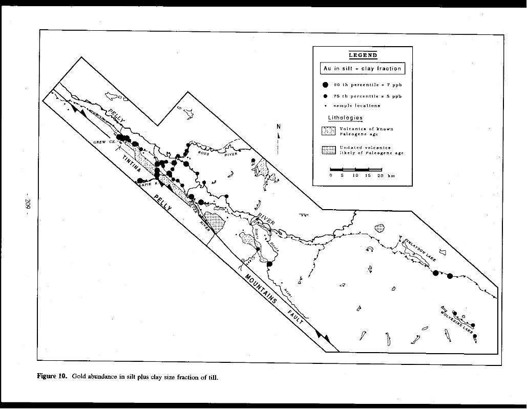
N @
Figure 10. Gold abundance in silt plus clay size fraction of till.
N
L I
t
J. a
LEGEND
[Au in silt + clay fraction I • 90 th percentile = 7 ppb
e 75 th percentile = 5 pp"b
sample locations
Lithologies
IT]
[JJ]
Volcanlc11 of known Paleogene age
Undated volcanics likely of Paleogene age
0 5 l 0 15 20 km
~-'- G§) '>-. 'I r
.<"I "' / "1"'->, -... "'\ 'fJ-.,
~
a {)
/}
f ~ .? d
t::J
..... .....,,~, -....
~~.· '" ~.P,.4'~ ~ '•+~~
'- ...... ....,

N LEGEND
~u in heavy minerals
• 90 th percentile = 540 ppb
• 75 th percentile = 92 ppb
• sample locations
0 5 10 15 20 km
Figure 11. Gold abundance in heavy mineral concentrate from till in the northwest part of the study area.
not associated with high As, Ag, Hg or Sb concentrations (T. Christie, oral presentation, Whitehorse Geoscience Forum, 1988). Geochemical maps showing the distribution of Ag, As, Hg and Sb concentrations over the area are presented in Plouffe (1989).
Use of heavy minerals for gold exploration
The use of heavy mineral concentrates in drift prospecting for gold was originally thought to be useful in the Tintina Trench, but with certain site specific limitations'. Two examples of site specific limitations are the following: (1) most of the gold at Grew Creek is attached to quartz with a minor amount bound in pyrite (Duke and Godwin, 1986;
Duke, 1986); gold in quartz is not recovered in the heavy mineral concentrate, and (2) surficial samples, as collected in recoIUlaissance surveys, are oxidized (except for certain areas where samples are collected in sections). Thus, gold in sulphides can be released, and reprecipitated or fixed in finer size fractions. In both cases, gold would go undetected in heavy mineral concentrates.
Heavy mineral separations, (s.g. ~ 3.3) on the 125 to 250 µm size fraction, were done only for samples of the northwestern region to test the reliability of this fraction for gold exploration in the Tintina Trench. No visible gold grains were seen in heavy mineral concentrates under a binocular microscope. However, as shown in Figure 11, the Grew Creek deposit is reflected in the gold content of heavy mineral
- 210 -

Fabric Vl V2 V3 SJ S2 S3
F-032-1 072 OJ J62 18 339 72 0.802 0.147 0.051
- - - - - - - - - - - - - - - - - - -F-038-1 057 OJ J47 J5 323 75 0.70J 0.192 0.107 F-038-2 262 OJ J72 22 354 68 0.714 0.164 0.123 F-038-3 307 04 2J7 OJ J J6 86 0.703 0.206 0.090
- - - - - - - - - - - - - - - - - - -F-044-1 286 03 017 11 179 79 0.544 0.390 0.066 F-044-2 112 12 017 23 227 64 0.518 0.374 0.108 F-044-3 080 16 347 11 224 70 0.667 0.222 0.110 F-044-4 098 20 188-02 282 70 0.591 0.317 0.092
- - - - - - - - - - - - - - - - - - -F-076-1 116 06 207 13 002 75 0.686 0.268 0.047 F-076-2 09003 181 03 315 85 0.507 0.387 0.106
Table l. Eigenvalues and eigenvectors of till fabrics calculated with the stereonet program (v. 3.6 by R.W. Allmendinger), following Mark (1973) eigenvalue method. Note that these values should be interpreted with care since as presented by Woodcock (1977), bimodal and multimodal data (which is the case for the till fabrics presented here) can result in the eigenvectors falling between modes. Vl, V2 and V3 represent the trend and plunge of the eigenvectors; VI being the direction of maximum clustering, and V3 that of normal clustering. SI, S2 and S3 are the respective normalized eigenvalues.
concentrates from McConnell till, in a few samples down-ice from the known mineralization. Likewise, heavy minerals show patterns of gold enrichment similar to those observed in the silt plus clay size fraction along the Campbell Highway close to the Lapie River (Fig. 10) (MINFILE 105F 044,045). Dispersed anomalous gold values (above the 90th percentile), not associated with known mineralization, occur throughout the area (Fig. 11). Some of these anomalies lie close to documented MINFILE occurrences (105F 050,051,060). Most of the bedrock in the study area is not particularly enriched in heavy minerals. Consequently, till derived from it has the same characteristics. That explains why several till samples yielded only small amounts of heavy minerals. In some instances, like certain samples down-ice from the Grew Creek mineralization, not enough heavy minerals were recovered for geochemical assays. In order to obtain a representative amount of heavy minerals for geochemical analysis ( > 5 g), much larger till samples would have to be taken. This can represent a practical problem in a reconnaissance survey where numerous samples have to be collected over wide areas and have to be carried long distances by the sampler.
Au Ag As Sb Hg
Au 1
-.04
-.071
-.105
.14
Correlation coefficients
Ag
1 As
.283 1 Sb
.2 .357 1 I Hg
.445 .295 .232 11 I
Table 2. Correlation coefficients of gold with arsenic, antimony, mercury, and silver.
Based on these observations, it can be concluded that heavy minerals could be used for reconnaissance-level gold exploration in the Tintina Trench, if sample size does not represent a practical problem. In follow-up surveys, where samples are recovered from below the zone of oxidation (from sections or overburden drill cores), heavy minerals may be particularly efficient in detecting mineralization.
CONCLUSIONS
Based on till lithologies and till fabrics, glacier ice flowed west to northwest over the area during McConnell and preMcConnell glaciations. However, at the onset of McConnell glaciation, a valley glacier might have flowed initially out of the Lapie River valley. More field information is needed to further verify this hypothesis. At the end of McConnell glaciation, an ice tongue flowed up gradient into the Lapie River valley. Within the study area, the silt plus clay size fraction of till is reliable for gold exploration since it reflects known gold mineralization at Grew Creek and is not influenced by textural parameters. On the other hand, reproducibility of gold analyses of the < 63 µm size fraction is very low because of the heterogeneity of the samples and the fact that gold levels in this size fraction are low, i.e. close to detection limit, where precision is low. The problem of poor reproducibility can be solved in part by duplicate analyses.
High gold values in the silt plus clay size fraction of till in proximity to Tertiary volcanics support the hypothesis that these rocks could be a source of placer gold as proposed by Jackson et al. (1986). However, since the transport distance of anomalous gold in till was found to be fairly short (250 to 500 m), more detailed sampling close to these volcanic bodies would be needed to detect any gold mineralization. The use of Ag, As, Hg and Sb as pathfinder elements for gold exploration is not.recommended because their correlation with gold is very poor in surficial samples. Heavy minerals could
- 211 -

be used for reconnaissance-level gold exploration in the Tintina Trench with certain site specific limitations.
ACKNOWLEDGEMENTS
Much of this paper was extracted from a M.Sc. thesis (Plouffe, 1989). Dr W.W. Shilts and Dr F.A. Michel are
acknowledged for supervising the thesis and for useful discussions of the material presented here. I. Poliquin provided cheerful field assistance. Noranda Exploration Co. Ltd financed the geochemical analyses and heavy mineral separations. Field work was funded by Indian and Northern Affairs Canada, and by a grant from the Northern Research Group of the Ottawa-Carlton Geoscience Centre.
REFERENCES
AMARK, M., 1986. Glacial tectonics and deposition of stratified drift during formation of tills beneath an active glacier- examples.from Skane, southern Sweden. Boreas, Vol. 15, p. 155-171.
BOSTOCK, H.S., 1966. Notes on glaciation in Central Yukon Territory. Geological Survey of Canada, Paper 65-36, 18 p.
BOSTOCK, H.S., 1934. The mining industry of Yukon 1933 and notes on the geology of Carmacks map area. Geological Survey of Canada, Summary Report 1933, Part A, p. 6-8.
BOULTON, G.S., 1970. On the origin and transport of englacial debris in Svalbard Glaciers. Journal of Glaciology, Vol. 9, p. 213-229.
BOYLE, R. W., 1979. The geochemistry of gold and its deposits. Geological Survey of Canada, Bulletin 280, 585 p.
BOYLE, R. W., ALEXANDER, W.M. and ASLIN, G.E.M., 1975. Some observations on the solubility of gold. Geological Survey of Canada, Paper 75-24, 6 p.
CAMPBEU, R.B., 1967. Glenlyon map area, Yukon Territory. Geological Survey of Canada, Memoir 352.
DILABIO, R.N. W., 1985. Gold abundances vs. grain size in weathered and unweathered till. In: Current Research, Part A; Geological Survey of Canada, Paper 85-JA, p. 117-122.
DUKE, J.L., 1986. The geology and alteration of an epithermal gold-silver prospect at Grew Creek, south-central Yukon Territory. Unpublished B.Sc. thesis, University of British Columbia.
DUKE, J.L. and GODWIN, C./., 1986. Geology and alteration of the Grew Creek epithermal gold-silver prospect, south-central Yukon. In: Yukon Geology, Volume 1; Exploration and Geological Services Division, Yukon, Indian and Northern Affairs Canada, p. 72-82.
DUKE-RODKIN, A., JACKSON, L. E. Jr. and RODKIN, 0., 1986. A composite profile of the Cordilleran Ice Sheet during McConnell Glaciation, Glenlyon and Tay River map areas, Yukon Territory. In: Current Research, Part B; Geological Survey of Canada, Paper 86-18, p. 257-262.
FOLK, R.L., 1968. Petrology of sedimentary rocks. Hempill's, University of Texas, 170 p.
GORDEY, S.P., 1988. The South Fork Volcanics: mid-Cretaceous caldera fill tu.ifs in east-central Yukon. Jn: Current Research, Part E; Geological Survey of Canada, Paper 88-JE, p. 13-18.
HUGHES, O.L., 1987. Quaternary Geology. In: Morison, S.R. and Smith, C.A.S. (eds), Guidebook to Quaternary Research in Yukon, JNQUA Congress, Ottawa, Canada, NationalResearch Council of Canada, Ottawa, p. 12-16.
HUGHES, O.L., CAMPBELL, R.B., MULLER, J.E. and WHEELER, J. 0., 1969. Glacial limits and flow patterns, Yukon Territory, south of65 degrees latitude. Geological Survey of Canada, Paper 68-34, 9 p.
JACKSON, L.E. Jr., 1989. Paleoglaciology of the Selwyn Lobe of the Cordilleran Ice Sheet and Quaternary stratigraphy of east central Yukon. In: Late Cenozoic history of the Interior Basins of Alaska and the Yukon. Carter, L.D., Hamilton, T.D. and Galloway, J.P. (eds.); United States Geological Survey, Circular 1026, p. 46-48.
- 212 -

JACKSON, L.E. Jr., 1987. Terrain Inventory Quiet Lake map area (105F). Geological Survey of Canada, Open File 1536.
JACKSON, L.E. Jr., 1986a. Terrain Inventory Finlayson Lake map area (105G). Geological Survey of Canada, Open File 1379.
JACKSON, L.E. Jr., 1986b. Terrain Inventory Tay River map area (105K). Geological Survey of Canada, Open File 1380.
JACKSON, L.E. Jr., GORDEY, S.P., ARMSTRONG, R.L. and. HARAKAL, J.E., 1986. Bimodal Paleogene volcanics near 1lntina Fault, east-central Yukon, and their possible relationship lo placer gold. Jn: Yukon Geology, Volume 1; Exploration and Geological Services Division, Yukon, Indian and Northern Affairs, Canada, p. 139-14 7.
JACKSON, L.E. Jr., MACDONALD, G.M. and WILSON, M.C., 1982. Paraglacial origin/or terraced river sediments in Bow Valley, Alberta. Canadian Journal of Earth Sciences, Vol. 19, p. 2219-2231.
KINDLE, E.D., 1946. Geological reconnaissance along the CanolRoad,Jrom Teslin River to Macmillan Pass, Yukon. Geological Survey of Canada, Paper 45-21, 29 p.
LERBEKMO, J.R., WEETGA1E, J.A., SMITH, D.G. W. and DENTON, G., 1975. New data on the character and history of the While River volcanic eruption. In: Quaternary studies, Suggate, R.P. and Creswall, M.M. (eds); The Royal Society of New Zealand Bulletin, Vol. 13, p. 203-209.
MARK, D.M., 1973. Analysis of axial orientation data, including till fabrics. Geological Society of America Bulletin, Vol. 84, p. 1369-1374.
PLOUFFE, A., 1989. Drift prospecting and till geochemistry in 1lntina Trench, southeastern Yukon. Carleton University and Ottawa Carleton Geoscience Centre, Ottawa, unpublished M.Sc. thesis, 111 p.
ROSE, A. W., HAWKES, H.E., WEBB, J.S., 1979. Geochemistry in mineral exploration. Academic Press, London, 657 p.
SHILTS, W.W., 1984. 1111 geochemistry in Finland and Canada. Journal of Geochemical Exploration, Vol. 21, p. 95-117.
SHILTS, W.W., 1978. Derailed sedimentological study of till sheets in a stratigraphic section, Samson River, Quebec. Geological Survey of Canada, Bulletin 285, 30 p.
SHILTS, W.W., 1975. Principles of geochemical exploration for sulphide deposits using shallow samples of glacial drift. Canadian Institute of Mining and Metallurgy, Bulletin 68, p. 73-80.
SINCLAIR, A.J., 1974. Selection of threshold values in geochemical data using probability graphs. Journal of Geochemical Exploration, Vol. 3, p. 129-149.
1EMPELMAN-Kl.UJT, D.J., 1977. Quiel Lake (I05F) and Finlayson Lake (105G) map areas, Yukon. Geological Survey of Canada, Open File 486, (3 sheets), scale I:250,000.
THOMPSON, M., and HOWARTH, R.J., 1976. Duplicate analysis in geochemical practice, part 1: theoretical approach and estimation of analytical reproducibility. The Analyst, Vol. 101, p. 690-698.
WARD, B., 1989. Quaternary stratigraphy akmg Pelly River in Glen/yon and Cannacks map areas, Yukon Territory. In: Current Research, Part E, Geological Survey of Canada, Paper 89-lE, p. 257-264.
WOODCOCK, N. H., 1977. Specification of fabric shapes using an eigenvalue method. Geological Society of America Bulletin, Vol. 88, p. 1231-1236.
I. 'site specific limitations' is used in the sense of Shilts (1978).
- 213 -

APPLICATION OF LANDSAT TM THERMAL IMAGERY TO STRUCTURAL INTERPRETATIONS OF THE TINTINA TRENCH IN WEST-CENTRAL YUKON
J.K. Mortensen Geological Survey of Canada
601 Booth St Ottawa, Ontario
KlA OE8
P. Von Glml Imperial Metals Corporation
800-601 West Hastings St Vancouver, B.C.
V6BSA6
MORTENSEN, J.M., and VON GAZA, P., 1992. Applicalion of Landsat 'TM thermal imagery to structural interpretations of the Tintina Trench in West-Central Yukon Territory. In: Yukon Geology, Vol. 3; Exploration and Geological Services Division, Yukon, Indian and Northern Affairs Canada, p.214-222
ABSTRACT
The structure of the Tintina Fault 'Zone (TFZ) within the Tintina Trench in west-central Yukon is almost completely unlawwn, due largely to very poor exposure, and thick overburden cover. Jn this study, we have used digitally enhanced Landsat Thematic Mapper thermal imagery as a basis for a preliminary structural interpretation of the Tintina Trench in the Dawson-McQuesten area. Linear features visible on the enhanced images are divided into first order (obvious, long strike-length), second order (less obvious, shorter strike-length), and third order (subtle, very short strike-length) lineaments. The images show major, NW-SE trending first and second order lineaments within the Trench which we interpret lo be separate strands of the TEZ. Sag ponds and fresh fault scarps in glacial drift along these lineaments attest to relatively recent fault activity. NE-SW trending first and second order lineaments that cut obliquely across the Trench are considered to be late faults and .fracture wnes which formed after major strike-slip displacement on the TFZ. Third order lineaments show strong preferred orientations over large portions of the image area, and are thought to reflect overall structural grain (bedding or foliation trends and/or regionally-developed joint patterns).
RESUME
La structure de la wne faille de Tintina (ZFT) a I 'interieur du sillon de Tintina dans la partie centrale ouest du Yukon est presque totalement inconnue, principalement parce que tres mal mise a nu ainsi qu'en raison de la presence d 'epais morts-terrains. Dans le cadre de cette etude nous avons utilise l 'imagerie thermique numeriquement amelioree de l'appareil de cartographie thhnatique du Landsat pour effectuer une interpretation structurale preliminaire du sit/on de Tintina dans la region de Dawson-Mcquesten. Les entires lineaires visibles sur les images accentuees se ripartissent en lineaments de premier ordre (evidents; longs dans l'axe), de deu.xieme ordre (moins evidents, plus courts, dans l'axe) et de troisieme ordre (tenus, tres courts, dans l'axe). "Les images montrent des lineaments majeurs des premier et deuxihne ordres orientes NW-SE que nous interprelons comme titant deux branches distinctes de la ZFT. Des etangs occupant des depressions et des escarpements de failles recents dans le drift glaciaire le long de ces lineaments temoignent d'une activite relativement recente le long de ces failles. Les lineaments des premier et deu.xieme ordres orientes NE-SW qui recoupent obliquement le sillon sont consideres comme etant des failles et des wnes de .fracture tardives qui se sont formees apres le decrochement majeur le long de la ZFT. Les lineaments de troisieme ordre presentent des orientations preferentielles marquees dans de grandes parties de la region imagee el I 'on pense qu 'ils refletent le grain structural general (tendances de la stratification OU de la schistosite et con.figurations des diaclases regiona/es, OU /es deu.x).
- 214 -

INTRODUCTION
The Tintina Trench is an elongated topographic depression which follows the trace of the Tintina Fault Zone (TFZ) for much of its length in Yukon. The TFZ is a major zone of Late Cretaceous and/or Early Tertiary dextral displacement. It separates two very different crustal blocks: to the northeast are strata of the North American miogeocline, and to the southwest lies an assemblage of crystalline rocks belonging to the Yukon-Tanana Terrane (e.g. Monger and Berg, 1987; Wheeler et al., 1988). In west-central Yukon there is almost no outcrop in the Tintina Trench and little is known about the detailed structure of the TFZ.
The Tintina Trench is of economic interest for two main reasons. First, several small lignite-grade coal deposits, some of which have been mined on a limited scale (MINFILE 116B 005,030,031), occur within faulted Paleocene-Eocene sediments in the Tintina Trench in the Dawson area (e.g. Mortensen, 1988a) and near Ross River (MINFILE 105F 048)(Hughes and Long, 1980)(Fig. 1). Second, epitherroal precious metal mineralization associated with Eocene volcanic and sedimentary rocks has recently been discovered in the Grew Creek area within the Tintina Trench in east-central Yukon (Fig. !)(e.g. Duke and Godwin, 1986; Jackson et al., 1986)(MINFILE !OSK 009). The suggestion that these Eocene volcanic rocks may be genetically related to the TFZ (e.g. Mortensen, 1988c) has focused attention on the mineral potential of the Tintina Trench elsewhere in western Yukon and eastern Alaska. An understanding of the overall structure of the TFZ will be critical to evaluating this potential.
The Tintina Trench in western Yukon approximately coincides with the southwest extent of Pleistocene glaciation. The region northeast of the Tintina Trench was glaciated and displays rugged relief and excellent bedrock exposure, whereas the area southwest of the Trench escaped glaciation, and generally shows low relief, very poor exposure and deep surface weathering. Much of the Tintina Trench in this area is mantled by glacial drift shed from the Ogilvie Mountains to the northeast. These factors complicate recognition and interpretation of surface features in the area.
This paper is an outgrowth of geological studies of the Klondike District and southwest Dawson map area (Fig. 1) by JKM (Mortensen, 1988a, b; 1990) and remote sensing studies of this and other areas of Yukon by PVG (e.g. Von Gaza and Eyton, 1988; Von Gaza, 1989). In this contribution we present a preliminary interpretation of the structure of the TFZ in west-central Yukon based on analysis of Landsat TM imagery. We hope that this work will both shed new light on the geology of this complex region and focus attention on some structural features in the area which may be of economic importance. The study also provides an example of how remote sensing may be applied to geological interpretation in areas of poor exposure in the northern Cordillera.
GEOLOGY OF THE TINTINA TRENCH IN THE DAWSON-MCQUESTEN AREA
The Tintina Trench in the Dawson-McQuesten area is a region of low relief ranging from 5 to nearly 20 km wide. In several places it is bounded on one or both sides by steep slopes that may represent eroded fault scarps. The bottom of the Tintina Trench is generally covered by glaciofluvial deposits and till (including the "Flat Creek Beds" and "Klondike Gravels" of McConnell, 1905, 1907) or by recent alluvial deposits (e.g. Hughes, 1987). Locally the unconsolidated deposits reach 200 m in thickness (Hughes, 1987). Rare bedrock exposures within Tintina Trench in this area consist of immature elastic sediments, including pebble conglomerate, sandstone, siltstone and mudstone. Seams of lignite grade coal occur in a number of localities (Fig. 1), and Paleocene to Eocene palynomorphs have been recovered from several exposures of coal-bearing elastic strata in this area (Hughes and Long, 1980). In many cases the elastic rocks are very poorly indurated, and decomposed outcrops of the coarser-grained units are commonly difficult to distinquish from glacial outwash gravels. All known outcrops of these Early Tertiary rocks display evidence of strong deformation: fault zones, folds, and locally overturned bedding are well developed (Bostock, 1935-1937 unpublished field notes, 1964; Hughes and Long, 1980; Mortensen, 1988b). Observed faults and fold axes are generally sub-parallel to the Tintina Trench.
The Tintina Trench ends just northwest of Chandindu River (Fig. 1), and between there and the Yukon-Alaska border the trace of the TFZ is marked by almost continuous exposure in outcrop and felsenmeer of the Early Tertiary sediments described above (Green, 1972; Hughes and Long, 1980; Mortensen, 1988a, b, 1990). Granitic and metamorphic rocks exposed along the banks of the Stewart River within the Tintina Trench near McQuesten (Fig. 1) imply that Early Tertiary rocks must be thin or absent in this area. About 50 km farther to the southeast (south of Stewart Crossing; Fig. 1), there is semi-continuous exposure of Mesozoic granite and Paleozoic and older metamorphic and sedimentary wall rocks right across the trace of the TFZ. The Early Tertiary strata apparently do not reappear in Tintina Trench until near the Pelly River, some 80 km farther to the southeast (Fig. !)(e.g. Gordey and Irwin, 1987; Pride, 1988).
The region southwest of Tintina Trench in west-central Yukon is mainly underlain by low to medium grade metamorphic rocks of the Yukon-Tanana Terrane (e.g. Monger and Berg, 1987; Mortensen, 1988a, b, 1991). Three distinct magmatic events of relatively young age have been recognized in the area southwest of the TF Z (Woodsworth et al., 1989; Mortensen, 1988a, b, 1990). Intermediate to felsic volcanic and plutonic rocks which yield mid-Cretaceous (110-85 Ma) or Late Cretaceous (70-64 Ma) ages are widespread in this area. A suite of bimodal dykes, plugs, and minor subaerial volcanic rocks which yield mid-Eocene ages (59-53 Ma)(Mortensen, !988a, b, unpublished data), is present in the Klondike District and parts of southwest Dawson map-area (Mortensen, 1988a, 1991) (Fig. I). This magmatism is
215 -

I ct! • c ~/o (/) ~ ct! • ::i
~I>-
/ . 0 I I • I
I • I
Chandindu R.
Klondike R.
50 100 150
km
l WHITEHORSE
•.J" • ..J·-., \:-.·-· -· \., -·s~"'\
. '\ . i f . ~.r· '""·,
Yukon ·-·-·-·-WATSON LAKE -·-·--·-·
8.C .
Figure 1. Location of study area (box). Limit of Eocene magmatism adjacent to the Tintina Trench is hachured. Location of the Grew Creek epithermal Au-Ag occurrence is shown by solid star; location of zone of epithermal-style alteration in the northern Klondike District shown by open star; location of coal occurrences within Tintina Trench is shown by open circles.
spatially and probably genetically related to the TFZ (Mortensen, 1988c). It is also identical in lithological association, composition and age to the igneous suite which hosts the Grew Creek epitherroal precious metal deposit. Volcanic members of this suite in the Dawson area interlayered with immature dastic sediments that are indistinguishable from those in the Tintina Trench.
The area northeast of the Tintina Trench is underlain by an almost complete stratigraphic sequence from Proterozoic through Jurassic age (Green, 1972; Thompson and Roots, in preparation). Alkaline plutonic rocks which intrude this sequence in the Ogilvie Mountains (Tombstone Suite, Woodsworth et al., 1989) yield mainly mid-Cretaceous ages (90 ± 10 Ma). Quartz monzonite intrusions which are also mid-Cretaceous in age (85 Ma) occur sporadically throughout
the area southeast of the North Klondike River on the north side of the TFZ (Fig. 1). Eocene igneous rocks have not been recognized in this area.
Geological mapping and analysis of conventional aerial photographs show little evidence of linear structures southwest of the Tintina Trench, which is surprising in an area so close to a major fault zone where subsidiary strands might reasonably be expected. A possible exception in the area between the· Yukon River and Tintina Trench south of Chandindu River is documented by Mortensen (1988b).
Despite relatively good exposure northeast of the trench, geological mapping has yielded little evidence for strands of the TFZ outside of the Tintina Trench itself (e.g. Green,1972; Thompson et al., in preparation).
- 216 -

STRUCTURAL INTERPRETATION OF THE TINTINA TRENCH USING LANDSAT TM IMAGERY
The use of Landsat Thematic Mapper (TM) imagery for structural interpretation has three main advantages. First, individual images cover a much larger area than conventional aerial photographs (a full TM scene represents 180 km E-W by 175 km N-S) allowing easier recognition of regional-scale patterns and large individual features. Second, a typical Landsat image is evenly illuminated across the entire scene, using a low sun angle which can enhance important structural features which have a topographic expression. In contrast, mosaics of aerial photographs usually show a variety of illumination patterns that can make interpretation difficult. Third, the TM imagery is acquired in seven spectral bands consisting of three visible bands, three near-infrared bands (reflected solar radiation), and a thermal infrared band (emitted terrestrial radiation). Using simple processing techniques these bands can be enhanced and viewed individually or in combination with other bands. The multispectral capability is valuable for enhancing lineaments where subtle changes in surface material such as soil or vegetation reflect underlying geology but the difference in image contrast is very low.
However, remote sensing techniques can be abused, by failure to recognize that some features may be artefacts, features produced during data acquisition and/or subsequent data manipulation. Ground checking of the satellite imagebased interpretation is critically important.
Application
The digital image data set used for this study was captured by the TM multispectral scanner onboard the Landsat 4 satellite on June 14, 1986, at approximately 9:30 a.m. (path 63; row 15). A half to a full Landsat scene (two quadrants), with a footprint of approximately 85 km by 180 km, was obtained from the Canada Centre for Remote Sensing ( CCRS) satellite receiving station located in Prince Albert, Saskatchewan.
We selected the segment of Tintina Trench between Chandindu River and McQuesten (Fig. 1) as a test area because of poor bedrock exposure and because known epithermal-type alteration occurs in Eocene volcanic and sedimentary rocks on the southwest margin of the Trench in the Dawson area (Fig. 1), and related mineralization may occur within the Trench.
The thermal band was the most successful in penetrating the thick vegetation cover of this unglaciated, geomorphically mature area. Thermal band data has a spatial resolution of 120 metres and is centred on a portion of the electromagnetic spectrum (I I µm) which detects changes in topography (sunlit slopes are "hot" and shadowed slopes are "cold") and gross changes in vegetation. This band does not appear to be significantly affected by subtle changes in the type of surface cover. The visible and reflected infrared bands, however, are affected by the "spectral clutter" of the regional vegetation
response which masks subtle topographic changes. Most ofthe interpretation that follows is based on analysis
of the thermal band data. Each linear feature was assigned to one of three groups which reflect the degree of confidence placed on the interpretation. The classification is based on criteria such as length and/or clarity of the linear feature, supporting geological evidence, and whether the feature can also be recognized on other spectral bands or conventional aerial photographs.
First order lineaments are prominent on the thermal band without enhancement, and portions of these-features can also be detected on other spectral bands. On the thermal image, first order lineaments can generally be followed continuously for more than 10 km along strike. Segments of first order features generally coincide with obvious topographic features such as aligned drainages, and are also usually visible on conventional aerial photographs. We believe that first order lineaments correspond to major through-going faults or fracture zones. Second order lineaments are somewhat more subtle, but can generally be recognized with minimal enhancement of the imagery. Second order features cannot always be recognized on other spectral bands. They also usually have shorter strike lengths, and are thought to represent minor faults and fracture zones.
Third order lineaments are subtle features that were only distinguished using a non-topographic hillshading technique (Von Gaza, 1989). This technique treats the digital image data as an actual topography, which is artificially illuminated by a single light source using a computer-assisted cartographic hillshading procedure. The shading of the digital image data provides an added depth clue that greatly improves the interpreter's ability to perceive subtle details in the image data. Various user-defined solar azimuths and solar elevations were used to identify third order lineaments.
To check the possibility that these third order features might represent artefacts produced by the enhancement technique, a digital lineament mask produced by the enhancement technique was overlaid on the contrast-stretched raw thermal image. In all cases, third order features were found to correspond with specific topographic features, usually short drainage segments, breaks in slope, or segments of ridge crests.
A variety of other lineaments that appear on the satellite image were examined on conventional aerial photographs and proved to be man-made features or natural surface features such as fluvial channels and levees or edges of old forest fire hums. These lineaments have been excluded from further discussion.
Figure 2 shows an enhanced thermal image of the study area, as well as a line sketch of the same area identifying the main first and second order linear features. Some of these features have been named where they coincide with named topographic features (e.g. Gravel Creek lineament, Barlow Lake lineament, etc.).
Two main orientations of first and second order lineaments are evident, generally trending to the NW-SE or NE-SW. The NW-SE trending lineaments occur only within
- 217 -
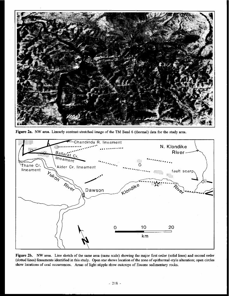
Figure 2a. NW area. Linearly contrast-stretched image of the TM Band 6 (thermal) data for the study area.
Thane Cr. lineament
Chandindu R. lineament .... . .......... .
Cr. lineament
.. . . . . . . .. .
..,./ .. ··
0
..... 0 ........... .....
10
km
N. Klondike River
. . . . . . . . fa ult scar~
20
Figure 2b. NW area. Line sketch of the same area (same scale) showing the major first order (solid lines) and second order (dotted lines) lineaments identified in this study. Open star shows location of the zone of epithermal-style alteration; open circles show locations of coal occurrences. Areas of light stipple show outcrops of Eocene sedimentary rocks.
- 218 -

Figure 2a. SE area. Linearly contrast-stretched image of the TM Band 6 (thermal) data for the study area .
. .i.*'-e .· .. · ... u' • • • • • • "" .·· . . .. . . ... "0''. • • • •••.
• L ' • • • • •' ~ .. . ... / .. . .. . ............... .
•. lineament ... ... McKay Lk.
.. ·· .. .. ..
Bartow Lk linearn
ent
Figure 2b. SE area. Line sketch of the same area (same scale) showing the major first order (solid lines) and second order (dotted lines) lineaments identified in this study. Open star shows location of the zone of epithermal-style alteration; open circles show locations of coal occurrences. Areas of light stipple show outcrops of Eocene sedimentary rocks.
- 219 -

Figure 3. A non-topographically hillshaded image of TM Band 6 data for the southeast half of the study area, using sun angle = 0° and sun azimuth = 30". The third order linear "fabric" is visible oriented at aproximately N-S and E-W in the north and southwest portions of the image area. Dashed lines show the approximate limits of the Tintina Trench.
or immediately adjacent to the Tintina Trench. The Barlow Lake lineament (Fig. 2) is one of the most obvious of these. At the southeast edge of the image, the lineament coincides with a prominent escarpment which forms the northeast edge of the Tintina Trench, and is probably an eroded fault scarp. A series of aligned, shallow lakes (including Barlow, Gravel, Lenore, and Strickland lakes) marks the northwest extension of the Barlow Lake lineament. These aligned lakes resemble "sag ponds" developed over small pull-apart zones in major strike-slip fault zones elsewhere in the world (e.g. Sylvester, 1988).
The Slough Creek, lower Flat Creek, and Gravel CreekMedrick Creek lineaments are mainly marked by aligned drainages; however, clusters of small ponds which may also represent sag ponds are present along both of these features. Firm evidence that the Medrick Creek lineament is at least partially related to faulting is found at its northwest end, where the lineament crosses a small area of bedrock exposed during construction of the South Klondike ditch. The outcrop consists of strongly sheared and contorted Eocene sedimentary rocks. Shear planes generally parallel the Tintina Trench and
dip vertically. Approximately 3 km farther to the northwest, immediately northwest of the Dempster Highway, a prominent scarp marks the trace of a normal fault down thrown at least 3 m to the south. The fault scarp can be traced for over I km along strike and is easily visible on aerial photographs (No. A37497:51-52). A similar but less obvious fault trace can be followed from the exposure of sheared Eocene sediments southeast to the Klondike River, a distance of 3 km (Fig. 2).
Some strong oblique lineaments are also evident. These are oriented at a moderate to high angle to the trend of the Tintina Trench. Some of the oblique lineaments, such as the upper Flat Creek lineament (Fig. 2), are confined to the Trench, and appear to connect pairs of the main NW-SE trending lineaments. Other features such as the McKay lineament (Fig. 2), however, cut right across the Trench and extend into topographically higher areas either side of the Trench. There is no evidence that the NW-SE trending features in the Trench are offset by this second set of lineaments, or vice versa.
Lineaments are less evident in the area northwest of the North Klondike River. Short segments of second order
- 220 -
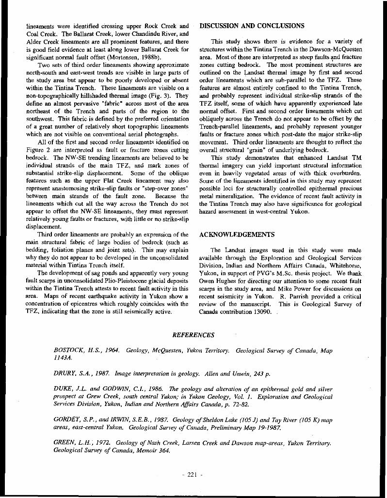
lineaments were identified crossing upper Rock Creek and Coal Creek. The Ballarat Creek, lower Chandindu River, and Alder Creek lineaments are all prominent features, and there is good field evidence at least along lower Ballarat Creek for significant normal fault offset (Mortensen, 1988b).
Two sets of third order lineaments showing approximate north-south and east-west trends are visible in large parts of the study area but appear to be poorly developed or absent within the Tintina Trench. These lineaments are visible on a non-topographically hillshaded thermal image (Fig. 3). They define an almost pervasive "fabric" across most of the area northeast of the Trench and parts of the region to the southwest. This fabric is defined by the preferred orientation of a great number of relatively short topographic lineaments which are not visible on conventional aerial photographs.
All of the first and second order lineaments identified on Figure 2 are interpreted as fault or fracture zones cutting bedrock. The NW-SE trending lineaments are believed to be individual strands of the main TFZ, and mark zones of substantial strike-slip displacement. Some of the oblique features such as the upper Flat Creek lineament may also represent anastomosing strike-slip faults or "step-over zones" between main strands of the fault zone. Because the lineaments which cut all the way across the Trench do not appear to offset the NW-SE lineaments, they must represent relatively young faults or fractures, with little or no strike-slip displacement.
Third order lineaments are probably an expression of the main structural fabric of large bodies of bedrock (such as bedding, foliation planes and joint sets). This may explain why they do not appear to be developed in the unconsolidated material within Tintina Trench itself.
The development of sag ponds and apparently very young fault scarps in unconsolidated Plio-Pleistocene glacial deposits within the Tintina Trench attests to recent fault activity in this area. Maps of recent earthquake activity in Yukon show a concentration of epicentres which roughly coincides with the TFZ, indicating that the zone is still seismically active.
DISCUSSION AND CONCLUSIONS
This study shows there is evidence for a variety of structures within the Tintina Trench in the Dawson-McQuesten area. Most of these are interpreted as steep faults '}Ild fracture zones cutting bedrock. The most prominent structures are outlined on the Landsat thermal image by first and second order lineaments which are sub-parallel to the TFZ. These features are almost entirely confined to the Tintina Trench, and probably represent individual strike-slip strands of the TFZ itself, some of which have apparently experienced late normal offset. First and second order lineaments which cut obliquely across the Trench do not appear to be offset by the Trench-parallel lineaments, and probably represent younger faults or fracture zones which post-date the major strike-slip movement. Third order lineaments are thought to reflect the overall structural "grain" of underlying bedrock.
This study demonstrates that enhanced Landsat TM thermal imagery can yield important structural information even in heavily vegetated areas of with thick overburden. Sume of the linean1ents identified in this study may represent possible loci for structurally controlled epithermal precious metal mineralization. The evidence of recent fault activity in the Tintina Trench may also have significance for geological hazard assessment in west-central Yukon.
ACKNOWLEDGEMENTS
The Landsat images used in this study were made available through the Exploration and Geological Services Division, Indian and Northern Affairs Canada, Whitehorse, Yukon, in supper! of PVG's M.Sc. thesis project. We thank Owen Hughes for directing our attention to some recent fault scarps in the study area, and Mike Power for discussions on recent seismicity in Yukon. R. Parrish provided a critical review of the manuscript. This is Geological Survey of Canada contribution 13090.
REFERENCES
BOSTOCK, H.S., 1964. Geology, McQuesten, Yukon Territory. Geological Survey of Canada, Map 1143A.
DRURY, S.A., 1987. Image interpretation in geology. Allen and Unwin, 243 p.
DUKE, J.L. and GODWIN, C.I., 1986. The geology and alteration of an epithermal gold and silver prospect at Grew Creek, south central Yukon; in Yukon Geology, Vol. 1. Exploration and Geological Services Division, Yukon, Indian and Northern Affairs Canada, p. 72-82.
GORDEY, S.P., and IRWIN, S.E.B., 1987. Geology of Sheldon Lake (105 J) and Tay River (105 K) map areas, east-central Yukon. Geological Survey of Canada, Preliminary Map 19-1987.
GREEN, L.H., 1972. Geology of Nash Creek, Larsen Creek and Dawson map-areas, Yukon Territory. Geological Survey of Canada, Memoir 364.
- 221 -

HUGHES, J.D., and LONG, D.G.F., 1980. Geology and coal resources potential of Early Tertiary strata along Tintina Trench, Yukon Territory. Geological Survey of Canada, Paper 79-32, 21 p.
HUGHES, O.L., 1987. Flat Creek Hill section. Jn: Guidebook to Quaternary Research in Yukon, S.R. Morison and C.A.S. Smith (eds); XII INQUA Congress, Ottawa, Canada; National Research Council of Canada, Ottawa, p. 61.
JACKSON, L.E., GORDEY, S. P., ARMSTRONG, R.L., and HARAKAL, J.E., 1986. Bimodal Paleogene volcanics near 1intina Fault, east-central Yukon Territory, and their possible relationship to placer gold. In: Yukon Geology, Vol. 1; Exploration and Geological Services D.ivision, Yukon, Indian and Northern Affairs Canada, p. 139-147.
McCONNEU, R.G., 1905. Report on the Klondike goldfields. Geological Survey of Canada, Annual Report, Vol. 14, 1901, p. 25-36.
McCONNEU, R.G., 1907. Report on gold values in the Klondike high level gravels. Geological Survey of Canada Publication No. 979, 34 p.
MONGER, J. W.H. and BERG, H. C., 1987. Lithotectonic terrane map of western Canada and southeastern Alaska. U.S. Geological Survey, Miscellaneous Field Studies Map 1847-B.
MORTENSEN, J. K., 198&. Geology of southwestern Dawson map area, Yukon Territory (NTS 116 B&C). In: Current Research, Part E, Geological Survey of Canada, Paper 88-lE, p. 73-78.
MORTENSEN, J.K., 1988b. Geology of southwestern Dawson map area (NTS 116 B&C). Geological Survey of Canada, Open File 1927.
MORTENSEN, J.K., 1988c. Eocene magmatism associated with the 1intina Fault Zone in Yukon Territory: new contraints on timing and magnitude of strike-slip displacemem. Paper presented at 1988 Geoscience Forum, Nov. 30, 1988, Whitehorse, Yukon.
MORTENSEN, J.K., 1990. Geology and U-Pb geochronology of the Klondike District, west-central Yukon Territory. Canadian Journal of Earth Sciences, Vol. 27, p. 903-914.
PRIDE, M.J., 1988. Bimodal volcanism along the 1intina Trench, near Faro and Ross River. In: Yukon Geology, Vol. 2, Exploration and Geological Services Division, Yukon, Indian and Northern Affairs Canada, p. 69-80.
SABINS, F.F.Jr., 1987. Remote sensing principles and techniques. W.H. Freeman and Company, 449 p.
SYLVESTER, A.G., 1988. Strike-slip faults; Geological Society of America Bulletin, Vol. 100, p. 1666-1703.
VON GAZ4, P., 1989. Image enhancements for mineral exploration. Unpublished M.Sc. thesis, University of Alberta, Edmonton, Alberta.
VON GAZ4, P. and EYTON, J.R., 1988. Enhanced Landsat Thematic Mapper imagery for exploration geology in the Wheaton River District, southern Yukon. In: Yukon Geology, Vol. 2; Exploration and Geological Services Division, Yukon, Indian and Northern Affairs Canada, p. 99-107.
WOODSWORTH, G.J., ANDERSON, R.G. and ARMSTRONG, R.J., 1989. Plutonic regimes in the Canadian Cordillera. Geological Survey of Canada, Open File 1983.
- 222 -

GREW CREEK EPITHERMAL GOLD-SILVER DEPOSIT, TINTINA TRENCH, YUKON, (105K/2)
Anthony B. Christie, DSIR Geology and Geophysics
P.O. Box 30-368, Lower Hutt, New Zealand
Jesse L. Duke, Noranda Exploration Company Limited,
Suite 203-107 Main Street, Whitehorse, Yukon,
Y1A2A7
and
Ralph Rushton, Department or Geology. University of Alberta, Edmonton, Alberta
T6G2E3
CHRISTIE, A.R., 1992. Grew Creek epithennal gold-silver deposit, Tintina Trench, Yukon. In: Yukon Geology, Vol. 3; Exploration and Geological Services Division, Yukon, Indian and Nonhem Affairs, Canada, p.223-259
ABSTRACT
The Grew Creek epithennal gold-silver deposit in southeast Yukon (MINFILE 105K 009) is hosted by Eocene volcanic and sedimentary rocks deposited in a pull-apan basin within the Tintina Fault Z.One. Flow rhyolites forming a dome in the Tarn Z.One area, 1.5 km east of Grew Creek, pass westward into a succession of rhyolitic ignimbrites and air fall tuffs, exposed along Grew Creek and in the Main Z.One, 500 m west of Grew Creek. These rhyolitic rocks are faulted againstfluvial sediments to the nonh, along the W-E Fault, and basaltic rocks to the west. In the Main Z.One, the volcanics, sediments, and the W-E Fault all dip steeply to the nonh.
The gold-silver mineralization forms an elongate tabular zone within the rhyolitic tuffs. The zone strikes parallel to the W-E Fault and dips venically or steeply to the nonh. The eastern end of the mineralized zone is defined by a decrease in grade, whereas the western end is faulted off against the basaltic rocks. Within the zone, stockwork veins and hydrothermal breccias contain assemblages which include quanz. adularia, carbonates, quartzpseudomorphous after calcite, pyrite, marcasite, and traces of arsenopyrite, chalcopyrite, acanthite, electrum, silver selenides, galena, and sphalerite.
There is good correlation between gold and silver in drill core assays, with a gold:silver ratio of around 1 :4 for the ore grade mineralization. The mineralization is strongly anomalous in arsenic and mercury, but there is only a weak correlation of mercury with gold and silver, with most high values for mercury lying above the gold-silver zone and associated with the W-E Fault. Arsenic concentrations are elevated over much of the area but there is no statistical correlation with the locally high concentrations of gold or silver.
Outcropping rhyolitic rocks are hydrothennally altered to intennediate argillic and advanced argillic assemblages, whereas subsurface rhyolitic rocks are altered to quanz-adularia or illite-quanz assemblages adjacent to veins, and to illite-quanz-adularia ± carbonate elsewhere. Advanced illite-quanz-adularia ± carbonate alteration is accompanied by an increase in Na,0 and decreases in TiO,, CaO and Al,O,. Basalts are altered to carbonate-chlorite (propylitic) assemblages, accompanied at an advanced stage by a slight increase in CaO, and decreases in K20, Na,O, Si02, and Al20,.
- 223 -

Mineralization postdated tilting of the host pyroclastic and sedimentary rocks. Episodic fault movements in the Tintina Fault Zone structurally focused the hydrothennal fluids by providing locally high secondary penneability, whereas the high primary permeability of the rhyolitic tuffs promoted the development ·of stockwork veins and breccias. The absence of significant alteration and mineralization in the sediments suggests that a partly welded and intensely altered tu.ff unit, along thefootwall of the W-E Fault, acted as an aquiclude, confining the hydrothennal fluid within the rhyolitic tuffs. Intense pyritic alteration of this unit and high concentrations of mercury in the vicinity of the W-E Fa ult fonn pyrite and mercury zones north of the mineralization.
RESUME
Le gisement epithermal d'or et d'argent Grew Creek, au sud-est du Yukon, se trouve dans des roches volcaniques et sedimentaires de I 'Eocene deposees dans un bass in d ·~tension sirue a l 'interieur de la zone faillee de Tintina. Des coulees de rhyolites provenant d'un Mme dans la region de la zone Tarn, a 1,5 km a I 'est du ruisseau Grew passent vers l 'ouest a une succession d 'ignimbrites et de projections de tufs rhyolitiques qui sont mis a nu le long du ruisseau Grew et dans la wne Main, a 500 m a l'ouest du ruisseau Grew. Ces roches rhyolitiques sontfaillees et reposent contre des sedimentsfluviaux au nord, le long de la faille W-E, et contre des roches basaltiques a l'ouest. Dans la wne Main, les roches volcaniques et sedimentaires et la faille W-E presentent un fort pendage en direction du nord.
La mineralisation en or et en argent forme une wne tabulaire a 1 'interieur des tufs rhyolitiques. La wne est orientee parallelement a la faille W-E et presente un pendage vertical ou abrupt en direction du nord. L 'extremite orientale de la zone mineralisee est definie par une diminution des teneurs alors qu ·a son extrimite occidentale elle est separee des roches basaltiques par une faille. A l 'interieur de la zone, un reseau de veines mineralisees et des breches hydrothennales renferment des assemblages englobant du quartz, de l'adulaire, des carbonates, du quartz pseudomorphe de la calcite, de la pyrite, de la marcasite et des traces d'arsenopyrite, de chalcopyrite, d'acanthite, d'electrum, de seleniures d'argent, de galene et de sphalerite.
Jl existe une bonne correlation entre les detenninations des teneurs en or et en argent dans des carottes de forages et le rapport or sur argent est d'environ 1:4 pour la mineralisation a teneur commerciale. La mineralisation presente des concentrations fonement anonnales en arseriic et en mercure, mais le mercure ne prhente qu'une faible correlation avec l'or et l'argent. La plupart des concentrations e1evees en mercure ont ete relevees au-dessus de la zone auri.fere et argenti.fere et sont associees a la faille W-E. Les concentrations en arsenic sont elevees sur une bonne partie de la region, mais ne presentent aucune correlation statistique avec les concentrations elevees par endroits en or et en argent.
Les roches rhyolitiques a.ffleurantes ont ete hydrothermalement alterees en assemblages argilliques intermediaires ii avances, alors que Jes roches rhyolitiques subsupeifricielles sont alterees en assemblages de quartz-adulaire ou de quartz-illite pres des veines et en illite-quartz-adulaire ± carbonate ailleurs. Une alteration poussee en illite-quartz-adulaire ± carbonates 'accompagne d 'accroissements des concentrations en Na20 et de diminutions des concentrations en Ti02 , en CaO et en Al20.l" Les basaltes sont alteres en assemblages de carbonate et chlorite (propylitiques) avec un Zeger accroissement de la concentration en CaO et des diminutions des concentrations en K20, en Na20, en Si02 et en A/20.l"
La mineralisation est posterieure a l'inclinaisondes roches pyroclastiques et sedimentaires hOtes. Des deplacements episodiques le long des failles dans la zone faillee de Tintina ont concentre les fluides hydrothermaux en fournissant des permiabilites secondaires elevees par endroits alors que la permeabilite primaire elevee des tufs rhyolitiquesfavorisait la formation du reseau de veines et des bri!ches. L 'absence d'une alteration importlinte et d 'une mineralisation dans les sediments suggere qu 'une unite partiellement soudee de tuf ayant subi une intense alteration, le long de la levre inferieure de la faille W-E, a agi comme une aquiclude confinant les fluides hydrothermawc awe tufs rhyolitiques. Une intense alteration pyriteuse de l'unite de tufrhyolitique et des concentrations elevees en mercure sont observees aux environs de la faille E-W au nord de Ia mineralisation.
- 224 -

INTRODUCTION
The Grew Creek prospect (MINFILE !OSK 009) is a volcanic-associated epithennal gold-silver deposit located about one kilometre south of the Robert Campbell Highway, half way between Faro and Ross River, in south-east Yukon (Fig. IA; NTS 105 K/2 115815; Latitude 62"03'N and Longitude 132"50'W). The prospect has been of considerable interest to the exploration industry because it was the first reported showing of epithermal mineralization in the Tintina Trench. Lesser showings have since been discovered near Dawson (Mortensen, 1988) and Glenlyon (Pride, 1988). We commenced this study in 1988 with the aims of characterizing the geology of the deposit and determining its genesis, building on previous descriptions of the deposit by Duke (1986), and Duke and Godwin (1986), but using a much larger database of drillhole information. This paper reports preliminary results of our work. Oxygen isotope analyses of vein and wall rock samples, and petrographic work, are continuing.
EXPLORATION HISTORY
Mineralization was discovered in outcrop, 600 m west of Grew Creek, by prospector Al Carlos in 1983 while exploring for a possible source of the previously known placer gold in Grew Creek. He reported an assay of 10 grams gold/tonne (git Au) across the discovery outcrop. Hudson Bay Exploration and Development Company Limited (Hudson Bay) optioned the property in November 1983 and carried out geological, geophysical and geochemical surveys, trenching, 1,732 m of diamond drilling in 13 holes, and 1,660 m of rotary drilling in 19 holes (Anon, 1985; Stroshein, 1986a, 1986b). An area of gold-silver mineraliz.ation, named the Main Zone, was defined around the discovery outcrop (10062E/9945N on the Noranda grid, see below) and centred approximately 500 m west of Grew Creek. An area of extensive hydrothermal alteration and anomalous geochemistry centred approximately 1.5 km east of Grew Creek, was named the Tarn Zone (Figs IC and 2). Hudson Bay dropped its option in January 1987, and a new option agreement was taken up by Noranda Exploration Company Limited (Noranda) in June 1987. Golden Nevada Resources Incorporated (Goldnev) and Brenda Mines farmed into the property in June 1987, by funding the subsequent exploration program operated by Noranda. During 1987 and 1988 Noranda carried out geological mapping, as well as ground based magnetometer, induced polarization (IP)/resistivity and soil geochemistry surveys, an airborne electromagnetic survey, 235 m of trenching, 19,173 m of diamond drilling in 77 holes, and 1,651 m of reverse circulation drilling in 13 holes (Copland, 1988a, !988b; Duke, 1988). Noranda defined the Main Zone mineralization as an east-west orientated body up to 550 m long, 110 m wide and 150 m deep. No significant mineralization was encountered in the Tam Zone but
additional drill targets near the Main Zone were identified. Subsequently, Goldnev became operator and, during 1989, drilled 10 diamond drillholes totalling 1, 164.5 min the Main Zone, to further define the ore reserves (Seto and Crowe, 1989).
The airborne geophysical surveys proved useful as an aid to interpreting regional structure and geology, and the IP/resistivity anomalies defined depth of overburden. However, the thick cover of till appears to have masked the detailed trends of the mineralization. On a regional scale, the mineralization is characterized by anomalous arsenic and mercury soil (till) geochemistry, but these anomalies are broad and failed to define drill targets in the mineralized zone.
ORE RESERVES
Orcan M iner~l Associates estimated geological reserves of 852,100 short tons (773,012 tonnes) grading 0.260 oz/ton Au (8.9 g/t Au) and 0.98 oz/ton Ag (33.6 git Ag) at a cut-off grade of 0.058 oz/ton (0.2 g/t), and containing a higher grade reserve of 203,870 short tons (184,947 tonnes) grading 0.354 oz/ton Au (12.1 g/t Au) (Goldnev news release, December 4, 1989).
PREVIOUS RESEARCH WORK
Duke (1986) and Duke and Godwin (1986) mapped and sampled Grew Creek, the discovery outcrop, and several of Hudson Bay's exploration trenches, and carried out mineralogical, geochemical, oxygen isotopic, and K-Ar age analyses and petrographic work. They demonstrated that the mineralization consisted of gold, electrum, pyrite, and silver selenide minerals in quartz and K-feldspar veins hosted by rhyolitic luffs. Silicic, acid sulphate, and argillic acid sulphate hydrothermal alteration types were identified in trenches and surface outcrops, and found to be overprinted by "surficial alteration" weathering. K-Ar ages on least altered basalts (51.4 and 50.7 m.a. B.P.) and palynological ages on mudstones (age range representing 56 to 46 m.a. B.P.) associated with the rhyolitic luffs indicated a mid Eocene age for the host rocks, whereas three K-Ar ages on hydrothermally altered luffs (51.5, 47.0 and 36.0 m.a. B.P.) suggested a mid to late Eocene age for the mineralization. A deep magmatic source for the mineralization was postulated based on the degree of heavy oxygen isotope enrichment.
Jackson et al. (1986) and Pride (1988) described the basalt and rhyolite associated with the Tintina Fault, including those at Grew Creek, and reported XRF analyses and several whole rock K-Ar ages. Jackson et al. (1986) concluded that the volcanic rock suite was strongly bimodal, with calc-alkaline to transitional tholeiitic basalts and high potassic subaluminous rhyolites. The basalts were dated as Eocene (5 K-Ar ages ranging from 55.4 to 46.4 m.a. B.P.) and the rhyolites as Paleocene to Eocene (4 K-Ar ages ranging from 58.2 to 51.5 Ma).
225 -

B ! c
0 10km
0 1km
YUKON TERRITORY
~u, \ '\ it .. ROSS RIVER \
GREW CREEK \
t N
I
--- ... IV-E Fault ------~,
•WHITEHORSE~
o 300km
~~~~~~~~~
Figure 1. Maps showing the location of the Grew Creek gold-silver deposit on tlie Tintina Fault Zone in south-eastern Yukon Territory (Figure IA), the component faults of the Tintina Fault Zone in the Grew Creek area (Figure IB), and the location of the deposit within the fault zone (Figure IC). In Figure IB, BC = Huttle Creek Fault, DC = Danger Creek Fault, G = Glenlyon Fault, GC = Grew Creek Fault, LR = Lapie River Fault and V = Vangorda Fault.
METHODOLOGY
Field work for this study was carried out during the 1988 summer. Duke was the Noranda Project Geologist at Grew Creek, whereas Christie made a one week visit in May to defme the project and a six week visit with Rushton, during July and August, to relog drill core, and map and collect surface samples from outcrop. Thirty nine of the total of 90 diamond drillholes (in 1988) were relogged using a scheme that emphasized descriptive features that were considered helpful in correlating the pyroclastic units (e.g. quantity, grain size and texture of the crystal, lithic, pumice and matrix components). These logs were used, in conjunction with Noranda drill logs, to construct 1:500 scale vertical crosssections (listed by coordinates in Fig. 3) and a longitudinal stratigraphic section through the Main Zone. Samples representative of the different lithological units were collected and 70 were later examined in thin section. Forty-eight samples were analysed for mineralogy, and major and trace elements, using XRD, XRF and ICP techniques respectively (Appendix).
Drillhole descriptive logs, downhole assay data, drill sections, maps and geophysical results were made available by
Noranda. The Noranda drillhole descriptive logs were used to prepare hand plotted cross-sections, individually showing veins, visually estimated percent pyrite concentration, and intensity and type of hydrothermal alteration, for eight crosssections through the Main Zone (listed by coordinates in Fig. 3).
GEOLOGIC AND STRUCTURAL SETTING
The Grew Creek deposit occurs in the Tintina Fault Zone, a transcurrent fault more than 1000 km long which crosses Yukon Territory (Fig. 1), and extends into Alaska to join the Kaltag Fault, and into British Columbia to join the Rocky Mountain Trench Fault. Displacement, crushing and erosion of rocks along the Tintina Fault Zone have formed a major linear physiographic depression termed the Tintina Trench. Dextral displacement of rock units either side of the fault zone indicates transcurtent movement of more than 500 km, mostly during the Late Cretaceous and Tertiary. In the Grew Creek area, rocks of the Pelly-Cassiar Platform to the southwest are juxtaposed against rocks of the Anvil Allochthon to the northeast. Pull-apart basins were formed along the fault zone where it expanded into braided sections, and these were the locus of sedimentation and bimodal basaltic-rhyoliticvolcanism
- 226 -

t N
I
A. Geology
0
B. Hydrothermal alteration
~ Sediments and bosoltlc volcanic rocks - (ocene
~ Rhyolitic tuff - Eocene
G Rhyolile - Eocene
~ Phylllte, ch•r1 and orgllllte - Paleozoic
Ill Au-Ag Zone
\·(::<:-:::·-I Moderate to strong hydrothermal alteration
EJ Weak hydrothermal alteration
rault
lkm //
x x
Tornx iOne"' x x x
.x x x x x x x x x
x x x x x x
x x x x x x x
)( )( )( x )(
x x
Figure 2. Grew Creek prospect geology (Figure 2A) and hydrothermal alteration (Figure 2B) maps (modified after Duke, 1988).
- 227 -

w w w w w w w w
Veins, pyrite 0 0 0 0 0 0 0 0
"' 0 "' 0 "' 0 "' 0 0 ;; ;; N N ,.., ,.., ...
& alteration 0 0 0 0 0 0
w w w w w w w w w w w Au, Ag, As 0 0 0 0 0 0 0 0 0 0 0
& Hg 0 0 "' 0 "' 0 "' 0 "' 0 "' assays "' 0 0 ;; ;; N N ,.., ,.., ... .... "' 0 0 0 0 0 0 0 0
w w w w w w w w w w w w w w w
Lithology 0 0 0 "' 0 0 0 0 0 0 0 0
0 "' 0
0 "' 0 N "'
0 "' 0 "' 0 "' 0 "' ~ 0
"' "' 0 0 0 ;; ;; N N ,.., ,.., .... ...... "' "' "' 0 0 0 0 0 0 0 0 0 0 0
~
n "
10200 N \ 10200 N
" " M \ 10100 N 10100 N ,.
" " " " ~ n " ~ .. ~ ..
" 1 " " " " lOJ\31 .,
" " ' ,.
' " " " " ~ ~
~ • " " " 1 "' " " 10000 N 10000 N u ' n " " " ~
" " " v 9900 N 9900 N
' ~ /" • " .. 9800 N
" " 9800 N
" 100 '""" 9700 N 9700 N
w w w w w w w w 0 0 0 0 0 0 0 0 0 0 0 0 0 0 0 0 1X1 "' 0 ;; N ,.., ... "' "' "' 0 0 ;: 0 0
© Discovery outcrop
Figure 3. Map of drillhole locations on the Noranda exploration grid in the Main Zone. The grid is orientated at 019"/109°. All drillholes shown are angled diamond drillholes (generally 45° or 55° dip). The rows of section numbers above the diagram note the sections on which the following work was carried out: 1. veins, pyrite and alteration row =
sections on each grid line were hand plotted from information in Noranda's descriptive drill logs, to show veins, visually estimated percent pyrite concentration, and intensity and type of hydrothermal alteration, 2. Au, Ag, As & Hg assays row = assay sections were computer plotted and examined, and 3. Lithology row = drillholes in these sections were relogged.
- 228 -

during the Eocene (Christie and Gordey, 1989; Pride, 1988; c.f. Hughes and Long, 1980). Subsequent differential uplift and erosion has exposed some of these Eocene rocks, preserved in graben within the Tintina Trench.
In the Grew Creek area, the Tintina Fault Zone includes at least six major faults; namely, from north to south: Vangorda, Lapie River, Danger Creek, Grew Creek, Bottle Creek, and Glenlyon (Fig. !B). The Grew Creek prospect lies on the northern side of the Grew Creek Fault, on the south side of the Tintina Trench. Duke (1988) considered that the Main Zone is located where the Grew Creek Fault is intersected by a north-south extensional fault (N-S Fault in Fig. IC), defined by a physiographic linear feature.
The Grew Creek area is covered with Quaternary glacial till, typically 50 m thick, which limits bedrock exposures to the creeks and rare exposures elsewhere, such as the discovery outcrop. The northwest striking Danger Creek and Grew Creek faults enclose a 1.5 km wide graben (Canyon Graben; Stroshein 1986b) of Eocene sedimentary and volcanic rocks. The faults separate the graben from Triassic metabasalt and limestone to the north, and from Paleozoic phyllite, argillite and chert to the south. A west-northwest striking fault (hereafter termed the W-E Fault) subdivides the Eocene rocks into a northern sequence of fluvia1 sedimentary rocks intercalated with basaltic pyroclastic and epiclastic rocks, and a southern sequence of rhyolitic volcanic rocks (Fig. 2A). To the east, the rhyolitic rocks consist predominantly of dome facies rhyolite flows and quartz feldspar porphyries, which pass westward into a succession of rhyolitic pyroclastic rocks exposed along and west of Grew Creek. Basalt and rhyolite dykes intrude both the volcanic and sedimentary sequences. From the Main Zone northwards, the tuffs, sediments, and intervening W-E Fault all dip about 80° to the north (Fig. 4A) so that a plan view transect (Fig. 2A) approximates a stratigraphic section.
PROSPECT STRUCTURE
In the Main Zone, drillhole intersections of the Grew Creek Fault define a more than 10 m wide zone of unconsolidated gouge and rock fragments. The W-E Fault is represented by shearing along the sedimentary-volcanic rock contact, sometimes with fault gouge developed. Many other faults have been intersected in the Main Zone drillholes, some with wide clay gouge zones and others represented by tectonic breccias. Duke (1988) correlated some of these intersections with air photo lineaments, and magnetic and IP/resistivity anomalies. He postulated the presence of six north to northwest-striking extensional faults, and several small northeast striking faults within the Main Zone, to account for displacements in the stratigraphy and jogs in the W-E and Grew Creek faults (Figs 2 and 5).
Severely broken core in mineralized vein and breccia zones indicates that many of the mineralized structures have been tectonically reactivated since cessation of mineralization.
DETAILED PROSPECT GEOLOGY
We constructed a stratigraphic column for each of the drillhole cross-sections by assuming that dip was a constant 80°, and by correlating and projecting the drillhole information onto a plane dipping 10" south and passing through a pivot on the 9950N grid line at an elevation of 700 m (equivalent to a depth of 90-145 m). These columns were assembled to produce a stratigraphic section for the Main Zone at 1 :500 scale, simplified and reproduced here at smaller scale in Fig. 5. This section illustrates the relationships of the rhyolitic and basaltic volcanic rock, and fluvial sedimentary rock sequences, and subdivides the rhyolitic sequence into a number of composite pyroclastic units. Lateral variations in thickness and pinching of units in the rhyolitic sequence, and the jagged trace of the W-E Fault, may be caused by changes in dip along the section (not compensated for) and displacements on several north and northwest striking faults (see Structure section above). Additionally, several primary volcanic facies features may also contribute to the lateral variations, including: (a) rapid thickening and thinning caused by draping over existing topography, and valley filling, (b) erosion and production of epiclastites, and (c) overlapping volcanic centres.
Rocle types
(a) Rhyolite and felsic porohyries Coarse grained "quartz eye" porphyritic rhyolite outcrops
along a prominent ridge from Rat Creek southeast to Danger Creek. Porphyritic rhyolites, including quartz-feldspar, quartz-eye, and feldspar "porphyries", are the main lithologies in the Tarn Zone drillholes and occur elsewhere in the sedimentary and volcanic sequences as dykes. Many of the dykes in the Main Zone logged by Noranda geologists as rhyolite and quartz feldspar porphyry proved to be hydrothermally altered basalt ("rhyolite"), vitric ash tuff ("rhyolite"), or partly welded lapilli tuff ("quartz feldspar porphyry") when examined in thin section. In the Main Zone there is a semi-continuum of textures from "quartz feldspar porphyry" to partly welded, crystal vitric lapilli ash tuff with pseudo quartz-feldspar porphyry macro-texture but containing some welded shards and pumice. These pseudo-porphyries may have been formed by melting and remobilization of basal pyroclastic units.
Samples of Tarn Zone rhyolite from DDH 90 contain about 40% phenocrysts, up to 4 mm in diameter, of plagioclase (euhedral), sanidine, quartz and a mafic mineral, in a groundmass recrystallized to quartz, K-feldspar and illite. Flow banding and spherulitic textures are developed locally. Quartz-feldspar porphyry is similar to rhyolite but with larger phenocrysts and well developed flow banding. Large quartz "eyes" are prominent in altered examples.
(bl Rhyolitic pyroclastites Rhyolitic tuffs are the most important lithology in
economic terms, as they host the Main Zone mineralization.
229 -

s 0
\
\, 1oom
\ \
\
200m \,
s 0
100m
200m
s 0
100m
200m
Figure 4.
CROSS SECTION GEOLOGY N
OVERBURDEN {TILL)
\ \, \\ ' I I I I I I I I I I \
1'1 1111111\11 11
\\ \ \ \ 'I,' '\ ' '
\ \ \ ' \ \ FLUVIAL SEDIMENTS
' \ 1, \ \ \ CYCLIC SEQUENCES
\ \ \ ~ \ \ \ \, I 'i.
RHYOLITIC TUFFS I 1<;,' i\ \ \\ \ \, ">. \ ~I
\ ' \ \< \
\I
\ \ i \ '\ \\ \ \, \~\ \ I
\ \\ I I
®
CROSS SECTION ALTERATION N
®
ADVANCED ARGILLIC '(~/ 1..
ILLITE +QUARlZ ; ,,... .... \ +-ADULARIA \ ~ I
f ~ \ ~CARBONATE \ -;;;.· 0.1;,. \ I !;: I \,
1/
I !.? I \,, /
I • I '\' · I 2 \ ,,.---...., V // I::!\/~\ Vi 10\ IQ\\//
I I !;(: I \\{;' .. I !.? \ ,' I • \ \ I § \ ' ,'
it \
UNALTERED
CROSS SECTION MINERALIZATION N
Diagrammatic cross-sections through the zone illustrating geology (Figure hydrothermal alteration (Figure 4B), mineralization (Figure 4C).
©
main 4A), and
They are exposed in the creeks and were intersected by the Main Zone drillholes, south of the W-E Fault (Figs 2A, 4A and 5), and can be grouped into the following three major types, based on grain size and composition (Table I and Fig. 6):
!. S&P (salt & pepper) tuff: S&P tuff comprises 'crystaland lithic-rich' mixed coarse ash tuff, lapilli-ash tuff and lapilli tuff with a distinctive, well sorted granular 'salt & pepper' appearance (Fig. 7). These are the crystal lithic tuffs described by Duke and Godwin (1986) from exposures along Grew Creek. They mapped six depositional units based on cyclic increases in grain size northward down the creek (up the stratigraphic sequence). We have identified more than 12 units of S&P tuff in the eastern drillholes of the Main Zone with contacts marked by major changes in grain size or tuff type (e.g. interbedded thin units of VA tuff or CLP tuff, see below). Each unit is internally homogeneous and no sedimentary struc'tures were observed. The upper part of the S&P sequence contains only 'fine' grained S&P units (crystals and lithics average about 1.5 mm}, whereas several coarse grained S&P units (crystals and lithics averaging 3 mm) are present in the lower part.
2. CLP (crystal lithic pumice) tuff: CLP tuffs are 'glassrich" coarse ash tuff and lapilli-ash tuff (Figs 8 and 9) which occur mostly in the upper part of the rhyolitic sequence and dominate the western end of the section (Fig. 5). Three major types are identified: (a) non-welded coarse ash tuff, (b) nonwelded lapilli-ash tuff, and (c) welded or partly welded lapilli ash tuff (logged by Noraoda as quartz-feldspar porphyry). Two units of non-welded CLP tuff on section IOOOE are separated by a 40 cm thick unit of trough cross bedding (Fig. 10), representing either a basal surge layer or an epiclastite.
3. VA (vitric ash) tuff: VA tuff (Figs 11 and 12) is characterized by having more than 75 % glass ash matrix and pumice fragments. It generally occurs as thin units separating units of S&P tuff and/or CLP tuff.
In all three types of tuff, the crystal fragments are mainly quartz and lesser feldspar (mostly sanidine), whereas the lithics are mostly fragments of rhyolitic tuff and rhyolite flows, and lesser basalt, shale, phyllite, and diabase (dolerite). The lithics generally have a coarser average grainsize than the crystals, and in some samples there is a bimodal grain size distribution of crystals with the finer population predominating. Pumice exhibits a considerable range in grain size, averaging 3-5 mm in diameter, but commonly around 1 cm, with rare blocks up to 25 cm in diameter (Fig. 8). The glass matrix is generally too fine grained, hydrothermally altered and/or recrystallized to identify components, but good examples of glass shard textures are present in some samples (e.g. 8/34.lm, 10/81.lm, 18/159.6m,47/100.8m,59/99.65m, 60/271m 65/346.Sm, and 85/333.4m; Fig. 12). Some CLP and VA tuffs are welded (e.g. 47 /79.95m, 60/271m, 65/346.5m, R,R19, and TRI) with flattening of pumice
230 -
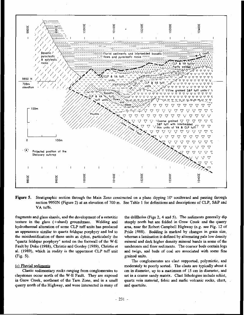
0
lOOm
10Dm
Projected position of the Discovery outcrop
w 0 0 ~ ~
w 0 0 0 0
w 0 0 0 :=
w 0 0
0
w 0 0
0
w 0 0 N 0
w 0 0 N
:=
w 0 0 ~ 0
w 0 0 ~
:=
w 0 0 ~ 0
w 0 0 ~
:=
Figure 5. Stratigraphic section through the Main Zone constructed on a plane dipping HY" southward and passing through section 9950N (Figure 2) at an elevation of 700 m. See Table 1 for definitions and descriptions of CLP, S&P and VA tuffs.
fragments and glass shards, and the development of a eutaxitic texture in the glass (+shard) groundmass. Welding and hydrothermal alteration of some CLP tuff units has produced an appearance similar to quartz feldspar porphyry and led to the misidentification of these units as dykes, particularly the "quartz feldspar porphyry" noted on the footwall of the W-E Fault by Duke (1988), Christie and Gordey (1989), Christie et al. (1989), which in reality is the uppermost CLP tuff unit (Fig. 5).
(cl Fluvial sediments Clastic sedimentary rocks ranging from conglomerates to
claystones occur north of the W-E Fault. They are exposed in Grew Creek, northeast of the Tam Zone, and in a small quarry north of the Highway, and were intersected in many of
the drillholes (Figs 2, 4 and 5). The sediments generally dip steeply north but are folded in Grew Creek and the quarry area, near the' Robert Campbell Highway (e.g. see Fig. 12 of Pride 1988). Bedding is marked by changes in grain size, whereas a lamination is defined by alternating pale low density mineral and dark higher density mineral bands in some of the sandstones and fmer sediments. The coarser beds contain logs and twigs, and beds of coal are associated with some fine grained units.
The conglomerates are clast supported, polymictic, and moderately to poorly sorted. The clasts are typically about 4 cm in diameter,_ up to a maximum of 15 cm in diameter, and set in a coarse sandy matrix. Clast lithologies include schist, quartz vein material, felsic and mafic volcanic rocks, chert, and quartzite.
231 -

25
2-64 mm
25
>64mm Agglomerate, pyroclastic breccia (or bomb luff and block luff, respectively)
751--~-_,_75
>J, 0 '1
I S&P tu ff
'Bj "' I!~ ~Q o~ ~ '6
"'o ':? 9-:· ~ 25
0 ~
"'
I CLP luff
Glass
VA tuft , • • Vitric • •
7 5 /---··~·~·--\ 7 5
----... ,, .... , l CLP '\ I I
\ tuft / '-... ,, ...........
mixed ,-----.... ,
VA luff
<2 mm
25
Crystal (S&P tuft) , _______ ,,,
Lithic
Mineral Rock
Figure 6. Relative compositions of the S&P, CLP, and VA rhyolitic luffs (Table 1) plotted on pyroclastic rock classification ternary diagrams from Dietrich & Skinner (1979).
Drillhole sections through the sediments in the Main Zone typically exhibit fining upward cycles from conglomerate, through pebbly sandstone, sandstone, siltstone and claystone, to coal beds, although many of the cycles are only partially preserved and are usually missing the fine grained units.
Thicknesses vary considerably. Forty two measurements of the fining upward cycles average 4.2 m thick (corrected for a dip of 80" northward) with a standard deviation of 3.6 and maximum value of 19.3 m, whereas 260 measurements of individual units of conglomerate, sandstone, etc., average 1.4 m with a standard deviation of 1.5 and maximum value of 8.1 m (pebbly sandstone).
(d) Basaltic pyroclastites and epiclastites Duke and Godwin (1986) described basaltic breccias, and
ash to block tuff from exposures in Grew Creek. Some of the exposures are bedded.
A more than 250 m thick continuous sequence of basaltic ash tuffs, lapilli tuffs, and epiclastites is present in the drillholes at the western end of the Main Zone area and crops out northwest of the Main Zone. Units have considerable variability in thickness, up to a maximum of 37 m for lapilli tuff in section 9900E. Cyclic fining upward sequences are locally present, mostly in the epiclastites (see below), where the cycles resemble those in the fluvial sediments but are composed almost entirely of basaltic material.
The luffs mostly consist of lapiili sized fragments (rare examples up to about 10 cm in diameter) and fine grained crystals (averaging 0.6 mm in diameter) of plagioclase and accessory quartz, in a fine grained ash matrix (Fig. 13). The lapilli are mostly basaltic, consisting of fine (0.3 mm) subhedral laths of plagioclase feldspar and lesser mafic minerals, and lithic fragments in a submicroscopic ash matrix (about 50%). Lapilli of a few units have been altered to pale hues of yellow, brown, green and red within the same rock, thus forming distinctive multicolored units compared to the pale green colour of most other altered rocks. A group of multicolored luffs interbedded with basalt (flows?) forms a major marker unit in the western and central part of the Main Zone rhyolitic sequence (Fig. 5). Another set of units (not shown in Fig. 5) is present in the lower part of the eastern section, too low to be correlated with the upper unit, and is assumed to pinch out westward on the Grew Creek Fault.
(el Basalt flows and dykes Basalt flows and dykes are exposed in Grew and Rat
creeks, and west of the Main Zone, and are intersected in the Main Zone drillholes (mostly logged by Noranda geologists as andesite). ·
In the Main Zone, the flows and dykes range from 0.1 to 38.7 m and average 4.5 min intersection width downhole (the dips of the dykes are unknown). They are generally porphyritic with 5-30% phenocrysts (averaging 1-2 mm long but up to JO mm) set in a microcrystalline (typically 0.5 mm) grouodmass with some glass (0-20 % but 40 % in one sample). Weak glomeroporphyritic and variolitic textures are present in many samplei, some are amygdaloidal (e.g. 72/!35.3m) and one exhibits trachytic texture (83/62.5m).
Labradorite, some with oscillatory zoning, is the dominant phenocryst and microcrystalline phase, followed by clinopyroxene (zoned pale green diopsidic core to purplish titaniferous augite rim in sample 39/149.8m), opaques, and
232 -

Figure 7. Drill core of S&P tuff from a downhole depth of 200.4 min DDH 60.
Figure 8. Drill core of CLP tuff with 18 cm long pumice block (immediately above scale) at a downhole depth of about 72 m inDDH 72.
- 233 -
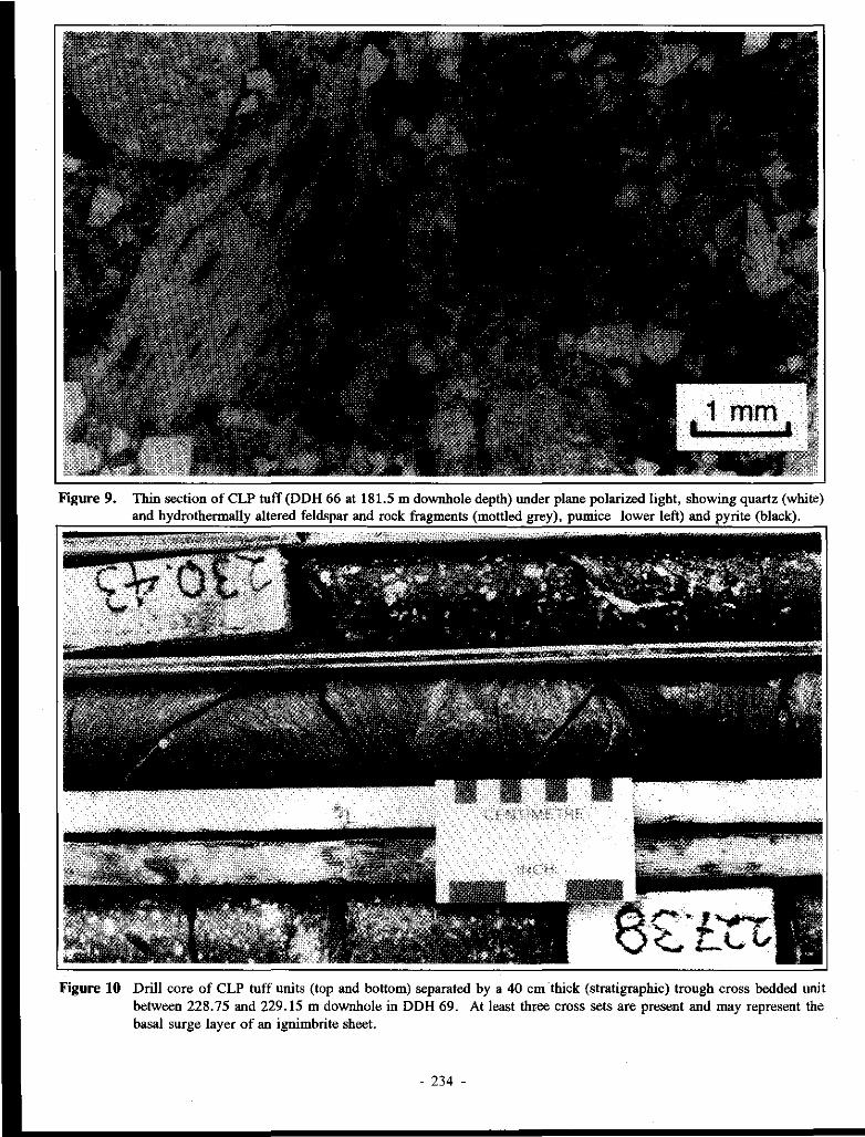
Figure 9. Thin section of CLP tuff (DDH 66 at 181.5 m downhole depth) under plane polariz.ed light, showing quartz (white) and hydrothermally altered feldspar and rock fragments (mottled grey), pumice lower left) and pyrite (black).
Figure IO Drill core of CLP tuff units (top and bottom) separated by a 40 cm thick (stratigraphic) trough cross bedded unit between 228. 75 and 229.15 m downhole in DDH 69. At least three cross sets are present and may represent the basal surge layer of an ignimbrite sheet.
- 234 -

·----
CENflillft'BE Figure 11. Drill core of welded vitric ash tuff from 123.3 m downhole in DOH 65. Mild eutaxitic texture is marked by partial
flattening of pumice fragments (white).
Figure 12. Thin section of vitric ash tuff (DOH 65 at 346.3 m downhole depth) showing sparse quartz fragments in a matrix dominated by glass shards (vitroclastic texture). Mild welding is marked by a preferred orientation of the shards.
- 235 -
Figure 13. Drill core of basaltic lapilli tuff from a downhole depth of 307 m in DDH 82.
Figure 14. Thin section of a medium grained diabase dike ("bird's foot porphyry') sampled at a downhole depth of 353.78 m in DDH 67. The rock consists of coarse subhedral plagioclase laths (altered to albite) with interstitial anhedral mafic (altered to carbonate and chlorite) and acicular opaque minerals.
- 236 -

olivine. Some labradorite and olivine phenocrysts have reaction and/or resorbed rims.
(f) Diabase (dolerite) dykes Medium to coarse grained mafic dykes are exposed in
Grew Creek and intersected in the drillholes in the Main and Tam zones. Two rock types are identified:
I. Porphyritic rocks (e.g. 391149.Sm and 90/58.85m), which are essentially coarse grained basalts, with 10-30% plagioclase phenocrysts averaging 2-3 mm but commonly up to 7 mm long, and 5-10 % mafic phenocrysts averaging 1 mm, clustered (glomeroporphyritic texture) or scattered in a 0.3-0.5 mm feldspar and mafic mineral groundmass. Needles of an opaque mineral (dendritic ilmenite?), averaging 0.3 mm long, make up about 5 % of the rock.
2. Medium to coarse grained equigranular rocks (e.g. 671353. 78m and 90/44. 7m; Fig. 14) which consist of 60-70% 1-1.5 mm (but up to 4 mm) plagioclase laths and 25-35 % 0.5 mm mafic minerals. Needles of an opaque mineral, averaging 0.3 mm long, make up about 5% of the rock. We named these rocks "bird's foot porphyry" in hand specimen because of their variolitic texture. lo thin section they are sub-ophitic and weakly variolitic. The original plagioclase composition could not be determined because of hydrothermal alteration to albite, illite and calcite but these rocks have almost identical chemical compositions to the basalts (see XRF geochemistry section below) and we therefore considered that they were diabase (dolerite). A similar but coarser grained rock (microgabbro) occurs as a dike crossing Grew Creek, near the camp.
HYDROTHERMAL ALTERATION
Introduction
Hudson Bay and Noranda geologists mapped hydrothermal alteration in the volcanic rocks south of the W-E Fault over a three kilometre strike length, including the Main and Tarn zones (Fig. 2B). The sedimentary rocks north of the fault are little altered apart from a few metres immediately adjacent to the fault in the Main Zone and north east of the Tam Zone (Figs 2B and 4B). Alteration in the rhyolitic rocks is pervasive although there is some structural control on the intensity and type. The specific types of alteration present are listed below and in Table 2, and results of XRD analyses are listed in the Appendix:
I. Illite-quartz-adularia±carbonate alteration is the predominant alteration type in the subsurface rhyolitic rocks. Other minerals which may be present include pyrite, interlayered illite/smectite, and albite. In the groundmass, felsic volcanic lithic fragments and pumice are generally altered to a finely crystallized mosaic of quartz and adularia. lo moderate to strongly altered rocks, the lithics and
- 237
groundmass. textures merge into a recrystallized mass, and feldspar crystals are alterated to quartz, adularia, illite and carbonate.
2. Quartz-adularia alteration (silicification) occurs adjacent to some quartz veins and breccias including the discovery outcrop. It is gradational to illite-quartz-adularia±carbonate alteration, representing an increase in the proportion of quartz and adularia.
3. Illite-quartz (sericitic or phyllic) alteration is represented by clay rich zones in the drillcore, particularly adjacent to veins, and brecciated, fractured or sheared zones. This alteration was logged by Noranda as argillic because of the presence of clays in hand specimen. The primary clays are predominantly illite, with lesser interlayered illite/smectite and smectite, overprinted with secondary kaolinite and therefore we prefer to classify this alteration as illite-quartz and not argillic. Illitequartz alteration is gradational with illite-quartzadularia±carbonate alteration, representing an increase in the proportion of illite and quartz.
4. Carbonate-chlorite (propylitic) alteration is the dominant alteration type in basaltic rocks. Other minerals that may be present include albite, illite, quartz, pyrite, adularia, interlayered illitelsmectite, and interlayered chloritelclay (illite?). The alteration of mafic minerals, and to a lesser extent feldspars, is dominated by the development of the carbonates calcite, siderite and dolomite, which form pseudomorphs of the original minerals and fill voids and vesicles. Alteration of feldspars has also produced illite, Kfeldspar and quartz, whereas chlorite and pyrite have replaced the mafic minerals. XRD analyses also indicate the presence of minor smectite, interlayered illite/smectite and chloritelsmectite (Appendix). Epidote was noted in one hand specimen of drill core. Amygdules are filled with calcite, sometimes with a chalcedonic quartz core.
5. Intermediate argillic alteration was mapped by Duke and Godwin (1986) in the rhyolitic rocks exposed in surface trenches within the Main Zone and it is also present, particularly as an overprint clay assemblage, in some subsurface wnes. It is characterized by abundant smectite and may also contain kaolinite, pyrite, interlayered illite/smectite, quartz and relict carbonate, illite and K-feldspar. The relict minerals in some of the trench material indicate that alteration of this material may have been primarily illite-quartzadularia±carbonate type, later overprinted by argillic alteration.
6. Advanced argillic (acid sulphate) alteration is clay alteration characterized by the presence of alunite and/or abundant kaolinite, and was identified by Duke and Godwin (1986) in rhyolitic rocks in the trenches in the Main Zone. Other minerals which may be present include smectite, quartz, pyrite, and relict carbonate and interlayered illite/smectite.

7. Weathering: Much of the strong "argillic" clay alteration, in both the illite-quartz-adularia+/-carhonate and propylitic alteration zones, may result from supergene alteration by surface weathering and/or acidified (from the oxidation of pyrite) groundwater. Duke and Godwin (1986) noted a deep weathering profile with a clay-carbonate mineral assemblage at Grew Creek. We were impressed at the rapid rate that rocks in exposed trenches and drill core decomposed to clay. Post-drilling weathering and resultant clay alteration was particularly noticeable in drill core when a complete hole was laid out. In many of the early holes, we noted that every tenth core box was extensively clay altered. This was because the core trays had been stacked in open racks, ten trays high and the rock in the exposed top tray was weathering more quickly than that in the other trays. The core tray racks were roofed subsequent to our work. Strong clay alteration elsewhere was generally concentrated near faults or sheared and crushed zones, and could be attributed to either late hydrothermal or supergene processes.
Alteration trends
We plotted hydrothermal alteration and visually estimated pyrite concentrations from the Noranda lithological drill logs for several cross-sections (listed as coordinates in Fig. 3), and correlated this data with our logs and analytical results to determine the alteration pattern and trends.
The hydrothermal alteration forms an envelope around the mineralized zone. The complete drill tested width of the Main Zone (about 300 m) is altered, but medium to high intensity alteration is concentrated within a width of about 100 m. Basaltic rocks within the rhyolitic sequence are altered to carbonate-chlorite (propylitic) assemblages, whereas those to the west, faulted against the rhyolitic sequence, are little altered (although green in hand specimen). At the time of alteration, they may have been remote from the centre of hydrothermal activity, but later, may have moved close to the mineralization along the intervening fault. Illite-quartzadularia +/-carbonate ·alteration is the most common type of alteration in the rhyolitic sequence. This grades into illitequartz, argillic (overprint?), or quartz-adularia alteration around major veins and other fracture structures. Quartzadularia is the highest rank of alteration present and is usually associated with zones of quartz veining but not necessarily vice versa. Although quartz-adularia alteration is present up to the highest level in some drillhole cross-sections, in many others it passes upward into illite-quartz and illite-quartzadularia ±carbonate alteration with similar (and sometimes greater) frequency of quartz veining (Fig. 4B). Illite-quartz and argillic clay zones associated with structural features range in thickness from a few centimetres to several metres. This clay alteration is considered the primary reason for poor recovery in mineralized intersections (c.f. Duke, 1988; Seto and Crowe, 1989).
Welded and partly welded CLP units present at various horizons are consistently moderately to intensely altered to illite-quartz-adularia and illite-quartz assemblages, suggesting
that this lithology was highly permeable and thus more susceptible to alteration. As a highly competent rock, it would have developed good fracture controlled permeability. Following alteration, the permeability would have been greatly decreased, thus causing the uppermost partly welded CLP unit adjacent to the W-E Fault to act as an aquiclude to hydrothermal fluid flow. Where this unit is present, the fluvial sediments across the W-E Fault are little altered, whereas where it is absent, the sedimentary rocks exhibit much greater alteration, extending more than 100 m into the sedimentary sequence on section !0050E.
Intermediate argillic and advanced argillic alteration are the main types of alteration in the upper parts of the system mostly as an overprint on earlier illite-quartzadularia±carhonate alteration.
The concentration of pyrite shows poor correlation with intensity of alteration,' veining, and mineralization but exhibits a strong increase in concentration in the vicinity of the W-E Fault, and particularly in the adjacent partly welded CLP unit (Fig. 15). This results in a pyrite zone adjacent to and north of the mineralization.
MINERALIZATION
Gold and silver mineralization of the Main Zone occurs in stockwork quartz veins and hydrothermal breccias. The quartz veins are mostly 2-10 cm but possibly up to I m thick, and the hydrothermal breccias are a few centimetres to 1 or 2 m thick. Many of the quartz veins are banded on a millimetre scale and some consist of, or contain bands of, brecciated and recemented vein material. The larger veins and breccias are poorly preserved in the drill core because of their broken ·nature and resultant poor core recovery (Noranda drill logs). Rubbly vein and breccia material, logged up to maxima of about 5 m and 10 m of apparent drill core length respectively, are not considered true representations of original widths of the veins and breccias because part of these drill lengths would have been occupied originally by clay altered wall rocks that have been flw;hed away during drilling.
Plots for some drill cross-sections showing veins noted in the Noranda drill logs (Fig. 3) indicate that veining is mostly confined to a steeply northward dipping zone, 40 m to 80 m wide. The veins die out below the 650 m elevation on most sections but extend down to at least the 550 m elevation on sections !0!50E and !0200E (the intervening !0175E section was not plotted), suggesting a funnelling down in this area. The greatest density of veins per unit distance occurs at intermediate depths.
Stroshein (!986a) considered that the discovery outcrop was a hydrothermal vent breccia. This outcrop is severely weathered and although it exhibits clast textures, we consider it is more likely to be quartz-adularia altered coarse CLP tuff, part of which projects to this surface position on the stratigraphic section (Fig. 5).
The main non-metallic phases in veins and hydrothermal breccias are quartz, adularia, carbonates, clays (mostly illite), and quartz pseudomorphous after calcite. Additionally,
- 238 .

fluorite occurs in the Tam Zone veins. The quartz is mostly chalcedonic and rarely finely crystalline. Crystal lined vugs are very rare.
McNeal (in Duke, 1988) noted that pyrite and marcasite are the main metallic minerals but there are also traces of arsenopyrite, cba1copyrite, sphalerite, galena, electrum, acanthite, naumannite, aguilarite, and silver amalgam. The electrum averages 7.5 µm in diameter, with a maximum diameter of 60 µm. Eleven analyses range in fineness from 640 to 160 and average 360 fine (64 to 16 and 36 weight percent Au respectively).
GEOCHEMISTRY
XRF and ICP analyses
Whole-rock XRF (X-ray fluorescence) and ICP (Inductively Coupled Plasma Spectroscopy) analyses of samples of basaltic and rhyolitic rocks are presented in the Appendix. When normalized free of water and carbon dioxide (Table 3), the analyses of basalt and rhyolite are similar to those from Grew Creek and nearby occurrences previously reported by Duke and Godwin (1986), Jackson et al. (1986), and Pride (1988). Jackson et al. (1986) concluded that the basalts were calc-alkaline to transitional tholeiites, whereas the rhyolites were a high potassic subaluminous type.
Measurements of rock density were made and the analyses converted to units of kg/m3 to reduce the apparent enrichment and depletion effects caused by changes in rock density during hydrothermal alteration. Densities were measured with a Walkers Steelyard beam balance and used in the following formula:
Wt% kg xp=-L -H,O-C02 m'
Where Wt% = weight percent of oxide = ppm x !a4
ppm = parts per million of element E = total of analysis (Wt%) H20 = water loss on drying (Wt%) CO, = carbon dioxide (Wt%) determined by wet
chemical methods p = density in kglm3
Binary plots of oxides and elements versus silica, presented in Figs 16 and 17, were constructed using the density corrected data in the computer program IGPET-11 from Terra Soft Incorporated, New Jersey. Even though hydrothermally altered, the different rock types form distinct trends and groupings on these plots, generally with the tuffs lying between basalt and rhyolite end members in the order: basalt, basaltic tuff, S&P tuff, CLP tuff, VT tuff, and rhyolite. The
intermediate composition of the tuffs reflects the presence of both basalt and rhyolite pyroclastic fragments. Separation of the various ~ock types is particularly good in binary and ternary plots (not shown) using Cr, Co, Cu, Ni, Y, La, and Pb.
Basaltic rocks: All of the basalt samples are propylitically altered, with intensities of alteration ranging from mild (55/30.7m) to strong (721117.6m and 66-115.2m). This is reflected in their high Joss on ignition (H20, C02 and S) in comparison to average analyses of basalts from exposures in Grew Creek and other nearby occurrences reported by previous authors (Table 3). Also, our hydrothermally altered basalts exhibit a marked K20 enrichment, and are slightly enriched in Al,03 and Na,O (probably secondary illite, Kfeldspar and albite), in addition to carbonate. In contrast, within our suite of arialyses, trends exhibited with increasing intensity of alteration are generally in reverse to those mentioned, although at subdued levels: there are small decreases in K,O, Na,O, SiO,, and Al20,_ a small increase in CaO, and possibly a slight increase in MgO (probably reflecting an increasing importance of secondary carbonate and chlorite).
Rbyolitic rocks: The rhyolites analysed are all similarly moderately ·altered to illite-quartz-adularia±carbonate assemblages, although sample 90/98.6m is more strongly altered and close to an illite-quartz assemblage. This sample is distinguished from the others by having greater Na,0 and less Ti02, CaO and Al20 3. However, in comparison to less altered rhyolites reported from other nearby occurrences by previous authors,' the Grew Creek rhyolites are depleted in Na,0 (Table 3). An initial assessment of the suite of tuff samples indicates that the markedly different chemistry of the individual tuff types (S&P, CLP, and VA tuffs) may mask the alteration effects, but further work is in progress.
Drill core assays
Noranda sampled a half split of the drill core over intervals of 1.5 m in holes DDH 19 to DDH 90 but used a smaller sampling interval (e.g. 0.5 m or 0. 75 m) over all or parts ofDDH 14 to DDH 18. Similarly, Hudson Bay sampled DDH I - DDH 13 using varying intervals (mostly between 0.5 m to 1.5 m). All Hudson Bay core samples were analysed for gold by fire assay, silver by hot HCl-HNO, extraction and atomic absorption, arsenic by perchloric-HN03 extraction and colorimetry, and mercury by flameless atomic absorption. Noranda core samples were analysed for gold and silver by fire assay, iron and arsenic by hot HCJ-HNO, extraction and ICP, and mercury by flameless atomic absorption. Composite 5 m samples of holes 29 and 30 were analysed for a suite of 30 elements by hot acid extraction and ICP (Table 4). The composite sample ICP analyses are useful for comparative purposes, however they may underestimate the real concentrations of many elements by about 50% - 75% (c.f. Sketchley, 1985), because of only partial leaching of the
- 239 -

Figure 15. Down hole trends in DDH 34 (190.5 m diamond drillhole, section 10150E, bearing 199°, and dipping 45°; see Figure 3).
- 240 -
.620 '" '" '
o<OO ·-· 0 6''8 0 p I vi':;' @<£ 'lb --+~. p p
p 0 a ail>- A 'l v
" " 12°3 p
"'' "" I Na1o • ' p • ' oCfo 0 0
-~' '~ p ~ 0
"'' I i§l • p v f_vl I + I -I' I
"' " "' 350 '"' 0 0
0 ii 0 o ""o""" p ll "'" 0 o\l p
eio 0 A TI02 p coo " p "'o 0 0 I!"° 0 0
p 0 0 0 0 •
·i=~1 + 0 v -""r-
,., '" 0 •
0 0 • 0 o ~Oo
@ 0 c 000 ~· p + p "' "" • ,.o 0 p + Fe2o
3 oO 0 .. o 0 • 0
0 0 0 p
' - ' o• ' v v'•
0 p i% 0 v j" 'V v _v '1 ~· "' 0 "' 0
'·' ' ' I ' ' I "' '" 0
@o 0 00
' 0 ~· 0 0 0
0 v ~- v •'' LP p
0 I " 0 v RO 0
=~v, " +• v • 0 p e p 0 0. .J I • 0 Oo o"' p I
!J;j80 o p
0 v 0 ' 0
""~I I .I -F . .
1000 "°' 2100 1000 "°' 2100 1000 "°' 2100
0 basalt • diabase 0 basaltic lithic + rhyolitic breccia tuft (dolerite) lapilli tuft
' rhyolite, VA lulf v CLP tuft - S&P tuft
Figure 16. Binary plots for whole-rock XRF and ICP analyses against Si02 corrected for density. Units are kglm3• The analyses show positive variations of K20 and Rb and negative variations of all other oxides and elements except Ba which exhibits an almost buckshot pattern.
- 241 -
0
y
0
0
0
• 0
1000 SIO::!
o basalt
' rhyolite,
c
c
c
vf -· •I
. ,, 9' I
r:l" I -v
-,,-,Iii· I +- '17",._. I
• F, v
"
"
"
l\00 1000
tJ. diabase [dolerite I
VA tuft
0
0
0
c
c c
0 0 C CQ. 0 0
c c
. ' v - :::: ,; ~
•
•• l v- I
+ ~,
'
'
'
" ' -1 ~II -=~ '1
v•
"'
Co
,,
0 0 A~ 0 0 v
0 c
' 0 0 0
• 0'6oC6o c '
0
c
•
0
0
0 c
0 L_J__L___L_L--1_L--'--'---U>-l--' SI~ 2100 1000
o basaltic lithic lapilli tuff
v CLP tuft
+ rhyolitic breccia tuff
- S&P tuft
2100
Figure 17. Binary plots for whole-rock XRF and JCP analyses corrected for density. Units are kg/m'. The analyses form positive (Zr, Y, La, and Pb) and negative (all others) variation trends with Si02 •
. 242 .

/ , :
-c c ~
L 0.1 1 2
, / 2ppm
/
As
/ 0.07 ppm /
5 10 20 304050607080 90 95 98 99 99.9
Cumulative percent
1000
100
10
0.1
O.Cl
Figure 18. Cumulative probability curves of As, Ag, Hg, and Au for 11,416 samples from DDH 1 to DDH 90 but excluding holes DDH 17 and DDH 65 (analyses not available). As, Ag and Au are truncated at their lower ends by detection limits of 2 ppm, 0.7 ppm and 0.07 ppm respectively. Hg is truncated at the upper end by a maximum recorded assay level of 5 ppm for some Hg-rich samples. Statistical parameters are listed in Table 5.
elements during extraction. Nevertheless, concentrations for silver determined by the two different analytical techniques showed good agreement, although many of the low concentration values are below the lCP detection limit and the high concentration values generally have higher peak values in the lCP analyses.
The various analyses show that, in addition to gold and silver, the mineralization exhibits strongly anomalous arsenic and mercury concentrations, but ]ow concentrations of copper, lead, zinc, antimony and barium, and very low concentrations of molybdenum, nickel, cobalt and tungsten (some shown in Table 4 and Fig. 15). Uranium and thorium were below their
analytical detection limits. Cumulative probability plots for 11,416 drillhole assays of
gold, silver, arsenic and mercury are shown in Fig. 18 and some statistics generated using the MINJT AB computer program (MlNIT AB Incorporated, Pennsylvania State University) are listed in Table 5. About 70 % of gold and 80 % of silver values are below the detection limits for these elements (0.07 ppm for Au and 0. 7 ppm for Ag). At 1 ppm gold (96th percentile), equivalent concentrations of other elements are: 3.4 ppm silver, 235 ppm arsenic and 1.54 ppm (1540 ppb) mercury.
Regression lines and R-squared values for correlation between gold, silver, arsenic, and mercury assays were calculated using MINIT AB and are shown in Fig. 19; the regression equations are listed in Table 6. The arsenicmercury pair was calculated using assays for all 11,416 samples, whereas gOld-silver, gold-arsenic, gold-mercury, silver-arsenic, and silver-mercury pairs were calculated using assays of a subset of 2, 771 samples with gold greater than 0.07 ppm and silver greater than 0. 7 ppm (i.e. above their detection limits) .. There is relatively good correlation between gold and silver (R-sq = 50.6 % ), weak correlation of silver and mercury (R-sq = 18.0%) and gold and mercury (R-sq = 14.6%), and little correlation between mercury and arsenic (Rsq = 2.4%). There is no correlation between gold and arsenic or silver and arsenic (R-sq = 0.1 % each). The goldsilver regression line shows a decreasing gold:silver ratio with increasing concentration, e.g. 1:3 at 1 ppm gold and 1:6 at 3 ppm gold.
Visual examination of computer plotted drill sections, showing downhole assays as histograms, for 12 cross-sections (listed as coordinates in Fig. 3) confirms the statistical analysis. Gold and silver show strong correlation and their enrichment in many of the sections defines a steeply northward-dipping gold-silver mineralized zone (termed the Gold-silver Zone) within the rhyolitic luffs, southward and below the W-E Fault and upper welded CLP unit (Figs 2A, 4C, 15, and 20). In contrast, mercury exhibits a strong enrichment above and north of the Gold-silver Zone in the vicinity of the W-E Fault, with enrichment in the adjacent rhyolitic tuffs and fluvial sediments, defining a mercury zone partly coincident with the pyrite zone (Fig. 15). In some holes, a second order enrichment of mercury associated with the Gold-silver Zone, has caused the weak correlation with gold and silver suggested by the statistical analysis. A local third order enrichment of mercury is associated with some breccia zones, faults other than the W-E Fault, and lithological contacts in a few holes. Arsenic shows elevated concentrations throughout large sections of the drillholes, and exhibits some local correlations with elevated gold and silver and/or mercury, but there is no consistent trend (e.g. Fig. 15).
Down hole trends in the southward angled holes 29 and 30 are illustrated in Fig. 20, from analyses listed in Table 4. There are coincident high concentrations of gold and silver representing the Gold-silver Zone, half to two thirds of the way down the holes. Lead and zinc are depressed around the
- 243 -

15
" 0 .;
" 150 -~
10 - ~ " ~
0, ;f "' ' " m ~
" O? 100 -
5 "'°' E ,
~ ,
~ ~
- 50.fi 3 />.,u-/>.9
\<,SO, -
50 -'
0 5 10 15
Hg-As Rsq ::: 2.4 3
'
0 50 100 150 200
ppm
Figure 19. Plots of regression lines determined for drill core assay data (see Table 6). The vertical axis scale relates to the first element listed in each element pair, whereas the horizontal scale relates to the second element.
Gold-silver Zone and show strongest concentrations higher in the holes (north of the Gold-silver Zone). Copper values are high in the Gold-silver Zone and similar copper values occur uphole with lead and zinc in DOH 30. Antimony values are highest near the top of the holes but also show a lesser concentration in the Gold-silver Zone. Cobalt and nickel generally follow iron with concentrations in the upper parts of the hole, above the Gold-silver Zone, and a narrow peak near the bottom of each hole. Manganese also generally follows iron but has an irregular pattern in the upper part of DOH 30. Arsenic has an irregular distribution, but shows small peaks in the Gold-silver Zone.
The Gold-silver Zone occurs in the shape of an elongated wedge, widening upwards, and has approximate maximum dimensions of 550 m long, 110 m wide and 150 m deep. The east end of the zone is defined by a marked decrease in grade, whereas the western end is faulted off against the basaltic rocks. The highest gold values lie between the vertical crosssections 10150E and 10350E, and above the 700 m level horizontal section, with a rapid decrease in gold grade away from this zone. Grade in the Gold-silver Zone appears to increase upward to the point where the zone is truncated by erosion. The only high level part of the system which is preserved is the discovery outcrop, which assays fairly low levels of gold and silver. However, this does not necessarily indicate an overall fall-off of Au-Ag at this level because the outcrop is about 100 m to the west of the high grade zone. A feeder zone may be present near section 10200E where high
assays extend down to a level of almost 700 m and quartz veining also ·appears to funnel down (see Mineralization section). In other sections, drilll)oles below the high grade zone return low gold assays. The possible extension of high grade gold values below 700 m in section 10200E was not drill tested.
DISCUSSION
Volcanic environment Contemporaneous basaltic and rhyolitic volcanism is
indicated by: (1) interbedded basaltic luffs and flows in the rhyolitic sequence, (2) fragments of basalt in the rhyolitic tuffs, and (3) abundant quartz xenocrysts in some of the basaltic tuffs. The Tam Zone rhyolites are considered to represent a rhyolite dome which, by reason of proximity, was probably the source of the rhyolitic pyroclastic rocks in the Grew Creek area, although there are other potential source rhyolite domes within a few kilometres distance (see Gordey and Irwin, 1987).
A basaltic eruptive centre west of the Main Zone is suggested by the predominance of basaltic rocks at the western end of the Main Zone, and strong magnetic anomalies extending to the west.
The CLP and VA tuff units are considered to have been erupted as a series of ignimbrites (ash flow luffs). The high crystal and lithic fragment content and degree of sorting of the S&P tuffs suggests a high degree of initial fragmentation of a crystal rich magma and/or efficient sorting processes during eruption and transport (see review of possible origins of crystal rich tuffs by Cas, 1983). Crystal-lithic rich ignimbrites similar to the S&P tuffs have been described elsewhere, for example Victoria, Australia (Birch, 1978; Clemens and Wall, 1984) and Colorado (Lipman, 1975), and therefore an ignimbritic origin is also possible for the S&P tuffs. The individual S&P units are generally homogeneous and lack sedimentary structures or other features which might help further determine their origin.
Sedimentary environment
Hughes and Long (1980) and Long (1981) described Tertiary age, coal bearing fresh water elastic sediments from many localities within the Tinlin.a Trench and suggested that they resulted from sedimentation within separate orinterconnected fault controlled basins. Cyclic fining upward sequences at a few locations were considered to indicate deposition in river, deltaic (fine sequences) and alluvial fan (e.g. coarse sequences at Lapie River and Watson Lake) environments. The Grew Creek cyclic fining upward sequences are similar to point bar deposits formed by meandering str~ms, but the abundance of conglomerates suggests that an alluvial fan environment may have been more likely. During tectonically active episodes, alluvial fans would be common within the Tintina Trench, receiving detritus from the rapidly eroding marginal fault scarps.
- 244 -

0 0 0 Au Ag f'b Zn Cu
' •
0 0 0 Au Ag Pb Zn Cu
0
. \ \
' ' ) I
····! 1 ••
{ :· \ .. I ·. ) .. :-.
·····; I
Pb
( I
I I \ I
I I I
Zc
I I
I I I I : I I I I
I I
I I
I ' .
Mo Ni Co
) I ( : I I i I
(. I >'1
/ . I I
0 0 0 0
Mc
0 Mo Ni Co Mn Fe
I ~ I I
I I I I I
I I I
I : I I I I I I ' I Mo Ni Co Mn 1; I I I I I I I I ll
L> , ,,
11 I I I o a o o o
Mo Ni Co Mn Fe
<) ( ti J I :
/ i.. i I ) > !~ ( < ~ / l ~ ! I \ \ ~ \ Fe As Sb W
/ / r
\ \ I ( I ' l '. . I
I 0
0
"' O D
Sb w
• I I 0 0
A$ Sb W
x = 50ppm for Au, Pb. Mo, Ni, Co, Sb, Ol'ld W 1 OOppm for Zn, 25Dppm for Ag, 500ppm for !>$, and SX for Fe
36.6-42.6
42.6-48.6
48.6-54.6
54.6-60.6
60.6-66.6
66.6-72.6
72.6-78.6
78.6-84.6
84.6-90.6
90.6-96.6
96.6-102.6
102.6-108.6
108.6-114.6
114.6-120.6
120.6-126.6
126.6-132.6
132.6-138.6
138.6-142.€
53.6-59.6
59.6-65.6
65.6-71.6
71.6-77.6
77.6-83.6
83.6-89.6
89_6-95.6
95.6-101.6
101.6-107.6
107.6-113.6
113.6-119.6
119.6-125.6
125.6-131.6
131.6-137.6
137.6-143.6
143.6-149.6
149.6-155.6
155.6-161.6
161.6-167.6
167.6-173.6
173.6-179.6
179.6-185.6
185.6-188.9
5·
3
3
Figure 20. Downhole trends for concentrations of several elements determined by ICP analyses of 6 m composite samples (Table 4), together with Au and Ag curves based on averages of fire assays for 1.5 m samples. Au and Ag exhibit strong concentrations halfway (DDH 29) to two thirds (DDH 30) downhole depth, defining the Gold-silver Zone, whereas Pb and Zn exhibit concentration peaks higher in the holes. Cu p~s in both zones in DDH 30.
- 245 -

Hydrothermal environment
The Grew Creek hydrothermal system. exhibits many of the well documented features of volcanic hosted, low sulphur, quartz-adularia, epithermal and geothermal systems (see Berger and Eimon, 1983; Bonham, 1986; Hayba et al., 1986; Henley, 1986). The widespread illite-quartz-adulariaalteration in the permeable luffs, and propylitic alteration of the basaltic rocks, are typical of equilibration with near neutral pH alkali chloride water. The presence of illite and trace epidote suggests temperatures of > 220' < 250° C. The quartz-adularia alteration results from high permeability in the tuffs and adjacent structurally controlled channelways (now veins and breccia zones), accompanied by higher fluid temperatures, and a more alkaline pH, probably produced by boiling. Cyclic sealing of channelways by mineral deposition and subsequent rupture by overpressure and hydraulic fracturing produced the hydrothermal breccias and ruptured veins. Intermediate argillic and advanced argillic alteration of the near surface rocks resulted from equilibration with acid sulphate water, evolved from the alkali chloride water by oxidation of contained sulphide to sulphate, or condensation in near surface waters of H2S and C02 evolved from boiling.
Structural and stratigraphic control of mineralization
The mineralization is structurally controlled on all scales. The deposit occurs along splinter faults of the Tintina Fault Zone, and is localized where these are intersected by the second order, northerly striking N-S Fault. These features were probably the control for focusing deep fluid upflow at Grew Creek. Nearer surface, high permeability was provided by the rhyolitic tuffs (primary permeability) and numerous small scale tensional faults and fractures, now represented by veins and breccia zones (secondary permeability). The high primary permeability of the rhyolitic luffs was probably a key factor in the development of the stockwork vein and breccia style of mineralization. Alteration and sealing of the upper welded CLP unit, accompanied by strong pyrite enrichment, prevented flow of hydrothermal fluid into the elastic sediments and confined the mineralization mostly in the non-welded CLP units. Mercury was concentrated along the W-E Fault possibly sometime after mineralization.
Tectonic style
The Grew Creek area records several local changes of tectonic style within a short period. Bimodal basalt-rhyolite volcanism, by analogy with similar occurrences elsewhere, was probably associated with regional extension. The mineralization occurs in approximate original orientation (near vertical veining), whereas the host rocks dip steeply, indicating that most of their tilting, as a result of a compressional tectonic regime, was pre-mineralization. Subsequently, mineralization was probably associated with extension because quartz veins are generally dilatant
structures. However, the Grew Creek stockwork vein and breccia structures were generated by the hydrothermal system itself, i.e. by hydrofracture mechanisms, which could develop in either a compressional or extensional environment.
Sequence of events
The sequence of events at Grew Creek is considered to be as follows:
I. Around 60-50 Ma, a local tensional tectonic regime within the Tintina Fault Zone caused the formation of a pull-apart basin and associated bimodal basalt-rhyolite volcanism. Clastic sediments were also deposited within the basin.
2. A period of local compressional tectonics caused major deformation of the rocks including tilting and folding.
3. Around 50 Ma, a hydrothermal system developed, probably within a local extensional tectonic environment. Deep fluid uptlow was localised at the intersection of the Grew Creek, North-South, and West-East faults. Near the surface, the hydrothermal fluid flowed into and through the permeable nonwelded ignimbrites, causing hydrothermal alteration and mineral deposition in these and adjacent units, including the fonnation of the pyrite zone. This was followed by the development of a hot springs style epithermal deposit with cyclic sealing and rupture resulting in quartz veining and hydrothermal breccias.
4. Cessation of hydrothermal activity was followed by additional faulting with considerable crushing and breaking of the veins and immediately adjacent wall rocks. This provided good secondary permeability for penetration and circulation of groundwater through the deposit, causing substantial supergene clay alteration. Considerable movement along some faults is demonstrated by the juxtaposition of the moderately to strongly altered rocks of the Main Zone against the little altered basaltic rocks in the west.
SUMMARY AND CONCLUSIONS
1. The Grew Creek prospect is a volcanic-associated epithermal gold-silver deposit of the low sulphur, quartzadularia type.
2. The "Main Zone" deposit is hosted by rhyolitic tuffs, grouped into: (1} "crystal-lithic rich" mixed coarse ash luff, lapilli-ash tu ff, and lapilli luff, (2) "glass rich" mixed coarse ash tuff and lapilli-ash luff, and (3) vitric ash luff. Welding and hydrothermal alteration have given some luff units a pseudo rhyolite or quartz-feldspar porphyry appearance in hand specimen, causing previous misidentification of these rocks. The luffs were most probably erupted as a series of ignimbrite (ash flow tuft) sheets associated with a rhyolite dome in the "Tam Zone", 4 km to the east-southeast. The rhyolitic rocks are faulted against basaltic pyroclastic rocks
- 246 -

and flows to the west and fluvial sediments to the north.
3. An alkali chloride-type hydrothermal fluid altered the rhyolitic rocks adjacent to the veins to quartz-adularia and illite-quartz assemblages, and elsewhere to illite-quartzadularia ±carbonate assemblages. Basaltic rocks are altered to carbonate-chlorite assemblages. Acid sulphate fluid formed intermediate argillic and advanced argillic alteration in the near surface environment. Hydrothermal alteration of the sediments is limited to a zone adjacent to the W-E Fault.
4. Gold and silver mineralization occurs in stockwork veins and hydrothermal breccias. The major minerals are electrum and acanthite, with associated pyrite, marcasite, and traces of arsenopyrite, chalcopyrite, sphalerite, galena, naumannite, aguilarite, and silver amalgam, in a gangue of quartz, adularia, carbonates, clays (mostly illite), and quartz pseudomorphous after calcite. A localized concentration of pyrite above and north of the mineralization forms a pyrite zone.
5. The mineralization occurs in a zone shaped like an elongate wedge, widening upwards, approximately 550 m long, 110 m wide and 150 m deep. The eastern end of the zone is defined by a marked decrease in grade, whereas the western end is faulted off against the basaltic rocks. Within the zone, the highest gold and silver assays occupy a level lying above the most intense quartz veining. Gold concentrations vary proportionally with silver, generally in a 1:4 ratio in the ore grade mineralization. A zone of anomalous mercury geochemistry is associated with the W-E Fault and coincides with the pyrite zone. Arsenic is present in anomalous concentrations but there is no statistical correlation with gold and silver when viewed in detail.
6. Hydrothermal activity and mineralization were intimately linked with the tectonic environment of the Tintina Fault and suggest a major period of activity along the fault in the mid Eocene. The deposit is hosted by volcanic rocks formed during extension in a pull-apart basin along the Tintina Fault Zone. Episodic fault movements structurally prepared the Grew Creek area by providing locally high secondary permeability for the focus of upflowing hydrothermal fluids.
7. The high primary permeability of the rhyolitic luffs resulted in the development of mineralization structures by hydrofracture type mechanisms, producing the stockwork vein and breccia style of mineralization.
8. The absence of significant mineralization and hydrothermal alteration in the elastic sediments is attributed to damming of
the hydrothermal fluids by the partly welded tuffs along the footwall of the W-E Fault.
9. Mineralization postdated tilting of the sedimentary and pyroclastic sequences.
10. Post-mineralization movements along the Tintina Fault Zone have disrupted the deposit, with displacements along several parallel and oblique faults, and crushing of vein material and adjacent wall rocks.
ACKNOWLEDGEMENTS
Christie carried out research on this project while on study leave from New Zealand Geological Survey (now DSIR Geology and Geophysics), and was hosted by Geological Survey of Canada in affiliation with the Department of Geological Sciences, University of British Columbia. These organizations are thanked for their support. Ken Dawson and Jim Morin suggested the topic. Fieldwork by Christie and Rushton, and some direct project costs were funded by a research grant from Indian and N orthem Affairs Canada and supported by Noranda and Golden Nevada. Steve Morison, Bill Lebarge, and other staff of Indian and Northern Affairs Canada, provided advice and logistical support.
Confidential proprietary data, generated by many company geologists, was supplied by Noranda, Goldnev, and Prime Explorations Ltd. We thank these companies for permission to publish their data in this paper.
Many Noranda staff and their contractors provided assistance during the study, and special thanks are due to .Managers Bill Mercer (Vancouver) and Hugh Copland (Whitehorse), and the geologists who worked at Grew Creek: Heather Brown, Dennis Bull, Louise Gagnon, Ken Galambos, Jan Reisen, Sheila Reid, and Chris Wild. Alison Star produced plans, sections and data from the Grew Creek computerized database in Noranda's Vancouver office.
XRD, XRF and some ICP analyses were supplied by the laboratories at Geological Survey of Canada, Ottawa. In particular we thank Jeanne Percival, Ruth Winter, and Gina I..echaminant for XRD -, Gerry LaChance for XRF -, and Ian Jonasson for coordinating - analytical work. Colin Tinker and Andy Tulloch of DSIR Geology & Geophysics assisted with the use of the MINIT AB and IGPET computer programs respectively.
Bob Brathwaite, Andy Tulloch and David Skinner reviewed the manuscript and provided constructive comments which have measurably improved the paper. The figures were drafted by Jeff Lyall and the manuscript was typed by Sue Nepe.
- 247 -
REFERENCES
ANON., 1985. Canyon project, Yukon Territory, 1984 - 1985 summary. Unpublished report, Hudson Bay Exploration and Development Company Limited.
BERGER, B.R., and ElMON, P., 1983. Conceptual Models of Epilhermal Precious-metal Deposits. In: Cameron Volume on Unconventional Mineral Deposits, W.C. Shanks (ed.), Society of Mining Engineers of the American Institute of Mining, Metallurgical, and Petroleum Engineers, Inc., New York,p. 191-205.
BIRCH, W.D., 1978. Petrogenesis of some Palaeozoic rhyolites in Victoria. Journal of the Geological Society of Australia, Vol. 25, No. 2, p. 75-87.
BONHAM, H.F. Jr., 1986. Models for volcanic-hosted epithermal precious metal deposits; a review. Proceedings of Symposium 5: Volcanism, Hydrothermal Systems and Related Mineralization, International Volcanological Congress, February 1986, p. 13-17.
CAS, R.A.F., 1983. Submarine 'crystal ruffs': their origin using a Lower Devonian example from southeast Australia. Geological Magazine, Vol. 120, No. 5, p. 471-486.
CHRISTIE, A.B., and GORDEY, S.P., 1989. The Ilntina Fault and gold: Grew Creek, Yukon. Program and Abstracts for Contributions of the Geological Survey of Canada, Cordilleran Geology and Exploration Roundup, February 7-10, 1989, Hotel Vancouver, Vancouver. Energy Mines and Resources Canada.
CHRISTIE, A.B., DUKE, J. and RUSHTON, R., 1989. Grew Creek gold deposit, Ilntina Trench, Yukon. Program and Abstracts for Contributions of the Geological Survey of Canada, Cordilleran Geology and Exploration Roundup, February 7-10, 1989, Hotel Vancouver, Vancouver. Energy Mines and Resources Canada.
CLEMENS, J.D. and WALL, V.J., 1984. Origin and evolution of a peraluminous silicic ignimbrite suite: the Violet Town Volcanics. Contributions to Mineralogy and Petrology, Vol. 88, p. 354-371.
COPLAND, H., 1988a. Geochemical and geophysical report on the Canyon 37-96, 218-222, 301-347, and Grand 1-136, 138-162 claims. Unpublished report, Noranda Exploration Company Limited for the Grew Creek Development Project.
COPLAND, H., 1988b. Geochemical and geophysical report on ,the Canyon 7-16 and 33-36 claims. Unpublished report, Noranda Exploration Company Limited for the Grew Creek Development Project.
DIETRICH, R. V. and SKINNER, B.J., 1979. Rocks and rock minerals; John Wiley & Sons, New York, 319 p.
DUKE, J.L., 1986. The geology and alteration of the Grew Creek epithermal gold-silver occurrence in south-central Yukon Territory (105 K 2). Unpublished BSc thesis, The University of British Columbia, 65 p.
DUKE, J.L., 1988. Report on 1988 exploration activities on the Canyon and Grand claims, NTS 105 K/2, Whitehorse Mining Di:strict, latitude 62 03" N longitude 132 50" W. Unpublished report, Noranda Exploration Company Limited for the Grew Creek Development Project.
DUKE, J.L. and GODWIN, C.I., 1986. Geology and alteration of the Grew Creek epilhermal gold-silver prospect, south-central Yukon. Jn: Yukon Geology, Vol. I. Exploration and Geological Services Division, Yukon, Indian and Northern Affairs Canada, p. 72-82.
GORDEY, S.P. and IRWIN, S.E.B., 1987. Geology, Sheldon Lake and Tay River map areas, Yukon Territory. Geological Survey of Canada, Map 19-1987 (3 sheets), scale 1:250 000.
- 248 -
HAYBA, D.O., BEIBKE, P.M., HFAUJ, P. and FOI.EY, N.K., 1986. Geologic, mineralogic, and geochemical characteristics of volcanic-hosted epithermal precious-,;,etal deposits. Jn: Berger, B.R., and Bethke, P.M. (eds), Geology and Geochemistry of Epithermal Systems, Society of Economic Geologists, Reviews in Economic Geology, Vol. 2, p. 129-167.
HENLEY, R. W., 1986. The geothermal framework of epithermal deposits. In: Berger, B.R., and Bethke, P.M. (eds), Geology and Geochemistry of Epithermal Systems, Society pf Economic Geologists, Reviews in Economic Geology, Vol. 2, p. 1-24.
HUGHES, J.D. and LONG, D. G.F., 1980. Geology and coal resource potential of Early Tertiary strata along the Tintina Trench, Yukon Territory. Geological Survey of Canada, Paper 79-32, 21 p.
JACKSON, L.E., GORDEY, S.P., ARMSTRONG, R.L. and HARAKAL, J.E., 1986. Bimodal Paleogene volcanics near Tintina Fault, east-central Yukon, and their possible relationship to placer gold. In: Yukon Geology, Vol. ]. Exploration and Geological Services Division, Yukon, Indian and Northern Affairs Canada, p. 139-147.
LIPMAN, P. W., 1975. Evolution of the Platoro Caldera Complex and related volcanic rocks, southeastern San Juan Mountains, Colorado. United States Geological Survey Professional Paper 852.
LONG, D. G.F., 1981. Dextral strike slip faults in the Canadian Cordillera and depositional environments of related fresh-water intermontane coal basins. Geological Association of Canada Special Paper 23, p. 154-186.
MOR JENSEN, J.E., 1988. Eocene mag mat ism in central Yukon - tectonic and metallogenic implications. Oral presentation at the Yukon Geoscience Forum, November 27-29, 1988, Whitehorse, Yukon.
PRIDE, M.J., 1988. Bimodal volcanism along the Tintina Trench, near Faro and Ross River. In: Yukon Geology, Vol. 2; Exploration and Geological Services Division, Yukon, Indian and Northern Affairs Canada, p. 69-80.
SETO, S., and CROWE, G.C., 1989. Diamond drilling report on the Grew Creek property, Grand and Canyon claims, Whitehorse Mining District, Yukon Territory. Unpublished report by Azimuth Geological Incorporated for Goldnev Resources Inc.
SKETCHLEY, D.A., 1985. Application of mineralogical and geochemical characteristics of carbonate alteration envelopes to exploration for auriferous white quartz veins at the Erickson gold mine, Cassiar, North-Central British Columbia. Proceedings of "Alteration with special reference to precious metal deposits• conference, Department of Geological Sciences, University of British Columbia, December 9, 1985, p. 1-15.
STROSHEIN, R., J 986a. The gold mineralization, geology and exploration potential at Grew Creek, Yukon Teritory. Unpublished report, Hudson Bay Exploration and Development Company Limited, January 1986.
STROSHEIN, R., 1986b. The 1986 exploration program on the Canyon project. Unpublished report, Hudson Bay Exploration and Development Company Limited, November 1986.
- 249 -

TABLE l: Textural and COlll.pOl\Uonal fNlUnl of lh• thr.e groups or rhJVlltlc turra.
NAME COL· UNIT COMPONENTS TEXTURE AND FABRIC OUR TmCKNESS •
(rounded lo noam1\ S-) Avcn.ie Grains~ mm
•= c..,...... so. Avi:. Muim.im (acction) c..,. Ll- ...,,_ M•- - ...... Wcklin& c..,.- Ll<h- ,__ .... -•I "'' 1~ '"" (crystals &t ;,, '"" l~ l~
lithics) "'""" s.tP mWd c:oarM1 uh tuft', P.Jo 1• S4 (IOOOOE) .,
"' JO 30 mcdcra1cly nm- ..... l.S ,_,
' Cf)'lltal, lithic lapilli uh tuff, ...,, __ , -&. vitric .t J.pilli tuft" ......
CLP """" <XJlltle uh luff Mo!. 1 35 {10400 E) "' IS " ,. inodera1cly ·- . ...... - I 2.5 J
.,,,.i.1, A 1apilli uh ""' . """ly -lithic, A luff ...... vitric
VAT vitric """"' """' I 20 {lOlSO E) JO ' JO "' mcdcralc\y ..... ....... - I I 3
... y --1>' ..... --""""
Table l: Hydrothermal alteration types and constituent mineral assemblages
(A = abundant, M = moderate, T = trace, ± = present or absent, and Opr = overprint)
lllite-quartz- Quartz-adularia Illite-quartz Carbonate-chlorite Intermediate Advanced adularia ± argillic argillic carbonate
Quartt M-A A A ± M T-M
Carbonate T-A ± A relict relict
Illite M-A ± Tr-M ± relict
Adularia T-A M-A A ± relict
Al bite ± ± ± ±
Chlorite ± ±
Epidote T
Smectite Opr Opr Opr A ±
Illite/smectite Tr ± ± ± ± relict
Chlorite/smectite ±
Kaolinite Opr Opr Opr T-M M-A
Alunite T-M
Pyrite T-M T-M T-M T-M T-M T-M
- 250 -

TABLES: Diamond drill hole ;way statistics
Au Ag As
Number of assays 11,416 11,416 11,416
Mean (average) ppm 0.35 . 1.45 62.2
50tb percentile <0.07•1 <0.7•1 25 (median) ppm
90th percentile ppm 0.35 1.4 115
96th percentile ppm l.O 3.4 235
Maximum value ppm 183.5 907.2 1262.0
Standard deviation - - 88.70 ppm
Detection limit ppm O.Q7 0.7 2
Analyses from DDH1-DDH90but excluding DDH17 and DDH65. Statistical analysis calculated using MIN IT AB on Digital Equipment Corp. VAX mainframe computer
•1 Below detection limits. Extrapolation of cumulative frequency curves (Fig. 18) suggest means of
approximately 0.03 ppm for Au and 0.25 ppm for Ag.
Hg•l
11,416
0.32
0.09
0.68
1.5
12.8•2
0.75
0.01
• 2 Most analyses of >5 ppm Hg samples were recorded as 5 ppm and therefore samples more concentrated than the 12.8 ppm maximum value may be present.
TABLE 6: Regression analyses of drillhole as.say data
Element pair Number of Assays Regression equation
Au-Ag 2,771 Au= 0.521 + 0.158 Ag
Ag-Hg 2,771 Ag= - LOO + 13.5 Hg
Au-Hg 2,771 Au= 0.125 + 2.68 Hg
As-Hg 11,416 A•= 56.6 + 18.4 Hg
Au-As 2,771 Au=- 1.53 - 0.00185 As
Ag-As 2,771 Ag= 5.62 - 0.00633 As
Regression analyses carried out using MINIT AB on Digital Equipment Corp. VAX mainframe computer
• R-sq is a measure of how well the regression equation fits the data, with 100% indicating a perfect fit.
R-sq = R- squared = 100 (sum of squares due to regression) (sum of squares total)
- 251 -
R-sq•
50.6%
18.0%
14.6%
2.4%
0.1 %
0.1 %

N
"' N
Table 3: A~ whole rock analy.a or Eocene balalll and rhy@lltet (calculated rree ot waler and e&rbon dioxld• but WI DOied to give lndkatlon or alteration).
BASALTS
Location Grew Grew Grew Glenlyon Kotza Weasel Hoole Pillow L.Starr Grew Ck. Ck. Ck. Ck. R. Ck. R. Mt Ck.
Source•• 1 2 3 3 4 4 1 3 4 4
Number 9 2 3 19 1 1 6 of 3 1 1 analyses
LOI••• 12.45 3.45 1.44 5.45 1.98 1.38 3.18 3.21 2.82 3.38
S;O:z 48.36 49.32 50.30 49.77 50.89 49.77 51.79 50.65 51.83 77.93
TiO:z 2.43 2.42 2.34 2.15 2.62 1.84 2.41 2.25 2.14 0.25
Al20 3 17.61 16.70 15.95 16.50 14.65 15.63 16.04 15.07 16.50 12.65
Cr20 3 0.02
Fe:t03T 11.74 11.72 11.38 12.40 2.26
Fe:t03 1.75 4.01 2.18 4.38 3.66 4.42 0.19
FeO . 9.01 6.57 8.52 5.67 7.50 5.72 1.88
MnO 0.18 0.51 0.21 0.18 0.19 0.16 0.17 0.21 0.14 0.05
MgO 5.13 4.64 5.26 5.18 4.91 8.06 4.50 5.26 4.51 0.33
Cao 8.18 7.98 8.02 9.03 8.62 8.74 8.96 8.67 9.02 0.94
Na20 4.15 3.74 3.67 2.83 2.88 2.72 3.14 2.51 3.00 0.45
K,O 2.32 1.69 1.53 1.33 1.43 1.02 1.43 1.57 1.29 4.95
P20 3 0.66 0.60 0.42 0.70 0.85 0.44 0.84 0.71 0.58 0.03
Ba 708 923 810 788 401 733 553 581 333
Nb 58 47 34 44 52
RHYOLJTES
Glenlyon1• Glenlyon2• Riddle TayR.
R.
3 3 4 4
8 5 1 1
1.34 1.85 0.7 1.6
75.01 72.06 75.33 76.32
0.03 0.29 0.o? 0.13
11.93 12.90 13.40 12.09
0.16 2.81
1.00 1.00
1.()9 0.90
1.34 . O.o? O.Q2 O.Q2
0.41 0.17 0.04 0.12
3.12 0.66 0.90 0.36
5.21 2.88 3.79 2.03
0.18 5.80 5.45 5.08
0.04 0.04 O.Q2 0.04
620 660 10 41
84 58

N
"' w
Rb
Sr
y
Zr
Be
Co
Cr
Cu
La
• ••
Ni
Pb
v
Yb
Zn
Ag
•••
79 68 45 51
647 599 580 374 283 385 329 326
51
270 241 260 384
4.5 0.5 l.O 0.5 0.5
42 36 34 22 29 23 23 22
144 148 154 166 210 164 156 122
46 29 20 19 38 49 37 43
38
72 61 53 24 67 41 38 42
I l l l I
190 140 140 146 159
2.54
90 86 86 97 86
0.6 0.2 0.2 0.2
Glenl}ron 1 = low K rhyolitcs, Glenlyon 2 = high K rhyolites Source: 1 = this study, 2 =Duke and Godwin (1986), 3 = Pride (1988), and 4 =Jackson et al. (1986) LOI = loss on ignition ~o + CD.i + S)
295 356 290
58 50 39
123
400 550 598
4.2 8.7 6.6
25 I 2 3 3
8 30 28 6 6
8 3 2 18 II
90 57 63
9 2 2 7 9
42 63 30
7 11 3
9.4 11.0 2.8
81 121 84
l.O l.O
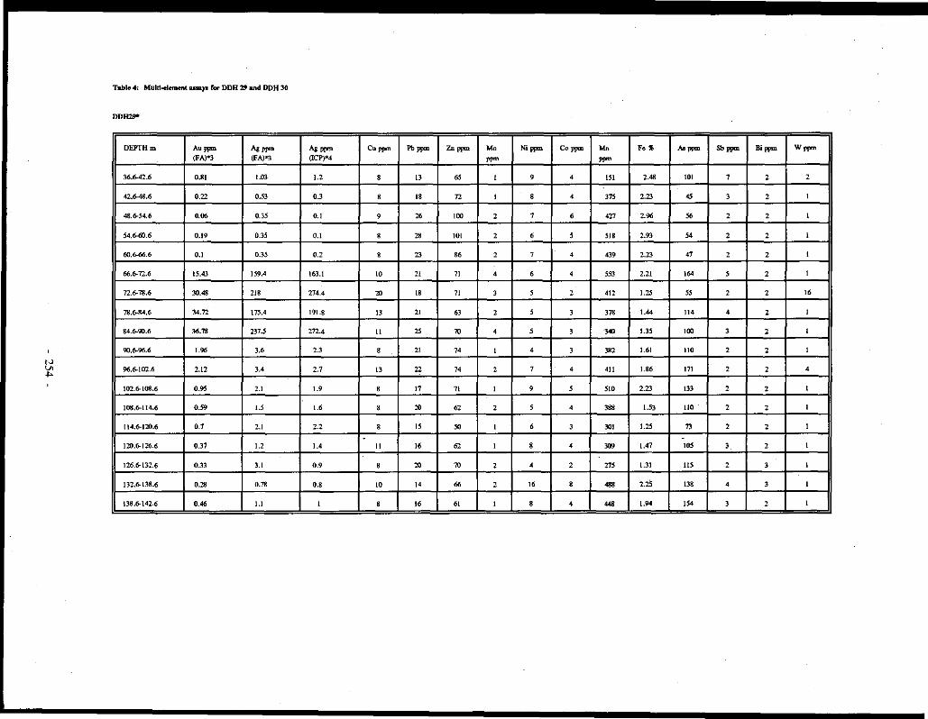
N V> ...
Table 4: Multi-element USll)'ll ror DDH 2' and DDH 30
DDll29"
DEPTH m A•- Ag ppm (FA)"3 (fA)"l
36.6-42.6 0.81 1.03
42.6-48.6 0.22 0.53
48.6-54.6 0.06 0.35
54.6-60.6 0.19 0.35
ro.6-66.6 0.1 0.35
66.6-12.6 15.43 159.4
72.6-78.6 30.48 218
78.6-84.6 34.72 175.4
84.6-90.6 36.78 237.5
90.6-96.6 1.96 3.6
96.6-100..6 2.12 3.4
102.6-108.6 0.95 2.1
108.6-114.6 0.59 1.5
[ 14.6-120.6 0.7 2.1
120.6-126.6 0.37 1.2
126.6-132.6 0.33 3.1
132.6-138.6 0.2' 0.78
138.6-142.6 0.46 I.I
Ag ppm C•ppm Pb ppm ,.,... (ICP)*4
1.2 ' 13 "' 0.3 ' 18 72
0.1 ' 26 100
0.1 ' " IOI
0.2 ' 23 86
163.! IO 21 71
274.4 ,,, 18 71
191.8 13 21 63
272.4 II 25 70
2.3 8 21 14
2.7 13 22 74
1.9 8 17 71
1.6 8 20 62
2.2 ' IS "' . 1.4 II 16 62
0.9 8 ,,, 70
0.8 IO 14 66
I 8 16 61
Mo Ni ppm Co- Mn Fo • "'""" Sb ppm Bi ppm w""' ppm ppm
I ' 4 ISi 2.48 IOI 1 2 2
I ' 4 375 2.23 45 3 2 I
2 1 6 427 2.9" " 2 2 I
2 6 5 518 2.93 54 2 2 I
2 7 4 439 2.23 47 2 2 I
4 6 4 "' 2.21 164 ' 2 I
3 5 2 412 1.25 55 2 2 16
2 5 3 378 1.44 114 4 2 I
4 5 3 340 1.35 100 3 2 I
I 4 3 382 1.61 110 2 2 I
2 1 4 411 1.86 171 2 2 4
I 9 5 510 2.23 133 2 2 I
2 ' 4 388 1.53 110 2 2 I
I 6 3 301 1.25 7) 2 2 I .
I ' 4 309 1.47 105 3 2 I
' 4 2 "' 1.31 115 2 3 I
2 16 ' 488 2.25 138 ' 3 I
I 8 4 ... 1.94 154 3 2 I

N '-" '-"
Table 4 (wntd)
DDH30"'
Au- Ag ppm Ag ppm eu,,,,.. Pb ppm Zn ppm Mu Ni ppm Cu Mn Fo. "'ppm DEPTH m (fA)*' (FA)"" (ICP)"" ""' ppm ppm
53.6"59.6 0.03 O.JS 0.1 50 16 97 2 ., 15 731 4.21 65
59.6-65.6 0.04 0.3.'i 0.2 27 19 " I 50 II 326 2.81 70
65.6-11.6 0.56 0,61 0.5 5R 52 61 I 27 ' 132 2.45 170
11.6-n.6 0.04 0.35 0.1 12 43 >JS I 10 6 261 3.47 27
n.6-sJ.6 0.45 0.43 0.1 ' 25 78 I 5 3 602 1.27 " 83.6-89.6 0.2! 0.35 0.1 7 26 85 I 6 4 561 2.11 103
89.6-95.6 0.03 0.35 0.1 ' 34 107 3 ' 5 242 2.73 17
95.6-101.6 0.07 0.35 0.1 ' 33 99 ' ' 5 228 2.37 69
101.6-107.6 0.14 0.63 0.4 6 27 ., 9 6 4 S8i 1.92 71
107.6-113,6 0.47 2.93 2.7 ' 28 82 5 6 4 516 1.94 " !13.6-119,6 7.3 34.63 35.7 6 28 " 4 5 4 558 1.72 84
!19.&125.6 1.2 2.58 2.7 47 25 70 3 7 3 "' l.17 108
125.6-131.6 22.04 22.78 29.6 ' 18 ., I 6 4 610 2.06 64
!31.6-137.6 0.57 1.98 1.1 5 20 71 2 ' 4 393 1.52 " !37.6-143.6 0.09 0.7 0.6 9 21 70 2 7 5 ... 1.78 62
.
143.6-149.6 0.16 0.7 0.4 6 20 62 I ' 5 423 1.85 " 149.6-155.6 O.JS 0.7 0.6 7 18 62 I 7 4 439 1.96 70
155.6-161.6 0.16 0.7 0.5 ' 22 "' I 9 5 508 2.27 73
!61.6-167.6 0.25 0.88 0.7 6 24 62 I 7 5 470 2.03 70
167.6-173.6 0.11 1.13 0.9 9 24 n I 9 6 554 2.26 99
!73.6-179.6 0.13 0.68 0.6 9 23 70 I 9 6 .,, 2.04 147
179.6-185.6 0.04 0.35 0.1 16 21 77 2 22 9 673 3.18 113
185.6-\88.9 0.03 0.35 0.1 9 22 16 2 9 7 516 2.54 48
*DDN29; Section 1017.'iE (Fig. 3), icn&:lh 142.65m, t-riD& 199' an:!. dip 45'.
*2DDN30: Scctioo 10l75E (Fig. 3), Jcna.th 188.98 m, bearing 199' and dip 45'.
""FA~ fill!) UINIY
.,.ICP = ICP 11D11.lyses by A~ Analytical LabonitQri=s Ltd, Vancouver. 05 gnltn.'I Qf sample wi::Ro di&cslod with 3 ml 3-1-2 HCl-HNOO-Hp at 95'C fot CJne bout an:1 diluled with 10 ml Qf H;.O.
Sb ppm Bi PPlll Wppm
24 4 I
IE 2 I
27 2 I
7 2 I
2 2 I
' 2 I
2 2 I
2 2 I
2 2 I
2 2 I
2 3 I
3 2 I
2 2 I
2 2 I
2 2 I
2 2 I
2 2 I
2 2 I
2 2 I
2 2 I
2 2 I
2 2 I
2 2 I
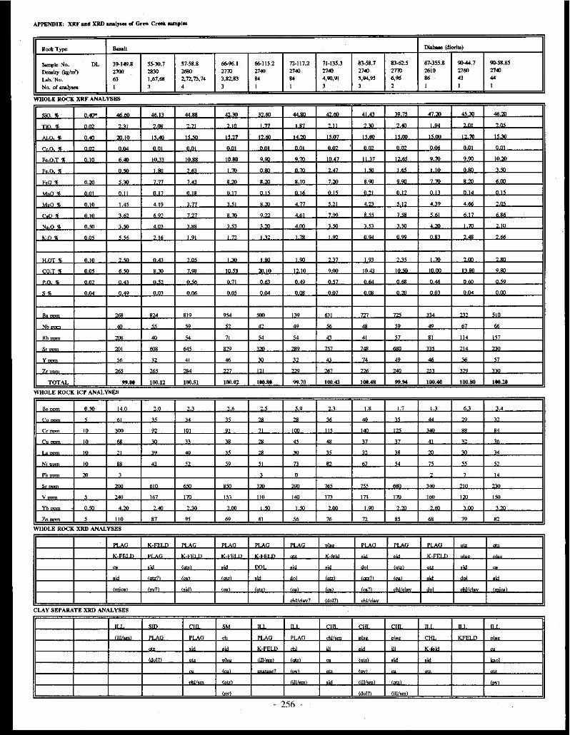
APPENDIX: XRI' a11d XRD anaiyHll GI Grirw Creek 111mpl•
Rook Type ..... Diabue (d.iorilc)
Samp~ No. DL 39-149.8 SS.30.7 57-58.8 61>96.I 66-115.2 n-1t1.2 71-135.3 83-58.7 83-62.5 61-355.8 9044,7 ~58.85
Dcmity (kghn') 2100 2830 """ 2770 ""' ""' ""' ""' 2710 u;io ""' 2740
Lab. No. 63 1,67,68 2,n,73,74 3,82,83 114 114 4,90,'JJ S,94.,9S .... .. 43 44
No. of analyse8 I ' 4 ' I I ' ' 2 I I I
WHOLE ROCK XRF ANALYSES .... -·- .... .. .. .. - ··- "" .. ..
" " .... ·-- .... ,,_
~-~ <!I. -.. -.. -- ""' ... ·- '"' " " ·- ·- ' "" , "' " ..
"". ·- -·· ' ... .... . . -- .. .. .... .... ,,_ ··- """ " - ··-r.o • ·- ·- ... .. ... . . . . ... ·- -- ·- ·-· -.. F. " ... <:l -·· "" •o" . .. ··.- . .. . .. ..
II 17 .... ·- ·- 10,'YI
• r < -.. ·- ... ·- . -- " .. ... ... ·- -- ... ... o.- , ·- ""7 74' ·- ·- " '" 7- '·"" ·- 1- ·- ··-... " .. "" " .. ... " .. " .. " .. " .. " - ... " " ... ""
u.o. " .. "' 4.'° ... . .. ·- 4.77
. .. - . '" 4 •• , .. ""'
r.o < "'" ,., ·- ·- " .. . .. . .. ... ... ... ... "" , .. "·". 0"'
, .. 4 0' , " , ,, . .. ... . .. "'" " '" - ·- "l.10
""• ""' ... , " , .. ·- ' "" ·- ·- ·-· ·- "-· " .. " ..
....• " .. ... " .. ... . "" . "" ·- """ ·- , "' - ·- ..
... . ... "" ·- ·- .... .... .. .. . .. 10,4l .... moo ""' .. .,
.. . """ " .. " .. " .. " .. . .. . .. . .. ... ·- ... ... ... '" "" " .. """ ""' " .. ... ... ... ·- -- """ ·- --,,_ -- .. . ... .,. ... ... ... - -· ... -- "0
'" .. « '" ,,
'" '" .. .. <o .. " ~
Rb - "' " 7' " 54 ., " <7 81 '" '"
" -· ... ... """ ... """ ... ·- ·- "' ... -· v ,,
" 4' .. - ,, " " •• 46 " <7
7, ... ... - ... "'
... ... ""' "'" "' - """
TOTAL ..... 100.12 100.SI 100.02 100.se 99.70 100.43 100.48 ..... 100.40 100.80 100.20
WHOLE ROCK ICP ANALYSES
"" O.'<> 14.0 '·" "" .. .. ,, ,_, '.8 1.7 1.1 " '-'
r. ' "' " u "' ~ ~ ~ "' " .. - "
r. '" ·- ~ ·-· " " ... ... ·- '" ·- .. "
~ '" ~ ~ ,, ,. ~ .. .. " " " "
,,
'. '" " ,, .. " ~ - " " " '" ~ u
N; '" .. ., " <O " - - " " 7' " " Pb ~
, , - , 7 " "
,,_ ... ... ... ··- ... - ... •.. ...
v < ... 167 '70 .,. 'IO 1- 17' 170 160 ·- ,,. .. "<O ·- ·- ... ·- ... . .. -- ·- -~
, <O ·- ...
Zn- ' 110 " " " " " " 72 " " 79 82
WHOLE ROCK XRD ANALYSES
.. '" K-"'"'' "' p• 'G .. '" .... -· .. . °'on "'"" ""G _,, -· v_--,.., .. v_ · ·· n ·~- ... '"" .,._ ~ . " . ,, v_---..,.
- .. ,, ~· ·" .. -··· ""
,, -'--?' . . ,, '· ,. .. •• ,_, . .
·~· , .. ... ' . ' . .. " _coo ,_, ··1 ...
cbl!dr'? 'dol'?' cbl/cla"
CLAY SEPARATE XRD ANALYSES
... -·- -··· .. ... - . .... rnn ..... TI' "' n' .... -· ·- "' - ~
.. . p• . ·•· ..... ··--· 0 .
... ... .,_---"' .. .. , ·'" "' v.· -
'""'" ... .. 1111/ ' .. - ..... .~ . ... - .
' ' . '·" - . ..
~·1 ' ····· ·'" 1;111 .... ldoJ'!\ lill/sml
. 256 .

Rock Type Basaltic 1ufT1 Rhyolite
Sample No. 63-66.2 82-307 SS-188.3 61-99.15 63-67.l 17-347.1 »104.3 ""'·' ll0-98.6 90-142.1 90-218.3
D:mity {'qlm') '·" ,... 2510 2S50 ,.,. 2510 "'° 2390 ""' ""' Lab No. 77 " "'
.,. 78 " .. " .. 47 " No. of Anal~ t t t I I I I I I I I
.. ... .
~·~ <E •' 00
«.M «.10 •• 40 -.- -- ,,_ .. - -- .,_ 74.'Xl
,..,,.. " .,, -- ·= '" ·- ·~ -_ _. -- -- -·- ...
.... """ "·"' I0.10 .. ~ ,,_ ··- .. ~ ··- " on "~ .. ~ n.n < --· -- ""' ·- ""' OM . nM . OM nM
.,_ " ... <E ... -- «• ·-- ... ·- 'nn -- ' •n - --" - . ·- ·- -- onn onn onn onn onn o nn -- --FeO w; 7"' 1- ·- ·- ·- 4.00 O.M "" ·- nM ·-.. ~. n " -" n" "'" n n" nnn .. OM .. nM
.. 0. • nn -.. '·" '47 ,,. "" "" "" n,. n '" 0"
n.n < ... . ·- ... ,., -.. ... n,. .. n,. n <n no<
" n < o nn . ·- o •n . ·- o nn --- -- ·- ' - -·- --·--~ <E ·~ "'
,. "° -.. '"' --- . ·- . ., . - ...
..... "' .,. "" -- -- ·~ -- '"' OM -- '"'
c·· • •• nn 690 •• nn '. ·- 9.M '90 -- o nn onn O<O ·--- . n <• n" -- n '' . ·- -- --- --- n"' -- nM
s• -.. 014 0.13 o.m -·- ".09 O.ITT Q.ITT rl.01. n '8 QM
.. -- '74 449 ... ,., 5117 ~1 ·- ·-· ,. ,_ ~ " " - .,
" .. ,. .. " .,.
" Rb- " " 188 7' " 184 -'9 ... - 4<7 ·-. ,., ·- '"' -· ... ·- "' M 0 0 " y 38 .. "' ~ " " "' ·- v ... ·-7, -· .,. -- rn< •« ,,. ..• ·- ... -· ... TOTAL 100.50 100.60 100.40 , ..... 100.40 99.70 "·"' 99.10 100.20 100.70 too.so
n NALYS"'S . ., " '""
,. .. -- <O . . " "
.. c 33 " '' " - ,. t3 ~ " •• " r, " ·- "' "" " " " • ' ' • Cu " 43 " 43 " 6 " ' ' IO 6
'. ,. " " " " .. ITT ..•
" ITT
•; 7'.l 10 45 78 " t4 " ' ' 6 7
~
" " " < " " .,,
" "' " " ,, '"'
... •90 - -- ·- HO M n 0 " " ·- ·- ~ ''" ·- " " < ' ' ' Yb '.00 '·"' '80 •.M '·"' 6 «! -- ·- 1.- -.. . '" Zn ., 68 '" 81 68 88 54 100 S2 92 "
PLAG "" ,_,
~· ·-F"' .,. ... - - ~ -~ --· . ;, v • .... v ... v .....
,_, do! •" ·" . 'ca' ;, . K-f,..'-'
... .. ... . ·oo• ""'ldav?
,_,_, '-'cal loo> ,_ ·ca.?\
-·· '
~ chllclav? ldoJ?i
AYSEl'A SES
.... .... n n rt• ... n' "' n' ... '" ... rt• !(_.,.,,..,. .... v••• .. v ....... K-~~·.,. n~ K-"""'"' ..... .. .. .. . . .. ... -··
v . •• V.fel-' "" . ..
ohl ""'sm\ '·"' ..... "' 00
·" ... '" '"
_, '"'· ' .
•• ''-" "" .. ''"· _, .,,,, -•
lil!/sm\ .. '
.... ~ ......
- 257 -

Rock TYP= VAwff CLP wff
Sample No. 18· 23-106.8 72-172.8 85-33.4 29-84.3 65-123.3 17-llJ.7 18-159.6 28-97.7 35-36.5 38-143.6 4G-193.8
Dcmity (kg/m') 311.IJ 231<J 2'JO 2540 2'JO """ 2380 '""" Lab. No. " 92 42 " 81 49 S4 " ., 61 64
No, of an&lyaos 52 1 1 1 1 1 1 l l l l 1
l
---·~--~~-
Sin 'II!. 76.30 72.0> 15.90 71.70 "'·"' 74.70 12.m 76.30 ..... "'·"' 80.SO 74.40
"" . ... . .. ·- ... ·- ... . .. ·- 0 .. ·- ·- "" "O < 9.<<J 10.00 10.10 12.50 10.10 12.80 11.90 10.80 9.20 9.00 7.30 8.20 ... -- n.oo 0.00 0.00 noo -- om om -- -- -- ·-Fe.OT% 4.00 3.0l 2.30 3.10 0.1<1 I.SO 3.70 2."' 1.SO 2.00 3.10 3.10
"-" . 0."' 000 0 '° 0.00 0.00 0."1 0.21l 0.21l nm
FeO 'JI: 3.10 2.20 2.70 l.00 ..,. 2.30 1.20 I.OJ 2.'<J
H .. n « ... O,M -.. -- -- -- o.m -.. o- -- 007 0"'
M~O c 0.74 0.61 0.15 0.65 0.29 o.n 0.64 0.40 0.43 0.36 0.52 0.9S
r.o • ··- n _, ·- l.18 ... . .. 0" ... ·~ "" ... -.. N"-0 % 0.40 O.lll .... l.«l 0.20 O,Ol 0.00 O.«J o.so 0.20 0.20 O.lll
ve• ... ... '-'"' < O< .., ~.04 4." 5"' ... • '4 ... ,_
.. -. ·- ·- •.~ ... ... ' -- ·~ . ., 1.1n
COT• '·"' 1.70 3.0l 3.00 0,70 2.ro O.Ol 1.80 O.Ol 1.30 2.30 4.10
"" . n.10 o•o 0,07 0."' n07 n.os 0.12 0.11 0" ... fl.07 0.07 ,. 0.41 1.01 0.01 0.29 0.2' 0.01 2.7' 0.40 0.47 0.32 0.24 1.16
.,- 267 410 345 653 399 "' 033 "' 490 426 296 325
Nh ,. "' " ~ " " " ,,
" ?A " 24
Rb "' 261 )63 211 "" J83 2'!1 212 190 "' 177 "' <. ., 7• " " M u M ,, m M " "' Y- 06 "' 83 " 83 1 IO 71 71 " " 71 "' - --· ... --- 4" --- '" 4- -·- - --- "' ---TOTAL 100.10 ... ,. 100.te 100.60 100.30 100.10 '9.20 100.30 lOl.40 100.so "·"' 100.60
WHOLE ROCK ICP ANALYSES
. '·' 0.8 " 4.6 7.8 7.0 '-' " '·' 0.7 80 " Co 20 " 17 J7 32 13 24 " " 31 32 " r, " " n " " n " " " " " •7
Cu 7 8 13 9 0 JO ' 8 8 6 8 0
,, .. 65 74 91 75 97 "' ., 49 ~ ~ "
Ni- " " " 13 9 JO 14 l3 " ll l3 l3
"" ,.,
" "' M " .. " " " .,.
" " ,, 57 70 31 " 44 84 " 88 "' " " 90
v ~ ,, '0 "' " " " 30 ,,
'7 " " Yb 4.30 5.10 OA(J 0.00 5.90 8.20 5.40 4.90 3.70 4.00 5.30 3.0l
Zn 61 ., 74 S4 74 88 70 63 " 51 " " '"
§ OTZ OTZ = OTZ OTZ = = OTZ OTZ = OTZ = v.c V.<m h '· K-""'" n K-F"''" K.' K.fi:::• n K-""'""' K-F''" n K-"""" K-•
'" lsid'?I In],."\ PLAG ln]o.al lrnical /mica\ lmica?I dol/onk
, . -• 11(.felAI -•
·~· lsid'?l 'sidl
CLAY SEPARATE XRD ANALYSES
"' "' n' "' K-FELD n' K-FET.D lLL ILL K-FE'n K-"''" n K-""''"" KFELD K-FELD K-FELD PLAG lLL = ll.L K-FELD K-FELD lLL 1LL ILL
-· K-""''.,. "' "'
'" filllsmi n\o" •m riJL!sml il118Jll. ,;, •• lilJ/sml rm/sm21 '" 'iWsml
mv -• "' lill/ . - t:l]/ . ,_. ?I ""'
. IAol?\
lilJfsm• ill/sm'
- 258 -

Appendix (contlnuOO): XRD and XRF 1U1al)'lle11 or Grt!W Creek samples
Rock Type CLP 1uff S&P Hydro- -brc:.ocia Quartz vein (OJDtinued) ruff """"" ~le No. 64-57.9 64-68.2 66-165.4 ~262.4 17-221.5 17-291.9 3<).90 56-264.4 (1()..200.4 55-183.8 21-61.7 29-74.90
Dcmity (kg/m') 2.44 2500 2500 2500 2'10 2470 2480 ""' 2490 Lab. No. 19 80 " 87 lO " 62 71 75 "' 56 an No. ofan11ly8cll I I I I I I I I I I I I
. ' SiO 'I 74.6J 66.10 74.50 71.80 74.80 .. _., 74.00 64.00 65.10 70.10 76.30 79.M
TOO • ·- O.<> n" 0.44 "'" n« n •o ·- ·-- n,. O.>l nno
.. 0 • 1".10 16.40 12.IO 13.00 11.00 12.80 10.80 12.80 13.00 8.M 8.00 7.30
- - . -- -- -- - o- ·- o- -- - o- -- ·-Fc.O T 'l 1.70 3 . ., 3.30 1.40 2.00 4.00 2.10 5.>J 4.80 7.00 4.>J 1.10
<- n • o- 0"' ·- 0 '" 0.10 ·- 0.40 ·-
Fc:O 'I: 1.30 3.00 2.70 1.111 3.lO 4 . ., 4.00 6.10
. -. 0.M 0.07 n "' 0.116 n 0' n "' O"' " " -- ",, 0" n ""
M~• 0.58 1.04 0.04 UI 0.44 1.01 0.49 1.10 0.82 1.22 0.85 1.1 l
--· "·" n 0.66 ' '" l.l4 ' " O.<> '·" - -- ' " n.84 '·'" NAO% 0.111 0 . ., 0.70 O.M 1.30 1.30 Ml 1.lO l."1 O.>J 0.10 0.10
vn• 4'0 «< 4.77 '-" ., 4J16 ,_
471 rn '" '"' 5.61
.. ~. -- --- - ·- -- •.m '-"' ·-~ ''" 0."'
co:r % I .SO 2.00 2-"l 2.00 2.10 3.80 0.70 5.10 5.10 5.6! 2.30 3.40
nn < n'" "' -- n I' " " 0" n " n" "·" "" ·- --S% 0.2' 0.13 0.19 0.66 0.39 0.04 1.22 0.07 0.02 0.48 1.78 0.02
··- 485 646 704 811 678 802 576 530 761 420 m 124
.,. 1< " "' " " " 77 " " " 24 0
Rb 186 275 191 "' "" 176 219 192 187 204 286 326
S• '•0 ~ 1'1 " ~ 96 ,., " 113 71 "' "
y 83 115 "1 93 lO 58 56 72 64 " " 14
, -- '"' ""' 455 --- '" 387 ~7 397 195 '" " TOTAL "9.70 100.60 100.90 "-'° 110.20 100.10 '6.70 100.20 100.40 100.30 100.30 101.00
WHOLE ROCK ICP ANALYSES
·- '-' ' ' <.O 1.0 4.4 79 " 3.4 " "n 15.0 24
c. 15 16 17 22 J2 26 76 31. " 20 .. 2
n " % " " " u· 31 " ~ " " 1'
Cu II ' lO 7 II 8 10 II 10 ' 9 16 .. " 110 " 78 49 " <o " 59 47 " 0
Ni- 14 " 17 14 19 21 18 24 ,, 17 16 6
Pb- "' " 14 21 ,. " 2' "' 21 " 24
,, 150 220 130 83 lO 96 100 88 110 71 ., v 'I " u '' " "' " " " 47 n l
Yb 6.30 8.60 5.10 6.10 l.50 3.90 4.00 4.611 UJ 4.10 l.M "-"' Zn 33 140 73 82 " 611 67 " 73 " 60 II
w "
~
"" OTZ OTZ ~z = = "" K-FELD OTZ OTZ
, . -'~ It.fold K---· n v_r;Et n v.--n v -fold - K-"'" K-FELD
'""'' ola~ ""' (mica) PLAG PLAG fmice?l ot.o "" ,)d , __ ,
!K-"'"' K-felcl (sidl I doll old ~ '" " I doll isidl lmical old
'~' tmice1
s
ILL ILL ILL ILL K-FELD ILL ILL "' ILL ILL Il.L
v.--· D -- V.fJ:'I n K---· n TIL V.fl;'l n K-FFJD . K-fCl n K-FELD
-- lill/sml OTZ "" -- "" "" " -·· ,)d "" '"" _, ,,
lill/sm\ -• fi.11/sml ""' _,
"" lill/sml
lill/sm21 'm-lavl qJisml " tj[l/sm'
lill/sml
an1UySC5 by -.-...ogical .'!\l./'Ve)' ot .__._ ..,vralonea, ttaW1l. '''"~" analyses Oii ,..,., """~ CJloep\ 1-c:U, H2v •, ,..,,.,, "'"" :; by wet ...... ~rmQI. tec ... uqucs. Fe,O, i>i calculated 118ing: Fc,O, = Fc~O,T (XRF) - l. I l l34 X FcO (V<Jlwn:tric) ICP analyses arc: Geological Survey of Canada's ICP-TRI group obtained on 1.0 gram of sample (acid + fusion of residue) di:lsolved
in 10% HCI and dilulrd to JOO ml. lnterprewion of XRD diffractograrm was by J.B. Percival of Geological Swvey of Canada. For clay sepe.~. IUllllyses were made of \lllltcated, heated and g!ycolated samples to
aid interpretalicn of the: clay minerals present.
XRD qua.n1itative estimates: ILL= abundant, ill = minor, (111) = trace, ard (t!l?) = trace, tentative identifiQl.tion
XRD abb~alions: ank = anhrite, QI = Ql.]cite, chi = chlorite, dol = dokmite, fold = fokbp11r, ill = illite, kaol = bwlinite, plag = plagiodase, py = p)l'i.te, qtz = q1$rtz, sid = siderite, ard srn = smcctite
"' Column of analytical detection limiis - 259 -
PRELIMINARY OBSERVATIONS ON THE GEOLOGY AND GEOCHEMISTRY OF QUARTZ VEINS IN THE
KLONDIKE DISTRICT, WEST-CENTRAL YUKON
1.K. Mortensen Geological Survey of Canada
601 Booth St Ottawa, Ontario
K1AOE8
and
B.E. Nesbitt and R. Rushton Department of Geology University of Alberta Edmonton, Alberta
T6G2E3
MORTENSEN, J.K., NESBIIT, B.E., and RUSHTON, R., 1992. Preliminary observations on the geology and geochemistry of quartz veins in the Klondike District, West-Central Yukon. In: Yukon Geology, Vol. 3; Exploration and Geological Services Division, Indian and Northern Affairs Canada, p.260-270
ABSTRACT
Four main styles of quartz veining are recognized in the Klondike District. These include foliaform and discordant mesothermal quartz veins in schistose metamorphic rocks, quartz-carbonate veins in altered ultramajic rocks and greenstones, epithennal chalcedony veins cutting Eocene igneous and sedimentary rocks, and low-temperature epithermal veins associated with intensely altered Plio-Pleistocene White Channel Gravel deposits. Foliaform mesothermal quartz veins are invariably barren; however discordant mesothermal veins locally contain visible gold. Both styles of epithermal veins in the Klondike contain at least geochemically anomalous levels of gold. The complex history of hydrothermal activity in the Klondike has led to considerable confusion about the nature of veining in this area. The results of this study provide a preliminary framework within which to evaluate the various prevailing theories regarding the major sources of gold in the Klondike placer deposits.
RESUME
Quatre principaux types de veines de quartz sont reconnus dans le district du Klondike; ce sont des veines de quartz misothermal foliiformes et discordant es dans les roches mitamorphiques schisteuses, des veines de quartz et carbonate dans les roches ultramajiques alterees et les roches vertes, des veines de caltedoine epithermale recoupant des roches ignees et sedimentaires de !'Eocene et en.fin des veines epithermales formees il basse temperature associees aux dep6ts plio-pleistocenes de graviers de White Channel intensement alteres. Les veines de quartz mesothermal foliiformes sont invariablement steriles; cependant les veines mesothermales discortantes renferment par endroits de l'or visible. Au klondike, les deux types de veines epithermales renferment au mo ins des concentrations geochimiquement anormales d 'or. L 'histoire complexe de I' activite hydrothermale au Klondike a susciti" une confusion considerable quant il la nature de la formation des veines dans cette region. Les resultats de cette etude assurent un cadre priliminaire pour l'ivaluation des diverses theories predominantes concernant les sources majeures d'or dans des dep6ts alluvionnaires au Klondike.
- 260 -
INTRODUCTION
Exploration for lode gold mineralization in the Klondike District began immediately after the discovery of rich placer gold deposits in the area in 1896. Although many quartz veins, some containing visible gold, were discovered early in the development of the Klondike District (e.g. McConnell, 1905), they have received little detailed study. In this paper we summarize preliminary results of an on-going investigation of the field relationships, genesis and composition of the different vein systems, and discuss the implications of this work for the origin of placer gold deposits in the area.
GEOLOGY OF THE KLONDIKE DISTRICT
The bedrock geology of the Klondike District is shown in Figure 1 (from Mortensen, 1990). Bedrock units can be divided into four main groups; (1) schistose metamorphic rocks, (2) greenstones and ultramafic rocks, (3) undeformed intrusive rocks, and (4) young volcanic and sedimentary rocks. The schistose metamorphic rocks include a variety of metaplutonic, metavolcanic, and metasedimentary rocks which range in age from pre-Late Devonian to mid-Permian. These rocks display a penetrative foliation which generally parallels compositional layering, and forme.d during the first main deformation event in the area (Fl). Metamorphism associated with the Fl event was at middle greenschist facies (chloritebiotite grade) throughout most of the area, but reached garnet grade along the southwest margin of the study area, and sillimanite grade along lower Dominion Creek adjacent to the granitic orthogneiss which underlies Mt Burnham (Fig. 1).
A younger defonnation event (F2) produced macroscopic scale folds in the Bonanza Creek and Eldorado Creek areas, and one or more crenulation cleavages over much of the Klondike area. Metamorphism associated with F2 was at lower greenschist facies, and is usually seen only as a retrogression of Fl mineral assemblages.
The schistose metamorphic rocks in the Klondike have been imbricated by regional scale thrust faults along which bodies of massive greenstone and altered ultramafic rocks (including serpentinized harzburgite, serpentinite, and quartzcarbonate-Cr mica rocks) were emplaced. The greenstones and ultramafic rocks were not affected by FI deformation, and field observations suggest that the F2 event approximately coincided with the thrust faulting (Mortensen, 1990).
K-Ar and Rb-Sr ages for metamorphic muscovite and hornblende in the Klondike range from Middle Jurassic to earliest Cretaceous, probably reflecting very prolonged cooling after the F 1 event.
Two distinct suites of undeformed and unmetamorphose.d intrusive rocks which post-date thrust faulting have been recognized in the Klondike. These are: (1) hornblende-biotite granodiorite which forms a small plug along middle Hunker Creek (Fig. I) and yields a latest Cretaceous K-Ar hornblende age (R.L. Debick:i, pers. comm., 1984), and (2) a widespread bimodal suite of quartz-feldspar porphyry and diabase and plagioclase-phyric mafic porphyry which occur as dykes and
as a large stock between lower Hunker Creek and the Klondike River (Eocene K-Ar whole-rock age, R.L. Debick:i, pers. comm., 1984; Mortensen, 1~90) (Fig. 1).
Unmetamorphosed andesite flows which are interlayered with elastic sediments along Last Chance Creek (Fig. 1) are undated, but, closely resemble similar sequences south of Indian River that have given latest Cretaceous isotopic ages (Lowey et al., 1986). An undated sequence of felsic lapilli tuff and volcanic breccia interlayered with immature elastic rocks near the mouth of Germaine Creek (Fig. 1) is composed of quartz-feldspar porphyry identical to the Eocene felsic porphyry intrusions and is considered to be their extrusive equivalent.
Despite the close promixity of the Klondike District to the Tintina Fault, there is surprisingly little evidence for largescale steep faults in the area (Mortensen, 1990).
The Klondike District is unglaciated and three main unconsolidated units in the area are known to contain gold. These are: (1) White Channel Gravels of Plio-Pleistocene age that rest on high level terraces, (2) gravels that occupy the beds of present streams, and (3) colluvium which mantles hillslopes (e.g. McConnell, 1905; Morison, 1987).
VEIN SYSTEMS IN KLONDIKE DISTRICT
Four main styles of veining are recognized in the Klondike District. These are: (1) mesothennal quartz veins in schistose metamorphic rocks; (2) quartz-carbonate veins cutting greenstones and ultramafic rocks; (3) Fluorite and chalcedony veins cutting igneous and sedimentary rocks of Eocene age; and (4) Quaternary, low-temperature epithermal veins.
Veins of the first type are by far the most widespread and abundant, and form the main focus of this paper.
MESOTHERMAL VEINS IN SCIDSTOSE METAMORPIDC ROCKS
Quartz vein material makes up a significant proportion of the schists and gneisses that underlie most of the Klondike District. Two main types of veins can be distinguished based mainly on their structural setting. Foliaform veins form typically lensoid bodies oriented along Fl foliation planes. Discordant veins form tabular bodies that crosscut the main foliation in the wall rocks. The main characteristics of these two types of veins are briefly summarized below.
Foliafonn veins.
These veins range up to 3 m in thickness, but are typically discontinuous·. They are present in all metamorphic rock units in the area, and are particularly abundant in the mica-rich lithologies (i.e. felsic schist, chloritic schist, and carbonaceous schist), where they locally comprise up to 10% of the rock volume. Structurally, the foliaform veins have been little affected by the F2 deformation, but locally occupy F2 fold hinges (see description of the PORTLAND occurrence
- 261 -

N
Rl
1311°30'
1311°00'
" "' 10
•m
-111•00·
U"45'
138°30'
LEGEND
[·z:j qua•t••felOopar porphyry (Eoc.no)
~ faloic lapllh WI!, includU aandotone and congloma<ata
llllllllll plogloc1au-phyf\c banlt, dlobau, minor gabbro
~ hornbl.nde-blorne ganodlorlte (late Craloceouo-Paleocene)
~ interbedded olltotone, nndslona, and andnitic llo"'a (~ 11111)
m manive greenstone. mmof diabaoe
- urpentmlle. carbonatized •erpentlnite, talc-carbMUe ochlot
0 !01010 •chi•1 (muocovite and <IU•rt•-musco•lle oohlot)(Permlan)
~ chlorotic •chrol (QU&rll-chlor<te {"- actinoli!e, blotl!e, !&ldspar) 1ch10t
locally includeo mino• metag&bbro and amph•bohle
~ foliated metagabbro
c:::J mlcaceouo and oMorltlc quarbile and faldopUhlc quar!Zlte
c:::J oarbonoceouo quar!z-muoco•I!• (t b•otrta) phyll1ta and •chiot,
lncludu minor cllloritic schlat
~ med.um gra•nad marble and calclt&-musco•ito-quortz schis!
E:J quartz-eugen aclllot (quartz •feldspar Hgan-bHring quartz-mu•co•ilo och!U)(Permian)
~ b•otl!e-bea•lng quart• monzonitic orthognaiu (Sulphur Creak orlho(lneiu)(Permien)
i.iiliil medium grained quartz dlorlllc orlhognalu
~ foldepa• ougen-bearln; granl11c ortllognelu (Ml_ Burnham orlhognelos)Uata Dn.-early Miso.l.
lithological cont.cl (d•linHa, approximUol
~-"'- thruol loult (dotlnlta, approx1m.iel
olHp fault (d&flnlta, apgroximatal
altered ultramellc occurrence
quarlz-faldapor porphyry occurrence
hlgh..-ay
Cl3"45'
Figure 1. Geological map of Klondike District. Solid stars show locations for geochronological samples discussed by Mortensen (1990). MD = King Solomon Dome; OM= Dominion Mountain; MB = Mt Burnham.
Midnight Dome; KO

0 17
0 15
km \
O = Discordant Mesothermal Vein Occurrences
l. AIME .......... GA, VG 2. GOLD RUN ...... GA, (VG) 3. PORTLAND ...... GA, (VG, SP) 4 LLOYD ........ GA, {VG) 5 SULPHUR ....... GA 6. HUNKER DOME ... GA, SP, TT, VG 7. SUMMIT ........ GA, AM 8 SHEBA ......... GA, SP, PO, TT, RS, AS, VG 9. MITCHELL ...... GA, SP, er, AS, RT, VG
10. LONE STAR ..... GA, TT, VG 11. PIONEER ....... GA, VG 12. HILCHEY ....... GA, VG 13. ROBIN ........ AM, VG, BA?, SC? 14. AMANDA 15. VJOLET ........ GA, VG, BA 16. BUCKLAND ...... GA, (VG) 17. PLINC ......... GA, VG 18 OROFINO ....... GA, AS 19 MT. BRONSON ... GA, CB 2(1. · LINDOW ........ GA, AS 21. VIRGIN ........ GA, VG, CB, BA
e = Veins in Altered Ultramalic Rocks
2Z. BEN LEVY 23. unnamed
"f' = Veins/Skarns Associated with Eocene Intrusions
24. \VEST DAWSON
\J = Eocene Enithermal Veins
25. GERMAINE
~ Figure 2. Sketch map of the Klondike District showing locations of the mineralized discordant vein occurrences as well as
other occurrences referred to in the text. Also shown are the occurrence name (in capital letters) and minerals present other than quartz and pyrite (minerals in parentheses reported to be present but not confirmed). GA = galena, SP = sphalerite, AS = arsenopyrite, PO= pyrrhotite, TI = tetrahedrite, VG = visible gold, RS = pyrargyrite, AM = amethyst, CB = carbonate, BA = barite, SC = scheelite, RT = rutile. Includes data from Debicki (1984), Friedrich and Hoymann (1989), and Yukon Minfile (1991). KSD refers to King Solomon's Dome.
(MINFILE 1150 064) in Maclean, 1914, p. 101-102 for an example), suggesting formation late in the F2 event.
Foliaform veins consist almost entirely of milky to clear, coarse grained quartz with locally abundant calcic to ferroan carbonate. Small masses of muscovite and/or chlorite are present in some of the foliaform veins, but it is uncertain whether these minerals form part of the vein assemblage or are small screens of mica-rich wall rock. Pink K-feldspar occurs in small amounts in foliaform veins within the quartzaugen schist unit and the Sulphur Creek orthogneiss, both along Bear Creek and in areas of somewhat higher metamorphic grade in the southwestern part of the district. Vuggy cavities appear locally in the foliaforrn veins.
The foliaforrn veins appear to contain no visible sulphides or gold and no evidence of alteration is visible in adjacent wallrocks.
Discordant veins.
Discordant yeins occur sporadically throughout the Klondike, although they are most abundant in the central and southern parts of the district. The abundance of discordant veins appears to decrease rapidly north of the Klondike River, northeast of Hunker and Dominion Creeks, and south of Indian River. The locations of some of the better known and explored veins and vein sets are shown in Figure 2. Discordant veins are usually less than 1 m thick; however examples up to 3 m thick are present at some localities (e.g. AMANDA occurrence on Eldorado Creek, (MINFILE 1150 051). In some instances single veins can be traced up to 800 m along strike. Most of the veins occupy steeply dipping extensional structures, which locally appear to forrn en echelon arrays. An example of such an array includes the
- 263 -

MITCHELL-SHEBA-HUNKER DOME occurrences (MINFILE 1150 068 and 1150 067) north and east of King Solomon Dome, where the largest and most continuous veins present form a north-south trending, left-stepping en echelon array. There is no obvious geometric relationship, however, between the orientation of these veins and any of the presently recognized regional deformation events.
Discordant veins crosscut, and are therefore younger than, foliaform veins at a number of localities in the Klondike District. In two instances, however, clearly discordant quartz veins appear to merge with foliaform veins, suggesting a possible partial overlap in age between the two types of veins.
Small vuggy cavities lined by clear quartz (and rare carbonate) crystals are abundant in some discordant veins. Ribboned veins are very rare; most veins appear to represent simple, single-stage, open space filling. Ribboned vein material appears in float at the south end of the vein system at the HUNKER DOME occurrence (MINFILE 1150 067), and on the dump at the AIME occurrence (MINFILE 1150 06l)(Fig. 2). Angular wall rock fragments to 25 cm in longest dimension appear in discordant veins at the LLOYD (MINFILE 1150 066) and SHEBA (MINFILE 1150 068b) occurrences (Fig. 2). There is no evidence for faulting synchronous with vein formation, although post-vein faults produce minor (up to several metres) offset on veins in the Lone Star mine area (MINFILE 1150 072) and zones of crush breccia along vein margins at the MITCHELL-SHEBA occurrence (MINFILE 1150 068)(Fig. 2).
Like the foliaform veins, discordant veins consist mainly of milky white to locally clear, coarse grained quartz. Coarse grained amethyst crystals line a vuggy cavity in a discordant vein near the north end of the HUNKER DOME occurrence (Fig. 2). A greater range of vein minerals is generally present in the discordant veins than in the foliaform veins. Barite, calcite, ferroan carbonate and rare rutile and feldspar occur locally as gangue in some of the veins. Scheelite appears in placer concentrates from most drainages in the Klondike (Gleeson, 1970), and coarse scheelite and barite grains have also been recovered from colluvial deposits in an are.a with abundant discordant veins near the ROBIN occurrence (MINFILE 1150 148) on Oro Grande Gulch (Fig. 2). Although scheelite has not been found in outcrop, it is most likely derived mainly from the discordant veins.
The discordant veins typically display very low sulphide concentrations. Pyrite is usually present in at least trace amounts, mainly as discontinuous selvages along vein walls or as irregular disseminations in vein interiors. Galena also commonly occurs in trace amounts, typically as disseminated grains and grain aggregates associated with pyrite in vein interiors. In relatively sulphide-rich portions of the discordant veins, other sulphides and sulphosalts including sphalerite, chalcopyrite, tetrahedrite, and rare pyrrhotite, arsenopyrite and pyrargyrite have also been noted.
Visible gold is present in a number of discordant veins in the Klondike District (Fig. 2). It is typically associated with sulphide (especially pyrite) concentrations, and occurs both in pyritic selvages and as disseminations in vein interiors. The
gold occurs as flakes and irregular inclusions up to 5 mm in diameter in pyrite (and in masses of limonite after pyrite) and as free grains of similar size in quartz. Crystalline gold has been reported from discordant veins at the LONE ST AR occurrence (Tyrrell, 1912). Zones of relatively high gold grades appear Iocall y in some veins; for example, assays of up to 857 git (25 opt) have been reported for handpicked specimens of vein material from the HUNKER DOME occurrence (Fig. 2) (Yukon Minfile, 1991). Pyrite-rich discordant veins in the vicinity of the Lone Star mine locally contain abundant visible gold. Such veins include narrow, shallowly dipping quartz-pyrite and pyrite veins and stringers in the open cut at the Lone Star mine itself (Fig. 2) and a very pyrite-rich vein (now largely altered to limonite) near the ROBIN occurrence on Oro Grande Gulch (Fig. 2). There appears to be an empirical correlation between the gold and pyrite contents of discordant veins, although it is also possible that the pyrite-rich veins described above represent a different (possibly younger) discordant vein event.
Mineralized discordant vein systems in the Klondike District produce irregular zones of weakly to moderately anomalous gold and arsenic values in soil which are locally associated with sporadic anomalous Pb, Zn and Cu values (Yukon Minfile, 1991).
The nature and extent of alteration around discordant veins is controlled to some extent by the mineralogy and bulk composition of the wall rocks. Felsic wall rocks are generally visually unaltered, but the more mafic lithologies, especially the chloritic schist unit, commonly display discernible alteration up to 3 m from the margins of discordant veins. The alteration consists mainly of introduction of ferroan carbonate into the wall rocks where it imparts a distinctive brownish weathering character to the otherwise greenweathering chloritic schist. The carbonate alteration is particularly well developed in an area of bulldozer trenching along the MITCHELL vein (MINFILE 1150 068)(Fig. 2). Pyritization and sericitization also occur locally in narrow zones adjacent to discordant veins in the chloritic schist. At the MITCHELL occurrence (MINFILE 1150 068)(Fig. 2), narrow zones of fine to coarse euhedral pyrite grains locally comprise up to 40 % of the wall rock by volume within 1-4 cm of the vein walls. At least some of the pyrite is formed from the sulphidization of magnetite porphyroblasts that are abundant in some bands in the chloritic schist unit in this area. The remainder of the schist in these zones is strongly bleached and altered to a muscovite-quartz assemblage. R.J. Cathro reported that samples of pyritic bleached schist adjacent to the MITCHELL vein assayed between 3.4 and 39.7 git gold (Yukon Minfile, 1991). The gold content of the alteration halo significantly increases the potential for proving up mineable tonnages of ore from relatively narrow discordant vein systems.
VEINS IN GREENSTONES AND UL TRAMAFIC ROCKS
Quartz and quartz-carbonate veins occur in massive greenstone and altered serpentinite in the northern and central
- 264 -

parts of the Klondike District. Greenstone-hosted veins are exposed in new road cuts on the Midnight Dome access road and along the Klondike Highway east of Rock Creek (Fig. !). They are typically quartz-rich, and are superficially similar to the discordant veins described above, but contain no sulphides and tend to be more irregular and discontinuous than the discordant veins in schistose wall rocks. Ferroan carbonaterich veins occur within silica-carbonate altered serpentinite ("listwanite") in two areas on lower Hunker Creek. These include the BEN LEVY occurrence (MJNFJLE J 16B 157) and a new occurrence exposed by bulldozer stripping approximately 2.5 km to the northwest (MINFILE 116B 167)(Fig. 2). The BEN LEVY occurrence consists of a vein at least 5 m thick which has been explored by limited underground development and by recent reverse circulation and core drilling by United Keno Hill Mines Ltd. It appears to dip moderately northeast and consists of 1-5 mm bands of comb-structured ferroan carbonate with rare interbands of clear fine grained quartz. Vuggy cavities, usually lined by drusy quartz crystals, appear locally, and angular fragments of strongly carbonatized serpentinite (and minor carbonaceous schist) occur within the vein. No sulphides are present in the vein or in adjacent wall rocks, and only trace levels of gold were detected (A.J. McFaull, pers. comm., 1988).
The second occurrence consists of irregular, coarse grained, apparently discontinuous ferroan carbonate-quartz veins and vein breccias up to 0.5 m wide. Disseminated rutile needles and blebs of galena, chalcopyrite, and pyrite are locally present. No assay information is presently available for this occurrence.
VEINS IN EOCENE IGNEOUS AND SEDIMENTARY ROCKS
Two distinct types of veins are included in this category. Medium grained quartz-calcite-epidote-tremolite-sulphide veinlets up to 2.5 cm wide occur in mafic porphyry dykes of inferred Eocene age on the west side of the Yukon River across from Dawson. This occurrence lies less than 300 m west of the WEST DAWSON occurrence (MINFILE 116B 015)(Fig. 2), a Cu-Pb-Ag skam developed in calcareous bands within the graphitic schist unit. Sulphides present in the veinlets include chalcopyrite, pyrite and galena. Wall rocks appear to be weak! y carbonatized. The identical mineralogy and Pb isotopic signature of the veins and skam mineralization suggest a close genetic relationship.
Veining is also associated with high-level quartz-feldspar porphyry intrusions, felsic luffs and coarse elastic rocks of Eocene age in the northern and eastern portions of the Klondike District. The felsic igneous rocks typically contain high levels of fluorine (W .D. Sinclair and S.B. Ballantyne, pers. comm., 1988), and fluorite is present as both disseminations and narrow discontinuous stringers at several localities along lower Hunker Creek (MINFILE 116B 006)(Fig. 2). This mineralization was probably produced during late or post-magmatic volatile streaming. Chalcedony
veins to JO cm wide and zones of chalcedonic breccia up to 1 m in diameter cut felsic lapilli luff, volcanic b~ia, and underlying pebble and cobble \OODglomerate and altered serpentinite between the mouths of Germaine and Goring creeks (MINFILE 116B 004)(Fig. 2). The chalcedonic material includes structureless, medium grey to resinous reddish brown open space fillings, and delicately laminated grey to very pale blue veinlets and crustifications. The vetrung is associated with intense kaolinization and silicification of wall rocks, and breccia fragments enclosed by veins are similarly altered. No sulphide mineralization has been found immediately adjacent to the chalcedony veins, although clay-altered felsic and mafic dykes of the Eocene suite locally contain up to 2 % pyrite elsewhere in the Klondike. The veins and associated alteration are variably anomalous in As, Hg, Sb and Tl, but available analyses indicate only rare anomalous precious metal values (S.B. Ballantyne, pers. comm., 1988). The style of veining and associated alteration, and the nature of its geochemical signature are typical of volcanic-hosted epithermal systems elsewhere in the Cordillera.
QUATERNARY VEINING
Plio-Pleistocene White Channel Gravel deposits have been intensely altered in several areas of the northern Klondike district (e.g. MINFILE 116B !59)(Tempelman-Kluit, 1982; Dufresne, 1986; Dufresne et al., 1986). Narrow quartzchalcedony veins are observed cutting both metamorphic rocks and diabase dykes of probable Eocene age beneath these altered zones. These veins are generally less than 2-3 cm thick, and range from vuggy, banded and crustiforrn quartz (plus minor siderite) to thinly banded quartz and chalcedony veins. Both the veins and the associated alteration zones are geochemically anomalous for S, Ba, As, Sb, and Au, and are considered to be the products of an epithermal mineralizing system of Quaternary age (Dufresne, 1986; Dufresne et al., 1986, 1987).
FLUID INCLUSION STUDIES
Doubly polished chips for fluid inclusion studies were prepared from more than JOO samples of vein quartz from the Klondike District in order to define the temperature and salinity of vein fluids, and gain information on the paleopressures under which the veins formed. Data discussed here pertain to primary inclusions which are thought to represent the main phase of each vein formation event.
Epithennal Veins
Ten of the chips represent Eocene epitherrna] veins in the Germaine Creek area. The samples include chalcedonic vein quartz cutting Eocene quartz-feldspar porphyry, and vuggy quartz veins in the underlying brecciated serpentinite. No useable inclusions were found in these samples.
- 265 -
0
w • '
' ' '
INCLUSION FLUIDS e CARBON DIOXIDE
BEARING
0 NO DETECTABLE CARBON DIOXIDE
0 s !Okm
Figure 3. Map showing the distribution of samples analyzed for fluid inclusions and the occurrence of carbon dioxide in inclusion fluids. KSD refers to King Solomon Dome.
Mesothennal Veins
In contrast to the epitherroal veins, excellent fluid inclusions were found in nearly all of the 80 chips prepared from mesotherroal quartz vein samples. Both foliaform and discordant veins from a number of localities were examined.
Nesbitt et al. (1990) define mesotherroal lode gold deposits as those formed at temperatures of 250-35Cl'C and pressures greater than 600 bars. By averaging only those samples which gave results above 250°C, it is evident that the foliaform veins have a higher average homogenization temperature than the discordant population (Table I). There is a suggestion that homogenization temperatures for both types of veins increase from north to south in the IDondike area, although further data are needed to confirm this.
Inclusion fluid salinities, determined from freezing experiments, are similar for both vein types, although the foliaform veins show a slightly larger range (Table I). Detectable CO, in inclusion fluids is confined to veins in the east-central and southeastern parts of the study area (Fig. 3), and occurs predominantly in discordant veins. CO, homogenization temperatures range from approximately 20-
29"C and appear to decrease toward the south, possibly indicating an increase in paleopressure in this direction.
The appareOt increase in homogenization temperatures toward the south-southeast approximate! y parallels the increase in metamorphic grade in that direction (Mortensen, 1990). The difference in average homogenization temperatures between the foliaform and discordant veins may reflect the slight difference in their relative ages. If, as field observations suggest, the foliaform veins are older than the discordant veins, they probably formed slightly earlier in the cooling history of the area, and therefore at slightly higher temperatures.
The occurrence of C02 in fluid inclusions appears to be confined to veins in the central and southeastern parts of the Klondike. This may also be due to the increase in metamorphic grade. Elevated paleopressures in these regions may have prevented the loss of CO, by effervescence from the vein-forming fluid during its passage through the host rocks. The presence of CO, in the mineralizing fluids may also explain the common occurrence of wallrock carbonatization around discordant veins in the King Solomon Dome area.
- 266 -

25 - • Discordant • Follaform
• 20 - • • • ... • •
15 - •• .. • •
"' •• • • - • •• - • • • • • • • 10 -
• 5-+-~~~..-.~~--.~~~-• .-~~-..-,~~--.,,.-~~~,.--
0 10 20 30 40 50 60 Dawson
Kilometers Southeast of Dawson
Figure 4. Projection of 0180 values for discordant and foliaform mesothermal veins to a northwest-southeast reference line through the Klondike District (see Fig. 3).
Quaternary veins
Fluid inclusion studies by Dufresne (1986) and Dufresne et al. (1987) indicate that veins associated with intense alteration of White Channel Gravel deposits in the northern Klondike District formed at relatively low temperatures ("'125°C) and were of low salinity (s;2 wt% NaCl equivalent).
LIGHT STABLE ISOTOPES
The principal objective of light stable isotope studies of the quartz ( ± carbonate) veins in the Klondike District is to document the origin and chemical evolution of fluids responsible for the formation of mineralized and barren mesothermal veins in the area. In addition, these studies are useful for evaluating the relationships between foliaform and discordant vein systems, as well as documenting any regional trends in isotopic patterns which might relate to the distribution of Au-bearing mesothermal veins.
Numerous samples were collected from vein systems which have been reported to yield high gold assay values. A number of samples were also taken from apparently barren veins throughout the Klondike. Quartz and carbonate from the veins were analysed for 1801160 ratios. Carbonate and fluid inclusion C02 were analysed for 13C, and OD analyses were
conducted on fluids extracted from fluid inclusions. 5180 values for mesothermal vein quartz range from + 8
·to +21 %0 with most of the data in the + 13 to 17%0 range. Where carbonate coexists with quartz in the mesothennal veins, the carbonate 0180 is 1 to 4 %0 lower than the 0180 value for the quartz.
In Figure 4, · 5180 values for vein quartz are projected onto a line which runs between Dawson and the Gold RunDominion Creek junction. The data show a northwest to southeast regional control on the distribution of 0180 in vein quartz. Near Dawson, the 5180 values tend to be enriched in 180, ranging from +21 to + 16%0. To the southeast, the 5180 values decrease to the + 13to+16%0 range for LONE STAR (MINFILE 1150 072) and LLOYD (MINFILE 1150 066) veins and occurrences in the King Solomon Dome area, to + 11 to + 15 %0 further southeast.
A comparison of 0180 values for foliaform versus discordant veins (Fig. 4) does not reveal any consistent pattern of enrichment or depletion of 180 between the two morphological types of veins, i.e. based on the stable isotope data the two vein types are indistinguishable. In addition, the results from areas of known mineraliz.ation and those from apparently barren veins in the same area are statistically identical.
Only six of the sampled veins contain carbonate. Results of 13C analyses of these vein carbonates vary from -1 to -
- 267 -

11 %0. Analyses of C02 from fluid inclusions produced a similar large spread of ll"C values varying from -5 to -17%o. The results from analyses of both inclusion C02 and carbonates are too limited at this stage to be of use in defining regional trends or comparisons between discordant or foliaform vein systems.
Approximately 20 samples of inclusion fluids have been analyzed for D/H ratios. The data cover a very wide range of values from -31 to -167%0 and appear to possess a regional zonation pattern similar to that observed in the a"o study. Near Dawson, veins typically have relatively low aD values of -15%0 or lower. Areas of known mineralization near King Solomon Dome and at the LONE ST AR (MINFILE 1150 072) and LLOYD (MINFILE 1150 066) occurrences typically have values in the -140 to -160%0 range. Farther southeast, ao values increase somewhat and are generally in the range -130 to 100%0. Additional work is needed to verify the apparent trend; however, there is a general indication that vein-forming fluids in the southeast part of the Klondike incorporated significantly higher proportions of D in the fluids. Similar to the results from the ll"O study there do not appear to be any distinct differences in D/H ratios between foliaforrn and discordant veins or between mineralized and apparently barren veins.
The results of the ll 180 and llD studies, in addition to geological relationships and fluid inclusion studies, suggest that the depth of erosion in the Klondike increases from northwest to southeast, so that veins exposed in the southeast were formed at deeper levels than those in the northwest. Consequently, the vein systems of the Klondike offer an opportunity to observe the progressive evolution of a mesotherrnal vein system from deeper (southeast) to shallower (northwest) levels of exposure.
The regional trend recognized in the oxygen isotope results for vein quartz could either reflect increasing temperatures of vein formation toward the southeast or decreasing ll180 values in the vein-forming fluids. At present neither possibility can be excluded but based on the observation that the metamorphic grade in the Klondike increases to the southeast, it appears likely that the temperature of vein formation is higher in the southeast part of the area. Assuming a temperature of 350°C for vein formation in the southeast part of the region (see Fluid Inclusion section) and an average a"o value of 14±2%0 for vein quartz, calculations indicate the vein fluids had a 0180 value 9±2%0. Farther north the estimated. ll180 value of the vein-forming fluid is 7 ± 2 %0. Considering the approximations incorporated into these estimates; these results show there is no significant difference between veins in the two areas in terms of ll 180.
The low llD values obtained from inclusion fluids in quartz veins near Dawson indicate that the major component of the vein-forming fluid was meteoric water. This result coupled with the relatively heavy 1) 180 values determined for the fluids indicates the vein-forming fluids consisted of deeply convected, isotopically evolved meteoric water (Nesbitt and Muehlenbachs, 1989). The increased llD values toward the
southeast can be explained either as the result of isotopic interaction of meteoric water with the wallrock at very low water/rock ratios ( < 0.1) or as a re~ult of mixing meteoric and metamorphic devolatilization fluids with convecting meteoric water. Given the increase in metamorphic grade in the area, the second explanation involving mixing of meteoric and metamorphic fluids seems more likely.
The isotopic results show no significant distinctions between mineralized and unmineralized vein systems. However, in the area of known mineralization around the LONE STAR (MINFILE 1150 072), LLOYD (MINFILE 1150 066), and King Solomon Dome occurrences (MINFILE · 1150 067,68), ll 180 values begin to increase. This suggests that gold deposition was influenced by the vertical zonation of the fluid regime and that gold may have been preferentially deposited at a specific level in the system. Gold mineralization in the southeast part of the area may have been lost to erosion and in the northwest part of the area, the mineralized level may not yet he exposed.
Dufresne (1986) and Dufresne et al. (1987) report average 6180 values of +47oc for epithenna1 veins of Quaternary age in the northern Klondike District. These values correspond to a calculated a1•0 of -15 %0 for the vein-forming fluids, indicating that these fluids were mainly meteoric water which had not interacted extensively with the host rocks.
LEAD ISOTOPE STUDIES
The lead isotopic composition of sulphide minerals, particularly galena, can provide important information about the ultimate source of metals in vein systems. More than 40 Pb isotopic analyses have been carried out at the Geological Survey of Canada on galena from the Klondike District. Most of these samples are from discordant mesotherrnal quartz veins. The results for the discordant vein samples fall in a broad range with 108Pb/""Pb = 38.8-39.5; 7117Pbl""Pb =
15.67-15.78; and lll6pb/7114Pb = 19.0-19.9. These relatively radiogenic compositions appear to preclude derivation of the Pb (and, by inference, the Au) in the veins from altered ultramafic rocks, as was suggested by Mortensen (1984). The data are interpreted to indicate mixing of Pb derived from a number of isotopically diverse sources, and the data therefore cannot be used directly to obtain information on the age of the mineralization.
Galena from veins cutting Eocene diabase dykes near the WEST DAWSON (MINFILE l 16B 015) occurrences (Fig. 2) yields exactly the same restricted range of Pb isotopic compositions as Cu-Pb-Ag skam mineralization in adjacent schist (208Pbl""Pb = 39.3; 207Pb/7114Pb = 15.7; lll6Pbl""Pb = 19.3). These compositions indicate that the two styles of mineralization are closely related, and are consistent with an Eocene age for the mineralization.
DISCUSSION
The preliminary results reported here indicate that several very different types of quartz veins occur in the Klondike
- 268 -

District. Both mesotherrnal and epithermal veins are represented, and at least three distinct ages of veining (middle or late Mesozoic, Eocene, and Quaternary) have been distinguished. Vein-forming fluids included meteoric water, metamorphic fluids, and, for at least some of the Eocene veins, magmatic fluids. This complex history of hydrothermal activity and vein formation has led to considerable confusion about which quartz veins are potentially gold-bearing. For example, much of the early hard-rock surface exploration in the Klondike was focused on foliaform mesothermal veins which can easily be identified in the field, and which are now known to be invariably barren. It is hoped that the results of this study will help constrain future lode gold exploration models for the area.
IMPLICATIONS FOR THE ORIGIN OF PLACER GOLD DEPOSITS
At least three of the styles of quartz vein described in this report contain anomalous levels of gold. Discordant mesothermal veins locally contain visible gold, some of which is quite coarse. Epithermal chalcedony veins of Eocene age yield sporadic anomalous Au values. Finally, Quaternary epithermal veins are moderately to strongly anomalous in Au. An important consideration regarding the source of gold in Klondike placer deposits, however, is that only relatively coarse gold had been recovered by historical (and present) placer mining methods. Gold in either of the two epithermal vein systems is likely to be too fine grained to have been recovered from the placers. Three possible candidates therefore remain for the ultimate source of the placer gold. These are (1) gold-bearing, discordant mesothermal veins, (2) coarse-grained gold originally deposited at a high level in Eocene epithermal vein systems, but now completely removed by erosion, and (3) coarse gold grown which grew within White Channel sediments during Quaternary epithermal
activity. Additional investigations are now in progress to attempt to determine from which source (or combination of sources) the bulk of the placer gol_d was derived.
CONCLUSIONS
Four main styles of quartz veining have been recognized in the Klondike District. Included are mesothermal quartz veins in metamorphic rocks, quartz-carbonate veins in altered ultramafic rocks and greenstones, epithermal chalcedonic quartz veins of Eocene age, and low-temperature epithermal veins of Quaternary age. These vein styles are sufficiently different that they can generally be distinguished in the field. Discordant mesothermal veins and Eocene and Quaternary epithermal veins are all known to contain at least geochemically anomalous levels of gold, although only the discordant mesothermal veins contain visible gold. Further investigations are required to determine the relative importance of these three styles of mineralization as the ultimate source(s) of the Klondike placer gold deposits.
ACKNOWLEDGMENTS
Jim McFaull of United Keno Hill Mines Ltd and Scott Tomlinson of the Hughes-Lang Group are thanked for providing R.R. with much appreciated logistical support during the 1989 field season. Financial and logistical support was also provided by the Boreal Institute for Northern Studies at the University of Alberta and Indian and Northern Affairs Canada in Whitehorse. -Analytical expenses for R.R. and B.E.N. were covered by NSERC operating grant A8003 to B.E.N. Scott Tomlinson and Ruth Debicki are also thanked for contributing some of the samples analysed in this study. We also thank Bruce Ballantyne for many useful discussions and for a critical review of an early version of the manuscript. This is G.S.C. contribution number 12990.
REFERENCES
DEBICKI, R.L., 1984. Bedrock geology and mineralization of the Klondike area (west), 115014,15 and 1 I6B2,3. Exploration and Geological Services Division, Yukon, Indian and Northern Affairs Canada, Open File I984-3 (1:50 000 scale map with marginal notes).
DUFRESNE, M.B., 1986. Origin of gold in the White Channel sediments of the Klondike region, Yukon Territory. Unpublished M.Sc. thesis, University of Alberta, Edmonton.
DUFRESNE, M.B., MORISON, S.R., and NESBITT, B.E., 1986. Evidence of hydrothermal alteration in White Channel sediments and bedrock of the Klondike area, West-central Yukon. Yukon Geology, Vol. 1; Exploration and Geological Services Division, Indian and Northern Affairs Canada, p. 44-49.
DUFRESNE, M.B., NESBITT, B.E., LONGSTAFF£, F.J., and MORISQN, S.R., I987. Plio-Pleistocene epithennal Au mineralization in the White Channel sediments of the Klondike District, Yukon. Geological Association of Canada, Program with Abstracts, Vol. 12, p. 38.
FRIEDRICH, G. and HOYMANN, K.H., 1989. Lithogeochemistry, ore mineralization and alteration of bedrock and auriferous quartz veins, Hunker Dome, Mitchell vein, and Sheba vein, Klondike area, Yukon Territory, Canada. Institute of Mineralogy and Economic Geology, RWTH Aachen, Federal Republic of
- 269 -

Gennany, Preliminary Report.
GLEESON, C.F., 1970. Heavy mineral studies in the Klondike area, Yukon Territory. Geological Survey of Canada, Bulletin 173.
LOWEY, G. W., SINCLAIR, W.D., and HILLS, L. V., 1986. Additional K-Ar dates for the Carmacks Group (Upper Cretaceous), West central Yukon. Canadian Journal of Earth Sciences, Vol. 23, p. 1857-1859.
MACLEAN, T.A., 1914. Lode mining in Yukon: an investigatiOf/ of quartz deposits in the Klondike Division. Canada, Department of Mines, Mines Branch, Pub. No. 222.
McCONNELL, R.G., 1905. Report on the Klondike goldfields. Geological Survey of Canada, Annual Report, Vol. 14, 1901, Part B, p. 1B-71B.
MORISON, S.R., 1971. White Channel placer deposits in the Klondike area. In: Guidebook to Quaternary Research in Yukon, S.R. Morison andC.A.S. Smith (eds); Xll INQUA Congress, Ottawa, Canada. National Research Council of Canada, p. 68-71.
MORISON, S.R. and HEIN, F.J., 1987. Sedimentology of White Channel Gravels, Klondike area, Yukon Territory: fluvial deposits of a confined valley. In: Recent Developments in Fluvial Sedimentology, F. G. Ethridge, R.M. Flores, and M.D. Harvey (eds); Society of Economic Paleontologists and Mineralogists, Special Publication 39, p. 205-216.
MORTENSEN, J.K., 1984. Bedrock geology of the Klondike Placer Gold District, and evidence for structural controls on lode gold mineralization. Geological Association of Canada, Cordilleran Section, Program with Abstracts, p. 27-29.
MORTENSEN, J. K., 1990. Geology and U-Pb geochronology of the Klondike District, west-central Yukon Territory. Canadian Journal of Earth Sciences, Vol. 27, p. 903-914.
NESBIIT, B.E. and MUEHLENBACHS, K., 1990. Geology, geochemistry and genesis ofmesothermal lode Au deposits of the Canadian Cordillera: evidence for ore formation from evolved meteoric water. In: The Geology of Gold Deposits: The Perspective in 1988. Economic Geology, Monograph 6, p. 553-563.
NESBlIT, B.E., MUEHLENBACHS, K., and MUROWCHICK, J.B., 1990. Geneticimplications of stable isotope characteristics of mesothermal Au deposits and related Sb and Hg deposits in the Canadian Cordillera; Economic Geology, Vol. 84, p. 1489-1506.
TEMPELMAN-KLUIT, D.J., 1982. White Channel gravel of the Klondike. In: Yukon Exploration and Geology, 1981; Exploration and Geological Services Division, Indian and Northern Affairs Canada, Yukon, p. 74-79.
TYRREU, J.B., 1912. The gold of the Klondike. Transactions of the Royal Society of Canada, Third Series, Vol. 6, p. 29-59.
YUKON MINFII.£, 1991 update. Exploration and Geological Services Division, Yukon, Indian and Northern Affairs Canada.
Table 1. Swrunary of fluid inclusion homogenization temperature and salinity data for Au-bearing discordant and barren foliafonn mesothennal quartz veins.
Discordant Veins Foliaform Veins
T"""' ('C) 310 ± 30 330 ± 43
Salinity (wt-% NaCl equivalent) 4.3 ± 2.2 4.8 ± 2.9
- 270 -

VOLCANIC-HOSTED EPITHERMAL GOLD-SULPHIDE MINERALIZATION AND ASSOCIATED ENRICHMENT PROCESSES, SIXTYMILE RIVER AREA,
YUKON TERRITORY, CANADA
U. Glasmacher &
G. Friedrich
Institute or Mineralogy and Economic Geology Aachen University of Technology
Wiillnerstr. 2, 5100 Aachen · Aachen, Gennany
GLASMACHER, U., & FRIEDRICH, G., 1992. Volcanic-hosted epithennal gold-sulphide mineralization and associated enrichmenl processes, Sixtymile River area, Yu/am Territory, Canada: in Yukon Geology, Vol. 3; Exploration and Geological Services Division, Yukon, Indian and Northern 4/fairs Canada, p.271-291
ABSTRACT
The upper Sixtymile River area is located approximately 128 km west of Dawson City, Yukon. Lithology in this area consists of Precambrian to Paleowic metamorphic rocks, Paleowic ultramaficrocks, Middle Jurassic pegmatitic and aplitic dykes, Upper Cretaceous porphyritic dykes and volcanic rocks with intercalated sedimentary rocks, Quaternary alkaline basaltic dykes and Quaternary alluvial sediments.
Precious metal occurrences in these volcanic rocks are divided into two types, based on differences in local distribution, petrology and wall rock alteration: a gold-bearing pyrite-arsenopyrite type and a silver-bearing galena-sphalerite type. Both types are characterized by four stages of mineralization.
Epithennal gold mineralization at the mouth of Big Gold Creek (M /NF ILE JJ 6C 153, GLASMACHER) occurs with disseminated, stockwork and vein-type sulphides related to highly altered Late Cretaceous andesitic volcanic rocks. An early kaolinite-carbonate-quartz-pyrite alteration wne in the volcanic rocks surrounding the precious metal occurrence is overprinted by a late phengite-(adularia)-carbonate-quartzpyrite alteration wne. Toward the unaltered andesites, a propylitic alteration wne is developed.
The mineral paragenesis of the gold-bearing pyrite-arsenopyrite occurrence is characterized by pyrite with gold inclusions and quartz (stage /),followed by pyrite (stage II) containing inclusions of galena with matildite exsolutions, sphalerite, chalcopyrite, molybdenite, arsenopyrite and gold, as well as quartz. Pyrite with gold and arsenopyrite inclusions, arsenopyrite and quartz are typical of stage 1//. Stage IV consists of finely banded chalcedony and pyrite. From stage Ito stage 1/, temperature, salinity, pH, oxygen and sulphur activity all increased. Temperature increased from 150 to 280°C, salinity from 2 wt-% NaCl equivalent to oversaturated (salt crystals), log a(O,)from -54 to -33 and log a(S,)from -20 to -JO. From stage 1/ to stage IV these parameters all decreased (temperature from 280 to 200°C, salinity from oversaturated (salt crystals) to 2.5 wt-% NaCl equivalent, log a(O,)from -33 to -45 and log a(S,)from -JO to -16.
Paragenetic studies of the silver-bearing galena-sphalerite occurrence (MINFILE 115N041, PER) also document four stages of mineralization. Stage I consists of iron-poor sphalerite, galena with matildite exsolutions, and quartz. Stage 1/ consists of iron-rich sphalerite, pyrite, pyrrhotite, arsenopyrite, chalcopyrite, galena with matildite exsolutions, and siderite. Stage Ill consists of sphalerite with an intermediate iron content, pyrite, marcasite, chalcopyrite, galena, siderite, ankerite, dolomite and calcite. Minerals of Stage IV include sphalerite with low iron content, pyrite, tetrahedrite, polybasite, pearcite, pyrostilpnite, chalcedony, ankerite, dolomite and calcite. From stage I to stage 1/, the fluid pH and temperature increased (170 to 230'C). Between stage 1/ and stage IV, temperature, oxygen activity and sulphur activity all decreased (temperature from 230 to 190°C, log a(O,) from -39 to -46 and log a(S,) from -13 to -15).
The following conclusions can be made about the fluid composition and mineralization process associated with the fossil geothermal system of the Sixtymile River area. The fluids which circulated at shallow depths in the volcanic rocks had a low temperature (about 150'C), low salinity (about 2 wt% NaCl equivalent), and a pH of about 4.6. They might represent hybrid fluids generated by the mixing of steam
- 271 -

and groundwater. Deep seated fluids are characterized by high temperature (280°C), high salinity (salt crystals) and higher pH. These fluids are similar to alkaline chloride fluids of active geothermal systems. The upwelling of these deep seated fluids caused the change in physical and chemical conditions during stage II. Arsenic was transponed as H3As03°, gold as Au(HS)2 - and lead, zinc, iron and copper as MeCl2 ° complexes.
In the gold-bearing pyrite-arsenopyrite occurrence, mineral precipitation during the first enrichment stage was caused by fluid-wall rock interaction. Gold and sulphide enrichment during stages lland Ill was controlled by boiling of the alkaline-chloride fluids. The mineralization is classified as volcanic-hosted epithermal mineralization of the low sulphur and adularia-sericite types.
In the silver-bearing galena-sphalerite occurrence, the first stage of mineralization was again caused by fluid-wall rock interaction. Subsequent mineral enrichment was controlled by the mixing of two fluids with different physical and chemical characteristics.
RESUME
La region du cours superieur de la riviere Sixtymile est situee approximativement a 128 km a I 'ouesl de Dawson City au Yukon. La lithologie de cette region consiste en roches metamorphiques precambriennes il pa/eowlques, en roches ultramafiques pa/eowrques, en dykes pegmatitiques et aplitiques du Jurassique moyen, en dykes po1]1hyriques et roches volcaniques avec roches sedimentaires intercalaires du Cretace superieur, en dykes basaltiques alcalins quaternaires et en sediments alluviaux quaternaires.
Les minb-ali~·ations ipithermales en or se prisentent avec des sulfures disseminis dans des stockwerks et de typefilonien associes a des roches volcaniques andisitiques du Cretace tardiftres alterees. Une zone d'altiration pricoce en kaolinite- carbonate-quartz-pyrite dans Jes roches volcaniques entourant l'indice mineralise aurifere porte en surimpression une zone d'alteration tardive en phengite-(adulaire)-carbonatequartz-pyrite entouree par une zone d'alteration propylitique. Les indices mineralises de metaux precieux dans ces roches volcaniques sont repanis en deux types selon des differences de distribution locale, de petrologie et d'alteration de la roche encaissante: des indices mineralises auriferes avec pyrite-arsenopyrite et des indices mineralises argentiferes avec galene-sphalerite. Les deux types sont caractbisir par quatre stades de mineralisation.
La paragen/Jse des indices mineralises auriftres avec pyrite et arsetWpyrite est caracterisee par de la pyrite avec des inclusions d'or (stade I), suivie de pyrite (stade II) avec des inclusions de galene avec des exsolutions de matildite, de la sphalerite, de la chalcopyrite, de la molybdenite, de l'arsenopyrite et de l'or ainsi que du quartz. La pyrite avec des inclusions d'or et d'arsenopyrite, l'arsenopyrite et le quartz caracterisent le stade Ill et le stade IV consiste enfin en calcedoine et pyrite finement rubanees. Du stade I au stade II la temperature, la salinite, le pH ainsi que l'activite de l'oxygene et du soufre ont tous augmente. La temperature est passee de 150 a 280 •c, la salinitede 2 % d'equivalents de NaCl en poids a la sursaturation (cristaux de sel), le log a(02) de -54 a -33 et le log a(S2) de -20 a -JO. Du Stade II au stade N Jes valeurs de tous ces parametres ont diminue (la temperature de 280 a 200 °C, la salinite de la sursaturation (cristaux de set) a 2,5 % d'equivalents de NaCl en poids, le log a(02) de -33 a -45 et le log a(S2) de -10 a -16.
Des etudes de la paragenese de I 'indice mineralise argentifere avec galene et sphalerite indiquent egalement quatre stades de mineralisation. Le stade I consiste en sphalerite pauvre en fer, en galene avec exsolutions de matildite et en quanz. Le stade II consiste en sphalerite riche en fer, en pyrite, en pyrrhotine, en arsinopyrite, en chalcopyrite, en galene avec e.xsolutions de matildite et en sidirite. Le stade III consiste en sphalerite d 'une teneur en fer intennediaire, en pyrite, en tetrahedrite, en polybasite, en pearcite, en pyrostilpnite, en calcedoine, en ankerite, en dolomite et en calcite. Du stade I au stade II le ph et la temperature des fluides ont augmente (170 a 230 °C). Entre /es stades Ill et N, la temperature, l'activite de l'oxygene et l'activite du soufre ont diminue (la temperature de 230 a 190 °C, le log a(02) de -39 a -46 et le log a(S2) de -13 a -15).
L 'on peut fonnuler [es conclusions suivantes quant a Ia composition des fluides et qua.nt au process us de mineralisation dans le reseau geothermalfossile dans la region de la riviere Si.xtymile. Les fluides ayant circule it faible profondeur dans [es roches volcaniques prisentaient une temperature peu ezevee (environ 150 °C), unefaible salinite (environ 2 % d'equivalent de NaCl en poids) et un pH d'environ 4,6. lls on pu tire des fluides hybrides resultant du melange de vapeur et d 'eau souterraine. Les fluides profonds sont caracterises par des temperatures elevees (280 °C), une salinite elevee (cristaux de sel) et un pH plus eieve. Ces fluides sont similaires aux chlorures alcalins des reseaux geothermiaux actifs. La remontee de
- 272 -
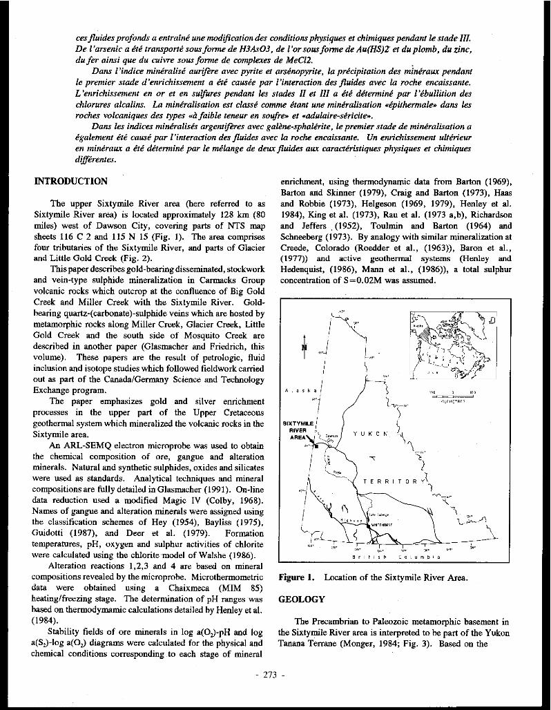
ces fluides profonds a entralne unemodification des conditions physiques et chimiques pendant le stade Ill. De ['arsenic a ete transporte sousforme de H3As03, de l'orsousforme de Au(HS)Z et du plomb, du zinc, du fer ainsi que du cuivre sous forme de complexes de MeCl2. .
Dans l'indice mineralise aurifere avec pyrite et arsenopyrite, la precipitation des miniraux pendant le premier stade d'enrichissement a ere causee par /'interaction des jluides avec la rache encaissante. L 'enrichissement en or et en sulfures pendant les stades II et Ill a ere determine par I' ebullition des chlorures alcalins. La mineralisation est classe comme itant une mineralisation "ipithermale» dans les roches volcaniques des types «il faible teneur en soufre» et «adulaire-siricite».
Dans les indices miniralisis argentiferes avec galene-sphalirite, le premier stade de mineralisation a igalement ere cause par ['interaction des fluides avec la roche encaissante. Un enrichissement ulterieur en mintiraux a ete determine par le melange de deux jluides aux caracteristiques physiques et chimiques differentes.
INTRODUCTION
The upper Sixtymile River area (here referred to as Sixtymile River area) is located approximately 128 km (80 miles) west of Dawson City, covering parts of NTS map sheets 116 C 2 and 115 N 15 (Fig. 1). The area comprises four tributaries of the Sixtymile River, and parts of Glacier and Little Gold Creek (Fig. 2).
This paper describes gold-bearing disseminated, stockwork and vein-type sulphide mineraliz.ation in Carmacks Group volcanic rocks which outcrop at the confluence of Big Gold Creek and Miller Creek with the Sixtymile River. Goldbearing quartz-(carbonate)-sulphide veins which are hosted by metamorphic rocks along Miller Creek, Glacier Creek, Little Gold Creek and the south side of Mosquito Creek are described in another paper (Glasmacher and Friedrich, this volume). These papers are the result of petrologic, fluid inclusion and isotope studies which followed fieldwork carried out as part of the Canada/Germany Science and Technology Exchange program.
The paper emphasizes gold and silver enrichment processes in the upper part of the Upper Cretaceous geothermal system which mineralized the volcanic rocks in the Sixtymile area.
An ARL-SEMQ electron microprobe was used to obtain the chemical composition of ore, gangue and alteration minerals. Natural and synthetic sulphides, oxides and silicates were used as standards. Analytical techniques and mineral compositions are fully detailed in Glasmacher (1991). On-line data reduction used a modified Magic IV (Colby, 1968). Names of gangue and alteration minerals were assigned using the classification schemes of Hey (1954), Bayliss (1975), Guidotti (1987), and Deer et al. (1979). Formation temperatures, pH, oxygen and sulphur activities of chlorite were calculated using the chlorite model of Walshe (1986).
Alteration reactions 1,2,3 and 4 are based on mineral compositions revealed by the microprobe. Microthermometric data were obtained using a Chaixmeca (MIM 85) heating/freezing stage. The determination of pH ranges was based on thermodymamic calculations detailed by Henley et al. (1984).
Stability fields of ore minerals in log a(O,)-pH and log a(S,)-Jog a(O,) diagrams were calculated for the physical and chemical conditions corresponding to each stage of mineral
- 273
enrichment, using thermodynamic data from Barton (1969), Barton and Skinner (1979), Craig and Barton (1973), Haas and Robbie (1973), Helgeson (1969, 1979), Henley et al. 1984), King et al. (1973), Rau et al. (1973 a,b), Richardson and Jeffers , (1952), Toulmin and Barton (1964) and Schneeberg (1973). By analogy with similar mineralization at Creede, Colorado (Roedder et al., (1963)), Baron et al., (1977)) and active geothermal systems (Henley and Hedenquist, (1986), Mann et al., (1986)), a total sulphur concentration of S=0.02M was assumed.
!~ ~ ..J L ..
I I I
Alaska I
--1
\ ( .,,._,,,
I ;, ~
,,._/ •, '•
I 1._...,
, ... !...,_
)
YUKON\ '\_"
'! T E R R I T 0 R Y~
KILOMOlRES
")
Figure 1. Location of the Sixtymile River Area.
GEOLOGY
The Precambrian to Paleozoic metamorphic basement in the Sixtymile River area is interpreted to be part of the Yukon Tanana Terrane (Monger, 1984; Fig. 3). Based on the
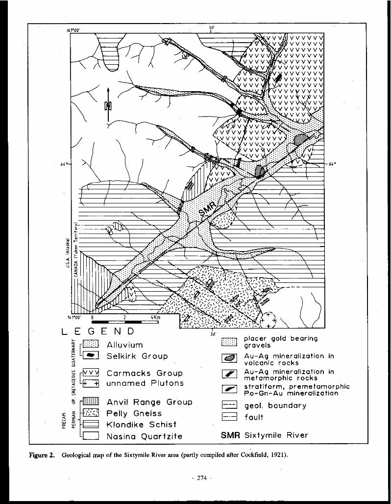
141°00'
141°00' 0 2 4Km ---====i---====:.
L E G E N D
~[~ "" ~ d
Alluvium Selkirk Group
Carmacks Group unnamed Plutons
Anvil Range Group
Pelly Gneiss
Klondike Schist
Nasina Quartzite
50'
50'
', . . ·.:;.
D
~ [ZJ
1,-1
El El
placer gold bearing gravels
64 °
Au-Ag mineralization in volcanic rocks Au-Ag mineralization in metamorphic rocks stratiform, premetamorphic Po-Gn-Au mineralization
geol. boundary
fault
SMR Sixtymile River
Figure 2. Geological map of the Sixtymile River area (partly compiled after Cockfield, 1921).
- 274 -
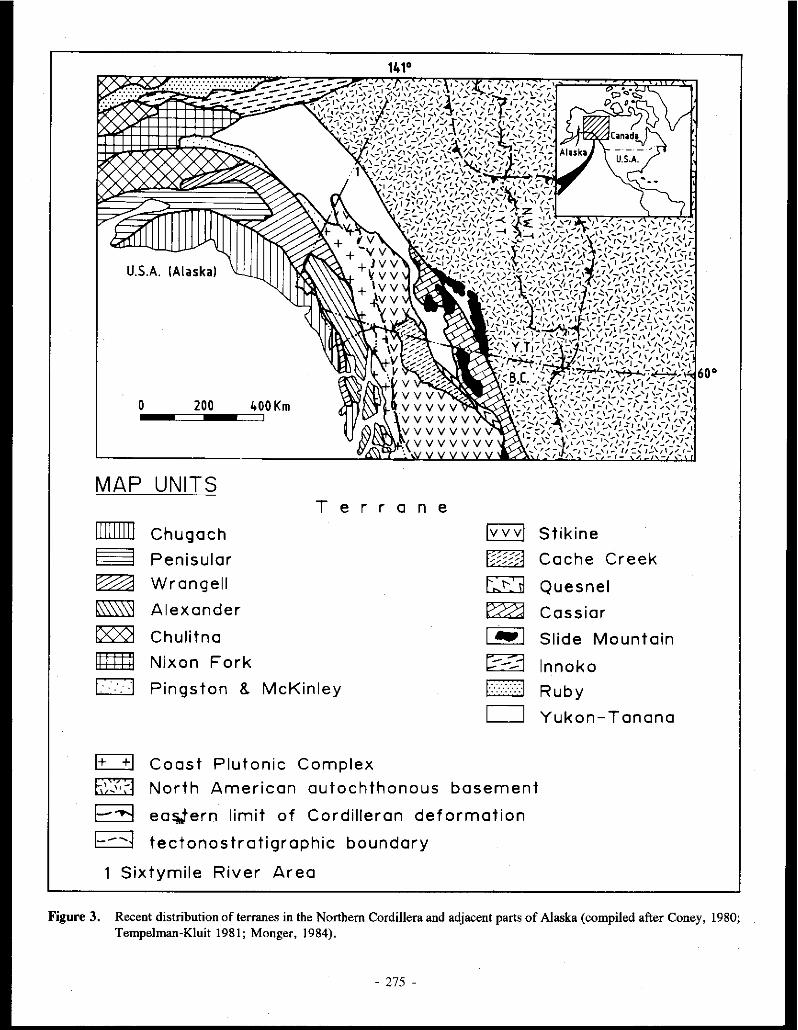
MAP UNITS
ITIIIIIlJ ~ ~ ~ ~ ~ c::J .
E::::±l b(<. ;-1
~ 1--'i
T e r r a n e
Chugach lvvvl Penisular t~§33fA Wrangell E:O Alexander ~ Chulitna 1-1 Nixon Fork r:--::i Pings ton 8. McKinley E2J .
c:J
Coast Plutonic Complex
North American autochthonous basement
ea~ern limit of Cordilleran deformation
tectonostratigraphic boundary
Sixtymile River Area
Stikine
Cache Creek
Quesnel
Cassiar
Slide Mountain
lnnoko
Ruby
Yukon-Tanana
Figure 3. Recent distribution of terranes in the Northern Cordillera and adjacent parts of Alaska (compiled after Coney, 1980; Tempelman-Kluit 1981; Monger, 1984).
- 275 -

0 ' ' ' Cu Mo w Sn
TERTIARY p • I
=---= • • • 63- l...C:..---------- -L- --J:; _I! - --
-e I
... "-= I ,.. • CRETACEOUS •
s - .. -138-. ---------- . - - - - - -- --
JURASSIC ~ • • 205 -= ib---------- - - - - -- - - -- --
TRIASSIC
240- ------------ - - - - - - I- - - - ---PERMIAN -i>
290- ----------- - -- - - - - - - - - -
PENNSYLVANIAN .
330- ------------ - - - -- - - - - - -MISSISSIPPIAN .• • • 360- ------------ -- - - - - - - - - - --
• • DEVONIAN . -
410- ------------ - - - - - - - - - ~ --$ 1'o 1
1s n
Figure 4. Radiometric ages of granitoid rocks in the Northern Cordillera and adjacent parts of Alaska. Shaded areas represent the ages of intrusions with associated mineral deposits; unshaded areas are ages of intrusions unrelated to any known deposits. The ages of Cu, Mo, W and Sn mineralization are inferred from the ages of associated intrusions (after Sinclair, 1986).
tectonic features of the metamorphic basement south ofTintina Fault, Tempelman-Kluit (1974; 1976; 1979) assigned part of Yukon Tanana Terrane and Stikine Terrane to 'Yukon Cataclastic Complex'. During Upper Cretaceous and Lower Tertiary, the crustal evolution of the Stikine and Yukon Tanana Terranes was influenced. by subduction processes further to the southwest (Monger et al., 1972; Monger et al., 1982). Tholeiitic calcalkaline and shoshonitic magmas were generated above a northeast-dipping subduction wne, (Armstrong, 1988). High local heat flow caused by these magmatic activities initiated the development of hydrothermal systems.
Today, the gold sulphide enrichment in these fossil geothermal systems occurs in mesothermal-type gold bearing
quartz-( carbonate )-sulphide veins hosted by metamorphic rocks and gold-bearing skaros (Meinert, 1986) or in gold bearing epithermal-type mineral occurrences hosted by volcanic rocks (Morin and Stroshein, 1987; Sinclair, 1986; Fig. 4). Regionally, most Yukon gold occurrences appear to be located in areas which are underlain by allochthonous terranes (Morin and Downing, 1984).
Due to tectonic and lithostratigraphic differences, the Sixtymile River area has been divided into a northern and a southern part. The boundary is represented by the Sixtymile River fault woe, which strikes east-northeast.
Lithologic units in the northern area comprise Precambrian to Paleozoic metamorphic rocks, Paleozoic ultramafic rocks, Middle Jurassic pegmatitic and aplitic dykes, Upper Cretaceous porphyritic dykes and volcanic rocks with intercalated sedimentary rocks, Quarternary alkaline basaltic dykes and Quarternary alluvial sediments (Glasmacher and Friedrich, 1985, Hughes and Morison, 1986; Fig. 2; Tab 1). Metasedimeotary rocks with minor metavolcanic layers are assigned to the Nasina Series, and metavolcanic rocks with minor metasedimeotary layers are assigned to the Klondike Schist. Biotite-amphibole orthogneiss of unknown age is discordant to the Nasina Series and Klondike Schist. Serpeotiniz.ed ultramafic rocks occur along thrust faults (Mortensen, personal communication) and are possibly linked to the Anvil Range Group .
Muscovite from one of the northeast-southwest trending pegmatitic to apl.itic dykes yielded a Ki Ar age of 180 Ma (Mortensen, 1988), the same age as rocks of the Klotassin Suite. Calcalkaline volcanic rocks of intermediate composition are intruded by a quartz-feldspar porphyry plug dated at 68 ± 0.3 Ma, (Mortensen, 1988), and are assigned to the Upper Cretaceous Carmacks Group. They are intercalated with sedimentary rocks. Northwest-southeast trending andesitic dykes are possible feeders to the Carmacks Group volcanics. Quaternary alkaline olivine basalts are the youngest igneous rocks in the area and are possibly Jinked to the Carmacks Group.
Metamorphic rocks in the southern area are similar to those in the northern area with the exception of the Pelly Gneiss (Late Devonian-Early Mississippian; Mortensen, 1988). This stratigraphic unit comprises mainly biotite augen gneisses with minor lenses of quartzite and garnet-mica schist. Magmatic rocks in the southern area include a calcalkaline, !type biotite graoodiorite intrusion and northeast-southwest trending andesite to dacite dykes. These dykes are possibly related to Cannacks Group volcanics in the northern area. Quaternary alluvial sediments occur in all valleys . .. MINERALIZATION
Gold and silver occur with disseminated, stockwork and vein-type sulphides in Carmacks Group volcanic rocks which outcrop at the mouths of Miller Creek (MINFILE Jl5N 041) and Big Gold Creek (MINFILE 116C 153) (Glasmacher (1984). The occurrences are structurally controlled and occur
- 276 -

at the junction of three major fault systems: the ENE-WSW trending Sixtymile River fault zone, a NW-SE trending fault zone and a NE-SW trending fault zone.
Between these two main occurrences, small northeastsouthwest trending quartz-( carbonate )-sulphide veinlets crosscut the volcanic rocks in the Sixtymile River valley. These veinlets show alteration patterns and mineral paragenesis similar to the major occurrences.
Recent placer mining activities have covered up outcrops which were uncovered during 1983, 1985 and 1986, leaving only one occurrence exposed. This is located on Granges' placer claims at the mouth of Miller Creek, and has been described in detail.
Two types of mineralization have been identified, based on differences in distribution, petrology and wall rock alteration: a gold-bearing pyrite-arsenopyrite occurrence and a silver-bearing galena-sphalerite occurrence.
Gold-bearing pyrite-arsenopyrite pccurrence (MINFILE l16C 153)
Petrology and Mineral Composition Based on the different textures and intergrowth
relationships between the various minerals, the paragenetic sequence was divided into four mineralizing stages.
Stage I is represented by quartz, and pyrite with gold inclusions (Table 2). Stage II is characterized by quartz, and pyrite with inclusions of other minerals including galena with matildite exsolutions, sphalerite, chalcopyrite, molybdenite, arsenopyrite and minor amounts of gold and quartz. Quartz, arsenopyrite and pyrite containing gold and arsenopyrite inclusions precipitated during Stage III. Banded chalcedony and pyrite represent Stage IV.
Pyrite deposited in Stages I, II and III contained no gold above detection limit. Cobalt ( <0.08 wt-%) and nickel (<0.06 wt-%) content is similar in all three stages. Stage Ill pyrite contains up to 9.38 wt-% arsenic. Arsenic values higher than 1 wt-% are inferred to be due to submicroscopic inclusions of arsenopyrite. Arsenopyrite inclusions in Pyrite III contained an average arsenic content of 28.03 at.-%. The trace element content (<0.12 wt-% Co; <0.06 wt-% Ni; <0.03 wt-% Sb) are generally low.
High silver ( < 9.49 wt-%) and bismuth values ( < 9.09 wt%) in Pyrite II galena inclusions are due to matildite exsolutions. Only a few of these inclusions contain antimony, which occurs in amounts less than 0.07 wt-%.
Sphalerite inclusions in pyrite are characterized by low iron (5.31-6.89 mol.-% FeS), manganese (<0.49 wt-%), cadmium ( <0.57 wt-%), and copper (<0.22 wt-%).
Gold deposited during Stage II contains a low silver content (4.8 wt-%) compared to gold deposited during Stage I (24.61 wt-% Ag) and Stage III (19.84 wt-% Ag). Except for bismuth (0.18 wt-%) and tellurium (0.11 wt-%), trace elements in gold are below detection limit.
Figure 5.
D ou.,t. ' -Quartl II
[[] Quut. Ill
IIllll Fald•pu
Histogram showing the frequency distribution of homogenization temperatures of fluid inclusions in quartz from the volcanic-hosted, disseminated, stockwork and vein-type gold-bearing pyritearsenopyrite occurrence.
Wall rock alteration and mineral composition Three zones of hydrothermal alteration are recognized:
Zone I (propylitic), Zone II (quartz-carbonate-kaolinite), and Zone Ill ( quartz-phengite).
In general the Mn content of all alteration minerals in these alteration zones increases from low in Stage I to high in Stage III.
In the propylitic zone (Table 3), amphibole and pyroxene are replaced by chlorite (Fe-clinochlore/ripidolite or pycnochlorite) and minor epidote, and plagioclase is replaced by minor sericite, epidote and K-feldspar. Pyrite occurs along small fractures and is intergrown with chlorite.
Alteration zone II is characterized by quartz, kaolinite, ankerite and disseminated pyrite. Stockwork veinlets of chalcedony and l'Yrite up to 1 cm wide are typical of this zone.
Alteration zone III is characterized by quartz, phengite and pyrite, with minor ankerite, dolomite and calcite.
The transition between zones II and III is frequently brecciated and healed by quartz, chalcedony and pyrite. Zone III ankerite is enriched in manganese, and depleted in iron and magnesium compared to Zone II.
Geochemical surveys reveal a consistent increase in average gold content from 40 ppb Au in zone I, through 57 ppb in zone II to 252 ppb in zone III. The highest gold values (up to 12 ppm) occur in quartz-sulphide samples.
Whereas ankerite of zone II is characterized by lower manganese and higher iron and magnesium content, ankerite of zone Ill contains higher manganese and lower iron and magnesium.
The transition from plagioclase and chlorite (zone I) to kaolinite, ankerite, quartz and pyrite (zone II) can be described by reaction I:
- 277 -

l6((C1to.sN&o.J(Al1.sSi2.~01:)) + 2(Mg2_,Fe1 .,~.2Fe0.,Si:.9010(0H).) + 18CO:z + 2.8H,S + 13.611, + 7.30, + SH. ~ !4.2(Al,Si,O,(OH)J + 8(Ca(Mg._,Fe,.J(CO,),) + 17.4Si0, + !.4FeS, + 8Na•
The change from kaolinite-ankerite-quartz-pyrite (zcne II) to phengite-ankerite-<lolomite-calciteis represented by reaction 2:
9.l(Al,S~O,(OH)J + 8(Ca(Mg0.,F<o.JCO,),) + 3.5Si0, + 0.9Mnq + 5.6 KCl + 0.811:zS = 7CKo.sA11.1Fe0. 1 Alo.9010(0H)~ + Ca(M&o.1Feo.,Mn.:..1)(COJ2 + 4Ca(Mg.,Fe0.,Mn,,)(CO,), + 3CaCO, + 0.4FeS, + 7.4H, + 3.50, + 3C02 + 7.4H .. + 7.4Cl"
Microthermometry Stage I quartz is fractured, healed and surrounded by
Stage II quartz. Primary inclusions in Stage I quartz indicate a homogenization temperature of !35°C and a salinity of 2 wt% NaCl equivalent (Fig. 5). Primary inclusions in Stage II quartz and secondary inclusions in Stage I quartz are characterized by a homogenization temperature of 295°C and up to six daughter crystals including sphalerite, hematite and halite. Stage JIJ quartz crystals surround and are intergrown with Stage II. quartz, and yield homogenization temperatures of 200°C and salinities of 2.5 wt-% NaCl equivalent. Stage II and Stage III inclusions in quartz exhibit features characteristic of boiling. Three phase inclusions (gas, liquid and solid) on microfractures which crosscut Stage I, II and III quartz homogenize at 200°C and yield a salinity of 2.5 wt-% NaCl equivalent. These fluids might represent the Stage IV fluids associated with the deposition of chalcedony. Secondary inclusions in feldspar from alteration zone I lie along microfractures showing two distinct orientations. Inclusions from one set microfractures homogenize at a temperature of 200°C, and inclusions from the other set yield a homogenization temperature of 250° and a salinity of 3.4 wt% NaCl.
Physical and chemical conditions Matildite exsolutions in Stage II galena indicate a
formation temperature above 215 ± !5°C (Craig, 1967). If the Stage II and Stage III fluids were entrapped under boiling conditions, the homogenization temperatures of both stages were higher than the fonnation temperature. Without pressure data, the formation temperatures of Stage I and IV minerals cannot be determined from fluid inclusions, but the homogenization temperatures give minimum values. The formation temperatures obtained from chlorite in alteration zcne I are 260 and !80°C. Secondary fluid inclusions in feldspar in alteration zone I yielded homogenization temperatures of 250 and 200°C.
The mineral assemblage ankerite-dolomite-calcite which occurs in alteration zone III has been found in active hydrothermal systems at temperatures above !95°C (McDowell and Paces, 1985). Dolomite together with calcite is stable between !95°C and about 280°C. Phengite first occurs as an alteration mineral at about 280°C (McDowell and Elders, 1980; Scrodon and Eberl, 1987).
Assuming that the kaolinite and quartz of Stage I were transformed during stages II, III and IV into phengite and quartz via the potassium-muscovite-quartz and muscovitekaolinite reactions, fonnation temperature and molarity were used to calculate the pH range. The temperatures used were J50°C for Stage I, 280°C for stage II, 260°C for stage II and 200°c for stage IV.
The calculated pH ranges are:
pyrite-arsenopyrite-quartz veinlets stage I pH150.c ~ 4.6 stage IV 4.2<pH200.c<6.0
alteration zcne I feldspar 4.2<pH250.c<5.7 chlori le pH26Cl'c = 5. 7 chlorite pH,.,.c = 6.4
neutral pH,50.c = 5.8 neutral pH,...c = 5. 7
neutral pH250.c = 5.6 neutral pH26Cl'C = 5.6 neutral pH11111.c = 5. 7
The mineral paragenesis indicates a range of oxygen activity between log a(O,) < -43 and log a(O,) > -54, and a range of sulphur activity between log a(S,) = -7 and log a(S,) = -20 during Stage I mineral enrichment (Figs 6A,B). Based on the presence of early pyrrhotite inclusions in pyrite, followed by crystallization of sphalerite inclusions (6 mol.-% FeS), Stage II is characterized by increasing oxygen activity (from log a(O,) = -35 to log a(O,) = -33) and sulphur activity (from log a(S,) = -12 to log a(S,) = -IO)(Figs 6C,D). The mineral paragenesis of stage III indicates oxygen activity of about log a(O,) = -30. Arsenopyrite inclusions in stage III pyrite formed at a sulphur activity of about log a(S2) = -12 (Figs 6E,F). The alteration assemblage suggests that stage IV pyrite formed under conditions of oxygen activity varying °from log a(O,) <-34 to log a(O,) >-45 and sulphur activity from log a(S,) < -6 to log a(S,) > -16 (Figs 6G,H).
Chlorites of alteration zcne I formed at 260°C, an oxygen activity of log a(O,) = -35 and a sulphur activity of log a(S,) ~ -11, and also at !80°C, log a(O,) ~ -45 and log a(S2) ~ -
17.
ArgentiferolJ!l galena-sphalerite occurrence (MINFILE lISN 041)
Petrology and mineral composition The first stage of mineralization consists of low-Fe
sphalerite, galena with matildite exsolutions and quartz (Table 4). The second stage consists of high Fe sphalerite, pyrite, pyrrhotite, arsenopyrite, chalcopyrite, galena with matildite exsolutions and siderite. The third stage is represented by sphalerite with intermediate iron content, pyrite, marcasite, chalcopyrite, galena, siderite, ankerite, dolomite and calcite. Silver enrichment occurred during the fourth stage. The main silver minerals are tetrahedrite, polybasite, pearcite and pyrostilpnite. . Other stage IV minerals include low Fe sphalerite, pyrite, chalcedony, ankerite, dolomite and calcite.
Major and trace element distribution is similar in pyrite from all four stages, with low levels of cobalt (less than 0.06 wt-%) and nickel (less than 0.03 wt-%).
278 -

A ~
Q
"' -"
c~
E
"' "
~ Q
"' -"
~
_,.
-42
-50
-JO
_,.
-J2
-JS
Hso;
Po
6 pH
Hem
B
\'f : --.... -._o
:HS
10 12
"" "' Py
2 .... ;~;;;;;;;;;;;~;~;--,r;!O::i:"".-----1 ......................................... '!'
H1S~I ~ \~--40~-~-~--~-~~~~~
0 2 4 6 8 10 12 pH
Hso; so:- 2ooq:
-J4 Hem
"'' Py '"
G ~ -42 2
Py B
-·-·-···-······-----.:~.~;;
-22
Hom
-45 -43 -41
- 8 280 c
Py
-10
!!! Q 0
"' " -12
Po
/Mag -14~~~~~~ ...... .,..~~_uu._~_.__J
Hom
-# -42 -40 -38 -36 -34 -J2 -30 -28 log a(0 1 )
- 8 260 c
-10 Py
" "' 0 F "' ·--~ ... -"
-12 ...
Po Hom -14~~~~~~'--"~~~'"-'~~~_.__J
-44 -42 -40 -38 -36 -34 -J2 -30 -28 log a(01 )
' -14 Py
.,· C-16 "' H -"
-1B
-40 -38 -36
Figure 6. Log a(O,) - pH and log a(S,) - log a(O,) diagrams of the mineralization stages in the volcanic-hosted, disseminated, stockwork and vein-type gold-bearing pyrite-arsenopyrite occurrence (/// = field of enrichment); arrows show direction of increasing physico-chemical conditions; mineral abbreviations after Kretz (1983).
- 279 -

The only exception is stage II pyrite which contains up to 0.96 wt-% arsenic.
The arsenic content of arsenopyrite ranges from40.42 and 46.31 wt-%, but close to the growth interface between pyrite and arsenopyrite crystals the arsenic content bas a more limited range of 40 to 41 wt-%, possibly as a result of equilibrium crystallization of the two minerals.
The high silver ( < 1.13 wt-%) and bismuth ( < 2.43 wt%) contents of stage II galena are caused by matildite exsolutions. Stage III galena is characterii.ed by low silver ( <0.64 wt-%), low bismuth ( < 10.8 wt-%) and low antimony ( <0.34 wt-%).
The iron content of sphalerite increases from stage I (0.12-0.39 mo!.-% FeS) to stage II (3.99-11.53 mo!-% FeS) and decreases in Stage III (6 mo!.-% FeS). The transition between stage I sphalerite (core) and stage II sphalerite (rim) in zoned crystals is marked by a small band of sphalerite II with pyrite inclusions. The trend of decreasing iron content, although interrupted by minor retrograde cycles of iron enrichment, continued throughout stage IV, culminating in nearly iron-free sphalerite containing only 0.2 mol.-% FeS.
Wall rock alteration and mineral composition Three alteration zones resulted from the hydrothermal
activity: propylitic (zone I), quartz-carbonate-kaolinite (zone II), and quartz-phengite-adularia (zone III).
In general, the manganese content of all alteration minerals in these zones increases from low in zone I to high in zone III.
In the propylitic zone (!), amphibole and pyroxene are replaced by chlorite (Fe clinochlorite/ripidolite or pycnochlorite) and epidote, and plagioclase is replaced by epidote and calcite (Table 5). Pyrite is intergrowo with chlorite and epidote along small fractures. In zone II, quartz, kaolinite, carbonate minerals and pyrite replace chlorite, epidote and sericite. The carbonate minerals are manganesebearing siderite, ferromagnesite, dolomite, ankerite and calcite. Small fissures of chalcedony, chalcedony-pyrite and quartz-carbonate-sulphides exhibit a stockwork-type distribution pattern. In zone III, adularia and sericite are the main potassium minerals. They are intergrown with quartz, manganese-bearing siderite, ankerite, ferromagnesite, dolomite and calcite.
Epidote in zone I contains 10.04-14.32 wt-% FeO, and 0.24-1.7 wt-% MnO.
Whereas the calcium content of siderite decreases from zone I toward the quartz-carbonate-sulphide veinlets, the manganese content increases. Like calcium, the magnesium content decreases from zone I to zone III, but is significantly higher in siderite gangue of the quartz-carbonate-sulphide veinlets.
Adularia in alteration zone III is characterii.ed by a low albite content (3.7-7 .0 % Ab) and a low barium content (0.17-1.33 wt-% BaO).
The change from the zone I alteration assemblage plagioclase, chlorite, epidote, ankerite, siderite, ferromagnesite and calcite to the zone II assemblage kaolinite, ankerite,
siderite, ferromagnesite, dolomite, calcite and quartz can be described by reaction 3:
4((C&o.sN&o . .s)A1a.1Si2.50 1) + 2(Mg2.sFe1_,A12.3Fe0 .,Si2.90 10(0H),) + 2(Co,(AI,,FeJ, . .J(SiO,)(Si,O,)O(OH)) + 4(CaMg.,,Fe,.,)(CO,), + (Feo .• M0o.1C&o.1)C03 + (Feo_µ&,_,c1o.1)CO, + Caco, + 3.8H2 + 1.7501 + 16.4CO, + I.2H,S +2W = 7.5(Al,S~O,(OH).) + 4(Ca..,Mg.,,Fe,,)CO,),) + (Fe,.,Mn,,c ... ,)CO, + ll(Fe,.,Mg., . .Ca. .• )Co,) + CaMg(CO,), + 5.4CaC03 + 6.8Si0i + 0.6Fe5,; + 2Na+
The change from the zone II alteration assemblage kaoliniteankerite-siderite-ferromagnesite-dolomite-calcite-<juartz to the zone III alteration assemblage phengite-adularia-ankeritesiderite-ferromagnesite-dolomite-calcite-pyrite can be represented by reaction 4:
7(Al,S~O,(Oll)J + 4(Ca..,Mg.,,Fe0 .,)(CO,), + 20(Fe,.,Mn,,Ca.,)C0, + 5(Fe0 . .Jdg0. [email protected] +CaMg(CO:s)2 + CaC03 + 6.5Si02 + 5.5KCI + 18.6 H2 S 5(Ko_ 1Ali. 7 Fe0 . 2Si 3 .2 Al0 .,0ao(OH)i) + I .5(KAISi30 1)
+2(Ca..,Mg,.,Fe, . .J(CO,),) + IO(Fe,.,Mn,.JCO, + 2.5((Mg.,,Fe,.,Ca.,)CO,) + CaMg(COJ2 + 3CaC03 + 9.3FeS2 + 15.8"2 +7.902 + 11.SCD: + s .sw + s .sci-
Microthermometry Primary fluid inclusions were studied in sphalerite,
siderite and quartz, and the same sphalerite and siderite crystals were analysed by microprobe. Secondary fluid inclusions occur along microfractures in euhedral quartz which is surrounded by chalcedony. All fluid inclusions consist of two phases at room temperature.
Primary fluid inclusions in stage I (low Fe) sphalerite show a homogenization temperature of 165°C (Figs 7,8). The increased iron in stage II sphalerite is accompanied by increased homogenization temperatures up to 220 ° C and salinity up to 8.6 wt-% NaCl equivalent. The general decrease in iron in stage III and stage IV sphalerite is interrupted by retrograde zones of increasing iron content. These fluctuations correspond to inclusions which have a narrow range of homogenization temperatures close to 185°C.
Primary fluid inclusions in stage II siderite are characterii.ed by a homogenization temperature of 225 ° C and a salinity of 8.6 wt-% NaCl equivalent.
Primary fluid inclusions in idomorphic quartz homogenize at 275°C. Homogenization temperatures of secondary fluid inclusions in this quartz range from 170°C to 240°C.
Physical and chemical conditions Matildite exsolutions in galena indicate a formation
temperature above 215 ± 15°C. Stage! sphalerite formed at a minimum temperature of !65°C, stage II sphalerite formed at 2!5°C and stage III and IV sphalerite formed at 185°C. Stage II siderite indicates a homogenization temperature of 225°C. Due to the unknown pressure conditions during stages I and IV, the homogenization temperatures for stage I and IV minerals are lower than the formation temperatures.
In alteration zone I, chlorite formed at 260°C and 230°C. Phengite first appears as an alteration mineral in active hydrothermal systems at temperatures above 280°C
- 280 -

c:J Quarlzlp.I
"
0 , .. ••• 300 T11t•t)
Figure 7. Histogram showing the frequency distribution of homogenization temperatures of fluid inclusions in quartz of the volcanic-hosted, disseminated, stockwork and vein-type silver-bearing galenasphalerite occurrence.
'• rcJ
••• j I , •• L_ ___________________ _ . -
Figure 8. Distribution of iron content in sphalerite relative to homogenization temperature of fluid inclusions in the same sphalerite. (Volcanic-hosted, disseminated, stockwork and vein-type silverbearing galena-sphalerite occurrence).
(McDowell and Elders, 1980; Scrodon and Eberl 1987). Based on the information above, temperatures of 170°C
for stage I, 230°C for stage II, and 190°C for stages III and IV were used to calculate pH, log a(O,) and log a(S,) for each of the mineral enrichment stages.
The pH range was calculated using the potassiummuscovite-quartz and muscovite-kaolinite reactions, as well as the formation temperature and molarity and alteration mineral paragenesis:
(galena-sphalerite-silver-carbonate-quartz veinlets)
stage II alt. zone I
pH,,..c = 5.5 pH230.c = 5.8
neutral pH2J1>•c = 5. 6 · neutral pH230.c = 5.6
Assuming that the iron concentration of the hydrothermal fluid was constant during stages II, III and IV, the change in iron content of sphalerite ( 4 mol-% to 12 mol-% to 0.2 mol-% FeS) indicates a decrease of oxygen and sulphur activity during stage II (Figs 9A,B) and an increase of oxygen and sulphur activity , during stages III and IV (Figs 9C,D), summarized below:
stage Fe content oxygen activity sulphur activity mol.-% FeS log a(O,) log a(S,)
II 4-12 -39 to -40 -13 to -14 III 6 -46 -15 IV 6 to 0.2 -46 to -43 -15 to -12
Some of the chlorite formed in alteration zone I formed at a temperature of 260°C, an oxygen activity of log a(O,) =
-37 and a sulphur activity of log a(S2) = -13; the remainder formed under condition• of T = 230°C, log a(O,) = -40 and log a(S,) = -14.
MINERAL ENRICHMENT PROCESS
The differences in mineral paragenesis, petrology and wall rock alteration between the gold-bearing pyrite-arsenopyrite and the silver-bearing galena-sphalerite occurrence reflect different enrichment processes. The physical and chemical conditions accompanying the formation of the gold-pyritearsenopyrite occurrence were influenced by boiling, whereas the silver-bearing galena-sphalerite occurrence is attributed to mixing of fluids with different physical and chemical characteristics.
Seward (1976), Henley et al. (1984), Seward (1984) and Henley and Brown (1985) described the transport of iron, lead, zinc, copper and silver in active hydrothermal systems as metal-chloride complex reaction 5:
MeCl2 ° + H2S0 = MeS + 2H+ + zc1·
In active hydrothermal systems with similar physicochemical conditions, gold is transported as a gold-thio complex (Au(HS);) up to about 300°C (Seward, 1973, 1982; Henley et al. 1984; Henley and Brown 1985)(reaction 6):
2Au(HS); + 2H+ + H,O = 2Au0 + 4H,S 0 + a.so,
Under the physical and chemical conditions of most active hydrothermal systems, arsenic is transported as the H3As03
complex (Heinrich and Eadington, 1986; Ballantyne and Moore 1988)(reaction 7):
2H,As0,°+6FeCl2 + 9H2S0 = 2FeAsS + 3 FeS2 + FeS
+ 12 Cl' + 6H2 + 302 + l2H+
- 281 -

~ a
"' _51
6'
-28 Hso; so:- 230~
-32 Hom
""• -36 J Py
en
2
-40 ... 1
Po H,S ii I I i!2 \ HS-
-44 '---~--'-~-i=.-----'~---'-..._~_, 0 2 4 6 8 10 12
pH
A
-34 so:- 190~
-38 ""' en
J "rt -42 ...
"' _51
-46 111
11, s Po 5
- 8 230 c
-10 '
""N-12
"' c "' .51-14
-16
Po
Py
II
Hom ./Mag -18'--~-~-~-'-..L..'-'--"-"'-=-"-.L._...L.____J
-50 -46 -42 -38 -34 log o(O,)
B
-lO 190'C
-~· -12f--·-···~···iv~~~~~-.---~~-i.~-1
Py
-14 2 ························/
"'" __________ _lj_I___ ______________________________ _ C-16 ·t ·········· .................. .
5
Hom -50 0 2 4 6 8 10
F:: .~--~1i: 12 -22 '--~-~~~~~~-~_..~_.____,
-54 -50 -46 -42 log o(O,)
-38 pH
c D
Figure 9. Log a(O,) - pH and log a(S,) - log a(O,) diagrams for the different stages of mineralization at the silver-bearing galena-sphalerite occurrence. Legend as described in Fig. 6; I = sphalerite containing 4 mo!.-% FeS; II =
sphalerite containing 12 mo!.-% FeS; III= sphalerite containing6 mo!-% FeS; IV= sphalerite containing 0.2 mol% FeS. Mineral abbreviations after Kretz_ (1983).
Gold-bearing pyrite-arsenopyrite occurrence (MINFILE 116C 153)
Wall rock alteration (reaction 1), along with salinity and fluid inclusion homogeniz.ation temperatures indicate a low temperature (about 150°C) low-salinity (2 wt-% NaCl equivalent) low-pH (4.6) stage I fluid. By analogy with the fluid chemistry in active hydrothermal systems the fluid of Stage I might represent a hybrid fluid generated by the mixing of steam (H2S, C02 etc) and groundwater. The steam could have separated during boiling of deeper alkaline chloride
fluids. Reaction I shows that fluid-wall rock interaction will increase the pH as well as decrease the sulphur and oxygen activity of the fluids. Reaction 5 shows that increasing the pH will cause the deposition of pyrite in qnartz-sulphide veinlets. Decreasing sulphur and oxygen activity will initiate the precipitation of gold by reaction 6.
The increase in temperature (280°C), salinity (indicated by salt crystals) and the change in wall rock alteration indicate high-temperature, high salinity, alkali-rich fluids caused the stage II mineralization. The fracturing and healing of sulphide and gangue minerals suggests that the deep alkaline chloride
- 282 -
fluids ascended fast, causing boiling to occur as a result of local pressure drops. Mineralization was concentrated during stages JI and lII due to the removal of H2S and C02 by boiling (reactions 5,6,7).
Fluids present during stages lII and IV are chemically similar to stage I fluids, suggesting a stronger influence of shallow groundwater. Declining temperature and salinity during these stages suggest that stage II corresponds to a single pulse of deep-seated alkaline chloride fluid.
An analogous situation in an active hydrothermal system OC<Ours at "Phlegrean Fields", Italy, where two contemporaneous fluids with different physical and chemical characteristics are isolated in separate stockwork systems. This is described by Belkin et al. (1986).
Silver-bearing galena-sphalerite occurrence (MINFILE HSN 041)
Based on the similarity of wallrock alteration at both showings, it seems that similar physical and chemical conditions might have prevailed during stage I mineralization at both the silver-bearing galena-sphalerite occurrence and the gold-bearing pyrite-arsenopyrite occurrence. However, at the galena-sphalerite showing, there is no evidence for boiling during the main stage II to stage IV mineralizing events, and the mineral precipitation may result from mixing deep-seated alkaline chloride fluid and shallow groundwater. Reaction 5 shows that mixing two contrasting fluids would decrease CI· activity and increase precipitation of metal sulphides.
Reaction 6 shows that if gold were transported as Au(HS)2", a decrease in sulphur activity would cause precipitation. Because no gold has been found (gold is below the 5 ppb detection limit), either the gold concentration in the hydrothermal fluid was very low and it stayed in solution, or the pH decrease resulting from fluid mixing (reactions 4 and 5) and the increased oxygen activity resulting from both fluid mixing and the wall rock alteration (reaction 4) counteracted the precipitation of gold. The change in iron content of sphalerite between stage III and stage JV happened at constant temperature and may have been caused by an increase in oxygen and sulphur activity.
A distinct event between stages I and II similar to that seen in the gold-pyrite-arsenopyrite enriched area was not observed at this showing, but appears to be possible based on the higher chlorite formation temperature, the difference in wall rock alteration, and the major change in ore mineralogy from stage I to stage II.
CONCLUSIONS
Both the gold-bearing pyrite arsenopyrite (MINFILE I I 6C 153) and the silver-bearing galena-sphalerite occurrence (MINFILE USN 041) are believed to have formed in the upper parts of the same fossil geothermal system, which appears to be close) y associated with Late Cretaceous magmatism.
The following conclusions are drawn about the fluid composition and inineral enrichment processes which formed the two showings:
(I) The near-surface fluids which circulated in the volcanic rocks during stage I had a low temperature (150°C), low salinity (about 2 wt-% NaCl equivalent) and a pH of about 4.6. They may be hybrid fluids generated by mixing steam and groundwater.
(2) The deep-seated fluids which caused a sudden change in physical and chemical conditions during stage II are characterized by high temperature (280°C), high salinity (salt crystals) and higher pH. These fluids are similar to alkaline chloride fluids of active geothermal systems.
(3) Arsenic was transported as H3As03 °·, gold as Au(HS),- and lead, zinc, copper and iron as MeCl2 ° complexes.
(4) The first stage of mineral enrichment was caused by fluid-wall rock interaction. The volcanic rocks were argillically altered and pyrite with gold inclusions and quartz were· deposited at the pyrite-arsenopyrite-gold occurrence, while low-iron sphalerite, galena with mati)dite exsolutions and quartz were deposited at the silver-bearing galena-sphalerite occurrence.
(5) Stage II and lII gold and sulphide enrichment at the pyrite-arsenopyrite-gold occurrence is believed to be due to the boiling of alkaline-chloride fluids.
(6) Stage II, III and JV silver enrichment at the galenasphalerite showing is believed to result from the mixing of two fluids with different physical and chemical characteristics.
Based on the wall rock alteration, mineral paragenesis and fluid chemistry, and the calculated physical and chemical characteristic& of the fluid, the showings can be classified as gold-bearing epitherrnal volcanic-hosted occurrences of the adularia-sericite type (Hayba et al., 1985, Heald et al., 1987), or the low-sulphur type of Bonham (1986). This kind of mineralization is typical of areas with calcalkaline volcanic rocks of andesitic to dacitic composition (Heald et al. 1987, Henley, 1985).
ACKNOWLEDGEMENTS
This research project was supported by the Deutsche Forschungsgemeinschaft (Grant FR 240/44). The study was also part of the Canada/Germany Science and Technology Exchange Agreement organized by the Geological Survey of Canada and the Federal Institute for Geosciences and Mineral Resources (BGR). Financial support was granted by the German Ministry of Research and Technology and by the Exploration and Geological Services Division of Indian and
283 -

Northern Affairs Canada, Whitehorse. We are particularly indebted to the mining companies for allowing access to their properties in the Sixtymile River area. We greatly appreciate discussions with J. Morin, J. Mortensen, G. Lynch, P. Moller, R. Walter, P. Siinger v. Oepen and L. Stroink.
REFERENCES
ARMSTRONG, R.L., 1988. Mesozoic and early Cenozoic magmatic evoiution of the Canadian Cordillera. Geological Society of America, Special Paper 218, p. 55-91.
BALLANTYNE, J.M., and MOOKE, J.N., 1988. Arsenic geochemistry in geothermal systems. Geochimica et Cosmochimica Acta, Vol. 52, p. 475-483.
BARTON Jr., P.B., I969. Thermochemical study of the system Fe-As-S. Geochimica et Cosmochimica Acta, Vol. 33, p. 841-857.
BARTON Jr., P.B., and SKINNER, J.B., I979. Sulphide mineral stabilities. Jn: Geochemistry of Hydrothermal Ore Deposits, H.L. Barnes, ed., 2nd Edition, Pennsylvania State University, p. 278-404.
BARWN Jr., P.B., BETHKE, P.M., and ROEDDER, E., 1977. Environment of ore deposition in the Creede Mining District, San Juan Mountains, Colorado: Part Ill. Progress toward interpretation of the chemistry of the ore:formingjluidfor the OH vein. Bulletin of the Society of Economic Geologists, Vol. 72, p. I-24.
BAYLISS, P., 1975. Nomenc/atureofthetrioctahedralchlorites. Canadian Mineralogist, Vol. I3,p.178-180. .
BELKIN, H.E., CHELINI, B. DE VIVO and LATTANZI, P., I986. Fluid inclusions in hydrothermal minerals from Mofete 2, Mofete 5 and San Vito 3 geothermal wells, Phlegrean Fields, Campania, Italy. International Volcanological Congress, Proceedings of Symposium 5.
BONHAM, H.F., Jr., I986. Models for volcanic-hosted epithermal precious metal deposits; a review. International Volcanological Congress, Proceedings of Symposium 5, p. 13-I 7.
COCKFIEW, W.E., I92I. Sixtymile and Ladue Rivers area, Yukon. Geological Survey of Canada, Memoir 123.
COLBY, J.W., I968. Advances inX-RayAnalyses, Vol. 11,p. 287-305.
CONEY, P.J., I982. Cordil/eran tectonics and plate motions. American Journal of Science, Vol. 272, p. 603-628.
CRAIG, J.R., I967. Phase relations and mineral assemblages in the Ag-Bi-Pb-S system. Mineralium Deposita, Vol. I, p. 278-306.
CRAIG, J.R., and BARTON, Jr., P.B., I973. Thermochemical approximations for sulfosalts. Economic Geology, Vol. 68, p. 493-506.
DEER, W.A., HOWIE,'R.A., and ZUSSMAN, J., 1977. An Introduction to the Rock Fonning Minerals. Longmans, 528 p.
GLASMACHER, U., 1984. Geologie, petrographie und mineralization im Gebiet des "Sixty Mile River", Yukon Territorium, Canada. RWTH Aachen, unveri!lf. Diplomarbeit, 205 p.
GLASMACHER, U., and FRIEDRICH, G., I985. Placer gold in the Sixtymile River Area, Yukon Territory, Canada. Proceedings of the Seventh Annual conference on Alaskan Placer Mining, Fairbanks, p. 53-57.
- 284 -

GLASMACHER, U., 1991. Petrogenetische und metallogenetische Entwicklung ausgewlihlter Gebiete im "Yukon-Tanana Terrane" und "Stikine Terrane •, (Yukon Territorium, Kanada) wilhrend der oberkreide und des Alltertiiirs. Diss., Aachen University of Technology, 435 p.
GLASMACHER, U., and Friedrich, G. 1992. Gold-sulphide enrichment process in mesothermal veins of the Sbrtymile River area, Yu/am Territory, Canada. Jn Yukon Geology, Volume 3, Exploration and Geological Services Division, Yukon, Indian and Northern Affairs Canada, this volume.
GUIDOTTI, C. V., 1987. Micas in metamorphic rocks. In: Micas, S. W. Bailey ed., Reviews in Mineralogy, Mineralogical Society of America, Vol. 13, p. 357-467.
HAAS, Jr., J.L., and ROBIE, R.A., 1973. Thermodynamic data for wilstite, Fe09470, magnetite, Fe30 4,
and hematite, Fe20 3 (abstract). Transactions of the American Geophysical Union, Vol. 54, p. 438.
HAYBA, D.O., BEmKE, P.M., HEALD, P., and FOLEY, N.K.; 1985. Geologic, mineralogic and geochemical characteristics of volcanic-hosted epithennal precious metal deposits. In: Geology and Geochemistry ofEpithermal Systems, Berger, B.R., and Bethke, P.M., eds, Reviews in Economic Geology, Vol. 2, p. 129-169.
HEALD, P., FOLEY, N.K., and HAYBA, D. 0., 1987. Comparalive anatomy of volcanic-hosted epithennal deposits: acid sulfate and adularia-sericite types. Economic Geology, Vol. 82, p. 1-26.
HEINRICH, C.A., and EADINGTON, P.J., 1986. Thermodynamic predictions of the hydrothermal chemistry of arsenic, and their significance for the paragenetic sequence of some cassiterite-arsenopyrite base metal deposits. Economic Geology, Vol. 81, p. 511-529.
HELGESON, H. C., 1969. Thermodynamics of hydrothermal systems al elevated temperatures and pressures. American Journal of Science, Vol. 267, p. 729-804.
HELGESON, H. C., 1979. Mass transfer among minerals and hydrothermal solutions. Jn: Geochemistry of Hydrothermal Ore Deposits, H.L. Barnes, ed., 2nd Edition, Pennsylvania Stale University, p. 568-610.
HENLEY, R. W., 1985. The geothermal framework for epithermal deposits. In: Geology and Geochemistry of Epithermal Systems, Berger, B.R., and Bethke, P.M., eds, Reviews in Economic Geology, Vol. 2, p. 129-169.
HENLEY, R. W., TRUESDELL, A.H., BARTON Jr., P.B. and WHITNEY, J.A., 1984. Fluid-mineral Equilibria in Hydrothermal Systems. Society of Economic Geologists, Vol. 1, 267 p.
HENLEY, R. W., and BROWN, K.L., 1985. A practical guide to the' thermodynamics of geothermal fluids and hydrothermal ore deposits. Jn: Geology and Geochemistry of Epithermal Systems, Berger, B.R., and Bethke, P.M., eds, Reviews in Economic Geology, Vol. 2, p. 129-169.
HENLEY, R. W., and HEDENQUJST, J. W., 1986. Introduction to the geochemistry of active and fossil geothermal systems. Ill: Guide to the Active Epithermal (Geothermal) Systems and Precious Metal Deposits of New Zealand. Monograph Series on Mineral Deposits, G. Friedrich (chief ed.), Vol. 26, p. 1-22.
HEY, M.H., 1954. A review of the chlorites. Mineralogical Magazine, Vol. XXX, No. 24.
HUGHES, R.L., and MORISON, S.R., 1986. Placer Gravels of Miller Creek, Sbrtymile River Area, 116 B,C. In: Yukon Geology, Volume 1, Exploration and Geological Services Division, Yukon, Indian and Northern Affairs Canada, p. 50-55.
KING, L. G., MAH, A.D., and PANKRA1Z, L.B., 1973. Thermodynamic properties of copper and its inorganic compounds. INCRA Monograph II on the Metallurgy of Copper, Internalional Copper Research Association.
KRE1Z, R., 1983. Symbols for rockforming minerals. American Mineralogist, Vol. 68, p. 277-279.
MANN, A. W., FARDY, J.J., and HEDENQUJST, J. W., 1986. Major and trace element concentralions in some New Zealand geothermal waters. International Volcanological Congress, Proceedings of Symposium 5, p. 61-80.
- 285 -

McDOWELL, S.D., and EWERS, W.A .. , 1980. Authigenic layer silicate minerals in borehole Elmore I, Salton Sea geothermal.field, California, U.S.A. Contributions to Mineralogy and Petrology, Vol. 74, p. 293-310.
McDOWELL, S.D., and PACES, J.B., 1985. Carbonate alteration minerals in the Salton Sea geothermal system, California, U.S.A. Mineralogical Magazine, Vol. 49, p. 469-479.
MEINERT, L.D., 1986. Gold in skarns of the Whitehorse Copper Belt. In: Yulwn Geology, Volume 1, Exploration and Geological Services Division, Yulwn, Indian and Northern Affairs Canada, p. 19-43.
MONGER, J. W.H., 1984. Cordilleran tectonics: a Canadian perspective. Bulletin of the Geological Society of France, Vol. 7, p. 255-278.
MONGER, J. W.H., SOUlliER, J. G., and GABRIELSE, H., 1972. Evolution of the Canadian Cordillera: a plate tectonic model. American Journal of Science, Vol. 272, p. 577-602.
MONGER, J. W.H., PRICE, R.A., and TEMPELMAN-KLUJT, D.J., 1982. Tectonic accretion and the origin of the two major metamorphic and plutonic belts in the Canadian Cordillera. Geology, Vol. 10, p. 70-75. MORIN, J.A. and DOWNING, D.A., 1984. Gold-silver deposits and occurrences in Yulwn Territory 1:2,000,000 scale map, list of occurrences. Exploration and Geological Services Division, Yukon, Indian and Northern Affairs Canada Open File 1984-2.
MORIN, J.A. and STROSHE!N, R., 1987. Disseminated precious metal exploration targets in Yulwn. Geological Society of Nevada Symposium: Bulk Mineable Precious Metal Deposits of the Western United States, Reno, Nevada.
MORIENSEN, J.K., 1988. Geology of southwestern Dawson Map Area, Yulwn. Geological Survey of Canada Open File 1927.
RAU, H., KUTIT, T.R.N. and GUEDES de CARVALHO, J.R.F., 1973a. High temperature saturated vapour pressure of sulfur and the estimation of its critical quantities. Journal of Chemical Themwdynamics, Vol. 5, p. 291-302.
RAU, H., KUTIT, T.R.N. and GUEDES de CARVALHO, J.R.F., 1973b. Thermodynamics of sulfur vapor. Journal of Chemical Thermodynamics, Vol. 5, p. 833-844.
ROEDDER, E.; RING/AM, B. and HALL, W.E., 1963. Studies of fluid inclusions lll: Extraction and quantitative analyses of inclusions in the milligram range. Economic Geology, Vol. 58, p. 353-374.
SCHNEEBERG, E.P., 1973. Sulfur fugacity measurements with the electrochemical cellAg,Agl,Ag2+.S/s. Economic Geology, Vol. 68, p. 507-517.
SEWARD, T.M., 1976. Stability of chloride complexes of silver in hydrothermal solutions up to 350°C. Geochimica et Cosmochimica Acta, Vol. 40, p. 1329-1341.
SEWARD, T.M., 1982. The transport and deposition of gold in hydrothermal systems. In: Gold '82: The Geology, Geochemistry and Genesis a/Gold Deposits, R.P. Foster (ed.); Geological Society of Zimbabwe, 1.
SEW ARD, T. M. , 1984. The formation of lead ll chloride complexes to 300 °C. Spectrophotometric study, Geochimica et Cosmochimica Acta, Vol. 48, p. 121-134.
SINCLAIR, W.D., I986. Molybdenum, tungsten and tin deposits and associated granitoid intrusions in the Northern Canadian Cordillera and adjacent parts of Alaska. In: J.A. Morin (ed.): Mineral deposits of Northern Cordillera; Canadian Institute of Mining and Metallurgy, Vo/, 37, p. 2I6-234.
SCRODEN, J., and EBERL, D.D., I987. Illite. In: Micas, S. W. Bailey (ed)., Reviews in Mineralogy, Mineralogical Society of America, Vol. 13, p. 357-467.
IEMPELMAN-Kl.U/T, D.J., I974. Reconnaissance geology of Aishihik Lake, Snag and part of Stewart River Map Areas, West-Cemral Yukon. Geological Survey of Canada, Paper 73-41.
- 286 -

TEMPELMAN-KLUIT, D.J., 1976. The Yukon Crystalline Terrane: Enigma in the Canadian Cordillera. Oeological Society of America Bulletin 87, p. 1343-1357.
TEMPELMAN-KLUIT, D.J., 1979. Transported cataclasite, ophioliteandgranodiorite in Yukon: Evidence of Arc-Continent Collision. Geological Survey of Canada, Paper 79-14.
TEMPELMAN-KLUIT, D.J., 1981. Geology and mineral deposits of southern Yukon. Jn: Yukon Exploration and Geology 1979-1980, Exploration and Geological Services Division, Indian and Northern Affairs Canada, p. 7-31.
TOULMIN, P. and BARTON, P.B., 1964. A thermodynamic study of pyrite and pyrrhotite. Geochimica et Cosmochimica Acta, Vol. 28, p. 641-671.
WALSHE, J.L., 1986. A six component chlorite solid solution model and the conditions of chlorite formation in hydrothermal and geothermal systems. Economic Geology, Vol. 81, p. 681-703.
Table 1. Lithostratigrapbic units of Sixtymile River area.
SYSTEM FORMATION LITHOWGY LITHOLOGY NW Area SE Area
QUATERNARY alluvial sediments alluvial sediments
Selk.irk: Group alkaline-olivine basalt
LATE Cannacks andesite, dacite, andesite and CRETACEOUS Group andesite-dacite dykes, dacite dykes
pyroclastic rocks, fluvial sediments
Unnamed plutons biotite granodiorite
MIDDLE JURASSIC Klotassin Suite pegmatite, aplite
PERMIAN ? orthogneiss
Anvil Range Gp ultramafic rocks
Pelly augen gneiss Gneiss gamet-rilica
schist, gneiss
Klondike chlorite schist, chlorite schist Schist mica schist mica schist
PRE-PERMIAN Nasina paragneiss, quartzite, quartzite, quartz-(DEVONO- Series quartz-mica schist, mica schist, MISSISSIPPIAN mica schist, graphite mica schist AND? OLDER) schist, marble
- 287 -

Table 2. Paragenetic sequence and physico-chemical conditions of volcanic hosted, disseminated, stockwork and vein-type gold bearing pyrite-arsenopyrite occurrences.
Pyrite (wt.- 0/o As)
Arsenopyrite (at.- 0/o As)
Gold (wt.- 0/o Ag)
Sphalerite (mol.- 0/o FeS)
Chalcopyrite
Pyrrhotite
Galena
Matildite
Molybdenite
0.uartz
Chalcedony
Temp. (C 0)
Salin. (wt.- 0/o NaCl equiv.)
log a(K•J
pH
log a(02 l
log a(S2)
Stage I
s::24 --
150
2
-2.1
4.6.
·c-43 => -54
<-7 = >-20
Stage II Stage Ill Stage IV
"'2
28.03 --"' 1 .. 20
.. 6
Ag-Bi
--
~
280 260 200
salt 2.5 crystals
-1.9
> 4.2 = -"6.0
-35 - -33 ... 37 <-34 =>-45
-12 - -10 o:-12 <-6 • >-16
- 288 -

Table 3. Mineral paragenesis and physico-<:bemical conditions of the sulphide veinlets and the alteration zones encasing the volcanic hosted, disseminated, stockwork and vein-type gold bearing pyrite-arsenopyrite occurrence.
Sphalerite lmol.- 0/o FeSJ
Pyrite lwt.- 0/o As)
Marcasite
Pyrrhotite
Arsenopyrite (wt.- 0/o As)
Chalcopyrite
Galena
Matildite
Tetrahedrite lwt.- 0/o Ag)
Polybasite
Pearceite
Pyrostilpnite
Q.uartz
Chalcedony
Siderite Ankerite Dolomite Calcite
Temp. !°CJ
Salin.(wt .- 0/o NaCl equiv.)
log a(K+l
pH
log ato2 J
log atS2 J
Stage I
0.2 4
170
..
Stage II Stage Ill Stage IV .
- 12 6 6 - 0.2
43.72
Ag-Bi Sb-Ag-Bi
17.4 7
u
230 190 190
8.6
-1.5
"'5.5
-39--40 -46 -43
-13 --14 -15 -12
- 289 -

Table 4. Paragenetic sequence and physico-chemical conditions of volcanic hosted, disseminated, stockwork and vein-type silver bearing galena-sphalerite occurrences.
Plagioclase
Amphibole
Pyroxene
Chlorite
Epidote
K feldspar
Kaolinite
sericite
Phengite
O.uartz
Ankerite
Dolomite
Calcite
Magnetite
Sulfides
Geothermometer
TemP..l'CI
Staqe I Staqe II Stoqe Ill Stoqe IV
Salin. !wt.-% NaCl eqYr!J.
Stoqe I Stoqe II Stoqe Ill Sta e IV
Stoqe I StoQe II Stoqe Ill Sto9e IV
Staqe I Stoqe II Stage HI Sta e IV
SIOQI I Sto91 II Stoqe Ill Sto9e IV
Andesite Zone I
- -
- - -- -
-
260
180
5.7
6.4
-35
-45
-II
-17
250
200
3.4
>4.2 •S5.7
Zone II
- 290 -
Zone Ill
-
:280
O.tz.-S.-Veins
- - -
EJ.utz
135 295 275 200
2 salt crystals
2.5
•4.6
>4.2 • <6,0
<-43 •>- 54 -35 - -33
•-35 <-34 •>-45
< -7 .>-20 -12 --10
•i2 < -s .::.-1s

Table S. Mineral paragenesis of the sulphide veinlets and the alteration zones encasing the volcanic hosted, disseminated, stockwork and vein-type silver bearing galena-sphalerite occurrences.
Plagioclase
Amphibole
Pyroxene
Chlorite
Epidote
Kaolinite
Phengite
O.uartz
Siderite
Adularia
Ankerite
Ferromagnesite
Dolomite
Calcite
Magnetite
Sulfides
Geo thermometer
TempJ"CI
Stage I !Stage ? Stage Ill Sta e Ill + IV
Salin. lwt.-'ll. NaCl equiv.)
Stage J
!Stage '? Stage Ill Stage Ill + IV
~H
Stage I !Sto;e ? Stage Ill Stage Ill + IV
l£g a(02l.
Stage I !Stage ? Stage HI Staelll•IV
log~2l
Stage I !Staljle ? Stage U! Stage HI + IV
Andesite Zone I Zone II Zone Ill
- -----+- - _,_ --------1
~ ---~~-+-
-
Chi Phengite
260 s:::280 230
5.8
-37 -40
- 291 -
O.tz.-S.-Veins
--
.E..10. tz
165 275 225 185
8.6
5.5
-39---41 -46-- -43
-13 --14 -15 --12
GOLD-SULPHIDE ENRICHMENT PROCESSES IN MESOTHERMAL VEINS OF THE SIXTYMILE RIVER AREA, YUKON TERRITORY, CANADA
U. Glasmacher &
G. Friedrich
Institute or Mineralogy and Economic Geology Aachen University or Technology
Wiillnerstr. 2, 5100 Aachen Aachen, Gennany
GLASMACHER, U. & FRIEDRICH, G., 1992. Gold-sulphide enrichment processes in mesothennal veins of the Sixtymile River area, Yukon Territory, Canada. In: Yukon Geology, VoL 3; Exploration and Geological Services Division, Yukon, Indian and Northern 4/fairs, Canada, p.292-311
ABSTRACT
The upper Sixtymile River area is located approximately 128 Ian west of Dawson City, Yukon. Lithology in this area consists of Precambrian to Paleozoic metamorphic rocks, Paleozoic ultramafic rocks, Middle Jurassic pegmatite and aplite dykes, Late Cretaceous porphyritic dykes and volcanic rocks with intercalated sedimentary rocks, Quaternary alkaline basaltic dykes and Quaternary alluvial sediments.
Gold bearing, mesothermal quartz-(carbonate)-sulphide veins which trend NNE-SSW are hosted by metamorphic rocks north and south of Sixtymile River.
The mesothermal quartz-(carbonate)-sulphide veins are surrounded by successive envelopes ofsericitic, Kfeldspar and propylitic alteration. 1Wo stages of vein mineralization are recognized in the northern part of the area, and three stages are recognized in the south part.
In the northern veins, pyrite, arsenopyrite, pyrrhotite and quartz are intergrown and formed first. These minerals are fractured and healed by second stage minerals, which include galena, sphalerite, chalcopyrite, pyrite, carbonate and minor quartz.
Stage I mineralization in the southern veins is represented by quartz, and pyrite containing inclusions of other sulphides. Stage II is the main stage of precious metal enrichment, represented by arsenopyrite and galena which contain tetrahedrite, miagyrite and polybasite exsolutions. Stage I and II minerals are tectonically fractured, and healed by pyrite, sphalerite, chalcopyrite, freibergite and quartz of stage III. In both vein systems, gold enrichment is associated with arsenopyrite and silver enrichment is associated with galena. The evolution of hydrothermal fluids in the northern area is characterized by decreasing temperature (33D°C to 28lJ°C), salinity (12.8% wt.-% to 6 wt.-% NaCl equiv.), oxygen activity (log a(O,) = -30 to log a(O,) = -35), and sulphur activity (log a(S,) = -10 to log a(S,) = -12), as well as a slight increase in pH range (from >3.1 - <5.2 to >3.3 - <5.4).
In the southern vein system the fluid evolution characterized by a decrease in temperature (330°C to 150°C), salinity (18.3 wt.-% to JO wt.-% NaCl equiv.), oxygen activity (log a(O,) = -29 to log a (0,) = -
52), and sulphur activity (log a(S,) = -9 to log a(S,) = -18, as well as a slight increase in pH range (>3.2 - <5.3 to >4.1 - <5.9).
The following conclusions can be drawn about the fluid composition and mineral enrichment process in the fossil geothermal system of the Sixtymile River area. Deep seated fluids which circulated in the metamorphic rocks were characterized by high temperatures (above 300°C), high salinities (about 18wt. -% NaCl equiv.) and pH values between 3.1and5.2. These fluids are similar to alkaline chloride fluids of active geothermal systems. Arsenic was transported as H,As03 °-, gold as Au(HS)2- - and lead, zinc, iron, copper as MeC/2 ° complexes. The first stage mineralization resulted from reaction of these deep-seated fluid with the wall rock. Second and third stage mineralization is believed to result from the mixing of two fluids with different physico-chemlcal characteristics.
- 292 -

RESUME
La region du cours superieur de la rivii!re Sixrymi/e est situee approximativement a 128 km a l 'ouesr de Dawson City au Yukon. La lithologie de cette region consiste en roches metamorphiques pricambriennes a paliozolques. en roches ultrama.fiques paliozofques, en dykes pegmatitiques et aplitiques du Jurassique moyen, en dykes porphyriques et roches volcaniques avec roches sedimentaires intercalaires du Critace supirieur, en dykes basaltiques alcalins quaternaires et en sediments alluviaux qUatemaires.
Les filons auriferes •mesothermaux• avec quartz-(carbonale)-suifures qui sont orientees NNE-SSW se trouvent dans les roches mitamorphiques au nord et au sud de la riviere Sixtymile.
Les jilons «misothennaux» avec quartz-(carbonate)-suifures sont entoures d-'enveloppes successives d 'alteration siricitique,feldspatho-potassique et propylitique. Deux stades de minralisationfilonienne sont reconnus dans Ia partie septentrionale de la rig ion et trois stades sont reconnus dans la partie meridionale.
Dans les filons septentrionaux, la pyrite, l'arsenopyrite, la pyrrhotine el le quartz sont enchevetres el se sont formis les premiers. Ces mineraux sont fractures et ont ete soudes les uns aux autres par Jes mineraux du deuxii!me stade incluant la gali!ne, la sphalerite, la chalcopyrite, la pyrite, le carbonate el des quantites mineures de quanz.
Le premier stade de mineralisation des filons meridionaux est caracterise par le quanz et la pyrite qui renfem1ent des inclusions d'autres sulfures. Le deuxietne stade est le principal stade d'enrichissement en arsenopyrite et en galene avec exsolutions de tetrahedrite, de miagyrite et de polybasite. En raison de mouvements tectoniques, !es miniraux du minerai et de Ia gaugue des stades I et II sontfractures et ont ete de nouveaux soudes les uns aux autres par de la pyrite, de la sphalerite, de la chalcopyrite, de la freibergite et du quartz du Stade Ill. Dans les deux reseaux de filons l'enrichissemenl en arsenopyrite coincide avec l'enrichissement en or et l'enrichissement en galene avec celui en argent.
L ·evolution des fluides hydrothennau.x dans la region septentrionale est caractirisee par une temperature (de 330 a 280 °C), une salinile (12,8 % a 6 % d'equivalent de NaCl en poids) une activite de l'oxygi!ne (log a(O') = -30 a log a (O') = -35) et une activite du soufre (log a(S') = -10 a log a(S') = -12) a la baisse ainsi que par une legi!re augmentation de laplage des pH (de > 3,1 - < 5,2 a > 3,3 -< 5,4).
Dans le reseau meridional defilons, !'evolution desfluides hydrothermaux enfonction du temps est caracterisee par une temperature (de 330 a 150 °C), une salinite (18,3 % a JO % d'equivalent de NaCl en poids) une activite de l'oxygi!ne (log a(O') = -29 a log a (O') = -52) et une activite du soufre (log a(S:J = -9 a log a(S'.J = -18) a la baisse ainsi que par une legi!re augmentation de la plage des pH (de > 3 ,2 -< 5) a > 4,1 - < 5,9J.
L 'on peut fonnuler Jes conclusions suivantes quant d la composition des fluides et quant au process us denrichissement en miniraux dans le rheau geothennalfossile dans la region de la riviere Sixtymile. Les fluides profonds sont caractbises par des temperatures €levees (superieures a 300 °C). une salinite €levee (environ 18 % d'equivalent de NaCl en poids) et des va/eurs du pH comprises entre 3,1et5,2. Cesfluides sont similaires aux chlorures alcalins des reseaux geothennaux actifs. De !'arsenic a ere transport€ sous Jorme de H,AsO,, de l'or sous forme de Au(HS),- et du plomb, du zinc, du fer ainsi que du cuivre sous forme de complexes MeCl,.
La precipitation des mineraux pendant le premier Stade d'enrichissement a ere causee par I 'interaction des fluides avec la roche encaissante. Le processus d'enrichissement qui a suivi le premier stade de mineralisation dans Jes .filons auri.feres avec quartz-(carbonate)-sulfures de type «mesothermal» ere detennine par le melange de deu.x fluides aux caractiristiques physiques et chimiques dijferentes.
INTRODUCTION
The upper Sixtymile River area (here referred to as Sixtymile River area) is located approximately 128 km (80 miles) west of Dawson City, Yukon, at an average latitude 64°00'N and longitude 141°45'W on N.T.S. map sheets 116C/2 and l 15N/l5 (Fig. 1). The area encompasses four tributaries of the Sixtymile River, as well as parts of Glacier and Little Gold Creek (Fig. 2). From southwest to northeast, the tributaries are Bedrock Creek, Mosquito Creek (south side), Miller Creek and Big Gold Creek.
At Miller Creek, Glacier Creek, Little Gold Creek and south of Mosquito Creek, NNE-SSW trending gold bearing quartz-(carbonate)-sulphide veins (MINFILE 116C 082, l 16C 146, 116C 166 and 116N 39) are hosted by metamorphic rocks. At the mouth of Big Gold Creek and Miller Creek in the Sixtymile River valley, gold-bearing disseminated, stockwork and vein-type sulphide mineralization occurs in Cannacks Group volcanics (MINFILE 116C 153, 115N 04l)(Glasmacher and Friedrich, 1985).
The occurrence of two types of gold-bearing mineralization in the area prompted a detailed study of the
- 293 -

A l a s
SIXTYMILE RIVER AREA
627
I
I
~.( 160'{·-r
11.00 1390
138°
10 0 0
1..u-.-660
KILOMETRES
)
Y U K 0 N )'\
\ •,--- 6.;. 0
2? T E R R I T 0 R y1
~
134 ° 132°
Brit sh (o umbia
Figure 1. Location of the Sixtymile River area.
- 294 -
100

50'
141°()()' 0
G E N L E D 50' >-
[EJ D placer gold bearing ~ Alluvium gravels < z 5 ~ Selkirk Group @!) Au-Ag mineralization in r < ~ volcanic rocks d
~ c6 Carmacks Group l-'I Au-Ag mineralization in ~ 0 metamorphic rocks ~ unnamed Plutons <
1,-1 stratiform, premetamorphic r w ~ Po-Gn-Au mineralization w
=r Anvil Range Group B geoL boundary >' < 1,... .... Pelly Gneiss E3 fault ;S ~g w Klondike Schist ~
~
D Nasina Quartzite SMR Sixtymile River
Figure 2. Geological map of the Sixtymile River area (partly compiled after Cockfield, 1921),
- 295 -

enrichment processes, using ore petrology, fluid inclusion and isotope studies. The field work was carried out as part of the Canada/Germany Science and Technology Exchange Program.
The chemical compositions of ore, gangue and alteration minerals were obtained by using an ARL-SEMQ electron microprobe. Natural and synthetic sulphides, oxides and silicates were used as standards. Full details of the analytical technique are given in Glasrnacher (1991). On-line data reduction used a modified Magic IV (Colby, 1968). Detailed mineral compositions are reported in Glasrnacher (1991). Names of gangue and alteration minerals follow the classification scheme of Deer et al. (1979).
Microthermometric data was obtained using a Chaixmeca (MIM 85) heating/freezing stage. The determination of pH ranges is based on thermodynamic calculations presented in Henley et al. (1984).
Stability fields of ore minerals in log a(O,) - pH and log a(S,) - log a(O,) diagrams were calculated for the physicochemical conditions of the different enrichment stages. Thermodynamic data bases are described in Barton (1969), Barton and Skinner (1979), Craig and Barton (1973), Haas and Robbie (1973), Helgeson (1969, 1979), Henley et al. (1984), King et al. (1973), Rau et al. (1973a, 1973b), Richardson and Jeffers (1952), Toulmin and Barton (1964), and Schneeberg (1973). By analogy with. similar hydrothermal mineraliz.ation (Creede, Colorado, Roedder et al., 1963, Baron et al., 1977) and active geothermal systems (Henley and Hedenquist, 1986, Mann et al., 1986) a total sulphur concentration of ES=0.02M was assumed.
GEOLOGY
The Precambrian to Paleozoic metamorphic basement in the Sixtymile River area is interpreted as part of the Yukon Tanana Terrane (Monger, 1984; Fig. 3). Based on the tectonic features of the metamorphic basement south of Tintina Fault, Tempelman-Kluit (1974; 1976; 1979) assigned part of Yukon Tanana Terrane and Stikine Terrane to "Yukon Cataclastic Complex". During Upper Cretaceous and Lower Tertiary, the crustal evolution of the Stikine and Yukon Tanana Terranes was influenced by subduction processes further to the southwest (Monger et al., 1972; Monger et al., 1982). Tholeiitic calcalkaline and shoshonitic magmas were generated above a northeast-dipping subduction zone, (Armstrong, 1988). High local beat flow caused by these magmatic activities initiated the development of hydrothermal systems.
Today, gold and sulphides precipitated from these fossil geothermal systems occurs in mesothennal gold-bearing quartz-( carbonate )-sulphide veins hosted by metamorphic rocks and gold-bearing skarns (Meinert, 1986) or in gold-bearing epithermal mineral occurrences hosted by volcanic rocks (Morin and Stroshein, 1987; Sinclair, 1986; Fig. 4). Regionally, most Yukon gold occurrences appear to be located
in areas which are underlain by allochtbonous terranes (Morin and Downing, 1984).
Due to tectonic and lithostratigraphic differences, the Sixtymile River area bas been divided into a northern and a southern part. The boundary is represented by the Sixtymile River fault zone, which strikes east-northeast.
Lithologic units in the northern area comprise Precambrian to Paleozoic metamorphic rocks, Paleozoic ultramafic ro~ks, Middle Jurassic pegmatitic and aplitic dykes, Upper Cretaceous porphyry dykes and volcanic rocks with intercalated sedimentary rocks, Quarternary alkaline basaltic dykes and Quarternary alluvial sediments (Glasmacber and Friedrich, 1985, Hughes and Morison, 1986; Fig. 2; Table 1 ). Metasedimel)tary rocks with minor metavolcanic layers are assigned to the Nasina Series, and metavolcanic rocks with minor metasedimentary layers are assigned to the Klondike Schist. Biotite-amphibole orthogneiss of unknown age is discordant to the Nasina Series and Klondike Schist. Serpentinized ultramafic rocks occur along thrust faults (Mortensen, personal communication) and are possibly linked to the Anvil Range Group.
Muscovite from one of the northeast-southwest trending pegmatitic to aplitic dykes yielded a Ki Ar age of 180 Ma (Mortensen, 1988), the same age as rocks of the Klotassin Suite. Calcalkaline volcanic rocks of intermediate composition are intruded by a quartz-feldspar porphyry plug dated at 68±0.3 Ma, (Mortensen, 1988), and are assigned to the Upper Cretaceous Carmacks Group. They are intercalated with sedimentary rocks. Northwest-southeast trending andesitic dykes are possible feeders to the Carmacks Group volcanics. Quaternary alkaline olivine basalts are the youngest igneous rocks in the area.
Metamorphic rocks in the southern area are similar to those in the northern area with the exception of the Pelly Gneiss (Late Devonian-Early Mississippian; Mortensen, 1988). This stratigraphic unit comprises mainly biotite augen gneiss with minor lenSes of quartzite and garnet-mica schist. Magmatic rocks in the southern area include a calcalkaline, 1-type biotite granodiorite intrusion and northeast-southwest trending andesite to dacite dykes. These dykes are possibly related to Cannacks Group volcanics in the northern area. Quaternary alluvial sediments occur in all valleys.
MINERALIZATION
Northern Area
Gold bearing quartz-carbonate veins in the northern area are hosted by metamorphic rocks and occur along nortbnortheast trending faults. The veins are lensoid, average 50 cm thick, and are often discontinuous. In the underground placer mine on Miller Creek, quartz-carbonate veins occur along the same structures as the Late Cretaceous volcanic rocks.
- 296 -

141°
U.S.A. IAlaskaJ
0 200 400 Km --==--===
MAP UNITS
E3 [-;~::.;-J
E:!j 1--~J
Chugach
Penisular
Wrangell
Alexander
Chulitna
Nixon Fork
Terrone
Pingston &. McKinley
Coast Plutonic Complex
North American autochthonous basement
eastern limit of Cordilleran deformation
tectonostratigraphic boundary
Sixtymile River Area
Stikine
Cache Creek
Quesnel
Gassier
Slide Mountain
lnnoko
Ruby
Yukon-Tanana
60°
Figure 3. Recent distribution of terranes in the northern Cordillera and adjacent parts of Alaska (compiled after Coney, 1980; Tempelman-Kluit, 1981; Monger, 1984).
- 297 -
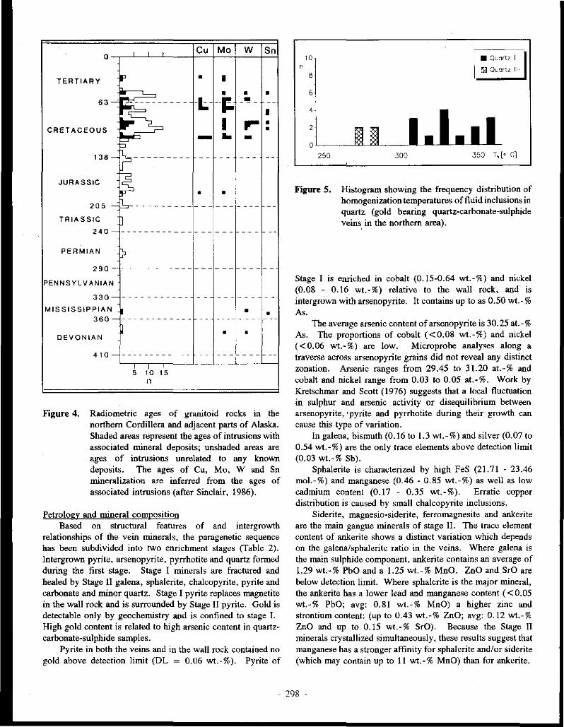
' ' ' Cu Mo w Sn 0
-
TERTIARY p • I
' • • • 63- CZ:::---------- -l- --1! _'! - --
c:: I
.. L-, I ... • CRETACEOUS • ~ - .. -
138-. ---------- - - - - - - - - -
JURASSIC -$ • •
205 - b---------- - - - - - - - - - - --
TRIASSIC
---------------1- --240 - - - - --: I
PERMIAN I> I I I I 290- ----------- - - -1- - - - - - - - -
I
PENNSYLVANIAN
330- - - - - -------· - - - - - - - - - - - ---
MISSISSIPPIAN • • • 360 - ------------ --- - - - - - - - - - - -
• • DEVONIAN
410- ------------ - - ___ ! ____ e --
' ~ 1
10 ' 15 n
Figure 4. Radiometric ages of granitoid rocks in the northern Cordillera and adjacent parts of Alaska. Shaded areas represent the ages of intrusions with associated mineral deposits; unshaded areas are ages of intrusions unrelated to any known deposits. The ages of Cu, Mo, W and Sn mineralization are inferred from the ages of associated intrusions (after Sinclair, 1986).
Petrology and mineral composition Based on structural features of and intergrowth
relationships of the vein minerals, the paragenetic sequence has been subdivided into two enrichment stages (Table 2). Intergrown pyrite, arsenopyrite, pyrrhotite and quartz formed during the first stage. Stage I minerals are fractured and healed by Stage II galena, sphalerite, chalcopyrite, pyrite and carbonate and minor quartz. Stage I pyrite replaces magnetite in the wall rock and is surrounded by Stage II pyrite. Gold is detectable on! y by geochemistry and is confined to stage I. High gold content is related to high arsenic content in quartzcarbonate-sulphide samples.
Pyrite in both the veins and in the wall rock contained no gold above detection limit (DL = 0.06 wt.-%). Pyrite of
10 • Quartz I
' 8 ~Quartzll·
6
4
1.l.11 :l I~ 250 300 350 T, [• C]
Figure 5. Histogram showing the frequency distribution of homogenization temperatures of fluid inclusions in quartz (gold bearing quartz-carbonate-sulphide veins. in the northern area).
Stage I is enriched in cobalt (0.15-0.64 wt.-%) and nickel (0.08 - 0.16 wt.-%) relative to the wall rock, and is intergrown with arsenopyrite. It contains up to as 0.50 wt.-% As .
The average arsenic content of arsenopyrite is 30.25 at.-% As. The proportions of cobalt ( <0.08 wt.-%) and nickel ( <0.06 wt.-%) are low. Microprobe analyses along a traverse across arsenopyrite grains did not reveal any distinct zonation. Arsenic ranges from 29.45 to 31.20 at.-% and cobalt and nickel range from 0.03 to 0.05 at.-%. Work by Kretschmar and Scott (1976) suggests that a local fluctuation in sulphur and arsenic activity or disequilibrium between arsenopyrite, •pyrite and pyrrhotite during their growth can cause this type of variation.
In galena, bismuth (0.16 to 1.3 wt.-%) and silver (0.07 to 0.54 wt.-%) are the only trace elements above detection limit (0.03 wt.-% Sb).
Sphalerite is characterized by high F eS (21. 71 - 23 .46 mol.-%) and manganese (0.46 - 0.85 wt.-%) as well as low cadmium content (0.17 - 0.35 wt.-%). Erratic copper distribution is caused by small chalcopyrite inclusions.
Siderite, magnesio-siderite, ferromagnesite and ankerite are the main gangue minerals of stage II. The trace element content of ankerite shows a distinct variation which depends on the galena/sphalerite ratio in the veins. Where galena is the main sulphide component, ankerite contains an average of 1.29 wt.-% PbO and a 1.25 wt.-% MnO. ZnO and SrO are below detection limit. Where sphalerite is the major mineral, the ankerite has a lower lead and manganese content ( < 0.05 wt.-% PbO; avg: 0.81 wt.-% MnO) a higher zinc and strontium content: (up to 0.43 wt.-% ZnO; avg: 0.12 wt.-% ZnO and up to 0.15 wt.-% SrO). Because the Stage II minerals crystallized simultaneously, these results suggest that manganese has a stronger affinity for sphalerite and/or siderite (which may contain up to 11 wt.-% MnO) than for ankerite.
- 298 -

Figure 6. Arsenopyrite composition as a function of temperature and bulk composition (" arsenopyrite of the gold bearing quartz-carbonate-sulphide veins in the northern area; stability fields after Kretschmar and Scott, 1976).
Wall rock alteration and mineral composition Each quartz-carbonate-sulphide vein is surrounded by an
irregular zone of sericitic alteration which grades outwards into an alteration zone dominated by K-feldspar (Table 3). In the sericitic alteration zone, pyrite replaces magnetite, and sericite and quartz replace K-feldspar. In the K-feldspar zone, sericite, quartz and minor K-feldspar replace epidote and chlorite. An outer propylitic zone, which is also irregular in
shape, is characterized by pyrite and chlorite replacement of biotite, epidote and sericite replacement of plagioclase, and as epidote and chlorite replacement of amphibole.
Microthermometry Microthermometric studies were carried out on fluid
inclusions in quartz crystals of both enrichment stages. Stage I quartz contains both primary and secondary inclusions,
- 299 -

-22 Hso; so>-• 330~
-26 Hom
~
si: Py Ano 0 .................... ....... Gn
"' _g 1
-30
Po
-34 H,S :i2 :I I ~ }IS~.
0 2 4 6 8 10 12 pH
A
Hso-· ·• 4
so:- 280~ -28 Hom
Gn d< -32 .•.. ;;:; ..... .
~ 1-.. _;·_ ... _ .. _ .. _ ... _ .. _ ... .:.i·+'·.~·::~·•:.<•:..:·:·:..:•·#----·r· . ;<,;;~~'''·-., ... \ .... 1.\ .. -36
Po
H,S ii I I ~ \HS~ -40 ~-~-~~-~~--~-~~-~
0 2 4 6 8 10 12 pH
c
- 5 330 c
-8 ~
" "' _.., ~
0 ""' "' _g
-10
Po
B
- 8 280 c ·············· •
Py
-10
Py
Po
-34 -30 log o(02 )
-26
Hom -14~---~-~~~-~-~--~
-44 -40
D
-36 log c(02 )
-32 -28
Figure 7. · Log a(O,)-pH and log a(S,)-log a(O,) diagrams of the mineralization stages in the gold bearing quartz-<:arhonatesulphide veins in the northern area (///I field of enrichment; ---> direction of change in physico-chemical conditions, I = sphalerite containing 24 mol.-% FeS; Mineral abbreviations follow Kretz, 1983).
whereas Stage II quartz contains only primary inclusions. Stage l inclusions gave homogenization temperatures between 308°C and 353°C with a maximum at 325°C and a salinity of 12.8 wt.-% NaCl-equivalent (Fig. 5). Fluid inclusions along microfractures in Stage I quartz yielded homogenization temperatures similar to fluid inclusions in Stage II quartz, which homogenize between 270 ° C and 280' C and have a salinity of 6 wt.-% NaCl equivalent.
Physical and chemical conditions Based on the mineral paragenesis arsenopyrite-pyrite
pyrrhotite (stage I) and the arsenopyrite thermometer of Kretschmar and Scott (1976), the arsenic content (30.25 at.-%)
of arsenopyrite indicates an average temperature of 320'C (Fig. 6). This temperature is close to the homogenization temperature (325°C) of primary fluid inclusions in Stage I quartz. Calculations of pH, log a(O,) and log a(S,) conditions during Stage I are based on an assumed formation temperature of 330°C, although the actual temperature may have been higher. Because of the tectonic fracturing between Stage I and Stage II it is possible that the fluid pressure during stage II was hydrostatic rather than lithostatic. If so, only a small pressure correction would be necessary to calculate the true formation temperature. Based on this assumption, and the measured homogenization temperatures of fluid inclusions in Stage II quartz (270°C - 280'C), the physico-chemical
- 300 -

conditions during the second stage were calculated assuming a formation temperature of 280°C.
Using the equilibrium between K-feldspar and muscovite, and also between muscovite and kaolinite, the formation temperature, molarity and the mineral paragenesis of alteration zone III the pH range was calculated as:
Stage I Stage II
3.1 <pHrn·c<5.2neutral pH330.c = 5.7 3.3<pH,,.rc<5.4neutral pH280.c = 5.6
The mineral paragenesis of Stage I is consistent with an oxygen activity of Jog a(O,) ~ -30 and a sulphur activity of about log a(S,) ~ -10 (Fig. 7 A; Fig. 7B). The Stage II mineral paragenesis indicates that oxygen activity during stage II decreased from log a(O,) = -35 to log a(O,) = -34 and sulphur activity decreased from Jog a(S2) = -12 to Jog a(S,) = -11 (Fig. 7C; Fig. 70).
Southern area
Gold bearing mesothermal quartz veins in the southern area are hosted by metamorphic rocks of the Pelly Gneiss unit and occur along north-northeast trending faults. These veins are often discontinuous and lenticular in shape and have an average thickness of about 70 cm. Some characteristic features of the veins include alternating quartz-sulphide bands, open-space fillings and idiomorphic zoned quartz crystals intergrown with sulphide minerals. Some of the veins show evidence of several phases of mineralization.
Petrology and mineral composition Three stages of mineral enrichment have been
distinguished (Table 4). Stage I minerals include quartz and pyrite with inclusions of bornite, galena with matildite exsolutions, chalcopyrite with mackinawite ex-solutions, cubanite, native bismuth, pyrrhotite, sphalerite, tetrahedrite and quartz.
Stage II coincides with the main enrichment of arsenopyrite and galena with tetrabedrite, miagyrite and polybasite exsolutions. Quartz, and pyrite containing arsenopyrite and galena inclusions (with matildite exsolutions) occur in subordinate amounts. Gold enrichment is associated with the arsenopyrite, and silver enrichment is associated with the galena!. Both the Stage I and Stage II minerals are fractured as a result of tectonic movements which preceded Stage III mineralization. The fractures are healed by Stage III pyrite, zoned sphalerite (iron poor core - iron rich rim), chalcopyrite, freibergite and quartz.
Gold was not detected in pyrite in any of the three stages (detection limit 0.06 wt.-% Au), but Stage II pyrite contains more arsenic (up to 2 wt.-%) than pyrite of stage I or stage III.
Arsenopyrite inclusions, which occur only in pyrite II, contain 27 .66 at. - % arsenic, and return low trace element values (0.04 wt.-% Co, Ni, Sb; < 0. I 1 wt.-% Cu; <0.04
wt.-% Ag). Arsenopyrite II, which is intergrown with pyrite and pyrrhotite, contains an average 29.03 at.-% As and a higher trace element content ( <0.43 wt.-% Co; 0.09 wt.-% Ni; <0.34 wt.-% Cu; <0.50 wt.-% Sb).
High bismuth (<7.86 wt.-%) and silver (4.35 wt.-%) values in galena inclusions in pyrite I and II are caused by matildite exsolutions. In addition to the matildite ex-solutions, galena inclusions in pyrite II are characterized by high arsenic content ( < 1.21 wt.-%). Trace element variations ( <0.49 wt.-% Bi; <0.78 wt.-% Ag; < 1.79 wt.-% Sb) of galena II are caused by tetrahedrite, miagyrite and polybasite exsolutions.
From Stage I to Stage III there was a decrease in the iron content of spha!erite, from 20.22 mol.-% to 3.46 mol.-% FeS, and a decrease in manganese content from 0.20 wt.-% to 0.04 wt.-%. The .iron content increased slightly to 5.77 mol.,% FeS during stage III. Cadmium content increased, from 0.34 wt. - % to 0. 84 wt.-% between Stage I and Stage III, but decreased slightly to 0.66 wt-% at the end of Stage III. Whereas the copper content of sphalerite I and II is below detection limit (0.04 wt.-%) sphalerite III contains significant copper (up to 0.42 wt.-%).
Wall rock alteration and mineral composition Veins showing evidence of one, two or three mineral
enrichment stages are surrounded by similar envelopes of wall rock alteration. Adjacent to the quartz-sulphide veins is a zone of sericitic alteration, where quartz is recrystallized, and K-feldspar is replaced by sericite and quartz (Table 5). Between the sericite alteration zone and the unaltered biotite augen gneiss is a zone of quartz-K feldspar-sericite alteration, followed by a zone of propylitic alteration. The quartz-K feldspar-sericite zone is characterized by the replacement of plagioclase and chlorite by sericite and quartz. In the propylitic zone, pyrite and rutile replace magnetite, biotite and muscovite replace chlorite and sericite replaces plagioclase.
Microthermometry The cores of idiomorphic and zoned quartz crystals consist
of Stage I quartz I, and the rims consist of Stage II quartz. Quartz of stages I and II is fractured, and healed by Stage III quartz. Primary fluid inclusions in Stage I quartz homogenize at about 275°C and indicate a salinity of 18.3 wt.-% NaCl equivalent (Fig. 8). Homogenization temperatures of primary fluid inclusions in Stage II quartz are about 205°C and the salinity of the fluid is 12 wt.-% NaCl equivalent. Primary inclusions in Stage III quartz and secondary inclusions in Stage I and II quartz return homogenization temperatures of about 145°C and salinity values of about IO wt.-% NaCl equivalent.
Physico-chemical conditions Based on studies done by Kojima and Sugaki (1985),
Sugaki et al. (1982) and Yund and Kullerud (1966), the presence of chalcopyrite-pyrrhotite, cubanite-pyrrhotite and cubanite-chalcopyrite-pyrrhotiteas inclusions in pyrite of stage I are consistent with formation temperatures above 325°C and 334 ± l7°C, respectively. The difference between this
- 301 -

o~••" ' - au•'"" Ill] Ouut. UI
lJl
Figure 8. Histogram showing the frequency distribution of homogenization temperatures of fluid inclusions in quartz of the gold bearing quartz-sulphide veins in the southern area.
mineral formation temperature and the 275°C homogenization temperature of Stage I inclusions suggests a minimum fluid pressure of about 500 bar, based on the work of Potter (1977).
According to the studies of Scott and Barnes (1971), Scott and Kissin (1973) and Browne and Lovering (1973), the iron content (15 mol.-% FeS) of sphalerite II intergrown with pyrite indicates a formation temperature above 248 ° -260° C for the second stage mineralization. Following the same reasoning as the paragraph above, the minimum pressure for hydrothermal fluids of stage II is also about 500 bar. Evidence of tectonic fracturing between stage II and stage III suggests that the fluid pressure may have been hydrostatic at some point.
Using temperatures of 330°C for stage 1, 280°C for stage II and 150°C for stage III, and with the additional assumption that the same mineral alteration occurred during each stage of mineralization, pH, log a(O,) and log a(S,) of mineral enrichment were calculated. The following pH ranges were obtained:
stage I stage II stage III
3.2<pH3.,.c<5.3neutral pH331,,c = 5.7 3.2 < pH280oe< 5.2neutral pH280.c = 5.6 4.l<pH150.c<5.9neutral pH 150T = 5.8
The change in mineral paragenesis during stage I from sphalerite (21 mol.-% FeS)-pyrrhotite-pyrite to native bismuthpyrrhotite-pyrite indicates a decrease in oxygen activity from log a(O,) = -29 to log a(O,) = -30 and a decrease in sulphur activity from log a(S2) = -9 to log a(S,) = -10 (Fig. 9A; Fig. 9B).
Oxygen and sulphur activity continued to decrease during stage II. Early arsenic-bearing pyrite with arsenopyrite and galena inclusions was followed by the crystallization of sphalerite (15 mol.-% FeS)-pyrite-pyrrhotite and pyritepyrrhotite, indicating a change from log a(02) = -31 to log a(O,) = -35 and log a(S2) = -11 to log a(S,) = -12 (Fig. 9C;
Fig. 9D). The mineral paragenesis sphalerite (6 mol.-% FeS)-pyrite
of stage III is consistent with an oxygen activity of log a(O,) = -53 and a sulphur activity of log a(S,) = -18 (Fig. 9E; Fig. 9F).
MINERAL ENRICHMENT PROCESS
Northern area
Although the physical and chemical conditions of both mineral enrichment stages lie within the stability fields of arsenopyrite, galena and sphalerite, arsenopyrite and gold enrichment occurred during stage I and galena, sphalerite and silver were deposited during stage II. Either the hydrothermal fluids of stage I were depleted in lead, zinc and silver, and the fluids of stage II in arsenic and gold, or these elements were transported as complexes with different stability conditions.
Heinrich and Eadington (1986) and Ballantyne and Moore (1988) described the transport of arsenic in hydrothermal solutions in terms of hydroxide (H3As03 ° and/ or H3As04 °) or bisulphide (HAsS2 °) complexes. Due to the physicochemical conditions prevalent in most active hydrothermal systems, arsenic is transported as the H3As03 °-complex. Transport of arsenic as a bisulphide complex is only possible at sulphur concentrations above i::s = O. lm. At very low pH and high salinities, arsenic is transported as a chloride complex.
Based on the assumptions above, an equilibrium reaction can be written which describes the coprecipitation of arsenopyrite, pyrite and pyrrhotite (reaction 1):
2H3As0,° + 6FeC12 + 9H,S 0 = 2FeAsS ·+ 3FeS2 + FeS + 12CI· + 6H2 + 302 + 12H+
The solubility of arsenopyrite at a particular temperature depends on the oxygen and sulphur activity and pH (Fig. JO). Decreased oxygen activity, or increased pH and sulphur activity, cause precipitation of arsenopyrite.
In active hydrothermal systems under similar physicochemical conditions, gold is transported as a gold-thio complex (Au(HS)i) up to a temperature of about 300°C (Seward, 1973; Seward, 1982; Henley et al., 1984; Henley and Brown, 1985). Above this temperature, the gold-chloride complex predominates (Henley, 1973). An equilibrium reaction describing the precipitation of gold can be written as follows (reaction 2):
2Au(HS)i + 2H+ + H20 = 2Au0 + 4H2S0 + 0.502
As this reaction shows, the solubility of gold as a gold-thio complex increases with increasing pH and oxygen activity.
Seward (1976), Barnes (1979), Henley et al. (1984), Seward (1984), and Henley and Brown (J 985), have described the transport of lead, zinc, copper and silver in active hydrothermal systems as a metal-chloride complex
- 302

A
~
d" ~ c
"' .2
c
~
~ c
"' .2
E
-22 Hso; so:- 330~
-26 2
-30
Po -34
H1 S
0
Py
2 4 6 pH
8 10 12
Hso; so:- 280~ -28
-32 2 Py
............... , -36 Po -40
H,S
0 2
-34 HSO~
-42 ············
-50 .L. , Py
II
.. " :I :I ..
" 4 6
pH
Ill
Hem
Hem
HS
10 12
so:- 150~
Ang Gn
H2S Po s2:1 :I~ -s8~-~--~---"-~~--~~~
0 2 4 6 8 pH
10 12
- 5 330 c . .......... .... Ii. r. .. .
~
rn" 15'
Py
-8
~ 1----------· !:"
~::~P-o--~--~~~i~1-~-~~'-j~"-~H•_m__, -42 -38 -34 -30
leg o(01 )
- 8 280°C
-10
" "' 15'
"' .2 -12
"' .2 -20
-22
...... .. ············ ························ 2
Py
, ~. :::::::::::::::::::::n:::::::::::::::·.
""
2
Po
-40
Py
-36 log o(O,)
············--------············ ..... .. ··
............. Po ..• -··· Mag
-26
-32 -28
Hom -24'---'~--'-~--""~~~~~..,__~~u....._J
-57 -55 -53 -51 -49 -47 -45 -43 -41 log o(O,)
B
D
F
Figure 9. Log a(O,)-pH and log a(S,)-log a(O,) diagrams of the mineralization stages in the gold bearing quartz-sulfide veins in the southern area (legend as described in Figure 7; I = sphalerite containing 21 mo!.-% FeS; II =
sphalerite containing 15 mo!.-% FeS; III = sphalerite containing 6 mo!.-% FeS; Mineral abbreviations after Kretz, 1983).
- 303 -

(reaction 3):
Meet,• + H2S0 =Mes + 2H+ + 2c1·
Above 200°C, these metal-chloride complexes are the prevalent transport mechanism. Increasing the sulphur activity and pH, or decreasing the activity of chlorine, causes the precipitation of sulphides.
In the Sixtymile area, fluid-wall rock interaction during the first stage of mineraliz.ation caused the replacement of Kfeldspar by muscovite (reaction 4):
1.5[KAISi,08] + H+ = 0.5[KAl3Si30 10(0H):J + 3[Si0:J+ K+
This alteration reaction would have increased the pH of the hydrothermal solutions during the first enrichment stage, probably causing the precipitation of arsenopyrite, pyrite and pyrrhotite by reaction 1. The crystalliz.ation of arsenopyrite, pyrite and pyrrhotite causes a decrease in pH and sulphur activity, and an increase in oxygen activity. The decrease in pH and sulphur activity as a result of reaction 1 predominates over the change in oxygen activity and probably control the precipitation of gold by reaction 2. On the other hand, an increase in c1· activity as a result of reaction 1 would favour the formation of metal-chloride complexes (reaction 3) and may have suppressed the formation of lead, zinc and copper sulphides during stage I.
The decrease in both temperature and salinity from stage I to stage II suggests mixing of two fluids with different physical and chemical characteristics. Decreased ct· activity can cause the precipitation of galena, sphalerite, chalcopyrite and silver as a result of reaction 3. The mixing of two fluids with contrasting oxygen activities would increase the oxygen activity of the initial fluid and counteract the deposition of arsenopyrite and gold and possibly dissolve arsenopyrite. The replacement of arsenopyrite I by galena of stage II might have been caused by this process.
Southern area
Physical and chemical conditions of hydrothermal fluids during the three stages of mineralii.ation were within the stability field of galena and arsenopyrite, but whereas galena formed during both Stage I and Stage II, arsenopyrite enrichment is confined to Stage II. Assuming that fluid-wall rock interaction during Stage I caused the alteration of Kfeldspar to muscovite by reaction 4, the pH of the fluids must have increased. Depending on the element saturation of the hydrothermal fluids, this pH increase could cause minerals to precipitate as a result of reaction 3. If the arsenic concentration in the fluid were low the change in pH would not cause a precipitation of arsenopyrite by reaction 1.
The decrease in temperature and salinity from Stage I to Stage III suggests mixing of two hydrothermal fluids with different physical and chemical characteristics. Assuming that
the element transport and enrichment during stage II occurred as described by reactions 1 to 4, the precipitation of minerals could have been caused by decreasing temperature, ct· and oxygen activity between stage I and II.
The absence of arsenopyrite and galena during stage III is indicative of low concentrations of arsenic and lead in the Stage III hydrothermal fluid.
CONCLUSIONS
Gold-bearing, mesothermal quartz-(carbonate)-sulphide veins in the northern and southern areas are believed to have formed in the deeper parts of the same fossil geothermal system, and are probably related to a Late Cretaceous magmatic event. The following conclusions about the fluid composition and mineral enrichment process can be made:
(1) The fluids which circulated at depth in the metamorphic rocks are characterized by high temperatures (above 300°C), high salinities (about 18 wt.-% NaCl equiv.) and pH values in the range 3.1 to 5.2. These fluids are similar to alkaline chloride fluids of active geothermal systems.
(2) Arsenic was transported as a H3As03 ° complex, gold as Au(HS)i and lead, zinc, copper and iron as MeCl2 ° complexes.
(3) Stage I mineraliz.ation resulted directly from fluid-wall rock interaction.
( 4) Subsequent (second and third stage) mineraliz.ation resulted from the mixing of two fluids with different physical and chemical characteristics.
ACKNOWLEDGEMENTS
This research project was supported by the Deutsche Forschungsgemeinschaft (Grant FR 240/44). The study was also part of the Canada/Germany Science and Technology Exchange Agreement organized by the Geological Survey of Canada and the Federal Institute for Geosciences and Mineral Resources (BGR). Financial support was granted by the German Ministry of Research and Technology and by Exploration and Geological Services Division of the Department of Indian and Northern Affilirs, Whitehorse, Yukon. We are particularly indebted to the mining companies for permitting access to their properties in the Sixtymile River area. We greatly appreciate the discussions with J. Morin, J. Mortensen, G. Lynch, P. Moller, R. Walter, P. Siinger v. Oepen and L. Stroink.
- 304 -

REFERENCES
ARMSTRONG, R.L., 1988. Mesozoic and early Cenozoic magmatic evolution of the Canadian Cordillera. Geological Society of America, Special Paper 218, p. 55-91.
BALLANTYNE, J.M. and MOORE, J.N., 1988. Arsenic geochemistry in geothermal systems. Geochimica et Cosmochimica Acta 52, p. 475-483.
BARTON, Jr., P.B., 1969. Thermochemical study of the system Fe-As-S. Geochimica et Cosmochimica Acta 33, p. 841-857.
BARTON, Jr., P.B. and SKINNER, J.B., 1979. Sulfide mineral stabilities. Jn: Geochemistry of hydrothermal ore deposits, H.L. Barnes (ed.), Pennsylvania State University, p. 278-404.
BARTON, Jr., P.B., BETHKE, P.M. and ROEDDER, E., 1977. Environment of ore deposition in the Creede Mining District, San Juan Mountains, Colorado: Part 111. Progress toward interpretation of the chemistry of the ore-forming fluid for the OH vein. Bulletin of the Society of Economic Geologists, Vol. 72, p. 1-24.
BROWNE, P.R.L. and LOWERING, J.F., 1973. Composition of sphalerites from the Broadlands Geothermal Field and their significance to sphalerite geothermometry and geobarometry. Economic Geology, Vol. 68, p. 381-387.
COCKFIELD, W.E., 1921. Sixtymile River and Ladue River area, Yukon. Geological Survey of Canada, Memoir 123.
COLBY, J. W., 1968. Advances in X-Ray Analyses, Vol. 11, p. 287-305.
CONEY, P.J., 1982. Cordilleran tectonics and North American plate motions_. American Journal of Science vol. 272, p. 603-628.
CRAIG, J.R. and BARTON Jr., P.B. 1973. Thermochemical approximations for sulfosalts. Economic Geology, Vol. 68, p. 493-506.
DEER, W.A., HOWIE, R.A. and ZUSSMAN, J., 1977. An introduction to the rock-forming minerals.
GLASMACHER, U., and FRIEDRICH, G., 1985. Placer gold in the Sixtymile River Area, Yukon Territory, Canada. Proceedings of the Seventh Annual conference on Alaskan Placer Mining, Fairbanks, p. 53-57.
GLASMACHER, U., 1991. Petrogenetische und metallogenetische Entwicklung ausgewiihlter Gebiete im "Yukon-Tanana Terrane" und "Stikine Terrane", (Yukon Territorium, Kanada) wiihrend deroberkreide und des Alltertiiirs. Diss., Aachen University of Technology, 435 p.
GLASMACHER, U. and FRIEDRICH, G., 1992. Volcanic hosted, epithermal gold-sulphide mineralization, Sixtymile River area, Yukon Territory, Canada. In: Yukon Geology, Vol. 3; Exploration and Geological Services Division, Yukon, Indian and Northern Affairs, Canada (this volume). ·
HAAS Jr., J.L. and ROBIE, R.A., 1973. Thermodynamic datafor wustite, Fe0,94,0, magnetite, Fe30 4, and hematite, Fe,03 (abstract). Transactions of the American Geophysical Union, Vol. 54, p. 438.
HEINRICH, C.A. and EADINGTON, P.J., 1986. Thermodynamic predictions of the hydrothermal chemistry of arsenic, and their significance for the paragenetic sequence of some cassiterite-arsenopyritebase metal sulfide deposits. Economic Geology, Vol. 81, p. 511-529.
- 305 -

HELGESON, H.C., 1969. Thermodynamics of hydrothermal systems at elevated temperatures and pressures. American Journal of Science, p. 729-804.
HELGESON, H. C., 1979. Mass transfer among minerals and hydrothermal solutions. Jn: Geochemistry of hydrothermal ore deposits, 2nd. Ed, H.L Barnes (ed.); Pennsylvania State University, p. 568-610.
HENLEY, R. W., 1973. Solubility of gold in hydrothermal chloride solutions. Chem. Geo!. Vol. 11, p. 73-8Z
HENLEY, R. W., TRUESDEU, A.H., BARTON Jr . ., P.B. and WHITNEY, J.A., 1984. Fluid-mineral equilibria in hydrothermal systems. Society of Economic Geologists, Vol. I.
HENLEY, R. W. and BROWN, K.L., 1985. A practical guide to the thermodynamics of geothermal.fluids and hydrothermal ore deposits. Jn: Geology and Geochemistry of epithermal systems, B.R. Berger and P.M. Bethke (eds); Reviews in Economic Geology, Vol. 2, p. 25-44.
HENLEY, R. W. and HEDENQUJST, J. W., 1986. Introduction to the geochemistry of active and fossil geothermal systems. In: Guide to the active epithermal (geothermal) systems and precious metal deposits of New "Zealand, G. Freidrich (chief ed.); Monograph 26, p.1-22.
HUGHES, R.L. and MORISON, S.R., 1986. Placer gravels of Miller Creek, Sixtymile River area, 116B,C: in Yukon Geology Vol. 1; Exploration and Geological Services Division, Yukon, Indian and Northern Affairs Canada, p. 50-55.
KING, L. G., MAH, A.D. and PANKRAIZ, L.B., 1973. Thermodynamic properties of copper and its inorganic compounds. JNCRA Monograph 1l on the Metallurgy of Copper, International Copper Research Association.
KRETSCHMAR, U. and SCOTT, S.D., 1976. Phase relations involving arsenopyrite in the system Fe-As-S and their application. Canadian Mineralogist, Vol. 14, p. 364-386.
KREIZ, R., 1983. Symbols for rock-forming minerals. American Mineralogist, Vol. 68, p. 277-279.
KOJIMA, S. and SUGAKI, A., 1985. Phase relations in the Cu-Fe-Zn-S system between 500°C and 300°C under hydrothermal conditions. Economic Geology, Vol. 80, p. 158-171.
MANN, A. W., F ARD Y, J.J. and HEDENQUJST, J. W., 1986. Major and trace element concentration in some New "Zealand geothermal waters. International Volcanological Congress, Proceedings of Symposium 5, p. 61-80.
MEINERT, L.D., 1986. Gold in skarns of the Whitehorse Copper Belt. Jn: Yukon Geology, Vol. 1; Exploration and Geological Services Division, Indian and Northern Affairs Canada, p.19-43.
MONGER, J. W.H., 1984. Cordilleran tectonics: a Canadian perspective. Bulletin of the Geological Society of France, Vol. 7, p. 255-278.
MONGER, J. W.H., SOUTHER, J.G. and GABRIELSE, H., 1972. Evolution of the Canadian Cordillera: A plate-tectonic model. American Journal of Science, Vol. 272, p. 577-602.
MONGER, J. W.H., PRICE, R.A. and TEMPELMAN-KLUJT, D.J., 1982. Tectonic accretion and the origin of the two major metamorphic and plutonic belts in the Canadian Cordillera. Geology, Vol. JO, p.70-75.
MORIN, J.A. and DOWNING, D.A., 1984. Gold-silver deposits and occurrences in Yukon Territory. 1:2,000,000 scale map, list of occurrences. Exploration and Geological Services Division, Yukon, Indian and Northern Affairs Canada Open File 1984-2.
- 306 -
MORIN, J.A. and STROSHEIN, R., 1987. Disseminated precious metal exploration targets in Yukon. Geological Society of Nevada Symposium: Bulk Mineable Precious Metal Deposits of the Western United States, Reno, Nevada.
MORTENSEN, J.K., 1988. Geology of southwestern Dawson Map Area, Yukon. Geological Survey of Canada, Open File 1927.
RAU, H., KUITY, T.R.N. and GUEDES DE CARVALHO, J.R.F., J973a. High temperature saturated vapour pressure of sulfur and the estimation of its critical quantities. Journal of Chemical Thermodynamics, Vol. 5, p. 291-302.
RAU, H., KUITY, T.R.N. and GUEDES DE CARVALHO, J.R.F., 1973b. Thermodynamics of sulfur vapor. Journal of Chemical Themwdynamics, Vol. 5, p. 833-844.
ROEDDER, E., RJNGJAM, B. and HAU, W.E., 1963. Studies of fluid inclusions III: Extraction and quantitative analyses of inclusions in the milligram range. Economic Geology, Vol. 58, p. 353-374.
SCHNEEBERG, E.P., 1973. Sulfur fugacity measurements with the electrochemical cell Ag Agl Ag2+,Sfs. Economic Geology, Vol. 68, p. 507-517.
SCOTT, S.D. and BARNES, H.L., 1971. Sphalerite geothermometry antj geobarometry. Economic Geology, Vol. 66, p. 653-669.
SCOTT, S.D. and KISSJN, S.A., 1973. Sphalerite composition in the Zn-Fe-S system below 300°C. Economic Geology, Vol. 68, p. 475-479.
SEWARD, T.M., 1976. Stability of chloride complexes of silver in hydrothermal solutions up to 350°C. Geochimica et Cosmochimica Acta, Vol. 40, p. 1329-1341.
SEWARD, T.M., 1982. The transport and deposition of gold in hydrothermal systems. In: Gold '82: The Geology, Geochemistry and Genesis of Gold Deposits, R.P. Foster (ed.);, Geological Society of Zimbabwe, Vol. 1.
SEWARD, T.M., 1984. The formation of lead 11 chloride complexes to 300'C: a spectrophotometric study. Geochimica et Cosmochimica Acta, Vol. 48, p. 121-134.
SINCLAIR, W.D., 1986. Molybdenum, tungsten and tin deposits and associated granitoid intrusions in the Northern Canadian Cordillera and adjacent parts of Alaska. Jn: Mineral deposits of Northern Cordillera, J.A. Morin (ed.); Canadian Institute of Mining and Metallurgy, Vol. 37, p. 216-234.
SUGAKJ, A., KITAKAZE, A. and UENO, T., 1982. Hydrothermal syntheses of minerals in the system CuFe-S and their phase equilibrium at 400°C and 500'C. Japan. Assoc. Min. Petrol. Econ. Geol., Vol. 3, p. 257-269.
TEMPELMAN-KLU/T, D.J., 1974. Reconnaissance geology of Aishihik Lake, Snag and part of Stewart River Map Areas, West-Central Yukon. Geological Survey of Canada Paper 73-41.
TEMPELMAN-KLU/T, D.J., 1976. The Yukon Crystalline Terrane:' Enigma in the Canadian Cordillera. Geological Society of America, Bulletin 87, p. 1343-1357.
TEMPELMAN-KLU/T, D.J., 1979. Transported cataclasite, ophioliteand granodiorite in Yukon: evidence of arc-continent Collision. Geological Survey of Canada, Paper 79-14.
TEMPELMAN-KLUJT, D.J., 1981. Geology and mineral deposits' of southern Yukon. In: Yukon Exploration and Geology 1979-1980; Exploration and Geological Services Division, Indian and Northern Affairs Canada, p. 7-31.
- 307 -

TOULMIN, P. and BARTON, P.B., 1964. A thermodynamic study of pyrite and pyrrhotite. Geochimica et Cosmochimica Acta, vol. 28, p.641-671.
YUND, R.A. and KUILERUD, G., 1966. Thermal stability of assemblages in the Cu-Fe-S system. Journal of Petrology, Vol. 7, p. 454-488.
Table 1. Lithostratigraphic units of Sixtymile River area.
SYSTEM FORMATION LITHOLOGY LITHOLOGY NW Area SE Area
QUATERNARY alluvial sediments alluvial sediments
Selkirk alkaline-olivine basalt Group
LATE Carmacks andesite, dacite, andesite and CRETACEOUS Group andesite-dacite dykes, dacite dykes
pyroclastic rocks, fluvial sediments
Unnamed biotite granodiorite plutons
MIDDLE Klotassin pegmatite, aplite JURASSIC Suite
PERMIAN ? ortbogneiss
Anvil ultramafic rocks Range Group
Pelly augen gneiss Gneiss garnet-mica
schist, gneiss
Klondike cblorite schist, chlorite schist Schist mica schist mica schist
PRE-PERMIAN Nasina paragneiss, quartzite, quartzite, quartz-(DEV ONO- Series quartz-mica schist, mica schist, MISSISSIPPIAN mica schist, graphite mica· schist AND? OLDER) schist, marble
- 308 -

Table 2. Paragenetic sequence and physico-chemical conditions of the gold-bearing mesotherrnal quartz-carbonate-sulphide veins in the northern area.
Arsenopyrite (at.- 0/o As)
Pyrite
Pyrrhotite
Galena
Sphalerite lmol.- 0/o FeS)
Chalcopyrite
Quartz
Ankerite
Siderite
Temp. (°CJ
Salin. (wt.- 0/o NaCl equiv.)
log a(K+l
pH
log a(02)
log a(S2J
Stage I Stage II
30.25
Ag-Bi
23
330 280
12.8 6
-1.4 -1.5
>3.1 = >5.2 >3.3 = >5.4
""-3o -35--34
~-10 -12 --11
- 309 -

Table 3. Mineral paragenesis of the quartz veins and the alteration zones encasing the gold-bearing mesothermal quartzcarbonate-sulphide veins in the northern area.
Plagioclase
K feldspar
O.uartz
Biotite
Amphibole
Sericite
Chlorite
Epidote
Magnetite
Sulphides
Wall rock Zone Zone II Zone Ill O.tz.-S. Veins
Table 5. Mineral paragenesis of the sulphide veinlets and the alteration zones encasing the gold-bearing mesothermal quartzcarbonate-sulphide veins in the southern area.
Plagioclase
K feldspar
O.uartz
Biotite
Muscovite
Sericite
Chlorite
Magnetite
Sulphides
Bio-K-Gneiss Zone I Zone II Zone Ill 0.tz.-S. Veins
__ ,___ __
- 310 -

Table 4. Paragenetic sequence and physico-chemical conditions of the gold-bearing mesothennal quartz-carbonate-sulphide veins in the southern area.
Pyrite (wt.- 0/o As)
Sphalerite (mol.- 0/o FeS)
Chalcopyrite
Mackinawite
Cubanite
Bornite
Pyrrhotite
nat. Bismuth
Arsenopyrite (at.- 0/o As)
Galena
Matildite
Tetrahedrite
Miagyrite
Polybasite
Gold
Freibergite (wt.-% Ag)
O.uartz
Temp. (°Cl
Salin. (wt.-% NaCl equiv.)
log a(K+)
pH
log a(02l
log a(S2)
Stage I
"'20
-
Ag-Bi
--
330
18.3
-1.5
>3.2 = >5.3
-29--30
-9--10
- 311 -
Stage II Stage Ill
> 1
.,,5 "'6
--
27.66 29 03
+As Sb-Ag-Bi
"'22
280 150
12 10
-1,3 -1.6
>3.2 = >5.2 >4.1 = >5.9
-31--35 -53
-11--12 -1a

GOLD AND SULPHIDE MINERALIZATION IN TIIE HUNKER CREEK AREA, YUKON TERRITORY, CANADA
K.-H. Hoymann &
G. Friedrich
Institute of Mineralogy and Economic Geology Aachen University of Technology
Wiillnerstr. 2, 5100 Aachen Aachen, Gennany
HOYMANN, K.-H. and FRIEDRICH, G., 1990. Gold and sulphide mineraliza1ion in the Hunker Creek area, Yukon Te"itory, Canada. Jn Yukon Geology, Vol. 3; Exploration and Geological Services Division, Yukon, lndian and Northern Affairs Canada, p.312-326
ABSTRACT
The Hunker Creek area is located 30 km southeast of Dawson City, Yukon. Gold and sulphide-bearing quartz veins (MINFILE 1150 067,068) crosscut metamorphic rocks of the Klondike Schist. The veins are enclosed by envelopes ofsericiric (inner) and propylitic (outer) aheration. Locally, carbonatization occurs between propylitized and sericitized rocks. Three stages of vein mineralization can be distinguished: (I) quartz, carbonates, gold, arsenopyrite, pyrite,py"hotite, chalcopyrite, and galena; (II) quartz, carbonates, chalcopyrite, sphalerite, tetrahedrite, freibergite, polybasite, 'polyargyrite', argentite, pyrostilbnite and galena; (Ill) quartz and gold.
Fluid inclusion data indicate that stage I minerals precipitated from hydrothermal solutions containing CO~ Homogenization temperatures range from 260° to 390°C. Stage //-aqueous fluid inclusions homogenize between 190° and 260°C. Stage Ill inclusions homogenize between 120° and 210°C. Salinities of the three stages range from 0 lo 7. 2 wt-% NaCl equiv. and show nd signiJicant changes with time.
It is suggested that stage I mineralizalion was initiated by unmixing of an original single-phase H,O and C02 bearing fluid, and that subsequent hydrothermal evolution was controlled mainly by decreasing temperature.
RESUME
La region du ruisseau Hunker est situee a 30 km au sud-est de Dawson City (Yukon). Des veines renfermant de I' or et du quartz recoupenl le schiste metamorphique de Klondike. Les veines sont entourees d'enveloppes d'aheration sericitique (interieure) et propylitique (exterieure). Par endroits, ii y a carbonatation entre /es roches sericitisees et /es roches propylitisees. Trois sttules de mineralisation peuvent etre distingues: /)quartz, carbonates, or, arsenopyrite, pyrite, pyrrhotine, chalcopyrite et ga/ene, II) quartz, carbonates, chalcopyrite, sphaltirite, tetrahtidrite, freibergite, polybasile, •polyargyrite•, argentite, pyrostilbnite et ga/ene, Ill) quartz et or.
Les donnees sur Jes inclusions fluides indiquent que /es mineraux du stade_ 111 ont precipite a partir de solutions hydrothermales renfermant du COr Les temperatures d'homogeneisatwn varient de 260 a 390 °C. Les inclusions de fluide aqueux du stade II sont homogeneisees ii des temperatures variant entre 120 et 210 °C. Pour /es trois stades /es sa/inites varient entre 0 et 7,2 % d'equiva/enr de NaCl en poids et ne presentent aucune variation importante en fonction du tempi.
fl est suggere que la mineralisation de stade I a &e amorcee par separation d 'un fluide original ii une seule phase renfermant H,O et CO, et que I 'evolution hydrotherma/e ulterieure a ete principalement determintie par une temperature ii la baisse.
- 312 -

INTRODUCTION
The Hunker Creek area, located 30 km southeast of Dawson City, is part of the Klondike District (Fig. !). Gold was discovered here in the late 19th century. The bulk of the gold production was derived from placer deposits. A relatively small amount of exploration was directed toward finding lode sources for the placer gold.
The purpose of this paper is to describe the mineralogy of three gold quartz veins (Mitchell Vein (MINFILE 1150 068a), Sheba Vein, (1150 068b) and Hunker Dome (1150 067) and to present a genetic model for the mineralizing events. The study is based on thin, polished and thick section microscopy, microprobe data, and fluid inclusion investigations.
GEOLOGY
The Hunker Creek area is underlain by metamorphic rocks of the Nasina Series, Klondike Schist, and the Moosehide Assemblage. The three units belong to the Yukon Cataclastic Complex (Tab. I, Fig. 2). The Nasina Series consists of graphitic schist, graphitic quartzite. siliceous marble, and minor chlorite and muscovite schist. The Klondike Schist is represented by quartz-augen schist, quartzchlorite-muscovite schist and muscovite schist. The metamorphic grade of the rocks ranges from upper greenschist to middle amphibolite facies (Mortensen, 1990). Mylonitic serpentinite, amphibolite, and chlorite and talc schist of the Moosehide Assemblage overlie the Klondike Schist. Tempelman-Kluit (1979, 1981) correlated this unit with the Anvil Allochthonous Assemblage, a sheared ophiolite sequence. Shear zones are developed between the Nasina Series, Klondike Schist and Moosehide Assemblage (Metcalfe and Clarke, 1983; Mortensen, 1990).
Younger intermediate andesites and their equivalents occur in outcrops along Last Chance Creek. They do not show any indications of major tectonic deformation. According to Debicki (1984, 1985), these volcanic rocks can be correlated with the Carmacks Group volcanic suite. Felsic luffs, monolithic and heterolithic felsic breccias (Skukum Group), and miarolitic quartz-feldspar porphyry (Nisling Range Alaskite) are of Eocene age (Debicki, 1984). The bedrock is covered by Pleistocene alluvial gravels.
MINERALIZATION
The steeply dipping, northwest striking Mitchell Vein (MINFILE 1150 068A) has an exposed length of about JOO m, an average thickness of 30 cm and an explored depth of about 25 m. The Sheba Vein, (MINFILE 1150 068b) is up to I m thick in surface exposures. It is located 850 m south of the Michell Vein and dips steeply to the northeast. At Hunker Dome (MINFILE 1150 067), quartz veins are highly variable in thickness to a maximum of 60 cm. The veins dip steeply to the east or west. Tectonic relationships indicate that the three veins formed during the same mineralizing event.
I~ T ..J L ...
I \. '"' --1
\ A I " s k " I '" 1-lr--W KILOM£lR£S
)
\ '\_,,.
'<> T E R R I T 0 R Y\
-.,,~,. "7 I '\ ,,,.
1, """-J\ \ (_,_ ,..-
,1.,.f.._
' "'' British Columbia
Figure 1. Location map of the Hunker Creek area.
Gold
Three different types· of gold have been observed: (!) Inclusions of gold ( <0.0lllUD) with a mean silver content of 17.58 wt-% occur in pyrite from Mitchell Vein (Fig. 3, Tab. 2). (2) Macroscopic visible gold containing small pyrite inclusions was found in quartz from Hunker Dome vein (Fig. 4). This type of gold has mean silver and tellurium contents of 12.74 wt-% and 0.08 wt-%, respectively. (3) Gold intergrowo with galena from a Hunker Dome quartz vein (Fig. 5) contains high silver, averaging 22.07 wt-% (Tab. 2).
Silver
Silver-bearing minerals include tetrahedrite-tennantite group minerals, sulphosalts and galena.
Tetrahedrite-tennantite group minerals found in the Hunker Creek a~ are freibergite, arsenic-bearing freibergite, and arsenic-bearing tetrahedrite. Freibergite and tetrahedrite are characterized by highly variable iron, zinc and cadmium contents (Fig. 6). Freibergite and tetrahedrite intergrown with sphalerite have low zinc and cadmium (Fig. 7). Except for arsenic-bearing freibergite, there is a strong positive correlation between antimony and silver in freibergite and tetrahedrite (Fig. 8).
Freibergite inclusions are often myrrnek:itically intergrown with galena. This feature indicates dissolution processes along grain boundaries as described by Ramdohr (1980). Freibergite is also intergrown with pyrite, chalcopyrite, sphalerite,
- 313 -

"' '.;:'.
64"00'
~ -D ~
AlolJQ/,t.E>
,f
Alluvium
Bench gravels
Nisling Range Alaskite
Carmacks Group
.c. ""+
~
"'
f.:.::·:·:I
D ~
~
-..;:
Moosehide Assemblage ~ -,, Klondike Schist
Nasina Series '
139"00'
~
)..,_ \" & \ ~1i "' ';. 'f ~ Q
~ h,3 '2
4,
Geological boundary
Thrust fault. approximate
Lineament, approximate
Gold-b@aring quartz Vf!ins 1 Mitchell Vein typ111 2,3 Sheba Vein type
0
4 Hunker Dome Vein type
Skm
Figure 2. Bedrock geology of the Klondike area (modified after Bostock, 1942; Boyle, 1979, 1987; Debicki, 1984 and 1985, and Dufresne, 1987).
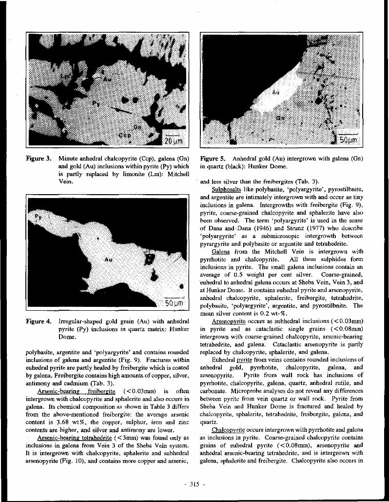
Figure 3. Minute anhedral chalcopyrite (Ccp), galena (Gn) and gold (Au) inclusions within pyrite (Py) which is partly replaced by limonite (Lm): Mitchell Vein.
Figure 4. Irregular-shaped gold grain (Au) with anhedral pyrite (Py) inclusions in quartz matrix: Hunker Dome.
polybasite, argentite and 'polyargyrite' and contains rounded inclusions of galena and argentite (Fig. 9). Fractures within euhedral pyrite are partly healed by freibergite which is coated by galena. Freibergite contains high amounts ofcopper, silver, antimony and cadmium (Tab. 3).
Arsenic-bearing freibergite ( <0.03mm) is often intergrown with chalcopyrite and sphalerite and also occurs in galena. Its chemical composition as shown in Table 3 differs from the above-m~ntioned freibergite: the average arsenic content is 3.68 wt%, the copper, sulphur, iron and zinc contents are higher, and silver and antimony are lower.
Arsenic-bearing tetrahedrite ( < 3mm) was found only as inclusions in galena from Vein 3 of the Sheba Vein system. It is intergrown with chalcopyrite, sphalerite and subhedral arsenopyrite (Fig. 10), and contains more copper and arsenic,
Figure 5. Anhedral gold (Au) intergrown with galena (Gn) in quartz (black): Hunker Dome.
and less silver than the freibergites (Tab. 3). Sulphosalts like polybasite, 'polyargyrite', pyrostilbnite,
and argentite are intimately intergrown with and occur as tiny inclusions in galena. lntergrowths with freibergite (Fig. 9), pyrite, coarse-grained chalcopyrite and sphalerite have also been observe.cl. The term 'polyargyrite' is used in the sense of Dana and ·Dana (1946) and Strunz (1977) who describe 'polyargyrite' as a submicrosopic intergrowth between pyrargyrite and polybasite or argentite and tetrahedrite.
Galena from the Mitchell Vein is intergrown with pyrrhotite and chalcopyrite. All three sulphides form inclusions in pyrite. The small galena inclusions contain an average of 0.5 ·weight per cent silver. Coarse-grained, euhedral to anhedral galena occurs at Sheba Vein, Vein 3, and at Hunker Dome. It contains euhedral pyrite and arsenopyrite, anhedral chalcopyrite, sphalerite, freibergite, tetrahedrite, polybasite, 'polyargyrite', argentite, and pyrostilbnite. The mean silver content is 0.2 wt-%.
Arsenopyrite occurs as subhedral inclusions ( < 0.03mm) in pyrite and as cataclastic single grains ( <0.08mm) intergrown with coarse-grained chalcopyrite, arsenic-bearing tetrahedrite, and galena. Cataclastic arsenopyrite is partly replaced by chalcopyrite, sphalerite, and galena.
Euhedral pyrite from veins contains rounded inclusions of anhedral gold, pyrrhotite, chalcopyrite, galena, and arsenopyrite. Pyrite from wall rock has inclusions of pyrrhotite, chalcopyrite, galena, quartz, anhedral rutile, and carbonate. Microprobe analyses do not reveal any differences between pyrite from vein quartz or wall rock. Pyrite from Sheba Vein and Hunker Dome is fractured and healed by chalcopyrite, sphalerite, tetrahedrite, freibergite, galena, and quartz.
Chalcopyrite occurs intergrown with pyrrhotite and galena as inclusions in_pyrite. Coarse-grained chalcopyrite contains grains of euhedral pyrite ( < 0.08mm), arsenopyrite and anhedral arsenic-bearing tetrahedrite, and is intergrown with galena, sphalerite and freibergite. Cbalcopyrite also occurs in
- 315 -

(Cu,Ag)2,5 Fe0•5As 53,25 1,0 Fe 0,5
1
l As Tennanti te
0,5 .... - - - - - - - - - - - - - - - - - 0, 5
8 00 0
Sb
Tetrahedrite
- -- - ----- -- ... -0 0,5 Zn+Cd 1,0
(Cu,Ag)i 5 Fe05 Sb 5325 ' ' '
(Cu,Ag)2,5(Zn,Cd)o,5 Sb 5325
Figure 6. Composition of tetrahedrite-tennantite group minerals from Hunker Dome and Sheba Vein; freibergite = solid circles, arsenic-bearing freibergite = crosses, arsenic-bearing tetrahedrite = open circles (tennaotite-tetrahedrite diagram, modified after Springer, 1969).
- 316 -

Fe
• • ••
• " •• • .. ... • •
•
' •
• • • •
Zn 50 Cd
Figure 7. Relative portions of iron, zinc and cadmium (at-%) in tetrahedrite-tennantite group minerals from Hunker Dome and Sheba Vein; solid circles = freibergite not intergrown with sphalerite, open squares = freibergite intergrown with sphalerite, crosses = arsenic-bearing freibergite intergrown with sphalerite, and open circles = arsenic-bearing tetrahedrite intergrown with sphalerite.
galena as coatings on subhedral pyrite and euhedral arsenopyrite crystals. Microprobe analyses indicate no differences between the trace element content of coarse
grained chalcopyrite and the rounded chalcopyrite inclusions in pyrite.
Sphalerite ( < 3mm) is generally intergrown with arsenopyrite, freibergite, chalcopyrite, and tetrabedrite. Sometimes sphalerite contains drop-shaped chalcopyrite inclusions, and has grown onto subhedral pyrite crystals
enclosed by galeoa. -Rounded chalcopyrite inclusions in sphalerite are interprete.d as 'chalcopyrite disease• in the sense of Barton (l 978f
Limonite, which formed from pyrite as a result of supergene processes, partly contains relict gold grains. Cerussite and finely disseminated covellite occur along fractures in galena. Covellite replacing chalcopyrite, freibergite and tetrahedrite contains up to 0.5 wt-% Ag.
- 317 -
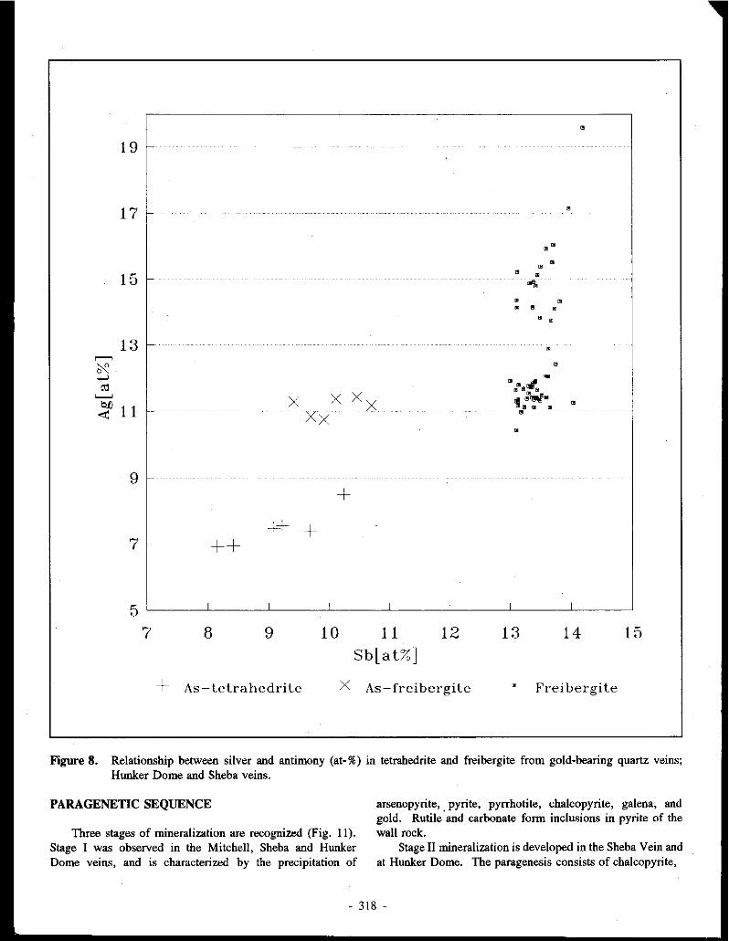
' 19
17
•" • •
15 ' • ..,, • • • ' •
• •
13 ' r--->
~ • ""'""
~
"' I! '!J.ml!r!//1! '----' x x xx ti :rw1M
Q{) • 11 ' ' ' <!'. Xx • •
9 +
++ + 7 ++
5 7 8 9 10 11 12 13 14 15
Sb[at%]
+ As-tetrahedrite x As-freibergite ' Frei ber gi te
Figure 8. Relationship between silver and antimony (at-%) in tetrabedrite and freibergite from gold-bearing quartz veins; Hunker Dome and Sheba veins.
PARAGENETIC SEQUENCE
Three stages of mineralization are recognized (Fig. 11). Stage I was observed in the Mitchell, Sheba and Hunker Dome veins, and is characterized by the precipitation of
arsenopyrite, pyrite, pyrrhotite, chalcopyrite, galena, and gold. Rutile 'and carbonate form inclusions in pyrite of the wall rock,
Stage II mineralization is developed in the Sheba Vein and at Hunker Dome. The paragenesis consists of chalcopyrite,
- 318 -

Figure 9. Sheba Vein: anbedral freibergite (Fbg) and polybasite (Pba) with inclusions of galena (Gn), and argentite (Agt) surrounded by galena.
Figure 10. Coarse-grained, arsenic-bearing tetrahedrite (Tet) containing subhedral arsenopyrite (Apy), anhedral chalcopyrite (Ccp), and sphalerite (Sp). Galena (Gn) is the host of this mineral assemblage: Vein (3).
sphalerite, tetrahedrite, freibergite, polybasite, 'polyargyrite', argentite, pyrostilbnite, and galena. Coarse-grained sphalerite, tetrahedrite, chalcopyrite and freibergite of stage II replace pyrite and arsenopyrite of stage I. Coarse-grained chalcopyrite, sphalerite, and arsenic-bearing tetrahedrite are rimmed and partly enclosed by freibergite, polybasite, 'polyargyrite', and argentite. Remaining voids are filled by galena, the youngest mineral phase of stage II.
During Stage lll, which was observed only in a quartz vein at Hunker Dome, silver-rich gold intergrown with galena was formed. Quartz is abundant in all three stages.
Quartz
Carbnnale
Rutile
Arsenop)Tite
r)'rito
!')·rrhotite
Chalcapyrite
Galena
Cold
Sphaleri1e
TOrahedrire
Frdbcrgite
Polyargni1e
Pol~basite
Argentite
P!rostilbnile
Figure 11.
Stage ( Stage ll Stage Ill
r====r====i===··-1
Paragenetic mineralization: Hunker Dome.
-
sequence of gold-sulphide Mitchell Vein, Sheba Vein and
WALL ROCK ALTERATION
Gold-bearing quartz veins are surrounded by a distinct alteration envelope, consisting of an inner zone of sericitization which grades outward into a propylitic zone. A more intensive carbonatization is occasionally developed between the outer propylitic and inner sericitic zone. The alteration envelope ranges up to about 2 m in thickness. The inner zone is characterized hy sericite/phengite, quartz and lninor amounts of euhedral to subhedral pyrite which contains inclusions of mica, chlorite and quartz. Sericite/phengite micas replace plagioclase, muscovite and chlorite. The propylitic zone contains mainly chlorite, epidote and plagioclase. Muscovite, secondary quartz, and carbonates like calcite/dolomite, occur in smaller amounts. In the carbonate zone, secondary quartz and carbonates replace plagioclasc, muscovite and chlorite.
MICROTHERMOMETRIC STUDY
Fluid inclusion studies were carried out in order to relate the paragenetic sequence to the evolution of the hydrothermal fluids. Investigations focused on vein quartz with several different habits: clear and euhedral, milky and brittle, cataclastic, and late stage quartz. Fluid inclusion data confirmed the three stages of mineralization established by microscopic observations.
Stage I: Two phase H,O-bearing fluid inclusions, as well as three phase H,O and C02-bearing inclusions, were identified to be of primary origin due to their spatial distrubution in quartz grains. Homogenization temperatures range from 260° to 390° C with a maximum at about 300° ± 40°C (Fig. 12). Melting of frozen C02 occurs between -60.2° and -56.6° C.
. 319 -

Cf) z 0 Cf) ::J _J
0 z
70
60 -
50 -
40 -
LL 0 30 ~
a: w m 20 -2 ::J z 10 -
0
MITCHELL VEIN
I I I I I I I I I I I 1 1 T 1 I I I I I I 1 1 I I I I
-SOLID BARS STAGE I PRIMARY INCLUSIONS
-
HATCHED BARS STAGE I SECONDARY INCLUSIONS
-
-
-
I I 1 I I I I I I I I I I I
105 115 125 135· 145 1s:; 165 115 185 195 WI> 215 225 236 245 256 2615 275 285 295 300 315 325 336 345 355 36S 375 38<i
HOMOGENIZATION TEMP (DEG C)
Figure 12. Histogram showing frequency distribution of homogenization temperatures for stage I inclusions in quartz: Mitchell Vein.
Cf) z
20
0 15 Cf) ::J _J
0 z LL 0 a: w m 2 ::J z
10
5
0
SHEBA VEIN
SOLID BARS STAGE II SECONDARY INCLUSIONS
HATCHEJ BARS STAGE I SECONDARY INCLUSION
WHITE BARS STAGE I PRIMARY INCLUSIONS
1~- 11s 12s. 135 145 155. 155 11t1. 1as. ms. 200. 215 225. 235. 2"46. 2ss. 265. 275 2~ 20s. 300 315. 325_ 335 ~- 355 :ies. 375 :ies 395
HOMOGENIZATION TEMP (DEG C)
Figure 13. Histogram showing frequency distribution of homogenization temperatures for stage I and II inclusions in quartz: Sheba Vein.
- 320 -

Figure 14. Earlier cataclastic quartz relics (medium to dark grey) healed by late, fine-grained quartz (white): Hunker Dome.
The deviation from the melting point of pure C02 (-56.6°C) is evidence of the presence of gases like CH,. or H2S (Hollister and Crawford, 1981). Melting point measurements of the aqueous phase show salinities ranging from 0 to 7 .2 wt-% NaCl equivalent. Secondary fluid inclusions of stage I occurring along microfractures are similar to primary inclusions with respect to their phase relationships and fluid characteristics. Stage I primary and secondary inclusions are observed in all veins.
Stage II: Another type of secondary, H,0-bearing fluid inclusion was identified in quartz from Sheba Vein (Fig. 13). Homogenization temperatures are significantly lower than for stage I fluid inclusions and vary from 190° to 260° C. Indicated salinity values are scattered between 1.5 and 5. 7 wt% NaCl equivalent.
Stage III: Aqueous fluid inclusions of stage III were observed only in late stage quartz at Hunker Dome. While fluid inclusions representing all stages of mineralization are present in quartz clasts, stage III inclusions occur only in quartz cement healing cataclastic vein quartz (Fig. 14). Homogenization temperatures of stage III inclusions range from 120° to 210°C with a maximum at about 170°C (Fig. 15). Last melting of ice occurs between -0.2° and -2.5°C corresponding to salinities between 0.4 and 4.2 wt-% NaCl equivalent.
Eutectic melting of ice was observed between -28° and -38°C in inclusions representing all three stages. This can be explained by the presence of a variety of dissolved salts, among which NaCl, KCI, MgCl2, Na,C03, and NaHC03 are the most important (Shepherd et al., 1985; Leeder et al., 1987).
SUMMARY AND CONCLUSIONS The gold-bearing quartz vein system in the Hunker Creek
area is an excellent example of the relationship between
mineralizing events and changes in the evolution of hydrothermal fluids. Three stages of mineralization recognized in the Mitchell (Stage I only), Sheba (stages I & II) and Hunker Dome (Stages I, II and Ill) veins are related to three generations of fluid inclusions (Fig. 16).
During stage I (gold, arsenopyrite, pyrite, pyrrhotite, chalcopyrite, rutile, quartz and minor carbonates), H20-rich and aqueous co,-bearing fluids with homogenization temperatures of 300° ± 40°C and salinities between 0 to 7.2 wt-% NaCl equiv. were involved.
Stage II mineralization consists of chalcopyrite, sphalerite, tetrahedrite, freibergite, 'polyargyrite', argentite, pyrostilbnite, galena, quartz, and accessory carbonate. Fluid homogenization temperatures are 230 ± 40°C and salinities range from 1.5 to 5.7 wt-% NaCl equivalent.
Fluid inclusions formed during late stage III mineralization homogenize at 170° ± 40°C. Salinities of hydrothermal fluids range from 0.4 to 4.2 wt-% NaCl equivalent.
The sericite/phengite alteration around the gold-sulphidequartz veins indicates slightly acid conditions (pH = 5 ± 1) during the mineralizing events (Hayba et al., 1985; Henley et al., 1984). The sulphide-sulphosalt mineral paragenesis suggests that reduced sulphur was abundant in the hydrothermal fluids. The abundance of sulphur, reducing conditions during gold deposition, and homogenization temperatures (minimum formation temperatures), at and far below 300°C imply that gold was been transported either as a bisulphide(Henley, 1973; Seward, 1973; Huston and Large, 1989) or as a sulpbarsenide complex (Boyle, 1979).
The following model . of the mineralization process is consistent with the petrographic and fluid inclusion data: gold deposition wa,s initiated by unmixing of an original one phase H20 and CO,- bearing fluid accompanying a drop in pressure and temperature. The loss of CO, caused an increase in pH and a decrease in the bisulphide concentration in the aqueous phase, favouring the formation of sulphides and the precipitation of gold. Subsequent mineralization processes were mainly influenced by decreasing temperature of the hydrothermal fluid.
ACKNOWLEDGEMENTS This study results from the Canada/Germany Science and
Technology Exchange Agreement organized by the Geological Survey of Canada and the Federal Institute for Geosciences and Mineral Resources (BGR) in Germany. Financial support was granted by the German Ministry of Research and Technology and by the· Exploration and Geological Services Division of the Department of Indian and Northern Affairs, Whitehorse, Yukon. We also acknowledge cooperation and support from United Keno Hill Mines Limited, particularly D. Prince and J. McFaull. Thanks are extended to H. Liedtke and J. Erikson for the permission to visit their prospects. The cooperation of J. Morin, G. Abbott and U. Glasmacher is greatly appreciated. This paper greatly benefited from discussions with P. Siinger von Oepen and P. Herzig.
- 321 -
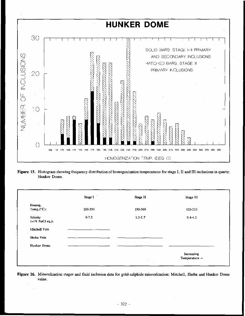
HUNKER DOME
30 I I I I I I i I I I I I I I I I : I I I I I I I I I I I
CJ) z 0 CJ) =i 20 _J () z LL 0 0:: 10 w OJ 2 =i z
0
~ SOLID BARS ST AGE 1-111 PRIMARY
~ AND SECONDARY INCLUSIONS
~
~ HATCHED BARS STAGE Ill
~ PRIMARY INCLUSIONS ~ f;; -
I ',
~
~ ' ~ '
~ :::; ~ ~
-
r ~ ~ ~ F ,, F ' R ~· ~ ' ~ R
~ _l_ [:; ~ ' ~ ~ §l I I lt I I : I I - ~ ~ - ~
105 115 125 135 145 155 165 175 185 195 205 215 235 245 255 265 275 285 ~5 305_ 315 325 335 345 355 365 375 385 395
HOMOGENIZATION iEMP. (DEG Cl
Figure 15. Histogram showing frequency distribution of homogenization temperatures for stage I, II and Ill inclusions in quartz: Hunker Dome.
Ilomog. Temp.(°C):
Salinity ("t% NaCl eq.):
J\1itchell Vein
Sheba Vein
llunker Dome
Stage I
260-390
0-7,2
Stage II
190-360
1.5-5.7
Stage III
120-210
0,4-4,2
Increasing Temperature_....
Figure 16. Mineralization stages and fluid inclusion data for gold-sulphide mineralization: Mitchell, Sheba and Hunker Dome veins.
- 322 -

REFERENCES
ARMSTRONG, R.L., I 988. Mesozoic and early Cenozoic magmatic evolution of the Canadian Cordillera. Geological Society of America, Special Paper 2I8, p. 55-9I.
BARTON, P.B., Jr., I978. Some ore textures involving sphale~ite from the Furutobe mine, Akita Prefecture, Japan. Mining Geology, Vol. 28, p. 293-300.
BOSTOCK, H.S., I942. Ogilvie Map-Sheet. Geological Survey of Canada, Map 711 A.
BOYLE, R. W., I979. The geochemistry of gold and its deposits. Geological Survey of Canada, Bulletin 280, p. 584.
BOYLE, R. W., I987. Gold; History and Genesis of Deposits. Van Nostrand Reinhold Company, New York, p. 676.
DANA, J.D., and DANA, E. S., I 946. The System of Mineralogy. 7th ed., Vol. I, John Wiley and Sons, Inc., London, p. 834.
DEBICKI, R.L., 1984. Bedrock geology and mineralization of the Klondike area (west); 115 0114, I5 and 116 B/2,3. 1:50 000 scale map with marginal notes. Exploration and Geological Services Division, Yukon, Indian and Northern Affairs Canada, Open File I984-3.
DEB/CK/, R.L., I985. Bedrock geology and mineralization of the Klondike area (east); 115 0/9,IO,I I ,14,I5,I6 and I I6 B/2. I :50 000 scale map with marginal notes. Exploration and Geological Services Division, Yukon, Indian and Northern Affairs Canada, Open File I985-I.
DUFRESNE, M.B., I987. Origin of gold in the white channel sediments of the Klondike Region, Yukon Territory. Unpublished M.Sc. thesis, University of Alberta, Edmonton, p. I8I.
GREEN, L. H., and RODDICK, J.A., I962. Dawson, Larsen Creek and Nash Creek map areas, Yukon Territory. Geological Survey of Canada, Paper 62-7, p. I9.
HAYBA, D. 0., BEWKE, P.M., HEALD, P., FOLEY, N.K., (1985). Geologic, mineralogic, and geochemical characteristics of volcanic hosted epithennal precious-metal deposits. Jn: Geology and Geochemistry of Epithermal Systems, Berger, B.R. and Bethke, P.M. (eds.); Society of Economic Geologists, Reviews in Economic Geology, Vol.2, p. 129-167.
HENLEY, R. W., I973. Solubility of gold in hydrothermal chloride solutions. Chemical Geology, Vol. I I, p. 73-87.
HENLEY, R. W, TRUESDELL, A.H., BARTON, Jr., P.B., I984p. Fluid-mineral equilibria in hydrothermal systems. Reviews in Economic geology, Vol. I, p. 267.
HOLLISTER, L. S. and CRAWFORD, M.L., I 98I. Fluid inclusions; applications to petrography. Mineral Association of Canada, Short Course Handbook, Vol. 6, p. 304.
HTOON, M., I979. Geology of the Clinton Creek asbestos deposit, Yukon Territory. Unpublished M.Sc. thesis, University of British Columbia, Vancouver, p. 194.
HUSTON, D.L., LARGE, R.R., I989. A chemical model for the concentration of gold in volcanogenic massive sulphide deposits. Ore Geology Reviews, Vol. 4, p. Ill-200.
LEEDER, D., WOMAS, R., and KLEMM, W, 1987. Einschlusse in Mineralien. VEB Deutscher Verlag far Grundstoffindustrie, Leipzig, p. I80.
- 323 -

METCALFE, P. and CLARK, G. S., i983. Rb-Sr whole-rock age of the Klondike Schist, Yukon Territory. Canadian Journal of Earth Sciences, Vol. 20, p. 886-891.
MORTENSEN, J., 1990. Bedrock Geology and U-Pb Geochronology of the Klondike District, West-Central Yukon Territory. Canadian Journal of Earth Sciences, Vol. 27, p. 903-914.
RAMDOHR, P., 1980. The ore minerals and their intergrowths. 2nd edition, Pergamon Press, Oxford, p. 1205.
SEWARD, T.M., 1973. Thio-complexes of gol.d and the transport of gol.d in hydrothermal ore solutions. Geochimica et Cosmochimica Acta, Vol. 37, p. 379-399.
SHEPHERD, T.J., RANKIN, A.H., and ALDERTON, D.H.M., 1985. A practical guide to fluid inclusion studiesp. Blackie & Son Ltd, Glasgow, p. 239.
SPRINGER, G., 1969. Electron probe analyses oftetrahedrite. Neues Jahrbuch der Mineralogie, p. 24-
32.
STRUNZ, H., 1977. Mineralogische Tabellen. Akademische Verlagsgesellschaft, Leipzig, p. 621.
TEMPELMAN-KLUIT, D.J., 1977. Stratigraphic and structural relations between Selwyn Basin, PellyCassiar Platform and Yukon Crystalline Terrain in the Pelly Mountains, Yukon. In: Report of Activities, Part A; Geological Survey of Canada, Paper 77-1A, p. 223-227.
TEMPELMAN-KLUIT, D.J., 1979. Transported cataclasite, ophiolite and granodiorite in Yukon: evidence of arc-continent collision. Geological Survey of Canada, Paper 79-14, p. 27.
TEMPELMAN-KLUIT, D.J., 1981. Geology and mineral deposits of southern Yukon. In: Yukon Geology and Exploration; Exploration and Geological Services Division, Yukon, Indian and Northern Affairs Canada, p. 7-31.
- 324 -
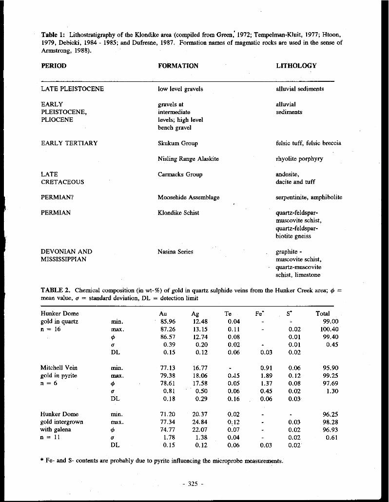
Table 1: Lithostratigrapby of the Klondike area (compiled from Green,' 1972; Tempelman-Kluit, 1977; Htoon, 1979, Debicki, 1984 - 1985; and Dufresne, 1987. Formation names of magmatic rocks are used in the sense of Armstrong, 1988).
PERIOD
LATE PLEISTOCENE
EARLY PLEISTOCENE, PLIOCENE
EARLY TERTIARY
LATE CRETACEOUS
PERMIAN?
PERMIAN
DEVONIAN AND MISSISSIPPIAN
FORMATION
low level gravels
gravels at intermediate levels; high level bench gravel
Skukum Group
Nisling Range Alaskite
Carmacks Group
Moosehide Assemblage
Klondike Schist
Nasina Series
LITHOLOGY
alluvial sediments
alluvial sediments
felsic tuff, felsic breccia
rhyolite porphyry
andesite, dacite and tuff
serpentinite, amphibolite
quartz-feldsparmuscovite schist, quartz-feldsparbiotite gneiss
graphite -muscovite schist, quartz-muscovite schist, limestone
TABLE 2. Chemical composition (in wt-%) of gold in quartz sulphide veins from the Hunker Creek area; ¢ =
mean value, o = standard deviation, DL = detection limit
Hunker Dome gold in quartz n = 16
Mitchell Vein gold in pyrite n=6
Hunker Dome gold intergrown with galena n = 11
min. max. ¢ (f
DL
nun. max. ¢ (f
DL
min. max. ¢ (f
DL
Au 85.96 87.26 86.57 0.39 0.15
77.13 79.38 78.61 0.81 0.18
71.20 77.34 74.77
1.78 0.15
Ag Te 12.48 0.04 13.15 0.11 12.74 0.08 0.20 0.02 0.12 0.06
16.77 18.06 0 .• 15 17.58 0.05 0.50 0.06 0.29 0.16
20.37 0.02 24.84 0.12 22.07 0.07
1.38 0.04 0.12 0.06
Fe
0.03
0.91 1.89 J.37 0.45 0.06
s·
0.02 0.01 0.01 0.02
0.06 0.12 0.08 0.02 0.03
0.03 0.02 0.02
0.03 0.02
* Fe- and S- contents are probably due to pyrite influencing the microprobe measurements.
- 325 -
Total 99.00
100.40 99.40
0.45
95.90 99.25 97.69
1.30
96.25 98.28 96.93 0.61

Table 3. Chemical composition (in wt-%) of freibergite and tetrahedrite in quartz sulphide veins from the Hunker Creek area; </> = mean value, o = standard deviation, DL = detection limit
Cu Ag Fe Zn Cd nun. 15.68 18.48 1.44 0.04 max. 25.97 31.52 5.57 2.60 7.29
1. </> 22.27 21.82 3.46 I.OJ 2.93 (f 2.33 3.22 1.17 0.59 2.29 DL 0.04 0.10 0.03 0.05 0.30
min. 24.42 19.34 4.72 1.15 0.19 max. 26.17 20.06 5.14 1.23 0.37
2. </> 25.26 19.75 4.88 1.19 0.25 (f 0.69 0.32 0.14 0.04 0.07 DL 0.04 0.10 0.03 0.05 0.30
min. 28.99 12.64 4.02 2.33 max. 31.87 15.22 4.41 2.72
3. </> 30.68 13.61 4.15 2.45 (f 1.03 0.93 0.16 0.14 DL 0.04 0.10 0.03 0.05 0.30
1. Freibergite from Sheba Vein and Hunker Dome (n = 54):
(C1Jo . .,Ago.i1h.,,(Fe,, . .,ZDo.1sC<lo.is)o.49Sbo.97Sl.24
2. Arsenic-bearing freibergite of Sheba Vein and Hunker Dome (n = 6): ( CUo_.,Ag0_32) 2_58(F e,,_.,Zn._ 17) 0_.9( Sb0. 77As0.23) 0. ,.s""
3. Arsenic-bearing tetrahedrite of Vein 3 (n = 6): ( CIJo. ,.Ag0_21 )2_,,(F e,,_.,Zn._33) 0_48( S b0_ 73As0_27 ) 0.90S3_23
- 326 -
Sb 24.74 26.69 25.63
0.36 0.10
18.81 21.43 20.12
0.90 0.10
16.94. 20.70 18.82 1.33 0.10
• As s Total
20.30 98.16 0.01 23.80 101.47
22.44 99.56 0.01 0.61 0.71 0.50 0.03
2.92 23.38 98.07 4.30 24.21 99.81 3.68 23.79 98.91 0.52 0.29 0.76 0.50 0.03
3.02 23.39 98.00 5.76 24.57 98.42 4.42 24.05 98.17 1.05 0.54 0.15 0.50 0.03