Embed Size (px)
Citation preview

®®
Towards standards in capturing the changing characteristics of a place for
disparate interests
Presentation to AAG, 14 April 2011
Raj Singh, PhDDirector, Interoperability Programs
© 2011 Open Geospatial Consortium

OGC®
agenda
• a little bit about OGC• overview of OGC’s current gazetteer spec (WFS-G)• moving towards a web-centric view of place information• the global gazetteer
© 2011 Open Geospatial Consortium

OGC®
Address Critical Interoperability Issues
• OGC Standards and Programs are Addressing Common Concerns:
“We can‘t share location data on the Web.”
“We can‘t deliver data to different systems.”
“We don‘t have a common language to exchange our geospatial data and services.”
© 2011 Open Geospatial Consortium

OGC®
What is the OGC?
• Open Geospatial Consortium, Inc. (OGC) • Not-for-profit, international voluntary consensus standards
organization• Founded in 1994, Incorporated in US, UK, Australia• 415 industry, government, research and university members
© 2011 Open Geospatial Consortium
OGC Mission
To lead in the development, promotion and harmonization of open geospatial standards …

OGC®
OGC Standards (30+)
• Encodings– GML– SLD– SensorML– CityGML– WMC– O&M– Filter Encoding– KML – Symbology Encoding– GML in JPEG 2000– NetCDF
• Data Services– Sensor Observation Service – Web Coverage Service – Web Feature Service– Web Map Service ..
• Catalogue Services– Catalogue Service
• Processing Services– Coordinate Transformation
Service– Web Processing Service
• Portrayal Services …
© 2011 Open Geospatial Consortium

OGC®
OGC’s Interoperability Approach
• Interoperability Program (IP) - a global, innovative, hands-on prototyping and testing program designed to accelerate interface development and validation, and bring interoperability to the market
• Specification Development Program – Consensus processes similar to other Industry consortia (World Wide Web Consortium, OMA, OMG, etc.).
• Outreach and Community Adoption Program – education and training, encourage take up of OGC specifications, business development, communications, etc.
Rapid InterfaceDevelopment
StandardsSetting
MarketAdoption
© 2011 Open Geospatial Consortium

OGC®
the specification…
© 2011 Open Geospatial Consortium

OGC®
the specification…
• There is growing interest in the development of a common feature-based model for access to named features, often referred to as a gazetteer. Two major activities form the basis of this specification, an OGC Discussion paper on gazetteers, and an ISO draft standard for geographic identifiers.
• As a result of the OGC Geospatial Fusion Services Testbed Phase I and the Web Mapping Testbed Phase II, an Open GIS Gazetteer Interface was defined and published as an OGC Discussion Paper [OGC 2001].
• The standardization process in the ISO TC 211 led to a separate mature draft standard defining "Spatial referencing by geographic identifiers" [ISO19112] that defines an abstract model to be implemented by a gazetteer service.
• The outcomes of these activities have been taken into account and a consolidated Gazetteer Service implementation specification has been developed and published as a discussion paper [OGC 02-076r3]. As the underlying specifications have been further developed the present document makes the necessary adjustments.
© 2011 Open Geospatial Consortium

OGC®
the specification…
• The Gazetteer Service is a specialized Application Profile (hereafter referred to as “profile”) of a Web Feature Service that specifies a minimum set of Feature Types and operations required to support an instance of a gazetteer service. Instances within a collection of gazetteer features may be – as the terms in a thesaurus – related to each other and constitute a hierarchical vocabulary of geographic places. The overall information model is here implemented as a GML application schema that defines a general feature type to be served by a Gazetteer Service.
• By using the capabilities of a Web Feature Server, the Gazetteer Service as proposed here exposes the following interfaces to query location instances in a gazetteer database:– Get or Query features based on thesaurus-specific properties (broader term (BT), narrower term (NT),
related term (RT)– Retrieve properties of the gazetteer database, such as the location type class definitions and the spatial
reference system definitions
© 2011 Open Geospatial Consortium

OGC®
gazetteer specification’s data model
© 2011 Open Geospatial Consortium

OGC®
XML text example of NGA GNS
© 2011 Open Geospatial Consortium

OGC®
XML graphic example of NGA GNS
© 2011 Open Geospatial Consortium

OGC®
WFS Gazetteer bottom line
• works well and easy to implement if…– you want to use WFS– your places are “features” -- mapping emphasis– you can do data modeling in GML– your information schema is structured and fixed
© 2011 Open Geospatial Consortium

OGC®
does WFS-G promote OGC’s goals?
OGC’s mission: make location information and its use pervasive throughout society
are we achieving this goal?
© 2011 Open Geospatial Consortium

OGC®
pervasiveness before apps
• favor geospatial information creation, sharing, and collaboration over application use cases
• tension between structured information (which promotes interesting queries, i.e. application development) and unstructured information (which promotes easy publishing and annotation)
• how do we get the best of both worlds?
© 2011 Open Geospatial Consortium

OGC®
nameplacetypestartdateenddatelocation
id-x
nameplacetypestartdateenddatelocation
id-x
nameplacetypestartdateenddatelocation
id-x
nameplacetypestartdateenddatelocation
id-x
traditional views of gazetteer design
© 2011 Open Geospatial Consortium
nameplacetypestartdateenddatelocation
id-x
nameplacetypestartdateenddatelocation
id-x
nameplacetypestartdateenddatelocation
id-x
nameplacetypestartdateenddatelocation
id-x

OGC®
the dream of a global gazetteer
not one database but different degrees of interoperability between gazetteers in the face of differing ontologies, languages, etc. –
Peter Bol
At one point we thought they would all be in WFSes, now there’s a focus on linked data (an anarchic approach) – Humphrey Southall
give us raw data now! – Tim Berners-Lee
© 2011 Open Geospatial Consortium
OGC®
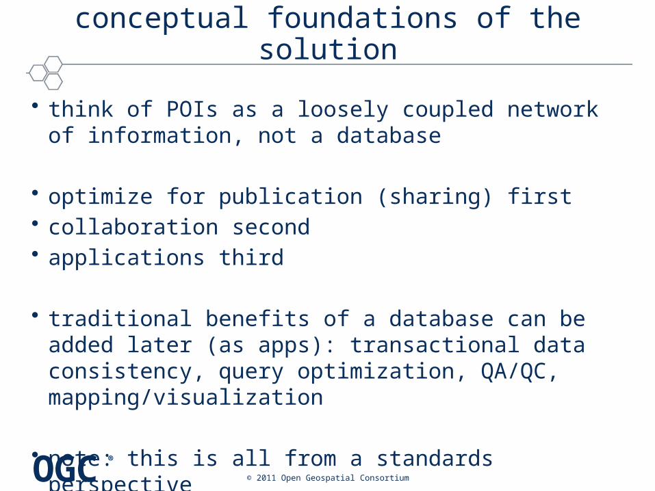
conceptual foundations of the solution
• think of POIs as a loosely coupled network of information, not a database
• optimize for publication (sharing) first• collaboration second• applications third
• traditional benefits of a database can be added later (as apps): transactional data consistency, query optimization, QA/QC, mapping/visualization
• note: this is all from a standards perspective
© 2011 Open Geospatial Consortium

OGC®
standards tenets
• throw all place information onto the web– standards: use WFS-G (sometimes)– standards: shared data models and formats– standards: at this point, the only query mechanism is HTTP GET
• link related places with URLs– standards: small vocab of types of links, e.g. identity, sort of identity,
within, next to, related– standards: still only querying with URLs
• layer higher level gazetteers on top– standards: shared data models
© 2011 Open Geospatial Consortium
OGC®
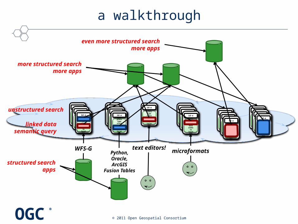
a walkthrough
© 2011 Open Geospatial Consortium
nameplacetyp
estartdat
eenddatelocation
id-x
nameplacetyp
estartdat
eenddatelocation
id-x
nameplacetyp
estartdat
eenddatelocation
id-x
nameplacetyp
estartdat
eenddatelocation
id-x
nameplacetyp
estartdat
eenddatelocation
id-x
nameplacetyp
estartdat
eenddatelocation
id-x
nameplacetyp
estartdat
eenddatelocation
id-x
nameplacetyp
estartdat
eenddatelocation
id-x
nameplacetyp
estartdat
eenddatelocation
id-x
nameplacetyp
estartdat
eenddatelocation
id-x
linked datasemantic query
unstructured search
WFS-G
structured searchapps
more structured searchmore apps
nameplacetyp
estartdat
eenddatelocation
id-x
nameplacetyp
estartdat
eenddatelocation
id-x
nameplacetyp
estartdat
eenddatelocation
id-xname
placetype
startdate
enddatelocation
id-x
nameplacetyp
estartdat
eenddatelocation
id-x
nameplacetyp
estartdat
eenddatelocation
id-x
Python,Oracle,ArcGIS
Fusion Tables
microformatstext editors!
even more structured searchmore apps

OGC®
it’s already happening…
© 2011 Open Geospatial Consortium

OGC®
it’s already happening…
© 2011 Open Geospatial Consortium