Embed Size (px)
Citation preview

INTERNATIONAL SCIENTIFIC CONFERENCE M E T H O D O L O G Y & A R C H A E O M E T R Y 0 7 1
07THINTERNATIONALS C I E N T I F I C C O N F E R E N C E
Methodology & Archaeometry
Z a g re b , 2 n d ‒ 3 rd D e c e m b e r 2 0 1 9
http://www.ffzg.unizg.hr/metarh/
07THINTERNATIONALS C I E N T I F I C C O N F E R E N C E
Methodology & Archaeometry
Z a g re b , 2 n d ‒ 3 rd D e c e m b e r 2 0 1 9
IMPRESSUM
PUBLISHER
Faculty of Humanities and Social Sciences of the University of ZagrebCroatian Archaeological Society
FOR THE PUBLISHER
Vesna Vlahović-ŠtetićJacqueline Balen
EDITOR
Ina Miloglav
CONFERENCE ORGANISED BY
Department of Archaeology, Faculty of Humanities and Social Sciences of the University of Zagreband the Croatian Archaeological Society
DESIGN & LAYOUT
Srećko Škrinjarić
PRINTED BY
Tiskara Zelina d.d.
PRINT RUN
100 copies
ISBN
Faculty of Humanities and Social Sciences of the University of Zagreb978-953-175-830-7Croatian Archaeological Society978-953-6335-17-6
CIP record 001045577 available in online catalogue of the Zagreb National and University Library.
FINANCIAL SUPPORT
This year’s Conference has been financially supported by the Croatian Archaeological Society, the Faculty of Humanities and Social Sciences of the University of Zagreb and the Ministry of Science and Education of the Republic of Croatia.
http://www.ffzg.unizg.hr/metarh/
07THINTERNATIONALS C I E N T I F I C C O N F E R E N C E
Methodology & Archaeometry
Zagreb, 2 nd ‒ 3 rd December 2019

Conference Methodology and Archaeometry 7
List of participants 9
Program 19
Abstracts 27
Exhibition Archaeology from the Air 47
Notes 48
Navigation & General Information 55
CONTENT
INTERNATIONAL SCIENTIFIC CONFERENCE M E T H O D O L O G Y & A R C H A E O M E T R Y 0 7 7
CONFERENCE METHODOLOGY & ARCHAEOMETRY
The scientific conference Methodology and Archaeometry is being organised by the Department of Archaeology, Faculty of Humanities and Social Sciences since 2013. The goal of the conference is to entice interdisciplinarity, critical thinking, new in-
sights and approaches as well as new theoretical frameworks in contemporary archaeo-logical science.Coverage of a wide spectrum of themes and scientific disciplines has resulted in papers and discussions that promote scientific issues in the fields of methodology, documentation and interpretation of archaeological data.The interdisciplinary character of the conference brings together archaeologists and re-searchers from other scientific disciplines with whom archaeologists collaborate closely; and who – through their work, projects and ideas – promote new insights about Interpre-tation of the human life in the past.
Section MethodologyObtaining and collecting data is an essential part of the archaeological research process. How we collect and interpret data defines the validity of our interpretation. We use dif-ferent techniques, approaches and tools which help us to reconstruct the past processes and to give more objective and comprehensive picture of the past. Contemporary inter-pretation tools alleviate and speed the data collection and also provide us with countless possibilities of interpretation, protection and presentation of archaeological sites and the landscapes encompassing them.
Section ArchaeometryHaving in mind limited information we obtain from archaeological excavations and from the classification of archaeological material, cooperation with other scientific disciplines becomes unnecessary, to obtain as much information as possible on the conditions and the way in which the humans lived in the past. Contemporary archaeology is a very hete-rogeneous discipline encompassing interest groups focussed on various periods, regions, theoretical frameworks and methodological techniques. Aside from the description of mechanical and physical features of a specific artefact or material, various arhaeometrical analyses help us to direct our scientific focus to questions regarding the ways and features included in the social and cultural life of people who made, used, exchanged and discarded those objects. Cooperation with the natural sciences provides answers to many questi-ons, but it also demands an additional level of caution when selecting adequate scientific analysis for a specific archaeological problem. It also demands a continuous cooperation of a specific expert and an archaeologist from sample collection to the final interpretation.
http://www.ffzg.unizg.hr/metarh/publications.html
INTERNATIONAL SCIENTIFIC CONFERENCE M E T H O D O L O G Y & A R C H A E O M E T R Y 0 7 98 M E T H O D O L O G Y & A R C H A E O M E T R Y 0 7 INTERNATIONAL SCIENTIFIC CONFERENCE
LIST OF PARTICIPANTS
ALIHODŽIĆ TIMKAArchaeological Museum ZadarTrg opatice Čike 1, 23000 Zadar, [email protected]
ANĐELINOVIĆ ŠIMUNClinical Department for Pathology, Forensic Medicine and Cytology, Clinical Hospital Center Spinčićeva 1, 21000 Split; School of Medicine, Šoltanska 2, 21000 Split, [email protected]
BALEN JACQUELINEArchaeological Museum in ZagrebNikola Šubić Zrinski Square 19, 10000 Zagreb, [email protected]
BAREŠIĆ JADRANKARuđer Bošković InstituteBijenička cesta 54, 10000 Zagreb, [email protected]
BAŠIĆ ŽELJANAUniversity Department of Forensic Sciences, University of SplitRuđera Boškovića 33, 21000 Split, [email protected]
BERNARDINI FEDERICOCentro Fermi, Museo Storico della Fisica e Centro di Studi e Ricerche “Enrico Fermi”Piazza del Viminale 1, 00184 Roma; Multidisciplinary Laboratory, The “Abdus Salam” International Centre for Theoretical Physics, Strada Costiera 11, 34014 Trieste, [email protected]
BORKOVIĆ DAMIRRuđer Bošković Institute, Bijenička cesta 54, 10000 Zagreb, [email protected]
BRENKO TOMISLAVFaculty of Mining, Geology and Petroleum Engineering, University of ZagrebPierottijeva 6, 10000 Zagreb, Croatia [email protected]
INTERNATIONAL SCIENTIFIC CONFERENCE M E T H O D O L O G Y & A R C H A E O M E T R Y 0 7 1110 M E T H O D O L O G Y & A R C H A E O M E T R Y 0 7 INTERNATIONAL SCIENTIFIC CONFERENCE
CAMPEAU KATHRYNDepartment of Anthropology, University of Toronto Mississauga, T. Donnelly Health Sciences ComplexHSC300, 3359 Mississauga Road, Ontario L5L 1C6,[email protected]
CARTER TRISTANDepartment of AnthropologyCNH 524, McMaster University, 1280 Main Street West, Hamilton, ON L8S 4L9, [email protected]
DE MIN ANGELODepartment of Mathematics and Geosciences, University of TriesteVia Weiss 8, 34127 Trieste, [email protected]
DIRIÉ NINARömisch-Germanisches ZentralmuseumErnst-Ludwig Platz 2, 55118 Mainz, Germany [email protected]
DIZDAR MARKOInstitute of ArchaeologyGajeva 32, Zagreb, Croatia [email protected]
DOBOSZ BERNADETAMedical Physics Division, Faculty of Physics, Adam Mickiewicz UniversityUniwersytetu Poznańskiego 2, 61-614 Poznań, [email protected]
DZIEGIELEWSKA-GAJSKI KATARZYNAZdenčice 1, Strmec Samoborski, [email protected]
ĐURIČIĆ ANALaboratory for Bioarchaeology, Dep. of Archaeology, Faculty of Philosophy, University of Belgrade Čika-Ljubina 18-20, Belgrade, [email protected]
FILEŠ KRAMBERGER JULIADepartment of Archaeology, Faculty of Humanities and Social Sciences, University of ZagrebIvana Lučića 3, Zagreb, [email protected]
GAJSKI DUBRAVKOFaculty of Geodesy, University of ZagrebKačićeva 26, 10000 Zagreb, [email protected]
GLUHAK TATJANARömisch-Germanisches ZentralmuseumErnst-Ludwig Platz 2, 55118 Mainz, Germany [email protected]
GROSMAN DARJADepartment of Archaeology, Faculty of Arts, University of LjubljanaZavetiška 5, 1000 Ljubljana, [email protected]
HARSÁNYI ILDIKÓNuclear Analysis and Radiography Department, MTA Centre for Energy ResearchKonkoly Thege 29-33, Budapest H-1121, [email protected]
HULINA MATEJADepartment of Archaeology, Faculty of Humanities and Social Sciences, University of ZagrebIvana Lučića 3, Zagreb, [email protected]
HULJEV IVANSv. Josipa 14, 22202 Primošten, [email protected]
JAKLIĆ MANUELAFaculty of Mining, Geology and Petroleum Engineering, University of ZagrebPierottieva 6, 10000 Zagreb, [email protected]
JERKOVIĆ IVANUniversity Department of Forensic Sciences, University of SplitRuđera Boškovića 33, 21000 Split, [email protected]
KABACIŃSKA ZUZANNAInstitute of Chemistry and Technical Electrochemistry, Poznań University of TechnologyBerdychowo 4, 60-965 Poznań, [email protected]
KALAFATIĆ HRVOJEInstitute of ArchaeologyGajeva 32, Zagreb, Croatia [email protected]
KARAVIDOVIĆ TENAInstitute of ArchaeologyGajeva 32, Zagreb, Croatia [email protected]
INTERNATIONAL SCIENTIFIC CONFERENCE M E T H O D O L O G Y & A R C H A E O M E T R Y 0 7 1312 M E T H O D O L O G Y & A R C H A E O M E T R Y 0 7 INTERNATIONAL SCIENTIFIC CONFERENCE
KASUM JOSIPUniversity Department of Forensic Sciences, University of SplitRuđera Boškovića 33, 21000 Split, [email protected]
KASZTOVSZKY ZSOLTNuclear Analysis and Radiography Department, MTA Centre for Energy ResearchKonkoly Thege 29-33, Budapest H-1121, [email protected]
KOVAČEVIĆ SAŠAInstitute of ArchaeologyLjudevita Gaja 32, 10000 Zagreb, [email protected]
KRUŽIĆ IVANAUniversity Department of Forensic Sciences, University of SplitRuđera Boškovića 33, 21000 Split, Croatia [email protected]
KUDELIĆ ANDREJAInstitute of ArchaeologyLjudevita Gaja 32, 10000 Zagreb, [email protected]
KULENOVIĆ IGORDepartment of Tourism and Communication Studies, University of ZadarUlica dr. Franje Tuđmana 24i, 23000 Zadar, [email protected]
KULENOVIĆ OCELIĆ NEDAUlica Andrije Hebranga 21, 23000 Zadar, [email protected]
LEGHISSA ELENAInstitute of Archaeology, ZRC SAZUNovi Trg 2, 1000 Ljubljana, [email protected]
LESKOVAR TAMARADepartment of Archaeology, Faculty of Arts, University of LjubljanaZavetiška 5, 1000 Ljubjana, [email protected]
LONČARIĆ VALENTINADepartment of Archaeology, Faculty of Humanities and Social Sciences, University of ZagrebIvana Lučića 3, Zagreb, [email protected]
LOZINA ANTEUniversity Department of Forensic Sciences, University of SplitRuđera Boškovića 33, 21000 Split, [email protected]
MAĐERIĆ MARINČerinina 3, 10000 Zagreb, [email protected]
MAGAŠ LUCIJAFaculty of Geodesy, University of ZagrebKačićeva 26, Zagreb, [email protected]
MATIJEVIĆ VINKA Department of Archaeology, Faculty of Humanities and Social Sciences, University of ZagrebIvana Lučića 3, 10000 Zagreb, [email protected]
MAVROVIĆ MOKOS JANJADepartment of Archaeology, Faculty of Humanities and Social Sciences, University of ZagrebIvana Lučića 3, Zagreb, [email protected]
MESTERHÁZY GÁBORCastle Headquarters Integrated Regional Development CentreH-1113 Daróczi út 1-3., Budapest, [email protected]
MEYER CORNELIUS CM ProspectionPrenzlauer Allee 181, 10405 Berlin, [email protected]
MICHALSKA DANUTADepartment of Dynamic and Regional Geology, Institute of Geology, Faculty of Geographical and Geological Sciences, Adam Mickiewicz University, Krygowskiego 12, 61-606 Poznań, [email protected]
MIHAILOVIĆ DANICA D.Archaeological InstituteKnez Mihailova 36, 11000 Belgrade, [email protected]
MIHALJEVIĆ MARIJAMunicipal museum Nova GradiškaTrg kralja Tomislava 7, Nova Gradiška, Croatia [email protected]
INTERNATIONAL SCIENTIFIC CONFERENCE M E T H O D O L O G Y & A R C H A E O M E T R Y 0 7 1514 M E T H O D O L O G Y & A R C H A E O M E T R Y 0 7 INTERNATIONAL SCIENTIFIC CONFERENCE
MILEUSNIĆ MARTAFaculty of Mining, Geology and Petroleum Engineering, University of ZagrebPierottieva 6, 10000 Zagreb, [email protected]
MILOGLAV INA Department of Archaeology, Faculty of Humanities and Social Sciences, University of ZagrebIvana Lučića 3, 10000 Zagreb, [email protected]
MLEKUŽ DIMITRIJDepartment of Archaeology, Faculty of Arts, University of LjubljanaZavetiška 5, 1000 Ljubljana; Institute for the Protection of Cultural Heritage of SloveniaPoljanska c. 40, 1000 Ljubljana, [email protected]
MONTAGNARI KOKELJ MANUELADepartment of Humanities, University of TriesteVia Lazzaretto Vecchio 6-8, 34123 Trieste, [email protected]
NOVAKOVIĆ PREDRAGDepartment of Archaeology, Faculty of Arts, University of LjubljanaZavetiška 5, 1000 Ljubljana, [email protected]
PETROVIĆ ANĐAUniversità La Sapienza, Roma, Dipartimento di Scienze dell’AntichitàVia Riccardo Zampieri 47, 00159 Rome RM, [email protected]
ROSENBERG DANNYLaboratory for Ground Stone Tools Research, Zinman Institute of Archaeology, University of Haifa Mount Carmel, Haifa, 3498838, [email protected]
SEKELJ IVANČAN TAJANAInstitute of ArchaeologyGajeva 32, Zagreb, Croatia [email protected]
SIRONIĆ ANDREJARuđer Bošković InstituteBijenička cesta 54, Zagreb, [email protected]
SKARPELIS NIKOLAOSDepartment of Economic Geology & Geochemistry, National and Kapodistrian University of Athens 30 Panepistimiou Str., 10679, Athens, [email protected]
SPITERI CYNTHIANNEE. Karls Universität Tübingen, Institut für Ur- und Frühgeschichte und Archäologie des MittelaltersBurgsteige 11, Tübingen, [email protected]
SZILÁGYI VERONIKANuclear Analysis and Radiography Department, MTA Centre for Energy ResearchKonkoly Thege 29-33, Budapest H-1121, [email protected]
ŠOŠIĆ KLINDŽIĆ RAJNADepartment of Archaeology, Faculty of Humanities and Social Sciences, University of ZagrebIvana Lučića 3, 10000 Zagreb, [email protected]
ŠPREM KATARINACentre for Interdisciplinary Research in Landscape Archaeology, Faculty of HumanitiesJuraj Dobrila University of Pula, I. Matetića Ronjgova 1, Pula, [email protected]
TAPAVIČKI-ILIĆ MILICAInstitute of ArchaeologyKneza Mihaila 35/IV, 11000 Belgrade, [email protected]
TONČINIĆ DOMAGOJ Department of Archaeology, Faculty of Humanities and Social Sciences, University of ZagrebIvana Lučića 3, 10000 Zagreb, [email protected]
TRESIĆ PAVIČIĆ DINKOKaducej Ltd.Papandopulova 27, Split, [email protected]
UREM-KOTSOU DUSHKADemocritus University of Thrace, Department of History and EthnologyTsaldari 1, 69 100 Komotini, [email protected]
INTERNATIONAL SCIENTIFIC CONFERENCE M E T H O D O L O G Y & A R C H A E O M E T R Y 0 7 1716 M E T H O D O L O G Y & A R C H A E O M E T R Y 0 7 INTERNATIONAL SCIENTIFIC CONFERENCE
VITEZOVIĆ SELENAInstitute of ArchaeologyKneza Mihaila 35/IV, 11000 Belgrade, [email protected]
VRKIĆ ŠIMEDepartment of Tourism and Communication Studies, University of ZadarUlica dr. Franje Tuđmana 24i, 23000 Zadar, [email protected]
VUKOVIĆ MIROSLAVDepartment of Archaeology, Faculty of Humanities and Social Sciences, University of ZagrebIvana Lučića 3, 10000 Zagreb, [email protected]
PROGRAM
INTERNATIONAL SCIENTIFIC CONFERENCE M E T H O D O L O G Y & A R C H A E O M E T R Y 0 7 1918 M E T H O D O L O G Y & A R C H A E O M E T R Y 0 7 INTERNATIONAL SCIENTIFIC CONFERENCE
PROGRAM
Monday, 2nd of December
10:00 – 10:20 Opening
Key-note lectures
Chair: Ina Miloglav
10:20 -10:50Duska Urem-KotsouInvestigating vessels content
10:55-11:25Tamara LeskovarLaboratory-based research on the changes caused to the in situ preserved archaeological remains by the heavy equipment compaction
11:30-12:00 Coffee break
Chair: Predrag Novaković
12:00-12:15Dimitrij MlekužGeostatistical modelling of the Neolithic settlement systems in western Carpathian basin
12:20-12:35Gábor MesterházyEffects of land cover changes on non-destructive archaeological research
12:40-12:55Cornelius Meyer & Saša KovačevićPatterns everywhere: Geophysical prospection strategies at archaeological sites in North-ern and Eastern Croatia
13:00-13:15Dubravko Gajski, Lucija Magaš & Katarzyna Dziegielewska-Gajski Evaluation of archaeological potential using multicriteria analysis in GIS

INTERNATIONAL SCIENTIFIC CONFERENCE M E T H O D O L O G Y & A R C H A E O M E T R Y 0 7 2120 M E T H O D O L O G Y & A R C H A E O M E T R Y 0 7 INTERNATIONAL SCIENTIFIC CONFERENCE
13:20-13:40 Coffee break
Chair: Dimitrij Mlekuž
13:40-13:55Dinko Tresić Pavičić & Andreja KudelićArchaeological excavation at Donja Cerovačka cave: methods, challenges and preliminary results
14:00-14:15Domagoj Tončinić, Vinka Matijević & Miroslav VukovićImage-based modelling approach to the documentation of an intact late antiquity tomb at Velić, Croatia
14:20-14:35Katarina ŠpremAll aboard! Quarries and transport in Roman Istria
14:40-14:55Darja GrosmanTracing the ancient coastline
15:00-15:15Predrag NovakovićWhy history of methodology matters?
15:20-16:20 Lunch break
16:20-17:00 Poster presentation
Ante Lozina, Željana Bašić, Ivana Kružić, Josip Kasum & Šimun AnđelinovićProtection and hydrographic representation of underwater archaeological sites along Croatian eastern Adriatic coast – current state and recommendations for improvement
Domagoj Tončinić & Miroslav VukovićChoosing the right spot – ALS data targets and acquisition in the AdriaRom project
Valentina Lončarić & Janja Mavrović MokosOld data, new perspectives – Retrieving spatial data of Bronze Age hoards in NW Croatia using GIS software
Ivan HuljevDoes the size of hillfort and enclosure sites in Šibenik area correspond to the size of available arable land?
Igor Kulenović, Šime Vrkić & Neda Kulenović OcelićHistoric and cadastral maps as a vital source in landscape history research
Rajna Šošić Klindžić & Marin MađerićPresentation of Neolithic archaeological site Gorjani Kremenjača
Milica Tapavički-Ilić & Timka AlihodžićPars pro toto, sed pars toto non est
Selena Vitezović Manufacturing antler in the Late Vučedol Culture: The case study of Zók
Zuzanna Kabacińska, Danuta Michalska & Bernadeta Doboszγ- and UV-induced radiation defects in lime mortars and plasters studied by EPR spectroscopy
Afternoon program18:00 - Visit to Archaeological Museum in Zagreb - conservation and preparation workshops, Museum depository and temporary exhibition Avars and Slavshttp://amz.hr/en/exhibitions/temporary-exhibitions/avars-and-slavs/
Tuesday, 3rd of December
Chair: Duska Urem-Kotsou
10:00-10:15Mateja Hulina, Hrvoje Kalafatić, Marija Mihaljević & Cynthianne SpiteriA biomarker and isotopic approach to investigate pot content from the site of Mačkovac-Crišnjevi, Croatia
10:20-10:35Federico Bernardini, Elena Leghissa, Zsolt Kasztovszky, Veronika Szilágyi, Ildikó Harsányi, Angelo De Min & Manuela Montagnari KokeljLocally produced or imported? Late-Copper-Age decorated bowls from the Trieste Karst (north-eastern Italy) and Deschmann’s pile-dwellings (central Slovenia) studied using non-destructive X-ray computed microtomography and Prompt gamma activation analysis
10:40-10:55Ana ĐuričićEarly Neolithic oven building techniques at the territory of the Starčevo culture
INTERNATIONAL SCIENTIFIC CONFERENCE M E T H O D O L O G Y & A R C H A E O M E T R Y 0 7 2322 M E T H O D O L O G Y & A R C H A E O M E T R Y 0 7 INTERNATIONAL SCIENTIFIC CONFERENCE
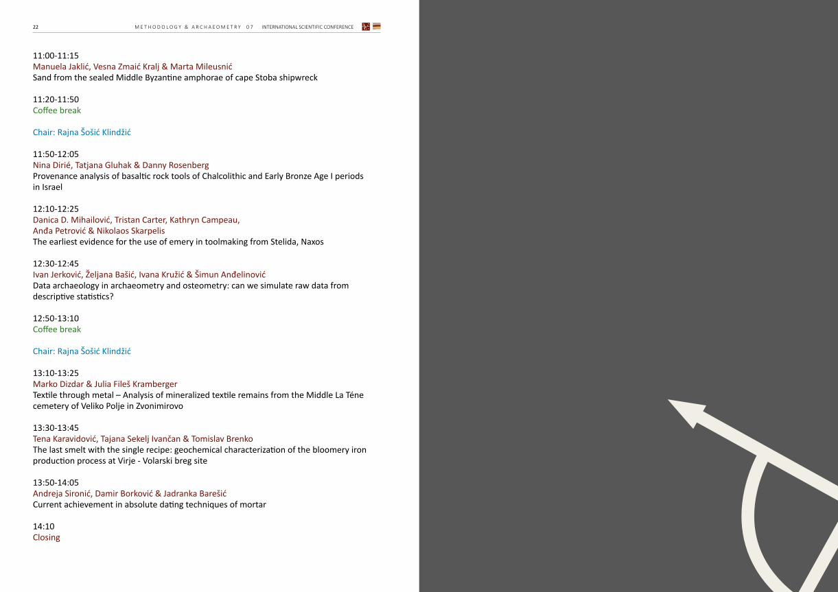
11:00-11:15Manuela Jaklić, Vesna Zmaić Kralj & Marta MileusnićSand from the sealed Middle Byzantine amphorae of cape Stoba shipwreck
11:20-11:50 Coffee break
Chair: Rajna Šošić Klindžić
11:50-12:05Nina Dirié, Tatjana Gluhak & Danny RosenbergProvenance analysis of basaltic rock tools of Chalcolithic and Early Bronze Age I periods in Israel
12:10-12:25Danica D. Mihailović, Tristan Carter, Kathryn Campeau, Anđa Petrović & Nikolaos SkarpelisThe earliest evidence for the use of emery in toolmaking from Stelida, Naxos
12:30-12:45Ivan Jerković, Željana Bašić, Ivana Kružić & Šimun AnđelinovićData archaeology in archaeometry and osteometry: can we simulate raw data from descriptive statistics?
12:50-13:10 Coffee break
Chair: Rajna Šošić Klindžić
13:10-13:25Marko Dizdar & Julia Fileš KrambergerTextile through metal – Analysis of mineralized textile remains from the Middle La Téne cemetery of Veliko Polje in Zvonimirovo
13:30-13:45Tena Karavidović, Tajana Sekelj Ivančan & Tomislav BrenkoThe last smelt with the single recipe: geochemical characterization of the bloomery iron production process at Virje - Volarski breg site
13:50-14:05Andreja Sironić, Damir Borković & Jadranka Barešić Current achievement in absolute dating techniques of mortar
14:10 Closing

ABSTRACTS
INTERNATIONAL SCIENTIFIC CONFERENCE M E T H O D O L O G Y & A R C H A E O M E T R Y 0 7 27
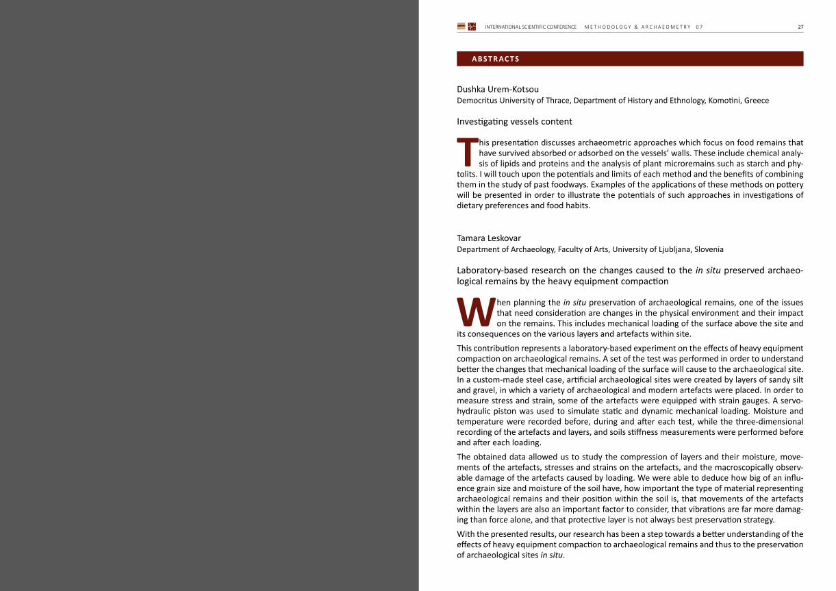
Dushka Urem-KotsouDemocritus University of Thrace, Department of History and Ethnology, Komotini, Greece
Investigating vessels content
This presentation discusses archaeometric approaches which focus on food remains that have survived absorbed or adsorbed on the vessels’ walls. These include chemical analy-sis of lipids and proteins and the analysis of plant microremains such as starch and phy-
tolits. I will touch upon the potentials and limits of each method and the benefits of combining them in the study of past foodways. Examples of the applications of these methods on pottery will be presented in order to illustrate the potentials of such approaches in investigations of dietary preferences and food habits.
Tamara LeskovarDepartment of Archaeology, Faculty of Arts, University of Ljubljana, Slovenia
Laboratory-based research on the changes caused to the in situ preserved archaeo-logical remains by the heavy equipment compaction
When planning the in situ preservation of archaeological remains, one of the issues that need consideration are changes in the physical environment and their impact on the remains. This includes mechanical loading of the surface above the site and
its consequences on the various layers and artefacts within site. This contribution represents a laboratory-based experiment on the effects of heavy equipment compaction on archaeological remains. A set of the test was performed in order to understand better the changes that mechanical loading of the surface will cause to the archaeological site. In a custom-made steel case, artificial archaeological sites were created by layers of sandy silt and gravel, in which a variety of archaeological and modern artefacts were placed. In order to measure stress and strain, some of the artefacts were equipped with strain gauges. A servo-hydraulic piston was used to simulate static and dynamic mechanical loading. Moisture and temperature were recorded before, during and after each test, while the three-dimensional recording of the artefacts and layers, and soils stiffness measurements were performed before and after each loading. The obtained data allowed us to study the compression of layers and their moisture, move-ments of the artefacts, stresses and strains on the artefacts, and the macroscopically observ-able damage of the artefacts caused by loading. We were able to deduce how big of an influ-ence grain size and moisture of the soil have, how important the type of material representing archaeological remains and their position within the soil is, that movements of the artefacts within the layers are also an important factor to consider, that vibrations are far more damag-ing than force alone, and that protective layer is not always best preservation strategy. With the presented results, our research has been a step towards a better understanding of the effects of heavy equipment compaction to archaeological remains and thus to the preservation of archaeological sites in situ.
AB S T R AC T S

INTERNATIONAL SCIENTIFIC CONFERENCE M E T H O D O L O G Y & A R C H A E O M E T R Y 0 7 2928 M E T H O D O L O G Y & A R C H A E O M E T R Y 0 7 INTERNATIONAL SCIENTIFIC CONFERENCE
Dimitrij Mlekuž1, 2
1 Department of Archaeology, Faculty of Arts, University of Ljubljana, Slovenia2 Institute for the protection of cultural heritage of Slovenia, Slovenia
Geostatistical modelling of the Neolithic settlement systems in western Carpathian basin
Paper tackles spatio-temporal patterns of Neolithic and Copper Age settlement dynamics in the Western Carpathian Basin and Eastern Alps using spatial explicit use of radiocarbon dates. It focuses on the spatial process of spread, movement, aggregation and segrega-
tion in the time frame between 8500 and 5000 cal BP. A database of 136 sites with 812 radio-carbon dates from the Neolithic and Copper Age was compiled. Data were aggregated over spatial grids, and different spatio-temporal variables were estimat-ed over the study area. This data was used to compute the first appearance of Neolithic settle-ment systems, direction and speed of the spread of the Neolithic. Then, spatially explicit demo-graphic estimations were computed for the study area, displaying interesting spatiotemporal dynamics and different regional trajectories. Distribution of Neolithic and Copper Age sites in the study area is clustered and patchy. The first Neolithic thus appears as isolated islands or en-claves of the Neolithic settlements which then slowly expand to fill neighbouring regions. There are also some backwater areas with much later Neolithic settlement. We identified the exist-ence of stationary borders where the Neolithic expansion toward west halted for almost 500 years. After 6300 cal BP study area experience a significant reduction in the extent of settle-ment systems, associated with the Late Neolithic to Copper Age transition. This significant de-crease in the extent of settlements system, but not all areas were affected to the same extent.
Gábor MesterházyCastle Headquarters Integrated Regional Development Centre, Budapest, Hungary
Effects of land cover changes on non-destructive archaeological research
Archaeological field survey is widely used across the world as a reliable survey method in scientific and development-led researches to locate and identify archaeological surface scatter. Methodological developments aimed to understand the capabilities and limita-
tions of field survey in many aspects. Geomorphological and pedological processes, artefact visibility, survey strategy, surface conditions and human factor are just a few examples in this regard. Nonetheless, regional surveys or bigger infrastructural projects almost always must face with non-surveyable areas due to temporal or permanent coverage.The five CORINE (Coordination of Information on the Environment) databases are providing a reliable starting point to track land cover changes between 1990 and 2018. This presentation aims to analyse the effect of land cover changes and trends in the aforementioned period in Hungary and their effect on fieldwork.During the automatic workflow in ArcGIS, firstly, the CORINE databases were reclassified into archaeologically relevant survey categories. Secondly, the five databases were overlapped based on the geometric union. Lastly, statistics were calculated in 197 districts about the size and changes of the archaeological land cover categories.Firstly, the analysis resulted in a theoretical map of researchable areas for field survey. Sec-ondly, the spatial and statistical analysis of long-term changes showed, that 2540 km2 arable
land were transformed into forests and grasslands mostly after Hungarian accession to the Eu-ropean Union. According to the principles of European Union’s Common Agricultural Policy and the aims of the Hungarian Government, we can expect a further decrease of the field surveys primary areas, arable lands.Lastly, a detailed analysis was carried out in a 350 km2 area around Polgár (NE Hungary) to analyse regional-scale effects of land cover on site identification. Geographical variables were selected (curvature, wetness, aspect, pedology, geomorphology, topographical index) to meas-ure the land cover caused site identification bias in researchable and non-researchable areas.
Cornelius Meyer1 & Saša Kovačević2
1 cm prospection, Berlin, Germany2 Institute of Archaeology, Zagreb, Croatia
Patterns everywhere: Geophysical prospection strategies at archaeological sites in Northern and Eastern Croatia
Between 2014 and 2019 several geophysical prospection campaigns on archaeological sites in Northern and Eastern Croatia were realised. Survey layout, data and interpreta-tion from the Hallstatt site of Bistričak (Varaždin), from the Late Bronze Age and Iron
Age site of Dolina (Nova Gradiška), and several prehistoric and Roman sites in Slavonia are presented and discussed. All data sets can be considered as incomplete since the investigations faced a number of seri-ous constraints. Firstly, those undertakings are often characterised by relatively low budgets. Secondly, intensive agricultural use, small property sizes result in limited accessibility of the areas to be investigated. On no account a complete coverage of the site’s cores was possible. Moreover, the limited budgets also implicate a methodological narrowness. Do these resulting incomplete data sets contribute to increase our archaeological knowledge? From a purely scientific point of view, a total coverage not only of the “site”, but also of the sur-rounding “landscape” is self-evident. But in the reality of archaeological fieldwork and research in today’s “austerity societies,” this remains mere wishful thinking. Yet, couldn’t we consider this kind of low-budget prospection campaigns as a full-value tool in archaeological research?Due to the wide availability of multi-channel equipment, data collection has become a standard procedure during the last 15 years. By contrast, the archaeological interpretation of the data is a matter of permanent epistemological development. The combination of the mentioned incomplete data sets and poor documentation of archaeological information on historical exca-vations and surveys present a challenge for both archaeologists and geophysicists. The presented examples prove that substantial archaeological information can be gathered even from limited data sets. Taking into account geological, geomorphological and archaeo-logical information, prevents us from both, merely describing geophysical data as well as from over-interpreting. It is self-evident that all information is assembled and presented in GIS so that continuous reworking of the data is possible for all involved parties.The geophysical prospection campaigns were initiated, funded and strongly supported by the Institute of Archaeology Zagreb, the OREA – Institut für Orientalische und Europäische Archäol-ogie, Vienna, the University of Zagreb, and the Vinkovci Municipal Museum.

INTERNATIONAL SCIENTIFIC CONFERENCE M E T H O D O L O G Y & A R C H A E O M E T R Y 0 7 3130 M E T H O D O L O G Y & A R C H A E O M E T R Y 0 7 INTERNATIONAL SCIENTIFIC CONFERENCE
Dubravko Gajski1, Lucija Magaš1 & Katarzyna Dziegielewska-Gajski2
1 Faculty of Geodesy University of Zagreb, Croatia2 Independent researcher, Strmec Samoborski, Croatia
Evaluation of archaeological potential using multicriteria analysis in GIS
Discovering the new potential archaeological deposit is a very demanding and challeng-ing task for an archaeologist, where one should take into account many historical facts and investigate their interaction and impact on ancient life. The most significant impact
on the life of the population has the surrounding. Beside rational conclusions, there is a lot of space for intuitive ones (“sixth sense”). To help the archaeologist to organize their knowledge and criteria to make the right decision, a multicriteria analysis in GIS supported by the Analyti-cal Hierarchical Process (AHP) can apply and contribute to more realistic and rational decisions. This paper aims to show how to evaluate the space according to the predefined criteria. The result of the evaluation shows the archaeological potential of every pixel on the map rep-resenting the evaluated area. The locations with high archaeological potential draw our atten-tion to places where is to expect an archaeological deposit. As a study area, the Požega valley was chosen. It represents a large number of localities dating from the Iron Age. Five criteria were selected and ranked according to personal preference: proximity to water, altitude, ter-rain slope, proximity to mineral resources, and land use. Five potential sites for archaeological research were identified using multicriteria analysis in GIS and AHP. Finally, the possibilities of multicriteria analysis in GIS in archaeological research are presented and discussed.
Dinko Tresić Pavičić1 & Andreja Kudelić2
1 Kaducej d.o.o., Split, Croatia2 Institute of Archaeology, Zagreb, Croatia
Archaeological excavation at Donja Cerovačka cave: methods, challenges and preliminary results
During April and May of 2019, archaeological firm Kaducej d.o.o. conducted a rescue exca-vation at Donja Cerovačka cave, near Gračac. The archaeological excavation covered an area of 210 square meters along the route of the future pathway. Despite the assump-
tion that the archaeological features in the cave were mostly destroyed by recent interventions and past archaeological and geological excavations, many intact archaeological features were discovered throughout the entire excavated area. At least two occupation phases dated to the Late Bronze Age were recognized, although the depth of archaeological layers generally does not exceed 15 centimetres.The authors will present the excavation methods and documentation techniques as well as the results of the preliminary analysis of archaeological stratification in Donja Cerovačka cave, with emphasis on the difficulties that accompany large-scale archaeological excavations in caves.
Domagoj Tončinić, Vinka Matijević & Miroslav VukovićDepartment of Archaeology, Faculty of Humanities and Social Sciences, University of Zagreb, Croatia
Image-based modelling approach to the documentation of an intact late antiquity tomb at Velić, Croatia
Systematic archaeological excavations at the site Velić near Trilj began in 2013. At this point, the remains of the rectangular ground plan building were documented. Its central structure has a semicircular apse. The whole object can be roughly dated to the period
of late antiquity and interpreted as an early Christian memoria which consists of three rooms and an east-west oriented vaulted tomb. The tomb was found open. Nevertheless, the remains of an older adult male were found inside. The excavation was characterized by the extreme poverty of small finds, which means that the precise dating of the site is not possible so far.In the last days of the 2019 excavation campaign another tomb situated beneath the central structure with an apse was documented. This time it was closed and intact. Anyone who ever worked in archaeology knows how rare these types of situations are and that in practice we usually deal with remains of structures, while in this case, the entire tomb seemed undisturbed since the antiquity. After the stone slab was carefully removed, a tomb with a vaulted ceil-ing and two benches was revealed. The skeletal remains of four individuals were identified: a younger male adult and three children.Although the tomb and its state of preservation were astonishing, the excavation was faced with a daunting task of documenting the buried structure and its content. Since image-based modeling has been used as a practical and detailed documentational tool in the research so far, it was only natural to approach this part of our excavations in the same manner. This paper will present the difficulties and the solutions that came across during the documentational process in this tomb, as well as some of the conclusions and interpretations of the tomb and the larger complex around it.
Katarina ŠpremJuraj Dobrila University of Pula, Faculty of Humanities, Pula, Croatia All aboard! Quarries and transport in Roman Istria
Istria is rich in a more or less high-quality limestone which was used during antiquity for various purposes. Several quarries on the coast, as well as in the hinterland are thought to be of Roman age, or at least in use since the Roman age. There are more than 300 sites of
Roman villae rusticae across the peninsula, so stone material was certainly needed very much. Limestone of high quality could have been distributed to far away locations using the sea as a means of transport, whereas if needed close-by, the roads could have served for this purpose. Travelling by sea was also less expensive and therefore more frequently used than travelling by land. The Istrian peninsula is rich in little bays and coves which could have provided sailors with a safe haven, and some of these bays show remains of Roman port facilities today. Regarding Roman roads in Istria, we do not know their exact routes, but several authors have suggested their main directions and stations.
INTERNATIONAL SCIENTIFIC CONFERENCE M E T H O D O L O G Y & A R C H A E O M E T R Y 0 7 3332 M E T H O D O L O G Y & A R C H A E O M E T R Y 0 7 INTERNATIONAL SCIENTIFIC CONFERENCE
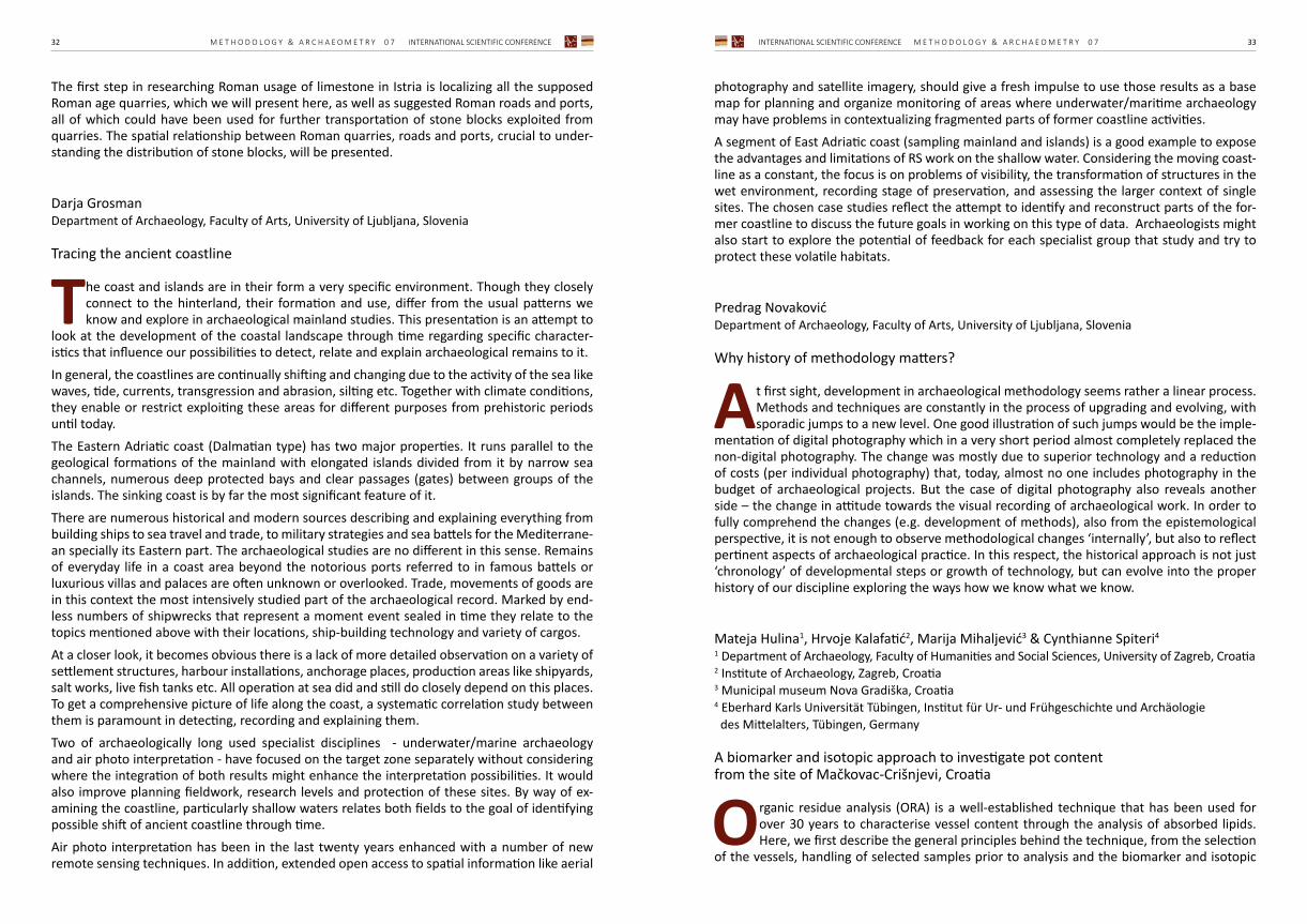
The first step in researching Roman usage of limestone in Istria is localizing all the supposed Roman age quarries, which we will present here, as well as suggested Roman roads and ports, all of which could have been used for further transportation of stone blocks exploited from quarries. The spatial relationship between Roman quarries, roads and ports, crucial to under-standing the distribution of stone blocks, will be presented.
Darja GrosmanDepartment of Archaeology, Faculty of Arts, University of Ljubljana, Slovenia
Tracing the ancient coastline
The coast and islands are in their form a very specific environment. Though they closely connect to the hinterland, their formation and use, differ from the usual patterns we know and explore in archaeological mainland studies. This presentation is an attempt to
look at the development of the coastal landscape through time regarding specific character-istics that influence our possibilities to detect, relate and explain archaeological remains to it. In general, the coastlines are continually shifting and changing due to the activity of the sea like waves, tide, currents, transgression and abrasion, silting etc. Together with climate conditions, they enable or restrict exploiting these areas for different purposes from prehistoric periods until today.The Eastern Adriatic coast (Dalmatian type) has two major properties. It runs parallel to the geological formations of the mainland with elongated islands divided from it by narrow sea channels, numerous deep protected bays and clear passages (gates) between groups of the islands. The sinking coast is by far the most significant feature of it. There are numerous historical and modern sources describing and explaining everything from building ships to sea travel and trade, to military strategies and sea battels for the Mediterrane-an specially its Eastern part. The archaeological studies are no different in this sense. Remains of everyday life in a coast area beyond the notorious ports referred to in famous battels or luxurious villas and palaces are often unknown or overlooked. Trade, movements of goods are in this context the most intensively studied part of the archaeological record. Marked by end-less numbers of shipwrecks that represent a moment event sealed in time they relate to the topics mentioned above with their locations, ship-building technology and variety of cargos.At a closer look, it becomes obvious there is a lack of more detailed observation on a variety of settlement structures, harbour installations, anchorage places, production areas like shipyards, salt works, live fish tanks etc. All operation at sea did and still do closely depend on this places. To get a comprehensive picture of life along the coast, a systematic correlation study between them is paramount in detecting, recording and explaining them.Two of archaeologically long used specialist disciplines - underwater/marine archaeology and air photo interpretation - have focused on the target zone separately without considering where the integration of both results might enhance the interpretation possibilities. It would also improve planning fieldwork, research levels and protection of these sites. By way of ex-amining the coastline, particularly shallow waters relates both fields to the goal of identifying possible shift of ancient coastline through time. Air photo interpretation has been in the last twenty years enhanced with a number of new remote sensing techniques. In addition, extended open access to spatial information like aerial
photography and satellite imagery, should give a fresh impulse to use those results as a base map for planning and organize monitoring of areas where underwater/maritime archaeology may have problems in contextualizing fragmented parts of former coastline activities.A segment of East Adriatic coast (sampling mainland and islands) is a good example to expose the advantages and limitations of RS work on the shallow water. Considering the moving coast-line as a constant, the focus is on problems of visibility, the transformation of structures in the wet environment, recording stage of preservation, and assessing the larger context of single sites. The chosen case studies reflect the attempt to identify and reconstruct parts of the for-mer coastline to discuss the future goals in working on this type of data. Archaeologists might also start to explore the potential of feedback for each specialist group that study and try to protect these volatile habitats.
Predrag NovakovićDepartment of Archaeology, Faculty of Arts, University of Ljubljana, Slovenia
Why history of methodology matters?
At first sight, development in archaeological methodology seems rather a linear process. Methods and techniques are constantly in the process of upgrading and evolving, with sporadic jumps to a new level. One good illustration of such jumps would be the imple-
mentation of digital photography which in a very short period almost completely replaced the non-digital photography. The change was mostly due to superior technology and a reduction of costs (per individual photography) that, today, almost no one includes photography in the budget of archaeological projects. But the case of digital photography also reveals another side – the change in attitude towards the visual recording of archaeological work. In order to fully comprehend the changes (e.g. development of methods), also from the epistemological perspective, it is not enough to observe methodological changes ‘internally’, but also to reflect pertinent aspects of archaeological practice. In this respect, the historical approach is not just ‘chronology’ of developmental steps or growth of technology, but can evolve into the proper history of our discipline exploring the ways how we know what we know.
Mateja Hulina1, Hrvoje Kalafatić2, Marija Mihaljević3 & Cynthianne Spiteri4
1 Department of Archaeology, Faculty of Humanities and Social Sciences, University of Zagreb, Croatia2 Institute of Archaeology, Zagreb, Croatia3 Municipal museum Nova Gradiška, Croatia4 Eberhard Karls Universität Tübingen, Institut für Ur- und Frühgeschichte und Archäologie des Mittelalters, Tübingen, Germany
A biomarker and isotopic approach to investigate pot content from the site of Mačkovac-Crišnjevi, Croatia
Organic residue analysis (ORA) is a well-established technique that has been used for over 30 years to characterise vessel content through the analysis of absorbed lipids. Here, we first describe the general principles behind the technique, from the selection
of the vessels, handling of selected samples prior to analysis and the biomarker and isotopic

INTERNATIONAL SCIENTIFIC CONFERENCE M E T H O D O L O G Y & A R C H A E O M E T R Y 0 7 3534 M E T H O D O L O G Y & A R C H A E O M E T R Y 0 7 INTERNATIONAL SCIENTIFIC CONFERENCE
approaches used to characterise the residues. Special attention will be given to compound-specific isotope analysis, which allows further distinction between terrestrial ruminant adipose fats, dairy fats, non-ruminant fats and even wild animals fats as well as fats from marine and freshwater sources based on the d13C signatures of the palmitic and stearic acids commonly found in archaeological residues. Complexities and limitations of the technique will also be discussed. The results obtained from ORA on vessels recovered from the Late Bronze Age cemetery and settlement of Mačkovac-Crišnjevi, in Northern Croatia will be presented. The site is located on the left bank of the Sava River, near the town of Nova Gradiška and is dated to the BrC2 to HaA1 period (Barice-Gređani group). Lipids were extracted and characterised using Gas Chro-matography-Mass Spectrometry (GC-MS) and Gas Chromatography - combustion - Isotope Ra-tio Mass Spectrometry (GC-c-IRMS). The results obtained were found to complement faunal data, and further show the use of dairy products.
Federico Bernardini1;2, Elena Leghissa3, Zsolt Kasztovszky4, Veronika Szilágyi4, Ildikó Harsányi4, Angelo De Min5 & Manuela Montagnari Kokelj6
1 Centro Fermi, Museo Storico della Fisica e Centro di Studi e Ricerche “Enrico Fermi”, Roma, Italy2 Multidisciplinary Laboratory, The “Abdus Salam” Int. Centre for Theoretical Physics, Trieste, Italy3 Institute of Archaeology, ZRC SAZU, Ljubljana, Slovenia4 Nuclear Analysis and Radiography Department, MTA Centre for Energy Research, Budapest Hungary5 Department of Mathematics and Geosciences, University of Trieste, Trieste, Italy6 Department of Humanities, University of Trieste, Trieste, Italy
Locally produced or imported? Late-Copper-Age decorated bowls from the Trieste Karst (north-eastern Italy) and Deschmann’s pile-dwellings (central Slovenia) studied using non-destructive X-ray computed microtomography and Prompt gamma activa-tion analysis
A group of Late-Copper-Age decorated cross-footed bowls from the Trieste Karst (NE Italy) and the Deschmann’s pile dwellings (Ljubljansko barje, Slovenia), has been investigated through a non-destructive approach combining X-ray computed microtomography (mi-
croCT) and Prompt gamma activation analysis (PGAA) in order to study the vessels-forming technique, to characterise their pastes and to test the hypothesis that some vessels from the Karst could have been imported.Cross-footed bowls represent one of the most characteristic vessels of the 3rd millennium BC. In the Deschmann’s pile dwellings most bowls are attributed to Ljubljansko barje variant of the Vučedol Culture, corresponding to the first phase of the site. In the Karst, only a few bowls were discovered and, despite the small number, they are heterogeneous in terms of shape and decoration. According to their typology, the Karst bowls are associated to the Vučedol Culture but often referred to as an individual type. The PGAA results, combined with the microCT data, have shown that only one bowl from the Karst might have been imported from Ljubljansko barje, while other 4 Karst vessels were most probably imported but not from central Slovenia. In more detail, K2O contents, higher than values reported from local Karst and Slovenian soils, have been recorded in two of these Italian bowls. The Karst bowls represent, according to their
shape and ornamentation mainly consisting of cord impressions, a special variant of cross-foot-ed bowls with relevant typological comparisons in Hungary, Slovakia and the Czech Republic. A possible central European origin of some Karst bowls would be in agreement with high K2O soil contents in some areas of the Czech Republic. Cross-footed bowls from the Trieste Karst might be considered as evidence of long-distance connections, movements of ideas, artefacts and/or even movements of people.
Ana ĐuričićLaboratory for Bioarchaeology, Department of Archaeology, Faculty of Philosophy, University of Belgrade, Serbia
Early Neolithic oven building techniques at the territory of the Starčevo culture
Ovens are enclosed thermal structures typical for sedentary agricultural communities in the Middle East and Europe since the Neolithic Period. At the territory of the Cen-tral Balkans and Croatia, ovens have been built and used since the beginning of the
Neolithic. In the published literature regarding the Starčevo culture settlements, four different types of enclosed thermal structures have been mentioned, some of which were interpreted as ovens and others as pottery kilns. It was assumed that all of the ovens/kilns were built from the same material – mud plaster and that all of them were free-standing above-ground structures located inside the dwellings. Several building techniques were proposed for their construction. The revision of the published data and unpublished field documentation from the excavations of the site of Lepenski Vir, has shown that not all of the thermal structures were constructed from the same material, only one type was a free-standing above-ground structure and one type should not have been interpreted either as an oven or as a kiln, but as an open fire instal-lation. Based on the building material, three different building techniques were defined, and some of the previously presumed techniques were refuted. Also, the existence of pottery kilns during the Early Neolithic Starčevo culture was questioned. In order to test these hypotheses, several oven building and usage experiments were conducted. The aim of this presentation is to show different oven building techniques applied during the Early Neolithic in this region and introduce a typology for the Starčevo culture ovens.
Manuela Jaklić1, Vesna Zmaić Kralj2 & Marta Mileusnić1
1 Faculty of Mining, Geology and Petroleum Engineering, University of Zagreb, Croatia2 Croatian Conservation Institute, Zagreb, Croatia
Sand from the sealed Middle Byzantine amphorae of cape Stoba shipwreck
The remains of cape Stoba shipwreck lies on the seabed near Mljet island at the depth be-tween 21 and 28 m. The wreck-site is evidenced by a cargo of amphorae and glass dated back to the 10th-11th century AD. Five amphoras, located in the cargo part of the ship, as
well as the small ceramic vessel which had to be placed in the ship’s kitchen, were found filled with sand and closed with a wooden stopper and resin. The aim of this study is a characteriza-tion of the sand which could help in the determination of its purpose.
INTERNATIONAL SCIENTIFIC CONFERENCE M E T H O D O L O G Y & A R C H A E O M E T R Y 0 7 3736 M E T H O D O L O G Y & A R C H A E O M E T R Y 0 7 INTERNATIONAL SCIENTIFIC CONFERENCE
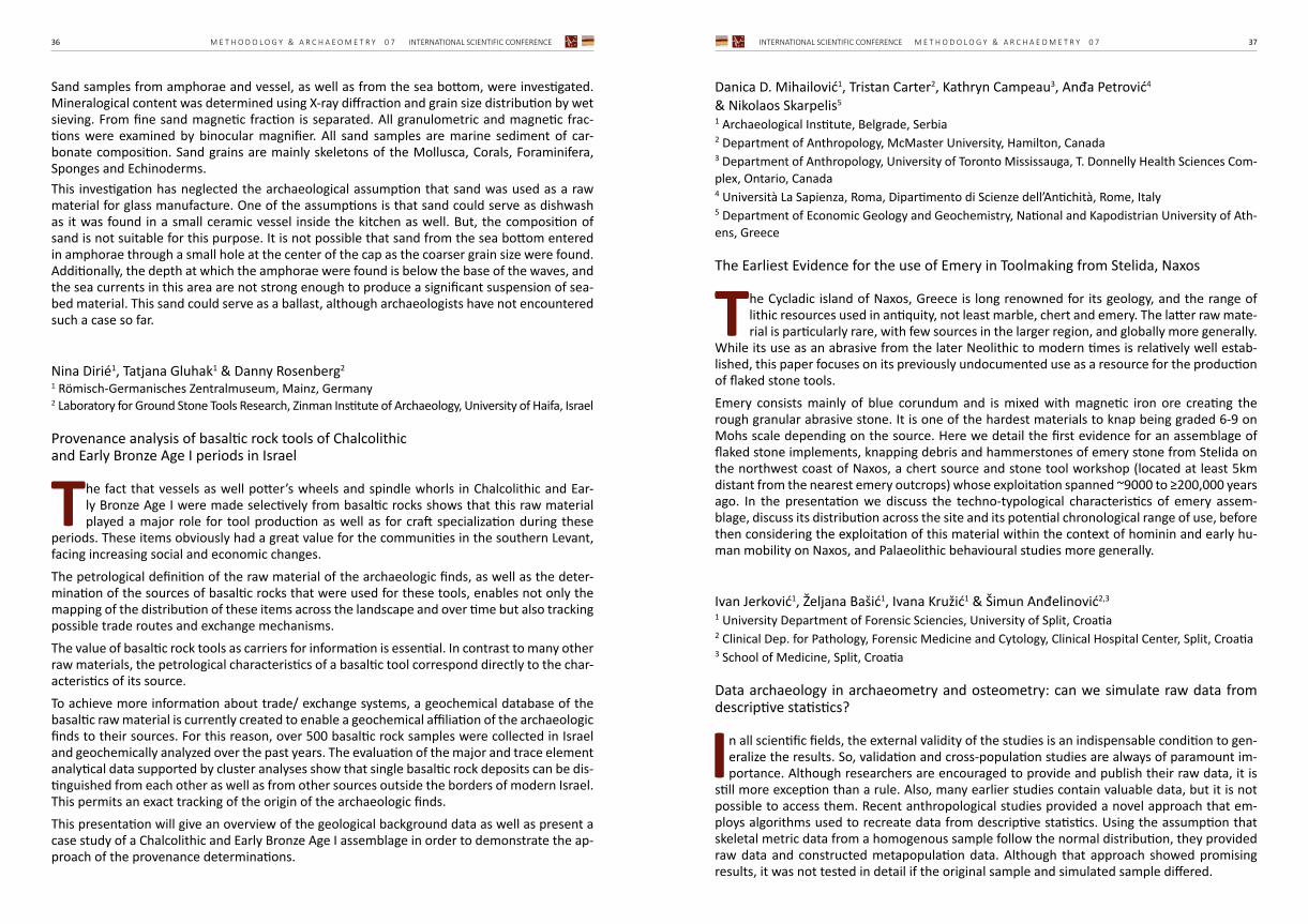
Sand samples from amphorae and vessel, as well as from the sea bottom, were investigated. Mineralogical content was determined using X-ray diffraction and grain size distribution by wet sieving. From fine sand magnetic fraction is separated. All granulometric and magnetic frac-tions were examined by binocular magnifier. All sand samples are marine sediment of car-bonate composition. Sand grains are mainly skeletons of the Mollusca, Corals, Foraminifera, Sponges and Echinoderms.This investigation has neglected the archaeological assumption that sand was used as a raw material for glass manufacture. One of the assumptions is that sand could serve as dishwash as it was found in a small ceramic vessel inside the kitchen as well. But, the composition of sand is not suitable for this purpose. It is not possible that sand from the sea bottom entered in amphorae through a small hole at the center of the cap as the coarser grain size were found. Additionally, the depth at which the amphorae were found is below the base of the waves, and the sea currents in this area are not strong enough to produce a significant suspension of sea-bed material. This sand could serve as a ballast, although archaeologists have not encountered such a case so far.
Nina Dirié1, Tatjana Gluhak1 & Danny Rosenberg2
1 Römisch-Germanisches Zentralmuseum, Mainz, Germany2 Laboratory for Ground Stone Tools Research, Zinman Institute of Archaeology, University of Haifa, Israel
Provenance analysis of basaltic rock tools of Chalcolithic and Early Bronze Age I periods in Israel
The fact that vessels as well potter’s wheels and spindle whorls in Chalcolithic and Ear-ly Bronze Age I were made selectively from basaltic rocks shows that this raw material played a major role for tool production as well as for craft specialization during these
periods. These items obviously had a great value for the communities in the southern Levant, facing increasing social and economic changes. The petrological definition of the raw material of the archaeologic finds, as well as the deter-mination of the sources of basaltic rocks that were used for these tools, enables not only the mapping of the distribution of these items across the landscape and over time but also tracking possible trade routes and exchange mechanisms. The value of basaltic rock tools as carriers for information is essential. In contrast to many other raw materials, the petrological characteristics of a basaltic tool correspond directly to the char-acteristics of its source. To achieve more information about trade/ exchange systems, a geochemical database of the basaltic raw material is currently created to enable a geochemical affiliation of the archaeologic finds to their sources. For this reason, over 500 basaltic rock samples were collected in Israel and geochemically analyzed over the past years. The evaluation of the major and trace element analytical data supported by cluster analyses show that single basaltic rock deposits can be dis-tinguished from each other as well as from other sources outside the borders of modern Israel. This permits an exact tracking of the origin of the archaeologic finds.This presentation will give an overview of the geological background data as well as present a case study of a Chalcolithic and Early Bronze Age I assemblage in order to demonstrate the ap-proach of the provenance determinations.
Danica D. Mihailović1, Tristan Carter2, Kathryn Campeau3, Anđa Petrović4 & Nikolaos Skarpelis5
1 Archaeological Institute, Belgrade, Serbia 2 Department of Anthropology, McMaster University, Hamilton, Canada3 Department of Anthropology, University of Toronto Mississauga, T. Donnelly Health Sciences Com-plex, Ontario, Canada4 Università La Sapienza, Roma, Dipartimento di Scienze dell’Antichità, Rome, Italy 5 Department of Economic Geology and Geochemistry, National and Kapodistrian University of Ath-ens, Greece
The Earliest Evidence for the use of Emery in Toolmaking from Stelida, Naxos
The Cycladic island of Naxos, Greece is long renowned for its geology, and the range of lithic resources used in antiquity, not least marble, chert and emery. The latter raw mate-rial is particularly rare, with few sources in the larger region, and globally more generally.
While its use as an abrasive from the later Neolithic to modern times is relatively well estab-lished, this paper focuses on its previously undocumented use as a resource for the production of flaked stone tools.Emery consists mainly of blue corundum and is mixed with magnetic iron ore creating the rough granular abrasive stone. It is one of the hardest materials to knap being graded 6-9 on Mohs scale depending on the source. Here we detail the first evidence for an assemblage of flaked stone implements, knapping debris and hammerstones of emery stone from Stelida on the northwest coast of Naxos, a chert source and stone tool workshop (located at least 5km distant from the nearest emery outcrops) whose exploitation spanned ~9000 to ≥200,000 years ago. In the presentation we discuss the techno-typological characteristics of emery assem-blage, discuss its distribution across the site and its potential chronological range of use, before then considering the exploitation of this material within the context of hominin and early hu-man mobility on Naxos, and Palaeolithic behavioural studies more generally.
Ivan Jerković1, Željana Bašić1, Ivana Kružić1 & Šimun Anđelinović2,3
1 University Department of Forensic Sciencies, University of Split, Croatia2 Clinical Dep. for Pathology, Forensic Medicine and Cytology, Clinical Hospital Center, Split, Croatia3 School of Medicine, Split, Croatia
Data archaeology in archaeometry and osteometry: can we simulate raw data from descriptive statistics?
In all scientific fields, the external validity of the studies is an indispensable condition to gen-eralize the results. So, validation and cross-population studies are always of paramount im-portance. Although researchers are encouraged to provide and publish their raw data, it is
still more exception than a rule. Also, many earlier studies contain valuable data, but it is not possible to access them. Recent anthropological studies provided a novel approach that em-ploys algorithms used to recreate data from descriptive statistics. Using the assumption that skeletal metric data from a homogenous sample follow the normal distribution, they provided raw data and constructed metapopulation data. Although that approach showed promising results, it was not tested in detail if the original sample and simulated sample differed.

INTERNATIONAL SCIENTIFIC CONFERENCE M E T H O D O L O G Y & A R C H A E O M E T R Y 0 7 3938 M E T H O D O L O G Y & A R C H A E O M E T R Y 0 7 INTERNATIONAL SCIENTIFIC CONFERENCE
This study aimed to examine differences between the original and simulated sample on seven femoral measurements. For the original sample, we used those of male and female skeletons from Ancient Salona for which we computed descriptive statistics. Using this data and pack-age ‘truncnorm’ in R, we created a simulated sample. We statistically compared distributions of those samples and descriptive data. In both samples, we tested the accuracy of univariate discriminant functions for sex estimation on femoral measurements developed in previous re-search for various ancient and modern populations.For all variables, both for males and females, there were no statistically significant differences. Also, in most of the cases, discriminant functions for sex estimation for the previous study showed minor variation in accuracy when they were applied to the original and simulated sample. Therefore, the employed approach could be of great importance in anthropological population studies but also studies from the forensic context for validation and development of methods for the estimation of biological profile. It could also be utilized for archaeometric studies of materials whose measurements follow normal distributions.
Marko Dizdar1 & Julia Fileš Kramberger2
1 Institute of Archaeology, Zagreb, Croatia2 Department of Archaeology, Faculty of Humanities and Social Sciences, University of Zagreb; Croatia
Textile through Metal – Analysis of Mineralized Textile Remains from the Middle La Téne Cemetery of Veliko Polje in Zvonimirovo
The La Tène cemetery at Veliko Polje is situated on an elongated ridge close to Zvonimirovo in northern Croatia. In the beginning, it was excavated as a medieval cemetery of the Bijelo Brdo group, but during the research, numerous incineration Middle La Téne graves
were unearthed, leading to continuous and systematic research of this particular Late Iron Age necropolis. These graves can be dated to a range from the end of the 3rd century BC to the first half of the 2nd century BC (LT C2). Based on the typological characteristics of the grave finds, this cemetery at Veliko Polje in Zvonimirovo can be ascribed to the Taurisci community, or more accurately to the distribution of the Mokronog group. The funerary ritual of this La Téne cemetery seems to have been quite well organized, because in most of the cases the graves were shaped as rectangular or oval pits, sometimes even con-taining wooden coffins or other funerary containers made of organic material, and the buried human remains were always incinerated. An important feature for this cemetery are the grave goods, ranging from ceramic vessels with food and drink as funerary gifts to weapons and toi-letry accessories in warrior graves or knives and ceramic spindle-whorls in female graves, all accompanied regularly by typical male or female costume attire, such as fibulae, belts, jewelry, etc. Thanks to the fact that many of these finds were made of iron, several textile and other organic fragments were preserved in its corrosion and were eligible for further investigation after the conservation of the objects. The analysis consisted of determining the weave type of the frag-ments, noticing the thread spin direction and measuring the thread diameter. The remains were analyzed primarily by viewing with the naked eye, but some finer details such as thread diameter and patterning were determined with the help of digital microscopy. In this paper, preliminary results of the analysis of textile remains from four graves will be presented, along with their explanation and possible interpretation.
Tena Karavidović1, Tajana Sekelj Ivančan1 & Tomislav Brenko2
1 Institute of Archaeology, Zagreb, Croatia2 Faculty of Mining, Geology and Petroleum Engineering, University of Zagreb, Croatia
The last smelt with the single recipe: geochemical characterization of the bloomery iron production process at Virje – Volarski breg site
Remains of an early medieval iron production workshop were excavated at the Virje – Vol-arski breg site, located in the Podravina region (NW), a lowland area dominated by the alluvial plain of the Drava river. Current archaeological research has confirmed that iron
ore processing has been present in this region in the 5th century (Virje-Sušine site), 7th century (Hlebine-Velike Hlebine site) and 8/9th century (Virje – Volarski breg and Sušine site). At the Virje-Volarski breg site several samples of iron ore were collected, analyzed and compared to ore samples from other iron production sites in the region as well as local bog iron ores col-lected as surface finds during an archaeological survey. Remains of four bloomery furnaces at the site had an in situ residue of iron production slag formed during the smelting process. Samples of different types of smelting slag (furnace slag, furnace bottom slag, tapped slag) were analyzed in order to define consistency or change in the smelting procedure during individual smelts. The aim of the study is also to define in what way and to what extent does the mineralogical and chemical composition of ores and smelting waste reflect the choice of resources and steps in the iron production procedures at the Virje – Volarski breg site. X-ray powder diffraction (XRD) was used to determine mineralogical compo-sition of slag and bog iron ore samples. Detailed geochemical characterization of samples was performed using inductively coupled plasma mass spectroscopy (ICP-MS).
Andreja Sironić, Damir Borković & Jadranka Barešić Ruđer Bošković Institute, Zagreb, Croatia
Current achievement in absolute dating techniques of mortar
Mortar can be absolutely dated by physical methods of radioactive carbon decay (ra-diocarbon), optically stimulated luminescence (OSL) or by electronic paramagnetic resonance spectroscopy (EPR). However, to this day, there is no consensus on the
method or on the unique way of sample preparation that would always provide the true date.The most used method is radiocarbon dating of pyrogenic carbonate created simultaneously with the mortar sample. However, the problem of extracting the pure pyrogenic fraction with-out carbonates originating from unburned limestone used for mortar production can often give too old dates. In order to find the most reliable method of mortar dating, the Mortar Dating Inter-comparison Study was conducted (MODIS, Hajdas et al. 2017; Hayen et al. 2017). Four mortar samples were distributed to seven radiocarbon and one OSL laboratory. The dates provided by mortar dating were compared by 14C dates obtained from charcoal associated with the production of mortars. For two samples laboratories provided dates similar to the consensus value, and one sample was found to be too heterogeneous for dating. For one sample all the laboratories provided too young dates, implying that the mortar was re-burned, so the analyzed pyrogenic carbonates actually pointed to the last time the construction was on fire, not to the actual building of the construction.
INTERNATIONAL SCIENTIFIC CONFERENCE M E T H O D O L O G Y & A R C H A E O M E T R Y 0 7 4140 M E T H O D O L O G Y & A R C H A E O M E T R Y 0 7 INTERNATIONAL SCIENTIFIC CONFERENCE
The new mortar dating inter-comparison is in progress (MODIS 2). Three mortar samples have been distributed among 12 radiocarbon laboratories. The Zagreb Radiocarbon Laboratory is also included in MODIS 2, after being recognized for the mortar dating of the Skopje Aqueduct (Sironić et al. 2019).The most promising methods for extraction of pyrogenic carbonate form mortars applied in the MODIS will be presented.
Ante Lozina1, Željana Bašić1, Ivana Kružić1, Josip Kasum1 & Šimun Anđelinović2, 3
1 University of Split, University Department of Forensic Sciences, Split, Croatia 2 Clinical Dep. for Pathology, Court Medicine and Cytology, Clinical Hospital center, Split, Croatia3 University of Split, Croatia
Protection and hydrographic representation of underwater archaeological sites along Croatian eastern Adriatic coast – current state and recommendations for improvement
Eastern Adriatic coast, especially its Croatian part, abounds with archaeological sites that testify about the uninterrupted presence of life, different social, ethnic, religious groups and cultures on this particular area. During the period of rule of ancient Greek communi-
ties and ancient Rome, with the inevitable influence of Hellenic and Roman culture, a large number of settlements have been established along the eastern Adriatic coast. Many of those settlements positioned on the very shore of Adriatic sea were forerunners of urban areas that are still present in the modern period. With such abundance of ancient settlements, we were left with many material traces of their existence, but also of the culture, customs and the ways of life of the people that inhabited them. Some of the archaeological sites from ancient periods became underwater sites, over the long period, due to the effects of geological changes, forces of nature and the constant changes of the sea level. The legislative framework in the Republic of Croatia regulates the protection and preservation of archaeological sites with no special mention of underwater archaeological sites. That fact alone gives us a great opportunity for recommending the best practice for protection, preservation and research of underwater ar-chaeological sites, regardless of the fact that all archaeological sites of cultural and historic significance enjoy a certain level of protection. Underwater archaeological sites require the provision of individual measures of protection and conservation, especially regarding their at-tractiveness and the cultural value they possess. By examining the actual condition of underwater archaeological locations along Croatian east-ern Adriatic coast, and legal framework that deals with measures of their protection, conserva-tion and hydrographic representation we will be able to get a full insight of the current state regarding levels of archaeological sites’ physical and legal protection and to propose the best practices to improve the previously mentioned measures.
POS T ER AB S T R AC T S
INTERNATIONAL SCIENTIFIC CONFERENCE M E T H O D O L O G Y & A R C H A E O M E T R Y 0 7 4342 M E T H O D O L O G Y & A R C H A E O M E T R Y 0 7 INTERNATIONAL SCIENTIFIC CONFERENCE
Domagoj Tončinić & Miroslav VukovićDepartment of Archaeology, Faculty of Humanities and Social Sciences, University of Zagreb, Croatia
Choosing the right spot – ALS data targets and acquisition in the AdriaRom project
The Roman conquest of eastern Adriatic coast lasted from the First Illyrian War in 229 BCE until 9 CE, when the final battle took place. To secure the conquered coastal region, the territory between the colonies of Iader and Salona, where the first Roman immigrants
had already arrived, Romans built – from the east to the west – two fortresses and several forts connected by the roads. In the scientific literature, this defense construction was laconically called the Delmataean limes, and it has been the subject of persistent scientific discussion. The aim of the AdriaRom project is to investigate the line of fortresses and forts of so-called Delmataean limes in order to show whether that line was a border or not. This area has seen numerous conflicts between the Romans and the indigenous populace which left their mark on the landscape. Using airborne laser scanning (ALS) we hope we can identify features which could further testify to the actions of the Roman military besides those already known from research done at the two legionary fortresses of Burnum on the river Krka and Tilurium on the river Cetina. This landscape approach will also give us an insight into the infrastructure of the indigenous populace, and having that in mind, we’ve set out to define our target areas. Our area of research is also specific because of the rough karst geology and dense Mediterranean vegetation which affects the visibility of sites and features. This poster will present the problems we encountered, our solutions and the results of the ALS scanning. Following the project methodology field survey will be conducted on target areas, in order to determine the archaeological potential and basic information on the distribution of archaeological findings and sites in areas that are selected by the ALS scanning.
Valentina Lončarić & Janja Mavrović MokosDepartment of Archaeology, Faculty of Humanities and Social Sciences, University of Zagreb, Croatia
Old data, new perspectives – Retrieving spatial data of Bronze Age hoards in NW Croatia using GIS software
Bronze hoards have had a key role in the construction of LBE chronologies on both local and wider regional levels, and more recently, in studies of distribution networks and communication routes. However, due to hoards being predominantly accidental finds
during construction or agricultural works, information on their provenance and archaeologi-cal context is usually sparse or non-existent. Building on the known data for bronze hoards in north-western Croatia, this poster presents the possibilities and limitations of inferring missing spatial data using GIS software. Combining the known information about each find with different publicly available vector and raster datasets allows for spatial analysis to be conducted and its results input into a uniform database which can ultimately be expanded to encompass all bronze hoards in Croatia. While the potential of GIS for spatial data retrieval may seem encouraging, its limitations should be nonetheless considered. In addition to the extent of archival data available, the use of GIS software is also limited by the completeness and resolution of spatial data hosted on WMS and WFS servers.
Ivan HuljevIndependent researcher, Primošten, Croatia
Does the size of hillfort and enclosure sites in Šibenik area correspond to the size of available arable land?
The problem discussed in this presentation is whether a correlation exists between the size of hillfort and enclosure sites (local term gradina) and corresponding arable land. The size of hillfort and enclosure sites was measured using measuring tools and aerial
photographs available through the Arkod public service. The research which included map-ping of hillfort and enclosure sites (either sites already known from archaeological literature or surveys conducted by the author) and basic measurements suggest that the position of the majority of larger hillfort and enclosure sites (more than 1 ha) closely correspond to large tracts of arable land. These plots are situated in karstic poljes such as Donje polje, Grebaštica, Vedro polje, Velimsko polje, Bribirske mostine etc. Furthermore, the research suggests that in areas where arable tracts of land are smaller in sizes such as Perković, Boraja, Primošten and Rogoznica areas, hill-fort and enclosure sites are also smaller, measuring on average less than 1 ha. At this point, due to the lack of research, it is impossible to claim whether the hillfort and enclosure sites found in the area existed simultaneously. However, it is plausible to claim that larger hillfort and en-closure sites (more than 1 ha) were built in periods in which socio-political-economic changes were rapidly taking place, leading to greater growth and development of communities whose economy is directly linked to large tracts of arable land.
Igor Kulenović1, Šime Vrkić1 & Neda Kulenović Ocelić2
1 Department of Tourism and Communication Studies, University of Zadar, Croatia2 Independent researcher, Zadar, Croatia
Historic and cadastral maps as a vital source in landscape history research
The project Cultural Landscape - A Model for Valorisation, Protection, Management and Use of Cultural Heritage (ProHeritage) continues its research activities. The research ac-tivities are being conducted in the areas covered by administrative units Jasenice and
Obrovac. Total research area covers 630 km2 of extremely karstifiled terrain. Research meth-ods include common landscape archaeology tools such as remote sensing, aerial archaeology, archival research and field survey. In this presentation, we would like to emphasize the archi-val aspect of our research. Historical and cadastral maps are a corner stone of any landscape research project. In respect with our research area, the primary historic source are Venetian surveys (Mape Grimani from 1709) curated by the state archive in Zadar. The survey in ques-tion records a period of relative stability following the cessation of hostilities with the Ottoman empire. The maps are truly well of various information for the history of a landscape. In this sense, maps containing old place names, archaeological sites, abandoned settlements and a host of other information necessary for landscape studies are a vital source for landscape studies. Key words: cultural heritage, cultural landscape, historic and cadastral maps
INTERNATIONAL SCIENTIFIC CONFERENCE M E T H O D O L O G Y & A R C H A E O M E T R Y 0 7 4544 M E T H O D O L O G Y & A R C H A E O M E T R Y 0 7 INTERNATIONAL SCIENTIFIC CONFERENCE
Rajna Šošić Klindžić1 & Marin Mađerić2
1 Department of Archaeology, Faculty of Humanities and Social Sciences, University of Zagreb, Croatia2 Independent researcher, Zagreb, Croatia
Presentation of Neolithic archaeological site Gorjani Kremenjača
Gorjani Kremenjača is Neolithic site in Slavonia, Croatia. It covers an area of several hectares covered with the modern agricultural fields. Magnetometry survey showed several enclosures and high concentration of objects and features.
Such archaeological site that contains only soil features is especially challenging for public presentation, yet the goal was to find a solution for efficient and effective presentation to the public. The chosen solution was to enlighten the area of one enclosure and layout of several prehistoric houses. In this poster, we are presenting the illumination of site Gorjani Kremenjača using 500 LED solar lights in September 2019.
Milica Tapavički-Ilić1 & Timka Alihodžić2
1 Institute of Archaeology, Belgrade, Serbia2 Archaeological Museum Zadar, Croatia
Pars pro toto, sed pars toto non est
This paper tends to show a critical approach to archaeological research applied in study-ing grave goods and their contexts, in which single finds were distracted from their context and displayed or published as single finds. Show cases from Viminacium and
Zadar shall be discussed, and solutions offered.The grave number G1-15 from the Viminacium – Brest cemetery is quite outstriking. Its most famous find is a water-clock. It was molded as a reverse Drag. 37 type bowl and glazed in its upper part, obviously representing a special order by the family of the deceased. In several publications, it was published as if it was a single find. However, the whole set of grave goods from grave G1-15 includes more than fifty finds, all of them clearly indicating the cult of Ve-nus Funeraria.The example of the lead casket discovered in 2006 in Zadar - grave 36 (Hypo banka) was also extracted from its original context and published within an exhibition catalogue about magic and superstition. During Antiquity, the lead did possess „magic features“, but in this case, it was just a protective casket for a glass urn in which cremated remains were deposited, same as many similar caskets made of stone. Needless to say, there was no „magic“ to be recog-nized from any of the grave-goods from the same grave.Although it surely is useful to make typologies of e.g. pottery, metal or glass finds discovered as grave-goods, it is even more important to look at each of the graves as a capsule that was created in a specific moment in time – designed for a person who died by those who mourned. These contexts are often left aside and neglected, but it is actually them that give a clear and broad image of a society who once created this cemetery.
Selena Vitezović Institute of Archaeology, Belgrade, Serbia
Manufacturing antler in the Late Vučedol culture: The case study of Zók
The Vučedol culture is famous for its rich and diverse material culture, in particular, ex-traordinary ceramic artefacts (vessels, figurines) and metal working. Bone industry is one of its less explored aspects, although relatively rich assemblages were discovered
at sites such as the eponymous Vučedol or Sarvaš. The site of Zók, in present-day Hungary (Baranya County), excavated in 1920, also yielded a rich assemblage of osseous artefacts, thus offering some data on the technology of antler manufacture in the Late Eneolithic and Early Bronze Age Vučedol culture. The collection of antler artefacts from Zók, currently stored in the National museum in Belgrade, includes axes, hammers, as well as manufacture debris, that helped in the reconstruction of chaîne opératoire. Mainly shed, collected antlers were used, and only occasionally we have antlers from killed animals. Red deer antlers pre-vail, with rare occurrences of roe deer antlers. Particularly interesting are traces of working in metal tools. Metal tools were occasionally used for working bone in the Eneolithic period in the South-East Europe, for examples at sites such as Sovjan in Albania, Armenochori in Greece, etc., but for the southern Carpathian basin, we have very little information regarding bone production in the earlier phases of the Eneolithic. Evidence from Zók shows that the antler production in the Late Vučedol culture was well developed and rather important activ-ity. Unfortunately, the scarce data on the context do not allow reconstruction of a possible workshop or working area at the site.
Zuzanna Kabacińska1, Danuta Michalska2 & Bernadeta Dobosz3
1 Institute of Chemistry and Technical Electrochemistry, Poznań University of Technology, Poznań, Poland2 Department of Dynamic and Regional Geology, Institute of Geology, Faculty of Geographical and Geological Sciences, Poznań, Poland3 Medical Physics Division, Faculty of Physics, Adam Mickiewicz University, Poznań, Poland
γ- and UV-induced radiation defects in lime mortars and plasters studied by EPR spectroscopy
Electron Paramagnetic Resonance (EPR) spectroscopy is a well-established method of dating based on trapped charges, applied to various crystalline materials, including car-bonates, bones and teeth. It provides a detailed insight into the structure of radiation
defects – paramagnetic centers generated by irradiation, without the need for painstaking sample preparation, often challenging in other methods. Using EPR we studied the effect of γ radiation on lime mortars and plasters from ancient settlement Hippos in Israel, in order to analyze the process of defect generation. Analysis of the complex spectra revealed the presence of radiation-induced species, including CO2-, NO32- and organic radical. Since, as it has been recently shown, radiation defects can also be generated, instead of bleached, in pure calcite by UV radiation, we investigated also the effect of UV exposure on lime mortars. Our results can lead to a deeper understanding of generation and bleaching mechanisms of paramagnetic species, which is crucial for identifying the issues, especially related to light exposition, affecting the accuracy of age determinations in trapped-charge dating methods.
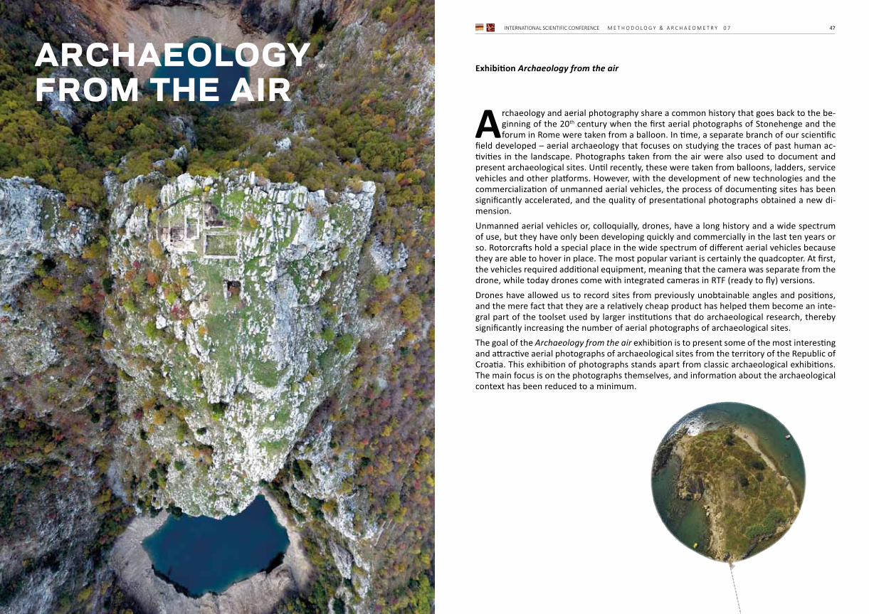
INTERNATIONAL SCIENTIFIC CONFERENCE M E T H O D O L O G Y & A R C H A E O M E T R Y 0 7 4746 M E T H O D O L O G Y & A R C H A E O M E T R Y 0 7 INTERNATIONAL SCIENTIFIC CONFERENCE
Exhibition Archaeology from the air
Archaeology and aerial photography share a common history that goes back to the be-ginning of the 20th century when the first aerial photographs of Stonehenge and the forum in Rome were taken from a balloon. In time, a separate branch of our scientific
field developed – aerial archaeology that focuses on studying the traces of past human ac-tivities in the landscape. Photographs taken from the air were also used to document and present archaeological sites. Until recently, these were taken from balloons, ladders, service vehicles and other platforms. However, with the development of new technologies and the commercialization of unmanned aerial vehicles, the process of documenting sites has been significantly accelerated, and the quality of presentational photographs obtained a new di-mension.Unmanned aerial vehicles or, colloquially, drones, have a long history and a wide spectrum of use, but they have only been developing quickly and commercially in the last ten years or so. Rotorcrafts hold a special place in the wide spectrum of different aerial vehicles because they are able to hover in place. The most popular variant is certainly the quadcopter. At first, the vehicles required additional equipment, meaning that the camera was separate from the drone, while today drones come with integrated cameras in RTF (ready to fly) versions.Drones have allowed us to record sites from previously unobtainable angles and positions, and the mere fact that they are a relatively cheap product has helped them become an inte-gral part of the toolset used by larger institutions that do archaeological research, thereby significantly increasing the number of aerial photographs of archaeological sites.The goal of the Archaeology from the air exhibition is to present some of the most interesting and attractive aerial photographs of archaeological sites from the territory of the Republic of Croatia. This exhibition of photographs stands apart from classic archaeological exhibitions. The main focus is on the photographs themselves, and information about the archaeological context has been reduced to a minimum.
archaeologyfrom the air
INTERNATIONAL SCIENTIFIC CONFERENCE M E T H O D O L O G Y & A R C H A E O M E T R Y 0 7 4948 M E T H O D O L O G Y & A R C H A E O M E T R Y 0 7 INTERNATIONAL SCIENTIFIC CONFERENCE
NOTESM
inistarstvoznanosti i obrazovanja
07THIN
TERNATIO
NAL
SC
IEN
TIF
IC C
ON
FEREN
CE
Me
th
od
olo
gy
& A
rc
ha
eo
me
tr
y
Zagreb, 2nd ‒ 3
rd Decem
ber 2019
INTERNATIONAL SCIENTIFIC CONFERENCE M E T H O D O L O G Y & A R C H A E O M E T R Y 0 7 5150 M E T H O D O L O G Y & A R C H A E O M E T R Y 0 7 INTERNATIONAL SCIENTIFIC CONFERENCE
NOTES NOTES
INTERNATIONAL SCIENTIFIC CONFERENCE M E T H O D O L O G Y & A R C H A E O M E T R Y 0 7 5352 M E T H O D O L O G Y & A R C H A E O M E T R Y 0 7 INTERNATIONAL SCIENTIFIC CONFERENCE
NOTES NOTES
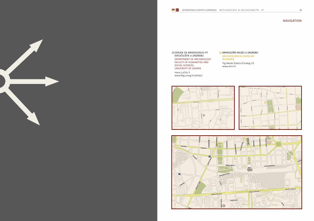
INTERNATIONAL SCIENTIFIC CONFERENCE M E T H O D O L O G Y & A R C H A E O M E T R Y 0 7 5554 M E T H O D O L O G Y & A R C H A E O M E T R Y 0 7 INTERNATIONAL SCIENTIFIC CONFERENCE
NAVIGATION
ODSJEK ZA ARHEOLOGIJU FF SVEUČILIŠTA U ZAGREBUDEPARTMENT OF ARCHAEOLOGYFACULTY OF HUMANITIES AND SOCIAL SCIENCES, UNIVERSITY OF ZAGREBIvana Lučića 3www.ffzg.unizg.hr/arheo/
ARHEOLOŠKI MUZEJ U ZAGREBUARCHAEOLOGICAL MUSEUM IN ZAGREBTrg Nikole Šubića Zrinskog 19www.amz.hr
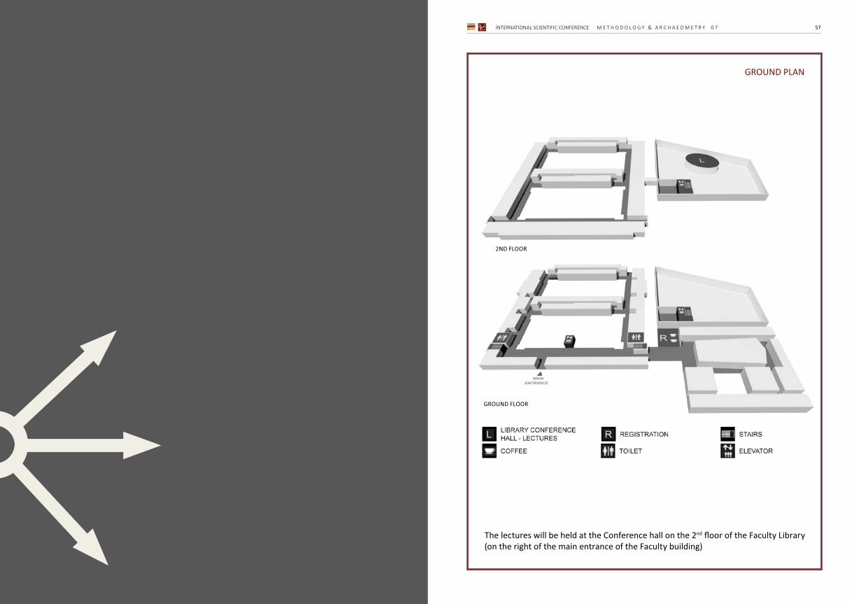
INTERNATIONAL SCIENTIFIC CONFERENCE M E T H O D O L O G Y & A R C H A E O M E T R Y 0 7 57
GROUND PLAN
The lectures will be held at the Conference hall on the 2nd floor of the Faculty Library (on the right of the main entrance of the Faculty building)
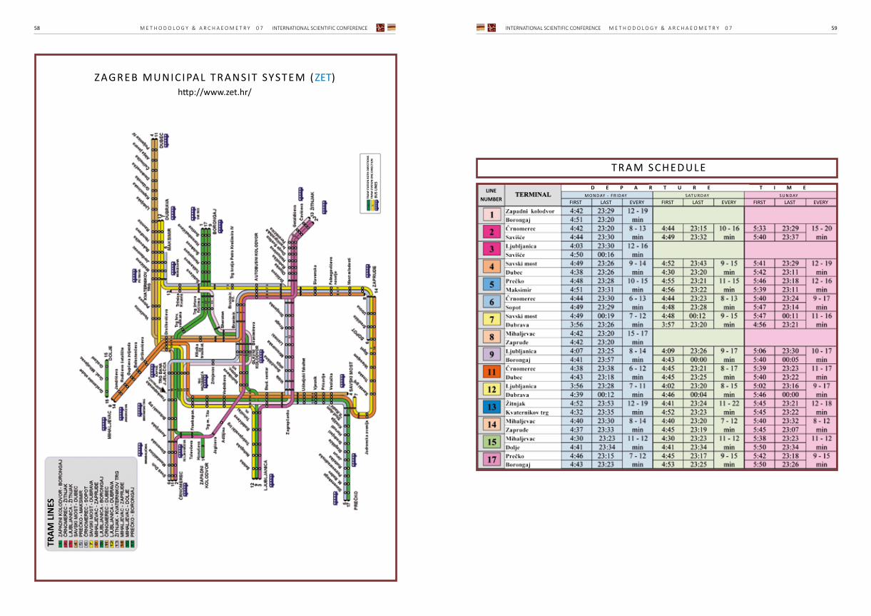
INTERNATIONAL SCIENTIFIC CONFERENCE M E T H O D O L O G Y & A R C H A E O M E T R Y 0 7 5958 M E T H O D O L O G Y & A R C H A E O M E T R Y 0 7 INTERNATIONAL SCIENTIFIC CONFERENCE
ZAGREB MUNICIPAL TRANSIT SYSTEM ( ZET)http://www.zet.hr/
TRAM SCHEDULE
BUS
LIN
ES
TRAM
STA
TIO
N B
OTH
DIR
ECTI
ON
STR
AM S
TATI
ON
ON
E DI
RECT
ION
D E P A R T U R E T I M E

07THINTERNATIONALS C I E N T I F I C C O N F E R E N C E
Methodology & Archaeometry
Z a g re b , 2 n d ‒ 3 rd D e c e m b e r 2 0 1 9