Embed Size (px)
Citation preview
2.31.1
2.31 Urban Development Pattern – Antiquated Platted Subdivisions
A. Introduction & Background: Modern land sales practices and regulations require the developer of a subdivision to either provide or pay for all necessary infrastructure. This includes internal roads, external road improvements, potable water and sanitary sewer facilities, and adequate drainage. These facilities must be ready at or near the time of sale to future residents. In some cases, the developer may also provide amenities, such as street lighting, parks, libraries or recreational facilities. Additionally, the developer is generally required to be aware of the environmental impacts of the proposed development. Factors such as protected species, preservation areas, and floodplain impacts must all be taken into account. Much of the money generated by these subdivisions goes back to the local government through various taxes, assessments and impact fees. Lending institutions often require hefty down payments on developable property (25% is not unusual) and repayment of loans is due in a relatively short period of time (often as little as 5 years). In part due to governmental assessments and lending fees, market forces encourage developers to quickly develop or sell their property. These factors explain the rapid pace of development in much of Southwest Florida (including Collier County). Modern Versus Pre-Platted Subdivisions: From the period beginning just after World War I and extending into the mid-1970s, Florida and other parts of the U.S. witnessed the phenomena of "pre-platted" communities. Pre-platted communities, also known as "platted lands" "obsolete subdivisions", or "antiquated subdivisions" differ from modern subdivisions in a number of ways. Some of the most important differences are provided below: 1. Modern subdivisions must funnel a large percentage (as much as 75%, in some
instances) of sales revenues into property taxes, various types of local assessments or exactions, infrastructure improvements, and environmental permitting. Pre-platted subdivisions channeled a large percentage of sales revenues (sometimes as much as 50%) into marketing and salaries for the sales force.
2. Modern subdivisions provide the majority of the infrastructure required to meet
the impacts of the proposed development. Pre-platted subdivisions usually only provided complete infrastructure in a relatively small "core" area, with only minimal (or sometimes no) infrastructure provided to the remainder of the development.
3. Modern subdivisions are generally relatively compact (from 50 acres to 2,000
acres in size, in most cases), and provide convenient access to governmental and commercial centers. Larger developments may even include commercial and institutional land uses within the confines of the development. Pre-platted
2.31.2
communities were very large in size (from 2,000 acres to more than 100,000 acres) and often provided poor access to commercial and institutional uses.
4. Modern subdivisions are to some extent dependant upon the availability of
existing infrastructure for connection purposes. Pre-platted communities were usually located outside of the existing urban area and therefore do not have access to adjacent existing infrastructure. Such development patterns are known as "leapfrog development" and constitute one form of urban sprawl.
5. Modern development practices require an orderly succession of ownership from
the original developer through lending institutions and community associations to the individual homeowner or lot owner. This progression allows for the gradual development of the community, consistent with the gradual provision of infrastructure to serve community needs. Pre-platted communities often resulted in fragmented ownership patterns, with no provision for infrastructure development concurrent with community needs.
Collier County has approximately 75,871 platted lots, covering approximately 134,529 acres (roughly 210 square miles). The majority of Collier County’s pre-platted lots occur in the area known as Golden Gate Estates, including Golden Gate City, (30,966 lots). However, there are also platted subdivisions in an around Marco Island (14,129 lots) and in other areas of the County (30,776 lots). Note that the last category includes both small, pre-platted subdivisions and conventional, modern development. The Platted Lands Problem: The significance of this phenomenon to local governments may not be readily apparent. Basically, the problem is one of cost to the local government. As noted previously, modern developments send a substantial amount of their revenue to the surrounding community. This is not true for obsolete, pre-platted developments in most cases. Staff recently concluded preparation of two major amendments to the County’s Golden Gate Area Master Plan (GGAMP). The amendments were divided into phases. The Phase 1 amendments were approved by the County in September of 2003, and were accepted by the Florida Department of Community Affairs (DCA) in November of 2003. The Phase 2 amendments are currently scheduled for transmittal to DCA in February 2004. As part of the amendment process staff prepared population projections for the greater Golden Gate Area, as covered within the GGAMP. As part of these projections, staff estimated the population for the GGAMP study area for the year 2020. The 2020 population is projected to be 69,882 persons. Note that this figure does not represent complete buildout for the Golden Gate Area. Using the current Collier County standards for public facilities, the projected demand for public facilities and services by Golden Gate residents in the year 2020 can be determined.
2.31.3
Potable Water Demand: 69,882 people x 185 gallons per capita per day (County standard) = 12,928,170 gallons per day. Wastewater Treatment Demand: 69,882 people x 145* gallons per capita per day (County standard) = 10,132,890 gallons per day. (*Note: This projection uses the standard for the County’s North Sewer District, which provides a worst case scenario.) Parks Required to serve population: Community Park Demand: 69,882 people x 1.2882 acres per 1,000 people (County standard) = 90+ acres. Regional Park Demand: 69,882 people x 2.9412 acres per 1,000 people (County standard) = 205.5+ acres. Recreational Facilities Value (apart from construction costs): 69,882 x $240.00 per person (County standard) = $ 16,771,680. Library Facility Demand: Building Demand: 69,882 people x 0.33 square feet per capita (County standard) = 23,061 square feet. Collection Demand: 69,882 people x 2.05 books per capita by FY 10* (County standard) = 143,258 volumes. (*Note: The standard refers to the 10th Fiscal Year after approval of the current Capital Improvement Element, or FY 2012. However, the population projection is based on the year 2020.) Jail Population: 69,882 people x 0.0024 beds per capita (County standard) = 168 beds, plus approximately 61 staff. County Emergency Medical Service: 69,882 people x 0.000068 EMS units per capita (County standard) = 5 units. B. Identification of Specific Goals, Objectives & Policies: Excepting only the Golden Gate Area Master Plan (GGAMP), which applies solely to antiquated subdivisions, the majority of the County’s Goals, Objectives and Policies would apply similarly to antiquated or modern subdivisions. The following Goals, Objectives and/or Policies, within the Collier County Growth Management Plan, include criteria specifically applicable to antiquated subdivisions (some items may include criteria applicable to other areas of the County as well):
2.31.4
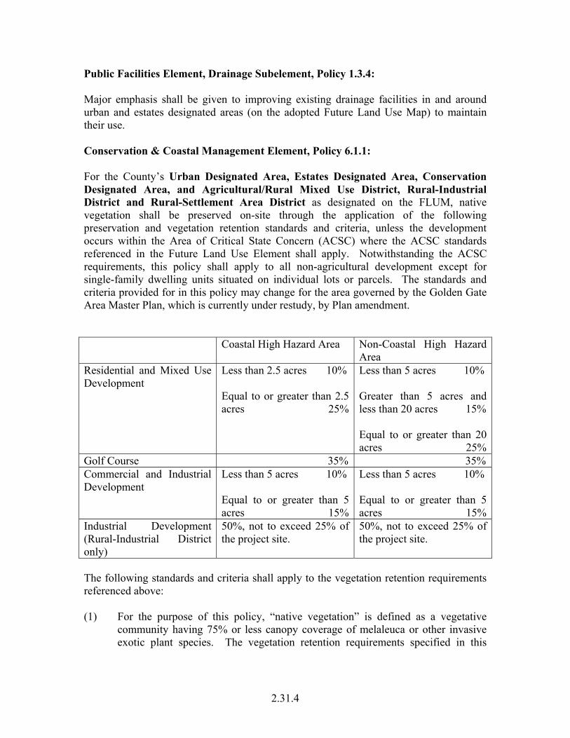
Public Facilities Element, Drainage Subelement, Policy 1.3.4: Major emphasis shall be given to improving existing drainage facilities in and around urban and estates designated areas (on the adopted Future Land Use Map) to maintain their use. Conservation & Coastal Management Element, Policy 6.1.1: For the County’s Urban Designated Area, Estates Designated Area, Conservation Designated Area, and Agricultural/Rural Mixed Use District, Rural-Industrial District and Rural-Settlement Area District as designated on the FLUM, native vegetation shall be preserved on-site through the application of the following preservation and vegetation retention standards and criteria, unless the development occurs within the Area of Critical State Concern (ACSC) where the ACSC standards referenced in the Future Land Use Element shall apply. Notwithstanding the ACSC requirements, this policy shall apply to all non-agricultural development except for single-family dwelling units situated on individual lots or parcels. The standards and criteria provided for in this policy may change for the area governed by the Golden Gate Area Master Plan, which is currently under restudy, by Plan amendment. Coastal High Hazard Area Non-Coastal High Hazard
Area Residential and Mixed Use Development
Less than 2.5 acres 10% Equal to or greater than 2.5 acres 25%
Less than 5 acres 10% Greater than 5 acres and less than 20 acres 15% Equal to or greater than 20 acres 25%
Golf Course 35% 35% Commercial and Industrial Development
Less than 5 acres 10% Equal to or greater than 5 acres 15%
Less than 5 acres 10% Equal to or greater than 5 acres 15%
Industrial Development (Rural-Industrial District only)
50%, not to exceed 25% of the project site.
50%, not to exceed 25% of the project site.
The following standards and criteria shall apply to the vegetation retention requirements referenced above: (1) For the purpose of this policy, “native vegetation” is defined as a vegetative
community having 75% or less canopy coverage of melaleuca or other invasive exotic plant species. The vegetation retention requirements specified in this
2.31.5
policy are calculated based on the amount of “native vegetation” that conforms to this definition.
(2) The preservation of native vegetation shall include canopy, under-story and
ground cover emphasizing the largest contiguous area possible. (3) Areas that fulfill the native vegetation retention standards and criteria of this
policy shall be set aside as preserve areas. All on-site or off-site preserve areas shall be identified as separate tracts and protected by a permanent conservation easement to prohibit further development, consistent with the requirements of this policy.
(4) Selection of the preserve areas shall reflect the following criteria in descending
order of priority:
a. Onsite wetlands shall be preserved pursuant to Policy 6.2.5 of this element;
b. Areas known to be utilized by listed species or that serve as corridors for
the movement of wildlife shall be preserved and protected in order to facilitate the movement of wildlife through the site. This criterion shall be consistent with the requirements of Policy 7.1.1 of this element. Parcels containing gopher tortoises shall protect the largest, most contiguous gopher tortoise habitat with the greatest number of active burrows, and provide a connection to off site adjacent gopher tortoise preserves.
c. Upland habitat shall be part of the preservation requirement when
wetlands alone do not constitute all of the requirement. Upland habitats have the following descending order of priority:
1. Any upland habitat that serves as a buffer to a wetland area. 2. Listed plant and animal species habitats, 3. Xeric Scrub, 4. Dune and Strand, Hardwood Hammocks, 5. Dry Prairie, Pine Flatwoods, and 6. All other upland habitats.
(5) Passive recreational uses such as pervious nature trails or boardwalks are allowed
within the preserve areas, as long as any clearing required to facilitate these uses does not impact the minimum required native vegetation.
(6) A management plan shall be submitted to identify actions that must be taken to
ensure that the preserved areas will function as proposed. The plan shall include methods to address control and treatment of invasive exotic species, fire management, and maintenance of permitted facilities.
(7) Off-site preservation shall be allowed to provide flexibility in the project design.
2.31.6
a. Within Receiving and Neutral Lands, off-site preservation shall be allowed for up to 50% of the vegetation retention requirement.
1. Off-site preservation areas shall be allowed at a ratio of 1:1 if such
off-site preservation is located within designated Sending Lands or at a ratio of 1.5:1 anywhere else.
2. Like for like preservation shall be required for Tropical Hardwood
and Oak Hammock vegetative communities.
b. Within non-NRPA Sending Lands, off-site preservation shall be allowed for up to 25% of the site preservation or vegetative retention requirement, whichever is controlling.
1. Off-site preservation areas shall be contiguous to designated
Sending Lands and shall be allowed at a ratio of 3:1. c. Off-site preservation shall not be allowed in NRPA Sending Lands. (8) Density Bonus Incentives shall be granted to encourage preservation amounts
greater than that required in this policy, as provided for in the FLUE for Receiving Lands and Rural Villages. Within one (1) year of the effective date of these amendments, Collier County shall adopt specific land development regulations to implement this incentive program.
(9) On-site preservation areas shall also conform to the Open Space requirements as
specified in the Future Land Use Element. These preservations shall be part of and counted towards the Open Space requirements.
(10) Existing native vegetation that is located contiguous to the natural reservation
shall be preserved pursuant to Policy 6.5.2 of this element. Natural reservation is defined as that specified in CCME Objective 6.5 of this element;
(11) Preservation areas shall be interconnected within the site and to adjoining off-site
preservation areas or wildlife corridors; (12) Should the amount of wetland vegetation exceed the minimum vegetation
requirements as specified herein, retention of wetland vegetation having significant habitat or hydrologic value is encouraged. Increased preservation shall be fostered through incentives including, but not limited to: clustered development, reduced development standards such as open space, setbacks, and landscape buffers, to allow for increased areas of preserved wetland vegetation. Significant habitat or hydrologic value is determined by wetland function, not the size of the wetland.
2.31.7
Conservation & Coastal Management Element, Policy 6.2.3: Collier County shall implement a comprehensive process to ensure wetlands and the natural functions of wetlands are protected and conserved. The process outlined within this policy is primarily based on directing concentrated population growth and intensive development away from large connected wetland systems. These wetland systems have been identified based on their type, values, functions, sizes, conditions and locations within Collier County. These systems predominantly occur east of the Urban boundary. Many fall within public lands or lands targeted for acquisition. High quality wetlands systems located on private property are primarily protected through native vegetation preservation requirements, or through existing PUD commitments, conservation easements, or Stewardship Sending Area Designations, or via the NRPA or Sending designations in the Rural Fringe. Protection measures for wetlands and wetland systems located within the Eastern Lands portion of the County’s Rural and Agricultural Assessment (depicted on the FLUM) will be adopted prior to November 1, 2002. Within the Urban and Estates designated areas of the County, the County will rely on the jurisdictional determinations made by the applicable state or federal agency. Where permits issued by such state or federal agencies allow for impacts to wetlands within Urban and Estates designated areas and require mitigation for such impacts, this shall be deemed to preserve and protect wetlands and their functions. The large connected wetland systems that exist at the landscape scale in Collier County shall be protected through various Land Use Designations and Overlays that restrict higher intensity land uses and require specific land development standards for the remaining allowable land uses. Collier County shall direct incompatible land uses away from these large landscape scale wetland systems by the following mechanisms: (1) Conservation Designation Best available data indicates that 76% of all wetlands found in Collier County are contained within the boundary of the land designated as Conservation on the Future Land Use Map. The overall purpose of the Conservation Designation is to conserve and maintain the natural resources of Collier County and their associated environmental, recreational, and economic benefits. The allowed land uses specified in the FLUE’s Conservation Designation (Reference FLUE Land Use Designation Section IV.) will accommodate limited residential development and future non-residential development. These limitations support Collier County’s comprehensive process to direct concentrated population growth and intensive land development away from large connected wetland systems. (2) Big Cypress Area of Critical State Concern Overlay (ACSC) Best available data indicates that 74% of the County’s wetlands are within the Big Cypress Area of Critical State Concern Overlay. The land development regulations contained in the ACSC Overlay District on the Future Land Use Map provide standards that facilitate the goal of directing higher intensity land uses away from wetland systems. The development standards for the ACSC Overlay specify that site alterations shall be
2.31.8
limited to 10% of the total site. A large percentage of the land contained within the ACSC is also within the Conservation Designation and thus is subject to the land use limitations of that Land Use Designation. (Land Use Designation Section V.) (3) Natural Resource Protection Areas (NRPAs) Major wetland systems and regional flow-ways were used as criteria to establish the NRPA Overlay District as shown on the Future Land Use Map. These areas identify high functioning wetland systems in the County and represent an additional 12%± of County wetlands that are not located in Conservation Lands. Based on the relatively high concentration of wetlands within NRPA designated lands, incompatible land uses shall be directed away from these areas. Allowable land uses for NRPAs are also subject to native vegetation and preservation standards of 90%. (Reference the NRPA Overlay in the FLUE.) (4) Rural Fringe Mixed Use District Sending Lands Best available data indicates that 16,000± acres of wetlands are contained within designated Sending Lands constituting 70%± of land cover in these areas. Incompatible land uses are directed away from the Rural Fringe Mixed Use District Sending Lands through an incentive based Transfer of Development Rights Program that allows landowners within these Sending Lands to transfer their residential density out of the Sending Lands to Rural Fringe Mixed Use District Receiving Lands. Incompatible land uses are also directed away from Sending Lands by restricting allowable uses. (Reference FLUE Rural Fringe Mixed Use District.) Finally, allowable uses within these lands are also subject to native vegetation retention and preservation standards of 80% to 90%. (Reference CCME Policy 6.7.1) (5) Flowway Stewardship Areas [re-numbered to reflect merger of Ordinance No.
2002-32 and 2002-54] Within the Rural Lands Stewardship Area (RLSA) Overlay as designated on the Future Land Use map, Flowway Stewardship Areas (FSAs) are primarily privately owned wetlands that are located within the Camp Keais Strand and Okaloacoochee Slough. These lands form the primary wetland flowway systems in the RLSA. The Overlay provides an incentive to permanently protect FSAs by the creation and transfer of Credits, elimination of incompatible uses, and establishment of protection measures. Collier County shall allow for more intensive development to occur in Rural Fringe Receiving Lands, North Golden Gate Estates, the Rural-Settlement Area District, and the Urban Designated Areas subject to the land uses identified in the Future Land Use Element, the Immokalee Area Master Plan, and the Golden Gate Area Master Plan. These areas account for only 6% of Collier County’s wetlands. Except for tidal wetlands within the coastal portion of the Urban Designated Area, the County finds that the wetland systems in these areas are more fragmented and altered than those systems located within the Conservation Lands, ACSC and NRPA overlays, and Rural Fringe Sending Lands.
2.31.9
On a project-specific basis, wetlands and wetland functions shall be protected through the following mechanisms: (1) Federal and State jurisdictional agency review and wetland permitting; (2) Vegetation preservation policies supporting CCME Objective 6.1; (3) Wetland protection policies supporting CCME Objective 6.2; and (4) Clustering provisions specified in the FLUE (Reference FLUE Rural Fringe
Mixed Use District.). (Note: Regarding the following policy, the Urban Designated Area includes Golden Gate City, an Antiquated Subdivision.) Conservation & Coastal Management Element, Policy 6.2.4: Within the Urban Designated area, the County shall rely on the wetland jurisdictional determinations and permit requirements issued by the applicable jurisdictional agency. This policy shall be implemented as follows: (1) Where permits issued by such jurisdictional agencies allow for impacts to
wetlands within this designated area and require mitigation for such impacts, this shall be deemed to meet the objective of protection and conservation of wetlands and the natural functions of wetlands within this area.
(2) The County shall require the appropriate jurisdictional permit prior to the issuance
of a final local development order permitting site improvements, except in the case of single-family residences, which are not part of an approved development or are not platted.
(3) Collier County will work with the jurisdictional agencies and applicants to
encourage mitigation to occur within targeted areas of the County including, but not limited to: Natural Resource Protection Areas (NRPAs); lands targeted for a acquisition by a public entity such as CREW lands; public or private mitigation banks; and other areas appropriate for mitigation, such as flow ways and areas containing habitat for listed species.
(4) Within the Immokalee Urban Designated Area, there exists high quality wetland
system connected to the Lake Trafford/Camp Keais system. These wetlands require greater protection measures and therefore the wetland protection standards set forth in Policy 6.2.5 shall apply in this area. As part of the County’s Evaluation and Appraisal Report (EAR), the County shall identify this area and map its boundaries on the Future Land Use Map.
(Note: Regarding the following policy, the Urban Designated Area includes Golden Gate City, an Antiquated Subdivision.)
2.31.10
Conservation & Coastal Management Element, Policy 6.2.6: Within the Urban Designation and the Rural Fringe Mixed Use District, [required] wetland preservation, buffer areas, and mitigation areas shall be dedicated as conservation and common areas in the form of conservation easements and shall be identified or platted as separate tracts; and, in the case of a Planned Unit Development (PUD), these areas shall also be depicted on the PUD Master Plan. These areas shall be maintained free from trash and debris and from Category I invasive exotic plants, as defined by the Florida Exotic Pest Plant Council. Land uses allowed in these areas shall be limited to those listed in Policy 6.2.5(5) d of this element and shall not include any other activities that are detrimental to drainage, flood control, water conservation, erosion control or fish and wildlife habitat conservation and preservation. Conservation & Coastal Management Element, Policy 6.2.7: Within the Estates Designated Area and the Rural Settlement Area, the County shall rely on the wetland jurisdictional determinations and permit requirements issued by the applicable jurisdictional agency. This policy shall be implemented as follows: (1) For single-family residences within Southern Golden Gate Estates or within the
Big Cypress Area of Critical State Concern, the County shall require the appropriate federal and state wetland-related permits before Collier County issues a building permit.
(2) Outside of Southern Golden Gate Estates and the Area of Critical State Concern,
Collier County shall inform applicants for individual single-family building permits that federal and state wetland permits may be required prior to construction. The County shall also notify the applicable federal and state agencies of single family building permits applications in these areas.
(3) Within one (1) year of the adoption of these amendments, Collier County shall
work with federal and state agencies to identify properties that have a high probabilities of wetlands or listed species occurrence. The identification process will be based on hydric soils data and other applicable criteria. Once this identification process is complete, the County will determine if it is sufficiently accurate to require federal and state wetland approvals prior to issuing a building permit within these areas. The County shall use this information to inform property owners of the potential existence of wetlands on their property.
(Note: With regard to the following policy, the “Rural-settlement Area District” refers to the Orangetree PUD, which was formerly the antiquated subdivision of North Golden Gate.)
2.31.11
Future Land Use Element (FLUE) Policy 1.2: The AGRICULTURAL/RURAL Future Land Use Designation shall include Future Land Use Districts and Subdistricts for: A. AGRICULTURAL/RURAL- MIXED USE DISTRICT 1. Rural Commercial Subdistrict B. RURAL FRINGE MIXED USE DISTRICT C. RURAL – INDUSTRIAL DISTRICT D. RURAL – SETTLEMENT AREA DISTRICT Future Land Use Element (FLUE) Policy 1.3: The ESTATES Future Land Use Designation shall include Future Land Use Districts and Subdistricts: as described in the Golden Gate Area Master Plan. Future Land Use Element (FLUE) Policy 4.1: A detailed Master Plan for Golden Gate Estates has been developed and was incorporated into this Growth Management Plan in February 1991. The Master Plan addresses Natural Resources, Future Land Use, Water Management, Public Facilities and other considerations. (Note: With regard to the following policy, the incorporation of the City of Marco Island, in 1997, removed the antiquated subdivisions on the island from County control, and thus from the Marco Island Master Plan.) Future Land Use Element (FLUE) Policy 4.3: A detailed Master Plan for Marco Island has been developed and was incorporated into this Growth Management Plan in January 1997. The Master Plan addresses Population, Public Facilities, Future Land Use, Urban Design, Land Development Regulations and other considerations. Future Land Use Element (FLUE) Policy 4.4: Corridor Management Plans have been developed by Collier County in conjunction with the City of Naples. The Plans identify appropriate urban design objectives and recommend Land Development Regulations and Capital Improvements to accomplish those objectives. Plans have been completed for the following road corridors: Goodlette-Frank Road south of Pine Ridge Road, and Golden Gate Parkway from US 41 to Santa Barbara Boulevard. Future Corridor Management Plans may be prepared as directed by the Board of County Commissioners. The goals for each Corridor Management Plan will

2.31.12
be established prior to the development of the Plan. Corridors that may be considered jointly with the City of Naples include: a. Pine Ridge Road from US 41 to Goodlette-Frank Road; b. Davis Boulevard from US 41 to Airport Road; c. US 41 from Creech Road to Pine Ridge Road; and d. US 41 from Davis Boulevard to Airport Road. The Board of County Commissioners will determine the boundaries of the corridors selected and the time frame for completion. Future Land Use Element (FLUE) Policy 4.7: Redevelopment Plans for existing commercial and residential areas may be considered by the Board of County Commissioners. These plans may consider alternative land use plans, modifications to development standards, and incentives that may be necessary to encourage redevelopment. For properties that have been reviewed under the Zoning Reevaluation Program, changes to the density and intensity of use permitted may be considered, in order to encourage redevelopment in these areas. Some of the specific areas that may be considered by the Board of County Commissioners for redevelopment include: a. Pine Ridge Road between U.S. 41 North and Goodlette-Frank Road; b. Bayshore Drive between U.S. 41 East and Thomasson Drive; c. U.S. 41 East between Davis Boulevard and Airport-Pulling Road; d. Davis Boulevard between U.S. 41 East and Airport-Pulling Road; e. U.S. 41 North in Naples Park; f. C.R. 951 between Green Boulevard and Golden Gate Parkway; and, g. Bonita Beach Road between Vanderbilt Drive and the west end of Little Hickory
Shores #1. Future Land Use Element (FLUE) Policy 5.5: Encourage the use of land presently designated for urban intensity uses before designating other areas for urban intensity uses. This shall occur by planning for the expansion of County owned and operated public facilities and services to existing lands designated for urban intensity uses, the Rural Settlement District (Orangetree PUD), and the Rural Fringe Mixed Use District before servicing new areas.
2.31.13
Future Land Use Element, Future Land Use Designation Description Section: The following section describes the land use designations shown on the Future Land Use Map. These designations generally indicate the types of land uses for which zoning may be requested. However, these land use designations do not guarantee that a zoning request will be approved. Requests may be denied by the Board of County Commissioners based on criteria in the Land Development Code or on special studies completed for the County. I. URBAN DESIGNATION Urban Designated Areas on the Future Land Use Map include two general portions of Collier County: areas with the greatest residential densities, and areas in close proximity, which have or are projected to receive future urban support facilities and services. It is intended that Urban Designated Areas accommodate the majority of population growth and that new intensive land uses be located within them. Accordingly, the Urban Area will accommodate residential uses and a variety of non-residential uses. The Urban Designated Area, which includes Immokalee and Marco Island, represents less than 10% of Collier County’s land area. The boundaries of the Urban Designated Areas have been established based on several factors, including: patterns of existing development; patterns of approved, but unbuilt, development; natural resources; water management; hurricane risk; existing and proposed public facilities; population projections and the land needed to accommodate the projected population growth. Urban Designated Areas will accommodate the following uses: a. Residential uses including single family, multi-family, duplex, and mobile home.
The maximum densities allowed are identified in the Districts, and Subdistricts and Overlays that follow.
b. Non-residential uses including: 1. Essential services as defined by the most recent Land Development Code. 2. Parks, open space and recreational uses; 3. Water-dependent and water-related uses (see Conservation and Coastal
Management Element, Objective 11.1 and subsequent policies and the Manatee Protection Plan contained in the Land Development Code);
4. Child care centers; 5. Community facilities such as churches group housing uses, cemeteries, schools
and school facilities co-located with other public facilities such as parks, libraries, and community centers, where feasible and mutually acceptable;
2.31.14
6. Safety service facilities; 7. Utility and communication 8. Earth mining, oil extraction, and related processing; 9. Agriculture; 10. Travel trailer recreational vehicle parks, provided the following criteria are met:
(a) The density is consistent with that permitted in the Land Development Code;
(b) The site has direct principal access to a road classified as an arterial in the
Transportation Element, direct principal access defined as a driveway and/or local roadway connection to the arterial road, provided the portion of the local roadway intended to provide access to the RV park is not within a residential neighborhood and does not service a predominately residential area; and
(c) The use will be compatible with surrounding land uses.
11. Support medical facilities such as physicians' offices, medical clinics, treatment,
research and rehabilitative centers, and pharmacies provided the dominant use is medical related and located within ¼ mile of existing or approved hospitals or medical centers which offer primary and urgent care treatment for all types of injuries and traumas, such as, but not limited to, North Collier Hospital. The distance shall be measured from the nearest point of the tract that the hospital is located on or approved for, to the project boundaries of the support medical facilities. Approval of such support medical facilities may be granted concurrent with the approval of new hospitals or medical centers which offer primary and urgent care treatment for all types of injuries and traumas. Stipulations to ensure that the construction of the support medical facilities is concurrent with hospitals or medical centers shall be determined at the time of zoning approval. Support medical facilities are not allowed under this provision if the hospital or medical center is a short-term leased facility due to the potential for relocation.
12. Commercial uses subject to criteria identified in the Urban - Mixed Use District,
PUD Neighborhood Village Center Subdistrict, Office and Infill Commercial Subdistrict, Traditional Neighborhood Design Subdistrict, Orange Blossom Mixed-Use Subdistrict, Goodlette/Pine Ridge Commercial Infill Subdistrict, Buckley Mixed Use Subdistrict, Vanderbilt Beach/Collier Boulevard Commercial Subdistrict, and Henderson Creek Mixed Use Subdistrict; and, in the Urban Commercial District, Mixed Use Activity Center Subdistrict, Interchange Activity Center Subdistrict, Livingston/Pine Ridge Commercial Infill Subdistrict, Livingston Road/Eatonwood Lane Commercial Infill Subdistrict, Livingston Road
2.31.15
Commercial Infill Subdistrict, and in the Bayshore/Gateway Triangle Redevelopment Overlay.
13. Commercial uses accessory to other permitted uses, such as a restaurant accessory
to a golf course or retail sales accessory to manufacturing, so long as restrictions or limitations are imposed to insure the commercial use functions as an accessory, subordinate use. Such restrictions or limitations could include limiting the size and/or location of the commercial use and/or limiting access to the commercial use.
14. Industrial uses subject to criteria identified in the Urban - Industrial District, in the
Urban - Mixed Use District, and in the Urban Commercial District, certain quadrants of Interchange Activity Centers.
15. Hotels/motels consistent by Policy 5.9, 5.10, and 5.11, or as permitted in the
Immokalee Area, Golden Gate Area and Marco Island Master Plans, and as permitted in the Bayshore/Gateway Triangle Redevelopment Overlay.
16. Business Park uses subject to criteria identified in the Urban-Mixed Use District,
Urban Commercial District and Urban-Industrial District. 17. Research and Technology Park uses subject to criteria identified in the Urban-
Mixed Use District, Urban Commercial District and Urban-Industrial District. A. Urban - Mixed Use District This District, which represents approximately 116,000 acres, is intended to accommodate a variety of residential and non-residential land uses, including mixed-use developments such as Planned Unit Developments. Certain industrial and commercial uses are also allowed subject to criteria. This may be accomplished by encouraging coordinated mixed-use sites of water-dependent and water-related land uses are permitted within the coastal region of this District. Mixed-use sites of water-dependent and water-related uses and other recreational uses may include water-related parks, marinas (public or private), yacht clubs, and related accessory and recreational uses, such as boat storage, launching facilities, fueling facilities, and restaurants. Any water-dependent and/or water-related land use shall encourage the use of the Planned Unit Development technique and other innovative approaches to conserve environmentally sensitive features and to assure compatibility with surrounding land uses. Priorities for shoreline land use shall be given to water dependent principal uses over water-related land uses. In addition to the criteria of compatibility with surrounding land uses and consistency with the siting policy of the Conservation and Coastal Management Element (Objective 10.1 and subsequent policies), the following land use criteria shall be used for prioritizing the siting of water-dependent and water-related uses:
2.31.16
a. Presently developed sites; b. Sites where water-dependent or water-related uses have been previously
established; c. Sites where shoreline improvements are in place; d. Sites where damage to viable, naturally functioning wetlands, or other
environmentally sensitive features, could be minimized. (Note: With regard to the following paragraph; “Port of The Islands,” formerly known as “Remuda Ranch,” is an antiquated subdivision considered to be within the Urban Designation.) Port of the Islands is a unique development, which is located within the Urban Designated Area, but is also totally within the Big Cypress Area of Critical State Concern. However, a portion of the development was determined “vested” by the State of Florida, thus exempting it from the requirements of Chapter 380, Florida Statutes. Further, there is an existing Development Agreement between Port of the Islands, Inc. and the State of Florida Department of Community Affairs dated July 2, 1985, which regulates land uses at Port of the Islands. Port of the Islands is eligible for all provisions of the Urban – Mixed Use District in which it is located to the extent that the overall residential density and commercial intensity does not exceed that permitted under zoning at time of adoption of this Plan. B. Urban Commercial District This District is intended to accommodate almost all new commercial zoning; a variety of residential uses, including higher densities for properties not located within the Urban Coastal Fringe or Urban Residential Fringe Subdistricts; and a variety of non-residential uses. (Note: With regard to the following Future Land Use Designation, one of the Mixed Use Activity Centers is located within Golden Gate City.) 1. Mixed Use Activity Center Subdistrict Mixed Use Activity Centers have been designated on the Future Land Use Map Series identified in the Future Land Use Element. The locations are based on intersections of major roads and on spacing criteria. There are 19 Mixed Use Activity Centers, which comprise approximately 3,000 acres, including 3 Interchange Activity Centers (#4, 9, 10), which will be discussed separately. Two Activity Centers #19 and 21 have been deleted and replaced by the land use designations identified in the Marco Island Master Plan and Future Land Use Map.
2.31.17
The Mixed-Use Activity Center concept is designed to concentrate almost all new commercial zoning in locations where traffic impacts can readily be accommodated, to avoid strip and disorganized patterns of commercial development, and to create focal points within the community. Additionally, some commercial development is allowed outside of Mixed Use Activity Centers in the PUD Neighborhood Village Center Subdistrict, Office and Infill Commercial Subdistrict, Interchange Activity Center Subdistrict, Traditional Neighborhood Design Subdistrict, Orange Blossom Mixed-Use Subdistrict, Goodlette/Pine Ridge Commercial Subdistrict, Vanderbilt Beach/Collier Boulevard Commercial Subdistrict, Livingston/Pine Ridge Commercial Infill Subdistrict, Henderson Creek Mixed Use Subdistrict, Livingston Road/Eatonwood Lane Commercial Infill Subdistrict, Livingston Road Commercial Infill Subdistrict, Buckley Mixed Use Subdistrict and the Bayshore/Gateway Triangle Redevelopment Overlay and by Policies 5.9, 5.10, and 5.11 of the Future Land Use Element. Mixed Use Activity Centers are intended to be mixed-use in character. The actual mix of the various land uses - which may include the full array of commercial uses, residential uses, institutional uses, hotel/motel uses at a density consistent with the Land Development Code – shall be determined during the rezoning process based on consideration of the factors listed below. For residential development, if a project is within the boundaries of a Mixed Use Activity Center, which is not within the Urban Residential Fringe Subdistrict or Urban Coastal Fringe Subdistrict, up to 16 residential units per gross acre, may be permitted. This density may be distributed throughout the project, including any portion located outside of the boundary of the Mixed Use Activity Center. (Note: The above-described Future Land Use Designation includes a large number of criteria for rezones. However, none of these are specific to the Center located in Golden Gate City. Some specific criteria for that Center are contained within the Golden Gate Area Master Plan Element (see below).) II. AGRICULTURAL/RURAL DESIGNATION Rural & Agricultural Area Assessment [Note: The assessment has been completed for the entire Assessment area.] (Note: This designation includes South Golden Gate Estates, a former antiquated subdivision.) The Governor and Cabinet sitting as the Administration Commission, on June 22, 1999, issued the Final Order (AC-99-002) pursuant to Section 163.3184(10)(b), Florida Statutes, in Division of Administrative Hearing Case No. 98-0324GM. Pursuant to the Order, Collier County is required to prepare a Rural and Agricultural Assessment (Assessment). This Assessment may be phased. The Geographic Scope of the Assessment Area shall be as follows:
2.31.18
Includes: All land designated Agricultural/Rural, except as noted below; Big Cypress Area of Critical State Concern (ACSC), except as noted below; Conservation lands outside the Urban Boundary, except as noted below; and, South Golden Gate Estates. Excludes: All Urban designated areas; Northern Golden Gate Estates; The Settlement District. The Assessment has been completed, and the Interim Development Provisions are no longer applicable, for these areas: The Agricultural/Rural area encompassed by the Rural Lands Stewardship Area Overlay, which includes a portion of the Big Cypress Area of Critical State Concern; The Conservation designated lands within the Eastern (Rural) Lands Study Area, known as the Okaloacoochee Slough State Forest - which includes a portion of the Big Cypress Area of Critical State Concern, and the Corkscrew Marsh CREW Trust Lands; and The Conservation designated lands lying outside of both the Eastern (Rural) Lands Study Area and the Rural Fringe Study Area, which includes the largest portion of the Big Cypress Area of Critical State Concern. The Rural Fringe Mixed Use District, Other privately owned lands generally located north of Everglades City; and, North Belle Mead, Belle Meade, and CREW NRPAs. The Assessment, or any phase thereof, shall be a collaborative, community-based effort with full and broad-based public participation and assistance from applicable State and Regional agencies. At a minimum, the Assessment must identify the means to accomplish the following: 1. Identify and propose measures to protect prime agricultural areas. Such measures
should prevent the premature conversion of agricultural lands to other uses. 2. Direct incompatible uses away from wetlands and upland habitat in order to
protect water quality and quantity and maintain the natural water regime as well as to protect listed animal and plant species and their habitats.
3. Assess the growth potential of the Area by assessing the potential conversion of
rural lands to other uses, in appropriate locations, while discouraging urban sprawl, directing incompatible land uses away from critical habitat and encouraging development that utilizes creative land use planning techniques
2.31.19
including, but not limited to, public and private schools, urban villages, new towns, satellite communities, area-based allocations, clustering and open space provisions and mixed use development. The Assessment, or any phase thereof, shall recognize the substantial advantages of innovative approaches to development which may better serve to protect environmentally sensitive areas, maintain the economic viability of agricultural and other predominantly rural land uses, and provide for the cost efficient delivery of public facilities and services.
Natural Resource Protection Areas (NRPAs) (Note: South Golden Gate Estates is a designated NRPA.) The following areas shall be generally mapped and identified as NRPAs: These NRPAs are designated on the Future Land Use Map: 1. Within these areas, only agriculture and directly related uses and one single-
family dwelling unit per parcel or lot created prior to June 22, 1999, shall be allowed;
2. These interim development standards shall not affect or limit the continuation of
existing uses. Existing uses shall also include those uses for which all required permits have been issued, or uses for which completed applications have been received by the County prior to June 22,1999. The continuation of existing uses shall include expansions of those uses if such expansions are consistent with or clearly ancillary to the existing use and do not require a rezoning or comprehensive plan amendment;
3. The general location shall be identified on a map as the interim NRPAs and shall
be refined as actual data and analysis is made available during the Collier County Rural and Agricultural Area Assessment.
(Note: The Rural Settlement Area District consists of the Orangetree PUD, formerly known as North Golden Gate City, an antiquated subdivision.) D. Rural - Settlement Area District This District consists of Sections 13, 14, 23, 24, and a portion of 22, Township 48 South, Range 27 East (the former North Golden Gate Subdivision), which was zoned and platted between 1967 and 1970. In settlement of a lawsuit pertaining to the permitted uses of this property, this property has been "vested" for the types of land uses specified in that certain "PUD by Settlement" zoning granted by the County as referenced in that certain SETTLEMENT AND ZONING AGREEMENT dated the 27th day of January 1986. This Settlement Area is commonly known as Orangetree PUD. Refer to the Golden Gate Area Master Plan for permitted uses and standards.
2.31.20
III. ESTATES DESIGNATION The Estates Land Use Designation encompasses lands, which are already subdivided into semi-rural residential parcels (2.25 acres as an average) essentially consisting of the Golden Gate Estates Subdivision. The area is identified as having potential for population growth far removed from supportive services and facilities. Expansion of the area shall be discouraged. Pursuant to Policy 4.1 of the Future Land Use Element, the Golden Gate Area Master Plan encompassing the Estates Designation was adopted by the Collier County Board of County Commissioners on February 5, 1991. Refer to the Golden Gate Area Master Plan for siting criteria and development standards for specific land uses. (Note: Technically, a portion of South Golden Gate Estates is within the following Overlay. However, as this area has been essentially purchased by the Florida Department of Environmental Protection (FDEP), any development within the area is unlikely.) V. OVERLAYS AND SPECIAL FEATURES A. Area of Critical State Concern Overlay The Big Cypress Area of Critical State Concern (ACSC) was established by the 1974 Florida Legislature. The Critical Area is displayed on the Future Land Use Map as an overlay area. The Critical Area encompasses lands designated Conservation, Agricultural/Rural, Estates and Urban (Port of the Islands, Plantation Island and Copeland). Chokoloskee is excluded from the Big Cypress Area of Critical State Concern. All Development Orders within the Critical Area shall comply with Chapter 28-25, Florida Administrative Code, "Boundary and Regulations for the Big Cypress Area of Critical State Concern". Those regulations include the following: 1. Site Alteration a. Site alteration shall be limited to 10% of the total site size, and installation of non-
permeable surfaces shall not exceed 50% of any such area. However, a minimum of 2,500 square feet may be altered on any permitted site.
b. Any non-permeable surface greater than 20,000 square feet shall provide for
release of surface run off, collected or uncollected, in a manner approximating the natural surface water flow regime of the area.
c. Soils exposed during site alteration shall be stabilized and retention ponds or
performance equivalent structures or systems maintained in order to retain run off and siltation on the construction site. Restoration of vegetation to site alteration areas shall be substantially completed within 180 days following completion of a development. Re-vegetation shall be accomplished with pre-existing species or
2.31.21
other suitable species except that undesirable exotic species shall not be replanted or propagated. Exotic species are listed below.
Australian Pine - (Casuarina spp.)
Bishopwood - (Bischofia javanica) Brazilian Pepper - (Shinus terebinthfolius) Melaleuca (cajeput) - (Melaleuca leucadendra spp.) Downy Rosemyrtle - (Rhodomytus tomentosa) Earleaf Acacia - (Acacia auriculiformis) Catclaw Mimosa - (Mimosa pigra) Java Plum - (Syzygium cumini)
d. No mangrove trees or salt marsh grasses shall be destroyed or otherwise altered.
Plants specifically protected by this regulation include: All wetland plants listed by the Florida Department of Environmental Regulation in Chapter 17-301, Florida Administrative Code, as amended.
e. Fill areas and related dredge or borrow ponds shall be aligned substantially in the
direction of local surface water flows and shall be separated from other fill areas and ponds by unaltered areas of vegetation of comparable size. Dredge or borrow ponds shall provide for the release of storm water as sheet flow from their downstream end into unaltered areas of vegetation. Access roads to and between fill areas shall provide for the passage of water in a manner approximating the natural flow regime and designed to accommodate the 50-year storm. Fill areas and related ponds shall not substantially retain or divert the total flow in or to a slough or strand or significantly impeded tidal action in any portion of the estuarine zone.
f. Man-made lakes, ponds, or other containment works shall be constructed with a
maximum slope of 30 degrees to a depth of six feet of water. Whenever mineral extraction is completed in new quarrying lakes, shoreline sloping, planting of littoral shelves with nursery grown aquatic vegetation, restoration or revegetation of the property and disposal of spoils or tailings shall be completed before abandonment of the site. Existing quarrying lakes are exempt from this provision, except that whenever any person carries out any activity defined in Section 380.04, Florida Statutes, as amended as development or applies for a development permit as defined in Section 380.031, Florida Statutes, as amended to develop any existing quarrying lake area, these regulations shall apply.
g. Finger canals shall not be constructed in the Critical Area. h. This rule shall not apply to site alterations undertaken in connection with the
agricultural use of land or for the conversion of land to agricultural use.
2.31.22
2. Drainage a. Existing drainage facilities shall not be modified so as to discharge water to any
coastal waters, either directly or through existing drainage facilities. Existing drainage facilities shall not be expanded in capacity or length except in conformance with paragraph (2) below; however, modifications may be made to existing facilities that will raise the ground water table or limit salt water intrusion.
b. New drainage facilities shall release water in a manner approximating the natural
local surface flow regime, through a spreader pond or performance equivalent structure or system, either on site or to a natural retention, or natural filtration and flow area. New drainage facilities shall also maintain a ground water level sufficient to protect wetland vegetation through the use of weirs or performance equivalent structures or systems. Said facilities shall not retain, divert, or otherwise block or channel the naturally occurring flows in a strand, slough or estuarine area.
c. New drainage facilities shall not discharge water into any coastal waters either
directly or through existing drainage facilities. d. This rule shall not apply to drainage facilities modified or constructed in order to
use land for agricultural purposes or to convert land to such use. 3. Transportation a. Transportation facilities, which would retain, divert or otherwise block surface
water flows shall provide for the re-establishment of sheet flow through the use of interceptor spreader systems or performance equivalent structures and shall provide for passage of stream, strand, or slough water through the use of bridges, culverts, piling construction or performance equivalent structures or systems.
b. Transportation facilities shall be constructed substantially parallel to the local
surface flow, and shall maintain a historic ground water level sufficient to protect wetland vegetation through the use of weirs or performance equivalent structures or systems and as feasible, the flows in such works shall be released to natural retention filtration and flow areas.
c. Transportation facility construction sites shall provide for siltation and run-off
control through the use of settling ponds, soil fixing or performance equivalent structures or systems.
4. Structure Installation a. Placement of structures shall be accomplished in a manner that will not adversely
affect surface water flow or tidal action.
2.31.23
b. Minimum lowest floor elevation permitted for structures shall be at or above the 100-year flood level, as established by the Administrator of the Federal Flood Insurance Administration. The construction of any structure shall meet additional Federal Flood Insurance Land Management and Use Criteria (24 CFR 1910), as administered by the appropriate local agency.
c. This rule shall not apply to structures used or intended for use in connection with
the agricultural use of the land. All Development Orders issued for projects within the Big Cypress Area of Critical State Concern shall be rendered to the State of Florida Department of Community Affairs for review with the potential for appeal to the Administration Commission per Chapter 9J-1, Florida Administrative Code, "Development Order Requirements for Areas of Critical State Concern". C. Natural Resource Protection Area Overlay The purpose of the Natural Resource Protection Area (NRPA) Overlay designation is to protect endangered or potentially endangered species and to identify large connected intact and relatively unfragmented habitats, which may be important for these listed species. NRPAs may include major wetland systems and regional flow-ways. These lands generally should be the focus of any federal, state, County or private acquisition efforts. NRPAs are located in the following areas: 1. Clam Bay Conservation Area (within Pelican Bay Plan Unit Development); 2. CREW (Corkscrew Regional Ecosystem Watershed); 3. North Belle Meade; 4. Belle Meade; 5. South Golden Gate Estates; 6. Okaloacoochee Slough (interim); and 7. Camp Keais (interim). NRPAs located in the Rural Fringe Mixed Use District, or on nearby or adjacent Conservation Designated Lands are identified as Sending Lands. Private property owners within these NRPAs may transfer residential development rights from these important environmentally sensitive lands. Natural Resource Protection Areas (NRPAs) that are not identified as “interim” above shall have the following standards:
2.31.24
1. Vegetation Retention and Site Preservation - Calculated at the higher value of 90% of the native vegetation present, or 90% of the total site area, or as may otherwise be permitted under the Density Blending provisions of the FLUE. Applicable standards provided for in CCME Policy 6.1.2 shall also apply;
2. Listed species protection shall be provided for as specified in CCME Policy 7.1.2; 3. Permitted and conditional uses for publicly owned lands within an NRPA Overlay
shall be those as set forth under the Conservation Designation. 4. For privately owned lands within a NRPA Overlay and designated Sending lands
or Estates, respectively, permitted and conditional uses shall be those as set forth in the Rural Fringe Mixed Use District for Sending Lands.
5. For privately owned lands within a NRPA Overlay and designated Estates,
permitted and conditional uses shall be those as set forth in the Estates Designation within the Golden Gate Area Master Plan, in recognition of Florida’s private property rights laws. As these privately owned Estates Designated lands are acquired for conservation purposes, the Plan will be amended to change the Designation to Conservation.
6. There are approximately 15 sections of privately owned land within a NRPA
Overlay that are not designated Sending and are not located within the Rural Fringe Mixed Use District (where all Sending Lands are located). Eight (8) of these sections, known as the “hole-in-the-doughnut,” are located within the South Golden Gate Estates NRPA and surrounded by platted Estates lots, almost all of which have been acquired by the State under the Florida Forever program as part of the Picayune Strand State Forest. The remaining seven (7) sections are within an approved mitigation bank located north and west of Corkscrew Swamp Sanctuary. Uses on these lands are limited to restoration and mitigation and, at the completion of this restoration process; these lands will be deeded to a land management entity for conservation purposes. As these privately owned Agricultural/Rural Designated lands are acquired for conservation purposes, the Plan will be amended to change the Designation to Conservation. Until such time, in recognition of Florida’s private property rights laws, permitted and conditional uses for these privately owned lands shall be those set forth in the Agricultural/Rural Mixed Use District.
GOLDEN GATE AREA MASTER PLAN The Golden Gate Area Master Plan (GGAMP) is an Element of the County’s Growth Management Plan that contains Goals, Objectives, Policies and Future Land Use Designations for the antiquated subdivisions of Golden Gate City, North Golden Gate Estates, South Golden Gate Estates and the Rural Settlement Area District (Orangetree PUD). An analysis of this Element is included under Section 1.5 of this Evaluation & Appraisal Report. Also, a copy of the GGAMP has been included as an attachment to this E.A.R.
2.31.25
C. DATA ASSESSMENT: Efforts To Regulate Antiquated Subdivisions: 1. Marco Island: As noted above, there are approximately 14,129 platted lots within the Marco Island Area. Prior to 1997, these lots were regulated through the County Growth Management Plan’s Marco Island Master Plan Element (MIMP). However, in 1997, the major part of this area was incorporated into the City of Marco Island. A portion of the original Master Plan Area is still regulated under the MIMP. However, as part of the proposed EAR-based amendments, the County will recommend that this area be brought under the Countywide Future Land Use Element, and that the MIMP be repealed. An analysis of this recommendation will be provided within the EAR-based amendments. 2. The Community Character Plan:
a. Process & recommendations: On April 13, 1999, the Board of County Commissioners adopted Resolution No. 99-203, establishing the Select Committee on Community Character and Design to oversee the development of a comprehensive urban/rural design master plan. The Select Committee prepared a Scope of Services for the purpose of preparing a Community Character and Design Master Plan, and recommended that the BCC select the consulting firm of Dover, Kohl and Partners as the lead consultant to help prepare the plan. On February 22, 2000, the Board of County Commissioners approved the contract agreement with Dover, Kohl. Subsequently, Dover, Kohl subcontracted with two other consulting firms, Glatting-Jackson of Orlando and Spikowski and Associates from Ft. Myers, to work on various aspects of the Plan. The purpose of the Community Character Plan was to guide urban and rural growth, address traffic issues, and plan for neighborhood parks and other natural areas to preserve and enhance the character of Collier County. While addressing transportation and greenspace needs, the Plan was to seek to maintain and enhance the quality of existing neighborhoods and allow new neighborhoods to be desirable places to live, work, shop, and enjoy the County’s natural environment. In April 2000, a series of community workshops and presentations were held. The workshops featured “hands-on” table sessions where the participants were encouraged to put their ideas on maps. The consultants then took the ideas generated in the workshops and turned them into proposals for implementation. Community input continued through presentations to civic associations and organizations and through discussion and input opportunities, including a County website.
2.31.26
The Plan, entitled “Toward Better Places: The Collier County Community Character Plan”, was accepted by the Board of County Commissioners in April of 2001. The completed plan provided potential planning strategies both for certain specific areas of the County and countywide. One of the areas examined by the Community Character Plan was the Golden Gate Area, particularly North Golden Gate Estates. In a chapter, entitled “Evolving the Subdivided Periphery,” the Community Character Plan provided its recommendations for Golden Gate Estates. These were as follows: Community Character Plan Recommendations: SETTING THE COURSE The Golden Gate Area Master Plan needs to be updated in response to rapid growth. Special rural design techniques should be worked out, in consultation with residents and property owners, to meet the demands of growth while maintaining valuable natural resources and rural character. Some initial ideas are presented here for residents to consider when updating this master plan. GETTING THERE Growth Management Plan a. Update the Golden Gate Area Master Plan, as follows:
i. Develop a plan for land surrounding the future interchange of Interstate 75 and Golden Gate Parkway so that it can provide a dramatic entry into Naples and Golden Gate instead of conventional interstate commercial uses.
ii. Define generalized alignments for two-lane collector roads and "missing
links" in the NGGE road system and illustrate cross-sections for these roads that include rows of native shade trees that will grow together to form a tree canopy.
iii. Delineate general subareas of Golden Gate Estates having differing
characters so that the updated master plan can consider appropriate treatments for each.
iv. Identify suitable locations for minor commercial uses in the form of rural
crossroads, hamlets, or rural villages.
v. Prepare general criteria for a design review system for all new commercial development in Golden Gate Estates.
vi. Identify any specific areas of environmental sensitivity where further
development would be undesirable and other areas that may be suitable for
2.31.27
a transfer of development rights into areas designated for minor commercial uses. Include the new "proposed publicly owned natural lands" acquisition area just north of Alligator Alley as shown in the greenspace manual.
vii. Include a refinement of the trail and greenway system and proposed
neighborhood parks as shown in the Greenspace Manual.
viii. Develop strategies for raising groundwater levels and reestablishing at least parts of the original flowways that ran through Golden Gate Estates. Flowways could be reestablished on public lands as actual sloughs or could remain as forested greenbelts running across private lands.
ix. Identify potential locations for new neighborhood centers that could serve
Golden Gate Estates. These locations could include land within or near the Orangetree settlement area or unplatted land west of 12th and 14th Avenues SE.
b. When republishing the countywide future land use map, include an outline or
hatched pattern to indicate the regulatory area included in the Golden Gate Area Master Plan so that its special provisions would be immediately apparent.
Thoroughfare Plan a. Include on the county's new thoroughfare plan:
i. A series of two-lane collector roads that will provide alternate routes for travel between Golden Gate Estates and coastal Collier County; and
ii. "missing links" in the Golden Gate Estates road system where short road
segments or new bridges could be installed to make the existing road network more functional.
Land Development Code a. Establish a design review system for new commercial development in Golden
Gate Estates. D. Objective Achievement Analysis: A complete analysis of the Golden Gate Area Master Plan (GGAMP), including an analysis relative to the recommendations of the Community Character Plan, is provided within Section 1.5 of this Evaluation & Appraisal Report. Section 1.5 will also discuss recent and proposed amendments to the GGAMP. The following is a discussion of the Goals, Objectives, Policies and Future Land Use Designations discussed within part B., above:
2.31.28
Public Facilities Element, Drainage Subelement, Policy 1.3.4: This policy commits the County to drainage improvements within both the Urban and Estates designated areas. This is an ongoing task. Conservation & Coastal Management Element, Policy 6.1.1: This policy sets out the native vegetation preservation requirements for various types of land uses and Future Land Use Designations within Collier County. It contains a provision recognizing that the Golden Gate Area Master Plan (GGAMP) is in the process of being updated and allows native vegetation preservation requirements to vary within the GGAMP through the plan amendment process. However, the County is not proposing to alter these requirements within the portion of the County covered by the GGAMP. Conservation & Coastal Management Element, Policy 6.2.3: This is the County’s wetlands preservation policy. The policy states that, “Within the Urban and Estates designated areas of the County, the County will rely on the jurisdictional determinations made by the applicable state or federal agency. Where permits issued by such state or federal agencies allow for impacts to wetlands within Urban and Estates designated areas and require mitigation for such impacts, this shall be deemed to preserve and protect wetlands and their functions.” The policy also contains preservation criteria for the County’s Natural Resource Protection Areas, one of which is South Golden Gate Estates. The plan then notes that “more intensive development” is allowed in certain areas of the County, including Golden Gate Estates. Conservation & Coastal Management Element, Policy 6.2.4: This policy deals with wetland preservation procedures within Collier County’s Urban Designated Area. Relative to the topic of antiquated subdivisions, the Urban Designation includes Golden Gate City, a platted (antiquated) subdivision. Conservation & Coastal Management Element, Policy 6.2.6: Within the Urban Designation, this policy requires that wetland preservation, buffer areas, and mitigation areas are to be dedicated as conservation and common areas in the form of conservation easements and are to be identified or platted as separate tracts; and, in the case of a Planned Unit Development (PUD), these areas are also to be depicted on the PUD Master Plan. Relative to the topic of antiquated subdivisions, the Urban Designation includes Golden Gate City, a platted (antiquated) subdivision. Conservation & Coastal Management Element, Policy 6.2.7: Within the Estates Designated Area and the Rural Settlement Area (Orangetree PUD), this policy requires that the County is to rely on the wetland jurisdictional determinations and permit requirements issued by the applicable jurisdictional agency. Future Land Use Element (FLUE) Policy 1.2: This policy establishes the Future Land Use Designations for the Agricultural/Rural portion of the County. This designation includes the Rural Settlement Area District, also known as the Orangetree PUD. This project was formerly known as the antiquated subdivision of North Golden Gate City.
2.31.29
Future Land Use Element (FLUE) Policy 1.3: This policy recognizes the Estates Future Land Use Designation, and its accompanying districts and subdistricts, as contained in the Golden Gate Area Master Plan (GGAMP) Element. Future Land Use Element (FLUE) Policy 4.1: This policy recognizes the existence of the GGAMP. Future Land Use Element (FLUE) Policy 4.3: This policy recognizes the existence of the Marco Island Master Plan (MIMP), approved in 1997. Marco Island contains antiquated subdivision areas. However, in 1997 the island was incorporated and the antiquated lots are now part of the City of Marco Island. Future Land Use Element (FLUE) Policy 4.4: This policy notes that corridor management plans have been established along several roadways within unincorporated Collier County and the City of Naples. Among these is Golden Gate Parkway from US 41 to Santa Barbara Boulevard. This corridor is partly within the Estates. Future Land Use Element (FLUE) Policy 4.7: This policy recognizes several areas of the County wherein the Board of County Commissioners may designate community redevelopment areas (CRAs). One of these is along C.R. 951 between Green Boulevard and Golden Gate Parkway, within Golden Gate City. Staff notes that there is currently no CRA in this area. Future Land Use Element (FLUE) Policy 5.5: This policy allows urban intensity uses to be established within the Rural Settlement Area District (Orangetree PUD). Future Land Use Element, Future Land Use Designation Description Section: Urban Designation: This designation includes Golden Gate City, an antiquated subdivision. Urban - Mixed Use District: This designation includes Golden Gate City, an antiquated subdivision. It also includes Port of the Islands, a vested resort subdivision located entirely within the Big Cypress Area of Critical State Concern. Mixed Use Activity Center Subdistrict: This designation identifies, and contains requirements for the County’s Mixed-Use Activity Centers. One of these is located on Golden Gate Parkway, within Golden Gate City. Rural & Agricultural Area Assessment: This section of the FLUE describes the requirements and purpose of the County’s Rural & Agricultural Area Assessment. Among the portions of the County affected by the assessment is South Golden Gate Estates, a former antiquated subdivision, now more than 90% state-owned.
2.31.30
Natural Resource Protection Areas (NRPAs): This section describes land use regulations for the County’s Natural Resource Protection Areas, including South Golden Gate Estates. Rural - Settlement Area District: This District consists of Sections 13, 14, 23, 24, and a portion of 22, Township 48 South, Range 27 East (the former North Golden Gate Subdivision), which was zoned and platted between 1967 and 1970. Land uses within this area (the Orangetree PUD) are controlled by the terms of a court settlement that has been written into the Golden Gate Area Master Plan Element and the Future Land Use Element. Estates Designation: This Designation encompasses lands, which are already subdivided into semi-rural residential parcels (2.25 acres as an average) essentially consisting of the Golden Gate Estates Subdivision. The Estates Designated Areas are included within the areas regulated by the requirements of the Golden Gate Area Master Plan. Area of Critical State Concern Overlay: This Planning Overlay is analogous to the boundaries of the Big Cypress Area of Critical State Concern (ACSC). The ACSC includes a portion of South Golden Gate Estates and all of the Port of the Islands Development. Natural Resource Protection Area Overlay: As noted previously, this designation includes South Golden Gate Estates, a former antiquated subdivision.
E. CONCLUSION:
This section of the E.A.R. summarizes Collier County’s efforts at managing growth in its large, antiquated subdivision areas, particularly Golden Gate Estates. The Estates, with Golden Gate City, are regulated through the Golden Gate Area Master Plan, an Element of the County’s Growth Management Plan. This Element is currently undergoing a two-phased amendment process, the Golden Gate Area Master Plan Restudy. Phase 1 of the Restudy Amendments was approved in September of 2003 and has recently become effective. Phase 2 of the Restudy Amendments will be transmitted to the Florida Department of Community Affairs during 2004. It remains uncontroverted that the Master Planning process remains the best means by which to manage growth within the antiquated subdivision areas. These areas are not amenable to large-scale deplatting or replatting methods because a large percentage of the antiquated lots are currently occupied by single-family homes. Perhaps, in the past, the County should have taken the opportunity to replat portions of these areas, but that opportunity is now gone. Through the Master Plan process, the County has taken a phased approach to gradually provide these areas (particularly Golden Gate Estates) with public services and amenities. The Golden Gate Area Master Plan (GGAMP) and the ongoing Restudy Amendment Process are further described in EAR Section 1.5.


![Praca licencjacka Renata Dowejko - doc [2.31 MB]](https://img.pdfslide.net/doc/110x75/587611fe1a28ab49438b897f/praca-licencjacka-renata-dowejko-doc-231-mb.jpg)