Embed Size (px)
Citation preview

AcrowdsourceapproachforcapacitybuildinginNorthCanada
Julien Desrochers
#chcnsc2018

TheCanadianArctic

Avastterritory
4.4millionsquarekilometers(47%underwater):• ~10%ofCanada’sArcticwater’sareadequatelysurveyed– 1%surveyedtomodernstandards
• ~32%oftheArctic’smarinecorridorsareadquatelysurveyed– 3%surveyedtomodernstandards

Avastterritory
4.4millionsquarekilometers(47%underwater):• ~10%ofCanada’sArcticwater’sareadequatelysurveyed.– 1%surveyedtomodernstandards
• ~32%oftheArctic’smarinecorridorsareadquatelysurveyed.– 3%surveyedtomodernstandards

Increaseofmaritimetraffic
Commercialships:• 2005:119• 2010:220
Fishingships:• 2005:30• 2010:220

How to avoid this situation??

Howtomapsuchavastterritory?
The crowdsourced bathymetry approach : - Pre-qualified measurement systems (HydroBall / HydroBox) - Local people from the communities (Inuits) - Automatic data processing and dissemination More reactive and cost effective than - Survey teams from the South - Conventional hydrographic tools

Presentationagenda
- Projectoverview- Pre-qualifiedsystems- Communityworkshops- Lessonslearned- Capacitybuildingpossibilities

CSBprojectoverview
1. WP1:UseandintegrateHydrographicsystemsfornon-specialistsinNorthernCanada.(CIDCO)
2. WP2:ConductworkshopswithInuits.(MI/CIDCO)3. WP3:Data-processing.(UNB/CIDCO)4. WP4:Datapost-processinganddata
dissemination.(YORK)

Pre-qualifiedsingle-beamsystem:HydroBall™
A robust shell of spherical shape (13kg – 40cm diam) which contains : - Echosounder (depth measurement) - GNSS receiver (position) - Inclinometer (roll and pitch)
* Autonomous, easy to use

TheHydroBall™system:

Pre-qualifiedblack-boxsystems
HydroBox: - Installation on opportunity vessels
- includes same components as the HydroBall except for :
sonar component which comes directly from the vessel.
* HydroBox is equipped with a GNSS L1/L2 receiver capable of logging raw data.

HydroBoxasasingle-beamsystem
* Measurement of lever arm between GNSS and sonar needed to geo-reference the soundings.

HydroBoxasaGNSSbasestation
HydroBoxcanbeusedasaGNSSbasestation:• OffsetbetweenmarkerandGNSSAPCpre-calibrated

Communityworkshops
Kuujjuaarapik(Inuit/Cree)- Population:~1300Quaqtaq(Inuit)-Population:~400

Kuujjuaarapik
KuujjuaarapikavillageinSEHudsonBay

Consultingthecommunity
Generalfeedback:• Don’tusechartstonavigate• Don’tfeeltheneedforbetterknowledgeofbathymetry
– Notmanyareaspresentadangertonavigation• Membersofthecommunityareopentotheprojectasitcan
bringjobstothecommunity

Workshopswithcommunitymembers
TrainedInuits/CreesinKuujjuarapik:• Jimmy-PaulAngatookalook• CharlieAngatookalook• RichardPetagumskum• CalebNouraJr• JordanKronenburg
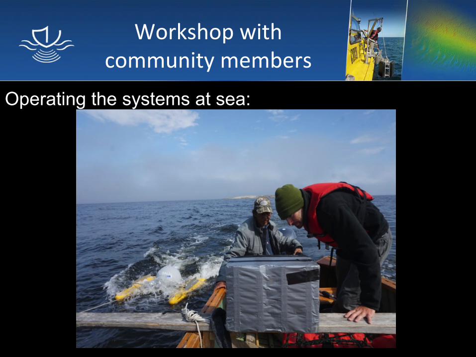
Workshopwithcommunitymembers
Operating the systems at sea:

Workshopwithcommunitymembers

Workshopresults
Kuujjuarapik:• Resultsvarieddependingontheusers:
– Somehadagoodunderstandingofthesystemsandhowtocollectqualitybathymetricdata
– Somedidnothaveagoodunderstandingonhowtooperatethesystemsandneededtobeguidedthroughthewholeprocess
– Theyoungeragegroup(16-22)weredifficulttomotivate
• Mostpeopleconsultedwerenotconvincedonthebeneficialimpactofthisproject.

Quaqtaq
AvillageinNWUngavaBay:

Consultationwithvillageleaders
- Mayor:RobertDeer- Generalmanager:JohnnyOovaut- Huntersupport:PhilippeBigonesse
Theyarewillingto:- Findcandidatesmotivatedforthejob- Hirepeoplewiththerequiredskillset- Hirepeoplewhoarereliable

Quaqtaq:surveyzones
Tomotivatecommunity:Pre-selectionofzonestobesurveyed

Projectcoordinator
Projectcoordinator:PhilippeBigoneseProjectcoordinatortasks:• Maintainingequipmentandensureitsproperuse• Hiring/training/payingthedifferentboatcaptains• ExtractingandsendingthedataovertotheCSBprojectserveraftereachsurveyday

Consultinggeneralcommunity
Oldergeneration:• Don’tusechartstonavigate• Don’tfeeltheneedforbetterknowledgeofbathymetrybut
mappingshoalsseemslikeagoodidea.
Youngergeneration:• Notagoodknowledgeofbathymetry• Feeltheneedforbetterknowledgeofbathymetry:
– Dangerstonavigation– Morphologyofseabedforpresenceoffish
• Interestedinworkingwithnewtechnology

Consultinggeneralcommunity
Generalconsensus:• Projectcanbringjobstothecommunity• Developmentofexpertisewithinthecommunity• Contributingtosafetyofnavigation

Workshopwithcommunitymembers
TwoInuitsweretrainedinQuaqtaq:• PaulAngnatuk• TuniqNingiuruvik
Trainingsessions:• Howtooperatethesystems• Operatingthesystemsatsea

Workshopwithcommunitymembers
Operatingthesystems:• TurnthesystemON/OFF.• Recordingmode• Verifytheequipmentstatus• Chargingthesystems• Extractingthedata

Workshopwithcommunitymembers
Operatingthesystemsatsea:• Systemsetupvalidation• Verificationofsystemstatusandgoodpractices

Workshopresults
Quaqtaq:• Thetwopeopletrainedhadagoodunderstandingofthe
proceduretoacquirequalitybathymetricdata• Atsea,theywereabletomakethenecessaryadjusmentsto
ensurethesystemswereworkingproperly.• Theyseemedinterestedandmotivatedtodothistypeof
workinthefuture.

Lessonslearned
Importantconsiderations:• Supportfromthevillageleadersisneededforasuccesfull
project• Areliableprojectcoordinatorismandatory• Thechosencandidatesneedtobemotivated• Alimitednumberofboatcaptains(2)needtobetrainedto
maximizethenumberofsurveydays(8-12surveydayspercandidate)
• Thecommunitymembersneedtobeinvolvedintheprocessofthedifferentsurveyzones

MappingtheCanadianNorth
How? Crowd sourced bathymetry with members of Inuit communities Why? Maritime traffic = >>>>>>>>>> Population = >>>>>>>>>> Safety of navigation = IMPORTANT Cost of data acquisition = <<<<<<<<<< Contribution to the development of Inuit communities
What’snext???
GeneralizationofthisCSBscenariocouldcontributeto:
IHOcapacitybuildingprogrammesHow??- Usingpre-qualifiedhydrographicsystems- UsingprocessingtoolsdevelopedduringCSBproject- Usingdatapost-processinganddisseminationtools
developedduringCSBproject

Projectparticipants
Allmembersof:

Thankyou!

#chcnsc2018