Embed Size (px)
Citation preview

Advancing the capability for collaborative discovery through data and model sharing: The HydroShare example.
http://www.hydroshare.org
Access these slides in HydroShare by searching for “OACWebinar”
David Tarboton, Ray Idaszak, Jeffery S Horsburgh, Daniel P Ames, Jonathan L Goodall, Alva Couch, Richard Hooper, Shaowen Wang, Martyn Clark, Pabitra Dash, Hong Yi, Christina Bandaragoda, Anthony Castronova, Tian Gan, Zhiyu Li, Mohamed Morsy, Maurier Ramirez, Jeffrey Sadler,
Dandong Yin, Yan Liu.HydroShare is operated by the Consortium of Universities for the Advancement of Hydrologic Science, Inc.
(CUAHSI) with ongoing development through a collaborative project among Utah State University, Brigham Young University, CyberGIS Center University of Illinois, Tufts, University of Virginia, and RENCI University of North
Carolina.
OAC-1664061OAC-1664018OAC-16641192017-2021
ACI-1148453 ACI-11480902012-2017

Vision
Data
Analysis
Models
Part of an ecosystem of cyberinfrastructure elements that make up an integrated cyberinfrastructure for collaboration and computation that integrates data storage, data organization, discovery, analysis and modeling through web applications (web apps) and that allows researchers to employ services beyond their desktop to make data storage and manipulation more reliable and scalable, while improving ability to collaborate and reproduce results.
• Don’t need your own software and platform to use• Reduce installation, library and platform dependencies• Data access and size, faster computation• Re-use• Reproducibility • Transparency• Trust• Collaboration
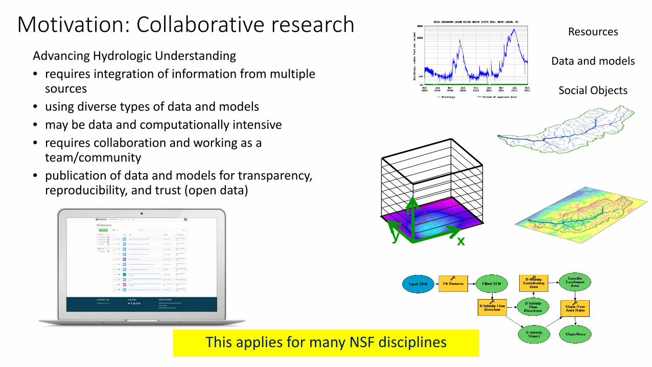
Motivation: Collaborative researchAdvancing Hydrologic Understanding• requires integration of information from multiple
sources• using diverse types of data and models• may be data and computationally intensive• requires collaboration and working as a
team/community• publication of data and models for transparency,
reproducibility, and trust (open data)
xyt
This applies for many NSF disciplines
Resources
Data and models
Social Objects

Grand ChallengeBetter hydrologic forecasting that quantifies effects and consequences of land surface change on hydrologic processes and conditions
by enabling access to and organizing data for integrated analysis and modeling
We want to be able to better forecast, plan for and mitigate the effects of floods.
We want to ensure sufficient water resources in times of shortage.
From https://ca.water.usgs.gov/california-drought/

Example from HydroShare: Data-driven methods model flood severity using crowd-sourced and environmental data.

Data from 2017 US Hurricanes
Look in HydroShare for keywords harvey2017, irma2017, maria2017

Example: Support for CSDMS Landlab Earth Surface Modeling Toolkit community.
7
Developers, Researchers & Students • 330 Users in Landlab
HydroShare Group
• 6 National/International Conference Workshops running on HydroShare JupyterHub App
• 10+ university classroom lectures interacting with HydroShare JupyterHub App
• PhD Dissertation and Journal Articles

NOCA Data, HydroShare, https://doi.org/10.4211/hs.a5b52c0e1493401a815f4e77b09d352bLandlab: Model code and Users Manual, HydroShare,https://doi.org/10.4211/hs.27d34fc967be4ee6bc1f1ae92657bf2b
Debris avalanches mapped within NOCA

050
010
0020
00
Date
Num
ber o
f Use
rs
2015-07-01 2016-01-01 2016-07-01 2017-01-01 2017-07-01 2018-01-01 2018-07
TotalActive (last 90 days)New (last 90 days)
2018-06-25 Total: 2606 Active: 684 New (last 90 days): 360
Hydroshare Users as of 2018-06-25
Audience and User basePrimary audience is US Hydrologic Research community (NSF funding) but open to international use and use by water resource professionals, educators and citizen scientists
Statistics as of 6/25/18 , see https://help.hydroshare.org/about-hydroshare/usage-metrics/
For users who have indicated type in their profile
5500 + Total Resources1522 Public
Resources
Users
Commercial Professional
Grad Student
Faculty
University Professional
Government Official
Post Doc
Undergrad student
28.89 %
27.42 %15.56 %
11.85 %
8.15 %
5.93 %
2.22 %

CyberInfrastructure Challenges
• The data deluge• Large datasets, data heterogeneity, Inadequate
metadata
• Data Organization and Model Input preparation• Reproducibility• Software installation and configuration
• Platform dependencies, Library dependencies, Licensing
• Computational resources • Memory, disk and processing

- iUTAH Proposal Data Management Plan
“All of the primary datasets collected as part of this project will be made freely and publicly available…”
Many of us put statements like this in our Data Management Plan, but how do we really accomplish this?
From Jeff Horsburgh
Data Management

Ideal Investigator Data Workflow• Easily create a digital instance of a dataset or model • Quickly share it with colleagues (perhaps privately at first)• Add value through collaboration, annotation, and iteration• Describe with metadata• Eventually…share publicly or formally Publish
DOI
META
This is still not as easy as it should be!From Jeff Horsburgh
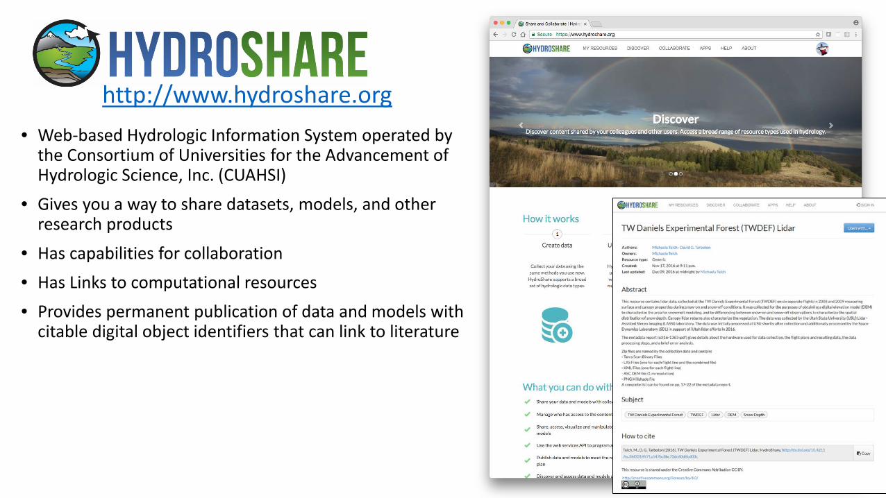
• Web-based Hydrologic Information System operated by the Consortium of Universities for the Advancement of Hydrologic Science, Inc. (CUAHSI)
• Gives you a way to share datasets, models, and other research products
• Has capabilities for collaboration• Has Links to computational resources• Provides permanent publication of data and models with
citable digital object identifiers that can link to literature
http://www.hydroshare.org
A system to advance hydrologic science by enabling the community to more easily and freely share products resulting from their research, not just the scientific publication summarizing a study, but also the data and models used to create the scientific publication.
• Findable• Accessible• Interoperable• Reusable

HydroShare is a platform for sharing Hydrologic Resources and Collaborating•File Storage
Value Added Functionality
DropBox-ish Functionality
dropbox.com
• Meta Data Descriptions• Data Access API• Web Apps• Social Functions• DOI Data Publication
From Dan Ames

Data and models used by hydrologists are diverse…
• Time series• Geographic rasters• Geographic features• Multidimensional space/time• Model programs• Model instances• …
141 241 341
131 231 331
121 221 321
111 211 311
441
431
421
411
142 242 342
132 232 332
122 222 322
112 212 312
442
432
422
412
143 243 343
133 233 333
123 223 323
113 213 313
443
433
423
413
Y
X
Time
http://www.unidata.ucar.edu
http://www.usgs.gov
http://www.esri.com
From Jeff Horsburgh
HydroShare can hold data in a wide variety of formats

OAI-ORE standard based Resource Data Model
Horsburgh, J. S., M. M. Morsy, A. M. Castronova, J. L. Goodall, T. Gan, H. Yi, M. J. Stealey and D. G. Tarboton, (2016), "HydroShare: Sharing Diverse Environmental Data Types and Models as Social Objects with Application to the Hydrology Domain," JAWRA Journal of the American Water Resources Association, 52(4): 873-889, http://dx.doi.org/10.1111/1752-1688.12363.
Dublin Core machine readable metadata and data model to make data in HydroShare FAIR

Collaborative data sharing
Add content to HydroShare to share with your colleagues or permanently publish to
document result reproducibility

Resources (data and models) in HydroShare are objects of collaboration (social objects)
For each resource you can- Manage who has access
- To edit- To view
- Comment or rate- Obtain unique identifier- Describe with metadata- Organize into collections- Permanently publish with DOI- Version- Open with compatible web
app

Resource Organization Concepts• A resource can hold multiple aggregations
• Each being a different type of data• Managed as one discoverable resource• One set of access controls (Owners, Editors etc.)• One unique identifier• One set of resource level metadata
• A collection can hold multiple resources• Collections and their members may each be
discovered separately• Unique keyword tags form informal collections
(e.g. “OACwebinar”)
Collection
Resource
Multi-dimensional
Feature Grid

Automatic and simple metadata gathering eases some of the pain of metadata entry
For geographic raster WGS 84 Coverage information automatically harvested from GeoTIFF coordinate system information
For multidimensional netCDF data with CF convention metadata the HydroShare metadata can be fully and automatically completed

Apps act on resources to support web based visualization and analysis http://www.hydroshare.org/apps

Resource StorageiRODS “Network File System”
Django Website HydroShare Apps
API
OAuth
HydroShare Data Store
Federated Data Store
APIAPI
Conceptual Architecture
• Organize and annotate your content
• Manage access
• Web software to operate on content you have access to (Apps)
• Extensibility
Anyone can set up a server/app platform (software service) to operate on HydroShare resources through iRODS and API
• SWATShare (Hubzero)• JupyterHub• Unidata – THREDDS• NWM Viewer• Tethys Apps
Resource exploration
Actions on Resources
Distributed file storage

HydroShare Web App Linkage
HydroShare Resource Catalog
Web App Resource Type
Web App #1
Web App #2
Web App #3
Web App #1 Metadata
Web App #2 Metadata
Web App #3 Metadata
Tethys Platform Apps
3rd Party Apps
HydroShare Python REST
API
Web App Metadata
Examples:https://apps.hydroshare.org/apps/
hydroshare-gis/?res_id= ${HS_RES_ID}
https://mygeohub.org/.../?res_id= ${HS_RES_ID}&usr=${HS_USR_NAME}&src=hs
http://hyrax.hydroshare.org/ opendap/${HS_RES_ID}/data/ contents/
Predefined URL Launch Parameters:Resource ID: ${HS_RES_ID}Resource Type: ${HS_RES_TYPE}HydroShare username:
${HS_USR_NAME}
Anybody can create a web app on any web server and configure a web app resource for it to be launched from HydroShare

JupyterHub App

JupyterHub App Analysis
Write and execute code in a JupyterNotebook, acting on content of HydroShare resources and saving results back to HydroShare Repository
• Reproducibility• Collaboration• Access to enhanced computation

Clark, M.P., Nijssen, B., Lundquist, J.D., Kavetski, D., Rupp, D.E., Woods, R.A., Freer, J.E., Gutmann, E.D., Wood, A.W., Brekke, L.D. and Arnold, J.R., 2015. A unified approach for process‐based hydrologic modeling: 1. Modeling concept. Water Resources Research, 51(4), pp.2498-2514.
The Structure for Unifying Multiple Modeling Alternatives (SUMMA)
Enable systematic evaluation of multiple working hypotheses on model representations of physical processes, encourage hydrologic modeling best practices, and elevate the state of practice of hydrologic modeling science.
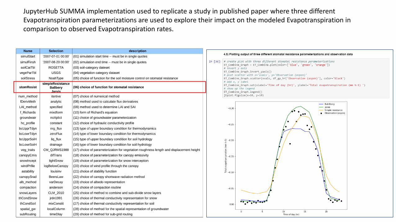
JupyterHub SUMMA implementation used to replicate a study in published paper where three different Evapotranspiration parameterizations are used to explore their impact on the modeled Evapotranspiration in comparison to observed Evapotranspiration rates.

JupyterHub SUMMA implementation used to replicate a study in published paper where three different Evapotranspiration parameterizations are used to explore their impact on the modeled Evapotranspiration in comparison to observed Evapotranspiration rates.

CyberGIS-Jupyter
Yin, D., Liu, Y., Padmanabhan, A., Terstriep, J., Rush, J. and Wang, S., 2017, July. A CyberGIS-Jupyter Framework for Geospatial Analytics at Scale. In Proceedings of the Practice and Experience in Advanced Research Computing 2017 on Sustainability, Success and Impact (p. 18). ACM.
An enhanced JupyterHub platform to ease linkages to geospatial data analytics and execution of HPC-enabled models
In progress

CUAHSI Data Series Viewer
Display one or more time series and metadata from time series resources.

Apps that facilitate and ease access to community value datasets
Not all data for which HydroShare facilitates access will be formal resources• National Water Model Data (NWM forecast viewer and Data
Explorer apps)• NASA Modis Snow Cover (Snow inspector app)• NASA NLDAS data (Data Rods Explorer app)• GRACE Satellite total water storage from gravity (GRACE App)

NWM Forecast Viewer App
• View a time series forecast for any stream segment, model variable, and forecast period.
• Download a NetCDFfile of a subset of forecasts for any polygon provided.
• Access data via web API – with auth token.
Enhancing access to community data products

View a time series of percent snow cover for any location on the globe based on the MODIS snow cover product.

NASA GRACE Groundwater App
View global GRACE satellite results including surface water, groundwater, soil moisture. Extract time series and animate data over selected time periods and locations using THREDDS.


Software Engineering Process
1. Issue 2. Branch 3. Pull Request
4.1 Deploy on test platform
4.2 Code Review
4.3 Jenkins Test
5. Merge
6. DeployCollaborative open development process used by multidisciplinary team of professional programmers and hydrologic scientists for HydroShare development.
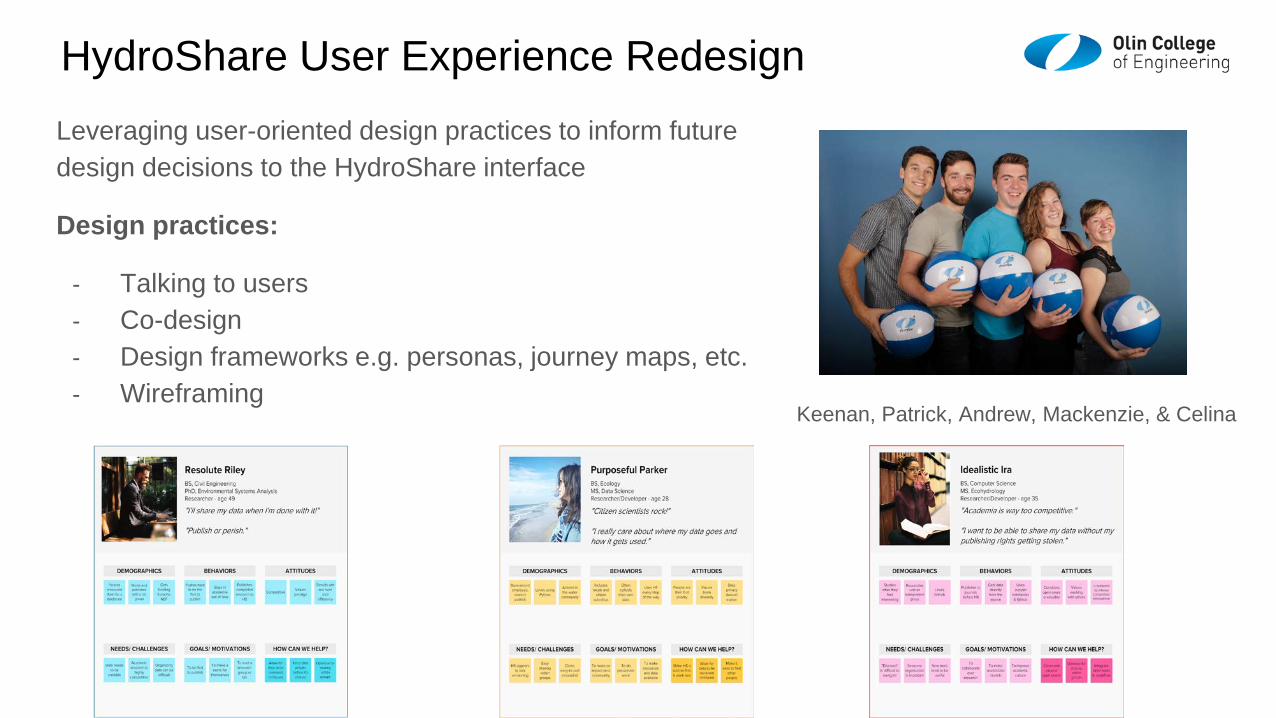
HydroShare User Experience RedesignLeveraging user-oriented design practices to inform future design decisions to the HydroShare interface
Design practices:
- Talking to users- Co-design- Design frameworks e.g. personas, journey maps, etc.- Wireframing
Keenan, Patrick, Andrew, Mackenzie, & Celina

Example: Recommendation for Dashboard and “Search all of HydroShare”
Full Final Report: https://www.hydroshare.org/resource/9e888ababe6648ad95d07b6ec5ed7cb0/

Summary
• Sharing and publication of data (DOI)• Social discovery and added value• Model sharing
• Model input data preparation• Model execution• Visualization and analysis (best of practice
tools)
Server/Cloud Computation• Platform independence• Big data• Reproducibility• Reduce needs for software
installation and configuration
Collaboration, Reproducibility, Credit, Transparency
HydroShare is a web based collaboration environment to enable more rapid advances in hydrologic understanding through collaborative data sharing, analysis and modeling

Thanks to the HydroShare team!
http://www.hydroshare.org
OAC-1664061OAC-1664018OAC-16641192017-2021
HydroShare is operated by CUAHSI with ongoing development through a collaborative project among Utah State University, RENCI University of North Carolina, CyberGIS Center University of Illinois, Tufts, University of Virginia, Brigham Young University, National Center for Atmospheric Research and the University of Washington.
To learn more• Publications https://help.hydroshare.org/about-
hydroshare/publish/• Online Help https://help.hydroshare.org/