Embed Size (px)
Citation preview
A!
A!
A!
A!
A!
A!
A!
A!
A!
A!
A!
A!
!
!
!
!
!
!
!
!
!
!
E
EE
E
E
E
E
E EE
E
E
E
EE
EE
EE
§̈¦
Barber Road
North
Vail R
oad
Blos
som
Road
Koontz Road
Thornton Road
West Kile Road
New Hope Road
Thor
nton R
oad
Beaver Slough
Mokelumne
R iver
Wim py'sMarina
!
1997RODENT HOLE OPENED UP
WHEN BEAN RANCHBROKE BACK AND FORCED
WATER AGAINST LEVEE
!
Barber RoadUnderpass
Com m and PostT hornton Fire Station25999 T hornton RoadT hornton, CA 95686
Reclam ation District 2086Canal Ranch
Reclam ation District 38Staten Island
Reclam ation District 2110McCorm ack-William son
T ract
5
§̈¦5
§̈¦5
§̈¦5
Reclam ation District 348New Hope T ract
1986
Bean Ranch
!
Bean Ranch Eastern Levee
!
Hartog Dryland Levee
!
Franklin Blvd / Thornton RoadBridge
!
Walnut Grove RoadBridge
!New Hope RoadBridge
Mokelumne River
Union Pacific Railroad
Union Pacific Railroad
Mokelumne River
k
New HopeElem entary School
Lamb
Roa d
Walnut Grove Road
West Lauffer Road
Blos
som
Roa d
Cosumnes River
T HORNT ON
8.01.30.3
15.412.7
-0.5
9.84.6
1.4
8.73.14.0
1.6
6.91.91.8
0.0
13.611.4
23.8
25.4
14.4
21.6
14.1
16.8
17.2
20.8
19.3
22.1
14.3
15.8
17.0
18.5
19.6
20.7
22.2
23.3
24.2
25.5
12.4
12.4
121°24'0"W121°25'0"W121°26'0"W121°27'0"W121°28'0"W121°29'0"W121°30'0"W
38°18'0"N
38°18'0"N
38°17'0"N
38°17'0"N
38°16'0"N
38°16'0"N
38°15'0"N
38°15'0"N
38°14'0"N
38°14'0"N
38°13'0"N
38°13'0"N
38°12'0"N
38°12'0"N
2151 River Plaza DriveSuite 100Sacramento, California 95833Ph: 916-441-6850
Map Source: Wanger & BonsignoreMap Date: 03/09/2016Vertical Datum: NAVD 88 SAN JOAQUIN COUNTY
OFFICE OF EMERGENCY SERVICESFIGURE
A1RECLAMATION DISTRICT 348 - NEW HOPE TRACT
ANNEX A - FLOOD CONTINGENCY MAP
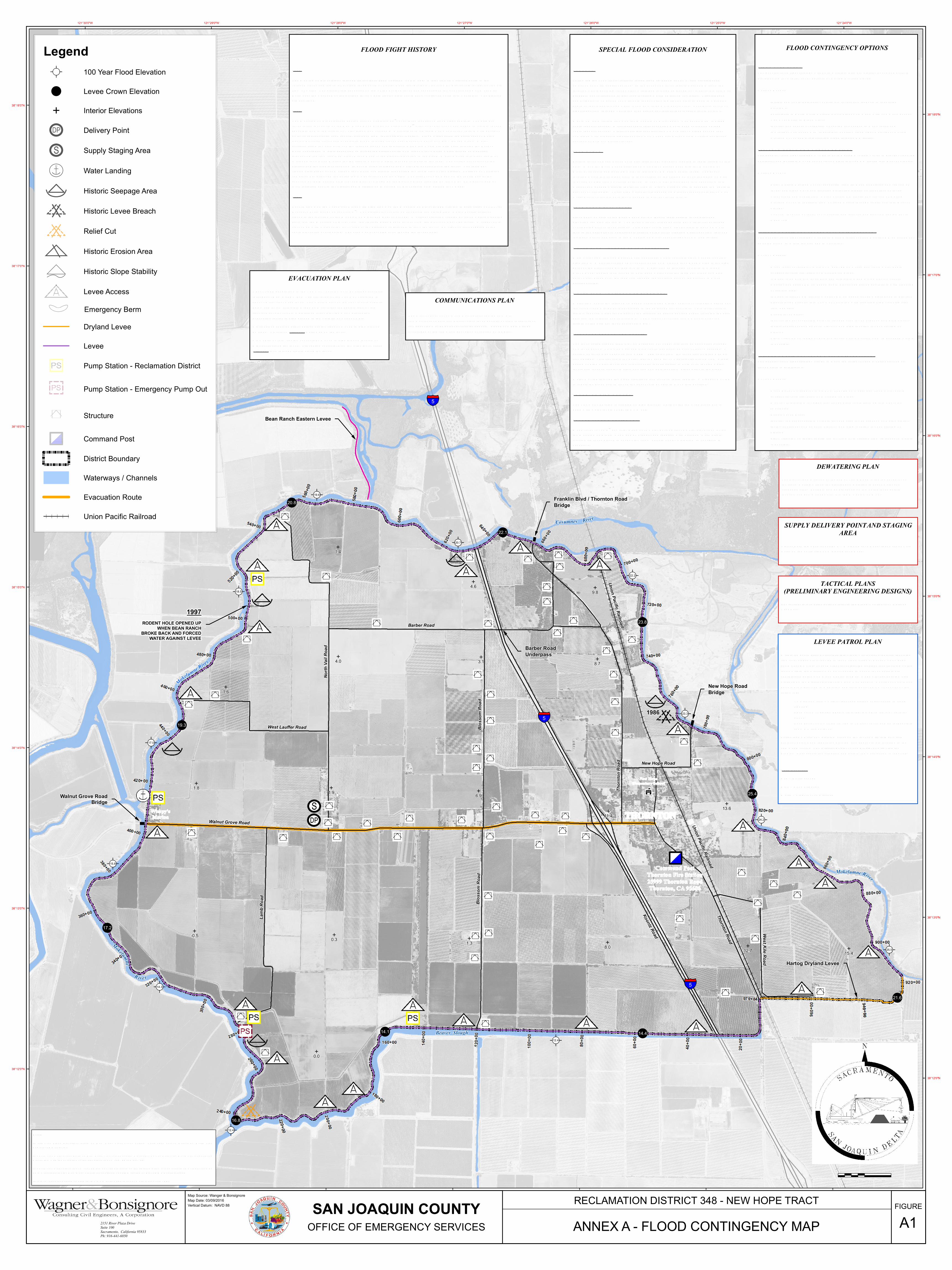
SPECIAL FLOOD CONSIDERATION
GENERAL Fo llo wing the 1986 flo o d , ra ilro a d ra ised tra c h em b a nkm ent by 2’ a nd strengthened em b a nkm ent with a d d itio na l ro c k. In the event o f a levee fa ilure East o f RR tra c k the lo c atio n where po nd ing flo o d waters will brea k through em b a nkm ent is unc erta in a nd will pro b a b ly no t c o rrespo nd to previo us lo c atio n where em b a nkm ent fa iled . Strengthened a nd heightened em b a nkm ent will ho ld lo nger a llo wing flo o d waters to po nd to a greater d epth so that brea kthrough when it c o m es will b e m o re d estructive. Possib ility exists o f signific a nt flo w through Thornto n if em b a nkm ent fa ils at that lo c atio n south o f to wn. Maxim um perm issib le flo ws o n the Mo kelum ne River belo w Ca m a nc he Da m is 5,000 cub ic feet per sec o nd . Most reaso na b le spill sc enario s would pea k at around 10,000 cub ic feet per sec o nd . District o ffic ia ls feel that flo ws m uc h a b o ve 5,000 sec o nd feet c o m b ined with pro b a b le signific a nt flo ws o n Cosum nes River would o vertop southeast sectio ns o f prim ary d istrict levees. BEAN RANCH Eastern levee o f Bea n Ra nc h no rm a lly fa ils at 18’ elevatio n lea d ing to rapid filling o f this area. When the Bea n Ra nc h fills, flo o d water then brea ks b a c k into the Mo kelum ne River at its south end pushing water to the top o f RD 348 western levee. The exa ct lo c atio n where it will brea k b a c k in is unc erta in so the stretc h o f levee ind ic ated o n m ap is at risk o f high flo ws d irectly at levee. In 1997 water bro ke b a c k into c ha nnel in this m a nner a nd pushed water to the levee cro wn. Crews were o n site to sa nd b a g lo w spots to prevent o vertopping. These high water levels opened up a ro d ent ro d ent ho le (sho wn o n m ap), d istrict o ffic ia ls o nly just m a na ged to prevent levee fa ilure. BEAN RANCH EAST LEVEE Sinc e 1997 o wners o f the Bea n Ra nc h ha ve wid ened their eastern levee a ltho ugh elevatio n rem a ins the sa m e. The levee will no t fa il as quic kly but will suffer extend ed o vertopping b efo re levee fa ilure. This d ela y c o uld a llo w flo o d waters to b a c k up m ore tha n in the past prior to c atastrophic fa ilure o f the levee creating a stro nger flo w through the Bea n Ra nc h a nd b a c k to the Mo kelum ne River c ha nnel a ga inst RD 348 levees. WAT ER FLOW – BARBER ROAD UNDERPASS Ma in water flo w through Barb er Ro a d und erpass where c o ncrete sid es washed out fro m high flo ws. Water sheet flo wed o ver area no rth o f Wa lnut Gro ve Ro a d whic h is the high po int o f the d istrict a nd d ivid es it in two. Water flo wed through culverts in Wa lnut Gro ve Ro a d , but the ro a d served to ho ld b a c k water until the third d a y brea k at whic h po int water bro ke o ver the ro a d a nd flo o d ed the southern part o f the d istrict to m uc h greater d epths. WAT ER FLOW – RAILROAD EMBANKMENT Water flo w und er the ra ilro a d em b a nkm ent through a large culvert eventua lly washed out the culvert a nd a large ho le d evelo ped in the em b a nkm ent structure. This initia l fa ilure rapid ly reduc ed water levels east o f the ra ilro a d em b a nkm ent a nd b ega n flo o d ing the area b etween the ra ilro a d a nd Interstate 5. The washo ut o c curred so m e 6 hours a fter the fa ilure o f the prim ary levee at around 2 p.m . 1986 LEVEE BREACH AND REPAIR The levee fa iled around 6:55 a.m . o n February 22, 1986, less tha n a n ho ur a fter passa ge o f a levee patro l. This area was, a nd historic a lly has b een, a n area o f hea vy seepa ge. A sectio n o f levee was o bserved so m e 300 – 400 yards fro m the levee still ho ld ing a sm a ll tree upright. This c o nfirm s the b elief that the sa nd levee was supersaturated fro m a lo ng perio d o f high water levels a nd subsequently lo st its a b ility to ho ld even though water levels ha d rec ed ed appro xim ately o ne a nd o ne-ha lf feet fro m highs prior to the brea k. Water m o ving through the brea k sta b ilized a nd rec ed ed fa irly rapid ly. A dred ger m o ving to repa ir the brea k ha d to trenc h the c ha nnel to b e a b le to m o ve into positio n. T HORNT ON HIGH GROUND The To wn o f Tho rnto n is situated o n high ground . Parts o f the to wn rem a ined dry in 1986 with water levels o f 18’ (NGV D 29). BEAVER SLOUGH RELIEF CUT Ma d e relief cut o n 4th d a y a fter brea k o nc e water built up a b o ve water elevatio ns insid e the Mo kelum ne River. Cut m a d e by d red ger a nd repa ired with dred ger. U sed d irt to repa ir with ro c ks pla c ed to a nc ho r the end s. Sho uld no t b e a pro b lem to cut a ga in if nec essary.
FLOOD FIGHT HISTORY
1955 The Mo klum ne River bro ke through its southern b a nk upstrea m o f RD 348. Water flo wed west a nd no rth to the ra ilro a d tra c ks a nd the sm a ll dryla nd levee no rth o f Peltier Ro a d that protects Thornto n by preventing further northward flo w o f water. The d istrict la id sa nd b a gs o n top o f the dryla nd levee a nd sa nd b a gged the und ercrossing o f West Kile Ro a d near the west end o f the dryla nd levee where flo o d waters c o uld ha ve c o ntinued no rth into Thornto n. The d istrict d id no t flo o d . 1986 The Mo kelum ne River pea ked at 18.3 feet o n February 19th, o ver three feet a b o ve flo o d sta ge (15.0’). The prim ary levee fa iled just north o f the New Hope Ro a d brid ge o n February 20th a fter river elevatio ns ha d b egun to rapid ly rec ed e (possib ly due to the fa ilure o f Tyler Isla nd d o wnstrea m ). Offic ia ls surm ise there was a saturatio n fa ilure with portio ns o f levee subsequently seen severa l feet b a c k fro m their origina l lo c atio n. Flo o d water filled the areas east o f U nio n Pa c ific Ra ilro a d tra c ks a nd eventua lly bro ke through tra c ks near Benso n’s Ferry at 2 p.m . the sa m e d a y. Water partia lly filled the area b etween the ra ilro a d tra c ks a nd Interstate 5 flo wing westward prim arily through the Barb er Ro a d und erpass. Waters sheet flo wed a cro ss the d istrict no rth o f Wa lnut Gro ve Ro a d whic h served as a b arrier preventing the flo w south (Wa lnut Gro ve Ro a d is the highest elevatio n in the area). Water m o ved into areas south o f Wa lnut Gro ve Ro a d Marina fo r the first two d a ys, m a inly through culverts in the ro a d . The no rthwest c o rner o f the d istrict a nd the area just east o f Wim py’s Marina is higher a nd water d id no t appro a c h the levee. The third d a y flo o d waters bro ke o ver Wa lnut Gro ve Ro a d c o m pletely inund ating the south sid e o f the d istrict. Portio ns o f Thornto n rem a ined dry a ltho ugh the entire to wn was surround ed by water. The relief cut was m a d e o n the fo urth d a y at the junctio n o f the Mo kelum ne River a nd Bea ver Slo ugh by the d istrict, brea k repa ired by the COE. Em ergenc y pum ps were insta lled next to the d istrict pum p statio n o n Mo kelum ne River south o f Wa lnut Gro ve Ro a d . 1997 Rec o rd flo ws o n the Cosum nes River with high flo ws o n the Mo kelum ne River (5,000 c fs) led to pea k sta ge o f 21.7’ at Benso n’s Ferry gauge o n Ja nuary 3rd. The d istrict levees ha d no freeb o ard rem a ining fro m U nio n Pa c ific ra ilro a d tra c ks to the junctio n o f the Mo kelum ne River a nd Bea ver Slo ugh. A critic a l situatio n created b y flo o d waters brea king b a c k into the Mo kelum ne River fro m the flo o d ed Bea n Ra nc h a cro ss fro m the d istrict’s west sid e levee. A ro d ent ho le opened up with water at the levee cro wn, the d istrict was just a b le to save the levee. Em ergenc y sa nd b a gging at lo w spots prevented o vertopping. The area was eva cuated even though the levees held .
SUPPLY DELIVERY POINT AND STAGING AREA
Sto kes Farm ing Shed at 12487 W. Wa lnut Gro ve Ro a d , just west o f V a il Ro a d o n the no rth sid e o f Wa lnut Gro ve Ro a d .
TACTICAL PLANS (PRELIMINARY ENGINEERING DESIGNS)
For ta ctic a l info rm atio n/a ctio ns refer to the Flo o d Co ntingenc y Optio ns Text Bo x.
COMMUNICATIONS PLAN The District d o es not o wn c o m m unic atio ns equipm ent. All c o m m unic atio ns between d istrict sta ff, levee patro ls, outsid e jurisd ictio ns a nd a genc ies will b e perso na l c ellular pho nes. Pho ne num b ers will b e exc ha nged at the c o m m a nd post upo n a ctivatio n o f the pla n.
LEVEE PATROL PLAN
Within 24 hours a fter a Fed era l/State Flo o d Center has pred icted that high tid e river sta ges are expected to rea c h flo o d sta ge at Benso n Ferry ga ge (17.0 Feet NAV D), or suc h other level that the trustees feel flo o d ing o f the la nd s within the District m a y b e expected to o c cur, levee patro ls are c o o rd inated at the Co m m a nd Center fo r New Hope Tra ct (Thornto n Fire Statio n) by the District Presid ent, Alec k Da m b a c her. Co ntinuous 24-Hour patro ls are orga nized im m ed iately a nd ea c h patro l unit will c o nsist o f the fo llo wing: Two perso n tea m s with at least o ne perso n experienc ed in flo o d fighting.
Ea c h unit will b e equipped with either a m o b ile ra d io or c ellular pho ne.
Ea c h patro l unit will b e lim ited to 12 hour shifts a nd b e respo nsib le fo r 3-4 m iles o f levee.
Patro l tea m s m ark a ny pro b lem areas o n the levees with lath (see lath proto c o l b elo w) a nd report the pro b lem a nd appro xim ate lo c atio n to the c o m m a nd c enter. The District Engineer a nd Presid ent will visit the pro b lem area, assess the situatio n a nd d eterm ine what a ctio n is required . Lath Protocol Red – Bo il/Seepa ge Blue – Ro c k Slippa ge White – Slo pe/L evee Distress
EVACUATION PLAN
Ab o ut 1,200 people live in the To wn o f Thornto n or in d wellings sc attered througho ut New Hope Tra ct. The elevatio n o f the To wn o f Thornto n is a b o ut 10 feet a b o ve sea level. The western part o f the tra ct is o nly slightly b elo w sea level. Interstate Highwa y 5 traverses the eastern part o f the tra ct a nd severa l c o unty m a inta ined ro a d s pro vid e m a ny a lternative eva cuatio n routes to high ground in the vic inity o f L o d i or Ga lt. All livesto c k sha ll b e either herd ed o ff the tra ct or m o ved to high ground by truc k. L ivesto c k w ill not b e a llo wed o n the levee. All m o b ile or farm equipm ent sha ll b e m o ved to high ground lo c ated at wid e areas a lo ng the levee. All equipm ent parked o n the wid e levee areas w ill not b lo c k through tra ffic a lo ng the levee.
DEWATERING PLAN
The d istrict pum p statio n at the end o f L a m b Ro a d is the lo west po int o n the tra ct. During a flo o d the d istrict pum p statio n is und er water a nd c a nno t be used. Porta b le pum ps are set up o n top o f the levee at this lo c atio n a nd pum p flo o d water into the Mo kelum ne River.
1,000 1,0000
Sc a le in Feet
FLOOD CONTINGENCY OPTIONS
HIGHWAT ER EVENT The genera l flo o d fight strategy will b e to m a inta in prim ary d istrict levees a nd perfo rm pre-pla nning fo r a relief cut or d efense o f Harto g Dryla nd L evee. Actions Need ed Initiate a nd c o o rd inate patro l o f prim ary levees a nd respo nd to id entified pro b lem s.
Partic ipate in North Delta U nified Flo o d Fight Co m m a nd with c o m m a nd post at V a n Exel Da iry in Bra c k Tra ct.
Id entify a nd ensure a va ila b ility o f equipm ent need ed to m a ke relief cut. If a spill at Ca m a nc he Dam is possib le, positio n flo o d fight m ateria l at Harto g Dryla nd L evee a nd b egin c learing brush through RR trestle.
UPST REAM BREAK ON MOKELUMNE RIVER The genera l flo o d fight strategy will b e to ho ld Harto g Dryla nd L evee to prevent flo o d ing o f d istrict a nd fa c ilitate m o vem ent o f flo o d waters through RR trestle into Bea ver Slo ugh. Actions Need ed Ra ise Harto g Dryla nd L evee, sa nd b a g West Kile Ro a d und erpass at west end o f levee, a nd pla c e wa ve a nd seepa ge protectio n plastic o n fro nt fa c e o f levee.
Clear brush a nd d ebris fro m U nio n Pa c ific RR trestle at west end o f Harto g Dryla nd L evee to fa c ilitate flo w o f flo o d waters through trestle a nd into Bea ver Slo ugh.
Co nfirm lo c a tio n o f relief cut if need ed a nd id entify a nd positio n equipm ent to m a ke cut.
FAILURE OF PRIMARY LEVEES EAST OF INT ERST AT E 5 The genera l flo o d fight strategy will b e to m a ke a relief cut a nd m o nito r RR em b a nkm ent as no ted b elo w to m inim ize d a m a ge to Tho rnto n. Actions Need ed Ma ke relief cut (appro xim ate STA 238+00 o n m ap) when flo o d water d epth exc eed s surfa c e elevatio n o f Mo kelum ne River.
If brea k is o n prim ary levee b etween Interstate 5 a nd U nio n Pa c ific tra c ks, m o nito r a nd patro l RR em b a nkm ent to prevent em b a nkm ent fa ilure with flo o d ing o f eastern sid e.
If brea k is east o f RR tra c ks, m o nito r RR em b a nkm ent as waters po nd to prevent brea kthrough d irectly into To wn o f Tho rnto n with resulting high velo c ity water flo w d a m a ge.
Repa ir levee brea k. Id entify lo west a c c essib le po int in flo o d ed area fo r em ergenc y pum ping statio n. Insta ll a d d itio na l pum ps at em ergenc y pum ping lo c a tio n fo r d ewatering o f d istrict.
Pla c e visquine o n insid e o f prim ary levees where erosio n fro m im po und ed waters is possib le.
FAILURE OF PRIMARY LEVEE WEST OF INT ERST AT E 5 The genera l flo o d fight strategy will b e to m a ke the relief cut a nd m o nito r b a c kup o f flo o d waters to Interstate 5. Actions Need ed Ma ke Relief Cut (appro xim ate STA 238+00 o n m ap) when flo o d water d epth exc eed s surfa c e elevatio n o f Mo kelum ne River.
Mo nito r Interstate 5 fo r signs that flo o d waters c o uld b a c k up into Tho rnto n (U nlikely)
Repa ir L evee Brea k Id entify lo west a c c essib le po int in flo o d ed area fo r em ergenc y pum ping statio n. Insta ll a d d itio na l pum ps at em ergenc y pum ping lo c a tio n fo r d ewatering o f d istrict.
Pla c e visquine o n insid e of prim ary levees where erosio n fro m im po und ed waters is possib le.
LegendA! 100 Year Flood Elevation
! Levee Crown Elevation
E Interior Elevations
Delivery Point
Supply Staging Area
Water Landing
Historic Seepage Area
Historic Levee Breach
Relief Cut
Historic Erosion Area
Historic Slope Stability
Levee Access
Emergency BermDryland Levee
Levee
Pump Station - Reclamation District
Pump Station - Emergency Pump Out
Structure
Command Post
District Boundary
Waterways / Channels
Evacuation Route
Union Pacific Railroad
Notes:
1) 100-Year Flo o d Elevatio ns b ased o n New Hope Tra ct L evee System April 2011 Survey Report by North StarEngineering Group, Inc.
2) L evee cro wn elevatio ns b ased o n New Hope Tra ct L evee System April 2011 Survey Report by North Star EngineeringGroup, Inc. with the exc eptio n o f the elevatio ns at STA 155+00 a nd 357+00.
3) L evee cro wn elevatio ns at STA 155+00 a nd 357+00 are b ased o n the finished gra d e survey perfo rm ed Octo b er 2015 byF3 & Asso c ia tes fo r the New Hope Tra ct Bea ver Slough / South Mo kelum ne River HMP Repa ir Pro ject.4) Interio r elevatio ns b ased o n b ase earth L iDAR d ata, Departm ent o f Water Resourc es, 2009.


![Integrated Humanitarian Contingency Plan for Iraq and ... · Annex 3 Checklist of Actions to be Taken during Different Phases of the Crisis [to be developed] Annex 4 Map of Iraq (2/3)](https://img.pdfslide.net/doc/110x75/604e52fc722d827e3b7aaf55/integrated-humanitarian-contingency-plan-for-iraq-and-annex-3-checklist-of-actions.jpg)