Embed Size (px)
Citation preview

Appendix B:Project Information
B-ii
CONNECTING OUR COMMUNITY
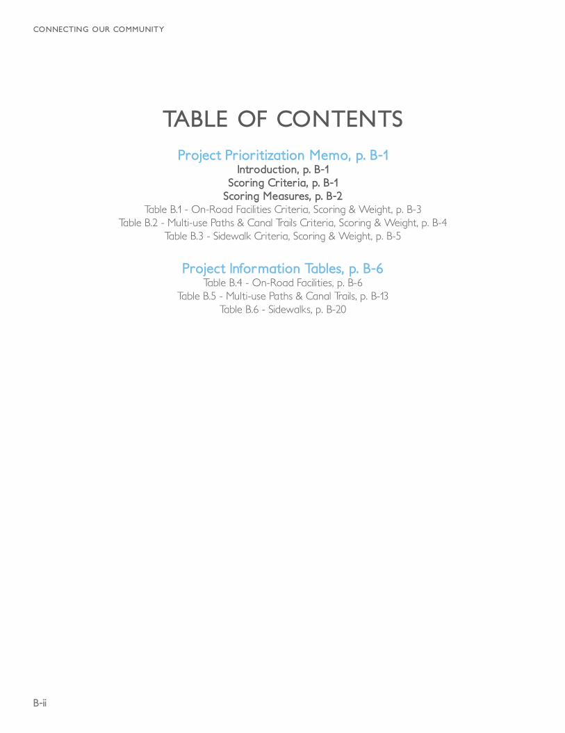
TABLE OF CONTENTSProject Prioritization Memo, p. B-1
Introduction, p. B-1Scoring Criteria, p. B-1
Scoring Measures, p. B-2Table B.1 - On-Road Facilities Criteria, Scoring & Weight, p. B-3
Table B.2 - Multi-use Paths & Canal Trails Criteria, Scoring & Weight, p. B-4Table B.3 - Sidewalk Criteria, Scoring & Weight, p. B-5
Project Information Tables, p. B-6Table B.4 - On-Road Facilities, p. B-6
Table B.5 - Multi-use Paths & Canal Trails, p. B-13Table B.6 - Sidewalks, p. B-20

B-1
APPENDIX B : PROJECT INFORMATION
PROJECT PRIORITIZATION MEMO
IntroductionThis document summarizes the methodology for prioritizing recommended improvements for projects within the Idaho Falls city limits. Prioritizing these projects will allow Idaho Falls to identify high priority projects and low-hanging fruit, as well as provide a foundation for implementation phasing. The prioritization framework relies upon facility-based criteria, as described in the following sections.
Scoring CriteriaPublic Input
The Idaho Falls “Connecting Our Community” Plan has engaged the public through the public workshops and mapping exercises, public surveys, and website. Feasible recommended projects with demonstrated public endorsement will qualify for these prioritization criteria.
Proximity to Schools
To encourage more students to walk and bicycle to school, proposed facilities that directly connect to or travel within ¼ mile of any school (public or private) would qualify for this prioritization criteria.
Connectivity to Existing Facilities
Bicycling is typically higher along designated facilities. Creating connectivity to existing bike facilities enable more trips to be made by bike, and provides bicyclists of varying capabilities multiple routes for reaching their destination. Facilities that connect to an existing bikeway or bikeways will receive this scoring criterion.
Connectivity to Proposed Facilities
In addition to the existing bikeway network, the “Connecting Our Community” Plan will be proposing the addition of many projects throughout Idaho Falls. While not as immediately effective for bikeway
continuity, facilities that connect to proposed facilities will help create a robust and cohesive network. Proposed facilities that intersect with other proposed facilities will be awarded this criterion.
Network Gaps
Gaps in the bicycling and walking networks discourage use of these modes because they limit route continuity, sense of belonging and security, or require users to choose less direct paths to access their destinations. Some feel “stranded” when a facility abruptly end or does not easily connect to their destination, forcing users to ride on a street that does not accommodate their prof iciency level or increase the length of their trip. Facilities that f ill gaps in the existing bicycling and walking network will qualify for this criterion.
Connections to Activity Centers
Activity centers are the major trip-driving destinations within Idaho Falls (e.g. parks, commercial districts, employment centers, Downtown, etc.). By increasing accessibility to major activity centers, the recommendations in the “Connecting Our Community” Plan can help reduce traff ic congestion and suppor t residents and visitors who choose to bicycle or walk. Projects that connect to these centers qualify for this prioritization criterion.
Jurisdiction (applicable only to Table B.2)
This criterion considers which agency or agencies own the right-of-way for which changes are proposed and whether or not the project is par tially or completely outside of the City limits. For example, a project that is only private land and is located in Iona would receive the lowest score, while a project utilizes existing right of way within Idaho Falls would receive the highest score. Planning and implementation are much more time-consuming and costly when projects cross jurisdictional and/or proper ty lines.
Resurfacing Projects (applicable only to Tables B.1 and B.3)
As Idaho Falls maintains its pavement, on-street bicycle facilities should be installed when a street is scheduled
B-2
CONNECTING OUR COMMUNITY
to be resurfaced or seal coated. Fur thermore, developers can be required to include recommended facilities in the “Connecting Our Community” Plan that are located on the streets they are improving. This can be an added benef it as Idaho Falls will not have to pay for the construction of these bikeways. Facilities that coincide with street paving projects will meet this scoring criterion.
Ease of Implementation
Bicycling and walking facilities range in project readiness and amount of reconf iguration or prior work that needs to be completed before a facility can be installed. With regard to on-street bikeways, some streets can accommodate bike lanes with little effor t; where as other projects may require signif icant changes to the travel lanes, medians, street parking, right-of-way, etc.
Similarly, some trail and street crossings will be easier than others to implement. Many cities choose to pursue the “low-hanging fruit” projects to achieve quick wins and build suppor t for more politically complex projects. Projects that require minimal changes to the built environment and have lower costs will score higher on this criterion.
Scoring MeasuresThe criteria discussed in the previous section will be applied to each facility. The facility will be assigned a numeric value to the degree it meets the criteria requirements. The criteria values are outlined in Tables B.1, B.2, and B.3. The criteria scoring (multipliers) can be modif ied by City preference to emphasize, or de-emphasize its relationship to the overall network.
B-3
APPENDIX B : PROJECT INFORMATION
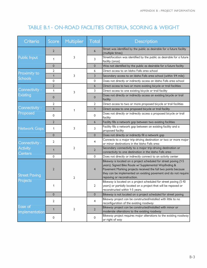
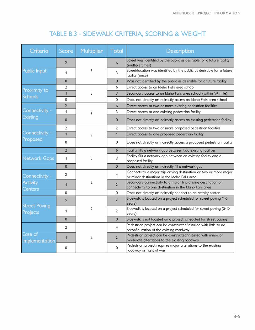
Criteria Score Multiplier Total Description
2 6Street was identified by the public as desirable for a future facility (multiple times)
1 3Street/location was identified by the public as desirable for a future facility (once)
0 0 Was not identified by the public as desirable for a future facility
2 6 Direct access to an Idaho Falls area school
1 3 Secondary access to an Idaho Falls area school (within 1/4 mile)
0 0 Does not directly or indirectly access an Idaho Falls area school
2 6 Direct access to two or more existing bicycle or trail facilities
1 3 Direct access to one existing bicycle or trail facility
0 0Does not directly or indirectly access an existing bicycle or trail facility
2 2 Direct access to two or more proposed bicycle or trail facilities
1 1 Direct access to one proposed bicycle or trail facility
0 0Does not directly or indirectly access a proposed bicycle or trail facility
2 6 Facility fills a network gap between two existing facilities
1 3Facility fills a network gap between an existing facility and a proposed facility
0 0 Does not directly or indirectly fill a network gap
2 4Connects to a major trip-driving destination or two or more major or minor destinations in the Idaho Falls area
1 2Secondary connectivity to a major trip-driving destination or connectivity to one destination in the Idaho Falls area
0 0 Does not directly or indirectly connect to an activity center
2 4
Bikeway is located on a project scheduled for street paving (1-5 years). Signed Bike Route w/ Supplemental Wayfinding & Pavement Marking projects received the full two points because they can be implemented on existing pavement and do not require repaving or reconstruction.
1 2Bikeway is located on a project scheduled for street paving (5-10 years) or partially located on a project that will be repaved or reconstructed within 1-5 years.
0 0 Bikeway is not located on a project scheduled for street paving
2 4Bikeway project can be constructed/installed with little to no reconfiguration of the existing roadway
1 2Bikeway project can be constructed/installed with minor or moderate alterations to the existing roadway
0 0Bikeway project requires major alterations to the existing roadway or right of way
Public Input 3
Proximity to Schools
3
Connectivity - Existing
3
Street Paving Projects
2
Ease of Implementation
2
Connectivity - Proposed
1
Network Gaps 3
Connectivity - Activity Centers
2
TABLE B.1 - ON-ROAD FACILITIES CRITERIA, SCORING & WEIGHT
B-4
CONNECTING OUR COMMUNITY
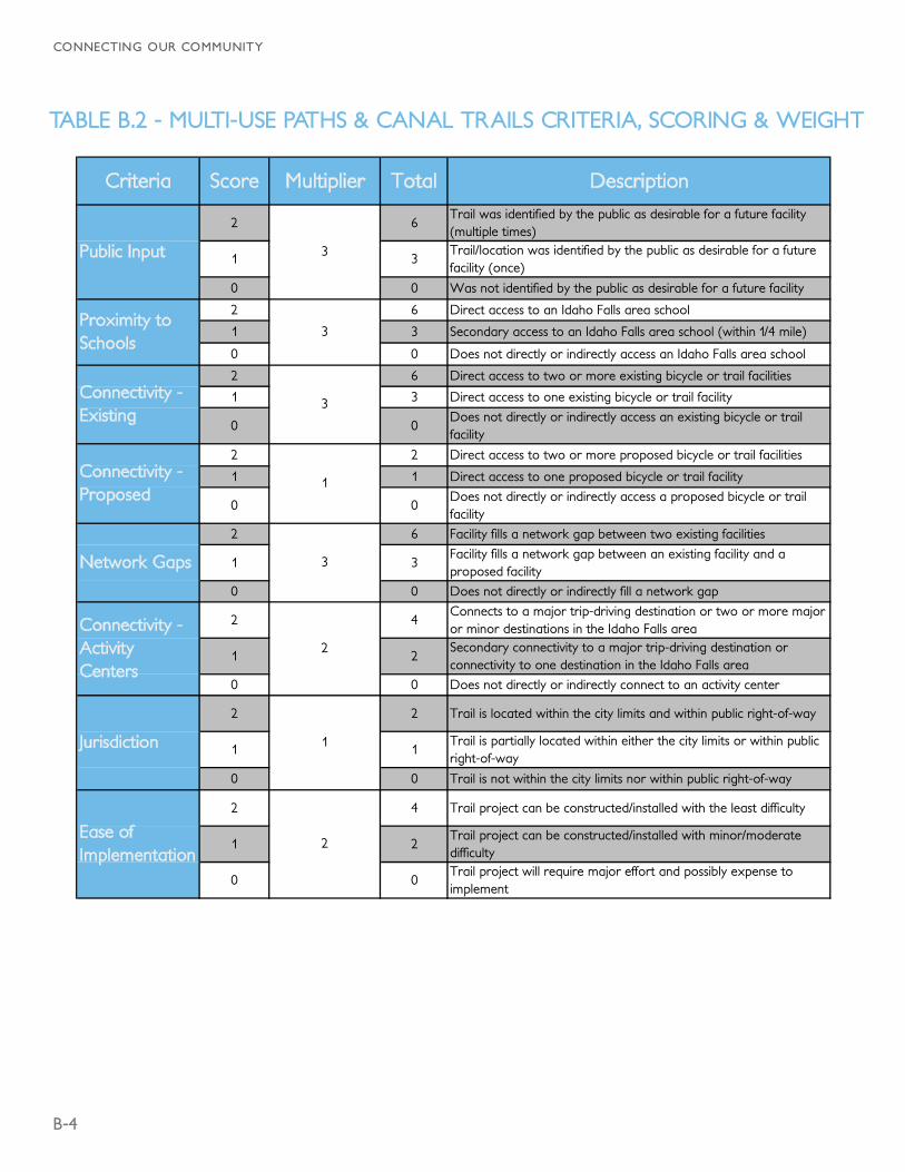
Criteria Score Multiplier Total Description
2 6Trail was identified by the public as desirable for a future facility (multiple times)
1 3Trail/location was identified by the public as desirable for a future facility (once)
0 0 Was not identified by the public as desirable for a future facility
2 6 Direct access to an Idaho Falls area school
1 3 Secondary access to an Idaho Falls area school (within 1/4 mile)
0 0 Does not directly or indirectly access an Idaho Falls area school
2 6 Direct access to two or more existing bicycle or trail facilities
1 3 Direct access to one existing bicycle or trail facility
0 0Does not directly or indirectly access an existing bicycle or trail facility
2 2 Direct access to two or more proposed bicycle or trail facilities
1 1 Direct access to one proposed bicycle or trail facility
0 0Does not directly or indirectly access a proposed bicycle or trail facility
2 6 Facility fills a network gap between two existing facilities
1 3Facility fills a network gap between an existing facility and a proposed facility
0 0 Does not directly or indirectly fill a network gap
2 4Connects to a major trip-driving destination or two or more major or minor destinations in the Idaho Falls area
1 2Secondary connectivity to a major trip-driving destination or connectivity to one destination in the Idaho Falls area
0 0 Does not directly or indirectly connect to an activity center
2 2 Trail is located within the city limits and within public right-of-way
1 1Trail is partially located within either the city limits or within public right-of-way
0 0 Trail is not within the city limits nor within public right-of-way
2 4 Trail project can be constructed/installed with the least difficulty
1 2Trail project can be constructed/installed with minor/moderate difficulty
0 0Trail project will require major effort and possibly expense to implement
Jurisdiction 1
Ease of Implementation
2
Connectivity - Proposed
1
Network Gaps 3
Connectivity - Activity Centers
2
Public Input 3
Proximity to Schools
3
Connectivity - Existing
3
TABLE B.2 - MULTI-USE PATHS & CANAL TRAILS CRITERIA, SCORING & WEIGHT
B-5
APPENDIX B : PROJECT INFORMATION
Criteria Score Multiplier Total Description
2 6Street was identified by the public as desirable for a future facility (multiple times)
1 3Street/location was identified by the public as desirable for a future facility (once)
0 0 Was not identified by the public as desirable for a future facility
2 6 Direct access to an Idaho Falls area school
1 3 Secondary access to an Idaho Falls area school (within 1/4 mile)
0 0 Does not directly or indirectly access an Idaho Falls area school
2 6 Direct access to two or more existing pedestrian facilities
1 3 Direct access to one existing pedestrian facility
0 0 Does not directly or indirectly access an existing pedestrian facility
2 2 Direct access to two or more proposed pedestrian facilities
1 1 Direct access to one proposed pedestrian facility
0 0 Does not directly or indirectly access a proposed pedestrian facility
2 6 Facility fills a network gap between two existing facilities
1 3Facility fills a network gap between an existing facility and a proposed facility
0 0 Does not directly or indirectly fill a network gap
2 4Connects to a major trip-driving destination or two or more major or minor destinations in the Idaho Falls area
1 2Secondary connectivity to a major trip-driving destination or connectivity to one destination in the Idaho Falls area
0 0 Does not directly or indirectly connect to an activity center
2 4Sidewalk is located on a project scheduled for street paving (1-5 years)
1 2Sidewalk is located on a project scheduled for street paving (5-10 years)
0 0 Sidewalk is not located on a project scheduled for street paving
2 4Pedestrian project can be constructed/installed with little to no reconfiguration of the existing roadway
1 2Pedestrian project can be constructed/installed with minor or moderate alterations to the existing roadway
0 0Pedestrian project requires major alterations to the existing roadway or right of way
Public Input 3
Proximity to Schools
3
Connectivity - Existing
3
Street Paving Projects
2
Ease of Implementation
2
Connectivity - Proposed
1
Network Gaps 3
Connectivity - Activity Centers
2
TABLE B.3 - SIDEWALK CRITERIA, SCORING & WEIGHT
B-6
CONNECTING OUR COMMUNITY
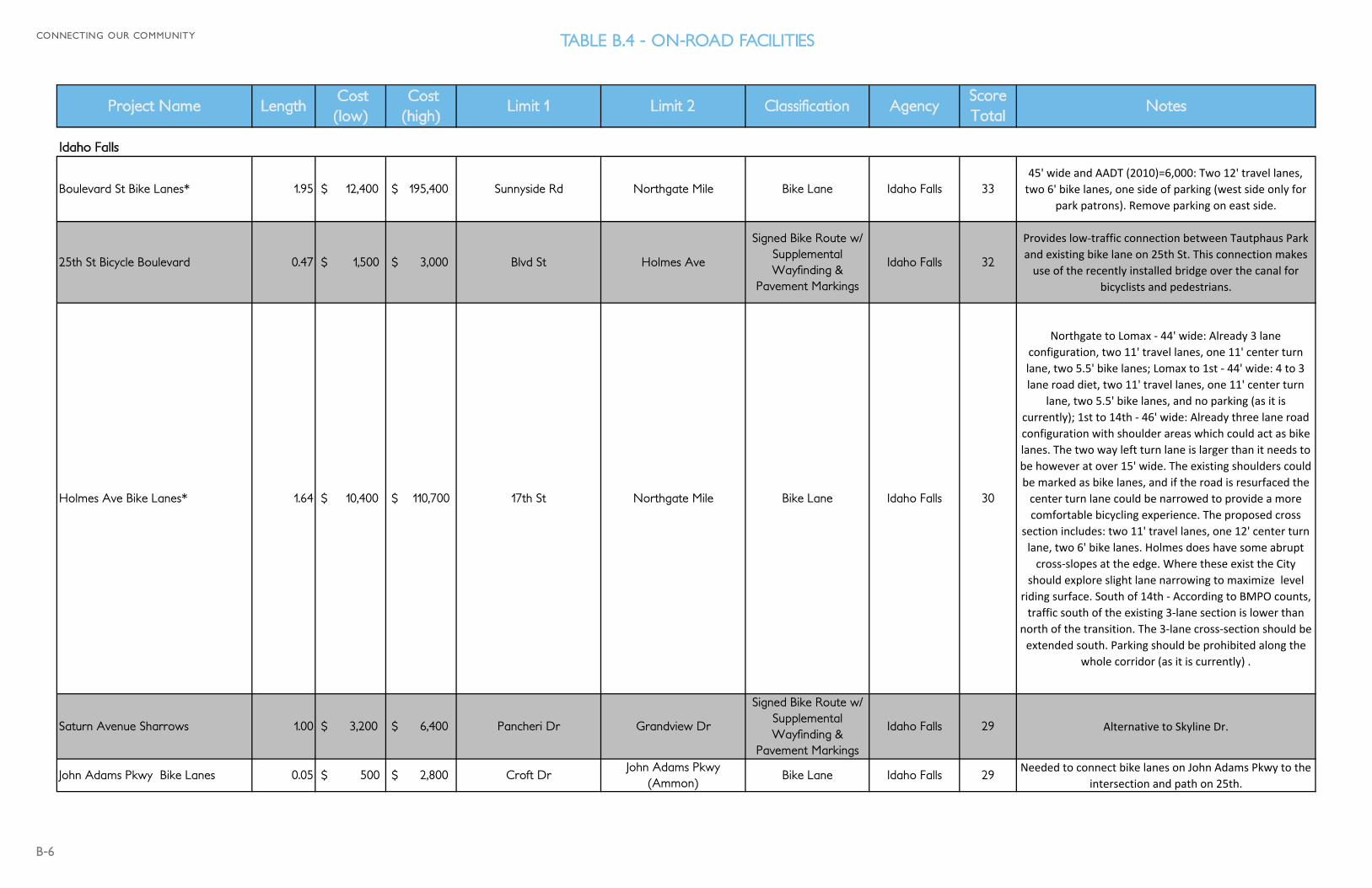
Project Name Length Cost (low)
Cost (high)
Limit 1 Limit 2 Classification AgencyScore Total
Notes
Idaho Falls
Boulevard St Bike Lanes* 1.95 $ 12,400 $ 195,400 Sunnyside Rd Northgate Mile Bike Lane Idaho Falls 3345' wide and AADT (2010)=6,000: Two 12' travel lanes, two 6' bike lanes, one side of parking (west side only for
park patrons). Remove parking on east side.
25th St Bicycle Boulevard 0.47 $ 1,500 $ 3,000 Blvd St Holmes Ave
Signed Bike Route w/ Supplemental Wayfinding &
Pavement Markings
Idaho Falls 32
Provides low‐traffic connection between Tautphaus Park and existing bike lane on 25th St. This connection makes use of the recently installed bridge over the canal for
bicyclists and pedestrians.
Holmes Ave Bike Lanes* 1.64 $ 10,400 $ 110,700 17th St Northgate Mile Bike Lane Idaho Falls 30
Northgate to Lomax ‐ 44' wide: Already 3 lane configuration, two 11' travel lanes, one 11' center turn lane, two 5.5' bike lanes; Lomax to 1st ‐ 44' wide: 4 to 3 lane road diet, two 11' travel lanes, one 11' center turn
lane, two 5.5' bike lanes, and no parking (as it is currently); 1st to 14th ‐ 46' wide: Already three lane road configuration with shoulder areas which could act as bike lanes. The two way left turn lane is larger than it needs to be however at over 15' wide. The existing shoulders could be marked as bike lanes, and if the road is resurfaced the center turn lane could be narrowed to provide a more comfortable bicycling experience. The proposed cross
section includes: two 11' travel lanes, one 12' center turn lane, two 6' bike lanes. Holmes does have some abrupt cross‐slopes at the edge. Where these exist the City
should explore slight lane narrowing to maximize level riding surface. South of 14th ‐ According to BMPO counts, traffic south of the existing 3‐lane section is lower than
north of the transition. The 3‐lane cross‐section should be extended south. Parking should be prohibited along the
whole corridor (as it is currently) .
Saturn Avenue Sharrows 1.00 $ 3,200 $ 6,400 Pancheri Dr Grandview Dr
Signed Bike Route w/ Supplemental Wayfinding &
Pavement Markings
Idaho Falls 29 Alternative to Skyline Dr.
John Adams Pkwy Bike Lanes 0.05 $ 500 $ 2,800 Croft DrJohn Adams Pkwy
(Ammon)Bike Lane Idaho Falls 29
Needed to connect bike lanes on John Adams Pkwy to the intersection and path on 25th.
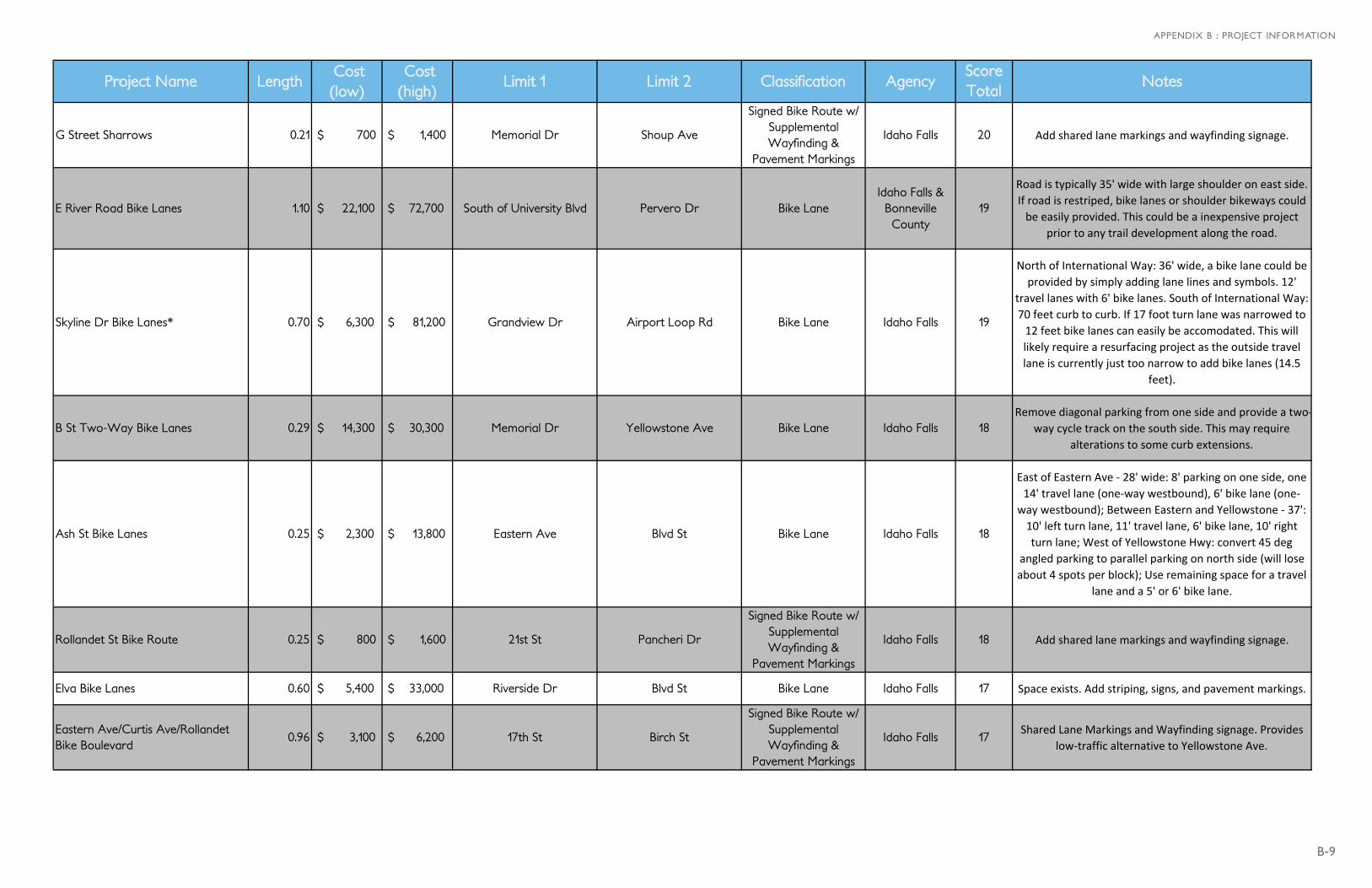
TABLE B.4 - ON-ROAD FACILITIES
B-7
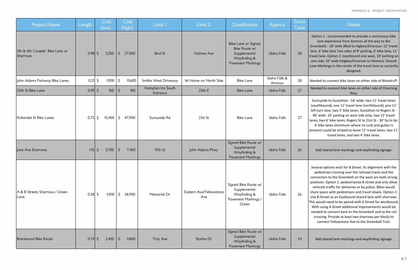
APPENDIX B : PROJECT INFORMATION
Project Name Length Cost (low)
Cost (high)
Limit 1 Limit 2 Classification AgencyScore Total
Notes
5th & 6th Couplet Bike Lane or Sharrows
0.98 $ 3,200 $ 27,000 Blvd St Holmes Ave
Bike Lane or Signed Bike Route w/ Supplemental Wayfinding &
Pavement Markings
Idaho Falls 28
Option 1 : (recommended to provide a continuous bike lane experience from Ammon all the way to the
Greenbelt) ‐ 28' wide (Blvd to Higbee/Emerson: 12' travel lane, 6' bike lane Two sides of 8' parking, 6' bike lane, 11' travel lane. Option 2: (eastbound one way), 10' parking on one side; 33' wide (Higbee/Emerson to Holmes): Shared Lane Markings in the center of the travel lane as currently
designed.
John Adams Parkway Bike Lanes 0.21 $ 1,900 $ 11,600 Smiths West Driveway 1st Home on North Side Bike LaneIdaho Falls &
Ammon28 Needed to connect bike lanes on either side of Woodruff.
25th St Bike Lane 0.09 $ 100 $ 100 Hampton Inn South
Entrance25th E Bike Lane Idaho Falls 27
Needed to connect bike lanes on either side of Channing Way.
Rollandet St Bike Lanes 0.75 $ 13,400 $ 47,900 Sunnyside Rd 21st St Bike Lane Idaho Falls 27
Sunnyside to Gustafson ‐ 54' wide: two 11' travel lanes (southbound), one 11' travel lane (northbound), pne 11' left turn lane, two 5' bike lanes. Gustafson to Rogers St ‐ 46' wide: 10' parking on west side only, two 12' travel
lanes, two 6' bike lanes; Rogers St to 21st St ‐ 30' lip to lip: 4' bike lanes (minimum where no curb and gutter is
present) could be striped to leave 11' travel lanes, two 11' travel lanes, and two 4' bike lanes.
June Ave Sharrows 1.15 $ 3,700 $ 7,400 17th St John Adams Pkwy
Signed Bike Route w/ Supplemental Wayfinding &
Pavement Markings
Idaho Falls 26 Add shared lane markings and wayfinding signage.
A & B Streets Sharrows / Green Lane
0.58 $ 1,900 $ 58,900 Memorial DrEastern Ave/Yellowstone
Ave
Signed Bike Route w/ Supplemental Wayfinding &
Pavement Markings / Green
Idaho Falls 26
Several options exist for B Street. Its alignment with the pedestrian crossing over the railroad tracks and the
connection to the Greenbelt on the west are both strong positives. Option 1: pedestrianize B street and only allow vehicele traffic for deliveries or by police. Bikes would
share space with pedestrians and travel slowly. Option 2: Use B‐Street as an Eastbound shared lane with sharrows. This would need to be paired with A Street for westbound. With using A Street additional improvements would be needed to connect back to the Greenbelt and to the rail crossing. Provide at least two sharrows per block) to connect Yellowstone Ave to the Greenbelt Trail.
Brentwood Bike Route 0.74 $ 2,400 $ 4,800 Troy Ave Skyline Dr
Signed Bike Route w/ Supplemental Wayfinding &
Pavement Markings
Idaho Falls 24 Add shared lane markings and wayfinding signage.
B-8
CONNECTING OUR COMMUNITY
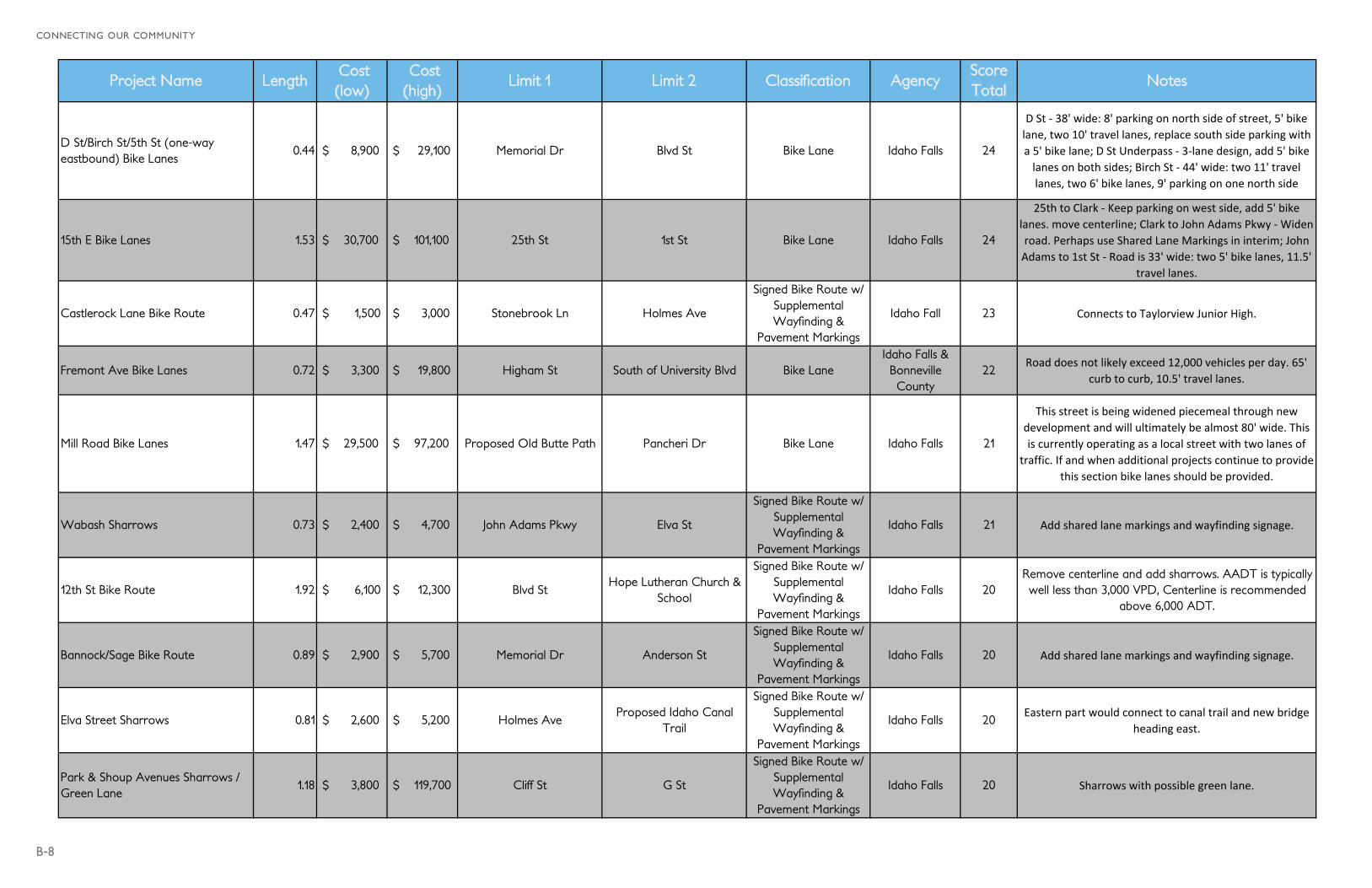
Project Name Length Cost (low)
Cost (high)
Limit 1 Limit 2 Classification AgencyScore Total
Notes
D St/Birch St/5th St (one-way eastbound) Bike Lanes
0.44 $ 8,900 $ 29,100 Memorial Dr Blvd St Bike Lane Idaho Falls 24
D St ‐ 38' wide: 8' parking on north side of street, 5' bike lane, two 10' travel lanes, replace south side parking with a 5' bike lane; D St Underpass ‐ 3‐lane design, add 5' bike lanes on both sides; Birch St ‐ 44' wide: two 11' travel lanes, two 6' bike lanes, 9' parking on one north side
15th E Bike Lanes 1.53 $ 30,700 $ 101,100 25th St 1st St Bike Lane Idaho Falls 24
25th to Clark ‐ Keep parking on west side, add 5' bike lanes. move centerline; Clark to John Adams Pkwy ‐ Widen road. Perhaps use Shared Lane Markings in interim; John Adams to 1st St ‐ Road is 33' wide: two 5' bike lanes, 11.5'
travel lanes.
Castlerock Lane Bike Route 0.47 $ 1,500 $ 3,000 Stonebrook Ln Holmes Ave
Signed Bike Route w/ Supplemental Wayfinding &
Pavement Markings
Idaho Fall 23 Connects to Taylorview Junior High.
Fremont Ave Bike Lanes 0.72 $ 3,300 $ 19,800 Higham St South of University Blvd Bike LaneIdaho Falls &
Bonneville County
22Road does not likely exceed 12,000 vehicles per day. 65'
curb to curb, 10.5' travel lanes.
Mill Road Bike Lanes 1.47 $ 29,500 $ 97,200 Proposed Old Butte Path Pancheri Dr Bike Lane Idaho Falls 21
This street is being widened piecemeal through new development and will ultimately be almost 80' wide. This is currently operating as a local street with two lanes of
traffic. If and when additional projects continue to provide this section bike lanes should be provided.
Wabash Sharrows 0.73 $ 2,400 $ 4,700 John Adams Pkwy Elva St
Signed Bike Route w/ Supplemental Wayfinding &
Pavement Markings
Idaho Falls 21 Add shared lane markings and wayfinding signage.
12th St Bike Route 1.92 $ 6,100 $ 12,300 Blvd StHope Lutheran Church &
School
Signed Bike Route w/ Supplemental Wayfinding &
Pavement Markings
Idaho Falls 20Remove centerline and add sharrows. AADT is typically well less than 3,000 VPD, Centerline is recommended
above 6,000 ADT.
Bannock/Sage Bike Route 0.89 $ 2,900 $ 5,700 Memorial Dr Anderson St
Signed Bike Route w/ Supplemental Wayfinding &
Pavement Markings
Idaho Falls 20 Add shared lane markings and wayfinding signage.
Elva Street Sharrows 0.81 $ 2,600 $ 5,200 Holmes AveProposed Idaho Canal
Trail
Signed Bike Route w/ Supplemental Wayfinding &
Pavement Markings
Idaho Falls 20Eastern part would connect to canal trail and new bridge
heading east.
Park & Shoup Avenues Sharrows / Green Lane
1.18 $ 3,800 $ 119,700 Cliff St G St
Signed Bike Route w/ Supplemental Wayfinding &
Pavement Markings
Idaho Falls 20 Sharrows with possible green lane.
B-9
APPENDIX B : PROJECT INFORMATION
Project Name Length Cost (low)
Cost (high)
Limit 1 Limit 2 Classification AgencyScore Total
Notes
G Street Sharrows 0.21 $ 700 $ 1,400 Memorial Dr Shoup Ave
Signed Bike Route w/ Supplemental Wayfinding &
Pavement Markings
Idaho Falls 20 Add shared lane markings and wayfinding signage.
E River Road Bike Lanes 1.10 $ 22,100 $ 72,700 South of University Blvd Pervero Dr Bike LaneIdaho Falls &
Bonneville County
19
Road is typically 35' wide with large shoulder on east side. If road is restriped, bike lanes or shoulder bikeways could be easily provided. This could be a inexpensive project
prior to any trail development along the road.
Skyline Dr Bike Lanes* 0.70 $ 6,300 $ 81,200 Grandview Dr Airport Loop Rd Bike Lane Idaho Falls 19
North of International Way: 36' wide, a bike lane could be provided by simply adding lane lines and symbols. 12'
travel lanes with 6' bike lanes. South of International Way: 70 feet curb to curb. If 17 foot turn lane was narrowed to 12 feet bike lanes can easily be accomodated. This will likely require a resurfacing project as the outside travel lane is currently just too narrow to add bike lanes (14.5
feet).
B St Two-Way Bike Lanes 0.29 $ 14,300 $ 30,300 Memorial Dr Yellowstone Ave Bike Lane Idaho Falls 18Remove diagonal parking from one side and provide a two‐
way cycle track on the south side. This may require alterations to some curb extensions.
Ash St Bike Lanes 0.25 $ 2,300 $ 13,800 Eastern Ave Blvd St Bike Lane Idaho Falls 18
East of Eastern Ave ‐ 28' wide: 8' parking on one side, one 14' travel lane (one‐way westbound), 6' bike lane (one‐
way westbound); Between Eastern and Yellowstone ‐ 37': 10' left turn lane, 11' travel lane, 6' bike lane, 10' right turn lane; West of Yellowstone Hwy: convert 45 deg
angled parking to parallel parking on north side (will lose about 4 spots per block); Use remaining space for a travel
lane and a 5' or 6' bike lane.
Rollandet St Bike Route 0.25 $ 800 $ 1,600 21st St Pancheri Dr
Signed Bike Route w/ Supplemental Wayfinding &
Pavement Markings
Idaho Falls 18 Add shared lane markings and wayfinding signage.
Elva Bike Lanes 0.60 $ 5,400 $ 33,000 Riverside Dr Blvd St Bike Lane Idaho Falls 17 Space exists. Add striping, signs, and pavement markings.
Eastern Ave/Curtis Ave/Rollandet Bike Boulevard
0.96 $ 3,100 $ 6,200 17th St Birch St
Signed Bike Route w/ Supplemental Wayfinding &
Pavement Markings
Idaho Falls 17Shared Lane Markings and Wayfinding signage. Provides
low‐traffic alternative to Yellowstone Ave.
B-10
CONNECTING OUR COMMUNITY
Project Name Length Cost (low)
Cost (high)
Limit 1 Limit 2 Classification AgencyScore Total
Notes
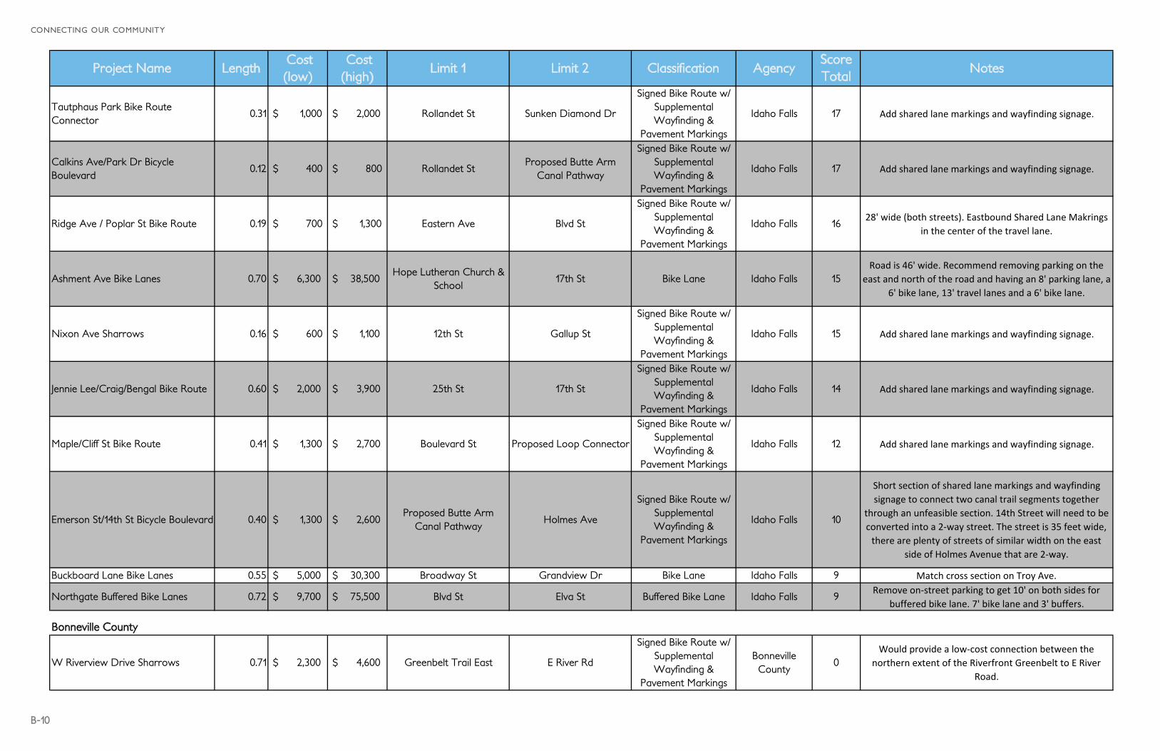
Tautphaus Park Bike Route Connector
0.31 $ 1,000 $ 2,000 Rollandet St Sunken Diamond Dr
Signed Bike Route w/ Supplemental Wayfinding &
Pavement Markings
Idaho Falls 17 Add shared lane markings and wayfinding signage.
Calkins Ave/Park Dr Bicycle Boulevard
0.12 $ 400 $ 800 Rollandet StProposed Butte Arm
Canal Pathway
Signed Bike Route w/ Supplemental Wayfinding &
Pavement Markings
Idaho Falls 17 Add shared lane markings and wayfinding signage.
Ridge Ave / Poplar St Bike Route 0.19 $ 700 $ 1,300 Eastern Ave Blvd St
Signed Bike Route w/ Supplemental Wayfinding &
Pavement Markings
Idaho Falls 1628' wide (both streets). Eastbound Shared Lane Makrings
in the center of the travel lane.
Ashment Ave Bike Lanes 0.70 $ 6,300 $ 38,500 Hope Lutheran Church &
School17th St Bike Lane Idaho Falls 15
Road is 46' wide. Recommend removing parking on the east and north of the road and having an 8' parking lane, a
6' bike lane, 13' travel lanes and a 6' bike lane.
Nixon Ave Sharrows 0.16 $ 600 $ 1,100 12th St Gallup St
Signed Bike Route w/ Supplemental Wayfinding &
Pavement Markings
Idaho Falls 15 Add shared lane markings and wayfinding signage.
Jennie Lee/Craig/Bengal Bike Route 0.60 $ 2,000 $ 3,900 25th St 17th St
Signed Bike Route w/ Supplemental Wayfinding &
Pavement Markings
Idaho Falls 14 Add shared lane markings and wayfinding signage.
Maple/Cliff St Bike Route 0.41 $ 1,300 $ 2,700 Boulevard St Proposed Loop Connector
Signed Bike Route w/ Supplemental Wayfinding &
Pavement Markings
Idaho Falls 12 Add shared lane markings and wayfinding signage.
Emerson St/14th St Bicycle Boulevard 0.40 $ 1,300 $ 2,600 Proposed Butte Arm
Canal PathwayHolmes Ave
Signed Bike Route w/ Supplemental Wayfinding &
Pavement Markings
Idaho Falls 10
Short section of shared lane markings and wayfinding signage to connect two canal trail segments together
through an unfeasible section. 14th Street will need to be converted into a 2‐way street. The street is 35 feet wide, there are plenty of streets of similar width on the east
side of Holmes Avenue that are 2‐way.
Buckboard Lane Bike Lanes 0.55 $ 5,000 $ 30,300 Broadway St Grandview Dr Bike Lane Idaho Falls 9 Match cross section on Troy Ave.
Northgate Buffered Bike Lanes 0.72 $ 9,700 $ 75,500 Blvd St Elva St Buffered Bike Lane Idaho Falls 9Remove on‐street parking to get 10' on both sides for
buffered bike lane. 7' bike lane and 3' buffers.
Bonneville County
W Riverview Drive Sharrows 0.71 $ 2,300 $ 4,600 Greenbelt Trail East E River Rd
Signed Bike Route w/ Supplemental Wayfinding &
Pavement Markings
Bonneville County
0Would provide a low‐cost connection between the
northern extent of the Riverfront Greenbelt to E River Road.
B-11
APPENDIX B : PROJECT INFORMATION
Project Name Length Cost (low)
Cost (high)
Limit 1 Limit 2 Classification AgencyScore Total
Notes
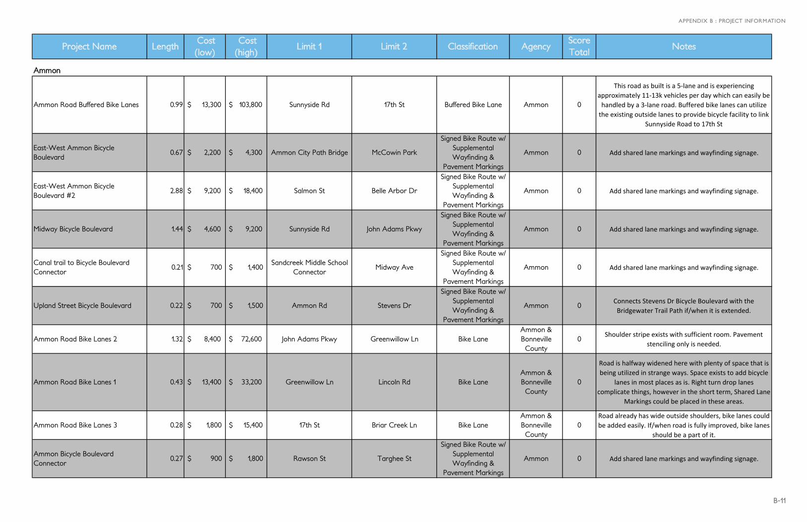
Ammon
Ammon Road Buffered Bike Lanes 0.99 $ 13,300 $ 103,800 Sunnyside Rd 17th St Buffered Bike Lane Ammon 0
This road as built is a 5‐lane and is experiencing approximately 11‐13k vehicles per day which can easily be handled by a 3‐lane road. Buffered bike lanes can utilize the existing outside lanes to provide bicycle facility to link
Sunnyside Road to 17th St
East-West Ammon Bicycle Boulevard
0.67 $ 2,200 $ 4,300 Ammon City Path Bridge McCowin Park
Signed Bike Route w/ Supplemental Wayfinding &
Pavement Markings
Ammon 0 Add shared lane markings and wayfinding signage.
East-West Ammon Bicycle Boulevard #2
2.88 $ 9,200 $ 18,400 Salmon St Belle Arbor Dr
Signed Bike Route w/ Supplemental Wayfinding &
Pavement Markings
Ammon 0 Add shared lane markings and wayfinding signage.
Midway Bicycle Boulevard 1.44 $ 4,600 $ 9,200 Sunnyside Rd John Adams Pkwy
Signed Bike Route w/ Supplemental Wayfinding &
Pavement Markings
Ammon 0 Add shared lane markings and wayfinding signage.
Canal trail to Bicycle Boulevard Connector
0.21 $ 700 $ 1,400 Sandcreek Middle School
ConnectorMidway Ave
Signed Bike Route w/ Supplemental Wayfinding &
Pavement Markings
Ammon 0 Add shared lane markings and wayfinding signage.
Upland Street Bicycle Boulevard 0.22 $ 700 $ 1,500 Ammon Rd Stevens Dr
Signed Bike Route w/ Supplemental Wayfinding &
Pavement Markings
Ammon 0Connects Stevens Dr Bicycle Boulevard with the Bridgewater Trail Path if/when it is extended.
Ammon Road Bike Lanes 2 1.32 $ 8,400 $ 72,600 John Adams Pkwy Greenwillow Ln Bike LaneAmmon & Bonneville County
0Shoulder stripe exists with sufficient room. Pavement
stenciling only is needed.
Ammon Road Bike Lanes 1 0.43 $ 13,400 $ 33,200 Greenwillow Ln Lincoln Rd Bike LaneAmmon & Bonneville County
0
Road is halfway widened here with plenty of space that is being utilized in strange ways. Space exists to add bicycle
lanes in most places as is. Right turn drop lanes complicate things, however in the short term, Shared Lane
Markings could be placed in these areas.
Ammon Road Bike Lanes 3 0.28 $ 1,800 $ 15,400 17th St Briar Creek Ln Bike LaneAmmon & Bonneville County
0Road already has wide outside shoulders, bike lanes could be added easily. If/when road is fully improved, bike lanes
should be a part of it.
Ammon Bicycle Boulevard Connector
0.27 $ 900 $ 1,800 Rawson St Targhee St
Signed Bike Route w/ Supplemental Wayfinding &
Pavement Markings
Ammon 0 Add shared lane markings and wayfinding signage.
B-12
CONNECTING OUR COMMUNITY
Project Name Length Cost (low)
Cost (high)
Limit 1 Limit 2 Classification AgencyScore Total
Notes
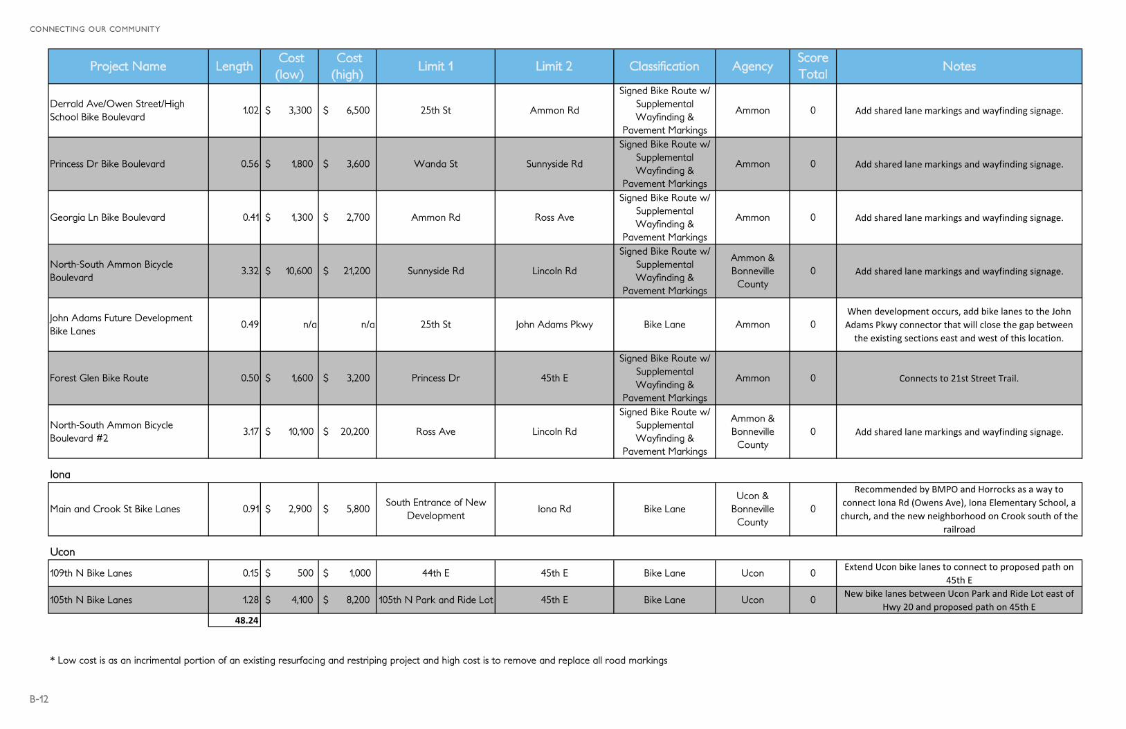
Derrald Ave/Owen Street/High School Bike Boulevard
1.02 $ 3,300 $ 6,500 25th St Ammon Rd
Signed Bike Route w/ Supplemental Wayfinding &
Pavement Markings
Ammon 0 Add shared lane markings and wayfinding signage.
Princess Dr Bike Boulevard 0.56 $ 1,800 $ 3,600 Wanda St Sunnyside Rd
Signed Bike Route w/ Supplemental Wayfinding &
Pavement Markings
Ammon 0 Add shared lane markings and wayfinding signage.
Georgia Ln Bike Boulevard 0.41 $ 1,300 $ 2,700 Ammon Rd Ross Ave
Signed Bike Route w/ Supplemental Wayfinding &
Pavement Markings
Ammon 0 Add shared lane markings and wayfinding signage.
North-South Ammon Bicycle Boulevard
3.32 $ 10,600 $ 21,200 Sunnyside Rd Lincoln Rd
Signed Bike Route w/ Supplemental Wayfinding &
Pavement Markings
Ammon & Bonneville County
0 Add shared lane markings and wayfinding signage.
John Adams Future Development Bike Lanes
0.49 n/a n/a 25th St John Adams Pkwy Bike Lane Ammon 0When development occurs, add bike lanes to the John Adams Pkwy connector that will close the gap between the existing sections east and west of this location.
Forest Glen Bike Route 0.50 $ 1,600 $ 3,200 Princess Dr 45th E
Signed Bike Route w/ Supplemental Wayfinding &
Pavement Markings
Ammon 0 Connects to 21st Street Trail.
North-South Ammon Bicycle Boulevard #2
3.17 $ 10,100 $ 20,200 Ross Ave Lincoln Rd
Signed Bike Route w/ Supplemental Wayfinding &
Pavement Markings
Ammon & Bonneville County
0 Add shared lane markings and wayfinding signage.
Iona
Main and Crook St Bike Lanes 0.91 $ 2,900 $ 5,800 South Entrance of New
DevelopmentIona Rd Bike Lane
Ucon & Bonneville County
0
Recommended by BMPO and Horrocks as a way to connect Iona Rd (Owens Ave), Iona Elementary School, a church, and the new neighborhood on Crook south of the
railroad
Ucon
109th N Bike Lanes 0.15 $ 500 $ 1,000 44th E 45th E Bike Lane Ucon 0Extend Ucon bike lanes to connect to proposed path on
45th E
105th N Bike Lanes 1.28 $ 4,100 $ 8,200 105th N Park and Ride Lot 45th E Bike Lane Ucon 0New bike lanes between Ucon Park and Ride Lot east of
Hwy 20 and proposed path on 45th E48.24
* Low cost is as an incrimental portion of an existing resurfacing and restriping project and high cost is to remove and replace all road markings
B-13
APPENDIX B : PROJECT INFORMATION
Project Name Length Cost (low)Cost (high)
Limit 1 Limit 2 Classification AgencyScore Total
Notes
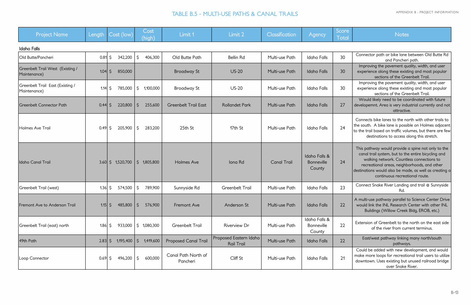
Idaho Falls
Old Butte/Pancheri 0.81 $ 342,200 $ 406,300 Old Butte Path Bellin Rd Multi-use Path Idaho Falls 30Connector path or bike lane between Old Butte Rd
and Pancheri path.
Greenbelt Trail West (Existing / Maintenance)
1.04 $ 850,000 Broadway St US-20 Multi-use Path Idaho Falls 30Improving the pavement quality, width, and user
experience along these existing and most popular sections of the Greenbelt Trail.
Greenbelt Trail East (Existing / Maintenance)
1.14 $ 785,000 $ 1,100,000 Broadway St US-20 Multi-use Path Idaho Falls 30Improving the pavement quality, width, and user
experience along these existing and most popular sections of the Greenbelt Trail.
Greenbelt Connector Path 0.44 $ 220,800 $ 255,600 Greenbelt Trail East Rollandet Park Multi-use Path Idaho Falls 27Would likely need to be coordinated with future
developemnt. Area is very industrial currently and not attractive.
Holmes Ave Trail 0.49 $ 205,900 $ 283,200 25th St 17th St Multi-use Path Idaho Falls 24
Connects bike lanes to the north with other trails to the south. A bike lane is possible on Holmes adjacent to the trail based on traffic volumes, but there are few
destinations to access along this stretch.
Idaho Canal Trail 3.60 $ 1,520,700 $ 1,805,800 Holmes Ave Iona Rd Canal TrailIdaho Falls &
Bonneville County
24
This pathway would provide a spine not only to the canal trail system, but to the entire bicycling and
walking network. Countless connections to recreational areas, neighborhoods, and other
destinations would also be made, as well as creating a continuous recreational route.
Greenbelt Trail (west) 1.36 $ 574,500 $ 789,900 Sunnyside Rd Greenbelt Trail Multi-use Path Idaho Falls 23Connect Snake River Landing and trail @ Sunnyside
Rd.
Fremont Ave to Anderson Trail 1.15 $ 485,800 $ 576,900 Fremont Ave Anderson St Multi-use Path Idaho Falls 22A multi-use pathway parallel to Science Center Drive would link the INL Research Center with other INL
Buildings (Willow Creek Bldg, EROB, etc.)
Greenbelt Trail (east) north 1.86 $ 933,000 $ 1,080,300 Greenbelt Trail Riverview Dr Multi-use PathIdaho Falls &
Bonneville County
22Extension of Greenbelt to the north on the east side
of the river from current terminus.
49th Path 2.83 $ 1,195,400 $ 1,419,600 Proposed Canal TrailProposed Eastern Idaho
Rail TrailMulti-use Path Idaho Falls 22
East/west pathway linking many north/south pathways.
Loop Connector 0.69 $ 496,200 $ 600,000 Canal Path North of
PancheriCliff St Multi-use Path Idaho Falls 21
Could be added with new development, and would make more loops for recreational trail users to utilize downtown. Uses existing but unused railroad bridge
over Snake River.
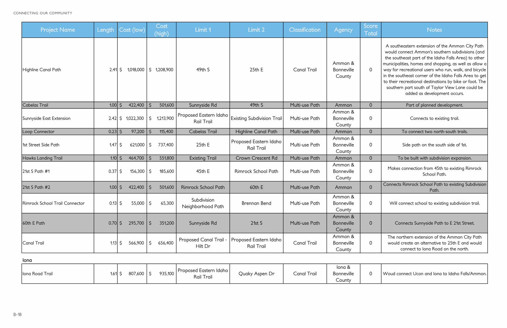
TABLE B.5 - MULTI-USE PATHS & CANAL TRAILS
B-14
CONNECTING OUR COMMUNITY
Project Name Length Cost (low)Cost (high)
Limit 1 Limit 2 Classification AgencyScore Total
Notes
Broadway Path 0.89 $ 446,500 $ 517,000 Existing Broadway PathProposed West Side
TrailMulti-use Path Idaho Falls 21
Connects where the existing path on the west ends to the proposed facilities on Bellin Rd. On street facilities
are also possible as Broadway has 7 lanes and <10,000 ADT.
Main Large Canal Trail E-W Connection to Ammon City Trail
2.76 $ 1,165,900 $ 1,603,100 Proposed Idaho Canal
TrailAmmon City Trail Canal Trail
Idaho Falls & Ammon
21
This is a spur of the publicly-requested, main N-S canal trail. It links that trail to the possible northern extension of the Ammon City Path and would serve as a connection between Idaho Falls and Ammon.
Community Park to the South Trail 3.00 $ 1,267,200 $ 1,742,400 Holmes Ave Path 15th E Canal TrailIdaho Falls &
Bonneville County
21 Trail that follows canal.
Pinecrest Loop Trail 1.74 $ 735,000 $ 872,800 Holmes Ave Lincoln Rd Multi-use Path Idaho Falls 21A gravel trail may be possible here around the golf
course.
Greenbelt to University Blvd 0.19 $ 80,300 $ 110,400 Greenbelt Trail University Blvd Multi-use Path Idaho Falls 21Connect the Greenbelt Trail with the Univeristy
campus and the University Blvd bike lanes,
Grandview Sidepath 1.41 $ 707,300 $ 819,000 Broadway St Skyline Rd Multi-use Path Idaho Falls 20Highly requested extension of the current path that exists along US-20. This path would extend west to
connect with Skyline Dr.
Grandview & John's Hole trail 0.65 $ 426,100 $ 477,600 Skyline Dr Greenbelt Trail Multi-use Path Idaho Falls 20
The path will require widening the bridge platform and clearer crossings of on- and off-ramps, as well as
at normal intersections. Narrow sidewalks over Lindsay Blvd, the railroad, and I-15 and substandard
crossings are not inviting. It will be multi-use and replace the existing sidewalk and fill in sidewalk gaps between Skyline and Saturn. Photo looking east from
N Skyline & Grandview, where sidewalk ends.
Troy Pond Pathway 0.75 $ 316,800 $ 376,200 Troy Ave Troy Ave Multi-use Path Idaho Falls 20 Requested by neighbors.
Northbound Greenbelt Connector 0.01 $ 5,100 $ 5,900 Greenbelt Trail Highway 20 Trail Multi-use Path Idaho Falls 20 Simplifies turning movements to and from trail.
Tautphaus-Sunnyside 0.51 $ 213,800 $ 253,900 Sunnyside Rd 25th St Multi-use Path Idaho Falls 19A pathway or sidewalk along S Blvd would link
Tautphaus Park with the existing Sunnyside multi-use pathway.
Idaho Falls River Walk 0.26 $ 1,000,000 $ 1,500,000 Greenbelt Trail West Greenbelt Trail East Multi-use Path Idaho Falls 19Bike/Ped Bridge that would more centrally connect
Idaho Falls with Hotels along River Parkway (proposed in Greenbelt Renewal Plan).
Greenbelt NW Trail 3.62 $ 1,529,100 $ 2,102,500 Highway 20 65th N Multi-use PathIdaho Falls &
Bonneville County
18Extention of greenbelt on the west side of the river.
Some private property considerations.
B-15
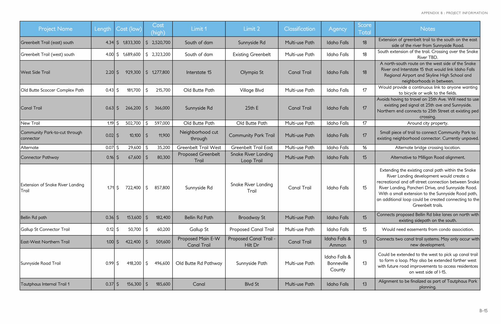
APPENDIX B : PROJECT INFORMATION
Project Name Length Cost (low)Cost (high)
Limit 1 Limit 2 Classification AgencyScore Total
Notes
Greenbelt Trail (east) south 4.34 $ 1,833,300 $ 2,520,700 South of dam Sunnyside Rd Multi-use Path Idaho Falls 18Extension of greenbelt trail to the south on the east
side of the river from Sunnyside Road.
Greenbelt Trail (west) south 4.00 $ 1,689,600 $ 2,323,200 South of dam Existing Greenbelt Multi-use Path Idaho Falls 18South extension of the trail. Crossing over the Snake
River TBD.
West Side Trail 2.20 $ 929,300 $ 1,277,800 Interstate 15 Olympia St Canal Trail Idaho Falls 18
A north-south route on the west side of the Snake River and Interstate 15 that would link Idaho Falls
Regional Airport and Skyline High School and neighborhoods in between.
Old Butte Scoccer Complex Path 0.43 $ 181,700 $ 215,700 Old Butte Path Village Blvd Multi-use Path Idaho Falls 17Would provide a continuous link to anyone wanting
to bicycle or walk to the fields.
Canal Trail 0.63 $ 266,200 $ 366,000 Sunnyside Rd 25th E Canal Trail Idaho Falls 17
Avoids having to travel on 25th Ave. Will need to use existing ped signal at 25th ave and Sunnyside.
Northern end connects to 25th Street at existing ped crossing.
New Trail 1.19 $ 502,700 $ 597,000 Old Butte Path Old Butte Path Multi-use Path Idaho Falls 17 Around city property.
Community Park-to-cut through connector
0.02 $ 10,100 $ 11,900 Neighborhood cut
throughCommunity Park Trail Multi-use Path Idaho Falls 17
Small piece of trail to connect Community Park to existing neighborhood connector. Currently unpaved.
Alternate 0.07 $ 29,600 $ 35,200 Greenbelt Trail West Greenbelt Trail East Multi-use Path Idaho Falls 16 Alternate bridge crossing location.
Connector Pathway 0.16 $ 67,600 $ 80,300 Proposed Greenbelt
TrailSnake River Landing
Loop TrailMulti-use Path Idaho Falls 15 Alternative to Milligan Road alignment.
Extension of Snake River Landing Trail
1.71 $ 722,400 $ 857,800 Sunnyside RdSnake River Landing
TrailCanal Trail Idaho Falls 15
Extending the existing canal path within the Snake River Landing development would create a
recreational and off-street connection between Snake River Landing, Pancheri Drive, and Sunnyside Road. With a small extension to the Sunnyside Road path,
an additional loop could be created connecting to the Greenbelt trails.
Bellin Rd path 0.36 $ 153,600 $ 182,400 Bellin Rd Path Broadway St Multi-use Path Idaho Falls 15Connects proposed Bellin Rd bike lanes on north with
existing sidepath on the south.
Gallup St Connector Trail 0.12 $ 50,700 $ 60,200 Gallup St Proposed Canal Trail Multi-use Path Idaho Falls 15 Would need easements from condo association.
East-West Northern Trail 1.00 $ 422,400 $ 501,600 Proposed Main E-W
Canal TrailProposed Canal Trail -
Hilt DrCanal Trail
Idaho Falls & Ammon
13Connects two canal trail systems. May only occur with
new development.
Sunnyside Road Trail 0.99 $ 418,200 $ 496,600 Old Butte Rd Pathway Sunnyside Path Multi-use PathIdaho Falls &
Bonneville County
13
Could be extended to the west to pick up canal trail to form a loop. May also be extended farther west
with future road improvements to access residentces on west side of I-15.
Tautphaus Internal Trail 1 0.37 $ 156,300 $ 185,600 Canal Blvd St Multi-use Path Idaho Falls 13Alignment to be finalized as part of Tautphaus Park
planning.

B-16
CONNECTING OUR COMMUNITY
Project Name Length Cost (low)Cost (high)
Limit 1 Limit 2 Classification AgencyScore Total
Notes
Tautphaus Park Path 2 0.40 $ 169,000 $ 200,700 Softball Dr Blvd St Multi-use Path Idaho Falls 13Alignment to be finalized as part of Tautphaus Park
planning.Sunnyside path extension 0.13 $ 55,000 $ 65,300 Central Ave Ammon Rd Multi-use Path Idaho Falls 13 Extend to Ammon Road.Loop Trail 0.77 $ 325,300 $ 386,300 Sunnyside Park Sunnyside Park Multi-use Path Idaho Falls 13 Loop trail within Sunnyside Park.
Boulevard to Bannock Connector 0.20 $ 84,500 $ 100,400 Bannock AveProposed Anderson
TrailMulti-use Path Idaho Falls 13 Only if Rail Trail is completed to the northwest.
Old Butte Pathway 0.57 $ 240,800 $ 286,000 Old Butte Path Old Butte Path Multi-use Path Idaho Falls 12 Loop trail within Old Butte Park.
25th E 0.50 $ 212,700 $ 252,600 Power Station Access
RoadLincoln Rd Multi-use Path Idaho Falls 12 Northern extension of the existing path.
Utah Ave Path Connector 0.10 $ 42,300 $ 50,200 Pancheri Dr Utah Ave Multi-use Path Idaho Falls 11Would serve to access services from the existing
Pancheri path.S Holmes Path 0.27 $ 114,100 $ 156,900 Castlerock Ln Cranbrook Ln Multi-use Path Idaho Falls 11 Connects to Castlerock Ln and School.
Sand Creek / Dune Creek Estates Trail
1.75 $ 739,200 $ 1,016,400 49th SProposed Sand Creek /
Dune Creek Estates Trail
Canal Trail Idaho Falls 10 As platted in subdivision.
Butte Arm Canal Pathway 0.76 $ 321,100 $ 441,500 Sunken Diamond Dr 17th St Canal Trail Idaho Falls 10
A north-south canal route between Tautphaus Park (on the south) and north of Iona Road (on the north)
would provide a spine not only to the canal trail system, but to the entire bicycling and walking
network. Countless connections to recreational areas, neighborhoods, and other destinations would also be made, as well as creating a continuous recreational route. A paved route already exists from Park Drive to Sunken Diamond Drive including a new bridge. A
break in the cemetary fenceline would be needed where the trail would follow a very lightly used road
and transition to Rose Hill Drive where only local residential traffic exists.
Sand Creek / Dune Creek Estates Trail 2
1.00 $ 422,400 $ 580,800 49th S Sunnyside Rd Canal TrailIdaho Falls &
Bonneville County
10 As platted in subdivision.
Sandy Downs Trail 1.70 $ 718,100 $ 852,800 Sandy Downs Sandy Downs Multi-use Path Idaho Falls 9 Loop trail around Sandy Downs.
Butte Arm Canal 2 0.28 $ 118,300 $ 162,700 17th St Emerson Ave Canal Trail Idaho Falls 8From 17th Street the trail can follow the north canal
bank to Emerson Ave.
Old Butte Road Pathway 1.51 $ 637,900 $ 757,500 Sunnyside Rd Pancheri Dr Multi-use PathIdaho Falls &
Bonneville County
7 Possible route to connect Old Butte to Sunnyside.
Grandvview Sidepath Connector 0.03 $ 12,700 $ 15,100 Moonlite Dr Grandview Sidepath Multi-use Path Idaho Falls 7Would connect proposed sidepath on Grandview to
neighborhoods via Moonlite Dr.
B-17
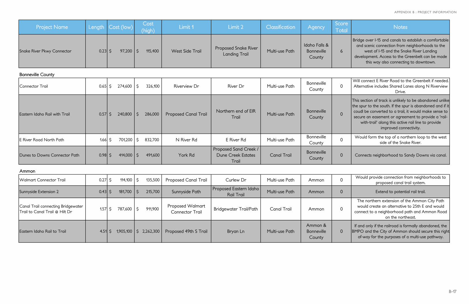
APPENDIX B : PROJECT INFORMATION
Project Name Length Cost (low)Cost (high)
Limit 1 Limit 2 Classification AgencyScore Total
Notes
Snake River Pkwy Connector 0.23 $ 97,200 $ 115,400 West Side Trail Proposed Snake River
Landing TrailMulti-use Path
Idaho Falls & Bonneville County
6
Bridge over I-15 and canals to establish a comfortable and scenic connection from neighborhoods to the
west of I-15 and the Snake River Landing development. Access to the Greenbelt can be made
this way also connecting to downtown.
Bonneville County
Connector Trail 0.65 $ 274,600 $ 326,100 Riverview Dr River Dr Multi-use PathBonneville County
0Will connect E River Road to the Greenbelt if needed. Alternative includes Shared Lanes along N Riverview
Drive.
Eastern Idaho Rail with Trail 0.57 $ 240,800 $ 286,000 Proposed Canal TrailNorthern end of EIR
TrailMulti-use Path
Bonneville County
0
This section of track is unlikely to be abandoned unlike the spur to the south. If the spur is abandoned and if it coudl be converted to a trail, it would make sense to secure an easement or agreement to provide a 'rail-
with-trail' along this active rail line to provide improved connectivity.
E River Road North Path 1.66 $ 701,200 $ 832,700 N River Rd E River Rd Multi-use PathBonneville County
0Would form the top of a northern loop to the west
side of the Snake River.
Dunes to Downs Connector Path 0.98 $ 414,000 $ 491,600 York RdProposed Sand Creek /
Dune Creek Estates Trail
Canal TrailBonneville County
0 Connects neighborhood to Sandy Downs via canal.
Ammon
Walmart Connector Trail 0.27 $ 114,100 $ 135,500 Proposed Canal Trail Curlew Dr Multi-use Path Ammon 0Would provide connection from neighborhoods to
proposed canal trail system.
Sunnyside Extension 2 0.43 $ 181,700 $ 215,700 Sunnyside PathProposed Eastern Idaho
Rail TrailMulti-use Path Ammon 0 Extend to potential rail trail.
Canal Trail connecting Bridgewater Trail to Canal Trail @ Hilt Dr
1.57 $ 787,600 $ 911,900 Proposed Walmart
Connector TrailBridgewater Trail/Path Canal Trail Ammon 0
The northern extension of the Ammon City Path would create an alternative to 25th E and would
connect to a neighborhood path and Ammon Road on the northeast.
Eastern Idaho Rail to Trail 4.51 $ 1,905,100 $ 2,262,300 Proposed 49th S Trail Bryan Ln Multi-use PathAmmon & Bonneville County
0If and only if the railroad is formally abandoned, the
BMPO and the City of Ammon should secure this rightof-way for the purposes of a multi-use pathway.
B-18
CONNECTING OUR COMMUNITY
Project Name Length Cost (low)Cost (high)
Limit 1 Limit 2 Classification AgencyScore Total
Notes
Highline Canal Path 2.41 $ 1,018,000 $ 1,208,900 49th S 25th E Canal TrailAmmon & Bonneville County
0
A southeastern extension of the Ammon City Path would connect Ammon’s southern subdivisions (and the southeast part of the Idaho Falls Area) to other
municipalities, homes and shopping, as well as allow a way for recreational users who run, walk, and bicycle in the southeast corner of the Idaho Falls Area to get to their recreational destinations by bike or foot. The
southern part south of Taylor View Lane could be added as development occurs.
Cabelas Trail 1.00 $ 422,400 $ 501,600 Sunnyside Rd 49th S Multi-use Path Ammon 0 Part of planned development.
Sunnyside East Extension 2.42 $ 1,022,300 $ 1,213,900 Proposed Eastern Idaho
Rail TrailExisting Subdivision Trail Multi-use Path
Ammon & Bonneville County
0 Connects to existing trail.
Loop Connector 0.23 $ 97,200 $ 115,400 Cabelas Trail Highline Canal Path Multi-use Path Ammon 0 To connect two north-south trails.
1st Street Side Path 1.47 $ 621,000 $ 737,400 25th EProposed Eastern Idaho
Rail TrailMulti-use Path
Ammon & Bonneville County
0 Side path on the south side of 1st.
Hawks Landing Trail 1.10 $ 464,700 $ 551,800 Existing Trail Crown Crescent Rd Multi-use Path Ammon 0 To be built with subdivision expansion.
21st S Path #1 0.37 $ 156,300 $ 185,600 45th E Rimrock School Path Multi-use PathAmmon & Bonneville County
0Makes connection from 45th to existing Rimrock
School Path.
21st S Path #2 1.00 $ 422,400 $ 501,600 Rimrock School Path 60th E Multi-use Path Ammon 0Connects Rimrock School Path to existing Subdivision
Path.
Rimrock School Trail Connector 0.13 $ 55,000 $ 65,300 Subdivision
Neighborhood PathBrennan Bend Multi-use Path
Ammon & Bonneville County
0 Will connect school to existing subdivision trail.
60th E Path 0.70 $ 295,700 $ 351,200 Sunnyside Rd 21st S Multi-use PathAmmon & Bonneville County
0 Connects Sunnyside Path to E 21st Street.
Canal Trail 1.13 $ 566,900 $ 656,400 Proposed Canal Trail -
Hilt DrProposed Eastern Idaho
Rail TrailCanal Trail
Ammon & Bonneville County
0The northern extension of the Ammon City Path would create an alternative to 25th E and would
connect to Iona Road on the north.
Iona
Iona Road Trail 1.61 $ 807,600 $ 935,100 Proposed Eastern Idaho
Rail TrailQuaky Aspen Dr Canal Trail
Iona & Bonneville County
0 Woud connect Ucon and Iona to Idaho Falls/Ammon.
B-19
APPENDIX B : PROJECT INFORMATION
Project Name Length Cost (low)Cost (high)
Limit 1 Limit 2 Classification AgencyScore Total
Notes
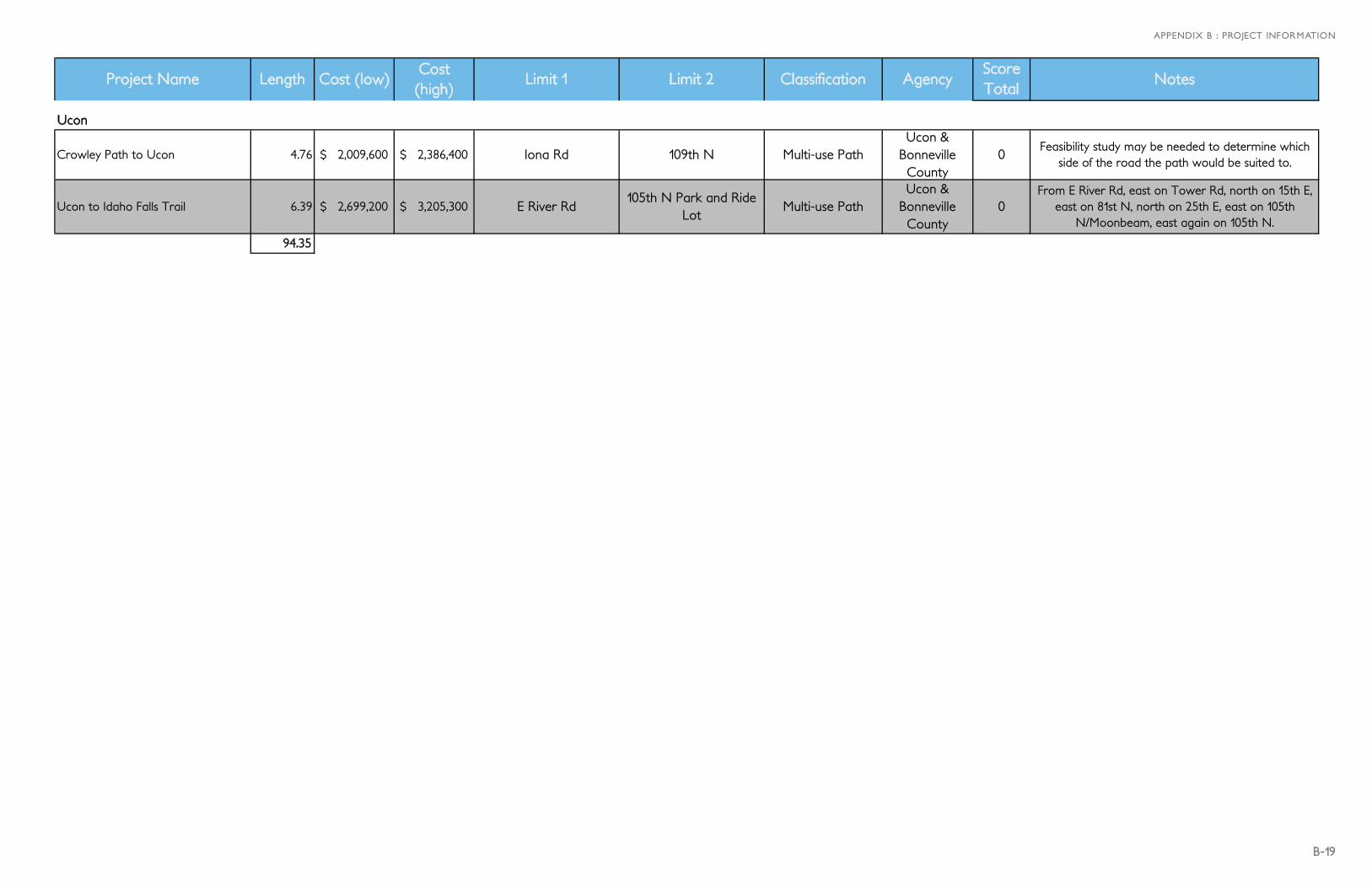
Ucon
Crowley Path to Ucon 4.76 $ 2,009,600 $ 2,386,400 Iona Rd 109th N Multi-use PathUcon &
Bonneville County
0Feasibility study may be needed to determine which
side of the road the path would be suited to.
Ucon to Idaho Falls Trail 6.39 $ 2,699,200 $ 3,205,300 E River Rd105th N Park and Ride
LotMulti-use Path
Ucon & Bonneville County
0From E River Rd, east on Tower Rd, north on 15th E,
east on 81st N, north on 25th E, east on 105th N/Moonbeam, east again on 105th N.
94.35

B-20
CONNECTING OUR COMMUNITY
Project Name Length Limit 1 Limit 2 Classification AgencyScore Total
Notes
Sidewalk along west side of Yellowstone Hwy
0.25North of Haven
Community Center
North of 23rd St
Sidewalks Idaho Falls 26Only isolated sections of sidewalk exist along the west side of Yellowstone from Sunnyside to
Pancheri.
Sidewalk along west side of Yellowstone Hwy
0.31 Quallity Heating Pancheri Dr Sidewalks Idaho Falls 25Only isolated sections of sidewalk exist along the west side of Yellowstone from Sunnyside to
Pancheri.
Sidewalk along west side of Yellowstone Hwy
0.29North of Platt
(store)
Haven Community
CenterSidewalks Idaho Falls 25
Only isolated sections of sidewalk exist along the west side of Yellowstone from Sunnyside to Pancheri.
Sidewalk along west side of Yellowstone Hwy
0.17 Sunnyside DrSouth of Platt
(store)Sidewalks Idaho Falls 25
Only isolated sections of sidewalk exist along the west side of Yellowstone from Sunnyside to Pancheri.
Sidewalk 0.09 Westhill AvePancheri Sidepath
Sidewalks Idaho Falls 21In 2011 the City replaced sidewalks on N side of Pancheri, but there is still a gap between Westhill
and the side path. This is important because it is where students need to walk.
Sidewalk extension to Greenbelt Trail 0.04 Greenbelt Trail Latah Ave Sidewalks Idaho Falls 12 Extend sidewalk to existing path.1.15
TABLE B.6 - SIDEWALKS