Embed Size (px)
Citation preview
ATTACHMENT 3PEER REVIEW LETTERS
COWAL GOLD MINE EXTENSION MODIFICATION
KALF AND ASSOCIATES Pty Ltd Hydrogeological, Numerical Modelling Specialists
BARRICK (COWAL) LIMITED
Lake Cowal Project KA Peer Review of Coffey Geotechnics
Hydrogeological and Modelling Assessment
Dr F. Kalf B.Sc M.App.Sc PhD
22 July 2013
BARRICK (COWAL) LIMITED PEER REVIEW Cowal Gold Mine Extension Modification Hydrogeological and Modelling Assessment
Kalf & Associates Pty Ltd 1
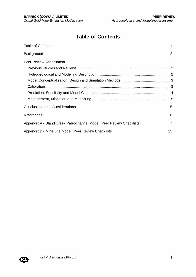
Table of Contents
Table of Contents 1
Background 2
Peer Review Assessment 2
Previous Studies and Reviews ........................................................................................... 2
Hydrogeological and Modelling Description ........................................................................ 2
Model Conceptualisation, Design and Simulation Methods ................................................ 3
Calibration .......................................................................................................................... 3
Prediction, Sensitivity and Model Constraints ..................................................................... 4
Management, Mitigation and Monitoring ............................................................................. 5
Conclusions and Considerations 5
References 6
Appendix A - Bland Creek Paleochannel Model Peer Review Checklists 7
Appendix B - Mine Site Model Peer Review Checklists 13
BARRICK (COWAL) LIMITED PEER REVIEW Cowal Gold Mine Extension Modification Hydrogeological and Modelling Assessment
Kalf & Associates Pty Ltd 2
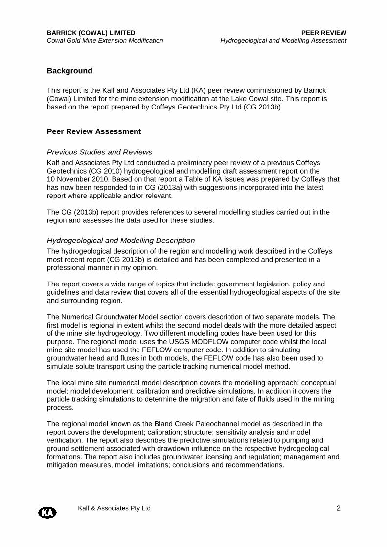
Background This report is the Kalf and Associates Pty Ltd (KA) peer review commissioned by Barrick (Cowal) Limited for the mine extension modification at the Lake Cowal site. This report is based on the report prepared by Coffeys Geotechnics Pty Ltd (CG 2013b)
Peer Review Assessment
Previous Studies and Reviews Kalf and Associates Pty Ltd conducted a preliminary peer review of a previous Coffeys Geotechnics (CG 2010) hydrogeological and modelling draft assessment report on the 10 November 2010. Based on that report a Table of KA issues was prepared by Coffeys that has now been responded to in CG (2013a) with suggestions incorporated into the latest report where applicable and/or relevant. The CG (2013b) report provides references to several modelling studies carried out in the region and assesses the data used for these studies.
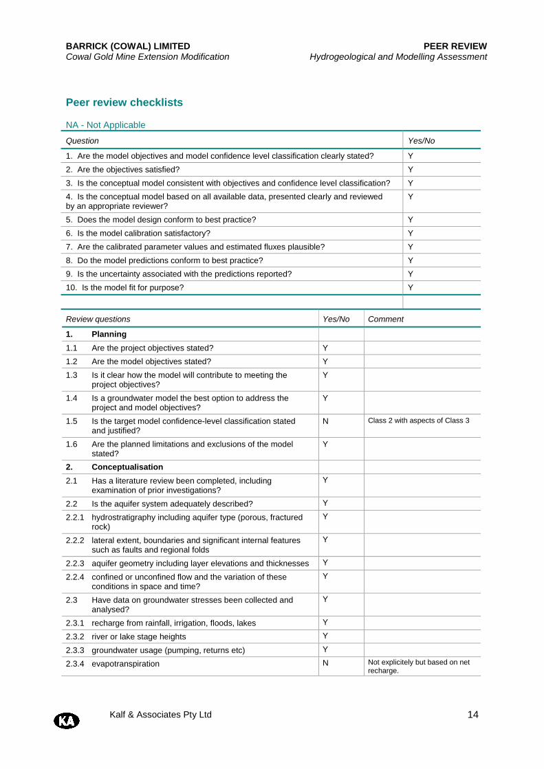
Hydrogeological and Modelling Description The hydrogeological description of the region and modelling work described in the Coffeys most recent report (CG 2013b) is detailed and has been completed and presented in a professional manner in my opinion. The report covers a wide range of topics that include: government legislation, policy and guidelines and data review that covers all of the essential hydrogeological aspects of the site and surrounding region. The Numerical Groundwater Model section covers description of two separate models. The first model is regional in extent whilst the second model deals with the more detailed aspect of the mine site hydrogeology. Two different modelling codes have been used for this purpose. The regional model uses the USGS MODFLOW computer code whilst the local mine site model has used the FEFLOW computer code. In addition to simulating groundwater head and fluxes in both models, the FEFLOW code has also been used to simulate solute transport using the particle tracking numerical model method. The local mine site numerical model description covers the modelling approach; conceptual model; model development; calibration and predictive simulations. In addition it covers the particle tracking simulations to determine the migration and fate of fluids used in the mining process. The regional model known as the Bland Creek Paleochannel model as described in the report covers the development; calibration; structure; sensitivity analysis and model verification. The report also describes the predictive simulations related to pumping and ground settlement associated with drawdown influence on the respective hydrogeological formations. The report also includes groundwater licensing and regulation; management and mitigation measures, model limitations; conclusions and recommendations.
BARRICK (COWAL) LIMITED PEER REVIEW Cowal Gold Mine Extension Modification Hydrogeological and Modelling Assessment
Kalf & Associates Pty Ltd 3
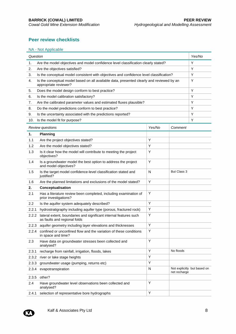
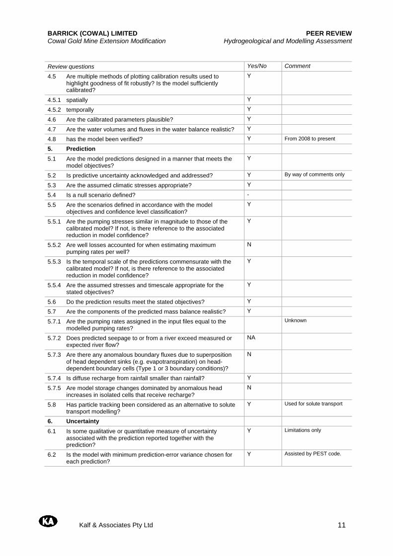
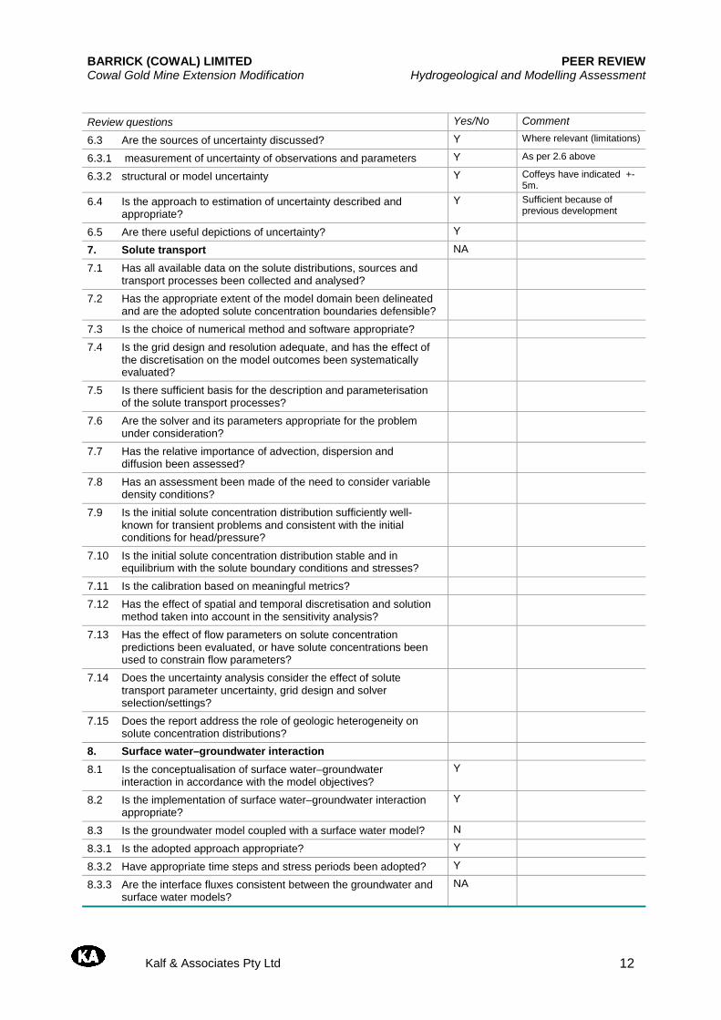
Modelling Guidelines This review report uses as a basis the new Australian Groundwater Modelling Guidelines (National Water Commission 2012). It should be noted that while this set of guidelines contains relevant procedures and items for the CG modelling work, it does not specifically cover open cut mining per se. Where no guidelines are available specific comments are made regarding the adequacy or otherwise of the approach used for modelling the groundwater system at the Lake Cowal mine site based on the author's experience, previous reviews or available reported field evidence. The completed Peer Review guideline checklists for both models (regional and local) are presented in Appendix A and B respectively.
Model Conceptualisation, Design and Simulation Methods As noted use is made of both the MODFLOW and FEFLOW computer codes for the regional and local mine site modelling study. In addition the parameter estimation code PEST was also applied during the regional model calibration. The model conceptualisations are considered suitable and described in detail in the CG report (CG 2013b). The regional model is comprised of three model layers representing the dominant alluvial formations (Cowra and Lachlan Formations). The local mine model is comprised of 14 layers that were divided within the Transported Saprolite, Saprock and Primary Rock hydrogeological units. The boundaries chosen for the local mine model included Lake Cowal as a constant head; Cowal West Hill ridge set at a constant head with respect to time but varying spatially along this boundary to reflect interpolated heads from field data. In addition constant heads were also set at a northern boundary within the Lake Nerang Cowal. The Bland paleochannel was set as the eastern constant boundary (in time) but again varied spatially along that boundary line. All other model boundaries were set to “no-flow”. These boundary conditions are considered to be suitable. The boundary conditions for the regional model are described in detail in Section 7.1.1.2 in the CG report (CG 2013b). These are also considered to be suitable. Groundwater recharge and discharge (open pit dewatering and saline groundwater supply) is also discussed in the report. The values adopted for rainfall recharge are considered to be plausible.
Calibration Initial values of hydraulic parameters for both models are discussed in Section 3.17 and 3.18 in CG (2013b). The available data for the regional model has been obtained from a variety of sources including pumping and packer tests. The local mine site parameters were obtained from both pumping bores and piezometers and also falling head tests within and to the east of the tailings storage facilities area. Calibration for the regional model was achieved with the assistance of the PEST computer code.
BARRICK (COWAL) LIMITED PEER REVIEW Cowal Gold Mine Extension Modification Hydrogeological and Modelling Assessment
Kalf & Associates Pty Ltd 4
Calibration for the local model was based on data described in an earlier Coffey report (Coffey 2009). A steady state was developed to provide initial head values for the local model transient simulation. The open pit was simulated using seepage face conditions and at varying stages that included horizontal dewatering bores, lateral expansion and deepening and inundation of Lake Cowal. Dewatering bores were also included. Modelled total inflow was compared to measured total inflow and the comparison is reasonable to quite good (Figure 46). The comparisons between measured and modelled water levels shown in Figures 38 to 41 are reasonable although some plots display notable divergence. No statistical measure of fit or a scatter diagram is presented for these comparisons. The calibration results for the regional model are reasonable. A root mean squared residual of 6.1% was attained which is acceptable.
Prediction, Sensitivity and Model Constraints The predictions for the local model included both flow and drawdown for the Extension Modification for both a dry and inundated Lake Cowal. The results indicate that the drawdown is contained within the mine site area at 2020 for both lake conditions. Pit inflow is predicted to be between 400 and 600 m3/day. The residual drawdown at 2044 is not significantly different to the drawdown at end of mine life in 2024. At full lake inundation the ‘take’ of water from the lake is 0.34ML/day. This represents 0.1% of the natural evaporation from the entire lake surface. Sensitivity of the local model was conducted by modifying the vertical permeability and horizontal permeability separately by a factor of 2. Under these conditions the calibration was found to be less favourable. But predicted drawdowns remain within the mine site boundary and inflows increased somewhat to between 670 and 740 m3/day. Solute transport migration was simulated using particle tracking and indicates that migration is affected by the final pit in the long-term that acts as a “sink” for the surrounding groundwater flow thereby preventing escape of any low concentration dissolved mining fluids and other analyte components. For the regional model pumping was simulated for two major bore fields (BCPB and ESB)1. In addition extraction was also compared to piezometer trigger levels. Drawdowns were determined for the Upper Cowra, Lower Cowra and Lachlan Formations. Influence on surrounding private bores as part of the Aquifer Interference Policy is being assessed and monitored. In addition salinity changes in the alluvial formations due to pumping have been assessed due to both the BCPB and ESB bore fields. Ground settlement has also been addressed due to pumping. However the results indicate that the settlements are not substantial. Sensitivity analysis in the report Appendix C indicates only moderate changes in drawdown response. The criteria for the Aquifer Interference Policy has been addressed with regard to ecosystems and supply works that are not relevant in the project region with minimum influence criteria having therefore been met.
1 BCPB: Bland Creek Paleochannel Borefield; ESB: Eastern Saline Borefield
BARRICK (COWAL) LIMITED PEER REVIEW Cowal Gold Mine Extension Modification Hydrogeological and Modelling Assessment
Kalf & Associates Pty Ltd 5
Validation of groundwater levels has also been conducted for the regional model since 2008. The results are in reasonable to good agreement (Appendix D). The modelling results for both models are considered plausible. The model constraints and limitations are adequately outlined in the report.
Management, Mitigation and Monitoring Management, mitigation and monitoring have been addressed in the CG report. Monitoring is to continue with respect to trigger levels that have been set in consultation with the NSW Office of Water and other water users. Suitable contingency measures are listed in the CG (2013b) to achieve these levels as listed in Section 9.1 of the CG report. In addition because of the establishment of drought protection bores in the region from 2002 onwards Barrick has assisted in this venture by maintaining production in these bores and pumping systems either through replacement of pumps, a bore and providing direct supply of water via a pipeline to one of the bore supply schemes. CG has also made recommendations on continued monitoring to validate the predictive modelling at the saline groundwater supply borefield. In addition the report recommends continued monitoring of salinity in the regional borefield and settlement. With respect to the local model it recommends post mine longer-term pit void water level and salinity monitoring and validation of the groundwater levels in and around the tailings storage facility.
Conclusions and Considerations The hydrogeological description of the region and modelling work described in the Coffeys report (CG 2013b) is detailed and has been completed and presented in a professional manner in my opinion. Two models have been successfully developed for the project that include a local mine site model and a regional model. The local model has provided hydrogeological conditions within the mine site boundary whilst the regional model has provided these conditions within the bore fields positioned within the Bland Creek paleochannel alluvial formations. Computer codes, model set-up and structure are considered to be suitable. The modelling approach used in both models is also considered to be suitable. Calibration of both groundwater pit inflow and groundwater levels is also reasonable to good. The predictive analyses results for both models are considered to be plausible including the validation for the regional model since 2008. The report has addressed adequately licensing requirements, Aquifer Interference Policy and management and mitigation and recommendations for continued monitoring.
BARRICK (COWAL) LIMITED PEER REVIEW Cowal Gold Mine Extension Modification Hydrogeological and Modelling Assessment
Kalf & Associates Pty Ltd 6
References Coffey 2009. Cowal Gold Mine, Groundwater Level Investigation. Report No GEOTLCOV21910AF-AB, 26 March. Coffey Geotechnics Pty Ltd 2010 Cowal Gold Mine Augumentation Project. Revised Draft Hydrogeological Conceptual Model 22 Oct. Coffey Geotechnics Pty Ltd (GC) 2013a. Cowal Gold Mine Extension Modification. Hydrogeological assessment. Response to KA comments on Draft Hydrogeological Assessment Report. GEOTLCOV21910AW-AI. Coffey Geotechnics Pty Ltd (GC) 2013b. Cowal Gold Mine Extension Modification. Hydrogeological Assessment. Final draft report No GEOTLCOV21910AW-AH_CGM July. National Water Commission 2012 Australian Groundwater Modelling Guidelines. Barnett et al. Waterlines Report Series No 82. June.
BARRICK (COWAL) LIMITED PEER REVIEW Cowal Gold Mine Extension Modification Hydrogeological and Modelling Assessment
Kalf & Associates Pty Ltd 7
Appendix A - Bland Creek Paleochannel Model Peer Review Checklists
BARRICK (COWAL) LIMITED PEER REVIEW Cowal Gold Mine Extension Modification Hydrogeological and Modelling Assessment
Kalf & Associates Pty Ltd 8
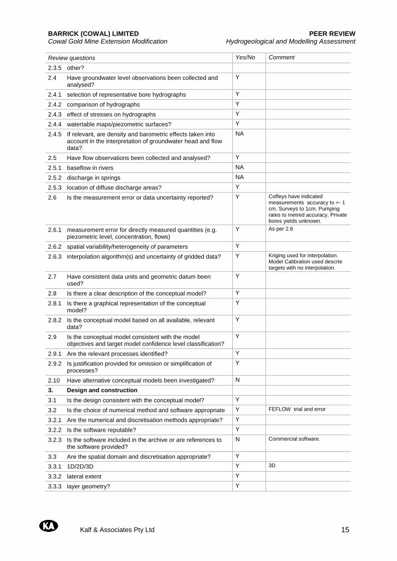
Peer review checklists
NA - Not Applicable
Question Yes/No
1. Are the model objectives and model confidence level classification clearly stated? Y
2. Are the objectives satisfied? Y
3. Is the conceptual model consistent with objectives and confidence level classification? Y
4. Is the conceptual model based on all available data, presented clearly and reviewed by an appropriate reviewer?
Y
5. Does the model design conform to best practice? Y
6. Is the model calibration satisfactory? Y
7. Are the calibrated parameter values and estimated fluxes plausible? Y
8. Do the model predictions conform to best practice? Y
9. Is the uncertainty associated with the predictions reported? Y
10. Is the model fit for purpose? Y
Review questions Yes/No Comment
1. Planning
1.1 Are the project objectives stated? Y
1.2 Are the model objectives stated? Y
1.3 Is it clear how the model will contribute to meeting the project objectives?
Y
1.4 Is a groundwater model the best option to address the project and model objectives?
Y
1.5 Is the target model confidence-level classification stated and justified?
N But Class 3
1.6 Are the planned limitations and exclusions of the model stated? Y
2. Conceptualisation
2.1 Has a literature review been completed, including examination of prior investigations?
Y
2.2 Is the aquifer system adequately described? Y
2.2.1 hydrostratigraphy including aquifer type (porous, fractured rock) Y
2.2.2 lateral extent, boundaries and significant internal features such as faults and regional folds
Y
2.2.3 aquifer geometry including layer elevations and thicknesses Y
2.2.4 confined or unconfined flow and the variation of these conditions in space and time?
Y
2.3 Have data on groundwater stresses been collected and analysed?
Y
2.3.1 recharge from rainfall, irrigation, floods, lakes Y No floods
2.3.2 river or lake stage heights Y
2.3.3 groundwater usage (pumping, returns etc) Y
2.3.4 evapotranspiration N Not explicitly but based on net recharge
2.3.5 other?
2.4 Have groundwater level observations been collected and analysed?
Y
2.4.1 selection of representative bore hydrographs Y
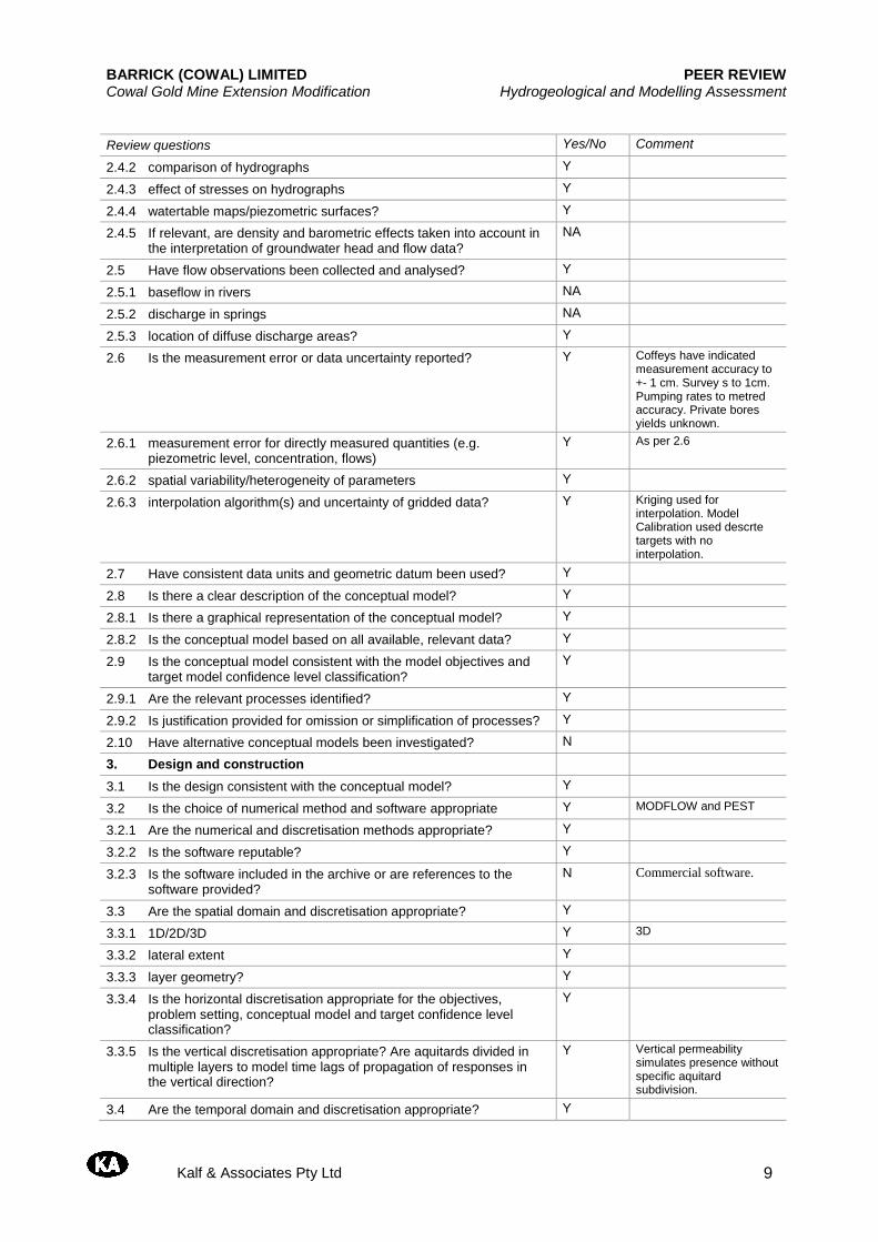
BARRICK (COWAL) LIMITED PEER REVIEW Cowal Gold Mine Extension Modification Hydrogeological and Modelling Assessment
Kalf & Associates Pty Ltd 9
Review questions Yes/No Comment
2.4.2 comparison of hydrographs Y
2.4.3 effect of stresses on hydrographs Y
2.4.4 watertable maps/piezometric surfaces? Y
2.4.5 If relevant, are density and barometric effects taken into account in the interpretation of groundwater head and flow data?
NA
2.5 Have flow observations been collected and analysed? Y
2.5.1 baseflow in rivers NA
2.5.2 discharge in springs NA
2.5.3 location of diffuse discharge areas? Y
2.6 Is the measurement error or data uncertainty reported? Y Coffeys have indicated measurement accuracy to +- 1 cm. Survey s to 1cm. Pumping rates to metred accuracy. Private bores yields unknown.
2.6.1 measurement error for directly measured quantities (e.g. piezometric level, concentration, flows)
Y As per 2.6
2.6.2 spatial variability/heterogeneity of parameters Y
2.6.3 interpolation algorithm(s) and uncertainty of gridded data? Y Kriging used for interpolation. Model Calibration used descrte targets with no interpolation.
2.7 Have consistent data units and geometric datum been used? Y
2.8 Is there a clear description of the conceptual model? Y
2.8.1 Is there a graphical representation of the conceptual model? Y
2.8.2 Is the conceptual model based on all available, relevant data? Y
2.9 Is the conceptual model consistent with the model objectives and target model confidence level classification?
Y
2.9.1 Are the relevant processes identified? Y
2.9.2 Is justification provided for omission or simplification of processes? Y
2.10 Have alternative conceptual models been investigated? N
3. Design and construction
3.1 Is the design consistent with the conceptual model? Y
3.2 Is the choice of numerical method and software appropriate Y MODFLOW and PEST
3.2.1 Are the numerical and discretisation methods appropriate? Y
3.2.2 Is the software reputable? Y
3.2.3 Is the software included in the archive or are references to the software provided?
N Commercial software.
3.3 Are the spatial domain and discretisation appropriate? Y
3.3.1 1D/2D/3D Y 3D
3.3.2 lateral extent Y
3.3.3 layer geometry? Y
3.3.4 Is the horizontal discretisation appropriate for the objectives, problem setting, conceptual model and target confidence level classification?
Y
3.3.5 Is the vertical discretisation appropriate? Are aquitards divided in multiple layers to model time lags of propagation of responses in the vertical direction?
Y Vertical permeability simulates presence without specific aquitard subdivision.
3.4 Are the temporal domain and discretisation appropriate? Y
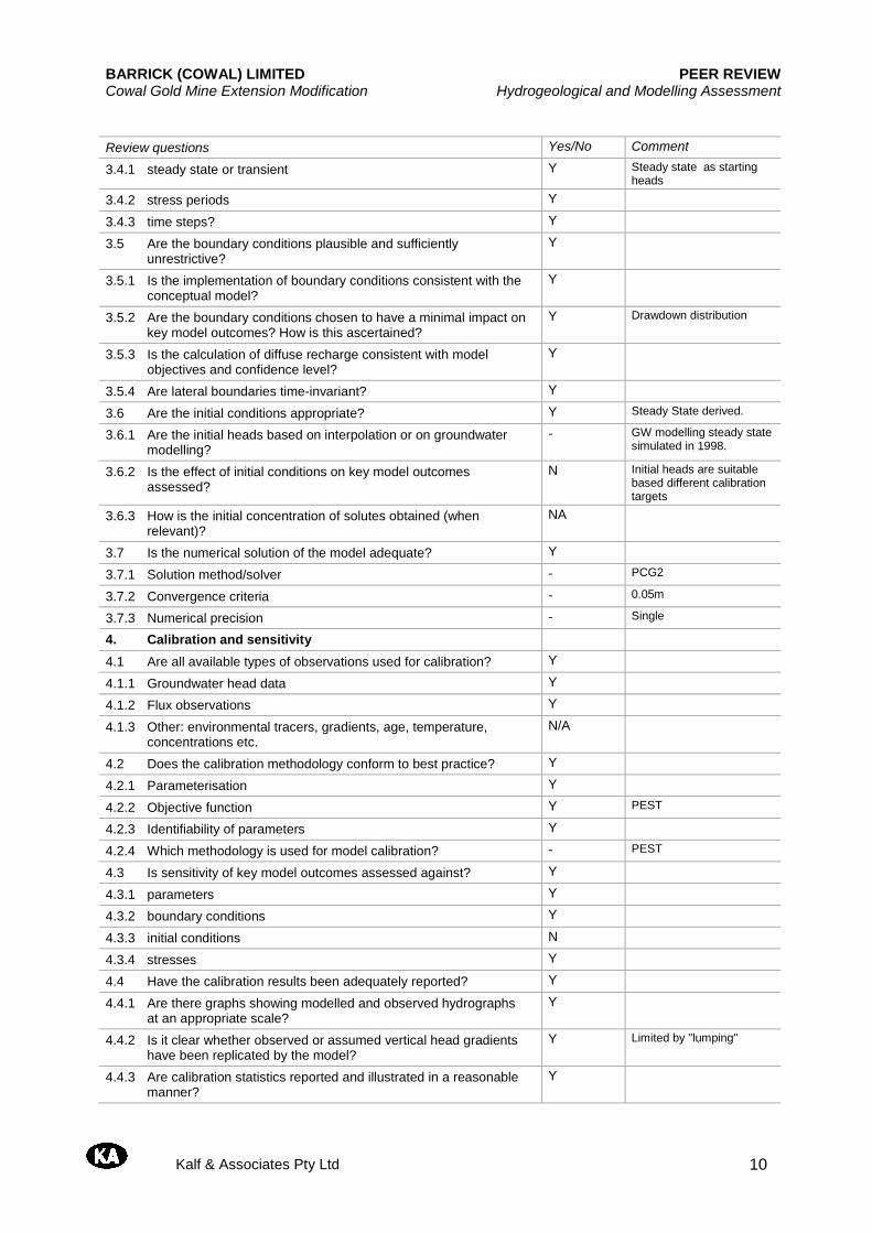
BARRICK (COWAL) LIMITED PEER REVIEW Cowal Gold Mine Extension Modification Hydrogeological and Modelling Assessment
Kalf & Associates Pty Ltd 10
Review questions Yes/No Comment
3.4.1 steady state or transient Y Steady state as starting heads
3.4.2 stress periods Y
3.4.3 time steps? Y
3.5 Are the boundary conditions plausible and sufficiently unrestrictive?
Y
3.5.1 Is the implementation of boundary conditions consistent with the conceptual model?
Y
3.5.2 Are the boundary conditions chosen to have a minimal impact on key model outcomes? How is this ascertained?
Y Drawdown distribution
3.5.3 Is the calculation of diffuse recharge consistent with model objectives and confidence level?
Y
3.5.4 Are lateral boundaries time-invariant? Y
3.6 Are the initial conditions appropriate? Y Steady State derived.
3.6.1 Are the initial heads based on interpolation or on groundwater modelling?
- GW modelling steady state simulated in 1998.
3.6.2 Is the effect of initial conditions on key model outcomes assessed?
N Initial heads are suitable based different calibration targets
3.6.3 How is the initial concentration of solutes obtained (when relevant)?
NA
3.7 Is the numerical solution of the model adequate? Y
3.7.1 Solution method/solver - PCG2
3.7.2 Convergence criteria - 0.05m
3.7.3 Numerical precision - Single
4. Calibration and sensitivity
4.1 Are all available types of observations used for calibration? Y
4.1.1 Groundwater head data Y
4.1.2 Flux observations Y
4.1.3 Other: environmental tracers, gradients, age, temperature, concentrations etc.
N/A
4.2 Does the calibration methodology conform to best practice? Y
4.2.1 Parameterisation Y
4.2.2 Objective function Y PEST
4.2.3 Identifiability of parameters Y
4.2.4 Which methodology is used for model calibration? - PEST
4.3 Is sensitivity of key model outcomes assessed against? Y
4.3.1 parameters Y
4.3.2 boundary conditions Y
4.3.3 initial conditions N
4.3.4 stresses Y
4.4 Have the calibration results been adequately reported? Y
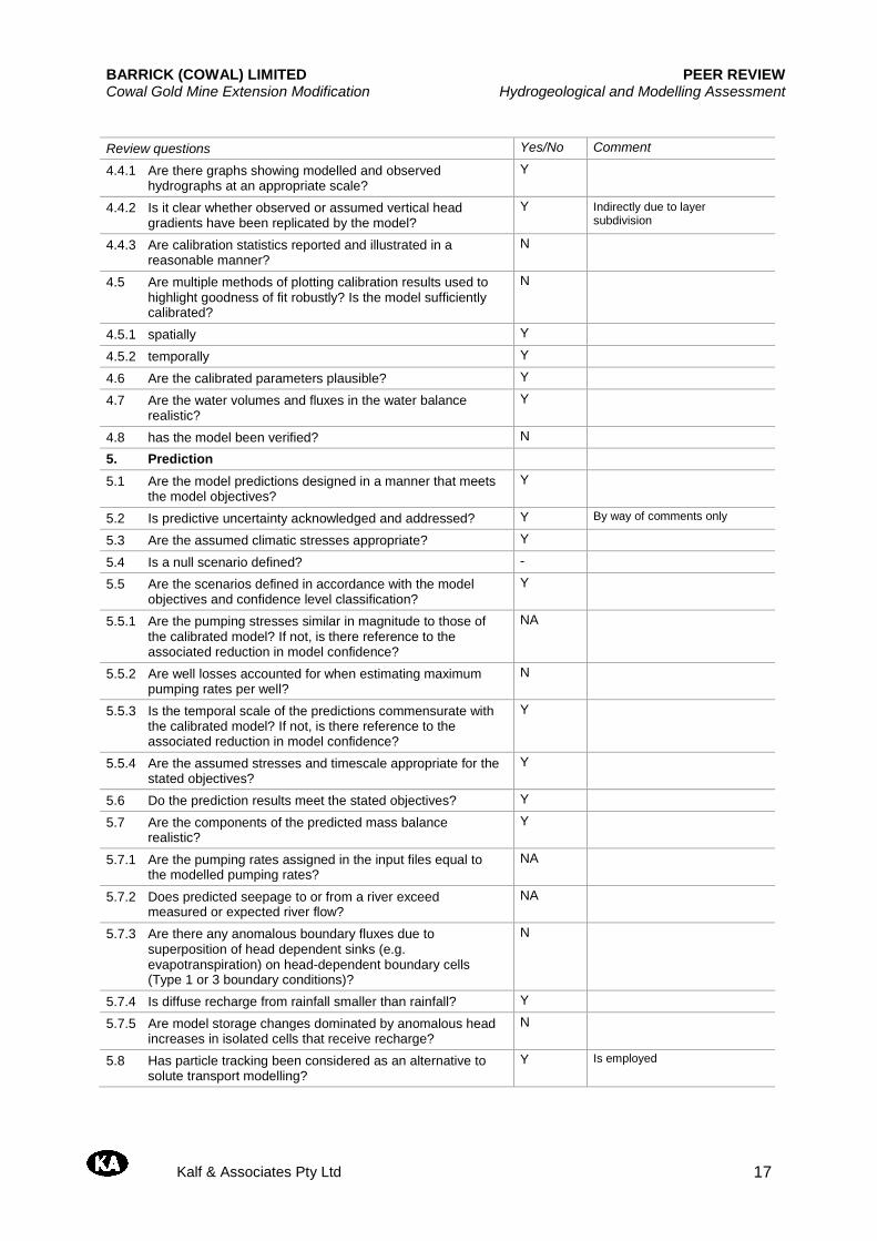
4.4.1 Are there graphs showing modelled and observed hydrographs at an appropriate scale?
Y
4.4.2 Is it clear whether observed or assumed vertical head gradients have been replicated by the model?
Y Limited by "lumping"
4.4.3 Are calibration statistics reported and illustrated in a reasonable manner?
Y
BARRICK (COWAL) LIMITED PEER REVIEW Cowal Gold Mine Extension Modification Hydrogeological and Modelling Assessment
Kalf & Associates Pty Ltd 11
Review questions Yes/No Comment
4.5 Are multiple methods of plotting calibration results used to highlight goodness of fit robustly? Is the model sufficiently calibrated?
Y
4.5.1 spatially Y
4.5.2 temporally Y
4.6 Are the calibrated parameters plausible? Y
4.7 Are the water volumes and fluxes in the water balance realistic? Y
4.8 has the model been verified? Y From 2008 to present
5. Prediction
5.1 Are the model predictions designed in a manner that meets the model objectives?
Y
5.2 Is predictive uncertainty acknowledged and addressed? Y By way of comments only
5.3 Are the assumed climatic stresses appropriate? Y
5.4 Is a null scenario defined? -
5.5 Are the scenarios defined in accordance with the model objectives and confidence level classification?
Y
5.5.1 Are the pumping stresses similar in magnitude to those of the calibrated model? If not, is there reference to the associated reduction in model confidence?
Y
5.5.2 Are well losses accounted for when estimating maximum pumping rates per well?
N
5.5.3 Is the temporal scale of the predictions commensurate with the calibrated model? If not, is there reference to the associated reduction in model confidence?
Y
5.5.4 Are the assumed stresses and timescale appropriate for the stated objectives?
Y
5.6 Do the prediction results meet the stated objectives? Y
5.7 Are the components of the predicted mass balance realistic? Y
5.7.1 Are the pumping rates assigned in the input files equal to the modelled pumping rates?
Unknown
5.7.2 Does predicted seepage to or from a river exceed measured or expected river flow?
NA
5.7.3 Are there any anomalous boundary fluxes due to superposition of head dependent sinks (e.g. evapotranspiration) on head-dependent boundary cells (Type 1 or 3 boundary conditions)?
N
5.7.4 Is diffuse recharge from rainfall smaller than rainfall? Y
5.7.5 Are model storage changes dominated by anomalous head increases in isolated cells that receive recharge?
N
5.8 Has particle tracking been considered as an alternative to solute transport modelling?
Y Used for solute transport
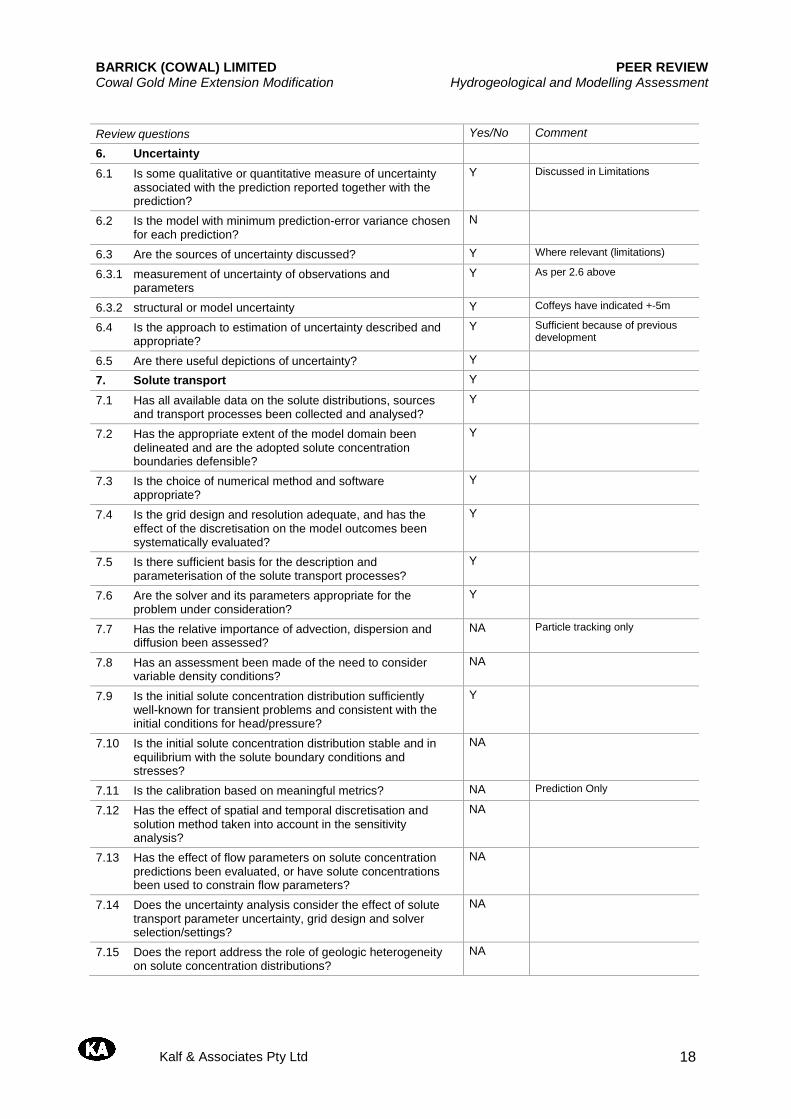
6. Uncertainty
6.1 Is some qualitative or quantitative measure of uncertainty associated with the prediction reported together with the prediction?
Y Limitations only
6.2 Is the model with minimum prediction-error variance chosen for each prediction?
Y Assisted by PEST code.
BARRICK (COWAL) LIMITED PEER REVIEW Cowal Gold Mine Extension Modification Hydrogeological and Modelling Assessment
Kalf & Associates Pty Ltd 12
Review questions Yes/No Comment
6.3 Are the sources of uncertainty discussed? Y Where relevant (limitations)
6.3.1 measurement of uncertainty of observations and parameters Y As per 2.6 above
6.3.2 structural or model uncertainty Y Coffeys have indicated +- 5m.
6.4 Is the approach to estimation of uncertainty described and appropriate?
Y Sufficient because of previous development
6.5 Are there useful depictions of uncertainty? Y
7. Solute transport NA
7.1 Has all available data on the solute distributions, sources and transport processes been collected and analysed?
7.2 Has the appropriate extent of the model domain been delineated and are the adopted solute concentration boundaries defensible?
7.3 Is the choice of numerical method and software appropriate?
7.4 Is the grid design and resolution adequate, and has the effect of the discretisation on the model outcomes been systematically evaluated?
7.5 Is there sufficient basis for the description and parameterisation of the solute transport processes?
7.6 Are the solver and its parameters appropriate for the problem under consideration?
7.7 Has the relative importance of advection, dispersion and diffusion been assessed?
7.8 Has an assessment been made of the need to consider variable density conditions?
7.9 Is the initial solute concentration distribution sufficiently well-known for transient problems and consistent with the initial conditions for head/pressure?
7.10 Is the initial solute concentration distribution stable and in equilibrium with the solute boundary conditions and stresses?
7.11 Is the calibration based on meaningful metrics?
7.12 Has the effect of spatial and temporal discretisation and solution method taken into account in the sensitivity analysis?
7.13 Has the effect of flow parameters on solute concentration predictions been evaluated, or have solute concentrations been used to constrain flow parameters?
7.14 Does the uncertainty analysis consider the effect of solute transport parameter uncertainty, grid design and solver selection/settings?
7.15 Does the report address the role of geologic heterogeneity on solute concentration distributions?
8. Surface water–groundwater interaction
8.1 Is the conceptualisation of surface water–groundwater interaction in accordance with the model objectives?
Y
8.2 Is the implementation of surface water–groundwater interaction appropriate?
Y
8.3 Is the groundwater model coupled with a surface water model? N
8.3.1 Is the adopted approach appropriate? Y
8.3.2 Have appropriate time steps and stress periods been adopted? Y
8.3.3 Are the interface fluxes consistent between the groundwater and surface water models?
NA
BARRICK (COWAL) LIMITED PEER REVIEW Cowal Gold Mine Extension Modification Hydrogeological and Modelling Assessment
Kalf & Associates Pty Ltd 13
Appendix B - Mine Site Model Peer Review Checklists
BARRICK (COWAL) LIMITED PEER REVIEW Cowal Gold Mine Extension Modification Hydrogeological and Modelling Assessment
Kalf & Associates Pty Ltd 14
Peer review checklists
NA - Not Applicable
Question Yes/No
1. Are the model objectives and model confidence level classification clearly stated? Y
2. Are the objectives satisfied? Y
3. Is the conceptual model consistent with objectives and confidence level classification? Y
4. Is the conceptual model based on all available data, presented clearly and reviewed by an appropriate reviewer?
Y
5. Does the model design conform to best practice? Y
6. Is the model calibration satisfactory? Y
7. Are the calibrated parameter values and estimated fluxes plausible? Y
8. Do the model predictions conform to best practice? Y
9. Is the uncertainty associated with the predictions reported? Y
10. Is the model fit for purpose? Y
Review questions Yes/No Comment
1. Planning
1.1 Are the project objectives stated? Y
1.2 Are the model objectives stated? Y
1.3 Is it clear how the model will contribute to meeting the project objectives?
Y
1.4 Is a groundwater model the best option to address the project and model objectives?
Y
1.5 Is the target model confidence-level classification stated and justified?
N Class 2 with aspects of Class 3
1.6 Are the planned limitations and exclusions of the model stated?
Y
2. Conceptualisation
2.1 Has a literature review been completed, including examination of prior investigations?
Y
2.2 Is the aquifer system adequately described? Y
2.2.1 hydrostratigraphy including aquifer type (porous, fractured rock)
Y
2.2.2 lateral extent, boundaries and significant internal features such as faults and regional folds
Y
2.2.3 aquifer geometry including layer elevations and thicknesses Y
2.2.4 confined or unconfined flow and the variation of these conditions in space and time?
Y
2.3 Have data on groundwater stresses been collected and analysed?
Y
2.3.1 recharge from rainfall, irrigation, floods, lakes Y
2.3.2 river or lake stage heights Y
2.3.3 groundwater usage (pumping, returns etc) Y
2.3.4 evapotranspiration N Not explicitely but based on net recharge.
BARRICK (COWAL) LIMITED PEER REVIEW Cowal Gold Mine Extension Modification Hydrogeological and Modelling Assessment
Kalf & Associates Pty Ltd 15
Review questions Yes/No Comment
2.3.5 other?
2.4 Have groundwater level observations been collected and analysed?
Y
2.4.1 selection of representative bore hydrographs Y
2.4.2 comparison of hydrographs Y
2.4.3 effect of stresses on hydrographs Y
2.4.4 watertable maps/piezometric surfaces? Y
2.4.5 If relevant, are density and barometric effects taken into account in the interpretation of groundwater head and flow data?
NA
2.5 Have flow observations been collected and analysed? Y
2.5.1 baseflow in rivers NA
2.5.2 discharge in springs NA
2.5.3 location of diffuse discharge areas? Y
2.6 Is the measurement error or data uncertainty reported? Y Coffeys have indicated measurements accuracy to +- 1 cm. Surveys to 1cm. Pumping rates to metred accuracy. Private bores yields unknown.
2.6.1 measurement error for directly measured quantities (e.g. piezometric level, concentration, flows)
Y As per 2.6
2.6.2 spatial variability/heterogeneity of parameters Y
2.6.3 interpolation algorithm(s) and uncertainty of gridded data? Y Kriging used for interpolation. Model Calibration used descrte targets with no interpolation.
2.7 Have consistent data units and geometric datum been used?
Y
2.8 Is there a clear description of the conceptual model? Y
2.8.1 Is there a graphical representation of the conceptual model?
Y
2.8.2 Is the conceptual model based on all available, relevant data?
Y
2.9 Is the conceptual model consistent with the model objectives and target model confidence level classification?
Y
2.9.1 Are the relevant processes identified? Y
2.9.2 Is justification provided for omission or simplification of processes?
Y
2.10 Have alternative conceptual models been investigated? N
3. Design and construction
3.1 Is the design consistent with the conceptual model? Y
3.2 Is the choice of numerical method and software appropriate Y FEFLOW trial and error
3.2.1 Are the numerical and discretisation methods appropriate? Y
3.2.2 Is the software reputable? Y
3.2.3 Is the software included in the archive or are references to the software provided?
N Commercial software.
3.3 Are the spatial domain and discretisation appropriate? Y
3.3.1 1D/2D/3D Y 3D
3.3.2 lateral extent Y
3.3.3 layer geometry? Y
BARRICK (COWAL) LIMITED PEER REVIEW Cowal Gold Mine Extension Modification Hydrogeological and Modelling Assessment
Kalf & Associates Pty Ltd 16
Review questions Yes/No Comment
3.3.4 Is the horizontal discretisation appropriate for the objectives, problem setting, conceptual model and target confidence level classification?
Y
3.3.5 Is the vertical discretisation appropriate? Are aquitards divided in multiple layers to model time lags of propagation of responses in the vertical direction?
Y
3.4 Are the temporal domain and discretisation appropriate? Y
3.4.1 steady state or transient Y Steady state as starting heads
3.4.2 stress periods Y
3.4.3 time steps? Y
3.5 Are the boundary conditions plausible and sufficiently unrestrictive?
Y
3.5.1 Is the implementation of boundary conditions consistent with the conceptual model?
Y
3.5.2 Are the boundary conditions chosen to have a minimal impact on key model outcomes? How is this ascertained?
Y Head distribution
3.5.3 Is the calculation of diffuse recharge consistent with model objectives and confidence level?
Y
3.5.4 Are lateral boundaries time-invariant? Y
3.6 Are the initial conditions appropriate? Y Steady State derived.
3.6.1 Are the initial heads based on interpolation or on groundwater modelling?
- GW modelling steady state
3.6.2 Is the effect of initial conditions on key model outcomes assessed?
N Initial heads are suitable based on different calibration targets
3.6.3 How is the initial concentration of solutes obtained (when relevant)?
NA
3.7 Is the numerical solution of the model adequate? Y
3.7.1 Solution method/solver - Unknown based on FEFLOW algorithms
3.7.2 Convergence criteria - 0,05m
3.7.3 Numerical precision - Single
4. Calibration and sensitivity
4.1 Are all available types of observations used for calibration? Y
4.1.1 Groundwater head data Y
4.1.2 Flux observations Y
4.1.3 Other: environmental tracers, gradients, age, temperature, concentrations etc.
N/A
4.2 Does the calibration methodology conform to best practice? Y
4.2.1 Parameterisation Y
4.2.2 Objective function N
4.2.3 Identifiability of parameters Y
4.2.4 Which methodology is used for model calibration? - Trial and error
4.3 Is sensitivity of key model outcomes assessed against? Y
4.3.1 parameters Y
4.3.2 boundary conditions Y
4.3.3 initial conditions Y Based on observations
4.3.4 stresses Y
4.4 Have the calibration results been adequately reported? Y
BARRICK (COWAL) LIMITED PEER REVIEW Cowal Gold Mine Extension Modification Hydrogeological and Modelling Assessment
Kalf & Associates Pty Ltd 17
Review questions Yes/No Comment 4.4.1 Are there graphs showing modelled and observed
hydrographs at an appropriate scale? Y
4.4.2 Is it clear whether observed or assumed vertical head gradients have been replicated by the model?
Y Indirectly due to layer subdivision
4.4.3 Are calibration statistics reported and illustrated in a reasonable manner?
N
4.5 Are multiple methods of plotting calibration results used to highlight goodness of fit robustly? Is the model sufficiently calibrated?
N
4.5.1 spatially Y
4.5.2 temporally Y
4.6 Are the calibrated parameters plausible? Y
4.7 Are the water volumes and fluxes in the water balance realistic?
Y
4.8 has the model been verified? N
5. Prediction
5.1 Are the model predictions designed in a manner that meets the model objectives?
Y
5.2 Is predictive uncertainty acknowledged and addressed? Y By way of comments only
5.3 Are the assumed climatic stresses appropriate? Y
5.4 Is a null scenario defined? -
5.5 Are the scenarios defined in accordance with the model objectives and confidence level classification?
Y
5.5.1 Are the pumping stresses similar in magnitude to those of the calibrated model? If not, is there reference to the associated reduction in model confidence?
NA
5.5.2 Are well losses accounted for when estimating maximum pumping rates per well?
N
5.5.3 Is the temporal scale of the predictions commensurate with the calibrated model? If not, is there reference to the associated reduction in model confidence?
Y
5.5.4 Are the assumed stresses and timescale appropriate for the stated objectives?
Y
5.6 Do the prediction results meet the stated objectives? Y
5.7 Are the components of the predicted mass balance realistic?
Y
5.7.1 Are the pumping rates assigned in the input files equal to the modelled pumping rates?
NA
5.7.2 Does predicted seepage to or from a river exceed measured or expected river flow?
NA
5.7.3 Are there any anomalous boundary fluxes due to superposition of head dependent sinks (e.g. evapotranspiration) on head-dependent boundary cells (Type 1 or 3 boundary conditions)?
N
5.7.4 Is diffuse recharge from rainfall smaller than rainfall? Y
5.7.5 Are model storage changes dominated by anomalous head increases in isolated cells that receive recharge?
N
5.8 Has particle tracking been considered as an alternative to solute transport modelling?
Y Is employed
BARRICK (COWAL) LIMITED PEER REVIEW Cowal Gold Mine Extension Modification Hydrogeological and Modelling Assessment
Kalf & Associates Pty Ltd 18
Review questions Yes/No Comment
6. Uncertainty
6.1 Is some qualitative or quantitative measure of uncertainty associated with the prediction reported together with the prediction?
Y Discussed in Limitations
6.2 Is the model with minimum prediction-error variance chosen for each prediction?
N
6.3 Are the sources of uncertainty discussed? Y Where relevant (limitations)
6.3.1 measurement of uncertainty of observations and parameters
Y As per 2.6 above
6.3.2 structural or model uncertainty Y Coffeys have indicated +-5m
6.4 Is the approach to estimation of uncertainty described and appropriate?
Y Sufficient because of previous development
6.5 Are there useful depictions of uncertainty? Y
7. Solute transport Y
7.1 Has all available data on the solute distributions, sources and transport processes been collected and analysed?
Y
7.2 Has the appropriate extent of the model domain been delineated and are the adopted solute concentration boundaries defensible?
Y
7.3 Is the choice of numerical method and software appropriate?
Y
7.4 Is the grid design and resolution adequate, and has the effect of the discretisation on the model outcomes been systematically evaluated?
Y
7.5 Is there sufficient basis for the description and parameterisation of the solute transport processes?
Y
7.6 Are the solver and its parameters appropriate for the problem under consideration?
Y
7.7 Has the relative importance of advection, dispersion and diffusion been assessed?
NA Particle tracking only
7.8 Has an assessment been made of the need to consider variable density conditions?
NA
7.9 Is the initial solute concentration distribution sufficiently well-known for transient problems and consistent with the initial conditions for head/pressure?
Y
7.10 Is the initial solute concentration distribution stable and in equilibrium with the solute boundary conditions and stresses?
NA
7.11 Is the calibration based on meaningful metrics? NA Prediction Only
7.12 Has the effect of spatial and temporal discretisation and solution method taken into account in the sensitivity analysis?
NA
7.13 Has the effect of flow parameters on solute concentration predictions been evaluated, or have solute concentrations been used to constrain flow parameters?
NA
7.14 Does the uncertainty analysis consider the effect of solute transport parameter uncertainty, grid design and solver selection/settings?
NA
7.15 Does the report address the role of geologic heterogeneity on solute concentration distributions?
NA

BARRICK (COWAL) LIMITED PEER REVIEW Cowal Gold Mine Extension Modification Hydrogeological and Modelling Assessment
Kalf & Associates Pty Ltd 19
Review questions Yes/No Comment
8. Surface water–groundwater interaction
8.1 Is the conceptualisation of surface water–groundwater interaction in accordance with the model objectives?
Y
8.2 Is the implementation of surface water–groundwater interaction appropriate?
Y
8.3 Is the groundwater model coupled with a surface water model?
N
8.3.1 Is the adopted approach appropriate? Y
8.3.2 Have appropriate time steps and stress periods been adopted?
Y
8.3.3 Are the interface fluxes consistent between the groundwater and surface water models?
NA
T.A. (Tom) McMahon FTSE Professor Emeritus
Department of Infrastructure Engineering The University of Melbourne Victoria 3010 Australia email: [email protected]
Shane Goodwin Barrick (Cowal) Limited PO Box 210 West Wylong NSW 2671 Dear Mr Goodwin
I have completed my assessment of the report Cowal Gold Mine Extension Modification Hydrological Assessment. My comments are set out below. My review process consisted of assessing the draft report written by Gilbert & Associate Pty Ltd, provided to me by Resources Strategies Pty Ltd. Although I did not carry out a field visit on this occasion, I visited the Cowal Gold Mine (CGM) operation on 21st September 2010 with Lindsay Gilbert and Tony Marszalek of Gilbert & Associates accompanied by staff from CGM.
During the field exercise we visited the open cut operations and surrounds, inspected the southern and northern rock emplacements and the up-catchment diversion system, all the contained water storages, the meteorological station, and the northern and southern tailings storage facility. I have commented on several draft reports, recommended a number of changes, and I can confirm that all these were adequately addressed. I have perused the final draft Report Cowal Gold Mine Extension Modification Hydrological Assessment (Sep-13 J1006-7 rm1i.docx) (emailed to me on 26th August 2013) and I am confident that the surface hydrology assessment and water balance methodologies are appropriate and, within the limits of the available data, are scientifically defensible.
The Report consists of seven sections. Following an introduction to the project, the
assessment requirements and a summary of relevant findings of previous environmental approvals are set out in Section B1.0. Section B2.0 deals with the hydrometeorological setting of the project and includes information on water quality. The current water management strategy and water supply – contained water storages, pit dewatering, waste rock emplacement water management, and tailings storage facility water management – are described in Section B 3.0 and future water management strategy and water supply including saline groundwater supply bores, eastern saline borefield, Bland Creek palaeochannel borefield and Lachlan River are outlined in Section B4.0. Section B5.0 provides a detailed discussion of the water balance model and its calibration which is followed by descriptions based on model simulations of the overall water balance, CGM external water demand, maximum pit water volume, model sensitivity, climate change effect, and the risk of spill to Lake Cowal. Issues relating to the post-closure water management system such as waste rock emplacements, tailings storage facilities, final void water balance, and implications of climate change are discussed in the penultimate section. The final section (Section B7.0) discusses the potential surface water impacts and mitigation measures during the operational phase and at post-closure.
-2-
Section B2.0 covers inter alia regional surface and groundwater hydrology, meteorology,
and water quality. The dominating features of the regional hydrology in the vicinity of the mine are Lake Cowal located east of CGM and the Lachlan River, which is approximately 40 km to the north, set in a semi-arid climate. In this section baseline water quality data of Lake Cowal are summarised. The material included in this section is an appropriate background for the analysis in the following sections of the Report.
In Section B3.0 the existing surface water management of the CGM is comprehensively
described noting that the system has been designed to ensure that the CGM operations do not impact on Lake Cowal. The system consists of five key components – water demand and supply, six runoff collection storages and two process water storages, pit dewatering, runoff from waste rock emplacement, and rainfall, runoff and free water post-settling in the tailings storage facility. Based on my site visit, I am confident Section B3.0 addresses all the key components of the existing water management system in sufficient detail to develop a comprehensive water balance model of the site.
Whereas Section B3.0 describes the existing (2013) water management and water supply
options, Section B4.0 covers the proposed future development in a series of snapshots at project year 2015, project year 2020, and the end of mining. Here the proposed changes in water management are described along with a description of the changes necessary in the four external water supply sources which make-up any shortfalls in the on-site sources. Based on my understanding of the CGM operations, the details provided are sufficient to be incorporated into the water balance model to assess the impact of mine expansion on future external water needs.
Section B5.0 describes the water balance model for the site, model calibration and its
application to the CGM. This is followed by a model sensitivity analysis, by an examination of the impact of climate change on the predicted annual demand from Lachlan River entitlements, and, finally, the risk of spill to Lake Cowal. The water balance is driven by 124 sequences, each 12 years in length, of historical climate data. Although this is a traditional approach, it is an appropriate technique, given the short length of the required simulations. As with many mine sites, no independent data were available to verify the parameters or validate the model, nevertheless, in the main the calibrated parameters yielded sensible values and the associated modelled values of the pond volumes, the reclaimed tailing water, and the external demand compared satisfactorily with monitored values.
Although I have limited experience in reviewing rehabilitation of waste rock emplacements,
the management concepts as set out in Section B6.1.1 to deal with post-closure management of the emplacements and the external batters and the berms of the tailings storage make sense. However, I have no expertise to comment on the proposed rehabilitation of the tailings beach surfaces.
In the case of the final void (discussed in Sections B6.1.3 and B6.2.1), a water balance
analysis incorporating catchment runoff, groundwater inflows and evaporation modified to allow for salinity effects was carried out which I consider appropriate. I note that the 124 years of historical climate data were concatenated to provide a 1000-year synthetic record rather than
-3-
applying a complex stochastic model to generate a long time sequence of future rainfall and evaporation. Given that the final void reached equilibrium in the water balance model at about 80 m below the spill level, the simple concatenated approach is appropriate.
The final section (B7.0) of the Report addresses seven potential surface water impacts and
mitigation measures and some post-closure comments. I believe the proposed mitigation measures are sensible and I fully endorse the comments. The post-closure comments are also appropriate, noting that the risk of discharge from the final void to Lake Cowal is extremely small.
In summary, I conclude that overall the study detailed in the Report Cowal Gold Mine
Extension Modification Hydrological Assessment was completed in a professional and detailed manner, and the conclusions in the Report were appropriately supplemented by the field and modelling studies carried out by the authors.
T.A. McMahon 27 August 2013
INDEPENDENT SCIENTIFIC REVIEW OF:
Cowal Gold Mine Extension Modification
Rehabilitation Proposal
Submitted
16 September 2013
Contact
Karen Fominas
Director, Client Relations
T +61 2 6125 5672 | F +61 2 6125 5875
Independent Scientific Review Cowal Gold Mine Extension Modification Rehabilitation Proposal
2
Independent Scientific Review of:
Cowal Gold Mine Extension Modification Rehabilitation Proposal
16 September 2013
Reviewer
David Freudenberger, PhD
ANU Edge
Canberra 0200
Independent Scientific Review Cowal Gold Mine Extension Modification Rehabilitation Proposal
3
REVIEW PROCESS
This review has been conducted in two stages. The first stage was a detailed review of the draft
Rehabilitation Proposal. The first stage review made a series of recommendations to improve the clarity
and rigour of the Rehabilitation Proposal (Appendix 1 attached). The Rehabilitation Proposal was then
revised and resubmitted for review (2 September 2013) by Dr David Freudenberger contracted to
ANUedge. The following is a review this revised Rehabilitation Proposal.
Review of responses to preliminary recommendations
Preliminary Recommendations (19 August 2013)
1. Provide detail on the Up-catchment Diversion System and investigate how this critically
important system is, or could, function as an ephemeral wetland supporting a diversity of
appropriately adapted flora and fauna.
Adequacy of revisions: the summary of the previously approved ecological design features of this
Diversion System are now included in the Rehabilitation Proposal. These details add important context
to the Proposal.
2. A commitment to replicate the most promising results of the 2013 Northern Waste Rock
Emplacement Trial on to a slope of contrasting aspect (e.g. western).
Adequacy of revisions: This commitment has now been clearly stated.
3. State within the Proposal how much topsoil will be required for mine closure applied at two
potential rates (150 mm and 300 mm), and state how much of this topsoil is already stockpiled,
and what proportion of the required topsoil will need to be treated with high rates of gypsum
(e.g. >35t/ha/m).
Adequacy of revisions: The insertion of Table 2 (“Preliminary Estimate of Soil Resources Available for
Rehabilitation”) provides a modest level of confidence that there will be sufficient topsoil to rehabilitate
all the required mined surfaces. The predicted net surplus of topsoil is less than 0.5% of total
requirements – a very fine margin. The report notes that a larger surplus of subsoil will likely be
available to extend the topsoil supply if required. Never the less, this analysis clearly indicates that
careful management of topsoil resources will be required.
Independent Scientific Review Cowal Gold Mine Extension Modification Rehabilitation Proposal
4
4. New rehabilitation trials for the New Lake Foreshore and Protection Bund should be planned and
implemented as a high priority.
Adequacy of revisions: sufficient detail has now been included to provide confidence that adaptive
rehabilitation continues on this critical interface between the mine and Lake Cowal.
5. Greater clarity is needed on how the ROMP will be reviewed and revised, and how annual
rehabilitation planning is conducted, approved and funded.
Adequacy of revisions: Various sections of the Proposal now include greater detail on how annual
rehabilitation planning is developed, reviewed, funded and implemented. The level of internal and
external review is commendable as long as these review processes don’t become encumbering
constraint to timely modifications that adapt to insights gained from the commendable monitoring plan.
Other more minor issues raised in the 19 August preliminary review have also been adequately
addressed.
Concluding comments
The Cowal Gold Mine Extension Modification Rehabilitation Proposal submitted to me on 2 September
2013 is now a scientifically sound document to guide the long-term rehabilitation of the enlarged mine.
The preliminary recommendations I suggested, based on my review of an earlier draft Proposal, have all
been rigorously addressed.
Independent Scientific Review Cowal Gold Mine Extension Modification Rehabilitation Proposal
5
APPENDIX 1 – PRELIMINARY REVIEW
Submitted 19 August 2013
Preliminary Findings - Summary
The Cowal Gold Mine (CGM) Rehabilitation Proposal is a highly professional and scientifically sound
plan. Implementation of this Proposal will likely lead to ecologically successful minesite rehabilitation
and mine closure. This Proposal is based on more than a decade of well designed and analysed trials to
test a variety of rehabilitation techniques. The Proposal outlines on-going rehabilitation trials and
monitoring that clearly demonstrates CGM’s commitment to innovative and adaptive rehabilitation
management.
This preliminary review makes the following relatively minor recommendations to improve the clarity,
rigour and comprehensiveness of the Rehabilitation Proposal.
Preliminary Recommendations
1. Provide detail on the Up-catchment Diversion System and investigate how this critically
important system is, or could, function as an ephemeral wetland supporting a diversity of
appropriately adapted flora and fauna.
2. A commitment to replicate the most promising results of the 2013 Northern Waste Rock
Emplacement Trial on to a slope of contrasting aspect (e.g. western).
3. State within the Proposal how much topsoil will be required for mine closure applied at two
potential rates (150 mm and 300 mm), and state how much of this topsoil is already stockpiled,
and what proportion of the required topsoil will need to be treated with high rates of gypsum
(e.g. >35t/ha/m).
4. New rehabilitation trials for the New Lake Foreshore and Protection Bund should be planned
and implemented as a high priority.
5. Greater clarity is needed on how the ROMP will be reviewed and revised, and how annual
rehabilitation planning is conducted, approved and funded.
Independent Scientific Review Cowal Gold Mine Extension Modification Rehabilitation Proposal
6
Review Context
This Rehabilitation Proposal has been independently reviewed by Dr David Freudenberger, a member of
the Society of Ecological Restoration Australasia (SERA). Dr Freudenberger has over 30 years ecological
research experience including 15 years with the CSIRO and he commenced as a Senior Lecturer at the
Fenner School of Environment and Society, Australian National University in late 2012. As such, he had
no involvement in the ANU rehabilitation research at Cowal Gold Mine (CGM).
The suitability of the CGM Rehabilitation Proposal has been reviewed against the rehabilitation
principles developed by Tongway and Ludwig (2011) based on their extensive experience of
rehabilitation research including minesites across a wide range of environmental conditions.
Comments
The GCM Rehabilitation Proposal is a well structured document that provides sufficient summaries of
detailed rehabilitation trials and implementation planning.
The Rehabilitation Principles (Section 2.1) are sound and emphasise the need for innovation, flexibility
and adaptation.
The Rehabilitation Objectives (2.2) are not fully Specific, Measureable, Actionable, Realistic and
Timebound (SMART). However the more detailed objectives stated in the Rehabilitation of the
Modification (3.0) partially redress this lack of specificity, measurability and time lines. These fairly
broad rehabilitation objectives are at least well visualised in the high quality Conceptual Final Landform
and Proposed Final Land Use Areas (Fig. 5).
The Status of Rehabilitation (2.5) could use with some more detail. What is meant by ‘covered’? I had
to presume this referred to a temporary cover of exotic pasture species. If this is the case, does this
‘cover’ pose a weed threat or cause any problems removing for final rehabilitation? Details (e.g. an
appendix) of the Up-catchment Diversion System is needed. This is a critically important system for
reducing the risk of sediment and potential pollutants coming from the minesite and entering Lake
Cowal. This Diversion System, if well designed and appropriately vegetated, has the potential to act a
constructed ephemeral wetland of significant area and length.
Rehabilitation Investigations and Trials (2.6)
CGM is highly commended for committing to so many high quality rehabilitation trials over such a
prolonged period of time. It was also pleasing to see references to similar applied research at the
Kalgoorlie mine. Every mine has unique rehabilitation challenges that require this level of commitment
to adaptive learning. It is particularly important that these trials should continue on a diversity of slope
aspects (e.g. north and south). Micro-climatic differences are well known due to slope aspect. I note
that the latest large and well replicated trial (Fig 7) is only being conducted on a north facing slope. It is
important that the most promising results from this trial are tested on a contrasting slope and aspect
Independent Scientific Review Cowal Gold Mine Extension Modification Rehabilitation Proposal
7
(e.g. west facing). It was particularly pleasing to see in this latest trial that a range of tree and shrub
species typically found on stony ridges in the region will be trialed along side species from lower and
more fertile slopes that characterised the site pre-mining. Since all the berms and batters will be formed
from rock covered by a relatively thin (150-300 mm) veneer of soil, testing the viable use of regionally
native plant species adapted to shallow soils and steep-well drained slopes is entirely sensible.
Geochemical Assessment of Rock Armouring Material
This is a particularly important assessment as it appears that rock armoring prior to the application of
the topsoil will become a common rehabilitation practice at CGM. It was noted that tunneling could
occur below this stable armouring if highly dispersive and saline oxidized waste rock becomes saturated
close to the surface. But I could not find any mention of how well (e.g. deep) oxidized waste rock will be
buried. There is clearly a large quantity (57 Mt) of primary (stable) waste rock, but I could find no
reference to what depth this stable rock will be used over and above its role as shallow armouring prior
to topsoil additions.
Soil Stockpile Sampling Programme (Attachment 1).
The comprehensive and rigorous nature of this programme is highly commendable However a
fundamental step seems to be missing, at least from this Rehabilitation Proposal. How much topsoil will
be required to fully implement this Proposal at 150 mm and 300 mm application rates? The Proposal is
dependent on having sufficient armouring rock (clearly the case), as well as at least a minimum of
reasonably non-dispersive topsoil. Is a minimum 150 mm of topsoil available for all post-mined surfaces
requiring it? How much subsoil will need to be treated with large quantities of gypsum to meet the
required m3 of topsoil, or is there enough suitably stable (non-dispersive) topsoil to meet requirements
so gypsum amelioration of sodic subsoils can be minimised?
Revegetation (2.6.4)
The New Lake Foreshore is a critical interface between the mine and the sensitive and highly dynamic
ecosystem of Lake Cowal. The rehabilitation trials established in this area in 2005 were are good start,
but what is next? The rehabilitation techniques trialed at that time appear to have had little success,
particularly the direct seeding. The Proposal concludes that ‘Overall there have been significant changes
on the New Lake Foreshore and the site is beginning to stabalise’ (p. 31,). This ‘…beginning to
stablise….’ is not good enough. This is a far too vague a statement summarising a section of the
Proposal that lacks in sufficient detail. The sensitive Foreshore should have been targeted for the
greatest attention and investment in rehabilitation trials. The rehabilitation process should have been
much more advanced by now for this critical interface with the Lake.
The Vegetation Growth Trials are an innovative and outstanding piece of applied rehabilitation research.
Far too many mine rehabilitation plans focus on topsoil conditions which seem to assume that trees and
large shrubs can either grow and survive entirely in 10 cm of topsoil or that the waste rock substrate can
Independent Scientific Review Cowal Gold Mine Extension Modification Rehabilitation Proposal
8
support root penetration and access to essential plant nutrients and water. It is also particularly
pleasing that this research will be scaled up to 1.5 m deep boxes. This depth should cover the rooting
depth of many of the woodland species likely to establish at the CGM (Zerihun et al. 2006).
Good to see such a wide diversity of trees and shrubs that will be trialed as tubestock for the Northern
Waste Rock Emplacement (Table 1). The list of species recommended for use in a native seed mix (Table
2) should provide an effective diversity of species in order to identify those most suited to the ‘novel’
landscapes being created at the CGM. The concept of novel ecosystems (Hobbs et al. 2009) is proving a
useful concept for the design and assessment of restoration and rehabilitation projects. However, there
is no mention of how this recommended seed mix will be applied to rehabilitation soil surfaces. Are
there direct seeding trials with mechanical seeders being planned? As shown by the New Foreshores
trials, hand broadcasting is unlikely to be effective.
Revegetation concepts (3.2)
In this section and elsewhere there is reference to “or wheaten hay” (e.g. p. 47). It is premature to
include wheaten hay as an option for the ‘rehabilitation cover system’. There is clear trial evidence that
seed laden native pasture hay promotes soil surface stability and the colonisation of native grasses. It is
unlikely that the current trial of wheaten hay will result in a similar cover of native grasses.
Some detail is needed of the “pasture species” used “…to rapidly stablised the batter slopes” (p. 48).
What are these species, are they native species, and do they pose a competitive weed risk?
It is appropriate that the top surface of the tailings dams are designed to be internally draining.
However each tailing dam will be nearly 1 km2 in area . If infiltration is low, a large rainfall event could
lead to a large area of inundation of some depth. Has there been any hydrologic modeling of potential
depth and area of inundation following a 1 in 100 year rainfall event? How long would this area of
inundation last based on summer versus winter evaporation rates, and minimal deep drainage? An
undulating final landform with shallow swales makes sense, but care will be needed to select
appropriate species that could cope with prolonged inundation, particularly within the swale.
Rehabilitation monitoring (3.4.2)
CGM is commended for its commitment to a quality ecological monitoring regime. The choices of
monitoring methodologies and performance criteria are scientifically sound as summarised in Table 4
and fully described in Attachment 2. The choice of reference ecosystems and sites (Lake Foreshore,
Grassland, Hill and Slopes ) is suitable given the wide range of ecosystems that will be constructed as
part of the rehabilitation programme. It was also pleasing to see that “lower” and “upper” ranges for
performance criteria (Attachment 2) have been developed to reflect the inherent variation of these
ecosystems.

Independent Scientific Review Cowal Gold Mine Extension Modification Rehabilitation Proposal
9
Soil Amelioration Farm (3.4.3)
This is likely to be an expensive system to establish and maintain, particularly if it includes irrigation.
However, this farm will only be needed if the assessment of topsoil supply vs. rehabilitation need
indicates a shortfall in soil stockpiles that are reasonable stable and only require modest amounts of
gypsum.

Independent Scientific Review Cowal Gold Mine Extension Modification Rehabilitation Proposal
10
Rehabilitation Management (3.4) & Governance
It appears that the ROMP is the operational plan for large scale rehabilitation of the CGM. It is stated
that the ROMP will be revised to reflect, amongst other issues, results from rehabilitation investigations
and trials. However, there is no clarity in this Rehabilitation Proposal how often the ROMP will be
reviewed and what processes will be implemented to revise it. All rehabilitation operations are a
compromise between efficacy and cost efficiency. The amount of time and money that can be
committed to rehabilitation is theoretically limitless. More can always be done. For example Alcoa
Australia is committed to restoring 100% of all species disturbed by their bauxite mining (Alcoa 2013).
To achieve this to date, Alcoa has gone as far as establishing their own tissue culture facility to
propagate plant species that can’t be established from seed. Rehabilitation practices are a compromise
between a noble goal of rapid re-establishment all species displaced by mining versus cost effectiveness
and feasibility of rehabilitation methods.
The CGM Rehabilitation Principles (2.1) states that “The annual rehabilitation programme and budget is
to be prepared by a site team incorporating senior management representatives”. Who provides
oversight to these preparation and approval processes? Who determines whether this critically
important annual programme and budget is sufficient? How is sufficiency defined? The Rehabilitation
Proposal has little value unless there is the financial commitment to implement it. To date this
commitment has been demonstrated by the relatively small scale rehabilitation trials and monitoring. It
is hoped that this commitment remains during the large scale implementation of the most promising
results from these ongoing trials.
Preliminary Recommendations
The following recommendations are suggested to improve the clarity, rigour and success of the
Rehabilitation Proposal. However, from my view point, none of these recommendations need to be
implemented prior to regulatory approval of this Rehabilitation Proposal.
1. Provide detail on the Up-catchment Diversion System and investigate how this critically
important system is, or could, function as an ephemeral wetland supporting a diversity of
appropriately adapted flora and fauna.
2. A commitment to replicate the most promising results of the 2013 Northern Waste Rock
Emplacement Trial on to a slope of contrasting aspect (e.g. western).
3. State within the Proposal how much topsoil will be required for mine closure applied at two
potential rates (150 mm and 300 mm), and state how much of this topsoil is already stockpiled,
and what proportion of the required topsoil will need to be treated with high rates of gypsum
(e.g. >35t/ha/m).
Independent Scientific Review Cowal Gold Mine Extension Modification Rehabilitation Proposal
11
4. New rehabilitation trials for the New Lake Foreshore and Protection Bund should be planned
and implemented as a high priority.
5. Greater clarity is needed on how the ROMP will be reviewed/revised and how annual
rehabilitation planning is conducted, approved and funded.
References
Alcoa Australia (2013) The Mining & Rehabilitation Process.
http://www.alcoa.com/australia/en/info_page/mining_rehab_process.asp
Hobbs, R.J., Higgs, E., Harris, J.A. (2009). Novel ecosystems: implications for conservation and
restoration. Trends in Ecology & Evolution 24, 599-605.
Tongway, D. and Ludwig, J. (2011). Restoring Disturbed Landscapes: Putting Principles into Practice.
Island Press, Washington.
Zerihun, A., Montagu, K. D., Hoffmann,M.B.,. Bray, S.G.( 2006). Patterns of below- and aboveground
biomass in Eucalyptus populnea woodland communities of northeast Australia along a rainfall
gradient. Ecosystems 9, 501-1.