Embed Size (px)
Citation preview
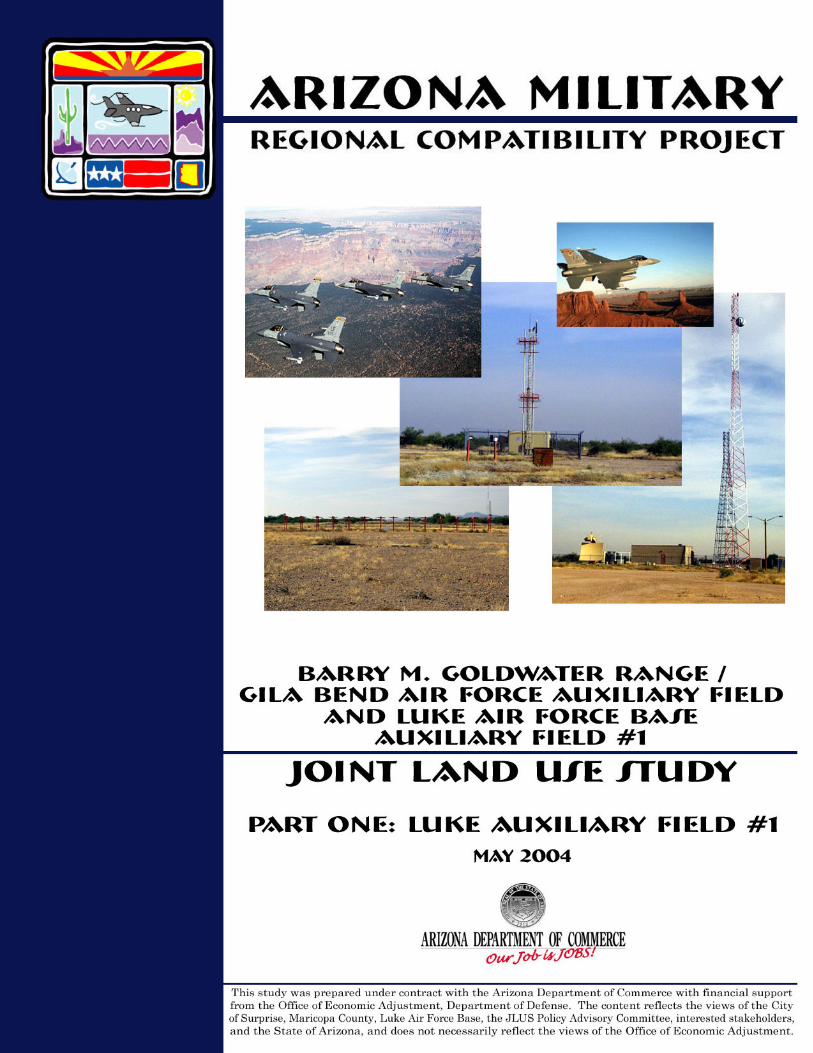
Barry M. Goldwater Range / Gila Bend Air force Auxiliary Field
and Luke Air Force Base Auxiliary Field #1
Joint land use study
Part One: Luke Auxiliary Field #1
Arizona military regional compatibility project
MAY 2004
Prepared for:
Prepared by:
This study was prepared under contract with the Arizona Department of Commerce with financial support from the Office of Economic Adjustment, Department of Defense. The content reflects the views of the City of Surprise, Maricopa County, Luke Air Force Base, the JLUS Policy Advisory Committee, interested stakeholders, and the State of Arizona, and does not necessarily reflect the views of the Office of Economic Adjustment.
JOINT LAND USE STUDY FOR LUKE AIR FORCE BASE AUXIL IARY F IELD #1
MAY 2004 ACKNOWLEDGEMENTS i
ACKNOWLEDGEMENTS
Policy advisory committee members (PAC) Lisa Atkins, Executive Director, County Supervisors Association of Arizona and Vice-
President, Fighter Country Partnership Amy Duffy, Duffy Consulting Archy Hamm, Superintendent, Wickenburg School District Richard Hubbard, Deputy Land Commissioner, Arizona State Land Department Spencer Kamps, Home Builders Association of Central Arizona Jack Lunsford, President, WESTMARC Diane McCarthy, Former President, WESTMARC Lon McDermott, Mayor, Town of Wickenburg Rusty Mitchell, Director, Community Initiatives Team, Luke Air Force Base Rep. John Nelson, Arizona House of Representatives, District 12 Dr. Margo Olivares-Seck, Former Superintendent, Dysart Unified School District Monty Ortman, El Dorado Holdings Elaine Scruggs, Mayor, City of Glendale Joan Shafer, Mayor, City of Surprise Stellan Tingstrom, Facility Manager, Volvo Arizona Proving Grounds Max Wilson, Maricopa County Supervisor, District 4
Working group and project team members Mike Davis, Department of Defense Office of Economic Adjustment John DeMartino, Parsons Bob Duchek, Parsons Tracey Ferguson, Parsons Heather Garbarino, Arizona Department of Commerce Mike Hanson, Luke Air Force Base Anders Hauge, Parsons Matt Holm, Maricopa County Greg Keller, Arizona State Land Department Scott Phillips, City of Surprise Deb Sydenham, Arizona Department of Commerce Phil Testa, City of Surprise
Additional acknowledgements Sintra Hoffman, City of Surprise Diane Malone, City of Surprise
JOINT LAND USE STUDY FOR LUKE AIR FORCE BASE AUXIL IARY F IELD #1
MAY 2004 TABLE OF CONTENTS i i
TABLE OF CONTENTS
ACKNOWLEDGEMENTS.........................................................................................I 1. INTRODUCTION...........................................................................................1-1
1.1 Project Purpose..........................................................................................................1-4 1.2 Project Goals..............................................................................................................1-4 1.3 Guiding Principles.....................................................................................................1-5 1.4 Public Participation ..................................................................................................1-5 1.5 Plan Implementation ................................................................................................1-6
2. STUDY AREA OVERVIEW.............................................................................2-1 2.1 Historical Growth and Development........................................................................2-1 2.2 Existing Development Pattern .................................................................................2-3 2.3 Growth Potential and Planned Land Use (Municipal and County) .......................2-5 2.4 Auxiliary Field #1 Operations ..................................................................................2-7 2.5 Land Ownership......................................................................................................2-10
3. REVIEW OF EXISTING LEGISLATION........................................................3-1 3.1 Existing Land-Use Compatibility Legislation, Ordinances, and Guidelines.........3-1 3.2 Differences Between Federal and State Guidance for Compatible Uses ...............3-3
4. TRENDS AND ISSUES ..................................................................................4-1 4.1 Regional Growth Trends...........................................................................................4-1 4.2 Development Issues ..................................................................................................4-3
5. LAND USE COMPATIBILITY ........................................................................5-1 5.1 Noise and Safety Considerations..............................................................................5-1 5.2 Land Use Compatibility Criteria..............................................................................5-8 5.3 Compatible Land Use Plan.....................................................................................5-10
6. IMPLEMENTATION PROGRAM ....................................................................6-1 6.1 Introduction...............................................................................................................6-1 6.2 Implementation Strategies .......................................................................................6-2
LIST OF TABLES
Table 3-1: Compatibility of Uses – AICUZ Program ..........................................................3-4 Table 3-2: Compatibility of Uses – ARS §28-8481 ..............................................................3-4 Table 4-1: Growth of Sample East Valley Cities.................................................................4-1 Table 4-2: Growth of Sample West Valley Cities................................................................4-2 Table 5-1: Recommended Land Use Compatibility Criteria ..............................................5-9
JOINT LAND USE STUDY FOR LUKE AIR FORCE BASE AUXIL IARY F IELD #1
MAY 2004 TABLE OF CONTENTS I I I
LIST OF FIGURES
Figure 1-1: Military Lands in Arizona ..................................................................................1-2 Figure 2-1: Vicinity Map ........................................................................................................2-2 Figure 2-2: Existing Land Use...............................................................................................2-4 Figure 2-3: Overflight Areas..................................................................................................2-9 Figure 2-4: Land Ownership................................................................................................2-11 Figure 5-1: F-16 Notional Noise Contours ............................................................................5-4 Figure 5-2: F-22 Notional Noise Contours ............................................................................5-5 Figure 5-3: Notional Accident Potential Zones .....................................................................5-7 Figure 5-4: Compatible Land Use Plan Zones ....................................................................5-12 Figure 5-5: Auxiliary Field #1Vicinity Box .........................................................................5-14 APPENDIX A: ARIZONA LAND USE COMPATIBILITY LEGISLATION .................................. A-1 APPENDIX B:
AIR INSTALLATION COMPATIBLE USE ZONE (AICUZ) ...................... B-1 APPENDIX C:
ARIZONA REGIONAL COMPATIBILITY PROJECT MODEL RESOLUTION..............................................................................C-1
APPENDIX D: GLOSSARY OF ACRONYMS.................................................................... D-1
APPENDIX E: RESOURCES CONSULTED .......................................................................E-1
JOINT LAND USE STUDY FOR LUKE AIR FORCE BASE AUXIL IARY F IELD #1
MAY 2004 CHAPTER 1 : INTRODUCT ION 1 - 1
1. INTRODUCTION
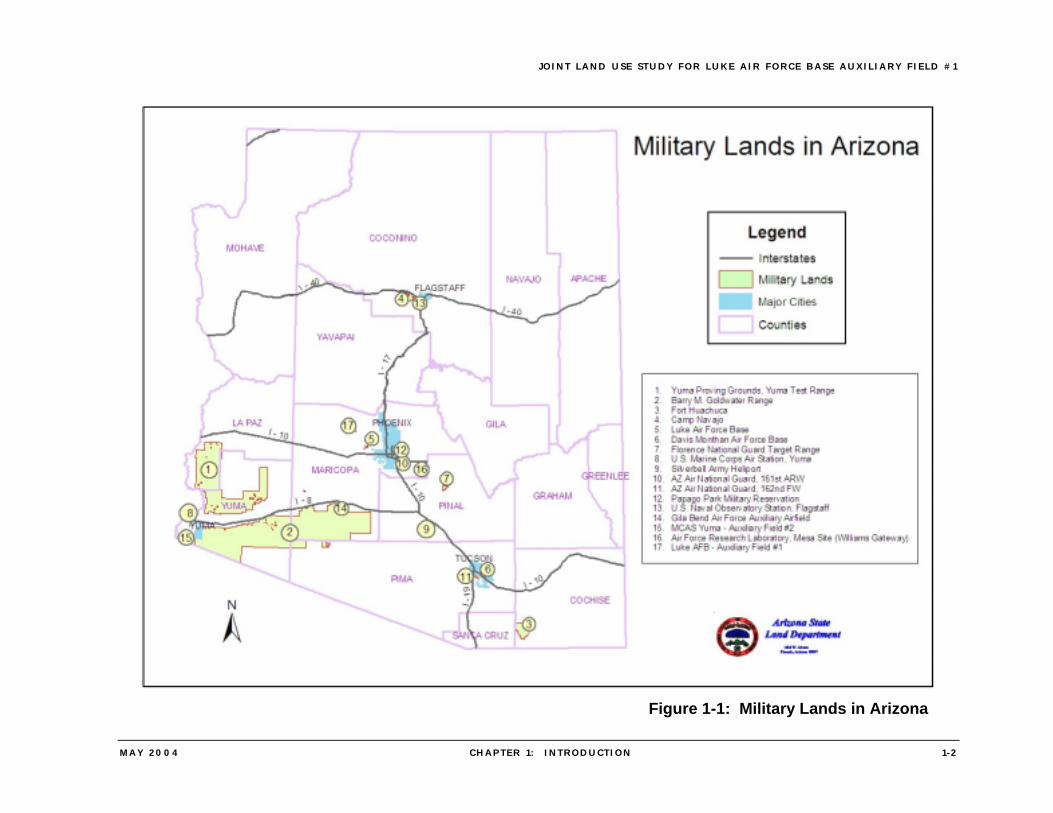
In July 2003, a Joint Land Use Study (JLUS) for Luke Air Force Base Auxiliary Field #1 began under the sponsorship of the Arizona Department of Commerce (ADOC). Partially funded by a grant from the Department of Defense Office of Economic Adjustment, this JLUS is Part One of a study that will also encompass a JLUS for the Barry M. Goldwater Range / Gila Bend Air Force Auxiliary Airfield. The Barry M. Goldwater Range / Gila Bend Air Force Auxiliary Airfield and Luke Air Force Base Auxiliary Airfield #1 JLUS is part of the Arizona Military Regional Compatibility Project, which was conceived as a proactive statewide endeavor to convene the stakeholders around each base — the relevant jurisdictions, base personnel, landowners, and other interested parties — to address land use compatibility issues. Arizona is home to a network of United States military airports and installations including Luke Air Force Base, Yuma Proving Ground and Yuma Marine Air Corps Station, Davis-Monthan Air Force Base, Fort Huachuca, and the Barry M. Goldwater Range (BMGR) Complex (Figure 1-1). As issues of growth and development have moved to the forefront in many parts of Arizona, the bases and jurisdictions where the bases are located play key roles in addressing compatibility. Through the statewide Compatibility Project, the State is endeavoring to provide the tools to address land use conflicts that might impact the ability of each base to conduct its mission, and to ensure land use compatibility around active military airports, as required under Title 28, Article 7 of the Arizona Revised Statues (ARS). Appendix A summarizes the applicable ARS land use compatibility legislation. Consistent with the statewide interest in land use compatibility issues and sustainability of military installations, and recognizing the combined importance to the Luke Air Force Base mission of the Barry M. Goldwater Range (BMGR), Gila Bend Air Force Auxiliary Airfield (AFAF) and Auxiliary Field #1, a comprehensive approach to these facilities is being taken in this JLUS. To maintain its mission as one of the premier training bases in the Air Force, Luke Air Force Base requires access to range and training facilities that provide for highly realistic combat training. BMGR is a critical facility because it is authorized for live-fire training, which is made possible through military control of the surface and airspace. Linkage between Luke Air Force Base and BMGR are the designated Military Training Routes crisscrossing Arizona, eight of which provide essential access to BMGR. These routes are used by the military to practice high-speed, low-altitude maneuvers (generally below the 10,000-foot altitude and at airspeeds greater than 400 miles per hour). In addition to accessing BMGR, pilots from Luke need access to both Gila Bend Auxiliary Field for practice approaches and landings and to Auxiliary Field #1 for instrument approach training. Military aircraft, including F-16s from Luke Air Force Base, routinely use Gila Bend AFAF for practicing traffic pattern and emergency simulated engine flameout procedures. The airfield is also used for emergency recoveries of military aircraft that experience malfunctions on BMGR and diversion of aircraft due to factors such as bad weather at their home base, unsafe ordnance, or low fuel.
JOINT LAND USE STUDY FOR LUKE AIR FORCE BASE AUXIL IARY F IELD #1
MAY 2004 CHAPTER 1 : INTRODUCT ION 1 -2
Figure 1-1: Military Lands in Arizona
JOINT LAND USE STUDY FOR LUKE AIR FORCE BASE AUXIL IARY F IELD #1
MAY 2004 CHAPTER 1 : INTRODUCT ION 1 -3
About 12,000 operations per year are conducted at Auxiliary Field #1 for instrument approach training in which pilots use the instrument landing systems at Auxiliary Field #1 to simulate approaches under poor weather conditions. One non-active runway at Auxiliary Field #1 is used for instrument approach runway alignment for Tactical Air Navigation (TACAN) approaches which are non-precision with course guidance, but not glide path guidance; Instrument Landing System (ILS) approaches which are precision approaches with both course and glide path guidance; and Precision Approach Radar (PAR), which also is a precision instrument approach system. Auxiliary Field #1 is one of only a few locations in the U.S. for training with Precision Approach Radar, which is commonly used in overseas locations. As stated in the Report of the Governor’s Military Facilities Task Force:1
Each military facility in Arizona has a mission to carry out in support of the nation’s defense. However, the sustainability of the installation to carry its mission depends not only on the ability to maintain its own capabilities, but also on its linkages with a network of other facilities and installations in the State.
For Luke Air Force Base to sustain its mission, it needs not only to protect the capabilities of the Base itself, but also to protect the capability of BMGR, Gila Bend AFAF, and Auxiliary Field #1 from incompatible use so that these facilities can continue to accommodate the necessary training sorties. In response to issues of incompatible uses that expose people to safety and noise effects ranging from nuisance to physical harm, State legislation amending Title 28, Article 7, Airport Zoning & Regulation (ARS §28-8480, §28-8481, and §28-8482) mandated that areas within high-noise or accident potential zones be addressed in municipal general plans and county comprehensive plans and required that land development within the high-noise or accident potential zones be compatible with military airport operations. Appendix A summarizes the applicable ARS land use compatibility legislation. Pending legislation (HB 2605 and HB 2141) would extend this mandate to the area affected by operations at Auxiliary Field #1. The State of Arizona, through amendments to existing law, including ARS §9-461.05, §9-461.06, §9-462.04, §11-806, §11-821, §11-824, and §11-826 enacted Growing Smarter and Growing Smarter Plus measures that address growth and land development issues through changes in community planning and rezoning processes. These measures require political jurisdictions with property within territory in the vicinity of a military airport, as defined in ARS §28-8461, to include consideration of military airport operations in their General Plans and Comprehensive Plans and to allow an opportunity for official comment by the military airport officials on the Plans. The pending HB 2140 and HB 2141 would also extend requirement to jurisdictions affected by operations at Auxiliary Field #1. In addition to the specific requirements for territory in the vicinity of military airports, the Growing Smarter statute requires that plans provide for a rational pattern of land development and an extensive public participation program. Compliance with these Growing Smarter and Growing Smarter Plus objectives serves as a key guiding principle for 1Report of the Governor’s Military Facilities Task Force, Executive Order 2003-18, December 2003.
JOINT LAND USE STUDY FOR LUKE AIR FORCE BASE AUXIL IARY F IELD #1
MAY 2004 CHAPTER 1 : INTRODUCT ION 1 -4
the overall Arizona Military Regional Compatibility Project as well as in the preparation of this JLUS. The U.S. Department of Defense has created the Air Installation Compatible Use Zone (AICUZ) Program to assist communities around military airports in planning for compatible land use. Elements from this national program were also considered in developing the recommendations of this Study. This JLUS was developed through a collaborative effort that included a public informational meeting, participation of a Policy Advisory Committee (PAC) and Working Group, individual meetings, and correspondence.
1.1 PROJECT PURPOSE
The purpose of the Joint Land Use Study (JLUS) for Auxiliary Field #1 is to facilitate the implementation of compatible land uses around Auxiliary Field #1 through a cooperative coordinated program among the affected jurisdictions in Maricopa County that have the authority and responsibility to implement land uses for their communities, Luke Air Force Base, and other interested and affected parties, including institutions, corporations, and individuals. To accomplish this, the JLUS Program uses existing data to understand issues of land use compatibility and proposes specific and achievable implementation strategies based upon sound compatibility criteria.
1.2 PROJECT GOALS
To accomplish the purpose, the primary goals of this JLUS are: • Compile and analyze existing plans and studies to identify existing data, data needs,
and points of consistency and conflict among the existing documentation in the area of encroachment prevention.
• Identify land uses that are compatible, acceptable, and feasible in areas around Auxiliary Field #1.
• Provide opportunities for meaningful input by landowners, county and municipal governmental agencies, educational institutions, and other stakeholders.
• Develop an implementation plan based on defined compatibility criteria that recommends actions to prevent encroachment by incompatible development and its resulting impacts on military missions and sustainability.
• Identify existing and develop new land use planning and zoning tools, strategies, and techniques and develop new tools, strategies, and techniques that fairly allocate impacts of achieving land use compatibility with respect to federal, State, and local governments, private landowners, and the military.
As the Project Team met with local jurisdictions, the Base, residents, landowners, and other stakeholders, additional goals were identified:
• Define areas affected by high noise and accident potential based upon specific standards that take into account the future operations at the Field, including the need for an extended approach corridor northeast of the Field to accommodate the ILS approaches.
JOINT LAND USE STUDY FOR LUKE AIR FORCE BASE AUXIL IARY F IELD #1
MAY 2004 CHAPTER 1 : INTRODUCT ION 1 -5
• Develop compatibility criteria that recognize the differences in risk and impacts from aircraft operations that create areas of high noise zones, accident potential zones, and the Approach Corridor.
• Identify strategies for transfer of development rights and strategies for land acquisition that provide the ability to acquire interests (including acquisition of development rights and land trades, as well as outright purchase) for land that is critical to preserving the Field’s operational capabilities.
1.3 GUIDING PRINCIPLES
The Arizona Military Regional Compatibility Project defined the following guiding principles for the compatibility planning process. These principles became a foundation of the JLUS and apply to each element and phase of the process.
• Create feasible and sustainable solutions that are consistent with Title 28, Article 7, Airport Zoning and Regulation and the Growing Smarter and Growing Smarter Plus legislation
• Address areas within the vicinity of military airports in municipal general plans and county comprehensive plans to ensure development is compatible with the high-noise or accident potential generated by military airport operations, as defined under ARS §28-8481
• Ensure openness to varying viewpoints throughout the process • Focus on fair and equitable solutions for all affected parties • Establish, maintain, and enhance consistency and continuity in the decision-making
process • Achieve consent among the stakeholders on the means to control encroachment • Devise compatible land use solutions that accommodate urban development while
preserving the operational capabilities of Luke Air Force Base Auxiliary Field #1
1.4 PUBLIC PARTICIPATION
The public participation program provided opportunities for interested parties to contribute to shaping the outcome of the Joint Land Use Study through the public outreach process. The vision for public participation was that no one interest dominated the public process, but that all stakeholders in the affected area and all other interested parties had access to frequent and timely progress reports, meaningful and convenient methods of participation, and timely access to draft documents in advance of public meetings. To achieve this vision, the public participation program consisted of a variety of communication opportunities:
• Posting project information on the Arizona Department of Commerce web site (http://www.azcommerce.com)
• Distributing project information to a mailing list of more than 450 community organizations, agencies, and individuals via monthly bulletins, e-mail notices, and direct mailings
JOINT LAND USE STUDY FOR LUKE AIR FORCE BASE AUXIL IARY F IELD #1
MAY 2004 CHAPTER 1 : INTRODUCT ION 1 -6
• Encouraging local media coverage of Military Compatibility Project achievements, milestones, and events through distribution of press releases and public service announcements
• Providing for participation in the Auxiliary Field #1 JLUS Policy Advisory Committee by key constituent groups, community organizations, Luke Air Force Base representatives, and local political jurisdictions to provide input and policy direction
• Conducting a Public Informational Meeting to provide residents and stakeholders an opportunity to receive information on issues and to provide input and comments in a comfortable environment
• Distributing documents in hard copy, web, email, and data disc formats
1.5 PLAN IMPLEMENTATION
The JLUS recommendations are the foundation for future action by a variety of public and private entities as it relates to compatible land use around the Base. The JLUS is designed to be implemented at several levels, including the State of Arizona and local political jurisdictions, and by cooperative efforts among local jurisdictions, Luke Air Force Base, and public / private partnerships. The implementation program for the JLUS is contained in Chapter 6.
JOINT LAND USE STUDY FOR LUKE AIR FORCE BASE AUXIL IARY F IELD #1
MAY 2004 CHAPTER 2 : S TUDY AREA OVERVIEW 2 - 1
2. STUDY AREA OVERVIEW
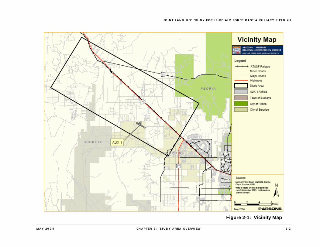
The Auxiliary Field #1 JLUS study area is defined by the location of the major approach and departure flight paths for operations at the Field (Figure 2-1). The study area, in the West Valley portion of the Phoenix metropolitan area, includes portions of the City of Surprise, the Town of Buckeye, and unincorporated Maricopa County. The Town of Wickenburg lies on the edge of the study area, although it is not impacted by overflights from operations at Auxiliary Field #1. This Chapter presents an overview of the existing conditions in the Auxiliary Field #1 study area, and briefly describes the area’s historical growth and development, as well as current development trends and growth potential. The chapter also presents overviews of airspace considerations, the military operations at Auxiliary Field #1, and the land ownership pattern in the study area.
2.1 HISTORICAL GROWTH AND DEVELOPMENT
2.1.1 Pre-1940
The first Anglo-American settlers arrived in western Maricopa County during the 1820s. However, the single event that transformed the West Valley into a well-traveled route used by gold prospectors and settlers alike was the California gold rush of the mid-1800s. It is estimated that by 1851 more than 60,000 people had passed through the Gila River Valley and adjacent areas on their journey to the California gold fields. On March 3, 1877, the Desert Land Act was passed by the U.S. Congress to encourage and promote economic development of the arid and semiarid public lands of the Western United States. The Act permitted settlers to obtain title to 640 acres of those public lands identified as arid and semiarid if they agreed to reclaim, irrigate, and cultivate the property within three years. By the 1890s, more than 100,000 acres of desert in the Salt and Gila River valleys had been irrigated, which attracted more settlers to the region. By the end of the 19th Century, Anglo settlement had increased due to the expanded presence of the U.S. Army, continued development of large-scale irrigation, the discovery of high-grade mineral deposits in nearby areas, and the opening of the railroad. Irrigation and agriculture production accelerated with the completion of Roosevelt Dam in 1911 and the entry of Arizona into the Union in 1912. Roosevelt Dam along with Waddell Dam, completed in 1927, successfully harnessed the Salt and Agua Fria Rivers, creating two new water sources for large-scale irrigation projects. After World War I, a number of settlements in the West Valley began to develop separate identities. Many of the workers involved in local cotton production gravitated to these settlements, including Surprise, which was founded in 1929. Additional settlement was spurred by the construction of Grand Avenue between Phoenix and Wickenburg as well as the construction of the Atchison, Topeka, and Santa Fe Railroad (now the Burlington Santa Fe) along Grand Avenue, linking Phoenix to Wickenburg and beyond.
JOINT LAND USE STUDY FOR LUKE AIR FORCE BASE AUXIL IARY F IELD #1
MAY 2004 CHAPTER 2 : S TUDY AREA OVERVIEW 2 -2
Figure 2-1: Vicinity Map
JOINT LAND USE STUDY FOR LUKE AIR FORCE BASE AUXIL IARY F IELD #1
MAY 2004 CHAPTER 2 : S TUDY AREA OVERVIEW 2 -3
2.2.2 Post-1940
In 1941, the U.S. Army selected a 1,440-acre site located in the center of the West Valley for a new military installation, Luke Army Airfield. Although the Base was decommissioned in 1946, at the end of the World War II, in its five years of operation over 12,000 fighter pilots had been trained there. The Army Airfield was reactivated as an Air Force Base in 1951 and has been involved in training U.S. and Allied pilots and operations and maintenance staff since that time. The post-World War II period brought many changes in land use patterns throughout the West Valley. Low-cost land and industrial decentralization attracted the electronics, aluminum, and aerospace industries to the region and industrial development brought with it rising numbers of employees, many of whom desired housing located in nearby areas. As a result, agriculture began to be replaced by residential development. The area’s pleasant climate and the ever-increasing use of air conditioning made the West Valley attractive to retirees, and retirement communities soon became part of the region’s growth pattern. Retail and service-related businesses followed the increasing population. In addition, office developers and distribution-related firms either moved from central Phoenix to the western suburbs or established additional facilities in those areas. Completion of the Central Arizona Project, Interstate 10, State Route 101 and other major roadways also had significant impacts on population growth and economic development in the West Valley as individuals, families, and businesses were able to move farther away from Phoenix’s central core, creating clustered development, satellite cities and numerous master planned communities. The City of Surprise was incorporated in 1960, and by 1990 had a population of just over 7,000 residents. Between 1990 and 2000, Surprise was the fastest growing city in the State, reaching a population of over 30,000, an increase of over 300 percent in ten years. The estimated population for the Surprise Municipal Planning Area (MPA) in 2002 was 45.125, and Surprise’s population is expected to reach 58,000 by the end of 2003. According to the Interim Projections of Population prepared by the Maricopa Association of Governments in July 2003, the projected 2030 population in the Surprise MPA is 395,500.
2.2 EXISTING DEVELOPMENT PATTERN
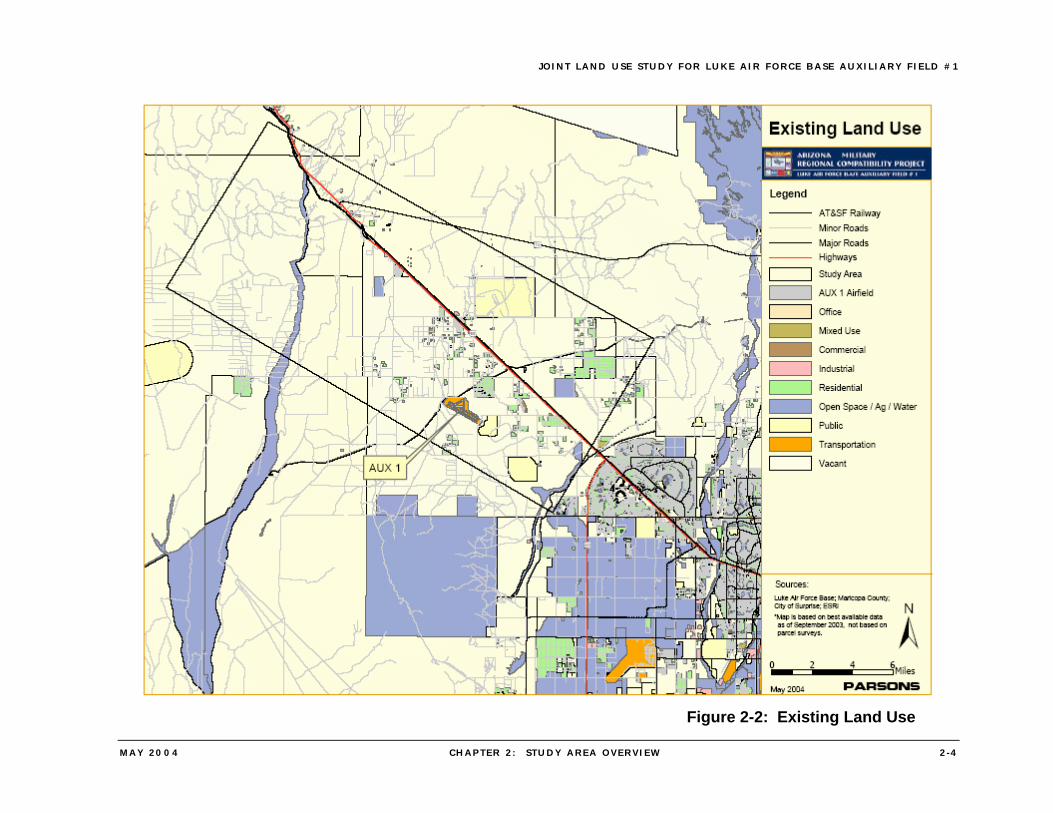
Western Maricopa County experienced relatively slow population growth for many decades as the land was converted from uninhabited Sonoran Desert to large scale and intensive agricultural uses. However, the construction and operation of Luke Army Airfield during World War II marked the beginning of a major transformation in the character of development in the area as the previously small communities began growing and became residential alternatives to the more urbanized City of Phoenix and its surroundings. These growth pressures slowly intensified, then accelerated over the past three decades, resulting in a transition from rural and agricultural uses to suburban uses, especially single-family residential development and associated retail and service uses (Figure 2-2).
JOINT LAND USE STUDY FOR LUKE AIR FORCE BASE AUXIL IARY F IELD #1
MAY 2004 CHAPTER 2 : S TUDY AREA OVERVIEW 2 -4
Figure 2-2: Existing Land Use

JOINT LAND USE STUDY FOR LUKE AIR FORCE BASE AUXIL IARY F IELD #1
MAY 2004 CHAPTER 2 : S TUDY AREA OVERVIEW 2 -5
2.3 GROWTH POTENTIAL AND PLANNED LAND USE (MUNICIPAL AND COUNTY)
The General Plans of the City of Surprise and the Towns of Buckeye and Wickenburg, and the Maricopa County Comprehensive Plan address land use, housing, economic development, environmental, and related planning issues within or adjacent to their boundaries. The Surprise General Plan 2020 was approved by the City’s voters in March 2001; the Buckeye General Plan Update was adopted in 2001; and the Maricopa County Comprehensive Plan (Maricopa County 2020, Eye to the Future) was adopted in October 1997. The Maricopa County Comprehensive Plan was last amended in August 2002. The Surprise General Plan was amended in December 2003. These Plans are regulated by various State laws, including the Growing Smarter and Growing Smarter Plus legislation and by ARS §28-8481, among others. The major issues driving the plans are future population growth and development and the various land uses and geographic areas that are required to enable that growth.
2.3.1 City of Surprise
The planning area for the Surprise General Plan 2020 is approximately 228 square miles and includes significant areas to the north and west of the current incorporated boundaries. The Plan estimates total build-out of the incorporated area and the planning area as ranging from 360,000 for low-range densities, to 510,000 for mid-range densities, to almost 670,000 at high-range densities. The Plan uses the mid-range density figure to calculate much of the future land use and population projections. However, much of the planning area is designated for low-density residential uses and the Plan acknowledges that as the City continues to grow, there will be pressure to re-designate land for higher density and higher intensity uses, which would have the effect of driving the total population higher than the high-range density estimate. The planning area is divided into five “Special Planning Areas” (SPA). SPAs 1, 2, and 3 are located within the “primary planning area” that includes lands that are anticipated to be developed over the next 20 years, while SPAs 4 and 5 are located within the “secondary planning area,” that is considered the City’s “sphere of influence.” Auxiliary Field #1 is located within SPA 3, which is bounded by Jomax Road to the north, Grand Avenue and the McMicken Dam to the east, White Tank Mountain Regional Park to the south, and the Town of Buckeye to the west and encompasses approximately 58.3 square miles of which 50 percent is currently in the incorporated boundaries of the City. SPA 3 is dominated by various existing large land uses including Volvo Proving Grounds, Northwest Regional Landfill, Phoenix Raceway, and Luke Air Force Base Auxiliary Field #1. These land uses are intended to remain into the foreseeable future. The SPA is also bisected by the Central Arizona Project Canal, which runs just west of Auxiliary Field #1, and a 640 KV power line corridor, and is adjacent to the northern boundary of the White Tank Mountain Regional Park. Sun Valley Parkway is a principal arterial that bisects the SPA connecting the planning area with the Town of Buckeye. With the exception of Sun Valley Parkway, the transportation system in SPA 3 has not been substantially developed. Operations at Auxiliary Field #1 also affect areas within the City’s SPAs 2, 4, and 5. SPA 2, located to the north of Grand Avenue and south of the Central Arizona Project Canal, is
JOINT LAND USE STUDY FOR LUKE AIR FORCE BASE AUXIL IARY F IELD #1
MAY 2004 CHAPTER 2 : S TUDY AREA OVERVIEW 2 -6
primarily undeveloped, with large washes and topography dominated by foothills. SPA 4, located to the west of SPA 3, is dominated by the Daimler-Chrysler Proving Ground, which occupies over 5,000 acres, and otherwise is sparsely developed with rural residential uses. SPA 5, which lies to the west of Auxiliary Field #1, includes three unincorporated rural communities (Circle City, Morristown and Whittmann) as well as large Arizona State Trust land holdings. In December 2003, the City of Surprise adopted three General Plan Amendments, including an amendment changing the planned land uses in the vicinity of Auxiliary Field #1, as well as an amendment extending the boundaries of the City’s Municipal Planning Area to the north of State Route 74. With the adoption of the General Plan Amendment for Auxiliary #1 Airfield Preservation (GPA 03-247), the Auxiliary Field #1 flight corridor will be buffered with employment uses, sparse residential development, and open space. Under the General Plan Amendment, the planned use for approximately 10.7 square miles (6,800 acres) of land in areas affected by operations at Auxiliary Field #1 was changed to the employment or airport preservation land use categories. Airport Preservation is a new land use category in which the primary use is intended to be employment-type land uses. It is located in areas to the northwest of Auxiliary Field #1, where service uses, proving grounds, office / warehouse, and or manufacturing-type industrial uses are encouraged. The Airport Preservation category is also intended to provide large-lot single-family housing in a rural setting, with homes on a minimum gross lot size of five acres or more, with most natural features of the land retained. The Employment land use category would accommodate professional offices and tourism / recreation uses in addition to the employment-type uses of the Airport Preservation category.
2.3.2 Town of Buckeye
Buckeye’s corporate limits contain approximately 200 square miles; most of the developed part of the Town is located south of Interstate 10, although much of the Town’s area for potential development is north of Interstate 10. The Town’s General Plan was adopted in 2001, and according to the Plan, numerous master planned communities have been approved or are being planned that include more than 160,000 dwelling units. This growth could add a projected 500,000 residents within the Town’s corporate boundaries. The westerly portion of the Auxiliary Field #1 JLUS study area is within the Buckeye Municipal Planning Area (MPA), and future land use in this part of the MPA is identified in the Town’s General Plan as Planned Community. Portions of the Festival Ranch Planned Community, located along Sun Valley Parkway, are within the JLUS study area; the Community, which is 10,000 acres in size is expected to have nearly 25,000 dwelling units.
2.3.3 City of Peoria
Established in the 1880s, Peoria was for many years a small agricultural community, but has now grown to a population of over 100,000. The City encompasses 170 square miles and its development has expanded outward from the original center, and particularly to the north in recent years. The City’s General Plan, as revised in 2002, anticipates a 2010 population of approximately 141,000; however, the areas designated for residential use in the Land Use Element would accommodate a substantially greater population, providing
JOINT LAND USE STUDY FOR LUKE AIR FORCE BASE AUXIL IARY F IELD #1
MAY 2004 CHAPTER 2 : S TUDY AREA OVERVIEW 2 -7
growth potential beyond 2010. The Land Use Element also contains goals and policies that support the preservation of Luke Air Force Base, including a policy to, “…respect Luke Air Force Base AICUZ and JLUS maps and departure and approach routes when considering developments that could potentially interfere with the Luke Air Force Base mission.” Although none of the City is under any of the Auxiliary Field #1 flight paths, some of the most westerly portions of the City are within 5 miles of the flight path used by pilots on departure from Auxiliary Field after the ILS approach. The planned development along the City’s western border is primarily low-density residential (2 to 5 dwelling units per acre) and open space.
2.3.4 Maricopa County
While Auxiliary Field #1 is located within the City of Surprise, lands within the vicinity of the Field to the east, west and northwest are unincorporated, and consequently their development is regulated by Maricopa County. These unincorporated lands are within the County’s White Tank / Grand Avenue Area Plan (WT / GAAP). In 1999, the County prepared the WT / GAAP to update several earlier plans that had been completed prior to 1993. Rapid growth and development in the West Valley in the intervening years as well as even more rapid growth that was projected for the future necessitated the update. The Maricopa Association of Governments population (MAG) projections show that the White Tank / Grand Avenue area population is expected to grow from approximately 172,000 in 2000 to 380,000 in 2020. Based on that estimate, the Plan estimates that approximately 4,000 acres of retail and general commercial land and about 3,050 acres of industrial land will be needed to satisfy the demand generated by the increased population. The WT / GAAP contains nine different goals, objectives and policies that address compatibility with Auxiliary Field #1, including policies that the County:
• Evaluate all new development within the WT / GAAP planning area to help ensure compatibility with operations at Luke Air Force Base auxiliary fields (Policy L2.2.2);
• Support and encourage all municipalities to adopt land use plans that are compatible with the continuing operation of Luke Air Force Base (Policy L2.2.3);
• Support efforts to determine the necessity of noise contours around Air Force auxiliary fields (Policy L2.2.5);
• Encourage agriculture and/or other compatible uses in areas within the 65 and higher Ldn noise contours (Policy L3.1.3); and
• Support development that is compatible with the Luke Auxiliary Base.
2.4 AUXILIARY FIELD #1 OPERATIONS
Auxiliary Field #1 is integral to the mission of Luke Air Force Base, which is the home of the 56th Fighter Wing (FW), an Air Education and Training Command unit, and is the world’s largest fighter training facility. The Base’s mission statement reads, “Train the world’s finest F-16 pilots and crew chiefs while providing agile combat support for air and space expeditionary forces.”
JOINT LAND USE STUDY FOR LUKE AIR FORCE BASE AUXIL IARY F IELD #1
MAY 2004 CHAPTER 2 : S TUDY AREA OVERVIEW 2 -8
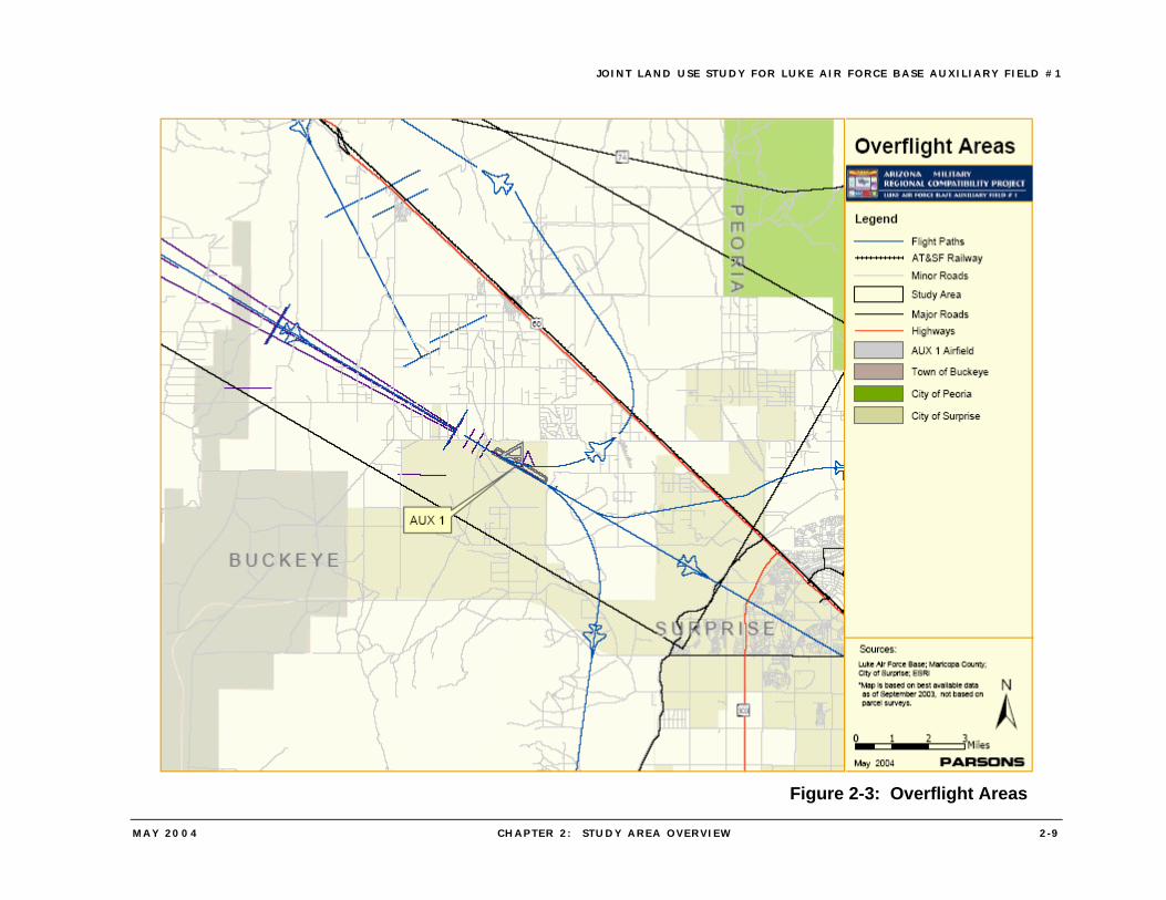
The 56th FW is the largest fighter wing in the world with eight fighter squadrons training all U.S. Air Force F-16 pilots. More than 900 pilots are trained yearly in a variety of syllabus courses for the F-16. Approximately 38,000 sorties and 50,000 hours are flown in the F-16 annually with 187 F-16 aircraft currently assigned to the 56th FW. The 56th FW also provides academic, simulator, and flying training and advanced F-16 training for Singapore and Taiwan Air Forces. Luke Air Force Base is also home to the 944th Fighter Wing; reserve instructor pilots from the Wing’s 301st Fighter Squadron train active-duty student pilots, using F-16s from the 56th FW. An additional 18 F-16s are assigned to the 944th Fighter Wing’s 302nd Fighter Squadron. Student pilots from Luke Air Force Base utilize Auxiliary Field #1, located about fifteen miles northwest of the Base, for instrument approach training. Over 12,000 training operations per year for instrument approach training bring the aircraft to an elevation ranging from 150 feet to 300 feet above the ground. The flight tracks for the operations at Auxiliary Field #1 are shown on Figure 2-3. The Tactical Air Navigation (TACAN) approach is a non-precision approach in which the pilot receives course guidance on the flight track from the navigation equipment but no glide path guidance. The Instrument Landing System (ILS) approach is a precision approach with both course and glide path guidance from the navigation equipment, as is the Precision Approach Radar (PAR) approach. Auxiliary Field #1 is one of the few Air Force fields in the United States with PAR facilities, which is important for training, as PAR is commonly used in overseas operations, particularly in combat areas. Although 12,000 operations occur annually at Auxiliary Field #1, the operations occur primarily during certain periods of time, and therefore residents, workers, and visitors around Auxiliary Field #1 are subject to military aircraft overflights on an irregular rather than a regular basis. In the Basic Course for new F-16 pilots, which typically covers a period of seven months, the use of Auxiliary Field #1 for instrument approaches occurs for a period of approximately two weeks during the second month of the course. There are then relatively few operations at Auxiliary Field #1 until the next Basic Course begins. As there typically is a new course starting every six weeks, there are 16 weeks of the year when high levels of operations occur at Auxiliary Field #1. Although there are established flight tracks that pilots are supposed to use, there are times when the aircraft do deviate from the flight track, especially those flown by student pilots. These deviations may range from one to as much as two miles from the established flight track.
JOINT LAND USE STUDY FOR LUKE AIR FORCE BASE AUXIL IARY F IELD #1
MAY 2004 CHAPTER 2 : S TUDY AREA OVERVIEW 2 -9
Figure 2-3: Overflight Areas
JOINT LAND USE STUDY FOR LUKE AIR FORCE BASE AUXIL IARY F IELD #1
MAY 2004 CHAPTER 2 : S TUDY AREA OVERVIEW 2 - 10
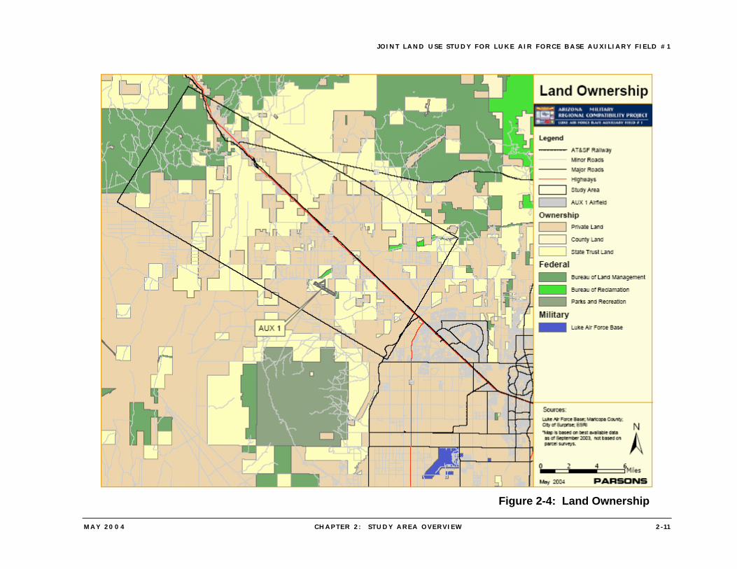
2.5 LAND OWNERSHIP
Land ownership in the vicinity of Auxiliary Field #1 can be divided into four principal classifications: federal, state, county / municipal, and private. The ownership patterns across the West Valley that are briefly described below are shown on the accompanying Figure 2-4: Land Ownership.
• Federal Lands – Bureau of Land Management (BLM) properties are scattered throughout the West Valley, with a number of these parcels located to the north and east of the future route of Loop 303 north of its intersection with Grand Avenue (U.S. 60). Luke Air Force Base, along with Auxiliary Field #1, constitutes the second largest concentration of federally owned property in the West Valley.
• State Trust Land – There are numerous parcels of State Trust Lands in the West Valley, and White Tank Mountain Regional Park is substantially encircled by State Trust Lands. Two major concentrations of Trust Lands are directly north of the Park (northwest of Auxiliary Field #1) and north of Bell Road (southeast of the Field). State Trust Lands to the northwest of Auxiliary Field #1 are under the approach patterns for the Field and are affected by potential noise and safety concerns due to the low flying aircraft, while areas to the southeast are under the departure routes and are similarly affected.
• County and Municipal Lands – Maricopa County operates White Tank Mountain Regional Park, which with 29,217 acres, is the largest park in the County system, and is located south of Auxiliary Field #1. A number of municipal properties, including parks and public building sites are also located in the Auxiliary Field #1 study area, primarily within the City of Surprise.
• Private Lands – The remaining lands in the Auxiliary Field #1 study area, which are the majority of the property in the study area, are in private ownership.
JOINT LAND USE STUDY FOR LUKE AIR FORCE BASE AUXIL IARY F IELD #1
MAY 2004 CHAPTER 2 : S TUDY AREA OVERVIEW 2 - 1 1
Figure 2-4: Land Ownership
JOINT LAND USE STUDY FOR LUKE AIR FORCE BASE AUXIL IARY F IELD #1
MAY 2004 CHAPTER 3 : REVIEW OF EXI ST ING LEG I SLATION 3 - 1
3. REVIEW OF EXISTING LEGISLATION
Land use compatibility within the vicinity of Auxiliary Field #1 is regulated by county and municipal laws and regulations. Neither the guidelines of the Department of Defense’s Air Installation Compatible Use Zone program nor the State of Arizona legislation concerning development around military airports is applicable to Auxiliary Field #1, because no takeoffs or landings occur at the field although pending legislation in the Arizona legislature would address compatibility of development around Auxiliary Field #1. At the present time, the AICUZ program and the State Statutes (specifically ARS §28-8481) contain the best available current guidance for land use compatibility and therefore this chapter includes a discussion of this guidance. The nature and status of the existing land use compatibility guidance (including federal, State and local guidelines and regulations) are addressed in the first section of this chapter, while the second section identifies differences between the federal and State compatibility guidelines. The final section summarizes the status of legislation or regulations in other states that is related to the operation of military facilities.
3.1 EXISTING LAND-USE COMPATIBILITY LEGISLATION, ORDINANCES AND GUIDELINES
3.1.1 U.S. Department of Defense
The Air Installation Compatible Use Zone (AICUZ) Program2 was implemented in 1973 by the U.S. Department of Defense to promote compatible land use development around military airfields. The AICUZ Program creates standard land-use guidelines for areas affected by possible noise exposure and accident potential combinations and provides local government jurisdictions with information that can be used to regulate land use and development. Included in the AICUZ program is a table of accident potential zones, noise zones, and guidance concerning the compatibility of various uses. The Air Force adopted the NOISEMAP computer model to describe noise impacts created by aircraft operations. NOISEMAP is one of two Environmental Protection Agency (EPA) approved models. The other is the Integrated Noise Model (INM), which is used by the Federal Aviation Administration (FAA) for civilian airports. In 1974, EPA designated the noise descriptor “Ldn,” or Day-Night Average Sound Level as the standard measurement for noise impacts. Ldn refers to the average sound level exposure, measured in decibels, over a 24-hour period, with a 10-decibel penalty added to sound levels for operations occurring during the hours of 10 p.m. to 7 a.m. This penalty is applied due to the increased annoyance created by noise events that occur during this time. Ldn is a quantity that can be calculated directly at a specific location. Accident Potential Zones (APZs) are one aspect of the AICUZ program where military application differs from civilian airfields. An analysis of aircraft accidents worldwide 2Guidance for the United States Air Force AICUZ program is contained in Air Force Instruction 32-7063, Air
Installation Compatible Use Zone Program, which implements Department of Defense Instruction 4165.57, Air Installations Compatible Use Zones.
JOINT LAND USE STUDY FOR LUKE AIR FORCE BASE AUXIL IARY F IELD #1
MAY 2004 CHAPTER 3 : REVIEW OF EXI ST ING LEG I SLATION 3 -2
within 10 nautical miles of a military airfield for the period of 1968–1972 led to defining areas of high accident potential known as the Clear Zone (CZ), Accident Potential Zone I (APZ-I), and Accident Potential Zone II (APZ-II). The majority of these accidents (62 percent) occurred either on or adjacent to the airfield or within the CZ, while about 8 percent occurred in APZ-I and 5 percent in APZ-II. It was concluded that the Clear Zone warranted special attention due to the high incident of accident potential that severely limited acceptable land uses. The Air Force has spent approximately $65 million to acquire real property interests within the clear zones at bases nationwide. The percentages of accidents within the two APZs are such that some land use control is essential. The Air Force recommendation for the APZs is to limit the number of people exposed to noise and safety hazards through appropriate land use planning.
3.1.2 State of Arizona
In the 1990s through 2003, the State of Arizona passed legislation to address the issue of residential and other compatibility issues around Arizona’s military airports. The major statutes, including ARS §28-8481 and ARS §28-8461, require political subdivisions in the vicinity of a military airport to adopt land use plans and enforce zoning regulations that assure development compatible with the high-noise and accident potential generated by military airport operations. State legislation, specifically ARS §28-8481, also regulates land uses in hazard zones and high-noise areas, but allows a landowner to undertake development of property for which a development plan was approved before December 31, 2000, even though the uses may not be compatible with the regulations under ARS §28-8481. It is the responsibility of the local jurisdiction and landowner to work cooperatively on these “grandfathered” plans to mitigate potential future development conflicts where possible. The provisions of the various statutes related to the operation of military airports are summarized in Appendix A.
3.1.3 Local Jurisdictions
Regulations and ordinances that typically may be implemented by local political jurisdictions include, zoning, military airport zoning, airport impact and noise overlay districts, notification areas, building code insulation (noise attenuation), and navigational easements. Interior noise level reductions related to noise generated by the operation of military aircraft are addressed in the Uniform Building Code adopted by the City of Surprise, City of Peoria, and Maricopa County. In 1978, the County passed a zoning ordinance that specifically addresses encroachment around Luke Air Force Base: Military Airport Zoning Ordinance for the Unincorporated Area of Maricopa County. That ordinance restricts development and helps deter encroachment through establishment of different uses and levels of lot coverage, intensity of use, yard regulations and lot size, etc. and by encouraging development that is compatible with the continued operation of military airports. However, this ordinance does not apply to Auxiliary Field #1. The Maricopa County Comprehensive Plan also addresses the need for compatible land use planning; specifically, Policy L4.3 encourages development patterns and standards compatible with the continuing operation of military and civilian airports, and other noise generating employment centers and the White Tank / Grand
JOINT LAND USE STUDY FOR LUKE AIR FORCE BASE AUXIL IARY F IELD #1
MAY 2004 CHAPTER 3 : REVIEW OF EXI ST ING LEG I SLATION 3 -3
Avenue Area Plan includes goals policies and objectives (as described in Section 2.3.4) addressing compatibility with Auxiliary Field #1. The County also has requirements for notification to future home owners regarding military aircraft operations, including posting various forms of notification in the sales offices, notification on plats and public reports, and disclosure in Covenants, Conditions &Restrictions (CC&Rs) for housing developments. In addition, to the policies and land use designations related to Airport Preservation in the it’s General Plan (as described in Section 2.3.1), the City of Surprise has adopted a requirement that a copy of the City’s “Surprise / Luke Notification Map” be posted in all real estate offices in the City. The Map contains a notice that all homes within the City of Surprise are subject to aircraft overflights from Luke Air Force Base. The Map also shows the noise contours for Luke Air Force Base, but the map does not show any noise contours for Auxiliary Field #1.
3.2 DIFFERENCES BETWEEN FEDERAL AND STATE GUIDANCE FOR COMPATIBLE USES
In 1995, the State of Arizona passed legislation, ARS §28-8481, requiring all political subdivisions in the vicinity of a military airport to adopt land use plans and enforce zoning regulations that assure development compatible with the high noise and accident potential generated by military airport operations. That legislation created a table of compatibility with reference to hazard zones and high noise areas. The tables concerning compatible land use in AICUZ and ARS §28-8481 do not address the same hazard zones and they organize the noise zones differently. For example, ARS §28-8481 does not recognize or identify a Clear Zone nor does it regulate uses in that high hazard zone, and an additional noise zone, 85+ decibels, is included in ARS §28-8481 that is not identified in the AICUZ Program. Certain uses allowed in the AICUZ Guidance are not permitted under Arizona law and uses that are not recommended in the AICUZ guidelines are allowed under Arizona law. Specific land use categories addressed in the AICUZ guidelines are not addressed in ARS §28-8481. Examples of this inconsistency include schools and public assembly uses, which are not listed as separate land uses in the State legislation but are listed in the AICUZ guidelines. The AICUZ guidelines list wholesale trade, retail sale of building materials and automobiles, business services, repair services as compatible uses in APZ I and APZ II, and also lists a variety of service uses, amusements, recreation, and single-family residential up to two dwelling units per acre as compatible uses in APZ II. The AICUZ guidelines (Table 3-1) also list most types of retail trade and services as compatible within noise zones 65 Ldn through 79 Ldn. Single-family residential, schools, churches, hospitals, and retail-food uses are listed as compatible in noise categories 65 to 74 decibels. Public assembly uses are listed as compatible in the 65-69 Ldn category.
JOINT LAND USE STUDY FOR LUKE AIR FORCE BASE AUXIL IARY F IELD #1
MAY 2004 CHAPTER 3 : REVIEW OF EXI ST ING LEG I SLATION 3 -4
Table 3-1: Compatibility of Uses – AICUZ Program
Source: Prepared by Parsons from U.S. Air Force data.
In ARS §28-8481, indoor recreation, and several types of commercial-retail trade, wholesale trade, retail sale of building materials and government services are permitted within APZ II and noise zones 65 Ldn through 79 Ldn (see Table 3-2). Outdoor amphitheaters and music shells, retail sale of general merchandise, retail apparel, water-based recreation, eating and drinking, and retail-food uses are permitted within noise zones 65 Ldn through 79 Ldn. Churches, medical and health services, auditoriums and concert halls, and other public and quasi-public services are permitted within noise zones 65 Ldn through 74 Ldn.
Table 3-2: Compatibility of Uses – ARS §28-8481
Source: Prepared by Parsons from ARS §28-8481 data.
Although ARS §28-8481 does not permit single-family residential uses in any of the hazard or noise zones (Table 3-2), it is silent about uses in the Clear Zone, since the law does not define such a zone.
3 Suggested maximum density of 1-2 dwelling units per acre 4The use is allowed in the AICUZ Guidance but is not permitted under Arizona law. 5Schools as a specific land use category are not addressed in ARS §28-8481; the data provided above are for the
category: Other Public and Quasi-Public Services. 6Public Assembly as a specific land use category is not addressed and it is not defined in ARS §28-8481; the data
provided above are for the category: Other Public and Quasi-Public Services. 7The use is allowed under Arizona law, but not under the AICUZ Program.
Selected Land Uses Clear Zone APZ I APZ II 65-69 Ldn
70-74 Ldn
75-80Ldn
80+ Ldn
Single-Family Residential N N Y3 Y Y N N Schools N N N Y Y N N Churches N N N Y Y N N Hospitals N N N Y Y N N Public Assembly N N N Y N N N Outdoor Amphitheaters N N N N N N N Retail-Food N N Y Y Y Y N
Selected Land Uses APZ I APZ II 65-69 Ldn
70-74 Ldn
75-79 Ldn
80-84 Ldn
85+ Ldn
Single-Family Residential N N4 N3 N3 N N N Schools5 N N N N N N N Churches N N Y Y N N N Hospitals N N Y Y N N N Public Assembly6 N N N N N N N Outdoor Amphitheaters N N Y7 Y6 Y6 N N Retail-Food N N3 Y Y Y N N
JOINT LAND USE STUDY FOR LUKE AIR FORCE BASE AUXIL IARY F IELD #1
MAY 2004 CHAPTER 4 : TRENDS AND I S SUES 4 - 1
4. TRENDS AND ISSUES
Regional growth trends in western Maricopa County directly and indirectly affect the ability of Auxiliary Field #1 to carry out its present and future mission by generating demand for new housing and related facilities; and this creates issues of compatibility due to the increased tempo of development of residential and other urban and suburban uses in the vicinity of the Field.
4.1 REGIONAL GROWTH TRENDS
The Phoenix Metropolitan area has been one of the fastest growing metropolitan areas in the nation. Over the last forty years (1960-2000), the metropolitan area population, as measured by all of Maricopa County, more than quadrupled from 664,000 to more than three million. Throughout that forty-year period, growth has continually spread outward from the center of Phoenix to the suburbs. Through the periods of the 1970s, 1980s, and 1990s much of the growth was concentrated in the eastern portion of Maricopa County. That concentration of growth followed the substantial expansion and improvement of U.S. Route 60 “Superstition Freeway” which, in conjunction with Interstate 10, connects the East Valley to the Phoenix Central Business District. The extent of development in the East Valley is best illustrated through simple analysis of the population growth in the East Valley over time. Table 4-1 illustrates the growth of several key cities in the East Valley, as substantial growth occurred in each of the listed East Valley municipalities over an extended period. The leading edge of that growth moved further east (away from central Phoenix) as time continued, with the most recent growth occurring in the furthest eastern jurisdictions.
Table 4-1: Growth of Sample East Valley Cities
City 1960 1970 1980 1990 2000 Tempe 25,000 64,000 107,000 142,000 159,000 Percent Change 155% 68% 33% 12% Mesa 34,000 63,000 152,000 288,000 396,000 Percent Change 87% 142% 89% 38% Chandler 9,000 14,000 30,000 90,000 177,000 Percent Change 44% 116% 203% 97% Gilbert 2,000 2,000 6,000 29,000 110,000 Percent Change 8% 190% 409% 277%
Source: U.S. Census Bureau
Today, a similar pattern is currently occurring and will continue in western Maricopa County. In the late 1980s, the last portion of Interstate 10 was completed, linking the West Valley to the Phoenix Central Business District, this connection has served as a similar catalyst for development in the West Valley as the substantial expansion and improvement
JOINT LAND USE STUDY FOR LUKE AIR FORCE BASE AUXIL IARY F IELD #1
MAY 2004 CHAPTER 4 : TRENDS AND I S SUES 4 -2
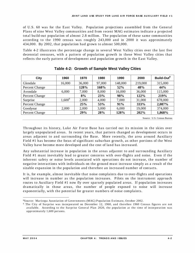
of U.S. 60 was for the East Valley. Population projections assembled from the General Plans of nine West Valley communities and from recent MAG estimates indicate a projected total build-out population of almost 2.8 million. The population of these same communities according to the 1990 census was roughly 243,000 and in 2000 it was approximately 434,000. By 2002, that population had grown to almost 500,000. Table 4-2 illustrates the percentage change in several West Valley cities over the last five decennial censuses, with a pattern of population growth in these West Valley cities that reflects the early pattern of development and population growth in the East Valley.
Table 4-2: Growth of Sample West Valley Cities
City 1960 1970 1980 1990 2000 Build-Out8 Glendale 16,000 36,000 97,000 148,000 219,000 315,000 Percent Change 128% 168% 52% 48% 44% Avondale 6,000 7,000 8,000 16,000 36,000 115,000 Percent Change 8% 23% 98% 122% 219% Surprise 1,6009 2,000 4,000 7,000 31,000 678,000 Percent Change 25% 53% 91% 333% 2,087% Goodyear 2,000 2,000 3,000 6,000 19,000 374,000 Percent Change 29% 28% 128% 202% 1,868%
Source: U.S. Census Bureau
Throughout its history, Luke Air Force Base has carried out its mission in the skies over largely unpopulated areas. In recent years, that pattern changed as development occurs in areas adjacent to and surrounding the Base. More recently, the area around Auxiliary Field #1 has become the focus of significant suburban growth, as other portions of the West Valley have become more developed and the cost of land has increased. Any substantial increase in population in the areas adjacent to and surrounding Auxiliary Field #1 must inevitably lead to greater concerns with over-flights and noise. Even if the inherent safety or noise levels associated with operations do not increase, the number of negative interactions with individuals on the ground must increase simply as a result of the sizable expansion in the population and therefore an increased number of contacts. It is, for example, almost inevitable that noise complaints due to over-flights and operations will increase in number as the population increases. Pilots on the instrument approach routes to Auxiliary Field #1 now fly over sparsely populated areas. If population increases dramatically in those areas, the number of people exposed to noise will increase exponentially, with the potential for greater numbers of noise complaints. 8Source: Maricopa Association of Governments (MAG) Population Estimate, October 2002. 9 The City of Surprise was incorporated on December 12, 1960, and therefore 1960 Census figures are not
available. According to the Surprise General Plan 2020, the population at the time of incorporation was approximately 1,600 persons.
JOINT LAND USE STUDY FOR LUKE AIR FORCE BASE AUXIL IARY F IELD #1
MAY 2004 CHAPTER 4 : TRENDS AND I S SUES 4 -3
4.2 DEVELOPMENT ISSUES
Today, the West Valley is one of the fastest growing regions in Arizona and in the country. Among the many reasons for this growth are the close proximity of the West Valley to Phoenix, available water, flat land that is easy to develop, and access to the region’s highway network. The benefits of this development include additional choices for residential location, a mix of housing types that range from moderate to upper end, and increased employment opportunities that are relatively close to home. The growth and development in the West Valley, has resulted in the rapid urbanization of previously rural and agricultural areas, with uses of higher density and intensity, especially single-family residences, schools, churches, and commercial centers. Residential development in the West Valley has surged ahead of the employment base and relatively little industrial development has occurred in the area because of a number of factors, including competition with long-established and more centralized industrial areas well served by the regional transportation network. Today, many of the municipalities are in effect bedroom communities with a growing but modest employment component. For many years, the area around Auxiliary Field #1 was predominantly rural in character with scattered residences and a very low population density, and even today, much of the land around the Field has a rural character. However, recent residential development has increased the population density in some areas in the vicinity of the Field, with development underway of housing at densities of one dwelling unit per acre, and proposed development with higher densities. As discussed in Chapter 5 of this JLUS, the increased population, and the increased residential density, exposes more people to potential noise and safety impacts from operations at Auxiliary Field #1.
JOINT LAND USE STUDY FOR LUKE AIR FORCE BASE AUXIL IARY F IELD #1
MAY 2004 CHAPTER 5 : LAND USE COMPATIBIL ITY 5 - 1
5. LAND USE COMPATIBILITY
The ability of Auxiliary Field #1 to maintain operational capabilities, which is critical to Luke Air Force Base’s mission today and into the future, is related in large part to the compatibility of the land uses in the vicinity of the Field. Through recognizing that the West Valley is a major focus for expansion of urban development in metropolitan Phoenix, it is essential to define land uses that contribute to the balanced growth of the area that are compatible with the operations of the Field, while also contributing to the balanced growth of the area.
5.1 NOISE AND SAFETY CONSIDERATIONS
5.1.1 Noise
Noise is “unwanted sound” and can be perceived as a nuisance that disturbs our routine activities or our peace, and at louder levels may cause feelings of mounting annoyance, irritation, or anger. The loudness of sounds is dependent upon many factors, including sound pressure level and frequency content, and within the usual range of environmental noise levels, perception of loudness is relatively predictable. Which sounds are perceived as noise may vary among listeners and what is not objectionable to some can be bothersome to others. Aircraft noise may be experienced as particularly annoying because it may startle people, cause windows to rattle and houses to shake, or cause people to fear a crash. In addition to varying levels of annoyance, adverse impacts associated with exposure to noise include interruption of sleep and conversation. Studies determined that at least 75 percent of sleeping people will be awakened if exposed to single-event noises over 74 decibels. Some common terms used in assessing the effects of noise are:
• The Decibel (dB) is the unit used to measure the magnitude or intensity of sound. Decibel means 1/10 of Bel (named after Alexander Graham Bell). The decibel uses a logarithmic scale to cover the very large range of sound pressures that can be heard by the human ear. Under the decibel unit of measure, a 10 dB increase will be perceived by most people to be a doubling in loudness (80 dB seems twice as loud as 70 dB).
• The A-weighted Decibel (dBA) is the most common unit used for measuring environmental sound levels. It adjusts, or weights, the frequency components of sound to conform with the normal response of the human ear at conversational levels. dBA is an international metric that is used for assessing environmental noise exposure of all noise sources.
• The Day-night Average Sound Level (Ldn) is the level of noise expressed (in decibels) as a 24-hour average. Nighttime noise, between the hours of 10:00 p.m. and 7:00 a.m. is weighted; that is, given an additional 10 decibels to compensate for sleep interference and other disruptions caused by nighttime noise. Ldn is used by all Federal agencies (Environmental Protection Agency, Department of Housing and
JOINT LAND USE STUDY FOR LUKE AIR FORCE BASE AUXIL IARY F IELD #1
MAY 2004 CHAPTER 5 : LAND USE COMPATIBIL ITY 5 -2
Urban Development, Department of Energy, Department of Defense, etc.) and internationally in the assessment of potential noise impacts.
To address noise problems in a logical manner, it is necessary to measure sound levels. Sound levels are plotted in units of A-weighted decibels (abbreviated dB, or sometimes dBA), a logarithmic measure of the magnitude of a sound as the average person hears it. The “A-weighting” accounts for the fact that humans do not hear low frequencies and high frequencies as well as they hear middle frequencies. The weighting corrects for the relative efficiency of the human ear at the different frequencies. One obvious way of describing the sound environment is to measure maximum sound levels. For example, a nearby motorcycle may generate 73 dB. But an aircraft engine sound, although perhaps not perceived as loud as the motorcycle owing to the distance of the observer from the aircraft, tends to last much longer. Since studies have shown that human response to noise involves both the maximum level and its duration, the maximum sound level alone is not sufficient to evaluate the effects of noise on people. An additional important factor in measuring a sound environment is the occurrence of sound events at night. People are normally more sensitive to intrusive sound events at night and background sound levels are normally lower at night because of decreased human activity. Therefore, a “penalty” may be added to sound levels that occur during night hours. By accepted scientific convention, a 10 decibel penalty is added to sound levels occurring between 10:00 p.m. and 7:00 a.m. the following morning. This 10 dB penalty means that one nighttime sound event is equivalent to 10 daytime events of the same level. The 24-hour average sound level, including the 10 dB penalty, is known as the day-night average sound level (Ldn). Extensive research has found that the day-night average sound level correlates very well with community annoyance from most environmental noise sources. A measure of noise impact, such as the day-night average sound level, provides a reliable indicator of overall community response but does not indicate how any single individual will respond. As a result, there is probably no minimum level of transportation-related noise at which no one is annoyed. Relying on a considerable body of scientific research on noise impacts, federal agencies have adopted guidelines for compatible land uses and environmental sound levels. Compatible land uses are normally determined by planning and zoning regulations that segregate types of activities, such as residential, industrial, or commercial. Noise levels that are unacceptable for homes may be quite acceptable for other uses, such as agriculture or certain industries. General guidelines for noise compatibility identify sound levels between 55 and 60 dB as “moderate exposure” and as generally acceptable for residential uses. Both the Department of Defense’s Air Installation Compatible Use Zone (AICUZ) guidance and the Federal Aviation Administration’s Airport Noise Compatibility Planning Toolkit discourage residential use in the 65 Ldn contour and higher. Noise contours for current operations at Auxiliary Field #1 were prepared in early 2004 based upon use of the F-16, which is the aircraft presently flown by pilots from Luke Air Force Base for the training at Auxiliary Field #1 (Figure 5-1). The contours are based upon a routine active day when operations are occurring at the Field; the total number of operations on the active day is 78, consisting of 39 approaches and the same number of departures. While the contours developed for the F-16 provide a basis for determining the
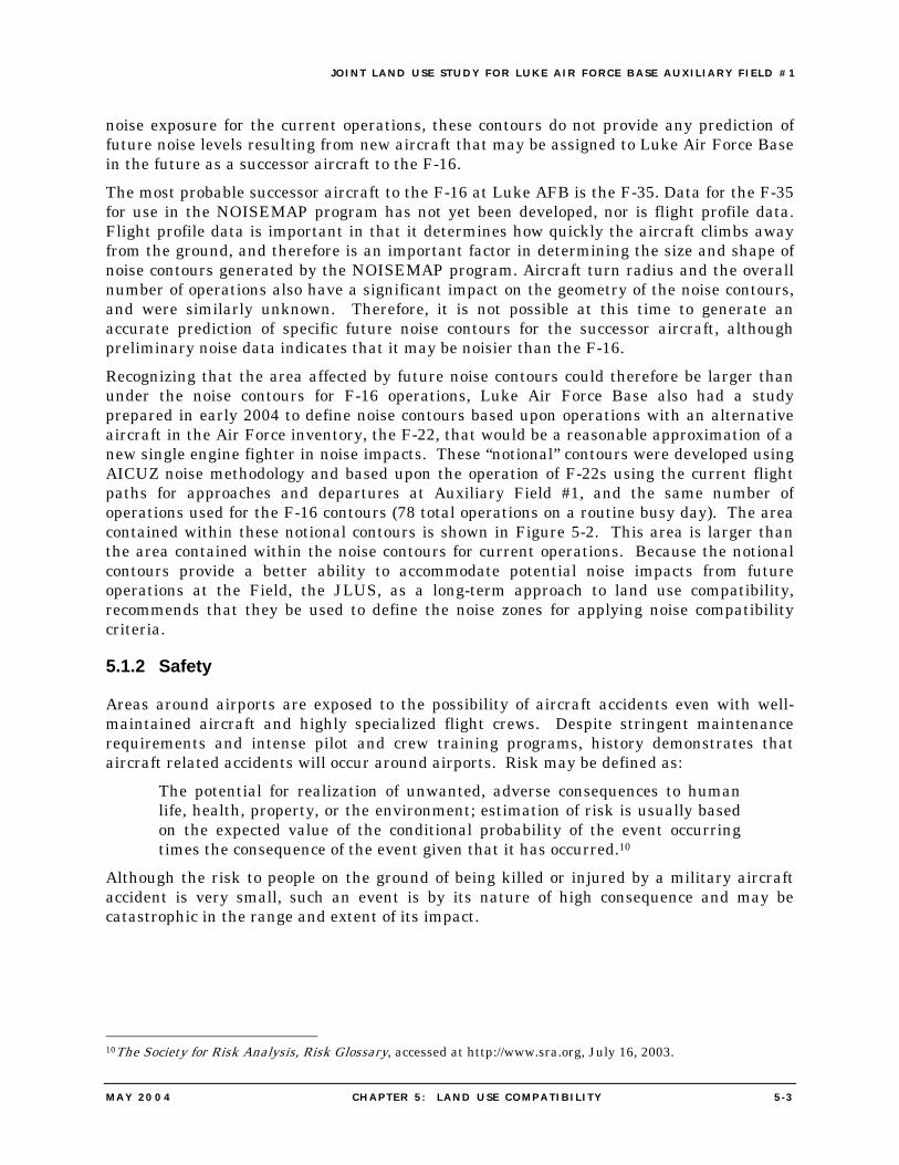
JOINT LAND USE STUDY FOR LUKE AIR FORCE BASE AUXIL IARY F IELD #1
MAY 2004 CHAPTER 5 : LAND USE COMPATIBIL ITY 5 -3
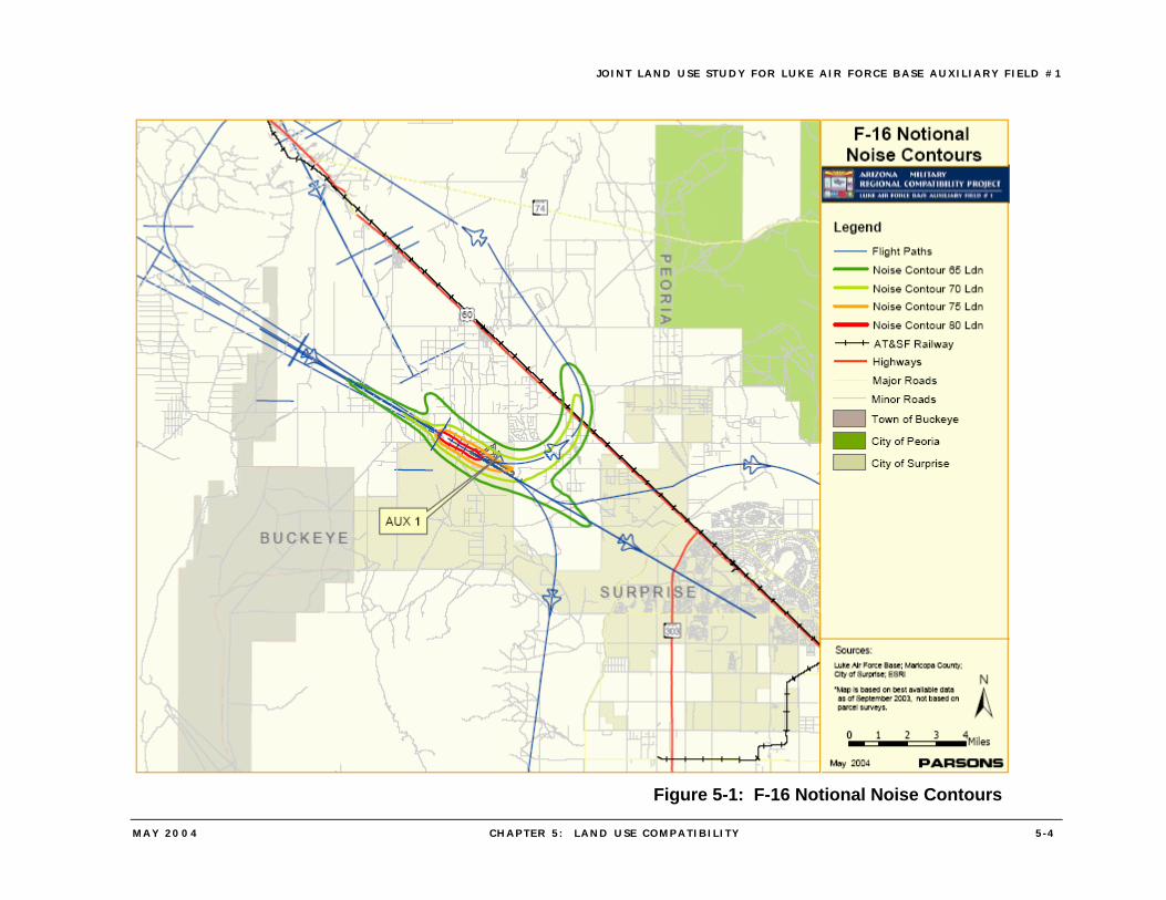
noise exposure for the current operations, these contours do not provide any prediction of future noise levels resulting from new aircraft that may be assigned to Luke Air Force Base in the future as a successor aircraft to the F-16. The most probable successor aircraft to the F-16 at Luke AFB is the F-35. Data for the F-35 for use in the NOISEMAP program has not yet been developed, nor is flight profile data. Flight profile data is important in that it determines how quickly the aircraft climbs away from the ground, and therefore is an important factor in determining the size and shape of noise contours generated by the NOISEMAP program. Aircraft turn radius and the overall number of operations also have a significant impact on the geometry of the noise contours, and were similarly unknown. Therefore, it is not possible at this time to generate an accurate prediction of specific future noise contours for the successor aircraft, although preliminary noise data indicates that it may be noisier than the F-16. Recognizing that the area affected by future noise contours could therefore be larger than under the noise contours for F-16 operations, Luke Air Force Base also had a study prepared in early 2004 to define noise contours based upon operations with an alternative aircraft in the Air Force inventory, the F-22, that would be a reasonable approximation of a new single engine fighter in noise impacts. These “notional” contours were developed using AICUZ noise methodology and based upon the operation of F-22s using the current flight paths for approaches and departures at Auxiliary Field #1, and the same number of operations used for the F-16 contours (78 total operations on a routine busy day). The area contained within these notional contours is shown in Figure 5-2. This area is larger than the area contained within the noise contours for current operations. Because the notional contours provide a better ability to accommodate potential noise impacts from future operations at the Field, the JLUS, as a long-term approach to land use compatibility, recommends that they be used to define the noise zones for applying noise compatibility criteria.
5.1.2 Safety
Areas around airports are exposed to the possibility of aircraft accidents even with well-maintained aircraft and highly specialized flight crews. Despite stringent maintenance requirements and intense pilot and crew training programs, history demonstrates that aircraft related accidents will occur around airports. Risk may be defined as:
The potential for realization of unwanted, adverse consequences to human life, health, property, or the environment; estimation of risk is usually based on the expected value of the conditional probability of the event occurring times the consequence of the event given that it has occurred.10
Although the risk to people on the ground of being killed or injured by a military aircraft accident is very small, such an event is by its nature of high consequence and may be catastrophic in the range and extent of its impact.
10The Society for Risk Analysis, Risk Glossary, accessed at http://www.sra.org, July 16, 2003.
JOINT LAND USE STUDY FOR LUKE AIR FORCE BASE AUXIL IARY F IELD #1
MAY 2004 CHAPTER 5 : LAND USE COMPATIBIL ITY 5 -4
Figure 5-1: F-16 Notional Noise Contours
JOINT LAND USE STUDY FOR LUKE AIR FORCE BASE AUXIL IARY F IELD #1
MAY 2004 CHAPTER 5 : LAND USE COMPATIBIL ITY 5 -5
Figure 5-2: F-22 Notional Noise Contours
JOINT LAND USE STUDY FOR LUKE AIR FORCE BASE AUXIL IARY F IELD #1
MAY 2004 CHAPTER 5 : LAND USE COMPATIBIL ITY 5 -6
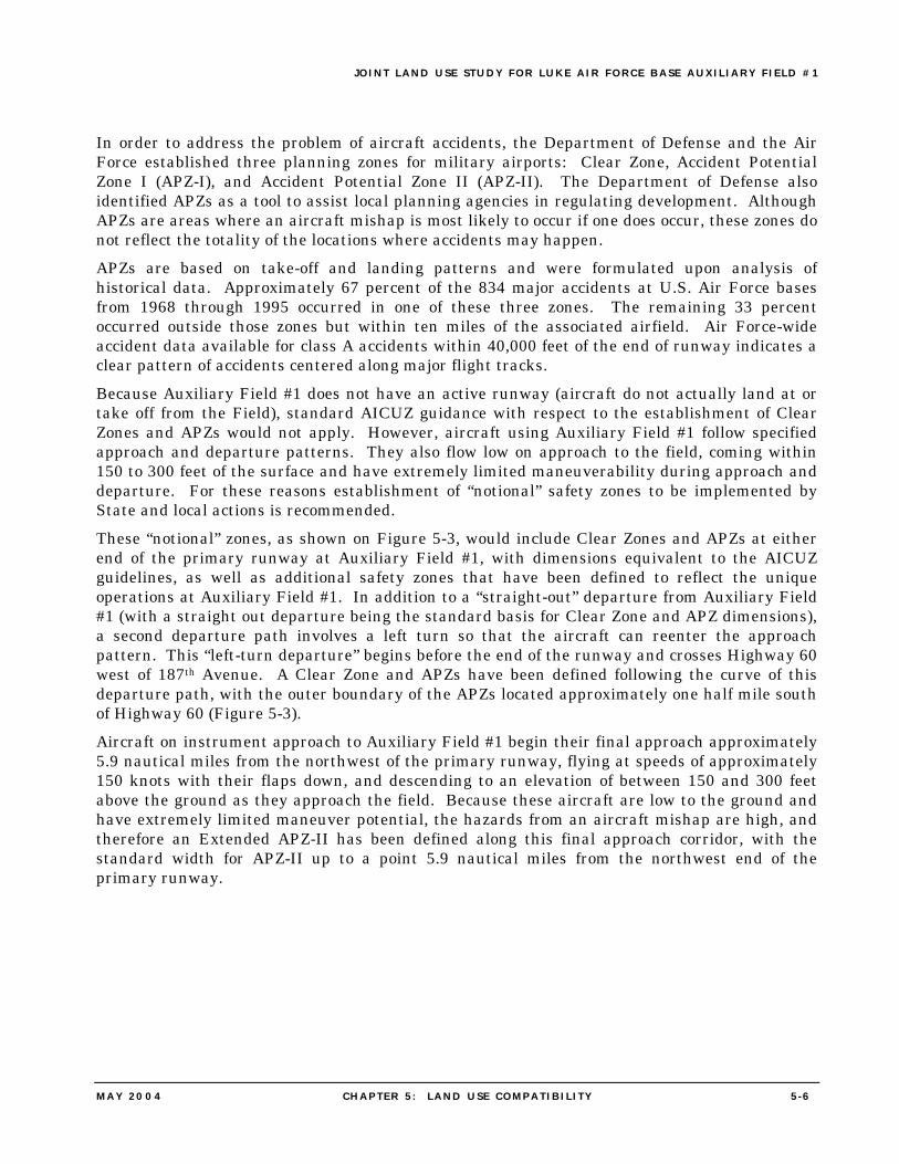
In order to address the problem of aircraft accidents, the Department of Defense and the Air Force established three planning zones for military airports: Clear Zone, Accident Potential Zone I (APZ-I), and Accident Potential Zone II (APZ-II). The Department of Defense also identified APZs as a tool to assist local planning agencies in regulating development. Although APZs are areas where an aircraft mishap is most likely to occur if one does occur, these zones do not reflect the totality of the locations where accidents may happen. APZs are based on take-off and landing patterns and were formulated upon analysis of historical data. Approximately 67 percent of the 834 major accidents at U.S. Air Force bases from 1968 through 1995 occurred in one of these three zones. The remaining 33 percent occurred outside those zones but within ten miles of the associated airfield. Air Force-wide accident data available for class A accidents within 40,000 feet of the end of runway indicates a clear pattern of accidents centered along major flight tracks. Because Auxiliary Field #1 does not have an active runway (aircraft do not actually land at or take off from the Field), standard AICUZ guidance with respect to the establishment of Clear Zones and APZs would not apply. However, aircraft using Auxiliary Field #1 follow specified approach and departure patterns. They also flow low on approach to the field, coming within 150 to 300 feet of the surface and have extremely limited maneuverability during approach and departure. For these reasons establishment of “notional” safety zones to be implemented by State and local actions is recommended. These “notional” zones, as shown on Figure 5-3, would include Clear Zones and APZs at either end of the primary runway at Auxiliary Field #1, with dimensions equivalent to the AICUZ guidelines, as well as additional safety zones that have been defined to reflect the unique operations at Auxiliary Field #1. In addition to a “straight-out” departure from Auxiliary Field #1 (with a straight out departure being the standard basis for Clear Zone and APZ dimensions), a second departure path involves a left turn so that the aircraft can reenter the approach pattern. This “left-turn departure” begins before the end of the runway and crosses Highway 60 west of 187th Avenue. A Clear Zone and APZs have been defined following the curve of this departure path, with the outer boundary of the APZs located approximately one half mile south of Highway 60 (Figure 5-3). Aircraft on instrument approach to Auxiliary Field #1 begin their final approach approximately 5.9 nautical miles from the northwest of the primary runway, flying at speeds of approximately 150 knots with their flaps down, and descending to an elevation of between 150 and 300 feet above the ground as they approach the field. Because these aircraft are low to the ground and have extremely limited maneuver potential, the hazards from an aircraft mishap are high, and therefore an Extended APZ-II has been defined along this final approach corridor, with the standard width for APZ-II up to a point 5.9 nautical miles from the northwest end of the primary runway.
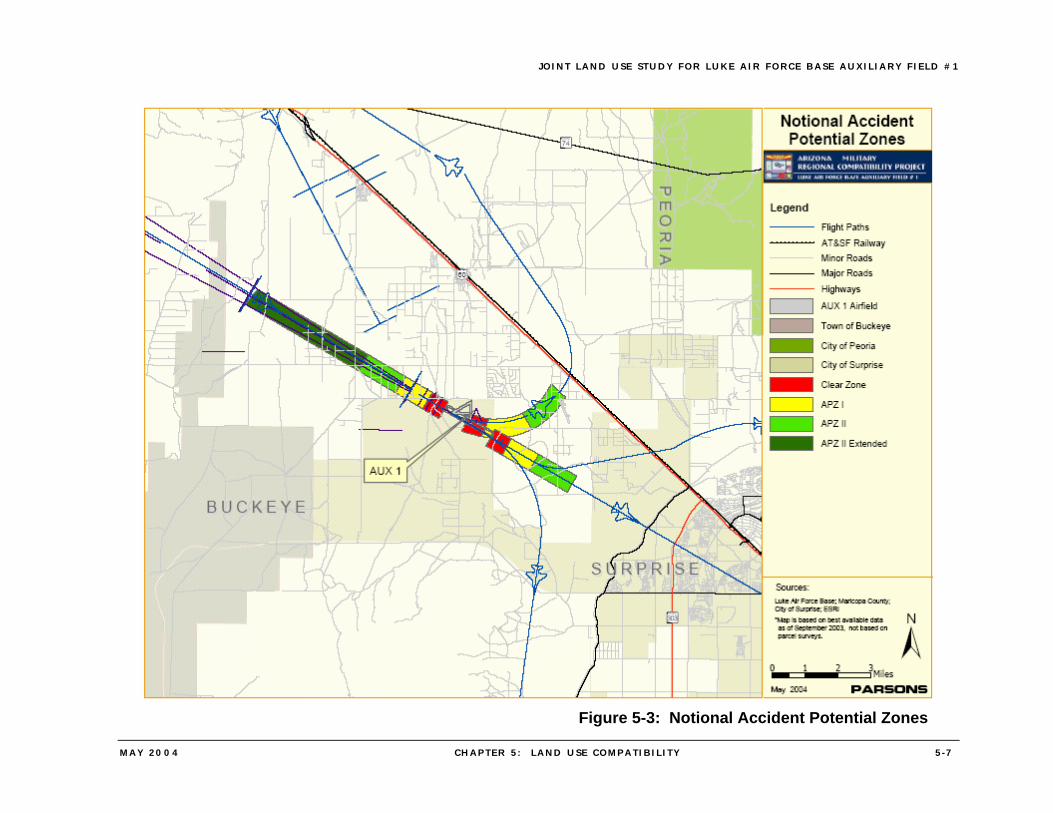
JOINT LAND USE STUDY FOR LUKE AIR FORCE BASE AUXIL IARY F IELD #1
MAY 2004 CHAPTER 5 : LAND USE COMPATIBIL ITY 5 -7
Figure 5-3: Notional Accident Potential Zones
JOINT LAND USE STUDY FOR LUKE AIR FORCE BASE AUXIL IARY F IELD #1
MAY 2004 CHAPTER 5 : LAND USE COMPATIBIL ITY 5 -8
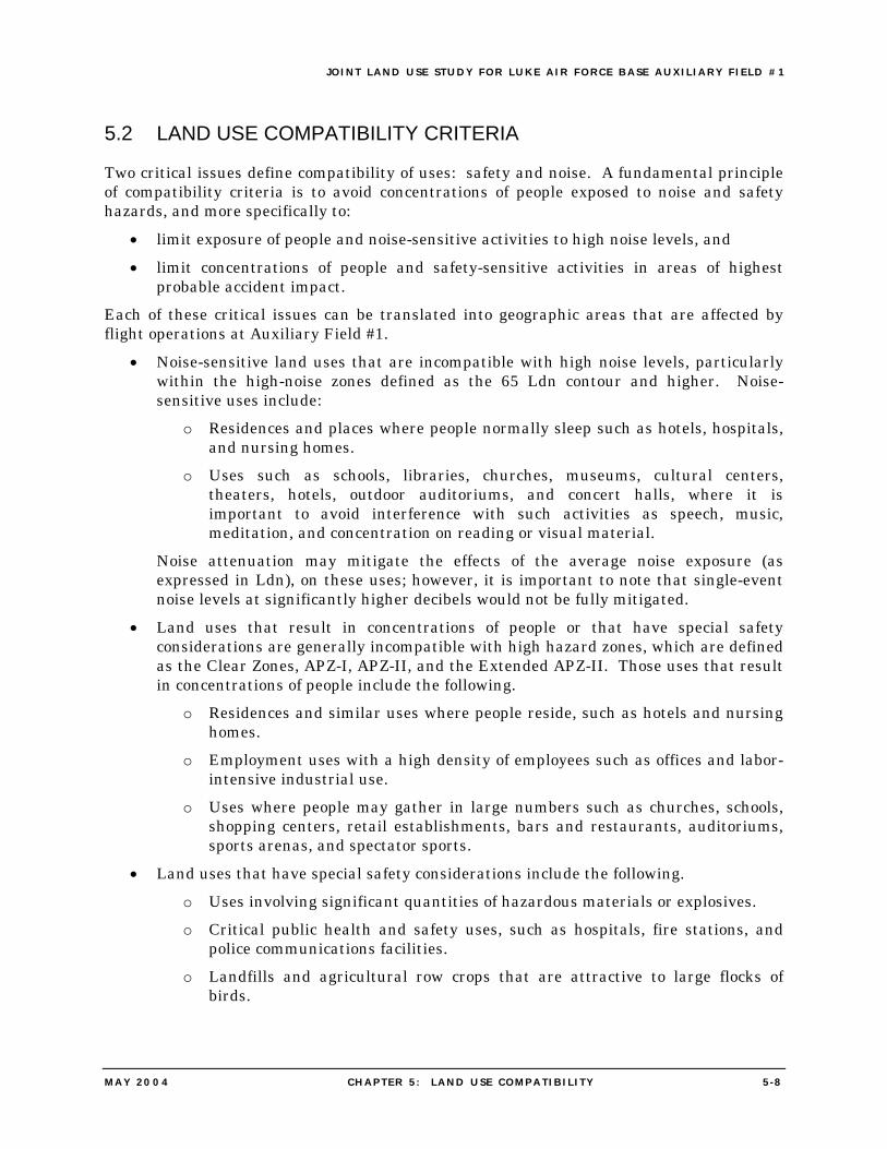
5.2 LAND USE COMPATIBILITY CRITERIA
Two critical issues define compatibility of uses: safety and noise. A fundamental principle of compatibility criteria is to avoid concentrations of people exposed to noise and safety hazards, and more specifically to:
• limit exposure of people and noise-sensitive activities to high noise levels, and • limit concentrations of people and safety-sensitive activities in areas of highest
probable accident impact. Each of these critical issues can be translated into geographic areas that are affected by flight operations at Auxiliary Field #1.
• Noise-sensitive land uses that are incompatible with high noise levels, particularly within the high-noise zones defined as the 65 Ldn contour and higher. Noise-sensitive uses include:
o Residences and places where people normally sleep such as hotels, hospitals, and nursing homes.
o Uses such as schools, libraries, churches, museums, cultural centers, theaters, hotels, outdoor auditoriums, and concert halls, where it is important to avoid interference with such activities as speech, music, meditation, and concentration on reading or visual material.
Noise attenuation may mitigate the effects of the average noise exposure (as expressed in Ldn), on these uses; however, it is important to note that single-event noise levels at significantly higher decibels would not be fully mitigated.
• Land uses that result in concentrations of people or that have special safety considerations are generally incompatible with high hazard zones, which are defined as the Clear Zones, APZ-I, APZ-II, and the Extended APZ-II. Those uses that result in concentrations of people include the following.
o Residences and similar uses where people reside, such as hotels and nursing homes.
o Employment uses with a high density of employees such as offices and labor-intensive industrial use.
o Uses where people may gather in large numbers such as churches, schools, shopping centers, retail establishments, bars and restaurants, auditoriums, sports arenas, and spectator sports.
• Land uses that have special safety considerations include the following. o Uses involving significant quantities of hazardous materials or explosives. o Critical public health and safety uses, such as hospitals, fire stations, and
police communications facilities. o Landfills and agricultural row crops that are attractive to large flocks of
birds.
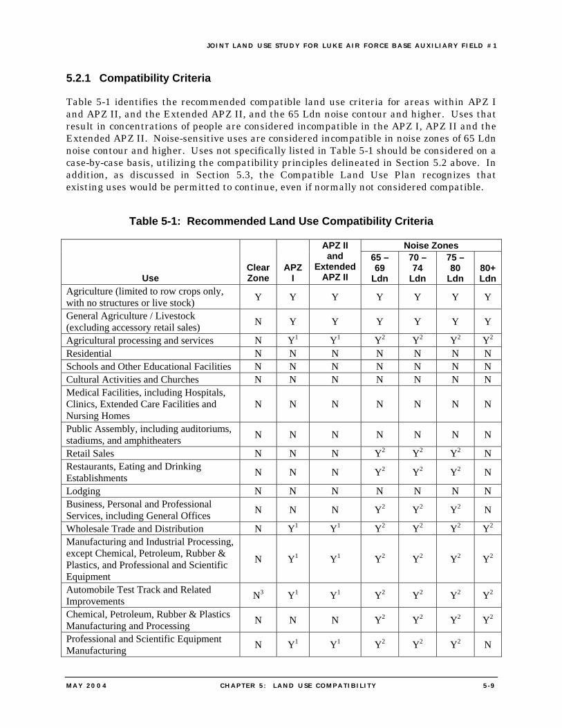
JOINT LAND USE STUDY FOR LUKE AIR FORCE BASE AUXIL IARY F IELD #1
MAY 2004 CHAPTER 5 : LAND USE COMPATIBIL ITY 5 -9
5.2.1 Compatibility Criteria
Table 5-1 identifies the recommended compatible land use criteria for areas within APZ I and APZ II, and the Extended APZ II, and the 65 Ldn noise contour and higher. Uses that result in concentrations of people are considered incompatible in the APZ I, APZ II and the Extended APZ II. Noise-sensitive uses are considered incompatible in noise zones of 65 Ldn noise contour and higher. Uses not specifically listed in Table 5-1 should be considered on a case-by-case basis, utilizing the compatibility principles delineated in Section 5.2 above. In addition, as discussed in Section 5.3, the Compatible Land Use Plan recognizes that existing uses would be permitted to continue, even if normally not considered compatible.
Table 5-1: Recommended Land Use Compatibility Criteria
Noise Zones
Use Clear Zone
APZ I
APZ II and
Extended APZ II
65 – 69
Ldn
70 – 74
Ldn
75 – 80
Ldn 80+ Ldn
Agriculture (limited to row crops only, with no structures or live stock) Y Y Y Y Y Y Y
General Agriculture / Livestock (excluding accessory retail sales) N Y Y Y Y Y Y
Agricultural processing and services N Y1 Y1 Y2 Y2 Y2 Y2 Residential N N N N N N N Schools and Other Educational Facilities N N N N N N N Cultural Activities and Churches N N N N N N N Medical Facilities, including Hospitals, Clinics, Extended Care Facilities and Nursing Homes
N N N N N N N
Public Assembly, including auditoriums, stadiums, and amphitheaters N N N N N N N
Retail Sales N N N Y2 Y2 Y2 N Restaurants, Eating and Drinking Establishments N N N Y2 Y2 Y2 N
Lodging N N N N N N N Business, Personal and Professional Services, including General Offices N N N Y2 Y2 Y2 N
Wholesale Trade and Distribution N Y1 Y1 Y2 Y2 Y2 Y2 Manufacturing and Industrial Processing, except Chemical, Petroleum, Rubber & Plastics, and Professional and Scientific Equipment
N Y1 Y1 Y2 Y2 Y2 Y2
Automobile Test Track and Related Improvements N3 Y1 Y1 Y2 Y2 Y2 Y2
Chemical, Petroleum, Rubber & Plastics Manufacturing and Processing N N N Y2 Y2 Y2 Y2
Professional and Scientific Equipment Manufacturing N Y1 Y1 Y2 Y2 Y2 N
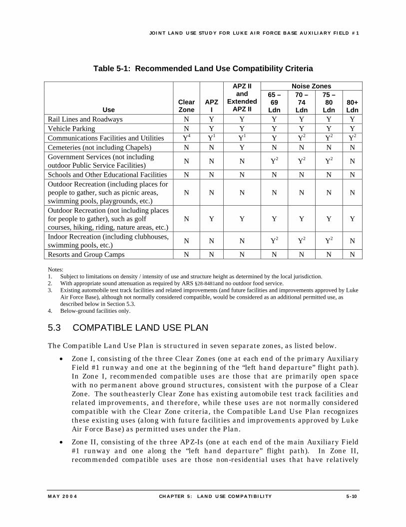
JOINT LAND USE STUDY FOR LUKE AIR FORCE BASE AUXIL IARY F IELD #1
MAY 2004 CHAPTER 5 : LAND USE COMPATIBIL ITY 5 - 10
Table 5-1: Recommended Land Use Compatibility Criteria
Noise Zones
Use Clear Zone
APZ I
APZ II and
Extended APZ II
65 – 69
Ldn
70 – 74
Ldn
75 – 80
Ldn 80+ Ldn
Rail Lines and Roadways N Y Y Y Y Y Y Vehicle Parking N Y Y Y Y Y Y Communications Facilities and Utilities Y4 Y1 Y1 Y Y2 Y2 Y2 Cemeteries (not including Chapels) N N Y N N N N Government Services (not including outdoor Public Service Facilities) N N N Y2 Y2 Y2 N
Schools and Other Educational Facilities N N N N N N N Outdoor Recreation (including places for people to gather, such as picnic areas, swimming pools, playgrounds, etc.)
N N N N N N N
Outdoor Recreation (not including places for people to gather), such as golf courses, hiking, riding, nature areas, etc.)
N Y Y Y Y Y Y
Indoor Recreation (including clubhouses, swimming pools, etc.) N N N Y2 Y2 Y2 N
Resorts and Group Camps N N N N N N N Notes: 1. Subject to limitations on density / intensity of use and structure height as determined by the local jurisdiction. 2. With appropriate sound attenuation as required by ARS §28-8481and no outdoor food service. 3. Existing automobile test track facilities and related improvements (and future facilities and improvements approved by Luke
Air Force Base), although not normally considered compatible, would be considered as an additional permitted use, as described below in Section 5.3.
4. Below-ground facilities only.
5.3 COMPATIBLE LAND USE PLAN
The Compatible Land Use Plan is structured in seven separate zones, as listed below. • Zone I, consisting of the three Clear Zones (one at each end of the primary Auxiliary
Field #1 runway and one at the beginning of the “left hand departure” flight path). In Zone I, recommended compatible uses are those that are primarily open space with no permanent above ground structures, consistent with the purpose of a Clear Zone. The southeasterly Clear Zone has existing automobile test track facilities and related improvements, and therefore, while these uses are not normally considered compatible with the Clear Zone criteria, the Compatible Land Use Plan recognizes these existing uses (along with future facilities and improvements approved by Luke Air Force Base) as permitted uses under the Plan.
• Zone II, consisting of the three APZ-Is (one at each end of the main Auxiliary Field #1 runway and one along the “left hand departure” flight path). In Zone II, recommended compatible uses are those non-residential uses that have relatively
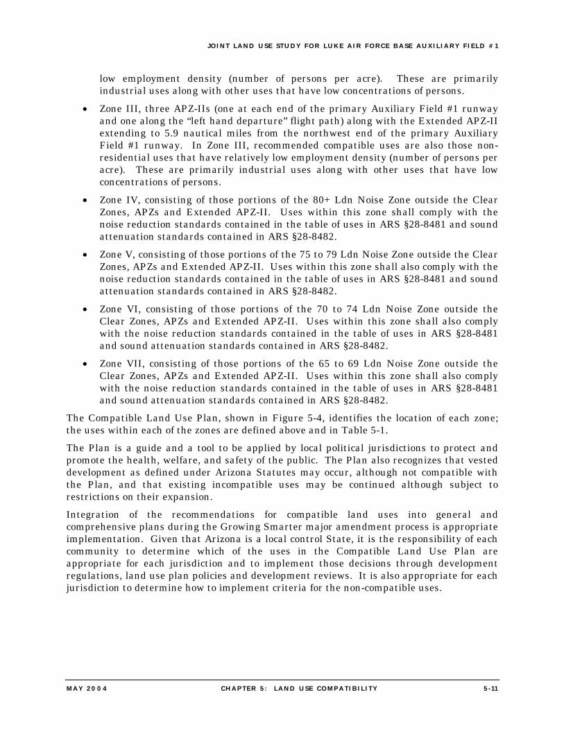
JOINT LAND USE STUDY FOR LUKE AIR FORCE BASE AUXIL IARY F IELD #1
MAY 2004 CHAPTER 5 : LAND USE COMPATIBIL ITY 5 - 1 1
low employment density (number of persons per acre). These are primarily industrial uses along with other uses that have low concentrations of persons.
• Zone III, three APZ-IIs (one at each end of the primary Auxiliary Field #1 runway and one along the “left hand departure” flight path) along with the Extended APZ-II extending to 5.9 nautical miles from the northwest end of the primary Auxiliary Field #1 runway. In Zone III, recommended compatible uses are also those non-residential uses that have relatively low employment density (number of persons per acre). These are primarily industrial uses along with other uses that have low concentrations of persons.
• Zone IV, consisting of those portions of the 80+ Ldn Noise Zone outside the Clear Zones, APZs and Extended APZ-II. Uses within this zone shall comply with the noise reduction standards contained in the table of uses in ARS §28-8481 and sound attenuation standards contained in ARS §28-8482.
• Zone V, consisting of those portions of the 75 to 79 Ldn Noise Zone outside the Clear Zones, APZs and Extended APZ-II. Uses within this zone shall also comply with the noise reduction standards contained in the table of uses in ARS §28-8481 and sound attenuation standards contained in ARS §28-8482.
• Zone VI, consisting of those portions of the 70 to 74 Ldn Noise Zone outside the Clear Zones, APZs and Extended APZ-II. Uses within this zone shall also comply with the noise reduction standards contained in the table of uses in ARS §28-8481 and sound attenuation standards contained in ARS §28-8482.
• Zone VII, consisting of those portions of the 65 to 69 Ldn Noise Zone outside the Clear Zones, APZs and Extended APZ-II. Uses within this zone shall also comply with the noise reduction standards contained in the table of uses in ARS §28-8481 and sound attenuation standards contained in ARS §28-8482.
The Compatible Land Use Plan, shown in Figure 5-4, identifies the location of each zone; the uses within each of the zones are defined above and in Table 5-1. The Plan is a guide and a tool to be applied by local political jurisdictions to protect and promote the health, welfare, and safety of the public. The Plan also recognizes that vested development as defined under Arizona Statutes may occur, although not compatible with the Plan, and that existing incompatible uses may be continued although subject to restrictions on their expansion. Integration of the recommendations for compatible land uses into general and comprehensive plans during the Growing Smarter major amendment process is appropriate implementation. Given that Arizona is a local control State, it is the responsibility of each community to determine which of the uses in the Compatible Land Use Plan are appropriate for each jurisdiction and to implement those decisions through development regulations, land use plan policies and development reviews. It is also appropriate for each jurisdiction to determine how to implement criteria for the non-compatible uses.
JOINT LAND USE STUDY FOR LUKE AIR FORCE BASE AUXIL IARY F IELD #1
MAY 2004 CHAPTER 5 : LAND USE COMPATIBIL ITY 5 - 12
Figure 5-4: Compatible Land Use Plan Zones
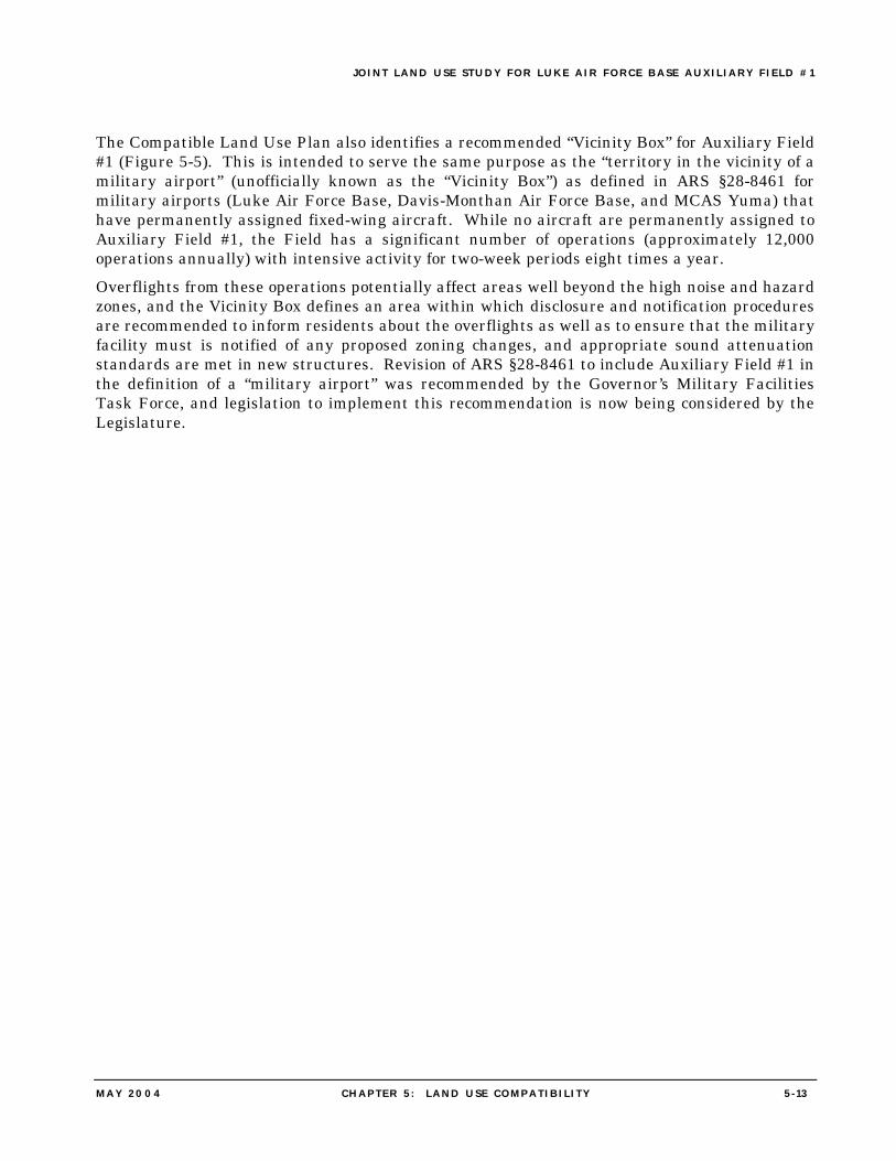
JOINT LAND USE STUDY FOR LUKE AIR FORCE BASE AUXIL IARY F IELD #1
MAY 2004 CHAPTER 5 : LAND USE COMPATIBIL ITY 5 - 13
The Compatible Land Use Plan also identifies a recommended “Vicinity Box” for Auxiliary Field #1 (Figure 5-5). This is intended to serve the same purpose as the “territory in the vicinity of a military airport” (unofficially known as the “Vicinity Box”) as defined in ARS §28-8461 for military airports (Luke Air Force Base, Davis-Monthan Air Force Base, and MCAS Yuma) that have permanently assigned fixed-wing aircraft. While no aircraft are permanently assigned to Auxiliary Field #1, the Field has a significant number of operations (approximately 12,000 operations annually) with intensive activity for two-week periods eight times a year. Overflights from these operations potentially affect areas well beyond the high noise and hazard zones, and the Vicinity Box defines an area within which disclosure and notification procedures are recommended to inform residents about the overflights as well as to ensure that the military facility must is notified of any proposed zoning changes, and appropriate sound attenuation standards are met in new structures. Revision of ARS §28-8461 to include Auxiliary Field #1 in the definition of a “military airport” was recommended by the Governor’s Military Facilities Task Force, and legislation to implement this recommendation is now being considered by the Legislature.
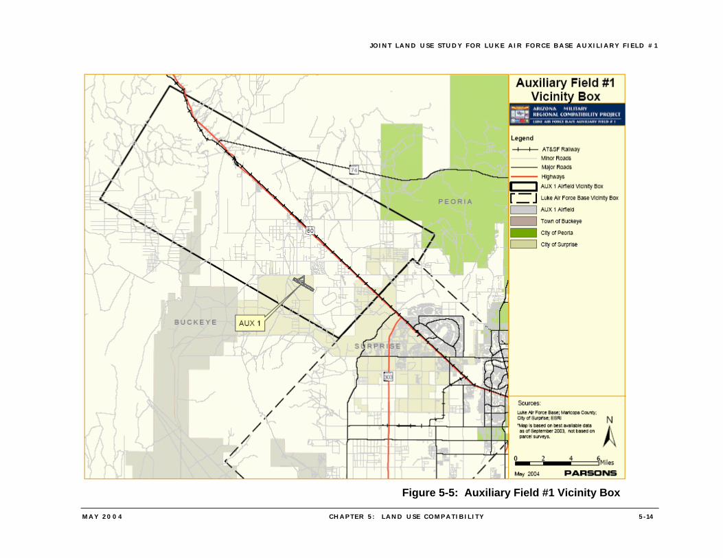
JOINT LAND USE STUDY FOR LUKE AIR FORCE BASE AUXIL IARY F IELD #1
MAY 2004 CHAPTER 5 : LAND USE COMPATIBIL ITY 5 - 14
Figure 5-5: Auxiliary Field #1 Vicinity Box
JOINT LAND USE STUDY FOR LUKE AIR FORCE BASE AUXIL IARY F IELD #1
MAY 2004 CHAPTER 6 : IMPLEMENTATION PROGRAM 6 - 1
6. IMPLEMENTATION PROGRAM
6.1 INTRODUCTION
This Joint Land Use Study (JLUS) for Auxiliary Field #1 is intended to guide the decisions made by a variety of public and private entities in relation to compatible land use around the Field. In addition to the State of Arizona and its agencies, Luke Air Force Base, local jurisdictions, and private interests within the area can contribute to the implementation of the recommendations of the JLUS. The Compatible Land Use Plan presented in Chapter 5 of this JLUS defines recommended compatible uses and performance standards that are intended to be used by the City of Surprise and Maricopa County to guide development in order to maintain the operational capabilities of Auxiliary Field #1, while facilitating the economic development of other key sectors in ways that are compatible with the Base’s mission. Implementation of the Compatible Use Plan is fundamental to achieving these goals and integration of land use recommendations into general and comprehensive plans and zoning ordinances is a key element in implementing the JLUS. However, successful implementation requires that other tools be utilized to achieve the JLUS goals. These tools are contained in the implementation program presented in the following sections. The implementation program has been developed in recognition of the ongoing planning by the Base and jurisdictions, as well as considering the divergent viewpoints expressed through the project’s process, and the need to present strategies that realistically accomplish the goal of maintaining the operational capabilities of Auxiliary Field #1, so that it can continue to support the Luke Air Force Base mission. While the changing nature of economics and politics may change the scope and timing of the implementation strategies, these recommendations provide the framework and guidance for achieving long-term compatibility of development with operations at the Field. The following sections present the recommended Implementation Strategies. Three aspects of implementation that are integral to the process follow a brief description of each strategy. The first aspect of implementation, Priority / Timing, establishes the importance of the action and the timeframe within which the Strategy is to be effected, as follows;
• High — by June, 2005, • Moderate — within 2–3 years, that is by June 2007, or • Low — 4–5 years, that is by June 2009.
The second aspect of implementation, Responsible Party(s), indicates the governmental agency, local political jurisdiction, and other parties responsible for implementing the Strategy. The third aspect of implementation, Evaluation Measures, presents recommendations concerning review and monitoring to facilitate adjustments if the strategy is not meeting its desired results. One of the appropriate functions for the State would be to monitor the implementation and effectiveness of the recommended measures through the Arizona Department of Commerce or other State agency.
JOINT LAND USE STUDY FOR LUKE AIR FORCE BASE AUXIL IARY F IELD #1
MAY 2004 CHAPTER 6 : IMPLEMENTATION PROGRAM 6 -2
6.2 IMPLEMENTATION STRATEGIES
6.2.1 Joint Land Use Study Recognition While the JLUS is not adopted in the traditional sense by local jurisdictions and is not a legal document, the completion of the JLUS and its status as guidance for land use decisions in the vicinity of Auxiliary Field #1 should be recognized by the City of Surprise, Town of Buckeye, Maricopa County and Luke Air Force Base. Appendix C contains a model resolution for consideration by the City and County.
• Priority / Timing – High • Responsible Party(s) – City of Surprise, Town of Buckeye, Maricopa County, and
Luke Air Force Base • Evaluation Measures – Resolution or similar official acknowledgement adopted in
2004
6.2.2 Revision of Local Plans and Ordinances The Compatible Land Use Plan of the JLUS study defines compatible land uses for the Clear Zones, APZ-I, APZ-II, the Extended APZ-II and high-noise zones around Auxiliary Field #1. The General Plans and ordinances of the City of Surprise, Town of Buckeye and Maricopa County are the primary means of implementing the recommended compatible uses. The City, Town, and County should review their respective plans and ordinances to identify changes that are necessary to implement the recommended compatible uses and prepare necessary amendments to the plans and ordinances for consideration and adoption by their respective governing bodies. As a long-term approach, the City, Town, and County should also utilize the notional noise contours, as recommended in the JLUS, as the basis for defining high-noise zones under their plans and ordinances.
• Priority / Timing – High • Responsible Party(s) – City of Surprise, Town of Buckeye, and Maricopa County • Evaluation Measures – Plan and Zoning Ordinance amendments adopted in 2004
6.2.3 Support for Recommendations of the Governor’s Military Facilities Task Force
The Governor’s Military Facilities Task Force has made recommendations to the Governor relating to actions needed at the federal, State, and local levels to ensure the long-term viability of military installations and resources. Of particular importance for Auxiliary Field #1 are a recommendation to define an “ancillary military facility” under ARS §28-8461 to include the Field; and recommendations that local jurisdictions be mandated to adopt noise contours and “vicinity boxes” as a basis for compatible land use planning and notification around military facilities. Other recommendations, including the designation of dedicated funding to assist military installation preservation and expansion projects, involve legislative action and are also important for implementing the JLUS recommendations. The City of Surprise, Town of Buckeye, and Maricopa County, along with Fighter Country Partnership and other interested groups should actively support the implementation of the recommendations of the Governor’s Military Facilities Task Force at the State level.
JOINT LAND USE STUDY FOR LUKE AIR FORCE BASE AUXIL IARY F IELD #1
MAY 2004 CHAPTER 6 : IMPLEMENTATION PROGRAM 6 -3
• Priority / Timing – High • Responsible Party(s) – City of Surprise, Town of Buckeye, Maricopa County, and
other organizations • Evaluation Measures – Enactment of the legislative recommendations of the
Governor’s Task Force
6.2.4 Support for Recommendations of the State Trust Land Reform Group One of the components that the State Trust Land Reform group is recommending proposes that a mechanism be developed to allow for the exchange of land in support of planning and disposition of State Trust land in support of the long-term preservation of Arizona’s military installations. The ability for the State Trust to engage in land exchanges and the ability to transfer densities and land uses between various State Trust lands is potentially an important element for achieving compatibility in the development of State Trust lands in the vicinity of Auxiliary Field #1. As the mechanism to allow this will likely require legislative action and / or a vote of the electorate to modify the State Constitution, the City of Surprise, Town of Buckeye, Maricopa County, Fighter Country Partnership, and other interested organizations should actively support the recommendations of the State Trust Land Reform Group.
• Priority / Timing – High • Responsible Party(s) – City of Surprise, Town of Buckeye, Maricopa County, Fighter
Country Partnership, and other organizations • Evaluation Measures – Enactment of the legislative recommendations of the State
Lands Reform Group
6.2.5 Ongoing Coordination for JLUS Implementation
Efficient and effective communication between the City of Surprise, Town of Buckeye, Maricopa County, area landowners, other local organizations and Luke Air Force Base is critical to the successful implementation of the JLUS. To provide a means to maintain communication and coordination as the JLUS recommendations are carried out, the Luke Air Force Base Community Initiatives Team should continue to work proactively with local communities and organizations that have an interest in compatible land use around the Base. The Community Initiatives Team could also serve as the Base’s interface with the newly established State Military Affairs Commission on issues related to Auxiliary Field #1.
• Priority / Timing – High • Responsible Party(s) – Luke Air Force Base • Evaluation Measures – Ongoing
6.2.6 Department of Defense Land Acquisition The City of Surprise, Town of Buckeye, Maricopa County, and other interested groups such as Fighter Country Partnership should work with the State’s Congressional delegation to obtain additional appropriations in the Department of Defense budget dedicated to the purchase of critical parcels to protect the Luke Air Force Base mission, including critical
JOINT LAND USE STUDY FOR LUKE AIR FORCE BASE AUXIL IARY F IELD #1
MAY 2004 CHAPTER 6 : IMPLEMENTATION PROGRAM 6 -4
parcels in the Auxiliary Field #1 safety zones. In addition to working for an appropriation in the next budget year (2005), efforts should be made for additional appropriations in the years following the 2005 BRAC round.
• Priority / Timing – High to moderate • Responsible Party(s) – City of Surprise, Town of Buckeye, Maricopa County, Fighter
Country Partnership, and other organizations, Arizona Congressional delegation • Evaluation Measures – Appropriated funding in the Department of Defense budget
6.2.7 Department of Defense Purchase of Conservation Easements The Department of Defense (DOD) is implementing a program of purchase of conservation easements around military installations in order to address environmental and encroachment issues. The “Bob Stump National Defense Authorization Act” for Fiscal Year 2003 (P.L. 107-314) provided new statutory authority that permits the Department of Defense enter into agreements with eligible entities to address the use or development of real property near a military installation, and to accept on behalf of the United States Government any property or interest acquired pursuant to such agreements. The Department of Defense is working to determine how this new authority will be used, and each of the Military Departments are developing specific program guidance. In general terms the new authority includes the following specific elements.
• Eligible entities are States, political subdivisions or private conservation organizations.
• The amendment provides for the acquisition by an eligible entity of all right, title, interest in and to any real property, and sharing by the Government and the entity in acquisition costs. The amendment also requires the entity, upon request of the DOD, to transfer to the Government the minimum property or interests necessary to avoid encroachment from the use or management of the property.
• Department of Defense funds may be used for such agreements for purchase from willing sellers. It is important to note that the amendment does not provide specific funding for these purchases. The Department of Defense will determine if, and how much funding will be available for this initiative.
• The amendment also permits Department of Defense to convey surplus real property to states or other eligible entities for conservation of natural resources.
The City of Surprise, Town of Buckeye, and Maricopa County should work with Luke Air Force Base and the Department of Defense to acquire conservation easements in appropriate locations within the Clear Zones and APZs.
• Priority / Timing – High to Moderate • Responsible Party(s) – City of Surprise, Town of Buckeye, Maricopa County, Luke
Air Force Base, Department of Defense and private landowners • Evaluation Measures – Completed purchase of conservation easements
JOINT LAND USE STUDY FOR LUKE AIR FORCE BASE AUXIL IARY F IELD #1
MAY 2004 CHAPTER 6 : IMPLEMENTATION PROGRAM 6 -5
6.2.8 Land and Water Conservation Fund The Land and Water Conservation Fund (LWCF) was established by Congress in 1964 to create parks and open spaces, protect wilderness, wetlands, and refuges, preserve wildlife habitat, and enhance recreational opportunities. The LWCF has a matching grants program that provides funds to states for planning, developing and acquiring land and water areas for state and local parks and recreation areas. These funds could be used to match state monies to purchase critical parcels of land around the Field for use as conservation / open space.
• Priority / Timing – High • Responsible Party(s) – Federal and State governments • Evaluation Measures – Use of land and water conservation funds as appropriate
6.2.9 Military Installation Fund One of the recommendations of the Governor’s Military Facilities Task Force is the creation of a Military Installation Fund (MIF), to be administered by the State and funded by dedicated revenue at the State level. The MIF, as envisioned by the Task Force, would provide grants to local governments for land acquisition or other activities to preserve or expand military installations. If this fund is established, the City, Town and County should consider use of MIF funding to support acquisition of land or development rights in critical areas (most likely in combination with other funding), or for other activities that would support compatible land use.
• Priority / Timing – High to Moderate • Responsible Party(s) – City of Surprise, Town of Buckeye, Maricopa County and
State of Arizona • Evaluation Measures – Use of MIF funds as provided for in grant
6.2.10 Purchase of Development Rights An alternative to the purchase of land is the purchase of development rights which would be negotiated with the owner of the development rights. Participation in the purchase of development rights would be voluntary on the part of the owner. This type of acquisition may be effective in appropriate situations and areas, particularly where the issue of compatibility involves density of development rather than the type of land use proposed. When development rights are purchased, a landowner is paid fair market value for the rights that are purchased. The value of the purchased rights is roughly equal to the value of the land without any special restriction less the value of the land with the land use restrictions. The use of this strategy would be dependent on securing funding for the purchase through one of the other strategies identified in this chapter.
• Priority / Timing – High to Moderate • Responsible Party(s) – Federal government, State government, and local
jurisdictions • Evaluation Measures – Development Rights are purchased
JOINT LAND USE STUDY FOR LUKE AIR FORCE BASE AUXIL IARY F IELD #1
MAY 2004 CHAPTER 6 : IMPLEMENTATION PROGRAM 6 -6
6.2.11 Transfer of Development Rights The use of Transfer of Development Rights (TDRs) can reduce the intensity and density of use in areas identified as significant to preserving the Base’s mission while increasing density in other areas by encouraging local political jurisdictions to create incentives for developers to use the density transfer technique in appropriate situations and areas affected by aircraft operations. The transfer of development rights is similar to the purchase of development rights, except rather than a public agency buying development rights, which are then in effect “retired,” the landowner is compensated by having the permitted uses of other land expanded or intensified. The land to which the rights are transferred may be owned either by the landowner, or by someone else. In the latter case, compensation is paid to the “sending” landowner by the “receiving” landowner. Participation in TDR programs would be voluntary on the part of the landowner(s). Under the TDR scenario, the use of land currently zoned for lower intensity use outside the affected areas could be modified to allow higher density development at the same time the use of land in the affected areas currently zoned to permit higher density development would be restricted to lower density use.
• Priority / Timing – High to Moderate • Responsible Party(s) – Local jurisdictions • Evaluation Measures – TDR programs are adopted by the local municipalites (and
by Maricopa County, if State legislation is enacted to allow the County to use TDRs)
6.2.12 Partnerships with Non-Governmental Organizations to Facilitate Transfers of Development Rights
Governmental or non-governmental entities such as the Trust for Public Land (TPL), may acquire development rights for land adjacent to a military installation or facility, especially for land in the high hazard and noise zones, and dedicating it to uses compatible with military missions or to transferring those lands to public ownership for conservation or open space uses. TPL also has a program to assist communities in pursuing a preservation ballot initiative, providing services that include political analysis and campaign strategy.
• Priority / Timing – High to Moderate • Responsible Party(s) – Local jurisdictions and TPL or other entity • Evaluation Measures – TDR programs are adopted by the City of Surprise, Town of
Buckeye (and by Maricopa County, if State legislation is enacted to allow the County to use TDRs)
6.2.13 Enhanced Local Notification and Disclosure The Governor’s Military Facilities Task Force has recommended that current notification and disclosure provisions in State law for military facilities be strengthened, including a recommendation that the Arizona Department of Real Estate develop a “rule” to strengthen and standardize the notification process for its licensees. Increasingly, communities have determined that there is value to their citizens in going beyond the minimum public notification and disclosure standards outlined in State law. Specific mechanisms to enhance public notification and disclosure may include:
JOINT LAND USE STUDY FOR LUKE AIR FORCE BASE AUXIL IARY F IELD #1
MAY 2004 CHAPTER 6 : IMPLEMENTATION PROGRAM 6 -7
• Requiring notices and maps to be posted in real estate sales and leasing offices, including identification of noise contours
• Requiring notices placed in model home complexes and sales offices advising potential buyers that the area is subject to military aircraft overflight
• Requiring avigation easements and indemnification / release of liability language on all recorded subdivision plats
• Installing overflight signage at roadway intersections within the noise contour lines The City of Surprise has adopted a requirement that a copy of the City’s “Surprise / Luke Notification Map” be posted in all real estate offices in the City. The Town of Buckeye and Maricopa County should consider adopting similar requirements, and all of the jurisdictions should consider the need for specific additional methods of notification and disclosure.
• Priority / Timing – High to Moderate • Responsible Party(s) – City of Surprise, Town of Buckeye, and Maricopa County • Evaluation Measures – Enhanced Notification and Disclosure procedures in place
6.2.14 Best Practice Techniques A process to assess the usefulness of various techniques used by other political jurisdictions with similar military air base encroachment issues is an effective means to ensure that the “best practices” are being used to guide development around the State’s military facilities. This evaluation of “best practice” techniques will need to determine their potential to be adapted to the needs of various political jurisdictions in the State, and the State will continue its role as convener and clearinghouse in these efforts. Other stakeholders are anticipated to participate in this data collection in support of the statewide effort. Results of the Best Practices research will be compiled into the State Policy Guide developed as part of the statewide effort by the Department of Commerce to address land use compatibility and encroachment issues under the Arizona Military Regional Compatibility Project.
• Priority / Timing – Development of State Policy Guide – High; continuing assessment is ongoing
• Responsible Party(s) – State government, local jurisdictions, and other stakeholder groups
• Evaluation Measures – Development of State Policy Guide and ongoing assessment
JOINT LAND USE STUDY FOR LUKE AIR FORCE BASE AUXIL IARY F IELD #1
MAY 2004 APPENDIX A : STATE LAND USE COMPATIBIL ITY LEGI SLATION A - 1
APPENDIX A: ARIZONA LAND USE COMPATIBILITY LEGISLATION
To view the full text of the Arizona Revised Statues (ARS), as of March 2004, discussed below visit the Arizona State Legislature’s web site at http://www.azleg.state.az.us/ArizonaRevisedStatutes.asp.
1.0 TITLE 9
Title 9 of the ARS contains legislation governing cities and towns; the cited sections are especially concerned with municipal planning issues. ARS §9-461.05. This section stipulates that the general plan prepared by municipalities within the territory in the vicinity of a military airport have a land use element that includes consideration of military airport operations. ARS §9-461.06. This section requires that the governing body shall consult with, advise, and provide an opportunity for official comment by the military airport if the municipality has territory in the vicinity of a military airport as defined in ARS section 28-8461. ARS §9-462.04. This section requires that in proceedings involving rezoning of land that is located within the territory in the vicinity of a military airport the municipality shall send copies of the notice of public hearing by first class mail to the military airport. In municipalities with territory in the vicinity of a military airport, the governing body shall hold a public hearing if, after notice is transmitted to the military airport and before the public hearing, the military airport provides comments or analysis concerning the compatibility of the proposed rezoning with the high-noise or accident potential generated by military airport operations that may have an adverse impact on public health and safety, and the governing body shall consider and analyze the comments or analysis before making a final determination.
2.0 TITLE 11
Title 11 of the ARS contains legislation governing counties; the cited sections are especially concerned with county planning and zoning. ARS §11-806. The section requires that counties with territory in the vicinity of a military airport must prepare a comprehensive plan that considers the operation of the military airport and allows the military airport the opportunity to consult with, advise, review, and comment on the plan. ARS §11-829. In proceedings involving rezoning of land that is located within territory in the vicinity of a military airport the commission shall send copies of the notice of public hearing to the military airport. In counties with territory in the
JOINT LAND USE STUDY FOR LUKE AIR FORCE BASE AUXIL IARY F IELD #1
MAY 2004 APPENDIX A : STATE LAND USE COMPATIBIL ITY LEGI SLATION A -2
vicinity of a military airport the board is required to hold a public hearing if the military airport provides comments or analysis concerning the compatibility of the proposed rezoning with the high-noise or accident potential generated by military airport operations the board shall consider and analyze the comments or analysis before making a final determination.
3.0 TITLE 15
Title 15 of the ARS contains legislation governing education; the cited sections are especially concerned with financing school development. ARS §15-2002. The executive director of the school facilities board is required to establish procedures in compliance with the official notice and hearing requirements that, with respect to monies to fund the construction of new school facilities proposed to be located in the territory in the vicinity of a military airport, the military airport receive notification of the application for funding at least thirty days before any hearing. ARS §15-2041. The section requires that, with respect to monies to fund the construction of new school facilities proposed to be located in the territory in the vicinity of a military airport the board shall consider and analyze the comments or analysis from military airport before making a decision.
4.0 TITLE 28
Title 28 of the ARS contains legislation governing transportation; the cited sections are especially concerned with airport zoning and regulation and joint powers airport authorities. ARS §28-8461. This section is concerned with a number of definitions that directly relate to military airport operations. It defines Accident Potential Zone 1 and Accident Potential Zone 2, Clear Zone, high-noise or accident potential zones, military airport, territory in the vicinity of a military airport, etc. ARS §28-8480. This section allows political subdivisions to acquire or lease land or interests in land for the continued operation of a military airport. ARS §28-8481. This section requires a political subdivision that has territory in the vicinity of a military airport to adopt comprehensive and general plans for property in the hazard zone to assure development compatible with the high-noise and accident potential generated by military airport operations, which includes noise reduction standards for specific land uses within noise zones of 65 Ldn or higher. Political subdivisions that have property in a high-noise or accident potential zone can not grant zoning variances without a specific finding that the purpose of military airport compatibility is preserved. A political subdivision that has territory in a high-noise or accident potential zone is required to notify the owner or owners of property in that zone of any additions or changes to the general plan, comprehensive plan, zoning regulations applicable to property in those zones. The political subdivision shall provide a notice of such
JOINT LAND USE STUDY FOR LUKE AIR FORCE BASE AUXIL IARY F IELD #1
MAY 2004 APPENDIX A : STATE LAND USE COMPATIBIL ITY LEGI SLATION A -3
additions or changes including a statement that the property is located in a high-noise or accident potential zone. Each political subdivision that has territory that includes property in a high-noise or accident potential zone is required to file with the attorney general a report that demonstrates compliance during the previous reporting period. ARS §28-8482. This section requires political subdivisions in the vicinity of a military airport to incorporate sound attenuation standards in their building codes. ARS §28-8483. The State Real Estate Department and political subdivisions that have territory in the vicinity of a military airport are required to request from the military airport a registry of certain information concerning flight operations and contact persons; this registry shall be available to the public on request. ARS §28-8484. Any public report applicable to property located within territory in the vicinity of a military airport is required to include the statements that: the property is located within territory in the vicinity of a military airport; the maps of military flight operations provided by the military airport are available to the public on request. Each military airport may provide the State Real Estate Department and each political subdivision with territory in the vicinity of the military airport with a map that shows the boundaries of each territory in the vicinity of a military airport and the boundaries of each high-noise or accident potential zone. ARS §28-8485. This section allows the state or a governing body of a political subdivision that operates an airport to designate an airport influence area of all property that is exposed to aircraft noise and overflights and has a 65 Ldn noise level or higher. If such an airport influence area is established it shall be recorded with the appropriate county recorder so as to be sufficient to notify owners or potential buyers of property that the area is currently subject to aircraft noise and overflights. ARS §28-8486. This section defines the terms, public airport and territory in the vicinity of a public airport and directs the State Real Estate Department to make available to the public a map showing the boundaries of each territory in the vicinity of a public airport. ARS §28-8521. This section allows two or more political jurisdictions to enter into an agreement establishing a joint powers airport authority in connection with the closing of a military facility. ARS §28-8521. This section defines a joint powers airport authority.
ARS §28-8523. The procedures for an annual operating budget for a joint powers airport authority are established in this section. ARS §28-8524. This section establishes procedures for a joint powers airport authority to allocate funds, hold public hearings, adopt a development plan and a capital improvement plan, etc. ARS §28-8526. The procedures for a joint powers airport authority to admit additional members established in this section. ARS §28-8527. The official procedures for a joint powers airport authority to operate established in this section.
JOINT LAND USE STUDY FOR LUKE AIR FORCE BASE AUXIL IARY F IELD #1
MAY 2004 APPENDIX A : STATE LAND USE COMPATIBIL ITY LEGI SLATION A -4
ARS §28-8528. If a joint powers airport authority is established under the statute, the President of the Senate and the Speaker of the House of Representatives shall establish a joint legislative military airport reuse committee and stipulates its membership and duties. ARS §28-2113. This section establishes requirements for disclosure applicable to property that is located within territory in the vicinity of a military airport: “This property is located within territory in the vicinity of a military airport and may be subject to increased noise and accident potential.” ARS §28-2181. This section establishes notification requirements of intentions to subdivide lands and requires a statement as to whether all or any portion of the property is located within territory in the vicinity of a military airport or a public airport, or a high-noise and accident potential zone.
5.0 TITLE 32
Title 32 of the ARS contains legislation governing professions and occupations; the cited sections are especially concerned with real estate transactions and land development. ARS §32-2181.01. Permits the commissioner to exempt certain land subdivisions or fractional; interests from one or more of the stipulations of the statute. ARS §32-2181.02. Defines the exempt land transactions.
ARS §32-2181.03. Defines the requirements of a lot reservation.
ARS §32-2183. If any of the lots, parcels, or fractional interests within a subdivision are located within territory in the vicinity of a military airport the report shall include the statements required pursuant to applicable Arizona law and, if the department has been provided a map prepared pursuant to applicable Arizona law, the report shall include a copy of the map. ARS §32-2195. This section requires the commissioner to be notified of the intent to offer unsubdivided lots or parcels for sale or lease; that notice shall include a statement as to whether the property is located within territory in the vicinity of a military airport or within territory in the vicinity of a public airport, or a high-noise and accident potential zone. ARS §32-2195.03. Establishes the requirements for the commissioner to issue a report on unsubdivided lands and determines that if the unsubdivided land is located within territory in the vicinity of a military airport such a statement shall be included as shall be a map showing its location within the vicinity of a military airport.
6.0 TITLE 41
Title 41 of the ARS contains legislation regulating state government; the cited sections are especially concerned with the duties of the State Department of Commerce with respect to military facilities.
JOINT LAND USE STUDY FOR LUKE AIR FORCE BASE AUXIL IARY F IELD #1
MAY 2004 APPENDIX A : STATE LAND USE COMPATIBIL ITY LEGI SLATION A -5
ARS §41-1531. This section determines the procedures to establish military reuse zones at closed military facilities. ARS §41-1532. This section establishes the conditions for tax incentives with respect to activities in a military reuse zone. ARS §41-1533. This section defines the duties of the State Department of Commerce with respect to military reuse zones.
7.0 TITLE 48
Title 48 of the ARS contains legislation regulating special taxing districts; the cited sections are especially concerned with agriculture preservation districts and military airports. ARS §48-5702. This section establishes and defines an agriculture preservation district; requires these districts to take actions that are consistent with the continued use and operation of military airports. ARS §48-5703. The procedures for the operation of an agriculture preservation district determined in this section and the district location with respect to an existing military airport or decommissioned military airport are defined.
JOINT LAND USE STUDY FOR LUKE AIR FORCE BASE AUXIL IARY F IELD #1
MAY 2004 APPENDIX B : ARIZONA REGIONAL COMPATIBIL ITY B - 1
PLAN MODEL RESOLUT ION
APPENDIX B: ARIZONA REGIONAL COMPATIBILITY PROJECT MODEL RESOLUTION
The following is a model resolution for Council or Board adoption of standards to comply with ARS §28-8461. This should not be construed as legal advice, as it is advisable to consult with your jurisdiction’s legal advisor on specific language for adoption.
ARIZONA REGIONAL MILITARY COMPATIBILITY PROJECT – JOINT LAND USE STUDY MODEL RESOLUTION
A resolution expressing the will of the Mayor and Council (Board of Supervisors) of ___________to protect the public health, safety, and welfare of citizens in the West Valley area and maintain a strong collaborative partnership with Luke Air Force Base to maintain the operational viability of Auxiliary Field #1.
Whereas we, the Mayor and Council (Board of Supervisors) of the City (Town) (County) of _______ in our elected posts are charged with a responsibility to protect the public health safety and welfare of ________ citizens and Whereas land within the jurisdiction of the City (Town) (County) of _________falls within an area of Auxiliary Field #1 operations and, Whereas as growth occurs, the City (Town) (County) of ___________ commits to working diligently towards ensuring the development of land uses compatible with the long-term sustainability of operations at Auxiliary Field #1 and Whereas citizens should be protected to a reasonable extent from the continued long term exposure to higher levels of noise, and Whereas citizens should be protected to a reasonable extent from the higher level of risk associated with over-flights that are integral to Auxiliary Field #1 operations and, Whereas recommended land use compatibility zones have been defined by the Joint Land Use Study for Auxiliary Field #1, therefore, Be it resolved, that we the Mayor and City (Town) Council (Board of Supervisors) of ________ will protect the public health, safety and welfare by consideration of these aspects as decision-making components in all discretionary development decisions. Be it also resolved therefore, that City (Town) (County) staff shall provide early and salient notification to Luke Air Force Base on all discretionary development approval requests within the Vicinity Box for Auxiliary Field #1. Be it also resolved that City (Town) (County) staff will incorporate the comments from the base for formal consideration by the Planning Commission and City (Town) Council (Board of Supervisors) in the approval process.
JOINT LAND USE STUDY FOR LUKE AIR FORCE BASE AUXIL IARY F IELD #1
MAY 2004 APPENDIX B : ARIZONA REGIONAL COMPATIBIL ITY B -2
PLAN MODEL RESOLUT ION
Be it finally resolved therefore, that we, the Mayor and Council (Board of Supervisors) of ________ shall work towards the implementation of recommendations contained within the Joint Land Use Study (JLUS) for Luke Air Force Base Auxiliary Field #1, shall integrate the recommended JLUS Compatibility Plan into its General (Comprehensive) Plan, and shall consider this information in the deliberation of all discretionary development approval requests. Resolved this day of ________, 200___.
JOINT LAND USE STUDY FOR LUKE AIR FORCE BASE AUXIL IARY F IELD #1
MAY 2004 APPENDIX C : GLOSSARY OF ACRONYMS C - 1
APPENDIX C: GLOSSARY OF ACRONYMS
A
AB – Assembly Bill ACC – Air Combat Command ADC – Approach-Departure Corridor ADOC – Arizona Department of Commerce ADOT – Arizona Department of Transportation AEP – Airport Environs Plan AEZ – Airport Environs Zone AFSOC – Air Force Special Operation Command AGL – Above Ground Level AHD – Airport Hazard District AICUZ – Air Installation Compatible Use Zone AMARC – Aerospace Maintenance and Regeneration Center APZ – Accident Potential Zone ARS – Arizona Revised Statutes ARTCC – Air Route Traffic Control Center ATCT – Airport Traffic Control Towers
B
BLM – Bureau of Land Management BMGR – Barry M. Goldwater Range BRAC – Base Realignment and Closure
C
CLS – Conservation Lands System CSAR – Combat Search and Rescue CUZ – Compatible Use Zone CZ – Clear Zone
JOINT LAND USE STUDY FOR LUKE AIR FORCE BASE AUXIL IARY F IELD #1
MAY 2004 APPENDIX C : GLOSSARY OF ACRONYMS C -2
D
dB – Decibel dBA – A-weighted Decibel DOD – Department of Defense
E
EPA – Environmental Protection Agency ESRI – Environmental Systems Research Institute
F
FAA – Federal Aviation Administration FW – Fighter Wing
G
GADA – Greater Arizona Development Authority GIS – Geographic Information System
H
HAMP – Houghton Area Master Plan
I
ICAO – International Civil Aviation Organization ILS – Instrument Landing System INM – Integrated Noise Model
J
JLUS – Joint Land Use Study
L
Ldn – Day-Night Average Sound Level LUC – Land Use Code LWCF – Land and Water Conservation Fund
M
MAG – Maricopa Association of Governments MCZ – Military Clear Zone
JOINT LAND USE STUDY FOR LUKE AIR FORCE BASE AUXIL IARY F IELD #1
MAY 2004 APPENDIX C : GLOSSARY OF ACRONYMS C -3
MIF – Military Installation Fund MPA – Municipal Planning Area MTR – Military Training Route
N
NAS – National Airspace System NCD – Noise Control District NLR – Noise Level Reduction
P
PAC – Policy Advisory Committee PAG – Pima Association of Governments PAR – Precision Approach Radar PUD – Planned Unit Development
R
RAPCON – Radar Approach Control RASP – Regional Aviation Systems Plan
S
SAC – Strategic Air Command SDCP – Sonoran Desert Conservation Plan SLT – Simulated Laser Target SPA – Special Planning Areas
T
TACAN – Tactical Air Navigation TDR – Transfer of Development Rights TIA – Tucson International Airport TPL – Trust for Public Land TRACON – Terminal Radar Approach Control
U
USAFB – United States Air Force Base
JOINT LAND USE STUDY FOR LUKE AIR FORCE BASE AUXIL IARY F IELD #1
MAY 2004 APPENDIX C : GLOSSARY OF ACRONYMS C -4
V
VFR – Visual Flight Rules
W
WT / GAAP – White Tank / Grand Avenue Area Plan

JOINT LAND USE STUDY FOR LUKE AIR FORCE BASE AUXIL IARY F IELD #1
MAY 2004 APPENDIX D : RESOURCES CONSULTED D - 1
APPENDIX D: RESOURCES CONSULTED
Arizona Military Regional Compatibility Project. Western Maricopa County / Luke Air Force Base Regional Compatibility Plan. March 2003.
Buckeye, Town of. General Plan 2001. Maricopa County. Comprehensive Plan, 1997 (as amended 2002) _____.White Tank / Grand Avenue Area Plan. 1999. _____. Zoning Ordinance. 2002 _____. Military Airport Zoning Ordinance. 1978 National Governors Association for Best Practices, State Strategies to Address
Encroachment at Military Installations; March 2003. Peoria, City of. General Plan. 2002. Surprise, City of. 2020 -- General Plan. 2000. _____. General Plan Amendment for Auxiliary #1 Airfield Preservation (GPA 03-247).
December 2003. _____. Zoning Ordinance. 1994 (as amended). The Society for Risk Analysis, Risk Glossary, accessed at http://www.sra.org, July 16, 2003. U.S. Air Force. Air Installation Compatible Use Zone Program. 1994. _____. HQ USAF. Air Installation Compatible Use Zone (AICUZ) Handbook, Volumes I, II,
and III. 1992. U.S. Department of Defense. DOD Instruction 4165.57, Air Installations Compatible Use
Zones. 1977. _____. Joint Land Use Study: Program Guidance Manual. 1993. U.S. Federal Aviation Administration, Office of Environment and Energy. Airport Noise
Compatibility Planning Toolkit. (no date). _____. FAR Part 150, Airport Noise Compatibility Planning. 1980.