Embed Size (px)
Citation preview
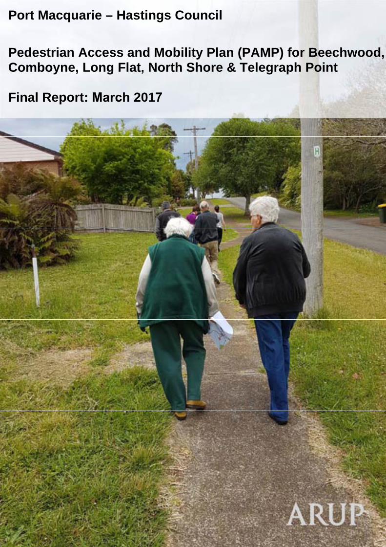
Port Macquarie – Hastings Council
Pedestrian Access and Mobility Plan (PAMP) for Beechwood, Comboyne, Long Flat, North Shore & Telegraph Point
Final Report: March 2017
Port Macquarie - Hastings Council Pedestrian Access and Mobility Plan for Beechwood, Comboyne, Long Flat,North Shore and Telegraph Point
Pedestrian Access and Mobility Plan
| Issue | 13 March 2017 | Arup
J:\250000\250779-00 PORT MACQUARIE PAMP\WORK\INTERNAL\04 REPORTING\FINAL PAMP REPORT\BEECHWOOD, COMBOYNE, LONG FLAT, NORTH SHORE AND TELEGRAPH POINT PAMP REPORT_FINAL REPORT.DOCX
Contents Page
1 Introduction 1
1.1 The Pedestrian Access and Mobility Plan 1
1.2 Objectives 1
1.3 Our process 2
1.4 Strategic context 3
1.5 The PAMP 4
2 Characteristics of the study areas 5
2.1 Beechwood characteristics 5
2.2 Comboyne characteristics 11
2.3 Long Flat characteristics 16
2.4 North Shore characteristics 20
2.5 Telegraph Point characteristics 24
3 Community consultation 29
3.1 Community workshops 29
3.2 Public exhibition 38
4 Infrastructure review and action plan 39
4.1 General considerations 39
4.2 Assessment criteria 39
4.3 Implementation priority 40
4.4 PAMP actions 41
4.5 Implementation 61
4.6 Monitoring 61
5 Summary 62
Tables Table 1: Staged Action Plan Priority
Table 2: Break down of issues and general recommended actions
Table 3 Beechwood proposed actions
Table 4 Comboyne proposed actions
Table 5 Long Flat proposed actions
Table 6 North Shore proposed actions
Table 7 Telegraph Point proposed actions
Port Macquarie - Hastings Council Pedestrian Access and Mobility Plan for Beechwood, Comboyne, Long Flat,North Shore and Telegraph Point
Pedestrian Access and Mobility Plan
| Issue | 13 March 2017 | Arup
J:\250000\250779-00 PORT MACQUARIE PAMP\WORK\INTERNAL\04 REPORTING\FINAL PAMP REPORT\BEECHWOOD, COMBOYNE, LONG FLAT, NORTH SHORE AND TELEGRAPH POINT PAMP REPORT_FINAL REPORT.DOCX
Figures Figure 1 - Study process
Figure 2 – Beechwood suburb extents
Figure 3 - Beechwood age profile
Figure 4 - Beechwood population requiring assistance
Figure 5 – Footpath at Neville Road - Beechwood
Figure 6 – Footpath serving shops / post office - Beechwood
Figure 7 - Footpath in front of Beechwood Public School Figure 8 – Footpath serving new residential subdivision
Figure 9 – Beechwood overview map
Figure 10 Comboyne suburb extents
Figure 11 - Comboyne age profile
Figure 12 – Comboyne population requiring assistance
Figure 13 – Main Street footpath - Comboyne
Figure 14 – Pedestrian refuge - Comboyne
Figure 15 – Comboyne community centre
Figure 16 – Comboyne overview map
Figure 17 - Long Flat suburb extents
Figure 18 – Long Flat age profile
Figure 19 - Long Flat population requiring assistance
Figure 20 – Missing footpath sections – Long Flat Figure 21 – Uneven footpath - Long Flat Figure 22 Strip of shops – Long Flat Figure 23 –Long Flat overview map
Figure 24 – North Shore suburb extents
Figure 25 - North Shore age profile
Figure 26 - North Shore population requiring assistance
Figure 27 – Ferry wharf at North Shore
Figure 28 – North Shore pedestrian environment Figure 29 – Ferry service across Hastings River Figure 30 –North Shore overview map
Figure 31 – Telegraph Point suburb extents
Figure 32 - Telegraph Point age profile
Figure 33 - Population requiring assistance
Figure 34 – Footpath adjacent to school at Telegraph Point Figure 35 – Pedestrian environment – Telegraph Point Figure 36 – Footpath over Wilson River Figure 37 – Pacific Highway upgrade near Telegraph Point Figure 38 –Telegraph Point overview map
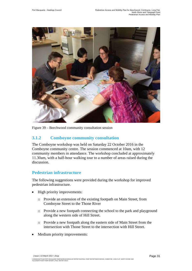
Figure 39 – Beechwood community consultation session
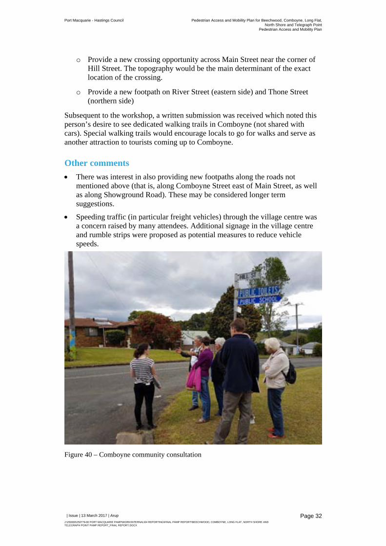
Figure 40 – Comboyne community consultation
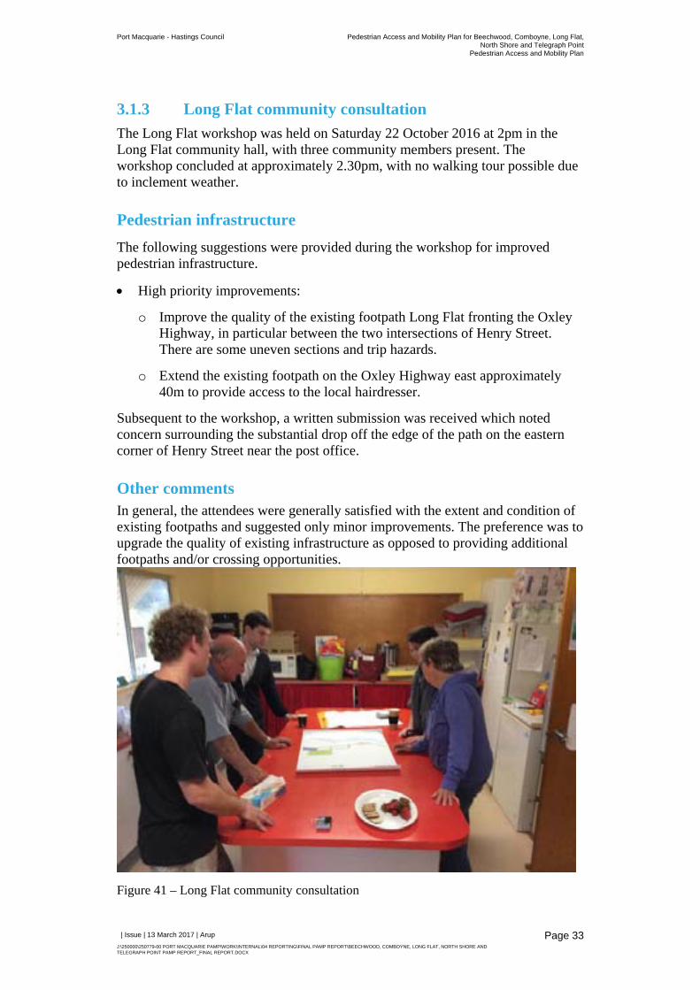
Figure 41 – Long Flat community consultation
Port Macquarie - Hastings Council Pedestrian Access and Mobility Plan for Beechwood, Comboyne, Long Flat,North Shore and Telegraph Point
Pedestrian Access and Mobility Plan
| Issue | 13 March 2017 | Arup
J:\250000\250779-00 PORT MACQUARIE PAMP\WORK\INTERNAL\04 REPORTING\FINAL PAMP REPORT\BEECHWOOD, COMBOYNE, LONG FLAT, NORTH SHORE AND TELEGRAPH POINT PAMP REPORT_FINAL REPORT.DOCX
Figure 42 – North Shore community consultation
Figure 43 – Telegraph Point community consultation
Figure 44 Beechwood, location of proposed pedestrian refuges
Figure 45 Beechwood proposed pedestrian infrastructure measures
Figure 46 Comboyne, Location of proposed pedestrian refuge
Figure 47 Comboyne proposed pedestrian infrastructure measures
Figure 48 Long Flat, location of proposed pedestrian refuge
Figure 49 Long Flat proposed pedestrian infrastructure measures
Figure 50 North Shore proposed pedestrian infrastructure measures
Figure 51 Telegraph Point, Location of proposed refuge
Figure 52 Telegraph Point proposed pedestrian infrastructure measures
Appendices
Appendix A
Action Plan
Port Macquarie - Hastings Council Pedestrian Access and Mobility Plan for Beechwood, Comboyne, Long Flat,North Shore and Telegraph Point
Pedestrian Access and Mobility Plan
| Issue | 13 March 2017 | Arup
J:\250000\250779-00 PORT MACQUARIE PAMP\WORK\INTERNAL\04 REPORTING\FINAL PAMP REPORT\BEECHWOOD, COMBOYNE, LONG FLAT, NORTH SHORE AND TELEGRAPH POINT PAMP REPORT_FINAL REPORT.DOCX
Page 1
1 Introduction
1.1 The Pedestrian Access and Mobility Plan
Arup was appointed by Port Macquarie Hastings Council (‘Council’) to prepare a Pedestrian Access and Mobility Plan (PAMP) for five villages within the Local Government Area (LGA), those being:
Beechwood
Comboyne
Long Flat
North Shore
Telegraph Point
The project aims to identify a framework for developing safe and convenient pedestrian routes and fostering improvements in personal mobility. The PAMP process provides a structured plan to implement pedestrian improvement programs and infrastructure. The study focuses on the two most critical types of pedestrian facilities - footpaths and road crossings, although considers broader infrastructure improvements to support pedestrian safety and amenity, such as traffic calming devices and pedestrian facilities.
1.2 Objectives
The key objective of this study is to deliver a PAMP improvement work program that meets the specific needs of users of the five villages – addressing barriers to walking by providing better pedestrian infrastructure at critical locations. The specific objectives of the PAMP are to:
Provide a planning framework for the necessary infrastructure to provide for a safer and more comfortable walking environment.
Improve the level of pedestrian access in urban locations.
Reduce pedestrian access severance by providing safe and convenient crossing opportunities of major roads.
Identify infrastructure works that can be implemented as part of Council’s future delivery and operational plans.
Provide a focus for Council to source funds from other levels of government.
Port Macquarie - Hastings Council Pedestrian Access and Mobility Plan for Beechwood, Comboyne, Long Flat,North Shore and Telegraph Point
Pedestrian Access and Mobility Plan
| Issue | 13 March 2017 | Arup
J:\250000\250779-00 PORT MACQUARIE PAMP\WORK\INTERNAL\04 REPORTING\FINAL PAMP REPORT\BEECHWOOD, COMBOYNE, LONG FLAT, NORTH SHORE AND TELEGRAPH POINT PAMP REPORT_FINAL REPORT.DOCX
Page 2
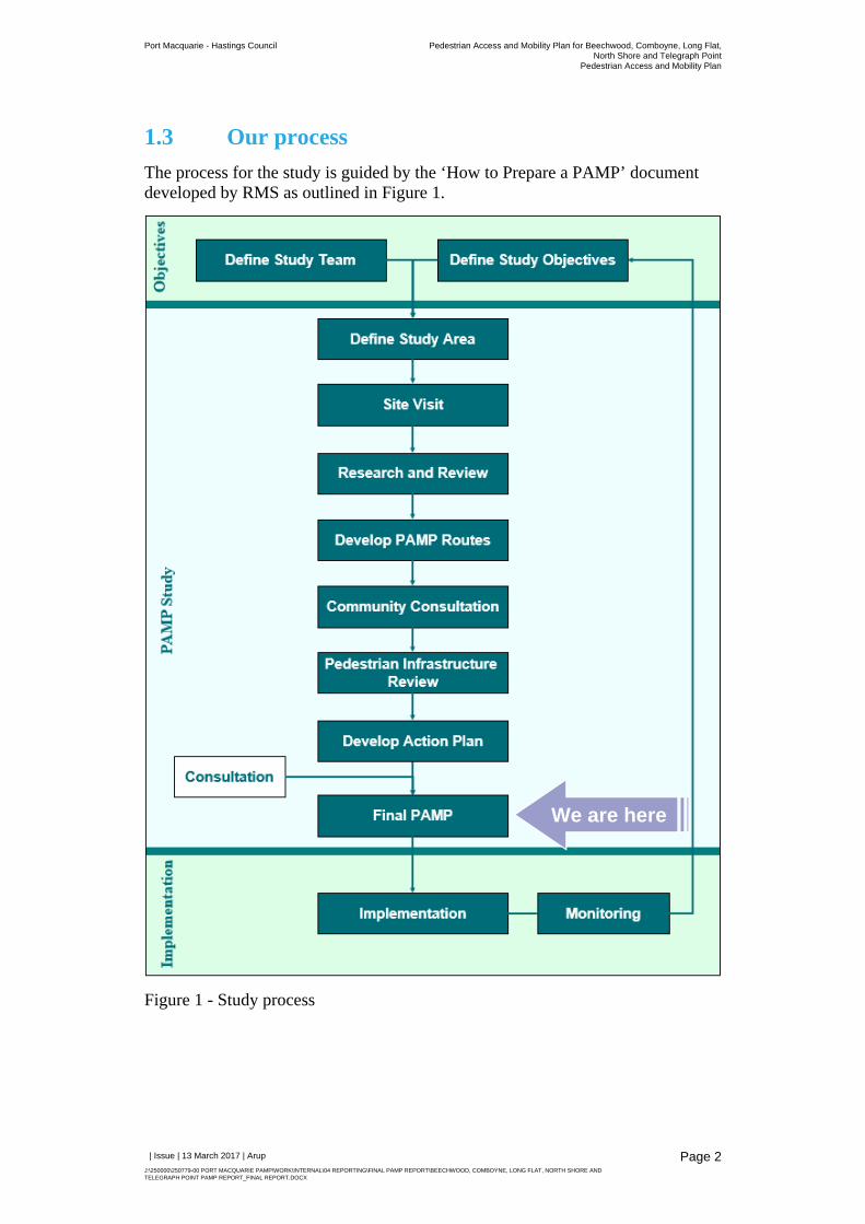
1.3 Our process
The process for the study is guided by the ‘How to Prepare a PAMP’ document developed by RMS as outlined in Figure 1.
Figure 1 - Study process
We are here
Port Macquarie - Hastings Council Pedestrian Access and Mobility Plan for Beechwood, Comboyne, Long Flat,North Shore and Telegraph Point
Pedestrian Access and Mobility Plan
| Issue | 13 March 2017 | Arup
J:\250000\250779-00 PORT MACQUARIE PAMP\WORK\INTERNAL\04 REPORTING\FINAL PAMP REPORT\BEECHWOOD, COMBOYNE, LONG FLAT, NORTH SHORE AND TELEGRAPH POINT PAMP REPORT_FINAL REPORT.DOCX
Page 3
1.4 Strategic context
Council have undertaken a series of studies and strategic plans that provide the context for the PAMP objectives to be delivered. Key documents are summarised in this section.
1.4.1 Towards 2030 Community Strategic Plan
In June 2011, Council adopted the Towards 2030 Community Strategic Plan for Port Macquarie - Hastings. This plan details the community’s overarching vision for the area, including:
A healthy and active community that is supported by recreational infrastructure,
A natural environment that can be accessed by a network of footpaths and cycleways,
Coastal and hinterland walkways,
An environmentally harmonious and prosperous tourism industry, and
Infrastructure provision and maintenance that respects community expectations and needs.
This PAMP forms one part of delivering on Council’s Community Strategic Plan vision.
1.4.2 Port Macquarie-Hastings PAMP
Following a robust community consultation process Council adopted a PAMP in May 2015 to continue the implementation of pedestrian facilities, with a particular focus on footpaths, kerb ramps and crossing facilities at critical locations. The Port Macquarie – Hastings PAMP covered the following areas:
Port Macquarie town centre
Port Macquarie East
Settlement City precinct
Wauchope town centre
Lake Cathie village centre
Bonny Hills village centre
North Haven village centre
Laurieton town centre
Kew village centre
Kendall village centre
This PAMP aims to build on the planning framework and recommendations for improved pedestrian infrastructure within the above listed areas.
Port Macquarie - Hastings Council Pedestrian Access and Mobility Plan for Beechwood, Comboyne, Long Flat,North Shore and Telegraph Point
Pedestrian Access and Mobility Plan
| Issue | 13 March 2017 | Arup
J:\250000\250779-00 PORT MACQUARIE PAMP\WORK\INTERNAL\04 REPORTING\FINAL PAMP REPORT\BEECHWOOD, COMBOYNE, LONG FLAT, NORTH SHORE AND TELEGRAPH POINT PAMP REPORT_FINAL REPORT.DOCX
Page 4
1.4.3 Port Macquarie-Hastings Council Transport Strategy
Council is currently in the process of developing a study which will bring together detailed supporting strategies and plans into a coherent strategy for the Port Macquarie-Hastings transport system. Working Paper 2 – Existing Conditions and Key Issues (February 2014) notes that priority “will be given to non-motorised forms of transport – walking and cycling, in addition to public transport”. Specific to the towns subject to this PAMP, the strategy notes “The private car will continue to be the most suitable form of transport for regional areas and from one town or village to another”.
The strategy therefore highlights that supporting walking within the villages is a key focus for Council.
1.4.4 Placemaking
Adopting a placemaking approach to the design and development of spaces means a focus on putting people first with an understanding of how people want to use and experience a place. Council is adopting a placemaking approach to the development of public infrastructure and open space, bringing together multidisciplinary approach to planning, development and community building that involves understanding the culture, qualities and needs and desires of the community.
The PAMP, through encouraging walking activity on the streets, will be an important input into placemaking projects such as recreational walkways and the invigoration of village centres.
1.5 The PAMP
The PAMP includes the following:
An overview of the current characteristics of each village
A review of the pedestrian infrastructure in each village, including inputs from community consultation and site visits
A summary of the feedback received during the initial community consultation period and the public exhibition
An Action Plan documenting pedestrian improvements, and the prioritisation and costs for these improvements
Port Macquarie - Hastings Council Pedestrian Access and Mobility Plan for Beechwood, Comboyne, Long Flat,North Shore and Telegraph Point
Pedestrian Access and Mobility Plan
| Issue | 13 March 2017 | Arup
J:\250000\250779-00 PORT MACQUARIE PAMP\WORK\INTERNAL\04 REPORTING\FINAL PAMP REPORT\BEECHWOOD, COMBOYNE, LONG FLAT, NORTH SHORE AND TELEGRAPH POINT PAMP REPORT_FINAL REPORT.DOCX
Page 5
2 Characteristics of the study areas
A selection of demographic data from ABS 2011 Census and Bureau of Transport Statistics Population Forecasts have been reviewed for each village and summarised by village below.
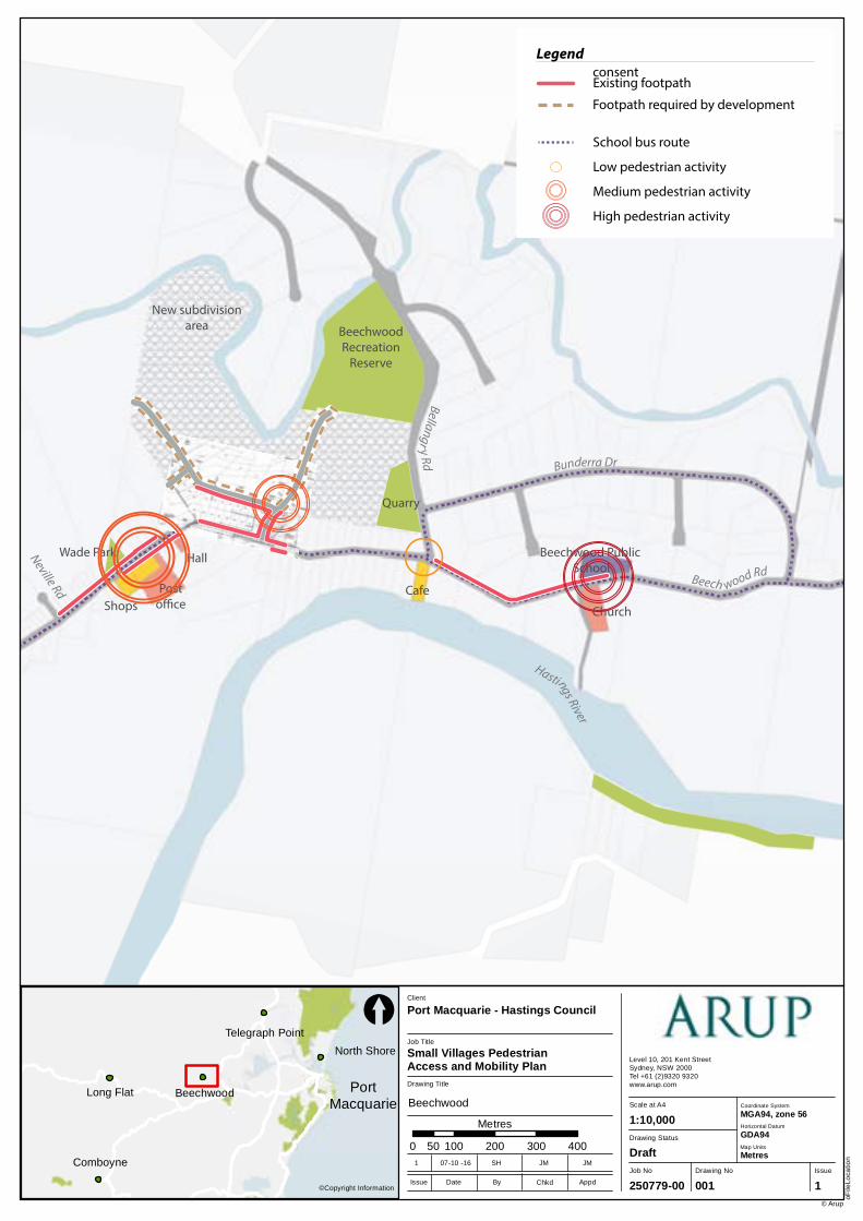
2.1 Beechwood characteristics
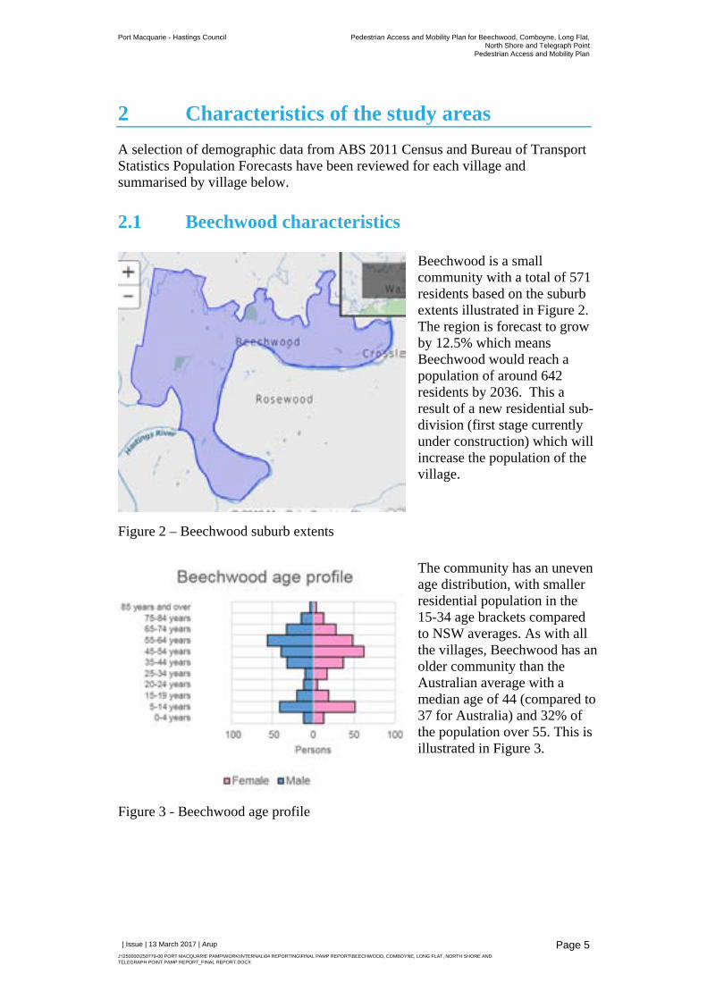
Figure 2 – Beechwood suburb extents
Beechwood is a small community with a total of 571 residents based on the suburb extents illustrated in Figure 2. The region is forecast to grow by 12.5% which means Beechwood would reach a population of around 642 residents by 2036. This a result of a new residential sub-division (first stage currently under construction) which will increase the population of the village.
Figure 3 - Beechwood age profile
The community has an uneven age distribution, with smaller residential population in the 15-34 age brackets compared to NSW averages. As with all the villages, Beechwood has an older community than the Australian average with a median age of 44 (compared to 37 for Australia) and 32% of the population over 55. This is illustrated in Figure 3.
Port Macquarie - Hastings Council Pedestrian Access and Mobility Plan for Beechwood, Comboyne, Long Flat,North Shore and Telegraph Point
Pedestrian Access and Mobility Plan
| Issue | 13 March 2017 | Arup
J:\250000\250779-00 PORT MACQUARIE PAMP\WORK\INTERNAL\04 REPORTING\FINAL PAMP REPORT\BEECHWOOD, COMBOYNE, LONG FLAT, NORTH SHORE AND TELEGRAPH POINT PAMP REPORT_FINAL REPORT.DOCX
Page 6
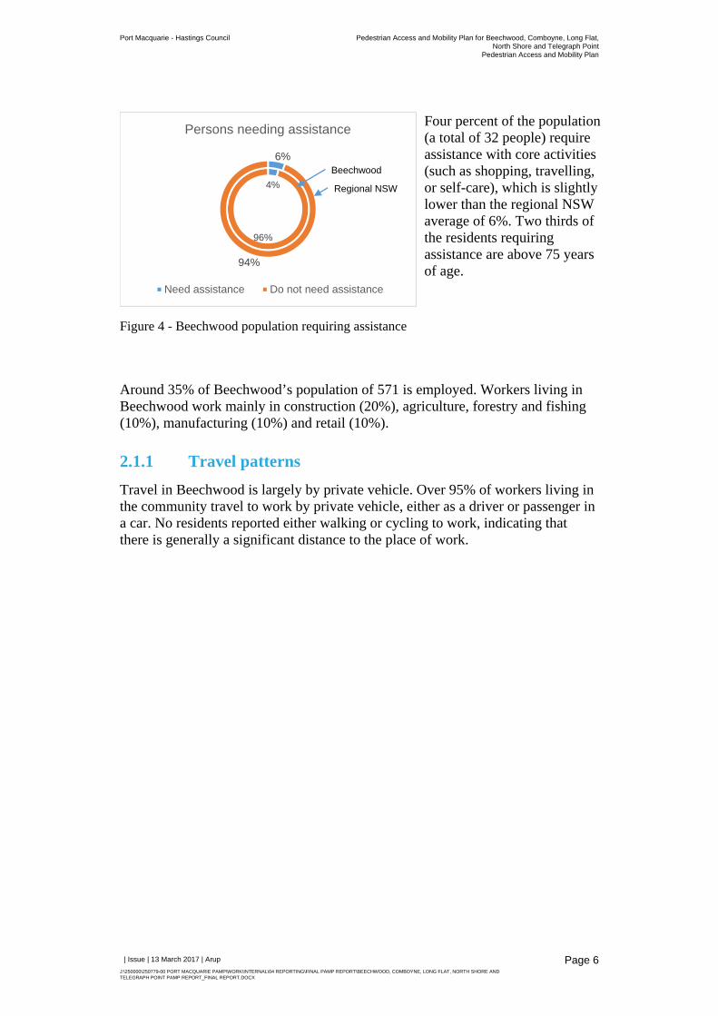
Figure 4 - Beechwood population requiring assistance
Four percent of the population (a total of 32 people) require assistance with core activities (such as shopping, travelling, or self-care), which is slightly lower than the regional NSW average of 6%. Two thirds of the residents requiring assistance are above 75 years of age.
Around 35% of Beechwood’s population of 571 is employed. Workers living in Beechwood work mainly in construction (20%), agriculture, forestry and fishing (10%), manufacturing (10%) and retail (10%).
2.1.1 Travel patterns
Travel in Beechwood is largely by private vehicle. Over 95% of workers living in the community travel to work by private vehicle, either as a driver or passenger in a car. No residents reported either walking or cycling to work, indicating that there is generally a significant distance to the place of work.
4%
96%
6%
94%
Persons needing assistance
Need assistance Do not need assistance
Beechwood
Regional NSW
Port Macquarie - Hastings Council Pedestrian Access and Mobility Plan for Beechwood, Comboyne, Long Flat,North Shore and Telegraph Point
Pedestrian Access and Mobility Plan
| Issue | 13 March 2017 | Arup
J:\250000\250779-00 PORT MACQUARIE PAMP\WORK\INTERNAL\04 REPORTING\FINAL PAMP REPORT\BEECHWOOD, COMBOYNE, LONG FLAT, NORTH SHORE AND TELEGRAPH POINT PAMP REPORT_FINAL REPORT.DOCX
Page 7
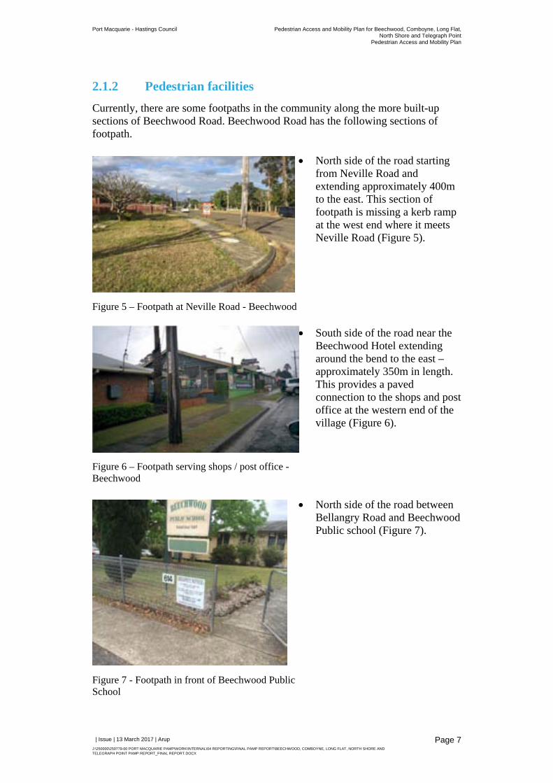
2.1.2 Pedestrian facilities
Currently, there are some footpaths in the community along the more built-up sections of Beechwood Road. Beechwood Road has the following sections of footpath.
Figure 5 – Footpath at Neville Road - Beechwood
North side of the road starting from Neville Road and extending approximately 400m to the east. This section of footpath is missing a kerb ramp at the west end where it meets Neville Road (Figure 5).
Figure 6 – Footpath serving shops / post office - Beechwood
South side of the road near the Beechwood Hotel extending around the bend to the east – approximately 350m in length. This provides a paved connection to the shops and post office at the western end of the village (Figure 6).
Figure 7 - Footpath in front of Beechwood Public School
North side of the road between Bellangry Road and Beechwood Public school (Figure 7).
Port Macquarie - Hastings Council Pedestrian Access and Mobility Plan for Beechwood, Comboyne, Long Flat,North Shore and Telegraph Point
Pedestrian Access and Mobility Plan
| Issue | 13 March 2017 | Arup
J:\250000\250779-00 PORT MACQUARIE PAMP\WORK\INTERNAL\04 REPORTING\FINAL PAMP REPORT\BEECHWOOD, COMBOYNE, LONG FLAT, NORTH SHORE AND TELEGRAPH POINT PAMP REPORT_FINAL REPORT.DOCX
Page 8
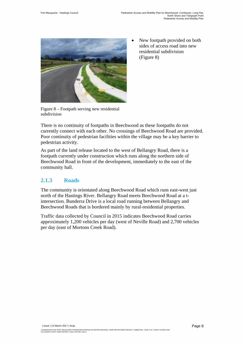
Figure 8 – Footpath serving new residential subdivision
New footpath provided on both sides of access road into new residential subdivision (Figure 8)
There is no continuity of footpaths in Beechwood as these footpaths do not currently connect with each other. No crossings of Beechwood Road are provided. Poor continuity of pedestrian facilities within the village may be a key barrier to pedestrian activity.
As part of the land release located to the west of Bellangry Road, there is a footpath currently under construction which runs along the northern side of Beechwood Road in front of the development, immediately to the east of the community hall.
2.1.3 Roads
The community is orientated along Beechwood Road which runs east-west just north of the Hastings River. Bellangry Road meets Beechwood Road at a t-intersection. Bunderra Drive is a local road running between Bellangry and Beechwood Roads that is bordered mainly by rural-residential properties.
Traffic data collected by Council in 2015 indicates Beechwood Road carries approximately 1,200 vehicles per day (west of Neville Road) and 2,700 vehicles per day (east of Mortons Creek Road).
Port Macquarie - Hastings Council Pedestrian Access and Mobility Plan for Beechwood, Comboyne, Long Flat,North Shore and Telegraph Point
Pedestrian Access and Mobility Plan
| Issue | 13 March 2017 | Arup
J:\250000\250779-00 PORT MACQUARIE PAMP\WORK\INTERNAL\04 REPORTING\FINAL PAMP REPORT\BEECHWOOD, COMBOYNE, LONG FLAT, NORTH SHORE AND TELEGRAPH POINT PAMP REPORT_FINAL REPORT.DOCX
Page 9
2.1.4 Public transport
The area is served by the 339 bus route operated by Busways, which loops around Beechwood Road and Bunderra Road and continues on to Wauchope. The bus operates Monday to Friday as a school bus, with one service arriving at Wauchope at 8:55am and leaves at 3:06pm to link in with school hours.
2.1.5 Pedestrian trip attractors and generators
Activity in Beechwood is focused along Beechwood Road which contains frontages to a number of shops and services. The key pedestrian attractors and generators are focused towards the west of village with shops and post office, as well as the central part of the village opposite Bellangry Road.
Beechwood Public School is located at the eastern end of the village. With approximately 130 students, the school generates a significant amount of pedestrian activity – particularly in the morning and afternoon periods. It is understood that students are either driven by their parents or walk to the school, as the bus route goes to Wauchope and is used by high school students attending school in the nearby town.
2.1.6 Pedestrian crash data
There has been one recorded instance of a crash involving a pedestrian in the last five years within the village. This occurred on Beechwood Road approximately 350m west of Bellangary Road – an area outside the strip of shops serving the village. The crash occurred as a pedestrian was emerging onto the road and was struck by a moving vehicle – resulting in an injury to the pedestrian.
Comboyne
Long Flat Beechwood
North Shore
Telegraph Point
Job No
250779-00
Drawing No Issue
001 1
Drawing Status
Draft
Scale at A4
Level 10, 201 Kent StreetSydney, NSW 2000Tel +61 (2)9320 9320 www.arup.com
oFile
Loca
tion
© Arup
1:10,000
Drawing Title
Job Title
Small Villages Pedestrian Access and Mobility Plan
Client
Port Macquarie - Hastings Council
0 100 200 300 40050
Metres
©Copyright InformationIssue Date By Appd
1 07-10 -16 SH JM JM
Chkd
[
Coordinate System
Horizontal Datum
GDA94
MGA94, zone 56
Map Units
Metres
PortMacquarie Beechwood
BeechwoodRecreation
Reserve
New subdivisionarea
Quarry
Church
Beechwood Public School
Posto�ce
HallWade Park
ShopsCafe
Bunderra Dr
Bellangry Rd
Beech wood Rd
Neville Rd
Hastings River
Legend
Existing footpath
Footpath under construction
Footpath required by developmentconsent
Suggested footpath
School bus route
Suggested improvements
Suggested crossing location
Fix tree damage to existing
footpaths (B06)
Provide new footpathto connect sections
between existingfootpaths (B01, B03)
Improve connection between end of footpath
and road (B09)
Provide kerb rampsmake existing footpaths
accessible (B04, B05)
Extend existingfootpath to cafe on south side of road
(B07)
Provide pedestrian refuge crossings across Bellangry
Rd and Beechwood Rd (B02, B08)
Legend
Existing footpath
Footpath under construction
School bus route
Damage to existingfootpaths
Missing sectionsbetween existing
footpaths
Dangerous crossing at Bellangry Rd andBeechwood Rd
Missing kerb rampsmake access to
existing footpaths di�cult
Legend
Existing footpath
Footpath required by development consent
School bus route
Low pedestrian activity
Medium pedestrian activity
High pedestrian activity
Port Macquarie - Hastings Council Pedestrian Access and Mobility Plan for Beechwood, Comboyne, Long Flat,North Shore and Telegraph Point
Pedestrian Access and Mobility Plan
| Issue | 13 March 2017 | Arup
J:\250000\250779-00 PORT MACQUARIE PAMP\WORK\INTERNAL\04 REPORTING\FINAL PAMP REPORT\BEECHWOOD, COMBOYNE, LONG FLAT, NORTH SHORE AND TELEGRAPH POINT PAMP REPORT_FINAL REPORT.DOCX
Page 11
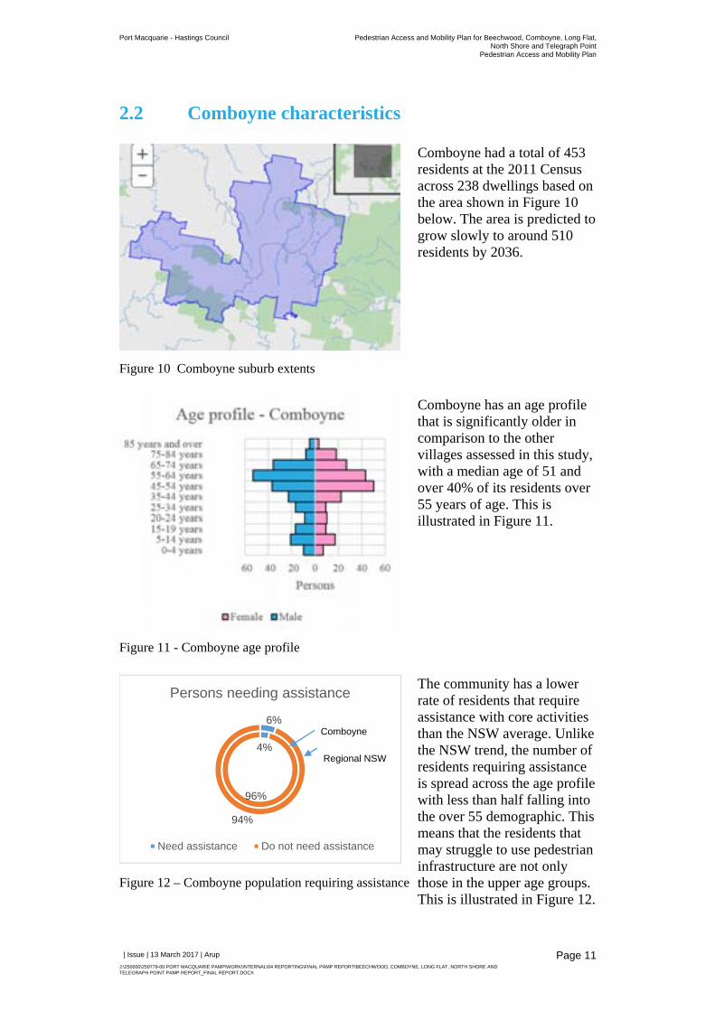
2.2 Comboyne characteristics
Figure 10 Comboyne suburb extents
Comboyne had a total of 453 residents at the 2011 Census across 238 dwellings based on the area shown in Figure 10 below. The area is predicted to grow slowly to around 510 residents by 2036.
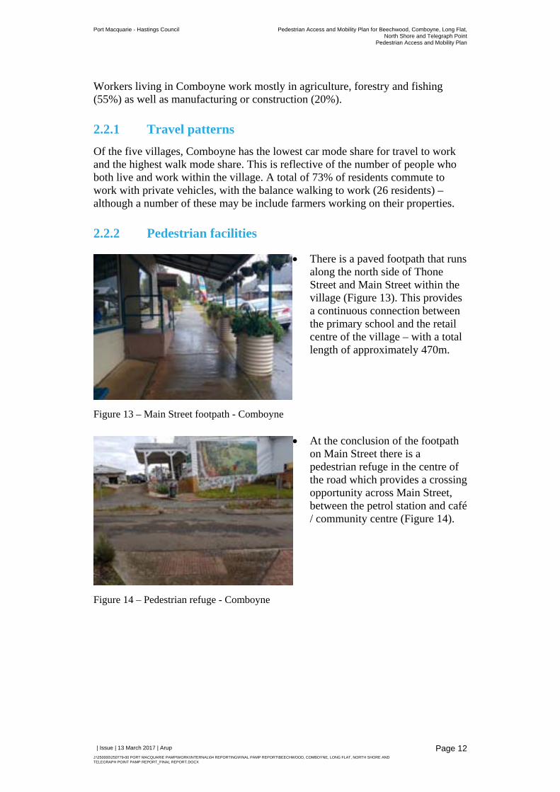
Figure 11 - Comboyne age profile
Comboyne has an age profile that is significantly older in comparison to the other villages assessed in this study, with a median age of 51 and over 40% of its residents over 55 years of age. This is illustrated in Figure 11.
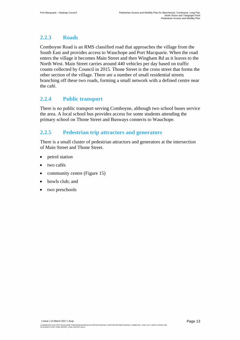
Figure 12 – Comboyne population requiring assistance
The community has a lower rate of residents that require assistance with core activities than the NSW average. Unlike the NSW trend, the number of residents requiring assistance is spread across the age profile with less than half falling into the over 55 demographic. This means that the residents that may struggle to use pedestrian infrastructure are not only those in the upper age groups. This is illustrated in Figure 12.
4%
96%
6%
94%
Persons needing assistance
Need assistance Do not need assistance
Comboyne
Regional NSW
Port Macquarie - Hastings Council Pedestrian Access and Mobility Plan for Beechwood, Comboyne, Long Flat,North Shore and Telegraph Point
Pedestrian Access and Mobility Plan
| Issue | 13 March 2017 | Arup
J:\250000\250779-00 PORT MACQUARIE PAMP\WORK\INTERNAL\04 REPORTING\FINAL PAMP REPORT\BEECHWOOD, COMBOYNE, LONG FLAT, NORTH SHORE AND TELEGRAPH POINT PAMP REPORT_FINAL REPORT.DOCX
Page 12
Workers living in Comboyne work mostly in agriculture, forestry and fishing (55%) as well as manufacturing or construction (20%).
2.2.1 Travel patterns
Of the five villages, Comboyne has the lowest car mode share for travel to work and the highest walk mode share. This is reflective of the number of people who both live and work within the village. A total of 73% of residents commute to work with private vehicles, with the balance walking to work (26 residents) – although a number of these may be include farmers working on their properties.
2.2.2 Pedestrian facilities
Figure 13 – Main Street footpath - Comboyne
There is a paved footpath that runs along the north side of Thone Street and Main Street within the village (Figure 13). This provides a continuous connection between the primary school and the retail centre of the village – with a total length of approximately 470m.
Figure 14 – Pedestrian refuge - Comboyne
At the conclusion of the footpath on Main Street there is a pedestrian refuge in the centre of the road which provides a crossing opportunity across Main Street, between the petrol station and café / community centre (Figure 14).
Port Macquarie - Hastings Council Pedestrian Access and Mobility Plan for Beechwood, Comboyne, Long Flat,North Shore and Telegraph Point
Pedestrian Access and Mobility Plan
| Issue | 13 March 2017 | Arup
J:\250000\250779-00 PORT MACQUARIE PAMP\WORK\INTERNAL\04 REPORTING\FINAL PAMP REPORT\BEECHWOOD, COMBOYNE, LONG FLAT, NORTH SHORE AND TELEGRAPH POINT PAMP REPORT_FINAL REPORT.DOCX
Page 13
2.2.3 Roads
Comboyne Road is an RMS classified road that approaches the village from the South East and provides access to Wauchope and Port Macquarie. When the road enters the village it becomes Main Street and then Wingham Rd as it leaves to the North West. Main Street carries around 440 vehicles per day based on traffic counts collected by Council in 2015. Thone Street is the cross street that forms the other section of the village. There are a number of small residential streets branching off these two roads, forming a small network with a defined centre near the café.
2.2.4 Public transport
There is no public transport serving Comboyne, although two school buses service the area. A local school bus provides access for some students attending the primary school on Thone Street and Busways connects to Wauchope.
2.2.5 Pedestrian trip attractors and generators
There is a small cluster of pedestrian attractors and generators at the intersection of Main Street and Thone Street.
petrol station
two cafés
community centre (Figure 15)
bowls club; and
two preschools
Port Macquarie - Hastings Council Pedestrian Access and Mobility Plan for Beechwood, Comboyne, Long Flat,North Shore and Telegraph Point
Pedestrian Access and Mobility Plan
| Issue | 13 March 2017 | Arup
J:\250000\250779-00 PORT MACQUARIE PAMP\WORK\INTERNAL\04 REPORTING\FINAL PAMP REPORT\BEECHWOOD, COMBOYNE, LONG FLAT, NORTH SHORE AND TELEGRAPH POINT PAMP REPORT_FINAL REPORT.DOCX
Page 14
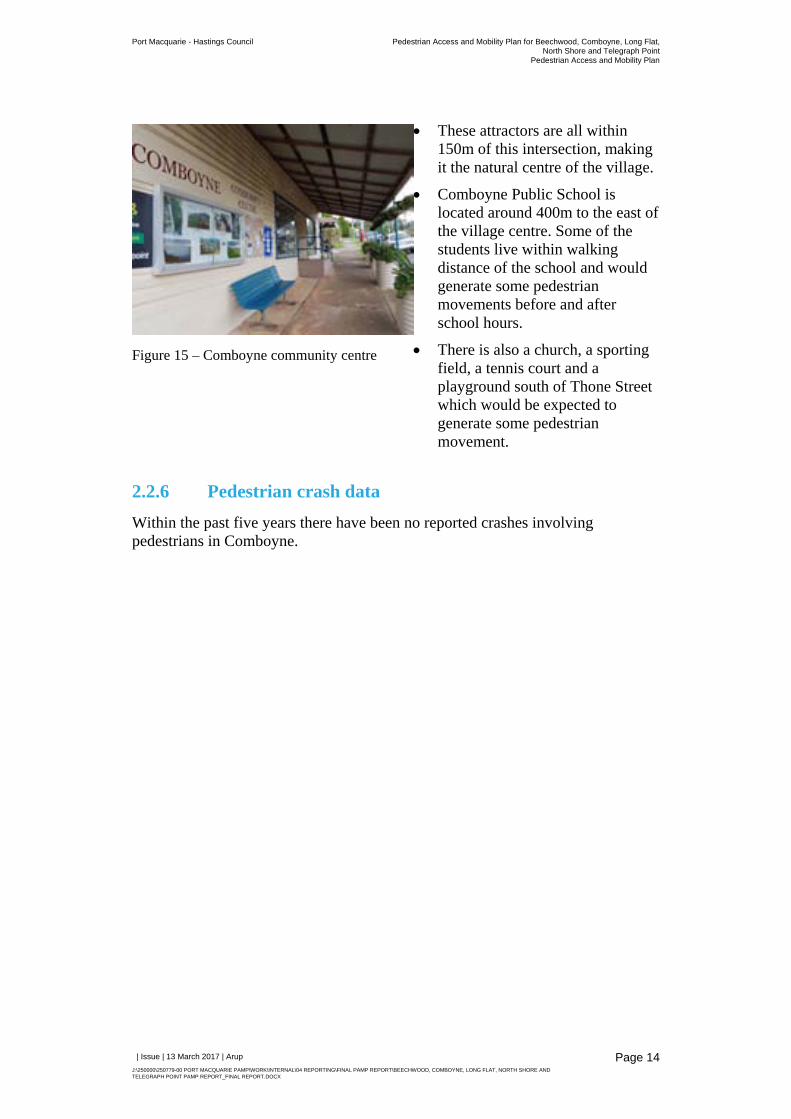
Figure 15 – Comboyne community centre
These attractors are all within 150m of this intersection, making it the natural centre of the village.
Comboyne Public School is located around 400m to the east of the village centre. Some of the students live within walking distance of the school and would generate some pedestrian movements before and after school hours.
There is also a church, a sporting field, a tennis court and a playground south of Thone Street which would be expected to generate some pedestrian movement.
2.2.6 Pedestrian crash data
Within the past five years there have been no reported crashes involving pedestrians in Comboyne.

Comboyne
Long Flat Beechwood
North Shore
Telegraph Point
Job No
250779-00
Drawing No Issue
001 1
Drawing Status
Draft
Scale at A4
Level 10, 201 Kent StreetSydney, NSW 2000Tel +61 (2)9320 9320 www.arup.com
oFile
Loca
tion
© Arup
1:5,000
Drawing Title
Job Title
Small Villages Pedestrian Access and Mobility Plan
Client
Port Macquarie - Hastings Council
0 100 20050
Metres
©Copyright InformationIssue Date By Appd
1 07-10 -16 SH JM JM
Chkd
[
Coordinate System
Horizontal Datum
GDA94
MGA94, zone 56
Map Units
Metres
PortMacquarie Comboyne
Showground / sports �eld
Cheesefactory Police
station Co-opshop
Community halland cafe
Petrolstation
Hall/childcarecentre
Bowlingclub
Cafe
ComboynePublicSchool
PioneerPark
Tea house
Church
Church
Tenniscourts
Thon
e Riv
er
PlaygroundShowgro
und RdM
ain St
Rive
r St
Comboyne St
Thone St
Hill St
La
ndsdowne Rd
Comboyne Rd
W ingha m Rd
Browns Rd
School childrenwalk to parkalong road
Lack of footpath alonghigh speed road
into town
Lack of footpathsin high pedestrian
activity areas
Di�cult crossing dueto high speeds and
low visibility over hill
High speed freighttra�c
through town
Legend
Existing footpath
School bus route
Connect school toplayground along
Hill Street (C02)
New footpath extendingalong Main Street from
town centre (C05)
New footpath alongMain Street and
Comboyne St(C03, C04)
New pedestrian refuge crossing near the
park (C06)
Legend
Existing footpath
Suggested footpath
School bus route
Suggested footpath improvements
Suggested crossing / crossing upgrade
New footpaths alongThone St and
River St(C07, C08)
Upgrade refugecrossing to meet
required standards(C01)
Legend
Existing footpath
School bus route
Existing pedestrian refuge
Low pedestrian activity
Medium pedestrian activity
High pedestrian activity
Port Macquarie - Hastings Council Pedestrian Access and Mobility Plan for Beechwood, Comboyne, Long Flat,North Shore and Telegraph Point
Pedestrian Access and Mobility Plan
| Issue | 13 March 2017 | Arup
J:\250000\250779-00 PORT MACQUARIE PAMP\WORK\INTERNAL\04 REPORTING\FINAL PAMP REPORT\BEECHWOOD, COMBOYNE, LONG FLAT, NORTH SHORE AND TELEGRAPH POINT PAMP REPORT_FINAL REPORT.DOCX
Page 16
2.3 Long Flat characteristics
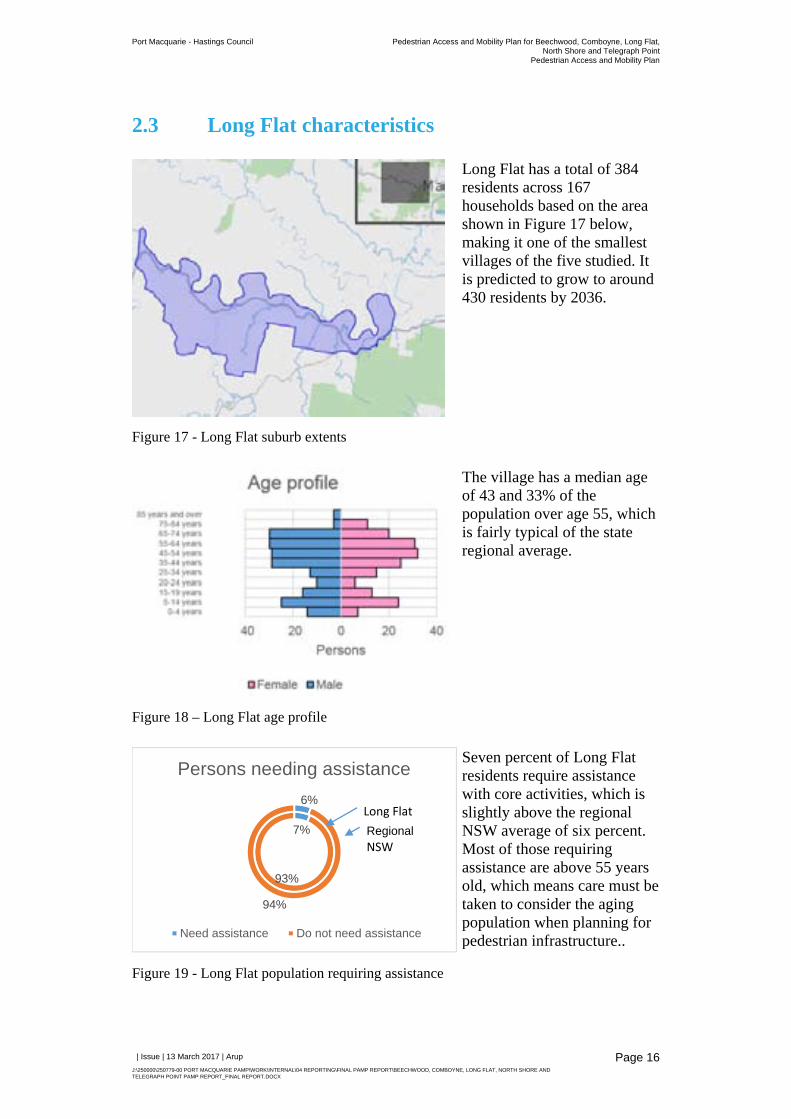
Figure 17 - Long Flat suburb extents
Long Flat has a total of 384 residents across 167 households based on the area shown in Figure 17 below, making it one of the smallest villages of the five studied. It is predicted to grow to around 430 residents by 2036.
Figure 18 – Long Flat age profile
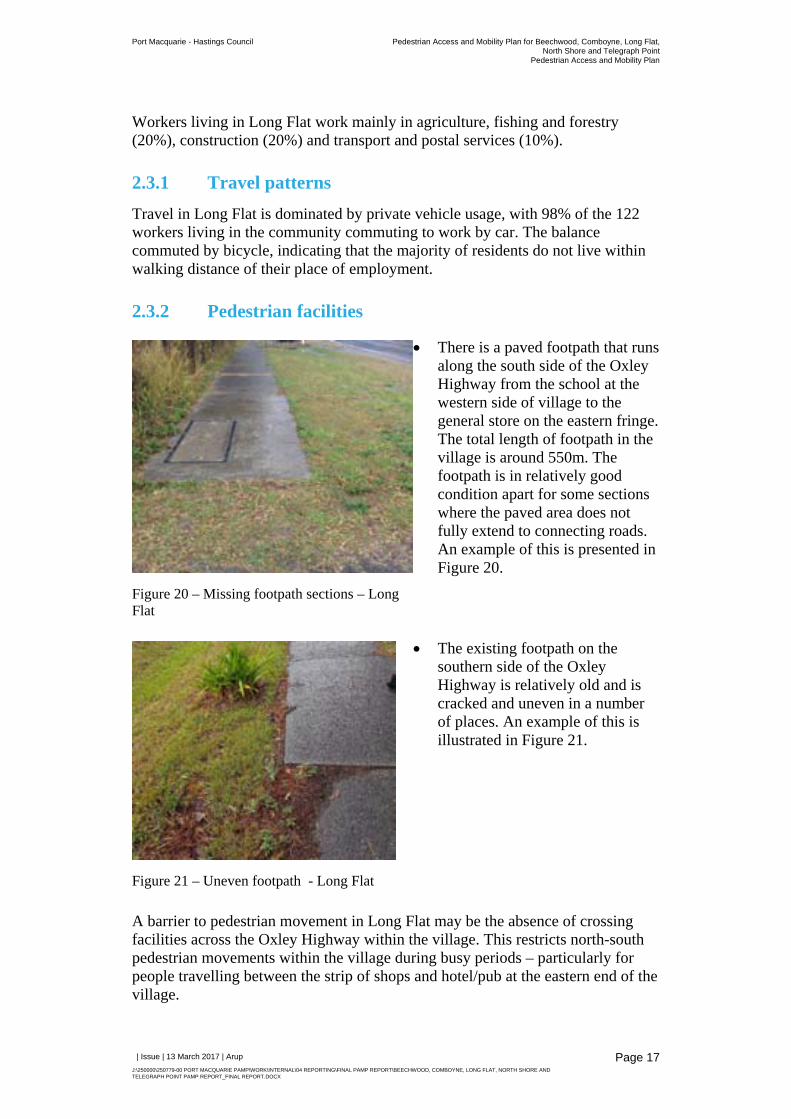
The village has a median age of 43 and 33% of the population over age 55, which is fairly typical of the state regional average.
Figure 19 - Long Flat population requiring assistance
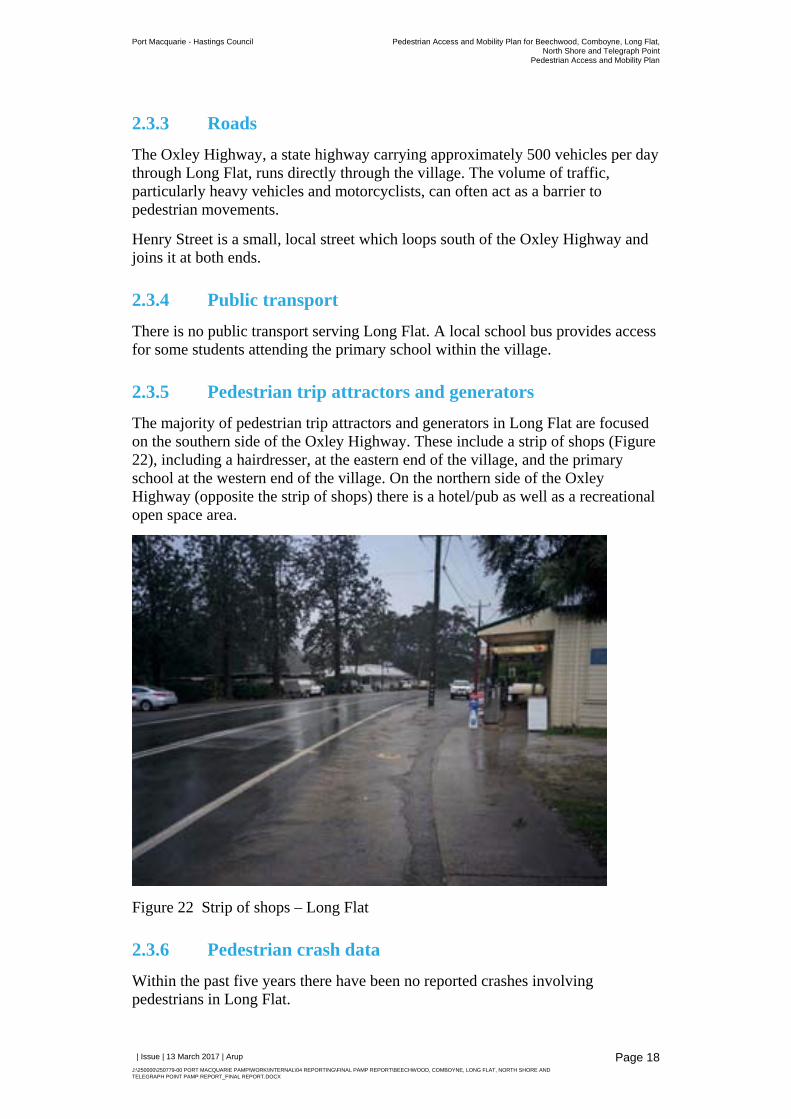
Seven percent of Long Flat residents require assistance with core activities, which is slightly above the regional NSW average of six percent. Most of those requiring assistance are above 55 years old, which means care must be taken to consider the aging population when planning for pedestrian infrastructure..
7%
93%
6%
94%
Persons needing assistance
Need assistance Do not need assistance
Long Flat
RegionalNSW
Port Macquarie - Hastings Council Pedestrian Access and Mobility Plan for Beechwood, Comboyne, Long Flat,North Shore and Telegraph Point
Pedestrian Access and Mobility Plan
| Issue | 13 March 2017 | Arup
J:\250000\250779-00 PORT MACQUARIE PAMP\WORK\INTERNAL\04 REPORTING\FINAL PAMP REPORT\BEECHWOOD, COMBOYNE, LONG FLAT, NORTH SHORE AND TELEGRAPH POINT PAMP REPORT_FINAL REPORT.DOCX
Page 17
Workers living in Long Flat work mainly in agriculture, fishing and forestry (20%), construction (20%) and transport and postal services (10%).
2.3.1 Travel patterns
Travel in Long Flat is dominated by private vehicle usage, with 98% of the 122 workers living in the community commuting to work by car. The balance commuted by bicycle, indicating that the majority of residents do not live within walking distance of their place of employment.
2.3.2 Pedestrian facilities
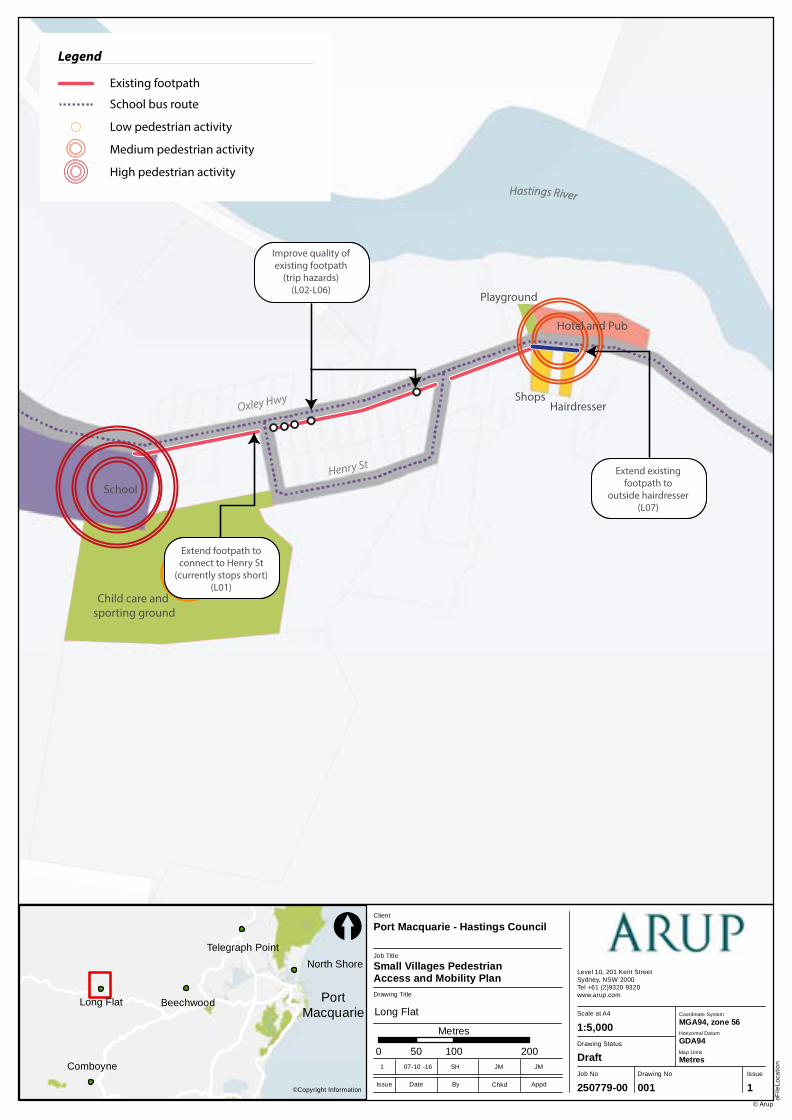
Figure 20 – Missing footpath sections – Long Flat
There is a paved footpath that runs along the south side of the Oxley Highway from the school at the western side of village to the general store on the eastern fringe. The total length of footpath in the village is around 550m. The footpath is in relatively good condition apart for some sections where the paved area does not fully extend to connecting roads. An example of this is presented in Figure 20.
Figure 21 – Uneven footpath - Long Flat
The existing footpath on the southern side of the Oxley Highway is relatively old and is cracked and uneven in a number of places. An example of this is illustrated in Figure 21.
A barrier to pedestrian movement in Long Flat may be the absence of crossing facilities across the Oxley Highway within the village. This restricts north-south pedestrian movements within the village during busy periods – particularly for people travelling between the strip of shops and hotel/pub at the eastern end of the village.
Port Macquarie - Hastings Council Pedestrian Access and Mobility Plan for Beechwood, Comboyne, Long Flat,North Shore and Telegraph Point
Pedestrian Access and Mobility Plan
| Issue | 13 March 2017 | Arup
J:\250000\250779-00 PORT MACQUARIE PAMP\WORK\INTERNAL\04 REPORTING\FINAL PAMP REPORT\BEECHWOOD, COMBOYNE, LONG FLAT, NORTH SHORE AND TELEGRAPH POINT PAMP REPORT_FINAL REPORT.DOCX
Page 18
2.3.3 Roads
The Oxley Highway, a state highway carrying approximately 500 vehicles per day through Long Flat, runs directly through the village. The volume of traffic, particularly heavy vehicles and motorcyclists, can often act as a barrier to pedestrian movements.
Henry Street is a small, local street which loops south of the Oxley Highway and joins it at both ends.
2.3.4 Public transport
There is no public transport serving Long Flat. A local school bus provides access for some students attending the primary school within the village.
2.3.5 Pedestrian trip attractors and generators
The majority of pedestrian trip attractors and generators in Long Flat are focused on the southern side of the Oxley Highway. These include a strip of shops (Figure 22), including a hairdresser, at the eastern end of the village, and the primary school at the western end of the village. On the northern side of the Oxley Highway (opposite the strip of shops) there is a hotel/pub as well as a recreational open space area.
Figure 22 Strip of shops – Long Flat
2.3.6 Pedestrian crash data
Within the past five years there have been no reported crashes involving pedestrians in Long Flat.
Comboyne
Long Flat Beechwood
North Shore
Telegraph Point
Job No
250779-00
Drawing No Issue
001 1
Drawing Status
Draft
Scale at A4
Level 10, 201 Kent StreetSydney, NSW 2000Tel +61 (2)9320 9320 www.arup.com
oFile
Loca
tion
© Arup
1:5,000
Drawing Title
Job Title
Small Villages Pedestrian Access and Mobility Plan
Client
Port Macquarie - Hastings Council
0 100 20050
Metres
©Copyright InformationIssue Date By Appd
1 07-10 -16 SH JM JM
Chkd
[
Coordinate System
Horizontal Datum
GDA94
MGA94, zone 56
Map Units
Metres
PortMacquarie Long Flat
Playground
Hotel and Pub
ShopsHairdresser
Child care and sporting ground
School
Hastings River
Oxley Hwy
Henry St
Legend
Existing footpath
School bus route
Footpath does notextend to Henry
Street
Footpath damagealong existing footpath
Footpath stopsbefore hairdresser
Hastings River
Legend
Existing footpath
Suggested footpath
School bus route
Suggested improvements
Extend footpath toconnect to Henry St
(currently stops short)(L01)
Improve quality ofexisting footpath
(trip hazards)(L02-L06)
Extend existingfootpath to
outside hairdresser(L07)
Legend
Existing footpath
School bus route
Low pedestrian activity
Medium pedestrian activity
High pedestrian activity
Port Macquarie - Hastings Council Pedestrian Access and Mobility Plan for Beechwood, Comboyne, Long Flat,North Shore and Telegraph Point
Pedestrian Access and Mobility Plan
| Issue | 13 March 2017 | Arup
J:\250000\250779-00 PORT MACQUARIE PAMP\WORK\INTERNAL\04 REPORTING\FINAL PAMP REPORT\BEECHWOOD, COMBOYNE, LONG FLAT, NORTH SHORE AND TELEGRAPH POINT PAMP REPORT_FINAL REPORT.DOCX
Page 20
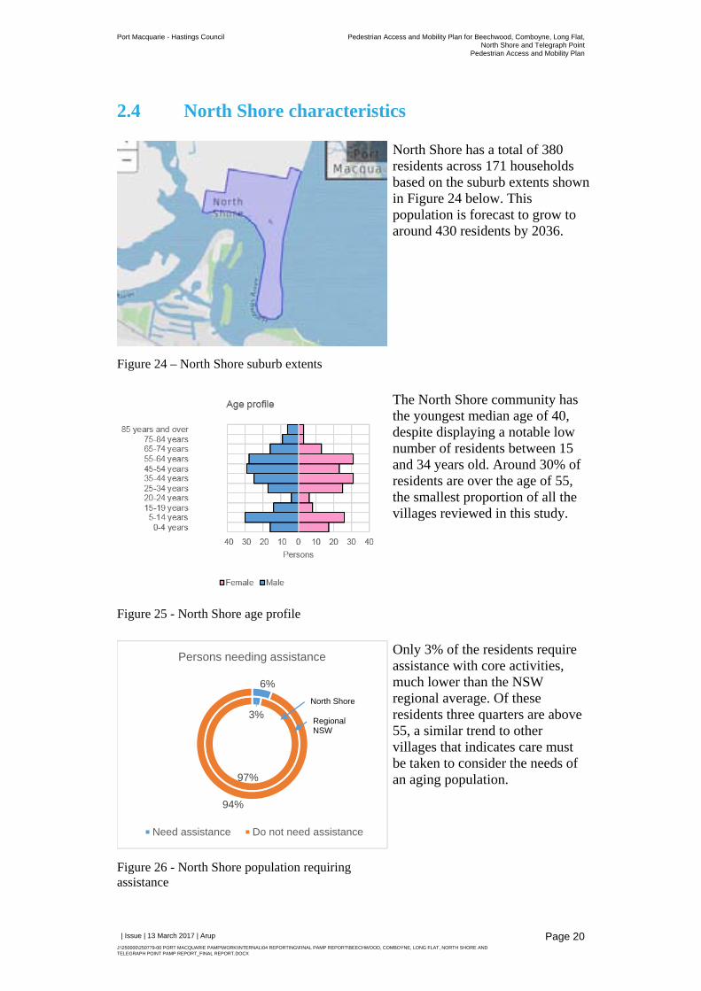
2.4 North Shore characteristics
Figure 24 – North Shore suburb extents
North Shore has a total of 380 residents across 171 households based on the suburb extents shown in Figure 24 below. This population is forecast to grow to around 430 residents by 2036.
Figure 25 - North Shore age profile
The North Shore community has the youngest median age of 40, despite displaying a notable low number of residents between 15 and 34 years old. Around 30% of residents are over the age of 55, the smallest proportion of all the villages reviewed in this study.
Figure 26 - North Shore population requiring assistance
Only 3% of the residents require assistance with core activities, much lower than the NSW regional average. Of these residents three quarters are above 55, a similar trend to other villages that indicates care must be taken to consider the needs of an aging population.
3%
97%
6%
94%
Persons needing assistance
Need assistance Do not need assistance
North Shore
Regional NSW
Port Macquarie - Hastings Council Pedestrian Access and Mobility Plan for Beechwood, Comboyne, Long Flat,North Shore and Telegraph Point
Pedestrian Access and Mobility Plan
| Issue | 13 March 2017 | Arup
J:\250000\250779-00 PORT MACQUARIE PAMP\WORK\INTERNAL\04 REPORTING\FINAL PAMP REPORT\BEECHWOOD, COMBOYNE, LONG FLAT, NORTH SHORE AND TELEGRAPH POINT PAMP REPORT_FINAL REPORT.DOCX
Page 21
The workforce works mainly in construction and accommodation industries, as well as transport/postal services and wholesale trade to a lesser extent. The main industries for workers living in the North Shore are construction, accommodation and transport.
2.4.1 Travel patterns
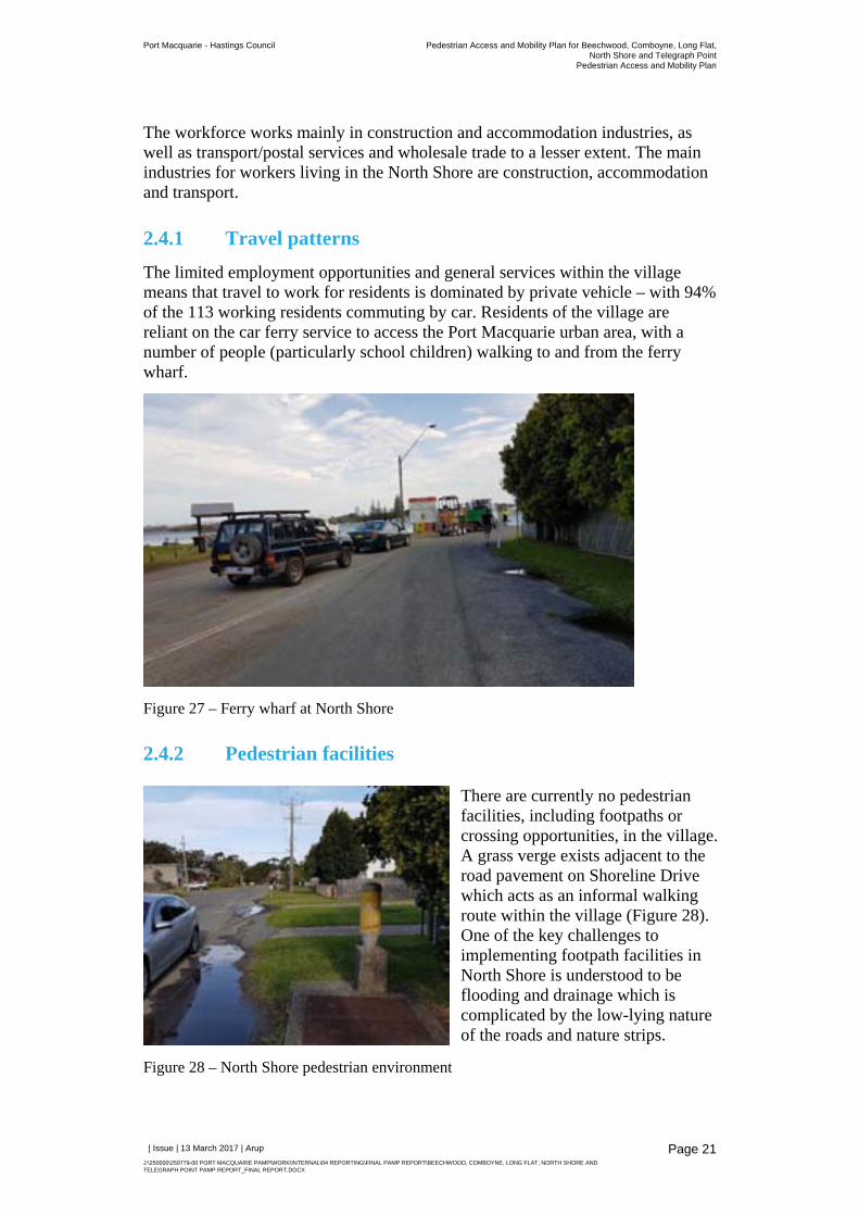
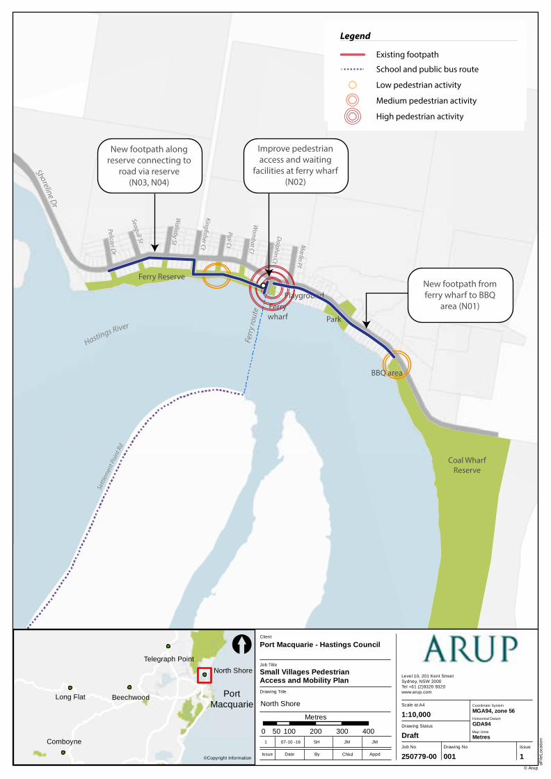
The limited employment opportunities and general services within the village means that travel to work for residents is dominated by private vehicle – with 94% of the 113 working residents commuting by car. Residents of the village are reliant on the car ferry service to access the Port Macquarie urban area, with a number of people (particularly school children) walking to and from the ferry wharf.
Figure 27 – Ferry wharf at North Shore
2.4.2 Pedestrian facilities
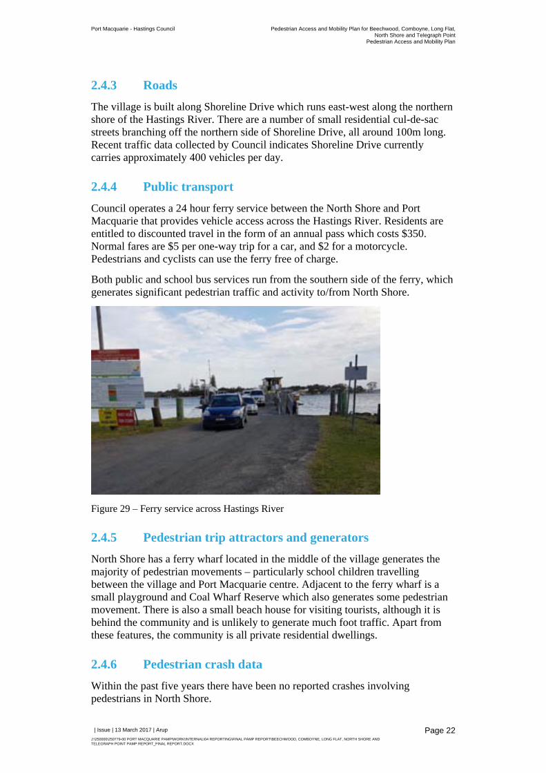
Figure 28 – North Shore pedestrian environment
There are currently no pedestrian facilities, including footpaths or crossing opportunities, in the village. A grass verge exists adjacent to the road pavement on Shoreline Drive which acts as an informal walking route within the village (Figure 28). One of the key challenges to implementing footpath facilities in North Shore is understood to be flooding and drainage which is complicated by the low-lying nature of the roads and nature strips.
Port Macquarie - Hastings Council Pedestrian Access and Mobility Plan for Beechwood, Comboyne, Long Flat,North Shore and Telegraph Point
Pedestrian Access and Mobility Plan
| Issue | 13 March 2017 | Arup
J:\250000\250779-00 PORT MACQUARIE PAMP\WORK\INTERNAL\04 REPORTING\FINAL PAMP REPORT\BEECHWOOD, COMBOYNE, LONG FLAT, NORTH SHORE AND TELEGRAPH POINT PAMP REPORT_FINAL REPORT.DOCX
Page 22
2.4.3 Roads
The village is built along Shoreline Drive which runs east-west along the northern shore of the Hastings River. There are a number of small residential cul-de-sac streets branching off the northern side of Shoreline Drive, all around 100m long. Recent traffic data collected by Council indicates Shoreline Drive currently carries approximately 400 vehicles per day.
2.4.4 Public transport
Council operates a 24 hour ferry service between the North Shore and Port Macquarie that provides vehicle access across the Hastings River. Residents are entitled to discounted travel in the form of an annual pass which costs $350. Normal fares are $5 per one-way trip for a car, and $2 for a motorcycle. Pedestrians and cyclists can use the ferry free of charge.
Both public and school bus services run from the southern side of the ferry, which generates significant pedestrian traffic and activity to/from North Shore.
Figure 29 – Ferry service across Hastings River
2.4.5 Pedestrian trip attractors and generators
North Shore has a ferry wharf located in the middle of the village generates the majority of pedestrian movements – particularly school children travelling between the village and Port Macquarie centre. Adjacent to the ferry wharf is a small playground and Coal Wharf Reserve which also generates some pedestrian movement. There is also a small beach house for visiting tourists, although it is behind the community and is unlikely to generate much foot traffic. Apart from these features, the community is all private residential dwellings.
2.4.6 Pedestrian crash data
Within the past five years there have been no reported crashes involving pedestrians in North Shore.
Comboyne
Long Flat Beechwood
North Shore
Telegraph Point
Job No
250779-00
Drawing No Issue
001 1
Drawing Status
Draft
Scale at A4
Level 10, 201 Kent StreetSydney, NSW 2000Tel +61 (2)9320 9320 www.arup.com
oFile
Loca
tion
© Arup
1:10,000
Drawing Title
Job Title
Small Villages Pedestrian Access and Mobility Plan
Client
Port Macquarie - Hastings Council
0 100 200 300 40050
Metres
©Copyright InformationIssue Date By Appd
1 07-10 -16 SH JM JM
Chkd
[
Coordinate System
Horizontal Datum
GDA94
MGA94, zone 56
Map Units
Metres
PortMacquarie North Shore
Ferr
y ro
ute
Hastings River
Pelican Dr
Seagull St
Wallaby St
Pipi Ct
Dolphin Ct
Marlin Pl
King�sher Ct
Wom
bat Cl
Shoreline Dr
Settl
emen
t Poi
nt R
d
Ferrywharf
Playground
Park
BBQ area
Ferry Reserve
Coal WharfReserve
New footpath fromferry wharf to BBQ
area (N01)
Improve pedestrian access and waiting
facilities at ferry wharf(N02)
New footpath along reserve connecting to
road via reserve(N03, N04)
Legend
Existing footpath
Suggested footpath
Suggested improvements
School and public bus route
Legend
Existing footpath
High speed tra�c makes walking on road
dangerous
Lack of facilitiesfor pedestrians
waiting at ferry wharf(path, shelter, seats)
School bus route
Legend
Existing footpath
School and public bus route
Low pedestrian activity
Medium pedestrian activity
High pedestrian activity
Port Macquarie - Hastings Council Pedestrian Access and Mobility Plan for Beechwood, Comboyne, Long Flat,North Shore and Telegraph Point
Pedestrian Access and Mobility Plan
| Issue | 13 March 2017 | Arup
J:\250000\250779-00 PORT MACQUARIE PAMP\WORK\INTERNAL\04 REPORTING\FINAL PAMP REPORT\BEECHWOOD, COMBOYNE, LONG FLAT, NORTH SHORE AND TELEGRAPH POINT PAMP REPORT_FINAL REPORT.DOCX
Page 24
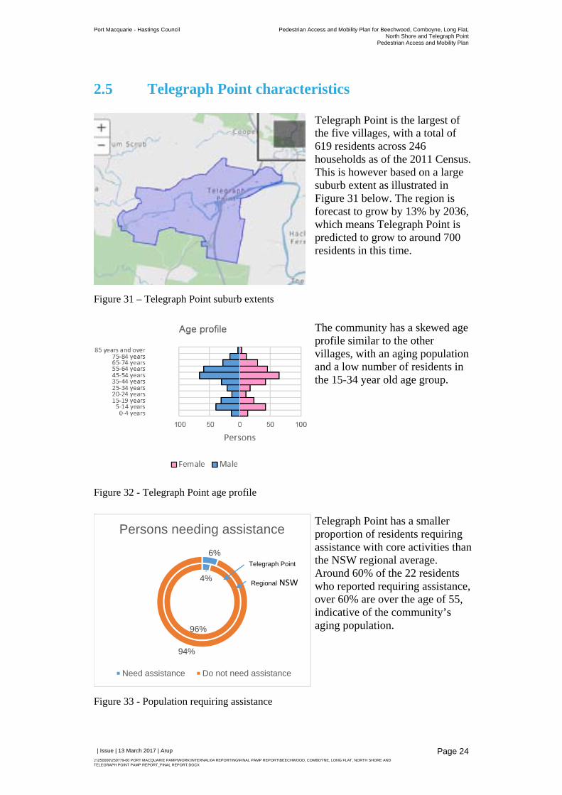
2.5 Telegraph Point characteristics
Figure 31 – Telegraph Point suburb extents
Telegraph Point is the largest of the five villages, with a total of 619 residents across 246 households as of the 2011 Census. This is however based on a large suburb extent as illustrated in Figure 31 below. The region is forecast to grow by 13% by 2036, which means Telegraph Point is predicted to grow to around 700 residents in this time.
Figure 32 - Telegraph Point age profile
The community has a skewed age profile similar to the other villages, with an aging population and a low number of residents in the 15-34 year old age group.
Figure 33 - Population requiring assistance
Telegraph Point has a smaller proportion of residents requiring assistance with core activities than the NSW regional average. Around 60% of the 22 residents who reported requiring assistance, over 60% are over the age of 55, indicative of the community’s aging population.
4%
96%
6%
94%
Persons needing assistance
Need assistance Do not need assistance
Telegraph Point
Regional NSW
Port Macquarie - Hastings Council Pedestrian Access and Mobility Plan for Beechwood, Comboyne, Long Flat,North Shore and Telegraph Point
Pedestrian Access and Mobility Plan
| Issue | 13 March 2017 | Arup
J:\250000\250779-00 PORT MACQUARIE PAMP\WORK\INTERNAL\04 REPORTING\FINAL PAMP REPORT\BEECHWOOD, COMBOYNE, LONG FLAT, NORTH SHORE AND TELEGRAPH POINT PAMP REPORT_FINAL REPORT.DOCX
Page 25
2.5.1 Travel patterns
Residents of Telegraph Point rely heavily on private vehicles for travel to work. Of the 237 residents who travel to work each day, 96% commute by private vehicle with the balance (10 people) walking to work.
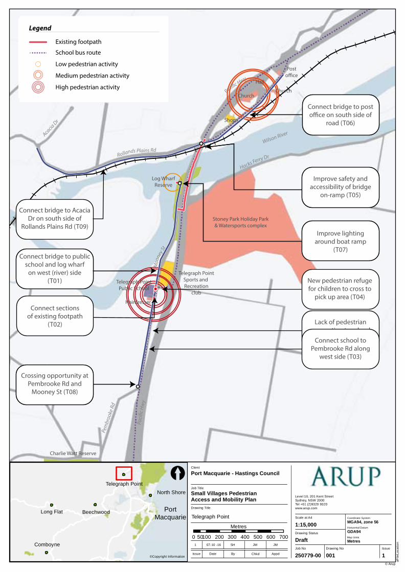
2.5.2 Pedestrian facilities
Figure 34 – Footpath adjacent to school at Telegraph Point
There is also a footpath extending north-south along Mooney Street for a 150m stretch outside the school and hairdresser (Figure 34), although it is in two unconnected parts.
Figure 35 – Pedestrian environment – Telegraph Point
Within the village on the northern side of the Wilson River there is no pedestrian infrastructure. The verge of the Rollands Plain Road contains a number of potholes and is not conducive to a safe walking environment – as illustrated in Figure 35.
Port Macquarie - Hastings Council Pedestrian Access and Mobility Plan for Beechwood, Comboyne, Long Flat,North Shore and Telegraph Point
Pedestrian Access and Mobility Plan
| Issue | 13 March 2017 | Arup
J:\250000\250779-00 PORT MACQUARIE PAMP\WORK\INTERNAL\04 REPORTING\FINAL PAMP REPORT\BEECHWOOD, COMBOYNE, LONG FLAT, NORTH SHORE AND TELEGRAPH POINT PAMP REPORT_FINAL REPORT.DOCX
Page 26
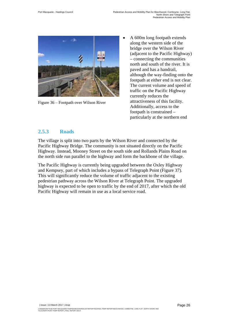
Figure 36 – Footpath over Wilson River
A 600m long footpath extends along the western side of the bridge over the Wilson River (adjacent to the Pacific Highway) – connecting the communities north and south of the river. It is paved and has a handrail, although the way-finding onto the footpath at either end is not clear. The current volume and speed of traffic on the Pacific Highway currently reduces the attractiveness of this facility. Additionally, access to the footpath is constrained – particularly at the northern end
2.5.3 Roads
The village is split into two parts by the Wilson River and connected by the Pacific Highway Bridge. The community is not situated directly on the Pacific Highway. Instead, Mooney Street on the south side and Rollands Plains Road on the north side run parallel to the highway and form the backbone of the village.
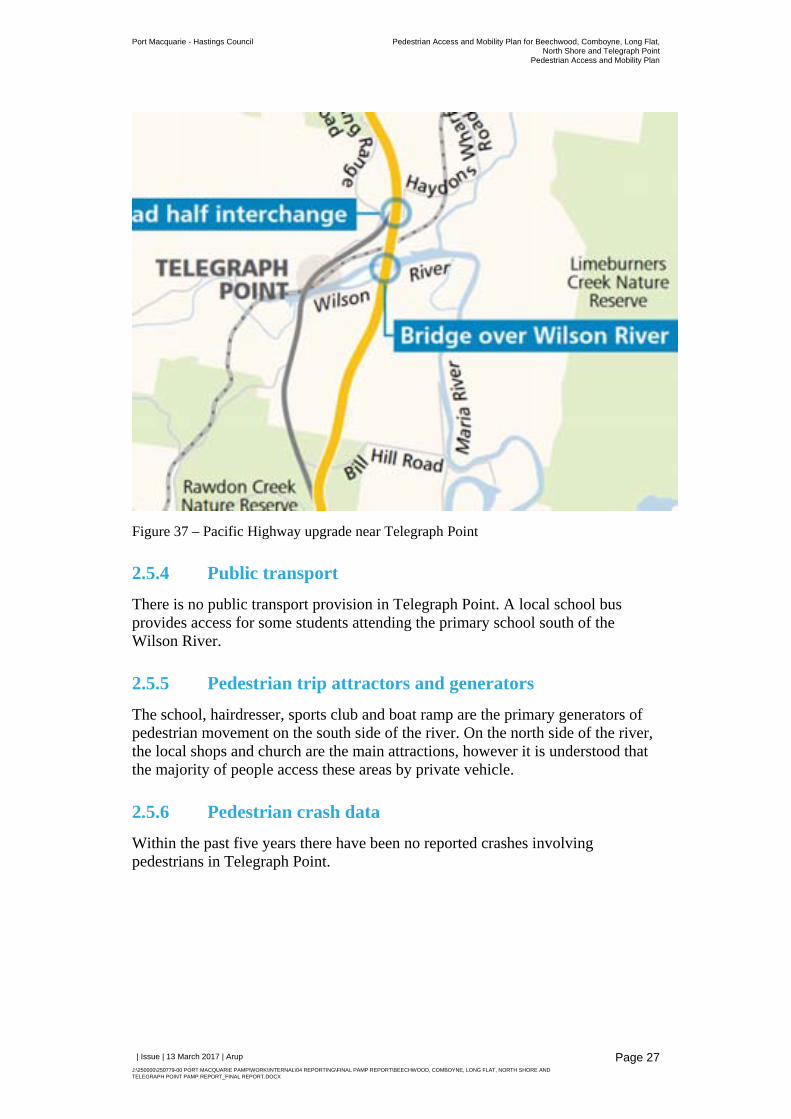
The Pacific Highway is currently being upgraded between the Oxley Highway and Kempsey, part of which includes a bypass of Telegraph Point (Figure 37). This will significantly reduce the volume of traffic adjacent to the existing pedestrian pathway across the Wilson River at Telegraph Point. The upgraded highway is expected to be open to traffic by the end of 2017, after which the old Pacific Highway will remain in use as a local service road.
Port Macquarie - Hastings Council Pedestrian Access and Mobility Plan for Beechwood, Comboyne, Long Flat,North Shore and Telegraph Point
Pedestrian Access and Mobility Plan
| Issue | 13 March 2017 | Arup
J:\250000\250779-00 PORT MACQUARIE PAMP\WORK\INTERNAL\04 REPORTING\FINAL PAMP REPORT\BEECHWOOD, COMBOYNE, LONG FLAT, NORTH SHORE AND TELEGRAPH POINT PAMP REPORT_FINAL REPORT.DOCX
Page 27
Figure 37 – Pacific Highway upgrade near Telegraph Point
2.5.4 Public transport
There is no public transport provision in Telegraph Point. A local school bus provides access for some students attending the primary school south of the Wilson River.
2.5.5 Pedestrian trip attractors and generators
The school, hairdresser, sports club and boat ramp are the primary generators of pedestrian movement on the south side of the river. On the north side of the river, the local shops and church are the main attractions, however it is understood that the majority of people access these areas by private vehicle.
2.5.6 Pedestrian crash data
Within the past five years there have been no reported crashes involving pedestrians in Telegraph Point.
Comboyne
Long Flat Beechwood
North Shore
Telegraph Point
Job No
250779-00
Drawing No Issue
001 1
Drawing Status
Draft
Scale at A4
Level 10, 201 Kent StreetSydney, NSW 2000Tel +61 (2)9320 9320 www.arup.com
oFile
Loca
tion
© Arup
1:15,000
Drawing Title
Job Title
Small Villages Pedestrian Access and Mobility Plan
Client
Port Macquarie - Hastings Council
0 100 200 300 400 500 600 70050
Metres
©Copyright InformationIssue Date By Appd
1 07-10 -16 SH JM JM
Chkd
[
Coordinate System
Horizontal Datum
GDA94
MGA94, zone 56
Map Units
Metres
PortMacquarie Telegraph Point
Telegraph PointPublic School
Hairdresser
Stoney Park Holiday Park& Watersports complex
Telegraph PointSports and Recreation
club
Log WharfReserve
Shops
Church
Hall
Posto�ce
Church
Charlie Watt Reserve
Rollands Plains RdM
ooney
StHacks Ferry Dr
Wilson RiverAcacia Dr
Paci�c Hwy
Paci
�c H
wy
Wilson River
Pem
broo
ke R
d
Access to bridgeis steep and
exposed to tra�c
Lack of footpathconnection to the
bridge
Lack of connection tobridge from school
Boat ramp recreationalarea unlit
Lack of pedestrianconnection to school
from the south
High speed intersectionat Pembrooke Rd and
Mooney St
Legend
Existing footpath
School bus route
Improve safety and accessibility of bridge
on-ramp (T05)
Connect bridge to post o�ce on south side of
road (T06)
Connect bridge to Acacia Dr on south side of
Rollands Plains Rd (T09)
Connect bridge to public school and log wharf
on west (river) side(T01)
Improve lighting around boat ramp
(T07)
Connect school to Pembrooke Rd along
west side (T03)
Crossing opportunity at Pembrooke Rd and
Mooney St (T08)
Legend
Existing footpath
Suggested footpath
School bus route
Suggested improvements
Suggested crossing
Connect sectionsof existing footpath
(T02)
New pedestrian refugefor children to cross to
pick up area (T04)
Legend
Existing footpath
School bus route
Low pedestrian activity
Medium pedestrian activity
High pedestrian activity
Port Macquarie - Hastings Council Pedestrian Access and Mobility Plan for Beechwood, Comboyne, Long Flat,North Shore and Telegraph Point
Pedestrian Access and Mobility Plan
| Issue | 13 March 2017 | Arup
J:\250000\250779-00 PORT MACQUARIE PAMP\WORK\INTERNAL\04 REPORTING\FINAL PAMP REPORT\BEECHWOOD, COMBOYNE, LONG FLAT, NORTH SHORE AND TELEGRAPH POINT PAMP REPORT_FINAL REPORT.DOCX
Page 29
3 Community consultation
For this study, with multiple study areas, the methodology has a strong focus on community consultation as a way of informing the development of pedestrian improvements that form part of the action plan within the PAMP. Community consultation consisted of community workshops and a public exhibition period where the public was invited to comment on the draft PAMP.
3.1 Community workshops
Community workshops were held over two weekends in October 2016 as part of the PAMP. Each workshop included the following:
an introduction to the PAMP process;
a group discussion with the community to understand the main pedestrian routes in the study area,
identification of barriers to walking and any key improvements to pedestrian infrastructure.
For some villages, the workshop group undertook a short walking tour to visit a number of areas raised during the discussion.
The location, date and number of participants present at each of the community workshops is presented in the table below.
Location Date and time Number of participants
Beechwood, Beechwood Community Hall
Friday 14 October 2016, 4 pm 5 (including mobility-impaired resident, a mother who regularly uses a pram and two residents)
Telegraph Point, Telegraph Point Arts Centre
Saturday 15 October 2016, 10 am
10 (including two representatives from the school P&C and a number of local residents)
North Shore, Kangaroo Park (adjacent to the ferry wharf)
Friday 21 October, 4 pm 15 community members attended
Comboyne, Community Centre
Saturday 22 October 2016, 10 am
12 community members attended
Long Flat, Community Centre Saturday 22 October 2016, 2 pm
3 community members (note that low numbers may have been partially due to wet weather)
The workshops provided an opportunity for the study team, together with the community to identify a long term ‘master plan’ of pedestrian infrastructure improvements in each village, as well as high priority improvements.
A summary of the key items discussed at each of the workshops is provided in the sections below.
Port Macquarie - Hastings Council Pedestrian Access and Mobility Plan for Beechwood, Comboyne, Long Flat,North Shore and Telegraph Point
Pedestrian Access and Mobility Plan
| Issue | 13 March 2017 | Arup
J:\250000\250779-00 PORT MACQUARIE PAMP\WORK\INTERNAL\04 REPORTING\FINAL PAMP REPORT\BEECHWOOD, COMBOYNE, LONG FLAT, NORTH SHORE AND TELEGRAPH POINT PAMP REPORT_FINAL REPORT.DOCX
Page 30
3.1.1 Beechwood community consultation
The Beechwood workshop was held on Friday 14 October 2016 at the Beechwood Community Hall, commencing at 4pm. Five community members attended, including a mobility-impaired resident, a mother who regularly uses a pram and two residents. The discussion lasted for approximately one hour, followed by a short, informal visit to a number of areas raised during the discussion.
Pedestrian infrastructure
The following suggestions were provided during the workshop for improved pedestrian infrastructure.
High priority improvements:
o Connect all existing footpaths within Beechwood, in particular the footpath leading to Beechwood Public School.
o Provide a safe crossing point at Beechwood Road and Bellangry Road to support safe access to school
o Provide a kerb ramp at Beechwood Road and Neville Road
o Provide a kerb ramp at Beechwood Road south, near the shops to enable accessible crossing movements to the existing footpath.
Medium priority:
o Provide a new footpath along the southern side of Beechwood Road, connecting the existing footpath to the café.
o Provide a crossing opportunity to connect to café, near the corner of Bellangry Road and Beechwood Road.
o Improve the quality of the existing footpath on Beechwood Road opposite the Post Office which has been damaged by a Jacaranda tree.
Subsequent to the workshop, a written submission was received which noted concern surrounding the lack of formal pedestrian crossing near the Primary School and Beechwood café in the context of high traffic movements on Beechwood Road. These crossing movements were noted to involve children and the elderly.
Other comments
The high speed environment on Bellangry Road was mentioned by all attendees as a safety hazard, especially for children crossing on their way to school.
The light pole close to road at post office corner was a safety concern for all attendees.
Erosion issues arise at the corner opposite the footpath, at the western end of the path currently under construction.
Port Macquarie - Hastings Council Pedestrian Access and Mobility Plan for Beechwood, Comboyne, Long Flat,North Shore and Telegraph Point
Pedestrian Access and Mobility Plan
| Issue | 13 March 2017 | Arup
J:\250000\250779-00 PORT MACQUARIE PAMP\WORK\INTERNAL\04 REPORTING\FINAL PAMP REPORT\BEECHWOOD, COMBOYNE, LONG FLAT, NORTH SHORE AND TELEGRAPH POINT PAMP REPORT_FINAL REPORT.DOCX
Page 31
Figure 39 – Beechwood community consultation session
3.1.2 Comboyne community consultation
The Comboyne workshop was held on Saturday 22 October 2016 in the Comboyne community centre. The session commenced at 10am, with 12 community members in attendance. The workshop concluded at approximately 11.30am, with a half-hour walking tour to a number of areas raised during the discussion.
Pedestrian infrastructure
The following suggestions were provided during the workshop for improved pedestrian infrastructure.
High priority improvements:
o Provide an extension of the existing footpath on Main Street, from Comboyne Street to the Thone River
o Provide a new footpath connecting the school to the park and playground along the western side of Hill Street.
o Provide a new footpath along the eastern side of Main Street from the intersection with Thone Street to the intersection with Hill Street.
Medium priority improvements:
Port Macquarie - Hastings Council Pedestrian Access and Mobility Plan for Beechwood, Comboyne, Long Flat,North Shore and Telegraph Point
Pedestrian Access and Mobility Plan
| Issue | 13 March 2017 | Arup
J:\250000\250779-00 PORT MACQUARIE PAMP\WORK\INTERNAL\04 REPORTING\FINAL PAMP REPORT\BEECHWOOD, COMBOYNE, LONG FLAT, NORTH SHORE AND TELEGRAPH POINT PAMP REPORT_FINAL REPORT.DOCX
Page 32
o Provide a new crossing opportunity across Main Street near the corner of Hill Street. The topography would be the main determinant of the exact location of the crossing.
o Provide a new footpath on River Street (eastern side) and Thone Street (northern side)
Subsequent to the workshop, a written submission was received which noted this person’s desire to see dedicated walking trails in Comboyne (not shared with cars). Special walking trails would encourage locals to go for walks and serve as another attraction to tourists coming up to Comboyne.
Other comments
There was interest in also providing new footpaths along the roads not mentioned above (that is, along Comboyne Street east of Main Street, as well as along Showground Road). These may be considered longer term suggestions.
Speeding traffic (in particular freight vehicles) through the village centre was a concern raised by many attendees. Additional signage in the village centre and rumble strips were proposed as potential measures to reduce vehicle speeds.
Figure 40 – Comboyne community consultation
Port Macquarie - Hastings Council Pedestrian Access and Mobility Plan for Beechwood, Comboyne, Long Flat,North Shore and Telegraph Point
Pedestrian Access and Mobility Plan
| Issue | 13 March 2017 | Arup
J:\250000\250779-00 PORT MACQUARIE PAMP\WORK\INTERNAL\04 REPORTING\FINAL PAMP REPORT\BEECHWOOD, COMBOYNE, LONG FLAT, NORTH SHORE AND TELEGRAPH POINT PAMP REPORT_FINAL REPORT.DOCX
Page 33
3.1.3 Long Flat community consultation
The Long Flat workshop was held on Saturday 22 October 2016 at 2pm in the Long Flat community hall, with three community members present. The workshop concluded at approximately 2.30pm, with no walking tour possible due to inclement weather.
Pedestrian infrastructure
The following suggestions were provided during the workshop for improved pedestrian infrastructure.
High priority improvements:
o Improve the quality of the existing footpath Long Flat fronting the Oxley Highway, in particular between the two intersections of Henry Street. There are some uneven sections and trip hazards.
o Extend the existing footpath on the Oxley Highway east approximately 40m to provide access to the local hairdresser.
Subsequent to the workshop, a written submission was received which noted concern surrounding the substantial drop off the edge of the path on the eastern corner of Henry Street near the post office.
Other comments In general, the attendees were generally satisfied with the extent and condition of existing footpaths and suggested only minor improvements. The preference was to upgrade the quality of existing infrastructure as opposed to providing additional footpaths and/or crossing opportunities.
Figure 41 – Long Flat community consultation
Port Macquarie - Hastings Council Pedestrian Access and Mobility Plan for Beechwood, Comboyne, Long Flat,North Shore and Telegraph Point
Pedestrian Access and Mobility Plan
| Issue | 13 March 2017 | Arup
J:\250000\250779-00 PORT MACQUARIE PAMP\WORK\INTERNAL\04 REPORTING\FINAL PAMP REPORT\BEECHWOOD, COMBOYNE, LONG FLAT, NORTH SHORE AND TELEGRAPH POINT PAMP REPORT_FINAL REPORT.DOCX
Page 34
3.1.4 North Shore community consultation
The North Shore workshop was help on Friday 21 October 2016 in Kangaroo Park. The session commenced at 4pm and was run as a drop-in style workshop, with 15 community members attending. The discussion lasted for approximately 1 hour and 20 minutes.
Pedestrian infrastructure
The following suggestions were provided during the workshop for improved pedestrian infrastructure.
High priority improvements:
o Improve the accessibility of the ferry wharf area for pedestrians by providing an improved connection from the ferry boarding area to Shoreline Drive
o Provide a formalised pedestrian link east of the ferry wharf along the southern side of Shoreline Drive, up to the BBQ and picnic area
Medium priority improvements:
o Provide a pedestrian connection extending west of the ferry wharf through the reserve adjacent to the Hasting River and connecting to Shoreline Drive via the easement opposite Kingfisher Court.
o Provide shelter and improved waiting facilities for pedestrians at the ferry wharf
Other comments
Drainage is an issue in the community due to the flat, sea-level topography and a lack of kerbs and guttering.
Many residents raised concerns about how any new footpaths would fit the character of the village (no ‘concrete landing strips’). Landscaping and aesthetic considerations are important for the success of the program in this community. Unsealed footpaths may be more appropriate in some areas.
Speeding of road traffic was a safety concern of all attendees, particularly with cars rushing to catch the ferry.
Port Macquarie - Hastings Council Pedestrian Access and Mobility Plan for Beechwood, Comboyne, Long Flat,North Shore and Telegraph Point
Pedestrian Access and Mobility Plan
| Issue | 13 March 2017 | Arup
J:\250000\250779-00 PORT MACQUARIE PAMP\WORK\INTERNAL\04 REPORTING\FINAL PAMP REPORT\BEECHWOOD, COMBOYNE, LONG FLAT, NORTH SHORE AND TELEGRAPH POINT PAMP REPORT_FINAL REPORT.DOCX
Page 35
Figure 42 – North Shore community consultation
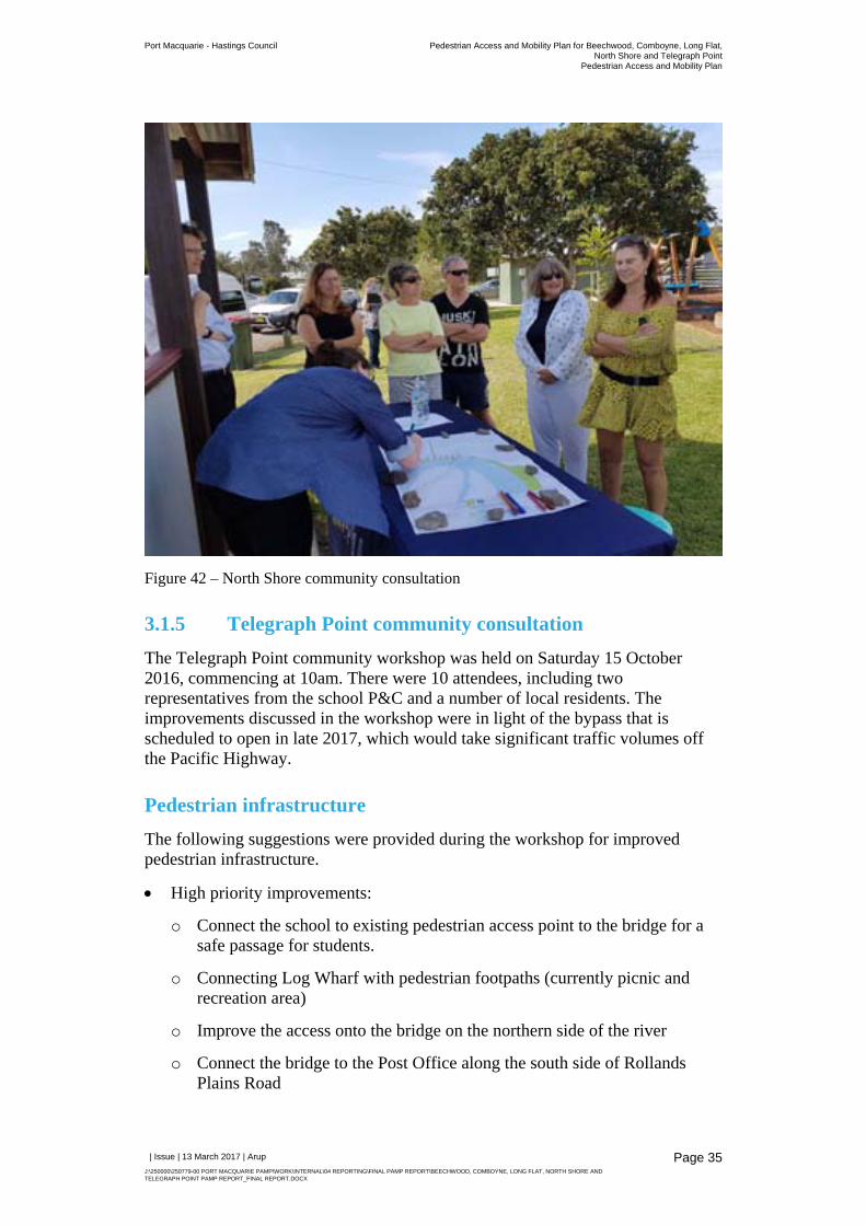
3.1.5 Telegraph Point community consultation
The Telegraph Point community workshop was held on Saturday 15 October 2016, commencing at 10am. There were 10 attendees, including two representatives from the school P&C and a number of local residents. The improvements discussed in the workshop were in light of the bypass that is scheduled to open in late 2017, which would take significant traffic volumes off the Pacific Highway.
Pedestrian infrastructure
The following suggestions were provided during the workshop for improved pedestrian infrastructure.
High priority improvements:
o Connect the school to existing pedestrian access point to the bridge for a safe passage for students.
o Connecting Log Wharf with pedestrian footpaths (currently picnic and recreation area)
o Improve the access onto the bridge on the northern side of the river
o Connect the bridge to the Post Office along the south side of Rollands Plains Road
Port Macquarie - Hastings Council Pedestrian Access and Mobility Plan for Beechwood, Comboyne, Long Flat,North Shore and Telegraph Point
Pedestrian Access and Mobility Plan
| Issue | 13 March 2017 | Arup
J:\250000\250779-00 PORT MACQUARIE PAMP\WORK\INTERNAL\04 REPORTING\FINAL PAMP REPORT\BEECHWOOD, COMBOYNE, LONG FLAT, NORTH SHORE AND TELEGRAPH POINT PAMP REPORT_FINAL REPORT.DOCX
Page 36
o Connect the school to residential areas along the western side of Mooney Street as far south as Pembrooke Street
Medium priority improvements:
o Provide a footpath on the southern side of Rollands Plains Road extending west of the bridge
o Provide a footpath on the western side of Mooney Street extending from the existing footpath outside the hairdresser south as far as Pembrooke Road
o Provide a crossing opportunity in front of Telegraph Point Public School to school drop off and pick up area
o Provide a crossing opportunity at Pembrooke Road and Mooney Street
o Provide a crossing opportunity at Post Office
o Consider lighting at boat ramp
Other comments
There is limited kerb and guttering in the village – pathways are exposed to flooding
Community suggests that ‘gravel treatment’ was sufficient as a first stage of implementing footpaths.
Existing ramps off the Pacific Highway pedestrian access require regular maintenance.
Existing footpaths fronting the Telegraph Point Public school are exposed to flooding
Erosion occurs on the road adjacent to the Wilson River
There is an opportunity to coordinate footpath works with new works associated with sewer upgrades undertaken by Council
Port Macquarie - Hastings Council Pedestrian Access and Mobility Plan for Beechwood, Comboyne, Long Flat,North Shore and Telegraph Point
Pedestrian Access and Mobility Plan
| Issue | 13 March 2017 | Arup
J:\250000\250779-00 PORT MACQUARIE PAMP\WORK\INTERNAL\04 REPORTING\FINAL PAMP REPORT\BEECHWOOD, COMBOYNE, LONG FLAT, NORTH SHORE AND TELEGRAPH POINT PAMP REPORT_FINAL REPORT.DOCX
Page 37
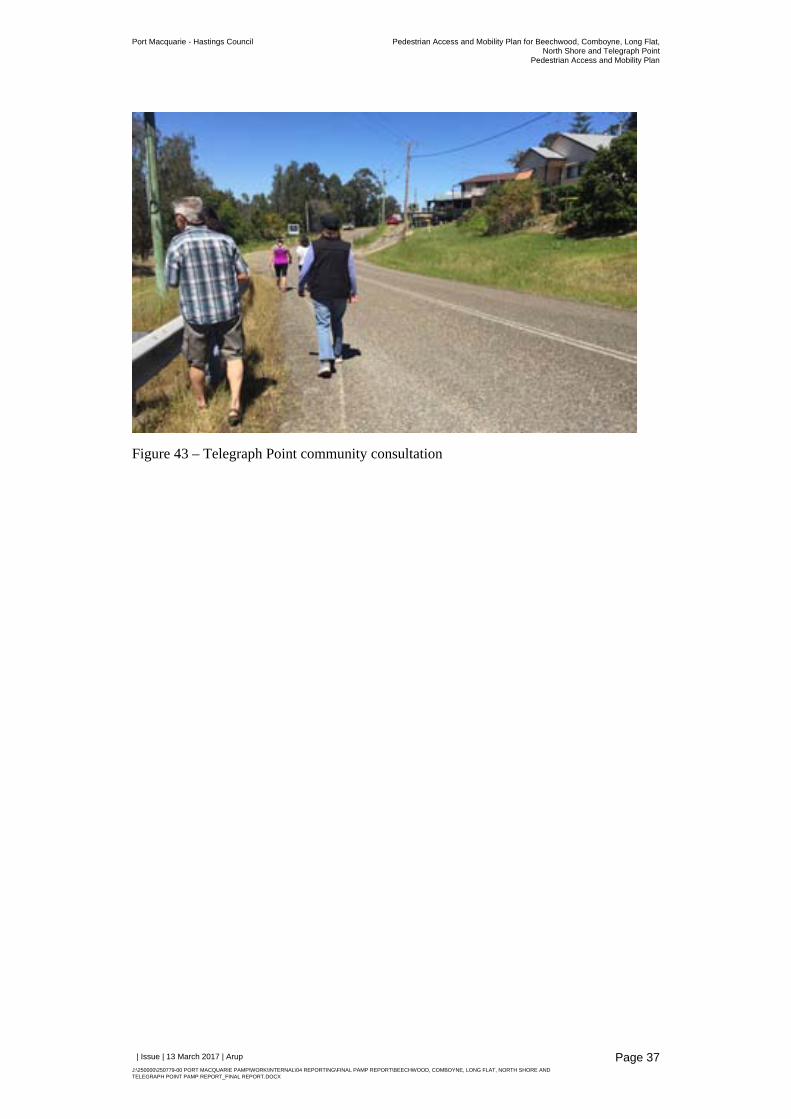
Figure 43 – Telegraph Point community consultation
Port Macquarie - Hastings Council Pedestrian Access and Mobility Plan for Beechwood, Comboyne, Long Flat,North Shore and Telegraph Point
Pedestrian Access and Mobility Plan
| Issue | 13 March 2017 | Arup
J:\250000\250779-00 PORT MACQUARIE PAMP\WORK\INTERNAL\04 REPORTING\FINAL PAMP REPORT\BEECHWOOD, COMBOYNE, LONG FLAT, NORTH SHORE AND TELEGRAPH POINT PAMP REPORT_FINAL REPORT.DOCX
Page 38
3.2 Public exhibition
The Draft Pedestrian Access and Mobility Plan (PAMP) for Beechwood, Comboyne, Long Flat, North Shore, and Telegraph Point was placed on public exhibition between 16 January 2017 and 24 February 2017.
The community were invited to review the draft plan and to provide feedback. The draft plan was available to be viewed online as well as in the document library and at Council Customer Service Centres and Council Libraries.
The website on which the draft PAMP was posted was viewed 309 times during the exhibition period and the document was downloaded 61 times. A total of 13 people submitted comments, many of whom made multiple submissions. The following key issues were noted for each village.
Beechwood
Comments were received from four individuals.
Increasing the number of road crossing opportunities was supported, with some suggesting further crossings near primary school and near the park.
Proposals to link existing footpaths were well received
Comboyne
Comments were received from one individual
Suggestions were made to prioritise footpath along Main Street to river above a footpath connecting the school to park. This has been noted and priorities reallocated in the final document.
Long Flat
Comments were received from one individual
Safety concerns about the drop from the footpath to the road near the post office were raised. This has been addressed as part of remediation works L02-L06 along the footpath between the two entrances to Henry Street.
North Shore
Comments were received from six individuals
Submissions raised concerns around the footpath through the Ferry Reserve between the wharf and Kingfisher Court. Issued raised included aesthetic considerations, drainage and interference with recreational activities.
Telegraph Point
Comments were received from one individual
The submission highlighted the need for a footpath on the west side of Mooney Street from the school to Pembrooke Road. This has now been included as a medium priority item (T06) in the final document.
The submission also noted that the north side of the river had no high priority items. The north access to the bridge has been increased to high priority as a result.
Port Macquarie - Hastings Council Pedestrian Access and Mobility Plan for Beechwood, Comboyne, Long Flat,North Shore and Telegraph Point
Pedestrian Access and Mobility Plan
| Issue | 13 March 2017 | Arup
J:\250000\250779-00 PORT MACQUARIE PAMP\WORK\INTERNAL\04 REPORTING\FINAL PAMP REPORT\BEECHWOOD, COMBOYNE, LONG FLAT, NORTH SHORE AND TELEGRAPH POINT PAMP REPORT_FINAL REPORT.DOCX
Page 39
4 Infrastructure review and action plan
4.1 General considerations
The review of the pedestrian infrastructure as part of this PAMP considers:
The provision of new pedestrian infrastructure, including footpaths, kerb ramps, kerb extensions, pedestrian refuges, pedestrian crossings and pedestrian amenity infrastructure such as seating and lighting
Maintenance of existing infrastructure, which may include repairing damaged, cracked or uneven paths, removing obstructions or barriers along paths; and
Broader infrastructure improvements to support pedestrian safety, such as traffic calming devices and signage
Non-infrastructure actions such as education or enforcement programs do not form part of the PAMP but will be considered by the State Government and Council as part of other programs such as road safety and school-based programs.
The PAMP process identifies deficiencies in the existing pedestrian network through a number of sources, particularly site observations, review of background data and consultation with Council and the local community. Actions were identified which meet the project objectives of improving the level of pedestrian access and reducing pedestrian access severance by providing safe and convenient crossing opportunities. Specific factors considered were as follows:
Footpaths provision (are footpaths absent?);
Footpath quality (are footpaths damaged, cracked or uneven path, narrow, or trip hazards?);
Kerb ramp provision (are kerb ramps absent?); and
Pedestrian crossing facilities (are there locations where crossing facilities are required or existing are in need of upgrade?)
4.2 Assessment criteria
Given the nature of the villages assessed in this study, where relatively small pedestrian demands are generated by the small populations, it is not considered realistic to provide a comprehensive footpath network throughout each village. In some areas it may be more appropriate to consider unsealed footpaths or the levelling of nature strips given the likely pedestrian demands and constraints.
In the context of the areas considered in this study, it is also important to consider the constructability issues associated with the action when prioritising future pedestrian works. In many circumstances the introduction of new footpaths that comply with Australian Standards will be challenging to implement. While the detailed engineering and design of the proposed pedestrian infrastructure will be undertaken at a later date, any current foreseen constructability issues associated with the measures has been considered within the prioritisation process.
Port Macquarie - Hastings Council Pedestrian Access and Mobility Plan for Beechwood, Comboyne, Long Flat,North Shore and Telegraph Point
Pedestrian Access and Mobility Plan
| Issue | 13 March 2017 | Arup
J:\250000\250779-00 PORT MACQUARIE PAMP\WORK\INTERNAL\04 REPORTING\FINAL PAMP REPORT\BEECHWOOD, COMBOYNE, LONG FLAT, NORTH SHORE AND TELEGRAPH POINT PAMP REPORT_FINAL REPORT.DOCX
Page 40
Therefore it is important that potential pedestrian improvements be measured against a suite of criteria to justify their inclusion in the PAMP. The following criteria have been considered in the development of the action plan:
Continuity: Does the proposed improvement complement the existing pedestrian network?
Connectivity: Does the proposed improvement provide connectivity to land uses which generate pedestrian activity, such as schools, community buildings, places of worship and village shops?
Demand: Does the proposed improvement accommodate a high number of pedestrian movements, both now and in future?
Safety: Does the proposed improvement improve the safety of pedestrians?
Constructability: Does the proposed improvement have any major constructability challenges due to issues such as the location of existing services, topography of the area, drainage or lack of available space?
4.3 Implementation priority
The PAMP process brings together a review of the existing pedestrian infrastructure, and outlines a long term ‘master plan’ with a long list of improvements to pedestrian infrastructure. A prioritisation process is an important part of the PAMP process to translate the long list of improvements into a manageable set of actions for Council or other agencies to deliver in a staged approach.
Pedestrian improvements within the PAMP have been prioritised based on how well they meet the assessment criteria previously listed in Section 4.2 of this study .The works were assigned a priority as shown in Table 1.
Table 1: Staged Action Plan Priority
Work Priority Staging of Works
1 – High Priority Short term works (0-3 years)
2 – Medium Priority Medium term works (3-6 years)
3 – Low Priority Long term works (6-10 years)
Port Macquarie - Hastings Council Pedestrian Access and Mobility Plan for Beechwood, Comboyne, Long Flat,North Shore and Telegraph Point
Pedestrian Access and Mobility Plan
| Issue | 13 March 2017 | Arup
J:\250000\250779-00 PORT MACQUARIE PAMP\WORK\INTERNAL\04 REPORTING\FINAL PAMP REPORT\BEECHWOOD, COMBOYNE, LONG FLAT, NORTH SHORE AND TELEGRAPH POINT PAMP REPORT_FINAL REPORT.DOCX
Page 41
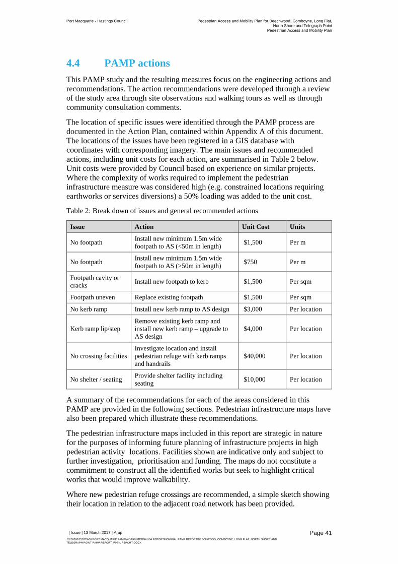
4.4 PAMP actions
This PAMP study and the resulting measures focus on the engineering actions and recommendations. The action recommendations were developed through a review of the study area through site observations and walking tours as well as through community consultation comments.
The location of specific issues were identified through the PAMP process are documented in the Action Plan, contained within Appendix A of this document. The locations of the issues have been registered in a GIS database with coordinates with corresponding imagery. The main issues and recommended actions, including unit costs for each action, are summarised in Table 2 below. Unit costs were provided by Council based on experience on similar projects. Where the complexity of works required to implement the pedestrian infrastructure measure was considered high (e.g. constrained locations requiring earthworks or services diversions) a 50% loading was added to the unit cost.
Table 2: Break down of issues and general recommended actions
Issue Action Unit Cost Units
No footpath Install new minimum 1.5m wide footpath to AS (<50m in length)
$1,500 Per m
No footpath Install new minimum 1.5m wide footpath to AS (>50m in length)
$750 Per m
Footpath cavity or cracks
Install new footpath to kerb $1,500 Per sqm
Footpath uneven Replace existing footpath $1,500 Per sqm
No kerb ramp Install new kerb ramp to AS design $3,000 Per location
Kerb ramp lip/step Remove existing kerb ramp and install new kerb ramp – upgrade to AS design
$4,000 Per location
No crossing facilities Investigate location and install pedestrian refuge with kerb ramps and handrails
$40,000 Per location
No shelter / seating Provide shelter facility including seating
$10,000 Per location
A summary of the recommendations for each of the areas considered in this PAMP are provided in the following sections. Pedestrian infrastructure maps have also been prepared which illustrate these recommendations.
The pedestrian infrastructure maps included in this report are strategic in nature for the purposes of informing future planning of infrastructure projects in high pedestrian activity locations. Facilities shown are indicative only and subject to further investigation, prioritisation and funding. The maps do not constitute a commitment to construct all the identified works but seek to highlight critical works that would improve walkability.
Where new pedestrian refuge crossings are recommended, a simple sketch showing their location in relation to the adjacent road network has been provided.
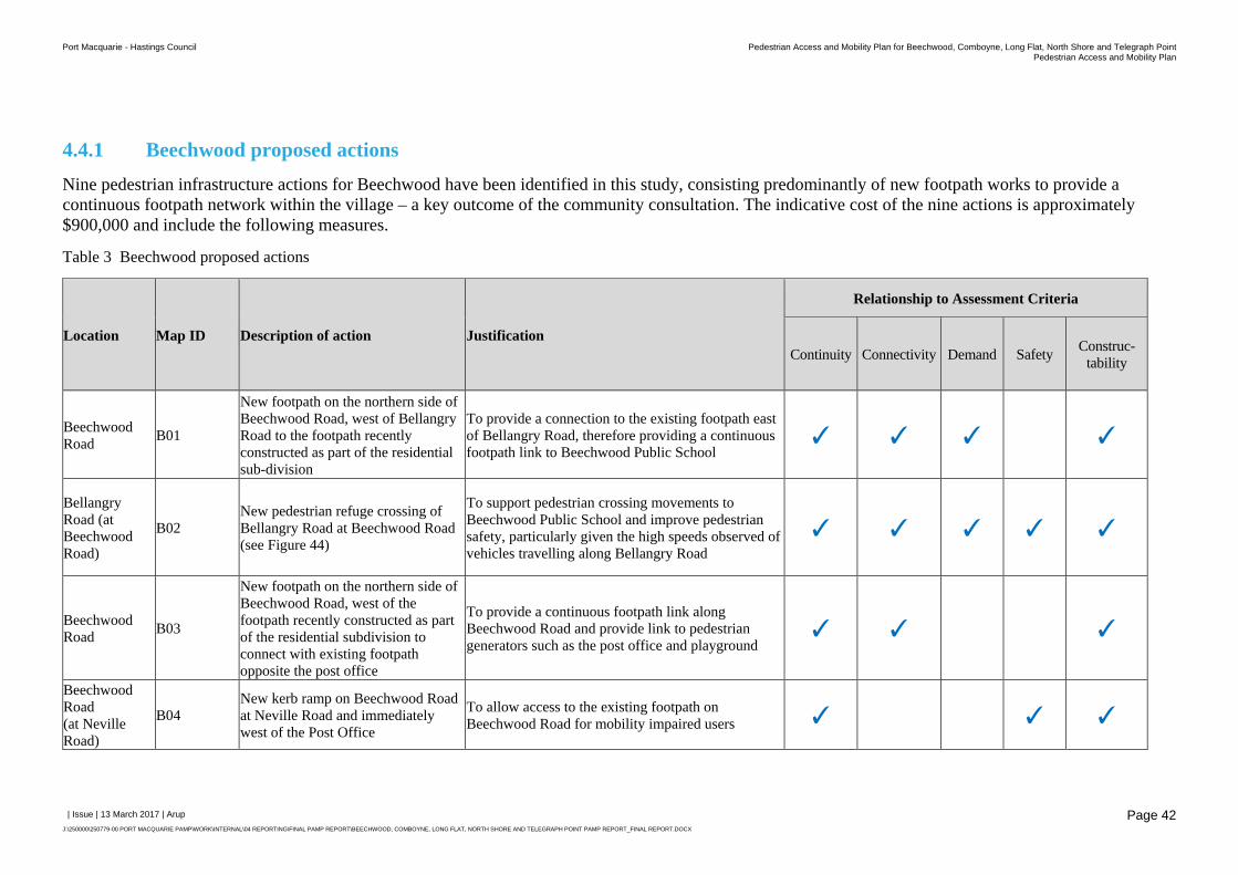
Port Macquarie - Hastings Council Pedestrian Access and Mobility Plan for Beechwood, Comboyne, Long Flat, North Shore and Telegraph PointPedestrian Access and Mobility Plan
| Issue | 13 March 2017 | Arup
J:\250000\250779-00 PORT MACQUARIE PAMP\WORK\INTERNAL\04 REPORTING\FINAL PAMP REPORT\BEECHWOOD, COMBOYNE, LONG FLAT, NORTH SHORE AND TELEGRAPH POINT PAMP REPORT_FINAL REPORT.DOCX
Page 42
4.4.1 Beechwood proposed actions
Nine pedestrian infrastructure actions for Beechwood have been identified in this study, consisting predominantly of new footpath works to provide a continuous footpath network within the village – a key outcome of the community consultation. The indicative cost of the nine actions is approximately $900,000 and include the following measures.
Table 3 Beechwood proposed actions
Location Map ID Description of action Justification
Relationship to Assessment Criteria
Continuity Connectivity Demand Safety Construc-tability
Beechwood Road
B01
New footpath on the northern side of Beechwood Road, west of Bellangry Road to the footpath recently constructed as part of the residential sub-division
To provide a connection to the existing footpath east of Bellangry Road, therefore providing a continuous footpath link to Beechwood Public School
✓ ✓ ✓ ✓
Bellangry Road (at Beechwood Road)
B02 New pedestrian refuge crossing of Bellangry Road at Beechwood Road (see Figure 44)
To support pedestrian crossing movements to Beechwood Public School and improve pedestrian safety, particularly given the high speeds observed of vehicles travelling along Bellangry Road
✓ ✓ ✓ ✓ ✓
Beechwood Road
B03
New footpath on the northern side of Beechwood Road, west of the footpath recently constructed as part of the residential subdivision to connect with existing footpath opposite the post office
To provide a continuous footpath link along Beechwood Road and provide link to pedestrian generators such as the post office and playground
✓ ✓ ✓
Beechwood Road (at Neville Road)
B04 New kerb ramp on Beechwood Road at Neville Road and immediately west of the Post Office
To allow access to the existing footpath on Beechwood Road for mobility impaired users ✓ ✓ ✓
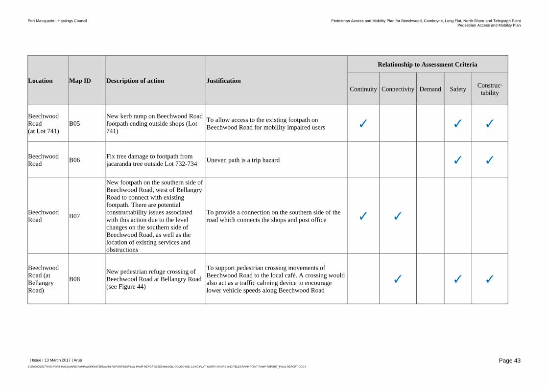
Port Macquarie - Hastings Council Pedestrian Access and Mobility Plan for Beechwood, Comboyne, Long Flat, North Shore and Telegraph PointPedestrian Access and Mobility Plan
| Issue | 13 March 2017 | Arup
J:\250000\250779-00 PORT MACQUARIE PAMP\WORK\INTERNAL\04 REPORTING\FINAL PAMP REPORT\BEECHWOOD, COMBOYNE, LONG FLAT, NORTH SHORE AND TELEGRAPH POINT PAMP REPORT_FINAL REPORT.DOCX
Page 43
Location Map ID Description of action Justification
Relationship to Assessment Criteria
Continuity Connectivity Demand Safety Construc-tability
Beechwood Road (at Lot 741)
B05 New kerb ramp on Beechwood Road footpath ending outside shops (Lot 741)
To allow access to the existing footpath on Beechwood Road for mobility impaired users ✓ ✓ ✓
Beechwood Road
B06 Fix tree damage to footpath from jacaranda tree outside Lot 732-734
Uneven path is a trip hazard ✓ ✓
Beechwood Road
B07
New footpath on the southern side of Beechwood Road, west of Bellangry Road to connect with existing footpath. There are potential constructability issues associated with this action due to the level changes on the southern side of Beechwood Road, as well as the location of existing services and obstructions
To provide a connection on the southern side of the road which connects the shops and post office ✓ ✓
Beechwood Road (at Bellangry Road)
B08 New pedestrian refuge crossing of Beechwood Road at Bellangry Road (see Figure 44)
To support pedestrian crossing movements of Beechwood Road to the local café. A crossing would also act as a traffic calming device to encourage lower vehicle speeds along Beechwood Road
✓ ✓ ✓
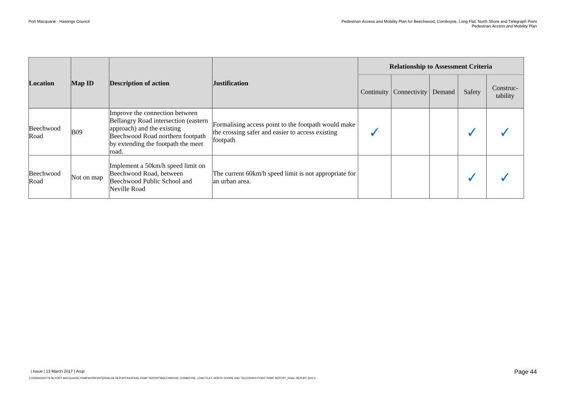
Port Macquarie - Hastings Council Pedestrian Access and Mobility Plan for Beechwood, Comboyne, Long Flat, North Shore and Telegraph PointPedestrian Access and Mobility Plan
| Issue | 13 March 2017 | Arup
J:\250000\250779-00 PORT MACQUARIE PAMP\WORK\INTERNAL\04 REPORTING\FINAL PAMP REPORT\BEECHWOOD, COMBOYNE, LONG FLAT, NORTH SHORE AND TELEGRAPH POINT PAMP REPORT_FINAL REPORT.DOCX
Page 44
Location Map ID Description of action Justification
Relationship to Assessment Criteria
Continuity Connectivity Demand Safety Construc-tability
Beechwood Road
B09
Improve the connection between Bellangry Road intersection (eastern approach) and the existing Beechwood Road northern footpath by extending the footpath the meet road.
Formalising access point to the footpath would make the crossing safer and easier to access existing footpath
✓ ✓ ✓
Beechwood Road
Not on map
Implement a 50km/h speed limit on Beechwood Road, between Beechwood Public School and Neville Road
The current 60km/h speed limit is not appropriate for an urban area. ✓ ✓
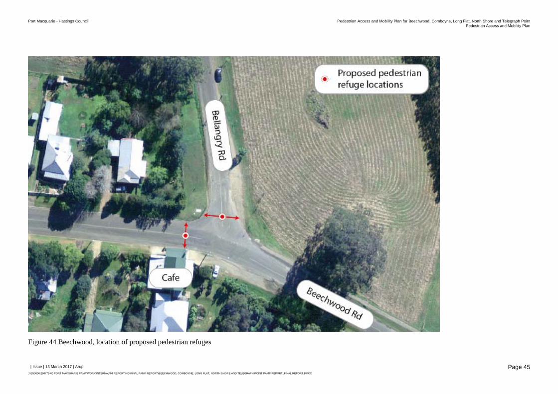
Port Macquarie - Hastings Council Pedestrian Access and Mobility Plan for Beechwood, Comboyne, Long Flat, North Shore and Telegraph PointPedestrian Access and Mobility Plan
| Issue | 13 March 2017 | Arup
J:\250000\250779-00 PORT MACQUARIE PAMP\WORK\INTERNAL\04 REPORTING\FINAL PAMP REPORT\BEECHWOOD, COMBOYNE, LONG FLAT, NORTH SHORE AND TELEGRAPH POINT PAMP REPORT_FINAL REPORT.DOCX
Page 45
Figure 44 Beechwood, location of proposed pedestrian refuges
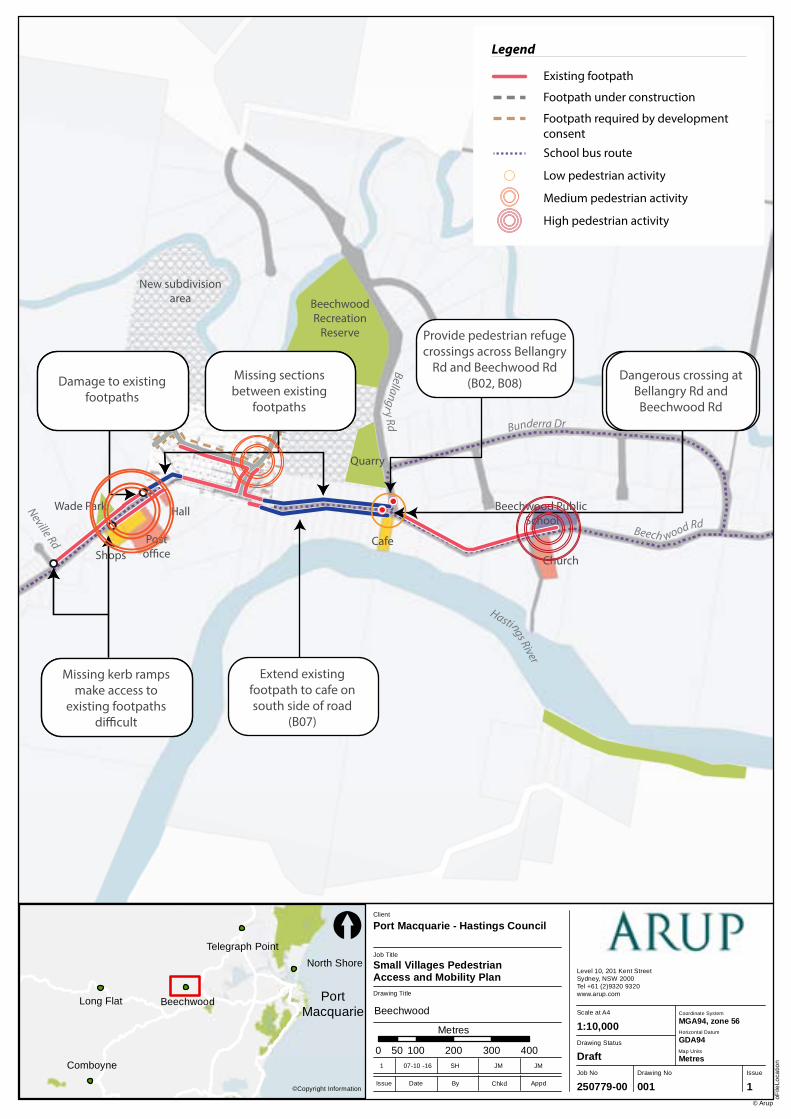
Comboyne
Long Flat Beechwood
North Shore
Telegraph Point
Job No
250779-00
Drawing No Issue
001 1
Drawing Status
Draft
Scale at A4
Level 10, 201 Kent StreetSydney, NSW 2000Tel +61 (2)9320 9320 www.arup.com
oFile
Loca
tion
© Arup
1:10,000
Drawing Title
Job Title
Small Villages Pedestrian Access and Mobility Plan
Client
Port Macquarie - Hastings Council
0 100 200 300 40050
Metres
©Copyright InformationIssue Date By Appd
1 07-10 -16 SH JM JM
Chkd
[
Coordinate System
Horizontal Datum
GDA94
MGA94, zone 56
Map Units
Metres
PortMacquarie Beechwood
BeechwoodRecreation
Reserve
New subdivisionarea
Quarry
Church
Beechwood Public School
Posto�ce
HallWade Park
ShopsCafe
Bunderra Dr
Bellangry Rd
Beech wood Rd
Neville Rd
Hastings River
Legend
Existing footpath
Footpath under construction
Footpath required by developmentconsent
Suggested footpath
School bus route
Suggested improvements
Suggested crossing location
Fix tree damage to existing
footpaths (B06)
Provide new footpathto connect sections
between existingfootpaths (B01, B03)
Improve connection between end of footpath
and road (B09)
Provide kerb rampsmake existing footpaths
accessible (B04, B05)
Extend existingfootpath to cafe on south side of road
(B07)
Provide pedestrian refuge crossings across Bellangry
Rd and Beechwood Rd (B02, B08)
Legend
Existing footpath
Footpath under construction
School bus route
Damage to existingfootpaths
Missing sectionsbetween existing
footpaths
Dangerous crossing at Bellangry Rd andBeechwood Rd
Missing kerb rampsmake access to
existing footpaths di�cult
Legend
Existing footpath
Footpath under construction
Footpath required by development consent
School bus route
Low pedestrian activity
Medium pedestrian activity
High pedestrian activity
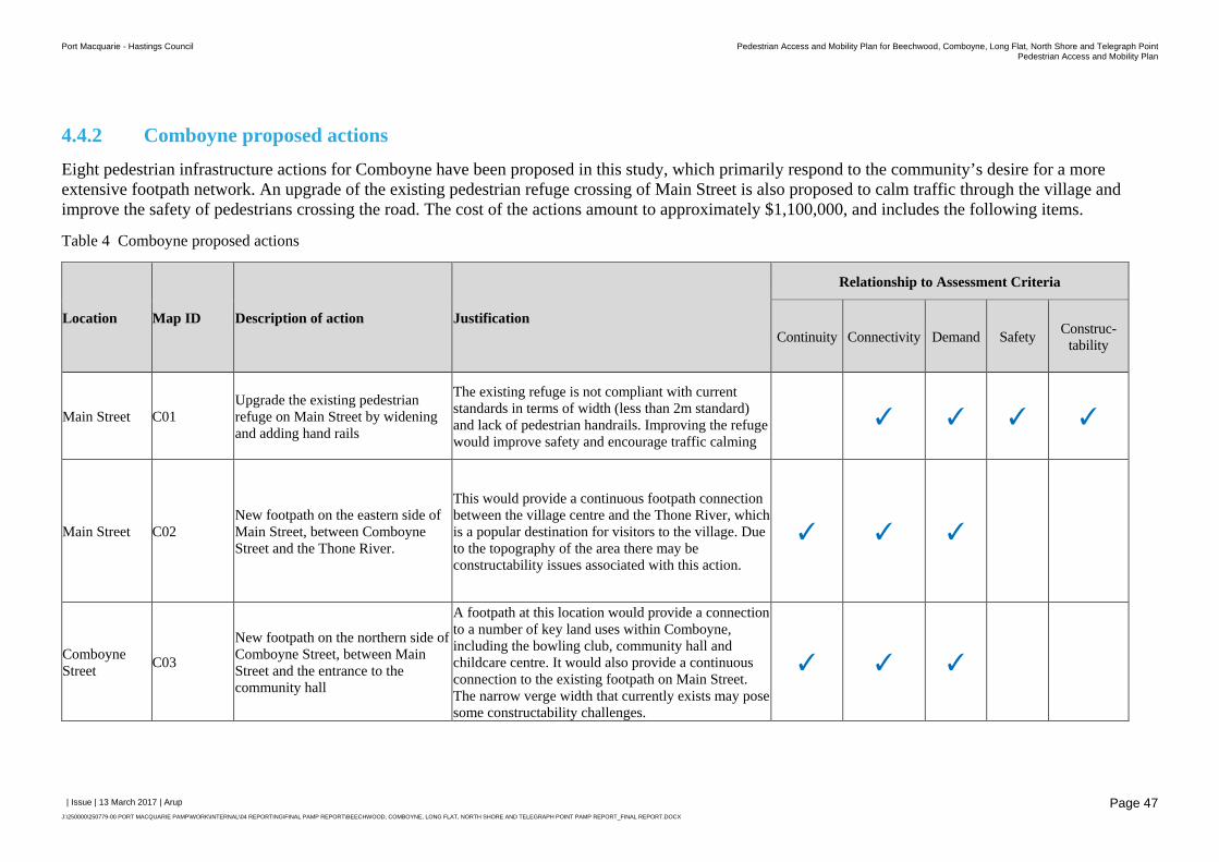
Port Macquarie - Hastings Council Pedestrian Access and Mobility Plan for Beechwood, Comboyne, Long Flat, North Shore and Telegraph PointPedestrian Access and Mobility Plan
| Issue | 13 March 2017 | Arup
J:\250000\250779-00 PORT MACQUARIE PAMP\WORK\INTERNAL\04 REPORTING\FINAL PAMP REPORT\BEECHWOOD, COMBOYNE, LONG FLAT, NORTH SHORE AND TELEGRAPH POINT PAMP REPORT_FINAL REPORT.DOCX
Page 47
4.4.2 Comboyne proposed actions
Eight pedestrian infrastructure actions for Comboyne have been proposed in this study, which primarily respond to the community’s desire for a more extensive footpath network. An upgrade of the existing pedestrian refuge crossing of Main Street is also proposed to calm traffic through the village and improve the safety of pedestrians crossing the road. The cost of the actions amount to approximately $1,100,000, and includes the following items.
Table 4 Comboyne proposed actions
Location Map ID Description of action Justification
Relationship to Assessment Criteria
Continuity Connectivity Demand Safety Construc-tability
Main Street C01 Upgrade the existing pedestrian refuge on Main Street by widening and adding hand rails
The existing refuge is not compliant with current standards in terms of width (less than 2m standard) and lack of pedestrian handrails. Improving the refuge would improve safety and encourage traffic calming
✓ ✓ ✓ ✓
Main Street C02 New footpath on the eastern side of Main Street, between Comboyne Street and the Thone River.
This would provide a continuous footpath connection between the village centre and the Thone River, which is a popular destination for visitors to the village. Due to the topography of the area there may be constructability issues associated with this action.
✓ ✓ ✓
Comboyne Street
C03
New footpath on the northern side of Comboyne Street, between Main Street and the entrance to the community hall
A footpath at this location would provide a connection to a number of key land uses within Comboyne, including the bowling club, community hall and childcare centre. It would also provide a continuous connection to the existing footpath on Main Street. The narrow verge width that currently exists may pose some constructability challenges.
✓ ✓ ✓
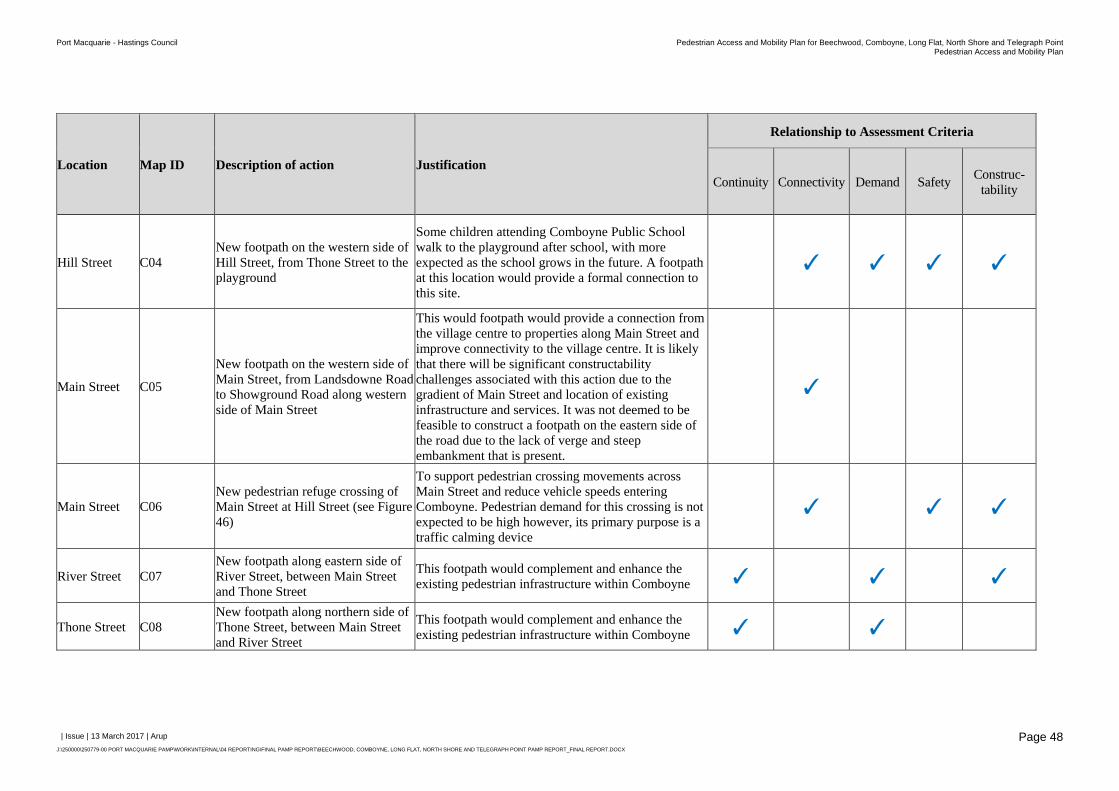
Port Macquarie - Hastings Council Pedestrian Access and Mobility Plan for Beechwood, Comboyne, Long Flat, North Shore and Telegraph PointPedestrian Access and Mobility Plan
| Issue | 13 March 2017 | Arup
J:\250000\250779-00 PORT MACQUARIE PAMP\WORK\INTERNAL\04 REPORTING\FINAL PAMP REPORT\BEECHWOOD, COMBOYNE, LONG FLAT, NORTH SHORE AND TELEGRAPH POINT PAMP REPORT_FINAL REPORT.DOCX
Page 48
Location Map ID Description of action Justification
Relationship to Assessment Criteria
Continuity Connectivity Demand Safety Construc-tability
Hill Street C04 New footpath on the western side of Hill Street, from Thone Street to the playground
Some children attending Comboyne Public School walk to the playground after school, with more expected as the school grows in the future. A footpath at this location would provide a formal connection to this site.
✓ ✓ ✓ ✓
Main Street C05
New footpath on the western side of Main Street, from Landsdowne Road to Showground Road along western side of Main Street
This would footpath would provide a connection from the village centre to properties along Main Street and improve connectivity to the village centre. It is likely that there will be significant constructability challenges associated with this action due to the gradient of Main Street and location of existing infrastructure and services. It was not deemed to be feasible to construct a footpath on the eastern side of the road due to the lack of verge and steep embankment that is present.
✓
Main Street C06 New pedestrian refuge crossing of Main Street at Hill Street (see Figure 46)
To support pedestrian crossing movements across Main Street and reduce vehicle speeds entering Comboyne. Pedestrian demand for this crossing is not expected to be high however, its primary purpose is a traffic calming device
✓ ✓ ✓
River Street C07 New footpath along eastern side of River Street, between Main Street and Thone Street
This footpath would complement and enhance the existing pedestrian infrastructure within Comboyne ✓ ✓ ✓
Thone Street C08 New footpath along northern side of Thone Street, between Main Street and River Street
This footpath would complement and enhance the existing pedestrian infrastructure within Comboyne ✓ ✓
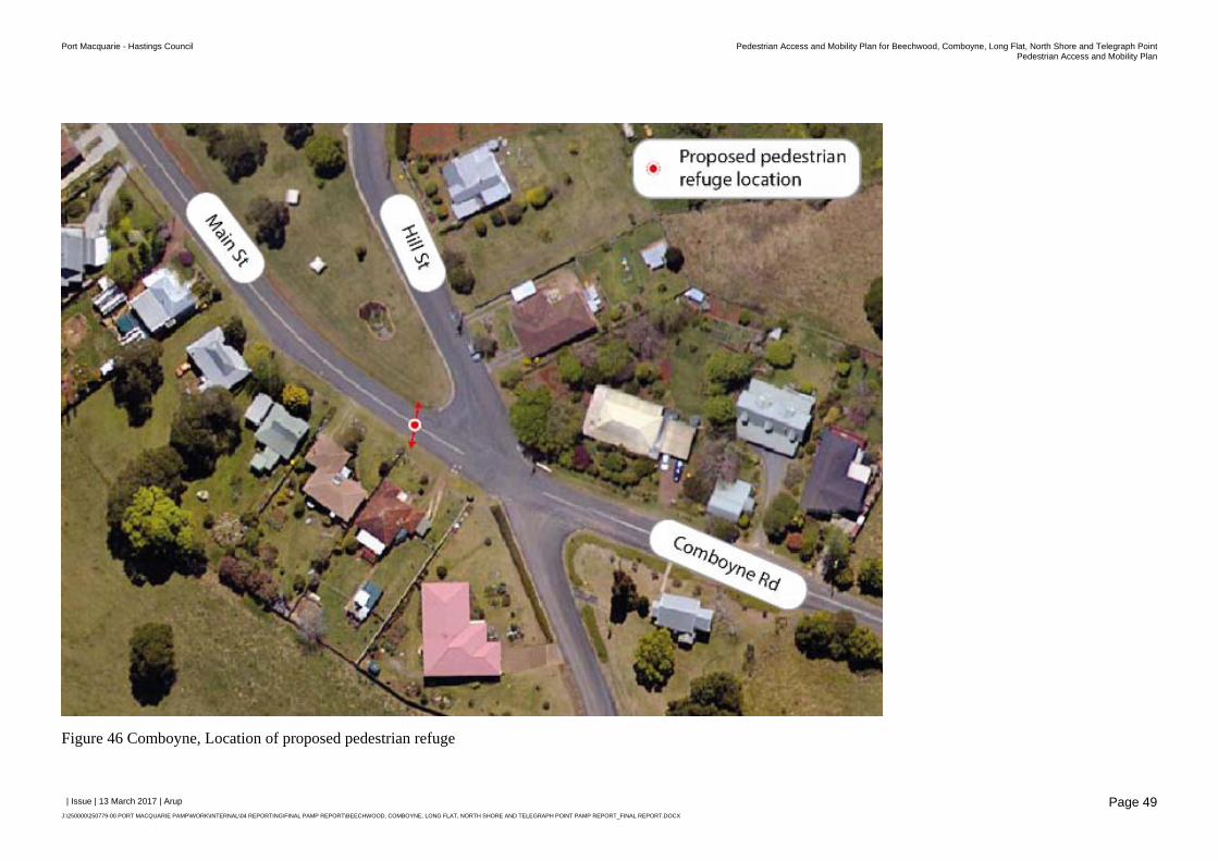
Port Macquarie - Hastings Council Pedestrian Access and Mobility Plan for Beechwood, Comboyne, Long Flat, North Shore and Telegraph PointPedestrian Access and Mobility Plan
| Issue | 13 March 2017 | Arup
J:\250000\250779-00 PORT MACQUARIE PAMP\WORK\INTERNAL\04 REPORTING\FINAL PAMP REPORT\BEECHWOOD, COMBOYNE, LONG FLAT, NORTH SHORE AND TELEGRAPH POINT PAMP REPORT_FINAL REPORT.DOCX
Page 49
Figure 46 Comboyne, Location of proposed pedestrian refuge
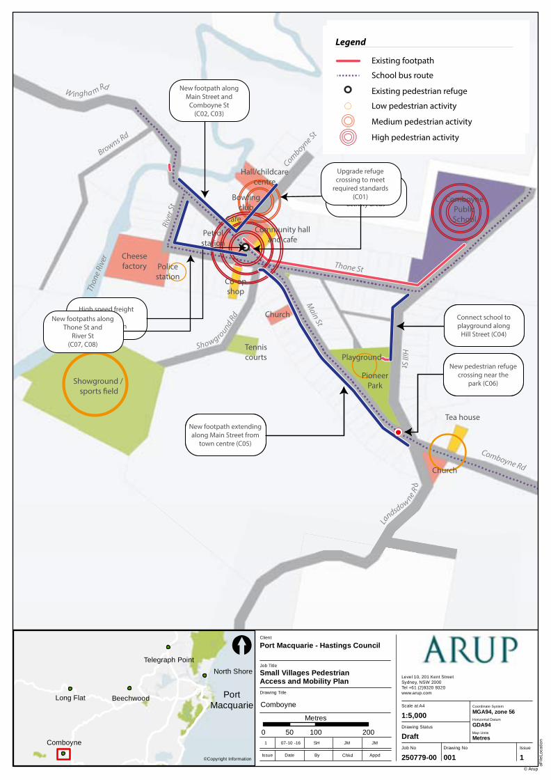
Comboyne
Long Flat Beechwood
North Shore
Telegraph Point
Job No
250779-00
Drawing No Issue
001 1
Drawing Status
Draft
Scale at A4
Level 10, 201 Kent StreetSydney, NSW 2000Tel +61 (2)9320 9320 www.arup.com
oFile
Loca
tion
© Arup
1:5,000
Drawing Title
Job Title
Small Villages Pedestrian Access and Mobility Plan
Client
Port Macquarie - Hastings Council
0 100 20050
Metres
©Copyright InformationIssue Date By Appd
1 07-10 -16 SH JM JM
Chkd
[
Coordinate System
Horizontal Datum
GDA94
MGA94, zone 56
Map Units
Metres
PortMacquarie Comboyne
Showground / sports �eld
Cheesefactory Police
station Co-opshop
Community halland cafe
Petrolstation
Hall/childcarecentre
Bowlingclub
Cafe
ComboynePublicSchool
PioneerPark
Tea house
Church
Church
Tenniscourts
Thon
e Riv
er
PlaygroundShowgro
und RdM
ain St
Rive
r St
Comboyne St
Thone St
Hill St
La
ndsdowne Rd
Comboyne Rd
W ingha m Rd
Browns Rd
School childrenwalk to parkalong road
Lack of footpath alonghigh speed road
into town
Lack of footpathsin high pedestrian
activity areas
Di�cult crossing dueto high speeds and
low visibility over hill
High speed freighttra�c
through town
Legend
Existing footpath
School bus route
Connect school toplayground along
Hill Street (C04)
New footpath extendingalong Main Street from
town centre (C05)
New footpath alongMain Street and
Comboyne St(C02, C03)
New pedestrian refuge crossing near the
park (C06)
Legend
Existing footpath
Suggested footpath
School bus route
Suggested footpath improvements
Suggested crossing / crossing upgrade
New footpaths alongThone St and
River St(C07, C08)
Upgrade refugecrossing to meet
required standards(C01)
Legend
Existing footpath
School bus route
Existing pedestrian refuge
Low pedestrian activity
Medium pedestrian activity
High pedestrian activity
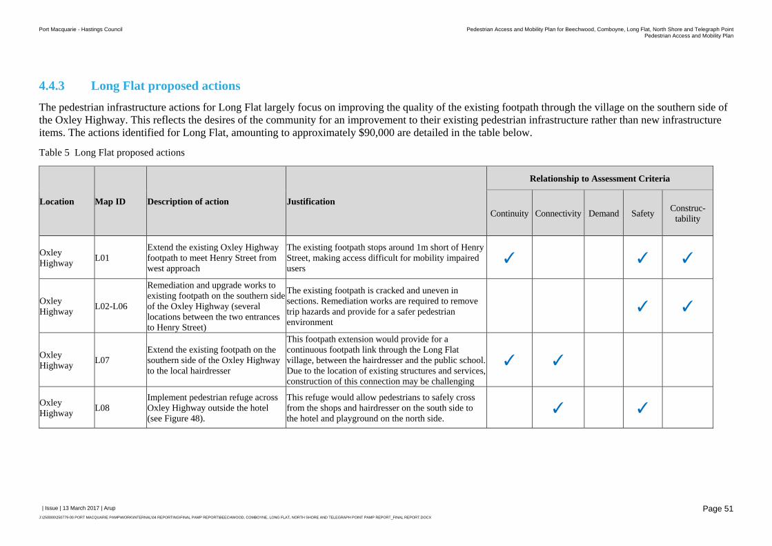
Port Macquarie - Hastings Council Pedestrian Access and Mobility Plan for Beechwood, Comboyne, Long Flat, North Shore and Telegraph PointPedestrian Access and Mobility Plan
| Issue | 13 March 2017 | Arup
J:\250000\250779-00 PORT MACQUARIE PAMP\WORK\INTERNAL\04 REPORTING\FINAL PAMP REPORT\BEECHWOOD, COMBOYNE, LONG FLAT, NORTH SHORE AND TELEGRAPH POINT PAMP REPORT_FINAL REPORT.DOCX
Page 51
4.4.3 Long Flat proposed actions
The pedestrian infrastructure actions for Long Flat largely focus on improving the quality of the existing footpath through the village on the southern side of the Oxley Highway. This reflects the desires of the community for an improvement to their existing pedestrian infrastructure rather than new infrastructure items. The actions identified for Long Flat, amounting to approximately $90,000 are detailed in the table below.
Table 5 Long Flat proposed actions
Location Map ID Description of action Justification
Relationship to Assessment Criteria
Continuity Connectivity Demand Safety Construc-tability
Oxley Highway
L01 Extend the existing Oxley Highway footpath to meet Henry Street from west approach
The existing footpath stops around 1m short of Henry Street, making access difficult for mobility impaired users
✓ ✓ ✓
Oxley Highway
L02-L06
Remediation and upgrade works to existing footpath on the southern side of the Oxley Highway (several locations between the two entrances to Henry Street)
The existing footpath is cracked and uneven in sections. Remediation works are required to remove trip hazards and provide for a safer pedestrian environment
✓ ✓
Oxley Highway
L07 Extend the existing footpath on the southern side of the Oxley Highway to the local hairdresser
This footpath extension would provide for a continuous footpath link through the Long Flat village, between the hairdresser and the public school. Due to the location of existing structures and services, construction of this connection may be challenging
✓ ✓
Oxley Highway
L08 Implement pedestrian refuge across Oxley Highway outside the hotel (see Figure 48).
This refuge would allow pedestrians to safely cross from the shops and hairdresser on the south side to the hotel and playground on the north side.
✓ ✓
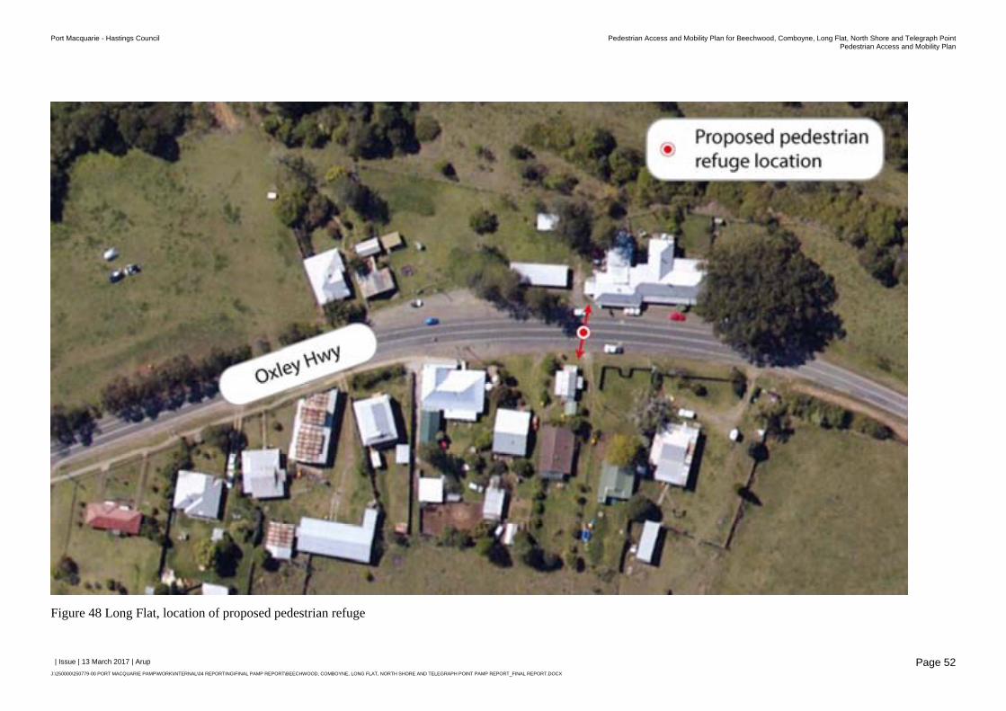
Port Macquarie - Hastings Council Pedestrian Access and Mobility Plan for Beechwood, Comboyne, Long Flat, North Shore and Telegraph PointPedestrian Access and Mobility Plan
| Issue | 13 March 2017 | Arup
J:\250000\250779-00 PORT MACQUARIE PAMP\WORK\INTERNAL\04 REPORTING\FINAL PAMP REPORT\BEECHWOOD, COMBOYNE, LONG FLAT, NORTH SHORE AND TELEGRAPH POINT PAMP REPORT_FINAL REPORT.DOCX
Page 52
Figure 48 Long Flat, location of proposed pedestrian refuge
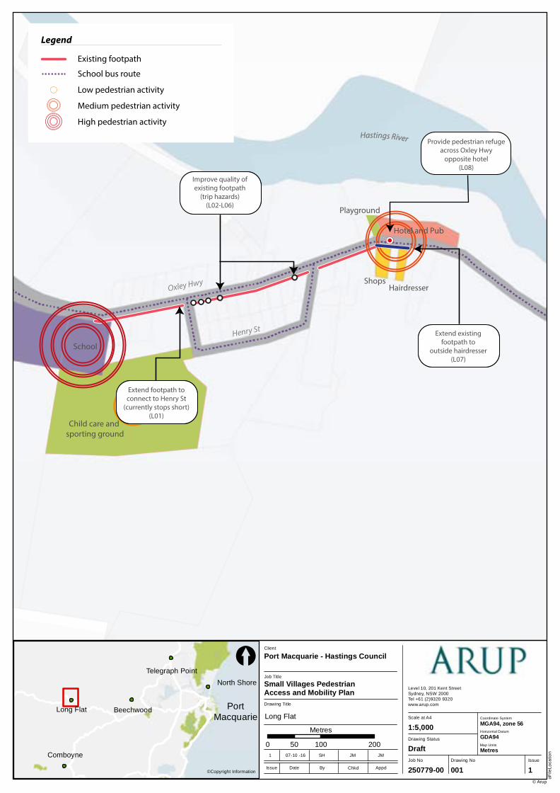
Comboyne
Long Flat Beechwood
North Shore
Telegraph Point
Job No
250779-00
Drawing No Issue
001 1
Drawing Status
Draft
Scale at A4
Level 10, 201 Kent StreetSydney, NSW 2000Tel +61 (2)9320 9320 www.arup.com
oFile
Loca
tion
© Arup
1:5,000
Drawing Title
Job Title
Small Villages Pedestrian Access and Mobility Plan
Client
Port Macquarie - Hastings Council
0 100 20050
Metres
©Copyright InformationIssue Date By Appd
1 07-10 -16 SH JM JM
Chkd
[
Coordinate System
Horizontal Datum
GDA94
MGA94, zone 56
Map Units
Metres
PortMacquarie Long Flat
Playground
Hotel and Pub
ShopsHairdresser
Child care and sporting ground
School
Hastings River
Oxley Hwy
Henry St
Legend
Existing footpath
School bus route
Footpath does notextend to Henry
Street
Footpath damagealong existing footpath
Footpath stopsbefore hairdresser
Hastings River
Legend
Existing footpath
Suggested footpath
School bus route
Suggested improvements
Suggested crossing / crossing upgrade
Extend footpath toconnect to Henry St
(currently stops short)(L01)
Improve quality ofexisting footpath
(trip hazards)(L02-L06)
Extend existingfootpath to
outside hairdresser(L07)
Provide pedestrian refuge across Oxley Hwy
opposite hotel (L08)
Legend
Existing footpath
School bus route
Low pedestrian activity
Medium pedestrian activity
High pedestrian activity
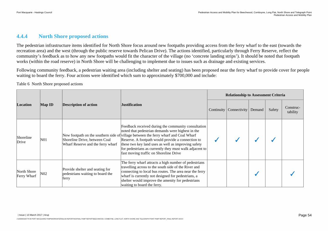
Port Macquarie - Hastings Council Pedestrian Access and Mobility Plan for Beechwood, Comboyne, Long Flat, North Shore and Telegraph PointPedestrian Access and Mobility Plan
| Issue | 13 March 2017 | Arup
J:\250000\250779-00 PORT MACQUARIE PAMP\WORK\INTERNAL\04 REPORTING\FINAL PAMP REPORT\BEECHWOOD, COMBOYNE, LONG FLAT, NORTH SHORE AND TELEGRAPH POINT PAMP REPORT_FINAL REPORT.DOCX
Page 54
4.4.4 North Shore proposed actions
The pedestrian infrastructure items identified for North Shore focus around new footpaths providing access from the ferry wharf to the east (towards the recreation area) and the west (through the public reserve towards Pelican Drive). The actions identified, particularly through Ferry Reserve, reflect the community’s feedback as to how any new footpaths would fit the character of the village (no ‘concrete landing strips’). It should be noted that footpath works (within the road reserve) in North Shore will be challenging to implement due to issues such as drainage and existing services.
Following community feedback, a pedestrian waiting area (including shelter and seating) has been proposed near the ferry wharf to provide cover for people waiting to board the ferry. Four actions were identified which sum to approximately $700,000 and include:
Table 6 North Shore proposed actions
Location Map ID Description of action Justification
Relationship to Assessment Criteria
Continuity Connectivity Demand Safety Construc-tability
Shoreline Drive
N01 New footpath on the southern side of Shoreline Drive, between Coal Wharf Reserve and the ferry wharf
Feedback received during the community consultation noted that pedestrian demands were highest in the village between the ferry wharf and Coal Wharf Reserve. A footpath would provide a connection to these two key land uses as well as improving safety for pedestrians as currently they must walk adjacent to fast moving traffic on Shoreline Drive
✓ ✓ ✓ ✓
North Shore Ferry Wharf
N02 Provide shelter and seating for pedestrians waiting to board the ferry
The ferry wharf attracts a high number of pedestrians travelling across to the south side of the River and connecting to local bus routes. The area near the ferry wharf is currently not designed for pedestrians, a shelter would improve the amenity for pedestrians waiting to board the ferry.
✓ ✓
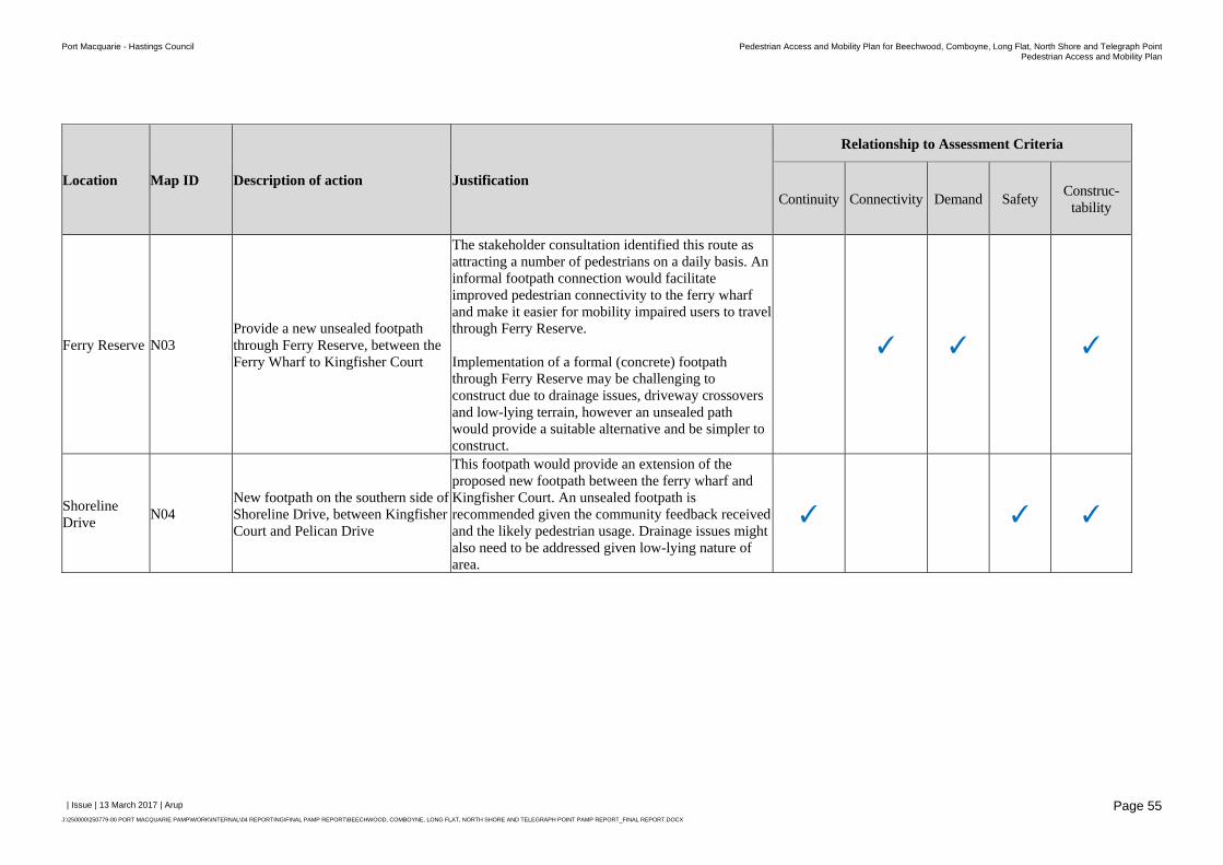
Port Macquarie - Hastings Council Pedestrian Access and Mobility Plan for Beechwood, Comboyne, Long Flat, North Shore and Telegraph PointPedestrian Access and Mobility Plan
| Issue | 13 March 2017 | Arup
J:\250000\250779-00 PORT MACQUARIE PAMP\WORK\INTERNAL\04 REPORTING\FINAL PAMP REPORT\BEECHWOOD, COMBOYNE, LONG FLAT, NORTH SHORE AND TELEGRAPH POINT PAMP REPORT_FINAL REPORT.DOCX
Page 55
Location Map ID Description of action Justification
Relationship to Assessment Criteria
Continuity Connectivity Demand Safety Construc-tability
Ferry Reserve N03 Provide a new unsealed footpath through Ferry Reserve, between the Ferry Wharf to Kingfisher Court
The stakeholder consultation identified this route as attracting a number of pedestrians on a daily basis. An informal footpath connection would facilitate improved pedestrian connectivity to the ferry wharf and make it easier for mobility impaired users to travel through Ferry Reserve. Implementation of a formal (concrete) footpath through Ferry Reserve may be challenging to construct due to drainage issues, driveway crossovers and low-lying terrain, however an unsealed path would provide a suitable alternative and be simpler to construct.
✓ ✓ ✓
Shoreline Drive
N04 New footpath on the southern side of Shoreline Drive, between Kingfisher Court and Pelican Drive
This footpath would provide an extension of the proposed new footpath between the ferry wharf and Kingfisher Court. An unsealed footpath is recommended given the community feedback received and the likely pedestrian usage. Drainage issues might also need to be addressed given low-lying nature of area.
✓ ✓ ✓
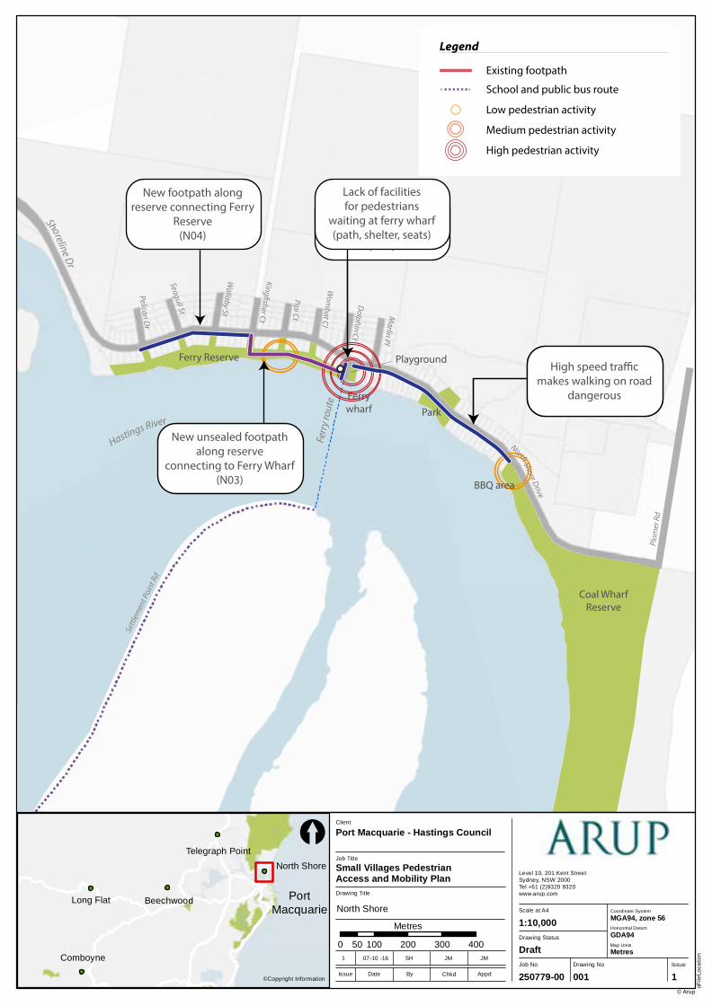
Comboyne
Long Flat Beechwood
North Shore
Telegraph Point
Job No
250779-00
Drawing No Issue
001 1
Drawing Status
Draft
Scale at A4
Level 10, 201 Kent StreetSydney, NSW 2000Tel +61 (2)9320 9320 www.arup.com
oFile
Loca
tion
© Arup
1:10,000
Drawing Title
Job Title
Small Villages Pedestrian Access and Mobility Plan
Client
Port Macquarie - Hastings Council
0 100 200 300 40050
Metres
©Copyright InformationIssue Date By Appd
1 07-10 -16 SH JM JM
Chkd
[
Coordinate System
Horizontal Datum
GDA94
MGA94, zone 56
Map Units
Metres
PortMacquarie North Shore
Ferr
y ro
ute
Hastings River
Pelican Dr
Seagull St
Wallaby St
Pipi Ct
Dolphin Ct
Marlin Pl
King�sher Ct
Wom
bat Cl
Shoreline Dr
Settl
emen
t Poi
nt R
d
Plom
er R
d
North Shore Drive
Ferrywharf
Playground
Park
BBQ area
Ferry Reserve
Coal WharfReserve
New footpath fromferry wharf to BBQ
area (N01)
Improve pedestrian access and waiting
facilities at ferry wharf(N02)
New footpath along reserve connecting Ferry
Reserve(N04)
New unsealed footpath along reserve
connecting to Ferry Wharf(N03)
Legend
Existing footpath
Suggested footpath (sealed)
Suggested footpath (unsealed)
Suggested improvements
School and public bus route
Legend
Existing footpath
High speed tra�c makes walking on road
dangerous
Lack of facilitiesfor pedestrians
waiting at ferry wharf(path, shelter, seats)
School bus route
Legend
Existing footpath
School and public bus route
Low pedestrian activity
Medium pedestrian activity
High pedestrian activity
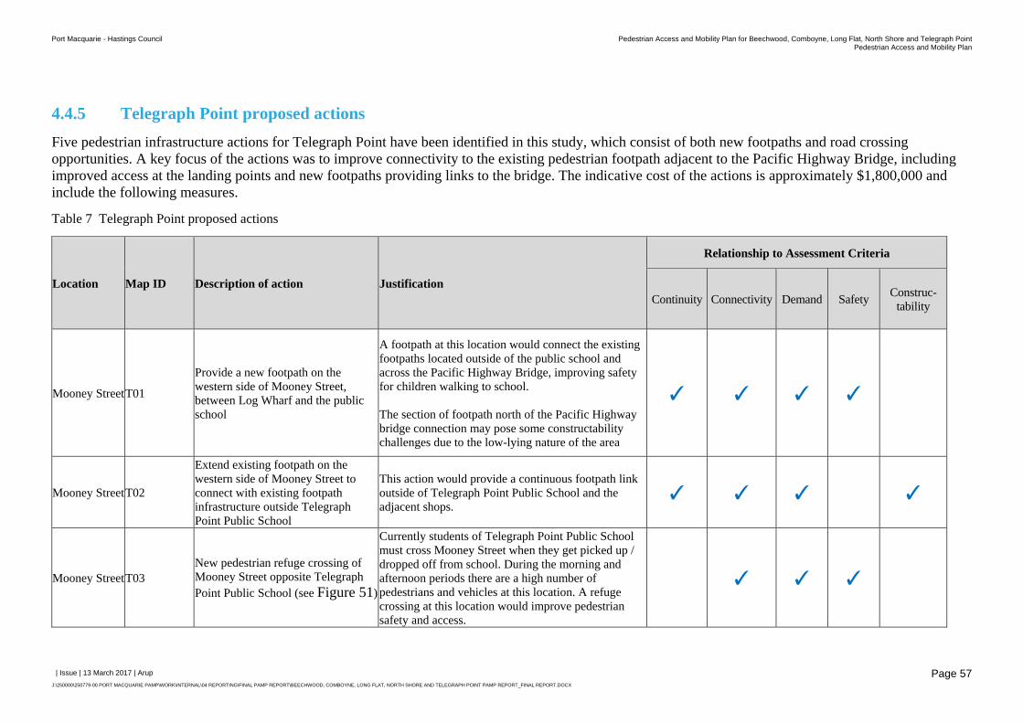
Port Macquarie - Hastings Council Pedestrian Access and Mobility Plan for Beechwood, Comboyne, Long Flat, North Shore and Telegraph PointPedestrian Access and Mobility Plan
| Issue | 13 March 2017 | Arup
J:\250000\250779-00 PORT MACQUARIE PAMP\WORK\INTERNAL\04 REPORTING\FINAL PAMP REPORT\BEECHWOOD, COMBOYNE, LONG FLAT, NORTH SHORE AND TELEGRAPH POINT PAMP REPORT_FINAL REPORT.DOCX
Page 57
4.4.5 Telegraph Point proposed actions
Five pedestrian infrastructure actions for Telegraph Point have been identified in this study, which consist of both new footpaths and road crossing opportunities. A key focus of the actions was to improve connectivity to the existing pedestrian footpath adjacent to the Pacific Highway Bridge, including improved access at the landing points and new footpaths providing links to the bridge. The indicative cost of the actions is approximately $1,800,000 and include the following measures.
Table 7 Telegraph Point proposed actions
Location Map ID Description of action Justification
Relationship to Assessment Criteria
Continuity Connectivity Demand Safety Construc-tability
Mooney Street T01
Provide a new footpath on the western side of Mooney Street, between Log Wharf and the public school
A footpath at this location would connect the existing footpaths located outside of the public school and across the Pacific Highway Bridge, improving safety for children walking to school. The section of footpath north of the Pacific Highway bridge connection may pose some constructability challenges due to the low-lying nature of the area
✓ ✓ ✓ ✓
Mooney Street T02
Extend existing footpath on the western side of Mooney Street to connect with existing footpath infrastructure outside Telegraph Point Public School
This action would provide a continuous footpath link outside of Telegraph Point Public School and the adjacent shops.
✓ ✓ ✓ ✓
Mooney Street T03 New pedestrian refuge crossing of Mooney Street opposite Telegraph Point Public School (see Figure 51)
Currently students of Telegraph Point Public School must cross Mooney Street when they get picked up / dropped off from school. During the morning and afternoon periods there are a high number of pedestrians and vehicles at this location. A refuge crossing at this location would improve pedestrian safety and access.
✓ ✓ ✓
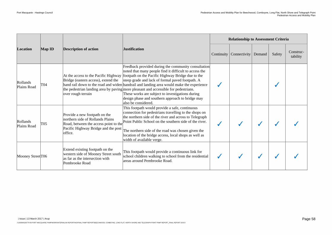
Port Macquarie - Hastings Council Pedestrian Access and Mobility Plan for Beechwood, Comboyne, Long Flat, North Shore and Telegraph PointPedestrian Access and Mobility Plan
| Issue | 13 March 2017 | Arup
J:\250000\250779-00 PORT MACQUARIE PAMP\WORK\INTERNAL\04 REPORTING\FINAL PAMP REPORT\BEECHWOOD, COMBOYNE, LONG FLAT, NORTH SHORE AND TELEGRAPH POINT PAMP REPORT_FINAL REPORT.DOCX
Page 58
Location Map ID Description of action Justification
Relationship to Assessment Criteria
Continuity Connectivity Demand Safety Construc-tability
Rollands Plains Road
T04
At the access to the Pacific Highway Bridge (eastern access), extend the hand rail down to the road and widen the pedestrian landing area by paving over rough terrain
Feedback provided during the community consultation noted that many people find it difficult to access the footpath on the Pacific Highway Bridge due to the steep grade and lack of formal paved footpath. A handrail and landing area would make the experience more pleasant and accessible for pedestrians. These works are subject to investigations during design phase and southern approach to bridge may also be considered.
✓ ✓
Rollands Plains Road
T05
Provide a new footpath on the northern side of Rollands Plains Road, between the access point to the Pacific Highway Bridge and the post office.
This footpath would provide a safe, continuous connection for pedestrians travelling to the shops on the northern side of the river and across to Telegraph Point Public School on the southern side of the river. The northern side of the road was chosen given the location of the bridge access, local shops as well as width of available verge.
✓ ✓ ✓ ✓ ✓
Mooney Street T06
Extend existing footpath on the western side of Mooney Street south as far as the intersection with Pembrooke Road
This footpath would provide a continuous link for school children walking to school from the residential areas around Pembrooke Road.
✓ ✓ ✓ ✓ ✓
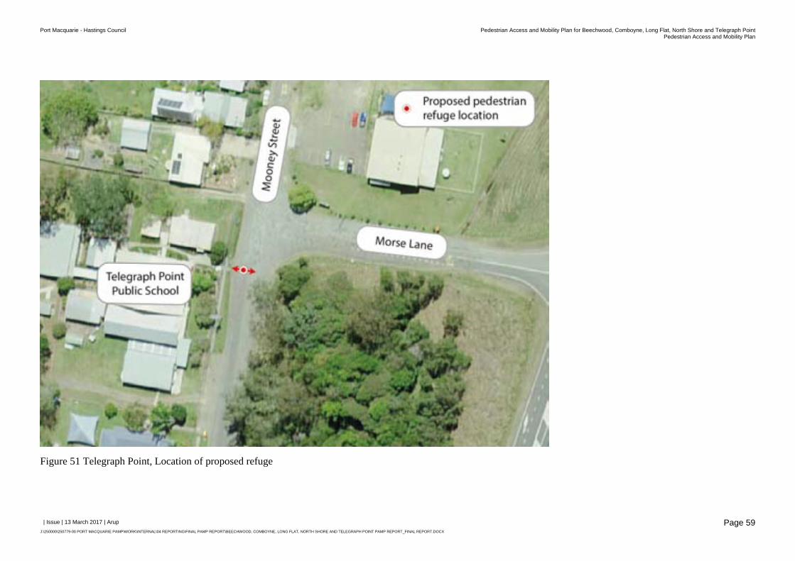
Port Macquarie - Hastings Council Pedestrian Access and Mobility Plan for Beechwood, Comboyne, Long Flat, North Shore and Telegraph PointPedestrian Access and Mobility Plan
| Issue | 13 March 2017 | Arup
J:\250000\250779-00 PORT MACQUARIE PAMP\WORK\INTERNAL\04 REPORTING\FINAL PAMP REPORT\BEECHWOOD, COMBOYNE, LONG FLAT, NORTH SHORE AND TELEGRAPH POINT PAMP REPORT_FINAL REPORT.DOCX
Page 59
Figure 51 Telegraph Point, Location of proposed refuge
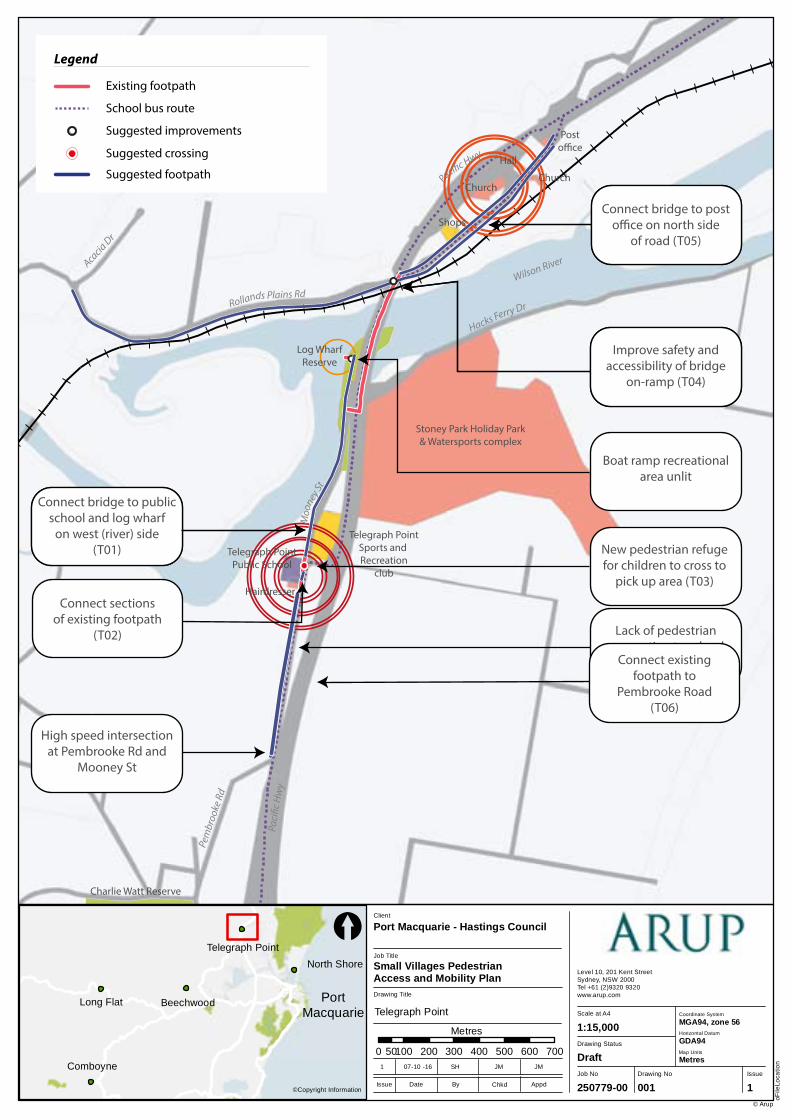
Comboyne
Long Flat Beechwood
North Shore
Telegraph Point
Job No
250779-00
Drawing No Issue
001 1
Drawing Status
Draft
Scale at A4
Level 10, 201 Kent StreetSydney, NSW 2000Tel +61 (2)9320 9320 www.arup.com
oFile
Loca
tion
© Arup
1:15,000
Drawing Title
Job Title
Small Villages Pedestrian Access and Mobility Plan
Client
Port Macquarie - Hastings Council
0 100 200 300 400 500 600 70050
Metres
©Copyright InformationIssue Date By Appd
1 07-10 -16 SH JM JM
Chkd
[
Coordinate System
Horizontal Datum
GDA94
MGA94, zone 56
Map Units
Metres
PortMacquarie Telegraph Point
Telegraph PointPublic School
Hairdresser
Stoney Park Holiday Park& Watersports complex
Telegraph PointSports and Recreation
club
Log WharfReserve
Shops
Church
Hall
Posto�ce
Church
Charlie Watt Reserve
Rollands Plains RdM
ooney
StHacks Ferry Dr
Wilson RiverAcacia Dr
Paci�c Hwy
Paci
�c H
wy
Wilson River
Pem
broo
ke R
d
Access to bridgeis steep and
exposed to tra�c
Lack of footpathconnection to the
bridge
Lack of connection tobridge from school
Boat ramp recreationalarea unlit
Lack of pedestrianconnection to school
from the south
High speed intersectionat Pembrooke Rd and
Mooney St
Legend
Existing footpath
School bus route
Improve safety and accessibility of bridge
on-ramp (T04)
Connect bridge to post o�ce on north side
of road (T05)
Connect bridge to public school and log wharf
on west (river) side(T01)
Legend
Existing footpath
Suggested footpath
School bus route
Suggested improvements
Suggested crossing
Connect sectionsof existing footpath
(T02)
New pedestrian refugefor children to cross to
pick up area (T03)
Connect existing footpath to
Pembrooke Road(T06)
Legend
Existing footpath
School bus route
Low pedestrian activity
Medium pedestrian activity
High pedestrian activity
Port Macquarie - Hastings Council Pedestrian Access and Mobility Plan for Beechwood, Comboyne, Long Flat,North Shore and Telegraph Point
Pedestrian Access and Mobility Plan
| Issue | 13 March 2017 | Arup
J:\250000\250779-00 PORT MACQUARIE PAMP\WORK\INTERNAL\04 REPORTING\FINAL PAMP REPORT\BEECHWOOD, COMBOYNE, LONG FLAT, NORTH SHORE AND TELEGRAPH POINT PAMP REPORT_FINAL REPORT.DOCX
Page 61
4.5 Implementation
The staged action plan identified through the PAMP study would need to be assessed and implemented based on specific site conditions and reflect the latest pedestrian facilities standards at the time of implementation. The staged action plan would be considered by Council into other projects (e.g. road upgrade, placemaking projects etc.) or included as standalone items in future Delivery Programs and Operational Plans.
Construction of any works identified in the PAMP will be subject to the availability of funding.
4.6 Monitoring
As the pedestrian network is developed, it will be important to monitor the progress of the network over time. Monitoring could relate to the following three areas:
Route conditions and overall route quality;
Changes in demand; and
Implementation of work program.
Monitoring of the quality of pedestrian routes could be undertaken by measuring the quality of the route against the existing design criteria as part of a "look and see" audit process. This will enable the overall quality of routes to be improved, problems to be addressed and resources to be targeted appropriately. Council would monitor the PAMP deliverables as per the action plan. A typical assessment would involve an assessment of route conditions and would be undertaken by a person familiar with pedestrian design issues and involve a site visit along the specified route.
Port Macquarie - Hastings Council Pedestrian Access and Mobility Plan for Beechwood, Comboyne, Long Flat,North Shore and Telegraph Point
Pedestrian Access and Mobility Plan
| Issue | 13 March 2017 | Arup
J:\250000\250779-00 PORT MACQUARIE PAMP\WORK\INTERNAL\04 REPORTING\FINAL PAMP REPORT\BEECHWOOD, COMBOYNE, LONG FLAT, NORTH SHORE AND TELEGRAPH POINT PAMP REPORT_FINAL REPORT.DOCX
Page 62
5 Summary
Arup has prepared a Pedestrian Access and Mobility Plan (PAMP) for Beechwood, Comboyne, Long Flat, North Shore, and Telegraph Point on behalf of Port Macquarie Hastings Council. The project aims to identify a framework for developing safe and convenient pedestrian routes and fostering improvements in personal mobility. The five villages considered in this study are as follows:
Beechwood
Comboyne
Long Flat
North Shore
Telegraph Point
The study focuses on the two most critical types of pedestrian facilities - footpaths and road crossings, although considers broader infrastructure improvements to support pedestrian safety and amenity, such as traffic calming devices and pedestrian facilities
The PAMP process identified deficiencies in the existing pedestrian network through a number of sources, particularly site observations, review of background data and consultation with Council and the local community. Potential actions were measured against a number of criteria, those being:
Continuity: Does the proposed improvement complement the existing pedestrian network?
Connectivity: Does the proposed improvement provide connectivity to land uses which generate pedestrian activity, such as schools, community buildings, places of worship and village shops?
Demand: Does the proposed improvement accommodate a high number of pedestrian movements, both now and in future?
Safety: Does the proposed improvement improve the safety of pedestrians?
Constructability: Does the proposed improvement have any major constructability challenges due to issues such as the location of existing services, topography of the area, drainage or lack of available space?
Based on the findings of the audits, a Staged Action Plan was developed which identified a number of individual measures to enhance pedestrian connectivity and movement within the villages. These actions were prioritised on a series of criteria and cost estimates were provided for each of the actions.
The implementation of this PAMP Action Plan will need to be assessed and implemented based on specific site conditions that reflect the latest pedestrian facilities standards at the time.

Appendix A
Action Plan
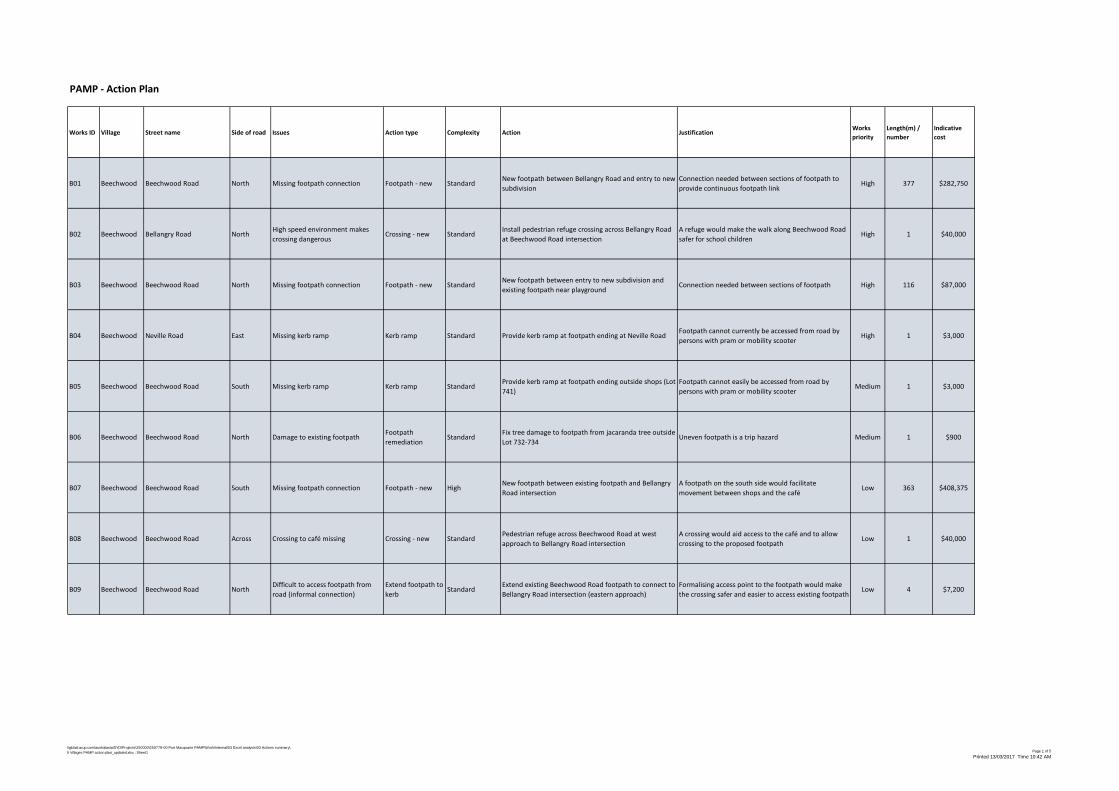
\\global.arup.com\australasia\SYD\Projects\250000\250779-00 Port Macquarie PAMP\Work\Internal\03 Excel analysis\03 Actions summary\5 Villages PAMP action plan_updated.xlsx : Sheet1 Page 1 of 5
Printed 13/03/2017 Time 10:42 AM
PAMP - Action Plan
Works ID Village Street name Side of road Issues Action type Complexity Action JustificationWorks priority
Length(m) / number
Indicative cost
B01 Beechwood Beechwood Road North Missing footpath connection Footpath - new StandardNew footpath between Bellangry Road and entry to new subdivision
Connection needed between sections of footpath to provide continuous footpath link
High 377 $282,750
B02 Beechwood Bellangry Road NorthHigh speed environment makes crossing dangerous
Crossing - new StandardInstall pedestrian refuge crossing across Bellangry Road at Beechwood Road intersection
A refuge would make the walk along Beechwood Road safer for school children
High 1 $40,000
B03 Beechwood Beechwood Road North Missing footpath connection Footpath - new StandardNew footpath between entry to new subdivision and existing footpath near playground
Connection needed between sections of footpath High 116 $87,000
B04 Beechwood Neville Road East Missing kerb ramp Kerb ramp Standard Provide kerb ramp at footpath ending at Neville RoadFootpath cannot currently be accessed from road by persons with pram or mobility scooter
High 1 $3,000
B05 Beechwood Beechwood Road South Missing kerb ramp Kerb ramp StandardProvide kerb ramp at footpath ending outside shops (Lot 741)
Footpath cannot easily be accessed from road by persons with pram or mobility scooter
Medium 1 $3,000
B06 Beechwood Beechwood Road North Damage to existing footpathFootpath remediation
StandardFix tree damage to footpath from jacaranda tree outside Lot 732-734
Uneven footpath is a trip hazard Medium 1 $900
B07 Beechwood Beechwood Road South Missing footpath connection Footpath - new HighNew footpath between existing footpath and Bellangry Road intersection
A footpath on the south side would facilitate movement between shops and the café
Low 363 $408,375
B08 Beechwood Beechwood Road Across Crossing to café missing Crossing - new StandardPedestrian refuge across Beechwood Road at west approach to Bellangry Road intersection
A crossing would aid access to the café and to allow crossing to the proposed footpath
Low 1 $40,000
B09 Beechwood Beechwood Road NorthDifficult to access footpath from road (informal connection)
Extend footpath to kerb
StandardExtend existing Beechwood Road footpath to connect to Bellangry Road intersection (eastern approach)
Formalising access point to the footpath would make the crossing safer and easier to access existing footpath
Low 4 $7,200
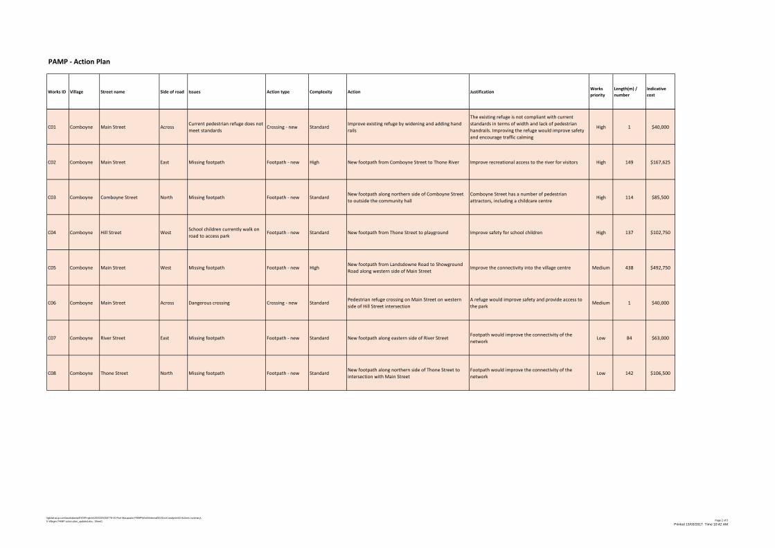
\\global.arup.com\australasia\SYD\Projects\250000\250779-00 Port Macquarie PAMP\Work\Internal\03 Excel analysis\03 Actions summary\5 Villages PAMP action plan_updated.xlsx : Sheet1 Page 2 of 5
Printed 13/03/2017 Time 10:42 AM
PAMP - Action Plan
Works ID Village Street name Side of road Issues Action type Complexity Action JustificationWorks priority
Length(m) / number
Indicative cost
C01 Comboyne Main Street AcrossCurrent pedestrian refuge does not meet standards
Crossing - new StandardImprove existing refuge by widening and adding hand rails
The existing refuge is not compliant with current standards in terms of width and lack of pedestrian handrails. Improving the refuge would improve safety and encourage traffic calming
High 1 $40,000
C02 Comboyne Main Street East Missing footpath Footpath - new High New footpath from Comboyne Street to Thone River Improve recreational access to the river for visitors High 149 $167,625
C03 Comboyne Comboyne Street North Missing footpath Footpath - new StandardNew footpath along northern side of Comboyne Street to outside the community hall
Comboyne Street has a number of pedestrian attractors, including a childcare centre
High 114 $85,500
C04 Comboyne Hill Street WestSchool children currently walk on road to access park
Footpath - new Standard New footpath from Thone Street to playground Improve safety for school children High 137 $102,750
C05 Comboyne Main Street West Missing footpath Footpath - new HighNew footpath from Landsdowne Road to Showground Road along western side of Main Street
Improve the connectivity into the village centre Medium 438 $492,750
C06 Comboyne Main Street Across Dangerous crossing Crossing - new StandardPedestrian refuge crossing on Main Street on western side of Hill Street intersection
A refuge would improve safety and provide access to the park
Medium 1 $40,000
C07 Comboyne River Street East Missing footpath Footpath - new Standard New footpath along eastern side of River StreetFootpath would improve the connectivity of the network
Low 84 $63,000
C08 Comboyne Thone Street North Missing footpath Footpath - new StandardNew footpath along northern side of Thone Street to intersection with Main Street
Footpath would improve the connectivity of the network
Low 142 $106,500
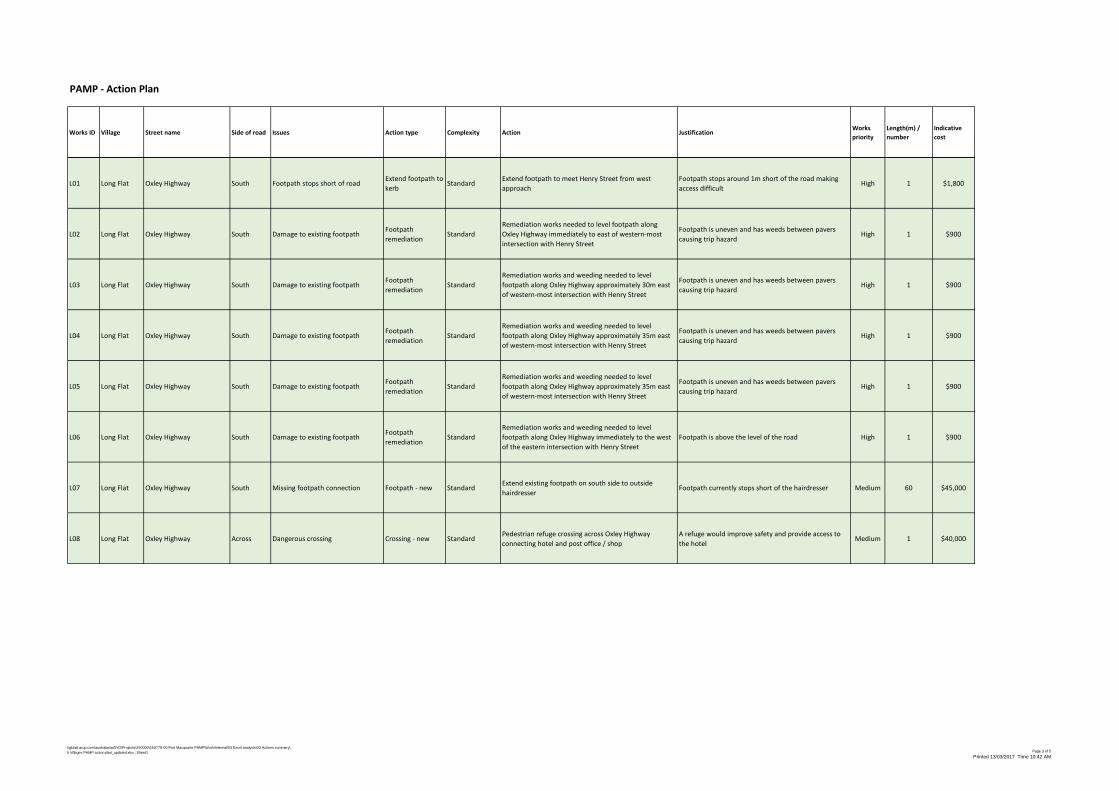
\\global.arup.com\australasia\SYD\Projects\250000\250779-00 Port Macquarie PAMP\Work\Internal\03 Excel analysis\03 Actions summary\5 Villages PAMP action plan_updated.xlsx : Sheet1 Page 3 of 5
Printed 13/03/2017 Time 10:42 AM
PAMP - Action Plan
Works ID Village Street name Side of road Issues Action type Complexity Action JustificationWorks priority
Length(m) / number
Indicative cost
L01 Long Flat Oxley Highway South Footpath stops short of roadExtend footpath to kerb
StandardExtend footpath to meet Henry Street from west approach
Footpath stops around 1m short of the road making access difficult
High 1 $1,800
L02 Long Flat Oxley Highway South Damage to existing footpathFootpath remediation
StandardRemediation works needed to level footpath along Oxley Highway immediately to east of western-most intersection with Henry Street
Footpath is uneven and has weeds between pavers causing trip hazard
High 1 $900
L03 Long Flat Oxley Highway South Damage to existing footpathFootpath remediation
StandardRemediation works and weeding needed to level footpath along Oxley Highway approximately 30m east of western-most intersection with Henry Street
Footpath is uneven and has weeds between pavers causing trip hazard
High 1 $900
L04 Long Flat Oxley Highway South Damage to existing footpathFootpath remediation
StandardRemediation works and weeding needed to level footpath along Oxley Highway approximately 35m east of western-most intersection with Henry Street
Footpath is uneven and has weeds between pavers causing trip hazard
High 1 $900
L05 Long Flat Oxley Highway South Damage to existing footpathFootpath remediation
StandardRemediation works and weeding needed to level footpath along Oxley Highway approximately 35m east of western-most intersection with Henry Street
Footpath is uneven and has weeds between pavers causing trip hazard
High 1 $900
L06 Long Flat Oxley Highway South Damage to existing footpathFootpath remediation
StandardRemediation works and weeding needed to level footpath along Oxley Highway immediately to the west of the eastern intersection with Henry Street
Footpath is above the level of the road High 1 $900
L07 Long Flat Oxley Highway South Missing footpath connection Footpath - new StandardExtend existing footpath on south side to outside hairdresser
Footpath currently stops short of the hairdresser Medium 60 $45,000
L08 Long Flat Oxley Highway Across Dangerous crossing Crossing - new StandardPedestrian refuge crossing across Oxley Highway connecting hotel and post office / shop
A refuge would improve safety and provide access to the hotel
Medium 1 $40,000
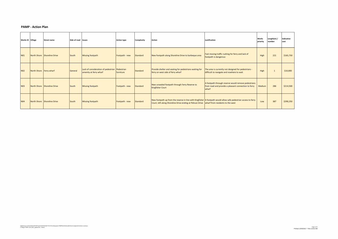
\\global.arup.com\australasia\SYD\Projects\250000\250779-00 Port Macquarie PAMP\Work\Internal\03 Excel analysis\03 Actions summary\5 Villages PAMP action plan_updated.xlsx : Sheet1 Page 4 of 5
Printed 13/03/2017 Time 10:42 AM
PAMP - Action Plan
Works ID Village Street name Side of road Issues Action type Complexity Action JustificationWorks priority
Length(m) / number
Indicative cost
N01 North Shore Shoreline Drive South Missing footpath Footpath - new Standard New footpath along Shoreline Drive to barbeque areaFast moving traffic rushing for ferry and lack of footpath is dangerous
High 221 $165,750
N02 North Shore Ferry wharf GeneralLack of consideration of pedestrian amenity at ferry wharf
Pedestrian furniture
StandardProvide shelter and seating for pedestrians waiting for ferry on west side of ferry wharf
The area is currently not designed for pedestrians - difficult to navigate and nowhere to wait
High 1 $10,000
N03 North Shore Shoreline Drive South Missing footpath Footpath - new StandardNew unsealed footpath through Ferry Reserve to Kingfisher Court
A footpath through reserve would remove pedestrians from road and provide a pleasant connection to ferry wharf
Medium 286 $214,500
N04 North Shore Shoreline Drive South Missing footpath Footpath - new StandardNew footpath up from the reserve in line with Kingfisher Court, left along Shoreline Drive ending at Pelican Drive
A footpath would allow safe pedestrian access to ferry wharf from residents to the west
Low 387 $290,250
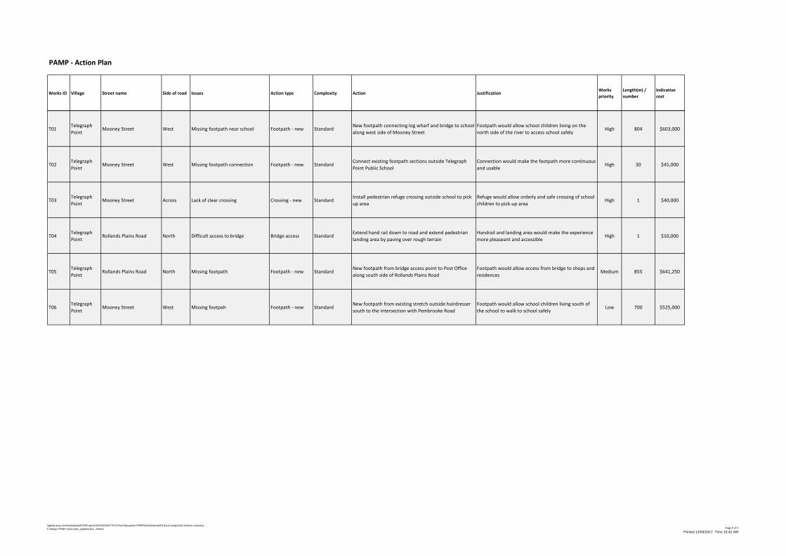
\\global.arup.com\australasia\SYD\Projects\250000\250779-00 Port Macquarie PAMP\Work\Internal\03 Excel analysis\03 Actions summary\5 Villages PAMP action plan_updated.xlsx : Sheet1 Page 5 of 5
Printed 13/03/2017 Time 10:42 AM
PAMP - Action Plan
Works ID Village Street name Side of road Issues Action type Complexity Action JustificationWorks priority
Length(m) / number
Indicative cost
T01Telegraph Point
Mooney Street West Missing footpath near school Footpath - new StandardNew footpath connecting log wharf and bridge to school along west side of Mooney Street
Footpath would allow school children living on the north side of the river to access school safely
High 804 $603,000
T02Telegraph Point
Mooney Street West Missing footpath connection Footpath - new StandardConnect existing footpath sections outside Telegraph Point Public School
Connection would make the footpath more continuous and usable
High 30 $45,000
T03Telegraph Point
Mooney Street Across Lack of clear crossing Crossing - new StandardInstall pedestrian refuge crossing outside school to pick up area
Refuge would allow orderly and safe crossing of school children to pick-up area
High 1 $40,000
T04Telegraph Point
Rollands Plains Road North Difficult access to bridge Bridge access StandardExtend hand rail down to road and extend pedestrian landing area by paving over rough terrain
Handrail and landing area would make the experience more pleaseant and accessible
High 1 $10,000
T05Telegraph Point
Rollands Plains Road North Missing footpath Footpath - new StandardNew footpath from bridge access point to Post Office along south side of Rollands Plains Road
Footpath would allow access from bridge to shops and residences
Medium 855 $641,250
T06Telegraph Point
Mooney Street West Missing footpah Footpath - new StandardNew footpath from existing stretch outside hairdresser south to the intersection with Pembrooke Road
Footpath would allow school children living south of the school to walk to school safely
Low 700 $525,000