Embed Size (px)
Citation preview

22588672_6.docx
BEFORE A BOARD OF INQUIRYMACKAYS TO PEKA PEKA EXPRESSWAY PROPOSAL
UNDER the Resource Management Act 1991
IN THE MATTER OF applications for resource consents and a notice of requirement in relation to the MacKays to Peka Peka Expressway Proposal
BY New Zealand Transport Agency
STATEMENT OF EVIDENCE OF DONALD RICHARD WIGNALLON BEHALF OF THE KAPITI COAST DISTRICT COUNCIL
Traffic and transportation
DATE: 5 October 2012
Barristers & Solicitors
D J S Laing / M G ConwayTelephone: +64-4-499 4599Facsimile: +64-4-472 6986E-mail: [email protected] SX11174PO Box 2402Wellington

Page 2
22588672_6.docx
1. INTRODUCTION
1.1 My full name is Donald Richard Wignall. I am a transport planner contracted to Kāpiti
Coast District Council (Council). My qualifications are Master of Science (Transportation
and Traffic Planning) and Master of Civic Design (Town Planning). I am a member of the
Chartered Institute of Logistics and Transport and a member of the Royal Town Planning
Institute.
1.2 I am principal of Transport Futures Limited, and have nine years’ experience of professional
transport planning work in New Zealand, in which time I have undertaken a range of
projects including:
(a) expressway consultant for the sections of the Roads of National Significance
(RoNS) Wellington to Levin, within Kapiti District (for Council);
(b) research case studies for major road investments (for NZ Transport Agency); and
(c) provision of advice on the transport implications of planning and development
proposals within Kapiti District (for Council).
1.3 I have worked for a range of other organisations in NZ, including the Ministry of Transport,
Ministry for the Environment, Transfund NZ, Land Transport NZ, Transit NZ, Auckland
Regional Transport Authority, regional councils, territorial authorities, public transport
operators and consultants.
1.4 Prior to 2003 I worked as a transport planner in the UK, most recently as a Director of
Transportation Planning Partnership Limited. In this role I undertook a number of large
scale projects as transportation team leader on a variety of Highways Agency projects,
including route management strategies, network management studies and development
control assessments.
1.5 In another UK role I was a technical director in a consulting engineering practice,
responsible for the analysis of major infrastructure projects for the Department of Transport
and other clients.

Page 3
22588672_6.docx
1.6 As part of my current role with the Council I have been involved in a range of discussions,
correspondence, consultation and workshops associated with the MacKay's to Peka Peka,
Peka Peka to Ōtaki and Transmission Gully RoNS projects.
1.7 I have been specifically engaged and am authorised to present this evidence on behalf of
the Council.
1.8 I have read and am familiar with the Code of Conduct for Expert Witnesses in the
Environment Court Consolidated Practice Note 2011. I agree to comply with that Code.
Other than where I state that I am relying on the advice of another person, this evidence is
within my area of expertise. I have not omitted to consider material facts known to me that
might alter or detract from the opinions that I express.
2. OUTLINE
2.1 My evidence will cover:
(a) Introductory comments (section 4);
(b) Effects on Kapiti Road intersection (section 5);
(c) Effects on Te Moana Road intersection (section 6)
(d) Bridges and underpasses (section 7);
(e) Traffic management during construction (section 8);
(f) Otaihanga Road construction traffic management (section 9);
(g) Concluding comments (section 10); and
(h) Annexes (A to I inclusive)
3. EXECUTIVE SUMMARY
3.1 This evidence relates to Mackays to Peka Peka Expressway (Expressway) assessment
and design matters which it has not been possible to satisfactorily resolve to date.
3.2 The evidence explains the issues for each particular subject area and recommends ways
forward to resolve these issues.

Page 4
22588672_6.docx
Kapiti Road Intersection
3.3 This part of my evidence focuses on operational effects on Kapiti Road as a result of the
implementation of the expressway, and measures I consider are needed to mitigate these
effects.
3.4 The AEE and other background information forecast difficult operational conditions for
traffic and other modes in the absence of improvements to adjacent junctions and links on
Kapiti Road.
3.5 My particular operational concerns include the potential for long delays for local turning
movements to and from Kapiti Road, associated safety concerns, and associated
inefficiencies between closely spaced and uncoordinated junctions.
3.6 There are substantial risks that these problems will be more severe than identified in the
AEE. I recommend further modelling to reduce current uncertainties.
3.7 To resolve these issues, I recommend that a number of essential works are developed in
conjunction with Expressway implementation, and that monitoring is undertaken to identify
further required mitigation measures.
Te Moana Road Intersection
3.8 This section focuses on operational effects on Te Moana Road as a result of the
implementation of the Expressway, and measures needed to mitigate these effects.
3.9 Standard roundabout junctions are currently proposed to connect the expressway ramps
with Te Moana Road, which would deter local movements along Te Moana Road and have
the effect of dividing local communities.
3.10 I recommend that traffic signal control of the ramp junctions is implemented to deliver a
more satisfactory solution and adequately mitigate effects on the Te Moana Road
intersection.

Page 5
22588672_6.docx
Bridges and Underpasses
3.11 Here I explain that the standard of proposed local crossings and underpasses, in terms of
their width and height clearances, is currently unclear from the application documents and
evidence.
3.12 My particular concerns include the need to safeguard current and future potential for
access by all modes of transport, services, drainage and other local road design
requirements.
3.13 I recommend conditions providing clarity, consistency with Council standards and policies,
and a commitment to safeguard the widths and heights of local road crossings.
Traffic Management During Construction
3.14 The principles to be adopted in preparing traffic management plans, which the Council is to
receive prior to implementation or construction, are not sufficiently clear.
3.15 My particular concerns include the need to maintain safe and convenient access by all
modes of transportation throughout the construction period, including maintaining two way
access on both sides of the road for all modes of transport, the avoidance of lane closures,
and the limitation of any delays to acceptable levels.
3.16 I recommend increased clarity in expression of the traffic management plans’ guiding
principles, and a commitment to principles to be agreed with the Council.
Otaihanga Road Construction Traffic Management
3.17 Here I explain that the principles to be adopted in operating and managing construction
related activity on Otaihanga Road are also not sufficiently clear.
3.18 My particular concerns include the need to safely manage potential conflicts between
construction traffic and local traffic, including the need to maintain access to local facilities.
3.19 I recommend increased clarity in expression of the traffic management plans’ guiding
principles, and a commitment to principles to be agreed with the Council.

Page 6
22588672_6.docx
Concluding comments
3.20 The issues raised in this evidence relate to the operation of the local road network and the
maintenance of convenient local movement by all modes of transport.
3.21 For each issue, I have identified productive ways forward and I recommend that these are
incorporated into the Expressway approval and implementation process.
4. INTRODUCTORY COMMENTS
4.1 A considerable amount of liaison and discussion has been undertaken between the Council
and NZTA on this project over the past two years. This has been very productive and I
acknowledge the helpful information provided by NZTA and the analysis undertaken by
their consultants.
4.2 This evidence relates to specific matters of assessment and design that create effects and
issues for which I believe appropriate remedial and mitigation measures are available.
5. KAPITI ROAD INTERSECTION
Introduction
5.1 The implementation of the Expressway will have the effect of redistributing a substantial
amount of road traffic, reducing future traffic levels on SH1 and on some sections of the
local network. Where traffic flows are reduced, care is needed to ensure a safe balance is
maintained between potential increases in vehicle speeds and additional pedestrian and
cyclist activities. So far as it relates to SH1, this issue is currently being addressed through
processes such as the SH1 revitalisation process, which involves the treatment and
revocation of the existing State Highway between Poplar Avenue and Peka Peka following
the opening of the Expressway.
5.2 Implementation of the Expressway will also cause traffic levels on parts of the local network
to increase, for example on Kapiti Road which is already heavily trafficked, at the Milne
Drive and Te Roto Drive intersections. This is significant, as Kapiti Road is critical to the
functioning of the local road network. It is therefore vital that this route (and access to it) is
Page 7
22588672_6.docx
maintained and appropriate treatments introduced, if in conjunction with Expressway
implementation.
5.3 Two way traffic volumes (immediately east of Milne Drive) are currently 1,800 vehicles per
hour in the evening peak period and this is forecast to rise to 2,500 vehicles per hour by
2026 with the Expressway in place (v13 of the Kapiti Saturn Model). To put the potential
traffic impacts in context, Expressway implementation is forecast to increase traffic volumes
on Kapiti Road in 2026 (compared to the 2026 do-minimum scenario defined in the AEE)
to the west of the Expressway by 17% in the AM peak and by 8% in the PM peak
(reference table 6.6 AEE TR 32).
5.4 I support the provision of a full interchange at Kāpiti Road for a range of urban planning
reasons, and in this regard I refer to Mr Munro’s evidence. However, irrespective of that
broader consideration, there are still substantial traffic effects on Kāpiti Road which need to
be addressed.
5.5 The introduction of the Expressway ramps on Kapiti Road will mean that there will be five
very closely spaced and busy intersections all with significant turning movements within half
a kilometre section of Kapiti Road between Arawhata Road and Te Roto Drive. The
approximate link distances along Kapiti Road (between junction centres) are provided in the
following table:
Link Distance
Te Roto-Milne 65m
Milne to western ramps 185m
Western to eastern ramps 85m
Eastern ramp to Arawhata 195m
Total 530m

Page 8
22588672_6.docx
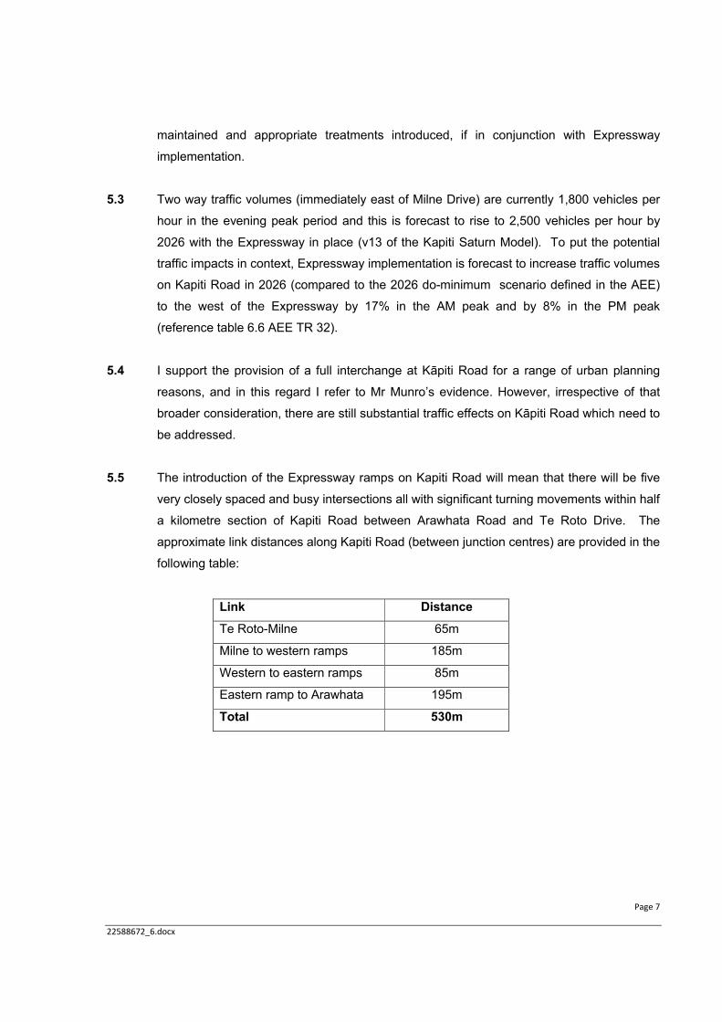
The closely spaced nature of the five marked junctions is illustrated below:
5.6 In such a situation it is very important to achieve acceptable levels of service (in traffic
delay terms), an acceptable level of service for pedestrian, cyclist and public transport
modes and safe operating conditions (particularly for turning traffic). It should also be
remembered that a relatively high proportion (double the national average) of local drivers
using these junctions will be elderly.
5.7 In my evidence I explain that the network and growth assumptions adopted for the AEE
imply a level of theoretical capacity in the network which is not warranted and has the
potential to skew the assessment of effects. Further work to address the issue of modelling
assumptions needs to be undertaken. It is hoped that this work will inform the discussion
on likely effects and further discussion of mitigation requirements.

Page 9
22588672_6.docx
5.8 Later in my evidence I raise the important issue of the suitability of NZTA’s chosen do
minimum scenario used for comparison reference case purposes in the AEE and the need
to identify effects relative to the Western Link Road (WLR).
5.9 My questioning of the adequacy of the assessment of traffic effects on Kāpiti Road does not
imply that the Expressway project should be seen as responsible for all improvements
required on the local network. The Council has already identified improvements to the
immediate area which it is planning to implement. However, the issue is whether the
Expressway project will adequately mitigate its share of the traffic effects, including effects
relative to the network which would be in place if the Expressway did not proceed.
5.10 The Guiding Objectives for the Project Alliance Board (AEE Vol 2, Appendix A, Guiding
Objectives for the Project Board) have driven the design philosophy for the Expressway.
Guiding Objective 3 (b) requires: ‘‘that level of Service C is achieved at the intersections
between the Expressway and the local network’’. The test year is specified as 2026.
5.11 My evidence therefore also concentrates on the year 2026, however all of my comments
should be regarded as applying continuously for the entire period from implementation to
2026. This is to ensure that the local network is safeguarded against lower levels of service
being ‘accepted’ between the opening of the Expressway and 2026.
5.12 I consider it important not to limit the consideration of levels of service to the Expressway
off-ramp junctions. Levels of service adjacent to these ramp junctions, including the closely
spaced and inter-related adjacent junctions on Kapiti Road at Milne Drive, Te Roto Drive
and Arawhata Road, also need to be taken into account.
5.13 In my opinion, consideration needs to be given to the level of service of particular turning
movements to and from Kapiti Road as well as movements along the road.
5.14 So far I have primarily referred to traffic issues, but it is important to note that the Guiding
Objectives go well beyond traffic to also address the need for multi-modal considerations,
such as pedestrian and cyclist movements, and to make it clear that connectivity (Guiding
Objective 4), local planning (8), safety (9) and urban form (10) requirements point to the
need for an integrated and multi-modal approach to be adopted.

Page 10
22588672_6.docx
5.15 In this respect, Kapiti Road has a variety of current users, including pedestrians and
cyclists, freight vehicles and local car drivers/passengers. A total of 44 pedestrians and
cyclists were recorded in one afternoon period 1.30-4.30 pm ref AEE Table 3.1 Tech Rep
32.
Issues with NZTA's assessment of effects on Kapiti Road junctions
5.16 The traffic assessment (ARR Technical Reports 32 and 34) as presented by NZTA accepts,
correctly in my view, that the intersections adjacent to the Expressway ramps (namely the
Te Roto Drive, Milne Drive and Arawhata Road junctions with Kapiti Road) are a single and
closely connected system. In my opinion, the closely spaced junctions from Te Roto to
Arawhata need to be considered together. This is because the operation of one potentially
affects the others due to queues ‘blocking back’ from one junction to another, and for
safety, capacity and operational efficiency reasons. Furthermore, as the adjacent junctions
are also part of an integrated system on Kapiti Road, all turning movements at each
junction, including the Te Roto Drive, Milne Drive and Arawhata Road junctions with Kapiti
Road also need to be considered.
5.17 However, the NZTA assessment also (incorrectly in my view) interprets the output from the
AEE modelling analysis only in terms of achieving an overall LOS C based on the average
delay for all vehicles using each of the Expressway ramp junctions with Kapiti Road. This
interpretation is not sufficient even to adequately describe conditions at the Expressway
ramps. This is because, as well as achieving an acceptable overall Level of Service (LOS),
it is also essential in my opinion for minimum individual LOS criteria to be achieved on all
arms and turning movements. This is consistent with professional advice on the
interpretation of LOS criteria (see Annex E)
5.18 In my opinion, if the traffic environment is assessed on the basis of a series of closely
connected junctions, an acceptable Level of Service C (LOS C) as set out in the Guiding
Objectives will not be achieved if the Te Roto Drive, Milne Drive and Arawhata Road
junctions with Kapiti Road remain unsignalised and if Kapiti Road remains in its current
form either side of the Expressway ramp junctions.
5.19 The AEE provides details of new queues to be introduced as a result of the Expressway
signalised ramp junctions that will be introduced on Kapiti Road. Whilst some queuing is
inevitable, the westbound Kapiti Rd maximum queue length of 202m is forecast to exceed

Page 11
22588672_6.docx
the space physically available for that queue (170m), creating the potential for blocking
back and interference with the Arawhata Road / Kapiti Road junction (Table 8.9 of the AEE
TR 32).
5.20 The westbound right turn into Te Roto Drive from Kapiti Road is highly problematic, with a
critical queue length of 50m and a maximum queue length estimated at 429m, with
potential to stretch back through the Expressway signalised ramps (Table 8.9 of the AEE
TR 32).
5.21 Without signalisation of adjacent junctions, traffic from both the west and the east will
sometimes have difficulty accessing the Expressway due to the queues created by
opposed right-turn movements into Milne Drive (from the west) and into Arawhata Road
(from the east) respectively. The effect of this unmanaged queuing will also reduce the
reliability of movement along Kapiti Road.
5.22 The NZTA traffic assessment indicates a range of LOS D, E and F on closely spaced Kapiti
Road intersections (Table 7.11 AEE TR 34), including LOS F for the right turn out of Te
Roto (i.e. the most direct route between the fire station and the Airport movement) which
Expressway implementation worsens in the AM peak.
5.23 Mr Murray in his evidence states that although there are effects on Kāpiti Road, for
example, 20-40 second increased waiting times for some intersections immediately
adjacent to the Expressway ramps, these effects can be traded off against the fact that
people travelling between Waikanae and Paraparaumu will have significantly shortened
travel times.
5.24 These shortened north / south travel times will occur but I do not consider that immediate
traffic movement effects on a major community connector linking town centres, residential
populations, schools, the airport and access to rail should be traded off or discounted in
such a way. The effects instead need to be adequately mitigated.
5.25 In my opinion, the implementation of the Expressway proposal (in the absence of additional
mitigation measures), will cause a deterioration of operational conditions with associated
safety implications on Kapiti Road. For example, the safety records of the Milne and Te
Roto junctions with Kapiti Road already indicate a social cost of $3.5m over a recent five

Page 12
22588672_6.docx
year period (Annex H), and the effects of the Expressway will in my view exacerbate this
cost.
5.26 Here I am specifically discussing traffic delay impacts, however the level of service for other
modes of transport, such as for pedestrians also needs to be considered in greater detail
(Annex E).
5.27 There are also other Guiding Objectives to consider, for example those concerning
connectivity. In this respect, no quantified analysis of the effect of the Expressway on
future pedestrian or cycling demand is contained in the AEE. The impact on local public
transport services and associated demand has also only been addressed at a very broad
scale (using the regional model) and no detailed local impacts on bus services or patronage
have been assessed. In my opinion, the Expressway assessment has not adequately
quantified the potential effect of the Expressway on connectivity along and across Kapiti
Road, and further modelling is needed.
5.28 The assessment undertaken for the AEE assumes that a number of uncommitted road
works are in place by 2026 (Annex B). This assumption underestimates the potential scale
of future operational problems following Expressway implementation. In essence, NZTA
relies on possible future improvements by the Council as part of the mitigation for the
effects of the Expressway, despite there being no certainty about if and when those
improvements will occur.
5.29 In my opinion, a more appropriate and realistic network scenario on which to base the AEE
would include SH1 revitalisation and would exclude the Ihakara Street extension, the
widening of Kapiti Road and the signalisation of Arawhata. I recommend that further
modelling is undertaken to describe operational performance and associated effects in such
a scenario, and that appropriate mitigation action is taken based on the results (including
potentially a contribution towards the Ihakara Street extension so that it can be brought
forward if necessary).
Incorrect assumptions in AEE in demand growth forecasting
5.30 The current demand growth forecasts on which the AEE is based (termed the composite
forecasts) only allow for a relatively low amount of development related traffic demand
growth in the District. The growth assumptions in the AEE are low in comparison to

Page 13
22588672_6.docx
development related estimates of traffic growth prepared for the Council. This is particularly
the case for expected Town Centre and Airport development growth. (Annex C)
5.31 Some sensitivity tests have been undertaken (reported in the AEE and elsewhere) to
estimate what the effects of alternative network assumptions and ‘full’ development related
growth at key locations (including the Town Centre and Airport) would be by 2026 and
these tests indicate substantial operational problems would be experienced on the local
network.
5.32 In my opinion, a more realistic demand related scenario on which to base the AEE would
have been an intermediate traffic growth forecast, higher than the composite forecast but
lower than the full growth forecast. I recommend that further modelling is undertaken to
describe operational conditions in such a scenario.
5.33 Earlier sensitivity testing (Kapiti Road Transport Modelling Workshop – Smmary of
Modelling Task Findings May 2012 and Annex C) shows that the most likely future network
and demand assumptions (as described in paragraphs 5.29 and 5.32 respectively) when
tested in combination would place greater demands on Kapiti Road than have been
assumed in the AEE.
5.34 The micro-simulation modelling undertaken for the AEE (Technical Report 34 and Murray)
was undertaken within the context of the network and future growth assumptions I have
discussed earlier.
5.35 The AEE implies that the need for any Kapiti Road upgrades are not Expressway related,
as they would need to occur in any case as a result of traffic growth in the do-minimum
scenario. However, in my opinion, the Expressway contributes to the need for those
upgrades and the specific forms these would need to take.
5.36 Until more realistic testing is undertaken as described above, it is not possible to confirm
the likely scale of effects of the Expressway on Kapiti Road, except to say that on the basis
of the testing to date the effects are likely to be greater than those presented in the AEE.

Page 14
22588672_6.docx
Issues with NZTA's selection of a "do minimum" scenario in assessing Expressway effects
on Kapiti Road
5.37 In interpreting the results of the analysis undertaken, the AEE has compared forecast
network performance with the Expressway in place to a future do minimum ‘reference
case’. This technique is primarily required for economic evaluation rather than AEE
purposes. In my opinion, NZTA's "do minimum" scenario is less likely to occur (in the
absence of the Expressway) than would the implementation of the WLR, which is currently
on hold while the Board of Inquiry addresses the NZTA application.
5.38 The WLR designation approval was for an at-grade arterial route with a high level of
connectivity along the route. In my opinion, the Expressway effects should have been
modelled primarily against the context of a WLR reference case (Annex C). Instead,
NZTA’s approach gives a potentially false impression of the level of effects, and in my
opinion a comparison of effects with the WLR scenario is important.
5.39 The situation of reduced connectivity under the Expressway proposal, compared to the
WLR, means that the range of potential east/west routes has been reduced, placing
considerable focus on Kāpiti Road and the need to manage the associated traffic effects.
Because modelling for the AEE has not been conducted which would address the level of
effect relative to the planned WLR, there is a risk that the level of mitigation being offered in
the application will not be adequate.
5.40 Kapiti Road is a particularly critical part of the wider local road network, which is already
problematic in terms of the restricted capacity of the number and standard of east west
linkages. The WLR and associated junction works would have reduced pressure in the
vicinity of the connection with Kapiti Road (Annex C).
5.41 In my opinion a future scenario with the WLR in place represents the most valid reference
case comparison for AEE purposes for assessing operational impacts on the local network.
The WLR provides a higher benchmark for comparing operational conditions with and
without the Expressway than the do minimum scenario benchmark used in the AEE.

Page 15
22588672_6.docx
Proposed approach to addressing uncertainties in relation to Kapiti Road
5.42 There is always inherent uncertainty when attempting to forecast future conditions, but in
my opinion there are too many significant doubts to have confidence in the results from the
Kapiti Road assessment as presented in the AEE.
5.43 There continues to be uncertainty in relation to NZTA's forecasts of future operational
conditions on the local network. Of particular concern to me is local network performance
on Kāpiti Road between Arawhata Road and Te Roto Drive.
5.44 The analysis presented in the AEE for Kapiti Road is on the margins of acceptability with
very significant risk of operational problems being worse than expected. I consider that this
risk could be reduced if additional traffic modelling is undertaken. All the information to do
this modelling already exists, providing appropriate options and assumptions are agreed
with Council and appropriate testing is undertaken.
Proposed physical works to address Expressway’s adverse effects on Kapiti Road
5.45 Without mitigation measures, such as signalisation and road improvements, some turning
movements at the Milne Drive, Te Roto Drive and Arawhata Road junctions with Kapiti
Road will operate at a very low level of service, post Expressway opening and are therefore
likely to become less safe.
5.46 Without improvements to the mitigation package currently proposed for Kapiti Road there is
also potential for substantial interference to occur between the Expressway ramp signals
and other closely spaced junctions on Kapiti Road.
5.47 In my opinion, it is also essential that the Arawhata Road and Kapiti Road junction is
improved and signalised prior to or simultaneously with the implementation of the
Expressway and that this improvement should be required as part of the proposal.
5.48 I also consider that the Milne Drive and Te Roto junctions with Kapiti Road should be
improved and signalised. Such an improvement is included in the Council’s forward
programme but will be subject to a funding application to NZTA, the justification for which
will include the need to respond to any effects caused by Expressway.

Page 16
22588672_6.docx
5.49 In my opinion, these improvements need to be implemented and co-ordinated (Annex I) to
adequately mitigate potential effects of the Expressway.
5.50 It is also clear from the NZTA traffic assessment that the sections of Kapiti Road either side
of the Expressway need to be widened and the associated side road junctions signalised in
conjunction with Expressway implementation and I agree with this assessment. I estimate
that four lanes are required on Kapiti Road between Arawhata Road and Milne Drive to
avoid excessive congestion as a result of the Expressway opening. The AEE and
associated evidence appears to accept that it would be beneficial to upgrade adjacent links
and intersections on Kapiti Road, for example:
''An additional lane on Kapiti Road in the section between the proposed interchange
and Te Roto Drive / Kapiti Road and Milne Drive Kapiti Road is recommended to
help increase the capacity of the road and the operation of these intersections.'' (AEE
TR 32 p63)
''A high level of congestion and delay is expected for the Te Roto Drive and Milne
Drive approaches."". (AEE TR s34 p87)
‘’Arawhata is considered in the assessment to be part of identified works that
represent ''the minimum investment needed in the study corridor to maintain
operations…'' (AEE TR 32 table 3.9)
5.51 Despite this recognition of the need for additional improvement works associated with the
Expressway, no mechanism is suggested in the proposals to actually deliver and achieve
these essential works. In the absence of such a mechanism, none of the above projects
can be regarded as being certain to occur, partly because they are excluded from the
project and due to the uncertainty around local road funding, described in more detail in
Annex F.
5.52 All the works I have identified as being required are feasible, and a variety of illustrations
and drawings have previously been prepared over the past two years, as shown in
Annex A. Here it should be noted that explicit confirmation is required of the access
management restrictions likely to be sought or required along both sides of Kāpiti Road and
also anywhere else where traffic signals are included (e.g. minimum pedestrian crossing
phase times must be specified).

Page 17
22588672_6.docx
5.53 It is possible that other measures (such as the Ihakara Street extension) will also be
required to alleviate effects. This could usefully be clarified by further modelling.
5.54 All in all the lack of a firm plan to signalise and improve Kapiti Road either side of the
Expressway ramps is, in my opinion, a significant issue. This is the case even when
considered solely in terms of the case as presented in the AEE and evidence (which is
based on the uncertainties inherent in the AEE's "do minimum" scenario and composite
growth case) due to the queuing, level of service and safety concerns referred to earlier in
my evidence.
5.55 However, there is a significant risk that higher development growth than anticipated in the
AEE composite case will occur and that a number of network improvements assumed in the
AEE networks will not be implemented. In my opinion there is a high likelihood of significant
problems if the Kapiti Road improvements identified in this evidence are not delivered.
5.56 In my opinion, the improvement and signalisation of Te Roto, Milne and Arawhata junctions
with upgraded sections of Kapiti Road would adequately mitigate the immediate effects of
the Expressway on Kapiti Road. However, beyond the immediate impact of Expressway
implementation at opening year, the effect of Expressway related traffic growth still needs
to be carefully monitored.
Recommendations to address issues identified for Kapiti Road
5.57 In summary, I recommend that further modelling of the effects of the Expressway on Kapiti
Road operations should be undertaken as soon as possible in order to identify works
needed to achieve acceptable levels of service for all movements between Te Roto Drive
and Arawhata Road, including turning movements. This will give more confidence in the
workability and acceptability of the proposal and will significantly reduce the current
uncertainty over the proposal. In my view, the modelling should be a mixture of SATURN
and micro-simulation work, on a basis to be agreed with the Council.

Page 18
22588672_6.docx
5.58 However, irrespective of whether or not this modelling occurs, I recommend a firm
programme and funding programme to implement the following essential works, as part of
the mitigation package for the project:
(a) the improvement and signalisation of the Arawhata Road junction with Kapiti
Road;
(b) the widening of Kapiti Road between Milne Drive and Arawhata Road; and
(c) the improvement and signalisation of Te Roto and Milne junctions with Kapiti
Road.
5.59 The Ihakara Street extension (and associated junction improvements on Kapiti Road and
SH1) may also assist, and should be required if the modelling outlined above identifies that
it is necessary.
5.60 In addition to these works, I recommend that future operational performance on Kapiti
Road, Raumati Road, Rimu Road and SH1 are monitored and the level of traffic generation
from the Expressway and any other sites are also monitored, based on criteria to be agreed
with the Council.
6. EFFECTS ON TE MOANA ROAD INTERSECTION
Introduction
6.1 Te Moana Road is a vital and low speed (50 km/hr) single carriageway community
connector, providing the most direct link between Waikanae Beach and Waikanae,
communities that are around 5km apart.
6.2 The 100km/hr Expressway intersects with Te Moana Road to the west of Park Road and to
the east of Waikanae Beach.
6.3 Te Moana Road has a variety of current users, including pedestrians, cyclists, horse riders,
bus users, local freight deliveries and local car drivers/passengers. A total of 61
pedestrians and cyclists were recorded in one afternoon period 1.30-4.30 pm (AEE Table
3.1 Technical Report 32.) Two way traffic volumes (immediately west of Park Road) are

Page 19
22588672_6.docx
currently 600 vehicles per hour in the pm peak period, and this is forecast to rise to 1,100
vehicles per hour with the Expressway in place in 2026 (v13 of the Kapiti Saturn Model).
Inadequacies in NZTA approach
6.4 The Expressway intersection is important in terms of providing access to the large planned
development at Ngarara (Annex D). This development (which is included in the District
Plan) will increase demand by all modes though this intersection and these additional flows
will need to be carefully managed. To date NZTA's traffic modelling for this intersection has
not adequately taken account of the Ngarara future development. In particular, the traffic
zoning and connections in NZTA's model do not reflect the anticipated form of the
development. This means that the traffic demands from the development are not being
correctly loaded onto Te Moana Road, and this will underestimate the demand that will be
attracted to and through the future Expressway. See, for example, the different ways the
development has been modelled for the AEE purposes, and the way the development was
modelled for the traffic impact assessment, as illustrated in Annex D.
6.5 I understand that a traffic signal design has been prepared and analysed for the Te Moana
Road and Expressway intersection, although a layout of this is not presented in the AEE
(details of this have been requested).
Effects on younger and vulnerable users
6.6 The traffic movements through the Te Moana Road intersection include a number of
younger users travelling to and from school, and under normal circumstances this demand
could be expected to increase, especially as a new school is accessed from Park Road,
Waikanae with a catchment that includes the Waikanae Beach area. Annex G contains
details of the substantial scale of school travel; and provides an indication of the potential
impact of intersections along travel routes to schools.
6.7 The proposed Expressway intersection on Te Moana Road therefore represents a critical
point on the local road network, where faster traffic and through traffic accessing the
Expressway will meet slower local traffic, and younger and vulnerable road users using
more active and sustainable modes such as walking and cycling.

Page 20
22588672_6.docx
6.8 This Expressway intersection is the point at which the north-south segregated walking and
cycling path (being implemented as part of the Expressway proposals) will cross Te Moana
Road. The Expressway intersection is also where cyclists, making use of the more direct
Expressway shoulders over the Waikanae river bridge, will enter and leave the local road
system.
6.9 For these reasons the form and treatment of the Expressway intersection on Te Moana
Road is critical to safety, local connectivity and the encouragement of younger and
vulnerable users of more active and sustainable modes.
6.10 In my opinion, the proposed roundabouts in the AEE (as shown below) are inappropriate for
this location because of the negative impact on actual and perceived safety and the
associated deterrence of walking and cycling. The impact of higher speed traffic moving
from the strategic Expressway route onto this local road, and the large circulatory nature of
the junctions, prevents pedestrians and cyclists being accommodated safely and
conveniently.
6.11 Current design practice tends to prioritise capacity ahead of safety and ease of negotiation
by younger and vulnerable users of more active and sustainable modes. In particular,
standard Austroads roundabouts such as those in the proposals have widely flared,

Page 21
22588672_6.docx
tangential entries and exits, a wide circulating lane and little deflection when compared to
other international examples (see comparison table below). The consequence of this will
be to deter walking and cycling movements and to increase community severance effects.
6.12 A Ministry of Transport publication states:
‘’Many of our urban areas are characterised by sprawling low-density land-use
patterns, which can make it inconvenient to walk and cycle due to the long distances
involved, or if there is a lack of connectivity to desired destinations. Some
pedestrians and cyclists may feel intimidated by high traffic volumes and speeds, as
well as intersections, crossings and roundabouts, which can be difficult to negotiate.
Negative perceptions and experiences may discourage people from using a
particular route or encourage them to drive instead of walk or cycle, especially if the
walking and cycling infrastructure is poor.’’ (Raising the Profile of Walking and
Cycling in New Zealand, A Guide for Decision-Makers, 2008)
6.13 An earlier survey of the reasons for not allowing children to travel to school by cycle in the
region found that the main reasons were traffic volumes, risk of road accidents, poor
provision for cycling, poor cycle skills and the speed of traffic (National Research Bureau,
GW Regional Perceptions Survey, 2003).

Page 22
22588672_6.docx
6.14 In my opinion a more suitable transition is needed to integrate traffic travelling from the high
speed Expressway environment to the local road network satisfactorily, safely and without
deterring local community connections by all modes of transport (eg pedestrian, cycle,
motor vehicles).
6.15 It could be argued that one option would be to modify the current design to introduce
mitigation measures, such as signalised pedestrian crossings, refuges and calming
measures. However, although such measures would represent an improvement on the
current design proposals, they would (in my opinion) still represent an unsatisfactory
design.
6.16 It should not be assumed that a roundabout is superior either in traffic delay or in cost
terms, especially if the added delays and costs associated with signalised pedestrian
crossings and calming measures (to supplement the conventional roundabouts) are also
factored in. The AEE does not address this point or the potential social cost associated with
future crashes involving pedestrians and cyclists at the roundabout intersections.
6.17 In my opinion, the only suitable treatment at this location is the introduction of fully
signalised junctions where the Expressway ramps connect with Te Moana Road. This
would allow the fully controlled separation of conflicting movements, thereby increasing the
confidence of pedestrians and cyclists passing through the junctions.
6.18 The existing junction of Te Moana Road with SH1 is currently signal controlled and the
introduction of signals with the Expressway would therefore be in keeping with driver
expectations on this road. Furthermore, the presence of the large road bridge carrying the
Expressway over Te Moana Road will adequately warn local drivers that they are
approaching a significant intersection, thereby reducing any ‘surprise factor’ associated with
the introduction of signalised junctions.
6.19 Corrected and more realistic modelling of the large Ngarara development would increase
forecast demands at the intersection and would identify additional local movements, which
would in my opinion also support the need for signalised control.
6.20 Mr Nancekivell in his evidence (paragraph 50) notes that the WLR intersection was planned
to be a roundabout. This is true, but this comment needs to be placed in context, namely,
that the WLR at this location was designed as a lower speed (between 50 km/hr and 70

Page 23
22588672_6.docx
km/hr) single carriageway road with a single at-grade junction with Te Moana Road.
Furthermore, the WLR acted solely as a local connector between communities. This is quite
different to the Expressway whose primary role is a high speed major through route
replacement for the existing SH1. As a consequence, the Expressway has a much greater
potential (albeit unintentionally) to divide communities.
6.21 The substantial traffic increases on Park Avenue identified in the AEE also require
mitigation measures to be introduced as part of the project, in agreement with the Council.
6.22 NZTA’s traffic witnesses agree that traffic signals are feasible at the intersection of the
Expressway and Te Moana Road, and also that this solution would have a number of
advantages.
Recommendations to address adverse effects on Te Moana Road
6.23 In my opinion, the best solution to maintain community connectivity is to develop a
signalised intersection and to provide appropriate facilities for all modes, including
pedestrians, cyclists and equestrians.
6.24 I therefore recommend that the form of the connection of the Expressway with Te Moana
Road is a signalised intersection and that the detailed form of this (including signal phasing)
is agreed with the Council prior to implementation.
6.25 In addition, Park Avenue traffic calming measures, as described in the AEE, need to be
agreed with the Council and implemented as part of the project.
7. BRIDGES AND UNDERPASSES
Introduction
7.1 The local road underpasses and bridges along the Expressway are crucial for the
functioning of the local network. It is important that all identified crossing points are suitable
for current and future local network needs.
Page 24
22588672_6.docx
7.2 Insufficient detail is provided in the application with respect to the standard of local
crossings (underpasses and bridges) in terms of the width and height clearances to be
allowed for future access, services, drainage, pedestrian, security and other needs.
Uncertainties in NZTA approach
7.3 The AEE Volume 2, Design Philosophy Statement in section 4.3 states as follows:
‘’A preliminary list of standards and requirements for local road cross sections has
been prepared by KCDC and this is contained in KCDC Expressway Technical Note
T7 Local Road Standards. A copy of this document is attached in Appendix 1.B.’’
7.4 However, it is not clear whether (and how significantly) the currently proposed project
design differs from the Appendix 1.B.
7.5 It is difficult to predict and assess the potential effects of bridge and underpass width and
height clearances, when in my view it is not obvious what is being proposed.
7.6 Council requirements for dimensions for local roads (KCDC Expressway Technical Note
T7) have been derived from existing Council policies. The purpose of these standards and
policies is to maintain a consistent approach to development proposals in the district likely
to impact on the local road network.
7.7 The practical reasons for these standards include the need to maintain current and future
access potential to:
(a) cater conveniently for all modes including pedestrians, cyclists, other active
modes and other local road users;
(b) reduce potential safety and security problems;
(c) maintain appropriate visibility;
(d) provide channels for drainage and other design requirements;
(e) maintain clearances for higher and wider (oversize) vehicles;
(f) maintain landscaping/urban design quality; and
(g) maintain the continuity of road reserve width along a corridor.

Page 25
22588672_6.docx
7.8 Allowing for future needs and options is critical, as once the Expressway is in place
variations in clearances will be virtually impossible.
7.9 It is important that the height and width clearances as set out in Council standards and
policies are not eroded through the (later) detailed Expressway design phase.
7.10 The current proposal does not provide any certainty about the design parameters to be
adopted for the width and height clearances for local roads affected by Expressway related
bridges and underpasses. In my opinion there is a real danger that detailed design
preferences and ongoing project cost reduction pressures will erode and outweigh the need
to achieve Council standards and polices.
Recommendations in relation to bridges and underpasses
7.11 I recommend that the width and height clearances in KCDC Expressway Technical Note T7
are adopted for Expressway design purposes or clarify and agree any proposed variations
with the Council.
7.12 The reason for this recommendation is that a commitment to design principles needs to be
established now rather than later through a shorter term certification process when only
limited scope is likely to be available to modify proposals.
7.13 Details of local crossings (bridges and underpasses) in terms of width and height
clearances for future access, services, drainage and pedestrian security need to be
provided now to enable an assessment of whether the proposed crossings meet the design
standards described above.
7.14 In addition, immediately prior to construction commencing, full detailed designs need to be
certified by the Council.
8. TRAFFIC MANAGEMENT DURING CONSTRUCTION
Introduction
8.1 Local roads, rather than State Highway 1, will experience disruption to traffic during the
(predominantly ‘off-line’) Expressway construction.

Page 26
22588672_6.docx
8.2 It is therefore critical that during construction, appropriate traffic management plans are put
in place that provide for safe, adequate and convenient facilities for local movements by all
transport modes.
Issues with NZTA approach
8.3 It is difficult to predict and assess the traffic effects of construction activities, when it is not
known what form of management is being proposed.
8.4 Potentially however, construction activities could result in access delays and inconvenience
for pedestrians, cyclists, public transport, emergency vehicles and other road users.
8.5 It is also important for any physical impacts to be identified and remedied during and after
construction to maintain acceptable operational conditions.
8.6 It is not clear if the level of construction traffic on Te Moana Road and through Waikanae to
the west of the Expressway is necessary as described in the AEE Technical Reports 4 and
33. The construction of a dedicated haul road from Ngarara Road which would have
relieved these impacts appears to have been dismissed as an option, although the reasons
for this are unclear.
8.7 There is a need to minimise the length of time that construction impacts will be felt on local
roads and in particular to provide a robust justification for the longer periods of disruption
(12 months or more) on key local routes.
8.8 Apart from the junction analysis in the AEE (Technical Report 33) the assessment of traffic
management proposals does not seem to have any analytical basis. For example, the
construction impacts on Kapiti Road do not appear to have been specifically analysed or
modelled.
8.9 Although some discussions on this topic have occurred, currently only limited information or
commitment on this topic has been provided by NZTA. The current proposals are very
general and do not provide any detail on the traffic management approach to be adopted
during construction (AEE) with all the detail to follow in traffic management plans issued to
the Council immediately prior to construction commencing.

Page 27
22588672_6.docx
Effects on local roads during construction
8.10 In my view clearer principles need to be established, for the traffic management of
construction activity, for example, to:
o minimise the disruption to residential streets;
o minimise construction activities on local roads in terms of periods and times of
working;
o avoid one way working, permit pedestrian and cyclist access along both sides of the
road;
o avoid the use of shared narrow lanes or the need for additional pedestrian crossings
of local roads;
o avoid excessive delays (ie the maximum 5 minute delay threshold suggested is too
high); and
o manage any traffic management control efficiently in agreement with the Council.
8.11 Consultation with Council on these principles is needed, prior to submitting detailed traffic
management plans (TMPs) to the Council for approval when only limited scope is likely to
be available modify proposals. Leaving such considerations to short notice TMPs is in my
opinion, unsatisfactory, as the potential impacts are considerable and the resources within
Council to review and approve proposals are limited.
8.12 The Expressway is not simply a standard project. The potential for disruption on local roads
is far greater and longer lasting than the usual matters considered in a TMP within Kapiti
District.
8.13 My main concerns are detailed below:
(a) Kapiti Road: This is a critically important route, with high potential for disruption
and inconvenience, especially if no immediately parallel alternative route via the
Ihakara Street extension is in place. It is very important that two way access is
maintained though any construction works by all modes. This would preclude one
way working or closure of pedestrian facilities on one side of the road, avoiding
cyclists and vehicles having to share narrow lanes and maintaining bus stopping
facilities.

Page 28
22588672_6.docx
(b) Otaihanga Road: The potential impacts here are discussed more extensively later
in this evidence (section 9).
(c) Te Moana Road: This is a very important local route with a high level of amenity
and a quiet natural character, including an important community and school
access road, with many younger and vulnerable users of more active and
sustainable modes and with similar requirements to Kapiti Road.
(d) Raumati Road: This is a very important local route, including an important
community and school access road, with many younger and vulnerable users of
more active and sustainable modes and with similar requirements to Kapiti Road.
(e) Poplar Avenue. This is an important local route, including an important community
and school access road, with many younger and vulnerable users of more active
and sustainable modes and with similar requirements to Kapiti Road.
8.14 In each case the potential disruption to local activities and to inconvenience local
movements is considerable, unless clear and well thought through principles are
established at this stage.
8.15 The current statement of construction traffic management (Technical Report 33) is vague
and, unfortunately, discussions on this subject have yet not been able to resolve this matter
satisfactorily.
8.16 The flexibility in the current general approach allows the contractor too high a degree of
flexibility which is not in the interests of local amenity, safety or convenience.
Recommendations in relation to construction traffic management
8.17 In my view, clearer construction traffic management principles, for example, in terms of
maintaining two way access for all modes and limiting delays to a more reasonable level,
need to be established in agreement with the Council.

Page 29
22588672_6.docx
8.18 The Construction Traffic Management Plan needs to be amended to provide for:
(a) safe, adequate and convenient facilities for two way local movements by all
transport modes (pedestrian, cycle, vehicle);
(b) a more reasonable level of delay; and
(c) twenty four hour access for all emergency services through construction work
areas, including but not exclusively around the Otaihanga construction yard, along
Otaihanga Road and on Te Moana Road.
8.19 The Construction Traffic Management Plan needs to provide for restitution proposals for
impacts on local roads on a basis to be agreed and certified by the Council prior to any
construction works being undertaken.
8.20 In addition, there should be a requirement that immediately prior to construction, final traffic
management plans and associated details are be certified by the Council.
9. OTAIHANGA ROAD: TRAFFIC MANAGEMENT DURING CONSTRUCTION
Introduction
9.1 The reason for discussing Otaihanga Road separately in this evidence is the scale and
duration of construction impacts anticipated at this location.
9.2 The proposal plans to locate the largest construction yard next to Otaihanga Resource
Recovery Facility (ORRF) on Council landfill land. It would be fully fenced, as the landfill is
still operational and the public enters the landfill through the ORRF. This yard will be in
place for the full length of the construction period.

Page 30
22588672_6.docx
9.3 The site plan for the construction yard includes part of the landfill leachate drain and the
access to the ORRF from Otaihanga Road as shown below:
Effects of Expressway
9.4 Otaihanga is of particular importance as it is so central to the construction of the
Expressway that it will have particular pressures placed on it. It is proposed to be affected
for a very long period of time, from the introduction of the roundabout intersection with SH1,
the construction of the yard and associated accesses to the completion of the Expressway
(a period of 5 years or so).
9.5 The Expressway construction activities will add significantly (by around 15%) to total traffic
levels on this road over the construction period (Technical Report 33). This is not within
normal seasonal variation as suggested in the report, as a high proportion of the increase in
traffic will be large vehicle turning movements.

Page 31
22588672_6.docx
9.6 The daily traffic of 960 construction vehicles will therefore have a major effect on the 6,300
local road users and the 750 daily users of the Council facilities, which are located
immediately adjacent to the construction yard. It is not clear if the AEE analysis has
adequately allowed for future traffic growth, including the effects of the roundabout with
SH1.
Issues with NZTA approach
9.7 Currently, only general outline proposals on this topic have been provided (Technical
Report 33 and Volume 5) with all significant details to follow in traffic management plans to
be issued to the Council shortly prior to implementation.
9.8 It is important that clearer principles are established and appropriate commitments made in
view of the importance of Otaihanga Road, and the scale and duration of anticipated
impacts.
9.9 Otaihanga Road is of poor geometric standard with an at-grade rail crossing with closely
spaced local accesses with restricted visibility. The speed limit of the road is currently
80km/hr, although 85th percentile speeds are slightly lower at between 69 and 74 km/hr.
Prior to and during Expressway construction a number of other factors need to be
considered that do not yet appear to have been taken into account satisfactorily:
(a) First, the current safety record of the road is poor. The safety record of the road
(between SH1 and Ratanui Road indicates a relatively high social cost of over
$5m over a five year period (Annex H), indicating the new construction access will
be entering into an already hazardous environment.
(b) Secondly, the roundabout intersection with SH1 is likely to ease what are currently
difficult turning movements and this is likely to attract more traffic along Otaihanga
road.

Page 32
22588672_6.docx
(c) Thirdly, the introduction of slower construction vehicles undertaking turning
manoeuvres creates the potential for conflict with other traffic and the indicative
layout supplied (see below) is non-standard and requires urgent review.
9.10 It is important that the way construction vehicles turn and emerge onto Otaihanga Road is
safely planned and controlled in agreement with the Council. In my opinion the currently
proposed arrangement of deceleration and acceleration shoulders within a 50 km/hr speed
environment is potentially hazardous and a more standardised layout based on Austroads
guidelines should be provided.
9.11 The current speed limit of 80 km/hr would be inappropriate during the construction period
and temporary speed management will be required (to between 30 and 50 km/hr over the
most critical section when construction activities are taking place) in agreement with the
Council.

Page 33
22588672_6.docx
9.12 The duration of the impact of construction on Otaihanga Road means that interim
maintenance inspections and the need for any immediate repairs also need to be provided
for during the construction period.
Recommendations in relation to Otaihanga Road construction traffic
9.13 I consider that the following should be implemented:
(a) continuous and safe access should be provided for residents to the ORRF and the
landfill from Otaihanga Road;
(b) an alternative solution should be provided for the access of dog club members
(after hours) via the club’s separate gate/road next to the ORRF entrance (which
appears to be incorporated into the construction yard);
(c) traffic management is a source of concern because Otaihanga Road provides
access to the main waste facilities in the District and is therefore heavily used by
the local community (see concerns raised above for other construction activity);
and
(d) access to the CNZ site from Otaihanga Road for green waste drop-off also needs
to be taken into account when assessing speed and safety.
9.14 In my opinion, design, traffic management and access principles need to be agreed with the
Council as a matter of urgency.
9.15 Inspections and restitution of any impacts during and after construction on Otaihanga Road
are required and should be a product of discussion and agreement with the Council.
9.16 In addition, prior to construction, more specific plans and final design details for Otaihanga
Road also need to be certified by the Council immediately prior to implementation.
10. CONCLUSION
10.1 The issues raised in this evidence relate to the operation of the local road network and the
maintenance of convenient local movement by all modes of transport.

Page 34
22588672_6.docx
10.2 For each issue, I have identified productive ways forward and these are recommended to
be incorporated into the Expressway approval and implementation process.
Don WignallTransport Futures5 October 2012

Page 35
22588672_6.docx
ANNEX A
Drawings / Illustrations
Milne Te Roto signalised staggered junction prepared by GHD as included in the Councils current
forward programme.

Page 36
22588672_6.docx
Milne Te Roto signalised crossroads, prepared in developing Expressway related improvement
options, although this is not being actively progressed.

Page 37
22588672_6.docx
Expressway signalised ramps, as presented in the AEE

Page 38
22588672_6.docx
Arawhata signalisation, prepared by the Alliance in developing Expressway related improvement
options, although this is not being actively progressed.

Page 39
22588672_6.docx
Arawhata signalisation illustration, prepared by the Alliance in developing Expressway related
improvement options, although this is not being actively progressed.

Page 40
22588672_6.docx
ANNEX B
AEE Modelling Issues
The approach undertaken for Expressway modelling in the AEE raises a number of issues that could
be addressed by further modelling.
Modelling the do minimum network – SATURN
A number of network improvement options have been considered in the development of the
Expressway proposal, including outline designs for the improvement and signalisation the Kapiti
Road junctions with Te Roto Drive, Milne Drive and Arawhata Road and the improvement of Kapiti
Road (Annex A). With the exception of the Milne Drive and Te Roto signalisation, all of these
improvements and the completion of the Ihakara Street extension have been assumed to be in place
for the purpose of analysing the effects reported in the AEE (Technical Reports 32 and 34).
However, the actual project described in the AEE only includes two signalised Expressway ramp
junctions on Kapiti Road, without any further Kapiti Road improvements or the Ihakara Street
extension.
For example, the SATURN 2026 traffic modelling reported in the AEE (Technical Report 34)
assumes that the future do-minimum network includes improvements that would reduce pressure on
Kapiti Road, as follows:
The Ihakara Street extension is completed (from Rimu Road, though the Airport
to Kapiti Road);
Kapiti Road is widened between Milne Drive and Arawhata Road to between two
and three lanes; and
Arawhata Road / Kapiti Road junction is signalised.
An assumption is also made by the AEE that the future do-minimum network does not include SH1
revitalisation (in other words turning the existing SH1 into a local standard arterial road with a lower
speed environment in a number of locations). The effect of this SH1 treatment will be to increase
traffic flows on Kapiti Road compared to the flows assumed in the AEE.
SATURN modelling needs to analyse the proposal as actually presented in the AEE/evidence,
especially in terms of the road width / number of lanes immediately approaching Milne Drive and

Page 41
22588672_6.docx
Arawhata (reference AEE Vol 5 drawing). The SATURN analysis undertaken to date has not done
this, as can be illustrated below:
The layout of the current Milne Drive / Kapiti Road junction is shown above. This confirms that the
Kapiti Road westbound approach clearly operates as a single lane with a very short flare
approaching Milne Drive. The Milne Drive approach is a wide single lane which can be used by two
short vehicles if they are correctly positioned but larger or incorrectly positioned vehicles mean that
this stop line operates as a single lane entry.

Page 42
22588672_6.docx
The AEE modelling of current Milne Drive / Kapiti Road layout (2010 base network) is shown below,
which assumes a two lane westbound approach (from node 9683) and a two lane Milne Drive
approach, neither of which is correct.
The assumption in the 2026 AEE do-minimum and Expressway modelling is that Kapiti Road is
improved to and through Milne Drive as follows:

Page 43
22588672_6.docx
Similar points can be made for the Te Roto Drive and Arawhata Road junctions with Kapiti Road and
the sections of Kapiti Road between these junctions which have been assumed to be 2 or 3 lanes
throughout.
When considering the do minimum network ….’’ It is important not to overstate the scope of the do-
minimum, ie it shall only include that work which is absolutely essential to preserve a minimum level
of service’’ (NZTA, EEM Vol 1, s2.8).
Whilst some judgement is required in determining the DM scenario, the Kapiti Road widening,
signalisation of Arawhata and Ihakara Street extension are not currently committed projects and
therefore should have been excluded.
Whilst in practical terms some of the lane definitions used may not have large material effects if
approach capacities have been constrained, the network coding assumptions for the AEE do not
provide confidence that the more detailed micro-simulation (VISSIM) modelling has been undertaken
within an appropriate context, as the VISSIM modelling is reliant on input from the SATURN
modelling.
Modelling demand matrices – SATURN peak hour
During the most critical period on the road network, namely the weekday evening peak, the highest
PM peak flow from the SATURN modelling has not been used for assessment purposes. This is
because the hour used in the assessment is 5-6 PM whilst the (so called) ‘pre-peak’ SATURN
modelling for the 4-5 PM period is actually around 10% busier in terms of total trips made.
In reality, the highest peak hour could be even higher than this if (say) the peak was found to occur
between 4.30-5.30 PM, as may well be the case. These factors indicate a further deterioration of
forecast conditions with and without the Expressway.
As an example, see ‘’sensitivity tests’’ (undertaken for a joint Council / Alliance workshop) on the
implications of no Ihakara St extension and no Arawhata St signalisation (note queue lengths and
delays are absent in this reference (and have been requested) but can be inferred in outline terms
from the LOS information supplied).

Page 44
22588672_6.docx
Modelling demand matrices – SATURN composite growth
The primary ‘composite growth’ development scenario tested underestimates the potential for
commercial growth (especially at the Airport, Town Centre, North Waikanae and Ngarara to 2026).
Of particular concern to Kapiti Road is the apparent underestimate of future traffic generation levels
from the Airport (by 15%) and Town Centre (by 20%) up to specified partial development levels,
namely the Airport to the threshold prior to triggering a full TIA and the Town Centre Pan Change
72A development. This is based on a comparison of previous Opus Kapiti Model zonal demand
forecasts and the composite growth method contained in the AEE for the same development
thresholds.
Sensitivity testing – SATURN
The SATURN analysis presented in the AEE/evidence is limited in terms of the sensitivity testing
undertaken and this reduces the strength of conclusions that can be drawn from it.
Only one other growth scenario has been sensitivity tested, namely ‘full development’ by 2026. This
full development scenario testing indicates serious operational problems on Kapiti Road at and
adjacent to the Expressway. This test would have been more useful if the reported convergence
problems identified in the do minimum testing had been investigated and corrected.
In my opinion, an intermediate growth scenario should also have been tested and presented in the
AEE/evidence.
Other potential future scenarios have also not been presented in the AEE/evidence, including: the
potential impact of SH1 revitalisation and longer term modelling to 2031 and 2041.
In all of the above these alternative scenarios, demand along Kapiti Road could be expected to be
higher than that presented in the AEE/evidence and therefore the extent of queuing, delay and
safety problems are likely to be greater than the conditions presented in the AEE/evidence ‘best
case’.
Sensitivity tests of alternative scenarios, including an intermediate growth scenario and comparison
with the Western Link Road for Council indicates potentially significant increases in traffic flow on

Page 45
22588672_6.docx
Kapiti Rd compared to the presented AEE case based on the do-minimum and option networks and
composite growth scenario (reference KCDC, Modelling Review v3.0 01-12-2011) see Annex C.
In interpreting the results of the analysis undertaken, a comparison has been undertaken in the AEE
between forecast conditions with the Expressway and with a DM scenario (something that is
required only for economic evaluation purposes).
However, this approach ignores the fact that a DM would not have occurred in the absence of the
Expressway as, the Western Link Road (WLR) would have been implemented instead and therefore
this represents a more appropriate comparison for considering potential operational impacts on the
local network.
The WLR provides a higher benchmark for the Expressway regarding local network criteria
compared with reference only to a DM scenario. The WLR and associated junction works would
have substantially improved conditions along Kapiti Road in the vicinity of the Expressway (reference
KCDC, Modelling Review v3.0 01-12-2011).
Modelling the do minimum network – VISSIM
The more detailed micro-simulation (VISSIM) modelling undertaken and reported in
AEE/evidence/supporting documentation, is therefore based on an inadequate context, due to the
SATURN modelling limitations, particularly those described above.
The VISSIM modelling does not analyse the proposal as actually presented by incorporating a
widened Kapiti Road and signalised Arawhata junction, both of which are outside the design
proposals actually presented (AEE Volume 5). A plan and exact details of the VISSIM model have
been requested.
Furthermore, there are differences between the VISSIM analysis and the Councils PARAMICS
analysis (Murray) which it has not been possible to date to fully resolve. These include future growth
rates and actual future traffic volumes, both of which are lower in VISSIM than in the Paramics
modelling.

Page 46
22588672_6.docx
Safety modelling
The safety analysis undertaken in support of the proposals is very general, as only very limited
reference is made to safety in the AEE and supporting documentation. This analysis is intended
primarily for economic evaluation and is not sufficiently specific to give confidence in future
outcomes following Expressway implementation. This is because the approach has been based on
default crash rates for current and future state highways only, with no detailed analysis of the effect
on adjacent intersections on the local road network.

Page 47
22588672_6.docx
ANNEX C
Sensitivity Tests Undertaken for Council
Modelling Review v3.0 01-12-2011
Introduction
A series of sensitivity tests have been undertaken using the Kapiti Traffic Model to estimate the effect of the Expressway on local roads.
The following table contains an indexed summary of this analysis on Kapiti Road (Arawhata Road to Airport) traffic flows during the PM peak.
Test Scenario Western Link Road Comparison
Do Minimum Comparison
Base Year 2010 82 73
Future Year Comparison Scenario
100 (WLR Scenario)
100 (DM Scenario)
Expressway 1 124 109
Expressway 2 (without Ihakara Street Extension).
136 120
Expressway 3 (without Ihakara Street Extension & with currently permitted development.
146 129
Interpretation of Preliminary Results
Substantial traffic growth on the network is expected to occur between 2010 and 2026.
The effect of the Expressway in overall terms is expected to be to reduce pressure on some parts of the local network as a result of the diversion of proportions of through and local traffic onto the new road (see ‘2026 option’ column).
However, the Expressway will result in increased traffic volumes on the central section of Kapiti Road between Arawhata, Milne, Te Roto and the Airport.
Furthermore, if the Ihakara Extension and the currently permitted development takes place (at the Airport and in the town centre) the introduction of the Expressway would result in even higher traffic flows on Kapiti Road and Rimu Road. This is a serious issue as this section is currently under pressure in peak periods and will be even more so in the future even without the Expressway.
In contrast, the Western Link Road would relieve Kapiti Road.
Notes:
This review has been undertaken using the Kapiti SATURN model version 8 as used by the Alliance for AEE purposes. The model (as supplied by Beca) contains the do-minimum (DM) and the option (expressway) ‘network’ files. As part of this review, alternative do-minimum networks (involving the non-completion of the Ihakara extension and town centre links) have been tested and representation

Page 48
22588672_6.docx
of the Western Link Road (WLR) between Poplar Road and Te Moana Road has also been coded into the do-minimum network.

22588672_6.docx
Modelling Results

Page 50
22588672_6.docxa
Notes: The above indication of where flow changes are either < -10% of DM or >+10% of DM, is illustrative and does not imply significance, especially in terms of smaller % changes being potentially significant when links or junctions are approaching capacity.
Table 3b : Comparison with DM % PM
Location 2010 2026 DM2026 DM OpusDev
Matrix
2026 DM OpusDev
No Ihakara or TC
Links
2026 DM No
Ihakara
2026 DM No TC
links
2026 DM
No Ihakara
or TC links
2026 Western
Link Road
with DM
Matrix
2026 Western
Link Road with DM OpusDev
Matrix
2026 Option
2026 Option No
Ihakara
2026
Option with
OpusDev matrix
2026 OpusDev
Option No
Ihakara or TC links
2026
Option No Ihakara
Opus Dev matrix
2026 Western
Link Road
with Option matrix
2026
Option No TC Links
2026 Option
No Ihakara or TC
Links
2026 Western
Link Road with
Option OpusDev Matrix
K Rd - Ai rport 66.4% 100.0% 112.1% 112.4% 112.6% 90.2% 102.5% 88.2% 94.2% 110.9% 125.2% 122.3% 139.1% 139.1% 90.5% 108.0% 121.5% 97.5%
K Rd -Te Roto to Milne 73.5% 100.0% 110.2% 108.5% 108.1% 92.9% 102.5% 85.7% 87.9% 109.2% 118.5% 117.6% 125.5% 124.8% 86.7% 107.2% 116.8% 89.3%
K Rd - Arawhata to Mi lne 76.2% 100.0% 110.1% 106.9% 107.1% 91.8% 101.0% 86.7% 74.3% 108.6% 117.5% 117.5% 125.0% 124.4% 87.5% 106.2% 115.2% 90.8%
Central Kapi ti Roa d 72.6% 100.0% 110.6% 108.9% 108.9% 91.7% 101.9% 86.7% 84.4% 109.4% 119.9% 118.8% 128.9% 128.5% 88.0% 107.0% 117.4% 92.1%
K Rd - Aquati c to Arawhata 109.3% 100.0% 110.4% 117.2% 107.0% 101.2% 111.4% 74.6% 77.4% 89.4% 95.2% 94.1% 96.0% 100.6% 76.3% 102.4% 109.3% 80.2%
K Rd- Rimu to Aquati c 105.4% 100.0% 108.1% 120.5% 104.3% 105.4% 115.4% 69.3% 71.9% 73.3% 78.9% 78.6% 86.7% 86.9% 71.6% 97.7% 104.0% 75.5%
K Rd SH1 to Rimu 83.7% 100.0% 111.8% 112.2% 101.7% 101.7% 103.0% 71.4% 77.2% 63.5% 65.8% 59.4% 85.3% 76.9% 75.1% 75.0% 79.1% 81.6%
Rimu 121.9% 100.0% 99.0% 113.8% 96.7% 112.1% 114.7% 84.2% 89.3% 91.5% 95.1% 113.5% 86.7% 96.2% 84.8% 118.1% 116.9% 86.8%
Ihakara 0.0% 100.0% 119.6% 0.0% 0.0% 128.8% 0.0% 137.0% 158.5% 104.5% 0.0% 122.2% 0.0% 0.0% 136.6% 114.4% 0.0% 159.2%
Raumati 82.9% 100.0% 105.8% 137.0% 113.1% 98.7% 120.1% 100.7% 108.5% 95.2% 110.7% 100.9% 123.4% 120.9% 105.2% 95.6% 115.5% 111.0%
Overall Statistics
total travel time 61.2% 100.0% 106.2% 105.9% 100.3% 100.3% 100.7% 99.0% 104.6% 95.6% 96.1% 100.0% 101.1% 100.6% 102.8% 96.1% 96.7% 109.1%
average speed 129.2% 100.0% 97.3% 97.7% 99.8% 99.8% 99.4% 101.9% 100.0% 109.1% 108.6% 108.0% 107.0% 107.4% 101.0% 108.6% 108.2% 98.8%
total trips loaded 77.5% 100.0% 103.7% 102.1% 99.6% 98.9% 98.3% 102.7% 107.2% 104.9% 104.9% 109.4% 109.4% 109.4% 104.9% 104.9% 104.9% 109.4%
Trip 2074 - 5431 South to North
Time 80.6% 100.0% 100.3% 100.5% 100.9% 110.8% 106.7% 90.4% 98.7% 57.1% 57.1% 57.1% 57.1% 57.1% 57.1% 57.1% 95.6% 106.1%

22588672_6.docx
ANNEX D
Ngarara Zone and Precinct Development: Modelling Review
The zoning and connections as modelled (earlier) for the Ngarara transportation
assessment (SKM/Opus 2008) assumed full development in 4 traffic zones 158, 159, 161
and 163 to the west of the Western Link Road, supported by a series of connecting nodes
and links
.

Page 52
22588672_6.docxa
The approach undertaken for Expressway modelling in the AEE assumes partial
completion (approximately 30%) of the Ngarara development in a single zone, accessed
via an (incorrectly located) link and node on Te Moana Road 400m to the east of the
Expressway intersection.

Page 53
22588672_6.docxa
ANNEX E
Levels of service definitions

Page 54
22588672_6.docxa

Page 55
22588672_6.docxa
ANNEX F
Funding issues
This Annex discusses the likelihood or otherwise of local network improvements being realised in view of funding constraints.
The problem with achieving a number of required improvements on Kapiti Road, namely
the signalisation and improvement of Kapiti Road and the extension of Ihakara Street (as
described in Section 5 of this evidence) is partly due to the current national funding policy
as applied to Council promoted projects.
In practical terms, it is increasingly difficult to obtain matching NZTA funding for local
transport projects because of the high priority given to RoNS projects. This policy requires
investments to be directly related to the Roads of National Significance RoNS
implementation they are to be awarded a high strategic fit assessment rating.
Furthermore, this requirement also affects effectiveness rating as this is largely based on
how effective the project is at delivering the strategic fit. Hence obtaining a good
assessment profile is problematic if a RoNS project in question does not seek to ‘own’ the
proposal.
It also needs to be remembered that there are a range of measures that the Council is
expected to contribute to associated with the Expressway, including: the large responsibility
associated with SH1 revocation through the entire length of the District and the need to
respond to the network management pressures arising from the development and
implementation of with 3 RoNS projects. The resource implications of this are significant
and the Council is unable to fully fund all required local road works associated with the
Expressway.

Page 56
22588672_6.docxa
ANNEX G
Statement by Brent Cherry School Travel Planner, KCDC on Waikanae School Travel
and the future form of the Expressway / Te Moana Road Interchange
Introduction
Waikanae currently has two primary schools, Waikanae School on Seddon Street (East of
State Highway 1) and Kapanui School (Waikanae central) on Rimu Street. There is a
proposal for a third primary school at Waikanae North close to the current State Highway 1.
Te Moana Road at the site of the proposed Te Moana Road Expressway interchange is the
only route for students travelling to both Waikanae and Kapanui School from Waikanae
Beach.
The Waikanae Beach community is zoned for Waikanae School and in November 2011
when the school travel survey was conducted, 255 children from a roll of 505 travelled from
their home in Waikanae Beach to the school.
Although Waikanae Beach is not zoned for Kapanui School, 166 students from a roll of 542
live at Waikanae Beach (November 2011 travel survey).
So on any given morning and afternoon 421 children will need to navigate the interchange
in some form. It is also important to note that Paraparaumu and Kapiti College students
who cycle from Waikanae will pass through the interchange as they ride to and from the
Otaihanga pedestrian swing bridge. Neither College has been involved in a travel survey.
Waikanae School Travel Plan:
Waikanae School in November 2011 had 57% of children travelling to school in the family
car (267 on average per day). This is high for Kapiti with schools like Paraparaumu Beach
at 40%, Paekakariki 28%, Kena Kena 53%, Paraparaumu School 51%, Raumati South
49% and Te Ra Waldorf 52%.
The majority of children choosing active travel were primarily on the school side of State
Highway 1, 42 (9%) cycling or scooting to school each day and 58 (12%) walking.

Page 57
22588672_6.docxa
A primary barrier for parents in relation to active travel was the perceived/actual risks for
children crossing State Highway 1.
Parents and students at the five Kapiti schools where State Highway 1 crosses the school
zone (Te Horo, Waitohu, Paraparaumu, Kapiti and Waikanae Schools) all identify that
crossing a busy road is the major hurdle to active travel.
At Waikanae there is a formalised crossing of the highway at the traffic lights, but parents
and students identified that the phasing of the green man was too short as children
crossed. Cars turning right out of Elizabeth Street were given a green arrow while the red
flashing clearance phase was operational. This in reality meant cars were driving through
the crossing as children were still navigating it. NZTA agreed to change the phasing and
this has received positive support from Waikanae School and the parent community.
To encourage cycling from Waikanae Beach the School Travel Plan has focused on
developing a safe cycling route up Te Moana Road, up Park Avenue, through a reserve to
Ngaio Road and up to the crossing over State Highway 1. The intersection at Marae Lane
and Te Moana Road has been assessed as too risky for children to negotiate with the
speed of cars exiting the State Highway. As part of this cycling initiative, 5 parents and 1
teacher have completed a grade 1 and 2 cycling skills trainers programme. Grade 1 skills
are conducted off road and grade 2 on road. These parents will then assist in the training of
24 primarily Waikanae Beach students who have been programmed to receive cycle skills
training in November 2012.
Kapanui School Travel Plan:
Kapanui School has had two travel surveys completed the first in November 2010 and the
second in November 2011. In both surveys 57% of children were driven to school in the
family car, 237 per day in 2011. 89 walked (17%) and 58 (11%) cycled or scooted to school
on average per day.
From Waikanae Beach 36 walked and 41 scooted or cycled per day from the 166
Waikanae Beach students and these students would therefore have to navigate the new
interchange. The primary parent concern from the 2010 survey was the risks their children
faced crossing Ngarara Road, which had no formalised crossing. A pedestrian crossing
with traffic calming (speed cushions) has been installed on Ngarara Road and this has
improved the safety for both parents and children crossing Ngarara Road.

Page 58
22588672_6.docxa
Conclusions
There is scope at both existing schools to increase the proportion of active mode use.
There is also a need to maximise active travel to the new Waikanae North School.
Te Moana Road Expressway interchange:
The evidence in Kapiti is overwhelming that it takes only one difficult crossing for parents to
be reluctant to let their children walk, scoot, skateboard or cycle to school. KCDC and
NZTA have worked hard to alleviate these risk points, by building an underpass under
State Highway 1 at Waitohu School, extending the phasing at Waikanae township, building
pedestrian crossings at Ngarara Road, Raumati Road and a Kea Crossing on Matai Road.
As the School Travel Planner at KCDC I would recommend that the interchange on Te
Moana Road be a controlled intersection via traffic lights with appropriate phasing for
pedestrians and cyclists to cross safely. Roundabouts are difficult for even adult cyclists to
navigate let alone children. The speed of cars exiting roundabouts with no formalised
crossing will be a significant barrier to active travel to Waikanae, Kapanui and the proposed
Waikanae North School.

Page 59
22588672_6.docxa
ANNEX H
Safety
(1) Te Roto Drive and Milne Drive junctions with Kapiti Road (2006-10)
(2) Otaihanga Road – SH1 to Greendrive (2007-11)
(3) Otaihanga Road – Greendrive to Ratanui (2007-11)

Page 60
22588672_6.docxa
ANNEX I
Intersections
‘’The Austroads Guide to Traffic Management Part 6: Intersections, Interchanges and
Crossings (Section 2, Table 2.4) indicates that the current ‘priority junctions’ at Te Roto,
Milne and Arawhata, are more appropriate for lower traffic demands than those forecast in
the NZTA assessment, and also lists other considerations that indicate where signalisation
is likely to be appropriate, including:
o enables efficient coordination along traffic routes
o can readily accommodate priority measures for public transport
o may provide controlled crossings for pedestrians and cyclists
o safer for cyclists than multi-lane roundabouts
Furthermore, in my opinion it is important that these closely spaced junctions (ie Te Roto to
Arawhata) are not only signalised but also that they are fully co-ordinated: This point is not
specifically addressed by NZTA in its AEE or evidence. The Guide To Traffic Management
Part 9: Traffic Operations Austroads 2009, lists the benefits of traffic signal coordination
including:
o reduction in travel time and delay
o reduction in the number of stops
o improved capacity of closely-spaced signalised intersections
reduction in intersection crashes
o reduction of noise levels, air pollution and energy (fuel) consumption
o achievement of other area or corridor traffic management goals
o increased capacity of the road network which may avoid or defer expensive
road widening....’’
‘’The closer the traffic control signals are spaced, the more platooned (less
random) the arrival patterns become, and the greater the opportunities are for
improved efficiency afforded by coordination …….At spacings of less than 500
metres, the reductions in delays and stops usually exceed 20% ….’’


![RETAINING WALL ADDENDUM - Land Transport …...RETAINING WALL ADDENDUM Site Specific Management Plan 008 - [sectors 480/510] MacKays to Peka Peka Expressway 17 AUGUST 2015 - CERTIFIED](https://img.pdfslide.net/doc/110x75/5ea606ec71263a4a077c6a3d/retaining-wall-addendum-land-transport-retaining-wall-addendum-site-specific.jpg)


![17 DECEMBER 2014 - REV C - CERTIFIED ISSUE · 2015. 3. 2. · Appendix 1: DRAWING SET Site Specific Management Plan 002 - [sector 330-340-350] MacKays to Peka Peka Expressway 17 DECEMBER](https://img.pdfslide.net/doc/110x75/6017c67960a7d25e4c59d433/17-december-2014-rev-c-certified-issue-2015-3-2-appendix-1-drawing-set.jpg)