Embed Size (px)
Citation preview
7. Biodiversity:
Assessment
Prepared for the Airports Commission
November 2014
AIRPORTS COMMISSION
BIODIVERSITY: ASSESSMENT Disclaimer
Disclaimer Jacobs U.K. Limited This document has been prepared by a division, subsidiary or affiliate of Jacobs U.K. Limited (“Jacobs”) in its professional capacity as consultants in accordance with the terms and conditions of Jacobs’ contract with the commissioning party (the “Client”). Regard should be had to those terms and conditions when considering and/or placing any reliance on this document. No part of this document may be copied or reproduced by any means without prior written permission from Jacobs. If you have received this document in error, please destroy all copies in your possession or control and notify Jacobs.
Any advice, opinions, or recommendations within this document (a) should be read and relied upon only in the context of the document as a whole; (b) do not, in any way, purport to include any manner of legal advice or opinion; (c) are based upon the information made available to Jacobs at the date of this document and on current UK standards, codes, technology and construction practices as at the date of this document. It should be noted and it is expressly stated that no independent verification of any of the documents or information supplied to Jacobs has been made. No liability is accepted by Jacobs for any use of this document, other than for the purposes for which it was originally prepared and provided. Following final delivery of this document to the Client, Jacobs will have no further obligations or duty to advise the Client on any matters, including development affecting the information or advice provided in this document.
This document has been prepared for the exclusive use of the Client and unless otherwise agreed in writing by Jacobs, no other party may use, make use of or rely on the contents of this document. Should the Client wish to release this document to a third party, Jacobs may, at its discretion, agree to such release provided that (a) Jacobs’ written agreement is obtained prior to such release; and (b) by release of the document to the third party, that third party does not acquire any rights, contractual or otherwise, whatsoever against Jacobs and Jacobs, accordingly, assume no duties, liabilities or obligations to that third party; and (c) Jacobs accepts no responsibility for any loss or damage incurred by the Client or for any conflict of Jacobs’ interests arising out of the Client's release of this document to the third party.

AIRPORTS COMMISSION
BIODIVERSITY: ASSESSMENT Contents
Contents
Contents 1-i
Executive Summary 1
1 Context, Scope and Methodology 1
1.1 Context and scope 1
1.2 Methodology 2
1.3 Bird strike Risk Management 3
1.4 Assumptions and Limitations 4
2 Assessment of Biodiversity Impacts 5
2.1 Gatwick Second Runway 5
2.2 Heathrow Airport Northwest Runway 17
2.3 Heathrow Airport Extended Northern Runway 31
References 44
Glossary & Designations 46
Appendix A Designated Sites Summary 48
A 1 Gatwick Airport 48
29 m west 48
A 2 Heathrow Airport Northwest Runway 49
29.8 km west 50
A3 Heathrow Airport Extended Northern Runway 51
Appendix B Aviation Sensitivity Maps 53
Appendix C Compensation Calculations 55
Appendix D: Birdstrike Report 59

Executive Summary AIRPORTS COMMISSION
BIODIVERSITY: ASSESSMENT
1
Executive Summary
This report provides a review and assessment of the three shortlisted airport schemes against the Airports Commission’s objective of minimising impacts to biodiversity. The three schemes assessed are:
• Gatwick Airport Second Runway (Gatwick 2R) promoted by Gatwick Airport
Limited (GAL);
• Heathrow Airport Northwest Runway (Heathrow NWR) promoted by
Heathrow Airport Limited (HAL); and
• Heathrow Airport Extended Northern Runway (Heathrow ENR) promoted by
Heathrow Hub Limited (HH).
Each scheme is assessed in accordance with the Airports Commission: Appraisal Framework (April, 2014). The Appraisal Framework sets out the objective for the schemes ‘to protect and maintain natural habitat and biodiversity’. The Appraisal Framework identifies two types of assessment required; the first covers biodiversity interests and Environmental Capital (addressed in this report); while the second is a high level Ecosystems services assessment and this is addressed in a separate report: Biodiversity: Ecosystem Services (Jacobs, 2014b) The promoter of each scheme has submitted a report assessing the existing biodiversity baseline at the site of the scheme proposals and within a surrounding buffer zone, identifying designated sites, habitats and species of importance to biodiversity. Each promoter has provided assessments of the ecological importance and value of this Environmental Capital. Potential impacts to this resource arising from the scheme proposal are then identified, and assessments made of the significance of likely effects. Jacobs has produced a Biodiversity: Baseline (Jacobs, 2014a) covering each of the three sites, which is referenced within this report to provide a basis for the assessment. The assessments made by the promoter of the ecological value of the Environmental Capital and likely significance of potential biodiversity impacts are then reviewed by Jacobs, and compared to Jacobs’ own assessments. Jacobs’ assessment considers the measures likely to be required to provide sufficient compensatory areas of habitat to adequately ‘replace’ habitats lost or adversely impacted within and around the schemes. A range of indicative outline costs for these measures is presented. Each promoter has provided a mitigation strategy within its submission, identifying measures required for compensation and these are discussed in relation to the mitigation review findings. Gatwick Airport Second Runway The Gatwick 2R scheme involves direct land take impacts on two local designated sites, one statutory (Willoughby Fields SNCI/LNR), one non-statutory (Rowley Wood SNCI), and would result in losses of priority habitats including deciduous and ancient woodland, traditional orchard, hedgerows and rivers and brooks. Significant local biodiversity enhancement opportunities exist in relation to the River Mole and its tributaries, in that whilst there will be some loss of natural sections of channel, other sections currently canalised and culverted can be re-naturalised. Jacobs’ outline cost for provision of compensatory mitigation for direct habitat loss is

Executive Summary AIRPORTS COMMISSION
BIODIVERSITY: ASSESSMENT
2
estimated as between £3.69M and £8.63M1 depending on use of management agreement or land acquisition approaches respectively. A large part of this figure is attributable to the cost of reinstating woodland and hedgerows, including the need to offset the loss of ancient woodland as far as this is possible. Birdstrike management issues at Gatwick are predicted to continue to centre on species associated with a predominantly agricultural landscape (e.g. pigeons, crows, starlings and gulls), and bird management and control activities likely to be required as a result of the scheme are not considered likely to result in a significant adverse impact on biodiversity. Compensatory habitats created to offset the scheme’s potential impacts will need to be designed in such a way as to deter/not attract bird species hazardous to aviation operations or be sited sufficiently far away for increased strike risks to be insignificant. Heathrow Airport Northwest Runway The Heathrow NWR scheme involves direct land take impacts on three local non-statutory designated sites (Old Slade Lake LWS, Lower Colne SMINC and Stanwell II SNCI), including potential impact on a nationally rare plant species (pennyroyal), and would result in losses of priority habitats including deciduous woodland, traditional orchard and rivers and brooks. The River Colne valley presents opportunities for biodiversity enhancement measures, which will be required as mitigation given the proposed culverting and diverting of sections of rivers with resultant biodiversity losses. Jacobs’ outline cost estimate for provision of compensatory mitigation habitat for direct habitat loss is between £1.80M and £5.47M2 depending on the use of management agreement or land purchase options. Birdstrike management issues for the Heathrow NWR scheme are primarily driven by the large numbers of birds associated with the nearby complex of open water bodies. The location for the third runway in closer proximity to the Queen Mother Reservoir is likely to result in an increased strike risk, and a corresponding requirement for an increase in bird management and control activities is anticipated. Methods of deterring/scaring and controlling bird species potentially hazardous to aviation operations could potentially have an adverse effect on non-target species and biodiversity. Although the Queen Mother Reservoir is not part of the South West London Water Bodies (SWLW) SPA and Ramsar site, it provides functional habitat for that site. At this stage, it is not possible to rule out potential likely significant effects from birdstrike risk management on the SWLW SPA and Ramsar site and it is considered likely that Appropriate Assessment3 would be required. Compensatory habitats created as mitigation for the scheme proposals would need to be designed in such a way as to deter/not attract birds hazardous to aviation operations or be sited sufficiently far away for increased strike risks to be insignificant. However, compensatory habitat creation areas identified to the west and north of the airport expansion are likely to be subject to birdstrike management and this may limit potential biodiversity benefits.
1 These costs are for habitat creation and management and do not cover construction costs such as diversions of new river
channels. The approach is adapted from Costing Potential Actions to Off-set the Impact of Development on Biodiversity’
(Defra, 2011) and assumes average agricultural land values. Appendix C contains further information on calculations. 2 These are indicative costs for habitat creation and management and do not cover construction costs such as diversions of
new river channels. The approach is adapted from Costing Potential Actions to Off-set the Impact of Development on
Biodiversity’ (Defra, 2011) and assumes average agricultural land values. Appendix C contains further information on
calculations. 3 A requirement under The Conservation of Habitats and Species Regulations 2010 (as amended)

Executive Summary AIRPORTS COMMISSION
BIODIVERSITY: ASSESSMENT
3
Heathrow Airport Extended Northern Runway The Heathrow ENR scheme involves direct land take impacts to varying degrees on five local designated sites, three of which are non-statutory (East Poyle Meadows SNCI, Lower Colne SMINC and Greenham’s Fishing Pond SINC), two statutory (Arthur Jacob LNR and Management Unit 1 (Poyle Meadow) of Staines Moor SSSI). This would involve culverting and diverting sections of existing rivers and other smaller-scale losses of priority habitats including deciduous woodland, traditional orchard, lowland meadows and reedbeds. The outline cost estimate for provision of compensatory mitigation habitat is between £3.63M and £7.63M4. There are birdstrike management issues for Heathrow Airport ENR associated with the nearby complex of open water bodies. The western threshold of the extended runway will be significantly closer to the complex of reservoirs and gravel pits to the west of the airport including sites designated as part of the South West London Water Bodies (SWLW) SPA and Ramsar site. The closer proximity of the runway and increased air traffic is likely to result in an increased strike risk, and a corresponding requirement for an increase in bird management and control activities is anticipated. Methods of deterring/scaring and controlling bird species potentially hazardous to aviation operations could potentially have an adverse effect on non-target species and biodiversity. At this stage, it is not possible to rule out potential likely significant effects from birdstrike risk management on the SWLW SPA and Ramsar site. In particular, if increased levels of bird scaring are required at Kingsmead Gravel Pits and Wraysbury II North and South lakes which support large numbers of gadwall (though not shoveler) there could be a likely significant effect on the SPA. It is therefore considered likely that Appropriate Assessment5 would be required. Compensatory habitats created as mitigation for the scheme proposals will need to be designed in such a way as to deter/not attract birds hazardous to aviation operations or be sited sufficiently far away for increased strike risks to be insignificant and this may limit the biodiversity benefits for some of the proposed mitigation areas close to the proposed scheme
4 These are indicative costs for habitat creation and management and do not cover construction costs such as diversions of
new river channels. The approach is adapted from Costing Potential Actions to Off-set the Impact of Development on
Biodiversity’ (Defra, 2011) and assumes average agricultural land values. Appendix C contains further information on
calculations. 5 South West London Water Bodies SPA and Ramsar site

Chapter 1 AIRPORTS COMMISSION
BIODIVERSITY: ASSESSMENT Context, Scope and Methodology
1
1 Context, Scope and Methodology
This section covers: • Context for the report and scope of the assessment • Outline of methodology - inputs and approach to the assessment • Assumptions and limitations
1.1 Context and scope
This report provides an assessment of the three shortlisted airport schemes against the Airports Commission’s objective of avoiding harm to biodiversity and, where possible, to provide net gains via habitat enhancement and mitigation measures. The three schemes assessed are: Gatwick Airport Second Runway (Gatwick 2R), Heathrow Airport Northwest Runway (Heathrow NWR), and Heathrow Airport Extended Northern Runway (Heathrow ENR). These are assessed in accordance with the Airports Commission Appraisal Framework (Airports Commission, 2014). The Appraisal Framework sets out the objective for the schemes ‘to protect and maintain natural habitat and biodiversity’. The Appraisal Framework identifies two types of assessment required; the first covers biodiversity interests and environmental capital (addressed in this report); while the second is a high level Ecosystems services assessment and this is addressed in a separate report: Biodiversity: Ecosystems Services (Jacobs, 2014b). Primary sources of information used to review and assess biodiversity baseline and impacts include the interactive website, MAGIC6, Natural England’s Aviation Sensitivity maps, local biological records centre data and the Index of Ancient Woodland and Trees (sources and information are presented in detail in the Biodiversity: Baseline report (Jacobs, 2014a). Figures containing baseline information and areas of compensatory habitat are provided in the accompanying Biodiversity: Figures document. Information from the promoters’ submissions included the documents listed in Table 1.1. These were the principal sources drawn on for the promoters’ biodiversity assessments and their mitigation and compensation proposals.
Table 1.1 - Assessment documents
Gatwick Airport Second Runway promoted by
Gatwick Airport Limited (GAL)
Heathrow Airport Northwest Runway
promoted by Heathrow Airport Limited (HAL)
Heathrow Airport Extended Northern Runway
promoted by Heathrow Hub Ltd (HH)
A Second Runway for Gatwick: Updated Scheme Design – Appendix A10: Biodiversity (May 2014)
Heathrow Airport Limited: Heathrow’s North-West Runway – Biodiversity Assessment (16 June 2014)
Heathrow Expansion; Runway Innovations Ltd; Airports Commission; Stage 2 Submission; Attachment 5-1 (14 May 2014) (Environment Technical Notes) Section 3 only: Biodiversity
A Second Runway for Gatwick: Updated Scheme
6 MAGIC (2014) Available online: www.magic.gov.uk [Accessed August 2014]

Chapter 1 AIRPORTS COMMISSION
BIODIVERSITY: ASSESSMENT Context, Scope and Methodology
2
Gatwick Airport Second Runway promoted by
Gatwick Airport Limited (GAL)
Heathrow Airport Northwest Runway
promoted by Heathrow Airport Limited (HAL)
Heathrow Airport Extended Northern Runway
promoted by Heathrow Hub Ltd (HH)
Design Submission – SD4: Mitigation Strategies (May 2014) (Section 8 only: Biodiversity)
1.2 Methodology
The Airports Commission Appraisal Framework document (Chapter 7 – Biodiversity), (Airports Commission, 2014) defines the scope, methodology and approach to be adopted for assessing biodiversity baseline and impacts. In summary, the primary requirements relating to identification and assessment of biodiversity features and impacts are as follows:
1. Identify sites, habitats and species of particular biodiversity interest (resources);
2. Assign a level of Environmental Capital to these resources, to include assessments of ecological trends, susceptibility, replaceability and ecological importance/value;
3. Estimate the impact of the scheme on these resources, at a strategic level, to include assessments of magnitude, duration and reversibility;
4. Propose potential mitigation strategies, to include an assessment of cost, achievability, and net biodiversity gains; and
5. Define post-mitigation (residual) impacts.
Jacobs has undertaken a biodiversity baseline assessment for each site, presented in the Biodiversity: Baseline Report (Jacobs, 2014a) and this has subsequently been used to inform this assessment of biodiversity impacts. The promoters’ submissions have been reviewed and, where the Jacobs assessment of biodiversity baseline information, impacts or proposed mitigation measures differs significantly from those presented by the scheme promoters, the likely implications in terms of risk to the relevant ecological receptors are discussed in this report.
The biodiversity assessments and mitigation proposals are, by necessity, based on a high level strategic approach. These early stage assessments will need to be followed, in due course, by appropriately detailed ecological field survey and subsequent impact assessments fully compliant with National Planning Policy Framework (NPPF) and the Habitats Regulations7. This review and assessment of the promoters’ documents, in conjunction with Jacobs’ own assessments, consequently follows a high level strategic approach. Regulation 61 of the Habitats Regulations requires the assessment of all plans or projects for implications for European sites. These Regulations transpose the European Habitats Directive (Directive 92/43/EEC on the Conservation of Natural Habitats and Wild Flora and Fauna) into domestic legislation. Such assessments are commonly known as Habitats Regulations Assessment (HRA) which demonstrate to the Competent Authority whether an Appropriate Assessment in relation to maintaining the Natura 2000 network’s integrity can be made. The HRA is based on
7 The Conservation of Habitats and Species Regulations 2010 (as amended)

Chapter 1 AIRPORTS COMMISSION
BIODIVERSITY: ASSESSMENT Context, Scope and Methodology
3
the maintenance and protection of individual Natura 2000 site conservation objectives.
The HRA process is split into 5 sequential stages that relate to the tests set within the Regulations –
Stage 1: Screening. Is the project Likely to have Significant Effects on a European site?
Stage 2: Appropriate Assessment. Will the project have an adverse effect on the integrity of a European site?
Stage 3: Consideration of Alternative Solutions. Is there an absence of Alternative Solutions?
Stage 4: Consideration of Imperative Reasons of Overriding Public Interest (IROPI). Are there IROPI?
Stage 5: Securing Compensatory Measures. Have Compensatory Measures been secured?
This assessment has considered the first screening step and whether at this stage it is possible to identify if the schemes are Likely to have Significant Effects (LSE) on a European site and the potential requirement for Appropriate Assessment.
1.3 Bird strike Risk Management
Jacobs has undertaken an overview assessment of the likely bird strike risks from the proposals and the types of management actions that may be needed (see further details in Appendix D: Birdstrike Report).
Change in the environment around the airport has the potential to impact on local bird populations and hence on the birdstrike risk for the airport. Longer term changes in bird populations at the local or national level may increase or reduce the numbers of birds of particular species in the area and thus change the birdstrike risk. The analysis uses the current bird populations around the airports as a benchmark, and does not attempt to project the risk, or any associated management needs, forward into the future.
In the context of potential implications for biodiversity, the focus of the assessment is on the bird management that would need to be in place to cope with the step-change resulting from the opening of an additional runway. All licensed civil airports in the UK are required to have an effective plan in place to monitor and manage the birdstrike risk at the airport. This plan is periodically audited by the Civil Aviation Authority (CAA) as part of their routine safety audit procedures. It is important to note, however, that risks arising from outside the airport property may be impossible for the airport to control. Nearby landowners are not obliged to allow the airport access to their property to disperse hazardous birds, nor are they required to manage their property to deter hazardous birds from frequenting the area. This means that once features that attract hazardous birds are developed near an airport it can be very difficult to have them removed or otherwise managed to control the risk. It is therefore key to any airport development that it does not either introduce features that will attract more hazardous birds or include features that will change the behaviour of the existing hazardous birds in a way that increases risk (e.g. by making it more likely that they will fly across the active airspace), and finally that it does not change the behaviour of

Chapter 1 AIRPORTS COMMISSION
BIODIVERSITY: ASSESSMENT Context, Scope and Methodology
4
the aircraft in a way that makes it more likely that they will encounter birds (e.g. by moving a runway closer to known bird concentrations).
1.4 Assumptions and Limitations
The Airports Commission’s Appraisal Framework sets out the approach to be adopted in making an assessment of the impact of a scheme on the biodiversity of sites at a strategic level, with emphasis on designated sites of ecological value, rather than undesignated habitats and species. Accordingly, the emphasis of this appraisal is on the effects to designated sites, with reference to rare or threatened species and habitats in undesignated areas, including functional habitats surrounding SPAs, as appropriate.
Assessments of impacts to biodiversity are based, by necessity at this stage, on the outputs of desk-based studies and compilation of publically available information. Jacobs’ habitat area calculations used for estimates of direct impacts and mitigation requirements are based on the Natural England Priority Habitat GIS database. There can be differences between this dataset and current on-the-ground conditions, reflecting recent changes in land use and habitat management8. Detailed assessment comprising ecological field surveys and in-depth impact assessment will be required during further detailed design and assessment process including the consent process for the selected option, and is outside the scope of this appraisal.
8 Note the Natural England Priority Habitat GIS data will differ from the Geo Information Group (GIG) land use data
presented in the Place: Assessment (Jacobs, 2014d) as the categorisation of land uses differs between the data sets,

Chapter 2 AIRPORTS COMMISSION
BIODIVERSITY: ASSESSMENT Assessment of Biodiversity Baseline and Impacts
5
2 Assessment of Biodiversity Impacts
This section covers the following for each proposed scheme :
• Summary assessment of the current biodiversity baseline as defined by Jacobs and the promoter, and subsequent comparison of findings;
• Assessment of potential range and significance of impacts to biodiversity features as identified by Jacobs and the promoter, and comparative analysis; and
• Assessment of proposed mitigation measures as suggested by Jacobs and the promoter, with comparisons and cost estimates.
2.1 Gatwick Second Runway
2.1.1 Biodiversity Baseline Assessment
(a) Designated sites
Jacobs’ Biodiversity: Baseline report (Jacobs, 2014a) presents the locations of all statutory designated sites, and provided tables of outline descriptive detail for each site. Jacobs uses a range of search areas for identification of designated sites, extending out to 30km from the scheme boundary. All statutory and non-statutory designated sites are listed 0-5km, statutory sites only 5-15km, and Special Areas of Conservation (SACs) which list bats as a qualifying feature 15-30km. Where the promoter’s and Jacobs’ search areas overlap, there is good correlation between results (see below for explanation of minor discrepancies). Jacobs has not identified any designated sites which the promoter has not recorded. Jacobs identifies 42 statutory designated sites and 45 non-statutory designated sites (also outlined in tables in the Biodiversity Baseline report) within the 15km search area, which corresponds well with the overall numbers of sites provided within the promoter’s report. A summary of designated sites identified by the promoter and by Jacobs is provided in Appendix A. Baseline figures are provided in the accompanying Biodiversity Figures Report: 1 - 3. The potential impacts via receptor pathways on SACs designated for highly mobile bat species (which can habitually travel distances greater than 11km) need to be considered. A guideline distance of 30km from the scheme footprint to identify designated sites for bats, as per the Design Manual for Roads and Bridges (DMRB HD44/09: Assessment of Implications (of Highways and/or Roads Projects) on European Sites (Including Appropriate Assessment)) is recommended.
Data published by Scottish Natural Heritage (SNH, 2013) indicates that three species of wintering geese, a group of birds potentially prone to aircraft strikes, have a core foraging range of 15-20km from their designated areas (normally Special Protection Areas (SPAs)) which would render a 15km search zone potentially inadequate for impact assessment purposes. The sensitivity distance for pink-footed goose used by Natural England in their Aviation Sensitivity Maps extends even further, at 22km. This does not however influence the outcome of the impact assessment, because analysis by Jacobs indicates there are no SPAs or other sites designated for such species within a 22km radius of Gatwick. The Jacobs baseline assessment identifies that there are two sites of importance to biodiversity at International (European) level within 15 km of the scheme, these being Ashdown Forest SAC/SPA, 12 km to the southeast, and Mole Gap to Reigate

Chapter 2 AIRPORTS COMMISSION
BIODIVERSITY: ASSESSMENT Assessment of Biodiversity Baseline and Impacts
6
Escarpment SAC, 10 km to the north. There are a further two SACs within 30 km of the scheme which are designated for important bat populations: The Mens SAC (25 km southwest) and Ebernoe Common SAC (29 km west). There are 35 SSSIs within 15 km of the proposed scheme. There are four SSSIs within 5km, with Glover’s Wood SSSI being the only one within 2 km of the scheme boundary; this SSSI is currently identified as being in 100% favourable condition based on trend data on general site condition, as defined by Natural England and is identified by the promoter as a potential site for biodiversity mitigation measures. Willoughby Fields Site of Nature Conservation Importance (SNCI) was also designated as a Local Nature Reserve (LNR) in 20129 and lies within the scheme footprint. There are four other LNRs within 5 km of the scheme boundary, with two within 2 km (Edolph’s Copse LNR and Grattons Park LNR). The Local Biological Records Centre has provided information on 46 non-statutory sites (all SNCIs) within 5 km of the scheme boundary; these are listed within Table 2.2. Three of these sites fall within the scheme footprint, these being: Horleyland Wood SNCI, Rowley Wood SNCI, and Willoughby Fields SNCI.
It should be noted that there is a minor difference in the methodology applied by the promoter and that used by Jacobs, related to search area spatial coverage, as Jacobs has used a 15km search zone around the airport scheme boundary outline, whereas the promoter’s submission uses a 15km radius circle centred on the central Aerodrome Reference Point (ARP).
(b) Habitats and species
Jacobs’ Biodiversity: Baseline report (Jacobs, 2014a) provides a table indicating Priority Habitats identified within the scheme proposal footprint, and within 2km and 5km buffers. Within the scheme footprint, the only priority habitat type present is deciduous woodland. Other UK Priority Habitats are present within 5km including semi-improved grassland, traditional orchards, lowland heath and lowland meadows. Jacobs has made use of Natural England’s GIS mapping data (which includes information on Priority Habitats) to map Priority Habitats within 5km of the scheme proposal boundary, (see Biodiversity Figure 4).
Jacobs also provide an extensive list of protected species recorded within 2km of the scheme boundary during the last 20 years, sourced from four separate biological records centres. This list does not, however, highlight any unusual species records or species groups over and above those discussed by the promoter. The promoter provides baseline information on habitats as a biodiversity resource. Priority Habitats as identified in local Biodiversity Action Plans, Natural Character Area assessments, and Section 41 of the Natural Environment & Rural Communities (NERC) Act 2006 are described and quantified where present and at risk within the proposed operational boundary.
9 http://www.crawley.gov.uk/pw/Leisure_and_Culture/Open_Spaces/Conservation/INT010153

Chapter 2 AIRPORTS COMMISSION
BIODIVERSITY: ASSESSMENT Assessment of Biodiversity Baseline and Impacts
7
(c) Biodiversity trends
Jacobs has examined trend data for relevant SSSIs on general site condition, as defined by Natural England. Glover’s Wood SSSI, identified by the promoter as a potential site for mitigation and biodiversity enhancements, is in 100% favourable condition10. The opportunity for mitigation should be taken to consider sites whose condition status (as defined by Natural England) is not as healthy as that of Glover’s Wood SSSI. It is however noted that Glover’s Wood SSSI is one of the closest sites to the airport and that there appear to be existing relationships with key stakeholders at this site, thereby possibly facilitating this proposal. Broadly similar sites such as Worth Forest SSSI and St. Leonard’s Forest SSSI have areas (67% and 91% respectively) currently categorised as unfavourable, recovering and therefore have arguably a greater need for ecological improvement work. The Gatwick 2R scheme lies within the Low Weald National Character Area (NCA) (No. 121)11 and the High Weald NCA (No. 122)12. Jacobs’ Biodiversity Baseline Report (2014) provides information on trends in relation to broad habitat types, with respect to these National Character Areas, highlighting the declines in woodland, hedgerow and other semi-natural habitats.
(d) Data sources
Jacobs has interrogated the Aviation Sensitivity maps produced by Natural England and presents outputs from this exercise within the Assessment of Impacts section below.
Jacobs has reviewed the scheme proposal against the UK post-2010 Biodiversity Framework and the Biodiversity 2020 Strategy for England. These are however, high level strategy documents, the content of which is considered unlikely to affect an assessment of impacts.
(e) Environmental Capital of features affected
Table 2.1 summarises the baseline assessment of Environmental Capital at Gatwick Airport, as derived by Jacobs and the promoter. These summary assessments are made at a high level, based on the information available. Generic, broad categories of High, Medium, Low, Negligible and No Change are used unless otherwise stated. A ‘not specified’ entry generally indicates that the impact was discussed within the promoter’s submission, but not necessarily quantified.
10
http://www.sssi.naturalengland.org.uk/special/sssi/search.cfm 11
Natural England, (2014). Natural Character Area profile: 121 Low Weald 12
Natural England, (2014). National Character Area profile: 122 High Weald

Chapter 2 AIRPORTS COMMISSION
BIODIVERSITY: ASSESSMENT Assessment of Biodiversity Baseline and Impacts
8
Table 2.1 - A Summary assessment of Environmental Capital (Gatwick 2R)
Feature
Susceptibility
Replaceability Ecological value
Jacobs GAL Jacobs GAL Jacobs GAL
Designated sites – European
High High Low Not specified
High High
Designated sites - National
High High Low Not specified
High High
Designated sites – Regional/ Local
High High Low Not specified
Medium Medium
Habitats Low to High, dependent on habitat type
Not specified
Low to High, dependent on habitat type
Low to High. Discussed within mitigation strategy
Low to High, dependent on habitat type
Low to High, dependent on habitat type
Species Low to High, dependent on species
Not specified
Low to High. Relevant for species translocation and mitigation strategy
Low to High. Discussed within mitigation strategy
Low to High, dependent on species
Low to High, dependent on species
(f) Current birdstrike risk and management
Gatwick Airport is situated in an area that consists of a complex of arable fields, hedgerows and small woodlands, interspersed with small villages. The larger towns of Crawley and Horley are located to the south and north-east of the airport respectively. There is not an extensive wetland habitat resource in the area, although the airport is located on the floodplain of the River Mole which skirts the airport to the north and a number of small balancing ponds exist that may attract ducks or geese in low numbers. However, the birdstrike sample is likely to consist of a mixture of common agricultural bird species (e.g. pigeons, corvids, starlings and gulls, plus a common range of smaller birds such as skylark, swallows, martins and swifts) (see Appendix D: Birdstrike Report). In common with all other licensed civil airports in the UK, Gatwick Airport is required to have an effective plan in place to monitor and manage the birdstrike risk which is audited by the CAA. 2.1.2 Assessment of impacts to biodiversity features
(a) Range and nature of impacts assessed
The Aviation Sensitivity maps and accompanying methodology produced by Natural England (Land Use Consultants (LUC), 2014) were used by Jacobs to determine Natural England’s assessment of potential effects on designated sites due to direct land take, disturbance and air quality at and around Gatwick Airport. These maps identify the area within which significant potential effects from aviation expansion are most likely to occur, and focus on potential impacts on nationally designated terrestrial nature conservation and geological sites (SSSIs). Nationally designated
Chapter 2 AIRPORTS COMMISSION
BIODIVERSITY: ASSESSMENT Assessment of Biodiversity Baseline and Impacts
9
terrestrial nature conservation sites (and protected landscapes) falling within the buffers are assessed to determine whether their features of interest/reasons for designation are sensitive to each of the potential impacts. A site is defined as sensitive to an impact and mapped as red on the Webmap if it falls within the impact distance buffer and is identified as having the potential to be significantly affected by that impact. Natural England assumes that any direct land take required for new airport infrastructure would be contained within a 5km radius of the existing airport boundary, and their online maps identify all SSSIs within this 5km radius. As the extent of direct land take arising from the scheme proposal is known in this instance, impacts to SSSIs within this 5km radius can be discounted. The buffer used by Natural England for disturbance effects to bats and birds is 11km, and SSSIs within this zone whose interest features include birds/bats are identified on the Webmap output. This map is reproduced in Appendix B. All identified sites are highlighted due to their bird interest. Birds can be sensitive to noise and visual disturbance from changes in the frequency and timing of Air Traffic Movements, flight paths, and bird control interventions. Whilst Jacobs accepts the potential for disturbance effects to birds at these particular SSSIs, which is likely to require further more detailed assessment, it is considered unlikely these effects will be significant. Lowland deciduous woodland and lowland heath habitats at these designated sites indicate the likely presence of bird species such as lesser-spotted woodpecker and nightjar which are highly unlikely to be significantly adversely affected by the proposal. Effects due to air quality are also presented within the sensitivity maps. A 5km buffer is adopted, and sites with habitats considered by Natural England to be Air Quality Sensitive are highlighted. Whilst Jacobs accepts the potential for air quality effects to habitats at these SSSIs, which are likely to require further detailed assessment, it is considered unlikely these effects will be significant. Jacobs and the promoter make assessments of land take impacts (pre-mitigation) on biodiversity, at sites of importance at European, national, regional and local levels. Both assessments predict direct effects due to land take at only Willoughby Fields LNR/SNCI and Rowley Wood SNCI - the majority of the area of these two sites would be lost. No impacts at Horleyland Wood SNCI from the proposed scheme are expected as this site is immediately east of the existing airport boundary. Important habitats within Zones 1 and 2 of the development (described by the promoter as the ‘updated scheme design land take boundary’) likely to be impacted upon are listed and quantified – the most significant being lowland deciduous woodland (especially ancient woodland), hedgerows (especially ancient hedgerows), and rivers and brooks. Potential impacts on protected and priority species are discussed (pre-mitigation) highlighting potentially adverse impacts on bats, particularly Bechstein’s bat13.
13
Although there are no designated sites for bats within 30km, there is potential for use of the area by foraging
bats.

Chapter 2 AIRPORTS COMMISSION
BIODIVERSITY: ASSESSMENT Assessment of Biodiversity Baseline and Impacts
10
For habitats of Principal Importance for biodiversity within the proposed operational boundary (land take) zone, figures of predicted loss are provided by the promoter: 62.1ha of lowland mixed deciduous woodland including 8ha of ancient woodland, 49.7km of hedgerow including 25.3km of ancient hedgerow, 3.5km of rivers and brooks including 2.2km of canalised or conduited channel, and six ponds (size unspecified, but indicated on drawings). Jacobs has calculated predicted habitat losses and agrees with these assessments. In addition to habitat loss within this zone, some direct impact to local woodlands is predicted in relation to proposed management approaches necessary to comply with Civil Aviation Publication (CAP) 168, (CAA, 2010). Some partial clearance and height reduction measures are required to allow safe aviation operations during take-off and landing procedures (Take-off Climb Surface (TOCS) and Approach Surface (APPS)). Specific details are provided within the promoter’s submission, with the key impact being to 6.2ha of ancient woodland. Sites within the region that support bird species considered to be of high or medium strike risk, as defined by the British Trust for Ornithology (BTO) (BTO, 2003), are generally limited to large waterbodies, the most important of which is Weir Wood Reservoir SSSI, notable for its breeding waterfowl species (including the highest number of great crested grebes in Sussex at over 20 pairs) and wintering wildfowl (county stronghold for pochard). However, this site is 10km to the southeast from the airport and is considered by Jacobs to be unlikely to represent a significant potential biodiversity impact issue in relation to bird strike. The promoter refers to the ongoing air quality monitoring programme for nitrogen deposition on Ashdown Forest SSSI/SPA/SAC, currently being conducted by Wealden District Council (DC)14. The Wealden DC report provides a review of relevant monitoring methods in general, and a proposed methodology for a planned programme of monitoring, which commences in 2014. Increased traffic levels within the SAC are predicted, partly as a result of the scheme proposal, which in turn are likely to increase levels of nitrogen deposition onto the sensitive habitat features of the SAC. When these monitoring results are published, a reassessment of the potential biodiversity impacts should be undertaken – but until such time, Jacobs concurs with the promoter’s assessment that the overall performance of the scheme would be neutral in terms of aerial emissions.
The Low Weald National Character Area (NCA) in which the scheme is proposed is amongst the most important areas for bats in terms of species diversity. Jacobs therefore recommends that lighting impacts to foraging bats be considered in forthcoming assessments. Bechstein’s bat populations or other bat species could be adversely effected if light spill from airport infrastructure and/or the recreational lighting requirements of proposed compensatory green spaces pollutes previously dark feeding corridors (Palmer, et al., 2013).
14 Available online at:
http://www.wealden.gov.uk/Wealden/Planning_and_Building_Control/Planning_Development_Management/Agents_and_Parish_Council_Information/Planning_Agents_Ashdown_Forest.aspx

Chapter 2 AIRPORTS COMMISSION
BIODIVERSITY: ASSESSMENT Assessment of Biodiversity Baseline and Impacts
11
The impacts to ancient woodland require particular attention given the protection for the habitat afforded in local and national planning policy. Following compensatory planting, the promoter has assessed the residual impact to ancient woodland as ‘highly supportive’ and residual impact to ancient hedgerows as ‘neutral-supportive’. However, genetic diversity will be lost when replacing mature with new tree stock. The irreplaceability of ancient woodlands has been acknowledged in the assessment with reference to the National Planning Policy Framework, which states that planning permission should be refused if ancient woodland is lost, unless the need for and benefits of the development outweigh the loss. In light of these points, Jacobs suggests an appropriate downgrading of the residual impact to ‘negative’ (from ‘highly supportive’), to reflect the irreplaceability of this habitat. Jacobs recommends that any future hydrological assessments for the scheme, as part of more detailed assessments, should consider the proposed discharge routes for waste and surface water. This exercise should be undertaken to assess, in particular, if there are any potential threats via discharge either directly or indirectly to Glovers Wood SSSI, the River Mole, and ponds in Zones 1 and 2, as protected aquatic species recorded in the locality could potentially be affected. Jacobs has identified that the surface access proposals for the scheme could have potential impacts due to land take and disturbance at a small number of non-statutory sites adjacent to the M23 motorway, in the general area of Junction 9A. Sites initially identified are Bridges Wood pSNCI, Bridges Fields pSNCI and The Roughs SNCI, all of which carry a degree of importance for biodiversity at the local level. Using the buffer zone of 100m as a potential area of impact around the proposed surface access routes has identified some potential overlap with the boundaries of these sites. It is considered likely that during subsequent design stages the exact alignment of the surface access routes and the construction methods to be used would be planned to avoid designated sites wherever practicable.
Table 2.2 summarises the assessment of biodiversity impacts due to the Gatwick 2R proposed scheme, as derived by Jacobs and the promoter. These summary assessments are made at a high level, based on the information available. Generic broad categories of High, Medium, Low, Negligible and No Change are used unless otherwise stated. A ‘not specified’ entry generally indicates that the impact was discussed within the promoter’s submission, but not necessarily quantified in the manner as stated in the Appraisal Framework.

Chapter 2 AIRPORTS COMMISSION
BIODIVERSITY: ASSESSMENT Assessment of Biodiversity Baseline and Impacts
12
Table 2.2 - Summary assessment of biodiversity impacts (Gatwick 2R)
Impact Magnitude Duration Reversibility
Jacobs GAL Jacobs GAL Jacobs GAL
Land take -Designated sites (Regional/Local)
High High Long term Not specified
Low Not specified
Land take - Habitats
High High Long term Not specified
Low to High dependent on habitat type
Not specified
Land take - Species
High to low
High to low
Medium to Long term
Not specified
Low Not specified
Noise Low Low Short term effect repeated over Long term period
Not specified
High Not specified
Air quality Low Low Long term Not specified
Medium Not specified
Water quality High Not specified
Long term Not specified
Medium Not specified
Bird strike Low Low Short term effect repeated over Long term period
Not specified
High Not specified
2.1.3 Mitigation strategy
Table 2.3 provides an outline summary of areas/receptors impacted, with corresponding compensatory habitat mitigation extents, as assessed by Jacobs and the promoter. Areas of proposed mitigation are quantified on a 2:1 ratio unless otherwise stated. This is a commonly adopted approach to calculating compensatory habitat areas, and is used within Defra’s Biodiversity Offsetting pilot schemes (Defra, 2012). Jacobs also recommends precautionary allowances for the possibility that protected species might exist in agricultural land not captured within designated sites or Priority Habitats (10% of the 382ha agricultural land extent within the scheme footprint, as measured by Jacobs), and for the potential for indirect effects discussed above (10% of the total compensatory habitat calculation). The allowance of 10% is an arbitrary figure, but is considered to be a reasonable value in both instances. The ‘Surface Access’ impact column shows extents of Priority Habitats potentially directly impacted by the proposed road access infrastructure network for the scheme, as calculated by Jacobs. Estimates for mitigation measures for these particular potential losses are also included in the mitigation areas, and estimated costs are shown. Outline costs for Jacobs’ assessment of mitigation requirements are set out in Table 2.3 in the right-hand column. These values are derived from information described in Defra’s report ‘Costing Potential Actions to Off-set the Impact of Development on

Chapter 2 AIRPORTS COMMISSION
BIODIVERSITY: ASSESSMENT Assessment of Biodiversity Baseline and Impacts
13
Biodiversity’, (Defra, 2011). This report sets out two main approaches for delivery of habitat creation or restoration for the purpose of off-setting losses:
• Management Agreement approach whereby a land owner is paid to manage land to maintain a required habitat over a period of time; or the
• Land Purchase approach, where land is purchased at the outset and the land is managed over a period but without the need to pay an allowance to the landowner making the initial costs much higher but annual habitat management costs lower.
Either of these approaches, or a combination, might be used to secure compensation measures for the scheme. For both approaches, the Defra 2011 report provides ‘catch-all’ cost estimates per hectare for the habitat creation works for a range of commonly recreated habitats and subsequent land/habitat management costs. The costs used here are for habitat creation rather than restoration and the costs have been adjusted to cover a 60 year management period rather than the 100 year period used in the Defra report. The Land Purchase approach has also been adapted to include land purchase costs at the outset based on average rural land values15 set out in the Defra 2011 report. Discrete values are provided within the Defra guidance for woodland, hedgerows, wetlands and lowland grassland - assumptions have been made here for traditional orchards, reedbeds and rivers, in that the values provided for woodland and wetland habitats respectively have been used. To provide an estimate of cost for non-specified habitats (namely those relating to protected species and indirect impacts), an average value (£/ha) has been taken from woodland, wetland and lowland grassland figures. Appendix C contains further details on the compensation calculations. Minor differences between Jacobs’ and the promoter’s area calculations are apparent for some habitat types, but these are thought to be attributable to slight variations in mapping of site boundary positions and/or (as for traditional orchards) minor variances in Natural England habitat classification assessment data versus the current situation on the ground. A comprehensive framework of specific mitigation commitments tied to local and regional biodiversity initiatives has been described by the promoter. Mitigation proposals and strategies are provided against all predicted impacts, and on all identified relevant ecological receptors. Jacobs provides outline costings for mitigation proposals in Table 2.3 below. Locations where compensatory provision could be provided are indicated by GAL and these are shown on Biodiversity Figure 16. However, the area to the west is an existing SSSI with favourable status, and the area east of the airport is within a biodiversity improvement area within the proposed airport development area. It is not clear how the mitigation proposals could be delivered adequately within these areas or if other locations outside these ae proposed. Based on the commonly adopted 2:1 area compensation ratio, GAL’s mitigation strategy would incorporate 124.2ha of woodland and, taking into account potential surface access losses, 99.4km of hedgerow (see below for ancient hedgerow), 7km of rivers and brooks and twelve ponds. Jacobs’ own assessment of woodland habitat loss and mitigation requirements is as detailed in Table 2.3 below.
15
Note actual land values will vary depending on the specific sites selected for use for the compensation proposals and market
conditions.

Chapter 2 AIRPORTS COMMISSION
BIODIVERSITY: ASSESSMENT Assessment of Biodiversity Baseline and Impacts
14
The promoter commits to replacing ancient woodland at a 3:1 ratio with newly planted woodland, and ‘other’ woodland at 2:1 (subject to agreement with Natural England and other stakeholders). Advice available from Defra (2012) on Biodiversity Offsetting would suggest, for a habitat as diverse and complex as ancient woodland, an area multiplier of between 3 and 10 be used. As a precautionary approach, a multiplier of greater than 3 is therefore advised. An area of 8ha of ancient woodland is likely to be lost, and an additional 6.2ha impacted due to TOCS/APPS management, as described above. The promoter indicates that the impacts on a large part of this additional ancient woodland area would be mitigated through management approaches to keep within required height restrictions. However, given the uncertainty over impacts at this stage, a precautionary approach has been taken and the whole area is included in Jacobs’ mitigation requirements. Using a ratio of 3:1, a minimum compensatory area of 42.6ha of woodland should be planted, but Jacobs suggests a higher precautionary ratio of 5:1 is used, giving a minimum of 71ha to be planted. This would need to be added to the total woodland planting required including the area potentially lost to surface access construction works (i.e. in addition to 151 ha of woodland planting required, making a total of 222ha). Similarly for hedgerows, of the 49.7km lost, 25.3km is ancient hedgerow. Applying a multiplier of 2:1 to the non-ancient length, and 3:1 to the ancient, gives a compensatory length requirement of 124.7km.

Chapter 2 AIRPORTS COMMISSION
BIODIVERSITY: ASSESSMENT Assessment of Biodiversity Baseline and Impacts
15
Table 2.3 - Impact, mitigation and cost estimate summary for Gatwick 2R
Type
GAL Jacobs Surface Access (1) GAL Jacobs
Management
Agreement
option £M
Land Purchase
Option £M
Designated Sites:
Willoughby Fields LNR/SNCI 20ha 25.8ha Not quantified
Rowley Wood SNCI Not specified 3.7ha Not quantified
Total Designated Sites* 20ha 29.5ha
Priority Habitats:
Deciduous woodland 62.1ha 62.1ha 13.4ha
2 to 1 ratio
suggested 151ha 1.09 3.83
Ancient woodland (taken
from within deciduous
woodland)(11)
14.2ha 14.2ha
3 to 1 ratio
suggested 71ha (5:1 ratio) 0.51 1.80
Traditional orchard Not specified 0.28ha Not specified 0.5ha 0.00 0.013
Hedgerow
49.7km (inc. 25.3km of
ancient hedgerow) Not calculated Not quantified 124.7km 1.15 0.50
Rivers & brooks (8)
3.5km 7.2 km Not quantified 14.3km 0.31 0.77
Protected species
Protected species outwith
designated sites and PHs (2)
Not specified 38.2ha(7)
Not specified 38.2ha 0.37 1.00
Indirect impacts (3)
Not specified Not specified 0.23 0.61
Total Habitat and
protected species 62.1 ha 92.09 ha 13.4 ha 124.2 ha (10)
283.7 ha 3.66 8.53
Total km 3.5 km 7.2 km 139 km
£3.69M £8.63M
IMPACT MITIGATION
11.5 23.0ha
Total Cost £MArea (ha) or Lengths (km)Area (ha) or Lengths (km)
(Covered through
Priority habitat
compensation - see
below)11
Notes:
*Proposed mitigation values (ha and km) and associated cost estimates do not apply to designated sites as compensation addressed through Priority Habitat calculations to avoid double counting.
**Area multipl ier ratio used for Jacobs suggested mitigation areas is 2:1 unless otherwise stated(1)
Jacobs suggested mitigation areas and cost estimates include our calculation of potential Surface Access impacts(2)
To compensate for protected species outwith designated sites and priority habitats, Jacobs suggests a 10% mitigation allowance based on overall land take(3)
Jacobs uses a 10% overall mitigation allowance, as a contingency against potential unforeseen indirect impacts (4)
Includes 60 year management costs based on Defra 2011 report: Costing potential actions to off set the impact of development on biodiversity (5)
Includes land acquisition costs plus 60 year management costs based on Defra 2011 report: Costing potential actions to off set the impact of development on biodiversity (6)
al l values converted to area with exception of hedgerows were rate relates to length(7)
10% of 382ha agricultural land to take account of potential protected species habitat(8)
River and Brooks also converted to area for cost and indirect impacts assuming 20m corridor (9)
Rates used for Management Agreement approach, and Land Purchase approach are shown in rates calculation table (10)
Area taken from Promoter's submission(11)
Ancient Woodland area includes areas within the footprint and also 6.2ha of woodland subject to clearance or management to comply with height clearance restrictions.
GAL note mitigation for 5.2 ha of this ancient woodland would avoid clearance however impact of proposals are uncertain at this stage and compensation for the whole area is included in Jacobs estimate.

Chapter 2 AIRPORTS COMMISSION
BIODIVERSITY: ASSESSMENT Assessment of Biodiversity Impacts
16
2.1.4 Scheme Birdstrike Risk and Mitigation
As the proposed new runway is on a similar alignment to the existing runway and will sit in the same habitat type, the overall birdstrike risk per flight on the new runway is likely to be similar to that on the existing site, providing that any environmental mitigation for lost habitats is appropriately designed and sited. The majority of the environmental mitigation proposed involves compensation for loss of woodland, hedgerows and rivers, smaller streams and ditches. The GAL submission acknowledges the need to manage birdstrike risk (e.g. by netting lengths of river that pass through the approaches close to the runway thresholds to exclude hazardous birds) and also proposes that environmental offsetting (development of land of equivalent or greater conservation value elsewhere) should be a feature of the proposal. Although the location of this offsetting is yet to be determined, providing that it is far enough away from the airfield that it does not impact on the birdstrike risk, this is preferable to attempting to create environmental mitigation close to a new runway development and has the potential to actually reduce the birdstrike risk if habitat that attracts hazardous birds is removed and recreated elsewhere (see Appendix D: Birdstrike Report). Key issues in relation to mitigation habitat design will be to avoid creating habitats that attract bird species know to be hazardous to aviation operations by virtue of their size and/or flocking behaviour. Large open waterbodies are to be avoided due to their appeal to larger waterbirds such as swans, (feral) geese, ducks and gulls. Habitats known to support roosts of large numbers of birds are also to be avoided, such as reedbeds which are known to attract starlings, pied wagtails and other passerines in large numbers at night. 2.1.5 Conclusions
The Gatwick 2R scheme involves direct land take impacts on two local designated sites, one statutory (Willoughby Fields SNCI/LNR), one non-statutory (Rowley Wood SNCI), and would result in losses of Priority Habitats including deciduous and ancient woodland, traditional orchard, hedgerows and rivers and brooks. Significant local biodiversity enhancement opportunities exist in relation to the River Mole and its tributaries, in that whilst there will be some loss of natural sections of channel, other sections currently canalised and culverted can be re-naturalised. Jacobs’ outline cost for provision of compensatory mitigation for direct habitat loss is estimated as between £3.69M and £8.63M (the range is based on considering either management agreement or land acquisition options for delivering the habitat compensation)16. A large part of the cost is attributable to the cost of reinstating woodland and hedgerows, and much of the remainder is due to the need to adequately mitigate for the loss of ancient woodland. Birdstrike management issues at Gatwick are predicted to continue to centre on species associated with a predominantly agricultural landscape (e.g. pigeons, crows, starlings and gulls), and bird management and control activities likely to be required as a result of the scheme are not considered likely to result in a significant adverse impact on biodiversity. Compensatory habitats created as mitigation for the scheme proposal will need to be designed in such a way as to deter/not attract bird species hazardous to aviation operations or be sited sufficiently far away for increased strike risks to be insignificant.
16
These indicative habitat offsetting costs are adapted from the Defra 2011 ‘Costing Potential Actions to Off-set the Impact of
Development on Biodiversity’ and do not cover construction costs for the river diversions or other capital works. Appendix C
contains further details on the compensation calculations.

Chapter 2 AIRPORTS COMMISSION
BIODIVERSITY: ASSESSMENT Assessment of Biodiversity Impacts
17
2.2 Heathrow Airport Northwest Runway
2.2.1 Biodiversity Baseline Assessment
(a) Designated sites
Jacobs’ Biodiversity: Baseline (Jacobs, 2014a) uses a range of search areas for identification of designated sites, extending out to 30km from the scheme boundary. All statutory and non-statutory designated sites are listed 0-5km, statutory sites only 5-15km, and SACs which list bats as a qualifying feature 15-30km. Baseline figures are provided in the accompanying Biodiversity Figures Report: Figures 6 - 8. The potential impacts via receptor pathways on SACs designated for highly mobile bat species which can habitually travel distances greater than 11km need to be considered. A guideline distance of 30km from the scheme footprint to identify designated sites for bats, as per the Design Manual for Roads and Bridges (DMRB HD44/09: Assessment of Implications (of Highways and/or Roads Projects) on European Sites (Including Appropriate Assessment)) is recommended. Jacobs has identified no sites designated for bats within 30km of this scheme. Data published by Scottish Natural Heritage (SNH, 2013) indicate that three species of wintering geese, a group of birds potentially prone to aircraft strikes, have a core foraging range of 15-20km from their designated areas (normally SPAs) which would potentially render a 15km search zone inadequate for impact assessment purposes. The sensitivity distance for pink-footed goose used by Natural England in their Aviation Sensitivity Maps extends even further, at 22km. This does not however influence the outcome of the impact assessment, because analysis by Jacobs indicates there are no Special Protection Areas or other sites designated for such species within a 22km radius of Heathrow Airport. Jacobs identifies that there are eight sites of importance to biodiversity at International (European) level within 15km of the scheme, these are: the South West London Waterbodies SPA and Ramsar; Windsor Forest and Great Park SAC; Burnham Beeches SAC; Thursley, Ash, Pirbright and Chobham SAC; Wimbledon Common SAC; Richmond Park SAC; and, the Thames Basin Heaths SPA. The South West London Waterbodies SPA and Ramsar site is located on the scheme boundary; this site has internationally important numbers of the ducks gadwall and shoveler (the qualifying interest species of the SPA). There are no European sites within 15-30 km of the airport boundary designated for important bat populations. There are also 34 SSSIs and four NNRs within 15 km of the proposed scheme. There are seven SSSIs within 5 km, with Wraysbury Reservoir SSSI and Staines Moor SSSI being within 2 km of the scheme boundary. The majority of Staines Moor SSSI (except the isolated Unit 1 Poyle Meadow) lies just outside the 2 km buffer and the proposer has identified that there is the potential for significant impacts to this site due to changes to the River Colne, on which the habitats depend. All SSSIs within the 5 km buffer are in either favourable or unfavourable recovering status barring a small section (2%) of Staines Moor SSSI. Nine LNRs are located within 5 km of the scheme boundary, with the following five within 2 km: Cranebank LNR; Bedfont Lakes LNR; Hounslow Heath LNR; Arthur Jacobs Nature Reserve LNR; and, Pevensley Road LNR. The Biological Records Centres information indicates 82 non-statutory sites within 5km of the scheme boundary. The following site lies within the footprint of the development proposal: Lower Colne Site of Metropolitan Importance for Nature
Chapter 2 AIRPORTS COMMISSION
BIODIVERSITY: ASSESSMENT Assessment of Biodiversity Impacts
18
Conservation (SMINC) (51ha). In addition, the River Crane Corridor Site of Metropolitan Importance17 lies adjacent to the eastern boundary of the airport site Jacobs identifies no sites of international importance within the scheme boundary itself, but six such sites within the 11km buffer – the closest and most likely to be impacted being the South West London Waterbodies (SWLW) SPA and Ramsar site, 0.02km to the southwest. These sites are also designated as SSSIs, four of which lie within 5km of the scheme boundary. Within the 5km buffer, a further three SSSIs are identified, plus nine LNRs. Within 1km, 25 non-statutory designated sites are identified, three of which are wholly or partly located within the proposed development area (Old Slade Lake Local Wildlife Site (LWS), Lower Colne Site of Importance to Nature Conservation (SINC) and Stanwell II Site of Nature Conservation Importance (SNCI)) and six of which lie within the promoter’s proposed mitigation area. The scheme promoter, Heathrow Airport Limited (HAL) identifies all sites designated at International (European) level within 11km of the existing airport boundary and provides a brief description with mapped locations. This level of detail is also provided for all nationally designated sites within 5km of the development, and non-statutory designated sites within 1km. Where the promoter’s and Jacobs search areas overlap, there is good correlation between results. Jacobs has not identified any designated sites which the promoter has not recorded. A summary of designated sites identified by the promoter and by Jacobs is provided in Appendix A. (b) Habitats and species
Jacobs’ Biodiversity Baseline (Jacobs, 2014a) provides a table indicating Priority Habitats (as defined within Section 41 of the NERC Act 2006) identified within the scheme proposal footprint, and within 2km and 5km buffers. Within the scheme footprint, the only Priority Habitat type present is deciduous woodland, but all other UK Priority Habitats are present within 5km except the habitat type associated with upland regions. Jacobs has made use of Natural England’s GIS mapping data which includes information on Priority Habitats to map Priority Habitats within 5km of the scheme proposal boundary, (see Biodiversity Figure 9). Appendix A of the Biodiversity Baseline provides an extensive list of protected species recorded within 2km of the scheme boundary during the last 20 years, sourced from four separate biological records centre. HAL provides baseline information on habitats as a biodiversity resource. Brief outline descriptions of the main habitat types within identified SSSIs, LNRs and non-statutory designated sites within the scheme boundary are given, and the point is made that existing habitats within and surrounding the scheme are generally of a highly modified nature.
17
SINCs are recognised by the Greater London Authority and London Borough councils as important wildlife sites. There are
three tiers of sites; Metropolitan, Borough I and Borough II and Local Importance.

Chapter 2 AIRPORTS COMMISSION
BIODIVERSITY: ASSESSMENT Assessment of Biodiversity Impacts
19
(c) Biodiversity trends
Jacobs Biodiversity Baseline (Jacobs, 2014a) provides information on trends in relation to broad habitat types, with respect to the Thames Valley National Character Area. Information on condition status trends of SSSI sites is available from Natural England18 and an examination of this data resource, for the SSSIs within the 5km buffer, indicates all sites are in either favourable or unfavourable recovering status, barring a small section (2%) of Staines Moor SSSI. Banks et al. (2004) in their study on wildfowl populations of the South West London Waterbodies SPA used Wetland Bird Survey (WeBS) data to analyse trends in numbers of gadwall and shoveler (the qualifying interest species of the SPA), concluding no observable decline in numbers over a ten year period, but with shoveler numbers beginning to decline in the latter five year period. (d) Data sources
Jacobs has interrogated the Aviation Sensitivity maps produced by Natural England and presents outputs from this exercise within the assessment of impacts section below. Appendix B contains details of the mapping. Jacobs has reviewed the scheme proposal against the UK post-2010 Biodiversity Framework and the Biodiversity 2020 Strategy for England. These are however, high level strategy documents, the content of which is considered unlikely to affect an assessment of impacts. (e) Environmental Capital of features affected
Inherent broad levels of importance of designated sites can be derived from their respective designation status, and similarly for species by their degree of legal protection. Table 2.4 below summarises the assessment of Environmental Capital at Heathrow Airport, as derived by Jacobs and the promoter. These summary assessments are made at a high level, based on the information available. Generic broad categories of High, Medium, Low, Negligible and No Change are used unless otherwise stated. A ‘not specified’ entry generally indicates that the impact was discussed within the promoter’s submission, but not necessarily quantified in the manner required by the Appraisal Framework.
18
http://www.sssi.naturalengland.org.uk/special/sssi/search.cfm

Chapter 2 AIRPORTS COMMISSION
BIODIVERSITY: ASSESSMENT Assessment of Biodiversity Impacts
20
Table 2.4 - Summary assessment of Environmental Capital (Heathrow NWR)
Feature Susceptibility Replaceability Ecological value
Jacobs HAL Jacobs HAL Jacobs HAL
Designated sites – European
High – see Note 1 below
Not specified
Low Not specified
High High
Designated sites - National
High Not specified
Low Not specified
High High
Designated sites – Regional/ Local
High Not specified
Low Not specified
Medium Medium
Habitats Low to High, dependent on habitat type – see Note 2 below
Not specified
Low to High, dependent on habitat type – see Note 3 below
Low to High. Discussed within HAL mitigation strategy
Low to High, dependent on habitat type
Low to High, dependent on habitat type
Species Low to High, dependent on species
Not specified
Low to High. Relevant for species translocation and mitigation strategy
Low to High. Discussed within HAL mitigation strategy
Low to High, dependent on species
Low to High, dependent on species
1. Threats and pressures for European designated sites (e.g. the adjacent South London
Waterbodies SPA) are provided within the relevant Natura 2000 Standard Data Forms under the ‘Vulnerability’ section. The assessment of vulnerability of a site is considered to be closely related to any assessment of its susceptibility to pressures. Threats to this particular SPA are cited as relating to potential future decommissioning of the reservoirs, local development pressures, vegetation succession and recreational disturbance (http://jncc.defra.gov.uk/pdf/SPA/UK9012171.pdf).
2. Aquatic habitats are particularly sensitive to the effects of pollution and desiccation - terrestrial habitats are generally more resilient to environmental pressures.
3. Some habitat types are more readily successfully recreated than others, as described in Defra (2012).
(f) Current Bird strike risk and management
Heathrow airport lies in a semi-urban environment, comprising a mosaic of domestic dwellings with gardens, light industrial buildings and ancillary buildings for the airport such as hotels and car parking. These areas are interspersed with agricultural fields, primarily growing arable crops, and grassed areas such as sports pitches and grazing pasture for horses. These habitats support an assemblage of common bird species such as pigeons, corvids, starlings, kestrel and gulls, as well as smaller species such as swallows and martins, swift, finches and pipits. These species are typical of many airports in the UK, but where Heathrow differs is in the presence of several very large water supply reservoirs and the complex of flooded mineral extractions in the Thames and Colne valleys which lie to the south and west of the airport. The western approach to the northern runway passes over the River Thames, Queen Mother Reservoir and the River Colne, whilst the western approach to the southern runway crosses the River Thames, the complex of flooded gravel pits between Horton and Wraysbury, Wraysbury Reservoir itself and the River Colne. The normal mixture

Chapter 2 AIRPORTS COMMISSION
BIODIVERSITY: ASSESSMENT Assessment of Biodiversity Impacts
21
of birds that would be expected at a UK airport is therefore augmented by very large numbers of gulls that roost on the reservoirs in the winter, for example over 18,000 gulls were recorded roosting on Queen Mother reservoir in February 2013 (P. Cropper pers. comm.) and by large numbers of waterfowl that occupy these reservoirs and gravel pits all year round. These wetland areas also attract smaller numbers of other hazardous species such as cormorant and grey heron. The increased numbers of wetland bird species in the area means that any development that influences the number or behaviour of these birds, or brings the aircraft into closer proximity to them, has the potential to increase the birdstrike risk, unless appropriate mitigating action is taken. In common with all other licensed civil airports in the UK, Heathrow is required to have an effective plan in place to monitor and manage the birdstrike risk which is audited by the CAA (see Appendix D: Birdstrike Report). 2.2.2 Assessment of Impacts to Biodiversity Features
(a) Range and nature of impacts assessed
Jacobs and HAL have identified the requirement for assessment of the effects of noise, air quality and land take on designated sites and important habitats and species. The Aviation Sensitivity maps and accompanying methodology produced by Natural England (LUC, 2014) were used by Jacobs to provide an assessment of potential effects on designated sites due to direct land take, disturbance and air quality at and around Heathrow Airport. These maps identify the area within which significant potential effects from aviation expansion are most likely to occur, and focus on potential impacts on nationally designated terrestrial nature conservation and geological sites (SSSIs). Nationally designated terrestrial nature conservation sites (and protected landscapes) falling within the study area are assessed to determine whether their features of interest/reasons for designation are sensitive to each of the potential impacts. A site is defined as sensitive to an impact and mapped as red on the Webmap if it falls within the impact distance buffer and is identified as having the potential to be significantly affected by that impact. Natural England assumes that any direct land take required for new airport infrastructure would be contained within a 5km radius, and their online maps identify all SSSIs within 5km of the existing airport boundary. As the extent of direct land take arising from the scheme proposal is known in this instance, impacts to sites within 5km other than those identified above, can be discounted. The distance used by Natural England for disturbance effects to bats and birds is 11km and SSSIs within this zone whose interest features include birds/bats are identified on the Webmap output. This map is reproduced in Appendix B. All identified sites are highlighted due to their bird interest. Birds can be sensitive to noise and visual disturbance from changes in the frequency and timing of Air Traffic Movements, flight paths, and bird control interventions. Whilst Jacobs accepts the potential for disturbance effects to birds at these particular SSSIs, which is likely to require further detailed assessment, it is considered unlikely these effects will be significant. Lowland deciduous woodland and lowland heath habitats at these designated sites indicate the likely presence of bird species such as lesser-spotted woodpecker and nightjar which are highly unlikely to be significantly adversely affected by the proposal.

Chapter 2 AIRPORTS COMMISSION
BIODIVERSITY: ASSESSMENT Assessment of Biodiversity Impacts
22
Waterfowl populations at the SWLW SPA (and its component SSSI units) are not likely to be significantly adversely effected due to current levels of tolerance of aircraft movement, and therefore we do not anticipate a likely significant effect on the integrity of the SPA. With regard to noise effects, Jacobs agrees with the promoter’s assessment that wildfowl species (most notably gadwall and shoveler) supported by the nearby wetland sites are the most likely receptor to this impact, and that the likely significance of this impact will be negligible. These waterbodies are currently routinely overflown by aviation traffic, the noise from which is tolerated by local wildfowl populations which do not exhibit any declines in numbers known to be attributable to this disturbance effect (Banks et al., 2004 and Briggs, 2007). These studies indicate no declines in gadwall and shoveler numbers at the SPA site level, but do detect declines in both species at the individual SSSI level – in that there can be a redistribution of birds within the SPA resulting in an increase in numbers at some SSSIs and a decrease at others. Declining numbers are ascribed to human disturbance due to recreational activities (angling and sailing), and the studies stress that water-based disturbance has a much greater effect than noise, at the levels currently experienced, on waterbirds. In a study by Komenda-Zehnder et al., (2003) investigating the effects of disturbance to waterbirds from aircraft overflights, the conclusion was drawn that, provided the aircraft passed over at a height greater than 300m above ground level, waterbirds did not exhibit significant displacement or stress levels. However, this was based on a study using smaller aircraft than the regular passenger aircraft, and did not measure noise levels. The western end of the proposed new runway will be situated much closer to the Queen Mother Reservoir (which does not form part of the SWLW SPA) than the existing runway arrangement. Distances between the new runway and the SWLW SPA lakes will be similar to existing distances between Heathrow Airport’s southern runway and the SPA lakes. If overflying aircraft (as a result of the proposed scheme) were to have a disturbance effect on waterbird populations, it is therefore reasonable to assume that this effect would be most acute at the Queen Mother Reservoir. Whilst this waterbody does not form part of the SPA, it has the potential to act as nearby functional habitat, acting in ecological support to the SPA. Numbers of gadwall and shoveler are, however, very low at Queen Mother Reservoir (and at Wraysbury Reservoir within the SPA), and significantly lower than numbers at other waterbodies within the SPA (Briggs, 2007). Both of these reservoirs are concrete-lined, supporting a negligible resource of marginal plant habitat, rendering them of little value to gadwall and shoveler, thus supporting the argument that there will be no likely significant effect to the SWLW SPA due to noise. Potential effects on gadwall and shoveler numbers (and therefore on the SPA) as a result of management practices related to birdstrike risk are discussed below, in section 2.24. Effects due to air quality are also presented within the sensitivity maps. A 5km buffer is adopted and sites with habitats considered by Natural England to be Air Quality Sensitive are highlighted. Whilst Jacobs accepts the potential for air quality effects to habitats at these SSSIs, which is likely to require further detailed assessment, it is considered unlikely these effects will be significant. In light of the absence of more detailed information, Jacobs also concurs with the promoter’s assessment of the potential effects of increased levels of air pollution. Jacobs agrees that the South West London Waterbodies SPA vegetation and invertebrate communities could be adversely affected by nitrogen deposition (with a consequent effect on gadwall and shoveler numbers), and that designated sites and important habitats elsewhere within the region are at sufficient distance from the scheme for this impact to be of negligible significance.

Chapter 2 AIRPORTS COMMISSION
BIODIVERSITY: ASSESSMENT Assessment of Biodiversity Impacts
23
HAL has identified potential impacts to Staines Moor SSSI, specifically the alluvial meadows through which the River Colne flows. It is acknowledged that significant changes to a number of water courses, including the River Colne, would need to be made to accommodate the proposal and that these could have potentially significant impacts to the status of the SSSI, through alterations to the hydrological conditions currently supporting the SSSI. The conclusions drawn by HAL on the potential impacts are that they will be avoided through the design of channel diversions and by minimising culverting requirements, and they state that flow regimes will be maintained to avoid impacts to ecology. As long as this is achieved through the detailed design of this element of the proposal, and that the water quality, volume and flow rate are maintained (or not adversely altered), then Jacobs agrees that impacts to the SSSI should be avoided. For non-statutory designated sites, HAL’s assessment of impacts focuses on those sites which lie either partly or wholly within the footprint of the development proposal (Old Slade Lake LWS (8ha); Lower Colne Site of Metropolitan Importance for Nature Conservation (SMINC) (51ha); Stanwell II SNCI (6ha) – a total area of 65ha). However, there is also the potential for impacts to sites beyond the footprint. These potential impacts are to sites such as the River Crane Corridor SMINC which runs adjacent to the eastern boundary of the airport site and could be affected through changes in surface run-off / drainage. For habitats of Principal Importance for biodiversity within the land take zone, figures are provided by the promoter: 13km of rivers, 34ha of mixed deciduous woodland, and 1.5ha of traditional orchard, and Jacobs largely agrees with these assessments with slightly larger area indicated for deciduous woodland and slightly smaller area of traditional orchard. For designated non-statutory sites, figures of potential areas lost are provided: 51ha from the Lower Colne SMINC, 8ha from Old Slade Lakes LWS, and 6ha from Stanwell II SNCI. Jacobs provides its summary of the assessment of predicted habitat loss in Table 2.5. The potential loss of such a long length of river corridor habitat is of particular concern and will require substantial mitigation effort. Pennyroyal is present at the Lower Colne SINC. This is a nationally rare plant species, listed as a UK Priority Species by the Joint Nature Conservation Committee (JNCC), and species of Principal Importance for the purpose of conserving biodiversity under Section 41 of the NERC Act (2006), also listed on Schedule 8 of the Wildlife and Countryside Act 1981 (as amended). The Lower Colne SINC is one of the designated sites located partially within the proposed development zone. The precise location/distribution of pennyroyal needs to be determined and mapped, and a subsequent assessment made of the potential impact on the species. Until this is known, the potential impact is unknown. Jacobs has identified that surface access proposals for the scheme involve potential impacts due to land take and disturbance in the southern area of the proposal, primarily along the existing M25 motorway corridor. Using the buffer zone of 100m as a potential area of impact around the proposed surface access routes has identified some potential overlap with the boundaries of sites that include Staines Moor SSSI and Wraysbury Reservoir SSSI (and therefore the SWLW SPA). It is considered likely that during subsequent design stages the exact alignment of the surface access routes and the construction methods to be used would be planned to avoid the SWLW SPA and its component Wraysbury Reservoir SSSI, and where practical avoid the impacts on Staines Moor SSSI. Table 2.5 summarises the assessment of biodiversity impacts, as derived by Jacobs and the promoter. These summary assessments are made at a high level, based on

Chapter 2 AIRPORTS COMMISSION
BIODIVERSITY: ASSESSMENT Assessment of Biodiversity Impacts
24
the information available. Generic broad categories of High, Medium, Low, Negligible and No Change are used unless otherwise stated. A ‘not specified’ entry generally indicates that the impact was discussed within the promoter’s submission, but not necessarily quantified in the manner stated in the Appraisal Framework.
Table 2.5 - Summary assessment of biodiversity impacts (Heathrow NWR)
Impact Magnitude Duration Reversibility
Jacobs HAL Jacobs HAL Jacobs HAL
Land take -Designated sites (Regional/ Local)
High – see Note 1
Not specified
Long term Not specified
Low Not specified
Land take – Habitats
High Not specified
Long term Not specified
Low to High dependent on habitat type
Not specified
Land take – Species
High to low
Not specified
Medium to Long term
Not specified
Low Not specified
Noise Low Low Short term effect repeated over Long term period
Not specified
High Not specified
Air quality Low Not specified
Long term Not specified
Medium Not specified
Water quality High Not specified
Long term Not specified
Medium Not specified
Bird strike Low Low Short term effect repeated over Long term period
Not specified
High Not specified
1. High for sites within the scheme footprint: Lower Colne SINC, Old Slade Lake LWS and Stanwell II SNCI.
Medium – Low for non-statutory sites at further distance.

Chapter 2 AIRPORTS COMMISSION
BIODIVERSITY: ASSESSMENT Assessment of Biodiversity Impacts
25
2.2.3 Mitigation strategy
Table 2.6 below provides an outline summary of areas/receptors impacted, with corresponding compensatory habitat mitigation extents, as assessed by the promoter and by Jacobs. Areas of proposed mitigation measures are quantified on a 2:1 ratio unless otherwise stated. Jacobs recommends precautionary allowances for the possibility that protected species might exist in agricultural land not captured within designated sites or Priority Habitats (10% of 235ha of agricultural land within the scheme footprint, as measured by Jacobs), and for the potential for indirect effects discussed above (10% of the total compensatory habitat calculation). The allowance of 10% is an arbitrary figure, but is considered to be a reasonable value in both instances. The ‘Surface Access’ impact column shows extents of Priority Habitats potentially directly impacted by the proposed road access infrastructure network for the scheme, as calculated by Jacobs. Estimates for mitigation measures for these particular potential losses are also included in the mitigation areas and costs shown. Outline costs for Jacobs’ assessment of mitigation requirements are set out in Table 2.6 in the right-hand column. These values are derived from information described in Defra’s report ‘Costing Potential Actions to Off-set the Impact of Development on Biodiversity’ (Defra, 2011). This report sets out two main approaches for delivery of habitat creation or restoration for the purpose of off-setting losses:
• Management Agreement approach whereby a land owner is paid to manage land to maintain a required habitat over a period of time; or the
• Land Purchase approach, where land is purchased at the outset and the land is managed over a period but without the need to pay an allowance to the landowner making the initial costs much higher but annual habitat management costs lower.
Either of these approaches, or a combination, might be used to secure compensation measures for the scheme. For both approaches, the Defra 2011 report provides ‘catch-all’ cost estimates per hectare for the habitat creation works for a range of commonly recreated habitats and subsequent land/habitat management costs. The costs used here are for habitat creation rather than restoration and the costs have been adjusted to cover a 60 year management period rather than the 100 year period used in the Defra report. The Land Purchase approach has also been adapted to include land purchase costs at the outset based on average rural land values19 set out in the Defra 2011 report. Discrete values are provided within the Defra guidance for woodland, hedgerows, wetlands and lowland grassland - assumptions have been made here for traditional orchards, reedbeds and rivers, in that the values provided for woodland and wetland habitats respectively have been used. To provide an estimate of cost for non-specified habitats (namely those relating to protected species and indirect impacts), an average value (£/ha) has been taken from woodland, wetland and lowland grassland figures. Appendix C contains further details on the compensation calculations. Minor discrepancies between Jacobs and the promoter’s calculations are apparent for some habitat types, but these are thought to be attributable to slight variations in
19
Note actual land values will vary depending on the specific sites selected for use for the compensation proposals and
market conditions.

Chapter 2 AIRPORTS COMMISSION
BIODIVERSITY: ASSESSMENT Assessment of Biodiversity Impacts
26
mapping of site boundary positions and/or minor variances in Natural England habitat classification assessments versus current on the ground conditions. A comprehensive framework of specific mitigation commitments tied to local and regional biodiversity initiatives has been described by the promoter. Post-mitigation (i.e. residual) impacts have been specified, and a detailed concept plan and supporting text is provided, the achievability of which has been discussed by the promoter. Jacobs assesses mitigation requirements and provides outline costs for proposed mitigation measures in Table 2.6 below. Mitigation proposed for potential impacts to non-statutory designated sites is described with reference to the three directly affected sites mentioned above and is addressed through the various landscape / habitat proposals put forward by the promoter. These proposals are presented in Biodiversity Figure 17. HAL state that the Biodiversity Offsetting initiative currently being trialled by Defra would be used as a tool to calculate ecological impacts and determine mitigation requirements and that these would be used to inform these landscape and habitat proposals. Jacobs agrees with this approach in principle but advises caution in that the ecological value of some of the sites directly affected by the proposal (e.g. the River Colne SMINC), is potentially such that the area of land proposed for mitigation might be insufficient given the uncertainties over the level of impact. This concern is exacerbated by the fact that no assessment of potential indirect impacts to non-statutory designated sites or Priority Habitats has been made by the promoter, and that there is no precautionary approach towards the potential impacts to SSSIs fed by the River Colne, notably Staines Moor SSSI. It is therefore proposed that the area of land required to mitigate ecological impacts should be increased to take account of these concerns. This is incorporated in the 10% allowance Jacobs uses for ‘Indirect effects’ in Table 2.6. HAL has identified the direct loss of priority habitats as being approximately 35.5ha of mixed deciduous woodland / traditional orchard and 13km of river. An estimate of approximately 400ha of potentially available mitigation space has been made by the promoter from the information given in Figure 4.1 of the promoter’s submission (see also Biodiversity Figure 17). The direct habitat loss figures quoted above give a total of approximately 120ha (the area of riparian habitat loss was calculated based on the assumption that an estimated 20m wide corridor of riparian habitat would be lost along the 13km length of river affected). The habitat proposal gain of 400ha versus the potential direct loss of 120ha gives a ratio of just over 3:1, which is likely to be sufficient, given the standard ratio of 2:1, but it is important to note that not all the areas shown in Figure 4.1 would be of inherent significant ecological value (e.g. the children’s’ play area or the community centre and sports pitches), meaning the extent of habitat actually available for ecological mitigation measures is reduced.
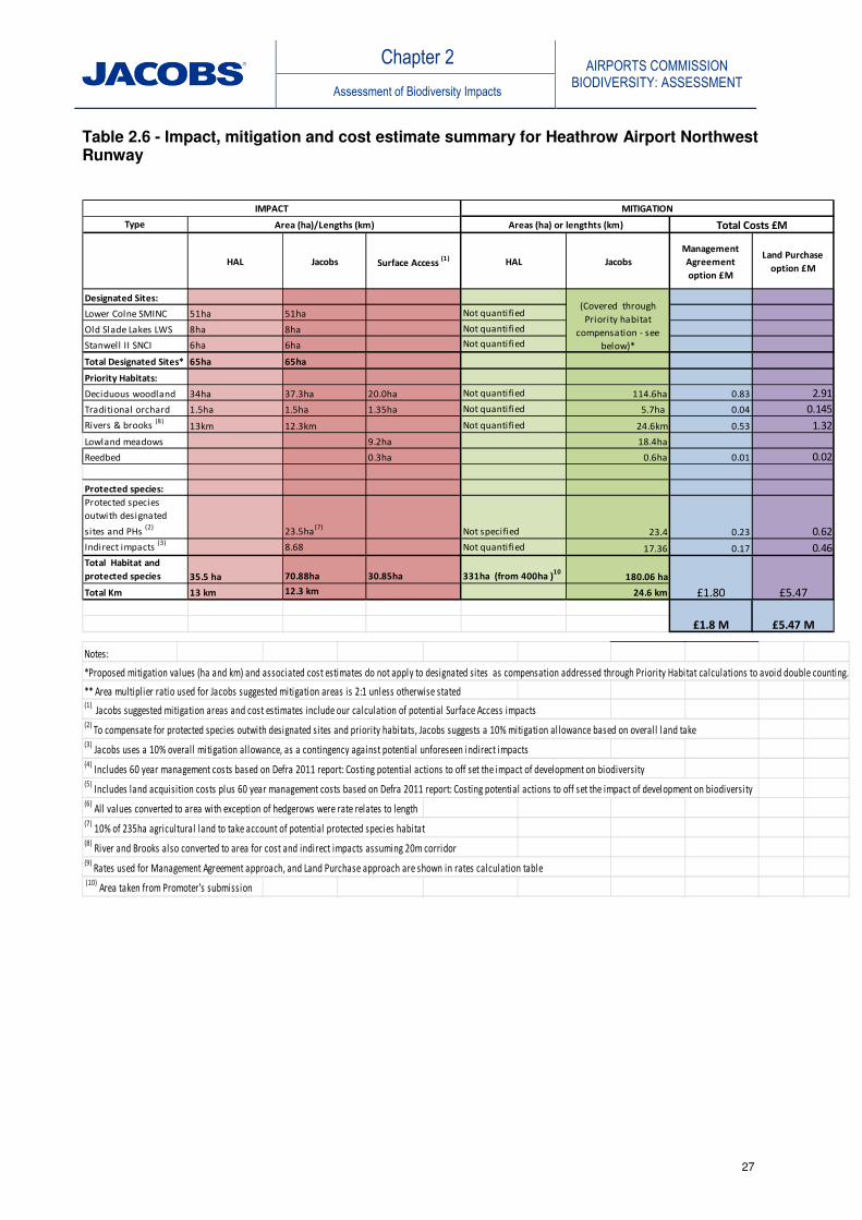
Chapter 2 AIRPORTS COMMISSION
BIODIVERSITY: ASSESSMENT Assessment of Biodiversity Impacts
27
Table 2.6 - Impact, mitigation and cost estimate summary for Heathrow Airport Northwest Runway
Type
HAL Jacobs Surface Access (1) HAL Jacobs
Management
Agreement
option £M
Land Purchase
option £M
Designated Sites:
Lower Colne SMINC 51ha 51ha Not quantified
Old Slade Lakes LWS 8ha 8ha Not quantified
Stanwell II SNCI 6ha 6ha Not quantified
Total Designated Sites* 65ha 65ha
Priority Habitats:
Deciduous woodland 34ha 37.3ha 20.0ha Not quantified 114.6ha 0.83 2.91
Traditional orchard 1.5ha 1.5ha 1.35ha Not quantified 5.7ha 0.04 0.145
Rivers & brooks (8)
13km 12.3km Not quantified 24.6km 0.53 1.32
Lowland meadows 9.2ha 18.4ha
Reedbed 0.3ha 0.6ha 0.01 0.02
Protected species:
Protected species
outwith designated
sites and PHs (2)
23.5ha(7)
Not specified 23.4 0.23 0.62
Indirect impacts (3)
8.68 Not quantified 17.36 0.17 0.46
Total Habitat and
protected species 35.5 ha 70.88ha 30.85ha 331ha (from 400ha )10
180.06 ha
Total Km 13 km 12.3 km 24.6 km
IMPACT
Total Costs £M
MITIGATION
Areas (ha) or lengthts (km)Area (ha)/Lengths (km)
£1.80 £5.47
(Covered through
Priority habitat
compensation - see
below)*
£1.8 M £5.47 M
Notes:
*Proposed mitigation values (ha and km) and associated cost estimates do not apply to designated sites as compensation addressed through Priority Habitat calculations to avoid double counting.
** Area multiplier ratio used for Jacobs suggested mitigation areas is 2:1 unless otherwise stated(1)
Jacobs suggested mitigation areas and cost estimates include our calculation of potential Surface Access impacts(2)
To compensate for protected species outwith designated sites and priority habitats, Jacobs suggests a 10% mitigation al lowance based on overall land take(3)
Jacobs uses a 10% overal l mitigation allowance, as a contingency against potential unforeseen indirect impacts (4)
Includes 60 year management costs based on Defra 2011 report: Costing potential actions to off set the impact of development on biodiversity (5)
Includes land acquisition costs plus 60 year management costs based on Defra 2011 report: Costing potential actions to off set the impact of development on biodiversity (6)
All values converted to area with exception of hedgerows were rate relates to length(7)
10% of 235ha agricultural land to take account of potential protected species habitat(8)
River and Brooks also converted to area for cost and indirect impacts assuming 20m corridor (9)
Rates used for Management Agreement approach, and Land Purchase approach are shown in rates calculation table (10)
Area taken from Promoter's submission

Chapter 2 AIRPORTS COMMISSION
BIODIVERSITY: ASSESSMENT Assessment of Biodiversity Impacts
28
2.2.4 Scheme Birdstrike Risk and Mitigation
The Heathrow Airport Northwest Runway scheme involves the creation of an additional runway to the northwest of the existing airport. The expanded airport footprint will remove a number of agricultural fields that attract significant numbers of pigeons and particularly Canada geese following the harvesting period. This area also attracts gulls following ploughing and seed sowing activities. This benefit is likely to be offset by the fact that the western threshold of the new runway will be significantly closer to Queen Mother Reservoir, which supports a very large gull roost numbering up to 20,000 birds during the winter months as well as a significant number of other waterfowl (see Appendix D Birdstrike Report). At present aircraft departing to, or arriving from the west are high enough when passing over the reservoir that they rarely encounter roosting gulls. Moving the runway closer to the reservoir may mean that aircraft arriving or departing on the western end will be low enough to conflict with gulls spiralling over the reservoir or those arriving at the roost from feeding sites, such as landfills, situated to the north or north east of the reservoir. This would create a significant additional birdstrike risk which would need to be managed. Further work is therefore needed to determine the arrival directions and flight altitude of birds using Queen Mother Reservoir in particular, and the reservoirs to the west of Heathrow in general, so that the likely additional risk can be properly assessed. Potentially elevated future levels of bird scaring/control as part of birdstrike risk management measures could cause bystander effects to other non-target waterbird species at waterbodies where these techniques are deployed, including gadwall and shoveler. There is a potential risk, therefore of an impact on the SWLW SPA, which will consequently require an Appropriate Assessment under the Habitat Regulations. As for noise effects, scaring of non-target birds at Queen Mother Reservoir and Wraysbury Reservoir is not likely to have a significant impact on gadwall or shoveler numbers given the very low numbers at/importance of these particular waterbodies to these birds. Kingsmead Gravel Pits and Wraysbury II North and South lakes do, however, support much larger numbers of gadwall (though not shoveler). If increased levels of bird scaring are required at these waterbodies, there will be a likely significant effect on the SPA. The HAL submission contains a commitment to mitigation for lost habitat as well as improvement of existing habitat for wildlife, creation of new habitat and development of outdoor leisure opportunities around the airport. The proposals include creation of wetlands, flood meadows, woodland, open water and marginal habitats. All of these areas have the potential to attract hazardous birds to the area or to change the behaviour patterns of birds that are already present and thus create an additional birdstrike risk. The need to manage the birdstrike risk is acknowledged in the promoter’s submission. The promoter’s assessment concluded that it is often very difficult to redesign environmental mitigation schemes to exclude hazardous species without reducing their effectiveness as a mitigation measure to a greater or lesser extent. The best option to solve these issues is to move the mitigation actions far enough away from the airport that the impact on birdstrike risk becomes negligible. Although this runs counter to normal practice, where mitigation is carried out as close to the original site as possible. In the case of airports, moving the mitigation further away would allow greater freedom to develop mitigation sites to fulfil conservation aims without the restriction imposed by the need to consider birdstrike risk as a design limitation.

Chapter 2 AIRPORTS COMMISSION
BIODIVERSITY: ASSESSMENT Assessment of Biodiversity Impacts
29
If the mitigation cannot be moved further away (e.g. in the case of rivers), detailed scrutiny and, potentially, extensive modification of the design and location of the proposed mitigation will be needed, and this may, in some instances, reduce its effectiveness as a mitigation for loss of biodiversity. Options would include the use of lasers to disperse the birds as they arrive at the roost site. This has been successfully implemented in trials elsewhere as a means of dispersing a large gull roost. Roost dispersal could be combined with implementing bird control on any local landfill sites that gulls are feeding on prior to moving to the reservoir to roost. Key issues in relation to mitigation habitat design will be to avoid creating habitats that attract bird species know to be hazardous to aviation operations by virtue of their size and/or flocking behaviour. Large open waterbodies are to be avoided due to their appeal to larger waterbirds such as swans, (feral) geese, ducks and gulls. Habitats known to support roosts of large numbers of birds are also to be avoided, such as reedbeds which are known to attract starlings, pied wagtails and other passerines in large numbers at night. Any mitigation that involves large scale bird dispersal from e.g. a reservoir has the potential to adversely impact on non-hazardous birds of conservation concern that currently use the site (see Appendix D Birdstrike Report). As discussed above, SPA qualifying species (gadwall and shoveler) could potentially be adversely affected by increased levels of bird dispersal activity and this would require monitoring and possible mitigation measures. The relative use of the SWLW SPA lakes (and nearby non-SPA functional habitat) by gadwall and shoveler are reasonably well understood, meaning habitat mitigation/enhancement measures can be focussed on areas known to be of importance for these species in an effort to ‘separate’ these non-target birds from species hazardous to aviation operations.
2.2.5 Conclusion
The Heathrow Airport Northwest Runway scheme involves direct land take impacts on three local non-statutory designated sites (Old Slade Lake LWS, Lower Colne SMINC and Stanwell II SNCI), including potential impacts on a nationally rare plant species (pennyroyal), and would result in losses of Priority Habitats including deciduous woodland, traditional orchard and rivers and brooks. The River Colne valley presents opportunities for biodiversity enhancement measures, which will be required as mitigation given the proposed culverting and diverting of sections of rivers with resultant biodiversity losses. Jacobs’ outline cost estimate for provision of compensatory mitigation habitat for direct habitat loss is between £1.8M and £5.47M calculated on the basis of the use of management agreement or land purchase options respectively20. Birdstrike management issues for the Heathrow Northwest Runway scheme are primarily driven by the large numbers of birds associated with the nearby complex of open water bodies. The location for the third runway in closer proximity to the Queen Mother Reservoir is likely to result in an increased strike risk, and a corresponding requirement for an increase in bird management and control activities is anticipated. Methods of deterring/scaring and controlling bird species potentially hazardous to aviation operations could potentially have an adverse effect on non-target species and biodiversity. Although the Queen Mother Reservoir is not part of the South West London Water Bodies (SWLW) SPA and Ramsar site, it provides functional habitat for
20 These indicative habitat offsetting costs are adapted from the Defra 2011 ‘Costing Potential Actions to Off-set the Impact of Development on Biodiversity’ and do not cover construction costs for the river diversions or other capital works. Appendix C contains further information on the compensation calculations.

Chapter 2 AIRPORTS COMMISSION
BIODIVERSITY: ASSESSMENT Assessment of Biodiversity Impacts
30
that site. At this stage, it is not possible to rule out potential likely significant effects from birdstrike risk management on the SWLW SPA and Ramsar site and it is considered likely that Appropriate Assessment would be required. Compensatory habitats created as mitigation for the scheme proposals would need to be designed in such a way as to deter/not attract birds hazardous to aviation operations or be sited sufficiently far away for increased strike risks to be insignificant. However, compensatory habitat creation areas identified to the west and north of the airport expansion are likely to be subject to birdstrike management and this may limit potential biodiversity benefits.

Chapter 2 AIRPORTS COMMISSION
BIODIVERSITY: ASSESSMENT Assessment of Biodiversity Impacts
31
2.3 Heathrow Airport Extended Northern Runway
2.3.1 Biodiversity Baseline Assessment
(a) Designated sites
Jacobs’ Biodiversity: Baseline (Jacobs, 2014a) uses a range of search areas for identification of designated sites, extending out to 30km from the scheme boundary. All statutory and non-statutory designated sites are listed 0-5km, statutory sites only 5-15km, and SACs which list bats as a qualifying feature 15-30km. The potential impacts via receptor pathways on SACs designated for highly mobile bat species which can habitually travel distances greater than 11km need to be considered. A guideline distance of 30km from the scheme footprint to identify designated sites for bats, as per the Design Manual for Roads and Bridges (DMRB HD44/09: Assessment of Implications (of Highways and/or Roads Projects) on European Sites (including Appropriate Assessment)) is therefore recommended. Jacobs identified no sites designated for bats within 30km of this submission. Baseline figures are provided in the accompanying Biodiversity Figures Report: Figures 11 – 13. Data published by Scottish Natural Heritage (SNH, 2013) indicates that three species of wintering geese, a group of birds potentially prone to aircraft strikes, have a core foraging range of 15-20km from their designated areas (normally SPAs) which would render a 15km search zone inadequate for impact assessment purposes. The sensitivity distance for pink-footed goose used by Natural England in their Aviation Sensitivity Maps extends even further, at 22km. This does not however influence the outcome of the impact assessment, because analysis by Jacobs indicates there are no SPAs or other sites designated for such species within a 22km radius of Heathrow Airport. Jacobs’ Biodiversity Baseline report (Jacobs, 2014a) identifies that there are eight sites of importance to biodiversity at International (European) level within 15km of the scheme, these are: the South West London Waterbodies SPA and Ramsar; Windsor Forest and Great Park SAC; Burnham Beeches SAC; Thursley, Ash, Pirbright and Chobham SAC; Wimbledon Common SAC; Richmond Park SAC; and, the Thames Basin Heaths SPA. The South West London Waterbodies SPA and Ramsar site is located on the scheme boundary; this site has internationally important numbers of the ducks gadwall and shoveler (the qualifying interest species of the SPA). There are no European sites within 15-30 km of the airport boundary designated for important bat populations. There are also 39 SSSIs and four NNRs within 15 km of the proposed scheme. There are eight SSSIs within 5 km, with the following four of these within 2km of the proposed boundary: Wraysbury Reservoir SSSI, which is within the proposed scheme footprint; Wraysbury and Hythe End Gravel Pits SSSI; Wraysbury No 1 Gravel Pit SSSI; and, Staines Moor SSSI. A small section of Staines Moor SSSI lies within the scheme footprint as discussed below. This section is known as Management Unit 1, Poyle Meadow, and is located adjacent to the northwest edge of Wraysbury Reservoir SSSI. The majority of Staines Moor SSSI lies just outside the 2 km buffer. The promoter has identified that there is the potential for significant impacts to this site due to changes to the River Colne, on which the habitats depend. All SSSIs within the 5 km buffer are in either favourable or unfavourable recovering status barring Poyle Meadow which is in unfavourable declining condition. There are eight LNRs within 5 km of the scheme boundary, with the following five within 2 km: Cranebank LNR; Bedfont Lakes LNR; Hounslow Heath LNR; Arthur Jacobs Nature Reserve LNR; and, Pevensley Road LNR.
Chapter 2 AIRPORTS COMMISSION
BIODIVERSITY: ASSESSMENT Assessment of Biodiversity Impacts
32
The promoter, Heathrow Hub Limited (HH), identifies no sites of international importance within the scheme boundary, but two such sites within the 5km buffer – the closest and most likely to be impacted being South West London Waterbodies SPA and Ramsar site, 0.364km to the southwest. This site is also a SSSI, and another six SSSIs and two LNRs were also identified within 5km of the scheme boundary. Within 2km, 17 non-statutory designated sites are identified. Where the promoter’s and Jacobs search areas overlap, there is good correlation between results. Jacobs has not identified any designated sites which the promoter did not record. A summary of designated sites identified by the promoter and by Jacobs is provided in Appendix A. (b) Habitats and species
Jacobs’ Biodiversity Baseline (Jacobs, 2014a) provides a table indicating Priority Habitats identified within the scheme proposal footprint, and within 2km and 5km buffers. Within the scheme footprint, the only Priority Habitat type present is deciduous woodland, but all other UK Priority Habitats are present within 5km, except those habitat types associated with upland regions. Jacobs has made use of Natural England’s GIS mapping data which includes information on Priority Habitats to map Priority Habitats within 5km of the scheme proposal boundary, (see Biodiversity Figure 14). The Jacobs Biodiversity Baseline Report (Jacobs, 2014a) provides an extensive list of protected species recorded within 2km of the scheme boundary during the last 20 years, sourced from four separate biological records centres. HH provides information presented in hierarchical order of importance and quantifies loss of Priority Habitats present within the footprint of the runway extension 16.2ha of deciduous woodland, 0.5ha of traditional orchard, 11.6km of river and brook, 6.8km of vegetated ditch and 13.0ha of lakes and ponds. Jacobs agrees with these estimates. (c) Biodiversity trends
Jacobs Biodiversity Baseline (Jacobs, 2014a) provides information on trends in relation to broad habitat types, with respect to the Thames Valley National Character Area. Information on condition status trends of SSSI sites is available from Natural England21 and an examination of this data resource, for the SSSIs within the 5km buffer, indicates all sites are primarily in either favourable or unfavourable recovering status. Banks et al. in their study on wildfowl populations of the South West London Waterbodies SPA used WeBS data to analyse trends in numbers of gadwall and shoveler (the qualifying interest species of the SPA), concluding no significant decline in numbers over a ten year period, but with shoveler numbers beginning to decline in the latter five year period, (Banks, et al., 2004). (d) Data sources
Jacobs has interrogated the Aviation Sensitivity maps produced by Natural England and presents outputs from this exercise within the assessment of impacts section. Appendix B contains further details on the Aviation Sensitivity maps.
21
http://www.sssi.naturalengland.org.uk/special/sssi/search.cfm

Chapter 2 AIRPORTS COMMISSION
BIODIVERSITY: ASSESSMENT Assessment of Biodiversity Impacts
33
Jacobs has reviewed the scheme proposal against the UK post-2010 Biodiversity Framework and the Biodiversity 2020 Strategy for England. These are however, high level strategy documents, the content of which is considered unlikely to affect an assessment of impacts. (e) Environmental Capital of features affected
Inherent levels of importance of designated sites can be derived from their respective designation status, and similarly for species by their degree of legal protection. Table 2.7 below summarises the assessment of Environmental Capital for the Heathrow Airport Extended Northern Runway scheme, as derived by Jacobs and the promoter. These summary assessments are made at a high level, based on the information available. Generic broad categories of High, Medium, Low, Negligible and No Change are used unless otherwise stated. A ‘Not specified’ entry generally indicates that the impact was discussed within the promoter’s submission, but not necessarily quantified in the manner required by the Appraisal Framework.
Table 2.7 - Summary assessment of Environmental Capital (Heathrow ENR)
Feature Susceptibility Replaceability Ecological value
Jacobs HH Jacobs HH Jacobs HH
Designated sites - European
High Not specified
Low Not specified
High High
Designated sites - National
High Not specified
Low Not specified
High High
Designated sites – Regional/ Local
High Not specified
Low Not specified
Medium Medium
Habitats Low to High, dependent on habitat type
Not specified
Low to High, dependent on habitat type
Low to High. Discussed within HH mitigation strategy
Low to High, dependent on habitat type
Low to High, dependent on habitat type
Species Low to High, dependent on species
Not specified
Low to High. Relevant for species translocation and mitigation strategy
Low to High. Discussed within HH mitigation strategy
Low to High, dependent on species
Low to High, dependent on species
(f) Current birdstrike risk and management
Heathrow lies in a semi-urban environment, comprising a mosaic of domestic dwellings with gardens, light industrial buildings and ancillary buildings for the airport such as hotels and car parking. These areas are interspersed with agricultural fields, primarily growing arable crops, and grassed areas such as sports pitches and grazing pasture for horses. These habitats support an assemblage of common bird species such as pigeons, corvids, starlings, kestrel and gulls, as well as smaller species such as swallows and martins, swift, finches and pipits. These species are typical of many airports in the UK, but where Heathrow differs is in the presence of several very large water supply reservoirs and the complex of flooded mineral extractions in the Thames and Colne valleys which lie to the south and west of the airport.

Chapter 2 AIRPORTS COMMISSION
BIODIVERSITY: ASSESSMENT Assessment of Biodiversity Impacts
34
The western approach to the northern runway passes over the River Thames, Queen Mother Reservoir and the River Colne, whilst the western approach to the southern runway crosses the River Thames, the complex of flooded gravel pits between Horton and Wraysbury, Wraysbury Reservoir itself and the River Colne. The normal mixture of birds that would be expected at a UK airport is therefore augmented by very large numbers of gulls that roost on the reservoirs in the winter, for example over 18,000 gulls were recorded roosting on Queen Mother Reservoir in February 2013 and by large numbers of waterfowl that occupy these reservoirs and gravel pits all year round. These wetland areas also attract smaller numbers of other hazardous species such as cormorant and grey heron. The increased numbers of wetland bird species in the area means that any development that influences the number or behaviour of these birds, or brings the aircraft into closer proximity to them, has the potential to increase the birdstrike risk, unless appropriate mitigating action is taken. In common with all other licensed civil airports in the UK, Heathrow are required to have an effective plan in place to monitor and manage the birdstrike risk which is audited by the CAA (see Appendix D: Birdstrike Report). 2.3.2 Assessment of Impacts to Biodiversity Features
(g) Range and nature of impacts assessed
The Aviation Sensitivity maps and accompanying methodology produced by Natural England (LUC, 2014) were used by Jacobs to determine Natural England’s assessment of potential effects on designated sites due to direct land take, disturbance and air quality at and around Heathrow Airport. These maps identify the area within which significant potential effects from aviation expansion are most likely to occur, and focus on potential impacts on nationally designated terrestrial nature conservation and geological sites (SSSIs). Nationally designated terrestrial nature conservation sites (and protected landscapes) falling within the buffers are assessed to determine whether their features of interest/reasons for designation are sensitive to each of the potential impacts. A site is defined as sensitive to an impact and mapped as red on the Webmap if it falls within the impact distance buffer and is identified as having the potential to be significantly affected by that impact. Natural England assumes that any direct land take required for new airport infrastructure would be contained within a 5km radius, and their online maps identify all SSSIs within 5km of the existing airport boundary. As the extent of direct landtake arising from the scheme proposal is known in this instance, impacts to sites within 5km other than those already identified above can be discounted. The distance used by Natural England for disturbance effects to bats and birds is 11km and SSSIs within this zone whose interest features include birds/bats are identified on the Webmap output. This map is reproduced in Appendix B. All identified sites are highlighted due to their bird interest. Birds can be sensitive to noise and visual disturbance from changes in the frequency and timing of Air Traffic Movements, flight paths, and bird control interventions.
Whilst Jacobs accepts the potential for disturbance effects to birds at these SSSIs, which is likely to require further more detailed assessment, it is considered unlikely these effects will be significant. Lowland deciduous woodland and lowland heath habitats at these designated sites indicate the likely presence of bird species such as lesser-spotted woodpecker and nightjar which are highly unlikely to be significantly adversely affected by the proposal.

Chapter 2 AIRPORTS COMMISSION
BIODIVERSITY: ASSESSMENT Assessment of Biodiversity Impacts
35
Waterfowl populations at the SWLW SPA (and its component SSSI units) are not likely to be significantly adversely effected due to current levels of tolerance of aircraft movement, and therefore we do not anticipate a likely significant effect on the integrity of the SPA due to this effect. With regard to noise effects, Jacobs agrees with the promoter’s informative assessment that wildfowl species (most notably gadwall and shoveler) supported by the nearby wetland sites are the most likely receptor to this impact, and that the likely significance of this impact will be negligible. These waterbodies are currently routinely overflown by aviation traffic, the noise from which is tolerated by local wildfowl populations which have habituated to this disturbance effect (Banks et al. 2004 and Briggs, 2007). These studies indicate no declines in gadwall and shoveler numbers at the SPA site level, but do detect declines in both species at the individual SSSI level – in that there can be a redistribution of birds within the SPA resulting in an increase in numbers at some SSSIs and a decrease at others. Declining numbers are ascribed to human disturbance due to recreational activities (angling and sailing), and the studies stress that water-based disturbance has a much greater effect than noise on waterbirds.
The proposed extended northern runway will, in particular, approach much closer to the Queen Mother Reservoir (which does not form part of the SWLW SPA) and Wraysbury Reservoir (which is part of the SWLW SPA) than the existing runway arrangement. In a study by Komenda-Zehnder et al. investigating the effects of disturbance to waterbirds from aircraft overflights, the conclusion was drawn that, provided the aircraft passed over at a height greater than 300m above ground level, waterbirds did not exhibit significant displacement or stress levels, (Komenda-Zehnder et al., 2003). However, this was based on a study using smaller aircraft than the regular passenger aircraft and did not measure noise levels. The promoter predicts that aircraft traffic as a result of the scheme will overfly this area at a height greater than 300m. The western end of the proposed Heathrow ENR runway will be closer to the complex of waterbodies than the existing distances between Heathrow Airport’s southern runway and these SPA lakes. If overflying aircraft (as a result of the proposed scheme) were to have a disturbance effect on waterbird populations, it is therefore reasonable to assume that this effect would be most acute at the Queen Mother Reservoir and Wraysbury Reservoir, but also potentially evident at Horton Gravel Pits and perhaps the Kingsmead Gravel Pits. Whilst the Queen Mother Reservoir does not form part of the SPA, it has the potential to act as nearby functional habitat, acting in ecological support to the SPA. Numbers of gadwall and shoveler are, however, very low at Queen Mother Reservoir and at Wraysbury Reservoir within the SPA, and significantly lower than numbers at other waterbodies within the SPA (Briggs, 2007). Both of these reservoirs are concrete-lined, supporting a negligible resource of marginal plant habitat, rendering them of little value to gadwall and shoveler. The potential for effects on the SPA deriving from these two closest waterbodies is therefore unlikely, but the possibility exists for effects to the Horton and Kingsmead lakes due to noise. Potential effects on gadwall and shoveler numbers (and therefore on the SPA) as a result of management practices related to birdstrike risk are discussed below, in section 2.3.4.
Effects due to air quality are also presented within the sensitivity maps. A 5km buffer is adopted and sites with habitats considered to be Air Quality Sensitive are highlighted. Whilst Jacobs accepts the potential for air quality effects to habitats at these SSSIs, which is likely to require further detailed assessment, it is considered unlikely that these effects will be significant. Heathrow Hub has identified the requirement for assessment of the effects of noise disturbance on wintering birds; air quality, land take and water quality on designated sites and important habitats and species; bird strike (and receptor pathways), lighting,

Chapter 2 AIRPORTS COMMISSION
BIODIVERSITY: ASSESSMENT Assessment of Biodiversity Impacts
36
and fish, otter and water vole passage, representing an adequate range of potential impacts identified. The promoter’s assessment of the impacts of air quality references the Air Pollution Information System (APIS)22 and uses this resource to illustrate the point that the habitats within the adjacent SWLW SPA (and for most waterbodies in the region) are essentially phosphate limited, rather than nitrogen limited, and that the emissions produced by the increased air traffic will not have a further detrimental effect on phosphate levels. Jacobs agrees with this reasoning on the assumption that further studies can be undertaken to effectively rule out the potential effect of increased nitrogen levels on the SPA habitats. Jacobs agrees that designated sites and important habitats elsewhere within the region are at sufficient distance from the scheme for this impact to be of negligible significance. The Heathrow Airport Extended Northern Runway option would be likely to impact upon Staines Moor SSSI in two locations. Adjacent to junction 14 of the M25 (the junction with the A3113) the footprint of the scheme would encroach into Unit 1 Lowland Grassland (the site is divided into land management parcels, or ‘units’). The predicted impact is 5.7ha of the total 8ha of the management unit. It is likely that the whole of the unit would be adversely impacted given that modifications to the transport corridors would take place on either side of the site as well. Therefore, it is likely the whole of this site would be lost. This is consistent with the assessment undertaken by Heathrow Hub which concluded there would be an 8.74ha impact.
There would also be works directly adjacent to King George VI Reservoir (which forms part of Staines Moor SSSI and SWLW SPA) and nearby Wraysbury Reservoir (also part of the SWLW SPA). This includes proposals for a relocated balancing pond which would be within 50m of the SSSI boundary. This could have a temporary impact during construction although long term the balancing pond could be beneficial in providing additional standing water habitat, although this would depend on whether water is stored permanently in the balancing pond and how any habitat on the site was managed. During the construction phase, these works could have a disturbance impact on the SPA wildfowl populations, and is therefore likely to require a Habitat Regulations Assessment, but can easily be avoided and screened out via appropriate timings of works.
In addition to these two sites it is acknowledged that significant changes to a number of water courses, including the River Colne, would need to be made to accommodate the proposal. These changes have been assessed in the Water Quality and Water Quantity Assessment Reports (Jacobs, 2014c) and could potentially have significant impacts to the status of the Staines Moor SSSI which is downstream of the Colne, through alterations to the hydrological conditions currently supporting the SSSI. Heathrow Hub has identified that a precautionary worst case impact could be a 40ha impact on part of the site. However, it is considered unlikely that the impact would be this extensive, and potential impacts could be reduced and potentially avoided through the design of channel diversions and minimising culverting requirements. As long as water quality, volume and flow rate are maintained (or not adversely affected), then impacts to the SSSI, Management Unit 12, downstream should be avoided.
Heathrow Extended Northern Runway scheme would directly impact on Arthur Jacob Local Nature Reserve (LNR). The LNR is on the boundary of the footprint identified by Jacobs and so a complete loss of this site may be avoidable. There is 0.6ha of this site
22
www.apis.ac.uk
Chapter 2 AIRPORTS COMMISSION
BIODIVERSITY: ASSESSMENT Assessment of Biodiversity Impacts
37
within the land take required for the scheme however, and 4.1ha is within 300m of the site and so is likely to be affected during construction and through disturbance during operation. This is consistent with the assessment undertaken by Heathrow Hub which indicated there would be a 4.1ha impact on the site.
Direct impacts have been identified by Jacobs on four non-statutory designated sites. East of Poyle Meadows SNCI would be directly affected by the footprint of the scheme. This site overlaps with the boundary of Staines Moor SSSI Unit 1 and although not all of the site is within the footprint of the airport itself it is likely that the whole of the site would be lost as a result of works to the transport network around the remainder of the 2.9ha site. This is consistent with the assessment completed by Heathrow Hub. Greenham’s Fishing Pond SNCI, a 0.45ha site to the south east of junction 14 of the M25 is also likely to be lost. The scheme would cross the Lower Colne SMINC affecting the entire site south of Bath Road and a small area above it. The exact extent of the impact would depend on final road realignments, however the impact is estimated to be between 10-15ha.
River Colne (From County boundary to Staines Moor) Stanwell Moor SNCI is also directly under the southern footprint of the proposed airport. This is a 5.5ha site situated around the River Colne. There is a high degree of uncertainty over the potential impact to this site. Using the footprint of the scheme alone it would be around 25% of the site or 1.25ha. Upstream impacts and the diversion of the River Colne could lead to additional impacts on the remainder of the SNCI however it would be expected that through detailed design water quality, volume and flow rate are maintained, then impacts to the downstream extent of SNCI should be avoided.
The promoter’s assessment focuses on those sites which lie directly within the footprint of the development proposal (East of Poyle Meadows Site of Nature Conservation Importance, Arthur Jacob Local Nature Reserve, Management Unit 1 (Poyle Meadow) of Staines Moor SSSI, Management Unit 12 Staines Moor SSSI and Greenham’s Fishing Pond SINC, a total area of approximately 100ha). Jacobs also identifies the potential for impact from surface access links on West of Poyle Meadows SNCI, as this site is directly adjacent to the proposed revised alignment of the M25. This site could be affected through construction and through changes in surface run-off / drainage.
In terms of Priority Habitats, the promoter has identified the direct loss of approximately 16.2ha of deciduous woodland, 0.5ha of traditional orchards, and 8.6ha of lowland meadows. In addition 13ha of standing water would be affected, 7km of river would need to be culverted and 6.8km of ditch network would be lost. Around 6ha of scrub and 70ha of pasture / rough grassland would also be lost, which is broadly consistent with Jacobs’ assessment, although Jacobs identifies larger loss of deciduous woodland habitat and a loss of over 10km of river corridor. This is a highly significant loss and will require substantial mitigation effort. Jacobs has identified that surface access proposals for the scheme involve potential impacts due to land take and disturbance in the southern area of the proposal, primarily along the existing M25 motorway corridor and across Staines Moor SSSI. Using the buffer zone of 100m as a potential area of impact around the proposed surface access routes has identified some potential overlap with the boundaries of Wraysbury Reservoir SSSI, King George VI Reservoir and Staines Reservoirs (and therefore the SWLW SPA). It is considered likely that during subsequent design stages the exact alignment of the surface access routes and the construction methods to be used would be planned to avoid land take within the SPA. Adverse impacts to Staines Moor SSSI and the River Colne due to current Surface Access proposals are likely to be highly significant.

Chapter 2 AIRPORTS COMMISSION
BIODIVERSITY: ASSESSMENT Assessment of Biodiversity Impacts
38
Table 2.8 below summarises the assessment of biodiversity impacts of Heathrow Airport Extended Northern Runway, as derived by Jacobs and the promoter. These summary assessments are made at a high level, based on the information available. Generic broad categories of High, Medium, Low, Negligible and No Change are used unless otherwise stated. A ‘not specified’ entry generally indicates that the impact was discussed within the promoter’s submission, but not necessarily quantified in a stated in the Appraisal Framework.
Table 2.8 - Summary assessment of biodiversity impacts (Heathrow ENR)
Impact Magnitude Duration Reversibility
Jacobs HH Jacobs HH Jacobs HH
Land take -Designated sites (Regional/Local)
High Not specified
Long term
Not specified
Low Not specified
Land take –Habitats
High Not specified
Long term
Not specified
Low Not specified
Land take – Species
High to low dependent on species
Not specified
Medium to Long term
Not specified
Low Not specified
Noise Low Low Short term effect repeated over Long term period
Not specified
High Not specified
Air quality Low Low Medium to Long term
Not specified
Medium Not specified
Water quality High High Long term
Not specified
Medium Not specified
Bird strike Low Low Short term effect repeated over Long term period
Not specified
High Not specified
2.3.3 Mitigation strategy
Table 2.9 provides an outline summary of areas/receptors impacted, with corresponding compensatory habitat mitigation extents, as assessed by the promoter and by Jacobs. Areas of proposed mitigation measures are quantified on a 2:1 ratio unless otherwise stated. Jacobs recommends precautionary allowances for the possibility that protected species might exist in agricultural land not captured within designated sites or Priority Habitats (10% of the 168ha of agricultural land within the scheme footprint, as measured by Jacobs), and for the potential for indirect effects discussed above (10% of the total compensatory habitat calculation). The allowance of 10% is an arbitrary figure, but is considered to be a reasonable value in both instances.

Chapter 2 AIRPORTS COMMISSION
BIODIVERSITY: ASSESSMENT Assessment of Biodiversity Impacts
39
The ‘Surface Access’ impact column shows extents of Priority Habitats potentially directly impacted by the proposed road access infrastructure network for the scheme, as calculated by Jacobs. Estimates for mitigation measures for these particular potential losses are also included in the mitigation areas and costs shown.
Outline costs for Jacobs’ assessment of mitigation requirements are set out in Table 2.9 in the right-hand column. These values are derived from information described in Defra’s report ‘Costing Potential Actions to Off-set the Impact of Development on Biodiversity’ (Defra, 2011). This report sets out two main approaches for delivery of habitat creation or restoration for the purpose of off-setting losses:
• Management Agreement approach whereby a land owner is paid to manage land to maintain a required habitat over a period of time; or the
• Land Purchase approach, where land is purchased at the outset and the land is managed over a period but without the need to pay an allowance to the landowner making the initial costs much higher but annual habitat management costs lower.
Either approach, or a mix of these approaches, might be used to secure compensation measures for the scheme. For both approaches, the Defra 2011 report provides ‘catch-all’ cost estimates per hectare for the habitat creation works for a range of commonly recreated habitats and subsequent land/habitat management costs. The costs used here are for habitat creation rather than restoration and the costs have been adjusted to cover a 60 year management period rather than the 100 year period used in the Defra report. The Land Purchase approach has also been adapted to include land purchase costs at the outset based on average rural land values23 set out in the Defra 2011 report.
Discrete values are provided within the Defra guidance for woodland, hedgerows, wetlands and lowland grassland - assumptions have been made here for traditional orchards, reedbeds and rivers, in that the values provided for woodland and wetland habitats respectively have been used. To provide an estimate of cost for non-specified habitats (namely those relating to protected species and indirect impacts), an average value (£/ha) has been taken from woodland, wetland and lowland grassland figures. Appendix C contains further details on the compensation calculations.
Minor discrepancies between Jacobs and the promoter’s calculations are apparent for some habitat types, but these are thought to be attributable to slight variations in mapping of site boundary positions and/or (as for traditional orchards) minor variances in Natural England habitat classification assessments versus current on the ground actuality. A comprehensive framework of specific mitigation commitments has been described by the promoter and post-mitigation (i.e. residual) impacts have been discussed. The achievability of mitigation has been addressed at a strategic level, with reference made to previous mitigation schemes. Locations within the region have been identified as potential receptor sites for mitigation and enhancement measures, with their extents defined and mapped (see Biodiversity Figure 18). Jacobs provides outline costings for mitigation proposals in Table 2.9 below.
A default precautionary multiplier of 2 has been proposed by Heathrow Hub to compensate for losses of habitats, and a detailed, quantified list is provided of proposed habitat creation actions. In summary this list prescribes provision of 18ha of
23
Note actual land values will vary depending on the specific sites selected for use for the compensation proposals and market
conditions.

Chapter 2 AIRPORTS COMMISSION
BIODIVERSITY: ASSESSMENT Assessment of Biodiversity Impacts
40
species-rich neutral grassland, 40ha of fen, 4ha of swamp/wet grassland, 8.2ha of wetland including wet woodland, 26ha of ponds/lakes, 32.4ha of deciduous woodland, 1ha of traditional orchard, 17.2ha of lowland meadow and 6.0km of ditch. These measures give totals of 146ha of habitat and 6km of linear watercourse.
A further recommendation of 6ha of scrub and up to 70ha of pasture/rough grassland to compensate for the loss of these less important (not of Principal Importance) habitats is made by the promoter. Consideration of the potential requirement for areas greater than those proposed has also been made, to compensate for the possibility of adversely impacting the biodiversity resource of the proposed mitigation sites themselves, and Jacobs agrees with this assessment and approach. Parcels of land totalling an area of 217ha have been identified by the promoter as possible mitigation sites. This area would just about accommodate the 146ha requirement above plus the 76ha for scrub and rough grassland. Jacobs assesses a requirement for 248.8ha of compensatory habitat (see Table 2.9), which is greater (by 63ha) than the promoter’s recommendation of 217ha, due to Jacobs’ inclusion of surface access impacts and precautionary allowances for potential indirect effects and protected species. Jacobs has identified that it should be possible to avoid impacts on Staines Moor SSSI Management Unit 12 for which Heathrow Hub have allowed 40ha of compensation area.

Chapter 2 AIRPORTS COMMISSION
BIODIVERSITY: ASSESSMENT Assessment of Biodiversity Impacts
41
Table 2.9 - Impact, mitigation and cost estimate summary for Heathrow ENR
Type
Hub Jacobs Surface Access(1) Hub Jacobs
Management
Agreement
option £M
Land
Purchase
option £M
Designated Sites:
East Poyle Meadows SNCI 2.9ha 2.9ha 4ha swamp
Arthur Jacob LNR 4.1ha 4.1ha
8.2ha wet
woodland
Greenham's Fishing Pond
SINC Not specified 0.45ha 26ha pond
Management Unit 1 (Poyle
Meadow) of Staines Moor
SSSI 8.7ha 8.0ha
18ha species-rich
neutral grassland
Lower Colne SMINC Not specified 10-15ha 40ha
River Colne (From County
boundary to Staines Moor)
Stanwell Moor SNCI Not specified 1.25ha Not specified
Total Designated Sites* 15.7ha 31.7ha
Priority Habitats:
Deciduous woodland 16.2ha 26.2ha 30.1ha 32.4ha 122.4ha 0.91 3.12
Traditional orchard 0.5ha 0.5ha 1ha 1ha 0.01 0.03
Lowland meadows 8.6ha 6.5ha 32.4ha 17.2ha 77..8a 0.88 2.101
Reedbeds Not specified 0.3ha 8.0ha Not specified 16.6ha 0.18 0.45
Rivers & brooks (8)
6.8km 10.4km 6.8km 20.8km 1.35 1.12
Protected species
Protected species outwith
designated sites and PHs (2)
Not specified 16.8ha Not specified 16.8ha 0.17 0.44
Indirect impacts (3)
7.1ha 14.2ha 0.14 0.37
Total ha Habitat and
protected species habitat 25.3 ha 57.4ha 70.5 ha 146.8 ha (10)
248.8 ha 3.63 7.63
Total km habitat 6.8 km 10.4 km 6.8 Km 20.8 km £3.63M £7.63M
(Covered through
Priority habitat
compensation - see
below)*
IMPACT
Total Costs £M
MITIGATION
Area (ha) or lengths (km)Area (ha) or Lengths (km)***
Notes:
*Proposed mitigation values (ha and km) and associated cost estimates do not apply to designated sites as compensation addressed through Priority Habitat calculations to avoid double counting.
**Area multipl ier ratio used for Jacobs suggested mitigation areas is 2:1 unless otherwise stated(1)
Jacobs suggested mitigation areas and cost estimates include our calculation of potential Surface Access impacts(2)
To compensate for protected species outwith designated sites and priority habitats, Jacobs suggests a 10% mitigation al lowance based on overall land take(3)
Jacobs uses a 10% overall mitigation allowance, as a contingency against potential unforeseen indirect impacts (4)
Includes 60 year management costs based on Defra 2011 report: Costing potential actions to off set the impact of development on biodiversity (5)
Includes land acquisition costs plus 60 year management costs based on Defra 2011 report: Costing potential actions to off set the impact of development on biodiversity (6)
All values converted to area with exception of hedgerows were rate relates to length(7)
10% of 168ha agricultural land to take account of potential protected species habitat(8)
River and Brooks also converted to area for cost and indirect impacts assuming 20m corridor (9)
Rates used for Management Agreement approach, and Land Purchase approach are shown in rate calculation table (10)
Area taken from promoter's submission

Chapter 2 AIRPORTS COMMISSION
BIODIVERSITY: ASSESSMENT Assessment of Biodiversity Baseline and Impacts
42
2.3.4 Scheme Birdstrike Risk and Mitigation
The western threshold of the extended runway will be significantly closer to the complex of reservoirs and gravel pits to the west of the airport. The main risk to aircraft that arises from these waterbodies (complex of reservoirs and gravel pits to the west of the airport), comes from the very large winter gull roosts that occur there. On clear, still winter days, gulls may commute into their roosting sites at altitudes in excess of those quoted for aircraft, and may also soar above roost sites at similar heights. Gulls also routinely move between the larger reservoirs when arriving at roosts or during the night (possibly in response to changing weather conditions) and there are regular movements of many hundreds of gulls between Queen Mother Reservoir and Wraysbury reservoir. It is highly likely that this scheme will result in a significantly elevated birdstrike risk from gulls, and this risk would need to be mitigated by dispersal of the roost from the water bodies concerned and/or from feeding sites that result in flight lines of birds that cross the active airspace at a height which results in an increased risk. At the very least, a full assessment of the heights at which gulls fly over the reservoirs and a modelling exercise to determine likely collision rates should be carried out as part of the assessment process for this option and necessary mitigation measures included in the submission if this proves necessary. Potentially elevated future levels of bird scaring/control as part of birdstrike risk management measures could cause bystander effects to other non-target waterbird species at waterbodies where these techniques are deployed, including gadwall and shoveler. There is a potential risk, therefore of an impact on the SWLW SPA, which will consequently require an Appropriate Assessment under the Habitat Regulations. As for noise effects, scaring of non-target birds at Queen Mother Reservoir (which is not part of the SWLW SPA) and Wraysbury Reservoir (which is part of the SWLW SPA) is not likely to have a significant impact on gadwall or shoveler numbers given the very low numbers at/importance of these particular waterbodies to these birds. Kingsmead Gravel Pits and Wraysbury II North and South lakes do, however, support much larger numbers of gadwall (though not shoveler). If increased levels of bird scaring are required at these waterbodies, there will be a likely significant effect on the SPA. The total amount of mitigation required is detailed in the Heathrow Airport Extended Northern Runway scheme, along with a number of sites where such mitigation could be carried out. The mitigation includes 26ha of lakes and ponds, the location of which could have a significant impact on the birdstrike risk at the airport. It would be preferable to move any environmental mitigation that might attract hazardous birds as far away from the airport as possible, which would both allow the mitigation impact to be maximised because the need to compromise designs to reduce birdstrike risk would be removed and also result in an overall safety benefit to the airport as bird attracting habitat close to the site will be removed and re-created at a safer distance (see Appendix D: Birdstrike Report). Key issues in relation to mitigation habitat design will be to avoid creating habitats that attract bird species know to be hazardous to aviation operations by virtue of their size and/or flocking behaviour. Large open waterbodies are to be avoided due to their appeal to larger waterbirds such as swans, (feral) geese, ducks and gulls. Habitats known to support roosts of large numbers of birds are also to be avoided, such as reedbeds which are known to attract starlings, pied wagtails and other passerines in large numbers at night.

Chapter 2 AIRPORTS COMMISSION
BIODIVERSITY: ASSESSMENT Assessment of Biodiversity Baseline and Impacts
43
The relative use of the SWLW SPA lakes (and nearby non-SPA functional habitat) by gadwall and shoveler are reasonably well understood, meaning habitat mitigation/enhancement measures can be focussed on areas known to be of importance for these species in an effort to ‘separate’ these non-target birds from species hazardous to aviation operations.
2.3.5 Conclusion
The Heathrow Airport Extended Northern Runway scheme involves direct land take impacts to varying degrees on five local designated sites, three of which are non-statutory (East Poyle Meadows SNCI, Lower Colne SMINC and Greenham’s Fishing Pond SINC), two statutory (Arthur Jacob LNR and Management Unit 1 (Poyle Meadow) of Staines Moor SSSI). This would involve culverting and diverting of section of existing rivers and other smaller-scale losses of Priority Habitats including deciduous woodland, traditional orchard, lowland meadows and reedbeds. The outline cost for provision of compensatory mitigation habitat is estimated as between £3.63M and £7.63M (based on the use of management agreement or land purchase options respectively24).
There are birdstrike management issues for Heathrow Airport Extended Northern Runway associated with the nearby complex of open water bodies. The western threshold of the extended runway will be significantly closer to the complex of reservoirs and gravel pits to the west of the airport including sites designated as part of the South West London Water Bodies (SWLW) SPA and Ramsar site. The closer proximity of the runway and increased air traffic is likely to result in an increased strike risk, and a corresponding requirement for an increase in bird management and control activities is anticipated. Methods of deterring/scaring and controlling bird species potentially hazardous to aviation operations could potentially have an adverse effect on non-target species and biodiversity. At this stage, it is not possible to rule out potential likely significant effects from birdstrike risk management on the SWLW SPA and Ramsar site. In particular, if increased levels of bird scaring are required at Kingsmead Gravel Pits and Wraysbury II North and South lakes which support large numbers of gadwall (though not shoveler) there could be a likely significant effect on the SPA. It is therefore considered likely that Appropriate Assessment would be required. Compensatory habitats created as mitigation for the scheme proposals will need to be designed in such a way as to deter/not attract birds hazardous to aviation operations or be sited sufficiently far away for increased strike risks to be insignificant and this may limit the biodiversity benefits for some of the proposed mitigation areas close to the proposed scheme
24
These are indicative habitat off setting costs are adapted from the Defra 2011 ‘Costing Potential Actions to Off-set the
Impact of Development on Biodiversity’ and do not cover construction costs for the river diversions or other capital works.
Appendix C contains further details on the compensation calculations.

References AIRPORTS COMMISSION
BIODIVERSITY: ASSESSMENT
44
References
Airports Commission, (2014). Appraisal Framework. https://www.gov.uk/government/uploads/system/uploads/attachment_data/file/300223/airports-commission-appraisal-framework.pdf, [Accessed 29/10/2014]. Banks AN, Austin GE & Rehfisch MM, (2004). South West London Waterbodies SPA Wildfowl Population Analysis. A report by the British Trust for Ornithology to English Nature. British Trust for Ornithology. Briggs B.D.J., (2007). The use of waterbodies in South West London by gadwall and shoveler; implications for nature conservation. University of Oxford. British Trust for Ornithology & Central Science Laboratory (BTO), (2003). Study on the potential safety risks from birds at and around a potential new airport at Cliffe Marshes and measures for mitigating those risks. CAA, (2008). CAP 772 Birdstrike risk Management for Aerodromes. Civil Aviation Authority, London. CAA, (2010). CAP 168 Licensing of Aerodromes Civil Aviation Authority, London. Defra, (2011). Costing potential actions to offset the impact of development on biodiversity – Final Report. Defra & Natural England, (2012). Biodiversity Offsetting Pilots – Technical Paper: the metric for the biodiversity offsetting pilot in England. Eaton MA, Brown AF, Noble DG, Musgrove AJ, Hearn R, Aebischer NJ, Gibbons DW, Evans A and Gregory RD, (2009). Birds of Conservation Concern 3: the population status of birds in the United Kingdom, Channel Islands and the Isle of Man. British Birds 102, pp296-341. Highways Agency, (1993). Design Manual for Roads and Bridges. Institute of Ecology and Environmental Management, (2006). Guidelines for Ecological Impact Assessment. Institute of Ecology and Environmental Management Komenda-Zehnder S, Cevallos M and Bruderer B, (2003). Effects of Disturbance by Aircraft Overflights on Waterbirds – an experimental approach. Proceeding of the 2003 International Birdstrike Committee Jacobs, (2014a). Module 7 Biodiversity: Baseline, Prepared for the Airports Commission, Jacobs Jacobs, (2014b). Module 7 Biodiversity: Ecosystems Services, Prepared for the Airports Commission, Jacobs Jacobs, (2014c). Module 9 Water and Flood Risk: Water Quantity and Water Quality Assessment, Prepared for the Airports Commission, Jacobs Jacobs, (2014d). Module 10 Place: Assessment, Prepared for the Airports Commission, Jacobs
References AIRPORTS COMMISSION
BIODIVERSITY: ASSESSMENT
45
Land Use Consultants, (2014). Aviation Capacity and the Natural Environment – detailed Methodology, References and Copyright Information. LUC. Palmer E, Pimley E, Sutton G, Birks J, (2013). A Study on the Population Size, Foraging Range and Roosting Ecology of Bechstein’s Bats at Grafton Wood SSSI Worcestershire. A report to Link Ecology and Swift Ecology to the Wildlife Trusts and the People’s Trust for Endangered Species. Available online at http://live.data.wt.precedenthost.co.uk/sites/live.data.wt.precedenthost.co.uk/files/Grafton%20Wood%20Bechsteins%20Report%20FINAL.pdf .Accessed July 2014. Scottish Natural Heritage (2013). Assessing Connectivity with Special Protection Areas (SPAs). Available online at www.snh.gov.uk/docs/A675474.pdf. Accessed July 2014.

Glossary AIRPORTS COMMISSION
BIODIVERSITY: ASSESSMENT
46
Glossary & Designations
The following table lists and explains key technical terms used in this report.
GLOSSARY
APPS Approach Surface
BAP Biodiversity Action Plan
BTO British Trust for Ornithology
CAP Civil Aviation Authority Publication
CIEEM Chartered Institute of Ecology and Environmental Management
ENR Extended Northern Runway
GAL Gatwick Airport Ltd
HAL Heathrow Airport Ltd
HH Heathrow Hub
LNR Local Nature Reserve
LWS Local Wildlife Site
NERC Natural Environment & Rural Communities
NE Natural England
NWR North West Runway
SAC Special Area of Conservation
SMINC Site of Metropolitan Importance for Nature Conservation
SNCI Site of Nature Conservation Importance
SPA Special Protection Area
SSSI Site of Special Scientific Interest
SWLWB South West London Water Bodies
TOCS Take Off Climb Surface
2R Second Runway

Glossary AIRPORTS COMMISSION
BIODIVERSITY: ASSESSMENT
47
The following table provides additional explanation for the designation types and the regulations relating to them.
Designations
Statutory wildlife sites
Those sites designated under UK legislation and regulated by the statutory nature conservation organisations; in England this being Natural England
Non-statutory wildlife sites
Those sites which are locally important for nature conservation and that complement nationally and internationally designated wildlife sites. There are a number of different terms used to describe these sites including: Local Wildlife Sites; Sites of Importance for Nature Conservation (SINCs); Sites of Nature Conservation Importance (SNCIs); County Wildlife Sites; and Wildlife and Heritage Sites.
Summary of Legislation and Related Statutory Designations
Relevant legislation Designation name
Conservation of Habitats and Species Act 2010 (as amended)
These regulations are the principal means by which the European Habitats Directive 92/43/EEC is transposed in England and Wales; it consolidates and amends existing national legislation to implement the Convention on the Conservation of European Wildlife and Natural Habitats (Bern Convention) and Council Directive 79/409/EEC on the Conservation of Wild Birds (Birds Directive) in Great Britain. The Regulations provide for the designation and protection of European sites, termed the Natura 2000 network. SPAs and SACs are covered by this legislation. Ramsar sites are wetlands of international importance, designated under the Ramsar Convention. As a matter of policy within England, Ramsar sites are protected as part of the Natura 2000 network. The relevant designations are:
• Special Areas of Conservation (SAC)
• Special Protection Areas (SPA)
• Ramsar sites
Wildlife and Countryside Act 1981, as amended by the CRoW Act 2000
This is the principal piece of UK legislation relating to the protection of wildlife. SSSIs and NNRs are designated under this Act, which is further strengthened by the Countryside and Rights of Way (CRoW) Act 2000. Key designations are:
• Sites of Special Scientific Interest (SSSI)
• National Nature Reserves (NNR)
National Parks and Access to the Countryside Act 1949, as amended by the NERC Act 2006
LNRs are designated under the National Parks and Access to the Countryside Act 1949, as amended by the Natural Environment and Rural Communities (NERC) Act 2006. These are areas of land designated by the local authority because of their local special natural interest and educational/community value.
• Local Nature Reserves (LNR)
Local Planning System / National Planning Policy Framework 2012
Non designated sites and habitat s
• Local Wildlife Sites (LWS)
• Sites of Importance for Nature Conservation (SINC)
• Sites of Nature Conservation Importance (SNCI)
• County Wildlife Sites (CWS)
• Wildlife and Heritage Sites (WHS)
• Priority Habitats
• Ancient semi-natural woodland

Appendix A AIRPORTS COMMISSION
BIODIVERSITY: ASSESSMENT Designated Sites Summary
48
Appendix A Designated Sites Summary
A 1 Gatwick Airport
Table A1.1 Gatwick Airport Second Runway: Designated Biodiversity sites as identified by Jacobs. Sites highlighted in blue are not identified in the promoter’s Biodiversity Assessment. (Note: differences are due to the different study areas used by Jacobs and the promoter).
Site Designation ((G) = Designated for
geological importance)
Distance (km) and bearing from scheme
Horleyland Wood SNCI 0.05 km south east
Rowley Wood SNCI 0.8km south
Willoughby Fields LNR/SNCI 1.1km south
Grattons Park LNR 1.3km south
Glovers Wood SSSI/SNCI 1.8km west
Edolph’s Copse LNR 2.0km west
Waterlea Meadow LNR 4.1 km south east
Tilgate Forest LNR 4.5km south
House Cope SSSI 4.5km south-west
Target Hill Park LNR 4.9km south
Hedgecourt SSSI 5.0km east
Buchan Hill Ponds SSSI 5.6 km south
Turner’s Hill SSSI (G) 6.3 km south-east
Worth Forest SSSI 6.5 km south
Wakehurst and Chiddingly Woods SSSI 6.8 km south-east
Ardingly Reservoir LNR 6.8 km south-east
Auclaye SSSI (G) 7.2 km west
Clock House Brickworks SSSI (G) 7.3 km west
Blindley Heath SSSI 7.9 km east
Reigate Heath SSSI 8.0 km north
Warnham SSSI (G) 8.4 km south-west
Cow Wood and Harry’s Wood SSSI 9.2 km south
St Leonard’s Forest SSSI 9.5 km south-west
Vann Lake and Ockley Woods SSSI 9.4 km west
Philpots and Hook Quarries SSSI (G) 9.8 km south-east
Stone Hill Rocks SSSI (G) 9.8 km south-east
Weir Wood Reservoir SSSI 9.8 km south-east
Mole Gap to Reigate Escarpment SAC/SSSI 9.9 km north
St. Leonard’s Park Ponds SSSI 10.2 km south-west
Leith Hill SSSI 10.7 km west
West Hoathly SSSI (G) 10.8 km south-east
Godstone Ponds SSSI 11.2 km north-east
Mills Rocks SSSI 11.8 km east
Ashdown Forest SPA/SAC/SSSI 12.0 km south-east
Lingfield Cernes SSSI 12.8 km east
Quarry Hangers SSSI 12.8 km north
Woldhingham & Oxted Downs SSSI 13.5 km north-east
Hackhurst and White Downs SSSI 13.7 km north-west
Smokejack Clay Pit SSSI (G) 13.7km west
Staffhurst Wood SSSI 13.7 km north-east
Chipstead Downs SSSI 13.8 km north
Ranmore Common SSSI 14.2 km north-west
Farthing Downs and Happy Valley SSSI 14.5 km north
Slinfold Stream and Quarry SSSI (G) 14.8 km south-west
The Mens SAC 25 km south-west
Ebernoe Common SAC 29 m west

Appendix A AIRPORTS COMMISSION
BIODIVERSITY: ASSESSMENT Designated Sites Summary
49
A 2 Heathrow Airport Northwest Runway
Table A2.1 Heathrow Airport Northwest Runway: Designated Biodiversity sites as identified by Jacobs. Sites highlighted in blue are not identified in the promoter’s Biodiversity Assessment. (Note: differences are due to the different study areas used by Jacobs and the promoter).
Site Designation ((G) = Designated
for geological importance)
Distance (km) and bearing from
scheme
Cranebank LNR 0 km east
Lower Colne (SINC) of Metropolitan
Importance SINC 0 km south-west
Old Slade Lake LWS 0 km west
Stanwell II SNIC 0 km west
Duke of Northumberland’s River at Bedfont SINC 0 km south
Cains Lane SINC 0 km south east
Field Close Open Space roughs SINC 0.2 km north
Cranford Countryside Park and Open Space SINC 0.3 km north-east
Hatton Meadows SINC 0.4 km south-east
South West London Waterbodies (SWLWB) SPA & Ramsar 0.6 km south-east
Staines Moor SSSI (part of SWLWB) 0.6 km south-east
River Colne (From County Boundary to
Staines Moor), Stanwell Moor SNCI 0.9 km west
East of Poyle Meadows SNIC 0.8 km west
Cranford Land Gravel Workings SINC 0.8 km north east
Greenham’s Fishing Pond SNIC 0.9 km west
Princes Lake SNCI 1.0 km south
Bedfont Lakes LNR 1.1 km south
Bedfont Lakes Country Park SINC 1.1km south
Longford River at Feltham SINC 1.1 km south-east
West of Poyle Meadows SNIC 1.3 km west
Hounslow, Feltham and Whitton junctions SINC 1.3 km south east
Wraysbury Reservoir SSSI (part of SWLWB) 1.4 km west
Wall Garden Farm Sand Heaps SINC 1.4 km north
Carp Ponds and Broads Dock SINC 1.5 km north
Bedfont Pits SINC 1.7 km south
Hounslow Heath SINC 1.9 km east
Hounslow Heath LNR 1.9 km east
Arthur Jacobs Nature Reserve LNR 2.4 km west
Feltham Marshalling Yards SINC 2.4 km south east
Pevensey Road LNR 2.8 km south-east
Wraysbury and Hythe end Gravel Pits SSSI (Part of SWLWB) 3.4 km west
Crane Park Island LNR 3.7 km south-east
River Crane Corridor Site SINC 3km south-east
Wraysbury No. 1 Gravel Pit SSSI (part of SWLWB) 4 km west
Little Britain SINC 4.3 km north west
Kempton Park Reservoirs SSSI 4.7 km south-east
Kempton Nature Reserves LNR 4.7 km south-east
Oak Avenue Hampton LNR 4.9 km south-east
Yeading Meadows LNR 5.0 km north
Thorpe Hay Meadows SSSI 5.0 km south
Langham Pond SSSI 5.2 km south-west
Syon Park SSSI 6.6 km east
Thorpe Park No.1 Gravel Pit SSSI (part of SWLWB) 6.7 km south
Knight and Bessborough Reservoirs SSSI (part of SWLWB) 6.8 km south-east
Windsor Forest and Great Park SSSI 6.8 km west
Windsor Forest and Great Park SAC 6.8 km west

Appendix A AIRPORTS COMMISSION
BIODIVERSITY: ASSESSMENT Designated Sites Summary
50
Dumsey Meadow SSSI 7.6 km south
Black Park SSSI 7.7 km north-west
Kingcup Meadows and Oldhouse Wood SSSI 8.0 km north
Richmond Park SAC 8.2 km east
Richmond Park NNR 8.2 km east
Richmond Park SSSI 8.2 km east
Fray’s Farm Meadows SSSI 8.7 km north
Denham Lock Wood SSSI 9.2 km north
Stoke Common SSSI 10.0 km north-west
Old Rectory Meadows SSSI 10.6 km north
Thursley, Ash, Pirbright and Chobham (TAPC) SAC 11.2 km south west
Chobham Common NNR (part of TAPC) 11.2 km south west
Chobham Common SSSI (part of TAPC) 11.2 km south-west
Ruislip Woods SSSI 11.3 km north
Ruislip Woods NNR 11.3 km north
Esher Commons SSSI 11.3 km south east
Thames Basin Heath (TBH) SPA 11.7 km south west
Wimbledon Common SAC 11.9 km east
Wimbledon Common SSSI (G) 11.9 km east
Burnham Beeches SSSI 12 km north-west
Burnham Beeches SAC 12 km north-west
Burnham Beeches NNR 12 km north-west
Barn Elms Wetland Centre SSSI 12.3 km east
Harefield Pit SSSI (G) 12.9 km north east
Bray Pennyroyal Field SSSI 13.0 km west
Mid Colne Valley SSSI 13.5 km north
Horsell Common SSSI (part of TBH) 13.8 km south
Old Park Wood SSSI 14.2 km north
Ockham and Wisley Commons SSSI & LNR 14.2 km south
Littleworth Common SSSI 14.6 km north-west
Brent Reservoir SSSI 14.7 km north-east
Chawridge Bourne SSSI 29.8 km west

Appendix A AIRPORTS COMMISSION
BIODIVERSITY: ASSESSMENT Designated Sites Summary
51
A3 Heathrow Airport Extended Northern Runway
Table A3.1 Heathrow Airport Extended Northern Runway: Designated Biodiversity sites as identified by Jacobs. Sites highlighted in blue are not identified in the promoter’s Biodiversity Assessment. (Note: in some cases the differences are due to the difference study areas used).
Site Designation ((G) = Designated
for geological importance)
Distance (km) and bearing from
scheme
Cranebank LNR 0 km east
Lower Colne (SINC) of Metropolitan
Importance SINC 0 km south-west
Old Slade Lake LWS 0 km west
Stanwell II SNIC 0 km west
Duke of Northumberland’s River at Bedfont SINC 0 km south
Cains Lane SINC 0 km south east
Field Close Open Space roughs SINC 0.2 km north
Cranford Countryside Park and Open Space SINC 0.3 km north-east
Hatton Meadows SINC 0.4 km south-east
South West London Waterbodies (SWLWB) SPA & Ramsar 0.6 km south-east
Staines Moor SSSI (part of SWLWB) 0.6 km south-east
River Colne (From County Boundary to
Staines Moor), Stanwell Moor SNCI 0.9 km west
East of Poyle Meadows SNIC 0.8 km west
Cranford Land Gravel Workings SINC 0.8 km north east
Greenhams Fishing Pond SNIC 0.9 km west
Princes Lake SNCI 1.0 km south
Bedfont Lakes LNR 1.1 km south
Bedfont Lakes Country Park SINC 1.1km south
Longford River at Feltham SINC 1.1 km south-east
West of Poyle Meadows SNIC 1.3 km west
Hounslow, Feltham and Whitton junctions SINC 1.3 km south east
Wraysbury Reservoir SSSI (part of SWLWB) 1.4 km west
Wall Garden Farm Sand Heaps SINC 1.4 km north
Carp Ponds and Broads Dock SINC 1.5 km north
Bedfont Pits SINC 1.7 km south
Hounslow Heath SINC 1.9 km east
Hounslow Heath LNR 1.9 km east
Arthur Jacobs Nature Reserve LNR 2.4 km west
Feltham Marshalling Yards SINC 2.4 km south east
Pevensey Road LNR 2.8 km south-east
Wraysbury and Hythe end Gravel Pits SSSI (Part of SWLWB) 3.4 km west
Crane Park Island LNR 3.7 km south-east
River Crane Corridor Site SINC 3km south-east
Wraysbury No. 1 Gravel Pit SSSI (part of SWLWB) 4 km west
Little Britain SINC 4.3 km north west
Kempton Park Reservoirs SSSI 4.7 km south-east
Kempton Nature Reserves LNR 4.7 km south-east
Oak Avenue Hampton LNR 4.9 km south-east
Yeading Meadows LNR 5.0 km north
Thorpe Hay Meadows SSSI 5.0 km south
Langham Pond SSSI 5.2 km south-west
Syon Park SSSI 6.6 km east
Thorpe Park No.1 Gravel Pit SSSI (part of SWLWB) 6.7 km south
Knight and Bessborough Reservoirs SSSI (part of SWLWB) 6.8 km south-east
Windsor Forest and Great Park SSSI 6.8 km west
Windsor Forest and Great Park SAC 6.8 km west
Dumsey Meadow SSSI 7.6 km south

Appendix A AIRPORTS COMMISSION
BIODIVERSITY: ASSESSMENT Designated Sites Summary
52
Black Park SSSI 7.7 km north-west
Kingcup Meadows and Oldhouse Wood SSSI 8.0 km north
Richmond Park SAC 8.2 km east
Richmond Park NNR 8.2 km east
Richmond Park SSSI 8.2 km east
Fray’s Farm Meadows SSSI 8.7 km north
Denham Lock Wood SSSI 9.2 km north
Stoke Common SSSI 10.0 km north-west
Old Rectory Meadows SSSI 10.6 km north
Thursley, Ash, Pirbright and Chobham (TAPC) SAC 11.2 km south west
Chobham Common NNR (part of TAPC) 11.2 km south west
Chobham Common SSSI (part of TAPC) 11.2 km south-west
Ruislip Woods SSSI 11.3 km north
Ruislip Woods NNR 11.3 km north
Esher Commons SSSI 11.3 km south east
Thames Basin Heath (TBH) SPA 11.7 km south west
Wimbledon Common SAC 11.9 km east
Wimbledon Common SSSI (G) 11.9 km east
Burnham Beeches SSSI 12 km north-west
Burnham Beeches SAC 12 km north-west
Burnham Beeches NNR 12 km north-west
Barn Elms Wetland Centre SSSI 12.3 km east
Harefield Pit SSSI (G) 12.9 km north east
Bray Pennyroyal Field SSSI 13.0 km west
Mid Colne Valley SSSI 13.5 km north
Horsell Common SSSI (part of TBH) 13.8 km south
Old Park Wood SSSI 14.2 km north
Ockham and Wisley Commons SSSI & LNR 14.2 km south
Littleworth Common SSSI 14.6 km north-west
Brent Reservoir SSSI 14.7 km north-east
Chawridge Bourne SSSI 14.8 km west
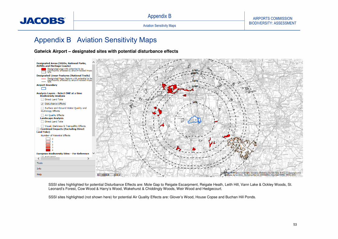
Appendix B AIRPORTS COMMISSION
BIODIVERSITY: ASSESSMENT Aviation Sensitivity Maps
53
Appendix B Aviation Sensitivity Maps
Gatwick Airport – designated sites with potential disturbance effects
SSSI sites highlighted for potential Disturbance Effects are: Mole Gap to Reigate Escarpment, Reigate Heath, Leith Hill, Vann Lake & Ockley Woods, St. Leonard’s Forest, Cow Wood & Harry’s Wood, Wakehurst & Chiddingly Woods, Weir Wood and Hedgecourt. SSSI sites highlighted (not shown here) for potential Air Quality Effects are: Glover’s Wood, House Copse and Buchan Hill Ponds.

Appendix C AIRPORTS COMMISSION
BIODIVERSITY: ASSESSMENT Compensation Calculations
54
Heathrow Airport – designated sites with potential disturbance effects.
SSSI sites highlighted for potential Disturbance Effects are: Staines Moor, Wraysbury Reservoir, Wraysbury and Hythe End Gravel Pits, Wraysbury No. 1 Gravel Pit, Kempton Park, Syon Park, Knight & Bessborough Reservoirs, Thorpe Park No.1 Gravel Pit, Langham Pond, Black Park, Frays Farm Meadows and Windsor Forest & Great Park. SSSI sites highlighted (not shown here) for potential Air Quality Effects are: Wraysbury No.1 Gravel Pit, Wraysbury & Hythe End Gravel Pits, Staines Moor and Kempton Park Reservoirs.

Appendix C AIRPORTS COMMISSION
BIODIVERSITY: ASSESSMENT Compensation Calculations
55
Appendix C Compensation Calculations
C1: Rate Assumptions
Habitat type
PV Rate -
Management
Agreement for
habitat creation
and
management**
PV Rate - Land
Purchase for
habitat creation
and management (
but excluding land
acquisition costs)**
Woodland £7,436/ha £3,404/ha
Hedgerow £18,380/km £8,047/km (est.)
Wetlands £11,072/ha £4,644/ha
Lowland Grassland £11,293/ha £4,946/ha
Avergage rate (used for
Protected Species and
Indirect Impacts
calculations) £9,934/ha £4,331/ha
**Habitat creation assumed
Assumption: Assessment year is 2014, costs begin in 2019 (start of construction loss)*
* including 60 years from construction year 2019
Woodland creation
60 Year assessmentPV (£ per hectare) Land Acquisition
Present Values (2009/2010)Woodland Management 6,469.3£ 7,436.0£
Land acquisition 23,294.5£ 3,404.0£ 20,333.0£
Present Values (2014) Woodland Management 7,242.7£ 8,324.9£ -£
Land acquisition 25,394.2£ 3,810.9£ 22,078.7£
Wetland Creation
60 Year assessmentPV (£ per hectare) Land Acquisition
Present Values (2009/2010) Management 9,632.6£ 11,072.0£
Land AcquisitionCreation24,547.3£ 4,844.0£ 20,333.0£
Present Values (2014) Management 10,784.2£ 12,395.6£ -£
Wetlands Land Acquisition 26,796.7£ 5,423.1£ 22,078.7£
Lowland grassland
60 Year assessmentPV (£ per hectare) Land Acquisition
Present Values (2009/2010) Management 9,824.9£ 11,293.0£
Land AcquisitionCreation24,636.0£ 4,946.0£ 20,333.0£
Present Values (2014) Management 10,999.4£ 12,643.0£ -£
Wetlands Land Acquisition 26,896.1£ 5,537.3£ 22,078.7£
Mixed habitat creation rates
60 Year assessmentPV (£ per hectare) Land Acquisition
Present Values (2009/2010) Management 8,642.6£ 9,934.0£
Land AcquisitionCreation24,101.0£ 4,331.0£ 20,333.0£
Present Values (2014) Management 9,675.8£ 11,121.6£ -£
Land Acquisition 26,297.1£ 4,848.8£ 22,078.7£
Land acquisition for rural land based on
average of £20,333 (RICS Economics, RICS Rural
Land Market Survey 2010)

Appendix C AIRPORTS COMMISSION
BIODIVERSITY: ASSESSMENT Compensation Calculations
56
C2: Gatwick Second Runway Direct Habitat Loss Compensation Areas and Costs
Type
GAL Jacobs Surface Access (1) GAL Jacobs Area ha
(6)
Management
Agreement
option rate £/ha
2014 (4)
Land Acquisition
option rate £/ha
2014 (5)
Management
Agreement
option £M
Land Purchase
Option £M
Designated Sites:
Willoughby Fields LNR/SNCI 20ha 25.8ha Not quantified
Rowley Wood SNCI Not specified 3.7ha Not quantified
Total Designated Sites* 20ha 29.5ha
Priority Habitats:
Deciduous woodland 62.1ha 62.1ha 13.4ha
2 to 1 ratio
suggested 151ha 151 7242.7 25394.2 1.09 3.83
Ancient woodland (taken
from within deciduous
woodland)(11)
14.2ha 14.2ha
3 to 1 ratio
suggested 71ha (5:1 ratio) 71 7242.7 25394.2 0.51 1.80
Traditional orchard Not specified 0.28ha Not specified 0.5ha 0.5 7242.7 25394.2 0.00 0.013
Hedgerow
49.7km (inc. 25.3km of
ancient hedgerow) Not calculated Not quantified 124.7km 62.4 18380 8047 1.15 0.50
Rivers & brooks (8)
3.5km 7.2 km Not quantified 14.3km 28.6 10784.2 26796.7 0.31 0.77
Protected species
Protected species outwith
designated sites and PHs (2)
Not specified 38.2ha(7)
Not specified 38.2ha 38.2 9675.8 26297.1 0.37 1.00
Indirect impacts (3)
Not specified Not specified 9898.2 26394.1 0.23 0.61
Total Habitat and
protected species 62.1 ha 92.09 ha 13.4 ha 124.2 ha (10)
283.7 ha 374.67 3.66 8.53
Total km 3.5 km 7.2 km 139 km
£3.69M £8.63M
Notes:
*Proposed mitigation values (ha and km) and associated cost estimates do not apply to designated sites as compensation addressed through Priority Habitat calculations to avoid double counting.
**Area multiplier ratio used for Jacobs suggested mitigation areas is 2:1 unless otherwise stated(1)
Jacobs suggested mitigation areas and cost estimates include our calculation of Potential Surface Access impacts(2)
To compensate for protected species outwith designated sites and priority habitats, Jacobs suggests a 10% mitigation allowance based on overal l land take(3)
Jacobs uses a 10% overall mitigation allowance, as a contingency against potential unforeseen indirect impacts (4)
Includes 60 year management costs based on Defra 2011 report: Costing potential actions to off set the impact of development on biodiversity (5)
Includes land acquisition costs plus 60 year management costs based on Defra 2011 report: Costing potential actions to off set the impact of development on biodiversity (6)
al l values converted to area with exception of hedgerows were rate relates to length(7)
10% of 382ha agricultural land to take account of potential protected species habitat(8)
River and Brooks also converted to area for cost and indirect impacts assuming 20m corridor (9)
Rates used for Management Agreement approach, and Land Purchase approach are shown in rates calculation table (10)
Area taken from Promoter's submission(11)
Ancient Woodland area includes areas within the footprint and also 6.2ha of woodland subject to clearance or management to comply with height clearance restrictions.
GAL note mitigation for 5.2 ha of this ancient woodland would avoid clearance however impact of proposals are uncertain at this stage and compensation for the whole area is included in Jacobs estimate.
IMPACT MITIGATION
11.5 23.0ha
Total Cost £Mrates £/ha (or £/km)Area (ha) or Lengths (km)Area (ha) or Lengths (km)
23.0
(Covered through
Priority habitat
compensation - see
below)11

Appendix C AIRPORTS COMMISSION
BIODIVERSITY: ASSESSMENT Compensation Calculations
57
C3: Heathrow Northwest Runway Direct Habitat Loss Compensation Areas and Costs
Type
HAL Jacobs Surface Access (1)
HAL Jacobs Area ha(6)
Management
Agreement
option rate
£/ha 2014 (4)
Land Acquisition
option rate
£/ha2014 (5)
Management
Agreement
option £M
Land Purchase
option £M
Designated Sites:
Lower Colne SMINC 51ha 51ha Not quantified
Old Slade Lakes LWS 8ha 8ha Not quantified
Stanwell II SNCI 6ha 6ha Not quantified
Total Designated Sites* 65ha 65ha
Priority Habitats:
Deciduous woodland 34ha 37.3ha 20.0ha Not quantified 114.6ha 114.6 7242.7 25394.2 0.83 2.91
Traditional orchard 1.5ha 1.5ha 1.35ha Not quantified 5.7ha 5.7 7242.7 25394.2 0.04 0.145
Rivers & brooks (8)
13km 12.3km Not quantified 24.6km 49.2 10784.2 26896.1 0.53 1.32
Lowland meadows 9.2ha 18.4ha 18.4 11252.3 27006.8
Reedbed 0.3ha 0.6ha 0.6 10784.2 26905.2 0.01 0.02
Protected species:
Protected species
outwith designated
sites and PHs (2)
23.5ha(7)
Not specified 23.4 23.4 9675.8 26297.1 0.23 0.62
Indirect impacts (3)
8.68 Not quantified 17.36 17.36 9675.8 26297.1 0.17 0.46
Total Habitat and
protected species 35.5 ha 70.88ha 30.85ha 331ha (from 400ha )10
180.06 ha 229.26
Total Km 13 km 12.3 km 24.6 km
Notes:
*Proposed mitigation values (ha and km) and associated cost estimates do not apply to designated sites as compensation addressed through Priority Habitat calculations to avoid double counting.
** Area multiplier ratio used for Jacobs suggested mitigation areas is 2:1 unless otherwise stated(1)
Jacobs suggested mitigation areas and cost estimates include our calculation of Surface Access impacts(2)
To compensate for protected species outwith designated sites and priority habitats, Jacobs suggests a 10% mitigation allowance based on overall land take(3)
Jacobs uses a 10% overall mitigation allowance, as a contingency against potential unforeseen indirect impacts (4)
Includes 60 year management costs based on Defra 2011 report: Costing potential actions to off set the impact of development on biodiversity (5)
Includes land acquisition costs plus 60 year management costs based on Defra 2011 report: Costing potential actions to off set the impact of development on biodiversity (6)
Al l values converted to area with exception of hedgerows were rate relates to length(7)
10% of 235ha agricultural land to take account of potential protected species habitat(8)
River and Brooks also converted to area for cost and indirect impacts assuming 20m corridor (9)
Rates used for Management Agreement approach, and Land Purchase approach are shown in rates calculation table (10)
Area taken from Promoter's submission
IMPACT
Rates £/ha Total Costs £M
MITIGATION
Areas (ha) or lengthts (km)Area (ha)/Lengths (km)
£1.80 £5.47
(Covered through
Priority habitat
compensation - see
below)*
£1.8 M £5.47 M

Appendix C AIRPORTS COMMISSION
BIODIVERSITY: ASSESSMENT Compensation Calculations
58
C4: Heathrow Extended Northern Runway Direct Habitat Loss Compensation Areas and Costs
Type
Hub Jacobs Surface Access(1) Hub Jacobs Area ha
(6)
Management
Agreement
option £/ha rate
2014 (4)
Land
Acquisition
option £/ha
rate 2014 (5)
Management
Agreement
option £M
Land
Purchase
option £M
Designated Sites:
East Poyle Meadows SNCI 2.9ha 2.9ha 4ha swamp
Arthur Jacob LNR 4.1ha 4.1ha
8.2ha wet
woodland
Greenham's Fishing Pond
SINC Not specified 0.45ha 26ha pond
Management Unit 1 (Poyle
Meadow) of Staines Moor
SSSI 8.7ha 8.0ha
18ha species-rich
neutral grassland
Lower Colne SMINC Not specified 10-15ha 40ha
River Colne (From County
boundary to Staines Moor)
Stanwell Moor SNCI Not specified 1.25ha Not specified
Total Designated Sites* 15.7ha 31.7ha
Priority Habitats:
Deciduous woodland 16.2ha 26.2ha 30.1ha 32.4ha 122.4ha 122.4 7409.2 25470.4 0.91 3.12
Traditional orchard 0.5ha 0.5ha 1ha 1ha 1 7409.2 25470.4 0.01 0.03
Lowland meadows 8.6ha 6.5ha 32.4ha 17.2ha 77..8a 77.8 11252.3 27006.8 0.88 2.101
Reedbeds Not specified 0.3ha 8.0ha Not specified 16.6ha 16.6 11032.1 26905.2 0.18 0.45
Rivers & brooks (8)
6.8km 10.4km 6.8km 20.8km 41.6 11032.1 26905.2 1.35 1.12
Protected species
Protected species outwith
designated sites and PHs (2)
Not specified 16.8ha Not specified 16.8ha 16.8 9839.2 26394.1 0.17 0.44
Indirect impacts (3)
7.1ha 14.2ha 14.2 9839.2 26394.1 0.14 0.37
Total ha Habitat and
protected species habitat 25.3 ha 57.4ha 70.5 ha 146.8 ha (10)
248.8 ha 290.4 3.63 7.63
Total km habitat 6.8 km 10.4 km 6.8 Km 20.8 km £3.63M £7.63M
Notes:
*Proposed mitigation values (ha and km) and associated cost estimates do not apply to designated sites as compensation addressed through Priority Habitat calculations to avoid double counting.
**Area multiplier ratio used for Jacobs suggested mitigation areas is 2:1 unless otherwise stated(1)
Jacobs suggested mitigation areas and cost estimates include our calculation of potential Surface Access impacts(2)
To compensate for protected species outwith designated sites and priority habitats, Jacobs suggests a 10% mitigation allowance based on overal l land take(3)
Jacobs uses a 10% overal l mitigation al lowance, as a contingency against potential unforeseen indirect impacts (4)
Includes 60 year management costs based on Defra 2011 report: Costing potential actions to off set the impact of development on biodiversity (5)
Includes land acquisition costs plus 60 year management costs based on Defra 2011 report: Costing potential actions to off set the impact of development on biodiversity (6)
Al l values converted to area with exception of hedgerows were rate relates to length(7)
10% of 168ha agricultural land to take account of potential protected species habitat(8)
River and Brooks also converted to area for cost and indirect impacts assuming 20m corridor (9)
Rates used for Management Agreement approach, and Land Purchase approach are shown in rate calculation table (10)
Area taken from promoter's submission
(Covered through
Priority habitat
compensation - see
below)*
IMPACT
Rates £/ha Total Costs £M
MITIGATION
Area (ha) or lengths (km)Area (ha) or Lengths (km)***

Appendix D AIRPORTS COMMISSION
BIODIVERSITY: ASSESSMENT Birdstrike Report
59
Appendix D: Birdstrike Report
The Birdstrike Risk, Needs For Management, and Associated
Biodiversity Impacts For Proposed Additional Runways at London
Heathrow and London Gatwick Airports
John Allan
Head of National Wildlife Management Centre
Animal Health and Veterinary Laboratories Agency
Sand Hutton
York
YO41 1LZ, UK

Appendix D AIRPORTS COMMISSION
BIODIVERSITY: ASSESSMENT Birdstrike Report
60
Introduction
1 Background
Collisions between wildlife and aircraft have been a recognised hazard to
aviation since the development of the first powered flight in 1910. Whilst all
wildlife has the potential to cause damage to an aircraft during a collision, in
the context of Heathrow and Gatwick the vast majority of the hazard arises
from birds. Hence the remainder of this document will refer only to the
birdstrike risk the two sites.
The first human fatality caused by a birdstrike occurred in 1912, and to date
birdstrikes have been responsible for the loss of at least 108 aircraft and 276
lives in civil aviation (Thorpe 2010). As well as a threat to life, less severe
birdstrike incidents result in significant operational costs to the industry, either
directly, in terms of the costs of damage to aircraft, or as a result of delays
and cancellations arising from the need for precautionary checks or
emergency return to an airport after a strike has occurred. These costs are
estimated to be a minimum of $1.2 billion per year for the world civil aviation
industry (Allan 2002). As well as the costs to the airlines, there are the on-
going costs to airport operators of habitat management and bird deterrence
operations that are needed to reduce the numbers of birds on and around the
airport to acceptable levels (Allan 2002).
In order to control the birdstrike risk, the International Civil Aviation
Organisation (ICAO) has implemented a series of standards and
recommended practices (SARPS) that require states to ensure that airports
under their control manage the birdstrike risk effectively. In the UK, the Civil
Aviation Authority (CAA) implements the ICAO SARPS by requiring airport
license holders to manage the birdstrike risk as part of their licensing
procedures (CAA 2010). The CAA provides guidance on how this should be
carried out in their publication CAP 772 Bird Control on Aerodromes (CAA
2008) which is currently undergoing revision.
The actions needed to control the birdstrike risk at UK aerodromes are well
understood (e.g. Allan 2006), and these can be extrapolated to airport
expansions, providing sufficient information about the numbers of hazardous
birds, existing birdstrike rate, current birds control practices etc. are available.
Unfortunately, most environmental surveys carried out by developers and
their consultants concentrate on counting birds at specific locations to assess
the ecological importance of particular sites that may be impacted, and often
focus on less common species or on sites with conservation designations or
other protected status. For birdstrike risk, however, it is the movements of the
birds from place to place that are the most significant because it is when
birds cross the active airspace that they pose the greatest risk to aircraft. It is

Appendix D AIRPORTS COMMISSION
BIODIVERSITY: ASSESSMENT Birdstrike Report
61
also obviously the case that most birdstrikes are caused by common species
that are most abundant around the airfield, and these are frequently not
recorded in many ornithological surveys. For example, in the cases of
Heathrow and Gatwick, information on the numbers and movements of gulls
at the former and Woodpigeons at the latter would be of particular
importance but have not been provided in the initial submissions.
All licensed civil airports in the UK are required to have an effective plan in
place to monitor and manage the birdstrike risk at the airport. This plan is
periodically audited by the CAA are part of their routine safety audit
procedures. It is important to note, however, that risks arising from outside
the airport property may be impossible for the airport to control. Nearby
landowners are not obliged to allow the airport access to their property to
disperse hazardous birds, nor are they required to manage their property to
deter hazardous birds from frequenting the area. This means that once
features that attract hazardous birds are developed near an airport it can be
very difficult to have them removed or otherwise managed to control the risk.
It is therefore key to any airport development that it does not either introduce
features that will attract more hazardous birds or include features that will
change the behaviour of the existing hazardous birds in a way that increases
the risk (e.g. by making it more likely that they will fly across the active
airspace), and finally that it does not change the behaviour of the aircraft in a
way that makes it more likely that they will encounter birds (e.g. by moving a
runway closer to known bird concentrations).
This document provides an overview of the likely birdstrike risks that will arise
from the proposals to develop an additional runway at Heathrow or Gatwick
and the likely management actions that will be needed to control these risks.
It also describes the type of data that need to be gathered in order to allow a
more detailed evaluation of the likely risk levels for the different proposals,
and hence to refine the type and level of management that would be needed.
Some of these data may already have been gathered by the airports
themselves as part of their routine monitoring of their birdstrike risk (for
example many airports monitor bird attractive sites outside the airport
perimeter and count the common birds present), but this assessment relies
only on the information provided by the applicants in their submissions.
2 Assumptions
Many of the assumptions used in developing impact assessments regarding
noise, air quality etc. routinely project forward into the future by periods of 10
to 50 years. In the case of birdstrike, any change in the environment around
the airport has the potential to impact on local bird populations and hence on
the birdstrike risk. Similarly, longer term changes in bird populations at the
local or national level may increase or reduce the numbers of birds of

Appendix D AIRPORTS COMMISSION
BIODIVERSITY: ASSESSMENT Birdstrike Report
62
particular species in the area and thus change the birdstrike risk. Rather than
attempt to predict all of these changes, this paper uses the current bird
populations around the airports as a benchmark, and does not attempt to
project the risk or its associated management needs, forward into the future.
This is because there will be a need to manage the birdstrike risk from day 1
of the new runway operation and any subsequent changes in the populations
or behaviour of the local birds that impacts on risk will be dealt with by
adjustments in the bird control practices which would be made as part of the
routine bird control processes. The bird control will thus evolve to take
account of changes in risk, and it is the bird management that needs to be in
place to cope with the step-change resulting from the opening of an
additional runway that is key to this assessment.
3 Gatwick Airport Second Runway
The Gatwick Airport Second Runway scheme involves developing a new
parallel runway to the south of the airport (see Figure.3.1).
Figure 3.1 Gatwick Airport Second Runway - Proposed Runway Location

Appendix D AIRPORTS COMMISSION
BIODIVERSITY: ASSESSMENT Birdstrike Report
63
3.1 Current Birdstrike Risk and management at Gatwick Airport
Gatwick is situated in an area that consists of a complex of arable fields,
hedgerows and small woodlands, interspersed with small villages. The larger
towns of Crawley and Horley are located to the south and north-east of the
airport respectively. The airport is located on the floodplain of the R Mole
which skirts the airport to the north and a number of small balancing ponds
exist that may attract ducks or geese in low numbers. The birdstrike sample
is likely to consist of a mixture of common agricultural bird species (pigeons
corvids, Starlings and Gulls, plus the normal range of smaller birds such as
Skylark, hirundines, Swift etc.).
3.2 Likely Future Risk: Gatwick Airport Second Runway
Because the proposed new runway is on a similar alignment to the existing
one and will sit in the same habitat type, the overall birdstrike risk per flight
on the new runway is likely to be similar to that on the existing site, providing
that any environmental mitigation for lost habitats is appropriately designed
and sited.
3.3 Additional Risks from Environmental Mitigation: Gatwick Airport
Second Runway
The majority of the environmental mitigation proposed (RPS, 2014) involves
compensation for loss of woodland, hedgerows and rivers and smaller
streams and ditches. The submission acknowledges the need to manage
birdstrike risk (e.g. by netting lengths of river that pass through the
approaches close to the runway thresholds to exclude hazardous birds) and
also proposes that environmental offsetting (development of land of
equivalent or greater conservation value elsewhere) should be a feature of
the proposal. Although the location of this offsetting is yet to be determined,
providing that it is far enough away from the airfield that it does not impact on
the birdstrike risk, this is a preferable option to attempting to create
environmental mitigation close to a new runway development and has the
potential to actually reduce the birdstrike risk if habitat that attracts hazardous
birds is removed and recreated elsewhere.
3.4 Conclusions: Gatwick Airport Second Runway
The proposal for Gatwick Airport Second Runway does not pose significant
problems in terms of birdstrike. The majority of the mitigation involves
woodland replacement and the small amount of wetland mitigation involved
small streams and ditches that will be netted to exclude hazardous birds
where necessary. The careful design and location of any proposed mitigation
that has to be sited close to the airport, combined with the suggested
offsetting of additional mitigation elsewhere (subject to the selection of

Appendix D AIRPORTS COMMISSION
BIODIVERSITY: ASSESSMENT Birdstrike Report
64
appropriate locations) should allow this proposal to proceed with
comparatively few additional birdstrike issues.
4 Heathrow Airport Northwest Runway
4.1 Current Birdstrike Risk and Management at Heathrow Airport
Heathrow lies in a semi-urban environment, comprising a mosaic of domestic
dwellings with gardens, light industrial buildings and ancillary buildings for the
airport such as hotels and car parking. These areas are interspersed with
agricultural fields, primarily growing arable crops, and grassed areas such as
sports pitches and grazing pasture for horses. These habitats support an
assemblage of common bird species such as pigeons, corvids, Starlings,
Kestrel and Gulls, as well as smaller species such as Hirundines, Swift,
finches pipits etc. These species are typical of many airports in the UK, but
where Heathrow differs is in the presence of several very large water supply
reservoirs and the complex of flooded mineral extractions in the Thames and
Colne valleys which lie to the south and west of the airport.
The western approach to the northern runway passes over the R.Thames,
Queen Mother Reservoir and the R.Coln, whilst the western approach to the
southern runway crosses the R.Thames, the complex of flooded gravel pits
between Horton and Wraysbury, Wraysbury Reservoir itself and the R.Coln.
The normal mixture of birds that would be expected at a UK airport is
therefore augmented by very large numbers of gulls that roost on the
reservoirs in the winter, for example over 18,000 gulls were recorded roosting
on Queen Mother reservoir in February 2013 (P. Cropper pers. Comm.) and
by large numbers of waterfowl that occupy these reservoirs and gravel pits all
year round. These wetland areas also attract smaller numbers of other
hazardous species such as cormorant and grey heron. The larger than
normal numbers of wetland bird species in the area means that any
development that influences the number or behaviour of these birds, or
brings the aircraft into closer proximity to them, has the potential to increase
the birdstrike risk, unless appropriate mitigating action is taken.
Evidence suggests that the overall strike rate per 10,000 aircraft movements
is low compared to other airports in the UK and to other large international
airports around the world.

Appendix D AIRPORTS COMMISSION
BIODIVERSITY: ASSESSMENT Birdstrike Report
65
4.2 Likely Future Risk: Heathrow Airport Northwest Runway
Figure 4.1 Heathrow Airport Northwest Runway: proposed runway location
The Heathrow Airport Northwest Runway scheme involves the creation of an
additional runway to the north west of the existing airport (see Figure 4.1).
The expanded airport footprint will remove a number of agricultural fields that
attract significant numbers of pigeons and particularly Canada Geese
following the harvesting period and that also attract gulls following ploughing
and seed sowing activities. This benefit is likely to be offset by the fact that
the western threshold of the new runway will be significantly closer to Queen
Mother reservoir, which supports a very large gull roost numbering up to
20,000 birds during the winter months (P Cropper pers. comm.), as well as a
significant number of other waterfowl. At present aircraft departing to, or
arriving from, the west are high enough when passing over the reservoir that
they rarely encounter roosting gulls.
Moving the runway closer to this reservoir may mean that aircraft arriving or
departing on the western end will be low enough to conflict with gulls
spiralling over the reservoir or those arriving at the roost from feeding sites,
such as landfills, situated to the north or north east. This would create a
significant additional birdstrike risk which would need to be managed. One of

Appendix D AIRPORTS COMMISSION
BIODIVERSITY: ASSESSMENT Birdstrike Report
66
the options for locating a new runway at Manchester Airport was discounted
because it would have resulted in aircraft overflying Rosthserne Mere which
supported a large gull roost. An assessment of the likely collision rate with
gulls had this option been developed concluded that the risk was
unacceptable and an alternative alignment was chosen. Further work is
therefore needed to determine the arrival directions and flight altitude of birds
using Queen Mother Reservoir in particular, and the reservoirs to the west of
Heathrow in general, so that the likely additional risk can be properly
assessed. If this work indicates that mitigation action is required, the best
option is probably to use lasers to disperse the birds as they arrive at the
roost site. This has been successfully implemented in trials elsewhere as a
means of dispersing a large gull roost Baxter & Allan (2007). Roost dispersal
could be combined with implementing bird control on any local landfill sites
that gulls are feeding on prior to moving to the reservoir to roost (Allan &
Baxter 2000). Any mitigation that involves large scale bird dispersal from the
reservoir has the potential to adversely impact on non-hazardous birds of
conservation concern that currently use the site.
4.3 Additional Risks from Environmental Mitigation: Heathrow
Airport Northwest Runway
The submission for this option contains a commitment to extensive mitigation for lost habitat as well as improvement of existing habitat for wildlife, creation of new habitat and development of outdoor leisure opportunities around the airport. The proposals include creation of wetlands, flood meadows, woodland, open water and marginal habitats etc.. All of these areas have the potential to attract hazardous birds to the area or to change the behaviour patterns of birds that are already present and thus create an additional birdstrike risk. The need to manage the birdstrike risk is acknowledged in the submission (AMEC 2014) in section 4.3: ‘There is a need to consider the potential for enhanced bird strike risk as a result of
the creation of new wetlands as part of the enhanced Colne Valley habitat creation
and enhancement proposals. To minimise this risk, careful attention will be paid to
ensuring that ducks, geese and gulls are not attracted to areas where they could
present an unacceptable bird strike risk (e.g. by only creating small waterbodies
except outside aircraft flight tracks where bird strike is less of a concern i.e. to the
south of the Airport). In such areas, open water habitats will be designed to attract
only those bird species that do not present such a risk (e.g. moorhen, and warblers
and other perching birds) together with other groups of species such as dragonflies and
amphibians.’
It is, however, often very difficult to redesign environmental mitigation schemes to exclude hazardous species without reducing their effectiveness as a mitigation measure to a greater or lesser extent. For example, steepening banks of water bodies and removing shallow margins to remove potential breeding sites for feral geese, reduces habitat for marginal plants, invertebrates and amphibians, as well as creating a potential health and

Appendix D AIRPORTS COMMISSION
BIODIVERSITY: ASSESSMENT Birdstrike Report
67
safety issue for the public. Similarly, creating woodland and scrubland that is suitable for species of conservation concern may provide communal roosting sites for pigeons, corvids or Starlings, all of which can pose significant risks to aircraft. Simply moving the mitigation away from the approach and departure corridor is, in itself, not sufficient as a precaution, because creating an attractive habitat to one side of the airfield when there is existing habitat on the opposite side may result in birds regularly crossing the active airspace to move from one site to the other thus increasing the risk. The best option to solve these issues is to move the mitigation actions far enough away from the airport that the impact on birdstrike risk becomes negligible. Although this runs counter to normal practice, where mitigation is carried out as close to the original site as possible, in the case of airports moving the mitigation further away would allow designers greater freedom to develop top class mitigation sites without the restriction imposed by the need to consider birdstrike risk as a design limitation. If the mitigation cannot be moved further away e.g. in the case of rivers, detailed scrutiny and, potentially, extensive modification of the design and location of the proposed mitigation will be needed, and this may, in some instances, reduce its effectiveness as a mitigation for loss of biodiversity. 4.4 Heathrow Airport Northwest Runway - Conclusions
Heathrow Airport Northwest Runway scheme offers some birdstrike benefits
in that it will remove some habitat close to the airport that is attractive to
hazardous birds. However, the new runway is significantly closer to Queen
Mother reservoir which supports a very large gull roost. This issue has not
been addressed and might require dispersal of the roost which would have
additional ecological impacts. The proposed mitigation will create large
quantities of new habitat close to the airport that has the potential to increase
the overall birdstrike risk. The promoter states that new habitat will be
designed to avoid increasing the birdstrike risk, but it is not clear how this can
be achieved whilst maintaining the mitigation value of the new Habitats
created. Offsetting habitat loss by creating new habitat further from the
airport would solve these problems.
5. Heathrow Airport Extended Northern Runway
5.1 Current Birdstrike Risk and Management at Heathrow Airport
Heathrow lies in a semi-urban environment, comprising a mosaic of domestic
dwellings with gardens, light industrial buildings and ancillary buildings for the
airport such as hotels and car parking. These areas are interspersed with
agricultural fields, primarily growing arable crops, and grassed areas such as
sports pitches and grazing pasture for horses. These habitats support an
assemblage of common bird species such as pigeons, corvids, Starlings,
Kestrel and Gulls, as well as smaller species such as Hirundines, Swift,

Appendix D AIRPORTS COMMISSION
BIODIVERSITY: ASSESSMENT Birdstrike Report
68
finches pipits etc. These species are typical of many airports in the UK, but
where Heathrow differs is in the presence of several very large water supply
reservoirs and the complex of flooded mineral extractions in the Thames and
Colne valleys which lie to the south and west of the airport.
The western approach to the northern runway passes over the R.Thames,
Queen Mother Reservoir and the R.Coln, whilst the western approach to the
southern runway crosses the R.Thames, the complex of flooded gravel pits
between Horton and Wraysbury, Wraysbury Reservoir itself and the R.Coln.
The normal mixture of birds that would be expected at a UK airport is
therefore augmented by very large numbers of gulls that roost on the
reservoirs in the winter, for example over 18,000 gulls were recorded roosting
on Queen Mother reservoir in February 2013 (P. Cropper pers. Comm.) and
by large numbers of waterfowl that occupy these reservoirs and gravel pits all
year round. These wetland areas also attract smaller numbers of other
hazardous species such as cormorant and grey heron. The larger than
normal numbers of wetland bird species in the area means that any
development that influences the number or behaviour of these birds, or
brings the aircraft into closer proximity to them, has the potential to increase
the birdstrike risk, unless appropriate mitigating action is taken.
Evidence suggests that the overall strike rate per 10,000 aircraft movements
is low compared to other airports in the UK and to other large international
airports around the world.
5.2 Likely Future Risk: Heathrow Airport Extended Northern Runway
The Heathrow Airport Extended Northern Runway scheme involves
extending the existing northern runway to the west, and operating in dual-
mode with landings and departures on the same runway at the same time
(see Figure 4.1).

Appendix D AIRPORTS COMMISSION
BIODIVERSITY: ASSESSMENT Birdstrike Report
69
Figure 5.1 Heathrow Airport Extended Northern Runway: proposed
runway location
The proposal acknowledges that this will mean that the western threshold of
the extended runway will be significantly closer to the complex of reservoirs
and gravel pits to the west of the airport. The submission (URS 2014) goes
on to conclude that there will be no additional risk to aircraft, nor need for
additional off site bird control, based on an analysis of waterfowl movements
around the area.
‘Interruption of Bird Flight-paths, Bird-strike 3.10.1 and Bird Control Measures
The runway extension will be located 364m north of Wraysbury Reservoir which is
closer than the current distance of 900m from Staines Reservoirs from the southern
runway). However, 350-400m is still a considerable distance and in situations such
as this in which the reservoir is already overflown the altitude of overflights is likely
to be more of an issue than the lateral distance. There is no reason to conclude that
bird control measures would need to be more extensive than currently undertaken
for Heathrow airport, nor would they need to take place outside the airport
boundary. From the Briggs PhD research it is known that there is an observed
flightpath for waterfowl between the Queen Mother Reservoir and Wraysbury
Gravel Pits to the south. No flightpath between Queen Mother Reservoir and
Wraysbury Reservoir was identified and even if such a flightpath existed the
geographical positioning of those waterbodies relative to both each other and the
northern runway extension are such that there would be no requirement for
waterfowl to fly through the extended airport boundary and runway airspace in

Appendix D AIRPORTS COMMISSION
BIODIVERSITY: ASSESSMENT Birdstrike Report
70
order to travel between the two reservoirs. Although aircraft will be flying over the
reservoirs/gravel pits they will be doing so at an altitude of at least 1000 feet
(305m)63 which is much higher than the likely flight altitude of waterfowl travelling
between the gravel pits and reservoirs in the area. As such no increased risk of bird
strike is likely to arise.’
Unfortunately the main risk to aircraft that arises from these waterbodies
comes from the very large winter gull roosts that occur there. On clear, still
winter days, gulls may commute into their roosting sites at altitudes in excess
of those quoted for aircraft, and may also soar above roost sites at similar
heights. Gulls also routinely move between the larger reservoirs when
arriving at roost or during the night (possibly in response to changing weather
conditions) and there are regular movements of many hundreds of gulls
between Queen Mother reservoir and Wraysbury reservoir (pers.obs.).
It is highly likely that this scheme will result in a significantly elevated
birdstrike risk from gulls, and this risk would need to be mitigated by dispersal
of the roost from the water bodies concerned and/or from feeding sites that
result in flightlines of birds that cross the active airspace at a height which
results in an increased risk. One of the options for locating a new runway at
Manchester Airport was discounted because it would have resulted in aircraft
overflying Rosthserne Mere which supported a large gull roost. An
assessment of the likely collision rate with gulls had this option been
developed concluded that the risk was unacceptable and an alternative
alignment was chosen. At the very least, a full assessment of the heights at
which gulls fly over the reservoirs and a modelling exercise to determine
likely collision rates should be carried out as part of the assessment process
for this option and necessary mitigation measures included in the submission
if this proves necessary.
4.3 Additional Risks from Environmental Mitigation: Heathrow
Airport Extended Northern Runway
The total amount of mitigation required is detailed in the proposal, along with
a number of sites where such mitigation could be carried out. The mitigation
includes 26ha of lakes and ponds, the location of which could have a
significant impact on the birdstrike risk at the airport. It would be preferable to
move any environmental mitigation that might attract hazardous birds as far
away from the airport as possible, which would both allow the mitigation
impact to be maximised because the need to compromise designs to reduce
birdstrike risk would be removed and also result in an overall safety benefit to
the airport as bird attracting habitat close to the site will be removed and re-
created at a safer distance.
Appendix D AIRPORTS COMMISSION
BIODIVERSITY: ASSESSMENT Birdstrike Report
71
4.4 Conclusions: Heathrow Airport Extended Northern Runway
Heathrow Airport Extended Northern Runway removes some bird attracting
habitat in the Western approaches, but moves the western threshold of the
runway to within a few hundred metres of Queen Mother and Wraysbury
reservoirs. The close proximity of the large gull roosts on these reservoirs will
create a significant additional birdstrike risk which has not been addressed in
the submission. This may require management of roosting gulls on the
reservoirs which may have additional environmental impacts that have not
been included in the submission. The detailed location of proposed
environmental mitigation is not provided at this stage, but any mitigation
involving creation of wetlands near to the runways has the potential to create
additional risks. Offsetting mitigation at a safe distance from the airfield would
overcome these issues.
7 References
Allan, J. R. (2002) The Costs Of Birdstrikes And Birdstrike Prevention. pp 147-153 in Clarke L. (ed.) Human Conflicts With Wildlife: Economic Considerations. US Department of Agriculture, Fort Collins. Allan, J.R. (2006) A heuristic risk assessment technique for birdstrike management at airports. Risk Analysis 26: 723-727.
Allan, J.R. & Baxter, A. (2000) An Evaluation of Techniques for the Control of
Birds on Landfills Near Airports. Proc Birdstrike Committee USA/Canada 2nd
Annual Meeting Minneapolis.
AMEC (2014) Heathrow’s North West Runwat Biodiversity Assessment. AMEC plc. Baxter, A.T. & Allan, J. R. (2007). Active bird control Measures Trial, report to Thames water 41pp.
CAA (2008) CAP 772 Birdstrike risk Management for Aerodromes. Civil Aviation Authority London. CAA (2010) CAP 168 Licensing of Aerodromes Civil Aviation Authority, London. Department for Transport (2005) Safeguarding aerodromes, technical sites and military explosives storage areas RPS (2014) Gatwick R2 Updated Scheme Design For Airports Commission May 2014 Biodiversity Appendix.

Appendix D AIRPORTS COMMISSION
BIODIVERSITY: ASSESSMENT Birdstrike Report
72
Thorpe, J. (2010) Update on fatalities and destroyed civil aircraft due to bird strikes with appendix for 2008 & 2009 Proceedings of International Birdstrike Committee 29, Cairns. URS (2014) Heathrow Expansion Attachment 5-1, URS Plc.