Embed Size (px)
Citation preview

2016 UNDERWATER
BRIDGE INSPECTION REPORT
BRIDGE #
DISTRICT: COUNTY: CITY/TOWNSHIP:
Date of Inspection:
Equipment Used:
Inspected By:
Report Written By:
Report Reviewed By:
Final Report Date:
66520
TWP 51 over STRAIGHT RIVER
District 6 Rice WALCOTT
05/25/2016
A-62
Owens, Garrett
Garrett Owens
County Highway AgencyOwner:
MinnesotaSTATE:

UNDERWATER SUMMARY 3
UNDERWATER INSPECTION 4
UNDERWATER INSPECTION PROCEDURES 6
STRUCTURE INVENTORY 7
ELEMENTS 8
PICTURES 12
DRAWINGS 15
TABLE OF CONTENTS
PAGE NUMBER

Contractor:
(A) Monitor concrete deterioration at the concrete column encasements during future underwater inspections.
(B) Remove timber debris at the piers.
(C) Reinspect the submerged substructure units at the normal maximum recommended (NBIS) interval of sixty (60) months.
Collins Engineers, Inc.
9687Contractor Job Number:
RECOMMENDATIONS
REPORT SUMMARY
UNDERWATER INSPECTION
The substructure units inspected at Bridge No. 66520, Piers 1 and 2, were found to be in good to satisfactory condition with no defects of structural significance observed. The channel bottom appeared stable with no significant scour, although with a heavy accumulation of timber debris present at Pier 1. Additionally, there is timber debris up to 5 inches in diameter along the upstream piles of pier 2. The concrete encasements along the lower portions of the columns exhibited spalling/section loss with up to 3 to 6 inches of penetration.
(A) Timber debris was observed along the west face of Pier 2 that consisted of a full tree and smaller branches and extended from the channel bottom to the bottom of the cap.
(B) The columns of Pier 2 were encased in up to 6 inches of additional concrete from the channel bottom to 1.1 feet above the waterline. The encasements exhibited form irregularities (embedded form boards) and spalling with up to 3 inches of penetration.
(C) The columns of Pier 1 were encased in up to 6 inches of additional concrete from the channel bottom to 2.8 feet above the waterline. The encasements exhibited form irregularities (embedded form boards) and spalling with up to 6 inches of penetration.
(D) The channel bottom material consisted of bedrock at the upstream and downstream columns with up to 2 inches of gravel and soft silt infilling along the middle columns with minimal probe rod penetrations.
(E) A hard bottom was found up to 3 feet to the east upstream end of Pier 2.
(F) Timber debris up to 5 inches in diameter is present near the upstream piles of Pier 1.
INSPECTION FINDINGS
Page 3 of 16

The top of the pier cap on the south end of Pier 1.Water Level Reference:
WATERLINE DATUM
Waterline Elevation (feet):
The waterline was approximately 11.6 feet below reference.Description:
88.4
4.
Piers 1 and 2.Substructure(s) Inspected:
SUBSTRUCTURE INSPECTION DATA
General Shape:
3.2 Maximum Water Depth at Substructure(s) Inspected (feet):
The piers each consist of four round concrete columns supporting an oblong concrete pier cap.
Code:Item 62: Culvert:
6
Y 48 05/2016 Code:Item 92B: Underwater Inspection:
Code:
(Minnesota specific codes are used for 92B and 113)
NBIS CODING INFORMATION5.
Item 60: Substructure:
Item 61: Channel and Channel Protection:
6Code:
District 6District:
TWP 51
County:
The bridge consists of three spans of multiple steel stringers supporting a reinforced concrete deck. The superstructure is supported by two reinforced concrete abutments and two reinforced concrete piers. The piers are labeled Piers 1 and 2 starting from the east end of the bridge.
Bridge Description:
066 - Rice
Facility Carried:
BRIDGE DATA1.
UNDERWATER INSPECTION
Bridge #:
STRAIGHT RIVERFeature Intersected:
66520
Underwater Visibility (feet):
Cloudy, 80°FWeather Conditions:
1.0
3.
0.5 Waterway Velocity (ft/sec):
05/25/2016
Professional Engineer/Team Leader:
INSPECTION DATA2.
Cory R. Stuber, P.E.
Date of Underwater Inspection:
Garrett R. Owens, P.E.Inspection Diver:
Page 4 of 16

885 Scour 1 EA 1
STRUCTURAL ELEMENT CONDITION RATING
Conditions
6.
I
Bridge is scour critical because abutment or pier foundation is rated as unstable due to observed scour at bridge site.
Item 113: Scour Critical Bridge: Code:
No (Mark your selection with an X)Yes X
205
CS3 CS4
Reinforced Concrete Column 88 EA
CS2ELEM # Unit CS1Element Description Quantity
Page 5 of 16

The routine underwater inspection of Bridge 66520 (TWP 51 over the Straight River) was completed on May 25, 2016. The underwater inspection was conducted from shore. The inspection was conducted by a team consisting of a PE-Diver with a valid MnDOT Team Leader certification, a backup diver and a dive tender. Due to waterway conditions at the time of inspection, the inspection could be accomplished by wading in accordance with OSHA regulations. Profiles were taken along the upstream and downstream faces of the bridge and around the periphery of substructure units to determine the presence, location and area of scour.
The bridge elements inspected consisted of Piers 1 and 2. According to the bridge inventory or design drawings, Piers 1 and 2 consist of four round concrete columns supporting an oblong concrete pier cap.. Inspection procedures followed FHWA guidance and the MnDOT Bridge and Structure Inspection Program Manual with channel bottom probing to search for foundations. The routine underwater inspection frequency is recommended to remain at a maximum of 60 months based on those findings and risk factors. Also, inspection procedures should continue to follow the above approach and standard guidance with 100% Level I and 10% Level II intensity efforts.
INSPECTION PROCEDURES
UNDERWATER INSPECTION
Page 6 of 16

Spec. Feat.Pier Foundation (Material/Type)
1 - CONCCantilever ID
+ W A T E R W A Y +Number of Spans Historic Status
4 - PILE BENT
Underwater Y 60Culvert Type 3 - FTG PILE
Pinned Asbly. N
05/25/2016
Barrel Length
210.6 ft. Navigation Control
Waterway Opening (sf.) 1907Structure Length
ft. Year Painted 1979
0 - No nav. control on waterwayDeck Width (Out-to-Out) 35.3
+ P A I N T +
APPR: 0 TOTAL:5 - Not eligible
MAIN: 3
Main Span Length 80.0 ft.Drainage Area (sq. mi.) 431.5
B R I D G E D A T A +Main Span Detail
0 - SUBSTANDARD+ M I S C.
Appr. Span Type Structure Flared
GR Termini 0 - SUBSTANDARD
Appr. Guardrail
Main Span Type 4 - Steel Continuous Median Width On Bridge
ft. Bridge Railing 1 - MEETS STANDARDS
0 - SUBSTANDARD
Main Span Design 01 - Beam Span
ft. GR Transition
Skew 0
Y/N Freq Date
NAbutment Foundation (Material/Type)
1 - CONC Frac. Critical
4 - Bolted
D E P T H I N S P. +Appr. Span Design
0 - No flare+ I N
Appr. Span Detail Field Conn. ID
Parallel Structure N - No parallel structure
Pier Protection
0 - Not Required
Rating Date 9/17/20097395 sq. ft. Traffic
ft. 50B. Rt 0.00Sidewalk Width 50A. Lt 0.00
Roadway Area (Curb-to-Curb)
Posted Load 0 - Not Required
PostingStructure Area (Out-to-Out) 7434 sq. ft.
DBL:VEH: SEMI:
Rt 22 ARail Type Lt 22 C N - N/AN - N/A B N - N/A
N - Not Applicable Overweight Permit CodesCurb Height Lt
ft. Horizontal 1 - Object Markers
0.25 ft. Vertical0.25 ft. Rt
Wear Surf Install Year
0 sq. ft. Nav. Vert. Lift Bridge Clear. (ft.)
I - LOW RISK YearPrimer Type 6 MN Scour Code
Painted Area
Unsound Paint % Nav. Clr. (ft.)
_
Deck Material 1 - Concrete Cast-in-Place 0.0Wear Surf Type 1 - Monolithic Concrete
(concurrently placed with stru
Vert. 0.0 Horiz.
S I G N S +Operating Rating 2 - HS TRUCK
0 - None + B R I D G E
Inventory Rating 2 - HS TRUCK 23.3
38.8Deck Rebars Install Year
Deck Rebars
Finish Type K - Unpainted 3309 SteelWear Course/Fill Depth 0.00 ft.
0 - None
Design Load 5 - HS 20
+ C A P A C I T Y R A T I N G S +Deck Membrane
44 ° 16
Inspector Name Owens, Garrett
Latitude Control Section (TH Only) Status' 7.69 ''
2 - 2-way traffic
Routine Inspection Frequency 24
Sect., Twp., Range
1.8 MI E OF JCT CSAH 19 Level of Service 1 - MAINLINE
- 20W Roadway Type9 - 109N
Detour Length 3.0 mi.R A T I N G S +
Custodian 02 - County Highway Agency
Owner 02 - County Highway AgencyDeck 7 Unsound
Deck %
C O N D I T I O N° 13 '
A - Open
Longitude 93 001+00.820 + N B I 24.94 '' Reference Point
Crew
+ I N S P E C T I O N +
Agency Br. No. 106
District 06
Bridge Match ID (TIS) 0 Userkey
TWP 51 over STRAIGHT RIVER
Minnesota Structure Inventory Report
Bridge ID: 66520
+ G E N E R A L + + R O A D W A Y +
Date: 08/29/2016
Sufficiency Rating 98.0Roadway Name or Description
51
City
Routine Inspection Date 04/27/2015
Desc. Loc.
Township 66009 - WALCOTT TWNS 51
Number
NRoadway O/U Key Route On StructureMaint. Area Structurally Deficient
NRoute Sys 08 - TWNSCounty 066 - Rice Functionally Obsolete
Lanes
Waterway Adequacy 9Max. Vert. Clear.
ft.Legislative District 26Bft.Potential ABC 2 - N/A ft.
ft.On - Off System Roadway Width 32.00 ft.
Vertical Clearance ft.0 - OFF
Underclearances N
Service On 1 - Highway Appr. Surface Width+ S A F E T Y F E A T U R E S +
5 - Waterway Bridge Roadway Width 32.0
32.0 ft.
Service Under
ft.
ft. Approach Alignment 8Horizontal Clear.
ft.
ft.+ S T R U C T U R E + Lateral Clearance
HCADT ADTT6
Year Built 1979
MN Year Reconstructed Functional Class
%Channel 6
Substructure
0Superstructure 7
ON 2 UNDER
95 YEAR 1985BMU Agreement ADT
Structure Evaluation 6If Divided
D I M E N S I O N S +Bridge Plan Location 3 - COUNTY
Deck Geometry 8NB-EB SB-WBDate Opened to Traffic
+ R D W Y
FHWA Year Reconstructed
MN Temporary Status
09 - Rural - LocalCulvert N
A P P R A I S A L R A T I N G S ++ N B I
Page 7 of 16

County:
City:
Township:
Township:Section: Range:
Span Type:
NBI Deck: Super: Sub: Chan: Culv:
Appraisal Ratings - Approach: Waterway:
Required Bridge Signs - Load Posting:
Horizntal:
Traffic:
Vertical:
MN Scour Code:
Open, Posted, Closed:
Location:
Route:
Control Section:
Local Agency Bridge Nbr.:
Ref. Pt.:
Maint. Area:
Length:
Deck Width:
Rdwy. Area/ Pct. Unsnd:
Paint Area/ Pct. Unsnd:
Culvert:
Rice
66009 - WALCOTT
109N9 20W
4 - Steel Continuous 2 -Stringer/Multi-beam or Girder
7 7 6 6 N
8 9
0 - Not Required
1 - Object Markers
0 - Not Required
N - Not Applicable
I - LOW RISK
1.8 MI E OF JCT CSAH 19
08 - TWNS 51 001+00.820
210.6
35.3
7395 sq. ft. / %
0 sq. ft. / %
N/A
A - Open
ft.
ft.
Postings:List:
MINNESOTA BRIDGE INSPECTION REPORT
09/10/2016
Inspector: CO Bridge
BRIDGE 66520 TWP 51 OVER STRAIGHT RIVER
Unofficial Structurally Deficient N
NUnofficial Functionally Obsolete
Unofficial Sufficiency Rating 98.0
ELEMNBR ELEMENT NAME INSP. DATE QUANTITY
QTYCS 1
QTYCS 2
QTYCS 3
QTYCS 4REPORT TYPE
Reinforced Concrete Deck 05/25/2016 7434 SF 7285 0 149 012 Underwater
7434 SF 7285 0 149 0Migrated Values
Notes: [2015]-[2013] There are scattered transverse cracks beneath the deck with efflorescence in spans 2 & 3 and scattered along bothoverhangs with some leaching.
510 - Wearing Surfaces 7395 SF 7395 0 0 0
Notes: Top of Concrete Deck with Uncoated Rebar Notes: [2015] Gravel along the shoulders of deck are now 1 to 6 feet wide.[2013] No spalls, delaminations, or patches noted. There are scattered areas across the deck surface where the deck concrete aggregate isexposed. Both shoulders have gravel 1 to 3 feet wide and up to 2 inches deep extending most of the length of the deck.
Underwater 05/25/2016
7395 SF 7395 0 0 0Migrated Values
Steel Open Girder/Beam 05/25/2016 840 LF 824 16 0 0107 Underwater
840 LF 824 16 0 0Migrated Values
Notes: There are cover plates welded to the negative moment areas of the beams over both piers.
[2015] Same/add; Near the bearing areas, there is minor flaking rust with incidental section loss, 16LF.[2013] All beams have a yellowish orange to light brown color with scattered areas of minor surface pitting.
515 - Steel Protective Coating 999 SF 980 0 19 0
Notes: [2016] Migrator assumed quantity of 999 SF and estimated the condition states.
Underwater 05/25/2016
999 SF 980 0 19 0Migrated Values
Reinforced Concrete Column 05/25/2016 8 EA 0 8 0 0205 Underwater
8 EA 0 8 0 0Migrated Values
Notes: Pier #1:[2015] Same/add; Column 1 has spalling at the base that has exposed the sheeting collar.[2013] All four columns have a larger concrete collar poured around the bottom at the waterline. The concrete is not round and uniform atcolumns 1 & 2. Columns 1,2,4 have minor to moderate scaling and deterioration present at the waterline.
Pier #2:[2015]-[2013] All four columns have a larger concrete collar poured around the bottom at the waterline. Column 2 has a small 1" X 12" rebarspall along the west side near the bottom.
Page 8 of 16

Reinforced Concrete Abutment 05/25/2016 112 LF 108 4 0 0215 Underwater
112 LF 108 4 0 0Migrated Values
Notes: [2016] Migrator added 40 LF to abutment quantity to account for wingwalls (CS1:40 CS2:0 CS3:0 CS4:0).The abutments are contraction type abutments with no moveable bearings. The amount of deterioration was lowered due to the damaged areasare along the end diaphragms not the actual abutments.
West Abutment:[2015] Same/add; There is graffiti at each abutment face.[2013] There are 2 vertical cracks in the front face each one next to a girder step. The bottom 4 to 18 inches of all 3 end diaphragms arespalled and chipped due possible movement of the abutment.
East Abutment:[2015] Same/add; There is graffiti at each abutment face.[2013] There are 2 vertical cracks in the front face each one next to a girder step. There is a small spalled area and horizontal crack at thebottom of the end diaphragm at the south end with leaching.
Wingwall notes: Southwest Wingwall:[2015]-[2013] The wingwall shows little or no deterioration at the time of this inspection.
Southeast Wingwall:[2015]-[2013] The wingwall shows little or no deterioration at the time of this inspection.
Northwest Wingwall:[2015]-[2013] The wingwall shows little or no deterioration at the time of this inspection.
Reinforced Concrete Pier Cap 05/25/2016 72 LF 72 0 0 0234 Underwater
72 LF 72 0 0 0Migrated Values
Notes: Pier #1:[2015]-[2013] There are a few minor hairline vertical cracks.
Pier #2:[2015]-[2013] There are a few minor hairline vertical cracks.
Fixed Bearing 05/25/2016 8 EA 8 0 0 0313 Underwater
8 EA 8 0 0 0Migrated Values
Notes: Fixed bearings are located at the piers.
Pier #1:[2015]-[2013] The fixed bearings show little or no deterioration at the time of the inspection.Pier #2:[2015]-[2013] The fixed bearings show little or no deterioration at the time of the inspection.
Reinforced Concrete Bridge Railing 05/25/2016 420 LF 392 28 0 0331 Underwater
420 LF 392 28 0 0Migrated Values
Notes: [2015]-[2013] There are 3 to 5 vertical cracks per rail section with some staining or leaching. The cork deflection joints on both sideshave completely deteriorated. There is graffiti painted on both rails.
South Rail:[2015]-[2013] The railing shows little deterioration at the time of this inspection.
North Rail:[2015]-[2013] The 4th section from the east end has a 4' long minor scrape.
Critical Deficiencies or Safety Hazards 05/25/2016 1 EA 1 0 0 0800 Underwater
1 EA 1 0 0 0Migrated Values
Notes: [2015]-[2013] No critical finding were observed at the time of this inspection.
Concrete Decks - Cracking & Sealing 05/25/2016 0 LF 0 0 0 0810 Underwater
0 LF 0 0 0 0Migrated Values
Notes: [2015]-[2013] There is approximately 400 linear feet of unsealed deck cracks.
ELEMNBR ELEMENT NAME INSP. DATE QUANTITY
QTYCS 1
QTYCS 2
QTYCS 3
QTYCS 4
BRIDGE 66520 TWP 51 OVER STRAIGHT RIVER
REPORT TYPE
Page 9 of 16

Gravel Approach Roadway 05/25/2016 2 EA 0 2 0 0823 Underwater
2 EA 0 2 0 0Migrated Values
Notes: West Approach:[2015] The gravel roadway over the culvert was in good condition with no signs of settlement at the time of this inspection.[2013] The gravel roadway has numerous small potholes forming.
East Approach:[2015] The gravel roadway over the culvert was in good condition with no signs of settlement at the time of this inspection.[2013] The gravel roadway has numerous small potholes forming.
Concrete Shear Cracking 05/25/2016 1 EA 1 0 0 0883 Underwater
1 EA 1 0 0 0Migrated Values
Notes: Use this element to monitor the presence of shear cracking on concrete elements. Pay particular attention to the concrete pier caps.
Scour 05/25/2016 1 EA 1 0 0 0885 Underwater
Other Bridge Signing 05/25/2016 1 EA 0 0 1 0891 Underwater
1 EA 0 0 1 0Migrated Values
Notes: Signs Required: Horizontal Clearance.
[2015]-[2013] The northwest corner delineator sign is missing. The southwest sign has memorial graffiti on and around it.
Slopes & Slope Protection 05/25/2016 1 EA 0 1 0 0892 Underwater
1 EA 0 1 0 0Migrated Values
Notes: [2015]-[2013] There are minor areas of slope erosion along the northwest and northeast wingwalls.
Deck & Approach Drainage 05/25/2016 1 EA 1 0 0 0894 Underwater
1 EA 1 0 0 0Migrated Values
Notes: [2015]-[2013] All deck drains are open at the time of this inspection.
Miscellaneous Items 05/25/2016 1 EA 0 1 0 0899 Underwater
1 EA 0 1 0 0Migrated Values
Notes: [2015]-[2013] Yes swallow nests.
[2015]-[2013] The cork joints between the wingwalls and the abutments have deteriorated.
[2015]-[2013] There is a conduit pipe in-place through the bottom portion of the north railing, the wire is exposed at the east end of the railing.
Protected Species 05/25/2016 1 EA 0 1 0 0900 Underwater
1 EA 0 1 0 0Migrated Values
Notes: [2016] Migrator determined the presence of swallows on this structure based on data in the inventory or comments in thegeneral/miscellaneous notes.
General Notes: Bridge 66520
NOTE: Built in 1979.
NOTE: Bridge was inspected using under deck snooper truck in 2015.NOTE: Bridge was inspected in 2015 by Robert Pyfferoen, Aaron Forthun and Tony Bale.
Channel:[2015]-[2013] NBI 7 There are minor areas of bank erosion both up and down stream and timber debris lodged aroundPier #2.
ELEMNBR ELEMENT NAME INSP. DATE QUANTITY
QTYCS 1
QTYCS 2
QTYCS 3
QTYCS 4
BRIDGE 66520 TWP 51 OVER STRAIGHT RIVER
REPORT TYPE
Page 10 of 16

ELEMNBR ELEMENT NAME INSP. DATE QUANTITY
QTYCS 1
QTYCS 2
QTYCS 3
QTYCS 4
BRIDGE 66520 TWP 51 OVER STRAIGHT RIVER
REPORT TYPE
Inspector's Signature Reviewer's Signature
Garrett Owens
Inventory Notes:
58. Deck NBI:
36A. Brdg Railings NBI:
36B. Transitions NBI:
36C. Appr Guardrail NBI:
36D. Appr GuardrailTerminal NBI:
59. Superstructure NBI:
60. Substructure NBI:
61. Channel NBI:
62. Culvert NBI:
71. Waterway Adeq NBI:
72. Appr RoadwayAlignment NBI:
[2015]-[2013] 7 - Good Condition
[2015]-[2013] 1 - MEETS STANDARDS
[2015]-[2013] 0 - SUBSTANDARD
[2015]-[2013] 0 - SUBSTANDARD
[2015]-[2013] 0 - SUBSTANDARD
[2015]-[2013] 7 - Good Condition
[2015]-[2013] 6 - Satisfactory Condition
[2015]-[2013] 7 - Needs minor repairs. Minor bank erosion.
[2015]-[2013] 9 - Bridge Above Flood Water Elevations
[2015] 8 - Equal to present desirable criteria[2013] 9 - Superior to present desirable criteria
Page 11 of 16
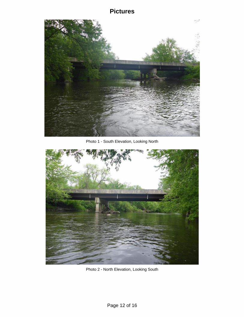
Photo 1 - South Elevation, Looking North
Photo 2 - North Elevation, Looking South
Pictures
Page 12 of 16

Pictures
Photo 3 - Pier 1 and Timber Debris, Looking East
Photo 4 - Pier 1 and Timber Debris, Looking West
Page 13 of 16

Pictures
Photo 5 - Spalling on Upstream Pile of Pier 1, Looking East
Photo 6 - View of 2nd and 3rd Piles from Upstream Side of Pier 1, Looking East
Page 14 of 16

Figure No.: 1
Scale: NTS
N
SOUNDING PLAN
UNDERWATER BRIDGE INSPECTION
DEPARTMENT OF TRANSPORTATION
MINNESOTA
INSPECTION AND SOUNDING PLAN
Flo
w
Str
aig
ht
River
TYPICAL PIER ELEVATION
1
2
West Abutment East Abutment
Pier 1 Pier 2
(Typ.)
Shoreline
DISTRICT 6, RICE COUNTY
OVER THE STRAIGHT RIVER
STRUCTURE NO. 66520
3
44
-3.6
-3.6
-1.3
-2.6
-2.0
3.2
-2.4
-3.1
-3.1
-2.5
-2.1
-2.4
-1.6
-1.5
-0.9
-1.2
-1.4
-1.7
-2.3
-1.8
-2.3
-3.2
-3.6
-3.3
-2.7
-2.8
-2.9
-3.1
-2.3
-2.9
-2.5
-2.2
3.3
-1.3
-2.0
-1.8
-2.4
-2.3
-2.3
-2.5
-2.6
-3.2
-3.0
-3.2
Drawn By: LBH
Checked By: BRL
Date: June 2016
-.--
2.4
-.--
0.6
-0.6
-.-
5
6
substructure units as well as around the pier structures.
Soundings were taken parallel to the bridge at 1/4 point intervals between the4.
in feet.
Soundings indicate the water depth at the time of inspection and are measured 3.
the waterline elevation was 88.4.
reference elevation of 100.0 was assumed. Based on the assumed reference,
of Pier 2. Since insufficant bridge elevation information was available, a
approximately 11.6 feet below the top of the pier cap at the downstream end
At the time of inspection, on May 25, 2016, the waterline was located2.
Piers 1 and 2 were inspected underwater. 1.
GENERAL NOTES:
Project 63-9687
1599 Selby Avenue
Suite 206
St. Paul, MN 55104
(651) 646-8502
www.collinsengr.com
location.
All soundings based on 2016 waterline
Note:
Sounding Depth not accessible due to debris
Sounding Depth not previously taken-.-
n/a
Timber Debris
Legend
Sounding Depth (5/25/16)Sounding Depth (9/12/12)
-0.4-0.4
Timber debris up to 5 inches in diameter is present near the upstream piles of Pier 1.6
A hard bottom was found up to 3 feet to the east upstream end of Pier 2.5
penetrations.
to 2 inches of gravel and soft silt infilling along the middle columns with minimal probe rod
The channel bottom material consisted of bedrock at the upstream and downstream columns with up 4
form boards) and spalling with up to 6 inches of penetration.
bottom to 2.8 feet above the waterline. The encasements exhibited form irregularities (embedded
The columns of Pier 1 were encased in up to 6 inches of additional concrete from the channel 3
form boards) and spalling with up to 3 inches of penetration.
bottom to 1.1 feet above the waterline. The encasements exhibited form irregularities (embedded
The columns of Pier 2 were encased in up to 6 inches of additional concrete from the channel 2
smaller branches and extended from the channel bottom to the bottom of the cap.
Timber debris was observed along the west face of Pier 2 that consisted of a full tree and 1
INSPECTION NOTES:
Page 15 of 16

UPSTREAM FASCIA PROFILE
DOWNSTREAM FASCIA PROFILE
Figure No.: 2
UNDERWATER BRIDGE INSPECTION
DEPARTMENT OF TRANSPORTATION
MINNESOTA
FASCIA PROFILES
Scale: 1"=20'
Refer to Figure 1 for General Notes.
Note:
W.L. El. 88.4
W.L. El. 88.4
~ Brg. West Abut. ~ Brg. East Abut.~ Pier 1 ~ Pier 2
~ Brg. West Abut. ~ Brg. East Abut.~ Pier 1 ~ Pier 2
DISTRICT 6, RICE COUNTY
OVER THE STRAIGHT RIVER
STRUCTURE NO. 66520
110
100
90
80
70
110
100
90
80
70
110
100
90
80
70
110
100
90
80
70
Checked By: BRL
UPSTREAM AND DOWNSTREAM
on 9/12/12Channel Bottom
on 9/12/12Channel Bottom
Shoreline
Shoreline
Shoreline
on 5/25/16Channel Bottom
Shoreline
on 5/25/16Channel Bottom
Drawn By: LBH
Project 63-9687
1599 Selby Avenue
Suite 206
St. Paul, MN 55104
(651) 646-8502
www.collinsengr.com
Date: June 2016
Page 16 of 16