Embed Size (px)
Citation preview
2016 UNDERWATER
BRIDGE INSPECTION REPORT
BRIDGE #
DISTRICT: COUNTY: CITY/TOWNSHIP:
Date of Inspection:
Equipment Used:
Inspected By:
Report Written By:
Report Reviewed By:
Final Report Date:
64504
CSAH 7 over MINNESOTA RIVER
District 8 Redwood SWEDES FOREST
06/20/2016
Forsyth, Roy
Roy Forsyth
County Highway AgencyOwner:
MinnesotaSTATE:
UNDERWATER SUMMARY 3
UNDERWATER INSPECTION 4
UNDERWATER INSPECTION PROCEDURES 6
STRUCTURE INVENTORY 7
ELEMENTS 8
PICTURES 11
DRAWINGS 13
TABLE OF CONTENTS
PAGE NUMBER
Contractor:
(A) Investigate revision of a scour critical code given the recent installation of scour countermeasures at the bridge site.
(B) Reinspect the submerged substructure units at the normal maximum recommended (NBIS) interval of sixty (60) months.
Collins Engineers, Inc.
9687Contractor Job Number:
RECOMMENDATIONS
REPORT SUMMARY
UNDERWATER INSPECTION
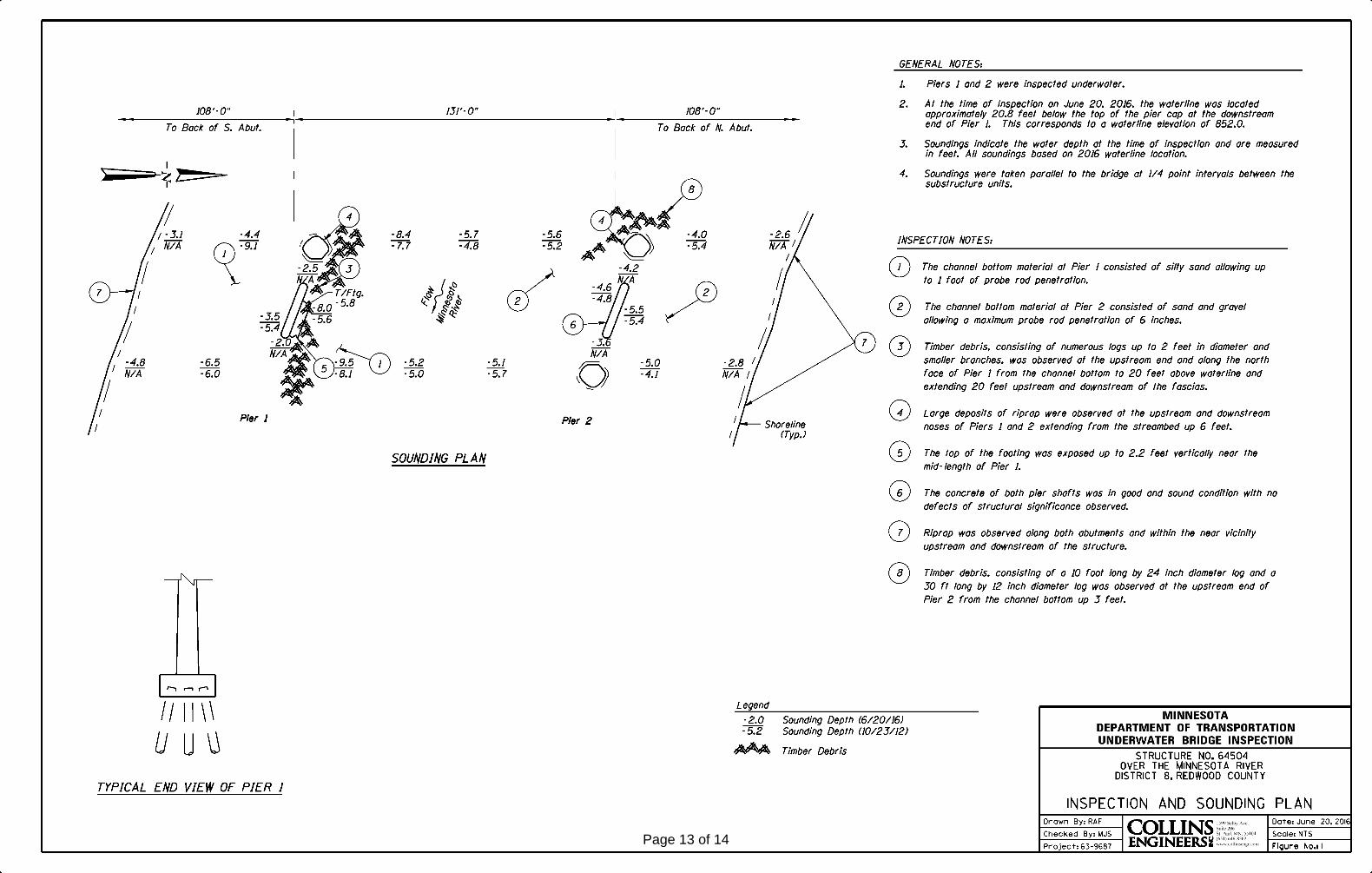
The substructure units inspected at Bridge No. 64504, Piers 1 and 2, were found to be in good condition below water with no structurally significant defects observed. Riprap was observed at the upstream and downstream noses of Piers 1 and 2 extending from the streambed up 6 feet. Timber debris was observed from channel bottom to 20' above waterline and 20' upstream and downstream of fascias along both faces of Pier 1. At Pier 2 there was timber debris along the upstream end from channel bottom up 3 feet. The top of footing of Pier 1 was vertically exposed near the midpoint along the north face. The channel bottom material at Pier 1 consisted of silty sand allowing up to 1 foot of probe rod penetration and at Pier 2 consisted of sand and gravel allowing a maximum probe rod penetration of 6 inches.
(A) Large deposits of riprap have been placed at both upstream and downstream noses of Piers 1 and 2 sometime between the 2007 and 2012 inspection. The riprap deposits remedied the previously observed footing exposure and undermining at Piers 1 and 2.
(B) Timber debris was observed from channel bottom to 20' above waterline and 20' upstream and downstream of fascias along both faces of Pier 1.
(C) Timber debris, consisting of a 10 feet long by 24 inch diameter log and a 30 feet long by 12 inch diameter log, was observed at the upstream end of Pier 2 from the channel bottom up 3 feet.
(D) The top of footing of Pier 1 was exposed up to 2.2 feet vertically near the midpoint.
(E) The channel bottom material at Pier 1 consisted of silty sand allowing up to 1 foot of probe rod penetration.
(F) The channel bottom material at Pier 2 consisted of sand and gravel allowing a maximum probe rod penetration of 6 inches.
INSPECTION FINDINGS
Page 3 of 14
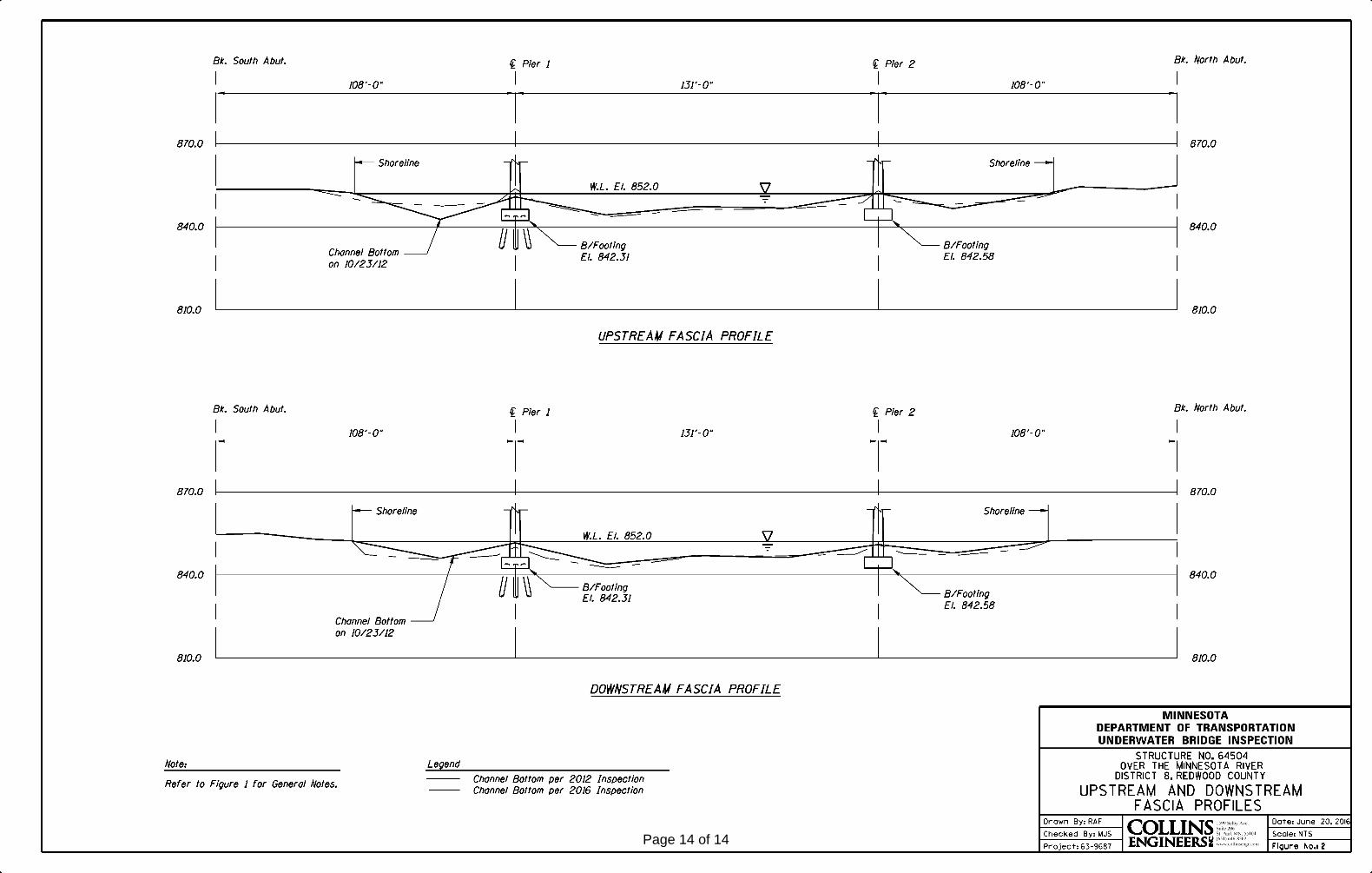
Top of the pier cap at the downstream end of Pier 1.Water Level Reference:
WATERLINE DATUM
Waterline Elevation (feet):
The waterline was approximately 20.8 below the reference. Description:
852.0
4.
Piers 1 and 2Substructure(s) Inspected:
SUBSTRUCTURE INSPECTION DATA
General Shape:
8.0Maximum Water Depth at Substructure(s) Inspected (feet):
Each pier consists of an oblong rectangular shaft with rounded ends that rests upon a rectangular footing. The footing at Pier 1 is founded on steel H-piles and the footing at Pier 2 is founded on bedrock.
Code:Item 62: Culvert:
7
Y 48 06/2016Code:Item 92B: Underwater Inspection:
Code:
(Minnesota specific codes are used for 92B and 113)
NBIS CODING INFORMATION5.
Item 60: Substructure:
Item 61: Channel and Channel Protection:
7Code:
District 8District:
CSAH 7
County:
The superstructure consists of a three span steel girder structure supporting a reinforced concrete deck. The superstructure is supported by two reinforced concrete piers and two reinforced concrete abutments. The piers are numbered 1 and 2 starting from the south end of the bridge. Pier 2 is founded on bedrock and Pier 1 is founded on steel H-piles.
Bridge Description:
064 - Redwood
Facility Carried:
BRIDGE DATA1.
UNDERWATER INSPECTION
Bridge #:
MINNESOTA RIVERFeature Intersected:
64504
Underwater Visibility (feet):
Sunny, 70°FWeather Conditions:
None/ Negligible
3.
0.5 ft/sWaterway Velocity (ft/sec):
06/20/2016
Professional Engineer/Team Leader:
INSPECTION DATA2.
Roy A. Forsyth
Date of Underwater Inspection:
Marc SternInspection Diver:
Page 4 of 14
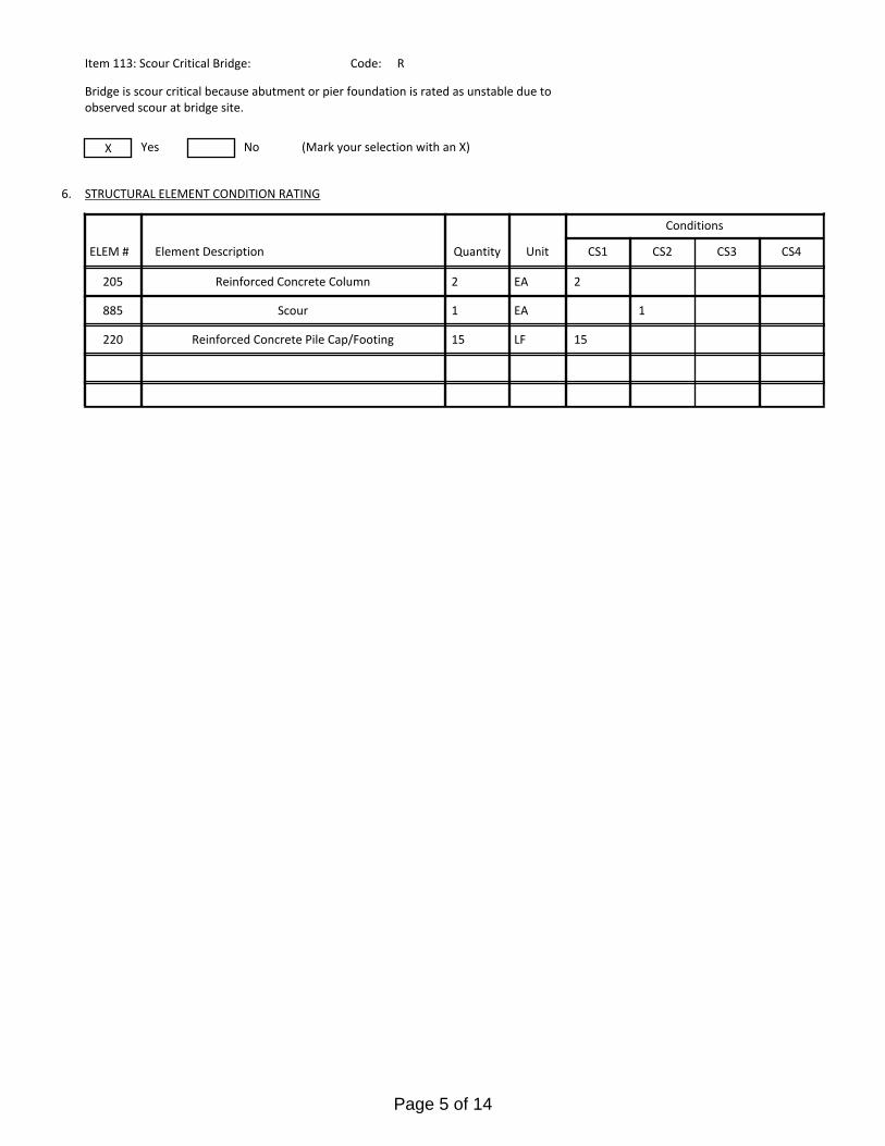
Reinforced Concrete Pile Cap/Footing 15220 LF 15
885 Scour 1 1EA
STRUCTURAL ELEMENT CONDITION RATING
Conditions
6.
R
Bridge is scour critical because abutment or pier foundation is rated as unstable due to observed scour at bridge site.
Item 113: Scour Critical Bridge: Code:
X No (Mark your selection with an X)Yes
205
CS3 CS4
Reinforced Concrete Column 22 EA
CS2ELEM # Unit CS1Element Description Quantity
Page 5 of 14
The routine underwater inspection of Bridge 64504 (CSAH 7 over the Minnesota River) was completed on June, 20, 2016. The underwater inspection was conducted from shore. The inspection was conducted by a team consisting of a PE-Diver with a valid MnDOT Team leader certification, a backup diver and a dive tender. The inspection utilized commercial dive equipment and techniques (SSA and/or SCUBA) in accordance with OSHA regulations Profiles were taken along the upstream and downstream faces of the bridge and around the periphery of substructure units to determine the presence, location and area of scour.
The bridge elements inspected consisted of 2 reinforced concrete pier walls. According to the bridge inventory or design drawings, Piers 1 was founded on steel H-piles and Pier 2 was founded on bedrock. Inspection procedures followed FHWA guidance and the MnDOT Bridge and Structure Inspection Program Manual with channel bottom probing to search for bottom foundations. The routine underwater inspection frequency is recommended to remain at a maximum of 60 months based on those findings and risk factors. Also, inspection procedures should continue to follow the above approach and standard guidance with 100% Level I and 10% Level II intensity efforts.
INSPECTION PROCEDURES
UNDERWATER INSPECTION
Page 6 of 14
Spec. Feat.Pier Foundation (Material/Type)
1 - CONCCantilever ID
+ W A T E R W A Y +Number of Spans Historic Status
3 - FTG PILE
Underwater 60Culvert Type 3 - FTG PILE
Pinned Asbly.
06/20/2016
Barrel Length
347.0 ft. Navigation Control
Waterway Opening (sf.) 8880Structure Length
ft. Year Painted 1966
0 - No nav. control on waterwayDeck Width (Out-to-Out) 34.0
+ P A I N T +
APPR: 0 TOTAL:5 - Not eligible
MAIN: 3
Main Span Length 131.0 ft.Drainage Area (sq. mi.)
B R I D G E D A T A +Main Span Detail
0 - SUBSTANDARD+ M I S C.
Appr. Span Type Structure Flared
GR Termini 0 - SUBSTANDARD
Appr. Guardrail
Main Span Type 4 - Steel Continuous Median Width On Bridge
ft. Bridge Railing 0 - SUBSTANDARD
0 - SUBSTANDARD
Main Span Design 01 - Beam Span
ft. GR Transition
Skew 20 RIGHT
Y/N Freq Date
Abutment Foundation (Material/Type)
1 - CONC Frac. Critical
4 - Bolted
D E P T H I N S P. +Appr. Span Design
0 - No flare+ I N
Appr. Span Detail Field Conn. ID
Parallel Structure N - No parallel structure
Pier Protection
0 - Not Required
Rating Date 6/1/197310409 sq. ft. Traffic
ft. 50B. Rt 0.00Sidewalk Width 50A. Lt 0.00
Roadway Area (Curb-to-Curb)
Posted Load 0 - Not Required
PostingStructure Area (Out-to-Out) 11798 sq. ft.
DBL:VEH: SEMI:
Rt 01 ARail Type Lt 01 C N - N/AN - N/A B N - N/A
N - Not Applicable Overweight Permit CodesCurb Height Lt
ft. Horizontal 1 - Object Markers
0.00 ft. Vertical0.00 ft. Rt
Wear Surf Install Year
sq. ft. Nav. Vert. Lift Bridge Clear. (ft.)
P - STBL - PROT INPL
Year 2015Primer Type 1 - Lead - non 3309 MN Scour Code
Painted Area
Unsound Paint % Nav. Clr. (ft.)
_
Deck Material 1 - Concrete Cast-in-Place 0.0Wear Surf Type 6 - Bituminous
Vert. 0.0 Horiz.
S I G N S +Operating Rating 1 - H TRUCK
0 - None + B R I D G E
Inventory Rating 1 - H TRUCK 27.9
44.3Deck Rebars Install Year
Deck Rebars
Finish Type F - - Phenolic Resin AlumWear Course/Fill Depth 0.00 ft.
0 - None
Design Load 4 - H 20
+ C A P A C I T Y R A T I N G S +Deck Membrane
44 ° 41
Inspector Name Forsyth, Roy
Latitude Control Section (TH Only) Status' 42.85 ''
2 - 2-way traffic
Routine Inspection Frequency 24
Sect., Twp., Range
1.6 MI N OF JCT CSAH 27 Level of Service 1 - MAINLINE
- 37W Roadway Type8 - 114N
Detour Length 7.0 mi.R A T I N G S +
Custodian 02 - County Highway Agency
Owner 02 - County Highway AgencyDeck 7 Unsound
Deck %
C O N D I T I O N° 20 '
A - Open
Longitude 95 037+00.400 + N B I 24.43 '' Reference Point
Crew
+ I N S P E C T I O N +
Agency Br. No. 104
District 08
Bridge Match ID (TIS) 0 Userkey
CSAH 7 over MINNESOTA RIVER
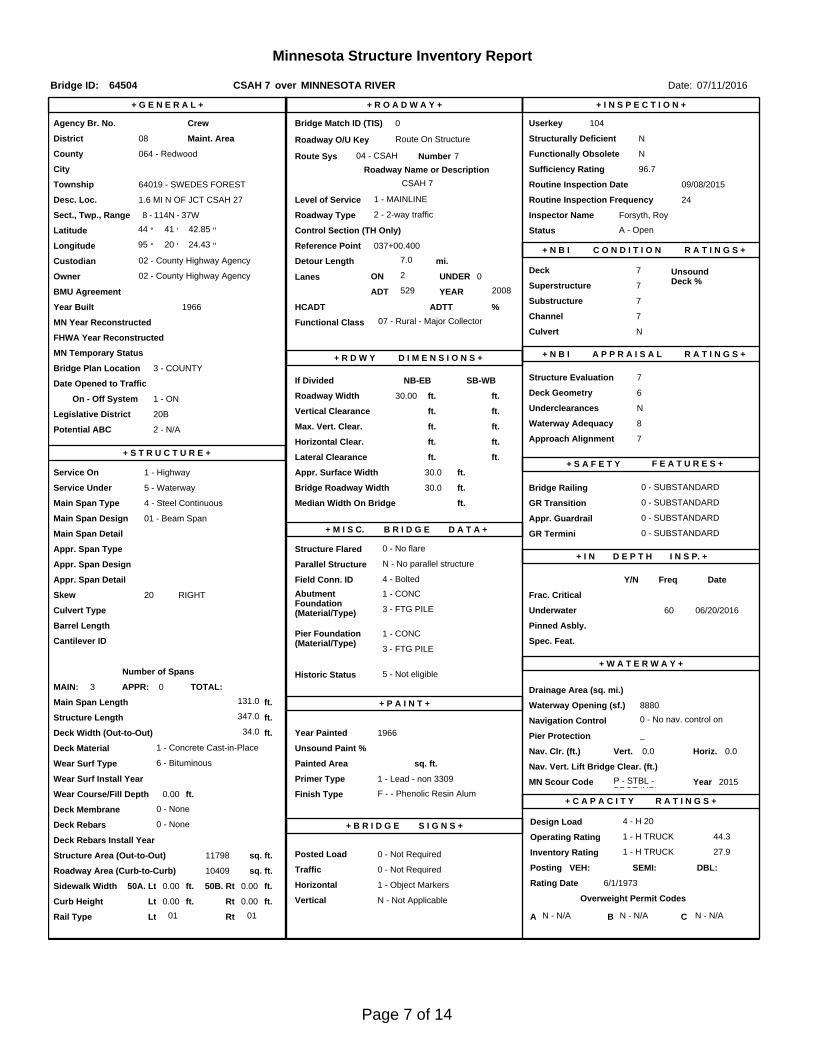
Minnesota Structure Inventory Report
Bridge ID: 64504
+ G E N E R A L + + R O A D W A Y +
Date: 07/11/2016
Sufficiency Rating 96.7Roadway Name or Description
7
City
Routine Inspection Date 09/08/2015
Desc. Loc.
Township 64019 - SWEDES FOREST CSAH 7
Number
NRoadway O/U Key Route On StructureMaint. Area Structurally Deficient
NRoute Sys 04 - CSAHCounty 064 - Redwood Functionally Obsolete
Lanes
Waterway Adequacy 8Max. Vert. Clear.
ft.Legislative District 20Bft.Potential ABC 2 - N/A ft.
ft.On - Off System Roadway Width 30.00 ft.
Vertical Clearance ft.1 - ON
Underclearances N
Service On 1 - Highway Appr. Surface Width+ S A F E T Y F E A T U R E S +
5 - Waterway Bridge Roadway Width 30.0
30.0 ft.
Service Under
ft.
ft. Approach Alignment 7Horizontal Clear.
ft.
ft.+ S T R U C T U R E + Lateral Clearance
HCADT ADTT7
Year Built 1966
MN Year Reconstructed Functional Class
%Channel 7
Substructure
0Superstructure 7
ON 2 UNDER
529 YEAR 2008BMU Agreement ADT
Structure Evaluation 7If Divided
D I M E N S I O N S +Bridge Plan Location 3 - COUNTY
Deck Geometry 6NB-EB SB-WBDate Opened to Traffic
+ R D W Y
FHWA Year Reconstructed
MN Temporary Status
07 - Rural - Major CollectorCulvert N
A P P R A I S A L R A T I N G S ++ N B I
Page 7 of 14
County:
City:
Township:
Township:Section: Range:
Span Type:
NBI Deck: Super: Sub: Chan: Culv:
Appraisal Ratings - Approach: Waterway:
Required Bridge Signs - Load Posting:
Horizntal:
Traffic:
Vertical:
MN Scour Code:
Open, Posted, Closed:
Location:
Route:
Control Section:
Local Agency Bridge Nbr.:
Ref. Pt.:
Maint. Area:
Length:
Deck Width:
Rdwy. Area/ Pct. Unsnd:
Paint Area/ Pct. Unsnd:
Culvert:
Redwood
64019 - SWEDESFOREST
114N8 37W
4 - Steel Continuous 2 -Stringer/Multi-beam or Girder
7 7 7 7 N
7 8
0 - Not Required
1 - Object Markers
0 - Not Required
N - Not Applicable
P - STBL - PROT INPL
1.6 MI N OF JCT CSAH 27
04 - CSAH 7 037+00.400
347.0
34.0
10409 sq. ft. / %
sq. ft. / %
N/A
A - Open
ft.
ft.
Postings:List:
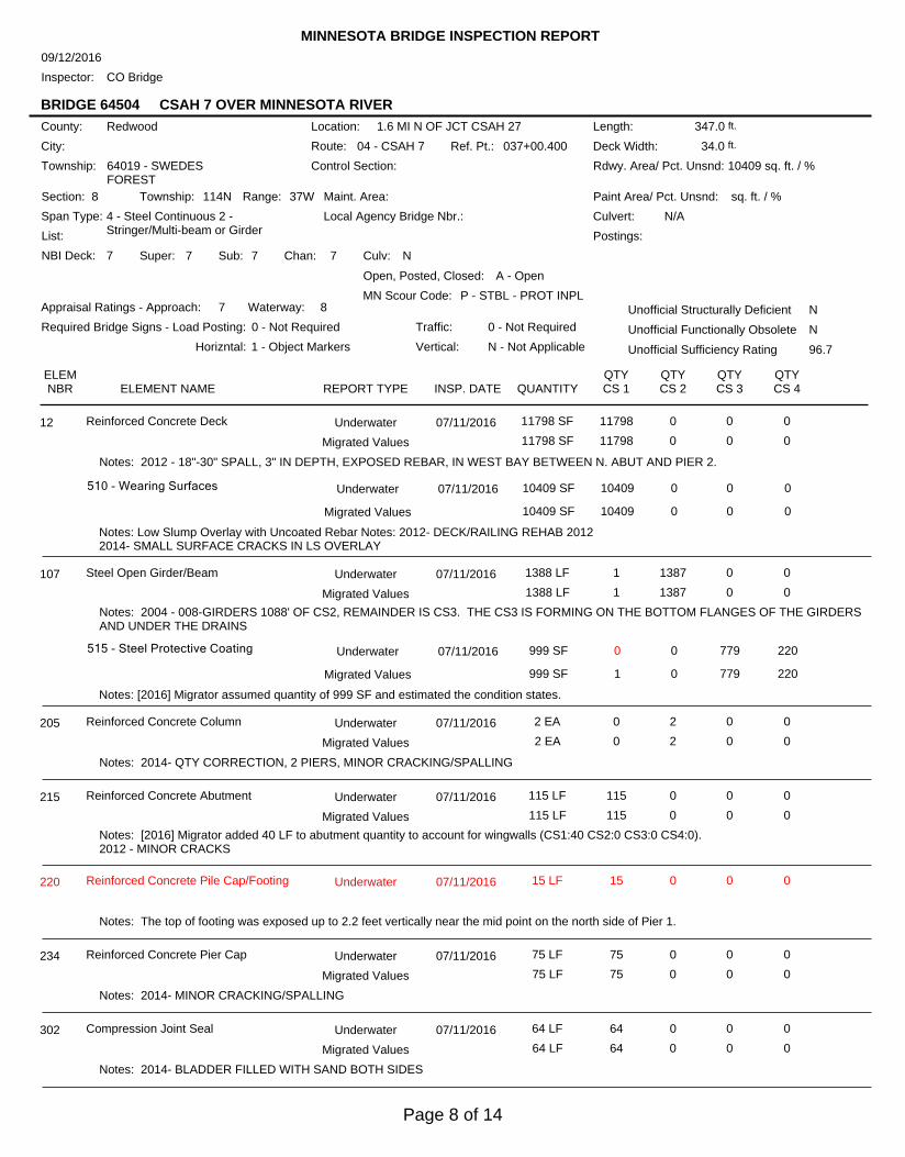
MINNESOTA BRIDGE INSPECTION REPORT
09/12/2016
Inspector: CO Bridge
BRIDGE 64504 CSAH 7 OVER MINNESOTA RIVER
Unofficial Structurally Deficient N
NUnofficial Functionally Obsolete
Unofficial Sufficiency Rating 96.7
ELEMNBR ELEMENT NAME INSP. DATE QUANTITY
QTYCS 1
QTYCS 2
QTYCS 3
QTYCS 4REPORT TYPE
Reinforced Concrete Deck 07/11/2016 11798 SF 11798 0 0 012 Underwater
11798 SF 11798 0 0 0Migrated Values
Notes: 2012 - 18"-30" SPALL, 3" IN DEPTH, EXPOSED REBAR, IN WEST BAY BETWEEN N. ABUT AND PIER 2.
510 - Wearing Surfaces 10409 SF 10409 0 0 0
Notes: Low Slump Overlay with Uncoated Rebar Notes: 2012- DECK/RAILING REHAB 20122014- SMALL SURFACE CRACKS IN LS OVERLAY
Underwater 07/11/2016
10409 SF 10409 0 0 0Migrated Values
Steel Open Girder/Beam 07/11/2016 1388 LF 1 1387 0 0107 Underwater
1388 LF 1 1387 0 0Migrated Values
Notes: 2004 - 008-GIRDERS 1088' OF CS2, REMAINDER IS CS3. THE CS3 IS FORMING ON THE BOTTOM FLANGES OF THE GIRDERSAND UNDER THE DRAINS
515 - Steel Protective Coating 999 SF 0 0 779 220
Notes: [2016] Migrator assumed quantity of 999 SF and estimated the condition states.
Underwater 07/11/2016
999 SF 1 0 779 220Migrated Values
Reinforced Concrete Column 07/11/2016 2 EA 0 2 0 0205 Underwater
2 EA 0 2 0 0Migrated Values
Notes: 2014- QTY CORRECTION, 2 PIERS, MINOR CRACKING/SPALLING
Reinforced Concrete Abutment 07/11/2016 115 LF 115 0 0 0215 Underwater
115 LF 115 0 0 0Migrated Values
Notes: [2016] Migrator added 40 LF to abutment quantity to account for wingwalls (CS1:40 CS2:0 CS3:0 CS4:0).2012 - MINOR CRACKS
Reinforced Concrete Pile Cap/Footing 07/11/2016 15 LF 15 0 0 0220 Underwater
Notes: The top of footing was exposed up to 2.2 feet vertically near the mid point on the north side of Pier 1.
Reinforced Concrete Pier Cap 07/11/2016 75 LF 75 0 0 0234 Underwater
75 LF 75 0 0 0Migrated Values
Notes: 2014- MINOR CRACKING/SPALLING
Compression Joint Seal 07/11/2016 64 LF 64 0 0 0302 Underwater
64 LF 64 0 0 0Migrated Values
Notes: 2014- BLADDER FILLED WITH SAND BOTH SIDES
Page 8 of 14
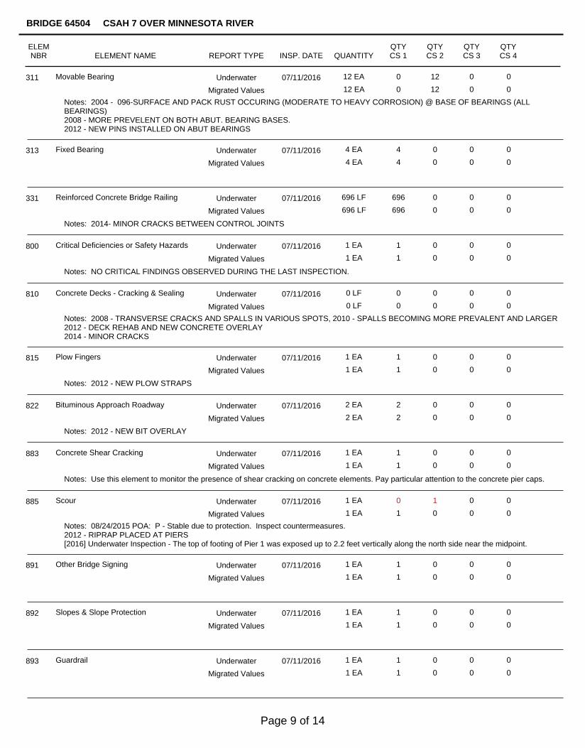
Movable Bearing 07/11/2016 12 EA 0 12 0 0311 Underwater
12 EA 0 12 0 0Migrated Values
Notes: 2004 - 096-SURFACE AND PACK RUST OCCURING (MODERATE TO HEAVY CORROSION) @ BASE OF BEARINGS (ALLBEARINGS)2008 - MORE PREVELENT ON BOTH ABUT. BEARING BASES.2012 - NEW PINS INSTALLED ON ABUT BEARINGS
Fixed Bearing 07/11/2016 4 EA 4 0 0 0313 Underwater
4 EA 4 0 0 0Migrated Values
Reinforced Concrete Bridge Railing 07/11/2016 696 LF 696 0 0 0331 Underwater
696 LF 696 0 0 0Migrated Values
Notes: 2014- MINOR CRACKS BETWEEN CONTROL JOINTS
Critical Deficiencies or Safety Hazards 07/11/2016 1 EA 1 0 0 0800 Underwater
1 EA 1 0 0 0Migrated Values
Notes: NO CRITICAL FINDINGS OBSERVED DURING THE LAST INSPECTION.
Concrete Decks - Cracking & Sealing 07/11/2016 0 LF 0 0 0 0810 Underwater
0 LF 0 0 0 0Migrated Values
Notes: 2008 - TRANSVERSE CRACKS AND SPALLS IN VARIOUS SPOTS, 2010 - SPALLS BECOMING MORE PREVALENT AND LARGER2012 - DECK REHAB AND NEW CONCRETE OVERLAY2014 - MINOR CRACKS
Plow Fingers 07/11/2016 1 EA 1 0 0 0815 Underwater
1 EA 1 0 0 0Migrated Values
Notes: 2012 - NEW PLOW STRAPS
Bituminous Approach Roadway 07/11/2016 2 EA 2 0 0 0822 Underwater
2 EA 2 0 0 0Migrated Values
Notes: 2012 - NEW BIT OVERLAY
Concrete Shear Cracking 07/11/2016 1 EA 1 0 0 0883 Underwater
1 EA 1 0 0 0Migrated Values
Notes: Use this element to monitor the presence of shear cracking on concrete elements. Pay particular attention to the concrete pier caps.
Scour 07/11/2016 1 EA 0 1 0 0885 Underwater
1 EA 1 0 0 0Migrated Values
Notes: 08/24/2015 POA: P - Stable due to protection. Inspect countermeasures.2012 - RIPRAP PLACED AT PIERS[2016] Underwater Inspection - The top of footing of Pier 1 was exposed up to 2.2 feet vertically along the north side near the midpoint.
Other Bridge Signing 07/11/2016 1 EA 1 0 0 0891 Underwater
1 EA 1 0 0 0Migrated Values
Slopes & Slope Protection 07/11/2016 1 EA 1 0 0 0892 Underwater
1 EA 1 0 0 0Migrated Values
Guardrail 07/11/2016 1 EA 1 0 0 0893 Underwater
1 EA 1 0 0 0Migrated Values
ELEMNBR ELEMENT NAME INSP. DATE QUANTITY
QTYCS 1
QTYCS 2
QTYCS 3
QTYCS 4
BRIDGE 64504 CSAH 7 OVER MINNESOTA RIVER
REPORT TYPE
Page 9 of 14
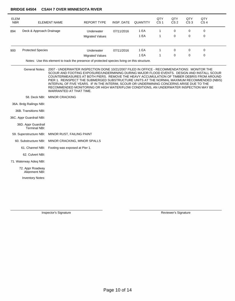
Deck & Approach Drainage 07/11/2016 1 EA 1 0 0 0894 Underwater
1 EA 1 0 0 0Migrated Values
Protected Species 07/11/2016 1 EA 1 0 0 0900 Underwater
1 EA 1 0 0 0Migrated Values
Notes: Use this element to track the presence of protected species living on this structure.
General Notes:
Inspector's Signature Reviewer's Signature
Inventory Notes:
2007 - UNDERWATER INSPECTION DONE 10/21/2007 FILED IN OFFICE - RECOMMENDATIONS: MONITOR THESCOUR AND FOOTING EXPOSURE/UNDERMINING DURING MAJOR FLOOD EVENTS. DESIGN AND INSTALL SCOURCOUNTERMEASURES AT BOTH PIERS. REMOVE THE HEAVY ACCUMULATION OF TIMBER DEBRIS FROM AROUNDPIER 1. REINSPECT THE SUBMERGED SUBSTRUCTURE UNITS AT THE NORMAL MAXIMUM RECOMMENDED (NBIS)INTERVAL OF FIVE YEARS. IF IN THE INTERIM, SCOUR OR UNDERMINING CONCERNS ARISE DUE TO THERECOMMENDED MONITORING OR HIGH WATER/FLOW CONDITIONS, AN UNDERWATER INSPECTION MAY BEWARRANTED AT THAT TIME.
58. Deck NBI:
36A. Brdg Railings NBI:
36B. Transitions NBI:
36C. Appr Guardrail NBI:
36D. Appr GuardrailTerminal NBI:
59. Superstructure NBI:
60. Substructure NBI:
61. Channel NBI:
62. Culvert NBI:
71. Waterway Adeq NBI:
72. Appr RoadwayAlignment NBI:
MINOR CRACKING
MINOR RUST, FAILING PAINT
MINOR CRACKING, MINOR SPALLS
Footing was exposed at Pier 1.
ELEMNBR ELEMENT NAME INSP. DATE QUANTITY
QTYCS 1
QTYCS 2
QTYCS 3
QTYCS 4
BRIDGE 64504 CSAH 7 OVER MINNESOTA RIVER
REPORT TYPE
Page 10 of 14
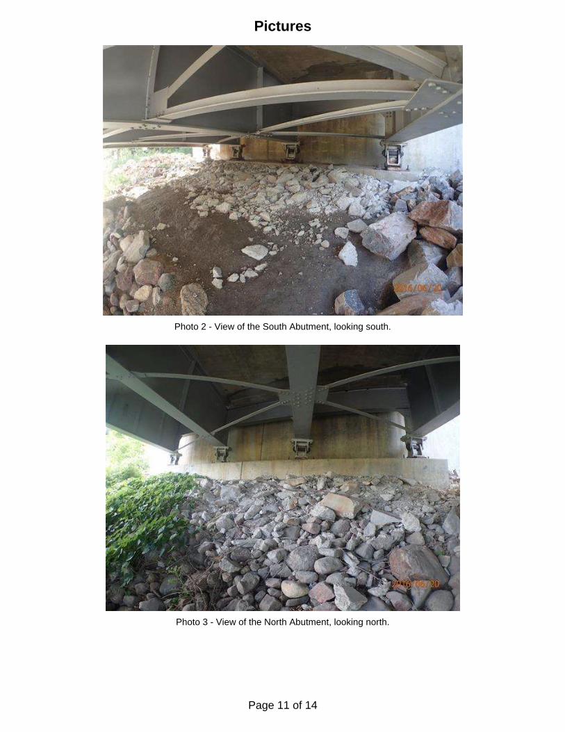
Photo 2 - View of the South Abutment, looking south.
Photo 3 - View of the North Abutment, looking north.
Pictures
Page 11 of 14
Pictures
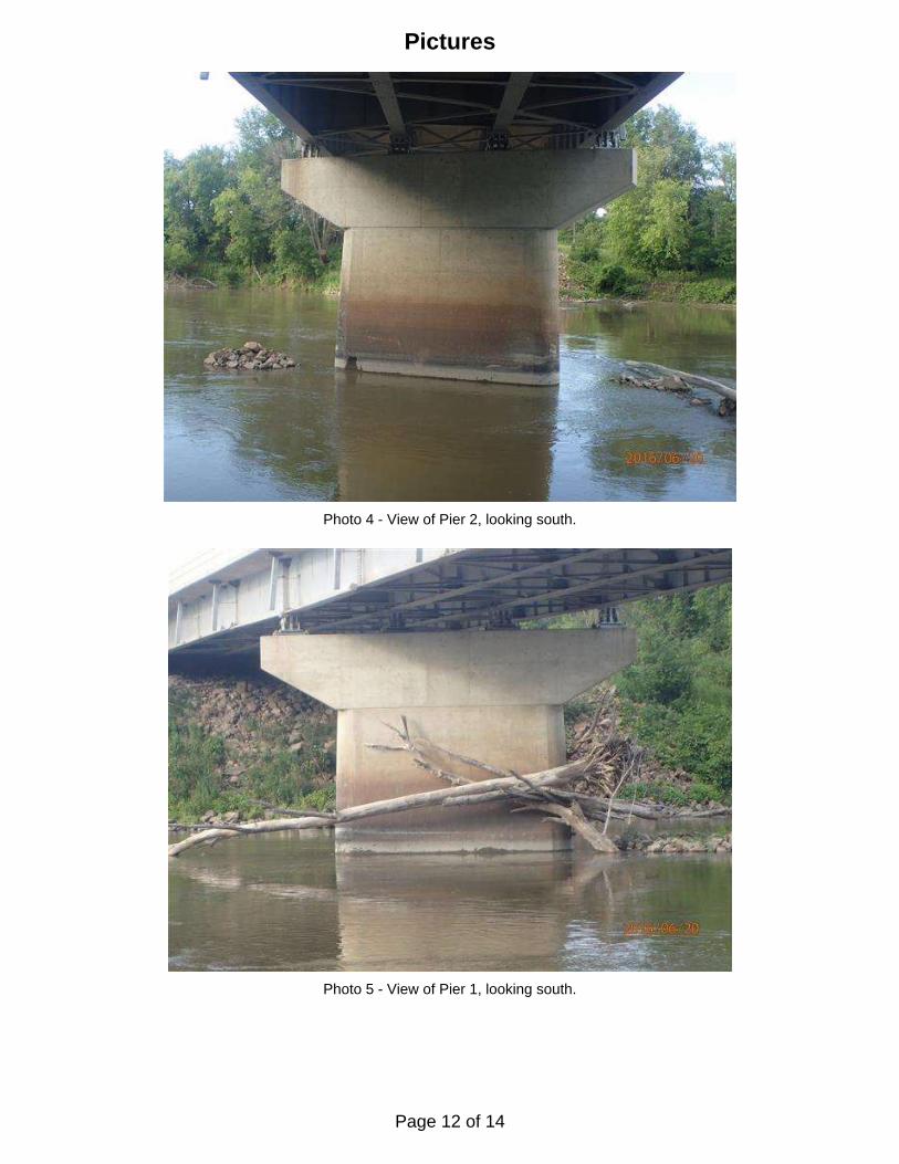
Photo 4 - View of Pier 2, looking south.
Photo 5 - View of Pier 1, looking south.
Page 12 of 14
Page 13 of 14
Page 14 of 14