Embed Size (px)
Citation preview
Summary• Wind speeds are calculated according to requirements of BS
6399-2, EN 1991-1-4 with UK and Irish national annexes and ASCE 7-10
• When integrated with CADS products, such as SMART Portal 2D or SMART Portal 3D, the design process is completely automated and streamlined saving time and reducing errors!
• A selection of methods is available for entering the site locations including a postcode, a national grid reference or using a simple drag and drop pointer over Google Maps
• The relevant national design code is automatically selected based on the location including support for the Channel Islands and the Isles of Scilly
• Users will enjoy the modern single screen user interface that makes it simple to learn and use
• VelVenti takes into account the seasonal factor and the design life of the structure, making it suitable for temporary structures e.g. scaffolding
• Takes into account the vicinity of the site with sheltering effects and height of neighbouring structures allowed for
• Standard and Directional/Hybrid methods according to BS 6399-2 are included
• Clear, concise reporting in both brief or detailed format• Export as a PDF or directly to Word
FeaturesGoogle MapsPowered by Google maps, users will enjoy the modern user interface that makes it exciting to use and a simple product to learn. Input of data is via a single screen which includes a digital world map, prompt boxes for site information and printout options.
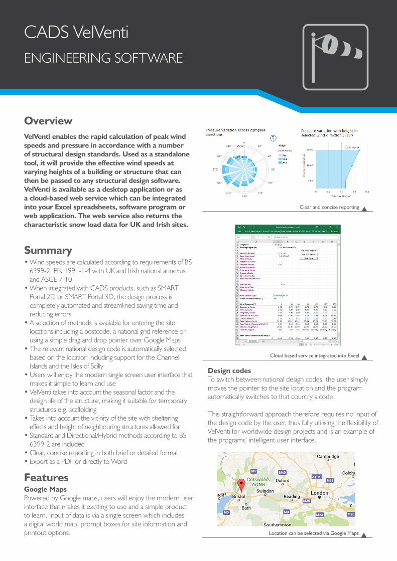
Design codesTo switch between national design codes, the user simply moves the pointer to the site location and the program automatically switches to that country’s code.
This straightforward approach therefore requires no input of the design code by the user, thus fully utilising the flexibility of VelVenti for worldwide design projects and is an example of the programs’ intelligent user interface.
CADS VelVentiENGINEERING SOFTWARE
OverviewVelVenti enables the rapid calculation of peak wind speeds and pressure in accordance with a number of structural design standards. Used as a standalone tool, it will provide the effective wind speeds at varying heights of a building or structure that can then be passed to any structural design software. VelVenti is available as a desktop application or as a cloud-based web service which can be integrated into your Excel spreadsheets, software program or web application. The web service also returns the characteristic snow load data for UK and Irish sites.
Cloud based service integrated into Excel
Clear and concise reporting
Location can be selected via Google Maps

Contact •01202 603031 • [email protected] CONSTRUCTION SOFTWARE AND SERVICES CADS · Arrowsmith Court · Broadstone · Dorset · BH18 8AX · UK www.cads.co.uk
Location affectsTo improve accuracy, account is taken of the local vicinity of the site. The sheltering effects of surrounding structures or the influence of a tall neighbouring structure are taken into account. The height and location of neighbouring buildings can be input as well as the location e.g. town, country or near the sea.
Standard, Directional and Hybrid methodsBoth Standard and Directional/Hybrid methods according to BS6399-2 are included. The Standard Method applies to projects where the form of the building is well defined but the site is not. Where only the standard orthogonal load cases are required but a better allowance for site exposure is desired because topography is significant and/or the site is in a town, the Directional or Hybrid method is available.
SectorFor all codes VelVenti will divide the site location in up to12 sectors. The number of sectors can be edited so users can specify their own required number depending on the required level of detailed analysis. For each of these sectors, if online, VelVenti will automatically calculate the effective wind speed and pressure curve taking account of the local topography and altitude of the site. If not online, this topography and altitude can be manually input.
GustingUsing the Eurocode, input parameters are automatically made available for gusting if the height of the building and topography of the site is significant.
Edits shownThe user has full control to view and edit design parameters which are clearly marked in the report so it is clear what has been used that deviates from the code.
Site and building information
Snow loading
Eurocode input parameters for gusting
Altitude, sheltering and coastal proximity included
Wind direction divided into 12 sections