Embed Size (px)
Citation preview
Chapter 2 Outline of Geology
The main part of the district lies across the northern faulted boundary of the Lantau Caldera (Langford et 叫l., 1995) which separates Mesozoic volcanic rocks in the south from Mesozoic sedimentary and intrusive rocks in the north. The volcanic rocks are composed mostly of rhyolite lava and tuff with minor intercalated
volcaniclastic sandstone and siltstone, tuffite and tuff breccia. The intrusive rocks consist mostly of granite and quartz monzonite plutons in the west and feldsparphyric and quartzphyric rhyolite dykes in the east
(Table 2, Figure 5). Representative whole-rock geochemical analyses of the rock types are given in Table 3.
Palaeozoic sedimentary rocks of the San Tin Group are the oldest rocks in the district. They are exposed only
on Tze Kan Chau (1585 2090) in the northeast, but are known to underlie parts of the offshore area to the
south and east of The Brothers islands. 0n Tze Kan Chau, the rocks comprise mainly quartz metasandstone
and graphitic metasiltstone of the Carboniferous Lok Ma Chau Formation, whereas offshore they consist of
marble belonging to the Yuen Long Formation. Limestone of Permian age, together with sandstone and
siltstone, has been identified in boreholes at Tung Chung. These rocks have also been encountered in boreholes farther north offshore and have been tentatively assigned to the Tolo Harbour Formation (Sewell et 叫l., 2000).
Metasiltstone and sandstone are exposed in the far west of the district against the fault marking the boundary
of the Lantau Caldera. Previously, these rocks were considered to be of Carboniferous age and assigned to
the Lok Ma Chau Formation (GE0, 1994; Langford et 叫l., 1995). However, following the discovery of Jurassic fossils in these rocks near Tai 0 (Ng et 叫l., 1997), they have been reassigned to the Lower Jurassic Tai 0 Formation (Sewell et 叫l., 2000). The Tai 0 Formation forms a northeast-trending outcrop along the coast of Lantau Island from Tai 0 to San Shek Wan.
Lapilli-bearing coarse ash crystal tuff of the Yim Tin Tsai Formation (Tsuen Wan Volcanic Group) is stratigraphically the oldest Mesozoic volcanic rock in the district and is confined to offshore boreholes along the North Lantau coast from Sham Shui Kok to Kwai Shek. These rocks have been dated elsewhere (Sewell
et 叫l., 2000) at 164.5 Ma and they conformably overlie lapilli-bearing coarse to fine ash crystal tuff of the Shing Mun Formation. They are intruded by porphyritic fine- to medium- and medium-grained granite belonging to the Tai Lam Granite and Lantau Granite plutons of the Lamma Suite (Sewell et 叫l., op. cit. ). Inthe western part of the district, the fine-grained Chek Lap Kok Granite (Lamma Suite) intrudes porphyritic fine- to medium-grained Lantau Granite.
Eastnortheast-trending feldsparphyric and quartzphyric rhyolite dykes of the Lantau Dyke Swarm intrude granites of the Lamma Suite in the northeastern and northwestern parts of the district. The dykes have been dated at approximately 146 Ma and are truncated by the fault marking the boundary of the Lantau Caldera. The dykes were emplaced in at least two phases (Li et 叫l., 2000) and may vary internally from feldsparphyric rhyolite to porphyritic microgranite. Quartzphyric rhyolite dykes are considered to have been emplaced mostly during the younger phase.
Welded lapilli- to block-bearing crystal tuff, tuff breccia, tuffite and flow-banded rhyolite lava, with intercalated
volcaniclastic sedimentary rocks infill the Lantau Caldera. Previously, these rocks were named as the Lantau Formation (Langford et 叫l., 1995), but they have now been reassigned to the Lantau Volcanic Group (undifferentiated) (Sewell et 叫l., 2000). These rocks have been dated at approximately 146 Ma and represent the products of a number of discrete eruptions.
The volcanic and granitic rocks of the district are intruded along the caldera-bounding fault by quartz monzonite
belonging to the Lion Rock Suite. Minor basalt, microdiorite and aplite dykes occur sporadically in the northern part of the district intruding the granitic rocks and rhyolite dykes. These mafic and felsic dykes are considered to be of Cretaceous age.
The geological structure of the district is complex, owing to the close proximity of intersecting regional fault trends and faults related to the caldera boundary. The dominant regional fault trend is to the northeast. These
17
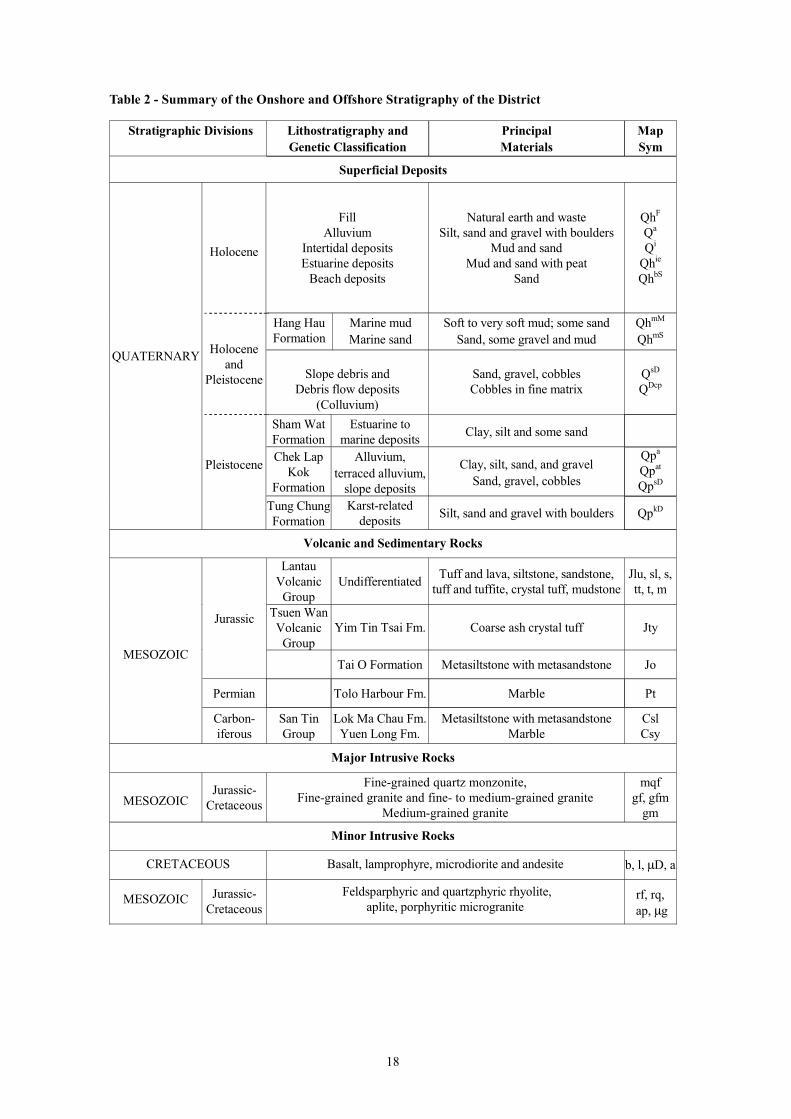
Table 2 - Summary of the Onshore and Offshore Stratigraphy of the District
Stratigraphic Divisions Lithostratigraphy and Genetic Classification
Principal Materials
Map Sym
Superficial Deposits
QUATERNARY
Holocene
Holocene and
Pleistocene
Pleistocene
Fill Alluvium
Intertidal deposits Estuarine deposits
Beach deposits
Natural earth and waste
Silt, sand and gravel with boulders Mud and sand
Mud and sand with peat Sand
QhF
Qa
Qi
Qhie
QhbS
Hang Hau Formation
Marine mud Marine sand
Soft to very soft mud; some sand
Sand, some gravel and mud Qh
mM
QhmS
Slope debris and Debris flow deposits
(Colluvium)
Sand, gravel, cobbles Cobbles in fine matrix
QsD
QDcp
Sham Wat Formation
Estuarine to marine deposits
Clay, silt and some sand
Chek Lap Kok
Formation
Alluvium,
terraced alluvium, slope deposits
Clay, silt, sand, and gravel
Sand, gravel, cobbles
Qpa
Qpat
QpsD
Tung Chung Formation
Karst-related deposits
Silt, sand and gravel with boulders QpkD
Volcanic and Sedimentary Rocks
MES0Z0IC
Jurassic
Lantau Volcanic
Group Undifferentiated
Tuff and lava, siltstone, sandstone,
tuff and tuffite, crystal tuff, m udstone
Jlu, sl, s,
tt, t, m
Tsuen Wan Volcanic
Group Yim Tin Tsai Fm. Coarse ash crystal tuff Jty
Tai 0 Formation Metasiltstone with metasandstone Jo
Permian Tolo Harbour Fm. Marble Pt
Carbon-
iferous San Tin Group
Lok Ma Chau Fm. Yuen Long Fm.
Metasiltstone with metasandstone Marble
Csl Csy
Major Intrusive Rocks
MES0Z0IC Jurassic-
Cretaceous
Fine-grained quartz monzonite, Fine-grained granite and fine- to medium-grained granite
Medium-grained granite
mqf
gf, gfm gm
Minor Intrusive Rocks
CRETACE0US Basalt, lamprophyre, m icrodiorite and andesite b, l, µD, a
MES0Z0IC Jurassic-
Cretaceous
Feldsparphyric and quartzphyric rhyolite,
aplite, porphyritic micrograniterf, rq,
ap, µg
18
Lim
itLi
mit
mm
RReecc
llaa
aattiioo
nn
Proposed
Proposed
�i���e � � �i�pli�ie� ����o�e �eolo�� o� t�e �i�t�ict
19
814 000E814 000E
818 000E818 000E
LEG
EN
D
Fin
e-, F
ine-
to m
ediu
m-,
and
Rec
lam
atio
nM
ediu
m-g
rain
ed G
rani
te
Maj
or in
trus
ive
rock
sF
ine-
grai
ned
Qua
rtz
Mon
zoni
teM
ount
Dav
is F
orm
atio
n
Lant
au V
olca
nic
Gro
upF
elds
parp
hyric
Rhy
olite
Min
or in
trus
ive
Por
phyr
itic
Mic
rogr
anite
Yim
Tin
Tsa
i For
mat
ion
rock
s (d
ykes
) S
IU M
O T
OS
IU M
O T
O82
2 00
0N82
2 00
0NT
ai O
For
mat
ion
Qua
rtzp
hyric
Rhy
olite
C
HE
UN
GC
HE
UN
GG
eolo
gica
l Bou
ndar
yS
OK
SO
KT
HE
BR
OT
HE
RS
TH
E B
RO
TH
ER
S
Fau
lt T
AI
MO
TO
TA
I M
O T
O
Lok
Ma
Cha
u F
orm
atio
n Sca
le 1
:60
000
0 1
2 K
m
TS
Z K
AN
CH
AU
TS
Z K
AN
CH
AU
CH
EK
LA
P K
OK
CH
EK
LA
P K
OK
Hon
g K
ong
Hon
g K
ong
Inte
rnat
iona
l Airp
ort
Inte
rnat
iona
l Airp
ort
818
000N
818
000N
LA
NT
AU
I
SL
AN
DL
AN
TA
U
IS
LA
ND
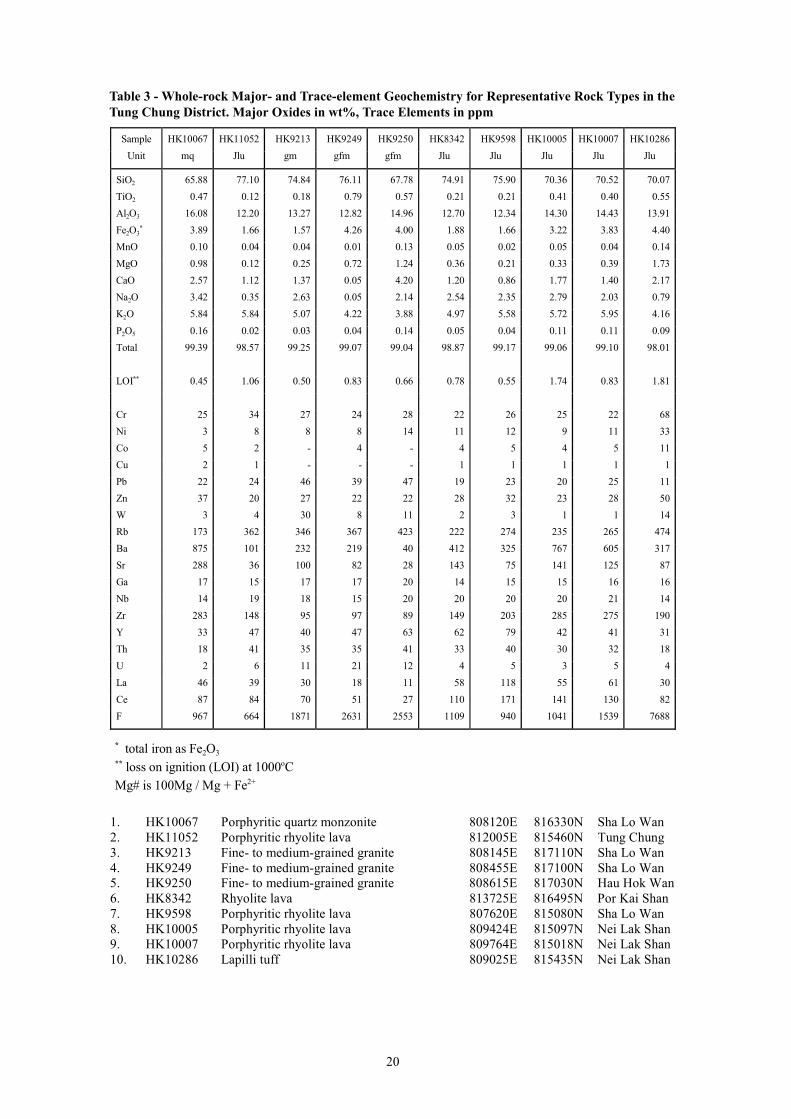
Table 3 - Whole-rock Major- and Trace-element Geochemistry for Representative Rock Types in the
Tung Chung District. Major Oxides in wt%, Trace Elements in ppm
Sample
Unit
HK10067
mq
HK11052
Jlu
HK9213
gm
HK9249
gfm
HK9250
gfm
HK8342
Jlu
HK9598
Jlu
HK10005
Jlu
HK10007
Jlu
HK10286
Jlu
Si02 65.88 77.10 74.84 76.11 67.78 74.91 75.90 70.36 70.52 70.07
Ti02 0.47 0.12 0.18 0.79 0.57 0.21 0.21 0.41 0.40 0.55
Al203 16. 80 12.20 13.27 12.82 14.96 12.70 12.34 14.30 14.43 13.91
Fe203的 3.89 1.66 1.57 4.26 4.00 1.88 1.66 3.22 3.83 4.40
Mn0 0.10 0.04 0.04 0.01 0.13 0.05 0.02 0.05 0.04 0.14
Mg0 0.98 0.12 0.25 0.72 1.24 0.36 0.21 0.33 0.39 1.73
Ca0 2.57 1.12 1.37 0.05 4.20 1.20 0.86 1.77 1.40 2.17
Na20 3.42 0.35 2.63 0.05 2.14 2.54 2.35 2.79 2.03 0.79
K20 5.84 5.84 5.07 4.22 3.88 4.97 5.58 5.72 5.95 4.16
P205 0.16 0.02 0.03 0.04 0.14 0.05 0.04 0.11 0.11 0.09
Total 99.39 98.57 99.25 99.07 99.04 98.87 99.17 99.06 99.10 98.01
L0I的的 0.45 1.06 0.50 0.83 0.66 0.78 0.55 1.74 0.83 1.81
Cr 25 34 27 24 28 22 26 25 22 68
Ni 3 8 8 8 14 11 12 9 11 33
Co 5 2 - 4 - 4 5 4 5 11
Cu 2 1 - - - 1 1 1 1 1
Pb 22 24 46 39 47 19 23 20 25 11
Zn 37 20 27 22 22 28 32 23 28
W 3 4 30 8 11 2 3 1 1 14
Rb 173 362 346 367 423 222 274 235 265 474
Ba 875 101 232 219 40 412 325 767 605 317
Sr 288 36 100 82 28 143 75 141 125 87
Ga 17 15 17 17 20 14 15 15 16 16
Nb 14 19 18 15 20 20 20 20 21 14
Zr 283 148 95 97 89 149 203 285 275 190
Y 33 47 40 47 63 62 79 42 41 31
Th 18 41 35 35 41 33 40 30 32 18
U 2 6 11 21 12 4 5 3 5 4
La 46 39 30 18 11 58 118 55 61
Ce 87 84 70 51 27 110 171 141 130 82
F 967 664 1871 2631 2553 1109 940 1041 1539 7688
50
30
的 total iron as Fe203的的 loss on ignition (L0I) at 1000oC Mg# is 100Mg / Mg + Fe2+
1. HK10067 Porphyritic quartz monzonite 808120E 816330N Sha Lo Wan 2. HK11052 Porphyritic rhyolite lava 812005E 815460N Tung Chung 3. HK9213 Fine- to medium-grained granite 808145E 817110N Sha Lo Wan 4. HK9249 Fine- to medium-grained granite 808455E 817100N Sha Lo Wan 5. HK9250 Fine- to medium-grained granite 808615E 817030N Hau Hok Wan 6. HK8342 Rhyolite lava 813725E 816495N Por Kai Shan 7. HK9598 Porphyritic rhyolite lava 807620E 815080N Sha Lo Wan 8. HK10005 Porphyritic rhyolite lava 809424E 815097N Nei Lak Shan 9. HK10007 Porphyritic rhyolite lava 809764E 815018N Nei Lak Shan 10. HK10286 Lapilli tuff 809025E 815435N Nei Lak Shan
20
faults offset the caldera boundary faults and an earlier set of north- to northnorthwest-trending faults. However, the northeast-trending faults have themselves been offset by reactivation of northnorthwest-trending faults.
Northeast- to northwest-trending quartz veins are present in the northwestern part of the district, mainly close
to granite intrusions. However, they are also found in close proximity to the caldera margin fault, intruding
volcanic rocks, and commonly contain traces of mineralization including arsenopyrite, chalcopyrite, galena,
magnetite, molybdenite, pyrite and wolframite.
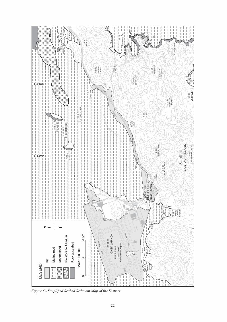
Superficial deposits within the district cover most of the low-lying ground and large tracts offshore (Figure 6). The onshore deposits comprise dominantly debris flow deposits on the higher ground and alluvial sediments on the valley floors. In the larger valleys, these have been disturbed by cultivation. Close to the coast, the superficial deposits comprise beach deposits of sand. Areas of deep weathering have been detected in boreholes beneath the Tung Chung reclamation and in a northeast-trending zone subparallel to the North Lantau coast extending from Tai Ho Wan to Ha Kok Tsui. These areas are associated with unusually thick superficial
deposits (Tung Chung Formation) comprising an assortment of debris flow deposits, laminated sediments,
and block breccias. These deposits are thought to be associated with collapse of karst-related cavities (Kirk, 2000; Fletcher et 叫l., 2000) formed from blocks of marble encased within granite and dyke intrusions.
The offshore superficial deposits on the seabed in the district consist mostly of intertidal and estuarine
deposits of sand and mud, and marine mud and sand of the Hang Hau Formation. A small area of marine sand belonging to the Chek Lap Kok Formation has been identified in the extreme northeastern part of the district
north of Yam 0 Wan. Extensive subcrop of the Chek Lap Kok Formation, and of estuarine to marine deposits
of the Sham Wat Formation, have also been identified.
21
200
100
200
100
200
100
100
200
200
100
200
300
400
100 200
300
100
100
200
300
400 50
0 600
500
400
300
200
100
200
400
300
300
300
200
100
100 20
0
300
500 40
0 300
200 10
0
200
100
200
300
400
500
300 20
0
100
100
200
100
100
200
200
300
400
100
200
Run
way
Run
way
NIM S
HUE W
AN
Proposed
m
R e c l a
a t
i o n
Lim
it
Dis
cove
ry B
ay
818
000N
81
8 00
0N
LEG
EN
D
LEG
EN
D F
ill
Fill
Mar
ine
mud
M
arin
e m
ud
814 000E 814 000E
818 000E 818 000E
SIU
MO
TO
82
2 00
0N
822
000N
M
arin
e sa
nd
Mar
ine
sand
H
A K
OK
TS
UI
CH
EU
NG
S
OK
T
HE
BR
OT
HE
RS
P
leis
toce
ne A
lluvi
um
Ple
isto
cene
Allu
vium
T
AI
MO
TO
Y
AM
O
Roc
k at
sea
bed
Roc
k at
sea
bed
WA
N
Sca
le 1
:60
000
Sca
le 1
:60
000
TS
Z K
AN
CH
AU
01
0
1 2
Km
2
Km
Y
AM
O
29
1
Sha
m S
hui
Kok
TA
I C
HE
T
UN
G
CH
EK
LA
P K
OK
Hon
g K
ong
In
tern
atio
nal A
irpor
t
YI
PA
K A
U
465
LO F
U T
AU
TA
I H
O
WA
N
PA
K M
ON
G
KE
I TA
U K
OK
77
HA
U H
OK
S
HA
LO
W
AN
W
AN
T
UN
G C
HU
NG
N
EW
TO
WN
T
IN S
AM
TA
I H
O
Res
ervo
ir T
AI P
O
PO
R K
AI S
HA
N
482
Gol
f C
ours
e T
UN
G C
HU
NG
B
AY
P
OK
TO
YA
N 529
HU
NG
FA
27
5 N
GA
N
TU
NG
C
HU
NG
V
ALL
EY
TA
I S
HU
I H
AN
G
721
200
LA
NT
AU
I
SL
AN
D
324
WO
NG
LU
NG
HA
NG
M
UI W
O
e � � �i�pli�ie� �e叫�e� �e�i�e�t �叫p o� t�e �i�t�ict
22
�i���