Embed Size (px)
Citation preview

ALTICORE-Africa workshop P. Cipollini / S. VignudelliCape Town, April 2008
Coastal Altimetry:a brief introduction
concept, development, lessons learnt, current & future initiatives
Paolo Cipollini (NOCS) & Stefano Vignudelli (CNR)

ALTICORE-Africa workshop P. Cipollini / S. VignudelliCape Town, April 2008
Outline• Altimetry at the coast:
– What we mean by coastalaltimetry
– Why it is important• Development of the field
– ALBICOCCA Project– Other recent/current
initiatives• Lessons learnt• The ALTICORE
framework - capacitybuilding
• Future prospects

ALTICORE-Africa workshop P. Cipollini / S. VignudelliCape Town, April 2008
Coastal altimetry - the concept• Satellite altimetry has been
designed for the open ocean• 15 years of data over the coastal
ocean are still unexploited andcould improve our knowledge ofcoastal processes dramatically– These data are normally flagged
as ʻbadʼ in the official GeophysicalData Records (GDRs) for anumber of reasons - non-standardwaveforms, inaccuratecorrections, etc.
• As coastal altimetry we definealtimetry over that oceandomain close to land wherestandard processing isproblematic (information issomehow hidden)
• We want to recover thatinformation!

ALTICORE-Africa workshop P. Cipollini / S. VignudelliCape Town, April 2008
Coastal altimetry - potential uses• The coastal region has enormous socio-economic-strategic importance• Long term monitoring (sea level, currents, wave) and climatologies - 15
years of data!– Integrates in situ observations (TG, currentmeters, wave meters)– Can provide observations where no instruments are available
• Assimilation into coastal models– Sediment transport and resuspension, contaminant dispersion modelling– Some schemes exist already: SOFA and SEQUOIA schemes– Might well be used in near-real-time Environmental Assessment
• In short: a legitimate component of a coastal ocean observing system!
Example of SYMPHONIEmodel output
Courtesy of J. Bouffard - See Bouffard et al., 2008, TAO

ALTICORE-Africa workshop P. Cipollini / S. VignudelliCape Town, April 2008
Coastal altimetry - development• Manzella et al 1997 - first example of
custom wet tropospheric correction• Crout 1998 - could recover data where
coastal topography is flat• Anzenhofer et al 1999 identified two
main strategies:– reprocessing of the GDRs:
• Discarding over-conservative flags• Filling gaps and filtering out noise
in some of the corrections,• Using local (more accurate)
models for tides & atmosphericeffects
– retracking of the waveforms• reprocess the single waveforms
using non-standard waveformmodels, in the attempt to recoverthe ocean surface parameters(SLA, significant wave height, windspeed)
Coastal setup in the Yellow Sea (Crout, 1998)
1st-gen products
2nd-gen productsCOASTALT/PISTACH

ALTICORE-Africa workshop P. Cipollini / S. VignudelliCape Town, April 2008
Development in the Corsica Channel
Comparison of in situ water transport with altimetric Sea Leveldifference between two ends of the Corsica channel
• Vignudelli et al 2000– Simple improvement in tidal modelling– Signal recovered consistent with in situ data
at seasonal time scales• Area of Corsica Channel is an excellent pilot
site for coastal altimetry• ALBICOCCA Project in the area (2001-
2004)• It is also one of the ALTICORE pilot sites
and COASTALT validation sites

ALTICORE-Africa workshop P. Cipollini / S. VignudelliCape Town, April 2008
Other recent and current initiatives• CIOSS/NOAA
– 10 Hz Geosat data, 20 Hz Jason-1data
– Model wet tropospheric correction– Simulation of benefits to forecasting
• X-TRACK– Coastal altimetry processor by
LEGOS/Noveltis Toulouse– Higher rate, data screening, along-
track loess filtering– Multisatellite capability– Initially developed under
ALBICOCCA, now being upgraded• ReCoSeTo
– DFG - IPG-TUD Darmstadt.– 10 Hz data, improved corrections– Will include retracking
• Many relevant papers at Venice2006 Altimetry symposium
• Dedicated International Workshop inBeijing in July 2006
• ALTICORE - funded by EU/INTAS(2006-2008)Figure courtesy of John Lillibridge, NOAA
1 Hz data
10 Hz data
GEOSAT tracks

ALTICORE-Africa workshop P. Cipollini / S. VignudelliCape Town, April 2008
Example: Vignudelli et al 2005• Recomputation of SLA along T/P track 085 with X-TRACK
system– RMS difference 2-3 cm w.r.t. Capraia station at periods > 30d– Speed anomalies:

ALTICORE-Africa workshop P. Cipollini / S. VignudelliCape Town, April 2008
Genesis of ALTICOREGenesis of ALTICORE
Incubator of the X-Track coastal altimeter processorIncubator of the X-Track coastal altimeter processor (Author: L. (Author: L. RoblouRoblou))
Built on precursor ALBICOCCA project ALtimeter-Based Investigations in COrsica, Capraia and Contiguous Areas
ALBICOCCA was a joint France/Italy/UK effort supported by CNES/ASI (2001-2004)
Focus on TOPEX/Poseidon mission at first and then extension to all
NW Mediterranean proposed as the “operational lab” for coastal altimetry
Backward reanalysis of standard products - data source: CTOH (LEGOS) - 1 Hz at first
A revised post-processing strategy - Editing and reconstruction - MOG2D-MedSea (high-freq signal de-aliasing) - Vertical reference frame (local MSS)

ALTICORE-Africa workshop P. Cipollini / S. VignudelliCape Town, April 2008
ALTICORE ALTICORE –– WHO we are WHO we are
S. VignudelliG.P. GaspariniC. GalliE. LazzoniCNRCNR Italy
Sharing knowledge across across organisationalorganisational and national boundariesnational boundaries … … but more importantly across disciplinesacross disciplines (oceanography, remote sensing, modelling, information technology, etc.)
… and drawing developing countries into the project bringstheir local expertiselocal expertise (tidal modelling, in situ measurementsfor validation/calibration, etc.)
F. LyardJ. BouffardJ. F. Cretaux
France
L. Roblou
France
H. SnaithP. CipolliniF. Venuti
UK
A. KostianoyN. SheremetA. GinzburgE. KuzminaSIOSIO Russia
S. LebedevA. SirotaD. MedvedevS. KhlebnikovaGCGC Russia
R. MamedovK. IsmatovaA. AlyevT. NabijevIGIG Azerbaijan
Now atNow atLEGOSLEGOS
A project funded byEU under CooperationProgram - INTAS(2007-2008)
Now atNow atECWMFECWMF

ALTICORE-Africa workshop P. Cipollini / S. VignudelliCape Town, April 2008
ALTICORE ALTICORE –– WHAT, HOW and WHERE WHAT, HOW and WHERE
Remember two fundamental keywords: moremore and betterbetter data… but more importantly add the new one: easyeasy access.. and build capacitycapacity in coastal altimetry on Eastern countries
with two priority topics for action in the NW Mediterranean: - Use of higher-rate data, no re-trackingUse of higher-rate data, no re-tracking - Multi-mission configuration analysisMulti-mission configuration analysis
with three priority topics for action in the other regional seas: - Getting the local knowledgeGetting the local knowledge (in situ data, regional models, etc.) (in situ data, regional models, etc.) -- Applying ALBICOCCA methodologies Applying ALBICOCCA methodologies -- Exploring the adoption of RADS data sets Exploring the adoption of RADS data sets with Web Services and Grid concepts with Web Services and Grid concepts
…… also incubator of other initiatives also incubator of other initiatives
ALTICORE-Africa workshop P. Cipollini / S. VignudelliCape Town, April 2008
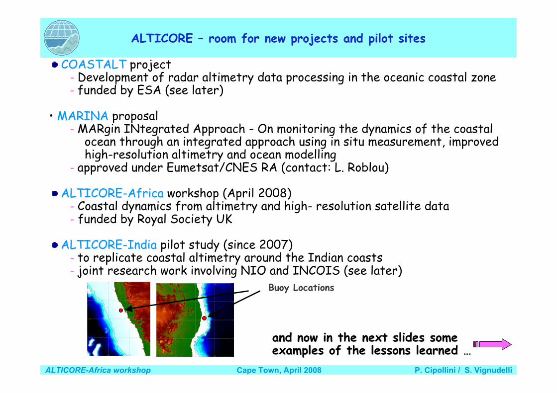
ALTICORE ALTICORE –– room for new projects and pilot sites room for new projects and pilot sites
COASTALTCOASTALT project - Development of radar altimetry data processing in the oceanic coastal zone - funded by ESA (see later)
• MARINAMARINA proposal - MARgin INtegrated Approach - On monitoring the dynamics of the coastal ocean through an integrated approach using in situ measurement, improved high-resolution altimetry and ocean modelling - approved under Eumetsat/CNES RA (contact: L. Roblou)
ALTICORE-AfricaALTICORE-Africa workshop (April 2008) - Coastal dynamics from altimetry and high- resolution satellite data - funded by Royal Society UK
ALTICORE-IndiaALTICORE-India pilot study (since 2007) - to replicate coastal altimetry around the Indian coasts - joint research work involving NIO and INCOIS (see later)
and now in the next slides someand now in the next slides someexamples of the lessons learned examples of the lessons learned ……
Buoy Locations

ALTICORE-Africa workshop P. Cipollini / S. VignudelliCape Town, April 2008
Starting point Starting point …… really no data ? really no data ?
Standard editing strategy too much conservativeStandard editing strategy too much conservative

ALTICORE-Africa workshop P. Cipollini / S. VignudelliCape Town, April 2008
Lessons learned I Lessons learned I –– Playing with flags Playing with flags
Some data flagged as “bad” would be recoverablesimply turning off RADS flags

ALTICORE-Africa workshop P. Cipollini / S. VignudelliCape Town, April 2008
Lessons learned II Lessons learned II –– Beyond flags: new editing strategy Beyond flags: new editing strategy
Screening profiles rather than single values Reconstructing /extrapolating profiles where possible
Much more data on average than using standard editing

ALTICORE-Africa workshop P. Cipollini / S. VignudelliCape Town, April 2008
Lessons learned III Lessons learned III –– Replacing global tidal models Replacing global tidal models
Example of regional tidal modelfrom HRC (Russia)
Difference of order of meters whencompared with GOT00 (global)
..Mog2D-Medsea … the regionalsolution for the NW Med Sea
with better mapping of Hi-freq
High High resolution resolution Mog2D Mog2D meshmesh
White Sea
cm
Tidal correction isproblematic

ALTICORE-Africa workshop P. Cipollini / S. VignudelliCape Town, April 2008
Lessons learned IV Lessons learned IV –– Using new vertical reference frame Using new vertical reference frame
Sea Level Anomaly computed from standard MSS is goodfor deep basin but not for shelves and slopes
A new method to compute a local MSS

ALTICORE-Africa workshop P. Cipollini / S. VignudelliCape Town, April 2008
Lessons learned V Lessons learned V –– More in quantity and quality More in quantity and quality
Nearer coasts but even in open sea
This promises a better monitoring of theLiguro-Provencal Current
which flows very close to the coastand exhibits a small spatial extension.
(Bouffard et. al. 2008, submitted to JAOT ..)

ALTICORE-Africa workshop P. Cipollini / S. VignudelliCape Town, April 2008
Lessons learned VI Lessons learned VI –– Exploiting a multi-mission scenario Exploiting a multi-mission scenario
Multi-satellite altimetry agrees well with the in situmeasurements even at time scales shorter than seasonal.
Non-homogeneity between missions is the major problem … Large-scale orbit error is the dominant component
LSER methodology for regional applications, Bouffard et al. 2008, GRL in rev.
Example of comparison of multi-mission altimetry at Genoa sea level station

ALTICORE-Africa workshop P. Cipollini / S. VignudelliCape Town, April 2008
Lessons learned VII Lessons learned VII –– Disseminating data efficiently Disseminating data efficiently
InteroperabilityInteroperability::Not only a technical question,Not only a technical question, but a cultural issue ! but a cultural issue !
With an With an ““eyeeye”” to possible users and applications to possible users and applications ……
OPenDAPOPenDAP + + netCDFnetCDF in coastal altimetry data management ?in coastal altimetry data management ? (more from H. (more from H. Snaith Snaith in in ““DataData”” presentation) presentation) e.g. we tested access to data on remote sites from within e.g. we tested access to data on remote sites from within Matlab Matlab codecode

ALTICORE-Africa workshop P. Cipollini / S. VignudelliCape Town, April 2008
ALTICORE web site
www.alticore.eu

ALTICORE-Africa workshop P. Cipollini / S. VignudelliCape Town, April 2008
ALTICORE ALTICORE –– coastal altimetry to everyone and everywhere coastal altimetry to everyone and everywhere
“A pilot study on the improvement and applicationof real time satellite altimeter data to derive coastalcurrents off the Indian Ocean “
joint research project between the National Institute of
Oceanography (NIO), Dona Paula, Goa and the Indian
National Centre for Ocean Information Services
(INCOIS), Hyderabad
…now replicated along theIndian Coasts!
Contacts: Dr. Y.K. Somayajulu (NIO), Dr. M. Ravichandran (INCOIS)
Objectives:to replicate and extend the ALTICORE methodology for coastalaltimetry around the Indian coasts
to explore the coastal dynamics of the waters in the seasbordering India.

ALTICORE-Africa workshop P. Cipollini / S. VignudelliCape Town, April 2008

ALTICORE-Africa workshop P. Cipollini / S. VignudelliCape Town, April 2008
The way forward• Work done so far has been promising, but to improve further we
need:1. Specialized retracking (to get closer to coast)2. Constellations (to improve spatio/temporal sampling)3. New sensor conceptsESA is funding the COASTALT study on ”DEVELOPMENT OF RADAR
ALTIMETRY DATA PROCESSING IN THE OCEANIC COASTALZONE” - NOCS leading with POL, CNR, U Cadiz, Starlab
operational processor for EnviSat Coastal AltimetryCNES is funding the PISTACH study in parallel (led by CLS and
focusing on JASON)A good thing is also that future sensors (AltiKa, WSOA, SIRAL on
Cryosat, Sentinel-3 altimeter…) are being designed with an eye topossible coastal applications
Also, for coastal altimetry to become operational, data access/datadissemination issues are crucial (a neat solution for these is heone being prototyped in the ALTICORE Project) - also for capacitybuilding

ALTICORE-Africa workshop P. Cipollini / S. VignudelliCape Town, April 2008
How does ALTICORE-Africa fit into this?
• Fill gaps in/integrate with current coastalobserving systems
• Potentially great synergy with LMEs work• Contribute to capacity building for altimetry• One (or more) new regional data centersin the
ALTICORE family??

ALTICORE-Africa workshop P. Cipollini / S. VignudelliCape Town, April 2008
SummarySummary Existing initiatives such as ALBICOCCA/ALTICORE have paved the way
to coastal altimetry … and we have learnt a number of lessonswe have learnt a number of lessons: - Need specialized processing - Much improved corrections now possible but not everywhere - Promote along-track data rather than gridded products - Rethinking data management is crucial to success (measured in terms of users exploiting the data) - International cooperation is essential
but we still need to improve coastal altimetry - Optimizing signal to noise ratio (developing specialized re-tracking,specialized re-tracking, to go closer coasts, improve measurement accuracy and precision - like in COASTALT) - Testing new sensor conceptsnew sensor concepts (constellations, SWOT, Ka-band Altimeter, Delay-Doppler Altimeter, - see SAMOSA)
And promoting USE (as in ALTICORE-Africa, ALTICORE-India)
Coastal altimetry should become part of any coastal observing systemcoastal observing system - we need to merge in situ, modeling and remote sensing to study local dynamics
Essential message: This newly formed community of "coastal altimetrists“ must be encouraged to work together

ALTICORE-Africa workshop P. Cipollini / S. VignudelliCape Town, April 2008
A rosy future for coastal altimetry?• A good amount of research has been done already; more
is needed, but several groups are working on it• COASTALT (ESA) and PISTACH (CNES) are paving the
way to operational coastal altimetry• ALTICORE, ALTICORE-India, ALTICORE-Africa are
widening up the user base• The US altimetry community got quite interested too and
CIOSS and NOAA organized the 1st Coastal AltimetryWorkshop last February in Silver Spring, Maryland– ~50 scientists including many from Europe– see
http://cioss.coas.oregonstate.edu/CIOSS/altimeter_workshop.html• This will be followed up…

2nd Coastal Altimetry WorkshopPisa, Italy, (5)-6-7 November 2008
• Showcase of COASTALT (and PISTACH)results
• Wed-Fri of week before Nice OSTST(which is on 10-14 Nov)– Wed 5 Nov: COASTALT Project meeting– Thu 6 - Fri 7 Nov: open workshop
• Also includes ALTICORE end-of-projectsummary
• Aims to follow-on to the many issuestouched in the recent US workshop, suchas:– Consolidate results on improvement of
corrections and editing– Discuss first results on coastal retracking– Promote future cooperation
• Findings/recommendations to be reportedat OSTST
• Organizers: S. Vignudelli, J. Benveniste,N. Picot, P. Cipollini
www.coastalt.eu/pisaworkshop08Mailing list: [email protected]