Embed Size (px)
Citation preview
Columbia River ESI: HYDRO (Hydrography Lines and Polygons)
Page: 1
Columbia River ESI: HYDRO (Hydrography Linesand Polygons)Metadata also available as - [Parseable text] - [SGML]
Metadata:Identification_Information Data_Quality_Information Spatial_Data_Organization_Information Spatial_Reference_Information Entity_and_Attribute_Information Distribution_Information Metadata_Reference_Information
Identification_Information: Citation:
Citation_Information: Originator:
National Oceanic and Atmospheric Administration (NOAA), National OceanService, Office of Response and Restoration, Hazardous Materials ResponseDivision, Seattle, Washington; Coastal Storms Initiative; U.S. Fish and WildlifeService; NOAA Fisheries; State of Oregon; and State of Washington.
Publication_Date: 200411 Title: Columbia River ESI: HYDRO (Hydrography Lines and Polygons) Edition: First Geospatial_Data_Presentation_Form: Vector digital data Series_Information:
Series_Name: None Issue_Identification: Columbia River
Publication_Information: Publication_Place: Seattle, Washington Publisher:
National Oceanic and Atmospheric Administration (NOAA), NationalOcean Service, Office of Response and Restoration, Hazardous MaterialsResponse Division, Seattle, Washington
Other_Citation_Details: Prepared by Research Planning, Inc., Columbia, South Carolina for the NationalOceanic and Atmospheric Administration (NOAA), National Ocean Service, Officeof Response and Restoration, Hazardous Materials Response Division, Seattle,Washington; Coastal Storms Initiative; U.S. Fish and Wildlife Service; NOAAFisheries; State of Oregon; and State of Washington.
Description: Abstract:
This data set contains vector lines and polygons representing coastal hydrography used inthe creation of the Environmental Sensitivity Index (ESI) for Columbia River. The HYDROdata layer contains all annotation used in producing the atlas. The annotation features arecategorized into three subclasses in order to simplify the mapping and quality controlprocedures: GEOG, or geographic features; SOC, or socioeconomic features; and HYDRO,or water features.
This data set comprises a portion of the ESI data for Columbia River. ESI data characterizethe marine and coastal environments and wildlife by their sensitivity to spilled oil. The ESIdata include information for three main components: shoreline habitats, sensitive biological

Columbia River ESI: HYDRO (Hydrography Lines and Polygons)
Page: 2
resources, and human-use resources. Purpose:
The ESI data were collected, mapped, and digitized to provide environmental data for oil spillplanning and response. The Clean Water Act with amendments by the Oil Pollution Act of1990 requires response plans for immediate and effective protection of sensitive resources.
Time_Period_of_Content: Time_Period_Information:
Range_of_Dates/Times: Beginning_Date: 1999 Ending_Date: 2003
Currentness_Reference: The data were compiled during 2003-2004. The currentness dates for the data range from1999 to 2003 and are documented in the Lineage section.
Status: Progress: Complete Maintenance_and_Update_Frequency: None Scheduled
Spatial_Domain: Bounding_Coordinates:
West_Bounding_Coordinate: -124.125 East_Bounding_Coordinate: -120.67375 North_Bounding_Coordinate: 46.375 South_Bounding_Coordinate: 45.3
Keywords: Theme:
Theme_Keyword_Thesaurus: None Theme_Keyword: ESI Theme_Keyword: Sensitivity maps Theme_Keyword: Coastal resources Theme_Keyword: Oil spill planning Theme_Keyword: Coastal Zone Management Theme_Keyword: Wildlife Theme_Keyword: Hydrography
Place: Place_Keyword_Thesaurus: None Place_Keyword: Columbia River
Access_Constraints: None Use_Constraints:
DO NOT USE MAPS FOR NAVIGATIONAL PURPOSES. Besides the above warning, there areno use constraints on these data. Note that the ESI database should not be used to the exclusion ofother pertinent data or information held by state or federal agencies or other organizations. Likewise,information contained in the database cannot be used in place of consultations with environmental,natural resource, and cultural resource agencies, or in place of field surveys. Recognize that theinformation contained in the ESI database represents known concentration areas or occurrences ofnatural, cultural, and human-use resources, but does not necessarily represent the full distribution orrange of each species or resource. This is particularly important to recognize when consideringpotential impacts to protected resources, such as endangered species, wetlands, etc. Acknowledgmentof the originators, publishers, contributors, and sources listed would be appreciated in productsderived from these data.
Browse_Graphic: Browse_Graphic_File_Name: datafig.jpg Browse_Graphic_File_Description:
Depicts the relationships between spatial data layers and attribute data tables for theColumbia River ESI data.
Browse_Graphic_File_Type: JPEG Data_Set_Credit:
This project was supported by the National Oceanic and Atmospheric Administration (NOAA),National Ocean Service, Office of Response and Restoration, Hazardous Materials ResponseDivision, Seattle, Washington; Coastal Storms Initiative; U.S. Fish and Wildlife Service; NOAAFisheries; State of Oregon; and State of Washington.
Native_Data_Set_Environment:

Columbia River ESI: HYDRO (Hydrography Lines and Polygons)
Page: 3
The software packages used to develop the atlas are Environmental Systems Research Institute'sARC/INFO(r) (version 8.3) and SQL SERVER(r) (version 7.0). The hardware configuration is PC'swith Windows Operating System (NT4.0/2000).
The Spatial_Data_Organization Information section refers only to the source files in the ARC exportformat. The following files are included in that data set: birds.e00, esi.e00, fish.e00, fishl.e00,habitats.e00, hydro.e00, index.e00, invert.e00, m_mammal.e00, m_mampt.e00, mgt.e00, nests.e00,nwi.e00, reptiles.e00, socecon.e00, t_mammal.e00. Associated relational and desktop data tablesprovided in Arc export and text format are bio_lut, biofile, biores, breed, breed_dt, runs_dat, seasonal,soc_dat, soc_lut, sources, species, and status.
Data_Quality_Information: Attribute_Accuracy:
Attribute_Accuracy_Report: A multi-stage error checking process is used to verify both attribute accuracy and logicalconsistency throughout data production. The process includes a standardized data entrymethodology, hardcopy data review by in-house and external resource experts, a final QualityAssurance/Quality Control (QA/QC) process, and multiple automated logical consistencychecks. Quantitative data (such as densities, counts, abundances, or concentrations) providedby resource experts for inclusion in the data set may vary widely in attribute accuracy,depending upon the methodology used to collect and compile such data. For a more detailedevaluation of source data attribute accuracy, contact the sources listed in the Lineage section.
Logical_Consistency_Report: A multi-stage error checking process, described in the above Attribute_Accuracy_Report, is used toverify both attribute accuracy and logical consistency throughout data production. This processincludes multiple automated logical consistency checks that test the files for missing or duplicate data,rules for proper coding, GIS topological consistencies (such as dangles, unnecessary nodes, etc.), andSQL SERVER(r) to ARC/INFO(r) consistencies. A final review is made by the GIS manager, wherethe data are written to CD-ROM and the metadata are written. After the data are delivered to NOAA,they are again subjected to a number of quality and consistency checks.
Completeness_Report: These data represent the linear and polygonal hydrography for Columbia River.
Positional_Accuracy: Horizontal_Positional_Accuracy:
Horizontal_Positional_Accuracy_Report: The hydrography data set was developed from pre-existing digital data and reflectsthe positional accuracy of these original data. The horizontal positional accuracy ofthe 1:24,000 USGS topographic quads should conform to National Map AccuracyStandards at scales of 1:24,000. See the Lineage and Process_Description sectionsfor more information on the original source data and how these data were integratedor manipulated to create the final data set.
Lineage: Source_Information:
Source_Citation: Citation_Information:
Originator: Oregon/Washington Bureau of Land Management (BLM) Publication_Date: 2001 Title: Boundary State Oregon Washington Geospatial_Data_Presentation_Form: Digital Vector Data Publication_Information:
Publication_Place: Portland, OR Publisher: Oregon/Washington BLM
Source_Scale_Denominator: 24000 Type_of_Source_Media: Online Source_Time_Period_of_Content:
Time_Period_Information: Range_of_Dates/Times:
Beginning_Date: 1999
Columbia River ESI: HYDRO (Hydrography Lines and Polygons)
Page: 4
Ending_Date: 2001 Source_Currentness_Reference: Ground condition
Source_Citation_Abbreviation: None Source_Contribution: Shoreline for main branch of Columbia River
Source_Information: Source_Citation:
Citation_Information: Originator: Colin Plank, Research Planning, Inc. Publication_Date: Unpublished material Title: ESI Overflight Geospatial_Data_Presentation_Form: Map Publication_Information:
Publication_Place: Unpublished material Publisher: Unpublished material
Source_Scale_Denominator: 24000 Type_of_Source_Media: Paper Source_Time_Period_of_Content:
Time_Period_Information: Single_Date/Time:
Calendar_Date: 200310 Source_Currentness_Reference: Date of overflight
Source_Citation_Abbreviation: None Source_Contribution: Hydrography information
Source_Information: Source_Citation:
Citation_Information: Originator: U.S. Geological Survey (USGS) Publication_Date: Varies Title: 7.5 Minute Topographic Quadrangles Geospatial_Data_Presentation_Form: Map Publication_Information:
Publication_Place: Reston, VA or Denver, CO Publisher: USGS
Source_Scale_Denominator: 24000 Type_of_Source_Media: Paper Source_Time_Period_of_Content:
Time_Period_Information: Single_Date/Time:
Calendar_Date: Varies Source_Currentness_Reference: Date of Publication
Source_Citation_Abbreviation: None Source_Contribution: Hydrography information
Source_Information: Source_Citation:
Citation_Information: Originator: Oregon Department of Transportation (ORDOT) Publication_Date: Unknown Title: County Maps Geospatial_Data_Presentation_Form: Digital Vector Data Publication_Information:
Publication_Place: Unknown Publisher: ORDOT
Source_Scale_Denominator: 100,000 Type_of_Source_Media: Online Source_Time_Period_of_Content:
Time_Period_Information: Single_Date/Time:
Calendar_Date: Unknown Source_Currentness_Reference: Unknown
Source_Citation_Abbreviation: None
Columbia River ESI: HYDRO (Hydrography Lines and Polygons)
Page: 5
Source_Contribution: Hydrography information for Columbia, Multnomah, and Clackamas counties
Source_Information: Source_Citation:
Citation_Information: Originator: Katheryn Simmons, NOAA, U.S. National Response Team Publication_Date: Unpublished material Title: mllwshore_utm Geospatial_Data_Presentation_Form: Digital Vector Data Publication_Information:
Publication_Place: Unpublished material Publisher: Unpublished material
Source_Scale_Denominator: Unknown Type_of_Source_Media: Electronic Mail System Source_Time_Period_of_Content:
Time_Period_Information: Single_Date/Time:
Calendar_Date: Unknown Source_Currentness_Reference: Unknown
Source_Citation_Abbreviation: None Source_Contribution: Hydrography information for Columbia River
Process_Step: Process_Description:
The shoreline was derived primarily from digital shoreline data fromOregon/Washington Bureau of Land Management (BLM). In some cases, minorshoreline changes or additional polygons were sketched during the overflightsconducted during October 2003. Overflight changes were digitized from the scannedand registered hardcopy field maps. After the initial shoreline classification, thesedata were edgematched and checked for logical consistency errors. Review mapswere plotted at 1:24000 scale for verification of polygonal and linear attributes.
Process_Date: 200408 Process_Contact:
Contact_Information: Contact_Organization_Primary:
Contact_Organization: NOAA, Office of Response andRestoration Contact_Person: Jill Petersen
Contact_Address: Address_Type: Physical address Address: 7600 Sand Point Way N.E. City: Seattle State_or_Province: Washington Postal_Code: 98115-6349
Contact_Voice_Telephone: (206) 526-6944 Contact_Facsimile_Telephone: (206) 526-6329 Contact_Electronic_Mail_Address: [email protected]
Spatial_Data_Organization_Information: Direct_Spatial_Reference_Method: Vector Point_and_Vector_Object_Information:
SDTS_Terms_Description: SDTS_Point_and_Vector_Object_Type: GT-polygon composed of rings Point_and_Vector_Object_Count: 774
SDTS_Terms_Description: SDTS_Point_and_Vector_Object_Type: Area point Point_and_Vector_Object_Count: 774
SDTS_Terms_Description: SDTS_Point_and_Vector_Object_Type: Complete chain

Columbia River ESI: HYDRO (Hydrography Lines and Polygons)
Page: 6
Point_and_Vector_Object_Count: 1557 SDTS_Terms_Description:
SDTS_Point_and_Vector_Object_Type: Link Point_and_Vector_Object_Count: 282656
SDTS_Terms_Description: SDTS_Point_and_Vector_Object_Type: Label Point Point_and_Vector_Object_Count: 172
SDTS_Terms_Description: SDTS_Point_and_Vector_Object_Type: Node, planar graph Point_and_Vector_Object_Count: 1556
Spatial_Reference_Information: Horizontal_Coordinate_System_Definition:
Geographic: Latitude_Resolution: 0.0000001 Longitude_Resolution: 0.0000001 Geographic_Coordinate_Units: Decimal degrees
Geodetic_Model: Horizontal_Datum_Name: North American Datum of 1927 Ellipsoid_Name: Clark 1866 Semi-major_Axis: 6378206.4 Denominator_of_Flattening_Ratio: 294.978698
Entity_and_Attribute_Information: Detailed_Description:
Entity_Type: Entity_Type_Label: HYDRO.AAT Entity_Type_Definition:
The HYDRO.AAT table contains attribute information for the vector linesrepresenting linear hydrography features in the HYDRO data layer.
Entity_Type_Definition_Source: Research Planning, Inc. Attribute:
Attribute_Label: LINE Attribute_Definition: Type of geographic feature Attribute_Definition_Source: Research Planning, Inc. Attribute_Domain_Values:
Enumerated_Domain: Enumerated_Domain_Value: B Enumerated_Domain_Value_Definition: Breakwater Enumerated_Domain_Value_Definition_Source: Research Planning, Inc.
Enumerated_Domain: Enumerated_Domain_Value: H Enumerated_Domain_Value_Definition: Hydrography Enumerated_Domain_Value_Definition_Source: Research Planning, Inc.
Enumerated_Domain: Enumerated_Domain_Value: I Enumerated_Domain_Value_Definition: Index Enumerated_Domain_Value_Definition_Source: Research Planning, Inc.
Enumerated_Domain: Enumerated_Domain_Value: S Enumerated_Domain_Value_Definition: Shoreline Enumerated_Domain_Value_Definition_Source: Research Planning, Inc.
Attribute: Attribute_Label: SOURCE_ID Attribute_Definition: Data source of the ESI lines Attribute_Definition_Source: Research Planning, Inc.

Columbia River ESI: HYDRO (Hydrography Lines and Polygons)
Page: 7
Attribute_Domain_Values: Enumerated_Domain:
Enumerated_Domain_Value: 1 Enumerated_Domain_Value_Definition:
Digital shoreline from Oregon/Washington Bureau of LandManagement (BLM)
Enumerated_Domain_Value_Definition_Source: Research Planning, Inc. Enumerated_Domain:
Enumerated_Domain_Value: 2 Enumerated_Domain_Value_Definition:
Digitized from low-altitude overflight field sketches and obliquephotography
Enumerated_Domain_Value_Definition_Source: Research Planning, Inc. Enumerated_Domain:
Enumerated_Domain_Value: 5 Enumerated_Domain_Value_Definition: Digitized from scanned1:24,000-USGS topographic quadrangles Enumerated_Domain_Value_Definition_Source: Research Planning, Inc.
Enumerated_Domain: Enumerated_Domain_Value: 7 Enumerated_Domain_Value_Definition: Digital map boundary fromINDEX data layer Enumerated_Domain_Value_Definition_Source: Research Planning, Inc.
Enumerated_Domain: Enumerated_Domain_Value: 8 Enumerated_Domain_Value_Definition:
Digital shoreline from Oregon Department of Transportationcounty maps
Enumerated_Domain_Value_Definition_Source: Research Planning, Inc. Enumerated_Domain:
Enumerated_Domain_Value: 9 Enumerated_Domain_Value_Definition: Digital shoreline from NationalResponse Team Enumerated_Domain_Value_Definition_Source: Research Planning, Inc.
Detailed_Description: Entity_Type:
Entity_Type_Label: HYDRO.PAT Entity_Type_Definition:
The HYDRO.PAT table contains attribute information for the vector polygonsrepresenting polygonal hydrography features in the HYDRO data layer.
Entity_Type_Definition_Source: Research Planning, Inc. Attribute:
Attribute_Label: WATER_CODE Attribute_Definition: Specifies a polygon as either water or land Attribute_Definition_Source: Research Planning, Inc. Attribute_Domain_Values:
Enumerated_Domain: Enumerated_Domain_Value: L Enumerated_Domain_Value_Definition: Land Enumerated_Domain_Value_Definition_Source: Research Planning, Inc.
Enumerated_Domain: Enumerated_Domain_Value: W Enumerated_Domain_Value_Definition: Water Enumerated_Domain_Value_Definition_Source: Research Planning, Inc.
Detailed_Description: Entity_Type:
Entity_Type_Label: ANNO.GEOG Entity_Type_Definition:
The spatial data layer HYDRO contains label points representing annotation forgeographic features.
Columbia River ESI: HYDRO (Hydrography Lines and Polygons)
Page: 8
Entity_Type_Definition_Source: Research Planning, Inc. Detailed_Description:
Entity_Type: Entity_Type_Label: ANNO.HYDRO Entity_Type_Definition:
The spatial data layer HYDRO contains label points representing annotation forwater features.
Entity_Type_Definition_Source: Research Planning, Inc. Detailed_Description:
Entity_Type: Entity_Type_Label: ANNO.SOC Entity_Type_Definition:
The spatial data layer HYDRO contains label points representing annotation forsocioeconomic features.
Entity_Type_Definition_Source: Research Planning, Inc.
Distribution_Information: Distributor:
Contact_Information: Contact_Person_Primary:
Contact_Person: John Kaperick Contact_Organization: NOAA, Office of Response and Restoration
Contact_Address: Address_Type: Physical Address Address: 7600 Sand Point Way N.E. City: Seattle State_or_Province: Washington Postal_Code: 98115-6349
Contact_Voice_Telephone: (206) 526-6400 Contact_Facsimile_Telephone: (206) 526-6329
Resource_Description: ESI Atlas for Columbia River Distribution_Liability:
Although these data have been processed successfully on a computer system at the National Oceanicand Atmospheric Administration, no warranty, expressed or implied, is made by NOAA regarding theutility of the data on any other system, nor shall the act of distribution constitute any such warranty.NOAA warrants the delivery of this product in computer-readable format, and will offer a replacementcopy of the product when the product is determined unreadable by computer-input peripherals, orwhen the physical medium is delivered in damaged condition.
Custom_Order_Process: Contact NOAA for distribution options (see Distributor). ESI data are processed into multipleformats to make them useful to a wider community of GIS/mapping users. Distribution formatsinclude ARC export, MOSS and Shape files, and MARPLOT map folders. An ArcView ESI projectand ESI_Viewer product are also included on the distribution CDs for ease of use of the ESI data.The database files are distributed both in the NOAA standard relational database format (see NOAATechnical Memorandum NOS ORCA 115) and in a simplified desktop flat file format. This metadatadocument includes information on both of these database formats.
Metadata_Reference_Information: Metadata_Date: 200411 Metadata_Review_Date: 200411 Metadata_Contact:
Contact_Information: Contact_Person_Primary:
Contact_Person: Jill Petersen Contact_Organization: NOAA, Office of Response and Restoration
Contact_Position: GIS Manager

Columbia River ESI: HYDRO (Hydrography Lines and Polygons)
Page: 9
Contact_Address: Address_Type: Physical Address Address: 7600 Sand Point Way N.E. City: Seattle State_or_Province: Washington Postal_Code: 98115-6349
Contact_Voice_Telephone: (206) 526-6944 Contact_Facsimile_Telephone: (206) 526-6329 Contact_Electronic_Mail_Address: [email protected]
Metadata_Standard_Name: Content Standards for Digital Geospatial Metadata Metadata_Standard_Version: FGDC-STD-001-1998
Generated by mp version 2.8.2 on Fri Dec 10 13:40:03 2004
Columbia River ESI: ESI (Environmental Sensitivity Index Shoreline Types - Lines and Polygons)
Page: 1
Columbia River ESI: ESI (Environmental SensitivityIndex Shoreline Types - Lines and Polygons)Metadata also available as - [Parseable text] - [SGML]
Metadata:Identification_Information Data_Quality_Information Spatial_Data_Organization_Information Spatial_Reference_Information Entity_and_Attribute_Information Distribution_Information Metadata_Reference_Information
Identification_Information: Citation:
Citation_Information: Originator:
National Oceanic and Atmospheric Administration (NOAA), National OceanService, Office of Response and Restoration, Hazardous Materials ResponseDivision, Seattle, Washington; Coastal Storms Initiative; U.S. Fish and WildlifeService; NOAA Fisheries; State of Oregon; and State of Washington.
Publication_Date: 200411 Title:
Columbia River ESI: ESI (Environmental Sensitivity Index Shoreline Types - Linesand Polygons)
Edition: First Geospatial_Data_Presentation_Form: Vector digital data Series_Information:
Series_Name: None Issue_Identification: Columbia River
Publication_Information: Publication_Place: Seattle, Washington Publisher:
National Oceanic and Atmospheric Administration (NOAA), NationalOcean Service, Office of Response and Restoration, Hazardous MaterialsResponse Division, Seattle, Washington
Other_Citation_Details: Prepared by Research Planning, Inc., Columbia, South Carolina for the NationalOceanic and Atmospheric Administration (NOAA), National Ocean Service, Officeof Response and Restoration, Hazardous Materials Response Division, Seattle,Washington; Coastal Storms Initiative; U.S. Fish and Wildlife Service; NOAAFisheries; State of Oregon; and State of Washington.
Description: Abstract:
This data set contains vector lines and polygons representing the shoreline and coastalhabitats of Columbia River classified according to the Environmental Sensitivity Index (ESI)classification system. This data set comprises a portion of the ESI data for Columbia River.ESI data characterize the marine and coastal environments and wildlife by their sensitivity tospilled oil. The ESI data include information for three main components: shoreline habitats,sensitive biological resources, and human-use resources.
Purpose: The ESI data were collected, mapped, and digitized to provide environmental data for oil spill

Columbia River ESI: ESI (Environmental Sensitivity Index Shoreline Types - Lines and Polygons)
Page: 2
planning and response. The Clean Water Act with amendments by the Oil Pollution Act of1990 requires response plans for immediate and effective protection of sensitive resources.
Time_Period_of_Content: Time_Period_Information:
Range_of_Dates/Times: Beginning_Date: 2003 Ending_Date: 2004
Currentness_Reference: The data were compiled during 2003-2004. The currentness date for the data is 2003 and isdocumented in the Lineage section.
Status: Progress: Complete Maintenance_and_Update_Frequency: None Scheduled
Spatial_Domain: Bounding_Coordinates:
West_Bounding_Coordinate: -124.125 East_Bounding_Coordinate: -120.67375 North_Bounding_Coordinate: 46.375 South_Bounding_Coordinate: 45.3
Keywords: Theme:
Theme_Keyword_Thesaurus: None Theme_Keyword: ESI Theme_Keyword: Sensitivity maps Theme_Keyword: Coastal resources Theme_Keyword: Oil spill planning Theme_Keyword: Coastal Zone Management Theme_Keyword: Wildlife
Place: Place_Keyword_Thesaurus: None Place_Keyword: Columbia River
Access_Constraints: None Use_Constraints:
DO NOT USE MAPS FOR NAVIGATIONAL PURPOSES. Besides the above warning, there areno use constraints on these data. Note that the ESI database should not be used to the exclusion ofother pertinent data or information held by state or federal agencies or other organizations. Likewise,information contained in the database cannot be used in place of consultations with environmental,natural resource, and cultural resource agencies, or in place of field surveys. Recognize that theinformation contained in the ESI database represents known concentration areas or occurrences ofnatural, cultural, and human-use resources, but does not necessarily represent the full distribution orrange of each species or resource. This is particularly important to recognize when consideringpotential impacts to protected resources, such as endangered species, wetlands, etc. Acknowledgmentof the originators, publishers, contributors, and sources listed would be appreciated in productsderived from these data.
Browse_Graphic: Browse_Graphic_File_Name: datafig.jpg Browse_Graphic_File_Description:
Depicts the relationships between spatial data layers and attribute data tables for theColumbia River ESI data.
Browse_Graphic_File_Type: JPEG Data_Set_Credit:
This project was supported by the National Oceanic and Atmospheric Administration (NOAA),National Ocean Service, Office of Response and Restoration, Hazardous Materials ResponseDivision, Seattle, Washington; Coastal Storms Initiative; U.S. Fish and Wildlife Service; NOAAFisheries; State of Oregon; and State of Washington.
Native_Data_Set_Environment: The software packages used to develop the atlas are Environmental Systems Research Institute'sARC/INFO(r) (version 8.3) and SQL SERVER(r) (version 7.0). The hardware configuration is PC'swith Windows Operating System (NT4.0/2000).

Columbia River ESI: ESI (Environmental Sensitivity Index Shoreline Types - Lines and Polygons)
Page: 3
The Spatial_Data_Organization_Information section refers only to the source files in the ARC exportformat. The following files are included in that data set: birds.e00, esi.e00, fish.e00, fishl.e00,habitats.e00, hydro.e00, index.e00, invert.e00, m_mammal.e00, m_mampt.e00, mgt.e00, nests.e00,nwi.e00, reptiles.e00, socecon.e00, t_mammal.e00. Associated relational and desktop data tablesprovided in Arc export and text format are bio_lut, biofile, biores, breed, breed_dt, runs_dat, seasonal,soc_dat, soc_lut, sources, species, and status.
Data_Quality_Information: Attribute_Accuracy:
Attribute_Accuracy_Report: A multi-stage error checking process is used to verify both attribute accuracy and logicalconsistency throughout data production. The process includes a standardized data entrymethodology, hardcopy data review by in-house and external resource experts, a final QualityAssurance/Quality Control (QA/QC) process, and multiple automated logical consistencychecks. Quantitative data (such as densities, counts, abundances, or concentrations) providedby resource experts for inclusion in the data set may vary widely in attribute accuracy,depending upon the methodology used to collect and compile such data. For a more detailedevaluation of source data attribute accuracy, contact the sources listed in the Lineage section.
Logical_Consistency_Report: A multi-stage error checking process, described in the above Attribute_Accuracy_Report, is used toverify both attribute accuracy and logical consistency throughout data production. This processincludes multiple automated logical consistency checks that test the files for missing or duplicate data,rules for proper coding, GIS topological consistencies (such as dangles, unnecessary nodes, etc.), andSQL SERVER(r) to ARC/INFO(r) consistencies. A final review is made by the GIS manager, wherethe data are written to CD-ROM and the metadata are written. After the data are delivered to NOAA,they are again subjected to a number of quality and consistency checks.
Completeness_Report: These data represent coastal shorelines and habitats classified according to the ESI classificationsystem.
Positional_Accuracy: Horizontal_Positional_Accuracy:
Horizontal_Positional_Accuracy_Report: The ESI data set was developed from pre-existing digital sources and reflects thepositional accuracy of these original data. The horizontal positional accuracy of the1:24,000 USGS topographic quads should conform to National Map AccuracyStandards at scales of 1:24,000. The minimum mapping unit (MMU) of the actualshoreline classification segments is estimated at 50 meters where mapping isconducted using 1:24,000 hardcopy field maps. Field verification has shown that theabsolute positional accuracy of breaks between shoreline ESI types with a95-percent error bound is approximately 58 meters. See the Lineage andProcess_Description sections for more information on the original data source andhow these data were integrated or manipulated to create the final data set.
Lineage: Source_Information:
Source_Citation: Citation_Information:
Originator: Colin Plank, Research Planning, Inc. Publication_Date: 200310 Title: ESI Overflight Geospatial_Data_Presentation_Form: Map Publication_Information:
Publication_Place: Unpublished material Publisher: Unpublished material
Source_Scale_Denominator: 24000 Type_of_Source_Media: Paper Source_Time_Period_of_Content:
Time_Period_Information: Single_Date/Time:

Columbia River ESI: ESI (Environmental Sensitivity Index Shoreline Types - Lines and Polygons)
Page: 4
Calendar_Date: 200310 Source_Currentness_Reference: Date of overflight
Source_Citation_Abbreviation: None Source_Contribution: Shoreline classification
Source_Information: Source_Citation:
Citation_Information: Originator: Oregon/Washington Bureau of Land Management (BLM) Publication_Date: 2001 Title: Boundary State Oregon Washington Geospatial_Data_Presentation_Form: Digital Vector Data Publication_Information:
Publication_Place: Portland, OR Publisher: Oregon/Washington BLM
Source_Scale_Denominator: 24000 Type_of_Source_Media: Online Source_Time_Period_of_Content:
Time_Period_Information: Range_of_Dates/Times:
Beginning_Date: 1999 Ending_Date: 2001
Source_Currentness_Reference: Ground condition Source_Citation_Abbreviation: None Source_Contribution: Shoreline for main branch of Columbia River
Source_Information: Source_Citation:
Citation_Information: Originator: U.S. Geological Survey (USGS) Publication_Date: Varies Title: 7.5 Minute Topographic Quadrangles Geospatial_Data_Presentation_Form: Map Publication_Information:
Publication_Place: Reston, VA or Denver, CO Publisher: USGS
Source_Scale_Denominator: 24000 Type_of_Source_Media: Paper Source_Time_Period_of_Content:
Time_Period_Information: Single_Date/Time:
Calendar_Date: Varies Source_Currentness_Reference: Date of Publication
Source_Citation_Abbreviation: None Source_Contribution: Hydrography information
Source_Information: Source_Citation:
Citation_Information: Originator: Oregon Department of Transportation (ORDOT) Publication_Date: Unknown Title: County Maps Geospatial_Data_Presentation_Form: Digital Vector Data Publication_Information:
Publication_Place: Unknown Publisher: ORDOT
Source_Scale_Denominator: 100,000 Type_of_Source_Media: Online Source_Time_Period_of_Content:
Time_Period_Information: Single_Date/Time:
Calendar_Date: Unknown Source_Currentness_Reference: Unknown

Columbia River ESI: ESI (Environmental Sensitivity Index Shoreline Types - Lines and Polygons)
Page: 5
Source_Citation_Abbreviation: None Source_Contribution:
Hydrography information for Columbia, Multnomah, and Clackamas counties Source_Information:
Source_Citation: Citation_Information:
Originator: Katheryn Simmons, NOAA, U.S. National Response Team Publication_Date: Unpublished material Title: mllwshore_utm Geospatial_Data_Presentation_Form: Digital Vector Data Publication_Information:
Publication_Place: Unpublished material Publisher: Unpublished material
Source_Scale_Denominator: Unknown Type_of_Source_Media: Electronic Mail System Source_Time_Period_of_Content:
Time_Period_Information: Single_Date/Time:
Calendar_Date: Unknown Source_Currentness_Reference: Unknown
Source_Citation_Abbreviation: None Source_Contribution: Hydrography information for Columbia River
Process_Step: Process_Description:
The shoreline habitats for Columbia River from the jetties up to the John Day Dam,and the Willamette River from its mouth up to Oregon City, were mapped duringoverflights and ground surveys conducted by an experienced coastal geologist inOctober 2003. The elevations were conducted using a fixed wing aircraft flying ataltitudes of 400-600 feet and slow air speeds. All flights were planned to maximizetime on site during the 2.5 hours preceding and the 2.5 hours following peak lowtide. During this work, the shoreline classification was denoted directly onto theshoreline depicted on 1:24000 scale USGS topographic maps. Where appropriate,revisions to the existing shoreline were made and, where necessary, multiple habitatswere described for each shoreline segment.
Process_Date: 200408 Process_Contact:
Contact_Information: Contact_Organization_Primary:
Contact_Organization: NOAA, Office of Response andRestoration Contact_Person: Jill Petersen
Contact_Address: Address_Type: Physical address Address: 7600 Sand Point Way N.E. City: Seattle State_or_Province: Washington Postal_Code: 98115-6349
Contact_Voice_Telephone: (206) 526-6944 Contact_Facsimile_Telephone: (206) 526-6329 Contact_Electronic_Mail_Address: [email protected]
Spatial_Data_Organization_Information: Direct_Spatial_Reference_Method: Vector Point_and_Vector_Object_Information:
SDTS_Terms_Description: SDTS_Point_and_Vector_Object_Type: GT-polygon composed of rings Point_and_Vector_Object_Count: 783
SDTS_Terms_Description:

Columbia River ESI: ESI (Environmental Sensitivity Index Shoreline Types - Lines and Polygons)
Page: 6
SDTS_Point_and_Vector_Object_Type: Area point Point_and_Vector_Object_Count: 783
SDTS_Terms_Description: SDTS_Point_and_Vector_Object_Type: Complete chain Point_and_Vector_Object_Count: 4438
SDTS_Terms_Description: SDTS_Point_and_Vector_Object_Type: Link Point_and_Vector_Object_Count: 215642
SDTS_Terms_Description: SDTS_Point_and_Vector_Object_Type: Node, planar graph Point_and_Vector_Object_Count: 4322
Spatial_Reference_Information: Horizontal_Coordinate_System_Definition:
Geographic: Latitude_Resolution: 0.0000001 Longitude_Resolution: 0.0000001 Geographic_Coordinate_Units: Decimal degrees
Geodetic_Model: Horizontal_Datum_Name: North American Datum of 1927 Ellipsoid_Name: Clark 1866 Semi-major_Axis: 6378206.4 Denominator_of_Flattening_Ratio: 294.978698
Entity_and_Attribute_Information: Detailed_Description:
Entity_Type: Entity_Type_Label: ESI.AAT Entity_Type_Definition:
The ESI.AAT table contains attribute information for the vector lines representinglinear shoreline features with ESI classification.
Entity_Type_Definition_Source: Research Planning, Inc. Attribute:
Attribute_Label: ESI Attribute_Definition:
The item ESI contains values representing the ESI shoreline type. In many casesshorelines are ranked with multiple codes, such as "6B/3A" (listed landward toseaward from left to right). The first code, "6B", is the most landward shoreline typeand the second code, "3A", is the shoreline type closest to the water. Singularshoreline types are listed below. No multiple codes are listed, but all multiple codesincluded in the data set can be assembled from the codes described.
The ESI rankings progress from low to high susceptibility to oil spills. To determinethe sensitivity of a particular intertidal shoreline habitat, the following factors areintegrated: (1) Shoreline type (substrate, grain size, tidal elevation, origin); (2)Exposure to wave and tidal energy; (3) Biological productivity and sensitivity; (4)Ease of cleanup. Prediction of the behavior and persistence of oil in intertidalhabitats is based on an understanding of the dynamics of the coastal environments,not just the substrate type and grain size. The intensity of energy expended upon ashoreline by wave action, tidal currents, and river currents directly affects thepersistence of stranded oil. The need for shoreline cleanup activities is determined, inpart, by the slowness of natural processes in removal of oil stranded on theshoreline. The potential for biological injury, and ease of cleanup of spilled oil arealso important factors in the ESI ranking. Generally speaking, areas exposed to highlevels of physical energy, such as wave action and tidal currents, and low biologicalactivity rank low on the scale, whereas sheltered areas with associated high biological
Columbia River ESI: ESI (Environmental Sensitivity Index Shoreline Types - Lines and Polygons)
Page: 7
activity have the highest ranking. Attribute_Definition_Source: Research Planning, Inc. Attribute_Domain_Values:
Enumerated_Domain: Enumerated_Domain_Value: 1A Enumerated_Domain_Value_Definition: Exposed Rocky Shores Enumerated_Domain_Value_Definition_Source: Research Planning, Inc.
Enumerated_Domain: Enumerated_Domain_Value: 1B Enumerated_Domain_Value_Definition: Exposed, Solid Man-madeStructures Enumerated_Domain_Value_Definition_Source: Research Planning, Inc.
Enumerated_Domain: Enumerated_Domain_Value: 2A Enumerated_Domain_Value_Definition: Exposed, Wave-cut Platforms inBedrock Enumerated_Domain_Value_Definition_Source: Research Planning, Inc.
Enumerated_Domain: Enumerated_Domain_Value: 3A Enumerated_Domain_Value_Definition: Fine- to Medium-grained SandBeaches Enumerated_Domain_Value_Definition_Source: Research Planning, Inc.
Enumerated_Domain: Enumerated_Domain_Value: 3B Enumerated_Domain_Value_Definition: Scarps and Steep Slopes in Sand Enumerated_Domain_Value_Definition_Source: Research Planning, Inc.
Enumerated_Domain: Enumerated_Domain_Value: 4 Enumerated_Domain_Value_Definition: Coarse-grained Sand Beaches Enumerated_Domain_Value_Definition_Source: Research Planning, Inc.
Enumerated_Domain: Enumerated_Domain_Value: 5 Enumerated_Domain_Value_Definition: Mixed Sand and Gravel Beaches Enumerated_Domain_Value_Definition_Source: Research Planning, Inc.
Enumerated_Domain: Enumerated_Domain_Value: 6A Enumerated_Domain_Value_Definition: Gravel Beaches Enumerated_Domain_Value_Definition_Source: Research Planning, Inc.
Enumerated_Domain: Enumerated_Domain_Value: 6B Enumerated_Domain_Value_Definition: Riprap Enumerated_Domain_Value_Definition_Source: Research Planning, Inc.
Enumerated_Domain: Enumerated_Domain_Value: 7 Enumerated_Domain_Value_Definition: Exposed Tidal Flats Enumerated_Domain_Value_Definition_Source: Research Planning, Inc.
Enumerated_Domain: Enumerated_Domain_Value: 8A Enumerated_Domain_Value_Definition: Sheltered Rocky Shores Enumerated_Domain_Value_Definition_Source: Research Planning, Inc.
Enumerated_Domain: Enumerated_Domain_Value: 8B Enumerated_Domain_Value_Definition: Sheltered, Solid Man-madeStructures Enumerated_Domain_Value_Definition_Source: Research Planning, Inc.
Enumerated_Domain: Enumerated_Domain_Value: 8C Enumerated_Domain_Value_Definition: Sheltered riprap Enumerated_Domain_Value_Definition_Source: Research Planning, Inc.
Enumerated_Domain:

Columbia River ESI: ESI (Environmental Sensitivity Index Shoreline Types - Lines and Polygons)
Page: 8
Enumerated_Domain_Value: 9A Enumerated_Domain_Value_Definition: Sheltered Tidal Flats Enumerated_Domain_Value_Definition_Source: Research Planning, Inc.
Enumerated_Domain: Enumerated_Domain_Value: 9B Enumerated_Domain_Value_Definition: Sheltered, Vegetated Low Banks Enumerated_Domain_Value_Definition_Source: Research Planning, Inc.
Enumerated_Domain: Enumerated_Domain_Value: 10A Enumerated_Domain_Value_Definition: Salt- and Brackish-waterMarshes Enumerated_Domain_Value_Definition_Source: Research Planning, Inc.
Enumerated_Domain: Enumerated_Domain_Value: 10B Enumerated_Domain_Value_Definition: Freshwater Marshes Enumerated_Domain_Value_Definition_Source: Research Planning, Inc.
Enumerated_Domain: Enumerated_Domain_Value: 10D Enumerated_Domain_Value_Definition: Scrub-shrub Wetlands Enumerated_Domain_Value_Definition_Source: Research Planning, Inc.
Enumerated_Domain: Enumerated_Domain_Value: U Enumerated_Domain_Value_Definition: Unranked Enumerated_Domain_Value_Definition_Source: Research Planning, Inc.
Attribute: Attribute_Label: LINE Attribute_Definition: Type of geographic feature Attribute_Definition_Source: Research Planning, Inc. Attribute_Domain_Values:
Enumerated_Domain: Enumerated_Domain_Value: B Enumerated_Domain_Value_Definition: Breakwater Enumerated_Domain_Value_Definition_Source: Research Planning, Inc.
Enumerated_Domain: Enumerated_Domain_Value: F Enumerated_Domain_Value_Definition: Flat Enumerated_Domain_Value_Definition_Source: Research Planning, Inc.
Enumerated_Domain: Enumerated_Domain_Value: H Enumerated_Domain_Value_Definition: Hydrography Enumerated_Domain_Value_Definition_Source: Research Planning, Inc.
Enumerated_Domain: Enumerated_Domain_Value: I Enumerated_Domain_Value_Definition: Index Enumerated_Domain_Value_Definition_Source: Research Planning, Inc.
Enumerated_Domain: Enumerated_Domain_Value: S Enumerated_Domain_Value_Definition: Shoreline Enumerated_Domain_Value_Definition_Source: Research Planning, Inc.
Attribute: Attribute_Label: SOURCE_ID Attribute_Definition:
Data source of the ESI lines. See the Lineage and Process_Description sections formore information on the original source data and how these data were integrated ormanipulated to create the final data set.
Attribute_Definition_Source: Research Planning, Inc. Attribute_Domain_Values:
Enumerated_Domain: Enumerated_Domain_Value: 1 Enumerated_Domain_Value_Definition:
Columbia River ESI: ESI (Environmental Sensitivity Index Shoreline Types - Lines and Polygons)
Page: 9
Digital shoreline from Oregon/Washington Bureau of LandManagement (BLM)
Enumerated_Domain_Value_Definition_Source: Research Planning, Inc. Enumerated_Domain:
Enumerated_Domain_Value: 2 Enumerated_Domain_Value_Definition:
Digitized from low-altitude overflight field sketches and obliquephotography
Enumerated_Domain_Value_Definition_Source: Research Planning, Inc. Enumerated_Domain:
Enumerated_Domain_Value: 5 Enumerated_Domain_Value_Definition: Digitized from scanned1:24,000-USGS topographic quadrangles Enumerated_Domain_Value_Definition_Source: Research Planning, Inc.
Enumerated_Domain: Enumerated_Domain_Value: 7 Enumerated_Domain_Value_Definition: Digital map boundary fromINDEX data layer Enumerated_Domain_Value_Definition_Source: Research Planning, Inc.
Enumerated_Domain: Enumerated_Domain_Value: 8 Enumerated_Domain_Value_Definition:
Digital shoreline from Oregon Department of Transportationcounty maps
Enumerated_Domain_Value_Definition_Source: Research Planning, Inc. Enumerated_Domain:
Enumerated_Domain_Value: 9 Enumerated_Domain_Value_Definition: Digital shoreline from NationalResponse Team Enumerated_Domain_Value_Definition_Source: Research Planning, Inc.
Attribute: Attribute_Label: ENVIR Attribute_Definition: Type of regional environment Attribute_Definition_Source: Research Planning, Inc. Attribute_Domain_Values:
Enumerated_Domain: Enumerated_Domain_Value: E Enumerated_Domain_Value_Definition: Estuarine Enumerated_Domain_Value_Definition_Source: Research Planning, Inc.
Enumerated_Domain: Enumerated_Domain_Value: R Enumerated_Domain_Value_Definition: Riverine Enumerated_Domain_Value_Definition_Source: Research Planning, Inc.
Enumerated_Domain: Enumerated_Domain_Value: U Enumerated_Domain_Value_Definition: Unranked Enumerated_Domain_Value_Definition_Source: Research Planning, Inc.
Detailed_Description: Entity_Type:
Entity_Type_Label: ESI.PAT Entity_Type_Definition:
The ESI.PAT table contains attribute information for the vector polygonsrepresenting polygonal features with ESI classification.
Entity_Type_Definition_Source: Research Planning, Inc. Attribute:
Attribute_Label: ESI Attribute_Definition: The item ESI contains values representing the ESI polygon type Attribute_Definition_Source: Research Planning, Inc. Attribute_Domain_Values:
Enumerated_Domain:

Columbia River ESI: ESI (Environmental Sensitivity Index Shoreline Types - Lines and Polygons)
Page: 10
Enumerated_Domain_Value: 7 Enumerated_Domain_Value_Definition: Exposed Tidal Flats Enumerated_Domain_Value_Definition_Source: Research Planning, Inc.
Enumerated_Domain: Enumerated_Domain_Value: 9A Enumerated_Domain_Value_Definition: Sheltered Tidal Flats Enumerated_Domain_Value_Definition_Source: Research Planning, Inc.
Enumerated_Domain: Enumerated_Domain_Value: U Enumerated_Domain_Value_Definition: Unranked Enumerated_Domain_Value_Definition_Source: Research Planning, Inc.
Attribute: Attribute_Label: WATER_CODE Attribute_Definition: Specifies a polygon as either water or land Attribute_Definition_Source: Research Planning, Inc. Attribute_Domain_Values:
Enumerated_Domain: Enumerated_Domain_Value: L Enumerated_Domain_Value_Definition: Land Enumerated_Domain_Value_Definition_Source: Research Planning, Inc.
Enumerated_Domain: Enumerated_Domain_Value: W Enumerated_Domain_Value_Definition: Water Enumerated_Domain_Value_Definition_Source: Research Planning, Inc.
Attribute: Attribute_Label: ENVIR Attribute_Definition: Type of regional environment Attribute_Definition_Source: Research Planning, Inc. Attribute_Domain_Values:
Enumerated_Domain: Enumerated_Domain_Value: E Enumerated_Domain_Value_Definition: Estuarine Enumerated_Domain_Value_Definition_Source: Research Planning, Inc.
Enumerated_Domain: Enumerated_Domain_Value: R Enumerated_Domain_Value_Definition: Riverine Enumerated_Domain_Value_Definition_Source: Research Planning, Inc.
Enumerated_Domain: Enumerated_Domain_Value: U Enumerated_Domain_Value_Definition: Unranked Enumerated_Domain_Value_Definition_Source: Research Planning, Inc.
Distribution_Information: Distributor:
Contact_Information: Contact_Person_Primary:
Contact_Person: John Kaperick Contact_Organization: NOAA, Office of Response and Restoration
Contact_Address: Address_Type: Physical Address Address: 7600 Sand Point Way N.E. City: Seattle State_or_Province: Washington Postal_Code: 98115-6349
Contact_Voice_Telephone: (206) 526-6400 Contact_Facsimile_Telephone: (206) 526-6329
Resource_Description: ESI Atlas for Columbia River Distribution_Liability:
Columbia River ESI: ESI (Environmental Sensitivity Index Shoreline Types - Lines and Polygons)
Page: 11
Although these data have been processed successfully on a computer system at the National Oceanicand Atmospheric Administration, no warranty, expressed or implied, is made by NOAA regarding theutility of the data on any other system, nor shall the act of distribution constitute any such warranty.NOAA warrants the delivery of this product in computer-readable format, and will offer a replacementcopy of the product when the product is determined unreadable by computer-input peripherals, orwhen the physical medium is delivered in damaged condition.
Custom_Order_Process: Contact NOAA for distribution options (see Distributor). ESI data are processed into multipleformats to make them useful to a wider community of GIS/mapping users. Distribution formatsinclude ARC export, MOSS and Shape files, and MARPLOT map folders. An ArcView ESI projectand ESI_Viewer product are also included on the distribution CDs for ease of use of the ESI data.The database files are distributed both in the NOAA standard relational database format (see NOAATechnical Memorandum NOS ORCA 115) and in a simplified desktop flat file format. This metadatadocument includes information on both of these database formats.
Metadata_Reference_Information: Metadata_Date: 200408 Metadata_Review_Date: 200408 Metadata_Contact:
Contact_Information: Contact_Person_Primary:
Contact_Person: Jill Petersen Contact_Organization: NOAA, Office of Response and Restoration
Contact_Position: GIS Manager Contact_Address:
Address_Type: Physical Address Address: 7600 Sand Point Way N.E. City: Seattle State_or_Province: Washington Postal_Code: 98115-6349
Contact_Voice_Telephone: (206) 526-6944 Contact_Facsimile_Telephone: (206) 526-6329 Contact_Electronic_Mail_Address: [email protected]
Metadata_Standard_Name: Content Standards for Digital Geospatial Metadata Metadata_Standard_Version: FGDC-STD-001-1998
Generated by mp version 2.8.2 on Fri Dec 10 13:34:57 2004
Columbia River ESI: INDEX (Index Polygons)
Page: 1
Columbia River ESI: INDEX (Index Polygons)Metadata also available as - [Parseable text] - [SGML]
Metadata:Identification_Information Data_Quality_Information Spatial_Data_Organization_Information Spatial_Reference_Information Entity_and_Attribute_Information Distribution_Information Metadata_Reference_Information
Identification_Information: Citation:
Citation_Information: Originator:
National Oceanic and Atmospheric Administration (NOAA), National OceanService, Office of Response and Restoration, Hazardous Materials ResponseDivision, Seattle, Washington; Coastal Storms Initiative; U.S. Fish and WildlifeService; NOAA Fisheries; State of Oregon; and State of Washington.
Publication_Date: 200411 Title: Columbia River ESI: INDEX (Index Polygons) Edition: First Geospatial_Data_Presentation_Form: Vector digital data Series_Information:
Series_Name: None Issue_Identification: Columbia River
Publication_Information: Publication_Place: Seattle, Washington Publisher:
National Oceanic and Atmospheric Administration (NOAA), NationalOcean Service, Office of Response and Restoration, Hazardous MaterialsResponse Division, Seattle, Washington
Other_Citation_Details: Prepared by Research Planning, Inc., Columbia, South Carolina for the NationalOceanic and Atmospheric Administration (NOAA), National Ocean Service, Officeof Response and Restoration, Hazardous Materials Response Division, Seattle,Washington; Coastal Storms Initiative; U.S. Fish and Wildlife Service; NOAAFisheries; State of Oregon; and State of Washington.
Description: Abstract:
This data set contains vector polygons representing the boundaries of all hardcopycartographic products produced as part of the Environmental Sensitivity Index (ESI) forColumbia River. This data set comprises a portion of the Environmental Sensitivity Index(ESI) data for Columbia River. ESI data characterize the marine and coastal environmentsand wildlife by their sensitivity to spilled oil. The ESI data include information for three maincomponents: shoreline habitats, sensitive biological resources, and human-use resources.
Purpose: The ESI data were collected, mapped, and digitized to provide environmental data for oil spillplanning and response. The Clean Water Act with amendments by the Oil Pollution Act of1990 requires response plans for immediate and effective protection of sensitive resources.
Time_Period_of_Content: Time_Period_Information:

Columbia River ESI: INDEX (Index Polygons)
Page: 2
Range_of_Dates/Times: Beginning_Date: 2003 Ending_Date: 2004
Currentness_Reference: The INDEX data were compiled during 2003-2004. The currentness date for the data is 2003and is documented in the Source_Information section.
Status: Progress: Complete Maintenance_and_Update_Frequency: None Scheduled
Spatial_Domain: Bounding_Coordinates:
West_Bounding_Coordinate: -124.125 East_Bounding_Coordinate: -120.67375 North_Bounding_Coordinate: 46.375 South_Bounding_Coordinate: 45.3
Keywords: Theme:
Theme_Keyword_Thesaurus: None Theme_Keyword: ESI Theme_Keyword: Sensitivity maps Theme_Keyword: Coastal resources Theme_Keyword: Oil spill planning Theme_Keyword: Coastal Zone Management Theme_Keyword: Wildlife
Place: Place_Keyword_Thesaurus: None Place_Keyword: Columbia River
Access_Constraints: None Use_Constraints:
DO NOT USE MAPS FOR NAVIGATIONAL PURPOSES. Besides the above warning, there areno use constraints on these data. Note that the ESI database should not be used to the exclusion ofother pertinent data or information held by state or federal agencies or other organizations. Likewise,information contained in the database cannot be used in place of consultations with environmental,natural resource, and cultural resource agencies, or in place of field surveys. Recognize that theinformation contained in the ESI database represents known concentration areas or occurrences ofnatural, cultural, and human-use resources, but does not necessarily represent the full distribution orrange of each species or resource. This is particularly important to recognize when consideringpotential impacts to protected resources, such as endangered species, wetlands, etc. Acknowledgmentof the originators, publishers, contributors, and sources listed would be appreciated in productsderived from these data.
Browse_Graphic: Browse_Graphic_File_Name: datafig.jpg Browse_Graphic_File_Description:
Depicts the relationships between spatial data layers and attribute data tables for theColumbia River ESI data.
Browse_Graphic_File_Type: JPEG Data_Set_Credit:
This project was supported by the National Oceanic and Atmospheric Administration (NOAA),National Ocean Service, Office of Response and Restoration, Hazardous Materials ResponseDivision, Seattle, Washington; Coastal Storms Initiative; U.S. Fish and Wildlife Service; NOAAFisheries; State of Oregon; and State of Washington.
Native_Data_Set_Environment: The software packages used to develop the atlas are Environmental Systems Research Institute'sARC/INFO(r) (version 8.3) and SQL SERVER(r) (version 7.0). The hardware configuration is PC'swith Windows Operating System (NT4.0/2000).
The Spatial_Data_Organization Information section refers only to the source files in the ARC exportformat. The following files are included in that data set: birds.e00, esi.e00, fish.e00, fishl.e00,habitats.e00, hydro.e00, index.e00, invert.e00, m_mammal.e00, m_mampt.e00, mgt.e00, nests.e00,nwi.e00, reptiles.e00, socecon.e00, species.e00, status.e00, t_mammal.e00. Associated relational and

Columbia River ESI: INDEX (Index Polygons)
Page: 3
desktop data tables provided in Arc export and text format are bio_lut, biofile, biores, breed, breed_dt,runs_dat, seasonal, soc_dat, soc_lut, sources, species, and status.
Data_Quality_Information: Attribute_Accuracy:
Attribute_Accuracy_Report: A multi-stage error checking process is used to verify both attribute accuracy and logicalconsistency throughout data production. The process includes a standardized data entrymethodology, hardcopy data review by in-house and external resource experts, a final QualityAssurance/Quality Control (QA/QC) process, and multiple automated logical consistencychecks. Quantitative data (such as densities, counts, abundances, or concentrations) providedby resource experts for inclusion in the data set may vary widely in attribute accuracy,depending upon the methodology used to collect and compile such data. For a more detailedevaluation of source data attribute accuracy, contact the sources listed in the Lineage section.
Logical_Consistency_Report: A multi-stage error checking process, described in the above Attribute_Accuracy_Report, is used toverify both attribute accuracy and logical consistency throughout data production. This processincludes multiple automated logical consistency checks that test the files for missing or duplicate data,rules for proper coding, GIS topological consistencies (such as dangles, unnecessary nodes, etc.), andSQL SERVER(r) to ARC/INFO(r) consistencies. A final review is made by the GIS manager, wherethe data are written to CD-ROM and the metadata are written. After the data are delivered to NOAA,they are again subjected to a number of quality and consistency checks.
Completeness_Report: These data represent the boundaries of all hardcopy cartographic products produced as part of theEnvironmental Sensitivity Index (ESI) for Columbia River, as well as the digital data extents.
Positional_Accuracy: Horizontal_Positional_Accuracy:
Horizontal_Positional_Accuracy_Report: The index polygons in this data layer were generated in ArcInfo from thecoordinates of the USGS 1:24,000 topographic map corners. Some small amount ofpositional error may be present along the arcs forming the boundaries of thesepolygons, particularly away from the polygon corners. See the Lineage andProcess_Description sections for more information on the original source data andhow these data were integrated or manipulated to create the final data set.
Lineage: Source_Information:
Source_Citation: Citation_Information:
Originator: U.S. Geological Survey (USGS) Publication_Date: Varies Title: 7.5 Minute Topographic Quadrangles Geospatial_Data_Presentation_Form: Map Publication_Information:
Publication_Place: Reston, VA or Denver, CO Publisher: USGS
Source_Scale_Denominator: 24000 Type_of_Source_Media: Paper Source_Time_Period_of_Content:
Time_Period_Information: Single_Date/Time:
Calendar_Date: Varies Source_Currentness_Reference: Date of Publication
Source_Citation_Abbreviation: None Source_Contribution: USGS Topographic Boundaries
Process_Step: Process_Description:
Primarily, 1:24,000 U.S. Geological Survey (USGS) topographic maps were used toprovide boundaries for cartographic products. In most cases, the polygons represent

Columbia River ESI: INDEX (Index Polygons)
Page: 4
U.S. Geological Survey (USGS) topographic maps that were re-tiled, moved, orextended to provide better cartographic coverage of the study area.
Process_Date: 200408 Process_Contact:
Contact_Information: Contact_Organization_Primary:
Contact_Organization: NOAA, Office of Response andRestoration Contact_Person: Jill Petersen
Contact_Address: Address_Type: Physical address Address: 7600 Sand Point Way N.E. City: Seattle State_or_Province: Washington Postal_Code: 98115-6349
Contact_Voice_Telephone: (206) 526-6944 Contact_Facsimile_Telephone: (206) 526-6329 Contact_Electronic_Mail_Address: [email protected]
Spatial_Data_Organization_Information: Direct_Spatial_Reference_Method: Vector Point_and_Vector_Object_Information:
SDTS_Terms_Description: SDTS_Point_and_Vector_Object_Type: GT-polygon composed of rings Point_and_Vector_Object_Count: 34
SDTS_Terms_Description: SDTS_Point_and_Vector_Object_Type: Area point Point_and_Vector_Object_Count: 34
SDTS_Terms_Description: SDTS_Point_and_Vector_Object_Type: Complete chain Point_and_Vector_Object_Count: 137
SDTS_Terms_Description: SDTS_Point_and_Vector_Object_Type: Link Point_and_Vector_Object_Count: 137
SDTS_Terms_Description: SDTS_Point_and_Vector_Object_Type: Node, planar graph Point_and_Vector_Object_Count: 104
Spatial_Reference_Information: Horizontal_Coordinate_System_Definition:
Geographic: Latitude_Resolution: 0.0000001 Longitude_Resolution: 0.0000001 Geographic_Coordinate_Units: Decimal degrees
Geodetic_Model: Horizontal_Datum_Name: North American Datum of 1927 Ellipsoid_Name: Clark 1866 Semi-major_Axis: 6378206.4 Denominator_of_Flattening_Ratio: 294.978698
Entity_and_Attribute_Information: Detailed_Description:
Entity_Type: Entity_Type_Label: INDEX.PAT

Columbia River ESI: INDEX (Index Polygons)
Page: 5
Entity_Type_Definition: The INDEX.PAT table contains attribute information for the vector polygonsrepresenting the boundaries of the maps and digital data boundaries used in thecreation of the ESI.
Entity_Type_Definition_Source: Research Planning, Inc. Attribute:
Attribute_Label: TILE-NAME Attribute_Definition:
The TILE-NAME contains the map number according to the specified layout of theatlas.
Attribute_Definition_Source: Research Planning, Inc. Attribute_Domain_Values:
Range_Domain: Range_Domain_Minimum: 1 Range_Domain_Maximum: 34
Attribute: Attribute_Label: TOPO-NAME Attribute_Definition:
USGS Topographic map name, short description of location, or atlas name Attribute_Definition_Source: Research Planning, Inc. Attribute_Domain_Values:
Unrepresentable_Domain: Acceptable values change from atlas to atlas Attribute:
Attribute_Label: SCALE Attribute_Definition:
SCALE contains the value of the denominator of the scale at which the map isplotted in the final map product
Attribute_Definition_Source: Research Planning, Inc. Attribute_Domain_Values:
Enumerated_Domain: Enumerated_Domain_Value: 45000 Enumerated_Domain_Value_Definition: Scale = 1:45000 Enumerated_Domain_Value_Definition_Source: Research Planning, Inc.
Attribute: Attribute_Label: MAPANGLE Attribute_Definition:
MAPANGLE contains the value to rotate the final map product so that it is situatedstraight up and down
Attribute_Definition_Source: Research Planning, Inc. Attribute_Domain_Values:
Range_Domain: Range_Domain_Minimum: -1.607 Range_Domain_Maximum: 0.769 Attribute_Units_of_Measure: Degree
Attribute: Attribute_Label: PAGESIZE Attribute_Definition:
PAGESIZE contains the value of the width and height of the map in the final mapproduct
Attribute_Definition_Source: Research Planning, Inc. Attribute_Domain_Values:
Enumerated_Domain: Enumerated_Domain_Value: 11,17 Enumerated_Domain_Value_Definition: Page size= 11" by 17" Enumerated_Domain_Value_Definition_Source: Research Planning, Inc.
Enumerated_Domain: Enumerated_Domain_Value: 17,11 Enumerated_Domain_Value_Definition: Page size= 17" by 11" Enumerated_Domain_Value_Definition_Source: Research Planning, Inc.

Columbia River ESI: INDEX (Index Polygons)
Page: 6
Distribution_Information: Distributor:
Contact_Information: Contact_Person_Primary:
Contact_Person: John Kaperick Contact_Organization: NOAA, Office of Response and Restoration
Contact_Address: Address_Type: Physical Address Address: 7600 Sand Point Way N.E. City: Seattle State_or_Province: Washington Postal_Code: 98115-6349
Contact_Voice_Telephone: (206) 526-6400 Contact_Facsimile_Telephone: (206) 526-6329
Resource_Description: ESI Atlas for Columbia River Distribution_Liability:
Although these data have been processed successfully on a computer system at the National Oceanicand Atmospheric Administration, no warranty, expressed or implied, is made by NOAA regarding theutility of the data on any other system, nor shall the act of distribution constitute any such warranty.NOAA warrants the delivery of this product in computer-readable format, and will offer a replacementcopy of the product when the product is determined unreadable by computer-input peripherals, orwhen the physical medium is delivered in damaged condition.
Custom_Order_Process: Contact NOAA for distribution options (see Distributor). ESI data are processed into multipleformats to make them useful to a wider community of GIS/mapping users. Distribution formatsinclude ARC export, MOSS and Shape files, and MARPLOT map folders. An ArcView ESI projectand ESI_Viewer product are also included on the distribution CDs for ease of use of the ESI data.The database files are distributed both in the NOAA standard relational database format (see NOAATechnical Memorandum NOS ORCA 115) and in a simplified desktop flat file format. This metadatadocument includes information on both of these database formats.
Metadata_Reference_Information: Metadata_Date: 200411 Metadata_Review_Date: 200411 Metadata_Contact:
Contact_Information: Contact_Person_Primary:
Contact_Person: Jill Petersen Contact_Organization: NOAA, Office of Response and Restoration
Contact_Position: GIS Manager Contact_Address:
Address_Type: Physical Address Address: 7600 Sand Point Way N.E. City: Seattle State_or_Province: Washington Postal_Code: 98115-6349
Contact_Voice_Telephone: (206) 526-6944 Contact_Facsimile_Telephone: (206) 526-6329 Contact_Electronic_Mail_Address: [email protected]
Metadata_Standard_Name: Content Standards for Digital Geospatial Metadata Metadata_Standard_Version: FGDC-STD-001-1998
Generated by mp version 2.8.2 on Fri Dec 10 13:47:40 2004

Columbia River ESI: NWI (National Wetlands Inventory - Polygons)
Page: 1
Columbia River ESI: NWI (National WetlandsInventory - Polygons)Metadata also available as - [Parseable text] - [SGML]
Metadata:Identification_Information Data_Quality_Information Spatial_Data_Organization_Information Spatial_Reference_Information Entity_and_Attribute_Information Distribution_Information Metadata_Reference_Information
Identification_Information: Citation:
Citation_Information: Originator:
National Oceanic and Atmospheric Administration (NOAA), National OceanService, Office of Response and Restoration, Hazardous Materials ResponseDivision, Seattle, Washington; Coastal Storms Initiative; U.S. Fish and WildlifeService; NOAA Fisheries; State of Oregon; and State of Washington.
Publication_Date: 200411 Title:
Columbia River ESI: NWI (National Wetlands Inventory - Polygons) Edition: First Geospatial_Data_Presentation_Form: Vector digital data Series_Information:
Series_Name: None Issue_Identification: Columbia River
Publication_Information: Publication_Place: Seattle, Washington Publisher:
National Oceanic and Atmospheric Administration (NOAA), NationalOcean Service, Office of Response and Restoration, Hazardous MaterialsResponse Division, Seattle, Washington
Other_Citation_Details: Prepared by Research Planning, Inc., Columbia, South Carolina for the NationalOceanic and Atmospheric Administration (NOAA), National Ocean Service, Officeof Response and Restoration, Hazardous Materials Response Division, Seattle,Washington; Coastal Storms Initiative; U.S. Fish and Wildlife Service; NOAAFisheries; State of Oregon; and State of Washington.
Description: Abstract:
This data set contains vector polygons representing the wetlands of Columbia Riverclassified according to the Environmental Sensitivity Index (ESI) classification system. Thisdata set comprises a portion of the ESI data for Columbia River. ESI data characterize themarine and coastal environments and wildlife by their sensitivity to spilled oil. The ESI datainclude information for three main components: shoreline habitats, sensitive biologicalresources, and human-use resources.
Purpose: The ESI data were collected, mapped, and digitized to provide environmental data for oil spillplanning and response. The Clean Water Act with amendments by the Oil Pollution Act of
Columbia River ESI: NWI (National Wetlands Inventory - Polygons)
Page: 2
1990 requires response plans for immediate and effective protection of sensitive resources. Time_Period_of_Content:
Time_Period_Information: Range_of_Dates/Times:
Beginning_Date: 1999 Ending_Date: 2004
Currentness_Reference: The data were compiled during 2003-2004. The currentness date for the data is 1999 and isdocumented in the Lineage section.
Status: Progress: Complete Maintenance_and_Update_Frequency: None Scheduled
Spatial_Domain: Bounding_Coordinates:
West_Bounding_Coordinate: -124.125 East_Bounding_Coordinate: -120.67375 North_Bounding_Coordinate: 46.375 South_Bounding_Coordinate: 45.3
Keywords: Theme:
Theme_Keyword_Thesaurus: None Theme_Keyword: ESI Theme_Keyword: NWI Theme_Keyword: Sensitivity maps Theme_Keyword: Coastal resources Theme_Keyword: Oil spill planning Theme_Keyword: Coastal Zone Management Theme_Keyword: Wildlife Theme_Keyword: Wetland
Place: Place_Keyword_Thesaurus: None Place_Keyword: Columbia River
Access_Constraints: None Use_Constraints:
DO NOT USE MAPS FOR NAVIGATIONAL PURPOSES. Besides the above warning, there areno use constraints on these data. Note that the ESI database should not be used to the exclusion ofother pertinent data or information held by state or federal agencies or other organizations. Likewise,information contained in the database cannot be used in place of consultations with environmental,natural resource, and cultural resource agencies, or in place of field surveys. Recognize that theinformation contained in the ESI database represents known concentration areas or occurrences ofnatural, cultural, and human-use resources, but does not necessarily represent the full distribution orrange of each species or resource. This is particularly important to recognize when consideringpotential impacts to protected resources, such as endangered species, wetlands, etc. Acknowledgmentof the originators, publishers, contributors, and sources listed would be appreciated in productsderived from these data.
Browse_Graphic: Browse_Graphic_File_Name: datafig.jpg Browse_Graphic_File_Description:
Depicts the relationships between spatial data layers and attribute data tables for theColumbia River ESI data.
Browse_Graphic_File_Type: JPEG Data_Set_Credit:
This project was supported by the National Oceanic and Atmospheric Administration (NOAA),National Ocean Service, Office of Response and Restoration, Hazardous Materials ResponseDivision, Seattle, Washington; Coastal Storms Initiative; U.S. Fish and Wildlife Service; NOAAFisheries; State of Oregon; and State of Washington.
Native_Data_Set_Environment: The software packages used to develop the atlas are Environmental Systems Research Institute'sARC/INFO(r) (version 8.3) and SQL SERVER(r) (version 7.0). The hardware configuration is PC'swith Windows Operating System (NT4.0/2000).

Columbia River ESI: NWI (National Wetlands Inventory - Polygons)
Page: 3
The Spatial_Data_Organization_Information section refers only to the source files in the ARC exportformat. The following files are included in that data set: birds.e00, esi.e00, fish.e00, fishl.e00,habitats.e00, hydro.e00, index.e00, invert.e00, m_mammal.e00, m_mampt.e00, mgt.e00, nests.e00,nwi.e00, reptiles.e00, socecon.e00, t_mammal.e00. Associated relational and desktop data tablesprovided in Arc export and text format are bio_lut, biofile, biores, breed, breed_dt, runs_dat, seasonal,soc_dat, soc_lut, sources, species, and status.
Data_Quality_Information: Attribute_Accuracy:
Attribute_Accuracy_Report: A multi-stage error checking process is used to verify both attribute accuracy and logicalconsistency throughout data production. The process includes a standardized data entrymethodology, hardcopy data review by in-house and external resource experts, a final QualityAssurance/Quality Control (QA/QC) process, and multiple automated logical consistencychecks. Quantitative data (such as densities, counts, abundances, or concentrations) providedby resource experts for inclusion in the data set may vary widely in attribute accuracy,depending upon the methodology used to collect and compile such data. For a more detailedevaluation of source data attribute accuracy, contact the sources listed in the Lineage section.
Logical_Consistency_Report: A multi-stage error checking process, described in the above Attribute_Accuracy_Report, is used toverify both attribute accuracy and logical consistency throughout data production. This processincludes multiple automated logical consistency checks that test the files for missing or duplicate data,rules for proper coding, GIS topological consistencies (such as dangles, unnecessary nodes, etc.), andSQL SERVER(r) to ARC/INFO(r) consistencies. A final review is made by the GIS manager, wherethe data are written to CD-ROM and the metadata are written. After the data are delivered to NOAA,they are again subjected to a number of quality and consistency checks.
Completeness_Report: These data represent coastal shorelines and habitats classified according to the ESI classificationsystem.
Positional_Accuracy: Horizontal_Positional_Accuracy:
Horizontal_Positional_Accuracy_Report: The ESI data set was developed from pre-existing digital sources and reflects thepositional accuracy of these original data. The horizontal positional accuracy of the1:24,000 USGS topographic quads should conform to National Map AccuracyStandards at scales of 1:24,000. The minimum mapping unit (MMU) of the actualshoreline classification segments is estimated at 50 meters where mapping isconducted using 1:24,000 hardcopy field maps. Field verification has shown that theabsolute positional accuracy of breaks between shoreline ESI types with a95-percent error bound is approximately 58 meters. See the Lineage andProcess_Description sections for more information on the original data sources andhow these data were integrated or manipulated to create the final data set.
Lineage: Source_Information:
Source_Citation: Citation_Information:
Originator: Lower Columbia River Estuary Partnership Publication_Date: 1999 Title: Habitat Types of the Lower Columbia River Estuary Geospatial_Data_Presentation_Form: Map Publication_Information:
Publication_Place: Seattle, Washington Publisher: Northwest Cartography, Inc.
Source_Scale_Denominator: 24000 Type_of_Source_Media: Paper Source_Time_Period_of_Content:
Time_Period_Information:

Columbia River ESI: NWI (National Wetlands Inventory - Polygons)
Page: 4
Single_Date/Time: Calendar_Date: 1999
Source_Currentness_Reference: Publication date Source_Citation_Abbreviation: None Source_Contribution: Wetlands
Source_Information: Source_Citation:
Citation_Information: Originator: Colin Plank, Research Planning, Inc. Publication_Date: 200310 Title: ESI Overflight Geospatial_Data_Presentation_Form: Map Publication_Information:
Publication_Place: Unpublished material Publisher: Unpublished material
Source_Scale_Denominator: 24000 Type_of_Source_Media: Paper Source_Time_Period_of_Content:
Time_Period_Information: Single_Date/Time:
Calendar_Date: 200310 Source_Currentness_Reference: Date of overflight
Source_Citation_Abbreviation: None Source_Contribution: Shoreline classification
Source_Information: Source_Citation:
Citation_Information: Originator: Oregon/Washington Bureau of Land Management (BLM) Publication_Date: 2001 Title: Boundary State Oregon Washington Geospatial_Data_Presentation_Form: Digital Vector Data Publication_Information:
Publication_Place: Portland, OR Publisher: Oregon/Washington BLM
Source_Scale_Denominator: 24000 Type_of_Source_Media: Online Source_Time_Period_of_Content:
Time_Period_Information: Range_of_Dates/Times:
Beginning_Date: 1999 Ending_Date: 2001
Source_Currentness_Reference: Ground condition Source_Citation_Abbreviation: None Source_Contribution: Shoreline for main branch of Columbia River
Source_Information: Source_Citation:
Citation_Information: Originator: U.S. Geological Survey (USGS) Publication_Date: Varies Title: 7.5 Minute Topographic Quadrangles Geospatial_Data_Presentation_Form: Map Publication_Information:
Publication_Place: Reston, VA or Denver, CO Publisher: USGS
Source_Scale_Denominator: 24000 Type_of_Source_Media: Paper Source_Time_Period_of_Content:
Time_Period_Information: Single_Date/Time:
Calendar_Date: Varies

Columbia River ESI: NWI (National Wetlands Inventory - Polygons)
Page: 5
Source_Currentness_Reference: Date of Publication Source_Citation_Abbreviation: None Source_Contribution: Hydrography information
Source_Information: Source_Citation:
Citation_Information: Originator: Oregon Department of Transportation (ORDOT) Publication_Date: Unknown Title: County Maps Geospatial_Data_Presentation_Form: Digital Vector Data Publication_Information:
Publication_Place: Unknown Publisher: ORDOT
Source_Scale_Denominator: 100,000 Type_of_Source_Media: Online Source_Time_Period_of_Content:
Time_Period_Information: Single_Date/Time:
Calendar_Date: Unknown Source_Currentness_Reference: Unknown
Source_Citation_Abbreviation: None Source_Contribution:
Hydrography information for Columbia, Multnomah, and Clackamas counties Source_Information:
Source_Citation: Citation_Information:
Originator: Katheryn Simmons, NOAA, U.S. National Response Team Publication_Date: Unpublished material Title: mllwshore_utm Geospatial_Data_Presentation_Form: Digital Vector Data Publication_Information:
Publication_Place: Unpublished material Publisher: Unpublished material
Source_Scale_Denominator: Unknown Type_of_Source_Media: Electronic Mail System Source_Time_Period_of_Content:
Time_Period_Information: Single_Date/Time:
Calendar_Date: Unknown Source_Currentness_Reference: Unknown
Source_Citation_Abbreviation: None Source_Contribution: Hydrography information for Columbia River
Process_Step: Process_Description:
The main source of data used to depict the wetlands for this data layer was theHabitat Types of the Lower Columbia River provided by the Lower Columbia RiverEstuary Partnership. Adjustments to the polygons were made in cases where awetland polygon was located partially or completely within a water polygon from theHYDRO coverage. The polygons were also classified with the NOAA's ESIclassification. No other adjustments were made to the original data.
Process_Date: 200408 Process_Contact:
Contact_Information: Contact_Organization_Primary:
Contact_Organization: NOAA, Office of Response andRestoration Contact_Person: Jill Petersen
Contact_Address: Address_Type: Physical address Address: 7600 Sand Point Way N.E.

Columbia River ESI: NWI (National Wetlands Inventory - Polygons)
Page: 6
City: Seattle State_or_Province: Washington Postal_Code: 98115-6349
Contact_Voice_Telephone: (206) 526-6944 Contact_Facsimile_Telephone: (206) 526-6329 Contact_Electronic_Mail_Address: [email protected]
Spatial_Data_Organization_Information: Direct_Spatial_Reference_Method: Vector Point_and_Vector_Object_Information:
SDTS_Terms_Description: SDTS_Point_and_Vector_Object_Type: GT-polygon composed of rings Point_and_Vector_Object_Count: 6078
SDTS_Terms_Description: SDTS_Point_and_Vector_Object_Type: Area point Point_and_Vector_Object_Count: 6078
SDTS_Terms_Description: SDTS_Point_and_Vector_Object_Type: Complete chain Point_and_Vector_Object_Count: 9761
SDTS_Terms_Description: SDTS_Point_and_Vector_Object_Type: Link Point_and_Vector_Object_Count: 360727
SDTS_Terms_Description: SDTS_Point_and_Vector_Object_Type: Node, planar graph Point_and_Vector_Object_Count: 7529
Spatial_Reference_Information: Horizontal_Coordinate_System_Definition:
Geographic: Latitude_Resolution: 0.0000001 Longitude_Resolution: 0.0000001 Geographic_Coordinate_Units: Decimal degrees
Geodetic_Model: Horizontal_Datum_Name: North American Datum of 1927 Ellipsoid_Name: Clark 1866 Semi-major_Axis: 6378206.4 Denominator_of_Flattening_Ratio: 294.978698
Entity_and_Attribute_Information: Detailed_Description:
Entity_Type: Entity_Type_Label: NWI.PAT Entity_Type_Definition:
The NWI.PAT table contains attribute information for the vector polygonsrepresenting polygonal features with ESI classification.
Entity_Type_Definition_Source: Research Planning, Inc. Attribute:
Attribute_Label: ESI Attribute_Definition: The item ESI contains values representing the ESI polygon type Attribute_Definition_Source: Research Planning, Inc. Attribute_Domain_Values:
Enumerated_Domain: Enumerated_Domain_Value: 10A Enumerated_Domain_Value_Definition: Salt- and Brackish-water

Columbia River ESI: NWI (National Wetlands Inventory - Polygons)
Page: 7
Marshes Enumerated_Domain_Value_Definition_Source: Research Planning, Inc.
Enumerated_Domain: Enumerated_Domain_Value: 10B Enumerated_Domain_Value_Definition: Freshwater Marshes Enumerated_Domain_Value_Definition_Source: Research Planning, Inc.
Enumerated_Domain: Enumerated_Domain_Value: 10C Enumerated_Domain_Value_Definition: Swamps Enumerated_Domain_Value_Definition_Source: Research Planning, Inc.
Enumerated_Domain: Enumerated_Domain_Value: 10D Enumerated_Domain_Value_Definition: Scrub-shrub Wetlands Enumerated_Domain_Value_Definition_Source: Research Planning, Inc.
Enumerated_Domain: Enumerated_Domain_Value: U Enumerated_Domain_Value_Definition: Unranked Enumerated_Domain_Value_Definition_Source: Research Planning, Inc.
Distribution_Information: Distributor:
Contact_Information: Contact_Person_Primary:
Contact_Person: John Kaperick Contact_Organization: NOAA, Office of Response and Restoration
Contact_Address: Address_Type: Physical Address Address: 7600 Sand Point Way N.E. City: Seattle State_or_Province: Washington Postal_Code: 98115-6349
Contact_Voice_Telephone: (206) 526-6400 Contact_Facsimile_Telephone: (206) 526-6329
Resource_Description: ESI Atlas for Columbia River Distribution_Liability:
Although these data have been processed successfully on a computer system at the National Oceanicand Atmospheric Administration, no warranty, expressed or implied, is made by NOAA regarding theutility of the data on any other system, nor shall the act of distribution constitute any such warranty.NOAA warrants the delivery of this product in computer-readable format, and will offer a replacementcopy of the product when the product is determined unreadable by computer-input peripherals, orwhen the physical medium is delivered in damaged condition.
Custom_Order_Process: Contact NOAA for distribution options (see Distributor). ESI data are processed into multipleformats to make them useful to a wider community of GIS/mapping users. Distribution formatsinclude ARC export, MOSS and Shape files, and MARPLOT map folders. An ArcView ESI projectand ESI_Viewer product are also included on the distribution CDs for ease of use of the ESI data.The database files are distributed both in the NOAA standard relational database format (see NOAATechnical Memorandum NOS ORCA 115) and in a simplified desktop flat file format. This metadatadocument includes information on both of these database formats.
Metadata_Reference_Information: Metadata_Date: 200411 Metadata_Review_Date: 200411 Metadata_Contact:
Contact_Information: Contact_Person_Primary:
Columbia River ESI: NWI (National Wetlands Inventory - Polygons)
Page: 8
Contact_Person: Jill Petersen Contact_Organization: NOAA, Office of Response and Restoration
Contact_Position: GIS Manager Contact_Address:
Address_Type: Physical Address Address: 7600 Sand Point Way N.E. City: Seattle State_or_Province: Washington Postal_Code: 98115-6349
Contact_Voice_Telephone: (206) 526-6944 Contact_Facsimile_Telephone: (206) 526-6329 Contact_Electronic_Mail_Address: [email protected]
Metadata_Standard_Name: Content Standards for Digital Geospatial Metadata Metadata_Standard_Version: FGDC-STD-001-1998
Generated by mp version 2.8.2 on Fri Dec 10 13:53:59 2004

Columbia River ESI: BIRDS (Bird Polygons)
Page: 1
Columbia River ESI: BIRDS (Bird Polygons)Metadata also available as - [Parseable text] - [SGML]
Metadata:Identification_Information Data_Quality_Information Spatial_Data_Organization_Information Spatial_Reference_Information Entity_and_Attribute_Information Distribution_Information Metadata_Reference_Information
Identification_Information: Citation:
Citation_Information: Originator:
National Oceanic and Atmospheric Administration (NOAA), National OceanService, Office of Response and Restoration, Hazardous Materials ResponseDivision, Seattle, Washington; Coastal Storms Initiative; U.S. Fish and WildlifeService; NOAA Fisheries; State of Oregon; and State of Washington.
Publication_Date: 200411 Title: Columbia River ESI: BIRDS (Bird Polygons) Edition: First Geospatial_Data_Presentation_Form: Vector digital data Series_Information:
Series_Name: None Issue_Identification: Columbia River
Publication_Information: Publication_Place: Seattle, Washington Publisher:
National Oceanic and Atmospheric Administration (NOAA), NationalOcean Service, Office of Response and Restoration, Hazardous MaterialsResponse Division, Seattle, Washington
Other_Citation_Details: Prepared by Research Planning, Inc., Columbia, South Carolina for the NationalOceanic and Atmospheric Administration (NOAA), National Ocean Service, Officeof Response and Restoration, Hazardous Materials Response Division, Seattle,Washington; Coastal Storms Initiative; U.S. Fish and Wildlife Service; NOAAFisheries; State of Oregon; and State of Washington.
Description: Abstract:
This data set contains sensitive biological resource data for wading birds, shorebirds,waterfowl, diving birds, seabirds, passerine birds, gulls, and terns in Columbia River. Vectorpolygons in this data set represent locations of bird nesting, resting, feeding, migratorystaging, and wintering sites. Species-specific abundance, seasonality, status, life history, andsource information are stored in relational data tables (described below) designed to be usedin conjunction with this spatial data layer.
This data set comprises a portion of the Environmental Sensitivity Index (ESI) data forColumbia River. ESI data characterize the marine and coastal environments and wildlife bytheir sensitivity to spilled oil. The ESI data include information for three main components:shoreline habitats, sensitive biological resources, and human-use resources. See also theNESTS (Nest Points) data layer, part of the larger Columbia River ESI database, for
Columbia River ESI: BIRDS (Bird Polygons)
Page: 2
additional bird information. Purpose:
The ESI data were collected, mapped, and digitized to provide environmental data for oil spillplanning and response. The Clean Water Act with amendments by the Oil Pollution Act of1990 requires response plans for immediate and effective protection of sensitive resources.
Time_Period_of_Content: Time_Period_Information:
Range_of_Dates/Times: Beginning_Date: 1979 Ending_Date: 2004
Currentness_Reference: The biological data were compiled during 2003-2004. The currentness dates for the datarange from 1979 to 2004 and are documented in the Lineage section.
Status: Progress: Complete Maintenance_and_Update_Frequency: None Scheduled
Spatial_Domain: Bounding_Coordinates:
West_Bounding_Coordinate: -124.125 East_Bounding_Coordinate: -120.67375 North_Bounding_Coordinate: 46.375 South_Bounding_Coordinate: 45.3
Keywords: Theme:
Theme_Keyword_Thesaurus: None Theme_Keyword: ESI Theme_Keyword: Sensitivity maps Theme_Keyword: Coastal resources Theme_Keyword: Oil spill planning Theme_Keyword: Coastal Zone Management Theme_Keyword: Wildlife Theme_Keyword: Bird
Place: Place_Keyword_Thesaurus: None Place_Keyword: Columbia River
Access_Constraints: None Use_Constraints:
DO NOT USE MAPS FOR NAVIGATIONAL PURPOSES. Besides the above warning, there areno use constraints on these data. Note that the ESI database should not be used to the exclusion ofother pertinent data or information held by state or federal agencies or other organizations. Likewise,information contained in the database cannot be used in place of consultations with environmental,natural resource, and cultural resource agencies, or in place of field surveys. Recognize that theinformation contained in the ESI database represents known concentration areas or occurrences ofnatural, cultural, and human-use resources, but does not necessarily represent the full distribution orrange of each species or resource. This is particularly important to recognize when consideringpotential impacts to protected resources, such as endangered species, wetlands, etc. Acknowledgmentof the originators, publishers, contributors, and sources listed would be appreciated in productsderived from these data.
Browse_Graphic: Browse_Graphic_File_Name: datafig.jpg Browse_Graphic_File_Description:
Depicts the relationships between spatial data layers and attribute data tables for theColumbia River ESI data.
Browse_Graphic_File_Type: JPEG Data_Set_Credit:
This project was supported by the National Oceanic and Atmospheric Administration (NOAA),National Ocean Service, Office of Response and Restoration, Hazardous Materials ResponseDivision, Seattle, Washington; Coastal Storms Initiative; U.S. Fish and Wildlife Service; NOAAFisheries; State of Oregon; and State of Washington.
Native_Data_Set_Environment:

Columbia River ESI: BIRDS (Bird Polygons)
Page: 3
The software packages used to develop the atlas are Environmental Systems Research Institute'sARC/INFO(r) (version 8.3) and SQL SERVER(r) (version 7.0). The hardware configuration is PC'swith Windows Operating System (NT4.0/2000).
The Spatial_Data_Organization_Information section refers only to the source files in the ARC exportformat. The following files are included in that data set: birds.e00, esi.e00, fish.e00, fishl.e00,habitats.e00, hydro.e00, index.e00, invert.e00, m_mammal.e00, m_mampt.e00, mgt.e00, nests.e00,nwi.e00, reptiles.e00, socecon.e00, t_mammal.e00. Associated relational and desktop data tablesprovided in Arc export and text format are bio_lut, biofile, biores, breed, breed_dt, runs_dat, seasonal,soc_dat, soc_lut, sources, species, and status.
Data_Quality_Information: Attribute_Accuracy:
Attribute_Accuracy_Report: A multi-stage error checking process is used to verify both attribute accuracy and logicalconsistency throughout data production. The process includes a standardized data entrymethodology, hardcopy data review by in-house and external resource experts, a final QualityAssurance/Quality Control (QA/QC) process, and multiple automated logical consistencychecks. Quantitative data (such as densities, counts, abundances, or concentrations) providedby resource experts for inclusion in the data set may vary widely in attribute accuracy,depending upon the methodology used to collect and compile such data. For a more detailedevaluation of source data attribute accuracy, contact the sources listed in the Lineage section.
Logical_Consistency_Report: A multi-stage error checking process, described in the above Attribute_Accuracy_Report, is used toverify both attribute accuracy and logical consistency throughout data production. This processincludes multiple automated logical consistency checks that test the files for missing or duplicate data,rules for proper coding, GIS topological consistencies (such as dangles, unnecessary nodes, etc.), andSQL SERVER(r) to ARC/INFO(r) consistencies. A final review is made by the GIS manager, wherethe data are written to CD-ROM and the metadata are written.
After the data are delivered to NOAA, they are again subjected to a number of quality and consistencychecks. In the process of checking for topological and database consistencies, new ID's andRARNUM's or HUNUM's are also generated. The new ID's are a combination of atlas number,element number, and record number. In addition, the value used to represent the element is modifiedto reflect the type of feature being mapped. In the case of an element that is normally represented by apoint or polygon, a value of 20 is added to the standard element value for mapping of linear features.In the case where an element usually mapped as a polygon is represented by a point, a value of 30 isadded to the regular element value. The RARNUM's are also modified to include the atlas number, somultiple atlases can be combined and RARNUM's remain unique. RARNUM's are redefined on anelement basis, so "resource at risk" groupings will contain only a single element. HUNUM's are alsomodified to include the atlas number.
Completeness_Report: These data represent a synthesis of expert knowledge and available hardcopy reports and digital dataon bird nesting, migratory staging, feeding, and wintering concentration areas. Portions of thisinformation were adapted from Washington Priority Habitat digital data. Contact WashingtonDepartment of Fish and Wildlife (WDFW) for additional information on this database. See also theNESTS (Nest Points) data layer, part of the larger Columbia River ESI database, for additional birdinformation. These data do not necessarily represent all bird occurrences in the Columbia River area.The following species are included in this data set: (Species_ID, Common Name, Scientific Name, ifapplicable): 7, Western grebe, Aechmophorus occidentalis; 8, Double-crested cormorant,Phalacrocorax auritus; 9, Brandt's cormorant, Phalacrocorax penicillatus; 10, Pelagic cormorant,Phalacrocorax pelagicus; 11, Tundra swan, Cygnus columbianus; 12, Canada goose, BrantaCanadensis; 14, Greater white-fronted goose, Anser albifrons; 16, Mallard, Anas platyrhynchos; 17,Northern pintail, Anas acuta; 18, Green-winged teal, Anas crecca; 21, Canvasback, Aythya valisineria;24, Common goldeneye, Bucephala clangula; 28, Harlequin duck, Histrionicus histrionicus; 29,White-winged scoter, Melanitta fusca; 30, Surf scoter, Melanitta perspicillata; 32, Commonmerganser, Mergus merganser; 34, American coot, Fulica Americana; 36, Glaucous-winged gull,Larus glaucescens; 37, Western gull, Larus occidentalis; 40, Ring-billed gull, Larus delawarensis; 54,

Columbia River ESI: BIRDS (Bird Polygons)
Page: 4
Great blue heron, Ardea herodias; 56, Spotted sandpiper, Actitis macularia; 63, Dunlin, Calidrisalpine; 66, Western sandpiper, Calidris mauri; 67, Sanderling, Calidris alba; 70, Killdeer, Charadriusvociferous; 76, Bald eagle, Haliaeetus leucocephalus; 77, Osprey, Pandion haliaetus; 88, Great egret,Ardea alba; 97, Green heron, Butorides virescens; 107, Peregrine falcon, Falco peregrinus; 118,Brown pelican, Pelecanus occidentalis; 136, Caspian tern, Sterna caspia; 169, American wigeon, AnasAmericana; 170, Trumpeter swan, Cygnus buccinator; 171, Dusky Canada goose, Branta canadensisoccidentalis; 172, Sandhill crane, Grus Canadensis; 191, Wood duck, Aix sponsa; 273, Geese; 299,Scaup, Aythya spp.; 462, Loons, Gavia spp.; 596, Purple martin, Progne subis; 1001, Gulls; 1002,Shorebirds; 1003, Waterfowl; 1004, Wading birds; 1013, Dabbling ducks; 1014, Diving ducks; 1021,Ducks; 1026, Grebes; 1027, Swans, Cygnus spp.
Positional_Accuracy: Horizontal_Positional_Accuracy:
Horizontal_Positional_Accuracy_Report: Most of the spatial components of the biological data sets are developed usingregional experts who estimate concentration areas. It is difficult to estimate thepositional accuracy of such data, except to state that they are compiled on hardcopybase maps with a scale of 1:24,000. Some of the spatial components of thebiological data sets are developed from pre-existing digital sources and reflect thepositional accuracy of these original data. See the Lineage and Process_Descriptionsections for more information on the original data source and how these data wereintegrated or manipulated to create the final data set. Note that biological resourcedata by their very nature are considered "fuzzy", and this should be understoodwhen considering the positional accuracy of vector digital objects representing theseresources.
Lineage: Source_Information:
Source_Citation: Citation_Information:
Originator: North, J., Oregon Department of Fish and Wildlife (ODFW) Publication_Date: 200402 Title: Fish, Bird, and Mammal Distributions along the Columbia River Geospatial_Data_Presentation_Form: Expert knowledge Publication_Information:
Publication_Place: Unpublished material Publisher: Unpublished material
Type_of_Source_Media: Personal communication Source_Time_Period_of_Content:
Time_Period_Information: Single_Date/Time:
Calendar_Date: 200402 Source_Currentness_Reference: Date of communication
Source_Citation_Abbreviation: None Source_Contribution: Distribution information for birds
Source_Information: Source_Citation:
Citation_Information: Originator: Rien, T., Oregon Department of Fish and Wildlife (ODFW) Publication_Date: 200402 Title: Distribution of Wildlife along the Columbia River Geospatial_Data_Presentation_Form: Expert knowledge Publication_Information:
Publication_Place: Unpublished material Publisher: Unpublished material
Type_of_Source_Media: Personal communication Source_Time_Period_of_Content:
Time_Period_Information: Single_Date/Time:
Calendar_Date: 200402 Source_Currentness_Reference: Date of communication
Source_Citation_Abbreviation: None
Columbia River ESI: BIRDS (Bird Polygons)
Page: 5
Source_Contribution: Distribution information for birds Source_Information:
Source_Citation: Citation_Information:
Originator: Van Der Naald, W., Oregon Department of Fish and Wildlife(ODFW)
Publication_Date: 200402 Title:
Distribution of Fish, Birds, and Mammals along the ColumbiaRiver
Geospatial_Data_Presentation_Form: Expert knowledge Publication_Information:
Publication_Place: Unpublished material Publisher: Unpublished material
Type_of_Source_Media: Personal communication Source_Time_Period_of_Content:
Time_Period_Information: Single_Date/Time:
Calendar_Date: 200402 Source_Currentness_Reference: Date of communication
Source_Citation_Abbreviation: None Source_Contribution: Distribution information for birds
Source_Information: Source_Citation:
Citation_Information: Originator: Kohl, K., Oregon Department of Fish and Wildlife (ODFW) Publication_Date: 200401 Title: Bird and Mammal Distribution along the Columbia River Geospatial_Data_Presentation_Form: Expert knowledge Publication_Information:
Publication_Place: Unpublished material Publisher: Unpublished material
Type_of_Source_Media: Personal communication Source_Time_Period_of_Content:
Time_Period_Information: Single_Date/Time:
Calendar_Date: 200401 Source_Currentness_Reference: Date of communication
Source_Citation_Abbreviation: None Source_Contribution: Distribution and seasonality information for birds
Source_Information: Source_Citation:
Citation_Information: Originator:
Meyer, B., National Oceanic and Atmospheric Administration(NOAA)
Publication_Date: 200402 Title:
Fish, Bird, Mammal, and Plant Distributions in the LowerColumbia River
Geospatial_Data_Presentation_Form: Expert Knowledge Publication_Information:
Publication_Place: Unpublished material Publisher: Unpublished material
Type_of_Source_Media: Personal communication Source_Time_Period_of_Content:
Time_Period_Information: Single_Date/Time:
Calendar_Date: 200402

Columbia River ESI: BIRDS (Bird Polygons)
Page: 6
Source_Currentness_Reference: Date of communication Source_Citation_Abbreviation: None Source_Contribution: Distribution and seasonality information for birds
Source_Information: Source_Citation:
Citation_Information: Originator: Collis, K.; Roby, D. et al. Publication_Date: 200311 Title:
Caspian Tern Research on the Lower Columbia River, Draft 2003Season Summary
Geospatial_Data_Presentation_Form: Hardcopy Text Publication_Information:
Publication_Place: Unpublished material Publisher: Unpublished material
Type_of_Source_Media: Paper Source_Time_Period_of_Content:
Time_Period_Information: Single_Date/Time:
Calendar_Date: 200311 Source_Currentness_Reference: Publication date
Source_Citation_Abbreviation: None Source_Contribution: Distribution and seasonality information for Caspian Terns
Source_Information: Source_Citation:
Citation_Information: Originator: Oregon Important Bird Areas Publication_Date: 2003 Title: Oregon's Important Bird Areas, East Sand Island Geospatial_Data_Presentation_Form: Hardcopy Text Publication_Information:
Publication_Place: Unpublished material Publisher: Unpublished material
Type_of_Source_Media: Online Source_Time_Period_of_Content:
Time_Period_Information: Single_Date/Time:
Calendar_Date: 2003 Source_Currentness_Reference: Publication date
Source_Citation_Abbreviation: None Source_Contribution: Distribution and seasonality of birds for East Sand Island
Source_Information: Source_Citation:
Citation_Information: Originator: U.S. Fish and Wildlife Service (USFWS) Publication_Date: 1981 Title: Hoquiam Washington-Oregon, Pacific Coast Ecological Inventory Geospatial_Data_Presentation_Form: Hardcopy Map Publication_Information:
Publication_Place: Washington, D.C. Publisher: U.S. Government Printing Office
Source_Scale_Denominator: 250,000 Type_of_Source_Media: Paper Source_Time_Period_of_Content:
Time_Period_Information: Single_Date/Time:
Calendar_Date: 1981 Source_Currentness_Reference: Publication date
Source_Citation_Abbreviation: None Source_Contribution: Distribution information for birds
Columbia River ESI: BIRDS (Bird Polygons)
Page: 7
Source_Information: Source_Citation:
Citation_Information: Originator:
Sutherland, B., Oregon Department of Environmental Quality(ODEQ)
Publication_Date: 1979 Title:
Oil Spill Protection Plan for the Natural Resources of the LowerColumbia River
Geospatial_Data_Presentation_Form: Hardcopy Map Publication_Information:
Publication_Place: Unknown Publisher: Unknown
Source_Scale_Denominator: Unknown Type_of_Source_Media: Paper Source_Time_Period_of_Content:
Time_Period_Information: Single_Date/Time:
Calendar_Date: 1979 Source_Currentness_Reference: Publication date
Source_Citation_Abbreviation: None Source_Contribution: Distribution information for birds
Source_Information: Source_Citation:
Citation_Information: Originator: Anderson, E., U.S. Fish and Wildlife Service (USFWS) Publication_Date: 200401 Title: Distribution of Wildlife on the Lower Columbia River Geospatial_Data_Presentation_Form: Expert Knowledge Publication_Information:
Publication_Place: Unpublished material Publisher: Unpublished material
Type_of_Source_Media: Personal communication Source_Time_Period_of_Content:
Time_Period_Information: Single_Date/Time:
Calendar_Date: 200401 Source_Currentness_Reference: Date of communication
Source_Citation_Abbreviation: None Source_Contribution: Distribution and seasonality information for birds
Source_Information: Source_Citation:
Citation_Information: Originator: Clark, A., U.S. Fish and Wildlife Service (USFWS) Publication_Date: 200402 Title:
Distribution of Fish, Birds, Plants, and Mammals in the ColumbiaRiver
Geospatial_Data_Presentation_Form: Expert Knowledge Publication_Information:
Publication_Place: Unpublished material Publisher: Unpublished material
Type_of_Source_Media: Personal communication Source_Time_Period_of_Content:
Time_Period_Information: Single_Date/Time:
Calendar_Date: 200402 Source_Currentness_Reference: Publication date
Source_Citation_Abbreviation: None

Columbia River ESI: BIRDS (Bird Polygons)
Page: 8
Source_Contribution: Distribution and seasonality information for birds Source_Information:
Source_Citation: Citation_Information:
Originator: Isaacs, F. Publication_Date: 2004 Title: Bald Eagle Nesting Sites in Oregon and Washington Geospatial_Data_Presentation_Form: Spreadsheet Publication_Information:
Publication_Place: Unpublished material Publisher: Unpublished material
Source_Scale_Denominator: 24,000 Type_of_Source_Media: CD-ROM Source_Time_Period_of_Content:
Time_Period_Information: Single_Date/Time:
Calendar_Date: 2004 Source_Currentness_Reference: Publication date
Source_Citation_Abbreviation: None Source_Contribution: Nesting sites for bald eagles in Washington and Oregon
Source_Information: Source_Citation:
Citation_Information: Originator: Nebeker, M., Oregon Department of Fish and Wildlife(ODFW) Publication_Date: 200402 Title: Distribution of Wildlife on Sauvie Island and Surrounding Areas Geospatial_Data_Presentation_Form: Expert Knowledge Publication_Information:
Publication_Place: Unpublished material Publisher: Unpublished material
Type_of_Source_Media: Personal communication Source_Time_Period_of_Content:
Time_Period_Information: Single_Date/Time:
Calendar_Date: 200402 Source_Currentness_Reference: Date of communication
Source_Citation_Abbreviation: None Source_Contribution:
Distribution and seasonality information of birds on Sauvie Island and surroundingareas
Source_Information: Source_Citation:
Citation_Information: Originator: Columbia River Estuary Data Development Program Publication_Date: 1984 Title:
The Columbia River Estuary Atlas of Physical and BiologicalCharacteristics
Geospatial_Data_Presentation_Form: Hardcopy atlas Publication_Information:
Publication_Place: Seattle, Washington Publisher: Northwest Cartography, Inc.
Source_Scale_Denominator: 250,000 Type_of_Source_Media: Paper Source_Time_Period_of_Content:
Time_Period_Information: Single_Date/Time:
Calendar_Date: 1984 Source_Currentness_Reference: Publication date

Columbia River ESI: BIRDS (Bird Polygons)
Page: 9
Source_Citation_Abbreviation: None Source_Contribution: Distribution and seasonality information for birds
Source_Information: Source_Citation:
Citation_Information: Originator: Washington Department of Fish and Wildlife (WDFW) Publication_Date: 2004 Title: Priority Habitat Data for the Lower Columbia River Geospatial_Data_Presentation_Form: Vector digital data Publication_Information:
Publication_Place: Unknown Publisher: Washington Department of Fish and Wildlife
Source_Scale_Denominator: 24,000 Type_of_Source_Media: CD-ROM Source_Time_Period_of_Content:
Time_Period_Information: Single_Date/Time:
Calendar_Date: 2004 Source_Currentness_Reference: Publication Date
Source_Citation_Abbreviation: None Source_Contribution: Distribution and seasonality information for birds
Source_Information: Source_Citation:
Citation_Information: Originator:
Engler, J.; Friez, D.; Anderson E., U.S. Fish and Wildlife Service(USFWS); Anderson, D., Washington Department of Fish andWildlife (WDFW)
Publication_Date: 2004 Title:
Final Status Report on the 2003 Greater Sandhill Crane NestingSeason
Geospatial_Data_Presentation_Form: Hardcopy text Publication_Information:
Publication_Place: Ridgefield, Washington Publisher: Ridgefield National Wildlife Refuge Complex
Type_of_Source_Media: Paper Source_Time_Period_of_Content:
Time_Period_Information: Single_Date/Time:
Calendar_Date: 2003 Source_Currentness_Reference: Survey date
Source_Citation_Abbreviation: None Source_Contribution: Seasonality information for the Greater Sandhill Crane
Source_Information: Source_Citation:
Citation_Information: Originator: Anderson, E., U.S. Fish and Wildlife Service (USFWS) Publication_Date: 200401 Title: Columbia Gorge Internal Draft CCP/EA Geospatial_Data_Presentation_Form: Hardcopy text Publication_Information:
Publication_Place: Unpublished material Publisher: Unpublished material
Type_of_Source_Media: Paper Source_Time_Period_of_Content:
Time_Period_Information: Single_Date/Time:
Calendar_Date: 200401 Source_Currentness_Reference: Publication date
Columbia River ESI: BIRDS (Bird Polygons)
Page: 10
Source_Citation_Abbreviation: None Source_Contribution: Seasonality information for birds
Process_Step: Process_Description:
Three main sources of data were used to depict bird distribution and seasonality forthis data layer: (1) personal interviews with resource experts from OregonDepartment of Fish and Wildlife (ODFW), Washington Department of Fish andWildlife (WDFW), and U.S. Fish and Wildlife Service (USFWS); (2) numerouspublished and unpublished reports; and (3) information adapted from WashingtonPriority Habitat data. (Contact WDFW for more information regarding theWashington Priority Habitat data.) Information gathered during initial interviewsand from hardcopy sources was compiled onto U.S. Geological Survey 1:24,000topographic quadrangles.
The compiled data were digitized off of the base maps into an ArcInfo system tocreate the BIRDS data layer. All ESI, biology, and human-use data were plotted ontohardcopy draft maps. Following the delivery of draft maps to the participatingresource experts, a second set of interviews was conducted to review the maps. Editsto the BIRDS data layer were made based on the recommendations of the resourceexperts, and final hardcopy maps were created.
Concentration information varied, and therefore for some species and locations,descriptive terms such as "HIGH" or "PRESENT" were used, while for others,numerical counts of individuals or pairs were used. When exact concentrationsvaried from year to year, concentration ranges such as "1000S", "100-500", or"1000-2000-PAIRS" were used. Generally, these numbers represented the peakconcentrations of birds present or potentially present. If no concentrationinformation was available from any source, the concentration field was populatedwith "-". Concentration and seasonality information was provided by resourceexperts, or was extracted from published sources, reports, and survey data.
Process_Date: 200408 Process_Contact:
Contact_Information: Contact_Organization_Primary:
Contact_Organization: NOAA, Office of Response andRestoration Contact_Person: Jill Petersen
Contact_Address: Address_Type: Physical address Address: 7600 Sand Point Way N.E. City: Seattle State_or_Province: Washington Postal_Code: 98115-6349
Contact_Voice_Telephone: (206) 526-6944 Contact_Facsimile_Telephone: (206) 526-6329 Contact_Electronic_Mail_Address: [email protected]
Spatial_Data_Organization_Information: Direct_Spatial_Reference_Method: Vector Point_and_Vector_Object_Information:
SDTS_Terms_Description: SDTS_Point_and_Vector_Object_Type: GT-polygon composed of rings Point_and_Vector_Object_Count: 863
SDTS_Terms_Description: SDTS_Point_and_Vector_Object_Type: Area point Point_and_Vector_Object_Count: 863
SDTS_Terms_Description: SDTS_Point_and_Vector_Object_Type: Complete chain
Columbia River ESI: BIRDS (Bird Polygons)
Page: 11
Point_and_Vector_Object_Count: 1439 SDTS_Terms_Description:
SDTS_Point_and_Vector_Object_Type: Link Point_and_Vector_Object_Count: 228612
SDTS_Terms_Description: SDTS_Point_and_Vector_Object_Type: Node, planar graph Point_and_Vector_Object_Count: 1270
Spatial_Reference_Information: Horizontal_Coordinate_System_Definition:
Geographic: Latitude_Resolution: 0.0000001 Longitude_Resolution: 0.0000001 Geographic_Coordinate_Units: Decimal degrees
Geodetic_Model: Horizontal_Datum_Name: North American Datum of 1927 Ellipsoid_Name: Clark 1866 Semi-major_Axis: 6378206.4 Denominator_of_Flattening_Ratio: 294.978698
Entity_and_Attribute_Information: Overview_Description:
Entity_and_Attribute_Overview: In addition to the geographic data layers, six relational attribute or data tables, BIORES,BREED, SEASONAL, SOURCES, SPECIES, and STATUS, are used to store the complexbiological data in the ESI data structure. The geographic data layer containing biologicalresource information (in this case, BIRDS) is linked to the Biological Resources table(BIORES) using the unique ID and the lookup table BIO_LUT, or it can be linked directlyusing RARNUM. The ID is a unique combination of the atlas number (for the ColumbiaRiver atlas, the number is 41), an element/layer specific number (BIRDS are layer 1, FISHare layer 2, etc.), and a unique record number. The RARNUM represents a uniquecombination of species, seasonalities, concentrations, and source information. For each ofthese groupings, a number is generated. That number is concatenated with the atlas numberto create a "resource at risk" number that is unique across atlases. BIORES and the otherrelational data tables are described below in detail. See the Browse_Graphic section for a linkto the entity-relationship diagram, which describes the way these tables relate to thegeographic data layers and other attribute tables in the ESI data structure.
Due to the complexity of the relational database model, the data items are also post-processedinto a flat file format. This table, called BIOFILE, may be used in place of the relational filesdescribed below to ease simple data queries. The items in the flat file are ELEMENT,SUBELEMENT, NAME, GEN_SPEC, S, F, NHP, DATE_PUB, CONC, JAN, FEB, MAR,APR, MAY, JUN, JUL, AUG, SEP, OCT, NOV, DEC, BREED1, BREED2, BREED3,BREED4, BREED5, RARNUM, G_SOURCE, S_SOURCE, and BREED. All of theseitems are the same as their counterparts in the individual data tables described below, exceptthe BREED1-BREED5 and BREED items. BREED is a newly generated variable used tolink to the BREED_DT data table, a modified, more compact version of the relationalBREED data table. BREED1-BREED5 give a text summary of when each life stage occurswithin the associated map object. The life stages referred to are the same as those listed in theDetailed_Description of the BREED data table. The link to the BIOFILE may be madethrough the BIO_LUT, using ID to link to RARNUM, or BIOFILE may be linked directlyto the RARNUM in each of the geographic layer's attribute data tables. As mentioned,BREED_DT is an auxiliary support data table to the flat file structure, which allows the userto do searches based on month for seasonal breeding activities. The link from the flat file toBREED_DT is the BREED item.
Columbia River ESI: BIRDS (Bird Polygons)
Page: 12
A second supporting data table is SOURCES. This is the same as the source file describedabove, and the link from the flat file is both G_SOURCE and S_SOURCE. It should benoted that although the flat file eases data query, it is not a normalized database structure, andactual updates performed by the states and other responsible agencies should be done usingthe relational data tables. The entity-relationship diagram, describing relationships betweenattribute tables in the ESI data structure, does NOT include the BIOFILE data table, and thisdata table is NOT described in detail below.
Detailed_Description: Entity_Type:
Entity_Type_Label: BIRDS.PAT Entity_Type_Definition:
The BIRDS.PAT table contains attribute information for the vector polygonsrepresenting bird nesting, resting, feeding, migratory staging, and wintering sites.Note that all attribute information is stored in a series of relational files, describedbelow. See the Browse_Graphic section for a link to the entity-relationship diagram,which describes the relationships between attribute tables in the ESI data structure.
Entity_Type_Definition_Source: Research Planning, Inc. Attribute:
Attribute_Label: ID Attribute_Definition:
An identifier that links vector objects in the biology data layers to records in theBIO_LUT data table. ID is a concatenation of atlas number (41), element number(1), and record number. ID values of 9999 are holes in polygons and do not containinformation.
Attribute_Definition_Source: NOAA Attribute_Domain_Values:
Range_Domain: Range_Domain_Minimum: 410100002 Range_Domain_Maximum: 410100861
Attribute: Attribute_Label: RARNUM Attribute_Definition:
An identifier that links directly to the BIORES table or the flat format BIOFILEtable. RARNUM values of 0 are holes in polygons and do not contain information.
Attribute_Definition_Source: NOAA Attribute_Domain_Values:
Range_Domain: Range_Domain_Minimum: 41000001 Range_Domain_Maximum: 41000131
Detailed_Description: Entity_Type:
Entity_Type_Label: BIO_LUT Entity_Type_Definition:
The data table BIO_LUT is a lookup table that contains items necessary for linkingvector objects in the biological data layers with the BIORES data table. Note that allattribute information is stored in a series of relational files, described below. See theBrowse_Graphic section for a link to the entity-relationship diagram, whichdescribes the way this table relates to other attribute tables in the ESI data structure.
Entity_Type_Definition_Source: Research Planning, Inc. Attribute:
Attribute_Label: RARNUM Attribute_Definition:
An identifier that links records in the BIO_LUT data table to records in the BIORESdata table or the flat format BIOFILE data table. RARNUM values of 0 are holes inpolygons and do not contain information.
Attribute_Definition_Source: NOAA Attribute_Domain_Values:
Range_Domain: Range_Domain_Minimum: 41000001 Range_Domain_Maximum: 41000290

Columbia River ESI: BIRDS (Bird Polygons)
Page: 13
Attribute: Attribute_Label: ID Attribute_Definition:
An identifier that links vector objects in the biology data layers to records in theBIO_LUT data table. ID is a concatenation of atlas number (41), element number(1), and record number. ID values of 9999 are holes in polygons and do not containinformation.
Attribute_Definition_Source: NOAA Attribute_Domain_Values:
Range_Domain: Range_Domain_Minimum: 410100002 Range_Domain_Maximum: 413400015
Detailed_Description: Entity_Type:
Entity_Type_Label: BIORES Entity_Type_Definition:
The data table BIORES contains both biological attribute data and items necessaryfor linking vector objects in the biological data layers via the BIO_LUT data table toother associated data tables. See the Browse_Graphic section for a link to theentity-relationship diagram, which describes the way this table relates to otherattribute tables in the ESI data structure.
Entity_Type_Definition_Source: Research Planning, Inc. Attribute:
Attribute_Label: RARNUM Attribute_Definition:
An identifier that links records in the BIORES data table to records in the BIO_LUTdata table or the flat format BIOFILE data table.
Attribute_Definition_Source: NOAA Attribute_Domain_Values:
Range_Domain: Range_Domain_Minimum: 041000001 Range_Domain_Maximum: 041000290
Attribute: Attribute_Label: SPECIES_ID Attribute_Definition:
Numeric identifier for each species that is unique within each element and refers to anationwide master ESI species list maintained at NOAA.
Attribute_Definition_Source: Research Planning, Inc. Attribute_Domain_Values:
Range_Domain: Range_Domain_Minimum: 1 Range_Domain_Maximum: N
Attribute: Attribute_Label: CONC Attribute_Definition:
The field CONC refers to "concentration," abundance, or density values, and maycontain counts of individuals for each species present at a particular nesting, resting,feeding, or wintering site, or a term that describes relative abundance of birds at aparticular site. The field may contain counts of individuals (XX) or pairs of birds(XX-PAIRS). When exact concentrations varied from year to year, concentrationranges such as "1000S", "100-500", or "1000-2000-PAIRS" are used. Thesenumbers represent the peak numbers of birds that may potentially be present at asite. In cases where no quantitative count data were available, the field may either beblank, or contain descriptive terms such as "HIGH" or "PRESENT". If noconcentration information was available from any source, the field is populated with"-". Counts were derived from a variety of surveys, and may range in date.
Attribute_Definition_Source: Research Planning, Inc. Attribute_Domain_Values:
Unrepresentable_Domain: Acceptable values change from atlas to atlas Attribute:

Columbia River ESI: BIRDS (Bird Polygons)
Page: 14
Attribute_Label: SEASON_ID Attribute_Definition:
Numeric identifier for the unique monthly presence and life history characteristics ofeach species at a given location.
Attribute_Definition_Source: Research Planning, Inc. Attribute_Domain_Values:
Range_Domain: Range_Domain_Minimum: 1 Range_Domain_Maximum: N
Attribute: Attribute_Label: G_SOURCE Attribute_Definition:
Geographic source identifier that links records in the BIORES data table to recordsin the SOURCES data table.
Attribute_Definition_Source: Research Planning, Inc. Attribute_Domain_Values:
Range_Domain: Range_Domain_Minimum: 1 Range_Domain_Maximum: N
Attribute: Attribute_Label: S_SOURCE Attribute_Definition:
Seasonality source identifier that links records in the BIORES data table to recordsin the SOURCES data table.
Attribute_Definition_Source: Research Planning, Inc. Attribute_Domain_Values:
Range_Domain: Range_Domain_Minimum: 1 Range_Domain_Maximum: N
Attribute: Attribute_Label: ELEMENT Attribute_Definition: Major categories of biological data Attribute_Definition_Source: Research Planning, Inc. Attribute_Domain_Values:
Enumerated_Domain: Enumerated_Domain_Value: BIRD Enumerated_Domain_Value_Definition: Birds Enumerated_Domain_Value_Definition_Source: Research Planning, Inc.
Attribute_Domain_Values: Enumerated_Domain:
Enumerated_Domain_Value: FISH Enumerated_Domain_Value_Definition: Fish Enumerated_Domain_Value_Definition_Source: Research Planning, Inc.
Attribute_Domain_Values: Enumerated_Domain:
Enumerated_Domain_Value: HABITAT Enumerated_Domain_Value_Definition: Habitats and Plants Enumerated_Domain_Value_Definition_Source: Research Planning, Inc.
Attribute_Domain_Values: Enumerated_Domain:
Enumerated_Domain_Value: INVERT Enumerated_Domain_Value_Definition: Invertebrates Enumerated_Domain_Value_Definition_Source: Research Planning, Inc.
Attribute_Domain_Values: Enumerated_Domain:
Enumerated_Domain_Value: M_MAMMAL Enumerated_Domain_Value_Definition: Marine Mammals Enumerated_Domain_Value_Definition_Source: Research Planning, Inc.
Attribute_Domain_Values: Enumerated_Domain:

Columbia River ESI: BIRDS (Bird Polygons)
Page: 15
Enumerated_Domain_Value: REPTILE Enumerated_Domain_Value_Definition: Reptiles and Amphibians Enumerated_Domain_Value_Definition_Source: Research Planning, Inc.
Attribute_Domain_Values: Enumerated_Domain:
Enumerated_Domain_Value: T_MAMMAL Enumerated_Domain_Value_Definition: Terrestrial Mammals Enumerated_Domain_Value_Definition_Source: Research Planning, Inc.
Attribute: Attribute_Label: EL_SPE Attribute_Definition:
Concatenation of ELEMENT and SPECIES_ID. This item links records in theBIORES data table to records in the SPECIES and STATUS data tables.
Attribute_Definition_Source: Research Planning, Inc. Attribute_Domain_Values:
Enumerated_Domain: Enumerated_Domain_Value: E##### Enumerated_Domain_Value_Definition:
Where E is the first character of ELEMENT and the next fivecharacters are SPECIES_ID (e.g. ELEMENT = 'BIRD' andSPECIES_ID = 1; EL_SPE = 'B00001').
Enumerated_Domain_Value_Definition_Source: Research Planning, Inc. Attribute:
Attribute_Label: EL_SPE_SEA Attribute_Definition:
Concatenation of ELEMENT, SPECIES_ID, and SEASON_ID. This item linksrecords in the BIORES data table to records in the SEASONAL and BREED datatables.
Attribute_Definition_Source: Research Planning, Inc. Attribute_Domain_Values:
Enumerated_Domain: Enumerated_Domain_Value: E####### Enumerated_Domain_Value_Definition:
Where E is the first character of ELEMENT, the next fivecharacters are SPECIES_ID, and the last two characters areSEASON_ID (e.g. ELEMENT = 'BIRD', SPECIES_ID = 1 andSEASON_ID = 1; EL_SPE_SEA = 'B0000101').
Enumerated_Domain_Value_Definition_Source: Research Planning, Inc. Detailed_Description:
Entity_Type: Entity_Type_Label: SPECIES Entity_Type_Definition:
The data table SPECIES identifies all species in the ESI data set. See theBrowse_Graphic section for a link to the entity-relationship diagram, whichdescribes the way this table relates to other attribute tables in the ESI data structure.Refer to the Completeness_Report for a list of layer-specific species.
Entity_Type_Definition_Source: Research Planning, Inc. Attribute:
Attribute_Label: SPECIES_ID Attribute_Definition:
Numeric identifier for each species that is unique within each element and refers to anationwide master ESI species list maintained at NOAA.
Attribute_Definition_Source: Research Planning, Inc. Attribute_Domain_Values:
Range_Domain: Range_Domain_Minimum: 1 Range_Domain_Maximum: N
Attribute: Attribute_Label: NAME Attribute_Definition: Species common name for the entire ESI data set

Columbia River ESI: BIRDS (Bird Polygons)
Page: 16
Attribute_Definition_Source: Research Planning, Inc. Attribute_Domain_Values:
Unrepresentable_Domain: Acceptable values change from atlas to atlas Attribute:
Attribute_Label: GEN_SPEC Attribute_Definition: Species scientific name for the entire ESI data set Attribute_Definition_Source: Research Planning, Inc. Attribute_Domain_Values:
Unrepresentable_Domain: Acceptable values change from atlas to atlas Attribute:
Attribute_Label: ELEMENT Attribute_Definition: Major categories of biological data Attribute_Definition_Source: Research Planning, Inc. Attribute_Domain_Values:
Enumerated_Domain: Enumerated_Domain_Value: BIRD Enumerated_Domain_Value_Definition: Birds Enumerated_Domain_Value_Definition_Source: Research Planning, Inc.
Attribute_Domain_Values: Enumerated_Domain:
Enumerated_Domain_Value: FISH Enumerated_Domain_Value_Definition: Fish Enumerated_Domain_Value_Definition_Source: Research Planning, Inc.
Attribute_Domain_Values: Enumerated_Domain:
Enumerated_Domain_Value: HABITAT Enumerated_Domain_Value_Definition: Habitats and Plants Enumerated_Domain_Value_Definition_Source: Research Planning, Inc.
Attribute_Domain_Values: Enumerated_Domain:
Enumerated_Domain_Value: INVERT Enumerated_Domain_Value_Definition: Invertebrates Enumerated_Domain_Value_Definition_Source: Research Planning, Inc.
Attribute_Domain_Values: Enumerated_Domain:
Enumerated_Domain_Value: M_MAMMAL Enumerated_Domain_Value_Definition: Marine Mammals Enumerated_Domain_Value_Definition_Source: Research Planning, Inc.
Attribute_Domain_Values: Enumerated_Domain:
Enumerated_Domain_Value: REPTILE Enumerated_Domain_Value_Definition: Reptiles and Amphibians Enumerated_Domain_Value_Definition_Source: Research Planning, Inc.
Attribute_Domain_Values: Enumerated_Domain:
Enumerated_Domain_Value: T_MAMMAL Enumerated_Domain_Value_Definition: Terrestrial Mammals Enumerated_Domain_Value_Definition_Source: Research Planning, Inc.
Attribute: Attribute_Label: SUBELEMENT Attribute_Definition: Element subgroup delineating a logical grouping of species Attribute_Definition_Source: Research Planning, Inc. Attribute_Domain_Values:
Enumerated_Domain: Enumerated_Domain_Value: bivalve Enumerated_Domain_Value_Definition: Bivalve Enumerated_Domain_Value_Definition_Source: Research Planning, Inc.
Attribute_Domain_Values: Enumerated_Domain:
Enumerated_Domain_Value: crab

Columbia River ESI: BIRDS (Bird Polygons)
Page: 17
Enumerated_Domain_Value_Definition: Crab Enumerated_Domain_Value_Definition_Source: Research Planning, Inc.
Attribute_Domain_Values: Enumerated_Domain:
Enumerated_Domain_Value: diadromous Enumerated_Domain_Value_Definition: Diadromous fish Enumerated_Domain_Value_Definition_Source: Research Planning, Inc.
Attribute_Domain_Values: Enumerated_Domain:
Enumerated_Domain_Value: diving Enumerated_Domain_Value_Definition: Diving bird Enumerated_Domain_Value_Definition_Source: Research Planning, Inc.
Attribute_Domain_Values: Enumerated_Domain:
Enumerated_Domain_Value: e_nursery Enumerated_Domain_Value_Definition: Estuarine nursery fish Enumerated_Domain_Value_Definition_Source: Research Planning, Inc.
Attribute_Domain_Values: Enumerated_Domain:
Enumerated_Domain_Value: fav Enumerated_Domain_Value_Definition: Floating aquatic vegetation Enumerated_Domain_Value_Definition_Source: Research Planning, Inc.
Attribute_Domain_Values: Enumerated_Domain:
Enumerated_Domain_Value: freshwater Enumerated_Domain_Value_Definition: Freshwater fish Enumerated_Domain_Value_Definition_Source: Research Planning, Inc.
Attribute_Domain_Values: Enumerated_Domain:
Enumerated_Domain_Value: gull_tern Enumerated_Domain_Value_Definition: Gull or tern Enumerated_Domain_Value_Definition_Source: Research Planning, Inc.
Attribute_Domain_Values: Enumerated_Domain:
Enumerated_Domain_Value: passerine Enumerated_Domain_Value_Definition: Passerine bird Enumerated_Domain_Value_Definition_Source: Research Planning, Inc.
Attribute_Domain_Values: Enumerated_Domain:
Enumerated_Domain_Value: pinniped Enumerated_Domain_Value_Definition: Pinniped Enumerated_Domain_Value_Definition_Source: Research Planning, Inc.
Attribute_Domain_Values: Enumerated_Domain:
Enumerated_Domain_Value: raptor Enumerated_Domain_Value_Definition: Raptor Enumerated_Domain_Value_Definition_Source: Research Planning, Inc.
Attribute_Domain_Values: Enumerated_Domain:
Enumerated_Domain_Value: sav Enumerated_Domain_Value_Definition: Submerged aquatic vegetation Enumerated_Domain_Value_Definition_Source: Research Planning, Inc.
Attribute_Domain_Values: Enumerated_Domain:
Enumerated_Domain_Value: shorebird Enumerated_Domain_Value_Definition: Shorebird Enumerated_Domain_Value_Definition_Source: Research Planning, Inc.
Attribute_Domain_Values: Enumerated_Domain:
Enumerated_Domain_Value: sm_mammal
Columbia River ESI: BIRDS (Bird Polygons)
Page: 18
Enumerated_Domain_Value_Definition: Small mammal Enumerated_Domain_Value_Definition_Source: Research Planning, Inc.
Attribute_Domain_Values: Enumerated_Domain:
Enumerated_Domain_Value: turtle Enumerated_Domain_Value_Definition: Turtle Enumerated_Domain_Value_Definition_Source: Research Planning, Inc.
Attribute_Domain_Values: Enumerated_Domain:
Enumerated_Domain_Value: ungulate Enumerated_Domain_Value_Definition: Ungulate Enumerated_Domain_Value_Definition_Source: Research Planning, Inc.
Attribute_Domain_Values: Enumerated_Domain:
Enumerated_Domain_Value: wading Enumerated_Domain_Value_Definition: Wading bird Enumerated_Domain_Value_Definition_Source: Research Planning, Inc.
Attribute_Domain_Values: Enumerated_Domain:
Enumerated_Domain_Value: waterfowl Enumerated_Domain_Value_Definition: Waterfowl Enumerated_Domain_Value_Definition_Source: Research Planning, Inc.
Attribute: Attribute_Label: NHP Attribute_Definition:
Natural Heritage Program global ranking. When no information was provided onthe global rank for a species, the field is blank.
Attribute_Definition_Source: Network of Natural Heritage Program Attribute_Domain_Values:
Codeset_Domain: Codeset_Name: NHP Global Conservation Status Rank Codeset_Source: Natural Heritage Program
Attribute: Attribute_Label: DATE_PUB Attribute_Definition: Date of NHP listing Attribute_Definition_Source: Research Planning, Inc. Attribute_Domain_Values:
Enumerated_Domain: Enumerated_Domain_Value: YYYYMM Enumerated_Domain_Value_Definition: YYYY for year and optionallyMM for month Enumerated_Domain_Value_Definition_Source: Research Planning, Inc.
Attribute_Domain_Values: Enumerated_Domain:
Enumerated_Domain_Value: 0 Enumerated_Domain_Value_Definition: No information was provided onthe global rank for the species Enumerated_Domain_Value_Definition_Source: Research Planning, Inc.
Attribute: Attribute_Label: EL_SPE Attribute_Definition:
Concatenation of ELEMENT and SPECIES_ID. This item links records in theSPECIES data table to records in the BIORES and STATUS data tables.
Attribute_Definition_Source: Research Planning, Inc. Attribute_Domain_Values:
Enumerated_Domain: Enumerated_Domain_Value: E##### Enumerated_Domain_Value_Definition:
Where E is the first character of ELEMENT and the next fivecharacters are SPECIES_ID (e.g. ELEMENT = 'BIRD' and

Columbia River ESI: BIRDS (Bird Polygons)
Page: 19
SPECIES_ID = 1; EL_SPE = 'B00001'). Enumerated_Domain_Value_Definition_Source: Research Planning, Inc.
Detailed_Description: Entity_Type:
Entity_Type_Label: SEASONAL Entity_Type_Definition:
The data table SEASONAL contains information on the seasonal presence of eachspecies associated with each spatial vector object. See the Browse_Graphic sectionfor a link to the entity-relationship diagram, which describes the way this tablerelates to other attribute tables in the ESI data structure.
Entity_Type_Definition_Source: Research Planning, Inc. Attribute:
Attribute_Label: ELEMENT Attribute_Definition: Major categories of biological data Attribute_Definition_Source: Research Planning, Inc. Attribute_Domain_Values:
Enumerated_Domain: Enumerated_Domain_Value: BIRD Enumerated_Domain_Value_Definition: Birds Enumerated_Domain_Value_Definition_Source: Research Planning, Inc.
Attribute_Domain_Values: Enumerated_Domain:
Enumerated_Domain_Value: FISH Enumerated_Domain_Value_Definition: Fish Enumerated_Domain_Value_Definition_Source: Research Planning, Inc.
Attribute_Domain_Values: Enumerated_Domain:
Enumerated_Domain_Value: HABITAT Enumerated_Domain_Value_Definition: Habitats and Plants Enumerated_Domain_Value_Definition_Source: Research Planning, Inc.
Attribute_Domain_Values: Enumerated_Domain:
Enumerated_Domain_Value: INVERT Enumerated_Domain_Value_Definition: Invertebrates Enumerated_Domain_Value_Definition_Source: Research Planning, Inc.
Attribute_Domain_Values: Enumerated_Domain:
Enumerated_Domain_Value: M_MAMMAL Enumerated_Domain_Value_Definition: Marine Mammals Enumerated_Domain_Value_Definition_Source: Research Planning, Inc.
Attribute_Domain_Values: Enumerated_Domain:
Enumerated_Domain_Value: REPTILE Enumerated_Domain_Value_Definition: Reptiles and Amphibians Enumerated_Domain_Value_Definition_Source: Research Planning, Inc.
Attribute_Domain_Values: Enumerated_Domain:
Enumerated_Domain_Value: T_MAMMAL Enumerated_Domain_Value_Definition: Terrestrial Mammals Enumerated_Domain_Value_Definition_Source: Research Planning, Inc.
Attribute: Attribute_Label: SPECIES_ID Attribute_Definition:
Numeric identifier for each species that is unique within each element and refers to anationwide ESI species list maintained at NOAA.
Attribute_Definition_Source: Research Planning, Inc. Attribute_Domain_Values:
Range_Domain: Range_Domain_Minimum: 1 Range_Domain_Maximum: N

Columbia River ESI: BIRDS (Bird Polygons)
Page: 20
Attribute: Attribute_Label: SEASON_ID Attribute_Definition:
Numeric identifier for the unique monthly presence and life history characteristics ofeach species at a given location.
Attribute_Definition_Source: Research Planning, Inc. Attribute_Domain_Values:
Range_Domain: Range_Domain_Minimum: 1 Range_Domain_Maximum: N
Attribute: Attribute_Label: JAN Attribute_Definition: January Attribute_Definition_Source: Research Planning, Inc. Attribute_Domain_Values:
Enumerated_Domain: Enumerated_Domain_Value: X Enumerated_Domain_Value_Definition: Present in January Enumerated_Domain_Value_Definition_Source: Research Planning, Inc.
Attribute: Attribute_Label: FEB Attribute_Definition: February Attribute_Definition_Source: Research Planning, Inc. Attribute_Domain_Values:
Enumerated_Domain: Enumerated_Domain_Value: X Enumerated_Domain_Value_Definition: Present in February Enumerated_Domain_Value_Definition_Source: Research Planning, Inc.
Attribute: Attribute_Label: MAR Attribute_Definition: March Attribute_Definition_Source: Research Planning, Inc. Attribute_Domain_Values:
Enumerated_Domain: Enumerated_Domain_Value: X Enumerated_Domain_Value_Definition: Present in March Enumerated_Domain_Value_Definition_Source: Research Planning, Inc.
Attribute: Attribute_Label: APR Attribute_Definition: April Attribute_Definition_Source: Research Planning, Inc. Attribute_Domain_Values:
Enumerated_Domain: Enumerated_Domain_Value: X Enumerated_Domain_Value_Definition: Present in April Enumerated_Domain_Value_Definition_Source: Research Planning, Inc.
Attribute: Attribute_Label: MAY Attribute_Definition: May Attribute_Definition_Source: Research Planning, Inc. Attribute_Domain_Values:
Enumerated_Domain: Enumerated_Domain_Value: X Enumerated_Domain_Value_Definition: Present in May Enumerated_Domain_Value_Definition_Source: Research Planning, Inc.
Attribute: Attribute_Label: JUN Attribute_Definition: June Attribute_Definition_Source: Research Planning, Inc. Attribute_Domain_Values:

Columbia River ESI: BIRDS (Bird Polygons)
Page: 21
Enumerated_Domain: Enumerated_Domain_Value: X Enumerated_Domain_Value_Definition: Present in June Enumerated_Domain_Value_Definition_Source: Research Planning, Inc.
Attribute: Attribute_Label: JUL Attribute_Definition: July Attribute_Definition_Source: Research Planning, Inc. Attribute_Domain_Values:
Enumerated_Domain: Enumerated_Domain_Value: X Enumerated_Domain_Value_Definition: Present in July Enumerated_Domain_Value_Definition_Source: Research Planning, Inc.
Attribute: Attribute_Label: AUG Attribute_Definition: August Attribute_Definition_Source: Research Planning, Inc. Attribute_Domain_Values:
Enumerated_Domain: Enumerated_Domain_Value: X Enumerated_Domain_Value_Definition: Present in August Enumerated_Domain_Value_Definition_Source: Research Planning, Inc.
Attribute: Attribute_Label: SEP Attribute_Definition: September Attribute_Definition_Source: Research Planning, Inc. Attribute_Domain_Values:
Enumerated_Domain: Enumerated_Domain_Value: X Enumerated_Domain_Value_Definition: Present in September Enumerated_Domain_Value_Definition_Source: Research Planning, Inc.
Attribute: Attribute_Label: OCT Attribute_Definition: October Attribute_Definition_Source: Research Planning, Inc. Attribute_Domain_Values:
Enumerated_Domain: Enumerated_Domain_Value: X Enumerated_Domain_Value_Definition: Present in October Enumerated_Domain_Value_Definition_Source: Research Planning, Inc.
Attribute: Attribute_Label: NOV Attribute_Definition: November Attribute_Definition_Source: Research Planning, Inc. Attribute_Domain_Values:
Enumerated_Domain: Enumerated_Domain_Value: X Enumerated_Domain_Value_Definition: Present in November Enumerated_Domain_Value_Definition_Source: Research Planning, Inc.
Attribute: Attribute_Label: DEC Attribute_Definition: December Attribute_Definition_Source: Research Planning, Inc. Attribute_Domain_Values:
Enumerated_Domain: Enumerated_Domain_Value: X Enumerated_Domain_Value_Definition: Present in December Enumerated_Domain_Value_Definition_Source: Research Planning, Inc.
Attribute: Attribute_Label: EL_SPE_SEA

Columbia River ESI: BIRDS (Bird Polygons)
Page: 22
Attribute_Definition: Concatenation of ELEMENT, SPECIES_ID, and SEASON_ID. This item linksrecords in the SEASONAL data table to records in the BIORES and BREED datatables.
Attribute_Definition_Source: Research Planning, Inc. Attribute_Domain_Values:
Enumerated_Domain: Enumerated_Domain_Value: E####### Enumerated_Domain_Value_Definition:
Where E is the first character of ELEMENT, the next fivecharacters are SPECIES_ID, and the last two characters areSEASON_ID (e.g. ELEMENT = 'BIRD', SPECIES_ID = 1 andSEASON_ID = 1; EL_SPE_SEA = 'B0000101').
Enumerated_Domain_Value_Definition_Source: Research Planning, Inc. Detailed_Description:
Entity_Type: Entity_Type_Label: BREED Entity_Type_Definition:
The data table BREED identifies the monthly presence of certain life-history stagesor activities for each species at a given location.
Entity_Type_Definition_Source: Research Planning, Inc. Attribute:
Attribute_Label: EL_SPE_SEA Attribute_Definition:
Concatenation of ELEMENT, SPECIES_ID, and SEASON_ID. This item linksrecords in the BREED data table to records in the BIORES and SEASONAL datatables.
Attribute_Definition_Source: Research Planning, Inc. Attribute_Domain_Values:
Enumerated_Domain: Enumerated_Domain_Value: E####### Enumerated_Domain_Value_Definition:
Where E is the first character of ELEMENT, the next fivecharacters are SPECIES_ID, and the last two characters areSEASON_ID (e.g. ELEMENT = 'BIRD', SPECIES_ID = 1 andSEASON_ID = 1; EL_SPE_SEA = 'B0000101').
Enumerated_Domain_Value_Definition_Source: Research Planning, Inc. Attribute:
Attribute_Label: MONTH Attribute_Definition:
Two-digit calendar month. Each life history stage or activity type for a particularspecies can have up to 12 records to account for each month of the year.
Attribute_Definition_Source: Research Planning, Inc. Attribute_Domain_Values:
Range_Domain: Range_Domain_Minimum: 1 Range_Domain_Maximum: 12
Attribute: Attribute_Label: BREED1 Attribute_Definition:
Life history stage or activity type, where: if ELEMENT is "BIRD" then BREED1 =nesting; if ELEMENT is "FISH" then BREED1 = spawning; if ELEMENT is"INVERT" then BREED1 = spawning; if ELEMENT is "REPTILE" then BREED1= nesting; if ELEMENT is "M_MAMMAL" then BREED1 = mating. This attributeis not used for HABITAT or T_MAMMAL elements.
Attribute_Definition_Source: Research Planning, Inc. Attribute_Domain_Values:
Enumerated_Domain: Enumerated_Domain_Value: Y Enumerated_Domain_Value_Definition: Life-history stage or activity

Columbia River ESI: BIRDS (Bird Polygons)
Page: 23
present Enumerated_Domain_Value_Definition_Source: Research Planning, Inc.
Attribute_Domain_Values: Enumerated_Domain:
Enumerated_Domain_Value: N Enumerated_Domain_Value_Definition: Life-history stage or activity notpresent Enumerated_Domain_Value_Definition_Source: Research Planning, Inc.
Attribute_Domain_Values: Enumerated_Domain:
Enumerated_Domain_Value: - Enumerated_Domain_Value_Definition:
Breed category not used or not appropriate for record(s) inquestion
Enumerated_Domain_Value_Definition_Source: Research Planning, Inc. Attribute:
Attribute_Label: BREED2 Attribute_Definition:
Life history stage or activity type, where: if ELEMENT is "BIRD" then BREED2 =migrating; if ELEMENT is "FISH" then BREED2 = eggs; if ELEMENT is"INVERT" then BREED2 = eggs; if ELEMENT is "REPTILE" then BREED2 =hatching; if ELEMENT is "M_MAMMAL" then BREED2 = calving. This attributeis not used for HABITAT or T_MAMMAL elements.
Attribute_Definition_Source: Research Planning, Inc. Attribute_Domain_Values:
Enumerated_Domain: Enumerated_Domain_Value: Y Enumerated_Domain_Value_Definition: Life-history stage or activitypresent Enumerated_Domain_Value_Definition_Source: Research Planning, Inc.
Attribute_Domain_Values: Enumerated_Domain:
Enumerated_Domain_Value: N Enumerated_Domain_Value_Definition: Life-history stage or activity notpresent Enumerated_Domain_Value_Definition_Source: Research Planning, Inc.
Attribute_Domain_Values: Enumerated_Domain:
Enumerated_Domain_Value: - Enumerated_Domain_Value_Definition:
Breed category not used or not appropriate for record(s) inquestion
Enumerated_Domain_Value_Definition_Source: Research Planning, Inc. Attribute:
Attribute_Label: BREED3 Attribute_Definition:
Life history stage or activity type, where: if ELEMENT is "BIRD" then BREED3 =molting; if ELEMENT is "FISH" then BREED3 = larvae; if ELEMENT is"INVERT" then BREED3 = larvae; if ELEMENT is "REPTILE" then BREED3 =internesting; if ELEMENT is "M_MAMMAL" then BREED3 = pupping. Thisattribute is not used for HABITAT or T_MAMMAL elements.
Attribute_Definition_Source: Research Planning, Inc. Attribute_Domain_Values:
Enumerated_Domain: Enumerated_Domain_Value: Y Enumerated_Domain_Value_Definition: Life-history stage or activitypresent Enumerated_Domain_Value_Definition_Source: Research Planning, Inc.
Attribute_Domain_Values: Enumerated_Domain:

Columbia River ESI: BIRDS (Bird Polygons)
Page: 24
Enumerated_Domain_Value: N Enumerated_Domain_Value_Definition: Life-history stage or activity notpresent Enumerated_Domain_Value_Definition_Source: Research Planning, Inc.
Attribute_Domain_Values: Enumerated_Domain:
Enumerated_Domain_Value: - Enumerated_Domain_Value_Definition:
Breed category not used or not appropriate for record(s) inquestion
Enumerated_Domain_Value_Definition_Source: Research Planning, Inc. Attribute:
Attribute_Label: BREED4 Attribute_Definition:
Life history stage or activity type, where: if ELEMENT is "FISH" then BREED4 =juveniles; if ELEMENT is "INVERT" then BREED4 = juveniles; if ELEMENT is"REPTILE" then BREED4 = juveniles; if ELEMENT is "M_MAMMAL" thenBREED4 = molting. This attribute is not used for BIRD, HABITAT, orT_MAMMAL elements.
Attribute_Definition_Source: Research Planning, Inc. Attribute_Domain_Values:
Enumerated_Domain: Enumerated_Domain_Value: Y Enumerated_Domain_Value_Definition: Life-history stage or activitypresent Enumerated_Domain_Value_Definition_Source: Research Planning, Inc.
Attribute_Domain_Values: Enumerated_Domain:
Enumerated_Domain_Value: N Enumerated_Domain_Value_Definition: Life-history stage or activity notpresent Enumerated_Domain_Value_Definition_Source: Research Planning, Inc.
Attribute_Domain_Values: Enumerated_Domain:
Enumerated_Domain_Value: - Enumerated_Domain_Value_Definition:
Breed category not used or not appropriate for record(s) inquestion
Enumerated_Domain_Value_Definition_Source: Research Planning, Inc. Attribute:
Attribute_Label: BREED5 Attribute_Definition:
Life history stage or activity type, where: if ELEMENT is "FISH" then BREED5 =adults; if ELEMENT is "INVERT" then BREED5 = adults; if ELEMENT is"REPTILE" then BREED5 = adults. This attribute is not used for BIRD,M_MAMMAL, HABITAT, or T_MAMMAL elements.
Attribute_Definition_Source: Research Planning, Inc. Attribute_Domain_Values:
Enumerated_Domain: Enumerated_Domain_Value: Y Enumerated_Domain_Value_Definition: Life-history stage or activitypresent Enumerated_Domain_Value_Definition_Source: Research Planning, Inc.
Attribute_Domain_Values: Enumerated_Domain:
Enumerated_Domain_Value: N Enumerated_Domain_Value_Definition: Life-history stage or activity notpresent Enumerated_Domain_Value_Definition_Source: Research Planning, Inc.
Attribute_Domain_Values:

Columbia River ESI: BIRDS (Bird Polygons)
Page: 25
Enumerated_Domain: Enumerated_Domain_Value: - Enumerated_Domain_Value_Definition:
Breed category not used or not appropriate for record(s) inquestion
Enumerated_Domain_Value_Definition_Source: Research Planning, Inc. Detailed_Description:
Entity_Type: Entity_Type_Label: SOURCES Entity_Type_Definition:
The data table SOURCES contains the primary sources used to create the ESI dataset. See the Browse_Graphic section for a link to the entity-relationship diagram,which describes the way this table relates to other attribute tables in the ESI datastructure.
Entity_Type_Definition_Source: Research Planning, Inc. Attribute:
Attribute_Label: SOURCE_ID Attribute_Definition:
Source identifier that links records in the SOURCES data table to the itemsG_SOURCE and A_SOURCE in the SOC_DAT table, and to G_SOURCE andS_SOURCE in the BIORES table.
Attribute_Definition_Source: Research Planning, Inc. Attribute_Domain_Values:
Range_Domain: Range_Domain_Minimum: 1 Range_Domain_Maximum: N
Attribute: Attribute_Label: ORIGINATOR Attribute_Definition: Author or developer of source material or data set Attribute_Definition_Source: Research Planning, Inc. Attribute_Domain_Values:
Unrepresentable_Domain: Acceptable values change from atlas to atlas Attribute:
Attribute_Label: DATE_PUB Attribute_Definition:
Date of source material, publication, or date of personal communication with expertsource
Attribute_Definition_Source: Research Planning, Inc. Attribute_Domain_Values:
Enumerated_Domain: Enumerated_Domain_Value: YYYYMM Enumerated_Domain_Value_Definition: YYYY for year and optionallyMM for month Enumerated_Domain_Value_Definition_Source: Research Planning, Inc.
Attribute: Attribute_Label: TITLE Attribute_Definition: Title of source material or data Attribute_Definition_Source: Research Planning, Inc. Attribute_Domain_Values:
Unrepresentable_Domain: Acceptable values change from atlas to atlas Attribute:
Attribute_Label: DATA_FORMAT Attribute_Definition: The format of the source material Attribute_Definition_Source: Research Planning, Inc. Attribute_Domain_Values:
Unrepresentable_Domain: Acceptable values change from atlas to atlas Attribute:
Attribute_Label: PUBLICATION Attribute_Definition: Additional citation information Attribute_Definition_Source: Research Planning, Inc.

Columbia River ESI: BIRDS (Bird Polygons)
Page: 26
Attribute_Domain_Values: Unrepresentable_Domain: Acceptable values change from atlas to atlas
Attribute: Attribute_Label: SCALE Attribute_Definition: Scale denominator of the source Attribute_Definition_Source: Research Planning, Inc. Attribute_Domain_Values:
Enumerated_Domain: Enumerated_Domain_Value: integer Enumerated_Domain_Value_Definition: Any integer Enumerated_Domain_Value_Definition_Source: Research Planning, Inc.
Attribute: Attribute_Label: TIME_PERIOD Attribute_Definition:
Date(s) of data collection that the source material is based upon. Attribute_Definition_Source: Research Planning, Inc. Attribute_Domain_Values:
Enumerated_Domain: Enumerated_Domain_Value: MM/DD/YY Enumerated_Domain_Value_Definition: Month/Day/Year Enumerated_Domain_Value_Definition_Source: Research Planning, Inc.
Attribute_Domain_Values: Enumerated_Domain:
Enumerated_Domain_Value: MM/YYYY Enumerated_Domain_Value_Definition: Month/Year Enumerated_Domain_Value_Definition_Source: Research Planning, Inc.
Attribute_Domain_Values: Enumerated_Domain:
Enumerated_Domain_Value: UNKNOWN Enumerated_Domain_Value_Definition: Date information unknown Enumerated_Domain_Value_Definition_Source: Research Planning, Inc.
Detailed_Description: Entity_Type:
Entity_Type_Label: STATUS Entity_Type_Definition:
The data table STATUS identifies the species that are listed as threatened orendangered by a state or federal authority. See the Browse_Graphic section for alink to the entity-relationship diagram, which describes the way this table relates toother attribute tables in the ESI data structure.
Entity_Type_Definition_Source: Research Planning, Inc. Attribute:
Attribute_Label: ELEMENT Attribute_Definition: Major categories of biological data Attribute_Definition_Source: Research Planning, Inc. Attribute_Domain_Values:
Enumerated_Domain: Enumerated_Domain_Value: BIRD Enumerated_Domain_Value_Definition: Birds Enumerated_Domain_Value_Definition_Source: Research Planning, Inc.
Attribute_Domain_Values: Enumerated_Domain:
Enumerated_Domain_Value: FISH Enumerated_Domain_Value_Definition: Fish Enumerated_Domain_Value_Definition_Source: Research Planning, Inc.
Attribute_Domain_Values: Enumerated_Domain:
Enumerated_Domain_Value: HABITAT Enumerated_Domain_Value_Definition: Habitats and Plants Enumerated_Domain_Value_Definition_Source: Research Planning, Inc.
Attribute_Domain_Values:
Columbia River ESI: BIRDS (Bird Polygons)
Page: 27
Enumerated_Domain: Enumerated_Domain_Value: INVERT Enumerated_Domain_Value_Definition: Invertebrates Enumerated_Domain_Value_Definition_Source: Research Planning, Inc.
Attribute_Domain_Values: Enumerated_Domain:
Enumerated_Domain_Value: M_MAMMAL Enumerated_Domain_Value_Definition: Marine Mammals Enumerated_Domain_Value_Definition_Source: Research Planning, Inc.
Attribute_Domain_Values: Enumerated_Domain:
Enumerated_Domain_Value: REPTILE Enumerated_Domain_Value_Definition: Reptiles and Amphibians Enumerated_Domain_Value_Definition_Source: Research Planning, Inc.
Attribute_Domain_Values: Enumerated_Domain:
Enumerated_Domain_Value: T_MAMMAL Enumerated_Domain_Value_Definition: Terrestrial Mammals Enumerated_Domain_Value_Definition_Source: Research Planning, Inc.
Attribute: Attribute_Label: SPECIES_ID Attribute_Definition:
Numeric identifier for each species that is unique within each element and refers to anationwide master ESI species list maintained at NOAA.
Attribute_Definition_Source: Research Planning, Inc. Attribute_Domain_Values:
Range_Domain: Range_Domain_Minimum: 1 Range_Domain_Maximum: N
Attribute: Attribute_Label: S Attribute_Definition: State threatened or endangered status Attribute_Definition_Source: Research Planning, Inc. Attribute_Domain_Values:
Enumerated_Domain: Enumerated_Domain_Value: E Enumerated_Domain_Value_Definition: Endangered on state list Enumerated_Domain_Value_Definition_Source: U.S. Fish and WildlifeService
Attribute_Domain_Values: Enumerated_Domain:
Enumerated_Domain_Value: T Enumerated_Domain_Value_Definition: Threatened on state list Enumerated_Domain_Value_Definition_Source: U.S. Fish and WildlifeService
Attribute_Domain_Values: Enumerated_Domain:
Enumerated_Domain_Value: C Enumerated_Domain_Value_Definition: Species of Special Concern Enumerated_Domain_Value_Definition_Source: U.S. Fish and WildlifeService
Attribute: Attribute_Label: F Attribute_Definition: Federal threatened or endangered status Attribute_Definition_Source: Research Planning, Inc. Attribute_Domain_Values:
Enumerated_Domain: Enumerated_Domain_Value: E Enumerated_Domain_Value_Definition: Endangered on federal list Enumerated_Domain_Value_Definition_Source: U.S. Fish and Wildlife

Columbia River ESI: BIRDS (Bird Polygons)
Page: 28
Service Attribute_Domain_Values:
Enumerated_Domain: Enumerated_Domain_Value: T Enumerated_Domain_Value_Definition: Threatened on federal list Enumerated_Domain_Value_Definition_Source: U.S. Fish and WildlifeService
Attribute_Domain_Values: Enumerated_Domain:
Enumerated_Domain_Value: C Enumerated_Domain_Value_Definition: Species of Special Concern Enumerated_Domain_Value_Definition_Source: U.S. Fish and WildlifeService
Attribute: Attribute_Label: STATE Attribute_Definition: Two-letter state abbreviation Attribute_Definition_Source: Research Planning, Inc. Attribute_Domain_Values:
Unrepresentable_Domain: Acceptable values change from atlas to atlas Attribute:
Attribute_Label: S_DATE Attribute_Definition:
Publication date of source material used to assign state status values for eachspecies, if used.
Attribute_Definition_Source: Research Planning, Inc. Attribute_Domain_Values:
Enumerated_Domain: Enumerated_Domain_Value: YYYYMM Enumerated_Domain_Value_Definition: YYYY for year and optionallyMM for month Enumerated_Domain_Value_Definition_Source: Research Planning, Inc.
Attribute: Attribute_Label: F_DATE Attribute_Definition:
Publication date of source material used to assign federal status values for eachspecies, if used.
Attribute_Definition_Source: Research Planning, Inc. Attribute_Domain_Values:
Enumerated_Domain: Enumerated_Domain_Value: YYYYMM Enumerated_Domain_Value_Definition: YYYY for year and optionallyMM for month Enumerated_Domain_Value_Definition_Source: Research Planning, Inc.
Attribute: Attribute_Label: EL_SPE Attribute_Definition:
Concatenation of ELEMENT and SPECIES_ID. This item links the STATUS datatable to the BIORES and SPECIES data tables.
Attribute_Definition_Source: Research Planning, Inc. Attribute_Domain_Values:
Enumerated_Domain: Enumerated_Domain_Value: E##### Enumerated_Domain_Value_Definition:
Where E is the first character of ELEMENT and the next fivecharacters are SPECIES_ID (e.g. ELEMENT = 'BIRD' andSPECIES_ID = 1; EL_SPE = 'B00001').
Enumerated_Domain_Value_Definition_Source: Research Planning, Inc.

Columbia River ESI: BIRDS (Bird Polygons)
Page: 29
Distribution_Information: Distributor:
Contact_Information: Contact_Person_Primary:
Contact_Person: John Kaperick Contact_Organization: NOAA, Office of Response and Restoration
Contact_Address: Address_Type: Physical Address Address: 7600 Sand Point Way N.E. City: Seattle State_or_Province: Washington Postal_Code: 98115-6349
Contact_Voice_Telephone: (206) 526-6400 Contact_Facsimile_Telephone: (206) 526-6329
Resource_Description: ESI Atlas for Columbia River Distribution_Liability:
Although these data have been processed successfully on a computer system at the National Oceanicand Atmospheric Administration, no warranty, expressed or implied, is made by NOAA regarding theutility of the data on any other system, nor shall the act of distribution constitute any such warranty.NOAA warrants the delivery of this product in computer-readable format, and will offer a replacementcopy of the product when the product is determined unreadable by computer-input peripherals, orwhen the physical medium is delivered in damaged condition.
Custom_Order_Process: Contact NOAA for distribution options (see Distributor). ESI data are processed into multipleformats to make them useful to a wider community of GIS/mapping users. Distribution formatsinclude ARC export, MOSS and Shape files, and MARPLOT map folders. An ArcView ESI projectand ESI_Viewer product are also included on the distribution CDs for ease of use of the ESI data.The database files are distributed both in the NOAA standard relational database format (see NOAATechnical Memorandum NOS ORCA 115) and in a simplified desktop flat file format. This metadatadocument includes information on both of these database formats.
Metadata_Reference_Information: Metadata_Date: 200411 Metadata_Review_Date: 200411 Metadata_Contact:
Contact_Information: Contact_Person_Primary:
Contact_Person: Jill Petersen Contact_Organization: NOAA, Office of Response and Restoration
Contact_Position: GIS Manager Contact_Address:
Address_Type: Physical Address Address: 7600 Sand Point Way N.E. City: Seattle State_or_Province: Washington Postal_Code: 98115-6349
Contact_Voice_Telephone: (206) 526-6944 Contact_Facsimile_Telephone: (206) 526-6329 Contact_Electronic_Mail_Address: [email protected]
Metadata_Standard_Name: Content Standards for Digital Geospatial Metadata Metadata_Standard_Version: FGDC-STD-001-1998
Generated by mp version 2.8.2 on Tue Dec 07 17:18:48 2004

Columbia River ESI: NESTS (Nest Points)
Page: 1
Columbia River ESI: NESTS (Nest Points)Metadata also available as - [Parseable text] - [SGML]
Metadata:Identification_Information Data_Quality_Information Spatial_Data_Organization_Information Spatial_Reference_Information Entity_and_Attribute_Information Distribution_Information Metadata_Reference_Information
Identification_Information: Citation:
Citation_Information: Originator:
National Oceanic and Atmospheric Administration (NOAA), National OceanService, Office of Response and Restoration, Hazardous Materials ResponseDivision, Seattle, Washington; Coastal Storms Initiative; U.S. Fish and WildlifeService; NOAA Fisheries; State of Oregon; and State of Washington.
Publication_Date: 200411 Title: Columbia River ESI: NESTS (Nest Points) Edition: First Geospatial_Data_Presentation_Form: Vector digital data Series_Information:
Series_Name: None Issue_Identification: Columbia River
Publication_Information: Publication_Place: Seattle, Washington Publisher:
National Oceanic and Atmospheric Administration (NOAA), NationalOcean Service, Office of Response and Restoration, Hazardous MaterialsResponse Division, Seattle, Washington
Other_Citation_Details: Prepared by Research Planning, Inc., Columbia, South Carolina for the NationalOceanic and Atmospheric Administration (NOAA), National Ocean Service, Officeof Response and Restoration, Hazardous Materials Response Division, Seattle,Washington; Coastal Storms Initiative; U.S. Fish and Wildlife Service; NOAAFisheries; State of Oregon; and State of Washington.
Description: Abstract:
This data set contains sensitive biological resource data for bird nesting sites in the ColumbiaRiver area. Vector points in this data set represent locations of bird nesting sites.Species-specific abundance, seasonality, status, life history, and source information are storedin relational data tables (described below) designed to be used in conjunction with this spatialdata layer.
This data set comprises a portion of the Environmental Sensitivity Index (ESI) data forColumbia River. ESI data characterize the marine and coastal environments and wildlife bytheir sensitivity to spilled oil. The ESI data include information for three main components:shoreline habitats, sensitive biological resources, and human-use resources. See also theBIRDS (Bird Polygons) data layer, part of the larger Columbia River ESI database, foradditional bird information.

Columbia River ESI: NESTS (Nest Points)
Page: 2
Purpose: The ESI data were collected, mapped, and digitized to provide environmental data for oil spillplanning and response. The Clean Water Act with amendments by the Oil Pollution Act of1990 requires response plans for immediate and effective protection of sensitive resources.
Time_Period_of_Content: Time_Period_Information:
Range_of_Dates/Times: Beginning_Date: 1979 Ending_Date: 2004
Currentness_Reference: The biological data were compiled during 2003-2004. The currentness dates for these datarange from 1979 to 2004 and are documented in the Lineage section.
Status: Progress: Complete Maintenance_and_Update_Frequency: None Scheduled
Spatial_Domain: Bounding_Coordinates:
West_Bounding_Coordinate: -124.125 East_Bounding_Coordinate: -120.67375 North_Bounding_Coordinate: 46.375 South_Bounding_Coordinate: 45.3
Keywords: Theme:
Theme_Keyword_Thesaurus: None Theme_Keyword: ESI Theme_Keyword: Sensitivity maps Theme_Keyword: Coastal resources Theme_Keyword: Oil spill planning Theme_Keyword: Coastal Zone Management Theme_Keyword: Wildlife Theme_Keyword: Nest Theme_Keyword: Bird
Place: Place_Keyword_Thesaurus: None Place_Keyword: Columbia River
Access_Constraints: None Use_Constraints:
DO NOT USE MAPS FOR NAVIGATIONAL PURPOSES. Besides the above warning, there areno use constraints on these data. Note that the ESI database should not be used to the exclusion ofother pertinent data or information held by state or federal agencies or other organizations. Likewise,information contained in the database cannot be used in place of consultations with environmental,natural resource, and cultural resource agencies, or in place of field surveys. Recognize that theinformation contained in the ESI database represents known concentration areas or occurrences ofnatural, cultural, and human-use resources, but does not necessarily represent the full distribution orrange of each species or resource. This is particularly important to recognize when consideringpotential impacts to protected resources, such as endangered species, wetlands, etc. Acknowledgmentof the originators, publishers, contributors, and sources listed would be appreciated in productsderived from these data.
Browse_Graphic: Browse_Graphic_File_Name: datafig.jpg Browse_Graphic_File_Description:
Depicts the relationships between spatial data layers and attribute data tables for theColumbia River ESI data.
Browse_Graphic_File_Type: JPEG Data_Set_Credit:
This project was supported by the National Oceanic and Atmospheric Administration (NOAA),National Ocean Service, Office of Response and Restoration, Hazardous Materials ResponseDivision, Seattle, Washington; Coastal Storms Initiative; U.S. Fish and Wildlife Service; NOAAFisheries; State of Oregon; and State of Washington.
Native_Data_Set_Environment:
Columbia River ESI: NESTS (Nest Points)
Page: 3
The software packages used to develop the atlas are Environmental Systems Research Institute'sARC/INFO(r) (version 8.3) and SQL SERVER(r) (version 7.0). The hardware configuration is PC'swith Windows Operating System (NT4.0/2000).
The Spatial_Data_Organization_Information section refers only to the source files in the ARC exportformat. The following files are included in that data set: birds.e00, esi.e00, fish.e00, fishl.e00,habitats.e00, hydro.e00, index.e00, invert.e00, m_mammal.e00, m_mampt.e00, mgt.e00, nests.e00,nwi.e00, reptiles.e00, socecon.e00, t_mammal.e00. Associated relational and desktop data tablesprovided in Arc export and text format are bio_lut, biofile, biores, breed, breed_dt, runs_dat, seasonal,soc_dat, soc_lut, sources, species, and status.
Data_Quality_Information: Attribute_Accuracy:
Attribute_Accuracy_Report: A multi-stage error checking process is used to verify both attribute accuracy and logicalconsistency throughout data production. The process includes a standardized data entrymethodology, hardcopy data review by in-house and external resource experts, a final QualityAssurance/Quality Control (QA/QC) process, and multiple automated logical consistencychecks. Quantitative data (such as densities, counts, abundances, or concentrations) providedby resource experts for inclusion in the data set may vary widely in attribute accuracy,depending upon the methodology used to collect and compile such data. For a more detailedevaluation of source data attribute accuracy, contact the sources listed in the Lineage section.
Logical_Consistency_Report: A multi-stage error checking process, described in the above Attribute_Accuracy_Report, is used toverify both attribute accuracy and logical consistency throughout data production. This processincludes multiple automated logical consistency checks that test the files for missing or duplicate data,rules for proper coding, GIS topological consistencies (such as dangles, unnecessary nodes, etc.), andSQL SERVER(r) to ARC/INFO(r) consistencies. A final review is made by the GIS manager, wherethe data are written to CD-ROM and the metadata are written.
After the data are delivered to NOAA, they are again subjected to a number of quality and consistencychecks. In the process of checking for topological and database consistencies, new ID's andRARNUM's or HUNUM's are also generated. The new ID's are a combination of atlas number,element number, and record number. In addition, the value used to represent the element is modifiedto reflect the type of feature being mapped. In the case of an element that is normally represented by apoint or polygon, a value of 20 is added to the standard element value for mapping of linear features.In the case where an element usually mapped as a polygon is represented by a point, a value of 30 isadded to the regular element value. The RARNUM's are also modified to include the atlas number, somultiple atlases can be combined and RARNUM's remain unique. RARNUM's are redefined on anelement basis, so "resource at risk" groupings will contain only a single element. HUNUM's are alsomodified to include the atlas number.
Completeness_Report: These data represent a synthesis of expert knowledge and available hardcopy reports and digital dataon bird nesting sites. Portions of this information were adapted from Washington Priority Habitatdigital data. Contact Washington Department of Fish and Wildlife (WDFW) for additionalinformation on this database. See also the BIRDS (Bird Polygons) data layer, part of the largerColumbia River ESI database, for additional bird information. These data do not necessarily representall nest occurrences in the Columbia River area. The following species are included in this data set:(Species_ID, Common Name, Scientific Name, if applicable): 54, Great blue heron, Ardea herodias;76, Bald eagle, Haliaeetus leucocephalus; 77, Osprey, Pandion haliaetus; 107, Peregrine falcon, Falcoperegrinus.
Positional_Accuracy: Horizontal_Positional_Accuracy:
Horizontal_Positional_Accuracy_Report: Most of the spatial components of the biological data sets are developed usingregional experts who estimate concentration areas. It is difficult to estimate thepositional accuracy of such data, except to state that they are compiled on hardcopybase maps with a scale of 1:24,000. Some of the spatial components of the
Columbia River ESI: NESTS (Nest Points)
Page: 4
biological data sets are developed from pre-existing digital sources and reflect thepositional accuracy of these original data. See the Lineage and Process_Descriptionsections for more information on the original data source and how these data wereintegrated or manipulated to create the final data set. Note that biological resourcedata by their very nature are considered "fuzzy", and this should be understoodwhen considering the positional accuracy of vector digital objects representing theseresources.
Lineage: Source_Information:
Source_Citation: Citation_Information:
Originator: North, J., Oregon Department of Fish and Wildlife (ODFW) Publication_Date: 200402 Title: Fish, Bird, and Mammal Distributions along the Columbia River Geospatial_Data_Presentation_Form: Expert knowledge Publication_Information:
Publication_Place: Unpublished material Publisher: Unpublished material
Type_of_Source_Media: Personal communication Source_Time_Period_of_Content:
Time_Period_Information: Single_Date/Time:
Calendar_Date: 200402 Source_Currentness_Reference: Date of communication
Source_Citation_Abbreviation: None Source_Contribution: Distribution information for birds
Source_Information: Source_Citation:
Citation_Information: Originator:
Van Der Naald, W., Oregon Department of Fish and Wildlife(ODFW)
Publication_Date: 200402 Title:
Distribution of Fish, Birds, and Mammals along the ColumbiaRiver
Geospatial_Data_Presentation_Form: Expert knowledge Publication_Information:
Publication_Place: Unpublished material Publisher: Unpublished material
Type_of_Source_Media: Personal communication Source_Time_Period_of_Content:
Time_Period_Information: Single_Date/Time:
Calendar_Date: 200402 Source_Currentness_Reference: Date of communication
Source_Citation_Abbreviation: None Source_Contribution: Distribution information for birds
Source_Information: Source_Citation:
Citation_Information: Originator: Kohl, K., Oregon Department of Fish and Wildlife (ODFW) Publication_Date: 200401 Title: Bird and Mammal Distribution along the Columbia River Geospatial_Data_Presentation_Form: Expert knowledge Publication_Information:
Publication_Place: Unpublished material Publisher: Unpublished material
Type_of_Source_Media: Personal communication Source_Time_Period_of_Content:
Columbia River ESI: NESTS (Nest Points)
Page: 5
Time_Period_Information: Single_Date/Time:
Calendar_Date: 200401 Source_Currentness_Reference: Date of communication
Source_Citation_Abbreviation: None Source_Contribution: Distribution and seasonality information for birds
Source_Information: Source_Citation:
Citation_Information: Originator:
Meyer, B., National Oceanic and Atmospheric Administration(NOAA)
Publication_Date: 200402 Title:
Fish, Bird, Mammal, and Plant Distributions in the LowerColumbia River
Geospatial_Data_Presentation_Form: Expert Knowledge Publication_Information:
Publication_Place: Unpublished material Publisher: Unpublished material
Type_of_Source_Media: Personal communication Source_Time_Period_of_Content:
Time_Period_Information: Single_Date/Time:
Calendar_Date: 200402 Source_Currentness_Reference: Date of communication
Source_Citation_Abbreviation: None Source_Contribution: Distribution and seasonality information for birds
Source_Information: Source_Citation:
Citation_Information: Originator: U.S. Fish and Wildlife Service (USFWS) Publication_Date: 1981 Title: Hoquiam Washington-Oregon, Pacific Coast Ecological Inventory Geospatial_Data_Presentation_Form: Hardcopy Map Publication_Information:
Publication_Place: Washington, D.C. Publisher: U.S. Government Printing Office
Source_Scale_Denominator: 250,000 Type_of_Source_Media: Paper Source_Time_Period_of_Content:
Time_Period_Information: Single_Date/Time:
Calendar_Date: 1981 Source_Currentness_Reference: Publication date
Source_Citation_Abbreviation: None Source_Contribution: Distribution information for birds
Source_Information: Source_Citation:
Citation_Information: Originator:
Sutherland, B., Oregon Department of Environmental Quality(ODEQ)
Publication_Date: 1979 Title:
Oil Spill Protection Plan for the Natural Resources of the LowerColumbia River
Geospatial_Data_Presentation_Form: Hardcopy Map Publication_Information:
Publication_Place: Unknown

Columbia River ESI: NESTS (Nest Points)
Page: 6
Publisher: Unknown Source_Scale_Denominator: Unknown Type_of_Source_Media: Paper Source_Time_Period_of_Content:
Time_Period_Information: Single_Date/Time:
Calendar_Date: 1979 Source_Currentness_Reference: Publication date
Source_Citation_Abbreviation: None Source_Contribution: Distribution information for birds
Source_Information: Source_Citation:
Citation_Information: Originator: Anderson, E., U.S. Fish and Wildlife Service (USFWS) Publication_Date: 200401 Title: Distribution of Wildlife on the Lower Columbia River Geospatial_Data_Presentation_Form: Expert Knowledge Publication_Information:
Publication_Place: Unpublished material Publisher: Unpublished material
Type_of_Source_Media: Personal communication Source_Time_Period_of_Content:
Time_Period_Information: Single_Date/Time:
Calendar_Date: 200401 Source_Currentness_Reference: Date of communication
Source_Citation_Abbreviation: None Source_Contribution: Distribution and seasonality information for birds
Source_Information: Source_Citation:
Citation_Information: Originator: Clark, A., U.S. Fish and Wildlife Service (USFWS) Publication_Date: 200402 Title:
Distribution of Fish, Birds, Plants, and Mammals in the ColumbiaRiver
Geospatial_Data_Presentation_Form: Expert Knowledge Publication_Information:
Publication_Place: Unpublished material Publisher: Unpublished material
Type_of_Source_Media: Personal communication Source_Time_Period_of_Content:
Time_Period_Information: Single_Date/Time:
Calendar_Date: 200402 Source_Currentness_Reference: Publication date
Source_Citation_Abbreviation: None Source_Contribution: Distribution and seasonality information for birds
Source_Information: Source_Citation:
Citation_Information: Originator: Isaacs, F. Publication_Date: 2004 Title: Bald Eagle Nesting Sites in Oregon and Washington Geospatial_Data_Presentation_Form: Spreadsheet Publication_Information:
Publication_Place: Unpublished material Publisher: Unpublished material
Source_Scale_Denominator: 24,000 Type_of_Source_Media: CD-ROM

Columbia River ESI: NESTS (Nest Points)
Page: 7
Source_Time_Period_of_Content: Time_Period_Information:
Single_Date/Time: Calendar_Date: 2004
Source_Currentness_Reference: Publication date Source_Citation_Abbreviation: None Source_Contribution: Nesting sites for bald eagles in Washington and Oregon
Source_Information: Source_Citation:
Citation_Information: Originator: Nebeker, M., Oregon Department of Fish and Wildlife(ODFW) Publication_Date: 200402 Title: Distribution of Wildlife on Sauvie Island and Surrounding Areas Geospatial_Data_Presentation_Form: Expert Knowledge Publication_Information:
Publication_Place: Unpublished material Publisher: Unpublished material
Type_of_Source_Media: Personal communication Source_Time_Period_of_Content:
Time_Period_Information: Single_Date/Time:
Calendar_Date: 200402 Source_Currentness_Reference: Date of communication
Source_Citation_Abbreviation: None Source_Contribution:
Distribution and seasonality information of birds on Sauvie Island and surroundingareas
Source_Information: Source_Citation:
Citation_Information: Originator: Anderson, E., U.S. Fish and Wildlife Service (USFWS) Publication_Date: 200401 Title: Columbia Gorge Internal Draft CCP/EA Geospatial_Data_Presentation_Form: Hardcopy text Publication_Information:
Publication_Place: Unpublished material Publisher: Unpublished material
Type_of_Source_Media: Paper Source_Time_Period_of_Content:
Time_Period_Information: Single_Date/Time:
Calendar_Date: 200401 Source_Currentness_Reference: Publication date
Source_Citation_Abbreviation: None Source_Contribution: Seasonality information for birds
Source_Information: Source_Citation:
Citation_Information: Originator: Washington Department of Fish and Wildlife (WDFW) Publication_Date: 2004 Title: Priority Habitat Data for the Lower Columbia River Geospatial_Data_Presentation_Form: Vector digital data Publication_Information:
Publication_Place: Unknown Publisher: Washington Department of Fish and Wildlife
Source_Scale_Denominator: 24,000 Type_of_Source_Media: CD-ROM Source_Time_Period_of_Content:
Time_Period_Information:
Columbia River ESI: NESTS (Nest Points)
Page: 8
Single_Date/Time: Calendar_Date: 2004
Source_Currentness_Reference: Publication Date Source_Citation_Abbreviation: None Source_Contribution: Distribution and seasonality information for birds
Process_Step: Process_Description:
Three main sources of data were used to depict bird distribution and seasonality forthis data layer: (1) personal interviews with resource experts from OregonDepartment of Fish and Wildlife (ODFW), Washington Department of Fish andWildlife (WDFW), and U.S. Fish and Wildlife Service (USFWS); (2) numerouspublished and unpublished reports; and (3) information adapted from WashingtonPriority Habitat data. Contact WDFW for more information regarding theWashington Priority Habitat data. Information gathered during initial interviews andfrom hardcopy sources was compiled onto U.S. Geological Survey 1:24,000topographic quadrangles.
The compiled data were digitized off of the base maps into an ArcInfo system tocreate the NESTS data layer. All ESI, biology, and human-use data were plotted ontohardcopy draft maps. Following the delivery of draft maps to the participatingresource experts, a second set of interviews was conducted to review the maps. Editsto the NESTS data layer were made based on the recommendations of the resourceexperts, and final hardcopy maps were created.
Concentration information varied. For most species, numerical counts or numericalranges of nesting pairs were used. Generally, these numbers represented the peakconcentrations of birds present or potentially present. In cases where noconcentration information was available, the field was populated with "-".Concentration and seasonality information was provided by resource experts, or wasextracted from published sources, reports, and survey data.
Process_Date: 200408 Process_Contact:
Contact_Information: Contact_Organization_Primary:
Contact_Organization: NOAA, Office of Response andRestoration Contact_Person: Jill Petersen
Contact_Address: Address_Type: Physical address Address: 7600 Sand Point Way N.E. City: Seattle State_or_Province: Washington Postal_Code: 98115-6349
Contact_Voice_Telephone: (206) 526-6944 Contact_Facsimile_Telephone: (206) 526-6329 Contact_Electronic_Mail_Address: [email protected]
Spatial_Data_Organization_Information: Direct_Spatial_Reference_Method: Vector Point_and_Vector_Object_Information:
SDTS_Terms_Description: SDTS_Point_and_Vector_Object_Type: Entity Point Point_and_Vector_Object_Count: 71
Spatial_Reference_Information: Horizontal_Coordinate_System_Definition:

Columbia River ESI: NESTS (Nest Points)
Page: 9
Geographic: Latitude_Resolution: 0.0000001 Longitude_Resolution: 0.0000001 Geographic_Coordinate_Units: Decimal degrees
Geodetic_Model: Horizontal_Datum_Name: North American Datum of 1927 Ellipsoid_Name: Clark 1866 Semi-major_Axis: 6378206.4 Denominator_of_Flattening_Ratio: 294.978698
Entity_and_Attribute_Information: Overview_Description:
Entity_and_Attribute_Overview: In addition to the geographic data layers, six relational attribute or data tables, BIORES,BREED, SEASONAL, SOURCES, SPECIES, and STATUS, are used to store the complexbiological data in the ESI data structure. The geographic data layer containing biologicalresource information (in this case, NESTS) is linked to the Biological Resources table(BIORES) using the unique ID and the lookup table BIO_LUT, or it can be linked directlyusing RARNUM. The ID is a unique combination of the atlas number (for the ColumbiaRiver atlas, the number is 41), an element/layer specific number (BIRDS are layer 1, FISHare layer 2, etc.), and a unique record number. The RARNUM represents a uniquecombination of species, seasonalities, concentrations, and source information. For each ofthese groupings, a number is generated. That number is concatenated with the atlas numberto create a "resource at risk" number that is unique across atlases. BIORES and the otherrelational data tables are described below in detail. See the Browse_Graphic section for a linkto the entity-relationship diagram, which describes the way these tables relate to thegeographic data layers and other attribute tables in the ESI data structure.
Due to the complexity of the relational database model, the data items are also post-processedinto a flat file format. This table, called BIOFILE, may be used in place of the relational filesdescribed below to ease simple data queries. The items in the flat file are ELEMENT,SUBELEMENT, NAME, GEN_SPEC, S, F, NHP, DATE_PUB, CONC, JAN, FEB, MAR,APR, MAY, JUN, JUL, AUG, SEP, OCT, NOV, DEC, BREED1, BREED2, BREED3,BREED4, BREED5, RARNUM, G_SOURCE, S_SOURCE, and BREED. All of theseitems are the same as their counterparts in the individual data tables described below, exceptthe BREED1-BREED5 and BREED items. BREED is a newly generated variable used tolink to the BREED_DT data table, a modified, more compact version of the relationalBREED data table. BREED1-BREED5 give a text summary of when each life stage occurswithin the associated map object. The life stages referred to are the same as those listed in theDetailed_Description of the BREED data table. The link to the BIOFILE may be madethrough the BIO_LUT, using ID to link to RARNUM, or BIOFILE may be linked directlyto the RARNUM in each of the geographic layer's attribute data tables. As mentioned,BREED_DT is an auxiliary support data table to the flat file structure, which allows the userto do searches based on month for seasonal breeding activities. The link from the flat file toBREED_DT is the BREED item.
A second supporting data table is SOURCES. This is the same as the source file describedabove, and the link from the flat file is both G_SOURCE and S_SOURCE. It should benoted that although the flat file eases data query, it is not a normalized database structure, andactual updates performed by the states and other responsible agencies should be done usingthe relational data tables. The entity-relationship diagram, describing relationships betweenattribute tables in the ESI data structure, does NOT include the BIOFILE data table, and thisdata table is NOT described in detail below.
Detailed_Description: Entity_Type:
Entity_Type_Label: NESTS.PAT Entity_Type_Definition:
The NESTS.PAT table contains attribute information for the vector points

Columbia River ESI: NESTS (Nest Points)
Page: 10
representing bird nesting sites. Note that all attribute information is stored in a seriesof relational files, described below. See the Browse_Graphic section for a link to theentity-relationship diagram, which describes the relationships between attributetables in the ESI data structure.
Entity_Type_Definition_Source: Research Planning, Inc. Attribute:
Attribute_Label: ID Attribute_Definition:
An identifier that links vector objects in the biology data layers to records in theBIO_LUT data table. ID is a concatenation of atlas number (41), element number(5), and record number.
Attribute_Definition_Source: NOAA Attribute_Domain_Values:
Range_Domain: Range_Domain_Minimum: 410500001 Range_Domain_Maximum: 410500071
Attribute: Attribute_Label: RARNUM Attribute_Definition:
An identifier that links directly to the BIORES table or the flat format BIOFILEtable.
Attribute_Definition_Source: NOAA Attribute_Domain_Values:
Range_Domain: Range_Domain_Minimum: 41000008 Range_Domain_Maximum: 41000081
Detailed_Description: Entity_Type:
Entity_Type_Label: BIO_LUT Entity_Type_Definition:
The data table BIO_LUT is a lookup table that contains items necessary for linkingvector objects in the biological data layers with the BIORES data table. Note that allattribute information is stored in a series of relational files, described below. See theBrowse_Graphic section for a link to the entity-relationship diagram, whichdescribes the way this table relates to other attribute tables in the ESI data structure.
Entity_Type_Definition_Source: Research Planning, Inc. Attribute:
Attribute_Label: RARNUM Attribute_Definition:
An identifier that links records in the BIO_LUT data table to records in the BIORESdata table or the flat format BIOFILE data table. RARNUM values of 0 are holes inpolygons and do not contain information.
Attribute_Definition_Source: NOAA Attribute_Domain_Values:
Range_Domain: Range_Domain_Minimum: 41000001 Range_Domain_Maximum: 41000290
Attribute: Attribute_Label: ID Attribute_Definition:
An identifier that links vector objects in the biology data layers to records in theBIO_LUT data table. ID is a concatenation of atlas number (41), element number(5), and record number. ID values of 9999 are holes in polygons and do not containinformation.
Attribute_Definition_Source: NOAA Attribute_Domain_Values:
Range_Domain: Range_Domain_Minimum: 410100002 Range_Domain_Maximum: 413400015
Detailed_Description:

Columbia River ESI: NESTS (Nest Points)
Page: 11
Entity_Type: Entity_Type_Label: BIORES Entity_Type_Definition:
The data table BIORES contains both biological attribute data and items necessaryfor linking vector objects in the biological data layers via the BIO_LUT data table toother associated data tables. See the Browse_Graphic section for a link to theentity-relationship diagram, which describes the way this table relates to otherattribute tables in the ESI data structure.
Entity_Type_Definition_Source: Research Planning, Inc. Attribute:
Attribute_Label: RARNUM Attribute_Definition:
An identifier that links records in the BIORES data table to records in the BIO_LUTdata table or the flat format BIOFILE data table.
Attribute_Definition_Source: NOAA Attribute_Domain_Values:
Range_Domain: Range_Domain_Minimum: 041000001 Range_Domain_Maximum: 041000290
Attribute: Attribute_Label: SPECIES_ID Attribute_Definition:
Numeric identifier for each species that is unique within each element and refers to anationwide master ESI species list maintained at NOAA.
Attribute_Definition_Source: Research Planning, Inc. Attribute_Domain_Values:
Range_Domain: Range_Domain_Minimum: 1 Range_Domain_Maximum: N
Attribute: Attribute_Label: CONC Attribute_Definition:
The field CONC refers to "concentration," abundance, or density values, andcontains counts of nesting pairs at a particular site. For most species, numericalcounts (X-PAIRS) or numerical ranges (X-XX-PAIRS) were used. Generally, thesenumbers represented the peak concentrations of birds present or potentially present.In cases where no concentration data were available, the field was populated with "-".Counts were derived from a variety of surveys, and may range in date.
Attribute_Definition_Source: Research Planning, Inc. Attribute_Domain_Values:
Unrepresentable_Domain: Acceptable values change from atlas to atlas Attribute:
Attribute_Label: SEASON_ID Attribute_Definition:
Numeric identifier for the unique monthly presence and life history characteristics ofeach species at a given location.
Attribute_Definition_Source: Research Planning, Inc. Attribute_Domain_Values:
Range_Domain: Range_Domain_Minimum: 1 Range_Domain_Maximum: N
Attribute: Attribute_Label: G_SOURCE Attribute_Definition:
Geographic source identifier that links records in the BIORES data table to recordsin the SOURCES data table.
Attribute_Definition_Source: Research Planning, Inc. Attribute_Domain_Values:
Range_Domain: Range_Domain_Minimum: 1

Columbia River ESI: NESTS (Nest Points)
Page: 12
Range_Domain_Maximum: N Attribute:
Attribute_Label: S_SOURCE Attribute_Definition:
Seasonality source identifier that links records in the BIORES data table to recordsin the SOURCES data table.
Attribute_Definition_Source: Research Planning, Inc. Attribute_Domain_Values:
Range_Domain: Range_Domain_Minimum: 1 Range_Domain_Maximum: N
Attribute: Attribute_Label: ELEMENT Attribute_Definition: Major categories of biological data Attribute_Definition_Source: Research Planning, Inc. Attribute_Domain_Values:
Enumerated_Domain: Enumerated_Domain_Value: BIRD Enumerated_Domain_Value_Definition: Birds Enumerated_Domain_Value_Definition_Source: Research Planning, Inc.
Attribute_Domain_Values: Enumerated_Domain:
Enumerated_Domain_Value: FISH Enumerated_Domain_Value_Definition: Fish Enumerated_Domain_Value_Definition_Source: Research Planning, Inc.
Attribute_Domain_Values: Enumerated_Domain:
Enumerated_Domain_Value: HABITAT Enumerated_Domain_Value_Definition: Habitats and Plants Enumerated_Domain_Value_Definition_Source: Research Planning, Inc.
Attribute_Domain_Values: Enumerated_Domain:
Enumerated_Domain_Value: INVERT Enumerated_Domain_Value_Definition: Invertebrates Enumerated_Domain_Value_Definition_Source: Research Planning, Inc.
Attribute_Domain_Values: Enumerated_Domain:
Enumerated_Domain_Value: M_MAMMAL Enumerated_Domain_Value_Definition: Marine Mammals Enumerated_Domain_Value_Definition_Source: Research Planning, Inc.
Attribute_Domain_Values: Enumerated_Domain:
Enumerated_Domain_Value: REPTILE Enumerated_Domain_Value_Definition: Reptiles and Amphibians Enumerated_Domain_Value_Definition_Source: Research Planning, Inc.
Attribute_Domain_Values: Enumerated_Domain:
Enumerated_Domain_Value: T_MAMMAL Enumerated_Domain_Value_Definition: Terrestrial Mammals Enumerated_Domain_Value_Definition_Source: Research Planning, Inc.
Attribute: Attribute_Label: EL_SPE Attribute_Definition:
Concatenation of ELEMENT and SPECIES_ID. This item links records in theBIORES data table to records in the SPECIES and STATUS data tables.
Attribute_Definition_Source: Research Planning, Inc. Attribute_Domain_Values:
Enumerated_Domain: Enumerated_Domain_Value: E##### Enumerated_Domain_Value_Definition:
Columbia River ESI: NESTS (Nest Points)
Page: 13
Where E is the first character of ELEMENT and the next fivecharacters are SPECIES_ID (e.g. ELEMENT = 'BIRD' andSPECIES_ID = 1; EL_SPE = 'B00001').
Enumerated_Domain_Value_Definition_Source: Research Planning, Inc. Attribute:
Attribute_Label: EL_SPE_SEA Attribute_Definition:
Concatenation of ELEMENT, SPECIES_ID, and SEASON_ID. This item linksrecords in the BIORES data table to records in the SEASONAL and BREED datatables.
Attribute_Definition_Source: Research Planning, Inc. Attribute_Domain_Values:
Enumerated_Domain: Enumerated_Domain_Value: E####### Enumerated_Domain_Value_Definition:
Where E is the first character of ELEMENT, the next fivecharacters are SPECIES_ID, and the last two characters areSEASON_ID (e.g. ELEMENT = 'BIRD', SPECIES_ID = 1 andSEASON_ID = 1; EL_SPE_SEA = 'B0000101').
Enumerated_Domain_Value_Definition_Source: Research Planning, Inc. Detailed_Description:
Entity_Type: Entity_Type_Label: SPECIES Entity_Type_Definition:
The data table SPECIES identifies all species in the ESI data set. See theBrowse_Graphic section for a link to the entity-relationship diagram, whichdescribes the way this table relates to other attribute tables in the ESI data structure.Refer to the Completeness_Report for a list of layer-specific species.
Entity_Type_Definition_Source: Research Planning, Inc. Attribute:
Attribute_Label: SPECIES_ID Attribute_Definition:
Numeric identifier for each species that is unique within each element and refers to anationwide master ESI species list maintained at NOAA.
Attribute_Definition_Source: Research Planning, Inc. Attribute_Domain_Values:
Range_Domain: Range_Domain_Minimum: 1 Range_Domain_Maximum: N
Attribute: Attribute_Label: NAME Attribute_Definition: Species common name for the entire ESI data set Attribute_Definition_Source: Research Planning, Inc. Attribute_Domain_Values:
Unrepresentable_Domain: Acceptable values change from atlas to atlas Attribute:
Attribute_Label: GEN_SPEC Attribute_Definition: Species scientific name for the entire ESI data set Attribute_Definition_Source: Research Planning, Inc. Attribute_Domain_Values:
Unrepresentable_Domain: Acceptable values change from atlas to atlas Attribute:
Attribute_Label: ELEMENT Attribute_Definition: Major categories of biological data Attribute_Definition_Source: Research Planning, Inc. Attribute_Domain_Values:
Enumerated_Domain: Enumerated_Domain_Value: BIRD Enumerated_Domain_Value_Definition: Birds Enumerated_Domain_Value_Definition_Source: Research Planning, Inc.

Columbia River ESI: NESTS (Nest Points)
Page: 14
Attribute_Domain_Values: Enumerated_Domain:
Enumerated_Domain_Value: FISH Enumerated_Domain_Value_Definition: Fish Enumerated_Domain_Value_Definition_Source: Research Planning, Inc.
Attribute_Domain_Values: Enumerated_Domain:
Enumerated_Domain_Value: HABITAT Enumerated_Domain_Value_Definition: Habitats and Plants Enumerated_Domain_Value_Definition_Source: Research Planning, Inc.
Attribute_Domain_Values: Enumerated_Domain:
Enumerated_Domain_Value: INVERT Enumerated_Domain_Value_Definition: Invertebrates Enumerated_Domain_Value_Definition_Source: Research Planning, Inc.
Attribute_Domain_Values: Enumerated_Domain:
Enumerated_Domain_Value: M_MAMMAL Enumerated_Domain_Value_Definition: Marine Mammals Enumerated_Domain_Value_Definition_Source: Research Planning, Inc.
Attribute_Domain_Values: Enumerated_Domain:
Enumerated_Domain_Value: REPTILE Enumerated_Domain_Value_Definition: Reptiles and Amphibians Enumerated_Domain_Value_Definition_Source: Research Planning, Inc.
Attribute_Domain_Values: Enumerated_Domain:
Enumerated_Domain_Value: T_MAMMAL Enumerated_Domain_Value_Definition: Terrestrial Mammals Enumerated_Domain_Value_Definition_Source: Research Planning, Inc.
Attribute: Attribute_Label: SUBELEMENT Attribute_Definition: Element subgroup delineating a logical grouping of species Attribute_Definition_Source: Research Planning, Inc. Attribute_Domain_Values:
Enumerated_Domain: Enumerated_Domain_Value: bivalve Enumerated_Domain_Value_Definition: Bivalve Enumerated_Domain_Value_Definition_Source: Research Planning, Inc.
Attribute_Domain_Values: Enumerated_Domain:
Enumerated_Domain_Value: crab Enumerated_Domain_Value_Definition: Crab Enumerated_Domain_Value_Definition_Source: Research Planning, Inc.
Attribute_Domain_Values: Enumerated_Domain:
Enumerated_Domain_Value: diadromous Enumerated_Domain_Value_Definition: Diadromous fish Enumerated_Domain_Value_Definition_Source: Research Planning, Inc.
Attribute_Domain_Values: Enumerated_Domain:
Enumerated_Domain_Value: diving Enumerated_Domain_Value_Definition: Diving bird Enumerated_Domain_Value_Definition_Source: Research Planning, Inc.
Attribute_Domain_Values: Enumerated_Domain:
Enumerated_Domain_Value: e_nursery Enumerated_Domain_Value_Definition: Estuarine nursery fish Enumerated_Domain_Value_Definition_Source: Research Planning, Inc.
Attribute_Domain_Values:

Columbia River ESI: NESTS (Nest Points)
Page: 15
Enumerated_Domain: Enumerated_Domain_Value: fav Enumerated_Domain_Value_Definition: Floating aquatic vegetation Enumerated_Domain_Value_Definition_Source: Research Planning, Inc.
Attribute_Domain_Values: Enumerated_Domain:
Enumerated_Domain_Value: freshwater Enumerated_Domain_Value_Definition: Freshwater fish Enumerated_Domain_Value_Definition_Source: Research Planning, Inc.
Attribute_Domain_Values: Enumerated_Domain:
Enumerated_Domain_Value: gull_tern Enumerated_Domain_Value_Definition: Gull or tern Enumerated_Domain_Value_Definition_Source: Research Planning, Inc.
Attribute_Domain_Values: Enumerated_Domain:
Enumerated_Domain_Value: passerine Enumerated_Domain_Value_Definition: Passerine bird Enumerated_Domain_Value_Definition_Source: Research Planning, Inc.
Attribute_Domain_Values: Enumerated_Domain:
Enumerated_Domain_Value: pinniped Enumerated_Domain_Value_Definition: Pinniped Enumerated_Domain_Value_Definition_Source: Research Planning, Inc.
Attribute_Domain_Values: Enumerated_Domain:
Enumerated_Domain_Value: raptor Enumerated_Domain_Value_Definition: Raptor Enumerated_Domain_Value_Definition_Source: Research Planning, Inc.
Attribute_Domain_Values: Enumerated_Domain:
Enumerated_Domain_Value: sav Enumerated_Domain_Value_Definition: Submerged aquatic vegetation Enumerated_Domain_Value_Definition_Source: Research Planning, Inc.
Attribute_Domain_Values: Enumerated_Domain:
Enumerated_Domain_Value: shorebird Enumerated_Domain_Value_Definition: Shorebird Enumerated_Domain_Value_Definition_Source: Research Planning, Inc.
Attribute_Domain_Values: Enumerated_Domain:
Enumerated_Domain_Value: sm_mammal Enumerated_Domain_Value_Definition: Small mammal Enumerated_Domain_Value_Definition_Source: Research Planning, Inc.
Attribute_Domain_Values: Enumerated_Domain:
Enumerated_Domain_Value: turtle Enumerated_Domain_Value_Definition: Turtle Enumerated_Domain_Value_Definition_Source: Research Planning, Inc.
Attribute_Domain_Values: Enumerated_Domain:
Enumerated_Domain_Value: ungulate Enumerated_Domain_Value_Definition: Ungulate Enumerated_Domain_Value_Definition_Source: Research Planning, Inc.
Attribute_Domain_Values: Enumerated_Domain:
Enumerated_Domain_Value: wading Enumerated_Domain_Value_Definition: Wading bird Enumerated_Domain_Value_Definition_Source: Research Planning, Inc.
Attribute_Domain_Values:

Columbia River ESI: NESTS (Nest Points)
Page: 16
Enumerated_Domain: Enumerated_Domain_Value: waterfowl Enumerated_Domain_Value_Definition: Waterfowl Enumerated_Domain_Value_Definition_Source: Research Planning, Inc.
Attribute: Attribute_Label: NHP Attribute_Definition:
Natural Heritage Program global ranking. When no information was provided onthe global rank for a species, the field is blank.
Attribute_Definition_Source: Network of Natural Heritage Program Attribute_Domain_Values:
Codeset_Domain: Codeset_Name: NHP Global Conservation Status Rank Codeset_Source: Natural Heritage Program
Attribute: Attribute_Label: DATE_PUB Attribute_Definition: Date of NHP listing Attribute_Definition_Source: Research Planning, Inc. Attribute_Domain_Values:
Enumerated_Domain: Enumerated_Domain_Value: YYYYMM Enumerated_Domain_Value_Definition: YYYY for year and optionallyMM for month Enumerated_Domain_Value_Definition_Source: Research Planning, Inc.
Attribute_Domain_Values: Enumerated_Domain:
Enumerated_Domain_Value: 0 Enumerated_Domain_Value_Definition: No information was provided onthe global rank for the species Enumerated_Domain_Value_Definition_Source: Research Planning, Inc.
Attribute: Attribute_Label: EL_SPE Attribute_Definition:
Concatenation of ELEMENT and SPECIES_ID. This item links records in theSPECIES data table to records in the BIORES and STATUS data tables.
Attribute_Definition_Source: Research Planning, Inc. Attribute_Domain_Values:
Enumerated_Domain: Enumerated_Domain_Value: E##### Enumerated_Domain_Value_Definition:
Where E is the first character of ELEMENT and the next fivecharacters are SPECIES_ID (e.g. ELEMENT = 'BIRD' andSPECIES_ID = 1; EL_SPE = 'B00001').
Enumerated_Domain_Value_Definition_Source: Research Planning, Inc. Detailed_Description:
Entity_Type: Entity_Type_Label: SEASONAL Entity_Type_Definition:
The data table SEASONAL contains information on the seasonal presence of eachspecies associated with each spatial vector object. See the Browse_Graphic sectionfor a link to the entity-relationship diagram, which describes the way this tablerelates to other attribute tables in the ESI data structure.
Entity_Type_Definition_Source: Research Planning, Inc. Attribute:
Attribute_Label: ELEMENT Attribute_Definition: Major categories of biological data Attribute_Definition_Source: Research Planning, Inc. Attribute_Domain_Values:
Enumerated_Domain: Enumerated_Domain_Value: BIRD
Columbia River ESI: NESTS (Nest Points)
Page: 17
Enumerated_Domain_Value_Definition: Birds Enumerated_Domain_Value_Definition_Source: Research Planning, Inc.
Attribute_Domain_Values: Enumerated_Domain:
Enumerated_Domain_Value: FISH Enumerated_Domain_Value_Definition: Fish Enumerated_Domain_Value_Definition_Source: Research Planning, Inc.
Attribute_Domain_Values: Enumerated_Domain:
Enumerated_Domain_Value: HABITAT Enumerated_Domain_Value_Definition: Habitats and Plants Enumerated_Domain_Value_Definition_Source: Research Planning, Inc.
Attribute_Domain_Values: Enumerated_Domain:
Enumerated_Domain_Value: INVERT Enumerated_Domain_Value_Definition: Invertebrates Enumerated_Domain_Value_Definition_Source: Research Planning, Inc.
Attribute_Domain_Values: Enumerated_Domain:
Enumerated_Domain_Value: M_MAMMAL Enumerated_Domain_Value_Definition: Marine Mammals Enumerated_Domain_Value_Definition_Source: Research Planning, Inc.
Attribute_Domain_Values: Enumerated_Domain:
Enumerated_Domain_Value: REPTILE Enumerated_Domain_Value_Definition: Reptiles and Amphibians Enumerated_Domain_Value_Definition_Source: Research Planning, Inc.
Attribute_Domain_Values: Enumerated_Domain:
Enumerated_Domain_Value: T_MAMMAL Enumerated_Domain_Value_Definition: Terrestrial Mammals Enumerated_Domain_Value_Definition_Source: Research Planning, Inc.
Attribute: Attribute_Label: SPECIES_ID Attribute_Definition:
Numeric identifier for each species that is unique within each element and refers to anationwide ESI species list maintained at NOAA.
Attribute_Definition_Source: Research Planning, Inc. Attribute_Domain_Values:
Range_Domain: Range_Domain_Minimum: 1 Range_Domain_Maximum: N
Attribute: Attribute_Label: SEASON_ID Attribute_Definition:
Numeric identifier for the unique monthly presence and life history characteristics ofeach species at a given location.
Attribute_Definition_Source: Research Planning, Inc. Attribute_Domain_Values:
Range_Domain: Range_Domain_Minimum: 1 Range_Domain_Maximum: N
Attribute: Attribute_Label: JAN Attribute_Definition: January Attribute_Definition_Source: Research Planning, Inc. Attribute_Domain_Values:
Enumerated_Domain: Enumerated_Domain_Value: X Enumerated_Domain_Value_Definition: Present in January

Columbia River ESI: NESTS (Nest Points)
Page: 18
Enumerated_Domain_Value_Definition_Source: Research Planning, Inc. Attribute:
Attribute_Label: FEB Attribute_Definition: February Attribute_Definition_Source: Research Planning, Inc. Attribute_Domain_Values:
Enumerated_Domain: Enumerated_Domain_Value: X Enumerated_Domain_Value_Definition: Present in February Enumerated_Domain_Value_Definition_Source: Research Planning, Inc.
Attribute: Attribute_Label: MAR Attribute_Definition: March Attribute_Definition_Source: Research Planning, Inc. Attribute_Domain_Values:
Enumerated_Domain: Enumerated_Domain_Value: X Enumerated_Domain_Value_Definition: Present in March Enumerated_Domain_Value_Definition_Source: Research Planning, Inc.
Attribute: Attribute_Label: APR Attribute_Definition: April Attribute_Definition_Source: Research Planning, Inc. Attribute_Domain_Values:
Enumerated_Domain: Enumerated_Domain_Value: X Enumerated_Domain_Value_Definition: Present in April Enumerated_Domain_Value_Definition_Source: Research Planning, Inc.
Attribute: Attribute_Label: MAY Attribute_Definition: May Attribute_Definition_Source: Research Planning, Inc. Attribute_Domain_Values:
Enumerated_Domain: Enumerated_Domain_Value: X Enumerated_Domain_Value_Definition: Present in May Enumerated_Domain_Value_Definition_Source: Research Planning, Inc.
Attribute: Attribute_Label: JUN Attribute_Definition: June Attribute_Definition_Source: Research Planning, Inc. Attribute_Domain_Values:
Enumerated_Domain: Enumerated_Domain_Value: X Enumerated_Domain_Value_Definition: Present in June Enumerated_Domain_Value_Definition_Source: Research Planning, Inc.
Attribute: Attribute_Label: JUL Attribute_Definition: July Attribute_Definition_Source: Research Planning, Inc. Attribute_Domain_Values:
Enumerated_Domain: Enumerated_Domain_Value: X Enumerated_Domain_Value_Definition: Present in July Enumerated_Domain_Value_Definition_Source: Research Planning, Inc.
Attribute: Attribute_Label: AUG Attribute_Definition: August Attribute_Definition_Source: Research Planning, Inc. Attribute_Domain_Values:
Columbia River ESI: NESTS (Nest Points)
Page: 19
Enumerated_Domain: Enumerated_Domain_Value: X Enumerated_Domain_Value_Definition: Present in August Enumerated_Domain_Value_Definition_Source: Research Planning, Inc.
Attribute: Attribute_Label: SEP Attribute_Definition: September Attribute_Definition_Source: Research Planning, Inc. Attribute_Domain_Values:
Enumerated_Domain: Enumerated_Domain_Value: X Enumerated_Domain_Value_Definition: Present in September Enumerated_Domain_Value_Definition_Source: Research Planning, Inc.
Attribute: Attribute_Label: OCT Attribute_Definition: October Attribute_Definition_Source: Research Planning, Inc. Attribute_Domain_Values:
Enumerated_Domain: Enumerated_Domain_Value: X Enumerated_Domain_Value_Definition: Present in October Enumerated_Domain_Value_Definition_Source: Research Planning, Inc.
Attribute: Attribute_Label: NOV Attribute_Definition: November Attribute_Definition_Source: Research Planning, Inc. Attribute_Domain_Values:
Enumerated_Domain: Enumerated_Domain_Value: X Enumerated_Domain_Value_Definition: Present in November Enumerated_Domain_Value_Definition_Source: Research Planning, Inc.
Attribute: Attribute_Label: DEC Attribute_Definition: December Attribute_Definition_Source: Research Planning, Inc. Attribute_Domain_Values:
Enumerated_Domain: Enumerated_Domain_Value: X Enumerated_Domain_Value_Definition: Present in December Enumerated_Domain_Value_Definition_Source: Research Planning, Inc.
Attribute: Attribute_Label: EL_SPE_SEA Attribute_Definition:
Concatenation of ELEMENT, SPECIES_ID, and SEASON_ID. This item linksrecords in the SEASONAL data table to records in the BIORES and BREED datatables.
Attribute_Definition_Source: Research Planning, Inc. Attribute_Domain_Values:
Enumerated_Domain: Enumerated_Domain_Value: E####### Enumerated_Domain_Value_Definition:
Where E is the first character of ELEMENT, the next fivecharacters are SPECIES_ID, and the last two characters areSEASON_ID (e.g. ELEMENT = 'BIRD', SPECIES_ID = 1 andSEASON_ID = 1; EL_SPE_SEA = 'B0000101').
Enumerated_Domain_Value_Definition_Source: Research Planning, Inc. Detailed_Description:
Entity_Type: Entity_Type_Label: BREED Entity_Type_Definition:

Columbia River ESI: NESTS (Nest Points)
Page: 20
The data table BREED identifies the monthly presence of certain life-history stagesor activities for each species at a given location.
Entity_Type_Definition_Source: Research Planning, Inc. Attribute:
Attribute_Label: EL_SPE_SEA Attribute_Definition:
Concatenation of ELEMENT, SPECIES_ID, and SEASON_ID. This item linksrecords in the BREED data table to records in the BIORES and SEASONAL datatables.
Attribute_Definition_Source: Research Planning, Inc. Attribute_Domain_Values:
Enumerated_Domain: Enumerated_Domain_Value: E####### Enumerated_Domain_Value_Definition:
Where E is the first character of ELEMENT, the next fivecharacters are SPECIES_ID, and the last two characters areSEASON_ID (e.g. ELEMENT = 'BIRD', SPECIES_ID = 1 andSEASON_ID = 1; EL_SPE_SEA = 'B0000101').
Enumerated_Domain_Value_Definition_Source: Research Planning, Inc. Attribute:
Attribute_Label: MONTH Attribute_Definition:
Two-digit calendar month. Each life history stage or activity type for a particularspecies can have up to 12 records to account for each month of the year.
Attribute_Definition_Source: Research Planning, Inc. Attribute_Domain_Values:
Range_Domain: Range_Domain_Minimum: 1 Range_Domain_Maximum: 12
Attribute: Attribute_Label: BREED1 Attribute_Definition:
Life history stage or activity type, where: if ELEMENT is "BIRD" then BREED1 =nesting; if ELEMENT is "FISH" then BREED1 = spawning; if ELEMENT is"INVERT" then BREED1 = spawning; if ELEMENT is "REPTILE" then BREED1= nesting; if ELEMENT is "M_MAMMAL" then BREED1 = mating. This attributeis not used for HABITAT or T_MAMMAL elements.
Attribute_Definition_Source: Research Planning, Inc. Attribute_Domain_Values:
Enumerated_Domain: Enumerated_Domain_Value: Y Enumerated_Domain_Value_Definition: Life-history stage or activitypresent Enumerated_Domain_Value_Definition_Source: Research Planning, Inc.
Attribute_Domain_Values: Enumerated_Domain:
Enumerated_Domain_Value: N Enumerated_Domain_Value_Definition: Life-history stage or activity notpresent Enumerated_Domain_Value_Definition_Source: Research Planning, Inc.
Attribute_Domain_Values: Enumerated_Domain:
Enumerated_Domain_Value: - Enumerated_Domain_Value_Definition:
Breed category not used or not appropriate for record(s) inquestion
Enumerated_Domain_Value_Definition_Source: Research Planning, Inc. Attribute:
Attribute_Label: BREED2 Attribute_Definition:

Columbia River ESI: NESTS (Nest Points)
Page: 21
Life history stage or activity type, where: if ELEMENT is "BIRD" then BREED2 =migrating; if ELEMENT is "FISH" then BREED2 = eggs; if ELEMENT is"INVERT" then BREED2 = eggs; if ELEMENT is "REPTILE" then BREED2 =hatching; if ELEMENT is "M_MAMMAL" then BREED2 = calving. This attributeis not used for HABITAT or T_MAMMAL elements.
Attribute_Definition_Source: Research Planning, Inc. Attribute_Domain_Values:
Enumerated_Domain: Enumerated_Domain_Value: Y Enumerated_Domain_Value_Definition: Life-history stage or activitypresent Enumerated_Domain_Value_Definition_Source: Research Planning, Inc.
Attribute_Domain_Values: Enumerated_Domain:
Enumerated_Domain_Value: N Enumerated_Domain_Value_Definition: Life-history stage or activity notpresent Enumerated_Domain_Value_Definition_Source: Research Planning, Inc.
Attribute_Domain_Values: Enumerated_Domain:
Enumerated_Domain_Value: - Enumerated_Domain_Value_Definition:
Breed category not used or not appropriate for record(s) inquestion
Enumerated_Domain_Value_Definition_Source: Research Planning, Inc. Attribute:
Attribute_Label: BREED3 Attribute_Definition:
Life history stage or activity type, where: if ELEMENT is "BIRD" then BREED3 =molting; if ELEMENT is "FISH" then BREED3 = larvae; if ELEMENT is"INVERT" then BREED3 = larvae; if ELEMENT is "REPTILE" then BREED3 =internesting; if ELEMENT is "M_MAMMAL" then BREED3 = pupping. Thisattribute is not used for HABITAT or T_MAMMAL elements.
Attribute_Definition_Source: Research Planning, Inc. Attribute_Domain_Values:
Enumerated_Domain: Enumerated_Domain_Value: Y Enumerated_Domain_Value_Definition: Life-history stage or activitypresent Enumerated_Domain_Value_Definition_Source: Research Planning, Inc.
Attribute_Domain_Values: Enumerated_Domain:
Enumerated_Domain_Value: N Enumerated_Domain_Value_Definition: Life-history stage or activity notpresent Enumerated_Domain_Value_Definition_Source: Research Planning, Inc.
Attribute_Domain_Values: Enumerated_Domain:
Enumerated_Domain_Value: - Enumerated_Domain_Value_Definition:
Breed category not used or not appropriate for record(s) inquestion
Enumerated_Domain_Value_Definition_Source: Research Planning, Inc. Attribute:
Attribute_Label: BREED4 Attribute_Definition:
Life history stage or activity type, where: if ELEMENT is "FISH" then BREED4 =juveniles; if ELEMENT is "INVERT" then BREED4 = juveniles; if ELEMENT is"REPTILE" then BREED4 = juveniles; if ELEMENT is "M_MAMMAL" thenBREED4 = molting. This attribute is not used for BIRD, HABITAT, or

Columbia River ESI: NESTS (Nest Points)
Page: 22
T_MAMMAL elements. Attribute_Definition_Source: Research Planning, Inc. Attribute_Domain_Values:
Enumerated_Domain: Enumerated_Domain_Value: Y Enumerated_Domain_Value_Definition: Life-history stage or activitypresent Enumerated_Domain_Value_Definition_Source: Research Planning, Inc.
Attribute_Domain_Values: Enumerated_Domain:
Enumerated_Domain_Value: N Enumerated_Domain_Value_Definition: Life-history stage or activity notpresent Enumerated_Domain_Value_Definition_Source: Research Planning, Inc.
Attribute_Domain_Values: Enumerated_Domain:
Enumerated_Domain_Value: - Enumerated_Domain_Value_Definition:
Breed category not used or not appropriate for record(s) inquestion
Enumerated_Domain_Value_Definition_Source: Research Planning, Inc. Attribute:
Attribute_Label: BREED5 Attribute_Definition:
Life history stage or activity type, where: if ELEMENT is "FISH" then BREED5 =adults; if ELEMENT is "INVERT" then BREED5 = adults; if ELEMENT is"REPTILE" then BREED5 = adults. This attribute is not used for BIRD,M_MAMMAL, HABITAT, or T_MAMMAL elements.
Attribute_Definition_Source: Research Planning, Inc. Attribute_Domain_Values:
Enumerated_Domain: Enumerated_Domain_Value: Y Enumerated_Domain_Value_Definition: Life-history stage or activitypresent Enumerated_Domain_Value_Definition_Source: Research Planning, Inc.
Attribute_Domain_Values: Enumerated_Domain:
Enumerated_Domain_Value: N Enumerated_Domain_Value_Definition: Life-history stage or activity notpresent Enumerated_Domain_Value_Definition_Source: Research Planning, Inc.
Attribute_Domain_Values: Enumerated_Domain:
Enumerated_Domain_Value: - Enumerated_Domain_Value_Definition:
Breed category not used or not appropriate for record(s) inquestion
Enumerated_Domain_Value_Definition_Source: Research Planning, Inc. Detailed_Description:
Entity_Type: Entity_Type_Label: SOURCES Entity_Type_Definition:
The data table SOURCES contains the primary sources used to create the ESI dataset. See the Browse_Graphic section for a link to the entity-relationship diagram,which describes the way this table relates to other attribute tables in the ESI datastructure.
Entity_Type_Definition_Source: Research Planning, Inc. Attribute:
Attribute_Label: SOURCE_ID Attribute_Definition:
Columbia River ESI: NESTS (Nest Points)
Page: 23
Source identifier that links records in the SOURCES data table to the itemsG_SOURCE and A_SOURCE in the SOC_DAT table, and to G_SOURCE andS_SOURCE in the BIORES table.
Attribute_Definition_Source: Research Planning, Inc. Attribute_Domain_Values:
Range_Domain: Range_Domain_Minimum: 1 Range_Domain_Maximum: N
Attribute: Attribute_Label: ORIGINATOR Attribute_Definition: Author or developer of source material or data set Attribute_Definition_Source: Research Planning, Inc. Attribute_Domain_Values:
Unrepresentable_Domain: Acceptable values change from atlas to atlas Attribute:
Attribute_Label: DATE_PUB Attribute_Definition:
Date of source material, publication, or date of personal communication with expertsource
Attribute_Definition_Source: Research Planning, Inc. Attribute_Domain_Values:
Enumerated_Domain: Enumerated_Domain_Value: YYYYMM Enumerated_Domain_Value_Definition: YYYY for year and optionallyMM for month Enumerated_Domain_Value_Definition_Source: Research Planning, Inc.
Attribute: Attribute_Label: TITLE Attribute_Definition: Title of source material or data Attribute_Definition_Source: Research Planning, Inc. Attribute_Domain_Values:
Unrepresentable_Domain: Acceptable values change from atlas to atlas Attribute:
Attribute_Label: DATA_FORMAT Attribute_Definition: The format of the source material Attribute_Definition_Source: Research Planning, Inc. Attribute_Domain_Values:
Unrepresentable_Domain: Acceptable values change from atlas to atlas Attribute:
Attribute_Label: PUBLICATION Attribute_Definition: Additional citation information Attribute_Definition_Source: Research Planning, Inc. Attribute_Domain_Values:
Unrepresentable_Domain: Acceptable values change from atlas to atlas Attribute:
Attribute_Label: SCALE Attribute_Definition: Scale denominator of the source Attribute_Definition_Source: Research Planning, Inc. Attribute_Domain_Values:
Enumerated_Domain: Enumerated_Domain_Value: integer Enumerated_Domain_Value_Definition: Any integer Enumerated_Domain_Value_Definition_Source: Research Planning, Inc.
Attribute: Attribute_Label: TIME_PERIOD Attribute_Definition:
Date(s) of data collection that the source material is based upon. Attribute_Definition_Source: Research Planning, Inc. Attribute_Domain_Values:
Enumerated_Domain:
Columbia River ESI: NESTS (Nest Points)
Page: 24
Enumerated_Domain_Value: MM/DD/YY Enumerated_Domain_Value_Definition: Month/Day/Year Enumerated_Domain_Value_Definition_Source: Research Planning, Inc.
Attribute_Domain_Values: Enumerated_Domain:
Enumerated_Domain_Value: MM/YYYY Enumerated_Domain_Value_Definition: Month/Year Enumerated_Domain_Value_Definition_Source: Research Planning, Inc.
Attribute_Domain_Values: Enumerated_Domain:
Enumerated_Domain_Value: UNKNOWN Enumerated_Domain_Value_Definition: Date information unknown Enumerated_Domain_Value_Definition_Source: Research Planning, Inc.
Detailed_Description: Entity_Type:
Entity_Type_Label: STATUS Entity_Type_Definition:
The data table STATUS identifies the species that are listed as threatened orendangered by a state or federal authority. See the Browse_Graphic section for alink to the entity-relationship diagram, which describes the way this table relates toother attribute tables in the ESI data structure.
Entity_Type_Definition_Source: Research Planning, Inc. Attribute:
Attribute_Label: ELEMENT Attribute_Definition: Major categories of biological data Attribute_Definition_Source: Research Planning, Inc. Attribute_Domain_Values:
Enumerated_Domain: Enumerated_Domain_Value: BIRD Enumerated_Domain_Value_Definition: Birds Enumerated_Domain_Value_Definition_Source: Research Planning, Inc.
Attribute_Domain_Values: Enumerated_Domain:
Enumerated_Domain_Value: FISH Enumerated_Domain_Value_Definition: Fish Enumerated_Domain_Value_Definition_Source: Research Planning, Inc.
Attribute_Domain_Values: Enumerated_Domain:
Enumerated_Domain_Value: HABITAT Enumerated_Domain_Value_Definition: Habitats and Plants Enumerated_Domain_Value_Definition_Source: Research Planning, Inc.
Attribute_Domain_Values: Enumerated_Domain:
Enumerated_Domain_Value: INVERT Enumerated_Domain_Value_Definition: Invertebrates Enumerated_Domain_Value_Definition_Source: Research Planning, Inc.
Attribute_Domain_Values: Enumerated_Domain:
Enumerated_Domain_Value: M_MAMMAL Enumerated_Domain_Value_Definition: Marine Mammals Enumerated_Domain_Value_Definition_Source: Research Planning, Inc.
Attribute_Domain_Values: Enumerated_Domain:
Enumerated_Domain_Value: REPTILE Enumerated_Domain_Value_Definition: Reptiles and Amphibians Enumerated_Domain_Value_Definition_Source: Research Planning, Inc.
Attribute_Domain_Values: Enumerated_Domain:
Enumerated_Domain_Value: T_MAMMAL Enumerated_Domain_Value_Definition: Terrestrial Mammals

Columbia River ESI: NESTS (Nest Points)
Page: 25
Enumerated_Domain_Value_Definition_Source: Research Planning, Inc. Attribute:
Attribute_Label: SPECIES_ID Attribute_Definition:
Numeric identifier for each species that is unique within each element and refers to anationwide master ESI species list maintained at NOAA.
Attribute_Definition_Source: Research Planning, Inc. Attribute_Domain_Values:
Range_Domain: Range_Domain_Minimum: 1 Range_Domain_Maximum: N
Attribute: Attribute_Label: S Attribute_Definition: State threatened or endangered status Attribute_Definition_Source: Research Planning, Inc. Attribute_Domain_Values:
Enumerated_Domain: Enumerated_Domain_Value: E Enumerated_Domain_Value_Definition: Endangered on state list Enumerated_Domain_Value_Definition_Source: U.S. Fish and WildlifeService
Attribute_Domain_Values: Enumerated_Domain:
Enumerated_Domain_Value: T Enumerated_Domain_Value_Definition: Threatened on state list Enumerated_Domain_Value_Definition_Source: U.S. Fish and WildlifeService
Attribute_Domain_Values: Enumerated_Domain:
Enumerated_Domain_Value: C Enumerated_Domain_Value_Definition: Species of Special Concern Enumerated_Domain_Value_Definition_Source: U.S. Fish and WildlifeService
Attribute: Attribute_Label: F Attribute_Definition: Federal threatened or endangered status Attribute_Definition_Source: Research Planning, Inc. Attribute_Domain_Values:
Enumerated_Domain: Enumerated_Domain_Value: E Enumerated_Domain_Value_Definition: Endangered on federal list Enumerated_Domain_Value_Definition_Source: U.S. Fish and WildlifeService
Attribute_Domain_Values: Enumerated_Domain:
Enumerated_Domain_Value: T Enumerated_Domain_Value_Definition: Threatened on federal list Enumerated_Domain_Value_Definition_Source: U.S. Fish and WildlifeService
Attribute_Domain_Values: Enumerated_Domain:
Enumerated_Domain_Value: C Enumerated_Domain_Value_Definition: Species of Special Concern Enumerated_Domain_Value_Definition_Source: U.S. Fish and WildlifeService
Attribute: Attribute_Label: STATE Attribute_Definition: Two-letter state abbreviation Attribute_Definition_Source: Research Planning, Inc. Attribute_Domain_Values:

Columbia River ESI: NESTS (Nest Points)
Page: 26
Unrepresentable_Domain: Acceptable values change from atlas to atlas Attribute:
Attribute_Label: S_DATE Attribute_Definition:
Publication date of source material used to assign state status values for eachspecies, if used.
Attribute_Definition_Source: Research Planning, Inc. Attribute_Domain_Values:
Enumerated_Domain: Enumerated_Domain_Value: YYYYMM Enumerated_Domain_Value_Definition: YYYY for year and optionallyMM for month Enumerated_Domain_Value_Definition_Source: Research Planning, Inc.
Attribute: Attribute_Label: F_DATE Attribute_Definition:
Publication date of source material used to assign federal status values for eachspecies, if used.
Attribute_Definition_Source: Research Planning, Inc. Attribute_Domain_Values:
Enumerated_Domain: Enumerated_Domain_Value: YYYYMM Enumerated_Domain_Value_Definition: YYYY for year and optionallyMM for month Enumerated_Domain_Value_Definition_Source: Research Planning, Inc.
Attribute: Attribute_Label: EL_SPE Attribute_Definition:
Concatenation of ELEMENT and SPECIES_ID. This item links the STATUS datatable to the BIORES and SPECIES data tables.
Attribute_Definition_Source: Research Planning, Inc. Attribute_Domain_Values:
Enumerated_Domain: Enumerated_Domain_Value: E##### Enumerated_Domain_Value_Definition:
Where E is the first character of ELEMENT and the next fivecharacters are SPECIES_ID (e.g. ELEMENT = 'BIRD' andSPECIES_ID = 1; EL_SPE = 'B00001').
Enumerated_Domain_Value_Definition_Source: Research Planning, Inc.
Distribution_Information: Distributor:
Contact_Information: Contact_Person_Primary:
Contact_Person: John Kaperick Contact_Organization: NOAA, Office of Response and Restoration
Contact_Address: Address_Type: Physical Address Address: 7600 Sand Point Way N.E. City: Seattle State_or_Province: Washington Postal_Code: 98115-6349
Contact_Voice_Telephone: (206) 526-6400 Contact_Facsimile_Telephone: (206) 526-6329
Resource_Description: ESI Atlas for Columbia River Distribution_Liability:
Although these data have been processed successfully on a computer system at the National Oceanicand Atmospheric Administration, no warranty, expressed or implied, is made by NOAA regarding the

Columbia River ESI: NESTS (Nest Points)
Page: 27
utility of the data on any other system, nor shall the act of distribution constitute any such warranty.NOAA warrants the delivery of this product in computer-readable format, and will offer a replacementcopy of the product when the product is determined unreadable by computer-input peripherals, orwhen the physical medium is delivered in damaged condition.
Custom_Order_Process: Contact NOAA for distribution options (see Distributor). ESI data are processed into multipleformats to make them useful to a wider community of GIS/mapping users. Distribution formatsinclude ARC export, MOSS and Shape files, and MARPLOT map folders. An ArcView ESI projectand ESI_Viewer product are also included on the distribution CDs for ease of use of the ESI data.The database files are distributed both in the NOAA standard relational database format (see NOAATechnical Memorandum NOS ORCA 115) and in a simplified desktop flat file format. This metadatadocument includes information on both of these database formats.
Metadata_Reference_Information: Metadata_Date: 200411 Metadata_Review_Date: 200411 Metadata_Contact:
Contact_Information: Contact_Person_Primary:
Contact_Person: Jill Petersen Contact_Organization: NOAA, Office of Response and Restoration
Contact_Position: GIS Manager Contact_Address:
Address_Type: Physical Address Address: 7600 Sand Point Way N.E. City: Seattle State_or_Province: Washington Postal_Code: 98115-6349
Contact_Voice_Telephone: (206) 526-6944 Contact_Facsimile_Telephone: (206) 526-6329 Contact_Electronic_Mail_Address: [email protected]
Metadata_Standard_Name: Content Standards for Digital Geospatial Metadata Metadata_Standard_Version: FGDC-STD-001-1998
Generated by mp version 2.8.2 on Tue Dec 07 17:30:17 2004
Columbia River ESI: FISH (Fish Polygons)
Page: 1
Columbia River ESI: FISH (Fish Polygons)Metadata also available as - [Parseable text] - [SGML]
Metadata:Identification_Information Data_Quality_Information Spatial_Data_Organization_Information Spatial_Reference_Information Entity_and_Attribute_Information Distribution_Information Metadata_Reference_Information
Identification_Information: Citation:
Citation_Information: Originator:
National Oceanic and Atmospheric Administration (NOAA), National OceanService, Office of Response and Restoration, Hazardous Materials ResponseDivision, Seattle, Washington; Coastal Storms Initiative; U.S. Fish and WildlifeService; NOAA Fisheries; State of Oregon; and State of Washington.
Publication_Date: 200411 Title: Columbia River ESI: FISH (Fish Polygons) Edition: First Geospatial_Data_Presentation_Form: Vector digital data Series_Information:
Series_Name: None Issue_Identification: Columbia River
Publication_Information: Publication_Place: Seattle, Washington Publisher:
National Oceanic and Atmospheric Administration (NOAA), NationalOcean Service, Office of Response and Restoration, Hazardous MaterialsResponse Division, Seattle, Washington
Other_Citation_Details: Prepared by Research Planning, Inc., Columbia, South Carolina for the NationalOceanic and Atmospheric Administration (NOAA), National Ocean Service, Officeof Response and Restoration, Hazardous Materials Response Division, Seattle,Washington; Coastal Storms Initiative; U.S. Fish and Wildlife Service; NOAAFisheries; State of Oregon; and State of Washington.
Description: Abstract:
This data set contains sensitive biological resource data for marine, estuarine, anadromous,and freshwater fish species in Columbia River. Vector polygons in this data set representlocations of fish distribution, concentration areas, spawning areas, and salmon spawningruns. Species specific abundance, seasonality, status, life history, and source information arestored in relational data tables (described below) designed to be used in conjunction with thisspatial data layer.
This data set comprises a portion of the Environmental Sensitivity Index (ESI) data forColumbia River. ESI data characterize the marine and coastal environments and wildlife bytheir sensitivity to spilled oil. The ESI data include information for three main components:shoreline habitats, sensitive biological resources, and human-use resources. See also theFISHL (Fish Lines) data layer, part of the larger Columbia River ESI database, for additional

Columbia River ESI: FISH (Fish Polygons)
Page: 2
fish information. Purpose:
The ESI data were collected, mapped, and digitized to provide environmental data for oil spillplanning and response. The Clean Water Act with amendments by the Oil Pollution Act of1990 requires response plans for immediate and effective protection of sensitive resources.
Time_Period_of_Content: Time_Period_Information:
Range_of_Dates/Times: Beginning_Date: 1979 Ending_Date: 2004
Currentness_Reference: The biological data were compiled during 2003-2004. The currentness dates for these datarange from 1979 to 2004 and are documented in the Lineage section.
Status: Progress: Complete Maintenance_and_Update_Frequency: None Scheduled
Spatial_Domain: Bounding_Coordinates:
West_Bounding_Coordinate: -124.125 East_Bounding_Coordinate: -120.67375 North_Bounding_Coordinate: 46.375 South_Bounding_Coordinate: 45.3
Keywords: Theme:
Theme_Keyword_Thesaurus: None Theme_Keyword: ESI Theme_Keyword: Sensitivity maps Theme_Keyword: Coastal resources Theme_Keyword: Oil spill planning Theme_Keyword: Coastal Zone Management Theme_Keyword: Wildlife Theme_Keyword: Fish
Place: Place_Keyword_Thesaurus: None Place_Keyword: Columbia River
Access_Constraints: None Use_Constraints:
DO NOT USE MAPS FOR NAVIGATIONAL PURPOSES. Besides the above warning, there areno use constraints on these data. Note that the ESI database should not be used to the exclusion ofother pertinent data or information held by state or federal agencies or other organizations. Likewise,information contained in the database cannot be used in place of consultations with environmental,natural resource, and cultural resource agencies, or in place of field surveys. Recognize that theinformation contained in the ESI database represents known concentration areas or occurrences ofnatural, cultural, and human-use resources, but does not necessarily represent the full distribution orrange of each species or resource. This is particularly important to recognize when consideringpotential impacts to protected resources, such as endangered species, wetlands, etc. Acknowledgmentof the originators, publishers, contributors, and sources listed would be appreciated in productsderived from these data.
Browse_Graphic: Browse_Graphic_File_Name: datafig.jpg Browse_Graphic_File_Description:
Depicts the relationships between spatial data layers and attribute data tables for theColumbia River ESI data.
Browse_Graphic_File_Type: JPEG Data_Set_Credit:
This project was supported by the National Oceanic and Atmospheric Administration (NOAA),National Ocean Service, Office of Response and Restoration, Hazardous Materials ResponseDivision, Seattle, Washington; Coastal Storms Initiative; U.S. Fish and Wildlife Service; NOAAFisheries; State of Oregon; and State of Washington.
Native_Data_Set_Environment:

Columbia River ESI: FISH (Fish Polygons)
Page: 3
The software packages used to develop the atlas are Environmental Systems Research Institute'sARC/INFO(r) (version 8.3) and SQL SERVER(r) (version 7.0). The hardware configuration is PC'swith Windows Operating System (NT4.0/2000).
The Spatial_Data_Organization_Information section refers only to the source files in the ARC exportformat. The following files are included in that data set: birds.e00, esi.e00, fish.e00, fishl.e00,habitats.e00, hydro.e00, index.e00, invert.e00, m_mammal.e00, m_mampt.e00, mgt.e00, nests.e00,nwi.e00, reptiles.e00, socecon.e00, t_mammal.e00. Associated relational and desktop data tablesprovided in Arc export and text format are bio_lut, biofile, biores, breed, breed_dt, runs_dat, seasonal,soc_dat, soc_lut, sources, species, and status.
Data_Quality_Information: Attribute_Accuracy:
Attribute_Accuracy_Report: A multi-stage error checking process is used to verify both attribute accuracy and logicalconsistency throughout data production. The process includes a standardized data entrymethodology, hardcopy data review by in-house and external resource experts, a final QualityAssurance/Quality Control (QA/QC) process, and multiple automated logical consistencychecks. Quantitative data (such as densities, counts, abundances, or concentrations) providedby resource experts for inclusion in the data set may vary widely in attribute accuracy,depending upon the methodology used to collect and compile such data. For a more detailedevaluation of source data attribute accuracy, contact the sources listed in the Lineage section.
Logical_Consistency_Report: A multi-stage error checking process, described in the above Attribute_Accuracy_Report, is used toverify both attribute accuracy and logical consistency throughout data production. This processincludes multiple automated logical consistency checks that test the files for missing or duplicate data,rules for proper coding, GIS topological consistencies (such as dangles, unnecessary nodes, etc.), andSQL SERVER(r) to ARC/INFO(r) consistencies. A final review is made by the GIS manager, wherethe data are written to CD-ROM and the metadata are written.
After the data are delivered to NOAA, they are again subjected to a number of quality and consistencychecks. In the process of checking for topological and database consistencies, new ID's andRARNUM's or HUNUM's are also generated. The new ID's are a combination of atlas number,element number, and record number. In addition, the value used to represent the element is modifiedto reflect the type of feature being mapped. In the case of an element that is normally represented by apoint or polygon, a value of 20 is added to the standard element value for mapping of linear features.In the case where an element usually mapped as a polygon is represented by a point, a value of 30 isadded to the regular element value. The RARNUM's are also modified to include the atlas number, somultiple atlases can be combined and RARNUM's remain unique. RARNUM's are redefined on anelement basis, so "resources at risk" groupings will contain only a single element. HUNUM's arealso modified to include the atlas number.
Completeness_Report: These data represent a synthesis of expert knowledge, digital data, and hardcopy maps. Salmonspawning runs were adapted by NOAA from Washington Department of Fish and Wildlife(WDFW) and Oregon Fish and Wildlife digital data. Contact these agencies or NOAA for moreinformation concerning this database. See also the FISHL (Fish Lines) data layer, part of the largerColumbia River ESI database, for additional fish information. These data do not necessarily representall fish occurrences in Columbia River. The following species are included in this data set:(Species_ID, Common Name, Scientific Name, if applicable): 12, Starry flounder, Platichthysstellatus; 43, White sturgeon, Acipenser transmontanus; 44, Green sturgeon, Acipenser medirostris;45, Coastal Cutthroat trout, Oncorhynchus clarkii clarkia; 69, Coho salmon, Oncorhynchus kisutch;71, Sockeye salmon, Oncorhynchus nerka; 72, Chum salmon, Oncorhynchus keta; 77, Eulachon,Thaleichthys pacificus; 83, Salmon; 87, American shad, Alosa sapidissima; 162, Common carp,Cyprinus carpio; 180, Smallmouth bass, Micropterus dolomieu; 188, Walleye, Stizostedion vitreumvitreum; 202, White crappie, Pomoxis annularis; 219, Pacific lamprey, Lampetra tridentate; 490,Chinook salmon (fall), Oncorhynchus tshawytscha (fall); 493, Chinook salmon (spring),Oncorhynchus tshawytscha (spring); 962, Rainbow trout (summer), Oncorhynchus mykiss(summer); 963, Rainbow trout (winter), Oncorhynchus mykiss (winter); 964, Bull trout, Salvelinus
Columbia River ESI: FISH (Fish Polygons)
Page: 4
confluentus; 965, Chinook salmon (summer), Oncorhynchus tshawytscha (summer). Positional_Accuracy:
Horizontal_Positional_Accuracy: Horizontal_Positional_Accuracy_Report:
Most of the spatial components of the biological data sets are developed usingregional experts who estimate concentration areas. It is difficult to estimate thepositional accuracy of such data, except to state that they are compiled on hardcopybase maps with a scale of 1:24,000. Some of the spatial components of thebiological data sets are developed from pre-existing digital sources and reflect thepositional accuracy of these original data. See the Lineage and Process_Descriptionsections for more information on the original data source and how these data wereintegrated or manipulated to create the final data set. Note that biological resourcedata by their very nature are considered "fuzzy", and this should be understoodwhen considering the positional accuracy of vector digital objects representing theseresources.
Lineage: Source_Information:
Source_Citation: Citation_Information:
Originator: North, J., Oregon Department of Fish and Wildlife (ODFW) Publication_Date: 200402 Title: Fish, Bird, and Mammal Distributions along the Columbia River Geospatial_Data_Presentation_Form: Expert knowledge Publication_Information:
Publication_Place: Unpublished material Publisher: Unpublished material
Type_of_Source_Media: Personal communication Source_Time_Period_of_Content:
Time_Period_Information: Single_Date/Time:
Calendar_Date: 200402 Source_Currentness_Reference: Date of communication
Source_Citation_Abbreviation: None Source_Contribution: Distribution and seasonality information for fish
Source_Information: Source_Citation:
Citation_Information: Originator: Rien, T., Oregon Department of Fish and Wildlife (ODFW) Publication_Date: 200402 Title: Distribution of Wildlife along the Columbia River Geospatial_Data_Presentation_Form: Expert knowledge Publication_Information:
Publication_Place: Unpublished material Publisher: Unpublished material
Type_of_Source_Media: Personal communication Source_Time_Period_of_Content:
Time_Period_Information: Single_Date/Time:
Calendar_Date: 200402 Source_Currentness_Reference: Date of communication
Source_Citation_Abbreviation: None Source_Contribution: Distribution and seasonality information for fish
Source_Information: Source_Citation:
Citation_Information: Originator:
Van Der Naald, W., Oregon Department of Fish and Wildlife(ODFW)
Publication_Date: 200402 Title:
Columbia River ESI: FISH (Fish Polygons)
Page: 5
Distribution of Fish, Birds, and Mammals along the ColumbiaRiver
Geospatial_Data_Presentation_Form: Expert knowledge Publication_Information:
Publication_Place: Unpublished material Publisher: Unpublished material
Type_of_Source_Media: Personal communication Source_Time_Period_of_Content:
Time_Period_Information: Single_Date/Time:
Calendar_Date: 200402 Source_Currentness_Reference: Date of communication
Source_Citation_Abbreviation: None Source_Contribution: Distribution and seasonality information for fish
Source_Information: Source_Citation:
Citation_Information: Originator: Pribyl, S., Oregon Department of Fish and Wildlife (ODFW) Publication_Date: 200401 Title: Fish Distribution in the Columbia River Geospatial_Data_Presentation_Form: Expert knowledge Publication_Information:
Publication_Place: Unpublished material Publisher: Unpublished material
Type_of_Source_Media: Personal communication Source_Time_Period_of_Content:
Time_Period_Information: Single_Date/Time:
Calendar_Date: 200401 Source_Currentness_Reference: Date of communication
Source_Citation_Abbreviation: None Source_Contribution: Distribution and seasonality information for fish
Source_Information: Source_Citation:
Citation_Information: Originator:
Meyer, B., National Oceanic and Atmospheric Administration(NOAA)
Publication_Date: 200402 Title:
Fish, Bird, Mammal, and Plant Distributions in the LowerColumbia River
Geospatial_Data_Presentation_Form: Expert Knowledge Publication_Information:
Publication_Place: Unpublished material Publisher: Unpublished material
Type_of_Source_Media: Personal communication Source_Time_Period_of_Content:
Time_Period_Information: Single_Date/Time:
Calendar_Date: 200402 Source_Currentness_Reference: Date of communication
Source_Citation_Abbreviation: None Source_Contribution: Distribution and seasonality information for fish
Source_Information: Source_Citation:
Citation_Information: Originator: U.S. Fish and Wildlife Service (USFWS) Publication_Date: 1981 Title: Hoquiam Washington-Oregon, Pacific Coast Ecological Inventory

Columbia River ESI: FISH (Fish Polygons)
Page: 6
Geospatial_Data_Presentation_Form: Hardcopy Map Publication_Information:
Publication_Place: Washington, D.C. Publisher: U.S. Government Printing Office
Source_Scale_Denominator: 250,000 Type_of_Source_Media: Paper Source_Time_Period_of_Content:
Time_Period_Information: Single_Date/Time:
Calendar_Date: 1981 Source_Currentness_Reference: Publication date
Source_Citation_Abbreviation: None Source_Contribution: Distribution information for fish
Source_Information: Source_Citation:
Citation_Information: Originator:
Sutherland, B., Oregon Department of Environmental Quality(ODEQ)
Publication_Date: 1979 Title:
Oil Spill Protection Plan for the Natural Resources of the LowerColumbia River
Geospatial_Data_Presentation_Form: Hardcopy Map Publication_Information:
Publication_Place: Unknown Publisher: Unknown
Source_Scale_Denominator: Unknown Type_of_Source_Media: Paper Source_Time_Period_of_Content:
Time_Period_Information: Single_Date/Time:
Calendar_Date: 1979 Source_Currentness_Reference: Publication date
Source_Citation_Abbreviation: None Source_Contribution: Distribution information for fish
Source_Information: Source_Citation:
Citation_Information: Originator: Anderson, E., U.S. Fish and Wildlife Service (USFWS) Publication_Date: 200401 Title: Distribution of Wildlife on the Lower Columbia River Geospatial_Data_Presentation_Form: Expert Knowledge Publication_Information:
Publication_Place: Unpublished material Publisher: Unpublished material
Type_of_Source_Media: Personal communication Source_Time_Period_of_Content:
Time_Period_Information: Single_Date/Time:
Calendar_Date: 200401 Source_Currentness_Reference: Date of communication
Source_Citation_Abbreviation: None Source_Contribution: Distribution information for fish
Source_Information: Source_Citation:
Citation_Information: Originator: Clark, A., U.S. Fish and Wildlife Service (USFWS) Publication_Date: 200402 Title:

Columbia River ESI: FISH (Fish Polygons)
Page: 7
Distribution of Fish, Birds, Plants, and Mammals in the ColumbiaRiver
Geospatial_Data_Presentation_Form: Expert Knowledge Publication_Information:
Publication_Place: Unpublished material Publisher: Unpublished material
Type_of_Source_Media: Personal communication Source_Time_Period_of_Content:
Time_Period_Information: Single_Date/Time:
Calendar_Date: 200402 Source_Currentness_Reference: Publication date
Source_Citation_Abbreviation: None Source_Contribution: Distribution and seasonality information for fish
Source_Information: Source_Citation:
Citation_Information: Originator:
Stone, S., National Oceanic and Atmospheric Administration(NOAA)
Publication_Date: 200402 Title: Anadromous Fish Data for Washington and Oregon Geospatial_Data_Presentation_Form: Expert knowledge Publication_Information:
Publication_Place: Unpublished material Publisher: Unpublished material
Type_of_Source_Media: Personal communication Source_Time_Period_of_Content:
Time_Period_Information: Single_Date/Time:
Calendar_Date: 200402 Source_Currentness_Reference: Date of communication
Source_Citation_Abbreviation: None Source_Contribution: Anadromous fish distributions
Source_Information: Source_Citation:
Citation_Information: Originator: Nebeker, M., Oregon Department of Fish and Wildlife(ODFW) Publication_Date: 200402 Title: Distribution of Wildlife on Sauvie Island and Surrounding Areas Geospatial_Data_Presentation_Form: Expert Knowledge Publication_Information:
Publication_Place: Unpublished material Publisher: Unpublished material
Type_of_Source_Media: Personal communication Source_Time_Period_of_Content:
Time_Period_Information: Single_Date/Time:
Calendar_Date: 200402 Source_Currentness_Reference: Date of communication
Source_Citation_Abbreviation: None Source_Contribution:
Distribution information of fish on Sauvie Island and surrounding areas Source_Information:
Source_Citation: Citation_Information:
Originator: Columbia River Estuary Data Development Program Publication_Date: 1984 Title:

Columbia River ESI: FISH (Fish Polygons)
Page: 8
The Columbia River Estuary Atlas of Physical and BiologicalCharacteristics
Geospatial_Data_Presentation_Form: Hardcopy atlas Publication_Information:
Publication_Place: Seattle, Washington Publisher: Northwest Cartography, Inc.
Source_Scale_Denominator: 250,000 Type_of_Source_Media: Paper Source_Time_Period_of_Content:
Time_Period_Information: Single_Date/Time:
Calendar_Date: 1984 Source_Currentness_Reference: Publication date
Source_Citation_Abbreviation: None Source_Contribution: Seasonality information for fish
Source_Information: Source_Citation:
Citation_Information: Originator: Washington Department of Fish and Wildlife Publication_Date: 2004 Title: Salmon Information for the Lower Columbia River Geospatial_Data_Presentation_Form: Hardcopy text Publication_Information:
Publication_Place: Olympia, Washington Publisher: Washington Department of Fish and Wildlife
Type_of_Source_Media: Online Source_Time_Period_of_Content:
Time_Period_Information: Single_Date/Time:
Calendar_Date: 200402 Source_Currentness_Reference: Date of communication
Source_Citation_Abbreviation: None Source_Contribution: Seasonality information for Sockeye salmon
Source_Information: Source_Citation:
Citation_Information: Originator: Guy, D., Lower Columbia Fish Recovery Board Publication_Date: 2003 Title: Recovery/Subbasin Plan Technical Document Geospatial_Data_Presentation_Form: Hardcopy text Publication_Information:
Publication_Place: Unpublished material Publisher: Unpublished material
Type_of_Source_Media: CD-ROM Source_Time_Period_of_Content:
Time_Period_Information: Single_Date/Time:
Calendar_Date: 2003 Source_Currentness_Reference: Publication date
Source_Citation_Abbreviation: None Source_Contribution: Seasonality information for fish
Source_Information: Source_Citation:
Citation_Information: Originator:
Monaco, M., et al., National Oceanic and AtmosphericAdministration
Publication_Date: 1990 Title:
Distribution and Abundance of Fishes and Invertebrates in West
Columbia River ESI: FISH (Fish Polygons)
Page: 9
Coast Estuaries, ELMR Report No. 4 Geospatial_Data_Presentation_Form: Hardcopy text Publication_Information:
Publication_Place: Silver Spring, Maryland Publisher: NOAA/NOS Strategic Environmental AssessmentsDivision
Type_of_Source_Media: Paper Source_Time_Period_of_Content:
Time_Period_Information: Single_Date/Time:
Calendar_Date: 1990 Source_Currentness_Reference: Publication date
Source_Citation_Abbreviation: None Source_Contribution: Seasonality information for fish
Process_Step: Process_Description:
Three main sources of data were used to depict fish distribution and seasonality forthis data layer: (1) personal interviews with resource experts from the OregonDepartment of Fish and Wildlife (ODFW) and the U.S. Fish and Wildlife Service(USFWS); (2) the 2003 Draft Lower Columbia Fish Recovery BoardRecovery/Subbasin Plan, Technical Foundation; and (3) NOAA synthesized digitalODFW and WDFW anadromous fish arc coverages. Note that these arcs wereadapted from the original ODFW and WDFW data. Information gathered duringinitial interviews and from hardcopy sources was compiled onto U.S. GeologicalSurvey 1:24,000 topographic quadrangles.
The compiled data were digitized off of the base maps into an ArcInfo system tocreate the FISH data layer. All ESI, biology, and human-use data were plotted ontohardcopy draft maps. Following the delivery of draft maps to the participatingresource experts, a second set of interviews was conducted to review the maps. Editsto the FISH data layer were made based on the recommendations of the resourceexperts, and final hardcopy maps were created.
Process_Date: 200408 Process_Contact:
Contact_Information: Contact_Organization_Primary:
Contact_Organization: NOAA, Office of Response andRestoration Contact_Person: Jill Petersen
Contact_Address: Address_Type: Physical address Address: 7600 Sand Point Way N.E. City: Seattle State_or_Province: Washington Postal_Code: 98115-6349
Contact_Voice_Telephone: (206) 526-6944 Contact_Facsimile_Telephone: (206) 526-6329 Contact_Electronic_Mail_Address: [email protected]
Spatial_Data_Organization_Information: Direct_Spatial_Reference_Method: Vector Point_and_Vector_Object_Information:
SDTS_Terms_Description: SDTS_Point_and_Vector_Object_Type: GT-polygon composed of rings Point_and_Vector_Object_Count: 788
SDTS_Terms_Description: SDTS_Point_and_Vector_Object_Type: Area point Point_and_Vector_Object_Count: 788

Columbia River ESI: FISH (Fish Polygons)
Page: 10
SDTS_Terms_Description: SDTS_Point_and_Vector_Object_Type: Complete chain Point_and_Vector_Object_Count: 1337
SDTS_Terms_Description: SDTS_Point_and_Vector_Object_Type: Link Point_and_Vector_Object_Count: 218347
SDTS_Terms_Description: SDTS_Point_and_Vector_Object_Type: Node, planar graph Point_and_Vector_Object_Count: 1186
Spatial_Reference_Information: Horizontal_Coordinate_System_Definition:
Geographic: Latitude_Resolution: 0.0000001 Longitude_Resolution: 0.0000001 Geographic_Coordinate_Units: Decimal degrees
Geodetic_Model: Horizontal_Datum_Name: North American Datum of 1927 Ellipsoid_Name: Clark 1866 Semi-major_Axis: 6378206.4 Denominator_of_Flattening_Ratio: 294.978698
Entity_and_Attribute_Information: Overview_Description:
Entity_and_Attribute_Overview: In addition to the geographic data layers, six relational attribute or data tables, BIORES,BREED, SEASONAL, SOURCES, SPECIES, and STATUS, are used to store the complexbiological data in the ESI data structure. The geographic data layer containing biologicalresource information (in this case, FISH) is linked to the Biological Resources table(BIORES) using the unique ID and the lookup table BIO_LUT, or it can be linked directlyusing RARNUM. The ID is a unique combination of the atlas number (for the ColumbiaRiver atlas, the number is 41), an element/layer specific number (BIRDS are layer 1, FISHare layer 2, etc.), and a unique record number. The RARNUM represents a uniquecombination of species, seasonalities, concentrations, and source information. For each ofthese groupings, a number is generated. That number is concatenated with the atlas numberto create a "resource at risk" number that is unique across atlases. BIORES and the otherrelational data tables are described below in detail. See the Browse_Graphic section for a linkto the entity-relationship diagram, which describes the way these tables relate to thegeographic data layers and other attribute tables in the ESI data structure.
Due to the complexity of the relational database model, the data items are also post-processedinto a flat file format. This table, called BIOFILE, may be used in place of the relational filesdescribed below to ease simple data queries. The items in the flat file are ELEMENT,SUBELEMENT, NAME, GEN_SPEC, S, F, NHP, DATE_PUB, CONC, JAN, FEB, MAR,APR, MAY, JUN, JUL, AUG, SEP, OCT, NOV, DEC, BREED1, BREED2, BREED3,BREED4, BREED5, RARNUM, G_SOURCE, S_SOURCE, and BREED. All of theseitems are the same as their counterparts in the individual data tables described below, exceptthe BREED1-BREED5 and BREED items. BREED is a newly generated variable used tolink to the BREED_DT data table, a modified, more compact version of the relationalBREED data table. BREED1-BREED5 give a text summary of when each life stage occurswithin the associated map object. The life stages referred to are the same as those listed in theDetailed_Description of the BREED data table. The link to the BIOFILE may be madethrough the BIO_LUT, using ID to link to RARNUM, or BIOFILE may be linked directlyto the RARNUM in each of the geographic layer's attribute data tables. As mentioned,BREED_DT is an auxiliary support data table to the flat file structure, which allows the userto do searches based on month for seasonal breeding activities. The link from the flat file to
Columbia River ESI: FISH (Fish Polygons)
Page: 11
BREED_DT is the BREED item.
A second supporting data table is SOURCES. This is the same as the source file describedabove, and the link from the flat file is both G_SOURCE and S_SOURCE. It should benoted that although the flat file eases data query, it is not a normalized database structure, andactual updates performed by the states and other responsible agencies should be done usingthe relational data tables. The entity-relationship diagram, describing relationships betweenattribute tables in the ESI data structure, does NOT include the BIOFILE data table, and thisdata table is NOT described in detail below.
Detailed_Description: Entity_Type:
Entity_Type_Label: FISH.PAT Entity_Type_Definition:
The FISH.PAT table contains attribute information for the vector polygonsrepresenting fish distribution, concentration areas, spawning areas, and salmonspawning runs. Note that all attribute information is stored in a series of relationalfiles, described below. See the Browse_Graphic section for a link to theentity-relationship diagram, which describes the relationships between attributetables in the ESI data structure.
Entity_Type_Definition_Source: Research Planning, Inc. Attribute:
Attribute_Label: ID Attribute_Definition:
An identifier that links vector objects in the biology data layers to records in theBIO_LUT data table. ID is a concatenation of atlas number (41), element number(2), and record number. ID values of 9999 are holes in polygons and do not containinformation.
Attribute_Definition_Source: NOAA Attribute_Domain_Values:
Range_Domain: Range_Domain_Minimum: 410200002 Range_Domain_Maximum: 410200784
Attribute: Attribute_Label: RARNUM Attribute_Definition:
An identifier that links directly to the BIORES table or the flat format BIOFILEtable. RARNUM values of 0 are holes in polygons and do not contain information.
Attribute_Definition_Source: NOAA Attribute_Domain_Values:
Range_Domain: Range_Domain_Minimum: 41000132 Range_Domain_Maximum: 41000245
Detailed_Description: Entity_Type:
Entity_Type_Label: BIO_LUT Entity_Type_Definition:
The data table BIO_LUT is a lookup table that contains items necessary for linkingvector objects in the biological data layers with the BIORES data table. Note that allattribute information is stored in a series of relational files, described below. See theBrowse_Graphic section for a link to the entity-relationship diagram, whichdescribes the way this table relates to other attribute tables in the ESI data structure.
Entity_Type_Definition_Source: Research Planning, Inc. Attribute:
Attribute_Label: RARNUM Attribute_Definition:
An identifier that links records in the BIO_LUT data table to records in the BIORESdata table or the flat format BIOFILE data table. RARNUM values of 0 are holes inpolygons and do not contain information.
Attribute_Definition_Source: NOAA Attribute_Domain_Values:

Columbia River ESI: FISH (Fish Polygons)
Page: 12
Range_Domain: Range_Domain_Minimum: 41000001 Range_Domain_Maximum: 41000290
Attribute: Attribute_Label: ID Attribute_Definition:
An identifier that links vector objects in the biology data layers to records in theBIO_LUT data table. ID is a concatenation of atlas number (41), element number(2), and record number. ID values of 9999 are holes in polygons and do not containinformation.
Attribute_Definition_Source: NOAA Attribute_Domain_Values:
Range_Domain: Range_Domain_Minimum: 410100002 Range_Domain_Maximum: 413400015
Detailed_Description: Entity_Type:
Entity_Type_Label: BIORES Entity_Type_Definition:
The data table BIORES contains both biological attribute data and items necessaryfor linking vector objects in the biological data layers via the BIO_LUT data table toother associated data tables. See the Browse_Graphic section for a link to theentity-relationship diagram, which describes the way this table relates to otherattribute tables in the ESI data structure.
Entity_Type_Definition_Source: Research Planning, Inc. Attribute:
Attribute_Label: RARNUM Attribute_Definition:
An identifier that links records in the BIORES data table to records in the BIO_LUTdata table or the flat format BIOFILE data table.
Attribute_Definition_Source: NOAA Attribute_Domain_Values:
Range_Domain: Range_Domain_Minimum: 041000001 Range_Domain_Maximum: 041000290
Attribute: Attribute_Label: SPECIES_ID Attribute_Definition:
Numeric identifier for each species that is unique within each element and refers to anationwide master ESI species list maintained at NOAA.
Attribute_Definition_Source: Research Planning, Inc. Attribute_Domain_Values:
Range_Domain: Range_Domain_Minimum: 1 Range_Domain_Maximum: N
Attribute: Attribute_Label: CONC Attribute_Definition:
The field CONC refers to "concentration," abundance, or density values of a speciesat a particular location. No quantitative concentration data were available for fish, sothe CONC field may contain a descriptive term, such as "HIGH", or may bepopulated with "-", to indicate that no concentration information was available.
Attribute_Definition_Source: Research Planning, Inc. Attribute_Domain_Values:
Unrepresentable_Domain: Acceptable values change from atlas to atlas Attribute:
Attribute_Label: SEASON_ID Attribute_Definition:
Numeric identifier for the unique monthly presence and life history characteristics ofeach species at a given location.
Columbia River ESI: FISH (Fish Polygons)
Page: 13
Attribute_Definition_Source: Research Planning, Inc. Attribute_Domain_Values:
Range_Domain: Range_Domain_Minimum: 1 Range_Domain_Maximum: N
Attribute: Attribute_Label: G_SOURCE Attribute_Definition:
Geographic source identifier that links records in the BIORES data table to recordsin the SOURCES data table.
Attribute_Definition_Source: Research Planning, Inc. Attribute_Domain_Values:
Range_Domain: Range_Domain_Minimum: 1 Range_Domain_Maximum: N
Attribute: Attribute_Label: S_SOURCE Attribute_Definition:
Seasonality source identifier that links records in the BIORES data table to recordsin the SOURCES data table.
Attribute_Definition_Source: Research Planning, Inc. Attribute_Domain_Values:
Range_Domain: Range_Domain_Minimum: 1 Range_Domain_Maximum: N
Attribute: Attribute_Label: ELEMENT Attribute_Definition: Major categories of biological data Attribute_Definition_Source: Research Planning, Inc. Attribute_Domain_Values:
Enumerated_Domain: Enumerated_Domain_Value: BIRD Enumerated_Domain_Value_Definition: Birds Enumerated_Domain_Value_Definition_Source: Research Planning, Inc.
Attribute_Domain_Values: Enumerated_Domain:
Enumerated_Domain_Value: FISH Enumerated_Domain_Value_Definition: Fish Enumerated_Domain_Value_Definition_Source: Research Planning, Inc.
Attribute_Domain_Values: Enumerated_Domain:
Enumerated_Domain_Value: HABITAT Enumerated_Domain_Value_Definition: Habitats and Plants Enumerated_Domain_Value_Definition_Source: Research Planning, Inc.
Attribute_Domain_Values: Enumerated_Domain:
Enumerated_Domain_Value: INVERT Enumerated_Domain_Value_Definition: Invertebrates Enumerated_Domain_Value_Definition_Source: Research Planning, Inc.
Attribute_Domain_Values: Enumerated_Domain:
Enumerated_Domain_Value: M_MAMMAL Enumerated_Domain_Value_Definition: Marine Mammals Enumerated_Domain_Value_Definition_Source: Research Planning, Inc.
Attribute_Domain_Values: Enumerated_Domain:
Enumerated_Domain_Value: REPTILE Enumerated_Domain_Value_Definition: Reptiles and Amphibians Enumerated_Domain_Value_Definition_Source: Research Planning, Inc.
Attribute_Domain_Values:

Columbia River ESI: FISH (Fish Polygons)
Page: 14
Enumerated_Domain: Enumerated_Domain_Value: T_MAMMAL Enumerated_Domain_Value_Definition: Terrestrial Mammals Enumerated_Domain_Value_Definition_Source: Research Planning, Inc.
Attribute: Attribute_Label: EL_SPE Attribute_Definition:
Concatenation of ELEMENT and SPECIES_ID. This item links records in theBIORES data table to records in the SPECIES and STATUS data tables.
Attribute_Definition_Source: Research Planning, Inc. Attribute_Domain_Values:
Enumerated_Domain: Enumerated_Domain_Value: E##### Enumerated_Domain_Value_Definition:
Where E is the first character of ELEMENT and the next fivecharacters are SPECIES_ID (e.g. ELEMENT = 'BIRD' andSPECIES_ID = 1; EL_SPE = 'B00001').
Enumerated_Domain_Value_Definition_Source: Research Planning, Inc. Attribute:
Attribute_Label: EL_SPE_SEA Attribute_Definition:
Concatenation of ELEMENT, SPECIES_ID, and SEASON_ID. This item linksrecords in the BIORES data table to records in the SEASONAL and BREED datatables.
Attribute_Definition_Source: Research Planning, Inc. Attribute_Domain_Values:
Enumerated_Domain: Enumerated_Domain_Value: E####### Enumerated_Domain_Value_Definition:
Where E is the first character of ELEMENT, the next fivecharacters are SPECIES_ID, and the last two characters areSEASON_ID (e.g. ELEMENT = 'BIRD', SPECIES_ID = 1 andSEASON_ID = 1; EL_SPE_SEA = 'B0000101').
Enumerated_Domain_Value_Definition_Source: Research Planning, Inc. Detailed_Description:
Entity_Type: Entity_Type_Label: SPECIES Entity_Type_Definition:
The data table SPECIES identifies all species in the ESI data set. See theBrowse_Graphic section for a link to the entity-relationship diagram, whichdescribes the way this table relates to other attribute tables in the ESI data structure.Refer to the Completeness_Report for a list of layer-specific species.
Entity_Type_Definition_Source: Research Planning, Inc. Attribute:
Attribute_Label: SPECIES_ID Attribute_Definition:
Numeric identifier for each species that is unique within each element and refers to anationwide master ESI species list maintained at NOAA.
Attribute_Definition_Source: Research Planning, Inc. Attribute_Domain_Values:
Range_Domain: Range_Domain_Minimum: 1 Range_Domain_Maximum: N
Attribute: Attribute_Label: NAME Attribute_Definition: Species common name for the entire ESI data set Attribute_Definition_Source: Research Planning, Inc. Attribute_Domain_Values:
Unrepresentable_Domain: Acceptable values change from atlas to atlas Attribute:

Columbia River ESI: FISH (Fish Polygons)
Page: 15
Attribute_Label: GEN_SPEC Attribute_Definition: Species scientific name for the entire ESI data set Attribute_Definition_Source: Research Planning, Inc. Attribute_Domain_Values:
Unrepresentable_Domain: Acceptable values change from atlas to atlas Attribute:
Attribute_Label: ELEMENT Attribute_Definition: Major categories of biological data Attribute_Definition_Source: Research Planning, Inc. Attribute_Domain_Values:
Enumerated_Domain: Enumerated_Domain_Value: BIRD Enumerated_Domain_Value_Definition: Birds Enumerated_Domain_Value_Definition_Source: Research Planning, Inc.
Attribute_Domain_Values: Enumerated_Domain:
Enumerated_Domain_Value: FISH Enumerated_Domain_Value_Definition: Fish Enumerated_Domain_Value_Definition_Source: Research Planning, Inc.
Attribute_Domain_Values: Enumerated_Domain:
Enumerated_Domain_Value: HABITAT Enumerated_Domain_Value_Definition: Habitats and Plants Enumerated_Domain_Value_Definition_Source: Research Planning, Inc.
Attribute_Domain_Values: Enumerated_Domain:
Enumerated_Domain_Value: INVERT Enumerated_Domain_Value_Definition: Invertebrates Enumerated_Domain_Value_Definition_Source: Research Planning, Inc.
Attribute_Domain_Values: Enumerated_Domain:
Enumerated_Domain_Value: M_MAMMAL Enumerated_Domain_Value_Definition: Marine Mammals Enumerated_Domain_Value_Definition_Source: Research Planning, Inc.
Attribute_Domain_Values: Enumerated_Domain:
Enumerated_Domain_Value: REPTILE Enumerated_Domain_Value_Definition: Reptiles and Amphibians Enumerated_Domain_Value_Definition_Source: Research Planning, Inc.
Attribute_Domain_Values: Enumerated_Domain:
Enumerated_Domain_Value: T_MAMMAL Enumerated_Domain_Value_Definition: Terrestrial Mammals Enumerated_Domain_Value_Definition_Source: Research Planning, Inc.
Attribute: Attribute_Label: SUBELEMENT Attribute_Definition: Element subgroup delineating a logical grouping of species Attribute_Definition_Source: Research Planning, Inc. Attribute_Domain_Values:
Enumerated_Domain: Enumerated_Domain_Value: bivalve Enumerated_Domain_Value_Definition: Bivalve Enumerated_Domain_Value_Definition_Source: Research Planning, Inc.
Attribute_Domain_Values: Enumerated_Domain:
Enumerated_Domain_Value: crab Enumerated_Domain_Value_Definition: Crab Enumerated_Domain_Value_Definition_Source: Research Planning, Inc.
Attribute_Domain_Values: Enumerated_Domain:
Columbia River ESI: FISH (Fish Polygons)
Page: 16
Enumerated_Domain_Value: diadromous Enumerated_Domain_Value_Definition: Diadromous fish Enumerated_Domain_Value_Definition_Source: Research Planning, Inc.
Attribute_Domain_Values: Enumerated_Domain:
Enumerated_Domain_Value: diving Enumerated_Domain_Value_Definition: Diving bird Enumerated_Domain_Value_Definition_Source: Research Planning, Inc.
Attribute_Domain_Values: Enumerated_Domain:
Enumerated_Domain_Value: e_nursery Enumerated_Domain_Value_Definition: Estuarine nursery fish Enumerated_Domain_Value_Definition_Source: Research Planning, Inc.
Attribute_Domain_Values: Enumerated_Domain:
Enumerated_Domain_Value: fav Enumerated_Domain_Value_Definition: Floating aquatic vegetation Enumerated_Domain_Value_Definition_Source: Research Planning, Inc.
Attribute_Domain_Values: Enumerated_Domain:
Enumerated_Domain_Value: freshwater Enumerated_Domain_Value_Definition: Freshwater fish Enumerated_Domain_Value_Definition_Source: Research Planning, Inc.
Attribute_Domain_Values: Enumerated_Domain:
Enumerated_Domain_Value: gull_tern Enumerated_Domain_Value_Definition: Gull or tern Enumerated_Domain_Value_Definition_Source: Research Planning, Inc.
Attribute_Domain_Values: Enumerated_Domain:
Enumerated_Domain_Value: passerine Enumerated_Domain_Value_Definition: Passerine bird Enumerated_Domain_Value_Definition_Source: Research Planning, Inc.
Attribute_Domain_Values: Enumerated_Domain:
Enumerated_Domain_Value: pinniped Enumerated_Domain_Value_Definition: Pinniped Enumerated_Domain_Value_Definition_Source: Research Planning, Inc.
Attribute_Domain_Values: Enumerated_Domain:
Enumerated_Domain_Value: raptor Enumerated_Domain_Value_Definition: Raptor Enumerated_Domain_Value_Definition_Source: Research Planning, Inc.
Attribute_Domain_Values: Enumerated_Domain:
Enumerated_Domain_Value: sav Enumerated_Domain_Value_Definition: Submerged aquatic vegetation Enumerated_Domain_Value_Definition_Source: Research Planning, Inc.
Attribute_Domain_Values: Enumerated_Domain:
Enumerated_Domain_Value: shorebird Enumerated_Domain_Value_Definition: Shorebird Enumerated_Domain_Value_Definition_Source: Research Planning, Inc.
Attribute_Domain_Values: Enumerated_Domain:
Enumerated_Domain_Value: sm_mammal Enumerated_Domain_Value_Definition: Small mammal Enumerated_Domain_Value_Definition_Source: Research Planning, Inc.
Attribute_Domain_Values: Enumerated_Domain:

Columbia River ESI: FISH (Fish Polygons)
Page: 17
Enumerated_Domain_Value: turtle Enumerated_Domain_Value_Definition: Turtle Enumerated_Domain_Value_Definition_Source: Research Planning, Inc.
Attribute_Domain_Values: Enumerated_Domain:
Enumerated_Domain_Value: ungulate Enumerated_Domain_Value_Definition: Ungulate Enumerated_Domain_Value_Definition_Source: Research Planning, Inc.
Attribute_Domain_Values: Enumerated_Domain:
Enumerated_Domain_Value: wading Enumerated_Domain_Value_Definition: Wading bird Enumerated_Domain_Value_Definition_Source: Research Planning, Inc.
Attribute_Domain_Values: Enumerated_Domain:
Enumerated_Domain_Value: waterfowl Enumerated_Domain_Value_Definition: Waterfowl Enumerated_Domain_Value_Definition_Source: Research Planning, Inc.
Attribute: Attribute_Label: NHP Attribute_Definition:
Natural Heritage Program global ranking. When no information was provided onthe global rank for a species, the field is blank.
Attribute_Definition_Source: Network of Natural Heritage Program Attribute_Domain_Values:
Codeset_Domain: Codeset_Name: NHP Global Conservation Status Rank Codeset_Source: Natural Heritage Program
Attribute: Attribute_Label: DATE_PUB Attribute_Definition: Date of NHP listing Attribute_Definition_Source: Research Planning, Inc. Attribute_Domain_Values:
Enumerated_Domain: Enumerated_Domain_Value: YYYYMM Enumerated_Domain_Value_Definition: YYYY for year and optionallyMM for month Enumerated_Domain_Value_Definition_Source: Research Planning, Inc.
Attribute_Domain_Values: Enumerated_Domain:
Enumerated_Domain_Value: 0 Enumerated_Domain_Value_Definition: No information was provided onthe global rank for the species Enumerated_Domain_Value_Definition_Source: Research Planning, Inc.
Attribute: Attribute_Label: EL_SPE Attribute_Definition:
Concatenation of ELEMENT and SPECIES_ID. This item links records in theSPECIES data table to records in the BIORES and STATUS data tables.
Attribute_Definition_Source: Research Planning, Inc. Attribute_Domain_Values:
Enumerated_Domain: Enumerated_Domain_Value: E##### Enumerated_Domain_Value_Definition:
Where E is the first character of ELEMENT and the next fivecharacters are SPECIES_ID (e.g. ELEMENT = 'BIRD' andSPECIES_ID = 1; EL_SPE = 'B00001').
Enumerated_Domain_Value_Definition_Source: Research Planning, Inc. Detailed_Description:
Entity_Type:

Columbia River ESI: FISH (Fish Polygons)
Page: 18
Entity_Type_Label: SEASONAL Entity_Type_Definition:
The data table SEASONAL contains information on the seasonal presence of eachspecies associated with each spatial vector object. See the Browse_Graphic sectionfor a link to the entity-relationship diagram, which describes the way this tablerelates to other attribute tables in the ESI data structure.
Entity_Type_Definition_Source: Research Planning, Inc. Attribute:
Attribute_Label: ELEMENT Attribute_Definition: Major categories of biological data Attribute_Definition_Source: Research Planning, Inc. Attribute_Domain_Values:
Enumerated_Domain: Enumerated_Domain_Value: BIRD Enumerated_Domain_Value_Definition: Birds Enumerated_Domain_Value_Definition_Source: Research Planning, Inc.
Attribute_Domain_Values: Enumerated_Domain:
Enumerated_Domain_Value: FISH Enumerated_Domain_Value_Definition: Fish Enumerated_Domain_Value_Definition_Source: Research Planning, Inc.
Attribute_Domain_Values: Enumerated_Domain:
Enumerated_Domain_Value: HABITAT Enumerated_Domain_Value_Definition: Habitats and Plants Enumerated_Domain_Value_Definition_Source: Research Planning, Inc.
Attribute_Domain_Values: Enumerated_Domain:
Enumerated_Domain_Value: INVERT Enumerated_Domain_Value_Definition: Invertebrates Enumerated_Domain_Value_Definition_Source: Research Planning, Inc.
Attribute_Domain_Values: Enumerated_Domain:
Enumerated_Domain_Value: M_MAMMAL Enumerated_Domain_Value_Definition: Marine Mammals Enumerated_Domain_Value_Definition_Source: Research Planning, Inc.
Attribute_Domain_Values: Enumerated_Domain:
Enumerated_Domain_Value: REPTILE Enumerated_Domain_Value_Definition: Reptiles and Amphibians Enumerated_Domain_Value_Definition_Source: Research Planning, Inc.
Attribute_Domain_Values: Enumerated_Domain:
Enumerated_Domain_Value: T_MAMMAL Enumerated_Domain_Value_Definition: Terrestrial Mammals Enumerated_Domain_Value_Definition_Source: Research Planning, Inc.
Attribute: Attribute_Label: SPECIES_ID Attribute_Definition:
Numeric identifier for each species that is unique within each element and refers to anationwide ESI species list maintained at NOAA.
Attribute_Definition_Source: Research Planning, Inc. Attribute_Domain_Values:
Range_Domain: Range_Domain_Minimum: 1 Range_Domain_Maximum: N
Attribute: Attribute_Label: SEASON_ID Attribute_Definition:
Numeric identifier for the unique monthly presence and life history characteristics of

Columbia River ESI: FISH (Fish Polygons)
Page: 19
each species at a given location. Attribute_Definition_Source: Research Planning, Inc. Attribute_Domain_Values:
Range_Domain: Range_Domain_Minimum: 1 Range_Domain_Maximum: N
Attribute: Attribute_Label: JAN Attribute_Definition: January Attribute_Definition_Source: Research Planning, Inc. Attribute_Domain_Values:
Enumerated_Domain: Enumerated_Domain_Value: X Enumerated_Domain_Value_Definition: Present in January Enumerated_Domain_Value_Definition_Source: Research Planning, Inc.
Attribute: Attribute_Label: FEB Attribute_Definition: February Attribute_Definition_Source: Research Planning, Inc. Attribute_Domain_Values:
Enumerated_Domain: Enumerated_Domain_Value: X Enumerated_Domain_Value_Definition: Present in February Enumerated_Domain_Value_Definition_Source: Research Planning, Inc.
Attribute: Attribute_Label: MAR Attribute_Definition: March Attribute_Definition_Source: Research Planning, Inc. Attribute_Domain_Values:
Enumerated_Domain: Enumerated_Domain_Value: X Enumerated_Domain_Value_Definition: Present in March Enumerated_Domain_Value_Definition_Source: Research Planning, Inc.
Attribute: Attribute_Label: APR Attribute_Definition: April Attribute_Definition_Source: Research Planning, Inc. Attribute_Domain_Values:
Enumerated_Domain: Enumerated_Domain_Value: X Enumerated_Domain_Value_Definition: Present in April Enumerated_Domain_Value_Definition_Source: Research Planning, Inc.
Attribute: Attribute_Label: MAY Attribute_Definition: May Attribute_Definition_Source: Research Planning, Inc. Attribute_Domain_Values:
Enumerated_Domain: Enumerated_Domain_Value: X Enumerated_Domain_Value_Definition: Present in May Enumerated_Domain_Value_Definition_Source: Research Planning, Inc.
Attribute: Attribute_Label: JUN Attribute_Definition: June Attribute_Definition_Source: Research Planning, Inc. Attribute_Domain_Values:
Enumerated_Domain: Enumerated_Domain_Value: X Enumerated_Domain_Value_Definition: Present in June Enumerated_Domain_Value_Definition_Source: Research Planning, Inc.
Columbia River ESI: FISH (Fish Polygons)
Page: 20
Attribute: Attribute_Label: JUL Attribute_Definition: July Attribute_Definition_Source: Research Planning, Inc. Attribute_Domain_Values:
Enumerated_Domain: Enumerated_Domain_Value: X Enumerated_Domain_Value_Definition: Present in July Enumerated_Domain_Value_Definition_Source: Research Planning, Inc.
Attribute: Attribute_Label: AUG Attribute_Definition: August Attribute_Definition_Source: Research Planning, Inc. Attribute_Domain_Values:
Enumerated_Domain: Enumerated_Domain_Value: X Enumerated_Domain_Value_Definition: Present in August Enumerated_Domain_Value_Definition_Source: Research Planning, Inc.
Attribute: Attribute_Label: SEP Attribute_Definition: September Attribute_Definition_Source: Research Planning, Inc. Attribute_Domain_Values:
Enumerated_Domain: Enumerated_Domain_Value: X Enumerated_Domain_Value_Definition: Present in September Enumerated_Domain_Value_Definition_Source: Research Planning, Inc.
Attribute: Attribute_Label: OCT Attribute_Definition: October Attribute_Definition_Source: Research Planning, Inc. Attribute_Domain_Values:
Enumerated_Domain: Enumerated_Domain_Value: X Enumerated_Domain_Value_Definition: Present in October Enumerated_Domain_Value_Definition_Source: Research Planning, Inc.
Attribute: Attribute_Label: NOV Attribute_Definition: November Attribute_Definition_Source: Research Planning, Inc. Attribute_Domain_Values:
Enumerated_Domain: Enumerated_Domain_Value: X Enumerated_Domain_Value_Definition: Present in November Enumerated_Domain_Value_Definition_Source: Research Planning, Inc.
Attribute: Attribute_Label: DEC Attribute_Definition: December Attribute_Definition_Source: Research Planning, Inc. Attribute_Domain_Values:
Enumerated_Domain: Enumerated_Domain_Value: X Enumerated_Domain_Value_Definition: Present in December Enumerated_Domain_Value_Definition_Source: Research Planning, Inc.
Attribute: Attribute_Label: EL_SPE_SEA Attribute_Definition:
Concatenation of ELEMENT, SPECIES_ID, and SEASON_ID. This item linksrecords in the SEASONAL data table to records in the BIORES and BREED datatables.
Columbia River ESI: FISH (Fish Polygons)
Page: 21
Attribute_Definition_Source: Research Planning, Inc. Attribute_Domain_Values:
Enumerated_Domain: Enumerated_Domain_Value: E####### Enumerated_Domain_Value_Definition:
Where E is the first character of ELEMENT, the next fivecharacters are SPECIES_ID, and the last two characters areSEASON_ID (e.g. ELEMENT = 'BIRD', SPECIES_ID = 1 andSEASON_ID = 1; EL_SPE_SEA = 'B0000101').
Enumerated_Domain_Value_Definition_Source: Research Planning, Inc. Detailed_Description:
Entity_Type: Entity_Type_Label: BREED Entity_Type_Definition:
The data table BREED identifies the monthly presence of certain life-history stagesor activities for each species at a given location.
Entity_Type_Definition_Source: Research Planning, Inc. Attribute:
Attribute_Label: EL_SPE_SEA Attribute_Definition:
Concatenation of ELEMENT, SPECIES_ID, and SEASON_ID. This item linksrecords in the BREED data table to records in the BIORES and SEASONAL datatables.
Attribute_Definition_Source: Research Planning, Inc. Attribute_Domain_Values:
Enumerated_Domain: Enumerated_Domain_Value: E####### Enumerated_Domain_Value_Definition:
Where E is the first character of ELEMENT, the next fivecharacters are SPECIES_ID, and the last two characters areSEASON_ID (e.g. ELEMENT = 'BIRD', SPECIES_ID = 1 andSEASON_ID = 1; EL_SPE_SEA = 'B0000101').
Enumerated_Domain_Value_Definition_Source: Research Planning, Inc. Attribute:
Attribute_Label: MONTH Attribute_Definition:
Two-digit calendar month. Each life history stage or activity type for a particularspecies can have up to 12 records to account for each month of the year.
Attribute_Definition_Source: Research Planning, Inc. Attribute_Domain_Values:
Range_Domain: Range_Domain_Minimum: 1 Range_Domain_Maximum: 12
Attribute: Attribute_Label: BREED1 Attribute_Definition:
Life history stage or activity type, where: if ELEMENT is "BIRD" then BREED1 =nesting; if ELEMENT is "FISH" then BREED1 = spawning; if ELEMENT is"INVERT" then BREED1 = spawning; if ELEMENT is "REPTILE" then BREED1= nesting; if ELEMENT is "M_MAMMAL" then BREED1 = mating. This attributeis not used for HABITAT or T_MAMMAL elements.
Attribute_Definition_Source: Research Planning, Inc. Attribute_Domain_Values:
Enumerated_Domain: Enumerated_Domain_Value: Y Enumerated_Domain_Value_Definition: Life-history stage or activitypresent Enumerated_Domain_Value_Definition_Source: Research Planning, Inc.
Attribute_Domain_Values: Enumerated_Domain:

Columbia River ESI: FISH (Fish Polygons)
Page: 22
Enumerated_Domain_Value: N Enumerated_Domain_Value_Definition: Life-history stage or activity notpresent Enumerated_Domain_Value_Definition_Source: Research Planning, Inc.
Attribute_Domain_Values: Enumerated_Domain:
Enumerated_Domain_Value: - Enumerated_Domain_Value_Definition:
Breed category not used or not appropriate for record(s) inquestion
Enumerated_Domain_Value_Definition_Source: Research Planning, Inc. Attribute:
Attribute_Label: BREED2 Attribute_Definition:
Life history stage or activity type, where: if ELEMENT is "BIRD" then BREED2 =migrating; if ELEMENT is "FISH" then BREED2 = eggs; if ELEMENT is"INVERT" then BREED2 = eggs; if ELEMENT is "REPTILE" then BREED2 =hatching; if ELEMENT is "M_MAMMAL" then BREED2 = calving. This attributeis not used for HABITAT or T_MAMMAL elements.
Attribute_Definition_Source: Research Planning, Inc. Attribute_Domain_Values:
Enumerated_Domain: Enumerated_Domain_Value: Y Enumerated_Domain_Value_Definition: Life-history stage or activitypresent Enumerated_Domain_Value_Definition_Source: Research Planning, Inc.
Attribute_Domain_Values: Enumerated_Domain:
Enumerated_Domain_Value: N Enumerated_Domain_Value_Definition: Life-history stage or activity notpresent Enumerated_Domain_Value_Definition_Source: Research Planning, Inc.
Attribute_Domain_Values: Enumerated_Domain:
Enumerated_Domain_Value: - Enumerated_Domain_Value_Definition:
Breed category not used or not appropriate for record(s) inquestion
Enumerated_Domain_Value_Definition_Source: Research Planning, Inc. Attribute:
Attribute_Label: BREED3 Attribute_Definition:
Life history stage or activity type, where: if ELEMENT is "BIRD" then BREED3 =molting; if ELEMENT is "FISH" then BREED3 = larvae; if ELEMENT is"INVERT" then BREED3 = larvae; if ELEMENT is "REPTILE" then BREED3 =internesting; if ELEMENT is "M_MAMMAL" then BREED3 = pupping. Thisattribute is not used for HABITAT or T_MAMMAL elements.
Attribute_Definition_Source: Research Planning, Inc. Attribute_Domain_Values:
Enumerated_Domain: Enumerated_Domain_Value: Y Enumerated_Domain_Value_Definition: Life-history stage or activitypresent Enumerated_Domain_Value_Definition_Source: Research Planning, Inc.
Attribute_Domain_Values: Enumerated_Domain:
Enumerated_Domain_Value: N Enumerated_Domain_Value_Definition: Life-history stage or activity notpresent Enumerated_Domain_Value_Definition_Source: Research Planning, Inc.
Columbia River ESI: FISH (Fish Polygons)
Page: 23
Attribute_Domain_Values: Enumerated_Domain:
Enumerated_Domain_Value: - Enumerated_Domain_Value_Definition:
Breed category not used or not appropriate for record(s) inquestion
Enumerated_Domain_Value_Definition_Source: Research Planning, Inc. Attribute:
Attribute_Label: BREED4 Attribute_Definition:
Life history stage or activity type, where: if ELEMENT is "FISH" then BREED4 =juveniles; if ELEMENT is "INVERT" then BREED4 = juveniles; if ELEMENT is"REPTILE" then BREED4 = juveniles; if ELEMENT is "M_MAMMAL" thenBREED4 = molting. This attribute is not used for BIRD, HABITAT, orT_MAMMAL elements.
Attribute_Definition_Source: Research Planning, Inc. Attribute_Domain_Values:
Enumerated_Domain: Enumerated_Domain_Value: Y Enumerated_Domain_Value_Definition: Life-history stage or activitypresent Enumerated_Domain_Value_Definition_Source: Research Planning, Inc.
Attribute_Domain_Values: Enumerated_Domain:
Enumerated_Domain_Value: N Enumerated_Domain_Value_Definition: Life-history stage or activity notpresent Enumerated_Domain_Value_Definition_Source: Research Planning, Inc.
Attribute_Domain_Values: Enumerated_Domain:
Enumerated_Domain_Value: - Enumerated_Domain_Value_Definition:
Breed category not used or not appropriate for record(s) inquestion
Enumerated_Domain_Value_Definition_Source: Research Planning, Inc. Attribute:
Attribute_Label: BREED5 Attribute_Definition:
Life history stage or activity type, where: if ELEMENT is "FISH" then BREED5 =adults; if ELEMENT is "INVERT" then BREED5 = adults; if ELEMENT is"REPTILE" then BREED5 = adults. This attribute is not used for BIRD,M_MAMMAL, HABITAT, or T_MAMMAL elements.
Attribute_Definition_Source: Research Planning, Inc. Attribute_Domain_Values:
Enumerated_Domain: Enumerated_Domain_Value: Y Enumerated_Domain_Value_Definition: Life-history stage or activitypresent Enumerated_Domain_Value_Definition_Source: Research Planning, Inc.
Attribute_Domain_Values: Enumerated_Domain:
Enumerated_Domain_Value: N Enumerated_Domain_Value_Definition: Life-history stage or activity notpresent Enumerated_Domain_Value_Definition_Source: Research Planning, Inc.
Attribute_Domain_Values: Enumerated_Domain:
Enumerated_Domain_Value: - Enumerated_Domain_Value_Definition:
Breed category not used or not appropriate for record(s) in
Columbia River ESI: FISH (Fish Polygons)
Page: 24
question Enumerated_Domain_Value_Definition_Source: Research Planning, Inc.
Detailed_Description: Entity_Type:
Entity_Type_Label: SOURCES Entity_Type_Definition:
The data table SOURCES contains the primary sources used to create the ESI dataset. See the Browse_Graphic section for a link to the entity-relationship diagram,which describes the way this table relates to other attribute tables in the ESI datastructure.
Entity_Type_Definition_Source: Research Planning, Inc. Attribute:
Attribute_Label: SOURCE_ID Attribute_Definition:
Source identifier that links records in the SOURCES data table to the itemsG_SOURCE and A_SOURCE in the SOC_DAT table, and to G_SOURCE andS_SOURCE in the BIORES table.
Attribute_Definition_Source: Research Planning, Inc. Attribute_Domain_Values:
Range_Domain: Range_Domain_Minimum: 1 Range_Domain_Maximum: N
Attribute: Attribute_Label: ORIGINATOR Attribute_Definition: Author or developer of source material or data set Attribute_Definition_Source: Research Planning, Inc. Attribute_Domain_Values:
Unrepresentable_Domain: Acceptable values change from atlas to atlas Attribute:
Attribute_Label: DATE_PUB Attribute_Definition:
Date of source material, publication, or date of personal communication with expertsource
Attribute_Definition_Source: Research Planning, Inc. Attribute_Domain_Values:
Enumerated_Domain: Enumerated_Domain_Value: YYYYMM Enumerated_Domain_Value_Definition: YYYY for year and optionallyMM for month Enumerated_Domain_Value_Definition_Source: Research Planning, Inc.
Attribute: Attribute_Label: TITLE Attribute_Definition: Title of source material or data Attribute_Definition_Source: Research Planning, Inc. Attribute_Domain_Values:
Unrepresentable_Domain: Acceptable values change from atlas to atlas Attribute:
Attribute_Label: DATA_FORMAT Attribute_Definition: The format of the source material Attribute_Definition_Source: Research Planning, Inc. Attribute_Domain_Values:
Unrepresentable_Domain: Acceptable values change from atlas to atlas Attribute:
Attribute_Label: PUBLICATION Attribute_Definition: Additional citation information Attribute_Definition_Source: Research Planning, Inc. Attribute_Domain_Values:
Unrepresentable_Domain: Acceptable values change from atlas to atlas Attribute:
Attribute_Label: SCALE

Columbia River ESI: FISH (Fish Polygons)
Page: 25
Attribute_Definition: Scale denominator of the source Attribute_Definition_Source: Research Planning, Inc. Attribute_Domain_Values:
Enumerated_Domain: Enumerated_Domain_Value: integer Enumerated_Domain_Value_Definition: Any integer Enumerated_Domain_Value_Definition_Source: Research Planning, Inc.
Attribute: Attribute_Label: TIME_PERIOD Attribute_Definition:
Date(s) of data collection that the source material is based upon. Attribute_Definition_Source: Research Planning, Inc. Attribute_Domain_Values:
Enumerated_Domain: Enumerated_Domain_Value: MM/DD/YY Enumerated_Domain_Value_Definition: Month/Day/Year Enumerated_Domain_Value_Definition_Source: Research Planning, Inc.
Attribute_Domain_Values: Enumerated_Domain:
Enumerated_Domain_Value: MM/YYYY Enumerated_Domain_Value_Definition: Month/Year Enumerated_Domain_Value_Definition_Source: Research Planning, Inc.
Attribute_Domain_Values: Enumerated_Domain:
Enumerated_Domain_Value: UNKNOWN Enumerated_Domain_Value_Definition: Date information unknown Enumerated_Domain_Value_Definition_Source: Research Planning, Inc.
Detailed_Description: Entity_Type:
Entity_Type_Label: STATUS Entity_Type_Definition:
The data table STATUS identifies the species that are listed as threatened orendangered by a state or federal authority. See the Browse_Graphic section for alink to the entity-relationship diagram, which describes the way this table relates toother attribute tables in the ESI data structure.
Entity_Type_Definition_Source: Research Planning, Inc. Attribute:
Attribute_Label: ELEMENT Attribute_Definition: Major categories of biological data Attribute_Definition_Source: Research Planning, Inc. Attribute_Domain_Values:
Enumerated_Domain: Enumerated_Domain_Value: BIRD Enumerated_Domain_Value_Definition: Birds Enumerated_Domain_Value_Definition_Source: Research Planning, Inc.
Attribute_Domain_Values: Enumerated_Domain:
Enumerated_Domain_Value: FISH Enumerated_Domain_Value_Definition: Fish Enumerated_Domain_Value_Definition_Source: Research Planning, Inc.
Attribute_Domain_Values: Enumerated_Domain:
Enumerated_Domain_Value: HABITAT Enumerated_Domain_Value_Definition: Habitats and Plants Enumerated_Domain_Value_Definition_Source: Research Planning, Inc.
Attribute_Domain_Values: Enumerated_Domain:
Enumerated_Domain_Value: INVERT Enumerated_Domain_Value_Definition: Invertebrates Enumerated_Domain_Value_Definition_Source: Research Planning, Inc.

Columbia River ESI: FISH (Fish Polygons)
Page: 26
Attribute_Domain_Values: Enumerated_Domain:
Enumerated_Domain_Value: M_MAMMAL Enumerated_Domain_Value_Definition: Marine Mammals Enumerated_Domain_Value_Definition_Source: Research Planning, Inc.
Attribute_Domain_Values: Enumerated_Domain:
Enumerated_Domain_Value: REPTILE Enumerated_Domain_Value_Definition: Reptiles and Amphibians Enumerated_Domain_Value_Definition_Source: Research Planning, Inc.
Attribute_Domain_Values: Enumerated_Domain:
Enumerated_Domain_Value: T_MAMMAL Enumerated_Domain_Value_Definition: Terrestrial Mammals Enumerated_Domain_Value_Definition_Source: Research Planning, Inc.
Attribute: Attribute_Label: SPECIES_ID Attribute_Definition:
Numeric identifier for each species that is unique within each element and refers to anationwide master ESI species list maintained at NOAA.
Attribute_Definition_Source: Research Planning, Inc. Attribute_Domain_Values:
Range_Domain: Range_Domain_Minimum: 1 Range_Domain_Maximum: N
Attribute: Attribute_Label: S Attribute_Definition: State threatened or endangered status Attribute_Definition_Source: Research Planning, Inc. Attribute_Domain_Values:
Enumerated_Domain: Enumerated_Domain_Value: E Enumerated_Domain_Value_Definition: Endangered on state list Enumerated_Domain_Value_Definition_Source: U.S. Fish and WildlifeService
Attribute_Domain_Values: Enumerated_Domain:
Enumerated_Domain_Value: T Enumerated_Domain_Value_Definition: Threatened on state list Enumerated_Domain_Value_Definition_Source: U.S. Fish and WildlifeService
Attribute_Domain_Values: Enumerated_Domain:
Enumerated_Domain_Value: C Enumerated_Domain_Value_Definition: Species of Special Concern Enumerated_Domain_Value_Definition_Source: U.S. Fish and WildlifeService
Attribute_Domain_Values: Enumerated_Domain:
Enumerated_Domain_Value: * Enumerated_Domain_Value_Definition:
Refer to the table RUNS_DAT for threatened or endangered status.Enumerated_Domain_Value_Definition_Source: Research Planning, Inc.
Attribute: Attribute_Label: F Attribute_Definition: Federal threatened or endangered status Attribute_Definition_Source: Research Planning, Inc. Attribute_Domain_Values:
Enumerated_Domain: Enumerated_Domain_Value: E

Columbia River ESI: FISH (Fish Polygons)
Page: 27
Enumerated_Domain_Value_Definition: Endangered on federal list Enumerated_Domain_Value_Definition_Source: U.S. Fish and WildlifeService
Attribute_Domain_Values: Enumerated_Domain:
Enumerated_Domain_Value: T Enumerated_Domain_Value_Definition: Threatened on federal list Enumerated_Domain_Value_Definition_Source: U.S. Fish and WildlifeService
Attribute_Domain_Values: Enumerated_Domain:
Enumerated_Domain_Value: C Enumerated_Domain_Value_Definition: Species of Special Concern Enumerated_Domain_Value_Definition_Source: U.S. Fish and WildlifeService
Attribute_Domain_Values: Enumerated_Domain:
Enumerated_Domain_Value: * Enumerated_Domain_Value_Definition:
Refer to the table RUNS_DAT for threatened or endangered status.Enumerated_Domain_Value_Definition_Source: Research Planning, Inc.
Attribute: Attribute_Label: STATE Attribute_Definition: Two-letter state abbreviation Attribute_Definition_Source: Research Planning, Inc. Attribute_Domain_Values:
Unrepresentable_Domain: Acceptable values change from atlas to atlas Attribute:
Attribute_Label: S_DATE Attribute_Definition:
Publication date of source material used to assign state status values for eachspecies, if used.
Attribute_Definition_Source: Research Planning, Inc. Attribute_Domain_Values:
Enumerated_Domain: Enumerated_Domain_Value: YYYYMM Enumerated_Domain_Value_Definition: YYYY for year and optionallyMM for month Enumerated_Domain_Value_Definition_Source: Research Planning, Inc.
Attribute: Attribute_Label: F_DATE Attribute_Definition:
Publication date of source material used to assign federal status values for eachspecies, if used.
Attribute_Definition_Source: Research Planning, Inc. Attribute_Domain_Values:
Enumerated_Domain: Enumerated_Domain_Value: YYYYMM Enumerated_Domain_Value_Definition: YYYY for year and optionallyMM for month Enumerated_Domain_Value_Definition_Source: Research Planning, Inc.
Attribute: Attribute_Label: EL_SPE Attribute_Definition:
Concatenation of ELEMENT and SPECIES_ID. This item links records in theSTATUS data table to records in the BIORES, SPECIES, and RUNS_DAT datatables.
Attribute_Definition_Source: Research Planning, Inc. Attribute_Domain_Values:
Enumerated_Domain:
Columbia River ESI: FISH (Fish Polygons)
Page: 28
Enumerated_Domain_Value: E##### Enumerated_Domain_Value_Definition:
Where E is the first character of ELEMENT and the next fivecharacters are SPECIES_ID (e.g. ELEMENT = 'BIRD' andSPECIES_ID = 1; EL_SPE = 'B00001').
Enumerated_Domain_Value_Definition_Source: Research Planning, Inc. Detailed_Description:
Entity_Type: Entity_Type_Label: RUNS_DAT Entity_Type_Definition:
The data table RUNS_DAT identifies anadromous fish runs that are listed asthreatened, endangered, sensitive-critical, or candidate by a state or federal authority.See the Browse_Graphic section for a link to the entity-relationship diagram, whichdescribes the way this table relates to other attribute tables in the ESI data structure.
Entity_Type_Definition_Source: Research Planning, Inc. Attribute:
Attribute_Label: EL_SPE Attribute_Definition:
Concatenation of ELEMENT and SPECIES_ID. This item links records in theRUNS_DAT table to records in the STATUS table.
Attribute_Definition_Source: Research Planning, Inc. Attribute_Domain_Values:
Enumerated_Domain: Enumerated_Domain_Value: E##### Enumerated_Domain_Value_Definition:
Where E is the first character of ELEMENT and the next fivecharacters are SPECIES_ID (e.g. ELEMENT = 'BIRD' andSPECIES_ID = 1; EL_SPE = 'B00001').
Enumerated_Domain_Value_Definition_Source: Research Planning, Inc. Attribute:
Attribute_Label: SPECIES Attribute_Definition:
Species common name. This field may also include the season in which the speciesis running [for example, "Chinook Salmon (Spring)"].
Attribute_Definition_Source: Research Planning, Inc. Attribute_Domain_Values:
Unrepresentable_Domain: Acceptable values change from atlas to atlas Attribute:
Attribute_Label: RUN Attribute_Definition:
Location of the run in which the species is listed as threatened, endangered,sensitive-critical, or a candidate.
Attribute_Definition_Source: Research Planning, Inc. Attribute_Domain_Values:
Unrepresentable_Domain: Acceptable values change from atlas to atlas Attribute:
Attribute_Label: OR Attribute_Definition: Threatened or endangered status for the state of Oregon. Attribute_Definition_Source: Research Planning, Inc. Attribute_Domain_Values:
Enumerated_Domain: Enumerated_Domain_Value: E Enumerated_Domain_Value_Definition: Listed as endangered by the stateof Oregon Enumerated_Domain_Value_Definition_Source: U.S. Fish and WildlifeService
Attribute_Domain_Values: Enumerated_Domain:
Enumerated_Domain_Value: T Enumerated_Domain_Value_Definition: Listed as threatened by the state

Columbia River ESI: FISH (Fish Polygons)
Page: 29
of Oregon Enumerated_Domain_Value_Definition_Source: U.S. Fish and WildlifeService
Attribute_Domain_Values: Enumerated_Domain:
Enumerated_Domain_Value: S-C Enumerated_Domain_Value_Definition: Listed as a sensitive-criticalspecies by the state of Oregon Enumerated_Domain_Value_Definition_Source: U.S. Fish and WildlifeService
Attribute_Domain_Values: Enumerated_Domain:
Enumerated_Domain_Value: NL Enumerated_Domain_Value_Definition: Not listed by the state of Oregon Enumerated_Domain_Value_Definition_Source: U.S. Fish and WildlifeService
Attribute: Attribute_Label: WA Attribute_Definition: Threatened or endangered status for the state of Washington Attribute_Definition_Source: Research Planning, Inc. Attribute_Domain_Values:
Enumerated_Domain: Enumerated_Domain_Value: Cand. Enumerated_Domain_Value_Definition: Listed as candidate species by thestate of Washington Enumerated_Domain_Value_Definition_Source: U.S. Fish and WildlifeService
Attribute_Domain_Values: Enumerated_Domain:
Enumerated_Domain_Value: NL Enumerated_Domain_Value_Definition: Not listed by the state ofWashington Enumerated_Domain_Value_Definition_Source: U.S. Fish and WildlifeService
Attribute: Attribute_Label: FEDERAL Attribute_Definition:
Threatened or endangered status for the Federal Endangered Species Act Attribute_Definition_Source: Research Planning, Inc. Attribute_Domain_Values:
Enumerated_Domain: Enumerated_Domain_Value: E Enumerated_Domain_Value_Definition: Listed as endangered by theFederal Endangered Species Act Enumerated_Domain_Value_Definition_Source: U.S. Fish and WildlifeService
Attribute_Domain_Values: Enumerated_Domain:
Enumerated_Domain_Value: T Enumerated_Domain_Value_Definition: Listed as threatened by theFederal Endangered Species Act Enumerated_Domain_Value_Definition_Source: U.S. Fish and WildlifeService
Attribute_Domain_Values: Enumerated_Domain:
Enumerated_Domain_Value: Cand. Enumerated_Domain_Value_Definition:
Listed as candidate species by the Federal Endangered Species Act Enumerated_Domain_Value_Definition_Source: U.S. Fish and WildlifeService

Columbia River ESI: FISH (Fish Polygons)
Page: 30
Attribute_Domain_Values: Enumerated_Domain:
Enumerated_Domain_Value: NL Enumerated_Domain_Value_Definition: Not listed by the FederalEndangered Species Act Enumerated_Domain_Value_Definition_Source: U.S. Fish and WildlifeService
Attribute: Attribute_Label: ESA_YEAR Attribute_Definition:
Year the species was listed by the Federal Endangered Species Act. Attribute_Definition_Source: Research Planning, Inc. Attribute_Domain_Values:
Enumerated_Domain: Enumerated_Domain_Value: YYYYMM Enumerated_Domain_Value_Definition: YYYY for year and optionallyMM for month Enumerated_Domain_Value_Definition_Source: Research Planning, Inc.
Attribute_Domain_Values: Enumerated_Domain:
Enumerated_Domain_Value: 0 Enumerated_Domain_Value_Definition: Species is not federally ranked Enumerated_Domain_Value_Definition_Source: Research Planning, Inc.
Distribution_Information: Distributor:
Contact_Information: Contact_Person_Primary:
Contact_Person: John Kaperick Contact_Organization: NOAA, Office of Response and Restoration
Contact_Address: Address_Type: Physical Address Address: 7600 Sand Point Way N.E. City: Seattle State_or_Province: Washington Postal_Code: 98115-6349
Contact_Voice_Telephone: (206) 526-6400 Contact_Facsimile_Telephone: (206) 526-6329
Resource_Description: ESI Atlas for Columbia River Distribution_Liability:
Although these data have been processed successfully on a computer system at the National Oceanicand Atmospheric Administration, no warranty, expressed or implied, is made by NOAA regarding theutility of the data on any other system, nor shall the act of distribution constitute any such warranty.NOAA warrants the delivery of this product in computer-readable format, and will offer a replacementcopy of the product when the product is determined unreadable by computer-input peripherals, orwhen the physical medium is delivered in damaged condition.
Custom_Order_Process: Contact NOAA for distribution options (see Distributor). ESI data are processed into multipleformats to make them useful to a wider community of GIS/mapping users. Distribution formatsinclude ARC export, MOSS and Shape files, and MARPLOT map folders. An ArcView ESI projectand ESI_Viewer product are also included on the distribution CDs for ease of use of the ESI data.The database files are distributed both in the NOAA standard relational database format (see NOAATechnical Memorandum NOS ORCA 115) and in a simplified desktop flat file format. This metadatadocument includes information on both of these database formats.
Metadata_Reference_Information:
Columbia River ESI: FISH (Fish Polygons)
Page: 31
Metadata_Date: 200411 Metadata_Review_Date: 200411 Metadata_Contact:
Contact_Information: Contact_Person_Primary:
Contact_Person: Jill Petersen Contact_Organization: NOAA, Office of Response and Restoration
Contact_Position: GIS Manager Contact_Address:
Address_Type: Physical Address Address: 7600 Sand Point Way N.E. City: Seattle State_or_Province: Washington Postal_Code: 98115-6349
Contact_Voice_Telephone: (206) 526-6944 Contact_Facsimile_Telephone: (206) 526-6329 Contact_Electronic_Mail_Address: [email protected]
Metadata_Standard_Name: Content Standards for Digital Geospatial Metadata Metadata_Standard_Version: FGDC-STD-001-1998
Generated by mp version 2.8.2 on Tue Dec 07 17:42:00 2004

Columbia River ESI: FISHL (Fish Lines)
Page: 1
Columbia River ESI: FISHL (Fish Lines)Metadata also available as - [Parseable text] - [SGML]
Metadata:Identification_Information Data_Quality_Information Spatial_Data_Organization_Information Spatial_Reference_Information Entity_and_Attribute_Information Distribution_Information Metadata_Reference_Information
Identification_Information: Citation:
Citation_Information: Originator:
National Oceanic and Atmospheric Administration (NOAA), National OceanService, Office of Response and Restoration, Hazardous Materials ResponseDivision, Seattle, Washington; Coastal Storms Initiative; U.S. Fish and WildlifeService; NOAA Fisheries; State of Oregon; and State of Washington.
Publication_Date: 200411 Title: Columbia River ESI: FISHL (Fish Lines) Edition: First Geospatial_Data_Presentation_Form: Vector digital data Series_Information:
Series_Name: None Issue_Identification: Columbia River
Publication_Information: Publication_Place: Seattle, Washington Publisher:
National Oceanic and Atmospheric Administration (NOAA), NationalOcean Service, Office of Response and Restoration, Hazardous MaterialsResponse Division, Seattle, Washington
Other_Citation_Details: Prepared by Research Planning, Inc., Columbia, South Carolina for the NationalOceanic and Atmospheric Administration (NOAA), National Ocean Service, Officeof Response and Restoration, Hazardous Materials Response Division, Seattle,Washington; Coastal Storms Initiative; U.S. Fish and Wildlife Service; NOAAFisheries; State of Oregon; and State of Washington.
Description: Abstract:
This data set contains sensitive biological resource data for anadromous fish species inColumbia River. Vector lines in this data set represent locations of anadromous fishspawning runs. Species-specific abundance, seasonality, status, life history, and sourceinformation are stored in relational data tables (described below) designed to be used inconjunction with this spatial data layer.
This data set comprises a portion of the Environmental Sensitivity Index (ESI) data forColumbia River. ESI data characterize the marine and coastal environments and wildlife bytheir sensitivity to spilled oil. The ESI data include information for three main components:shoreline habitats, sensitive biological resources, and human-use resources. See also theFISH (Fish Polygons) data layer, part of the larger Columbia River ESI database, foradditional fish information.

Columbia River ESI: FISHL (Fish Lines)
Page: 2
Purpose: The ESI data were collected, mapped, and digitized to provide environmental data for oil spillplanning and response. The Clean Water Act with amendments by the Oil Pollution Act of1990 requires response plans for immediate and effective protection of sensitive resources.
Time_Period_of_Content: Time_Period_Information:
Range_of_Dates/Times: Beginning_Date: 2003 Ending_Date: 2004
Currentness_Reference: The biological data were compiled during 2003-2004. The currentness dates for the datarange from 2003 to 2004 and are documented in the Lineage section.
Status: Progress: Complete Maintenance_and_Update_Frequency: None Scheduled
Spatial_Domain: Bounding_Coordinates:
West_Bounding_Coordinate: -124.125 East_Bounding_Coordinate: -120.67375 North_Bounding_Coordinate: 46.375 South_Bounding_Coordinate: 45.3
Keywords: Theme:
Theme_Keyword_Thesaurus: None Theme_Keyword: ESI Theme_Keyword: Sensitivity maps Theme_Keyword: Coastal resources Theme_Keyword: Oil spill planning Theme_Keyword: Coastal Zone Management Theme_Keyword: Wildlife Theme_Keyword: Fish
Place: Place_Keyword_Thesaurus: None Place_Keyword: Columbia River
Access_Constraints: None Use_Constraints:
DO NOT USE MAPS FOR NAVIGATIONAL PURPOSES. Besides the above warning, there areno use constraints on these data. Note that the ESI database should not be used to the exclusion ofother pertinent data or information held by state or federal agencies or other organizations. Likewise,information contained in the database cannot be used in place of consultations with environmental,natural resource, and cultural resource agencies, or in place of field surveys. Recognize that theinformation contained in the ESI database represents known concentration areas or occurrences ofnatural, cultural, and human-use resources, but does not necessarily represent the full distribution orrange of each species or resource. This is particularly important to recognize when consideringpotential impacts to protected resources, such as endangered species, wetlands, etc. Acknowledgmentof the originators, publishers, contributors, and sources listed would be appreciated in productsderived from these data.
Browse_Graphic: Browse_Graphic_File_Name: datafig.jpg Browse_Graphic_File_Description:
Depicts the relationships between spatial data layers and attribute data tables for theColumbia River ESI data.
Browse_Graphic_File_Type: JPEG Data_Set_Credit:
This project was supported by the National Oceanic and Atmospheric Administration (NOAA),National Ocean Service, Office of Response and Restoration, Hazardous Materials ResponseDivision, Seattle, Washington; Coastal Storms Initiative; U.S. Fish and Wildlife Service; NOAAFisheries; State of Oregon; and State of Washington.
Native_Data_Set_Environment: The software packages used to develop the atlas are Environmental Systems Research Institute's

Columbia River ESI: FISHL (Fish Lines)
Page: 3
ARC/INFO(r) (version 8.3) and SQL SERVER(r) (version 7.0). The hardware configuration is PC'swith Windows Operating System (NT4.0/2000).
The Spatial_Data_Organization_Information section refers only to the source files in the ARC exportformat. The following files are included in that data set: birds.e00, esi.e00, fish.e00, fishl.e00,habitats.e00, hydro.e00, index.e00, invert.e00, m_mammal.e00, m_mampt.e00, mgt.e00, nests.e00,nwi.e00, reptiles.e00, socecon.e00, t_mammal.e00. Associated relational and desktop data tablesprovided in Arc export and text format are bio_lut, biofile, biores, breed, breed_dt, runs_dat, seasonal,soc_dat, soc_lut, sources, species, and status.
Data_Quality_Information: Attribute_Accuracy:
Attribute_Accuracy_Report: A multi-stage error checking process is used to verify both attribute accuracy and logicalconsistency throughout data production. The process includes a standardized data entrymethodology, hardcopy data review by in-house and external resource experts, a final QualityAssurance/Quality Control (QA/QC) process, and multiple automated logical consistencychecks. Quantitative data (such as densities, counts, abundances, or concentrations) providedby resource experts for inclusion in the data set may vary widely in attribute accuracy,depending upon the methodology used to collect and compile such data. For a more detailedevaluation of source data attribute accuracy, contact the sources listed in the Lineage section.
Logical_Consistency_Report: A multi-stage error checking process, described in the above Attribute_Accuracy_Report, is used toverify both attribute accuracy and logical consistency throughout data production. This processincludes multiple automated logical consistency checks that test the files for missing or duplicate data,rules for proper coding, GIS topological consistencies (such as dangles, unnecessary nodes, etc.), andSQL SERVER(r) to ARC/INFO(r) consistencies. A final review is made by the GIS manager, wherethe data are written to CD-ROM and the metadata are written.
After the data are delivered to NOAA, they are again subjected to a number of quality and consistencychecks. In the process of checking for topological and database consistencies, new ID's andRARNUM's or HUNUM's are also generated. The new ID's are a combination of atlas number,element number, and record number. In addition, the value used to represent the element is modifiedto reflect the type of feature being mapped. In the case of an element that is normally represented by apoint or polygon, a value of 20 is added to the standard element value for mapping of linear features.In the case where an element usually mapped as a polygon is represented by a point, a value of 30 isadded to the regular element value. The RARNUM's are also modified to include the atlas number, somultiple atlases can be combined and RARNUM's remain unique. RARNUM's are redefined on anelement basis, so "resources at risk" groupings will contain only a single element. HUNUM's arealso modified to include the atlas number.
Completeness_Report: These data represent a synthesis of expert knowledge, digital data, and hardcopy maps onanadromous fish spawning runs in Columbia River. See also the FISH (Fish Polygons) data layer,part of the larger Columbia River ESI database, for additional fish information. These data do notnecessarily represent all fish occurrences in Columbia River. The following species are included inthis data set: (Species_ID, Common Name, Scientific Name, if applicable): 69, Coho salmon,Oncorhynchus kisutch; 72, Chum salmon, Oncorhynchus keta; 77, Eulachon, Thaleichthys pacificus;219, Pacific lamprey, Lampetra tridentate; 490, Chinook salmon (fall), Oncorhynchus tshawytscha(fall); 493, Chinook salmon (spring), Oncorhynchus tshawytscha (spring); 963, Rainbow trout(winter), Oncorhynchus mykiss (winter); 965, Chinook salmon (summer), Oncorhynchustshawytscha (summer).
Positional_Accuracy: Horizontal_Positional_Accuracy:
Horizontal_Positional_Accuracy_Report: Most of the spatial components of the biological data sets are developed usingregional experts who estimate concentration areas. It is difficult to estimate thepositional accuracy of such data, except to state that they are compiled on hardcopybase maps with a scale of 1:24,000. Some of the spatial components of the
Columbia River ESI: FISHL (Fish Lines)
Page: 4
biological data sets are developed from pre-existing digital sources and reflect thepositional accuracy of these original data. See the Lineage and Process_Descriptionsections for more information on the original data source and how these data wereintegrated or manipulated to create the final data set. Note that biological resourcedata by their very nature are considered "fuzzy", and this should be understoodwhen considering the positional accuracy of vector digital objects representing theseresources.
Lineage: Source_Information:
Source_Citation: Citation_Information:
Originator: North, J., Oregon Department of Fish and Wildlife (ODFW) Publication_Date: 200402 Title: Fish, Bird, and Mammal Distributions along the Columbia River Geospatial_Data_Presentation_Form: Expert knowledge Publication_Information:
Publication_Place: Unpublished material Publisher: Unpublished material
Type_of_Source_Media: Personal communication Source_Time_Period_of_Content:
Time_Period_Information: Single_Date/Time:
Calendar_Date: 200402 Source_Currentness_Reference: Date of communication
Source_Citation_Abbreviation: None Source_Contribution: Distribution and seasonality information for fish
Source_Information: Source_Citation:
Citation_Information: Originator:
Meyer, B., National Oceanic and Atmospheric Administration(NOAA)
Publication_Date: 200402 Title:
Fish, Bird, Mammal, and Plant Distributions in the LowerColumbia River
Geospatial_Data_Presentation_Form: Expert Knowledge Publication_Information:
Publication_Place: Unpublished material Publisher: Unpublished material
Type_of_Source_Media: Personal communication Source_Time_Period_of_Content:
Time_Period_Information: Single_Date/Time:
Calendar_Date: 200402 Source_Currentness_Reference: Date of communication
Source_Citation_Abbreviation: None Source_Contribution: Distribution and seasonality information for fish
Source_Information: Source_Citation:
Citation_Information: Originator:
Stone, S., National Oceanic and Atmospheric Administration(NOAA)
Publication_Date: 200402 Title: Anadromous Fish Data for Washington and Oregon Geospatial_Data_Presentation_Form: Expert knowledge Publication_Information:
Publication_Place: Unpublished material Publisher: Unpublished material
Columbia River ESI: FISHL (Fish Lines)
Page: 5
Type_of_Source_Media: Personal communication Source_Time_Period_of_Content:
Time_Period_Information: Single_Date/Time:
Calendar_Date: 200402 Source_Currentness_Reference: Date of communication
Source_Citation_Abbreviation: None Source_Contribution: Anadromous fish distributions
Source_Information: Source_Citation:
Citation_Information: Originator: Stone, S., National Oceanic and Atmospheric Administration Publication_Date: 200402 Title:
Anadromous Fish Data for Washington and Oregon - Adaptedfrom WDFW and ODFW
Geospatial_Data_Presentation_Form: Vector digital data Publication_Information:
Publication_Place: Unpublished material Publisher: Unpublished material
Source_Scale_Denominator: varies Type_of_Source_Media: CD-ROM Source_Time_Period_of_Content:
Time_Period_Information: Single_Date/Time:
Calendar_Date: 200402 Source_Currentness_Reference: Publication date
Source_Citation_Abbreviation: None Source_Contribution: Anadromous fish distribution information
Source_Information: Source_Citation:
Citation_Information: Originator: Guy, D., Lower Columbia Fish Recovery Board Publication_Date: 2003 Title: Recovery/Subbasin Plan Technical Document Geospatial_Data_Presentation_Form: Hardcopy text Publication_Information:
Publication_Place: Unpublished material Publisher: Unpublished material
Type_of_Source_Media: CD-ROM Source_Time_Period_of_Content:
Time_Period_Information: Single_Date/Time:
Calendar_Date: 2003 Source_Currentness_Reference: Publication date
Source_Citation_Abbreviation: None Source_Contribution: Seasonality information for fish
Process_Step: Process_Description:
Three main sources of data were used to depict spawning runs for this data layer: (1)personal interviews with the resource experts from the Oregon Department of Fishand Wildlife (ODFW) and the U.S. Fish and Wildlife Service (USFWS); (2) the2003 Draft Lower Columbia Fish Recovery Board Recovery/Subbasin Plan,Technical Foundation; and (3) NOAA-synthesized digital ODFW and WashingtonDepartment of Fish and Wildlife (WDFW) anadromous fish data. Note that thedigital lines were adapted from the original ODFW and WDFW data. Informationgathered during initial interviews and from hardcopy sources was compiled ontoU.S. Geological Survey 1:24,000 topographic quadrangles.
The compiled data were digitized off of the base maps into an ArcInfo system to

Columbia River ESI: FISHL (Fish Lines)
Page: 6
create the FISHL data layer. All ESI, biology, and human-use data were plotted ontohardcopy draft maps. Following the delivery of draft maps to the participatingresource experts, a second set of interviews was conducted to review the maps. Editsto the FISHL data layer were made based on the recommendations of the resourceexperts, and final hardcopy maps were created.
Process_Date: 200408 Process_Contact:
Contact_Information: Contact_Organization_Primary:
Contact_Organization: NOAA, Office of Response andRestoration Contact_Person: Jill Petersen
Contact_Address: Address_Type: Physical address Address: 7600 Sand Point Way N.E. City: Seattle State_or_Province: Washington Postal_Code: 98115-6349
Contact_Voice_Telephone: (206) 526-6944 Contact_Facsimile_Telephone: (206) 526-6329 Contact_Electronic_Mail_Address: [email protected]
Spatial_Data_Organization_Information: Direct_Spatial_Reference_Method: Vector Point_and_Vector_Object_Information:
SDTS_Terms_Description: SDTS_Point_and_Vector_Object_Type: Complete chain Point_and_Vector_Object_Count: 568
SDTS_Terms_Description: SDTS_Point_and_Vector_Object_Type: Link Point_and_Vector_Object_Count: 22507
SDTS_Terms_Description: SDTS_Point_and_Vector_Object_Type: Node, planar graph Point_and_Vector_Object_Count: 830
Spatial_Reference_Information: Horizontal_Coordinate_System_Definition:
Geographic: Latitude_Resolution: 0.0000001 Longitude_Resolution: 0.0000001 Geographic_Coordinate_Units: Decimal degrees
Geodetic_Model: Horizontal_Datum_Name: North American Datum of 1927 Ellipsoid_Name: Clark 1866 Semi-major_Axis: 6378206.4 Denominator_of_Flattening_Ratio: 294.978698
Entity_and_Attribute_Information: Overview_Description:
Entity_and_Attribute_Overview: In addition to the geographic data layers, six relational attribute or data tables, BIORES,BREED, SEASONAL, SOURCES, SPECIES, and STATUS, are used to store the complexbiological data in the ESI data structure. The geographic data layer containing biologicalresource information (in this case, FISHL) is linked to the Biological Resources table

Columbia River ESI: FISHL (Fish Lines)
Page: 7
(BIORES) using the unique ID and the lookup table BIO_LUT, or it can be linked directlyusing RARNUM. The ID is a unique combination of the atlas number (for the ColumbiaRiver atlas, the number is 41), an element/layer specific number (BIRDS are layer 1, FISHare layer 2, etc.), and a unique record number. The RARNUM represents a uniquecombination of species, seasonalities, concentrations, and source information. For each ofthese groupings, a number is generated. That number is concatenated with the atlas numberto create a "resource at risk" number that is unique across atlases. BIORES and the otherrelational data tables are described below in detail. See the Browse_Graphic section for a linkto the entity-relationship diagram, which describes the way these tables relate to thegeographic data layers and other attribute tables in the ESI data structure.
Due to the complexity of the relational database model, the data items are also post-processedinto a flat file format. This table, called BIOFILE, may be used in place of the relational filesdescribed below to ease simple data queries. The items in the flat file are ELEMENT,SUBELEMENT, NAME, GEN_SPEC, S, F, NHP, DATE_PUB, CONC, JAN, FEB, MAR,APR, MAY, JUN, JUL, AUG, SEP, OCT, NOV, DEC, BREED1, BREED2, BREED3,BREED4, BREED5, RARNUM, G_SOURCE, S_SOURCE, and BREED. All of theseitems are the same as their counterparts in the individual data tables described below, exceptthe BREED1-BREED5 and BREED items. BREED is a newly generated variable used tolink to the BREED_DT data table, a modified, more compact version of the relationalBREED data table. BREED1-BREED5 give a text summary of when each life stage occurswithin the associated map object. The life stages referred to are the same as those listed in theDetailed_Description of the BREED data table. The link to the BIOFILE may be madethrough the BIO_LUT, using ID to link to RARNUM, or BIOFILE may be linked directlyto the RARNUM in each of the geographic layer's attribute data tables. As mentioned,BREED_DT is an auxiliary support data table to the flat file structure, which allows the userto do searches based on month for seasonal breeding activities. The link from the flat file toBREED_DT is the BREED item.
A second supporting data table is SOURCES. This is the same as the source file describedabove, and the link from the flat file is both G_SOURCE and S_SOURCE. It should benoted that although the flat file eases data query, it is not a normalized database structure, andactual updates performed by the states and other responsible agencies should be done usingthe relational data tables. The entity-relationship diagram, describing relationships betweenattribute tables in the ESI data structure, does NOT include the BIOFILE data table, and thisdata table is NOT described in detail below.
Detailed_Description: Entity_Type:
Entity_Type_Label: FISHL.AAT Entity_Type_Definition:
The FISHL.AAT table contains attribute information for the vector linesrepresenting anadromous fish spawning runs. Note that all attribute information isstored in a series of relational files, described below. See the Browse_Graphicsection for a link to the entity-relationship diagram, which describes the relationshipsbetween attribute tables in the ESI data structure.
Entity_Type_Definition_Source: Research Planning, Inc. Attribute:
Attribute_Label: ID Attribute_Definition:
An identifier that links vector objects in the biology data layers to records in theBIO_LUT data table. ID is a concatenation of atlas number (41), element number(22; 20 because it is a line feature, plus 2, the element value for FISH), and recordnumber.
Attribute_Definition_Source: NOAA Attribute_Domain_Values:
Range_Domain: Range_Domain_Minimum: 412200001 Range_Domain_Maximum: 412200568
Attribute: Attribute_Label: RARNUM
Columbia River ESI: FISHL (Fish Lines)
Page: 8
Attribute_Definition: An identifier that links directly to the BIORES table or the flat format BIOFILEtable.
Attribute_Definition_Source: NOAA Attribute_Domain_Values:
Range_Domain: Range_Domain_Minimum: 41000133 Range_Domain_Maximum: 41000179
Detailed_Description: Entity_Type:
Entity_Type_Label: BIO_LUT Entity_Type_Definition:
The data table BIO_LUT is a lookup table that contains items necessary for linkingvector objects in the biological data layers with the BIORES data table. Note that allattribute information is stored in a series of relational files, described below. See theBrowse_Graphic section for a link to the entity-relationship diagram, whichdescribes the way this table relates to other attribute tables in the ESI data structure.
Entity_Type_Definition_Source: Research Planning, Inc. Attribute:
Attribute_Label: RARNUM Attribute_Definition:
An identifier that links records in the BIO_LUT data table to records in the BIORESdata table or the flat format BIOFILE data table. RARNUM values of 0 are holes inpolygons and do not contain information.
Attribute_Definition_Source: NOAA Attribute_Domain_Values:
Range_Domain: Range_Domain_Minimum: 41000001 Range_Domain_Maximum: 41000290
Attribute: Attribute_Label: ID Attribute_Definition:
An identifier that links vector objects in the biology data layers to records in theBIO_LUT data table. ID is a concatenation of atlas number (41), element number(22; 20 because it is a line feature, plus 2, the element value for FISH), and recordnumber. ID values of 9999 are holes in polygons and do not contain information.
Attribute_Definition_Source: NOAA Attribute_Domain_Values:
Range_Domain: Range_Domain_Minimum: 410100002 Range_Domain_Maximum: 413400015
Detailed_Description: Entity_Type:
Entity_Type_Label: BIORES Entity_Type_Definition:
The data table BIORES contains both biological attribute data and items necessaryfor linking vector objects in the biological data layers via the BIO_LUT data table toother associated data tables. See the Browse_Graphic section for a link to theentity-relationship diagram, which describes the way this table relates to otherattribute tables in the ESI data structure.
Entity_Type_Definition_Source: Research Planning, Inc. Attribute:
Attribute_Label: RARNUM Attribute_Definition:
An identifier that links records in the BIORES data table to records in the BIO_LUTdata table or the flat format BIOFILE data table.
Attribute_Definition_Source: NOAA Attribute_Domain_Values:
Range_Domain: Range_Domain_Minimum: 041000001

Columbia River ESI: FISHL (Fish Lines)
Page: 9
Range_Domain_Maximum: 041000290 Attribute:
Attribute_Label: SPECIES_ID Attribute_Definition:
Numeric identifier for each species that is unique within each element and refers to anationwide master ESI species list maintained at NOAA.
Attribute_Definition_Source: Research Planning, Inc. Attribute_Domain_Values:
Range_Domain: Range_Domain_Minimum: 1 Range_Domain_Maximum: N
Attribute: Attribute_Label: CONC Attribute_Definition:
The field CONC refers to "concentration," abundance, or density of a species at aparticular location. No concentration data were available for anadromous fish, so thefield is populated with "-".
Attribute_Definition_Source: Research Planning, Inc. Attribute_Domain_Values:
Unrepresentable_Domain: Acceptable values change from atlas to atlas Attribute:
Attribute_Label: SEASON_ID Attribute_Definition:
Numeric identifier for the unique monthly presence and life history characteristics ofeach species at a given location.
Attribute_Definition_Source: Research Planning, Inc. Attribute_Domain_Values:
Range_Domain: Range_Domain_Minimum: 1 Range_Domain_Maximum: N
Attribute: Attribute_Label: G_SOURCE Attribute_Definition:
Geographic source identifier that links records in the BIORES data table to recordsin the SOURCES data table.
Attribute_Definition_Source: Research Planning, Inc. Attribute_Domain_Values:
Range_Domain: Range_Domain_Minimum: 1 Range_Domain_Maximum: N
Attribute: Attribute_Label: S_SOURCE Attribute_Definition:
Seasonality source identifier that links records in the BIORES data table to recordsin the SOURCES data table.
Attribute_Definition_Source: Research Planning, Inc. Attribute_Domain_Values:
Range_Domain: Range_Domain_Minimum: 1 Range_Domain_Maximum: N
Attribute: Attribute_Label: ELEMENT Attribute_Definition: Major categories of biological data Attribute_Definition_Source: Research Planning, Inc. Attribute_Domain_Values:
Enumerated_Domain: Enumerated_Domain_Value: BIRD Enumerated_Domain_Value_Definition: Birds Enumerated_Domain_Value_Definition_Source: Research Planning, Inc.
Attribute_Domain_Values:

Columbia River ESI: FISHL (Fish Lines)
Page: 10
Enumerated_Domain: Enumerated_Domain_Value: FISH Enumerated_Domain_Value_Definition: Fish Enumerated_Domain_Value_Definition_Source: Research Planning, Inc.
Attribute_Domain_Values: Enumerated_Domain:
Enumerated_Domain_Value: HABITAT Enumerated_Domain_Value_Definition: Habitats and Plants Enumerated_Domain_Value_Definition_Source: Research Planning, Inc.
Attribute_Domain_Values: Enumerated_Domain:
Enumerated_Domain_Value: INVERT Enumerated_Domain_Value_Definition: Invertebrates Enumerated_Domain_Value_Definition_Source: Research Planning, Inc.
Attribute_Domain_Values: Enumerated_Domain:
Enumerated_Domain_Value: M_MAMMAL Enumerated_Domain_Value_Definition: Marine Mammals Enumerated_Domain_Value_Definition_Source: Research Planning, Inc.
Attribute_Domain_Values: Enumerated_Domain:
Enumerated_Domain_Value: REPTILE Enumerated_Domain_Value_Definition: Reptiles and Amphibians Enumerated_Domain_Value_Definition_Source: Research Planning, Inc.
Attribute_Domain_Values: Enumerated_Domain:
Enumerated_Domain_Value: T_MAMMAL Enumerated_Domain_Value_Definition: Terrestrial Mammals Enumerated_Domain_Value_Definition_Source: Research Planning, Inc.
Attribute: Attribute_Label: EL_SPE Attribute_Definition:
Concatenation of ELEMENT and SPECIES_ID. This item links records in theBIORES data table to records in the SPECIES and STATUS data tables.
Attribute_Definition_Source: Research Planning, Inc. Attribute_Domain_Values:
Enumerated_Domain: Enumerated_Domain_Value: E##### Enumerated_Domain_Value_Definition:
Where E is the first character of ELEMENT and the next fivecharacters are SPECIES_ID (e.g. ELEMENT = 'BIRD' andSPECIES_ID = 1; EL_SPE = 'B00001').
Enumerated_Domain_Value_Definition_Source: Research Planning, Inc. Attribute:
Attribute_Label: EL_SPE_SEA Attribute_Definition:
Concatenation of ELEMENT, SPECIES_ID, and SEASON_ID. This item linksrecords in the BIORES data table to records in the SEASONAL and BREED datatables.
Attribute_Definition_Source: Research Planning, Inc. Attribute_Domain_Values:
Enumerated_Domain: Enumerated_Domain_Value: E####### Enumerated_Domain_Value_Definition:
Where E is the first character of ELEMENT, the next fivecharacters are SPECIES_ID, and the last two characters areSEASON_ID (e.g. ELEMENT = 'BIRD', SPECIES_ID = 1 andSEASON_ID = 1; EL_SPE_SEA = 'B0000101').
Enumerated_Domain_Value_Definition_Source: Research Planning, Inc. Detailed_Description:
Columbia River ESI: FISHL (Fish Lines)
Page: 11
Entity_Type: Entity_Type_Label: SPECIES Entity_Type_Definition:
The data table SPECIES identifies all species in the ESI data set. See theBrowse_Graphic section for a link to the entity-relationship diagram, whichdescribes the way this table relates to other attribute tables in the ESI data structure.Refer to the Completeness_Report for a list of layer-specific species.
Entity_Type_Definition_Source: Research Planning, Inc. Attribute:
Attribute_Label: SPECIES_ID Attribute_Definition:
Numeric identifier for each species that is unique within each element and refers to anationwide master ESI species list maintained at NOAA.
Attribute_Definition_Source: Research Planning, Inc. Attribute_Domain_Values:
Range_Domain: Range_Domain_Minimum: 1 Range_Domain_Maximum: N
Attribute: Attribute_Label: NAME Attribute_Definition: Species common name for the entire ESI data set Attribute_Definition_Source: Research Planning, Inc. Attribute_Domain_Values:
Unrepresentable_Domain: Acceptable values change from atlas to atlas Attribute:
Attribute_Label: GEN_SPEC Attribute_Definition: Species scientific name for the entire ESI data set Attribute_Definition_Source: Research Planning, Inc. Attribute_Domain_Values:
Unrepresentable_Domain: Acceptable values change from atlas to atlas Attribute:
Attribute_Label: ELEMENT Attribute_Definition: Major categories of biological data Attribute_Definition_Source: Research Planning, Inc. Attribute_Domain_Values:
Enumerated_Domain: Enumerated_Domain_Value: BIRD Enumerated_Domain_Value_Definition: Birds Enumerated_Domain_Value_Definition_Source: Research Planning, Inc.
Attribute_Domain_Values: Enumerated_Domain:
Enumerated_Domain_Value: FISH Enumerated_Domain_Value_Definition: Fish Enumerated_Domain_Value_Definition_Source: Research Planning, Inc.
Attribute_Domain_Values: Enumerated_Domain:
Enumerated_Domain_Value: HABITAT Enumerated_Domain_Value_Definition: Habitats and Plants Enumerated_Domain_Value_Definition_Source: Research Planning, Inc.
Attribute_Domain_Values: Enumerated_Domain:
Enumerated_Domain_Value: INVERT Enumerated_Domain_Value_Definition: Invertebrates Enumerated_Domain_Value_Definition_Source: Research Planning, Inc.
Attribute_Domain_Values: Enumerated_Domain:
Enumerated_Domain_Value: M_MAMMAL Enumerated_Domain_Value_Definition: Marine Mammals Enumerated_Domain_Value_Definition_Source: Research Planning, Inc.
Attribute_Domain_Values:
Columbia River ESI: FISHL (Fish Lines)
Page: 12
Enumerated_Domain: Enumerated_Domain_Value: REPTILE Enumerated_Domain_Value_Definition: Reptiles and Amphibians Enumerated_Domain_Value_Definition_Source: Research Planning, Inc.
Attribute_Domain_Values: Enumerated_Domain:
Enumerated_Domain_Value: T_MAMMAL Enumerated_Domain_Value_Definition: Terrestrial Mammals Enumerated_Domain_Value_Definition_Source: Research Planning, Inc.
Attribute: Attribute_Label: SUBELEMENT Attribute_Definition: Element subgroup delineating a logical grouping of species Attribute_Definition_Source: Research Planning, Inc. Attribute_Domain_Values:
Enumerated_Domain: Enumerated_Domain_Value: bivalve Enumerated_Domain_Value_Definition: Bivalve Enumerated_Domain_Value_Definition_Source: Research Planning, Inc.
Attribute_Domain_Values: Enumerated_Domain:
Enumerated_Domain_Value: crab Enumerated_Domain_Value_Definition: Crab Enumerated_Domain_Value_Definition_Source: Research Planning, Inc.
Attribute_Domain_Values: Enumerated_Domain:
Enumerated_Domain_Value: diadromous Enumerated_Domain_Value_Definition: Diadromous fish Enumerated_Domain_Value_Definition_Source: Research Planning, Inc.
Attribute_Domain_Values: Enumerated_Domain:
Enumerated_Domain_Value: diving Enumerated_Domain_Value_Definition: Diving bird Enumerated_Domain_Value_Definition_Source: Research Planning, Inc.
Attribute_Domain_Values: Enumerated_Domain:
Enumerated_Domain_Value: e_nursery Enumerated_Domain_Value_Definition: Estuarine nursery fish Enumerated_Domain_Value_Definition_Source: Research Planning, Inc.
Attribute_Domain_Values: Enumerated_Domain:
Enumerated_Domain_Value: fav Enumerated_Domain_Value_Definition: Floating aquatic vegetation Enumerated_Domain_Value_Definition_Source: Research Planning, Inc.
Attribute_Domain_Values: Enumerated_Domain:
Enumerated_Domain_Value: freshwater Enumerated_Domain_Value_Definition: Freshwater fish Enumerated_Domain_Value_Definition_Source: Research Planning, Inc.
Attribute_Domain_Values: Enumerated_Domain:
Enumerated_Domain_Value: gull_tern Enumerated_Domain_Value_Definition: Gull or tern Enumerated_Domain_Value_Definition_Source: Research Planning, Inc.
Attribute_Domain_Values: Enumerated_Domain:
Enumerated_Domain_Value: passerine Enumerated_Domain_Value_Definition: Passerine bird Enumerated_Domain_Value_Definition_Source: Research Planning, Inc.
Attribute_Domain_Values: Enumerated_Domain:

Columbia River ESI: FISHL (Fish Lines)
Page: 13
Enumerated_Domain_Value: pinniped Enumerated_Domain_Value_Definition: Pinniped Enumerated_Domain_Value_Definition_Source: Research Planning, Inc.
Attribute_Domain_Values: Enumerated_Domain:
Enumerated_Domain_Value: raptor Enumerated_Domain_Value_Definition: Raptor Enumerated_Domain_Value_Definition_Source: Research Planning, Inc.
Attribute_Domain_Values: Enumerated_Domain:
Enumerated_Domain_Value: sav Enumerated_Domain_Value_Definition: Submerged aquatic vegetation Enumerated_Domain_Value_Definition_Source: Research Planning, Inc.
Attribute_Domain_Values: Enumerated_Domain:
Enumerated_Domain_Value: shorebird Enumerated_Domain_Value_Definition: Shorebird Enumerated_Domain_Value_Definition_Source: Research Planning, Inc.
Attribute_Domain_Values: Enumerated_Domain:
Enumerated_Domain_Value: sm_mammal Enumerated_Domain_Value_Definition: Small mammal Enumerated_Domain_Value_Definition_Source: Research Planning, Inc.
Attribute_Domain_Values: Enumerated_Domain:
Enumerated_Domain_Value: turtle Enumerated_Domain_Value_Definition: Turtle Enumerated_Domain_Value_Definition_Source: Research Planning, Inc.
Attribute_Domain_Values: Enumerated_Domain:
Enumerated_Domain_Value: ungulate Enumerated_Domain_Value_Definition: Ungulate Enumerated_Domain_Value_Definition_Source: Research Planning, Inc.
Attribute_Domain_Values: Enumerated_Domain:
Enumerated_Domain_Value: wading Enumerated_Domain_Value_Definition: Wading bird Enumerated_Domain_Value_Definition_Source: Research Planning, Inc.
Attribute_Domain_Values: Enumerated_Domain:
Enumerated_Domain_Value: waterfowl Enumerated_Domain_Value_Definition: Waterfowl Enumerated_Domain_Value_Definition_Source: Research Planning, Inc.
Attribute: Attribute_Label: NHP Attribute_Definition:
Natural Heritage Program global ranking. When no information was provided onthe global rank for a species, the field is blank.
Attribute_Definition_Source: Network of Natural Heritage Program Attribute_Domain_Values:
Codeset_Domain: Codeset_Name: NHP Global Conservation Status Rank Codeset_Source: Natural Heritage Program
Attribute: Attribute_Label: DATE_PUB Attribute_Definition: Date of NHP listing Attribute_Definition_Source: Research Planning, Inc. Attribute_Domain_Values:
Enumerated_Domain: Enumerated_Domain_Value: YYYYMM

Columbia River ESI: FISHL (Fish Lines)
Page: 14
Enumerated_Domain_Value_Definition: YYYY for year and optionallyMM for month Enumerated_Domain_Value_Definition_Source: Research Planning, Inc.
Attribute_Domain_Values: Enumerated_Domain:
Enumerated_Domain_Value: 0 Enumerated_Domain_Value_Definition: No information was provided onthe global rank for the species Enumerated_Domain_Value_Definition_Source: Research Planning, Inc.
Attribute: Attribute_Label: EL_SPE Attribute_Definition:
Concatenation of ELEMENT and SPECIES_ID. This item links records in theSPECIES data table to records in the BIORES and STATUS data tables.
Attribute_Definition_Source: Research Planning, Inc. Attribute_Domain_Values:
Enumerated_Domain: Enumerated_Domain_Value: E##### Enumerated_Domain_Value_Definition:
Where E is the first character of ELEMENT and the next fivecharacters are SPECIES_ID (e.g. ELEMENT = 'BIRD' andSPECIES_ID = 1; EL_SPE = 'B00001').
Enumerated_Domain_Value_Definition_Source: Research Planning, Inc. Detailed_Description:
Entity_Type: Entity_Type_Label: SEASONAL Entity_Type_Definition:
The data table SEASONAL contains information on the seasonal presence of eachspecies associated with each spatial vector object. See the Browse_Graphic sectionfor a link to the entity-relationship diagram, which describes the way this tablerelates to other attribute tables in the ESI data structure.
Entity_Type_Definition_Source: Research Planning, Inc. Attribute:
Attribute_Label: ELEMENT Attribute_Definition: Major categories of biological data Attribute_Definition_Source: Research Planning, Inc. Attribute_Domain_Values:
Enumerated_Domain: Enumerated_Domain_Value: BIRD Enumerated_Domain_Value_Definition: Birds Enumerated_Domain_Value_Definition_Source: Research Planning, Inc.
Attribute_Domain_Values: Enumerated_Domain:
Enumerated_Domain_Value: FISH Enumerated_Domain_Value_Definition: Fish Enumerated_Domain_Value_Definition_Source: Research Planning, Inc.
Attribute_Domain_Values: Enumerated_Domain:
Enumerated_Domain_Value: HABITAT Enumerated_Domain_Value_Definition: Habitats and Plants Enumerated_Domain_Value_Definition_Source: Research Planning, Inc.
Attribute_Domain_Values: Enumerated_Domain:
Enumerated_Domain_Value: INVERT Enumerated_Domain_Value_Definition: Invertebrates Enumerated_Domain_Value_Definition_Source: Research Planning, Inc.
Attribute_Domain_Values: Enumerated_Domain:
Enumerated_Domain_Value: M_MAMMAL Enumerated_Domain_Value_Definition: Marine Mammals

Columbia River ESI: FISHL (Fish Lines)
Page: 15
Enumerated_Domain_Value_Definition_Source: Research Planning, Inc. Attribute_Domain_Values:
Enumerated_Domain: Enumerated_Domain_Value: REPTILE Enumerated_Domain_Value_Definition: Reptiles and Amphibians Enumerated_Domain_Value_Definition_Source: Research Planning, Inc.
Attribute_Domain_Values: Enumerated_Domain:
Enumerated_Domain_Value: T_MAMMAL Enumerated_Domain_Value_Definition: Terrestrial Mammals Enumerated_Domain_Value_Definition_Source: Research Planning, Inc.
Attribute: Attribute_Label: SPECIES_ID Attribute_Definition:
Numeric identifier for each species that is unique within each element and refers to anationwide ESI species list maintained at NOAA.
Attribute_Definition_Source: Research Planning, Inc. Attribute_Domain_Values:
Range_Domain: Range_Domain_Minimum: 1 Range_Domain_Maximum: N
Attribute: Attribute_Label: SEASON_ID Attribute_Definition:
Numeric identifier for the unique monthly presence and life history characteristics ofeach species at a given location.
Attribute_Definition_Source: Research Planning, Inc. Attribute_Domain_Values:
Range_Domain: Range_Domain_Minimum: 1 Range_Domain_Maximum: N
Attribute: Attribute_Label: JAN Attribute_Definition: January Attribute_Definition_Source: Research Planning, Inc. Attribute_Domain_Values:
Enumerated_Domain: Enumerated_Domain_Value: X Enumerated_Domain_Value_Definition: Present in January Enumerated_Domain_Value_Definition_Source: Research Planning, Inc.
Attribute: Attribute_Label: FEB Attribute_Definition: February Attribute_Definition_Source: Research Planning, Inc. Attribute_Domain_Values:
Enumerated_Domain: Enumerated_Domain_Value: X Enumerated_Domain_Value_Definition: Present in February Enumerated_Domain_Value_Definition_Source: Research Planning, Inc.
Attribute: Attribute_Label: MAR Attribute_Definition: March Attribute_Definition_Source: Research Planning, Inc. Attribute_Domain_Values:
Enumerated_Domain: Enumerated_Domain_Value: X Enumerated_Domain_Value_Definition: Present in March Enumerated_Domain_Value_Definition_Source: Research Planning, Inc.
Attribute: Attribute_Label: APR
Columbia River ESI: FISHL (Fish Lines)
Page: 16
Attribute_Definition: April Attribute_Definition_Source: Research Planning, Inc. Attribute_Domain_Values:
Enumerated_Domain: Enumerated_Domain_Value: X Enumerated_Domain_Value_Definition: Present in April Enumerated_Domain_Value_Definition_Source: Research Planning, Inc.
Attribute: Attribute_Label: MAY Attribute_Definition: May Attribute_Definition_Source: Research Planning, Inc. Attribute_Domain_Values:
Enumerated_Domain: Enumerated_Domain_Value: X Enumerated_Domain_Value_Definition: Present in May Enumerated_Domain_Value_Definition_Source: Research Planning, Inc.
Attribute: Attribute_Label: JUN Attribute_Definition: June Attribute_Definition_Source: Research Planning, Inc. Attribute_Domain_Values:
Enumerated_Domain: Enumerated_Domain_Value: X Enumerated_Domain_Value_Definition: Present in June Enumerated_Domain_Value_Definition_Source: Research Planning, Inc.
Attribute: Attribute_Label: JUL Attribute_Definition: July Attribute_Definition_Source: Research Planning, Inc. Attribute_Domain_Values:
Enumerated_Domain: Enumerated_Domain_Value: X Enumerated_Domain_Value_Definition: Present in July Enumerated_Domain_Value_Definition_Source: Research Planning, Inc.
Attribute: Attribute_Label: AUG Attribute_Definition: August Attribute_Definition_Source: Research Planning, Inc. Attribute_Domain_Values:
Enumerated_Domain: Enumerated_Domain_Value: X Enumerated_Domain_Value_Definition: Present in August Enumerated_Domain_Value_Definition_Source: Research Planning, Inc.
Attribute: Attribute_Label: SEP Attribute_Definition: September Attribute_Definition_Source: Research Planning, Inc. Attribute_Domain_Values:
Enumerated_Domain: Enumerated_Domain_Value: X Enumerated_Domain_Value_Definition: Present in September Enumerated_Domain_Value_Definition_Source: Research Planning, Inc.
Attribute: Attribute_Label: OCT Attribute_Definition: October Attribute_Definition_Source: Research Planning, Inc. Attribute_Domain_Values:
Enumerated_Domain: Enumerated_Domain_Value: X Enumerated_Domain_Value_Definition: Present in October

Columbia River ESI: FISHL (Fish Lines)
Page: 17
Enumerated_Domain_Value_Definition_Source: Research Planning, Inc. Attribute:
Attribute_Label: NOV Attribute_Definition: November Attribute_Definition_Source: Research Planning, Inc. Attribute_Domain_Values:
Enumerated_Domain: Enumerated_Domain_Value: X Enumerated_Domain_Value_Definition: Present in November Enumerated_Domain_Value_Definition_Source: Research Planning, Inc.
Attribute: Attribute_Label: DEC Attribute_Definition: December Attribute_Definition_Source: Research Planning, Inc. Attribute_Domain_Values:
Enumerated_Domain: Enumerated_Domain_Value: X Enumerated_Domain_Value_Definition: Present in December Enumerated_Domain_Value_Definition_Source: Research Planning, Inc.
Attribute: Attribute_Label: EL_SPE_SEA Attribute_Definition:
Concatenation of ELEMENT, SPECIES_ID, and SEASON_ID. This item linksrecords in the SEASONAL data table to records in the BIORES and BREED datatables.
Attribute_Definition_Source: Research Planning, Inc. Attribute_Domain_Values:
Enumerated_Domain: Enumerated_Domain_Value: E####### Enumerated_Domain_Value_Definition:
Where E is the first character of ELEMENT, the next fivecharacters are SPECIES_ID, and the last two characters areSEASON_ID (e.g. ELEMENT = 'BIRD', SPECIES_ID = 1 andSEASON_ID = 1; EL_SPE_SEA = 'B0000101').
Enumerated_Domain_Value_Definition_Source: Research Planning, Inc. Detailed_Description:
Entity_Type: Entity_Type_Label: BREED Entity_Type_Definition:
The data table BREED identifies the monthly presence of certain life-history stagesor activities for each species at a given location.
Entity_Type_Definition_Source: Research Planning, Inc. Attribute:
Attribute_Label: EL_SPE_SEA Attribute_Definition:
Concatenation of ELEMENT, SPECIES_ID, and SEASON_ID. This item linksrecords in the BREED data table to records in the BIORES and SEASONAL datatables.
Attribute_Definition_Source: Research Planning, Inc. Attribute_Domain_Values:
Enumerated_Domain: Enumerated_Domain_Value: E####### Enumerated_Domain_Value_Definition:
Where E is the first character of ELEMENT, the next fivecharacters are SPECIES_ID, and the last two characters areSEASON_ID (e.g. ELEMENT = 'BIRD', SPECIES_ID = 1 andSEASON_ID = 1; EL_SPE_SEA = 'B0000101').
Enumerated_Domain_Value_Definition_Source: Research Planning, Inc. Attribute:
Attribute_Label: MONTH
Columbia River ESI: FISHL (Fish Lines)
Page: 18
Attribute_Definition: Two-digit calendar month. Each life history stage or activity type for a particularspecies can have up to 12 records to account for each month of the year.
Attribute_Definition_Source: Research Planning, Inc. Attribute_Domain_Values:
Range_Domain: Range_Domain_Minimum: 1 Range_Domain_Maximum: 12
Attribute: Attribute_Label: BREED1 Attribute_Definition:
Life history stage or activity type, where: if ELEMENT is "BIRD" then BREED1 =nesting; if ELEMENT is "FISH" then BREED1 = spawning; if ELEMENT is"INVERT" then BREED1 = spawning; if ELEMENT is "REPTILE" then BREED1= nesting; if ELEMENT is "M_MAMMAL" then BREED1 = mating. This attributeis not used for HABITAT or T_MAMMAL elements.
Attribute_Definition_Source: Research Planning, Inc. Attribute_Domain_Values:
Enumerated_Domain: Enumerated_Domain_Value: Y Enumerated_Domain_Value_Definition: Life-history stage or activitypresent Enumerated_Domain_Value_Definition_Source: Research Planning, Inc.
Attribute_Domain_Values: Enumerated_Domain:
Enumerated_Domain_Value: N Enumerated_Domain_Value_Definition: Life-history stage or activity notpresent Enumerated_Domain_Value_Definition_Source: Research Planning, Inc.
Attribute_Domain_Values: Enumerated_Domain:
Enumerated_Domain_Value: - Enumerated_Domain_Value_Definition:
Breed category not used or not appropriate for record(s) inquestion
Enumerated_Domain_Value_Definition_Source: Research Planning, Inc. Attribute:
Attribute_Label: BREED2 Attribute_Definition:
Life history stage or activity type, where: if ELEMENT is "BIRD" then BREED2 =migrating; if ELEMENT is "FISH" then BREED2 = eggs; if ELEMENT is"INVERT" then BREED2 = eggs; if ELEMENT is "REPTILE" then BREED2 =hatching; if ELEMENT is "M_MAMMAL" then BREED2 = calving. This attributeis not used for HABITAT or T_MAMMAL elements.
Attribute_Definition_Source: Research Planning, Inc. Attribute_Domain_Values:
Enumerated_Domain: Enumerated_Domain_Value: Y Enumerated_Domain_Value_Definition: Life-history stage or activitypresent Enumerated_Domain_Value_Definition_Source: Research Planning, Inc.
Attribute_Domain_Values: Enumerated_Domain:
Enumerated_Domain_Value: N Enumerated_Domain_Value_Definition: Life-history stage or activity notpresent Enumerated_Domain_Value_Definition_Source: Research Planning, Inc.
Attribute_Domain_Values: Enumerated_Domain:
Enumerated_Domain_Value: -
Columbia River ESI: FISHL (Fish Lines)
Page: 19
Enumerated_Domain_Value_Definition: Breed category not used or not appropriate for record(s) inquestion
Enumerated_Domain_Value_Definition_Source: Research Planning, Inc. Attribute:
Attribute_Label: BREED3 Attribute_Definition:
Life history stage or activity type, where: if ELEMENT is "BIRD" then BREED3 =molting; if ELEMENT is "FISH" then BREED3 = larvae; if ELEMENT is"INVERT" then BREED3 = larvae; if ELEMENT is "REPTILE" then BREED3 =internesting; if ELEMENT is "M_MAMMAL" then BREED3 = pupping. Thisattribute is not used for HABITAT or T_MAMMAL elements.
Attribute_Definition_Source: Research Planning, Inc. Attribute_Domain_Values:
Enumerated_Domain: Enumerated_Domain_Value: Y Enumerated_Domain_Value_Definition: Life-history stage or activitypresent Enumerated_Domain_Value_Definition_Source: Research Planning, Inc.
Attribute_Domain_Values: Enumerated_Domain:
Enumerated_Domain_Value: N Enumerated_Domain_Value_Definition: Life-history stage or activity notpresent Enumerated_Domain_Value_Definition_Source: Research Planning, Inc.
Attribute_Domain_Values: Enumerated_Domain:
Enumerated_Domain_Value: - Enumerated_Domain_Value_Definition:
Breed category not used or not appropriate for record(s) inquestion
Enumerated_Domain_Value_Definition_Source: Research Planning, Inc. Attribute:
Attribute_Label: BREED4 Attribute_Definition:
Life history stage or activity type, where: if ELEMENT is "FISH" then BREED4 =juveniles; if ELEMENT is "INVERT" then BREED4 = juveniles; if ELEMENT is"REPTILE" then BREED4 = juveniles; if ELEMENT is "M_MAMMAL" thenBREED4 = molting. This attribute is not used for BIRD, HABITAT, orT_MAMMAL elements.
Attribute_Definition_Source: Research Planning, Inc. Attribute_Domain_Values:
Enumerated_Domain: Enumerated_Domain_Value: Y Enumerated_Domain_Value_Definition: Life-history stage or activitypresent Enumerated_Domain_Value_Definition_Source: Research Planning, Inc.
Attribute_Domain_Values: Enumerated_Domain:
Enumerated_Domain_Value: N Enumerated_Domain_Value_Definition: Life-history stage or activity notpresent Enumerated_Domain_Value_Definition_Source: Research Planning, Inc.
Attribute_Domain_Values: Enumerated_Domain:
Enumerated_Domain_Value: - Enumerated_Domain_Value_Definition:
Breed category not used or not appropriate for record(s) inquestion
Enumerated_Domain_Value_Definition_Source: Research Planning, Inc.

Columbia River ESI: FISHL (Fish Lines)
Page: 20
Attribute: Attribute_Label: BREED5 Attribute_Definition:
Life history stage or activity type, where: if ELEMENT is "FISH" then BREED5 =adults; if ELEMENT is "INVERT" then BREED5 = adults; if ELEMENT is"REPTILE" then BREED5 = adults. This attribute is not used for BIRD,M_MAMMAL, HABITAT, or T_MAMMAL elements.
Attribute_Definition_Source: Research Planning, Inc. Attribute_Domain_Values:
Enumerated_Domain: Enumerated_Domain_Value: Y Enumerated_Domain_Value_Definition: Life-history stage or activitypresent Enumerated_Domain_Value_Definition_Source: Research Planning, Inc.
Attribute_Domain_Values: Enumerated_Domain:
Enumerated_Domain_Value: N Enumerated_Domain_Value_Definition: Life-history stage or activity notpresent Enumerated_Domain_Value_Definition_Source: Research Planning, Inc.
Attribute_Domain_Values: Enumerated_Domain:
Enumerated_Domain_Value: - Enumerated_Domain_Value_Definition:
Breed category not used or not appropriate for record(s) inquestion
Enumerated_Domain_Value_Definition_Source: Research Planning, Inc. Detailed_Description:
Entity_Type: Entity_Type_Label: SOURCES Entity_Type_Definition:
The data table SOURCES contains the primary sources used to create the ESI dataset. See the Browse_Graphic section for a link to the entity-relationship diagram,which describes the way this table relates to other attribute tables in the ESI datastructure.
Entity_Type_Definition_Source: Research Planning, Inc. Attribute:
Attribute_Label: SOURCE_ID Attribute_Definition:
Source identifier that links records in the SOURCES data table to the itemsG_SOURCE and A_SOURCE in the SOC_DAT table, and to G_SOURCE andS_SOURCE in the BIORES table.
Attribute_Definition_Source: Research Planning, Inc. Attribute_Domain_Values:
Range_Domain: Range_Domain_Minimum: 1 Range_Domain_Maximum: N
Attribute: Attribute_Label: ORIGINATOR Attribute_Definition: Author or developer of source material or data set Attribute_Definition_Source: Research Planning, Inc. Attribute_Domain_Values:
Unrepresentable_Domain: Acceptable values change from atlas to atlas Attribute:
Attribute_Label: DATE_PUB Attribute_Definition:
Date of source material, publication, or date of personal communication with expertsource
Attribute_Definition_Source: Research Planning, Inc. Attribute_Domain_Values:

Columbia River ESI: FISHL (Fish Lines)
Page: 21
Enumerated_Domain: Enumerated_Domain_Value: YYYYMM Enumerated_Domain_Value_Definition: YYYY for year and optionallyMM for month Enumerated_Domain_Value_Definition_Source: Research Planning, Inc.
Attribute: Attribute_Label: TITLE Attribute_Definition: Title of source material or data Attribute_Definition_Source: Research Planning, Inc. Attribute_Domain_Values:
Unrepresentable_Domain: Acceptable values change from atlas to atlas Attribute:
Attribute_Label: DATA_FORMAT Attribute_Definition: The format of the source material Attribute_Definition_Source: Research Planning, Inc. Attribute_Domain_Values:
Unrepresentable_Domain: Acceptable values change from atlas to atlas Attribute:
Attribute_Label: PUBLICATION Attribute_Definition: Additional citation information Attribute_Definition_Source: Research Planning, Inc. Attribute_Domain_Values:
Unrepresentable_Domain: Acceptable values change from atlas to atlas Attribute:
Attribute_Label: SCALE Attribute_Definition: Scale denominator of the source Attribute_Definition_Source: Research Planning, Inc. Attribute_Domain_Values:
Enumerated_Domain: Enumerated_Domain_Value: integer Enumerated_Domain_Value_Definition: Any integer Enumerated_Domain_Value_Definition_Source: Research Planning, Inc.
Attribute: Attribute_Label: TIME_PERIOD Attribute_Definition:
Date(s) of data collection that the source material is based upon. Attribute_Definition_Source: Research Planning, Inc. Attribute_Domain_Values:
Enumerated_Domain: Enumerated_Domain_Value: MM/DD/YY Enumerated_Domain_Value_Definition: Month/Day/Year Enumerated_Domain_Value_Definition_Source: Research Planning, Inc.
Attribute_Domain_Values: Enumerated_Domain:
Enumerated_Domain_Value: MM/YYYY Enumerated_Domain_Value_Definition: Month/Year Enumerated_Domain_Value_Definition_Source: Research Planning, Inc.
Attribute_Domain_Values: Enumerated_Domain:
Enumerated_Domain_Value: UNKNOWN Enumerated_Domain_Value_Definition: Date information unknown Enumerated_Domain_Value_Definition_Source: Research Planning, Inc.
Detailed_Description: Entity_Type:
Entity_Type_Label: STATUS Entity_Type_Definition:
The data table STATUS identifies the species that are listed as threatened orendangered by a state or federal authority. See the Browse_Graphic section for alink to the entity-relationship diagram, which describes the way this table relates toother attribute tables in the ESI data structure.

Columbia River ESI: FISHL (Fish Lines)
Page: 22
Entity_Type_Definition_Source: Research Planning, Inc. Attribute:
Attribute_Label: ELEMENT Attribute_Definition: Major categories of biological data Attribute_Definition_Source: Research Planning, Inc. Attribute_Domain_Values:
Enumerated_Domain: Enumerated_Domain_Value: BIRD Enumerated_Domain_Value_Definition: Birds Enumerated_Domain_Value_Definition_Source: Research Planning, Inc.
Attribute_Domain_Values: Enumerated_Domain:
Enumerated_Domain_Value: FISH Enumerated_Domain_Value_Definition: Fish Enumerated_Domain_Value_Definition_Source: Research Planning, Inc.
Attribute_Domain_Values: Enumerated_Domain:
Enumerated_Domain_Value: HABITAT Enumerated_Domain_Value_Definition: Habitats and Plants Enumerated_Domain_Value_Definition_Source: Research Planning, Inc.
Attribute_Domain_Values: Enumerated_Domain:
Enumerated_Domain_Value: INVERT Enumerated_Domain_Value_Definition: Invertebrates Enumerated_Domain_Value_Definition_Source: Research Planning, Inc.
Attribute_Domain_Values: Enumerated_Domain:
Enumerated_Domain_Value: M_MAMMAL Enumerated_Domain_Value_Definition: Marine Mammals Enumerated_Domain_Value_Definition_Source: Research Planning, Inc.
Attribute_Domain_Values: Enumerated_Domain:
Enumerated_Domain_Value: REPTILE Enumerated_Domain_Value_Definition: Reptiles and Amphibians Enumerated_Domain_Value_Definition_Source: Research Planning, Inc.
Attribute_Domain_Values: Enumerated_Domain:
Enumerated_Domain_Value: T_MAMMAL Enumerated_Domain_Value_Definition: Terrestrial Mammals Enumerated_Domain_Value_Definition_Source: Research Planning, Inc.
Attribute: Attribute_Label: SPECIES_ID Attribute_Definition:
Numeric identifier for each species that is unique within each element and refers to anationwide master ESI species list maintained at NOAA.
Attribute_Definition_Source: Research Planning, Inc. Attribute_Domain_Values:
Range_Domain: Range_Domain_Minimum: 1 Range_Domain_Maximum: N
Attribute: Attribute_Label: S Attribute_Definition: State threatened or endangered status Attribute_Definition_Source: Research Planning, Inc. Attribute_Domain_Values:
Enumerated_Domain: Enumerated_Domain_Value: E Enumerated_Domain_Value_Definition: Endangered on state list Enumerated_Domain_Value_Definition_Source: U.S. Fish and WildlifeService

Columbia River ESI: FISHL (Fish Lines)
Page: 23
Attribute_Domain_Values: Enumerated_Domain:
Enumerated_Domain_Value: T Enumerated_Domain_Value_Definition: Threatened on state list Enumerated_Domain_Value_Definition_Source: U.S. Fish and WildlifeService
Attribute_Domain_Values: Enumerated_Domain:
Enumerated_Domain_Value: C Enumerated_Domain_Value_Definition: Species of Special Concern Enumerated_Domain_Value_Definition_Source: U.S. Fish and WildlifeService
Attribute_Domain_Values: Enumerated_Domain:
Enumerated_Domain_Value: * Enumerated_Domain_Value_Definition:
Refer to the table RUNS_DAT for threatened or endangered status.Enumerated_Domain_Value_Definition_Source: Research Planning, Inc.
Attribute: Attribute_Label: F Attribute_Definition: Federal threatened or endangered status Attribute_Definition_Source: Research Planning, Inc. Attribute_Domain_Values:
Enumerated_Domain: Enumerated_Domain_Value: E Enumerated_Domain_Value_Definition: Endangered on federal list Enumerated_Domain_Value_Definition_Source: U.S. Fish and WildlifeService
Attribute_Domain_Values: Enumerated_Domain:
Enumerated_Domain_Value: T Enumerated_Domain_Value_Definition: Threatened on federal list Enumerated_Domain_Value_Definition_Source: U.S. Fish and WildlifeService
Attribute_Domain_Values: Enumerated_Domain:
Enumerated_Domain_Value: C Enumerated_Domain_Value_Definition: Species of Special Concern Enumerated_Domain_Value_Definition_Source: U.S. Fish and WildlifeService
Attribute_Domain_Values: Enumerated_Domain:
Enumerated_Domain_Value: * Enumerated_Domain_Value_Definition:
Refer to the table RUNS_DAT for threatened or endangered status.Enumerated_Domain_Value_Definition_Source: Research Planning, Inc.
Attribute: Attribute_Label: STATE Attribute_Definition: Two-letter state abbreviation Attribute_Definition_Source: Research Planning, Inc. Attribute_Domain_Values:
Unrepresentable_Domain: Acceptable values change from atlas to atlas Attribute:
Attribute_Label: S_DATE Attribute_Definition:
Publication date of source material used to assign state status values for eachspecies, if used.
Attribute_Definition_Source: Research Planning, Inc. Attribute_Domain_Values:
Enumerated_Domain:
Columbia River ESI: FISHL (Fish Lines)
Page: 24
Enumerated_Domain_Value: YYYYMM Enumerated_Domain_Value_Definition: YYYY for year and optionallyMM for month Enumerated_Domain_Value_Definition_Source: Research Planning, Inc.
Attribute: Attribute_Label: F_DATE Attribute_Definition:
Publication date of source material used to assign federal status values for eachspecies, if used.
Attribute_Definition_Source: Research Planning, Inc. Attribute_Domain_Values:
Enumerated_Domain: Enumerated_Domain_Value: YYYYMM Enumerated_Domain_Value_Definition: YYYY for year and optionallyMM for month Enumerated_Domain_Value_Definition_Source: Research Planning, Inc.
Attribute: Attribute_Label: EL_SPE Attribute_Definition:
Concatenation of ELEMENT and SPECIES_ID. This item links records in theSTATUS data table to records in the BIORES, SPECIES, and RUNS_DAT datatables.
Attribute_Definition_Source: Research Planning, Inc. Attribute_Domain_Values:
Enumerated_Domain: Enumerated_Domain_Value: E##### Enumerated_Domain_Value_Definition:
Where E is the first character of ELEMENT and the next fivecharacters are SPECIES_ID (e.g. ELEMENT = 'BIRD' andSPECIES_ID = 1; EL_SPE = 'B00001').
Enumerated_Domain_Value_Definition_Source: Research Planning, Inc. Detailed_Description:
Entity_Type: Entity_Type_Label: RUNS_DAT Entity_Type_Definition:
The data table RUNS_DAT identifies anadromous fish runs that are listed asthreatened, endangered, sensitive-critical, or candidate by a state or federal authority.See the Browse_Graphic section for a link to the entity-relationship diagram, whichdescribes the way this table relates to other attribute tables in the ESI data structure.
Entity_Type_Definition_Source: Research Planning, Inc. Attribute:
Attribute_Label: EL_SPE Attribute_Definition:
Concatenation of ELEMENT and SPECIES_ID. This item links records in theRUNS_DAT table to records in the STATUS table.
Attribute_Definition_Source: Research Planning, Inc. Attribute_Domain_Values:
Enumerated_Domain: Enumerated_Domain_Value: E##### Enumerated_Domain_Value_Definition:
Where E is the first character of ELEMENT and the next fivecharacters are SPECIES_ID (e.g. ELEMENT = 'BIRD' andSPECIES_ID = 1; EL_SPE = 'B00001').
Enumerated_Domain_Value_Definition_Source: Research Planning, Inc. Attribute:
Attribute_Label: SPECIES Attribute_Definition:
Species common name. This field may also include the season in which the speciesis running [for example, "Chinook Salmon (Spring)"].
Attribute_Definition_Source: Research Planning, Inc.

Columbia River ESI: FISHL (Fish Lines)
Page: 25
Attribute_Domain_Values: Unrepresentable_Domain: Acceptable values change from atlas to atlas
Attribute: Attribute_Label: RUN Attribute_Definition:
Location of the run in which the species is listed as threatened, endangered,sensitive-critical, or a candidate.
Attribute_Definition_Source: Research Planning, Inc. Attribute_Domain_Values:
Unrepresentable_Domain: Acceptable values change from atlas to atlas Attribute:
Attribute_Label: OR Attribute_Definition: Threatened or endangered status for the state of Oregon. Attribute_Definition_Source: Research Planning, Inc. Attribute_Domain_Values:
Enumerated_Domain: Enumerated_Domain_Value: E Enumerated_Domain_Value_Definition: Listed as endangered by the stateof Oregon Enumerated_Domain_Value_Definition_Source: U.S. Fish and WildlifeService
Attribute_Domain_Values: Enumerated_Domain:
Enumerated_Domain_Value: T Enumerated_Domain_Value_Definition: Listed as threatened by the stateof Oregon Enumerated_Domain_Value_Definition_Source: U.S. Fish and WildlifeService
Attribute_Domain_Values: Enumerated_Domain:
Enumerated_Domain_Value: S-C Enumerated_Domain_Value_Definition: Listed as a sensitive-criticalspecies by the state of Oregon Enumerated_Domain_Value_Definition_Source: U.S. Fish and WildlifeService
Attribute_Domain_Values: Enumerated_Domain:
Enumerated_Domain_Value: NL Enumerated_Domain_Value_Definition: Not listed by the state of Oregon Enumerated_Domain_Value_Definition_Source: U.S. Fish and WildlifeService
Attribute: Attribute_Label: WA Attribute_Definition: Threatened or endangered status for the state of Washington Attribute_Definition_Source: Research Planning, Inc. Attribute_Domain_Values:
Enumerated_Domain: Enumerated_Domain_Value: Cand. Enumerated_Domain_Value_Definition: Listed as candidate species by thestate of Washington Enumerated_Domain_Value_Definition_Source: U.S. Fish and WildlifeService
Attribute_Domain_Values: Enumerated_Domain:
Enumerated_Domain_Value: NL Enumerated_Domain_Value_Definition: Not listed by the state ofWashington Enumerated_Domain_Value_Definition_Source: U.S. Fish and WildlifeService
Attribute:

Columbia River ESI: FISHL (Fish Lines)
Page: 26
Attribute_Label: FEDERAL Attribute_Definition:
Threatened or endangered status for the Federal Endangered Species Act Attribute_Definition_Source: Research Planning, Inc. Attribute_Domain_Values:
Enumerated_Domain: Enumerated_Domain_Value: E Enumerated_Domain_Value_Definition: Listed as endangered by theFederal Endangered Species Act Enumerated_Domain_Value_Definition_Source: U.S. Fish and WildlifeService
Attribute_Domain_Values: Enumerated_Domain:
Enumerated_Domain_Value: T Enumerated_Domain_Value_Definition: Listed as threatened by theFederal Endangered Species Act Enumerated_Domain_Value_Definition_Source: U.S. Fish and WildlifeService
Attribute_Domain_Values: Enumerated_Domain:
Enumerated_Domain_Value: Cand. Enumerated_Domain_Value_Definition:
Listed as candidate species by the Federal Endangered Species Act Enumerated_Domain_Value_Definition_Source: U.S. Fish and WildlifeService
Attribute_Domain_Values: Enumerated_Domain:
Enumerated_Domain_Value: NL Enumerated_Domain_Value_Definition: Not listed by the FederalEndangered Species Act Enumerated_Domain_Value_Definition_Source: U.S. Fish and WildlifeService
Attribute: Attribute_Label: ESA_YEAR Attribute_Definition:
Year the species was listed by the Federal Endangered Species Act. Attribute_Definition_Source: Research Planning, Inc. Attribute_Domain_Values:
Enumerated_Domain: Enumerated_Domain_Value: YYYYMM Enumerated_Domain_Value_Definition: YYYY for year and optionallyMM for month Enumerated_Domain_Value_Definition_Source: Research Planning, Inc.
Attribute_Domain_Values: Enumerated_Domain:
Enumerated_Domain_Value: 0 Enumerated_Domain_Value_Definition: Species is not federally ranked Enumerated_Domain_Value_Definition_Source: Research Planning, Inc.
Distribution_Information: Distributor:
Contact_Information: Contact_Person_Primary:
Contact_Person: John Kaperick Contact_Organization: NOAA, Office of Response and Restoration
Contact_Address: Address_Type: Physical Address Address: 7600 Sand Point Way N.E.
Columbia River ESI: FISHL (Fish Lines)
Page: 27
City: Seattle State_or_Province: Washington Postal_Code: 98115-6349
Contact_Voice_Telephone: (206) 526-6400 Contact_Facsimile_Telephone: (206) 526-6329
Resource_Description: ESI Atlas for Columbia River Distribution_Liability:
Although these data have been processed successfully on a computer system at the National Oceanicand Atmospheric Administration, no warranty, expressed or implied, is made by NOAA regarding theutility of the data on any other system, nor shall the act of distribution constitute any such warranty.NOAA warrants the delivery of this product in computer-readable format, and will offer a replacementcopy of the product when the product is determined unreadable by computer-input peripherals, orwhen the physical medium is delivered in damaged condition.
Custom_Order_Process: Contact NOAA for distribution options (see Distributor). ESI data are processed into multipleformats to make them useful to a wider community of GIS/mapping users. Distribution formatsinclude ARC export, MOSS and Shape files, and MARPLOT map folders. An ArcView ESI projectand ESI_Viewer product are also included on the distribution CDs for ease of use of the ESI data.The database files are distributed both in the NOAA standard relational database format (see NOAATechnical Memorandum NOS ORCA 115) and in a simplified desktop flat file format. This metadatadocument includes information on both of these database formats.
Metadata_Reference_Information: Metadata_Date: 200411 Metadata_Review_Date: 200411 Metadata_Contact:
Contact_Information: Contact_Person_Primary:
Contact_Person: Jill Petersen Contact_Organization: NOAA, Office of Response and Restoration
Contact_Position: GIS Manager Contact_Address:
Address_Type: Physical Address Address: 7600 Sand Point Way N.E. City: Seattle State_or_Province: Washington Postal_Code: 98115-6349
Contact_Voice_Telephone: (206) 526-6944 Contact_Facsimile_Telephone: (206) 526-6329 Contact_Electronic_Mail_Address: [email protected]
Metadata_Standard_Name: Content Standards for Digital Geospatial Metadata Metadata_Standard_Version: FGDC-STD-001-1998
Generated by mp version 2.8.2 on Tue Dec 07 17:50:42 2004
Columbia River ESI: INVERT (Invertebrate Polygons)
Page: 1
Columbia River ESI: INVERT (InvertebratePolygons)Metadata also available as - [Parseable text] - [SGML]
Metadata:Identification_Information Data_Quality_Information Spatial_Data_Organization_Information Spatial_Reference_Information Entity_and_Attribute_Information Distribution_Information Metadata_Reference_Information
Identification_Information: Citation:
Citation_Information: Originator:
National Oceanic and Atmospheric Administration (NOAA), National OceanService, Office of Response and Restoration, Hazardous Materials ResponseDivision, Seattle, Washington; Coastal Storms Initiative; U.S. Fish and WildlifeService; NOAA Fisheries; State of Oregon; and State of Washington.
Publication_Date: 200411 Title: Columbia River ESI: INVERT (Invertebrate Polygons) Edition: First Geospatial_Data_Presentation_Form: Vector digital data Series_Information:
Series_Name: None Issue_Identification: Columbia River
Publication_Information: Publication_Place: Seattle, Washington Publisher:
National Oceanic and Atmospheric Administration (NOAA), NationalOcean Service, Office of Response and Restoration, Hazardous MaterialsResponse Division, Seattle, Washington
Other_Citation_Details: Prepared by Research Planning, Inc., Columbia, South Carolina for the NationalOceanic and Atmospheric Administration (NOAA), National Ocean Service, Officeof Response and Restoration, Hazardous Materials Response Division, Seattle,Washington; Coastal Storms Initiative; U.S. Fish and Wildlife Service; NOAAFisheries; State of Oregon; and State of Washington.
Description: Abstract:
This data set contains sensitive biological resource data for clams, oysters, crabs, and otherinvertebrate species in Columbia River. Vector polygons in this data set represent locationsof concentrations areas for these invertebrate species. Species-specific abundance,seasonality, status, life history, and source information are stored in relational data tables(described below) designed to be used in conjunction with this spatial data layer.
This data set comprises a portion of the Environmental Sensitivity Index (ESI) data forColumbia River. ESI data characterize the marine and coastal environments and wildlife bytheir sensitivity to spilled oil. The ESI data include information for three main components:shoreline habitats, sensitive biological resources, and human-use resources.

Columbia River ESI: INVERT (Invertebrate Polygons)
Page: 2
Purpose: The ESI data were collected, mapped, and digitized to provide environmental data for oil spillplanning and response. The Clean Water Act with amendments by the Oil Pollution Act of1990 requires response plans for immediate and effective protection of sensitive resources.
Time_Period_of_Content: Time_Period_Information:
Range_of_Dates/Times: Beginning_Date: 1990 Ending_Date: 2004
Currentness_Reference: The biological data were compiled during 2003-2004. The currentness dates for these datarange from 1990 to 2004 and are documented in the Lineage section.
Status: Progress: Complete Maintenance_and_Update_Frequency: None Scheduled
Spatial_Domain: Bounding_Coordinates:
West_Bounding_Coordinate: -124.125 East_Bounding_Coordinate: -120.67375 North_Bounding_Coordinate: 46.375 South_Bounding_Coordinate: 45.3
Keywords: Theme:
Theme_Keyword_Thesaurus: None Theme_Keyword: ESI Theme_Keyword: Sensitivity maps Theme_Keyword: Coastal resources Theme_Keyword: Oil spill planning Theme_Keyword: Coastal Zone Management Theme_Keyword: Wildlife Theme_Keyword: Invertebrate
Place: Place_Keyword_Thesaurus: None Place_Keyword: Columbia River
Access_Constraints: None Use_Constraints:
DO NOT USE MAPS FOR NAVIGATIONAL PURPOSES. Besides the above warning, there areno use constraints on these data. Note that the ESI database should not be used to the exclusion ofother pertinent data or information held by state or federal agencies or other organizations. Likewise,information contained in the database cannot be used in place of consultations with environmental,natural resource, and cultural resource agencies, or in place of field surveys. Recognize that theinformation contained in the ESI database represents known concentration areas or occurrences ofnatural, cultural, and human-use resources, but does not necessarily represent the full distribution orrange of each species or resource. This is particularly important to recognize when consideringpotential impacts to protected resources, such as endangered species, wetlands, etc. Acknowledgmentof the originators, publishers, contributors, and sources listed would be appreciated in productsderived from these data.
Browse_Graphic: Browse_Graphic_File_Name: datafig.jpg Browse_Graphic_File_Description:
Depicts the relationships between spatial data layers and attribute data tables for theColumbia River ESI data.
Browse_Graphic_File_Type: JPEG Data_Set_Credit:
This project was supported by the National Oceanic and Atmospheric Administration (NOAA),National Ocean Service, Office of Response and Restoration, Hazardous Materials ResponseDivision, Seattle, Washington; Coastal Storms Initiative; U.S. Fish and Wildlife Service; NOAAFisheries; State of Oregon; and State of Washington.
Native_Data_Set_Environment: The software packages used to develop the atlas are Environmental Systems Research Institute's
Columbia River ESI: INVERT (Invertebrate Polygons)
Page: 3
ARC/INFO(r) (version 8.3) and SQL SERVER(r) (version 7.0). The hardware configuration is PC'swith Windows Operating System (NT4.0/2000).
The Spatial_Data_Organization_Information section refers only to the source files in the ARC exportformat. The following files are included in that data set: birds.e00, esi.e00, fish.e00, fishl.e00,habitats.e00, hydro.e00, index.e00, invert.e00, m_mammal.e00, m_mampt.e00, mgt.e00, nests.e00,nwi.e00, reptiles.e00, socecon.e00, t_mammal.e00. Associated relational and desktop data tablesprovided in Arc export and text format are bio_lut, biofile, biores, breed, breed_dt, runs_dat, seasonal,soc_dat, soc_lut, sources, species, and status.
Data_Quality_Information: Attribute_Accuracy:
Attribute_Accuracy_Report: A multi-stage error checking process is used to verify both attribute accuracy and logicalconsistency throughout data production. The process includes a standardized data entrymethodology, hardcopy data review by in-house and external resource experts, a final QualityAssurance/Quality Control (QA/QC) process, and multiple automated logical consistencychecks. Quantitative data (such as densities, counts, abundances, or concentrations) providedby resource experts for inclusion in the data set may vary widely in attribute accuracy,depending upon the methodology used to collect and compile such data. For a more detailedevaluation of source data attribute accuracy, contact the sources listed in the Lineage section.
Logical_Consistency_Report: A multi-stage error checking process, described in the above Attribute_Accuracy_Report, is used toverify both attribute accuracy and logical consistency throughout data production. This processincludes multiple automated logical consistency checks that test the files for missing or duplicate data,rules for proper coding, GIS topological consistencies (such as dangles, unnecessary nodes, etc.), andSQL SERVER(r) to ARC/INFO(r) consistencies. A final review is made by the GIS manager, wherethe data are written to CD-ROM and the metadata are written.
After the data are delivered to NOAA, they are again subjected to a number of quality and consistencychecks. In the process of checking for topological and database consistencies, new ID's andRARNUM's or HUNUM's are also generated. The new ID's are a combination of atlas number,element number, and record number. In addition, the value used to represent the element is modifiedto reflect the type of feature being mapped. In the case of an element that is normally represented by apoint or polygon, a value of 20 is added to the standard element value for mapping of linear features.In the case where an element usually mapped as a polygon is represented by a point, a value of 30 isadded to the regular element value. The RARNUM's are also modified to include the atlas number, somultiple atlases can be combined and RARNUM's remain unique. RARNUM's are redefined on anelement basis, so "resource at risk" groupings will contain only a single element. HUNUM's are alsomodified to include the atlas number.
Completeness_Report: These data represent a synthesis of expert knowledge and available hardcopy reports and digital dataon invertebrate concentration areas. Locations of some invertebrate concentration areas were adaptedfrom Washington Priority Habitat data. Contact Washington Department of Fish and Wildlife(WDFW) for additional information on these data. The ESI data do not necessarily represent allinvertebrate occurrences in Columbia River. The following species are included in this data set:(Species_ID, Common Name, Scientific Name, if applicable): 14, Dungeness crab, Cancer magister;25, Softshell clam, Mya arenaria; 28, Pacific razor clam, Siliqua patula; 29, Pacific littleneck,Protothaca staminea; 76, Nuttall cockle, Clinocardium nuttallii; 504, Freshwater mussel, Anodontaspp.
Positional_Accuracy: Horizontal_Positional_Accuracy:
Horizontal_Positional_Accuracy_Report: Most of the spatial components of the biological data sets are developed usingregional experts who estimate concentration areas. It is difficult to estimate thepositional accuracy of such data, except to state that they are compiled on hardcopybase maps with a scale of 1:24,000. Some of the spatial components of thebiological data sets are developed from pre-existing digital sources and reflect the

Columbia River ESI: INVERT (Invertebrate Polygons)
Page: 4
positional accuracy of these original data. See the Lineage and Process_Descriptionsections for more information on the original data source and how these data wereintegrated or manipulated to create the final data set. Note that biological resourcedata by their very nature are considered "fuzzy", and this should be understoodwhen considering the positional accuracy of vector digital objects representing theseresources.
Lineage: Source_Information:
Source_Citation: Citation_Information:
Originator: Kohl, K., Oregon Department of Fish and Wildlife (ODFW) Publication_Date: 200401 Title: Bird and Mammal Distribution along the Columbia River Geospatial_Data_Presentation_Form: Expert knowledge Publication_Information:
Publication_Place: Unpublished material Publisher: Unpublished material
Type_of_Source_Media: Personal communication Source_Time_Period_of_Content:
Time_Period_Information: Single_Date/Time:
Calendar_Date: 200401 Source_Currentness_Reference: Date of communication
Source_Citation_Abbreviation: None Source_Contribution: Distribution information for invertebrates
Source_Information: Source_Citation:
Citation_Information: Originator:
Meyer, B., National Oceanic and Atmospheric Administration(NOAA)
Publication_Date: 200402 Title:
Fish, Bird, Mammal, and Plant Distributions in the LowerColumbia River
Geospatial_Data_Presentation_Form: Expert Knowledge Publication_Information:
Publication_Place: Unpublished material Publisher: Unpublished material
Type_of_Source_Media: Personal communication Source_Time_Period_of_Content:
Time_Period_Information: Single_Date/Time:
Calendar_Date: 200402 Source_Currentness_Reference: Date of communication
Source_Citation_Abbreviation: None Source_Contribution: Distribution and seasonality information for invertebrates
Source_Information: Source_Citation:
Citation_Information: Originator: Hunter, M., Oregon Department of Fish and Wildlife(ODFW) Publication_Date: 200402 Title:
Invertebrate Abundance and Distribution in the Columbia RiverEstuary
Geospatial_Data_Presentation_Form: Hardcopy map Publication_Information:
Publication_Place: Unpublished material Publisher: Unpublished material

Columbia River ESI: INVERT (Invertebrate Polygons)
Page: 5
Source_Scale_Denominator: Unknown Type_of_Source_Media: Paper Source_Time_Period_of_Content:
Time_Period_Information: Single_Date/Time:
Calendar_Date: 200402 Source_Currentness_Reference: Date of publication
Source_Citation_Abbreviation: None Source_Contribution:
Invertebrate distribution, seasonality, and abundance information Source_Information:
Source_Citation: Citation_Information:
Originator: Monaco, M., et al., National Oceanic and AtmosphericAdministration
Publication_Date: 1990 Title:
Distribution and Abundance of Fishes and Invertebrates in WestCoast Estuaries, ELMR Report No. 4
Geospatial_Data_Presentation_Form: Hardcopy text Publication_Information:
Publication_Place: Silver Spring, Maryland Publisher: NOAA/NOS Strategic Environmental AssessmentsDivision
Type_of_Source_Media: Paper Source_Time_Period_of_Content:
Time_Period_Information: Single_Date/Time:
Calendar_Date: 1990 Source_Currentness_Reference: Publication date
Source_Citation_Abbreviation: None Source_Contribution: Seasonality information for invertebrates
Source_Information: Source_Citation:
Citation_Information: Originator: Washington Department of Fish and Wildlife (WDFW) Publication_Date: 2004 Title: Priority Habitat Data for the Lower Columbia River Geospatial_Data_Presentation_Form: Vector digital data Publication_Information:
Publication_Place: Unknown Publisher: Washington Department of Fish and Wildlife
Source_Scale_Denominator: 24,000 Type_of_Source_Media: CD-ROM Source_Time_Period_of_Content:
Time_Period_Information: Single_Date/Time:
Calendar_Date: 2004 Source_Currentness_Reference: Publication Date
Source_Citation_Abbreviation: None Source_Contribution: Distribution and seasonality information for invertebrates
Process_Step: Process_Description:
Three main sources were used to depict invertebrate distribution and seasonality forthis data layer: (1) personal interviews with resource experts from OregonDepartment of Fish and Wildlife (ODFW); (2) numerous published andunpublished reports; and (3) information and locations adapted from WashingtonPriority Habitat data. Information gathered during initial interviews and fromhardcopy sources was compiled onto U.S. Geological Survey 1:24,000 topographic
Columbia River ESI: INVERT (Invertebrate Polygons)
Page: 6
quadrangles.
The compiled data were digitized off of the base maps into an ArcInfo system tocreate the INVERT data layer. All ESI, biology, and human-use data were plottedonto hardcopy draft maps. Following the delivery of draft maps to the participatingresource experts, a second set of interviews was conducted to review the maps. Editsto the INVERT data layer were made based on the recommendations of the resourceexperts, and final hardcopy maps were created. Concentration information varied,and in general, no numerical counts of invertebrates were available. Therefore, forsome species and locations, descriptive terms such as "HIGH" or "COMMON"were used. Concentration and seasonality information was provided by resourceexperts, or was extracted from published sources, reports, and survey data.
Process_Date: 200408 Process_Contact:
Contact_Information: Contact_Organization_Primary:
Contact_Organization: NOAA, Office of Response andRestoration Contact_Person: Jill Petersen
Contact_Address: Address_Type: Physical address Address: 7600 Sand Point Way N.E. City: Seattle State_or_Province: Washington Postal_Code: 98115-6349
Contact_Voice_Telephone: (206) 526-6944 Contact_Facsimile_Telephone: (206) 526-6329 Contact_Electronic_Mail_Address: [email protected]
Spatial_Data_Organization_Information: Direct_Spatial_Reference_Method: Vector Point_and_Vector_Object_Information:
SDTS_Terms_Description: SDTS_Point_and_Vector_Object_Type: GT-polygon composed of rings Point_and_Vector_Object_Count: 33
SDTS_Terms_Description: SDTS_Point_and_Vector_Object_Type: Area point Point_and_Vector_Object_Count: 33
SDTS_Terms_Description: SDTS_Point_and_Vector_Object_Type: Complete chain Point_and_Vector_Object_Count: 120
SDTS_Terms_Description: SDTS_Point_and_Vector_Object_Type: Link Point_and_Vector_Object_Count: 40396
SDTS_Terms_Description: SDTS_Point_and_Vector_Object_Type: Node, planar graph Point_and_Vector_Object_Count: 110
Spatial_Reference_Information: Horizontal_Coordinate_System_Definition:
Geographic: Latitude_Resolution: 0.0000001 Longitude_Resolution: 0.0000001 Geographic_Coordinate_Units: Decimal degrees
Geodetic_Model: Horizontal_Datum_Name: North American Datum of 1927

Columbia River ESI: INVERT (Invertebrate Polygons)
Page: 7
Ellipsoid_Name: Clark 1866 Semi-major_Axis: 6378206.4 Denominator_of_Flattening_Ratio: 294.978698
Entity_and_Attribute_Information: Overview_Description:
Entity_and_Attribute_Overview: In addition to the geographic data layers, six relational attribute or data tables, BIORES,BREED, SEASONAL, SOURCES, SPECIES, and STATUS, are used to store the complexbiological data in the ESI data structure. The geographic data layer containing biologicalresource information (in this case, INVERT) is linked to the Biological Resources table(BIORES) using the unique ID and the lookup table BIO_LUT, or it can be linked directlyusing RARNUM. The ID is a unique combination of the atlas number (for the ColumbiaRiver atlas, the number is 41), an element/layer specific number (BIRDS are layer 1, FISHare layer 2, etc.), and a unique record number. The RARNUM represents a uniquecombination of species, seasonalities, concentrations, and source information. For each ofthese groupings, a number is generated. That number is concatenated with the atlas numberto create a "resource at risk" number that is unique across atlases. BIORES and the otherrelational data tables are described below in detail. See the Browse_Graphic section for a linkto the entity-relationship diagram, which describes the way these tables relate to thegeographic data layers and other attribute tables in the ESI data structure.
Due to the complexity of the relational database model, the data items are also post-processedinto a flat file format. This table, called BIOFILE, may be used in place of the relational filesdescribed below to ease simple data queries. The items in the flat file are ELEMENT,SUBELEMENT, NAME, GEN_SPEC, S, F, NHP, DATE_PUB, CONC, JAN, FEB, MAR,APR, MAY, JUN, JUL, AUG, SEP, OCT, NOV, DEC, BREED1, BREED2, BREED3,BREED4, BREED5, RARNUM, G_SOURCE, S_SOURCE, and BREED. All of theseitems are the same as their counterparts in the individual data tables described below, exceptthe BREED1-BREED5 and BREED items. BREED is a newly generated variable used tolink to the BREED_DT data table, a modified, more compact version of the relationalBREED data table. BREED1-BREED5 give a text summary of when each life stage occurswithin the associated map object. The life stages referred to are the same as those listed in theDetailed_Description of the BREED data table. The link to the BIOFILE may be madethrough the BIO_LUT, using ID to link to RARNUM, or BIOFILE may be linked directlyto the RARNUM in each of the geographic layer's attribute data tables. As mentioned,BREED_DT is an auxiliary support data table to the flat file structure, which allows the userto do searches based on month for seasonal breeding activities. The link from the flat file toBREED_DT is the BREED item.
A second supporting data table is SOURCES. This is the same as the source file describedabove, and the link from the flat file is both G_SOURCE and S_SOURCE. It should benoted that although the flat file eases data query, it is not a normalized database structure, andactual updates performed by the states and other responsible agencies should be done usingthe relational data tables. The entity-relationship diagram, describing relationships betweenattribute tables in the ESI data structure, does NOT include the BIOFILE data table, and thisdata table is NOT described in detail below.
Detailed_Description: Entity_Type:
Entity_Type_Label: INVERT.PAT Entity_Type_Definition:
The INVERT.PAT table contains attribute information for the vector polygonsrepresenting invertebrate concentration areas. Note that all attribute information isstored in a series of relational files, described below. See the Browse_Graphicsection for a link to the entity-relationship diagram, which describes the relationshipsbetween attribute tables in the ESI data structure.
Entity_Type_Definition_Source: Research Planning, Inc. Attribute:
Columbia River ESI: INVERT (Invertebrate Polygons)
Page: 8
Attribute_Label: ID Attribute_Definition:
An identifier that links vector objects in the biology data layers to records in theBIO_LUT data table. ID is a concatenation of atlas number (41), element number(7), and record number. ID values of 9999 are holes in polygons and do not containinformation.
Attribute_Definition_Source: NOAA Attribute_Domain_Values:
Range_Domain: Range_Domain_Minimum: 410700002 Range_Domain_Maximum: 410700034
Attribute: Attribute_Label: RARNUM Attribute_Definition:
An identifier that links directly to the BIORES table or the flat format BIOFILEtable. RARNUM values of 0 are holes in polygons and do not contain information.
Attribute_Definition_Source: NOAA Attribute_Domain_Values:
Range_Domain: Range_Domain_Minimum: 41000250 Range_Domain_Maximum: 41000263
Detailed_Description: Entity_Type:
Entity_Type_Label: BIO_LUT Entity_Type_Definition:
The data table BIO_LUT is a lookup table that contains items necessary for linkingvector objects in the biological data layers with the BIORES data table. Note that allattribute information is stored in a series of relational files, described below. See theBrowse_Graphic section for a link to the entity-relationship diagram, whichdescribes the way this table relates to other attribute tables in the ESI data structure.
Entity_Type_Definition_Source: Research Planning, Inc. Attribute:
Attribute_Label: RARNUM Attribute_Definition:
An identifier that links records in the BIO_LUT data table to records in the BIORESdata table or the flat format BIOFILE data table. RARNUM values of 0 are holes inpolygons and do not contain information.
Attribute_Definition_Source: NOAA Attribute_Domain_Values:
Range_Domain: Range_Domain_Minimum: 41000001 Range_Domain_Maximum: 41000290
Attribute: Attribute_Label: ID Attribute_Definition:
An identifier that links vector objects in the biology data layers to records in theBIO_LUT data table. ID is a concatenation of atlas number (41), element number(7), and record number. ID values of 9999 are holes in polygons and do not containinformation.
Attribute_Definition_Source: NOAA Attribute_Domain_Values:
Range_Domain: Range_Domain_Minimum: 410100002 Range_Domain_Maximum: 413400015
Detailed_Description: Entity_Type:
Entity_Type_Label: BIORES Entity_Type_Definition:
The data table BIORES contains both biological attribute data and items necessaryfor linking vector objects in the biological data layers via the BIO_LUT data table to

Columbia River ESI: INVERT (Invertebrate Polygons)
Page: 9
other associated data tables. See the Browse_Graphic section for a link to theentity-relationship diagram, which describes the way this table relates to otherattribute tables in the ESI data structure.
Entity_Type_Definition_Source: Research Planning, Inc. Attribute:
Attribute_Label: RARNUM Attribute_Definition:
An identifier that links records in the BIORES data table to records in the BIO_LUTdata table or the flat format BIOFILE data table.
Attribute_Definition_Source: NOAA Attribute_Domain_Values:
Range_Domain: Range_Domain_Minimum: 041000001 Range_Domain_Maximum: 041000290
Attribute: Attribute_Label: SPECIES_ID Attribute_Definition:
Numeric identifier for each species that is unique within each element and refers to anationwide master ESI species list maintained at NOAA.
Attribute_Definition_Source: Research Planning, Inc. Attribute_Domain_Values:
Range_Domain: Range_Domain_Minimum: 1 Range_Domain_Maximum: N
Attribute: Attribute_Label: CONC Attribute_Definition:
The field CONC refers to "concentration," abundance, or density values. In the caseof invertebrates, no quantitative count data were available, so the field may contain adescriptive term, such as "HIGH" or "COMMON". If no concentration informationwas available from any source, the field is populated with "-". Concentrationestimates were derived from a variety of surveys.
Attribute_Definition_Source: Research Planning, Inc. Attribute_Domain_Values:
Unrepresentable_Domain: Acceptable values change from atlas to atlas Attribute:
Attribute_Label: SEASON_ID Attribute_Definition:
Numeric identifier for the unique monthly presence and life history characteristics ofeach species at a given location.
Attribute_Definition_Source: Research Planning, Inc. Attribute_Domain_Values:
Range_Domain: Range_Domain_Minimum: 1 Range_Domain_Maximum: N
Attribute: Attribute_Label: G_SOURCE Attribute_Definition:
Geographic source identifier that links records in the BIORES data table to recordsin the SOURCES data table.
Attribute_Definition_Source: Research Planning, Inc. Attribute_Domain_Values:
Range_Domain: Range_Domain_Minimum: 1 Range_Domain_Maximum: N
Attribute: Attribute_Label: S_SOURCE Attribute_Definition:
Seasonality source identifier that links records in the BIORES data table to recordsin the SOURCES data table.

Columbia River ESI: INVERT (Invertebrate Polygons)
Page: 10
Attribute_Definition_Source: Research Planning, Inc. Attribute_Domain_Values:
Range_Domain: Range_Domain_Minimum: 1 Range_Domain_Maximum: N
Attribute: Attribute_Label: ELEMENT Attribute_Definition: Major categories of biological data Attribute_Definition_Source: Research Planning, Inc. Attribute_Domain_Values:
Enumerated_Domain: Enumerated_Domain_Value: BIRD Enumerated_Domain_Value_Definition: Birds Enumerated_Domain_Value_Definition_Source: Research Planning, Inc.
Attribute_Domain_Values: Enumerated_Domain:
Enumerated_Domain_Value: FISH Enumerated_Domain_Value_Definition: Fish Enumerated_Domain_Value_Definition_Source: Research Planning, Inc.
Attribute_Domain_Values: Enumerated_Domain:
Enumerated_Domain_Value: HABITAT Enumerated_Domain_Value_Definition: Habitats and Plants Enumerated_Domain_Value_Definition_Source: Research Planning, Inc.
Attribute_Domain_Values: Enumerated_Domain:
Enumerated_Domain_Value: INVERT Enumerated_Domain_Value_Definition: Invertebrates Enumerated_Domain_Value_Definition_Source: Research Planning, Inc.
Attribute_Domain_Values: Enumerated_Domain:
Enumerated_Domain_Value: M_MAMMAL Enumerated_Domain_Value_Definition: Marine Mammals Enumerated_Domain_Value_Definition_Source: Research Planning, Inc.
Attribute_Domain_Values: Enumerated_Domain:
Enumerated_Domain_Value: REPTILE Enumerated_Domain_Value_Definition: Reptiles and Amphibians Enumerated_Domain_Value_Definition_Source: Research Planning, Inc.
Attribute_Domain_Values: Enumerated_Domain:
Enumerated_Domain_Value: T_MAMMAL Enumerated_Domain_Value_Definition: Terrestrial Mammals Enumerated_Domain_Value_Definition_Source: Research Planning, Inc.
Attribute: Attribute_Label: EL_SPE Attribute_Definition:
Concatenation of ELEMENT and SPECIES_ID. This item links records in theBIORES data table to records in the SPECIES and STATUS data tables.
Attribute_Definition_Source: Research Planning, Inc. Attribute_Domain_Values:
Enumerated_Domain: Enumerated_Domain_Value: E##### Enumerated_Domain_Value_Definition:
Where E is the first character of ELEMENT and the next fivecharacters are SPECIES_ID (e.g. ELEMENT = 'BIRD' andSPECIES_ID = 1; EL_SPE = 'B00001').
Enumerated_Domain_Value_Definition_Source: Research Planning, Inc. Attribute:
Attribute_Label: EL_SPE_SEA
Columbia River ESI: INVERT (Invertebrate Polygons)
Page: 11
Attribute_Definition: Concatenation of ELEMENT, SPECIES_ID, and SEASON_ID. This item linksrecords in the BIORES data table to records in the SEASONAL and BREED datatables.
Attribute_Definition_Source: Research Planning, Inc. Attribute_Domain_Values:
Enumerated_Domain: Enumerated_Domain_Value: E####### Enumerated_Domain_Value_Definition:
Where E is the first character of ELEMENT, the next fivecharacters are SPECIES_ID, and the last two characters areSEASON_ID (e.g. ELEMENT = 'BIRD', SPECIES_ID = 1 andSEASON_ID = 1; EL_SPE_SEA = 'B0000101').
Enumerated_Domain_Value_Definition_Source: Research Planning, Inc. Detailed_Description:
Entity_Type: Entity_Type_Label: SPECIES Entity_Type_Definition:
The data table SPECIES identifies all species in the ESI data set. See theBrowse_Graphic section for a link to the entity-relationship diagram, whichdescribes the way this table relates to other attribute tables in the ESI data structure.Refer to the Completeness_Report for a list of layer-specific species.
Entity_Type_Definition_Source: Research Planning, Inc. Attribute:
Attribute_Label: SPECIES_ID Attribute_Definition:
Numeric identifier for each species that is unique within each element and refers to anationwide master ESI species list maintained at NOAA.
Attribute_Definition_Source: Research Planning, Inc. Attribute_Domain_Values:
Range_Domain: Range_Domain_Minimum: 1 Range_Domain_Maximum: N
Attribute: Attribute_Label: NAME Attribute_Definition: Species common name for the entire ESI data set Attribute_Definition_Source: Research Planning, Inc. Attribute_Domain_Values:
Unrepresentable_Domain: Acceptable values change from atlas to atlas Attribute:
Attribute_Label: GEN_SPEC Attribute_Definition: Species scientific name for the entire ESI data set Attribute_Definition_Source: Research Planning, Inc. Attribute_Domain_Values:
Unrepresentable_Domain: Acceptable values change from atlas to atlas Attribute:
Attribute_Label: ELEMENT Attribute_Definition: Major categories of biological data Attribute_Definition_Source: Research Planning, Inc. Attribute_Domain_Values:
Enumerated_Domain: Enumerated_Domain_Value: BIRD Enumerated_Domain_Value_Definition: Birds Enumerated_Domain_Value_Definition_Source: Research Planning, Inc.
Attribute_Domain_Values: Enumerated_Domain:
Enumerated_Domain_Value: FISH Enumerated_Domain_Value_Definition: Fish Enumerated_Domain_Value_Definition_Source: Research Planning, Inc.
Attribute_Domain_Values:
Columbia River ESI: INVERT (Invertebrate Polygons)
Page: 12
Enumerated_Domain: Enumerated_Domain_Value: HABITAT Enumerated_Domain_Value_Definition: Habitats and Plants Enumerated_Domain_Value_Definition_Source: Research Planning, Inc.
Attribute_Domain_Values: Enumerated_Domain:
Enumerated_Domain_Value: INVERT Enumerated_Domain_Value_Definition: Invertebrates Enumerated_Domain_Value_Definition_Source: Research Planning, Inc.
Attribute_Domain_Values: Enumerated_Domain:
Enumerated_Domain_Value: M_MAMMAL Enumerated_Domain_Value_Definition: Marine Mammals Enumerated_Domain_Value_Definition_Source: Research Planning, Inc.
Attribute_Domain_Values: Enumerated_Domain:
Enumerated_Domain_Value: REPTILE Enumerated_Domain_Value_Definition: Reptiles and Amphibians Enumerated_Domain_Value_Definition_Source: Research Planning, Inc.
Attribute_Domain_Values: Enumerated_Domain:
Enumerated_Domain_Value: T_MAMMAL Enumerated_Domain_Value_Definition: Terrestrial Mammals Enumerated_Domain_Value_Definition_Source: Research Planning, Inc.
Attribute: Attribute_Label: SUBELEMENT Attribute_Definition: Element subgroup delineating a logical grouping of species Attribute_Definition_Source: Research Planning, Inc. Attribute_Domain_Values:
Enumerated_Domain: Enumerated_Domain_Value: bivalve Enumerated_Domain_Value_Definition: Bivalve Enumerated_Domain_Value_Definition_Source: Research Planning, Inc.
Attribute_Domain_Values: Enumerated_Domain:
Enumerated_Domain_Value: crab Enumerated_Domain_Value_Definition: Crab Enumerated_Domain_Value_Definition_Source: Research Planning, Inc.
Attribute_Domain_Values: Enumerated_Domain:
Enumerated_Domain_Value: diadromous Enumerated_Domain_Value_Definition: Diadromous fish Enumerated_Domain_Value_Definition_Source: Research Planning, Inc.
Attribute_Domain_Values: Enumerated_Domain:
Enumerated_Domain_Value: diving Enumerated_Domain_Value_Definition: Diving bird Enumerated_Domain_Value_Definition_Source: Research Planning, Inc.
Attribute_Domain_Values: Enumerated_Domain:
Enumerated_Domain_Value: e_nursery Enumerated_Domain_Value_Definition: Estuarine nursery fish Enumerated_Domain_Value_Definition_Source: Research Planning, Inc.
Attribute_Domain_Values: Enumerated_Domain:
Enumerated_Domain_Value: fav Enumerated_Domain_Value_Definition: Floating aquatic vegetation Enumerated_Domain_Value_Definition_Source: Research Planning, Inc.
Attribute_Domain_Values: Enumerated_Domain:
Columbia River ESI: INVERT (Invertebrate Polygons)
Page: 13
Enumerated_Domain_Value: freshwater Enumerated_Domain_Value_Definition: Freshwater fish Enumerated_Domain_Value_Definition_Source: Research Planning, Inc.
Attribute_Domain_Values: Enumerated_Domain:
Enumerated_Domain_Value: gull_tern Enumerated_Domain_Value_Definition: Gull or tern Enumerated_Domain_Value_Definition_Source: Research Planning, Inc.
Attribute_Domain_Values: Enumerated_Domain:
Enumerated_Domain_Value: passerine Enumerated_Domain_Value_Definition: Passerine bird Enumerated_Domain_Value_Definition_Source: Research Planning, Inc.
Attribute_Domain_Values: Enumerated_Domain:
Enumerated_Domain_Value: pinniped Enumerated_Domain_Value_Definition: Pinniped Enumerated_Domain_Value_Definition_Source: Research Planning, Inc.
Attribute_Domain_Values: Enumerated_Domain:
Enumerated_Domain_Value: raptor Enumerated_Domain_Value_Definition: Raptor Enumerated_Domain_Value_Definition_Source: Research Planning, Inc.
Attribute_Domain_Values: Enumerated_Domain:
Enumerated_Domain_Value: sav Enumerated_Domain_Value_Definition: Submerged aquatic vegetation Enumerated_Domain_Value_Definition_Source: Research Planning, Inc.
Attribute_Domain_Values: Enumerated_Domain:
Enumerated_Domain_Value: shorebird Enumerated_Domain_Value_Definition: Shorebird Enumerated_Domain_Value_Definition_Source: Research Planning, Inc.
Attribute_Domain_Values: Enumerated_Domain:
Enumerated_Domain_Value: sm_mammal Enumerated_Domain_Value_Definition: Small mammal Enumerated_Domain_Value_Definition_Source: Research Planning, Inc.
Attribute_Domain_Values: Enumerated_Domain:
Enumerated_Domain_Value: turtle Enumerated_Domain_Value_Definition: Turtle Enumerated_Domain_Value_Definition_Source: Research Planning, Inc.
Attribute_Domain_Values: Enumerated_Domain:
Enumerated_Domain_Value: ungulate Enumerated_Domain_Value_Definition: Ungulate Enumerated_Domain_Value_Definition_Source: Research Planning, Inc.
Attribute_Domain_Values: Enumerated_Domain:
Enumerated_Domain_Value: wading Enumerated_Domain_Value_Definition: Wading bird Enumerated_Domain_Value_Definition_Source: Research Planning, Inc.
Attribute_Domain_Values: Enumerated_Domain:
Enumerated_Domain_Value: waterfowl Enumerated_Domain_Value_Definition: Waterfowl Enumerated_Domain_Value_Definition_Source: Research Planning, Inc.
Attribute: Attribute_Label: NHP

Columbia River ESI: INVERT (Invertebrate Polygons)
Page: 14
Attribute_Definition: Natural Heritage Program global ranking. When no information was provided onthe global rank for a species, the field is blank.
Attribute_Definition_Source: Network of Natural Heritage Program Attribute_Domain_Values:
Codeset_Domain: Codeset_Name: NHP Global Conservation Status Rank Codeset_Source: Natural Heritage Program
Attribute: Attribute_Label: DATE_PUB Attribute_Definition: Date of NHP listing Attribute_Definition_Source: Research Planning, Inc. Attribute_Domain_Values:
Enumerated_Domain: Enumerated_Domain_Value: YYYYMM Enumerated_Domain_Value_Definition: YYYY for year and optionallyMM for month Enumerated_Domain_Value_Definition_Source: Research Planning, Inc.
Attribute_Domain_Values: Enumerated_Domain:
Enumerated_Domain_Value: 0 Enumerated_Domain_Value_Definition: No information was provided onthe global rank for the species Enumerated_Domain_Value_Definition_Source: Research Planning, Inc.
Attribute: Attribute_Label: EL_SPE Attribute_Definition:
Concatenation of ELEMENT and SPECIES_ID. This item links records in theSPECIES data table to records in the BIORES and STATUS data tables.
Attribute_Definition_Source: Research Planning, Inc. Attribute_Domain_Values:
Enumerated_Domain: Enumerated_Domain_Value: E##### Enumerated_Domain_Value_Definition:
Where E is the first character of ELEMENT and the next fivecharacters are SPECIES_ID (e.g. ELEMENT = 'BIRD' andSPECIES_ID = 1; EL_SPE = 'B00001').
Enumerated_Domain_Value_Definition_Source: Research Planning, Inc. Detailed_Description:
Entity_Type: Entity_Type_Label: SEASONAL Entity_Type_Definition:
The data table SEASONAL contains information on the seasonal presence of eachspecies associated with each spatial vector object. See the Browse_Graphic sectionfor a link to the entity-relationship diagram, which describes the way this tablerelates to other attribute tables in the ESI data structure.
Entity_Type_Definition_Source: Research Planning, Inc. Attribute:
Attribute_Label: ELEMENT Attribute_Definition: Major categories of biological data Attribute_Definition_Source: Research Planning, Inc. Attribute_Domain_Values:
Enumerated_Domain: Enumerated_Domain_Value: BIRD Enumerated_Domain_Value_Definition: Birds Enumerated_Domain_Value_Definition_Source: Research Planning, Inc.
Attribute_Domain_Values: Enumerated_Domain:
Enumerated_Domain_Value: FISH Enumerated_Domain_Value_Definition: Fish
Columbia River ESI: INVERT (Invertebrate Polygons)
Page: 15
Enumerated_Domain_Value_Definition_Source: Research Planning, Inc. Attribute_Domain_Values:
Enumerated_Domain: Enumerated_Domain_Value: HABITAT Enumerated_Domain_Value_Definition: Habitats and Plants Enumerated_Domain_Value_Definition_Source: Research Planning, Inc.
Attribute_Domain_Values: Enumerated_Domain:
Enumerated_Domain_Value: INVERT Enumerated_Domain_Value_Definition: Invertebrates Enumerated_Domain_Value_Definition_Source: Research Planning, Inc.
Attribute_Domain_Values: Enumerated_Domain:
Enumerated_Domain_Value: M_MAMMAL Enumerated_Domain_Value_Definition: Marine Mammals Enumerated_Domain_Value_Definition_Source: Research Planning, Inc.
Attribute_Domain_Values: Enumerated_Domain:
Enumerated_Domain_Value: REPTILE Enumerated_Domain_Value_Definition: Reptiles and Amphibians Enumerated_Domain_Value_Definition_Source: Research Planning, Inc.
Attribute_Domain_Values: Enumerated_Domain:
Enumerated_Domain_Value: T_MAMMAL Enumerated_Domain_Value_Definition: Terrestrial Mammals Enumerated_Domain_Value_Definition_Source: Research Planning, Inc.
Attribute: Attribute_Label: SPECIES_ID Attribute_Definition:
Numeric identifier for each species that is unique within each element and refers to anationwide ESI species list maintained at NOAA.
Attribute_Definition_Source: Research Planning, Inc. Attribute_Domain_Values:
Range_Domain: Range_Domain_Minimum: 1 Range_Domain_Maximum: N
Attribute: Attribute_Label: SEASON_ID Attribute_Definition:
Numeric identifier for the unique monthly presence and life history characteristics ofeach species at a given location.
Attribute_Definition_Source: Research Planning, Inc. Attribute_Domain_Values:
Range_Domain: Range_Domain_Minimum: 1 Range_Domain_Maximum: N
Attribute: Attribute_Label: JAN Attribute_Definition: January Attribute_Definition_Source: Research Planning, Inc. Attribute_Domain_Values:
Enumerated_Domain: Enumerated_Domain_Value: X Enumerated_Domain_Value_Definition: Present in January Enumerated_Domain_Value_Definition_Source: Research Planning, Inc.
Attribute: Attribute_Label: FEB Attribute_Definition: February Attribute_Definition_Source: Research Planning, Inc. Attribute_Domain_Values:

Columbia River ESI: INVERT (Invertebrate Polygons)
Page: 16
Enumerated_Domain: Enumerated_Domain_Value: X Enumerated_Domain_Value_Definition: Present in February Enumerated_Domain_Value_Definition_Source: Research Planning, Inc.
Attribute: Attribute_Label: MAR Attribute_Definition: March Attribute_Definition_Source: Research Planning, Inc. Attribute_Domain_Values:
Enumerated_Domain: Enumerated_Domain_Value: X Enumerated_Domain_Value_Definition: Present in March Enumerated_Domain_Value_Definition_Source: Research Planning, Inc.
Attribute: Attribute_Label: APR Attribute_Definition: April Attribute_Definition_Source: Research Planning, Inc. Attribute_Domain_Values:
Enumerated_Domain: Enumerated_Domain_Value: X Enumerated_Domain_Value_Definition: Present in April Enumerated_Domain_Value_Definition_Source: Research Planning, Inc.
Attribute: Attribute_Label: MAY Attribute_Definition: May Attribute_Definition_Source: Research Planning, Inc. Attribute_Domain_Values:
Enumerated_Domain: Enumerated_Domain_Value: X Enumerated_Domain_Value_Definition: Present in May Enumerated_Domain_Value_Definition_Source: Research Planning, Inc.
Attribute: Attribute_Label: JUN Attribute_Definition: June Attribute_Definition_Source: Research Planning, Inc. Attribute_Domain_Values:
Enumerated_Domain: Enumerated_Domain_Value: X Enumerated_Domain_Value_Definition: Present in June Enumerated_Domain_Value_Definition_Source: Research Planning, Inc.
Attribute: Attribute_Label: JUL Attribute_Definition: July Attribute_Definition_Source: Research Planning, Inc. Attribute_Domain_Values:
Enumerated_Domain: Enumerated_Domain_Value: X Enumerated_Domain_Value_Definition: Present in July Enumerated_Domain_Value_Definition_Source: Research Planning, Inc.
Attribute: Attribute_Label: AUG Attribute_Definition: August Attribute_Definition_Source: Research Planning, Inc. Attribute_Domain_Values:
Enumerated_Domain: Enumerated_Domain_Value: X Enumerated_Domain_Value_Definition: Present in August Enumerated_Domain_Value_Definition_Source: Research Planning, Inc.
Attribute: Attribute_Label: SEP
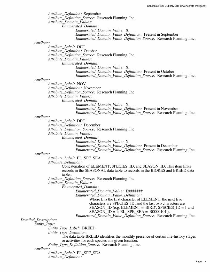
Columbia River ESI: INVERT (Invertebrate Polygons)
Page: 17
Attribute_Definition: September Attribute_Definition_Source: Research Planning, Inc. Attribute_Domain_Values:
Enumerated_Domain: Enumerated_Domain_Value: X Enumerated_Domain_Value_Definition: Present in September Enumerated_Domain_Value_Definition_Source: Research Planning, Inc.
Attribute: Attribute_Label: OCT Attribute_Definition: October Attribute_Definition_Source: Research Planning, Inc. Attribute_Domain_Values:
Enumerated_Domain: Enumerated_Domain_Value: X Enumerated_Domain_Value_Definition: Present in October Enumerated_Domain_Value_Definition_Source: Research Planning, Inc.
Attribute: Attribute_Label: NOV Attribute_Definition: November Attribute_Definition_Source: Research Planning, Inc. Attribute_Domain_Values:
Enumerated_Domain: Enumerated_Domain_Value: X Enumerated_Domain_Value_Definition: Present in November Enumerated_Domain_Value_Definition_Source: Research Planning, Inc.
Attribute: Attribute_Label: DEC Attribute_Definition: December Attribute_Definition_Source: Research Planning, Inc. Attribute_Domain_Values:
Enumerated_Domain: Enumerated_Domain_Value: X Enumerated_Domain_Value_Definition: Present in December Enumerated_Domain_Value_Definition_Source: Research Planning, Inc.
Attribute: Attribute_Label: EL_SPE_SEA Attribute_Definition:
Concatenation of ELEMENT, SPECIES_ID, and SEASON_ID. This item linksrecords in the SEASONAL data table to records in the BIORES and BREED datatables.
Attribute_Definition_Source: Research Planning, Inc. Attribute_Domain_Values:
Enumerated_Domain: Enumerated_Domain_Value: E####### Enumerated_Domain_Value_Definition:
Where E is the first character of ELEMENT, the next fivecharacters are SPECIES_ID, and the last two characters areSEASON_ID (e.g. ELEMENT = 'BIRD', SPECIES_ID = 1 andSEASON_ID = 1; EL_SPE_SEA = 'B0000101').
Enumerated_Domain_Value_Definition_Source: Research Planning, Inc. Detailed_Description:
Entity_Type: Entity_Type_Label: BREED Entity_Type_Definition:
The data table BREED identifies the monthly presence of certain life-history stagesor activities for each species at a given location.
Entity_Type_Definition_Source: Research Planning, Inc. Attribute:
Attribute_Label: EL_SPE_SEA Attribute_Definition:
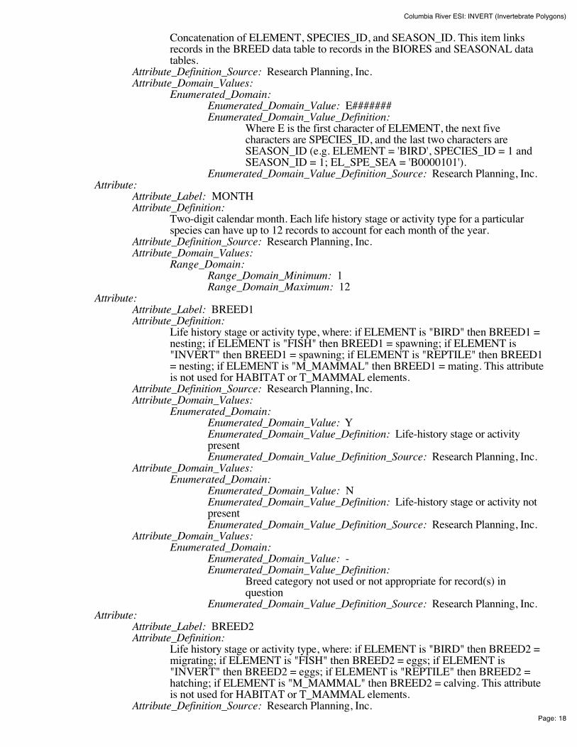
Columbia River ESI: INVERT (Invertebrate Polygons)
Page: 18
Concatenation of ELEMENT, SPECIES_ID, and SEASON_ID. This item linksrecords in the BREED data table to records in the BIORES and SEASONAL datatables.
Attribute_Definition_Source: Research Planning, Inc. Attribute_Domain_Values:
Enumerated_Domain: Enumerated_Domain_Value: E####### Enumerated_Domain_Value_Definition:
Where E is the first character of ELEMENT, the next fivecharacters are SPECIES_ID, and the last two characters areSEASON_ID (e.g. ELEMENT = 'BIRD', SPECIES_ID = 1 andSEASON_ID = 1; EL_SPE_SEA = 'B0000101').
Enumerated_Domain_Value_Definition_Source: Research Planning, Inc. Attribute:
Attribute_Label: MONTH Attribute_Definition:
Two-digit calendar month. Each life history stage or activity type for a particularspecies can have up to 12 records to account for each month of the year.
Attribute_Definition_Source: Research Planning, Inc. Attribute_Domain_Values:
Range_Domain: Range_Domain_Minimum: 1 Range_Domain_Maximum: 12
Attribute: Attribute_Label: BREED1 Attribute_Definition:
Life history stage or activity type, where: if ELEMENT is "BIRD" then BREED1 =nesting; if ELEMENT is "FISH" then BREED1 = spawning; if ELEMENT is"INVERT" then BREED1 = spawning; if ELEMENT is "REPTILE" then BREED1= nesting; if ELEMENT is "M_MAMMAL" then BREED1 = mating. This attributeis not used for HABITAT or T_MAMMAL elements.
Attribute_Definition_Source: Research Planning, Inc. Attribute_Domain_Values:
Enumerated_Domain: Enumerated_Domain_Value: Y Enumerated_Domain_Value_Definition: Life-history stage or activitypresent Enumerated_Domain_Value_Definition_Source: Research Planning, Inc.
Attribute_Domain_Values: Enumerated_Domain:
Enumerated_Domain_Value: N Enumerated_Domain_Value_Definition: Life-history stage or activity notpresent Enumerated_Domain_Value_Definition_Source: Research Planning, Inc.
Attribute_Domain_Values: Enumerated_Domain:
Enumerated_Domain_Value: - Enumerated_Domain_Value_Definition:
Breed category not used or not appropriate for record(s) inquestion
Enumerated_Domain_Value_Definition_Source: Research Planning, Inc. Attribute:
Attribute_Label: BREED2 Attribute_Definition:
Life history stage or activity type, where: if ELEMENT is "BIRD" then BREED2 =migrating; if ELEMENT is "FISH" then BREED2 = eggs; if ELEMENT is"INVERT" then BREED2 = eggs; if ELEMENT is "REPTILE" then BREED2 =hatching; if ELEMENT is "M_MAMMAL" then BREED2 = calving. This attributeis not used for HABITAT or T_MAMMAL elements.
Attribute_Definition_Source: Research Planning, Inc.

Columbia River ESI: INVERT (Invertebrate Polygons)
Page: 19
Attribute_Domain_Values: Enumerated_Domain:
Enumerated_Domain_Value: Y Enumerated_Domain_Value_Definition: Life-history stage or activitypresent Enumerated_Domain_Value_Definition_Source: Research Planning, Inc.
Attribute_Domain_Values: Enumerated_Domain:
Enumerated_Domain_Value: N Enumerated_Domain_Value_Definition: Life-history stage or activity notpresent Enumerated_Domain_Value_Definition_Source: Research Planning, Inc.
Attribute_Domain_Values: Enumerated_Domain:
Enumerated_Domain_Value: - Enumerated_Domain_Value_Definition:
Breed category not used or not appropriate for record(s) inquestion
Enumerated_Domain_Value_Definition_Source: Research Planning, Inc. Attribute:
Attribute_Label: BREED3 Attribute_Definition:
Life history stage or activity type, where: if ELEMENT is "BIRD" then BREED3 =molting; if ELEMENT is "FISH" then BREED3 = larvae; if ELEMENT is"INVERT" then BREED3 = larvae; if ELEMENT is "REPTILE" then BREED3 =internesting; if ELEMENT is "M_MAMMAL" then BREED3 = pupping. Thisattribute is not used for HABITAT or T_MAMMAL elements.
Attribute_Definition_Source: Research Planning, Inc. Attribute_Domain_Values:
Enumerated_Domain: Enumerated_Domain_Value: Y Enumerated_Domain_Value_Definition: Life-history stage or activitypresent Enumerated_Domain_Value_Definition_Source: Research Planning, Inc.
Attribute_Domain_Values: Enumerated_Domain:
Enumerated_Domain_Value: N Enumerated_Domain_Value_Definition: Life-history stage or activity notpresent Enumerated_Domain_Value_Definition_Source: Research Planning, Inc.
Attribute_Domain_Values: Enumerated_Domain:
Enumerated_Domain_Value: - Enumerated_Domain_Value_Definition:
Breed category not used or not appropriate for record(s) inquestion
Enumerated_Domain_Value_Definition_Source: Research Planning, Inc. Attribute:
Attribute_Label: BREED4 Attribute_Definition:
Life history stage or activity type, where: if ELEMENT is "FISH" then BREED4 =juveniles; if ELEMENT is "INVERT" then BREED4 = juveniles; if ELEMENT is"REPTILE" then BREED4 = juveniles; if ELEMENT is "M_MAMMAL" thenBREED4 = molting. This attribute is not used for BIRD, HABITAT, orT_MAMMAL elements.
Attribute_Definition_Source: Research Planning, Inc. Attribute_Domain_Values:
Enumerated_Domain: Enumerated_Domain_Value: Y Enumerated_Domain_Value_Definition: Life-history stage or activity
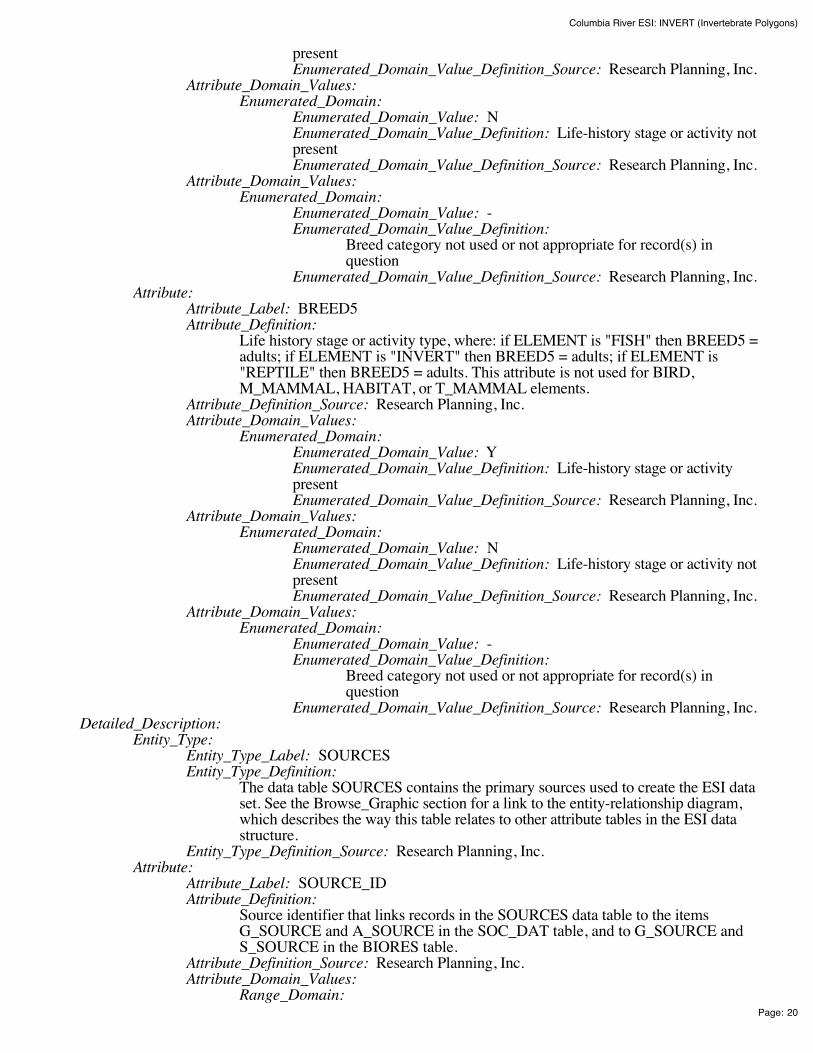
Columbia River ESI: INVERT (Invertebrate Polygons)
Page: 20
present Enumerated_Domain_Value_Definition_Source: Research Planning, Inc.
Attribute_Domain_Values: Enumerated_Domain:
Enumerated_Domain_Value: N Enumerated_Domain_Value_Definition: Life-history stage or activity notpresent Enumerated_Domain_Value_Definition_Source: Research Planning, Inc.
Attribute_Domain_Values: Enumerated_Domain:
Enumerated_Domain_Value: - Enumerated_Domain_Value_Definition:
Breed category not used or not appropriate for record(s) inquestion
Enumerated_Domain_Value_Definition_Source: Research Planning, Inc. Attribute:
Attribute_Label: BREED5 Attribute_Definition:
Life history stage or activity type, where: if ELEMENT is "FISH" then BREED5 =adults; if ELEMENT is "INVERT" then BREED5 = adults; if ELEMENT is"REPTILE" then BREED5 = adults. This attribute is not used for BIRD,M_MAMMAL, HABITAT, or T_MAMMAL elements.
Attribute_Definition_Source: Research Planning, Inc. Attribute_Domain_Values:
Enumerated_Domain: Enumerated_Domain_Value: Y Enumerated_Domain_Value_Definition: Life-history stage or activitypresent Enumerated_Domain_Value_Definition_Source: Research Planning, Inc.
Attribute_Domain_Values: Enumerated_Domain:
Enumerated_Domain_Value: N Enumerated_Domain_Value_Definition: Life-history stage or activity notpresent Enumerated_Domain_Value_Definition_Source: Research Planning, Inc.
Attribute_Domain_Values: Enumerated_Domain:
Enumerated_Domain_Value: - Enumerated_Domain_Value_Definition:
Breed category not used or not appropriate for record(s) inquestion
Enumerated_Domain_Value_Definition_Source: Research Planning, Inc. Detailed_Description:
Entity_Type: Entity_Type_Label: SOURCES Entity_Type_Definition:
The data table SOURCES contains the primary sources used to create the ESI dataset. See the Browse_Graphic section for a link to the entity-relationship diagram,which describes the way this table relates to other attribute tables in the ESI datastructure.
Entity_Type_Definition_Source: Research Planning, Inc. Attribute:
Attribute_Label: SOURCE_ID Attribute_Definition:
Source identifier that links records in the SOURCES data table to the itemsG_SOURCE and A_SOURCE in the SOC_DAT table, and to G_SOURCE andS_SOURCE in the BIORES table.
Attribute_Definition_Source: Research Planning, Inc. Attribute_Domain_Values:
Range_Domain:

Columbia River ESI: INVERT (Invertebrate Polygons)
Page: 21
Range_Domain_Minimum: 1 Range_Domain_Maximum: N
Attribute: Attribute_Label: ORIGINATOR Attribute_Definition: Author or developer of source material or data set Attribute_Definition_Source: Research Planning, Inc. Attribute_Domain_Values:
Unrepresentable_Domain: Acceptable values change from atlas to atlas Attribute:
Attribute_Label: DATE_PUB Attribute_Definition:
Date of source material, publication, or date of personal communication with expertsource
Attribute_Definition_Source: Research Planning, Inc. Attribute_Domain_Values:
Enumerated_Domain: Enumerated_Domain_Value: YYYYMM Enumerated_Domain_Value_Definition: YYYY for year and optionallyMM for month Enumerated_Domain_Value_Definition_Source: Research Planning, Inc.
Attribute: Attribute_Label: TITLE Attribute_Definition: Title of source material or data Attribute_Definition_Source: Research Planning, Inc. Attribute_Domain_Values:
Unrepresentable_Domain: Acceptable values change from atlas to atlas Attribute:
Attribute_Label: DATA_FORMAT Attribute_Definition: The format of the source material Attribute_Definition_Source: Research Planning, Inc. Attribute_Domain_Values:
Unrepresentable_Domain: Acceptable values change from atlas to atlas Attribute:
Attribute_Label: PUBLICATION Attribute_Definition: Additional citation information Attribute_Definition_Source: Research Planning, Inc. Attribute_Domain_Values:
Unrepresentable_Domain: Acceptable values change from atlas to atlas Attribute:
Attribute_Label: SCALE Attribute_Definition: Scale denominator of the source Attribute_Definition_Source: Research Planning, Inc. Attribute_Domain_Values:
Enumerated_Domain: Enumerated_Domain_Value: integer Enumerated_Domain_Value_Definition: Any integer Enumerated_Domain_Value_Definition_Source: Research Planning, Inc.
Attribute: Attribute_Label: TIME_PERIOD Attribute_Definition:
Date(s) of data collection that the source material is based upon. Attribute_Definition_Source: Research Planning, Inc. Attribute_Domain_Values:
Enumerated_Domain: Enumerated_Domain_Value: MM/DD/YY Enumerated_Domain_Value_Definition: Month/Day/Year Enumerated_Domain_Value_Definition_Source: Research Planning, Inc.
Attribute_Domain_Values: Enumerated_Domain:
Enumerated_Domain_Value: MM/YYYY
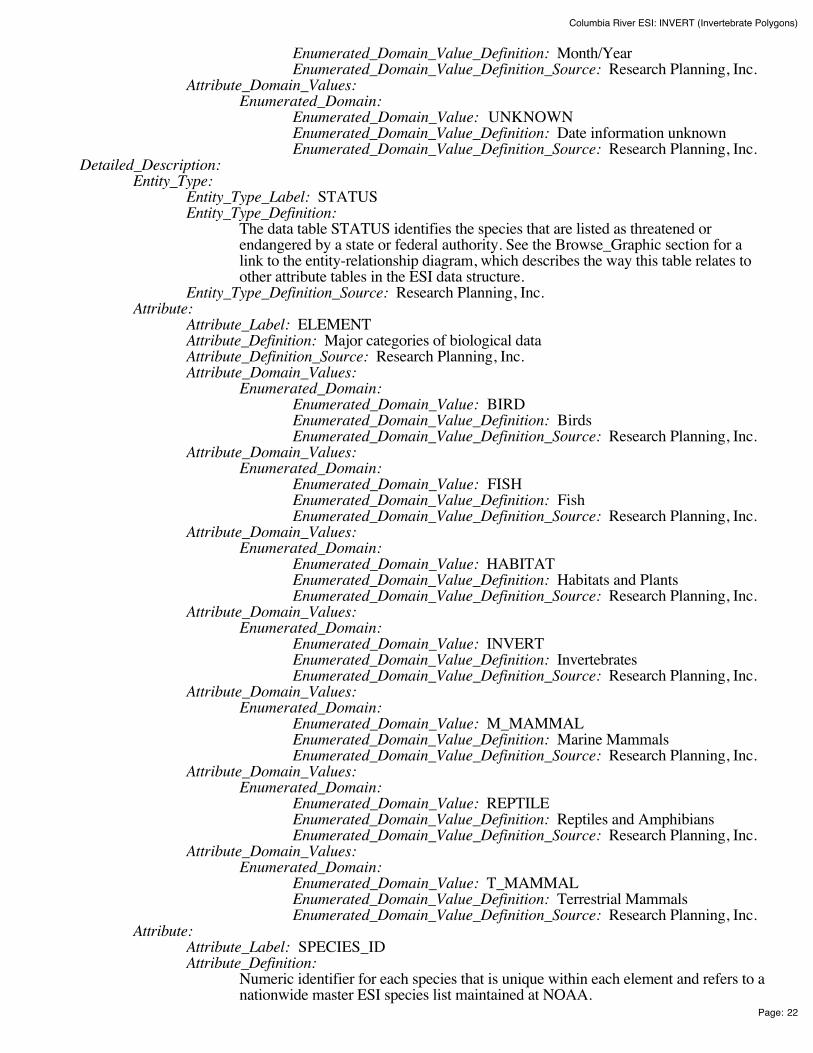
Columbia River ESI: INVERT (Invertebrate Polygons)
Page: 22
Enumerated_Domain_Value_Definition: Month/Year Enumerated_Domain_Value_Definition_Source: Research Planning, Inc.
Attribute_Domain_Values: Enumerated_Domain:
Enumerated_Domain_Value: UNKNOWN Enumerated_Domain_Value_Definition: Date information unknown Enumerated_Domain_Value_Definition_Source: Research Planning, Inc.
Detailed_Description: Entity_Type:
Entity_Type_Label: STATUS Entity_Type_Definition:
The data table STATUS identifies the species that are listed as threatened orendangered by a state or federal authority. See the Browse_Graphic section for alink to the entity-relationship diagram, which describes the way this table relates toother attribute tables in the ESI data structure.
Entity_Type_Definition_Source: Research Planning, Inc. Attribute:
Attribute_Label: ELEMENT Attribute_Definition: Major categories of biological data Attribute_Definition_Source: Research Planning, Inc. Attribute_Domain_Values:
Enumerated_Domain: Enumerated_Domain_Value: BIRD Enumerated_Domain_Value_Definition: Birds Enumerated_Domain_Value_Definition_Source: Research Planning, Inc.
Attribute_Domain_Values: Enumerated_Domain:
Enumerated_Domain_Value: FISH Enumerated_Domain_Value_Definition: Fish Enumerated_Domain_Value_Definition_Source: Research Planning, Inc.
Attribute_Domain_Values: Enumerated_Domain:
Enumerated_Domain_Value: HABITAT Enumerated_Domain_Value_Definition: Habitats and Plants Enumerated_Domain_Value_Definition_Source: Research Planning, Inc.
Attribute_Domain_Values: Enumerated_Domain:
Enumerated_Domain_Value: INVERT Enumerated_Domain_Value_Definition: Invertebrates Enumerated_Domain_Value_Definition_Source: Research Planning, Inc.
Attribute_Domain_Values: Enumerated_Domain:
Enumerated_Domain_Value: M_MAMMAL Enumerated_Domain_Value_Definition: Marine Mammals Enumerated_Domain_Value_Definition_Source: Research Planning, Inc.
Attribute_Domain_Values: Enumerated_Domain:
Enumerated_Domain_Value: REPTILE Enumerated_Domain_Value_Definition: Reptiles and Amphibians Enumerated_Domain_Value_Definition_Source: Research Planning, Inc.
Attribute_Domain_Values: Enumerated_Domain:
Enumerated_Domain_Value: T_MAMMAL Enumerated_Domain_Value_Definition: Terrestrial Mammals Enumerated_Domain_Value_Definition_Source: Research Planning, Inc.
Attribute: Attribute_Label: SPECIES_ID Attribute_Definition:
Numeric identifier for each species that is unique within each element and refers to anationwide master ESI species list maintained at NOAA.

Columbia River ESI: INVERT (Invertebrate Polygons)
Page: 23
Attribute_Definition_Source: Research Planning, Inc. Attribute_Domain_Values:
Range_Domain: Range_Domain_Minimum: 1 Range_Domain_Maximum: N
Attribute: Attribute_Label: S Attribute_Definition: State threatened or endangered status Attribute_Definition_Source: Research Planning, Inc. Attribute_Domain_Values:
Enumerated_Domain: Enumerated_Domain_Value: E Enumerated_Domain_Value_Definition: Endangered on state list Enumerated_Domain_Value_Definition_Source: U.S. Fish and WildlifeService
Attribute_Domain_Values: Enumerated_Domain:
Enumerated_Domain_Value: T Enumerated_Domain_Value_Definition: Threatened on state list Enumerated_Domain_Value_Definition_Source: U.S. Fish and WildlifeService
Attribute_Domain_Values: Enumerated_Domain:
Enumerated_Domain_Value: C Enumerated_Domain_Value_Definition: Species of Special Concern Enumerated_Domain_Value_Definition_Source: U.S. Fish and WildlifeService
Attribute: Attribute_Label: F Attribute_Definition: Federal threatened or endangered status Attribute_Definition_Source: Research Planning, Inc. Attribute_Domain_Values:
Enumerated_Domain: Enumerated_Domain_Value: E Enumerated_Domain_Value_Definition: Endangered on federal list Enumerated_Domain_Value_Definition_Source: U.S. Fish and WildlifeService
Attribute_Domain_Values: Enumerated_Domain:
Enumerated_Domain_Value: T Enumerated_Domain_Value_Definition: Threatened on federal list Enumerated_Domain_Value_Definition_Source: U.S. Fish and WildlifeService
Attribute_Domain_Values: Enumerated_Domain:
Enumerated_Domain_Value: C Enumerated_Domain_Value_Definition: Species of Special Concern Enumerated_Domain_Value_Definition_Source: U.S. Fish and WildlifeService
Attribute: Attribute_Label: STATE Attribute_Definition: Two-letter state abbreviation Attribute_Definition_Source: Research Planning, Inc. Attribute_Domain_Values:
Unrepresentable_Domain: Acceptable values change from atlas to atlas Attribute:
Attribute_Label: S_DATE Attribute_Definition:
Publication date of source material used to assign state status values for eachspecies, if used.

Columbia River ESI: INVERT (Invertebrate Polygons)
Page: 24
Attribute_Definition_Source: Research Planning, Inc. Attribute_Domain_Values:
Enumerated_Domain: Enumerated_Domain_Value: YYYYMM Enumerated_Domain_Value_Definition: YYYY for year and optionallyMM for month Enumerated_Domain_Value_Definition_Source: Research Planning, Inc.
Attribute: Attribute_Label: F_DATE Attribute_Definition:
Publication date of source material used to assign federal status values for eachspecies, if used.
Attribute_Definition_Source: Research Planning, Inc. Attribute_Domain_Values:
Enumerated_Domain: Enumerated_Domain_Value: YYYYMM Enumerated_Domain_Value_Definition: YYYY for year and optionallyMM for month Enumerated_Domain_Value_Definition_Source: Research Planning, Inc.
Attribute: Attribute_Label: EL_SPE Attribute_Definition:
Concatenation of ELEMENT and SPECIES_ID. This item links the STATUS datatable to the BIORES and SPECIES data tables.
Attribute_Definition_Source: Research Planning, Inc. Attribute_Domain_Values:
Enumerated_Domain: Enumerated_Domain_Value: E##### Enumerated_Domain_Value_Definition:
Where E is the first character of ELEMENT and the next fivecharacters are SPECIES_ID (e.g. ELEMENT = 'BIRD' andSPECIES_ID = 1; EL_SPE = 'B00001').
Enumerated_Domain_Value_Definition_Source: Research Planning, Inc.
Distribution_Information: Distributor:
Contact_Information: Contact_Person_Primary:
Contact_Person: John Kaperick Contact_Organization: NOAA, Office of Response and Restoration
Contact_Address: Address_Type: Physical Address Address: 7600 Sand Point Way N.E. City: Seattle State_or_Province: Washington Postal_Code: 98115-6349
Contact_Voice_Telephone: (206) 526-6400 Contact_Facsimile_Telephone: (206) 526-6329
Resource_Description: ESI Atlas for Columbia River Distribution_Liability:
Although these data have been processed successfully on a computer system at the National Oceanicand Atmospheric Administration, no warranty, expressed or implied, is made by NOAA regarding theutility of the data on any other system, nor shall the act of distribution constitute any such warranty.NOAA warrants the delivery of this product in computer-readable format, and will offer a replacementcopy of the product when the product is determined unreadable by computer-input peripherals, orwhen the physical medium is delivered in damaged condition.
Custom_Order_Process: Contact NOAA for distribution options (see Distributor). ESI data are processed into multiple
Columbia River ESI: INVERT (Invertebrate Polygons)
Page: 25
formats to make them useful to a wider community of GIS/mapping users. Distribution formatsinclude ARC export, MOSS and Shape files, and MARPLOT map folders. An ArcView ESI projectand ESI_Viewer product are also included on the distribution CDs for ease of use of the ESI data.The database files are distributed both in the NOAA standard relational database format (see NOAATechnical Memorandum NOS ORCA 115) and in a simplified desktop flat file format. This metadatadocument includes information on both of these database formats.
Metadata_Reference_Information: Metadata_Date: 200411 Metadata_Review_Date: 200411 Metadata_Contact:
Contact_Information: Contact_Person_Primary:
Contact_Person: Jill Petersen Contact_Organization: NOAA, Office of Response and Restoration
Contact_Position: GIS Manager Contact_Address:
Address_Type: Physical Address Address: 7600 Sand Point Way N.E. City: Seattle State_or_Province: Washington Postal_Code: 98115-6349
Contact_Voice_Telephone: (206) 526-6944 Contact_Facsimile_Telephone: (206) 526-6329 Contact_Electronic_Mail_Address: [email protected]
Metadata_Standard_Name: Content Standards for Digital Geospatial Metadata Metadata_Standard_Version: FGDC-STD-001-1998
Generated by mp version 2.8.2 on Tue Dec 07 18:04:53 2004

Columbia River ESI: REPTILES (Reptile and AmphibianPolygons)
Page: 1
Columbia River ESI: REPTILES (Reptile andAmphibian Polygons)Metadata also available as - [Parseable text] - [SGML]
Metadata:Identification_Information Data_Quality_Information Spatial_Data_Organization_Information Spatial_Reference_Information Entity_and_Attribute_Information Distribution_Information Metadata_Reference_Information
Identification_Information: Citation:
Citation_Information: Originator:
National Oceanic and Atmospheric Administration (NOAA), National OceanService, Office of Response and Restoration, Hazardous Materials ResponseDivision, Seattle, Washington; Coastal Storms Initiative; U.S. Fish and WildlifeService; NOAA Fisheries; State of Oregon; and State of Washington.
Publication_Date: 200411 Title: Columbia River ESI: REPTILES (Reptile and Amphibian Polygons) Edition: First Geospatial_Data_Presentation_Form: Vector digital data Series_Information:
Series_Name: None Issue_Identification: Columbia River
Publication_Information: Publication_Place: Seattle, Washington Publisher:
National Oceanic and Atmospheric Administration (NOAA), NationalOcean Service, Office of Response and Restoration, Hazardous MaterialsResponse Division, Seattle, Washington
Other_Citation_Details: Prepared by Research Planning, Inc., Columbia, South Carolina for the NationalOceanic and Atmospheric Administration (NOAA), National Ocean Service, Officeof Response and Restoration, Hazardous Materials Response Division, Seattle,Washington; Coastal Storms Initiative; U.S. Fish and Wildlife Service; NOAAFisheries; State of Oregon; and State of Washington.
Description: Abstract:
This data set contains sensitive biological resource data for western pond turtles and westernpainted turtles in Columbia River. Vector polygons in this data set represent locations ofturtle distributions. Species-specific abundance, seasonality, status, life history, and sourceinformation are stored in relational data tables (described below) designed to be used inconjunction with this spatial data layer.
This data set comprises a portion of the Environmental Sensitivity Index (ESI) data forColumbia River. ESI data characterize the marine and coastal environments and wildlife bytheir sensitivity to spilled oil. The ESI data include information for three main components:shoreline habitats, sensitive biological resources, and human-use resources.

Columbia River ESI: REPTILES (Reptile and AmphibianPolygons)
Page: 2
Purpose: The ESI data were collected, mapped, and digitized to provide environmental data for oil spillplanning and response. The Clean Water Act with amendments by the Oil Pollution Act of1990 requires response plans for immediate and effective protection of sensitive resources.
Time_Period_of_Content: Time_Period_Information:
Range_of_Dates/Times: Beginning_Date: 2003 Ending_Date: 2004
Currentness_Reference: The biological data were compiled during 2003-2004. The currentness date for these data is2004 and is documented in the Lineage section.
Status: Progress: Complete Maintenance_and_Update_Frequency: None Scheduled
Spatial_Domain: Bounding_Coordinates:
West_Bounding_Coordinate: -124.125 East_Bounding_Coordinate: -120.67375 North_Bounding_Coordinate: 46.375 South_Bounding_Coordinate: 45.3
Keywords: Theme:
Theme_Keyword_Thesaurus: None Theme_Keyword: ESI Theme_Keyword: Sensitivity maps Theme_Keyword: Coastal resources Theme_Keyword: Oil spill planning Theme_Keyword: Coastal Zone Management Theme_Keyword: Wildlife Theme_Keyword: Reptile
Place: Place_Keyword_Thesaurus: None Place_Keyword: Columbia River
Access_Constraints: None Use_Constraints:
DO NOT USE MAPS FOR NAVIGATIONAL PURPOSES. Besides the above warning, there areno use constraints on these data. Note that the ESI database should not be used to the exclusion ofother pertinent data or information held by state or federal agencies or other organizations. Likewise,information contained in the database cannot be used in place of consultations with environmental,natural resource, and cultural resource agencies, or in place of field surveys. Recognize that theinformation contained in the ESI database represents known concentration areas or occurrences ofnatural, cultural, and human-use resources, but does not necessarily represent the full distribution orrange of each species or resource. This is particularly important to recognize when consideringpotential impacts to protected resources, such as endangered species, wetlands, etc. Acknowledgmentof the originators, publishers, contributors, and sources listed would be appreciated in productsderived from these data.
Browse_Graphic: Browse_Graphic_File_Name: datafig.jpg Browse_Graphic_File_Description:
Depicts the relationships between spatial data layers and attribute data tables for theColumbia River ESI data.
Browse_Graphic_File_Type: JPEG Data_Set_Credit:
This project was supported by the National Oceanic and Atmospheric Administration (NOAA),National Ocean Service, Office of Response and Restoration, Hazardous Materials ResponseDivision, Seattle, Washington; Coastal Storms Initiative; U.S. Fish and Wildlife Service; NOAAFisheries; State of Oregon; and State of Washington.
Native_Data_Set_Environment: The software packages used to develop the atlas are Environmental Systems Research Institute's
Columbia River ESI: REPTILES (Reptile and AmphibianPolygons)
Page: 3
ARC/INFO(r) (version 8.3) and SQL SERVER(r) (version 7.0). The hardware configuration is PC'swith Windows Operating System (NT4.0/2000).
The Spatial_Data_Organization_Information section refers only to the source files in the ARC exportformat. The following files are included in that data set: birds.e00, esi.e00, fish.e00, fishl.e00,habitats.e00, hydro.e00, index.e00, invert.e00, m_mammal.e00, m_mampt.e00, mgt.e00, nests.e00,nwi.e00, reptiles.e00, socecon.e00, t_mammal.e00. Associated relational and desktop data tablesprovided in Arc export and text format are bio_lut, biofile, biores, breed, breed_dt, runs_dat, seasonal,soc_dat, soc_lut, sources, species, and status.
Data_Quality_Information: Attribute_Accuracy:
Attribute_Accuracy_Report: A multi-stage error checking process is used to verify both attribute accuracy and logicalconsistency throughout data production. The process includes a standardized data entrymethodology, hardcopy data review by in-house and external resource experts, a final QualityAssurance/Quality Control (QA/QC) process, and multiple automated logical consistencychecks. Quantitative data (such as densities, counts, abundances, or concentrations) providedby resource experts for inclusion in the data set may vary widely in attribute accuracy,depending upon the methodology used to collect and compile such data. For a more detailedevaluation of source data attribute accuracy, contact the sources listed in the Lineage section.
Logical_Consistency_Report: A multi-stage error checking process, described in the above Attribute_Accuracy_Report, is used toverify both attribute accuracy and logical consistency throughout data production. This processincludes multiple automated logical consistency checks that test the files for missing or duplicate data,rules for proper coding, GIS topological consistencies (such as dangles, unnecessary nodes, etc.), andSQL SERVER(r) to ARC/INFO(r) consistencies. A final review is made by the GIS manager, wherethe data are written to CD-ROM and the metadata are written.
After the data are delivered to NOAA, they are again subjected to a number of quality and consistencychecks. In the process of checking for topological and database consistencies, new ID's andRARNUM's or HUNUM's are also generated. The new ID's are a combination of atlas number,element number, and record number. In addition, the value used to represent the element is modifiedto reflect the type of feature being mapped. In the case of an element that is normally represented by apoint or polygon, a value of 20 is added to the standard element value for mapping of linear features.In the case where an element usually mapped as a polygon is represented by a point, a value of 30 isadded to the regular element value. The RARNUM's are also modified to include the atlas number, somultiple atlases can be combined and RARNUM's remain unique. RARNUM's are redefined on anelement basis, so "resource at risk" groupings will contain only a single element. HUNUM's are alsomodified to include the atlas number.
Completeness_Report: These data represent a synthesis of expert knowledge and available digital data on turtle distribution.These data do not necessarily represent all reptile occurrences in Columbia River. The followingspecies are included in this data set: (Species_ID, Common Name, Scientific Name, if applicable): 58,Western pond turtle, Clemmys marmorata; 151, Western painted turtle, Chrysemys picta bellii.
Positional_Accuracy: Horizontal_Positional_Accuracy:
Horizontal_Positional_Accuracy_Report: Most of the spatial components of the biological data sets are developed usingregional experts who estimate concentration areas. It is difficult to estimate thepositional accuracy of such data, except to state that they are compiled on hardcopybase maps with a scale of 1:24,000. Some of the spatial components of thebiological data sets are developed from pre-existing digital sources and reflect thepositional accuracy of these original data. See the Lineage and Process_Descriptionsections for more information on the original data source and how these data wereintegrated or manipulated to create the final data set. Note that biological resourcedata by their very nature are considered "fuzzy", and this should be understoodwhen considering the positional accuracy of vector digital objects representing these
Columbia River ESI: REPTILES (Reptile and AmphibianPolygons)
Page: 4
resources. Lineage:
Source_Information: Source_Citation:
Citation_Information: Originator: Kohl, K., Oregon Department of Fish and Wildlife (ODFW) Publication_Date: 200401 Title: Bird and Mammal Distribution along the Columbia River Geospatial_Data_Presentation_Form: Expert knowledge Publication_Information:
Publication_Place: Unpublished material Publisher: Unpublished material
Type_of_Source_Media: Personal communication Source_Time_Period_of_Content:
Time_Period_Information: Single_Date/Time:
Calendar_Date: 200401 Source_Currentness_Reference: Date of communication
Source_Citation_Abbreviation: None Source_Contribution: Distribution information for reptiles
Source_Information: Source_Citation:
Citation_Information: Originator: Anderson, E., U.S. Fish and Wildlife Service (USFWS) Publication_Date: 200401 Title: Distribution of Wildlife on the Lower Columbia River Geospatial_Data_Presentation_Form: Expert Knowledge Publication_Information:
Publication_Place: Unpublished material Publisher: Unpublished material
Type_of_Source_Media: Personal communication Source_Time_Period_of_Content:
Time_Period_Information: Single_Date/Time:
Calendar_Date: 200401 Source_Currentness_Reference: Date of communication
Source_Citation_Abbreviation: None Source_Contribution: Distribution and seasonality information for reptiles
Source_Information: Source_Citation:
Citation_Information: Originator: Nebeker, M., Oregon Department of Fish and Wildlife(ODFW) Publication_Date: 200402 Title: Distribution of Wildlife on Sauvie Island and Surrounding Areas Geospatial_Data_Presentation_Form: Expert Knowledge Publication_Information:
Publication_Place: Unpublished material Publisher: Unpublished material
Type_of_Source_Media: Personal communication Source_Time_Period_of_Content:
Time_Period_Information: Single_Date/Time:
Calendar_Date: 200402 Source_Currentness_Reference: Date of communication
Source_Citation_Abbreviation: None Source_Contribution:
Distribution and seasonality information of reptiles on Sauvie Island andsurrounding areas
Source_Information:

Columbia River ESI: REPTILES (Reptile and AmphibianPolygons)
Page: 5
Source_Citation: Citation_Information:
Originator: Szumski, M., U.S. Fish and Wildlife Service (USFWS) Publication_Date: 200401 Title: Distribution of Wildlife in the Columbia River Geospatial_Data_Presentation_Form: Expert Knowledge Publication_Information:
Publication_Place: Unpublished material Publisher: Unpublished material
Type_of_Source_Media: Personal communication Source_Time_Period_of_Content:
Time_Period_Information: Single_Date/Time:
Calendar_Date: 200401 Source_Currentness_Reference: Date of communication
Source_Citation_Abbreviation: None Source_Contribution: Distribution of reptiles in the Columbia River
Source_Information: Source_Citation:
Citation_Information: Originator: Washington Department of Fish and Wildlife (WDFW) Publication_Date: 2004 Title: Priority Habitat Data for the Lower Columbia River Geospatial_Data_Presentation_Form: Vector digital data Publication_Information:
Publication_Place: Unknown Publisher: Washington Department of Fish and Wildlife
Source_Scale_Denominator: 24,000 Type_of_Source_Media: CD-ROM Source_Time_Period_of_Content:
Time_Period_Information: Single_Date/Time:
Calendar_Date: 2004 Source_Currentness_Reference: Publication Date
Source_Citation_Abbreviation: None Source_Contribution: Distribution and seasonality information for reptiles
Process_Step: Process_Description:
Two main sources of data were used to depict turtle distribution for this data layer:(1) personal interviews with resource experts from the Oregon Department of Fishand Wildlife (ODFW) and U.S. Fish and Wildlife Service (USFWS) and (2)published and unpublished reports. Information gathered during initial interviewsand from hardcopy sources was compiled onto U.S. Geological Survey 1:24,000topographic quadrangles.
The compiled data were digitized off of the base maps into an ArcInfo system tocreate the REPTILES data layer. All ESI, biology, and human-use data were plottedonto hardcopy draft maps. Following the delivery of draft maps to the participatingresource experts, a second set of interviews was conducted to review the maps. Editsto the REPTILES data layer were made based on the recommendations of theresource experts, and final hardcopy maps were created.
Process_Date: 200408 Process_Contact:
Contact_Information: Contact_Organization_Primary:
Contact_Organization: NOAA, Office of Response andRestoration Contact_Person: Jill Petersen
Contact_Address: Address_Type: Physical address

Columbia River ESI: REPTILES (Reptile and AmphibianPolygons)
Page: 6
Address: 7600 Sand Point Way N.E. City: Seattle State_or_Province: Washington Postal_Code: 98115-6349
Contact_Voice_Telephone: (206) 526-6944 Contact_Facsimile_Telephone: (206) 526-6329 Contact_Electronic_Mail_Address: [email protected]
Spatial_Data_Organization_Information: Direct_Spatial_Reference_Method: Vector Point_and_Vector_Object_Information:
SDTS_Terms_Description: SDTS_Point_and_Vector_Object_Type: GT-polygon composed of rings Point_and_Vector_Object_Count: 15
SDTS_Terms_Description: SDTS_Point_and_Vector_Object_Type: Area point Point_and_Vector_Object_Count: 15
SDTS_Terms_Description: SDTS_Point_and_Vector_Object_Type: Complete chain Point_and_Vector_Object_Count: 25
SDTS_Terms_Description: SDTS_Point_and_Vector_Object_Type: Link Point_and_Vector_Object_Count: 7114
SDTS_Terms_Description: SDTS_Point_and_Vector_Object_Type: Node, planar graph Point_and_Vector_Object_Count: 24
Spatial_Reference_Information: Horizontal_Coordinate_System_Definition:
Geographic: Latitude_Resolution: 0.0000001 Longitude_Resolution: 0.0000001 Geographic_Coordinate_Units: Decimal degrees
Geodetic_Model: Horizontal_Datum_Name: North American Datum of 1927 Ellipsoid_Name: Clark 1866 Semi-major_Axis: 6378206.4 Denominator_of_Flattening_Ratio: 294.978698
Entity_and_Attribute_Information: Overview_Description:
Entity_and_Attribute_Overview: In addition to the geographic data layers, six relational attribute or data tables, BIORES,BREED, SEASONAL, SOURCES, SPECIES, and STATUS, are used to store the complexbiological data in the ESI data structure. The geographic data layer containing biologicalresource information (in this case, REPTILES) is linked to the Biological Resources table(BIORES) using the unique ID and the lookup table BIO_LUT, or it can be linked directlyusing RARNUM. The ID is a unique combination of the atlas number (for the ColumbiaRiver atlas, the number is 41), an element/layer specific number (BIRDS are layer 1, FISHare layer 2, etc.), and a unique record number. The RARNUM represents a uniquecombination of species, seasonalities, concentrations, and source information. For each ofthese groupings, a number is generated. That number is concatenated with the atlas numberto create a "resource at risk" number that is unique across atlases. BIORES and the otherrelational data tables are described below in detail. See the Browse_Graphic section for a link

Columbia River ESI: REPTILES (Reptile and AmphibianPolygons)
Page: 7
to the entity-relationship diagram, which describes the way these tables relate to thegeographic data layers and other attribute tables in the ESI data structure.
Due to the complexity of the relational database model, the data items are also post-processedinto a flat file format. This table, called BIOFILE, may be used in place of the relational filesdescribed below to ease simple data queries. The items in the flat file are ELEMENT,SUBELEMENT, NAME, GEN_SPEC, S, F, NHP, DATE_PUB, CONC, JAN, FEB, MAR,APR, MAY, JUN, JUL, AUG, SEP, OCT, NOV, DEC, BREED1, BREED2, BREED3,BREED4, BREED5, RARNUM, G_SOURCE, S_SOURCE, and BREED. All of theseitems are the same as their counterparts in the individual data tables described below, exceptthe BREED1-BREED5 and BREED items. BREED is a newly generated variable used tolink to the BREED_DT data table, a modified, more compact version of the relationalBREED data table. BREED1-BREED5 give a text summary of when each life stage occurswithin the associated map object. The life stages referred to are the same as those listed in theDetailed_Description of the BREED data table. The link to the BIOFILE may be madethrough the BIO_LUT, using ID to link to RARNUM, or BIOFILE may be linked directlyto the RARNUM in each of the geographic layer's attribute data tables. As mentioned,BREED_DT is an auxiliary support data table to the flat file structure, which allows the userto do searches based on month for seasonal breeding activities. The link from the flat file toBREED_DT is the BREED item.
A second supporting data table is SOURCES. This is the same as the source file describedabove, and the link from the flat file is both G_SOURCE and S_SOURCE. It should benoted that although the flat file eases data query, it is not a normalized database structure, andactual updates performed by the states and other responsible agencies should be done usingthe relational data tables. The entity-relationship diagram, describing relationships betweenattribute tables in the ESI data structure, does NOT include the BIOFILE data table, and thisdata table is NOT described in detail below.
Detailed_Description: Entity_Type:
Entity_Type_Label: REPTILES.PAT Entity_Type_Definition:
The REPTILES.PAT table contains attribute information for the vector polygonsrepresenting turtle distributions. Note that all attribute information is stored in aseries of relational files, described below. See the Browse_Graphic section for a linkto the entity-relationship diagram, which describes the relationships between attributetables in the ESI data structure.
Entity_Type_Definition_Source: Research Planning, Inc. Attribute:
Attribute_Label: ID Attribute_Definition:
An identifier that links vector objects in the biology data layers to records in theBIO_LUT data table. ID is a concatenation of atlas number (41), element number(6), and record number. ID values of 9999 are holes in polygons and do not containinformation.
Attribute_Definition_Source: NOAA Attribute_Domain_Values:
Range_Domain: Range_Domain_Minimum: 410600002 Range_Domain_Maximum: 410600016
Attribute: Attribute_Label: RARNUM Attribute_Definition:
An identifier that links directly to the BIORES table or the flat format BIOFILEtable. RARNUM values of 0 are holes in polygons and do not contain information.
Attribute_Definition_Source: NOAA Attribute_Domain_Values:
Range_Domain: Range_Domain_Minimum: 41000273 Range_Domain_Maximum: 41000278
Columbia River ESI: REPTILES (Reptile and AmphibianPolygons)
Page: 8
Detailed_Description: Entity_Type:
Entity_Type_Label: BIO_LUT Entity_Type_Definition:
The data table BIO_LUT is a lookup table that contains items necessary for linkingvector objects in the biological data layers with the BIORES data table. Note that allattribute information is stored in a series of relational files, described below. See theBrowse_Graphic section for a link to the entity-relationship diagram, whichdescribes the way this table relates to other attribute tables in the ESI data structure.
Entity_Type_Definition_Source: Research Planning, Inc. Attribute:
Attribute_Label: RARNUM Attribute_Definition:
An identifier that links records in the BIO_LUT data table to records in the BIORESdata table or the flat format BIOFILE data table. RARNUM values of 0 are holes inpolygons and do not contain information.
Attribute_Definition_Source: NOAA Attribute_Domain_Values:
Range_Domain: Range_Domain_Minimum: 41000001 Range_Domain_Maximum: 41000290
Attribute: Attribute_Label: ID Attribute_Definition:
An identifier that links vector objects in the biology data layers to records in theBIO_LUT data table. ID is a concatenation of atlas number (41), element number(6), and record number. ID values of 9999 are holes in polygons and do not containinformation.
Attribute_Definition_Source: NOAA Attribute_Domain_Values:
Range_Domain: Range_Domain_Minimum: 410100002 Range_Domain_Maximum: 413400015
Detailed_Description: Entity_Type:
Entity_Type_Label: BIORES Entity_Type_Definition:
The data table BIORES contains both biological attribute data and items necessaryfor linking vector objects in the biological data layers via the BIO_LUT data table toother associated data tables. See the Browse_Graphic section for a link to theentity-relationship diagram, which describes the way this table relates to otherattribute tables in the ESI data structure.
Entity_Type_Definition_Source: Research Planning, Inc. Attribute:
Attribute_Label: RARNUM Attribute_Definition:
An identifier that links records in the BIORES data table to records in the BIO_LUTdata table or the flat format BIOFILE data table.
Attribute_Definition_Source: NOAA Attribute_Domain_Values:
Range_Domain: Range_Domain_Minimum: 041000001 Range_Domain_Maximum: 041000290
Attribute: Attribute_Label: SPECIES_ID Attribute_Definition:
Numeric identifier for each species that is unique within each element and refers to anationwide master ESI species list maintained at NOAA.
Attribute_Definition_Source: Research Planning, Inc. Attribute_Domain_Values:

Columbia River ESI: REPTILES (Reptile and AmphibianPolygons)
Page: 9
Range_Domain: Range_Domain_Minimum: 1 Range_Domain_Maximum: N
Attribute: Attribute_Label: CONC Attribute_Definition:
The field CONC refers to "concentration," abundance, or density values of a speciesat a particular location. In cases where no quantitative count data were available, thefield may contain a descriptive term such as "HIGH" or "COMMON". If noconcentration information was available from any source, the field is populated with"-". Counts were derived from a variety of surveys, and may range in date.
Attribute_Definition_Source: Research Planning, Inc. Attribute_Domain_Values:
Unrepresentable_Domain: Acceptable values change from atlas to atlas Attribute:
Attribute_Label: SEASON_ID Attribute_Definition:
Numeric identifier for the unique monthly presence and life history characteristics ofeach species at a given location.
Attribute_Definition_Source: Research Planning, Inc. Attribute_Domain_Values:
Range_Domain: Range_Domain_Minimum: 1 Range_Domain_Maximum: N
Attribute: Attribute_Label: G_SOURCE Attribute_Definition:
Geographic source identifier that links records in the BIORES data table to recordsin the SOURCES data table.
Attribute_Definition_Source: Research Planning, Inc. Attribute_Domain_Values:
Range_Domain: Range_Domain_Minimum: 1 Range_Domain_Maximum: N
Attribute: Attribute_Label: S_SOURCE Attribute_Definition:
Seasonality source identifier that links records in the BIORES data table to recordsin the SOURCES data table.
Attribute_Definition_Source: Research Planning, Inc. Attribute_Domain_Values:
Range_Domain: Range_Domain_Minimum: 1 Range_Domain_Maximum: N
Attribute: Attribute_Label: ELEMENT Attribute_Definition: Major categories of biological data Attribute_Definition_Source: Research Planning, Inc. Attribute_Domain_Values:
Enumerated_Domain: Enumerated_Domain_Value: BIRD Enumerated_Domain_Value_Definition: Birds Enumerated_Domain_Value_Definition_Source: Research Planning, Inc.
Attribute_Domain_Values: Enumerated_Domain:
Enumerated_Domain_Value: FISH Enumerated_Domain_Value_Definition: Fish Enumerated_Domain_Value_Definition_Source: Research Planning, Inc.
Attribute_Domain_Values: Enumerated_Domain:
Columbia River ESI: REPTILES (Reptile and AmphibianPolygons)
Page: 10
Enumerated_Domain_Value: HABITAT Enumerated_Domain_Value_Definition: Habitats and Plants Enumerated_Domain_Value_Definition_Source: Research Planning, Inc.
Attribute_Domain_Values: Enumerated_Domain:
Enumerated_Domain_Value: INVERT Enumerated_Domain_Value_Definition: Invertebrates Enumerated_Domain_Value_Definition_Source: Research Planning, Inc.
Attribute_Domain_Values: Enumerated_Domain:
Enumerated_Domain_Value: M_MAMMAL Enumerated_Domain_Value_Definition: Marine Mammals Enumerated_Domain_Value_Definition_Source: Research Planning, Inc.
Attribute_Domain_Values: Enumerated_Domain:
Enumerated_Domain_Value: REPTILE Enumerated_Domain_Value_Definition: Reptiles and Amphibians Enumerated_Domain_Value_Definition_Source: Research Planning, Inc.
Attribute_Domain_Values: Enumerated_Domain:
Enumerated_Domain_Value: T_MAMMAL Enumerated_Domain_Value_Definition: Terrestrial Mammals Enumerated_Domain_Value_Definition_Source: Research Planning, Inc.
Attribute: Attribute_Label: EL_SPE Attribute_Definition:
Concatenation of ELEMENT and SPECIES_ID. This item links records in theBIORES data table to records in the SPECIES and STATUS data tables.
Attribute_Definition_Source: Research Planning, Inc. Attribute_Domain_Values:
Enumerated_Domain: Enumerated_Domain_Value: E##### Enumerated_Domain_Value_Definition:
Where E is the first character of ELEMENT and the next fivecharacters are SPECIES_ID (e.g. ELEMENT = 'BIRD' andSPECIES_ID = 1; EL_SPE = 'B00001').
Enumerated_Domain_Value_Definition_Source: Research Planning, Inc. Attribute:
Attribute_Label: EL_SPE_SEA Attribute_Definition:
Concatenation of ELEMENT, SPECIES_ID, and SEASON_ID. This item linksrecords in the BIORES data table to records in the SEASONAL and BREED datatables.
Attribute_Definition_Source: Research Planning, Inc. Attribute_Domain_Values:
Enumerated_Domain: Enumerated_Domain_Value: E####### Enumerated_Domain_Value_Definition:
Where E is the first character of ELEMENT, the next fivecharacters are SPECIES_ID, and the last two characters areSEASON_ID (e.g. ELEMENT = 'BIRD', SPECIES_ID = 1 andSEASON_ID = 1; EL_SPE_SEA = 'B0000101').
Enumerated_Domain_Value_Definition_Source: Research Planning, Inc. Detailed_Description:
Entity_Type: Entity_Type_Label: SPECIES Entity_Type_Definition:
The data table SPECIES identifies all species in the ESI data set. See theBrowse_Graphic section for a link to the entity-relationship diagram, whichdescribes the way this table relates to other attribute tables in the ESI data structure.

Columbia River ESI: REPTILES (Reptile and AmphibianPolygons)
Page: 11
Refer to the Completeness_Report for a list of layer-specific species. Entity_Type_Definition_Source: Research Planning, Inc.
Attribute: Attribute_Label: SPECIES_ID Attribute_Definition:
Numeric identifier for each species that is unique within each element and refers to anationwide master ESI species list maintained at NOAA.
Attribute_Definition_Source: Research Planning, Inc. Attribute_Domain_Values:
Range_Domain: Range_Domain_Minimum: 1 Range_Domain_Maximum: N
Attribute: Attribute_Label: NAME Attribute_Definition: Species common name for the entire ESI data set Attribute_Definition_Source: Research Planning, Inc. Attribute_Domain_Values:
Unrepresentable_Domain: Acceptable values change from atlas to atlas Attribute:
Attribute_Label: GEN_SPEC Attribute_Definition: Species scientific name for the entire ESI data set Attribute_Definition_Source: Research Planning, Inc. Attribute_Domain_Values:
Unrepresentable_Domain: Acceptable values change from atlas to atlas Attribute:
Attribute_Label: ELEMENT Attribute_Definition: Major categories of biological data Attribute_Definition_Source: Research Planning, Inc. Attribute_Domain_Values:
Enumerated_Domain: Enumerated_Domain_Value: BIRD Enumerated_Domain_Value_Definition: Birds Enumerated_Domain_Value_Definition_Source: Research Planning, Inc.
Attribute_Domain_Values: Enumerated_Domain:
Enumerated_Domain_Value: FISH Enumerated_Domain_Value_Definition: Fish Enumerated_Domain_Value_Definition_Source: Research Planning, Inc.
Attribute_Domain_Values: Enumerated_Domain:
Enumerated_Domain_Value: HABITAT Enumerated_Domain_Value_Definition: Habitats and Plants Enumerated_Domain_Value_Definition_Source: Research Planning, Inc.
Attribute_Domain_Values: Enumerated_Domain:
Enumerated_Domain_Value: INVERT Enumerated_Domain_Value_Definition: Invertebrates Enumerated_Domain_Value_Definition_Source: Research Planning, Inc.
Attribute_Domain_Values: Enumerated_Domain:
Enumerated_Domain_Value: M_MAMMAL Enumerated_Domain_Value_Definition: Marine Mammals Enumerated_Domain_Value_Definition_Source: Research Planning, Inc.
Attribute_Domain_Values: Enumerated_Domain:
Enumerated_Domain_Value: REPTILE Enumerated_Domain_Value_Definition: Reptiles and Amphibians Enumerated_Domain_Value_Definition_Source: Research Planning, Inc.
Attribute_Domain_Values: Enumerated_Domain:

Columbia River ESI: REPTILES (Reptile and AmphibianPolygons)
Page: 12
Enumerated_Domain_Value: T_MAMMAL Enumerated_Domain_Value_Definition: Terrestrial Mammals Enumerated_Domain_Value_Definition_Source: Research Planning, Inc.
Attribute: Attribute_Label: SUBELEMENT Attribute_Definition: Element subgroup delineating a logical grouping of species Attribute_Definition_Source: Research Planning, Inc. Attribute_Domain_Values:
Enumerated_Domain: Enumerated_Domain_Value: bivalve Enumerated_Domain_Value_Definition: Bivalve Enumerated_Domain_Value_Definition_Source: Research Planning, Inc.
Attribute_Domain_Values: Enumerated_Domain:
Enumerated_Domain_Value: crab Enumerated_Domain_Value_Definition: Crab Enumerated_Domain_Value_Definition_Source: Research Planning, Inc.
Attribute_Domain_Values: Enumerated_Domain:
Enumerated_Domain_Value: diadromous Enumerated_Domain_Value_Definition: Diadromous fish Enumerated_Domain_Value_Definition_Source: Research Planning, Inc.
Attribute_Domain_Values: Enumerated_Domain:
Enumerated_Domain_Value: diving Enumerated_Domain_Value_Definition: Diving bird Enumerated_Domain_Value_Definition_Source: Research Planning, Inc.
Attribute_Domain_Values: Enumerated_Domain:
Enumerated_Domain_Value: e_nursery Enumerated_Domain_Value_Definition: Estuarine nursery fish Enumerated_Domain_Value_Definition_Source: Research Planning, Inc.
Attribute_Domain_Values: Enumerated_Domain:
Enumerated_Domain_Value: fav Enumerated_Domain_Value_Definition: Floating aquatic vegetation Enumerated_Domain_Value_Definition_Source: Research Planning, Inc.
Attribute_Domain_Values: Enumerated_Domain:
Enumerated_Domain_Value: freshwater Enumerated_Domain_Value_Definition: Freshwater fish Enumerated_Domain_Value_Definition_Source: Research Planning, Inc.
Attribute_Domain_Values: Enumerated_Domain:
Enumerated_Domain_Value: gull_tern Enumerated_Domain_Value_Definition: Gull or tern Enumerated_Domain_Value_Definition_Source: Research Planning, Inc.
Attribute_Domain_Values: Enumerated_Domain:
Enumerated_Domain_Value: passerine Enumerated_Domain_Value_Definition: Passerine bird Enumerated_Domain_Value_Definition_Source: Research Planning, Inc.
Attribute_Domain_Values: Enumerated_Domain:
Enumerated_Domain_Value: pinniped Enumerated_Domain_Value_Definition: Pinniped Enumerated_Domain_Value_Definition_Source: Research Planning, Inc.
Attribute_Domain_Values: Enumerated_Domain:
Enumerated_Domain_Value: raptor
Columbia River ESI: REPTILES (Reptile and AmphibianPolygons)
Page: 13
Enumerated_Domain_Value_Definition: Raptor Enumerated_Domain_Value_Definition_Source: Research Planning, Inc.
Attribute_Domain_Values: Enumerated_Domain:
Enumerated_Domain_Value: sav Enumerated_Domain_Value_Definition: Submerged aquatic vegetation Enumerated_Domain_Value_Definition_Source: Research Planning, Inc.
Attribute_Domain_Values: Enumerated_Domain:
Enumerated_Domain_Value: shorebird Enumerated_Domain_Value_Definition: Shorebird Enumerated_Domain_Value_Definition_Source: Research Planning, Inc.
Attribute_Domain_Values: Enumerated_Domain:
Enumerated_Domain_Value: sm_mammal Enumerated_Domain_Value_Definition: Small mammal Enumerated_Domain_Value_Definition_Source: Research Planning, Inc.
Attribute_Domain_Values: Enumerated_Domain:
Enumerated_Domain_Value: turtle Enumerated_Domain_Value_Definition: Turtle Enumerated_Domain_Value_Definition_Source: Research Planning, Inc.
Attribute_Domain_Values: Enumerated_Domain:
Enumerated_Domain_Value: ungulate Enumerated_Domain_Value_Definition: Ungulate Enumerated_Domain_Value_Definition_Source: Research Planning, Inc.
Attribute_Domain_Values: Enumerated_Domain:
Enumerated_Domain_Value: wading Enumerated_Domain_Value_Definition: Wading bird Enumerated_Domain_Value_Definition_Source: Research Planning, Inc.
Attribute_Domain_Values: Enumerated_Domain:
Enumerated_Domain_Value: waterfowl Enumerated_Domain_Value_Definition: Waterfowl Enumerated_Domain_Value_Definition_Source: Research Planning, Inc.
Attribute: Attribute_Label: NHP Attribute_Definition: Natural Heritage Program global ranking Attribute_Definition_Source: Network of Natural Heritage Program Attribute_Domain_Values:
Codeset_Domain: Codeset_Name: NHP Global Conservation Status Rank Codeset_Source: Natural Heritage Program
Attribute: Attribute_Label: DATE_PUB Attribute_Definition: Date of NHP listing Attribute_Definition_Source: Research Planning, Inc. Attribute_Domain_Values:
Enumerated_Domain: Enumerated_Domain_Value: YYYYMM Enumerated_Domain_Value_Definition: YYYY for year and optionallyMM for month Enumerated_Domain_Value_Definition_Source: Research Planning, Inc.
Attribute: Attribute_Label: EL_SPE Attribute_Definition:
Concatenation of ELEMENT and SPECIES_ID. This item links records in theSPECIES data table to records in the BIORES and STATUS data tables.

Columbia River ESI: REPTILES (Reptile and AmphibianPolygons)
Page: 14
Attribute_Definition_Source: Research Planning, Inc. Attribute_Domain_Values:
Enumerated_Domain: Enumerated_Domain_Value: E##### Enumerated_Domain_Value_Definition:
Where E is the first character of ELEMENT and the next fivecharacters are SPECIES_ID (e.g. ELEMENT = 'BIRD' andSPECIES_ID = 1; EL_SPE = 'B00001').
Enumerated_Domain_Value_Definition_Source: Research Planning, Inc. Detailed_Description:
Entity_Type: Entity_Type_Label: SEASONAL Entity_Type_Definition:
The data table SEASONAL contains information on the seasonal presence of eachspecies associated with each spatial vector object. See the Browse_Graphic sectionfor a link to the entity-relationship diagram, which describes the way this tablerelates to other attribute tables in the ESI data structure.
Entity_Type_Definition_Source: Research Planning, Inc. Attribute:
Attribute_Label: ELEMENT Attribute_Definition: Major categories of biological data Attribute_Definition_Source: Research Planning, Inc. Attribute_Domain_Values:
Enumerated_Domain: Enumerated_Domain_Value: BIRD Enumerated_Domain_Value_Definition: Birds Enumerated_Domain_Value_Definition_Source: Research Planning, Inc.
Attribute_Domain_Values: Enumerated_Domain:
Enumerated_Domain_Value: FISH Enumerated_Domain_Value_Definition: Fish Enumerated_Domain_Value_Definition_Source: Research Planning, Inc.
Attribute_Domain_Values: Enumerated_Domain:
Enumerated_Domain_Value: HABITAT Enumerated_Domain_Value_Definition: Habitats and Plants Enumerated_Domain_Value_Definition_Source: Research Planning, Inc.
Attribute_Domain_Values: Enumerated_Domain:
Enumerated_Domain_Value: INVERT Enumerated_Domain_Value_Definition: Invertebrates Enumerated_Domain_Value_Definition_Source: Research Planning, Inc.
Attribute_Domain_Values: Enumerated_Domain:
Enumerated_Domain_Value: M_MAMMAL Enumerated_Domain_Value_Definition: Marine Mammals Enumerated_Domain_Value_Definition_Source: Research Planning, Inc.
Attribute_Domain_Values: Enumerated_Domain:
Enumerated_Domain_Value: REPTILE Enumerated_Domain_Value_Definition: Reptiles and Amphibians Enumerated_Domain_Value_Definition_Source: Research Planning, Inc.
Attribute_Domain_Values: Enumerated_Domain:
Enumerated_Domain_Value: T_MAMMAL Enumerated_Domain_Value_Definition: Terrestrial Mammals Enumerated_Domain_Value_Definition_Source: Research Planning, Inc.
Attribute: Attribute_Label: SPECIES_ID Attribute_Definition:

Columbia River ESI: REPTILES (Reptile and AmphibianPolygons)
Page: 15
Numeric identifier for each species that is unique within each element and refers to anationwide ESI species list maintained at NOAA.
Attribute_Definition_Source: Research Planning, Inc. Attribute_Domain_Values:
Range_Domain: Range_Domain_Minimum: 1 Range_Domain_Maximum: N
Attribute: Attribute_Label: SEASON_ID Attribute_Definition:
Numeric identifier for the unique monthly presence and life history characteristics ofeach species at a given location.
Attribute_Definition_Source: Research Planning, Inc. Attribute_Domain_Values:
Range_Domain: Range_Domain_Minimum: 1 Range_Domain_Maximum: N
Attribute: Attribute_Label: JAN Attribute_Definition: January Attribute_Definition_Source: Research Planning, Inc. Attribute_Domain_Values:
Enumerated_Domain: Enumerated_Domain_Value: X Enumerated_Domain_Value_Definition: Present in January Enumerated_Domain_Value_Definition_Source: Research Planning, Inc.
Attribute: Attribute_Label: FEB Attribute_Definition: February Attribute_Definition_Source: Research Planning, Inc. Attribute_Domain_Values:
Enumerated_Domain: Enumerated_Domain_Value: X Enumerated_Domain_Value_Definition: Present in February Enumerated_Domain_Value_Definition_Source: Research Planning, Inc.
Attribute: Attribute_Label: MAR Attribute_Definition: March Attribute_Definition_Source: Research Planning, Inc. Attribute_Domain_Values:
Enumerated_Domain: Enumerated_Domain_Value: X Enumerated_Domain_Value_Definition: Present in March Enumerated_Domain_Value_Definition_Source: Research Planning, Inc.
Attribute: Attribute_Label: APR Attribute_Definition: April Attribute_Definition_Source: Research Planning, Inc. Attribute_Domain_Values:
Enumerated_Domain: Enumerated_Domain_Value: X Enumerated_Domain_Value_Definition: Present in April Enumerated_Domain_Value_Definition_Source: Research Planning, Inc.
Attribute: Attribute_Label: MAY Attribute_Definition: May Attribute_Definition_Source: Research Planning, Inc. Attribute_Domain_Values:
Enumerated_Domain: Enumerated_Domain_Value: X

Columbia River ESI: REPTILES (Reptile and AmphibianPolygons)
Page: 16
Enumerated_Domain_Value_Definition: Present in May Enumerated_Domain_Value_Definition_Source: Research Planning, Inc.
Attribute: Attribute_Label: JUN Attribute_Definition: June Attribute_Definition_Source: Research Planning, Inc. Attribute_Domain_Values:
Enumerated_Domain: Enumerated_Domain_Value: X Enumerated_Domain_Value_Definition: Present in June Enumerated_Domain_Value_Definition_Source: Research Planning, Inc.
Attribute: Attribute_Label: JUL Attribute_Definition: July Attribute_Definition_Source: Research Planning, Inc. Attribute_Domain_Values:
Enumerated_Domain: Enumerated_Domain_Value: X Enumerated_Domain_Value_Definition: Present in July Enumerated_Domain_Value_Definition_Source: Research Planning, Inc.
Attribute: Attribute_Label: AUG Attribute_Definition: August Attribute_Definition_Source: Research Planning, Inc. Attribute_Domain_Values:
Enumerated_Domain: Enumerated_Domain_Value: X Enumerated_Domain_Value_Definition: Present in August Enumerated_Domain_Value_Definition_Source: Research Planning, Inc.
Attribute: Attribute_Label: SEP Attribute_Definition: September Attribute_Definition_Source: Research Planning, Inc. Attribute_Domain_Values:
Enumerated_Domain: Enumerated_Domain_Value: X Enumerated_Domain_Value_Definition: Present in September Enumerated_Domain_Value_Definition_Source: Research Planning, Inc.
Attribute: Attribute_Label: OCT Attribute_Definition: October Attribute_Definition_Source: Research Planning, Inc. Attribute_Domain_Values:
Enumerated_Domain: Enumerated_Domain_Value: X Enumerated_Domain_Value_Definition: Present in October Enumerated_Domain_Value_Definition_Source: Research Planning, Inc.
Attribute: Attribute_Label: NOV Attribute_Definition: November Attribute_Definition_Source: Research Planning, Inc. Attribute_Domain_Values:
Enumerated_Domain: Enumerated_Domain_Value: X Enumerated_Domain_Value_Definition: Present in November Enumerated_Domain_Value_Definition_Source: Research Planning, Inc.
Attribute: Attribute_Label: DEC Attribute_Definition: December Attribute_Definition_Source: Research Planning, Inc.
Columbia River ESI: REPTILES (Reptile and AmphibianPolygons)
Page: 17
Attribute_Domain_Values: Enumerated_Domain:
Enumerated_Domain_Value: X Enumerated_Domain_Value_Definition: Present in December Enumerated_Domain_Value_Definition_Source: Research Planning, Inc.
Attribute: Attribute_Label: EL_SPE_SEA Attribute_Definition:
Concatenation of ELEMENT, SPECIES_ID, and SEASON_ID. This item linksrecords in the SEASONAL data table to records in the BIORES and BREED datatables.
Attribute_Definition_Source: Research Planning, Inc. Attribute_Domain_Values:
Enumerated_Domain: Enumerated_Domain_Value: E####### Enumerated_Domain_Value_Definition:
Where E is the first character of ELEMENT, the next fivecharacters are SPECIES_ID, and the last two characters areSEASON_ID (e.g. ELEMENT = 'BIRD', SPECIES_ID = 1 andSEASON_ID = 1; EL_SPE_SEA = 'B0000101').
Enumerated_Domain_Value_Definition_Source: Research Planning, Inc. Detailed_Description:
Entity_Type: Entity_Type_Label: BREED Entity_Type_Definition:
The data table BREED identifies the monthly presence of certain life-history stagesor activities for each species at a given location.
Entity_Type_Definition_Source: Research Planning, Inc. Attribute:
Attribute_Label: EL_SPE_SEA Attribute_Definition:
Concatenation of ELEMENT, SPECIES_ID, and SEASON_ID. This item linksrecords in the BREED data table to records in the BIORES and SEASONAL datatables.
Attribute_Definition_Source: Research Planning, Inc. Attribute_Domain_Values:
Enumerated_Domain: Enumerated_Domain_Value: E####### Enumerated_Domain_Value_Definition:
Where E is the first character of ELEMENT, the next fivecharacters are SPECIES_ID, and the last two characters areSEASON_ID (e.g. ELEMENT = 'BIRD', SPECIES_ID = 1 andSEASON_ID = 1; EL_SPE_SEA = 'B0000101').
Enumerated_Domain_Value_Definition_Source: Research Planning, Inc. Attribute:
Attribute_Label: MONTH Attribute_Definition:
Two-digit calendar month. Each life history stage or activity type for a particularspecies can have up to 12 records to account for each month of the year.
Attribute_Definition_Source: Research Planning, Inc. Attribute_Domain_Values:
Range_Domain: Range_Domain_Minimum: 1 Range_Domain_Maximum: 12
Attribute: Attribute_Label: BREED1 Attribute_Definition:
Life history stage or activity type, where: if ELEMENT is "BIRD" then BREED1 =nesting; if ELEMENT is "FISH" then BREED1 = spawning; if ELEMENT is"INVERT" then BREED1 = spawning; if ELEMENT is "REPTILE" then BREED1

Columbia River ESI: REPTILES (Reptile and AmphibianPolygons)
Page: 18
= nesting; if ELEMENT is "M_MAMMAL" then BREED1 = mating. This attributeis not used for HABITAT or T_MAMMAL elements.
Attribute_Definition_Source: Research Planning, Inc. Attribute_Domain_Values:
Enumerated_Domain: Enumerated_Domain_Value: Y Enumerated_Domain_Value_Definition: Life-history stage or activitypresent Enumerated_Domain_Value_Definition_Source: Research Planning, Inc.
Attribute_Domain_Values: Enumerated_Domain:
Enumerated_Domain_Value: N Enumerated_Domain_Value_Definition: Life-history stage or activity notpresent Enumerated_Domain_Value_Definition_Source: Research Planning, Inc.
Attribute_Domain_Values: Enumerated_Domain:
Enumerated_Domain_Value: - Enumerated_Domain_Value_Definition:
Breed category not used or not appropriate for record(s) inquestion
Enumerated_Domain_Value_Definition_Source: Research Planning, Inc. Attribute:
Attribute_Label: BREED2 Attribute_Definition:
Life history stage or activity type, where: if ELEMENT is "BIRD" then BREED2 =migrating; if ELEMENT is "FISH" then BREED2 = eggs; if ELEMENT is"INVERT" then BREED2 = eggs; if ELEMENT is "REPTILE" then BREED2 =hatching; if ELEMENT is "M_MAMMAL" then BREED2 = calving. This attributeis not used for HABITAT or T_MAMMAL elements.
Attribute_Definition_Source: Research Planning, Inc. Attribute_Domain_Values:
Enumerated_Domain: Enumerated_Domain_Value: Y Enumerated_Domain_Value_Definition: Life-history stage or activitypresent Enumerated_Domain_Value_Definition_Source: Research Planning, Inc.
Attribute_Domain_Values: Enumerated_Domain:
Enumerated_Domain_Value: N Enumerated_Domain_Value_Definition: Life-history stage or activity notpresent Enumerated_Domain_Value_Definition_Source: Research Planning, Inc.
Attribute_Domain_Values: Enumerated_Domain:
Enumerated_Domain_Value: - Enumerated_Domain_Value_Definition:
Breed category not used or not appropriate for record(s) inquestion
Enumerated_Domain_Value_Definition_Source: Research Planning, Inc. Attribute:
Attribute_Label: BREED3 Attribute_Definition:
Life history stage or activity type, where: if ELEMENT is "BIRD" then BREED3 =molting; if ELEMENT is "FISH" then BREED3 = larvae; if ELEMENT is"INVERT" then BREED3 = larvae; if ELEMENT is "REPTILE" then BREED3 =internesting; if ELEMENT is "M_MAMMAL" then BREED3 = pupping. Thisattribute is not used for HABITAT or T_MAMMAL elements.
Attribute_Definition_Source: Research Planning, Inc. Attribute_Domain_Values:

Columbia River ESI: REPTILES (Reptile and AmphibianPolygons)
Page: 19
Enumerated_Domain: Enumerated_Domain_Value: Y Enumerated_Domain_Value_Definition: Life-history stage or activitypresent Enumerated_Domain_Value_Definition_Source: Research Planning, Inc.
Attribute_Domain_Values: Enumerated_Domain:
Enumerated_Domain_Value: N Enumerated_Domain_Value_Definition: Life-history stage or activity notpresent Enumerated_Domain_Value_Definition_Source: Research Planning, Inc.
Attribute_Domain_Values: Enumerated_Domain:
Enumerated_Domain_Value: - Enumerated_Domain_Value_Definition:
Breed category not used or not appropriate for record(s) inquestion
Enumerated_Domain_Value_Definition_Source: Research Planning, Inc. Attribute:
Attribute_Label: BREED4 Attribute_Definition:
Life history stage or activity type, where: if ELEMENT is "FISH" then BREED4 =juveniles; if ELEMENT is "INVERT" then BREED4 = juveniles; if ELEMENT is"REPTILE" then BREED4 = juveniles; if ELEMENT is "M_MAMMAL" thenBREED4 = molting. This attribute is not used for BIRD, HABITAT, orT_MAMMAL elements.
Attribute_Definition_Source: Research Planning, Inc. Attribute_Domain_Values:
Enumerated_Domain: Enumerated_Domain_Value: Y Enumerated_Domain_Value_Definition: Life-history stage or activitypresent Enumerated_Domain_Value_Definition_Source: Research Planning, Inc.
Attribute_Domain_Values: Enumerated_Domain:
Enumerated_Domain_Value: N Enumerated_Domain_Value_Definition: Life-history stage or activity notpresent Enumerated_Domain_Value_Definition_Source: Research Planning, Inc.
Attribute_Domain_Values: Enumerated_Domain:
Enumerated_Domain_Value: - Enumerated_Domain_Value_Definition:
Breed category not used or not appropriate for record(s) inquestion
Enumerated_Domain_Value_Definition_Source: Research Planning, Inc. Attribute:
Attribute_Label: BREED5 Attribute_Definition:
Life history stage or activity type, where: if ELEMENT is "FISH" then BREED5 =adults; if ELEMENT is "INVERT" then BREED5 = adults; if ELEMENT is"REPTILE" then BREED5 = adults. This attribute is not used for BIRD,M_MAMMAL, HABITAT, or T_MAMMAL elements.
Attribute_Definition_Source: Research Planning, Inc. Attribute_Domain_Values:
Enumerated_Domain: Enumerated_Domain_Value: Y Enumerated_Domain_Value_Definition: Life-history stage or activitypresent Enumerated_Domain_Value_Definition_Source: Research Planning, Inc.

Columbia River ESI: REPTILES (Reptile and AmphibianPolygons)
Page: 20
Attribute_Domain_Values: Enumerated_Domain:
Enumerated_Domain_Value: N Enumerated_Domain_Value_Definition: Life-history stage or activity notpresent Enumerated_Domain_Value_Definition_Source: Research Planning, Inc.
Attribute_Domain_Values: Enumerated_Domain:
Enumerated_Domain_Value: - Enumerated_Domain_Value_Definition:
Breed category not used or not appropriate for record(s) inquestion
Enumerated_Domain_Value_Definition_Source: Research Planning, Inc. Detailed_Description:
Entity_Type: Entity_Type_Label: SOURCES Entity_Type_Definition:
The data table SOURCES contains the primary sources used to create the ESI dataset. See the Browse_Graphic section for a link to the entity-relationship diagram,which describes the way this table relates to other attribute tables in the ESI datastructure.
Entity_Type_Definition_Source: Research Planning, Inc. Attribute:
Attribute_Label: SOURCE_ID Attribute_Definition:
Source identifier that links records in the SOURCES data table to the itemsG_SOURCE and A_SOURCE in the SOC_DAT table, and to G_SOURCE andS_SOURCE in the BIORES table.
Attribute_Definition_Source: Research Planning, Inc. Attribute_Domain_Values:
Range_Domain: Range_Domain_Minimum: 1 Range_Domain_Maximum: N
Attribute: Attribute_Label: ORIGINATOR Attribute_Definition: Author or developer of source material or data set Attribute_Definition_Source: Research Planning, Inc. Attribute_Domain_Values:
Unrepresentable_Domain: Acceptable values change from atlas to atlas Attribute:
Attribute_Label: DATE_PUB Attribute_Definition:
Date of source material, publication, or date of personal communication with expertsource
Attribute_Definition_Source: Research Planning, Inc. Attribute_Domain_Values:
Enumerated_Domain: Enumerated_Domain_Value: YYYYMM Enumerated_Domain_Value_Definition: YYYY for year and optionallyMM for month Enumerated_Domain_Value_Definition_Source: Research Planning, Inc.
Attribute: Attribute_Label: TITLE Attribute_Definition: Title of source material or data Attribute_Definition_Source: Research Planning, Inc. Attribute_Domain_Values:
Unrepresentable_Domain: Acceptable values change from atlas to atlas Attribute:
Attribute_Label: DATA_FORMAT Attribute_Definition: The format of the source material
Columbia River ESI: REPTILES (Reptile and AmphibianPolygons)
Page: 21
Attribute_Definition_Source: Research Planning, Inc. Attribute_Domain_Values:
Unrepresentable_Domain: Acceptable values change from atlas to atlas Attribute:
Attribute_Label: PUBLICATION Attribute_Definition: Additional citation information Attribute_Definition_Source: Research Planning, Inc. Attribute_Domain_Values:
Unrepresentable_Domain: Acceptable values change from atlas to atlas Attribute:
Attribute_Label: SCALE Attribute_Definition: Scale denominator of the source Attribute_Definition_Source: Research Planning, Inc. Attribute_Domain_Values:
Enumerated_Domain: Enumerated_Domain_Value: integer Enumerated_Domain_Value_Definition: Any integer Enumerated_Domain_Value_Definition_Source: Research Planning, Inc.
Attribute: Attribute_Label: TIME_PERIOD Attribute_Definition:
Date(s) of data collection that the source material is based upon. Attribute_Definition_Source: Research Planning, Inc. Attribute_Domain_Values:
Enumerated_Domain: Enumerated_Domain_Value: YYYYMM Enumerated_Domain_Value_Definition: YYYY for year and optionallyMM for month Enumerated_Domain_Value_Definition_Source: Research Planning, Inc.
Detailed_Description: Entity_Type:
Entity_Type_Label: STATUS Entity_Type_Definition:
The data table STATUS identifies the species that are listed as threatened orendangered by a state or federal authority. See the Browse_Graphic section for alink to the entity-relationship diagram, which describes the way this table relates toother attribute tables in the ESI data structure.
Entity_Type_Definition_Source: Research Planning, Inc. Attribute:
Attribute_Label: ELEMENT Attribute_Definition: Major categories of biological data Attribute_Definition_Source: Research Planning, Inc. Attribute_Domain_Values:
Enumerated_Domain: Enumerated_Domain_Value: BIRD Enumerated_Domain_Value_Definition: Birds Enumerated_Domain_Value_Definition_Source: Research Planning, Inc.
Attribute_Domain_Values: Enumerated_Domain:
Enumerated_Domain_Value: FISH Enumerated_Domain_Value_Definition: Fish Enumerated_Domain_Value_Definition_Source: Research Planning, Inc.
Attribute_Domain_Values: Enumerated_Domain:
Enumerated_Domain_Value: HABITAT Enumerated_Domain_Value_Definition: Habitats and Plants Enumerated_Domain_Value_Definition_Source: Research Planning, Inc.
Attribute_Domain_Values: Enumerated_Domain:
Enumerated_Domain_Value: INVERT
Columbia River ESI: REPTILES (Reptile and AmphibianPolygons)
Page: 22
Enumerated_Domain_Value_Definition: Invertebrates Enumerated_Domain_Value_Definition_Source: Research Planning, Inc.
Attribute_Domain_Values: Enumerated_Domain:
Enumerated_Domain_Value: M_MAMMAL Enumerated_Domain_Value_Definition: Marine Mammals Enumerated_Domain_Value_Definition_Source: Research Planning, Inc.
Attribute_Domain_Values: Enumerated_Domain:
Enumerated_Domain_Value: REPTILE Enumerated_Domain_Value_Definition: Reptiles and Amphibians Enumerated_Domain_Value_Definition_Source: Research Planning, Inc.
Attribute_Domain_Values: Enumerated_Domain:
Enumerated_Domain_Value: T_MAMMAL Enumerated_Domain_Value_Definition: Terrestrial Mammals Enumerated_Domain_Value_Definition_Source: Research Planning, Inc.
Attribute: Attribute_Label: SPECIES_ID Attribute_Definition:
Numeric identifier for each species that is unique within each element and refers to anationwide master ESI species list maintained at NOAA.
Attribute_Definition_Source: Research Planning, Inc. Attribute_Domain_Values:
Range_Domain: Range_Domain_Minimum: 1 Range_Domain_Maximum: N
Attribute: Attribute_Label: S Attribute_Definition: State threatened or endangered status Attribute_Definition_Source: Research Planning, Inc. Attribute_Domain_Values:
Enumerated_Domain: Enumerated_Domain_Value: E Enumerated_Domain_Value_Definition: Endangered on state list Enumerated_Domain_Value_Definition_Source: U.S. Fish and WildlifeService
Attribute_Domain_Values: Enumerated_Domain:
Enumerated_Domain_Value: T Enumerated_Domain_Value_Definition: Threatened on state list Enumerated_Domain_Value_Definition_Source: U.S. Fish and WildlifeService
Attribute_Domain_Values: Enumerated_Domain:
Enumerated_Domain_Value: C Enumerated_Domain_Value_Definition: Species of Special Concern Enumerated_Domain_Value_Definition_Source: U.S. Fish and WildlifeService
Attribute: Attribute_Label: F Attribute_Definition: Federal threatened or endangered status Attribute_Definition_Source: Research Planning, Inc. Attribute_Domain_Values:
Enumerated_Domain: Enumerated_Domain_Value: E Enumerated_Domain_Value_Definition: Endangered on federal list Enumerated_Domain_Value_Definition_Source: U.S. Fish and WildlifeService
Attribute_Domain_Values:

Columbia River ESI: REPTILES (Reptile and AmphibianPolygons)
Page: 23
Enumerated_Domain: Enumerated_Domain_Value: T Enumerated_Domain_Value_Definition: Threatened on federal list Enumerated_Domain_Value_Definition_Source: U.S. Fish and WildlifeService
Attribute_Domain_Values: Enumerated_Domain:
Enumerated_Domain_Value: C Enumerated_Domain_Value_Definition: Species of Special Concern Enumerated_Domain_Value_Definition_Source: U.S. Fish and WildlifeService
Attribute: Attribute_Label: STATE Attribute_Definition: Two-letter state abbreviation Attribute_Definition_Source: Research Planning, Inc. Attribute_Domain_Values:
Unrepresentable_Domain: Acceptable values change from atlas to atlas Attribute:
Attribute_Label: S_DATE Attribute_Definition:
Publication date of source material used to assign state status values for eachspecies, if used.
Attribute_Definition_Source: Research Planning, Inc. Attribute_Domain_Values:
Enumerated_Domain: Enumerated_Domain_Value: YYYYMM Enumerated_Domain_Value_Definition: YYYY for year and optionallyMM for month Enumerated_Domain_Value_Definition_Source: Research Planning, Inc.
Attribute: Attribute_Label: F_DATE Attribute_Definition:
Date of publication of source material used to assign federal status values for eachspecies, if used.
Attribute_Definition_Source: Research Planning, Inc. Attribute_Domain_Values:
Enumerated_Domain: Enumerated_Domain_Value: YYYYMM Enumerated_Domain_Value_Definition: YYYY for year and optionallyMM for month Enumerated_Domain_Value_Definition_Source: Research Planning, Inc.
Attribute: Attribute_Label: EL_SPE Attribute_Definition:
Concatenation of ELEMENT and SPECIES_ID. This item links the STATUS datatable to the BIORES and SPECIES data tables.
Attribute_Definition_Source: Research Planning, Inc. Attribute_Domain_Values:
Enumerated_Domain: Enumerated_Domain_Value: E##### Enumerated_Domain_Value_Definition:
Where E is the first character of ELEMENT and the next fivecharacters are SPECIES_ID (e.g. ELEMENT = 'BIRD' andSPECIES_ID = 1; EL_SPE = 'B00001').
Enumerated_Domain_Value_Definition_Source: Research Planning, Inc.
Distribution_Information: Distributor:

Columbia River ESI: REPTILES (Reptile and AmphibianPolygons)
Page: 24
Contact_Information: Contact_Person_Primary:
Contact_Person: John Kaperick Contact_Organization: NOAA, Office of Response and Restoration
Contact_Address: Address_Type: Physical Address Address: 7600 Sand Point Way N.E. City: Seattle State_or_Province: Washington Postal_Code: 98115-6349
Contact_Voice_Telephone: (206) 526-6400 Contact_Facsimile_Telephone: (206) 526-6329
Resource_Description: ESI Atlas for Columbia River Distribution_Liability:
Although these data have been processed successfully on a computer system at the National Oceanicand Atmospheric Administration, no warranty, expressed or implied, is made by NOAA regarding theutility of the data on any other system, nor shall the act of distribution constitute any such warranty.NOAA warrants the delivery of this product in computer-readable format, and will offer a replacementcopy of the product when the product is determined unreadable by computer-input peripherals, orwhen the physical medium is delivered in damaged condition.
Custom_Order_Process: Contact NOAA for distribution options (see Distributor). ESI data are processed into multipleformats to make them useful to a wider community of GIS/mapping users. Distribution formatsinclude ARC export, MOSS and Shape files, and MARPLOT map folders. An ArcView ESI projectand ESI_Viewer product are also included on the distribution CDs for ease of use of the ESI data.The database files are distributed both in the NOAA standard relational database format (see NOAATechnical Memorandum NOS ORCA 115) and in a simplified desktop flat file format. This metadatadocument includes information on both of these database formats.
Metadata_Reference_Information: Metadata_Date: 200411 Metadata_Review_Date: 200411 Metadata_Contact:
Contact_Information: Contact_Person_Primary:
Contact_Person: Jill Petersen Contact_Organization: NOAA, Office of Response and Restoration
Contact_Position: GIS Manager Contact_Address:
Address_Type: Physical Address Address: 7600 Sand Point Way N.E. City: Seattle State_or_Province: Washington Postal_Code: 98115-6349
Contact_Voice_Telephone: (206) 526-6944 Contact_Facsimile_Telephone: (206) 526-6329 Contact_Electronic_Mail_Address: [email protected]
Metadata_Standard_Name: Content Standards for Digital Geospatial Metadata Metadata_Standard_Version: FGDC-STD-001-1998
Generated by mp version 2.8.2 on Fri Dec 10 11:08:19 2004
Columbia River ESI: M_MAMMAL (Marine Mammal Polygons)
Page: 1
Columbia River ESI: M_MAMMAL (MarineMammal Polygons)Metadata also available as - [Parseable text] - [SGML]
Metadata:Identification_Information Data_Quality_Information Spatial_Data_Organization_Information Spatial_Reference_Information Entity_and_Attribute_Information Distribution_Information Metadata_Reference_Information
Identification_Information: Citation:
Citation_Information: Originator:
National Oceanic and Atmospheric Administration (NOAA), National OceanService, Office of Response and Restoration, Hazardous Materials ResponseDivision, Seattle, Washington; Coastal Storms Initiative; U.S. Fish and WildlifeService; NOAA Fisheries; State of Oregon; and State of Washington.
Publication_Date: 200411 Title: Columbia River ESI: M_MAMMAL (Marine Mammal Polygons) Edition: First Geospatial_Data_Presentation_Form: Vector digital data Series_Information:
Series_Name: None Issue_Identification: Columbia River
Publication_Information: Publication_Place: Seattle, Washington Publisher:
National Oceanic and Atmospheric Administration (NOAA), NationalOcean Service, Office of Response and Restoration, Hazardous MaterialsResponse Division, Seattle, Washington
Other_Citation_Details: Prepared by Research Planning, Inc., Columbia, South Carolina for the NationalOceanic and Atmospheric Administration (NOAA), National Ocean Service, Officeof Response and Restoration, Hazardous Materials Response Division, Seattle,Washington; Coastal Storms Initiative; U.S. Fish and Wildlife Service; NOAAFisheries; State of Oregon; and State of Washington.
Description: Abstract:
This data set contains sensitive biological resource data for Steller sea lions, harbor seals, andCalifornia sea lions in Columbia River. Vector polygons in this data set represent locationsof marine mammal distribution and haul-out sites. Species-specific abundance, seasonality,status, life history, and source information are stored in relational data tables (describedbelow) designed to be used in conjunction with this spatial data layer.
This data set comprises a portion of the Environmental Sensitivity Index (ESI) data forColumbia River. ESI data characterize the marine and coastal environments and wildlife bytheir sensitivity to spilled oil. The ESI data include information for three main components:shoreline habitats, sensitive biological resources, and human-use resources. See also the

Columbia River ESI: M_MAMMAL (Marine Mammal Polygons)
Page: 2
M_MAMPT (Marine Mammal Points) data layer, part of the larger Columbia River ESIdatabase, for additional marine mammal information.
Purpose: The ESI data were collected, mapped, and digitized to provide environmental data for oil spillplanning and response. The Clean Water Act with amendments by the Oil Pollution Act of1990 requires response plans for immediate and effective protection of sensitive resources.
Time_Period_of_Content: Time_Period_Information:
Range_of_Dates/Times: Beginning_Date: 1984 Ending_Date: 2004
Currentness_Reference: The biological data were compiled during 2003-2004. The currentness dates for these datarange from 1984 to 2004 and are documented in the Lineage section.
Status: Progress: Complete Maintenance_and_Update_Frequency: None Scheduled
Spatial_Domain: Bounding_Coordinates:
West_Bounding_Coordinate: -124.125 East_Bounding_Coordinate: -120.67375 North_Bounding_Coordinate: 46.375 South_Bounding_Coordinate: 45.3
Keywords: Theme:
Theme_Keyword_Thesaurus: None Theme_Keyword: ESI Theme_Keyword: Sensitivity maps Theme_Keyword: Coastal resources Theme_Keyword: Oil spill planning Theme_Keyword: Coastal Zone Management Theme_Keyword: Wildlife Theme_Keyword: Marine Mammal
Place: Place_Keyword_Thesaurus: None Place_Keyword: Columbia River
Access_Constraints: None Use_Constraints:
DO NOT USE MAPS FOR NAVIGATIONAL PURPOSES. Besides the above warning, there areno use constraints on these data. Note that the ESI database should not be used to the exclusion ofother pertinent data or information held by state or federal agencies or other organizations. Likewise,information contained in the database cannot be used in place of consultations with environmental,natural resource, and cultural resource agencies, or in place of field surveys. Recognize that theinformation contained in the ESI database represents known concentration areas or occurrences ofnatural, cultural, and human-use resources, but does not necessarily represent the full distribution orrange of each species or resource. This is particularly important to recognize when consideringpotential impacts to protected resources, such as endangered species, wetlands, etc. Acknowledgmentof the originators, publishers, contributors, and sources listed would be appreciated in productsderived from these data.
Browse_Graphic: Browse_Graphic_File_Name: datafig.jpg Browse_Graphic_File_Description:
Depicts the relationships between spatial data layers and attribute data tables for theColumbia River ESI data.
Browse_Graphic_File_Type: JPEG Data_Set_Credit:
This project was supported by the National Oceanic and Atmospheric Administration (NOAA),National Ocean Service, Office of Response and Restoration, Hazardous Materials ResponseDivision, Seattle, Washington; Coastal Storms Initiative; U.S. Fish and Wildlife Service; NOAAFisheries; State of Oregon; and State of Washington.
Columbia River ESI: M_MAMMAL (Marine Mammal Polygons)
Page: 3
Native_Data_Set_Environment: The software packages used to develop the atlas are Environmental Systems Research Institute'sARC/INFO(r) (version 8.3) and SQL SERVER(r) (version 7.0). The hardware configuration is PC'swith Windows Operating System (NT4.0/2000).
The Spatial_Data_Organization Information section refers only to the source files in the ARC exportformat. The following files are included in that data set: birds.e00, esi.e00, fish.e00, fishl.e00,habitats.e00, hydro.e00, index.e00, invert.e00, m_mammal.e00, m_mampt.e00, mgt.e00, nests.e00,nwi.e00, reptiles.e00, socecon.e00, t_mammal.e00. Associated relational and desktop data tablesprovided in Arc export and text format are bio_lut, biofile, biores, breed, breed_dt, runs_dat, seasonal,soc_dat, soc_lut, sources, species, and status.
Data_Quality_Information: Attribute_Accuracy:
Attribute_Accuracy_Report: A multi-stage error checking process is used to verify both attribute accuracy and logicalconsistency throughout data production. The process includes a standardized data entrymethodology, hardcopy data review by in-house and external resource experts, a final QualityAssurance/Quality Control (QA/QC) process, and multiple automated logical consistencychecks. Quantitative data (such as densities, counts, abundances, or concentrations) providedby resource experts for inclusion in the data set may vary widely in attribute accuracy,depending upon the methodology used to collect and compile such data. For a more detailedevaluation of source data attribute accuracy, contact the sources listed in the Lineage section.
Logical_Consistency_Report: A multi-stage error checking process, described in the above Attribute_Accuracy_Report, is used toverify both attribute accuracy and logical consistency throughout data production. This processincludes multiple automated logical consistency checks that test the files for missing or duplicate data,rules for proper coding, GIS topological consistencies (such as dangles, unnecessary nodes, etc.), andSQL SERVER(r) to ARC/INFO(r) consistencies. A final review is made by the GIS manager, wherethe data are written to CD-ROM and the metadata are written.
After the data are delivered to NOAA, they are again subjected to a number of quality and consistencychecks. In the process of checking for topological and database consistencies, new ID's andRARNUM's or HUNUM's are also generated. The new ID's are a combination of atlas number,element number, and record number. In addition, the value used to represent the element is modifiedto reflect the type of feature being mapped. In the case of an element that is normally represented by apoint or polygon, a value of 20 is added to the standard element value for mapping of linear features.In the case where an element usually mapped as a polygon is represented by a point, a value of 30 isadded to the regular element value. The RARNUM's are also modified to include the atlas number, somultiple atlases can be combined and RARNUM's remain unique. RARNUM's are redefined on anelement basis, so "resource at risk" groupings will contain only a single element. HUNUM's are alsomodified to include the atlas number.
Completeness_Report: These data represent a synthesis of expert knowledge and available hardcopy reports and digital dataon marine mammal distribution. Information on marine mammal haulouts and concentrations wasalso adapted from Washington Priority habitat data. Contact Washington Department of Fish andWildlife (WDFW) for more information on these data. See also the M_MAMPT (Marine MammalPoints) data layer, part of the larger Columbia River ESI database, for additional marine mammalinformation. These data do not necessarily represent all marine mammal occurrences in ColumbiaRiver. The following species are included in this data set: (Species_ID, Common Name, ScientificName, if applicable): 1, Steller sea lion, Eumetopias jubatus; 2, Harbor seal, Phoca vitulina; 22,California sea lion, Zalophus californianus.
Positional_Accuracy: Horizontal_Positional_Accuracy:
Horizontal_Positional_Accuracy_Report: Most of the spatial components of the biological data sets are developed usingregional experts who estimate concentration areas. It is difficult to estimate thepositional accuracy of such data, except to state that they are compiled on hardcopy
Columbia River ESI: M_MAMMAL (Marine Mammal Polygons)
Page: 4
base maps with a scale of 1:24,000. Some of the spatial components of thebiological data sets are developed from pre-existing digital sources and reflect thepositional accuracy of these original data. See the Lineage and Process_Descriptionsections for more information on the original data source and how these data wereintegrated or manipulated to create the final data set. Note that biological resourcedata by their very nature are considered "fuzzy", and this should be understoodwhen considering the positional accuracy of vector digital objects representing theseresources.
Lineage: Source_Information:
Source_Citation: Citation_Information:
Originator: North, J., Oregon Department of Fish and Wildlife (ODFW) Publication_Date: 200402 Title: Fish, Bird, and Mammal Distributions along the Columbia River Geospatial_Data_Presentation_Form: Expert knowledge Publication_Information:
Publication_Place: Unpublished material Publisher: Unpublished material
Type_of_Source_Media: Personal communication Source_Time_Period_of_Content:
Time_Period_Information: Single_Date/Time:
Calendar_Date: 200402 Source_Currentness_Reference: Date of communication
Source_Citation_Abbreviation: None Source_Contribution: Distribution information for marine mammals
Source_Information: Source_Citation:
Citation_Information: Originator: Tennis, M., Oregon Department of Fish and Wildlife(ODFW) Publication_Date: 200402 Title:
Marine Mammal Abundance and Distribution in the ColumbiaRiver Estuary
Geospatial_Data_Presentation_Form: Expert knowledge Publication_Information:
Publication_Place: Unpublished material Publisher: Unpublished material
Type_of_Source_Media: Personal communication Source_Time_Period_of_Content:
Time_Period_Information: Single_Date/Time:
Calendar_Date: 200402 Source_Currentness_Reference: Date of communication
Source_Citation_Abbreviation: None Source_Contribution: Distribution and abundance information for marine mammals
Source_Information: Source_Citation:
Citation_Information: Originator: Columbia River Estuary Data Development Program Publication_Date: 1984 Title:
The Columbia River Estuary Atlas of Physical and BiologicalCharacteristics
Geospatial_Data_Presentation_Form: Hardcopy atlas Publication_Information:
Publication_Place: Seattle, Washington Publisher: Northwest Cartography, Inc.

Columbia River ESI: M_MAMMAL (Marine Mammal Polygons)
Page: 5
Source_Scale_Denominator: 250,000 Type_of_Source_Media: Paper Source_Time_Period_of_Content:
Time_Period_Information: Single_Date/Time:
Calendar_Date: 1984 Source_Currentness_Reference: Publication date
Source_Citation_Abbreviation: None Source_Contribution: Seasonality information for marine mammals
Source_Information: Source_Citation:
Citation_Information: Originator: Washington Department of Fish and Wildlife (WDFW) Publication_Date: 200403 Title: Marine Mammal Haulout Sites in the Columbia River Geospatial_Data_Presentation_Form: Vector digital data Publication_Information:
Publication_Place: Unpublished material Publisher: Unpublished material
Source_Scale_Denominator: 24,000 Type_of_Source_Media: CD-ROM Source_Time_Period_of_Content:
Time_Period_Information: Single_Date/Time:
Calendar_Date: 200403 Source_Currentness_Reference: Publication date
Source_Citation_Abbreviation: None Source_Contribution: Location of marine mammal haulout sites adapted from WDFW data
Process_Step: Process_Description:
Three main sources of data were used to depict marine mammal distributions andhaulout sites for this data layer: (1) personal interviews with resource experts fromOregon Department of Fish and Wildlife (ODFW), Washington Department ofFish and Wildlife (WDFW), and U.S. Fish and Wildlife Service (USFWS); (2)numerous published and unpublished reports; and (3) information adapted fromWashington Priority Habitat data. (Contact WDFW for more information regardingthe Washington Priority Habitat data.) Information gathered during initial interviewsand from hardcopy sources was compiled onto U.S. Geological Survey 1:24,000topographic quadrangles.
The compiled data were digitized off of the base maps into an ArcInfo system tocreate the M_MAMMAL data layer. All ESI, biology, and human-use data wereplotted onto hardcopy draft maps. Following the delivery of draft maps to theparticipating resource experts, a second set of interviews was conducted to review themaps. Edits to the M_MAMMAL data layer were made based on therecommendations of the resource experts, and final hardcopy maps were created.
Process_Date: 200408 Process_Contact:
Contact_Information: Contact_Organization_Primary:
Contact_Organization: NOAA, Office of Response andRestoration Contact_Person: Jill Petersen
Contact_Address: Address_Type: Physical address Address: 7600 Sand Point Way N.E. City: Seattle State_or_Province: Washington Postal_Code: 98115-6349
Contact_Voice_Telephone: (206) 526-6944

Columbia River ESI: M_MAMMAL (Marine Mammal Polygons)
Page: 6
Contact_Facsimile_Telephone: (206) 526-6329 Contact_Electronic_Mail_Address: [email protected]
Spatial_Data_Organization_Information: Direct_Spatial_Reference_Method: Vector Point_and_Vector_Object_Information:
SDTS_Terms_Description: SDTS_Point_and_Vector_Object_Type: GT-polygon composed of rings Point_and_Vector_Object_Count: 10
SDTS_Terms_Description: SDTS_Point_and_Vector_Object_Type: Area point Point_and_Vector_Object_Count: 10
SDTS_Terms_Description: SDTS_Point_and_Vector_Object_Type: Complete chain Point_and_Vector_Object_Count: 19
SDTS_Terms_Description: SDTS_Point_and_Vector_Object_Type: Link Point_and_Vector_Object_Count: 6274
SDTS_Terms_Description: SDTS_Point_and_Vector_Object_Type: Node, planar graph Point_and_Vector_Object_Count: 19
Spatial_Reference_Information: Horizontal_Coordinate_System_Definition:
Geographic: Latitude_Resolution: 0.0000001 Longitude_Resolution: 0.0000001 Geographic_Coordinate_Units: Decimal degrees
Geodetic_Model: Horizontal_Datum_Name: North American Datum of 1927 Ellipsoid_Name: Clark 1866 Semi-major_Axis: 6378206.4 Denominator_of_Flattening_Ratio: 294.978698
Entity_and_Attribute_Information: Overview_Description:
Entity_and_Attribute_Overview: In addition to the geographic data layers, six relational attribute or data tables, BIORES,BREED, SEASONAL, SOURCES, SPECIES, and STATUS, are used to store the complexbiological data in the ESI data structure. The geographic data layer containing biologicalresource information (in this case, M_MAMMAL) is linked to the Biological Resourcestable (BIORES) using the unique ID and the lookup table BIO_LUT, or it can be linkeddirectly using RARNUM. The ID is a unique combination of the atlas number (for theColumbia River atlas, the number is 41), an element/layer specific number (BIRDS are layer1, FISH are layer 2, etc.), and a unique record number. The RARNUM represents a uniquecombination of species, seasonalities, concentrations, and source information. For each ofthese groupings, a number is generated. That number is concatenated with the atlas numberto create a "resource at risk" number that is unique across atlases. BIORES and the otherrelational data tables are described below in detail. See the Browse_Graphic section for a linkto the entity-relationship diagram, which describes the way these tables relate to thegeographic data layers and other attribute tables in the ESI data structure.
Due to the complexity of the relational database model, the data items are also post-processedinto a flat file format. This table, called BIOFILE, may be used in place of the relational files
Columbia River ESI: M_MAMMAL (Marine Mammal Polygons)
Page: 7
described below to ease simple data queries. The items in the flat file are ELEMENT,SUBELEMENT, NAME, GEN_SPEC, S, F, NHP, DATE_PUB, CONC, JAN, FEB, MAR,APR, MAY, JUN, JUL, AUG, SEP, OCT, NOV, DEC, BREED1, BREED2, BREED3,BREED4, BREED5, RARNUM, G_SOURCE, S_SOURCE, and BREED. All of theseitems are the same as their counterparts in the individual data tables described below, exceptthe BREED1-BREED5 and BREED items. BREED is a newly generated variable used tolink to the BREED_DT data table, a modified, more compact version of the relationalBREED data table. BREED1-BREED5 give a text summary of when each life stage occurswithin the associated map object. The life stages referred to are the same as those listed in theDetailed_Description of the BREED data table. The link to the BIOFILE may be madethrough the BIO_LUT, using ID to link to RARNUM, or BIOFILE may be linked directlyto the RARNUM in each of the geographic layer's attribute data tables. As mentioned,BREED_DT is an auxiliary support data table to the flat file structure, which allows the userto do searches based on month for seasonal breeding activities. The link from the flat file toBREED_DT is the BREED item.
A second supporting data table is SOURCES. This is the same as the source file describedabove, and the link from the flat file is both G_SOURCE and S_SOURCE. It should benoted that although the flat file eases data query, it is not a normalized database structure, andactual updates performed by the states and other responsible agencies should be done usingthe relational data tables. The entity-relationship diagram, describing relationships betweenattribute tables in the ESI data structure, does NOT include the BIOFILE data table, and thisdata table is NOT described in detail below.
Detailed_Description: Entity_Type:
Entity_Type_Label: M_MAMMAL.PAT Entity_Type_Definition:
The M_MAMMAL.PAT table contains attribute information for the vector polygonsrepresenting marine mammal haulouts and distribution areas. Note that all attributeinformation is stored in a series of relational files, described below. See theBrowse_Graphic section for a link to the entity-relationship diagram, whichdescribes the relationships between attribute tables in the ESI data structure.
Entity_Type_Definition_Source: Research Planning, Inc. Attribute:
Attribute_Label: ID Attribute_Definition:
An identifier that links vector objects in the biology data layers to records in theBIO_LUT data table. ID is a concatenation of atlas number (41), element number(4), and record number. ID values of 9999 are holes in polygons and do not containinformation.
Attribute_Definition_Source: NOAA Attribute_Domain_Values:
Range_Domain: Range_Domain_Minimum: 410400002 Range_Domain_Maximum: 410400011
Attribute: Attribute_Label: RARNUM Attribute_Definition:
An identifier that links directly to the BIORES table or the flat format BIOFILEtable. RARNUM values of 0 are holes in the polygons and do not containinformation.
Attribute_Definition_Source: NOAA Attribute_Domain_Values:
Range_Domain: Range_Domain_Minimum: 41000264 Range_Domain_Maximum: 41000272
Detailed_Description: Entity_Type:
Entity_Type_Label: BIO_LUT Entity_Type_Definition:
Columbia River ESI: M_MAMMAL (Marine Mammal Polygons)
Page: 8
The data table BIO_LUT is a lookup table that contains items necessary for linkingvector objects in the biological data layers with the BIORES data table. Note that allattribute information is stored in a series of relational files, described below. See theBrowse_Graphic section for a link to the entity-relationship diagram, whichdescribes the way this table relates to other attribute tables in the ESI data structure.
Entity_Type_Definition_Source: Research Planning, Inc. Attribute:
Attribute_Label: RARNUM Attribute_Definition:
An identifier that links records in the BIO_LUT data table to records in the BIORESdata table or the flat format BIOFILE data table. RARNUM values of 0 are holes inpolygons and do not contain information.
Attribute_Definition_Source: NOAA Attribute_Domain_Values:
Range_Domain: Range_Domain_Minimum: 41000001 Range_Domain_Maximum: 41000290
Attribute: Attribute_Label: ID Attribute_Definition:
An identifier that links vector objects in the biology data layers to records in theBIO_LUT data table. ID is a concatenation of atlas number (41), element number(4), and record number. ID values of 9999 are holes in polygons and do not containinformation.
Attribute_Definition_Source: NOAA Attribute_Domain_Values:
Range_Domain: Range_Domain_Minimum: 410100002 Range_Domain_Maximum: 413400015
Detailed_Description: Entity_Type:
Entity_Type_Label: BIORES Entity_Type_Definition:
The data table BIORES contains both biological attribute data and items necessaryfor linking vector objects in the biological data layers via the BIO_LUT data table toother associated data tables. See the Browse_Graphic section for a link to theentity-relationship diagram, which describes the way this table relates to otherattribute tables in the ESI data structure.
Entity_Type_Definition_Source: Research Planning, Inc. Attribute:
Attribute_Label: RARNUM Attribute_Definition:
An identifier that links records in the BIORES data table to records in the BIO_LUTdata table or the flat format BIOFILE data table.
Attribute_Definition_Source: NOAA Attribute_Domain_Values:
Range_Domain: Range_Domain_Minimum: 041000001 Range_Domain_Maximum: 041000290
Attribute: Attribute_Label: SPECIES_ID Attribute_Definition:
Numeric identifier for each species that is unique within each element and refers to anationwide master ESI species list maintained at NOAA.
Attribute_Definition_Source: Research Planning, Inc. Attribute_Domain_Values:
Range_Domain: Range_Domain_Minimum: 1 Range_Domain_Maximum: N
Attribute:
Columbia River ESI: M_MAMMAL (Marine Mammal Polygons)
Page: 9
Attribute_Label: CONC Attribute_Definition:
The field CONC refers to "concentration," abundance, or density values. The fieldmay contain counts of individuals (e.g., 500), a range count of individuals (e.g.,50-100), or a concentration approximation (e.g., 100s). Note that these numbersgenerally represent the peak concentrations of marine mammals present orpotentially present. Counts were derived from a variety of surveys, and may range indate.
Attribute_Definition_Source: Research Planning, Inc. Attribute_Domain_Values:
Unrepresentable_Domain: Acceptable values change from atlas to atlas Attribute:
Attribute_Label: SEASON_ID Attribute_Definition:
Numeric identifier for the unique monthly presence and life history characteristics ofeach species at a given location.
Attribute_Definition_Source: Research Planning, Inc. Attribute_Domain_Values:
Range_Domain: Range_Domain_Minimum: 1 Range_Domain_Maximum: N
Attribute: Attribute_Label: G_SOURCE Attribute_Definition:
Geographic source identifier that links records in the BIORES data table to recordsin the SOURCES data table.
Attribute_Definition_Source: Research Planning, Inc. Attribute_Domain_Values:
Range_Domain: Range_Domain_Minimum: 1 Range_Domain_Maximum: N
Attribute: Attribute_Label: S_SOURCE Attribute_Definition:
Seasonality source identifier that links records in the BIORES data table to recordsin the SOURCES data table.
Attribute_Definition_Source: Research Planning, Inc. Attribute_Domain_Values:
Range_Domain: Range_Domain_Minimum: 1 Range_Domain_Maximum: N
Attribute: Attribute_Label: ELEMENT Attribute_Definition: Major categories of biological data Attribute_Definition_Source: Research Planning, Inc. Attribute_Domain_Values:
Enumerated_Domain: Enumerated_Domain_Value: BIRD Enumerated_Domain_Value_Definition: Birds Enumerated_Domain_Value_Definition_Source: Research Planning, Inc.
Attribute_Domain_Values: Enumerated_Domain:
Enumerated_Domain_Value: FISH Enumerated_Domain_Value_Definition: Fish Enumerated_Domain_Value_Definition_Source: Research Planning, Inc.
Attribute_Domain_Values: Enumerated_Domain:
Enumerated_Domain_Value: HABITAT Enumerated_Domain_Value_Definition: Habitats and Plants Enumerated_Domain_Value_Definition_Source: Research Planning, Inc.
Columbia River ESI: M_MAMMAL (Marine Mammal Polygons)
Page: 10
Attribute_Domain_Values: Enumerated_Domain:
Enumerated_Domain_Value: INVERT Enumerated_Domain_Value_Definition: Invertebrates Enumerated_Domain_Value_Definition_Source: Research Planning, Inc.
Attribute_Domain_Values: Enumerated_Domain:
Enumerated_Domain_Value: M_MAMMAL Enumerated_Domain_Value_Definition: Marine Mammals Enumerated_Domain_Value_Definition_Source: Research Planning, Inc.
Attribute_Domain_Values: Enumerated_Domain:
Enumerated_Domain_Value: REPTILE Enumerated_Domain_Value_Definition: Reptiles and Amphibians Enumerated_Domain_Value_Definition_Source: Research Planning, Inc.
Attribute_Domain_Values: Enumerated_Domain:
Enumerated_Domain_Value: T_MAMMAL Enumerated_Domain_Value_Definition: Terrestrial Mammals Enumerated_Domain_Value_Definition_Source: Research Planning, Inc.
Attribute: Attribute_Label: EL_SPE Attribute_Definition:
Concatenation of ELEMENT and SPECIES_ID. This item links records in theBIORES data table to records in the SPECIES and STATUS data tables.
Attribute_Definition_Source: Research Planning, Inc. Attribute_Domain_Values:
Enumerated_Domain: Enumerated_Domain_Value: E##### Enumerated_Domain_Value_Definition:
Where E is the first character of ELEMENT and the next fivecharacters are SPECIES_ID (e.g. ELEMENT = 'BIRD' andSPECIES_ID = 1; EL_SPE = 'B00001').
Enumerated_Domain_Value_Definition_Source: Research Planning, Inc. Attribute:
Attribute_Label: EL_SPE_SEA Attribute_Definition:
Concatenation of ELEMENT, SPECIES_ID, and SEASON_ID. This item linksrecords in the BIORES data table to records in the SEASONAL and BREED datatables.
Attribute_Definition_Source: Research Planning, Inc. Attribute_Domain_Values:
Enumerated_Domain: Enumerated_Domain_Value: E####### Enumerated_Domain_Value_Definition:
Where E is the first character of ELEMENT, the next fivecharacters are SPECIES_ID, and the last two characters areSEASON_ID (e.g. ELEMENT = 'BIRD', SPECIES_ID = 1 andSEASON_ID = 1; EL_SPE_SEA = 'B0000101').
Enumerated_Domain_Value_Definition_Source: Research Planning, Inc. Detailed_Description:
Entity_Type: Entity_Type_Label: SPECIES Entity_Type_Definition:
The data table SPECIES identifies all species in the ESI data set. See theBrowse_Graphic section for a link to the entity-relationship diagram, whichdescribes the way this table relates to other attribute tables in the ESI data structure.Refer to the Completeness_Report for a list of layer-specific species.
Entity_Type_Definition_Source: Research Planning, Inc. Attribute:
Columbia River ESI: M_MAMMAL (Marine Mammal Polygons)
Page: 11
Attribute_Label: SPECIES_ID Attribute_Definition:
Numeric identifier for each species that is unique within each element and refers to anationwide master ESI species list maintained at NOAA.
Attribute_Definition_Source: Research Planning, Inc. Attribute_Domain_Values:
Range_Domain: Range_Domain_Minimum: 1 Range_Domain_Maximum: N
Attribute: Attribute_Label: NAME Attribute_Definition: Species common name for the entire ESI data set Attribute_Definition_Source: Research Planning, Inc. Attribute_Domain_Values:
Unrepresentable_Domain: Acceptable values change from atlas to atlas Attribute:
Attribute_Label: GEN_SPEC Attribute_Definition: Species scientific name for the entire ESI data set Attribute_Definition_Source: Research Planning, Inc. Attribute_Domain_Values:
Unrepresentable_Domain: Acceptable values change from atlas to atlas Attribute:
Attribute_Label: ELEMENT Attribute_Definition: Major categories of biological data Attribute_Definition_Source: Research Planning, Inc. Attribute_Domain_Values:
Enumerated_Domain: Enumerated_Domain_Value: BIRD Enumerated_Domain_Value_Definition: Birds Enumerated_Domain_Value_Definition_Source: Research Planning, Inc.
Attribute_Domain_Values: Enumerated_Domain:
Enumerated_Domain_Value: FISH Enumerated_Domain_Value_Definition: Fish Enumerated_Domain_Value_Definition_Source: Research Planning, Inc.
Attribute_Domain_Values: Enumerated_Domain:
Enumerated_Domain_Value: HABITAT Enumerated_Domain_Value_Definition: Habitats and Plants Enumerated_Domain_Value_Definition_Source: Research Planning, Inc.
Attribute_Domain_Values: Enumerated_Domain:
Enumerated_Domain_Value: INVERT Enumerated_Domain_Value_Definition: Invertebrates Enumerated_Domain_Value_Definition_Source: Research Planning, Inc.
Attribute_Domain_Values: Enumerated_Domain:
Enumerated_Domain_Value: M_MAMMAL Enumerated_Domain_Value_Definition: Marine Mammals Enumerated_Domain_Value_Definition_Source: Research Planning, Inc.
Attribute_Domain_Values: Enumerated_Domain:
Enumerated_Domain_Value: REPTILE Enumerated_Domain_Value_Definition: Reptiles and Amphibians Enumerated_Domain_Value_Definition_Source: Research Planning, Inc.
Attribute_Domain_Values: Enumerated_Domain:
Enumerated_Domain_Value: T_MAMMAL Enumerated_Domain_Value_Definition: Terrestrial Mammals Enumerated_Domain_Value_Definition_Source: Research Planning, Inc.

Columbia River ESI: M_MAMMAL (Marine Mammal Polygons)
Page: 12
Attribute: Attribute_Label: SUBELEMENT Attribute_Definition: Element subgroup delineating a logical grouping of species Attribute_Definition_Source: Research Planning, Inc. Attribute_Domain_Values:
Enumerated_Domain: Enumerated_Domain_Value: bivalve Enumerated_Domain_Value_Definition: Bivalve Enumerated_Domain_Value_Definition_Source: Research Planning, Inc.
Attribute_Domain_Values: Enumerated_Domain:
Enumerated_Domain_Value: crab Enumerated_Domain_Value_Definition: Crab Enumerated_Domain_Value_Definition_Source: Research Planning, Inc.
Attribute_Domain_Values: Enumerated_Domain:
Enumerated_Domain_Value: diadromous Enumerated_Domain_Value_Definition: Diadromous fish Enumerated_Domain_Value_Definition_Source: Research Planning, Inc.
Attribute_Domain_Values: Enumerated_Domain:
Enumerated_Domain_Value: diving Enumerated_Domain_Value_Definition: Diving bird Enumerated_Domain_Value_Definition_Source: Research Planning, Inc.
Attribute_Domain_Values: Enumerated_Domain:
Enumerated_Domain_Value: e_nursery Enumerated_Domain_Value_Definition: Estuarine nursery fish Enumerated_Domain_Value_Definition_Source: Research Planning, Inc.
Attribute_Domain_Values: Enumerated_Domain:
Enumerated_Domain_Value: fav Enumerated_Domain_Value_Definition: Floating aquatic vegetation Enumerated_Domain_Value_Definition_Source: Research Planning, Inc.
Attribute_Domain_Values: Enumerated_Domain:
Enumerated_Domain_Value: freshwater Enumerated_Domain_Value_Definition: Freshwater fish Enumerated_Domain_Value_Definition_Source: Research Planning, Inc.
Attribute_Domain_Values: Enumerated_Domain:
Enumerated_Domain_Value: gull_tern Enumerated_Domain_Value_Definition: Gull or tern Enumerated_Domain_Value_Definition_Source: Research Planning, Inc.
Attribute_Domain_Values: Enumerated_Domain:
Enumerated_Domain_Value: passerine Enumerated_Domain_Value_Definition: Passerine bird Enumerated_Domain_Value_Definition_Source: Research Planning, Inc.
Attribute_Domain_Values: Enumerated_Domain:
Enumerated_Domain_Value: pinniped Enumerated_Domain_Value_Definition: Pinniped Enumerated_Domain_Value_Definition_Source: Research Planning, Inc.
Attribute_Domain_Values: Enumerated_Domain:
Enumerated_Domain_Value: raptor Enumerated_Domain_Value_Definition: Raptor Enumerated_Domain_Value_Definition_Source: Research Planning, Inc.
Attribute_Domain_Values:

Columbia River ESI: M_MAMMAL (Marine Mammal Polygons)
Page: 13
Enumerated_Domain: Enumerated_Domain_Value: sav Enumerated_Domain_Value_Definition: Submerged aquatic vegetation Enumerated_Domain_Value_Definition_Source: Research Planning, Inc.
Attribute_Domain_Values: Enumerated_Domain:
Enumerated_Domain_Value: shorebird Enumerated_Domain_Value_Definition: Shorebird Enumerated_Domain_Value_Definition_Source: Research Planning, Inc.
Attribute_Domain_Values: Enumerated_Domain:
Enumerated_Domain_Value: sm_mammal Enumerated_Domain_Value_Definition: Small mammal Enumerated_Domain_Value_Definition_Source: Research Planning, Inc.
Attribute_Domain_Values: Enumerated_Domain:
Enumerated_Domain_Value: turtle Enumerated_Domain_Value_Definition: Turtle Enumerated_Domain_Value_Definition_Source: Research Planning, Inc.
Attribute_Domain_Values: Enumerated_Domain:
Enumerated_Domain_Value: ungulate Enumerated_Domain_Value_Definition: Ungulate Enumerated_Domain_Value_Definition_Source: Research Planning, Inc.
Attribute_Domain_Values: Enumerated_Domain:
Enumerated_Domain_Value: wading Enumerated_Domain_Value_Definition: Wading bird Enumerated_Domain_Value_Definition_Source: Research Planning, Inc.
Attribute_Domain_Values: Enumerated_Domain:
Enumerated_Domain_Value: waterfowl Enumerated_Domain_Value_Definition: Waterfowl Enumerated_Domain_Value_Definition_Source: Research Planning, Inc.
Attribute: Attribute_Label: NHP Attribute_Definition:
Natural Heritage Program global ranking. When no information was provided onthe global rank for a species, the field is blank.
Attribute_Definition_Source: Network of Natural Heritage Program Attribute_Domain_Values:
Codeset_Domain: Codeset_Name: NHP Global Conservation Status Rank Codeset_Source: Natural Heritage Program
Attribute: Attribute_Label: DATE_PUB Attribute_Definition: Date of NHP listing Attribute_Definition_Source: Research Planning, Inc. Attribute_Domain_Values:
Enumerated_Domain: Enumerated_Domain_Value: YYYYMM Enumerated_Domain_Value_Definition: YYYY for year and optionallyMM for month Enumerated_Domain_Value_Definition_Source: Research Planning, Inc.
Attribute_Domain_Values: Enumerated_Domain:
Enumerated_Domain_Value: 0 Enumerated_Domain_Value_Definition: No information was provided onthe global rank for the species Enumerated_Domain_Value_Definition_Source: Research Planning, Inc.
Columbia River ESI: M_MAMMAL (Marine Mammal Polygons)
Page: 14
Attribute: Attribute_Label: EL_SPE Attribute_Definition:
Concatenation of ELEMENT and SPECIES_ID. This item links records in theSPECIES data table to records in the BIORES and STATUS data tables.
Attribute_Definition_Source: Research Planning, Inc. Attribute_Domain_Values:
Enumerated_Domain: Enumerated_Domain_Value: E##### Enumerated_Domain_Value_Definition:
Where E is the first character of ELEMENT and the next fivecharacters are SPECIES_ID (e.g. ELEMENT = 'BIRD' andSPECIES_ID = 1; EL_SPE = 'B00001').
Enumerated_Domain_Value_Definition_Source: Research Planning, Inc. Detailed_Description:
Entity_Type: Entity_Type_Label: SEASONAL Entity_Type_Definition:
The data table SEASONAL contains information on the seasonal presence of eachspecies associated with each spatial vector object. See the Browse_Graphic sectionfor a link to the entity-relationship diagram, which describes the way this tablerelates to other attribute tables in the ESI data structure.
Entity_Type_Definition_Source: Research Planning, Inc. Attribute:
Attribute_Label: ELEMENT Attribute_Definition: Major categories of biological data Attribute_Definition_Source: Research Planning, Inc. Attribute_Domain_Values:
Enumerated_Domain: Enumerated_Domain_Value: BIRD Enumerated_Domain_Value_Definition: Birds Enumerated_Domain_Value_Definition_Source: Research Planning, Inc.
Attribute_Domain_Values: Enumerated_Domain:
Enumerated_Domain_Value: FISH Enumerated_Domain_Value_Definition: Fish Enumerated_Domain_Value_Definition_Source: Research Planning, Inc.
Attribute_Domain_Values: Enumerated_Domain:
Enumerated_Domain_Value: HABITAT Enumerated_Domain_Value_Definition: Habitats and Plants Enumerated_Domain_Value_Definition_Source: Research Planning, Inc.
Attribute_Domain_Values: Enumerated_Domain:
Enumerated_Domain_Value: INVERT Enumerated_Domain_Value_Definition: Invertebrates Enumerated_Domain_Value_Definition_Source: Research Planning, Inc.
Attribute_Domain_Values: Enumerated_Domain:
Enumerated_Domain_Value: M_MAMMAL Enumerated_Domain_Value_Definition: Marine Mammals Enumerated_Domain_Value_Definition_Source: Research Planning, Inc.
Attribute_Domain_Values: Enumerated_Domain:
Enumerated_Domain_Value: REPTILE Enumerated_Domain_Value_Definition: Reptiles and Amphibians Enumerated_Domain_Value_Definition_Source: Research Planning, Inc.
Attribute_Domain_Values: Enumerated_Domain:
Enumerated_Domain_Value: T_MAMMAL

Columbia River ESI: M_MAMMAL (Marine Mammal Polygons)
Page: 15
Enumerated_Domain_Value_Definition: Terrestrial Mammals Enumerated_Domain_Value_Definition_Source: Research Planning, Inc.
Attribute: Attribute_Label: SPECIES_ID Attribute_Definition:
Numeric identifier for each species that is unique within each element and refers to anationwide ESI species list maintained at NOAA.
Attribute_Definition_Source: Research Planning, Inc. Attribute_Domain_Values:
Range_Domain: Range_Domain_Minimum: 1 Range_Domain_Maximum: N
Attribute: Attribute_Label: SEASON_ID Attribute_Definition:
Numeric identifier for the unique monthly presence and life history characteristics ofeach species at a given location.
Attribute_Definition_Source: Research Planning, Inc. Attribute_Domain_Values:
Range_Domain: Range_Domain_Minimum: 1 Range_Domain_Maximum: N
Attribute: Attribute_Label: JAN Attribute_Definition: January Attribute_Definition_Source: Research Planning, Inc. Attribute_Domain_Values:
Enumerated_Domain: Enumerated_Domain_Value: X Enumerated_Domain_Value_Definition: Present in January Enumerated_Domain_Value_Definition_Source: Research Planning, Inc.
Attribute: Attribute_Label: FEB Attribute_Definition: February Attribute_Definition_Source: Research Planning, Inc. Attribute_Domain_Values:
Enumerated_Domain: Enumerated_Domain_Value: X Enumerated_Domain_Value_Definition: Present in February Enumerated_Domain_Value_Definition_Source: Research Planning, Inc.
Attribute: Attribute_Label: MAR Attribute_Definition: March Attribute_Definition_Source: Research Planning, Inc. Attribute_Domain_Values:
Enumerated_Domain: Enumerated_Domain_Value: X Enumerated_Domain_Value_Definition: Present in March Enumerated_Domain_Value_Definition_Source: Research Planning, Inc.
Attribute: Attribute_Label: APR Attribute_Definition: April Attribute_Definition_Source: Research Planning, Inc. Attribute_Domain_Values:
Enumerated_Domain: Enumerated_Domain_Value: X Enumerated_Domain_Value_Definition: Present in April Enumerated_Domain_Value_Definition_Source: Research Planning, Inc.
Attribute: Attribute_Label: MAY

Columbia River ESI: M_MAMMAL (Marine Mammal Polygons)
Page: 16
Attribute_Definition: May Attribute_Definition_Source: Research Planning, Inc. Attribute_Domain_Values:
Enumerated_Domain: Enumerated_Domain_Value: X Enumerated_Domain_Value_Definition: Present in May Enumerated_Domain_Value_Definition_Source: Research Planning, Inc.
Attribute: Attribute_Label: JUN Attribute_Definition: June Attribute_Definition_Source: Research Planning, Inc. Attribute_Domain_Values:
Enumerated_Domain: Enumerated_Domain_Value: X Enumerated_Domain_Value_Definition: Present in June Enumerated_Domain_Value_Definition_Source: Research Planning, Inc.
Attribute: Attribute_Label: JUL Attribute_Definition: July Attribute_Definition_Source: Research Planning, Inc. Attribute_Domain_Values:
Enumerated_Domain: Enumerated_Domain_Value: X Enumerated_Domain_Value_Definition: Present in July Enumerated_Domain_Value_Definition_Source: Research Planning, Inc.
Attribute: Attribute_Label: AUG Attribute_Definition: August Attribute_Definition_Source: Research Planning, Inc. Attribute_Domain_Values:
Enumerated_Domain: Enumerated_Domain_Value: X Enumerated_Domain_Value_Definition: Present in August Enumerated_Domain_Value_Definition_Source: Research Planning, Inc.
Attribute: Attribute_Label: SEP Attribute_Definition: September Attribute_Definition_Source: Research Planning, Inc. Attribute_Domain_Values:
Enumerated_Domain: Enumerated_Domain_Value: X Enumerated_Domain_Value_Definition: Present in September Enumerated_Domain_Value_Definition_Source: Research Planning, Inc.
Attribute: Attribute_Label: OCT Attribute_Definition: October Attribute_Definition_Source: Research Planning, Inc. Attribute_Domain_Values:
Enumerated_Domain: Enumerated_Domain_Value: X Enumerated_Domain_Value_Definition: Present in October Enumerated_Domain_Value_Definition_Source: Research Planning, Inc.
Attribute: Attribute_Label: NOV Attribute_Definition: November Attribute_Definition_Source: Research Planning, Inc. Attribute_Domain_Values:
Enumerated_Domain: Enumerated_Domain_Value: X Enumerated_Domain_Value_Definition: Present in November

Columbia River ESI: M_MAMMAL (Marine Mammal Polygons)
Page: 17
Enumerated_Domain_Value_Definition_Source: Research Planning, Inc. Attribute:
Attribute_Label: DEC Attribute_Definition: December Attribute_Definition_Source: Research Planning, Inc. Attribute_Domain_Values:
Enumerated_Domain: Enumerated_Domain_Value: X Enumerated_Domain_Value_Definition: Present in December Enumerated_Domain_Value_Definition_Source: Research Planning, Inc.
Attribute: Attribute_Label: EL_SPE_SEA Attribute_Definition:
Concatenation of ELEMENT, SPECIES_ID, and SEASON_ID. This item linksrecords in the SEASONAL data table to records in the BIORES and BREED datatables.
Attribute_Definition_Source: Research Planning, Inc. Attribute_Domain_Values:
Enumerated_Domain: Enumerated_Domain_Value: E####### Enumerated_Domain_Value_Definition:
Where E is the first character of ELEMENT, the next fivecharacters are SPECIES_ID, and the last two characters areSEASON_ID (e.g. ELEMENT = 'BIRD', SPECIES_ID = 1 andSEASON_ID = 1; EL_SPE_SEA = 'B0000101').
Enumerated_Domain_Value_Definition_Source: Research Planning, Inc. Detailed_Description:
Entity_Type: Entity_Type_Label: BREED Entity_Type_Definition:
The data table BREED identifies the monthly presence of certain life-history stagesor activities for each species at a given location.
Entity_Type_Definition_Source: Research Planning, Inc. Attribute:
Attribute_Label: EL_SPE_SEA Attribute_Definition:
Concatenation of ELEMENT, SPECIES_ID, and SEASON_ID. This item linksrecords in the BREED data table to records in the BIORES and SEASONAL datatables.
Attribute_Definition_Source: Research Planning, Inc. Attribute_Domain_Values:
Enumerated_Domain: Enumerated_Domain_Value: E####### Enumerated_Domain_Value_Definition:
Where E is the first character of ELEMENT, the next fivecharacters are SPECIES_ID, and the last two characters areSEASON_ID (e.g. ELEMENT = 'BIRD', SPECIES_ID = 1 andSEASON_ID = 1; EL_SPE_SEA = 'B0000101').
Enumerated_Domain_Value_Definition_Source: Research Planning, Inc. Attribute:
Attribute_Label: MONTH Attribute_Definition:
Two-digit calendar month. Each life history stage or activity type for a particularspecies can have up to 12 records to account for each month of the year.
Attribute_Definition_Source: Research Planning, Inc. Attribute_Domain_Values:
Range_Domain: Range_Domain_Minimum: 1 Range_Domain_Maximum: 12
Attribute:
Columbia River ESI: M_MAMMAL (Marine Mammal Polygons)
Page: 18
Attribute_Label: BREED1 Attribute_Definition:
Life history stage or activity type, where: if ELEMENT is "BIRD" then BREED1 =nesting; if ELEMENT is "FISH" then BREED1 = spawning; if ELEMENT is"INVERT" then BREED1 = spawning; if ELEMENT is "REPTILE" then BREED1= nesting; if ELEMENT is "M_MAMMAL" then BREED1 = mating. This attributeis not used for HABITAT or T_MAMMAL elements.
Attribute_Definition_Source: Research Planning, Inc. Attribute_Domain_Values:
Enumerated_Domain: Enumerated_Domain_Value: Y Enumerated_Domain_Value_Definition: Life-history stage or activitypresent Enumerated_Domain_Value_Definition_Source: Research Planning, Inc.
Attribute_Domain_Values: Enumerated_Domain:
Enumerated_Domain_Value: N Enumerated_Domain_Value_Definition: Life-history stage or activity notpresent Enumerated_Domain_Value_Definition_Source: Research Planning, Inc.
Attribute_Domain_Values: Enumerated_Domain:
Enumerated_Domain_Value: - Enumerated_Domain_Value_Definition:
Breed category not used or not appropriate for record(s) inquestion
Enumerated_Domain_Value_Definition_Source: Research Planning, Inc. Attribute:
Attribute_Label: BREED2 Attribute_Definition:
Life history stage or activity type, where: if ELEMENT is "BIRD" then BREED2 =migrating; if ELEMENT is "FISH" then BREED2 = eggs; if ELEMENT is"INVERT" then BREED2 = eggs; if ELEMENT is "REPTILE" then BREED2 =hatching; if ELEMENT is "M_MAMMAL" then BREED2 = calving. This attributeis not used for HABITAT or T_MAMMAL elements.
Attribute_Definition_Source: Research Planning, Inc. Attribute_Domain_Values:
Enumerated_Domain: Enumerated_Domain_Value: Y Enumerated_Domain_Value_Definition: Life-history stage or activitypresent Enumerated_Domain_Value_Definition_Source: Research Planning, Inc.
Attribute_Domain_Values: Enumerated_Domain:
Enumerated_Domain_Value: N Enumerated_Domain_Value_Definition: Life-history stage or activity notpresent Enumerated_Domain_Value_Definition_Source: Research Planning, Inc.
Attribute_Domain_Values: Enumerated_Domain:
Enumerated_Domain_Value: - Enumerated_Domain_Value_Definition:
Breed category not used or not appropriate for record(s) inquestion
Enumerated_Domain_Value_Definition_Source: Research Planning, Inc. Attribute:
Attribute_Label: BREED3 Attribute_Definition:
Life history stage or activity type, where: if ELEMENT is "BIRD" then BREED3 =molting; if ELEMENT is "FISH" then BREED3 = larvae; if ELEMENT is

Columbia River ESI: M_MAMMAL (Marine Mammal Polygons)
Page: 19
"INVERT" then BREED3 = larvae; if ELEMENT is "REPTILE" then BREED3 =internesting; if ELEMENT is "M_MAMMAL" then BREED3 = pupping. Thisattribute is not used for HABITAT or T_MAMMAL elements.
Attribute_Definition_Source: Research Planning, Inc. Attribute_Domain_Values:
Enumerated_Domain: Enumerated_Domain_Value: Y Enumerated_Domain_Value_Definition: Life-history stage or activitypresent Enumerated_Domain_Value_Definition_Source: Research Planning, Inc.
Attribute_Domain_Values: Enumerated_Domain:
Enumerated_Domain_Value: N Enumerated_Domain_Value_Definition: Life-history stage or activity notpresent Enumerated_Domain_Value_Definition_Source: Research Planning, Inc.
Attribute_Domain_Values: Enumerated_Domain:
Enumerated_Domain_Value: - Enumerated_Domain_Value_Definition:
Breed category not used or not appropriate for record(s) inquestion
Enumerated_Domain_Value_Definition_Source: Research Planning, Inc. Attribute:
Attribute_Label: BREED4 Attribute_Definition:
Life history stage or activity type, where: if ELEMENT is "FISH" then BREED4 =juveniles; if ELEMENT is "INVERT" then BREED4 = juveniles; if ELEMENT is"REPTILE" then BREED4 = juveniles; if ELEMENT is "M_MAMMAL" thenBREED4 = molting. This attribute is not used for BIRD, HABITAT, orT_MAMMAL elements.
Attribute_Definition_Source: Research Planning, Inc. Attribute_Domain_Values:
Enumerated_Domain: Enumerated_Domain_Value: Y Enumerated_Domain_Value_Definition: Life-history stage or activitypresent Enumerated_Domain_Value_Definition_Source: Research Planning, Inc.
Attribute_Domain_Values: Enumerated_Domain:
Enumerated_Domain_Value: N Enumerated_Domain_Value_Definition: Life-history stage or activity notpresent Enumerated_Domain_Value_Definition_Source: Research Planning, Inc.
Attribute_Domain_Values: Enumerated_Domain:
Enumerated_Domain_Value: - Enumerated_Domain_Value_Definition:
Breed category not used or not appropriate for record(s) inquestion
Enumerated_Domain_Value_Definition_Source: Research Planning, Inc. Attribute:
Attribute_Label: BREED5 Attribute_Definition:
Life history stage or activity type, where: if ELEMENT is "FISH" then BREED5 =adults; if ELEMENT is "INVERT" then BREED5 = adults; if ELEMENT is"REPTILE" then BREED5 = adults. This attribute is not used for BIRD,M_MAMMAL, HABITAT, or T_MAMMAL elements.
Attribute_Definition_Source: Research Planning, Inc. Attribute_Domain_Values:
Columbia River ESI: M_MAMMAL (Marine Mammal Polygons)
Page: 20
Enumerated_Domain: Enumerated_Domain_Value: Y Enumerated_Domain_Value_Definition: Life-history stage or activitypresent Enumerated_Domain_Value_Definition_Source: Research Planning, Inc.
Attribute_Domain_Values: Enumerated_Domain:
Enumerated_Domain_Value: N Enumerated_Domain_Value_Definition: Life-history stage or activity notpresent Enumerated_Domain_Value_Definition_Source: Research Planning, Inc.
Attribute_Domain_Values: Enumerated_Domain:
Enumerated_Domain_Value: - Enumerated_Domain_Value_Definition:
Breed category not used or not appropriate for record(s) inquestion
Enumerated_Domain_Value_Definition_Source: Research Planning, Inc. Detailed_Description:
Entity_Type: Entity_Type_Label: SOURCES Entity_Type_Definition:
The data table SOURCES contains the primary sources used to create the ESI dataset. See the Browse_Graphic section for a link to the entity-relationship diagram,which describes the way this table relates to other attribute tables in the ESI datastructure.
Entity_Type_Definition_Source: Research Planning, Inc. Attribute:
Attribute_Label: SOURCE_ID Attribute_Definition:
Source identifier that links records in the SOURCES data table to the itemsG_SOURCE and A_SOURCE in the SOC_DAT table, and to G_SOURCE andS_SOURCE in the BIORES table.
Attribute_Definition_Source: Research Planning, Inc. Attribute_Domain_Values:
Range_Domain: Range_Domain_Minimum: 1 Range_Domain_Maximum: N
Attribute: Attribute_Label: ORIGINATOR Attribute_Definition: Author or developer of source material or data set Attribute_Definition_Source: Research Planning, Inc. Attribute_Domain_Values:
Unrepresentable_Domain: Acceptable values change from atlas to atlas Attribute:
Attribute_Label: DATE_PUB Attribute_Definition:
Date of source material, publication, or date of personal communication with expertsource
Attribute_Definition_Source: Research Planning, Inc. Attribute_Domain_Values:
Enumerated_Domain: Enumerated_Domain_Value: YYYYMM Enumerated_Domain_Value_Definition: YYYY for year and optionallyMM for month Enumerated_Domain_Value_Definition_Source: Research Planning, Inc.
Attribute: Attribute_Label: TITLE Attribute_Definition: Title of source material or data Attribute_Definition_Source: Research Planning, Inc.

Columbia River ESI: M_MAMMAL (Marine Mammal Polygons)
Page: 21
Attribute_Domain_Values: Unrepresentable_Domain: Acceptable values change from atlas to atlas
Attribute: Attribute_Label: DATA_FORMAT Attribute_Definition: The format of the source material Attribute_Definition_Source: Research Planning, Inc. Attribute_Domain_Values:
Unrepresentable_Domain: Acceptable values change from atlas to atlas Attribute:
Attribute_Label: PUBLICATION Attribute_Definition: Additional citation information Attribute_Definition_Source: Research Planning, Inc. Attribute_Domain_Values:
Unrepresentable_Domain: Acceptable values change from atlas to atlas Attribute:
Attribute_Label: SCALE Attribute_Definition: Scale denominator of the source Attribute_Definition_Source: Research Planning, Inc. Attribute_Domain_Values:
Enumerated_Domain: Enumerated_Domain_Value: integer Enumerated_Domain_Value_Definition: Any integer Enumerated_Domain_Value_Definition_Source: Research Planning, Inc.
Attribute: Attribute_Label: TIME_PERIOD Attribute_Definition:
Date(s) of data collection that the source material is based upon. Attribute_Definition_Source: Research Planning, Inc. Attribute_Domain_Values:
Enumerated_Domain: Enumerated_Domain_Value: MM/DD/YY Enumerated_Domain_Value_Definition: Month/Day/Year Enumerated_Domain_Value_Definition_Source: Research Planning, Inc.
Attribute_Domain_Values: Enumerated_Domain:
Enumerated_Domain_Value: MM/YYYY Enumerated_Domain_Value_Definition: Month/Year Enumerated_Domain_Value_Definition_Source: Research Planning, Inc.
Attribute_Domain_Values: Enumerated_Domain:
Enumerated_Domain_Value: UNKNOWN Enumerated_Domain_Value_Definition: Date information unknown Enumerated_Domain_Value_Definition_Source: Research Planning, Inc.
Detailed_Description: Entity_Type:
Entity_Type_Label: STATUS Entity_Type_Definition:
The data table STATUS identifies the species that are listed as threatened orendangered by a state or federal authority. See the Browse_Graphic section for alink to the entity-relationship diagram, which describes the way this table relates toother attribute tables in the ESI data structure.
Entity_Type_Definition_Source: Research Planning, Inc. Attribute:
Attribute_Label: ELEMENT Attribute_Definition: Major categories of biological data Attribute_Definition_Source: Research Planning, Inc. Attribute_Domain_Values:
Enumerated_Domain: Enumerated_Domain_Value: BIRD Enumerated_Domain_Value_Definition: Birds

Columbia River ESI: M_MAMMAL (Marine Mammal Polygons)
Page: 22
Enumerated_Domain_Value_Definition_Source: Research Planning, Inc. Attribute_Domain_Values:
Enumerated_Domain: Enumerated_Domain_Value: FISH Enumerated_Domain_Value_Definition: Fish Enumerated_Domain_Value_Definition_Source: Research Planning, Inc.
Attribute_Domain_Values: Enumerated_Domain:
Enumerated_Domain_Value: HABITAT Enumerated_Domain_Value_Definition: Habitats and Plants Enumerated_Domain_Value_Definition_Source: Research Planning, Inc.
Attribute_Domain_Values: Enumerated_Domain:
Enumerated_Domain_Value: INVERT Enumerated_Domain_Value_Definition: Invertebrates Enumerated_Domain_Value_Definition_Source: Research Planning, Inc.
Attribute_Domain_Values: Enumerated_Domain:
Enumerated_Domain_Value: M_MAMMAL Enumerated_Domain_Value_Definition: Marine Mammals Enumerated_Domain_Value_Definition_Source: Research Planning, Inc.
Attribute_Domain_Values: Enumerated_Domain:
Enumerated_Domain_Value: REPTILE Enumerated_Domain_Value_Definition: Reptiles and Amphibians Enumerated_Domain_Value_Definition_Source: Research Planning, Inc.
Attribute_Domain_Values: Enumerated_Domain:
Enumerated_Domain_Value: T_MAMMAL Enumerated_Domain_Value_Definition: Terrestrial Mammals Enumerated_Domain_Value_Definition_Source: Research Planning, Inc.
Attribute: Attribute_Label: SPECIES_ID Attribute_Definition:
Numeric identifier for each species that is unique within each element and refers to anationwide master ESI species list maintained at NOAA.
Attribute_Definition_Source: Research Planning, Inc. Attribute_Domain_Values:
Range_Domain: Range_Domain_Minimum: 1 Range_Domain_Maximum: N
Attribute: Attribute_Label: S Attribute_Definition: State threatened or endangered status Attribute_Definition_Source: Research Planning, Inc. Attribute_Domain_Values:
Enumerated_Domain: Enumerated_Domain_Value: E Enumerated_Domain_Value_Definition: Endangered on state list Enumerated_Domain_Value_Definition_Source: U.S. Fish and WildlifeService
Attribute_Domain_Values: Enumerated_Domain:
Enumerated_Domain_Value: T Enumerated_Domain_Value_Definition: Threatened on state list Enumerated_Domain_Value_Definition_Source: U.S. Fish and WildlifeService
Attribute_Domain_Values: Enumerated_Domain:
Enumerated_Domain_Value: C
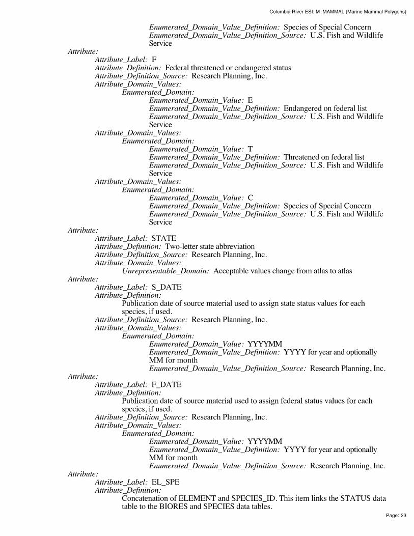
Columbia River ESI: M_MAMMAL (Marine Mammal Polygons)
Page: 23
Enumerated_Domain_Value_Definition: Species of Special Concern Enumerated_Domain_Value_Definition_Source: U.S. Fish and WildlifeService
Attribute: Attribute_Label: F Attribute_Definition: Federal threatened or endangered status Attribute_Definition_Source: Research Planning, Inc. Attribute_Domain_Values:
Enumerated_Domain: Enumerated_Domain_Value: E Enumerated_Domain_Value_Definition: Endangered on federal list Enumerated_Domain_Value_Definition_Source: U.S. Fish and WildlifeService
Attribute_Domain_Values: Enumerated_Domain:
Enumerated_Domain_Value: T Enumerated_Domain_Value_Definition: Threatened on federal list Enumerated_Domain_Value_Definition_Source: U.S. Fish and WildlifeService
Attribute_Domain_Values: Enumerated_Domain:
Enumerated_Domain_Value: C Enumerated_Domain_Value_Definition: Species of Special Concern Enumerated_Domain_Value_Definition_Source: U.S. Fish and WildlifeService
Attribute: Attribute_Label: STATE Attribute_Definition: Two-letter state abbreviation Attribute_Definition_Source: Research Planning, Inc. Attribute_Domain_Values:
Unrepresentable_Domain: Acceptable values change from atlas to atlas Attribute:
Attribute_Label: S_DATE Attribute_Definition:
Publication date of source material used to assign state status values for eachspecies, if used.
Attribute_Definition_Source: Research Planning, Inc. Attribute_Domain_Values:
Enumerated_Domain: Enumerated_Domain_Value: YYYYMM Enumerated_Domain_Value_Definition: YYYY for year and optionallyMM for month Enumerated_Domain_Value_Definition_Source: Research Planning, Inc.
Attribute: Attribute_Label: F_DATE Attribute_Definition:
Publication date of source material used to assign federal status values for eachspecies, if used.
Attribute_Definition_Source: Research Planning, Inc. Attribute_Domain_Values:
Enumerated_Domain: Enumerated_Domain_Value: YYYYMM Enumerated_Domain_Value_Definition: YYYY for year and optionallyMM for month Enumerated_Domain_Value_Definition_Source: Research Planning, Inc.
Attribute: Attribute_Label: EL_SPE Attribute_Definition:
Concatenation of ELEMENT and SPECIES_ID. This item links the STATUS datatable to the BIORES and SPECIES data tables.

Columbia River ESI: M_MAMMAL (Marine Mammal Polygons)
Page: 24
Attribute_Definition_Source: Research Planning, Inc. Attribute_Domain_Values:
Enumerated_Domain: Enumerated_Domain_Value: E##### Enumerated_Domain_Value_Definition:
Where E is the first character of ELEMENT and the next fivecharacters are SPECIES_ID (e.g. ELEMENT = 'BIRD' andSPECIES_ID = 1; EL_SPE = 'B00001').
Enumerated_Domain_Value_Definition_Source: Research Planning, Inc.
Distribution_Information: Distributor:
Contact_Information: Contact_Person_Primary:
Contact_Person: John Kaperick Contact_Organization: NOAA, Office of Response and Restoration
Contact_Address: Address_Type: Physical Address Address: 7600 Sand Point Way N.E. City: Seattle State_or_Province: Washington Postal_Code: 98115-6349
Contact_Voice_Telephone: (206) 526-6400 Contact_Facsimile_Telephone: (206) 526-6329
Resource_Description: ESI Atlas for Columbia River Distribution_Liability:
Although these data have been processed successfully on a computer system at the National Oceanicand Atmospheric Administration, no warranty, expressed or implied, is made by NOAA regarding theutility of the data on any other system, nor shall the act of distribution constitute any such warranty.NOAA warrants the delivery of this product in computer-readable format, and will offer a replacementcopy of the product when the product is determined unreadable by computer-input peripherals, orwhen the physical medium is delivered in damaged condition.
Custom_Order_Process: Contact NOAA for distribution options (see Distributor). ESI data are processed into multipleformats to make them useful to a wider community of GIS/mapping users. Distribution formatsinclude ARC export, MOSS and Shape files, and MARPLOT map folders. An ArcView ESI projectand ESI_Viewer product are also included on the distribution CDs for ease of use of the ESI data.The database files are distributed both in the NOAA standard relational database format (see NOAATechnical Memorandum NOS ORCA 115) and in a simplified desktop flat file format. This metadatadocument includes information on both of these database formats.
Metadata_Reference_Information: Metadata_Date: 200411 Metadata_Review_Date: 200411 Metadata_Contact:
Contact_Information: Contact_Person_Primary:
Contact_Person: Jill Petersen Contact_Organization: NOAA, Office of Response and Restoration
Contact_Position: GIS Manager Contact_Address:
Address_Type: Physical Address Address: 7600 Sand Point Way N.E. City: Seattle State_or_Province: Washington Postal_Code: 98115-6349

Columbia River ESI: M_MAMMAL (Marine Mammal Polygons)
Page: 25
Contact_Voice_Telephone: (206) 526-6944 Contact_Facsimile_Telephone: (206) 526-6329 Contact_Electronic_Mail_Address: [email protected]
Metadata_Standard_Name: Content Standards for Digital Geospatial Metadata Metadata_Standard_Version: FGDC-STD-001-1998
Generated by mp version 2.8.2 on Fri Dec 10 11:14:24 2004
Columbia River ESI: M_MAMPT (Marine Mammal Points)
Page: 1
Columbia River ESI: M_MAMPT (Marine MammalPoints)Metadata also available as - [Parseable text] - [SGML]
Metadata:Identification_Information Data_Quality_Information Spatial_Data_Organization_Information Spatial_Reference_Information Entity_and_Attribute_Information Distribution_Information Metadata_Reference_Information
Identification_Information: Citation:
Citation_Information: Originator:
National Oceanic and Atmospheric Administration (NOAA), National OceanService, Office of Response and Restoration, Hazardous Materials ResponseDivision, Seattle, Washington; Coastal Storms Initiative; U.S. Fish and WildlifeService; NOAA Fisheries; State of Oregon; and State of Washington.
Publication_Date: 200411 Title: Columbia River ESI: M_MAMPT (Marine Mammal Points) Edition: First Geospatial_Data_Presentation_Form: Vector digital data Series_Information:
Series_Name: None Issue_Identification: Columbia River
Publication_Information: Publication_Place: Seattle, Washington Publisher:
National Oceanic and Atmospheric Administration (NOAA), NationalOcean Service, Office of Response and Restoration, Hazardous MaterialsResponse Division, Seattle, Washington
Other_Citation_Details: Prepared by Research Planning, Inc., Columbia, South Carolina for the NationalOceanic and Atmospheric Administration (NOAA), National Ocean Service, Officeof Response and Restoration, Hazardous Materials Response Division, Seattle,Washington; Coastal Storms Initiative; U.S. Fish and Wildlife Service; NOAAFisheries; State of Oregon; and State of Washington.
Description: Abstract:
This data set contains sensitive biological resource data for sea lions and harbor seals inColumbia River. Vector points in this data set represent locations of seal and sea lionhaul-out sites. Species-specific abundance, seasonality, status, life history, and sourceinformation are stored in relational data tables (described below) designed to be used inconjunction with this spatial data layer.
This data set comprises a portion of the Environmental Sensitivity Index (ESI) data forColumbia River. ESI data characterize the marine and coastal environments and wildlife bytheir sensitivity to spilled oil. The ESI data include information for three main components:shoreline habitats, sensitive biological resources, and human-use resources. See also the

Columbia River ESI: M_MAMPT (Marine Mammal Points)
Page: 2
M_MAMMAL (Marine Mammal Polygons) data layer, part of the larger Columbia RiverESI database, for additional marine mammal information.
Purpose: The ESI data were collected, mapped, and digitized to provide environmental data for oil spillplanning and response. The Clean Water Act with amendments by the Oil Pollution Act of1990 requires response plans for immediate and effective protection of sensitive resources.
Time_Period_of_Content: Time_Period_Information:
Range_of_Dates/Times: Beginning_Date: 1984 Ending_Date: 2004
Currentness_Reference: The biological data were compiled during 2003-2004. The currentness dates for these datarange from 1984 to 2004 and are documented in the Lineage section.
Status: Progress: Complete Maintenance_and_Update_Frequency: None Scheduled
Spatial_Domain: Bounding_Coordinates:
West_Bounding_Coordinate: -124.125 East_Bounding_Coordinate: -120.67375 North_Bounding_Coordinate: 46.375 South_Bounding_Coordinate: 45.3
Keywords: Theme:
Theme_Keyword_Thesaurus: None Theme_Keyword: ESI Theme_Keyword: Sensitivity maps Theme_Keyword: Coastal resources Theme_Keyword: Oil spill planning Theme_Keyword: Coastal Zone Management Theme_Keyword: Wildlife Theme_Keyword: Marine Mammal
Place: Place_Keyword_Thesaurus: None Place_Keyword: Columbia River
Access_Constraints: None Use_Constraints:
DO NOT USE MAPS FOR NAVIGATIONAL PURPOSES. Besides the above warning, there areno use constraints on these data. Note that the ESI database should not be used to the exclusion ofother pertinent data or information held by state or federal agencies or other organizations. Likewise,information contained in the database cannot be used in place of consultations with environmental,natural resource, and cultural resource agencies, or in place of field surveys. Recognize that theinformation contained in the ESI database represents known concentration areas or occurrences ofnatural, cultural, and human-use resources, but does not necessarily represent the full distribution orrange of each species or resource. This is particularly important to recognize when consideringpotential impacts to protected resources, such as endangered species, wetlands, etc. Acknowledgmentof the originators, publishers, contributors, and sources listed would be appreciated in productsderived from these data.
Browse_Graphic: Browse_Graphic_File_Name: datafig.jpg Browse_Graphic_File_Description:
Depicts the relationships between spatial data layers and attribute data tables for theColumbia River ESI data.
Browse_Graphic_File_Type: JPEG Data_Set_Credit:
This project was supported by the National Oceanic and Atmospheric Administration (NOAA),National Ocean Service, Office of Response and Restoration, Hazardous Materials ResponseDivision, Seattle, Washington; Coastal Storms Initiative; U.S. Fish and Wildlife Service; NOAAFisheries; State of Oregon; and State of Washington.
Columbia River ESI: M_MAMPT (Marine Mammal Points)
Page: 3
Native_Data_Set_Environment: The software packages used to develop the atlas are Environmental Systems Research Institute'sARC/INFO(r) (version 8.3) and SQL SERVER(r) (version 7.0). The hardware configuration is PC'swith Windows Operating System (NT4.0/2000).
The Spatial_Data_Organization_Information section refers only to the source files in the ARC exportformat. The following files are included in that data set: birds.e00, esi.e00, fish.e00, fishl.e00,habitats.e00, hydro.e00, index.e00, invert.e00, m_mammal.e00, m_mampt.e00, mgt.e00, nests.e00,nwi.e00, reptiles.e00, socecon.e00, t_mammal.e00. Associated relational and desktop data tablesprovided in Arc export and text format are bio_lut, biofile, biores, breed, breed_dt, runs_dat, seasonal,soc_dat, soc_lut, sources, species, and status.
Data_Quality_Information: Attribute_Accuracy:
Attribute_Accuracy_Report: A multi-stage error checking process is used to verify both attribute accuracy and logicalconsistency throughout data production. The process includes a standardized data entrymethodology, hardcopy data review by in-house and external resource experts, a final QualityAssurance/Quality Control (QA/QC) process, and multiple automated logical consistencychecks. Quantitative data (such as densities, counts, abundances, or concentrations) providedby resource experts for inclusion in the data set may vary widely in attribute accuracy,depending upon the methodology used to collect and compile such data. For a more detailedevaluation of source data attribute accuracy, contact the sources listed in the Lineage section.
Logical_Consistency_Report: A multi-stage error checking process, described in the above Attribute_Accuracy_Report, is used toverify both attribute accuracy and logical consistency throughout data production. This processincludes multiple automated logical consistency checks that test the files for missing or duplicate data,rules for proper coding, GIS topological consistencies (such as dangles, unnecessary nodes, etc.), andSQL SERVER(r) to ARC/INFO(r) consistencies. A final review is made by the GIS manager, wherethe data are written to CD-ROM and the metadata are written.
After the data are delivered to NOAA, they are again subjected to a number of quality and consistencychecks. In the process of checking for topological and database consistencies, new ID's andRARNUM's or HUNUM's are also generated. The new ID's are a combination of atlas number,element number, and record number. In addition, the value used to represent the element is modifiedto reflect the type of feature being mapped. In the case of an element that is normally represented by apoint or polygon, a value of 20 is added to the standard element value for mapping of linear features.In the case where an element usually mapped as a polygon is represented by a point, a value of 30 isadded to the regular element value. The RARNUM's are also modified to include the atlas number, somultiple atlases can be combined and RARNUM's remain unique. RARNUM's are redefined on anelement basis, so "resource at risk" groupings will contain only a single element. HUNUM's are alsomodified to include the atlas number.
Completeness_Report: These data represent a synthesis of expert knowledge and available hardcopy reports and digital dataon seal and sea lion haul-out sites. See also the M_MAMMAL (Marine Mammal Polygons) datalayer, part of the larger Columbia River ESI database, for additional marine mammal information.These data do not necessarily represent all marine mammal occurrences in Columbia River. Thefollowing species are included in this data set: (Species_ID, Common Name, Scientific Name, ifapplicable): 2, Harbor seal, Phoca vitulina; 22, California sea lion, Zalophus californianus.
Positional_Accuracy: Horizontal_Positional_Accuracy:
Horizontal_Positional_Accuracy_Report: Most of the spatial components of the biological data sets are developed usingregional experts who estimate concentration areas. It is difficult to estimate thepositional accuracy of such data, except to state that they are compiled on hardcopybase maps with a scale of 1:24,000. Some of the spatial components of thebiological data sets are developed from pre-existing digital sources and reflect thepositional accuracy of these original data. See the Lineage and Process_Description

Columbia River ESI: M_MAMPT (Marine Mammal Points)
Page: 4
sections for more information on the original data source and how these data wereintegrated or manipulated to create the final data set. Note that biological resourcedata by their very nature are considered "fuzzy", and this should be understoodwhen considering the positional accuracy of vector digital objects representing theseresources.
Lineage: Source_Information:
Source_Citation: Citation_Information:
Originator: North, J., Oregon Department of Fish and Wildlife (ODFW) Publication_Date: 200402 Title: Fish, Bird, and Mammal Distributions along the Columbia River Geospatial_Data_Presentation_Form: Expert knowledge Publication_Information:
Publication_Place: Unpublished material Publisher: Unpublished material
Type_of_Source_Media: Personal communication Source_Time_Period_of_Content:
Time_Period_Information: Single_Date/Time:
Calendar_Date: 200402 Source_Currentness_Reference: Date of communication
Source_Citation_Abbreviation: None Source_Contribution: Distribution information for marine mammals
Source_Information: Source_Citation:
Citation_Information: Originator: Columbia River Estuary Data Development Program Publication_Date: 1984 Title:
The Columbia River Estuary Atlas of Physical and BiologicalCharacteristics
Geospatial_Data_Presentation_Form: Hardcopy atlas Publication_Information:
Publication_Place: Seattle, Washington Publisher: Northwest Cartography, Inc.
Source_Scale_Denominator: 250,000 Type_of_Source_Media: Paper Source_Time_Period_of_Content:
Time_Period_Information: Single_Date/Time:
Calendar_Date: 1984 Source_Currentness_Reference: Publication date
Source_Citation_Abbreviation: None Source_Contribution: Seasonality information for marine mammals
Source_Information: Source_Citation:
Citation_Information: Originator: Washington Department of Fish and Wildlife (WDFW) Publication_Date: 200403 Title: Marine Mammal Haulout Sites in the Columbia River Geospatial_Data_Presentation_Form: Vector digital data Publication_Information:
Publication_Place: Unpublished material Publisher: Unpublished material
Source_Scale_Denominator: 24,000 Type_of_Source_Media: CD-ROM Source_Time_Period_of_Content:
Time_Period_Information: Single_Date/Time:

Columbia River ESI: M_MAMPT (Marine Mammal Points)
Page: 5
Calendar_Date: 200403 Source_Currentness_Reference: Publication date
Source_Citation_Abbreviation: None Source_Contribution: Location of marine mammal haulout sites adapted from WDFW data
Process_Step: Process_Description:
Three main sources of data were used to depict haul-out sites for this data layer: (1)personal interviews with resource experts from Oregon Department of Fish andWildlife (ODFW), Washington Department of Fish and Wildlife (WDFW), andU.S. Fish and Wildlife Service (USFWS); (2) numerous published andunpublished reports; and (3) information adapted from Washington Priority Habitatdata. Information gathered during initial interviews and from hardcopy sources wascompiled onto U.S. Geological Survey 1:24,000 topographic quadrangles.
The compiled data were digitized off of the base maps into an ArcInfo system tocreate the M_MAMPT data layer. All ESI, biology, and human-use data were plottedonto hardcopy draft maps. Following the delivery of draft maps to the participatingresource experts, a second set of interviews was conducted to review the maps. Editsto the M_MAMPT data layer were made based on the recommendations of theresource experts, and final hardcopy maps were created.
Process_Date: 200408 Process_Contact:
Contact_Information: Contact_Organization_Primary:
Contact_Organization: NOAA, Office of Response andRestoration Contact_Person: Jill Petersen
Contact_Address: Address_Type: Physical address Address: 7600 Sand Point Way N.E. City: Seattle State_or_Province: Washington Postal_Code: 98115-6349
Contact_Voice_Telephone: (206) 526-6944 Contact_Facsimile_Telephone: (206) 526-6329 Contact_Electronic_Mail_Address: [email protected]
Spatial_Data_Organization_Information: Direct_Spatial_Reference_Method: Vector Point_and_Vector_Object_Information:
SDTS_Terms_Description: SDTS_Point_and_Vector_Object_Type: Entity Point Point_and_Vector_Object_Count: 15
Spatial_Reference_Information: Horizontal_Coordinate_System_Definition:
Geographic: Latitude_Resolution: 0.0000001 Longitude_Resolution: 0.0000001 Geographic_Coordinate_Units: Decimal degrees
Geodetic_Model: Horizontal_Datum_Name: North American Datum of 1927 Ellipsoid_Name: Clark 1866 Semi-major_Axis: 6378206.4 Denominator_of_Flattening_Ratio: 294.978698

Columbia River ESI: M_MAMPT (Marine Mammal Points)
Page: 6
Entity_and_Attribute_Information: Overview_Description:
Entity_and_Attribute_Overview: In addition to the geographic data layers, six relational attribute or data tables, BIORES,BREED, SEASONAL, SOURCES, SPECIES, and STATUS, are used to store the complexbiological data in the ESI data structure. The geographic data layer containing biologicalresource information (in this case, M_MAMPT) is linked to the Biological Resources table(BIORES) using the unique ID and the lookup table BIO_LUT, or it can be linked directlyusing RARNUM. The ID is a unique combination of the atlas number (for the ColumbiaRiver atlas, the number is 41), an element/layer specific number (BIRDS are layer 1, FISHare layer 2, etc.), and a unique record number. The RARNUM represents a uniquecombination of species, seasonalities, concentrations, and source information. For each ofthese groupings, a number is generated. That number is concatenated with the atlas numberto create a "resource at risk" number that is unique across atlases. BIORES and the otherrelational data tables are described below in detail. See the Browse_Graphic section for a linkto the entity-relationship diagram, which describes the way these tables relate to thegeographic data layers and other attribute tables in the ESI data structure.
Due to the complexity of the relational database model, the data items are also post-processedinto a flat file format. This table, called BIOFILE, may be used in place of the relational filesdescribed below to ease simple data queries. The items in the flat file are ELEMENT,SUBELEMENT, NAME, GEN_SPEC, S, F, NHP, DATE_PUB, CONC, JAN, FEB, MAR,APR, MAY, JUN, JUL, AUG, SEP, OCT, NOV, DEC, BREED1, BREED2, BREED3,BREED4, BREED5, RARNUM, G_SOURCE, S_SOURCE, and BREED. All of theseitems are the same as their counterparts in the individual data tables described below, exceptthe BREED1-BREED5 and BREED items. BREED is a newly generated variable used tolink to the BREED_DT data table, a modified, more compact version of the relationalBREED data table. BREED1-BREED5 give a text summary of when each life stage occurswithin the associated map object. The life stages referred to are the same as those listed in theDetailed_Description of the BREED data table. The link to the BIOFILE may be madethrough the BIO_LUT, using ID to link to RARNUM, or BIOFILE may be linked directlyto the RARNUM in each of the geographic layer's attribute data tables. As mentioned,BREED_DT is an auxiliary support data table to the flat file structure, which allows the userto do searches based on month for seasonal breeding activities. The link from the flat file toBREED_DT is the BREED item.
A second supporting data table is SOURCES. This is the same as the source file describedabove, and the link from the flat file is both G_SOURCE and S_SOURCE. It should benoted that although the flat file eases data query, it is not a normalized database structure, andactual updates performed by the states and other responsible agencies should be done usingthe relational data tables. The entity-relationship diagram, describing relationships betweenattribute tables in the ESI data structure, does NOT include the BIOFILE data table, and thisdata table is NOT described in detail below.
Detailed_Description: Entity_Type:
Entity_Type_Label: M_MAMPT.PAT Entity_Type_Definition:
The M_MAMPT.PAT table contains attribute information for the vector pointsrepresenting seal and sea lion haul-out sites. Note that all attribute information isstored in a series of relational files, described below. See the Browse_Graphicsection for a link to the entity-relationship diagram, which describes the relationshipsbetween attribute tables in the ESI data structure.
Entity_Type_Definition_Source: Research Planning, Inc. Attribute:
Attribute_Label: ID Attribute_Definition:
An identifier that links vector objects in the biology data layers to records in theBIO_LUT data table. ID is a concatenation of atlas number (41), element number

Columbia River ESI: M_MAMPT (Marine Mammal Points)
Page: 7
(34; 30 because it is a point feature, plus 4, the element value for M_MAMMAL),and record number.
Attribute_Definition_Source: NOAA Attribute_Domain_Values:
Range_Domain: Range_Domain_Minimum: 413400001 Range_Domain_Maximum: 413400015
Attribute: Attribute_Label: RARNUM Attribute_Definition:
An identifier that links directly to the BIORES table or the flat format BIOFILEtable.
Attribute_Definition_Source: NOAA Attribute_Domain_Values:
Range_Domain: Range_Domain_Minimum: 41000064 Range_Domain_Maximum: 41000068
Detailed_Description: Entity_Type:
Entity_Type_Label: BIO_LUT Entity_Type_Definition:
The data table BIO_LUT is a lookup table that contains items necessary for linkingvector objects in the biological data layers with the BIORES data table. Note that allattribute information is stored in a series of relational files, described below. See theBrowse_Graphic section for a link to the entity-relationship diagram, whichdescribes the way this table relates to other attribute tables in the ESI data structure.
Entity_Type_Definition_Source: Research Planning, Inc. Attribute:
Attribute_Label: RARNUM Attribute_Definition:
An identifier that links records in the BIO_LUT data table to records in the BIORESdata table or the flat format BIOFILE data table. RARNUM values of 0 are holes inpoints and do not contain information.
Attribute_Definition_Source: NOAA Attribute_Domain_Values:
Range_Domain: Range_Domain_Minimum: 41000001 Range_Domain_Maximum: 41000290
Attribute: Attribute_Label: ID Attribute_Definition:
An identifier that links vector objects in the biology data layers to records in theBIO_LUT data table. ID is a concatenation of atlas number (41), element number(34; 30 because it is a point feature, plus 4, the element value for M_MAMMAL),and record number. ID values of 9999 are holes in polygons and do not containinformation.
Attribute_Definition_Source: NOAA Attribute_Domain_Values:
Range_Domain: Range_Domain_Minimum: 410100002 Range_Domain_Maximum: 413400015
Detailed_Description: Entity_Type:
Entity_Type_Label: BIORES Entity_Type_Definition:
The data table BIORES contains both biological attribute data and items necessaryfor linking vector objects in the biological data layers via the BIO_LUT data table toother associated data tables. See the Browse_Graphic section for a link to theentity-relationship diagram, which describes the way this table relates to otherattribute tables in the ESI data structure.

Columbia River ESI: M_MAMPT (Marine Mammal Points)
Page: 8
Entity_Type_Definition_Source: Research Planning, Inc. Attribute:
Attribute_Label: RARNUM Attribute_Definition:
An identifier that links records in the BIORES data table to records in the BIO_LUTdata table or the flat format BIOFILE data table.
Attribute_Definition_Source: NOAA Attribute_Domain_Values:
Range_Domain: Range_Domain_Minimum: 041000001 Range_Domain_Maximum: 041000290
Attribute: Attribute_Label: SPECIES_ID Attribute_Definition:
Numeric identifier for each species that is unique within each element and refers to anationwide master ESI species list maintained at NOAA.
Attribute_Definition_Source: Research Planning, Inc. Attribute_Domain_Values:
Range_Domain: Range_Domain_Minimum: 1 Range_Domain_Maximum: N
Attribute: Attribute_Label: CONC Attribute_Definition:
The field CONC refers to "concentration," abundance, or density values andcontains counts of a range of individuals (XX-XXX). Note that these numbersgenerally represent the peak concentrations of marine mammals present orpotentially present. Counts were derived from a variety of surveys, and may range indate.
Attribute_Definition_Source: Research Planning, Inc. Attribute_Domain_Values:
Unrepresentable_Domain: Acceptable values change from atlas to atlas Attribute:
Attribute_Label: SEASON_ID Attribute_Definition:
Numeric identifier for the unique monthly presence and life history characteristics ofeach species at a given location.
Attribute_Definition_Source: Research Planning, Inc. Attribute_Domain_Values:
Range_Domain: Range_Domain_Minimum: 1 Range_Domain_Maximum: N
Attribute: Attribute_Label: G_SOURCE Attribute_Definition:
Geographic source identifier that links records in the BIORES data table to recordsin the SOURCES data table.
Attribute_Definition_Source: Research Planning, Inc. Attribute_Domain_Values:
Range_Domain: Range_Domain_Minimum: 1 Range_Domain_Maximum: N
Attribute: Attribute_Label: S_SOURCE Attribute_Definition:
Seasonality source identifier that links records in the BIORES data table to recordsin the SOURCES data table.
Attribute_Definition_Source: Research Planning, Inc. Attribute_Domain_Values:
Range_Domain:
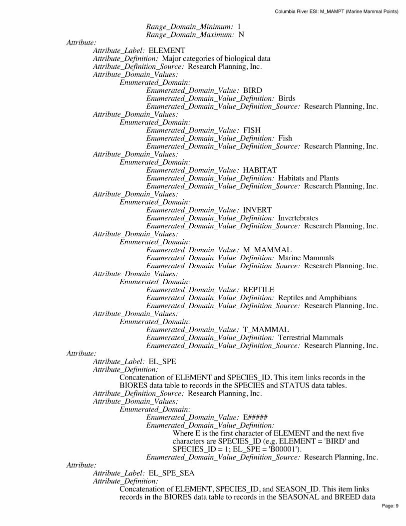
Columbia River ESI: M_MAMPT (Marine Mammal Points)
Page: 9
Range_Domain_Minimum: 1 Range_Domain_Maximum: N
Attribute: Attribute_Label: ELEMENT Attribute_Definition: Major categories of biological data Attribute_Definition_Source: Research Planning, Inc. Attribute_Domain_Values:
Enumerated_Domain: Enumerated_Domain_Value: BIRD Enumerated_Domain_Value_Definition: Birds Enumerated_Domain_Value_Definition_Source: Research Planning, Inc.
Attribute_Domain_Values: Enumerated_Domain:
Enumerated_Domain_Value: FISH Enumerated_Domain_Value_Definition: Fish Enumerated_Domain_Value_Definition_Source: Research Planning, Inc.
Attribute_Domain_Values: Enumerated_Domain:
Enumerated_Domain_Value: HABITAT Enumerated_Domain_Value_Definition: Habitats and Plants Enumerated_Domain_Value_Definition_Source: Research Planning, Inc.
Attribute_Domain_Values: Enumerated_Domain:
Enumerated_Domain_Value: INVERT Enumerated_Domain_Value_Definition: Invertebrates Enumerated_Domain_Value_Definition_Source: Research Planning, Inc.
Attribute_Domain_Values: Enumerated_Domain:
Enumerated_Domain_Value: M_MAMMAL Enumerated_Domain_Value_Definition: Marine Mammals Enumerated_Domain_Value_Definition_Source: Research Planning, Inc.
Attribute_Domain_Values: Enumerated_Domain:
Enumerated_Domain_Value: REPTILE Enumerated_Domain_Value_Definition: Reptiles and Amphibians Enumerated_Domain_Value_Definition_Source: Research Planning, Inc.
Attribute_Domain_Values: Enumerated_Domain:
Enumerated_Domain_Value: T_MAMMAL Enumerated_Domain_Value_Definition: Terrestrial Mammals Enumerated_Domain_Value_Definition_Source: Research Planning, Inc.
Attribute: Attribute_Label: EL_SPE Attribute_Definition:
Concatenation of ELEMENT and SPECIES_ID. This item links records in theBIORES data table to records in the SPECIES and STATUS data tables.
Attribute_Definition_Source: Research Planning, Inc. Attribute_Domain_Values:
Enumerated_Domain: Enumerated_Domain_Value: E##### Enumerated_Domain_Value_Definition:
Where E is the first character of ELEMENT and the next fivecharacters are SPECIES_ID (e.g. ELEMENT = 'BIRD' andSPECIES_ID = 1; EL_SPE = 'B00001').
Enumerated_Domain_Value_Definition_Source: Research Planning, Inc. Attribute:
Attribute_Label: EL_SPE_SEA Attribute_Definition:
Concatenation of ELEMENT, SPECIES_ID, and SEASON_ID. This item linksrecords in the BIORES data table to records in the SEASONAL and BREED data

Columbia River ESI: M_MAMPT (Marine Mammal Points)
Page: 10
tables. Attribute_Definition_Source: Research Planning, Inc. Attribute_Domain_Values:
Enumerated_Domain: Enumerated_Domain_Value: E####### Enumerated_Domain_Value_Definition:
Where E is the first character of ELEMENT, the next fivecharacters are SPECIES_ID, and the last two characters areSEASON_ID (e.g. ELEMENT = 'BIRD', SPECIES_ID = 1 andSEASON_ID = 1; EL_SPE_SEA = 'B0000101').
Enumerated_Domain_Value_Definition_Source: Research Planning, Inc. Detailed_Description:
Entity_Type: Entity_Type_Label: SPECIES Entity_Type_Definition:
The data table SPECIES identifies all species in the ESI data set. See theBrowse_Graphic section for a link to the entity-relationship diagram, whichdescribes the way this table relates to other attribute tables in the ESI data structure.Refer to the Completeness_Report for a list of layer-specific species.
Entity_Type_Definition_Source: Research Planning, Inc. Attribute:
Attribute_Label: SPECIES_ID Attribute_Definition:
Numeric identifier for each species that is unique within each element and refers to anationwide master ESI species list maintained at NOAA.
Attribute_Definition_Source: Research Planning, Inc. Attribute_Domain_Values:
Range_Domain: Range_Domain_Minimum: 1 Range_Domain_Maximum: N
Attribute: Attribute_Label: NAME Attribute_Definition: Species common name for the entire ESI data set Attribute_Definition_Source: Research Planning, Inc. Attribute_Domain_Values:
Unrepresentable_Domain: Acceptable values change from atlas to atlas Attribute:
Attribute_Label: GEN_SPEC Attribute_Definition: Species scientific name for the entire ESI data set Attribute_Definition_Source: Research Planning, Inc. Attribute_Domain_Values:
Unrepresentable_Domain: Acceptable values change from atlas to atlas Attribute:
Attribute_Label: ELEMENT Attribute_Definition: Major categories of biological data Attribute_Definition_Source: Research Planning, Inc. Attribute_Domain_Values:
Enumerated_Domain: Enumerated_Domain_Value: BIRD Enumerated_Domain_Value_Definition: Birds Enumerated_Domain_Value_Definition_Source: Research Planning, Inc.
Attribute_Domain_Values: Enumerated_Domain:
Enumerated_Domain_Value: FISH Enumerated_Domain_Value_Definition: Fish Enumerated_Domain_Value_Definition_Source: Research Planning, Inc.
Attribute_Domain_Values: Enumerated_Domain:
Enumerated_Domain_Value: HABITAT Enumerated_Domain_Value_Definition: Habitats and Plants
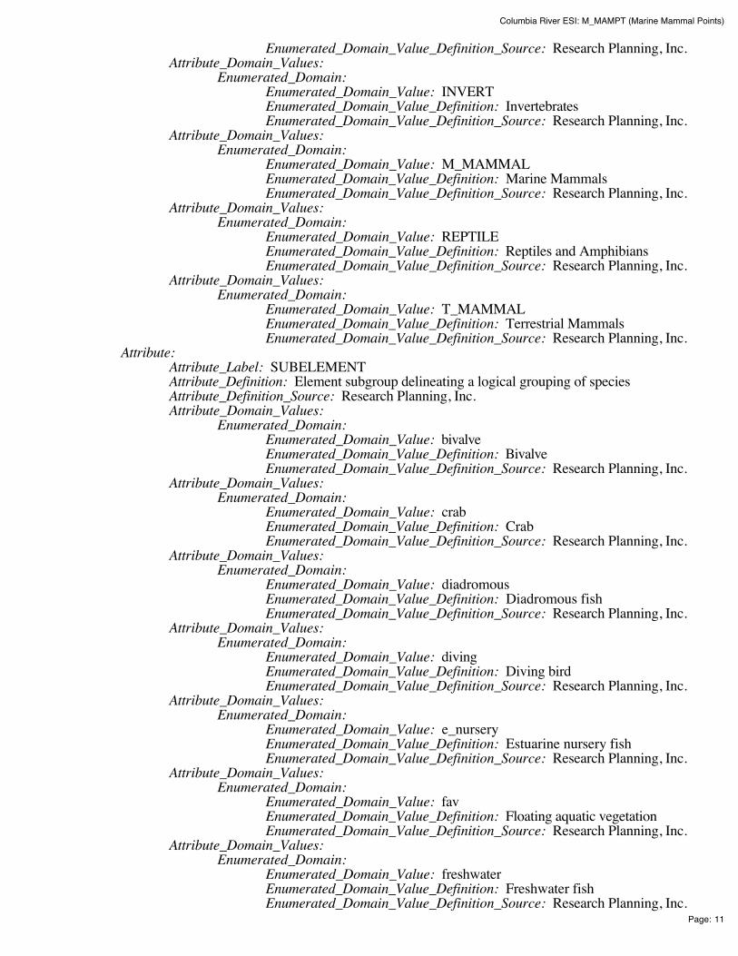
Columbia River ESI: M_MAMPT (Marine Mammal Points)
Page: 11
Enumerated_Domain_Value_Definition_Source: Research Planning, Inc. Attribute_Domain_Values:
Enumerated_Domain: Enumerated_Domain_Value: INVERT Enumerated_Domain_Value_Definition: Invertebrates Enumerated_Domain_Value_Definition_Source: Research Planning, Inc.
Attribute_Domain_Values: Enumerated_Domain:
Enumerated_Domain_Value: M_MAMMAL Enumerated_Domain_Value_Definition: Marine Mammals Enumerated_Domain_Value_Definition_Source: Research Planning, Inc.
Attribute_Domain_Values: Enumerated_Domain:
Enumerated_Domain_Value: REPTILE Enumerated_Domain_Value_Definition: Reptiles and Amphibians Enumerated_Domain_Value_Definition_Source: Research Planning, Inc.
Attribute_Domain_Values: Enumerated_Domain:
Enumerated_Domain_Value: T_MAMMAL Enumerated_Domain_Value_Definition: Terrestrial Mammals Enumerated_Domain_Value_Definition_Source: Research Planning, Inc.
Attribute: Attribute_Label: SUBELEMENT Attribute_Definition: Element subgroup delineating a logical grouping of species Attribute_Definition_Source: Research Planning, Inc. Attribute_Domain_Values:
Enumerated_Domain: Enumerated_Domain_Value: bivalve Enumerated_Domain_Value_Definition: Bivalve Enumerated_Domain_Value_Definition_Source: Research Planning, Inc.
Attribute_Domain_Values: Enumerated_Domain:
Enumerated_Domain_Value: crab Enumerated_Domain_Value_Definition: Crab Enumerated_Domain_Value_Definition_Source: Research Planning, Inc.
Attribute_Domain_Values: Enumerated_Domain:
Enumerated_Domain_Value: diadromous Enumerated_Domain_Value_Definition: Diadromous fish Enumerated_Domain_Value_Definition_Source: Research Planning, Inc.
Attribute_Domain_Values: Enumerated_Domain:
Enumerated_Domain_Value: diving Enumerated_Domain_Value_Definition: Diving bird Enumerated_Domain_Value_Definition_Source: Research Planning, Inc.
Attribute_Domain_Values: Enumerated_Domain:
Enumerated_Domain_Value: e_nursery Enumerated_Domain_Value_Definition: Estuarine nursery fish Enumerated_Domain_Value_Definition_Source: Research Planning, Inc.
Attribute_Domain_Values: Enumerated_Domain:
Enumerated_Domain_Value: fav Enumerated_Domain_Value_Definition: Floating aquatic vegetation Enumerated_Domain_Value_Definition_Source: Research Planning, Inc.
Attribute_Domain_Values: Enumerated_Domain:
Enumerated_Domain_Value: freshwater Enumerated_Domain_Value_Definition: Freshwater fish Enumerated_Domain_Value_Definition_Source: Research Planning, Inc.
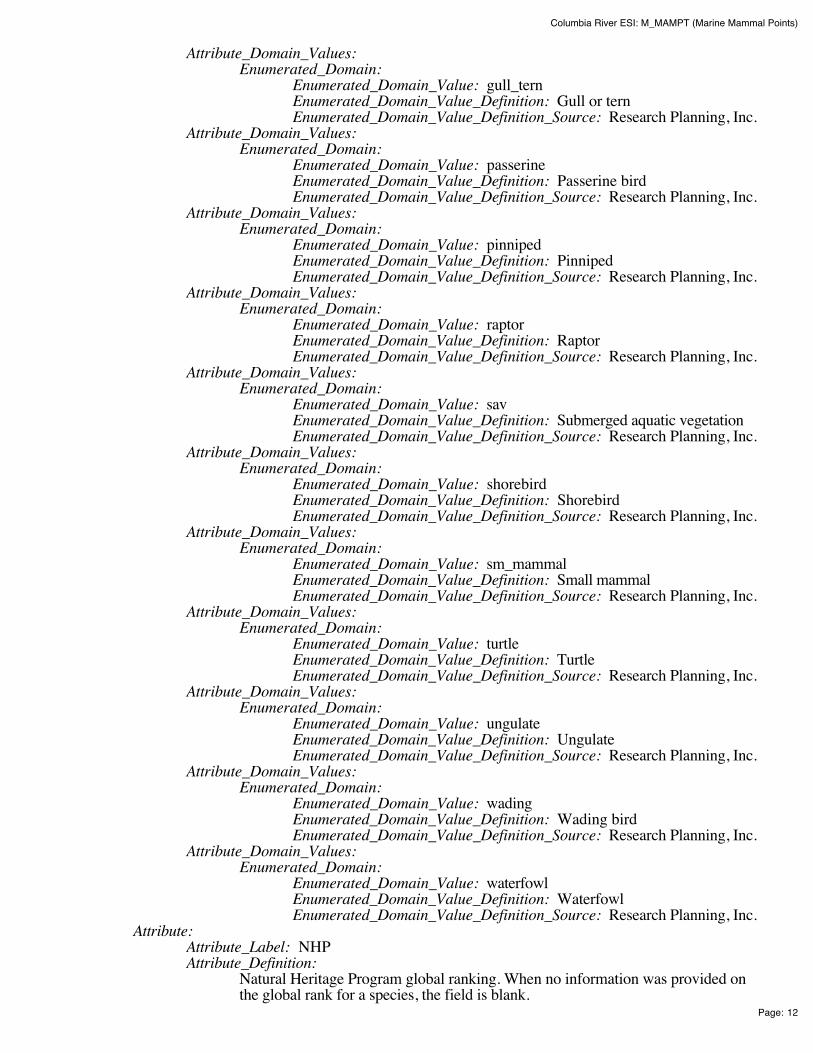
Columbia River ESI: M_MAMPT (Marine Mammal Points)
Page: 12
Attribute_Domain_Values: Enumerated_Domain:
Enumerated_Domain_Value: gull_tern Enumerated_Domain_Value_Definition: Gull or tern Enumerated_Domain_Value_Definition_Source: Research Planning, Inc.
Attribute_Domain_Values: Enumerated_Domain:
Enumerated_Domain_Value: passerine Enumerated_Domain_Value_Definition: Passerine bird Enumerated_Domain_Value_Definition_Source: Research Planning, Inc.
Attribute_Domain_Values: Enumerated_Domain:
Enumerated_Domain_Value: pinniped Enumerated_Domain_Value_Definition: Pinniped Enumerated_Domain_Value_Definition_Source: Research Planning, Inc.
Attribute_Domain_Values: Enumerated_Domain:
Enumerated_Domain_Value: raptor Enumerated_Domain_Value_Definition: Raptor Enumerated_Domain_Value_Definition_Source: Research Planning, Inc.
Attribute_Domain_Values: Enumerated_Domain:
Enumerated_Domain_Value: sav Enumerated_Domain_Value_Definition: Submerged aquatic vegetation Enumerated_Domain_Value_Definition_Source: Research Planning, Inc.
Attribute_Domain_Values: Enumerated_Domain:
Enumerated_Domain_Value: shorebird Enumerated_Domain_Value_Definition: Shorebird Enumerated_Domain_Value_Definition_Source: Research Planning, Inc.
Attribute_Domain_Values: Enumerated_Domain:
Enumerated_Domain_Value: sm_mammal Enumerated_Domain_Value_Definition: Small mammal Enumerated_Domain_Value_Definition_Source: Research Planning, Inc.
Attribute_Domain_Values: Enumerated_Domain:
Enumerated_Domain_Value: turtle Enumerated_Domain_Value_Definition: Turtle Enumerated_Domain_Value_Definition_Source: Research Planning, Inc.
Attribute_Domain_Values: Enumerated_Domain:
Enumerated_Domain_Value: ungulate Enumerated_Domain_Value_Definition: Ungulate Enumerated_Domain_Value_Definition_Source: Research Planning, Inc.
Attribute_Domain_Values: Enumerated_Domain:
Enumerated_Domain_Value: wading Enumerated_Domain_Value_Definition: Wading bird Enumerated_Domain_Value_Definition_Source: Research Planning, Inc.
Attribute_Domain_Values: Enumerated_Domain:
Enumerated_Domain_Value: waterfowl Enumerated_Domain_Value_Definition: Waterfowl Enumerated_Domain_Value_Definition_Source: Research Planning, Inc.
Attribute: Attribute_Label: NHP Attribute_Definition:
Natural Heritage Program global ranking. When no information was provided onthe global rank for a species, the field is blank.

Columbia River ESI: M_MAMPT (Marine Mammal Points)
Page: 13
Attribute_Definition_Source: Network of Natural Heritage Program Attribute_Domain_Values:
Codeset_Domain: Codeset_Name: NHP Global Conservation Status Rank Codeset_Source: Natural Heritage Program
Attribute: Attribute_Label: DATE_PUB Attribute_Definition: Date of NHP listing Attribute_Definition_Source: Research Planning, Inc. Attribute_Domain_Values:
Enumerated_Domain: Enumerated_Domain_Value: YYYYMM Enumerated_Domain_Value_Definition: YYYY for year and optionallyMM for month Enumerated_Domain_Value_Definition_Source: Research Planning, Inc.
Attribute_Domain_Values: Enumerated_Domain:
Enumerated_Domain_Value: 0 Enumerated_Domain_Value_Definition: No information was provided onthe global rank for the species Enumerated_Domain_Value_Definition_Source: Research Planning, Inc.
Attribute: Attribute_Label: EL_SPE Attribute_Definition:
Concatenation of ELEMENT and SPECIES_ID. This item links records in theSPECIES data table to records in the BIORES and STATUS data tables.
Attribute_Definition_Source: Research Planning, Inc. Attribute_Domain_Values:
Enumerated_Domain: Enumerated_Domain_Value: E##### Enumerated_Domain_Value_Definition:
Where E is the first character of ELEMENT and the next fivecharacters are SPECIES_ID (e.g. ELEMENT = 'BIRD' andSPECIES_ID = 1; EL_SPE = 'B00001').
Enumerated_Domain_Value_Definition_Source: Research Planning, Inc. Detailed_Description:
Entity_Type: Entity_Type_Label: SEASONAL Entity_Type_Definition:
The data table SEASONAL contains information on the seasonal presence of eachspecies associated with each spatial vector object. See the Browse_Graphic sectionfor a link to the entity-relationship diagram, which describes the way this tablerelates to other attribute tables in the ESI data structure.
Entity_Type_Definition_Source: Research Planning, Inc. Attribute:
Attribute_Label: ELEMENT Attribute_Definition: Major categories of biological data Attribute_Definition_Source: Research Planning, Inc. Attribute_Domain_Values:
Enumerated_Domain: Enumerated_Domain_Value: BIRD Enumerated_Domain_Value_Definition: Birds Enumerated_Domain_Value_Definition_Source: Research Planning, Inc.
Attribute_Domain_Values: Enumerated_Domain:
Enumerated_Domain_Value: FISH Enumerated_Domain_Value_Definition: Fish Enumerated_Domain_Value_Definition_Source: Research Planning, Inc.
Attribute_Domain_Values: Enumerated_Domain:

Columbia River ESI: M_MAMPT (Marine Mammal Points)
Page: 14
Enumerated_Domain_Value: HABITAT Enumerated_Domain_Value_Definition: Habitats and Plants Enumerated_Domain_Value_Definition_Source: Research Planning, Inc.
Attribute_Domain_Values: Enumerated_Domain:
Enumerated_Domain_Value: INVERT Enumerated_Domain_Value_Definition: Invertebrates Enumerated_Domain_Value_Definition_Source: Research Planning, Inc.
Attribute_Domain_Values: Enumerated_Domain:
Enumerated_Domain_Value: M_MAMMAL Enumerated_Domain_Value_Definition: Marine Mammals Enumerated_Domain_Value_Definition_Source: Research Planning, Inc.
Attribute_Domain_Values: Enumerated_Domain:
Enumerated_Domain_Value: REPTILE Enumerated_Domain_Value_Definition: Reptiles and Amphibians Enumerated_Domain_Value_Definition_Source: Research Planning, Inc.
Attribute_Domain_Values: Enumerated_Domain:
Enumerated_Domain_Value: T_MAMMAL Enumerated_Domain_Value_Definition: Terrestrial Mammals Enumerated_Domain_Value_Definition_Source: Research Planning, Inc.
Attribute: Attribute_Label: SPECIES_ID Attribute_Definition:
Numeric identifier for each species that is unique within each element and refers to anationwide ESI species list maintained at NOAA.
Attribute_Definition_Source: Research Planning, Inc. Attribute_Domain_Values:
Range_Domain: Range_Domain_Minimum: 1 Range_Domain_Maximum: N
Attribute: Attribute_Label: SEASON_ID Attribute_Definition:
Numeric identifier for the unique monthly presence and life history characteristics ofeach species at a given location.
Attribute_Definition_Source: Research Planning, Inc. Attribute_Domain_Values:
Range_Domain: Range_Domain_Minimum: 1 Range_Domain_Maximum: N
Attribute: Attribute_Label: JAN Attribute_Definition: January Attribute_Definition_Source: Research Planning, Inc. Attribute_Domain_Values:
Enumerated_Domain: Enumerated_Domain_Value: X Enumerated_Domain_Value_Definition: Present in January Enumerated_Domain_Value_Definition_Source: Research Planning, Inc.
Attribute: Attribute_Label: FEB Attribute_Definition: February Attribute_Definition_Source: Research Planning, Inc. Attribute_Domain_Values:
Enumerated_Domain: Enumerated_Domain_Value: X Enumerated_Domain_Value_Definition: Present in February
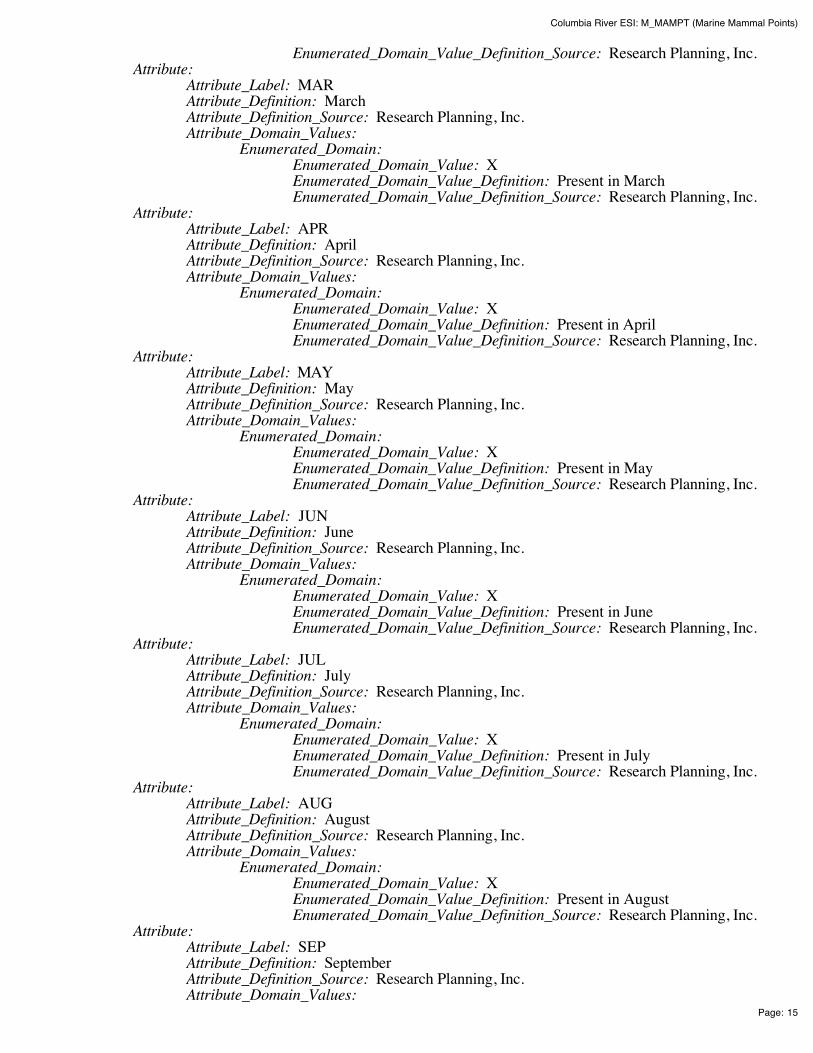
Columbia River ESI: M_MAMPT (Marine Mammal Points)
Page: 15
Enumerated_Domain_Value_Definition_Source: Research Planning, Inc. Attribute:
Attribute_Label: MAR Attribute_Definition: March Attribute_Definition_Source: Research Planning, Inc. Attribute_Domain_Values:
Enumerated_Domain: Enumerated_Domain_Value: X Enumerated_Domain_Value_Definition: Present in March Enumerated_Domain_Value_Definition_Source: Research Planning, Inc.
Attribute: Attribute_Label: APR Attribute_Definition: April Attribute_Definition_Source: Research Planning, Inc. Attribute_Domain_Values:
Enumerated_Domain: Enumerated_Domain_Value: X Enumerated_Domain_Value_Definition: Present in April Enumerated_Domain_Value_Definition_Source: Research Planning, Inc.
Attribute: Attribute_Label: MAY Attribute_Definition: May Attribute_Definition_Source: Research Planning, Inc. Attribute_Domain_Values:
Enumerated_Domain: Enumerated_Domain_Value: X Enumerated_Domain_Value_Definition: Present in May Enumerated_Domain_Value_Definition_Source: Research Planning, Inc.
Attribute: Attribute_Label: JUN Attribute_Definition: June Attribute_Definition_Source: Research Planning, Inc. Attribute_Domain_Values:
Enumerated_Domain: Enumerated_Domain_Value: X Enumerated_Domain_Value_Definition: Present in June Enumerated_Domain_Value_Definition_Source: Research Planning, Inc.
Attribute: Attribute_Label: JUL Attribute_Definition: July Attribute_Definition_Source: Research Planning, Inc. Attribute_Domain_Values:
Enumerated_Domain: Enumerated_Domain_Value: X Enumerated_Domain_Value_Definition: Present in July Enumerated_Domain_Value_Definition_Source: Research Planning, Inc.
Attribute: Attribute_Label: AUG Attribute_Definition: August Attribute_Definition_Source: Research Planning, Inc. Attribute_Domain_Values:
Enumerated_Domain: Enumerated_Domain_Value: X Enumerated_Domain_Value_Definition: Present in August Enumerated_Domain_Value_Definition_Source: Research Planning, Inc.
Attribute: Attribute_Label: SEP Attribute_Definition: September Attribute_Definition_Source: Research Planning, Inc. Attribute_Domain_Values:
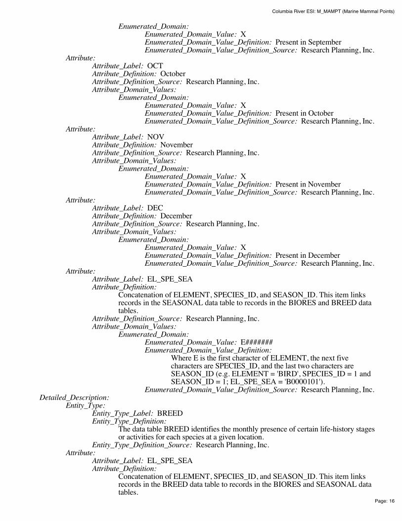
Columbia River ESI: M_MAMPT (Marine Mammal Points)
Page: 16
Enumerated_Domain: Enumerated_Domain_Value: X Enumerated_Domain_Value_Definition: Present in September Enumerated_Domain_Value_Definition_Source: Research Planning, Inc.
Attribute: Attribute_Label: OCT Attribute_Definition: October Attribute_Definition_Source: Research Planning, Inc. Attribute_Domain_Values:
Enumerated_Domain: Enumerated_Domain_Value: X Enumerated_Domain_Value_Definition: Present in October Enumerated_Domain_Value_Definition_Source: Research Planning, Inc.
Attribute: Attribute_Label: NOV Attribute_Definition: November Attribute_Definition_Source: Research Planning, Inc. Attribute_Domain_Values:
Enumerated_Domain: Enumerated_Domain_Value: X Enumerated_Domain_Value_Definition: Present in November Enumerated_Domain_Value_Definition_Source: Research Planning, Inc.
Attribute: Attribute_Label: DEC Attribute_Definition: December Attribute_Definition_Source: Research Planning, Inc. Attribute_Domain_Values:
Enumerated_Domain: Enumerated_Domain_Value: X Enumerated_Domain_Value_Definition: Present in December Enumerated_Domain_Value_Definition_Source: Research Planning, Inc.
Attribute: Attribute_Label: EL_SPE_SEA Attribute_Definition:
Concatenation of ELEMENT, SPECIES_ID, and SEASON_ID. This item linksrecords in the SEASONAL data table to records in the BIORES and BREED datatables.
Attribute_Definition_Source: Research Planning, Inc. Attribute_Domain_Values:
Enumerated_Domain: Enumerated_Domain_Value: E####### Enumerated_Domain_Value_Definition:
Where E is the first character of ELEMENT, the next fivecharacters are SPECIES_ID, and the last two characters areSEASON_ID (e.g. ELEMENT = 'BIRD', SPECIES_ID = 1 andSEASON_ID = 1; EL_SPE_SEA = 'B0000101').
Enumerated_Domain_Value_Definition_Source: Research Planning, Inc. Detailed_Description:
Entity_Type: Entity_Type_Label: BREED Entity_Type_Definition:
The data table BREED identifies the monthly presence of certain life-history stagesor activities for each species at a given location.
Entity_Type_Definition_Source: Research Planning, Inc. Attribute:
Attribute_Label: EL_SPE_SEA Attribute_Definition:
Concatenation of ELEMENT, SPECIES_ID, and SEASON_ID. This item linksrecords in the BREED data table to records in the BIORES and SEASONAL datatables.
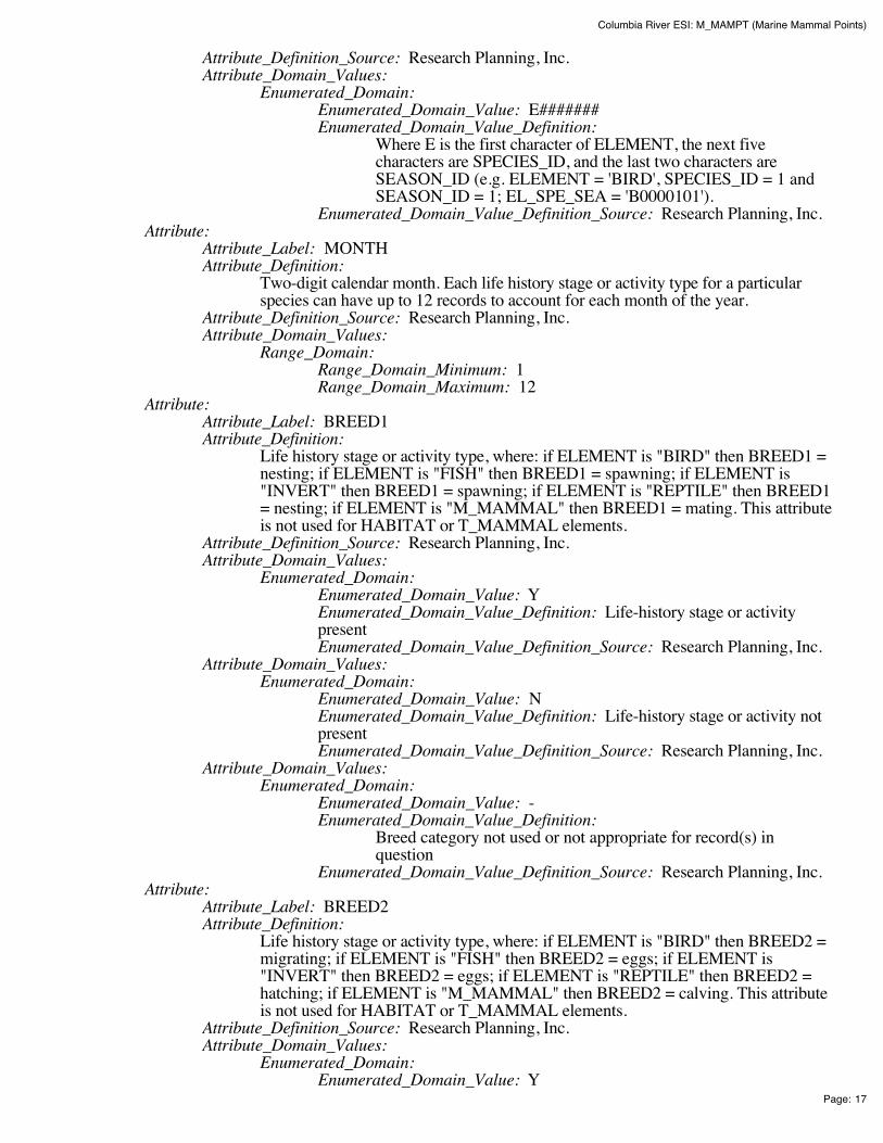
Columbia River ESI: M_MAMPT (Marine Mammal Points)
Page: 17
Attribute_Definition_Source: Research Planning, Inc. Attribute_Domain_Values:
Enumerated_Domain: Enumerated_Domain_Value: E####### Enumerated_Domain_Value_Definition:
Where E is the first character of ELEMENT, the next fivecharacters are SPECIES_ID, and the last two characters areSEASON_ID (e.g. ELEMENT = 'BIRD', SPECIES_ID = 1 andSEASON_ID = 1; EL_SPE_SEA = 'B0000101').
Enumerated_Domain_Value_Definition_Source: Research Planning, Inc. Attribute:
Attribute_Label: MONTH Attribute_Definition:
Two-digit calendar month. Each life history stage or activity type for a particularspecies can have up to 12 records to account for each month of the year.
Attribute_Definition_Source: Research Planning, Inc. Attribute_Domain_Values:
Range_Domain: Range_Domain_Minimum: 1 Range_Domain_Maximum: 12
Attribute: Attribute_Label: BREED1 Attribute_Definition:
Life history stage or activity type, where: if ELEMENT is "BIRD" then BREED1 =nesting; if ELEMENT is "FISH" then BREED1 = spawning; if ELEMENT is"INVERT" then BREED1 = spawning; if ELEMENT is "REPTILE" then BREED1= nesting; if ELEMENT is "M_MAMMAL" then BREED1 = mating. This attributeis not used for HABITAT or T_MAMMAL elements.
Attribute_Definition_Source: Research Planning, Inc. Attribute_Domain_Values:
Enumerated_Domain: Enumerated_Domain_Value: Y Enumerated_Domain_Value_Definition: Life-history stage or activitypresent Enumerated_Domain_Value_Definition_Source: Research Planning, Inc.
Attribute_Domain_Values: Enumerated_Domain:
Enumerated_Domain_Value: N Enumerated_Domain_Value_Definition: Life-history stage or activity notpresent Enumerated_Domain_Value_Definition_Source: Research Planning, Inc.
Attribute_Domain_Values: Enumerated_Domain:
Enumerated_Domain_Value: - Enumerated_Domain_Value_Definition:
Breed category not used or not appropriate for record(s) inquestion
Enumerated_Domain_Value_Definition_Source: Research Planning, Inc. Attribute:
Attribute_Label: BREED2 Attribute_Definition:
Life history stage or activity type, where: if ELEMENT is "BIRD" then BREED2 =migrating; if ELEMENT is "FISH" then BREED2 = eggs; if ELEMENT is"INVERT" then BREED2 = eggs; if ELEMENT is "REPTILE" then BREED2 =hatching; if ELEMENT is "M_MAMMAL" then BREED2 = calving. This attributeis not used for HABITAT or T_MAMMAL elements.
Attribute_Definition_Source: Research Planning, Inc. Attribute_Domain_Values:
Enumerated_Domain: Enumerated_Domain_Value: Y
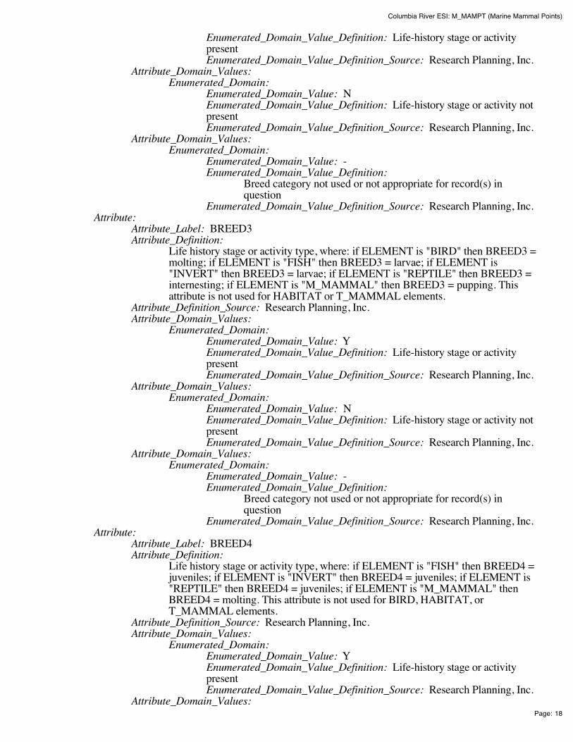
Columbia River ESI: M_MAMPT (Marine Mammal Points)
Page: 18
Enumerated_Domain_Value_Definition: Life-history stage or activitypresent Enumerated_Domain_Value_Definition_Source: Research Planning, Inc.
Attribute_Domain_Values: Enumerated_Domain:
Enumerated_Domain_Value: N Enumerated_Domain_Value_Definition: Life-history stage or activity notpresent Enumerated_Domain_Value_Definition_Source: Research Planning, Inc.
Attribute_Domain_Values: Enumerated_Domain:
Enumerated_Domain_Value: - Enumerated_Domain_Value_Definition:
Breed category not used or not appropriate for record(s) inquestion
Enumerated_Domain_Value_Definition_Source: Research Planning, Inc. Attribute:
Attribute_Label: BREED3 Attribute_Definition:
Life history stage or activity type, where: if ELEMENT is "BIRD" then BREED3 =molting; if ELEMENT is "FISH" then BREED3 = larvae; if ELEMENT is"INVERT" then BREED3 = larvae; if ELEMENT is "REPTILE" then BREED3 =internesting; if ELEMENT is "M_MAMMAL" then BREED3 = pupping. Thisattribute is not used for HABITAT or T_MAMMAL elements.
Attribute_Definition_Source: Research Planning, Inc. Attribute_Domain_Values:
Enumerated_Domain: Enumerated_Domain_Value: Y Enumerated_Domain_Value_Definition: Life-history stage or activitypresent Enumerated_Domain_Value_Definition_Source: Research Planning, Inc.
Attribute_Domain_Values: Enumerated_Domain:
Enumerated_Domain_Value: N Enumerated_Domain_Value_Definition: Life-history stage or activity notpresent Enumerated_Domain_Value_Definition_Source: Research Planning, Inc.
Attribute_Domain_Values: Enumerated_Domain:
Enumerated_Domain_Value: - Enumerated_Domain_Value_Definition:
Breed category not used or not appropriate for record(s) inquestion
Enumerated_Domain_Value_Definition_Source: Research Planning, Inc. Attribute:
Attribute_Label: BREED4 Attribute_Definition:
Life history stage or activity type, where: if ELEMENT is "FISH" then BREED4 =juveniles; if ELEMENT is "INVERT" then BREED4 = juveniles; if ELEMENT is"REPTILE" then BREED4 = juveniles; if ELEMENT is "M_MAMMAL" thenBREED4 = molting. This attribute is not used for BIRD, HABITAT, orT_MAMMAL elements.
Attribute_Definition_Source: Research Planning, Inc. Attribute_Domain_Values:
Enumerated_Domain: Enumerated_Domain_Value: Y Enumerated_Domain_Value_Definition: Life-history stage or activitypresent Enumerated_Domain_Value_Definition_Source: Research Planning, Inc.
Attribute_Domain_Values:
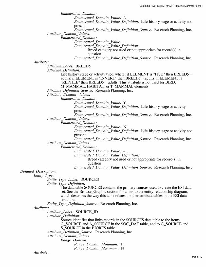
Columbia River ESI: M_MAMPT (Marine Mammal Points)
Page: 19
Enumerated_Domain: Enumerated_Domain_Value: N Enumerated_Domain_Value_Definition: Life-history stage or activity notpresent Enumerated_Domain_Value_Definition_Source: Research Planning, Inc.
Attribute_Domain_Values: Enumerated_Domain:
Enumerated_Domain_Value: - Enumerated_Domain_Value_Definition:
Breed category not used or not appropriate for record(s) inquestion
Enumerated_Domain_Value_Definition_Source: Research Planning, Inc. Attribute:
Attribute_Label: BREED5 Attribute_Definition:
Life history stage or activity type, where: if ELEMENT is "FISH" then BREED5 =adults; if ELEMENT is "INVERT" then BREED5 = adults; if ELEMENT is"REPTILE" then BREED5 = adults. This attribute is not used for BIRD,M_MAMMAL, HABITAT, or T_MAMMAL elements.
Attribute_Definition_Source: Research Planning, Inc. Attribute_Domain_Values:
Enumerated_Domain: Enumerated_Domain_Value: Y Enumerated_Domain_Value_Definition: Life-history stage or activitypresent Enumerated_Domain_Value_Definition_Source: Research Planning, Inc.
Attribute_Domain_Values: Enumerated_Domain:
Enumerated_Domain_Value: N Enumerated_Domain_Value_Definition: Life-history stage or activity notpresent Enumerated_Domain_Value_Definition_Source: Research Planning, Inc.
Attribute_Domain_Values: Enumerated_Domain:
Enumerated_Domain_Value: - Enumerated_Domain_Value_Definition:
Breed category not used or not appropriate for record(s) inquestion
Enumerated_Domain_Value_Definition_Source: Research Planning, Inc. Detailed_Description:
Entity_Type: Entity_Type_Label: SOURCES Entity_Type_Definition:
The data table SOURCES contains the primary sources used to create the ESI dataset. See the Browse_Graphic section for a link to the entity-relationship diagram,which describes the way this table relates to other attribute tables in the ESI datastructure.
Entity_Type_Definition_Source: Research Planning, Inc. Attribute:
Attribute_Label: SOURCE_ID Attribute_Definition:
Source identifier that links records in the SOURCES data table to the itemsG_SOURCE and A_SOURCE in the SOC_DAT table, and to G_SOURCE andS_SOURCE in the BIORES table.
Attribute_Definition_Source: Research Planning, Inc. Attribute_Domain_Values:
Range_Domain: Range_Domain_Minimum: 1 Range_Domain_Maximum: N
Attribute:

Columbia River ESI: M_MAMPT (Marine Mammal Points)
Page: 20
Attribute_Label: ORIGINATOR Attribute_Definition: Author or developer of source material or data set Attribute_Definition_Source: Research Planning, Inc. Attribute_Domain_Values:
Unrepresentable_Domain: Acceptable values change from atlas to atlas Attribute:
Attribute_Label: DATE_PUB Attribute_Definition:
Date of source material, publication, or date of personal communication with expertsource
Attribute_Definition_Source: Research Planning, Inc. Attribute_Domain_Values:
Enumerated_Domain: Enumerated_Domain_Value: YYYYMM Enumerated_Domain_Value_Definition: YYYY for year and optionallyMM for month Enumerated_Domain_Value_Definition_Source: Research Planning, Inc.
Attribute: Attribute_Label: TITLE Attribute_Definition: Title of source material or data Attribute_Definition_Source: Research Planning, Inc. Attribute_Domain_Values:
Unrepresentable_Domain: Acceptable values change from atlas to atlas Attribute:
Attribute_Label: DATA_FORMAT Attribute_Definition: The format of the source material Attribute_Definition_Source: Research Planning, Inc. Attribute_Domain_Values:
Unrepresentable_Domain: Acceptable values change from atlas to atlas Attribute:
Attribute_Label: PUBLICATION Attribute_Definition: Additional citation information Attribute_Definition_Source: Research Planning, Inc. Attribute_Domain_Values:
Unrepresentable_Domain: Acceptable values change from atlas to atlas Attribute:
Attribute_Label: SCALE Attribute_Definition: Scale denominator of the source Attribute_Definition_Source: Research Planning, Inc. Attribute_Domain_Values:
Enumerated_Domain: Enumerated_Domain_Value: integer Enumerated_Domain_Value_Definition: Any integer Enumerated_Domain_Value_Definition_Source: Research Planning, Inc.
Attribute: Attribute_Label: TIME_PERIOD Attribute_Definition:
Date(s) of data collection that the source material is based upon. Attribute_Definition_Source: Research Planning, Inc. Attribute_Domain_Values:
Enumerated_Domain: Enumerated_Domain_Value: MM/DD/YY Enumerated_Domain_Value_Definition: Month/Day/Year Enumerated_Domain_Value_Definition_Source: Research Planning, Inc.
Attribute_Domain_Values: Enumerated_Domain:
Enumerated_Domain_Value: MM/YYYY Enumerated_Domain_Value_Definition: Month/Year Enumerated_Domain_Value_Definition_Source: Research Planning, Inc.
Attribute_Domain_Values:

Columbia River ESI: M_MAMPT (Marine Mammal Points)
Page: 21
Enumerated_Domain: Enumerated_Domain_Value: UNKNOWN Enumerated_Domain_Value_Definition: Date information unknown Enumerated_Domain_Value_Definition_Source: Research Planning, Inc.
Detailed_Description: Entity_Type:
Entity_Type_Label: STATUS Entity_Type_Definition:
The data table STATUS identifies the species that are listed as threatened orendangered by a state or federal authority. See the Browse_Graphic section for alink to the entity-relationship diagram, which describes the way this table relates toother attribute tables in the ESI data structure.
Entity_Type_Definition_Source: Research Planning, Inc. Attribute:
Attribute_Label: ELEMENT Attribute_Definition: Major categories of biological data Attribute_Definition_Source: Research Planning, Inc. Attribute_Domain_Values:
Enumerated_Domain: Enumerated_Domain_Value: BIRD Enumerated_Domain_Value_Definition: Birds Enumerated_Domain_Value_Definition_Source: Research Planning, Inc.
Attribute_Domain_Values: Enumerated_Domain:
Enumerated_Domain_Value: FISH Enumerated_Domain_Value_Definition: Fish Enumerated_Domain_Value_Definition_Source: Research Planning, Inc.
Attribute_Domain_Values: Enumerated_Domain:
Enumerated_Domain_Value: HABITAT Enumerated_Domain_Value_Definition: Habitats and Plants Enumerated_Domain_Value_Definition_Source: Research Planning, Inc.
Attribute_Domain_Values: Enumerated_Domain:
Enumerated_Domain_Value: INVERT Enumerated_Domain_Value_Definition: Invertebrates Enumerated_Domain_Value_Definition_Source: Research Planning, Inc.
Attribute_Domain_Values: Enumerated_Domain:
Enumerated_Domain_Value: M_MAMMAL Enumerated_Domain_Value_Definition: Marine Mammals Enumerated_Domain_Value_Definition_Source: Research Planning, Inc.
Attribute_Domain_Values: Enumerated_Domain:
Enumerated_Domain_Value: REPTILE Enumerated_Domain_Value_Definition: Reptiles and Amphibians Enumerated_Domain_Value_Definition_Source: Research Planning, Inc.
Attribute_Domain_Values: Enumerated_Domain:
Enumerated_Domain_Value: T_MAMMAL Enumerated_Domain_Value_Definition: Terrestrial Mammals Enumerated_Domain_Value_Definition_Source: Research Planning, Inc.
Attribute: Attribute_Label: SPECIES_ID Attribute_Definition:
Numeric identifier for each species that is unique within each element and refers to anationwide master ESI species list maintained at NOAA.
Attribute_Definition_Source: Research Planning, Inc. Attribute_Domain_Values:
Range_Domain:

Columbia River ESI: M_MAMPT (Marine Mammal Points)
Page: 22
Range_Domain_Minimum: 1 Range_Domain_Maximum: N
Attribute: Attribute_Label: S Attribute_Definition: State threatened or endangered status Attribute_Definition_Source: Research Planning, Inc. Attribute_Domain_Values:
Enumerated_Domain: Enumerated_Domain_Value: E Enumerated_Domain_Value_Definition: Endangered on state list Enumerated_Domain_Value_Definition_Source: U.S. Fish and WildlifeService
Attribute_Domain_Values: Enumerated_Domain:
Enumerated_Domain_Value: T Enumerated_Domain_Value_Definition: Threatened on state list Enumerated_Domain_Value_Definition_Source: U.S. Fish and WildlifeService
Attribute_Domain_Values: Enumerated_Domain:
Enumerated_Domain_Value: C Enumerated_Domain_Value_Definition: Species of Special Concern Enumerated_Domain_Value_Definition_Source: U.S. Fish and WildlifeService
Attribute: Attribute_Label: F Attribute_Definition: Federal threatened or endangered status Attribute_Definition_Source: Research Planning, Inc. Attribute_Domain_Values:
Enumerated_Domain: Enumerated_Domain_Value: E Enumerated_Domain_Value_Definition: Endangered on federal list Enumerated_Domain_Value_Definition_Source: U.S. Fish and WildlifeService
Attribute_Domain_Values: Enumerated_Domain:
Enumerated_Domain_Value: T Enumerated_Domain_Value_Definition: Threatened on federal list Enumerated_Domain_Value_Definition_Source: U.S. Fish and WildlifeService
Attribute_Domain_Values: Enumerated_Domain:
Enumerated_Domain_Value: C Enumerated_Domain_Value_Definition: Species of Special Concern Enumerated_Domain_Value_Definition_Source: U.S. Fish and WildlifeService
Attribute: Attribute_Label: STATE Attribute_Definition: Two-letter state abbreviation Attribute_Definition_Source: Research Planning, Inc. Attribute_Domain_Values:
Unrepresentable_Domain: Acceptable values change from atlas to atlas Attribute:
Attribute_Label: S_DATE Attribute_Definition:
Publication date of source material used to assign state status values for eachspecies, if used.
Attribute_Definition_Source: Research Planning, Inc. Attribute_Domain_Values:
Enumerated_Domain:

Columbia River ESI: M_MAMPT (Marine Mammal Points)
Page: 23
Enumerated_Domain_Value: YYYYMM Enumerated_Domain_Value_Definition: YYYY for year and optionallyMM for month Enumerated_Domain_Value_Definition_Source: Research Planning, Inc.
Attribute: Attribute_Label: F_DATE Attribute_Definition:
Publication date of source material used to assign federal status values for eachspecies, if used.
Attribute_Definition_Source: Research Planning, Inc. Attribute_Domain_Values:
Enumerated_Domain: Enumerated_Domain_Value: YYYYMM Enumerated_Domain_Value_Definition: YYYY for year and optionallyMM for month Enumerated_Domain_Value_Definition_Source: Research Planning, Inc.
Attribute: Attribute_Label: EL_SPE Attribute_Definition:
Concatenation of ELEMENT and SPECIES_ID. This item links the STATUS datatable to the BIORES and SPECIES data tables.
Attribute_Definition_Source: Research Planning, Inc. Attribute_Domain_Values:
Enumerated_Domain: Enumerated_Domain_Value: E##### Enumerated_Domain_Value_Definition:
Where E is the first character of ELEMENT and the next fivecharacters are SPECIES_ID (e.g. ELEMENT = 'BIRD' andSPECIES_ID = 1; EL_SPE = 'B00001').
Enumerated_Domain_Value_Definition_Source: Research Planning, Inc.
Distribution_Information: Distributor:
Contact_Information: Contact_Person_Primary:
Contact_Person: John Kaperick Contact_Organization: NOAA, Office of Response and Restoration
Contact_Address: Address_Type: Physical Address Address: 7600 Sand Point Way N.E. City: Seattle State_or_Province: Washington Postal_Code: 98115-6349
Contact_Voice_Telephone: (206) 526-6400 Contact_Facsimile_Telephone: (206) 526-6329
Resource_Description: ESI Atlas for Columbia River Distribution_Liability:
Although these data have been processed successfully on a computer system at the National Oceanicand Atmospheric Administration, no warranty, expressed or implied, is made by NOAA regarding theutility of the data on any other system, nor shall the act of distribution constitute any such warranty.NOAA warrants the delivery of this product in computer-readable format, and will offer a replacementcopy of the product when the product is determined unreadable by computer-input peripherals, orwhen the physical medium is delivered in damaged condition.
Custom_Order_Process: Contact NOAA for distribution options (see Distributor). ESI data are processed into multipleformats to make them useful to a wider community of GIS/mapping users. Distribution formatsinclude ARC export, MOSS and Shape files, and MARPLOT map folders. An ArcView ESI projectand ESI_Viewer product are also included on the distribution CDs for ease of use of the ESI data.

Columbia River ESI: M_MAMPT (Marine Mammal Points)
Page: 24
The database files are distributed both in the NOAA standard relational database format (see NOAATechnical Memorandum NOS ORCA 115) and in a simplified desktop flat file format. This metadatadocument includes information on both of these database formats.
Metadata_Reference_Information: Metadata_Date: 200411 Metadata_Review_Date: 200411 Metadata_Contact:
Contact_Information: Contact_Person_Primary:
Contact_Person: Jill Petersen Contact_Organization: NOAA, Office of Response and Restoration
Contact_Position: GIS Manager Contact_Address:
Address_Type: Physical Address Address: 7600 Sand Point Way N.E. City: Seattle State_or_Province: Washington Postal_Code: 98115-6349
Contact_Voice_Telephone: (206) 526-6944 Contact_Facsimile_Telephone: (206) 526-6329 Contact_Electronic_Mail_Address: [email protected]
Metadata_Standard_Name: Content Standards for Digital Geospatial Metadata Metadata_Standard_Version: FGDC-STD-001-1998
Generated by mp version 2.8.2 on Fri Dec 10 11:51:31 2004

Columbia River ESI: T_MAMMAL (Terrestrial Mammal Polygons)
Page: 1
Columbia River ESI: T_MAMMAL (TerrestrialMammal Polygons)Metadata also available as - [Parseable text] - [SGML]
Metadata:Identification_Information Data_Quality_Information Spatial_Data_Organization_Information Spatial_Reference_Information Entity_and_Attribute_Information Distribution_Information Metadata_Reference_Information
Identification_Information: Citation:
Citation_Information: Originator:
National Oceanic and Atmospheric Administration (NOAA), National OceanService, Office of Response and Restoration, Hazardous Materials ResponseDivision, Seattle, Washington; Coastal Storms Initiative; U.S. Fish and WildlifeService; NOAA Fisheries; State of Oregon; and State of Washington.
Publication_Date: 200411 Title: Columbia River ESI: T_MAMMAL (Terrestrial Mammal Polygons) Edition: First Geospatial_Data_Presentation_Form: Vector digital data Series_Information:
Series_Name: None Issue_Identification: Columbia River
Publication_Information: Publication_Place: Seattle, Washington Publisher:
National Oceanic and Atmospheric Administration (NOAA), NationalOcean Service, Office of Response and Restoration, Hazardous MaterialsResponse Division, Seattle, Washington
Other_Citation_Details: Prepared by Research Planning, Inc., Columbia, South Carolina for the NationalOceanic and Atmospheric Administration (NOAA), National Ocean Service, Officeof Response and Restoration, Hazardous Materials Response Division, Seattle,Washington; Coastal Storms Initiative; U.S. Fish and Wildlife Service; NOAAFisheries; State of Oregon; and State of Washington.
Description: Abstract:
This data set contains sensitive biological resource data for beavers, otters, nutria, mink,muskrats, and Columbian white-tailed deer in the Columbia River area. Vector polygons inthis data set represent locations of terrestrial mammal distributions. Species-specificabundance, seasonality, status, life history, and source information are stored in relationaldata tables (described below) designed to be used in conjunction with this spatial data layer.
This data set comprises a portion of the Environmental Sensitivity Index (ESI) data forColumbia River. ESI data characterize the marine and coastal environments and wildlife bytheir sensitivity to spilled oil. The ESI data include information for three main components:shoreline habitats, sensitive biological resources, and human-use resources.
Columbia River ESI: T_MAMMAL (Terrestrial Mammal Polygons)
Page: 2
Purpose: The ESI data were collected, mapped, and digitized to provide environmental data for oil spillplanning and response. The Clean Water Act with amendments by the Oil Pollution Act of1990 requires response plans for immediate and effective protection of sensitive resources.
Time_Period_of_Content: Time_Period_Information:
Range_of_Dates/Times: Beginning_Date: 1979 Ending_Date: 2004
Currentness_Reference: The biological data were compiled during 2003-2004. The currentness dates for the datarange from 1979 to 2004 and are documented in the Lineage section.
Status: Progress: Complete Maintenance_and_Update_Frequency: None Scheduled
Spatial_Domain: Bounding_Coordinates:
West_Bounding_Coordinate: -124.125 East_Bounding_Coordinate: -120.67375 North_Bounding_Coordinate: 46.375 South_Bounding_Coordinate: 45.3
Keywords: Theme:
Theme_Keyword_Thesaurus: None Theme_Keyword: ESI Theme_Keyword: Sensitivity maps Theme_Keyword: Coastal resources Theme_Keyword: Oil spill planning Theme_Keyword: Coastal Zone Management Theme_Keyword: Wildlife Theme_Keyword: Terrestrial Mammal
Place: Place_Keyword_Thesaurus: None Place_Keyword: Columbia River
Access_Constraints: None Use_Constraints:
DO NOT USE MAPS FOR NAVIGATIONAL PURPOSES. Besides the above warning, there areno use constraints on these data. Note that the ESI database should not be used to the exclusion ofother pertinent data or information held by state or federal agencies or other organizations. Likewise,information contained in the database cannot be used in place of consultations with environmental,natural resource, and cultural resource agencies, or in place of field surveys. Recognize that theinformation contained in the ESI database represents known concentration areas or occurrences ofnatural, cultural, and human-use resources, but does not necessarily represent the full distribution orrange of each species or resource. This is particularly important to recognize when consideringpotential impacts to protected resources, such as endangered species, wetlands, etc. Acknowledgmentof the originators, publishers, contributors, and sources listed would be appreciated in productsderived from these data.
Browse_Graphic: Browse_Graphic_File_Name: datafig.jpg Browse_Graphic_File_Description:
Depicts the relationships between spatial data layers and attribute data tables for theColumbia River ESI data.
Browse_Graphic_File_Type: JPEG Data_Set_Credit:
This project was supported by the National Oceanic and Atmospheric Administration (NOAA),National Ocean Service, Office of Response and Restoration, Hazardous Materials ResponseDivision, Seattle, Washington; Coastal Storms Initiative; U.S. Fish and Wildlife Service; NOAAFisheries; State of Oregon; and State of Washington.
Native_Data_Set_Environment: The software packages used to develop the atlas are Environmental Systems Research Institute's
Columbia River ESI: T_MAMMAL (Terrestrial Mammal Polygons)
Page: 3
ARC/INFO(r) (version 8.3) and SQL SERVER(r) (version 7.0). The hardware configuration is PC'swith Windows Operating System (NT4.0/2000).
The Spatial_Data_Organization_Information section refers only to the source files in the ARC exportformat. The following files are included in that data set: birds.e00, esi.e00, fish.e00, fishl.e00,habitats.e00, hydro.e00, index.e00, invert.e00, m_mammal.e00, m_mampt.e00, mgt.e00, nests.e00,nwi.e00, reptiles.e00, socecon.e00, t_mammal.e00. Associated relational and desktop data tablesprovided in Arc export and text format are bio_lut, biofile, biores, breed, breed_dt, runs_dat, seasonal,soc_dat, soc_lut, sources, species, and status.
Data_Quality_Information: Attribute_Accuracy:
Attribute_Accuracy_Report: A multi-stage error checking process is used to verify both attribute accuracy and logicalconsistency throughout data production. The process includes a standardized data entrymethodology, hardcopy data review by in-house and external resource experts, a final QualityAssurance/Quality Control (QA/QC) process, and multiple automated logical consistencychecks. Quantitative data (such as densities, counts, abundances, or concentrations) providedby resource experts for inclusion in the data set may vary widely in attribute accuracy,depending upon the methodology used to collect and compile such data. For a more detailedevaluation of source data attribute accuracy, contact the sources listed in the Lineage section.
Logical_Consistency_Report: A multi-stage error checking process, described in the above Attribute_Accuracy_Report, is used toverify both attribute accuracy and logical consistency throughout data production. This processincludes multiple automated logical consistency checks that test the files for missing or duplicate data,rules for proper coding, GIS topological consistencies (such as dangles, unnecessary nodes, etc.), andSQL SERVER(r) to ARC/INFO(r) consistencies. A final review is made by the GIS manager, wherethe data are written to CD-ROM and the metadata are written.
After the data are delivered to NOAA, they are again subjected to a number of quality and consistencychecks. In the process of checking for topological and database consistencies, new ID's andRARNUM's or HUNUM's are also generated. The new ID's are a combination of atlas number,element number, and record number. In addition, the value used to represent the element is modifiedto reflect the type of feature being mapped. In the case of an element that is normally represented by apoint or polygon, a value of 20 is added to the standard element value for mapping of linear features.In the case where an element usually mapped as a polygon is represented by a point, a value of 30 isadded to the regular element value. The RARNUM's are also modified to include the atlas number, somultiple atlases can be combined and RARNUM's remain unique. RARNUM's are redefined on anelement basis, so "resource at risk" groupings will contain only a single element. HUNUM's are alsomodified to include the atlas number.
Completeness_Report: These data represent a synthesis of expert knowledge and available hardcopy reports and digital dataon terrestrial mammal concentration areas. These data do not necessarily represent all terrestrialmammal occurrences in the Columbia River area. The following species are included in this data set:(Species_ID, Common Name, Scientific Name, if applicable): 8, Northern river otter, LutraCanadensis; 30, Columbian white-tailed deer, Odocoileus virginianus leucurus; 36, Beaver, CastorCanadensis; 37, Muskrat, Ondatra zibethicus; 38, Mink, Mustela vison; 43, Nutria, Myocastorcoypus.
Positional_Accuracy: Horizontal_Positional_Accuracy:
Horizontal_Positional_Accuracy_Report: Most of the spatial components of the biological data sets are developed usingregional experts who estimate concentration areas. It is difficult to estimate thepositional accuracy of such data, except to state that they are compiled on hardcopybase maps with a scale of 1:24,000. Some of the spatial components of thebiological data sets are developed from pre-existing digital sources and reflect thepositional accuracy of these original data. See the Lineage and Process_Descriptionsections for more information on the original data source and how these data were

Columbia River ESI: T_MAMMAL (Terrestrial Mammal Polygons)
Page: 4
integrated or manipulated to create the final data set. Note that biological resourcedata by their very nature are considered "fuzzy", and this should be understoodwhen considering the positional accuracy of vector digital objects representing theseresources.
Lineage: Source_Information:
Source_Citation: Citation_Information:
Originator: North, J., Oregon Department of Fish and Wildlife (ODFW) Publication_Date: 200402 Title: Fish, Bird, and Mammal Distributions along the Columbia River Geospatial_Data_Presentation_Form: Expert knowledge Publication_Information:
Publication_Place: Unpublished material Publisher: Unpublished material
Type_of_Source_Media: Personal communication Source_Time_Period_of_Content:
Time_Period_Information: Single_Date/Time:
Calendar_Date: 200402 Source_Currentness_Reference: Date of communication
Source_Citation_Abbreviation: None Source_Contribution: Distribution information for terrestrial mammals
Source_Information: Source_Citation:
Citation_Information: Originator: Kohl, K., Oregon Department of Fish and Wildlife (ODFW) Publication_Date: 200401 Title: Bird and Mammal Distribution along the Columbia River Geospatial_Data_Presentation_Form: Expert knowledge Publication_Information:
Publication_Place: Unpublished material Publisher: Unpublished material
Type_of_Source_Media: Personal communication Source_Time_Period_of_Content:
Time_Period_Information: Single_Date/Time:
Calendar_Date: 200401 Source_Currentness_Reference: Date of communication
Source_Citation_Abbreviation: None Source_Contribution: Distribution information for terrestrial mammals
Source_Information: Source_Citation:
Citation_Information: Originator:
Sutherland, B., Oregon Department of Environmental Quality(ODEQ)
Publication_Date: 1979 Title:
Oil Spill Protection Plan for the Natural Resources of the LowerColumbia River
Geospatial_Data_Presentation_Form: Hardcopy Map Publication_Information:
Publication_Place: Unknown Publisher: Unknown
Source_Scale_Denominator: Unknown Type_of_Source_Media: Paper Source_Time_Period_of_Content:
Time_Period_Information: Single_Date/Time:

Columbia River ESI: T_MAMMAL (Terrestrial Mammal Polygons)
Page: 5
Calendar_Date: 1979 Source_Currentness_Reference: Publication date
Source_Citation_Abbreviation: None Source_Contribution: Distribution information for terrestrial mammals
Source_Information: Source_Citation:
Citation_Information: Originator: Clark, A., U.S. Fish and Wildlife Service (USFWS) Publication_Date: 200402 Title:
Distribution of Fish, Birds, Plants, and Mammals in the ColumbiaRiver
Geospatial_Data_Presentation_Form: Expert Knowledge Publication_Information:
Publication_Place: Unpublished material Publisher: Unpublished material
Type_of_Source_Media: Personal communication Source_Time_Period_of_Content:
Time_Period_Information: Single_Date/Time:
Calendar_Date: 200402 Source_Currentness_Reference: Publication date
Source_Citation_Abbreviation: None Source_Contribution:
Distribution and seasonality information for terrestrial mammals Source_Information:
Source_Citation: Citation_Information:
Originator: Columbia River Estuary Data Development Program Publication_Date: 1984 Title:
The Columbia River Estuary Atlas of Physical and BiologicalCharacteristics
Geospatial_Data_Presentation_Form: Hardcopy atlas Publication_Information:
Publication_Place: Seattle, Washington Publisher: Northwest Cartography, Inc.
Source_Scale_Denominator: 250,000 Type_of_Source_Media: Paper Source_Time_Period_of_Content:
Time_Period_Information: Single_Date/Time:
Calendar_Date: 1984 Source_Currentness_Reference: Publication date
Source_Citation_Abbreviation: None Source_Contribution:
Distribution and seasonality information for terrestrial mammals Source_Information:
Source_Citation: Citation_Information:
Originator: Washington Department of Fish and Wildlife (WDFW) Publication_Date: 2004 Title: Priority Habitat Data for the Lower Columbia River Geospatial_Data_Presentation_Form: Vector digital data Publication_Information:
Publication_Place: Unknown Publisher: Washington Department of Fish and Wildlife
Source_Scale_Denominator: 24,000 Type_of_Source_Media: CD-ROM Source_Time_Period_of_Content:

Columbia River ESI: T_MAMMAL (Terrestrial Mammal Polygons)
Page: 6
Time_Period_Information: Single_Date/Time:
Calendar_Date: 2004 Source_Currentness_Reference: Publication Date
Source_Citation_Abbreviation: None Source_Contribution: Distribution information for terrestrial mammals
Process_Step: Process_Description:
Three main sources of data were used to depict terrestrial mammal distribution forthis data layer: (1) personal interviews with resource experts from OregonDepartment of Fish and Wildlife (ODFW) and U.S. Fish and Wildlife Service(USFWS); (2) numerous published and unpublished reports; and (3) informationand locations adapted from the Washington Priority Habitat database. (Contact theWashington Department of Fish and Wildlife for more information regarding theWashington Priority Habitat data.) Information gathered during initial interviewsand from hardcopy sources was compiled onto U.S. Geological Survey 1:24,000topographic quadrangles.
The compiled data were digitized off of the base maps into an ArcInfo system tocreate the T_MAMMAL data layer. All ESI, biology, and human-use data wereplotted onto hardcopy draft maps. Following the delivery of draft maps to theparticipating resource experts, a second set of interviews was conducted to review themaps. Edits to the T_MAMMAL data layer were made based on therecommendations of the resource experts, and final hardcopy maps were created.
Process_Date: 200408 Process_Contact:
Contact_Information: Contact_Organization_Primary:
Contact_Organization: NOAA, Office of Response andRestoration Contact_Person: Jill Petersen
Contact_Address: Address_Type: Physical address Address: 7600 Sand Point Way N.E. City: Seattle State_or_Province: Washington Postal_Code: 98115-6349
Contact_Voice_Telephone: (206) 526-6944 Contact_Facsimile_Telephone: (206) 526-6329 Contact_Electronic_Mail_Address: [email protected]
Spatial_Data_Organization_Information: Direct_Spatial_Reference_Method: Vector Point_and_Vector_Object_Information:
SDTS_Terms_Description: SDTS_Point_and_Vector_Object_Type: GT-polygon composed of rings Point_and_Vector_Object_Count: 200
SDTS_Terms_Description: SDTS_Point_and_Vector_Object_Type: Area point Point_and_Vector_Object_Count: 200
SDTS_Terms_Description: SDTS_Point_and_Vector_Object_Type: Complete chain Point_and_Vector_Object_Count: 265
SDTS_Terms_Description: SDTS_Point_and_Vector_Object_Type: Link Point_and_Vector_Object_Count: 43528
SDTS_Terms_Description: SDTS_Point_and_Vector_Object_Type: Node, planar graph
Columbia River ESI: T_MAMMAL (Terrestrial Mammal Polygons)
Page: 7
Point_and_Vector_Object_Count: 263
Spatial_Reference_Information: Horizontal_Coordinate_System_Definition:
Geographic: Latitude_Resolution: 0.0000001 Longitude_Resolution: 0.0000001 Geographic_Coordinate_Units: Decimal degrees
Geodetic_Model: Horizontal_Datum_Name: North American Datum of 1927 Ellipsoid_Name: Clark 1866 Semi-major_Axis: 6378206.4 Denominator_of_Flattening_Ratio: 294.978698
Entity_and_Attribute_Information: Overview_Description:
Entity_and_Attribute_Overview: In addition to the geographic data layers, six relational attribute or data tables, BIORES,BREED, SEASONAL, SOURCES, SPECIES, and STATUS, are used to store the complexbiological data in the ESI data structure. The geographic data layer containing biologicalresource information (in this case, T_MAMMAL) is linked to the Biological Resources table(BIORES) using the unique ID and the lookup table BIO_LUT, or it can be linked directlyusing RARNUM. The ID is a unique combination of the atlas number (for the ColumbiaRiver atlas, the number is 41), an element/layer specific number (BIRDS are layer 1, FISHare layer 2, etc.), and a unique record number. The RARNUM represents a uniquecombination of species, seasonalities, concentrations, and source information. For each ofthese groupings, a number is generated. That number is concatenated with the atlas numberto create a "resource at risk" number that is unique across atlases. BIORES and the otherrelational data tables are described below in detail. See the Browse_Graphic section for a linkto the entity-relationship diagram, which describes the way these tables relate to thegeographic data layers and other attribute tables in the ESI data structure.
Due to the complexity of the relational database model, the data items are also post-processedinto a flat file format. This table, called BIOFILE, may be used in place of the relational filesdescribed below to ease simple data queries. The items in the flat file are ELEMENT,SUBELEMENT, NAME, GEN_SPEC, S, F, NHP, DATE_PUB, CONC, JAN, FEB, MAR,APR, MAY, JUN, JUL, AUG, SEP, OCT, NOV, DEC, BREED1, BREED2, BREED3,BREED4, BREED5, RARNUM, G_SOURCE, S_SOURCE, and BREED. All of theseitems are the same as their counterparts in the individual data tables described below, exceptthe BREED1-BREED5 and BREED items. BREED is a newly generated variable used tolink to the BREED_DT data table, a modified, more compact version of the relationalBREED data table. BREED1-BREED5 give a text summary of when each life stage occurswithin the associated map object. The life stages referred to are the same as those listed in theDetailed_Description of the BREED data table. The link to the BIOFILE may be madethrough the BIO_LUT, using ID to link to RARNUM, or BIOFILE may be linked directlyto the RARNUM in each of the geographic layer's attribute data tables. As mentioned,BREED_DT is an auxiliary support data table to the flat file structure, which allows the userto do searches based on month for seasonal breeding activities. The link from the flat file toBREED_DT is the BREED item.
A second supporting data table is SOURCES. This is the same as the source file describedabove, and the link from the flat file is both G_SOURCE and S_SOURCE. It should benoted that although the flat file eases data query, it is not a normalized database structure, andactual updates performed by the states and other responsible agencies should be done usingthe relational data tables. The entity-relationship diagram describing relationships betweenattribute tables in the ESI data structure does NOT include the BIOFILE data table, and this

Columbia River ESI: T_MAMMAL (Terrestrial Mammal Polygons)
Page: 8
data table is NOT described in detail below. Detailed_Description:
Entity_Type: Entity_Type_Label: T_MAMMAL.PAT Entity_Type_Definition:
The T_MAMMAL.PAT table contains attribute information for the vector polygonsrepresenting terrestrial mammal distributions. Note that all attribute information isstored in a series of relational files, described below. See the Browse_Graphicsection for a link to the entity-relationship diagram, which describes the relationshipsbetween attribute tables in the ESI data structure.
Entity_Type_Definition_Source: Research Planning, Inc. Attribute:
Attribute_Label: ID Attribute_Definition:
An identifier that links vector objects in the biology data layers to records in theBIO_LUT data table. ID is a concatenation of atlas number (41), element number(9), and record number. ID values of 9999 are holes in polygons and do not containinformation.
Attribute_Definition_Source: NOAA Attribute_Domain_Values:
Range_Domain: Range_Domain_Minimum: 410900002 Range_Domain_Maximum: 410900201
Attribute: Attribute_Label: RARNUM Attribute_Definition:
An identifier that links directly to the BIORES table or the flat format BIOFILEtable. RARNUM values of 0 are holes in the polygons and do not containinformation.
Attribute_Definition_Source: NOAA Attribute_Domain_Values:
Range_Domain: Range_Domain_Minimum: 41000279 Range_Domain_Maximum: 41000290
Detailed_Description: Entity_Type:
Entity_Type_Label: BIO_LUT Entity_Type_Definition:
The data table BIO_LUT is a lookup table that contains items necessary for linkingvector objects in the biological data layers with the BIORES data table. Note that allattribute information is stored in a series of relational files, described below. See theBrowse_Graphic section for a link to the entity-relationship diagram, whichdescribes the way this table relates to other attribute tables in the ESI data structure.
Entity_Type_Definition_Source: Research Planning, Inc. Attribute:
Attribute_Label: RARNUM Attribute_Definition:
An identifier that links records in the BIO_LUT data table to records in the BIORESdata table or the flat format BIOFILE data table. RARNUM values of 0 are holes inpolygons and do not contain information.
Attribute_Definition_Source: NOAA Attribute_Domain_Values:
Range_Domain: Range_Domain_Minimum: 41000001 Range_Domain_Maximum: 41000290
Attribute: Attribute_Label: ID Attribute_Definition:
An identifier that links vector objects in the biology data layers to records in theBIO_LUT data table. ID is a concatenation of atlas number (41), element number

Columbia River ESI: T_MAMMAL (Terrestrial Mammal Polygons)
Page: 9
(9), and record number. ID values of 9999 are holes in polygons and do not containinformation.
Attribute_Definition_Source: NOAA Attribute_Domain_Values:
Range_Domain: Range_Domain_Minimum: 410100002 Range_Domain_Maximum: 413400015
Detailed_Description: Entity_Type:
Entity_Type_Label: BIORES Entity_Type_Definition:
The data table BIORES contains both biological attribute data and items necessaryfor linking vector objects in the biological data layers via the BIO_LUT data table toother associated data tables. See the Browse_Graphic section for a link to theentity-relationship diagram, which describes the way this table relates to otherattribute tables in the ESI data structure.
Entity_Type_Definition_Source: Research Planning, Inc. Attribute:
Attribute_Label: RARNUM Attribute_Definition:
An identifier that links records in the BIORES data table to records in the BIO_LUTdata table or the flat format BIOFILE data table.
Attribute_Definition_Source: NOAA Attribute_Domain_Values:
Range_Domain: Range_Domain_Minimum: 041000001 Range_Domain_Maximum: 041000290
Attribute: Attribute_Label: SPECIES_ID Attribute_Definition:
Numeric identifier for each species that is unique within each element and refers to anationwide master ESI species list maintained at NOAA.
Attribute_Definition_Source: Research Planning, Inc. Attribute_Domain_Values:
Range_Domain: Range_Domain_Minimum: 1 Range_Domain_Maximum: N
Attribute: Attribute_Label: CONC Attribute_Definition:
The field CONC refers to "concentration," abundance, or density values. The fieldmay contain counts of individuals (XX) or in cases where no quantitative count datawas available, the field may contain a descriptive term such as "HIGH" or"PRESENT". If no concentration information was available from any source, thefield is populated with "-". Counts were derived from a variety of surveys, and mayrange in date.
Attribute_Definition_Source: Research Planning, Inc. Attribute_Domain_Values:
Unrepresentable_Domain: Acceptable values change from atlas to atlas Attribute:
Attribute_Label: SEASON_ID Attribute_Definition:
Numeric identifier for the unique monthly presence and life history characteristics ofeach species at a given location.
Attribute_Definition_Source: Research Planning, Inc. Attribute_Domain_Values:
Range_Domain: Range_Domain_Minimum: 1 Range_Domain_Maximum: N
Attribute:

Columbia River ESI: T_MAMMAL (Terrestrial Mammal Polygons)
Page: 10
Attribute_Label: G_SOURCE Attribute_Definition:
Geographic source identifier that links records in the BIORES data table to recordsin the SOURCES data table.
Attribute_Definition_Source: Research Planning, Inc. Attribute_Domain_Values:
Range_Domain: Range_Domain_Minimum: 1 Range_Domain_Maximum: N
Attribute: Attribute_Label: S_SOURCE Attribute_Definition:
Seasonality source identifier that links records in the BIORES data table to recordsin the SOURCES data table.
Attribute_Definition_Source: Research Planning, Inc. Attribute_Domain_Values:
Range_Domain: Range_Domain_Minimum: 1 Range_Domain_Maximum: N
Attribute: Attribute_Label: ELEMENT Attribute_Definition: Major categories of biological data Attribute_Definition_Source: Research Planning, Inc. Attribute_Domain_Values:
Enumerated_Domain: Enumerated_Domain_Value: BIRD Enumerated_Domain_Value_Definition: Birds Enumerated_Domain_Value_Definition_Source: Research Planning, Inc.
Attribute_Domain_Values: Enumerated_Domain:
Enumerated_Domain_Value: FISH Enumerated_Domain_Value_Definition: Fish Enumerated_Domain_Value_Definition_Source: Research Planning, Inc.
Attribute_Domain_Values: Enumerated_Domain:
Enumerated_Domain_Value: HABITAT Enumerated_Domain_Value_Definition: Habitats and Plants Enumerated_Domain_Value_Definition_Source: Research Planning, Inc.
Attribute_Domain_Values: Enumerated_Domain:
Enumerated_Domain_Value: INVERT Enumerated_Domain_Value_Definition: Invertebrates Enumerated_Domain_Value_Definition_Source: Research Planning, Inc.
Attribute_Domain_Values: Enumerated_Domain:
Enumerated_Domain_Value: M_MAMMAL Enumerated_Domain_Value_Definition: Marine Mammals Enumerated_Domain_Value_Definition_Source: Research Planning, Inc.
Attribute_Domain_Values: Enumerated_Domain:
Enumerated_Domain_Value: REPTILE Enumerated_Domain_Value_Definition: Reptiles and Amphibians Enumerated_Domain_Value_Definition_Source: Research Planning, Inc.
Attribute_Domain_Values: Enumerated_Domain:
Enumerated_Domain_Value: T_MAMMAL Enumerated_Domain_Value_Definition: Terrestrial Mammals Enumerated_Domain_Value_Definition_Source: Research Planning, Inc.
Attribute: Attribute_Label: EL_SPE

Columbia River ESI: T_MAMMAL (Terrestrial Mammal Polygons)
Page: 11
Attribute_Definition: Concatenation of ELEMENT and SPECIES_ID. This item links records in theBIORES data table to records in the SPECIES and STATUS data tables.
Attribute_Definition_Source: Research Planning, Inc. Attribute_Domain_Values:
Enumerated_Domain: Enumerated_Domain_Value: E##### Enumerated_Domain_Value_Definition:
Where E is the first character of ELEMENT and the next fivecharacters are SPECIES_ID (e.g. ELEMENT = 'BIRD' andSPECIES_ID = 1; EL_SPE = 'B00001').
Enumerated_Domain_Value_Definition_Source: Research Planning, Inc. Attribute:
Attribute_Label: EL_SPE_SEA Attribute_Definition:
Concatenation of ELEMENT, SPECIES_ID, and SEASON_ID. This item linksrecords in the BIORES data table to records in the SEASONAL and BREED datatables.
Attribute_Definition_Source: Research Planning, Inc. Attribute_Domain_Values:
Enumerated_Domain: Enumerated_Domain_Value: E####### Enumerated_Domain_Value_Definition:
Where E is the first character of ELEMENT, the next fivecharacters are SPECIES_ID, and the last two characters areSEASON_ID (e.g. ELEMENT = 'BIRD', SPECIES_ID = 1 andSEASON_ID = 1; EL_SPE_SEA = 'B0000101').
Enumerated_Domain_Value_Definition_Source: Research Planning, Inc. Detailed_Description:
Entity_Type: Entity_Type_Label: SPECIES Entity_Type_Definition:
The data table SPECIES identifies all species in the ESI data set. See theBrowse_Graphic section for a link to the entity-relationship diagram, whichdescribes the way this table relates to other attribute tables in the ESI data structure.Refer to the Completeness_Report for a list of layer-specific species.
Entity_Type_Definition_Source: Research Planning, Inc. Attribute:
Attribute_Label: SPECIES_ID Attribute_Definition:
Numeric identifier for each species that is unique within each element and refers to anationwide master ESI species list maintained at NOAA.
Attribute_Definition_Source: Research Planning, Inc. Attribute_Domain_Values:
Range_Domain: Range_Domain_Minimum: 1 Range_Domain_Maximum: N
Attribute: Attribute_Label: NAME Attribute_Definition: Species common name for the entire ESI data set Attribute_Definition_Source: Research Planning, Inc. Attribute_Domain_Values:
Unrepresentable_Domain: Acceptable values change from atlas to atlas Attribute:
Attribute_Label: GEN_SPEC Attribute_Definition: Species scientific name for the entire ESI data set Attribute_Definition_Source: Research Planning, Inc. Attribute_Domain_Values:
Unrepresentable_Domain: Acceptable values change from atlas to atlas Attribute:

Columbia River ESI: T_MAMMAL (Terrestrial Mammal Polygons)
Page: 12
Attribute_Label: ELEMENT Attribute_Definition: Major categories of biological data Attribute_Definition_Source: Research Planning, Inc. Attribute_Domain_Values:
Enumerated_Domain: Enumerated_Domain_Value: BIRD Enumerated_Domain_Value_Definition: Birds Enumerated_Domain_Value_Definition_Source: Research Planning, Inc.
Attribute_Domain_Values: Enumerated_Domain:
Enumerated_Domain_Value: FISH Enumerated_Domain_Value_Definition: Fish Enumerated_Domain_Value_Definition_Source: Research Planning, Inc.
Attribute_Domain_Values: Enumerated_Domain:
Enumerated_Domain_Value: HABITAT Enumerated_Domain_Value_Definition: Habitats and Plants Enumerated_Domain_Value_Definition_Source: Research Planning, Inc.
Attribute_Domain_Values: Enumerated_Domain:
Enumerated_Domain_Value: INVERT Enumerated_Domain_Value_Definition: Invertebrates Enumerated_Domain_Value_Definition_Source: Research Planning, Inc.
Attribute_Domain_Values: Enumerated_Domain:
Enumerated_Domain_Value: M_MAMMAL Enumerated_Domain_Value_Definition: Marine Mammals Enumerated_Domain_Value_Definition_Source: Research Planning, Inc.
Attribute_Domain_Values: Enumerated_Domain:
Enumerated_Domain_Value: REPTILE Enumerated_Domain_Value_Definition: Reptiles and Amphibians Enumerated_Domain_Value_Definition_Source: Research Planning, Inc.
Attribute_Domain_Values: Enumerated_Domain:
Enumerated_Domain_Value: T_MAMMAL Enumerated_Domain_Value_Definition: Terrestrial Mammals Enumerated_Domain_Value_Definition_Source: Research Planning, Inc.
Attribute: Attribute_Label: SUBELEMENT Attribute_Definition: Element subgroup delineating a logical grouping of species Attribute_Definition_Source: Research Planning, Inc. Attribute_Domain_Values:
Enumerated_Domain: Enumerated_Domain_Value: bivalve Enumerated_Domain_Value_Definition: Bivalve Enumerated_Domain_Value_Definition_Source: Research Planning, Inc.
Attribute_Domain_Values: Enumerated_Domain:
Enumerated_Domain_Value: crab Enumerated_Domain_Value_Definition: Crab Enumerated_Domain_Value_Definition_Source: Research Planning, Inc.
Attribute_Domain_Values: Enumerated_Domain:
Enumerated_Domain_Value: diadromous Enumerated_Domain_Value_Definition: Diadromous fish Enumerated_Domain_Value_Definition_Source: Research Planning, Inc.
Attribute_Domain_Values: Enumerated_Domain:
Enumerated_Domain_Value: diving
Columbia River ESI: T_MAMMAL (Terrestrial Mammal Polygons)
Page: 13
Enumerated_Domain_Value_Definition: Diving bird Enumerated_Domain_Value_Definition_Source: Research Planning, Inc.
Attribute_Domain_Values: Enumerated_Domain:
Enumerated_Domain_Value: e_nursery Enumerated_Domain_Value_Definition: Estuarine nursery fish Enumerated_Domain_Value_Definition_Source: Research Planning, Inc.
Attribute_Domain_Values: Enumerated_Domain:
Enumerated_Domain_Value: fav Enumerated_Domain_Value_Definition: Floating aquatic vegetation Enumerated_Domain_Value_Definition_Source: Research Planning, Inc.
Attribute_Domain_Values: Enumerated_Domain:
Enumerated_Domain_Value: freshwater Enumerated_Domain_Value_Definition: Freshwater fish Enumerated_Domain_Value_Definition_Source: Research Planning, Inc.
Attribute_Domain_Values: Enumerated_Domain:
Enumerated_Domain_Value: gull_tern Enumerated_Domain_Value_Definition: Gull or tern Enumerated_Domain_Value_Definition_Source: Research Planning, Inc.
Attribute_Domain_Values: Enumerated_Domain:
Enumerated_Domain_Value: passerine Enumerated_Domain_Value_Definition: Passerine bird Enumerated_Domain_Value_Definition_Source: Research Planning, Inc.
Attribute_Domain_Values: Enumerated_Domain:
Enumerated_Domain_Value: pinniped Enumerated_Domain_Value_Definition: Pinniped Enumerated_Domain_Value_Definition_Source: Research Planning, Inc.
Attribute_Domain_Values: Enumerated_Domain:
Enumerated_Domain_Value: raptor Enumerated_Domain_Value_Definition: Raptor Enumerated_Domain_Value_Definition_Source: Research Planning, Inc.
Attribute_Domain_Values: Enumerated_Domain:
Enumerated_Domain_Value: sav Enumerated_Domain_Value_Definition: Submerged aquatic vegetation Enumerated_Domain_Value_Definition_Source: Research Planning, Inc.
Attribute_Domain_Values: Enumerated_Domain:
Enumerated_Domain_Value: shorebird Enumerated_Domain_Value_Definition: Shorebird Enumerated_Domain_Value_Definition_Source: Research Planning, Inc.
Attribute_Domain_Values: Enumerated_Domain:
Enumerated_Domain_Value: sm_mammal Enumerated_Domain_Value_Definition: Small mammal Enumerated_Domain_Value_Definition_Source: Research Planning, Inc.
Attribute_Domain_Values: Enumerated_Domain:
Enumerated_Domain_Value: turtle Enumerated_Domain_Value_Definition: Turtle Enumerated_Domain_Value_Definition_Source: Research Planning, Inc.
Attribute_Domain_Values: Enumerated_Domain:
Enumerated_Domain_Value: ungulate

Columbia River ESI: T_MAMMAL (Terrestrial Mammal Polygons)
Page: 14
Enumerated_Domain_Value_Definition: Ungulate Enumerated_Domain_Value_Definition_Source: Research Planning, Inc.
Attribute_Domain_Values: Enumerated_Domain:
Enumerated_Domain_Value: wading Enumerated_Domain_Value_Definition: Wading bird Enumerated_Domain_Value_Definition_Source: Research Planning, Inc.
Attribute_Domain_Values: Enumerated_Domain:
Enumerated_Domain_Value: waterfowl Enumerated_Domain_Value_Definition: Waterfowl Enumerated_Domain_Value_Definition_Source: Research Planning, Inc.
Attribute: Attribute_Label: NHP Attribute_Definition:
Natural Heritage Program global ranking. When no information was provided onthe global rank for a species, the field is blank.
Attribute_Definition_Source: Network of Natural Heritage Program Attribute_Domain_Values:
Codeset_Domain: Codeset_Name: NHP Global Conservation Status Rank Codeset_Source: Natural Heritage Program
Attribute: Attribute_Label: DATE_PUB Attribute_Definition: Date of NHP listing Attribute_Definition_Source: Research Planning, Inc. Attribute_Domain_Values:
Enumerated_Domain: Enumerated_Domain_Value: YYYYMM Enumerated_Domain_Value_Definition: YYYY for year and optionallyMM for month Enumerated_Domain_Value_Definition_Source: Research Planning, Inc.
Attribute_Domain_Values: Enumerated_Domain:
Enumerated_Domain_Value: 0 Enumerated_Domain_Value_Definition: No information was provided onthe global rank for the species Enumerated_Domain_Value_Definition_Source: Research Planning, Inc.
Attribute: Attribute_Label: EL_SPE Attribute_Definition:
Concatenation of ELEMENT and SPECIES_ID. This item links records in theSPECIES data table to records in the BIORES and STATUS data tables.
Attribute_Definition_Source: Research Planning, Inc. Attribute_Domain_Values:
Enumerated_Domain: Enumerated_Domain_Value: E##### Enumerated_Domain_Value_Definition:
Where E is the first character of ELEMENT and the next fivecharacters are SPECIES_ID (e.g. ELEMENT = 'BIRD' andSPECIES_ID = 1; EL_SPE = 'B00001').
Enumerated_Domain_Value_Definition_Source: Research Planning, Inc. Detailed_Description:
Entity_Type: Entity_Type_Label: SEASONAL Entity_Type_Definition:
The data table SEASONAL contains information on the seasonal presence of eachspecies associated with each spatial vector object. See the Browse_Graphic sectionfor a link to the entity-relationship diagram, which describes the way this tablerelates to other attribute tables in the ESI data structure.
Columbia River ESI: T_MAMMAL (Terrestrial Mammal Polygons)
Page: 15
Entity_Type_Definition_Source: Research Planning, Inc. Attribute:
Attribute_Label: ELEMENT Attribute_Definition: Major categories of biological data Attribute_Definition_Source: Research Planning, Inc. Attribute_Domain_Values:
Enumerated_Domain: Enumerated_Domain_Value: BIRD Enumerated_Domain_Value_Definition: Birds Enumerated_Domain_Value_Definition_Source: Research Planning, Inc.
Attribute_Domain_Values: Enumerated_Domain:
Enumerated_Domain_Value: FISH Enumerated_Domain_Value_Definition: Fish Enumerated_Domain_Value_Definition_Source: Research Planning, Inc.
Attribute_Domain_Values: Enumerated_Domain:
Enumerated_Domain_Value: HABITAT Enumerated_Domain_Value_Definition: Habitats and Plants Enumerated_Domain_Value_Definition_Source: Research Planning, Inc.
Attribute_Domain_Values: Enumerated_Domain:
Enumerated_Domain_Value: INVERT Enumerated_Domain_Value_Definition: Invertebrates Enumerated_Domain_Value_Definition_Source: Research Planning, Inc.
Attribute_Domain_Values: Enumerated_Domain:
Enumerated_Domain_Value: M_MAMMAL Enumerated_Domain_Value_Definition: Marine Mammals Enumerated_Domain_Value_Definition_Source: Research Planning, Inc.
Attribute_Domain_Values: Enumerated_Domain:
Enumerated_Domain_Value: REPTILE Enumerated_Domain_Value_Definition: Reptiles and Amphibians Enumerated_Domain_Value_Definition_Source: Research Planning, Inc.
Attribute_Domain_Values: Enumerated_Domain:
Enumerated_Domain_Value: T_MAMMAL Enumerated_Domain_Value_Definition: Terrestrial Mammals Enumerated_Domain_Value_Definition_Source: Research Planning, Inc.
Attribute: Attribute_Label: SPECIES_ID Attribute_Definition:
Numeric identifier for each species that is unique within each element and refers to anationwide ESI species list maintained at NOAA.
Attribute_Definition_Source: Research Planning, Inc. Attribute_Domain_Values:
Range_Domain: Range_Domain_Minimum: 1 Range_Domain_Maximum: N
Attribute: Attribute_Label: SEASON_ID Attribute_Definition:
Numeric identifier for the unique monthly presence and life history characteristics ofeach species at a given location.
Attribute_Definition_Source: Research Planning, Inc. Attribute_Domain_Values:
Range_Domain: Range_Domain_Minimum: 1 Range_Domain_Maximum: N

Columbia River ESI: T_MAMMAL (Terrestrial Mammal Polygons)
Page: 16
Attribute: Attribute_Label: JAN Attribute_Definition: January Attribute_Definition_Source: Research Planning, Inc. Attribute_Domain_Values:
Enumerated_Domain: Enumerated_Domain_Value: X Enumerated_Domain_Value_Definition: Present in January Enumerated_Domain_Value_Definition_Source: Research Planning, Inc.
Attribute: Attribute_Label: FEB Attribute_Definition: February Attribute_Definition_Source: Research Planning, Inc. Attribute_Domain_Values:
Enumerated_Domain: Enumerated_Domain_Value: X Enumerated_Domain_Value_Definition: Present in February Enumerated_Domain_Value_Definition_Source: Research Planning, Inc.
Attribute: Attribute_Label: MAR Attribute_Definition: March Attribute_Definition_Source: Research Planning, Inc. Attribute_Domain_Values:
Enumerated_Domain: Enumerated_Domain_Value: X Enumerated_Domain_Value_Definition: Present in March Enumerated_Domain_Value_Definition_Source: Research Planning, Inc.
Attribute: Attribute_Label: APR Attribute_Definition: April Attribute_Definition_Source: Research Planning, Inc. Attribute_Domain_Values:
Enumerated_Domain: Enumerated_Domain_Value: X Enumerated_Domain_Value_Definition: Present in April Enumerated_Domain_Value_Definition_Source: Research Planning, Inc.
Attribute: Attribute_Label: MAY Attribute_Definition: May Attribute_Definition_Source: Research Planning, Inc. Attribute_Domain_Values:
Enumerated_Domain: Enumerated_Domain_Value: X Enumerated_Domain_Value_Definition: Present in May Enumerated_Domain_Value_Definition_Source: Research Planning, Inc.
Attribute: Attribute_Label: JUN Attribute_Definition: June Attribute_Definition_Source: Research Planning, Inc. Attribute_Domain_Values:
Enumerated_Domain: Enumerated_Domain_Value: X Enumerated_Domain_Value_Definition: Present in June Enumerated_Domain_Value_Definition_Source: Research Planning, Inc.
Attribute: Attribute_Label: JUL Attribute_Definition: July Attribute_Definition_Source: Research Planning, Inc. Attribute_Domain_Values:
Enumerated_Domain:

Columbia River ESI: T_MAMMAL (Terrestrial Mammal Polygons)
Page: 17
Enumerated_Domain_Value: X Enumerated_Domain_Value_Definition: Present in July Enumerated_Domain_Value_Definition_Source: Research Planning, Inc.
Attribute: Attribute_Label: AUG Attribute_Definition: August Attribute_Definition_Source: Research Planning, Inc. Attribute_Domain_Values:
Enumerated_Domain: Enumerated_Domain_Value: X Enumerated_Domain_Value_Definition: Present in August Enumerated_Domain_Value_Definition_Source: Research Planning, Inc.
Attribute: Attribute_Label: SEP Attribute_Definition: September Attribute_Definition_Source: Research Planning, Inc. Attribute_Domain_Values:
Enumerated_Domain: Enumerated_Domain_Value: X Enumerated_Domain_Value_Definition: Present in September Enumerated_Domain_Value_Definition_Source: Research Planning, Inc.
Attribute: Attribute_Label: OCT Attribute_Definition: October Attribute_Definition_Source: Research Planning, Inc. Attribute_Domain_Values:
Enumerated_Domain: Enumerated_Domain_Value: X Enumerated_Domain_Value_Definition: Present in October Enumerated_Domain_Value_Definition_Source: Research Planning, Inc.
Attribute: Attribute_Label: NOV Attribute_Definition: November Attribute_Definition_Source: Research Planning, Inc. Attribute_Domain_Values:
Enumerated_Domain: Enumerated_Domain_Value: X Enumerated_Domain_Value_Definition: Present in November Enumerated_Domain_Value_Definition_Source: Research Planning, Inc.
Attribute: Attribute_Label: DEC Attribute_Definition: December Attribute_Definition_Source: Research Planning, Inc. Attribute_Domain_Values:
Enumerated_Domain: Enumerated_Domain_Value: X Enumerated_Domain_Value_Definition: Present in December Enumerated_Domain_Value_Definition_Source: Research Planning, Inc.
Attribute: Attribute_Label: EL_SPE_SEA Attribute_Definition:
Concatenation of ELEMENT, SPECIES_ID, and SEASON_ID. This item linksrecords in the SEASONAL data table to records in the BIORES and BREED datatables.
Attribute_Definition_Source: Research Planning, Inc. Attribute_Domain_Values:
Enumerated_Domain: Enumerated_Domain_Value: E####### Enumerated_Domain_Value_Definition:
Where E is the first character of ELEMENT, the next five
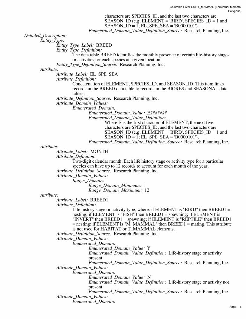
Columbia River ESI: T_MAMMAL (Terrestrial Mammal Polygons)
Page: 18
characters are SPECIES_ID, and the last two characters areSEASON_ID (e.g. ELEMENT = 'BIRD', SPECIES_ID = 1 andSEASON_ID = 1; EL_SPE_SEA = 'B0000101').
Enumerated_Domain_Value_Definition_Source: Research Planning, Inc. Detailed_Description:
Entity_Type: Entity_Type_Label: BREED Entity_Type_Definition:
The data table BREED identifies the monthly presence of certain life-history stagesor activities for each species at a given location.
Entity_Type_Definition_Source: Research Planning, Inc. Attribute:
Attribute_Label: EL_SPE_SEA Attribute_Definition:
Concatenation of ELEMENT, SPECIES_ID, and SEASON_ID. This item linksrecords in the BREED data table to records in the BIORES and SEASONAL datatables.
Attribute_Definition_Source: Research Planning, Inc. Attribute_Domain_Values:
Enumerated_Domain: Enumerated_Domain_Value: E####### Enumerated_Domain_Value_Definition:
Where E is the first character of ELEMENT, the next fivecharacters are SPECIES_ID, and the last two characters areSEASON_ID (e.g. ELEMENT = 'BIRD', SPECIES_ID = 1 andSEASON_ID = 1; EL_SPE_SEA = 'B0000101').
Enumerated_Domain_Value_Definition_Source: Research Planning, Inc. Attribute:
Attribute_Label: MONTH Attribute_Definition:
Two-digit calendar month. Each life history stage or activity type for a particularspecies can have up to 12 records to account for each month of the year.
Attribute_Definition_Source: Research Planning, Inc. Attribute_Domain_Values:
Range_Domain: Range_Domain_Minimum: 1 Range_Domain_Maximum: 12
Attribute: Attribute_Label: BREED1 Attribute_Definition:
Life history stage or activity type, where: if ELEMENT is "BIRD" then BREED1 =nesting; if ELEMENT is "FISH" then BREED1 = spawning; if ELEMENT is"INVERT" then BREED1 = spawning; if ELEMENT is "REPTILE" then BREED1= nesting; if ELEMENT is "M_MAMMAL" then BREED1 = mating. This attributeis not used for HABITAT or T_MAMMAL elements.
Attribute_Definition_Source: Research Planning, Inc. Attribute_Domain_Values:
Enumerated_Domain: Enumerated_Domain_Value: Y Enumerated_Domain_Value_Definition: Life-history stage or activitypresent Enumerated_Domain_Value_Definition_Source: Research Planning, Inc.
Attribute_Domain_Values: Enumerated_Domain:
Enumerated_Domain_Value: N Enumerated_Domain_Value_Definition: Life-history stage or activity notpresent Enumerated_Domain_Value_Definition_Source: Research Planning, Inc.
Attribute_Domain_Values: Enumerated_Domain:
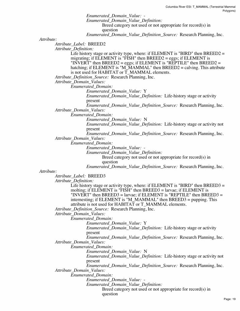
Columbia River ESI: T_MAMMAL (Terrestrial Mammal Polygons)
Page: 19
Enumerated_Domain_Value: - Enumerated_Domain_Value_Definition:
Breed category not used or not appropriate for record(s) inquestion
Enumerated_Domain_Value_Definition_Source: Research Planning, Inc. Attribute:
Attribute_Label: BREED2 Attribute_Definition:
Life history stage or activity type, where: if ELEMENT is "BIRD" then BREED2 =migrating; if ELEMENT is "FISH" then BREED2 = eggs; if ELEMENT is"INVERT" then BREED2 = eggs; if ELEMENT is "REPTILE" then BREED2 =hatching; if ELEMENT is "M_MAMMAL" then BREED2 = calving. This attributeis not used for HABITAT or T_MAMMAL elements.
Attribute_Definition_Source: Research Planning, Inc. Attribute_Domain_Values:
Enumerated_Domain: Enumerated_Domain_Value: Y Enumerated_Domain_Value_Definition: Life-history stage or activitypresent Enumerated_Domain_Value_Definition_Source: Research Planning, Inc.
Attribute_Domain_Values: Enumerated_Domain:
Enumerated_Domain_Value: N Enumerated_Domain_Value_Definition: Life-history stage or activity notpresent Enumerated_Domain_Value_Definition_Source: Research Planning, Inc.
Attribute_Domain_Values: Enumerated_Domain:
Enumerated_Domain_Value: - Enumerated_Domain_Value_Definition:
Breed category not used or not appropriate for record(s) inquestion
Enumerated_Domain_Value_Definition_Source: Research Planning, Inc. Attribute:
Attribute_Label: BREED3 Attribute_Definition:
Life history stage or activity type, where: if ELEMENT is "BIRD" then BREED3 =molting; if ELEMENT is "FISH" then BREED3 = larvae; if ELEMENT is"INVERT" then BREED3 = larvae; if ELEMENT is "REPTILE" then BREED3 =internesting; if ELEMENT is "M_MAMMAL" then BREED3 = pupping. Thisattribute is not used for HABITAT or T_MAMMAL elements.
Attribute_Definition_Source: Research Planning, Inc. Attribute_Domain_Values:
Enumerated_Domain: Enumerated_Domain_Value: Y Enumerated_Domain_Value_Definition: Life-history stage or activitypresent Enumerated_Domain_Value_Definition_Source: Research Planning, Inc.
Attribute_Domain_Values: Enumerated_Domain:
Enumerated_Domain_Value: N Enumerated_Domain_Value_Definition: Life-history stage or activity notpresent Enumerated_Domain_Value_Definition_Source: Research Planning, Inc.
Attribute_Domain_Values: Enumerated_Domain:
Enumerated_Domain_Value: - Enumerated_Domain_Value_Definition:
Breed category not used or not appropriate for record(s) inquestion
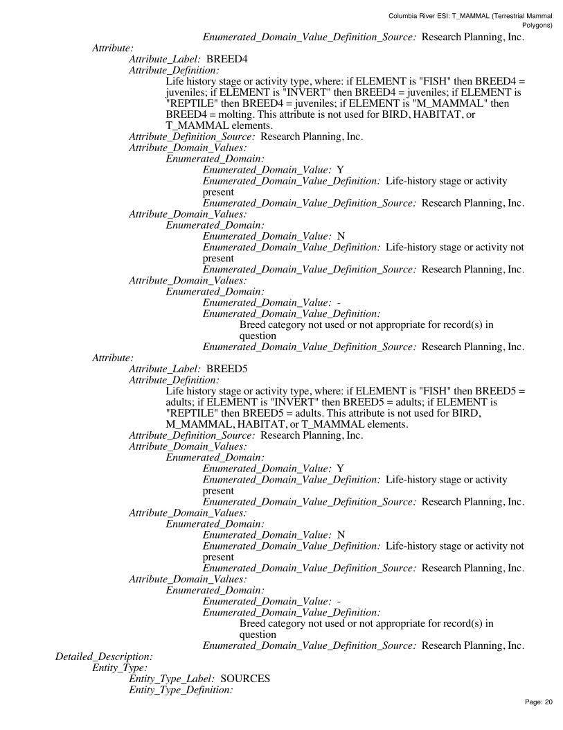
Columbia River ESI: T_MAMMAL (Terrestrial Mammal Polygons)
Page: 20
Enumerated_Domain_Value_Definition_Source: Research Planning, Inc. Attribute:
Attribute_Label: BREED4 Attribute_Definition:
Life history stage or activity type, where: if ELEMENT is "FISH" then BREED4 =juveniles; if ELEMENT is "INVERT" then BREED4 = juveniles; if ELEMENT is"REPTILE" then BREED4 = juveniles; if ELEMENT is "M_MAMMAL" thenBREED4 = molting. This attribute is not used for BIRD, HABITAT, orT_MAMMAL elements.
Attribute_Definition_Source: Research Planning, Inc. Attribute_Domain_Values:
Enumerated_Domain: Enumerated_Domain_Value: Y Enumerated_Domain_Value_Definition: Life-history stage or activitypresent Enumerated_Domain_Value_Definition_Source: Research Planning, Inc.
Attribute_Domain_Values: Enumerated_Domain:
Enumerated_Domain_Value: N Enumerated_Domain_Value_Definition: Life-history stage or activity notpresent Enumerated_Domain_Value_Definition_Source: Research Planning, Inc.
Attribute_Domain_Values: Enumerated_Domain:
Enumerated_Domain_Value: - Enumerated_Domain_Value_Definition:
Breed category not used or not appropriate for record(s) inquestion
Enumerated_Domain_Value_Definition_Source: Research Planning, Inc. Attribute:
Attribute_Label: BREED5 Attribute_Definition:
Life history stage or activity type, where: if ELEMENT is "FISH" then BREED5 =adults; if ELEMENT is "INVERT" then BREED5 = adults; if ELEMENT is"REPTILE" then BREED5 = adults. This attribute is not used for BIRD,M_MAMMAL, HABITAT, or T_MAMMAL elements.
Attribute_Definition_Source: Research Planning, Inc. Attribute_Domain_Values:
Enumerated_Domain: Enumerated_Domain_Value: Y Enumerated_Domain_Value_Definition: Life-history stage or activitypresent Enumerated_Domain_Value_Definition_Source: Research Planning, Inc.
Attribute_Domain_Values: Enumerated_Domain:
Enumerated_Domain_Value: N Enumerated_Domain_Value_Definition: Life-history stage or activity notpresent Enumerated_Domain_Value_Definition_Source: Research Planning, Inc.
Attribute_Domain_Values: Enumerated_Domain:
Enumerated_Domain_Value: - Enumerated_Domain_Value_Definition:
Breed category not used or not appropriate for record(s) inquestion
Enumerated_Domain_Value_Definition_Source: Research Planning, Inc. Detailed_Description:
Entity_Type: Entity_Type_Label: SOURCES Entity_Type_Definition:

Columbia River ESI: T_MAMMAL (Terrestrial Mammal Polygons)
Page: 21
The data table SOURCES contains the primary sources used to create the ESI dataset. See the Browse_Graphic section for a link to the entity-relationship diagram,which describes the way this table relates to other attribute tables in the ESI datastructure.
Entity_Type_Definition_Source: Research Planning, Inc. Attribute:
Attribute_Label: SOURCE_ID Attribute_Definition:
Source identifier that links records in the SOURCES data table to the itemsG_SOURCE and A_SOURCE in the SOC_DAT table, and to G_SOURCE andS_SOURCE in the BIORES table.
Attribute_Definition_Source: Research Planning, Inc. Attribute_Domain_Values:
Range_Domain: Range_Domain_Minimum: 1 Range_Domain_Maximum: N
Attribute: Attribute_Label: ORIGINATOR Attribute_Definition: Author or developer of source material or data set Attribute_Definition_Source: Research Planning, Inc. Attribute_Domain_Values:
Unrepresentable_Domain: Acceptable values change from atlas to atlas Attribute:
Attribute_Label: DATE_PUB Attribute_Definition:
Date of source material, publication, or date of personal communication with expertsource
Attribute_Definition_Source: Research Planning, Inc. Attribute_Domain_Values:
Enumerated_Domain: Enumerated_Domain_Value: YYYYMM Enumerated_Domain_Value_Definition: YYYY for year and optionallyMM for month Enumerated_Domain_Value_Definition_Source: Research Planning, Inc.
Attribute: Attribute_Label: TITLE Attribute_Definition: Title of source material or data Attribute_Definition_Source: Research Planning, Inc. Attribute_Domain_Values:
Unrepresentable_Domain: Acceptable values change from atlas to atlas Attribute:
Attribute_Label: DATA_FORMAT Attribute_Definition: The format of the source material Attribute_Definition_Source: Research Planning, Inc. Attribute_Domain_Values:
Unrepresentable_Domain: Acceptable values change from atlas to atlas Attribute:
Attribute_Label: PUBLICATION Attribute_Definition: Additional citation information Attribute_Definition_Source: Research Planning, Inc. Attribute_Domain_Values:
Unrepresentable_Domain: Acceptable values change from atlas to atlas Attribute:
Attribute_Label: SCALE Attribute_Definition: Scale denominator of the source Attribute_Definition_Source: Research Planning, Inc. Attribute_Domain_Values:
Enumerated_Domain: Enumerated_Domain_Value: integer Enumerated_Domain_Value_Definition: Any integer

Columbia River ESI: T_MAMMAL (Terrestrial Mammal Polygons)
Page: 22
Enumerated_Domain_Value_Definition_Source: Research Planning, Inc. Attribute:
Attribute_Label: TIME_PERIOD Attribute_Definition:
Date(s) of data collection that the source material is based upon. Attribute_Definition_Source: Research Planning, Inc. Attribute_Domain_Values:
Enumerated_Domain: Enumerated_Domain_Value: MM/DD/YY Enumerated_Domain_Value_Definition: Month/Day/Year Enumerated_Domain_Value_Definition_Source: Research Planning, Inc.
Attribute_Domain_Values: Enumerated_Domain:
Enumerated_Domain_Value: MM/YYYY Enumerated_Domain_Value_Definition: Month/Year Enumerated_Domain_Value_Definition_Source: Research Planning, Inc.
Attribute_Domain_Values: Enumerated_Domain:
Enumerated_Domain_Value: UNKNOWN Enumerated_Domain_Value_Definition: Date information unknown Enumerated_Domain_Value_Definition_Source: Research Planning, Inc.
Detailed_Description: Entity_Type:
Entity_Type_Label: STATUS Entity_Type_Definition:
The data table STATUS identifies the species that are listed as threatened orendangered by a state or federal authority. See the Browse_Graphic section for alink to the entity-relationship diagram, which describes the way this table relates toother attribute tables in the ESI data structure.
Entity_Type_Definition_Source: Research Planning, Inc. Attribute:
Attribute_Label: ELEMENT Attribute_Definition: Major categories of biological data Attribute_Definition_Source: Research Planning, Inc. Attribute_Domain_Values:
Enumerated_Domain: Enumerated_Domain_Value: BIRD Enumerated_Domain_Value_Definition: Birds Enumerated_Domain_Value_Definition_Source: Research Planning, Inc.
Attribute_Domain_Values: Enumerated_Domain:
Enumerated_Domain_Value: FISH Enumerated_Domain_Value_Definition: Fish Enumerated_Domain_Value_Definition_Source: Research Planning, Inc.
Attribute_Domain_Values: Enumerated_Domain:
Enumerated_Domain_Value: HABITAT Enumerated_Domain_Value_Definition: Habitats and Plants Enumerated_Domain_Value_Definition_Source: Research Planning, Inc.
Attribute_Domain_Values: Enumerated_Domain:
Enumerated_Domain_Value: INVERT Enumerated_Domain_Value_Definition: Invertebrates Enumerated_Domain_Value_Definition_Source: Research Planning, Inc.
Attribute_Domain_Values: Enumerated_Domain:
Enumerated_Domain_Value: M_MAMMAL Enumerated_Domain_Value_Definition: Marine Mammals Enumerated_Domain_Value_Definition_Source: Research Planning, Inc.
Attribute_Domain_Values:

Columbia River ESI: T_MAMMAL (Terrestrial Mammal Polygons)
Page: 23
Enumerated_Domain: Enumerated_Domain_Value: REPTILE Enumerated_Domain_Value_Definition: Reptiles and Amphibians Enumerated_Domain_Value_Definition_Source: Research Planning, Inc.
Attribute_Domain_Values: Enumerated_Domain:
Enumerated_Domain_Value: T_MAMMAL Enumerated_Domain_Value_Definition: Terrestrial Mammals Enumerated_Domain_Value_Definition_Source: Research Planning, Inc.
Attribute: Attribute_Label: SPECIES_ID Attribute_Definition:
Numeric identifier for each species that is unique within each element and refers to anationwide master ESI species list maintained at NOAA.
Attribute_Definition_Source: Research Planning, Inc. Attribute_Domain_Values:
Range_Domain: Range_Domain_Minimum: 1 Range_Domain_Maximum: N
Attribute: Attribute_Label: S Attribute_Definition: State threatened or endangered status Attribute_Definition_Source: Research Planning, Inc. Attribute_Domain_Values:
Enumerated_Domain: Enumerated_Domain_Value: E Enumerated_Domain_Value_Definition: Endangered on state list Enumerated_Domain_Value_Definition_Source: U.S. Fish and WildlifeService
Attribute_Domain_Values: Enumerated_Domain:
Enumerated_Domain_Value: T Enumerated_Domain_Value_Definition: Threatened on state list Enumerated_Domain_Value_Definition_Source: U.S. Fish and WildlifeService
Attribute_Domain_Values: Enumerated_Domain:
Enumerated_Domain_Value: C Enumerated_Domain_Value_Definition: Species of Special Concern Enumerated_Domain_Value_Definition_Source: U.S. Fish and WildlifeService
Attribute: Attribute_Label: F Attribute_Definition: Federal threatened or endangered status Attribute_Definition_Source: Research Planning, Inc. Attribute_Domain_Values:
Enumerated_Domain: Enumerated_Domain_Value: E Enumerated_Domain_Value_Definition: Endangered on federal list Enumerated_Domain_Value_Definition_Source: U.S. Fish and WildlifeService
Attribute_Domain_Values: Enumerated_Domain:
Enumerated_Domain_Value: T Enumerated_Domain_Value_Definition: Threatened on federal list Enumerated_Domain_Value_Definition_Source: U.S. Fish and WildlifeService
Attribute_Domain_Values: Enumerated_Domain:
Enumerated_Domain_Value: C

Columbia River ESI: T_MAMMAL (Terrestrial Mammal Polygons)
Page: 24
Enumerated_Domain_Value_Definition: Species of Special Concern Enumerated_Domain_Value_Definition_Source: U.S. Fish and WildlifeService
Attribute: Attribute_Label: STATE Attribute_Definition: Two-letter state abbreviation Attribute_Definition_Source: Research Planning, Inc. Attribute_Domain_Values:
Unrepresentable_Domain: Acceptable values change from atlas to atlas Attribute:
Attribute_Label: S_DATE Attribute_Definition:
Publication date of source material used to assign state status values for eachspecies, if used.
Attribute_Definition_Source: Research Planning, Inc. Attribute_Domain_Values:
Enumerated_Domain: Enumerated_Domain_Value: YYYYMM Enumerated_Domain_Value_Definition: YYYY for year and optionallyMM for month Enumerated_Domain_Value_Definition_Source: Research Planning, Inc.
Attribute: Attribute_Label: F_DATE Attribute_Definition:
Publication date of source material used to assign federal status values for eachspecies, if used.
Attribute_Definition_Source: Research Planning, Inc. Attribute_Domain_Values:
Enumerated_Domain: Enumerated_Domain_Value: YYYYMM Enumerated_Domain_Value_Definition: YYYY for year and optionallyMM for month Enumerated_Domain_Value_Definition_Source: Research Planning, Inc.
Attribute: Attribute_Label: EL_SPE Attribute_Definition:
Concatenation of ELEMENT and SPECIES_ID. This item links the STATUS datatable to the BIORES and SPECIES data tables.
Attribute_Definition_Source: Research Planning, Inc. Attribute_Domain_Values:
Enumerated_Domain: Enumerated_Domain_Value: E##### Enumerated_Domain_Value_Definition:
Where E is the first character of ELEMENT and the next fivecharacters are SPECIES_ID (e.g. ELEMENT = 'BIRD' andSPECIES_ID = 1; EL_SPE = 'B00001').
Enumerated_Domain_Value_Definition_Source: Research Planning, Inc.
Distribution_Information: Distributor:
Contact_Information: Contact_Person_Primary:
Contact_Person: John Kaperick Contact_Organization: NOAA, Office of Response and Restoration
Contact_Address: Address_Type: Physical Address Address: 7600 Sand Point Way N.E. City: Seattle

Columbia River ESI: T_MAMMAL (Terrestrial Mammal Polygons)
Page: 25
State_or_Province: Washington Postal_Code: 98115-6349
Contact_Voice_Telephone: (206) 526-6400 Contact_Facsimile_Telephone: (206) 526-6329
Resource_Description: ESI Atlas for Columbia River Distribution_Liability:
Although these data have been processed successfully on a computer system at the National Oceanicand Atmospheric Administration, no warranty, expressed or implied, is made by NOAA regarding theutility of the data on any other system, nor shall the act of distribution constitute any such warranty.NOAA warrants the delivery of this product in computer-readable format, and will offer a replacementcopy of the product when the product is determined unreadable by computer-input peripherals, orwhen the physical medium is delivered in damaged condition.
Custom_Order_Process: Contact NOAA for distribution options (see Distributor). ESI data are processed into multipleformats to make them useful to a wider community of GIS/mapping users. Distribution formatsinclude ARC export, MOSS and Shape files, and MARPLOT map folders. An ArcView ESI projectand ESI_Viewer product are also included on the distribution CDs for ease of use of the ESI data.The database files are distributed both in the NOAA standard relational database format (see NOAATechnical Memorandum NOS ORCA 115) and in a simplified desktop flat file format. This metadatadocument includes information on both of these database formats.
Metadata_Reference_Information: Metadata_Date: 200411 Metadata_Review_Date: 200411 Metadata_Contact:
Contact_Information: Contact_Person_Primary:
Contact_Person: Jill Petersen Contact_Organization: NOAA, Office of Response and Restoration
Contact_Position: GIS Manager Contact_Address:
Address_Type: Physical Address Address: 7600 Sand Point Way N.E. City: Seattle State_or_Province: Washington Postal_Code: 98115-6349
Contact_Voice_Telephone: (206) 526-6944 Contact_Facsimile_Telephone: (206) 526-6329 Contact_Electronic_Mail_Address: [email protected]
Metadata_Standard_Name: Content Standards for Digital Geospatial Metadata Metadata_Standard_Version: FGDC-STD-001-1998
Generated by mp version 2.8.2 on Fri Dec 10 11:21:11 2004
Columbia River ESI: HABITATS (Habitat Polygons)
Page: 1
Columbia River ESI: HABITATS (Habitat Polygons)Metadata also available as - [Parseable text] - [SGML]
Metadata:Identification_Information Data_Quality_Information Spatial_Data_Organization_Information Spatial_Reference_Information Entity_and_Attribute_Information Distribution_Information Metadata_Reference_Information
Identification_Information: Citation:
Citation_Information: Originator:
National Oceanic and Atmospheric Administration (NOAA), National OceanService, Office of Response and Restoration, Hazardous Materials ResponseDivision, Seattle, Washington; Coastal Storms Initiative; U.S. Fish and WildlifeService; NOAA Fisheries; State of Oregon; and State of Washington.
Publication_Date: 200411 Title: Columbia River ESI: HABITATS (Habitat Polygons) Edition: First Geospatial_Data_Presentation_Form: Vector digital data Series_Information:
Series_Name: None Issue_Identification: Columbia River
Publication_Information: Publication_Place: Seattle, Washington Publisher:
National Oceanic and Atmospheric Administration (NOAA), NationalOcean Service, Office of Response and Restoration, Hazardous MaterialsResponse Division, Seattle, Washington
Other_Citation_Details: Prepared by Research Planning, Inc., Columbia, South Carolina for the NationalOceanic and Atmospheric Administration (NOAA), National Ocean Service, Officeof Response and Restoration, Hazardous Materials Response Division, Seattle,Washington; Coastal Storms Initiative; U.S. Fish and Wildlife Service; NOAAFisheries; State of Oregon; and State of Washington.
Description: Abstract:
This data set contains sensitive biological resource data for submerged aquatic vegetation(SAV), rare plant species [Water howellia (Howelia aquatilis) and Columbia yellowcress(Rorippa columbiae)], and other plant species in Columbia River. Vector polygons in thisdata set represent locations of habitat and rare plant distribution. Species-specific abundance,seasonality, status, life history, and source information are stored in relational data tables(described below) designed to be used in conjunction with this spatial data layer.
This data set comprises a portion of the Environmental Sensitivity Index (ESI) data forColumbia River. ESI data characterize the marine and coastal environments and wildlife bytheir sensitivity to spilled oil. The ESI data include information for three main components:shoreline habitats, sensitive biological resources, and human-use resources.
Purpose:
Columbia River ESI: HABITATS (Habitat Polygons)
Page: 2
The ESI data were collected, mapped, and digitized to provide environmental data for oil spillplanning and response. The Clean Water Act with amendments by the Oil Pollution Act of1990 requires response plans for immediate and effective protection of sensitive resources.
Time_Period_of_Content: Time_Period_Information:
Range_of_Dates/Times: Beginning_Date: 1981 Ending_Date: 2004
Currentness_Reference: The biological data were compiled during 2003-2004. The currentness dates for the datarange from 1981 to 2004 and are documented in the Lineage section.
Status: Progress: Complete Maintenance_and_Update_Frequency: None Scheduled
Spatial_Domain: Bounding_Coordinates:
West_Bounding_Coordinate: -124.125 East_Bounding_Coordinate: -120.67375 North_Bounding_Coordinate: 46.375 South_Bounding_Coordinate: 45.3
Keywords: Theme:
Theme_Keyword_Thesaurus: None Theme_Keyword: ESI Theme_Keyword: Sensitivity maps Theme_Keyword: Coastal resources Theme_Keyword: Oil spill planning Theme_Keyword: Coastal Zone Management Theme_Keyword: Wildlife Theme_Keyword: Habitat Theme_Keyword: Plant
Place: Place_Keyword_Thesaurus: None Place_Keyword: Columbia River
Access_Constraints: None Use_Constraints:
DO NOT USE MAPS FOR NAVIGATIONAL PURPOSES. Besides the above warning, there areno use constraints on these data. Note that the ESI database should not be used to the exclusion ofother pertinent data or information held by state or federal agencies or other organizations. Likewise,information contained in the database cannot be used in place of consultations with environmental,natural resource, and cultural resource agencies, or in place of field surveys. Recognize that theinformation contained in the ESI database represents known concentration areas or occurrences ofnatural, cultural, and human-use resources, but does not necessarily represent the full distribution orrange of each species or resource. This is particularly important to recognize when consideringpotential impacts to protected resources, such as endangered species, wetlands, etc. Acknowledgmentof the originators, publishers, contributors, and sources listed would be appreciated in productsderived from these data.
Browse_Graphic: Browse_Graphic_File_Name: datafig.jpg Browse_Graphic_File_Description:
Depicts the relationships between spatial data layers and attribute data tables for theColumbia River ESI data.
Browse_Graphic_File_Type: JPEG Data_Set_Credit:
This project was supported by the National Oceanic and Atmospheric Administration (NOAA),National Ocean Service, Office of Response and Restoration, Hazardous Materials ResponseDivision, Seattle, Washington; Coastal Storms Initiative; U.S. Fish and Wildlife Service; NOAAFisheries; State of Oregon; and State of Washington.
Native_Data_Set_Environment: The software packages used to develop the atlas are Environmental Systems Research Institute's

Columbia River ESI: HABITATS (Habitat Polygons)
Page: 3
ARC/INFO(r) (version 8.3) and SQL SERVER(r) (version 7.0). The hardware configuration is PC'swith Windows Operating System (NT4.0/2000).
The Spatial_Data_Organization_Information section refers only to the source files in the ARC exportformat. The following files are included in that data set: birds.e00, esi.e00, fish.e00, fishl.e00,habitats.e00, hydro.e00, index.e00, invert.e00, m_mammal.e00, m_mampt.e00, mgt.e00, nests.e00,nwi.e00, reptiles.e00, socecon.e00, t_mammal.e00. Associated relational and desktop data tablesprovided in Arc export and text format are bio_lut, biofile, biores, breed, breed_dt, runs_dat, seasonal,soc_dat, soc_lut, sources, species, and status.
Data_Quality_Information: Attribute_Accuracy:
Attribute_Accuracy_Report: A multi-stage error checking process is used to verify both attribute accuracy and logicalconsistency throughout data production. The process includes a standardized data entrymethodology, hardcopy data review by in-house and external resource experts, a final QualityAssurance/Quality Control (QA/QC) process, and multiple automated logical consistencychecks. Quantitative data (such as densities, counts, abundances, or concentrations) providedby resource experts for inclusion in the data set may vary widely in attribute accuracy,depending upon the methodology used to collect and compile such data. For a more detailedevaluation of source data attribute accuracy, contact the sources listed in the Lineage section.
Logical_Consistency_Report: A multi-stage error checking process, described in the above Attribute_Accuracy_Report, is used toverify both attribute accuracy and logical consistency throughout data production. This processincludes multiple automated logical consistency checks that test the files for missing or duplicate data,rules for proper coding, GIS topological consistencies (such as dangles, unnecessary nodes, etc.), andSQL SERVER(r) to ARC/INFO(r) consistencies. A final review is made by the GIS manager, wherethe data are written to CD-ROM and the metadata are written.
After the data are delivered to NOAA, they are again subjected to a number of quality and consistencychecks. In the process of checking for topological and database consistencies, new ID's andRARNUM's or HUNUM's are also generated. The new ID's are a combination of atlas number,element number, and record number. In addition, the value used to represent the element is modifiedto reflect the type of feature being mapped. In the case of an element that is normally represented by apoint or polygon, a value of 20 is added to the standard element value for mapping of linear features.In the case where an element usually mapped as a polygon is represented by a point, a value of 30 isadded to the regular element value. The RARNUM's are also modified to include the atlas number, somultiple atlases can be combined and RARNUM's remain unique. RARNUM's are redefined on anelement basis, so "resources at risk" groupings will contain only a single element. HUNUM's arealso modified to include the atlas number.
Completeness_Report: These data represent a synthesis of expert knowledge and available hardcopy reports and digital dataon submerged aquatic vegetation and rare plant distributions. These data do not necessarily representall habitat and plant occurrences in Columbia River. The following species are included in this dataset: (Species_ID, Common Name, Scientific Name, if applicable): 1, Eelgrass, Zostera marina; 607,Columbia yellowcress, Rorippa columbiae; 608, Water howellia, Howellia aquatilis.
Positional_Accuracy: Horizontal_Positional_Accuracy:
Horizontal_Positional_Accuracy_Report: Most of the spatial components of the biological data sets are developed usingregional experts who estimate concentration areas. It is difficult to estimate thepositional accuracy of such data, except to state that they are compiled on hardcopybase maps with a scale of 1:24,000. Some of the spatial components of thebiological data sets are developed from pre-existing digital sources and reflect thepositional accuracy of these original data. See the Lineage and Process_Descriptionsections for more information on the original data source and how these data wereintegrated or manipulated to create the final data set. Note that biological resourcedata by their very nature are considered "fuzzy", and this should be understood
Columbia River ESI: HABITATS (Habitat Polygons)
Page: 4
when considering the positional accuracy of vector digital objects representing theseresources.
Lineage: Source_Information:
Source_Citation: Citation_Information:
Originator: Meyer, B., National Oceanic and Atmospheric Administration(NOAA)
Publication_Date: 200402 Title:
Fish, Bird, Mammal, and Plant Distributions in the LowerColumbia River
Geospatial_Data_Presentation_Form: Expert Knowledge Publication_Information:
Publication_Place: Unpublished material Publisher: Unpublished material
Type_of_Source_Media: Personal communication Source_Time_Period_of_Content:
Time_Period_Information: Single_Date/Time:
Calendar_Date: 200402 Source_Currentness_Reference: Date of communication
Source_Citation_Abbreviation: None Source_Contribution: Distribution information for aquatic vegetation
Source_Information: Source_Citation:
Citation_Information: Originator: U.S. Fish and Wildlife Service (USFWS) Publication_Date: 1981 Title: Hoquiam Washington-Oregon, Pacific Coast Ecological Inventory Geospatial_Data_Presentation_Form: Hardcopy Map Publication_Information:
Publication_Place: Washington, D.C. Publisher: U.S. Government Printing Office
Source_Scale_Denominator: 250,000 Type_of_Source_Media: Paper Source_Time_Period_of_Content:
Time_Period_Information: Single_Date/Time:
Calendar_Date: 1981 Source_Currentness_Reference: Publication date
Source_Citation_Abbreviation: None Source_Contribution: Distribution information for aquatic vegetation
Source_Information: Source_Citation:
Citation_Information: Originator: Anderson, E., U.S. Fish and Wildlife Service (USFWS) Publication_Date: 200401 Title: Distribution of Wildlife on the Lower Columbia River Geospatial_Data_Presentation_Form: Expert Knowledge Publication_Information:
Publication_Place: Unpublished material Publisher: Unpublished material
Type_of_Source_Media: Personal communication Source_Time_Period_of_Content:
Time_Period_Information: Single_Date/Time:
Calendar_Date: 200401 Source_Currentness_Reference: Date of communication

Columbia River ESI: HABITATS (Habitat Polygons)
Page: 5
Source_Citation_Abbreviation: None Source_Contribution: Distribution information for aquatic vegetation
Process_Step: Process_Description:
Two main sources of data were used to depict habitat and rare plant distributions andseasonality for this data layer: (1) personal interviews with resource experts fromOregon Department of Fish and Wildlife (ODFW), U.S. Fish and Wildlife Service(USFWS), and National Oceanic Atmospheric Administration (NOAA) and (2)numerous published and unpublished reports. Information gathered during initialinterviews and from hardcopy sources was compiled onto U.S. Geological Survey1:24,000 topographic quadrangles.
The compiled data were digitized off of the base maps into an ArcInfo system tocreate the HABITATS data layer. All ESI, biology, and human-use data were plottedonto hardcopy draft maps. Following the delivery of draft maps to the participatingresource experts, a second set of interviews was conducted to review the maps. Editsto the HABITATS data layer were made based on the recommendations of theresource experts, and final hardcopy maps were created.
Process_Date: 200408 Process_Contact:
Contact_Information: Contact_Organization_Primary:
Contact_Organization: NOAA, Office of Response andRestoration Contact_Person: Jill Petersen
Contact_Address: Address_Type: Physical address Address: 7600 Sand Point Way N.E. City: Seattle State_or_Province: Washington Postal_Code: 98115-6349
Contact_Voice_Telephone: (206) 526-6944 Contact_Facsimile_Telephone: (206) 526-6329 Contact_Electronic_Mail_Address: [email protected]
Spatial_Data_Organization_Information: Direct_Spatial_Reference_Method: Vector Point_and_Vector_Object_Information:
SDTS_Terms_Description: SDTS_Point_and_Vector_Object_Type: GT-polygon composed of rings Point_and_Vector_Object_Count: 21
SDTS_Terms_Description: SDTS_Point_and_Vector_Object_Type: Area point Point_and_Vector_Object_Count: 21
SDTS_Terms_Description: SDTS_Point_and_Vector_Object_Type: Complete chain Point_and_Vector_Object_Count: 61
SDTS_Terms_Description: SDTS_Point_and_Vector_Object_Type: Link Point_and_Vector_Object_Count: 20237
SDTS_Terms_Description: SDTS_Point_and_Vector_Object_Type: Node, planar graph Point_and_Vector_Object_Count: 61
Spatial_Reference_Information: Horizontal_Coordinate_System_Definition:

Columbia River ESI: HABITATS (Habitat Polygons)
Page: 6
Geographic: Latitude_Resolution: 0.0000001 Longitude_Resolution: 0.0000001 Geographic_Coordinate_Units: Decimal degrees
Geodetic_Model: Horizontal_Datum_Name: North American Datum of 1927 Ellipsoid_Name: Clark 1866 Semi-major_Axis: 6378206.4 Denominator_of_Flattening_Ratio: 294.978698
Entity_and_Attribute_Information: Overview_Description:
Entity_and_Attribute_Overview: In addition to the geographic data layers, six relational attribute or data tables, BIORES,BREED, SEASONAL, SOURCES, SPECIES, and STATUS, are used to store the complexbiological data in the ESI data structure. The geographic data layer containing biologicalresource information (in this case, HABITATS) is linked to the Biological Resources table(BIORES) using the unique ID and the lookup table BIO_LUT, or it can be linked directlyusing RARNUM. The ID is a unique combination of the atlas number (for the ColumbiaRiver atlas, the number is 41), an element/layer specific number (BIRDS are layer 1, FISHare layer 2, etc.), and a unique record number. The RARNUM represents a uniquecombination of species, seasonalities, concentrations, and source information. For each ofthese groupings, a number is generated. That number is concatenated with the atlas numberto create a "resource at risk" number that is unique across atlases. BIORES and the otherrelational data tables are described below in detail. See the Browse_Graphic section for a linkto the entity-relationship diagram, which describes the way these tables relate to thegeographic data layers and other attribute tables in the ESI data structure.
Due to the complexity of the relational database model, the data items are also post-processedinto a flat file format. This table, called BIOFILE, may be used in place of the relational filesdescribed below to ease simple data queries. The items in the flat file are ELEMENT,SUBELEMENT, NAME, GEN_SPEC, S, F, NHP, DATE_PUB, CONC, JAN, FEB, MAR,APR, MAY, JUN, JUL, AUG, SEP, OCT, NOV, DEC, BREED1, BREED2, BREED3,BREED4, BREED5, RARNUM, G_SOURCE, S_SOURCE, and BREED. All of theseitems are the same as their counterparts in the individual data tables described below, exceptthe BREED1-BREED5 and BREED items. BREED is a newly generated variable used tolink to the BREED_DT data table, a modified, more compact version of the relationalBREED data table. BREED1-BREED5 give a text summary of when each life stage occurswithin the associated map object. The life stages referred to are the same as those listed in theDetailed_Description of the BREED data table. The link to the BIOFILE may be madethrough the BIO_LUT, using ID to link to RARNUM, or BIOFILE may be linked directlyto the RARNUM in each of the geographic layer's attribute data tables. As mentioned,BREED_DT is an auxiliary support data table to the flat file structure, which allows the userto do searches based on month for seasonal breeding activities. The link from the flat file toBREED_DT is the BREED item.
A second supporting data table is SOURCES. This is the same as the source file describedabove, and the link from the flat file is both G_SOURCE and S_SOURCE. It should benoted that although the flat file eases data query, it is not a normalized database structure, andactual updates performed by the states and other responsible agencies should be done usingthe relational data tables. The entity-relationship diagram, describing relationships betweenattribute tables in the ESI data structure, does NOT include the BIOFILE data table, and thisdata table is NOT described in detail below.
Detailed_Description: Entity_Type:
Entity_Type_Label: HABITATS.PAT Entity_Type_Definition:
The HABITATS.PAT table contains attribute information for the vector polygons

Columbia River ESI: HABITATS (Habitat Polygons)
Page: 7
representing submerged aquatic vegetation concentration areas and locations of rareplants and other plant species. Note that all attribute information is stored in a seriesof relational files, described below. See the Browse_Graphic section for a link to theentity-relationship diagram, which describes the relationships between attributetables in the ESI data structure.
Entity_Type_Definition_Source: Research Planning, Inc. Attribute:
Attribute_Label: ID Attribute_Definition:
An identifier that links vector objects in the biology data layers to records in theBIO_LUT data table. ID is a concatenation of atlas number (41), element number(3), and record number. ID values of 9999 are holes in polygons and do not containinformation.
Attribute_Definition_Source: NOAA Attribute_Domain_Values:
Range_Domain: Range_Domain_Minimum: 410300002 Range_Domain_Maximum: 410300022
Attribute: Attribute_Label: RARNUM Attribute_Definition:
An identifier that links directly to the BIORES table or the flat format BIOFILEtable. RARNUM values of 0 are holes in polygons and do not contain information.
Attribute_Definition_Source: NOAA Attribute_Domain_Values:
Range_Domain: Range_Domain_Minimum: 41000246 Range_Domain_Maximum: 41000249
Detailed_Description: Entity_Type:
Entity_Type_Label: BIO_LUT Entity_Type_Definition:
The data table BIO_LUT is a lookup table that contains items necessary for linkingvector objects in the biological data layers with the BIORES data table. Note that allattribute information is stored in a series of relational files, described below. See theBrowse_Graphic section for a link to the entity-relationship diagram, whichdescribes the way this table relates to other attribute tables in the ESI data structure.
Entity_Type_Definition_Source: Research Planning, Inc. Attribute:
Attribute_Label: RARNUM Attribute_Definition:
An identifier that links records in the BIO_LUT data table to records in the BIORESdata table or the flat format BIOFILE data table. RARNUM values of 0 are holes inpolygons and do not contain information.
Attribute_Definition_Source: NOAA Attribute_Domain_Values:
Range_Domain: Range_Domain_Minimum: 41000001 Range_Domain_Maximum: 41000290
Attribute: Attribute_Label: ID Attribute_Definition:
An identifier that links vector objects in the biology data layers to records in theBIO_LUT data table. ID is a concatenation of atlas number (41), element number(3), and record number. ID values of 9999 are holes in polygons and do not containinformation.
Attribute_Definition_Source: NOAA Attribute_Domain_Values:
Range_Domain: Range_Domain_Minimum: 410100002
Columbia River ESI: HABITATS (Habitat Polygons)
Page: 8
Range_Domain_Maximum: 413400015 Detailed_Description:
Entity_Type: Entity_Type_Label: BIORES Entity_Type_Definition:
The data table BIORES contains both biological attribute data and items necessaryfor linking vector objects in the biological data layers via the BIO_LUT data table toother associated data tables. See the Browse_Graphic section for a link to theentity-relationship diagram, which describes the way this table relates to otherattribute tables in the ESI data structure.
Entity_Type_Definition_Source: Research Planning, Inc. Attribute:
Attribute_Label: RARNUM Attribute_Definition:
An identifier that links records in the BIORES data table to records in the BIO_LUTdata table or the flat format BIOFILE data table.
Attribute_Definition_Source: NOAA Attribute_Domain_Values:
Range_Domain: Range_Domain_Minimum: 041000001 Range_Domain_Maximum: 041000290
Attribute: Attribute_Label: SPECIES_ID Attribute_Definition:
Numeric identifier for each species that is unique within each element and refers to anationwide master ESI species list maintained at NOAA.
Attribute_Definition_Source: Research Planning, Inc. Attribute_Domain_Values:
Range_Domain: Range_Domain_Minimum: 1 Range_Domain_Maximum: N
Attribute: Attribute_Label: CONC Attribute_Definition:
The field CONC refers to "concentration," abundance, or density value of a habitator plant at a particular location. No quantitative information on concentrations ofSAV or rare plants was available, so the field is populated either with a descriptiveterm such as "PRESENT", or "-", to indicate that no concentration information wasavailable.
Attribute_Definition_Source: Research Planning, Inc. Attribute_Domain_Values:
Unrepresentable_Domain: Acceptable values change from atlas to atlas Attribute:
Attribute_Label: SEASON_ID Attribute_Definition:
Numeric identifier for the unique monthly presence and life history characteristics ofeach species at a given location.
Attribute_Definition_Source: Research Planning, Inc. Attribute_Domain_Values:
Range_Domain: Range_Domain_Minimum: 1 Range_Domain_Maximum: N
Attribute: Attribute_Label: G_SOURCE Attribute_Definition:
Geographic source identifier that links records in the BIORES data table to recordsin the SOURCES data table.
Attribute_Definition_Source: Research Planning, Inc. Attribute_Domain_Values:
Range_Domain:
Columbia River ESI: HABITATS (Habitat Polygons)
Page: 9
Range_Domain_Minimum: 1 Range_Domain_Maximum: N
Attribute: Attribute_Label: S_SOURCE Attribute_Definition:
Seasonality source identifier that links records in the BIORES data table to recordsin the SOURCES data table.
Attribute_Definition_Source: Research Planning, Inc. Attribute_Domain_Values:
Range_Domain: Range_Domain_Minimum: 1 Range_Domain_Maximum: N
Attribute: Attribute_Label: ELEMENT Attribute_Definition: Major categories of biological data Attribute_Definition_Source: Research Planning, Inc. Attribute_Domain_Values:
Enumerated_Domain: Enumerated_Domain_Value: BIRD Enumerated_Domain_Value_Definition: Birds Enumerated_Domain_Value_Definition_Source: Research Planning, Inc.
Attribute_Domain_Values: Enumerated_Domain:
Enumerated_Domain_Value: FISH Enumerated_Domain_Value_Definition: Fish Enumerated_Domain_Value_Definition_Source: Research Planning, Inc.
Attribute_Domain_Values: Enumerated_Domain:
Enumerated_Domain_Value: HABITAT Enumerated_Domain_Value_Definition: Habitats and Plants Enumerated_Domain_Value_Definition_Source: Research Planning, Inc.
Attribute_Domain_Values: Enumerated_Domain:
Enumerated_Domain_Value: INVERT Enumerated_Domain_Value_Definition: Invertebrates Enumerated_Domain_Value_Definition_Source: Research Planning, Inc.
Attribute_Domain_Values: Enumerated_Domain:
Enumerated_Domain_Value: M_MAMMAL Enumerated_Domain_Value_Definition: Marine Mammals Enumerated_Domain_Value_Definition_Source: Research Planning, Inc.
Attribute_Domain_Values: Enumerated_Domain:
Enumerated_Domain_Value: REPTILE Enumerated_Domain_Value_Definition: Reptiles and Amphibians Enumerated_Domain_Value_Definition_Source: Research Planning, Inc.
Attribute_Domain_Values: Enumerated_Domain:
Enumerated_Domain_Value: T_MAMMAL Enumerated_Domain_Value_Definition: Terrestrial Mammals Enumerated_Domain_Value_Definition_Source: Research Planning, Inc.
Attribute: Attribute_Label: EL_SPE Attribute_Definition:
Concatenation of ELEMENT and SPECIES_ID. This item links records in theBIORES data table to records in the SPECIES and STATUS data tables.
Attribute_Definition_Source: Research Planning, Inc. Attribute_Domain_Values:
Enumerated_Domain: Enumerated_Domain_Value: E#####

Columbia River ESI: HABITATS (Habitat Polygons)
Page: 10
Enumerated_Domain_Value_Definition: Where E is the first character of ELEMENT and the next fivecharacters are SPECIES_ID (e.g. ELEMENT = 'BIRD' andSPECIES_ID = 1; EL_SPE = 'B00001').
Enumerated_Domain_Value_Definition_Source: Research Planning, Inc. Attribute:
Attribute_Label: EL_SPE_SEA Attribute_Definition:
Concatenation of ELEMENT, SPECIES_ID, and SEASON_ID. This item linksrecords in the BIORES data table to records in the SEASONAL and BREED datatables.
Attribute_Definition_Source: Research Planning, Inc. Attribute_Domain_Values:
Enumerated_Domain: Enumerated_Domain_Value: E####### Enumerated_Domain_Value_Definition:
Where E is the first character of ELEMENT, the next fivecharacters are SPECIES_ID, and the last two characters areSEASON_ID (e.g. ELEMENT = 'BIRD', SPECIES_ID = 1 andSEASON_ID = 1; EL_SPE_SEA = 'B0000101').
Enumerated_Domain_Value_Definition_Source: Research Planning, Inc. Detailed_Description:
Entity_Type: Entity_Type_Label: SPECIES Entity_Type_Definition:
The data table SPECIES identifies all species in the ESI data set. See theBrowse_Graphic section for a link to the entity-relationship diagram, whichdescribes the way this table relates to other attribute tables in the ESI data structure.Refer to the Completeness_Report for a list of layer-specific species.
Entity_Type_Definition_Source: Research Planning, Inc. Attribute:
Attribute_Label: SPECIES_ID Attribute_Definition:
Numeric identifier for each species that is unique within each element and refers to anationwide master ESI species list maintained at NOAA.
Attribute_Definition_Source: Research Planning, Inc. Attribute_Domain_Values:
Range_Domain: Range_Domain_Minimum: 1 Range_Domain_Maximum: N
Attribute: Attribute_Label: NAME Attribute_Definition: Species common name for the entire ESI data set Attribute_Definition_Source: Research Planning, Inc. Attribute_Domain_Values:
Unrepresentable_Domain: Acceptable values change from atlas to atlas Attribute:
Attribute_Label: GEN_SPEC Attribute_Definition: Species scientific name for the entire ESI data set Attribute_Definition_Source: Research Planning, Inc. Attribute_Domain_Values:
Unrepresentable_Domain: Acceptable values change from atlas to atlas Attribute:
Attribute_Label: ELEMENT Attribute_Definition: Major categories of biological data Attribute_Definition_Source: Research Planning, Inc. Attribute_Domain_Values:
Enumerated_Domain: Enumerated_Domain_Value: BIRD Enumerated_Domain_Value_Definition: Birds

Columbia River ESI: HABITATS (Habitat Polygons)
Page: 11
Enumerated_Domain_Value_Definition_Source: Research Planning, Inc. Attribute_Domain_Values:
Enumerated_Domain: Enumerated_Domain_Value: FISH Enumerated_Domain_Value_Definition: Fish Enumerated_Domain_Value_Definition_Source: Research Planning, Inc.
Attribute_Domain_Values: Enumerated_Domain:
Enumerated_Domain_Value: HABITAT Enumerated_Domain_Value_Definition: Habitats and Plants Enumerated_Domain_Value_Definition_Source: Research Planning, Inc.
Attribute_Domain_Values: Enumerated_Domain:
Enumerated_Domain_Value: INVERT Enumerated_Domain_Value_Definition: Invertebrates Enumerated_Domain_Value_Definition_Source: Research Planning, Inc.
Attribute_Domain_Values: Enumerated_Domain:
Enumerated_Domain_Value: M_MAMMAL Enumerated_Domain_Value_Definition: Marine Mammals Enumerated_Domain_Value_Definition_Source: Research Planning, Inc.
Attribute_Domain_Values: Enumerated_Domain:
Enumerated_Domain_Value: REPTILE Enumerated_Domain_Value_Definition: Reptiles and Amphibians Enumerated_Domain_Value_Definition_Source: Research Planning, Inc.
Attribute_Domain_Values: Enumerated_Domain:
Enumerated_Domain_Value: T_MAMMAL Enumerated_Domain_Value_Definition: Terrestrial Mammals Enumerated_Domain_Value_Definition_Source: Research Planning, Inc.
Attribute: Attribute_Label: SUBELEMENT Attribute_Definition: Element subgroup delineating a logical grouping of species Attribute_Definition_Source: Research Planning, Inc. Attribute_Domain_Values:
Enumerated_Domain: Enumerated_Domain_Value: bivalve Enumerated_Domain_Value_Definition: Bivalve Enumerated_Domain_Value_Definition_Source: Research Planning, Inc.
Attribute_Domain_Values: Enumerated_Domain:
Enumerated_Domain_Value: crab Enumerated_Domain_Value_Definition: Crab Enumerated_Domain_Value_Definition_Source: Research Planning, Inc.
Attribute_Domain_Values: Enumerated_Domain:
Enumerated_Domain_Value: diadromous Enumerated_Domain_Value_Definition: Diadromous fish Enumerated_Domain_Value_Definition_Source: Research Planning, Inc.
Attribute_Domain_Values: Enumerated_Domain:
Enumerated_Domain_Value: diving Enumerated_Domain_Value_Definition: Diving bird Enumerated_Domain_Value_Definition_Source: Research Planning, Inc.
Attribute_Domain_Values: Enumerated_Domain:
Enumerated_Domain_Value: e_nursery Enumerated_Domain_Value_Definition: Estuarine nursery fish Enumerated_Domain_Value_Definition_Source: Research Planning, Inc.

Columbia River ESI: HABITATS (Habitat Polygons)
Page: 12
Attribute_Domain_Values: Enumerated_Domain:
Enumerated_Domain_Value: fav Enumerated_Domain_Value_Definition: Floating aquatic vegetation Enumerated_Domain_Value_Definition_Source: Research Planning, Inc.
Attribute_Domain_Values: Enumerated_Domain:
Enumerated_Domain_Value: freshwater Enumerated_Domain_Value_Definition: Freshwater fish Enumerated_Domain_Value_Definition_Source: Research Planning, Inc.
Attribute_Domain_Values: Enumerated_Domain:
Enumerated_Domain_Value: gull_tern Enumerated_Domain_Value_Definition: Gull or tern Enumerated_Domain_Value_Definition_Source: Research Planning, Inc.
Attribute_Domain_Values: Enumerated_Domain:
Enumerated_Domain_Value: passerine Enumerated_Domain_Value_Definition: Passerine bird Enumerated_Domain_Value_Definition_Source: Research Planning, Inc.
Attribute_Domain_Values: Enumerated_Domain:
Enumerated_Domain_Value: pinniped Enumerated_Domain_Value_Definition: Pinniped Enumerated_Domain_Value_Definition_Source: Research Planning, Inc.
Attribute_Domain_Values: Enumerated_Domain:
Enumerated_Domain_Value: raptor Enumerated_Domain_Value_Definition: Raptor Enumerated_Domain_Value_Definition_Source: Research Planning, Inc.
Attribute_Domain_Values: Enumerated_Domain:
Enumerated_Domain_Value: sav Enumerated_Domain_Value_Definition: Submerged aquatic vegetation Enumerated_Domain_Value_Definition_Source: Research Planning, Inc.
Attribute_Domain_Values: Enumerated_Domain:
Enumerated_Domain_Value: shorebird Enumerated_Domain_Value_Definition: Shorebird Enumerated_Domain_Value_Definition_Source: Research Planning, Inc.
Attribute_Domain_Values: Enumerated_Domain:
Enumerated_Domain_Value: sm_mammal Enumerated_Domain_Value_Definition: Small mammal Enumerated_Domain_Value_Definition_Source: Research Planning, Inc.
Attribute_Domain_Values: Enumerated_Domain:
Enumerated_Domain_Value: turtle Enumerated_Domain_Value_Definition: Turtle Enumerated_Domain_Value_Definition_Source: Research Planning, Inc.
Attribute_Domain_Values: Enumerated_Domain:
Enumerated_Domain_Value: ungulate Enumerated_Domain_Value_Definition: Ungulate Enumerated_Domain_Value_Definition_Source: Research Planning, Inc.
Attribute_Domain_Values: Enumerated_Domain:
Enumerated_Domain_Value: wading Enumerated_Domain_Value_Definition: Wading bird Enumerated_Domain_Value_Definition_Source: Research Planning, Inc.

Columbia River ESI: HABITATS (Habitat Polygons)
Page: 13
Attribute_Domain_Values: Enumerated_Domain:
Enumerated_Domain_Value: waterfowl Enumerated_Domain_Value_Definition: Waterfowl Enumerated_Domain_Value_Definition_Source: Research Planning, Inc.
Attribute: Attribute_Label: NHP Attribute_Definition:
Natural Heritage Program global ranking. When no information was provided onthe global rank for a species, the field is blank.
Attribute_Definition_Source: Network of Natural Heritage Program Attribute_Domain_Values:
Codeset_Domain: Codeset_Name: NHP Global Conservation Status Rank Codeset_Source: Natural Heritage Program
Attribute: Attribute_Label: DATE_PUB Attribute_Definition: Date of NHP listing Attribute_Definition_Source: Research Planning, Inc. Attribute_Domain_Values:
Enumerated_Domain: Enumerated_Domain_Value: YYYYMM Enumerated_Domain_Value_Definition: YYYY for year and optionallyMM for month Enumerated_Domain_Value_Definition_Source: Research Planning, Inc.
Attribute_Domain_Values: Enumerated_Domain:
Enumerated_Domain_Value: 0 Enumerated_Domain_Value_Definition: No information was provided onthe global rank for the species Enumerated_Domain_Value_Definition_Source: Research Planning, Inc.
Attribute: Attribute_Label: EL_SPE Attribute_Definition:
Concatenation of ELEMENT and SPECIES_ID. This item links records in theSPECIES data table to records in the BIORES and STATUS data tables.
Attribute_Definition_Source: Research Planning, Inc. Attribute_Domain_Values:
Enumerated_Domain: Enumerated_Domain_Value: E##### Enumerated_Domain_Value_Definition:
Where E is the first character of ELEMENT and the next fivecharacters are SPECIES_ID (e.g. ELEMENT = 'BIRD' andSPECIES_ID = 1; EL_SPE = 'B00001').
Enumerated_Domain_Value_Definition_Source: Research Planning, Inc. Detailed_Description:
Entity_Type: Entity_Type_Label: SEASONAL Entity_Type_Definition:
The data table SEASONAL contains information on the seasonal presence of eachspecies associated with each spatial vector object. See the Browse_Graphic sectionfor a link to the entity-relationship diagram, which describes the way this tablerelates to other attribute tables in the ESI data structure.
Entity_Type_Definition_Source: Research Planning, Inc. Attribute:
Attribute_Label: ELEMENT Attribute_Definition: Major categories of biological data Attribute_Definition_Source: Research Planning, Inc. Attribute_Domain_Values:
Enumerated_Domain:

Columbia River ESI: HABITATS (Habitat Polygons)
Page: 14
Enumerated_Domain_Value: BIRD Enumerated_Domain_Value_Definition: Birds Enumerated_Domain_Value_Definition_Source: Research Planning, Inc.
Attribute_Domain_Values: Enumerated_Domain:
Enumerated_Domain_Value: FISH Enumerated_Domain_Value_Definition: Fish Enumerated_Domain_Value_Definition_Source: Research Planning, Inc.
Attribute_Domain_Values: Enumerated_Domain:
Enumerated_Domain_Value: HABITAT Enumerated_Domain_Value_Definition: Habitats and Plants Enumerated_Domain_Value_Definition_Source: Research Planning, Inc.
Attribute_Domain_Values: Enumerated_Domain:
Enumerated_Domain_Value: INVERT Enumerated_Domain_Value_Definition: Invertebrates Enumerated_Domain_Value_Definition_Source: Research Planning, Inc.
Attribute_Domain_Values: Enumerated_Domain:
Enumerated_Domain_Value: M_MAMMAL Enumerated_Domain_Value_Definition: Marine Mammals Enumerated_Domain_Value_Definition_Source: Research Planning, Inc.
Attribute_Domain_Values: Enumerated_Domain:
Enumerated_Domain_Value: REPTILE Enumerated_Domain_Value_Definition: Reptiles and Amphibians Enumerated_Domain_Value_Definition_Source: Research Planning, Inc.
Attribute_Domain_Values: Enumerated_Domain:
Enumerated_Domain_Value: T_MAMMAL Enumerated_Domain_Value_Definition: Terrestrial Mammals Enumerated_Domain_Value_Definition_Source: Research Planning, Inc.
Attribute: Attribute_Label: SPECIES_ID Attribute_Definition:
Numeric identifier for each species that is unique within each element and refers to anationwide ESI species list maintained at NOAA.
Attribute_Definition_Source: Research Planning, Inc. Attribute_Domain_Values:
Range_Domain: Range_Domain_Minimum: 1 Range_Domain_Maximum: N
Attribute: Attribute_Label: SEASON_ID Attribute_Definition:
Numeric identifier for the unique monthly presence and life history characteristics ofeach species at a given location.
Attribute_Definition_Source: Research Planning, Inc. Attribute_Domain_Values:
Range_Domain: Range_Domain_Minimum: 1 Range_Domain_Maximum: N
Attribute: Attribute_Label: JAN Attribute_Definition: January Attribute_Definition_Source: Research Planning, Inc. Attribute_Domain_Values:
Enumerated_Domain: Enumerated_Domain_Value: X

Columbia River ESI: HABITATS (Habitat Polygons)
Page: 15
Enumerated_Domain_Value_Definition: Present in January Enumerated_Domain_Value_Definition_Source: Research Planning, Inc.
Attribute: Attribute_Label: FEB Attribute_Definition: February Attribute_Definition_Source: Research Planning, Inc. Attribute_Domain_Values:
Enumerated_Domain: Enumerated_Domain_Value: X Enumerated_Domain_Value_Definition: Present in February Enumerated_Domain_Value_Definition_Source: Research Planning, Inc.
Attribute: Attribute_Label: MAR Attribute_Definition: March Attribute_Definition_Source: Research Planning, Inc. Attribute_Domain_Values:
Enumerated_Domain: Enumerated_Domain_Value: X Enumerated_Domain_Value_Definition: Present in March Enumerated_Domain_Value_Definition_Source: Research Planning, Inc.
Attribute: Attribute_Label: APR Attribute_Definition: April Attribute_Definition_Source: Research Planning, Inc. Attribute_Domain_Values:
Enumerated_Domain: Enumerated_Domain_Value: X Enumerated_Domain_Value_Definition: Present in April Enumerated_Domain_Value_Definition_Source: Research Planning, Inc.
Attribute: Attribute_Label: MAY Attribute_Definition: May Attribute_Definition_Source: Research Planning, Inc. Attribute_Domain_Values:
Enumerated_Domain: Enumerated_Domain_Value: X Enumerated_Domain_Value_Definition: Present in May Enumerated_Domain_Value_Definition_Source: Research Planning, Inc.
Attribute: Attribute_Label: JUN Attribute_Definition: June Attribute_Definition_Source: Research Planning, Inc. Attribute_Domain_Values:
Enumerated_Domain: Enumerated_Domain_Value: X Enumerated_Domain_Value_Definition: Present in June Enumerated_Domain_Value_Definition_Source: Research Planning, Inc.
Attribute: Attribute_Label: JUL Attribute_Definition: July Attribute_Definition_Source: Research Planning, Inc. Attribute_Domain_Values:
Enumerated_Domain: Enumerated_Domain_Value: X Enumerated_Domain_Value_Definition: Present in July Enumerated_Domain_Value_Definition_Source: Research Planning, Inc.
Attribute: Attribute_Label: AUG Attribute_Definition: August Attribute_Definition_Source: Research Planning, Inc.

Columbia River ESI: HABITATS (Habitat Polygons)
Page: 16
Attribute_Domain_Values: Enumerated_Domain:
Enumerated_Domain_Value: X Enumerated_Domain_Value_Definition: Present in August Enumerated_Domain_Value_Definition_Source: Research Planning, Inc.
Attribute: Attribute_Label: SEP Attribute_Definition: September Attribute_Definition_Source: Research Planning, Inc. Attribute_Domain_Values:
Enumerated_Domain: Enumerated_Domain_Value: X Enumerated_Domain_Value_Definition: Present in September Enumerated_Domain_Value_Definition_Source: Research Planning, Inc.
Attribute: Attribute_Label: OCT Attribute_Definition: October Attribute_Definition_Source: Research Planning, Inc. Attribute_Domain_Values:
Enumerated_Domain: Enumerated_Domain_Value: X Enumerated_Domain_Value_Definition: Present in October Enumerated_Domain_Value_Definition_Source: Research Planning, Inc.
Attribute: Attribute_Label: NOV Attribute_Definition: November Attribute_Definition_Source: Research Planning, Inc. Attribute_Domain_Values:
Enumerated_Domain: Enumerated_Domain_Value: X Enumerated_Domain_Value_Definition: Present in November Enumerated_Domain_Value_Definition_Source: Research Planning, Inc.
Attribute: Attribute_Label: DEC Attribute_Definition: December Attribute_Definition_Source: Research Planning, Inc. Attribute_Domain_Values:
Enumerated_Domain: Enumerated_Domain_Value: X Enumerated_Domain_Value_Definition: Present in December Enumerated_Domain_Value_Definition_Source: Research Planning, Inc.
Attribute: Attribute_Label: EL_SPE_SEA Attribute_Definition:
Concatenation of ELEMENT, SPECIES_ID, and SEASON_ID. This item linksrecords in the SEASONAL data table to records in the BIORES and BREED datatables.
Attribute_Definition_Source: Research Planning, Inc. Attribute_Domain_Values:
Enumerated_Domain: Enumerated_Domain_Value: E####### Enumerated_Domain_Value_Definition:
Where E is the first character of ELEMENT, the next fivecharacters are SPECIES_ID, and the last two characters areSEASON_ID (e.g. ELEMENT = 'BIRD', SPECIES_ID = 1 andSEASON_ID = 1; EL_SPE_SEA = 'B0000101').
Enumerated_Domain_Value_Definition_Source: Research Planning, Inc. Detailed_Description:
Entity_Type: Entity_Type_Label: BREED

Columbia River ESI: HABITATS (Habitat Polygons)
Page: 17
Entity_Type_Definition: The data table BREED identifies the monthly presence of certain life-history stagesor activities for each species at a given location.
Entity_Type_Definition_Source: Research Planning, Inc. Attribute:
Attribute_Label: EL_SPE_SEA Attribute_Definition:
Concatenation of ELEMENT, SPECIES_ID, and SEASON_ID. This item linksrecords in the BREED data table to records in the BIORES and SEASONAL datatables.
Attribute_Definition_Source: Research Planning, Inc. Attribute_Domain_Values:
Enumerated_Domain: Enumerated_Domain_Value: E####### Enumerated_Domain_Value_Definition:
Where E is the first character of ELEMENT, the next fivecharacters are SPECIES_ID, and the last two characters areSEASON_ID (e.g. ELEMENT = 'BIRD', SPECIES_ID = 1 andSEASON_ID = 1; EL_SPE_SEA = 'B0000101').
Enumerated_Domain_Value_Definition_Source: Research Planning, Inc. Attribute:
Attribute_Label: MONTH Attribute_Definition:
Two-digit calendar month. Each life history stage or activity type for a particularspecies can have up to 12 records to account for each month of the year.
Attribute_Definition_Source: Research Planning, Inc. Attribute_Domain_Values:
Range_Domain: Range_Domain_Minimum: 1 Range_Domain_Maximum: 12
Attribute: Attribute_Label: BREED1 Attribute_Definition:
Life history stage or activity type, where: if ELEMENT is "BIRD" then BREED1 =nesting; if ELEMENT is "FISH" then BREED1 = spawning; if ELEMENT is"INVERT" then BREED1 = spawning; if ELEMENT is "REPTILE" then BREED1= nesting; if ELEMENT is "M_MAMMAL" then BREED1 = mating. This attributeis not used for HABITAT or T_MAMMAL elements.
Attribute_Definition_Source: Research Planning, Inc. Attribute_Domain_Values:
Enumerated_Domain: Enumerated_Domain_Value: Y Enumerated_Domain_Value_Definition: Life-history stage or activitypresent Enumerated_Domain_Value_Definition_Source: Research Planning, Inc.
Attribute_Domain_Values: Enumerated_Domain:
Enumerated_Domain_Value: N Enumerated_Domain_Value_Definition: Life-history stage or activity notpresent Enumerated_Domain_Value_Definition_Source: Research Planning, Inc.
Attribute_Domain_Values: Enumerated_Domain:
Enumerated_Domain_Value: - Enumerated_Domain_Value_Definition:
Breed category not used or not appropriate for record(s) inquestion
Enumerated_Domain_Value_Definition_Source: Research Planning, Inc. Attribute:
Attribute_Label: BREED2

Columbia River ESI: HABITATS (Habitat Polygons)
Page: 18
Attribute_Definition: Life history stage or activity type, where: if ELEMENT is "BIRD" then BREED2 =migrating; if ELEMENT is "FISH" then BREED2 = eggs; if ELEMENT is"INVERT" then BREED2 = eggs; if ELEMENT is "REPTILE" then BREED2 =hatching; if ELEMENT is "M_MAMMAL" then BREED2 = calving. This attributeis not used for HABITAT or T_MAMMAL elements.
Attribute_Definition_Source: Research Planning, Inc. Attribute_Domain_Values:
Enumerated_Domain: Enumerated_Domain_Value: Y Enumerated_Domain_Value_Definition: Life-history stage or activitypresent Enumerated_Domain_Value_Definition_Source: Research Planning, Inc.
Attribute_Domain_Values: Enumerated_Domain:
Enumerated_Domain_Value: N Enumerated_Domain_Value_Definition: Life-history stage or activity notpresent Enumerated_Domain_Value_Definition_Source: Research Planning, Inc.
Attribute_Domain_Values: Enumerated_Domain:
Enumerated_Domain_Value: - Enumerated_Domain_Value_Definition:
Breed category not used or not appropriate for record(s) inquestion
Enumerated_Domain_Value_Definition_Source: Research Planning, Inc. Attribute:
Attribute_Label: BREED3 Attribute_Definition:
Life history stage or activity type, where: if ELEMENT is "BIRD" then BREED3 =molting; if ELEMENT is "FISH" then BREED3 = larvae; if ELEMENT is"INVERT" then BREED3 = larvae; if ELEMENT is "REPTILE" then BREED3 =internesting; if ELEMENT is "M_MAMMAL" then BREED3 = pupping. Thisattribute is not used for HABITAT or T_MAMMAL elements.
Attribute_Definition_Source: Research Planning, Inc. Attribute_Domain_Values:
Enumerated_Domain: Enumerated_Domain_Value: Y Enumerated_Domain_Value_Definition: Life-history stage or activitypresent Enumerated_Domain_Value_Definition_Source: Research Planning, Inc.
Attribute_Domain_Values: Enumerated_Domain:
Enumerated_Domain_Value: N Enumerated_Domain_Value_Definition: Life-history stage or activity notpresent Enumerated_Domain_Value_Definition_Source: Research Planning, Inc.
Attribute_Domain_Values: Enumerated_Domain:
Enumerated_Domain_Value: - Enumerated_Domain_Value_Definition:
Breed category not used or not appropriate for record(s) inquestion
Enumerated_Domain_Value_Definition_Source: Research Planning, Inc. Attribute:
Attribute_Label: BREED4 Attribute_Definition:
Life history stage or activity type, where: if ELEMENT is "FISH" then BREED4 =juveniles; if ELEMENT is "INVERT" then BREED4 = juveniles; if ELEMENT is"REPTILE" then BREED4 = juveniles; if ELEMENT is "M_MAMMAL" then

Columbia River ESI: HABITATS (Habitat Polygons)
Page: 19
BREED4 = molting. This attribute is not used for BIRD, HABITAT, orT_MAMMAL elements.
Attribute_Definition_Source: Research Planning, Inc. Attribute_Domain_Values:
Enumerated_Domain: Enumerated_Domain_Value: Y Enumerated_Domain_Value_Definition: Life-history stage or activitypresent Enumerated_Domain_Value_Definition_Source: Research Planning, Inc.
Attribute_Domain_Values: Enumerated_Domain:
Enumerated_Domain_Value: N Enumerated_Domain_Value_Definition: Life-history stage or activity notpresent Enumerated_Domain_Value_Definition_Source: Research Planning, Inc.
Attribute_Domain_Values: Enumerated_Domain:
Enumerated_Domain_Value: - Enumerated_Domain_Value_Definition:
Breed category not used or not appropriate for record(s) inquestion
Enumerated_Domain_Value_Definition_Source: Research Planning, Inc. Attribute:
Attribute_Label: BREED5 Attribute_Definition:
Life history stage or activity type, where: if ELEMENT is "FISH" then BREED5 =adults; if ELEMENT is "INVERT" then BREED5 = adults; if ELEMENT is"REPTILE" then BREED5 = adults. This attribute is not used for BIRD,M_MAMMAL, HABITAT, or T_MAMMAL elements.
Attribute_Definition_Source: Research Planning, Inc. Attribute_Domain_Values:
Enumerated_Domain: Enumerated_Domain_Value: Y Enumerated_Domain_Value_Definition: Life-history stage or activitypresent Enumerated_Domain_Value_Definition_Source: Research Planning, Inc.
Attribute_Domain_Values: Enumerated_Domain:
Enumerated_Domain_Value: N Enumerated_Domain_Value_Definition: Life-history stage or activity notpresent Enumerated_Domain_Value_Definition_Source: Research Planning, Inc.
Attribute_Domain_Values: Enumerated_Domain:
Enumerated_Domain_Value: - Enumerated_Domain_Value_Definition:
Breed category not used or not appropriate for record(s) inquestion
Enumerated_Domain_Value_Definition_Source: Research Planning, Inc. Detailed_Description:
Entity_Type: Entity_Type_Label: SOURCES Entity_Type_Definition:
The data table SOURCES contains the primary sources used to create the ESI dataset. See the Browse_Graphic section for a link to the entity-relationship diagram,which describes the way this table relates to other attribute tables in the ESI datastructure.
Entity_Type_Definition_Source: Research Planning, Inc. Attribute:
Attribute_Label: SOURCE_ID

Columbia River ESI: HABITATS (Habitat Polygons)
Page: 20
Attribute_Definition: Source identifier that links records in the SOURCES data table to the itemsG_SOURCE and A_SOURCE in the SOC_DAT table, and to G_SOURCE andS_SOURCE in the BIORES table.
Attribute_Definition_Source: Research Planning, Inc. Attribute_Domain_Values:
Range_Domain: Range_Domain_Minimum: 1 Range_Domain_Maximum: N
Attribute: Attribute_Label: ORIGINATOR Attribute_Definition: Author or developer of source material or data set Attribute_Definition_Source: Research Planning, Inc. Attribute_Domain_Values:
Unrepresentable_Domain: Acceptable values change from atlas to atlas Attribute:
Attribute_Label: DATE_PUB Attribute_Definition:
Date of source material, publication, or date of personal communication with expertsource
Attribute_Definition_Source: Research Planning, Inc. Attribute_Domain_Values:
Enumerated_Domain: Enumerated_Domain_Value: YYYYMM Enumerated_Domain_Value_Definition: YYYY for year and optionallyMM for month Enumerated_Domain_Value_Definition_Source: Research Planning, Inc.
Attribute: Attribute_Label: TITLE Attribute_Definition: Title of source material or data Attribute_Definition_Source: Research Planning, Inc. Attribute_Domain_Values:
Unrepresentable_Domain: Acceptable values change from atlas to atlas Attribute:
Attribute_Label: DATA_FORMAT Attribute_Definition: The format of the source material Attribute_Definition_Source: Research Planning, Inc. Attribute_Domain_Values:
Unrepresentable_Domain: Acceptable values change from atlas to atlas Attribute:
Attribute_Label: PUBLICATION Attribute_Definition: Additional citation information Attribute_Definition_Source: Research Planning, Inc. Attribute_Domain_Values:
Unrepresentable_Domain: Acceptable values change from atlas to atlas Attribute:
Attribute_Label: SCALE Attribute_Definition: Scale denominator of the source Attribute_Definition_Source: Research Planning, Inc. Attribute_Domain_Values:
Enumerated_Domain: Enumerated_Domain_Value: integer Enumerated_Domain_Value_Definition: Any integer Enumerated_Domain_Value_Definition_Source: Research Planning, Inc.
Attribute: Attribute_Label: TIME_PERIOD Attribute_Definition:
Date(s) of data collection that the source material is based upon. Attribute_Definition_Source: Research Planning, Inc. Attribute_Domain_Values:
Columbia River ESI: HABITATS (Habitat Polygons)
Page: 21
Enumerated_Domain: Enumerated_Domain_Value: MM/DD/YY Enumerated_Domain_Value_Definition: Month/Day/Year Enumerated_Domain_Value_Definition_Source: Research Planning, Inc.
Attribute_Domain_Values: Enumerated_Domain:
Enumerated_Domain_Value: MM/YYYY Enumerated_Domain_Value_Definition: Month/Year Enumerated_Domain_Value_Definition_Source: Research Planning, Inc.
Attribute_Domain_Values: Enumerated_Domain:
Enumerated_Domain_Value: UNKNOWN Enumerated_Domain_Value_Definition: Date information unknown Enumerated_Domain_Value_Definition_Source: Research Planning, Inc.
Detailed_Description: Entity_Type:
Entity_Type_Label: STATUS Entity_Type_Definition:
The data table STATUS identifies the species that are listed as threatened orendangered by a state or federal authority. See the Browse_Graphic section for alink to the entity-relationship diagram, which describes the way this table relates toother attribute tables in the ESI data structure.
Entity_Type_Definition_Source: Research Planning, Inc. Attribute:
Attribute_Label: ELEMENT Attribute_Definition: Major categories of biological data Attribute_Definition_Source: Research Planning, Inc. Attribute_Domain_Values:
Enumerated_Domain: Enumerated_Domain_Value: BIRD Enumerated_Domain_Value_Definition: Birds Enumerated_Domain_Value_Definition_Source: Research Planning, Inc.
Attribute_Domain_Values: Enumerated_Domain:
Enumerated_Domain_Value: FISH Enumerated_Domain_Value_Definition: Fish Enumerated_Domain_Value_Definition_Source: Research Planning, Inc.
Attribute_Domain_Values: Enumerated_Domain:
Enumerated_Domain_Value: HABITAT Enumerated_Domain_Value_Definition: Habitats and Plants Enumerated_Domain_Value_Definition_Source: Research Planning, Inc.
Attribute_Domain_Values: Enumerated_Domain:
Enumerated_Domain_Value: INVERT Enumerated_Domain_Value_Definition: Invertebrates Enumerated_Domain_Value_Definition_Source: Research Planning, Inc.
Attribute_Domain_Values: Enumerated_Domain:
Enumerated_Domain_Value: M_MAMMAL Enumerated_Domain_Value_Definition: Marine Mammals Enumerated_Domain_Value_Definition_Source: Research Planning, Inc.
Attribute_Domain_Values: Enumerated_Domain:
Enumerated_Domain_Value: REPTILE Enumerated_Domain_Value_Definition: Reptiles and Amphibians Enumerated_Domain_Value_Definition_Source: Research Planning, Inc.
Attribute_Domain_Values: Enumerated_Domain:
Enumerated_Domain_Value: T_MAMMAL
Columbia River ESI: HABITATS (Habitat Polygons)
Page: 22
Enumerated_Domain_Value_Definition: Terrestrial Mammals Enumerated_Domain_Value_Definition_Source: Research Planning, Inc.
Attribute: Attribute_Label: SPECIES_ID Attribute_Definition:
Numeric identifier for each species that is unique within each element and refers to anationwide master ESI species list maintained at NOAA.
Attribute_Definition_Source: Research Planning, Inc. Attribute_Domain_Values:
Range_Domain: Range_Domain_Minimum: 1 Range_Domain_Maximum: N
Attribute: Attribute_Label: S Attribute_Definition: State threatened or endangered status. Attribute_Definition_Source: Research Planning, Inc. Attribute_Domain_Values:
Enumerated_Domain: Enumerated_Domain_Value: E Enumerated_Domain_Value_Definition: Endangered on state list Enumerated_Domain_Value_Definition_Source: U.S. Fish and WildlifeService
Attribute_Domain_Values: Enumerated_Domain:
Enumerated_Domain_Value: T Enumerated_Domain_Value_Definition: Threatened on state list Enumerated_Domain_Value_Definition_Source: U.S. Fish and WildlifeService
Attribute_Domain_Values: Enumerated_Domain:
Enumerated_Domain_Value: C Enumerated_Domain_Value_Definition: Species of Special Concern Enumerated_Domain_Value_Definition_Source: U.S. Fish and WildlifeService
Attribute: Attribute_Label: F Attribute_Definition: Federal threatened or endangered status. Attribute_Definition_Source: Research Planning, Inc. Attribute_Domain_Values:
Enumerated_Domain: Enumerated_Domain_Value: E Enumerated_Domain_Value_Definition: Endangered on federal list Enumerated_Domain_Value_Definition_Source: U.S. Fish and WildlifeService
Attribute_Domain_Values: Enumerated_Domain:
Enumerated_Domain_Value: T Enumerated_Domain_Value_Definition: Threatened on federal list Enumerated_Domain_Value_Definition_Source: U.S. Fish and WildlifeService
Attribute_Domain_Values: Enumerated_Domain:
Enumerated_Domain_Value: C Enumerated_Domain_Value_Definition: Species of Special Concern Enumerated_Domain_Value_Definition_Source: U.S. Fish and WildlifeService
Attribute: Attribute_Label: STATE Attribute_Definition: Two-letter state abbreviation Attribute_Definition_Source: Research Planning, Inc.

Columbia River ESI: HABITATS (Habitat Polygons)
Page: 23
Attribute_Domain_Values: Unrepresentable_Domain: Acceptable values change from atlas to atlas
Attribute: Attribute_Label: S_DATE Attribute_Definition:
Publication date of source material used to assign state status values for eachspecies, if used.
Attribute_Definition_Source: Research Planning, Inc. Attribute_Domain_Values:
Enumerated_Domain: Enumerated_Domain_Value: YYYYMM Enumerated_Domain_Value_Definition: YYYY for year and optionallyMM for month Enumerated_Domain_Value_Definition_Source: Research Planning, Inc.
Attribute: Attribute_Label: F_DATE Attribute_Definition:
Publication date of source material used to assign federal status values for eachspecies, if used.
Attribute_Definition_Source: Research Planning, Inc. Attribute_Domain_Values:
Enumerated_Domain: Enumerated_Domain_Value: YYYYMM Enumerated_Domain_Value_Definition: YYYY for year and optionallyMM for month Enumerated_Domain_Value_Definition_Source: Research Planning, Inc.
Attribute: Attribute_Label: EL_SPE Attribute_Definition:
Concatenation of ELEMENT and SPECIES_ID. This item links the STATUS datatable to the BIORES and SPECIES data tables.
Attribute_Definition_Source: Research Planning, Inc. Attribute_Domain_Values:
Enumerated_Domain: Enumerated_Domain_Value: E##### Enumerated_Domain_Value_Definition:
Where E is the first character of ELEMENT and the next fivecharacters are SPECIES_ID (e.g. ELEMENT = 'BIRD' andSPECIES_ID = 1; EL_SPE = 'B00001').
Enumerated_Domain_Value_Definition_Source: Research Planning, Inc.
Distribution_Information: Distributor:
Contact_Information: Contact_Person_Primary:
Contact_Person: John Kaperick Contact_Organization: NOAA, Office of Response and Restoration
Contact_Address: Address_Type: Physical Address Address: 7600 Sand Point Way N.E. City: Seattle State_or_Province: Washington Postal_Code: 98115-6349
Contact_Voice_Telephone: (206) 526-6400 Contact_Facsimile_Telephone: (206) 526-6329
Resource_Description: ESI Atlas for Columbia River Distribution_Liability:
Although these data have been processed successfully on a computer system at the National Oceanic

Columbia River ESI: HABITATS (Habitat Polygons)
Page: 24
and Atmospheric Administration, no warranty, expressed or implied, is made by NOAA regarding theutility of the data on any other system, nor shall the act of distribution constitute any such warranty.NOAA warrants the delivery of this product in computer-readable format, and will offer a replacementcopy of the product when the product is determined unreadable by computer-input peripherals, orwhen the physical medium is delivered in damaged condition.
Custom_Order_Process: Contact NOAA for distribution options (see Distributor). ESI data are processed into multipleformats to make them useful to a wider community of GIS/mapping users. Distribution formatsinclude ARC export, MOSS and Shape files, and MARPLOT map folders. An ArcView ESI projectand ESI_Viewer product are also included on the distribution CDs for ease of use of the ESI data.The database files are distributed both in the NOAA standard relational database format (see NOAATechnical Memorandum NOS ORCA 115) and in a simplified desktop flat file format. This metadatadocument includes information on both of these database formats.
Metadata_Reference_Information: Metadata_Date: 200411 Metadata_Review_Date: 200411 Metadata_Contact:
Contact_Information: Contact_Person_Primary:
Contact_Person: Jill Petersen Contact_Organization: NOAA, Office of Response and Restoration
Contact_Position: GIS Manager Contact_Address:
Address_Type: Physical Address Address: 7600 Sand Point Way, N.E. City: Seattle State_or_Province: Washington Postal_Code: 98115-6349
Contact_Voice_Telephone: (206) 526-6944 Contact_Facsimile_Telephone: (206) 526-6329 Contact_Electronic_Mail_Address: [email protected]
Metadata_Standard_Name: Content Standards for Digital Geospatial Metadata Metadata_Standard_Version: FGDC-STD-001-1998
Generated by mp version 2.8.2 on Fri Dec 10 11:58:12 2004

Columbia River ESI: MGT (Management Area Polygons)
Page: 1
Columbia River ESI: MGT (Management AreaPolygons)Metadata also available as - [Parseable text] - [SGML]
Metadata:Identification_Information Data_Quality_Information Spatial_Data_Organization_Information Spatial_Reference_Information Entity_and_Attribute_Information Distribution_Information Metadata_Reference_Information
Identification_Information: Citation:
Citation_Information: Originator:
National Oceanic and Atmospheric Administration (NOAA), National OceanService, Office of Response and Restoration, Hazardous Materials ResponseDivision, Seattle, Washington; Coastal Storms Initiative; U.S. Fish and WildlifeService; NOAA Fisheries; State of Oregon; and State of Washington.
Publication_Date: 200411 Title: Columbia River ESI: MGT (Management Area Polygons) Edition: First Geospatial_Data_Presentation_Form: Vector digital data Series_Information:
Series_Name: None Issue_Identification: Columbia River
Publication_Information: Publication_Place: Seattle, Washington Publisher:
National Oceanic and Atmospheric Administration (NOAA), NationalOcean Service, Office of Response and Restoration, Hazardous MaterialsResponse Division, Seattle, Washington
Other_Citation_Details: Prepared by Research Planning, Inc., Columbia, South Carolina for the NationalOceanic and Atmospheric Administration (NOAA), National Ocean Service, Officeof Response and Restoration, Hazardous Materials Response Division, Seattle,Washington; Coastal Storms Initiative; U.S. Fish and Wildlife Service; NOAAFisheries; State of Oregon; and State of Washington.
Description: Abstract:
This data set contains sensitive human-use data for Wildlife Refuges, National Forests, andState Parks for the Columbia River area. Vector polygons in this data set represent themanagement areas. Location-specific type and source information is stored in relational datatables (described below) designed to be used in conjunction with this spatial data layer.
This data set comprises a portion of the Environmental Sensitivity Index (ESI) data forColumbia River. ESI data characterize the marine and coastal environments and wildlife bytheir sensitivity to spilled oil. The ESI data include information for three main components:shoreline habitats, sensitive biological resources, and human-use resources. See also theSOCECON (Socioeconomic Resource Points and Lines) data layer, part of the larger

Columbia River ESI: MGT (Management Area Polygons)
Page: 2
Columbia River ESI database, for additional human-use information. Purpose:
The ESI data were collected, mapped, and digitized to provide environmental data for oil spillplanning and response. The Clean Water Act with amendments by the Oil Pollution Act of1990 requires response plans for immediate and effective protection of sensitive resources.
Time_Period_of_Content: Time_Period_Information:
Range_of_Dates/Times: Beginning_Date: 1981 Ending_Date: 2004
Currentness_Reference: The MGT data were compiled during 2003-2004. The currentness dates for the data rangefrom 1981 to 2004 and are documented in the Lineage section.
Status: Progress: Complete Maintenance_and_Update_Frequency: None Scheduled
Spatial_Domain: Bounding_Coordinates:
West_Bounding_Coordinate: -124.125 East_Bounding_Coordinate: -120.67375 North_Bounding_Coordinate: 46.375 South_Bounding_Coordinate: 45.3
Keywords: Theme:
Theme_Keyword_Thesaurus: None Theme_Keyword: ESI Theme_Keyword: Sensitivity maps Theme_Keyword: Coastal resources Theme_Keyword: Oil spill planning Theme_Keyword: Coastal Zone Management Theme_Keyword: Wildlife Theme_Keyword: Management Area
Place: Place_Keyword_Thesaurus: None Place_Keyword: Columbia River
Access_Constraints: None Use_Constraints:
DO NOT USE MAPS FOR NAVIGATIONAL PURPOSES. Besides the above warning, there areno use constraints on these data. Note that the ESI database should not be used to the exclusion ofother pertinent data or information held by state or federal agencies or other organizations. Likewise,information contained in the database cannot be used in place of consultations with environmental,natural resource, and cultural resource agencies, or in place of field surveys. Recognize that theinformation contained in the ESI database represents known concentration areas or occurrences ofnatural, cultural, and human-use resources, but does not necessarily represent the full distribution orrange of each species or resource. This is particularly important to recognize when consideringpotential impacts to protected resources, such as endangered species, wetlands, etc. Acknowledgmentof the originators, publishers, contributors, and sources listed would be appreciated in productsderived from these data.
Browse_Graphic: Browse_Graphic_File_Name: datafig.jpg Browse_Graphic_File_Description:
Depicts the relationships between spatial data layers and attribute data tables for theColumbia River ESI data.
Browse_Graphic_File_Type: JPEG Data_Set_Credit:
This project was supported by the National Oceanic and Atmospheric Administration (NOAA),National Ocean Service, Office of Response and Restoration, Hazardous Materials ResponseDivision, Seattle, Washington; Coastal Storms Initiative; U.S. Fish and Wildlife Service; NOAAFisheries; State of Oregon; and State of Washington.
Native_Data_Set_Environment:

Columbia River ESI: MGT (Management Area Polygons)
Page: 3
The software packages used to develop the atlas are Environmental Systems Research Institute'sARC/INFO(r) (version 8.3) and SQL SERVER(r) (version 7.0). The hardware configuration is PC'swith Windows Operating System (NT4.0/2000).
The Spatial_Data_Organization_Information section refers only to the source files in the ARC exportformat. The following files are included in that data set: birds.e00, esi.e00, fish.e00, fishl.e00,habitats.e00, hydro.e00, index.e00, invert.e00, m_mammal.e00, m_mampt.e00, mgt.e00, nests.e00,nwi.e00, reptiles.e00, socecon.e00, t_mammal.e00. Associated relational and desktop data tablesprovided in Arc export and text format are bio_lut, biofile, biores, breed, breed_dt, runs_dat, seasonal,soc_dat, soc_lut, sources, species, and status.
Data_Quality_Information: Attribute_Accuracy:
Attribute_Accuracy_Report: A multi-stage error checking process is used to verify both attribute accuracy and logicalconsistency throughout data production. The process includes a standardized data entrymethodology, hardcopy data review by in-house and external resource experts, a final QualityAssurance/Quality Control (QA/QC) process, and multiple automated logical consistencychecks. Quantitative data (such as densities, counts, abundances, or concentrations) providedby resource experts for inclusion in the data set may vary widely in attribute accuracy,depending upon the methodology used to collect and compile such data. For a more detailedevaluation of source data attribute accuracy, contact the sources listed in the Lineage section.
Logical_Consistency_Report: A multi-stage error checking process, described in the above Attribute_Accuracy_Report, is used toverify both attribute accuracy and logical consistency throughout data production. This processincludes multiple automated logical consistency checks that test the files for missing or duplicate data,rules for proper coding, GIS topological consistencies (such as dangles, unnecessary nodes, etc.), andSQL SERVER(r) to ARC/INFO(r) consistencies. A final review is made by the GIS manager, wherethe data are written to CD-ROM and the metadata are written.
After the data are delivered to NOAA, they are again subjected to a number of quality and consistencychecks. In the process of checking for topological and database consistencies, new ID's andRARNUM's or HUNUM's are also generated. The new ID's are a combination of atlas number,element number, and record number. In addition, the value used to represent the element is modifiedto reflect the type of feature being mapped. In the case of an element that is normally represented by apoint or polygon, a value of 20 is added to the standard element value for mapping of linear features.In the case where an element usually mapped as a polygon is represented by a point, a value of 30 isadded to the regular element value. The RARNUM's are also modified to include the atlas number, somultiple atlases can be combined and RARNUM's remain unique. RARNUM's are redefined on anelement basis, so "resource at risk" groupings will contain only a single element. HUNUM's are alsomodified to include the atlas number.
Completeness_Report: These data represent a synthesis of digital boundaries for management areas. These data do notnecessarily represent all management area sites in the Columbia River region. See also theSOCECON (Socioeconomic Resource Points and Lines) data layer, part of the larger Columbia RiverESI database, for additional human-use information.
Positional_Accuracy: Horizontal_Positional_Accuracy:
Horizontal_Positional_Accuracy_Report: The MGT data set was developed from pre-existing digital sources and reflects thepositional accuracy of these original data. See the Lineage and Process_Descriptionsections for more information on the original data source and how these data wereintegrated or manipulated to create the final data set.
Lineage: Source_Information:
Source_Citation: Citation_Information:
Originator: U.S. Fish and Wildlife Service (USFWS)
Columbia River ESI: MGT (Management Area Polygons)
Page: 4
Publication_Date: 1981 Title: Hoquiam Washington-Oregon, Pacific Coast Ecological Inventory Geospatial_Data_Presentation_Form: Hardcopy Map Publication_Information:
Publication_Place: Washington, D.C. Publisher: U.S. Government Printing Office
Source_Scale_Denominator: 250,000 Type_of_Source_Media: Paper Source_Time_Period_of_Content:
Time_Period_Information: Single_Date/Time:
Calendar_Date: 1981 Source_Currentness_Reference: Publication date
Source_Citation_Abbreviation: None Source_Contribution: Regional park boundaries
Source_Information: Source_Citation:
Citation_Information: Originator: Clark, A., U.S. Fish and Wildlife Service (USFWS) Publication_Date: 200402 Title:
Distribution of Fish, Birds, Plants, and Mammals in the ColumbiaRiver
Geospatial_Data_Presentation_Form: Expert Knowledge Publication_Information:
Publication_Place: Unpublished material Publisher: Unpublished material
Type_of_Source_Media: Personal communication Source_Time_Period_of_Content:
Time_Period_Information: Single_Date/Time:
Calendar_Date: 200402 Source_Currentness_Reference: Publication date
Source_Citation_Abbreviation: None Source_Contribution: Wildlife Refuge boundaries
Source_Information: Source_Citation:
Citation_Information: Originator: Nebeker, M., Oregon Department of Fish and Wildlife(ODFW) Publication_Date: 200402 Title: Distribution of Wildlife on Sauvie Island and Surrounding Areas Geospatial_Data_Presentation_Form: Expert Knowledge Publication_Information:
Publication_Place: Unpublished material Publisher: Unpublished material
Type_of_Source_Media: Personal communication Source_Time_Period_of_Content:
Time_Period_Information: Single_Date/Time:
Calendar_Date: 200402 Source_Currentness_Reference: Date of communication
Source_Citation_Abbreviation: None Source_Contribution: Sauvie Island Wildlife Area boundary
Source_Information: Source_Citation:
Citation_Information: Originator: DeLorme Publication_Date: 2001 Title: Oregon Atlas and Gazetteer
Columbia River ESI: MGT (Management Area Polygons)
Page: 5
Geospatial_Data_Presentation_Form: Hardcopy atlas Publication_Information:
Publication_Place: Yarmouth, Maine Publisher: DeLorme
Source_Scale_Denominator: 150,000 Type_of_Source_Media: Paper Source_Time_Period_of_Content:
Time_Period_Information: Single_Date/Time:
Calendar_Date: 2001 Source_Currentness_Reference: Publication date
Source_Citation_Abbreviation: None Source_Contribution: Oregon state park boundaries
Source_Information: Source_Citation:
Citation_Information: Originator: University of Washington Publication_Date: Varies Title: USGS Digital Raster Graphics Geospatial_Data_Presentation_Form: Raster digital data Publication_Information:
Publication_Place: Seattle, Washington Publisher: University of Washington Libraries
Source_Scale_Denominator: 24,000 Type_of_Source_Media: Online Source_Time_Period_of_Content:
Time_Period_Information: Single_Date/Time:
Calendar_Date: Varies Source_Currentness_Reference: Publication date
Source_Citation_Abbreviation: None Source_Contribution: Oregon state park boundaries
Source_Information: Source_Citation:
Citation_Information: Originator: Washington State Parks and Recreation Commission Publication_Date: 2004 Title: Washington State Park Boundaries Geospatial_Data_Presentation_Form: Vector digital data Publication_Information:
Publication_Place: Unpublished material Publisher: Unpublished material
Source_Scale_Denominator: 24,000 Type_of_Source_Media: Electronic mail system Source_Time_Period_of_Content:
Time_Period_Information: Single_Date/Time:
Calendar_Date: 2004 Source_Currentness_Reference: Date of communication
Source_Citation_Abbreviation: None Source_Contribution: Washington state park boundaries
Source_Information: Source_Citation:
Citation_Information: Originator: Anderson, E., U.S. Fish and Wildlife Service (USFWS) Publication_Date: 2004 Title: Ridgefield National Wildlife Complex Boundaries Geospatial_Data_Presentation_Form: Vector digital data Publication_Information:
Publication_Place: Unpublished material

Columbia River ESI: MGT (Management Area Polygons)
Page: 6
Publisher: Unpublished material Source_Scale_Denominator: 24,000 Type_of_Source_Media: Electronic mail system Source_Time_Period_of_Content:
Time_Period_Information: Single_Date/Time:
Calendar_Date: 2004 Source_Currentness_Reference: Date of communication
Source_Citation_Abbreviation: None Source_Contribution: Ridgefield National Wildlife Complex boundaries
Process_Step: Process_Description:
Digital vector lines used to depict management areas (State Parks) for Washingtonin this data layer were provided by Washington Department of Parks andRecreation. Boundaries for the Ridgefield National Wildlife Refuge complex(Washington) were provided by U.S. Fish and Wildlife Service (USFWS).Management boundaries for the state of Oregon were digitized from U.S.Geological Survey (USGS) Digital Raster Graphics (DRGs). The MGT data layerwas incorporated into an ArcInfo system along with the SOCECON and biologydata layers, and hardcopy draft maps were created using U.S. Geological Survey1:24,000 topographic quadrangles as base maps. Following the creation of draftmaps, a second set of interviews were conducted with the resource experts.Participants who were unable to attend the meetings were sent a set of maps toreview. Edits to the MGT data layer were based on the recommendations of theresource experts, and final hardcopy maps were created.
Process_Date: 200408 Process_Contact:
Contact_Information: Contact_Organization_Primary:
Contact_Organization: NOAA, Office of Response andRestoration Contact_Person: Jill Petersen
Contact_Address: Address_Type: Physical address Address: 7600 Sand Point Way N.E. City: Seattle State_or_Province: Washington Postal_Code: 98115-6349
Contact_Voice_Telephone: (206) 526-6944 Contact_Facsimile_Telephone: (206) 526-6329 Contact_Electronic_Mail_Address: [email protected]
Spatial_Data_Organization_Information: Direct_Spatial_Reference_Method: Vector Point_and_Vector_Object_Information:
SDTS_Terms_Description: SDTS_Point_and_Vector_Object_Type: GT-polygon composed of rings Point_and_Vector_Object_Count: 78
SDTS_Terms_Description: SDTS_Point_and_Vector_Object_Type: Area point Point_and_Vector_Object_Count: 78
SDTS_Terms_Description: SDTS_Point_and_Vector_Object_Type: Complete chain Point_and_Vector_Object_Count: 110
SDTS_Terms_Description: SDTS_Point_and_Vector_Object_Type: Link Point_and_Vector_Object_Count: 18385
SDTS_Terms_Description:

Columbia River ESI: MGT (Management Area Polygons)
Page: 7
SDTS_Point_and_Vector_Object_Type: Node, planar graph Point_and_Vector_Object_Count: 104
Spatial_Reference_Information: Horizontal_Coordinate_System_Definition:
Geographic: Latitude_Resolution: 0.0000001 Longitude_Resolution: 0.0000001 Geographic_Coordinate_Units: Decimal degrees
Geodetic_Model: Horizontal_Datum_Name: North American Datum of 1927 Ellipsoid_Name: Clark 1866 Semi-major_Axis: 6378206.4 Denominator_of_Flattening_Ratio: 294.978698
Entity_and_Attribute_Information: Overview_Description:
Entity_and_Attribute_Overview: In addition to the geographic data layers, two relational attribute or data tables, SOC_DATand SOURCES, are used to store the complex socioeconomic data in the ESI data structure.The geographic data layer containing socioeconomic data resource information (in this case,MGT) is linked to the Socioeconomic Resources table (SOC_DAT) using the unique ID andthe lookup table SOC_LUT, or it can be linked directly using HUNUM. HUNUM is aunique reference number concatenated with the atlas number (the Columbia River atlasnumber is 41). ID is a unique combination of the atlas number (41), an element specificnumber (MGT=11), and a unique record number. SOC_DAT and the other relational datatables are described below in detail. See the Browse_Graphic section for a link to theentity-relationship diagram, which describes the way these tables relate to the geographic datalayers and other attribute tables in the ESI data structure.
Detailed_Description: Entity_Type:
Entity_Type_Label: MGT.PAT Entity_Type_Definition:
The MGT.PAT table contains attribute information for the vector polygonsrepresenting boundaries of management areas. Note that all attribute information isstored in a series of relational files, described below. See the Browse_Graphicsection for a link to the entity-relationship diagram, which describes the relationshipsbetween attribute tables in the ESI data structure.
Entity_Type_Definition_Source: Research Planning, Inc. Attribute:
Attribute_Label: TYPE Attribute_Definition:
The human-use features depicted on the maps are those that could be impacted by anoil spill or could provide access for response operations.
Attribute_Definition_Source: Research Planning, Inc. Attribute_Domain_Values:
Enumerated_Domain: Enumerated_Domain_Value: FO Enumerated_Domain_Value_Definition: National Forest Enumerated_Domain_Value_Definition_Source: Research Planning, Inc.
Attribute_Domain_Values: Enumerated_Domain:
Enumerated_Domain_Value: P Enumerated_Domain_Value_Definition: Regional or State Park Enumerated_Domain_Value_Definition_Source: Research Planning, Inc.
Attribute_Domain_Values:
Columbia River ESI: MGT (Management Area Polygons)
Page: 8
Enumerated_Domain: Enumerated_Domain_Value: WR Enumerated_Domain_Value_Definition: Wildlife Refuge Enumerated_Domain_Value_Definition_Source: Research Planning, Inc.
Attribute: Attribute_Label: ID Attribute_Definition:
An identifier that links vector objects in the human-use data layers to records in theSOC_LUT data table. ID is a concatenation of atlas number (41), element number(11), and record number. ID values of 9999 are holes in polygons and do notcontain information.
Attribute_Definition_Source: NOAA Attribute_Domain_Values:
Range_Domain: Range_Domain_Minimum: 411100002 Range_Domain_Maximum: 411100079
Attribute: Attribute_Label: HUNUM Attribute_Definition:
An identifier that links directly to the SOC_DAT table. HUNUM values of 0 areholes in polygons and do not contain information.
Attribute_Definition_Source: NOAA Attribute_Domain_Values:
Range_Domain: Range_Domain_Minimum: 41000065 Range_Domain_Maximum: 41000112
Detailed_Description: Entity_Type:
Entity_Type_Label: SOC_LUT Entity_Type_Definition:
The data table SOC_LUT is a lookup table that contains items necessary for linkingvector objects in the human-use data layers with the SOC_DAT data table. See theBrowse_Graphic section for a link to the entity-relationship diagram, whichdescribes the way this table relates to other attribute tables in the ESI data structure.
Entity_Type_Definition_Source: Research Planning, Inc. Attribute:
Attribute_Label: HUNUM Attribute_Definition:
An identifier that links records in the SOC_LUT data table to records in theSOC_DAT data table. HUNUM values of 0 are holes in polygons and do notcontain information.
Attribute_Definition_Source: NOAA Attribute_Domain_Values:
Range_Domain: Range_Domain_Minimum: 41000001 Range_Domain_Maximum: 41000112
Attribute: Attribute_Label: ID Attribute_Definition:
An identifier that links vector objects in the human-use data layers to records in theSOC_LUT data table. ID is a concatenation of atlas number (41), element number(SOCECON=10; MGT=11), and record number. ID values of 9999 are holes inpolygons and do not contain information.
Attribute_Definition_Source: NOAA Attribute_Domain_Values:
Range_Domain: Range_Domain_Minimum: 411000001 Range_Domain_Maximum: 411100079
Detailed_Description: Entity_Type:
Columbia River ESI: MGT (Management Area Polygons)
Page: 9
Entity_Type_Label: SOC_DAT Entity_Type_Definition:
The data table SOC_DAT contains both human-use attribute data and itemsnecessary for linking the human-use spatial data layers to the SOURCES data table.See the Browse_Graphic section for a link to the entity-relationship diagram, whichdescribes the way this table relates to other attribute tables in the ESI data structure.
Entity_Type_Definition_Source: Research Planning, Inc. Attribute:
Attribute_Label: HUNUM Attribute_Definition:
An identifier that links records in the SOC_DAT data table to records in theSOC_LUT data table.
Attribute_Definition_Source: NOAA Attribute_Domain_Values:
Range_Domain: Range_Domain_Minimum: 41000001 Range_Domain_Maximum: 41000112
Attribute: Attribute_Label: TYPE Attribute_Definition: Identifies the feature type Attribute_Definition_Source: Research Planning, Inc. Attribute_Domain_Values:
Enumerated_Domain: Enumerated_Domain_Value: AQUACULTURE Enumerated_Domain_Value_Definition: Aquaculture Enumerated_Domain_Value_Definition_Source: Research Planning, Inc.
Attribute_Domain_Values: Enumerated_Domain:
Enumerated_Domain_Value: BOAT RAMP Enumerated_Domain_Value_Definition: Boat Ramp Enumerated_Domain_Value_Definition_Source: Research Planning, Inc.
Attribute_Domain_Values: Enumerated_Domain:
Enumerated_Domain_Value: COAST GUARD Enumerated_Domain_Value_Definition: Coast Guard Enumerated_Domain_Value_Definition_Source: Research Planning, Inc.
Attribute_Domain_Values: Enumerated_Domain:
Enumerated_Domain_Value: FERRY Enumerated_Domain_Value_Definition: Ferry Enumerated_Domain_Value_Definition_Source: Research Planning, Inc.
Attribute_Domain_Values: Enumerated_Domain:
Enumerated_Domain_Value: HATCHERY Enumerated_Domain_Value_Definition: Hatchery Enumerated_Domain_Value_Definition_Source: Research Planning, Inc.
Attribute_Domain_Values: Enumerated_Domain:
Enumerated_Domain_Value: LOCK AND DAM Enumerated_Domain_Value_Definition: Lock and Dam Enumerated_Domain_Value_Definition_Source: Research Planning, Inc.
Attribute_Domain_Values: Enumerated_Domain:
Enumerated_Domain_Value: MARINA Enumerated_Domain_Value_Definition: Marina Enumerated_Domain_Value_Definition_Source: Research Planning, Inc.
Attribute_Domain_Values: Enumerated_Domain:
Enumerated_Domain_Value: NATIONAL FOREST Enumerated_Domain_Value_Definition: National Forest
Columbia River ESI: MGT (Management Area Polygons)
Page: 10
Enumerated_Domain_Value_Definition_Source: Research Planning, Inc. Attribute_Domain_Values:
Enumerated_Domain: Enumerated_Domain_Value: PARK Enumerated_Domain_Value_Definition: Regional or State Park Enumerated_Domain_Value_Definition_Source: Research Planning, Inc.
Attribute_Domain_Values: Enumerated_Domain:
Enumerated_Domain_Value: RECREATIONAL FISHING Enumerated_Domain_Value_Definition: Recreational Fishing Enumerated_Domain_Value_Definition_Source: Research Planning, Inc.
Attribute_Domain_Values: Enumerated_Domain:
Enumerated_Domain_Value: SUBSISTENCE Enumerated_Domain_Value_Definition: Subsistence use Enumerated_Domain_Value_Definition_Source: Research Planning, Inc.
Attribute_Domain_Values: Enumerated_Domain:
Enumerated_Domain_Value: WATER INTAKE Enumerated_Domain_Value_Definition: Water Intake Enumerated_Domain_Value_Definition_Source: Research Planning, Inc.
Attribute_Domain_Values: Enumerated_Domain:
Enumerated_Domain_Value: WILDLIFE REFUGE Enumerated_Domain_Value_Definition: Wildlife Refuge Enumerated_Domain_Value_Definition_Source: Research Planning, Inc.
Attribute: Attribute_Label: NAME Attribute_Definition: The feature name Attribute_Definition_Source: Research Planning, Inc. Attribute_Domain_Values:
Unrepresentable_Domain: Acceptable values change from atlas to atlas Attribute:
Attribute_Label: CONTACT Attribute_Definition: Contact person or entity Attribute_Definition_Source: Research Planning, Inc. Attribute_Domain_Values:
Unrepresentable_Domain: Acceptable values change from atlas to atlas Attribute:
Attribute_Label: PHONE Attribute_Definition: Contact telephone number Attribute_Definition_Source: Research Planning, Inc. Attribute_Domain_Values:
Unrepresentable_Domain: Acceptable values change from atlas to atlas Attribute:
Attribute_Label: G_SOURCE Attribute_Definition:
Geographic source identifier that links records in the SOC_DAT data table torecords in the SOURCES data table.
Attribute_Definition_Source: Research Planning, Inc. Attribute_Domain_Values:
Range_Domain: Range_Domain_Minimum: 1 Range_Domain_Maximum: N
Attribute: Attribute_Label: A_SOURCE Attribute_Definition:
Attribute source identifier that links records in the SOC_DAT data table to recordsin the SOURCES data table.
Attribute_Definition_Source: Research Planning, Inc.

Columbia River ESI: MGT (Management Area Polygons)
Page: 11
Attribute_Domain_Values: Range_Domain:
Range_Domain_Minimum: 1 Range_Domain_Maximum: N
Detailed_Description: Entity_Type:
Entity_Type_Label: SOURCES Entity_Type_Definition:
The data table SOURCES contains the primary sources used to create the ESI dataset. See the Browse_Graphic section for a link to the entity-relationship diagram,which describes the way this table relates to other attribute tables in the ESI datastructure.
Entity_Type_Definition_Source: Research Planning, Inc. Attribute:
Attribute_Label: SOURCE_ID Attribute_Definition:
Source identifier that links records in the SOURCES data table to the itemsG_SOURCE and A_SOURCE in the SOC_DAT table, and to G_SOURCE andS_SOURCE in the BIORES table.
Attribute_Definition_Source: Research Planning, Inc. Attribute_Domain_Values:
Range_Domain: Range_Domain_Minimum: 1 Range_Domain_Maximum: N
Attribute: Attribute_Label: ORIGINATOR Attribute_Definition: Author or developer of source material or data set Attribute_Definition_Source: Research Planning, Inc. Attribute_Domain_Values:
Unrepresentable_Domain: Acceptable values change from atlas to atlas Attribute:
Attribute_Label: DATE_PUB Attribute_Definition:
Date of source material, publication, or date of personal communication with expertsource
Attribute_Definition_Source: Research Planning, Inc. Attribute_Domain_Values:
Enumerated_Domain: Enumerated_Domain_Value: YYYYMM Enumerated_Domain_Value_Definition: YYYY for year and optionallyMM for month Enumerated_Domain_Value_Definition_Source: Research Planning, Inc.
Attribute: Attribute_Label: TITLE Attribute_Definition: Title of source material or data Attribute_Definition_Source: Research Planning, Inc. Attribute_Domain_Values:
Unrepresentable_Domain: Acceptable values change from atlas to atlas Attribute:
Attribute_Label: DATA_FORMAT Attribute_Definition: The format of the source material Attribute_Definition_Source: Research Planning, Inc. Attribute_Domain_Values:
Unrepresentable_Domain: Acceptable values change from atlas to atlas Attribute:
Attribute_Label: PUBLICATION Attribute_Definition: Additional citation information Attribute_Definition_Source: Research Planning, Inc. Attribute_Domain_Values:
Unrepresentable_Domain: Acceptable values change from atlas to atlas

Columbia River ESI: MGT (Management Area Polygons)
Page: 12
Attribute: Attribute_Label: SCALE Attribute_Definition: Scale denominator of the source Attribute_Definition_Source: Research Planning, Inc. Attribute_Domain_Values:
Enumerated_Domain: Enumerated_Domain_Value: integer Enumerated_Domain_Value_Definition: Any integer Enumerated_Domain_Value_Definition_Source: Research Planning, Inc.
Attribute: Attribute_Label: TIME_PERIOD Attribute_Definition:
Date(s) of data collection that the source material is based upon. Attribute_Definition_Source: Research Planning, Inc. Attribute_Domain_Values:
Enumerated_Domain: Enumerated_Domain_Value: MM/DD/YY Enumerated_Domain_Value_Definition: Month/Day/Year Enumerated_Domain_Value_Definition_Source: Research Planning, Inc.
Attribute_Domain_Values: Enumerated_Domain:
Enumerated_Domain_Value: MM/YYYY Enumerated_Domain_Value_Definition: Month/Year Enumerated_Domain_Value_Definition_Source: Research Planning, Inc.
Attribute_Domain_Values: Enumerated_Domain:
Enumerated_Domain_Value: UNKNOWN Enumerated_Domain_Value_Definition: Date information unknown Enumerated_Domain_Value_Definition_Source: Research Planning, Inc.
Distribution_Information: Distributor:
Contact_Information: Contact_Person_Primary:
Contact_Person: John Kaperick Contact_Organization: NOAA, Office of Response and Restoration
Contact_Address: Address_Type: Physical Address Address: 7600 Sand Point Way N.E. City: Seattle State_or_Province: Washington Postal_Code: 98115-6349
Contact_Voice_Telephone: (206) 526-6400 Contact_Facsimile_Telephone: (206) 526-6329
Resource_Description: ESI Atlas for Columbia River Distribution_Liability:
Although these data have been processed successfully on a computer system at the National Oceanicand Atmospheric Administration, no warranty, expressed or implied, is made by NOAA regarding theutility of the data on any other system, nor shall the act of distribution constitute any such warranty.NOAA warrants the delivery of this product in computer-readable format, and will offer a replacementcopy of the product when the product is determined unreadable by computer-input peripherals, orwhen the physical medium is delivered in damaged condition.
Custom_Order_Process: Contact NOAA for distribution options (see Distributor). ESI data are processed into multipleformats to make them useful to a wider community of GIS/mapping users. Distribution formatsinclude ARC export, MOSS and Shape files, and MARPLOT map folders. An ArcView ESI projectand ESI_Viewer product are also included on the distribution CDs for ease of use of the ESI data.The database files are distributed both in the NOAA standard relational database format (see NOAA

Columbia River ESI: MGT (Management Area Polygons)
Page: 13
Technical Memorandum NOS ORCA 115) and in a simplified desktop flat file format. This metadatadocument includes information on both of these database formats.
Metadata_Reference_Information: Metadata_Date: 200411 Metadata_Review_Date: 200411 Metadata_Contact:
Contact_Information: Contact_Person_Primary:
Contact_Person: Jill Petersen Contact_Organization: NOAA, Office of Response and Restoration
Contact_Position: GIS Manager Contact_Address:
Address_Type: Physical Address Address: 7600 Sand Point Way N.E. City: Seattle State_or_Province: Washington Postal_Code: 98115-6349
Contact_Voice_Telephone: (206) 526-6944 Contact_Facsimile_Telephone: (206) 526-6329 Contact_Electronic_Mail_Address: [email protected]
Metadata_Standard_Name: Content Standards for Digital Geospatial Metadata Metadata_Standard_Version: FGDC-STD-001-1998
Generated by mp version 2.8.2 on Fri Dec 10 12:55:49 2004

Columbia River ESI: SOCECON (Socioeconomic Resource Points and Lines)
Page: 1
Columbia River ESI: SOCECON (SocioeconomicResource Points and Lines)Metadata also available as - [Parseable text] - [SGML]
Metadata:Identification_Information Data_Quality_Information Spatial_Data_Organization_Information Spatial_Reference_Information Entity_and_Attribute_Information Distribution_Information Metadata_Reference_Information
Identification_Information: Citation:
Citation_Information: Originator:
National Oceanic and Atmospheric Administration (NOAA), National OceanService, Office of Response and Restoration, Hazardous Materials ResponseDivision, Seattle, Washington; Coastal Storms Initiative; U.S. Fish and WildlifeService; NOAA Fisheries; State of Oregon; and State of Washington.
Publication_Date: 200411 Title:
Columbia River ESI: SOCECON (Socioeconomic Resource Points and Lines) Edition: First Geospatial_Data_Presentation_Form: Vector digital data Series_Information:
Series_Name: None Issue_Identification: Columbia River
Publication_Information: Publication_Place: Seattle, Washington Publisher:
National Oceanic and Atmospheric Administration (NOAA), NationalOcean Service, Office of Response and Restoration, Hazardous MaterialsResponse Division, Seattle, Washington
Other_Citation_Details: Prepared by Research Planning, Inc., Columbia, South Carolina for the NationalOceanic and Atmospheric Administration (NOAA), National Ocean Service, Officeof Response and Restoration, Hazardous Materials Response Division, Seattle,Washington; Coastal Storms Initiative; U.S. Fish and Wildlife Service; NOAAFisheries; State of Oregon; and State of Washington.
Description: Abstract:
This data set contains vector points and lines representing human-use resource data forColumbia River. In the data set, vector points represent aquaculture sites, boat ramps, coastguard stations, ferry sites, hatchery sites, locks and dams, marinas, recreational fishing sites,subsistence sites, and water intakes. Vector lines represent roads, bridges, and state borders.Location-specific type and source information are stored in relational data tables (describedbelow) designed to be used in conjunction with this spatial data layer.
This data set comprises a portion of the Environmental Sensitivity Index (ESI) data forColumbia River. ESI data characterize the marine and coastal environments and wildlife by

Columbia River ESI: SOCECON (Socioeconomic Resource Points and Lines)
Page: 2
their sensitivity to spilled oil. The ESI data include information for three main components:shoreline habitats, sensitive biological resources, and human-use resources. See also theMGT (Management Area Polygons) data layer, part of the larger Columbia River ESIdatabase, for additional human-use information.
Purpose: The ESI data were collected, mapped, and digitized to provide environmental data for oil spillplanning and response. The Clean Water Act with amendments by the Oil Pollution Act of1990 requires response plans for immediate and effective protection of sensitive resources.
Time_Period_of_Content: Time_Period_Information:
Range_of_Dates/Times: Beginning_Date: 2000 Ending_Date: 2004
Currentness_Reference: The SOCECON data were compiled during 2003-2004. The currentness dates for the datarange from 2000 to 2004 and are documented in the Lineage section.
Status: Progress: Complete Maintenance_and_Update_Frequency: None Scheduled
Spatial_Domain: Bounding_Coordinates:
West_Bounding_Coordinate: -124.125 East_Bounding_Coordinate: -120.67375 North_Bounding_Coordinate: 46.375 South_Bounding_Coordinate: 45.3
Keywords: Theme:
Theme_Keyword_Thesaurus: None Theme_Keyword: ESI Theme_Keyword: Sensitivity maps Theme_Keyword: Coastal resources Theme_Keyword: Oil spill planning Theme_Keyword: Coastal Zone Management Theme_Keyword: Wildlife Theme_Keyword: Socioeconomic Resources Theme_Keyword: Human Use Resources
Place: Place_Keyword_Thesaurus: None Place_Keyword: Columbia River
Access_Constraints: None Use_Constraints:
DO NOT USE MAPS FOR NAVIGATIONAL PURPOSES. Besides the above warning, there areno use constraints on these data. Note that the ESI database should not be used to the exclusion ofother pertinent data or information held by state or federal agencies or other organizations. Likewise,information contained in the database cannot be used in place of consultations with environmental,natural resource, and cultural resource agencies, or in place of field surveys. Recognize that theinformation contained in the ESI database represents known concentration areas or occurrences ofnatural, cultural, and human-use resources, but does not necessarily represent the full distribution orrange of each species or resource. This is particularly important to recognize when consideringpotential impacts to protected resources, such as endangered species, wetlands, etc. Acknowledgmentof the originators, publishers, contributors, and sources listed would be appreciated in productsderived from these data.
Browse_Graphic: Browse_Graphic_File_Name: datafig.jpg Browse_Graphic_File_Description:
Depicts the relationships between spatial data layers and attribute data tables for theColumbia River ESI data.
Browse_Graphic_File_Type: JPEG Data_Set_Credit:
This project was supported by the National Oceanic and Atmospheric Administration (NOAA),

Columbia River ESI: SOCECON (Socioeconomic Resource Points and Lines)
Page: 3
National Ocean Service, Office of Response and Restoration, Hazardous Materials ResponseDivision, Seattle, Washington; Coastal Storms Initiative; U.S. Fish and Wildlife Service; NOAAFisheries; State of Oregon; and State of Washington.
Native_Data_Set_Environment: The software packages used to develop the atlas are Environmental Systems Research Institute'sARC/INFO(r) (version 8.3) and SQL SERVER(r) (version 7.0). The hardware configuration is PC'swith Windows Operating System (NT4.0/2000).
The Spatial_Data_Organization_Information section refers only to the source files in the ARC exportformat. The following files are included in that data set: birds.e00, esi.e00, fish.e00, fishl.e00,habitats.e00, hydro.e00, index.e00, invert.e00, m_mammal.e00, m_mampt.e00, mgt.e00, nests.e00,nwi.e00, reptiles.e00, socecon.e00, t_mammal.e00. Associated relational and desktop data tablesprovided in Arc export and text format are bio_lut, biofile, biores, breed, breed_dt, runs_dat, seasonal,soc_dat, soc_lut, sources, species, and status.
Data_Quality_Information: Attribute_Accuracy:
Attribute_Accuracy_Report: A multi-stage error checking process is used to verify both attribute accuracy and logicalconsistency throughout data production. The process includes a standardized data entrymethodology, hardcopy data review by in-house and external resource experts, a final QualityAssurance/Quality Control (QA/QC) process, and multiple automated logical consistencychecks. Quantitative data (such as densities, counts, abundances, or concentrations) providedby resource experts for inclusion in the data set may vary widely in attribute accuracy,depending upon the methodology used to collect and compile such data. For a more detailedevaluation of source data attribute accuracy, contact the sources listed in the Lineage section.
Logical_Consistency_Report: A multi-stage error checking process, described in the above Attribute_Accuracy_Report, is used toverify both attribute accuracy and logical consistency throughout data production. This processincludes multiple automated logical consistency checks that test the files for missing or duplicate data,rules for proper coding, GIS topological consistencies (such as dangles, unnecessary nodes, etc.), andSQL SERVER(r) to ARC/INFO(r) consistencies. A final review is made by the GIS manager, wherethe data are written to CD-ROM and the metadata are written.
After the data are delivered to NOAA, they are again subjected to a number of quality and consistencychecks. In the process of checking for topological and database consistencies, new ID's andRARNUM's or HUNUM's are also generated. The new ID's are a combination of atlas number,element number, and record number. In addition, the value used to represent the element is modifiedto reflect the type of feature being mapped. In the case of an element that is normally represented by apoint or polygon, a value of 20 is added to the standard element value for mapping of linear features.In the case where an element usually mapped as a polygon is represented by a point, a value of 30 isadded to the regular element value. The RARNUM's are also modified to include the atlas number, somultiple atlases can be combined and RARNUM's remain unique. RARNUM's are redefined on anelement basis, so "resource at risk" groupings will contain only a single element. HUNUM's are alsomodified to include the atlas number.
Completeness_Report: These data represent a synthesis of expert knowledge and available hardcopy reports and digital dataon socioeconomic resources. These data do not necessarily represent all human-use sites in theColumbia River area. See also the MGT (Management Area Polygons) data layer, part of the largerColumbia River ESI database, for additional human-use information.
Positional_Accuracy: Horizontal_Positional_Accuracy:
Horizontal_Positional_Accuracy_Report: The spatial components of the SOCECON data set were developed frompre-existing digital and hardcopy sources and regional expert knowledge. It isdifficult to estimate the positional accuracy of such data, except to state thathardcopy data were compiled on base maps with a scale of 1:24,000. See theLineage and Process_Description sections for more information on the original data

Columbia River ESI: SOCECON (Socioeconomic Resource Points and Lines)
Page: 4
sources and how the data were integrated or manipulated to create the final data set. Lineage:
Source_Information: Source_Citation:
Citation_Information: Originator: North, J., Oregon Department of Fish and Wildlife (ODFW) Publication_Date: 200402 Title: Fish, Bird, and Mammal Distributions along the Columbia River Geospatial_Data_Presentation_Form: Expert knowledge Publication_Information:
Publication_Place: Unpublished material Publisher: Unpublished material
Type_of_Source_Media: Personal communication Source_Time_Period_of_Content:
Time_Period_Information: Single_Date/Time:
Calendar_Date: 200402 Source_Currentness_Reference: Date of communication
Source_Citation_Abbreviation: None Source_Contribution: Location of aquaculture sites and fish hatcheries
Source_Information: Source_Citation:
Citation_Information: Originator: Pribyl, S., Oregon Department of Fish and Wildlife (ODFW) Publication_Date: 200401 Title: Fish Distribution in the Columbia River Geospatial_Data_Presentation_Form: Expert knowledge Publication_Information:
Publication_Place: Unpublished material Publisher: Unpublished material
Type_of_Source_Media: Personal communication Source_Time_Period_of_Content:
Time_Period_Information: Single_Date/Time:
Calendar_Date: 200401 Source_Currentness_Reference: Date of communication
Source_Citation_Abbreviation: None Source_Contribution:
Location of aquaculture and recreational fishing sites, boat ramps, and marinas Source_Information:
Source_Citation: Citation_Information:
Originator: Meyer, B., National Oceanic and Atmospheric Administration(NOAA)
Publication_Date: 200402 Title:
Fish, Bird, Mammal, and Plant Distributions in the LowerColumbia River
Geospatial_Data_Presentation_Form: Expert Knowledge Publication_Information:
Publication_Place: Unpublished material Publisher: Unpublished material
Type_of_Source_Media: Personal communication Source_Time_Period_of_Content:
Time_Period_Information: Single_Date/Time:
Calendar_Date: 200402 Source_Currentness_Reference: Date of communication
Source_Citation_Abbreviation: None

Columbia River ESI: SOCECON (Socioeconomic Resource Points and Lines)
Page: 5
Source_Contribution: Location of aquaculture and recreational fishing sites, fish hatcheries, boat ramps,marinas, and Coast Guard stations
Source_Information: Source_Citation:
Citation_Information: Originator: Anderson, E., U.S. Fish and Wildlife Service (USFWS) Publication_Date: 200401 Title: Distribution of Wildlife on the Lower Columbia River Geospatial_Data_Presentation_Form: Expert Knowledge Publication_Information:
Publication_Place: Unpublished material Publisher: Unpublished material
Type_of_Source_Media: Personal communication Source_Time_Period_of_Content:
Time_Period_Information: Single_Date/Time:
Calendar_Date: 200401 Source_Currentness_Reference: Date of communication
Source_Citation_Abbreviation: None Source_Contribution: Location of boat ramps, marinas, and water intakes
Source_Information: Source_Citation:
Citation_Information: Originator: Clark, A., U.S. Fish and Wildlife Service (USFWS) Publication_Date: 200402 Title:
Distribution of Fish, Birds, Plants, and Mammals in the ColumbiaRiver
Geospatial_Data_Presentation_Form: Expert Knowledge Publication_Information:
Publication_Place: Unpublished material Publisher: Unpublished material
Type_of_Source_Media: Personal communication Source_Time_Period_of_Content:
Time_Period_Information: Single_Date/Time:
Calendar_Date: 200402 Source_Currentness_Reference: Publication date
Source_Citation_Abbreviation: None Source_Contribution:
Location of aquaculture sites, boat ramps, marinas, ferries, locks and dams, andsubsistence sites
Source_Information: Source_Citation:
Citation_Information: Originator: Peterson, D., Washington Parks and Recreation Commission Publication_Date: 2004 Title: Washington State Parks Geospatial_Data_Presentation_Form: Vector digital data Publication_Information:
Publication_Place: Unpublished material Publisher: Unpublished material
Source_Scale_Denominator: Unknown Type_of_Source_Media: CD-ROM Source_Time_Period_of_Content:
Time_Period_Information: Single_Date/Time:
Calendar_Date: 2004 Source_Currentness_Reference: Publication date

Columbia River ESI: SOCECON (Socioeconomic Resource Points and Lines)
Page: 6
Source_Citation_Abbreviation: None Source_Contribution: Location of boat ramps
Source_Information: Source_Citation:
Citation_Information: Originator: Nebeker, M., Oregon Department of Fish and Wildlife(ODFW) Publication_Date: 200402 Title: Distribution of Wildlife on Sauvie Island and Surrounding Areas Geospatial_Data_Presentation_Form: Expert Knowledge Publication_Information:
Publication_Place: Unpublished material Publisher: Unpublished material
Type_of_Source_Media: Personal communication Source_Time_Period_of_Content:
Time_Period_Information: Single_Date/Time:
Calendar_Date: 200402 Source_Currentness_Reference: Date of communication
Source_Citation_Abbreviation: None Source_Contribution: Sauvie Island boat ramps and water intakes
Source_Information: Source_Citation:
Citation_Information: Originator: Washington Department of Fish and Wildlife Publication_Date: 200012 Title: Hatcheries and Facilities on the Columbia River Geospatial_Data_Presentation_Form: Vector digital data Publication_Information:
Publication_Place: Seattle, Washington Publisher: Washington Department of Fish and Wildlife
Source_Scale_Denominator: 100,000 Type_of_Source_Media: CD-ROM Source_Time_Period_of_Content:
Time_Period_Information: Single_Date/Time:
Calendar_Date: 200012 Source_Currentness_Reference: Publication date
Source_Citation_Abbreviation: None Source_Contribution: Location of fish hatcheries
Source_Information: Source_Citation:
Citation_Information: Originator: Colin Plank, Research Planning, Inc. Publication_Date: Unpublished material Title: ESI Overflight Geospatial_Data_Presentation_Form: Map Publication_Information:
Publication_Place: Unpublished material Publisher: Unpublished material
Source_Scale_Denominator: 24000 Type_of_Source_Media: Paper Source_Time_Period_of_Content:
Time_Period_Information: Single_Date/Time:
Calendar_Date: 200310 Source_Currentness_Reference: Date of overflight
Source_Citation_Abbreviation: None Source_Contribution: Location of boat ramps and locks and dams
Source_Information:
Columbia River ESI: SOCECON (Socioeconomic Resource Points and Lines)
Page: 7
Source_Citation: Citation_Information:
Originator: University of Washington Publication_Date: Varies Title: USGS Digital Raster Graphics Geospatial_Data_Presentation_Form: Raster digital data Publication_Information:
Publication_Place: Seattle, Washington Publisher: University of Washington Libraries
Source_Scale_Denominator: 24,000 Type_of_Source_Media: Online Source_Time_Period_of_Content:
Time_Period_Information: Single_Date/Time:
Calendar_Date: Varies Source_Currentness_Reference: Publication date
Source_Citation_Abbreviation: None Source_Contribution: Location of boat ramps
Process_Step: Process_Description:
Four main sources of data were used to depict human-use resources for this datalayer: (1) personal interviews with resource experts from the Oregon Department ofFish and Wildlife (ODFW), U.S. Fish and Wildlife Service (USFWS), andNational Oceanographic and Atmospheric Administration (NOAA); (2) WashingtonDepartment of Fish and Wildlife (WDFW) StreamNet data; (3) Washington StateParks and Recreation digital data; and (4) numerous published and unpublishedreports. Hardcopy data and local knowledge data were digitized off of 1:24,000 scalebasemaps. Resource agencies confirmed the accuracy of the boundaries duringreview.
Process_Date: 200408 Process_Contact:
Contact_Information: Contact_Organization_Primary:
Contact_Organization: NOAA, Office of Response andRestoration Contact_Person: Jill Petersen
Contact_Address: Address_Type: Physical address Address: 7600 Sand Point Way N.E. City: Seattle State_or_Province: Washington Postal_Code: 98115-6349
Contact_Voice_Telephone: (206) 526-6944 Contact_Facsimile_Telephone: (206) 526-6329 Contact_Electronic_Mail_Address: [email protected]
Spatial_Data_Organization_Information: Direct_Spatial_Reference_Method: Vector Point_and_Vector_Object_Information:
SDTS_Terms_Description: SDTS_Point_and_Vector_Object_Type: Entity Point Point_and_Vector_Object_Count: 119
SDTS_Terms_Description: SDTS_Point_and_Vector_Object_Type: Complete chain Point_and_Vector_Object_Count: 114
SDTS_Terms_Description: SDTS_Point_and_Vector_Object_Type: Link Point_and_Vector_Object_Count: 1300
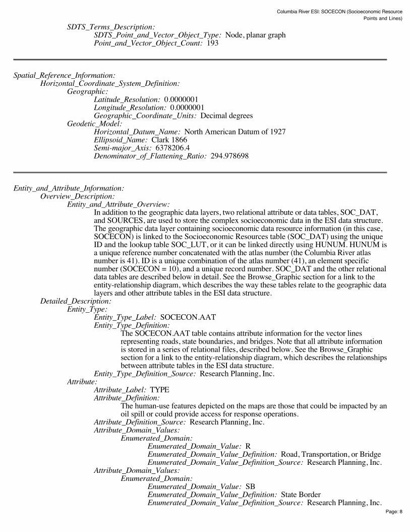
Columbia River ESI: SOCECON (Socioeconomic Resource Points and Lines)
Page: 8
SDTS_Terms_Description: SDTS_Point_and_Vector_Object_Type: Node, planar graph Point_and_Vector_Object_Count: 193
Spatial_Reference_Information: Horizontal_Coordinate_System_Definition:
Geographic: Latitude_Resolution: 0.0000001 Longitude_Resolution: 0.0000001 Geographic_Coordinate_Units: Decimal degrees
Geodetic_Model: Horizontal_Datum_Name: North American Datum of 1927 Ellipsoid_Name: Clark 1866 Semi-major_Axis: 6378206.4 Denominator_of_Flattening_Ratio: 294.978698
Entity_and_Attribute_Information: Overview_Description:
Entity_and_Attribute_Overview: In addition to the geographic data layers, two relational attribute or data tables, SOC_DAT,and SOURCES, are used to store the complex socioeconomic data in the ESI data structure.The geographic data layer containing socioeconomic data resource information (in this case,SOCECON) is linked to the Socioeconomic Resources table (SOC_DAT) using the uniqueID and the lookup table SOC_LUT, or it can be linked directly using HUNUM. HUNUM isa unique reference number concatenated with the atlas number (the Columbia River atlasnumber is 41). ID is a unique combination of the atlas number (41), an element specificnumber (SOCECON = 10), and a unique record number. SOC_DAT and the other relationaldata tables are described below in detail. See the Browse_Graphic section for a link to theentity-relationship diagram, which describes the way these tables relate to the geographic datalayers and other attribute tables in the ESI data structure.
Detailed_Description: Entity_Type:
Entity_Type_Label: SOCECON.AAT Entity_Type_Definition:
The SOCECON.AAT table contains attribute information for the vector linesrepresenting roads, state boundaries, and bridges. Note that all attribute informationis stored in a series of relational files, described below. See the Browse_Graphicsection for a link to the entity-relationship diagram, which describes the relationshipsbetween attribute tables in the ESI data structure.
Entity_Type_Definition_Source: Research Planning, Inc. Attribute:
Attribute_Label: TYPE Attribute_Definition:
The human-use features depicted on the maps are those that could be impacted by anoil spill or could provide access for response operations.
Attribute_Definition_Source: Research Planning, Inc. Attribute_Domain_Values:
Enumerated_Domain: Enumerated_Domain_Value: R Enumerated_Domain_Value_Definition: Road, Transportation, or Bridge Enumerated_Domain_Value_Definition_Source: Research Planning, Inc.
Attribute_Domain_Values: Enumerated_Domain:
Enumerated_Domain_Value: SB Enumerated_Domain_Value_Definition: State Border Enumerated_Domain_Value_Definition_Source: Research Planning, Inc.
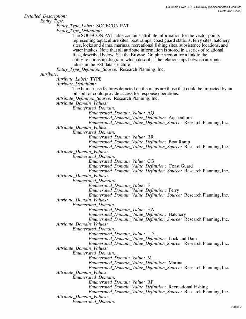
Columbia River ESI: SOCECON (Socioeconomic Resource Points and Lines)
Page: 9
Detailed_Description: Entity_Type:
Entity_Type_Label: SOCECON.PAT Entity_Type_Definition:
The SOCECON.PAT table contains attribute information for the vector pointsrepresenting aquaculture sites, boat ramps, coast guard stations, ferry sites, hatcherysites, locks and dams, marinas, recreational fishing sites, subsistence locations, andwater intakes. Note that all attribute information is stored in a series of relationalfiles, described below. See the Browse_Graphic section for a link to theentity-relationship diagram, which describes the relationships between attributetables in the ESI data structure.
Entity_Type_Definition_Source: Research Planning, Inc. Attribute:
Attribute_Label: TYPE Attribute_Definition:
The human-use features depicted on the maps are those that could be impacted by anoil spill or could provide access for response operations.
Attribute_Definition_Source: Research Planning, Inc. Attribute_Domain_Values:
Enumerated_Domain: Enumerated_Domain_Value: AQ Enumerated_Domain_Value_Definition: Aquaculture Enumerated_Domain_Value_Definition_Source: Research Planning, Inc.
Attribute_Domain_Values: Enumerated_Domain:
Enumerated_Domain_Value: BR Enumerated_Domain_Value_Definition: Boat Ramp Enumerated_Domain_Value_Definition_Source: Research Planning, Inc.
Attribute_Domain_Values: Enumerated_Domain:
Enumerated_Domain_Value: CG Enumerated_Domain_Value_Definition: Coast Guard Enumerated_Domain_Value_Definition_Source: Research Planning, Inc.
Attribute_Domain_Values: Enumerated_Domain:
Enumerated_Domain_Value: F Enumerated_Domain_Value_Definition: Ferry Enumerated_Domain_Value_Definition_Source: Research Planning, Inc.
Attribute_Domain_Values: Enumerated_Domain:
Enumerated_Domain_Value: HA Enumerated_Domain_Value_Definition: Hatchery Enumerated_Domain_Value_Definition_Source: Research Planning, Inc.
Attribute_Domain_Values: Enumerated_Domain:
Enumerated_Domain_Value: LD Enumerated_Domain_Value_Definition: Lock and Dam Enumerated_Domain_Value_Definition_Source: Research Planning, Inc.
Attribute_Domain_Values: Enumerated_Domain:
Enumerated_Domain_Value: M Enumerated_Domain_Value_Definition: Marina Enumerated_Domain_Value_Definition_Source: Research Planning, Inc.
Attribute_Domain_Values: Enumerated_Domain:
Enumerated_Domain_Value: RF Enumerated_Domain_Value_Definition: Recreational Fishing Enumerated_Domain_Value_Definition_Source: Research Planning, Inc.
Attribute_Domain_Values: Enumerated_Domain:
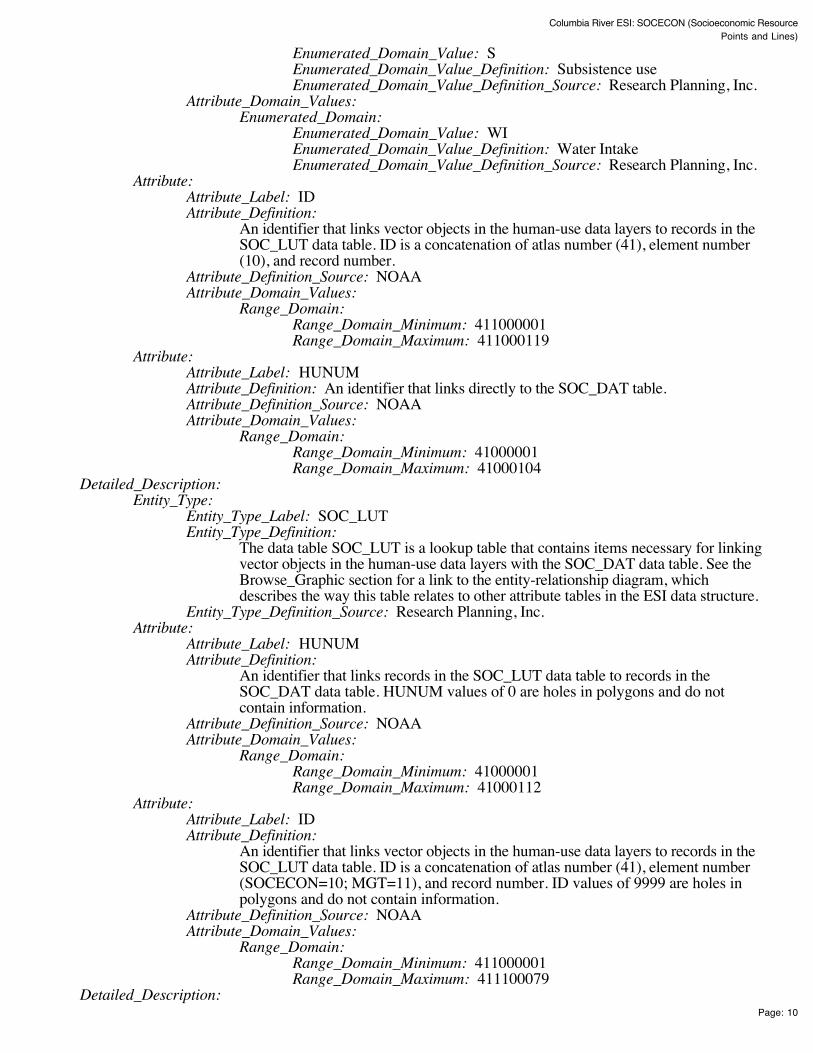
Columbia River ESI: SOCECON (Socioeconomic Resource Points and Lines)
Page: 10
Enumerated_Domain_Value: S Enumerated_Domain_Value_Definition: Subsistence use Enumerated_Domain_Value_Definition_Source: Research Planning, Inc.
Attribute_Domain_Values: Enumerated_Domain:
Enumerated_Domain_Value: WI Enumerated_Domain_Value_Definition: Water Intake Enumerated_Domain_Value_Definition_Source: Research Planning, Inc.
Attribute: Attribute_Label: ID Attribute_Definition:
An identifier that links vector objects in the human-use data layers to records in theSOC_LUT data table. ID is a concatenation of atlas number (41), element number(10), and record number.
Attribute_Definition_Source: NOAA Attribute_Domain_Values:
Range_Domain: Range_Domain_Minimum: 411000001 Range_Domain_Maximum: 411000119
Attribute: Attribute_Label: HUNUM Attribute_Definition: An identifier that links directly to the SOC_DAT table. Attribute_Definition_Source: NOAA Attribute_Domain_Values:
Range_Domain: Range_Domain_Minimum: 41000001 Range_Domain_Maximum: 41000104
Detailed_Description: Entity_Type:
Entity_Type_Label: SOC_LUT Entity_Type_Definition:
The data table SOC_LUT is a lookup table that contains items necessary for linkingvector objects in the human-use data layers with the SOC_DAT data table. See theBrowse_Graphic section for a link to the entity-relationship diagram, whichdescribes the way this table relates to other attribute tables in the ESI data structure.
Entity_Type_Definition_Source: Research Planning, Inc. Attribute:
Attribute_Label: HUNUM Attribute_Definition:
An identifier that links records in the SOC_LUT data table to records in theSOC_DAT data table. HUNUM values of 0 are holes in polygons and do notcontain information.
Attribute_Definition_Source: NOAA Attribute_Domain_Values:
Range_Domain: Range_Domain_Minimum: 41000001 Range_Domain_Maximum: 41000112
Attribute: Attribute_Label: ID Attribute_Definition:
An identifier that links vector objects in the human-use data layers to records in theSOC_LUT data table. ID is a concatenation of atlas number (41), element number(SOCECON=10; MGT=11), and record number. ID values of 9999 are holes inpolygons and do not contain information.
Attribute_Definition_Source: NOAA Attribute_Domain_Values:
Range_Domain: Range_Domain_Minimum: 411000001 Range_Domain_Maximum: 411100079
Detailed_Description:

Columbia River ESI: SOCECON (Socioeconomic Resource Points and Lines)
Page: 11
Entity_Type: Entity_Type_Label: SOC_DAT Entity_Type_Definition:
The data table SOC_DAT contains both human-use attribute data and itemsnecessary for linking the human-use spatial data layers to the SOURCES data table.See the Browse_Graphic section for a link to the entity-relationship diagram, whichdescribes the way this table relates to other attribute tables in the ESI data structure.
Entity_Type_Definition_Source: Research Planning, Inc. Attribute:
Attribute_Label: HUNUM Attribute_Definition:
An identifier that links records in the SOC_DAT data table to records in theSOC_LUT data table.
Attribute_Definition_Source: NOAA Attribute_Domain_Values:
Range_Domain: Range_Domain_Minimum: 41000001 Range_Domain_Maximum: 41000112
Attribute: Attribute_Label: TYPE Attribute_Definition: Identifies the feature type Attribute_Definition_Source: Research Planning, Inc. Attribute_Domain_Values:
Enumerated_Domain: Enumerated_Domain_Value: AQUACULTURE Enumerated_Domain_Value_Definition: Aquaculture Enumerated_Domain_Value_Definition_Source: Research Planning, Inc.
Attribute_Domain_Values: Enumerated_Domain:
Enumerated_Domain_Value: BOAT RAMP Enumerated_Domain_Value_Definition: Boat Ramp Enumerated_Domain_Value_Definition_Source: Research Planning, Inc.
Attribute_Domain_Values: Enumerated_Domain:
Enumerated_Domain_Value: COAST GUARD Enumerated_Domain_Value_Definition: Coast Guard Enumerated_Domain_Value_Definition_Source: Research Planning, Inc.
Attribute_Domain_Values: Enumerated_Domain:
Enumerated_Domain_Value: FERRY Enumerated_Domain_Value_Definition: Ferry Enumerated_Domain_Value_Definition_Source: Research Planning, Inc.
Attribute_Domain_Values: Enumerated_Domain:
Enumerated_Domain_Value: HATCHERY Enumerated_Domain_Value_Definition: Hatchery Enumerated_Domain_Value_Definition_Source: Research Planning, Inc.
Attribute_Domain_Values: Enumerated_Domain:
Enumerated_Domain_Value: LOCK AND DAM Enumerated_Domain_Value_Definition: Lock and Dam Enumerated_Domain_Value_Definition_Source: Research Planning, Inc.
Attribute_Domain_Values: Enumerated_Domain:
Enumerated_Domain_Value: MARINA Enumerated_Domain_Value_Definition: Marina Enumerated_Domain_Value_Definition_Source: Research Planning, Inc.
Attribute_Domain_Values: Enumerated_Domain:
Enumerated_Domain_Value: NATIONAL FOREST

Columbia River ESI: SOCECON (Socioeconomic Resource Points and Lines)
Page: 12
Enumerated_Domain_Value_Definition: National Forest Enumerated_Domain_Value_Definition_Source: Research Planning, Inc.
Attribute_Domain_Values: Enumerated_Domain:
Enumerated_Domain_Value: PARK Enumerated_Domain_Value_Definition: Regional or State Park Enumerated_Domain_Value_Definition_Source: Research Planning, Inc.
Attribute_Domain_Values: Enumerated_Domain:
Enumerated_Domain_Value: RECREATIONAL FISHING Enumerated_Domain_Value_Definition: Recreational Fishing Enumerated_Domain_Value_Definition_Source: Research Planning, Inc.
Attribute_Domain_Values: Enumerated_Domain:
Enumerated_Domain_Value: SUBSISTENCE Enumerated_Domain_Value_Definition: Subsistence use Enumerated_Domain_Value_Definition_Source: Research Planning, Inc.
Attribute_Domain_Values: Enumerated_Domain:
Enumerated_Domain_Value: WATER INTAKE Enumerated_Domain_Value_Definition: Water Intake Enumerated_Domain_Value_Definition_Source: Research Planning, Inc.
Attribute_Domain_Values: Enumerated_Domain:
Enumerated_Domain_Value: WILDLIFE REFUGE Enumerated_Domain_Value_Definition: Wildlife Refuge Enumerated_Domain_Value_Definition_Source: Research Planning, Inc.
Attribute: Attribute_Label: NAME Attribute_Definition: The feature name Attribute_Definition_Source: Research Planning, Inc. Attribute_Domain_Values:
Unrepresentable_Domain: Acceptable values change from atlas to atlas Attribute:
Attribute_Label: CONTACT Attribute_Definition: Contact person or entity Attribute_Definition_Source: Research Planning, Inc. Attribute_Domain_Values:
Unrepresentable_Domain: Acceptable values change from atlas to atlas Attribute:
Attribute_Label: PHONE Attribute_Definition: Contact telephone number Attribute_Definition_Source: Research Planning, Inc. Attribute_Domain_Values:
Unrepresentable_Domain: Acceptable values change from atlas to atlas Attribute:
Attribute_Label: G_SOURCE Attribute_Definition:
Geographic source identifier that links records in the SOC_DAT data table torecords in the SOURCES data table.
Attribute_Definition_Source: Research Planning, Inc. Attribute_Domain_Values:
Range_Domain: Range_Domain_Minimum: 1 Range_Domain_Maximum: N
Attribute: Attribute_Label: A_SOURCE Attribute_Definition:
Attribute source identifier that links records in the SOC_DAT data table to recordsin the SOURCES data table.

Columbia River ESI: SOCECON (Socioeconomic Resource Points and Lines)
Page: 13
Attribute_Definition_Source: Research Planning, Inc. Attribute_Domain_Values:
Range_Domain: Range_Domain_Minimum: 1 Range_Domain_Maximum: N
Detailed_Description: Entity_Type:
Entity_Type_Label: SOURCES Entity_Type_Definition:
The data table SOURCES contains the primary sources used to create the ESI dataset. See the Browse_Graphic section for a link to the entity-relationship diagram,which describes the way this table relates to other attribute tables in the ESI datastructure.
Entity_Type_Definition_Source: Research Planning, Inc. Attribute:
Attribute_Label: SOURCE_ID Attribute_Definition:
Source identifier that links records in the SOURCES data table to the itemsG_SOURCE and A_SOURCE in the SOC_DAT table, and to G_SOURCE andS_SOURCE in the BIORES table.
Attribute_Definition_Source: Research Planning, Inc. Attribute_Domain_Values:
Range_Domain: Range_Domain_Minimum: 1 Range_Domain_Maximum: N
Attribute: Attribute_Label: ORIGINATOR Attribute_Definition: Author or developer of source material or data set Attribute_Definition_Source: Research Planning, Inc. Attribute_Domain_Values:
Unrepresentable_Domain: Acceptable values change from atlas to atlas Attribute:
Attribute_Label: DATE_PUB Attribute_Definition:
Date of source material, publication, or date of personal communication with expertsource
Attribute_Definition_Source: Research Planning, Inc. Attribute_Domain_Values:
Enumerated_Domain: Enumerated_Domain_Value: YYYYMM Enumerated_Domain_Value_Definition: YYYY for year and optionallyMM for month Enumerated_Domain_Value_Definition_Source: Research Planning, Inc.
Attribute: Attribute_Label: TITLE Attribute_Definition: Title of source material or data Attribute_Definition_Source: Research Planning, Inc. Attribute_Domain_Values:
Unrepresentable_Domain: Acceptable values change from atlas to atlas Attribute:
Attribute_Label: DATA_FORMAT Attribute_Definition: The format of the source material Attribute_Definition_Source: Research Planning, Inc. Attribute_Domain_Values:
Unrepresentable_Domain: Acceptable values change from atlas to atlas Attribute:
Attribute_Label: PUBLICATION Attribute_Definition: Additional citation information Attribute_Definition_Source: Research Planning, Inc. Attribute_Domain_Values:

Columbia River ESI: SOCECON (Socioeconomic Resource Points and Lines)
Page: 14
Unrepresentable_Domain: Acceptable values change from atlas to atlas Attribute:
Attribute_Label: SCALE Attribute_Definition: Scale denominator of the source Attribute_Definition_Source: Research Planning, Inc. Attribute_Domain_Values:
Enumerated_Domain: Enumerated_Domain_Value: integer Enumerated_Domain_Value_Definition: Any integer Enumerated_Domain_Value_Definition_Source: Research Planning, Inc.
Attribute: Attribute_Label: TIME_PERIOD Attribute_Definition:
Date(s) of data collection that the source material is based upon. Attribute_Definition_Source: Research Planning, Inc. Attribute_Domain_Values:
Enumerated_Domain: Enumerated_Domain_Value: MM/DD/YY Enumerated_Domain_Value_Definition: Month/Day/Year Enumerated_Domain_Value_Definition_Source: Research Planning, Inc.
Attribute_Domain_Values: Enumerated_Domain:
Enumerated_Domain_Value: MM/YYYY Enumerated_Domain_Value_Definition: Month/Year Enumerated_Domain_Value_Definition_Source: Research Planning, Inc.
Attribute_Domain_Values: Enumerated_Domain:
Enumerated_Domain_Value: UNKNOWN Enumerated_Domain_Value_Definition: Date information unknown Enumerated_Domain_Value_Definition_Source: Research Planning, Inc.
Distribution_Information: Distributor:
Contact_Information: Contact_Person_Primary:
Contact_Person: John Kaperick Contact_Organization: NOAA, Office of Response and Restoration
Contact_Address: Address_Type: Physical Address Address: 7600 Sand Point Way N.E. City: Seattle State_or_Province: Washington Postal_Code: 98115-6349
Contact_Voice_Telephone: (206) 526-6400 Contact_Facsimile_Telephone: (206) 526-6329
Resource_Description: ESI Atlas for Columbia River Distribution_Liability:
Although these data have been processed successfully on a computer system at the National Oceanicand Atmospheric Administration, no warranty, expressed or implied, is made by NOAA regarding theutility of the data on any other system, nor shall the act of distribution constitute any such warranty.NOAA warrants the delivery of this product in computer-readable format, and will offer a replacementcopy of the product when the product is determined unreadable by computer-input peripherals, orwhen the physical medium is delivered in damaged condition.
Custom_Order_Process: Contact NOAA for distribution options (see Distributor). ESI data are processed into multipleformats to make them useful to a wider community of GIS/mapping users. Distribution formatsinclude ARC export, MOSS and Shape files, and MARPLOT map folders. An ArcView ESI projectand ESI_Viewer product are also included on the distribution CDs for ease of use of the ESI data.

Columbia River ESI: SOCECON (Socioeconomic Resource Points and Lines)
Page: 15
The database files are distributed both in the NOAA standard relational database format (see NOAATechnical Memorandum NOS ORCA 115) and in a simplified desktop flat file format. This metadatadocument includes information on both of these database formats.
Metadata_Reference_Information: Metadata_Date: 200411 Metadata_Review_Date: 200411 Metadata_Contact:
Contact_Information: Contact_Person_Primary:
Contact_Person: Jill Petersen Contact_Organization: NOAA, Office of Response and Restoration
Contact_Position: GIS Manager Contact_Address:
Address_Type: Physical Address Address: 7600 Sand Point Way, N.E. City: Seattle State_or_Province: Washington Postal_Code: 98115-6349
Contact_Voice_Telephone: (206) 526-6944 Contact_Facsimile_Telephone: (206) 526-6329 Contact_Electronic_Mail_Address: [email protected]
Metadata_Standard_Name: Content Standards for Digital Geospatial Metadata Metadata_Standard_Version: FGDC-STD-001-1998
Generated by mp version 2.8.2 on Fri Dec 10 13:04:22 2004

BIO_LUTRARNUM (9, 9, I)ID (10, 10, I)
ESI (LINES)ESI (10, 10, C)LINE (1, 1, C)SOURCE_ID (6, 6, I)ENVIR (1, 1, C)
ESI (POLYS)ESI (10, 10, C)WATER_CODE (1, 1, C)ENVIR (1, 1, C)
HYDRO (LINES)LINE (1, 1, C)SOURCE_ID (6, 6, I)
HYDRO (POLYS)WATER_CODE (1, 1, C)
INDEX (POLYS)TILE-NAME (32, 32, C)TOPO-NAME (255, 255, C)SCALE (7, 7, I)MAPANGLE (4, 8, F, 3)PAGESIZE (11, 11, C)
NWI (POLYS)ESI (10, 10, C)
MGT (POLYS)TYPE (2, 2, C)ID (10, 10, I)HUNUM (9, 9, I)
SOCECON (LINES)TYPE (2, 2, C)
SOCECON (POINTS)TYPE (2, 2, C)ID (10,10,I)HUNUM (9, 9, I)
BIRDS (POLYS)ID (10, 10, I)RARNUM (9, 9, I)
FISH (POLYS)ID (10, 10, I)RARNUM (9, 9, I)
FISHL (LINES)ID (10, 10, I)RARNUM (9, 9, I)
HABITATS (POLYS)ID (10, 10, I)RARNUM (9, 9, I)
INVERT (POLYS)ID (10, 10, I)RARNUM (9, 9, I)
M_MAMMAL (POLYS)ID (10, 10, I)RARNUM (9, 9, I)
M_MAMPT (POINTS)ID (10, 10, I)RARNUM (9, 9, I)
NESTS (POINTS)ID (10, 10, I)RARNUM (9, 9, I)
REPTILES (POLYS)ID (10, 10, I)RARNUM (9, 9, I)
T_MAMMAL (POLYS)ID (10, 10, I)RARNUM (9, 9, I)
SOC_DATHUNUM (9, 9, I)TYPE (20, 20, C)NAME (40, 40, C)CONTACT (80, 80, C)PHONE (20, 20, C)G_SOURCE (6, 6, I)A_SOURCE (6, 6, I)
BIORESRARNUM (9, 9, I)SPECIES_ID (5, 5, I)CONC (20, 20, C)SEASON_ID (2, 2, I)G_SOURCE (6, 6, I)S_SOURCE (6, 6, I)ELEMENT (10, 10, C)EL_SPE (6, 6, C)EL_SPE_SEA (8, 8, C)
SOURCESSOURCE_ID (6, 6, I)ORIGINATOR (35, 35, C)DATE_PUB (10, 10, I)TITLE (80, 80, C)DATA_FORMAT (80, 80, C)PUBLICATION (120, 120, C)SCALE (20, 20, C)TIME_PERIOD (22, 22, C)
SPECIESSPECIES_ID (5, 5, I)NAME (35, 35, C)GEN_SPEC (45, 45, C)ELEMENT (10, 10, C)SUBELEMENT (10, 10, C)NHP (10, 10, C)DATE_PUB (10, 10, I)EL_SPE (6, 6, C)
SEASONALELEMENT (10, 10, C)SPECIES_ID (5, 5, I)SEASON_ID (2, 2, I)JAN (1, 1, C)FEB (1, 1, C)MAR (1, 1, C)APR (1, 1, C)MAY (1, 1, C)JUN (1, 1, C)JUL (1, 1, C)AUG (1, 1, C)SEP (1, 1, C)OCT (1, 1, C)NOV (1, 1, C)DEC (1, 1, C)EL_SPE_SEA (8, 8, C)
STATUSELEMENT (10, 10, C)SPECIES_ID (5, 5, I)STATE (2, 2, C)S (1, 1, C)F (1, 1, C)STATE (2, 2, C)S_DATE (10, 10, I)F_DATE (10, 10, I)EL_SPE (6, 6, C)
BREEDEL_SPE_SEA (8, 8, C)MONTH (2, 2, I)BREED1 (1, 1, C)BREED2 (1, 1, C)BREED3 (1, 1, C)BREED4 (1, 1, C)BREED5 (1, 1, C)
(The BIO_LUT tablecan be bypassed bylinking the biologytables to BIORESusing RARNUM.)
SOC_LUTHUNUM (9, 9, I)ID (10, 10, I)
(The SOC_LUT tablecan be bypassed bylinking the human-usetables to SOC_DATusing HUNUM.)
Data TablesGeographicThemes
Lookup Tables
Columbia River ESI Entity Relationship DiagramRelationships between spatial data layers and attribute data tables
RUNS_DATEL_SPE (6, 6, C)SPECIES (40, 40, C)RUN (40, 40, C)OR (5, 5, C)WA (5, 5, C)FEDERAL (5, 5, C)ESA_YEAR (4, 4, N)