Embed Size (px)
Citation preview

~CMULGEE NATIONAL MONUMENT•
AN ADMINISTRATIVE HISTORY
by Alan Marsh
ettt'LtS •A.Tl••..tL llf$~lftflb:T C> 0 0
D-Jb
Ocmulgee National Monument Macon Georgia
1986
National Pan ~rvice
United Stal~• Dtpartmmt of tlM lntuior

AT1-,ENTION:
Portions of this scanned document are illegible due to the poor quality of the source document.

•.
•
( .•
•

CONTENTS
F'rc~f 2,ce .•...•....•
More Thar) Mounds ................................... .
New Mor1ument And New Deal ........................•..
Acco1nodations For Interpretation ••.•..••.••...•.••••
Admir1istration: The Beginning .•.••.••..••...•.•.•.•
Interstates, Indians, And Improvements •...•..••.•.•.
c:o1ilp r eh ens ion'
i'lotes Bibliography Appendices
Concern, Cooperation.
page
i
4
18
25
39
46
61

--· L
ILLUSTRr~TIONS
1. E~·~cav1:tti(Jns dLlring the 19~5r)'s
Earthlodge exterior
Earthlodge interior
4. Visitor center and solar panels
5. Wi:\yside el<hibit, 194·<)
6. Burial shelter
7. Lamar mounds, 1930's
MAPS
1. Regional location of Ocmulgee National Monument
2. Ocmulgee National Monument
(

PREFACE
The desire of the National Park Service to produce
administrative histories led Southeast Regional Historian
Lenard Brown to the campus of the University of Georgia late
in 1983. Lester Stephens, Chairman of the history department,
informed me of the quest by the Regional Historian for
prospective authors and a meeting was subsequently arranged
between myself anct Mr-. Brawn. A recent graduate of the
University, I had written a paper concerning Ocmulgee National
Monument and was eager to conduct additional research. A
proposal to write an administrative history of Ocmulgee
National Monument was accepted by Mr. Brown, who then contacted
Superintendent Sibbald Smith at the monument. 8Ltper i ntendent
Smith reacted favorably to the proposal and arrangements were
made to employ me as a VIP !Volunteer In Parks) the following
SL\mmer. Research for the project began at Ocmulgee on April
2' 1984.
The summer of 1984 was devoted strictly to research and
included trips to the National Archives in Washington D.C., and
the Southeast Archeological Center in Tallahassee, Florida. The
material collected during research efforts was put on hold as the
summer ended, and I began work at Georgia College in the masters of
Employment as a seasonal ranger at Ocmulgee was
C:)bt.ai neci for the sL1mrner of 1985 and wat-k resLuned on thE?
adminis;trative history. The process of sifting through abundant
c:_• information for ti1e most relevant and beneficial facts proved to be
tedialJs, but work advanced. In August the project was completed,
1

t11ar1l<s lo ttie assistance of 1nany individuals.
As with many works, it would be impossible to thank everyone
wl10 contributed time, information, criticism, and encouragement
over the past y~ar. Certainly Lenard Brown is to be thanked for
kindling my interest in the project. Chief Historian Edwin C.
Bear·ss and Historian Barry Mackintosh provided much assistance
durir1g my Washington visit and were a great source of
encouragement dur·ing the initial stages of the project. The
staff of the Smithsonian Institution (Anthropological Department
and Processing Lab) was also friendly and willing to ~ssist.
The staff at the Southeast Archeological Center was extremely
cooperative in pro~iding information from files and personal
intervieWSa I extend my gratitude to Richard Faust, Chief o~ SEAC,
for allowing me freedom to operate, and to staff archeologists
George Fischer and John Walker for providing information. The
excitement expressed by Judy Hellmich in relation to Ocmulgee,
and her willingness to direct my research efforts, also made my
job a lot easier.
Interviews with several former superintendents and employees
of Ocmulgee furnished me with new insight into the operation and
&dministration of the monument during various stages of its
development.
T!-ie present staff at Ocmulgee National Monument has been more
than helpful and encouraging duri11g the past two summers.
·superihter1dent Sibbald Smith has shared his experiences and
goals, but has allowec1 me to write without interference as to
content perception. Sylvia Flowers has been more than loyal
to the pr·o.ject over the past two summers arid spent time
2

(. '-.., .
during and after work; reading n1anuscripts, offering sL1ggestions,
and pr-oviding r E'~SOLH'"" C E:-?S. Chief Ranger Phil Noblitt ar·ri ved
the SLtmmer of 1985 and quickly assL1med the
of over-seeing the project; providing direction,
constru~tive criticism, and just enough pressure
t C.) kG?ep the wor-k proceeding smoothly. My thanks also to Leni
Covey for typing most of the manuscript and making revisions.
Special thanks and appre~iation must be given to my wife
Regina Marsh, who exhibited a great deal of patience while I
spent days away and nights awake war-king on the paper.
···'
Alan Marsh August 1 , 1985
.•

CHAPTER I
MORE THAN MOUNDS
Ocmulgee National Monument, established by proclamation of
President Franklin D. Roosevelt in 1936, is located on the east
bank of the Ocmulgee River in Macon, Georgia !Map 11. l~ithin its
683.48 acres ar·e prehistoric trenches, nine earthen Indian mounds,
a reconstructed earthlodge, a late 17th - early 18th century
' trading post site, and a Civil War earthwork.I A detached 45 acre
section of the monument, known as the Lamar site, is located
three miles downriver and contains two of these mounds <Map 2).
p ~.' .. '···) ;:·. ~~
\.__/
The features of ~he monument also include a 19th century residence
and a visitor center.
The monument's main section is part of a geographical fall
line, a transitional zone between the piedmont region and the
lower coastal plain. At one time this area was part of ancient
Indian fields which extended along the river and came to be known
as the Ocmulgee Old Fields.
Indian arrival to the Macon Plateau area came approximately
12,000 years ago after a southeastward migration across North
These r1omadic hunters, or Paleo-Indians, were succeeded
by hunters and gatherers of the Archaic period 19000-1000 B.C.),
incipient agriculturalists of the Woodland period 11000 B.C.- A.D.
900), and established farmers of the Early Mississippian period
4

• •,
I
•
•
; . .
OCMULGEE NA TtONAL ..:>.· MONUMENT
'"'"''"°"••Ill n II.a•
GULF o~
HAP 1
• SAVANNAH ;tt p.,~P.· n.m.
h. fr~tr1c1 fl m
THE REGION OCMULGEE NATIONAL MONUMENT
GEORGIA UNITED QTATEG DlPAATMlNT OF THE lt.lTlRIOR
C;JATIONAl PAii IU¥1(1
•
Pu.hi. as ,., j 19 095 &>JC .a.VO .
31,3 I .:J.c>~O~ Ii

• • • '
---·---·
. I I
' ' ...... ·-..... I I
.·· ....
c~ /"'~'•, .·· ..... , , ... , .·· , .. _ .. __ ......... : .... · - ,."""' - -· ... - .. , -~-_,
' I ..... , .... m • ,~;;;.:.;;.;;--~
,~ ... .... ' ........
' '
MAP 2
.. _.... ....... --.............. ,... .. ,...~----_ ............. ..,.
....._...,Ill ..... _.......,. ...... •._~•-•-•o~------~~-' ""'-~.-·~v-;;:..~~~~~~~~'
m ...... _
CX:mJ.lgee National M:lnurrent
/
/

(A.D. 900-1100). Prior to the end of the latter period, Macon
Plateau people also occupied the Lamar site downriver. By about
A.D. 1350 these people had developed a new culture, also known as
Lamar, that blended Mississippian and Woodland .elements. In 1540
Hernando De Soto encountered people of the Lamar culture, possibly
at tlie Lamar site~ and estatJlished the first EurcJpear1 contact in
the area. The Lamar people declined probably due to disease and
cultural disruption caused by European contact and by 1650 remnants
of the culture had relocated along the Chattahoochee River.
These Indians, known to the English as Lower Creeks, returned to
central Georgia about 1690. They settled at the Lamar site and
near an English trading post on the· Macon Plateau. In 1715 these
villages joined t~e unsuccessful Indian uprising known as the
Yamassee War-. A~ its conclusion they again returned to the
Chattahoochee but continued to frequent the Macon Plateau area
until the early 1800's.
The most noticeable archeological features of the Macon Plateau -
are the earthen mounds constructed by the Early Mississippians.
The mounds, along with earthlodges and fortification trenches, were
built prior to the waning of the culture •round A.D. 1100.
Although the fate of these Indians is unknown, their mounds
continued to attract attention. In 1739 one of General James
Oglethorpe's rangers made the first written account of the mounds.
Subsequent accounts were wr·itten by James Adair Cpublished 1775)
the botanist William Bartram (1775), and Charles C. Jones, Jr.
(1873).2 According to Adair, Indians claimed they could hear
mysterious singing and dancing while camped near the Macon Plateau.3
Ttie area continued to exert an influence over the Indians after

the time of Adair. In 1805 tlie Creeks ceded most of the land on
the east side of the Ocmulgee River to the United States
government. Excluded from tt1e cession were 15 square ·miles
containing the Indian mounds of the Ocmulgee Old Fields. The Creek
Indians ceded more lanci in 1821 but it was not until 1826 that the
15 square miles of Ocmulgee Fields were officially ceded to the
United States. The land was auctioned off to settlers by 1828 and
the Macon Plateau became home for yet another culture.
The Plateau underwent extensive transformation during the 19th
century. Railroad cuts destroyed a portion of the Lesser Temple
Mound in 1843 and much of the Funeral Mound during the early 1870s.
In 1856 the Dunlap House, a plantation cottage, was constructed on
the Macon Plateau. Confederate troops <Macon Home Guard)
constructed a Li-shaped earth~ork south of the house during the
early 1860s to protect a trestle over Walnut Creek. In 1864
Federal troops approached Macon but halted at the Dunlap House
where they established headquarters.
Near the turn of the century additional changes occurred on the
Macon Plateau. The McDougal Mound suffered damage when it was used
for fill dirt during the construction of east Macon. By the early
1920s the plateau had served as home for a fertilizer factory,
brici~yard, open-pit clay mine, railroad roundhouse, and dairy
farm.4 During the 1920's the mounds were also used for hill
climbir1g by motorcycle enthusiasts.5
Efforts to preserve the Indian mounds of the Macon Plateau
6

were first begun during the 1920's by General Walter A. Harris, a
prominent Macon attorney (Appendix Bl. Harris wrote the Bureau of
American Ethnology on February 3, 1922, and expressed an interest
in acquiring and preserving the Indian remnants of the Ocmulgee
Fields.6 The letter was acknowledged by fhe .Smithsonian
Institution bL1t nothing more developed and the issue apparently. lay
do1-mant for seven years. In 1929 Harris attempted to attract the
intere~;t of the Smitt1scJnian Institution once again. In April of
that year the General wrote the Bureau of American Ethnology,
suggesting that tt1e city of Macbn provide funds for Smithsonian led
excavations.7 Bureau Chief M.W. Stirling arrived in Macon twenty
days later and visited the Indian mound~. Although Stirling
recommended the mounds be excavated, it was not until November of
1933 that Maconites Walter Harris, Dr. Charles C. Harrold, and
Linton Solomon persuaded the Macon Junior Chamber of Commerce to
support a movement to purchase and restore the mounds. The Society
for Georgia Archaeology <created a mont~ earlier)) Macon
Historical Society, and Junior Chamber of Commerce, then began the
process of land acquisition. The organizations also initiated
efforts to obtain New Deal relief labor. With the help of
Representative Carl Vinson of the Sixth District the goal was
reached i11 December, 1933. The Civil Works Administration ICWAI
granted funds for excavations at the Ocmulgee site and the
Smitl1sonian agreed to oversee the project~ Th<' Smithsonian
appointed anthropologist Arthur R. Kelly of Harvard University to
(;-·· 'l... ..
direct tJ-ie ex!:avatior1s ancf James A. Ford to assist.
F•t-eset-v~.tion of the 11 Indi.c:1.r1 1·10L1nds 11 \'Jas the prime concern of
local organizati11ns in obtaining New Deal labor·. The Civil Works
7

Administration, however, was more concerned with the employment of
the local population. The availability of a local labor supply
supported formation of a New Deal project near Macon, and the CWA,
once it began archeological excavations, served to promote the
goals of local preservationist. Tl1e CvJA, and other agencies '"hich
conciucted work at Ocmulgee~ uncovered evidence of 10,000 years of
Indian occupation while employing several hundred workers.
Fortunately, the availability of labor in Macon, and the interest
shown by the Smithsonian and local groups, sustained New Deal labor ~
at Ocmulgee throughout the 1930s and early 1940s. . .. .., .
The federal CWA project which began December 20 1 1933 1 was
switched to a state CWA project the f6llowing February.
0 .•. / I
Archeological responsibiliti~s were transferred to the Federal
Emergency Relief Administration !FERAi in April of 1934. These
early excavations received national attention and created
excitement throughout the local community which was never equalled
during later excavations. Some Maconites viewed the Ocmulgee
Fields as the ''lost colony'' of Roanoke, while others envisioned
Macon becoming a resort city with an annual Indian corn festival.8
Many citizens speculated about the past and future of the Indian
mounds but General Harris and other concerned individu~ls worked to
ensure their immediate protection. Prompted by these local
leaders, Representative Vinson contacted the National Park Service
about the pc~ssj.bility of establishing a national park or monument
at the Ocmulgee Fields. An answer to Vinson's letter came on
January 6, 1934~ only 17 days afte~ excavations began on the Macon
Plateau. Nafional Pdr~· Service Dir·ector Arno B. Cammerer replied
8
that ''the Office of National Parks, Buildings, and Reservations
lthe National Park Service) will be very glad to investigate these
mounds to determine their value."9 With Smithsonian e:<cavations
pr-oce(·::ding, few t1i~c:an citizens qLlestioned the value of 11 their 11
mounds and legislation to establish a unit of the National Park
System soor1 followed.
Repre;;·entati ve Carl Vinson introduced a bi 11 in the House of
Representatives on February 5, 1934, to establish Ocmulgee National
Park. The bill, H.R. 7653, requested that the Secretary of the
Interior secure 2,000 acres of land on behalf of the United States.
The bill was reported to the House Committee on Public Lands which,·
at the request of Secretary:6f the Interior Harold Ickes, made
rev1s1ons. Ickes recommended passage of the bill on condition that
land acquistion be secured by public or private do~ation instead of
government appropriation and that the title designation be changed
to Ocmulgee National Monument IAppendi>< Cl. The Interior Secretary
viewed Ocmulgee as having '1 national-monument character, being
similar to lands set apart in Western States for scientific
put-poses .... "10 The House Cammi t tee on Pub 1 i c Lands adopted the
recommendation of Ickes and submitted the revised legislation to
the House on May 15, 1934,in report 1657. The House passed the
measure without debate on May 21 7 1934u
The same legislation introduced by VinstJr1 in tt)e ~louse was
intr·odLlced FebrtAary 8, 1934, in the Senate as Su 2679 by Georgia
Senator Walter F. George. The t1ill was acted lJ~)on on May 22 when
the Senate read the meas,Jr-e twice anci referred it to the Senate
9
\-:!' ;,'!'.·.

Committee on Public Lands and Surveys. This committee incorporated
Ickes suggestions as the House had done and two days later sent the
revision to the Senate in report 1156. The Senate approved the
bill on June 6, and on June 14, 1934, approval was received from
President Roosevelt, authorizing the establishment of Ocmulgee
National Monument (Appendix DI. 'fhe actual establishment, however,
depended on the receipt of necessary land by the United States
government from public or private donations. The task of acquiring
the land fell upon the city of Macon and local organizations.
The Society for Georgia Archaeology, Macon Historical Society,
and Macon Junior Chamber of Commerce had tried since November 1933
to acquire land but limited financial resources hampered their
efforts. In early April 1934, Gen. Harris invited all Macon civic
organizations to send respresentatives to a Confe~ence to discuss
£uture developments and benefits of the Indian mounds. Twenty-five
civic organizations were represented at the coriference and each
group endorsed the "In di an Mounds" p1-oject and establishment of a
national park.10 The initial enthusiasm of the organizations was
short lived, however, because Vinson's bill was revised to prohibit
government appropriations for land acquisition. Harris echoed the
frustrations of many Maconites when he told a local audience that
Macon could maintain the Indian mounds and land if she were
responsible for buying them.12 The National Park Service, worried
that local attitudes in Macon would threate11 passage of Vinson's
revised bill, began efforts to "enlighten" the local populace.
~ .• ,
Through Representative Vinson, Park Service Director Arno B.
Cammerer expressed the advantages of establishing a Publ~c Works
10
\ I '
' I \
l

~ ;,.•~
·. ' ~--·
• ( . ' ~
facilities, a headquarters, and utility buildings. A PWA project,
according to the Director, would probably result in an immediate
expenditure of $75,000 with $10,000 in annual maintenance funds.13
Local leaders, although still upset over revisions in the
Vinson bill, maintained their desire to protect and preserve the
mour1ds. Another conference of civic organizations was held June 4,
1934, and representatives voted for a city-wide campaign to raise
$25 7 ()00, contingent on Senate passage of the bill. A committee of
one hundred civic representatives which was to direct the drive,
however, had not been formed when Presidential approval of the bill
was received on June 14th. The citizens of Macon, like the civic
organizations, seemed to have little interest in the development of
the Ocmulgee mounds. Dr. Harrold criticized the ''disappointing
response ... from Macon people'' and even a year later Dr. Kelly
stated that ''never before ••• have I seen so little general interest
or concern evidenced as·in Macon •.•• 11 14
June, July, and August of 1934 brought many visits to Macon by
National Park Service personnel. Verne E. Chatelain (Chief
Historian>, M.J. Winter (Assistant Hi~torianl, Herbert E. Kahler
(historical section), Oliver G. Taylor <Chief Engineer of Eastern
Division), and Kenneth Simmons (Landscape Architect) all made trips
to Macon to examine the area and give advice on methods of
acquiring the necessary land for monument establishment.15 The
Macon Historical So(:iety was primarily responsible for land
acquisition and by May, 1935, the society held ownership to nearly
500 acres. At that point funds of the Macon Historical Society,
Society for Georgia Archaeology, and Junior Chamber of Commerce
1 1

q)\ :··'··· l .
\, : ·.
were once again exhausted. Leaders turned to the people of Macon.
A fund drive was started May 15, 1935 1 by the Macon Junior Chamber
of Commerce, a civic committee headed by W.E. Dunwody, and the
Jaycees Indian Mounds Committee headed by Gus Jones. On June 4th
the organizations reached their goal of $8 1 500 for land
e:i.cqLlisiti(Jn 1::i.lthc.1L1~1h n1L1ch o·f tht:.=: money carne in tl1e for-m of pledges
and arrived three days after the original deadline.
Funds collected during the drive helped purchase additional
land but the transfer of property to the United States government
presented new problems. As a result, tension between the Park
Service and local community soon developed. The Park Service
becE<me frustrated w-ith the manner in which local leaders were '·
handling land-related ~atters and local leaders in turn felt
resentment toward Park Service attitud~s. In December 1934, Acting
Director A.E. Demaray informed Dr. Harrold that the transfer of
titles could not take place without maps defining monument
boundaries.16 The following month Demaray wrote Vinson that plans
were slowed down because the National Park Service had to locate
funds and personnel to obtain proper topographic maps; a task he
thought would be accomplished ''by persons interested in Macon.''17
Demaray may have been interested in the Indian mounds and not Macon
t)ut persons interested in both, such as Dr. Harrold, were quick to
express their resentment toward NPS officials. Dr. Harrold
complair1ed to Demaray ir1 December 1934, that the Director's men
(except Winter) were always in a big hurry to return to
Washington.18 NPS Acting Custodian for Ocmulgee, Herbert Kahler,
agreed with Dr. Harrold some months later that 11 th~ feeling appears
to be pr·esent that the Park Service is somewhat indifferent to
12
··"' . ·.·t-.
.. ;~.'
efforts made by this grOL<p [Macon Historical SocietyJ."19
The transfer process was also slowed down because of problems
with the deeds and titles of the acquired land. Nathan R.
Margold, Solicitor for the Department of Interior, was responsible
fen· c~:<t'.:1.mining dt"?eds a11d titles <::s.ent to Washington by the t"lacon law
firm of Harris, Russell, Popper, and Weaver. Margold's e:<amination
revealed tl1at, among ott1er itefns, records were incomplete because
of the breaks in the chain of title, defects in lot descriptions,
and three unreleased mortgages.20 Time was required to clear up I
various errors in deeds and titles. The Macon Historical Society,
in the interim, continued to work in an attempt to acquire property
which the federal government desired to be included within Dcmulgee
l\lat ion al Monument. The spe~ific tracts sought by the Park Service
belonged to the Macon, Dublin, and Savannah Railroad Company and
the Bibb Manufacturing Company, businesses which were either
unwilling or unable to relinquish their property. »:
One target of acquisition was an abandoned right-of-way
consisting of 8.38 acres of land owned by the Macon, Dublin, and
Savannah Railroad Company~ General Harris suggested obtaining a
quit claim deed to avoid condemnation proceedings but James F;
Wright, Solicitor for the Seaboard Air Line Railway Company,
informed the Solicitor of the Macon, Dublin, and Savannah Company
that condemnation proceedings would be the best solution.21 The
abandoned right-of-way was of no use tc the railroad company.
•~owever, mortgage release provisions in 1907 to the New York Trust
Company and \>Jillat-d V. l'::ing specified that the Macon, Dublin, and
Savannat1 Railroad Company could not make any release unless the
13

property was sold, contracted to be sold, or exchanged for other
property.22 To avoid a time consuming and possibly unsuccessful
campaign, Gen. Harris decided to forego efforts to obtain a quit
claim deed and to pursue condemnation proceedings instead. On
March 9, 1936 1 condemnation proceedings were filed in US. District
Court (Middle District of Georgia, Macon Division) by T. Hoyt
Davis, District Attorney.
The United States also filed condemnation papers against Bibb
Manufacturing Company, a Macon textile mill. Dff icials of the Bibb
Company had cooperated with the Macon Historical Society in 1933 by :
allowing excavations to be conducted on company land. In 1935 the
General Superintendent of the Bibb Company served as chairman of
the finance Committee of City Council and had helped acquire city
support for land purchases made by the Historical Society.
Cooperation with the Historical Society, however, did not mean that
the textile company had to cooperate with the National Park
Service .. The Bibb Company was willing to allow archeological
exploration but it was not willing to surrender its high ground at
the Funeral Mound. The textile company was less concerned with
other property sought by the government, ·but officials b~lieved
that the high ground was the only place for future mill expansion
and that the loss to stockholders could not be justified.23
Though interested local leaders tried desperately, they failed at
attempts to acquire the property peaceably. Not wishing to agitate
the prosperous and well established Bibb Company, a compromise was
formulated and presented by Dr. Harrold to NPS Acting Assistant
Director Verne Chatelain on April 23, 1935.
"The 1 i ne has to stop some·•~here, and I honest 1 y think
14
that if we can get all [land J lying to the South of the railroad and the small tract of the Bibb Manufacturing Company lying East of the creek run and North of the railroad that we should be able to travel. The fight to get more will be too bitter and too hard .•• Mound C is almost torn to pieces at any rate. We can completely tear it down, then rebuild it 200 feet South of its original site .... 24
Two days later Chatelain replied that 11 ! feel a compromise is not
the best solution of this problem; but rather than face a
stalemate, I shall suggest it •.•• I feel Ethe property] should be
included and you should try to bring it in: the compromise, in
other words, should be more properly regarded as a postponement of
that addition. 11 25
The Bibb Company, elated over their victory, proceeded the
following June to offer $250 to the Macon fund drive (for land
acquisition) in addition to:~ $475 subscription by its directors.
The company also pr-omised 38 acres of land if plans for- a national
monument matLwed. 26 The victory, hm~ever, · was only temporary for on
March 9, 1936, condemnation proceedings were filed against Bibb
Manufacturing Company by District Attorney T. Hoyt Davis on behalf
of the United States gover-nment.27
Bibb Manufacturing company fought condemnation proceedings by
filing a demurr-er on May 30, 1936. The textile company claimed ·
that the property in question was of imnien·se importance for future
expansion and that it was not necess~ry for inclusion in the
proposed Ocmulgee National Monument. 1he Bibb Company also
challenged the constitutional r-ight of the federal gover-nment to
cor1demn land and establish monuments, a right Bibb attorneys stated
as belonging to states under the Tenth Ainendment.28 The United
States District Court disagr-eed with the Bibb Company's ar-gument
15

" :.J ... . \ /
and overruled the demufrer on June 26. On July 8 appraisers
awarded the Bibb Company Sl,274 for 24.7 acres of land. The Bibb
Company, angry at the ruling, filed an appeal on July 11 and
requested a jury hearing. One week later company officials withdrew
their appeal. The final judgement was signed July 25, 1936, by
[)istrict Judge Bascorn S. Deaver. The judgement order-ed
compensation to the Bibb Company and also ordered payment of $35 to
the Macon, Dublin, and Savannah Railroad Company for 8.38 acres, an
amount awarded earlier by assessors and not contested by company
officials.29 Subsequently, the Bibb Company donated 33.5 acres
outright, possibly to show the Park Service that the company was ~
not really hurt by the loss and possibly to keep their pride
intact.3c)
The award payment to the two companies was to be paid by
tche Macon Historical Society but the money had been sent to
Washington D.C. prior to appeals by the Bibb Manufacturing Company.
Three months after the final judgement by Judge Deaver the payment
still remained in Washington and proceedings in Macon were at a
star1dsti 11. Local proponents of the Ocmulgee project became
impatient over the delay, failing to understand that the National
Park Service was a government bureaucracy which was responsible
for other areas besides Ocmulgee.
Macon citizens pushing for the establishment of a monument did,
however~ have support ir1 the ranks of the National Park Service.
Olinus Smith, NPS Engineer, agreed that establishment of a
monument was taking too long. Smith wrote the Deputy Chief Engineer
in Washington to explain 11 just what a condition the Ocmulge~
Nation~l ~1or1ument has reached through inattention and apparent lack
1/,

of interest [by the NF'SJ. "31 Condemnation payments were finally
made within the next two months and all deeds and titles were
vested in the gover-nmr,.nt. On December 23, 1936, President Franklin
D. Roosevelt established Ocmulgee National Monument by Presidential
procl.r::i.mc.'\ti.onR The newly established Monument consisted of 678.48
acres, far short of the 2,000 acres originally proposed by the
Vinson bill in 1934. The one-time dream of Macon business leaders
for a 30,000 acre park, game refuge, and fish hatchery was also
Ltnt·*eal i z: ed. 32
l~ith 678 acres acquired and deemed suitable for National
Monument purposes, President Roosevelt's proclamation stated that
"the Di rect6r- of the Nati on al Park Service, under the di rec ti on of
the Secretary of the Interior, shall have the supervision~
management,- and control of the monument.a .. 11 33 Administration of
Ocmulgee National Monument was officially and finally the
responsibility of the National Park Service.
17

------,,...,=.,..---- --- - -
CHAPTER II
NEW MONUMENT AND NEW DEAL
The National Park Service officially assumed administrative
responsibility of Ocmulgee in December 1936, although unofficial
supervision had been given since authorization of the monument in
1934. The Park Se~vice was aware that continued archeological
research was needed, but Service officials were also concerned with
·""-( .• '~
dE~vel opment of the monument~ .. In 1935, service personnel,
Congressman Vinson, Gen. Harris, and Dr. Harrald devised a list of
needed development projects. The plan called for the construction
of a museum and restoration of various archeological features, but
the majority of items dealt with general physical developments such
as road improvement, tree planting, and fence construction.
In 1937 a similar but mare comprehensive plan was prepared and
sent to the Director's Office in Washington by Herbert Kahler,
Superintendent of Fort Marion (now Ca~tillo de San Marcos) and Fort
Matanzas National Monuments. The six-year plan included physical
developments for improvement and beautification of the monument.
High priority was also placed on the construction of a museum-
ad mini str-at. ion bui 1 ding and a contact station at Mound "A". The
fifth and sixth years of the plan proposed development of the
detached Lamar site; including construction of a levee, parking
18

area, contact station, and caretaker's building.1
Two years later development of Ocmulgee National Monument was
still a high priority of the National Park Service. In 1939 the
Service devised a master plan for the monument. The plan covered
various construction needs, with much emphasis placed on
development cJf archeological features at both the monument's main
section and the l_amar sj_te. Major development of archeological
features included the following:
-Mound A: Construct permanent stairway to top.
-·Mound C: Complete shelter and provide stratigraphic section.
-Mound D: Develop post town house site. Exhibit in situ or
reconstrLtct SLtper~_trLtctLtre.
-·F'rehistoric Cornfield: Construct protective shelter. Other
proposals for protection and preservation considered.
-F'r·eh i st or i c Tr·enches.: Remain as at present, ditch covered with
sod.
-Trading Post: Restore stockade.
-But-ials: Obliterate present burial shelter at trading post site
of four Creek Indians and construct permanant shelters.
-CoLtnci 1 E>:isting.
-Reconstruct the palisade within the levee.
-Restore all prehistoric houses found.
The Master Plan, while proposing reconstruction at the Lamar
site, acknowledged that development would have to wait for
fur·tl1er archealogical investigation and completion of the levee.5
General development plans, along with road and trail
19
-... ,.
.· ·c~i .· t~·. 't~: : ... ,,.,r. '~-;-·- ...
·"''·

ij. development, were also an important feature of the 1939 Master Plan
<Appendix E). Proposals included construction of a two lane tunnel
underneath the railroad track and construction of two foot
bridges where nature trails crossed the railroad track. The dual
traffic proposal remained an issue for several years while the
construction of foot bridges has continued to appear in planning
documents into the 1980s.
·;.
Early development plans for Ocmulgee were based on
archeological work which was conducted in the area between
1933 and 1936. During that time exc~vations were undertaken by
the Civil Works Administration <CWAJ, Federal Emergency Relief
Administration IFERAJ,and Works Progress Administration <WPAJ. ·1
_Dr. Kelly directed each group and earned the distinction of
overseeing the largest archeological field party in the United
States. The National Park Service c6ntinued the use of relief
labor in 1936, and in 1937 additional relief labor was provided
through the Civilian Conservation Corps <CCC). By the end of 1940
work at the monument had been conducted by the CCC, WPA,
Emergency Relief Administration CERAJ, and Public Works
Administration <PWA>.
New Deal relief agencies had a profour1d impact on Ocmulgee
National Monument. Their work, however, is difficult to trace
because so many projects were conducted simultaneously and
diffe~ent agencies ~Jarticipated in many of the same jobs. Despite
these limitations, accomplishments of New Deal relief agencies
cjuring this time (1936-1942) should be examined in order to gain
2C)

• • I
F.)ceavations during the 1930s revealed cultivated soil reneath t-t>und "D" lCornfield t-t:lUndJ. .,

insight into the many developments at the Monument. A look at Park
Service Administration in relation to relief labor can also be
provided.
The large number of relief workers at Ocmulgee allowed the
r"1ational F'i..~r-k Ser'tice to condLlCt a wide variety of fJ..r·ojE:~c:ts. Some
relief workers concentrated on laboratory operations while others
conducted archeological explorations under the supervision of Dr.
Kelly~ a National Park Service employee as of 1936. Ocmulgee's
first Acting Superintendent, James T. Swanson, was responsible for
administration of the monument. With a small staff, however, and
relief laborers already committed to various development projects,
his role consisted primarily of maintaining work already in
The ne:<t five SL1perintendents at Ocmulgee would
supervise continuing New Deal projects until World War II decreased
both labor and money. Two important projects during this period,
construction of a museum and reconstruction of an earthlodge, will
be discussed in Chapter Three.
Workers at Ocmulgee held other jobs before the Great
Depression forced them to seek employment on New Deal projects.
These laborers, accustom to certain freedoms in their previous
occupations, suddenly found themselves thrust into a system known
for its numerous rules and regulations- the federal bureaucracy.
Park Service administrative personnel,however~ viewed New Deal
workers as a temporary work force and did not strictly enforce NPS
re:-:-gu.lations. This feeling created an atmosphere of independence c• '-·. within the ranks of relief laborers and contributed to a rela:<ed
mood among some workers. Three enterprising ERA employees
21

exemplified this atmosphere when they wet-e all owed to ·establish
concession stands within monument bO\.tndari es for workers. One
relief employee sold drinks, sandwiches, and cakes at ERA offices
at the Dunlap House while two other employees sold drinks at the
ERA tool shed and museum vicinity.2 The practice was permitted
until Superintendent William Luckett arrived in 1940 and brought
the matter to the attention of higher NPS officials who decided
that sales should cease.
A report filed in 1938 by Herman E. Myers, Regional Fiscal
Supervisor, also revealed administrative shortcomings at
Ocmulgee National Monument. Myers found the records at
Ocmulgee disorganized and the filing system not up to-
standat-ds. The Fiscal Superyisor attributed the problems to
inexperienced enrollees who served as clerks. Myers summed up
.his overall opinion of personnel at Ocmulgee the following way:
11 as some one has said, they were ·just an irritation·, and this about covers the attit6de of the personnel at this monument, as to handbook, memorand~1ms, correspondence and other regulations.''3
Despite the apparent lack of interest in regulations, Park
Service staff and relief employees contributed greatly to the
development of pcmulgee National Monument. One of the most
impor·tant New Deal agencies was the Civilian Conservation
Corps <CCCI, formerly known as the Emergency Conservation Work.
The CCC began work at Ocmulgee in May 1937 and employed about.
2(l(l yoLlng mer1. The men of camp NM-4 (Company 14261 performed
many functions during t~1eir five-year stay at the monument,
including road and parking area construction, levee
constr·uction at Lamar, lab work at the Macon Municipal
22

Auditorium where artifacts were housed, and construction of a
protective shelter over Mound "C". The CCC was also
responsible for guiding visitors, planting vegetation along
nature trails, and conducting work on the earthlodge.
The CCC shared work at Ocmulgee with the Emergency Relief
Ptdmi ni stt-a.t ion. ERA laborers devoted a large quantity of time
to laboratory work and nature trail development. They also
conducted excavations at Lamar, erected boundary fences, and
helped in construction of a museum building. ERA workers
belonging to a non-construction project were also used as
guards at the monument's main unit and Lamar. Six men were
kept on duty at all hours, seven days a week.4
In 1938 the Branch of Historic Sites decided to halt further
r~• excavations at Ocmulgee (except wher~ consfruction was planned) ~-·.
until the mass of information collected from 1933 to 1938 could be
scientifically studied. Examination of material was conducted by
(mainly l.JPA) at the Macon Auditorium laboratory. ,. Th~
employees also examined material from other Georgia sites and from
neighboring states. Countless hours were spent typing analysis
cards, restoring pottery, preparing reports, and producing
drawings. Lab personnel also studied skeletal material although
much was sent to Columbia University in New York. The large volume
of material collected for lab examination created a need for
additional help and in 1940 a pottery laboratory was established
inside the partially completed museum-administration building.
The 1940 · s •·•ere a time of change at Ocmulgee National Monument.
On June 13, 1941, 5 acres of land at Lamar were acquired from
Mr. A.C. Gledhill and added to the monument by Presidential
23
'.r·· f . ·. ,.
(~
proclamation. Unfortunately, the follo~ing months brought less
exciting news for National Park Service personnel. In November
1941 the Emergency Relief Administration halted work at Ocmulgee
and the following year archeological work almost came to a
co~iplete stop. The prime concern of the United States government
was national defense, and Ocmulgee, along with numerous other Park
Service units~ suffered the conseqL1ences. The CCC continued to
work at the monument into 1942 but 60% of its time was devoted to
defense work at nearby Camp Wheeler.6 Were it not for the
presence of Camp Wheeler, however, the CCC would probably have been
removed from Ocmulgee long before its departure in July of 1942.
The.extra time afforded the monument by the CCC, although limited,
allowed additional constructf~n work on buildings, levees, and
burial shelters.
Upon closure of the CCC camp, activity at Ocmulgee came to a
standstill. Only the monument's Junior Archeologist was left to
serve as guide and. interpreter for the public. Official visitation
records were not kept during the war years but regardless of
numbers the monument was understaffed. In 1944 the staff consisted
of Superintendent Luckett, one laborer, a ranger for six months,
and a clerk for seven months.7 The main duties consisted of patrol
and guide service.
Numerous agencies arose from President Roosevelt's 11 New Deal 11•
Tt1ese agencies pl~yed an important role througl1out the nation and
throughout the National Park Service. At Ocmulgee National
Monument, a Park Service unit which was heavily affected by New
Deal labor, the efforts of these agencies is easily discernable.
24

CHAPTER III
ACCOMODATIONS FOR INTERPRETATION
~i§§i§§ig2i~o ~~~tblg~gg
Among the many projects conducted by New Deal relief agencies
at Ocmulgee, perhaps none were more important than the restoration
of the ceremonial earthlodge, or council chamber. Located on the
northern section of the Macon Plateau, the earthlodge is the best
preserved structure of this type in the Southeastern United States
and contributes greatly to the significance of Ocmulgee National
MonLtff1ent. Because of its immense importance to the study of
Southeastern Indian culture and to Ocmulgee National Monument,
examination of restoration and preservation efforts will be
presented in the following account.
an
During initial excavations in 1933, a small rise was noticed in
a cultivated field on the Macon Plateau. In early 1934 excavators
began a test trench which eventually entered the 3-foot high knoll.
Near the mound's ceni:t?r archeologists uncovered a band of red clay
and the trenching method was abandoned for horizontal stripping.
Thin layers of soil were meticulously removed until a circular clay
structure~ 42 feet in diameter, was uncovered. Further
archeological work with trowels, brushes, and whisk broo~1s
unearthed clay seats inside a low clay wall, a central fire p,it,
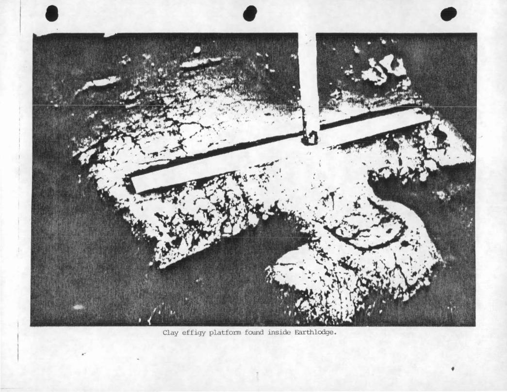
and charred timbers and cane on the floor. A clay effigy platform
25
'

View of the Cererronial Earthlodge, entranceway on the left .
• • •
'I
'. ' ....
~ .. -.. t.f~ . J.-
· • .
Clay effigy platform found inside F.arthlcdge .
.. f

in the shape of a bird was discovered that extended toward the fire
pit from the west side of the wall. Archeologists were able to
determine that the structure, a ceremonial earthlodge or council
chamber, had collapsed when fire burned through the roof's wood and
cane SL1ppc•t'""ts. The layer of earth atop the supports then fell through
upon the floor, extinguishing much of the fire and ultimately
preserving the remaining timbers and clay surface. This evidence of
construction provided the field crew and National Park Service.
t""ept'""esentat i ves with a unique opportunity to reconstruct the chamber;'.
Ameri~ans~,· based on the archi b?ctural plan of native
Soon after : . ·1¥ ..
the importance of the~
'.··ff weeks later a temporarYj,:
e:.:cavated area. Thei;_: ~:· i".'
initial e>:cavations in 1934,
earth lodge apparent and several bec:arne
protective shelter was placed over the
11 tem1'3orary 11 shelter, a circular wall of conduit tile covered by a
. _ ~...,ooden roof, would stand over the clay remains until December 1936.)
The shelter did not completely conceal
thet-efore Park Servic-e personnel, as
solutions for protecting the clay floor.
the floor from wind and air;
f unofficial advisors, sought. ,,., ,..
Meetings in late 1935 by Dr:'f', ~{~';;
•::elly, James Swanson <NPS Assistant Architect), and Olinus Smith CNPS,~ ·.·<
Engineer·) yielded a basic plan for correcting the earth lodge'
si tL1at ion. The plan called for a concrete shell with steel beams to
be erected over the earthlodge floor and outside the wall of the
temporary shelter. The ti le ••all would be incorporated in the
cons·truction of a clay wall inside the chamber. Reconstruction plans
.c:1lso inclu.ded a simLtlated roof opening, or 0 smoke hole". This featLtr-e
would ser·ve as the central location for ear·thlodge lighting and
ventilation. To provide interpretation, visitors would be allowed to
enter· th~ council chamber on a wooden walkway extending three quarters_
26

of the way around the chamber interior. These ideas were approved as
a preliminary plan by the Director of the National Park Service on
March 1936. After architectural and engineering details
were added, the Director gave final approval on June 8 1 1936.
Although the CWA and FERA had worked on excavations at the
earthlodge site, the process of restoration was begun by the WPA on
December 21, 1936, two days before President Franklin D. Roosevelt
established Ocmulgee National Monument. The protective shelter was
torn down, contrary lo original plans, and a concrete wall built
in its pl.ace. Roof construction, begun in February 1937 by WPA ..
laborers, consisted of sheath covered boards radiating from a
center wooden nucleus. The wooden form was then covered with a
layer of concrete and supporfing steel rods. ''Considering the
great quantity of steel in the roof .•• and the fact that ~he
majority of relief laborers used on this particular portion of the
concrete work hjd no previous experience of this kind, the result
was entirely sati5factory. 11 2 An entrance corridor, also
constructed of concrete, was built along the original clay lines
revealed during excavation~ Upon placement of a waterproof
membrane over the roof, the structure was covered with dirt and
sodded. To complete the authenticity, based on archeological
evidence, the earthlodge interior· was restored with posts, beams,
overhead rafters~ and cane matting.
In April 1937 the CCC joined the WPA in efforts to restore the
earth lodge. CCC enrollees puddled clay in a large pit, mixed the
clay witt1 straw, and applied the mixture onto the inner concrete.
wall of the council chamber. A fire was built at the entrance and
27

~.
e;f/"" .:o•
fans used to blow hot air inside. After several weeks of drying,
the wall sunk badly and the clay was removed and replaced with clay
bricks mixed with straw. Completion of the wall was succeeded by
installation of a stael walkway into the lodge and the addition of
electric lights and fans, a w~lcomed change from the acetylene
la111iJs and small gasoline powered exhaust system. On November 1,
1937, the reconstructed earthlodge was opened to the public.
Since its restoration the earthlodge has presented problems for
the National Park Service. Visitors have vandalized the inner
walls by carving initials into the clay, and during the early
1950s park archeologist Gus D. Pope Jr. reported that "one of our
most disturbing problem~ is the occasional spitting of tobacco
juice by older country people on the earthlodge floor."3 To deal
with this dilemma, park guides were instru~ted to stress the
chamber floor's antiquity and importance if they noticed someone
chewing tobacco during a tour. Vandalism of the earthlodge was,
and continues to be, a prime concern of the National Park Service.
The major challenge faced by the Service however, has been the
preservation of the clay floor against deterioration.
The earthlodge floor dried out during the 1930s as a result of · .. ·,~·
.: .. ;_·' ;-exposure to air during early excavations and exposure to heat (from H ::· '..
fires) during the restoration process. In 1938 various chemicals
were tested for use on the clay floor and in 1940 the chemical
Treatment with Alvar continued for several years
after the initial application in 1940; Despite chemical treatment,
detericJratio11 of the earthlodge clay continued to worry National
Park Service officials. The problem was listed as a threat to
cultural r-esources as late as 1981 in Park Service documents.4
28

Despite installation of electric blowers in 1937, the high
humidity in the chamber induced mold growth, caused visitors to
faint, and produced a vile odor. Superintendent Jesse D. Jennings
complained to the Park Service Southeast Regional Director in
September 1938 that the stench in the council chamber after
numerous visitors, made the earthlodge trip 11 a grim and harrowing
e.1:-:peri ence 11• 5
Solving the humidity problem became a major concern of the
National Park Service during the 1930s along with preservation of
the earthlodge floor. In 1938 National Park Service Architect
Jamc-:s SW<3nson SLtggested installation of an '"'air conditior:iing system,
but Pat-~': Service Engineer Olinus Smith advised the Regional
Engineer that air conditioniri"g the earthlodge would be of no value
because of high maintenance costs and difficulty of operation.6
The Park Service's Branch of Engineering was assigned the task of
studying the ventilation situation but no major steps were taken
and park rangers at Ocmulgee began cleaning fungus off the
structure with chemicals. Despite the use of chemicals throughout
the following years fungus problems persisted. In 1967
archeologist Norman Ritchie sent mold samples from the earthlodge
to a plant pathologist for analysis. Pathologist Samual Rowan,
U.S. Department of Agriculture, suggested the use of ultraviolet
lamps or methyl bromide if the environment of the earthlodge was
unable to be changed.7 Park Service officials considered
alteration of the environment too costly and the other suggestions
wer·e not guaranteed effective. Al so, the 1 amp method •~oul d have.
had to be c:onducted when visitors were not present and fumigation
29
... '.·•
·;:·· :;r

li~ ,.,,. woulrj have required closing the earthlodge for 72 hours. Chemical
treatment continued and in 1972 the National Park Service realized
that additional drying and flaking of the earthlodge interior was
' resLllting from the use cf ventilation fans. Use of the fans was
limited in 1973 and the Park Service decided to contact a
consulting ar1d er1gir1eering firm.
Kidd and Associates, an Atlanta firm, contracted with the
National Park Service in July 1973 to study the earthlodge and
suggest improvements and methods of preservation. A d~tailed study
was conducted and Kidd submitted a final report on April 2, 1974.8
Three major recommendations were made by the firm in the report.
The ~ark Service, desiring a final solution to earthlodge problems,
acted upon two of the suggestions. One involved installation of a
partition in the earthlodge to separate visitors from the clay
e:< hi bits. The other suggestion was to increase the moisture of the
clay by continually wetting the soil. Kidd and Associates warned
that~ this method could be detrimental and suggested making tests
first. The Park Service decided to forego the moisturizing
attempt but did accept the partitioning plan. The walkway was
removed from within the earthlodge and a transparent, walled
viewing platform erected instead. With the addition of a taped
narrative and synchronized lighting, the project was completed.
The third recommendation made by Kidd, and one accepted by the
National Park Service, was the installation of a climatological
control system to regulate temperature and humidity. The system
installed in the earthlodge consisted of a five ton self-contained
air conditioning unit with a 12.5 kw heater. Mounted humidistats
and tt1ermostats located in the viewing and exhibit areas maintained
3(>
.¥ ··~:· ,,,, " .,~,··~-
.<'.:
,.,, <t[

(. ··~~/
0
relative humidity from 40 to 95% and temperature from 70 to 80 F.
According to the Superintendent's Annual Reports of 1975 and 1976,
installation of the viewing platform and climate control system was
completed by January, 1976, at a cost of $93,678.00.
The addition of the climatological control system seems to have
solved the problems of humidity, molding, and drying that had
pla.gued the earthlodge for 40 years. Although the use of air
conditioning was suggested in 1938, the Park Service sought a
solution which would prove to be efficient and economical. This
effort to conserve funds, along with the lack of precedent
concerning earthlodge restoration and preservation, contributed to
the continuation of earthlodge-related problems and the use of
chemicals whict1 eventually di~colored the clay walls in several
places.
Another step in protection of the earthlodge was taken in 1984
with the installation of a monitoring system. Audio signals are
picked up inside the earthlodge and transmitted to a receiver
located in the administrative off ices. This system allows Park
Service personnel to monitor situations which threaten the interior
of the earthlodge.
The National Park Service has progressed in its struggle to
preserve and protect the Macon Plateau earthlodge, but past
experiences should not be forgotten. Future administrators of
Ocmulgee National Monument must realize that the reconstructed
earthlodge is a unique feature of the monu~ent and the main visitor
Despite high costs, proper maintenance of t~e
earthlodge is essential.
31

• ( ·-"
New Deal relief labor at Ocmulgee during the late 1930s was
also responsible for the initial construction of a museum
administration building, later referred to as the Visitor Center.
Soon after excavations began on the Macon Plateau in 1933,
archeological field crews began to unearth large numbers of
artifacts. The need to display a portion of the material and to
create public awareness of excavations and finds led to the
construction of a temporary wooden museum during the mid 1930s.
Plans for a permanent museum were made in all early Park Service
planning documents, and in 1937 chances seemed good for this desire \
to become reality. Efforts by Georgia Congressmen to acquire a
$50,000 WPA allotment faile~;·- however, and proponents of the
project had to wait until 1938. Meanwhile, the Indian Mounds
Commission, chaired by Walter Harris, pushed Georgia
representatives in Congress to obtain a Public Works allotment. In
April of 1938 the National Park Service and Georgia Congressmen
were able to have a WPA allotment included in the federal budget.
Approval of the budget was delayed and proponents of the museum
building became wary. Regional Director Carl Russell wrote General
Harris that ''none of us will be quite content until the completed
structure is a reality.''9 Director Russell's statement could have
been made-thirteen years later and still have been true.
Securing funds for construction was not the only challenge
faced by the National Park Service. Officials were also presented
with the question of design. The Park Service usually constructed
buildings which complemented the environment of an area and did not
32

• •
.. · ...
Q::m.llgee Nation.al r-t:>rn..urent VJ.~J.tor CenLer .
.. ..
'
'.
\ \
\
•
\
\

contrast with existing buildings. At Ocmulgee, however, there were
no existing buildings (except a mid 19th century farm house) and
the Indian mound related environment of the area did not make for
easy design planning. The solution advanced by NPS architect James
T. Swanson was a departure from normal Park Service policy. The
final architectur·al blueprints contained an '1 Art Moderne 11
structure; smooth walls, rounded corners, flat roofs, and geometric
forms. The design also incorporated a geometric frieze <Art
Deco), detailed by the Branch of Plans and Designs, which simulated
Lamar Bold Incised pottery found in the area of the monument.
As could be expected, this departure from usual Park Service
design did not please everyone. Upon completion in the early
1950s the building drew some~riticism for its modern design, most
notably from Devereaux Butcher, Field Representative for the
.National Parks Association. In 1952 Butcher referred to ''the
supremely ugly museum at Georgia's Ocmulgee National Mon~ment'' in
Construction of the museum-administration building continued
from 1938 until 1941 when money and material became scarce. In
1941 relief appropriations were terminated and work on the building
halted. At this time the structure was only 65X complete but
housed a pottery lab, Emergency Relief Administration and National
Park Service offices, and a large quantity of archeological
material. A library, auditorium, and additional office space was
yet to be constructed.11 Relief workers constructed a temporary
roof on the building, stored artifacts in boxes, and began other
work until construction on the museum could be resumed. During the
war, however, the National Park Service did not receive any funds
33

for construction and Ocmulgee's new building remained incomplete.
Temporary exhibits in a portion of the museum went largely
unattended and the temporary roof leaked. Proponents of the museum
project were justifiably disappointed and must have certainly
looked forward to the end of the war and completion of the
building.
In September 1945, World War II came to an end and the
following January Interior Secretary Harold Ickes informed Georgia
Governor Ellis Arnall that work at Dcmulgee National Monument would
resume as soon as conditions permitted.12 Appropriations were
included in the 1947 federal budget but had to be removed because
competition with private industry for building material was
contradictory to Presidential policy. Secretary Ickes also
"confidently promised" that appropriations for the museum -
administration building would be given high priority in the 1948
budget but wisely did not promise approval.13 Ocmulgee supporters
continued to struggle for financial aid to complete the museum. ,_..,
Monument administrators accepted bids for construction in 1948,
but only one was received and it exceeded available funds.
Superintendent Millard D. Guy, hopeful that the monument could
finance so~e construction work, and perhaps eager to make a good
impression in his new position as superintendent, regretably had to
reject the bid.14
On February 10, 1942, the Ocmulgee Auxiliary Corporation was
established (for a period of 35 years) as Ocmulgee National
MonLtment's cooperative association. The organization followed in
the footsteps of the Indian Mounds Commission 119371 and was
34

m-ganized "e:.:clusively for scientific, literary, and educational
pLlr-poses. "15 IOn May 11, 1977 1 the name was. amended to read
Ocmulgee National Monument Association). In November 1949 1 members
of the Ocmulgee Auxiliary Corporation met in Macon with National
Park Service officials from the Washington and Regional offices,
including National Park Service Associate Director Arthur Demaray.
Discussions centered around completion of the museum building and,
if nothing else, seemed to promote public relations between the
National Park Service and local supporters of the monument. The
federal budget for 1950 contained appropriations for improvements
and rehabilitation for critical needs within the National Park
Service but museum construction at Ocmulgee was not included.
Ef farts by Congressman Vinson_ and Senators Walter George and · I
Richard Russell, however, managed to obtairi funding for completion
.. of the museum under the title of "rehabilitation". Ocmulgee
National Monument would receive $135,000 for physical improvement
of the mus~um-administration building. A contract for the long-
awaited con~truction work was signed June 2, 1950, and in June
1951 work was completed. The total estimated cost of construction
in 1939 was $275,340; the final cost, however, is unknown since
adequate records were not kept by New Deal relief workers.16 An ,1•
unsigned report written shortly after the construction was
completed, stated that $350,000 was a ''fairly accurate'' estimate of
construction cost.17
A dedication program for the completed museum and
adrninistration building was held November 2, 1951. It was
sponsored by the Ocmulgee Auxilary Corporation, with about $4,000
contributed by local individuals and organizations .
.,.~
._1..J
A group of
Creek Indians was invited to Macon for the festivities, but rain
forced the cancellation of a parade and night tim_e stick ball game.
Formal ceremonies at the Macon Auditorium, including an exhibition
stick ball game and Indian dancing, attracted approximately 6,000
people. Tours at the monument also attracted numerous visitors but
tt1e announcement af schedules and tours presented problems.
According to Superintendent Guy, the announcements (made by a
public address system in two exhibit rooms) were largely ignored.
Visitors were also disappointed that they could not tour the
monufnent at their own leisure.18
Since initial construction of the museum-administration
building, numerous and consistent problems have plagued NPS
administrators. As early as January 1951, the terrazzo t~rrace
began to crack and separate. As a result, water seeped through
cracks under the terrazzo and was forced out when the terrazzo
expanded. Leaks in the flat asphalt roof were also a recurring
problem throughout the_ following years.
to give the Visitor Center a facelift.
In 1966 efforts were made
The building was repainted
and repairs made on the terrazzo and roof. The rehabilitation,
although an improvement, did not solve all of the Visitor Center's
problems. Jn the late 1970s and early 1980s, measures were again
taken to improve the Visitor tenter and surrounding area.
In 1977 a portion of the terrace and roof was replaced but more
extensive changes would soon follow. In 1979 the Visitor Center was
partially closed in preparation for the addition of a solar energy
system. The solar heating and cooling system was designed by
Honeywell Corporation and constructed by the National Park Service
36

and the Department of Energy/NASA. It began operation in November
1979 as a pilot project to study the use of solar energy as an
alternate source of power and to test the design of the system.
The 1980s saw sweeping changes take place at the monument.
New roofing was i~stalled at the Visitor Center in 1981 but the
building, with its flat roof, continued to leak. A study was
subsequently conducted by an architect of the National Park Service
and his report recommended the use of a sealant, regular
inspections, and further study.19 Late in 1985, additional roof
improvements were attempted. A weather proofing material was to be
applied to prevent water from seeping through cracks caused by
expansion o{ the building. Heavy rai~s occurred during the
process, however, and the Visitor Center incurred extensive water
re \:.:'.:../
damage. At the time of this writing r-epair -work was still in
--progress and the outcome remains to be seen.
Perhaps the most important aspect of Visitor Center
transformation began in November 1981 when the building was ~;. .. ~ ,,; ..• _\
·, J
completely closed for renovation. Audio-visual equipment was
installed and old exhibits were replaced with new ones. Staff .·
off ices, formerly divided between the basement and first floo~~
were relocated downstairs. The renovation process also included the
construction of a theater and library-conference room.
A contact station was set up outside the Center to provide
visitor assistance while renovation work continued for sixteen
months. The rededication of the museum and dedication of the solar
energy system was held March 23, 1983 in conjunction with Macon 1 s
annual Cherry Blossom Festival. Representatives of the Cr~ek
NaticJn, Georgia Cor1gressman J. Roy Rowlatid, National Park Service
37

officials, and local city and county government officials attended
the ceremonies. Public reaction to the renovated museum has been
extremely favorable. With proper maintenance, the Visitor Center
should continue to serve as an imp6rtant means of interpretation.
38
-~ 1.\ 't"::~.
··'~

CHAPTER IV
ADMINISTRATION: THE BEGINNING
Prior to the construction of the Museum-Administration
building, interpretation of Ocmulgee National Monument was the sole
responsibility of tour guides. The National Park Service used
relief workers as guides during the late 1930s and earl!y 1940s but· .:;jj: . ·~ .
most had little experience in .visitor contact and park
i nter-pretat I o-n. To provide instruction for the unoriented
tour guides, Benjamin L. Brya_n, National Park Service Junior ··~·-··"/>~· ,. •.·
Historical Technician, developed a manual ~hich discussed proper
.personal appearance and conduct as well as the historical and -~ .. , ,,
-~:~ .. i~ ~-Ji. :-~~-~ cf;'';
. . "'" Bryan's guide manual gives insight into the initial visitor ... :~,i'!.
services program at Ocmulgee National Monument. During the week };~~~t-
archeological importance of the area. The 1940.manual contained
information on the various archeological features, a list of ..
often-asked questions, and a description of tour routes.1
and on Saturdays, visitors stopped at a contact station at the
morlument 's entrance and were met by two employees. One worker
distributed (and later collected) visitor information cards while
the other provided information and kept a record of the number of
cars and people entering the monument. Visitors then proceeded to
the museum parking area. Once a group was assembled, a guide would
make contact and lead the assembly to the council chamber
(E•arthlodge). The interpreter presented an introduction to the
39

chamber and the group then entered the structure to view the
original and reconstructed features. The council chamber trip was
followed by a visit to Mound ''D'' and prehistoric trenches where
visitors were given an option of riding or walking to features
located across the railroad. Visitors who chose to walk continued
to the trading post site and associated burials, then proceeded to
If desired, a trip to the temporary
mL.tseLlm foll owed. Visitors who chose to ride were led through the
museum, then returned to their cars where they drove around to view
the same exhibits as the group on foot.
Times of heavy visitor use, such as Sundays and holidays,
necessitated the implementation of slightly different presentation
methods. On these days guides were stationed at each feature in
the monument to provide i~terpretive services for visitors. The
Emergency Relief and Civilian Conservation Corps guidem, forced by
economic woes of the Great Depression to earn money through New
Deal relief programs, were genuinely interested in the Ocmulgee
p~oject and took great pride in their role and accomplishments at
the monument.2
During March 1948, Regional Director Thomas J. Allen and
Region Archeologist J.C. Harrington decided it would be beneficial '
to r-eplace the 11 drab and uninspired 11 names of archeologic:al
features .(such as Mound 11 A 11 and Swift Creek) with 11 descriptive and
The two regional officials visited Ocmulg~e
and suggested to Archeologist Charles Fairbanks that he submit
ideas for· new riames. Fairbanks later submitted his ideas to
Harrington for review. Superintendent Guy, once he learned that
40

• '.
Wayside exhibit located on Great Terrple M:lund, 1940 .
•
Buria:. shelter, Middle Plateau (Trad.i.J'¥3 Post Site) . •
Harrington was seeking suggestions, proceeded to submit his own
ideas. The ideas were received by Harrington who reviewed them and
submitted a list, with his own ideas included, to the Region
Director on May 27, 1948 !Appendix Fl. The names ultimately
decided upon, however, diff~red from those recommended.
The 1940s at Dcmulgee National Monument contrasted sharply
with the preceding decade. The activity and excitement of
excavations and development slowly gave way to inactivity and
frustrations for monument administrators. Decreased ~ ,J
funding during
World War II, besides preventing additional physical development,
forced reductions in staff. Law enforcement became a concern as
vandals continually tampered ~ith the temporary burial shelters and
items were stolen.
Dr. Arthur- R. f<elly, once troubled with the supervision of
num•rous employees, became Custodian <Superintendent) of Ocmulgee
on October 3, 1944, and was faced with the unenviable task of ,,
administering a National Monument without adequate personnel. The,
new superintendent, aware of the monument's lack of personnel and_';-,."-:i
money, had little choice but to allow further deterioration of the
premises. The following years would demonstrate that some pe/pLe
felt, despite the circumstances,Sth't Dr. Illy was not doing
enoLAgh in ·his administration of Ocmulgee National Monument.
An audit of Octnulgee covering the period from February to
December, 1946, revealed money charged to wrong accounts, payrolls
charged ir1correctly, purchases incorrectly coded, and purchase
orders completed after supplies were received.4 This may have been
41

•
•
the product of inexperienced cler~s but Dr. Kelly, as
Super·interldent, was held respor1sitlle. National Park Service
Regional Director Thomas Allen venomously attacked Kelly's
11 unpro·fessionalism 11 and recommended his removal to the Acting
Director of the National Park Service.4 Les.s than a year later
k:elly decided to resign. On June 13, 1947, Newton 8. Drury,
National Park Service Director, responded to a letter from Kelly
and agreed with the anthropologist's decision to return to the
teaching profession.6 Director Drury, aware of the contributions made
by Kelly to Ocmulgee, offered use of his name as a reference in Kelly's
negotiations with the University of Georgia. Eleven days later Dr.
Kelly officially submitted his resignation, effective September 1 1
1947.
Millard D. Guy assumed the position of superintendent at
Ocmulgee National Monument on October 28, 1947. The new
superintendent was under a great deal of pressure to improve the
degenerating conditions at the monument. Soon after his arrival
efforts were made to straighten the records and filing system.
Maintenance work was also increased. In 1948 permanent burial
shelters were constructed on the Macon Plateau lin the vicinity of
the trading post site).
Dunlap House was begun.
In May 1952 extensive renovation of the
The Dunlap House was built about 1856 as a plantation cottage
and was occupied by Union troo~s during Ge11eral Stoneman's attack
01-i Macon, July 30, 1864. The l·1ouse served as a residence during
tl·le ensuing years, ~nci in the late 193c)s was altered to serve as
• C:\n office for- F'ark Set-\1 ice stC\ff and the Emet-gency· Relief
P1dmi ni st.r .. at ion. The offices we~e moved tc1 tl,e adn1inistration
42

building in 1940 and the house was converted to a superintendent's
residence. Remodeling in 1952 and 1953 included new tile on the
floors, porch construction, and exterior paint.
Another positive improvement was made around 1953 when
arLt1eologist Gus Pope Jr. cut down trees growing on Mound '1 A 11•
The mound remained covere<j with stumps but at least some progress
had occurred. Additional changes were made in 1954 when the 120
foot long 11 pr·atective 11 shelter over Mound 11 C 1' was removed. The
mound's profile had deteriorated greatly, an~ long established
plans for its preservation had not been implemented. A year later
Ocmulgee's staff archeologist suggested tbat the Indian burial
shelters also be removed and the skeletons reburied. The
archeologist complained abou~ the ''obese white lumps'' which caused
visitors to ''squat, squint, and barely make out the moth eaten,
mangy disarray of yellowish bones.''7
The early 1950s also marked a time ~hen monument
administrators attempted to form a closer bond with the local
community. Public ceremonies were held in 1951 to dedicate the
museum-administration building and in September 1952 a two day
Indian festival was held. The festival consisted of a parade from
downtown Macon to Ocmulgee National Monument, Indian craft
demonstrations, a stick ball game between Creeks and Cherokees, and
an orchestra concert. Fifty Creek Indians from Oklahoma
participated in various even~s, and Bibb County public schools
cancelled classes on Friday for the occasion. The festival
attracted large ~rowds and was considered a success, although three
stick ball players were sent to a local hospital with lacerations

~. and abrasions.
In July 1955, Louis R. Caywood became Superintendent of
Ocmulgee National Monument. In 1956 two publications were
released, both written by NPS employees at the monument.
~~ti9D~1 ~QO~ill§Ot~ ~§9C9i~i the monumer1t's official handbook, was
written by Gus Pope Jr. and was reprinted in 1961. 0c£b~Q1Q9~ gf
tbg Eyogc§! ~QYD~i written by archeologist Charles Fairbanks, was
also pc1bl ished. It remains a classical work concerning excav~tions
at Ocmctlgee. '•
During the latter part of the 1950s, plans were announced for a ' .~~~-':
interstate highway !Interstate 161 to be constructed through Macon
enroute to Savannah. The proposed route placed the interstate
through a portion of Ocmulgee National Monument bet~een Mound ''A"
and the Ocmulgee River • Much local public ·support was generated
.. due to speculation that an interstate would attract more tourists
(customers) to the city of Macon. Residents were also hopeful that
the interstate would require the construction of a bridge at Seco~d
Street. Some individuals, such as General Harris and Cecil Coke,
felt that the interstate would spoil archeological sites and
present an eyesore to visitors at the monument. They were joined
by very few people with similar opinions. The sentiments of Harris
and Coke also lacked support because plans were still in the
initial stages and even the National 1Park Service did not voice its
objections.
The interstate issue did not create much cbntroversy during the
late 1950s. Superintendent Caywooci informed the Southeast Region
of the proposed interstate route on November 15, 1957. The
Superintendent's main concern was that the highw2y would ruin the
44

historic setting for visitors.8 Regional Director Elbert Cox
agreed that there was not much hope of preventing the interstate
from crossing monument grounds unless there was actual damage to
archeological remains. The route might destroy the historic
setting Cox acknowledged, '' but with the proximity of the railroad,
related highways, and other modern structures, it is a little hard
to become exercised about one more intrusion in the picture. 11 10
Little more was said on the subject until the 1960's. In January
1961, as plans for the interstate system progressed, Superintendent
Caywood departed Ocmulgee. Albert Dillahunty became superintendent
later the same month and shortly afterwards engaged in a bitter ·~
fight against the proposed route of Interstate 16.
~ ...
45

CHAPTER V
INTERSTATES, INDIANS, AND IMPROVEMENTS
Superintendent Albert Dillahunty.was stationed at Ocmulgee
National Monument for six eventful years. The Superintendent was
determined to improve the physical aspects of the monument to which ' .
previous administrators had devoted !little time. The ''bulldozer
days'' of Superintendent Dillahunty included the destruction of
brick kilns formerly associated with Anderson brickyard, the
removal of the railroad roundhouse foundation, and the
reconstitution of the Civil War earthworks. Other areas of the
monLlment were also cleared and mol..iing operations became a major 1 job
of park staff. The greatest concern, however, was the proposed
route of I-16.
The local situation concerning Interstate 16 seemed bleak in
1961. Mayor Wilson and most Macon civic and business leaders
favored the I-16 route through the monument. Their views were
supported by Congressman Carl Vinson, instrumental in establishing
Ocmulgee National Monument a quarter of a century earlier.
The administrative personnel of the monument and the National
Park Service were definitely opposed to the planned interstate
route although their stand attracted few supporters. The position
•• ( . ~
of the Park Service drew much criticism from m~ny local citize~s
who favor-ed the interstate route. Other groups were angry at the
46

Service for not voicing objections sooner. The Bibb Company let it
be known that the interstate would cross land that had been
acquired from them by the Park Service and had been declared
''indispensable.''1 Even members of the Ocmulgee Auxilary
Corporation were divided in their opinions. A called meeting of
the Board of Directors was held June 12, 1961, and after a two hour
discussion of the proposed interstate route a decision of ''No
Action 11 was reached.2
In July the interstate debate heated and tempers boiled. A
meeting of city leaders was held July 13 at which Ellsworth
Hall Jr. 1 representing the Chamber of Commerce and others, stated
that ''if a choice had to be made between the highway and some
esthetic damage to the monument, the choice was for the highway.''3
(~. '--
The meeting enforced feelings of oppositiort toward P~rk Service
policy. Superintendent Dillahunty continued to oppose the highway
plans but had to allow the battle to be fought on a national level.
In mid-July the National Park Service proposed an alternate
route, transferring the proposed route from the monument's southern
sector to a location between the Visitor Center and Emery,Highway. . '
The nevJ proposal· would protect undisturbed ground along the river
for future archeological work and preserve the bottom land area
from further encroachments by man. The Park Service had earlier
rejected a land swap proposal and city leaders, eager for a bridge
at Seconci Street~ rejected the new Park Service proposal.
In August the Park Service submitted another plan which was
also rejected. On September 8, 1961, a final decision was reached
in a meeting between Congressman Vinson, G~orge Williams
(Assistant Co1nmissioner for Engineering, Bureau of Public Roads>,
47

and NPS Director Conrad Wirth. Interstate 16 would pass through
Ocmulgee National Monument between the route originally proposed
and the Ocmulgee River. The new highway would effectively separate
the bulk of monument land from the river which had been essential
to Native American habitation of the site.
An agr-eement between the National Park Service and ~he State
Highway Department provided for archeological exploration of the
interstate route through Ocmulgee National Monument. An advisory
committee was established and project personnel arrived at ' :.;,;.:-• .f~;r;.' '• .· I
Ocmulgee in late 1961. Wi 1 fred D. Logan was named Di rector of the . t·•
Nati on al Park Service sponsored project but Cdue to i 11 ness) JohM -:;i:v:
W. Griffin, Carroll Burroughs, and John M. Corbett served as Acting'
(• _;.
Other members of tr.i~·- Archeological Research Unit CARUl Chiefs.
included archeologists Jackson W. Moore, Jr., John E. Ingmanson,
John W. l.Jalker, Charles F. Bohann'on, Char'!es B. Voll, and
administrative assistant Donald Sarver. The Research Unit shared
' space in the Visitor Center with the monument's Park Service staff. -~
The archeological work, sometimes referred to as "Big Dig II",
began in December 1961 and reached full scale during Janu~ry 1962 . •
The pr-oject 1 hampered by rain and f 1 ood waters, continued unti 1 ·its
labor force was terminated in June 1962. The ARU and OcmL1l gee
staff coexisted and shared expenses throughout the archeological
pr-oj ect. At the conclusion of the project an attempt was made to
continue the research unit with Ocmulgee National Monument as a
These plans culminated during the mid 1960s with a
re!;earch unit known as the So1Jtheast Archeological Center.
The Southeast Archeological Center- lSEACI was established at
4·8

Ocmulgee National Monument in October of 1966 and was responsible
for the supervision of archeological research within the
Southeastern Region of the National Park Service. John Walker,
John Griffin, and Richard Faust each headed the center. The
professional staff consisted of Lee Hanson, David Hannah, and
Dcln.a.l d CrLlsoe. The Center occupied several offices, a library
room, map and archives room, and small lab in the Visitor Center
b-=.1.sement. The National Park Service staff assigned to Ocmulgee
National Monument occupied rooms on the main floor. The cramped
quarters were the major problem faced by the dual NPS units and in ,·r;;·.
1972 SEAC moved to Tallahassee, Florida.
The year 1966 also marked the end of 11 Missian 66 1', .. a ten year
program designed to bring units of the National Park Service System
up to standards necessary for their enjoymjnt by the public. The
program's effect on Ocmulgee National Monument was summed up by
Superintendent Dillahunty in March when he reflected that "Ocmulgee
did not fare as well under Mission 66 as most other National Parks.
In fact, construction of one employee residence is 66's only
development here. This, compared to accomplishments in other. parks
is so insignificant, we (Monument staff) sometimes think of the
program as 'Missing 66'."4
Superintendent Dillahunty transferred to Delaware Water Gap
National Recreation Area in December, 1966. Ocmulgee National
Moriument received a new superintendent, Charles F. Bohannon, on
January 15 1 1967. The intense land clearing efforts of the former
sLtperintendent were obscured as the new superintendent allowed
renewed growth to provide Ocmulgee with a 11 natural look 11• A
reducticr1 in staff size also occured and the monument began closing
49
'\:}:· . .. ,4
,:_~-~~~· . •· ~-
on Mondays and Tuesdays. The changes contributed to reduced
visitation, with the total number of visitors plummeting from
72,580 in 1967 to 39,641 in 1969.
An investigation of Mound "A", supervised by John Walker, was
also conducted during 1967. The examination revealed that the
plateau on which it stands had been purposely leveled and shaped.
The archeology team also determined that the clay cap of the mound
was almost impervious to rain damage and would require little
restoration.5
In 1968 Region officials were concerned with administrative
policies at Ocmulgee National Monument. In October the
administration of the monument was combined with that of the
Southeast Archeological Cent~~. which was under the
general supervision of Dr. Ernest Allen Connally, Chief of the
Office of Archeology and Historic Preservation, located in
Washington D.C. The move was supposedly designed to ''put more '· emph~sis on archeological research'' and provide ''a reduction in
administrative work 1'.6
El even months later Superintendent Bohan.non 1 ef t. the monument
and National Park Service officials implemented plans to create the
position of Management Assistant. The reorganization also placed
Ocmulgee under the general supervision of Superintendent Vincent
Ellis at Kennesaw Mountain National Battlefield Park. Regional
Director J. Leonard Volz stated that 11 interpretive personnel at the
monument ... should report administratively to the Management
Assistant (while] the format, content, and quality of the
interpretive program should be under the professional direction of
5<)

the professional persbnnel at the Archeological Center.''? The aim
of the National Park Service in proposing the new administration
was to create "a total unit that demonstrates, at high standards,
the Service's capabilities in research through interpretation.''8
On December 28, 1969, W. Pingree Crawford assumed the newly
cr·eated Management Assistant position at Ocm\Jlgee Natior1al
Monument. In March, 1971, Ocmulgee was removed from Kennesaw's
jurisdiction and Crawford's title was changed to Superintendent.
8~i~cQ_Qf_ib~-~c~~t§
Early in 1972 efforts were begun by the Macon Chamber of
Commerce, Ocmulgee National Monument Auxiliary Corporation, Bureau
of Indian Affairs, and National Park Service to relocate a group of •
Creek Indians to Ocmulgee National Monument. A ''living history''
program was developed at the monument and a few Creek Indians from
Oklahoma moved to Macon to conduct craft demonstrations for the
pub 1 i c. Several Creeks were also hired to fill temporary
interpretive and maintenance positions at the monument with the
prospect of qualifying for permanent Park Service positions. The
Macon Chamber of Commerce encouraged local businesses to provide
jobs as an enticement for the Indians to relocate and Mercer
University later offered ten full scholarships for them to stay.
The Bureau of Indian Affairs contributed travel money for use on
the trip to Macon and provided a grant for operation of an Indian
Trading Post, or gift shop, at the monument.
Tt1e local fascination with Indiar1s rea~hed its peak in October
1972, with a week long celebration to commemorate the return of the
11 Creek Week 11 beg,J.n with a. SLtcce~ssfLtl pc.\rade~ but
51

•• (__
the events that followed did not fare as well. A drama "Return of
the Creeks" was per-formed with the use of several hundred Bibb
County schoolchildren (and two Creeks) and received mixed reviews
from the local newspaper. Other events proposed for the week
included dancing, craft demonstrations, archery contests, and corn
t:~<='-i.: i ng. Plans were char1ged, however, when four of seven events
were cancelled the first day. The week ended as a disaster.
Sponsors owed over $2,000 for use cf the coliseum while the total
debt incurred from "Creek Week" was $12,675. (91 Charles H. Jones,
president of both the Chamber of Commerce and Ocmulgee Auxiliary
Corporation, insisted that the celebration would have been better
had local leaders prodc1ced it instead of the Rogers Company, an out
of town production company.10 This ex post facto statement could
not change the dire financial situation and Creek Week promoters
pleaded with County Commissioners for aid.
The effect of the Creek Week celebration was also detrimental
~o Ocmulgee National Monument. Although Monument admiriistrators
were not the prime organizers of the celebration, many people
associated the events with the Monument and the National Park
Service. Local visitation decreased, fewer people attended the
living history programs, and th• Creek Trading Post, never a
bustling business, continued to struggle. The gift shop closed
during the mid 1970s due to financial problems, the difficulty of
obtaining genuine items, local competition, and personal problems
of the operators.
The Creeks at Ocmulgee also encountered difficulties adjusting
to Macon and Ocmulgee National Monument. Most had come to Macon as
young adults, seeking jobs and new experiences. The availability
52
·.;.:~.:.: •.• ~$ r
~, !'f-1

of jobs seemed like a promising opportunity and the first two
summers were indeed positive. Many of the Creeks, however, soon
became homesick and returned to their family and friends in
Oklahoma. Those who stayed were confronted with the exiting of
Charles Jones as Chamber of Commerce president. With him went the
dreams of the Creek Indian relocation project. The initial fervor
of local people over the project also faded, and the Creeks were no
longer viewed as novelties in the community.11
The Creeks who continued to work at the monument also (_
.~:.
encountered administrative changes. Archeologist Norman Ritchie left ,
Ocmulgee for another unit of the National Park System, and in 1976
Walter T. Berrett replaced Crawford as superintendent. The new
superintendent did not support the freedom_given. to the Creek
inter·preters as they related, in no uncertain terms, ''their'' story
to visitors. The emphasis was placed on the historic rather than . . . , 'Ji The Creeks at , .• " :ft
Ocmulgee gradually found their Park Service positions unrenewed and.;, t prehistoric period of Ocmulgee National Monument.
other personnel hired to fill vacancies.12 The position of the .. :._·.:_··~.~-~-·-National Park Service and Ocmulgee's administrators drew intense ~
i-1 'itr~ criticism in 1980 from Charles Jones who claimed that "the Nati.~n~{i~·;4;\
. ·: /:,~~· Park Service in genera~, is of t,he persuasion that they are
operating a cemetery where Indians have been dead and buried for
thousands of years. 11 13
The administration of Ocmulgee National Monument under
Superintendent Berrett was marked by conflicts between the monument
a11d local community. In 1977 John Holley, executive director of

the Macon-Bibb County Planning and Zoning Commission, launched an
effort to have artifacts returned to Ocmulgee which were supposedly
removed during the 1930s. The material Holley referred to had not
actu.?.lly b'eem removed until 1972, when SEAC was transferred to the
campus of Florida State University, but Maconites were uninformed
in matters concerning Ocmulgee National Monument.
Holley's complaints led the Bibb County Commissioners to ask
Senator Sam Nunn to investigate the matter. Ib§ ~§£QD_!§l~9C§Hb
also joined the attack on Ocmulgee and the National Park Service,
encouraging local citizens to join a letter writing campaign to
have ·tt1e archeological material returned. The Telegraph attempted ·;:f*t·
to establish the National Park Service as a villain and complained ~!;.~~~:
that "the '"hite man was not:c.ontent to take the Indian's land; he
also took their simple treasures.''14 Superintendent Berrett
replied in an editorial that a misunderstanding existed and that,
the material taken in 1972 to be studied at SEAC would be returned
when analysis and study were complete.15 Linda Wilson, staff
writer for the ne•~spaper promptly reported on December 7, 1977,
"Artifacts To Come Back".16 The bold heading was followed_ by the
~..,.ords 11 as soon as the 2.5 million objects are stL!died in Fl·orida 11•
,_.,
Wilson and other lc)cal people were not aware that Ocmulgee National
Monument could not properly display the numerous artifacts, or that
much of the collection was small ceramic and lithic fragments
unsuitable for display.
Superintendent Berrett also found it difficult to deal with
city officials in Macari. The city government, like business
leaders, had taken an active part in Ocmulgee during the early
54

1970s and had been i nstr-umental in directing affairs ,-elated to the
monument, such as the Indian relocation effor-ts. In 1978 a Mr. E.
G. Sher-r-ill met with the Macon Chamber- of Commer-ce and the
president of the Ocmulgee National Monument Association. Mr.
Sher-rill then submitted his recommendations to Mayor- Buckner- F.
Melton in a ,-epor-t titled "Proposal for- the Indian Mounds".17
Mayor Melton r-equested a study of the feasibility of the proposals
he made by the Middle Geor-gia Ar-ea Planning and Development
Commission. The Mayor- then wr-ote the monument to infor-m the ',, l,i' super-intendent of his decision to have the proposals studied. •,:'';~:~;·;f~-ii
·' .·· ;--!;.\:~.riJ;:~~~~ proposals were aimed at development of the monL1ment for- commer-c1al~:f
:: ':,;~ benefits and included the following: ~-~ '.
1) clearing trees between G~·eat Temple Mound and I-16 to provide
travelers a view of the mounds. '' .. r-;
2) r-ebuilding temples atop the Greater- and Lesser Temple Mounds. '
3) er-ecting an Indian village adjacent to the Trading Post.
4) constructing picnic ar-eas in the woods.
5) L1sing Civil l~ar batt'legr-ound for- interpretation of Battle of
DLm 1 ap hi 1 1 •
Mayor Melton agreed that Sherrill's pr-oposals appeared to have
validity, and forwarded them to the National Park Service Regional
The Acting Director-'s reply, dated March 28, 1978,
politely rE•jt?ct.ed the proposals. The histor-ical and archeological
value of Ocmulgee National Monument was once again preserved.18
Relations between the city arid Ocmulgee National Monument
remained poor and in 1978 the situation became wor-se. In June the
State Department of Transportation authorized the city of Macon to
55

install a traffic signal at the intersection of Emery Highway and
Jeffersonville Road. State Transportation officials later learned
that a portion of the right-of-way belonged to Ocmulgee National
Monument and proceeded to seek permission from Superintendent
Berrett for installation of an overhead traffic sign. The
superintendent agreed to approve the city's request o~ly if a I
traffic signal was i~stalled at the monument's entrance. The
deadlock between the city and monument continued and neither party
obtained their objective. The city of Macon and Ocmulgee National 1-.
Monument continued to have an unsteady relationship.
A positive note found during the conflict of the late 1970s was
the discovery of a Macon Plateau period site. The site ·was 1 ocated . ~~·
dur i.ng a survey conducted by ... Service archeologi st John Walker in
1978. The 25 acre site extended south of the Visitor Center
parking area. News of discovery, however, did not improve
relations between monument and city and in 1979 a new
superintenaent entered the scene.
'· The new superintendent, Sibbald Smith, assumed duties at' .,
Ocmulgee National Monument on December 16, 1979. The local
community was pleased to receive a new administrator at the
mont~merit but were cautious not to overreact to the change. 'The
superirttendent was. unaware of past relations between the monument
arid city but soon realized that he would have to take the
initiative and establish good public relations with the local
t:ommL.ln it y .. This was done through the media and by personal contact
and helped to lay a foundation for future cooperation between the
56

two bodies. Changes were· also made at the monument itself.
Plans for renovation of the Visitor Center at Ocmulgee had been
devised during the 1970s. Implementation of the plans, however,
was carried out soon after Superintendent Smith arrived at I
Ocmulgee. The remodeled Visito~ Center was designed so it could be
operated by one ranger. This provided maximum effectiveness at
: ~ ,, !
of the new superintendent and was evident in all areas of the j~ "'°''"•:::,·;:::::::::::::• .::'::~:teoao<• "•m• t.,gets of toe oew I
''Cost effectiveness'' became the goal and trademark minimttfn costa
philosophy at Ocmulgee. Mowing operations were sharply decreased 0;t,i conserving money and manp~wer. This policy was conducted on a fa~ __ · >~ff.
smaller scale by Superint.?ndent Crawford a few years earlier, but
was abandoned by the succeeding administrafion. Maintenance of
archeological features has also been a high priority of the present .. -,~~ :~~.r
administt-ation. Employment of seasonals, volunteers, and -~-
You<" Coosec"Hoo Cocp wOc,ecs a;o ;o toe "P'•ee of toe featuces. " ffi Volunteers in Parks have al so begun to be used to a greater·:. <:~_·_-.·_f_,_·_.~.~--.-,~-----··
extent in visitor cehter operations. This allows rangers to devote · ~_g
time to other inte1-pretive projects and improves the monument's . -~ ~¥-.t ·~~·~·
fy interpretive program. The inter·pretive program also benefited from
an administrative change that occurred during the early 1980s.
The earthlodge was equipped with an audio system prior to
Superintendent Smith's arrival but tours were conducted every half
hOLlr a This double interpretation was halted after Superintendent
Smith and staff experimented with keeping the earthlodge open
during par·k h(JLlrs. The new administrative policy allowed group
tours~ but other visitors were given the chance to tour at their
57

----- ---------
own leisL\re. Visitors had asked for this opportunity in 1952 when
the museum-administration building was dedicated <Chapter III>.
Visitation at Ocmulgee National Monument increased sharply
during the mid 1980s. This increase can be partially attributed to
the emphasis which the National Park Service has placed on the
smaller parks and mo11uments in recent years. Locally, Ocmulgee has
received attention through good public relations and the
distribution of brochures at welcom~ centers. A four-month r
calendar of events was devised to provide activities and learning
e:<periences for the visiting public and was later expanded to
eleven months. Craft demonstrations continued to be held at
scheduled times <but not weekly) and more responsibility was given
to the Ocmulgee National Monument Association.
Ocmulgee National Monument has been directly involved with
several major projects during the 1980s. On November 12, 1983, a
reunion of former Civilian Conservation Corps workers was held at
the monument to celebrate the 50th anniversary of the CCC. The
reunion was a success as speakers, pictures, memorabilia and
conversations recalled the experiences of the CCC a~ Ocmulgee from ·'
1937 to 1942.
In 1984 Keep America Beautiful Inc. and the Department of
Interior agreed to launch a pilot project at the monument through
the help of the Macon-Bibb County Beautification Clean Community
Co1l11n i. ss i an .. The project was developed to provide local citizens
with an opportunity to 11 contribute to cleaning and maintaining
r1ear·by federally-owned public lar1ds .... 11 in order to encourage
public interest and awareness.19 The first Public Lands Day at
58

I). Ocmulgee was held September 8, 1984. The short notice given the
monument prohibited the coordination of a major project but the
local community was invited to have lunch on the grounds, followed
by a brief ceremony marking the occasion. The project, designed to be,
annual event, attracted over 2,000 people in 1985.
Another current project is the development of a Di~covery Lab
workshop for children. Teachers from the Bibb County School
System, working for certification credits and as volunteers,
contributed to its planning and development.
In other areas, plans to relocate the monument entrance have
been renewed. Superintendent Smith, recognizing the need for a
safer entrance, began working with local highway authorities to
explore solutions. Plans were discussed for alteration of the
existing entrance (larger holding lane, un6btrusive entrance sign)
as well as construction of a new entrance from Main Street. These \
two possibilities took a back seat, however, when city and county
highway officials began planning a connecto~ from-Eisenhower
Parkway CUS 801 to Emery Highway IUS 801. The possibility now
exists that a new road to the monument can be constructed from the
connector. Administrators hope that the the connector will also be I
=·,
.•
used to provide a road into the Lamar section of the monument.20 ·•
Development of the Lamar unit of Ocmulgee National MonL1ment has
presented a challenge to monument administrators for years. During
the 1930s the mounds stood majestically in an open field while New
Deal employees conducted excavations nearby. In 1938 Charles
Harrold recorded the anticipation and admiration which he and
others felt regarding Lamar:
11 Lan1ar of COLlrse is r-eal 1 y going to be the most
59

beautiful thing in the entire monument when it is finally completed. From the very beginning the citizens of Macon have looked forward to' its restoration as a place for pageants and even for the return visits of the remnants of the Creek Nation.' 1 21
Unfortunately, the Lamar site suffered during the ensuing years
along with the rest of the monument. In 1948 it was considered a
low priority until better roads and a completed levee could be
constructed.22 Today the Lamar unit is surrounded by dense timber
and is not easily accessible. The Youth Conservation Corps
conducts clearing operations in the area but trees continue to
cover the mounds themselves. Until the area is developed, the
vegetation serves as a barrier against artifact collectors and
other possible intruders. The desire of the pr~sent administration
is to develop the Lamar unit as a prirnitive day use area.
60

•
. . -
..
~.
, .. .. . .. 'I . . .. .. . ., -:
• .
• I t , •f , . J t '
i .. . ~ ...... •• t
,, .• f .. ,, . "" ., .
• ' ~4.:
' .. (. ...... ·.'\ .... ·- ""' • . " .. . r .. t er .. .. I:
I
• '.., .... , .. ,•
\ . ..
.. ·'
. ~ .
..- .·..;i ··,,,,,"'"'
• I '
f - • ~ .- .~~
1· ... • • •
#' t I '-t• ' .. 'i •\ .
~ \
'/. •· '?: .I~ .. ~ i. ~,.. . · \' '
,.._
" l
.Aerial view of the Lamar t-b.mds .
.. . , ,.. ...... -
' ' '
•
f

CHAPTER VI
COMPREHENSION, CONCERN, COOPERATION: THE KEYS TO SUCCESS
The administrative history of Ocmulgee National Monument is
marked with both succe~s and failure. This in turn has prevented
the monument from maintaining a consistency which is vital for
continued growth and success. The task of present and future
managers is to establish and maintain Ocmulgee as an~efficient,
functional unit of the National Park Service System. A recent
visitor to Ocmulgee aptly destribed the monument as ''an unpolished
gem, growing br-ighter every day." To ensure that this gem reaches
its highest potential, monument administrators and the local
community must realize that success depends on several key factors.
During past administrations, relations between Ocmulgee and the
community have varied. Some superintendents have wanted nothing to
do with the city and surrounding area, while others have gone
overboard to please. Ocmulgee's success depends on a balanced,
working relationship where compromise is standard policy. The
Chamber of Commerce will naturally continue to view Ocmulgee as an
attraction site which draws tourists, but this is just a fringe
benefit provided to local businesses. The primary concern of the
monument is to preserve, protect, and interpret the scientific and
historical resources of the area .
. Ocmulgee National Monument represents a past era, but it also
61
represents the past of each person living in Macon, Georgia.
Today, Macon serves as home for many people; for 10,000 years it
was home to various Indian cultures. The arrival of Europeans
established contact and the Indian's past and white man's past
intertwined. At this point the story of the Indian takes on
personal meaning, for to this day we are influenced by the result
of the historic confrontation. Ocmulgee, Tobesofkee - the Indian
influence, in names and products <corn, tobacco, etc.>, is very
evident today in Macon, Georgia. Comprehension by the local
community of what Ocmulgee National Monument constitutes is a vital
aspect of the monument's J'ey to success.
Once the local population understands that the monument is more
than just Indian mounds, consistent and successful administration
is just around the carrier. The superintendent and local community
will be able to pursue common goals and together can make Ocmulgee
National Monument efficient and functional.
Another aspect of cooperation land a key to success) involves
the Ocmulgee National Monument Association. The Association should
play an important and active role in promoting the monument. The
past couple of years have seen progress and growth in the
organization, but its potential is far from being reached. The
Association, as a sel f1-sLtppor~ed body, shoLtl d promote the mont..tment
as authorized in its bylaws.
The Ocmulgee National Monument Association and local community
can have a great impact on affairs at the monument. They could work
c~ with monument administrators to promote and maintain the historical
and archeological importance of the area. If the local population
£QffiHC~b~a~~ wt1at Ocmulgee actually is, becomes ~QQ£§~Q~~ with
62

preserving it, and £QQQ~CAt~• with monument administrators to
ensure its protection and promotion, then growth and success will
r-esul t.
Ocmulgee National Monument is administered by the National Park
Ser-vice, but it belongs to the people of the United Sta~es. Input
by citizens, and especially the local population, will enable
Ocmulgee to reach its highest potential; the gem, once polished,
will be permanently set for pr-oper- display.
-· C:

-· c
f,IOTES: CHAPTER I
1An additional feature, a probable house mound, is located· in the main section near the Cornfield Mound. This feature is not e.,.sily discer·nable and has been given the name Mound "X". See E!!'.:Sb§9199lL9f_t!EL'2!9!'.::!;b_l:1sSQ!J_Elst§sW by J. Mark Wi 11 i ams and Joseph N. Henderson, 1974.
2The account by one of Oglethorpe's rangers is recorded in !!'.:sYB1§_io_tbg_8mB!'.:!£s!J_~Ql9D!B§, edited by Newton Mereness. Adair, ~!§t9!'.:~_gf_tbB_8mB!'.:!£sD_lo9iso§; Bartram, I!'.:sY§!§_Qf_~!l!ism_§s!'.:t!'.:sm; and Jones, eat!gw!ty_Qf_tb•§gwtb§!'.:O_lo9is!J§, also mention the mounds.
3James Adair, ~!§i9!'.:Y_Qf_ibB_8ffiB!'.:i£s!J_lo9!s!J§ <Johnson City, Tenn.: Watuga Press, 19301, p. 39.
4The Cherokee fertilizer factory was located on the Middle Plateau near the 1870's railroad cut; Anderson brickyard -south of the Funeral Mound; clay mine - east of the Great Temple Mound; railroad roundhouse - southwest of the Funeral Mound. The McDougal Mour1d area was L~sed ·as a dairy fc?.rm.
5 11 Ccuntry's most Perfect Mounds Found Near City, 11
!:1s£Q!J_!g!gg!'.:sQb, November 17,1933, Harrold Scrapbooks, original located at i~ashington Memorial Library, Macon. Motorcycle climbing also remembered by local residents.
6Hale Smith, E!os!~§!§_Qf_ibB_bsffis!'.:_§iiB <Tallahassee, Fla.: Florida State University, 1973), p. iii.
71!2!9· S"Macon's Civic Spirit Wins," !:1s£Q!J_IBlBg!'.:§!Qb, June 7,
1945, Harrold Scrapbooks<article labeled June 7, 1933; Book 3). 9Letter, Cammerer to Vinson, January 6, 1934, National
Park Service Central Classified files of Ocmulgee National Monument, located in the National Archives, Washington D.C. (hereinafter cited as CCFl.
10Letter, Ic:kes to Chairman Rene' L. DeRouen, Committee on Public Lands, House of Representatives, April 16, 1934, NPS Office of Legislation, Washington D.C., Appendix A.
ll''Indian Mound Plan Backed By Civic: Bodies,'' l:lsSQ!J_IBl§g!'.:§!Qb, Macon, Georgia, Ap~il 13, 1934, Harrold Scrapbooks.
12"Hope Abandoned For Mound Aid," !:1"'\£Q!J_IB!B9!'.:sQQ, April 20, 1934, Harrold Scrapbooks.
13"U. S. Park Service l>Jants Mounds Developed,''!:1s£QD_IB!•9!'.:sBb 1 May 3, 1934, Harrold Scrapbooks.
14''CCC Interested in Mound Work,''~s~Q!J_I@lBg!'.:§\~Q, May 26,1934, Harrold Scrapbooks.
15Chatelain was Chief Historian; Winter, Assistant Historian; Kahler, Historical Section of NPS; Taylor, Chief Engineer of Eastern Division; Simmons, Landscape Architect.
16Letter, Demaray to Harrold, December 4, 1934, CCF-RG79,

Box 2302. 17Letter, Demaray to Vinson, January 28, 1935; CCF-RG79,
Box 2302. 18Letter, Harrold to Demaray, December 9, 1934, CCF-RG79,
Box 2302. 19Letter, Kahler to NPS Director, November 2, 1935, CCF
RG79, Boi< 2302. 20Memorandum, Margold to Interior Secretary, July 26,
1935, M.27994, CCF. 21Letter, Wright to Charles Akerman, December 27, 1935,
CCF. 221P-i9· 23Letter, Harrold to Chatelain, April 241P-i9· 25Letter, Chatelain to Harrold, April
Box 2302.
1935, CCF.
1935, CCF-RG79,
26''U.S. Park Assured For Bibb As Leaders Reach Top In Drive,'' ~1£QO_l§l•9CA9b 1 June 6, 1935, Harrold Scrapbook One, OCMU.
27Petition Number 555, United States vs. Three Parcels of Land, March 9, 1936, Federal Archives, Eastpoint, Georgia.
28Demurrer to Petition Number 555, May 30,1936, Federal ~rchives, Eastpoint, Georgia.
29Final Judgement on Petition Number 555, July 25, 1936, Federal Archives, Eastpoint,.Georgia.
30 11 Appraisal of Park Laod~ ·Accept~d by Bibb Mills, 11 ~~£QQ_ I•!•9CIQb, July 18, 1936 1 Harrold Scrapbook Two, OCMU;
31Letter, Olinus Smith to Oliver G. Taylor, October 14, • 1936, CCF.
32Letter, W.E. Dunwoody to President Franklin D. Roosevelt, March 26, 1934, CCF-RG79, Box 2302.
33Proclamation by President Franklin D. Roosevelt, Ei,abling Legislation No. 2212, Dec. 23, 1936, Stat. 1798.

NOTES: CHAPTER II
1 Letter, Kahler to NPS Director, August 27, 1936, CCF.
2Letter, Superintendent William Luckett to Coordinating Superintendent, Southeast National Monuments, June 13,1940, CCF, Box 2307.
3Audit Report by Myers, March 30, 1938, CCF. 4Superintendent's Annual Report, 1939, located at the
Southeast Archaeological Center CSEACl, Tallahassee, Florida. 5''Proposed Development of Major Archaeological Features, 11
Master Plan for Ocmulgee National Monument, 1939, located at Ocmulgee National Monument (hereinafter referred to as OCMUI ,Plan file.
6Superintendent's Annual Report, 1942, OCMU. , , ?Letter, Superintendent Dillahunty to former Superintendent
Luckett, March 3, 1966, OCMU, Reading file 7-1-65/6-30-66.
'
lte
----------
NOTES: CHAPTER III
J. J arnes S1tJanson Jr. , 11 Discovery, E:<cavati on, and Restoration
of a Prehistoric Indian Ceremonial Earthlodge,'' Unpublished manuscript, OCMU, pp. 14, 18.
2H!_i_g., p. 41. 3Memorandum, Response by Pope to Memorandum F0-54-53,
September 30, 1953, OCMU, Earthlodge file. 4Memorandum, Superintendent Sibbald Smith to NPS Region One
Director, January 16,~981, ''Threats to Cultural Resources,'' OCMU, H-42.
5Memorandum, Jennings to Region One Director, September 22, 1938, OCMU, 620-107.
6Memorandum, Smith to Gray, May 21, 1938, OCMU, 620-107. ?Kidd and Associates Inc., ''Earthlodge Study: Ocmulgee
National Monument,'' 1974, Appendix B, OCMU, Earthlodge file. 8Report titled "Earthlodge Study: Ocmulgee National
Monument,'' 1974, OCMU, Earthlodge file. 9Letter, Russell to Harris, May 17, 1938, SEAC. 10Devereaux Butcher, "For a Return to Harmony in Park
Arch i tee tu re," ~.§:!;iQD§l_E§t:1~L!'.!.§99~iD§, October-December, 1952, p. 150.
11Superintendent's Monthly Report, November 1940, CCF, Box 2304, files 6 and 7.
12Letter, Ickes to Arnall, Jan~1ary 29, 1946, CCF. 131!2i9· 14Superintendent's Annual Report, November 1948 1 OCMU. 158ylaws of Ocmulgee Au:dliary Corporation, OCMU,
Association files. 16Branch of Plans and Designs, "Estimate of Cost, Museum
and Administration Building,'' September 26, 1939, OCMU, Visitor Center files.
1 7Report, anonymoLlS, made between May 19, 1951, .and JLtne 14, J. 951, CCF.
18Superintendents Monthly Report, November 1951, OCMU. 19Report by Architect, Branch of Design, SE/SW Team/Chief
COCMU-401i January 26, 1983, OCMU.

NOTES: CHAPTER IV
1 Benjamin Bryan, !2"-!!.Q~_lji'!Q"-.\£1_.._ Q<::'!l~!lg§'.~-~i'!i!.QD.i'!l_ljQQ"-.\!!lS'.Oi
<Wt<shington D.C.: National Pt<rk Service, 1940). 2The role of the various New Deal agencies is a vital portion
of Ocmulgee National Monument's history. Future reset<rch and documentation, including oral histories from remt<ining participants, would greatly increase cur understanding of this er-a.
3Letter, Harrington to Allen, March 11, 1948, CCF, Box 2307. 4Audit Report, February 23, 1946, through December 31,1946,
written February 24, 1947, CCF, Box 2304, files 6 t<nd 7. 5Letter, Acting Director Tolson to Allen, August 19,1946,
CCF, Box 2, file 3, 1-1-37/12-31-37. -6Letter, Drury to f<elly, J.une 13,1947, CCF, copy with
author. ?Memorandum, Staff Archae'olcgist, Ocmulgee, to Region
Director, April 14, 1955, History Division Ocmulgee files, NPS, l~ashington D.C.
BLetter, Superintendent Caywood to Region Director, November 15, 1957, OCMU, Interstate 16 file.
9Memorandum, Regional Director Cox to Superintendent Caywood, November 29, 1957, OCMU, Interstate 16 file.

NOTES: CHAPTER V
1 Memorandum, Superintendent Dillahunty to Region One
Director, June 26 1 1961 1 L2431 1 OCMU, Reading File 7-60/6-61. 2Statement from Dillahunty, June 13 1 1961 1 OCMU, Reading
File 7-1-60/6-30-61. 3''Park Service Is Under Fire,'' ~@SQQ_I§!.§9CAQb 1 July 14,
1961. 4Letter 1 Dillahynty to Elizabeth Wagner, National
Geographic Research Staff, March 7,1966, OCMU, Reading File 7-1-65/6-30-66.
5Interview with John Walker, August 1 1 1985. 6NPS·Press Release, October 1 1 1968 1 for release October
4, SEAC. ?Letter 1 Volz to NPS Di rector, /'Operating Procedures-
Oc:mul gee National Monument," August 20 1 1969 1 SEAC. 819.i.9• I P• 2. 9"Creek"Week Bill Given to Board," ~Sl£QO_!g!_ggt:siEJ.b
1019.i.9· 11 Tom Patterson 1 "Indian Go Home! , " ~CQ~!l.'..!§L§!di.9g_:!;.Q_
-§§QC9i.§, February 1980 1 p. 23. 1219.i.9· 1319.i.9· 14"Ripping Off Roots," ~ASQ!l_Ig!.ggc,;iQb. 1 November 23,1977. 15"Misunderstanding Exists About
Artifacts,''~ASQQ_!§!.§9C§QQ 1 December 7, 1977. 16"Artifacts to Come Back," ~§£Q!l_!§!.§9CAQb. 1 December:- 7 1
1977. 17Letter 1 Melton to Charles Howell, Middle Georgia Area
Planning and Development C6mmission, March 9,1978, SEAC, Administrative files.
18Letter, Acting Regional Director to Melton, March 28,1978, SEAC.
19Memorandum, fC:eep America Beautifc1l Inc. 1 "A Proposal to Establish A National Public Lands Day,'' OCMU, Administrative f i 1 es.
20Interview with Superintendent Smith, July 23, 1985. 21Letter, Harrold to Region One DirectoP Carl Russell,
May 21, 1938, SEAC. 22Letter 1 Region Archaeologist J.C. Harrington to Region
One Director, March 11, 1948.

BIBLIOGRAPHY
Secondary Sources:
Adair, James. Ib@_tii§iQ!:~_Qf_ib@_0m@ci£@Q_!agi@D§· Johnson City, Tenn.: Watuga Press, 1930. First published in 1775.
B,,.r· tr ~'m, W i 11 i am. Ir:s>Y@l§_Qf_~illi.s\m_!2s>t:ir:s>m. Edi. ted by Mark Van Doren. New York: Dover Publications, 1928. First published in 1791.
Bryan, Benjamin L. §~igg ~-o~•l~_Qsm~lggg_bJ@ii2a@[email protected]· Washington, D.C.: National Park Service, July 1940.
Butcher, Devereux. "For· a Return to Ar c:h i tee tLlr-e. 11
. ~§!i~_QO.~!.-Ee!:[email protected]~!.D.~,
Harmony in Park October-December
1952, pp. 15C>-157.
Butler, John C. tiimi2r:is@l_8@SQ!:Q_Qf_~e£QQ_,;>QQ_(;;goir:el §ggr:gi@· Macon, Ga.: J.W. Burke and Co., 187~.
Holland, Ross Jr. E2ci_tie~tiom~_Er:2oiigc_EQ!:i· History and Historic Architecture, Washington, National Park Service, 1970. CRecal led by NPS)
Office of D. C. :
Jones, Charles Colcock, Jr. 0oiig~iii@§_Qf_ibg §g~ib@!:Q_ !D.Qi@D.§· Spartenburg, S.C.: The Reprint Cci., 1972. First published in 1873.
f<idd and Associates Inc. "Earthlodge Study: Ocmulgee National Monument,'' April, 1974.
Mackintosh, Barry. 022@iggg~g_!§leQQ_~siiiQD.@l_§gg§bQt:§.;__ 01J_ 0gmioi2ir:@iiyg_tii2i2t:~· Washington, D.C.: U.S. Government Printing Office, .1982.
Marsh, Alan. "The Making of a Monument: The Story of Ocmulgee National Monument.'' Unpublish~d manuscript, 1983.
Mereness 1 Newton D., ed. 1st edition. Norwood,
IceY@l2_io_ib~_6mgcisao_!;;2l2oigm. Mass: Norwood Press, 1916.
p,,,,i ge, '1 ohn C. !bg !;;iYili•IJ !;;gQ§g!:Y.€!ii9D !;;Qt:~§ S'QQ J;bg bJ@!;iQIJ@l EE!t:h §@r:YiS@i 12]]=121~· U.S. Department of the Interior, National Park Service. Washington, D. C.: 1985.
Patterson, Tom. ''Indian, Go Home: An Update on the Most Recent Indian Removal'', ~CQ~D~~ §~!~§ tg §~gcgi~, February 1980, pp. 15-24.

Pope, Gus D., Jr. · Q£!!l!Jl9'il!Lt:l£iiQ!J.£l_t:Jgo.!J!!l§Di.s._§§Q!:9i£• National Park Service Historical Handbook Series, no. 24. Washington, D.C.: 1'i56. Reprinted 1961.
Smith, Hale G. BD£b::,,;i§ 9i ib§ b£!!l§l!: §j._i§ .i'! §i Zl.· Tallahassee, Florida: Florida State University, 1973.
Swanson, James T., Jr. 11 A Report Including Discovery, Excavation, and Restoration of a Prehistoric Indian Ceremonial Ea.rthlodge, Ocmulgee National Monc1ment". Branch of Plans and Designs, National Park Service: 1940.
United States Department of the Interior. E!:Q£!£ID£ii9D§_ §lQQ_
Qr.~§!:§· Compiled by Thomas Alan Sullivan.· Washington: United States Government Printing Office, 1947.
Unrau, Harlan D. and Frank G. Williss. !99miDi§i!:£iiY!'L!::Ji§i9!::'.k'.!._ ~~Q§lD§iQQ_gf_ib§_!:;l,;iiigo,;i!_E,;ir.h_§§!:YiS§_io_ib§_l'!}Q~§. Denver: Denver Service Center, National Park Service, 1983.
Waters, John C. and Lo~is DeVorsey. ''Fort Hawkins Study'', Prepared by The Institute of Community and Area Development, University of Georgia, February 1973.
Wi 11 i ams, J. Mark and Henders'on, Joseph. N. , Ib§_6!:£Q§Q!Qgt:_9i _ib§_!:;lgr.ib_t:l.££9D_El£i§£l'. T al l ahassee: · ·Fl or i da State University, 1974.
Wilson, Rex L. ''A Radiocarbon Date for the Macon Earthlodge''. 6!!l§!:iS£D 6oii9!Jiit:, vol •· 30, no. 2, 1964, p. 202.
Bibb County Commission. Minutes of Meeting, November 11, 1961
Department of the Interior, National Park Service. documents in Interior Library.
Legislative
1933-1985.
National Archives Regional Branch; Eastpoint, Georgia. Land Condemnation papers.
National Archives; Washington, D.C. Files of National Park Service, Ocmulgee Natiorial Monument.
Ocmulgee National Monument; Macon, Georgia. Na.tional Pat-k Service.
Southeast Archaeological Center; LJniversity, Tallahassee, Fla. Service.
Campus of Flo1-ida State Administered by Natior1al Park

(.:'A \.:..W
Pingree Cra••ford, former Sc1perintendent. Interviewed July 29, 1985. Richard Faust, Chief of SEAC. Interviewed August, 1984. George Fischer, Archeologist, SEAC. Interviewed August, 1984. ·~
Jesse D. Jennings, former Superintendent. Interviewed August 1, 1985~i • Frank E. Lester, former Acting Superintendent. Interviewed January ,;,f 15, 1983. ;:,'S~, Wilfred Logan, Denver Service Center. Interviewed July 29, 1985. ·• Jackson Moore, Archeologist, SEAC. Interviewed August, 1984. ·;L~ Sibbald Smith, Superintendent. Interviewed September, 1985. ~)
John W. Walker, Archeologist, SEAC. Interviewed August 1, 1985.
\,-
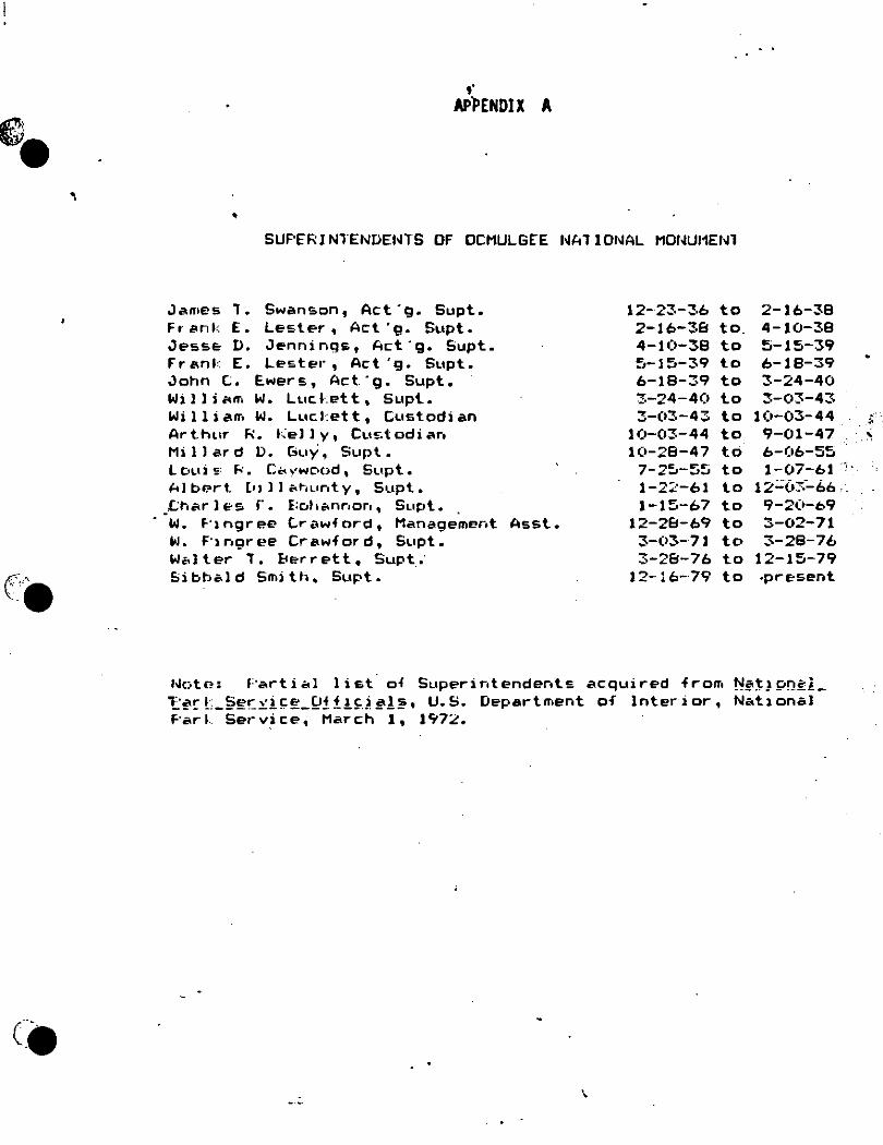
e •
(''9
,. APPENDIX A
• SUF'E"RJN1.ENDENTS OF OCMULGEE NA1 IONAL MDl~Ul1Elfl
James , . Swanson, Act·g. Supt. 12-23-36 to 2-16-38 Fr· e>nk E • Lester, Act'g. Supt. 2-16-38 to. 4-10-38 Jesse o. Jennings, Act·g. Supt. 4-10-38 to 5-15-39 Fr anl: E. Lester, Act 'g. Supt. 5-J5-3q to 6-18-39 John (;. Ewers, Act .. g. Supt. 6-18-39 to 3-24-40 Wi l l i 1<n-1 w. Lur. l·:et t, Supt. 3-24-40 to 3-03-43 Willian-. w. Lur. l:et t, Custodian 3-(>3-43 to H•-03-44 Ar t.hLOr "'· kel l y, Cus t od i aro 10-03-44 to 9-01-47 Millard D. Guy, Supt. 10-28-47 to b-(•6-55 L OLii !:; I<. Cc. ''WC'tC)d. Supt. 7-25-55 to 1-07-61 AlbP.rt. l•> JI a~.unty, Supt. 1-2::-61 to 12::0~--66
_,c;i-.ar l E-s r. E:c.t1~nr1or1, Supt. J-15-67 to 9-2(1-b9 w. f·1 ngr ee (;r i.\wf ord, Management Asst. 12-28-69 to 3-02-71 w. f·1ngree Crawford, Supt. 3-03-71 to 3-28-76 Wc.lter , . l:<er r et t, Supt_; 3-28-76 to 12-15-79 Sibbald Smith, Supt. 12-16-79 to .present
Note: 1:·artial list of Superirotendents acquired from 1'1!<~)9".!E'.i._
1:!l'rL_§~r::y!!=~_Q!!!~)!l'!lh U.S. Department of Interior, National Par~ Service, March 1, 1972.
~~ '
':'"
1 .

APPENDIX B
• General Walter Alellander Hards, soldier, lawyer and author, was born
in Macon, Georgia November 17, 1875, the son of Nathaniel Edwin (at one time Governor of Georgia) and Fannie (Burke) Harris. He graduated from the Unfverury of Georgia in 1895 with the degree of Bachelor of Arts, and received his LL. B. degree from Georgi a the following year. His alma mater conferred upon him the deg1ree of Doctor of Laws in 1928.
Admitted to the bar of the State of Georgia in 1896, General Harris served as a partne1r in a local law finn for many years. He also served as a member of the Bibb County Soard of Education from 1905 to 1912.
General Harris retired as 11 Plajor General of the Georgia National Gual"d and was a member of the 3rd Georgia U.S. Volunteers for Play 1, 1898, until April 22, 1899, dul"ing which time he rose to the rank of captain. He se.-ved in Cuba with the Anny of Occupation, and continued his military career until January 21, 1919, when he was honorably discharged. He was the first co11JT1ander of·the Geo,.9i11 Department of the American Legion in 1919.
General Harris was a 1nember of the American and Georgia Sar Associations, the Macon B~1r Association, president of the Placon Historical Society, member of the Executive Corrrnittee of the Society for Georgia Archaeology, a trustee emeritus of Wesleyan College, and a member of Chi Phi and Phi Beta Kappa fraternities, and the Kiwanis Club.
General Harris was also the author of "Empel"or Brim" and Here the Creeks Sat Down.

•
"Hon. Rt:Ni L. D&RotrmK,
APFDIDIX C
llf'Tllatoa Dar.&.BTM&n, WGaAi..,ion, April. II, lllS+.
.. Chairman ('ommi'.Urt on Pu.IHtt La.di, Hou.11 of Repr11n.lallw:1. . MT DIAR MR. CHAIRMAN: I ho\·e n.-aelved your lett.er or .~ebruary 8,encJO.lng
copy of 11.R 70~31 onttlled "A bill lo .. tahll•h tho Ocinul100 National Park ID Bii>b County, Ga.' and req11ratln1 a n-porl thereon.
Due t.o the raplJ develup111l'11t «>f the NaUon, the remain• of the ptchl.atorSo life arc fa.at di1appea.rlng. Ju Uu.~ lnt.e-re11t. of aclont'O and hl1tory it lA of tbe utmoat hnporto.11ce tha.t 1owe low t\'fJi<"al areu be prueorved for all tlnae t.o oome &1 l)ln.ccs for the 1tudy_ of the ear)y a.nleC"edf'nt.a of hu1uan life 011 tho Nort.h American COuth1r11t. The Na.tlonl\I Gu\'f't111nout through the pau.B.ac of the act for the pr1~1ct\'&tlon of American anllquitloa, approved June 8, JUOO (34 St.at. 22~). aod tha.t rrt.·atl111 the hlcfl& Verde Ns.llnnaJ Park, Colo.
1 appruvad June 20, 100ll
(3~1 8tal. 616), \11.'licro 10111c nr tho outMtanrllnti: e1:amp oa of 8outh\\'011t.ern arch• olcigy arc to be found, ho.a dc1non111trated the lmporLAnco of tho preacrvatlou of auch l>rt·hiittorlc run1al1115. ·
I u lhc cw.e of t11c I ndlan 1nou11d1 ln the Octnulgee flohl, It. l1 the opinion of nutc?J nrchculogl11l.tl tha.t U1il group conlprlaca one uf tho 111011t ln1portant. cenWn of .u.rchcoluK\' t•nt1ol of the Appala.r:hlan Aiuunt&in•. It 1hould bo bthlod tlt.bt aeverW 1cic11\IK\it u( ll10 81nlU1111uulu.n l1u1tltullun have rbceut.ly atudiu<l t.hl• t(ruup uf JJH1u111lit untl tl111it )rutltutlun cndor110M the prujoct fur }'cderal Jireeor:vatiuu.
\\'Jilh: l 11111 111 fuvnr of prc1u!r\·alluu tn· the \Jnltc<l 8tatoa uf t.he Ocmulgee aru., Jt. wuuld k"l"IH tlu1ot Jt 11 of di .. tturt. naiiunal-monu111e11t character, being almlla.r lo lund11 .-ct apllrl In V.'cetcru St1:1.tca fur aclentlfic purpoece, and t.hercfu"5 ahuuld Le Cdte.l>liabed in that 1talu1 ratliur tl..a11 u a national park, u con\eJnplated by tl1!11 1irc1po1ed lt"ti:illllfl.tlon.
:SlTliuu l or the Lill pro\·ldc• ror an au1 hurlcatlon for the approprlat.lon or fedrrnl funde fur tho purchulK" of appro1i111ntely 2,000 acre.a o( land &ta COil of 1111\ Ju ~xcucd t.26 per acre. l aJU 11ut In favor of authurl1lng tho approprlatluu c.1f Fcclrral run<l111 for the acqulaltion or land" u oontc111platcd Ly thla ecctloo and lH•lil'\'l' if lhe 11crt·Mary area for the J>rra-r,·atiun of thrlM: µrehh1torlcal 111ound1 II t,1 )H• tuhui11iKlcn•cl l>.)' the }"ederal Gn,·rr1uur11t that th~ hu1l11 •hould be eecure-d 11.)' public ur µrivtt.te clnnaHou. Ju ''lr111· tilth~ alio,·e It la rcc1untne11ded tho.t the., Lill Le a111c11dcd u (ullo"·11:
C'hn.nge the title ·w: HA l>Ul t.o authorize the eatabliehmeut or the Ocmul1ee N&H111u1ol hluunmcnt In Ril>b County, C~nala.'' ••
Eli111l11nle All or ltctlu11 1 ant.I 1ul111lit1.1tt• tho follo"A·i11R: ••·r1iat \\'hei1 title to lande ron11uohl_v kno•11 ae the 'Old Ocmulgee Fic1d1 1
1
upon \\·lilrh rertnln Jndiau Utnt111d1 of an-at hi•turirAI huportanco are lveat@d, rn1n11ri1i111i1: ap11ruxi1natelv twu tln1uu11d arr"""• In a11d around the City of )la.con, Cu1111ty ur H1IJ1.>, that.u uf Gl'or1i1:ia, u •hall he dc11l~uatcd by the Sccrt•tary or the lnil•rlor, In the excrclaa· of hl11 j1ul,,::1nent and diitrrctlon aa ll~C"caaa.ry fur 11aUona1· n1unu1u"·ut 11urpoM!1J 1hall ha,·e ht.'t'll veah·d In t.he Uultcd Htatea; 1alJ area ahall lie r.et &Bi1li• "'a nat oua.l 1nonu111c11l, by prrw:lan1atlnn of the PrOAldeut. and ahaU IK• knov.·11 as the 'Or1uulgee Natloual J.lonun1ent': Prot-idcJ, Tha.t the Uolt.od titnlt~a •ilu1ll 11ot µurchue by •r.proprlatlun of pul>llo mo11c\'• any land• 91·Jthln tho ah.1rrallhl 11rrn, hut •UC"h l11in1 11 11111.ll be a-rurcd by tba \hilted tit.ate. unl7 by µuhliC" ur private do11Ktlon.11
l'aac 2, litu~ H, r.l~n.uJte t.ho word 1' Park .. to .. Afonument ••.
Thi11 pr11JH11M'1I h•Jthtla.pon la lllcntil"a.1 with that covoi:_cd by 8. 2679, on wl1loh a 9C'pnrnlc n•purt. ILi! aUovc hu bcl·n a11l1mltLL-cl. aud I &Ju a1l,·laetl l.y the lllro<'tor ur th{' Ut1tl'IU of the UudRet that u tbl1 propo.ud le,;l11lallun ls an~ended u lndi· t'aaell ll.Uovc the nine -.·UI not be In euoflict •·itb the fiua.ncia1 prngrAm of the frcaldcnl.
I n?co111n1end that H.R. 7853, If amended a. lndlca.ted above, be glven ravonLle OOh1idrrRlinn li_,. the Congre11.
Hi11l·crcly yuun,
;Q
H AB.OLD L. lc.s.1:a Sccrd4rf1 oJ ~ 1 Bltrior.
'

ce
•
APPENDIX Df LffiISIATIOO
.Eetabliehment of monument aut.horbed, •••• Act. or .lune lit, NJl1
AN ACT TO AUTHORISE THE ESTABLISHMENT OF THE OCMULGEE NATIONAL MONUMENT IN BIBB COUNTY, GEORGIA, APPROVEO JUNE lQ, 193Q (Q6 STAT. 956)
Be .U e. na c ted by the. Se.na-te. till!! How. e. o ~ ll e.plle .. u nta.t.i. vu o& the. Un.i.te.d Sta.tu 06 Al!ICJl.ica Ui con91tu6 uumbl.e.d, That vhen title to lande commonly known ae t.he "Old Ocmulgee Field," upon vhich certain Indian mo1U1ds of great hietorical importance &Te located, comprising approximately tvo thousand •~Tea, in and around the city of Macon, County of Bibb, State of Georgia, as ehall be designated by the Secretary of the lnterio:r, in the exercise of his· Judgement and discretion &a
necessa:ry for .national-monument purposes, shall have Leen vested in the United states, aa.1d area shall be set aside &a
a national monument, by procl11111ation or the President, and a hall b1! known as the "Oc111ulgee liational Monument": P1tovide.d, that the United States shall not purchase by appropriation of public moneys any lands vithin the aforesa.1d area, but such lands shall be secured by the United States only by public or private donationl, (16 U.S.C. sec. LL7a.)
Sec. ;?. The Secretary or the Interior 1s hereby aut.hori:r.ed to accept donations of land, 1nterest1 1n land, buildings, etructures, and other property vithin the bowtdaries or said national monument as determined and fized herewider and donations 01" fwids for the purchase and or maintenance t.hereof, the title and evidence of title to lands acquired to be aat.-1" ractory to the ~ecretary or the Interior: P11.ov.ideif, 1~at he may acquire on behnlr or the Unite~ ~t.atea wider any uonated fundn by purchase vhen purchasable at prices deemed by hir.> 1·easonable. othervise by condenination under the provi aions oft.he Act of Au;;ust l, lBBB, such tracts or lllZld vi thin 1.he eai d national monW11ent &B may be necessary for the coo:1>letion thereof. (16 U.S.C. aec. lili7b.)
Sec. 3. The a~nistration,, protection, and development of the Ocmulgee National HonWllent shall be under the supervision or the Secret&.ry or the Int.erior subject to the provie iona of the Act entitled "An Act to establish a National Park Service, &nd for otber purposes", approved All8UBt 25, 1916, ae amecded. (16 U.S.C. sec. lili7c.)
·,

( -.
f:' .-,· .. ,_, .• ..
( •. ,_
l't' 1'HB PJ.ESlDE._'T OF THE UNITED nAT£5 OF A!\f!RICA
A PROCLAMATION
• (No. 2212-Dtt. 21, 1911>-SO Stat.1791)
WHEREAS th• act of Congr<Ss •ntitl•d "An Act '.To authorize thr establish. mrnt of thr Ocmulgtt National l'ifonummt in Bibb County, Gtori:ia" approv•d Jun• 14, 1934 (48 Stat. 958), provides, in part: '
"That when tit!• to lands commonly known IS th• 'Old Ocmulgtt Fidds', upon which crrtain Indian mounds of gr<at historical importancr art locattd, comprising approximately two thousand ac"" in and around th• city of Macon, County of Bibb, Sta" of Grorgia, as .hall be designated by tht Src7'tary of th• Interior, in tb• cxrrci,. of his judgmtnt and disc7'tion 11 nrces~~ary Jor nationa1~monumt'nt purposes, shall havr been vrstcd in the United gtates, said ar•a &hall be &ct asid• as a national monum•nt, by proclamation of thr Prrsidcnt, and 1hall be known IS th• 'Ocmulgr• Natiomd 1'.1onument' :"
Asu WHEREAS th• Sccrctary of thc lntcrior has drsignatcd an ar<a comprising 678.48 acres of such land as nccrssary for national-monument pur· posts, titlc to which is vcstcd in thc Unitrd Statcs:
Now, THEREFORE, I, Franklin D. ROOS<'vdt, Prrsid•nt of thc Unirtd States of Amcrica, undrr and by virtur of th• authority vrsrrd in m• by thr statutory pro\'isions above set out, do proclaim that the aforesaid area as indicatrd on th< diagram attachrd h•r<to and forming a part hcrtof is hcreby &ct side IS a national monument to be known IS th• Ocmulgtt National Monum•nt.
\\'arning is hcrtb)' txpre<Sly giv•n to all unauthoriud p<rsons not to appropriate, injure. dtstrO)'i or rcmo,·e anr ftaturr of this monument and not to local< or &c:ttle upon an)' of thr lands thcrtol.
The Dir<etor of th• National Park Scn·ice, und" th• direction ol thr St-crc:tary of tht ) ntcrior, shall ha\'t thr supt"n·ision, managcn1cnt1 and control of th• monum•nt a. pro\"id•d in th• act of Congttss •ntitl•d "An An To eStablish a National Park Scn·ice, and for othrr purpost's", approved August 25, 1916 (39 Stat. 535, U. S. C., title 16, &ccs. I and 2), and 1<1s.
suppll•mcntary thereto or am•ndatory thrrtof. . IN V<IT"ESS WHEREOF, I havc hercunto s<t my hand and cau&cd th• &cal of
th• United States to be aflix•d. Do"E at th• City of \\' ashington this 23d day of Dectmber, in th• year
of our Lord nin<tttn hundttd and thirty-six and of the lndr[ sEAL] p<nd•n« of the United Starrs of Am'1ica thr on• hundred and ·
sixty-first.
Bv th• Prrsident: · R. WALTON Moou,
Aeling Srrrl'lnrr of Statt.
.. ·
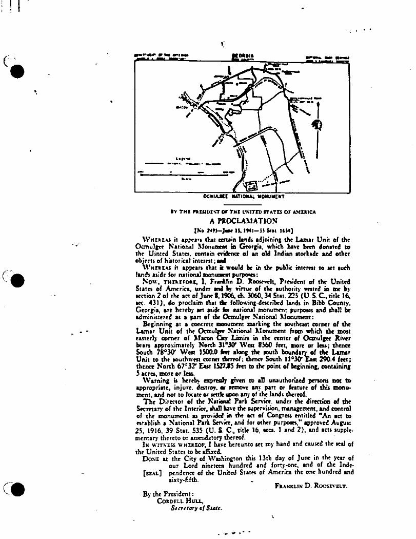
I .
(' •
(.
•.
..
............... ~~ "''' ~- .....
,.,.~ ... -.. --··---
.... THE n.uu>t,.,.Of' THI l'J\;fTrD rrAT£5 or A.\fEaJCA
A PROCLA!.lATJOS (to;o ~9J-J- II. 1'41-ll S.11. UJ.t)
\V>tUUJ ii •Pl'!"•" that a:ruin land• adjoinin& tht Lamar Unit of thr Ocmulrtt National )Jon.......r in Grorcia. •·hith hllvr ~ clonatrd to thr Uin1rd Siam. contain csik- of an old Indian 11ochdr and othor objrm of his1orital inmm; _.
\\'Hnus it appran that ir ...... td .. in tlw publir in1rm1 to ar1 aurh land1 uidr for national mon_,,, pu._.:
Now, T>tnrrou, 1. Fronllin D. Jt~rlt, Pr..idmt of tho Uni10d Stain of America, undrr ...t "i· Yinur of tho authoriti· vnird in mo b~· arction 2 of tl.t an of Junr I, 1906, di. 3060, 34 Stai. Z!S IU. S C., titlr 16, arc. 431 ), clo proclaim that dir follo,.ini-drscribrd land• in Bibb County, Grorcia, a.rt hrrobi· art uidt Im national monurnrn1 purposes and ahall to. admininorod as a pan oft'- Ocmulrtt Sational l\lonummt:
lkcinnin& 11 a conn•tt _,mmt mark.in& thr aouthcut cornor of thr Lamar Unit of thr Ocmullft National l\lonummt frDlll whith tho !DOSI UJtrrJy CDl"MT of )facon ~ Limits in rhr tentrr Of 0cmullft Jlivtr bran approximatrly Nonh 31°.JO' \Vat IS60 fttt, -r• or Im; thmet South 71°30' Wat lSOO.O Im alone sht ., .. th boundary of tho Lamar Unit to tht aouthwm cornn dwnof: thmc. South ll"lO' Eu! 290.4 fttt; thrnet North 67' 32' Eut JW.IS Im to thr point of llqinJlin&, containin& S acres, morr or less.
\Vamin& is htrt~ txprmJy sinn to .n unauthorized prraons DOt ID appropriate, injurt. d .. t~. • rnnovr any part or fnturr of this monumtnl, and not to locatr or wnlr gpon any of tht land• thrrtof.
Tht Director of tht N11ianal Park S.rvitt. undrr tht direction of tht S..Cmary of th• lntrrior, ahaJI bvr tht ouprrvision, ffllllll'mtm, and c:ontrol of tht monum<nl u proviclal in !ht an of Con&ftl$ mtitlrd M An act to .. ubli•h a National Pan Stn·ic., ano for oth.r purP"I"," approvtd Aucu•t 25, 1916, 39 Stat. 535 (U. S. C., titlr 16, ara. l and 2), and acts •upplrinrntary thrrtto or amrnda1ory thtrrof.
I" WITHSS l\·>1u.ror, l have hrrrunlo art iny hand and causrd th• seal of th• United Stairs to br affixed.
DoNE 11 thr City of \\'uhini!on thi• 13th day of Junr in tht year of our Lord nintletn hundred and fortr-onr, and of th• lndr
[SEAL] rrndmcr of tht Unitrd Stairs of Amrrica thr on• hundred and sixty-fifth. _
By tht Prrsidrnt: CokDELL HllLL,
Surt111r1 of Stotc.
.... .,, ...
Fu>iKLl>i D. Roos£\'ELT.
\
. .

. \
\ I I . 1:
I , , I ' , "-I
l I
\! I J
' 1 ,, \. 'i i t I r i t '\
·\
!
•
.. ·-:::-::~ ......... _\·~-"- /' ····- •.-._.'~
"' .. ~:. ~---'-:. ~---
·-~;~-~-~- -,! '·- /
// /.
// Ll..C.E.ND
. - ------------ ---./
_/ - ---------------- -------------""""""""" ----. ------------ -
·,., " ... -~ .· _ .. :.. ... '-..(" _ _... ------------- -.. -------- ----- --------------- ------------------------ II -- ------------
·,., .- '·, ' '
-·--- ------- ------·-
·,.,_ .,., ' --~' ·, /-/-- -_ ... , APPENDIX E
or' THll. INn..- N4TIOJlllAil.. P....-. ~ ~----:~•
CENERAL DLVLLOPHENT '°R.LAN ,.o:: :-: :_ :_ :.=;.=> PART or THE M•-STLR Pui..N roR '- • - - - -. ' . _/_-:,-_-_- ;/
0CMLILC£.£. MONUMENT ,.,_:.:._-_::_-_ - ---.7 "-::: -: .. .:.::·~_: ::--~-::-;,,:,;:. ....... -....-----
:loC•L .. t1-·LMn.&'T '• - .-. - - • - ... ____ _,-.;;;;....-,;:;;;.;,.:;;.;;::;,;_____ . - - - -/ - -· ... -=::;=:;t~==--, ___ ---- - --,,,,· - - . --- ....,. ..... ....._ .. .....,. o ...... _ ,...... N.•a . ..-..... -.a-.1.-.- - : - --.' _ .;;..~--------
• -· ~- - ..... C:•- ... - - - - / ,- - - -. ·"- --- _-./
NATIONAL

'
...
Propo11l1 Submitted 11)' fafrb1nk1:
1) IP!ony 011< and Swift Creek - t.rly Bunten 2) IP!acon 1'lauau - Western lnv1der1 3l L1mar - t1rly Hitchite or t1tly Cree\ 4) Ocmulgee Fields - Old Ocmulgee Fields Town or Ocmulgee Old Town
Pr o:posals Sub11>1t ted by Guy:
I) Mossy 011< and Svift Creek - tarly Hunten 2) ~aeon Plateau - Primitive or First FJr11>ers 3) la~ar - s~amp I>wellers 4) Oc11>ulgee Fields - Creek Tr1ders S) Mound "C" • Rainbow Mound 6) Mound ... D" • Cornfield Mound 7) McDougal and Dunlap Mounds - (No Suggestions but should be changed)
Pro?osals Sub~itted by Harrington:
I) Svift Creek - Sta:r.ped Pottery Mal<ers 2) ]Period vhen moun~s built - urthlodge People or tarthlodge Builders 3) La~ar - River Bottom People or River Botto~ Dwellers 4) Ocmulgu Fields - Creeks of Old Ocmulgee Fields S) £arthlodge - tagle tarthlodge or Restored tarthlodge
Some Terms Vsee During the 19SO's:
~andering Hunters· Shellfish toters t1Tly Farmers Master Fanners tar:ty Creeks
......

I I
I
•
,,.,,,,.., ~ .... ··-' -· -~-··--'--=-...... ,,_~.r.---- - --·
/ I
/ /
/
/ -/ ,,.
L 0., '" , II 0 , .,AL
-------.......... -:--:"'"'::--:----:-. .... ' --
'•
' ' ' ' '
--:..-; .~ _ .. _ ~~ ... -:~~:: . .-~mivmm . -·~lltlll ... -~ - - .. _
' ' ' '
........... --·--------
\ 0.,. ""'' , ... ,, I I
r~ . • , .. '
.~.
I _,
-...---=-::-~~:~J~~~·-~~=::~~~~~~~~t-- -- ·-·--·-~~- m;y., ...... _ ..... .,,. ... _ ....
------
_,,_""' I \ \ \
\ ' ' ' ' ,,
.......... .....
.............. ------- CHA,,,,,eCR CO V#CIL "t:JTORATIOll •• .. n ..... ,,.,y " --- ..... -........ - - .....
• •
. ·'--'- - '"" :t::;.; : ~-,:-.;• -· p t
' '- 1 •. " •' I .,..,.., • .......- I _,,...,..,..,. I
I
' \" ._. -,, ., ....... \
'..... -- --· . ---- _..-........,
N'l'ENDIX G
• .. • ............ _ ~ili?iiiii'"i ,..-,-; ..... _ c-a ,_ o. ...... - • -----· ...... -·· ...

~ • '
('.:·. --·
APPENDIX H ':
ANNUAL VISITATION
1 '~85 • 198,596 1960 1984 148,769 1959 1983 111,014 1958 1982 80,904 1957 1981 76,001 1956 1980 88,929 1955 1979 81,572 1954 1978 76,555 1953 1977 86' ::;64 1952 1976 128,414 1951 1975 115,341 1950 1974 104,439 ( 1949 1973 116' ~?6l) 1948 1972 96,347 1947 1971 51 '637 1946 1970 59 ~81(> 1945 1969 39,641 1944 196B 48,210 1943 1967 72 ,58(1 1942 1966 85,412 1941 1965 85' 9·70 1940 1964 86,729 1939 1963 71 ,845 1938
- 1962 69,442 1937 1961 88. ::.<)5 1936
NOTES: tl Figures for 1944-1946 from Master Plan of 1952. 21 1952 marked year of first Indian festival.
·85,984 87,647 67,064 75,013 88,007 92,667 65,834 76,551
107,729 44. 101 31,160 29. 76•) 27,479 28,716 31. 105 '2.9,976. 28,497 27,944 5(•, 442 57. 115 39, 155 41,042 40,000 no record no record
3) 1972 marked beginning of Indian relocation effort.
Sources for figures include Annual Reports and other administrative documents.
,,._