Embed Size (px)
Citation preview
ENVIRONMENTAL ASSESSMENT
Proposed Construction and Operation
of a New 70th Intelligence Wing Facility
Fort George G. Meade, Maryland
Prepared by: Versar, Inc. 9200 Rumsey Road Columbia, Maryland 21045
Reviewed and Recommended for Approval by: ___________________________________
Chief, Environmental Management Office Directorate of Public Works Fort George G. Meade, Maryland
Approved by: ____________________________________ COL, U.S. Army Commanding
August 2005

Fort Meade 70th Intelligence Wing Final Environmental Assessment August 2005
i
EXECUTIVE SUMMARY
INTRODUCTION
Pursuant to the National Environmental Policy Act (NEPA) of 1969, as amended, the Army has
prepared this Environmental Assessment (EA) to address the potential environmental and socio-
economic impacts of an action currently before the decision maker. This activity is undertaken
to satisfy Fort Meade’s growing mission as a Federal administrative center. To implement this
new mission, Fort Meade must construct and renovate administrative and support facilities.
Construction of a new 70th Intelligence Wing within the National Security Agency Exclusive
Use Area is part of Fort Meade’s master planning strategy to maintain this mission. This EA
analyzes the potential environmental effects of the proposed construction project and its
operation under three alternatives: the Proposed Action, No-Action Alternative, and Action
Alternative. The potential cumulative effects of this project, in combination with other actions
on post and outside Fort Meade, are also evaluated. This EA is based on the most current
information available as of March 2005.
BACKGROUND
Fort George G. Meade (Fort Meade) encompasses approximately 5,415 acres in Anne Arundel
County, Maryland. Its location is approximately midway between Baltimore, Maryland, and
Washington, D.C.
Fort Meade was authorized by Congress in 1917 as a training cantonment during World War I.
Fort Meade continued with its training mission until the 8,100-acre range and training area south
of MD Route 32 was transferred to the U.S. Fish and Wildlife Service, as part of the first round
of closures under the Defense Authorization Amendments and Base Closure Act of 1988 (Public
Law 100-526).
There are approximately 114 tenant organizations at Fort Meade, including the Defense
Information School, 694th Intelligence Wing, and the National Security Agency. Fort Meade
currently has an increased mission as a major federal administrative center and has the need to
accommodate additional tenants and activities.
Fort Meade 70th Intelligence Wing Final Environmental Assessment August 2005
ii
PROPOSED ACTION
Fort Meade has requested the preparation of this EA to address the construction of a new 72,000
square-foot 70th Intelligence Wing (70 IW) facility at the NSA Exclusive Use Area. The
Proposed Action would construct a new 70 IW facility between Love Road and 3rd Cavalry Road
at NSA. An open paved parking lot with 269 spaces for the facility would be constructed on an
existing playing field immediately north of Newjon Road, near 3rd Calvary Road. The purpose
of constructing a new 70th Intelligence Wing facility is to support the mission of the 70 IW and
694 IG to communicate at all levels of security in a timely manner with national decision-
makers, Theater Commanders, and Warfighters of all the services. The proposed project would
facilitate more effective communication between all essential parties by bringing together the
now geographically-separated members of the 70 IW in one building with updated, state-of-the-
art facilities.
NO-ACTION ALTERNATIVE
Analysis of the No-Action Alternative is prescribed by CEQ regulations and serves as the
benchmark against which the environmental and socioeconomic effects of the Proposed Action
and other reasonable alternatives can be evaluated. In this EA, the benchmark is the baseline of
existing conditions at Fort Meade and adjacent areas as of 2005.
If the No-Action Alternative were selected, the existing 70th Intelligence Wing situation would
remain the same and there would be no improvements, expansion, or modification to the existing
inadequate facilities. The 70 IW is currently in violation of Air Force regulations 32-1024 and
Air Force Handbook 32-1084 owing to the lack of adequate space.
ACTION ALTERNATIVE
Under the action alternative, a new 70 IW facility of the same size and characteristics described
for the Proposed Action would be constructed, but at a different site. The action alternative site
is located immediately north of Newjon Road, near 3rd Cavalry Road at the site of an existing
playing field (Fig. 2-1). The existing paved parking area on the site of the Proposed Action
(immediately west of 3rd Calvary Road) would be used for parking for the new facility. The
construction of building and paved areas would be situated on the parcel in a manner that would
Fort Meade 70th Intelligence Wing Final Environmental Assessment August 2005
iii
comply with all regulatory requirements and address issues pertaining to existing natural
resources (LaSalle 2005). The proposed site under this Alternative has been considered because
of its proximity to other NSA facilities (LaSalle 2005). As with the Proposed Action site, the
action alternative site would provide a relatively easily developable parcel (both sites were
previously disturbed) with no significant environmental effect.
REGULATORY REQUIREMENTS
The Proposed Action will comply with all applicable regulations. Construction permits will be
obtained for soil and erosion control, floodplain effects, and storm water discharge during
construction. Wetlands and cultural resources will be avoided. Mitigation of potential adverse
impacts on each resource will be included in all planned construction or renovation activities.
ENVIRONMENTAL CONSEQUENCES
Potential environmental impacts associated with implementing the Proposed Action, No-Action
Alternative, and Action Alternative are summarized in Table ES-1. No significantly adverse
individual or cumulative environmental impacts to resources have been identified as a result of
the construction and operation of the 70th Intelligence Wing facility under the Proposed Action,
No-Action Alternative, or Action Alternative.
CONCLUSION
The No-Action Alternative, as described under baseline conditions, would not meet the purpose
of and need for the project, because the 70 IW and 694 IG would continue to operate in
geographically separated locations, resulting in decreased effectiveness of a unit responding to
National Intelligence tasks. Command and control of the largest intelligence wing in the Air
Force would continue to be hindered by the time delay in internal communications.
Additionally, 40 airmen will continue to be denied access to Unaccompanied Enlisted Personnel
housing and an additional 20 airmen will be required to live off post in order to meet current
facility space requirements. The ability of the 70 IW to deliver tailored, timely, and full
spectrum information operations to national decision-makers, theater commanders and
warfighters of all services will continue to be severely degraded. The Wing’s ability to conduct
Fort Meade 70th Intelligence Wing Final Environmental Assessment August 2005
iv
foreign intelligence and information assurance operations as a major element of the Air Force
Global Intelligence Mission will continue to be negatively impacted.
The Proposed Action and Action Alternative would meet this need; neither would result in
significant adverse impacts on the quality of the natural or human environment. The Action
Alternative would require clearing of several small existing buildings (one outdoor restroom and
a small storage building); this would likely increase overall project costs slightly. The site
considered under the Proposed Action is an existing parking lot, requiring minimal pre-
construction preparation. Construction on this site has little potential to disturb natural resources
nearby. The construction of the new 70th Intelligence Wing facility on this land would reduce
the potential for new impacts to natural resources. Building the new 70th Intelligence Wing
facility on the site considered under the Proposed Action is the preferred alternative.
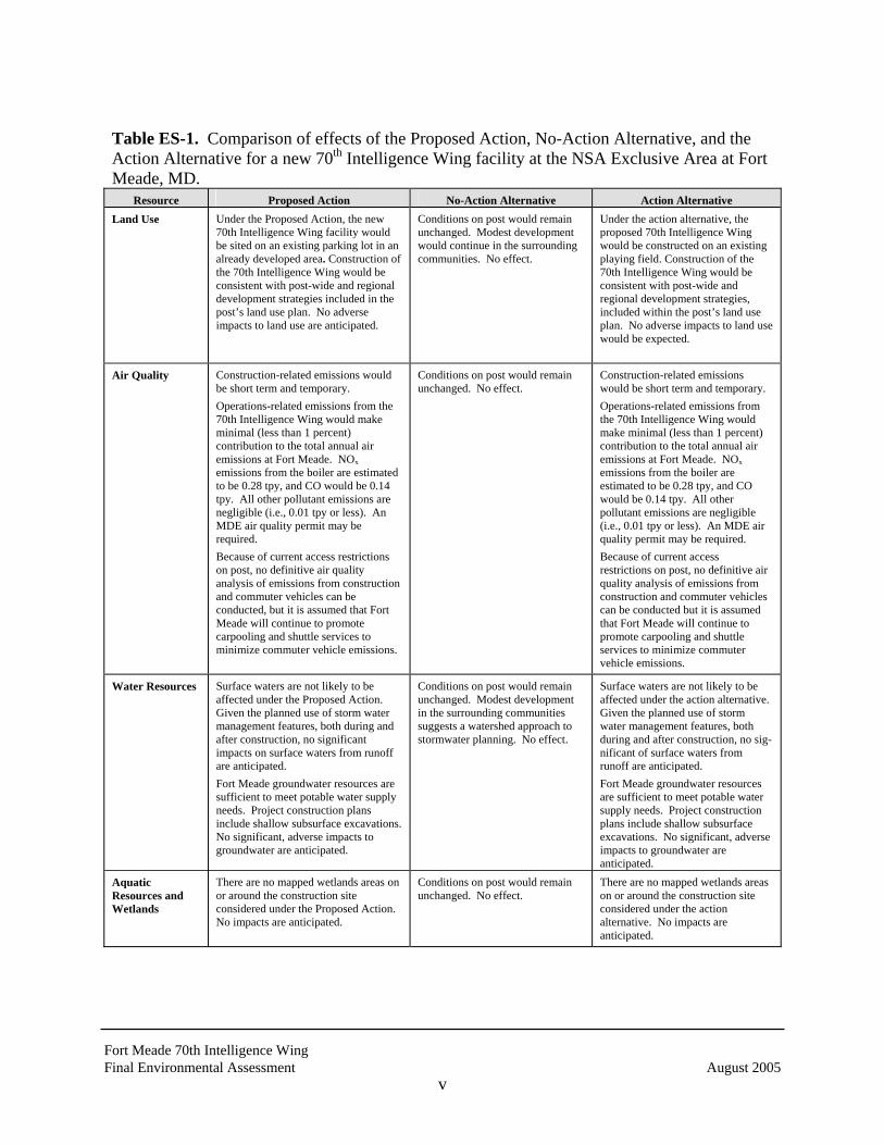
Table ES-1 provides a concise comparison of effects on resources that would result from the
Proposed Action, No-Action Alternative, and the Action Alternative.
Fort Meade 70th Intelligence Wing Final Environmental Assessment August 2005
v
Table ES-1. Comparison of effects of the Proposed Action, No-Action Alternative, and the Action Alternative for a new 70th Intelligence Wing facility at the NSA Exclusive Area at Fort Meade, MD.
Resource Proposed Action No-Action Alternative Action Alternative Land Use
Under the Proposed Action, the new 70th Intelligence Wing facility would be sited on an existing parking lot in an already developed area. Construction of the 70th Intelligence Wing would be consistent with post-wide and regional development strategies included in the post’s land use plan. No adverse impacts to land use are anticipated.
Conditions on post would remain unchanged. Modest development would continue in the surrounding communities. No effect.
Under the action alternative, the proposed 70th Intelligence Wing would be constructed on an existing playing field. Construction of the 70th Intelligence Wing would be consistent with post-wide and regional development strategies, included within the post’s land use plan. No adverse impacts to land use would be expected.
Air Quality
Construction-related emissions would be short term and temporary. Operations-related emissions from the 70th Intelligence Wing would make minimal (less than 1 percent) contribution to the total annual air emissions at Fort Meade. NOx emissions from the boiler are estimated to be 0.28 tpy, and CO would be 0.14 tpy. All other pollutant emissions are negligible (i.e., 0.01 tpy or less). An MDE air quality permit may be required. Because of current access restrictions on post, no definitive air quality analysis of emissions from construction and commuter vehicles can be conducted, but it is assumed that Fort Meade will continue to promote carpooling and shuttle services to minimize commuter vehicle emissions.
Conditions on post would remain unchanged. No effect.
Construction-related emissions would be short term and temporary. Operations-related emissions from the 70th Intelligence Wing would make minimal (less than 1 percent) contribution to the total annual air emissions at Fort Meade. NOx emissions from the boiler are estimated to be 0.28 tpy, and CO would be 0.14 tpy. All other pollutant emissions are negligible (i.e., 0.01 tpy or less). An MDE air quality permit may be required. Because of current access restrictions on post, no definitive air quality analysis of emissions from construction and commuter vehicles can be conducted but it is assumed that Fort Meade will continue to promote carpooling and shuttle services to minimize commuter vehicle emissions.
Water Resources
Surface waters are not likely to be affected under the Proposed Action. Given the planned use of storm water management features, both during and after construction, no significant impacts on surface waters from runoff are anticipated. Fort Meade groundwater resources are sufficient to meet potable water supply needs. Project construction plans include shallow subsurface excavations. No significant, adverse impacts to groundwater are anticipated.
Conditions on post would remain unchanged. Modest development in the surrounding communities suggests a watershed approach to stormwater planning. No effect.
Surface waters are not likely to be affected under the action alternative. Given the planned use of storm water management features, both during and after construction, no sig-nificant of surface waters from runoff are anticipated. Fort Meade groundwater resources are sufficient to meet potable water supply needs. Project construction plans include shallow subsurface excavations. No significant, adverse impacts to groundwater are anticipated.
Aquatic Resources and Wetlands
There are no mapped wetlands areas on or around the construction site considered under the Proposed Action. No impacts are anticipated.
Conditions on post would remain unchanged. No effect.
There are no mapped wetlands areas on or around the construction site considered under the action alternative. No impacts are anticipated.
Fort Meade 70th Intelligence Wing Final Environmental Assessment August 2005
vi
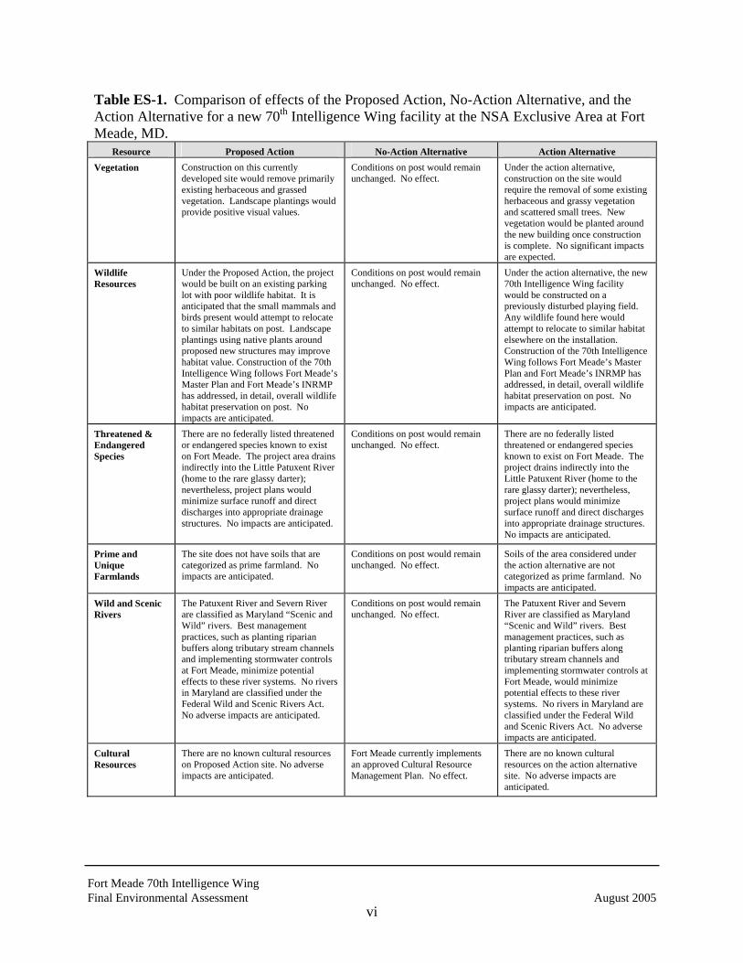
Table ES-1. Comparison of effects of the Proposed Action, No-Action Alternative, and the Action Alternative for a new 70th Intelligence Wing facility at the NSA Exclusive Area at Fort Meade, MD.
Resource Proposed Action No-Action Alternative Action Alternative Vegetation
Construction on this currently developed site would remove primarily existing herbaceous and grassed vegetation. Landscape plantings would provide positive visual values.
Conditions on post would remain unchanged. No effect.
Under the action alternative, construction on the site would require the removal of some existing herbaceous and grassy vegetation and scattered small trees. New vegetation would be planted around the new building once construction is complete. No significant impacts are expected.
Wildlife Resources
Under the Proposed Action, the project would be built on an existing parking lot with poor wildlife habitat. It is anticipated that the small mammals and birds present would attempt to relocate to similar habitats on post. Landscape plantings using native plants around proposed new structures may improve habitat value. Construction of the 70th Intelligence Wing follows Fort Meade’s Master Plan and Fort Meade’s INRMP has addressed, in detail, overall wildlife habitat preservation on post. No impacts are anticipated.
Conditions on post would remain unchanged. No effect.
Under the action alternative, the new 70th Intelligence Wing facility would be constructed on a previously disturbed playing field. Any wildlife found here would attempt to relocate to similar habitat elsewhere on the installation. Construction of the 70th Intelligence Wing follows Fort Meade’s Master Plan and Fort Meade’s INRMP has addressed, in detail, overall wildlife habitat preservation on post. No impacts are anticipated.
Threatened & Endangered Species
There are no federally listed threatened or endangered species known to exist on Fort Meade. The project area drains indirectly into the Little Patuxent River (home to the rare glassy darter); nevertheless, project plans would minimize surface runoff and direct discharges into appropriate drainage structures. No impacts are anticipated.
Conditions on post would remain unchanged. No effect.
There are no federally listed threatened or endangered species known to exist on Fort Meade. The project drains indirectly into the Little Patuxent River (home to the rare glassy darter); nevertheless, project plans would minimize surface runoff and direct discharges into appropriate drainage structures. No impacts are anticipated.
Prime and Unique Farmlands
The site does not have soils that are categorized as prime farmland. No impacts are anticipated.
Conditions on post would remain unchanged. No effect.
Soils of the area considered under the action alternative are not categorized as prime farmland. No impacts are anticipated.
Wild and Scenic Rivers
The Patuxent River and Severn River are classified as Maryland “Scenic and Wild” rivers. Best management practices, such as planting riparian buffers along tributary stream channels and implementing stormwater controls at Fort Meade, minimize potential effects to these river systems. No rivers in Maryland are classified under the Federal Wild and Scenic Rivers Act. No adverse impacts are anticipated.
Conditions on post would remain unchanged. No effect.
The Patuxent River and Severn River are classified as Maryland “Scenic and Wild” rivers. Best management practices, such as planting riparian buffers along tributary stream channels and implementing stormwater controls at Fort Meade, would minimize potential effects to these river systems. No rivers in Maryland are classified under the Federal Wild and Scenic Rivers Act. No adverse impacts are anticipated.
Cultural Resources
There are no known cultural resources on Proposed Action site. No adverse impacts are anticipated.
Fort Meade currently implements an approved Cultural Resource Management Plan. No effect.
There are no known cultural resources on the action alternative site. No adverse impacts are anticipated.
Fort Meade 70th Intelligence Wing Final Environmental Assessment August 2005
vii
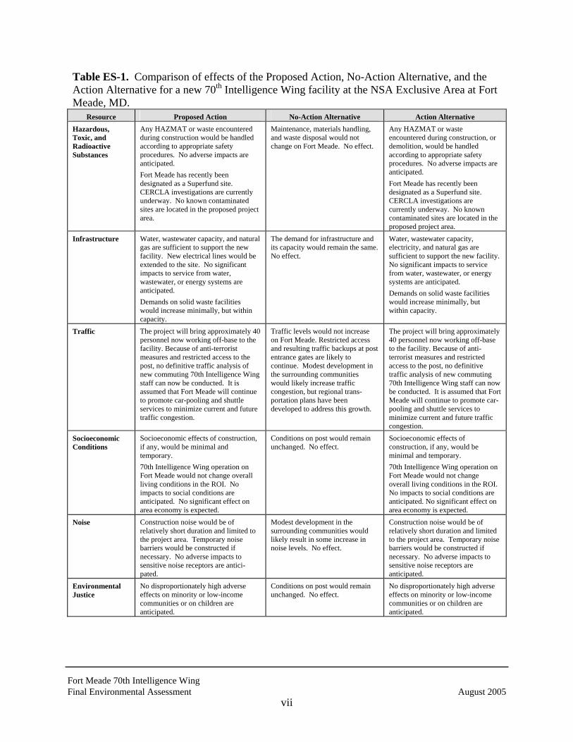
Table ES-1. Comparison of effects of the Proposed Action, No-Action Alternative, and the Action Alternative for a new 70th Intelligence Wing facility at the NSA Exclusive Area at Fort Meade, MD.
Resource Proposed Action No-Action Alternative Action Alternative Hazardous, Toxic, and Radioactive Substances
Any HAZMAT or waste encountered during construction would be handled according to appropriate safety procedures. No adverse impacts are anticipated. Fort Meade has recently been designated as a Superfund site. CERCLA investigations are currently underway. No known contaminated sites are located in the proposed project area.
Maintenance, materials handling, and waste disposal would not change on Fort Meade. No effect.
Any HAZMAT or waste encountered during construction, or demolition, would be handled according to appropriate safety procedures. No adverse impacts are anticipated. Fort Meade has recently been designated as a Superfund site. CERCLA investigations are currently underway. No known contaminated sites are located in the proposed project area.
Infrastructure
Water, wastewater capacity, and natural gas are sufficient to support the new facility. New electrical lines would be extended to the site. No significant impacts to service from water, wastewater, or energy systems are anticipated. Demands on solid waste facilities would increase minimally, but within capacity.
The demand for infrastructure and its capacity would remain the same. No effect.
Water, wastewater capacity, electricity, and natural gas are sufficient to support the new facility. No significant impacts to service from water, wastewater, or energy systems are anticipated. Demands on solid waste facilities would increase minimally, but within capacity.
Traffic The project will bring approximately 40 personnel now working off-base to the facility. Because of anti-terrorist measures and restricted access to the post, no definitive traffic analysis of new commuting 70th Intelligence Wing staff can now be conducted. It is assumed that Fort Meade will continue to promote car-pooling and shuttle services to minimize current and future traffic congestion.
Traffic levels would not increase on Fort Meade. Restricted access and resulting traffic backups at post entrance gates are likely to continue. Modest development in the surrounding communities would likely increase traffic congestion, but regional trans-portation plans have been developed to address this growth.
The project will bring approximately 40 personnel now working off-base to the facility. Because of anti-terrorist measures and restricted access to the post, no definitive traffic analysis of new commuting 70th Intelligence Wing staff can now be conducted. It is assumed that Fort Meade will continue to promote car-pooling and shuttle services to minimize current and future traffic congestion.
Socioeconomic Conditions
Socioeconomic effects of construction, if any, would be minimal and temporary. 70th Intelligence Wing operation on Fort Meade would not change overall living conditions in the ROI. No impacts to social conditions are anticipated. No significant effect on area economy is expected.
Conditions on post would remain unchanged. No effect.
Socioeconomic effects of construction, if any, would be minimal and temporary. 70th Intelligence Wing operation on Fort Meade would not change overall living conditions in the ROI. No impacts to social conditions are anticipated. No significant effect on area economy is expected.
Noise
Construction noise would be of relatively short duration and limited to the project area. Temporary noise barriers would be constructed if necessary. No adverse impacts to sensitive noise receptors are antici-pated.
Modest development in the surrounding communities would likely result in some increase in noise levels. No effect.
Construction noise would be of relatively short duration and limited to the project area. Temporary noise barriers would be constructed if necessary. No adverse impacts to sensitive noise receptors are anticipated.
Environmental Justice
No disproportionately high adverse effects on minority or low-income communities or on children are anticipated.
Conditions on post would remain unchanged. No effect.
No disproportionately high adverse effects on minority or low-income communities or on children are anticipated.

Fort Meade 70th Intelligence Wing Final Environmental Assessment August 2005
viii
THIS PAGE INTENTIONALLY LEFT BLANK
Fort Meade 70th Intelligence Wing Final Environmental Assessment August 2005
ix
TABLE OF CONTENTS
Page
EXECUTIVE SUMMARY .......................................................................................................... i
ACRONYMS AND ABBREVIATIONS................................................................................. xvii
1.0 PURPOSE OF AND NEED FOR THE ACTION....................................................... 1-1
1.1 NEED FOR THE ACTION ................................................................................. 1-1
1.2 PURPOSE OF THE ACTION............................................................................. 1-2
1.3 LOCATION ......................................................................................................... 1-3
1.4 INSTALLATION HISTORY .............................................................................. 1-4
1.5 MISSION ............................................................................................................. 1-4
1.6 SCOPE OF THE EA............................................................................................ 1-5
1.7 APPLICABLE REGULATORY REQUIREMENTS ......................................... 1-6
1.8 ORGANIZATION OF THE ENVIRONMENTAL ASSESSMENT.................. 1-7
2.0 ALTERNATIVES CONSIDERED .............................................................................. 2-1
2.1 PROPOSED ACTION......................................................................................... 2-1
2.2 NO-ACTION ALTERNATIVE........................................................................... 2-3
2.3 ACTION ALTERNATIVE.................................................................................. 2-3
2.4 MITIGATION MEASURES ............................................................................... 2-4
2.5 OTHER PLANNED ACTIVITIES...................................................................... 2-4
2.5.1 On-Post ................................................................................................. 2-4
2.5.2 Regional ................................................................................................ 2-5
2.6 FOCUS OF THE ENVIRONMENTAL ANALYSIS ......................................... 2-7
3.0 AFFECTED ENVIRONMENT .................................................................................... 3-1
3.1 LAND USE.......................................................................................................... 3-4
3.1.1 On-Post Land Use ................................................................................. 3-4
3.1.2 Regional Land Use and Zoning ............................................................ 3-6
Fort Meade 70th Intelligence Wing Final Environmental Assessment August 2005
x
3.1.3 Geology............................................................................................... 3-10
3.1.4 Soils..................................................................................................... 3-11
3.1.5 Topography and Drainage................................................................... 3-12
3.2 AIR QUALITY.................................................................................................. 3-12
3.3 WATER RESOURCES ..................................................................................... 3-14
3.3.1 Surface Water...................................................................................... 3-15
3.4 AQUATIC RESOURCES AND WETLANDS................................................. 3-21
3.4.1 Aquatic Resources .............................................................................. 3-21
3.4.2 Wetlands ............................................................................................. 3-21
3.5 VEGETATION.................................................................................................. 3-23
3.5.1 NSA Secure Area................................................................................ 3-23
3.5.2 Berman Tract ...................................................................................... 3-24
3.5.3 Fort Meade Vegetation ....................................................................... 3-27
3.6 WILDLIFE RESOURCES................................................................................. 3-29
3.6.1 NSA Wildlife ...................................................................................... 3-29
3.6.2 Fort Meade Wildlife............................................................................ 3-31
3.7 THREATENED AND ENDANGERED SPECIES .......................................... 3-32
3.8 PRIME AND UNIQUE FARMLANDS............................................................ 3-37
3.9 WILD AND SCENIC RIVERS......................................................................... 3-37
3.10 CULTURAL RESOURCES .............................................................................. 3-39
3.11 HAZARDOUS, TOXIC, AND RADIOACTIVE SUBSTANCES ................... 3-41
3.11.1 Underground Storage Tanks and Aboveground Storage Tanks ......... 3-41
3.11.2 Polychlorinated Biphenyls .................................................................. 3-41
3.11.3 Radon .................................................................................................. 3-42
3.11.4 Hazardous Materials and Waste.......................................................... 3-43
3.11.5 Contaminated Areas............................................................................ 3-44
3.11.6 Permits and Regulatory Authorizations .............................................. 3-46
3.12 INFRASTRUCTURE ........................................................................................ 3-46
3.12.1 Utilities................................................................................................ 3-46
3.12.2 Solid Waste ......................................................................................... 3-51
Fort Meade 70th Intelligence Wing Final Environmental Assessment August 2005
xi
3.12.3 Transportation ..................................................................................... 3-52
3.13 SOCIOECONOMIC CONDITIONS................................................................. 3-57
3.13.1 Region of Influence............................................................................. 3-57
3.13.2 Demographics ..................................................................................... 3-58
3.13.3 Economics........................................................................................... 3-61
3.13.4 Schools, Libraries, and Recreation Facilities...................................... 3-63
3.13.5 Public Health and Safety..................................................................... 3-66
3.13.6 Noise ................................................................................................... 3-68
3.13.7 Aesthetics and Visual Zones............................................................... 3-70
3.14 ENVIRONMENTAL JUSTICE ........................................................................ 3-70
4.0 ENVIRONMENTAL CONSEQUENCES....................................................................... 4-1
4.1 LAND USE.......................................................................................................... 4-1
4.1.1 On-Post Land Use ................................................................................. 4-1
4.1.2 Regional Land Use and Zoning ............................................................ 4-2
4.1.3 Geology................................................................................................. 4-2
4.1.4 Soils....................................................................................................... 4-3
4.1.5 Topography and Drainage..................................................................... 4-3
4.2 AIR QUALITY.................................................................................................... 4-3
4.2.1 Construction-Related Air Emissions..................................................... 4-3
4.2.2 Operations-Related Air Emissions........................................................ 4-5
4.3 WATER RESOURCES ....................................................................................... 4-6
4.3.1 Surface Water........................................................................................ 4-6
4.3.2 Groundwater ......................................................................................... 4-8
4.4 AQUATIC RESOURCES AND WETLANDS................................................... 4-8
4.4.1 Aquatic Resources ................................................................................ 4-8
4.4.2 Wetlands ............................................................................................... 4-9
4.5 VEGETATION.................................................................................................... 4-9
4.5.1 Proposed Action.................................................................................. 4-10
4.5.2 Action Alternative............................................................................... 4-10
4.6 WILDLIFE RESOURCES................................................................................. 4-10
Fort Meade 70th Intelligence Wing Final Environmental Assessment August 2005
xii
4.6.1 Proposed Action.................................................................................. 4-10
4.6.2 Action Alternative............................................................................... 4-10
4.7 THREATENED AND ENDANGERED SPECIES........................................... 4-11
4.8 PRIME AND UNIQUE FARMLANDS............................................................ 4-12
4.8.1 Proposed Action.................................................................................. 4-12
4.8.2 Action Alternative............................................................................... 4-12
4.9 WILD AND SCENIC RIVERS......................................................................... 4-12
4.10 CULTURAL RESOURCES .............................................................................. 4-12
4.10.1 Archaeological Resources................................................................... 4-12
4.10.2 Historic Architectural Resources ........................................................ 4-13
4.10.3 Underground Storage Tanks and Above Ground Storage Tanks........ 4-13
4.10.4 Polychlorinated Biphenyls .................................................................. 4-13
4.10.5 Radon .................................................................................................. 4-13
4.10.6 Storage and Mangement of Hazardous Materials and Waste ............. 4-13
4.10.7 Contaminated Areas............................................................................ 4-14
4.10.8 Permits and Regulatory Authorizations .............................................. 4-15
4.11 INFRASTRUCTURE ........................................................................................ 4-16
4.11.1 Utilities................................................................................................ 4-16
4.11.2 Solid Waste ......................................................................................... 4-18
4.11.3 Transportation ..................................................................................... 4-19
4.12 SOCIOECONOMIC CONDITIONS................................................................. 4-20
4.12.1 Region of Influence............................................................................. 4-20
4.12.2 Demographics ..................................................................................... 4-20
4.12.3 Economics........................................................................................... 4-20
4.12.4 Schools, Libraries, and Recreation Facilities...................................... 4-21
4.12.5 Public Health and Safety..................................................................... 4-21
4.12.6 Noise ................................................................................................... 4-22
4.12.7 Aesthetics and Visual Zones............................................................... 4-23
4.13 ENVIRONMENTAL JUSTICE ........................................................................ 4-24
4.14 CUMULATIVE IMPACTS............................................................................... 4-24
Fort Meade 70th Intelligence Wing Final Environmental Assessment August 2005
xiii
5.0 CONCLUSIONS ................................................................................................................ 5-1
6.0 PERSONS CONSULTED ................................................................................................. 6-1
7.0 LIST OF PREPARERS..................................................................................................... 7-1
8.0 REFERENCES................................................................................................................... 8-1
APPENDICES
A AGENCY COORDINATION LETTERS ...........................................................A-1
B PLANT LIST NSA/FORT MEADE AREA........................................................B-1
C BIRDS OBSERVED NSA/FORT MEADE AREA ............................................C-1
D MAMMALS NSA/FORT MEADE AREA.........................................................D-1

Fort Meade 70th Intelligence Wing Final Environmental Assessment August 2005
xiv
THIS PAGE INTENTIONALLY LEFT BLANK
Fort Meade 70th Intelligence Wing Final Environmental Assessment August 2005
xv
LIST OF FIGURES
Page
1-1 Map showing Fort Meade within a regional context ....................................................... 1-3
2-1 Locations of the Proposed Action and Action Alternative sites for the proposed new
70th Intelligence Wing facilities at the National Security Agency, within Fort Meade,
Anne Arundel County, Maryland .................................................................................... 2-2
3-1 Map showing Fort Meade within a regional context ....................................................... 3-2
3-2 Fort Meade Land Use Plan showing postwide arrangement of designated areas by land
use categories ................................................................................................................... 3-5
3-3 Map showing the watersheds, wetlands, and streams within Fort Meade boundaries .. 3-16
3-4 Map of Fort Meade showing forest conservation areas ................................................. 3-28
Fort Meade 70th Intelligence Wing Final Environmental Assessment August 2005
xvi
LIST OF TABLES
Page
2-1. Construction Efforts at Fort Meade Through the Construction Year 2006 ..................... 2-4
3-1 Summary of Annual Criteria Pollutant Emissions by Source........................................ 3-14
3-2 State List of Rare, Threatened, and Endangered Plant Species Identified at Fort
Meade Between 1993 and August 1994 ........................................................................ 3-35
3-3 State and Federal List of Rate, Threatened, and Endangered Animal Species
Identified at Fort Meade Between 1993 and August 1994 ............................................ 3-36
3-4 Permits and Regulatory Authorizations at Fort Meade, Maryland ................................ 3-47
3-5 Level of Service for Traffic Analysis/Critical Lane Volumes....................................... 3-55
3-6 Results of Intersection Capacity Analysis Conducted During Recent NEPA
Assessment..................................................................................................................... 3-56
3-7 Historic Population Trends and Forecasts for Fort Meade Region................................ 3-59
3-8 Population Characteristics in the Counties Surrounding Fort Meade............................ 3-60
3-9 Employment Trends for 1970 and1997 in the Fort Meade Region of Influence........... 3-62
3-10 Common Noise Levels................................................................................................... 3-69
3-11 Department of the Army Noise Zones ........................................................................... 3-69
5-1 Comparison of Effects of the Proposed action, No-Action Alternative, and
the Action Alternatives for a new 70th Intelligence Wing facility at the NSA
Exclusive Area at Fort Meade, MD ................................................................................. 5-2
Fort Meade 70th Intelligence Wing Final Environmental Assessment August 2005
xvii
ACRONYMS AND ABBREVIATIONS
AAFES Army and Air Force Exchange Service ACM asbestos-containing material ARPA Archeological Resource Protection Act ARRP Army Radon Reduction Program ASL Active Sanitary Landfill AST above ground storage tanks AWTP advanced wastewater treatment plant BGE Baltimore Gas and Electric BRAC Base Realignment and Closure BRAC 1 Defense Authorization Amendments and Base Closure Act of 1988
(Public Law 100-526) BRAC 95 Base Realignment and Closure Act of 1990 (Public Law 101-510) BWI Baltimore-Washington International CAA Clean Air Act CDC Child Development Center CDS Child Development Services CEQ Council on Environmental Quality CERCLA Comprehensive Environmental Response, Compensation, and Liability
Act CFR Code of Federal Regulations CLD Clean Landfill Dump CLV Critical Lane Volume CO carbon monoxide COMAR Code of Maryland Regulations CRMP Cultural Resource Management Plan CWA Clean Water Act DA Department of the Army dB decibels dBA A-weighted decibel DINFOS Defense Information School DNL Day-Night Level DoD Department of Defense DNR Department of Natural Resources
Fort Meade 70th Intelligence Wing Final Environmental Assessment August 2005
xviii
DPW Directorate of Public Works DRM Directorate of Resource Management DRMO Directorate of Resource Management Operations EA Environmental Assessment EIAP Environmental Impact Analysis Process EMO Environmental Management Office EO Executive Order EPA U.S. Environmental Protection Agency ESA Endangered Species Act ESSD Executive Software Systems Directorate FCA Forest Conservation Act FFCA Federal Facility Compliance Act FIDS forest interior dwelling species FY Fiscal Year GMA growth management area gpcd gallons per capita per day gpd gallons per day gpm gallons per minute HAZMAT hazardous material HCM Highway Capacity Manual HUD Housing and Urban Development INRMP Integrated Natural Resource Management Plan IPMP Installation Pest Management Plan ISCP Installation Spill Contingency Plan ISWM Integrated Solid Waste Management Plan K thousand kV kilovolt kVA kilovolt average LBP lead based paint Leq equivalent sound levels LOS Level of Service (traffic) M million MARC Maryland Rail Commuter Service MD Maryland
Fort Meade 70th Intelligence Wing Final Environmental Assessment August 2005
xix
MDE Maryland Department of the Environmental mgd million gallons per day mg/l milligrams per liter MMBtu/hr million British thermal units per hour MMBtu/yr million British thermal units per year MSDS material safety data sheets msl mean sea level MTA Mass Transit Administration NAHB National Association of Home Builders NEPA National Environmental Policy Act NHPA National Historic Preservation Act NO2 nitrogen dioxide NOI notice of intent NPDES National Pollutant Discharge Elimination System NPL National Priority List NRCS Natural Resource Conservation Service NRHP National Register of Historic Places NSA National Security Agency O3 ozone OSHA Occupational Safety and Health PAO Public Affairs Office Pb Lead PCB polychlorinated biphenyl pCi/L picocuries per liter PM-10 particulate matter- with diameter of 10 microns or less PMSA primary metropolitan statistical area PPA Pollution Prevention Act ppm parts per million psi pounds per square inch psig pounds per square inch/gas PTC permit to construct RCRA Resource Conservation Recovery Act ROI region of influence SAV Submerged Aquatic Vegetation

Fort Meade 70th Intelligence Wing Final Environmental Assessment August 2005
xx
SF square feet SHPO State Historic Preservation Office SO2 sulfur dioxide SPCC Spill Prevention Control Countermeasures SWDA Solid Waste Disposal Act SWMP stormwater management program SWM stormwater management TAA Tipton Army Airfield tpd tons per day tpy tons per year USACE U.S. Army Corps of Engineers USATHAMA U.S. Army Toxic and Hazardous Materials Agency USCB U.S. Census Bureau USDA U.S. Department of Agriculture USFWS U.S. Fish and Wildlife Service USGS United States Geological Survey UST underground storage tanks VOC volatile organic compound WTP water treatment plant WWI World War I WWII World War II

Fort Meade 70th Intelligence Wing Final Environmental Assessment August 2005
1-1
1.0 PURPOSE OF AND NEED FOR THE ACTION
1.1 NEED FOR THE ACTION
Fort George G. Meade is a permanent United States Army Installation with the mission of
providing leadership in base operations supporting tenant activities that includes all services,
Department of Defense (DoD) activities, and federal agencies. The major command for Fort
Meade is the Military District of Washington (MDW). The construction of a new 70th
Intelligence Wing facility supports this mission.
The proposed project was submitted at the request of the 694th Intelligence Wing (70 IW), an Air
Force Tenant unit assigned to Fort Meade. The proposed facility would provide administrative
space for Command components of the 70th Intelligence Wing and the 694th Intelligence Group
(694 IG), Air Force Special Intelligence Detachment and customer support functions. The
House Command and support functions of the 70 IW and 694 IG are currently located in five
separate sub-standard facilities. The 70 IW and 694 IG require the ability to communicate at all
levels of security in a timely manner with national decision-makers, Theater Commanders, and
Warfighters of all services. The 70 IW provides command and control to over 3,800 personnel
assigned to Fort Meade, MD; Misawa AB, Japan; and Lackland AFB, TX. The 694 IG and
subordinate organizations provide administrative support to over 2,700 military personnel
assigned to the National Security Agency, located at Fort Meade. The proposed facility would
also provide space to the Air Force Office of Special Investigations, investigative and polygraph
functions.
Currently, the 70 IW operations occupy 4,810 square meters (SM) in four separate facilities in
the 9800 Area of Fort Meade and one National Security Agency Facility located 9 miles away
from the rest of the 70 IW in the Fort Meade 9800 Area. Of the 4,810 SM currently occupied,
1,208 SM are adequate. This includes appropriate security level, functionality and location. Of
the space currently occupied, 925 SM is in converted dormitory rooms, resulting in 40 airmen
being required to reside off post each year; of this 474 SM are substandard basement storage area
converted to office space with ceiling heights as low as 6.5 feet. Five Wing and Group staff
agencies, as well as Wing and Group operations functions are located 9 miles away in leased
Fort Meade 70th Intelligence Wing Final Environmental Assessment August 2005
1-2
facilities. There is no resident Sensitive Compartmentalized Information Facility (SCIF) space
available to the Wing leadership and staff, thereby denying access to critical, time sensitive,
classified information required to control world-wide intelligence resources under the 70 IW
command. The 70 IW is in violation of Air Force regulations 32-1024 and Air Force Handbook
32-1084 owing to the lack of adequate space.
Without the proposed project, the 70 IW and 694 IG would continue to operate in geographically
separated locations, resulting in decreased effectiveness of a unit responding to National
Intelligence tasks. Command and control of the largest intelligence wing in the Air Force would
continue to be hindered by the time delay in internal communications. Additionally, 40 airmen
will continue to be denied access to Unaccompanied Enlisted Personnel housing and an
additional 20 airmen will be required to live off post in order to meet current facility space
requirements. The ability of the 70 IW to deliver tailored, timely, and full spectrum information
operations to national decision-makers, theater commanders and warfighters of all services will
continue to be severely degraded. The Wing’s ability to conduct foreign intelligence and
information assurance operations as a major element of the Air Force Global Intelligence
Mission will continue to be negatively impacted.
1.2 PURPOSE OF THE ACTION
The purpose of constructing a new 70th Intelligence Wing facility is to support the mission of the
70 IW and 694 IG to communicate at all levels of security in a timely manner with national
decision-makers, Theater Commanders, and Warfighters of all the services. The proposed
project would facilitate more effective communication between all essential parties by bringing
together the now geographically-separated members of the 70th Intelligence Wing in one
building with updated, state-of-the-art facilities.
Pursuant to the National Environmental Policy Act (NEPA) of 1969, as amended, and its
implementing regulations, the Army has prepared this environmental assessment (EA) to address
the potential environmental impacts of this action. The study area for this EA encompasses both
Fort Meade and the surrounding communities defined as the region of influence (ROI). For this
EA, the ROI consists of Anne Arundel and Howard Counties in Maryland.
Fort Meade 70th Intelligence Wing Final Environmental Assessment August 2005
1-3
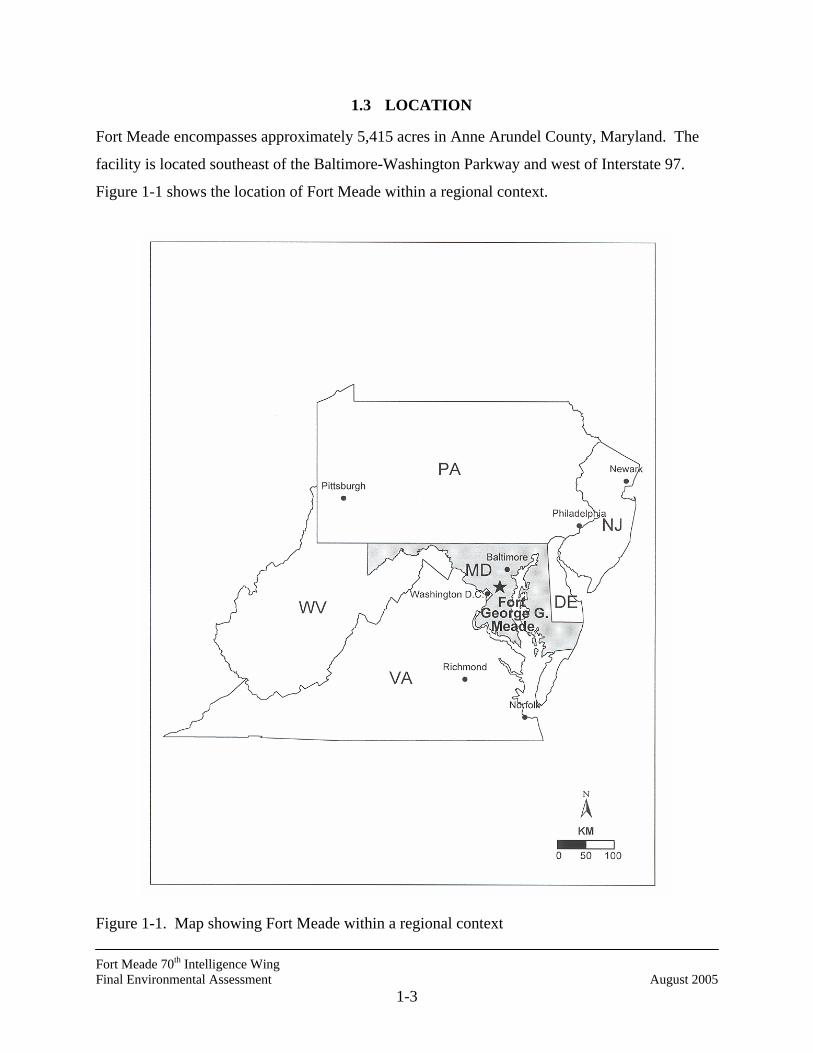
1.3 LOCATION
Fort Meade encompasses approximately 5,415 acres in Anne Arundel County, Maryland. The
facility is located southeast of the Baltimore-Washington Parkway and west of Interstate 97.
Figure 1-1 shows the location of Fort Meade within a regional context.
Figure 1-1. Map showing Fort Meade within a regional context

Fort Meade 70th Intelligence Wing Final Environmental Assessment August 2005
1-4
1.4 INSTALLATION HISTORY
Fort Meade, originally named Camp Meade for Major General George Gordon Meade, was
authorized by Congress in 1917 as a training cantonment during World War I (WWI). During
WWI, more than 100,000 troops passed through Camp Meade. A second cantonment area was
added to the site in 1918. In 1928, Camp Meade was made a permanent installation and given
the name Fort Leonard Wood, which was changed a year later, after much protest from
Pennsylvania residents, to Fort George G. Meade. About 2,200 troops were assigned to Fort
Meade during the 1930s (Goodwin et al. 1994).
By 1940, the installation had 251 permanent brick buildings and 218 temporary wooden
buildings. In the same year, however, Fort Meade began an extensive build out of facilities in
response to the New Selective Service and Training Act of 1940. Originally 9,349 acres in size,
the installation was expanded to 13,691 acres to accommodate the additional training activities.
As a result of the build-out, Fort Meade became the fourth largest community in Maryland. Fort
Meade continued its training mission until 1992 when, under BRAC I, the 8,100-acre range and
training area south of MD Route 32 was transferred to the U.S. Fish and Wildlife Service.
Reduced to approximately 5,415 acres, the remaining installation acreage is being developed for
military and tenant uses. Currently, there are approximately 76 tenant organizations at Fort
Meade, including the Defense Information School (DINFOS), 694th Intelligence Wing, and the
National Security Agency (NSA), Fort Meade’s largest tenant (USACE 1997).
1.5 MISSION
Fort Meade is dedicated to providing quality support to many federal agencies (including the
DoD), soldiers and their families, and civilian employees. Fort Meade’s mission is to provide
leadership in post operations and to assume the responsibility for numerous activities conducted
to support the approximately 114 tenant organizations from all four services and many federal
agencies. Following Base Realignment and Closure (BRAC) actions, Fort Meade currently has
an increased mission as a major federal administrative center and has the need to accommodate
additional tenants and activities. Fort Meade also provides for the quality of life for service
members and their families, the civilian work force, and retirees that make up the Fort Meade
community.
Fort Meade 70th Intelligence Wing Final Environmental Assessment August 2005
1-5
1.6 SCOPE OF THE EA
The NEPA was enacted to ensure that federal agencies consider the environmental effects of
their actions. The intent of the NEPA is to protect, restore, or enhance the environment through
well-informed federal decisions. Under the NEPA, federal agencies are required to
systematically assess the environmental consequences of their Proposed Actions during the
decision-making process. The purpose of the Council on Environmental Quality (CEQ) is to
develop implementation regulations and to oversee the efforts of federal agencies as they
implement the NEPA programs. NEPA implementation regulations were issued in 1978, and are
included in Title 40, Code of Federal Regulations (CFR), Parts 1500-1508.
This EA identifies, describes, and evaluates the potential environmental impacts that would
result from the implementation of the Proposed Action and its alternatives, taking into
consideration possible cumulative impacts from other actions. As appropriate, the affected
environment and environmental consequences of the action will be described in both regional
and site-specific contexts. In instances where mitigation measures may not be required, this EA
identifies operating procedures that would be implemented to further minimize environmental
impacts. This EA is based on the most current information available as of March 2005.
The following biophysical resources have been identified for study at Fort Meade: water
resources, earth resources, aquatic resources and wetlands, vegetation, wildlife resources,
infrastructure and utilities, hazardous materials and waste (relative to Fort Meade’s Superfund
status), biological resources, cultural resources, socioeconomic resources, and land use.
Potential impacts of stormwater runoff into waterways, as a result of the Proposed Action and its
alternatives, are also evaluated. Safety and health impacts are evaluated, but it has been assumed
that contractors would be responsible for compliance with the applicable Occupational Safety
and Health Act (OSHA) regulations that concern occupational hazards and specifying
appropriate protective measures for all employees. Additionally, maintenance activities subject
to OSHA regulations are not components of the Proposed Action.
Because of terrorist activities conducted against the United States on September 11, 2001, Fort
Meade and all other federal installations and agencies have been closed to unrestricted public
access. During this time, access to and travel on Fort Meade has been restricted through the
Fort Meade 70th Intelligence Wing Final Environmental Assessment August 2005
1-6
implementation of gate inspections and random vehicle searches. The duration of these
restrictions are permanent (Gebhardt 2001a). Because of the traffic changes that have resulted
from this situation, this EA cannot definitively address projected traffic conditions and air
emissions (related to traffic). To the extent possible, however, potential impacts to these
resource areas are discussed.
Executive Order (EO) 12898, Federal Actions to Address Environmental Justice in Minority
Populations and Low-Income Populations, February 11, 1994, instructs each federal agency to
make “achieving environmental justice part of its mission, by identifying and addressing, as
appropriate, disproportionately high and adverse human health or environmental effects of its
programs, policies, and activities on minority populations and low-income populations.” No
disproportionately high and adverse impacts upon minority populations and low-income
populations are expected from the Proposed Action or alternatives.
This EA identifies, documents, and evaluates the potential environmental impacts of the
Proposed Action and one action alternative. The current activities included in the No-Action
Alternative constitute the baseline for the analysis of effects. Fiscal Year 2005 (FY05) activities
are used to establish the baseline conditions. However, where FY05 data were not available, the
most current available information was used. The implementation of the No-Action Alternative
would not result in any change to this baseline. The existing conditions at Fort Meade are
described in Chapter 3 – Affected Environment. A team of environmental scientists, ecologists,
and engineers have analyzed the potential effects associated with each alternative and have
presented the results in Chapter 4 – Environmental Consequences.
1.7 APPLICABLE REGULATORY REQUIREMENTS
This EA complies with the NEPA, CEQ regulations, and DoD Instruction 4715.9. The EA also
addresses all applicable laws and regulations, including but not limited to the following:
• National Historic Preservation Act (NHPA),
• Archeological Resources Protection Act (ARPA),
• Clean Air Act (CAA),
• AFI 32-7040, Air Quality Compliance,
Fort Meade 70th Intelligence Wing Final Environmental Assessment August 2005
1-7
• Clean Water Act (CWA),
• Endangered Species Act (ESA),
• Pollution Prevention Act (PPA), and
• Resource Conservation and Recovery Act (RCRA).
1.8 ORGANIZATION OF THE ENVIRONMENTAL ASSESSMENT
This EA is organized into eight chapters and four appendices. Chapter 1 contains an
introduction, the purpose and need for the action, the location of the Proposed Action, and the
scope and organization of the document. Chapter 2 presents the alternatives, describing the
Proposed Action, No-Action Alternative, two Action Alternatives, and alternatives eliminated
from consideration. Chapter 3 describes the affected environment. Chapter 4 analyzes the
environmental consequences of the Proposed Action, No-Action Alternative, and the Action
Alternative. Chapter 5 presents conclusions and recommendations that are derived from a
review of the analysis of environmental consequences and presents a tabular summary of impacts
by resource. Chapter 6 lists the persons and the agencies that were consulted. Chapter 7
provides a list of the preparers. Chapter 8 lists the source documents and the references that
were relevant to the preparation of this EA.
Appendices to this document cover relevant EA documentation and information. Appendix A
presents interagency and intergovernmental coordination efforts and correspondences. A sample
cover letter is included that was sent to previous agency correspondents who had recently replied
to NEPA-related requests concerning activities at Fort Meade. Appendices B, C, and D contain
lists of the plants, birds, and mammals, respectively, that exist at Fort Meade.

Fort Meade 70th Intelligence Wing Final Environmental Assessment August 2005
1-8
THIS PAGE INTENTIONALLY LEFT BLANK

Fort Meade 70th Intelligence Wing Final Environmental Assessment August 2005
2-1
2.0 ALTERNATIVES CONSIDERED
This chapter is composed of seven sections: a detailed description of the Proposed Action, a
description of the No-Action Alternative, a description of the action alternative, other
alternatives eliminated from detailed study, mitigation measures (if applicable), other planned
activities that might contribute to cumulative effects, and the focus of the analysis.
2.1 PROPOSED ACTION
Fort Meade has requested the preparation of this EA to address the construction of a new 72,000
square foot facility for the 70th Intelligence Wing (70 IW). Currently, the 70 IW operations
occupy 4,810 square meters (SM) in four separate facilities in the 9800 Area of Fort Meade and
one National Security Agency Facility located 9 miles away from the rest of the 70 IW in the
Fort Meade 9800 Area. Of the space currently occupied, 925 SM is in converted dormitory
rooms, resulting in 40 airmen being required to reside off post each year; of this 474 SM are
substandard basement storage area converted to office space with ceiling heights as low as 6.5
feet. Five Wing and Group staff agencies, as well as Wing and Group operations functions are
located 9 miles away in leased facilities. There is no resident Sensitive Compartmentalized
Information Facility (SCIF) space available to the Wing leadership and staff, thereby denying
access to critical, time sensitive, classified information required to control world-wide
intelligence resources under the 70 IW command. The Proposed Action would construct a new
70th Intelligence Wing facility between Love Road and 3rd Cavalry Road at NSA. An open
paved parking lot with 269 spaces for the facility would be constructed on an existing playing
field immediately north of Newjon Road, near 3rd Calvary Road. Figure 2-1 shows the proposed
location of the new 70th Intelligence Wing facility and its associated parking lot.
The site of the Proposed Action has been considered relative to force protection and security.
The site has been selected because it ensures protection of assigned personnel in a secure facility
that has been designed with safeguards against terrorism. The location of the 70th Intelligence
Wing under the Proposed Action would be in close proximity to other services and related
facilities. This site has the advantage of having the facility in an optimal location with respect to

Fort Meade 70th Intelligence Wing Final Environmental Assessment August 2005
2-2
Figure 2-1. Approximate locations of the Proposed Action and Action Alternative sites (in
yellow) for the proposed new 70th Intelligence Wing facilities at the National Security Agency, within Fort Meade, Anne Arundel County, Maryland.
N

Fort Meade 70th Intelligence Wing Final Environmental Assessment August 2005
2-3
related on-post facilities. Further, new construction on this open existing parking area would be
environmentally and economically viable.
2.2 NO-ACTION ALTERNATIVE
Analysis of the No-Action Alternative is prescribed by CEQ regulations and serves as the
benchmark against which the environmental and socioeconomic effects of the Proposed Action
and other reasonable alternatives can be evaluated. In this EA, the benchmark is the baseline of
existing conditions at Fort Meade and adjacent areas as of 2005. However, where FY05 data
were not available, the most current available information was used. These conditions are
described in detail in Chapter 3 of the document.
If the No-Action Alternative were selected, the 70 IW and 694 IG would continue to operate in
geographically separated locations, resulting in decreased effectiveness of a unit responding to
National Intelligence tasks. Command and control of the largest intelligence wing in the Air
Force would continue to be hindered by the time delay in internal communications.
Additionally, 40 airmen will continue to be denied access to Unaccompanied Enlisted Personnel
housing and an additional 20 airmen will be required to live off post in order to meet current
facility space requirements.
2.3 ACTION ALTERNATIVE
Under the action alternative, a new 70th Intelligence Wing facility of the same size and
characteristics described for the Proposed Action would be constructed, but at a different site.
The action alternative site is located immediately north of Newjon Road, near 3rd Cavalry Road
at the site of an existing playing field (Fig. 2-1). The existing paved parking area on the site of
the Proposed Action (immediately west of 3rd Calvary Road) would be used for parking for the
new facility. Two small buildings, including one outdoor restroom and a storage shed, would
have to be removed prior to construction of the Action Alternative. The construction of building
and paved areas would be situated on the parcel in a manner that would comply with all
regulatory requirements and address issues pertaining to existing natural resources. The
proposed site under this alternative has been considered relative to force protection and security.
Fort Meade 70th Intelligence Wing Final Environmental Assessment August 2005
2-4
2.4 MITIGATION MEASURES
The Proposed Action would comply with all applicable regulations. Construction permits would
be obtained for soil and erosion control, floodplain effects, and storm water discharge during
construction. Wetland and cultural resources would be avoided.
2.5 OTHER PLANNED ACTIVITIES
2.5.1 On-Post
Construction of the new 70th Intelligence Wing facility would occur during 2005-2006.
Construction efforts at Fort Meade through the construction year 2006 are listed below in Table
2-1 (Galiber 2005).
Table 2-1. Construction Efforts at Fort Meade Through the Construction Year 2006
Project Size Cost ConstructionYear
Facility Classification
Personnel/ occupants Location
Family Travel Camp
36 Acres $3.1M 2001- 2002 Transient 4 full-time personnel
Between Ernie Pyle and Wilson south of 4th Street
Pet Boarding Facility
2,900 SF $0.5M 2002- 2002 Transient 4 full-time personnel
South side of Rte 32, west of Pepper Street overpass cleared area east of Building T-4.
Child Development Center
24,047 SF $5.8M 2002- 2003 Transient 27 full-time personnel/ 303 children
West side of Ernie Pyle just north of SWMP vic Building P-909 on north side of Reece Road
55th Signal Company Operations
31,821 SF $5.4M 2002- 2003 Relocation 200 feet east of current WWII wood site
79 People East of Building 909 on Chisholm, north of 13th Street
Barracks Complex, DH
27,550 SF $9.6M 2004-2006 Relocation from 2 buildings across the street
20 F-T Personnel 800 Customers
North East corner of 6th Armored Calvary Road and Simonds Street
AR Center/OMS
104,716 SF $21.4M 2005-2007 Relocation 1/2 mile North West from Current WWII Site and 2.5 Miles North West from Current Korean War Site
10 F-T Personnel 1500 Customers
South East corner of I Street and 21 & ½ Street
AR Center Phase II
109,430 SF $14.6M 2005-2007 Relocation 1/2 mile North West from Current WWII Site and 2.5 Miles North West from Current Korean War Site
10 F-T Personnel 1500 Customers
North East corner of Maryland Route 175 and 20 & ½ Street
Fort Meade 70th Intelligence Wing Final Environmental Assessment August 2005
2-5
Table 2-1. Continued Project Size Cost Construction
Year Facility
Classification Personnel/ occupants Location
Rosie's Ball Field
7 Acres $0.6M 2004-2005 Relocation 1 & ¼ Miles North East from new Barracks construction site
0 Personnel 18 Customers
North West Corner of Y Street and Llewellyn Avenue
Teen Center 5,152 SF $1.3M 2005-2006 Relocation ¼ Mile North from Current WWII Site
1 F-T Personnel 20 Customers
South East corner of Mac Aurthur Road and Clark Road
2.5.2 Regional
Both Anne Arundel and Howard Counties have devised growth and development strategies with
their respective general plans. The 1997 General Development Plan for Anne Arundel County
has major goals to manage growth, conserve the environment and meet residents’ needs. County
officials are encouraged to use zoning laws to promote construction with three major Town
Centers, the Parole Growth Management Area, the Odenton Growth Management Area, and the
Glen Burnie Urban Renewal Area (Anne Arundel County 1997). Odenton, a neighboring town
to Fort Meade, has also outlined detailed development goals in its 1997 Town Plan (Anne
Arundel County 1995). Many Anne Arundel County residential and commercial construction
efforts in the Fort Meade area have been on-going or have been completed within the last several
years. Notable projects are listed in the following sections.
2.5.2.1 Residential
• Seven Oaks
• Piney Orchard
• Russett
• Chapel Grove
• Dorchester Housing Development
• Senior Citizen Housing Development
• Village at Waugh Chapel (planned unit development by County Planning Area)
2.5.2.2 Commercial and Industrial
• Odenton Small Planning Area Mayfield Industrial Park
Fort Meade 70th Intelligence Wing Final Environmental Assessment August 2005
2-6
Mayfield Industrial Park Section 2
Arundel Crossing East/West
Arundel Crossing East
Academy Crossing
Piney Orchard
Nevarmar Corporation
Exxon Corporation
Nellis Corporation
Amerada Hess Corporation
Ascherl Property
Williams Property/Storage U.S.A.
Odenton Self Storage
• Jessup/Maryland City Small Planning Area The National Business Park
Corrider Marketplace
• Severn Small Planning Area (Commercial/Industrial Activity) Dorchester
Quarterfield Business Park
Metro at Quarterfield
Arundel Mills
More detailed information concerning Anne Arundel County development is provided in section
3.1.3.
The Howard County General Plan is updated every decade, and that, in conjunction with the
strategies devised by the Department of Planning and Zoning has influenced development within
the county since 1967. The 2000 General Plan (adopted November 2000) steers development
over the next 10 years toward community conservation and enhancement, economic viability of
older commercial and employment centers, agricultural land preservation, support for the
farming industry, and environmental protection and restoration (Howard County 2000a). The
county’s growth management system has worked to phase in proposed projects at a reasonable
pace and lessen impacts on public utilities and schools, especially in the northern areas of the
county where the greatest development pressure exists. Planners have predicted that more than
Fort Meade 70th Intelligence Wing Final Environmental Assessment August 2005
2-7
5,300 new housing units would be phased in county-wide over several years (Howard County
2000). As of October 2001, Howard County’s Department of Planning and zoning issued 150
residential and 53 non-residential construction permits. However, no residential or commercial
projects were specifically identified to begin construction during 2002 (Howard County 2001a).
2.6 FOCUS OF THE ENVIRONMENTAL ANALYSIS
Preliminary analysis of the Proposed Action and its action alternative indicated that potential
impacts would likely be greatest on the following resources: land use, water quality, and
infrastructure. Potential impacts to other resources have been addressed to the extent needed to
ensure that no significant impacts would occur.

Fort Meade 70th Intelligence Wing Final Environmental Assessment August 2005
2-8
THIS PAGE INTENTIONALLY LEFT BLANK
Fort Meade 70th Intelligence Wing Final Environmental Assessment August 2005
3-1
3.0 AFFECTED ENVIRONMENT
Fort Meade, originally named Camp Meade for Major General George Gordon Meade, was
authorized by Congress in 1917 as a training cantonment during World War I (WWI). During
WWI more than 100,000 troops passed through Camp Meade. A second cantonment area was
added to the site in 1918. In 1928, Camp Meade was made a permanent installation and given
the name Fort Leonard Wood, which was changed back a year later, after much protest from
Pennsylvania residents, to Fort George G. Meade. About 2,200 troops were assigned to Fort
Meade during the 1930s (Goodwin et al. 1994).
By 1940, the installation had 251 permanent brick buildings and 218 wooden temporary
buildings. In the same year, however, Fort Meade began an extensive build-out of facilities in
response to the New Selective Service and Training Act of 1940. Originally 9,349 acres in size,
the installation was expanded to 13,691 acres to accommodate the additional training activities.
As a result of the build out, Fort Meade became the fourth largest community in Maryland
(Goodwin et al. 1994).
Fort Meade continued its training mission until 1988 when, under BRAC I, the 8,100-acre range
and training area south of MD Route 32 was transferred to the Department of the Interior for the
creation of the Patuxent National Research Refuge. Another 366 acres comprising Tipton
Airfield was transferred to Anne Arundel County Government in 1999. Reduced to approxi-
mately 5,415 acres, the remaining installation acreage is being developed for military and tenant
uses. Currently, there are approximately 76 tenant activities at Fort Meade, including the
Defense Information School, 694th Intelligence Wing, Naval Security Group Activity, and the
NSA, Fort Meade’s largest tenant (Galiber 2002).
Geographic Setting and Location
Fort Meade is situated in Anne Arundel County, almost equidistant from Baltimore, Maryland,
and Washington, D.C. The Anne Arundel County Seat is approximately 14 miles southeast of
the installation in Annapolis, Maryland. The southeastern part of Howard County extends to
within 2 miles of Fort Meade. Figure 3-1 depicts Fort Meade within this regional context. Fort
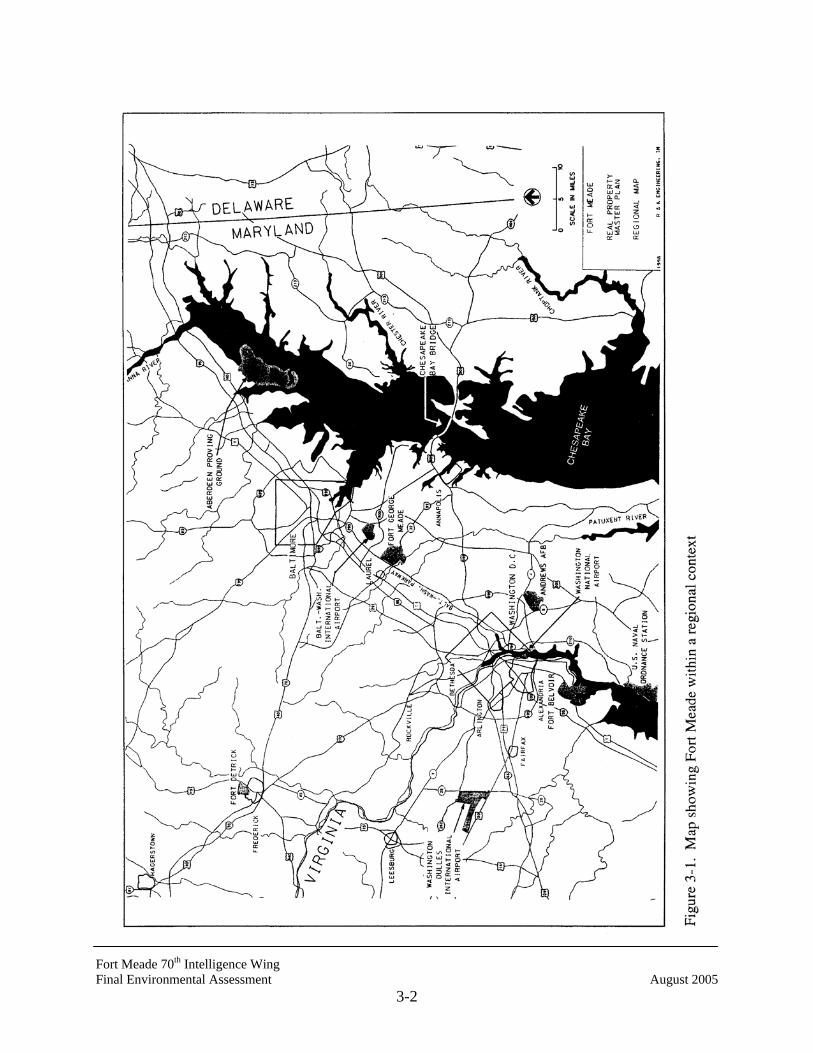
Fort Meade 70th Intelligence Wing Final Environmental Assessment August 2005
3-2
Fort Meade 70th Intelligence Wing Final Environmental Assessment August 2005
3-3
Meade is bounded by the Baltimore-Washington Parkway to the northwest, as well as the
AMTRAK line, MD Route 175, and MD Route 32 to the south. The Little Patuxent River runs
along a part of the southwest corner of the facility. Two of its tributaries, Midway Branch and
Franklin Branch, flow south through the installation. Fort Meade is located in the Chesapeake
Bay watershed.
Fort Meade is surrounded to the north, west, and east by residential areas of low-medium density
(2 to 5 dwellings per acre), medium density (5 to 10 dwellings per acre), and high density (10 or
more dwellings per acre); commercial centers; and a mix of industrial uses. Areas along
transportation corridors such as MD Routes 198, 32, and 175 are moderately developed. Much
of this development is associated with the Fort Meade installation (Anne Arundel County 1997).
The undeveloped area south of Fort Meade, previously used for military training and transferred
to the U.S. Fish and Wildlife Service (USFWS), is currently used as a wildlife refuge and is
zoned by Anne Arundel County as governmental/institutional (Anne Arundel County 1997).
Climate
Fort Meade is located in the continental climate zone of the eastern United States, where general
atmospheric flow is from west to east. This climate regime is characterized by summers that are
long, warm, and often humid as a result of persisting maritime tropical air; however, frequent air
mass exchanges result from the influence of either maritime tropical air or continental polar air.
Temperate weather prevails in the spring and autumn.
The annual mean temperature at Fort Meade is 61E Fahrenheit (F), with an average daily
maximum of 72 EF and minimum of 45 EF. Annual temperature extremes range from -6 EF to
100 EF (USATHAMA 1989). Precipitation averages 41 inches annually, including 22 inches of
snow. Rainfall occurs throughout the year, but the greatest amounts occur in the summer
(peaking in August) as a result of strong thunderstorms. The region has moderate to high
humidity levels throughout the year. Prevailing winds are generally from the west throughout
the year, except in September, when prevailing winds are from the south. The windiest period is
late winter and early spring. The annual average wind speed is 9.3 mph (Gale Research
Company 1985).
Fort Meade 70th Intelligence Wing Final Environmental Assessment August 2005
3-4
3.1 LAND USE
3.1.1 On-Post Land Use
Historically, the Fort Meade development scheme scattered housing, recreational, administrative,
and industrial facilities throughout the installation. With the creation of a future on-post land use
plan, Fort Meade planners have consolidated many diverse areas into related use areas and have
provided a more cohesive pattern for future development. As the post mission changed
(principally from troop cantonment to administrative support), additional development was more
carefully planned and designated, restricting areas to certain land uses to eliminate incompatible
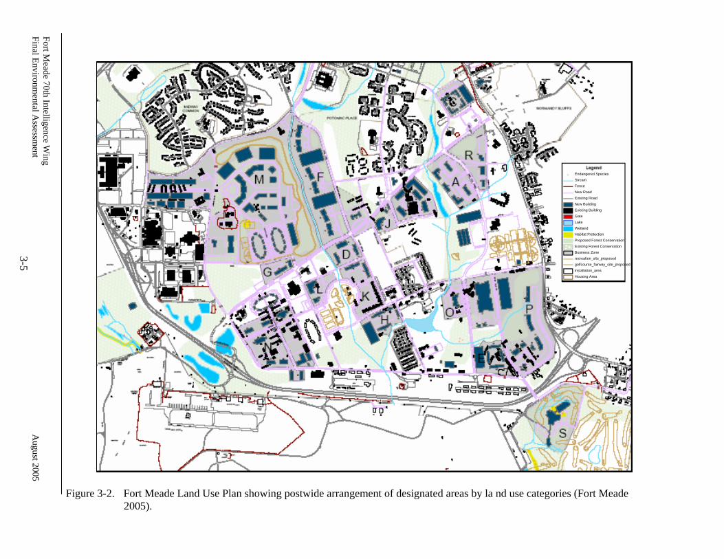
activities. The Fort Meade Land Use Plan Map (Galiber 2000) shown in Figure 3-2 is designed
to assist installation planners with siting new facilities. The Plan Map allows for specific
development in various areas of the post, identifying 13 siting categories and 3 restrictive land
use types. The siting categories are:
(1) Administrative and academic training,
(2) Troop housing,
(3) Family housing,
(4) Maintenance,
(5) Medical,
(6) Retail sales,
(7) Supply and storage,
(8) Open space,
(9) Recreation,
(10) Community facilities,
(11) Services/Industries,
(12) National Security Agency (NSA) lands, and
(13) Reserve facilities.
Fort Meade 70th Intelligence W
ing Final Environm
ental Assessm
ent
August 2005
3-5
Figure 3-2. Fort Meade Land Use Plan showing postwide arrangement of designated areas by la nd use categories (Fort Meade
2005).
Endangered Species Stream Fence New Road Existing Road New Building Existing Building Gate Lake Wetland Habitat Protection Proposed Forest Conservation Existing Forest Conservation Business Zone recreation_site_proposed golfcourse_fairway_site_proposed installation_area Housing Area
70th Intelligence Wing Final Environmental Assessment August 2005
3-6
Within the Fort Meade’s planned use map, administration and academic training, family housing,
community facilities, and outdoor recreation are the four most widely distributed and common
land uses on the post. According to this future land use plan, the project sites considered in this
EA fall within land use designated for community use. The Proposed Action would be sited on
an existing paved parking lot; parking for the new facility would be via a new, paved 269-space
lot to be constructed on an existing grassed playing field. The action alternative site proposed
for this project is in the existing grassed playing field; the facility would use the existing paved
parking lot that the Proposed Action would have been constructed on.
3.1.2 Regional Land Use and Zoning
Anne Arundel County
Anne Arundel County is located in a central position among (1) the metropolitan growth
corridors of Baltimore and Washington, (2) Annapolis, (3) the suburban fringe and rural areas of
the Eastern Shore, and (4) southern Maryland. This area is diverse in both its natural
environment and land development patterns. Anne Arundel County, though influenced by its
central location, has its own character and has developed its own economy. The county contains
447 linear miles of tidal shoreline. Major tributaries of the Chesapeake Bay penetrate 8 to 10
miles inland. “In 1990 nearly two-thirds of the population lived within two miles of tidal waters.
This water orientation reinforces the traditional image of Anne Arundel County as a boating
mecca with commercial and recreational fishing, maritime industries, and water sports” (Anne
Arundel County 1997). Annapolis, located in eastern Anne Arundel County, was established in
1649, and has been the capital of Maryland since 1694. The U.S. Naval Academy is located in
Annapolis.
More than 50 percent of the County’s land area is developed. Non-residential development
(including commercial, government, institutional use, and roadways) accounts for 17 percent of
the developed land (Anne Arundel County 1997).
Land classified as non-developed (including natural open space, vacant, and agricultural land)
comprises most of the northern part of the county around Baltimore Washington International
(BWI) Airport, Marley Neck, and Odenton. Commercial activities are concentrated along MD
70th Intelligence Wing Final Environmental Assessment August 2005
3-7
Route 2 and MD Route 3 in the Glen Burnie, Annapolis, and Parole areas, with some occurring
in Odenton, Severna Park, Crofton, and Maryland City.
Agriculture continues to be a major component of the economic base in Anne Arundel County,
occupying an estimated 43,320 acres, or 16 percent of Anne Arundel County land. Farming
operations range from crop farms and livestock to timber production and horse breeding.
Predominant crops are tobacco, corn, soybeans, hay, and flowering plants. The overall total
acres in crop production has declined steadily since 1959, decreasing more than 47 percent by
1992 from 81,700 to 43,300 acres (Anne Arundel County 1997).
Recognizing the unique character of Anne Arundel County's different communities, the Anne
Arundel County 1997 General Development Plan divides the county into 16 small planning areas
and recommends that a separate, more detailed land-use plan be completed for each. These
Small Area Plans will guide officials as they reexamine how individual properties should be
used, a review that occurs every 10 years and is known as comprehensive rezoning. The plans
also will recommend street, sidewalk, open space and other capital improvements and will target
neighborhoods for commercial revitalization and, possibly, mixed use development (Anne
Arundel County 2001). Usually zoning laws have segregated the use of property into residential,
commercial, and industrial zones. The General Development Plan identifies 16 areas where the
County should promote a variety of uses, including jobs, homes, shops, and recreation, in close
proximity. The plan recommends four categories of Mixed Use Development: Transit,
Employment, Commercial, and Community. The Plan recommends that the County identify
greenways, environmentally sensitive areas, and other open space for conservation easements
and public acquisition. The plan also suggests that the County create incentives for developers to
preserve those areas and to provide sidewalks and trails between subdivisions (Anne Arundel
County 2001a).
Revitalization Efforts
Some county areas meeting the eligibility requirements of the State of Maryland’s Neighborhood
Business Development Program are proposed for revitalization by Anne Arundel County. The
commercial redevelopment targets areas that are suitable candidates for State and County
70th Intelligence Wing Final Environmental Assessment August 2005
3-8
revitalization efforts. Some of these development efforts will most likely occur over the next 6
years, concurrent with Fort Meade’s planned “build out” (Fort Meade 2001a).
The Commercial Redevelopment Areas near Fort Meade include: Odenton Growth Management
Area, Parole Growth Management Area, Brooklyn Park Corridor, Mayo Road Corridor,
Deale/Churchton Business Corridor, Shadyside Business Area, Veteran’s Highway Business
Area, Wayson’s Corner Business Area, Severna Park Business Area, Riviera Beach Business
Area, and Mountain Road Business Area.
Of particular interest, within the context of the EA, is the planned development in the Odenton
area. Odenton Town Center and the surrounding Odenton Growth Management Area (GMA)
extend southeast of Fort Meade and include the North Odenton Business Corridor along MD
Route 175, from MD Route 32 to Reece Road. The Odenton Town Center and GMA are
designated for commercial revitalization, mixed use, and higher density planned development
(Anne Arundel County 1995). The 1994 Odenton Town Center Plan includes Fort Meade’s
Transitional Zone (along MD Route 175) as an employment growth area within the Odenton
GMA. Directly north of the installation, at MD Route 175 and the Baltimore-Washington
Parkway, is a zone designated for future development as office and retail with high-density
residential under the new “community mixed-use” category (Anne Arundel County 2001a).
A prime example of the type of commercial development planned for this area is the Arundel
Mills Mall, located two miles west of the BWI Airport, and approximately two miles north of
Fort Meade. The Mills Corporation completed construction of this massive complex in 2001.
The Arundel Mills Mall is a 1.3 million-SF retail and entertainment facility on 130 acres. The
mall provides employment for approximately 3,000 people with approximately 3,000 additional
jobs becoming available over the next few years as a result of new commercial development
around the mall (Fort Meade 2001a).
Howard County
Howard County is located along the northwestern border of Anne Arundel County and extends to
within two miles of Fort Meade. Similar to Anne Arundel County, Howard County is nestled
between the large metropolitan growth areas of Baltimore and Washington, D.C. This location

70th Intelligence Wing Final Environmental Assessment August 2005
3-9
has fostered the development of large residential communities. Foremost among these is
Columbia, Maryland. One of the most successful planned communities in the United States,
Columbia has, within 20 years, changed the eastern part of Howard County from a major
agricultural area to a residential and commercial center.
Columbia, Maryland, an unincorporated, planned community in the New Town (NT) Zoning
District, was created in 1965 with an initial area of 13,690 acres. Since 1965, an additional 446
acres have been added, bringing the total to 14,136 acres. Columbia accommodates a variety of
land uses, including approximately 295,000 dwellings; 5,300 acres of land committed to
parkland and open space; and 18.3 million square feet of office, light industrial, and research and
development space. Shopping Centers, schools, libraries, medical, and recreational facilities are
also included (Howard County 1999b). The western areas of Howard County remain largely
rural and agricultural, although residential development is continuing in these areas.
The total land area for Howard County is 160,640 acres. According to the Howard County Land
Use data of July 1, 1997, approximately 112,277 acres (70 percent) were recorded as
“Developed/Committed” in the Department of Planning and Zoning (DPZ) Database. The
Developed/Committed land use category included: Rural, Low, Medium, and High Density;
Mixed Use; New Town; Planned Golf Course Community; and “Other Zones” (non-residential
zonings). Committed land may not be developed. This category includes the land in
preservation programs, parkland, and open space.
Unbuilt residential lots comprise 6,205 acres (4 percent) of Howard County’s total land area. In
the process of being developed are 4,721 acres (3 percent). Only 37,437 acres (23 percent) acres
remain undeveloped. The majority of undeveloped land, 25,354 acres, is zoned for Rural
Density (RR-DEO and RC-DEO). There are 3,774 acres in the Low Density residential zoning
category (R-20, R-ED) and 2,303 acres in the Mixed Use category (Howard County 1999).
As of September 30, 2000, there were 151 subdivision plans in the review process. If all were
approved, they would create 5,340 new housing units. Many of these new projects are phased
over several years. Residential subdivision has kept a relatively constant pace over the last five
years, creating lots with the potential to accommodate an average of about 2,200 new dwelling
70th Intelligence Wing Final Environmental Assessment August 2005
3-10
units a year. The mix of single and multifamily housing units created is close to the 1990
General Plan projections (Howard County 2000).
Between October 1999 and September 2000, building permits were issued for 23 nonresidential
projects with a gross square footage of 50,000. Ten of these projects were in Columbia, seven
were in the I-95 corridor, five in Ellicott City and one in the west part of the County. Permits of
more than 100,000 SF include projects in Meadowridge Business Park, the former University of
Maryland Horse Farm at MD Route 108/Snowden River Parkway, the Baltimore-Washington
Industrial Park and redevelopment of the Chatham Mall (Howard County 2000).
Howard County may continue to receive significant residential growth from surrounding
jurisdictions, such as Fort Meade. The portion of the county that is most affected by changes at
Fort Meade is the southeast. This area, sandwiched between Interstate 95 and the Anne Arundel
County border, is zoned for industrial development, in order to offer area employment
opportunities (1990 General Plan Land Use Map).
3.1.3 Geology
Fort Meade is in the Atlantic Coastal Plain Physiographic Province. It is underlain by a wedge-
shaped mass of unconsolidated sediments that thickens to the southeast. The unconsolidated
sediments overlie crystalline rock of Precambrian to early Cambrian age. The crystalline
bedrock underlying Fort Meade consists of gabbro, diorite, and other igneous and metamorphic
rocks. The surface of these rocks dips to the southeast and acts as a lower confining layer for the
Potomac Group. The premise that the crystalline basement rock acts as a confining layer is
based on the low conductivity of similar crystalline rocks in the Maryland Piedmont (USACE
1997).
The series of thick, unconsolidated sediments underlying Anne Arundel Country are subdivided
(from oldest to youngest) into the Potomac Group, Magothy Formation, and Patuxent River
terraces and associated alluvium. The Potomac Group contains five geological units, three of
which underlie Fort Meade: the Arundel Clay, the Patuxent Aquifer, and the Lower Patapsco
Aquifer. The Arundel Clay is a unit with low vertical hydraulic conductivity and is the confining
layer between the Patuxent and Lower Patapsco aquifers. It is visible in northern Anne Arundel
70th Intelligence Wing Final Environmental Assessment August 2005
3-11
County and consists of red, brown, and gray clay with some ironstone nodules and plant remains
(USACE 1997).
Above the Lower Patapsco Aquifer is an unnamed confining layer composed of tough variegated
clay that separates it from the Upper Patapsco Aquifer. Alluvium underlies all of the rivers,
streams, and marshes of Fort Meade and consists of interbedded sand, silt, and clay with small
gravel inclusions (USACE 1997).
3.1.4 Soils
The Fort George G. Meade Soil Survey (USDA 1995) identifies 39 distinct soil mapping units on
Fort Meade. Most of the soils are part of the Evesboro complex. Evesboro soils are very deep,
excessively-drained, sandy loams on uplands. None of the soils on Fort Meade are used for
agricultural purposes and there are no farmsteads contiguous with installation areas.
Modified soil areas mapped within Fort Meade include loamy and clayey land, urban land, cut
and fill areas, and gravel and borrow pit operations. Loamy and clayey land consists of mantles
of various kinds of soil that overlie clay deposits, but which are unrelated to the underlying
subsoil. Urban land comprises those areas in the vicinity of pavement and buildings. Cut and
fill land consists of severely disturbed areas of miscellaneous soil types that have been altered by
earth-moving equipment. Gravel and borrow pit areas define land where soil material has been
removed for construction, landfill, or mining operations. Such areas have been altered so
severely that their association with a soil series is impossible to determine (USDA 1995).
The soils classifications present on the majority of NSA include the following soils: Urban Land,
Evesboro-Urban Complex, Downer Loamy Sand, Downer-Urban Land Complex, Fallsington
Sandy Loam, Sassafras-Urban Complex, and Woodstown Sandy Loam (USDA 1995). Most of
these soils are on 5 to 15 percent slopes (USDA 1995).
Soils found on the site of the Proposed Action and the action alternative are mapped in the Fort
Meade Soil Survey (1995) within the Cut and Fill Land Series, and are designated as Cut and fill
land, 0 to 5 percent slopes. According to the soil survey, cut and fill land consists of
miscellaneous land types where the soil has been so severely disturbed or altered by machines
70th Intelligence Wing Final Environmental Assessment August 2005
3-12
that it can no longer be identified by soil series. Most areas mapped under this designation have
been graded for home sites, schools, recreation sites, highway exchanges, and industrial
establishments. The area proposed for construction of the Proposed Action is on a large,
relatively flat existing parking lot; a paved parking lot would be constructed on an existing
grassed playing field. Only minimal site grading would be necessary for construction of the
Proposed Action. The Action Alternative site is on a relatively flat grassed playing field; it would
also require only minimal site grading for construction of the project. Parking for the action
alternative would be in the existing paved lot at the site of the Proposed Action; no grading
would be required.
3.1.5 Topography and Drainage
The topography of Fort Meade can be best characterized as almost level to gently rolling. The
installation has approximately 210 feet of topographic relief. The highest point reaches 307 feet
mean sea level (msl) and occurs at the 1st Army Radio Station Tower in the northern-most central
part of the installation. The lowest elevation, approximately 97 feet msl, occurs in the
southwestern corner of Fort Meade, along the Little Patuxent River (USACE 1997). Average
elevation on the post is typically between 140 and 180 feet msl (Fort Meade 1998a).
Most of the installation slopes gradually to the south and southwest. Slopes exceeding ten
percent are rare and occur primarily in pockets in the north-central and central parts of the
installation, and along stream corridors. These steep slopes usually occur in natural wooded
areas, and are ideally suited as vegetated buffer zones for more developed areas. The southern
half of Fort Meade contains gradual slopes, generally less than six percent (USACE 1997). The
majority of the land at Fort Meade is suitable for building. Slopes found in the area considered
for construction under the Proposed Action and the Action Alternative are minimal.
3.2 AIR QUALITY
Fort Meade is located in Anne Arundel County, which is part of the Maryland Department of the
Environment (MDE) Air Quality Control Area III, Metropolitan Baltimore Intrastate Air Quality
Control Region. This region comprises Anne Arundel, Baltimore, Carroll, Harford, and Howard
Counties, and Baltimore City.
70th Intelligence Wing Final Environmental Assessment August 2005
3-13
The State of Maryland had adopted ambient air quality standards and emission regulations for
the following pollutants:
• Particulate matter with diameter of 10 microns or less (PM-10),
• Carbon monoxide (CO),
• Sulfur dioxide (SO2),
• Nitrogen dioxide (NO2),
• Lead (Pb),
• Ozone (O3), and
• Fluorides.
MDE has developed plans, which have been submitted to the EPA, for attaining standards in
those areas where ambient air quality monitoring indicates nonattainment of specific standards
(e.g., ozone).
Existing ambient air quality monitoring data can be used to describe the air quality in the Fort
Meade area. The air quality data reported from the monitoring stations at, and closest to, Fort
Meade indicate that the air quality meets National and Maryland Ambient Air Quality Standards
for all monitored pollutants except ozone. As part of the Baltimore Area Air Quality Control
Region, Anne Arundel County is designated as a severe nonattainment area for ozone (40 CFR
81.321). At the MDE’s Fort Meade air quality monitoring station in particular, the federal
1-hour ozone standard was exceeded 4 days, over the 3-year period, 1998 to 2000 (MDE 2001b).
Emissions of criteria air pollutants for registered sources at Fort Meade are summarized in Table
3-1. Criteria pollutants are those pollutants for which an ambient air quality standard has been
established. Ozone is not directly emitted from sources, such as those listed in Table 3-1 and,
therefore, is not included. Ozone is formed indirectly from other air pollutants, particularly
nitrogen oxides (NOx) and volatile organic compounds (VOCs), that are “cooked” by sunlight
under stagnant, hot weather conditions (MDE 2001a).
Under Federally mandated energy reduction efforts, Fort Meade operations and maintenance
objectives include the implementation of energy conservation measures (ECMs) that are
designed not only to reduce energy consumption but also to reduce pollutant emissions to the
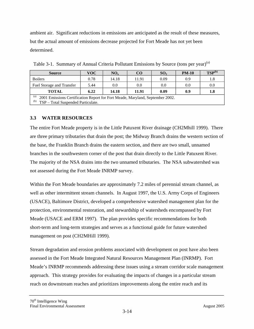
70th Intelligence Wing Final Environmental Assessment August 2005
3-14
ambient air. Significant reductions in emissions are anticipated as the result of these measures,
but the actual amount of emissions decrease projected for Fort Meade has not yet been
determined.
Table 3-1. Summary of Annual Criteria Pollutant Emissions by Source (tons per year)(a)
Source VOC NOx CO SO2 PM-10 TSP(b) Boilers 0.78 14.18 11.91 0.09 0.9 1.8 Fuel Storage and Transfer 5.44 0.0 0.0 0.0 0.0 0.0
TOTAL 6.22 14.18 11.91 0.09 0.9 1.8 (a) 2001 Emissions Certification Report for Fort Meade, Maryland, September 2002. (b) TSP – Total Suspended Particulate.
3.3 WATER RESOURCES
The entire Fort Meade property is in the Little Patuxent River drainage (CH2Mhill 1999). There
are three primary tributaries that drain the post; the Midway Branch drains the western section of
the base, the Franklin Branch drains the eastern section, and there are two small, unnamed
branches in the southwestern corner of the post that drain directly to the Little Patuxent River.
The majority of the NSA drains into the two unnamed tributaries. The NSA subwatershed was
not assessed during the Fort Meade INRMP survey.
Within the Fort Meade boundaries are approximately 7.2 miles of perennial stream channel, as
well as other intermittent stream channels. In August 1997, the U.S. Army Corps of Engineers
(USACE), Baltimore District, developed a comprehensive watershed management plan for the
protection, environmental restoration, and stewardship of watersheds encompassed by Fort
Meade (USACE and ERM 1997). The plan provides specific recommendations for both
short-term and long-term strategies and serves as a functional guide for future watershed
management on post (CH2MHill 1999).
Stream degradation and erosion problems associated with development on post have also been
assessed in the Fort Meade Integrated Natural Resources Management Plan (INRMP). Fort
Meade’s INRMP recommends addressing these issues using a stream corridor scale management
approach. This strategy provides for evaluating the impacts of changes in a particular stream
reach on downstream reaches and prioritizes improvements along the entire reach and its
70th Intelligence Wing Final Environmental Assessment August 2005
3-15
watershed. The major emphasis will be the establishment of a stream corridor restoration and
preservation program for each major stream on post (CH2MHill 1999).
Little Patuxent River Protection
The MDE designated the segments of the Little Patuxent River and its tributaries that are
upstream from a point 1 mile south of the MD Route 198 bridge as Use I-P Waters. This
protected area is located within Department of Interior property near the Patuxent Environmental
Science Center that borders Fort Meade to the south (Fort Meade 1998a). Use I-P Waters are
protected for water contact recreation, aquatic life, and public water supply. Use I-P Waters may
be used for the following activities:
• Water contact sports;
• Play and leisure-time activities where individuals may come into contact with the
surface water;
• Fishing;
• The growth and propagation of fish (other than trout), other aquatic life, and wildlife;
• Agricultural water supply;
• Industrial water supply; and
• Public water supply.
Less than a half mile from Fort Meade’s eastern boundary lie tributaries of the Severn River which are designated as a Use IV Recreational Trout Waters. These waters have the potential for, or are currently
• Capable of holding or supporting adult trout for put-and-take fishing, or
• Managed as a special fishery by periodic stocking and seasonal catching.
3.3.1 Surface Water
The majority of Fort Meade lies within the 160 square-mile Little Patuxent River Drainage
Basin. Near the installation, the river averages 30 feet wide and 2 feet deep. Most of the
installation is drained by two tributaries: Midway Branch and Franklin Branch. Surface flow on
the installation is primarily south-southwest (Fort Meade 1998a). Fort Meade’s watersheds,
wetlands, and streams are depicted in Figure 3-3.

70th Intelligence Wing Final Environmental Assessment August 2005
3-16
Figure 3-3. Map showing the watersheds, wetlands, and streams within Fort Meade boundaries. Watersheds are designated with letter-number identifiers. Proposed projects site is shown with a black star. (Source: Fort Meade Integrated Natural Resources Management Plan (CH2MHill 1999).

70th Intelligence Wing Final Environmental Assessment August 2005
3-17
Midway Branch drains the center of the installation and flows southeasterly then southerly to a
confluence with Franklin Branch, where it is renamed Rogue Harbor Branch. Its watershed
comprises approximately 1,860 acres, located almost entirely within the installation (USACE
1997). Rogue Harbor Branch empties into Allen Lake, a 19.7-acre man-made lake used for
stormwater management, flood control, and limited recreational purposes. South of Allen Lake,
the tributary drains directly into the Little Patuxent River. There are a large number of drainage
swales, ditches, and natural streams and brooks traversing Fort Meade. Some of them flow into
Burba Lake, others drain into Rogue Harbor Branch.
Although the NSA was not assessed during the Fort Meade INRMP watershed survey, the site
considered for the Proposed Action is located within the northern unnamed tributary that flows
offsite directly to the Little Patuxent River.
Storm Water Management
NSA has performed stormwater management assessments for sub-basins A and B within the
NSA boundaries (WRA 1997 A, B). Sub-basin A is the northernmost part of NSA and includes
a small portion of Berman Tract and the adjacent section of the NSA campus, as well as Fort
Meade base housing along Cavalry Road. Sub-basin B includes the mid-section of the NSA
campus, from roughly Rockenbach Road southward to Emory Road and including a small
portion of the land south of Emory Road and East of Canine Road. There remains, however, a
large section of NSA within sub-basin C that has not been evaluated since 1988. As is common
throughout the NSA property, the drainage in this area primarily consists of concrete channels.
Sub-basin C drains southward, eventually into Fort Meade’s stormwater pond located near
Perimeter Road. Effective January 2005, Fort Meade submitted NOI to comply with General
Discharge Permit 05-SF-5501, NPDES General Permit for discharges from Small Municipal
Separate Storm Sewer Systems.
Stormwater from NSA eventually drains into the unnamed tributaries and into the Little Patuxent
River. Given the designation of this portion of the Little Patuxent River as USE I-P waters,
additional care should be taken to ensure stormwater management practices comply with
70th Intelligence Wing Final Environmental Assessment August 2005
3-18
applicable regulations and do not contribute to sedimentation in or pollutant loads to the Little
Patuxent River.
The Environment Article Title 4, Subtitle 2, Annotated Code of Maryland states that “…the
management of storm water runoff is necessary to reduce stream channel erosion, pollution,
siltation and sedimentation, and local flooding, all of which have adverse impacts on the water
and land resources of Maryland.” Code of Maryland Regulations (COMAR) 26.09.01-26.09.02
also requires that all jurisdictions within the state implement a storm water management (SWM)
program to control the quality and quantity of storm water runoff from new development. Fort
Meade SWM adheres to these principles and has based its management plans and procedures on
the Maryland Storm Water Design Manual (MDE 2000) and state and county guidelines. Fort
Meade currently operates under National Pollutant Discharge Elimination System (NPDES)
Storm Water Discharge Permit 02-SW-0700 for industrial discharges, Permit GP-00HT for
maintenance and repair discharges, Permit 01-DP-2533 and MD-00217-17 for wastewater
treatment, and Permit 00-DP-2634 for golf course discharges.
Since new mission and realignment activities recently implemented at Fort Meade have
increased development on post, Fort Meade planners follow the installation’s Comprehensive
Watershed Management Plan developed by the USACE which addresses storm water runoff
issues within a larger context. Emphasis has been put on devising more effective SWM
techniques. All planned and newly constructed Fort Meade SWM structures are based on
designs following the MDE’s guidance, published in the 1998 Maryland Stormwater Design
Manual (MDE 1998; Harmeyer 1998).
There are a total of 19 SWM ponds located throughout Fort Meade (Marquardt 2002).
Stormwater controls for new construction projects are considered individually (Galiber 2001).
On-post SWM features are incorporated as necessary to comply with state and county
regulations.
Fort Meade has been addressing its SWM issues for several years. Installation analysts have
recommended that the storm water drainage system, although generally considered adequate to
meet existing demands, be expanded with new SWM ponds to control localized drainage

70th Intelligence Wing Final Environmental Assessment August 2005
3-19
problems. Construction of these facilities, including 19 retention ponds to reduce concentrated
flow in main branch channels, has been completed. Potential expansion plans include new
drainage catchments (curb, gutter, drains, inlets), possible new or enlarged storm sewers, and
channel enhancement to Midway Branch and Franklin Branch (Harmeyer 1999a).
Chesapeake Bay Initiative
The Chesapeake Bay and its 64,000 square-mile watershed comprises a complex “ecosystem” of
water and land, creatures and people, culture, and economics. Since the first comprehensive
scientific study of the Bay in the mid-1970s, the Chesapeake Bay Program partners (including
almost 15 million citizens of the region) have learned a great deal about how this system works,
what makes it “sick,” and what needs to be done to keep it healthy.
Excess or waste water, usually from stormwater, runs off the land carrying nutrients, sediments,
and even traces of toxic products into nearby creeks and streams. Protection of local waterways
feeding into the Bay, therefore, is contingent upon reduced surface water runoff. Fort Meade’s
Storm Water Management (SWM) program actively assists in this effort.
Fort Meade is also an active participant in the U.S. Army’s Chesapeake Bay initiative called the
Submerged Aquatic Vegetation (SAV) Installation Support Program which is committed to
improving the water quality and overall watershed of the Chesapeake Bay as well as protecting,
preserving, and restoring the Bay’s water and habitat.
SAV is essential to a healthy Bay ecosystem. It serves as a valuable food source for waterfowl,
provides protection from predators, and acts as a nursery and breeding ground for many species
of fish and shellfish. Furthermore, the plants help to filter sediment from the water, stabilize the
coastal soil, and absorb nutrients, which can be toxic to the biota in excess. For these reasons,
SAV has been targeted by many as the key to restoring the Chesapeake Bay to a healthy state.
Strategic implementation priorities have been established as follows:
1. To meet nutrient reduction goals through the tributary strategies.
2. To increase stakeholder involvement in the Chesapeake Bay Program.
70th Intelligence Wing Final Environmental Assessment August 2005
3-20
3. To implement habitat restoration projects for key habitat areas.
4. To support fisheries management through inter-jurisdictional cooperation and
coordination.
5. To implement critical elements of the Revised Toxins Reduction strategy.
6. To reinforce federal and state efforts to reduce atmospheric deposition to the bay.
One method of improving the SAV is through the protection of riparian forest buffers. A ripar-
ian forest buffer is an area of trees, usually accompanied by shrubs and other vegetation, adjacent
to a body of water and managed to maintain the integrity of stream channels and shorelines.
Riparian forest buffers reduce the impact of upland pollution sources by (1) trapping, filtering,
and converting sediments, nutrients, and other chemicals, and (2) supplying food, cover, and
thermal protection to fish and other wildlife. Fort Meade is committed to preservation of riparian
forest buffers; none would be affected by either the Proposed Action or the Action Alternative.
Groundwater
Three aquifers – the Patuxent Aquifer, the Lower Patapsco Aquifer, and the Upper Patapsco
Aquifer – underlie Fort Meade. The aquifers are separated by the Arundel Clay formation. The
Patuxent Aquifer, which directly overlays the crystalline basement, consists of lenticular
interfingering sand, silt, and clay capable of yielding large quantities of water. The aquifer is at
or near the surface near the fall line (the boundary between the Coastal Plain and Piedmont
Physiographic Provinces) and dips below the surface as it moves eastward. The aquifer is
between 200 and 400 feet thick beneath Fort Meade.
The Lower Patapsco Aquifer is composed of fine- to medium-grained brown sand that overlays
the Arundel Clay. It is capable of yielding 0.5 to 2 million gallons per day (mgd) of water from
individual wells in most localities and is a source of water for several large wells within the
region.
The Upper Patapsco Aquifer consists of fine- to medium-sized brown sand. Its average
thickness is 250 feet. The aquifer is under confined conditions and is one of the best water-
bearing formations in Anne Arundel County.

70th Intelligence Wing Final Environmental Assessment August 2005
3-21
Flow from all three aquifers is generally toward the southeast. Recharge to deep artesian wells is
slow because of the low permeabilities of the confining layers.
Fort Meade withdraws potable water from the Patuxent Aquifer. In general, water from this
aquifer is soft (hardness 6 to 8.4 milligrams per liter [mg/l] calcium carbonate), acidic (pH 4.9 to
5.0), high in iron (0.77 to 2.7 mg/l), low in chlorides (5 to 8.4 mg/l), and low in total dissolved
solids (38 mg/l). In general, the iron levels in groundwater from the Patuxent Aquifer exceed
Federal drinking water standards and require treatment at Fort Meade (USACE 1997).
3.4 AQUATIC RESOURCES AND WETLANDS
3.4.1 Aquatic Resources
The Patuxent River and its associated tributaries and small streams that flow through Fort Meade
provide habitat for many aquatic organisms. A list of fish species found in the surface waters on
the post is presented in Appendix B.
There are no streams located in the areas designated for the Proposed Action or the Action
Alternative.
3.4.2 Wetlands
Section 404 of the Clean Water Act requires Federal regulation of most activities that impact
wetlands. The Section 404 requirements support the goal of no net loss of wetlands. Wetland
protection and management applies to all Army facilities’ engineering activities. Fort Meade lies
within the Chesapeake Bay watershed, a region supporting some of the most important wetland
areas in the United States.
Wetlands were delineated and mapped throughout the NSA exclusive area by Halliburton NUS
in 1995 (1995); they were also delineated in part by Potomac-Hudson Engineering in 2000
(2000). Wetlands were delineated during field visits using the methodology contained in the
1987 Corps of Engineers Wetland Delineation Manual. Wetland vegetation was also previously
described as part of Versar's 2001 and 2002 endangered species report for the NSA exclusive
area (Versar 2003).
70th Intelligence Wing Final Environmental Assessment August 2005
3-22
Potomac-Hudson Engineering indicated that the Anne Arundel County, Maryland soil survey
was reviewed prior to the delineation to determine the approximate locations of mapped hydric
soils on and adjacent to the NSA exclusive area (Potomac-Hudson Engineering 2000). Hydric
soils conditions are defined as those that meet the criteria of the National Technical Committee
for Hydric Soils (NTCHS 1987), and the NRCS (1998). Saturation in such soils creates
anaerobic conditions that typically produce rust-colored mottles in a matrix of gray soil within
approximately 6 inches of the surface. Hydric soils frequently are indicated by high chroma
mottling in combination with moist soil matrix chromas of 2 or less at the top of the B horizon or
a chroma of 1 or less (with or without mottles) at the same depth -- as determined by comparison
with standard Munsell color charts.
According to Potomac-Hudson Engineering (2000) soil colors were determined using Munsell
color charts; textures were also documented. Where possible, soil samples were examined to a
depth of at least 24 inches from the surface. Soil profiles were observed at a number of data
collection points. In general, the soils observed were similar physically to the descriptions
provided in the county soil survey. Most of the soils observed possessed matrices with Hues of
10YR and 2.5Y; Values and Chromas varied somewhat by depths and site location, but were in
the very dark gray to very dark grayish brown (3/1 and 3/2) range for the silty clay soils. Soils
throughout the site were generally categorized as silty clay and sandy loam throughout. All of
the soils within the mapped wetlands possessed chromas of 2 or less with mottles within major
portions of the root zone. Soils outside of the mapped wetlands generally possessed chromas of
2 or greater, usually without mottles.
Based on other data and information presented in the Halliburton NUS and Potomac-Hudson
Engineering wetlands reports, as well as Versar's field observations, virtually all wetlands on the
NSA exclusive area were forested, and possessed hydric soils, wetland hydrology, and a
predominance of wetland vegetation. Several ditches and stormwater facilities were not
delineated as wetlands because they did not possess one or all of these criteria.
Of the approximately 5,500 acres that comprise Fort Meade, only 160 acres have been
designated as wetlands (Fort Meade 1998a). The majority of those wetlands are situated in the
70th Intelligence Wing Final Environmental Assessment August 2005
3-23
floodplain of the Little Patuxent River, in the southwestern section of the installation.
Information concerning the potential extent and nature of wetlands on Fort Meade was obtained
from site visits and nontidal wetlands maps included in the Wetlands Mapping Report for the
U.S. Army, Fort Meade (1996). These maps were the result of a wetland survey conducted in
June 1996 for the USACE to identify wetlands and other waters of the U.S. for potential
jurisdiction under Section 404 of the Clean Water Act. The survey was prepared primarily by
stereoscopic analysis of high altitude and aerial photographs. Wetlands were identified from
photographs based on vegetation, visible hydrology, and geography in accordance with
Classification of Wetlands and Deepwater Habitats of the United States (USFWS 1979). There
were no attempts in the above-mentioned Fort Meade Wetlands Mapping Report to define
federal, state, or local jurisdiction (Geonex 1996). The Fort Meade INRMP also offers maps that
identify major wetland areas on post (CH2MHill 1999). These resources were used in
conjunction with field reconnaissance to determine the proximity of potential wetlands to the
proposed construction sites.
According to the above resources, there are no wetland areas on or adjacent to either the
Proposed Action site or the Action Alternative site (see Fig. 3-3).
3.5 VEGETATION
Versar, Inc. recently described existing vegetation as part of its studies to describe threatened and
endangered species at the NSA (Versar 2003). The following section describes the existing
vegetation at NSA; distinction is made between the relatively undeveloped Berman Tract in the
northern section and the “secure area” to the south.
3.5.1 NSA Secure Area
Deciduous Forest
Upland deciduous forest is essentially the sole vegetation type in most of the "semi-natural"
parcels inspected in the vicinity of the Proposed Action; wetland deciduous forest also exists in
several smaller areas. In most of the upland areas, the deciduous forest is clearly dominated by
chestnut oak and willow oak. The largest trees in these parcels appear to be willow oaks; some
70th Intelligence Wing Final Environmental Assessment August 2005
3-24
of these are as large as 25 to 30 inches diameter at breast height (dbh). Other trees present in
these forested areas include black oak, red oak, tulip poplar, and scrub pine. Dominant trees
within more mesic areas of the upland forest and within the wetland deciduous forest are
typically red maple and sweetgum; small areas also possess black willow, sweet bay magnolia
(Magnolia virginiana), and black gum (Nyssa sylvatica).
The shrub layer varies in the upland deciduous forest from sparse to very dense. Many areas of
the forest possess dense areas of poison ivy (Toxicodendron radicans); other areas possess
virtually impenetrable growths of common greenbrier (Smilax rotundifolia). Some areas of the
forest also possess dense shrub layers of privet (Ligustrum vulgare), Tartarian honeysuckle
(Lonicera tatarica), and inkberry (Ilex glabra). Other upland forest areas possess dense growths
of wisteria (Wisteria sinensis). The shrub layer in the wetland forest is usually moderately
dense. Principal species observed include spicebush, sweet bay magnolia, sweet pepperbush
(Clethra alnifolia), and saplings of the principal tree species.
Very few herbaceous species are typically present in the upland deciduous forest, presumably
because of the density of the canopy and shrub/woody vine layers. Three species that were
occasionally present included bracken, partridgeberry (Mitchella repens), spotted wintergreen,
and hay-scented fern. One interesting plant of note occasionally observed in the upland forest
was pink ladies slipper (Cypripedium acuale); this plant was sometimes concentrated in dense
populations of 30 or more individuals. The herbaceous layer in the wetland forest is somewhat
variable, depending on location. Several ubiquitous species, however, included cinnamon fern,
skunk cabbage, royal fern, and New York fern. Other herbaceous plants often found in these
wetlands were sallow sedge, false nettle, and jewelweed.
3.5.2 Berman Tract
Coniferous Forest Immediately to the northeast of the West Meade Elementary School is a large, roughly rectan-
gular area (with several smaller branches to the west) of dense coniferous forest that is clearly
dominated by scrub pine (Pinus virginiana), with scattered areas of loblolly pine (Pinus taeda).
The coniferous forest also exists in smaller areas on most of the ridge tops at the Berman Tract.
70th Intelligence Wing Final Environmental Assessment August 2005
3-25
Most of the pines appear to be approximately 25 to 30 years old. The northeastern edges of the
coniferous forest also possess moderately-sized chestnut oak (Quercus prinus) and American
beech (Fagus grandifolia). In addition, several large tulip poplar (Liriodendron tulipifera) and
black oak (Quercus velutina) trees exist along the western edge of the coniferous forest.
The majority of the coniferous forest is completely dominated by scrub pine, with almost no
shrub/woody vine or herbaceous layers. In smaller areas, however, where there is a break in the
canopy, the sub-canopy of the coniferous forest is dominated by chestnut oak (the primary suc-
cessional species). Some of these semi-open canopy areas contain dense areas of black huckle-
berry (Gaylussacia bacata) and lowbush blueberry. The edges of some areas of the forest also
contain some invasive and semi-invasive species, such as poison ivy (Toxicodendron radicans),
wisteria (Wisteria sinensis), perfoliate tearthumb (Polygonum perfoliatum), Asiatic bittersweet
(Celastrus orbiculata), Japanese honeysuckle (Lonicera japonica), and tree of heaven (Ailanthus
altissima). Few other shrub and woody vine species, however, exist within the coniferous forest.
Spotted wintergreen (Chimaphila maculata) was the only herbaceous plant regularly observed
within the dense coniferous forest. Ebony spleenwort (Asplenium platyneuron) was also
observed occasionally, but it was not a common plant within the coniferous forest.
Deciduous Forest Upland deciduous forest exists throughout the majority of the Berman Tract, particularly
throughout the western sections. Wetland deciduous forest exists in several small areas,
particularly along the small streams in the northwestern and southern parts of the site, and along
the edges of the spring-fed herbaceous wetland along the west-central edge of the site (adjacent
to I-295).
On the ridgetops and the highest parts of the slopes, particularly in the southern and west-central
areas, the upland deciduous forest is clearly dominated by chestnut oak. Willow oak (Quercus
phellos), however, is dominant on the side slopes. The largest trees on the Berman Tract appear
to be willow oaks; these are about 50 inches diameter at breast height (dbh). Other trees present
in these areas include black oak, red oak (Quercus rubra), and tulip poplar. Dominant trees
70th Intelligence Wing Final Environmental Assessment August 2005
3-26
within more mesic areas of the upland forest and within the wetland deciduous forest are
typically red maple (Acer rubrum) and sweetgum (Liquidambar styraciflua); small areas also
possess yellow birch (Betula alleghaniensis), black willow (Salix nigra), and black gum (Nyssa
sylvatica).
The shrub layer in most areas of the Berman Tract upland deciduous forest is moderately dense
to dense. Many areas of the forest possess dense, virtually impenetrable growths of common
greenbrier (Smilax rotundifolia). Some areas of the forest also possess a dense shrub layer of
black huckleberry (Gaylussacia bacata) and lowbush blueberry. Scattered individuals of
chinquapin (Castanea pumila) are also present, and are locally co-dominant. The shrub layer in
the wetland forest is typically moderately dense. Principal species observed include spicebush
(Lindera benzoin), swamp azalea (Rhododendron viscosum), sweet bay magnolia (Magnolia
virginiana), possumhaw viburnum (Viburnum nudum), and saplings of the principal tree species.
Very few herbaceous species are present in the upland deciduous forest, presumably because of
the density of the canopy and shrub/woody vine layers. Three species that were occasionally
present included bracken (Pteridium aquilinum), spotted wintergreen, and hay-scented fern
(Dennstaedtia punctilobula). One interesting plant of note occasionally observed in the upland
forest was pink ladies slipper (Cyprepidium acaule). The herbaceous layer in the wetland forest
is somewhat variable, depending on location. Several ubiquitous species, however, included
cinnamon fern (Osmunda cinnamomea), skunk cabbage (Symplocarpus foetidus), royal fern
(Osmunda regalis), and New York fern (Thelypteris noveboracensis). Other herbaceous plants
often found in the site wetlands were sphagnum mosses (Sphagnum spp.), sallow sedge (Carex
lurida), follicle sedge (Carex folliculata), false nettle (Bohemeria cylindrica), and jewelweed
(Impatiens duthicae).
Oldfield A moderately-sized oldfield exists in a roughly rectangular area near the northern end of the
Berman Tract. It appears that the oldfield is an old farmed or grazed field that has not been
mowed or otherwise maintained for at least 2 years (possibly up to 5 years). The edges of the
southern side of the oldfield possess dense areas of tree of heaven interspersed with scattered
70th Intelligence Wing Final Environmental Assessment August 2005
3-27
princess trees (Paulownia tomentosa). The remainder of the oldfield is dominated by dense
areas of Canada goldenrod (Solidago canadensis), horseweed (Conyza canadensis), and several
unidentified species of blackberries (Rubus spp.).
Herbaceous Marsh Several small areas of herbaceous wetlands exist at the Berman Tract (note that wetlands were
not delineated as part of this endangered species study). The herbaceous wetlands are generally
on the western side of the Berman Tract, along several stream corridors, and in one small spring-
fed wetland along the west-central edge of the property. Most of the herbaceous wetlands are
dominated by skunk cabbage, cinnamon fern, and sphagnum mosses. The vegetational
composition of the spring-fed wetland is somewhat different. In some areas it is dominated by
dense areas of cinnamon ferns and New York ferns, and in other (wettest) areas it is dominated
by eastern sedge, follicle sedge, sallow sedge, and bur-reed (Sparganium americanum). The
small shrub, possumhaw viburnum (Viburnum nudum), was also present in some areas. The
peripheries of the herbaceous marsh are bounded by either wetland deciduous forest or upland
deciduous forest (refer to descriptions above), depending on topography, position of adjacent
slopes, and landforms.
3.5.3 Fort Meade Vegetation
Previous development throughout Fort Meade has been extensive and few areas currently retain
their native vegetation. Fort Meade has partnered with the Maryland Department of Natural
Resources (DNR) Forest Service and voluntarily supports the Maryland Forest Conservation Act
and the Anne Arundel County “Tree Bill.” All outside contractors are required to follow the
State Forest Conservation Manual in planning construction. Fort Meade has inventoried much of
the forested area on post. Currently 29 percent, or approximately 1,594 acres, of Fort Meade is
woodlands. Figure 3-4 shows Fort Meade’s forest conservation areas (CH2MHill 1999). Plans
for future development on post call for most existing wooded areas to remain intact. Fort Meade
guidelines established in the INRMP recommend preserving mature trees and wooded buffers
during future development. Existing planted areas will be evaluated for additional plantings and
more street trees will be added where appropriate (Anne Arundel County 1995).
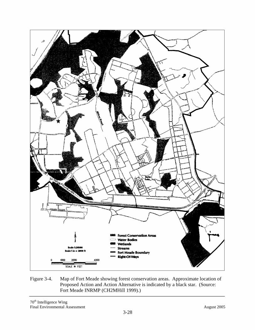
70th Intelligence Wing Final Environmental Assessment August 2005
3-28
Figure 3-4. Map of Fort Meade showing forest conservation areas. Approximate location of Proposed Action and Action Alternative is indicated by a black star. (Source: Fort Meade INRMP (CH2MHill 1999).)

70th Intelligence Wing Final Environmental Assessment August 2005
3-29
Natural tree cover on Fort Meade consists of a mixture of softwood loblolly pine, pitch pine and
Virginia pine and hardwoods consisting of sycamore, willow, sweetgum, birch, maple, and
walnut. The largest wooded area on the installation is within the Berman Tract on the NSA
Exclusive Use Area in the northern part of the base. Smaller wooded areas are scattered
throughout upland and wetland areas of the installation. They are dominated by white, red, and
chestnut oak; mockernut and pignut hickory; flowering dogwood; blueberry; greenbrier; loblolly
and pitch pine; and poison ivy (Fort Meade 1999a). A species list of plants found at Fort Meade
is presented in Appendix B.
Most of the developed portions of Fort Meade have been landscaped using a combination of
turfgrasses, interspersed with native and exotic trees and shrubs, including elm, maple, flowering
cherry, black willow, flowering dogwood, and an assortment of holly cultivars. Plant
communities at the areas considered for construction were identified during field reconnaissance
conducted as part of NEPA investigations in February 2005. The majority of the site for the
Proposed Action is an existing paved parking lot between Love Road and 3rd Cavalry Roads,
with little existing natural vegetation. Parking for the Proposed Action would be constructed at
the grassed playing field immediately north of Newjon Road, near 3rd Cavalry Road. This
parking site is currently a grassed playing field with a few scattered small trees and shrubs
around its western and southern peripheries.
The parcel proposed for construction under the action alternative is immediately north of Newjon
Road, near 3rd Cavalry Road. This site is currently a grassed playing field with a few scattered
small trees and shrubs around its western and southern peripheries. Parking for the new facility
would be in the existing paved parking lot on the site of the Proposed Action.
3.6 WILDLIFE RESOURCES
3.6.1 NSA Wildlife
Observations of wildlife were included in Versar’s reporting for threatened and endangered
species in November 2001, May 2002, and July 2002 at NSA. The following section on wildlife
is excerpted from Versar’s report (Versar 2003).

70th Intelligence Wing Final Environmental Assessment August 2005
3-30
Few wildlife were observed within the NSA Secure Area, owing to the relatively small size of
the forested parcels (as contrasted to the Berman Tract). Species, however, were similar to those
observed at the Berman Tract. Mammal species and their signs observed on and adjacent to the
study area included white-tailed deer, striped skunk, red fox, raccoon, eastern chipmunk, gray
squirrel, opossum, and woodchuck. A variety of other small and large mammals also potentially
occur in the study area. Of these mammals, woodchuck and deer were by far most commonly
observed in a wide variety of habitats. Deer were very abundant within the study area; adults
and their signs were observed in numerous locations. Raccoon tracks were also observed
throughout the study area, particularly along streams. Red foxes and their signs were observed
in several wooded locations in the study area.
Sixty-three species of birds were identified on or adjacent to the NSA exclusive use area during
this study’s field surveys (Appendix B). Owing to the timing of many of the observations
(primarily during the breeding season), many of the species observed likely breed within
appropriate habitats in the study area. In general, most of the birds and their signs were observed
in the upland and wetland forested habitats at the Berman Tract.
The only reptiles observed within the study area were eastern box turtle (Terrapene carolina
carolina), water snake (Nerodia sipedon sipedon), and five-lined skink (Eumeces fasciatus).
Several species of amphibians were identified within the study area. Gray tree frog (Hyla
versicolor), pickerel frog (Rana palustris), green frog (Rana clamitans clamitans), southern
leopard frog (Rana utricularia), and bullfrog (Rana catesbeiana) were observed along the
streams and water features within the study area. American and Fowler's toads (Bufo
americanus; Bufo woodhousii fowleri) were observed primarily in upland forests throughout the
study area. Several red-backed salamanders (Plethodon cinereus) were found in the upland
forested habitats at the Berman Tract.
As indicated above, the amphibian of note observed during the May 2002 field studies was the
mud salamander (Pseudotriton montanus). One individual was caught in the small spring-fed
wetland along the west-central boundary of the Berman Tract. While distinguishing mud
salamanders from red salamanders is sometimes problematic, this identification was confirmed
in the field by an experienced herpetologist. As there appear to be relatively few seep and
70th Intelligence Wing Final Environmental Assessment August 2005
3-31
spring-fed wetlands on the Berman Tract (the requisite habitat for this species), this location may
be key for the survival of this species on the site. No other individuals of this species were
observed within the study area.
A number of terrestrial and aquatic invertebrates were also observed within the Berman Tract.
Adult damselflies and dragonflies were common near aquatic habitats throughout the study area.
Butterflies appeared particularly abundant during the May 2001 and July 2002 field studies;
species observed include monarch, regal fritillary, cabbage butterfly, black swallowtail, and tiger
swallowtail. Gypsy moth caterpillars were observed in forested habitats at the Berman Tract and
appeared especially abundant in localized areas of the upland deciduous oak forest, particularly
during the May 2002 field visits.
3.6.2 Fort Meade Wildlife
Because most of the installation has been developed and few large continuous tracts of forests
remain, it can be assumed that the wildlife species found at Fort Meade are typical of those found
in most urban-suburban areas. White-tailed deer are frequently observed on post, especially
along the Little Patuxent River. Other mammals that may be found on Fort Meade include the
grey squirrel, raccoon, opossum, eastern chipmunk, field mouse, meadow vole, eastern mole, and
red fox (USACE 1997). These species are likely to be found on or adjacent to the proposed
project sites.
Birds common on the sites are those that have adapted to an urban-suburban existence, such as
the American robin, catbird, mockingbird, Carolina chickadee, Carolina wren, house wren,
downy woodpecker, common flicker, European starling, house sparrow, rock dove, mourning
dove, and song sparrow. These common species are likely to be found on the proposed project
sites. Other species, including warblers and raptors, may be found on the installation during
migrations. It is unlikely that large numbers of these birds are breeding on the installation,
because available habitat is limited (USACE 1997).
Because the greenways and open space parks scattered throughout the installation are maintained
as grassy areas and golf courses, their value as wildlife habitat is limited. Areas with greater
habitat value are scattered around the installation, with large forested parcels on-post (some with
70th Intelligence Wing Final Environmental Assessment August 2005
3-32
100 acres or more in the northern and western sections) and more extending off-post to create
significantly large clusters of woodland habitat. The conservation of such large contiguous
forest that supports forest interior dwelling species (FIDS) is strongly encouraged by the
Maryland DNR.1 Habitat protection for FIDS is mandated in Maryland through regulations
authorized by the Chesapeake Bay Critical Area Law (Natural Resources Article 8–1808,
COMAR). As part of its role as a stakeholder in the Chesapeake Bay Initiative, Fort Meade
intends to sustain these large forested areas where possible, or mitigate de-forested parcels to re-
create wildlife habitat following the mandates of the Maryland Forest Conservation Act in a
voluntary manner (Harmeyer 2000).
3.7 THREATENED AND ENDANGERED SPECIES
Versar performed a one-year field survey for rare, threatened, and endangered plants and animals
within the NSA exclusive use area at Fort Meade in November 2001, May 2002, and July 2002
(Versar 2003). These surveys had three primary objectives: (1) to document the presence of any
rare, threatened, and endangered species of federal or state concern or their habitats; (2) to
compile a list of resident flora and fauna and their relative compositions; and (3) to identify
invasive species problems. As a result of Versar’s recent survey at NSA, one state rare
(provisional) salamander, two state watchlist plants, and two former state watchlist plants were
identified in the Berman Tract; these species are described below. No rare, threatened, or
endangered species or other plants and animals of special concern were observed within the NSA
Secure Area.
Pseudotriton montanus (Mud Salamander) - State Rare S2?, G5 Mud salamander is currently under review for possible inclusion on the state list of rare,
threatened, and endangered animals of Maryland. It has been assigned a State Rank of S2?,
indicating that the species has not yet been approved for listing. The difficulty of finding this
species has thus far prevented Heritage from obtaining enough information to confirm this
designation or justify granting this species legal protection (Scott Smith, DNR, personal
1 Guidelines submitted in correspondence to D. Uhrin, 99th Regional Support Command, DoD from M. Slattery,
Director, Wildlife and Heritage Division of Maryland DNR, April 16, 1998.
70th Intelligence Wing Final Environmental Assessment August 2005
3-33
communication). One individual was caught in the small spring-fed wetland along the west-
central boundary of the Berman Tract near the location of the Atlantic sedge; the individual was
a mature adult of approximately 6 inches in length. According to Conant and Collins (1991), this
species typically occurs in springs and muddy seeps; Petranka (1998) indicated that this
salamander inhabits muddy or mucky microhabitats in or along the margins of swamps, bogs,
springs, floodplain forests, and small headwater tributaries. This salamander was not cited as
present at Fort Meade by the recent rare, threatened, end endangered species survey (FGGM
2001).
Carex hirtifolia (Pubescent Sedge) - State Watchlist S3, G5 Pubescent sedge has been assigned a State Rank of S3 by the Maryland Natural Heritage
Program and is thus considered a watchlist species in Maryland. Two individuals of pubescent
sedge were observed adjacent to a dirt/sand path along the northeastern side of the Berman Tract.
The plants were found directly adjacent to the existing path in sandy soil in the slight canopy
openings of upland deciduous forest. Predominant adjacent forest species included willow oak,
black oak, scrub pine, and common greenbrier. Despite several concentrated efforts to locate
additional individuals of the species along this pathway (and in other similar habitats at Berman
Tract), no others were found. Because of the small, inconspicuous nature of this plant, and the
fact that other similar habitats exist at Berman Tract, however, it is possible that it occurs in
several other places. Brown and Brown (1980) indicated that this plant occurs in dry to moist
woods and fields; Gleason and Cronquist (1963) indicated only that this plant occurs in dry
woods. This plant was not cited as present at Fort Meade by the recent rare, threatened, end
endangered species survey (FGGM 2001).
Aronia prunifolia (Purple Chokeberry) - State Watchlist S3, G4G5Q Purple chokeberry has been assigned a State Rank of S3 by Heritage, and is thus considered a
Watchlist species in Maryland. Several individuals of this species were noted in one small area
of forested wetlands along the southwestern end of the Berman Tract. No other individuals of
this species were noted at the Berman Tract. Predominant adjacent wetland forest species
included red maple, sweetgum, yellow birch, sweet pepperbush, and cinnamon fern. Brown and
Brown (1980) indicated that this plant occurs in swamps, wet woods, and bogs; Gleason and
70th Intelligence Wing Final Environmental Assessment August 2005
3-34
Cronquist (1963) indicated that this plant occurs in bogs, swamps, and wet woods. Purple
chokeberry was cited as present at Fort Meade by the recent rare, threatened, end endangered
species survey (FGGM 2001).
Carex atlantica (Atlantic Sedge) – No Current Status Eastern sedge is not currently included on the state list of rare, threatened, and endangered plants
of Maryland; previously it was assigned a State Rank of S3, and was considered a watchlist
species. Approximately 25 to 30 individuals of this species were observed in one small area of
spring-fed wetlands along the west-central edge of Berman Tract; no other individuals were
observed. The plants were found in and adjacent to the small stream formed near the lower end
of the seep. Prominent adjacent marsh plants include cinnamon fern, New York fern, skunk cab-
bage, and possumhaw viburnum. Brown and Brown (1980) indicated that this plant infrequently
occurs in swamps, wet woods, and bogs; Gleason and Cronquist (1963) indicated only that this
plant occurs in swamps and bogs on the coastal plain. This plant was cited as present at Fort
Meade by the recent rare, threatened, end endangered species survey (FGGM 2001).
Castanea pumila (Chinquapin) – No Current Status Chinquapin is not currently included on the state list of rare, threatened, and endangered plants
of Maryland; previously it was assigned a State Rank of S3, and was considered a watchlist
species. The species is an occasional component of the shrub layer in the upland deciduous
forest at the Berman Tract. Several small concentrations of Chinquapin, however, were noted
near the center (two small parcels) and the northeastern parts of the property. Approximately 15
to 20 individuals exist in the center two parcels; at least 100 individuals exist in the northeastern
parcel. The plants observed ranged in size from small saplings to mature individuals with a dbh
of about 4 inches and heights of 15 to 20 feet. Some extensive damage, apparently caused by
chestnut blight (Endothia parasitica) was evident. Predominant adjacent forest species included
willow oak, black oak, red oak, scrub pine, and common greenbrier. Brown and Brown (1980)
indicated that this plant occurs in dry woods and thickets in the eastern half of the state; Gleason
and Cronquist (1963) indicated that this plant occurs in dry or moist acid soils. Chinquapin was
cited as present at Fort Meade by the recent rare, threatened, end endangered species survey
(FGGM 2001).
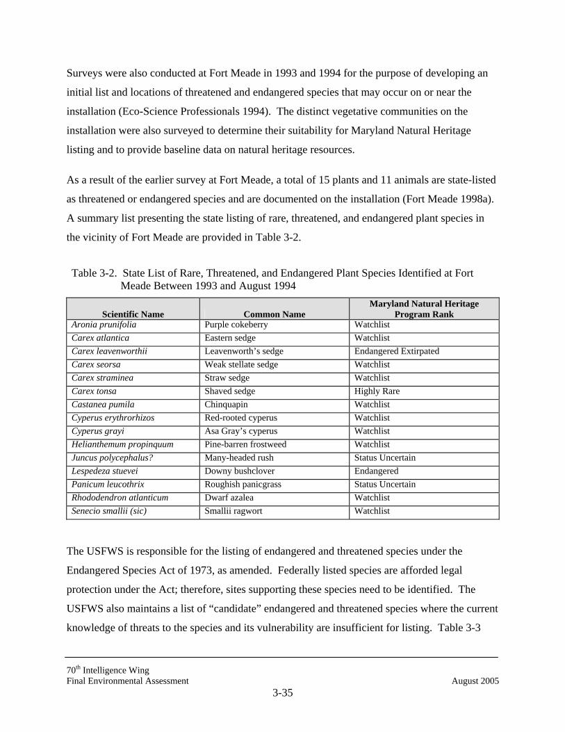
70th Intelligence Wing Final Environmental Assessment August 2005
3-35
Surveys were also conducted at Fort Meade in 1993 and 1994 for the purpose of developing an
initial list and locations of threatened and endangered species that may occur on or near the
installation (Eco-Science Professionals 1994). The distinct vegetative communities on the
installation were also surveyed to determine their suitability for Maryland Natural Heritage
listing and to provide baseline data on natural heritage resources.
As a result of the earlier survey at Fort Meade, a total of 15 plants and 11 animals are state-listed
as threatened or endangered species and are documented on the installation (Fort Meade 1998a).
A summary list presenting the state listing of rare, threatened, and endangered plant species in
the vicinity of Fort Meade are provided in Table 3-2.
Table 3-2. State List of Rare, Threatened, and Endangered Plant Species Identified at Fort Meade Between 1993 and August 1994
Scientific Name Common Name Maryland Natural Heritage
Program Rank Aronia prunifolia Purple cokeberry Watchlist Carex atlantica Eastern sedge Watchlist Carex leavenworthii Leavenworth’s sedge Endangered Extirpated Carex seorsa Weak stellate sedge Watchlist Carex straminea Straw sedge Watchlist Carex tonsa Shaved sedge Highly Rare Castanea pumila Chinquapin Watchlist Cyperus erythrorhizos Red-rooted cyperus Watchlist Cyperus grayi Asa Gray’s cyperus Watchlist Helianthemum propinquum Pine-barren frostweed Watchlist Juncus polycephalus? Many-headed rush Status Uncertain Lespedeza stuevei Downy bushclover Endangered Panicum leucothrix Roughish panicgrass Status Uncertain Rhododendron atlanticum Dwarf azalea Watchlist Senecio smallii (sic) Smallii ragwort Watchlist
The USFWS is responsible for the listing of endangered and threatened species under the
Endangered Species Act of 1973, as amended. Federally listed species are afforded legal
protection under the Act; therefore, sites supporting these species need to be identified. The
USFWS also maintains a list of “candidate” endangered and threatened species where the current
knowledge of threats to the species and its vulnerability are insufficient for listing. Table 3-3

70th Intelligence Wing Final Environmental Assessment August 2005
3-36
presents the state rank and Federal status of rare, threatened, and endangered animal species
found at Fort Meade.
Table 3-3. State and Federal List of Rare, Threatened, and Endangered Animal Species Identified at Fort Meade Between 1993 and August 1994*
Scientific Name Common Name Maryland Natural Heritage
Program Rank U.S. Status
Chlorotettix sp. A cicadellid leafhopper Status Uncertain - Etheostoma vitreum Glassy Darter Extremely Rare - Gallinula chloropus Common moorhen Very rare - Limotettix sp. Eastern sedge barrens Extremely Rare - Lophodytes cucullatus Hooded merganser Extremely Rare - Percina notogramma Stripeback darter Historically Known - Pituophis melanoleucus Northern pine snake Historically Known Candidate I/D** Porzana Carolina Sora Extremely Very Rare - Reithrodontomys humulis Eastern harvest mouse Historically Known - Sorex longirostris Southeastern shrew Very Rare - Sperchopsis tessellatus A hydrophylid bettle Very Rare - * Information adapted from Fort Meade 1998a. ** I/D = Evidence of vulnerability, but insufficient data.
As a result of the rare species surveys at Fort Meade, five areas were identified as having
statewide significance. The five areas include:
• Rock Avenue Shrub Swamp,
• Range Road Obstacle Course,
• Range Road Corridor,
• NSA Antenna Site, and
• Little Patuxent River.
In accordance with the requirements of the Endangered Species Act, agency coordination was
initiated with the USFWS; Wildlife and Heritage Division of the Maryland DNR; and Maryland
DNR Division of Environmental Review. Correspondence from the USFWS and Maryland’s
Wildlife and Heritage Division indicated that no Federally-listed or proposed endangered or
threatened species were known to occur on any of the project sites (Ratnassway 2002, Appendix
A). Prior correspondence with the Maryland DNR Division of Environmental Review reports
70th Intelligence Wing Final Environmental Assessment August 2005
3-37
the potential of a state-endangered fish, the glassy darter (Etheostoma vitreum), within the Little
Patuxent River (Bieber 1998, Appendix A).
3.8 PRIME AND UNIQUE FARMLANDS
Prime farmland is land that has the best combination of physical and chemical characteristics for
producing food, feed, forage, fiber, and oilseed crops. The land must also be available for these
uses (cropland, pasture land, forestland, or other land, but not water or urban built-up land).
Prime farmland has the soil quality, growing season, and moisture supply needed to
economically produce sustained high yields of crops when treated and managed, including water
management, according to acceptable farming methods (NRCS 2000).
Unique farmland is land other than prime farmland that is used for production of specific high-
value food and fiber crops. It has the special combination of soil quality, location, growing
season, and moisture supply needed to economically produce sustained high quality or yields of
specific crops (NRCS 2000).
Scattered pockets of land that contain soils indicative of prime farmland do exist within Fort
Meade boundaries, but no agricultural activities are currently pursued in these areas. Soils found
on the site of the Proposed Action and the action alternative at the NSA are mapped in the Fort
Meade Soil Survey (1995) within the Cut and Fill Land Series, and are designated as Cut and fill
land, 0 to 5 percent slopes; these soils are not considered prime farmland.
3.9 WILD AND SCENIC RIVERS
The Maryland Scenic and Wild Rivers Act established state policy to protect the water quality of
designated scenic rivers and fulfill vital conservation purposes by wise use of resources within
the scenic and wild rivers system. The Patuxent and Severn Rivers have been designated as
Maryland Scenic Rivers.
In the Odenton Town Plan, the Patuxent River Policy Plan of 1984 outlines the policy direction
for local and state agencies that carry out programs and make regulatory decisions for the
Patuxent River Watershed (Anne Arundel County 1995). Policy direction is provided through 10
recommendations:

70th Intelligence Wing Final Environmental Assessment August 2005
3-38
• A Primary Management Area will be established to identify and manage land from
which pollution is most likely to be transported into the river (1/4 mile along
mainstem, 1/8 mile along tributaries).
• Programs for providing best management practices and vegetative buffers
immediately adjacent to the river and its tributaries will be developed.
• The state, in conjunction with local governments, will survey the watershed and
identify major nonpoint source pollution sites.
• The state will develop a cost-sharing program to aid local governments in correcting
and managing stormwater pollution from existing developed areas.
• Future development will be accommodated in ways to minimize impact on water
quality and maximize existing protection opportunities.
• Additional recreation and open space land will be acquired.
• Existing forest cover will be retained and important sensitive areas will be reforested
to protect water quality.
• Prime and productive agricultural land will be preserved.
• Sand and gravel activities will be managed to allow extraction of the resource
without damage to the river.
• The Patuxent River Commission will develop and adopt an action program to
implement the strategies.
No streams are located on or directly adjacent to any of the sites under consideration in this EA
Fort Meade intends to follow, whenever possible, state recommendations for preserving the
Patuxent and Severn scenic rivers.
To provide for a National Wild and Scenic River System, Congress enacted the Wild and Scenic
Rivers Act (P.L. 90-542, as amended) (16 USC 1271-1287) in 1968. The Act pronounced:
“It is hereby declared to be the policy of the United States that certain selected rivers of
the Nation which, with their immediate environments, possess outstandingly remarkable

70th Intelligence Wing Final Environmental Assessment August 2005
3-39
scenic recreational, geologic, fish and wildlife, historic, cultural or other similar values,
shall be preserved in free-flowing condition, and that they and their immediate environ-
ments shall be protected for the benefit and enjoyment of present and future generations.
The Congress declares that the established national policy of dams and other construction
at appropriate sections of the rivers of the United States need to be complemented by a
policy that would preserve other selected rivers or sections thereof in their free-flowing
condition to protect the water quality of such rivers and to fulfill other vital national
conservation purposes.”
As yet, no Maryland rivers are so designated under this Federal act.
3.10 CULTURAL RESOURCES
The 2001 Fort Meade Integrated Cultural Resources Management Plan (ICRMP; USACE 2001)
updated previous cultural resource information presented in Fort George G. Meade Cultural
Resources Management Plan (CRMP; Goodwin et al. 1994) and the Fort George G. Meade
Phase II Architectural Summary Report (Goodwin et al. 1996). The ICRMP identified and
evaluated all archeological resources and architectural resources built between 1946 and 1960 at
Fort Meade, and determined two resources eligible for the National Register of Historic Places
(NRHP): the Post Core Historic District and Building 8688, a water treatment plant. In addition,
the ICRMP added information to the Phase I Archeological Survey of Approximately 2,210
Acres at Fort George G. Meade, Maryland (Goodwin et al. 1995), and identified a total of 36
archeological sites; 13 of the sites have been found not to be eligible for listing in the NRHP, 19
of the sites are recommended for additional evaluation prior to any soil disturbance, and 4 of the
sites are cemeteries and are recommended for avoidance.
The 1996 CRMP developed a predictive model for areas of archeological sensitivity. After the
CRMP was finalized, an archeological survey of extensive areas on Fort Meade was conducted.
The results and recommendations were presented in a technical appendix to the CRMP, entitled
Phase I Archeological Survey of approximately 2,210 acres at Fort George G. Meade, Maryland.
The predictive model was critically evaluated through intensive archeological investigation of
areas determined to exhibit a high potential for containing cultural resources. The model
identified a total of approximately 2,210 acres (5,461 hectares) of high probability land within
70th Intelligence Wing Final Environmental Assessment August 2005
3-40
Fort Meade and determined that some 1,395 (3,447 hectares) of those had been subjected to
various degrees and types of disturbance.
A pedestrian reconnaissance study of all 1,395 disturbed acres was performed that entailed visual
inspection and photo documentation of lands so designated, as well as excavation of random
auger and shovel tests to determine the nature and degree of disturbances and to ascertain the
need for more intensive examination. Of the total high probability portions of the installation,
100 percent of the undisturbed areas (approximately 815 acres/2,014 hectares) and some 350
acres (865 hectares) of the disturbed sections were subjected to intensive, systematic shovel
testing. The results and recommendations of this archeological testing at Fort Meade is
documented in the technical appendix to the CRMP; Phase I Archeological Survey of
Approximately 2,210 acres at Fort Meade, Maryland (Goodwin et al. 1995). In 1997, additional
field work was conducted on 19 small parcels recommended for Phase I testing in the 1995
report. No additional sites were identified as a result of this survey.
Correspondence received from the Maryland Historical Trust, Development, Office of
Preservation Services, indicates that there are no known sites of cultural significance on the site
of the Proposed Action, or the action alternative (Appendix A, Cole 2005).
Historic Architectural Resources
The 2001 ICRMP evaluated all historic architectural resources at Fort Meade built between 1946
and 1960; other resources were evaluated in previous documents. The 1994 CRMP included a
comprehensive reconnaissance-level survey of 501 historic resources (Goodwin et al. 1994).
The CRMP found the Post Core Historic District eligible for the NRHP under Criterion C. The
ICRMP indicated that the historic district included 124 permanent buildings constructed between
1928 and 1940, and encompasses the original, formally-planned core of the installation. It must
be noted, however, that 113 of these historic resources were privatized in 2001 after publication
of the ICRMP; this left Fort Meade with only 14 of these historic structures (DiGiovanni 2005).
The 1996 Fort George G. Meade Phase II Architectural Summary Report evaluated the potential
significance of 61 resources (Goodwin et al. 1996). The architectural summary report found
Building 8688, a water treatment plant, eligible for the NRHP under Criterion C for its Art
70th Intelligence Wing Final Environmental Assessment August 2005
3-41
Moderne design. The Maryland State Historic Preservation Officer (SHPO) concurred with this
determination in November 1996. Fort Meade’s WWII temporary frame buildings have been
addressed under the 1986 Programmatic Memorandum of Agreement between the Department of
Defense, the National Conference of State Historic Preservation Officers, and the Advisory
Council on Historic Preservation. Thus, the installation has been entirely surveyed for historic
architectural resources and two resources have been determined eligible for the NRHP: the Post
Core Historic District and Building 8688. No historic structures are located on or near the
construction sites for the Proposed Action or its action alternative.
3.11 HAZARDOUS, TOXIC, AND RADIOACTIVE SUBSTANCES
The EMO/DPW coordinates inventories of hazardous materials and disposal of hazardous waste.
Emergency response to spills of hazardous waste and materials is conducted through on-site
coordinators, installation fire department, and installation hazardous material team.
3.11.1 Underground Storage Tanks and Aboveground Storage Tanks
No underground storage tanks (USTs) are located in the vicinity of the planned construction
activities (DiGiovanni 2002).
3.11.2 Polychlorinated Biphenyls
Polychlorinated Biphenyls (PCBs) are mixtures of synthetic organic chemicals with the same
basic chemical structure and similar physical properties. PCBs were used in hundreds of
industrial and commercial applications in the past due to their non-flammability, chemical
stability, high boiling point, and electrical insulating properties. They have been used in
electrical, heat transfer, and hydraulic equipment; in paints, plastics and rubber products; in
pigment, dyes, and carbonless copy paper; as well as in other applications. The manufacturing of
PCBs was terminated in 1977. PCBs have been shown to cause a variety of adverse health
effects. Studies in humans provide supportive evidence for the potential carcinogenicity and
non-carcinogenic effects of PCBs. Non-carcinogenic effects include effects on the immune
system, reproductive system, nervous system, and endocrine system (EPA 1999c).
EPA regulation 40 CFR 761.30 requires that all 480-volt PCB transformers have advanced
primary protection, be removed, or be reclassified to non-PCB status through a retrofit process.
70th Intelligence Wing Final Environmental Assessment August 2005
3-42
Subsequently, the decision to replace or retrofit was clarified by Engineering Technical Letter
1110-3-412 Transformer Application Guidance which specifically required the replacement of
transformers with PCB concentrations of more than 1,000 parts per million (ppm).
EPA regulation 40 CFR 761 Subpart B regulates the use of PCBs and PCB items, including the
use of transformers and capacitors containing PCBs. Regulation 40 CFR 761.30 indicates that
the use of network PCB transformers with higher secondary voltages (secondary voltages equal
to or greater than 480 volts) in or near commercial buildings is prohibited. Network transformers
that are removed from service in accordance with this requirement must either be reclassified to
PCB-contaminated or non-PCB status, placed into storage for disposal, or disposed of.
Transformers are classified into three categories based on the PCB-concentration within the unit.
The categories are PCB (more than 500 ppm), PCB-contaminated (50 to 499 ppm), and non-PCB
(less than 50 ppm).
Fort Meade has removed all PCB transformers with PCB concentrations exceeding 500 ppm.
There are three possible PCB-contaminated transformers (concentrations between 50 ppm and
499 ppm) located within the MacArthur Manor area (3000 Housing Area, Puls 2002). No PCB
transformers are located on the Proposed Action site, or either of the alternative sites. However,
the 3000 Housing Area is adjacent to Alternative site 1. PCB contamination issues are being
addressed under a separate action.
3.11.3 Radon
Radon is an invisible, odorless radioactive gas formed by the natural breakdown or decay of
uranium, a naturally occurring element found in granite and certain other types of rock. Radon
gas dissipates in outdoor settings and is present at concentrations considered to be harmless.
However, radon gas can accumulate inside enclosed spaces and represent a health risk to
occupants. In general, the risk increases as the level of radon and the length of exposure
increases. There is an increased risk of developing lung cancer when exposed to elevated levels
of radon. The EPA has established a guidance level of 4 picocuries per liter (pCi/L) of radon in
indoor air for residences; however, there have been no standards established for commercial
structures. Radon gas accumulations above 4 pCi/L are considered to represent a health risk to
70th Intelligence Wing Final Environmental Assessment August 2005
3-43
occupants (Internet Radon Research Center and EPA Sources of Information on Indoor Air
Quality for Radon, August 1999).
In response to concern over indoor air concentrations of radon, the Army formulated the Army
Radon Reduction Program (ARRP). The objectives of ARRP are to
• Identify structures owned and leased by the Army that have indoor radon levels
greater than 4 pCi/L of air.
• Modify all Army-owned structures having radon levels greater than 4 pCi/L so that
levels are reduced to 4 pCi/L or less.
• Provide detailed guidance concerning radon measurement procedures and risk
estimates that have been published in the U.S. Army Environmental Health Agency
Technical Guide No. 164.
• Issue mitigation strategies and procedures that will be addressed in separate
publications furnished by the USACE.
The Army has adopted EPA’s recommended remedial action level as its indoor radon standard.
Levels of radon exceeding 4 pCi/L of air require mitigation efforts. Radon monitoring at Fort
Meade is complete. The results from the survey have found that indoor radon concentrations are
within the EPA acceptable levels and, therefore, require no further action (Colianni 1999).
3.11.4 Hazardous Materials and Waste
Procedures for handling, storage, transportation, and disposal of hazardous materials and wastes
are outlined in the Installation Hazardous Waste Management Plan, Fort George G. Meade
(USACHPPM-North 2004). The plan also outlines command responsibilities, identification
procedures, inspections, personnel training, and spill response and emergency procedures.
Fort Meade generates relatively small quantities of a variety of hazardous wastes. The
Installation Hazardous Waste Management Plan, Fort George G. Meade (USACHPPM-North
2004) identifies 32 hazardous waste generators on the installation including the Directorate of
Public Works, Directorate of Logistics, and the Directorate of Personnel and Community
Activities. An analysis of annual waste disposal data in the Bi-annual Hazardous Waste
70th Intelligence Wing Final Environmental Assessment August 2005
3-44
Generators Report (Fort Meade 2001c), filed with MDE, indicated that Fort Meade generated
71,285 pounds per year (lb/year) of regulated waste in 2001. In addition, 59,631 lb/year of non-
regulated wastes were generated on Fort Meade during the same year (Kandt 2002).
Pesticides, Herbicides, and Fertilizers
A pesticide is any substance or mixture of substances that is intended to prevent, destroy, or
mitigate any pest. This term also applies to herbicides when the substance or mixture of
substances is used to destroy or inhibit plant growth. Because these substances are designed to
adversely affect living organisms, they create a potential health risk to humans, animals, and the
environment. In the past few years, increasing scientific and public attention has been focused
on the potential adverse effects of man-made chemicals on public health. There is an increasing
amount of evidence that these synthetic chemicals, also found in fertilizers, interfere with the
normal endocrine system functioning in humans and other animals (EPA 1999a, b, c).
3.11.5 Contaminated Areas
Congress enacted the Comprehensive Environmental Response, Compensation and Liability Act
(CERCLA), commonly referred to as Superfund, on December 11, 1980. This act is targeted at
the cleanup of areas contaminated by releases of hazardous substances into the environment.
CERCLA assigns accountability for cleanup costs of contaminated areas by providing federal
authority to respond directly to the hazardous substance releases that may endanger public health
or the environment. This act created a tax on the chemical and petroleum industries that formed
a trust fund used for cleaning up abandoned or uncontrolled hazardous waste sites. CERCLA
also requires the EPA to establish and maintain a National Priorities List (NPL) of the most
serious uncontrolled or abandoned hazardous waste sites requiring long-term remedial response
actions (EPA 1999a; MDE 1999).
Fort Meade was designated a NPL site on July 28, 1998. The EPA designated Fort Meade a
NPL site based on the evaluation of four locations, the Defense Reutilization and Marketing
Office (DRMO), Active Sanitary Landfill (ASL), Clean Fill Dump (CFD), and Post Laundry
Facility (PLF), that have been identified as past storage and disposal sites for hazardous
materials and wastes that contained hazardous substances.
70th Intelligence Wing Final Environmental Assessment August 2005
3-45
The NPL listing includes BRAC and non-BRAC portions of Fort Meade. An estimated 8,848
acres of Fort Meade were originally targeted for closure; 8,100 acres of the BRAC property have
since been transferred to the Department of Interior’s Patuxent National Research Refuge
(PNRR) for use as a wildlife refuge. The Active Sanitary Landfill encompasses approximately
308 acres of the BRAC property and has been obtained by the U.S. Army. Approximately 366
acres of property is occupied by Tipton Army Airfield (TAA), which was transferred to Anne
Arundel County to serve as a General Aviation Facility the fall of 1999.
Environmental cleanup of potentially contaminated sites on Fort Meade has consisted of a
combination of removal actions, eliminating the threat to public health and the environment by
removing hazardous substances from the site, and remedial actions the permanent cleanup of
contaminated areas. Removal actions have been completed at the DRMO site and the TAA
parcel. Environmental investigations are currently being performed at eight sites within the
BRAC property and at three non-BRAC sites (ASL, DRMO, and PLF). Remedial investigations
are occurring at 11 sites and several additional removal actions and remedial actions are planned
within the next few years. In addition, in order to comply with obligations under the RCRA, the
U.S. Army has recently identified Solid Waste Management Units (SWMUs) and Areas of
Concern (AOCs) on non-BRAC portions of Fort Meade (EPA CERCLA Information Site, the
Superfund NPL Assessment Program (SNAP) Database, Fort George G. Meade Site; EPA
Region 3).
Contaminated areas investigated under the CERCLA actions are generally located along the
southern border of the installation and all are undergoing investigative or remediation activities
at this time. Areas of industrial contamination are located along MD Route 32. The
contaminated areas are located down gradient from the proposed sites, none on or near the areas
of proposed construction.
Other contaminated sites include all inactive landfills on post located at TAA and landfill cells 1,
2, and 3. Landfills 2 and 3 at TAA have been closed and capped, and all other post landfills are
to be closed and capped in the near future. The Fire Training Area and Post Laundry facility
(Building 2250) both have well monitoring activities being conducted on site. Both the Battery
Shop building (Building 2283), which has lead in the groundwater, and areas long the MD Route
70th Intelligence Wing Final Environmental Assessment August 2005
3-46
32 corridor, known to have petroleum products in the groundwater, have well monitoring in
place and are undergoing further investigation to recommend cleanup procedures (Gebhardt
1998).
The installation’s CERCLA initiative is currently operating parallel to investigative procedures
for this assessment. As part of the CERCLA process, contaminated areas are being sampled to
determine the extent of contamination. Treatment systems are currently in place and monitoring
is being conducted to determine further courses of action. Because investigative procedures and
remediation activities for Fort Meade’s CERCLA initiative continue to be performed
concurrently and separate from this assessment, those processes will not be addressed in detail in
this EA.
3.11.6 Permits and Regulatory Authorizations
Fort Meade operates under a number of permits from various state and federal agencies. Table
3-4 lists the primary permits and authorizations issued to Fort Meade.
3.12 INFRASTRUCTURE
3.12.1 Utilities
3.12.1.1 Potable Water Supply
Fort Meade obtains the majority of its the potable water on the installation from a combination of
an intake in the Little Patuxent River and five groundwater wells. Under normal conditions, the
Little Patuxent River supplies 75 percent of the water requirements of Fort Meade. Daily
demands are met by using a mix of surface water and the groundwater wells. For the past two
years, however, the groundwater wells have been providing 100 percent of Fort Meade’s water
because of problems with the river basin and the weir at the intake of the low lift pump station
(Moyer 2005). The river water intake and low lift pumping station are located approximately
3000 feet from the installation water treatment plant. The raw water is transported via one 12-
inch transit pipe and two 12-inch cast iron pipes (Fort Meade 1998a). The Little Patuxent River
capacity is approximately 4.5 mgd (Stickland 2002). The groundwater wells were installed at
Fort Meade to take advantage of the Patuxent Aquifer. The wells have static water levels
ranging between 80 and 120 feet below the surface. The individual well capacities vary from
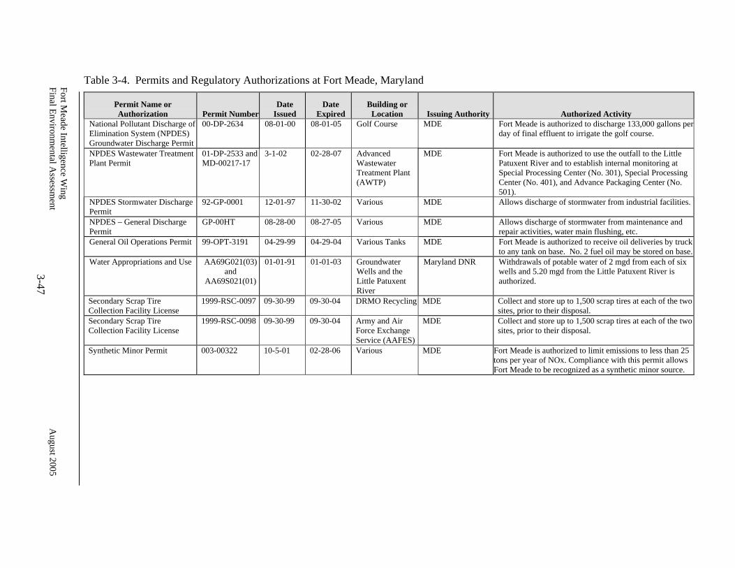
Fort Meade Intelligence W
ing Final Environm
ental Assessm
ent August 2005
3-47
Table 3-4. Permits and Regulatory Authorizations at Fort Meade, Maryland
Permit Name or Authorization Permit Number
Date Issued
Date Expired
Building or Location Issuing Authority Authorized Activity
National Pollutant Discharge of Elimination System (NPDES) Groundwater Discharge Permit
00-DP-2634 08-01-00 08-01-05 Golf Course MDE Fort Meade is authorized to discharge 133,000 gallons per day of final effluent to irrigate the golf course.
NPDES Wastewater Treatment Plant Permit
01-DP-2533 andMD-00217-17
3-1-02 02-28-07 Advanced Wastewater Treatment Plant (AWTP)
MDE Fort Meade is authorized to use the outfall to the Little Patuxent River and to establish internal monitoring at Special Processing Center (No. 301), Special Processing Center (No. 401), and Advance Packaging Center (No. 501).
NPDES Stormwater Discharge Permit
92-GP-0001 12-01-97 11-30-02 Various MDE Allows discharge of stormwater from industrial facilities.
NPDES – General Discharge Permit
GP-00HT 08-28-00 08-27-05 Various MDE Allows discharge of stormwater from maintenance and repair activities, water main flushing, etc.
General Oil Operations Permit 99-OPT-3191 04-29-99 04-29-04 Various Tanks MDE Fort Meade is authorized to receive oil deliveries by truck to any tank on base. No. 2 fuel oil may be stored on base.
Water Appropriations and Use AA69G021(03) and
AA69S021(01)
01-01-91 01-01-03 Groundwater Wells and the Little Patuxent River
Maryland DNR Withdrawals of potable water of 2 mgd from each of six wells and 5.20 mgd from the Little Patuxent River is authorized.
Secondary Scrap Tire Collection Facility License
1999-RSC-0097 09-30-99 09-30-04 DRMO Recycling MDE Collect and store up to 1,500 scrap tires at each of the two sites, prior to their disposal.
Secondary Scrap Tire Collection Facility License
1999-RSC-0098 09-30-99 09-30-04 Army and Air Force Exchange Service (AAFES)
MDE Collect and store up to 1,500 scrap tires at each of the two sites, prior to their disposal.
Synthetic Minor Permit 003-00322 10-5-01 02-28-06 Various MDE Fort Meade is authorized to limit emissions to less than 25 tons per year of NOx. Compliance with this permit allows Fort Meade to be recognized as a synthetic minor source.

70th Intelligence Wing Final Environmental Assessment August 2005
3-48
650,000 (tgd) to 1.44 (mgd). There are approximately 30 days a year when water withdrawal
from the Little Patuxent River is restricted. Reasons include hazardous spills and road salt
contamination. During these times, capacity is sustained 100 per cent by the existing
groundwater wells.
The installation operates the withdrawal of water under two Water Appropriation and Use
permits from the Maryland DNR, Water Resources Administration. One permit allows an
average of 2 mgd of water to be withdrawn annually from each of the installation’s groundwater
wells. The other permit allows an average of 5.2 mgd of water to be withdrawn annually from
the Little Patuxent River. The installation uses approximately 3.3 mgd on average, which is
approximately 40 percent of the plant’s capacity. Peak summer demand rarely exceeds 6 mgd.
Fort Meade also maintains approximately 3.5 million gallons of water for emergency use in eight
storage tanks on the base (USACE 1997).
Fort Meade operates its own water treatment plant located in the southwest quadrant of the
installation cantonment area near the intersection of Mapes and O’Brien Roads; the water
treatment and supply operation is scheduled to be privatized by late 2006 (Moyer 2005). The
water treatment plant, a multimedia filtration plant with a clearwell capacity of 2 million gallons,
receives raw water from both the river and the wells. The treatment capacity of the plant is
8.2 mgd. The plant contains three clearwells with a total capacity of 2 mgd. The water is treated
for turbidity, iron, and manganese. Fluoride is added to the water before it is distributed
(USACE 1997).
Using the Fort Meade installation population figures per the Army Stationing and Installation
Plan, the average per capita Fort Meade water consumption is approximately 90.0 gallons per
capita per day (gpcd). This consumption figure is consistent with normal planning figures used
in the engineer planning books; “Civil Engineering Reference Manual” (Lindeburg 1997) and
“Standard Handbook of Engineering Calculation” (Hicks 1994). The existing water treatment
and distribution system can support a population range of approximately 54,000 to 91,000
persons (Fort Meade 1998a).
70th Intelligence Wing Final Environmental Assessment August 2005
3-49
3.12.1.2 Sewer and Wastewater
Fort Meade operates its own sewage treatment system. The Advanced Wastewater Treatment
Plant (AWTP), formerly Sewage Treatment Plant No. 2, was completed in August 1983. The
facility is located in the southwest corner of the installation along the Little Patuxent River at the
intersection of MD Route 198 and MD Route 32. The AWTP operation will be privatized by
late 2006 (Moyer 2005).
The AWTP treats approximately 2.5 mgd, but has an average daily design capacity of 4.5 mgd.
The outfall from the AWTP discharges into the Little Patuxent River. Approximately 16,000
wet tons of sludge material are generated annually and disposed of by contract, as a soil
amendment (USACE 1997). Based on Fort Meade installation population figures per the Army
Stationing and Installation Plan, the average per capita Fort Meade sewage treatment is
approximately 70.3 gpcd, 78 percent of the installation average per capita water consumption
(90.0 gpcd; Fort Meade 2001).
3.12.1.3 Energy
Energy capacity distribution on Fort Meade, including electricity, natural gas, and fuel oil, are
described in the following subsections.
Electrical Power
Baltimore Gas & Electric (BGE) currently provides part of the electricity to Fort Meade and all
of it to the surrounding off-post area. A 115-kilovolt (kV) transmission line brings electricity to
government-owned master substations on the base. The existing primary source for
approximately 79 percent of Fort Meade’s power is a 110 kV feederline (3 phase-4 wire)
redundant feeder pair from the BGE Waugh Chapel Power Station that is found along the south
and east sides of the installation (along MD Route 32) on steel towers and terminates at
Substation 3. The remaining 21 percent of Fort Meade’s power is provided from NSA’s
Substation 2A. The installation’s primary distribution system is composed of both underground
and overhead lines. The majority of the distribution system is overhead on wooden power poles.
Portions of the distribution system were constructed in the 1940s.
70th Intelligence Wing Final Environmental Assessment August 2005
3-50
Fort Meade, however, is in the process of privatizing and upgrading all on-base electrical
facilities through BGE and Constellation Energy. A new electrical substation will be
constructed in the vicinity of the existing substation; tentative completion of the work is
September 2008. Because recent studies have recommended that consideration be given to
placing the secondary overhead system underground (Fort Meade 1998a), all above-ground
distribution facilities will be relocated underground as part of the privatization upgrades. Recent
studies indicate that the new transmission and distribution facilities will be able to handle the
projected growth at Fort Meade without impacting power supply redundancy (Moyer 2005).
Natural Gas
Fort Meade is supplied with natural gas by BGE. BGE natural gas is supplied via high pressure
(100 lbs pressure per square inch) mains, which form a loop around the installation. The natural
gas is supplied to the Government distribution system via 5 BGE bulk gas meters; the pressure is
reduced to 10 lbs pressure per square inch. The natural gas distribution system at Fort Meade,
including primary mains and service connections, is extensive and runs throughout the
installation. Fort Meade is also in the process of privatizing and upgrading all on-base natural
gas facilities through BGE and Constellation Energy; tentative completion of work is September
2008. Fort Meade’s two oil-fired central steam plants were decommissioned in 2000 by Fort
Meade’s Energy Savings Performance Contracting contractor (Moyer 2005). New gas-fired
boilers installed throughout the installation have replaced old centralized oil-fired boilers. The
proposed project evaluated in this document would be served by natural gas.
Fuel Oil
Number 2 fuel oil is used throughout the installation as fuel for individual heat plants. The oil is
stored in both aboveground and underground storage tanks (AGTs and USTs, respectively) near
the heat plants they service. There are currently 7 USTs and 43 AGTs remaining on post;
however, not all contain fuel oil (DiGiovanni 2002). The proposed facility would not use fuel oil
as a heating source.
70th Intelligence Wing Final Environmental Assessment August 2005
3-51
3.12.2 Solid Waste
Fort Meade has its own Integrated Solid Waste Management Plan (ISWM) that defines
procedures for disposal of solid waste on the installation, including municipal solid waste and
recyclable materials. In accordance with the Federal Facility Compliance Act of 1992 (FFCA),
Fort Meade’s ISWM Plan complies with the Solid Waste Disposal Act (SWDA) amended to
include Federal installations.
From residential, office, and industrial sources, Fort Meade currently generates an average of
approximately 9,358 tons per year of solid waste or 25.6 tons per day (tpd) (Marquardt 2005).
During 2004, approximately 11.05 tons of municipal solid waste per day from Fort Meade was
disposed of through the Annapolis Junction Transfer facility.
The remaining 14.55 tons per day consists of recyclable materials, much of them generated from
installation daily maintenance activities. According to information provided by the Fort Meade
EMO office, approximately 519.58 tons (1.42 tons per day) of recyclable large and small sized
yard waste were recycled by Fort Meade through A-A Recycle and Sand, Inc., and MES regional
Composting Facility in 2004. As reported by the DPW’s Environmental Management Office, an
estimated 4,365 tons of other types of recyclable materials (11.65 tons per day) were received
into the Fort Meade Recycling Program during the year 2004 (Fort Meade DPW EMO 2001;
Marquardt 2005).
Recyclable materials such as aluminum and paper products are recycled through the Fort Meade
Recycling Center. The remaining solid waste generated per day is made up of other recyclable
materials such as yard waste, scrap metal (steel), used tires, and waste oil, and are recycled
through Fort Meade’s DRMO Recycling and other recycling programs (Fort Meade 1998b,
Marquardt 2005).
Fort Meade’s solid waste is ultimately transported to the King George Landfill in King George,
VA for disposal. The total capacity of the King George Landfill is 31,850,000 tons (45,500,000
cubic yards). The estimated remaining capacity of the King George Landfill, as of Spring 1999,
was 28,850,000 tons. Any solid waste that is not accepted through the Annapolis Junction

70th Intelligence Wing Final Environmental Assessment August 2005
3-52
Transfer facility is disposed of at the Millersville Sanitary Landfill in Anne Arundel County; the
amount is negligible (Fort Meade 1998b).
3.12.3 Transportation
3.12.3.1 Surrounding Road System
Fort Meade is located in the western portion of Anne Arundel County and comprises
approximately 5,415 acres. Three major highways provide access around the perimeter of the
installation as follows:
• The Baltimore-Washington Parkway (MD Route 295) is located just west of Fort
Meade and provides north/south access between Baltimore and Washington, D.C. No
heavy trucks are permitted on the Parkway south of MD Route 175.
• MD Route 175 borders the north and east boundaries of Fort Meade and provides for
east/west travel between Columbia and Odenton. MD Route 175 provides access to
other major roadways such as MD Route 32, the Baltimore-Washington Parkway,
I-95, and US 29. MD Route 175 has a varying width that provides a two-lane
roadway from Rockenbach Road to Reece Road, then widens to a minimum four-lane
roadway from Reece Road to MD Route 32.
• MD Route 32 borders the southern portion of Fort Meade and provides for east/west
travel from I-97, east of Odenton, to Howard County. In the vicinity of Fort Meade,
MD Route 32 has a four-lane divided cross section and primarily functions as a
freeway. However, at grade signalized intersections are provided along the Fort
Meade boundary at Mapes Road and MD Route 198. Interchanges are provided
along MD Route 32, at both MD Route 175 and the Baltimore-Washington Parkway.
The major roadways providing access through Fort Meade include Rockenbach Road, which
extends from MD Route 175 southerly to MD Route 32 through Fort Meade, and Mapes Road,
which traverses east/west through Fort Meade between MD Route 175 and MD Route 32.
Other state roadways providing access to the Fort Meade area include Ridge Road (MD Route
713), Reece Road (MD Route 174) and Laurel-Fort Meade Road (MD Route 198). The first two
70th Intelligence Wing Final Environmental Assessment August 2005
3-53
roadways provide for north/south travel north of MD Route 175. During 2001, MD Route 713
was upgraded to accommodate increased traffic generated by the Arundel Mills Mall. MD Route
198 extends from MD Route 32 on the south side of Fort Meade, westerly into Laurel and then
Howard County.
3.12.3.2 Access to Fort Meade
Direct access to Fort Meade is via several entrances from MD Route 175, MD Route 32, and MD
Route 295. From the east, Fort Meade can be accessed from MD Route 175 at Rockenbach
Road, Reece Road, Mapes Road, and Llewellyn Avenue. From the south, Fort Meade can be
accessed from Pepper Road after it crosses MD Route 32, from the Mapes Road intersection with
MD Route 32, and from two locations near the NSA facility in the southwest corner of the base.
NSA can be accessed directly from MD Route 295.
However, increased security on post, implemented since September 11, 2001, has rerouted
entering traffic through security check points at all gates that will be in place indefinitely
(Gebhardt 2001a). All civilian and military personnel must enter the installation through these
check points. Because of this situation, traffic backups along MD Route 175 before post
entrances are now common during all hours of the day and night. Traffic on post, however,
remains relatively normal. A follow-up traffic assessment planned for Fort Meade has been
postponed pending relaxation of these strict anti-terrorism measures (Gaphardt 2001a).
Results of a traffic study conducted in 1999-2000 are presented below as an example of normal
traffic conditions as surveyed during the time period prior to the implementation of access
restrictions.
3.12.3.3 Existing Traffic (prior to access restrictions)
As part of a recent NEPA assessment of normal Fort Meade traffic conditions conducted in 1999,
traffic counts were made throughout Fort Meade and the surrounding area road. The traffic data
collected included Intersection Turning Movement Counts, Average Daily Traffic Volume
Counts, Vehicular Classification Studies, and Travel Speed Studies.

70th Intelligence Wing Final Environmental Assessment August 2005
3-54
Traffic conditions are typically evaluated using capacity and Level of Service (LOS) as a method
of evaluation. The Highway Capacity Manual (HCM) Special Report 209, 3rd Edition, published
by the Transportation Research Board in 1998, addresses capacity and LOS as its two principal
concepts. The capacity of a facility is defined as “the maximum hourly rate at which persons or
vehicles can reasonably be expected to traverse a point or uniform section of a lane or roadway
during a given time period under prevailing roadway, traffic, and control conditions.”
Level of Service (LOS) uses qualitative measures that characterize operational conditions within
a traffic stream and their perception by motorists and passengers. The descriptions of individual
“levels of service” characterize these conditions in terms of such factors as speed and travel time,
freedom to maneuver, traffic interruptions, and comfort and convenience. Six levels of service
are defined for each type of facility for which analysis procedures are available. They are given
letter designations, from A to F, with LOS-A representing the best operating conditions and
LOS-F the worst. Each level of service represents a range of operating conditions. The volume
of traffic that can be served under the stop-and-go conditions of LOS-F is generally accepted as
being lower than that possible at LOS-E; consequently, LOS- E is the value that corresponds to
the maximum flow rate, or capacity, of the facility. For most analysis purposes, LOS-D is
usually considered to be the lowest level of service considered acceptable to the facility users.
The Maryland State Highway Administration (SHA) as well as Anne Arundel County use
LOS-D as their criterion for determining adequacy of transportation facilities. Furthermore, in
more urban and suburban areas, the adequacy of transportation facilities is typically dictated by
the operation of major intersections. For this purpose, Capacity Analyses are conducted for
intersections using the Critical Lane Volume (CLV) methodology, which is a planning
methodology accepted by many jurisdictions throughout the region. The CLV procedure
develops a Critical Lane Volume on the basis of the sum of hourly volumes coinciding at an
intersection, considering the various turning movements and travel lanes available. Table 3-5
details the various LOS for intersections and the corresponding Critical Lane Volumes.
The CLV methodology is a planning procedure that provides valuable insight to operating
conditions of critical intersections. However, the HCM also provides a detailed analysis
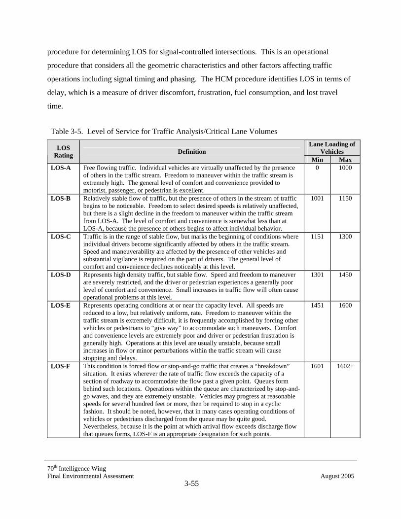
70th Intelligence Wing Final Environmental Assessment August 2005
3-55
procedure for determining LOS for signal-controlled intersections. This is an operational
procedure that considers all the geometric characteristics and other factors affecting traffic
operations including signal timing and phasing. The HCM procedure identifies LOS in terms of
delay, which is a measure of driver discomfort, frustration, fuel consumption, and lost travel
time.
Table 3-5. Level of Service for Traffic Analysis/Critical Lane Volumes Lane Loading of
Vehicles LOS Rating Definition
Min Max LOS-A Free flowing traffic. Individual vehicles are virtually unaffected by the presence
of others in the traffic stream. Freedom to maneuver within the traffic stream is extremely high. The general level of comfort and convenience provided to motorist, passenger, or pedestrian is excellent.
0 1000
LOS-B Relatively stable flow of traffic, but the presence of others in the stream of traffic begins to be noticeable. Freedom to select desired speeds is relatively unaffected, but there is a slight decline in the freedom to maneuver within the traffic stream from LOS-A. The level of comfort and convenience is somewhat less than at LOS-A, because the presence of others begins to affect individual behavior.
1001 1150
LOS-C Traffic is in the range of stable flow, but marks the beginning of conditions where individual drivers become significantly affected by others in the traffic stream. Speed and maneuverability are affected by the presence of other vehicles and substantial vigilance is required on the part of drivers. The general level of comfort and convenience declines noticeably at this level.
1151 1300
LOS-D Represents high density traffic, but stable flow. Speed and freedom to maneuver are severely restricted, and the driver or pedestrian experiences a generally poor level of comfort and convenience. Small increases in traffic flow will often cause operational problems at this level.
1301 1450
LOS-E Represents operating conditions at or near the capacity level. All speeds are reduced to a low, but relatively uniform, rate. Freedom to maneuver within the traffic stream is extremely difficult, it is frequently accomplished by forcing other vehicles or pedestrians to “give way” to accommodate such maneuvers. Comfort and convenience levels are extremely poor and driver or pedestrian frustration is generally high. Operations at this level are usually unstable, because small increases in flow or minor perturbations within the traffic stream will cause stopping and delays.
1451 1600
LOS-F This condition is forced flow or stop-and-go traffic that creates a “breakdown” situation. It exists wherever the rate of traffic flow exceeds the capacity of a section of roadway to accommodate the flow past a given point. Queues form behind such locations. Operations within the queue are characterized by stop-and-go waves, and they are extremely unstable. Vehicles may progress at reasonable speeds for several hundred feet or more, then be required to stop in a cyclic fashion. It should be noted, however, that in many cases operating conditions of vehicles or pedestrians discharged from the queue may be quite good. Nevertheless, because it is the point at which arrival flow exceeds discharge flow that queues forms, LOS-F is an appropriate designation for such points.
1601 1602+
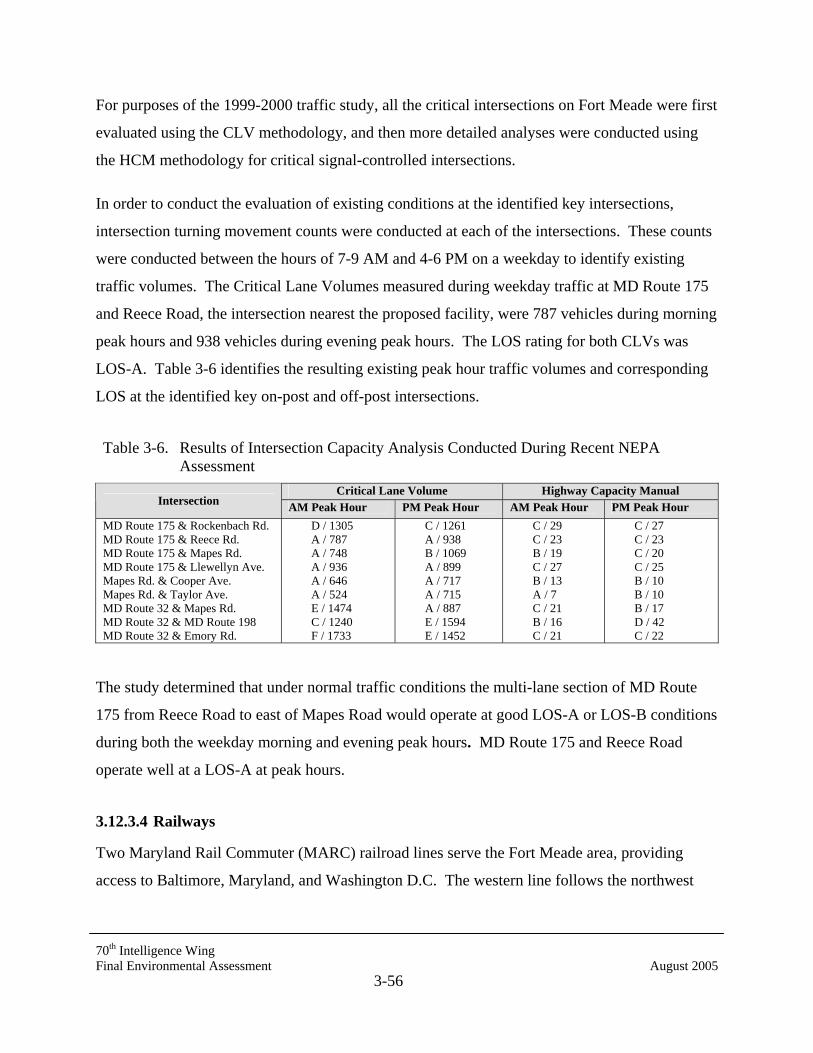
70th Intelligence Wing Final Environmental Assessment August 2005
3-56
For purposes of the 1999-2000 traffic study, all the critical intersections on Fort Meade were first
evaluated using the CLV methodology, and then more detailed analyses were conducted using
the HCM methodology for critical signal-controlled intersections.
In order to conduct the evaluation of existing conditions at the identified key intersections,
intersection turning movement counts were conducted at each of the intersections. These counts
were conducted between the hours of 7-9 AM and 4-6 PM on a weekday to identify existing
traffic volumes. The Critical Lane Volumes measured during weekday traffic at MD Route 175
and Reece Road, the intersection nearest the proposed facility, were 787 vehicles during morning
peak hours and 938 vehicles during evening peak hours. The LOS rating for both CLVs was
LOS-A. Table 3-6 identifies the resulting existing peak hour traffic volumes and corresponding
LOS at the identified key on-post and off-post intersections.
Table 3-6. Results of Intersection Capacity Analysis Conducted During Recent NEPA Assessment
Critical Lane Volume Highway Capacity Manual Intersection AM Peak Hour PM Peak Hour AM Peak Hour PM Peak Hour
MD Route 175 & Rockenbach Rd. MD Route 175 & Reece Rd. MD Route 175 & Mapes Rd. MD Route 175 & Llewellyn Ave. Mapes Rd. & Cooper Ave. Mapes Rd. & Taylor Ave. MD Route 32 & Mapes Rd. MD Route 32 & MD Route 198 MD Route 32 & Emory Rd.
D / 1305 A / 787 A / 748 A / 936 A / 646 A / 524 E / 1474 C / 1240 F / 1733
C / 1261 A / 938 B / 1069 A / 899 A / 717 A / 715 A / 887 E / 1594 E / 1452
C / 29 C / 23 B / 19 C / 27 B / 13 A / 7 C / 21 B / 16 C / 21
C / 27 C / 23 C / 20 C / 25 B / 10 B / 10 B / 17 D / 42 C / 22
The study determined that under normal traffic conditions the multi-lane section of MD Route
175 from Reece Road to east of Mapes Road would operate at good LOS-A or LOS-B conditions
during both the weekday morning and evening peak hours. MD Route 175 and Reece Road
operate well at a LOS-A at peak hours.
3.12.3.4 Railways
Two Maryland Rail Commuter (MARC) railroad lines serve the Fort Meade area, providing
access to Baltimore, Maryland, and Washington D.C. The western line follows the northwest
70th Intelligence Wing Final Environmental Assessment August 2005
3-57
border of Anne Arundel County. The closest station on this line is in Jessup, approximately 1.5
miles west of the base. The eastern line runs through Odenton, 1.5 miles east of Fort Meade.
3.12.3.5 Aviation
Three major commercial airports, one military airfield, and four small airfields are near Fort
Meade. The commercial airports are in Anne Arundel County (BWI); Alexandria, Virginia
(Ronald Reagan National Airport); and Loudoun County, Virginia (Washington-Dulles
International Airport). Andrews Air Force Base in Prince George’s County, Maryland, provides
air cargo and military transportation. Three of the small airfields are located in southern Anne
Arundel County and one is located in western Prince George’s County.
Tipton Army Airfield, located in the southwest section of Fort Meade, formerly served the
military units stationed at Fort Meade. As recommended by BRAC 95, Tipton Army Airfield
was closed in September 1995. The property was transferred to Anne Arundel County, who
operate Tipton as a general aviation airport.
3.12.3.6 Public Transportation
Certain parts of Anne Arundel County are served by bus transit. Maryland Mass Transit
Administration (MTA) buses serve the northern part of the county, including a route to
Annapolis along MD Route 2. The MTA contracts with private operators to run a commuter bus
service with limited schedules between Annapolis and Washington D.C. Currently, MTA offers
bus service to Fort Meade via bus No. 240.
3.13 SOCIOECONOMIC CONDITIONS
3.13.1 Region of Influence
Fort Meade is located in the northwestern corner of Anne Arundel County and less than two
miles from the Howard County border. Anne Arundel and Howard Counties are located in the
Baltimore Primary Metropolitan Statistical Area (PMSA). The region of influence (ROI)
describes the area potentially subject to direct demographic and economic impacts. The ROI is
determined by identifying the counties that will likely: (1) provide the construction workers and
operational personnel. Based on these criteria, the ROI for the Proposed Action consists of Anne
70th Intelligence Wing Final Environmental Assessment August 2005
3-58
Arundel and Howard Counties. The City of Annapolis is both the state capitol of Maryland and
the Anne Arundel county seat. The Howard County seat is Ellicott City.
3.13.2 Demographics
According to Fort Meade’s Directorate of Resource Management (DRM), a total of 9,925
military personnel are assigned to Fort Meade with 5,849 family members residing on post (Fort
Meade DRM 2000). There are a large number of persons who work at Fort Meade (both military
personnel assigned to the installation and civilians), but reside in the surrounding communities
and commute to the installation each day. The installation population includes (1) military
personnel assigned to Fort Meade, (2) the dependents of the military personnel living on the
installation, (3) civilians working at Fort Meade, and (4) volunteers. The total installation
population is 50,075 persons (Fort Meade DRM 2000). The installation population represents
the total number of persons who are on the installation on a daily basis between Monday and
Friday during normal working hours. The civilian workers include 2,281 DA civilian employees
and an estimated 21,875 NSA civilian employees. The remaining civilian workers consist of
non-appropriated employees, AAFES, contractors, and others. There are 2,103 volunteers who
work on the installation.
Fort Meade also supports a large number of additional persons who reside off the post in the
adjacent communities and who come onto the post periodically to use the recreational facilities
or to shop at the Base Exchange. The off-post population totals 167,742 persons, (residing
within 50 miles) and consists of 55,536 retirees, 111,072 family members of retirees, 803 off-
post family members and 1,134 assigned military personnel and their dependents living off the
post. The total population supported by Fort Meade, including on-post and off-post populations
in 2000 was 218,620 persons (Fort Meade DRM 2000).
According to the 2000 Census of Population and Housing, the population of Anne Arundel
County was 489,656 persons, while Howard County’s population was approximately half that, at
247,842 persons for a total population of 737,498 in the ROI. Fort Meade comprised all of
census tract 7406 in Anne Arundel County (USCD 2002, Howard County 2001c).

70th Intelligence Wing Final Environmental Assessment August 2005
3-59
Table 3-7 shows the historic and forecast population trends in the ROI. Anne Arundel's
population grew steadily between 1970 and 1990, increasing by 44 percent, while population
more than tripled in Howard County over that same period. Populations in both counties have
continued to soar, having increased 32 percent by 2000 in Howard County and nearly 15 percent
in Anne Arundel County. The high population growth between 1970 and 1990 in the ROI
resulted from strong economic growth and the rapid suburbanization along the Interstate 95
corridor between Baltimore and Washington D.C. The economic and population growth rates in
both counties have slowed somewhat since 1990 as the amount of remaining, developable land
has declined. Strong economic growth pressures, however, are still present.
The Maryland Office of Planning's population projects the population of Anne Arundel County
to reach 533,400 persons by 2020 (see Table 3-7). The annual population growth rate will be
lower than occurred between 1970 and 1990, averaging about 0.5 percent between 2000 and
2020. The population of Howard County is projected to grow at an average annual rate of 0.99
percent through 2020, reaching a total of 303,450 persons.
Table 3-7. Historic Population Trends and Forecasts for Fort Meade Region
Total Population Year Anne Arundel County Howard County
1970 1980 1990 1995 2000 2005 2010 2015 2020
298,042 370,775 427,239 459,400 489,656 504,100 521,500 529,300 533,400
61,911 118,572 187,328 218,030 248,950 279,250 297,950 304,850 303,450
Source: Howard County Web Site, Demographic and Socio-Economic Outlook, Projection Page http://www.op.state.md.us/MSDC/County/howaproj.htm Source: Anne Arundel Major Statistics, 1960-2030, Anne Arundel Department of Planning and Code Enforcement.
The Anne Arundel County Planning Department has projected population growth in census tract
7406 through the year 2020. This projection assumes that the mission of Fort Meade would
remain the same as at present. Owing to demographic factors such as declining household size,
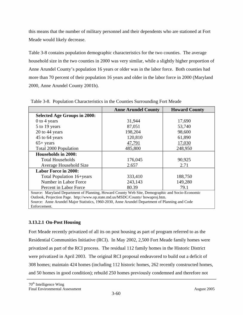
70th Intelligence Wing Final Environmental Assessment August 2005
3-60
this means that the number of military personnel and their dependents who are stationed at Fort
Meade would likely decrease.
Table 3-8 contains population demographic characteristics for the two counties. The average
household size in the two counties in 2000 was very similar, while a slightly higher proportion of
Anne Arundel County’s population 16 years or older was in the labor force. Both counties had
more than 70 percent of their population 16 years and older in the labor force in 2000 (Maryland
2000, Anne Arundel County 2001b).
Table 3-8. Population Characteristics in the Counties Surrounding Fort Meade
Anne Arundel County Howard County Selected Age Groups in 2000: 0 to 4 years 5 to 19 years 20 to 44 years 45 to 64 years 65+ years Total 2000 Population
31,944 87,051
198,204 120,810 47,791
485,800
17,690 53,740 98,600 61,890 17,030 248,950
Households in 2000: Total Households Average Household Size
176,045 2.657
90,925 2.71
Labor Force in 2000: Total Population 16+years Number in Labor Force Percent in Labor Force
333,410 243,143 80.39
188,750 149,280
79.1 Source: Maryland Department of Planning, Howard County Web Site, Demographic and Socio-Economic Outlook, Projection Page. http://www.op.state.md.us/MSDC/County/ howaproj.htm. Source: Anne Arundel Major Statistics, 1960-2030, Anne Arundel Department of Planning and Code Enforcement.
3.13.2.1 On-Post Housing
Fort Meade recently privatized of all its on post housing as part of program referred to as the
Residential Communities Initiative (RCI). In May 2002, 2,500 Fort Meade family homes were
privatized as part of the RCI process. The residual 112 family homes in the Historic District
were privatized in April 2003. The original RCI proposal endeavored to build out a deficit of
308 homes; maintain 424 homes (including 112 historic homes, 262 recently constructed homes,
and 50 homes in good condition); rebuild 250 homes previously condemned and therefore not
70th Intelligence Wing Final Environmental Assessment August 2005
3-61
transferred; and demolish 2,438 homes and re-build new homes in their place, for a total of 3,170
homes. Per the RCI plan to date, 535 new homes have been built and are being maintained, and
158 homes have been demolished, for a total of 2,989 homes (Faux 2005).
Family housing for active duty service members are in the following areas: Argonne Hills,
Meade Heights, Geraghty Village, MacArthur Manor, and Shea Court. These family housing
areas include 23 five-bedroom units, 581 four-bedroom units, 1,518 three-bedroom units, and
703 two-bedroom units. Currently there are 399 officers of different ranks at Fort Meade with
new homes, and about 2,825 other officers who are designated for houses (Faux 2005).
3.13.2.2 Off-Post Housing
Some military personnel and their dependents assigned to Fort Meade live off the post and have
to obtain housing through the private housing market. The Family Housing Office assists active
personnel in obtaining housing off post. A recent survey indicates that off-post rental housing
begins around $650 a month plus utilities (Fort Meade 2001).
Anne Arundel County had 186,937 housing units in 2000 and with a vacancy rate of 4.4 percent.
(USCB 2002). The total housing stock in Anne Arundel County contains the following
proportions of units: 65 percent single family; 17 percent townhouses; and 15 percent multi-
family. A total of 3,078 new housing units were authorized for construction in the County in
2000 (Anne Arundel County 2001b,c).
Howard County contained 92,818 housing units and had a vacancy rate of 5.6 percent according
to the 2000 Census. According to Census data, 20,235 new housing units were built in Howard
County between 1990 and 2000, an average of about 2,000 new units per year, where most of the
units are owner-occupied. The number of vacant units has decreased significantly over the dec-
ade, from 5.8 percent to 3.0 percent. This is due, in part, to the large construction boom at the
end of the 1980s where about 4000 new units per year were being built (Howard County 2001c).
3.13.3 Economics
Table 3-9 presents trends in place of work employment by 1-digit SIC code for Anne Arundel
and Howard Counties for the years 1970 and 1997. This table shows changes in the size and
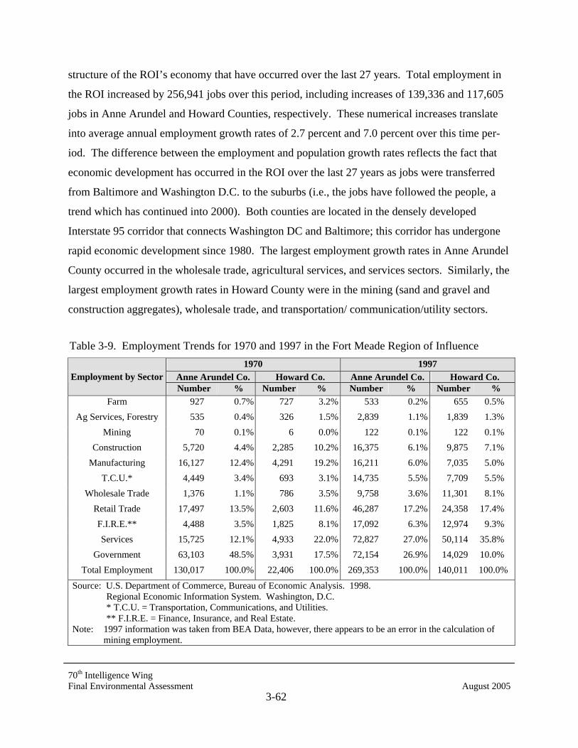
70th Intelligence Wing Final Environmental Assessment August 2005
3-62
structure of the ROI’s economy that have occurred over the last 27 years. Total employment in
the ROI increased by 256,941 jobs over this period, including increases of 139,336 and 117,605
jobs in Anne Arundel and Howard Counties, respectively. These numerical increases translate
into average annual employment growth rates of 2.7 percent and 7.0 percent over this time per-
iod. The difference between the employment and population growth rates reflects the fact that
economic development has occurred in the ROI over the last 27 years as jobs were transferred
from Baltimore and Washington D.C. to the suburbs (i.e., the jobs have followed the people, a
trend which has continued into 2000). Both counties are located in the densely developed
Interstate 95 corridor that connects Washington DC and Baltimore; this corridor has undergone
rapid economic development since 1980. The largest employment growth rates in Anne Arundel
County occurred in the wholesale trade, agricultural services, and services sectors. Similarly, the
largest employment growth rates in Howard County were in the mining (sand and gravel and
construction aggregates), wholesale trade, and transportation/ communication/utility sectors.
Table 3-9. Employment Trends for 1970 and 1997 in the Fort Meade Region of Influence 1970 1997
Anne Arundel Co. Howard Co. Anne Arundel Co. Howard Co. Employment by Sector Number % Number % Number % Number %
Farm 927 0.7% 727 3.2% 533 0.2% 655 0.5% Ag Services, Forestry 535 0.4% 326 1.5% 2,839 1.1% 1,839 1.3%
Mining 70 0.1% 6 0.0% 122 0.1% 122 0.1% Construction 5,720 4.4% 2,285 10.2% 16,375 6.1% 9,875 7.1%
Manufacturing 16,127 12.4% 4,291 19.2% 16,211 6.0% 7,035 5.0% T.C.U.* 4,449 3.4% 693 3.1% 14,735 5.5% 7,709 5.5%
Wholesale Trade 1,376 1.1% 786 3.5% 9,758 3.6% 11,301 8.1% Retail Trade 17,497 13.5% 2,603 11.6% 46,287 17.2% 24,358 17.4% F.I.R.E.** 4,488 3.5% 1,825 8.1% 17,092 6.3% 12,974 9.3% Services 15,725 12.1% 4,933 22.0% 72,827 27.0% 50,114 35.8%
Government 63,103 48.5% 3,931 17.5% 72,154 26.9% 14,029 10.0% Total Employment 130,017 100.0% 22,406 100.0% 269,353 100.0% 140,011 100.0%
Source: U.S. Department of Commerce, Bureau of Economic Analysis. 1998. Regional Economic Information System. Washington, D.C. * T.C.U. = Transportation, Communications, and Utilities. ** F.I.R.E. = Finance, Insurance, and Real Estate. Note: 1997 information was taken from BEA Data, however, there appears to be an error in the calculation of mining employment.

70th Intelligence Wing Final Environmental Assessment August 2005
3-63
The total civilian labor force in the ROI in 2000 was 409,276 persons. The labor force was
259,996 persons in Anne Arundel County and 149,280 persons in Howard County. The civilian
labor force consists of residents 16 years and older who are either currently employed, regardless
of where they work, or are actively seeking work. The labor force estimate for Anne Arundel
County does not include the permanent military personnel assigned to Fort Meade, but does
include the spouses of the Fort Meade military personnel. Consistent with the trends in place of
work employment, the labor force in the ROI has also grown rapidly in recent years as more of
its residents have entered the labor force to capture the jobs that have come there. The number
of employed persons residing in the ROI in 2000 was 381,252, including 246,958 in Anne
Arundel County and 134,294 in Howard County. Recent unemployment rates in Anne Arundel
and Howard Counties in 2000 were 3.0 percent and 2.1 percent respectively. (Anne Arundel
County 2001b, Howard County 2001c).
Fort Meade generates a major, direct economic impact on the ROI annually, through the payroll
of the persons employed there, and through its annual expenditures for goods and services. The
total 2000 annual payroll of military and civilian persons employed at Fort Meade is estimated at
approximately $1.96 billion. Additional annual payments totaling $0.63 million are made to
retirees and annuitants. With the exception of $28 million of estimated utility purchases, the
total annual direct economic spending generated by the installation amounts to almost $2.62
billion (Fort Meade DRM 2000).
3.13.4 Schools, Libraries, and Recreation Facilities
3.13.4.1 Schools and Libraries
Public school enrollments are increasing in both counties. Total enrollments in Anne Arundel
County grew by more than 17 percent 64,339 in 1990 to 75,366 in 2000 (Anne Arundel 2001).
Enrollments in Howard County schools grew by nearly 48 percent, from 29,863 in 1990 to
44,150 in 2000 (Maryland 2000).
There are seven public schools located on Fort Meade attended primarily by children living on
the installation, although some students living off the post also attend these schools. The four
elementary schools on Fort Meade, all with grades kindergarten through five, have a total

70th Intelligence Wing Final Environmental Assessment August 2005
3-64
enrollment of 1,961 students (2000-2001 school year). These schools are: Pershing Hill
Elementary School with an enrollment of 395, Manor View with 585 students, Meade Heights
with 626 students, and West Meade with 355 students. The new Meade Heights Elementary
School opened in September 1997. Two middle schools, grades 6 through 8, are also located on
Fort Meade: MacArthur Middle with an enrollment of 1,050 and Meade Middle School with an
enrollment of 833. The Meade Middle School is located adjacent to Meade High School and
opened in September 1998. Meade Senior High School had an enrollment of 1900 in 2001.
These schools are owned and operated by the Anne Arundel County Board of Education, on land
leased from Fort Meade (Fort Meade POA 2001).
Children of military personnel housed on and off post attend these schools. The off-post students
who eventually attend the two middle schools, or Meade Senior High, include those who first
attend the Brock Ridge, Harman, Jessup, Maryland City, and Van Bokkelen elementary schools
located off the post. Children with special educational needs attend schools off post. Adult
continuing education programs are also provided through the Army Education Center located in
Building 8452. Graduate Equivalency Diploma testing is also available on and off post. A basic
skills program provides educational assistance in the areas of math, English, and reading for
those who are not high school graduates and require refresher work. Undergraduate and
graduate level programs are available on and off post.
Other educational and related facilities near Fort Meade include Glen Burnie Academy, Arthur
Slade Middle School, Martin Spaulding High School, and several private day-care facilities.
Childcare services are available through the Child Development Services, consisting of two 303
capacity centers offering full-day developmental care and hourly care for children ages 6 weeks
to 12 years old. Services include full-day and up to 11.5 hours per day and hourly care for
children attending on an intermittent basis, up to 25 hours per week (Fort Meade 2001b).
Additional childcare facilities are desperately needed on post to accommodate the ever-
increasing demand for these services.
Colleges and universities within about 15 miles of the installation, include Anne Arundel
Community College in Arnold, Howard Community College in Columbia, Bowie State College

70th Intelligence Wing Final Environmental Assessment August 2005
3-65
in Bowie, the University of Maryland in College Park, and the U.S. Naval Academy and Saint
John's College in Annapolis.
The installation library (the Medal of Honor Library) is housed in Building 4418 on Llewellyn
Avenue. Other libraries near Fort Meade include the Provinces, Odenton, and Maryland City
branches of the Anne Arundel County Public Library; the Laurel-Stanley Memorial Branch of
the Prince George's County; and the Savage Branch of the Howard County Public Library.
3.13.4.2 Recreation Facilities
Fort Meade has a number of indoor and outdoor recreational and cultural facilities, including
swimming pools, golf courses, a bowling center, and service members clubs. Recreational
facilities include the Fort Meade Museum, Burba Park, Gaffney Sports Arena, Murphy Field
House, Mullins Stadium Track, indoor and outdoor swimming pools, a golf complex, tennis
courts, a bowling center, a riding stable, an arts and crafts center, and an installation theater. The
Fort George G. Meade U.S. Army Museum was established in 1963 as the First U.S. Army
Museum. It is located on Leonard Wood Avenue, immediately off Mapes Road, which runs
through the main gates of Fort Meade.
Indoor and outdoor facilities supporting active recreation are located throughout Fort Meade.
Burba Park is located between Roberts and Llewellyn Avenues and Wilson Street, and contains
picnic facilities, a playground, and a lake. Gaffney Sports Arena, located on Broadfoot Road,
has three basketball courts, two squash courts, three racquetball courts, a sauna room, weight
room, workout rooms, a 23-station Nautilus center, a 25-meter swimming pool, and separate
locker room facilities for 150 men and 350 women. Murphy Field House offers indoor physical
training equipment as well as intramural sports activities. The three outdoor swimming pools on
Fort Meade are open from Memorial Day to Labor Day. The Fort Meade Golf Complex consists
of two 18-hole golf courses: Applewood and Floyd L. Parks. Finally, 17 tennis courts are
located throughout the installation.
Anne Arundel County offers a variety of private and public recreational facilities. In 1982,
approximately 7,518 acres in the county were devoted to parks and recreational facilities. This
area includes state and county parks, community and school recreation areas, and private
70th Intelligence Wing Final Environmental Assessment August 2005
3-66
facilities. The Anne Arundel County Department of Recreation and Parks manages or owns 92
recreational facilities that encompass 4,198 acres. These facilities include athletic fields, hiking
and biking trails, picnic areas, beaches, and historic sites.
3.13.5 Public Health and Safety
As Fort Meade has transitioned into an administrative center for DoD, no known munitions
storage or training activities which could pose a threat to public safety are presently conducted
on post. However, because of the events of September 11, 2001, Fort Meade is no longer an
open installation. The installation is now a gated facility, and increased security measures have
been implemented as per DoD directives to restrict access and limit travel on post. All access to
the installation is now restricted to U.S. military personnel and sponsored civilians only. The
duration of these access restrictions as well as other anti-terrorism measures is unknown.
Potential threats to public health and safety related to storage, use and disposal of hazardous
materials as they exist on post have been addressed in accordance with state and Federal law and
Army regulations. Fort Meade has prepared an Installation Spill Contingency Plan (ISCP)
(USACE 1998a) and Spill Prevention Control Countermeasures Plan (SPCC) (USACE 1998b).
The ISCP is updated at least every 3 years, or when significant changes are made in the SPCC.
The SPCC plan is updated every 3 years, or when there is a significant change in operations that
could increase the likelihood or impact of a spill (USACE 1998b). Updated SPCC and ISCP
plans are scheduled for completion in 2002. Fort Meade has also prepared an Installation
Hazardous Waste Management Plan (USACHPPM-North 2001). Personnel employed at Fort
Meade who manage or handle hazardous materials or wastes are trained in accordance with
federal, state, local, and Army requirements. Each facility has an appointed emergency
management coordinator, who is responsible for coordinating an emergency response until
relieved by hazardous materials spill response personnel.
While no installation-wide evacuation plan exists, the ISCP provides emergency response
instructions for spills and uncontrolled releases of hazardous materials at each of the facilities
that store hazardous materials. The instructions include notification, probable spill routes,
control measures, exposure limits and danger levels for each material, and evacuation guidelines.

70th Intelligence Wing Final Environmental Assessment August 2005
3-67
Some of the evacuation instructions could also apply to residents located adjacent to the
installation. Material Safety Data Sheets, which include information about health hazards and
first-aid measures, are maintained along with the appropriate ISCP sections in each facility.
3.13.5.1 Police Services
The Emergency Services Center, building 6619, accommodates the Provost Marshal Operation
(PMO), and has approximately 84 staff. The center is located between Taylor Ave. and York
Rd., south of Mapes Rd. County and state police provide service to the areas surrounding Fort
Meade. The nearest county police station is on the east side of the installation on Annapolis
Road, near the Odenton Shopping Center. Eighty-eight officers are assigned to the station and
they respond to approximately one-third of the calls for assistance in the Severn-Odenton area.
The Military Police at Fort Meade do not have formal agreements for assistance with either the
county or the Maryland State Police and they have limited contact with those police jurisdictions.
3.13.5.2 Fire Protection and Prevention Division
The Emergency Services Center, located in Building P-6619, south of Mapes Rd. between York
and Taylor Ave., also accommodates the Fire Protection and Prevention Division of DPW. The
Fire Protection and Prevention Division resulted from combining the fire station originally
located at Rock Avenue and the fire station located at the Tipton Army Airfield; it currently has
a staff of 42 people, including 2 chiefs and 3 inspectors.
3.13.5.3 Medical Facilities
Kimbrough Ambulatory Care Center, formerly the Kimbrough Army Community Hospital,
provides outpatient services only. Several other hospitals and numerous medical centers are near
Fort Meade. Patients from Fort Meade are transported, as necessary, to other military facilities
or to nearby civilian facilities, where services can be provided to military personnel under the
Civilian Health and Medical Program of the Uniformed Services.
Nearby civilian emergency facilities are located at North Arundel Hospital in Glen Burnie (about
6 miles east of Fort Meade), Laurel Regional Hospital in Prince George's County (6 miles west),
and Anne Arundel Medical Center in Annapolis (12 miles southeast). The closest military
70th Intelligence Wing Final Environmental Assessment August 2005
3-68
hospitals are the Walter Reed Army Hospital in northwest Washington, D.C. (about 30 miles
from Fort Meade), and the National Naval Medical Center in Bethesda (24 miles).
3.13.5.4 Family Support Services
Numerous family support services are available to the residents of Fort Meade and Anne Arundel
County. Federal, state, and local public service programs offer many services, including family
counseling, financial assistance, employment referrals, and emergency relief. Family support
services are also available through the local school system, religious and civic organizations, and
community volunteer programs.
3.13.6 Noise
Noise can be annoying or disruptive to normal activities for people and wildlife. In extreme
cases, it can have adverse health effects, such as hearing loss. Recognizing that its activities and
equipment can generate potentially annoying noise levels, the U.S. Army has an Army-wide
noise impact management program. The purpose of this program is to minimize the potential for
annoying the Army’s neighbors.
The pattern (location, duration, timing and frequency) of activities at an Army installation rise to
an associated pattern of noise. The loudness is measured in units called decibels (dB). The
loudness of sound as heard by the human ear is measured on the A-weighted decibel (dBA)
scale. Examples can be found in Table 3-10.
Because most noise generated is intermittent, the calculations of noise levels are averaged over a
24-hour period. The “sound exposure events,” the calculations of the total sound exposure for a
single event expressed in one second of time, are totaled and averaged. This averaging of sound
exposure events results in the Day-Night Level (DNL) noise average. These DNLs are weighted
more heavily toward nighttime noise compared to daytime noise, because noise at night is more
annoying. When DNLs are calculated for each location they produce noise contour maps. Just
as a topographic map shows land elevations, a noise contour map shows areas of elevated noise
levels. The higher the noise level, the more likely citizens exposed to that level would be
annoyed. The noise zones and the associated annoyance level are shown in Table 3-11.
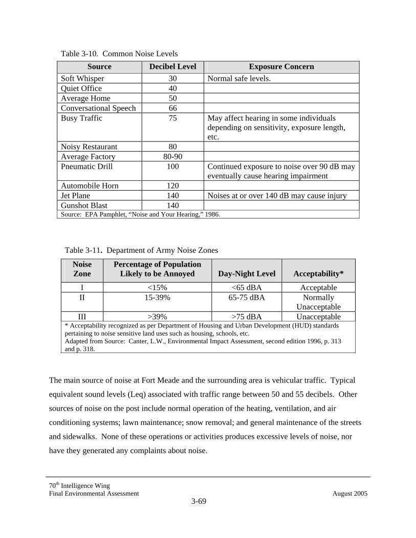
70th Intelligence Wing Final Environmental Assessment August 2005
3-69
Table 3-10. Common Noise Levels Source Decibel Level Exposure Concern
Soft Whisper 30 Normal safe levels. Quiet Office 40 Average Home 50 Conversational Speech 66 Busy Traffic 75 May affect hearing in some individuals
depending on sensitivity, exposure length, etc.
Noisy Restaurant 80 Average Factory 80-90 Pneumatic Drill 100 Continued exposure to noise over 90 dB may
eventually cause hearing impairment Automobile Horn 120 Jet Plane 140 Noises at or over 140 dB may cause injury Gunshot Blast 140 Source: EPA Pamphlet, “Noise and Your Hearing,” 1986.
Table 3-11. Department of Army Noise Zones
Noise Zone
Percentage of Population Likely to be Annoyed Day-Night Level Acceptability*
I <15% <65 dBA Acceptable II 15-39% 65-75 dBA Normally
Unacceptable III >39% >75 dBA Unacceptable
* Acceptability recognized as per Department of Housing and Urban Development (HUD) standards pertaining to noise sensitive land uses such as housing, schools, etc. Adapted from Source: Canter, L.W., Environmental Impact Assessment, second edition 1996, p. 313 and p. 318.
The main source of noise at Fort Meade and the surrounding area is vehicular traffic. Typical
equivalent sound levels (Leq) associated with traffic range between 50 and 55 decibels. Other
sources of noise on the post include normal operation of the heating, ventilation, and air
conditioning systems; lawn maintenance; snow removal; and general maintenance of the streets
and sidewalks. None of these operations or activities produces excessive levels of noise, nor
have they generated any complaints about noise.
70th Intelligence Wing Final Environmental Assessment August 2005
3-70
3.13.7 Aesthetics and Visual Zones
The Fort Meade Installation Design Guide identifies specific visual zones on the installation,
designated by location, character, assets, and liabilities.
3.14 ENVIRONMENTAL JUSTICE
On February 11, 1994, President Clinton issued Executive Order 12898, Federal Actions to
Address Environmental Justice in Minority Populations and Low-Income Populations. This
Executive Order is designed to focus the attention of federal agencies on the human health and
environmental conditions in minority communities and low-income communities. It requires
federal agencies to adopt strategies to address environmental justice concerns within the context
of agency operations. In an accompanying Presidential memorandum, the President emphasizes
that existing laws, including NEPA, provide opportunities for federal agencies to address
environmental hazards in minority communities and low-income communities. In April of 1995,
the EPA released the document titled Environmental Justice Strategy: Executive Order 12898.
The document established Agency-wide goals and defined the approaches by which EPA will
ensure that disproportionately high and adverse human health or environmental effects on
minority communities and low-income communities are identified and addressed. There are no
minority or low income populations on the post that would require consideration under this
executive mandate.
Also within the context of the NEPA process, effects of the action on children should be
reviewed under environmental justice. Executive Order 13045, Protection of Children from
Environmental Health Risks and Safety Risks, directs federal agencies to ensure that their
policies, programs, activities, and standards address disproportionate risks to children that result
from environmental health or safety risks.
Fort Meade 70th Intelligence Wing Final Environmental Assessment August 2005
4-1
4.0 ENVIRONMENTAL CONSEQUENCES
This chapter describes the potential environmental effects, both adverse and beneficial, of the
Proposed Action and its action alternative as described in Chapter 2. Mitigation measures are
described if applicable and appropriate.
The baseline established to evaluate the environmental and socioeconomic effects of the
Proposed Action and its action alternative are the conditions at Fort Meade and adjacent areas in
2005, as described in Chapter 3. Unless otherwise described in this chapter, the No-Action
Alternative (not implementing the proposed construction outlined in the Proposed Action or the
action alternative) would not result in any change to this baseline.
4.1 LAND USE
4.1.1 On-Post Land Use
A long-range planning analysis recently conducted at Fort Meade examined the following critical
land use planning elements: (1) existing land use patterns, (2) future facility requirements, and
(3) governmental regulations. The availability of land at Fort Meade for future development, and
its location relative to existing post facilities, is the primary consideration for siting new projects.
The land use plan developed for Fort Meade by the master planning office would retain the
current overall land use pattern, while certain areas would change to compatible uses. Facilities
required for future growth or mission changes, as well as replacements for inadequate or obsolete
facilities, would be sited within appropriate land use areas. Land uses planned for Fort Meade
are described in the Real Property Master Plan, Long Range Component for Fort Meade (Fort
Meade 1999a). These planned land uses would produce a more cohesive pattern of land use on
the installation by consolidating areas of compatible activities.
The most significant changes in future land use are expected to occur in the northern and central
administrative areas (also referred to as the Transitional Zone). Under the phased development
strategy planned for Fort Meade, this area would supply more than 300 acres for the replacement
of existing WWII structures and expansion for new tenant activities.
Fort Meade 70th Intelligence Wing Final Environmental Assessment August 2005
4-2
4.1.1.1 Proposed Action
The Proposed Action would construct a new 70th Intelligence Wing facility between Love Road
and 3rd Cavalry Road at NSA. An open-paved parking lot with 269 spaces would be constructed
on an existing playing field immediately north of Newjohn Road, near 3rd Cavalry Road. The
construction of the Proposed Action in this location is compatible with Fort Meade’s land use
planning (Figure 3-2). No adverse impacts to on-post land use would be expected from the
Proposed Action.
4.1.1.2 Action Alternative
Under the action alternative, a new 70th Intelligence Wing facility of the same size and
characteristics described for the Proposed Action would be constructed, but at a different
(adjacent) site. The action alternative site is located immediately north of Newjohn Road, near
3rd Cavalry Road at the site of an existing playing field. The existing paved parking area on the
site of the Proposed Action would be used for parking for the new facility. Two small buildings,
including one outdoor restroom and a storage shed, would have to be removed prior to
construction of the Action Alternative. The construction of the 70th Intelligence Wing in this
location is compatible with Fort Meade’s Land Use Planning (see Figure 3-2). No adverse
impacts to on-post land use would be expected from the action alternative.
4.1.2 Regional Land Use and Zoning
The proposed and action alternative project sites are located well within the installation and near
either base housing or community-related facilities. Constructing a new community-related
building on any of these sites would not affect off-post land use. Therefore, no impacts to
regional land use would result from the Proposed Action or its action alternative.
4.1.3 Geology
Site assessments were conducted during the development of construction plans for the 70th
Intelligence Wing project. Based on the site assessments, project construction for the Proposed
Action and its action alternative need only follow appropriate construction procedures, in
accordance with state and local regulations, to ensure that there would be no effects on site
geology. No impacts are anticipated from the Proposed Action or its action alternative.
Fort Meade 70th Intelligence Wing Final Environmental Assessment August 2005
4-3
4.1.4 Soils
Prior to design and construction, appropriate subsurface investigations will be completed at the
project site and approved sediment and erosion control plans will be followed to reduce the
potential for erosion. Some soils mixing, compaction, and removal is to be expected during
construction activities. To the extent possible, soil disturbance will be limited to the immediate
building footprint and associated parking areas. It should be noted that both the Proposed Action
site and the action alternative site are already within a group of highly disturbed soils mapped by
the NRCS as Cut and Fill Land. Given these factors, neither the Proposed Action nor the action
alternative are anticipated to have significant effects on soils.
4.1.5 Topography and Drainage
The ground surface slope at the Proposed Action and action alternative project sites are well
within the regionally-acceptable ranges for construction activities. Grading would be minimal to
prepare for construction at the sites for the Proposed Action and the action alternative. Very few
trees would have to be cleared for either the Proposed Action or the action alternative. No
significant impacts to area topography are expected.
4.2 AIR QUALITY
To assess the potential impacts to air quality under the Proposed Action, a quantitative
assessment of emission-generating activities associated with the 70th Intelligence Wing facility
was conducted. The primary sources of air emissions from the Proposed Action are (1)
construction vehicle fuel combustion, (2) earth moving activities (fugitive dust), and (3) boiler
fuel combustion. Important air pollutant emissions regulated by EPA and MDE include SO2,
particulate matter, CO, NOx, VOC, and lead (Pb) emissions. VOC and NOx are of particular
importance because they contribute to the formation of ozone, and, as noted in the Affected
Environment section of this EA, Fort Meade is located in a severe ozone nonattainment area (the
Baltimore region).
4.2.1 Construction-Related Air Emissions
Construction activities generate short-term, temporary emissions that result in generally localized
impacts on air quality. Such temporary emissions include exhaust emissions from heavy-duty

Fort Meade 70th Intelligence Wing Final Environmental Assessment August 2005
4-4
construction equipment/vehicles. Various types of construction equipment could be used at Fort
Meade for clearing, grading, digging, hauling, etc. Exhaust emission factors for these various
types of equipment can be found in the EPA publication AP-42, Volume II (EPA 1991). At the
time of this EA, there is no specific estimate of equipment requirements for construction of the
70th Intelligence Wing project. Therefore, to estimate construction vehicle emissions, it was
assumed that 10 pieces of equipment (two bulldozers, two loaders, two excavators, and four
dump trucks) would operate continuously on site during the earth moving/grading phase of
construction (10 days). In addition, it was assumed that two pieces of equipment (one forklift
and one crane) would operate continuously on site during the building phase of construction (40
days). Emissions to the air from heavy-duty construction equipment/vehicles are assumed to
cease once exterior building construction is complete. (The time period for exterior building
construction will be significantly shorter than the time period for interior construction activities.)
Short-term, temporary emissions also include fugitive dust (particulate matter) emissions
generated by construction equipment activities. The specific sources of fugitive dust emissions
associated with construction are earth moving and dirt pile/loose soil wind erosion. These
sources were assumed to be “active” during the earth moving/grading phase of construction.
Emission factors for these fugitive dust-generating activities can be found in the EPA publication
AP-42, Volume I (EPA 1991).
Based on these assumptions and emission factors, the estimated annual air emissions (tons per
year, tpy) from construction activities are as follows:
• NOx – 2.24 tpy, • VOC – 0.14 tpy, • CO – 0.92 tpy, • SO2 – 0.22 tpy, • PM – 0.14 tpy, and • Pb – <0.002 tpy.
Note that emission-generating activities (outdoor construction activities) are assumed to occur
within the first half of the construction period. Therefore, for the 70th Intelligence Wing
project, emission-generating activities would occur in the year 2005. It should be re-emphasized
Fort Meade 70th Intelligence Wing Final Environmental Assessment August 2005
4-5
that these temporary emissions would result in generally short-term, localized effects on air
quality. No significant impact is expected.
4.2.2 Operations-Related Air Emissions
Once the completed 70th Intelligence Wing facility is occupied by Fort Meade personnel,
emissions would be generated on continuous basis. The new 72,000-SF building will require
heating and cooling systems for day-to-day operations; these systems would use natural gas for
fuel. Estimation factors were developed for the 70th Intelligence Wing from emissions analysis
found in the Final Environmental Impact Statement Future Development and Operations, Fort
George G. Meade, Maryland (2001). Specifically, the ratio of the estimated natural gas use to
building area for EIS projects was averaged to yield a factor that was multiplied by the building
area of the 70th Intelligence Wing facility to estimate natural gas usage. Given this factor, the
estimated annual gas usage at the 70th Intelligence Wing would amount to 3,960,000 cubic feet.
The natural gas usage estimate was then multiplied by pollutant emission factors provided in AP-
42, Volume I (revised) (EPA 1998) to yield emission estimates. Using this approach, NOx
emissions from the heating and cooling systems are estimated to be 0.28 tpy, and CO to be 0.14
tpy. All other pollutant emissions can be considered negligible (i.e., 0.14 tpy or less). Therefore,
operations-related emissions from the 70th Intelligence Wing would make a minimal (less than 1
percent) contribution to the total annual air emissions at Fort Meade. This level of emissions is
below the de minimus thresholds for EPA-regulated criteria pollutants and, therefore, would not
require a formal General Conformity rule determination.
An MDE air quality permit (permit-to-construct, or PTC) is required for fuel-burning equipment,
such as heating and air conditioning systems using natural gas with a rated capacity of greater
than 1.0 MMBtu/hr (COMAR 26.11.02.10C). At this time, it is anticipated that the new boiler
associated with the 70th Intelligence Wing facility would have a capacity of 2.0 MMBtu/hr., thus
indicating the need for a State PTC.
After construction of the project is complete, air emissions would also be generated on a
continuing basis by new employee commuter vehicles. Similar to boilers emissions, these
mobile emissions can classified as a “permanent” emissions increase resulting from the Proposed
Action. Mobile sources constitute an important source category of air emissions, especially for
Fort Meade 70th Intelligence Wing Final Environmental Assessment August 2005
4-6
VOCs, CO, and NOx emissions. Mobile source emissions of these pollutants are regulated by
EPA under the Clean Air Act (CAA). However, because the current access restrictions on post
have temporarily impacted normal traffic flows, and the duration of these travel restrictions is
unknown, no definitive analysis can be conducted at this time for the air emissions generated
now or in the future by additional construction and commuter vehicles.
Because of the non-attainment status of this region, Fort Meade has been working with state and
local agencies to reduce overall mobile emissions on post and would be expected to continue to
do so (Gebhardt 2001a). More discussion addressing traffic reduction strategies (thereby,
contributing to air emissions reduction efforts) at Fort Meade is presented in section 4.12.8.
4.3 WATER RESOURCES
4.3.1 Surface Water
4.3.1.1 Proposed Action
In general, the potential effects on surface water quality associated with the Proposed Action
would be limited to (1) construction activities and (2) continuing runoff from the new structure
and parking area. Storm water runoff from construction areas typically carries excess sediments
and sediment-bound metals and nutrients into receiving waters. Following construction, the
grease and oil that accumulate on newly paved parking areas may result in periodic inputs of
these substances into the local waterways. In addition, runoff may contribute to thermal
pollution, because water flowing over warm asphalt will have a higher temperature than ambient
surface water.
Construction under the Proposed Action of a 72,000-SF building with 90,000-SF of associated
paved parking area would result in a total impervious surface area of approximately 162,000-SF
(3.7 acres). Considering, however, that the new 72,000-SF building would be constructed on
already impervious surface (i.e., existing parking lot), new impervious surface areas would be
limited to only 90,000-SF (about 2 acres) for the new parking lot. This small amount of new
impervious surface is likely negligible when considering the existing total on-post impervious
surface area of more than 530 acres (Fort Meade 2001a).
Fort Meade 70th Intelligence Wing Final Environmental Assessment August 2005
4-7
Under the Proposed Action, all storm water management plans would be approved by the State
of Maryland in accordance with COMAR 260901-260902. The Maryland Department of the
Environment has renewed Fort Meade’s storm water permit application, Case No. MD#
00SF0147. The new permit GP-00HT expires in 2005.
Maryland State regulations require that all jurisdictions implement a storm water management
program (SWMP) to control the quality and quantity of storm water runoff that results from new
development. The regulations require that the release rate from newly developed areas doesn’t
exceed the rate generated by the site prior to development. Currently, Fort Meade follows storm
water management guidance outlined in the Maryland Stormwater Design Manual (MDE
1998a).
Fort Meade has addressed its storm water management issues. Although the storm water
drainage system is generally considered adequate to meet existing demands, installation analysts
have recommended that it be expanded with new storm water management ponds to control
localized drainage problems. As of 1999, construction of these facilities, including 19 retention
ponds to reduce concentrated flow in main branch channels, was essentially complete (Fort
Meade 2001a). Potential expansion plans include new drainage catchments (curb, gutter, drains,
inlets), possible new or enlarged storm sewers, and channel enhancement to Midway Branch and
Franklin Branch.
The grading scheme for the construction of the 70th Intelligence Wing under the Proposed
Action provides for storm drainage to exit into a nearby SWM pond which will upgraded to
accommodate any potential increases in runoff. All runoff from the new parking areas, as well
as the roof runoff, would be directed to the pond. Similar to current storm water management
now being implemented on post, the construction also would include a subdrainage system for
all new asphalt pavement sections. The system would consist of perforated pipe within a gravel
blanket enveloped in filter fabric that discharges to the storm drainage system and SWM pond.
The project includes landscaping and perimeter tree plantings to shade pavement and reduce
runoff temperatures, minimizing the potential for increasing ambient surface water temperatures.
No significant impacts on surface waters are anticipated under the Proposed Action.

Fort Meade 70th Intelligence Wing Final Environmental Assessment August 2005
4-8
4.3.1.2 Action Alternative
The action alternative would construct the new 70th Intelligence Wing facility on a partially
developed playing field with several small existing buildings and a parking area. The site has
existing drainage culverts and established storm water conveyances. Newly paved areas would
be expected to be similar in size to those planned under the Proposed Action. Construction plans
have not yet been developed for the action alternative site, but it can be assumed that the plans
would be similar if not identical to those of the Proposed Action with similar storm water
drainage features to be installed as part of the construction effort. As Fort Meade is actively
working to mitigate its storm water runoff post-wide, as well as on a project-by-project basis, no
significant impacts to surface water would be anticipated under the action alternative.
4.3.2 Groundwater
4.3.2.1 Proposed Action and its Alternatives
It is not known if proposed construction of the 70th Intelligence Wing would require subsurface
excavation (other than utility installation). It is assumed that minimal subsurface excavation is
required for this project. If subsurface excavation is required, high water tables would be
avoided. No impacts to groundwater from building construction are anticipated for either the
Proposed Action or its action alternative.
The Proposed Action and the action alternative would only increase the existing personnel
numbers by about 40; therefore, demands on the water supply would not increase significantly.
According to recent studies, groundwater resources are sufficient to meet current potable water
supply needs (Fort Meade 1998). No effects on groundwater supplies are expected.
4.4 AQUATIC RESOURCES AND WETLANDS
4.4.1 Aquatic Resources
4.4.1.1 Proposed Action
No permanent surface water features are located within or nearby the proposed project area. All
appropriate sediment control methods would be employed during construction. Fort Meade is
currently implementing measures such as riparian buffers and ‘no-mow” zones in certain area on
Fort Meade 70th Intelligence Wing Final Environmental Assessment August 2005
4-9
post to minimize contaminant and sediment loadings into possible aquatic habitats. No
significant impacts to aquatic resources are anticipated.
4.4.1.2 Action Alternative
The project area does not have a permanent surface water feature on or nearby the site. All
appropriate sediment control methods would be employed during construction. No significant
impacts to aquatic resources are anticipated.
4.4.2 Wetlands
4.4.2.1 Proposed Action
There are no mapped wetlands areas on or around the construction site considered under the
Proposed Action (CH2Mhill 1999). No wetland areas were apparent on or near the site during
the February 2005 site visit. Therefore, no impacts to wetlands are anticipated as the result of
the Proposed Action.
4.4.2.2 Action Alternative
No mapped wetlands are on the site or in the vicinity of the area proposed for construction under
the action alternative (CH2Mhill 1999). No wetland areas were apparent on or near the site
during the February 2005 visit. Therefore, no impacts to wetlands would occur under the action
alternative.
4.5 VEGETATION
Fort Meade voluntarily supports the Maryland Forest Conservation Act (FCA) and following the
state forest Conservation Manual, has delineated and characterized existing forest resources on
post. Specified forest conservation areas are to be maintained as undisturbed to the extent
practicable. Figure 3-4 shows the designated Forest Conservation Areas on Fort Meade. Fort
Meade complies with the FCA on a project-by-project basis. All outside contractors are required
to follow the State Forest Conservation Manual in construction planning. Contractors are
required to either maintain the necessary portion of property as forest, or to plan for the
necessary mitigation.

Fort Meade 70th Intelligence Wing Final Environmental Assessment August 2005
4-10
4.5.1 Proposed Action
The project site considered under the Proposed Action is a large paved parking area. Existing
trees and shrubs that surround the site are species commonly found within the region; none of the
existing trees are of significant size. Any existing herbaceous vegetation on the site would be
completely removed during construction of the 70th Intelligence Wing building. New vegetation
would be planted around the new facility once construction is complete. Native shrub species
would be planted in the vicinity of the building where possible, to provide greater habitat value.
The resulting landscaping would produce a potentially positive visual impact for this area of Fort
Meade.
4.5.2 Action Alternative
The parcel proposed for construction under the action alternative is primarily a previously
disturbed playing field. Construction on the site would require the removal of the existing
herbaceous vegetation and several areas of small trees, including Virginia pine, oak (red, white,
and chestnut), and maple (silver and red). New vegetation would be planted around the new
building once construction is complete. Native shrub species will be planted where possible, to
provide greater habitat value. No significant impacts to forest resources would result from the
action alternative.
4.6 WILDLIFE RESOURCES
4.6.1 Proposed Action
The site considered under the Proposed Action is an existing paved parking area with little
existing habitat value. It is expected that the few birds and small mammals that may be found
here would likely attempt to relocate to similar adjacent habitats. Therefore, no significant
impacts to wildlife under the Proposed Action are expected.
4.6.2 Action Alternative
Under the action alternative, the new 70th Intelligence Wing facility would be constructed on a
previously disturbed playing field. Any wildlife found here would likely attempt to relocate to
similar adjacent habitats. Therefore, no significant impacts to wildlife under the action
alternative are expected.
Fort Meade 70th Intelligence Wing Final Environmental Assessment August 2005
4-11
4.7 THREATENED AND ENDANGERED SPECIES
The Little Patuxent River may support one of only two populations of the glassy darter in
Maryland. Listed as highly rare by the Maryland Natural Heritage Program, the species was
relatively common in the Little Patuxent River immediately below the Fort Meade Dam at MD
Route 198. In recent correspondence, Maryland DNR has expressed the need for special
precautions to avoid impacts to this area, as even very infrequent impacts to installation streams
could potentially cause damage to the glassy darter population in Maryland .
Although surface water runoff from the project would drain directly into the Little Patuxent
River via an unnamed tributary, concern for stormwater water and runoff impacts to sensitive
species has been incorporated into Fort Meade development plans (see Section 3.3.1). Fort
Meade is currently planting trees and shrubs as riparian buffers to minimize runoff into streams
(Fort Meade 2001). Implementing best management practices, such as rain gardens and
retention ponds, near the source of runoff producing areas avoids or minimizes potential impacts
to endangered species that exist outside of the immediate vicinity of any project.
Studies conducted at NSA in 2001 and 2002 by Versar, Inc. and at Fort Meade between March
2000 and November 2000 by Eco-Science Professionals, Inc. identified rare and endangered
species habitats within installation boundaries (Versar 2003; Eco-Science Professionals 2001).
None of these habitats exist within the areas designated for construction under either the
Proposed Action or the action alternative, nor were threatened or endangered species (or
evidence of their presence) observed during site reconnaissance. Recent correspondence with
the U.S. Fish and Wildlife Service has also indicated that “no federally proposed or listed
endangered or threatened species are known to exist within the project impact area”
(Ratnaswamy 2005; Appendix A). Therefore, no impacts to threatened or endangered species
areas are expected under the Proposed Action or the action alternative.
Fort Meade 70th Intelligence Wing Final Environmental Assessment August 2005
4-12
4.8 PRIME AND UNIQUE FARMLANDS
4.8.1 Proposed Action
Soils found on the site of the Proposed Action are designated in the Fort Meade Soil Survey
(NRCS) as within the Cut and Fill Land Series; they are specifically mapped as Cut and Fill
Land, 0 to 5 percent slopes, and are not considered prime farmland. No impacts to prime and
unique farmlands would be expected under the Proposed Action.
4.8.2 Action Alternative
Soils on the alternative action site are also mapped by the NRCS as within the Cut and Fill Land
Series; they are specifically mapped as Cut and Fill Land, 0 to 5 percent slopes, and are not
considered prime farmland. As such, no impacts on prime farmland or unique farmlands are
expected under the action alternative.
4.9 WILD AND SCENIC RIVERS
No Maryland rivers fall under the Federal Wild and Scenic Rivers designation. However, the
Patuxent and Severn Rivers were formally designated under the Maryland Scenic and Wild
Rivers Act as two of Maryland’s Scenic Rivers. The Little Patuxent River and Severn Run are
tributaries of these rivers, respectively. Fort Meade will review the site location for the Proposed
Action or the action alternative and, if necessary, would follow guidelines set forth by the
Patuxent and Severn River Commissions. No significant impacts to either of these rivers are
anticipated.
4.10 CULTURAL RESOURCES
4.10.1 Archeological Resources
4.10.1.1 Proposed Action
Recent correspondence with the Maryland Historical Trust, Office of Preservation Services,
indicates that construction on site of the Proposed Action would be unlikely to impact significant
archeological properties and no archeological studies would be warranted prior to using this
Fort Meade 70th Intelligence Wing Final Environmental Assessment August 2005
4-13
location (Henry 2005, Appendix A). Therefore, no impacts to cultural resources are expected as
the result of implementing the Proposed Action.
4.10.1.2 Action Alternative
Correspondence with the Maryland Historical Trust, Office of Preservation Services, indicates
that construction on either of the alternative sites would be unlikely to impact significant
archeological properties and no archeological studies would be warranted prior to using these
locations (Henry 2005, Appendix A). Therefore, no impacts to cultural resources are expected as
a result of implementing the action alternative.
4.10.2 Historic Architectural Resources
Neither the Proposed Action nor the action alternative would impact eligible historic
architectural resources at Fort Meade (Henry 2005, Appendix A). The project sites for the
Proposed Action and the action alternative are not in the vicinity of previously designated
historical sites such as Building 8688, or those located in the Post Core Historic District.
4.10.3 Underground Storage Tanks and Above Ground Storage Tanks
There are no ASTs or USTs associated with the project area under the Proposed Action or the
action alternative (DiGiovanni 2005). No impacts to USTs or ASTs are expected.
4.10.4 Polychlorinated Biphenyls
No PCB transformers are associated with either the proposed project sites or the action
alternative; therefore, no impacts are anticipated.
4.10.5 Radon
A radon survey of the installation was completed in 1989-1990 by the Fort Meade EMO. All test
results were below the EPA action level of 4 picocuries per liter. Therefore, no further action is
required and no impacts are expected.
4.10.6 Storage and Management of Hazardous Materials and Waste
Neither the 70th Intelligence Wing facility to be constructed under the Proposed Action or its
action alternative would store pesticides, herbicides, or fertilizers. Application of pesticides at
Fort Meade 70th Intelligence Wing Final Environmental Assessment August 2005
4-14
the structure would be conducted in accordance with federal and state regulations and protocols
prescribed in the Fort Meade IPMP. Relative to overall on-post pesticide use, the new facility
would not require significant additional pest management support; therefore, no impacts are
anticipated.
The proposed 70th Intelligence Wing facility would not store any hazardous materials beyond
those routinely used for maintenance and office supplies. All handling, storage, transportation,
and disposal of hazardous materials would be conducted in accordance with the Fort Meade
Management Plan for Hazardous Materials and Hazardous Waste (U.S. Department of the
Army 1993) and any other applicable federal, state, local, and installation guidelines. Provided
all personnel follow applicable guidelines, no impacts from the storage and handling of
hazardous materials are anticipated.
Significant amounts of hazardous waste would not be generated by the proposed construction
under the Proposed Action or its alternatives. Procedures for the disposal of hazardous wastes
are defined in the Fort Meade Management Plan for Hazardous Materials and Hazardous
Waste. No impacts from hazardous waste are anticipated.
4.10.7 Contaminated Areas
The Comprehensive Environmental Response, Compensation and Liability Act (CERCLA),
commonly referred to as Superfund, was enacted by Congress on December 11, 1980. This act
is targeted at the cleanup of areas contaminated by releases of hazardous substances into the
environment. CERCLA assigns accountability for cleanup costs of contaminated areas by
providing federal authority to respond directly to the hazardous substance releases that may
endanger public health or the environment. This act created a tax on the chemical and petroleum
industries that formed a trust fund used for cleaning up abandoned or uncontrolled hazardous
waste sites. CERCLA also requires the EPA to establish and maintain a National Priorities List
(NPL) of the most serious uncontrolled or abandoned hazardous waste sites requiring long-term
remedial response actions (EPA 1999a; MDE 1999).
Fort Meade was designated a NPL site on July 28, 1998. The EPA designated Fort Meade a
NPL site based on the evaluation of four locations, the Defense Reutilization and Marketing
Fort Meade 70th Intelligence Wing Final Environmental Assessment August 2005
4-15
Office (DRMO), Active Sanitary Landfill (ASL), Clean Fill Dump (CFD), and Post Laundry
Facility (PLF), that have been identified as past storage and disposal sites for hazardous
materials and wastes that contained hazardous substances.
Environmental cleanup of potentially contaminated sites on Fort Meade has consisted of a
combination of removal actions (eliminating the threat to public health and the environment by
removing hazardous substances from the site) and remedial actions to permanently clean up
contaminated areas. Contaminated areas are generally located along the southern border of the
installation and all are undergoing investigative or remediation activities at this time. The
contaminated areas are downgradient from the sites of the Proposed Action and the action
alternatives, neither on nor near the areas of proposed construction. Areas of industrial
contamination are located along MD Route 32 and outside of the footprint of proposed
construction areas. In earlier discussions with the FGGM EMO personnel concerning Fort
Meade’s contaminated areas, it was established that any potential contaminated groundwater
contamination would flow toward MD Route 32 and away from proposed construction (Fort
Meade 2001a).
The installation’s CERCLA initiative is currently operating parallel to investigative procedures
for this assessment. As part of the CERCLA process, contaminated areas are being sampled to
determine the extent of contamination. Treatment systems are currently in place and monitoring
is being conducted to determine further courses of action. Investigative procedures and
remediation activities for Fort Meade’s CERCLA initiative continue to be performed
concurrently and separate from this assessment.
4.10.8 Permits and Regulatory Authorizations
Fort Meade operates under a number of permits from various federal and state agencies (see
Table 3-7). No changes to the existing operational permits and authorizations currently held by
Fort Meade would be required under the Proposed Action or the action alternative.
Fort Meade 70th Intelligence Wing Final Environmental Assessment August 2005
4-16
4.11 INFRASTRUCTURE
4.11.1 Utilities
4.11.1.1 Potable Water Supply
Studies indicate that Fort Meade’s average water treatment for the 1994-1995 fiscal year was
approximately 3.3 mgd. Per the Army Stationing and Installation Plan, the average water
treatment (consumption) at an installation like Fort Meade is an estimated 90.0 gpcd. Based on
these figures, the existing water treatment and distribution system can support a population of
54,667 to 91,111 persons. Some system deficiencies exist, but no system-wide upgrade is
planned for the foreseeable future (Fort Meade 2001a).
Water distribution to a new 70th Intelligence Wing facility built under the Proposed Action or
the action alternative would be accommodated within the capacity of the installation’s current
water supply and distribution system and would not require system upgrades (Fort Meade
2001a). Existing lines are proximal to the proposed sites and have sufficient capacity to
accommodate the required level of services. No impacts to the potable water supply would be
expected under the Proposed Action or its action alternative.
4.11.1.2 Sewer and Wastewater
The construction activity under the Proposed Action or its action alternative would not impact
the ability of Fort Meade to convey and treat wastewater. Fort Meade’s sewage treatment plant
treats approximately 2.5 mgd but has the capacity to treat an average maximum of 4.5 mgd. The
existing sewage collection and treatment system can support a total population of approximately
64,011 to 106,034 persons, a level substantially greater than the current on-post population of
45,726 (Fort Meade 1998a). The addition of approximately forty 70th Intelligence Wing staff
personnel on site would not increase total on-post population beyond existing system capacity.
The new 70th Intelligence Wing facility planned under the Proposed Action and the action
alternative does not require adjustments to the existing sewage collection system. The
government-owned systems may be sold and upgraded in the near future, but this would only be
Fort Meade 70th Intelligence Wing Final Environmental Assessment August 2005
4-17
beneficial and would not affect the construction or operation of the new 70th Intelligence Wing
facility.
Site observations indicated that existing wastewater lines are either close to or running through
the proposed sites. Any increase in system demands would be within existing limits. No impacts
to the wastewater system are anticipated under the Proposed Action or its action alternative.
4.11.1.3 Energy
Electrical Power
Electric power from the commercial supplier, BGE, is readily available at Fort Meade and
distributed throughout the installation by primary service of 13.8 kV, 3-phase power over
Government-owned lines. Continued availability is anticipated. Major electric service is located
in close proximity to all proposed construction sites. Feeder lines would have to be relocated or
installed at all sites. No impacts to electrical services are expected under the Proposed Action or
the action alternative.
Natural Gas
Natural gas supplies from the commercial supplier, BGE, are readily available at Fort Meade.
The extensive BGE and government-owned distribution system provides readily available
natural gas throughout the installation. However, natural gas distribution is currently undergoing
privatization at Fort Meade. The BGE and government-owned systems loop the entire
installation so that almost every building is within a few hundred feet of an active gas supply.
The existing BGE natural gas supply and installation distribution system can support a
population of approximately 41,488 to 68,000 persons (current Fort Meade population is
approximately 50,075). The ready availability of this energy source is expected to continue with
an annual anticipated cost increase (USACE 2001a). The 70th Intelligence Wing heating system
will be a gas-fired self-contained system (FGGM DPW 2001). No impacts to natural gas
services are expected as the result of the Proposed Action or the action alternative.
Fort Meade 70th Intelligence Wing Final Environmental Assessment August 2005
4-18
Fuel Oil
Number 2 fuel oil is used throughout the installation as fuel for individual heat plants. The oil is
stored in both ASTs and USTs located near the heat plants they service. There are currently 7
USTs and 43 AGTs remaining on post; however, not all contain fuel (DiGiovanni 2005). The
construction project considered under the Proposed Action and its action alternative would not
use fuel oil as a heating source; therefore, no impacts would occur.
4.11.2 Solid Waste
To evaluate the potential of impacts to Fort Meade’s solid waste generation and disposal under
the Proposed Action and its action alternative, several items were considered. These items
include evaluating the degree to which the following could impact Fort Meade’s Solid Waste
Management Plan and the capacity of the landfill used by the installation: (1) proposed
construction and (2) potential for additional solid waste from daily operations. Solid waste
generated during construction would consist of building materials such as lumber and concrete.
The National Association of Homebuilders (NAHB) Research Center has developed a detailed
methodology for conducting waste assessments at construction sites. Assessment data were
analyzed for five construction sites in five locations providing a weighted average value for
construction debris. Projected solid waste generation has been estimated based on the square
footage for the building and the assumption that 4.38 pounds of debris would produced per
square foot (Fort Meade 2001a). Using this criteria, construction of the 70th Intelligence Wing
facility would produce approximately 11.2 tons of loose debris. With the total landfill capacity
of 6,809,530 tons, the solid waste contribution for either the Proposed Action or its action
alternative would decrease the landfill life by less than one day. Given that the generation of
construction debris would occur over a period of many months, no significant impact on daily
operations at the King George landfill would be expected.
Fort Meade is expecting an increase of approximately 100 on-post workers/employees with the
implementation of the Proposed Action or its action alternatives. Therefore, solid waste
generation may increase. Without considering the potential for recycling, the projected 100
additional personnel would increase the annual solid waste tonnage by 54 tpy, an increase of
approximately 0.2 percent. Daily maintenance activities associated with the additional facility
Fort Meade 70th Intelligence Wing Final Environmental Assessment August 2005
4-19
would minimally increase disposed waste compared to the more than 13,000 tons of total annual
waste generated by Fort Meade (Marquardt 2002). Therefore, no adverse impacts to solid waste
generation and disposition at Fort Meade are anticipated.
4.11.3 Transportation
Under the Proposed Action and the action alternative, there would be a short-term increase in the
number of construction and grading equipment, and worker vehicles, on post during construction
of the 70th Intelligence Wing. Some minor congestion may occur on roads around the
construction site. No significant impacts to traffic are expected during construction of the 70th
Intelligence Wing.
The Proposed Action and its action alternative would increase the number of on-site operational
personnel by approximately 100 70th Intelligence Wing staffers. Most, if not all, of the staffers
would be commuting to Fort Meade from the surrounding communities and outlying areas. The
recent implementation of anti-terrorism measures in response to the September 11 tragedy
includes closed gates and restricted access on post. Since these measures took effect in
September 2001, traffic back-ups at installation gates and other check on-post points are
common during peak traffic hours. Because the duration of this situation is unknown, it is not
possible at this time to either conduct definitive traffic studies to ascertain normal existing
condition to determine potential impacts associated with the Proposed Action and its alternatives.
The additional traffic generated by the approximately 100 70th Intelligence Wing staffers would
only add minimally to the current congestion problems if the security measures are still in effect
once the facility is operational, but the extent of this effect cannot now be determined.
During this emergency situation, Fort Meade is promoting transportation options such as car-
pooling and area-wide shuttle services to alleviate current traffic problems (Gebhardt 2001). It
can be assumed that once these alternative means of local travel are actively in place, they would
continue to serve the Fort Meade community over the long-term, thus minimizing the impact of
additional commuter personnel.
Fort Meade 70th Intelligence Wing Final Environmental Assessment August 2005
4-20
4.12 SOCIOECONOMIC CONDITIONS
4.12.1 Region of Influence
The ROI consists of Anne Arundel and Howard Counties. It can be assumed that construction of
the 70th Intelligence Wing would be conducted by a local construction company pulling from
labor pools within the ROI. There would be an increase in on-site personnel of forty 70th
Intelligence Wing operations Staffers. The construction of the 70th Intelligence Wing on Fort
Meade is compatible with the usual on-going business activities of the area, and would not
change overall living conditions in the ROI. No impacts to social conditions are anticipated.
4.12.2 Demographics
There would be no change in the local population during the construction phase since
construction companies would likely draw from within the ROI. There are enough construction
workers residing in the Baltimore and Washington, D.C. metropolitan areas within easy daily
commuting distance of Fort Meade to meet the construction labor demands of the Proposed
Action or its alternatives.
There would be no increase of military personnel and their dependents residing on Fort Meade
under the Proposed Action and its action alternative. It is assumed that most, if not all, potential
staffers would already live either on post or in surrounding communities. Therefore no
significant increase in ROI populations would be anticipated under the Proposed Action or its
action alternative.
4.12.3 Economics
The size of the 70th Intelligence Wing building necessitates a moderately large construction
effort with a corresponding construction crew. Because of this, there would be minor, temporary
positive economic effects in the immediate local area during construction of the 70th Intelligence
Wing. No significant economic impacts are anticipated as the result of the Proposed Action or
its alternatives.
A net permanent increase in the level of economic activity in the ROI would occur only when an
activity comes into the ROI from outside, causing an increase in employment and annual
Fort Meade 70th Intelligence Wing Final Environmental Assessment August 2005
4-21
purchases of goods and services. There would be little to no net increase in economic activity in
the ROI because the new structure would be built at Fort Meade to accommodate a service that is
currently provided elsewhere on post or within the ROI. The proposed 70th Intelligence Wing
project would minimally increase the number of personnel working on Fort Meade, but not
within the ROI. No impacts to economic resources under the Proposed Action or its action
alternative are expected.
4.12.4 Schools, Libraries, and Recreation Facilities
There would be no increase in the demand for schools, libraries, and recreation facilities during
either the construction or operational phases of the 70th Intelligence Wing. There would be no
increase in the use of library and recreation facilities on Fort Meade, because there would be no
increase in the number of military personnel assigned to the installation under the Proposed
Action or its alternatives. Similarly, there would be no increase in demand for library and
recreation services located in the ROI outside Fort Meade, as no permanent or significant
increase in population would occur.
4.12.5 Public Health and Safety
Neither the Proposed Action nor its action alternative would affect the public health and safety of
either the military personnel and their dependents residing on Fort Meade or the civilian workers
employed at Fort Meade. The construction and operation of the project would not disturb
hazardous materials or hazardous wastes that are present on Fort Meade.
4.12.5.1 Police Services
There would be no increase in the demand for police services from persons living on Fort Meade
or within the ROI, as neither the on-post nor off-post populations would increase significantly.
4.12.5.2 Fire and Emergency Services
There would be no significant increase in the demand for fire and emergency services from Fort
Meade residents, since the population of the installation would remain the same.
Fort Meade 70th Intelligence Wing Final Environmental Assessment August 2005
4-22
As populations in the surrounding communities would not likely change significantly as the
result of the Proposed Action or its action alternative, no increase in off-post fire and emergency
services would be required.
4.12.5.3 Medical Facilities
There would be no impact on Fort Meade’s existing medical facilities. Since the on-post
population would not increase under the Proposed Action or its action alternative, there would be
no additional demands for on-post medical services from residents of Fort Meade. For the same
reason, the existing off-post medical facilities in the ROI would not be significantly affected.
4.12.5.4 Family Support Services
The new 70th Intelligence Wing facility will have no impact on family support services, as the
on-post population would not increase under the Proposed Action or its action alternative, and
there would be no additional demands for on-post family support services from residents of Fort
Meade. Accordingly, existing family services in the ROI would not be significantly affected.
4.12.6 Noise
The analysis of potential noise impacts resulting from the Proposed Action and the action
alternative was based on procedures in the Department of Housing and Urban Development,
Office of Community Planning and Development document, “The Noise Guidebook,” published
in September 1991. This document discusses noise and its analysis in detail, and focuses on the
concept of noise attenuation by distance. For example, in flat areas with no obstruction between
the noise source and a receptor, noise will attenuate approximately 6 decibels for each doubling
of distance between source and receptor (e.g., a noise of 90 decibels would be reduced to
approximately 50 decibels at 4,000 feet).
A second important concept is the designation of “sensitive” noise receptors. A “sensitive”
receptor is a church, school, hospital, retirement home, residential area, or similar facility (HUD
1991). These facilities are less tolerant of noise and noise levels greater than 65 dBA are
considered “normally unacceptable.” Some allowance for noise levels greater than 65 dBA can
be made depending upon the time of day and duration. In particular, higher levels of
construction noise are usually considered acceptable because they are of short duration.
Fort Meade 70th Intelligence Wing Final Environmental Assessment August 2005
4-23
Receptors that are not “sensitive” (e.g., office buildings) tolerate higher noise levels. For
example, noise levels up to 75 dBA are considered “acceptable” for office buildings (HUD
1991).
The analysis of potential impacts of noise resulting from the Proposed Action and the action
alternative focused on whether the noise levels created by project activities would exceed
ambient conditions experienced by relevant receptors (baseline condition). Specifically, if there
was an existing noise source closer to the receptor than that included as part of the Proposed
Action or alternatives, the noise levels from the two sources were compared. For example, it is
very possible, if not probable, that the noise from a highway would overwhelm any but the most
intrusive individual noises emanating from a construction site, even if it was quite close.
The proposed 70th Intelligence Wing facility will be located between Love Road and 3rd Calvary
Road Road at NSA. The nearest sensitive noise receptors would be the existing buildings to the
immediate north and south of the proposed action site, each approximately 100 hundred feet
away. Construction noise levels associated with the 70th Intelligence Wing facility could
possibly reach 75 to 80 dBA during certain phases of construction at the site. This level of noise
could possibly reach annoyance levels at the nearby center. However, construction noise would
be relatively short-term, and temporary noise barriers would be constructed to reduce overall
noise levels if deemed necessary to avoid disturbing activities at the existing facility. Fort
Meade and the contractors would work closely with CDC personnel to ensure that noise levels
are acceptable to those attending the nearby facility. No other sensitive noise receptors are
located within the immediate area. No significant noise impacts resulting from the Proposed
Action or alternatives are anticipated.
4.12.7 Aesthetics and Visual Zones
The proposed 70th Intelligence Wing structure would follow the Fort Meade Installation Design
Guide. No impacts to aesthetics or visual zones are anticipated under either the Proposed Action
or the action alternative.
Fort Meade 70th Intelligence Wing Final Environmental Assessment August 2005
4-24
4.13 ENVIRONMENTAL JUSTICE
Neither the construction activities nor the operations of the 70th Intelligence Wing project would
have disproportionate, adverse environmental or human health impacts on minority or low-
income populations. Therefore, the Proposed Action or its action alternative would have no
adverse impacts on environmental justice.
Nor would the construction and operation of the proposed project have disproportionate, adverse
human health or safety impacts on children. As in this case, any construction project on Fort
Meade that is close to a facility frequented by children (e.g., day care center, school, recreation
center, theater, athletic facility) will have restricted access. The two project sites considered
under the Proposed Action and its action alternative would be located relatively close to either
on-post housing, child care facilities, or schools. Therefore, normal precautions (e.g., fencing,
proper storage of hazardous materials, and locking equipment) would be taken to prevent access
by children. Higher noise levels associated with construction activities would be mitigated, if
necessary, by constructing temporary barriers to reduce overall construction noise to safe and
acceptable levels.
4.14 CUMULATIVE IMPACTS
CEQ regulations (40 CFR 1508.7) require an analysis of the cumulative impacts resulting from
the incremental impact of an action when added to other past, present, and reasonably
foreseeable future actions, regardless of who undertakes these other actions. Cumulative impacts
can result from individually minor, but collectively significant, actions.
This cumulative impacts section of the EA addresses only the cumulative effects arising from
considering the Proposed Action and its action alternatives in combination with other ongoing
actions at Fort Meade and other actions outside Fort Meade. The cumulative impact of the
Proposed Action or the action alternative is evaluated within the context of the greater Fort
Meade area, although the specific area of influence varies with the resource being addressed.
According to the Fort Meade master planner, there are substantial RCI housing construction
projects that could potentially coincide with the construction of the new 70th Intelligence Wing
in 2003 (Galiber 2002). These projects include RCI Neighborhood I, southeast of Rockenbach
Fort Meade 70th Intelligence Wing Final Environmental Assessment August 2005
4-25
Road and Cooper Avenue, adjacent to Alternative site 1, and RCI Neighborhood II west of the
8100 area. EAs conducted on the RCI projects found that no significant impacts would result
from these housing construction activities (USACE 2001). The proposed 70th Intelligence Wing
project is quite small by comparison, and should not contribute significantly to the cumulative
impact of these larger developments. The Intelligence Material Activity (IMA) facility, and the
CDC III, will also be under construction during this time (Galiber 2002). The IMA facility site
is located on Rock Avenue near Huber Road (Building 2266 footprint) far from the proposed
70th Intelligence Wing location. The CDC III site is located in the 900 area off Ernie Pyle Street
adjacent to the Youth Center. Both of these projects are small and would not significantly
contribute to cumulative impacts on any resources.
For the Proposed Action and its action alternative, effects on most resources during construction
would be temporary and short-lived. Any equipment-related emissions or noise would be
minimal and comparable to those released by the four existing buildings that comprise the 70th
Intelligence Wing facility. There would be no change in the on-post resident population.
Because of recent increased security on post, cumulative impacts to traffic volumes and resulting
air emissions cannot be definitively addressed in this EA at this time. It is assumed mitigation
measures would be implemented to minimize any potential impacts to these resources. This 70th
Intelligence Wing facility is an important part of the development providing support to the
military and other federal tenants consistent with Fort Meade’s transition to an administrative
center. Neither the Proposed Action nor its action alternative would significantly contribute to
cumulative impacts on any resource.

Fort Meade 70th Intelligence Wing Final Environmental Assessment August 2005
4-26
THIS PAGE INTENTIONALLY LEFT BLANK
Fort Meade 70th Intelligence Wing Final Environmental Assessment August 2005
5-1
5.0 CONCLUSIONS
The No-Action Alternative, as described under baseline conditions, would not meet the purpose
of and need for providing adequate facilities and support for the 70th Intelligence Wing. The
current 70th Intelligence Wing facilities do not meet the required security and other needs of the
military community. The site considered under the Proposed Action is an open existing parking
area. The construction of the new 70th Intelligence Wing facility on this land would reduce the
potential for new impacts to natural resources. This EA concludes that the Proposed Action
would best meet the project goals while having minimal impact on the environment.
Table 5-1 provides a concise comparison of effects on resources that would result from the
Proposed Action and the action alternative.
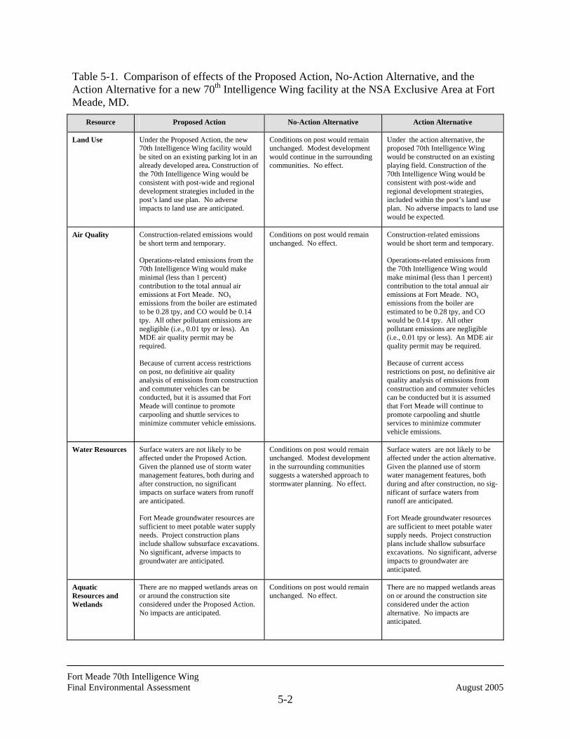
Fort Meade 70th Intelligence Wing Final Environmental Assessment August 2005
5-2
Table 5-1. Comparison of effects of the Proposed Action, No-Action Alternative, and the Action Alternative for a new 70th Intelligence Wing facility at the NSA Exclusive Area at Fort Meade, MD.
Resource Proposed Action No-Action Alternative Action Alternative
Land Use
Under the Proposed Action, the new 70th Intelligence Wing facility would be sited on an existing parking lot in an already developed area. Construction of the 70th Intelligence Wing would be consistent with post-wide and regional development strategies included in the post’s land use plan. No adverse impacts to land use are anticipated.
Conditions on post would remain unchanged. Modest development would continue in the surrounding communities. No effect.
Under the action alternative, the proposed 70th Intelligence Wing would be constructed on an existing playing field. Construction of the 70th Intelligence Wing would be consistent with post-wide and regional development strategies, included within the post’s land use plan. No adverse impacts to land use would be expected.
Air Quality
Construction-related emissions would be short term and temporary.
Operations-related emissions from the 70th Intelligence Wing would make minimal (less than 1 percent) contribution to the total annual air emissions at Fort Meade. NOx emissions from the boiler are estimated to be 0.28 tpy, and CO would be 0.14 tpy. All other pollutant emissions are negligible (i.e., 0.01 tpy or less). An MDE air quality permit may be required.
Because of current access restrictions on post, no definitive air quality analysis of emissions from construction and commuter vehicles can be conducted, but it is assumed that Fort Meade will continue to promote carpooling and shuttle services to minimize commuter vehicle emissions.
Conditions on post would remain unchanged. No effect.
Construction-related emissions would be short term and temporary.
Operations-related emissions from the 70th Intelligence Wing would make minimal (less than 1 percent) contribution to the total annual air emissions at Fort Meade. NOx emissions from the boiler are estimated to be 0.28 tpy, and CO would be 0.14 tpy. All other pollutant emissions are negligible (i.e., 0.01 tpy or less). An MDE air quality permit may be required.
Because of current access restrictions on post, no definitive air quality analysis of emissions from construction and commuter vehicles can be conducted but it is assumed that Fort Meade will continue to promote carpooling and shuttle services to minimize commuter vehicle emissions.
Water Resources
Surface waters are not likely to be affected under the Proposed Action. Given the planned use of storm water management features, both during and after construction, no significant impacts on surface waters from runoff are anticipated.
Fort Meade groundwater resources are sufficient to meet potable water supply needs. Project construction plans include shallow subsurface excavations. No significant, adverse impacts to groundwater are anticipated.
Conditions on post would remain unchanged. Modest development in the surrounding communities suggests a watershed approach to stormwater planning. No effect.
Surface waters are not likely to be affected under the action alternative. Given the planned use of storm water management features, both during and after construction, no sig-nificant of surface waters from runoff are anticipated.
Fort Meade groundwater resources are sufficient to meet potable water supply needs. Project construction plans include shallow subsurface excavations. No significant, adverse impacts to groundwater are anticipated.
Aquatic Resources and Wetlands
There are no mapped wetlands areas on or around the construction site considered under the Proposed Action. No impacts are anticipated.
Conditions on post would remain unchanged. No effect.
There are no mapped wetlands areas on or around the construction site considered under the action alternative. No impacts are anticipated.
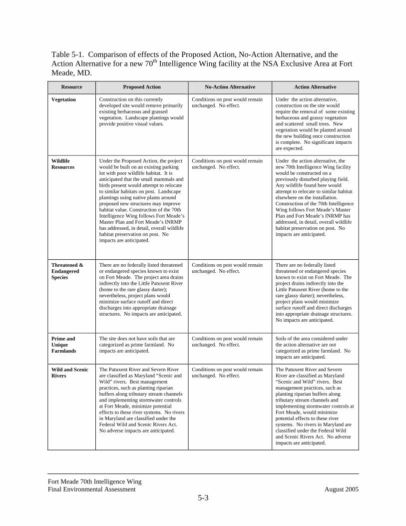
Fort Meade 70th Intelligence Wing Final Environmental Assessment August 2005
5-3
Table 5-1. Comparison of effects of the Proposed Action, No-Action Alternative, and the Action Alternative for a new 70th Intelligence Wing facility at the NSA Exclusive Area at Fort Meade, MD.
Resource Proposed Action No-Action Alternative Action Alternative
Vegetation
Construction on this currently developed site would remove primarily existing herbaceous and grassed vegetation. Landscape plantings would provide positive visual values.
Conditions on post would remain unchanged. No effect.
Under the action alternative, construction on the site would require the removal of some existing herbaceous and grassy vegetation and scattered small trees. New vegetation would be planted around the new building once construction is complete. No significant impacts are expected.
Wildlife Resources
Under the Proposed Action, the project would be built on an existing parking lot with poor wildlife habitat. It is anticipated that the small mammals and birds present would attempt to relocate to similar habitats on post. Landscape plantings using native plants around proposed new structures may improve habitat value. Construction of the 70th Intelligence Wing follows Fort Meade’s Master Plan and Fort Meade’s INRMP has addressed, in detail, overall wildlife habitat preservation on post. No impacts are anticipated.
Conditions on post would remain unchanged. No effect.
Under the action alternative, the new 70th Intelligence Wing facility would be constructed on a previously disturbed playing field. Any wildlife found here would attempt to relocate to similar habitat elsewhere on the installation. Construction of the 70th Intelligence Wing follows Fort Meade’s Master Plan and Fort Meade’s INRMP has addressed, in detail, overall wildlife habitat preservation on post. No impacts are anticipated.
Threatened & Endangered Species
There are no federally listed threatened or endangered species known to exist on Fort Meade. The project area drains indirectly into the Little Patuxent River (home to the rare glassy darter); nevertheless, project plans would minimize surface runoff and direct discharges into appropriate drainage structures. No impacts are anticipated.
Conditions on post would remain unchanged. No effect.
There are no federally listed threatened or endangered species known to exist on Fort Meade. The project drains indirectly into the Little Patuxent River (home to the rare glassy darter); nevertheless, project plans would minimize surface runoff and direct discharges into appropriate drainage structures. No impacts are anticipated.
Prime and Unique Farmlands
The site does not have soils that are categorized as prime farmland. No impacts are anticipated.
Conditions on post would remain unchanged. No effect.
Soils of the area considered under the action alternative are not categorized as prime farmland. No impacts are anticipated.
Wild and Scenic Rivers
The Patuxent River and Severn River are classified as Maryland “Scenic and Wild” rivers. Best management practices, such as planting riparian buffers along tributary stream channels and implementing stormwater controls at Fort Meade, minimize potential effects to these river systems. No rivers in Maryland are classified under the Federal Wild and Scenic Rivers Act. No adverse impacts are anticipated.
Conditions on post would remain unchanged. No effect.
The Patuxent River and Severn River are classified as Maryland “Scenic and Wild” rivers. Best management practices, such as planting riparian buffers along tributary stream channels and implementing stormwater controls at Fort Meade, would minimize potential effects to these river systems. No rivers in Maryland are classified under the Federal Wild and Scenic Rivers Act. No adverse impacts are anticipated.
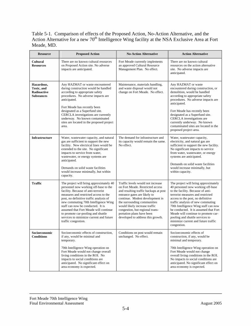
Fort Meade 70th Intelligence Wing Final Environmental Assessment August 2005
5-4
Table 5-1. Comparison of effects of the Proposed Action, No-Action Alternative, and the Action Alternative for a new 70th Intelligence Wing facility at the NSA Exclusive Area at Fort Meade, MD.
Resource Proposed Action No-Action Alternative Action Alternative
Cultural Resources
There are no known cultural resources on Proposed Action site. No adverse impacts are anticipated.
Fort Meade currently implements an approved Cultural Resource Management Plan. No effect.
There are no known cultural resources on the action alternative site. No adverse impacts are anticipated.
Hazardous, Toxic, and Radioactive Substances
Any HAZMAT or waste encountered during construction would be handled according to appropriate safety procedures. No adverse impacts are anticipated.
Fort Meade has recently been designated as a Superfund site. CERCLA investigations are currently underway. No known contaminated sites are located in the proposed project area.
Maintenance, materials handling, and waste disposal would not change on Fort Meade. No effect.
Any HAZMAT or waste encountered during construction, or demolition, would be handled according to appropriate safety procedures. No adverse impacts are anticipated.
Fort Meade has recently been designated as a Superfund site. CERCLA investigations are currently underway. No known contaminated sites are located in the proposed project area.
Infrastructure
Water, wastewater capacity, and natural gas are sufficient to support the new facility. New electrical lines would be extended to the site. No significant impacts to service from water, wastewater, or energy systems are anticipated.
Demands on solid waste facilities would increase minimally, but within capacity.
The demand for infrastructure and its capacity would remain the same. No effect.
Water, wastewater capacity, electricity, and natural gas are sufficient to support the new facility. No significant impacts to service from water, wastewater, or energy systems are anticipated.
Demands on solid waste facilities would increase minimally, but within capacity.
Traffic The project will bring approximately 40 personnel now working off-base to the facility. Because of anti-terrorist measures and restricted access to the post, no definitive traffic analysis of new commuting 70th Intelligence Wing staff can now be conducted. It is assumed that Fort Meade will continue to promote car-pooling and shuttle services to minimize current and future traffic congestion.
Traffic levels would not increase on Fort Meade. Restricted access and resulting traffic backups at post entrance gates are likely to continue. Modest development in the surrounding communities would likely increase traffic congestion, but regional trans-portation plans have been developed to address this growth.
The project will bring approximately 40 personnel now working off-base to the facility. Because of anti-terrorist measures and restricted access to the post, no definitive traffic analysis of new commuting 70th Intelligence Wing staff can now be conducted. It is assumed that Fort Meade will continue to promote car-pooling and shuttle services to minimize current and future traffic congestion.
Socioeconomic Conditions
Socioeconomic effects of construction, if any, would be minimal and temporary.
70th Intelligence Wing operation on Fort Meade would not change overall living conditions in the ROI. No impacts to social conditions are anticipated. No significant effect on area economy is expected.
Conditions on post would remain unchanged. No effect.
Socioeconomic effects of construction, if any, would be minimal and temporary.
70th Intelligence Wing operation on Fort Meade would not change overall living conditions in the ROI. No impacts to social conditions are anticipated. No significant effect on area economy is expected.

Fort Meade 70th Intelligence Wing Final Environmental Assessment August 2005
5-5
Table 5-1. Comparison of effects of the Proposed Action, No-Action Alternative, and the Action Alternative for a new 70th Intelligence Wing facility at the NSA Exclusive Area at Fort Meade, MD.
Resource Proposed Action No-Action Alternative Action Alternative
Noise
Construction noise would be of relatively short duration and limited to the project area. Temporary noise barriers would be constructed if necessary. No adverse impacts to sensitive noise receptors are antici-pated.
Modest development in the surrounding communities would likely result in some increase in noise levels. No effect.
Construction noise would be of relatively short duration and limited to the project area. Temporary noise barriers would be constructed if necessary. No adverse impacts to sensitive noise receptors are anticipated.
Environmental Justice
No disproportionately high adverse effects on minority or low-income communities or on children are anticipated.
Conditions on post would remain unchanged. No effect.
No disproportionately high adverse effects on minority or low-income communities or on children are anticipated.

Fort Meade 70th Intelligence Wing Final Environmental Assessment August 2005
5-6
THIS PAGE INTENTIONALLY LEFT BLANK
Fort Meade 70th Intelligence Wing Final Environmental Assessment August 2005
6-1
6.0 PERSONS CONSULTED
Numerous individuals were consulted during the preparation of this Final EA. The list below
contains the primary sources of information for this EA and other related NEPA documents
pertinent to this study:
Mr. Andrew Bagnall Master Planner Engineering Plans and Services Division Fort George G. Meade Ms. Heather Carolan Environmentalist Directorate of Public Works Environmental Management Office Fort George G. Meade Mr. Joseph DiGiovanni Historic Resources Directorate of Public Works Environmental Management Office Fort George G. Meade Ms. Debbie Faux Residential Communities Initiative Directorate of Public Works Fort George G. Meade
Mr. Don Marquardt Solid Waste Program Directorate of Public Works Environmental Management Office Fort George G. Meade Ms. Lynn Miller Senior Planner Department of Planning and Code Enforcement Annapolis, MD Mr. Joseph V. Moyer Fort Meade Energy Coordinator Directorate of Public Works Engineering and Contract Administration Div. Fort George G. Meade Ms. Susan M. Pfluger Planner Department of Planning and Code Enforcement Annapolis, MD Ms. Carole L. Sanner Planner Development Division Department of Planning and Code Enforcement Annapolis, MD

Fort Meade 70th Intelligence Wing Final Environmental Assessment August 2005
6-2
THIS PAGE INTENTIONALLY LEFT BLANK
Fort Meade Intelligence Wing Final Environmental Assessment August 2005
7-1
7.0 LIST OF PREPARERS
Mark T. Southerland NEPA Program Manager Ph.D. Biology (Ecology) Steven P. Harriott Professional Wetland Scientist M.S. Environmental Studies (Botany)

Fort Meade Intelligence Wing Final Environmental Assessment August 2005
7-2
THIS PAGE INTENTIONALLY LEFT BLANK
Fort Meade Intelligence Wing Final Environmental Assessment August 2005
8-1
8.0 REFERENCES
Anne Arundel County. 1995. The 1994 Odenton Town Center Plan. Department of Planning & Code Enforcement, Annapolis, MD.
Anne Arundel County. 1997a. Anne Arundel County General Development Plan. Department of Planning and Code Enforcement, Annapolis, MD.
Anne Arundel County. 1997b. Anne Arundel County General Development Plan, Department of Planning and Code Enforcement, Annapolis, MD
Anne Arundel County. 2001a. 1997 General Development Plan Summary. Anne Arundel County Department of Planning and Code Enforcement. Obtained at website: http://www.co. anne-arundel.md.us/ pace/planning_gdp/htm.
Anne Arundel County. 2001b. Anne Arundel Count Major Statistics 1960-2030. Obtained from website: http://www.co.anne-arundel.md.us/pace/default_pace.htm
Anne Arundel County. 2001c. Anne Arundel County Population and Household Estimates and Projection 1960-2030.
Canter, L.W. 1996. Environmental Impact Assessment, 2nd edition. McGraw-Hill, NY.
CH2MHill. 1999. Final Integrated Natural Resource Management Plan, Fort George G. Meade, Maryland 1999-2004.
Council on Environmental Quality (CEQ). December 1997. Environmental Justice: Guidance Under the National Environmental Policy Act. Washington, D.C.
Department of Defense (DoD). 1993. Environmental Assessment, Defense Information School Fort George G. Meade, MD.
Eco-Science Professionals, Inc. 1994. Natural Heritage Survey of Critical Habitats. Fort George G. Meade, MD.
Fort Meade. 1995. Installation Pest Management Plan, Directorate of Public Works.
Fort Meade. 1996. Fort Meade Development Projects Through 1998. Fort Meade, MD.
Fort Meade. 1998a. Draft Real Property Master Plan Long Range Component. Prepared by S&K Engineering. Fort Meade, MD.
Fort Meade. 1998b. An Economic Analysis of Recycling at Fort George G. Meade.
Fort Meade Intelligence Wing Final Environmental Assessment August 2005
8-2
Fort Meade. 2001. Category 2 Project Validation Assessment for Construction of Proposed Teen Center, Fort Meade, MD.
Fort Meade. 2001a. Final Environmental Impact Statement, Future Development and Operations, Fort George G. Meade, Maryland.
Fort Meade. 2001b. Child Development Services, Fort Meade, Maryland Website. Information obtained at http://ftmeade.army.mil/cds.htm.
Fort Meade. 2001c. Bi-annual Hazardous Waste Generators Report, Fort Meade, Maryland.
Fort Meade. 2002. 2002 Emissions Certification Report for Fort Meade, Maryland.
Fort Meade Directorate of Public Works (DPW). 2001. Military Construction Project Date Report (1391s). Teen Development Center.
Fort Meade Directorate of Resource Management (FGGM DRM). 2000. Command Summary Report. Fort Meade, MD.
Fort Meade Public Affairs Office (POA). 2001. A County of Excellence, Informational brochure. Fort Meade Public Affairs Office. 2001.
Franklin Associates. 1998. Characterization of Building-Related Construction and Demolition Debris in the United States. Prepared for the U.S. Environmental Protection Agency Municipal and Industrial Solid Waste Division, by Franklin Associates, Prairie Village, KS.
Gale Research Company. 1985. Climate of the States, Volume 2. Detroit, MI.
Geonex Corporation. 1996. Wetlands Mapping Report for United States Army, Fort Meade. Prepared by Geonex Corporation, St. Petersburg, FL under contract #728698-S-001.
Goodwin, R. Christopher, H,. McAloon, J. Minze, et al. 1994. Fort George G. Meade Cultural Resource Management Plan. Final Report August 1994. Prepared for the U.S. Army Corps of Engineers, Baltimore District, by R. Christopher Goodwin and Associates, Inc., Frederick, MD.
Goodwin, R. Christopher, M.B. Hornum, K. Saul, and T. Majorov. 1995. Phase I Archeological Survey of Approximately 2,210 Acres at Fort George G. Meade, Anne Arundel County, Maryland. R. Christopher Goodwin and Associates, Inc., Frederick, MD. (Technical Appendix to the Fort George G. Meade Cultural Resource Management Plan). .
Greater Washington Initiative. 1998. Profile for Anne Arundel County. Obtained from http://www.greaterwashington.org. Washington, D.C.
Hicks, T.G. (ed.). 1994. Standard Handbook of Engineering Calculations, 3rd edition. McGraw-Hill, NY.
Fort Meade Intelligence Wing Final Environmental Assessment August 2005
8-3
Howard County. 1990. Howard County General Plan. July 28, 1990. Department of Planning and Zoning. Ellicott City, MD.
Howard County. 1998a. Total Population 1995-2020 by Election District. Department of Planning and Zoning, Division of Research. Ellicott City, MD.
Howard County. 1998b. Development Monitoring System Report (contains data on building permits issued, population, and average sales price of residential housing). Department of Planning and Zoning, Division of Research. Ellicott City, MD.
Howard County. 1999a. Howard County Department of Planning and Zoning Brochure: The New Town Zoning District. Obtained from http://www.co.ho.md.us/PZ/brochures.html.
Howard County. 2000b. Department of Planning and Zoning Annual Report Fiscal Year 2000.
Howard County. 2001a. Howard County Economic Indicators Newsletter. December 2001.
Howard County. 2001c. Howard County Department of Planning and Zoning Research Report, Issue 1. August 2001.
Lindeburg, M.R. 1997. Civil Engineering Reference Manual. Professional Publications, Inc.
Maryland Department of Natural Resources (DNR) Forest, Park and Wildlife Service. 1998. Habitat Management Guidelines for Forest Interior Breeding Birds of Coastal Maryland.
Maryland Department of the Environment (MDE). 1998b. Baltimore Region and Cecil County Phase II Attainment Plan.
Maryland Department of the Environment (MDE). 1999. MDE CERCLA Information. Obtained from http://www.mde.state.md.us/gw/gunpowder/cercla.html.
Maryland Department of the Environment (MDE). 2000. Maryland Stormwater Design Manual, Volumes I and II. Baltimore, Maryland.
Maryland Department of the Environment (MDE). 2001a. Maryland Air Quality Data, Criteria Pollutants. Obtained at website: http:// www.mde.state.md.us/environmental/air/airdata.
Maryland Department of the Environment (MDE). 2001b. Historical Ground Level Ozone Pollution Data. Obtained at website: http://www.mde.state.md.us/arma/Programs/ Airmon/archives.
Maryland Department of the Environment (MDE). 2001c. Maryland Stormwater Management Guidelines for State and Federal Projects.
Maryland, State of. 2001. Demographic and Socioeconomic Outlook, Maryland. Department of Planning. Obtained at website: http://www.op.state.md.us/MSDC/County/howaproj.html
Fort Meade Intelligence Wing Final Environmental Assessment August 2005
8-4
National Resource Council. 1994. Highway Capacity Manual, Special Report 209. Transportation Research Board.
R & K Engineering. 2001. Real Property Master Plan Capital Investment Strategy for Fort George G. Meade. January 2001.
The Traffic Group. 2001. Fort George G. Meade Transportation Master Plan. Anne Arundel County, MD. Fort Meade, Maryland.
U.S. Army Corps of Engineers (USACE). 2001. Final Environmental Assessment of Implementation of the Army Residential Communities Initiative at Fort Meade, Maryland. Prepared by U.S. Army Corps of Engineers, Baltimore District, with technical assistance from CH2M Hill, Herndon, VA.
U.S. Army Corps of Engineers (USACE), Baltimore District, and Environmental Resource Management (ERM). 1997. Fort Meade Comprehensive Watershed Management Plan. Prepared for Fort George G. Meade, Fort Meade, MD.
U.S. Army Corps of Engineers (USACE), Baltimore District. 1998a. Installation Spill Contingency Plan. Fort George G. Meade, MD.
U.S. Army Corps of Engineers (USACE), Baltimore District. 1998b. Spill Prevention, Control, and Countermeasures Plan. Fort George G. Meade, MD.
U.S. Army Corps of Engineers (USACE), Baltimore District. 1997. Realignment/Construction Environmental Assessment (BRAC 95), Fort George G. Meade Maryland. Baltimore, MD.
U. S. Army Center for Health Promotion and Preventive Medicine-North (USACHPPM-North). 2004. Installation Hazardous Waste Management Plan. Fort George G. Meade, MD.
U.S. Army Toxic and Hazardous Materials Agency (USATHAMA). 1989. Enhanced Preliminary Assessment Report. Fort Meade, MD.
U.S. Census Bureau (USCB). 2002. State and County Quickfacts, Anne Arundel County. Obtained at website: http://www.quickfacts.census.gov/qfd/states/24/24003.html.
U.S. Department of Agriculture (USDA). 1995. Soil Survey of Fort George G. Meade, Anne Arundel County, Maryland. Natural Resources Conservation Service.
U.S. Department of Agriculture, Natural Resources Conservation Service (NRCS). 2001. National Soil Survey Handbook, title 430-VI. Obtained at http://www.statlab.iastate.edu/ soils/nssh
Fort Meade Intelligence Wing Final Environmental Assessment August 2005
8-5
U.S. Department of Commerce, Bureau of Economic Analysis. 1997. Regional Economic Information System. Full-Time and Part-Time Employees by Major Industry for Anne Arundel County, Howard County, Baltimore PMSA, and the State of Maryland, 1969-1995. Washington, D.C.
U.S. Department of Commerce, Bureau of Economic Analysis. 1998. Regional Economic Information System. Regional Economic Profiles for Anne Arundel County, Howard County, Baltimore PMSA, and the State of Maryland. Washington, D.C.
U.S. Department of Commerce, Bureau of the Census. 1992. 1990 Census of Population and Housing Statistics for Anne Arundel and Howard Counties, Summary Tape File 1 (STF1). Obtained from http://www.Census.gov.
U.S. Department of Commerce, Bureau of the Census. 1998. July 1, 1997 Population Estimates for Maryland Counties and Independent Cities. Obtained from http://www.Census.gov.
U.S. Department of Housing and Urban Development (HUD). 1991. The Noise Guidebook. Office of Community Planning and Development. Washington, D.C.
U.S. Department of the Army (DOA). 1995. Department of the Army Guide for Compliance with the General Conformity Rule under the Clean Air Act. Prepared by the U.S. Army Environmental Center and the U.S. Army Center for Health Promotion and Preventive Medicine.
U.S. Environmental Protection Agency (EPA). 1986. Noise and Your Hearing.
U.S. Environmental Protection Agency (EPA). 1991. Compilation of Air Pollutant Emission Factors, Volume II: Mobile Sources. AP-42.
U.S. Environmental Protection Agency (EPA). 1992. Fugitive Dust Background Document and Technical Information Document for Best Available Control Measures. EPA-450/2-92-004.
U.S. Environmental Protection Agency (EPA). 1994. User’s Guide to MOBILE 5 (Mobile Source Emission Factor Model). U.S. Environmental Protection Agency, Air Quality Analysis Branch, Ann Arbor, Michigan. EPA-AA-TEB-94-01.
U.S. Environmental Protection Agency (EPA). 1996. Compilation of Air Pollutant Emission Factors, Volume I: Stationary Point and Area Sources. AP-42.
U.S. Environmental Protection Agency (EPA). 1997. Interim Final Guidance for Incorporating Environmental Justice Concerns in EPA’s NEPA Compliance Analyses. Washington, D.C.
U.S. Environmental Protection Agency (EPA). 1998. Compilation of Air Pollutant Emission Factors, Volume I: Stationary Point and Areas Sources. AP-42.
Fort Meade Intelligence Wing Final Environmental Assessment August 2005
8-6
U.S. Environmental Protection Agency (EPA). 1999a. EPA Superfund Site, Federal Register Notice 5598-5605 Federal Register/Vol. 56, No. 28/Monday, February 11, 1991/Rules and Regulations. Obtained from http://www.epa.gov/superfund/sites/npl/f910211.thm 2/11/91.
U.S. Environmental Protection Agency (EPA). 1999b. EPA Region 3 Hazardous Site Clean Up Division, Fort Meade Site. Obtained from http://www.epa.gov/reg3hwmd/super/ftmead/ pad.htm.
U.S. Environmental Protection Agency (EPA). 1999c EPA Region 3 Super Fund Site NPL Site Narrative at Listing, Fort George G. Meade. Obtained from http://www.epa.gov/superfund/sites/ npl/nar1487.htm.
U.S. Fish and Wildlife Service (USFWS). 1979. Classification of Wetlands and Deepwater Habitats of the United States. December 1979. FWS/OBS-79/3.
Personal Communications
Cole, Bill. USA Waste, July, 1998.
Bagnall, Andrew. 2002. Planner, Engineering Plans and Services Division. Telephone communication, September 4, 2002.
Bagnall, Andrew. 2005. Planner, Engineering Plans and Services Division. Telephone communication, July 27, 2005.
Brink, Patricia M. 2002. Administrator, Office of Preservation Services, Maryland Historic Trust. Letter dated June 24, 2002.
Payne, Lida. 2002. Youth Services Director. Telephone communication, September 11, 2002.
DiGiovanni, Joseph. 2002. Fort Meade Environmental Office. Telephone communication, April 19, 2002.
DiGiovanni, Joseph. 2005. Fort Meade Environmental Office. Telephone communication, August 1, 2005.
Dintaman, Jr., Ray. 2002. Director, Environmental Review Unit, Maryland Department of Natural Resources. Letter dated May 29, 2002.
Faux, Deborah. 2005. Fort Meade Residential Communities Initiative. Telephone and email communications, August 2&3, 2005.
Galiber, Leayle. 2001. Fort Meade Master Planner. Meeting held at Fort Meade, MD. October 10, 2001.
Galiber, Leayle. 2002. Fort Meade Master Planner. Communication via e-mail, April 30, 2002.
Fort Meade Intelligence Wing Final Environmental Assessment August 2005
8-7
Gebhardt, James. 2001a. Directorate of Public Works, Environmental Management Office. Meeting held on October 10, 2001.
Gebhardt, James. 2001b. Directorate of Public Works, Environmental Management Office. Communication via e-mail December 27. 2001.
Harmeyer, William. 1998. Directorate of Public Works, Environmental Management Office. Communication via e-mail, November 19, 1998.
Harmeyer, William. 1999a. Directorate of Public Works, Environmental Management Office. Communication via e-mail, February 16 and 18; March 25, 1999.
Harmeyer, William. 2000. Directorate of Public Works, Environmental Management Office. February 1, 2000.
Kandt, David. 2002. Fort Meade Environmental Management Office. Telephone communication, April 30, 2002.
Klinkert, Tracy. 1999. King George County Landfill. December 19, 1999.
Lane, Richard. 2002. Fort Meade Office of Public Affairs. Faxed communication, January 11, 2002.
Marquardt, Don. 2000. Fort Meade Environmental Management Office. June 5, 2000.
Marquardt, Don. 2002. Fort Meade Environmental Management Office. Meeting on April 22, 2002.
Marquardt, Don. 2005. Fort Meade Environmental Management Office. Telephone and fax communications, August 3, 2005.
McMillan, S. Patrick. 2001. Director, Intergovernmental Relations, State of Maryland Department of Agriculture. Letter dated November 15, 2001.
Moyer, Joseph. 2005. Fort Meade Utilities. Telephone and email communications, August 2, 2005.
Mueller, Joane D. 2002. Clearinghouse Coordinator, Maryland Department of the Environment. Letter dated July 24, 2002.
Puls, Terence. 2002. Fort Meade Environmental Management Office. Meeting on April 22, 2002.
Ratnaswamy, Mary J. Program Leader, Endangered Species, U.S. Department of the Interior, Fish and Wildlife Service. Letter dated July 12, 2002.
Fort Meade Intelligence Wing Final Environmental Assessment August 2005
8-8
Slattery, Michael. 1998. Guidelines submitted in correspondence to D. Uhrin, 99th Regional Support Command, DoD from M. Slattery, Director, Wildlife and Heritage Division of Maryland DNR, April 16, 1998.
Strickland, Keith. 2002. Fort Meade Water Treatment Plant Operations Supervisor. Telephone Communication. April 23, 2002.
Additional Internet Information Sources
Asbestos Background Information = http://www.musc.edu/DEHS/Asbestos_Info.html – August, 1999.
CDC Lead Information Site = http://www.atsdr.cdc.gov/HEC/caselead.html – August, 1999.
EPA CERCLA Information Sites = http://www.superfund/ and http://www.epa.gov/reg3hwmd/wuper/ftmead/pad.htm – August, 1999.
EPA Office of Pesticide Programs Page = http://www.epa.gov/pesticides/ and http://www.epa.govopp00001/whatis.htm – August, 1999.
EPA Sources of Information on Indoor Air Quality – Radon – www.epa.gov/iaq/radon/index.html – August, 1999.
Lead Home Page at EPA = http://www.aeclp.org/2/lead101.html and http://www.epa.gov/opptintr/lead/index.html – August, 1999.
MDE CERCLA Information Site = http://www.mde.state.md.us/gw/gunpowder/cercla.htm – August, 1999.
NRCS Internet Site = http://www.wi.nrcs.usda.gov/soil/prime/prinotes.html -- August, 1999.
OSHA Internet Site = http://www.osha.gov – August, 1999.
PCB Home Page at EPA = http://www.epa.gov/opptintr/pcb/ – August, 1999.
Radon Research Center = http://www.Sbu.ac.uk/rrc/sect1.html – August, 1999.
The Superfund NPL Assessment Program (SNAP) Database – August 1999.
Reference Materials
Fort Meade Master Plan Review Map 1997 and 2001.
Howard County General Plan Map 1990.

Fort Meade Intelligence Wing Final Environmental Assessment August 2005
A-1
APPENDIX A
AGENCY COORDINATION LETTERS

Fort Meade Intelligence Wing Final Environmental Assessment August 2005
A-2
THIS PAGE INTENTIONALLY LEFT BLANK
Fort Meade Intelligence Wing Final Environmental Assessment August 2005
A-3

Fort Meade Intelligence Wing Final Environmental Assessment August 2005
A-4
Fort Meade Intelligence Wing Final Environmental Assessment August 2005
A-5

Fort Meade Intelligence Wing Final Environmental Assessment August 2005
A-6

Fort Meade Intelligence Wing Final Environmental Assessment August 2005
A-7

Fort Meade Intelligence Wing Final Environmental Assessment August 2005
A-8
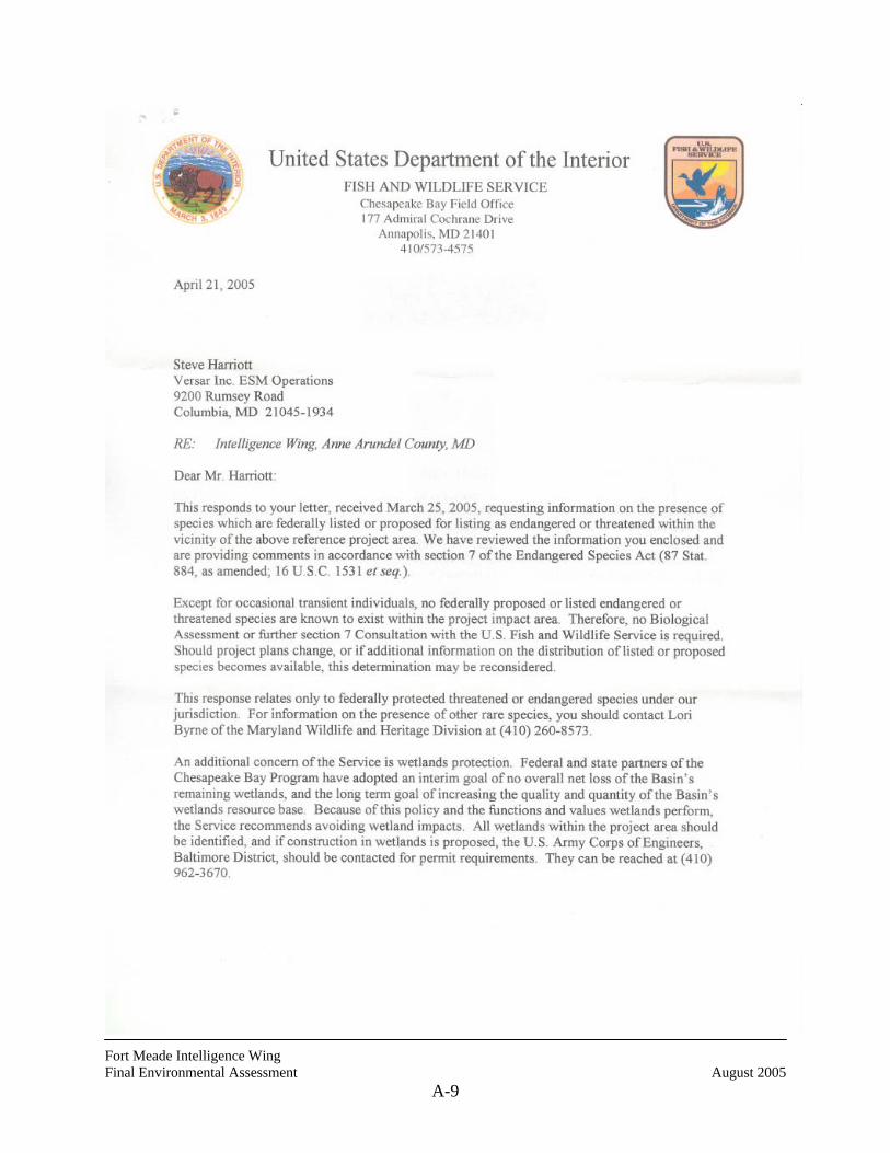
Fort Meade Intelligence Wing Final Environmental Assessment August 2005
A-9
Fort Meade Intelligence Wing Final Environmental Assessment August 2005
A-10
Fort Meade Intelligence Wing Final Environmental Assessment August 2005
A-11

Fort Meade Intelligence Wing Final Environmental Assessment August 2005
A-12
THIS PAGE INTENTIONALLY LEFT BLANK
Fort Meade Intelligence Wing Final Environmental Assessment August 2005
B-1
APPENDIX B
PLANT LIST NSA/FORT MEADE AREA

Fort Meade Intelligence Wing Final Environmental Assessment August 2005
B-2
THIS PAGE INTENTIONALLY LEFT BLANK
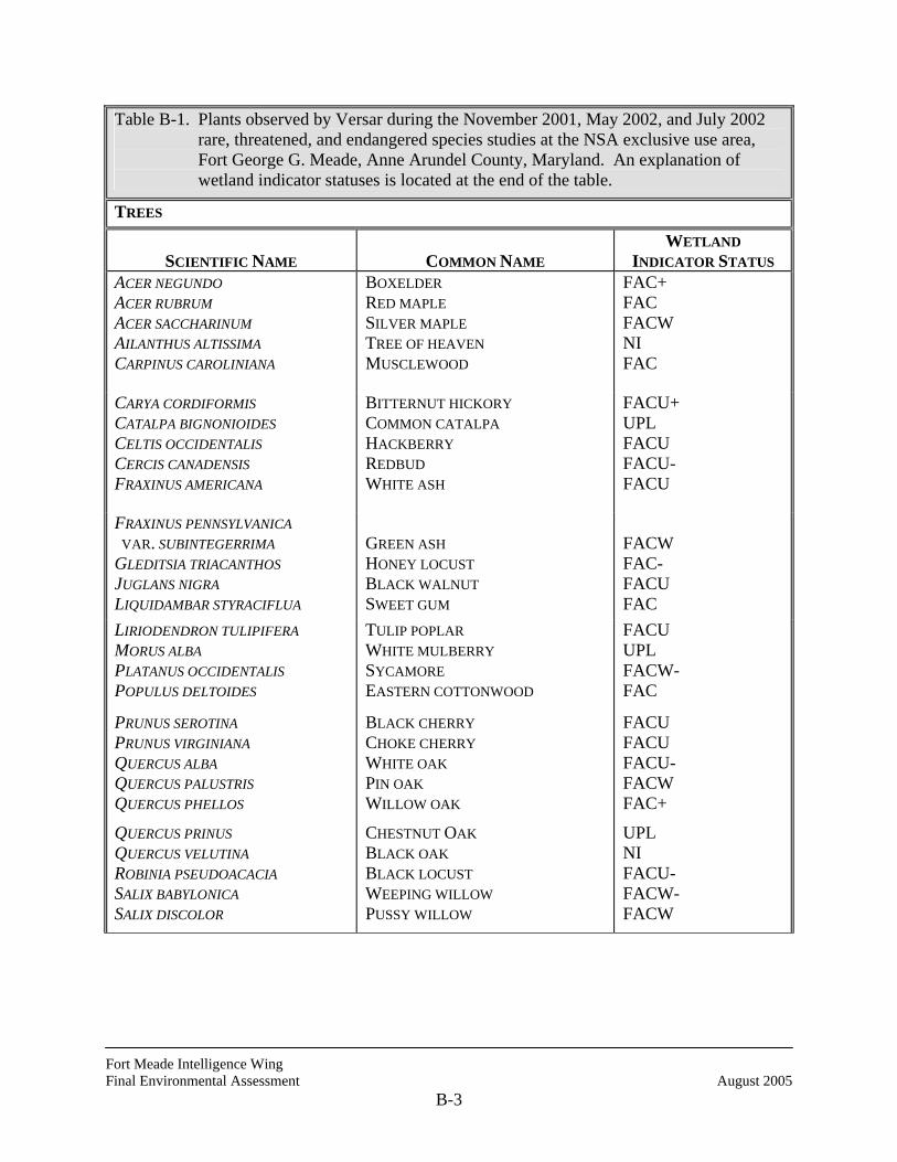
Fort Meade Intelligence Wing Final Environmental Assessment August 2005
B-3
Table B-1. Plants observed by Versar during the November 2001, May 2002, and July 2002 rare, threatened, and endangered species studies at the NSA exclusive use area, Fort George G. Meade, Anne Arundel County, Maryland. An explanation of wetland indicator statuses is located at the end of the table.
TREES
SCIENTIFIC NAME
COMMON NAME
WETLAND INDICATOR STATUS
ACER NEGUNDO ACER RUBRUM ACER SACCHARINUM AILANTHUS ALTISSIMA CARPINUS CAROLINIANA
BOXELDER RED MAPLE SILVER MAPLE TREE OF HEAVEN MUSCLEWOOD
FAC+ FAC FACW NI FAC
CARYA CORDIFORMIS CATALPA BIGNONIOIDES CELTIS OCCIDENTALIS CERCIS CANADENSIS FRAXINUS AMERICANA
BITTERNUT HICKORY COMMON CATALPA HACKBERRY REDBUD WHITE ASH
FACU+ UPL FACU FACU- FACU
FRAXINUS PENNSYLVANICA VAR. SUBINTEGERRIMA GLEDITSIA TRIACANTHOS JUGLANS NIGRA LIQUIDAMBAR STYRACIFLUA
GREEN ASH HONEY LOCUST BLACK WALNUT SWEET GUM
FACW FAC- FACU FAC
LIRIODENDRON TULIPIFERA MORUS ALBA PLATANUS OCCIDENTALIS POPULUS DELTOIDES
TULIP POPLAR WHITE MULBERRY SYCAMORE EASTERN COTTONWOOD
FACU UPL FACW- FAC
PRUNUS SEROTINA PRUNUS VIRGINIANA QUERCUS ALBA QUERCUS PALUSTRIS QUERCUS PHELLOS
BLACK CHERRY CHOKE CHERRY WHITE OAK PIN OAK WILLOW OAK
FACU FACU FACU- FACW FAC+
QUERCUS PRINUS QUERCUS VELUTINA ROBINIA PSEUDOACACIA SALIX BABYLONICA SALIX DISCOLOR
CHESTNUT OAK BLACK OAK BLACK LOCUST WEEPING WILLOW PUSSY WILLOW
UPL NI FACU- FACW- FACW
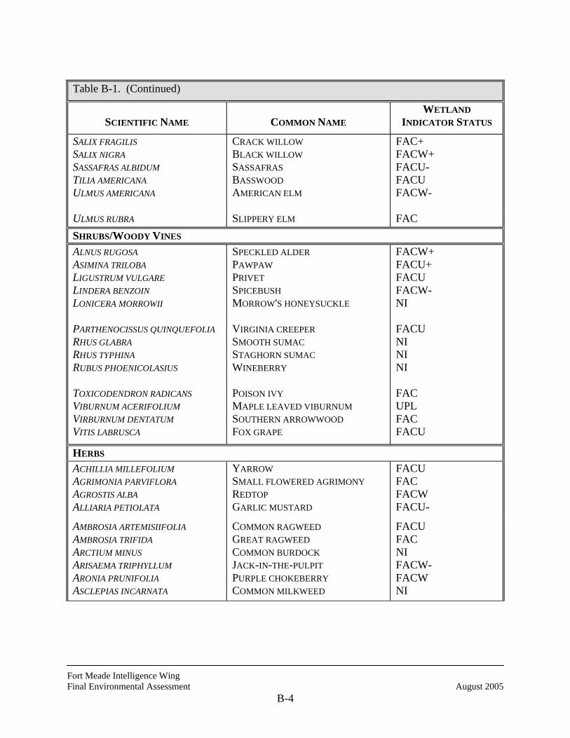
Fort Meade Intelligence Wing Final Environmental Assessment August 2005
B-4
Table B-1. (Continued)
SCIENTIFIC NAME
COMMON NAME
WETLAND INDICATOR STATUS
SALIX FRAGILIS SALIX NIGRA SASSAFRAS ALBIDUM TILIA AMERICANA ULMUS AMERICANA
CRACK WILLOW BLACK WILLOW SASSAFRAS BASSWOOD AMERICAN ELM
FAC+ FACW+ FACU- FACU FACW-
ULMUS RUBRA SLIPPERY ELM FAC SHRUBS/WOODY VINES ALNUS RUGOSA ASIMINA TRILOBA LIGUSTRUM VULGARE LINDERA BENZOIN LONICERA MORROWII PARTHENOCISSUS QUINQUEFOLIA RHUS GLABRA RHUS TYPHINA RUBUS PHOENICOLASIUS TOXICODENDRON RADICANS VIBURNUM ACERIFOLIUM VIRBURNUM DENTATUM VITIS LABRUSCA
SPECKLED ALDER PAWPAW PRIVET SPICEBUSH MORROW'S HONEYSUCKLE VIRGINIA CREEPER SMOOTH SUMAC STAGHORN SUMAC WINEBERRY POISON IVY MAPLE LEAVED VIBURNUM SOUTHERN ARROWWOOD FOX GRAPE
FACW+ FACU+ FACU FACW- NI FACU NI NI NI FAC UPL FAC FACU
HERBS ACHILLIA MILLEFOLIUM AGRIMONIA PARVIFLORA AGROSTIS ALBA ALLIARIA PETIOLATA
YARROW SMALL FLOWERED AGRIMONY REDTOP GARLIC MUSTARD
FACU FAC FACW FACU-
AMBROSIA ARTEMISIIFOLIA AMBROSIA TRIFIDA ARCTIUM MINUS ARISAEMA TRIPHYLLUM ARONIA PRUNIFOLIA ASCLEPIAS INCARNATA
COMMON RAGWEED GREAT RAGWEED COMMON BURDOCK JACK-IN-THE-PULPIT PURPLE CHOKEBERRY COMMON MILKWEED
FACU FAC NI FACW- FACW NI

Fort Meade Intelligence Wing Final Environmental Assessment August 2005
B-5
Table B-1. (Continued)
SCIENTIFIC NAME
COMMON NAME
WETLAND INDICATOR STATUS
ASCLEPIAS SYRIACA ASPLENIUM PLATYNEURON BIDENS FRONDOSA BOHEMERIA CYLINDRICA BOTRYCHIUM ONEIDENSE
SWAMP MILKWEED EBONY SPLEENWORT BEGGAR TICKS FALSE NETTLE BLUNTLOBE GRAPEFERN
OBL FACU FACW FACW+ NI
CAREX ATLANTICA CAREX HIRTIFOLIA CAREX LURIDA CASTANEA PUMILA CICHORIUM INTYBUS CIMICIFUGA RACEMOSA COMMELINA COMMUNIS
ATLANTIC SEDGE PUBESCENT SEDGE SALLOW SEDGE CHINQUAPIN CHICKORY BLACK COHOSH ASIATIC DAYFLOWER
FACW+ NI OBL NI NI NI FAC-
CORONILLA VARIA CUSCUTA GRONOVII CYPERUS ERYTHRORHIZOS CYPERUS RETRORSUS DACTYLIS GLOMERATA
CROWN VETCH DODDER RED ROOTED SEDGE BARREN CYPERUS ORCHARD GRASS
NI NI FACW+ FAC- FACU
DAUCUS CAROTA DIANTHUS ARMERIA DISCOREA VILLOSA ECHINOCHLOA CRUS-GALLI ELEOCHARIS OBTUSA
WILD CARROT DEPTFORD PINK COMMON WILD YAM BARNYARD GRASS BLUNT SPIKERUSH
NI NI FAC+ FACU OBL
EQUISETUM ARVENSE ERAGROSTIS PECTINACEA EUPATORUIM MACULATUM EUPATORIUM SEROTINUM
FIELD HORSETAIL PURPLE LOVE GRASS SPOTTED JOE PYE WEED LATE FLOWERING BONESET
FAC FAC FACW FAC-
EUPATORIUM PERFOLIATUM EUPATORIUM RUGOSUM EUPHORBIA COROLLATA EUTHAMIA GRAMINIFOLIA FESTUCA PRATENSIS
THOROUGHWORT BONESET WHITE SNAKEROOT FLOWERING SPURGE GRASS-LEAVED GOLDENROD MEADOW FESCUE
FACW+ NI NI FAC FACU-
GEUM CANADENSE WHITE AVENS FACU
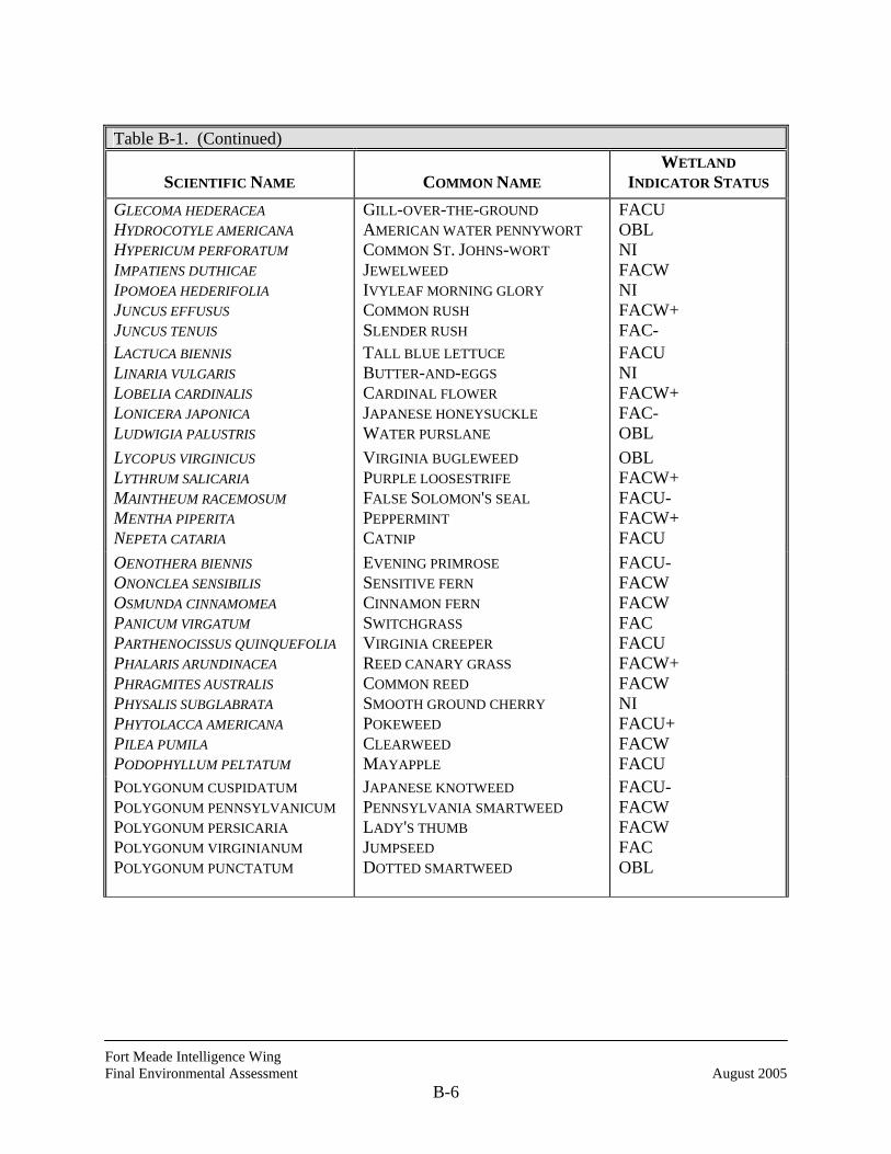
Fort Meade Intelligence Wing Final Environmental Assessment August 2005
B-6
Table B-1. (Continued)
SCIENTIFIC NAME
COMMON NAME
WETLAND INDICATOR STATUS
GLECOMA HEDERACEA HYDROCOTYLE AMERICANA HYPERICUM PERFORATUM IMPATIENS DUTHICAE IPOMOEA HEDERIFOLIA JUNCUS EFFUSUS JUNCUS TENUIS
GILL-OVER-THE-GROUND AMERICAN WATER PENNYWORT COMMON ST. JOHNS-WORT JEWELWEED IVYLEAF MORNING GLORY COMMON RUSH SLENDER RUSH
FACU OBL NI FACW NI FACW+ FAC-
LACTUCA BIENNIS LINARIA VULGARIS LOBELIA CARDINALIS LONICERA JAPONICA LUDWIGIA PALUSTRIS
TALL BLUE LETTUCE BUTTER-AND-EGGS CARDINAL FLOWER JAPANESE HONEYSUCKLE WATER PURSLANE
FACU NI FACW+ FAC- OBL
LYCOPUS VIRGINICUS LYTHRUM SALICARIA MAINTHEUM RACEMOSUM MENTHA PIPERITA NEPETA CATARIA
VIRGINIA BUGLEWEED PURPLE LOOSESTRIFE FALSE SOLOMON'S SEAL PEPPERMINT CATNIP
OBL FACW+ FACU- FACW+ FACU
OENOTHERA BIENNIS ONONCLEA SENSIBILIS OSMUNDA CINNAMOMEA PANICUM VIRGATUM PARTHENOCISSUS QUINQUEFOLIA PHALARIS ARUNDINACEA
EVENING PRIMROSE SENSITIVE FERN CINNAMON FERN SWITCHGRASS VIRGINIA CREEPER REED CANARY GRASS
FACU- FACW FACW FAC FACU FACW+
PHRAGMITES AUSTRALIS PHYSALIS SUBGLABRATA PHYTOLACCA AMERICANA PILEA PUMILA PODOPHYLLUM PELTATUM
COMMON REED SMOOTH GROUND CHERRY POKEWEED CLEARWEED MAYAPPLE
FACW NI FACU+ FACW FACU
POLYGONUM CUSPIDATUM POLYGONUM PENNSYLVANICUM POLYGONUM PERSICARIA POLYGONUM VIRGINIANUM POLYGONUM PUNCTATUM
JAPANESE KNOTWEED PENNSYLVANIA SMARTWEED LADY'S THUMB JUMPSEED DOTTED SMARTWEED
FACU- FACW FACW FAC OBL
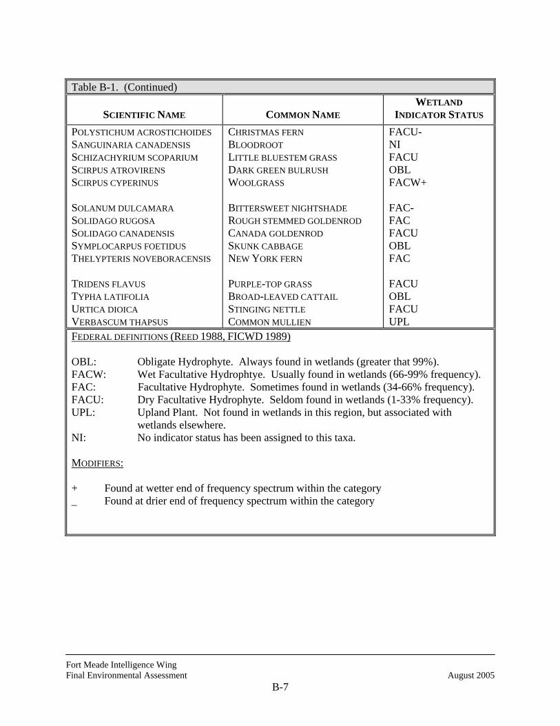
Fort Meade Intelligence Wing Final Environmental Assessment August 2005
B-7
Table B-1. (Continued)
SCIENTIFIC NAME
COMMON NAME
WETLAND INDICATOR STATUS
POLYSTICHUM ACROSTICHOIDES SANGUINARIA CANADENSIS SCHIZACHYRIUM SCOPARIUM SCIRPUS ATROVIRENS SCIRPUS CYPERINUS SOLANUM DULCAMARA SOLIDAGO RUGOSA SOLIDAGO CANADENSIS SYMPLOCARPUS FOETIDUS THELYPTERIS NOVEBORACENSIS TRIDENS FLAVUS TYPHA LATIFOLIA URTICA DIOICA VERBASCUM THAPSUS
CHRISTMAS FERN BLOODROOT LITTLE BLUESTEM GRASS DARK GREEN BULRUSH WOOLGRASS BITTERSWEET NIGHTSHADE ROUGH STEMMED GOLDENROD CANADA GOLDENROD SKUNK CABBAGE NEW YORK FERN PURPLE-TOP GRASS BROAD-LEAVED CATTAIL STINGING NETTLE COMMON MULLIEN
FACU- NI FACU OBL FACW+ FAC- FAC FACU OBL FAC FACU OBL FACU UPL
FEDERAL DEFINITIONS (REED 1988, FICWD 1989) OBL: Obligate Hydrophyte. Always found in wetlands (greater that 99%). FACW: Wet Facultative Hydrophtye. Usually found in wetlands (66-99% frequency). FAC: Facultative Hydrophyte. Sometimes found in wetlands (34-66% frequency). FACU: Dry Facultative Hydrophyte. Seldom found in wetlands (1-33% frequency). UPL: Upland Plant. Not found in wetlands in this region, but associated with wetlands elsewhere. NI: No indicator status has been assigned to this taxa. MODIFIERS: + Found at wetter end of frequency spectrum within the category _ Found at drier end of frequency spectrum within the category

Fort Meade Intelligence Wing Final Environmental Assessment August 2005
B-8
THIS PAGE INTENTIONALLY LEFT BLANK

Fort Meade Intelligence Wing Final Environmental Assessment August 2005
C-1
APPENDIX C
BIRDS OBSERVED NSA/FORT MEADE AREA

Fort Meade Intelligence Wing Final Environmental Assessment August 2005
C-2
THIS PAGE INTENTIONALLY LEFT BLANK
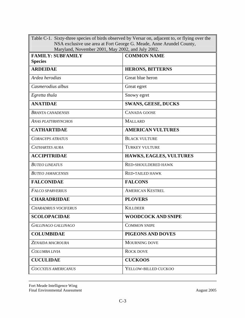
Fort Meade Intelligence Wing Final Environmental Assessment August 2005
C-3
Table C-1. Sixty-three species of birds observed by Versar on, adjacent to, or flying over the
NSA exclusive use area at Fort George G. Meade, Anne Arundel County, Maryland, November 2001, May 2002, and July 2002.
FAMILY: SUBFAMILY Species
COMMON NAME
ARDEIDAE HERONS, BITTERNS
Ardea herodias Great blue heron
Casmerodius albus Great egret
Egretta thula Snowy egret
ANATIDAE SWANS, GEESE, DUCKS
BRANTA CANADENSIS CANADA GOOSE
ANAS PLATYRHYNCHOS MALLARD
CATHARTIDAE AMERICAN VULTURES
CORAGYPS ATRATUS BLACK VULTURE
CATHARTES AURA TURKEY VULTURE
ACCIPITRIDAE HAWKS, EAGLES, VULTURES
BUTEO LINEATUS RED-SHOULDERED HAWK
BUTEO JAMAICENSIS RED-TAILED HAWK
FALCONIDAE FALCONS
FALCO SPARVERIUS AMERICAN KESTREL
CHARADRIIDAE PLOVERS
CHARADRIUS VOCIFERUS KILLDEER
SCOLOPACIDAE WOODCOCK AND SNIPE
GALLINAGO GALLINAGO COMMON SNIPE
COLUMBIDAE PIGEONS AND DOVES
ZENAIDA MACROURA MOURNING DOVE
COLUMBA LIVIA ROCK DOVE
CUCULIDAE CUCKOOS
COCCYZUS AMERICANUS YELLOW-BILLED CUCKOO
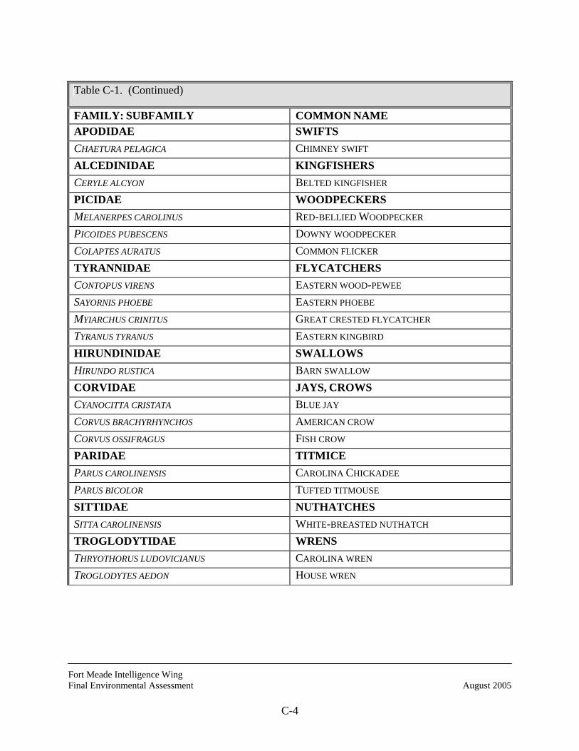
Fort Meade Intelligence Wing Final Environmental Assessment August 2005
C-4
Table C-1. (Continued)
FAMILY: SUBFAMILY COMMON NAME APODIDAE SWIFTS CHAETURA PELAGICA CHIMNEY SWIFT ALCEDINIDAE KINGFISHERS CERYLE ALCYON BELTED KINGFISHER PICIDAE WOODPECKERS MELANERPES CAROLINUS RED-BELLIED WOODPECKER PICOIDES PUBESCENS DOWNY WOODPECKER COLAPTES AURATUS COMMON FLICKER TYRANNIDAE FLYCATCHERS CONTOPUS VIRENS EASTERN WOOD-PEWEE SAYORNIS PHOEBE EASTERN PHOEBE MYIARCHUS CRINITUS GREAT CRESTED FLYCATCHER TYRANUS TYRANUS EASTERN KINGBIRD HIRUNDINIDAE SWALLOWS HIRUNDO RUSTICA BARN SWALLOW CORVIDAE JAYS, CROWS CYANOCITTA CRISTATA BLUE JAY CORVUS BRACHYRHYNCHOS AMERICAN CROW CORVUS OSSIFRAGUS FISH CROW PARIDAE TITMICE PARUS CAROLINENSIS CAROLINA CHICKADEE PARUS BICOLOR TUFTED TITMOUSE SITTIDAE NUTHATCHES SITTA CAROLINENSIS WHITE-BREASTED NUTHATCH TROGLODYTIDAE WRENS THRYOTHORUS LUDOVICIANUS CAROLINA WREN TROGLODYTES AEDON HOUSE WREN

Fort Meade Intelligence Wing Final Environmental Assessment August 2005
C-5
Table C-1. (Continued)
FAMILY: SUBFAMILY COMMON NAME MUSCICAPIDAE: SYLVIINAE GNATCATCHERS, KINGLETS REGULUS CALENDULA RUBY-CROWNED KINGLET POLIOPTILA CAERULEA BLUE-GRAY GNATCATCHER MUSCICAPIDAE: TURDINAE THRUSHES, BLUEBIRDS SIALIA SIALIS EASTERN BLUEBIRD HYLOCICHLA MUSTELINA WOOD THRUSH TURDUS MIGRATORIUS AMERICAN ROBIN MIMIDAE MOCKINGBIRDS, THRASHERS DUMETELLA CAROLINENSIS GRAY CATBIRD MIMUS POLYGLOTTOS NORTHERN MOCKINGBIRD TOXOSTOMA RUFUM BROWN THRASHER BOMBYCILLIDAE WAXWINGS BOMBYCILLA CEDRORUM CEDAR WAXWING STURNIDAE STARLINGS STURNUS VULGARIS EUROPEAN STARLING VIREONIDAE VIREOS VIREO OLIVACEUS RED-EYED VIREO EMBERIZIDAE: PARULINAE WOOD WARBLERS DENDROICA CORONATA YELLOW-RUMPED WARBLER DENDROICA PENSYLVANICA CHESTNUT-SIDED WARBLER DENDROICA PINUS PINE WARBLER GEOTHLYPIS TRICHAS COMMON YELLOWTHROAT SEIURUS NOVEBORACENSIS OVENBIRD VERMIVORA PINUS BLUE-WINGED WARBLER EMBERIZIDAE: THRAUPINAE TANAGERS PIRANGA OLIVACEA SCARLET TANAGER EMBERIZIDAE: CARDINALINAE CARDINAL, GROSBEAKS CARDINALIS CARDINALIS NORTHERN CARDINAL PASSERINA CYANEA INDIGO BUNTING
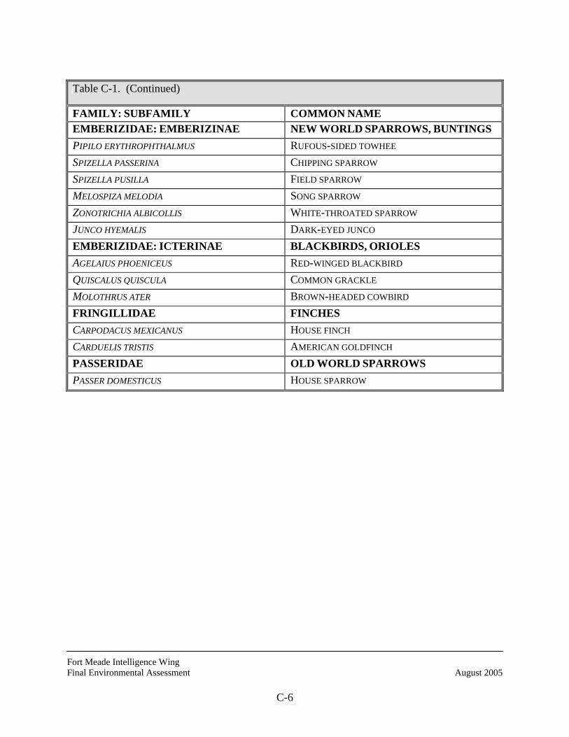
Fort Meade Intelligence Wing Final Environmental Assessment August 2005
C-6
Table C-1. (Continued)
FAMILY: SUBFAMILY COMMON NAME EMBERIZIDAE: EMBERIZINAE NEW WORLD SPARROWS, BUNTINGS PIPILO ERYTHROPHTHALMUS RUFOUS-SIDED TOWHEE SPIZELLA PASSERINA CHIPPING SPARROW SPIZELLA PUSILLA FIELD SPARROW MELOSPIZA MELODIA SONG SPARROW ZONOTRICHIA ALBICOLLIS WHITE-THROATED SPARROW JUNCO HYEMALIS DARK-EYED JUNCO EMBERIZIDAE: ICTERINAE BLACKBIRDS, ORIOLES AGELAIUS PHOENICEUS RED-WINGED BLACKBIRD QUISCALUS QUISCULA COMMON GRACKLE MOLOTHRUS ATER BROWN-HEADED COWBIRD FRINGILLIDAE FINCHES CARPODACUS MEXICANUS HOUSE FINCH CARDUELIS TRISTIS AMERICAN GOLDFINCH PASSERIDAE OLD WORLD SPARROWS PASSER DOMESTICUS HOUSE SPARROW
Fort Meade Intelligence Wing Final Environmental Assessment August 2005
D-1
APPENDIX D
MAMMALS NSA/FORT MEADE AREA

Fort Meade Intelligence Wing Final Environmental Assessment August 2005
D-2
THIS PAGE INTENTIONALLY LEFT BLANK
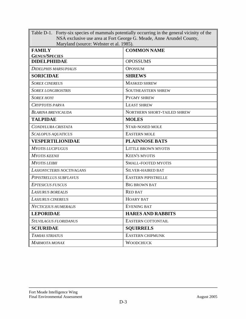
Fort Meade Intelligence Wing Final Environmental Assessment August 2005
D-3
Table D-1. Forty-six species of mammals potentially occurring in the general vicinity of the NSA exclusive use area at Fort George G. Meade, Anne Arundel County, Maryland (source: Webster et al. 1985).
FAMILY GENUS/SPECIES
COMMON NAME
DIDELPHIIDAE OPOSSUMS DIDELPHIS MARSUPIALIS OPOSSUM SORICIDAE SHREWS SOREX CINEREUS MASKED SHREW SOREX LONGIROSTRIS SOUTHEASTERN SHREW SOREX HOYI PYGMY SHREW CRYPTOTIS PARVA LEAST SHREW BLARINA BREVICAUDA NORTHERN SHORT-TAILED SHREW TALPIDAE MOLES CONDYLURA CRISTATA STAR-NOSED MOLE SCALOPUS AQUATICUS EASTERN MOLE VESPERTILIONIDAE PLAINNOSE BATS MYOTIS LUCIFUGUS LITTLE BROWN MYOTIS MYOTIS KEENII KEEN'S MYOTIS MYOTIS LEIBII SMALL-FOOTED MYOTIS LASIONYCTERIS NOCTIVAGANS SILVER-HAIRED BAT PIPISTRELLUS SUBFLAVUS EASTERN PIPISTRELLE EPTESICUS FUSCUS BIG BROWN BAT LASIURUS BOREALIS RED BAT LASIURUS CINEREUS HOARY BAT NYCTICEIUS HUMERALIS EVENING BAT LEPORIDAE HARES AND RABBITS SYLVILAGUS FLORIDANUS EASTERN COTTONTAIL SCIURIDAE SQUIRRELS TAMIAS STRIATUS EASTERN CHIPMUNK MARMOTA MONAX WOODCHUCK
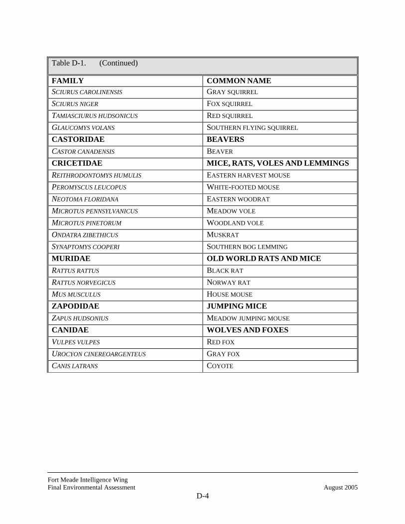
Fort Meade Intelligence Wing Final Environmental Assessment August 2005
D-4
Table D-1. (Continued)
FAMILY COMMON NAME SCIURUS CAROLINENSIS GRAY SQUIRREL SCIURUS NIGER FOX SQUIRREL TAMIASCIURUS HUDSONICUS RED SQUIRREL GLAUCOMYS VOLANS SOUTHERN FLYING SQUIRREL CASTORIDAE BEAVERS CASTOR CANADENSIS BEAVER CRICETIDAE MICE, RATS, VOLES AND LEMMINGS REITHRODONTOMYS HUMULIS EASTERN HARVEST MOUSE PEROMYSCUS LEUCOPUS WHITE-FOOTED MOUSE NEOTOMA FLORIDANA EASTERN WOODRAT MICROTUS PENNSYLVANICUS MEADOW VOLE MICROTUS PINETORUM WOODLAND VOLE ONDATRA ZIBETHICUS MUSKRAT SYNAPTOMYS COOPERI SOUTHERN BOG LEMMING MURIDAE OLD WORLD RATS AND MICE RATTUS RATTUS BLACK RAT RATTUS NORVEGICUS NORWAY RAT MUS MUSCULUS HOUSE MOUSE ZAPODIDAE JUMPING MICE ZAPUS HUDSONIUS MEADOW JUMPING MOUSE CANIDAE WOLVES AND FOXES VULPES VULPES RED FOX UROCYON CINEREOARGENTEUS GRAY FOX CANIS LATRANS COYOTE
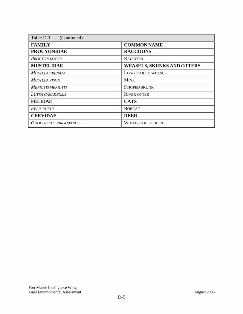
Fort Meade Intelligence Wing Final Environmental Assessment August 2005
D-5
Table D-1. (Continued) FAMILY COMMON NAME PROCYONIDAE RACCOONS PROCYON LOTOR RACCOON MUSTELIDAE WEASELS, SKUNKS AND OTTERS MUSTELA FRENATA LONG-TAILED WEASEL MUSTELA VISON MINK MEPHITIS MEPHITIS STRIPED SKUNK LUTRA CANADENSIS RIVER OTTER FELIDAE CATS FELIS RUFUS BOBCAT CERVIDAE DEER ODOCOILEUS VIRGINIANUS WHITE-TAILED DEER

Fort Meade Intelligence Wing Final Environmental Assessment August 2005
D-6
THIS PAGE INTENTIONALLY LEFT BLANK