Embed Size (px)
Citation preview
IOSR Journal Of Humanities And Social Science (IOSR-JHSS)
Volume 22, Issue 6, Ver.13 (June. 2017) PP 07-14
e-ISSN: 2279-0837, p-ISSN: 2279-0845.
www.iosrjournals.org
DOI: 10.9790/0837-2206130714 www.iosrjournals.org 7 | Page
Flood Hazard Assessment At Block Level And Its Management
Strategy In Paschim Medinipur District, West Bengal, India.
Kishor Dandapat1 Dr. Gopal Krishna Panda
2
1. Doctoral Research Scholar, P.G. Department of Geography, Utkal University, Vani-Vihar, Bhubaneswar – 04
2. Emeritus Professor, P.G. Department of Geography, Utkal University, Vani-Vihar, Bhubaneswar – 04
Abstract: Being a depositional plain, the rivers sweep over the meandering channel under low gradients
forming extensive flood plains in Ghatal Block. Ghatal Block is situated in the Gangetic Plains of West Bengal
with a high concentration disaster affected people, extensive damage of standing crops and domestic lives due to
high intensity of floods. In this condition situation analysis of a flood are very much essential to increase the
awareness in the sense of time, duration, depth, areas of flooding and causes of floods too much obligate in the
flood plain dwellers. And it has also been a very good instrument, which enhance to formulate an effective
management strategy for reducing the potential damages of flood.
KeyWords: Gangetic Plains, Situation Analysis, Duration, Depth, Gradient, Area Flooding, Management
Strategy, Awareness.
I. INTRODUCTION
Ghatal is situated in Paschim Medinipur district state of West Bengal. If we are going through the river
pattern of Ghatal block, the block divided into three parts. Namely, interfluves part of Silabati and Sankari
River, interfluves part of Sankari and Darakeswar River and interfluves part of Silabati and Rupnarayan River.
Ghatal town situated in the interfluves part of Silabati and Rupnarayan River. If the more rainfall occurs than the
normal rainfall by any cause the Block has been flooded. In a year the Block has been flooded 3 to 5 times
(Author Field Interview). Mainly excessive monsoonal rainfall from July to September month and additional
dam discharge water from Mukutmanipur and D.V.C reservoir are mainly responsible for flooding in this Block
and create a great havoc to the people’s life. Cyclone formation on the head of Bay of Bengal from the month of
October to November is also the cause of flood in this Block.
Fig. 1.1 Geographical Location of Ghatal Block
Flood Hazard Assessment At Block Level And Its Management Strategy In Paschim Medinipur
DOI: 10.9790/0837-2206130714 www.iosrjournals.org 8 | Page
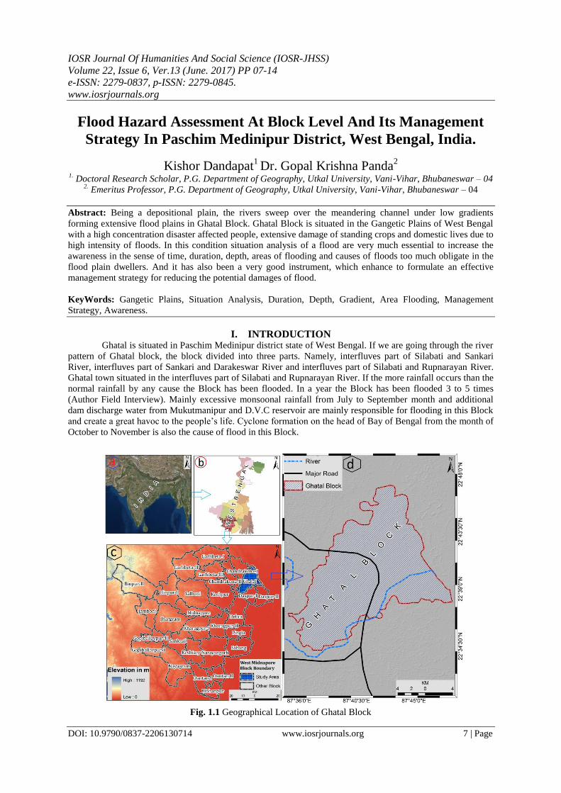
II. SITUATION ANALYSIS OF FLOOD HAZARD IN PASCHIM MEDINIPUR DISTRICT: If we look the history, we can see that Ghatal and its adjacent area is highly flood prone segment by the
River of Silabati and Kangsabati. In British Empire Ghatal Block was divided by many small Jamindars. After
starting the permanent settlement the local Jamindars prepared circuit bank in their locality on the rivers in their
areas to protect the flood and extend the productive land for which their total income would be increased. As a
result when flood water comes from the upstream and high tide water comes from the sea then accumulated
water continuously store on the river channel. So, the flood plains area of the river becomes lower in respect to
the accumulated water on the river channel. By the gradually assembled of silt in the river bed it becomes a high
area than the nearest areas and at the same time the rate of flood increased than the normal situation. As a result
in one side these become barrier to discharge excess flood water and in other side as the internal areas of the
river bed is lower than the river bank, resulting the critical problem of drainage. The National Flood
Commission recommended to reorganize or to abolish these unnecessary banks if necessary. Although this type
of steps were not taken after considering the socio economic condition of the area. According to the “Bengal
Amendment Law” 1873, the Govt. Acquired all circuit and river banks of the area. The Silabati barrage
constructed nearest Bankura Shimlipal and the rest whole area is uncontrolled or semi-controlled. Up to the 1st
period of 20th
century the excess flood water flowed through Silabati and its tributary Ketia Khal. Afterwards
the carrying capacity of Silabati so reduce that the excessive water of Silabati and Ketia khal broke the river
bank and flooded the lower areas of the river side. Due to revival of the same about every year the ways of flood
water created deep ditch, local people called these ‘Chatal’. The Irrigation and Water Ways Department of West
Bengal marked as ‘Flood Causeway’ instead of ‘Chatal’. During the time of flood these ‘Chatal’ are used as the
main waterways for communication. The pictures of boating which we see in the television or news paper of
Ghatal Block at the time of flood are the pictures of boating on these ‘Chatal’. At the time of flood the depth of
flood water on the causeway is about 6-7 metre. To save the Block from the flood there are six circuits around
Ghatal Block and adjacent areas. Among them three are abandoned. According to Govt. Calendar 1888, 1913,
1942, 1956, 1959, 1968, 1971, 1973, 1978, 1984, 1995, 2007 and 2013 are most noteworthy flooded year
among all disaster prone floods.
Fig. 1.2 Drainage System of Ghatal Block.
Flood Hazard Assessment At Block Level And Its Management Strategy In Paschim Medinipur
DOI: 10.9790/0837-2206130714 www.iosrjournals.org 9 | Page
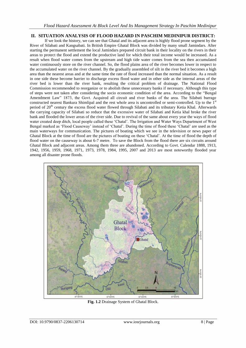
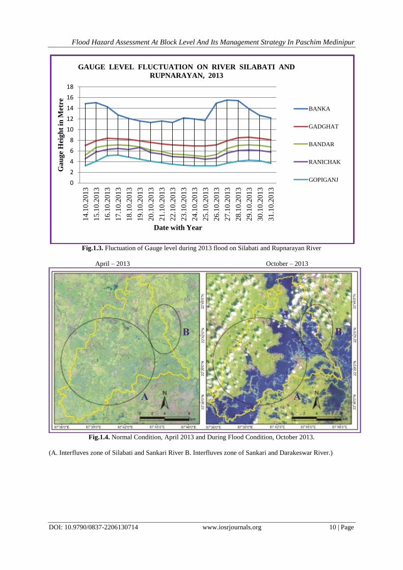
Table: 1.1- Gauge level fluctuation on river Silabati and Rupnarayan, 2013 Flood.
Place
Year
BANKA
(Silabati)
GADGHAT
(Silabati)
BANDAR
(Rupnarayan)
RANICHAK
(Rupnarayan)
GOPIGANJ
(Rupnarayan)
D.L –
15.08 m
E.D.L– 15.69
m
H.F.L – 16.34
m
D.L –
8.99 m
E.D.L –
9.60 m
H.F.L –11.22
m
D.L –
6.85 m
E.D.L –
7.46 m
H.F.L –
9.47 m
D.L –
5.33 m
E.D.L –
5.94 m
H.F.L –
9.14m
D.L –
5.03 m
E.D.L –
5.64m
H.F.L –
8.41 m
14.10.2013 14.82 7.07 5.21 4.57 3.20
15.10.2013 15.08 7.92 6.64 5.82 4.11
16.10.2013 14.30 8.32 7.01 6.27 5.15
17.10.2013 12.75 8.29 7.10 6.42 5.18
18.10.2013 12.11 8.20 7.01 6.27 4.87
19.10.2013 11.62 7.92 6.70 6.60 4.45
20.10.2013 11.35 7.59 6.21 5.67 4.02
21.10.2013 11.56 7.37 5.85 5.39 3.75
22.10.2013 11.35 7.17 5.45 4.97 3.53
23.10.2013 12.14 7.01 5.30 4.84 3.26
24.10.2013 11.96 6.97 5.15 4.72 3.20
25.10.2013 11.71 6.91 4.93 4.45 3.17
26.10.2013 14.94 7.13 5.30 4.66 3.20
27.10.2013 15.55 7.89 6.48 5.64 3.65
28.10.2013 15.43 8.50 7.04 6.09 4.11
29.10.2013 13.92 8.53 7.16 6.15 4.29
30.10.2013 12.66 8.38 7.07 6.06 4.20
31.10.2013 12.14 8.04 6.70 5.79 3.68
Source: West Bengal Irrigation and Waterways Department, 2015.
Fig.1.2 Different Circuit around Ghatal Block (Source: Ghatal Irrigation and Waterways Dept.)
Flood Hazard Assessment At Block Level And Its Management Strategy In Paschim Medinipur
DOI: 10.9790/0837-2206130714 www.iosrjournals.org 10 | Page
Fig.1.3. Fluctuation of Gauge level during 2013 flood on Silabati and Rupnarayan River
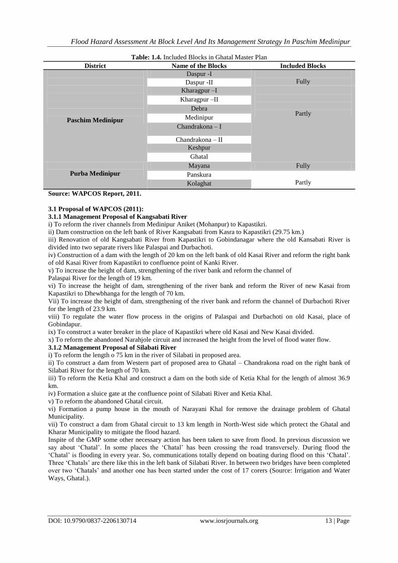
April – 2013 October – 2013
Fig.1.4. Normal Condition, April 2013 and During Flood Condition, October 2013.
(A. Interfluves zone of Silabati and Sankari River B. Interfluves zone of Sankari and Darakeswar River.)
0
2
4
6
8
10
12
14
16
18 1
4.1
0.2
01
3
15
.10
.20
13
16
.10
.20
13
17
.10
.20
13
18
.10
.20
13
19
.10
.20
13
20
.10
.20
13
21
.10
.20
13
22
.10
.20
13
23
.10
.20
13
24.1
0.2
013
25
.10
.20
13
26
.10
.20
13
27
.10
.20
13
28
.10
.20
13
29
.10
.20
13
30
.10
.20
13
31
.10
.20
13
Ga
ug
e H
eig
ht
in M
etre
Date with Year
GAUGE LEVEL FLUCTUATION ON RIVER SILABATI AND
RUPNARAYAN, 2013
BANKA
GADGHAT
BANDAR
RANICHAK
GOPIGANJ

Flood Hazard Assessment At Block Level And Its Management Strategy In Paschim Medinipur
DOI: 10.9790/0837-2206130714 www.iosrjournals.org 11 | Page
Fig.1.5. Chatal No.1, 2013 Flood (Normal condition, Left side/During Flood, Right side) Source: Kar, et.al,
2014.
Fig.1.6. Chatal No. 2, 2013 Flood (Normal condition, Left side/During Flood, Right side), Source: Kar, et.al,
2014.

Flood Hazard Assessment At Block Level And Its Management Strategy In Paschim Medinipur
DOI: 10.9790/0837-2206130714 www.iosrjournals.org 12 | Page
Table: 1.2- Depth and Duration of flood water and inundated area in Ghatal Block and adjacent areas.
Year More than 30 days More than 15 days
Area (sq.km) Depth (m) Area (sq.km) Depth (m)
1959 100 2.00 184 1.50
1967 100 2.50 69 1.50
1968 350 2.50 308 2.00
1973 208 3.00 150 2.00-1.00
1974 61 3.00 102 2.00-1.00
1975 104 2.50 110 2.00-1.00
1976 55 2.50 104 2.00-1.00
1977 100 3.50 130 2.00-1.00
1978 710 3.50 356 2.00-1.00
1999 78 3.00 100 2.00-1.00
2000 80 3.00 121 2.00-1.00
2007 233 3.00 400 2.00-1.00 2013 245 3.00 275 2.00-1.00
Source: WAPCOS and Ghatal Irrigation Office (2011 & 2015)
Table: 1.3. Highest flood discharge in different time periods at Silabati Watershed
Time periods
Discharge
25 year 50 year 100 year
2734 cusec 3428 cusec 3696 cusec
Source: WAPCOS Report, 2009
III. MANAGEMENT STRATEGIES: Now a day’s carrying capacity of Silabati River 650 cms which is totally inadequate to flow the flood
water. After a comprehensive study from 1970 to 1976, West Bengal Irrigation and Water Ways Department
proposed a plan to mitigate the flood and drainage problem which is known as ‘Ghatal Master Plan’ (GMP) and
in 1976 plan was approved by West Bengal Government. In 1982, 10th February the foundation stone of the
project was laid down but that was not implemented. In 1997, again the project was newly prepared and for that
estimated cost has was approved 20.82 corers but it was not successful. Considering the physical and socio-
economic condition of the region the Central Govt. authorised the responsibilities for preparing a reliable plan to
subordinate organisation Water and Power Consultancy Services (WAPCOS). WAPCOS showed the estimated
cost for this project in two report Rs. 1460 corers and Rs. 1740 corers in the year of 2009 and 2011 respectively.
Total area of this project is 1659 sq.km and area located in between 22°15ʹ N to 22°50ʹ N and 87°15ʹ E to 87°55ʹ
E. Ten blocks of Paschim Medinipur District and three blocks of Purba Medinipur District are fully or partly
included in the project area. In Western, Eastern, Northern and Southern boundary of the project area are
Chandrakona-Medinipur road; Rupnarayan River (From Hooghly port to Kolaghat), Panskura-Tamluk road,
Denan khal; Part of Ghatal-Chandrakona road, watershed of Silabati and Darakeswar River; Medinipur Khal,
Boxi khal and National High Way 6 respectively. Considering the locational importance of Ghatal Sub-division
and Ghatal town WAPCOS primarily measured the intensity of the flood which is possible to occur 100 years
interval. But geographical structure and location of the region is like that, if embankment is constructed in both
the side of the river Silabati than the height of water level in Silabati River is almost 4.5 m. to 5.0 m. from the
ground surface. Such a movement is highly dangerous to populous areas like Ghatal. If somehow the
embankment breaks any time it may be cause to a major disaster. That’s why WAPCOS reformed the plans and
they measured the intensity of flood which possible to come 50 years interval instead of 100 years interval. In
perspective of this idea WAPCOS formulate a plan to mitigate the flood problem in Kangsabati and Silabati
watershed.
According to WAPCOS highest discharge of flood water in Kangsabati and Silabati River 3869 cusec
and 3428 cusec in 50 years time. From WAPCOS study it is ensure that to enclosed the flood water in any
reservoir and mitigate the flood problem of this region totally impossible. So, they (WAPCOS) are proposed to
construct the breakwater, widthing the river channel etc. to minimize the flood problem.
Flood Hazard Assessment At Block Level And Its Management Strategy In Paschim Medinipur
DOI: 10.9790/0837-2206130714 www.iosrjournals.org 13 | Page
Table: 1.4. Included Blocks in Ghatal Master Plan
District Name of the Blocks Included Blocks
Paschim Medinipur
Daspur -I
Fully Daspur -II
Kharagpur –I
Partly
Kharagpur –II
Debra
Medinipur
Chandrakona – I
Chandrakona – II
Keshpur
Ghatal
Purba Medinipur
Mayana Fully
Panskura
Partly Kolaghat
Source: WAPCOS Report, 2011.
3.1 Proposal of WAPCOS (2011):
3.1.1 Management Proposal of Kangsabati River
i) To reform the river channels from Medinipur Aniket (Mohanpur) to Kapastikri.
ii) Dam construction on the left bank of River Kangsabati from Kasra to Kapastikri (29.75 km.)
iii) Renovation of old Kangsabati River from Kapastikri to Gobindanagar where the old Kansabati River is
divided into two separate rivers like Palaspai and Durbachoti.
iv) Construction of a dam with the length of 20 km on the left bank of old Kasai River and reform the right bank
of old Kasai River from Kapastikri to confluence point of Kanki River.
v) To increase the height of dam, strengthening of the river bank and reform the channel of
Palaspai River for the length of 19 km.
vi) To increase the height of dam, strengthening of the river bank and reform the River of new Kasai from
Kapastikri to Dhewbhanga for the length of 70 km.
Vii) To increase the height of dam, strengthening of the river bank and reform the channel of Durbachoti River
for the length of 23.9 km.
viii) To regulate the water flow process in the origins of Palaspai and Durbachoti on old Kasai, place of
Gobindapur.
ix) To construct a water breaker in the place of Kapastikri where old Kasai and New Kasai divided.
x) To reform the abandoned Narahjole circuit and increased the height from the level of flood water flow.
3.1.2 Management Proposal of Silabati River
i) To reform the length o 75 km in the river of Silabati in proposed area.
ii) To construct a dam from Western part of proposed area to Ghatal – Chandrakona road on the right bank of
Silabati River for the length of 70 km.
iii) To reform the Ketia Khal and construct a dam on the both side of Ketia Khal for the length of almost 36.9
km.
iv) Formation a sluice gate at the confluence point of Silabati River and Ketia Khal.
v) To reform the abandoned Ghatal circuit.
vi) Formation a pump house in the mouth of Narayani Khal for remove the drainage problem of Ghatal
Municipality.
vii) To construct a dam from Ghatal circuit to 13 km length in North-West side which protect the Ghatal and
Kharar Municipality to mitigate the flood hazard.
Inspite of the GMP some other necessary action has been taken to save from flood. In previous discussion we
say about ‘Chatal’. In some places the ‘Chatal’ has been crossing the road transversely. During flood the
‘Chatal’ is flooding in every year. So, communications totally depend on boating during flood on this ‘Chatal’.
Three ‘Chatals’ are there like this in the left bank of Silabati River. In between two bridges have been completed
over two ‘Chatals’ and another one has been started under the cost of 17 corers (Source: Irrigation and Water
Ways, Ghatal.).

Flood Hazard Assessment At Block Level And Its Management Strategy In Paschim Medinipur
DOI: 10.9790/0837-2206130714 www.iosrjournals.org 14 | Page
IV. RESULTS AND DISCUSSION: To regulate the flood in GMP totally depends on reform the river channel and construction of dam.
Although construction of this dam in an unscientific manner is the main causes of flood. So, once again when
the dam will be constructed the level of flood water is much higher than the level of ground surface. If somehow
earthen dam is broken, it may be the cause of the deadful disaster. If dam is constructed, the suspended sediment
of flood water will not get the space to spread over the floodplain. So, it is the cause of increasing the sediment
on the river channel and decreasing the depth of channel. So, flood takes a terrible grace in future. Normal slope
of ground surface is parallel to the ‘Chatal’. That’s why it is not ensured that the excessive flood water will not
only flow through the river channel. So, GMP is suitable for short term duration to mitigate the flood problem
but in long term duration it is very much suspicious that how could GMP mitigate the flood problem. Inspite of
that if we want to complete the plan, according to WAPCOS to possess the land permanently 1407 hector and
temporarily land 4180 hector which is very difficult in present circumstances of the State Government. So, flood
problem of Ghatal Block completely mitigated if GMP executes, this type of publicity is completely wrong. Part
of Ghatal Block which is fallen left bank of River Silabati is fully submerged by flood water during flood. If
Ghatal Master Plan will be executed the depth and duration of flood water also increased. So, it is doubtful
about the positive result if the Ghatal Master Plam (GMP) is executed.
REFERENCES
[1]. Chandra, S. (2003): India: Flood Management – Damodar River Basin. The Associated Programme on
Flood Management, World Meteorological Organization, pp.1-9.
[2]. Adnan, s. (1991): Floods, People and the Environment. Instituational aspects of flood protection
programmes in Bangladesh, 1990. Dhaka: Research and Advisory Services.
[3]. Executive Summary, Mastar Plan and DPR for Ghatal Area, West Bengal, WAPCOS Limited (2011):
Irrigation and Waterways Directorate, West Bengal.
[4]. Report of the Damodar Flood Enquiry Committee (1943): Addendum. Reprinted in West Bengal District
Gazetteers, Rivers of Bengal, Vol.3 (1), pp.187-205.
[5]. Inglis, W.A. (1909): The Canals and Flood Banks of Bengal, The Bengal Secretariat Book Depot, 1909.
Reprinted in West Bengal District Gazetteers, Rivers of Bengal, Vol.5 (1), pp.409-469.