Embed Size (px)
Citation preview
Development of National Flood Protection Plan-IV (NFPP-IV) and Related Flood Protection Plan-IV
Studies to Enhance Capacity Building of Federal Flood Commission-FFC
NESPAK | DELTARES i
Development of National Flood Protection Plan-IV (NFPP-IV) and Related Studies to Enhance Capacity Building of Federal Flood Commission-FFC
FLOOD PROTECTION PLAN-IV (Ten Years Plan)
TABLE OF CONTENTS
Page No.
TABLE OF CONTENTS .......................................................................................................................... i LIST OF TABLES .................................................................................................................................. iv LIST OF FIGURES ................................................................................................................................. v PROJECT ORGANIZATION ................................................................................................................. vi LIST OF ABBREVIATIONS/ACRONYMS .......................................................................................... viii EXECUTIVE SUMMARY .................................................................................................................. ES-1
1 INTRODUCTION .............................................................................................................................. 1
1.1 Background ............................................................................................................................. 1 1.2 Engagement of Consultants and Main Tasks ......................................................................... 1 1.3 Flood Mechanics and History of Floods in Pakistan ............................................................... 2
1.3.1 Flood Mechanics .............................................................................................................. 2
1.3.2 History of Floods .............................................................................................................. 4
1.3.3 Historic Flood Damages ................................................................................................. 11
2 REVIEW OF EXISTING FLOOD MANAGEMENT PRACTICES ................................................... 12
2.1 Review of Previous National Flood Protection Plans ........................................................... 12 2.2 Review of Organizational Role and Responsibilities ............................................................ 13
2.2.1 Federal Flood Commission ............................................................................................ 13
2.2.2 National Disaster Management Authority (NDMA) ........................................................ 14
2.2.3 Provincial Irrigation Departments ................................................................................... 14
2.2.4 Pakistan Meteorological Department ............................................................................. 15
2.2.5 Water and Power Development Authority ...................................................................... 15
2.2.6 Pakistan Army ................................................................................................................ 15
2.2.7 Pakistan Commissioner for Indus Waters (PCIW) ......................................................... 16
2.2.8 Provincial Relief Organization/Provincial Disaster Management/District Administration
Authorities (District Disaster Management Authority) .................................................... 16
2.3 Review of Existing Non-Structural and Structural Measures ................................................ 16 2.3.1 Existing Non-structural Measures .................................................................................. 16
2.3.2 Existing Structural Measures ......................................................................................... 19
2.4 Shortcomings, Constraints and Gaps in Existing Flood Management Practices ................. 22 2.4.1 Shortcomings in Policy and Planning ............................................................................. 22
2.4.2 Shortcomings in Design Flood Limits and Design Criteria ............................................. 22
2.4.3 Limitations in Barrage/Bridge Capacities ....................................................................... 22
2.4.4 Constraints in Flood Early Warning System ................................................................... 22
2.4.5 Financial Limitations and Constraints ............................................................................ 23
2.4.6 Gaps and Lapses ........................................................................................................... 23
3 PLANNING STRATEGY, OBJECTIVES AND GOALS OF NFPP-IV ........................................... 23
3.1 National Water Policy ........................................................................................................... 23 3.2 Planning Objective and Goals .............................................................................................. 24 3.3 Planning Strategy.................................................................................................................. 24
Development of National Flood Protection Plan-IV (NFPP-IV) and Related Flood Protection Plan-IV
Studies to Enhance Capacity Building of Federal Flood Commission-FFC
NESPAK | DELTARES ii
4 INTEGRATED FLOOD MANAGEMENT ....................................................................................... 25 4.1 General ................................................................................................................................. 25 4.2 Components of Integrated Flood Management .................................................................... 25 4.3 Non-structural Measures and Future Challenges ................................................................. 26
4.3.1 Watershed Management ................................................................................................ 26
4.3.2 Global Warming .............................................................................................................. 27
4.3.3 Role of Mangla and Tarbela Reservoirs in Flood Mitigation .......................................... 28
4.3.4 Floodplain Mapping and Zoning ..................................................................................... 29
4.3.5 Floodplain Regulations ................................................................................................... 30
4.3.6 Flood Forecasting and Warning ..................................................................................... 30
4.3.7 Strengthening of Rain and River Gauging Network ....................................................... 32
4.3.8 Trans-boundary Water Management ............................................................................. 34
4.3.9 Environmental Management .......................................................................................... 35
4.3.10 Financial Resource Management .................................................................................. 35
4.3.11 Information and Education of Stakeholders ................................................................... 36
4.3.12 Disaster Preparedness ................................................................................................... 36
4.3.13 Flood Insurance .............................................................................................................. 36
4.3.14 Unified Design Criteria for Flood Protection Structures ................................................. 37
4.3.15 Capacity Building of Organizations/Agencies ................................................................ 37
4.4 Structural Measures .............................................................................................................. 38 4.4.1 Dams and Reservoirs ..................................................................................................... 39
4.4.2 Embankments/Bunds, Spurs and Studs ........................................................................ 39
4.4.3 Gabions and Protection/Retaining Walls ........................................................................ 39
4.4.4 Diversions of High flows through Breaching Sections ................................................... 39
4.4.5 Diversion / Escape Channels ......................................................................................... 40
4.4.6 Channel Improvements .................................................................................................. 46
5 FLOOD PROTECTION INVESTMENT PLAN ............................................................................... 49
5.1 General ................................................................................................................................. 49 5.2 Previous Financial Provisions ............................................................................................... 49 5.3 Investment Schedule for NFPP-IV ........................................................................................ 50
5.3.1 Identification, Evaluation and Selection of Flood Protection Schemes .......................... 50
5.3.2 Prioritizing of Schemes and Phasing ............................................................................. 53
5.3.3 Investment Schedule/Plan.............................................................................................. 54
5.4 Description on Investment Categories .................................................................................. 55 5.4.1 Completion of On-Going Projects/Liability ..................................................................... 55
5.4.2 Construction of Flood Protection Structures/Works of Major & Other Rivers ................ 62
5.4.3 Flood Management Structures across Hill Torrents ....................................................... 63
5.4.4 Feasibility and Detailed Design Studies of Barrages and Hydraulic Structures ............ 64
5.4.5 Coastal Flood Protection Works ..................................................................................... 65
5.4.6 Measures for GLOFs & Land Sliding in Hilly Areas ....................................................... 65
5.4.7 Remodeling and Proper Maintenance of Drainage System in Lower Indus .................. 66
5.4.8 Master Planning, Feasibility Studies, Detailed Designing and Implementation, Including
Physical Model Study of All Major Rivers and Railway Bridges..................................... 66
5.4.9 Flood Mitigation, Channelization and Execution of the Lai Nullah Project ..................... 66
5.4.10 Study to be conducted for improving the Existing Strom Drainage System of Urban
Areas (Major Cities) ........................................................................................................ 67
5.4.11 Provision of Annual Funds under Provincial ADPs for Flood Fighting Activities during
Flood Season and procurement & repair of Flood Fighting Equipment/ Machinery under
PID .................................................................................................................................. 67
5.4.12 Up-gradation & Expansion in the Existing Flood Forecasting & Warning System of
Pakistan Meteorological Department ............................................................................. 68
5.4.13 Up-gradation, Installation and Expansion in the Existing System of Water and Power
Development Authority ................................................................................................... 69
Development of National Flood Protection Plan-IV (NFPP-IV) and Related Flood Protection Plan-IV
Studies to Enhance Capacity Building of Federal Flood Commission-FFC
NESPAK | DELTARES iii
5.4.14 Study to be conducted for Removal of Encroachments from High Risk Areas on Major
River ............................................................................................................................... 69
5.4.15 Development of Watershed Management in the uplands of Major Rivers and Hill
Torrents Areas ................................................................................................................ 70
5.4.16 Wetland Sites Recommended by RAMSAR Advisory Mission ...................................... 70
5.4.17 Disaster Management Activities by NDMA including Rescue and Relief ...................... 71
5.4.18 Capacity Building and Staff Training of Institutions ........................................................ 71
5.4.19 Drought Management with Floods ................................................................................. 72
6 NFPP-IV APPROVAL THROUGH COUNCIL OF COMMON INTERESTS .................................. 72
6.1 Background ........................................................................................................................... 72 6.2 CCI Meetings and Decisions/Recommendations ................................................................. 73 6.3 Compliance of CCI Recommendations ................................................................................ 74
6.3.1 Consultative Meeting with Balochistan Province ........................................................... 75
6.3.2 Consultative Meeting with Khyber Pakhtunkhwa Province ............................................ 75
6.3.3 Consultative Meeting with Sindh Province ..................................................................... 76
6.3.4 Consultative Meeting with Punjab Province ................................................................... 76
6.3.5 NDMA and PMD Additional Suggestions ....................................................................... 76
6.4 Way Forward ......................................................................................................................... 82
7 CONCLUSIONS AND RECOMMENDATIONS ............................................................................. 82
7.1 Non-Structural Measures ...................................................................................................... 82 7.1.1 Watershed Management ................................................................................................ 82
7.1.2 Global Warming and Climate Change ............................................................................ 83
7.1.3 Revision of SOPs for Operation of Major Reservoirs ..................................................... 83
7.1.4 Environmental Management .......................................................................................... 83
7.1.5 Financial Resource Management .................................................................................. 83
7.1.6 Flood Forecasting and Warning Systems ...................................................................... 84
7.1.7 Floodplain Policies and Legislation ................................................................................ 84
7.1.8 Floodplain Mapping and Zoning other than Indus River and its Tributaries .................. 84
7.1.9 Community Awareness and Preparedness .................................................................... 84
7.1.10 Institutional Capacity Building ........................................................................................ 85
7.2 Structural Measures .............................................................................................................. 85 7.2.1 Flood Protection Works .................................................................................................. 85
7.2.2 Rehabilitation and Capacity Enhancement of Barrages/Bridges ................................... 85
7.2.3 Dams and Storages ........................................................................................................ 85
7.2.4 Breaching Sections at Barrages/Bridges and Flood Escape Channels ......................... 85
7.3 Plan Implementation and Third Party Verification ................................................................ 86
ANNEXES Annex-1: List of Recommended Works/Schemes along with Investment Schedule for NFPP-IV
Annex-2: Proposed Additional Schemes by Provinces and NDMA &PMD
Development of National Flood Protection Plan-IV (NFPP-IV) and Related Flood Protection Plan-IV
Studies to Enhance Capacity Building of Federal Flood Commission-FFC
NESPAK | DELTARES iv
LIST OF TABLES
Page No.
Table 1: Comparison of 2010 Monsoon Rainfall with Mean Rainfall in Northern Parts of Pakistan ...... 5
Table 2: Comparison of Historic Flood Peaks during 2010 with Highest Records ................................. 6
Table 3: Rainfall Recorded in Sindh Province during 2011 Monsoon .................................................... 9
Table 4: Historical Flood Damages in Pakistan, 1950-2014 ................................................................. 12
Table 5: Summary of Federal Investment on Flood Protection Works/Schemes ................................. 13
Table 6: Existing Flood Protection Facilities ......................................................................................... 20
Table 7: Existing Flood Protection Structures ....................................................................................... 21
Table 8: Non-structural and Structural Measures in Integrated Flood Management ............................ 26
Table 9: WMO Guideline for Gauge Density (Area in Km2) .................................................................. 32
Table 10: List of Existing Breaching Sections ....................................................................................... 41
Table 11: Allocation of Funds................................................................................................................ 50
Table 12: Summary of Budget Allocation and Releases under Normal/Emergent Flood Program ..... 50
Table 13: Proposed Projects/ Schemes and Associated Costs Collected Under NFPP-IV Studies ... 51
Table 14: Summary of Non-structural Projects ..................................................................................... 51
Table 15: Summary of Selected Projects/Schemes for NFPP-IV ......................................................... 52
Table 16: Selected Types of Projects/Schemes ................................................................................... 52
Table 17: Category-wise Investment Plan for NFPP-IV: 2015-16 to 2024-25 ...................................... 56
Table 18: Ten (10) Years Investment Plan ........................................................................................... 58
Table 19: Projects Recommended for Studies under NFPP-IV ............................................................ 60
Table 20: Executed Projects during 2008-2013 .................................................................................... 61
Table 21: Summary of Ongoing Projects .............................................................................................. 61
Table 22: Summary of Proposed Flood Protection Works in Various River Reaches .......................... 62
Table 23: Cost Estimates for Hill Torrent Management across Provinces and Federal Agencies ....... 64
Table 24: Details of Structures to be studied ........................................................................................ 64
Table 25: Capacity Building under Proposed NFPP-IV (2015-16 TO 2024-25) ................................... 72
Table 26: Original Proposed Cost of NFPP-IV vs Total Demand After CCI Meeting ........................... 75
Table 27: Revised Investment Schedule for NFPP-IV (10 Year Plan) ................................................. 78
Table 28: Revised NFPP-IV Investment plan (Phase-I & Phase-II)...................................................... 80
Development of National Flood Protection Plan-IV (NFPP-IV) and Related Flood Protection Plan-IV
Studies to Enhance Capacity Building of Federal Flood Commission-FFC
NESPAK | DELTARES v
LIST OF FIGURES
Page No.
Figure 1: Historical Storm Tracks ............................................................................................................ 4
Figure 2: Inundation Areas during 2010 Flood in Indus River System ................................................... 6
Figure 3: Forecast of Second Flood Peak by PMD (Source PMD)....................................................... 11
Figure 4: Existing and Future Dams ..................................................................................................... 20
Figure 5: Hourly Inflows, Outflows and Reservoir Levels at Mangla During 2014 flood ....................... 29
Figure 6: High, Medium and Low Flood Risk Area Map on District Level ............................................ 30
Figure 7: Analysis for New Gauges as per WMO Recommended Density in Gomal River Basin ....... 33
Figure 8: Ranges of Existing and Proposed Radars ............................................................................. 34
Figure 9: Piezometric Line and Pressure Head Contours in an Embankment using
Seep / W-Geostudio (2007) ................................................................................................... 37
Figure 10: Main Modules of Proposed System ..................................................................................... 38
Figure 11: Escape Route-1 for Guddu Barrage .................................................................................... 44
Figure 12: Escape Route 2 for Sukkur Barrage .................................................................................... 44
Figure 13: GIS Based Assessment of Flow paths on Left Embankment of Panjnad Barrage .............. 46
Figure 14: Drainage Channels in Urban Areas ..................................................................................... 47
Figure 15: Bottleneck below Guddu Barrage ........................................................................................ 48
Figure 16: Reduction in Conveyance Capacity near Qadirpur ............................................................. 48
Figure 17: River Encroachment Downstream of Sukkur Barrage ......................................................... 49
Development of National Flood Protection Plan-IV (NFPP-IV) and Related Flood Protection Plan-IV
Studies to Enhance Capacity Building of Federal Flood Commission-FFC
NESPAK | DELTARES vi
PROJECT ORGANIZATION
The Members of the WCAP during the preparation of the National Flood Protection Plan-IV are listed below:
Designation Name
1. Project Director/Chief Engineering Advisor/ Mr. Asjad Imtiaz Ali Chairman Federal Flood Commission
2. Team Leader/Chief Engineer (FFC) Mr. Javed Bukhari 3. Director Technical/Principal River Engineer Mr. Ather Hameed 4. Principal River Engineer Dr. Amjad Nabi 5. Manager Finance Mr. Muhammad Zahid
The names of Consultant’s Team are given below:
Key Expert Position Name
KE 1 Project Coordinator Dr. Mansoor Ahmed Hashmi /
Mr. Tariq Altaf
KE 2 Project Team Leader Mr. Muhammad Masood Asif /
Syed Tajammal Hussain
1 Quality Assurance Mr. Javed Munir
2 Quality Assurance Mr. Muhammad Masood Asif
3 Project Engineer Mr. Adnan Yousaf / Mr. Kanwar Sajid
4 Accounts Assistant Mr. Mohsin Malik
KE 3 Task Team Leader A Mr. Abdul Khaliq Hashmi
1 Head Hydrology Malik Shahrukh Latif
2 Hydraulics Design Specialist Mr. Javed Munir
3 Chief Engineer Mr. Muhammad Ittfaq
4 Principal Engineer Mr. Rizwan Maqsood
5 Agro-Economics Expert Mr. Abdul Ghani Randhawa
6 Senior Economist Mr. Muhammad Tahir Awan
7 Geotechnical Expert Mr. Abdus Salam
8 Senior Economist Mr. Amir Hussain Ansari
9 Senior Engineer Syed Abbas Ali
10 Senior Engineer Mr. Kanwar Sajid
11 Engineer Mr. Uzair Bashir
12 Engineer Mr. Muhammad Kashif Ali
KE 4 Task Team Leader B Malik Shahrukh Latif
1 Principal Engineer Mr. Rizwan Maqsood
2 Monitoring & Evaluation Expert Mr. Abdul Ghani Randhawa
3 Senior Economist Mr. Muhammad Tahir Awan
4 Senior Engineer Mr. Kanwar Sajid
5 Engineer Mr. Muhammad Qasim
Development of National Flood Protection Plan-IV (NFPP-IV) and Related Flood Protection Plan-IV
Studies to Enhance Capacity Building of Federal Flood Commission-FFC
NESPAK | DELTARES vii
Key Expert Position Name
6 Engineer Mr. Rameez
KE 5 Task Team Leader C Dr. Mansoor Ahmed Hashmi
1 Principal Modeller Mehar Ali Shah
2 Hydrologist/Modelling Specialist Mr. Ron Paschier
3 Modeller/FEWs Specialist Mr. Dirk Schwanberg
4 Modeller/Principal Engineer Mr. Yasir Abbas
5 Modeller/FEWS Specialist Mr. Jan Talsma
6 Senior Engineer Mr. Muhammad Hasnain Aslam
7 Senior Engineer Mr. Omer Farooq
8 Engineer Mr. Adnan Yousaf
9 Principal GIS/Computer Engr. Mr. Usman Tarar
10 Principal GIS/Computer Engr. Mr. Khurrum Ahmad Khan
11 Senior RS Analyst Mr. Imran Zafar
12 Senior RS Analyst Mr. Safdar Hussain
13 Senior RS Analyst Mr. Muhammad Asif Ali
14 Senior RS Analyst Mr. Tahir Mahmood Butt
15 Senior Engineer Mr. Muhammad Tahir
16 GIS Expert Mr. Muntazir Mehdi
17 GIS Expert Mr. Humayun Mirza
18 GIS Expert Mr. Adil Latif
19 GIS Expert Mr. Waseem Saeed
20 Legal Specialist Dr. Dil Muhammad
KE 6 Task Team Leader D Mr. Zubair Hashmi
1 Principal GIS Engineer Mr. Khurrum Ahmad Khan
2 Senior Database Specialist Syed Moneeb Ali
3 Senior Programmer Mr. Rashid Mahmood
4 Senior Network Specialist Mr. Nauman Ali
5 Business Analyst Ms. Sadaf Zafar
6 Web Developer Mr. Farooq Mushtaq
7 Web Developer Mr. Shahzad Ejaz,
8 Web Developer Mr. Wajahat Yawar,
9 Web Developer Ms. Satwat Bashir
10 WebGIS Developer Mr. Mamoon ur Rasheed
11 WebGIS Developer Mr. Ghulam Mohyyu Ddin
12 Graphic Designer Mr. Faysal Iqbal
13 Configuration Controller Syed Imran Raza
14 Software Quality Assurance Ms. Amna Rafiq
15 Software Quality Assurance Mr. Jahanzeb Ahmed
Development of National Flood Protection Plan-IV (NFPP-IV) and Related Flood Protection Plan-IV
Studies to Enhance Capacity Building of Federal Flood Commission-FFC
NESPAK | DELTARES viii
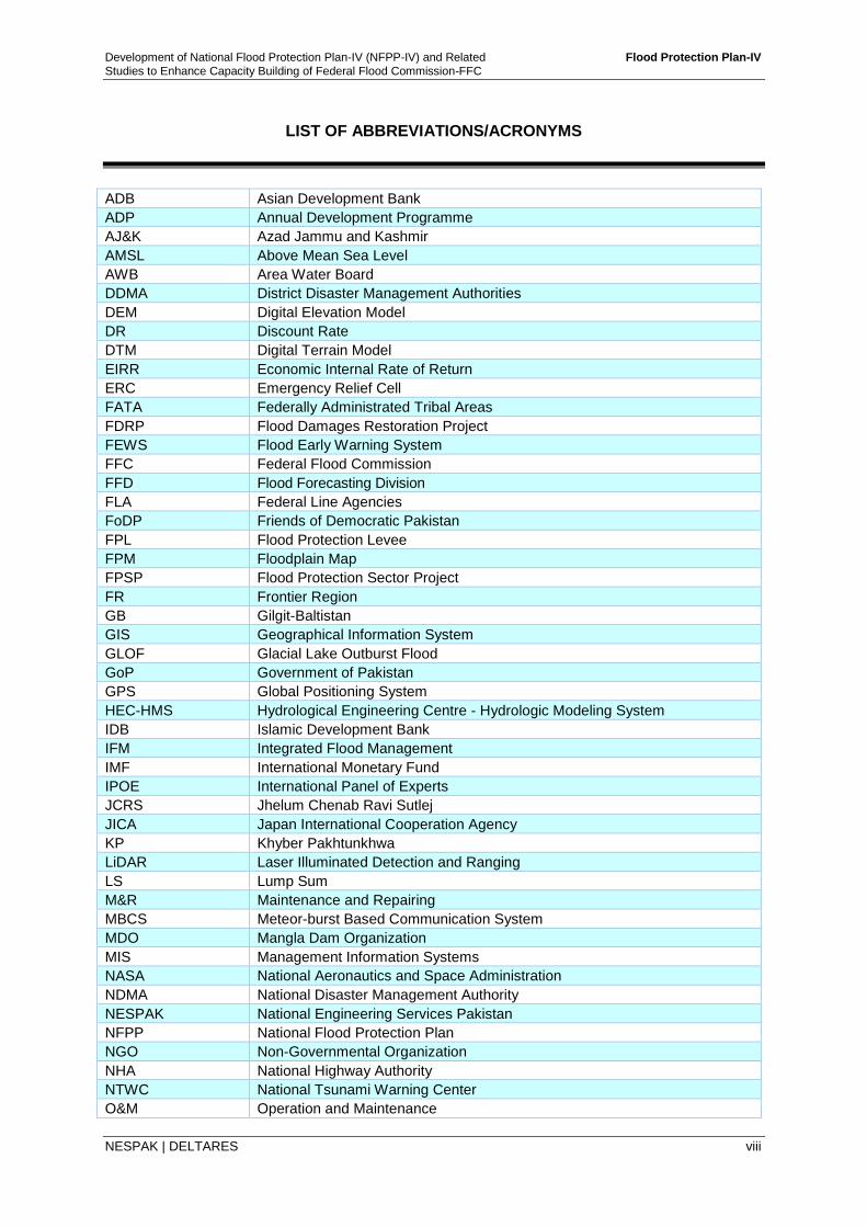
LIST OF ABBREVIATIONS/ACRONYMS
ADB Asian Development Bank
ADP Annual Development Programme
AJ&K Azad Jammu and Kashmir
AMSL Above Mean Sea Level
AWB Area Water Board
DDMA District Disaster Management Authorities
DEM Digital Elevation Model
DR Discount Rate
DTM Digital Terrain Model
EIRR Economic Internal Rate of Return
ERC Emergency Relief Cell
FATA Federally Administrated Tribal Areas
FDRP Flood Damages Restoration Project
FEWS Flood Early Warning System
FFC Federal Flood Commission
FFD Flood Forecasting Division
FLA Federal Line Agencies
FoDP Friends of Democratic Pakistan
FPL Flood Protection Levee
FPM Floodplain Map
FPSP Flood Protection Sector Project
FR Frontier Region
GB Gilgit-Baltistan
GIS Geographical Information System
GLOF Glacial Lake Outburst Flood
GoP Government of Pakistan
GPS Global Positioning System
HEC-HMS Hydrological Engineering Centre - Hydrologic Modeling System
IDB Islamic Development Bank
IFM Integrated Flood Management
IMF International Monetary Fund
IPOE International Panel of Experts
JCRS Jhelum Chenab Ravi Sutlej
JICA Japan International Cooperation Agency
KP Khyber Pakhtunkhwa
LiDAR Laser Illuminated Detection and Ranging
LS Lump Sum
M&R Maintenance and Repairing
MBCS Meteor-burst Based Communication System
MDO Mangla Dam Organization
MIS Management Information Systems
NASA National Aeronautics and Space Administration
NDMA National Disaster Management Authority
NESPAK National Engineering Services Pakistan
NFPP National Flood Protection Plan
NGO Non-Governmental Organization
NHA National Highway Authority
NTWC National Tsunami Warning Center
O&M Operation and Maintenance
Development of National Flood Protection Plan-IV (NFPP-IV) and Related Flood Protection Plan-IV
Studies to Enhance Capacity Building of Federal Flood Commission-FFC
NESPAK | DELTARES ix
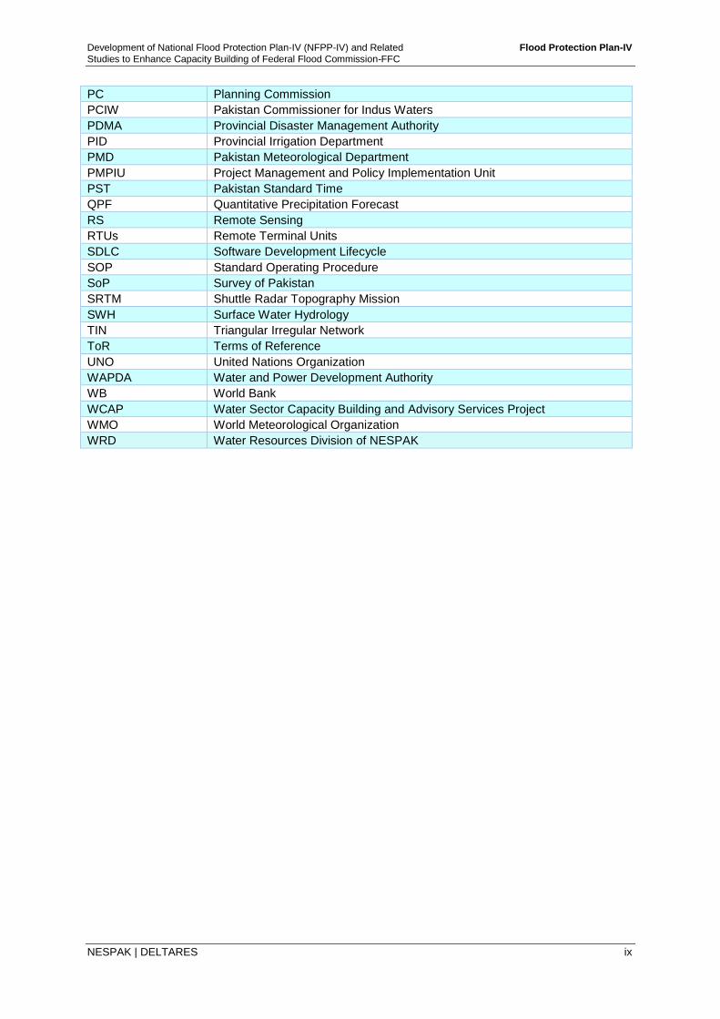
PC Planning Commission
PCIW Pakistan Commissioner for Indus Waters
PDMA Provincial Disaster Management Authority
PID Provincial Irrigation Department
PMD Pakistan Meteorological Department
PMPIU Project Management and Policy Implementation Unit
PST Pakistan Standard Time
QPF Quantitative Precipitation Forecast
RS Remote Sensing
RTUs Remote Terminal Units
SDLC Software Development Lifecycle
SOP Standard Operating Procedure
SoP Survey of Pakistan
SRTM Shuttle Radar Topography Mission
SWH Surface Water Hydrology
TIN Triangular Irregular Network
ToR Terms of Reference
UNO United Nations Organization
WAPDA Water and Power Development Authority
WB World Bank
WCAP Water Sector Capacity Building and Advisory Services Project
WMO World Meteorological Organization
WRD Water Resources Division of NESPAK
Development of National Flood Protection Plan-IV (NFPP-IV) and Related Flood Protection Plan-IV
Studies to Enhance Capacity Building of Federal Flood Commission-FFC
NESPAK | DELTARES ES-1
NATIONAL FLOOD PROTECTION PLAN-IV (NFPP-IV)
EXECUTIVE SUMMARY
ES.1 Introduction Ministry of Water and Power, Government of Pakistan through Federal Flood Commission (FFC) under Water Sector Capacity Building and Advisory Services Project (WCAP) program engaged National Engineering Services of Pakistan (NESPAK) in association with Deltares of The Netherlands for ‘Development of National Flood Protection Plan-IV with the following objectives:
i. Task-A: Develop ‘National Flood Protection Plan-IV to be implemented during next 10 years; 2015-2025 based on innovative and integrated approach incorporating structural and non-structural measures for reducing floods, reducing susceptibility to flood damages and mitigating the flood impacts keeping in view constraints, gaps and lapses in the previous Flood Protection Plans, technical shortcomings and lessons learnt from past major flood events.
ii. Task-B: Develop a comprehensive inventory of the existing flood protection infrastructure of all regions of Pakistan (four provinces, Gilgit-Baltistan, FATA & AJ&K) constructed so far through various resources (Federal/ Provincial/Foreign Aided) and carry out benefit monitoring and evaluation of flood protection works, constructed under FPSP-I and II.
iii. Task-C: Carry out Floodplain Mapping & Zoning along all the Indus River and its major tributaries including Kabul and Swat rivers, identify high, medium and low flood risk areas up to district level and prepare River Act for restricting/prohibiting permanent settlements in high and medium flood risk areas.
iv. Task-D: For the capacity building of Federal Flood Commission, develop a reliable database/information system to store and retrieve required data and enhance data processing techniques for preparation and dissemination of Flood Reports, as approved by the FFC, among the concerned organizations and design a web based interface for effective data sharing with all stakeholders at the federal and provincial levels, including public.
The Consultants commenced their work in June 2013 and submitted Draft reports on Task-A, B and C on January, 2015 and Task-D in February 2015. Thereafter, detailed discussions were held with WCAP, FFC, Provincial Irrigation Departments, PMD, WAPDA, NDMA and other stakeholders to obtain their suggestions for incorporation in the National Flood Protection Plan-IV. The Plan consists of the following set of reports:
National Flood Protection Plan-IV (this Report)
Task-A: Development of National Flood Protection Plan-IV (NFPP-IV) and PC-I
Task-B: Development of Inventory of Flood Works, and Benefit Monitoring and Evaluation of Flood Protection Works
Task-C: Floodplain Mapping and Zoning
Task-D: Automation of Flood Situation Monitoring and Reporting
ES.2 Flood Mechanics, 2010 Flood and Flood Damages In 2010, Pakistan was hit by one of the worst natural disasters - floodwaters inundated 38,600 km2 area in all four provinces and affected an estimated 20 million people, mostly by destruction of property, infrastructure and lands of livelihood, with a death toll close to 2,000.
Development of National Flood Protection Plan-IV (NFPP-IV) and Related Flood Protection Plan-IV
Studies to Enhance Capacity Building of Federal Flood Commission-FFC
NESPAK | DELTARES ES-2
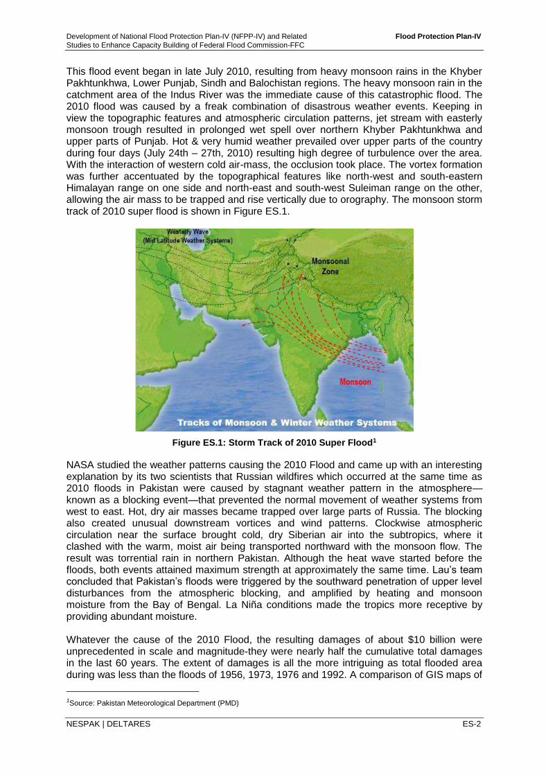
This flood event began in late July 2010, resulting from heavy monsoon rains in the Khyber Pakhtunkhwa, Lower Punjab, Sindh and Balochistan regions. The heavy monsoon rain in the catchment area of the Indus River was the immediate cause of this catastrophic flood. The 2010 flood was caused by a freak combination of disastrous weather events. Keeping in view the topographic features and atmospheric circulation patterns, jet stream with easterly monsoon trough resulted in prolonged wet spell over northern Khyber Pakhtunkhwa and upper parts of Punjab. Hot & very humid weather prevailed over upper parts of the country during four days (July 24th – 27th, 2010) resulting high degree of turbulence over the area. With the interaction of western cold air-mass, the occlusion took place. The vortex formation was further accentuated by the topographical features like north-west and south-eastern Himalayan range on one side and north-east and south-west Suleiman range on the other, allowing the air mass to be trapped and rise vertically due to orography. The monsoon storm track of 2010 super flood is shown in Figure ES.1.
Figure ES.1: Storm Track of 2010 Super Flood1
NASA studied the weather patterns causing the 2010 Flood and came up with an interesting explanation by its two scientists that Russian wildfires which occurred at the same time as 2010 floods in Pakistan were caused by stagnant weather pattern in the atmosphere—known as a blocking event—that prevented the normal movement of weather systems from west to east. Hot, dry air masses became trapped over large parts of Russia. The blocking also created unusual downstream vortices and wind patterns. Clockwise atmospheric circulation near the surface brought cold, dry Siberian air into the subtropics, where it clashed with the warm, moist air being transported northward with the monsoon flow. The result was torrential rain in northern Pakistan. Although the heat wave started before the floods, both events attained maximum strength at approximately the same time. Lau’s team concluded that Pakistan’s floods were triggered by the southward penetration of upper level disturbances from the atmospheric blocking, and amplified by heating and monsoon moisture from the Bay of Bengal. La Niña conditions made the tropics more receptive by providing abundant moisture. Whatever the cause of the 2010 Flood, the resulting damages of about $10 billion were unprecedented in scale and magnitude-they were nearly half the cumulative total damages in the last 60 years. The extent of damages is all the more intriguing as total flooded area during was less than the floods of 1956, 1973, 1976 and 1992. A comparison of GIS maps of
1Source: Pakistan Meteorological Department (PMD)
Development of National Flood Protection Plan-IV (NFPP-IV) and Related Flood Protection Plan-IV
Studies to Enhance Capacity Building of Federal Flood Commission-FFC
NESPAK | DELTARES ES-3
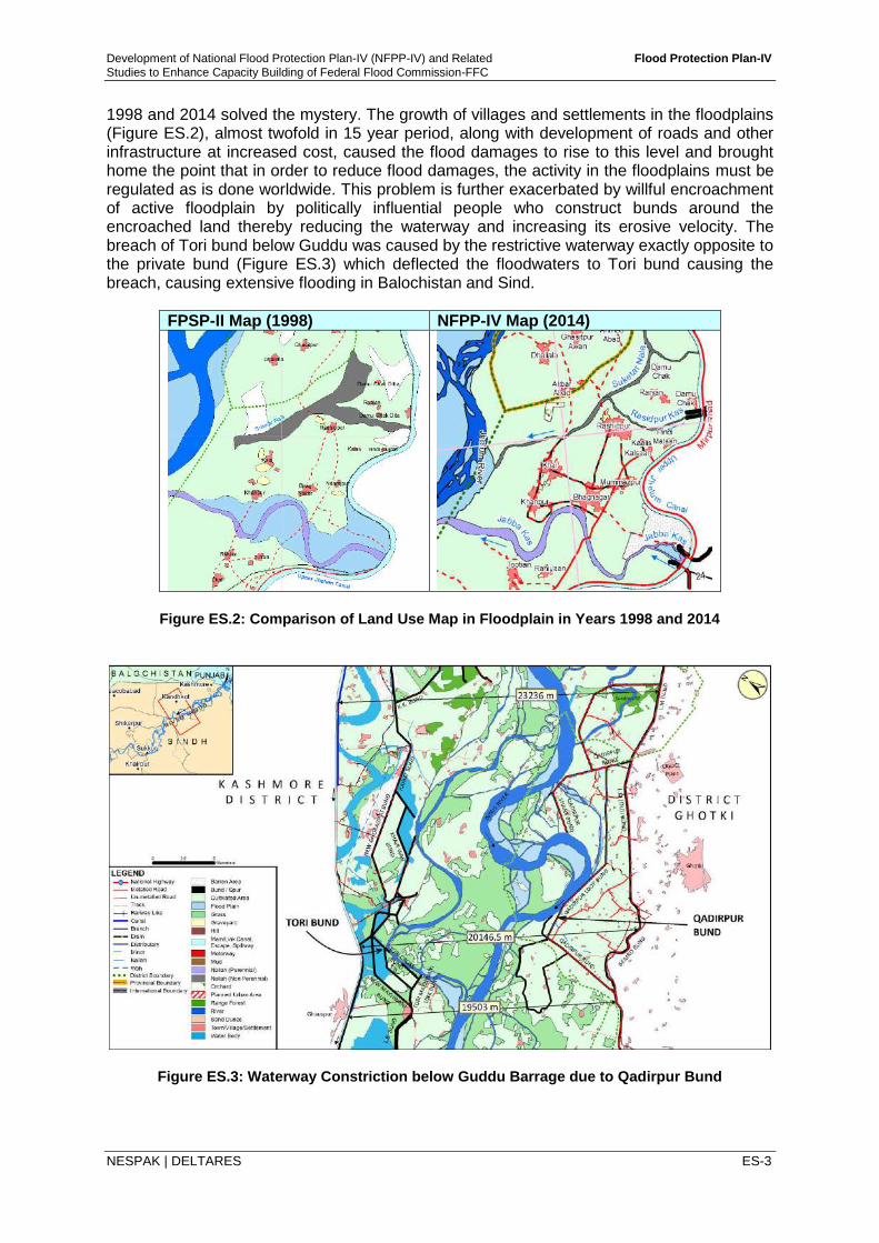
1998 and 2014 solved the mystery. The growth of villages and settlements in the floodplains (Figure ES.2), almost twofold in 15 year period, along with development of roads and other infrastructure at increased cost, caused the flood damages to rise to this level and brought home the point that in order to reduce flood damages, the activity in the floodplains must be regulated as is done worldwide. This problem is further exacerbated by willful encroachment of active floodplain by politically influential people who construct bunds around the encroached land thereby reducing the waterway and increasing its erosive velocity. The breach of Tori bund below Guddu was caused by the restrictive waterway exactly opposite to the private bund (Figure ES.3) which deflected the floodwaters to Tori bund causing the breach, causing extensive flooding in Balochistan and Sind.
FPSP-II Map (1998) NFPP-IV Map (2014)
Figure ES.2: Comparison of Land Use Map in Floodplain in Years 1998 and 2014
Figure ES.3: Waterway Constriction below Guddu Barrage due to Qadirpur Bund
Development of National Flood Protection Plan-IV (NFPP-IV) and Related Flood Protection Plan-IV
Studies to Enhance Capacity Building of Federal Flood Commission-FFC
NESPAK | DELTARES ES-4
Another aspect of the 2010 flood was that it came without warning. The flood early warning system (FEWS) developed under FPSP-II did not cover the Kabul and Swat River basins and the PMD weather radars also did not cover the western and northern part of Pakistan, therefore the communities living along these rivers were caught unawares resulting in heavy loss of life and property. It is obvious from lessons learnt of 2010 flood and later floods of 2011, 2012, 2013, 2014, that the traditional approaches of controlling floods through structural measures alone is not sufficient and a more comprehensive, innovative measures need to be adopted to minimize flood damages in the future. ES.3 Planning Strategy for Developing Integrated Flood Management Plan The planning strategy for development of National Flood Protection Plan-IV, in line with the current practices worldwide, is focused on integrated flood management planning laying more emphasis on the non-structural measures, like reservoir operations, flood forecasting and early warning, flood risk zoning, watershed management, flood proofing and insurance, disaster management and other measures, aimed at mitigating flood damages rather than completely controlling floods- an impossible task as experienced worldwide. However, considering the uniqueness of Indus Basin with its large integrated network of dams, barrages and canals, which is the lifeline of agriculture economy of the country, the protection of this infrastructure as wells as the irrigated area that it feeds and which has been the focus of previous three Flood Protection Plans, the maintenance, up-gradation and in some cases new construction especially in light of 2010 floods, has not been ignored. In order to address these two issues, the need for an Integrated Flood Management Plan cannot be over emphasized and the Draft National Water Policy reflects this in the following manner:
Construction of flood protection facilities and maintenance of existing facilities
Review of design and maintenance standards of existing facilities
Establishment and promotion of flood zoning and enforcement of appropriate land use
Optimized reservoir operating rules
Improved and updated flood manuals
Effective use of nonstructural measures
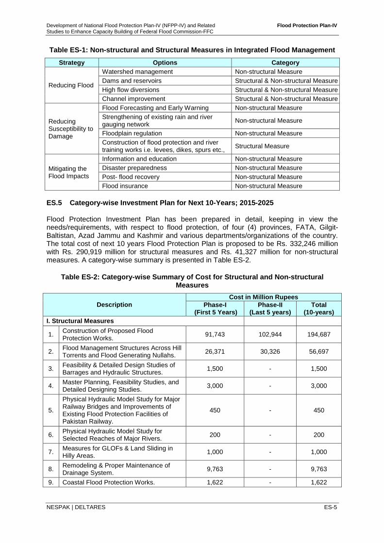
Creation of flood response plans The above guidelines have been adopted while formulating the Plan. ES.4 Integrated Flood Management Plan Integrated flood management should appropriately address both structural and nonstructural measures. Construction of dams, dikes levees etc., reduce the flooding while flood forecasting and warning can reduce the extent of damage caused by floods. An effective integrated flood management plan involves a holistic approach consisting not only of structural and nonstructural measures, but a vertical and horizontal integration between various stakeholders consisting of government departments (national, provincial, local), NGOs, relief agencies, local communities, flood affectees, funding agencies and others. NFPP-IV attempts to address all the above issues which is reflected in the Investment Plan for next 10 years. Structural and non-structural measures help in accomplishing different strategies involved in Integrated Flood Management as given in Table ES-1.
Development of National Flood Protection Plan-IV (NFPP-IV) and Related Flood Protection Plan-IV
Studies to Enhance Capacity Building of Federal Flood Commission-FFC
NESPAK | DELTARES ES-5
Table ES-1: Non-structural and Structural Measures in Integrated Flood Management
Strategy Options Category
Reducing Flood
Watershed management Non-structural Measure
Dams and reservoirs Structural & Non-structural Measure
High flow diversions Structural & Non-structural Measure
Channel improvement Structural & Non-structural Measure
Reducing Susceptibility to Damage
Flood Forecasting and Early Warning Non-structural Measure
Strengthening of existing rain and river gauging network
Non-structural Measure
Floodplain regulation Non-structural Measure
Construction of flood protection and river training works i.e. levees, dikes, spurs etc.,
Structural Measure
Mitigating the Flood Impacts
Information and education Non-structural Measure
Disaster preparedness Non-structural Measure
Post- flood recovery Non-structural Measure
Flood insurance Non-structural Measure
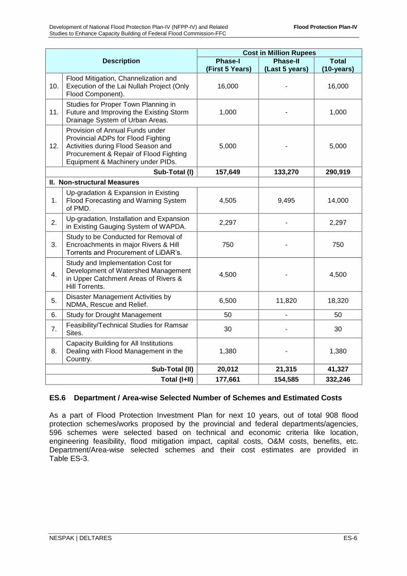
ES.5 Category-wise Investment Plan for Next 10-Years; 2015-2025 Flood Protection Investment Plan has been prepared in detail, keeping in view the needs/requirements, with respect to flood protection, of four (4) provinces, FATA, Gilgit-Baltistan, Azad Jammu and Kashmir and various departments/organizations of the country. The total cost of next 10 years Flood Protection Plan is proposed to be Rs. 332,246 million with Rs. 290,919 million for structural measures and Rs. 41,327 million for non-structural measures. A category-wise summary is presented in Table ES-2.
Table ES-2: Category-wise Summary of Cost for Structural and Non-structural
Measures
Description
Cost in Million Rupees
Phase-I (First 5 Years)
Phase-II (Last 5 years)
Total (10-years)
I. Structural Measures
1. Construction of Proposed Flood Protection Works.
91,743 102,944 194,687
2. Flood Management Structures Across Hill Torrents and Flood Generating Nullahs.
26,371 30,326 56,697
3. Feasibility & Detailed Design Studies of Barrages and Hydraulic Structures.
1,500 - 1,500
4. Master Planning, Feasibility Studies, and Detailed Designing Studies.
3,000 - 3,000
5.
Physical Hydraulic Model Study for Major Railway Bridges and Improvements of Existing Flood Protection Facilities of Pakistan Railway.
450 - 450
6. Physical Hydraulic Model Study for Selected Reaches of Major Rivers.
200 - 200
7. Measures for GLOFs & Land Sliding in Hilly Areas.
1,000 - 1,000
8. Remodeling & Proper Maintenance of Drainage System.
9,763 - 9,763
9. Coastal Flood Protection Works. 1,622 - 1,622
Development of National Flood Protection Plan-IV (NFPP-IV) and Related Flood Protection Plan-IV
Studies to Enhance Capacity Building of Federal Flood Commission-FFC
NESPAK | DELTARES ES-6
Description
Cost in Million Rupees
Phase-I (First 5 Years)
Phase-II (Last 5 years)
Total (10-years)
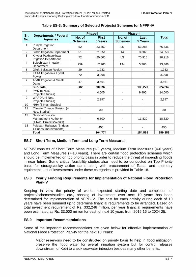
10. Flood Mitigation, Channelization and Execution of the Lai Nullah Project (Only Flood Component).
16,000 - 16,000
11. Studies for Proper Town Planning in Future and Improving the Existing Storm Drainage System of Urban Areas.
1,000 - 1,000
12.
Provision of Annual Funds under Provincial ADPs for Flood Fighting Activities during Flood Season and Procurement & Repair of Flood Fighting Equipment & Machinery under PIDs.
5,000 - 5,000
Sub-TotaI (I) 157,649 133,270 290,919
II. Non-structural Measures
1. Up-gradation & Expansion in Existing Flood Forecasting and Warning System of PMD.
4,505 9,495 14,000
2. Up-gradation, Installation and Expansion in Existing Gauging System of WAPDA.
2,297 - 2,297
3. Study to be Conducted for Removal of Encroachments in major Rivers & Hill Torrents and Procurement of LiDAR’s.
750 - 750
4.
Study and Implementation Cost for Development of Watershed Management in Upper Catchment Areas of Rivers & Hill Torrents.
4,500 - 4,500
5. Disaster Management Activities by NDMA, Rescue and Relief.
6,500 11,820 18,320
6. Study for Drought Management 50 - 50
7. Feasibility/Technical Studies for Ramsar Sites.
30 - 30
8. Capacity Building for All Institutions Dealing with Flood Management in the Country.
1,380 - 1,380
Sub-Total (II) 20,012 21,315 41,327
Total (I+II) 177,661 154,585 332,246
ES.6 Department / Area-wise Selected Number of Schemes and Estimated Costs As a part of Flood Protection Investment Plan for next 10 years, out of total 908 flood protection schemes/works proposed by the provincial and federal departments/agencies, 596 schemes were selected based on technical and economic criteria like location, engineering feasibility, flood mitigation impact, capital costs, O&M costs, benefits, etc. Department/Area-wise selected schemes and their cost estimates are provided in Table ES-3.
Development of National Flood Protection Plan-IV (NFPP-IV) and Related Flood Protection Plan-IV
Studies to Enhance Capacity Building of Federal Flood Commission-FFC
NESPAK | DELTARES ES-7
Table ES-3: Summary of Selected Projects/ Schemes for NFPP-IV
Sr. No.
Departments / Federal Agencies
Phase-I Phase-II Total No. of
Schemes First
5 Years No. of
Schemes Last
5 Years 1 Punjab Irrigation
Department 52 23,350 LS 53,286 76,636
2 Sindh Irrigation Department 51 21,351 14 3,302 24,653
3 Khyber Pakhtunkhwa Irrigation Department
72 20,000 LS 70,916 90,916
4 Balochistan Irrigation Department
259 17,700 134 5,766 23,466
5 Gilgit-Baltistan Region 29 1,932 - - 1,932
6 FATA Irrigation & Hydel Power
72 3,098 - - 3,098
7 AJ&K Irrigation & Small Dams
47 3,561 - - 3,561
Sub-Total 582 90,992 133,270 224,262
8 PMD (6 Nos. Projects/Studies)
- 4,505 - 9,495 14,000
9 WAPDA (6 Nos. Projects/Studies)
- 2,297 - - 2,297
10 NHA (8 Nos. Studies) - - - - -
11 Climate Change Division (4 Nos. Studies)
- 30 - - 30
12 National Disaster Management Authority (4 Nos. Projects/Works)
- 6,500 - 11,820 18,320
13 Pakistan Railways (Bridges + Bunds Improvements)
- 450 - - 450
Total 104,774 154,585 259,359
ES.7 Short Term, Medium Term and Long Term Measures NFP-IV consists of Short Term Measures (1-3 years), Medium Term Measures (4-6 years) and Long Term Measures (7-10 years). There are certain flood protection schemes which should be implemented on top priority basis in order to reduce the threat of impending floods in near future. Some critical feasibility studies also need to be conducted on Top Priority basis for storage/delay action dams along with procurement of Radar and telemetry equipment. List of investments under these categories is provided in Table 18. ES.8 Yearly Funding Requirements for Implementation of National Flood Protection
Plan-IV Keeping in view the priority of works, expected starting date and completion of projects/schemes/studies etc., phasing of investment over next 10 years has been determined for implementation of NFPP-IV. The cost for each activity during each of 10 years have been summed up to determine financial requirements to be arranged. Based on total investment requirement of Rs. 332,246 million, per year financial requirements have been estimated as Rs. 33,000 million for each of next 10 years from 2015-16 to 2024-25. ES.9 Important Recommendations
Some of the important recommendations are given below for effective implementation of National Flood Protection Plan-IV for the next 10 Years:
i. Major reservoirs need to be constructed on priority basis to help in flood mitigation, preserve the flood water for overall irrigation system but for control releases downstream of Kotri to check seawater intrusion besides many other benefits.
Development of National Flood Protection Plan-IV (NFPP-IV) and Related Flood Protection Plan-IV
Studies to Enhance Capacity Building of Federal Flood Commission-FFC
NESPAK | DELTARES ES-8
ii. Existing reservoir Standing Operating Procedures (Revised in 2015 by FFC) for major reservoir to be implemented to ensure efficient control of floods in order to provide maximum relief to downstream areas.
iii. Rehabilitation and enhancement of flood passing capacity of barrages and bridges needs special attention for their immediate execution.
iv. Adequate conveyance capacity within the river and urban channels needs to be restored by removing bottle necks and encroachments.
v. Analysis indicate that small dams have substantial potential in mitigating flood peaks from their respective catchments. It is recommended to consider construction of various small dams in KP, AJ&K, Punjab and Balochistan for cumulative impact on flood mitigation from flash flooding. The pre-feasibility/feasibility studies on these dams may be taken-up by the provincial governments from their own resources.
vi. Flood Early Warning System needs to be up-graded on immediate basis for inclusion of catchment area upstream of Tarbela dam, updating of existing river and floodplain geometry, study on Radar calibrations, enhancement in reliability of Quantitative Precipitation Forecast (QPF) through meteorological studies and training of PMD professionals. Reliable and accurate QPF estimate can enhance lead times for forecast of flash floods.
vii. Expansion and up-gradation of existing gauging network, Radar network, telemetry network under PMD and WAPDA should be undertaken.
viii. Repairing, strengthening and up-gradation of existing flood protection works need to be carried out on immediate basis through provincial resources to protect the population and infrastructure against flood threat. Operation and Maintenance (O&M) of existing flood infrastructure is a key issue which is sole responsibility of provinces. It is highly recommended that provinces take concrete steps towards O&M by providing adequate and timely resources. Water charges may be enhanced initially to at least Rs. 1,500 per acre (as recommended by Friends of Democratic Pakistan (FoDP) assembled after 2010 floods), yielding an annual revenue of Rs. 33 billion for 22 million acres of Punjab alone.
ix. Conduct comprehensive studies for all existing breaching sections to ascertain their effectiveness and possible flow paths, flow depths, velocities and inundation extents of breach flood flows.
x. Formulate and implement watershed management policy for re-forestation, soil conservation and improvement in land use in the watersheds and carry out necessary legislation at national level as well as provincial level.
xi. ‘River Act’ for the rivers floodplains has been formulated during current NFPP-IV studies keeping relevant stakeholders on board and there is strong need to implement the ‘River Act’ in its real sense and spirit for removing encroachments, permanent settlements and undue developments in the floodplains so that flood damages can be reduced.
xii. Provinces, NDMA, PDMAs, DDMAs and district management etc., should play active role through workshops, electronic and print media to create awareness in flood prone communities for preparing them to fight against floods. Awareness campaigns for removal of encroachments and un-planned developments in floodplain areas should be initiated.
Development of National Flood Protection Plan-IV (NFPP-IV) and Related Flood Protection Plan-IV
Studies to Enhance Capacity Building of Federal Flood Commission-FFC
NESPAK | DELTARES ES-9
xiii. Institutional reforms, capacity building and training of FFC, PIDs, NDMA, PDMAs, and other related departments/agencies/organizations is recommended on priority basis.
ES.10 Compliance of CCI Recommendations
The basic objective of NFPP-IV is aimed at improving country-wide comprehensive flood management planning, implementation and monitoring to essentially achieve flood management objectives during next ten (10) years, 2015-16 to 2024-25. An important aspect in development of NFPP-IV is the contribution and consent of all stakeholders (Provinces and Federal Line Agencies) were conducted to share findings of the study. The plan was prepared with category wise breakdown into structural and non-structural measures worked out as;
Structural Measures Rs. 290.919 Billion Non-Structural Measures Rs. 41.327 Billion
Total Rs. 332.246 Billion
After the 18th Amendment, it is necessary for Ministry of Water & Power that NFPP-IV shall be present in the meeting of CCI and get approval for implementation. In the two meetings of CCI forum (held on February 29 & March 25, 2016) the following recommendations were given for NFPP-IV;
A steering Committee will be established to oversee and monitor implementation of
the Plan and provide policy guidelines;
Third party verification will be carried out for all the works in order to ensure
transparency in implementation;
A study will be undertaken to determine suitable interventions for drought
management; and
Entire cost of the plan may be borne by the Federal Government-CCI to decide about
the funding mechanism.
With inclusion of above mentioned recommendations in NFPP-IV, the Honorable Prime Minster of Pakistan recommended to constitute a committee comprising Minister for Water & Power and Minister for Climate Change to consider Provincial reservations before finalization and approval of NFPP-IV.
To proceed with approval process of NFPP-IV, a meeting was held at Ministry of Water & Power, Islamabad on May 4, 2016 attended by high Officials under chairmanship of Honorable Federal Minister for Water and Power to review suggestions of the provincial governments. It was decided that a team will visit provincial capitals for last round of consultative meetings to finalize priority and cost of flood protection schemes for incorporation in NFPP-IV.
The constituted team visited Quetta, Peshawar, Karachi and Lahore during the month of May & June 2016. During the visits, additional number of flood protection schemes was proposed by all provinces plus NDMA & PMD to be included in NFPP-IV. The additional total costs were worked out to be 154.585 billion rupees. This additional cost is also important and therefore, it has been proposed to consider the additional demand raised by the stakeholders in Phase-II of plan implementation as per recommendations of Ministry of Water and Power on February 10, 2017 (details given in Section 6).
Development of National Flood Protection Plan-IV (NFPP-IV) and Related Flood Protection Plan-IV
Studies to Enhance Capacity Building of Federal Flood Commission-FFC
NESPAK | DELTARES 1
NATIONAL FLOOD PROTECTION PLAN-IV (NFPP-IV) 1 INTRODUCTION 1.1 Background The super flood of 2010 in Indus River caused unprecedented damage of US$10 billion2, which is nearly half of the cumulative damage of US$19 billion in the cumulative 64 years period of 1950-2014. This event coupled with successive flood events in 2011, 2012, 2013 & 2014 and equally disastrous flood events globally not only raised the deep concerns about the perceived effects of Global Warming and Climate Change but also exposed the inadequacy and ineffectiveness of traditional approaches alone to control floods, flood management and mitigation of flood damages. This realization has given birth to the idea of an Integrated Flood Management Approach which emphasizes, in addition to structural measures, the use of a broad range of non-structural measures consisting of flood warning, floodplain land use legislation, organizational roles down to local level, flood insurance, community participation etc., with the sole purpose of reduction of flood damages from future unavoidable flood events of greater magnitudes.
Federal Flood Commission (FFC) formulated National Flood Protection Plans (NFPPs) I, II and III in years 1978, 1988 and 1998, respectively in recognition of the impact of floods on the socio-economic conditions and the need for continuous and uninterrupted efforts for solution of the problems. The focus of NFPP-I (1978) and NFPP-II (1988) was on construction of flood protection embankments, bunds, spurs etc., in vulnerable reaches in rivers, cities and locations of key installations and infrastructure. NFPP-III (1998) shifted the focus to non-structural measures which included institutional reforms and strengthening, development of flood protection works, development of flood early warning and floodplain mapping and zoning. In view of huge flood damages of 2010 flood, the focus of NFPP-IV is both on non-structural measures with provision for restoration and maintenance of existing flood protection works. However, key areas where need for new flood protection works are identified have been considered for construction. 1.2 Engagement of Consultants and Main Tasks The formulation of National Flood Protection Plan-IV aims at improving country-wide comprehensive flood management planning, implementation and monitoring to achieve flood management objectives. Ministry of Water and Power, Government, of Pakistan through Federal Flood Commission under WCAP program engaged National Engineering Services of Pakistan in association with Deltares of The Netherlands for ‘Development of National Flood Protection Plan-IV and related Studies to enhance the Capacity Building of Federal Flood Commission. The following four (4) distinct tasks were assigned:
I. Task-A: Development of National Flood Protection Plan -IV (NFPP-IV) and PC-I Develop a National Flood Protection Plan-IV (NFPP-IV) and umbrella PC-I for next 10 years based on integrated and innovative approaches and technical shortcomings and lessons learnt in the past major flood events;
II. Task-B: Development of Inventory of Flood Works, and Benefit Monitoring and Evaluation of Flood Protection Works
2Annual Flood Report, 2014, FFC, Islamabad.
Development of National Flood Protection Plan-IV (NFPP-IV) and Related Flood Protection Plan-IV
Studies to Enhance Capacity Building of Federal Flood Commission-FFC
NESPAK | DELTARES 2
Develop a comprehensive inventory of the existing flood protection infrastructure of all regions of Pakistan (four provinces, Gilgit-Baltistan, FATA & AJ&K) constructed so far through various resources (Federal/ Provincial/Foreign Aided) and carry out benefit monitoring and evaluation of flood protection works, constructed under FPSP-I and II.
III. Task-C: Floodplain Mapping and Zoning Carry out Floodplain Mapping & Zoning along all the Indus River and its major tributaries (Kabul, Swat, Jhelum, Chenab, Ravi & Sutlej) and prepare River Act for restricting/prohibiting permanent settlements in high and medium flood risk areas (Provinces to enact River Act);
IV. Task-D: Automation of Flood Situation Monitoring and Reporting Develop a reliable database/information system to store and retrieve required data and enhance data processing techniques for preparation and dissemination of Flood Reports, as approved by the FFC, among the concerned organizations and design a web interface for effective data sharing with all stakeholders at the federal and provincial levels, including public.
The Consultants commenced their work in June 2013 and submitted Draft reports on Task-A, B and C on January, 2015 and Task-D in February 2015. Thereafter, meetings and detailed discussions were held with WCAP, FFC, PIDs, PMD, WAPDA, NDMA and other stakeholders to obtain suggestions to be incorporated in the National Flood Protection Plan-IV. Subsequently, NFFP-IV and reports on all the four (4) tasks have been revised and are presented in the format comprising the following set of reports:
National Flood Protection Plan-IV (this Report)
Task-A: Development of National Flood Protection Plan-IV (NFPP-IV) and PC-I
Task-B: Development of Inventory of Flood Works, and Benefit Monitoring and Evaluation of Flood Protection Works
Task-C: Floodplain Mapping and Zoning
Task-D: Automation of Flood Situation Monitoring and Reporting
This report ‘National Flood Protection Plan-IV’ is the outcome of Task-A studies and provides a short summary on various issues related to NFPP-IV, financial investment for next 10 years and findings along with recommendations for its effective implementation. The reader can find more details on different topics in the reports on Task-A, Task-B, Task-C and Task-D.
1.3 Flood Mechanics and History of Floods in Pakistan
1.3.1 Flood Mechanics
Pakistan’s major rivers; Indus and its tributaries; Jhelum, Chenab, Ravi and Sutlej rivers originate from the northern mountains of Himalaya, Karakoram, Hindukush and Kashmir ranges and drain one by one into another and finally fall into Indus River creating the Indus River Basin (IRB). Indus River is the twelfth largest river in the world and a major trans-boundary river in Asia.
Physiographic variation results in different types of flooding like flash, riverine, glacial lake outburst, coastal and urban flooding. Northern areas of Pakistan are distinguished by high slopes and elevations associated with Himalayan and Karakorum ranges which lead to flash flooding in foothills and Glacial Lake Outburst Flood (GLOF) in the upper areas. The western extents of Pakistan with Afghanistan and Iran also experience flash flooding due to Suleiman ranges in Potowar Plateau and many other mountain ranges in Balochistan Plateau.
Development of National Flood Protection Plan-IV (NFPP-IV) and Related Flood Protection Plan-IV
Studies to Enhance Capacity Building of Federal Flood Commission-FFC
NESPAK | DELTARES 3
The flood mechanics for different types of floods in country are briefly defined below: Riverine Floods The floods in rivers are generally caused by heavy concentrated rainfall in the upper catchments, during the monsoon season (July through September), which is sometimes augmented by snow melt flows. Monsoon currents originating in the Bay of Bengal and resultant depressions often result in heavy downpour in the Western Himalayan foothills which occasionally produce destructive floods in one or more of the main rivers of the Indus system. The monsoon season is characterized by the occurrence of general south-west monsoon current. A series of tropical depressions develop at the head of the Bay of Bengal and move in a north-westerly direction over northern India and enter Pakistan. The monsoons gain strength until July, remain constant to the end of August, and then begin to slacken. The monsoon-current reaches Pakistan in beginning of July and is well established by the middle of that month. In some years, the monsoon remains active even in September. The Sutlej and Ravi Rivers are the first to be affected and generally receive the heaviest rains in their catchments. The intensity decreases steadily to the north-west along the foot-hills of the Western Himalayas. The upper part of the Indus River basin receives the least contribution from the monsoon rains. Flash Floods in Hill Torrents Flash floods in the hill torrents occur primarily in mountainous, semi-mountainous regions and in adjoining piedmont. It can also be described as sudden severe increase in the flow of river/stream water within short interval of time (6 hours of causative event). There are thirteen (13) major hill torrent areas of Pakistan which are highly vulnerable towards flood damages. Historic flood events due to high intensity rainfall over Kirther and Koh-e-Suleman hill ranges resulted in huge damages. Coastal Floods Weather and tidal conditions can increase sea levels that result in flooding along coastal areas. The cause of such a surge is generally a severe storm or cyclonic activity in Arabian Sea. The storm wind pushes the water up and creates high waves. Winds generated from tropical storms and hurricanes or intense offshore low pressure systems can drive sea water inland and cause significant flooding. The Makran Coast of Balochistan and south-eastern Sindh experienced such coastal floods from tropical cyclones from Arabian Sea.
Urban Floods
Flooding in urban areas can be caused by flash floods, or coastal floods, or river floods, but there is also a specific flood type that is called urban flooding. Urban flooding is specific in the areas that lack drainage of storm water. High intensity rainfall can cause flooding, when the city drainage system does not have the adequate capacity to drain away the runoff generated through concentrated rains. Urban floods are a great disturbance for daily life in the city. During periods of urban flooding, streets can become swift moving rivers, while basements can become death traps as they fill with water. Urban floods are being experienced in Pakistan cities, especially in monsoon season-having high population density (Karachi, Lahore, Faisalabad, Multan, Hyderabad, etc.,) with unplanned, clogged, encroached and undersized drainage systems.
Development of National Flood Protection Plan-IV (NFPP-IV) and Related Flood Protection Plan-IV
Studies to Enhance Capacity Building of Federal Flood Commission-FFC
NESPAK | DELTARES 4
Glacial Lake Outburst Floods Glacier outburst floods may be broadly defined as the sudden release of water stored either within a glacier or dammed by a glacier. Outburst floods have been reported in all glaciated regions of the world and may be triggered by:
- The sudden drainage of an ice-dammed lake below or through an ice dam; - Lake water overflow and rapid fluvial incision of ice, bedrock or sediment barriers
occur; or - The growth and collapse of sub-surface reservoirs.
Due to their high and rapid discharge, the outburst floods originating from high mountain glaciers have devastating impacts on downstream communities. The areas of Gilgit-Baltistan region many times experienced glacier outburst floods. A detail on historic GLOF events is given in Task-A report.
1.3.2 History of Floods
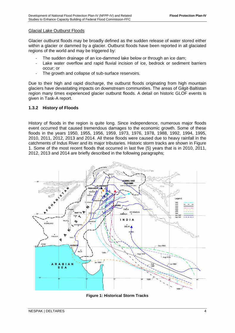
History of floods in the region is quite long. Since independence, numerous major floods event occurred that caused tremendous damages to the economic growth. Some of these floods in the years 1950, 1955, 1956, 1959, 1973, 1976, 1978, 1988, 1992, 1994, 1995, 2010, 2011, 2012, 2013 and 2014. All these floods were caused due to heavy rainfall in the catchments of Indus River and its major tributaries. Historic storm tracks are shown in Figure 1. Some of the most recent floods that occurred in last five (5) years that is in 2010, 2011, 2012, 2013 and 2014 are briefly described in the following paragraphs;
Figure 1: Historical Storm Tracks
Development of National Flood Protection Plan-IV (NFPP-IV) and Related Flood Protection Plan-IV
Studies to Enhance Capacity Building of Federal Flood Commission-FFC
NESPAK | DELTARES 5
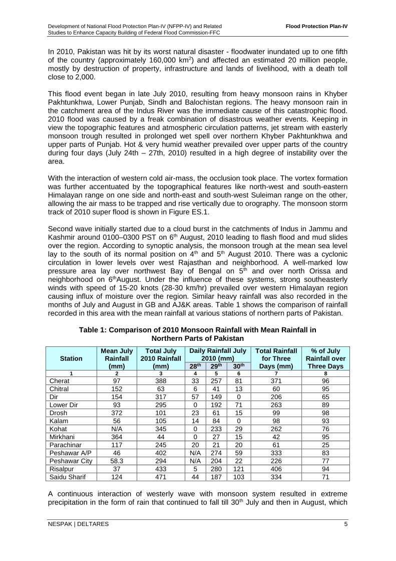
In 2010, Pakistan was hit by its worst natural disaster - floodwater inundated up to one fifth of the country (approximately 160,000 km2) and affected an estimated 20 million people, mostly by destruction of property, infrastructure and lands of livelihood, with a death toll close to 2,000. This flood event began in late July 2010, resulting from heavy monsoon rains in Khyber Pakhtunkhwa, Lower Punjab, Sindh and Balochistan regions. The heavy monsoon rain in the catchment area of the Indus River was the immediate cause of this catastrophic flood. 2010 flood was caused by a freak combination of disastrous weather events. Keeping in view the topographic features and atmospheric circulation patterns, jet stream with easterly monsoon trough resulted in prolonged wet spell over northern Khyber Pakhtunkhwa and upper parts of Punjab. Hot & very humid weather prevailed over upper parts of the country during four days (July 24th – 27th, 2010) resulted in a high degree of instability over the area. With the interaction of western cold air-mass, the occlusion took place. The vortex formation was further accentuated by the topographical features like north-west and south-eastern Himalayan range on one side and north-east and south-west Suleiman range on the other, allowing the air mass to be trapped and rise vertically due to orography. The monsoon storm track of 2010 super flood is shown in Figure ES.1. Second wave initially started due to a cloud burst in the catchments of Indus in Jammu and Kashmir around 0100–0300 PST on 6th August, 2010 leading to flash flood and mud slides over the region. According to synoptic analysis, the monsoon trough at the mean sea level lay to the south of its normal position on 4th and 5th August 2010. There was a cyclonic circulation in lower levels over west Rajasthan and neighborhood. A well-marked low pressure area lay over northwest Bay of Bengal on 5th and over north Orissa and neighborhood on 6thAugust. Under the influence of these systems, strong southeasterly winds with speed of 15-20 knots (28-30 km/hr) prevailed over western Himalayan region causing influx of moisture over the region. Similar heavy rainfall was also recorded in the months of July and August in GB and AJ&K areas. Table 1 shows the comparison of rainfall recorded in this area with the mean rainfall at various stations of northern parts of Pakistan.
Table 1: Comparison of 2010 Monsoon Rainfall with Mean Rainfall in Northern Parts of Pakistan
Station Mean July
Rainfall (mm)
Total July 2010 Rainfall
(mm)
Daily Rainfall July 2010 (mm)
Total Rainfall for Three
Days (mm)
% of July Rainfall over Three Days 28th 29th 30th
1 2 3 4 5 6 7 8
Cherat 97 388 33 257 81 371 96
Chitral 152 63 6 41 13 60 95
Dir 154 317 57 149 0 206 65
Lower Dir 93 295 0 192 71 263 89
Drosh 372 101 23 61 15 99 98
Kalam 56 105 14 84 0 98 93
Kohat N/A 345 0 233 29 262 76
Mirkhani 364 44 0 27 15 42 95
Parachinar 117 245 20 21 20 61 25
Peshawar A/P 46 402 N/A 274 59 333 83
Peshawar City 58.3 294 N/A 204 22 226 77
Risalpur 37 433 5 280 121 406 94
Saidu Sharif 124 471 44 187 103 334 71
A continuous interaction of westerly wave with monsoon system resulted in extreme precipitation in the form of rain that continued to fall till 30th July and then in August, which
Development of National Flood Protection Plan-IV (NFPP-IV) and Related Flood Protection Plan-IV
Studies to Enhance Capacity Building of Federal Flood Commission-FFC
NESPAK | DELTARES 6
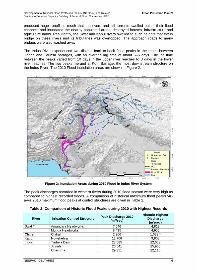
produced huge runoff so much that the rivers and hill torrents swelled out of their flood channels and inundated the nearby populated areas, destroyed houses, infrastructure and agriculture lands. Resultantly, the Swat and Kabul rivers swelled to such heights that every bridge on these rivers and its tributaries was overtopped. The approach roads to many bridges were also washed away. The Indus River experienced two distinct back-to-back flood peaks in the reach between Jinnah and Taunsa barrages, with an average lag time of about 5–6 days. The lag time between the peaks varied from 10 days in the upper river reaches to 3 days in the lower river reaches. The two peaks merged at Kotri Barrage, the most downstream structure on the Indus River. The 2010 Flood inundation areas are shown in Figure 2.
Figure 2: Inundation Areas during 2010 Flood in Indus River System
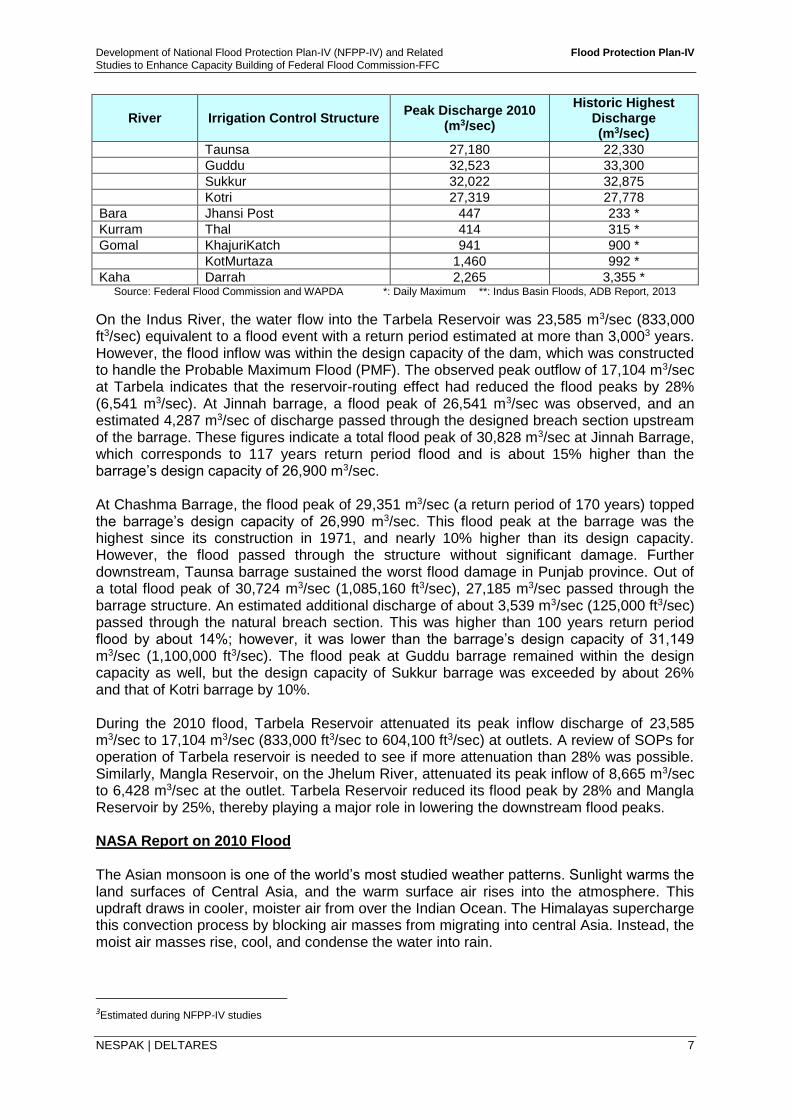
The peak discharges recorded in western rivers during 2010 flood season were very high as compared to highest recorded floods. A comparison of historical maximum flood peaks viz-a-viz 2010 maximum flood peaks at control structures are given in Table 2.
Table 2: Comparison of Historic Flood Peaks during 2010 with Highest Records
River Irrigation Control Structure Peak Discharge 2010
(m3/sec)
Historic Highest Discharge (m3/sec)
Swat ** Amandara Headworks 7,646 4,813
Munda Headworks 8,495 4,955
Chitral Chitral 2,266 1,633 *
Kabul Nowshehra 12,708 9,808
Indus Tarbela Dam 23,585 22,653
Jinnah 26,541 25,966
Chashma 29,351 22,115
Development of National Flood Protection Plan-IV (NFPP-IV) and Related Flood Protection Plan-IV
Studies to Enhance Capacity Building of Federal Flood Commission-FFC
NESPAK | DELTARES 7
River Irrigation Control Structure Peak Discharge 2010
(m3/sec)
Historic Highest Discharge (m3/sec)
Taunsa 27,180 22,330
Guddu 32,523 33,300
Sukkur 32,022 32,875
Kotri 27,319 27,778
Bara Jhansi Post 447 233 *
Kurram Thal 414 315 *
Gomal KhajuriKatch 941 900 *
KotMurtaza 1,460 992 *
Kaha Darrah 2,265 3,355 * Source: Federal Flood Commission and WAPDA *: Daily Maximum **: Indus Basin Floods, ADB Report, 2013
On the Indus River, the water flow into the Tarbela Reservoir was 23,585 m3/sec (833,000 ft3/sec) equivalent to a flood event with a return period estimated at more than 3,0003 years. However, the flood inflow was within the design capacity of the dam, which was constructed to handle the Probable Maximum Flood (PMF). The observed peak outflow of 17,104 m3/sec at Tarbela indicates that the reservoir-routing effect had reduced the flood peaks by 28% (6,541 m3/sec). At Jinnah barrage, a flood peak of 26,541 m3/sec was observed, and an estimated 4,287 m3/sec of discharge passed through the designed breach section upstream of the barrage. These figures indicate a total flood peak of 30,828 m3/sec at Jinnah Barrage, which corresponds to 117 years return period flood and is about 15% higher than the barrage’s design capacity of 26,900 m3/sec. At Chashma Barrage, the flood peak of 29,351 m3/sec (a return period of 170 years) topped the barrage’s design capacity of 26,990 m3/sec. This flood peak at the barrage was the highest since its construction in 1971, and nearly 10% higher than its design capacity. However, the flood passed through the structure without significant damage. Further downstream, Taunsa barrage sustained the worst flood damage in Punjab province. Out of a total flood peak of 30,724 m3/sec (1,085,160 ft3/sec), 27,185 m3/sec passed through the barrage structure. An estimated additional discharge of about 3,539 m3/sec (125,000 ft3/sec) passed through the natural breach section. This was higher than 100 years return period flood by about 14%; however, it was lower than the barrage’s design capacity of 31,149 m3/sec (1,100,000 ft3/sec). The flood peak at Guddu barrage remained within the design capacity as well, but the design capacity of Sukkur barrage was exceeded by about 26% and that of Kotri barrage by 10%. During the 2010 flood, Tarbela Reservoir attenuated its peak inflow discharge of 23,585 m3/sec to 17,104 m3/sec (833,000 ft3/sec to 604,100 ft3/sec) at outlets. A review of SOPs for operation of Tarbela reservoir is needed to see if more attenuation than 28% was possible. Similarly, Mangla Reservoir, on the Jhelum River, attenuated its peak inflow of 8,665 m3/sec to 6,428 m3/sec at the outlet. Tarbela Reservoir reduced its flood peak by 28% and Mangla Reservoir by 25%, thereby playing a major role in lowering the downstream flood peaks. NASA Report on 2010 Flood The Asian monsoon is one of the world’s most studied weather patterns. Sunlight warms the land surfaces of Central Asia, and the warm surface air rises into the atmosphere. This updraft draws in cooler, moister air from over the Indian Ocean. The Himalayas supercharge this convection process by blocking air masses from migrating into central Asia. Instead, the moist air masses rise, cool, and condense the water into rain.
3Estimated during NFPP-IV studies
Development of National Flood Protection Plan-IV (NFPP-IV) and Related Flood Protection Plan-IV
Studies to Enhance Capacity Building of Federal Flood Commission-FFC
NESPAK | DELTARES 8
In 2010, this pattern went awry over Pakistan. Over and over again, the rainstorms dwarfed the heaviest rainfall events from the previous, more typical summer. July rainfall in Peshawar, for instance, was up 772 percent from normal, according to the Pakistan Meteorological Department. August rainfall in Khanpur was up 1,483 percent. The relentless rain had a handful of causes. For one, the global La Niñaevent—which drenched Australia and other Pacific and Indian Ocean locations in late 2010 and early 2011—actually started around the time of the 2010 monsoon. La Niña warms both water and air masses, increasing the amount of moisture that can be carried in the atmosphere. While La Niña increased the chance of rain events, it did not necessarily increase the intensity and unusual persistence. Instead, some meteorologists speculated in late 2010 that the jet stream might have set the stage for floods in Pakistan, as well as the summer of drought and fire in Russia. Some noted in science meetings that the jet stream had taken on an unusual pattern, stretching down over the Eurasian continent and stagnating the weather patterns. In a subsequent study (in press) using NASA satellite data, scientists William Lau and Kyu-Myong Kim of NASA’s Goddard Space Flight Center found a connection between the wildfires and floods. The Russian heat wave and wildfires were associated with a large-scale, stagnant weather pattern in the atmosphere—known as a blocking event—that prevented the normal movement of weather systems from west to east. Hot, dry air masses became trapped over large parts of Russia. The blocking also created unusual downstream vortices and wind patterns. Clockwise atmospheric circulation near the surface brought cold, dry Siberian air into the subtropics, where it clashed with the warm, moist air being transported northward with the monsoon flow. The result was torrential rain in northern Pakistan. Although the heat wave started before the floods, both events attained maximum strength at approximately the same time. Lau’s team concluded that Pakistan’s floods were triggered by the southward penetration of upper level disturbances from the atmospheric blocking, and amplified by heating and monsoon moisture from the Bay of Bengal. La Niña conditions made the tropics more receptive by providing abundant moisture. NASA Report highlights the unusual weather patterns that cause extreme storm events giving rise to concerns about climate change and its global impact. 2011 Flood The flood of 2011 occurred during the monsoon season in mid-August mainly in Sindh, surrounding areas of Balochistan and Punjab. The extraordinary rain event caused colossal damages to human settlements, infrastructure and agricultural lands. In July 2011, precipitation remained below normal monsoon; however, from August 2011 to September 2011 the rainfall significantly exceeded the monsoon historic norms. A heavy rain occurred over the areas of Sindh across the Indian Territory and continued for three weeks in spells. This continuous rainfall over flat areas resulted in abnormal water depths and inundated a large area away from the Indus left bank stretching from Shaheed Benazirabad (Nawabshah) to coastal areas. An important damaging factor was the long duration of ponded un-drained water due to restricted drainage of the area. Runoff generated from continuous rain spells was ten times more than the drainage capacity of Left Bank Outfall Drain (LBOD) and Kotri drainage systems in Sindh that resulted in overflow of drains and flooding of area outside the drain system.
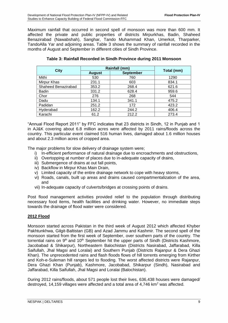
Development of National Flood Protection Plan-IV (NFPP-IV) and Related Flood Protection Plan-IV
Studies to Enhance Capacity Building of Federal Flood Commission-FFC
NESPAK | DELTARES 9
Maximum rainfall that occurred in second spell of monsoon was more than 600 mm. It affected the private and public properties of districts Mirpurkhas, Badin, Shaheed Benazirabad (Nawabshah), Sanghar, Tando Muhammad Khan, Umerkot, Tharparker, TandoAlla Yar and adjoining areas. Table 3 shows the summary of rainfall recorded in the months of August and September in different cities of Sindh Province.
Table 3: Rainfall Recorded in Sindh Province during 2011 Monsoon
City Rainfall (mm)
Total (mm) August September
Mithi 530 760 1290
Mirpur Khas 231.1 603 834.1
Shaheed Benazirabad 353.2 268.4 621.6
Badin 331.2 628.4 959.6
Chor 276 268 544
Dadu 134.1 341.1 475.2
Padidan 251.2 172 423.2
Hyderabad 162.2 244.2 406.4
Karachi 61.2 212.2 273.4
“Annual Flood Report 2011” by FFC indicates that 23 districts in Sindh, 12 in Punjab and 1 in AJ&K covering about 6.8 million acres were affected by 2011 rains/floods across the country. This particular event claimed 516 human lives, damaged about 1.6 million houses and about 2.3 million acres of cropped area. The major problems for slow delivery of drainage system were;
i) In-efficient performance of natural drainage due to encroachments and obstructions, ii) Overtopping at number of places due to in-adequate capacity of drains, iii) Submergence of drains at out fall points, iv) Backflow in Mirpur Khas Main Drain, v) Limited capacity of the entire drainage network to cope with heavy storms, vi) Roads, canals, built up areas and drains caused compartmentalization of the area,
and vii) In-adequate capacity of culverts/bridges at crossing points of drains.
Post flood management activities provided relief to the population through distributing necessary food items, health facilities and drinking water. However, no immediate steps towards the drainage of flood water were considered. 2012 Flood Monsoon started across Pakistan in the third week of August 2012 which affected Khyber Pakhtunkhwa, Gilgit-Baltistan (GB) and Azad Jammu and Kashmir. The second spell of the monsoon started from the first week of September, over southern parts of the country. The torrential rains on 9th and 10th September hit the upper parts of Sindh (Districts Kashmore, Jacobabad & Shikarpur), Northeastern Balochistan (Districts Nasirabad, Jaffarabad, Killa Saifullah, Jhal Magsi and Loralai) and Southern Punjab (Districts Rajanpur & Dera Ghazi Khan). The unprecedented rains and flash floods flows of hill torrents emerging from Kirther and Koh-e-Suleman hill ranges led to flooding. The worst affected districts were Rajanpur, Dera Ghazi Khan (Punjab), Kashmore, Jacobabad, Shikarpur (Sindh), Nasirabad and Jaffarabad, Killa Saifullah, Jhal Magsi and Loralai (Balochistan). During 2012 rains/floods, about 571 people lost their lives, 636,438 houses were damaged/ destroyed, 14,159 villages were affected and a total area of 4,746 km2 was affected.
Development of National Flood Protection Plan-IV (NFPP-IV) and Related Flood Protection Plan-IV
Studies to Enhance Capacity Building of Federal Flood Commission-FFC
NESPAK | DELTARES 10
2013 Flood The monsoon remained comparatively more active during the month of August 2013. Overall, five rain spells of heavy to very heavy intensity were experienced during the month of August. As a consequence of heavy rains in catchment areas, River Chenab attained very high stage at Marala, Khanki & Qadirabad barrages. Flood flow levels in other main rivers also increased. Indus River at Chashma, Kabul River at Nowshera and Jhelum River at Mangla (upstream) also attained high flood stage during that period. The rains/floods during 2013 affected cropped area of about 1.107 million acres affecting 8,297 villages, claimed about 333 lives, fully damaged 33,763 houses and partially damaged 46,180 houses. Population of about 1.489 million was also affected. 2014 Flood In September 2014, the monsoonal low across northern India and Pakistan produced extreme amounts of rainfall in 48 hours, causing deadly floods in both countries. The Kashmir region witnessed disastrous floods across majority of its districts caused by torrential rainfall. The Indian occupied Jammu and Kashmir, as well as Azad Kashmir, Gilgit-Baltistan and Punjab in Pakistan, were affected by these floods. By September 24, 2014, 3674people in Pakistan had died due to the floods.
The strongest post monsoon storm took place in Pakistan's recorded history when on 3rd of September a very low pressure system developed in parts of Jammu and Kashmir and north-east districts of Sialkot, Lahore, Kasur, Okara, Gujrat, Gujranwala, Jhelum. By the 4th of September, the rains became more widespread in the northern Punjab, Azad Kashmir and Khyber Pakhtunkhwa including the twin cities of Rawalpindi and Islamabad, Mangla, Rawalakot, Kotli and Jhelum. The heaviest amounts of rainfall however were recorded on 4th
and 5th of September as several weather stations broke their 24 hour, 48 hour and total monthly rainfall records for the month of September.
The total amount of rainfall recorded between 3rd and 5th of September at various locations is as under:
Rawalakot, Azad Kashmir – 464mm Kotli, Azad Kashmir – 410mm Lahore: Airport – 498mm, Shahi Qila – 466mm, Misri Shah – 453mm, Shahdara
Upper Mall – 389mm, Jail Road – 379mm Sialkot: Cantt – 471mm, Airport – 346mm Rawalpindi: Islamabad Airport – 336mm, Shamsabad – 311mm, Bokra – 208mm Gujranwala: 286mm Kasur: 280mm Islamabad: (Zero Point) – 274mm, Saidpur – 268mm, Golra Sharif – 209mm Okara: 257mm Gujrat: 231mm Murree: 204mm Jhelum: 202mm
Based on the lessons learnt from the previous floods, Flood Forecasting Division of PMD made better predictions this time. A comparison of forecasts and actual observed peaks on Jhelum and Chenab Rivers is presented in Figure 3.
4Source NDMA web retrieved on 21-10-2014 and Seminar on Flood event 2014
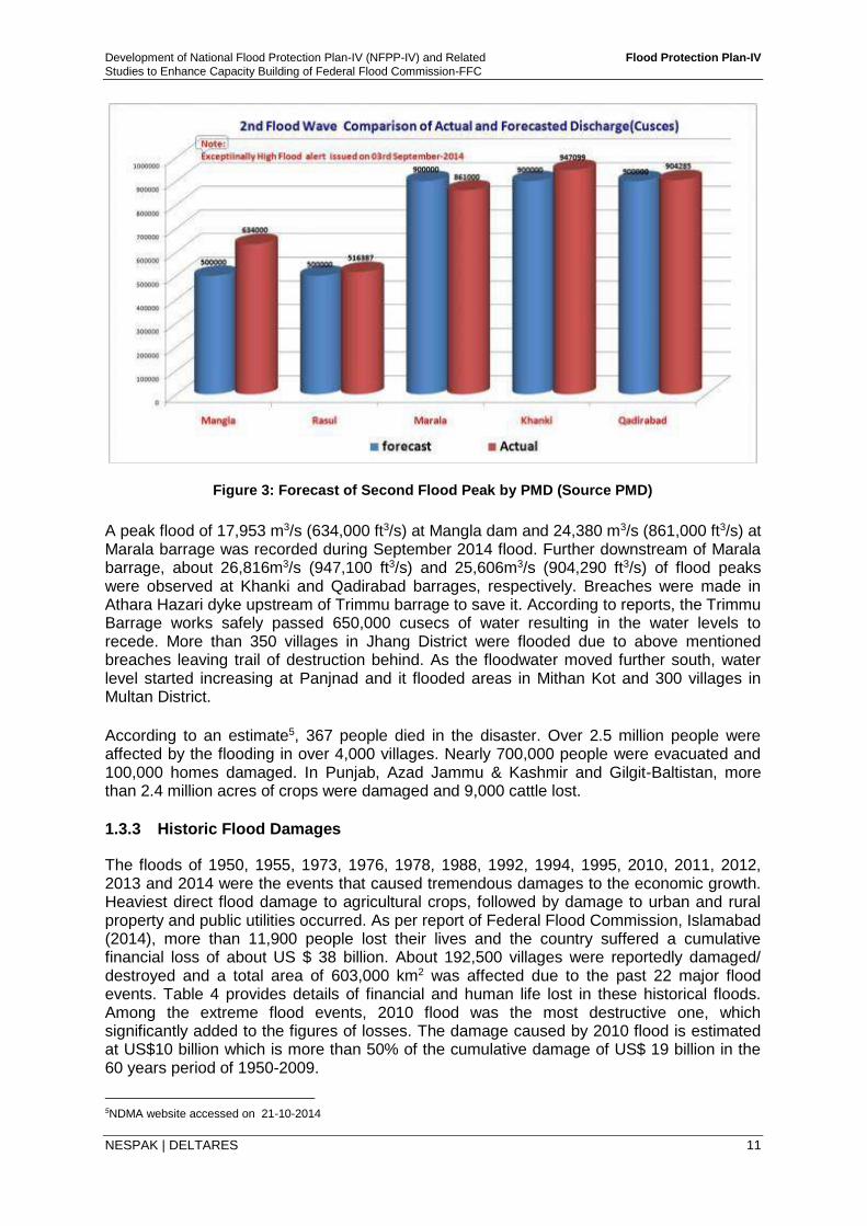
Development of National Flood Protection Plan-IV (NFPP-IV) and Related Flood Protection Plan-IV
Studies to Enhance Capacity Building of Federal Flood Commission-FFC
NESPAK | DELTARES 11
Figure 3: Forecast of Second Flood Peak by PMD (Source PMD)
A peak flood of 17,953 m3/s (634,000 ft3/s) at Mangla dam and 24,380 m3/s (861,000 ft3/s) at Marala barrage was recorded during September 2014 flood. Further downstream of Marala barrage, about 26,816m3/s (947,100 ft3/s) and 25,606m3/s (904,290 ft3/s) of flood peaks were observed at Khanki and Qadirabad barrages, respectively. Breaches were made in Athara Hazari dyke upstream of Trimmu barrage to save it. According to reports, the Trimmu Barrage works safely passed 650,000 cusecs of water resulting in the water levels to recede. More than 350 villages in Jhang District were flooded due to above mentioned breaches leaving trail of destruction behind. As the floodwater moved further south, water level started increasing at Panjnad and it flooded areas in Mithan Kot and 300 villages in Multan District.
According to an estimate5, 367 people died in the disaster. Over 2.5 million people were affected by the flooding in over 4,000 villages. Nearly 700,000 people were evacuated and 100,000 homes damaged. In Punjab, Azad Jammu & Kashmir and Gilgit-Baltistan, more than 2.4 million acres of crops were damaged and 9,000 cattle lost.
1.3.3 Historic Flood Damages
The floods of 1950, 1955, 1973, 1976, 1978, 1988, 1992, 1994, 1995, 2010, 2011, 2012, 2013 and 2014 were the events that caused tremendous damages to the economic growth. Heaviest direct flood damage to agricultural crops, followed by damage to urban and rural property and public utilities occurred. As per report of Federal Flood Commission, Islamabad (2014), more than 11,900 people lost their lives and the country suffered a cumulative financial loss of about US $ 38 billion. About 192,500 villages were reportedly damaged/ destroyed and a total area of 603,000 km2 was affected due to the past 22 major flood events. Table 4 provides details of financial and human life lost in these historical floods. Among the extreme flood events, 2010 flood was the most destructive one, which significantly added to the figures of losses. The damage caused by 2010 flood is estimated at US$10 billion which is more than 50% of the cumulative damage of US$ 19 billion in the 60 years period of 1950-2009.
5NDMA website accessed on 21-10-2014
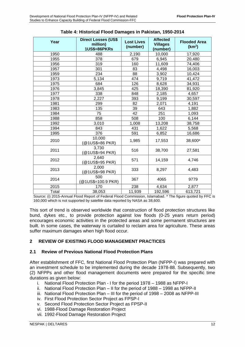
Development of National Flood Protection Plan-IV (NFPP-IV) and Related Flood Protection Plan-IV
Studies to Enhance Capacity Building of Federal Flood Commission-FFC
NESPAK | DELTARES 12
Table 4: Historical Flood Damages in Pakistan, 1950-2014
Year
Direct Losses (US$ million)
1US$=86PKRs
Lost Lives (number)
Affected Villages (number)
Flooded Area (km2)
1950 488 2,190 10,000 17,920
1955 378 679 6,945 20,480
1956 319 160 11,609 74,406
1957 301 83 4,498 16,003
1959 234 88 3,902 10,424
1973 5,134 474 9,719 41,472
1975 684 126 8,628 34,931
1976 3,845 425 18,390 81,920
1977 338 848 2,185 4,657
1978 2,227 393 9,199 30,597
1981 299 82 2,071 4,191
1983 135 39 643 1,882
1984 75 42 251 1,093
1988 858 508 100 6,144
1992 3,010 1,008 13,208 38,758
1994 843 431 1,622 5,568
1995 376 591 6,852 16,686
2010 10,000
(@1US$=86 PKR) 1,985 17,553 38,600a
2011 3,730
(@1US$=94 PKR) 516 38,700 27,581
2012 2,640
(@1US$=95 PKR) 571 14,159 4,746
2013 2,000
(@1US$=98 PKR) 333 8,297 4,483
2014 500
(@1US$=100.9 PKR) 367 4065 9779
2015 170 238 4,634 2,877
Total 38,053 11,939 192,596 613,721 Source: (i) 2015-Annual Flood Report of Federal Flood Commission, Islamabad. a The figure quoted by FFC is 160,000 which is not supported by satellite data reported by NASA as 38,600.
This sort of trend is observed worldwide that construction of flood protection structures like bund, dykes etc., to provide protection against low floods (0-25 years return period) encourages economic activities in the protected areas and some permanent structures are built. In some cases, the waterway is curtailed to reclaim area for agriculture. These areas suffer maximum damages when high flood occur. 2 REVIEW OF EXISTING FLOOD MANAGEMENT PRACTICES 2.1 Review of Previous National Flood Protection Plans After establishment of FFC, first National Flood Protection Plan (NFPP-I) was prepared with an investment schedule to be implemented during the decade 1978-88. Subsequently, two (2) NFPPs and other flood management documents were prepared for the specific time durations as given below:
i. National Flood Protection Plan - I for the period 1978 – 1988 as NFPP-I ii. National Flood Protection Plan – II for the period of 1988 – 1998 as NFPP-II iii. National Flood Protection Plan – III for the period of 1998 – 2008 as NFPP-III iv. First Flood Protection Sector Project as FPSP-I v. Second Flood Protection Sector Project as FPSP-II vi. 1988-Flood Damage Restoration Project vii. 1992-Flood Damage Restoration Project
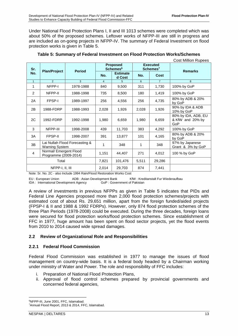
Development of National Flood Protection Plan-IV (NFPP-IV) and Related Flood Protection Plan-IV
Studies to Enhance Capacity Building of Federal Flood Commission-FFC
NESPAK | DELTARES 13
Under National Flood Protection Plans I, II and III 1013 schemes were completed which was about 50% of the proposed schemes. Leftover works of NFPP-III are still in progress and are included as on-going projects in NFPP-IV. The summary of Federal Investment on flood protection works is given in Table 5.
Table 5: Summary of Federal Investment on Flood Protection Works/Schemes
Cost Million Rupees
Sr. No.
Plan/Project Period
Proposed Schemes6
Executed Schemes7
Remarks
No. Estimated Cost
No. Cost
1 2 3 4 5 6 7 8
1 NFPP-I 1978-1988 840 9,500 311 1,730 100% by GoP
2 NFPP-II 1988-1998 735 8,500 180 1,419 100% by GoP
2A FPSP-I 1989-1997 256 4,556 256 4,735 80% by ADB & 20% by GoP
2B 1988-FDRP 1988-1993 2,028 1,926 2,028 1,926 90% by IDA & ADB 10% by GoP
2C 1992-FDRP 1992-1998 1,980 6,659 1,980 6,659 80% by IDA, ADB, EU & KfW and 20% by GoP
3 NFPP-III 1998-2008 439 11,703 383 4,292 100% by GoP
3A FPSP-II 1998-2007 391 13,877 101 4,165 80% by ADB & 20% by GoP
3B Lai Nullah Flood Forecasting & Warning System
1 348 1 348 97% by Japanese Grant & 3% by GoP
4 Normal/ Emergent Flood Programme (2009-2014)
1,151 44,407 271 4,012 100 % by GoP
Total 7,821 101,476 5,511 29,286
NFPP-I, II, III 2,014 29,703 874 7,441
Note: Sr. No. 2C - also Include 1994 Rain/Flood Restoration Works Cost EU : European Union ADB : Asian Development Bank KfW : Kreditanstalt Fur Wiederaufbau IDA : International Development Agency GoP : Government of Pakistan
A review of investments in previous NFPPs as given in Table 5 indicates that PIDs and Federal Line Agencies proposed more than 2,000 flood protection schemes/projects with estimated cost of about Rs. 29,651 million, apart from the foreign funded/aided projects (FPSP-I & II and 1988 & 1992 FDRPs). However, only 874 flood protection schemes of the three Plan Periods (1978-2008) could be executed. During the three decades, foreign loans were secured for flood protection works/flood protection schemes. Since establishment of FFC in 1977, huge amount has been spent on flood sector projects, yet the flood events from 2010 to 2014 caused wide spread damages. 2.2 Review of Organizational Role and Responsibilities 2.2.1 Federal Flood Commission
Federal Flood Commission was established in 1977 to manage the issues of flood management on country-wide basis. It is a federal body headed by a Chairman working under ministry of Water and Power. The role and responsibility of FFC includes:
i. Preparation of National Flood Protection Plans, ii. Approval of flood control schemes prepared by provincial governments and
concerned federal agencies,
6NFPP-III, June 2001, FFC, Islamabad. 7Annual Flood Report, 2013 & 2014, FFC, Islamabad.
Development of National Flood Protection Plan-IV (NFPP-IV) and Related Flood Protection Plan-IV
Studies to Enhance Capacity Building of Federal Flood Commission-FFC
NESPAK | DELTARES 14
iii. Review of flood damages to flood protection infrastructure and review of plans for restoration and reconstruction works,
iv. Measures for improvements in Flood Forecasting and Warning System (FEWS), v. Standardization of designs and specifications for flood protection works, vi. Evaluation and monitoring relating to progress of implementation of National Flood
Protection Plans, vii. Preparation of research program for flood control and protection, and viii. Recommendations regarding SOPs of reservoir for flood control.
2.2.2 National Disaster Management Authority (NDMA)
The National Disaster Management Authority (NDMA) was established under the Act – 2010 as a federal institution to deal with whole spectrum of disaster management and preparedness in the country. The Authority charged with the following duties:
i. Act as the implementing, coordinating and monitoring body for disaster management; ii. Prepare the National Plan to be approved by the National Commission; iii. Implement coordinate and monitor the implementation of the National policy; iv. Lay down guidelines for preparing disaster management plans by different Ministries
or Departments and the Provincial Authorities; v. Provide necessary technical assistance to the Provincial Governments and the
Provincial Authorities for preparing their disaster management plans in accordance with the guidelines laid down by the National Commission;
vi. Coordinate response in the event of any threatening disaster situation or disaster; vii. Lay down guidelines for or give directions to the concerned Ministries or Provincial
Governments and the Provincial Authorities regarding measures to be taken by them in response to any threatening disaster situation or disaster;
viii. For any specific purpose or for general assistance requisition the services for any person and such person shall be a co-opted member and exercise such power as conferred upon him by the Authority in writing;
ix. Promote general education and awareness in relation to disaster management; and x. Perform such other functions as the National Commission may require it to perform.
2.2.3 Provincial Irrigation Departments
At present, Irrigation Departments (PIDs) are the provincial entities headed by Secretaries under provincial Ministers of Irrigation. They are mainly responsible for operation and maintenance of the irrigation system. PID’s main functions include; river survey and hydrological data, operation and maintenance of barrages, operation and maintenance of canals, distribution of water, installation of tube wells, flood protection works, drainage schemes, land reclamation, construction of small dams, irrigation research, administration of canal and drainage works and assessment of water charges. The water charges are abysmally low at Rs. 135 per acre annually, a miniscule fraction of Rs. 60,000 per acre input annually, leaving PIDs cash strapped for maintenance of irrigations systems and flood protection works. Since floods in Pakistan follow a 10 year cycle of wet and dry spells, there is almost a memory lapse during dry spells with very little maintenance of flood protection works making them vulnerable when suddenly wet cycle begins PIDs is one of the major departments which play an active role in the management of floods. Its responsibilities are multi-dimensional.
Development of National Flood Protection Plan-IV (NFPP-IV) and Related Flood Protection Plan-IV
Studies to Enhance Capacity Building of Federal Flood Commission-FFC
NESPAK | DELTARES 15
2.2.4 Pakistan Meteorological Department
Pakistan Meteorological Department (PMD) is an attached department of the Cabinet Secretariat (Aviation Division). It is technical and service department and provides services mainly in the fields of meteorology, hydrology and seismology for the fulfillment of its objectives and national obligations. In addition to have various specialized units and centres (like Flood Forecasting Division, Drought Monitoring Centre, Research & Development Division etc.), PMD has a network of about 97 diversified observing stations and about 50 Automatic Weather Observing Stations (AWSs) which function under the technical and administrative control of PMD’s various Directorates including Regional Directorates established at provincial capitals i.e. Lahore, Karachi, Peshawar, Quetta and GB. Flood Forecasting Division (FFD) is responsible for Operational Hydrology (flood monitoring/forecasting) in the country and issues all types of flood forecast and warnings across the country to different stakeholders, government functionaries and disaster management agencies.
2.2.5 Water and Power Development Authority
The Pakistan Water and Power Development Authority (WAPDA), was created in 1958 as a Semi-Autonomous Body for the purpose of coordinating and giving a unified direction to the development of schemes in Water and Power Sectors. The Charter of Duties8 of WAPDA is to investigate, plan and execute schemes for the following fields:
i. Generation, Transmission and Distribution of Power. ii. Irrigation, Water Supply and Drainage. iii. Prevention of Water logging and Reclamation of Waterlogged and Saline Lands. iv. Flood Management. v. Inland Navigation.
WAPDA has lead role in providing hydrologic data from whole river network in Pakistan. Besides, WAPDA is responsible for installation and maintenance of staff gauges and telemetry network along various rivers. Real-time transmittal of data from telemetry system which is extremely important in flood warnings is responsibility of WAPDA. The operation of major reservoirs; Tarbela Dam and Mangla Dam, which plays significant role in mitigating floods, is the responsibility of WAPDA.
2.2.6 Pakistan Army
Pakistan Army invariably is called upon in aid of civil administration for undertaking relief and rescue operations for protection of life and property during flood season. Over the period, army has developed a comprehensive organizational setup to fight any challenges resulting from floods in the country. The setup is named as ‘Army Flood Protection and Relief Organization’. General Headquarters Flood Relief Centre was established in 1977 and is functioning under General Staff Branch (Engineering Directorate) since then. Corps Flood Control Centers work under respective Corp Headquarters. Commanders Corps of Engineers at Lahore, Karachi, Peshawar and Quetta function as the Army liaison/ coordinating officers with the respective Provincial Governments.
Army takes an active part in flood rescue and relief operation. The equipment for flood relief operations are procured through Irrigation and Power Department according to the requirement of different formations. Explosive for the breaching sections is also provided by Irrigation and Power Departments/concerned department and further issued to formations and maintained by respective Army units on behalf of Provincial Governments.
8http://www.wapda.gov.pk/htmls/auth-index.html
Development of National Flood Protection Plan-IV (NFPP-IV) and Related Flood Protection Plan-IV
Studies to Enhance Capacity Building of Federal Flood Commission-FFC
NESPAK | DELTARES 16
2.2.7 Pakistan Commissioner for Indus Waters (PCIW)
For the purpose of cooperation in matters related to the Indus Water Treaty (IWT-1960), the Permanent Indus Commission was established, with a commissioner appointed by each country. In follow-up of IWT, an agreement was signed between India and Pakistan in 1989 through their respective PCIW, which includes provision to share rivers flow data as considered important for flood forecasting in Pakistan. The Pakistan Commissioner for Indus Waters receives the Indian data normally once a day. The data is then passed on to the FFD, Lahore for preparation and issuance of flood forecast to concerned organizations. Frequency of data reception is increased to six hourly and even to hourly in case of severe flood situation. Pakistan Commissioner for Indus Waters is thus responsible to provide to the Chief Meteorologist, FFD, Lahore, the much-needed data obtained from India for use in the flood forecasting models to ensure accurate forecasts for Rivers Sutlej, Ravi, Jhelum and Chenab. Pakistan Commissioner for Indus Waters is the only forum through which any clarification or further information can be obtained from India with regard to flood flows data or the flood control structures in India. 2.2.8 Provincial Relief Organization/Provincial Disaster Management/District
Administration Authorities (District Disaster Management Authority)
Provincial Relief Organizations (now Provincial Disaster Management Authorities) are responsible for disaster preparedness, preparation of emergency response plan, rescue and relief measures and rehabilitation plan. Before seeking approval from Provincial Government for implementation, the PDMAs are to examine the vulnerability of different parts of the province to different disasters and specify prevention or mitigation measures. They should lay down guidelines for preparation of disaster management plans by the Provincial Department and District Authorities, evaluate preparedness at governmental & non-governmental, coordinate response in the event of disaster and give directions to District Disaster Management Authorities (DDMAs). They are also supposed to promote general education, awareness and community training. Relief functions at the District and Tehsil/Union Council level are now to be performed through DDMA. Despite a significant role and wide range of responsibilities, the local authorities are hampered by lack of preparedness due to shortage of funds and accurate forecasts and early warning with the result that much of the relief is carried out by the Army. 2.3 Review of Existing Non-Structural and Structural Measures
2.3.1 Existing Non-structural Measures
Flood Forecasting and Early Warnings Pakistan Meteorological Department has the key responsibility for flood forecasting and early warning. A special cell namely Flood Forecasting Division (FFD) collects hydro-meteorological data and after analyses dispatches necessary alerts and flood warnings to various stakeholders. Flood Early Warning System of Pakistan (FEWS-Pakistan) was developed under ‘Flood Protection Sector Project’ with the beginning in 1990 and completion in 2007. It was developed by a joint venture of NESPAK and Deft Hydraulics (now Deltares) of The Netherlands. FEWS is based on mathematical model composed of two components; hydrological model (SACRAMENTO) and hydraulic model (SOBEK). Hydrological model is a rainfall-runoff model that computes flood hydrograph at the rim stations from the catchments of Jhelum, Chenab, Ravi and Sutlej Rivers in India and from hill torrents in Pakistan at the
Development of National Flood Protection Plan-IV (NFPP-IV) and Related Flood Protection Plan-IV
Studies to Enhance Capacity Building of Federal Flood Commission-FFC
NESPAK | DELTARES 17
specified locations on main rivers. Hydraulic model is a river geometry based mathematical model that simulates hydraulically the flood hydrographs given as an input from the hydrological models. The flood hydrographs are simulated from the rim stations to the Kotri barrage, the most downstream structure on Indus River and provides flood peaks and hydrographs at each of bridges and barrages or other built-in location. This information is used as an early warning to the downstream barrages/structures. FEWS is a useful tool for flood forecasting purpose. Recently in parallel to FEWS, “Integrated Flood Analysis System” (IFAS) has been deployed at FFD. This project was initiated by UNESCO through funding from Government of Japan. IFAS is hydrological modeling software which is used to calculate the river discharge with the help of satellite rainfall data (GSMaP) provided by JAXA and/or ground rainfall data. It uses the Digital Elevation Model (DEM) and land cover/ use data in addition to precipitation data to calculate Run-off. The model covers flood forecasting along Indus River excluding Sutlej, Ravi, Chenab and Jhelum Rivers. Second phase of the project for extension of model boundaries to Indus tributaries has been initiated.
Japan International Cooperation Agency (JICA) under a follow-up cooperation worth Rs. 13 million has extended equipment to the Pakistan Meteorological Department (PMD), Islamabad for flood forecasting system of Lai Nullah. This follow up cooperation consists of providing equipment and technical assistance in continuation of previous assistance by JICA for mitigating the flood loss from Lai Nullah.
Tsunami monitoring and early warning is being carried out by PMD through National Tsunami Warning Centers (NTWC) having monitoring capabilities from east coast of Australia to the Atlantic Ocean. PMD has also developed link through special line with Japan and Hawaii warning centers. PMD has improved its capability of digital data processing and analysis and frequency domain within two to three minutes after the occurrence of any earthquake. The digital data recording and processing with international data has greatly improved the evaluation of source parameters. Floodplain and Flood Risk Maps Under FPSP-II, floodplain maps were prepared along Indus river and its major tributaries; Jhelum, Chenab, Ravi and Sutlej rivers using satellite imageries, SoP maps, Google maps and other field survey information. Flood inundation maps were developed by overlaying the inundation depth data obtained from SOBEK hydraulic model over the floodplain maps for the 5 and 50 year return periods. These maps indicate the extent of flood inundation with demarcation of low and high risk areas. Floodplain Policies and Legislations People living along the rivers consist of socially impoverished and vulnerable communities, who engage in agriculture and pastoral activities taking advantage of soil moisture available in river beds. The land is mostly government owned and by default people become owners of the land by occupation. They gradually build their permanent settlements and many times under political pressure, government itself also carries out development activities like building roads, schools, power network etc. In lower Indus below Guddu, where river bed is several km wide, large tracts of land are occupied by rich and powerful landlords who construct bunds often with government help. The restricted waterway is unable to sustain the force of flood waters causing breaches in flood protection bunds, as happened in Tori bund breach causing enormous inundation in Sind and Balochistan in 2010 floods. Similarly, many tributaries and nullahs draining into rivers are blocked completely, like Deg nullah which literally has disappeared causing widespread inundation. The urban drainage network has also suffered a similar fate causing urban flooding.
Development of National Flood Protection Plan-IV (NFPP-IV) and Related Flood Protection Plan-IV
Studies to Enhance Capacity Building of Federal Flood Commission-FFC
NESPAK | DELTARES 18
At present, there is no firm policy, river act or legislation to prevent the encroachments in the floodplains though urban areas have enough laws to prevent encroachment. While an effective policy is needed to prevent encroachments in the floodplains, the urban areas and their hinterlands need effective monitoring. Under the present studies, the formulation of draft ‘River Act’ has been completed. The details on Draft River Act are provided in Task-C Report. Hydro-meteorological Observation Network Generally the hydrologic stations in Pakistan have been installed on the valleys of the main rivers and tributaries and the discharges of the rivers are measured at all the barrages. The observation networks are installed and maintained by the Water and Power Development Authority, the Provincial Irrigation Department and the Pakistan Meteorological Department. The data collected is used for flood forecasts and flood records. Surface Water Hydrology Project (SWHP) of WAPDA measures rainfall and river flow in the upper catchment of rivers. This data is transmitted to reservoir operating agencies and PMD through the High Frequency (HF) radio network of WAPDA. The Hydrology and Research Directorate of WAPDA operates gauges of rainfall and river stage under its telemetry system and, through its telecommunication system, provides data during flood season to PMD for flood forecasts. PID measures river flows at all barrages and rainfall at locations in areas below rim stations. PMD has a network for rainfall and other meteorological observations all over the country. PMD, at present has weather radars at about seven (7) locations including radars at Mangla, Sialkot and Lahore that have been installed to provide aerial rainfall estimates of the various sub-basins of Jhelum, Chenab, Ravi and Sutlej rivers. Flood Forecasting Division of Pakistan Meteorological Department located at Jail Road, Lahore receives and analyses all the hydro-meteorological data/information and issues flood forecasts. The current hydro-meteorological network for flood forecasting and communication systems comprises:
a) High Frequency (HF) radio based network, b) VHF real-time telemetry system, c) Meteor-burst telemetry system, and d) Weather Radars at Sialkot, Lahore and Mangla.
These systems are briefly described below; High Frequency Radio Based Network system is operated by WRMD of WAPDA and PID, and transmits the stage and flow data at the barrages and a few other key-stations at every 6 hour. Under FPSP-I, 69 HF radios were provided to WAPDA, PID, PMD and civil administration. To upgrade and strengthen the network, 21 more HF radios were provided under FPSP-II. VHF Real-Time Telemetry System is operated by HRD of WAPDA for transmitting rainfall and river stage information gauged at a number of key-stations. There are 24 telemetry stations and among these 7 are located in Indus river basin, 8 in Jhelum river basin, 5 in Chenab river basin, 3 in Ravi river basin and 1 in Sutlej river basin. The VHF real-time system has not been functioning properly since its installation in 1981. Under FPSP-I the system was rehabilitated temporarily in 1995. However, the system worked partially but without reliability. Its usefulness during the last three floods has been much below expectation.
Development of National Flood Protection Plan-IV (NFPP-IV) and Related Flood Protection Plan-IV
Studies to Enhance Capacity Building of Federal Flood Commission-FFC
NESPAK | DELTARES 19
Meteor-burst Based Communication System (MBCS) was installed as replacement of VHF telemetry system under FPSP-I. This system, consisting of 24 gauging stations was completed by March 1998. The system consists of; 24 Remote Terminal Units (RTUs), HRD Maintenance Centre Lahore for monitoring of sensors for correct operation, 1 Master station at Baddoki (near Lahore) for receiving data from above RTUs and HRD Monitoring Centre in FFD premises to receive data from master stations. The system transmits hourly rainfall and river levels data using MBCS. It uses trails of meteors in the troposphere for reflecting radio wave signals to establish data communication. Data is delivered to FFD for making flood forecasts. Under FPSP-II, 20 more new gauging stations have been installed across Indus basin.
Community Role
Communities living in/along riverine areas are unwilling to pay heed to flood warnings as they lack resources to quickly move their assets out of floodways resulting in heavy loss of life and property. Images of people trapped in floodwaters and being rescued by army boats and helicopters is a familiar site on television screens. Floodproofing, such as concrete foundations and plinth levels above HFL of 100 years Return Period-a measure practiced in developed countries, cannot be practiced for lack of resources. Similarly, flood insurance also cannot be implemented due to inability of the people to buy insurance policies. Flood zoning coupled with subsidies to buy insurance policies for people adhering to zoning policies can perhaps encourage people to heed flood warnings in time, thus reducing flood damages. An awareness campaign and community mobilization through NGOs can reduce flood damages
Reservoir Operation Policies
Presently, Tarbela dam is operated for flood situations according to its O&M Manual while Standard Operating Procedures (SOPs) have been developed for Mangla Dam. More description is presented in Section 4.3.3 of this report.
2.3.2 Existing Structural Measures
Dams and Reservoirs
The role of reservoirs in flood management is very important and historic flood events (2010 & 2014) have highlighted their significance. Pakistan’s western rivers have two major reservoirs Tarbela and Mangla on Indus and Jhelum Rivers, respectively. There is no major reservoir on Chenab River which can significantly play a role in flood peak attenuation. Chiniot dam has been identified with 1.29 MAF gross capacity. Thein dam and Bhakra dam along Ravi and Sutlej Rivers in Indian part of catchment are already playing effective role in dampening of flood peak magnitudes in these rivers. The location of existing major reservoirs is shown in Figure 4.
Consultant’s analysis indicate that construction of Mangla Dam has reduced the intensity of large floods (about 100 year recurrence interval) by about 20%. The flood peak of 2014 flood released from Mangla could have been reduced by about 40% if the reservoir had been filled up to El.1242 ft, instead of El. 1241 ft.
Similarly India’s Thein and Bhakra dams on Ravi and Sutlej rivers significantly lowers the magnitude of frequent (low and medium) floods and are able to shave the peaks of large floods (about 100 year interval) by about 20%.
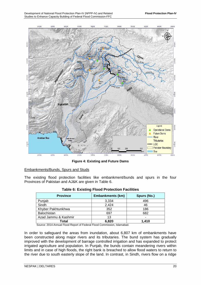
Development of National Flood Protection Plan-IV (NFPP-IV) and Related Flood Protection Plan-IV
Studies to Enhance Capacity Building of Federal Flood Commission-FFC
NESPAK | DELTARES 20
Figure 4: Existing and Future Dams
Embankments/Bunds, Spurs and Studs
The existing flood protection facilities like embankment/bunds and spurs in the four Provinces of Pakistan and AJ&K are given in Table 6.
Table 6: Existing Flood Protection Facilities
Province Embankments (km) Spurs (No.)
Punjab 3,334 496
Sindh 2,424 46
Khyber Pakhtunkhwa 352 186
Balochistan 697 682
Azad Jammu & Kashmir 13 -
Total 6,820 1,410 Source: 2014-Annual Flood Report of Federal Flood Commission, Islamabad.
In order to safeguard the areas from inundation, about 6,807 km of embankments have been constructed along major rivers and its tributaries. The bund system has gradually improved with the development of barrage controlled irrigation and has expanded to protect irrigated agriculture and population. In Punjab, the bunds contain meandering rivers within limits and in case of high floods, the right bank is breached to allow flood waters to return to the river due to south easterly slope of the land. In contrast, in Sindh, rivers flow on a ridge
Development of National Flood Protection Plan-IV (NFPP-IV) and Related Flood Protection Plan-IV
Studies to Enhance Capacity Building of Federal Flood Commission-FFC
NESPAK | DELTARES 21
and if the bunds are breached the water does not return to the river. Therefore, to contain water within bunds, first, second and at places third line of bunds have been built.
Out of a total of 6,807 km length of existing bunds, Sindh has 1,525 km as first line and 899 km as second line of bunds. At places loop bunds have been provided. Punjab has about 2,947 km as first line bunds and 387 km as second line bunds. In Khyber Pakhtunkhwa, 352 km length of embankments have been constructed along major river system, while in Balochistan 697 km long bunds have been constructed to safeguard areas from the onslaught of hill torrents.
The spurs along the rivers of Pakistan have been constructed to encounter the problem of land erosion, which is caused due to changes in river morphology. During the last few decades, about 283,500 ha of land have been lost due to erosion. In order to protect the areas from erosion, 242 spurs were constructed prior to the start of Flood Protection Sector Project in 1987. Of these, about 120 were for the channelization of flows to the barrages and bridges and 122 for flood management in the areas. Another 1,168 new spurs have been constructed after 1987. The aggregate number of spurs in the country has accordingly increased to 1,410.
Gabions Protection/Retaining Walls
In hilly areas the rivers usually have high gradient/velocity flows. In 2011, Swat river caused heavy damage retaining walls, bridges, spurs and other structures. Stone protection alone against bank erosion is not sufficient. For such locations, the most stable structural measure is the provision of stone retaining wall (with or without gabions). Gabions are well suited for retaining walls because of their flexibility and also to make full use of readily available local stone. These retaining walls are mostly used in hill torrents areas like Balochistan, Khyber Pakhtunkhwa, AJ&K and Gilgit-Baltistan.
In addition to the above, under the Task-B Report of present project studies, a comprehensive inventory of the existing flood protection structures/works in all the regions of Pakistan has been prepared. During studies, various Federal & Provincial Authorities and Organizations have been approached for the collection of details of existing flood protection works up to 2014 and under FPSP I & II. Some available information was obtained from the documents i.e. Flood Fighting & Contingency Plans, Completion Reports, etc., and the remaining information has been collected through field visits and official meetings. The inventory includes information relevant to these structures/works, their location, type, year of completion, cost of completion and their present physical status whether intact, damaged or washed away. The detailed number of flood protection facilities existing in the Provinces and FLAs are given in Task-B Report and the summary of these facilities are given in Table 7.
Table 7: Existing Flood Protection Structures
Province / Federal Line Agency /
Department
Embankment / Bund / Flood
Protection Wall
Spur / Stud / Flood Dispersion Structure
Watershed Management Interventions
Punjab 394 791 -
Sindh 257 4 -
Khyber Pakhtunkhwa 560 224 -
Balochistan 257 3 -
FATA 205 4 -
Gilgit-Baltistan 28 2 -
AJ&K 0 13 -
Pakistan Railways 7 1 -
Sub-Total 1,708 1,042 -
NGOs 192 8 7
TOTAL 1,900 1,050 7 Source: Task-B Report, Development of Inventory of Flood Works and Benefit Monitoring & Evaluation of Flood Protection Works
Development of National Flood Protection Plan-IV (NFPP-IV) and Related Flood Protection Plan-IV
Studies to Enhance Capacity Building of Federal Flood Commission-FFC
NESPAK | DELTARES 22
2.4 Shortcomings, Constraints and Gaps in Existing Flood Management Practices
2.4.1 Shortcomings in Policy and Planning
There has been absence of a coherent water policy to deal with water issues in the country. Finally, after much debate and discussions at various forums, the government seems to be moving towards formulating a water policy for which a draft water policy is in circulation. The draft national water policy recognizes the need for appropriate flood management, emphasizing structural and non- structural measures. However beyond a policy until now, lack of national will to address the issue and enforce its implementation has been a stumbling block in formulating an Integrated Flood Management Plan. Structural measures are easy to implement, are visible and show early results. Non-structural measures on the other hand require behavioral change on part of all stakeholders, are not attractive or resource intensive and given the psyche of the nation, are very difficult to implement. Encroachment of floodplains, sewage dumping in city drains, blockage of drainage paths require determined policy and implementation.
NFPP-IV seeks to address this issue through formulation of River Act, which is submitted as part of the Plan. It needs to be approved and implemented without any political, bureaucratic or other considerations. 2.4.2 Shortcomings in Design Flood Limits and Design Criteria
During the 2010 flood, the peaks in the Swat river at Munda Headworks, Kabul river at Nowshera, and Indus river at Taunsa barrage were much higher than the historical peaks, with 100-year return periods. Yet the flood management approach currently in use has no provisions for floods exceeding design limits. Due to changes in the patterns of flooding and in the behavior of streams, the design limits and criteria for major river structures, as well as structures in rural and urban areas, should be reviewed. 2.4.3 Limitations in Barrage/Bridge Capacities
Some barrages and bridges have low flood passing capacities. For this reason, these structures create constrictions, which cause affluxes upstream, that damage flood protection works and river-training works. Given that a barrage can only be designed for floods of a certain return period, the importance of breaching sections must be emphasized, and alternative solutions must be found for these locations. 2.4.4 Constraints in Flood Early Warning System
While Pakistan’s flood forecasting and early warning system (FEWS) has demonstrated its usefulness, it has not been fully utilized. Under the present Consultancy services, FEWS has been upgraded to include hydrological models of Swat River and Kabul River basins. As FEWS requires inflow hydrograph at rim stations which are; Tarbela, Mangla and Marala, PMD has advocated to extend the system’s coverage to the upper reaches of Indus and Chenab rivers with particular emphasis on improving rainfall forecasts. FEWS can only be utilized with full benefits if meteorological forecast during monsoon season can be made qualitatively as well as quantitatively well in time. This would give an adequate lead time to predict floods and their magnitude.
Development of National Flood Protection Plan-IV (NFPP-IV) and Related Flood Protection Plan-IV
Studies to Enhance Capacity Building of Federal Flood Commission-FFC
NESPAK | DELTARES 23
2.4.5 Financial Limitations and Constraints
The repair and rehabilitation of flood protection works, especially during pro-longed dry cycle, suffers from a memory lapse that floods do occur. Meagre financial resources available and further miniscule allocation in the budget, makes it virtually impossible to keep the health of the protection works intact. The financial limitations also affect the level of investment which directly determines the degree of protection against floods. Normally, flood protection bunds are designed for 25 year return period which is quite low. Higher return period floods of 50, 100 or 1000 years require higher investments. An untapped source of funding are the water charges which charged for irrigation at Rs.135 per acre are abysmally low. Enhancement to Rs. 1,500 per acre, as recommended by FoDP, will raise Rs. 33 billion for Punjab alone. It is high time that operation and maintenance of irrigation and flood infrastructure is financed through enhanced water charges rather than foreign funding. 2.4.6 Gaps and Lapses
A thorough review of planning and associated actions has been carried out to identify major gaps and lapses in flood protection measures. These gaps have been categorized as institutional, managerial, technical and of financial nature and are described below;
Institutional Gaps i. Lack of coordination between federal and provincial departments during floods ii. Lack of technical data sharing mechanism among departments iii. Lack of expertise and specialists in flood handling departments iv. Lack of definition of roles and responsibility in departments towards floodplain
encroachments
Managerial Gaps i. Lack of regular inspection/monitoring of flood protection structures ii. Lack of technical expertise in operation of water control structures iii. Lack of information and real-time instructions at water control structures
Technical Gaps i. Limited real-time data availability ii. Low density of hydro-meteorological gauges as compared to International standards iii. Limited information on spatial and temporal forecast of Monsoon events iv. Limited reaction time for flashy streams v. Non-uniform design standards for embankments and barrages vi. Lack of storages for flood peak attenuation vii. Poor maintenance, monitoring and repair of flood embankments
Financial Gaps i. Lack of funds for implementation of flood protection schemes highlighted in NFPPs ii. Lack of capacity to consume allocated funds iii. Limited funding by GoP which results in Securing Loans to address requirements
3 PLANNING STRATEGY, OBJECTIVES AND GOALS OF NFPP-IV
3.1 National Water Policy Water has competing demands for consumptive and non-consumptive use of water as it is used for drinking and sanitation, irrigation, hydropower, industry, environment, river system, wetlands, aquatic life, forestry, recreation and sports, and navigation. Draft National Water
Development of National Flood Protection Plan-IV (NFPP-IV) and Related Flood Protection Plan-IV
Studies to Enhance Capacity Building of Federal Flood Commission-FFC
NESPAK | DELTARES 24
Policy recognizes the need of an integrated water management strategy that aims at maximizing the sustainable economic, social and environmental returns. The Draft National Water Policy reflects this in the following manner:
Construction of flood protection facilities and maintenance of existing facilities
Review of design and maintenance standards of existing facilities
Establishment and promotion of flood zoning and enforcement of appropriate land use
Optimized reservoir operating rules
Improved and updated flood manuals
Effective use of nonstructural measures
Creation of flood response plans The policy needs to be adopted without further delay and mechanism set in place for its early implementation.
3.2 Planning Objective and Goals
The formulation of a comprehensive integrated and innovative National Flood Protection Plan is the main objective of the present studies. The Plan should propose effective short term, medium term and long term measures for next ten years which should include; rehabilitation of flood protection works, construction of new works, up-gradation and strengthening of meteorological and flood forecasting system, updating of floodplain mapping and zoning, formulation of River Act, flood and disaster relief and others. The objectives of the Flood Protection Plan-IV are quite clear that effective measures should be proposed for providing long term protection to the communities living in mountainous, riverine, coastal and urban areas. By implementing National Flood Protection Plan-IV, it is expected that the main goal of saving the population from flood hazards throughout Pakistan would be achieved. 3.3 Planning Strategy The planning strategy for development of National Flood Protection Plan-IV, in line with the current practices worldwide, is focused on integrated flood management planning laying more emphasis on the non-structural measures, like reservoir operations, flood forecasting and early warning, flood risk zoning, watershed management, flood proofing and insurance, disaster management and other measures aimed at mitigating flood damages rather than completely controlling floods- an impossible task as experienced worldwide. However, considering the uniqueness of Indus Basin with its large integrated network of dams, barrages and canals, which is the lifeline of agriculture economy of the country, the protection of this infrastructure as wells as the irrigated area that it feeds and which has been the focus of previous three Flood Protection Plans; the maintenance, up-gradation and in some cases new construction especially in light of 2010 floods, has not been ignored. In order to address these two issues, the need for an Integrated Flood Management Plan cannot be over emphasized. Following the super flood of 2010, the Government of Pakistan planned to have a comprehensive flood management plan for the next 10 years. In the past, emphasis had been on the structural measures alone. Non-structural measures are now being fully incorporated. Investments on non-structural measures are minimal on a short term basis and are extremely important in the long term to make structural measures more effective and purposeful. Moreover, there are no environmental impacts associated with non-structural measures.
Development of National Flood Protection Plan-IV (NFPP-IV) and Related Flood Protection Plan-IV
Studies to Enhance Capacity Building of Federal Flood Commission-FFC
NESPAK | DELTARES 25
Encroachments on floodplains for agricultural purposes, associated settlements and other infrastructure are main reasons for increasing flood damages. Judicial Flood Enquiry Report following the flood of 2010 also highlighted the need to setup and effectively manage the floodplains. Well informed community role is also required so that permanent settlements in the floodplain areas are avoided. Deforestation in the uplands of rivers at an alarming rate needs to be addressed immediately. This is one of the causes of global warming/climate change, silt erosion and landslides. Another cause of global warming/climate change is the excessive release of carbon dioxide from the factories, vehicles etc., due to non-implementation of laws and regulations. Improper disposal of solid waste in the towns and cities is one of the main causes that result in outburst of diseases immediately after the floods. Thus, formulation of a comprehensive program for watershed management and environmental management is the need of time. The planning strategy has thus following three elements:
Reducing the flood peaks and inundation extents
Reducing susceptibility to damage
Mitigating the flood impacts These elements are reflected in the Integrated Flood management Plan as discussed below. 4 INTEGRATED FLOOD MANAGEMENT
4.1 General
Floods are part of a natural cycle that can never be fully controlled. “Flood Control” is therefore an allusion raising false expectations. An integrated approach towards flood management to save lives and to reduce flood damages is the accepted best practice world over. The benefits of floods also cannot be ignored. Rich in nutrient, flood waters recharge groundwater, restore polluted waters in lakes and ponds, regenerate riverine forests and enrich the soil. It has been documented that subsequent to floods, crop yields register a significant increase. In ancient and pre-modern times, man living in flood plains built settlements on high ground thereby avoiding flood damage while benefiting from flood waters. Increased demographic pressures and economic activity forced man to move to flood plains resulting in increased flood damages. Compounding the problem in Pakistan is the vast network of barrages and canals the protection of which necessitate confining floodwaters within embankments to not only safely dump high beneficial flood waters into the sea but also endangering downstream structures which now must cope with higher discharges because of confinement in upper reaches. In Pakistan, flood fighting is more of a reaction than pre-emption. Flood management in various parts of Pakistan is fairly a complex issue, due to the varying physiographic, climatic, demographic and socio-economic conditions. These can be best addressed with an integrated flood management approach. 4.2 Components of Integrated Flood Management
Integrated flood management has two distinct components i.e. structural measures and non-structural measures. Integrated flood management is a fusion of different strategies. Structural and non-structural measures help in accomplishing different strategies involved in integrated flood management as shown in Table 8. Construction of dams, dikes levees etc., reduce the flooding and flood forecasting and warning can reduce the extent of damage caused by floods. An effective integrated flood management plan involves amalgamation
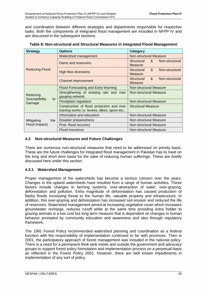
Development of National Flood Protection Plan-IV (NFPP-IV) and Related Flood Protection Plan-IV
Studies to Enhance Capacity Building of Federal Flood Commission-FFC
NESPAK | DELTARES 26
and coordination between different strategies and departments responsible for respective tasks. Both the components of integrated flood management are included in NFPP-IV and are discussed in the subsequent sections.
Table 8: Non-structural and Structural Measures in Integrated Flood Management
Strategy Options Category
Reducing Flood
Watershed management Non-structural Measure
Dams and reservoirs Structural & Non-structural Measure
High flow diversions Structural & Non-structural Measure
Channel improvement Structural & Non-structural Measure
Reducing Susceptibility to Damage
Flood Forecasting and Early Warning Non-structural Measure
Strengthening of existing rain and river gauging network
Non-structural Measure
Floodplain regulation Non-structural Measure
Construction of flood protection and river training works i.e. levees, dikes, spurs etc.,
Structural Measure
Mitigating the Flood Impacts
Information and education Non-structural Measure
Disaster preparedness Non-structural Measure
Post- flood recovery Non-structural Measure
Flood insurance Non-structural Measure
4.3 Non-structural Measures and Future Challenges There are numerous non-structural measures that need to be addressed on priority basis. These are the future challenges for integrated flood management in Pakistan has to meet on the long and short term basis for the sake of reducing human sufferings. These are briefly discussed here under this section. 4.3.1 Watershed Management
Proper management of the watersheds has become a serious concern over the years. Changes in the upland watersheds have resulted from a range of human activities. These factors include changes in farming systems, over-abstraction of water, over-grazing, deforestation and pollution. Extra magnitude of deforestation has caused production of flashy floods increasing threat to the human life, valuable property and infrastructure. In addition, this over-grazing and deforestation has increased soil erosion and reduced the life of reservoirs. Watershed management aimed at increasing vegetative cover which increases groundwater recharge, reduces runoff while at the same time providing extra fodder to grazing animals is a low cost but long term measure that is dependent on changes in human behavior prompted by community education and awareness and also through regulatory framework. The 1991 Forest Policy recommended watershed planning and coordination as a federal function with the responsibility of implementation continued to be with provinces. Then in 2001, the participatory approach of forest management was included in the national policy. There is a need for a permanent think tank inside and outside the government and advocacy groups to support forest policy formulation and implementation process on a perpetual basis as reflected in the Forest Policy 2001. However, there are well known impediments in implementation of any sort of policy.
Development of National Flood Protection Plan-IV (NFPP-IV) and Related Flood Protection Plan-IV
Studies to Enhance Capacity Building of Federal Flood Commission-FFC
NESPAK | DELTARES 27
Under present studies, seven (7) watershed regions have been identified in Pakistan. In these regions following areas are proposed for development of watershed management under NFPP-IV:
Region Proposed Watershed Area
i. The Northern Mountain Region Swat Basin
ii. The uplands of Northern Punjab Hazara Area, Haro & Soan River
iii. Western Mountain Region Gomal, Zhob, Kaha and various
hill torrents
iv. The South-Western Balochistan Plateau Nari Basin
v. The Coastal Zone Hub Basin
vi. The Indus plains Gaj Nai Basin
vii Gilgit-Baltistan Chilas
To achieve the above mentioned objectives for development of watershed management, the first step is to identify the appropriate areas within above mentioned regions/river basins for watershed management and selection of suitable watershed management measures for that area. Following actions need to be taken:
i. Establish Watershed Management Departments or strengthen existing forestry departments with the relevant Provincial Governments,
ii. Formulate watershed management policy, guidelines or plan for each of rivers according to their requirement,
iii. Carry out necessary legislation at national level as well as provincial level and implement forcefully,
iv. Allocate/arrange necessary funding, and
v. Effective enforcement of the existing laws and regulations on forests use and management and involvement of the communities in the policy making process from the very outset enables the government to address sharp forest decline by creating a feeling of sense of ownership and empowerment among communities.
4.3.2 Global Warming
In its most commonly used sense, “Global Warming” refers to the gradual warming of global-average temperatures due to the slowly increasing concentrations of man-made atmospheric greenhouse gases, primarily carbon dioxide. But global warming can alternatively refer to simply the observation of warming, without implying the cause(s) of that warming. The most popular explanation for global warming is the burning of fossil fuels, mainly petroleum and coal, which produces carbon dioxide as one of the by-products. The net effect of greenhouse gases is to keep the lower layers of the atmosphere warmer that they otherwise would be without those gases. Deforestation is another reason of increase in global warming. The trees when alive absorb carbon dioxide and release oxygen during day time and absorb oxygen and release carbon dioxide during night time. Till the time of a living tree, nature balances all the releases and absorption. However, when a tree is cut down, it only releases carbon dioxide. The whole ecosystem is disturbed due to this human intervention. Few recommendations to minimize release of greenhouse gases and reduce the likely warming of upper atmosphere are:
Development of National Flood Protection Plan-IV (NFPP-IV) and Related Flood Protection Plan-IV
Studies to Enhance Capacity Building of Federal Flood Commission-FFC
NESPAK | DELTARES 28
i. Control the release of carbon dioxide by vehicles through strict implementation of laws and imposing penalties to prevent such vehicles to be on road that produce excessive smoke especially diesel consuming vehicles like buses, trucks etc.;
ii. Raise the standard of population living below the line of poverty by providing them electricity and natural gas to avoid burning of wood for cooking of their meals and heating of their livings to fight against cold weather;
iii. Prevent excessive grazing, deforestation and cutting of trees; and
iv. Forestation, soil conservation and improvement in land use in the watersheds should be promoted.
4.3.3 Role of Mangla and Tarbela Reservoirs in Flood Mitigation
There are two major reservoirs in the Indus river basin in Pakistan; Mangla dam on Jhelum River near Mangla and Tarbela dam on Indus River near Tarbela. Both of these were constructed during 1960s and 1970s, respectively for power generation and irrigation with the priority to store/release water for irrigation purposes. At time of construction, both of these dams were not meant to mitigate floods. Flood mitigation was only possible if the storage was already below the maximum conservation. The flood surcharge storage was provided over and above the maximum conservation levels of both the dams to pass the design flood with the operation policy to keep the reservoir level at maximum conservation level by passing outflow equal to inflow till the time inflow exceeds the design outflow capacity and the excessive flood volume to be stored in the flood storage designed for the purpose. However, due to unprecedented damages which occurred during the flood of 1992, it was felt to change the operational policy to mitigate the floods to some extent by lowering the reservoir levels below the maximum conservation levels immediately after receiving flood forecast of a high magnitude flood. Thus, the Standard Operating Procedures (SOP) for Tarbela and Mangla reservoirs were set by the competent operating authorities. However, the SOPs for Mangla reservoir were revised by consultants, NESPAK, with the competent operating authorities on board keeping in view the floods of 1992 and 2010. Mangla reservoir was successfully operated by Mangla Dam Organization (MDO) during the flood of 2014 with some reservations on it. A small description on how Mangla reservoir was operated during 2014 flood is presented in the paragraphs below.
In the normal conditions releases from reservoir are made as per IRSA indent. In flood situation, when reservoir level is at or above El. 1238 ft., it is operated by as per instructions issued by local flood management committee at Mangla.
Heavy rainfall was reported on September 4, and a forecast of 200,000 cusecs to 600,000 cusecs was issued at 10am by PMD. On the day, the reservoir level was raised at/above El. 1229 ft. and IRSA reduced the indent from 30,000 cusecs to 15,000 cusecs. On September 5, two (2) forecasts were issued. The 1st forecast was made at 1030 hours with the prediction that well marked low pressure was weakened and likely inflow would be 300,000 cusecs to 500, 000 cusecs. The reservoir level was El. 1236 ft in the morning which was raised to El.1238 ft. at 1300 hours with inflows to Mangla reservoir as 634,000 cusecs. The 2nd forecast was made on the same day at 1400 hours with prediction that probable inflow would be more than 700, 000 cusecs. Immediately afterwards, the SOP for Cat-III Flood were Implemented. The outflows increased gradually from 266,185 cusecs at 1500 hours to 499,624 cusecs at 2100 hours to mitigate the affect of expected peak inflows above 700,000 cusecs. The SOP states that increase outflow to 475,000 cusecs after achieving El. 1240 ft and keep watching till elevation rises to El.1241 ft. The reservoir level reached at El. 1241 ft. at 1600 hours. The SOP states to increase outflow to 500,000 cusecs after achieving El.1241 ft. The outflows were increased gradually to 499,624 cusecs. During the period of
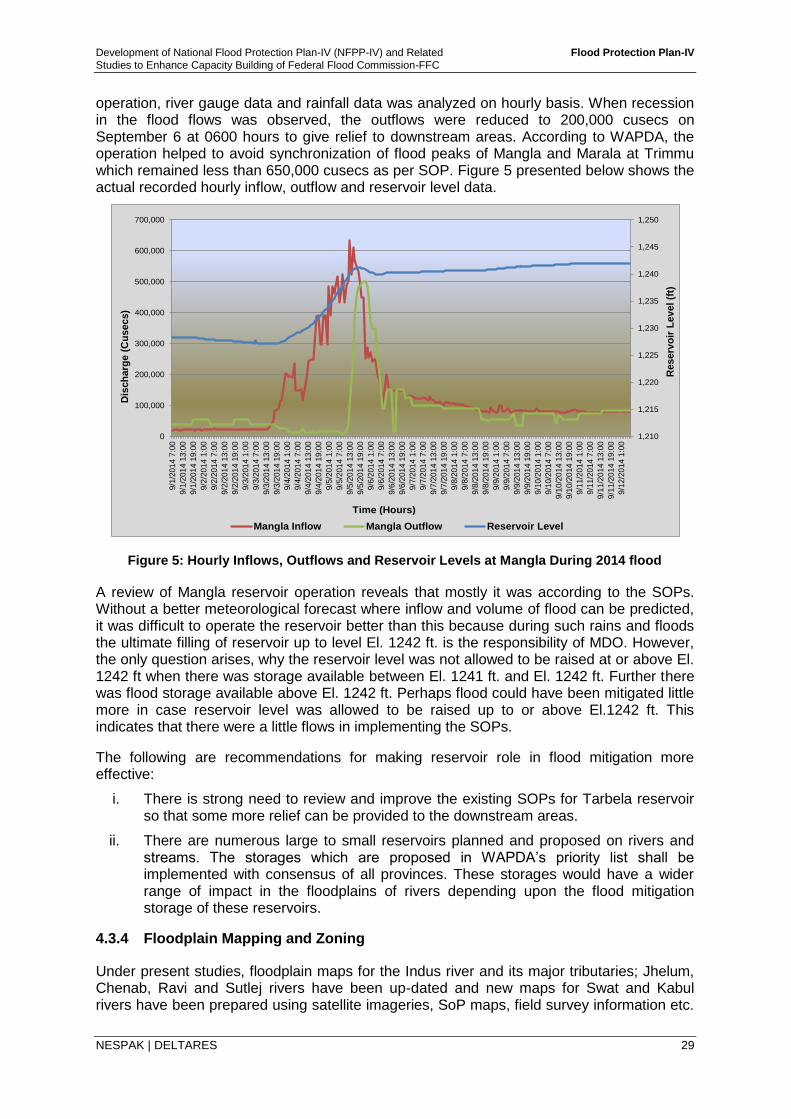
Development of National Flood Protection Plan-IV (NFPP-IV) and Related Flood Protection Plan-IV
Studies to Enhance Capacity Building of Federal Flood Commission-FFC
NESPAK | DELTARES 29
operation, river gauge data and rainfall data was analyzed on hourly basis. When recession in the flood flows was observed, the outflows were reduced to 200,000 cusecs on September 6 at 0600 hours to give relief to downstream areas. According to WAPDA, the operation helped to avoid synchronization of flood peaks of Mangla and Marala at Trimmu which remained less than 650,000 cusecs as per SOP. Figure 5 presented below shows the actual recorded hourly inflow, outflow and reservoir level data.
1,210
1,215
1,220
1,225
1,230
1,235
1,240
1,245
1,250
0
100,000
200,000
300,000
400,000
500,000
600,000
700,000
9/1
/201
4 7
:00
9/1
/201
4 1
3:0
0
9/1
/201
4 1
9:0
0
9/2
/201
4 1
:00
9/2
/201
4 7
:00
9/2
/201
4 1
3:0
0
9/2
/201
4 1
9:0
0
9/3
/201
4 1
:00
9/3
/201
4 7
:00
9/3
/201
4 1
3:0
0
9/3
/201
4 1
9:0
0
9/4
/201
4 1
:00
9/4
/201
4 7
:00
9/4
/201
4 1
3:0
0
9/4
/201
4 1
9:0
0
9/5
/201
4 1
:00
9/5
/201
4 7
:00
9/5
/201
4 1
3:0
0
9/5
/201
4 1
9:0
0
9/6
/201
4 1
:00
9/6
/201
4 7
:00
9/6
/201
4 1
3:0
0
9/6
/201
4 1
9:0
0
9/7
/201
4 1
:00
9/7
/201
4 7
:00
9/7
/201
4 1
3:0
0
9/7
/201
4 1
9:0
0
9/8
/201
4 1
:00
9/8
/201
4 7
:00
9/8
/201
4 1
3:0
0
9/8
/201
4 1
9:0
0
9/9
/201
4 1
:00
9/9
/201
4 7
:00
9/9
/201
4 1
3:0
0
9/9
/201
4 1
9:0
0
9/1
0/2
014 1
:00
9/1
0/2
014 7
:00
9/1
0/2
014 1
3:0
0
9/1
0/2
014 1
9:0
0
9/1
1/2
014 1
:00
9/1
1/2
014 7
:00
9/1
1/2
014 1
3:0
0
9/1
1/2
014 1
9:0
0
9/1
2/2
014 1
:00
Mangla Inflow Mangla Outflow Reservoir Level
Time (Hours)
Dis
ch
arg
e (
Cu
secs)
Reserv
oir
Lev
el(f
t)
Figure 5: Hourly Inflows, Outflows and Reservoir Levels at Mangla During 2014 flood
A review of Mangla reservoir operation reveals that mostly it was according to the SOPs. Without a better meteorological forecast where inflow and volume of flood can be predicted, it was difficult to operate the reservoir better than this because during such rains and floods the ultimate filling of reservoir up to level El. 1242 ft. is the responsibility of MDO. However, the only question arises, why the reservoir level was not allowed to be raised at or above El. 1242 ft when there was storage available between El. 1241 ft. and El. 1242 ft. Further there was flood storage available above El. 1242 ft. Perhaps flood could have been mitigated little more in case reservoir level was allowed to be raised up to or above El.1242 ft. This indicates that there were a little flows in implementing the SOPs.
The following are recommendations for making reservoir role in flood mitigation more effective:
i. There is strong need to review and improve the existing SOPs for Tarbela reservoir so that some more relief can be provided to the downstream areas.
ii. There are numerous large to small reservoirs planned and proposed on rivers and streams. The storages which are proposed in WAPDA’s priority list shall be implemented with consensus of all provinces. These storages would have a wider range of impact in the floodplains of rivers depending upon the flood mitigation storage of these reservoirs.
4.3.4 Floodplain Mapping and Zoning
Under present studies, floodplain maps for the Indus river and its major tributaries; Jhelum, Chenab, Ravi and Sutlej rivers have been up-dated and new maps for Swat and Kabul rivers have been prepared using satellite imageries, SoP maps, field survey information etc.
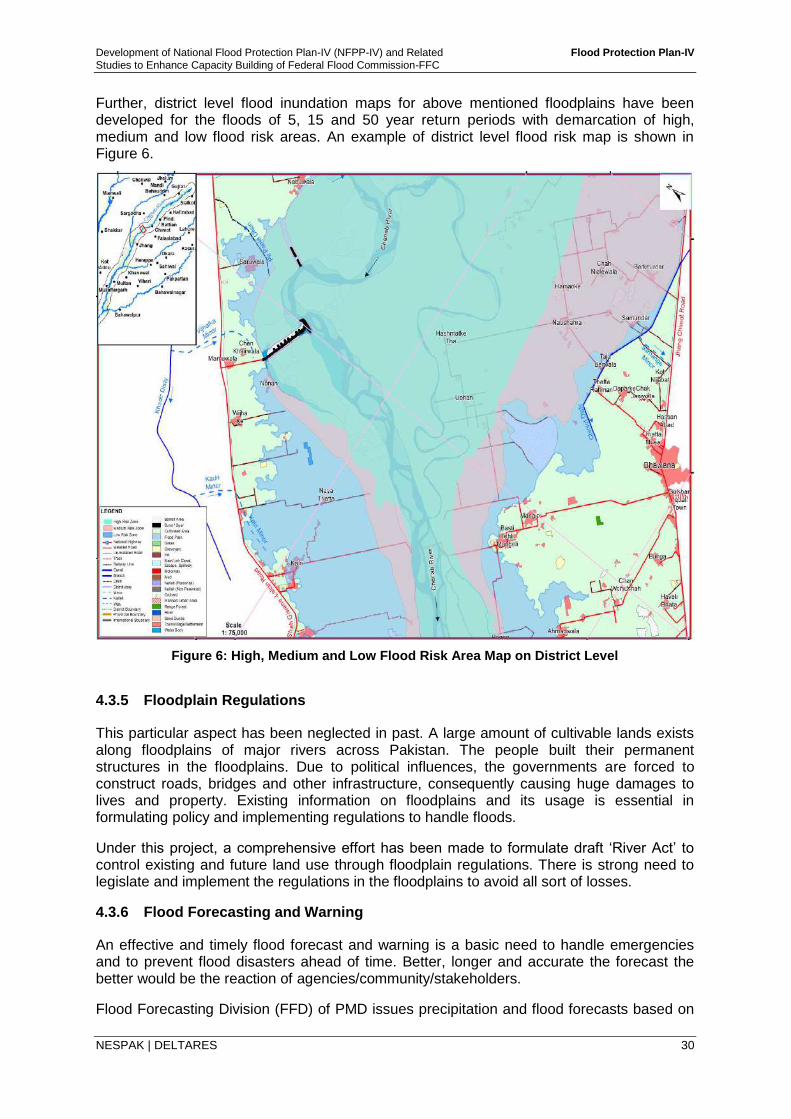
Development of National Flood Protection Plan-IV (NFPP-IV) and Related Flood Protection Plan-IV
Studies to Enhance Capacity Building of Federal Flood Commission-FFC
NESPAK | DELTARES 30
Further, district level flood inundation maps for above mentioned floodplains have been developed for the floods of 5, 15 and 50 year return periods with demarcation of high, medium and low flood risk areas. An example of district level flood risk map is shown in Figure 6.
Figure 6: High, Medium and Low Flood Risk Area Map on District Level
4.3.5 Floodplain Regulations
This particular aspect has been neglected in past. A large amount of cultivable lands exists along floodplains of major rivers across Pakistan. The people built their permanent structures in the floodplains. Due to political influences, the governments are forced to construct roads, bridges and other infrastructure, consequently causing huge damages to lives and property. Existing information on floodplains and its usage is essential in formulating policy and implementing regulations to handle floods.
Under this project, a comprehensive effort has been made to formulate draft ‘River Act’ to control existing and future land use through floodplain regulations. There is strong need to legislate and implement the regulations in the floodplains to avoid all sort of losses.
4.3.6 Flood Forecasting and Warning
An effective and timely flood forecast and warning is a basic need to handle emergencies and to prevent flood disasters ahead of time. Better, longer and accurate the forecast the better would be the reaction of agencies/community/stakeholders.
Flood Forecasting Division (FFD) of PMD issues precipitation and flood forecasts based on
Development of National Flood Protection Plan-IV (NFPP-IV) and Related Flood Protection Plan-IV
Studies to Enhance Capacity Building of Federal Flood Commission-FFC
NESPAK | DELTARES 31
examining weather charts, satellite mapped precipitation, statistical flood forecasting tool. FFC got developed a phenomenon based Flood Early Warning System for FFD of PMD to have more reliable flood forecasts in the Indus system of rivers. The existing FEWS has been updated in the current study by including Kabul river from Warsak to Nowshera and the whole Swat river basin i.e. till confluence with Kabul.
With the above update, FEWS covers upper watersheds of Swat, Jhelum, Chenab, Ravi & Sutlej and the hill torrents, and provides simulated flood hydrographs at the rim stations by using the forecasted or real-time rainfall.
In addition, the river reaches of Indus and its tributaries below rim stations along with Kabul below Warsak are also covered in the FEWS to get the forecasted flood hydrograph at various barrages and bridges across the Indus and its tributaries (JCRS).
Flood forecasts at rim stations can be made by using:
(i) Forecasted rainfall (best choice but with low reliability) lead time = time duration between issuance of forecast and occurrence of event + lag time
(ii) Real-time or near real-time rainfall estimates (good choice with relatively better reliability) lead time = lag time
Given the importance of forecasted rainfall to get a reasonable reaction time at the rim stations e.g. Marala on Chenab, Mangla on Jhelum, the current level of knowledge to generate at least 24 hours Quantitative Precipitation Forecast (QPF) with (at least) 3 hour time distribution, requires improvement. Similarly real-time or near real-time rainfall estimation also requires improvements by strengthening of existing rain measuring and river gauging network.
In the current NFPP-IV, specific cost provision has been made to undertake a study to improve the QPF and FEWS-Pakistan model. This study would include, inter alia;
a) For improving forecasted rainfall:
i) Confirm utility of satellite data for rainfall estimation and forecasting ii) Optimum use of satellite data for rainfall estimation and forecasting iii) Survey of available weather models and their utility for the Indus catchments iv) Verify the validity of analyses and forecasts of the selected models
b) For improving real or near real-time rainfall estimation:
i) Analysis of existing Radars data from Sialkot, Mangle and Lahore to determine storm motion and orographic effects
ii) Determination of the meteorological situations and types of rain events which give rise to systematic overestimates or underestimates of rainfall by Radar
iii) Study of Radar observed storm characteristics and of influence of orography under different meteorological situations
iv) Determination of the relationship between river levels and Radar rain estimates for the hill torrents and their catchments
v) Study of spatial and temporal variability of rainfall to determine the ability of gauge measurements to represent aerial rainfall over a range of time periods and areas
c) For improving FEWS-Pakistan model:
i) Include catchment area of Indus river upstream of Tarbela dam ii) Update rivers geometry for low flood forecasts iii) Remove bottle necks of FEWS model keeping in view reservations of PMD iv) Train professionals of PMD
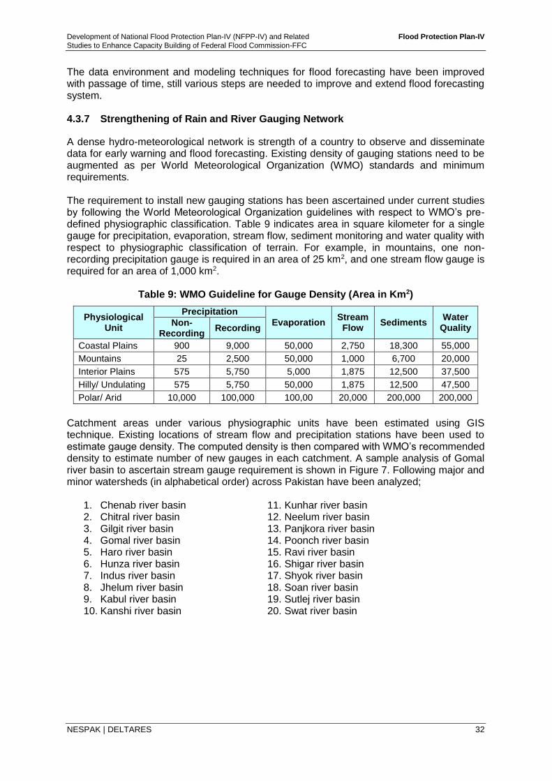
Development of National Flood Protection Plan-IV (NFPP-IV) and Related Flood Protection Plan-IV
Studies to Enhance Capacity Building of Federal Flood Commission-FFC
NESPAK | DELTARES 32
The data environment and modeling techniques for flood forecasting have been improved with passage of time, still various steps are needed to improve and extend flood forecasting system. 4.3.7 Strengthening of Rain and River Gauging Network
A dense hydro-meteorological network is strength of a country to observe and disseminate data for early warning and flood forecasting. Existing density of gauging stations need to be augmented as per World Meteorological Organization (WMO) standards and minimum requirements. The requirement to install new gauging stations has been ascertained under current studies by following the World Meteorological Organization guidelines with respect to WMO’s pre-defined physiographic classification. Table 9 indicates area in square kilometer for a single gauge for precipitation, evaporation, stream flow, sediment monitoring and water quality with respect to physiographic classification of terrain. For example, in mountains, one non-recording precipitation gauge is required in an area of 25 km2, and one stream flow gauge is required for an area of 1,000 km2.
Table 9: WMO Guideline for Gauge Density (Area in Km2)
Physiological Unit
Precipitation
Evaporation Stream Flow
Sediments Water
Quality Non-
Recording Recording
Coastal Plains 900 9,000 50,000 2,750 18,300 55,000
Mountains 25 2,500 50,000 1,000 6,700 20,000
Interior Plains 575 5,750 5,000 1,875 12,500 37,500
Hilly/ Undulating 575 5,750 50,000 1,875 12,500 47,500
Polar/ Arid 10,000 100,000 100,00 20,000 200,000 200,000
Catchment areas under various physiographic units have been estimated using GIS technique. Existing locations of stream flow and precipitation stations have been used to estimate gauge density. The computed density is then compared with WMO’s recommended density to estimate number of new gauges in each catchment. A sample analysis of Gomal river basin to ascertain stream gauge requirement is shown in Figure 7. Following major and minor watersheds (in alphabetical order) across Pakistan have been analyzed;
1. Chenab river basin 11. Kunhar river basin 2. Chitral river basin 12. Neelum river basin 3. Gilgit river basin 13. Panjkora river basin 4. Gomal river basin 14. Poonch river basin 5. Haro river basin 15. Ravi river basin 6. Hunza river basin 16. Shigar river basin 7. Indus river basin 17. Shyok river basin 8. Jhelum river basin 18. Soan river basin 9. Kabul river basin 19. Sutlej river basin 10. Kanshi river basin 20. Swat river basin
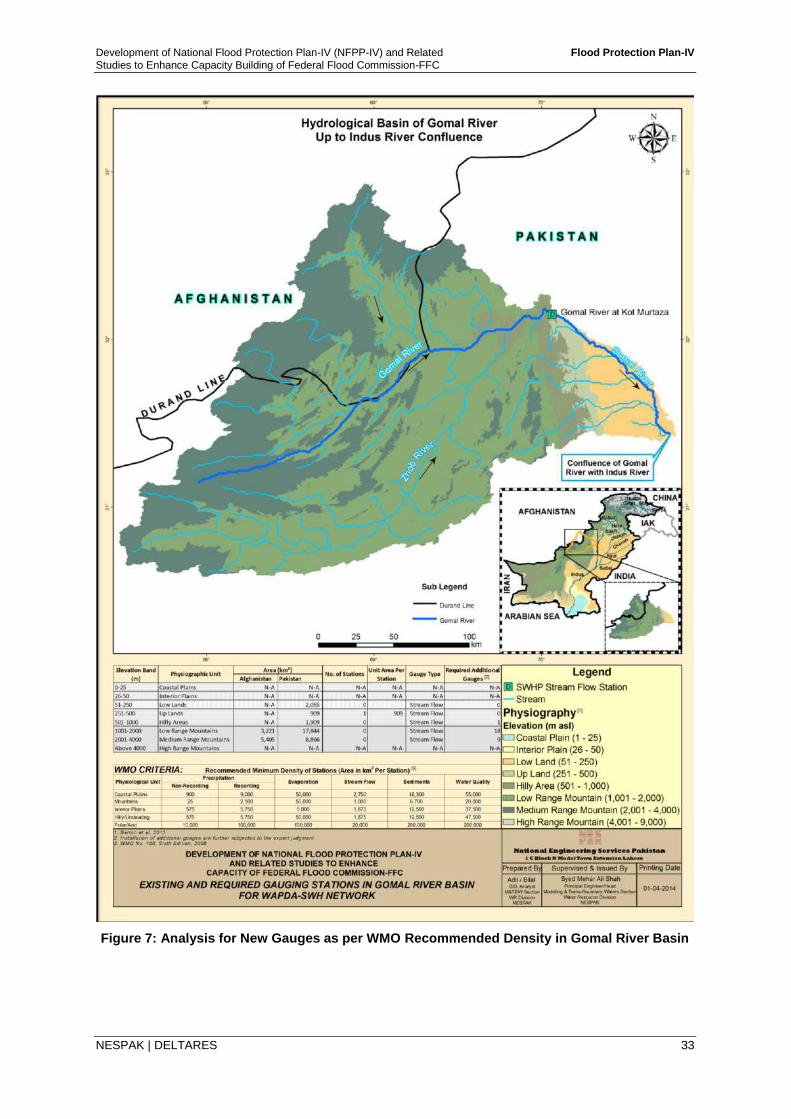
Development of National Flood Protection Plan-IV (NFPP-IV) and Related Flood Protection Plan-IV
Studies to Enhance Capacity Building of Federal Flood Commission-FFC
NESPAK | DELTARES 33
Figure 7: Analysis for New Gauges as per WMO Recommended Density in Gomal River Basin
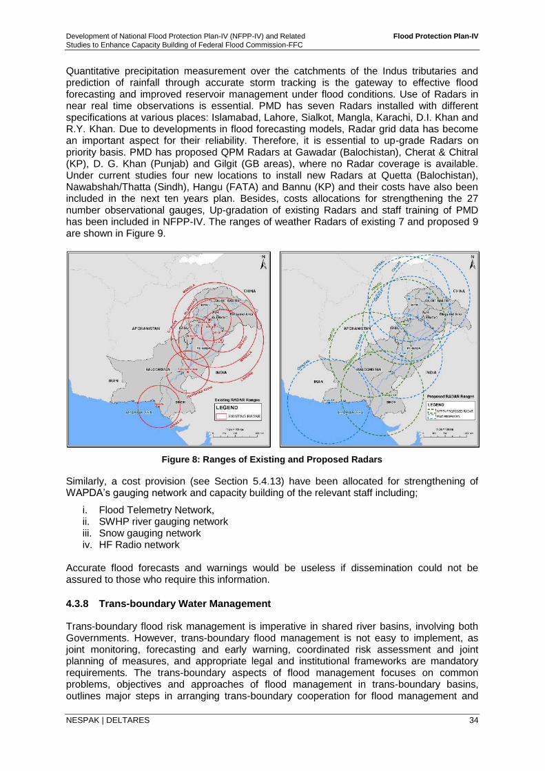
Development of National Flood Protection Plan-IV (NFPP-IV) and Related Flood Protection Plan-IV
Studies to Enhance Capacity Building of Federal Flood Commission-FFC
NESPAK | DELTARES 34
Quantitative precipitation measurement over the catchments of the Indus tributaries and prediction of rainfall through accurate storm tracking is the gateway to effective flood forecasting and improved reservoir management under flood conditions. Use of Radars in near real time observations is essential. PMD has seven Radars installed with different specifications at various places: Islamabad, Lahore, Sialkot, Mangla, Karachi, D.I. Khan and R.Y. Khan. Due to developments in flood forecasting models, Radar grid data has become an important aspect for their reliability. Therefore, it is essential to up-grade Radars on priority basis. PMD has proposed QPM Radars at Gawadar (Balochistan), Cherat & Chitral (KP), D. G. Khan (Punjab) and Gilgit (GB areas), where no Radar coverage is available. Under current studies four new locations to install new Radars at Quetta (Balochistan), Nawabshah/Thatta (Sindh), Hangu (FATA) and Bannu (KP) and their costs have also been included in the next ten years plan. Besides, costs allocations for strengthening the 27 number observational gauges, Up-gradation of existing Radars and staff training of PMD has been included in NFPP-IV. The ranges of weather Radars of existing 7 and proposed 9 are shown in Figure 9.
Figure 8: Ranges of Existing and Proposed Radars
Similarly, a cost provision (see Section 5.4.13) have been allocated for strengthening of WAPDA’s gauging network and capacity building of the relevant staff including;
i. Flood Telemetry Network, ii. SWHP river gauging network iii. Snow gauging network iv. HF Radio network
Accurate flood forecasts and warnings would be useless if dissemination could not be assured to those who require this information.
4.3.8 Trans-boundary Water Management
Trans-boundary flood risk management is imperative in shared river basins, involving both Governments. However, trans-boundary flood management is not easy to implement, as joint monitoring, forecasting and early warning, coordinated risk assessment and joint planning of measures, and appropriate legal and institutional frameworks are mandatory requirements. The trans-boundary aspects of flood management focuses on common problems, objectives and approaches of flood management in trans-boundary basins, outlines major steps in arranging trans-boundary cooperation for flood management and
Development of National Flood Protection Plan-IV (NFPP-IV) and Related Flood Protection Plan-IV
Studies to Enhance Capacity Building of Federal Flood Commission-FFC
NESPAK | DELTARES 35
presents approaches in sharing knowledge for the management of trans-boundary flood risks.
All the major rivers that run through Pakistan, originate from uplands in India except Kabul River which enters from Afghanistan. There exists Indus Water Treaty between India and Pakistan since 1960 for sharing of waters between both the countries along with mechanism for transmission of flood data/information during monsoon period. No such agreement or arrangement exists with Afghanistan.
Efforts are required to convince India under pressure for adherence to international norms to give Pakistan direct data access to real-time rainfall data in Jhelum, Chenab and Sutlej catchments and reservoir levels on eastern rivers so as to provide early warning to Pakistan.
4.3.9 Environmental Management
Floods cause major destruction to humans, infrastructure and natural environment. Adverse impacts of floods lead to disruption in biodiversity and ecological balance. Global warming is likely to increase flooding in the future. There is need to pay special attention to reduce the flood disasters. The main environmental issues include; i) loss of natural vegetation and cutting of trees, ii) poor drainage, iii) increased air and water pollution, iv) increased litter and waste, v) loss of plants and wildlife, vi) loss of aquatic habitats, and vii) reduced water quality.
The following recommendations are made:
i. Environmental problems vary from area to area within country and even from within city, so there is need to investigate it locally.
ii. Rules and laws are required to be formulated and implemented at Government level to mitigate environmental impacts
iii. Particular attention should be given to deforestation in Pakistan.
iv. Awareness and trainings for community participation should be carried out
v. Education curriculum at university levels should have some space for environmental related issues related to disasters in general and floods in particular.
vi. Institutional framework for environmental issues in Pakistan is the need of time. Government organizations/institutions at local level should be equipped to deal with environmental degradation caused by adverse impacts of floods.
vii. Ministry of Climate Change and Pakistan Meteorological Department should play role in awareness campaigns for the communities.
viii. There is a need to involve all the stakeholders (Army, NDMA, PDMAs, DCO's, PID’s etc.,) for better planning and execution of plans.
4.3.10 Financial Resource Management
Financial resources management is the process of procuring, allocating and controlling financial resource of a country at the least cost with maximum benefits. There are numerous funding agencies in the flood protection sector besides Government of Pakistan. Some of these agencies are World Bank (WB), Asian Development Bank (ADB), Islamic Development Bank (IDB), USAID, International Monitoring Fund (IMF), Japan International Cooperation Agency (JICA), etc. These funding agencies offer short-term and or long-term loans usually at soft interest rate. Investments are also offered by some of these banks or agencies particularly for construction of dams. Funds in the form of aid are also offered by USAID, friendly countries and other Charity organizations for the flood relief purpose.
Development of National Flood Protection Plan-IV (NFPP-IV) and Related Flood Protection Plan-IV
Studies to Enhance Capacity Building of Federal Flood Commission-FFC
NESPAK | DELTARES 36
However, there is a dire need now to generate funds from local resources. Recommendation has been made by FoDP to increase water charges to Rs. 1500 per acre from the currently charges of Rs. 120 per acre. For nearly 40 million acres of irrigated agriculture, this would yield Rs. 60 billion annually, probably more than sufficient for maintenance of irrigation infrastructure and flood protection works. Some of the other possible sources, besides federal grants and donations from the local and international donors for the financial sustainability of flood management are indicated as under:
i. Cess on irrigated land in general; ii. Cess on areas/land benefitting from development schemes; iii. Cess on big cities under protection, may be a part of utility bills; iv. Cess on commercial activity in the river areas; v. Property tax collected from the flood protected commercial establishments; vi. Proceeds of sand excavation leases; vii. Proceeds of sale/auction of timber collected from river; viii. Licensing/registration fees of commercial activities on river bank areas; ix. Licensing/registration fees of navigational activities of rivers; x. Contributions by Provincial Governments and Local Governments; and xi. Contributions by high income groups in vulnerable areas.
4.3.11 Information and Education of Stakeholders
The whole society is affected by the adverse effects of floods. At the community level, the effect is in the shape of economic loss and at the personal level, the effect can be in the shape of property loss or even life endangerment. The recent recurrent floods in Pakistan call for a community and individual level participation in flood response. Community outreach at the union council level is needed to raise awareness and basic knowledge, to understand local vulnerabilities and capacities to prepare disaster management maps, to establish community disaster management committee, and to enhance preparedness and emergency response capacities. Community participation is also important in the implementation phase of River Act. 4.3.12 Disaster Preparedness
All measures and policies taken before an event occurs that allow for prevention, mitigation, and readiness constitutes disaster preparedness. Preparedness includes designing warning systems, planning for evacuation, and reallocation, storing food and water, building temporary shelters, devising management strategies, and holding disaster drills and exercises. NDMA, PDMAs and DDMAs are responsible for coordinating hazard risk reduction, preparedness, and responses to riverine floods, flash floods, cyclones etc. For the purpose to strengthen these institutions, a cost has been proposed for NDMA (including PDMAs, DDMA and related agencies) under NFPP-IV for education, training, preparedness and awareness of community and flood relief functions. 4.3.13 Flood Insurance
An effective way to control and restrict floodplain activities and land use is introduction of flood insurance of assets within floodplains. Currently, there is no mechanism or concept of flood insurance in Pakistan. Keeping in view haphazard population and infrastructure growth along floodplains there is a need to introduce flood insurance to compensate losses due to
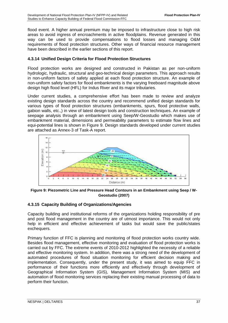
Development of National Flood Protection Plan-IV (NFPP-IV) and Related Flood Protection Plan-IV
Studies to Enhance Capacity Building of Federal Flood Commission-FFC
NESPAK | DELTARES 37
flood event. A higher annual premium may be imposed to infrastructure close to high risk areas to avoid ingress of encroachments in active floodplains. Revenue generated in this way can be used to provide compensations to flood losses and managing O&M requirements of flood protection structures. Other ways of financial resource management have been described in the earlier sections of this report. 4.3.14 Unified Design Criteria for Flood Protection Structures
Flood protection works are designed and constructed in Pakistan as per non-uniform hydrologic, hydraulic, structural and geo-technical design parameters. This approach results in non-uniform factors of safety applied at each flood protection structure. An example of non-uniform safety factors for flood embankments is the varying freeboard magnitude above design high flood level (HFL) for Indus River and its major tributaries.
Under current studies, a comprehensive effort has been made to review and analyze existing design standards across the country and recommend unified design standards for various types of flood protection structures (embankments, spurs, flood protective walls, gabion walls, etc.,) in view of latest design tools and construction techniques. An example of seepage analysis through an embankment using Seep/W-Geostudio which makes use of embankment material, dimensions and permeability parameters to estimate flow lines and equi-potential lines is shown in Figure 9. Design standards developed under current studies are attached as Annex-3 of Task-A report.
Figure 9: Piezometric Line and Pressure Head Contours in an Embankment using Seep / W-
Geostudio (2007)
4.3.15 Capacity Building of Organizations/Agencies
Capacity building and institutional reforms of the organizations holding responsibility of pre and post flood management in the country are of utmost importance. This would not only help in efficient and effective achievement of tasks but would save the public/states exchequers.
Primary function of FFC is planning and monitoring of flood protection works country wide. Besides flood management, effective monitoring and evaluation of flood protection works is carried out by FFC. The extreme events of 2010-2012 highlighted the necessity of a reliable and effective monitoring system. In addition, there was a strong need of the development of automated procedures of flood situation monitoring for efficient decision making and implementation. Consequently, under the present study, it was aimed to equip FFC in performance of their functions more efficiently and effectively through development of Geographical Information System (GIS), Management Information System (MIS) and automation of flood monitoring services replacing their existing manual processing of data to perform their function.
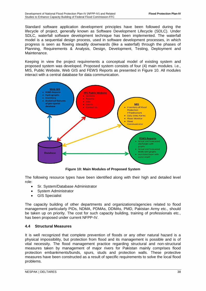
Development of National Flood Protection Plan-IV (NFPP-IV) and Related Flood Protection Plan-IV
Studies to Enhance Capacity Building of Federal Flood Commission-FFC
NESPAK | DELTARES 38
Standard software application development principles have been followed during the lifecycle of project, generally known as Software Development Lifecycle (SDLC). Under SDLC, waterfall software development technique has been implemented. The waterfall model is a sequential design process, used in software development processes, in which progress is seen as flowing steadily downwards (like a waterfall) through the phases of Planning, Requirements & Analysis, Design, Development, Testing, Deployment and Maintenance.
Keeping in view the project requirements a conceptual model of existing system and proposed system was developed. Proposed system consists of four (4) main modules. i.e., MIS, Public Website, Web GIS and FEWS Reports as presented in Figure 10. All modules interact with a central database for data communication.
Figure 10: Main Modules of Proposed System
The following resource types have been identified along with their high and detailed level role:
Sr. System/Database Administrator
System Administrator
GIS Specialist The capacity building of other departments and organizations/agencies related to flood management particularly PIDs, NDMA, PDMAs, DDMAs, PMD, Pakistan Army etc., should be taken up on priority. The cost for such capacity building, training of professionals etc., has been proposed under current NFPP-IV. 4.4 Structural Measures It is well recognized that complete prevention of floods or any other natural hazard is a physical impossibility, but protection from flood and its management is possible and is of vital necessity. The flood management practice regarding structural and non-structural measures taken by management of major rivers for Pakistan mainly comprises flood protection embankments/bunds, spurs, studs and protection walls. These protective measures have been constructed as a result of specific requirements to solve the local flood problems.
Development of National Flood Protection Plan-IV (NFPP-IV) and Related Flood Protection Plan-IV
Studies to Enhance Capacity Building of Federal Flood Commission-FFC
NESPAK | DELTARES 39
The nature and need of flood protection works vary due to physiographic characteristics and local conditions in different parts of Pakistan. Flood protection embankments have been constructed, wherever over-bank flooding is the major problem, while spurs have been constructed to encounter the land erosion, where this phenomenon is predominant. The existing flood management works are described briefly in the following sections; 4.4.1 Dams and Reservoirs
The role of reservoirs in flood management is very important and historic flood events (2010 & 2014) have highlighted their significance. Pakistan’s western rivers have two major reservoirs, Tarbela and Mangla on Indus and Jhelum rivers, respectively playing significant role in flood mitigation. Likewise on Indus, future dams upstream of Tarbela would provide relief in terms of reduced flood peaks. i.e., flood peak at Tarbela may get reduced by absorbing flood volumes through future reservoirs. NFPP-IV recommends the construction of new reservoirs as per WAPDA’s priority list with consensus of all provinces. The provision of cost is however, not made in the plan and is suggested to be undertaken as separate Public Sector Development Projects. 4.4.2 Embankments/Bunds, Spurs and Studs
Under the present project studies, comprehensive inventory has been developed comprising of existing flood protection infrastructure of all regions of Pakistan (Four Provinces, Gilgit-Baltistan, FATA and AJ&K) providing description/information including; reference/code number, name of river/stream/nullah, name of district, type of structure, length, height, name of the program, name of the scheme, cost, year of completion, executing agency (Federal/Provincial), etc. The physical status of existing flood protection works are given in Task-B Report. 4.4.3 Gabions and Protection/Retaining Walls
Gabions are well suited for retaining walls in hilly areas of the rivers where there are high flow velocity because of their flexibility and to make full use of readily available local material. These retaining walls are mostly used in hill torrents areas like Balochistan, Khyber Pakhtunkhwa, AJ&K and Gilgit-Baltistan. As per requirement, provision for necessary funds has been proposed under current NFPP-IV. 4.4.4 Diversions of High flows through Breaching Sections
In monsoon season, when there are exceptionally high flood flows and water levels in the rivers, embankments have to be breached to escape the excess water, resulting in damage to standing crops, loss of human and animal life, destruction of properties, dislocation of communication and unimaginable suffering of people which cannot be measured in terms of money. In this section of report, a review of breaches in flood embankments has been made. Proper investigation of such breaches is essential to avoid them and to take appropriate measures to minimize/control such breaches in future. A brief overview of existing breaching sections and possible escape/ diversion paths being studied by provinces is provided in next section. Normally two types of breaches exist such as natural and artificial. Natural breach in rivers is accompanied by the numbers of factors, which endanger the safety of the banks of rivers. Erosion of the surface of an embankment is usually caused by the action of wind, rodent
Development of National Flood Protection Plan-IV (NFPP-IV) and Related Flood Protection Plan-IV
Studies to Enhance Capacity Building of Federal Flood Commission-FFC
NESPAK | DELTARES 40
holes, poor maintenance of wetting channel, etc. Failure of the subsurface of an embankment may be the reason of breach in rivers. Breaches at Taunsa barrage, Jampur Flood bund & Jinnah barrage (2 No’s) in Punjab and Guddu barrage & Tori bund in Sindh during 2010 flood may be categorized as natural breaches.
Artificial breaches are provided to cater a situation where flood endangers the safety of hydraulic structure or bridge or nearby city. Therefore, various breaching sections provided near major hydraulic structures are operated. Table 10 shows the list of existing breaching sections on different hydraulic structures. Part A shows the breaching sections on barrages and headworks. While Part B shows the breaching sections on road bridges.
4.4.5 Diversion / Escape Channels
In Punjab all 10 barrages/headworks and some bridges on rivers have breaching sections as given in Table 10, except Taunsa barrage because canals are off-taking from both sides and road, railway, gas/oil pipe line are crossing the river. Any breach, accidental or deliberate, on either side will result in colossal damage to the private and public property. The site of breaching section is always mentioned in the flood fighting plans of Taunsa barrage at RD 1 to 2 of Link bund and RD 1 to 2 of shank of Spur 2-A, but practically it was never operated. The breaching section is now being proposed at RD 9 to 10 at shank of Spur T-2. Since the water from this breaching section will touch bank of Kachhi and D. G. Khan canals, thus a breaching section has to be provided at RD 22 to 24 of the canals. A causeway has to be constructed on Pacca road and water way has to be provided under main railway line. The bunds have to be constructed both upstream and downstream of Kachhi canal and railway line, respectively. Gates with head regulator have to be constructed on Kachhi and D.G. Khan canals both upstream and downstream of RD 22 and RD 24.
Similarly, the current breaching section near Shahdara on Ravi River is no more operational due to heavy encroachments in the surrounding areas. The opening of two bays has been proposed by Pakistan Railway. Efforts may also be required through District Government, Lahore to remove encroachments and relocate the encroachers. The scheme for opening of nine bays of Shahdara Railway Bridge titled "Enhancing Capacity of Shahdara Railway Bridge and Downstream Old G.T. Road Bridge” costing about Rs. 3,784 million was sent to Federal Government, which was deferred for till of model study.
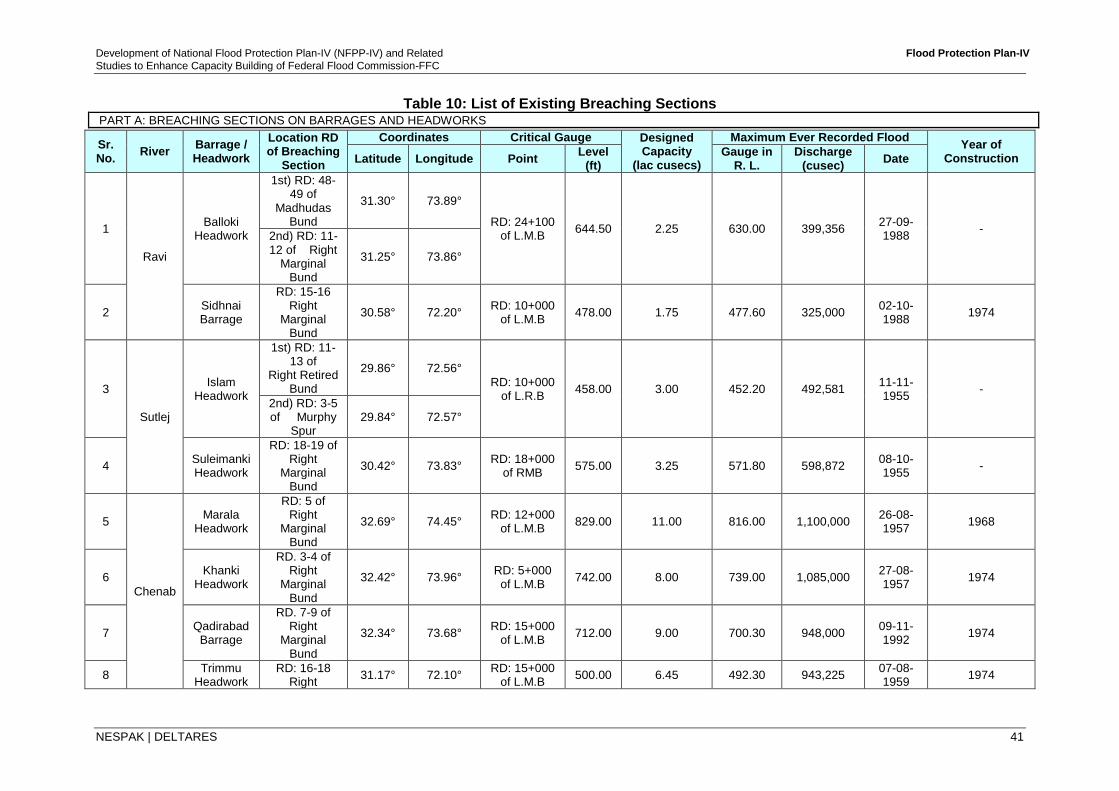
Development of National Flood Protection Plan-IV (NFPP-IV) and Related Flood Protection Plan-IV
Studies to Enhance Capacity Building of Federal Flood Commission-FFC
NESPAK | DELTARES 41
Table 10: List of Existing Breaching Sections PART A: BREACHING SECTIONS ON BARRAGES AND HEADWORKS
Sr. No.
River Barrage / Headwork
Location RD of Breaching
Section
Coordinates Critical Gauge Designed Capacity
(lac cusecs)
Maximum Ever Recorded Flood Year of
Construction Latitude Longitude Point Level
(ft) Gauge in
R. L. Discharge
(cusec) Date
1
Ravi
Balloki Headwork
1st) RD: 48-49 of
Madhudas Bund
31.30° 73.89°
RD: 24+100 of L.M.B
644.50 2.25 630.00 399,356 27-09-1988
- 2nd) RD: 11-12 of Right
Marginal Bund
31.25° 73.86°
2 Sidhnai Barrage
RD: 15-16 Right
Marginal Bund
30.58° 72.20° RD: 10+000
of L.M.B 478.00 1.75 477.60 325,000
02-10-1988
1974
3
Sutlej
Islam Headwork
1st) RD: 11-13 of
Right Retired Bund
29.86° 72.56°
RD: 10+000 of L.R.B
458.00 3.00 452.20 492,581 11-11-1955
-
2nd) RD: 3-5 of Murphy
Spur 29.84° 72.57°
4 Suleimanki Headwork
RD: 18-19 of Right
Marginal Bund
30.42° 73.83° RD: 18+000
of RMB 575.00 3.25 571.80 598,872
08-10-1955
-
5
Chenab
Marala Headwork
RD: 5 of Right
Marginal Bund
32.69° 74.45° RD: 12+000
of L.M.B 829.00 11.00 816.00 1,100,000
26-08-1957
1968
6 Khanki
Headwork
RD. 3-4 of Right
Marginal Bund
32.42° 73.96° RD: 5+000 of L.M.B
742.00 8.00 739.00 1,085,000 27-08-1957
1974
7 Qadirabad
Barrage
RD. 7-9 of Right
Marginal Bund
32.34° 73.68° RD: 15+000
of L.M.B 712.00 9.00 700.30 948,000
09-11-1992
1974
8 Trimmu
Headwork RD: 16-18
Right 31.17° 72.10°
RD: 15+000 of L.M.B
500.00 6.45 492.30 943,225 07-08-1959
1974
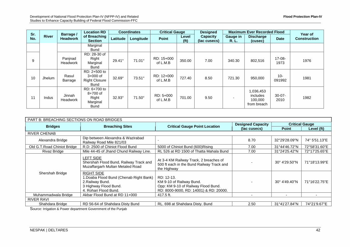
Development of National Flood Protection Plan-IV (NFPP-IV) and Related Flood Protection Plan-IV
Studies to Enhance Capacity Building of Federal Flood Commission-FFC
NESPAK | DELTARES 42
Sr. No.
River Barrage / Headwork
Location RD of Breaching
Section
Coordinates Critical Gauge Designed Capacity
(lac cusecs)
Maximum Ever Recorded Flood Year of
Construction Latitude Longitude Point Level
(ft) Gauge in
R. L. Discharge
(cusec) Date
Marginal Bund
9 Panjnad
Headwork
RD: 28-30 of Right
Marginal Bund
29.41° 71.01° RD: 15+000
of L.M.B 350.00 7.00 340.30 802,516
17-08-1973
1976
10 Jhelum Rasul
Barrage
RD: 2+500 to 3+000 of
Right Closure Bund
32.69° 73.51° RD: 12+000
of L.M.B 727.40 8.50 721.30 950,000
10-091992
1981
11 Indus Jinnah
Headwork
RD: 6+700 to 8+700 of
Right Marginal
Bund
32.93° 71.50° RD: 5+000 of L.M.B
701.00 9.50 -
1,036,453 includes 100,000
from breach
30-07-2010
1982
PART B: BREACHING SECTIONS ON ROAD BRIDGES
Bridges Breaching Sites Critical Gauge Point Location Designed Capacity
(lac cusecs)
Critical Gauge
Point Level (ft)
RIVER CHENAB
Alexandra Bridge Dip between Alexandra & Wazirabad Railway Road Mile 821/03
- 8.70 32°29'28.09"N 74° 5'51.13"E
Old G.T.Road Chiniot Bridge R.D: 2500 of Chiniot Flood Bund 5000 of Chiniot Bund (600)Rising 7.00 31°44'46.72"N 72°58'31.60"E
Rivaz Bridge Mile 44-45 of Jhand Chund Railway Line. RL 526 at RD 1500 of Thatta Mahala Bund 7.00 31°24'25.42"N 72°17'25.65"E
Shershah Bridge
LEFT SIDE Shershah Flood Bund, Railway Track and Muzaffargarh Multan Metaled Road
At 3-4 KM Railway Track, 2 breaches of 500 ft each in the Bund Railway Track and the Highway
- 30° 4'29.50"N 71°18'13.99"E
RIGHT SIDE 1.Doaba Flood Bund (Chenab Right Bank) 2.Railway Bund. 3 Highway Flood Bund. 4. Rohari Flood Bund.
RD: 12-13. KM 9-10 of Railway Bund. Opp: KM 9-10 of Railway Flood Bund. RD: 8000-9000, RD: 14001) & RD: 20000.
- 30° 4'49.40"N 71°16'22.75"E
Muhammadwala Bridge Akbar Flood Bund at RD 11+000 417.5 ft. - - -
RIVER RAVI
Shahdara Bridge RD 56-64 of Shahdara Disty Bund RL. 698 at Shahdara Disty. Bund 2.50 31°41'27.84"N 74°21'9.67"E
Source: Irrigation & Power department Government of the Punjab
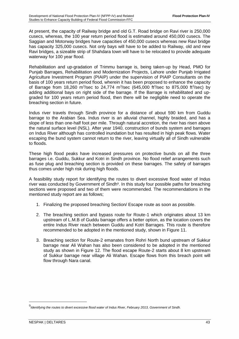
Development of National Flood Protection Plan-IV (NFPP-IV) and Related Flood Protection Plan-IV
Studies to Enhance Capacity Building of Federal Flood Commission-FFC
NESPAK | DELTARES 43
At present, the capacity of Railway bridge and old G.T. Road bridge on Ravi river is 250,000 cusecs, whereas, the 100 year return period flood is estimated around 450,000 cusecs. The Saggian and Motorway bridges have capacities of 450,000 cusecs whereas new Ravi bridge has capacity 325,000 cusecs. Not only bays will have to be added to Railway, old and new Ravi bridges, a sizeable strip of Shahdara town will have to be relocated to provide adequate waterway for 100 year flood. Rehabilitation and up-gradation of Trimmu barrage is, being taken-up by Head, PMO for Punjab Barrages, Rehabilitation and Modernization Projects, Lahore under Punjab Irrigated Agriculture Investment Program (PIAIP) under the supervision of PIAIP Consultants on the basis of 100 years return period flood, wherein it has been proposed to enhance the capacity of Barrage from 18,260 m3/sec to 24,774 m3/sec (645,000 ft3/sec to 875,000 ft3/sec) by adding additional bays on right side of the barrage. If the Barrage is rehabilitated and up-graded for 100 years return period flood, then there will be negligible need to operate the breaching section in future. Indus river travels through Sindh province for a distance of about 590 km from Guddu barrage to the Arabian Sea. Indus river is an alluvial channel, highly braided, and has a slope of less than one-half foot per mile. Through natural accretion, the river has risen above the natural surface level (NSL). After year 1940, construction of bunds system and barrages on Indus River although has controlled inundation but has resulted in high peak flows. Water escaping the bund system cannot return to the river, leaving virtually all of Sindh vulnerable to floods. These high flood peaks have increased pressures on protective bunds on all the three barrages i.e. Guddu, Sukkur and Kotri in Sindh province. No flood relief arrangements such as fuse plug and breaching section is provided on these barrages. The safety of barrages thus comes under high risk during high floods. A feasibility study report for identifying the routes to divert excessive flood water of Indus river was conducted by Government of Sindh9. In this study four possible paths for breaching sections were proposed and two of them were recommended. The recommendations in the mentioned study report are as follows;
1. Finalizing the proposed breaching Section/ Escape route as soon as possible. 2. The breaching section and bypass route for Route-1 which originates about 13 km
upstream of L.M.B of Guddu barrage offers a better option, as the location covers the entire Indus River reach between Guddu and Kotri Barrages. This route is therefore recommended to be adopted in the mentioned study, shown in Figure 11.
3. Breaching section for Route-2 emanates from Rohri North bund upstream of Sukkur barrage near Ali Wahan has also been considered to be adopted in the mentioned study as shown in Figure 12. The flood escape Route-2 starts about 8 km upstream of Sukkur barrage near village Ali Wahan. Escape flows from this breach point will flow through Nara canal.
9Identifying the routes to divert excessive flood water of Indus River, February 2013, Government of Sindh.
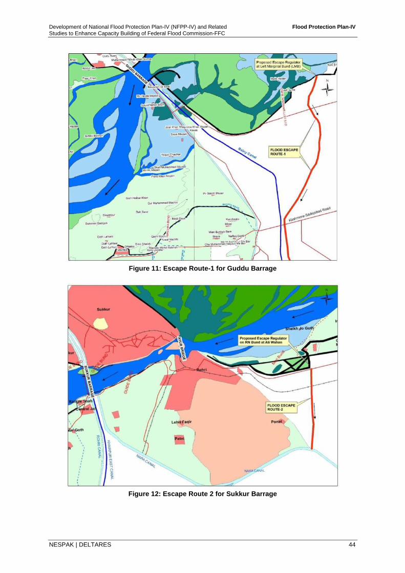
Development of National Flood Protection Plan-IV (NFPP-IV) and Related Flood Protection Plan-IV
Studies to Enhance Capacity Building of Federal Flood Commission-FFC
NESPAK | DELTARES 44
Figure 11: Escape Route-1 for Guddu Barrage
Figure 12: Escape Route 2 for Sukkur Barrage
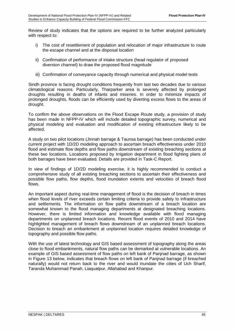
Development of National Flood Protection Plan-IV (NFPP-IV) and Related Flood Protection Plan-IV
Studies to Enhance Capacity Building of Federal Flood Commission-FFC
NESPAK | DELTARES 45
Review of study indicates that the options are required to be further analyzed particularly with respect to:
i) The cost of resettlement of population and relocation of major infrastructure to route the escape channel and at the disposal location
ii) Confirmation of performance of intake structure (head regulator of proposed diversion channel) to draw the proposed flood magnitude
iii) Confirmation of conveyance capacity through numerical and physical model tests Sindh province is facing drought conditions frequently from last two decades due to various climatological reasons. Particularly, Tharparker area is severely affected by prolonged droughts resulting in deaths of infants and miseries. In order to minimize impacts of prolonged droughts, floods can be efficiently used by diverting excess flows to the areas of drought. To confirm the above observations on the Flood Escape Route study, a provision of study has been made in NFPP-IV which will include detailed topographic survey, numerical and physical modeling and evaluation and modification of existing infrastructure likely to be affected. A study on two pilot locations (Jinnah barrage & Taunsa barrage) has been conducted under current project with 1D/2D modeling approach to ascertain breach effectiveness under 2010 flood and estimate flow depths and flow paths downstream of existing breaching sections at these two locations. Locations proposed by Irrigation department in flood fighting plans of both barrages have been evaluated. Details are provided in Task-C Report. In view of findings of 1D/2D modeling exercise, it is highly recommended to conduct a comprehensive study of all existing breaching sections to ascertain their effectiveness and possible flow paths, flow depths, flood inundation extents and velocities of breach flood flows. An important aspect during real-time management of flood is the decision of breach in times when flood levels of river exceeds certain limiting criteria to provide safety to infrastructure and settlements. The information on flow paths downstream of a breach location are somewhat known to the flood managing departments at designated breaching locations. However, there is limited information and knowledge available with flood managing departments on unplanned breach locations. Recent flood events of 2010 and 2014 have highlighted management of breach flows downstream of an unplanned breach locations. Decision to breach an embankment at unplanned location requires detailed knowledge of topography and possible flow paths. With the use of latest technology and GIS based assessment of topography along the areas close to flood embankments, natural flow paths can be demarked at vulnerable locations. An example of GIS based assessment of flow paths on left bank of Panjnad barrage, as shown in Figure 13 below, indicates that breach flows on left bank of Panjnad barrage (if breached naturally) would not return back to the river and would inundate the cities of Uch Sharif, Taranda Muhammad Panah, Liaquatpur, Allahabad and Khanpur.
Development of National Flood Protection Plan-IV (NFPP-IV) and Related Flood Protection Plan-IV
Studies to Enhance Capacity Building of Federal Flood Commission-FFC
NESPAK | DELTARES 46
Figure 13: GIS Based Assessment of Flow paths on Left Embankment of Panjnad Barrage
4.4.6 Channel Improvements
Urban drainage systems are consolidated systems including drainage channels, networks, and pump stations within drainage basins. Channels in urban drainage system cater for larger volume of flood flows. Drastic population growth and insufficient O&M activities may cause early clogging of drainage channels and result to the malfunctioning of the drainage network.
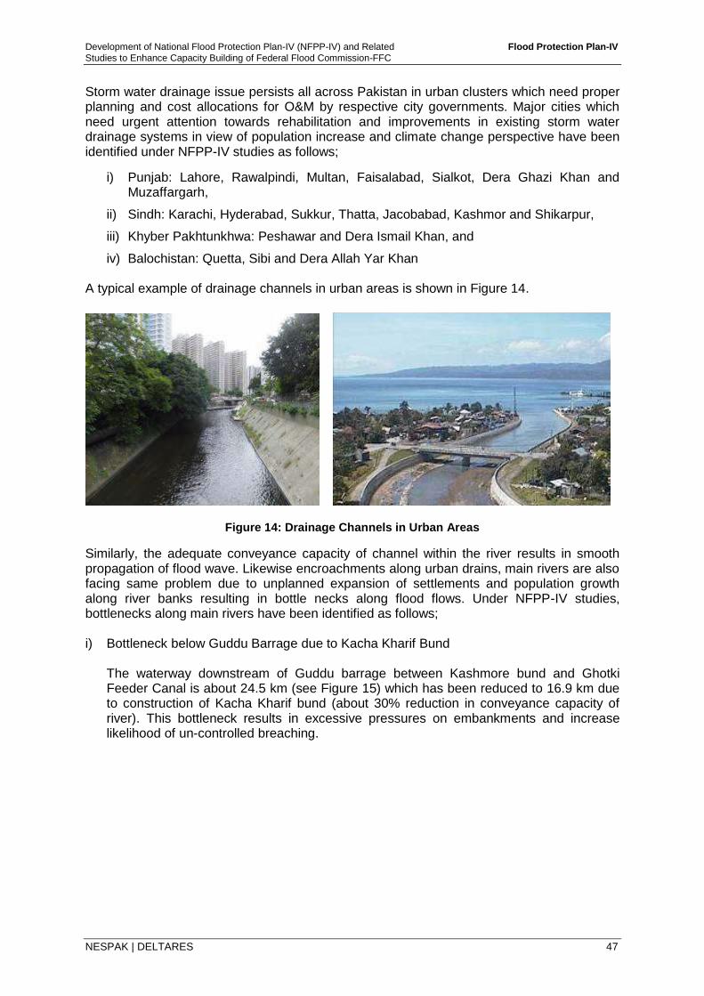
Development of National Flood Protection Plan-IV (NFPP-IV) and Related Flood Protection Plan-IV
Studies to Enhance Capacity Building of Federal Flood Commission-FFC
NESPAK | DELTARES 47
Storm water drainage issue persists all across Pakistan in urban clusters which need proper planning and cost allocations for O&M by respective city governments. Major cities which need urgent attention towards rehabilitation and improvements in existing storm water drainage systems in view of population increase and climate change perspective have been identified under NFPP-IV studies as follows;
i) Punjab: Lahore, Rawalpindi, Multan, Faisalabad, Sialkot, Dera Ghazi Khan and Muzaffargarh,
ii) Sindh: Karachi, Hyderabad, Sukkur, Thatta, Jacobabad, Kashmor and Shikarpur,
iii) Khyber Pakhtunkhwa: Peshawar and Dera Ismail Khan, and
iv) Balochistan: Quetta, Sibi and Dera Allah Yar Khan A typical example of drainage channels in urban areas is shown in Figure 14.
Figure 14: Drainage Channels in Urban Areas
Similarly, the adequate conveyance capacity of channel within the river results in smooth propagation of flood wave. Likewise encroachments along urban drains, main rivers are also facing same problem due to unplanned expansion of settlements and population growth along river banks resulting in bottle necks along flood flows. Under NFPP-IV studies, bottlenecks along main rivers have been identified as follows; i) Bottleneck below Guddu Barrage due to Kacha Kharif Bund
The waterway downstream of Guddu barrage between Kashmore bund and Ghotki Feeder Canal is about 24.5 km (see Figure 15) which has been reduced to 16.9 km due to construction of Kacha Kharif bund (about 30% reduction in conveyance capacity of river). This bottleneck results in excessive pressures on embankments and increase likelihood of un-controlled breaching.
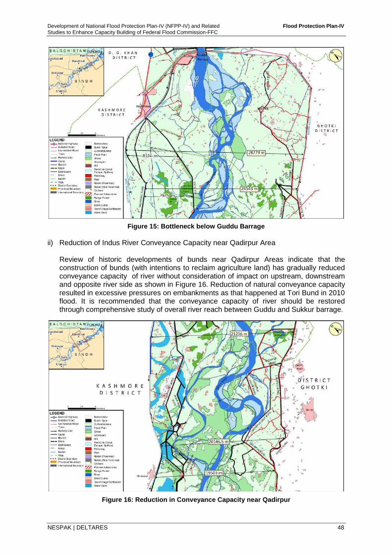
Development of National Flood Protection Plan-IV (NFPP-IV) and Related Flood Protection Plan-IV
Studies to Enhance Capacity Building of Federal Flood Commission-FFC
NESPAK | DELTARES 48
Figure 15: Bottleneck below Guddu Barrage
ii) Reduction of Indus River Conveyance Capacity near Qadirpur Area
Review of historic developments of bunds near Qadirpur Areas indicate that the construction of bunds (with intentions to reclaim agriculture land) has gradually reduced conveyance capacity of river without consideration of impact on upstream, downstream and opposite river side as shown in Figure 16. Reduction of natural conveyance capacity resulted in excessive pressures on embankments as that happened at Tori Bund in 2010 flood. It is recommended that the conveyance capacity of river should be restored through comprehensive study of overall river reach between Guddu and Sukkur barrage.
Figure 16: Reduction in Conveyance Capacity near Qadirpur
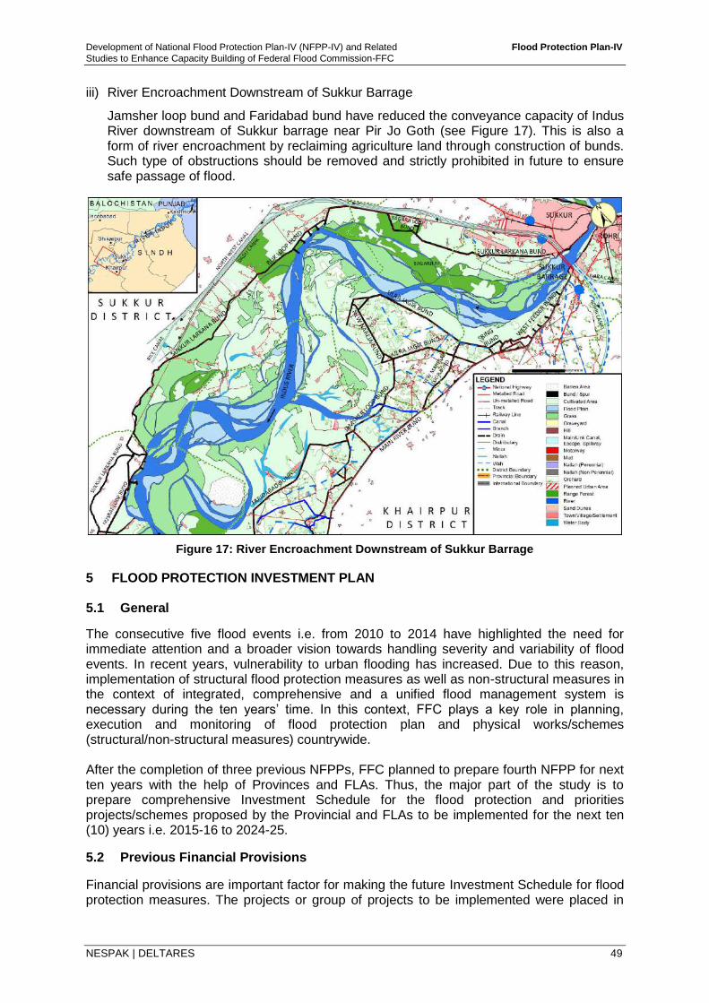
Development of National Flood Protection Plan-IV (NFPP-IV) and Related Flood Protection Plan-IV
Studies to Enhance Capacity Building of Federal Flood Commission-FFC
NESPAK | DELTARES 49
iii) River Encroachment Downstream of Sukkur Barrage
Jamsher loop bund and Faridabad bund have reduced the conveyance capacity of Indus River downstream of Sukkur barrage near Pir Jo Goth (see Figure 17). This is also a form of river encroachment by reclaiming agriculture land through construction of bunds. Such type of obstructions should be removed and strictly prohibited in future to ensure safe passage of flood.
Figure 17: River Encroachment Downstream of Sukkur Barrage
5 FLOOD PROTECTION INVESTMENT PLAN
5.1 General
The consecutive five flood events i.e. from 2010 to 2014 have highlighted the need for immediate attention and a broader vision towards handling severity and variability of flood events. In recent years, vulnerability to urban flooding has increased. Due to this reason, implementation of structural flood protection measures as well as non-structural measures in the context of integrated, comprehensive and a unified flood management system is necessary during the ten years’ time. In this context, FFC plays a key role in planning, execution and monitoring of flood protection plan and physical works/schemes (structural/non-structural measures) countrywide. After the completion of three previous NFPPs, FFC planned to prepare fourth NFPP for next ten years with the help of Provinces and FLAs. Thus, the major part of the study is to prepare comprehensive Investment Schedule for the flood protection and priorities projects/schemes proposed by the Provincial and FLAs to be implemented for the next ten (10) years i.e. 2015-16 to 2024-25.
5.2 Previous Financial Provisions
Financial provisions are important factor for making the future Investment Schedule for flood protection measures. The projects or group of projects to be implemented were placed in
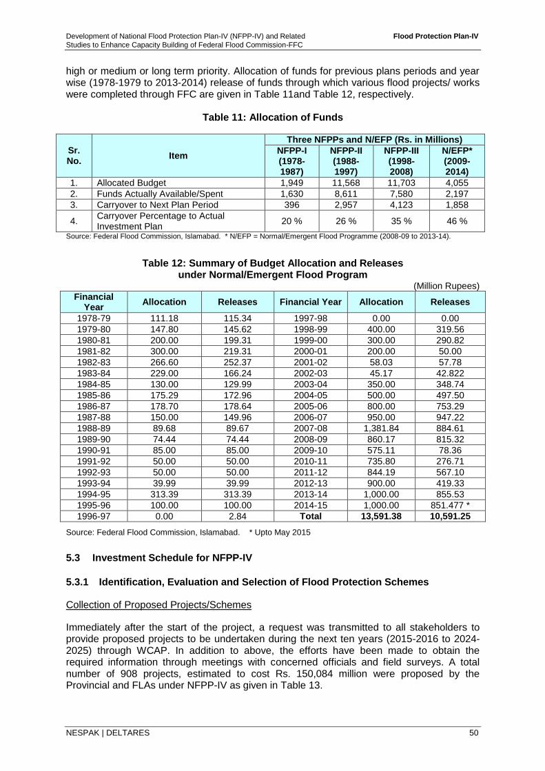
Development of National Flood Protection Plan-IV (NFPP-IV) and Related Flood Protection Plan-IV
Studies to Enhance Capacity Building of Federal Flood Commission-FFC
NESPAK | DELTARES 50
high or medium or long term priority. Allocation of funds for previous plans periods and year wise (1978-1979 to 2013-2014) release of funds through which various flood projects/ works were completed through FFC are given in Table 11and Table 12, respectively.
Table 11: Allocation of Funds
Sr. No.
Item
Three NFPPs and N/EFP (Rs. in Millions)
NFPP-I (1978-1987)
NFPP-II (1988-1997)
NFPP-III (1998- 2008)
N/EFP* (2009-2014)
1. Allocated Budget 1,949 11,568 11,703 4,055
2. Funds Actually Available/Spent 1,630 8,611 7,580 2,197
3. Carryover to Next Plan Period 396 2,957 4,123 1,858
4. Carryover Percentage to Actual Investment Plan
20 % 26 % 35 % 46 %
Source: Federal Flood Commission, Islamabad. * N/EFP = Normal/Emergent Flood Programme (2008-09 to 2013-14).
Table 12: Summary of Budget Allocation and Releases under Normal/Emergent Flood Program
(Million Rupees) Financial
Year Allocation Releases Financial Year Allocation Releases
1978-79 111.18 115.34 1997-98 0.00 0.00
1979-80 147.80 145.62 1998-99 400.00 319.56
1980-81 200.00 199.31 1999-00 300.00 290.82
1981-82 300.00 219.31 2000-01 200.00 50.00
1982-83 266.60 252.37 2001-02 58.03 57.78
1983-84 229.00 166.24 2002-03 45.17 42.822
1984-85 130.00 129.99 2003-04 350.00 348.74
1985-86 175.29 172.96 2004-05 500.00 497.50
1986-87 178.70 178.64 2005-06 800.00 753.29
1987-88 150.00 149.96 2006-07 950.00 947.22
1988-89 89.68 89.67 2007-08 1,381.84 884.61
1989-90 74.44 74.44 2008-09 860.17 815.32
1990-91 85.00 85.00 2009-10 575.11 78.36
1991-92 50.00 50.00 2010-11 735.80 276.71
1992-93 50.00 50.00 2011-12 844.19 567.10
1993-94 39.99 39.99 2012-13 900.00 419.33
1994-95 313.39 313.39 2013-14 1,000.00 855.53
1995-96 100.00 100.00 2014-15 1,000.00 851.477 *
1996-97 0.00 2.84 Total 13,591.38 10,591.25
Source: Federal Flood Commission, Islamabad. * Upto May 2015
5.3 Investment Schedule for NFPP-IV
5.3.1 Identification, Evaluation and Selection of Flood Protection Schemes
Collection of Proposed Projects/Schemes
Immediately after the start of the project, a request was transmitted to all stakeholders to provide proposed projects to be undertaken during the next ten years (2015-2016 to 2024-2025) through WCAP. In addition to above, the efforts have been made to obtain the required information through meetings with concerned officials and field surveys. A total number of 908 projects, estimated to cost Rs. 150,084 million were proposed by the Provincial and FLAs under NFPP-IV as given in Table 13.
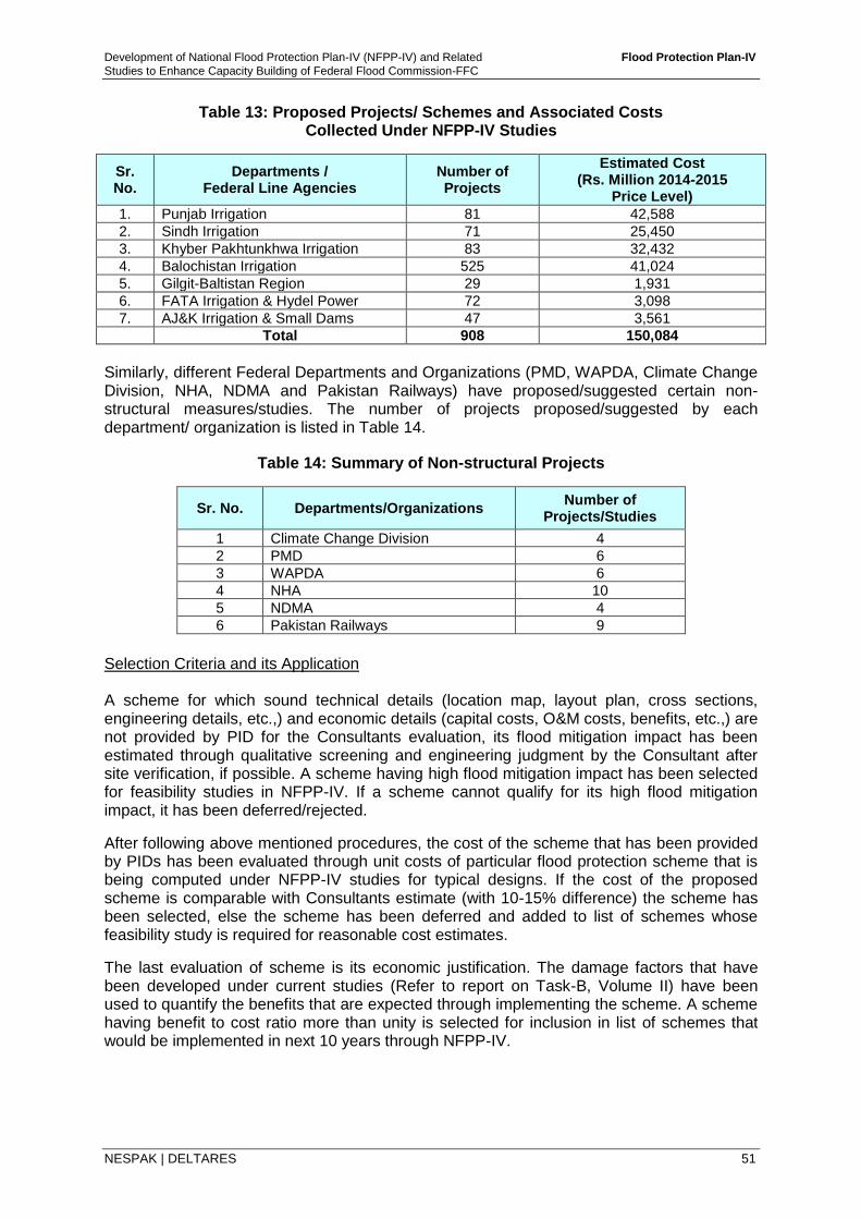
Development of National Flood Protection Plan-IV (NFPP-IV) and Related Flood Protection Plan-IV
Studies to Enhance Capacity Building of Federal Flood Commission-FFC
NESPAK | DELTARES 51
Table 13: Proposed Projects/ Schemes and Associated Costs Collected Under NFPP-IV Studies
Sr. No.
Departments / Federal Line Agencies
Number of Projects
Estimated Cost (Rs. Million 2014-2015
Price Level)
1. Punjab Irrigation 81 42,588
2. Sindh Irrigation 71 25,450
3. Khyber Pakhtunkhwa Irrigation 83 32,432
4. Balochistan Irrigation 525 41,024
5. Gilgit-Baltistan Region 29 1,931
6. FATA Irrigation & Hydel Power 72 3,098
7. AJ&K Irrigation & Small Dams 47 3,561
Total 908 150,084
Similarly, different Federal Departments and Organizations (PMD, WAPDA, Climate Change Division, NHA, NDMA and Pakistan Railways) have proposed/suggested certain non-structural measures/studies. The number of projects proposed/suggested by each department/ organization is listed in Table 14.
Table 14: Summary of Non-structural Projects
Sr. No. Departments/Organizations Number of
Projects/Studies
1 Climate Change Division 4
2 PMD 6
3 WAPDA 6
4 NHA 10
5 NDMA 4
6 Pakistan Railways 9
Selection Criteria and its Application A scheme for which sound technical details (location map, layout plan, cross sections, engineering details, etc.,) and economic details (capital costs, O&M costs, benefits, etc.,) are not provided by PID for the Consultants evaluation, its flood mitigation impact has been estimated through qualitative screening and engineering judgment by the Consultant after site verification, if possible. A scheme having high flood mitigation impact has been selected for feasibility studies in NFPP-IV. If a scheme cannot qualify for its high flood mitigation impact, it has been deferred/rejected.
After following above mentioned procedures, the cost of the scheme that has been provided by PIDs has been evaluated through unit costs of particular flood protection scheme that is being computed under NFPP-IV studies for typical designs. If the cost of the proposed scheme is comparable with Consultants estimate (with 10-15% difference) the scheme has been selected, else the scheme has been deferred and added to list of schemes whose feasibility study is required for reasonable cost estimates.
The last evaluation of scheme is its economic justification. The damage factors that have been developed under current studies (Refer to report on Task-B, Volume II) have been used to quantify the benefits that are expected through implementing the scheme. A scheme having benefit to cost ratio more than unity is selected for inclusion in list of schemes that would be implemented in next 10 years through NFPP-IV.
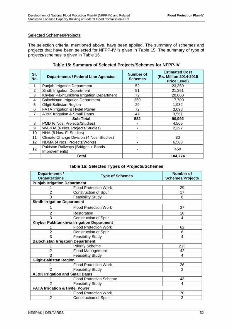
Development of National Flood Protection Plan-IV (NFPP-IV) and Related Flood Protection Plan-IV
Studies to Enhance Capacity Building of Federal Flood Commission-FFC
NESPAK | DELTARES 52
Selected Schemes/Projects The selection criteria, mentioned above, have been applied. The summary of schemes and projects that have been selected for NFPP-IV is given in Table 15. The summary of type of projects/schemes is given in Table 16.
Table 15: Summary of Selected Projects/Schemes for NFPP-IV
Sr. No.
Departments / Federal Line Agencies Number of Schemes
Estimated Cost (Rs. Million 2014-2015
Price Level)
1 Punjab Irrigation Department 52 23,350
2 Sindh Irrigation Department 51 21,351
3 Khyber Pakhtunkhwa Irrigation Department 72 20,000
4 Balochistan Irrigation Department 259 17,700
5 Gilgit-Baltistan Region 29 1,932
6 FATA Irrigation & Hydel Power 72 3,098
7 AJ&K Irrigation & Small Dams 47 3,561
Sub-Total 582 90,992
8 PMD (6 Nos. Projects/Studies) - 4,505
9 WAPDA (6 Nos. Projects/Studies) - 2,297
10 NHA (8 Nos. F. Studies) - -
11 Climate Change Division (4 Nos. Studies) - 30
12 NDMA (4 Nos. Projects/Works) - 6,500
12 Pakistan Railways (Bridges + Bunds Improvements)
- 450
Total 104,774
Table 16: Selected Types of Projects/Schemes
Departments / Organizations
Type of Schemes Number of
Schemes/Projects
Punjab Irrigation Department
1 Flood Protection Work 29
2 Construction of Spur 17
3 Feasibility Study 6
Sindh Irrigation Department
1 Flood Protection Work 37
2 Restoration 10
3 Construction of Spur 4
Khyber Pakhtunkhwa Irrigation Department
1 Flood Protection Work 62
2 Construction of Spur 6
3 Feasibility Study 4
Balochistan Irrigation Department
1 Priority Scheme 213
2 Flood Management 42
3 Feasibility Study 4
Gilgit-Baltistan Region
1 Flood Protection Work 26
2 Feasibility Study 3
AJ&K Irrigation and Small Dams
1 Flood Protection Scheme 43
2 Feasibility Study 4
FATA Irrigation & Hydel Power
1 Flood Protection Work 70
2 Construction of Spur 2
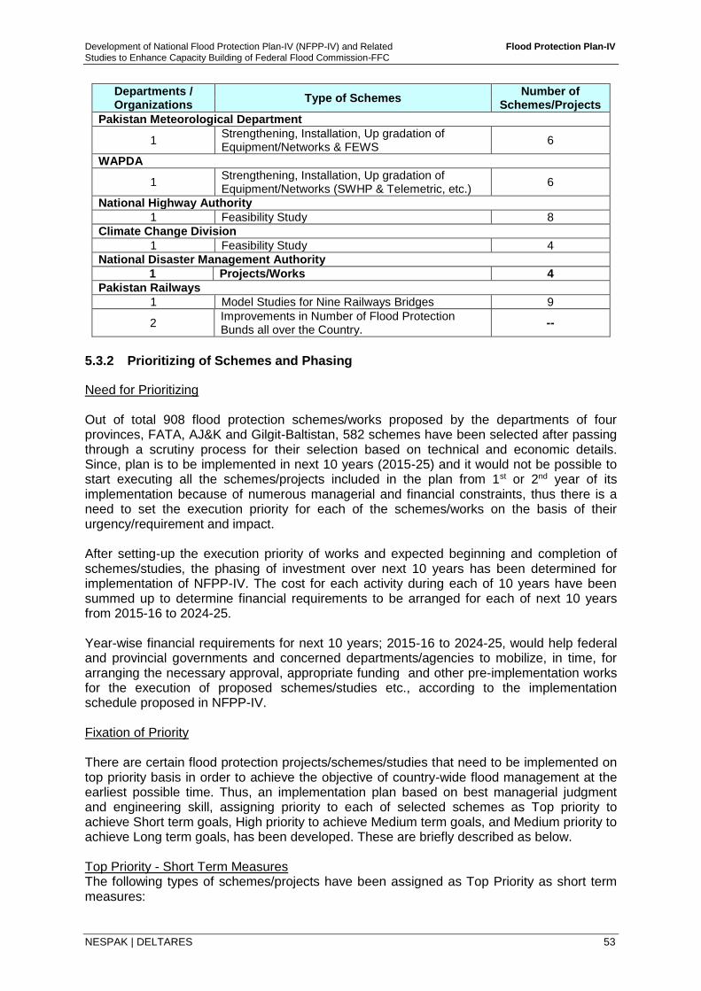
Development of National Flood Protection Plan-IV (NFPP-IV) and Related Flood Protection Plan-IV
Studies to Enhance Capacity Building of Federal Flood Commission-FFC
NESPAK | DELTARES 53
Departments / Organizations
Type of Schemes Number of
Schemes/Projects
Pakistan Meteorological Department
1 Strengthening, Installation, Up gradation of Equipment/Networks & FEWS
6
WAPDA
1 Strengthening, Installation, Up gradation of Equipment/Networks (SWHP & Telemetric, etc.)
6
National Highway Authority
1 Feasibility Study 8
Climate Change Division
1 Feasibility Study 4
National Disaster Management Authority
1 Projects/Works 4
Pakistan Railways
1 Model Studies for Nine Railways Bridges 9
2 Improvements in Number of Flood Protection Bunds all over the Country.
--
5.3.2 Prioritizing of Schemes and Phasing
Need for Prioritizing Out of total 908 flood protection schemes/works proposed by the departments of four provinces, FATA, AJ&K and Gilgit-Baltistan, 582 schemes have been selected after passing through a scrutiny process for their selection based on technical and economic details. Since, plan is to be implemented in next 10 years (2015-25) and it would not be possible to start executing all the schemes/projects included in the plan from 1st or 2nd year of its implementation because of numerous managerial and financial constraints, thus there is a need to set the execution priority for each of the schemes/works on the basis of their urgency/requirement and impact. After setting-up the execution priority of works and expected beginning and completion of schemes/studies, the phasing of investment over next 10 years has been determined for implementation of NFPP-IV. The cost for each activity during each of 10 years have been summed up to determine financial requirements to be arranged for each of next 10 years from 2015-16 to 2024-25. Year-wise financial requirements for next 10 years; 2015-16 to 2024-25, would help federal and provincial governments and concerned departments/agencies to mobilize, in time, for arranging the necessary approval, appropriate funding and other pre-implementation works for the execution of proposed schemes/studies etc., according to the implementation schedule proposed in NFPP-IV. Fixation of Priority There are certain flood protection projects/schemes/studies that need to be implemented on top priority basis in order to achieve the objective of country-wide flood management at the earliest possible time. Thus, an implementation plan based on best managerial judgment and engineering skill, assigning priority to each of selected schemes as Top priority to achieve Short term goals, High priority to achieve Medium term goals, and Medium priority to achieve Long term goals, has been developed. These are briefly described as below. Top Priority - Short Term Measures The following types of schemes/projects have been assigned as Top Priority as short term measures:
Development of National Flood Protection Plan-IV (NFPP-IV) and Related Flood Protection Plan-IV
Studies to Enhance Capacity Building of Federal Flood Commission-FFC
NESPAK | DELTARES 54
i. Completion of on-going projects,
ii. Strengthening and re-modeling of existing flood protection works in the most vulnerable or problematic areas,
iii. Up-gradation/strengthening of river gauging network and flood early warning and forecasting system, and
iv. Revision of SOPs for existing reservoirs, and
v. Implementation of floodplain legislation (River Act).
High Priority – Medium Term Measures The following types of schemes/projects have been assigned High Priority as medium term measures:
i. To revive the original capacity of barrages/bridges and enhance the existing system capacity of river reaches, hydraulic structures, embankment (top levels) to bear floods above their existing design magnitudes,
ii. Strengthening and re-modeling of existing flood protection works (not covered under Top Priority I) in all over the country,
iii. Design/construction of new works as per unique design standards with respect to hydrologic, hydraulic, structural, geotechnical investigations, etc.,
iv. Watershed management/land use control in the uplands of all the concerned rivers.
Medium Priority – Long Term Measures All the remaining works (not covered under Top priority and High Priority) falling in the areas with lesser flood threat and low level of damages have been placed in Medium Priority III as long term measures. 5.3.3 Investment Schedule/Plan
Previous National Flood Protection Plans including foreign funded/aided projects, indicated priority-wise projects to be undertaken. Priority was based on proposals given by the Provincial Irrigation Departments and Federal Agencies/Organizations. During course of preparation of NFPP-IV, for the period 2015-16 to 2024-25, 908 projects/schemes were proposed by the PIDs and FLAs out of which 582 projects/Schemes have been selected with estimated cost of Rs 90,992 million.
Presently, the urgent flood protection works are being undertaken through GoP funded Normal/Emergent Flood Protection Programme under PSDP on yearly basis, which are planned and executed by the Provinces and Federal Administered Areas (Table 12). As per previous practices in the country, due to financial constraints many of proposed projects could not be executed (2009-2014) and some of the on-going projects are to be completed during implementation of NFPP-IV during period 2015-16 to 2024-25. Again this time, the priority is given to ongoing works.
A summary of Investment Schedule is provided in Table 17. The yearly phasing of investment schedule is presented in Table 18 and the project wise details are given in Annex-1. In addition, as mentioned in earlier sections of this report, there are certain projects that are proposed by the Federal Agencies / Organizations without any cost estimates. Since these

Development of National Flood Protection Plan-IV (NFPP-IV) and Related Flood Protection Plan-IV
Studies to Enhance Capacity Building of Federal Flood Commission-FFC
NESPAK | DELTARES 55
are the projects of high priority, thus are recommended for their feasibility studies as given in Table 19. Further, there are some projects, proposed by PIDs and FLAs having very high estimated cost. These are also included in Table 19 for further studies. Necessary description on various investment categories mentioned in Table 19 are provided in the later Sections of this report. 5.4 Description on Investment Categories
5.4.1 Completion of On-Going Projects/Liability
A number of flood protection projects are presently under implementation and will require additional funds for their completion. High priority is required to be given for the completion of on-going projects. From 2008 to 2013, FFC have started 174 projects with an estimated cost of Rs. 5,001 million. The completed projects are given in Table 20. At present, 56 projects are on-going on which Rs. 884.70 million have already been spent and an additional amount of Rs. 750.75 million is required to complete these projects in first three years of NFPP-IV (2014-2016), as shown in Table 21.
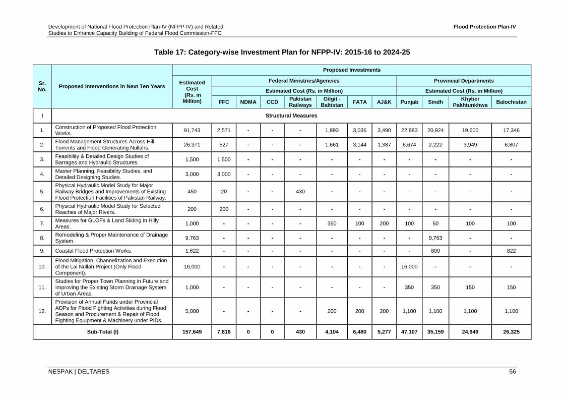
Development of National Flood Protection Plan-IV (NFPP-IV) and Related Flood Protection Plan-IV
Studies to Enhance Capacity Building of Federal Flood Commission-FFC
NESPAK | DELTARES 56
Table 17: Category-wise Investment Plan for NFPP-IV: 2015-16 to 2024-25
Sr. No.
Proposed Interventions in Next Ten Years
Proposed Investments
Estimated Cost
(Rs. in Million)
Federal Ministries/Agencies Provincial Departments
Estimated Cost (Rs. in Million) Estimated Cost (Rs. in Million)
FFC NDMA CCD Pakistan Railways
Gilgit - Baltistan
FATA AJ&K Punjab Sindh Khyber
Pakhtunkhwa Balochistan
I Structural Measures
1. Construction of Proposed Flood Protection Works.
91,743 2,571 - - - 1,893 3,036 3,490 22,883 20,924 19,600 17,346
2. Flood Management Structures Across Hill Torrents and Flood Generating Nullahs.
26,371 527 - - - 1,661 3,144 1,387 6,674 2,222 3,949 6,807
3. Feasibility & Detailed Design Studies of Barrages and Hydraulic Structures.
1,500 1,500 - - - - - - - - - -
4. Master Planning, Feasibility Studies, and Detailed Designing Studies.
3,000 3,000 - - - - - - - - - -
5. Physical Hydraulic Model Study for Major Railway Bridges and Improvements of Existing Flood Protection Facilities of Pakistan Railway.
450 20 - - 430 - - - - - - -
6. Physical Hydraulic Model Study for Selected Reaches of Major Rivers.
200 200 - - - - - - - - - -
7. Measures for GLOFs & Land Sliding in Hilly Areas.
1,000 - - - - 350 100 200 100 50 100 100
8. Remodeling & Proper Maintenance of Drainage System.
9,763 - - - - - - - - 9,763 - -
9. Coastal Flood Protection Works. 1,622 - - - - - - - - 800 - 822
10. Flood Mitigation, Channelization and Execution of the Lai Nullah Project (Only Flood Component).
16,000 - - - - - - - 16,000 - - -
11. Studies for Proper Town Planning in Future and Improving the Existing Storm Drainage System of Urban Areas.
1,000 - - - - - - - 350 350 150 150
12.
Provision of Annual Funds under Provincial ADPs for Flood Fighting Activities during Flood Season and Procurement & Repair of Flood Fighting Equipment & Machinery under PIDs.
5,000 - - - - 200 200 200 1,100 1,100 1,100 1,100
Sub-TotaI (I) 157,649 7,818 0 0 430 4,104 6,480 5,277 47,107 35,159 24,949 26,325
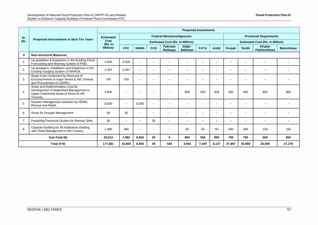
Development of National Flood Protection Plan-IV (NFPP-IV) and Related Flood Protection Plan-IV
Studies to Enhance Capacity Building of Federal Flood Commission-FFC
NESPAK | DELTARES 57
Sr. No.
Proposed Interventions in Next Ten Years
Proposed Investments
Estimated Cost
(Rs. in Million)
Federal Ministries/Agencies Provincial Departments
Estimated Cost (Rs. in Million) Estimated Cost (Rs. in Million)
FFC NDMA CCD Pakistan Railways
Gilgit - Baltistan
FATA AJ&K Punjab Sindh Khyber
Pakhtunkhwa Balochistan
II Non-structural Measures
1. Up-gradation & Expansion in the Existing Flood Forecasting and Warning System of PMD.
4,505 4,505 - - - - - - - - - -
2. Up-gradation, Installation and Expansion in the Existing Gauging System of WAPDA.
2,297 2,297 - - - - - - - - - -
3. Study to be Conducted for Removal of Encroachments in major Rivers & Hill Torrents and Procurement of LiDAR’s.
750 750 - - - - - - - - - -
4.
Study and Implementation Cost for Development of Watershed Management in Upper Catchment Areas of Rivers & Hill Torrents.
4,500 - - - - 800 500 800 400 400 800 800
5. Disaster Management Activities by NDMA, Rescue and Relief.
6,500 - 6,500 - - - - - - - - -
6. Study for Drought Management 50 50 - - - - - - - - - -
7. Feasibility/Technical Studies for Ramsar Sites. 30 - - 30 - - - - - - - -
8. Capacity Building for All Institutions Dealing with Flood Management in the Country.
1,380 380 - - - 50 50 50 300 300 100 150
Sub-Total (II) 20,012 7,982 6,500 30 0 850 550 850 700 700 900 950
Total (I+II) 177,661 15,800 6,500 30 430 4,954 7,030 6,127 47,807 35,859 25,849 27,275
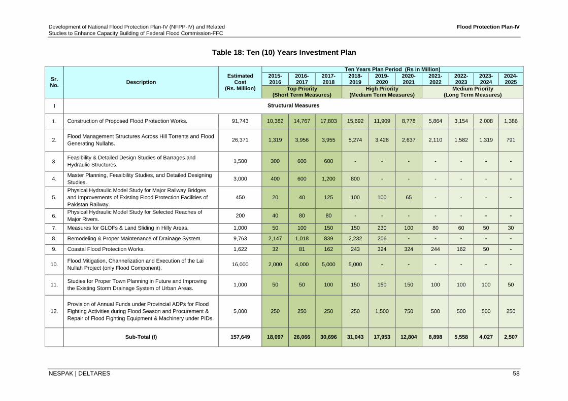
Development of National Flood Protection Plan-IV (NFPP-IV) and Related Flood Protection Plan-IV
Studies to Enhance Capacity Building of Federal Flood Commission-FFC
NESPAK | DELTARES 58
Table 18: Ten (10) Years Investment Plan
Sr. No.
Description Estimated
Cost (Rs. Million)
Ten Years Plan Period (Rs in Million)
2015-2016
2016-2017
2017-2018
2018-2019
2019-2020
2020-2021
2021-2022
2022-2023
2023-2024
2024-2025
Top Priority (Short Term Measures)
High Priority (Medium Term Measures)
Medium Priority (Long Term Measures)
I Structural Measures
1. Construction of Proposed Flood Protection Works. 91,743 10,382 14,767 17,803 15,692 11,909 8,778 5,864 3,154 2,008 1,386
2. Flood Management Structures Across Hill Torrents and Flood
Generating Nullahs. 26,371 1,319 3,956 3,955 5,274 3,428 2,637 2,110 1,582 1,319 791
3. Feasibility & Detailed Design Studies of Barrages and
Hydraulic Structures. 1,500 300 600 600 - - - - - - -
4. Master Planning, Feasibility Studies, and Detailed Designing
Studies. 3,000 400 600 1,200 800 - - - - - -
5.
Physical Hydraulic Model Study for Major Railway Bridges
and Improvements of Existing Flood Protection Facilities of
Pakistan Railway.
450 20 40 125 100 100 65 - - - -
6. Physical Hydraulic Model Study for Selected Reaches of
Major Rivers. 200 40 80 80 - - - - - - -
7. Measures for GLOFs & Land Sliding in Hilly Areas. 1,000 50 100 150 150 230 100 80 60 50 30
8. Remodeling & Proper Maintenance of Drainage System. 9,763 2,147 1,018 839 2,232 206 - - - - -
9. Coastal Flood Protection Works. 1,622 32 81 162 243 324 324 244 162 50 -
10. Flood Mitigation, Channelization and Execution of the Lai
Nullah Project (only Flood Component). 16,000 2,000 4,000 5,000 5,000 - - - - - -
11. Studies for Proper Town Planning in Future and Improving
the Existing Storm Drainage System of Urban Areas. 1,000 50 50 100 150 150 150 100 100 100 50
12.
Provision of Annual Funds under Provincial ADPs for Flood
Fighting Activities during Flood Season and Procurement &
Repair of Flood Fighting Equipment & Machinery under PIDs.
5,000 250 250 250 250 1,500 750 500 500 500 250
Sub-Total (I) 157,649 18,097 26,066 30,696 31,043 17,953 12,804 8,898 5,558 4,027 2,507
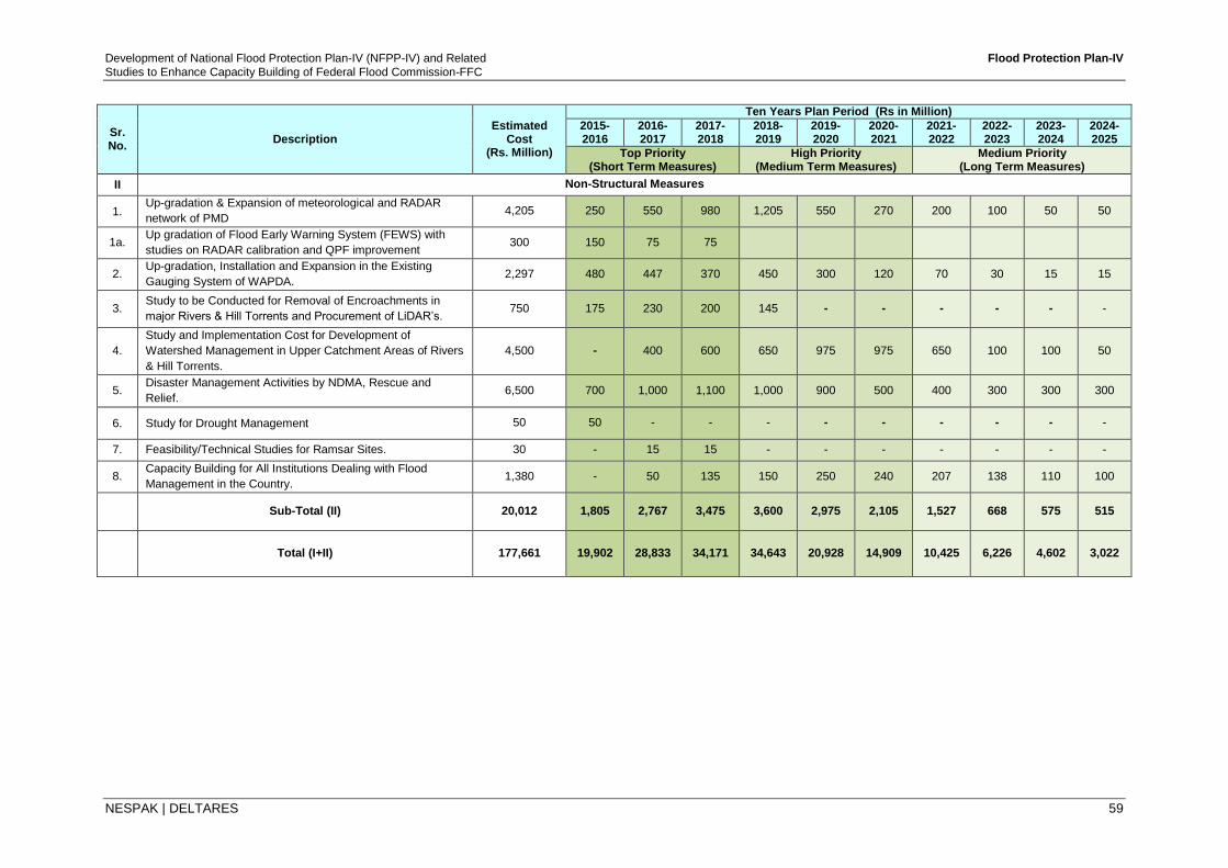
Development of National Flood Protection Plan-IV (NFPP-IV) and Related Flood Protection Plan-IV
Studies to Enhance Capacity Building of Federal Flood Commission-FFC
NESPAK | DELTARES 59
Sr. No.
Description Estimated
Cost (Rs. Million)
Ten Years Plan Period (Rs in Million)
2015-2016
2016-2017
2017-2018
2018-2019
2019-2020
2020-2021
2021-2022
2022-2023
2023-2024
2024-2025
Top Priority (Short Term Measures)
High Priority (Medium Term Measures)
Medium Priority (Long Term Measures)
II Non-Structural Measures
1. Up-gradation & Expansion of meteorological and RADAR
network of PMD 4,205 250 550 980 1,205 550 270 200 100 50 50
1a. Up gradation of Flood Early Warning System (FEWS) with
studies on RADAR calibration and QPF improvement 300 150 75 75
2. Up-gradation, Installation and Expansion in the Existing
Gauging System of WAPDA. 2,297 480 447 370 450 300 120 70 30 15 15
3. Study to be Conducted for Removal of Encroachments in
major Rivers & Hill Torrents and Procurement of LiDAR’s. 750 175 230 200 145 - - - - - -
4.
Study and Implementation Cost for Development of
Watershed Management in Upper Catchment Areas of Rivers
& Hill Torrents.
4,500 - 400 600 650 975 975 650 100 100 50
5. Disaster Management Activities by NDMA, Rescue and
Relief. 6,500 700 1,000 1,100 1,000 900 500 400 300 300 300
6. Study for Drought Management 50 50 - - - - - - - - -
7. Feasibility/Technical Studies for Ramsar Sites. 30 - 15 15 - - - - - - -
8. Capacity Building for All Institutions Dealing with Flood
Management in the Country. 1,380 - 50 135 150 250 240 207 138 110 100
Sub-Total (II) 20,012 1,805 2,767 3,475 3,600 2,975 2,105 1,527 668 575 515
Total (I+II) 177,661 19,902 28,833 34,171 34,643 20,928 14,909 10,425 6,226 4,602 3,022
Development of National Flood Protection Plan-IV (NFPP-IV) and Related Flood Protection Plan-IV
Studies to Enhance Capacity Building of Federal Flood Commission-FFC
NESPAK | DELTARES 60
Table 19: Projects Recommended for Studies under NFPP-IV
Department/ F. Agencies
Sr. No.
Name of Projects or Problem Areas
Punjab Irrigation Department
1 Channelization of Palkhu and Aik Nullahs up to u/s of Khanki Headworks.
2 Strengthening / Raising of Flood Bunds in D. G. Khan Irrigation Zone
3 Improvements of Flood Bunds of Haveli Canal Circle in Multan Zone
4 Channelization of Deg Nullah
5 Raising Banks of River Jhelum D/S Mangla to Protect Jhelum City & Cantt. on right bank and Sarai Alamgir up to Pind Dadan Khan (opposite) on left bank (2 Nos Projects)
Sindh Irrigation Department
1 Hill Torrents Flood Mitigation for Jacobabad Kashmore Area
2 Development of Retardation Basin for River Indus in Lakhi Range Near Manjhand
3 Development of Routes to Divert Excessive Flood Water of River Indus
4 Up-Gradation & Capacity Enhancement of Kotri Barrage
5 Drought Management Study
Khyber Pakhtunkhwa
Irrigation Department
1 Flood Protection of Nowshera City and Cantt. Areas (Study Both Banks of Kabul River)
2 Improvement of Rod Kohi (Hill Torrents) System in D.I. Khan Division and Including Ramak – D.I. Khan Road Section of Indus Highway (PID & NHA)
3 Feasibility Study (Survey and Model Study) of Indus River from Chashma Barrage to Ramak Boundary
4 Feasibility Study of Kabul River from Peshawar to M1 Bridge and from M1 Bridge to Nowshera City
Balochistan Irrigation
Department
1 Feasibility Study of Tangi Warsari Toi Storage Dam (Zhob)
2 Flood Management Scheme - Sagar Koh Panjgoor District (Feasibility Study)
3 Feasibility Study of Gaddi Bar Storage Dam (Loralai)
4 Study for Effluent Disposal of Nasirabad
5 Flood protection structure in Kashmore on Eastern & South Eastern side of Kashmore
Gilgit-Baltistan Areas
1 Land slide problem along Hunza River (L/S) - Miachare Nagar (Feasibility Study)
2 Feasibility Study and Detailed Design for all Major Rivers and Nullahs, Ghizar District
3 Construction of flood protective works in Astore District
Irrigation & Small Dams, AJ&K
1 Protection of Khari Sharif and adjoining areas along Jhelum River, Mirpur and Bhimber Districts
2 Construction of Flood Protection Works along both banks of Mahl Nullah, District Bagh
3 Flood Protection Works along Jhelum and Neelum Rivers in Muzaffarabad, Hattian and Neelum Districts (2 No’s Projects).
PMD 1 Up-Gradation of FEWS with inclusion of QPF Model and River Flow Model upstream Tarbela Dam
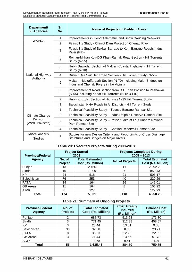
Development of National Flood Protection Plan-IV (NFPP-IV) and Related Flood Protection Plan-IV
Studies to Enhance Capacity Building of Federal Flood Commission-FFC
NESPAK | DELTARES 61
Department/ F. Agencies
Sr. No.
Name of Projects or Problem Areas
WAPDA 1 Improvements in Flood Telemetric and Snow Gauging Networks
2 Feasibility Study - Chiniot Dam Project on Chenab River
National Highway Authority
1 Feasibility Study of Sukkur Barrage to Kotri Barrage Reach, Indus River (PID)
2 Rojhan-Mithan Kot–DG Khan-Ramak Road Section - Hill Torrents Study (N-55)
3 Hub - Gawadar Section of Makran Coastal Highway - Hill Torrent Study (N-10)
4 District Qila Saifullah Road Section - Hill Torrent Study (N-55)
5 Multan – Muzaffargarh Section (N-70) Including Major Bridges on Indus and Chenab Rivers in the Vicinity
6 Improvement of Road Section from D.I. Khan Division to Peshawar (N-55) Including Kohat Hill Torrents (NHA & PID)
7 Hub - Khuzdar Section of Highway N-25 Hill Torrent Study
8 Balochistan NHA Roads in All Districts - Hill Torrent Study
Climate Change Division
(WWF Pakistan)
1 Technical Feasibility Study – Taunsa Barrage Ramsar Site
2 Technical Feasibility Study – Indus Dolphin Reserve Ramsar Site
3 Technical Feasibility Study – Patisar Lake at Lal Suhanra National Park Ramsar Site
4 Technical Feasibility Study – Chotiari Reservoir Ramsar Site
Miscellaneous
Studies 1
Studies for new Design Criteria and Flood Limits of Cross Drainage Structures and Bridges on Major Rivers.
Table 20: Executed Projects during 2008-2013
Province/Federal Agency
Project Started 2008
Projects Completed During 2008 – 2013
No. of Project
Total Estimated Cost (Rs. Million)
No. of Projects Total Estimated
Cost (Rs. Million)
Punjab 13 2,466 11 2,292.20
Sindh 10 1,309 7 850.43
KP 24 518 21 508.17
Balochistan 76 253 40 229.29
FATA 34 164 26 141.01
GB Areas 11 164 8 106.22
AJ&K 6 127 5 122.93
Total 174 5,001 118 4,250.25
Table 21: Summary of Ongoing Projects
Province/Federal Agency
No. of Projects
Total Estimated Cost (Rs. Million)
Cost Already Incurred
(Rs. Million)
Balance Cost (Rs. Million)
Punjab 2 687.73 513.93 173.80
Sindh 3 771.45 312.88 458.57
KP 3 23.44 13.61 9.83
Balochistan 36 32.58 8.88 23.71
FATA 8 35.23 12.23 22.99
GB Areas 3 71.44 13.66 57.78
AJ&K 1 13.58 9.51 4.07
Total 56 1,635.45 884.70 750.75
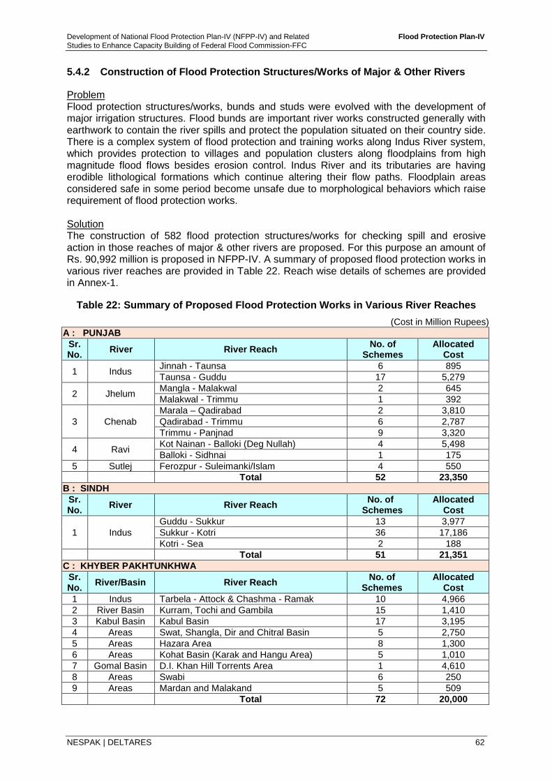
Development of National Flood Protection Plan-IV (NFPP-IV) and Related Flood Protection Plan-IV
Studies to Enhance Capacity Building of Federal Flood Commission-FFC
NESPAK | DELTARES 62
5.4.2 Construction of Flood Protection Structures/Works of Major & Other Rivers
Problem Flood protection structures/works, bunds and studs were evolved with the development of major irrigation structures. Flood bunds are important river works constructed generally with earthwork to contain the river spills and protect the population situated on their country side. There is a complex system of flood protection and training works along Indus River system, which provides protection to villages and population clusters along floodplains from high magnitude flood flows besides erosion control. Indus River and its tributaries are having erodible lithological formations which continue altering their flow paths. Floodplain areas considered safe in some period become unsafe due to morphological behaviors which raise requirement of flood protection works. Solution The construction of 582 flood protection structures/works for checking spill and erosive action in those reaches of major & other rivers are proposed. For this purpose an amount of Rs. 90,992 million is proposed in NFPP-IV. A summary of proposed flood protection works in various river reaches are provided in Table 22. Reach wise details of schemes are provided in Annex-1.
Table 22: Summary of Proposed Flood Protection Works in Various River Reaches
(Cost in Million Rupees)
A : PUNJAB
Sr. No.
River River Reach No. of
Schemes Allocated
Cost
1 Indus Jinnah - Taunsa 6 895
Taunsa - Guddu 17 5,279
2 Jhelum Mangla - Malakwal 2 645
Malakwal - Trimmu 1 392
3 Chenab
Marala – Qadirabad 2 3,810
Qadirabad - Trimmu 6 2,787
Trimmu - Panjnad 9 3,320
4 Ravi Kot Nainan - Balloki (Deg Nullah) 4 5,498
Balloki - Sidhnai 1 175
5 Sutlej Ferozpur - Suleimanki/Islam 4 550
Total 52 23,350
B : SINDH
Sr. No.
River River Reach No. of
Schemes Allocated
Cost
1 Indus
Guddu - Sukkur 13 3,977
Sukkur - Kotri 36 17,186
Kotri - Sea 2 188
Total 51 21,351
C : KHYBER PAKHTUNKHWA
Sr. No.
River/Basin River Reach No. of
Schemes Allocated
Cost
1 Indus Tarbela - Attock & Chashma - Ramak 10 4,966
2 River Basin Kurram, Tochi and Gambila 15 1,410
3 Kabul Basin Kabul Basin 17 3,195
4 Areas Swat, Shangla, Dir and Chitral Basin 5 2,750
5 Areas Hazara Area 8 1,300
6 Areas Kohat Basin (Karak and Hangu Area) 5 1,010
7 Gomal Basin D.I. Khan Hill Torrents Area 1 4,610
8 Areas Swabi 6 250
9 Areas Mardan and Malakand 5 509
Total 72 20,000
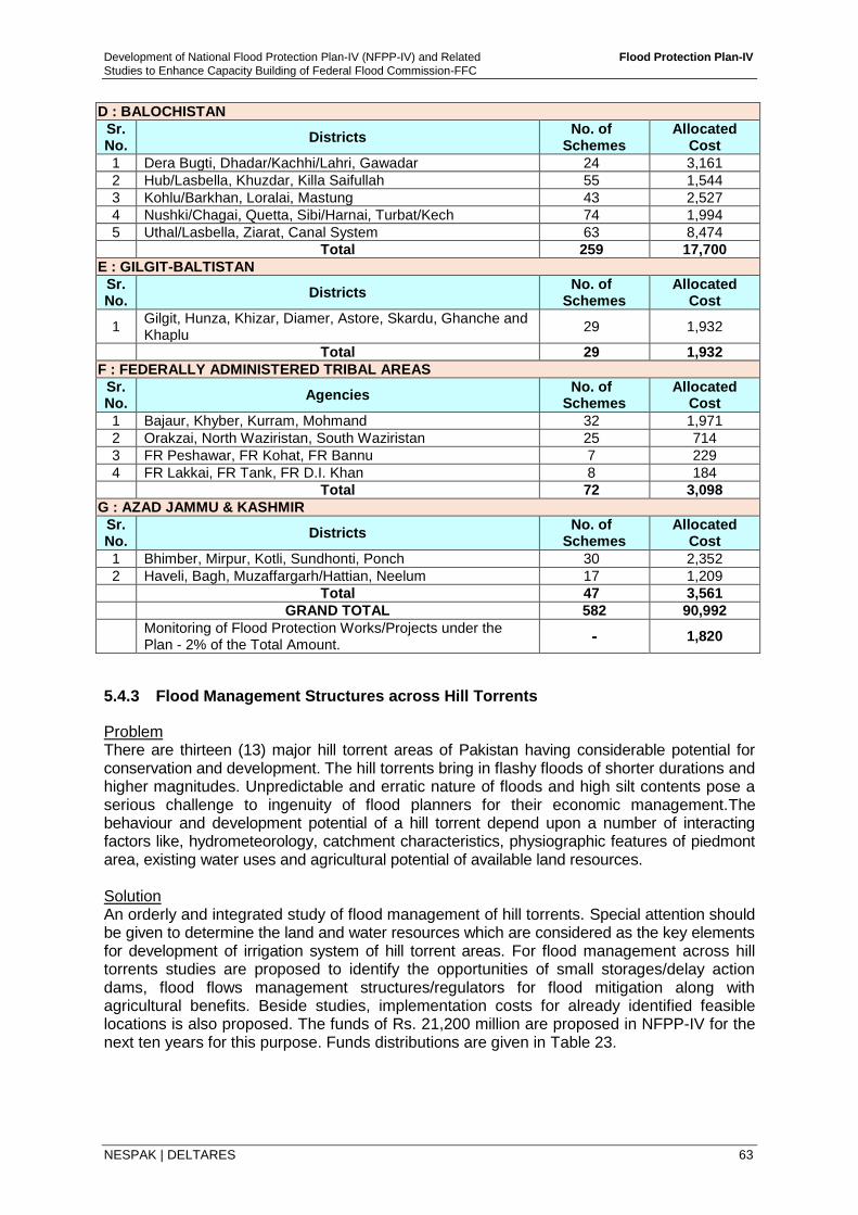
Development of National Flood Protection Plan-IV (NFPP-IV) and Related Flood Protection Plan-IV
Studies to Enhance Capacity Building of Federal Flood Commission-FFC
NESPAK | DELTARES 63
D : BALOCHISTAN
Sr. No.
Districts No. of
Schemes Allocated
Cost
1 Dera Bugti, Dhadar/Kachhi/Lahri, Gawadar 24 3,161
2 Hub/Lasbella, Khuzdar, Killa Saifullah 55 1,544
3 Kohlu/Barkhan, Loralai, Mastung 43 2,527
4 Nushki/Chagai, Quetta, Sibi/Harnai, Turbat/Kech 74 1,994
5 Uthal/Lasbella, Ziarat, Canal System 63 8,474
Total 259 17,700
E : GILGIT-BALTISTAN
Sr. No.
Districts No. of
Schemes Allocated
Cost
1 Gilgit, Hunza, Khizar, Diamer, Astore, Skardu, Ghanche and Khaplu
29 1,932
Total 29 1,932
F : FEDERALLY ADMINISTERED TRIBAL AREAS
Sr. No.
Agencies No. of
Schemes Allocated
Cost
1 Bajaur, Khyber, Kurram, Mohmand 32 1,971
2 Orakzai, North Waziristan, South Waziristan 25 714
3 FR Peshawar, FR Kohat, FR Bannu 7 229
4 FR Lakkai, FR Tank, FR D.I. Khan 8 184
Total 72 3,098
G : AZAD JAMMU & KASHMIR
Sr. No.
Districts No. of
Schemes Allocated
Cost
1 Bhimber, Mirpur, Kotli, Sundhonti, Ponch 30 2,352
2 Haveli, Bagh, Muzaffargarh/Hattian, Neelum 17 1,209
Total 47 3,561
GRAND TOTAL 582 90,992
Monitoring of Flood Protection Works/Projects under the Plan - 2% of the Total Amount.
- 1,820
5.4.3 Flood Management Structures across Hill Torrents
Problem There are thirteen (13) major hill torrent areas of Pakistan having considerable potential for conservation and development. The hill torrents bring in flashy floods of shorter durations and higher magnitudes. Unpredictable and erratic nature of floods and high silt contents pose a serious challenge to ingenuity of flood planners for their economic management.The behaviour and development potential of a hill torrent depend upon a number of interacting factors like, hydrometeorology, catchment characteristics, physiographic features of piedmont area, existing water uses and agricultural potential of available land resources. Solution An orderly and integrated study of flood management of hill torrents. Special attention should be given to determine the land and water resources which are considered as the key elements for development of irrigation system of hill torrent areas. For flood management across hill torrents studies are proposed to identify the opportunities of small storages/delay action dams, flood flows management structures/regulators for flood mitigation along with agricultural benefits. Beside studies, implementation costs for already identified feasible locations is also proposed. The funds of Rs. 21,200 million are proposed in NFPP-IV for the next ten years for this purpose. Funds distributions are given in Table 23.
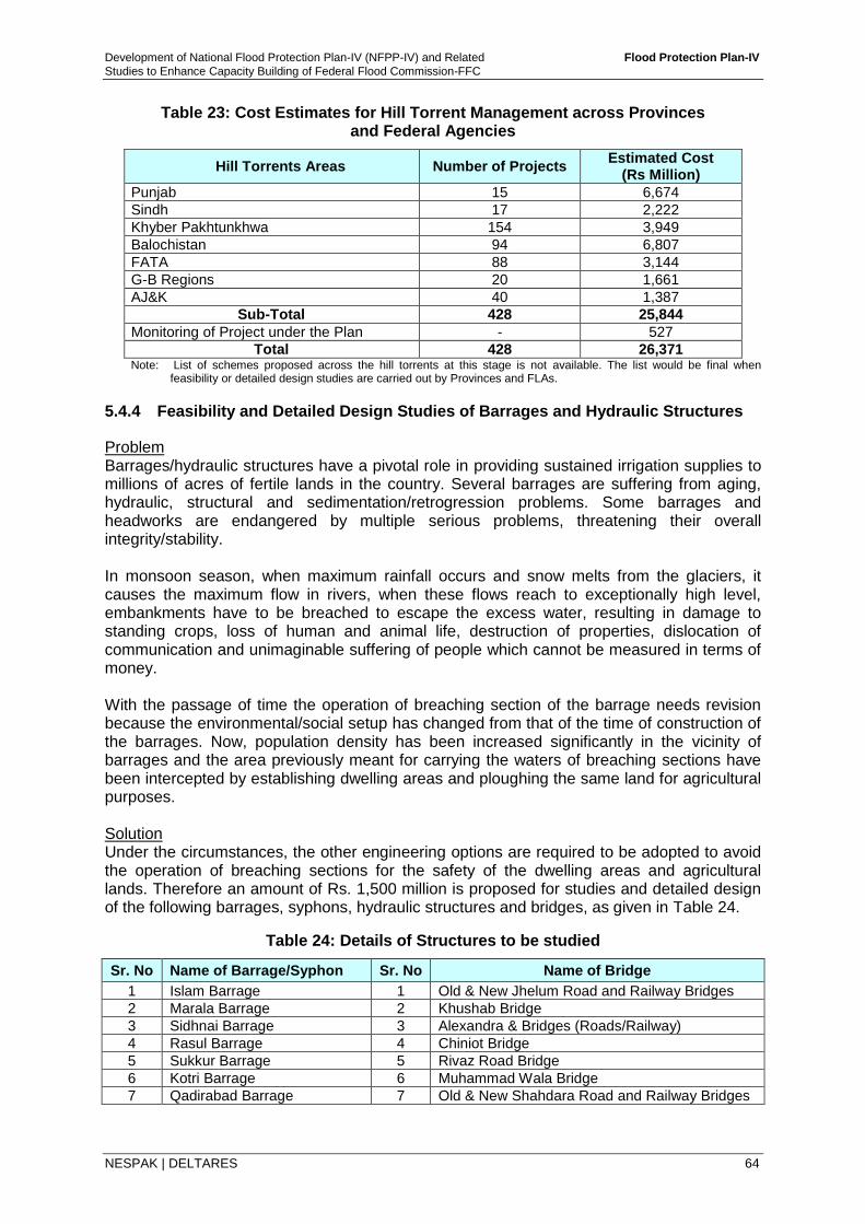
Development of National Flood Protection Plan-IV (NFPP-IV) and Related Flood Protection Plan-IV
Studies to Enhance Capacity Building of Federal Flood Commission-FFC
NESPAK | DELTARES 64
Table 23: Cost Estimates for Hill Torrent Management across Provinces and Federal Agencies
Hill Torrents Areas Number of Projects Estimated Cost
(Rs Million)
Punjab 15 6,674
Sindh 17 2,222 Khyber Pakhtunkhwa 154 3,949
Balochistan 94 6,807
FATA 88 3,144
G-B Regions 20 1,661
AJ&K 40 1,387
Sub-Total 428 25,844
Monitoring of Project under the Plan - 527
Total 428 26,371 Note: List of schemes proposed across the hill torrents at this stage is not available. The list would be final when
feasibility or detailed design studies are carried out by Provinces and FLAs.
5.4.4 Feasibility and Detailed Design Studies of Barrages and Hydraulic Structures
Problem Barrages/hydraulic structures have a pivotal role in providing sustained irrigation supplies to millions of acres of fertile lands in the country. Several barrages are suffering from aging, hydraulic, structural and sedimentation/retrogression problems. Some barrages and headworks are endangered by multiple serious problems, threatening their overall integrity/stability. In monsoon season, when maximum rainfall occurs and snow melts from the glaciers, it causes the maximum flow in rivers, when these flows reach to exceptionally high level, embankments have to be breached to escape the excess water, resulting in damage to standing crops, loss of human and animal life, destruction of properties, dislocation of communication and unimaginable suffering of people which cannot be measured in terms of money. With the passage of time the operation of breaching section of the barrage needs revision because the environmental/social setup has changed from that of the time of construction of the barrages. Now, population density has been increased significantly in the vicinity of barrages and the area previously meant for carrying the waters of breaching sections have been intercepted by establishing dwelling areas and ploughing the same land for agricultural purposes. Solution Under the circumstances, the other engineering options are required to be adopted to avoid the operation of breaching sections for the safety of the dwelling areas and agricultural lands. Therefore an amount of Rs. 1,500 million is proposed for studies and detailed design of the following barrages, syphons, hydraulic structures and bridges, as given in Table 24.
Table 24: Details of Structures to be studied
Sr. No Name of Barrage/Syphon Sr. No Name of Bridge
1 Islam Barrage 1 Old & New Jhelum Road and Railway Bridges
2 Marala Barrage 2 Khushab Bridge
3 Sidhnai Barrage 3 Alexandra & Bridges (Roads/Railway)
4 Rasul Barrage 4 Chiniot Bridge
5 Sukkur Barrage 5 Rivaz Road Bridge
6 Kotri Barrage 6 Muhammad Wala Bridge
7 Qadirabad Barrage 7 Old & New Shahdara Road and Railway Bridges
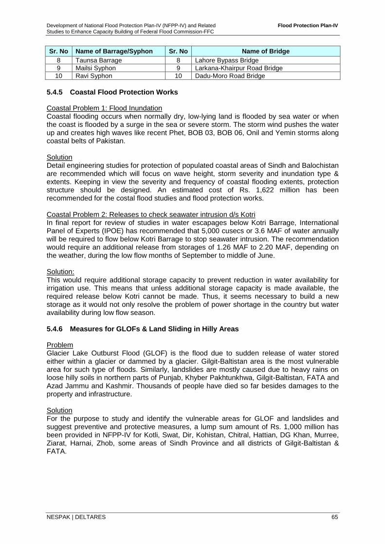
Development of National Flood Protection Plan-IV (NFPP-IV) and Related Flood Protection Plan-IV
Studies to Enhance Capacity Building of Federal Flood Commission-FFC
NESPAK | DELTARES 65
Sr. No Name of Barrage/Syphon Sr. No Name of Bridge
8 Taunsa Barrage 8 Lahore Bypass Bridge
9 Mailsi Syphon 9 Larkana-Khairpur Road Bridge
10 Ravi Syphon 10 Dadu-Moro Road Bridge
5.4.5 Coastal Flood Protection Works
Coastal Problem 1: Flood Inundation Coastal flooding occurs when normally dry, low-lying land is flooded by sea water or when the coast is flooded by a surge in the sea or severe storm. The storm wind pushes the water up and creates high waves like recent Phet, BOB 03, BOB 06, Onil and Yemin storms along coastal belts of Pakistan. Solution Detail engineering studies for protection of populated coastal areas of Sindh and Balochistan are recommended which will focus on wave height, storm severity and inundation type & extents. Keeping in view the severity and frequency of coastal flooding extents, protection structure should be designed. An estimated cost of Rs. 1,622 million has been recommended for the costal flood studies and flood protection works. Coastal Problem 2: Releases to check seawater intrusion d/s Kotri In final report for review of studies in water escapages below Kotri Barrage, International Panel of Experts (IPOE) has recommended that 5,000 cusecs or 3.6 MAF of water annually will be required to flow below Kotri Barrage to stop seawater intrusion. The recommendation would require an additional release from storages of 1.26 MAF to 2.20 MAF, depending on the weather, during the low flow months of September to middle of June. Solution: This would require additional storage capacity to prevent reduction in water availability for irrigation use. This means that unless additional storage capacity is made available, the required release below Kotri cannot be made. Thus, it seems necessary to build a new storage as it would not only resolve the problem of power shortage in the country but water availability during low flow season. 5.4.6 Measures for GLOFs & Land Sliding in Hilly Areas
Problem Glacier Lake Outburst Flood (GLOF) is the flood due to sudden release of water stored either within a glacier or dammed by a glacier. Gilgit-Baltistan area is the most vulnerable area for such type of floods. Similarly, landslides are mostly caused due to heavy rains on loose hilly soils in northern parts of Punjab, Khyber Pakhtunkhwa, Gilgit-Baltistan, FATA and Azad Jammu and Kashmir. Thousands of people have died so far besides damages to the property and infrastructure. Solution For the purpose to study and identify the vulnerable areas for GLOF and landslides and suggest preventive and protective measures, a lump sum amount of Rs. 1,000 million has been provided in NFPP-IV for Kotli, Swat, Dir, Kohistan, Chitral, Hattian, DG Khan, Murree, Ziarat, Harnai, Zhob, some areas of Sindh Province and all districts of Gilgit-Baltistan & FATA.
Development of National Flood Protection Plan-IV (NFPP-IV) and Related Flood Protection Plan-IV
Studies to Enhance Capacity Building of Federal Flood Commission-FFC
NESPAK | DELTARES 66
5.4.7 Remodeling and Proper Maintenance of Drainage System in Lower Indus
Problem Due to an inadequate drainage network and the flat topography in lower Indus, flooding of areas in period 2010 – 2012 has caused severe damage. There is a pressing need to rehabilitate the existing Left Bank Outfall Drain (LBOD) drainage infrastructure and to expand the drainage area from existing 4 districts to 15 districts by reviving the natural drainage system (dhoros) and constructing new surface storm water drains. Solution Recent detailed study on drainage system in Lower Indus has identified various projects which include i) rehabilitation of LBOD, ii) revival of natural waterways and storm drains, iii) mangrove plantation in coastal areas, iv) rehabilitation of Deh Akro II and Chotiari wetlands, and v) forest plantation using drainage water (pilot). Therefore for the purpose of channelization, remodeling and proper maintenance of drainage system, an amount of Rs. 9,763 million is proposed in NFPP-IV for rehabilitation of drainage Infrastructure. 5.4.8 Master Planning, Feasibility Studies, Detailed Designing and Implementation,
Including Physical Model Study of All Major Rivers and Railway Bridges
Problem Flood problems in Indus River and its major tributaries differ from one area to another depending on physiographic, morphologic, hydraulic and hydrologic conditions. Comprehensive systems of flood protection embankments have been constructed to reduce the extent of flooding and minimize flood damages. However, recent flood events from 2010 to 2014 caused wide spread damages, although huge amount has been spent on flood sector projects during last four decades. These damages are due to encroachments in the floodplain areas, unplanned breaching, reduced flood passage capacity of structures, changes in the river morphology, river bed aggradations, etc. Solution In NFPP-IV, various studies have been proposed for this purpose as follows;
A total amount of Rs. 3,000 million has been allocated for Master Planning/Feasibility Studies/Detailed Design Studies for PIDs, FLAs, etc. as given in Table 19.
A total amount of Rs. 200 million has been allocated for physical model study of selected major rivers reaches as follows; i) Indus River: Jinnah-Chashma-DI Khan-Taunsa-Ghazi Ghat Bridge-Guddu-
Sukkur-Dadu Moro Bridge-Kotri-Sea, ii) Jhelum River: Rasul-Khushab-Trimmu, iii) Chenab River: Qadirabad-Chiniot Bridge-Trimmu-Shershah Bridge-Panjnad, iv) Kabul River: Warsak-M-1 Bridge-Nowshera Road Bridge-upto Attock.
An amount of Rs. 50 million has been allocated for physical model study of nine (9) Railways Bridges on the Indus River (Attock, Ayub & Kotri), Jhelum River (Jhelum), Chenab River (Wazirabad, Shershah & Rivaz) and Ravi River (Shahdara & Abdul Hakeem), respectively.
An amount of Rs. 400 million has been allocated for improvements of existing flood protection & guide bunds/works both sides of Railways Track and Bridges.
5.4.9 Flood Mitigation, Channelization and Execution of the Lai Nullah Project
Floods in the Lai Nullah Basin occur during the monsoon season (July to September). The nullah has an incised channel which overflows its banks during large floods, causing damage to human life and property. Under the pressure of rapidly expanding population,
Development of National Flood Protection Plan-IV (NFPP-IV) and Related Flood Protection Plan-IV
Studies to Enhance Capacity Building of Federal Flood Commission-FFC
NESPAK | DELTARES 67
new abadies sprang up not only in low lying areas, but at places structures were built on the banks and berms of the nullah itself which has reduced its conveyance capacity. The situation poses a permanent danger of flooding to Rawalpindi and Islamabad. It is recommended that a permanent solution of the problem must be evolved as early as possible. Keeping in view the severity of matter, flood management/channelization for Lai Nullah is proposed in NFPP-IV, which has a cost of about Rs. 16,000 million that covers flood management component only. 5.4.10 Study to be conducted for improving the Existing Strom Drainage System of
Urban Areas (Major Cities)
Problem Besides spills from the river, heavy monsoonal rainfall within the cities and towns causes urban flooding. The inundation period is extended when there is poor drainage system within the cities and towns. Urban floods are being experienced in Pakistan especially during Monsoon seasons - cities having high population density like Karachi, Lahore, Faisalabad, Multan, Hyderabad, etc., with unplanned, clogged, encroached and old undersized drainage systems which has not been rehabilitated/remodeled proportional to population growth.
The examples of urban flooding during recent years are the floods in year 2003 in Karachi. Thatta etc., year 2007 in Khyber Pakhtunkhwa, Sindh and coastal Balochistan, year 2010 in many cities and towns all over Pakistan, year 2011 in Sindh Province and year 2012 in Sindh (Districts Kashmore, Jacobabad & Shikarpur) and few cities in Balochistan.
Solution Studies are required to identify the specific drainage problem for each of those cities and towns where it is more severe. Twenty (20) cities/towns have been identified which are included in NFPP-IV for the identification of specific drainage problems and suggest solution as follows;
i. Punjab: Lahore, Rawalpindi, Multan, Faisalabad, Sialkot, Dera Ghazi Khan and Muzaffargarh,
ii. Sindh: Karachi, Hyderabad, Sukkur, Thatta, Jacobabad, Kashmor and Shikarpur, iii. Khyber Pakhtunkhwa: Peshawar and Dera Ismail Khan, and iv. Balochistan: Quetta, Sibi and Dera Allah Yar Khan
A lump sum amount of Rs. 1,000 million has been allocated in NFPP-IV for these studies. 5.4.11 Provision of Annual Funds under Provincial ADPs for Flood Fighting Activities
during Flood Season and procurement & repair of Flood Fighting Equipment/ Machinery under PID
Problem Irrigation Departments of all the provinces and federal agencies have been facing financial hardships for the execution of flood management projects. The concerned departments face lack of flood fighting equipment. It has been observed that the equipment used for flood fighting by concerned departments is old and needs improvements. Solution Provision of Rs. 5,000 millions, under Provincial ADP for procurement & repair of flood fighting equipment & machinery and for flood fighting activities during flood season (June-September each year for the next ten (10) years) is proposed under NFPP-IV.
Development of National Flood Protection Plan-IV (NFPP-IV) and Related Flood Protection Plan-IV
Studies to Enhance Capacity Building of Federal Flood Commission-FFC
NESPAK | DELTARES 68
5.4.12 Up-gradation & Expansion in the Existing Flood Forecasting & Warning System of Pakistan Meteorological Department
Problem 1 An accurate early warning of the flood increases the reaction time for evacuation of population and adopting precautions against floods. Besides various components involved in flood forecasting, Radar play an important role in detecting and quantifying storm events over catchments that can be used to increase lead time for flood forecast. Pakistan Meteorological Department has proposed to install five new Quantitative Precipitation Measurement Radar (QPM Radar) at Gawadar (Balochistan), Cherat & Chitral (KP), D. G. Khan (Punjab) and Gilgit (GB areas), where no Radar coverage is available. Consultants also proposed four new locations for installation of new Radars at Quetta (Balochistan), Nawabshah/Thatta (Sindh), Hangu (FATA) and Bannu (KP). PMD has seven Radars installed with different specifications at various places: Islamabad, Lahore, Sialkot, Mangla, Karachi, D.I. Khan and R.Y. Khan. Most of these Radars have been installed 15 to 20 years ago. Similarly due to developments in flood forecasting models, Radar grid data has become an important aspect for their reliability. Therefore, it is essential to up- grade these seven Radars on priority basis. Upgradation of existing Radars has been proposed in NFPP-IV beside installation of new Radars at new locations. In order to enhance density of meteorological network for accurate estimates of rainfall over catchments, there is a need to install 27 telemetric rain gauge stations (12 stations in KP and 15 stations in Balochistan). Furthermore, for effective data and information collection and dissemination there is a need to establish four flood early warning centers at the following locations:
1. Flood Early Warning Center for Gilgit-Baltistan Areas at Gilgit. 2. Flood Early Warning Center for Kabul River in KP. 3. Flood Early Warning Center for D.G. Khan Hill Torrents. 4. Flood Early Warning Center at Quetta for Balochistan.
Similarly PMD proposed 39 Nos. Radio Sounding Stations for acquiring upper air data,
which is very important for forecasting purposes. Solution A cost allocation of Rs. 4,205 million has been made in NFPP-IV for installation of new Radars, up gradation of existing Radars, installation of new meteorological stations and establishment of flood early warning centers. Problem 2 Investments on development and implementation of hydrological models through flood forecasting systems have been carried out in past. The performance of hydrological models depends on quality of temporal and spatial hydro-meteorological inputs. Timely and accurate inputs to hydrological models would result in quality forecast with a reasonable lead time. A major input to hydrological models is the forecasted rainfall over catchments above rim-stations (usually known as Quantitative Precipitation Forecast (QPF)). This input is primarily a meteorological input which requires an expert knowledge of meteorological phenomena and updated real-time information on meteorological variables (wind directions, atmospheric pressures, relative humidity, temperatures, etc.). With advancement in remote sensing technology, certain meteorological variables are now available for next 7 days in grid format through models like Global Forecasting System (GFS). Use of GFS models requires certain calibration to enhance degree of confidence in predicting QPF.
Development of National Flood Protection Plan-IV (NFPP-IV) and Related Flood Protection Plan-IV
Studies to Enhance Capacity Building of Federal Flood Commission-FFC
NESPAK | DELTARES 69
Further, up-gradation of FEWS and technical support with respect to; i) Inclusion of catchment area upstream of Tarbela dam as hydrological and hydraulics
models. ii) Existing geometry of Indus river and its major tributaries. iii) Addressing the constraints and operational problems of PMD is required on
immediate basis. Solution An amount of Rs.300 million has been allocated for specific meteorological studies to estimate accurate and reliable QPF through optimized use of GFS models. The specified cost also includes up-gradation of FEWS and technical support and testing during real time operation. 5.4.13 Up-gradation, Installation and Expansion in the Existing System of Water and
Power Development Authority
Problem Water and Power Development Authority has vast telemetric and gauging network throughout Pakistan that monitors overall water availability from Glaciers and rivers. WAPDA gauging network also plays an important role in transmitting timely flood related data needed for reservoir operation and flood forecasting. There is an immense need to enhance existing flood telemetric network, snow gauging stations, Surface Water Hydrology (SWH) network and High Frequency (HF) radio network.
Solution An estimated cost of Rs. 2,297 million has been proposed in NFPP-IV for following tasks;
1. Improving present and expansion of Flood Telemetric Network, 2. Expansion, strengthening and densification on snow gauging stations. 3. Improvement and strengthening of the existing SWH network. 4. Development of GMRC system 5. Improvements on existing and additional HF Radios networks. 6. Feasibility Study – Chiniot Dam on Chenab River near Chiniot City.
5.4.14 Study to be conducted for Removal of Encroachments from High Risk Areas
on Major River
Problem Encroachments within river corridors and floodplains result in flood damages. Due to increasing population density, development and settlements along floodplains has increased across Indus river and its major tributaries. An effective way of monitoring and removing of such encroachments is the implementation of “River Act” which has been developed under current studies. Implementation of River Act requires accurate location and layout of encroachments on floodplain maps and must be treated as a continuous updating activity. Solution Demarcation of encroachments on floodplain maps requires accurate information of land-use and river geometry. Comprehensive efforts have been made in current studies in development of floodplain and flood risk maps along Indus River and its major tributaries. For future updating of existing floodplain maps and river geometry details, cost of specific studies has been allocated in NFPP-IV. These studies require updated and accurate floodplain information. LiDAR10 is a remote sensing technology that uses ultraviolet, visible
10Acronyms of Laser Detection and Ranging.
Development of National Flood Protection Plan-IV (NFPP-IV) and Related Flood Protection Plan-IV
Studies to Enhance Capacity Building of Federal Flood Commission-FFC
NESPAK | DELTARES 70
or near infrared light to image objects. For assessment of location and layout of existing encroachments in complete river corridor an amount of Rs. 750 million is allocated in NFPP-IV, which includes floodplain mapping studies and procurement of LiDARs. 5.4.15 Development of Watershed Management in the uplands of Major Rivers and Hill
Torrents Areas
Problem Watershed management in flood producing catchments is a key intervention through which flood intensity and magnitude can be reduced. Three major activities in watershed management are as follows;
1. Protecting and maintaining permanent vegetation cover in forest, range and wild lands.
2. Modifying agricultural practices to control soil erosion and runoff. 3. Stream training and check dams.
Solution Seven watershed regions have been identified in Pakistan11. In these regions following areas are proposed for development of watershed management under NFPP-IV:
Region Proposed Watershed area
i. The Northern Mountain Region Swat Basin ii. The uplands of Northern Punjab Hazara, Haro & Soan Rivers iii. Western Mountain Region Gomal, Zhob, Kaha and various hill torrents iv. The South-Western Balochistan Plateau Nari Basin v. The Coastal Zone Hub Basin vi. The Indus plains Gaj Nai Basin vii. Gilgit-Baltistan Area Chilas
To achieve the above mentioned objectives/operations for development of watershed management, the first step is the identification of appropriate area for watershed management and selection of suitable watershed management measures for that area. An amount of Rs. 4,500 million is allocated in NFPP-IV for studies and implementation of watershed management plans. 5.4.16 Wetland Sites Recommended by RAMSAR12 Advisory Mission
Problem
Wetlands along floodplains have potential to mitigate flood by absorbing flood volumes. For management and restoration of wetlands and the use of floodplain wetlands for mitigating the severe impacts from floods Ramsar sites have been identified in Pakistan by experts. The potential wetland sites, recommended to be investigated on priority basis for their impact on flood mitigation are as follows;
i. Taunsa Barrage Ramsar Site ii. Indus Dolphin Reserve Ramsar Site iii. Patisar lake at Lal Suhanra National Park iv. Chotiari Reservoir
11Watershed Management in Pakistan by Dr. Masood A. A. Quraishi 12The Convention on Wetlands of International Importance, called the Ramsar Convention, is the intergovernmental treaty that
provides the framework for the conservation and wise use of wetlands and their resources.(http://www.ramsar.org/about-the-ramsar-convention)
Development of National Flood Protection Plan-IV (NFPP-IV) and Related Flood Protection Plan-IV
Studies to Enhance Capacity Building of Federal Flood Commission-FFC
NESPAK | DELTARES 71
Solution
It is recommended to investigate the above mentioned four (4) potential wetland sites for diverting and using effectively the flood water to these wetland areas for development of forestry, wildlife and other purposes for the benefit of stakeholders and locals and study the flood mitigation impact thereafter and initial environmental impacts. An amount of Rs. 30 million is allocated in NFPP-IV for above mentioned study.
5.4.17 Disaster Management Activities by NDMA including Rescue and Relief
Problem National Disaster Management Authority, is the lead agency at the Federal level to deal with whole spectrum of Disaster Management Activities13. Rescue and relief operations during floods is an important part of overall flood mitigation activities and important component of integrated flood management. During flood situations, NDMA coordinates with provinces through PDMAs to facilitate rescue and relief operations. Pakistan Army in coordination with PDMAs and PIDs plays lead role in providing rescue and relief operations through its equipment’s and resources. Solution For enhancing the capacity of Government Agencies responsible for disaster management, rescue and relief operation by Pakistan Army and preparation of disaster management plans at various levels Rs. 6,500 million is allocated in NFPP-IV. 5.4.18 Capacity Building and Staff Training of Institutions
Problem The recent major floods have exposed all aspects of flood management in Pakistan. From flood protection bunds to decision making at the departmental level, investigations show flaws and weaknesses. Non-structural measures are an integral part of flood management policy. We cannot reduce the probability of flood completely, but what we can do through proper planning, timely decisions and policy to avert the catastrophic effects of floods. The essence of a best plan is effective coordination between concerned departments right down to the community level. For minimizing the losses due to flood, the awareness of people residing in the flood prone areas, the coordination among the flood management related organizations at Federal, Provincial, District/Local Government level play a vital role. Solution The capacity building and training of staff of flood management related organizations at Federal, Provincial, District/Local Government level is necessary in the light of most modern/current practices being adopted all over the world. To achieve this, an amount of Rs 1,380 million is allocated in NFPP-IV for capacity building/staff training of institutions dealing with flood management in country. The sectors/departments proposed for the capacity building in NFPP-IV is Provincial Irrigation Departments (Punjab, Sindh, Khyber Pakhtunkhwa and Balochistan), Federal Agencies (Gilgit-Baltistan Area, FATA, AJ&K), Federal Organizations (FFC, WAPDA, PMD, PCIW) are included. In addition to this improvement and strengthening of Hydraulic Research Stations at Hyderabad & Gujranwala (Nandipur) and training for computer staffs (Provincial Irrigation Department Balochistan) and awareness campaign/workshops at different cities in the various locations of country for educating the people residing in flood prone areas are also included. The breakup of proposed amount is given in Table 25.
13http://www.ndma.gov.pk/new/aboutus/aboutus.php

Development of National Flood Protection Plan-IV (NFPP-IV) and Related Flood Protection Plan-IV
Studies to Enhance Capacity Building of Federal Flood Commission-FFC
NESPAK | DELTARES 72
Table 25: Capacity Building under Proposed NFPP-IV (2015-16 TO 2024-25)
Sr. No. Institution Name Estimated Cost (Rs in Million)
A - Provincial Irrigation Departments
1 Punjab 150
2 Sindh & SIDA 150
3 Khyber Pakhtunkhwa 100
4 Balochistan 100
B - Federal Agencies/Organizations
1 FFC 100
2 WAPDA 100
3 PMD 100
4 PCIW 50
5 Gilgit-Baltistan Area 50
6 FATA 50
7 AJ&K 50
C - Miscellaneous Works
1 Improvement and Strengthening of Hydraulic Research Stations at Hyderabad (SID) and Gujranwala (PID).
300
2 Training for Computer Staffs (PIB). 50
3 Flood Related Workshops at Various Cities of Pakistan.
30
Total 1,380
5.4.19 Drought Management with Floods
Problem Sindh province is facing drought conditions frequently from last two decades due to various climatological reasons. Particularly, Tharparker area is severely affected by prolonged droughts resulting in deaths of infants and miseries. In order to minimize impacts of prolonged droughts, floods can be efficiently used by diverting excess flows to the areas of drought. Solution Drought mitigation through floods requires a comprehensive study based on possibilities of new flow paths/ capacity enhancement and extension of existing canals reaching Tharparker. An amount of 50 million has been proposed for studies on drought mitigation through floods in Sindh. The proposed study will provide recommendations based on techno-economical evaluations. 6 NFPP-IV APPROVAL THROUGH COUNCIL OF COMMON INTERESTS
6.1 Background
An important aspect in development of National Flood Protection Plan-IV is the contribution and consent of all stakeholders, which remained part of development process right from Inception stage of the study in August 2013. The objectives of stakeholder consultation were to share ownership of development phase and ascertain need based priorities in combating flood issues across the country. Several presentations and meetings with the stakeholders were conducted to share findings and recommendations of the plan along with critical issues which needed to be addressed in implementation phase of NFPP-IV.
After the completion of three previous NFPPs, FFC planned to prepare fourth NFPP for next ten years with the help of Provinces and Federal Line Agencies (FLAs). Thus, the major part
Development of National Flood Protection Plan-IV (NFPP-IV) and Related Flood Protection Plan-IV
Studies to Enhance Capacity Building of Federal Flood Commission-FFC
NESPAK | DELTARES 73
of the study was to prepare comprehensive investment schedule for flood management across the country and prioritize projects/schemes proposed by the Provinces and FLAs to be implemented for the next ten (10) years i.e., 2015-16 to 2024-25. The estimated cost of the Plan with category wise breakdown into structural and non-structural measures was worked out as;
I. Structural Measures Rs. 157,649 Million
II. Non-Structural Measures Rs. 20,012Million
Total Rs. 177,661Million
Category and priority wise investment Plan for the above mentioned amount is presented in previous Section 5.4, and given in Table 17 and Table 18, respectively. The same was presented at CCI forum whose details are provided in following section.
6.2 CCI Meetings and Decisions/Recommendations
Keeping in view socio economic importance of NFPP-IV and its linkage with other Ministries/Divisions, Provinces and Federal Line Agencies, Ministry of Water & Power submitted the Plan to CCI for its approval and decision on financing modalities.
First Meeting of CCI on NFPP-IV Held on February 29, 2016
NFPP-IV was presented in the 28th meeting of Council of Common Interests (CCI) held on February 29, 2016, wherein following decision was taken;
"The CCI decided that the Minister for the Climate Change and Minister for Water & Power in collaboration with all Provincial Chief Ministers shall workout a comprehensive National Flood Protection Plan and present the same in the next meeting of the CCI scheduled to be held on March 25, 2016".
In pursuance to the decision taken in 28th meeting of CCI, another follow up meeting was held on March 17, 2016 in Ministry of Water & Power, Islamabad, which was attended by Minister for Water & Power, Minister for Climate Change, Chief Minister Sindh, Additional Chief Secretary (Dev) Government of Balochistan, Secretary Irrigation Punjab, Secretary Irrigation Khyber Pakhtunkhwa and senior officials from Provincial and Federal Government.
Detailed presentation on NFPP-IV was made to the forum highlighting integrated flood management approach to be implemented in next ten years to handle flood issues across Pakistan. Province/area wise problems and solutions were presented along with estimated figures of short, medium and long-term investments. Province/area wise distribution of investments with financing resources were also discussed.
The forum agreed with proposed investments subject to following recommendations to be included in NFPP-IV;
A Steering Committee will be established to oversee and monitor implementation of the Plan and provide policy guidelines;
Third party verification will be carried out for all the works in order to ensure transparency in implementation;
A study will be undertaken to determine suitable interventions for drought management; and
Entire cost of the plan may be borne by the Federal Government-CCI to decide about the funding mechanism.
Development of National Flood Protection Plan-IV (NFPP-IV) and Related Flood Protection Plan-IV
Studies to Enhance Capacity Building of Federal Flood Commission-FFC
NESPAK | DELTARES 74
Second Meeting of CCI on NFPP-IV Held on March 25, 2016
With inclusion of above mentioned recommendations in NFPP-IV, the flood protection plan was presented again in 29th meeting of CCI held on March 25, 2016. The Honorable Chief Minister Sindh highlighted reservations on proposed construction of reservoirs downstream of Tarbela Dam. Whereas, Honorable Chief Minister, Khyber Pakhtunkhwa highlighted the need for another round of consultation with provinces to prioritize and finalize costs of flood protection schemes. Furthermore, it was discussed in detail and endorsed by all provinces that the financing for implementation phase of NFPP-IV shall be the responsibility of Federal Government (as per previous practice in implementation of NFPP-I, II and III).
Another aspect discussed in the same meeting was release of funds through Normal/ Emergent Flood Program for Sindh Province. It was highlighted that more than 30 schemes related to flood protection were still awaited for implementation.
In order to address the above mentioned reservations by the provinces, the Honorable Prime Minster of Pakistan decided that the Committee established in 28th meeting of CCI should continue consultative process for another month and include the suggestions of the Provincial Governments in the Plan after removing their concerns and keep CCI updated with the process.
Although the role of reservoirs in mitigation of floods is accepted widely across the globe, yet to ensure stakeholder's consent over implementation of NFPP-IV, the name of Kalabagh Dam was removed from the document with the need for consensus among provinces before construction of reservoirs downstream of Tarbela Dam. The revised NFPP-IV was circulated among all stakeholders after removal of name of Kalabagh Dam on 26th April 2016.
To proceed with approval process of NFPP-IV, a meeting was held at Ministry of Water & Power, Islamabad on May 4, 2016 attended by Chief Minister Khyber Pakhtunkhwa, Chief Minister Balochistan, Minister for Climate Change, Irrigation Minister Punjab, Chief Secretary Balochistan and high Officials under chairmanship of Honorable Federal Minister for Water and Power to review suggestions of the provincial governments. During the meeting, it was decided that a team comprising of members from Ministry of Water and Power, Federal Flood Commission and NESPAK will visit provincial capitals to explore the possibilities of incorporating the schemes highlighted by the provinces as essential, in addition to those already included in the draft NFPP-IV. The team members who visited provincial capitals are as follows;
Joint Secretary (Water), Ministry of Water & Power
Chief Engineer (Floods), Federal Flood Commission
Acting Team Leader, WCAP
Team Leader, NFPP-IV, NESPAK
Team Leader, Task-A of NFPP-IV, NESPAK
6.3 Compliance of CCI Recommendations
Above mentioned team members visited the concerned officials at Quetta, Peshawar, Karachi and Lahore on May 9 &10, May 25, May 31 and June 3, 2016, respectively. During these visits, additional flood protection (FP) schemes were proposed by all provinces to be included in NFPP-IV. The additional cost of schemes during visits to provinces plus PMD & NDMA was worked out as Rs. 154,585 million as shown in Table 26 (col.4), which is over and above the original estimated cost of the Plan i.e., Rs. 177,661 million Table 26 (col. 3). The proposed total cost of NFPP-IV with inclusion of additional requirements may become Rs. 332,246 million as shown in Table 26 (col.5).
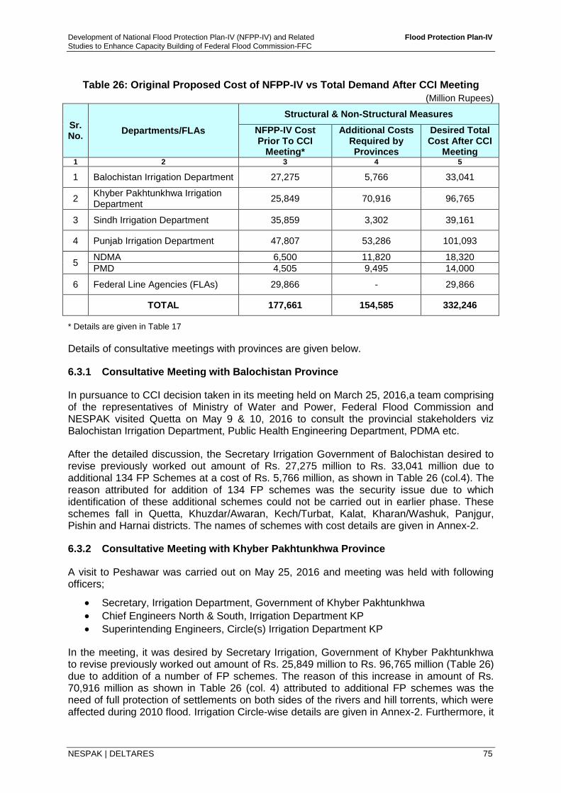
Development of National Flood Protection Plan-IV (NFPP-IV) and Related Flood Protection Plan-IV
Studies to Enhance Capacity Building of Federal Flood Commission-FFC
NESPAK | DELTARES 75
Table 26: Original Proposed Cost of NFPP-IV vs Total Demand After CCI Meeting
(Million Rupees)
Sr. No.
Departments/FLAs
Structural & Non-Structural Measures
NFPP-IV Cost Prior To CCI
Meeting*
Additional Costs Required by Provinces
Desired Total Cost After CCI
Meeting 1 2 3 4 5
1 Balochistan Irrigation Department 27,275 5,766 33,041
2 Khyber Pakhtunkhwa Irrigation Department
25,849 70,916 96,765
3 Sindh Irrigation Department 35,859 3,302 39,161
4 Punjab Irrigation Department 47,807 53,286 101,093
5 NDMA 6,500 11,820 18,320
PMD 4,505 9,495 14,000
6 Federal Line Agencies (FLAs) 29,866 - 29,866
TOTAL 177,661 154,585 332,246
* Details are given in Table 17
Details of consultative meetings with provinces are given below.
6.3.1 Consultative Meeting with Balochistan Province
In pursuance to CCI decision taken in its meeting held on March 25, 2016,a team comprising of the representatives of Ministry of Water and Power, Federal Flood Commission and NESPAK visited Quetta on May 9 & 10, 2016 to consult the provincial stakeholders viz Balochistan Irrigation Department, Public Health Engineering Department, PDMA etc.
After the detailed discussion, the Secretary Irrigation Government of Balochistan desired to revise previously worked out amount of Rs. 27,275 million to Rs. 33,041 million due to additional 134 FP Schemes at a cost of Rs. 5,766 million, as shown in Table 26 (col.4). The reason attributed for addition of 134 FP schemes was the security issue due to which identification of these additional schemes could not be carried out in earlier phase. These schemes fall in Quetta, Khuzdar/Awaran, Kech/Turbat, Kalat, Kharan/Washuk, Panjgur, Pishin and Harnai districts. The names of schemes with cost details are given in Annex-2.
6.3.2 Consultative Meeting with Khyber Pakhtunkhwa Province
A visit to Peshawar was carried out on May 25, 2016 and meeting was held with following officers;
Secretary, Irrigation Department, Government of Khyber Pakhtunkhwa
Chief Engineers North & South, Irrigation Department KP
Superintending Engineers, Circle(s) Irrigation Department KP
In the meeting, it was desired by Secretary Irrigation, Government of Khyber Pakhtunkhwa to revise previously worked out amount of Rs. 25,849 million to Rs. 96,765 million (Table 26) due to addition of a number of FP schemes. The reason of this increase in amount of Rs. 70,916 million as shown in Table 26 (col. 4) attributed to additional FP schemes was the need of full protection of settlements on both sides of the rivers and hill torrents, which were affected during 2010 flood. Irrigation Circle-wise details are given in Annex-2. Furthermore, it
Development of National Flood Protection Plan-IV (NFPP-IV) and Related Flood Protection Plan-IV
Studies to Enhance Capacity Building of Federal Flood Commission-FFC
NESPAK | DELTARES 76
was desired that 60% of the total proposed amount of Rs 96,765 million shall be allocated on priority basis in initial phase of NFPP-IV implementation.
6.3.3 Consultative Meeting with Sindh Province
A meeting was held in Sindh Irrigation Secretariat, Karachi on May 31, 2016 attended by following officers;
Secretary, Irrigation Department, Government of Sindh
Additional Secretary, Irrigation Department, Government of Sindh
Chief Engineer, Sukkur Barrage, Sindh Irrigation Department
Sindh Government desired that the already worked out estimate for FP schemes/works and hill torrents protection should be merged and their additional schemes/works (14 numbers) with a cost of Rs. 3,302 million as shown in Table 26 (col 4) shall be included in same estimated plan. In addition, it was desired to replace certain number of schemes with the new ones, because some of the schemes communicated earlier for inclusion in NFPP-IV were already taken up by the department. Reach wise details are given in Annex-2.
6.3.4 Consultative Meeting with Punjab Province
A meeting was held in Punjab Irrigation Secretariat, Lahore on June 3, 2016 attended by following officers;
Secretary, Irrigation Department, Government of the Punjab
Additional Secretary (Tech), Government of the Punjab
Deputy Secretary (Dev), Punjab Irrigation Department
Chief Engineers Irrigation D&F Zone, Lahore Zone and DG Khan Zone
Superintending Engineer, Development Circle Punjab, Sargodha
During the discussion with Irrigation Department of Punjab, they proposed additional flood works/management of hill torrents under NFPP-IV with cost of Rs. 62,000 million, as shown in Annex-2. It is to be noted that amount of Rs. 8,714 million out of Rs. 62,000 million was already included in previously worked out amount of Rs. 47,807 million as shown in Table 26, therefore the additional amount of Rs. 53,286 (62,000 - 8,715) million was proposed by Punjab Province in actual. The same amount is shown in Table 26 (col.4).
6.3.5 NDMA and PMD Additional Suggestions
During the process of consultations with the provinces, the Consultants received a letter from NDMA through FFC, Islamabad, as shown in Annex-2. In the letter, they have desired that their budget provision should be enhanced from Rs. 6,500 million to Rs. 18,320 million as shown in Table 26.
NDMA also wanted that amount for PMD should also be increased from Rs. 4,505 million to Rs. 14,000 million as shown in Table 26. NDMA desired that PMD has to be modernized in next six years at all cost.
6.4 Recommendation from Ministry of Water and Power
A meeting was held on February 10, 2017 at Ministry of Water and Power, Islamabad chaired by Minister of Water and Power to finalize various aspects of NFPP-IV in view of CCI recommendations. Following decisions were made in the said meeting;
1. The original investment Plan of Rs. 177.661 billion may be submitted to CCI and considered as Phase-I of NFPP-IV to be implemented in first five (5) years.
Development of National Flood Protection Plan-IV (NFPP-IV) and Related Flood Protection Plan-IV
Studies to Enhance Capacity Building of Federal Flood Commission-FFC
NESPAK | DELTARES 77
2. After financial close of first phase of NFPP-IV (Rs. 177.661 billion), the additional demand of Rs. 154.585 billion would be taken up as Phase-II of NFPP-IV to be implemented in next 5 years after financing of these projects through Consultants and Technical teams of Provincial governments.
3. The issue of financing of NFPP-IV would be deliberated and decided by the CCI.
In pursuance of above decisions, 10-years investment plan of NFPP-IV has been phased out in two periods, i.e., Phase-I will be implemented in first 5 years and Phase-II will be implemented in remaining 5 years. Accordingly, costs allocations among Federal Ministries/ Agencies & Provincial Departments elaborated in Table 17 have been modified. The revised allocations of costs in view of two phases plan implementation are provided as Table 27 with following modifications;
Plan is divided into two phases as below;
- Phase-I of NFPP-IV: 1st Five Years Plan Period = Rs. 177,661 million
- Phase-II of NFPP-IV: 2nd Five Years Plan Period = Rs. 154,585 million
- Total cost of NFPP-IV (Phase-I & Phase-II) = Rs. 332,246 million
Similarly, yearly allocations of costs among various structural and non-structural measures elaborated in Table 18 have also been modified. The revised allocations of costs in view of two phases plan implementation are provided in Table 28 with following modifications;
• Investment amount has been distributed in two Phases, i.e., Phase-I and Phase-II.
• Distribution of Phase-II costs (for additional proposed flood protection works) have been proposed by Consultants as 30%, 25%, 20%, 15% and 10% for the years 6, 7, 8, 9 & 10, respectively (see Annex-2 for details).
• Distribution of additional costs for Flood Management of Hill Torrents Works in Phase-II have been carried out equally at 20% per year (Provided by KPK & Punjab, Ref Annex-2).
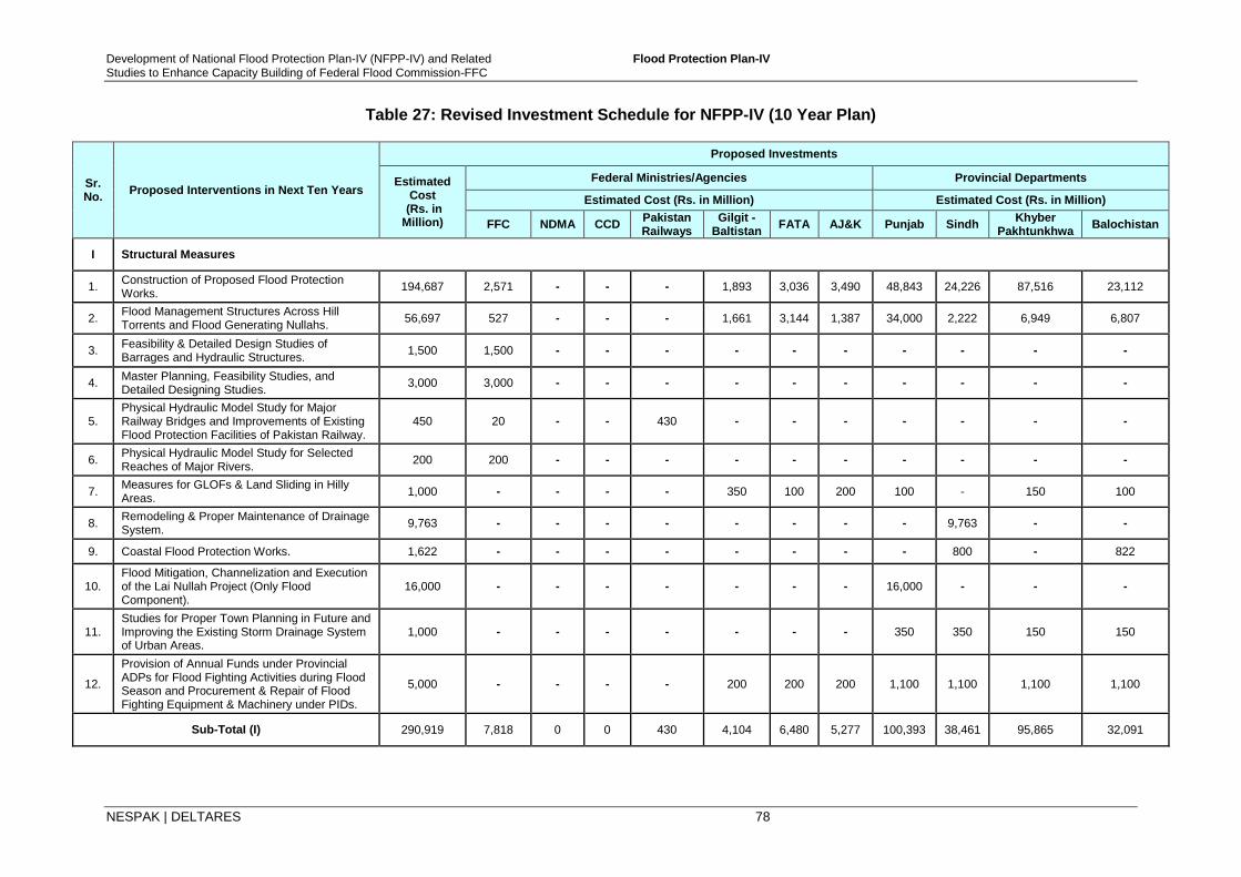
Development of National Flood Protection Plan-IV (NFPP-IV) and Related Flood Protection Plan-IV
Studies to Enhance Capacity Building of Federal Flood Commission-FFC
NESPAK | DELTARES 78
Table 27: Revised Investment Schedule for NFPP-IV (10 Year Plan)
Sr. No.
Proposed Interventions in Next Ten Years
Proposed Investments
Estimated Cost
(Rs. in Million)
Federal Ministries/Agencies Provincial Departments
Estimated Cost (Rs. in Million) Estimated Cost (Rs. in Million)
FFC NDMA CCD Pakistan Railways
Gilgit - Baltistan
FATA AJ&K Punjab Sindh Khyber
Pakhtunkhwa Balochistan
I Structural Measures
1. Construction of Proposed Flood Protection Works.
194,687 2,571 - - - 1,893 3,036 3,490 48,843 24,226 87,516 23,112
2. Flood Management Structures Across Hill Torrents and Flood Generating Nullahs.
56,697 527 - - - 1,661 3,144 1,387 34,000 2,222 6,949 6,807
3. Feasibility & Detailed Design Studies of Barrages and Hydraulic Structures.
1,500 1,500 - - - - - - - - - -
4. Master Planning, Feasibility Studies, and Detailed Designing Studies.
3,000 3,000 - - - - - - - - - -
5. Physical Hydraulic Model Study for Major Railway Bridges and Improvements of Existing Flood Protection Facilities of Pakistan Railway.
450 20 - - 430 - - - - - - -
6. Physical Hydraulic Model Study for Selected Reaches of Major Rivers.
200 200 - - - - - - - - - -
7. Measures for GLOFs & Land Sliding in Hilly Areas.
1,000 - - - - 350 100 200 100 - 150 100
8. Remodeling & Proper Maintenance of Drainage System.
9,763 - - - - - - - - 9,763 - -
9. Coastal Flood Protection Works. 1,622 - - - - - - - - 800 - 822
10. Flood Mitigation, Channelization and Execution of the Lai Nullah Project (Only Flood Component).
16,000 - - - - - - - 16,000 - - -
11. Studies for Proper Town Planning in Future and Improving the Existing Storm Drainage System of Urban Areas.
1,000 - - - - - - - 350 350 150 150
12.
Provision of Annual Funds under Provincial ADPs for Flood Fighting Activities during Flood Season and Procurement & Repair of Flood Fighting Equipment & Machinery under PIDs.
5,000 - - - - 200 200 200 1,100 1,100 1,100 1,100
Sub-TotaI (I) 290,919 7,818 0 0 430 4,104 6,480 5,277 100,393 38,461 95,865 32,091
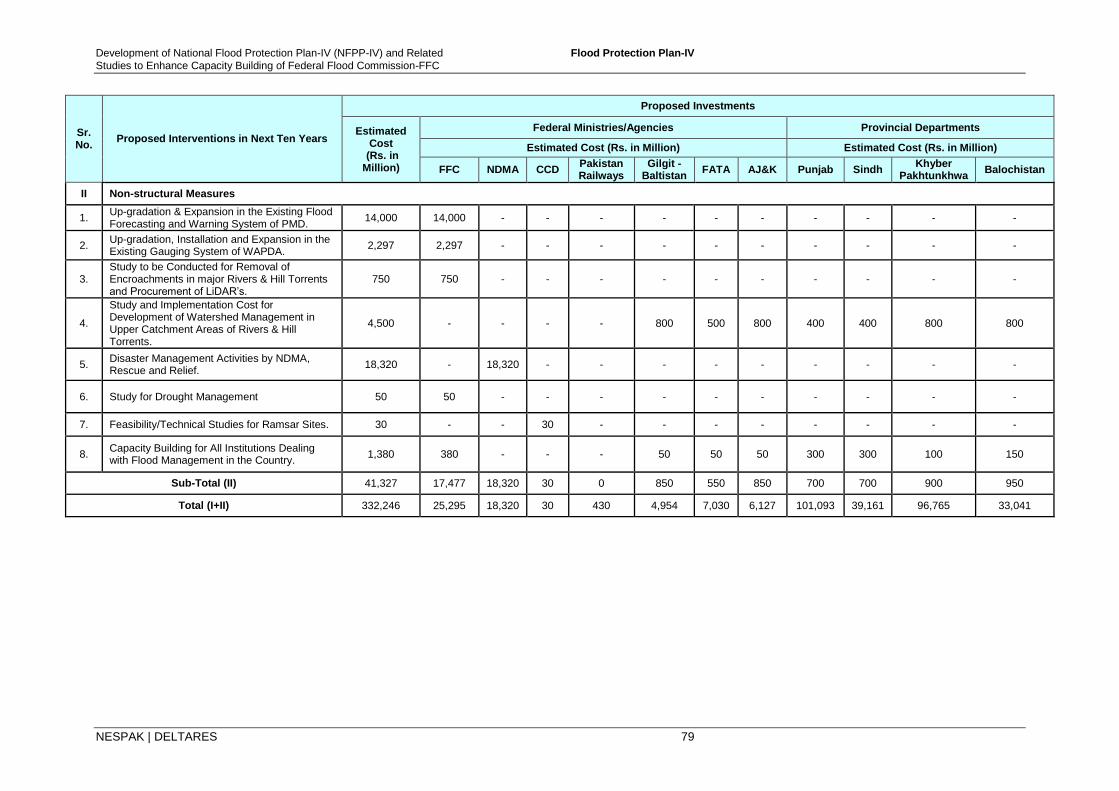
Development of National Flood Protection Plan-IV (NFPP-IV) and Related Flood Protection Plan-IV
Studies to Enhance Capacity Building of Federal Flood Commission-FFC
NESPAK | DELTARES 79
Sr. No.
Proposed Interventions in Next Ten Years
Proposed Investments
Estimated Cost
(Rs. in Million)
Federal Ministries/Agencies Provincial Departments
Estimated Cost (Rs. in Million) Estimated Cost (Rs. in Million)
FFC NDMA CCD Pakistan Railways
Gilgit - Baltistan
FATA AJ&K Punjab Sindh Khyber
Pakhtunkhwa Balochistan
II Non-structural Measures
1. Up-gradation & Expansion in the Existing Flood Forecasting and Warning System of PMD.
14,000 14,000 - - - - - - - - - -
2. Up-gradation, Installation and Expansion in the Existing Gauging System of WAPDA.
2,297 2,297 - - - - - - - - - -
3. Study to be Conducted for Removal of Encroachments in major Rivers & Hill Torrents and Procurement of LiDAR’s.
750 750 - - - - - - - - - -
4.
Study and Implementation Cost for Development of Watershed Management in Upper Catchment Areas of Rivers & Hill Torrents.
4,500 - - - - 800 500 800 400 400 800 800
5. Disaster Management Activities by NDMA, Rescue and Relief.
18,320 - 18,320 - - - - - - - - -
6. Study for Drought Management 50 50 - - - - - - - - - -
7. Feasibility/Technical Studies for Ramsar Sites. 30 - - 30 - - - - - - - -
8. Capacity Building for All Institutions Dealing with Flood Management in the Country.
1,380 380 - - - 50 50 50 300 300 100 150
Sub-Total (II) 41,327 17,477 18,320 30 0 850 550 850 700 700 900 950
Total (I+II) 332,246 25,295 18,320 30 430 4,954 7,030 6,127 101,093 39,161 96,765 33,041
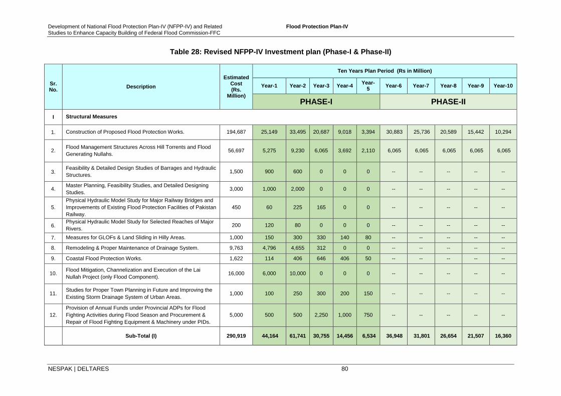
Development of National Flood Protection Plan-IV (NFPP-IV) and Related Flood Protection Plan-IV
Studies to Enhance Capacity Building of Federal Flood Commission-FFC
NESPAK | DELTARES 80
Table 28: Revised NFPP-IV Investment plan (Phase-I & Phase-II)
Sr. No.
Description
Estimated Cost (Rs.
Million)
Ten Years Plan Period (Rs in Million)
Year-1 Year-2 Year-3 Year-4 Year-
5 Year-6 Year-7 Year-8 Year-9 Year-10
PHASE-I PHASE-II
I Structural Measures
1. Construction of Proposed Flood Protection Works. 194,687 25,149 33,495 20,687 9,018 3,394 30,883 25,736 20,589 15,442 10,294
2. Flood Management Structures Across Hill Torrents and Flood
Generating Nullahs. 56,697 5,275 9,230 6,065 3,692 2,110 6,065 6,065 6,065 6,065 6,065
3. Feasibility & Detailed Design Studies of Barrages and Hydraulic
Structures. 1,500 900 600 0 0 0 -- -- -- -- --
4. Master Planning, Feasibility Studies, and Detailed Designing
Studies. 3,000 1,000 2,000 0 0 0 -- -- -- -- --
5.
Physical Hydraulic Model Study for Major Railway Bridges and
Improvements of Existing Flood Protection Facilities of Pakistan
Railway.
450 60 225 165 0 0 -- -- -- -- --
6. Physical Hydraulic Model Study for Selected Reaches of Major
Rivers. 200 120 80 0 0 0 -- -- -- -- --
7. Measures for GLOFs & Land Sliding in Hilly Areas. 1,000 150 300 330 140 80 -- -- -- -- --
8. Remodeling & Proper Maintenance of Drainage System. 9,763 4,796 4,655 312 0 0 -- -- -- -- --
9. Coastal Flood Protection Works. 1,622 114 406 646 406 50 -- -- -- -- --
10. Flood Mitigation, Channelization and Execution of the Lai
Nullah Project (only Flood Component). 16,000 6,000 10,000 0 0 0 -- -- -- -- --
11. Studies for Proper Town Planning in Future and Improving the
Existing Storm Drainage System of Urban Areas. 1,000 100 250 300 200 150 -- -- -- -- --
12.
Provision of Annual Funds under Provincial ADPs for Flood
Fighting Activities during Flood Season and Procurement &
Repair of Flood Fighting Equipment & Machinery under PIDs.
5,000 500 500 2,250 1,000 750 -- -- -- -- --
Sub-Total (I) 290,919 44,164 61,741 30,755 14,456 6,534 36,948 31,801 26,654 21,507 16,360

Development of National Flood Protection Plan-IV (NFPP-IV) and Related Flood Protection Plan-IV
Studies to Enhance Capacity Building of Federal Flood Commission-FFC
NESPAK | DELTARES 81
Sr. No.
Description
Estimated Cost (Rs.
Million)
Ten Years Plan Period (Rs in Million)
Year-1 Year-2 Year-3 Year-4 Year-
5 Year-6 Year-7 Year-8 Year-9 Year-10
PHASE-I PHASE-II
II Non-Structural Measures
1. Up-gradation & Expansion in the Existing Flood Forecasting
and Warning System of PMD. 14,000 1,025 2,260 820 300 100
4,748
2,374
2,374 -- --
2. Up-gradation, Installation and Expansion in the Existing
Gauging System of WAPDA. 2,297 927 820 420 100 30 -- -- -- -- --
3. Study to be Conducted for Removal of Encroachments in major
Rivers & Hill Torrents and Procurement of LiDARs. 750 405 345 0 0 0 -- -- -- -- --
4.
Study and Implementation Cost for Development of Watershed
Management in Upper Catchment Areas of Rivers & Hill
Torrents.
4,500 400 1,250 1,950 750 150 -- -- -- -- --
5. Disaster Management Activities by NDMA, Rescue and Relief. 18,320 1,500 2,350 1,250 800 600 5910 2364 1773 1773
6. Study for Drought Management 50 50 0 0 0 0 -- -- -- -- --
7. Feasibility/Technical Studies for Ramsar Sites. 30 15 15 0 0 0 -- -- -- -- --
8. Capacity Building for All Institutions Dealing with Flood
Management in the Country. 1,380 50 285 490 345 210 -- -- -- -- --
Sub-TotaI (II) 41,327 4,372 7,325 4,930 2,295 1,090 10,658 4,738 4,147 1,773 0
TotaI (I+II)
332,246 48,536 69,066 35,684 16,751 7,624 47,606 36,539 30,801 23,280 16,360
PHASE-I Total Cost = Rs. 177,661 Million
PHASE-II Total Cost = Rs.154,585 Million
Development of National Flood Protection Plan-IV (NFPP-IV) and Related Flood Protection Plan-IV
Studies to Enhance Capacity Building of Federal Flood Commission-FFC
NESPAK | DELTARES 82
6.5 Way Forward
It is worth mentioning that original cost of NFPP-IV amounting to Rs. 177.661 billion was worked out after detailed consultations with all the four Provinces and other Stakeholders; the details of costs may be seen in Table 17. However, pursuant to the decision of 29th meeting of CCI held on March 25, 2016, the aforesaid rounds of further consultations were undertaken in which additional estimate of Rs. 154.585 billion was desired by the provinces, NDMA and PMD to be included into the original estimate of Rs. 177.661 billion, which would result in total cost of the plan to Rs. 332.246 billion.
In a ten year investment plan as prepared earlier (before CCI meeting), exclusively for the flood sector, we understand the challenge of earmarking the funds of Rs. 177.661 billion, which requires about Rs. 18 billion per year. In view of recommendations by Ministry of Water and Power, funds of Rs. 177.661 billion are proposed to be implemented in first 5 years of 10 year plan. This will lead to a financial requirement of 36 billion per year for first 5 year of plan implementation.
The additional costs of Rs. 154.585 billion are also important and therefore, it has been proposed to consider the additional demand raised by the stakeholders, has to be retained in the current plan as Phase-II, which would take effect after successful implementation of Phase-I.
Under existing financial constraints and keeping in view spending capacity of implementing agencies, managing financial resources corresponding to Rs. 332.246 billion @ Rs. 33 billion/year seems too optimistic, yet the investments required in flood sector are utmost important in view of recurrent damages being faced by the nation, each year. For implementation of such a national scale plan, third party verifications through steering committee has been proposed whose role is elaborated in section 7.3.
It may be noted that each year after passing high flood flows, changes in river conditions might occur due to excessive variation in quantum of flow. Some vulnerable points/ schemes indicated in proposed NFPP-IV may become dormant and some other locations may become active due to change in river regime. Therefore, some priority flood works may lose their priority and some new works may crop up which require emergent protection/remedial measures on top priority basis. Therefore, necessary changes in terms of number, parameters/design, location and estimated cost may be needed at later stage. Such issues will be considered in implementation stage of NFPP-IV. Fine tuning of design will also be done, keeping in view the actual site conditions before implementation. 7 CONCLUSIONS AND RECOMMENDATIONS 7.1 Non-Structural Measures
7.1.1 Watershed Management
i. Establish Watershed Management Departments/Agencies with the relevant provincial Governments like Gilgit-Baltistan, Azad Jammu and Kashmir and Balochistan and strengthen department in KP through necessary legislation.
ii. Re-forestation, soil conservation and improvement in land use in the watersheds should be promoted.
iii. Formulate watershed management policy and carry out necessary legislation at national level as well as provincial level and implement forcefully.
iv. Ensure effective enforcement of the existing laws and regulations on forests use and management and involvement of the communities in the policy making process from
Development of National Flood Protection Plan-IV (NFPP-IV) and Related Flood Protection Plan-IV
Studies to Enhance Capacity Building of Federal Flood Commission-FFC
NESPAK | DELTARES 83
the very outset enables the government to address and arrest sharp forest decline by creating a feeling of sense of ownership and empowerment among communities.
7.1.2 Global Warming and Climate Change
i. Take measures to control the release of carbon dioxide by vehicles, factories etc., through strict implementation of laws and imposing penalties to prevent the excessive smoke producing vehicles to be on road especially diesel consuming vehicles like buses, truck etc.
ii. Raise the standard of population living below the line of poverty by proving them electricity and Sui gas so that to avoid burning of wood for cooking of their meals and heating of their livings to fight against cold weather.
iii. Prevent excessive grazing and deforestation and cutting of trees.
7.1.3 Revision of SOPs for Operation of Major Reservoirs
i. Existing reservoir operational rules (SOPs) for Mangla and Tarbela needs to be further reviewed particularly for Tarbela in the light of 2010 and 2014 floods to ensure efficient control of floods in order to provide maximum relief to downstream areas.
7.1.4 Environmental Management
i. Environmental problems vary from area to area within the country and even within city as well, thus there is need to investigate them locally.
ii. Deforestation should be discouraged not only in the uplands of rivers but all over in the country.
iii. Rules and laws are required to be formulated and implemented at Government level to improve the environmental resilience.
iv. Awareness and trainings to community to strengthen resilience and education curriculum at university levels should have some space for environmental related issues related to disasters in general and floods in particular.
v. Institutional framework for environmental issues in country is the need of time, government organizations/institutions at local level should be equipped to deal with environmental degradation caused by adverse impacts of floods, for the purpose Ministry of Climate change and Pakistan Meteorological department should play role for awareness of the environmental degradation to the communities and there is a need to involve all the stakeholders (PIDs, NDMA, PDMA, DCO'S) for better planning and execution of plans made for environmental resilience.
7.1.5 Financial Resource Management
i. There is need for designing a strategy to ensure the proper utilization of funds, this helps to evade situations in which the funds remain idle or lack of profitable utilization of funds in hand, while availing of funds, it is important to understand the involved cost and risk factors and any sort of wastage of funds needs to be avoided.
ii. There is need to strengthen the existing accountability laws and ensure implementation forcefully without any of interference, political or otherwise.
Development of National Flood Protection Plan-IV (NFPP-IV) and Related Flood Protection Plan-IV
Studies to Enhance Capacity Building of Federal Flood Commission-FFC
NESPAK | DELTARES 84
iii. Explore all possible means of gathering the financial resources required for flood management and flood relief, some of the possible sources other than federal grants and donations from local and international donors for the financial sustainability of flood management include; Cess on irrigated land in general at the rate of Rs. 1500 per acre should be levied (part of it can be used for flood protection works), Cess on areas / land benefitting from development schemes, Cess on big cities under protection may be a part of utility bills, Cess on commercial activity in the river areas, property tax collected from the flood protected commercial establishments, proceeds of sand excavation leases, proceeds of sale / auction of timber collected from river, licensing / registration fees of commercial activities on river bank areas, licensing / registration fees of navigational activities of rivers, contribution by Provincial and Local Governments; and contributions by high income groups in vulnerable areas.
7.1.6 Flood Forecasting and Warning Systems
i. Flood Early Warning System (FEWS-Pakistan) needs to be up-graded on immediate basis for inclusion of catchment area upstream of Tarbela dam, updating of existing river and floodplain geometry, study on Radar calibrations, enhancement in reliability of Quantitative Precipitation Forecast through meteorological studies and training of PMD professionals. Reliable and accurate QPF estimate can enhance lead times for forecast of flash floods.
ii. Expansion and up-gradation of existing gauging network, radars network and telemetry network under PMD and WAPDA is required on priority basis.
7.1.7 Floodplain Policies and Legislation
i. ‘River Act’ for the rivers floodplains has been formulated during current NFPP-IV studies keeping relevant stakeholders on board and there is strong need to carry out necessary legislation at provincial as well as well federal level. Provinces may modify it according to their requirements, from river to river.
ii. There is strong need to implement the ‘River Act’ in its real sense and spirit for removing encroachments, permanent settlements and undue developments in the floodplains so that flood damages can be reduced.
7.1.8 Floodplain Mapping and Zoning other than Indus River and its Tributaries
i. There is strong need to investigate the requirement of Floodplain Mapping and Zoning in the areas other than Indus River and its tributaries. These areas may include floodplains of rivers and major streams/Nullahs in Punjab, Khyber Pakhtunkhwa and Balochistan. For this purpose, provincial governments should carry out necessary investigations and studies at their own resources.
7.1.9 Community Awareness and Preparedness
i. Governmental role in enhancing awareness and preparedness in community to fight against floods should be significant.
ii. PIDs, NDMA, PDMA, DDMA and district management etc., should play active role through workshops, electronic and print media to create awareness in flood prone communities for preparing them to fight against floods and its after affects, awareness about encroachments and un-planned developments in floodplain areas resulting huge damages to their lives and property,
Development of National Flood Protection Plan-IV (NFPP-IV) and Related Flood Protection Plan-IV
Studies to Enhance Capacity Building of Federal Flood Commission-FFC
NESPAK | DELTARES 85
iii. Keeping in view the flood situation, flood events, social problems and government limited resources, there is need to improve the present traditional attitudes of community and concrete steps should be taken to legislate for restriction of permanent settlements in floodplains and enhance the awareness and preparedness to cope the emergency situation.
7.1.10 Institutional Capacity Building
Capacity building and training of FFC, PIDs, NDMA, PDMAs, PMD, WAPDA and Pakistan Army formations dealing with floods is recommended on priority basis.
7.2 Structural Measures
7.2.1 Flood Protection Works
i. Repairing, strengthening and up-gradation of existing flood protection works need to be carried out on immediate basis through provincial resources to protect the population and infrastructure against flood threat.
ii. The need for new flood protection works have been identified along with cost provision and federal agencies/government should arrange funding for their design and construction as per implementation schedule of NFPP-IV.
7.2.2 Rehabilitation and Capacity Enhancement of Barrages/Bridges
i. Rehabilitation and capacity enhancement of barrages and bridges needs special attention for their immediate execution. Necessary provisions for their studies and implementation have been made in the current NFPP-IV.
7.2.3 Dams and Storages
i. Major reservoirs need to be investigated and constructed on priority basis to preserve the flood water to substantiate irrigation flows and controlled releases to check seawater intrusion. Construction and operation of reservoirs is under WAPDA jurisdictions and need Federal government’s attention for necessary approvals, settlement of political and technical issues with the provinces and arrangement of funds.
ii. Analysis indicate that small dams have substantial potential in mitigating flood peaks from their respective catchments. It is recommended to consider various small dams in KPK, AJ&K, Punjab and Balochistan for cumulative impact on flood mitigation. The list of small dams is given in Task-A report. The pre-feasibility/feasibility studies on these dams may be taken-up by the provinces at their own resources.
7.2.4 Breaching Sections at Barrages/Bridges and Flood Escape Channels
i. It is highly recommended to conduct a comprehensive study of all existing breaching sections to ascertain their effectiveness and possible flow paths, flow depths, velocities and inundation extents of breach flood flows.
ii. Feasibility study for identification of route of flood escape channel, conducted by Government of Sindh, should be further investigated for finalization of route and with respect to i) the cost of resettlement of population and relocation of major infrastructure to route the escape channel and at the disposal location, ii) confirmation of performance of intake structure (head regulator of proposed diversion
Development of National Flood Protection Plan-IV (NFPP-IV) and Related Flood Protection Plan-IV
Studies to Enhance Capacity Building of Federal Flood Commission-FFC
NESPAK | DELTARES 86
channel) to draw the proposed flood magnitude, and iii) confirmation of conveyance capacity through numerical and physical model tests.
iii. Adequate conveyance capacity within the river and urban channels needs to be restored by removing bottle necks and encroachments.
7.3 Plan Implementation and Third Party Verification The scale and magnitude of proposed investments in flood sector requires comprehensive monitoring of activities related to funding arrangements, distributions of funds and plan implementation as per priorities. For this particular objective, a steering committee is proposed which will guide on implementation of priorities based on short term and long term needs in flood management across the country. Besides guidelines on priorities, one of the objectives of steering committee would be monitoring of various projects under plan implementation stage.
To ensure transparency and efficient utilization of funds, third party verification is proposed. It will provide important feedback on performance of plan implementation by evaluating activities through certain benchmarks and monitoring indicators. It will assure objectives of integrated flood management through structural and non-structural interventions.

![2017 Central Valley Flood Protection Plan Update: Overview · 2017 Central Valley Flood Protection Plan Update: Overview [TRACKING NUMBER] 2012 Central Valley Flood Protection Plan](https://img.pdfslide.net/doc/110x75/600b701285d0f2151664ff2e/2017-central-valley-flood-protection-plan-update-overview-2017-central-valley-flood.jpg)