Embed Size (px)
Citation preview
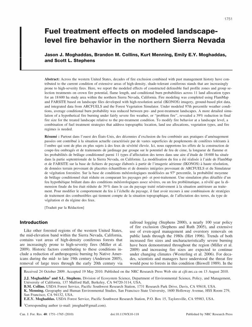
Fuel treatment effects on modeled landscape-level fire behavior in the northern Sierra Nevada
Jason J. Moghaddas, Brandon M. Collins, Kurt Menning, Emily E.Y. Moghaddas,and Scott L. Stephens
Abstract: Across the western United States, decades of fire exclusion combined with past management history have con-tributed to the current condition of extensive areas of high-density, shade-tolerant coniferous stands that are increasinglyprone to high-severity fires. Here, we report the modeled effects of constructed defensible fuel profile zones and group se-lection treatments on crown fire potential, flame length, and conditional burn probabilities across 11 land allocation typesfor an 18 600 ha study area within the northern Sierra Nevada, California. Fire modeling was completed using FlamMapand FARSITE based on landscape files developed with high-resolution aerial (IKONOS) imagery, ground-based plot data,and integrated data from ARCFUELS and the Forest Vegetation Simulator. Under modeled 97th percentile weather condi-tions, average conditional burn probability was reduced between pre- and post-treatment landscapes. A more detailed simu-lation of a hypothetical fire burning under fairly severe fire weather, or ‘‘problem fire’’, revealed a 39% reduction in finalfire size for the treated landscape relative to the pre-treatment condition. To modify fire behavior at a landscape level, acombination of fuel treatment strategies that address topographic location, land use allocations, vegetation types, and fireregimes is needed.
Resume : Partout dans l’ouest des Etats-Unis, des decennies d’exclusion du feu combinee aux pratiques d’amenagementpassees ont contribue a la situation actuelle caracterisee par de vastes superficies de peuplements de coniferes tolerants al’ombre qui sont de plus en plus sujets a des feux de severite elevee. Ici, nous rapportons les effets de la construction decoupe-feu ombrages et de traitements de jardinage par groupe sur le potentiel de feu de cime, la longueur de flamme etles probabilites de brulage conditionnel parmi 11 types d’affectation des terres dans une aire d’etude de 18 600 ha situeedans la partie septentrionale de la Sierra Nevada, en Californie. La modelisation du feu a ete realisee a l’aide de FlamMapet de FARSITE sur la base de fichiers de paysage elabores a partir de l’imagerie aerienne (IKONOS) a haute resolution,de donnees terrain provenant de placettes echantillons et de donnees integrees provenant de ARCFUELS et du Simulateurde vegetation forestiere. Sur la base de conditions meteorologiques modelisees au 97e percentile, la probabilite moyennede brulage conditionnel etait reduite en comparant les paysages pre- et post-traitement. Une simulation plus detaillee d’unfeu hypothetique brulant dans des conditions meteorologiques assez severes, ou un feu problematique, a revele que la di-mension finale du feu etait reduite de 39 % dans le cas du paysage traite relativement a la situation anterieure au traite-ment. Pour modifier le comportement du feu a l’echelle du paysage, il faut avoir recours a une combinaison de strategiesde traitement des combustibles qui tiennent compte de la situation topographique, de l’affectation des terres, du type devegetation et du regime des feux.
[Traduit par la Redaction]
Introduction
Like other forested regions of the western United States,the mid-elevation band within the Sierra Nevada, California,contains vast areas of high-density coniferous forests thatare increasingly prone to high-severity fires (Miller et al.2009). Historic factors contributing to these conditions in-clude a reduction of anthropogenic burning by Native Amer-icans during the mid- to late 19th century (Anderson 2005),removal of large trees through the early 20th century via
railroad logging (Stephens 2000), a nearly 100 year policyof fire exclusion (Stephens and Ruth 2005), and extensiveuse of even-aged management and overstory removals onpublic lands through the 1980s (Hirt 1996). Trends of bothincreased fire sizes and uncharacteristically severe burninghave been demonstrated throughout the region (Miller et al.2009) and increasing fire sizes are expected to continueunder changing climates (Westerling et al. 2006). For deca-des, scientists and managers have understood the threat firewould pose to forests in this condition (Biswell 1989). In the
Received 24 October 2009. Accepted 19 May 2010. Published on the NRC Research Press Web site at cjfr.nrc.ca on 13 August 2010.
J.J. Moghaddas1 and S.L. Stephens. Division of Ecosystem Science, Department of Environmental Science, Policy, and Management,University of California, 137 Mulford Hall, Berkeley, CA 94720-3114, USA.B.M. Collins. USDA Forest Service, Pacific Southwest Research Station, 1731 Research Park Drive, Davis, CA 95618, USA.K. Menning. Geography and Human Environmental Studies, San Francisco State University, 1600 Holloway Avenue, HSS Room 279,San Francisco, CA 94132, USA.E.E.Y. Moghaddas. USDA Forest Service, Pacific Southwest Research Station, P.O. Box 15, Taylorsville, CA 95983, USA.
1Corresponding author (e-mail: [email protected]).
1751
Can. J. For. Res. 40: 1751–1765 (2010) doi:10.1139/X10-118 Published by NRC Research Press
western United States, it was not until the early 1990s thatfederal land management agencies were given direction tomanipulate stands, using a combination of silvicultural pre-scriptions, with the specific objective of modifying land-scape-level fire behavior.
Many stand-scale studies have demonstrated the effective-ness of various fuel treatment alternatives at changing thebehavior and reducing the impacts of both computer-mod-eled fires (Stephens and Moghaddas 2005; Stephens et al.
2009) and actual wildland fires (Ritchie et al. 2007; Saffordet al. 2009). These studies document treatment effects onfire behavior across several treatment types and provideguidance on designing prescriptions for forest stands. How-ever, the extensive tracts of relatively homogenous, fire-ex-cluded forests throughout the western United States and thelarge wildfires that can occur in these forests demonstratethe pressing need to ‘‘scale up’’ insights gained at the standlevel to larger landscapes. However, implementing fuel
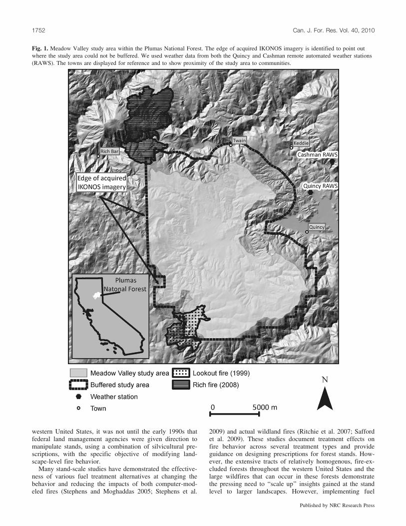
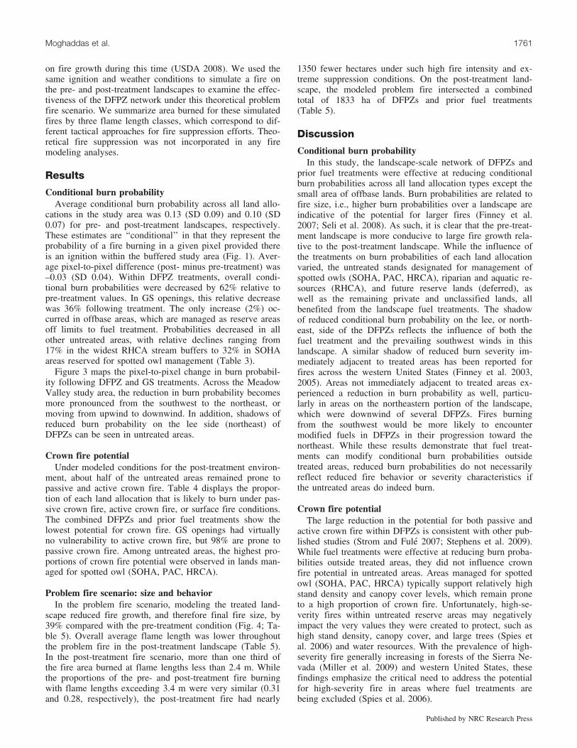
Fig. 1. Meadow Valley study area within the Plumas National Forest. The edge of acquired IKONOS imagery is identified to point outwhere the study area could not be buffered. We used weather data from both the Quincy and Cashman remote automated weather stations(RAWS). The towns are displayed for reference and to show proximity of the study area to communities.
1752 Can. J. For. Res. Vol. 40, 2010
Published by NRC Research Press
treatments across an entire landscape over a short period oftime is difficult — there is simply too much forest needingimmediate treatment (Collins et al. 2010). In addition, bothpublic and private forestlands are often constrained by ad-ministrative or regulatory rules that limit silvicultural treat-ment options within a landscape. Certain designations, orland allocations, limit the range of fuel treatment options orrestrict such activities all together. Examples of such land
allocations include habitat for sensitive wildlife species andwatercourse buffer zones. These land allocations potentiallyconstrain the three important components of any fuel treat-ment project: location of treatments, treatment type, and sizeof individual treatment units (Collins et al. 2010). The im-pacts that these types of constraining land allocations haveon fuel treatment implementation and overall effectivenessat reducing adverse fire effects have not been well studied.
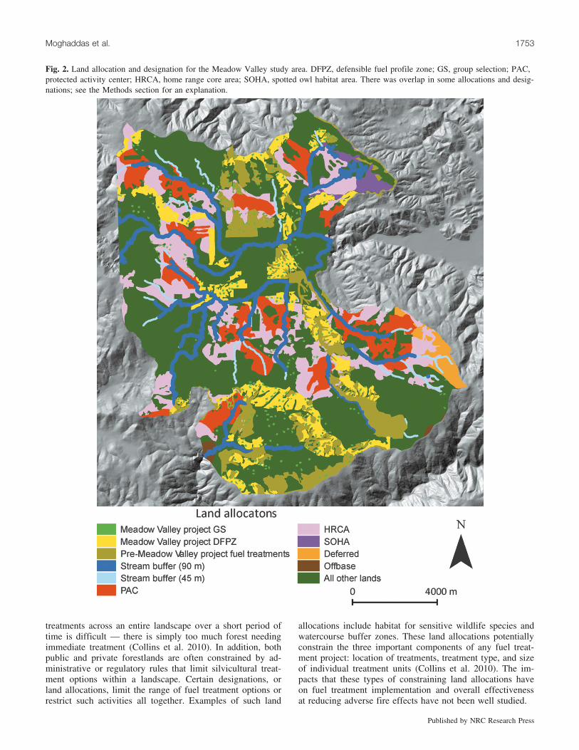
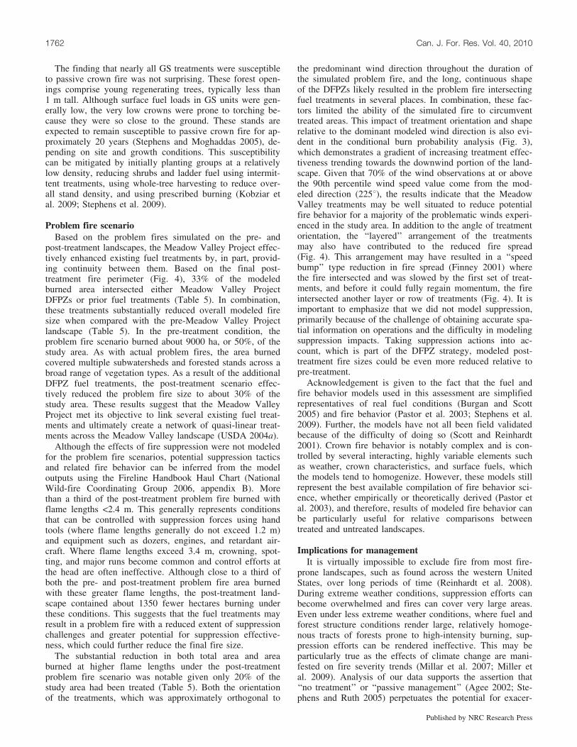
Fig. 2. Land allocation and designation for the Meadow Valley study area. DFPZ, defensible fuel profile zone; GS, group selection; PAC,protected activity center; HRCA, home range core area; SOHA, spotted owl habitat area. There was overlap in some allocations and desig-nations; see the Methods section for an explanation.
Moghaddas et al. 1753
Published by NRC Research Press
One approach for implementing a landscape fuel treat-ment relies on creating defensible fuel profile zones(DFPZs). A DFPZ is an area approximately 0.4–0.8 kmwide where surface, ladder, and crown fuel loads are re-duced by using a combination of mechanical thinning frombelow and prescribed fire treatments (USDA 2004a). Theyare usually constructed along roads or ridge tops to reducefuel continuity across the landscape and provide a defensiblezone for fire suppression resources. DFPZs are designed toprovide three primary functions: (i) provide safe access forfirefighters to conduct suppression activities, (ii) limit fire
behavior to prescribed levels (e.g., limit flame lengths at the90th percentile weather condition to 122 cm), and (iii) createa well-spaced canopy and conditions in which canopy firesare less likely to spread (USDA 2004a; Menning and Ste-phens 2007). DFPZs are generally designed to be used inconjunction with suppression actions including fire line con-struction, application of aerial retardant, and burnout activ-ities. DFPZs are designed to function under 90th percentileweather conditions and their successful performance hasbeen documented in many instances (Moghaddas and Craggs2007). Under more extreme weather conditions, DFPZs have
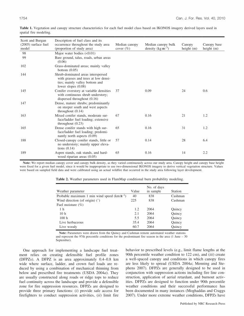
Table 1. Vegetation and canopy structure characteristics for each fuel model class based on IKONOS imagery derived layers used inspatial fire modeling.
Scott and Burgan(2005) surface fuelmodel
Description of fuel class and itsoccurrence throughout the study area(proportion of study area)
Median canopycover (%)
Median canopy bulkdensity (kg�m–3)
Canopyheight (m)
Canopy baseheight (m)
98 Major water bodies (<0.01)99 Bare ground, talus, roads, urban areas
(0.06)102 Grass-dominated areas; mainly valley
bottom (0.05)144 Shrub-dominated areas interspersed
with grasses and trees at low densi-ties; mainly valley bottom andlower slopes (0.08)
145 Conifer overstory at variable densitieswith continuous shrub understory;dispersed throughout (0.16)
37 0.09 24 0.6
147 Dense, mature shrubs; predominantlyon steeper south and west aspectsthroughout (0.14)
163 Mixed conifer stands, moderate sur-face/ladder fuel loading; extensivethroughout (0.23)
67 0.16 21 1.2
165 Dense conifer stands with high sur-face/ladder fuel loading; predomi-nantly north aspects (0.09)
65 0.16 31 1.2
188 Closed-canopy conifer stands, little orno understory; mainly upper eleva-tions (0.14)
57 0.14 28 6.4
189 Aspen stands, oak stands, and hard-wood riparian areas (0.05)
65 0.16 14 2.2
Note: We report median canopy cover and canopy bulk density, as they varied continuously across our study area. Canopy height and canopy base heightwere fixed for a given fuel model, since it would be inappropriate to use two-dimensional IKONOS imagery to derive vertical vegetation structure. Valueswere based on sampled field data and were calibrated using an actual wildfire that occurred in the study area following layer development.
Table 2. Weather parameters used in FlamMap conditional burn probability modeling.
Weather parameter ValueNo. of daysin sample Station
Probable maximum 1 min wind speed (km�h–1) 40 838 CashmanWind direction (of origin) (8) 225 838 CashmanFuel moisture (%)
1 h 1.2 2064 Quincy10 h 2.1 2064 Quincy100 h 5.5 2064 QuincyLive herbaceous 35.4 2064 QuincyLive woody 60.7 2064 Quincy
Note: Parameters were drawn from the Quincy and Cashman remote automated weather stationsand represent the 97th percentile conditions for the predominant fire season in the area (1 June – 30September).
1754 Can. J. For. Res. Vol. 40, 2010
Published by NRC Research Press
reduced fire severity at the stand level, but the performanceof DFPZs at the landscape scale in more extreme conditionsis less understood (Agee et al. 2000) and has not been sys-tematically studied.
In addition to fuel treatments, a common forest manage-ment practice in the Sierra Nevada is group selection (GS)silviculture. In an effort to achieve an all-aged mosaic oftimber stands, this uneven-aged regeneration system createssmall forest openings by removing all trees in an area up toabout 1 ha. These openings are then replanted by hand ornaturally regenerated via seed from adjacent stands (USDA2004a). Forest management incorporating GS practices hasbeen applied or proposed in the southern United States(Menzel et al. 2002), boreal Europe, southeast Asia, andCalifornia (York et al. 2004). On public lands, trees greaterthan 76 cm diameter at breast height (DBH) are typicallynot cut in GS openings.
In this study, we examine the effects of the landscape-level fuel treatment network created by the Meadow ValleyProject in the northern Sierra Nevada. This project installedDFPZs and created GS openings to test and demonstratetheir effectiveness at meeting a mix of ecologic, social, eco-nomic, and fuel reduction objectives. Using high-resolutionIKONOS imagery coupled with field measurements, wecharacterize the fuel and vegetation characteristics in the18 623 ha Meadow Valley landscape before and after theMeadow Valley Project was implemented. These data wereinput into the spatially explicit fire behavior models Flam-Map and FARSITE (Finney 1998, 2006) to generate esti-mates of crown fire potential, flame length, and burnprobabilities across the Meadow Valley landscape pre- andpost-treatment. We summarize results by land allocationtype to discern whether certain types are more prone to in-creased fire behavior and (or) increased probability of burn-ing. FARSITE was further used to simulate a single wildfireoccurring under severe fire weather conditions in theMeadow Valley study area. The same ignition and weatherconditions were used to simulate this fire for the pre- andpost-treatment landscape to demonstrate the influence of
fuel treatments on fire size and behavior. This paper ad-dresses the effectiveness of these landscape-scale fuel treat-ments at reducing modeled fire behavior and providesmanagement considerations pertinent to these results.
Methods
Study area and land management objectivesThe Meadow Valley study area is located in the northern
Sierra Nevada range within the Plumas National Forest at39856’N, 12183’W (Fig. 1). The climate is Mediterraneanwith a predominance of winter precipitation totaling about1200 mm�year–1 (Ansley and Battles 1998). The study areaencompasses several subwatersheds totaling 18 623 ha withelevations ranging from 850 to 2100 m (Fig. 1). Althoughthe definition of ‘‘landscape scale’’ can be ambiguous, otherlandscape-level fire behavior studies in western coniferousforests have analyzed areas ranging from about 16 000 ha(Ager et al. 2007a) to 55 000 ha (Finney et al. 2007), whichis consistent with the size of the Meadow Valley study area.Vegetation on this landscape is primarily mixed conifer for-est (Barbour and Major 1995), a mix of conifers and severalhardwoods: white fir (Abies concolor (Gord. & Glend.)Lindl. ex Hildebr.), Douglas-fir (Pseudotsuga menziesii(Mirb.) Franco), sugar pine (Pinus lambertiana Dougl.),ponderosa pine (Pinus ponderosa P.&C. Lawson), Jeffreypine (Pinus jeffreyi Grev. & Balf.), incense cedar (Calo-cedrus decurrens (Torr.) Florin), and California black oak(Quercus kelloggii Newberry). Montane chaparral and somegrasslands are interspersed within the forest. Tree densityvaries by fire and timber management history, elevation,slope, aspect, and edaphic conditions. Fire history, inferredfrom fire scars recorded in tree rings, suggests a fire regimewith predominantly frequent, low-severity fires occurring atintervals ranging from 7 to 12 years (Moody et al. 2006).
This study was conducted within the Meadow ValleyProject on USDA Forest Service lands currently managedwith DFPZ fuel treatments and GS silviculture. TheMeadow Valley Project is included in the Pilot Project of
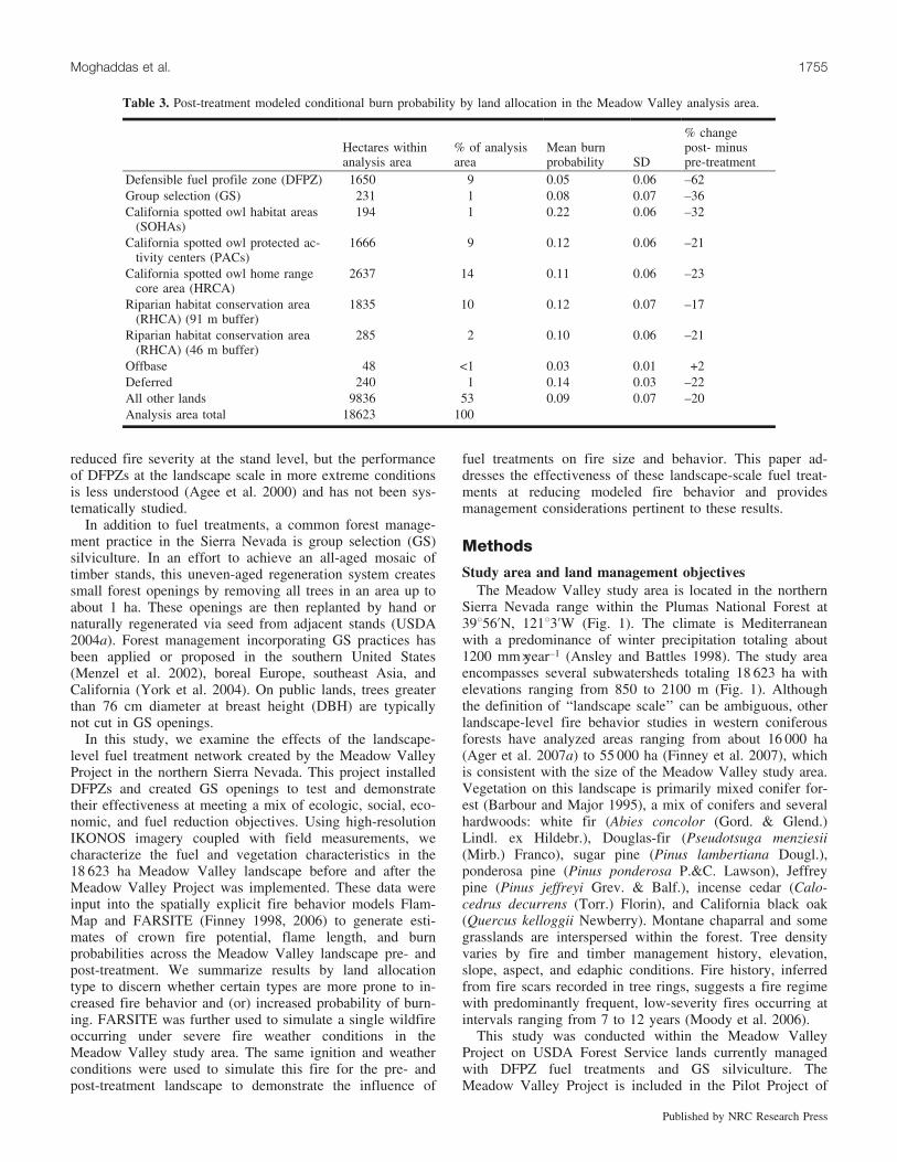
Table 3. Post-treatment modeled conditional burn probability by land allocation in the Meadow Valley analysis area.
Hectares withinanalysis area
% of analysisarea
Mean burnprobability SD
% changepost- minuspre-treatment
Defensible fuel profile zone (DFPZ) 1650 9 0.05 0.06 –62Group selection (GS) 231 1 0.08 0.07 –36California spotted owl habitat areas
(SOHAs)194 1 0.22 0.06 –32
California spotted owl protected ac-tivity centers (PACs)
1666 9 0.12 0.06 –21
California spotted owl home rangecore area (HRCA)
2637 14 0.11 0.06 –23
Riparian habitat conservation area(RHCA) (91 m buffer)
1835 10 0.12 0.07 –17
Riparian habitat conservation area(RHCA) (46 m buffer)
285 2 0.10 0.06 –21
Offbase 48 <1 0.03 0.01 +2Deferred 240 1 0.14 0.03 –22All other lands 9836 53 0.09 0.07 –20Analysis area total 18623 100 .
Moghaddas et al. 1755
Published by NRC Research Press
the Herger–Feinstein Quincy Library Group (HFQLG) Act,established to promote ecologic and economic health of des-ignated federal lands (US House of Representatives 1998).Under the HFQLG Act, a range of watershed restorationand forest management activities, including implementationof fuel treatments, GS silviculture, and individual tree selec-tion harvests, have been conducted to meet these objectives.Individual tree selection was not implemented in theMeadow Valley Project.
Landscape fuel treatmentsBeginning in the late 1990s, the Plumas National Forest
initiated several fuel reduction projects within the studyarea. Several treatments predate our vegetation and fueldata collection. These prior treatments account for a total of9% of the study area and are included in the pre-treatmentcondition of this analysis. The Meadow Valley Project,which began implementation in 2005, was designed in partto create a landscape-level fuel reduction network that
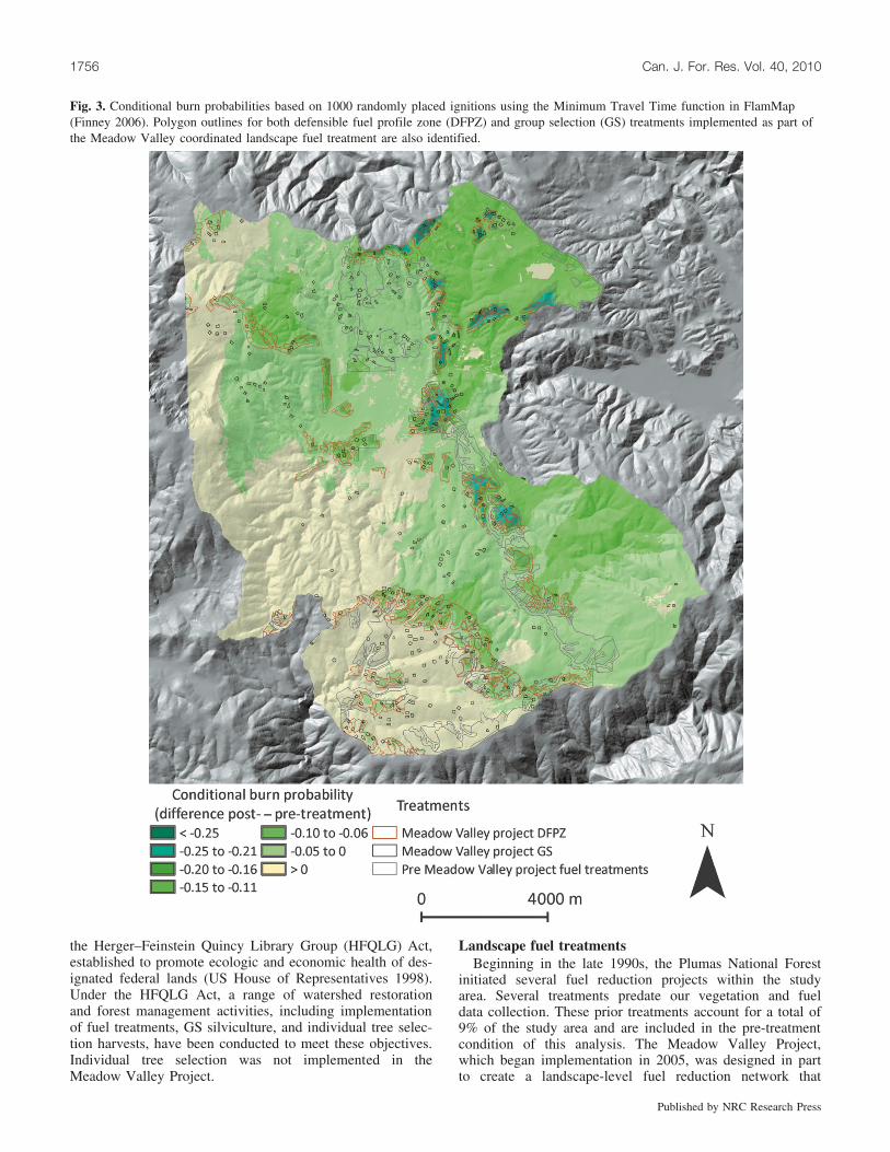
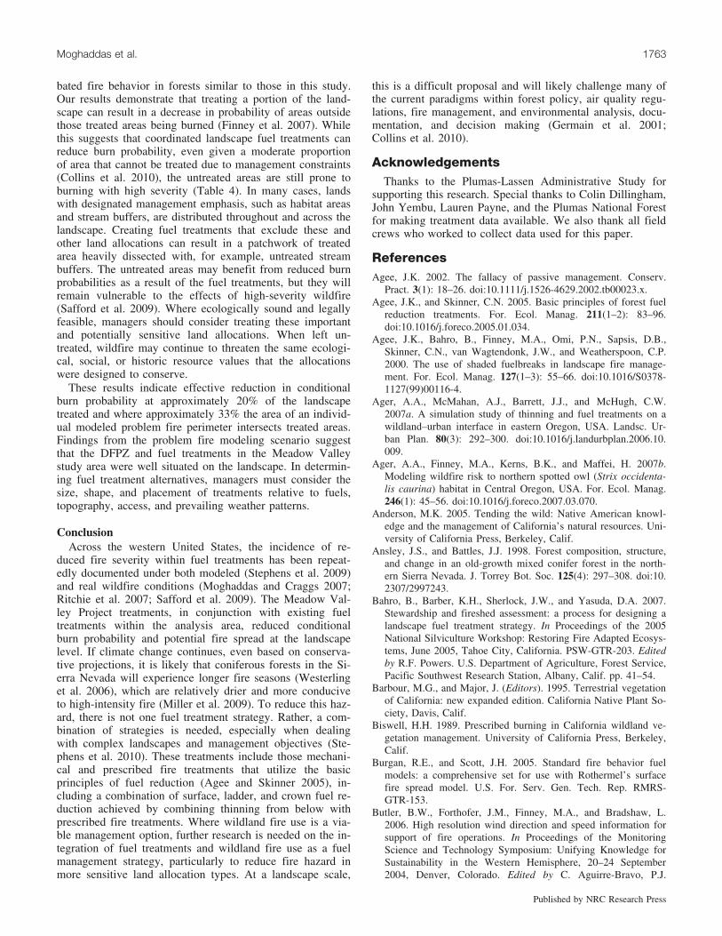
Fig. 3. Conditional burn probabilities based on 1000 randomly placed ignitions using the Minimum Travel Time function in FlamMap(Finney 2006). Polygon outlines for both defensible fuel profile zone (DFPZ) and group selection (GS) treatments implemented as part ofthe Meadow Valley coordinated landscape fuel treatment are also identified.
1756 Can. J. For. Res. Vol. 40, 2010
Published by NRC Research Press
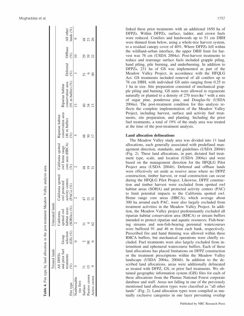
linked these prior treatments with an additional 1650 ha ofDFPZs. Within DFPZs, surface, ladder, and crown fuelswere reduced. Conifers and hardwoods up to 51 cm DBHwere thinned from below, using a whole-tree harvest system,to a residual canopy cover of 40%. Where DFPZs fell withinthe wildland–urban interface, the upper DBH limit for har-vest was 76 cm (USDA 2004a). Post-harvest treatments toreduce and rearrange surface fuels included grapple piling,hand piling, pile burning, and underburning. In addition toDFPZs, 231 ha of GS was implemented as part of theMeadow Valley Project, in accordance with the HFQLGAct. GS treatments included removal of all conifers up to76 cm DBH, with individual GS units ranging from 0.25 to1 ha in size. Site preparation consisted of mechanical grap-ple piling and burning. GS units were allowed to regeneratenaturally or planted to a density of 270 trees�ha–1 with a mixof sugar pine, ponderosa pine, and Douglas-fir (USDA2004a). The post-treatment condition for this analysis re-flects the complete implementation of the Meadow ValleyProject, including harvest, surface and activity fuel treat-ments, site preparation, and planting. Including the priorfuel treatments, a total of 19% of the study area was treatedat the time of the post-treatment analysis.
Land allocation delineationsThe Meadow Valley study area was divided into 11 land
allocations, each generally associated with predefined man-agement direction, standards, and guidelines (USDA 2004b)(Fig. 2). These land allocations, in part, dictated fuel treat-ment type, scale, and location (USDA 2004a) and werebased on the management direction for the HFQLG PilotProject area (USDA 2004b). Deferred and offbase landswere effectively set aside as reserve areas where no DFPZconstruction, timber harvest, or road construction can occurduring the HFQLG Pilot Project. Likewise, DFPZ construc-tion and timber harvest were excluded from spotted owlhabitat areas (SOHA) and protected activity centers (PAC)to limit potential impacts to the California spotted owl.Home range core areas (HRCA), which average about300 ha around each PAC, were also largely excluded fromtreatment activities in the Meadow Valley Project. In addi-tion, the Meadow Valley project predominantly excluded allriparian habitat conservation area (RHCA) or stream buffersintended to protect riparian and aquatic resources. Fish-bear-ing streams and non-fish-bearing perennial watercourseswere buffered 91 and 46 m from each bank, respectively.Prescribed fire and hand thinning was allowed within theseRHCA buffers, but mechanical operations were chiefly ex-cluded. Fuel treatments were also largely excluded from in-termittent and ephemeral watercourse buffers. Each of theseland allocations has placed limitations on DFPZ constructionor the treatment prescriptions within the Meadow Valleylandscape (USDA 2004a, 2004b). In addition to the de-scribed land allocations, areas were additionally delineatedas treated with DFPZ, GS, or prior fuel treatments. We ob-tained geographic information system (GIS) files for each ofthese allocations from the Plumas National Forest corporatedatabase and staff. Areas not falling in one of the previouslymentioned land allocation types were classified as ‘‘all otherlands’’ (Fig. 2). Land allocation types were compiled as mu-tually exclusive categories in one layer preventing overlapT
able
4.Fi
rety
peby
land
allo
catio
nin
the
post
-tre
atm
ent
Mea
dow
Val
ley
anal
ysis
area
.
Tre
ated
land
sU
ntre
ated
land
s
Fire
type
All
DFP
Zs
and
prio
rfu
eltr
eatm
ents
(%)
Gro
upse
lect
ion
(GS)
(%)
Cal
ifor
nia
spot
ted
owl
habi
tat
area
s(S
OH
As)
(%)
Cal
ifor
nia
spot
ted
owl
prot
ecte
dac
tivit
yce
nter
s(P
AC
s)(%
)
Cal
ifor
nia
spot
ted
owl
hom
era
nge
core
area
(HR
CA
)(%
)
Rip
aria
nha
bita
tco
nser
vatio
nar
ea(4
6m
buff
er)
(%)
Rip
aria
nha
bita
tco
nser
vatio
nar
ea(9
1m
buff
er)
(%)
Def
erre
d(%
)O
ffba
se(%
)A
llot
her
land
s(%
)N
onbu
rnab
le(n
ofi
re)
50
22
25
133
109
Surf
ace
712
3147
4848
4051
2948
Pass
ive
crow
n15
984
2119
3034
639
23A
ctiv
ecr
own
90
6231
3117
1340
2220
Moghaddas et al. 1757
Published by NRC Research Press
among the individual types so that summed area among thetypes was not greater than the total study area. Where theland allocations overlapped, we used the hierarchy as fol-lows: (1) DFPZ/GS, (2) RHCA, (3) HRCA/PAC, (4)SOHA, and (5) offbase/deferred.
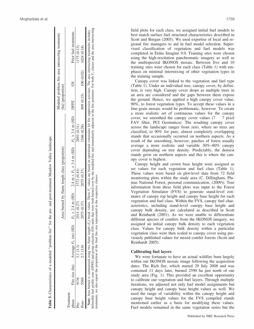
ImageryWe acquired high-resolution IKONOS imagery for the
study area from the Space Imaging Corporation in 2003 and2004; the acquisition was spread over 2 years due to incom-plete coverage of the study area in 2003. The imagery cap-tured the pre-Meadow Valley treatment condition butincluded completed fuel treatments implemented prior tothe Meadow Valley Project. The prescribed acquisition wasintended to be near the summer solstice at noon to ensureminimal topographic and tree shadowing. The 2003 imagerywas collected on 30 June. Due to poor weather and otherconstraints, 2004 image acquisition was delayed until 3 Sep-tember. Both acquisitions had identical prescriptions: 1 m
panchromatic and 4 m multispectral imagery collected withan upgraded and narrowed field of view (72–908 from azi-muth). We completed radiometric corrections to minimizebackscatter and distortion due to atmospheric moisture andhaze. These radiometrically corrected images were then or-thorectified using the Geomatica 9.1 Orthoengine moduleusing 12 independent ground reference points.
Creating fuel layersPre-treatment vegetation and fuel characteristics were
mapped from the IKONOS mosaic using supervised classifi-cation (Menning 2003). We created the five vegetation/fuellayers needed to run the spatial fire models FARSITE(Finney 1998) and FlamMap (Finney 2006): fuel model,canopy cover, canopy base height, canopy height, and can-opy bulk density. We used vegetation spectral signatures toclassify the IKONOS imagery into 10 discrete vegetationand fuel classes (Table 1). Based on the stand structure andfuel characteristics observed in the field and sampled in
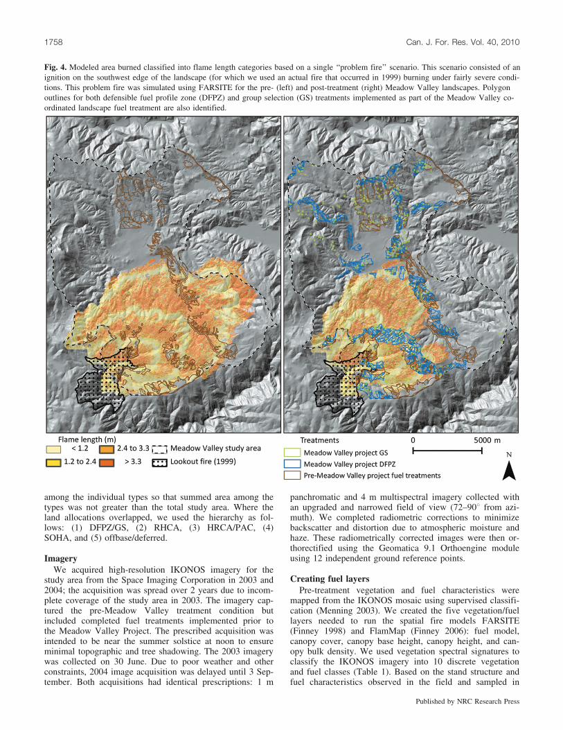
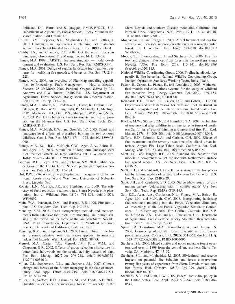
Fig. 4. Modeled area burned classified into flame length categories based on a single ‘‘problem fire’’ scenario. This scenario consisted of anignition on the southwest edge of the landscape (for which we used an actual fire that occurred in 1999) burning under fairly severe condi-tions. This problem fire was simulated using FARSITE for the pre- (left) and post-treatment (right) Meadow Valley landscapes. Polygonoutlines for both defensible fuel profile zone (DFPZ) and group selection (GS) treatments implemented as part of the Meadow Valley co-ordinated landscape fuel treatment are also identified.
1758 Can. J. For. Res. Vol. 40, 2010
Published by NRC Research Press
field plots for each class, we assigned initial fuel models tobest match surface fuel structural characteristics described inScott and Burgan (2005). We used expertise of local and re-gional fire managers to aid in fuel model selection. Super-vised classification of vegetation and fuel models wascompleted in Erdas Imagine 9.0. Training sites were chosenusing the high-resolution panchromatic imagery as well asthe multispectral IKONOS mosaic. Between five and 10training sites were chosen for each class (Table 1) with em-phasis on minimal intermixing of other vegetation types inthe training sample.
Canopy cover was linked to the vegetation and fuel type(Table 1). Under an individual tree, canopy cover, by defini-tion, is very high. Canopy cover drops as multiple trees inan area are considered and the gaps between them exposethe ground. Hence, we applied a high canopy cover value,90%, to forest vegetation types. To accept these values in afine-grain mosaic would be problematic, however. To createa more realistic set of continuous values for the canopycover, we smoothed the canopy cover values (7 � 7 pixelFAV filter, PCI Geomatica). The resulting canopy coveracross the landscape ranges from zero, where no trees areclassified, to 90% for pure, almost completely overlappingstands that occasionally occurred on northern aspects. As aresult of the smoothing, however, patches of forest usuallyaverage a more realistic and variable 30%–80% canopycover depending on tree density. Predictably, the denseststands grow on northern aspects and this is where the can-opy cover is highest.
Canopy height and crown base height were assigned asset values for each vegetation and fuel class (Table 1).These values were based on plot-level data from 72 fieldmonitoring plots within the study area (C. Dillingham, Plu-mas National Forest, personal communication, (2009)). Treeinformation from these field plots was input to the ForestVegetation Simulator (FVS) to generate stand-level esti-mates of canopy top height and canopy base height for eachvegetation and fuel class. Within the FVS, canopy fuel char-acteristics, including stand-level canopy base height andcanopy bulk density, are calculated as described in Scottand Reinhardt (2001). As we were unable to differentiatedifferent species of conifers from the IKONOS imagery, weassigned an initial canopy bulk density to each vegetationclass. Values for canopy bulk density within a particularvegetation class were then scaled to canopy cover using pre-viously published values for mixed conifer forests (Scott andReinhardt 2005).
Calibrating fuel layersWe were fortunate to have an actual wildfire burn largely
within our IKONOS mosaic image following the acquisitiondates. The Rich fire, which started 29 July 2008 and wascontained 11 days later, burned 2590 ha just north of ourstudy area (Fig. 1). This provided an excellent opportunityto calibrate our vegetation and fuel layers. Through multipleiterations, we adjusted not only fuel model assignments butcanopy height and canopy base height values as well. Weused the range of variability within the canopy height andcanopy base height values for the FVS compiled standsmentioned earlier as a basis for modifying these values.Fuel models remained in the same vegetation series but theT
able
5.C
hara
cter
istic
sof
am
odel
ed‘‘p
robl
emfi
re’’
for
the
pre-
and
post
-tre
atm
ent
Mea
dow
Val
ley
land
scap
e.
Are
abu
rned
byfl
ame
leng
thcl
ass
(pro
port
ion)
Mod
eled
prob
lem
fire
area
inte
rsec
ting
trea
tmen
ts(h
a)(p
ropo
rtio
n)
Tre
atm
ent
phas
eFi
resi
ze(h
a)A
vera
geF
L(m
)(S
D)
FL
<2.
4m
(SD
)2.
4m
<F
L<
3.4
m(S
D)
FL
>3.
4m
(SD
)D
FPZ
GS
Prio
rfu
eltr
eatm
ents
Pre-
9176
3.1
(3.3
)25
11(0
.27)
3772
(0.4
1)28
93(0
.31)
1175
(0.1
3)Po
st-
5569
2.7
(3.0
)20
75(0
.37)
2075
(0.3
7)15
46(0
.28)
809
(0.1
5)10
0(0
.02)
1024
(0.1
8)
Not
e:A
rea
burn
edis
sum
mar
ized
usin
gtw
ofl
ame
leng
th(F
L)
brea
kva
lues
.T
hese
FL
valu
esar
eba
sed
onop
erat
iona
lco
nstr
aint
sfo
rfi
resu
ppre
ssio
nac
tiviti
es.
The
area
inte
rsec
ting
trea
tmen
tsin
clud
esde
fens
ible
fuel
prof
ilezo
ne(D
FPZ
)an
dgr
oup
sele
ctio
n(G
S)un
itsth
atw
ere
both
burn
edov
erby
the
mod
eled
fire
and
imm
edia
tely
adja
cent
toth
efi
repe
rim
eter
.For
both
FL
clas
ses
and
the
area
inte
rsec
ting
trea
tmen
ts,
we
also
repo
rtth
epr
opor
tion
ofth
efi
nal
fire
size
repr
esen
ted
inth
ere
spec
tive
clas
ses.
Moghaddas et al. 1759
Published by NRC Research Press
new model was iterated by one level within a given fuelmodel group (i.e., from model 163 to 165) (Scott and Bur-gan 2005). The intent of these adjustments was to reason-ably approximate the size and post-fire effects observed forthe Rich fire using the fire models FARSITE (Finney 1998)and FlamMap (Finney 2006). Our initial fuel model andcanopy layers substantially underpredicted fire spread andcrown fire activity. Our final iteration resulted in approxi-mately 80% agreement between the modeled and actual firesize. This agreement suggests reasonable validity with re-spect to our ability to model fire over the Meadow Valleylandscape.
Post-treatment adjustmentsPost-treatment adjustments were made for each of the five
layers developed for spatial fire modeling: fuel model, can-opy cover, canopy base height, canopy height, and canopybulk density. These adjustments were applied only to thoseraster cells that were within Meadow Valley Project treat-ment polygons. These reflect the actual treatment boundariesimplemented on the ground. The treatment polygons differedslightly from the areas mapped in the Meadow Valley Proj-ect environmental planning documents, as units were re-moved or modified during implementation due to limitedaccess, steep slopes, or other constraints. Modified valuesfor the four canopy layers were based on post-treatmentfield data collected within the analysis area 1 year followingimplementation. As with the pre-treatment plot-level data,the post-treatment plot data were run in FVS to computenot only canopy height and canopy base height but canopycover and canopy bulk density as well. Plot-level valueswere averaged to generate stand-level estimates. These esti-mates were stratified by treatment type (DFPZ, GS), coniferand nonconifer vegetation type, and geographic area. Wherepost-treatment data were available for multiple stands withina given treatment type stratum, we randomly assigned thestand-level values for the four canopy parameters to treatedstands using ArcGIS to capture the full range of variabilitythat actually exists post-treatment. Post-treatment fuel mod-els were assumed to be light- to moderate-load timber litter(FM 181) for DFPZ conifer stands based on activity fueltreatments, which include prescribed underburning or pilingand burning (Scott and Burgan 2005). Nonconifer DFPZstands, which were primarily shrub vegetation and fueltypes, were assigned a moderate-load shrub fuel model (FM142) based on characteristics observed in the field.
Fire weather: conditional burn probability and fire typemodeling
Weather data were drawn from the Quincy and Cashmanremote automated weather stations (RAWS) (Fig. 1). TheQuincy RAWS had a longer period of record (since 1991),and as such, we used the Quincy data for determining fuelmoistures. We used the Cashman RAWS for data on windspeeds and directions. The Quincy RAWS would be moreideal given the shorter period of record for Cashman (onlinesince 2002); however, local fire managers and weather ex-perts indicated that wind speeds recorded by the QuincyRAWS are well below those experienced in the study area.We adjusted the Cashman RAWS wind speeds for probablemaximum 1 min speed using recommendations outlined by
Crosby and Chandler (2004). These adjusted wind speeds re-sulted in better agreement between observed crowning in the2008 Rich fire and our modeled crown fire potential for thecalibration. We used 97th percentile fuel moisture and windspeed values for our analysis (Table 2), as these are the con-ditions that support large fire growth. We used the programFire Family Plus (Main et al. 1990) to calculate fuel mois-tures and wind speeds, limiting our analysis period to thepredominant fire season for the study area landscape (1June – 30 September).
The wind direction that we used for modeling fire was de-termined by identifying the direction that consistentlyshowed the highest average wind speed for the 1 June – 30September analysis period. Seventy percent of all windspeed observations that were at or above the 90th percentilevalue were from one direction, southwest (2258). We usedthis direction and the adjusted 97th percentile wind speed,along with a 10 m digital elevation model for our studyarea, to develop gridded winds (or ‘‘wind vectors’’) usingthe program Wind Ninja (Butler et al. 2006).
Fire modelingWe use the Minimum Travel Time algorithm in FlamMap
(Finney 2006) to derive conditional burn probability esti-mates based on 1000 random ignitions for both the pre- andpost-treatment landscapes. This methodology has been uti-lized in other previously published papers (Ager et al.2007b; Finney et al. 2007). The maximum simulation timefor each ignition was 900 min, or three 5 h burning periods,with a node resolution for fire behavior computations of30 m. All raster layers were resampled to 10 m pixel resolu-tion to increase computational efficiency. Simulation timeswere 7.4 and 5.8 h for pre- and post-treatment model runs,respectively, using a four-processor, 4 GB RAM machine.We buffered our study area by 2 km where possible andthen extracted conditional burn probability estimates for theanalysis area (not including the buffer, see Fig. 1). FlamMapwas also used to generate fire type for the pre- and post-treatment landscapes.
We used FARSITE to simulate the potential fire behaviorand size of a single ‘‘problem fire’’ (sensu Bahro et al. 2007)ignited on the upwind edge of the study area in both the pre-and post-treatment landscapes. A ‘‘problem fire’’ is definedas a ‘‘hypothetical wildfire that could be expected to burnin an area that would have severe or uncharacteristic effectsor result in unacceptable consequences’’ (Bahro et al. 2007).We used a line ignition for this simulation based on an ac-tual 1999 fire that occurred in the study area (Lookout Fire),which, if burning under dry fuel moisture conditions andmoderate to high southwest winds, would pose significantfire management difficulties within the Meadow Valleystudy area (Fig. 1). We modeled this supposed problem firefor 3 days under the same conditions that existed during thepreviously mentioned Rich fire. We used the weather ob-served during the Rich fire, as opposed to basing theweather on percentiles, because it better reflected actualtemporal variability (hourly and diurnal) experiencedthroughout an active period of fire growth. The Rich fire,which burned just north of the Meadow Valley study area,demonstrated substantial growth during the first 2 days(48 h), and as such, suppression efforts were less effective
1760 Can. J. For. Res. Vol. 40, 2010
Published by NRC Research Press
on fire growth during this time (USDA 2008). We used thesame ignition and weather conditions to simulate a fire onthe pre- and post-treatment landscapes to examine the effec-tiveness of the DFPZ network under this theoretical problemfire scenario. We summarize area burned for these simulatedfires by three flame length classes, which correspond to dif-ferent tactical approaches for fire suppression efforts. Theo-retical fire suppression was not incorporated in any firemodeling analyses.
Results
Conditional burn probabilityAverage conditional burn probability across all land allo-
cations in the study area was 0.13 (SD 0.09) and 0.10 (SD0.07) for pre- and post-treatment landscapes, respectively.These estimates are ‘‘conditional’’ in that they represent theprobability of a fire burning in a given pixel provided thereis an ignition within the buffered study area (Fig. 1). Aver-age pixel-to-pixel difference (post- minus pre-treatment) was–0.03 (SD 0.04). Within DFPZ treatments, overall condi-tional burn probabilities were decreased by 62% relative topre-treatment values. In GS openings, this relative decreasewas 36% following treatment. The only increase (2%) oc-curred in offbase areas, which are managed as reserve areasoff limits to fuel treatment. Probabilities decreased in allother untreated areas, with relative declines ranging from17% in the widest RHCA stream buffers to 32% in SOHAareas reserved for spotted owl management (Table 3).
Figure 3 maps the pixel-to-pixel change in burn probabil-ity following DFPZ and GS treatments. Across the MeadowValley study area, the reduction in burn probability becomesmore pronounced from the southwest to the northeast, ormoving from upwind to downwind. In addition, shadows ofreduced burn probability on the lee side (northeast) ofDFPZs can be seen in untreated areas.
Crown fire potentialUnder modeled conditions for the post-treatment environ-
ment, about half of the untreated areas remained prone topassive and active crown fire. Table 4 displays the propor-tion of each land allocation that is likely to burn under pas-sive crown fire, active crown fire, or surface fire conditions.The combined DFPZs and prior fuel treatments show thelowest potential for crown fire. GS openings had virtuallyno vulnerability to active crown fire, but 98% are prone topassive crown fire. Among untreated areas, the highest pro-portions of crown fire potential were observed in lands man-aged for spotted owl (SOHA, PAC, HRCA).
Problem fire scenario: size and behaviorIn the problem fire scenario, modeling the treated land-
scape reduced fire growth, and therefore final fire size, by39% compared with the pre-treatment condition (Fig. 4; Ta-ble 5). Overall average flame length was lower throughoutthe problem fire in the post-treatment landscape (Table 5).In the post-treatment fire scenario, more than one third ofthe fire area burned at flame lengths less than 2.4 m. Whilethe proportions of the pre- and post-treatment fire burningwith flame lengths exceeding 3.4 m were very similar (0.31and 0.28, respectively), the post-treatment fire had nearly
1350 fewer hectares under such high fire intensity and ex-treme suppression conditions. On the post-treatment land-scape, the modeled problem fire intersected a combinedtotal of 1833 ha of DFPZs and prior fuel treatments(Table 5).
Discussion
Conditional burn probabilityIn this study, the landscape-scale network of DFPZs and
prior fuel treatments were effective at reducing conditionalburn probabilities across all land allocation types except thesmall area of offbase lands. Burn probabilities are related tofire size, i.e., higher burn probabilities over a landscape areindicative of the potential for larger fires (Finney et al.2007; Seli et al. 2008). As such, it is clear that the pre-treat-ment landscape is more conducive to large fire growth rela-tive to the post-treatment landscape. While the influence ofthe treatments on burn probabilities of each land allocationvaried, the untreated stands designated for management ofspotted owls (SOHA, PAC, HRCA), riparian and aquatic re-sources (RHCA), and future reserve lands (deferred), aswell as the remaining private and unclassified lands, allbenefited from the landscape fuel treatments. The shadowof reduced conditional burn probability on the lee, or north-east, side of the DFPZs reflects the influence of both thefuel treatment and the prevailing southwest winds in thislandscape. A similar shadow of reduced burn severity im-mediately adjacent to treated areas has been reported forfires across the western United States (Finney et al. 2003,2005). Areas not immediately adjacent to treated areas ex-perienced a reduction in burn probability as well, particu-larly in areas on the northeastern portion of the landscape,which were downwind of several DFPZs. Fires burningfrom the southwest would be more likely to encountermodified fuels in DFPZs in their progression toward thenortheast. While these results demonstrate that fuel treat-ments can modify conditional burn probabilities outsidetreated areas, reduced burn probabilities do not necessarilyreflect reduced fire behavior or severity characteristics ifthe untreated areas do indeed burn.
Crown fire potentialThe large reduction in the potential for both passive and
active crown fire within DFPZs is consistent with other pub-lished studies (Strom and Fule 2007; Stephens et al. 2009).While fuel treatments were effective at reducing burn proba-bilities outside treated areas, they did not influence crownfire potential in untreated areas. Areas managed for spottedowl (SOHA, PAC, HRCA) typically support relatively highstand density and canopy cover levels, which remain proneto a high proportion of crown fire. Unfortunately, high-se-verity fires within untreated reserve areas may negativelyimpact the very values they were created to protect, such ashigh stand density, canopy cover, and large trees (Spies etal. 2006) and water resources. With the prevalence of high-severity fire generally increasing in forests of the Sierra Ne-vada (Miller et al. 2009) and western United States, thesefindings emphasize the critical need to address the potentialfor high-severity fire in areas where fuel treatments arebeing excluded (Spies et al. 2006).
Moghaddas et al. 1761
Published by NRC Research Press
The finding that nearly all GS treatments were susceptibleto passive crown fire was not surprising. These forest open-ings comprise young regenerating trees, typically less than1 m tall. Although surface fuel loads in GS units were gen-erally low, the very low crowns were prone to torching be-cause they were so close to the ground. These stands areexpected to remain susceptible to passive crown fire for ap-proximately 20 years (Stephens and Moghaddas 2005), de-pending on site and growth conditions. This susceptibilitycan be mitigated by initially planting groups at a relativelylow density, reducing shrubs and ladder fuel using intermit-tent treatments, using whole-tree harvesting to reduce over-all stand density, and using prescribed burning (Kobziar etal. 2009; Stephens et al. 2009).
Problem fire scenarioBased on the problem fires simulated on the pre- and
post-treatment landscapes, the Meadow Valley Project effec-tively enhanced existing fuel treatments by, in part, provid-ing continuity between them. Based on the final post-treatment fire perimeter (Fig. 4), 33% of the modeledburned area intersected either Meadow Valley ProjectDFPZs or prior fuel treatments (Table 5). In combination,these treatments substantially reduced overall modeled firesize when compared with the pre-Meadow Valley Projectlandscape (Table 5). In the pre-treatment condition, theproblem fire scenario burned about 9000 ha, or 50%, of thestudy area. As with actual problem fires, the area burnedcovered multiple subwatersheds and forested stands across abroad range of vegetation types. As a result of the additionalDFPZ fuel treatments, the post-treatment scenario effec-tively reduced the problem fire size to about 30% of thestudy area. These results suggest that the Meadow ValleyProject met its objective to link several existing fuel treat-ments and ultimately create a network of quasi-linear treat-ments across the Meadow Valley landscape (USDA 2004a).
Although the effects of fire suppression were not modeledfor the problem fire scenarios, potential suppression tacticsand related fire behavior can be inferred from the modeloutputs using the Fireline Handbook Haul Chart (NationalWild-fire Coordinating Group 2006, appendix B). Morethan a third of the post-treatment problem fire burned withflame lengths <2.4 m. This generally represents conditionsthat can be controlled with suppression forces using handtools (where flame lengths generally do not exceed 1.2 m)and equipment such as dozers, engines, and retardant air-craft. Where flame lengths exceed 3.4 m, crowning, spot-ting, and major runs become common and control efforts atthe head are often ineffective. Although close to a third ofboth the pre- and post-treatment problem fire area burnedwith these greater flame lengths, the post-treatment land-scape contained about 1350 fewer hectares burning underthese conditions. This suggests that the fuel treatments mayresult in a problem fire with a reduced extent of suppressionchallenges and greater potential for suppression effective-ness, which could further reduce the final fire size.
The substantial reduction in both total area and areaburned at higher flame lengths under the post-treatmentproblem fire scenario was notable given only 20% of thestudy area had been treated (Table 5). Both the orientationof the treatments, which was approximately orthogonal to
the predominant wind direction throughout the duration ofthe simulated problem fire, and the long, continuous shapeof the DFPZs likely resulted in the problem fire intersectingfuel treatments in several places. In combination, these fac-tors limited the ability of the simulated fire to circumventtreated areas. This impact of treatment orientation and shaperelative to the dominant modeled wind direction is also evi-dent in the conditional burn probability analysis (Fig. 3),which demonstrates a gradient of increasing treatment effec-tiveness trending towards the downwind portion of the land-scape. Given that 70% of the wind observations at or abovethe 90th percentile wind speed value come from the mod-eled direction (2258), the results indicate that the MeadowValley treatments may be well situated to reduce potentialfire behavior for a majority of the problematic winds experi-enced in the study area. In addition to the angle of treatmentorientation, the ‘‘layered’’ arrangement of the treatmentsmay also have contributed to the reduced fire spread(Fig. 4). This arrangement may have resulted in a ‘‘speedbump’’ type reduction in fire spread (Finney 2001) wherethe fire intersected and was slowed by the first set of treat-ments, and before it could fully regain momentum, the fireintersected another layer or row of treatments (Fig. 4). It isimportant to emphasize that we did not model suppression,primarily because of the challenge of obtaining accurate spa-tial information on operations and the difficulty in modelingsuppression impacts. Taking suppression actions into ac-count, which is part of the DFPZ strategy, modeled post-treatment fire sizes could be even more reduced relative topre-treatment.
Acknowledgement is given to the fact that the fuel andfire behavior models used in this assessment are simplifiedrepresentatives of real fuel conditions (Burgan and Scott2005) and fire behavior (Pastor et al. 2003; Stephens et al.2009). Further, the models have not all been field validatedbecause of the difficulty of doing so (Scott and Reinhardt2001). Crown fire behavior is notably complex and is con-trolled by several interacting, highly variable elements suchas weather, crown characteristics, and surface fuels, whichthe models tend to homogenize. However, these models stillrepresent the best available compilation of fire behavior sci-ence, whether empirically or theoretically derived (Pastor etal. 2003), and therefore, results of modeled fire behavior canbe particularly useful for relative comparisons betweentreated and untreated landscapes.
Implications for managementIt is virtually impossible to exclude fire from most fire-
prone landscapes, such as found across the western UnitedStates, over long periods of time (Reinhardt et al. 2008).During extreme weather conditions, suppression efforts canbecome overwhelmed and fires can cover very large areas.Even under less extreme weather conditions, where fuel andforest structure conditions render large, relatively homoge-nous tracts of forests prone to high-intensity burning, sup-pression efforts can be rendered ineffective. This may beparticularly true as the effects of climate change are mani-fested on fire severity trends (Millar et al. 2007; Miller etal. 2009). Analysis of our data supports the assertion that‘‘no treatment’’ or ‘‘passive management’’ (Agee 2002; Ste-phens and Ruth 2005) perpetuates the potential for exacer-
1762 Can. J. For. Res. Vol. 40, 2010
Published by NRC Research Press
bated fire behavior in forests similar to those in this study.Our results demonstrate that treating a portion of the land-scape can result in a decrease in probability of areas outsidethose treated areas being burned (Finney et al. 2007). Whilethis suggests that coordinated landscape fuel treatments canreduce burn probability, even given a moderate proportionof area that cannot be treated due to management constraints(Collins et al. 2010), the untreated areas are still prone toburning with high severity (Table 4). In many cases, landswith designated management emphasis, such as habitat areasand stream buffers, are distributed throughout and across thelandscape. Creating fuel treatments that exclude these andother land allocations can result in a patchwork of treatedarea heavily dissected with, for example, untreated streambuffers. The untreated areas may benefit from reduced burnprobabilities as a result of the fuel treatments, but they willremain vulnerable to the effects of high-severity wildfire(Safford et al. 2009). Where ecologically sound and legallyfeasible, managers should consider treating these importantand potentially sensitive land allocations. When left un-treated, wildfire may continue to threaten the same ecologi-cal, social, or historic resource values that the allocationswere designed to conserve.
These results indicate effective reduction in conditionalburn probability at approximately 20% of the landscapetreated and where approximately 33% the area of an individ-ual modeled problem fire perimeter intersects treated areas.Findings from the problem fire modeling scenario suggestthat the DFPZ and fuel treatments in the Meadow Valleystudy area were well situated on the landscape. In determin-ing fuel treatment alternatives, managers must consider thesize, shape, and placement of treatments relative to fuels,topography, access, and prevailing weather patterns.
ConclusionAcross the western United States, the incidence of re-
duced fire severity within fuel treatments has been repeat-edly documented under both modeled (Stephens et al. 2009)and real wildfire conditions (Moghaddas and Craggs 2007;Ritchie et al. 2007; Safford et al. 2009). The Meadow Val-ley Project treatments, in conjunction with existing fueltreatments within the analysis area, reduced conditionalburn probability and potential fire spread at the landscapelevel. If climate change continues, even based on conserva-tive projections, it is likely that coniferous forests in the Si-erra Nevada will experience longer fire seasons (Westerlinget al. 2006), which are relatively drier and more conduciveto high-intensity fire (Miller et al. 2009). To reduce this haz-ard, there is not one fuel treatment strategy. Rather, a com-bination of strategies is needed, especially when dealingwith complex landscapes and management objectives (Ste-phens et al. 2010). These treatments include those mechani-cal and prescribed fire treatments that utilize the basicprinciples of fuel reduction (Agee and Skinner 2005), in-cluding a combination of surface, ladder, and crown fuel re-duction achieved by combining thinning from below withprescribed fire treatments. Where wildland fire use is a via-ble management option, further research is needed on the in-tegration of fuel treatments and wildland fire use as a fuelmanagement strategy, particularly to reduce fire hazard inmore sensitive land allocation types. At a landscape scale,
this is a difficult proposal and will likely challenge many ofthe current paradigms within forest policy, air quality regu-lations, fire management, and environmental analysis, docu-mentation, and decision making (Germain et al. 2001;Collins et al. 2010).
AcknowledgementsThanks to the Plumas-Lassen Administrative Study for
supporting this research. Special thanks to Colin Dillingham,John Yembu, Lauren Payne, and the Plumas National Forestfor making treatment data available. We also thank all fieldcrews who worked to collect data used for this paper.
ReferencesAgee, J.K. 2002. The fallacy of passive management. Conserv.
Pract. 3(1): 18–26. doi:10.1111/j.1526-4629.2002.tb00023.x.Agee, J.K., and Skinner, C.N. 2005. Basic principles of forest fuel
reduction treatments. For. Ecol. Manag. 211(1–2): 83–96.doi:10.1016/j.foreco.2005.01.034.
Agee, J.K., Bahro, B., Finney, M.A., Omi, P.N., Sapsis, D.B.,Skinner, C.N., van Wagtendonk, J.W., and Weatherspoon, C.P.2000. The use of shaded fuelbreaks in landscape fire manage-ment. For. Ecol. Manag. 127(1–3): 55–66. doi:10.1016/S0378-1127(99)00116-4.
Ager, A.A., McMahan, A.J., Barrett, J.J., and McHugh, C.W.2007a. A simulation study of thinning and fuel treatments on awildland–urban interface in eastern Oregon, USA. Landsc. Ur-ban Plan. 80(3): 292–300. doi:10.1016/j.landurbplan.2006.10.009.
Ager, A.A., Finney, M.A., Kerns, B.K., and Maffei, H. 2007b.Modeling wildfire risk to northern spotted owl (Strix occidenta-lis caurina) habitat in Central Oregon, USA. For. Ecol. Manag.246(1): 45–56. doi:10.1016/j.foreco.2007.03.070.
Anderson, M.K. 2005. Tending the wild: Native American knowl-edge and the management of California’s natural resources. Uni-versity of California Press, Berkeley, Calif.
Ansley, J.S., and Battles, J.J. 1998. Forest composition, structure,and change in an old-growth mixed conifer forest in the north-ern Sierra Nevada. J. Torrey Bot. Soc. 125(4): 297–308. doi:10.2307/2997243.
Bahro, B., Barber, K.H., Sherlock, J.W., and Yasuda, D.A. 2007.Stewardship and fireshed assessment: a process for designing alandscape fuel treatment strategy. In Proceedings of the 2005National Silviculture Workshop: Restoring Fire Adapted Ecosys-tems, June 2005, Tahoe City, California. PSW-GTR-203. Editedby R.F. Powers. U.S. Department of Agriculture, Forest Service,Pacific Southwest Research Station, Albany, Calif. pp. 41–54.
Barbour, M.G., and Major, J. (Editors). 1995. Terrestrial vegetationof California: new expanded edition. California Native Plant So-ciety, Davis, Calif.
Biswell, H.H. 1989. Prescribed burning in California wildland ve-getation management. University of California Press, Berkeley,Calif.
Burgan, R.E., and Scott, J.H. 2005. Standard fire behavior fuelmodels: a comprehensive set for use with Rothermel’s surfacefire spread model. U.S. For. Serv. Gen. Tech. Rep. RMRS-GTR-153.
Butler, B.W., Forthofer, J.M., Finney, M.A., and Bradshaw, L.2006. High resolution wind direction and speed information forsupport of fire operations. In Proceedings of the MonitoringScience and Technology Symposium: Unifying Knowledge forSustainability in the Western Hemisphere, 20–24 September2004, Denver, Colorado. Edited by C. Aguirre-Bravo, P.J.
Moghaddas et al. 1763
Published by NRC Research Press
Pellicane, D.P. Burns, and S. Draggan. RMRS-P-42CD. U.S.Department of Agriculture, Forest Service, Rocky Mountain Re-search Station, Fort Collins, Co.
Collins, B.M., Stephens, S.L., Moghaddas, J.J., and Battles, J.2010. Challenges and approaches in planning fuel treatmentsacross fire-excluded forested landscapes. J. For. 108(1): 24–31.
Crosby, J.S., and Chandler, C.C. 2004. Get the most from yourwindspeed observation. Fire Manag. Today, 64(1): 53–55.
Finney, M.A. 1998. FARSITE: fire area simulator — model devel-opment and evaluation. U.S. For. Serv. Res. Pap. RMRS-RP-4.
Finney, M.A. 2001. Design of regular landscape fuel treatment pat-terns for modifying fire growth and behavior. For. Sci. 47: 219–228.
Finney, M.A. 2006. An overview of FlamMap modeling capabil-ities. In Proceedings: Fuels Management — How to MeasureSuccess, 28–30 March 2006, Portland, Oregon. Edited by P.L.Andrews and B.W. Butler. RMRS-P41. U.S. Department ofAgriculture, Forest Service, Rocky Mountain Research Station,Fort Collins, Co. pp. 213–220.
Finney, M.A., Bartlette, R., Bradshaw, L., Close, K., Collins, B.M.,Gleason, P., Hao, W.M., Langowski, P., McGinely, J., McHugh,C.W., Martinson, E.J., Omi, P.N., Shepperd, W.D., and Zeller,K. 2003. Part 1: fire behavior, fuels treatments, and fire suppres-sion on the Hayman fire. U.S. For. Serv. Gen. Tech. Rep.RMRS-GTR-114.
Finney, M.A., McHugh, C.W., and Grenfell, I.C. 2005. Stand- andlandscape-level effects of prescribed burning on two Arizonawildfires. Can. J. For. Res. 35(7): 1714–1722. doi:10.1139/x05-090.
Finney, M.A., Seli, R.C., McHugh, C.W., Ager, A.A., Bahro, B.,and Agee, J.K. 2007. Simulation of long-term landscape-levelfuel treatment effects on large wildfires. Int. J. Wildland Fire,16(6): 712–727. doi:10.1071/WF06064.
Germain, R.H., Floyd, D.W., and Stehman, S.V. 2001. Public per-ceptions of the USDA Forest Service public participation pro-cess. For. Policy Econ. 3: 113–124.
Hirt, P.W. 1996. A conspiracy of optimism: management of the na-tional forests since World War Two. University of NebraskaPress, Lincoln, Neb.
Kobziar, L.N., McBride, J.R., and Stephens, S.L. 2009. The effi-cacy of fuels reduction treatments in a Sierra Nevada pine plan-tation. Int. J. Wildland Fire, 18(7): 791–801. doi:10.1071/WF06097.
Main, W.A., Paananen, D.M., and Burgan, R.E. 1990. Fire familyplus. U.S. For. Serv. Gen. Tech. Rep. NC-138.
Menning, K.M. 2003. Forest eterogeneity: methods and measure-ments from extensive field plots, fire modeling, and remote sen-sing of the mixed conifer forest of the southern Sierra Nevada,USA. Ph.D. dissertation, Department of Wildland ResourceScience, University of California, Berkeley, Calif.
Menning, K.M., and Stephens, S.L. 2007. Fire climbing in the for-est: a semi-qualitative, semi-quantitative approach to assessingladder fuel hazards. West. J. Appl. For. 22(2): 88–93.
Menzel, M.A., Carter, T.C., Menzel, J.M., Ford, W.M., andChapman, B.R. 2002. Effects of group selection silviculture inbottomland hardwoods on the spatial activity pattern of bats.For. Ecol. Manag. 162(2–3): 209–218. doi:10.1016/S0378-1127(01)00516-3.
Millar, C.I., Stephenson, N.L., and Stephens, S.L. 2007. Climatechange and forests of the future: managing in the face of uncer-tainty. Ecol. Appl. 17(8): 2145–2151. doi:10.1890/06-1715.1.PMID:18213958.
Miller, J.D., Safford, H.D., Crimmins, M., and Thode, A.E. 2009.Quantitative evidence for increasing forest fire severity in the
Sierra Nevada and southern Cascade mountains, California andNevada, USA. Ecosystems (N.Y., Print), 12(1): 16–32. doi:10.1007/s10021-008-9201-9.
Moghaddas, J.J., and Craggs, L. 2007. A fuel treatment reduces fireseverity and increases suppression efficiency in a mixed coniferforest. Int. J. Wildland Fire, 16(6): 673–678. doi:10.1071/WF06066.
Moody, T.J., Fites-Kaufman, J., and Stephens, S.L. 2006. Fire his-tory and climate influences from forests in the northern SierraNevada, USA. Fire Ecol. 2(1): 115–141. doi:10.4996/fireecology.0201115.
National Wildfire Coordinating Group. 2006. Fireline handbook. Ap-pendix B. Fire behavior. National Wildfire Coordinating Group,Incident Operations Standards Working Team, Boise, Idaho.
Pastor, E., Zarate, L., Planas, E., and Arnaldos, J. 2003. Mathema-tical models and calculations systems for the study of wildlandfire behavior. Prog. Energy Combust. Sci. 29(2): 139–153.doi:10.1016/S0360-1285(03)00017-0.
Reinhardt, E.D., Keane, R.E., Calkin, D.E., and Cohen, J.D. 2008.Objectives and considerations for wildland fuel treatment inforested ecosystems of the interior western United States. For.Ecol. Manag. 256(12): 1997–2006. doi:10.1016/j.foreco.2008.09.016.
Ritchie, M.W., Skinner, C.N., and Hamilton, T.A. 2007. Probabilityof tree survival after wildfire in an interior pine forest of north-ern California: effects of thinning and prescribed fire. For. Ecol.Manag. 247(1–3): 200–208. doi:10.1016/j.foreco.2007.04.044.
Safford, H.D., Schmidt, D.A., and Carlson, C.H. 2009. Effects offuel treatments on fire severity in an area of wildland–urban in-terface, Angora Fire, Lake Tahoe Basin, California. For. Ecol.Manag. 258: 773–787. doi:10.1016/j.foreco.2009.05.024.
Scott, J.H., and Burgan, R.E. 2005. Standard fire behavior fuelmodels: a comprehensive set for use with Rothermel’s surfacefire spread model. U.S. For. Serv. Gen. Tech. Rep. RMRS-GTR-153.
Scott, J.H., and Reinhardt, E.D. 2001. Assessing crown fire poten-tial by linking models of surface and crown fire behavior. U.S.For. Serv. Res. Pap. RMRS-29.
Scott, J.H., and Reinhardt, E.D. 2005. Stereo photo guide for esti-mating canopy fuelcharacteristics in conifer stands. U.S. For.Serv. Gen. Tech. Rep. RMRS-GTR-145.
Seli, R.C., Ager, A.A., Crookston, N.L., Finney, M.A., Bahro, B.,Agee, J.K., and McHugh, C.W. 2008. Incorporating landscapefuel treatment modeling into the Forest Vegetation Simulator.In Proceedings of the 3rd Forest Vegetation Simulator Confer-ence, 13–15 February 2007, Fort Collins, Colorado. RMRS-P-54. Edited by R.N. Havis and N.L. Crookston. U.S. Departmentof Agriculture, Forest Service, Rocky Mountain Research Sta-tion, Fort Collins, Co. pp. 27–39.
Spies, T.A., Hemstrom, M.A., Youngblood, A., and Hummel, S.2006. Conserving old-growth forest diversity in disturbance-prone landscapes. Conserv. Biol. 20(2): 351–362. doi:10.1111/j.1523-1739.2006.00389.x. PMID:16903096.
Stephens, S.L. 2000. Mixed conifer and upper montane forest struc-ture and uses in 1899 from the central and northern Sierra Ne-vada, CA. Madrono, 47: 43–52.
Stephens, S.L., and Moghaddas, J.J. 2005. Silvicultural and reserveimpacts on potential fire behavior and forest conservation:twenty-five years of experience from Sierra Nevada mixed con-ifer forests. Biol. Conserv. 125(3): 369–379. doi:10.1016/j.biocon.2005.04.007.
Stephens, S.L., and Ruth, L.W. 2005. Federal forest-fire policy inthe United States. Ecol. Appl. 15(2): 532–542. doi:10.1890/04-0545.
1764 Can. J. For. Res. Vol. 40, 2010
Published by NRC Research Press
Stephens, S.L., Moghaddas, J.J., Edminster, C., Fiedler, C.E.,Haase, S., Harrington, M., Keeley, J.E., Knapp, E.E., McIver,J.D., Metlen, K., Skinner, C.N., and Youngblood, A. 2009. Firetreatment effects on vegetation structure, fuels, and potential fireseverity in western U.S. forests. Ecol. Appl. 19(2): 305–320.doi:10.1890/07-1755.1. PMID:19323192.
Stephens, S.L., Miller, C.I., and Collins, B.M. 2010. Operationalapproaches to managing forests of the future in Mediterraneanregions within a context of changing climates. Environ. Res.Lett. 5(2): 1–9. doi:10.1088/1748-9326/5/2/024003.
Strom, B.A., and Fule, P.Z. 2007. Pre-wildfire fuel treatments af-fect long-term ponderosa pine forest dynamics. Int. J. WildlandFire, 16(1): 128–138. doi:10.1071/WF06051.
US House of Representatives. 1998. Quincy Library Group ForestRecovery and Stability Act of 1997. Report prepared by the Com-mittee on Resources. 105th Congress, 1st Session, 18 June 1997.
USDA. 2004a. Environmental assessment: Meadow Valley defensi-ble fuel profile zone and group selection project. U.S. Depart-
ment of Agriculture, Forest Service, Plumas National Forest,Quincy, Calif.
USDA. 2004b. Sierra Nevada Forest Plan Amendment, Final Sup-plemental Environmental Impact Statement. R5-MB-019. U.S.Department of Agriculture, Forest Service, Pacific SouthwestRegion, Vallejo, Calif.
USDA. 2008. Rich fire and canyon complex. Incident narrative.PNW National Incident Management Team 2. U.S. Departmentof Agriculture, Forest Service, Prineville, Ore.
Westerling, A.L., Hidalgo, H.G., Cayan, D.R., and Swetnam, T.W.2006. Warming and earlier spring increase western U.S. forestwildfire activity. Science, 313(5789): 940–943. doi:10.1126/science.1128834. PMID:16825536.
York, R.A., Heald, R.C., Battles, J.J., and York, J.D. 2004. Groupselection management in conifer forests: relationships betweenopening size and tree growth. Can. J. For. Res. 34(3): 630–641.doi:10.1139/x03-222.
Moghaddas et al. 1765
Published by NRC Research Press