Embed Size (px)
Citation preview
Geography 2019 v1.1 General Senior Syllabus This syllabus is for implementation with Year 11 students in 2019.
1703
60
Contents 1 Course overview __________________________________ 1 1.1 Introduction ............................................................................................... 1
1.1.1 Rationale .......................................................................................................... 1 1.1.2 Learning area structure .................................................................................... 2 1.1.3 Course structure .............................................................................................. 3
1.2 Teaching and learning .............................................................................. 4 1.2.1 Syllabus objectives .......................................................................................... 4 1.2.2 Underpinning factors ........................................................................................ 5 1.2.3 Aboriginal perspectives and Torres Strait Islander perspectives .................... 8 1.2.4 Pedagogical and conceptual frameworks ........................................................ 8 1.2.5 Subject matter ................................................................................................ 12
1.3 Assessment — general information ........................................................ 17 1.3.1 Formative assessments — Units 1 and 2 ...................................................... 17 1.3.2 Summative assessments — Units 3 and 4 .................................................... 17
1.4 Reporting standards ............................................................................... 19
2 Unit 1: Responding to risk and vulnerability in hazard zones __________________________________________ 21
2.1 Unit description ....................................................................................... 21 2.2 Unit objectives ........................................................................................ 21 2.3 Topic 1: Natural hazard zones ................................................................ 22 2.4 Topic 2: Ecological hazard zones ........................................................... 23 2.5 Assessment guidance ............................................................................ 24
3 Unit 2: Planning sustainable places _________________ 25 3.1 Unit description ....................................................................................... 25 3.2 Unit objectives ........................................................................................ 25 3.3 Topic 1: Responding to challenges facing a place in Australia ............... 26 3.4 Topic 2: Managing challenges facing a megacity ................................... 27 3.5 Assessment guidance ............................................................................ 29
4 Unit 3: Responding to land cover transformations _____ 30 4.1 Unit description ....................................................................................... 30 4.2 Unit objectives ........................................................................................ 31 4.3 Topic 1: Land cover transformations and climate change ...................... 32 4.4 Topic 2: Responding to local land cover transformations ....................... 33 4.5 Assessment ............................................................................................ 35
4.5.1 Summative internal assessment 1 (IA1): Examination — combination response (25%).............................................................................................. 35
4.5.2 Summative internal assessment 2 (IA2): Investigation — field report (25%) .............................................................................................................. 41
5 Unit 4: Managing population change ________________ 47 5.1 Unit description ....................................................................................... 47 5.2 Unit objectives ........................................................................................ 48 5.3 Topic 1: Population challenges in Australia ............................................ 49 5.4 Topic 2: Global population change ......................................................... 50 5.5 Assessment ............................................................................................ 51
5.5.1 Summative internal assessment 3 (IA3): Investigation — data report (25%) .............................................................................................................. 51
5.5.2 Summative external assessment (EA): Examination — combination response (25%).............................................................................................. 57
6 Glossary _______________________________________ 60
7 References _____________________________________ 80
8 Version history __________________________________ 81
Geography 2019 v1.1 General Senior Syllabus
Queensland Curriculum & Assessment Authority May 2018
Page 1 of 81
1 Course overview
1.1 Introduction 1.1.1 Rationale Geography teaches us about the significance of ‘place’ and ‘space’ in understanding our world. These two concepts are foundational to the discipline, with the concepts of environment, interconnection, sustainability, scale and change building on this foundation. By observing and measuring spatial, environmental, economic, political, social and cultural factors, geography provides a way of thinking about contemporary challenges and opportunities.
Teaching and learning in Geography are underpinned by inquiry, through which students investigate places in Australia and across the globe. When students think geographically, they observe, gather, organise, analyse and present data and information across a range of scales.
Fieldwork is central to the study of Geography in the 21st century. It provides authentic opportunities for students to engage in real-world applications of geographical skills and thinking, including the collection and representation of data. Fieldwork also encourages participation in collaborative learning and engagement with the world in which students live.
Spatial technologies are also core components of contemporary geography. These technologies provide a real-world experience of Science, Technology, Engineering and Maths (STEM), allowing students to interact with particular geographic phenomena through dynamic, three-dimensional representations that take the familiar form of maps. The skills of spatial visualisation, representation and analysis are highly valued in an increasingly digital and globalised world.
In Geography, students engage in a range of learning experiences that develop their geographical skills and thinking through the exploration of geographical challenges and their effects on people, places and the environment. Students are exposed to a variety of contemporary problems and challenges affecting people and places across the globe, at a range of scales. These challenges include responding to risk in hazard zones, planning sustainable places, managing land cover transformations and planning for population change.
This course of study enables students to appreciate and promote a more sustainable way of life. Through analysing and applying geographical knowledge, students develop an understanding of the complexities involved in sustainable planning and management practices. Geography aims to encourage students to become informed and adaptable so they develop the skills required to interpret global concerns and make genuine and creative contributions to society. It contributes to their development as global citizens who recognise the challenges of sustainability and the implications for their own and others’ lives.
Pathways Geography is a General subject suited to students who are interested in pathways beyond school that lead to tertiary studies, vocational education or work. A course of study in Geography can establish a basis for further education and employment in the fields of urban and environmental design, planning and management; biological and environmental science; conservation and land management; emergency response and hazard management; oceanography, surveying, global security, economics, business, law, engineering, architecture, information technology, and science. These pathways draw on the skills acquired through understanding and using spatial technologies.
Geography 2019 v1.1 General Senior Syllabus
Queensland Curriculum & Assessment Authority May 2018
Page 2 of 81
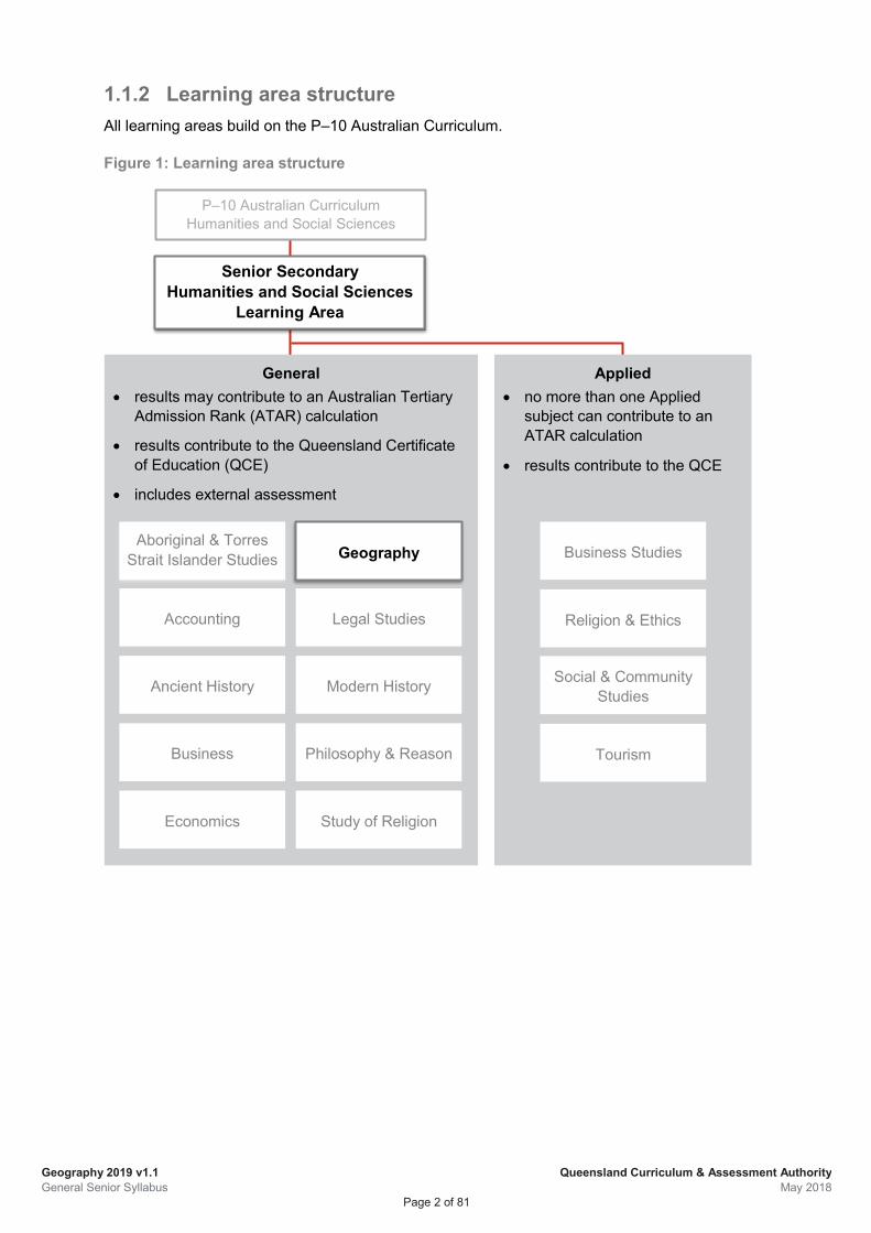
1.1.2 Learning area structure All learning areas build on the P–10 Australian Curriculum.
Figure 1: Learning area structure
Senior Secondary Humanities and Social Sciences
Learning Area
P–10 Australian Curriculum Humanities and Social Sciences
Applied • no more than one Applied
subject can contribute to an ATAR calculation
• results contribute to the QCE
General • results may contribute to an Australian Tertiary
Admission Rank (ATAR) calculation
• results contribute to the Queensland Certificate of Education (QCE)
• includes external assessment
Business Studies
Religion & Ethics
Social & Community Studies
Tourism
Aboriginal & Torres Strait Islander Studies
Accounting
Ancient History
Business
Economics
Geography
Legal Studies
Study of Religion
Modern History
Philosophy & Reason
Geography 2019 v1.1 General Senior Syllabus
Queensland Curriculum & Assessment Authority May 2018
Page 3 of 81
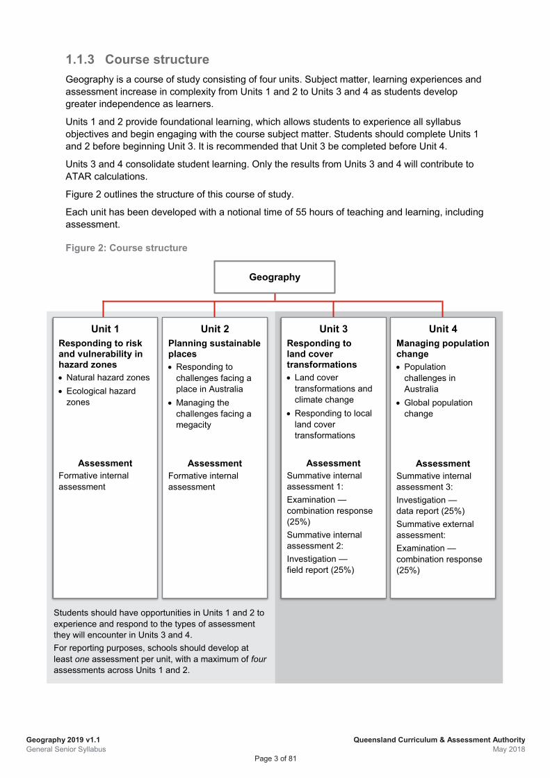
Geography
Students should have opportunities in Units 1 and 2 to experience and respond to the types of assessment they will encounter in Units 3 and 4. For reporting purposes, schools should develop at least one assessment per unit, with a maximum of four assessments across Units 1 and 2.
Unit 3 Responding to land cover transformations • Land cover
transformations and climate change
• Responding to local land cover transformations
Assessment Summative internal assessment 1: Examination — combination response (25%) Summative internal assessment 2: Investigation — field report (25%)
Unit 4 Managing population change • Population
challenges in Australia
• Global population change
Assessment Summative internal assessment 3: Investigation — data report (25%) Summative external assessment: Examination — combination response (25%)
Unit 1 Responding to risk and vulnerability in hazard zones • Natural hazard zones • Ecological hazard
zones
Assessment Formative internal assessment
Unit 2 Planning sustainable places • Responding to
challenges facing a place in Australia
• Managing the challenges facing a megacity
Assessment Formative internal assessment
1.1.3 Course structure Geography is a course of study consisting of four units. Subject matter, learning experiences and assessment increase in complexity from Units 1 and 2 to Units 3 and 4 as students develop greater independence as learners.
Units 1 and 2 provide foundational learning, which allows students to experience all syllabus objectives and begin engaging with the course subject matter. Students should complete Units 1 and 2 before beginning Unit 3. It is recommended that Unit 3 be completed before Unit 4.
Units 3 and 4 consolidate student learning. Only the results from Units 3 and 4 will contribute to ATAR calculations.
Figure 2 outlines the structure of this course of study.
Each unit has been developed with a notional time of 55 hours of teaching and learning, including assessment.
Figure 2: Course structure
Geography 2019 v1.1 General Senior Syllabus
Queensland Curriculum & Assessment Authority May 2018
Page 4 of 81
1.2 Teaching and learning 1.2.1 Syllabus objectives The syllabus objectives outline what students have the opportunity to learn. Assessment provides evidence of how well students have achieved the objectives.
Syllabus objectives inform unit objectives, which are contextualised for the subject matter and requirements of the unit. Unit objectives, in turn, inform the assessment objectives, which are further contextualised for the requirements of the assessment instruments. The number of each objective remains constant at all levels, i.e. Syllabus objective 1 relates to Unit objective 1 and to Assessment objective 1 in each assessment instrument.
Syllabus objectives are described in terms of actions that operate on the subject matter. Students are required to use a range of cognitive processes in order to demonstrate and meet the syllabus objectives. These cognitive processes are described in the explanatory paragraph following each objective in terms of four levels: retrieval, comprehension, analytical processes (analysis), and knowledge utilisation, with each process building on the previous processes (see Marzano & Kendall 2007, 2008). That is, comprehension requires retrieval, and knowledge utilisation requires retrieval, comprehension and analytical processes (analysis).
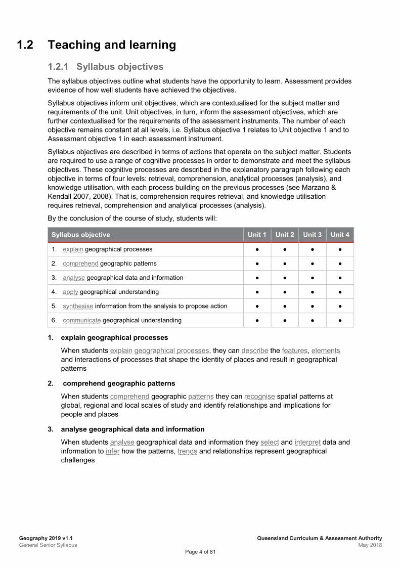
By the conclusion of the course of study, students will:
Syllabus objective Unit 1 Unit 2 Unit 3 Unit 4
1. explain geographical processes ● ● ● ●
2. comprehend geographic patterns ● ● ● ●
3. analyse geographical data and information ● ● ● ●
4. apply geographical understanding ● ● ● ●
5. synthesise information from the analysis to propose action ● ● ● ●
6. communicate geographical understanding ● ● ● ●
1. explain geographical processes
When students explain geographical processes, they can describe the features, elements and interactions of processes that shape the identity of places and result in geographical patterns
2. comprehend geographic patterns
When students comprehend geographic patterns they can recognise spatial patterns at global, regional and local scales of study and identify relationships and implications for people and places
3. analyse geographical data and information
When students analyse geographical data and information they select and interpret data and information to infer how the patterns, trends and relationships represent geographical challenges
Geography 2019 v1.1 General Senior Syllabus
Queensland Curriculum & Assessment Authority May 2018
Page 5 of 81
4. apply geographical understanding
When students apply geographical understanding they extrapolate from their analysis to generalise about the potential impacts of geographical challenges for environments and/or people
5. synthesise information from the analysis to propose action
When students synthesise information from their analysis they propose justified action/s in response to a geographical challenge
6. communicate geographical understanding
When students communicate geographical understanding, they select and use cartographic, graphic, written and mathematical skills and conventions to transform and represent geographical data and information for a particular purpose.
1.2.2 Underpinning factors There are three skill sets that underpin senior syllabuses and are essential for defining the distinctive nature of subjects:
• literacy — the set of knowledge and skills about language and texts essential for understanding and conveying Geography content
• numeracy — the knowledge, skills, behaviours and dispositions that students need to use mathematics in a wide range of situations, to recognise and understand the role of mathematics in the world, and to develop the dispositions and capacities to use mathematical knowledge and skills purposefully
• 21st century skills — the attributes and skills students need to prepare them for higher education, work and engagement in a complex and rapidly changing world.
These skill sets, which overlap and interact, are derived from current education, industry and community expectations. They encompass the knowledge, skills, capabilities, behaviours and dispositions that will help students live and work successfully in the 21st century.
Together these three skill sets shape the development of senior subject syllabuses. Although coverage of each skill set may vary from syllabus to syllabus, students should be provided with opportunities to learn through and about these skills over the course of study. Each skill set contains identifiable knowledge and skills that can be directly assessed.
Literacy in Geography Ongoing systematic teaching and learning focused on the literacy knowledge and skills specific to Geography is essential for student achievement.
Students need to learn and use knowledge and skills of reading, viewing and listening to understand and learn the content of Geography. Students need to learn and use the knowledge and skills of writing, composing and speaking to convey the Geography content they have learnt.
Geography 2019 v1.1 General Senior Syllabus
Queensland Curriculum & Assessment Authority May 2018
Page 6 of 81
To understand and use Geography content, teaching and learning strategies include:
• making literal and inferential meaning of geographical language, written texts and visual texts such as graphic and cartographic representations of data and information
• understanding how language is used and modified for specific purposes to communicate geographically by
constructing geographical texts, and graphic and cartographic representations of data and information
questioning attitudes and assumptions embedded in texts
• using geographical ideas and information in classroom, real-world and/or lifelike contexts to progress students’ learning.
To analyse Geography content, teaching and learning strategies include:
• analysing the ways language and graphicacy — the ability to understand and use a map or graph — are used to convey ideas, information and data in geographical texts
• analysing and interpreting data and information from a range of sources to present and justify ideas, conclusions and opinions within a broad range of geographical contexts
• transforming language, data and information to communicate geographical ideas, data and information in particular ways for particular purposes.
These aspects of literacy knowledge and skills are embedded in the syllabus objectives, unit objectives and subject matter, and the instrument specific marking guides (ISMGs) for Geography.
Numeracy in Geography Although much of the explicit teaching of numeracy skills occurs in Mathematics, being numerate involves using mathematical skills across the curriculum. Therefore, numeracy development is an essential component of teaching and learning across the curriculum and a responsibility for all teachers.
To understand and use Geography content, teaching and learning strategies include:
• identifying the specific mathematical data and information in Geography
• identifying and describing distributions, geographic patterns and relationships in data, including those that can be visually represented on a map or graph
• applying mathematical models to manipulate and interpret data
• identifying and describing trends and change over time in data
• making connections between diverse facts and suggesting responses to geographical challenges in a range of circumstances.
These aspects of numeracy knowledge and skills are embedded in the syllabus objectives, unit objectives and subject matter, and ISMGs for Geography.
Geography 2019 v1.1 General Senior Syllabus
Queensland Curriculum & Assessment Authority May 2018
Page 7 of 81
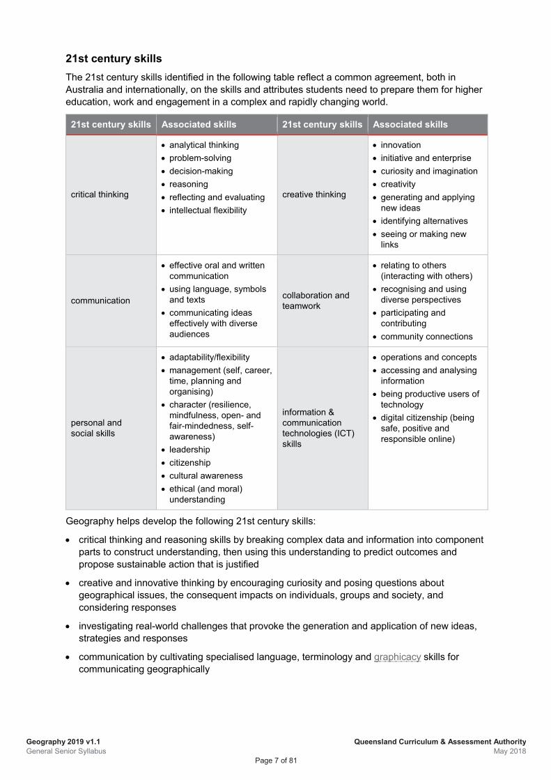
21st century skills The 21st century skills identified in the following table reflect a common agreement, both in Australia and internationally, on the skills and attributes students need to prepare them for higher education, work and engagement in a complex and rapidly changing world.
21st century skills Associated skills 21st century skills Associated skills
critical thinking
• analytical thinking • problem-solving • decision-making • reasoning • reflecting and evaluating • intellectual flexibility
creative thinking
• innovation • initiative and enterprise • curiosity and imagination • creativity • generating and applying
new ideas • identifying alternatives • seeing or making new
links
communication
• effective oral and written communication
• using language, symbols and texts
• communicating ideas effectively with diverse audiences
collaboration and teamwork
• relating to others (interacting with others)
• recognising and using diverse perspectives
• participating and contributing
• community connections
personal and social skills
• adaptability/flexibility • management (self, career,
time, planning and organising)
• character (resilience, mindfulness, open- and fair-mindedness, self-awareness)
• leadership • citizenship • cultural awareness • ethical (and moral)
understanding
information & communication technologies (ICT) skills
• operations and concepts • accessing and analysing
information • being productive users of
technology • digital citizenship (being
safe, positive and responsible online)
Geography helps develop the following 21st century skills:
• critical thinking and reasoning skills by breaking complex data and information into component parts to construct understanding, then using this understanding to predict outcomes and propose sustainable action that is justified
• creative and innovative thinking by encouraging curiosity and posing questions about geographical issues, the consequent impacts on individuals, groups and society, and considering responses
• investigating real-world challenges that provoke the generation and application of new ideas, strategies and responses
• communication by cultivating specialised language, terminology and graphicacy skills for communicating geographically
Geography 2019 v1.1 General Senior Syllabus
Queensland Curriculum & Assessment Authority May 2018
Page 8 of 81
• using spatial technologies and information and communication technologies to manipulate, adapt, transform and represent primary data and information to ascertain spatial distributions geographical patterns, trends and relationships
• promoting opportunities for students to work collaboratively and constructively, to develop personal, intrapersonal and social skills, and also to maximise their own understanding of geographic concepts through peer discussions.
These elements of 21st century skills are embedded in the syllabus objectives, unit objectives and subject matter, and ISMGs for Geography.
1.2.3 Aboriginal perspectives and Torres Strait Islander perspectives
The QCAA is committed to reconciliation in Australia. As part of its commitment, the QCAA affirms that:
• Aboriginal peoples and Torres Strait Islander peoples are the first Australians, and have the oldest living cultures in human history
• Aboriginal peoples and Torres Strait Islander peoples have strong cultural traditions and speak diverse languages and dialects, other than Standard Australian English
• teaching and learning in Queensland schools should provide opportunities for students to deepen their knowledge of Australia by engaging with the perspectives of Aboriginal peoples and Torres Strait Islander peoples
• positive outcomes for Aboriginal students and Torres Strait Islander students are supported by successfully embedding Aboriginal perspectives and Torres Strait Islander perspectives across planning, teaching and assessing student achievement.
Guidelines about Aboriginal perspectives and Torres Strait Islander perspectives and resources for teaching are available at www.qcaa.qld.edu.au/k-12-policies/aboriginal-torres-strait-islander-perspectives.
Where appropriate, Aboriginal perspectives and Torres Strait Islander perspectives have been embedded in the subject matter.
Geography requires students to engage with the perspectives of Aboriginal peoples and Torres Strait Islander peoples by having them study Unit 3: Topic 2 - Responding to local land cover transformations.
1.2.4 Pedagogical and conceptual frameworks
An approach to inquiry Learning in the 21st century is dynamic, and is enhanced by an inquiry approach that applies discipline knowledge and skills to real-world situations and contemporary events (Masters 2016). An inquiry approach involves a range of instructional practices that stimulate student learning and give precedence to students’ investigative work (Aditomo et al. 2013).
Inquiry-based learning
An inquiry approach involves:
• a method of learning, initiated by questions or problems
• personal construction of a student’s own knowledge, i.e. knowledge that is new to the student
Geography 2019 v1.1 General Senior Syllabus
Queensland Curriculum & Assessment Authority May 2018
Page 9 of 81
• an active approach to learning where students have the central role
• the teacher acting as a facilitator
• developing self-directed learning over time, as students assume increasing responsibility for their learning.
These core elements are stated by Spronken-Smith and Walker (2010, p. 726), and supported by references to Justice et al. (2007), Khan and O’Rourke (2004) and Weaver (1989).
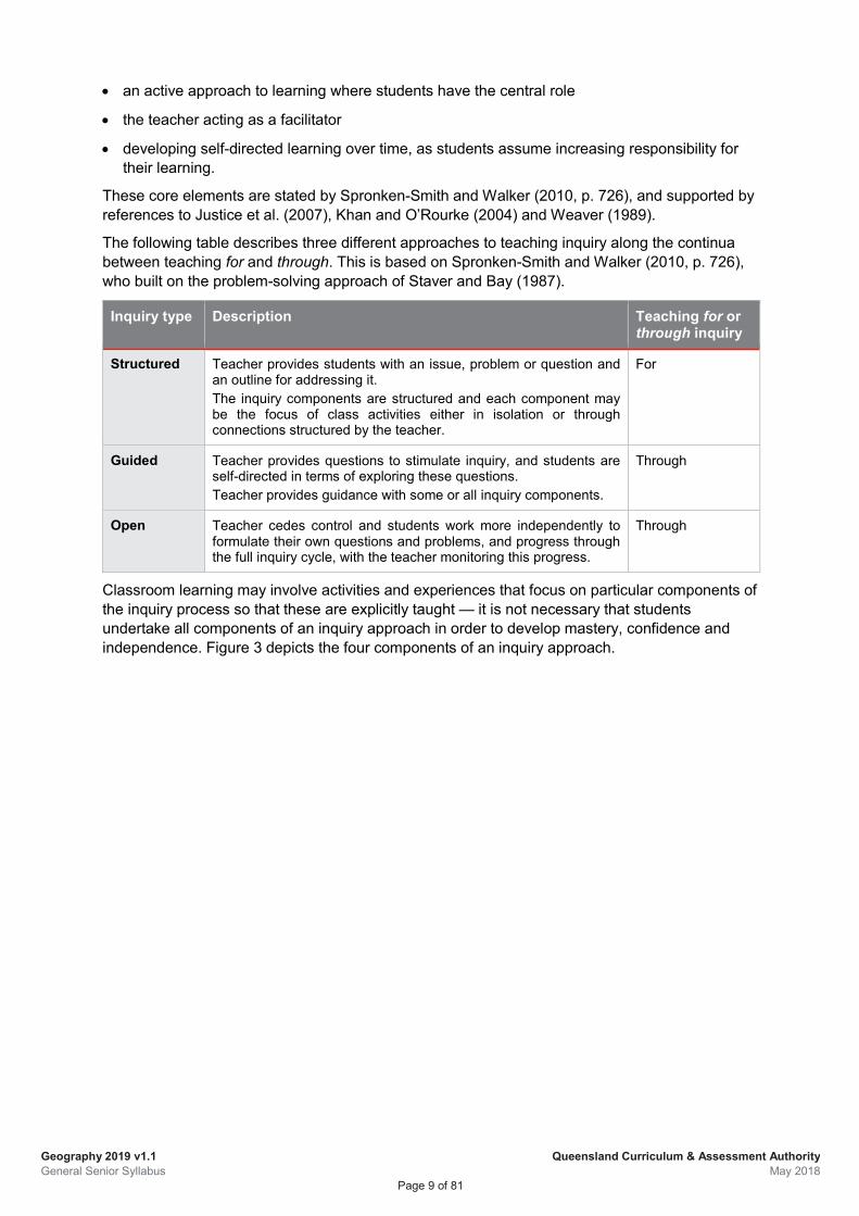
The following table describes three different approaches to teaching inquiry along the continua between teaching for and through. This is based on Spronken-Smith and Walker (2010, p. 726), who built on the problem-solving approach of Staver and Bay (1987).
Inquiry type Description Teaching for or through inquiry
Structured Teacher provides students with an issue, problem or question and an outline for addressing it. The inquiry components are structured and each component may be the focus of class activities either in isolation or through connections structured by the teacher.
For
Guided Teacher provides questions to stimulate inquiry, and students are self-directed in terms of exploring these questions. Teacher provides guidance with some or all inquiry components.
Through
Open Teacher cedes control and students work more independently to formulate their own questions and problems, and progress through the full inquiry cycle, with the teacher monitoring this progress.
Through
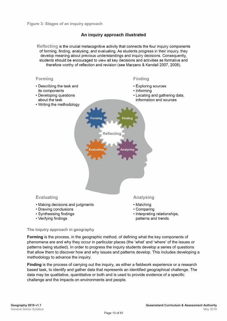
Classroom learning may involve activities and experiences that focus on particular components of the inquiry process so that these are explicitly taught — it is not necessary that students undertake all components of an inquiry approach in order to develop mastery, confidence and independence. Figure 3 depicts the four components of an inquiry approach.
Geography 2019 v1.1 General Senior Syllabus
Queensland Curriculum & Assessment Authority May 2018
Page 10 of 81
Figure 3: Stages of an inquiry approach
The inquiry approach in geography
Forming is the process, in the geographic method, of defining what the key components of phenomena are and why they occur in particular places (the ‘what’ and ‘where’ of the issues or patterns being studied). In order to progress the inquiry students develop a series of questions that allow them to discover how and why issues and patterns develop. This includes developing a methodology to advance the inquiry.
Finding is the process of carrying out the inquiry, as either a fieldwork experience or a research based task, to identify and gather data that represents an identified geographical challenge. The data may be qualitative, quantitative or both and is used to provide evidence of a specific challenge and the impacts on environments and people.
Geography 2019 v1.1 General Senior Syllabus
Queensland Curriculum & Assessment Authority May 2018
Page 11 of 81
Analysing is the process of using data to explain how and why geographical processes and patterns create geographical challenges and the impacts of these challenges for environments and people. Analysis is interpreting data to make inferences about relationships, patterns and trends evident in the data. The analysis allows for the explanation and description of geographic challenges and allows students to make predictions that are evidence based.
Evaluating in the geographic method is the process of applying the knowledge gained through analysis and synthesis to draw conclusions and propose action to an identified geographical challenge that can be justified using evidence. This process involves understanding the limitations of the methodology employed.
Reflecting is the process that allows students to make links between and revisit each stage of the inquiry. Reflecting involves monitoring process and accuracy. Monitoring process in the geographic method includes identifying which aspects of the inquiry are effective and which aspects might be improved to enhance an accurate understanding of a geographic challenge, i.e. ‘determining how effective a procedure is being carried out’ (Marzano and Kendall, 2007, p102). For example, students might reflect on: whether the inquiry questions they have posed are adequate, or do other questions need to be explored; is the data gathered sufficient to carry out the analysis or is something more needed; and which aspects of the process produce successful outcomes. Monitoring accuracy involves determining the extent to which the knowledge generated is correct and being able to provide evidence for this accuracy (Marzano and Kendall, 2007, p. 105).
Geography 2019 v1.1 General Senior Syllabus
Queensland Curriculum & Assessment Authority May 2018
Page 12 of 81
1.2.5 Subject matter Subject matter is the body of information, mental procedures and psychomotor procedures (see Marzano & Kendall 2007, 2008) that are necessary for students’ learning and engagement with Geography. It is particular to each unit in the course of study and provides the basis for student learning experiences.
Subject matter has a direct relationship to the unit objectives, but is of a finer granularity and is more specific. These statements of learning are constructed in a similar way to objectives. Each statement:
• describes an action (or combination of actions) — what the student is expected to do
• describes the element — expressed as information, mental procedures and/or psychomotor procedures
• is contextualised for the topic or circumstance particular to the unit.
The subject matter consists of the geographical concepts, skills, knowledge and understandings described in the unit objectives. Teachers should apply the sequence and emphasis of these objectives to enhance the process of geographical inquiry and align with the assessment.
When interpreting the subject matter and assessment specifications, it is important to understand the intent of terms such as ‘including’ and ‘for example’.
When preceding a list, ‘including’ refers to the aspects, elements or contexts that must be covered when teaching topics in the units; additional aspects, elements or contexts may be used at the teacher’s discretion. In instances when ‘for example’ or ‘e.g.’ is used, teachers may select examples from the provided content or choose other relevant examples that are not stated. There is no expectation that all examples must be covered.
Fieldwork
Fieldwork is a critical part of learning in Geography. The ‘field’ refers to a specific area or areas of study outside the classroom environment. Consequently, fieldwork may be conducted within the school grounds, just beyond the perimeter of the school or at specific off-site location/s. It is important to note the fieldwork must be conducted at a local scale to provide the most effective opportunities for the collection of valid and reliable data.
Fieldwork forms the basis of experiential learning in Geography. It provides authentic opportunities for students to engage in investigating and responding to real-world situations while applying a range of geographic skills such as observing, questioning, planning, collecting, recording, evaluating, representing, analysing, concluding, communicating, reflecting and responding.
Fieldwork is a mandated requirement of this syllabus, with one field study specified in Unit 3 Topic 2: Responding to local land cover transformations. A minimum of five hours must be spent in the field for this specified field study. It is recommended that a field study also be conducted in Unit 2 Topic 1: Challenges facing a place in Australia.
Spatial technologies
The emphasis on the concepts of ‘place’ and ‘space’ uniquely positions Geography to address spatial information. Relevant examples of spatial information include population density and settlement patterns, migration patterns and trends or the changing land cover of a region.
Geography 2019 v1.1 General Senior Syllabus
Queensland Curriculum & Assessment Authority May 2018
Page 13 of 81
Spatial technologies are the tools used to acquire, manipulate, manage, represent and analyse data that has a spatial context, and are a mandated aspect of this syllabus. The term ‘spatial technologies’ is an umbrella term that generally refers to tools such as Global Navigation Satellite Systems (GNSS), Geographic Information Systems (GIS) and remote sensing.
In the context of teaching and learning, spatial technologies allow students to:
• acquire and record spatial information
• manipulate and manage spatial information in its various forms
• represent spatial information in a variety of visual formats such as thematic maps
• analyse spatial information for purposes such as modelling responses or predicting outcomes.
Geographical skills
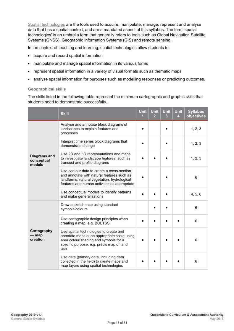
The skills listed in the following table represent the minimum cartographic and graphic skills that students need to demonstrate successfully.
Skill Unit 1
Unit 2
Unit 3
Unit 4
Syllabus objectives
Diagrams and conceptual models
Analyse and annotate block diagrams of landscapes to explain features and processes
● ● 1, 2, 3
Interpret time series block diagrams that demonstrate change ● ● 1, 2, 3
Use 2D and 3D representations and maps to investigate landscape features, such as transect and profile diagrams
● ● ● 1, 2, 3
Use contour data to create a cross-section and annotate with natural features such as landforms, natural vegetation, hydrological features and human activities as appropriate
● ● 6
Use conceptual models to identify patterns and make generalisations ● ● ● 4, 5, 6
Cartography — map creation
Draw a sketch map using standard symbols/colours ● ● 6
Use cartographic design principles when creating a map, e.g. BOLTSS ● ● ● ● 6
Use spatial technologies to create and annotate maps at an appropriate scale using area colour/shading and symbols for a specific purpose, e.g. précis map of land use
● ● ● ● 6
Use data (primary data, including data collected in the field) to create maps and map layers using spatial technologies
● ● ● ● 6
Geography 2019 v1.1 General Senior Syllabus
Queensland Curriculum & Assessment Authority May 2018
Page 14 of 81
Skill Unit 1
Unit 2
Unit 3
Unit 4
Syllabus objectives
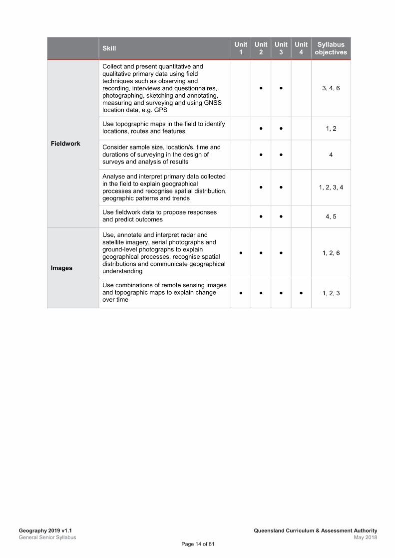
Fieldwork
Collect and present quantitative and qualitative primary data using field techniques such as observing and recording, interviews and questionnaires, photographing, sketching and annotating, measuring and surveying and using GNSS location data, e.g. GPS
● ● 3, 4, 6
Use topographic maps in the field to identify locations, routes and features ● ● 1, 2
Consider sample size, location/s, time and durations of surveying in the design of surveys and analysis of results
● ● 4
Analyse and interpret primary data collected in the field to explain geographical processes and recognise spatial distribution, geographic patterns and trends
● ● 1, 2, 3, 4
Use fieldwork data to propose responses and predict outcomes ● ● 4, 5
Images
Use, annotate and interpret radar and satellite imagery, aerial photographs and ground-level photographs to explain geographical processes, recognise spatial distributions and communicate geographical understanding
● ● ● 1, 2, 6
Use combinations of remote sensing images and topographic maps to explain change over time
● ● ● ● 1, 2, 3
Geography 2019 v1.1 General Senior Syllabus
Queensland Curriculum & Assessment Authority May 2018
Page 15 of 81
Skill Unit 1
Unit 2
Unit 3
Unit 4
Syllabus objectives
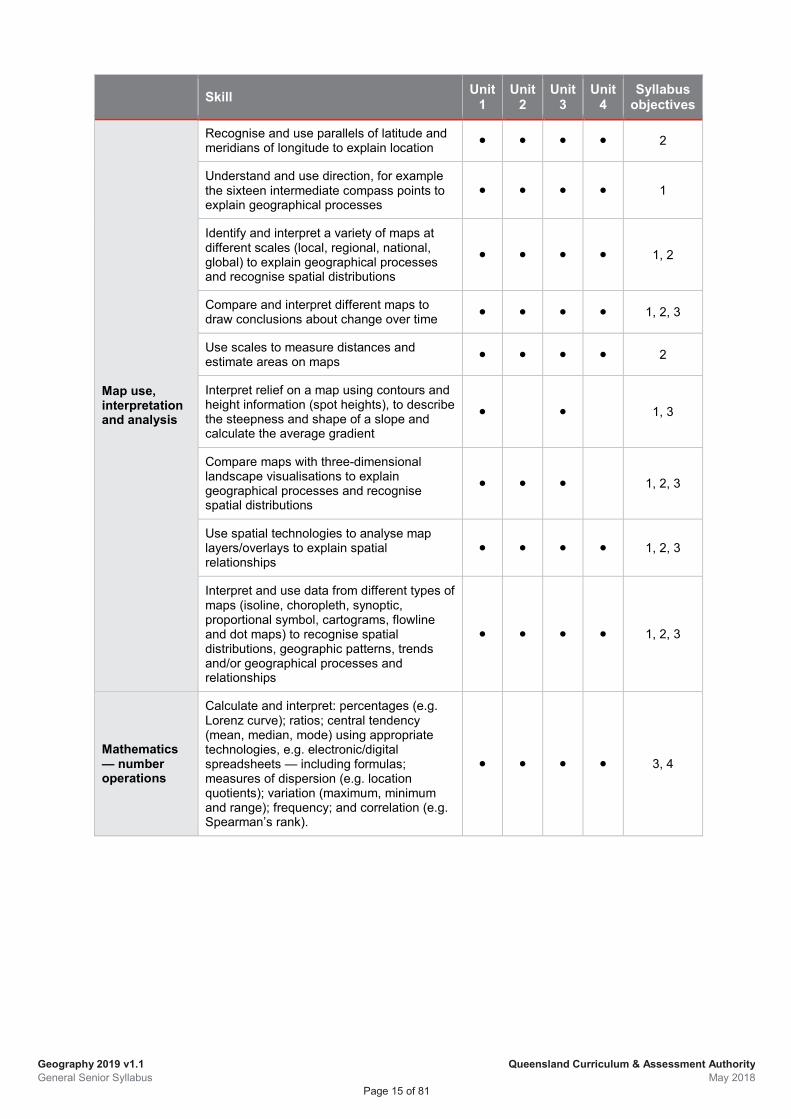
Map use, interpretation and analysis
Recognise and use parallels of latitude and meridians of longitude to explain location ● ● ● ● 2
Understand and use direction, for example the sixteen intermediate compass points to explain geographical processes
● ● ● ● 1
Identify and interpret a variety of maps at different scales (local, regional, national, global) to explain geographical processes and recognise spatial distributions
● ● ● ● 1, 2
Compare and interpret different maps to draw conclusions about change over time ● ● ● ● 1, 2, 3
Use scales to measure distances and estimate areas on maps ● ● ● ● 2
Interpret relief on a map using contours and height information (spot heights), to describe the steepness and shape of a slope and calculate the average gradient
● ● 1, 3
Compare maps with three-dimensional landscape visualisations to explain geographical processes and recognise spatial distributions
● ● ● 1, 2, 3
Use spatial technologies to analyse map layers/overlays to explain spatial relationships
● ● ● ● 1, 2, 3
Interpret and use data from different types of maps (isoline, choropleth, synoptic, proportional symbol, cartograms, flowline and dot maps) to recognise spatial distributions, geographic patterns, trends and/or geographical processes and relationships
● ● ● ● 1, 2, 3
Mathematics — number operations
Calculate and interpret: percentages (e.g. Lorenz curve); ratios; central tendency (mean, median, mode) using appropriate technologies, e.g. electronic/digital spreadsheets — including formulas; measures of dispersion (e.g. location quotients); variation (maximum, minimum and range); frequency; and correlation (e.g. Spearman’s rank).
● ● ● ● 3, 4
Geography 2019 v1.1 General Senior Syllabus
Queensland Curriculum & Assessment Authority May 2018
Page 16 of 81
Skill Unit 1
Unit 2
Unit 3
Unit 4
Syllabus objectives
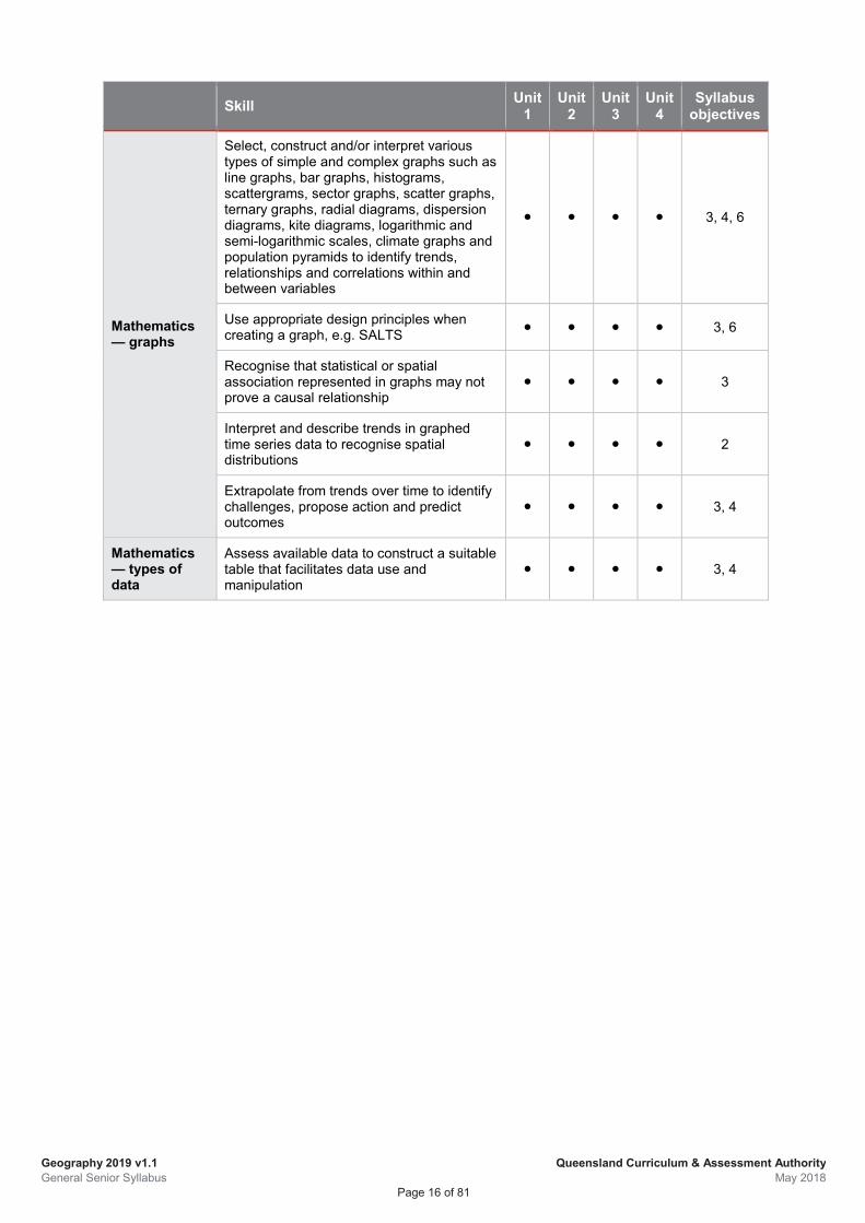
Mathematics — graphs
Select, construct and/or interpret various types of simple and complex graphs such as line graphs, bar graphs, histograms, scattergrams, sector graphs, scatter graphs, ternary graphs, radial diagrams, dispersion diagrams, kite diagrams, logarithmic and semi-logarithmic scales, climate graphs and population pyramids to identify trends, relationships and correlations within and between variables
● ● ● ● 3, 4, 6
Use appropriate design principles when creating a graph, e.g. SALTS ● ● ● ● 3, 6
Recognise that statistical or spatial association represented in graphs may not prove a causal relationship
● ● ● ● 3
Interpret and describe trends in graphed time series data to recognise spatial distributions
● ● ● ● 2
Extrapolate from trends over time to identify challenges, propose action and predict outcomes
● ● ● ● 3, 4
Mathematics — types of data
Assess available data to construct a suitable table that facilitates data use and manipulation
● ● ● ● 3, 4
Geography 2019 v1.1 General Senior Syllabus
Queensland Curriculum & Assessment Authority May 2018
Page 17 of 81
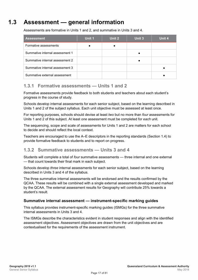
1.3 Assessment — general information Assessments are formative in Units 1 and 2, and summative in Units 3 and 4.
Assessment Unit 1 Unit 2 Unit 3 Unit 4
Formative assessments ● ●
Summative internal assessment 1 ●
Summative internal assessment 2 ●
Summative internal assessment 3 ●
Summative external assessment ●
1.3.1 Formative assessments — Units 1 and 2 Formative assessments provide feedback to both students and teachers about each student’s progress in the course of study.
Schools develop internal assessments for each senior subject, based on the learning described in Units 1 and 2 of the subject syllabus. Each unit objective must be assessed at least once.
For reporting purposes, schools should devise at least two but no more than four assessments for Units 1 and 2 of this subject. At least one assessment must be completed for each unit.
The sequencing, scope and scale of assessments for Units 1 and 2 are matters for each school to decide and should reflect the local context.
Teachers are encouraged to use the A–E descriptors in the reporting standards (Section 1.4) to provide formative feedback to students and to report on progress.
1.3.2 Summative assessments — Units 3 and 4 Students will complete a total of four summative assessments — three internal and one external — that count towards their final mark in each subject.
Schools develop three internal assessments for each senior subject, based on the learning described in Units 3 and 4 of the syllabus.
The three summative internal assessments will be endorsed and the results confirmed by the QCAA. These results will be combined with a single external assessment developed and marked by the QCAA. The external assessment results for Geography will contribute 25% towards a student’s result.
Summative internal assessment — instrument-specific marking guides This syllabus provides instrument-specific marking guides (ISMGs) for the three summative internal assessments in Units 3 and 4.
The ISMGs describe the characteristics evident in student responses and align with the identified assessment objectives. Assessment objectives are drawn from the unit objectives and are contextualised for the requirements of the assessment instrument.
Geography 2019 v1.1 General Senior Syllabus
Queensland Curriculum & Assessment Authority May 2018
Page 18 of 81
Criteria Each ISMG groups assessment objectives into criteria. An assessment objective may appear in multiple criteria, or in a single criterion of an assessment.
Making judgments
Assessment evidence of student performance in each criterion is matched to a performance-level descriptor, which describes the typical characteristics of student work.
Where a student response has characteristics from more than one performance level, a best-fit approach is used. Where a performance level has a two-mark range it must be decided if the best fit is the higher or lower mark of the range.
Authentication
Schools and teachers must have strategies in place for ensuring that work submitted for internal summative assessment is the student’s own. Authentication strategies outlined in QCAA guidelines, which include guidance for drafting, scaffolding and teacher feedback, must be adhered to.
Summative external assessment The summative external assessment adds valuable evidence of achievement to a student’s profile. External assessment is:
• common to all schools
• administered under the same conditions at the same time and on the same day
• developed and marked by the QCAA according to a commonly applied marking scheme.
The external assessment contributes 25% to the student’s result in Geography. It is not privileged over the school-based assessment.
Geography 2019 v1.1 General Senior Syllabus
Queensland Curriculum & Assessment Authority May 2018
Page 19 of 81
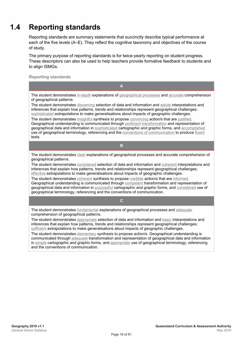
1.4 Reporting standards Reporting standards are summary statements that succinctly describe typical performance at each of the five levels (A–E). They reflect the cognitive taxonomy and objectives of the course of study.
The primary purpose of reporting standards is for twice-yearly reporting on student progress. These descriptors can also be used to help teachers provide formative feedback to students and to align ISMGs.
Reporting standards
A
The student demonstrates in-depth explanations of geographical processes and accurate comprehension of geographical patterns. The student demonstrates discerning selection of data and information and astute interpretations and inferences that explain how patterns, trends and relationships represent geographical challenges; sophisticated extrapolations to make generalisations about impacts of geographic challenges. The student demonstrates insightful synthesis to propose convincing action/s that are justified. Geographical understanding is communicated through proficient transformation and representation of geographical data and information in sophisticated cartographic and graphic forms, and accomplished use of geographical terminology, referencing and the conventions of communication to produce fluent texts.
B
The student demonstrates clear explanations of geographical processes and accurate comprehension of geographical patterns. The student demonstrates considered selection of data and information and coherent interpretations and inferences that explain how patterns, trends and relationships represent geographical challenges; effective extrapolations to make generalisations about impacts of geographic challenges. The student demonstrates coherent synthesis to propose credible action/s that are informed. Geographical understanding is communicated through competent transformation and representation of geographical data and information in purposeful cartographic and graphic forms, and considered use of geographical terminology, referencing and the conventions of communication.
C
The student demonstrates fundamental explanations of geographical processes and adequate comprehension of geographical patterns. The student demonstrates appropriate selection of data and information and basic interpretations and inferences that explain how patterns, trends and relationships represent geographical challenges; sufficient extrapolations to make generalisations about impacts of geographic challenges. The student demonstrates elementary synthesis to propose action/s. Geographical understanding is communicated through adequate transformation and representation of geographical data and information in simple cartographic and graphic forms, and appropriate use of geographical terminology, referencing and the conventions of communication.
Geography 2019 v1.1 General Senior Syllabus
Queensland Curriculum & Assessment Authority May 2018
Page 20 of 81
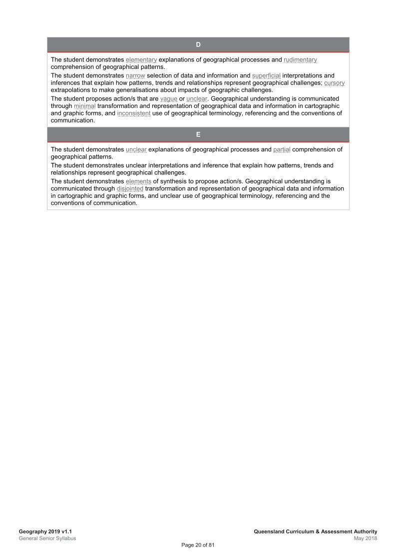
D
The student demonstrates elementary explanations of geographical processes and rudimentary comprehension of geographical patterns. The student demonstrates narrow selection of data and information and superficial interpretations and inferences that explain how patterns, trends and relationships represent geographical challenges; cursory extrapolations to make generalisations about impacts of geographic challenges. The student proposes action/s that are vague or unclear. Geographical understanding is communicated through minimal transformation and representation of geographical data and information in cartographic and graphic forms, and inconsistent use of geographical terminology, referencing and the conventions of communication.
E
The student demonstrates unclear explanations of geographical processes and partial comprehension of geographical patterns. The student demonstrates unclear interpretations and inference that explain how patterns, trends and relationships represent geographical challenges. The student demonstrates elements of synthesis to propose action/s. Geographical understanding is communicated through disjointed transformation and representation of geographical data and information in cartographic and graphic forms, and unclear use of geographical terminology, referencing and the conventions of communication.
Geography 2019 v1.1 General Senior Syllabus
Queensland Curriculum & Assessment Authority May 2018
Page 21 of 81
2 Unit 1: Responding to risk and vulnerability in hazard zones
2.1 Unit description In Unit 1, students develop an understanding of how natural and ecological hazards represent potential sources of harm to human life, health, income and property, and how such hazards may affect elements of the built and natural environments.
Through two case studies, students investigate the risk/s posed by specific hazards in recognised hazard zones and analyse the vulnerability of local communities and identify ways to respond. Students propose action to eliminate or minimise harm to people and the environment in ecological hazard zones.
The use of technologies (including spatial technology) is an integral part of learning for this unit and allows students to develop a range of transferable skills necessary to research, manipulate and represent data.
Unit requirements The learning for this unit consists of two separate and interrelated topics. Each is of equal importance in providing students with the required knowledge and skills.
The table below outlines the notional time between topics.
Topics Notional hours
Topic 1: Natural hazard zones 25
Topic 2: Ecological hazard zones 30
A minimum of two case studies should be conducted in this unit, with at least one case study for each topic. Across these two case studies, hazard zones from at least one developed and one developing country should be investigated. The scales of study for this unit can range from local, national, regional or global, as determined by the teacher.
2.2 Unit objectives Unit objectives are drawn from the syllabus objectives and are contextualised for the subject matter and requirements of the unit. Each unit objective must be assessed at least once.
Students will:
1. explain geographical processes by describing the features, elements and interactions between biophysical and anthropogenic processes that shape the identity of places and result in hazard zones
2. comprehend geographic patterns by recognising spatial patterns of hazard zones at global, regional and local scales of study, identifying relationships and implications for people and places in these zones
3. analyse geographical data and information by selecting and interpreting vulnerability data to infer how patterns, trends and relationships represent risk for people and environments in hazard zones
Geography 2019 v1.1 General Senior Syllabus
Queensland Curriculum & Assessment Authority May 2018
Page 22 of 81
4. apply geographical understanding by extrapolating from their analysis to generalise about the potential impacts for environments and/or people in hazard zones
5. synthesise information from their analysis to propose justified action/s in response to the challenge of sustainable risk management
6. communicate geographical understanding of vulnerability and risk for environments and/or people in hazard zones by selecting and using cartographic, graphic, written and mathematical skills
2.3 Topic 1: Natural hazard zones Notional time: 25 hours
In Topic 1, students explain the geographical processes that result in geological, geomorphic or atmospheric hazard zones. They recognise the spatial patterns of hazard zones and the implications for people and places. Students investigate natural and anthropogenic factors to identify why some places are more at risk than others to specific types of natural hazards and disasters.
Students conduct a case study of two locations to understand vulnerability and risk in hazard zones for places in developing and developed countries. Through their investigation, students understand why people in particular places have a greater or lesser capacity to respond to natural hazards and natural disasters.
Subject matter
In this topic, students will: • explain, using a range of representations such as maps, conceptual models, block diagrams, and cross
sections, how natural hazards are the result of processes that occur within the earth (geological) on the surface of the earth (geomorphic), in the atmosphere (atmospheric) or a combination of these and may result in natural hazards
• recognise hazard zones, represent these on a map (using spatial technologies) and analyse spatial distribution of the hazard to describe geographic patterns and identify the implications for people and environments
• explain how the severity of the impacts of natural hazards is influenced by factors such as speed of onset magnitude frequency duration temporal spacing (the sequencing and seasonality of events, i.e. random or regular) explain how climate change may affect the severity and incidence of some natural hazards, and
increase risk • explain the concepts of vulnerability and risk as applied to natural hazard management • conduct a case study to investigate one natural hazard that has affected a place in a developed country
and a place in a developing country. As part of this case study, students must manipulate, adapt and transform data, using spatial technologies and information and communication
technologies, to represent and describe the nature, extent and characteristics of the hazard zone for the case study locations
analyse vulnerability data and information (including representations in maps) for each place to explain how these factors contribute to risk for the case study locations including population density and settlement patterns topographic features such as hydrology and elevation level of economic development degree of preparedness the location, speed and effectiveness of emergency responses
Geography 2019 v1.1 General Senior Syllabus
Queensland Curriculum & Assessment Authority May 2018
Page 23 of 81
the use of technologies (including spatial) in responding to natural hazards apply geographical understanding by extrapolating from their analysis to explain the impacts for
communities in developed and developing countries identify preparedness, mitigation, prevention and adaptation strategies to manage risk from various
agencies such as NGOs, governments and individuals communicate understanding of risk and vulnerability of environments and/or people in hazard zones
and identify adaption and/or mitigation strategies to reduce risk suited to different locations.
2.4 Topic 2: Ecological hazard zones Notional time: 30 hours
In Topic 2, students explain the geographical processes that result in ecological hazards and hazard zones. They recognise the spatial patterns of hazard zones and the implications for people and environments. Students investigate natural and anthropogenic factors to identify why some places are more vulnerable to ecological hazards than other places.
Students conduct a case study of a selected ecological hazard to understand the factors that contribute to the spread of the hazard and the resulting primary, secondary and tertiary impacts on communities. Students propose action for managing a selected ecological hazard. Through their investigation students understand that ecological hazards evident in the world today pose significant management challenges.
Subject matter
In this topic, students will: • explain how ecological hazards are the result of biological and anthropogenic processes that have an
impact on the physical environment (eco-hazards), e.g. environmental plant and animal invasions, impacts of
pollutants on lithosphere, atmosphere, hydrosphere and biosphere human health (diseases), e.g. infectious diseases and vector-borne diseases
• explain the concepts of vulnerability and risk as applied to ecological hazard management • recognise ecological hazard zones, represent these on a map and analyse spatial distribution to
describe geographic patterns and identify the implications for people and places • explain how the severity of the impacts of ecological hazards is influenced by factors such as speed of onset magnitude frequency duration sequencing and seasonality of events, i.e. random or regular
• explain how climate change may affect the severity and incidence of some ecological hazards, and increase risk
• conduct a case study to investigate how ONE ecological hazard has affected ONE community or environment. The scale of study may be regional, national or local. As part of this case study, students must manipulate, adapt and transform data, using spatial and information and communication
technologies, to represent and describe the nature, extent and characteristics of the hazard zone for the case study location
analyse vulnerability data and information (including representations in maps) to explain how these factors contribute to the risk for the case study location, including all of the following that are relevant to the case study hazard population density and settlement patterns topographic factors such as vegetation cover and catchment condition anthropogenic factors such as access to medical services and waste management mechanisms land use
Geography 2019 v1.1 General Senior Syllabus
Queensland Curriculum & Assessment Authority May 2018
Page 24 of 81
level of economic development climatic conditions degree of preparedness the location, speed and effectiveness of emergency responses aid programs
apply geographical understanding by extrapolating from the analysis to identify and explain the impacts of the hazard on the case study location, including a range of social, economic and environmental impacts caused by the selected hazard the primary, secondary and tertiary impacts of the selected hazard
synthesise information from the analysis to propose action that will reduce risk in the case study location
• communicate understanding of risk and vulnerability for environments and/or people in hazard zones and propose responses for sustainable adaption and/or mitigation.
2.5 Assessment guidance In constructing assessment instruments for Unit 1, schools should ensure that the objectives cover, or are chosen from, the unit objectives. If one assessment instrument is developed for a unit, it must assess all the unit objectives; if more than one assessment instrument is developed, the unit objectives must be covered across those instruments.
For Unit 1, suggested assessment instruments include an Examination — combination response and an Investigation — report.
Geography 2019 v1.1 General Senior Syllabus
Queensland Curriculum & Assessment Authority May 2018
Page 25 of 81
3 Unit 2: Planning sustainable places
3.1 Unit description In Unit 2, students develop an understanding of the challenges of sustainable development for remote, rural and urban places in Australia and a megacity in the developing world. Through fieldwork and a case study, students investigate the geographical processes and interactions over time and space that have resulted in challenges for places in Australia and megacities in developing countries. Students propose action to improve the sustainability and liveability for a place in Australia.
Fieldwork plays a central role in Topic 1 of this unit. Through experiential learning, students develop a range of geographic skills necessary to collect, manipulate and explain the meaning of data. Through this field study, students understand that every place, including their own, is faced with the challenge of planning for a more sustainable and liveable future.
The learning for this unit consists of two separate and interrelated topics. Each is of equal importance in providing students with the required knowledge and skills.
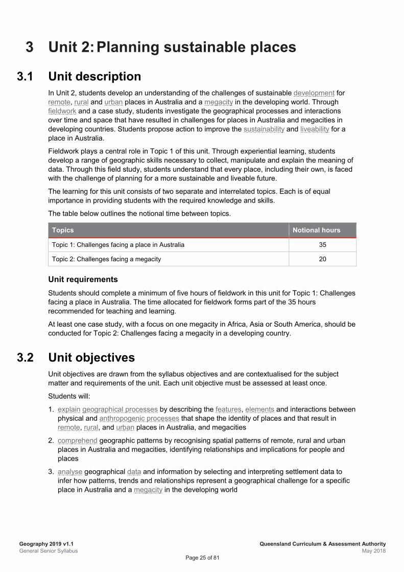
The table below outlines the notional time between topics.
Topics Notional hours
Topic 1: Challenges facing a place in Australia 35
Topic 2: Challenges facing a megacity 20
Unit requirements Students should complete a minimum of five hours of fieldwork in this unit for Topic 1: Challenges facing a place in Australia. The time allocated for fieldwork forms part of the 35 hours recommended for teaching and learning.
At least one case study, with a focus on one megacity in Africa, Asia or South America, should be conducted for Topic 2: Challenges facing a megacity in a developing country.
3.2 Unit objectives Unit objectives are drawn from the syllabus objectives and are contextualised for the subject matter and requirements of the unit. Each unit objective must be assessed at least once.
Students will:
1. explain geographical processes by describing the features, elements and interactions between physical and anthropogenic processes that shape the identity of places and that result in remote, rural, and urban places in Australia, and megacities
2. comprehend geographic patterns by recognising spatial patterns of remote, rural and urban places in Australia and megacities, identifying relationships and implications for people and places
3. analyse geographical data and information by selecting and interpreting settlement data to infer how patterns, trends and relationships represent a geographical challenge for a specific place in Australia and a megacity in the developing world
Geography 2019 v1.1 General Senior Syllabus
Queensland Curriculum & Assessment Authority May 2018
Page 26 of 81
4. apply geographical understanding by extrapolating from their analysis to generalise about the impacts on sustainability and liveability for people living in remote, rural, and urban places in Australia, and a megacity in the developing world
5. synthesise information from their analysis to propose justified action/s in response to the identified geographical challenge to improve sustainability and liveability for places
6. communicate geographical understanding of sustainability and liveability challenges for places by selecting and using cartographic, graphic, written and mathematical skills and conventions to transform and represent geographical data and information.
3.3 Topic 1: Responding to challenges facing a place in Australia Notional time: 35 hours
In Topic 1, students explain geographical processes that have shaped the identity of remote, rural and urban places in Australia. They recognise the spatial patterns of these places and the implications for people. Students investigate a specific geographical challenge in their local area by conducting fieldwork, using the geographic inquiry model.
Students understand the factors that contribute to liveability and sustainability in their local area and the impacts for people and environments. They propose action to manage the identified challenge to improve the sustainability and liveability of the local place. Through their fieldwork investigation students apply a geographical perspective to understand the challenges to sustainability and liveability for their local area.
Subject matter
In this topic, students will: • explain how remote, rural and urban places in Australia are defined by the Australian Bureau of
Statistics (ABS) • explain the processes that shape the identity of remote, rural and urban places, including urbanisation suburbanisation counterurbanisation population increase population decline
• recognise the spatial patterns of remote, rural and urban places in Australia and represent these on a map, using spatial technologies
• explain the factors that have contributed to these patterns (i.e. factors affecting settlement patterns), including: physical factors, such as access to fresh water, soil fertility and other natural resource availability; economic factors, such as resource exploitation, employment and affordability; and social factors, such as access to health and education services
• identify the implications for people living in remote, rural and urban places, e.g. provision of goods and services, transport, housing accessibility and affordability
• analyse ABS data to explain the changing characteristics of remote, rural and urban places in Australia • describe the geographical challenges facing places in Australia as a result of the changing
characteristics of places, including rural and remote places, e.g. employment, provision of health and educational services,
transportation connections to major centres, expansion or contraction of industry, isolation and remoteness, access to fresh and affordable food, housing availability and affordability, waste management, fresh water quality and availability, and access to communication technology (e.g. NBN)
metropolitan and/or regional cities in Australia, e.g. urban sprawl, gentrification, transport options, environmental degradation, land-use zoning, service provision and management, housing availability
Geography 2019 v1.1 General Senior Syllabus
Queensland Curriculum & Assessment Authority May 2018
Page 27 of 81
and affordability, and waste management • conduct a field study at a local scale to collect primary data for investigating a specific challenge
associated with sustainability and liveability for a place in Australia (remote, rural or urban) and how this challenge might be managed. As part of this field study, students must use the geographic inquiry model to develop a plan and carry out fieldwork to investigate a challenge
facing a place in Australia identify the aim of the field study, the methodology to be used, the data required and appropriate
methods for data collection analyse data to describe the nature, location and extent of the selected challenge apply geographical understanding by extrapolating from their analysis to generalise about the impacts
on sustainability and liveability for the place in Australia synthesise information from the analysis to propose action/s for managing the identified challenge to
improve liveability and sustainability for the place in Australia transform primary data collected in the field using cartographic, graphic and mathematical skills,
spatial technologies and ICT to communicate findings in a fieldwork report.
3.4 Topic 2: Managing challenges facing a megacity Notional time: 20 hours
In Topic 2, students explain the geographical processes of urbanisation that have resulted in the growth of megacities around the world and how these processes shape the identity of megacities. They recognise the spatial patterns of megacities on Earth’s surface and the implications for people and environments. Students investigate a specific geographical challenge, by conducting a case study that focuses on one megacity from Africa, Asia or South America.
Students understand the factors that contribute to the growth of an identified megacity and the challenges it faces to sustainable development. They propose action for managing a significant challenge in the identified megacity. Through their investigation students understand how urbanisation and megacities are changing the organisation of the world's populations and the challenges for sustainability and liveability for a specific place.
Subject matter
In this topic, students will: • explain features of global population growth and the processes of urbanisation that have resulted in the
rise of megacities • recognise and represent the spatial patterns of megacity distribution across the world and the spatial
change in this pattern over time • identify the impacts of urbanisation and the growth of megacities for human wellbeing and
environments using various forms of data and information and spatial technologies. Consider risks and opportunities posed by rate of urban growth population density changing land use and consumption of land formal and informal economies settlement infrastructure and land tenure risk and vulnerability to natural hazards and disasters
• describe the challenges for sustainable development facing megacities in developing countries compared with challenges facing megacities in developed countries, including climate change employment housing transport sanitation
Geography 2019 v1.1 General Senior Syllabus
Queensland Curriculum & Assessment Authority May 2018
Page 28 of 81
health and education services provision of fresh water and energy land availability waste management
• explain how urban planning, including the eco-city model, can be used in the development of resilient cities to mitigate and adapt to the future impacts of urbanisation
• conduct a case study to investigate a significant challenge faced by a selected megacity in a developing country in Africa, Asia or South America. As part of this case study, students must manipulate, adapt, and transform data, using spatial and information and communication
technologies, to represent and describe the nature and extent of urban growth for a selected megacity
identify a specific geographical challenge for the selected city analyse data and information to describe the nature and extent of the selected challenge apply geographical understanding by extrapolating from their analysis to explain the impacts for
people and/or environments in the selected megacity investigate a range of planning strategies that could be used to address the selected challenge for
future sustainability and liveability of megacities synthesise information from the analysis to propose action that will improve sustainability and
liveability of the megacity investigated • communicate understanding of the identified challenge and planning for sustainable outcomes for a
megacity in the developing world.
Geography 2019 v1.1 General Senior Syllabus
Queensland Curriculum & Assessment Authority May 2018
Page 29 of 81
3.5 Assessment guidance In constructing assessment instruments for Unit 2, schools should ensure that the objectives cover, or are chosen from, the unit objectives. If one assessment instrument is developed for a unit, it must assess all the unit objectives. If more than one assessment instrument is developed, the unit objectives must be covered across those instruments.
For Unit 2, suggested assessment instruments include an Investigation — field report, aligned with Topic 1, and an Examination — combination of short and extended response items aligned with Topic 2.
Geography 2019 v1.1 General Senior Syllabus
Queensland Curriculum & Assessment Authority May 2018
Page 30 of 81
4 Unit 3: Responding to land cover transformations
4.1 Unit description In Unit 3, students develop an understanding of changes to the biophysical environment over time, with a particular focus on land cover transformation and climate change. Through a case study and fieldwork, students investigate the geographical processes, natural and anthropogenic, that have resulted in change to Earth’s land cover and climate change and the resulting impacts and challenges posed at global, regional and local scales. Students propose action for sustainable management of land cover change for a fieldwork location.
Fieldwork plays a central role in Topic 2 of this unit. Through experiential learning, students apply a range of geographic skills to collect, manipulate and explain the meaning of data. Through this field study, students understand that managing land cover change at the local level is required for resilient and sustainable futures.
The learning for this unit consists of two separate and interrelated topics. Each is of equal importance in providing students with the required knowledge and skills.
The table below outlines the notional time between topics, including assessments.
There are two assessment instruments in this unit.
Topics and assessment Notional hours
Topic 1: Land cover transformations and climate change 21
Summative internal assessment 1: Examination — combination response 2
Topic 2: Responding to local land cover transformations 17
Summative internal assessment 2: Investigation — field report 15
Unit requirements Students must complete a minimum of five hours of fieldwork in this unit for Topic 2: Responding to local land cover transformations. The time allocated for fieldwork forms part of the 17 hours recommended for teaching and learning in Topic 2.
Geography 2019 v1.1 General Senior Syllabus
Queensland Curriculum & Assessment Authority May 2018
Page 31 of 81
4.2 Unit objectives Unit objectives are drawn from the syllabus objectives and are contextualised for the subject matter and requirements of the unit. Each unit objective must be assessed at least once.
Students will:
Unit objective IA1 IA2
1. explain geographical processes by describing the features, elements and interactions between biophysical and anthropogenic processes that shape the identity of places and result in land cover change of Earth’s surface and a changing climate
● ●
2. comprehend geographic patterns by recognising spatial patterns of land cover change and indications of climate change at global, regional and local scales of study and identifying relationships and implications for people and places
● ●
3. analyse geographic data by selecting and interpreting climate and land cover data and information to infer how patterns, trends and relationships represent a geographical challenge for a specific place in Australia, and in relation to climate change for a selected land cover type
● ●
4. apply geographic understanding by extrapolating from their analysis to generalise about the impacts of land cover and climate change on biophysical and anthropogenic environments
● ●
5. synthesise information from their analysis to propose justified action/s in response to the sustainable management of land cover change for the fieldwork location
●
6. communicate geographical understanding of land cover change and climate change at a variety of scales, and ways of managing the impacts for sustainable outcomes, by selecting and using cartographic, graphic, written and mathematical skills in short and extended responses, including a fieldwork report.
● ●
Geography 2019 v1.1 General Senior Syllabus
Queensland Curriculum & Assessment Authority May 2018
Page 32 of 81
4.3 Topic 1: Land cover transformations and climate change Notional time: 23 hours
In Topic 1, students explain the geographical processes that have resulted in land cover transformation and a changing global climate and how these processes shape the identity of places. They recognise the spatial patterns of land cover change, the trends in climate change, and the implications for people and places.
Students investigate the challenges climate change poses for the future sustainability of natural environments and communities. They conduct a case study to understand the impact of climate change on a particular type of land cover transformation. Through their investigation, students understand the interdependence of these processes and the resulting challenges for sustainable responses.
Subject matter
In this topic, students will: • identify the spatial distribution of the different types of land cover, including global forests, wetlands, ice,
croplands, rangelands and urban land use • explain the interconnection between Earth’s physical systems and how changes in land use, such as
deforestation, land drainage, land reclamation, resource extraction, intensification of agriculture and pastoralism, coastal modification, and soil and water degradation can interrupt these systems and result in land cover transformation at global and regional scales
• recognise the spatial patterns of land cover change at a variety of scales, using remotely sensed images and aerial photographs
• explain how selected factors, such as world population growth, growing affluence and advances in technology, have had an impact on the rate and extent of land cover change at a variety of scales
• explain the concept of anthropogenic biomes • explain, using conceptual models, the key processes and relationships associated with global climatic
systems, including global winds precipitation patterns ocean circulation, e.g. El Niño Southern Oscillation (ENSO), Arctic Oscillation, North Atlantic
Oscillation or the Indian Ocean Dipole • identify, using evidence, how anthropogenic activity (such as changes in land use) may be influencing
climate change • describe the interconnections between land cover change and climate change, including the impact of land cover loss on natural carbon sequestration the impact of land cover loss on surface reflectivity (albedo)
• analyse data, using models and modelling, to interpret current and future indicators of climate change and generalise about the implications for people and environments, including temperature precipitation sea surface temperature
• conduct a case study to investigate the effects of climate change on a specific type of land cover (for example, vegetation, ice sheets and glaciers, coral reefs) at a regional or local scale of study. As part of this case, students must manipulate, adapt or transform data, using spatial and information & communication technologies, to
represent and describe the nature and extent of the extent of the land cover change being investigated
analyse data and information to explain the interconnection between changes in climate on the biophysical processes associated with the specific land cover change
apply geographical understanding by extrapolating from their analysis to generalise about the impacts these changes will have on people, places and environments (e.g. pattern and location of transport
Geography 2019 v1.1 General Senior Syllabus
Queensland Curriculum & Assessment Authority May 2018
Page 33 of 81
systems, location of hospitals and emergency services, location of energy infrastructure, location of commercial, retail and education facilities)
synthesise information from the analysis to propose current or future responses (e.g. international or governmental agreements, non-government responses, national or regional strategies or local initiatives) to adapt to or mitigate (e.g. defend or retreat) the risks associated with climate change for future sustainability
• communicate understanding of the impact of climate change on a particular type of land cover and the challenges for sustainable responses
4.4 Topic 2: Responding to local land cover transformations Notional time: 32 hours
In Topic 2, students explain the geographical process that result in land cover change at a local level and how these processes shape the identity of places, including for Aboriginal peoples and Torres Strait Islander peoples. They recognise the spatial pattern of this land cover change and the implications for people and places. Students investigate a specific local land or water management challenge by conducting fieldwork, using the geographic inquiry model.
Students understand the interconnections between people and physical systems, and the effects of land cover change on community and the environment at a local level, including for Aboriginal peoples and Torres Strait Islander peoples. Students propose action to manage the identified challenge to improve the sustainability of land use in the local area. Through their fieldwork investigation, students apply a geographical perspective to understand the impacts of land cover change for the biophysical environments in their own community and the challenge of sustainable responses.
Subject matter
In this topic, students will: • explain the geographical processes that result in particular physical features (e.g. dunes systems, river
systems, deserts, forests, grasslands) that shape the identity of places at the local level • explain the importance of Aboriginal peoples’ and Torres Strait Islander peoples’ connection to
Country/Place and understanding of natural features and elements of the local ecosystem/s, e.g. dunes systems, river systems, deserts, forests, grasslands
• interpret land use maps to identify where changing land cover (e.g. deforestation, land reclamation, agricultural practices, urbanisation, land drainage, pastoralism, mining) has had an impact on the biophysical environment in the local area
• identify Aboriginal peoples’ and Torres Strait Islander peoples’ care for land (as applicable to their local area, where relevant) and the impacts of these practices on land cover over time
• explain geographical processes that have contributed to land cover change in a local area, including anthropogenic processes, e.g. urbanisation and resource exploitation natural processes, e.g. natural hazards
• recognise the spatial changes to land cover at the local level and represent these on maps using spatial technologies
• identify the implications for environments and people of the changing land cover, including on spiritual and cultural features of value for Aboriginal peoples and Torres Strait Islander peoples, where relevant
• use a conceptual model to identify a local land or water management challenge, e.g. threats to biodiversity, reduced water quality or availability, diminished riparian health, salinity, loss of coastal protection through diminished mangroves or dune systems, waste management (e.g. landfill), coral reef loss or destruction
• conduct a field study (for assessment purposes) to collect primary data for investigating a land or water management challenge on a local scale. As part of this field study, students must use an inquiry approach to develop a plan and carry out fieldwork for investigating a local land or
Geography 2019 v1.1 General Senior Syllabus
Queensland Curriculum & Assessment Authority May 2018
Page 34 of 81
water management challenge identify the methodology to be used, data required and appropriate methods for data collection analyse data gathered to describe the nature, location and extent of the selected challenge apply geographical understanding by extrapolating from their analysis to generalise about the impacts
on people, including Aboriginal and Torres Strait Islander peoples, where relevant, and the sustainability of the environment for the place being investigated
synthesise information from the analysis to propose action for managing the identified challenge to create or improve sustainability
transform primary data collected in the field using cartographic, graphic and mathematical skills, spatial technologies and ICT to communicate findings in a fieldwork report.
Geography 2019 v1.1 General Senior Syllabus
Queensland Curriculum & Assessment Authority May 2018
Page 35 of 81
4.5 Assessment 4.5.1 Summative internal assessment 1 (IA1):
Examination — combination response (25%)
Description The examination assesses the application of a range of cognitions to multiple provided items. Items are both short response and extended response using evidence from data. Data consists of a collection of information presented as tables and graphs, maps, diagrams and images with minimal text.
Student responses must be completed individually, under supervised conditions, and in a set timeframe.
Assessment objectives This assessment technique is used to determine student achievement in the following objectives:
1. explain geographical process by describing the features, elements and interactions between biophysical and anthropogenic processes that shape the identity of places and result in land cover change of the earth’s surface and a changing climate
2. comprehend geographic patterns by recognising spatial patterns of land cover change and indications of climate change at global, regional and local scales of study, identifying relationships and implications for people and places
3. analyse geographic data and information by selecting and interpreting climate and land cover data to infer how patterns, trends and relationships represent a geographical challenge in relation to climate change for a selected land cover type
4. apply geographic understanding by extrapolating from their analysis to generalise about the impacts of climate change on biophysical and anthropogenic environments
6. communicate geographical understanding of the impacts of land cover change and climate change at a variety of scales, by selecting and using cartographic, graphic, written and mathematical skills in short and extended responses
Note: Objective 5 is not assessed in this instrument.
Specifications The examination includes a combination of short and extended response items relating to Unit 3 Topic 1: Land cover transformations and climate change.
To maintain the validity of the examination, the items cannot have been specifically practised or rehearsed in class. Unseen materials or items must not be copied from information or texts that students have previously been exposed to or have directly used in class.
The examination requires students to respond to multiple items. Students may develop their responses using point form, sentences and/or paragraphs as required by each item. Calculations may also be used.
Geography 2019 v1.1 General Senior Syllabus
Queensland Curriculum & Assessment Authority May 2018
Page 36 of 81
Part A Items will include: • five to eight short response items that assess the breadth of learning and depth of
comprehension with a range of items that may require measurement; calculations using a recalled formula;
and/or creating, annotating, drawing and labelling maps, diagrams and graphs
Stimulus specifications
• stimulus materials may be used but are not required. If stimuli are used, care must be taken to ensure that items assess retrieval and comprehension of knowledge, not analysis.
Part B One extended response item to unseen stimulus that assesses analytical skills with:
• appropriate scope and scale to allow students to demonstrate their skills of analysis within the time limit and word length
• multiple possible responses from the stimulus provided.
Stimulus specifications
• stimulus materials should be succinct enough to engage with in the planning time and fit on one A3 page or equivalent.
• stimulus materials should consist of visual texts, e.g. maps, graphs, statistics, infographics, images, diagrams and minimal text
• stimulus materials must not be copied from information or texts that students have previously been exposed to or have directly used in class.
Conditions • Time: 2 hours plus 15 minutes planning time.
• Length:
short-response items (approximately 50–150 words per item)
extended-response item (approximately 450–600 words)
examination in its entirety 800–1000 words
• Non-programmable calculators are permitted
• Rulers free from markings other than measurement indicators are permitted
If written text is required as stimulus, no more than one piece of text should be used and it should not exceed 150 words.
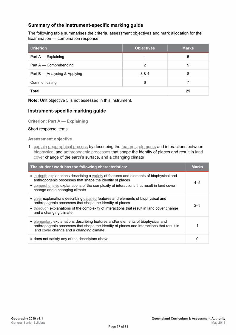
Geography 2019 v1.1 General Senior Syllabus
Queensland Curriculum & Assessment Authority May 2018
Page 37 of 81
Summary of the instrument-specific marking guide The following table summarises the criteria, assessment objectives and mark allocation for the Examination — combination response.
Criterion Objectives Marks
Part A — Explaining 1 5
Part A — Comprehending 2 5
Part B — Analysing & Applying 3 & 4 8
Communicating 6 7
Total 25
Note: Unit objective 5 is not assessed in this instrument.
Instrument-specific marking guide
Criterion: Part A — Explaining
Short response items
Assessment objective
1. explain geographical process by describing the features, elements and interactions between biophysical and anthropogenic processes that shape the identity of places and result in land cover change of the earth’s surface, and a changing climate
The student work has the following characteristics: Marks
• in-depth explanations describing a variety of features and elements of biophysical and anthropogenic processes that shape the identity of places
• comprehensive explanations of the complexity of interactions that result in land cover change and a changing climate.
4–5
• clear explanations describing detailed features and elements of biophysical and anthropogenic processes that shape the identity of places
• thorough explanations of the complexity of interactions that result in land cover change and a changing climate.
2–3
• elementary explanations describing features and/or elements of biophysical and anthropogenic processes that shape the identity of places and interactions that result in land cover change and a changing climate.
1
• does not satisfy any of the descriptors above. 0
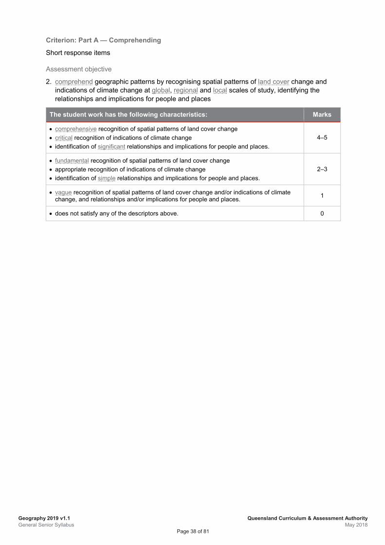
Geography 2019 v1.1 General Senior Syllabus
Queensland Curriculum & Assessment Authority May 2018
Page 38 of 81
Criterion: Part A — Comprehending
Short response items
Assessment objective
2. comprehend geographic patterns by recognising spatial patterns of land cover change and indications of climate change at global, regional and local scales of study, identifying the relationships and implications for people and places
The student work has the following characteristics: Marks
• comprehensive recognition of spatial patterns of land cover change • critical recognition of indications of climate change • identification of significant relationships and implications for people and places.
4–5
• fundamental recognition of spatial patterns of land cover change • appropriate recognition of indications of climate change • identification of simple relationships and implications for people and places.
2–3
• vague recognition of spatial patterns of land cover change and/or indications of climate change, and relationships and/or implications for people and places. 1
• does not satisfy any of the descriptors above. 0
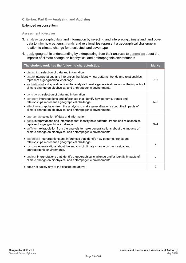
Geography 2019 v1.1 General Senior Syllabus
Queensland Curriculum & Assessment Authority May 2018
Page 39 of 81
Criterion: Part B — Analysing and Applying
Extended response item
Assessment objectives
3. analyse geographic data and information by selecting and interpreting climate and land cover data to infer how patterns, trends and relationships represent a geographical challenge in relation to climate change for a selected land cover type
4. apply geographic understanding by extrapolating from their analysis to generalise about the impacts of climate change on biophysical and anthropogenic environments
The student work has the following characteristics: Marks
• discerning selection of data and information • astute interpretations and inferences that identify how patterns, trends and relationships
represent a geographical challenge • sophisticated extrapolation from the analysis to make generalisations about the impacts of
climate change on biophysical and anthropogenic environments.
7–8
• considered selection of data and information • coherent interpretations and inferences that identify how patterns, trends and
relationships represent a geographical challenge • effective extrapolation from the analysis to make generalisations about the impacts of
climate change on biophysical and anthropogenic environments.
5–6
• appropriate selection of data and information • basic interpretations and inferences that identify how patterns, trends and relationships
represent a geographical challenge • sufficient extrapolation from the analysis to make generalisations about the impacts of
climate change on biophysical and anthropogenic environments.
3–4
• superficial interpretations and inferences that identify how patterns, trends and relationships represent a geographical challenge
• narrow generalisations about the impacts of climate change on biophysical and anthropogenic environments.
2
• unclear interpretations that identify a geographical challenge and/or identify impacts of climate change on biophysical and anthropogenic environments. 1
• does not satisfy any of the descriptors above. 0
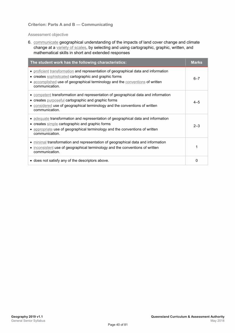
Geography 2019 v1.1 General Senior Syllabus
Queensland Curriculum & Assessment Authority May 2018
Page 40 of 81
Criterion: Parts A and B — Communicating
Assessment objective
6. communicate geographical understanding of the impacts of land cover change and climate change at a variety of scales, by selecting and using cartographic, graphic, written, and mathematical skills in short and extended responses
The student work has the following characteristics: Marks
• proficient transformation and representation of geographical data and information • creates sophisticated cartographic and graphic forms • accomplished use of geographical terminology and the conventions of written
communication.
6–7
• competent transformation and representation of geographical data and information • creates purposeful cartographic and graphic forms • considered use of geographical terminology and the conventions of written
communication.
4–5
• adequate transformation and representation of geographical data and information • creates simple cartographic and graphic forms • appropriate use of geographical terminology and the conventions of written
communication.
2–3
• minimal transformation and representation of geographical data and information • inconsistent use of geographical terminology and the conventions of written
communication. 1
• does not satisfy any of the descriptors above. 0
Geography 2019 v1.1 General Senior Syllabus
Queensland Curriculum & Assessment Authority May 2018
Page 41 of 81
4.5.2 Summative internal assessment 2 (IA2): Investigation — field report (25%)
Description This assessment requires students to research a land-management or water-management challenge at a local scale through a field investigation. A field investigation assesses a range of cognitions in a particular context including observing, questioning, planning, collecting, recording, representing, analysing and responding to primary data and communicating geographical understanding in a field report.
The assessment occurs over a defined period of time. Students may use class time and their own time to develop a response.
Assessment objectives This assessment technique is used to determine student achievement in the following objectives:
1. explain geographical processes by describing the features, elements and interactions between biophysical and anthropogenic processes that shape the identity of places and result in land cover change
2. comprehend geographic patterns by recognising spatial patterns of land cover change at a local scale, identifying relationships and implications for people and places
3. analyse geographic data and information by selecting and interpreting fieldwork data to infer how patterns, trends and relationships represent a geographical challenge for the fieldwork location
4. apply geographic understanding by extrapolating from their analysis to generalise about the impacts of land cover change on biophysical and anthropogenic environments
5. synthesise information from their analysis to propose justified action/s in response to the sustainable management of land cover change for the fieldwork location
6. communicate geographical understanding of the impacts of land cover change at a local scale, and ways of managing the impacts for sustainable outcomes, by selecting and using cartographic, graphic, written and mathematical skills in a fieldwork report
Specifications The investigation focuses on Unit 3 Topic 2: Responding to local land cover transformation.
Field studies must be conducted at a local scale and are essential for the collection of primary data and information. The collection of this data may be conducted individually or as part of a group. The field study must investigate a local land or water management challenge. The scope and scale of the task must provide opportunity for students to respond within the word limit. Students are required to use spatial technologies and ICT to graphically represent primary data and information collected in the field.
Geography 2019 v1.1 General Senior Syllabus
Queensland Curriculum & Assessment Authority May 2018
Page 42 of 81
Students must present their findings in a report, which is a written document that describes the findings of the fieldwork investigation. It will offer proposal/s based on an analysis of the results of the investigation. Appropriate maps, tables, and figures are included as sources of information and analysis within reports. A report may be an electronic publication (i.e. in non-paper form) that allows for interaction with the data representations.
The report will require students to:
• collect, analyse and interpret geographical data and information gathered in the field
• extrapolate from data analysis to generalise about the impacts of land cover change at the fieldwork location
• propose action to achieve sustainable management of land cover change for the fieldwork location.
The written report provides information to the audience. It is divided into sections using headings and sub-headings. The report includes the following sections:
• title page
• introduction
• methodology — a statement that identifies data collection methods and limitations to investigate an identified geographic challenge
• body — analysis and interpretation organised into appropriate sections and sub-sections, including transformation and representation of data into appropriate cartographic and graphic forms and in-text referencing where appropriate
• conclusion — proposal/s
• reference list — includes any references used to produce the report
• appendices — raw fieldwork data represented in the report.
Maps
Maps must be student-generated using spatial technologies and/or ICT and must be made relevant to the field study. Maps that are downloaded or photocopied must be adapted to the student’s own information; this may be achieved effectively by overlays and annotations.
Graphs
Simple and complex graphs may be used to represent primary data collected in the field. Simple graphs generally represent a single dataset, e.g. bar, line or pie graphs. Complex graphs are used to represent multiple datasets and are useful for determining relationships between the variables or factors displayed, e.g. scattergraphs, multiple line, compound bar, and ternary graphs.
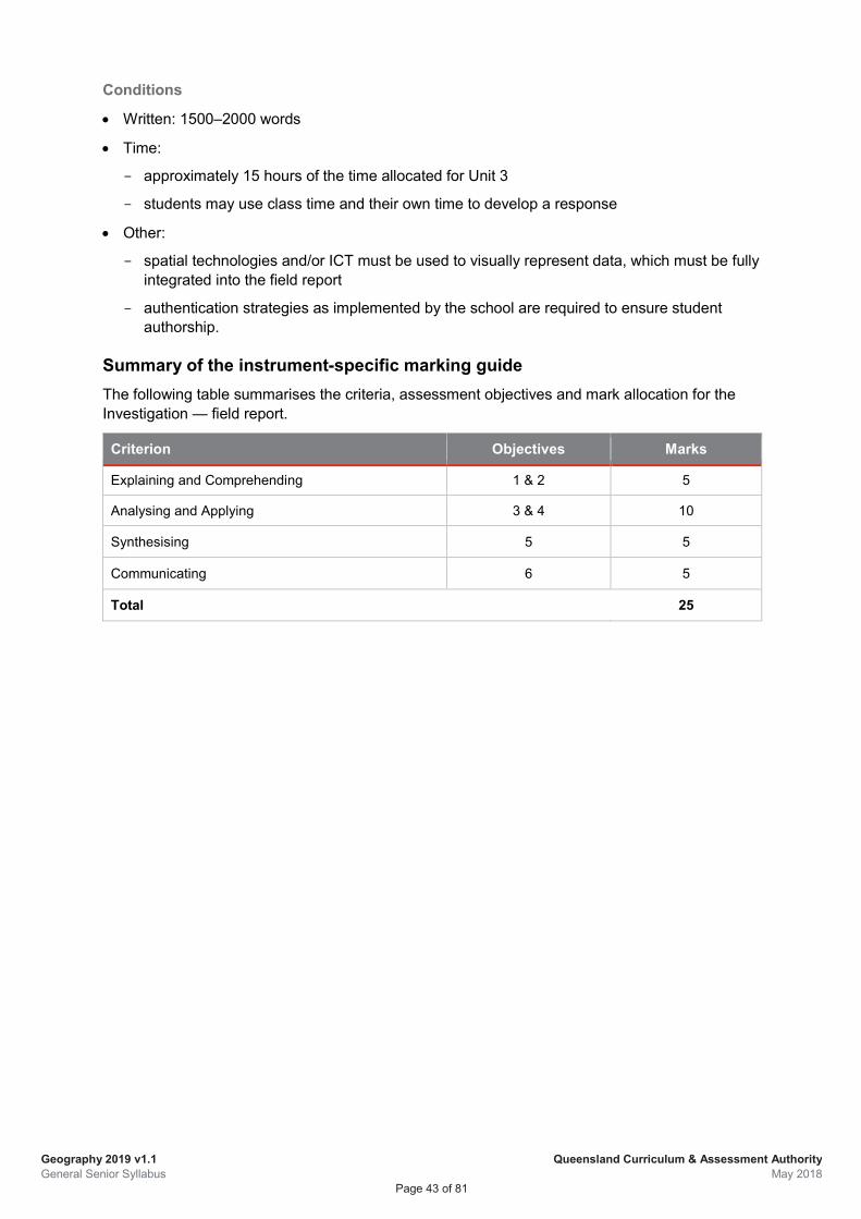
Geography 2019 v1.1 General Senior Syllabus
Queensland Curriculum & Assessment Authority May 2018
Page 43 of 81
Conditions
• Written: 1500–2000 words
• Time:
approximately 15 hours of the time allocated for Unit 3
students may use class time and their own time to develop a response
• Other:
spatial technologies and/or ICT must be used to visually represent data, which must be fully integrated into the field report
authentication strategies as implemented by the school are required to ensure student authorship.
Summary of the instrument-specific marking guide The following table summarises the criteria, assessment objectives and mark allocation for the Investigation — field report.
Criterion Objectives Marks
Explaining and Comprehending 1 & 2 5
Analysing and Applying 3 & 4 10
Synthesising 5 5
Communicating 6 5
Total 25
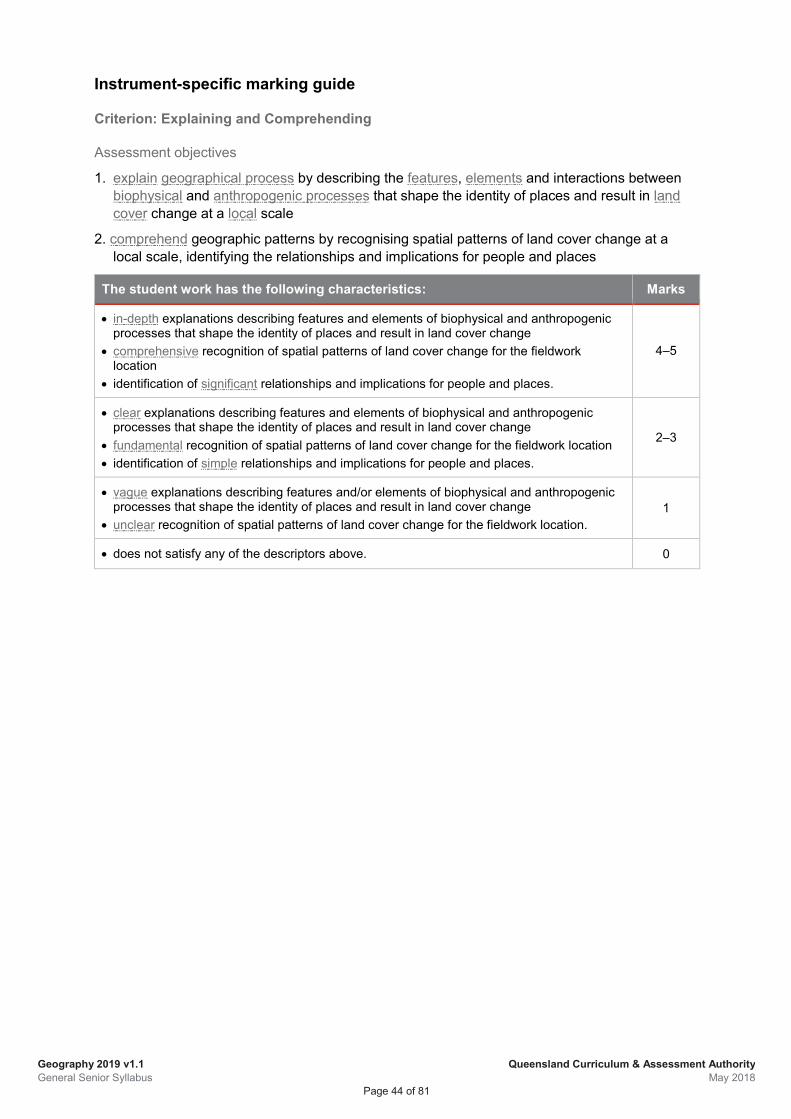
Geography 2019 v1.1 General Senior Syllabus
Queensland Curriculum & Assessment Authority May 2018
Page 44 of 81
Instrument-specific marking guide
Criterion: Explaining and Comprehending
Assessment objectives
1. explain geographical process by describing the features, elements and interactions between biophysical and anthropogenic processes that shape the identity of places and result in land cover change at a local scale
2. comprehend geographic patterns by recognising spatial patterns of land cover change at a local scale, identifying the relationships and implications for people and places
The student work has the following characteristics: Marks
• in-depth explanations describing features and elements of biophysical and anthropogenic processes that shape the identity of places and result in land cover change
• comprehensive recognition of spatial patterns of land cover change for the fieldwork location
• identification of significant relationships and implications for people and places.
4–5
• clear explanations describing features and elements of biophysical and anthropogenic processes that shape the identity of places and result in land cover change
• fundamental recognition of spatial patterns of land cover change for the fieldwork location • identification of simple relationships and implications for people and places.
2–3
• vague explanations describing features and/or elements of biophysical and anthropogenic processes that shape the identity of places and result in land cover change
• unclear recognition of spatial patterns of land cover change for the fieldwork location. 1
• does not satisfy any of the descriptors above. 0
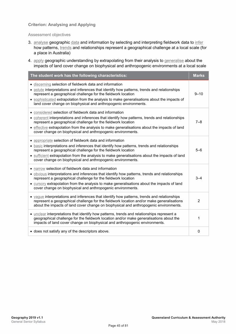
Geography 2019 v1.1 General Senior Syllabus
Queensland Curriculum & Assessment Authority May 2018
Page 45 of 81
Criterion: Analysing and Applying
Assessment objectives
3. analyse geographic data and information by selecting and interpreting fieldwork data to infer how patterns, trends and relationships represent a geographical challenge at a local scale (for a place in Australia)
4. apply geographic understanding by extrapolating from their analysis to generalise about the impacts of land cover change on biophysical and anthropogenic environments at a local scale
The student work has the following characteristics: Marks
• discerning selection of fieldwork data and information • astute interpretations and inferences that identify how patterns, trends and relationships
represent a geographical challenge for the fieldwork location • sophisticated extrapolation from the analysis to make generalisations about the impacts of
land cover change on biophysical and anthropogenic environments.
9–10
• considered selection of fieldwork data and information • coherent interpretations and inferences that identify how patterns, trends and relationships
represent a geographical challenge for the fieldwork location • effective extrapolation from the analysis to make generalisations about the impacts of land
cover change on biophysical and anthropogenic environments.
7–8
• appropriate selection of fieldwork data and information • basic interpretations and inferences that identify how patterns, trends and relationships
represent a geographical challenge for the fieldwork location • sufficient extrapolation from the analysis to make generalisations about the impacts of land
cover change on biophysical and anthropogenic environments.
5–6
• narrow selection of fieldwork data and information • obvious interpretations and inferences that identify how patterns, trends and relationships
represent a geographical challenge for the fieldwork location • cursory extrapolation from the analysis to make generalisations about the impacts of land
cover change on biophysical and anthropogenic environments.
3–4
• vague interpretations and inferences that identify how patterns, trends and relationships represent a geographical challenge for the fieldwork location and/or make generalisations about the impacts of land cover change on biophysical and anthropogenic environments.
2
• unclear interpretations that identify how patterns, trends and relationships represent a geographical challenge for the fieldwork location and/or make generalisations about the impacts of land cover change on biophysical and anthropogenic environments.
1
• does not satisfy any of the descriptors above. 0
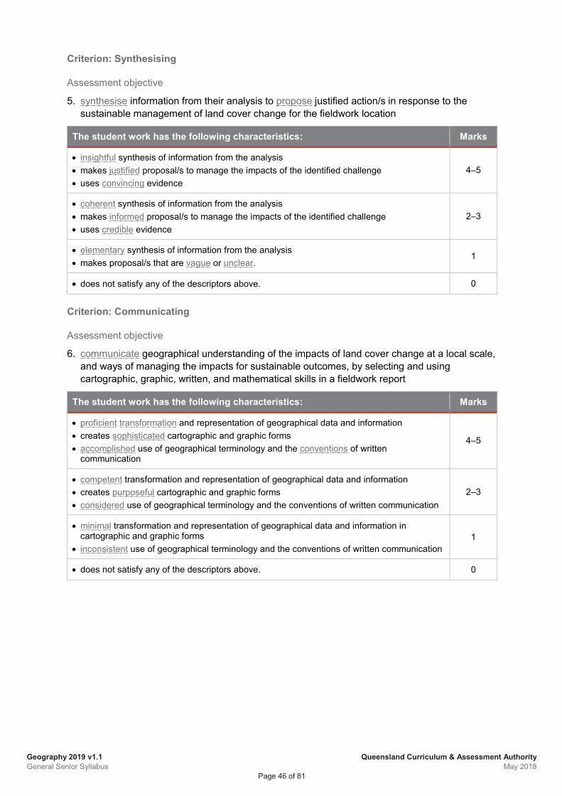
Geography 2019 v1.1 General Senior Syllabus
Queensland Curriculum & Assessment Authority May 2018
Page 46 of 81
Criterion: Synthesising
Assessment objective
5. synthesise information from their analysis to propose justified action/s in response to the sustainable management of land cover change for the fieldwork location
The student work has the following characteristics: Marks
• insightful synthesis of information from the analysis • makes justified proposal/s to manage the impacts of the identified challenge • uses convincing evidence
4–5
• coherent synthesis of information from the analysis • makes informed proposal/s to manage the impacts of the identified challenge • uses credible evidence
2–3
• elementary synthesis of information from the analysis • makes proposal/s that are vague or unclear.
1
• does not satisfy any of the descriptors above. 0
Criterion: Communicating
Assessment objective
6. communicate geographical understanding of the impacts of land cover change at a local scale, and ways of managing the impacts for sustainable outcomes, by selecting and using cartographic, graphic, written, and mathematical skills in a fieldwork report
The student work has the following characteristics: Marks
• proficient transformation and representation of geographical data and information • creates sophisticated cartographic and graphic forms • accomplished use of geographical terminology and the conventions of written
communication
4–5
• competent transformation and representation of geographical data and information • creates purposeful cartographic and graphic forms • considered use of geographical terminology and the conventions of written communication
2–3
• minimal transformation and representation of geographical data and information in cartographic and graphic forms
• inconsistent use of geographical terminology and the conventions of written communication 1
• does not satisfy any of the descriptors above. 0
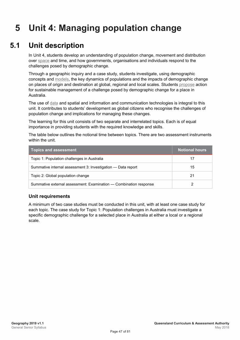
Geography 2019 v1.1 General Senior Syllabus
Queensland Curriculum & Assessment Authority May 2018
Page 47 of 81
5 Unit 4: Managing population change
5.1 Unit description In Unit 4, students develop an understanding of population change, movement and distribution over space and time, and how governments, organisations and individuals respond to the challenges posed by demographic change.
Through a geographic inquiry and a case study, students investigate, using demographic concepts and models, the key dynamics of populations and the impacts of demographic change on places of origin and destination at global, regional and local scales. Students propose action for sustainable management of a challenge posed by demographic change for a place in Australia.
The use of data and spatial and information and communication technologies is integral to this unit. It contributes to students’ development as global citizens who recognise the challenges of population change and implications for managing these changes.
The learning for this unit consists of two separate and interrelated topics. Each is of equal importance in providing students with the required knowledge and skills.
The table below outlines the notional time between topics. There are two assessment instruments within the unit.
Topics and assessment Notional hours
Topic 1: Population challenges in Australia 17
Summative internal assessment 3: Investigation — Data report 15
Topic 2: Global population change 21
Summative external assessment: Examination — Combination response 2
Unit requirements A minimum of two case studies must be conducted in this unit, with at least one case study for each topic. The case study for Topic 1: Population challenges in Australia must investigate a specific demographic challenge for a selected place in Australia at either a local or a regional scale.
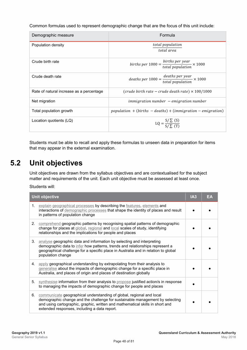
Geography 2019 v1.1 General Senior Syllabus
Queensland Curriculum & Assessment Authority May 2018
Page 48 of 81
Common formulas used to represent demographic change that are the focus of this unit include:
Demographic measure Formula
Population density
𝑡𝑡𝑡𝑡𝑡𝑡𝑡𝑡𝑡𝑡 𝑝𝑝𝑡𝑡𝑝𝑝𝑝𝑝𝑡𝑡𝑡𝑡𝑡𝑡𝑝𝑝𝑡𝑡𝑝𝑝𝑡𝑡𝑡𝑡𝑡𝑡𝑡𝑡𝑡𝑡 𝑡𝑡𝑎𝑎𝑎𝑎𝑡𝑡
Crude birth rate 𝑏𝑏𝑝𝑝𝑎𝑎𝑡𝑡ℎ𝑠𝑠 𝑝𝑝𝑎𝑎𝑎𝑎 1000 =𝑏𝑏𝑝𝑝𝑎𝑎𝑡𝑡ℎ𝑠𝑠 𝑝𝑝𝑎𝑎𝑎𝑎 𝑦𝑦𝑎𝑎𝑡𝑡𝑎𝑎 𝑡𝑡𝑡𝑡𝑡𝑡𝑡𝑡𝑡𝑡 𝑝𝑝𝑡𝑡𝑝𝑝𝑝𝑝𝑡𝑡𝑡𝑡𝑡𝑡𝑝𝑝𝑡𝑡𝑝𝑝
× 1000
Crude death rate 𝑑𝑑𝑎𝑎𝑡𝑡𝑡𝑡ℎ𝑠𝑠 𝑝𝑝𝑎𝑎𝑎𝑎 1000 =𝑑𝑑𝑎𝑎𝑡𝑡𝑡𝑡ℎ𝑠𝑠 𝑝𝑝𝑎𝑎𝑎𝑎 𝑦𝑦𝑎𝑎𝑡𝑡𝑎𝑎𝑡𝑡𝑡𝑡𝑡𝑡𝑡𝑡𝑡𝑡 𝑝𝑝𝑡𝑡𝑝𝑝𝑝𝑝𝑡𝑡𝑡𝑡𝑡𝑡𝑝𝑝𝑡𝑡𝑝𝑝
× 1000
Rate of natural increase as a percentage (𝑐𝑐𝑎𝑎𝑝𝑝𝑑𝑑𝑎𝑎 𝑏𝑏𝑝𝑝𝑎𝑎𝑡𝑡ℎ 𝑎𝑎𝑡𝑡𝑡𝑡𝑎𝑎 − 𝑐𝑐𝑎𝑎𝑝𝑝𝑑𝑑𝑎𝑎 𝑑𝑑𝑎𝑎𝑡𝑡𝑡𝑡ℎ 𝑎𝑎𝑡𝑡𝑡𝑡𝑎𝑎) × 100/1000
Net migration 𝑝𝑝𝑖𝑖𝑖𝑖𝑝𝑝𝑖𝑖𝑎𝑎𝑡𝑡𝑡𝑡𝑝𝑝𝑡𝑡𝑝𝑝 𝑝𝑝𝑝𝑝𝑖𝑖𝑏𝑏𝑎𝑎𝑎𝑎 − 𝑎𝑎𝑖𝑖𝑝𝑝𝑖𝑖𝑎𝑎𝑡𝑡𝑡𝑡𝑝𝑝𝑡𝑡𝑝𝑝 𝑝𝑝𝑝𝑝𝑖𝑖𝑏𝑏𝑎𝑎𝑎𝑎
Total population growth 𝑝𝑝𝑡𝑡𝑝𝑝𝑝𝑝𝑡𝑡𝑡𝑡𝑡𝑡𝑝𝑝𝑡𝑡𝑝𝑝 + (𝑏𝑏𝑝𝑝𝑎𝑎𝑡𝑡ℎ𝑠𝑠 − 𝑑𝑑𝑎𝑎𝑡𝑡𝑡𝑡ℎ𝑠𝑠) + (𝑝𝑝𝑖𝑖𝑖𝑖𝑝𝑝𝑖𝑖𝑎𝑎𝑡𝑡𝑡𝑡𝑝𝑝𝑡𝑡𝑝𝑝 − 𝑎𝑎𝑖𝑖𝑝𝑝𝑖𝑖𝑎𝑎𝑡𝑡𝑡𝑡𝑝𝑝𝑡𝑡𝑝𝑝)
Location quotients (LQ) LQ =
S/∑ (S)S/∑ (T)
Students must be able to recall and apply these formulas to unseen data in preparation for items that may appear in the external examination.
5.2 Unit objectives Unit objectives are drawn from the syllabus objectives and are contextualised for the subject matter and requirements of the unit. Each unit objective must be assessed at least once.
Students will:
Unit objective IA3 EA
1. explain geographical processes by describing the features, elements and interactions of demographic processes that shape the identity of places and result in patterns of population change
● ●
2. comprehend geographic patterns by recognising spatial patterns of demographic change for places at global, regional and local scales of study, identifying relationships and the implications for people and places
● ●
3. analyse geographic data and information by selecting and interpreting demographic data to infer how patterns, trends and relationships represent a geographical challenge for a specific place in Australia and in relation to global population change
● ●
4. apply geographical understanding by extrapolating from their analysis to generalise about the impacts of demographic change for a specific place in Australia, and places of origin and places of destination globally
● ●
5. synthesise information from their analysis to propose justified action/s in response to managing the impacts of demographic change for people and places ●
6. communicate geographical understanding of global, regional and local demographic change and the challenge for sustainable management by selecting and using cartographic, graphic, written and mathematical skills in short and extended responses, including a data report.
● ●
Geography 2019 v1.1 General Senior Syllabus
Queensland Curriculum & Assessment Authority May 2018
Page 49 of 81
5.3 Topic 1: Population challenges in Australia Notional time: 32 hours
In Topic 1, students explain the geographical processes that result in population change over time and space, focusing on demographic indicators such as life expectancy, birth, death and fertility rates, and migration patterns. They recognise the spatial patterns of this change and the implications for people and places. Students investigate a particular demographic challenge for a place in Australia through geographic inquiry, using primary data.
Students understand the factors that influence demographic change for a specific place and the challenges that arise. Students propose action to manage a specific demographic challenge for a place in Australia. Through their geographic inquiry, students understand the nature of population changes over time and the impact on resulting needs and resources of a community.
Subject matter
In this topic, students will: • describe key demographic concepts, including birth, death and fertility rates, life expectancy, age/sex
structure and migration rates • explain how demographic processes result in changes to populations, including rates of natural
increase and decrease, and overall population increases • explain how changes to populations are influenced by factors such as advances in health care and life
expectancy, the changing role of women in society and birth rates, the impact of disease on death rates, migration policies over time, and amenity
• analyse primary data (ABS census data) relating to each of the key demographic concepts (birth, death and fertility rates, life expectancy, age/sex structure, and migration rates) to identify population patterns and trends in Australia
• recognise and represent the population patterns and trends in each key demographic concept for Australia, using spatial technologies and information and communication technologies
• identify implications for people and places of demographic change, including migration • conduct a geographic inquiry using primary data, for assessment purposes, to investigate a specific
demographic challenge for a selected place in Australia at a local scale, e.g. a regional city, a suburb, or a rural town. As part of this inquiry students must describe the demographic characteristics for the selected place in Australia recognise and represent demographic change over time using spatial and information and
communication technologies (i.e. cartographic and graphical representations) analyse primary demographic data using the common formulas for this unit and other mathematical
models, including dependency ratio, to identify and explain a demographic challenge for the place in Australia (e.g. ageing population, youth population, population decline, rapid population growth)
explain the geographical and/or demographic factors that have contributed to the challenge (e.g. birth and death rates, migration flows, amenity, employment)
apply geographical understanding by extrapolating from their analysis to generalise about the impacts of the demographic challenge in the selected place (e.g. resource management, workforce participation, ethnic and cultural diversity, housing, infrastructure)
synthesise information from the analysis to propose action in response to the identified challenge for the place in Australia
manipulate, adapt or transform the initial provided data and further gathered primary data using spatial technologies and ICT to prepare data for analysis using cartographic, graphic and mathematical skills, spatial and information and communication technologies to communicate geographical understanding in a data report.
Geography 2019 v1.1 General Senior Syllabus
Queensland Curriculum & Assessment Authority May 2018
Page 50 of 81
5.4 Topic 2: Global population change Notional time: 23 hours
In Topic 2, students explain the geographical processes that result in patterns and trends in global populations and how these changes have been represented over time using models. They recognise the spatial patterns of population distributions and the implications for people and places. Students investigate the demographic and geographic processes that have resulted in the movements of people across the world and the impacts for places of origin and places of destination.
Students conduct a case study to understand variations in the global characteristics of population distributions and the implications of these transitions on places and for people. Through their investigation, students develop empathy for and understanding of the reasons people move and the challenges this poses for communities.
Subject matter
In this topic, students will: • describe global population characteristics, focusing on demographic concepts of the rate of natural
change, including birth rate, death rate, infant mortality rate, fertility rate, life expectancy and age/sex structure
• explain the demographic processes that cause variations in the spatial distributions of global population characteristics, including population momentum
• describe changes in world population distribution, including internal and international migration since the 1700s, and the projected changes in the 21st century
• explain how population trends and characteristics have been described over time using models (e.g. Demographic Transition Model; Rostow’s Stages of Growth Model; Wallerstein’s World-Systems theory) and decide whether these are still applicable to describe contemporary and projected population changes
• recognise current population growth, distribution and density and represent global population patterns in maps, using spatial technologies and identify relationships and implications for people
• analyse geographic data represented in maps and graphs to infer how the patterns and trends represent specific challenges at global and regional scales
• explain the causes of internal migrations, both forced and voluntary, as a result of human factors (including social, cultural, political and economic factors such as conflict, labour supply and demand, family reunion, religious or cultural persecution, poverty, food security, governance) and/or geographical and environmental processes (e.g. large-scale flooding or drought, ecological breakdown)
• explain the causes of international migrations, both forced and voluntary, as a result of human factors as for internal migrations (including social, cultural, political and economic factors such as conflict, labour supply and demand, family reunion, religious or cultural persecution, poverty, food security, governance), and other factors (e.g. educational opportunities and/or geographic and environmental processes such as large-scale flooding, drought or ecological breakdown) and other factors (e.g. climate change)
• conduct a case study to identify the impacts on places of origin (e.g. declining populations, gender imbalance, employment opportunities, decline in agricultural production) and places of destination (e.g. urbanisation, ghettoisation, resource availability) as a result of internal or international migrations, for a place in the developing world. As part of this case study, students should explain the geographical processes that have resulted in migration (internal and/or international) to the
place under investigation manipulate, adapt and transform data, using spatial and information and communication technologies to
represent and describe the geographic patterns and trends in population flows for the place under investigation
analyse data and information to explain the changing characteristics of populations for the place under investigation as a result of migration (internal and/or international), e.g. population growth rates and population density, and the changing characteristics of the place/places of origin, e.g. declining populations, change age/sex structure
apply geographical understanding by extrapolating from their analysis to identify the impacts on places of origin (e.g. workforce structure, population momentum) and the impacts on the place of destination (e.g. ghettoisation, urbanisation, cultural and ethnic diversity) being investigated
Geography 2019 v1.1 General Senior Syllabus
Queensland Curriculum & Assessment Authority May 2018
Page 51 of 81
identify and describe current or future responses (e.g. national or regional strategies and initiatives, non-government responses, international or governmental agreements)
communicate understanding of the impacts of population change on places of origin and places of destination and the challenge of sustainable responses.
5.5 Assessment 5.5.1 Summative internal assessment 3 (IA3):
Investigation — data report (25%)
Description This assessment requires students to research a specific challenge or problem (at a local scale of study, for a place in Australia) through collecting, representing, analysing and responding to a range of data that is both teacher-provided and student researched. A geographic inquiry uses research practices to assess a range of cognitions in a particular context. Research practices include locating and using information beyond students’ own knowledge and the data they have been given.
This assessment occurs over a defined period of time. Students may use class time and their own time to develop a response.
Assessment objectives This assessment technique is used to determine student achievement in the following objectives:
1. explain geographical processes by describing the features, elements and interactions of demographic processes that shape the identity of places and result in patterns of population change
2. comprehend geographic patterns by recognising spatial patterns of demographic change for places at a local scale of study, identifying relationships and the implications for people and places
3. analyse geographic data and information by selecting and interpreting demographic data to infer how patterns, trends and relationships represent a geographical challenge for a specific place in Australia
4. apply geographical understanding by extrapolating from their analysis to generalise about the impacts of demographic change for people and places
5. synthesise information from their analysis to propose justified action/s in response to managing the impacts of demographic change
6. communicate geographical understanding of demographic change and the challenge for sustainable management for a place in Australia, by selecting and using cartographic, graphic, written and mathematical skills in a data report
Geography 2019 v1.1 General Senior Syllabus
Queensland Curriculum & Assessment Authority May 2018
Page 52 of 81
Specifications The investigation will focus on Unit 4 Topic 1: Population challenges in Australia.
The investigation requires students to respond to an identified population challenge for a selected place in Australia at a local scale, e.g. a city; a suburb; a rural town, using a fundamental set of raw data provided by the teacher (as a starting point) and additional data researched and gathered by the student. The scope and scale of the task must provide opportunity for students to respond within the word limit. Students are required to use spatial technologies and ICT to graphically represent data and information. Authentication strategies include that students produce graphs for the final response under supervised conditions.
Students must present their findings in a report, which is a written document that describes the findings of the geographic inquiry. It will offer proposal/s and recommendations based on the analysis of the data. The student must determine which data and presentation methods to use to represent the population challenge under investigation. The report may be an electronic publication (i.e. in non-paper form) that allows for interaction with the data representations.
The written report will require students to:
• describe the demographic challenge for the selected place in Australia
• explain the demographic processes that have contributed to the challenge
• analyse geographical data using the common formulas for this unit and other mathematical models, including dependency ratio
• extrapolate from the analysis to determine the impacts of demographic change in the selected place
• make proposal/s for sustainable management in response to the identified challenge.
The written report provides information to the audience. It is divided into sections using headings and sub-headings. The report includes the following sections:
• title page
• introduction
• methodology — a statement that identifies the type of data gathered and limitations and the formulas used to represent demographic change
• body — analysis and interpretation organised into appropriate sections and sub-sections, including data transformation and representation in appropriate cartographic and graphic forms using in-text referencing
• conclusion — proposal/s
• reference list — includes any references used to source data and produce the report
Maps
Maps must be student-generated using spatial technologies and/or ICT. Maps that are downloaded or photocopied must be adapted to the student’s own information; this may be achieved effectively by overlays and annotations.
Graphs
Simple and complex graphs may be used to represent data. Simple graphs generally represent a single dataset, e.g. bar, line or pie graphs. Complex graphs are used to represent multiple datasets and are useful for determining relationships between the variables or factors displayed, e.g. scattergraphs, multiple line, compound bar, ternary graphs.
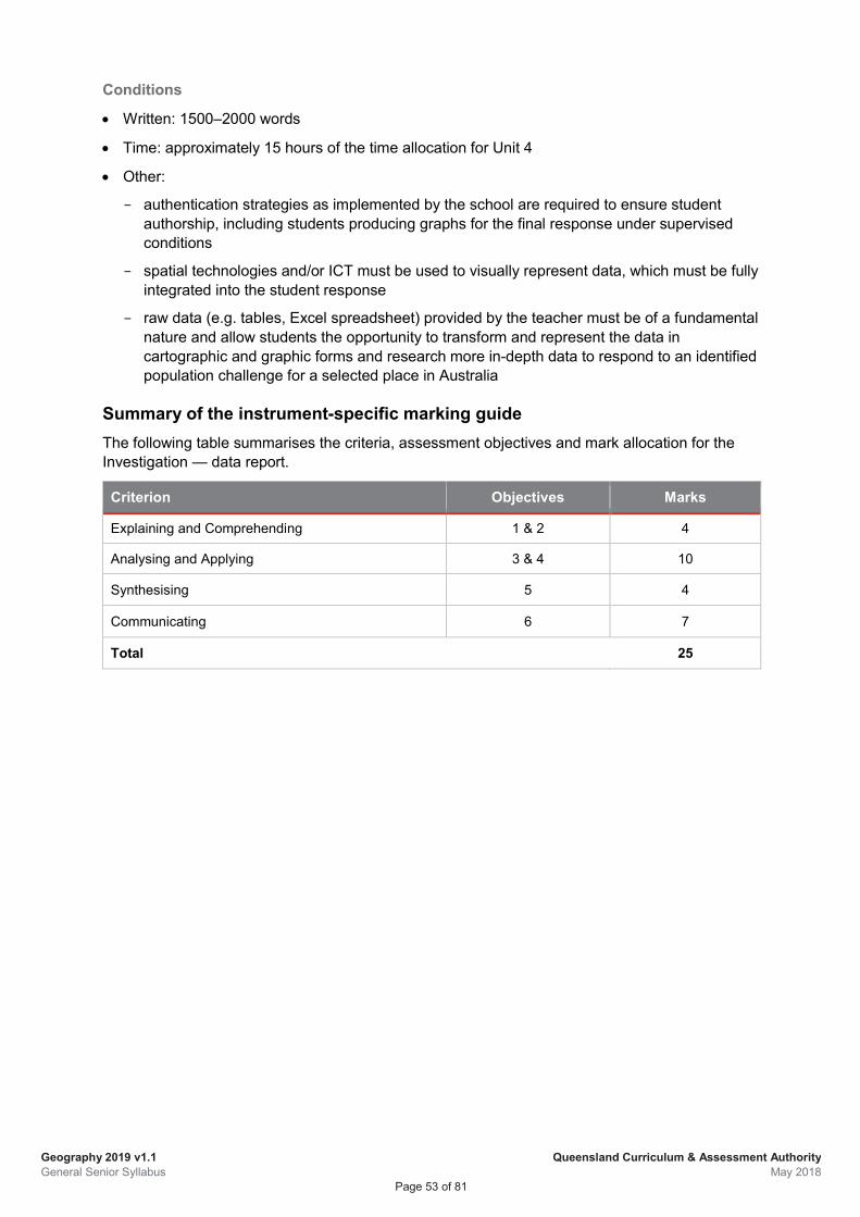
Geography 2019 v1.1 General Senior Syllabus
Queensland Curriculum & Assessment Authority May 2018
Page 53 of 81
Conditions
• Written: 1500–2000 words
• Time: approximately 15 hours of the time allocation for Unit 4
• Other:
authentication strategies as implemented by the school are required to ensure student authorship, including students producing graphs for the final response under supervised conditions
spatial technologies and/or ICT must be used to visually represent data, which must be fully integrated into the student response
raw data (e.g. tables, Excel spreadsheet) provided by the teacher must be of a fundamental nature and allow students the opportunity to transform and represent the data in cartographic and graphic forms and research more in-depth data to respond to an identified population challenge for a selected place in Australia
Summary of the instrument-specific marking guide The following table summarises the criteria, assessment objectives and mark allocation for the Investigation — data report.
Criterion Objectives Marks
Explaining and Comprehending 1 & 2 4
Analysing and Applying 3 & 4 10
Synthesising 5 4
Communicating 6 7
Total 25
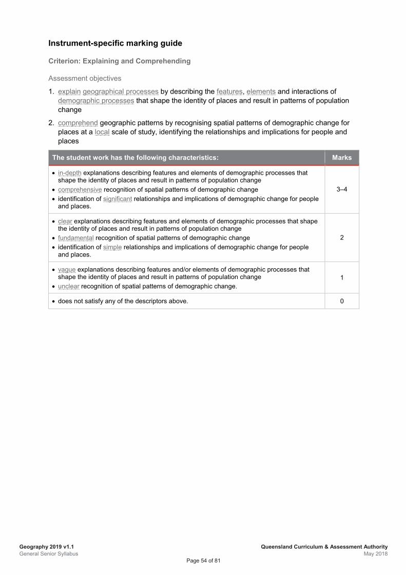
Geography 2019 v1.1 General Senior Syllabus
Queensland Curriculum & Assessment Authority May 2018
Page 54 of 81
Instrument-specific marking guide
Criterion: Explaining and Comprehending
Assessment objectives
1. explain geographical processes by describing the features, elements and interactions of demographic processes that shape the identity of places and result in patterns of population change
2. comprehend geographic patterns by recognising spatial patterns of demographic change for places at a local scale of study, identifying the relationships and implications for people and places
The student work has the following characteristics: Marks
• in-depth explanations describing features and elements of demographic processes that shape the identity of places and result in patterns of population change
• comprehensive recognition of spatial patterns of demographic change • identification of significant relationships and implications of demographic change for people
and places.
3–4
• clear explanations describing features and elements of demographic processes that shape the identity of places and result in patterns of population change
• fundamental recognition of spatial patterns of demographic change • identification of simple relationships and implications of demographic change for people
and places.
2
• vague explanations describing features and/or elements of demographic processes that shape the identity of places and result in patterns of population change
• unclear recognition of spatial patterns of demographic change. 1
• does not satisfy any of the descriptors above. 0
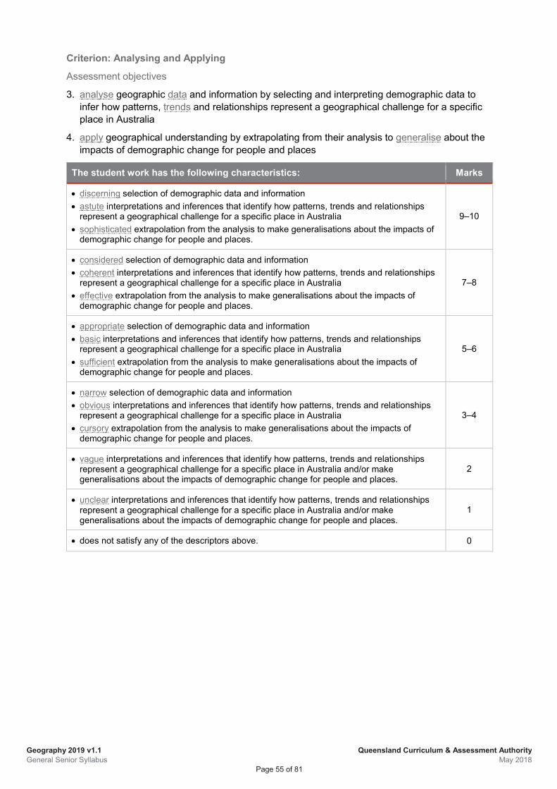
Geography 2019 v1.1 General Senior Syllabus
Queensland Curriculum & Assessment Authority May 2018
Page 55 of 81
Criterion: Analysing and Applying
Assessment objectives
3. analyse geographic data and information by selecting and interpreting demographic data to infer how patterns, trends and relationships represent a geographical challenge for a specific place in Australia
4. apply geographical understanding by extrapolating from their analysis to generalise about the impacts of demographic change for people and places
The student work has the following characteristics: Marks
• discerning selection of demographic data and information • astute interpretations and inferences that identify how patterns, trends and relationships
represent a geographical challenge for a specific place in Australia • sophisticated extrapolation from the analysis to make generalisations about the impacts of
demographic change for people and places.
9–10
• considered selection of demographic data and information • coherent interpretations and inferences that identify how patterns, trends and relationships
represent a geographical challenge for a specific place in Australia • effective extrapolation from the analysis to make generalisations about the impacts of
demographic change for people and places.
7–8
• appropriate selection of demographic data and information • basic interpretations and inferences that identify how patterns, trends and relationships
represent a geographical challenge for a specific place in Australia • sufficient extrapolation from the analysis to make generalisations about the impacts of
demographic change for people and places.
5–6
• narrow selection of demographic data and information • obvious interpretations and inferences that identify how patterns, trends and relationships
represent a geographical challenge for a specific place in Australia • cursory extrapolation from the analysis to make generalisations about the impacts of
demographic change for people and places.
3–4
• vague interpretations and inferences that identify how patterns, trends and relationships represent a geographical challenge for a specific place in Australia and/or make generalisations about the impacts of demographic change for people and places.
2
• unclear interpretations and inferences that identify how patterns, trends and relationships represent a geographical challenge for a specific place in Australia and/or make generalisations about the impacts of demographic change for people and places.
1
• does not satisfy any of the descriptors above. 0
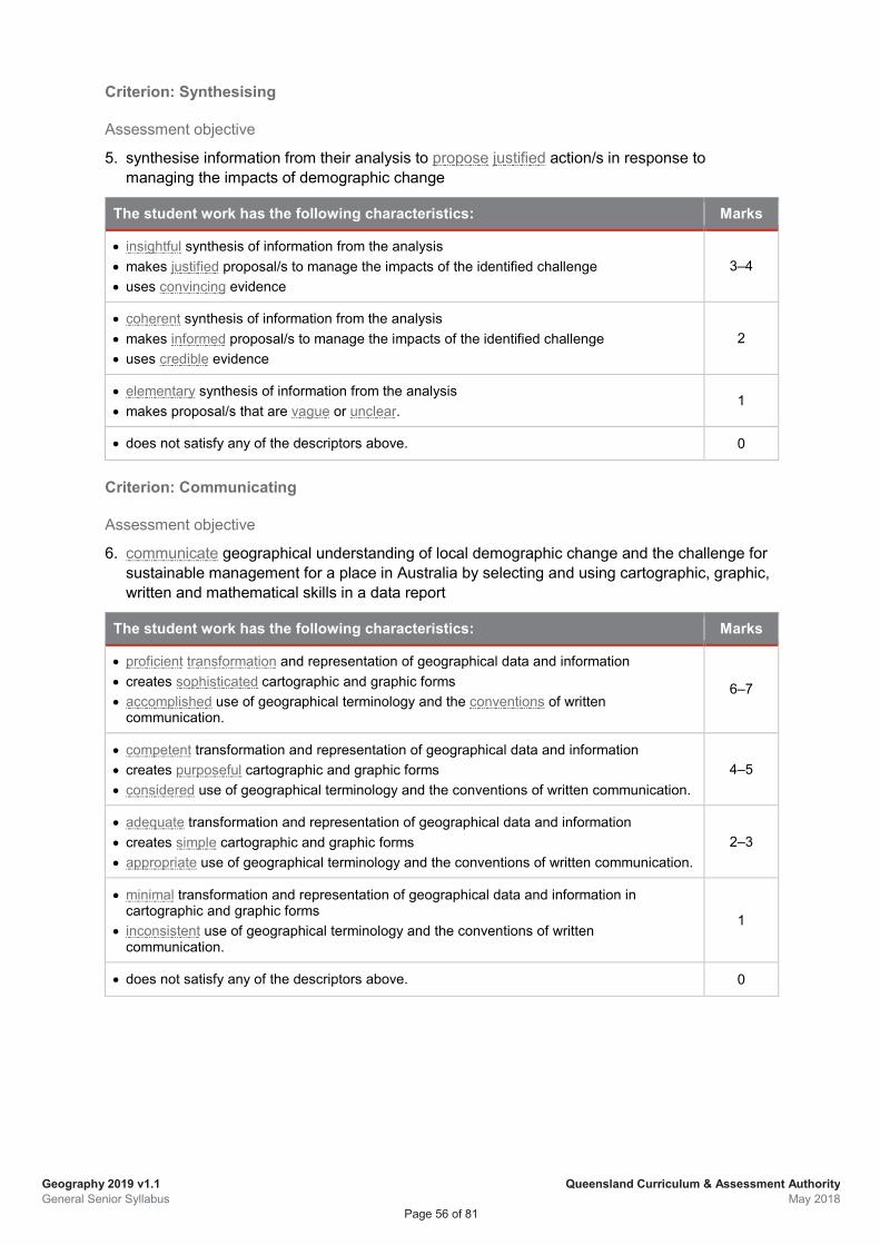
Geography 2019 v1.1 General Senior Syllabus
Queensland Curriculum & Assessment Authority May 2018
Page 56 of 81
Criterion: Synthesising
Assessment objective
5. synthesise information from their analysis to propose justified action/s in response to managing the impacts of demographic change
The student work has the following characteristics: Marks
• insightful synthesis of information from the analysis • makes justified proposal/s to manage the impacts of the identified challenge • uses convincing evidence
3–4
• coherent synthesis of information from the analysis • makes informed proposal/s to manage the impacts of the identified challenge • uses credible evidence
2
• elementary synthesis of information from the analysis • makes proposal/s that are vague or unclear.
1
• does not satisfy any of the descriptors above. 0
Criterion: Communicating
Assessment objective
6. communicate geographical understanding of local demographic change and the challenge for sustainable management for a place in Australia by selecting and using cartographic, graphic, written and mathematical skills in a data report
The student work has the following characteristics: Marks
• proficient transformation and representation of geographical data and information • creates sophisticated cartographic and graphic forms • accomplished use of geographical terminology and the conventions of written
communication.
6–7
• competent transformation and representation of geographical data and information • creates purposeful cartographic and graphic forms • considered use of geographical terminology and the conventions of written communication.
4–5
• adequate transformation and representation of geographical data and information • creates simple cartographic and graphic forms • appropriate use of geographical terminology and the conventions of written communication.
2–3
• minimal transformation and representation of geographical data and information in cartographic and graphic forms
• inconsistent use of geographical terminology and the conventions of written communication.
1
• does not satisfy any of the descriptors above. 0
Geography 2019 v1.1 General Senior Syllabus
Queensland Curriculum & Assessment Authority May 2018
Page 57 of 81
5.5.2 Summative external assessment (EA): Examination — combination response (25%)
General information Summative external assessment is developed and marked by the QCAA. In Geography it contributes 25% to a student’s overall subject result.
The external assessment in Geography is common to all schools and administered under the same conditions, at the same time, on the same day.
Description The examination assesses the application of a range of cognitions to unseen questions in response to stimulus materials. Items are both short response and extended response using evidence from data. Data consists of a collection of statistical information presented as tables and graphs, maps, diagrams, images and minimal text.
Student responses must be completed individually, under supervised conditions, and in a set timeframe.
Assessment objectives This assessment technique is used to determine student achievement in the following objectives:
1. explain geographical processes by describing the features, elements and interactions of demographic processes that shape the identity of places and result in patterns of population change
2. comprehend geographic patterns by recognising spatial patterns of demographic change for places at global, regional and local scales of study, identifying relationships and the implications for people and places
3. analyse geographic data and information by selecting and interpreting demographic data to infer how patterns, trends and relationships represent a geographical challenge in relation to global population change
4. apply geographical understanding by extrapolating from their analysis to generalise about the impacts of demographic change for places of origin and places of destination globally
6. communicate geographical understanding of global, regional and local demographic change and the challenge for sustainable management by selecting and using cartographic, graphic, written and mathematical skills in short and extended responses
Note: Objective 5 is not assessed in this instrument.
Geography 2019 v1.1 General Senior Syllabus
Queensland Curriculum & Assessment Authority May 2018
Page 58 of 81
Specifications The examination is a combination of short and extended response items that will relate to Unit 4 Topic 2: Global population change.
• 5–8 short response items in response to stimulus (data)
may include explanation, measurement, calculations, drawing, labelling and, annotating maps, diagrams and graphs
responses may take the form of creating maps and graphs, annotating, sentences and/or paragraphs as required by each item
• One extended response item in response to stimulus (data)
may include using a model and/or calculations
multiple possible responses from the stimulus.
Stimulus specifications
• Stimulus materials will be succinct enough to engage with in the planning time and fit on one A3 page or equivalent.
• Stimulus materials will consist of visual texts, e.g. maps, graphs, statistics, infographics, images, diagrams and minimal text.
• Stimulus materials are not provided prior to exam.
• Context statements will be supplied for each piece of stimulus in the form of a brief description that may include source of data, and any general details about the purpose or construction of the data.
Conditions
• Time: 2 hours plus 15 minutes planning time
• Length
short-response items (approximately 50–150 words per item)
extended-response item (approximately 450–600 words)
examination in its entirety 800–1000 words
• Non-programmable calculators are permitted.
• Rulers free from markings other than measurement indicators are permitted.
If written text is required, no more than one piece of text will be used and it will not exceed 150 words.
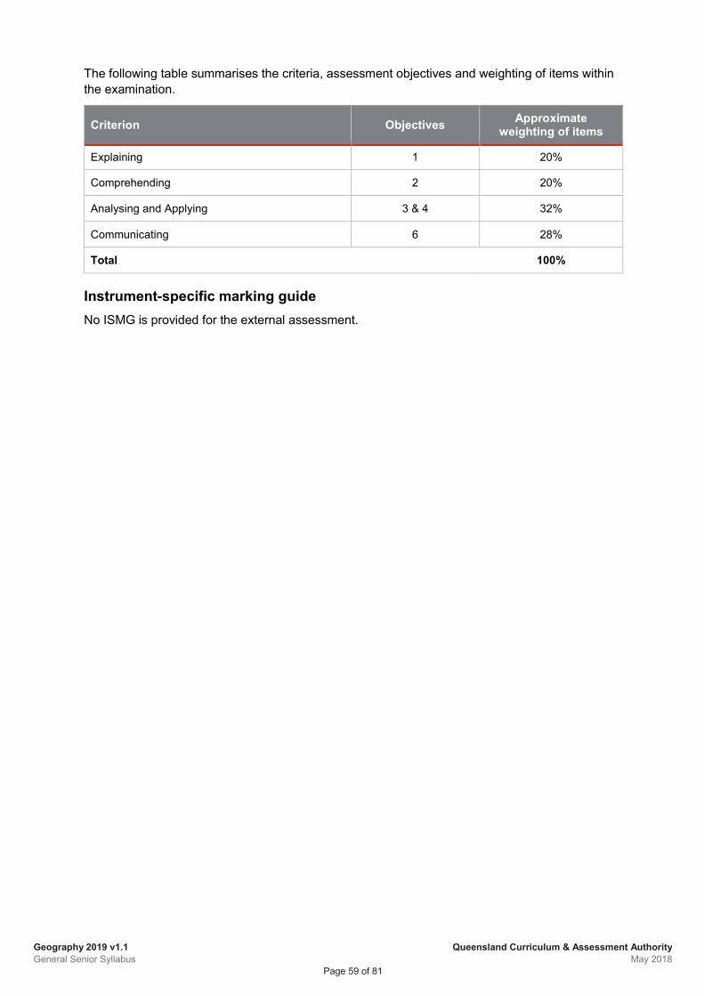
Geography 2019 v1.1 General Senior Syllabus
Queensland Curriculum & Assessment Authority May 2018
Page 59 of 81
The following table summarises the criteria, assessment objectives and weighting of items within the examination.
Criterion Objectives Approximate weighting of items
Explaining 1 20%
Comprehending 2 20%
Analysing and Applying 3 & 4 32%
Communicating 6 28%
Total 100%
Instrument-specific marking guide No ISMG is provided for the external assessment.
Geography 2019 v1.1 General Senior Syllabus
Queensland Curriculum & Assessment Authority May 2018
Page 60 of 81
6 Glossary Term Explanation
A
accomplished highly trained or skilled in a particular activity; perfected in knowledge or training; expert
accuracy
the condition or quality of being true, correct or exact; freedom from error or defect; precision or exactness; correctness; in science, the extent to which a measurement result represents the quantity it purports to measure; an accurate measurement result includes an estimate of the true value and an estimate of the uncertainty
accurate precise and exact; to the point; consistent with or exactly conforming to a truth, standard, rule, model, convention or known facts; free from error or defect; meticulous; correct in all details
adept very/highly skilled or proficient at something; expert
adequate satisfactory or acceptable in quality or quantity equal to the requirement or occasion
albedo
the fraction of solar energy (shortwave radiation) reflected from the Earth back into space; a measure of the reflectivity of Earth's surface (https://www.esa.int/Our_Activities/Observing_the_Earth/Reflecting_on_Earth_s_albedo)
analyse
dissect to ascertain and examine constituent parts and/or their relationships; break down or examine in order to identify the essential elements, features, components or structure; determine the logic and reasonableness of information; examine or consider something in order to explain and interpret it, for the purpose of finding meaning or relationships and identifying patterns, similarities and differences
anthropogenic caused by human beings
anthropogenic biomes
the terrestrial biosphere in its contemporary, human-altered form using global ecosystem units defined by patterns of sustained direct human interaction (SEDAC); the way humans have reshaped the Earth’s ecological patterns and processes (Ecotope.org)
anthropogenic processes
intentional human activity that may result in changes to the biophysical environment (e.g. when land is cleared for agriculture and development modifying landscapes and introducing new species); intended or unintended side-effects of human activity
applied learning
the acquisition and application of knowledge, understanding and skills in real-world or lifelike contexts that may encompass workplace, industry and community situations; it emphasises learning through doing and includes both theory and the application of theory, connecting subject knowledge and understanding with the development of practical skills
Applied subject
a subject whose primary pathway is work and vocational education; it emphasises applied learning and community connections; a subject for which a syllabus has been developed by the QCAA with the following characteristics: results from courses developed from Applied syllabuses contribute to the QCE; Applied subjects do not have an external assessment component; results may contribute to ATAR calculations
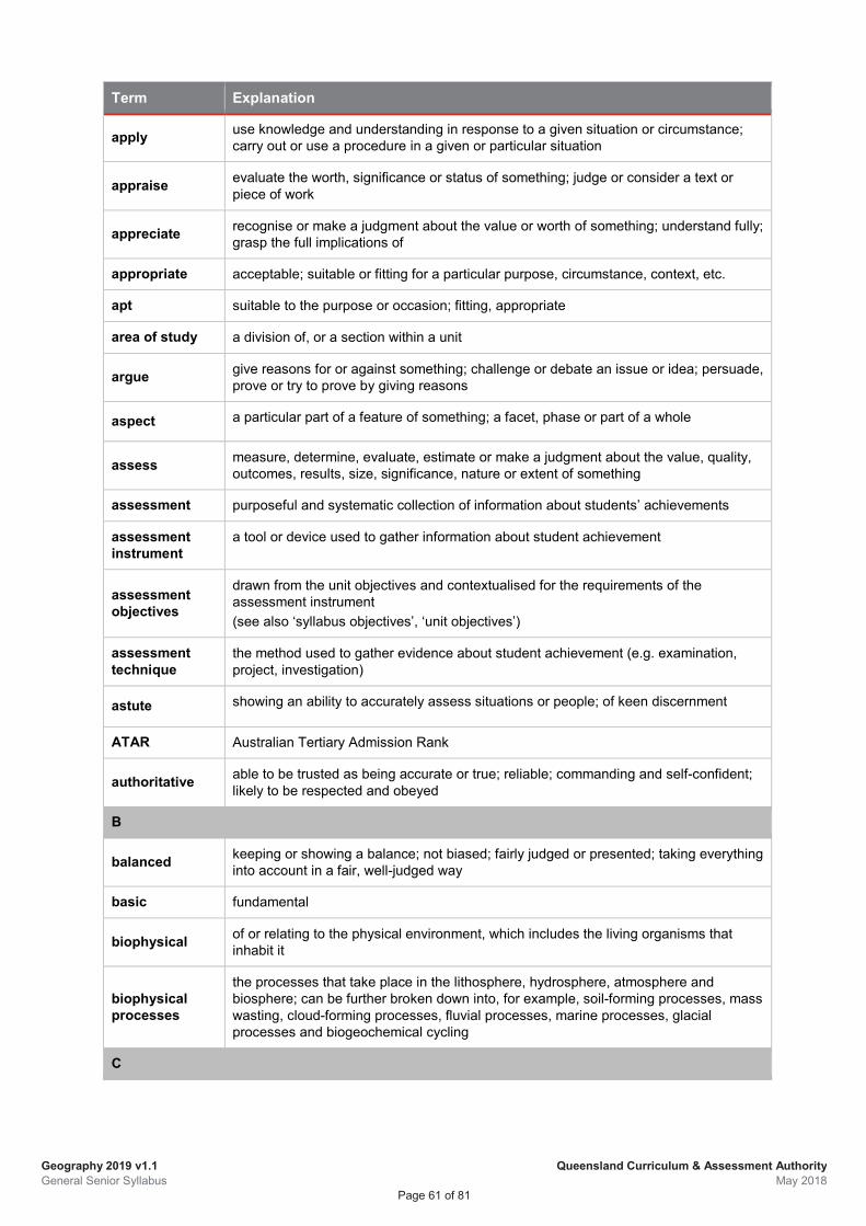
Geography 2019 v1.1 General Senior Syllabus
Queensland Curriculum & Assessment Authority May 2018
Page 61 of 81
Term Explanation
apply use knowledge and understanding in response to a given situation or circumstance; carry out or use a procedure in a given or particular situation
appraise evaluate the worth, significance or status of something; judge or consider a text or piece of work
appreciate recognise or make a judgment about the value or worth of something; understand fully; grasp the full implications of
appropriate acceptable; suitable or fitting for a particular purpose, circumstance, context, etc.
apt suitable to the purpose or occasion; fitting, appropriate
area of study a division of, or a section within a unit
argue give reasons for or against something; challenge or debate an issue or idea; persuade, prove or try to prove by giving reasons
aspect a particular part of a feature of something; a facet, phase or part of a whole
assess measure, determine, evaluate, estimate or make a judgment about the value, quality, outcomes, results, size, significance, nature or extent of something
assessment purposeful and systematic collection of information about students’ achievements
assessment instrument
a tool or device used to gather information about student achievement
assessment objectives
drawn from the unit objectives and contextualised for the requirements of the assessment instrument (see also ‘syllabus objectives’, ‘unit objectives’)
assessment technique
the method used to gather evidence about student achievement (e.g. examination, project, investigation)
astute showing an ability to accurately assess situations or people; of keen discernment
ATAR Australian Tertiary Admission Rank
authoritative able to be trusted as being accurate or true; reliable; commanding and self-confident; likely to be respected and obeyed
B
balanced keeping or showing a balance; not biased; fairly judged or presented; taking everything into account in a fair, well-judged way
basic fundamental
biophysical of or relating to the physical environment, which includes the living organisms that inhabit it
biophysical processes
the processes that take place in the lithosphere, hydrosphere, atmosphere and biosphere; can be further broken down into, for example, soil-forming processes, mass wasting, cloud-forming processes, fluvial processes, marine processes, glacial processes and biogeochemical cycling
C
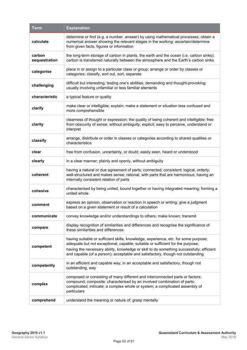
Geography 2019 v1.1 General Senior Syllabus
Queensland Curriculum & Assessment Authority May 2018
Page 62 of 81
Term Explanation
calculate determine or find (e.g. a number, answer) by using mathematical processes; obtain a numerical answer showing the relevant stages in the working; ascertain/determine from given facts, figures or information
carbon sequestration
the long-term storage of carbon in plants, the earth and the ocean (i.e. carbon sinks); carbon is transferred naturally between the atmosphere and the Earth’s carbon sinks
categorise place in or assign to a particular class or group; arrange or order by classes or categories; classify, sort out, sort, separate
challenging difficult but interesting; testing one’s abilities; demanding and thought-provoking; usually involving unfamiliar or less familiar elements
characteristic a typical feature or quality
clarify make clear or intelligible; explain; make a statement or situation less confused and more comprehensible
clarity clearness of thought or expression; the quality of being coherent and intelligible; free from obscurity of sense; without ambiguity; explicit; easy to perceive, understand or interpret
classify arrange, distribute or order in classes or categories according to shared qualities or characteristics
clear free from confusion, uncertainty, or doubt; easily seen, heard or understood
clearly in a clear manner; plainly and openly, without ambiguity
coherent having a natural or due agreement of parts; connected; consistent; logical, orderly; well-structured and makes sense; rational, with parts that are harmonious; having an internally consistent relation of parts
cohesive characterised by being united, bound together or having integrated meaning; forming a united whole
comment express an opinion, observation or reaction in speech or writing; give a judgment based on a given statement or result of a calculation
communicate convey knowledge and/or understandings to others; make known; transmit
compare display recognition of similarities and differences and recognise the significance of these similarities and differences
competent
having suitable or sufficient skills, knowledge, experience, etc. for some purpose; adequate but not exceptional; capable; suitable or sufficient for the purpose; having the necessary ability, knowledge or skill to do something successfully; efficient and capable (of a person); acceptable and satisfactory, though not outstanding
competently in an efficient and capable way; in an acceptable and satisfactory, though not outstanding, way
complex
composed or consisting of many different and interconnected parts or factors; compound; composite; characterised by an involved combination of parts; complicated; intricate; a complex whole or system; a complicated assembly of particulars
comprehend understand the meaning or nature of; grasp mentally
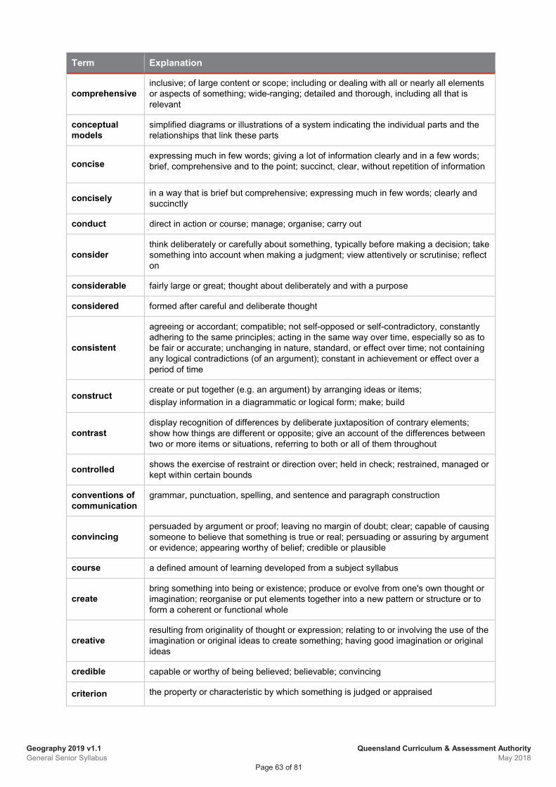
Geography 2019 v1.1 General Senior Syllabus
Queensland Curriculum & Assessment Authority May 2018
Page 63 of 81
Term Explanation
comprehensive inclusive; of large content or scope; including or dealing with all or nearly all elements or aspects of something; wide-ranging; detailed and thorough, including all that is relevant
conceptual models
simplified diagrams or illustrations of a system indicating the individual parts and the relationships that link these parts
concise expressing much in few words; giving a lot of information clearly and in a few words; brief, comprehensive and to the point; succinct, clear, without repetition of information
concisely in a way that is brief but comprehensive; expressing much in few words; clearly and succinctly
conduct direct in action or course; manage; organise; carry out
consider think deliberately or carefully about something, typically before making a decision; take something into account when making a judgment; view attentively or scrutinise; reflect on
considerable fairly large or great; thought about deliberately and with a purpose
considered formed after careful and deliberate thought
consistent
agreeing or accordant; compatible; not self-opposed or self-contradictory, constantly adhering to the same principles; acting in the same way over time, especially so as to be fair or accurate; unchanging in nature, standard, or effect over time; not containing any logical contradictions (of an argument); constant in achievement or effect over a period of time
construct create or put together (e.g. an argument) by arranging ideas or items; display information in a diagrammatic or logical form; make; build
contrast display recognition of differences by deliberate juxtaposition of contrary elements; show how things are different or opposite; give an account of the differences between two or more items or situations, referring to both or all of them throughout
controlled shows the exercise of restraint or direction over; held in check; restrained, managed or kept within certain bounds
conventions of communication
grammar, punctuation, spelling, and sentence and paragraph construction
convincing persuaded by argument or proof; leaving no margin of doubt; clear; capable of causing someone to believe that something is true or real; persuading or assuring by argument or evidence; appearing worthy of belief; credible or plausible
course a defined amount of learning developed from a subject syllabus
create bring something into being or existence; produce or evolve from one's own thought or imagination; reorganise or put elements together into a new pattern or structure or to form a coherent or functional whole
creative resulting from originality of thought or expression; relating to or involving the use of the imagination or original ideas to create something; having good imagination or original ideas
credible capable or worthy of being believed; believable; convincing
criterion the property or characteristic by which something is judged or appraised
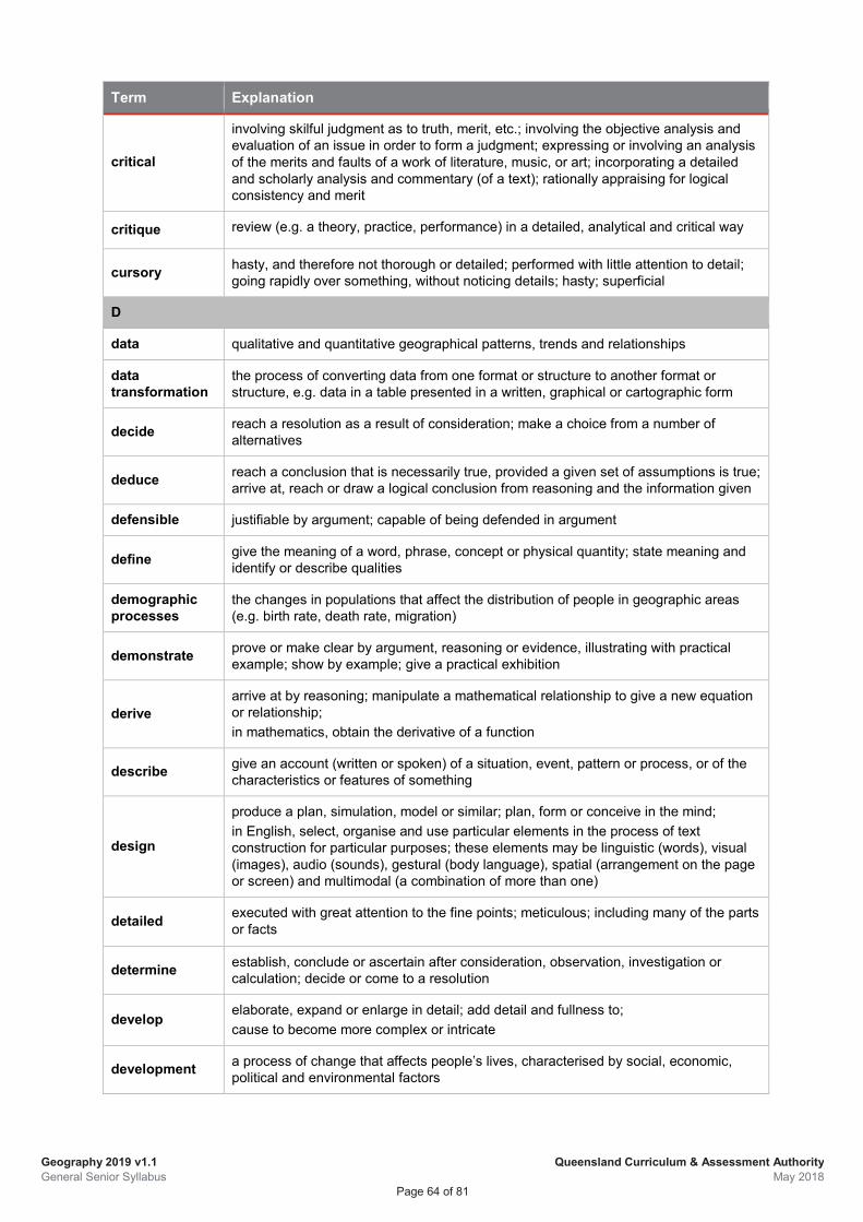
Geography 2019 v1.1 General Senior Syllabus
Queensland Curriculum & Assessment Authority May 2018
Page 64 of 81
Term Explanation
critical
involving skilful judgment as to truth, merit, etc.; involving the objective analysis and evaluation of an issue in order to form a judgment; expressing or involving an analysis of the merits and faults of a work of literature, music, or art; incorporating a detailed and scholarly analysis and commentary (of a text); rationally appraising for logical consistency and merit
critique review (e.g. a theory, practice, performance) in a detailed, analytical and critical way
cursory hasty, and therefore not thorough or detailed; performed with little attention to detail; going rapidly over something, without noticing details; hasty; superficial
D
data qualitative and quantitative geographical patterns, trends and relationships
data transformation
the process of converting data from one format or structure to another format or structure, e.g. data in a table presented in a written, graphical or cartographic form
decide reach a resolution as a result of consideration; make a choice from a number of alternatives
deduce reach a conclusion that is necessarily true, provided a given set of assumptions is true; arrive at, reach or draw a logical conclusion from reasoning and the information given
defensible justifiable by argument; capable of being defended in argument
define give the meaning of a word, phrase, concept or physical quantity; state meaning and identify or describe qualities
demographic processes
the changes in populations that affect the distribution of people in geographic areas (e.g. birth rate, death rate, migration)
demonstrate prove or make clear by argument, reasoning or evidence, illustrating with practical example; show by example; give a practical exhibition
derive arrive at by reasoning; manipulate a mathematical relationship to give a new equation or relationship; in mathematics, obtain the derivative of a function
describe give an account (written or spoken) of a situation, event, pattern or process, or of the characteristics or features of something
design
produce a plan, simulation, model or similar; plan, form or conceive in the mind; in English, select, organise and use particular elements in the process of text construction for particular purposes; these elements may be linguistic (words), visual (images), audio (sounds), gestural (body language), spatial (arrangement on the page or screen) and multimodal (a combination of more than one)
detailed executed with great attention to the fine points; meticulous; including many of the parts or facts
determine establish, conclude or ascertain after consideration, observation, investigation or calculation; decide or come to a resolution
develop elaborate, expand or enlarge in detail; add detail and fullness to; cause to become more complex or intricate
development a process of change that affects people’s lives, characterised by social, economic, political and environmental factors
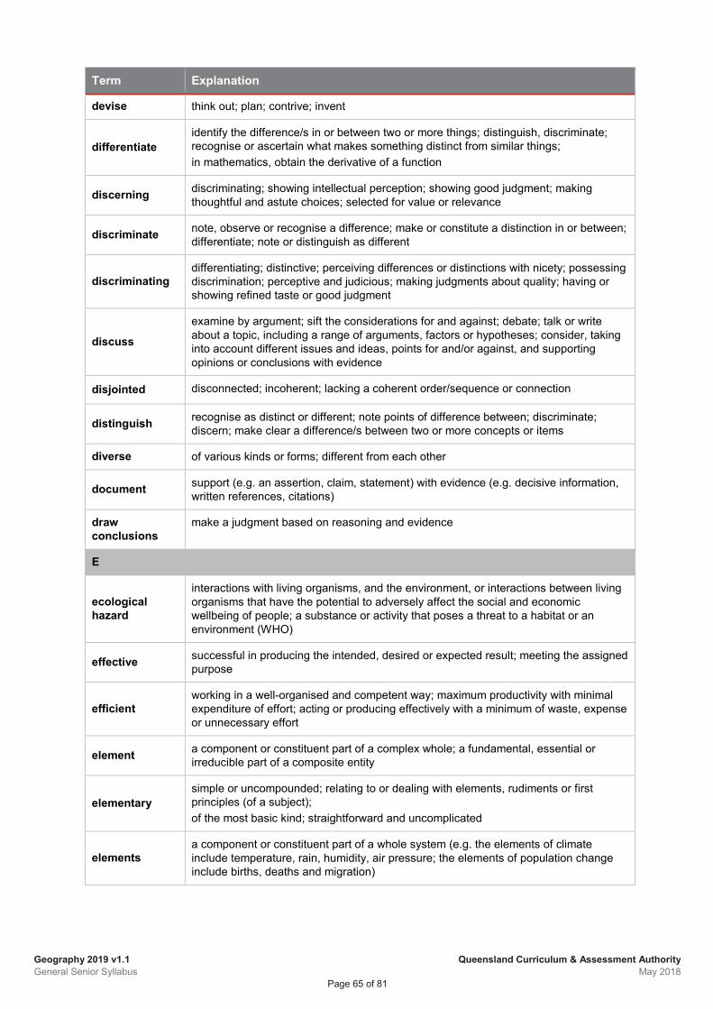
Geography 2019 v1.1 General Senior Syllabus
Queensland Curriculum & Assessment Authority May 2018
Page 65 of 81
Term Explanation
devise think out; plan; contrive; invent
differentiate identify the difference/s in or between two or more things; distinguish, discriminate; recognise or ascertain what makes something distinct from similar things; in mathematics, obtain the derivative of a function
discerning discriminating; showing intellectual perception; showing good judgment; making thoughtful and astute choices; selected for value or relevance
discriminate note, observe or recognise a difference; make or constitute a distinction in or between; differentiate; note or distinguish as different
discriminating differentiating; distinctive; perceiving differences or distinctions with nicety; possessing discrimination; perceptive and judicious; making judgments about quality; having or showing refined taste or good judgment
discuss
examine by argument; sift the considerations for and against; debate; talk or write about a topic, including a range of arguments, factors or hypotheses; consider, taking into account different issues and ideas, points for and/or against, and supporting opinions or conclusions with evidence
disjointed disconnected; incoherent; lacking a coherent order/sequence or connection
distinguish recognise as distinct or different; note points of difference between; discriminate; discern; make clear a difference/s between two or more concepts or items
diverse of various kinds or forms; different from each other
document support (e.g. an assertion, claim, statement) with evidence (e.g. decisive information, written references, citations)
draw conclusions
make a judgment based on reasoning and evidence
E
ecological hazard
interactions with living organisms, and the environment, or interactions between living organisms that have the potential to adversely affect the social and economic wellbeing of people; a substance or activity that poses a threat to a habitat or an environment (WHO)
effective successful in producing the intended, desired or expected result; meeting the assigned purpose
efficient working in a well-organised and competent way; maximum productivity with minimal expenditure of effort; acting or producing effectively with a minimum of waste, expense or unnecessary effort
element a component or constituent part of a complex whole; a fundamental, essential or irreducible part of a composite entity
elementary simple or uncompounded; relating to or dealing with elements, rudiments or first principles (of a subject); of the most basic kind; straightforward and uncomplicated
elements a component or constituent part of a whole system (e.g. the elements of climate include temperature, rain, humidity, air pressure; the elements of population change include births, deaths and migration)
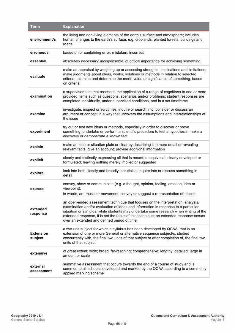
Geography 2019 v1.1 General Senior Syllabus
Queensland Curriculum & Assessment Authority May 2018
Page 66 of 81
Term Explanation
environment/s the living and non-living elements of the earth’s surface and atmosphere; includes human changes to the earth’s surface, e.g. croplands, planted forests, buildings and roads
erroneous based on or containing error; mistaken; incorrect
essential absolutely necessary; indispensable; of critical importance for achieving something
evaluate
make an appraisal by weighing up or assessing strengths, implications and limitations; make judgments about ideas, works, solutions or methods in relation to selected criteria; examine and determine the merit, value or significance of something, based on criteria
examination a supervised test that assesses the application of a range of cognitions to one or more provided items such as questions, scenarios and/or problems; student responses are completed individually, under supervised conditions, and in a set timeframe
examine investigate, inspect or scrutinise; inquire or search into; consider or discuss an argument or concept in a way that uncovers the assumptions and interrelationships of the issue
experiment try out or test new ideas or methods, especially in order to discover or prove something; undertake or perform a scientific procedure to test a hypothesis, make a discovery or demonstrate a known fact
explain make an idea or situation plain or clear by describing it in more detail or revealing relevant facts; give an account; provide additional information
explicit clearly and distinctly expressing all that is meant; unequivocal; clearly developed or formulated; leaving nothing merely implied or suggested
explore look into both closely and broadly; scrutinise; inquire into or discuss something in detail
express convey, show or communicate (e.g. a thought, opinion, feeling, emotion, idea or viewpoint); in words, art, music or movement, convey or suggest a representation of; depict
extended response
an open-ended assessment technique that focuses on the interpretation, analysis, examination and/or evaluation of ideas and information in response to a particular situation or stimulus; while students may undertake some research when writing of the extended response, it is not the focus of this technique; an extended response occurs over an extended and defined period of time
Extension subject
a two-unit subject for which a syllabus has been developed by QCAA, that is an extension of one or more General or alternative sequence subject/s, studied concurrently with, the final two units of that subject or after completion of, the final two units of that subject
extensive of great extent; wide; broad; far-reaching; comprehensive; lengthy; detailed; large in amount or scale
external assessment
summative assessment that occurs towards the end of a course of study and is common to all schools; developed and marked by the QCAA according to a commonly applied marking scheme
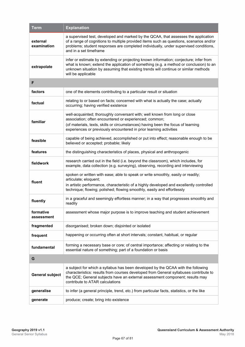
Geography 2019 v1.1 General Senior Syllabus
Queensland Curriculum & Assessment Authority May 2018
Page 67 of 81
Term Explanation
external examination
a supervised test, developed and marked by the QCAA, that assesses the application of a range of cognitions to multiple provided items such as questions, scenarios and/or problems; student responses are completed individually, under supervised conditions, and in a set timeframe
extrapolate infer or estimate by extending or projecting known information; conjecture; infer from what is known; extend the application of something (e.g. a method or conclusion) to an unknown situation by assuming that existing trends will continue or similar methods will be applicable
F
factors one of the elements contributing to a particular result or situation
factual relating to or based on facts; concerned with what is actually the case; actually occurring; having verified existence
familiar
well-acquainted; thoroughly conversant with; well known from long or close association; often encountered or experienced; common; (of materials, texts, skills or circumstances) having been the focus of learning experiences or previously encountered in prior learning activities
feasible capable of being achieved, accomplished or put into effect; reasonable enough to be believed or accepted; probable; likely
features the distinguishing characteristics of places, physical and anthropogenic
fieldwork research carried out in the field (i.e. beyond the classroom), which includes, for example, data collection (e.g. surveying), observing, recording and interviewing
fluent
spoken or written with ease; able to speak or write smoothly, easily or readily; articulate; eloquent; in artistic performance, characteristic of a highly developed and excellently controlled technique; flowing; polished; flowing smoothly, easily and effortlessly
fluently in a graceful and seemingly effortless manner; in a way that progresses smoothly and readily
formative assessment
assessment whose major purpose is to improve teaching and student achievement
fragmented disorganised; broken down; disjointed or isolated
frequent happening or occurring often at short intervals; constant, habitual, or regular
fundamental forming a necessary base or core; of central importance; affecting or relating to the essential nature of something; part of a foundation or basis
G
General subject
a subject for which a syllabus has been developed by the QCAA with the following characteristics: results from courses developed from General syllabuses contribute to the QCE; General subjects have an external assessment component; results may contribute to ATAR calculations
generalise to infer (a general principle, trend, etc.) from particular facts, statistics, or the like
generate produce; create; bring into existence
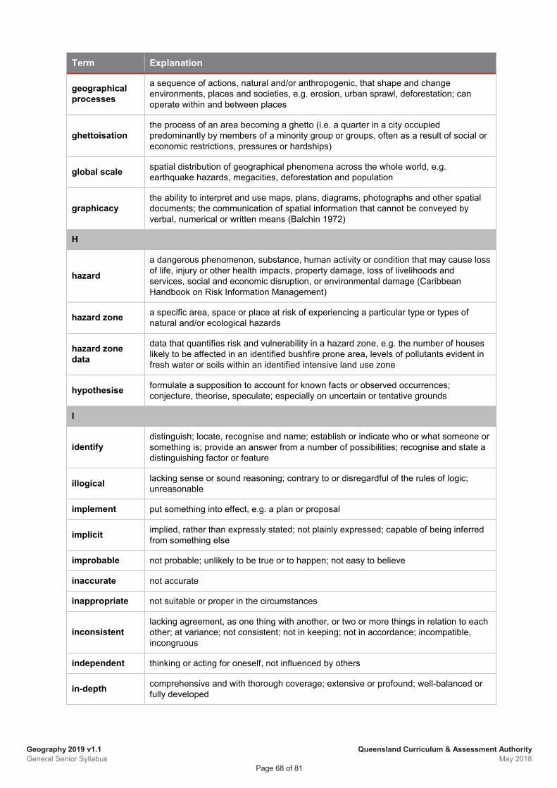
Geography 2019 v1.1 General Senior Syllabus
Queensland Curriculum & Assessment Authority May 2018
Page 68 of 81
Term Explanation
geographical processes
a sequence of actions, natural and/or anthropogenic, that shape and change environments, places and societies, e.g. erosion, urban sprawl, deforestation; can operate within and between places
ghettoisation the process of an area becoming a ghetto (i.e. a quarter in a city occupied predominantly by members of a minority group or groups, often as a result of social or economic restrictions, pressures or hardships)
global scale spatial distribution of geographical phenomena across the whole world, e.g. earthquake hazards, megacities, deforestation and population
graphicacy the ability to interpret and use maps, plans, diagrams, photographs and other spatial documents; the communication of spatial information that cannot be conveyed by verbal, numerical or written means (Balchin 1972)
H
hazard
a dangerous phenomenon, substance, human activity or condition that may cause loss of life, injury or other health impacts, property damage, loss of livelihoods and services, social and economic disruption, or environmental damage (Caribbean Handbook on Risk Information Management)
hazard zone a specific area, space or place at risk of experiencing a particular type or types of natural and/or ecological hazards
hazard zone data
data that quantifies risk and vulnerability in a hazard zone, e.g. the number of houses likely to be affected in an identified bushfire prone area, levels of pollutants evident in fresh water or soils within an identified intensive land use zone
hypothesise formulate a supposition to account for known facts or observed occurrences; conjecture, theorise, speculate; especially on uncertain or tentative grounds
I
identify distinguish; locate, recognise and name; establish or indicate who or what someone or something is; provide an answer from a number of possibilities; recognise and state a distinguishing factor or feature
illogical lacking sense or sound reasoning; contrary to or disregardful of the rules of logic; unreasonable
implement put something into effect, e.g. a plan or proposal
implicit implied, rather than expressly stated; not plainly expressed; capable of being inferred from something else
improbable not probable; unlikely to be true or to happen; not easy to believe
inaccurate not accurate
inappropriate not suitable or proper in the circumstances
inconsistent lacking agreement, as one thing with another, or two or more things in relation to each other; at variance; not consistent; not in keeping; not in accordance; incompatible, incongruous
independent thinking or acting for oneself, not influenced by others
in-depth comprehensive and with thorough coverage; extensive or profound; well-balanced or fully developed
Geography 2019 v1.1 General Senior Syllabus
Queensland Curriculum & Assessment Authority May 2018
Page 69 of 81
Term Explanation
indicator a data element that represents statistical data for a specified time, place, and/or other characteristic, and is corrected for at least one dimension (usually size) to allow for meaningful comparisons
infer derive or conclude something from evidence and reasoning, rather than from explicit statements; listen or read beyond what has been literally expressed; imply or hint at
informed knowledgeable; learned; having relevant knowledge; being conversant with the topic; based on an understanding of the facts of the situation (of a decision or judgment)
innovative new and original; introducing new ideas; original and creative in thinking
insightful showing understanding of a situation or process; understanding relationships in complex situations; informed by observation and deduction
instrument-specific marking guide
ISMG; a tool for marking that describes the characteristics evident in student responses and aligns with the identified objectives for the assessment (see ‘assessment objectives’)
integral
adjective necessary for the completeness of the whole; essential or fundamental; noun in mathematics, the result of integration; an expression from which a given function, equation, or system of equations is derived by differentiation
intended designed; meant; done on purpose; intentional
interconnection the ways that geographical phenomena are connected to each other through complex, reciprocal or interdependent processes
internal assessment
assessments that are developed by schools; summative internal assessments are endorsed by the QCAA before use in schools and results externally confirmed contribute towards a student’s final result
interpret
use knowledge and understanding to recognise trends and draw conclusions from given information; make clear or explicit; elucidate or understand in a particular way; bring out the meaning of, e.g. a dramatic or musical work, by performance or execution; bring out the meaning of an artwork by artistic representation or performance; give one's own interpretation of; identify or draw meaning from, or give meaning to, information presented in various forms, such as words, symbols, pictures or graphs
investigate carry out an examination or formal inquiry in order to establish or obtain facts and reach new conclusions; search, inquire into, interpret and draw conclusions about data and information
investigation
an assessment technique that requires students to research a specific problem, question, issue, design challenge or hypothesis through the collection, analysis and synthesis of primary and/or secondary data; it uses research or investigative practices to assess a range of cognitions in a particular context; an investigation occurs over an extended and defined period of time
irrelevant not relevant; not applicable or pertinent; not connected with or relevant to something
Geography 2019 v1.1 General Senior Syllabus
Queensland Curriculum & Assessment Authority May 2018
Page 70 of 81
Term Explanation
ISMG
instrument-specific marking guide; a tool for marking that describes the characteristics evident in student responses and aligns with the identified objectives for the assessment (see ‘assessment objectives’)
isolated detached, separate, or unconnected with other things; one-off; something set apart or characterised as different in some way
J
judge form an opinion or conclusion about; apply both procedural and deliberative operations to make a determination
justified sound reasons or evidence are provided to support an argument, statement or conclusion
justify give reasons or evidence to support an answer, response or conclusion; show or prove how an argument, statement or conclusion is right or reasonable
L
land cover the vegetation and artificial structures that cover the land’s surface, e.g. trees, grass, crops, wetlands, water, buildings and pavement (Landcover)
land use
purpose for which land is used, based on the functional dimension of land for different human purposes or economic activities (i.e. how people use the land); categories include residential, industrial, recreational, commercial, transport, primary industry, water, medical or natural protected areas (ABS)
learning area a grouping of subjects, with related characteristics, within a broad field of learning, e.g. the Arts, sciences, languages
liveability the sum of the factors that add up to a community's quality of life, including the built and natural environments, economic prosperity, social stability and equity, educational opportunity, and cultural, entertainment and recreation possibilities (livable.org)
local scale a geographically small, bounded area, such as a suburb, a town, a neighbourhood, a specific property or location, e.g. a dump or industrial site, a park, a section of remnant bushland (Tschakert et al. n.d.)
logical
rational and valid; internally consistent; reasonable; reasoning in accordance with the principles/rules of logic or formal argument; characterised by or capable of clear, sound reasoning; (of an action, decision, etc.) expected or sensible under the circumstances
logically according to the rules of logic or formal argument; in a way that shows clear, sound reasoning; in a way that is expected or sensible
M
make decisions select from available options; weigh up positives and negatives of each option and consider all the alternatives to arrive at a position
manipulate adapt or change to suit one's purpose
megacity a metropolitan area with a total population in excess of 10 million people
Geography 2019 v1.1 General Senior Syllabus
Queensland Curriculum & Assessment Authority May 2018
Page 71 of 81
Term Explanation
mental procedures
a domain of knowledge in Marzano’s taxonomy, and acted upon by the cognitive, metacognitive and self-systems; sometimes referred to as ‘procedural knowledge’ there are three distinct phases to the acquisition of mental procedures — the cognitive stage, the associative stage, and the autonomous stage; the two categories of mental procedures are skills (single rules, algorithms and tactics) and processes (macroprocedures)
methodical performed, disposed or acting in a systematic way; orderly; characterised by method or order; performed or carried out systematically
metropolitan
of, relating to, or characteristic of the city or city life; metropolitan areas contain one or more of the following: residential development with a density more than 200 persons per square kilometre; built infrastructure including ports, airports with paved runways, industrial, commercial and retail development, large sports complexes, educational campuses, places of worship, military camps, research stations; local parks and playgrounds; local sports facilities and ovals; vegetation corridors; golf courses; cemeteries; lakes, rivers, riverbanks, creeks and drainage reserves surrounded by development of an urban character; sewerage facilities, waste disposal facilities, hospitals, transport hubs, grain storage (ABS)
migration the movement of groups of people from one place to another; may be internal (i.e. within a country or region) or international (i.e. from one country to another)
minimal least possible; small, the least amount; negligible
mitigation to lessen in force or intensity; to moderate the severity of impacts
model a representation of an idea; an object; a process or a system that is used to describe and explain phenomena; simplified representations of reality that enable predictions to be developed
modify change the form or qualities of; make partial or minor changes to something
multimodal
uses a combination of at least two modes (e.g. spoken, written), delivered at the same time, to communicate ideas and information to a live or virtual audience, for a particular purpose; the selected modes are integrated so that each mode contributes significantly to the response
N
narrow limited in range or scope; lacking breadth of view; limited in amount; barely sufficient or adequate; restricted
natural hazard the threat of a naturally occurring event negatively impacting on humans; when the hazardous threat happens and harms humans, the event becomes a natural disaster; may be primary, secondary or tertiary (Nelson, 2014)
nuanced
showing a subtle difference or distinction in expression, meaning, response, etc.; finely differentiated; characterised by subtle shades of meaning or expression; a subtle distinction, variation or quality; sensibility to, awareness of, or ability to express delicate shadings, as of meaning, feeling, or value
O
objectives see ‘syllabus objectives’, ‘unit objectives’, ‘assessment objectives’
obvious clearly perceptible or evident; easily seen, recognised or understood
Geography 2019 v1.1 General Senior Syllabus
Queensland Curriculum & Assessment Authority May 2018
Page 72 of 81
Term Explanation
optimal best, most favourable, under a particular set of circumstances
organise arrange, order; form as or into a whole consisting of interdependent or coordinated parts, especially for harmonious or united action
organised systematically ordered and arranged; having a formal organisational structure to arrange, coordinate and carry out activities
outstanding exceptionally good; clearly noticeable; prominent; conspicuous; striking
P
partial not total or general; existing only in part; attempted, but incomplete
particular distinguished or different from others or from the ordinary; noteworthy
pattern (geographical)
spatial arrangement of phenomena in which recognisable organisation is evident; the regularity of distribution, e.g. migration settlement patterns, the clustering of particular species in designated areas
perceptive having or showing insight and the ability to perceive or understand; discerning (see also ‘discriminating’)
performance
an assessment technique that requires students to demonstrate a range of cognitive, technical, creative and/or expressive skills and to apply theoretical and conceptual understandings, through the psychomotor domain; it involves student application of identified skills when responding to a task that involves solving a problem, providing a solution or conveying meaning or intent; a performance is developed over an extended and defined period of time
persuasive
capable of changing someone’s ideas, opinions or beliefs; appearing worthy of approval or acceptance; (of an argument or statement) communicating reasonably or credibly (see also ‘convincing’)
perusal time time allocated in an assessment to reading items and tasks and associated assessment materials; no writing is allowed; students may not make notes and may not commence responding to the assessment in the response space/book
place
the world is made up of places, from those with largely natural features, e.g. an area of rainforest, to those with largely constructed features such as the centre of a large city; places are cultural constructs; they are sites of biodiversity, locations for economic activity, centres of decision-making and administration, sites for the transmission and exchange of knowledge and ideas, meeting places for social interaction, sources of identity, belonging and enjoyment, and areas of natural beauty and wonder; the importance of Country/Place to Aboriginal and Torres Strait Islander peoples is an example of the interaction between culture and identity, and shows how places can be invested with spiritual and other significance
planning time time allocated in an assessment to planning how to respond to items and tasks and associated assessment materials; students may make notes but may not commence responding to the assessment in the response space/book; notes made during planning are not collected, nor are they graded or used as evidence of achievement
plausible having an appearance of truth or reason; seemingly worthy of approval or acceptance; seeming reasonable or probable (of an argument or statement); credible and possible
polished flawless or excellent; performed with skilful ease
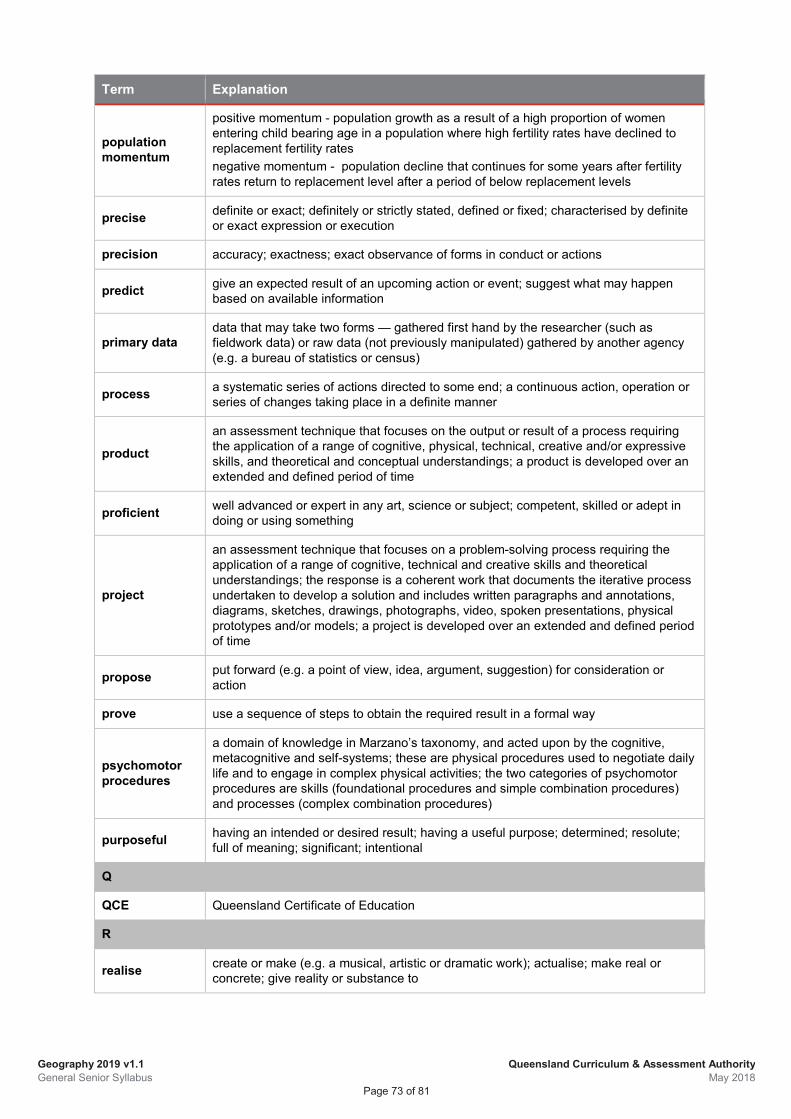
Geography 2019 v1.1 General Senior Syllabus
Queensland Curriculum & Assessment Authority May 2018
Page 73 of 81
Term Explanation
population momentum
positive momentum - population growth as a result of a high proportion of women entering child bearing age in a population where high fertility rates have declined to replacement fertility rates negative momentum - population decline that continues for some years after fertility rates return to replacement level after a period of below replacement levels
precise definite or exact; definitely or strictly stated, defined or fixed; characterised by definite or exact expression or execution
precision accuracy; exactness; exact observance of forms in conduct or actions
predict give an expected result of an upcoming action or event; suggest what may happen based on available information
primary data data that may take two forms — gathered first hand by the researcher (such as fieldwork data) or raw data (not previously manipulated) gathered by another agency (e.g. a bureau of statistics or census)
process a systematic series of actions directed to some end; a continuous action, operation or series of changes taking place in a definite manner
product an assessment technique that focuses on the output or result of a process requiring the application of a range of cognitive, physical, technical, creative and/or expressive skills, and theoretical and conceptual understandings; a product is developed over an extended and defined period of time
proficient well advanced or expert in any art, science or subject; competent, skilled or adept in doing or using something
project
an assessment technique that focuses on a problem-solving process requiring the application of a range of cognitive, technical and creative skills and theoretical understandings; the response is a coherent work that documents the iterative process undertaken to develop a solution and includes written paragraphs and annotations, diagrams, sketches, drawings, photographs, video, spoken presentations, physical prototypes and/or models; a project is developed over an extended and defined period of time
propose put forward (e.g. a point of view, idea, argument, suggestion) for consideration or action
prove use a sequence of steps to obtain the required result in a formal way
psychomotor procedures
a domain of knowledge in Marzano’s taxonomy, and acted upon by the cognitive, metacognitive and self-systems; these are physical procedures used to negotiate daily life and to engage in complex physical activities; the two categories of psychomotor procedures are skills (foundational procedures and simple combination procedures) and processes (complex combination procedures)
purposeful having an intended or desired result; having a useful purpose; determined; resolute; full of meaning; significant; intentional
Q
QCE Queensland Certificate of Education
R
realise create or make (e.g. a musical, artistic or dramatic work); actualise; make real or concrete; give reality or substance to
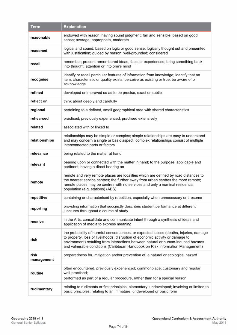
Geography 2019 v1.1 General Senior Syllabus
Queensland Curriculum & Assessment Authority May 2018
Page 74 of 81
Term Explanation
reasonable endowed with reason; having sound judgment; fair and sensible; based on good sense; average; appropriate, moderate
reasoned logical and sound; based on logic or good sense; logically thought out and presented with justification; guided by reason; well-grounded; considered
recall remember; present remembered ideas, facts or experiences; bring something back into thought, attention or into one’s mind
recognise identify or recall particular features of information from knowledge; identify that an item, characteristic or quality exists; perceive as existing or true; be aware of or acknowledge
refined developed or improved so as to be precise, exact or subtle
reflect on think about deeply and carefully
regional pertaining to a defined, small geographical area with shared characteristics
rehearsed practised; previously experienced; practised extensively
related associated with or linked to
relationships relationships may be simple or complex; simple relationships are easy to understand and may concern a single or basic aspect; complex relationships consist of multiple interconnected parts or factors
relevance being related to the matter at hand
relevant bearing upon or connected with the matter in hand; to the purpose; applicable and pertinent; having a direct bearing on
remote remote and very remote places are localities which are defined by road distances to the nearest service centres; the further away from urban centres the more remote; remote places may be centres with no services and only a nominal residential population (e.g. stations) (ABS)
repetitive containing or characterised by repetition, especially when unnecessary or tiresome
reporting providing information that succinctly describes student performance at different junctures throughout a course of study
resolve in the Arts, consolidate and communicate intent through a synthesis of ideas and application of media to express meaning
risk
the probability of harmful consequences, or expected losses (deaths, injuries, damage to property, loss of livelihoods, disruption of economic activity or damage to environment) resulting from interactions between natural or human-induced hazards and vulnerable conditions (Caribbean Handbook on Risk Information Management)
risk management
preparedness for, mitigation and/or prevention of, a natural or ecological hazard
routine often encountered, previously experienced; commonplace; customary and regular; well-practised; performed as part of a regular procedure, rather than for a special reason
rudimentary relating to rudiments or first principles; elementary; undeveloped; involving or limited to basic principles; relating to an immature, undeveloped or basic form
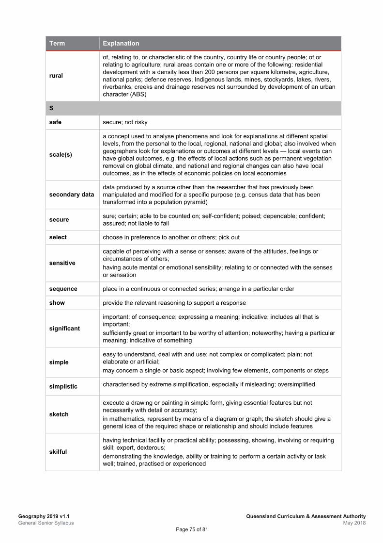
Geography 2019 v1.1 General Senior Syllabus
Queensland Curriculum & Assessment Authority May 2018
Page 75 of 81
Term Explanation
rural
of, relating to, or characteristic of the country, country life or country people; of or relating to agriculture; rural areas contain one or more of the following: residential development with a density less than 200 persons per square kilometre, agriculture, national parks; defence reserves, Indigenous lands, mines, stockyards, lakes, rivers, riverbanks, creeks and drainage reserves not surrounded by development of an urban character (ABS)
S
safe secure; not risky
scale(s)
a concept used to analyse phenomena and look for explanations at different spatial levels, from the personal to the local, regional, national and global; also involved when geographers look for explanations or outcomes at different levels — local events can have global outcomes, e.g. the effects of local actions such as permanent vegetation removal on global climate, and national and regional changes can also have local outcomes, as in the effects of economic policies on local economies
secondary data data produced by a source other than the researcher that has previously been manipulated and modified for a specific purpose (e.g. census data that has been transformed into a population pyramid)
secure sure; certain; able to be counted on; self-confident; poised; dependable; confident; assured; not liable to fail
select choose in preference to another or others; pick out
sensitive
capable of perceiving with a sense or senses; aware of the attitudes, feelings or circumstances of others; having acute mental or emotional sensibility; relating to or connected with the senses or sensation
sequence place in a continuous or connected series; arrange in a particular order
show provide the relevant reasoning to support a response
significant
important; of consequence; expressing a meaning; indicative; includes all that is important; sufficiently great or important to be worthy of attention; noteworthy; having a particular meaning; indicative of something
simple easy to understand, deal with and use; not complex or complicated; plain; not elaborate or artificial; may concern a single or basic aspect; involving few elements, components or steps
simplistic characterised by extreme simplification, especially if misleading; oversimplified
sketch
execute a drawing or painting in simple form, giving essential features but not necessarily with detail or accuracy; in mathematics, represent by means of a diagram or graph; the sketch should give a general idea of the required shape or relationship and should include features
skilful
having technical facility or practical ability; possessing, showing, involving or requiring skill; expert, dexterous; demonstrating the knowledge, ability or training to perform a certain activity or task well; trained, practised or experienced
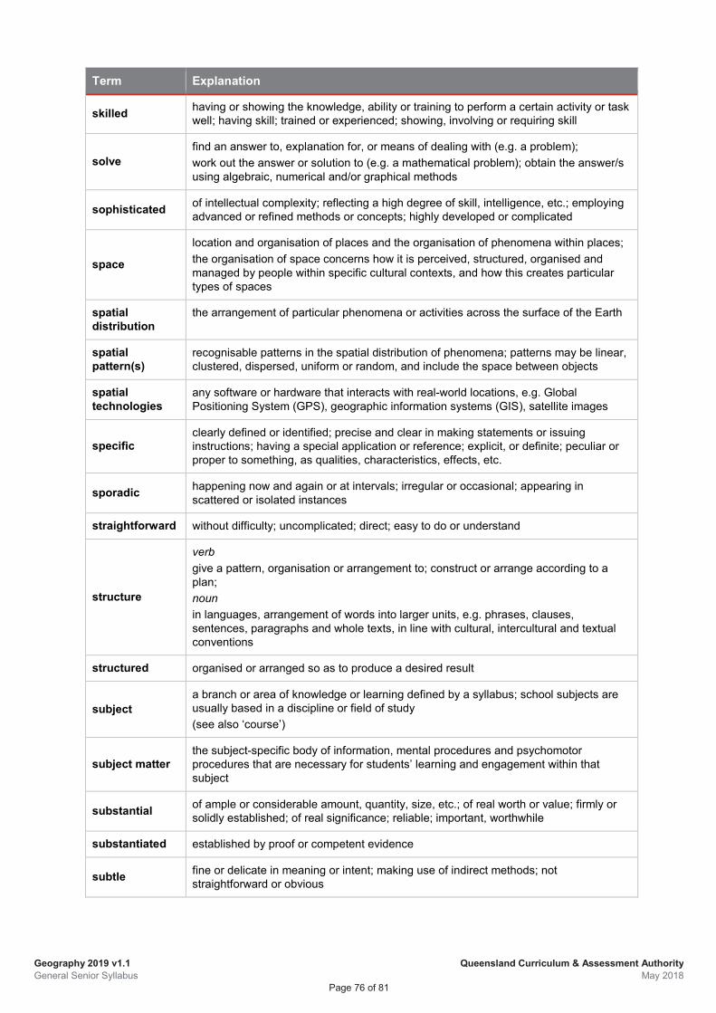
Geography 2019 v1.1 General Senior Syllabus
Queensland Curriculum & Assessment Authority May 2018
Page 76 of 81
Term Explanation
skilled having or showing the knowledge, ability or training to perform a certain activity or task well; having skill; trained or experienced; showing, involving or requiring skill
solve find an answer to, explanation for, or means of dealing with (e.g. a problem); work out the answer or solution to (e.g. a mathematical problem); obtain the answer/s using algebraic, numerical and/or graphical methods
sophisticated of intellectual complexity; reflecting a high degree of skill, intelligence, etc.; employing advanced or refined methods or concepts; highly developed or complicated
space
location and organisation of places and the organisation of phenomena within places; the organisation of space concerns how it is perceived, structured, organised and managed by people within specific cultural contexts, and how this creates particular types of spaces
spatial distribution
the arrangement of particular phenomena or activities across the surface of the Earth
spatial pattern(s)
recognisable patterns in the spatial distribution of phenomena; patterns may be linear, clustered, dispersed, uniform or random, and include the space between objects
spatial technologies
any software or hardware that interacts with real-world locations, e.g. Global Positioning System (GPS), geographic information systems (GIS), satellite images
specific clearly defined or identified; precise and clear in making statements or issuing instructions; having a special application or reference; explicit, or definite; peculiar or proper to something, as qualities, characteristics, effects, etc.
sporadic happening now and again or at intervals; irregular or occasional; appearing in scattered or isolated instances
straightforward without difficulty; uncomplicated; direct; easy to do or understand
structure
verb give a pattern, organisation or arrangement to; construct or arrange according to a plan; noun in languages, arrangement of words into larger units, e.g. phrases, clauses, sentences, paragraphs and whole texts, in line with cultural, intercultural and textual conventions
structured organised or arranged so as to produce a desired result
subject a branch or area of knowledge or learning defined by a syllabus; school subjects are usually based in a discipline or field of study (see also ‘course’)
subject matter the subject-specific body of information, mental procedures and psychomotor procedures that are necessary for students’ learning and engagement within that subject
substantial of ample or considerable amount, quantity, size, etc.; of real worth or value; firmly or solidly established; of real significance; reliable; important, worthwhile
substantiated established by proof or competent evidence
subtle fine or delicate in meaning or intent; making use of indirect methods; not straightforward or obvious
Geography 2019 v1.1 General Senior Syllabus
Queensland Curriculum & Assessment Authority May 2018
Page 77 of 81
Term Explanation
suburbanisation
the outward growth of urban development; a population shift from central urban areas into suburbs that are close enough to the city centre to be accessible by commuters
successful achieving or having achieved success; accomplishing a desired aim or result
succinct expressed in few words; concise; terse; characterised by conciseness or brevity; brief and clear
sufficient enough or adequate for the purpose
suitable appropriate; fitting; conforming or agreeing in nature, condition, or action
summarise give a brief statement of a general theme or major point/s; present ideas and information in fewer words and in sequence
summative assessment
assessment whose major purpose is to indicate student achievement; summative assessments contribute towards a student’s subject result
superficial
concerned with or comprehending only what is on the surface or obvious; shallow; not profound, thorough, deep or complete; existing or occurring at or on the surface; cursory; lacking depth of character or understanding; apparent and sometimes trivial
supported corroborated; given greater credibility by providing evidence
survey a sampling, or partial collection, of facts, figures, quantities used to approximate or indicate what a complete collection might reveal
sustainability meeting the needs of the current generation without compromising the ability of future generations to have their needs met in similar ways; the capacity of Earth to maintain life; requires a healthy environment, economic prosperity and social justice
sustained carried on continuously, without interruption, or without any diminishing of intensity or extent
syllabus a document that prescribes the curriculum for a course of study
syllabus objectives
outline what the school is required to teach and what students have the opportunity to learn; described in terms of actions that operate on the subject matter; the overarching objectives for a course of study (see also ‘unit objectives’, ‘assessment objectives’)
symbolise represent or identify by a symbol or symbols
synthesise combine different parts or elements (e.g. information, ideas, components) into a whole, in order to create new understanding
system an assemblage or combination of things or parts forming a complex or unitary whole; a method or scheme of classification; any set of interrelated parts; can be classified as open, closed or isolated
systematic done or acting according to a fixed plan or system; methodical; organised and logical; having, showing, or involving a system, method, or plan; characterised by system or method; methodical; arranged in, or comprising an ordered system
T
test take measures to check the quality, performance or reliability of something
Geography 2019 v1.1 General Senior Syllabus
Queensland Curriculum & Assessment Authority May 2018
Page 78 of 81
Term Explanation
thorough
carried out through, or applied to the whole of something; carried out completely and carefully; including all that is required; complete with attention to every detail; not superficial or partial; performed or written with care and completeness; taking pains to do something carefully and completely
thoughtful occupied with, or given to thought; contemplative; meditative; reflective; characterised by or manifesting thought
topic a division of, or sub-section within a unit; all topics/sub-topics within a unit are interrelated
trend general direction in which something is developing or changing; a perceived pattern; may be identified and/or measured over the short, intermediate or long term (e.g. pattern of population growth over a defined period of time)
U
unclear not clear or distinct; not easy to understand; obscure
understand perceive what is meant by something; grasp; be familiar with (e.g. an idea); construct meaning from messages, including oral, written and graphic communication
uneven unequal; not properly corresponding or agreeing; irregular; varying; not uniform; not equally balanced
unfamiliar not previously encountered; situations or materials that have not been the focus of prior learning experiences or activities
unit a defined amount of subject matter delivered in a specific context or with a particular focus; it includes unit objectives particular to the unit, subject matter and assessment direction
unit objectives drawn from the syllabus objectives and contextualised for the subject matter and requirements of a particular unit; they are assessed at least once in the unit (see also ‘syllabus objectives’, ‘assessment objectives’)
unrelated having no relationship; unconnected
urban
a built-up and populated area; urban areas contain one or more of the following: residential development with a density over 200 persons per square kilometre; built infrastructure, including ports, airports with paved runways, industrial, commercial and retail development, large sports complexes, educational campuses, places of worship, military camps, research stations; local parks and playgrounds; local sports facilities and ovals; vegetation corridors; golf courses; cemeteries; lakes, rivers, riverbanks, creeks and drainage reserves surrounded by development of an urban character; sewerage facilities, waste disposal facilities, hospitals, transport hubs, grain storage (ABS)
urban renewal the rehabilitation of urban areas, by regeneration, replacement, repair or renovation, in accordance with comprehensive plans
urban sprawl the outer areas of a city, especially where development is considered to have been unplanned and undesirable
urbanisation the increasing percentage or proportion of a population living in urban areas of a country; the term ‘level of urbanisation’ is often used
use operate or put into effect; apply knowledge or rules to put theory into practice
Geography 2019 v1.1 General Senior Syllabus
Queensland Curriculum & Assessment Authority May 2018
Page 79 of 81
Term Explanation
V
vague
not definite in statement or meaning; not explicit or precise; not definitely fixed, determined or known; of uncertain, indefinite or unclear character or meaning; not clear in thought or understanding; couched in general or indefinite terms; not definitely or precisely expressed; deficient in details or particulars; thinking or communicating in an unfocused or imprecise way
valid sound, just or well-founded; authoritative; having a sound basis in logic or fact (of an argument or point); reasonable or cogent; able to be supported; legitimate and defensible; applicable
variety (of scales)
the geographical view of processes and phenomena at different levels on a continuum from the local to the international and global scales; may include comparative studies at the same scale, studying the same issue and phenomenon at a range of scales, or seeking explanations at a different scale from the one being studied
vulnerability the conditions determined by physical, social, economic and environmental factors or processes, which increase the susceptibility of a community to the impact of hazards (Caribbean Handbook on Risk Information Management)
W
wide of great range or scope; embracing a great number or variety of subjects, cases, etc.; of full extent
with expression in words, art, music or movement, conveying or indicating feeling, spirit, character, etc.; a way of expressing or representing something; vivid, effective or persuasive communication
Geography 2019 v1.1 General Senior Syllabus
Queensland Curriculum & Assessment Authority May 2018
Page 80 of 81
7 References Aditomo, A, Goodyear, P, Bliuc, AM & Ellis, R 2013, ‘Inquiry-based learning in higher education:
Principal forms, educational objectives, and disciplinary variations’, Studies in Higher Education, vol. 38, no. 9, pp. 1239–1258, http://dx.doi.org/10.1080/03075079.2011.616584.
Anthropogenic Landscape Ecology 2014, Anthromes, http://ecotope.org/anthromes/. Australian Bureau of Statistics 2017, Remoteness Structure,
http://www.abs.gov.au/websitedbs/d3310114.nsf/home/remoteness+structure Balchin, WGV 1972, ‘Graphicacy’, Geography, Vol. 57. pp. 185–95 Caribbean Handbook on Risk Information Management (CHARIM) n.d, Caribbean Handbook on
Risk Management, http://www.charim.net/ Demeritt, D & Wainwright, J 2005, ‘Models, modelling and geography’ in Castree N, Rogers &
Sherman D (eds), Questioning Geography: Fundamental debates, Wiley-Blackwell, USA Justice, C, Rice, J, Warry, W, Inglis, S, Miller, S & Sammon, S 2007, ‘Inquiry in higher education:
Reflections and directions on course design and teaching methods’, Innovative Higher Education, vol. 31, no. 4, pp. 201–14.
Department of Environment and Heritage Protection 2012, Pictures Worth a Thousand Words: A guide to pictorial concept modelling, Queensland Government, Brisbane
Earth and Space Research 2017, Glossary, https://www.esa.int/Our_Activities/Observing_the_Earth/Reflecting_on_Earth_s_albedo
Kahn, P & O’Rourke, K 2004, ‘Guide to curriculum design: Enquiry-based learning’, Higher Education Academy, https://www.researchgate.net/publication/ 242281830_Guide_to_Curriculum_Design_Enquiry-Based_Learning.
Livability.org 2017, What is Livability?, http://livable.org/livability-resources Marzano, RJ & Kendall, JS 2008, Designing and Assessing Educational Objectives: Applying the
new taxonomy, Corwin Press, USA. Marzano, RJ & Kendall, JS 2007, The New Taxonomy of Educational Objectives, (2nd edn),
Corwin Press, USA. Mason, A 2001, International Encyclopedia of the Social & Behavioral Sciences,
http://geog.ucsb.edu/~montello/pubs/scale2.pdf Masters, G 2016, ‘Five challenges in Australian school education’, Policy Insights Issue 5,
Australian Council for Educational Research (ACER), http://research.acer.edu.au/policyinsights/5.
Nelson, SA 2014. Natural Hazards and Natural Disasters. Tulane University, http://www.tulane.edu/~sanelson/Natural_Disasters/introduction.htm.
Socioeconomic Data and Applications Centre (SEDAC) 2017, Anthropogenic Biomes, NASA, http://sedac.ciesin.columbia.edu/data/collection/anthromes.
Spronken‐Smith, R & Walker, R 2010, ‘Can inquiry‐based learning strengthen the links between teaching and disciplinary research?’ Studies in Higher Education, vol. 35, no. 6, pp. 723–40, www.tandfonline.com/doi/full/10.1080/03075070903315502.
Staver, JR & Bay, M 1987, ‘Analysis of the project synthesis goal cluster orientation and inquiry emphasis of elementary science textbooks’ Journal of Research in Science Teaching, vol. 24, issue 7, pp. 629–43, http://onlinelibrary.wiley.com/doi/10.1002/tea.3660240704/abstract.
Weaver, FS (ed.) 1989, Promoting Inquiry in Undergraduate Learning, New Directions for Teaching and Learning no. 38, Jossey-Bass, San Francisco.
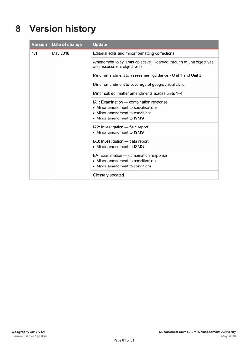
Geography 2019 v1.1 General Senior Syllabus
Queensland Curriculum & Assessment Authority May 2018
Page 81 of 81
8 Version history Version Date of change Update
1.1 May 2018 Editorial edits and minor formatting corrections
Amendment to syllabus objective 1 (carried through to unit objectives and assessment objectives)
Minor amendment to assessment guidance - Unit 1 and Unit 2
Minor amendment to coverage of geographical skills
Minor subject matter amendments across units 1–4
IA1: Examination — combination response • Minor amendment to specifications • Minor amendment to conditions • Minor amendment to ISMG
IA2: Investigation — field report • Minor amendment to ISMG
IA3: Investigation — data report • Minor amendment to ISMG
EA: Examination — combination response • Minor amendment to specifications • Minor amendment to conditions
Glossary updated

ISBN: 978-1-74378-032-9
Geography General Senior Syllabus 2019
© The State of Queensland (Queensland Curriculum & Assessment Authority) 2017
Queensland Curriculum & Assessment Authority PO Box 307 Spring Hill QLD 4004 Australia 154 Melbourne Street, South Brisbane
Phone: (07) 3864 0299 Email: [email protected] Website: www.qcaa.qld.edu.au