Embed Size (px)
Citation preview

Product:
Prepared: August 2018
Geoscape® Data Product Description

Geoscape Product Description
Page i
Standard
This document is based on the AS/NZS ISO 19131:2008 Geographic information – Data product
specifications standard. For more information, refer to www.saiglobal.com/online/.
Disclaimer
PSMA Australia believes this publication to be correct at the time of printing and does not accept
responsibility for any consequences arising from the use of information herein. Readers should rely on
their own skill and judgement to apply information to particular issues.
This work is copyright. Apart from any use as permitted under the Copyright Act 1968, no part may be
reproduced by any process without prior written permission of PSMA Australia Limited.

Geoscape Product Description
Page ii
Contents
1. Overview ......................................................................................................................................... 1
1.1 About PSMA – Delivery Organisation ....................................................................................... 1
1.2 Data Product Specification Title ................................................................................................ 1
1.3 Data Scope ............................................................................................................................... 1
1.4 Reference Date ......................................................................................................................... 1
1.5 Responsible Party ..................................................................................................................... 1
1.6 Language .................................................................................................................................. 1
1.7 Topic Category .......................................................................................................................... 1
1.8 Informal Description of the Data Product .................................................................................. 2
1.9 Distribution Format .................................................................................................................... 2
1.10 Copyright in Geoscape dataset ................................................................................................. 2
1.11 Privacy ...................................................................................................................................... 2
1.12 Definitions, Acronyms and Abbreviations ................................................................................. 3
2. Specification Scope ........................................................................................................................ 5
2.1 Scope Identification – Dataset .................................................................................................. 5
2.2 Scope Identification – Theme ................................................................................................... 5
2.3 Scope Identification – Layer ...................................................................................................... 6
3. Data Product Identification .............................................................................................................. 8
3.1 Title............................................................................................................................................ 8
3.2 Alternate Titles .......................................................................................................................... 8
3.3 Abstract ..................................................................................................................................... 8
3.4 Purpose ..................................................................................................................................... 9
3.5 Topic Category .......................................................................................................................... 9
3.6 Geographic Description ............................................................................................................ 9
4. Data Content and Structure .......................................................................................................... 11
4.1 Feature-Based Data ................................................................................................................ 11
4.2 Feature-Based Application Schema (Data Model) ................................................................. 11
4.3 Data Dictionary ........................................................................................................................ 12
4.4 Feature-Based Content Scope ............................................................................................... 12
5. Reference System ........................................................................................................................ 13
5.1 Spatial Reference System ...................................................................................................... 13
5.2 Temporal Reference System .................................................................................................. 13
5.3 Reference System Scope ....................................................................................................... 13
6. Data Quality .................................................................................................................................. 14
6.1 Positional Accuracy ................................................................................................................. 14

Geoscape Product Description
Page iii
6.2 Thematic Quality ..................................................................................................................... 15
6.3 Logical Consistency ................................................................................................................ 17
6.4 Topological Consistency ......................................................................................................... 17
6.5 Temporal Accuracy ................................................................................................................. 17
6.6 Completeness ......................................................................................................................... 18
6.7 Data Quality Scope ................................................................................................................. 18
7. Data Capture ................................................................................................................................. 19
7.1 Buildings Theme ..................................................................................................................... 20
7.2 Trees Theme ........................................................................................................................... 45
7.3 Surface Cover Theme ............................................................................................................. 46
8. Data Maintenance ......................................................................................................................... 47
8.1 Update Frequency................................................................................................................... 47
8.2 Maintenance Scope ................................................................................................................ 47
8.3 Release Schedule ................................................................................................................... 47
8.4 Maintenance Rules ................................................................................................................. 47
9. Delivery Format ............................................................................................................................. 51
9.1 Components ............................................................................................................................ 51
10. PSMA Partner Network ................................................................................................................. 54
11. PSMA Data ................................................................................................................................... 55
Appendix A – Geoscape Dataset Data Model Diagram ........................................................................ 57
Appendix B – Data Dictionary................................................................................................................ 60
BUILDINGS ....................................................................................................................................... 60
SURFACE COVER ............................................................................................................................ 80
TREES ............................................................................................................................................... 82
Appendix C - Building Address Process Type Examples ...................................................................... 83
Appendix D - Building CAD Process Type Examples ........................................................................... 99
Tables
Table 1: BUILDING ................................................................................................................................ 60
Table 2: BUILDING_ADDRESS ............................................................................................................ 61
Table 3: BUILDING_CAD ...................................................................................................................... 62
Table 4: BUILDING_MESH_BLOCK ..................................................................................................... 63
Table 5: BUILDING_POINT................................................................................................................... 63
Table 6: BUILDING_POLYGON ............................................................................................................ 64
Table 7: BUILDING_PROPERTY .......................................................................................................... 64
Table 8: BUILDING_QUALITY .............................................................................................................. 65
Table 9: BUILDING_ROOF ................................................................................................................... 65
Table 10: BUILDING_ROOF_QUALITY ................................................................................................ 66
Geoscape Product Description
Page iv
Table 11: BUILDING_SWIMMING_POOL ............................................................................................ 67
Table 12: BUILDING_TREE .................................................................................................................. 67
Table 13: BUILDING_ZONE ................................................................................................................. 67
Table 14: ELEVATION .......................................................................................................................... 68
Table 15: ELEVATION_TYPE_AUT ...................................................................................................... 68
Table 16: ELEVATION_TYPE_AUT codes ........................................................................................... 69
Table 17: HEIGHT_ABOVE_GROUND ................................................................................................ 69
Table 18: HEIGHT_TYPE_AUT ............................................................................................................ 69
Table 19: HEIGHT_TYPE_AUT codes .................................................................................................. 70
Table 20: MESH_BLOCK_VERSION_AUT .......................................................................................... 70
Table 21: MESH_BLOCK_VERSION_AUT Codes ............................................................................... 70
Table 22: PROCESS_TYPE_AUT ........................................................................................................ 70
Table 23: PROCESS_TYPE_AUT Codes ............................................................................................. 70
Table 24: QUALITY_CLASS_AUT ........................................................................................................ 73
Table 25: QUALITY_CLASS_AUT codes ............................................................................................. 73
Table 26: QUALITY_INDICATOR_AUT ................................................................................................ 73
Table 27: QUALITY_INDICATOR_AUT Codes..................................................................................... 73
Table 28: ROOF_MATERIAL ................................................................................................................ 74
Table 29: ROOF_MATERIAL_AUT ....................................................................................................... 75
Table 30: ROOF_MATERIAL_AUT Codes ........................................................................................... 75
Table 31: ROOF_TYPE_AUT................................................................................................................ 75
Table 32: ROOF_TYPE_AUT Codes .................................................................................................... 75
Table 33: SOLAR_PANEL_AUT ........................................................................................................... 76
Table 34: SOLAR_PANEL_AUT Codes ................................................................................................ 76
Table 35: SOURCE_AUT ...................................................................................................................... 76
Table 36: SOURCE_AUT Codes .......................................................................................................... 76
Table 37: SWIMMING_POOL ............................................................................................................... 77
Table 38: SWIMMING_POOL_ADDRESS ............................................................................................ 78
Table 39: SWIMMING_POOL_ADJACENT_AUT ................................................................................. 78
Table 40: SWIMMING_POOL_ADJACENT_AUT Codes ..................................................................... 78
Table 41: ZONE_AUT ........................................................................................................................... 79
Table 42: ZONE_AUT Codes ................................................................................................................ 79
Table 43: SURFACE_COVER_TYPE_AUT .......................................................................................... 80
Table 44: SURFACE_COVER_2M_TYPE_AUT Codes ....................................................................... 80
Table 45: SURFACE_COVER_30M_TYPE_AUT Codes ..................................................................... 81
Table 46: TREE_METADATA_AUT ...................................................................................................... 82
Table 47: TREE_METADATA_AUT Codes........................................................................................... 82

Geoscape Product Description
Page 1
1. Overview
1.1 About PSMA – Delivery Organisation
PSMA Australia Limited (PSMA) was formed by the governments of Australia in 1993 to collate,
transform and deliver their geospatial data as national datasets. PSMA’s establishment reflected the
desire of Australian governments to work together to establish a national location information
infrastructure to advance the emerging information economy. The organisation’s first major initiative
was to support the 1996 Census through the provision of Australia’s first digital map at a national
street-level.
The value of PSMA’s datasets is in the richness of the data, which enables a broad range of
innovations and applications. To support the use of this data in business-ready formats, PSMA makes
our data available to the market through a value-added reseller and integrator network. Our network
includes traditional geospatial specialists and data engineers as well as software developers,
marketing service providers, systems integrators and consultancies.
1.2 Data Product Specification Title
Geoscape® Product Description
1.3 Data Scope
Geoscape® is a national digital dataset containing Australia, including some External Territories and
offshore islands (Jervis Bay and Norfolk Island).
The national rollout schedule for Geoscape will continue to be updated on the Geoscape website. In
addition, there will be a Release Report provided with each release which will detail the specific
updates and any issues contained within Geoscape.
1.4 Reference Date
August 2018
1.5 Responsible Party
PSMA Australia Limited
ABN: 23 089 912 710
Level 2, 113 Canberra Avenue, GRIFFITH ACT 2603 Australia
T: +61 2 6260 9000
URL: http://www.psma.com.au
1.6 Language
English.
1.7 Topic Category
Boundaries for buildings and related characteristics within Australia.
Geoscape Product Description
Page 2
1.8 Informal Description of the Data Product
Geoscape is a national digital dataset which represents buildings, surface cover and trees. Once the rollout has been completed, this will include all datasets for each State and Territory in Australia.
Additionally, Geoscape licencing includes access to linkages of other PSMA products, including:
G-NAF®
CADLITE® (Cadastre and Property)
Administrative Boundaries™ (Mesh Blocks and Suburbs/Localities)
Users should note that the listed PSMA products above are not part of Geoscape, and G-NAF and Administrative Boundaries are available through PSMA’s Partner Network or under an open licence from the Commonwealth of Australia at www.data.gov.au
The Mesh Block data is sourced from the Australian Bureau of Statistics (ABS) and is part of their Australian Statistical Geography Standard (ASGS).
Data quality and potential capture timelines will vary across Australia based on three categories, each category has been developed based on a number of factors including the probability of the occurrence of a natural events (e.g. flooding), population distribution and industrial/commercial activities. Areas with a population greater than 200, or with significant industrial/commercial activity in a visual assessment have been defined as ‘Urban’, areas meeting the same criteria however with known cultural or accessibility sensitivities have been defined as ‘Remote Communities’, and all other regions have been defined as ‘Rural Balance’.
The Geoscape Dataset is comprised of 3 themes: Buildings, Trees and Surface Cover.
PSMA welcomes your feedback on the Geoscape Dataset. We also publish regular updates on Geoscape’s development on our PSMA website.
1.9 Distribution Format
This document is available in PDF format. For other formats and use of this document, contact
1.10 Copyright in Geoscape dataset Please see www.psma.com.au/psma-data-copyright-and-disclaimer for the Copyright and Disclaimer
Notice for the Geoscape dataset.
1.11 Privacy
PSMA products and services should not contain any personal names or other personal information.
PSMA undertakes reasonable data cleansing steps as part of its production processes to ensure that
is the case. If you think that personal information may have inadvertently been included in PSMA
products or services, please contact [email protected]
Geoscape Product Description
Page 3
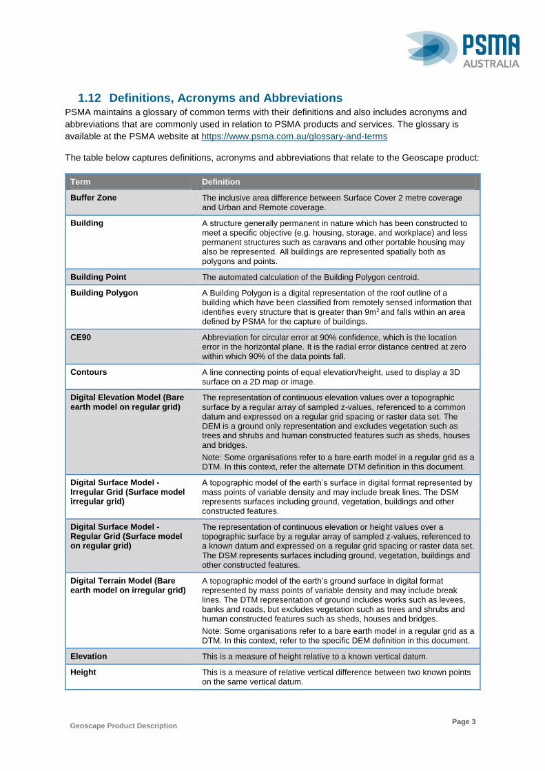
1.12 Definitions, Acronyms and Abbreviations PSMA maintains a glossary of common terms with their definitions and also includes acronyms and
abbreviations that are commonly used in relation to PSMA products and services. The glossary is
available at the PSMA website at https://www.psma.com.au/glossary-and-terms
The table below captures definitions, acronyms and abbreviations that relate to the Geoscape product:
Term Definition
Buffer Zone The inclusive area difference between Surface Cover 2 metre coverage and Urban and Remote coverage.
Building A structure generally permanent in nature which has been constructed to meet a specific objective (e.g. housing, storage, and workplace) and less permanent structures such as caravans and other portable housing may also be represented. All buildings are represented spatially both as polygons and points.
Building Point The automated calculation of the Building Polygon centroid.
Building Polygon A Building Polygon is a digital representation of the roof outline of a building which have been classified from remotely sensed information that identifies every structure that is greater than 9m2 and falls within an area defined by PSMA for the capture of buildings.
CE90 Abbreviation for circular error at 90% confidence, which is the location error in the horizontal plane. It is the radial error distance centred at zero within which 90% of the data points fall.
Contours A line connecting points of equal elevation/height, used to display a 3D surface on a 2D map or image.
Digital Elevation Model (Bare earth model on regular grid)
The representation of continuous elevation values over a topographic surface by a regular array of sampled z-values, referenced to a common datum and expressed on a regular grid spacing or raster data set. The DEM is a ground only representation and excludes vegetation such as trees and shrubs and human constructed features such as sheds, houses and bridges.
Note: Some organisations refer to a bare earth model in a regular grid as a DTM. In this context, refer the alternate DTM definition in this document.
Digital Surface Model - Irregular Grid (Surface model irregular grid)
A topographic model of the earth’s surface in digital format represented by mass points of variable density and may include break lines. The DSM represents surfaces including ground, vegetation, buildings and other constructed features.
Digital Surface Model - Regular Grid (Surface model on regular grid)
The representation of continuous elevation or height values over a topographic surface by a regular array of sampled z-values, referenced to a known datum and expressed on a regular grid spacing or raster data set. The DSM represents surfaces including ground, vegetation, buildings and other constructed features.
Digital Terrain Model (Bare earth model on irregular grid)
A topographic model of the earth’s ground surface in digital format represented by mass points of variable density and may include break lines. The DTM representation of ground includes works such as levees, banks and roads, but excludes vegetation such as trees and shrubs and human constructed features such as sheds, houses and bridges.
Note: Some organisations refer to a bare earth model in a regular grid as a DTM. In this context, refer to the specific DEM definition in this document.
Elevation This is a measure of height relative to a known vertical datum.
Height This is a measure of relative vertical difference between two known points on the same vertical datum.
Geoscape Product Description
Page 4
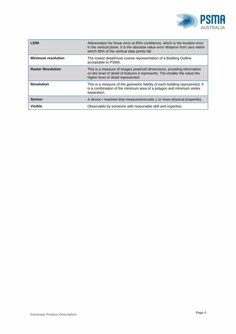
LE90 Abbreviation for linear error at 90% confidence, which is the location error in the vertical plane. It is the absolute value error distance from zero within which 90% of the vertical data points fall.
Minimum resolution The lowest detail/most coarse representation of a Building Outline acceptable to PSMA.
Raster Resolution This is a measure of images pixel/cell dimensions, providing information on the level of detail of features it represents. The smaller the value the higher level of detail represented.
Resolution This is a measure of the geometric fidelity of each building represented. It is a combination of the minimum area of a polygon and minimum vertex separation.
Sensor A device / machine that measures/records 1 or more physical properties.
Visible Observable by someone with reasonable skill and expertise.
Geoscape Product Description
Page 5
2. Specification Scope
The Geoscape Dataset is separated into three themes and one of these themes is divided into layers.
Each theme and layer (within the theme) has a defined extent and scope.
NB: The national rollout schedule for Geoscape identifies what State and Territory data will be
included in each release and also available at https://www.geoscape.com.au/rollout/
2.1 Scope Identification – Dataset
Geoscape (refer to Release documentation for specifics of each release)
Level
Dataset
Level Name
Geoscape
Extent
Spatial coverage of Australia’s land mass including some External Territories (Jervis Bay and Norfolk
Island). The dataset has areas classified within the boundaries of the national geography of Australia
(AUS) that meet certain criteria based on the occurrence of natural events (e.g. flooding), population
distribution and industrial/commercial activities. The classifications are “Urban”, “Rural Balance” and
‘Remote Communities” and data captured varies based on these three classifications.
2.2 Scope Identification – Theme
Geoscape themes
Level
Theme
Level Name
Buildings,
Surface Cover, and
Trees.
Extent
Spatial coverage of Australia’s land mass including some External Territories (Jervis Bay and Norfolk
Island). The dataset has areas classified within the boundaries of the national geography of Australia
(AUS) that meet certain criteria based on the occurrence of natural events (e.g. flooding), population
distribution and industrial/commercial activities. The classifications are “Urban”, “Rural Balance” and
‘Remote Communities”. Data captured varies based on these three classifications and also the three
themes.
Geoscape Product Description
Page 6
2.3 Scope Identification – Layer
Layers within the Geoscape Themes
Level
Layers within one of the themes
Level Name
Buildings
Extent
Spatial coverage of Australia’s land mass including some External Territories (Jervis Bay and Norfolk
Island). The dataset has areas classified within the boundaries of the national geography of Australia
(AUS) that meet certain criteria based on the occurrence of natural events (e.g. flooding), population
distribution and industrial/commercial activities. The classifications are “Urban”, “Rural Balance” and
‘Remote Communities”. Data captured varies based on these three classifications and also the two
layers.
Level
Layers within one of the themes
Level Name
• Surface Cover 2 Metres, and
• Surface Cover 30 Metres.
Extent
Spatial coverage of Australia’s land mass including some External Territories (Jervis Bay and Norfolk
Island). The dataset has areas classified within the boundaries of the national geography of Australia
(AUS) that meet certain criteria based on the occurrence of natural events (e.g. flooding), population
distribution and industrial/commercial activities. The classifications are “Urban”, “Rural Balance” and
‘Remote Communities”. Data captured varies based on these three classifications and also the two
layers.

Geoscape Product Description
Page 7
Level
Layers within one of the themes
Level Name
• Trees , and
• Trees Metadata.
Extent
Spatial coverage of Australia’s land mass including some External Territories (Jervis Bay and Norfolk
Island). The dataset has areas classified within the boundaries of the national geography of Australia
(AUS) that meet certain criteria based on the occurrence of natural events (e.g. flooding), population
distribution and industrial/commercial activities. The classifications are “Urban”, “Rural Balance” and
‘Remote Communities”. Data captured varies based on these three classifications and also the two
layers.

Geoscape Product Description
Page 8
3. Data Product Identification
3.1 Title
Geoscape
3.2 Alternate Titles
Geoscape for Australia
3.3 Abstract
Geoscape is a suite of digital datasets which represent buildings, surface cover, trees, and has links to
other PSMA products: G-NAF addresses, Cadastre and Property, Suburb/Locality and Mesh Blocks.
Data quality and potential capture timelines will vary across Australia based on three categories, each
category has been developed based on a number of factors including the probability of the occurrence
of a natural events (e.g. flooding), population distribution and industrial/commercial activities.
Areas with a population greater than 200, or with significant industrial/commercial activity in a visual
assessment have been defined as ‘Urban’, areas meeting the same criteria however with known
cultural or accessibility sensitivities have been defined as ‘Remote Communities’, and all other regions
have been defined as ‘Rural Balance’.
Figure 1. An illustration depicting characteristics captured in Geoscape.
Geoscape includes the spatial coverage of Australia’s buildings using remotely sensed information. A
building is a digital representation of the roof outline of buildings which have been classified from
remotely sensed information using a combination of automated and manual processes to extract and
orthogonalise building roof outline and identifies every structure greater than 9m2. These processes
Geoscape Product Description
Page 9
use electromagnetic radiation reflectance in the red, green and blue bands (visible bands) to classify
pixels based on known patterns of signal combinations from various building roof materials.
The Trees dataset is a digital representation of areas which are classified using remotely sensed
information as ‘trees’, generally using additional spectral bands. Where information is classified as
trees, various digital surface model and digital elevation model sources have been used to derive each
cell values height.
Surface Cover is a digital representation of the location of different types of surface cover which have
been classified from satellite imagery. This theme contains two variations; one a high resolution
dataset representing surface cover within urban areas, the other a national 30m resolution dataset
representing surface coverage nationally.
The Geoscape Dataset is comprised of three themes and one of the Themes has Layers as listed:
Buildings Theme
Surface Cover Theme
Surface Cover 2 Metres Layer
Surface Cover 30 Metres Layer
Trees Theme
Trees
Trees Metadata
3.4 Purpose
The purpose of the Geoscape national dataset is to spatially represent building and related features
for the use by industry and government in digital applications / systems.
3.5 Topic Category
Vector and raster spatial data defined by coordinates (latitude and longitude) with associated textual
metadata.
3.6 Geographic Description
The Geoscape dataset covers the boundaries within the complete national geography of Australia
(AUS). The dataset has classified areas within these boundaries that meet certain criteria based on
the occurrence of natural events (e.g. flooding), population distribution and industrial/commercial
activities. The classifications are “Urban”, “Rural Balance” and ‘Remote Communities” and data
captured varies based these three classifications. The Bounding Box for this data is as follows:
North bounding latitude: -8˚
South bounding latitude: -45˚
East bounding longitude: 168˚
West bounding longitude: 96˚
The area covers the land masses of Australia, including External Territories and offshore islands.
PSMA is planning for Geoscape to include data for Jervis Bay, the other territories of Christmas
Island, Cocos (Keeling) Islands and Norfolk Island will be considered at a later time based on market
demand.
The spatial domain is described by the polygon in Figure 2.

Geoscape Product Description
Page 10
Figure 2. A visual representation of the bounding box for Geoscape.
Note: Each release will contain a section of the national spatial domain and will progressively increase
with each release until full national spatial coverage is achieved. Refer to the Release documentation
for specifics of the spatial domains contained within each release.
Geographic Extent Name
AUSTRALIA INCLUDING EXTERNAL TERRITORIES – AUS – Australia – Australia
The States and Territories within Australia are represented by the following:
State or Territory Name Abbreviation Character Code
New South Wales NSW 1 (or 01)
Victoria VIC 2 (or 02)
Queensland QLD 3 (or 03)
South Australia SA 4 (or 04)
West Australia WA 5 (or 05)
Tasmania TAS 6 (or 06)
Northern Territory NT 7 (or 07)
Australian Capital Territory ACT 8 (or 08)
Other Territories OT 9 (or 09)
Note: PSMA has adopted Australian Bureau of Statistics (ABS) definition of Other Territories (OT). It
includes the Territory of Christmas Island, Territory of Cocos (Keeling) Islands, Jervis Bay Territory
and more recently the inclusion of Norfolk Island. OT does not include any other external Territory.
However, unique to the Geoscape product, the raster data for Jervis Bay Territory is included with
NSW, and ACT is combined with NSW.

Geoscape Product Description
Page 11
4. Data Content and Structure
The Geoscape Dataset is a feature-based product. A data model is included (Appendix A) with an
associated data dictionary (Appendix B).
4.1 Feature-Based Data
The feature type is a spatial polygon or raster representation for the various Geoscape Dataset
features. The table below outlines the features and their integration into related datasets.
Entity Description Integration Rules
Building A building feature will have one or more spatial representations. Polygon representations define the building’s boundary as observed from an elevated perspective. Point representations are based on the centroid calculated from the polygon.
A building’s representation has:
0 to many related G-NAF Address records
0 to many CAD related records
0 to many Property related records
0 to one Suburb/Locality record
0 to many related Mesh Blocks
0 to one State/Territory record
0 to many related Zoning records
0 to many Swimming Pool records
Trees An area classified as ‘trees’ will have raster cells defining the boundary
No special rules
Surface Cover
Each surface cover classification area will have raster cells.
Building polygon representations are used to define the building class in the 2m surface cover. Where the building polygon representation intersects the majority of a pixel the building classification supersedes any existing pixel classification with the exception of the trees classification.
4.2 Feature-Based Application Schema (Data Model)
The Geoscape Dataset Data Model Diagram is set out in Appendix A.
Geoscape Product Description
Page 12
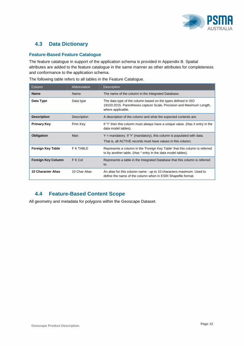
4.3 Data Dictionary
Feature-Based Feature Catalogue
The feature catalogue in support of the application schema is provided in Appendix B. Spatial
attributes are added to the feature catalogue in the same manner as other attributes for completeness
and conformance to the application schema.
The following table refers to all tables in the Feature Catalogue.
Column Abbreviation Description
Name Name The name of the column in the Integrated Database.
Data Type Data type The data type of the column based on the types defined in ISO
19103:2015. Parentheses capture Scale, Precision and Maximum Length,
where applicable.
Description Description A description of the column and what the expected contents are.
Primary Key Prim Key If 'Y' then this column must always have a unique value. (Has # entry in the
data model tables).
Obligation Man Y = mandatory. If 'Y' (mandatory), this column is populated with data.
That is, all ACTIVE records must have values in this column.
Foreign Key Table F K TABLE Represents a column in the 'Foreign Key Table' that this column is referred
to by another table. (Has * entry in the data model tables).
Foreign Key Column F K Col Represents a table in the Integrated Database that this column is referred
to.
10 Character Alias 10 Char Alias An alias for this column name - up to 10 characters maximum. Used to
define the name of the column when in ESRI Shapefile format.
4.4 Feature-Based Content Scope
All geometry and metadata for polygons within the Geoscape Dataset.
Geoscape Product Description
Page 13
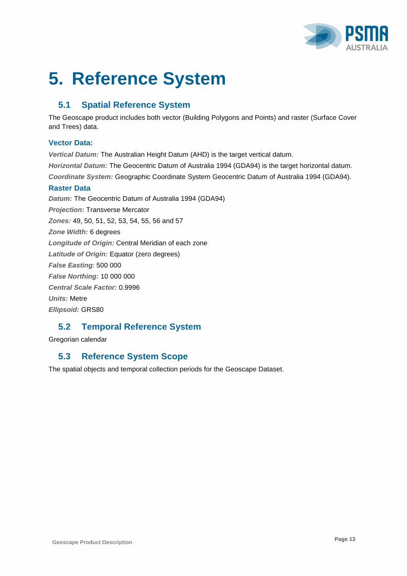
5. Reference System
5.1 Spatial Reference System
The Geoscape product includes both vector (Building Polygons and Points) and raster (Surface Cover
and Trees) data.
Vector Data:
Vertical Datum: The Australian Height Datum (AHD) is the target vertical datum.
Horizontal Datum: The Geocentric Datum of Australia 1994 (GDA94) is the target horizontal datum.
Coordinate System: Geographic Coordinate System Geocentric Datum of Australia 1994 (GDA94).
Raster Data
Datum: The Geocentric Datum of Australia 1994 (GDA94)
Projection: Transverse Mercator
Zones: 49, 50, 51, 52, 53, 54, 55, 56 and 57
Zone Width: 6 degrees
Longitude of Origin: Central Meridian of each zone
Latitude of Origin: Equator (zero degrees)
False Easting: 500 000
False Northing: 10 000 000
Central Scale Factor: 0.9996
Units: Metre
Ellipsoid: GRS80
5.2 Temporal Reference System
Gregorian calendar
5.3 Reference System Scope
The spatial objects and temporal collection periods for the Geoscape Dataset.

Geoscape Product Description
Page 14
6. Data Quality
6.1 Positional Accuracy
Positional accuracy is an assessment of the closeness of the location of the spatial objects in relation
to their true positions on the earth’s surface. Positional accuracy consists 2 assessments:
Horizontal accuracy assessment, and
Vertical accuracy assessment.
Horizontal Accuracy
The horizontal positional accuracy of Geoscape data differs in areas classified as urban/remote
communities and rural banace as this reflects the positional accuracy of remote sensors utilised in
data collection, and the reliability of feature classification and associated orthogonalisation processes.
Building feature extraction in urban areas was completed across satellite imagery resampled to 50cm
resolution. The horizontal positional accuracy of source imagery varies across collected strips. The
horizontal positional accuracy of imagery used for the extraction of features ranges from +/-0.5m
CE90, to +/-2.5m CE90.
Building feature extraction in rural areas was completed across satellite imagery with source sensor
resolutions of ~0.5m and ~0.6m. The horizontal positional accuracy of rural buildings is known to be
less than 10.9m CE90 and has been measured across various rural locations with CE90 accuracy
between 1.8m and 7m.
The positional accuracy of the vertices of unobstructed building features will reflect the accuracy of the
source imagery from which it is extracted. Obstructed vertices will have their position estimated with
building shapes orthogonalised using specialised algorithms with some operator assistance.
The 2m surface cover was classified from satellite imagery at a 2m grid spacing. The horizontal
positional accuracy of source imagery varies across collected strips. The horizontal positional
accuracy of imagery used for the classification of surface cover pixels ranges from +/-0.5m CE90, to
+/-2.5m CE90. The positional accuracy of the 2m surface cover pixels will reflect the accuracy of the
source imagery from which it was classified as well as the classification process.
The trees dataset is derived from the 2m surface cover and inherits the horizontal positional accuracy
of the 2m surface cover dataset.
The 30m surface cover was classified from satellite imagery at a 30m grid spacing owing to the
resolution of source sensors active in the imagery collection. The horizontal positional accuracy of
source imagery used for the classification of surface cover pixels is +/-12m CE90. The positional
accuracy of the 30m surface cover pixels will reflect the accuracy of the source imagery from which it
was classified as well as the classification process.
Vertical Accuracy
Source elevation data used for the derivation of building height attributes is a 0.5m resolution DSM
derived from high resolution satellite imagery. Absolute spatial accuracy of the DSM is +/-2m LE90, +/-
2m CE90 with relative accuracies of +/-1m LE90, +/-1m CE90.
To determine building heights an elevation mask is applied to the building polygon to exclude tree
heights. The resultant polygon is then intersected with the DSM to attribute the minimum ground
surface, eave, and maximum roof elevations. Differences between these elevations are calculated and
attributed as heights to the building polygons.

Geoscape Product Description
Page 15
The attributed centroid elevation, and the elevation assigned to the building polygon vertices is
calculated by intersecting the centroid and the vertices of a building with the relevant corresponding
intersecting DEM, with the specific DEM recorded in the ground elevation source code attribute.
To determine tree heights the maximum intersecting DSM elevation is attributed to each tree pixel and
elevations are converted to heights by taking the difference between the maximum elevation and the
corresponding ground pixel value from a DEM derived from the DSM.
Multiple factors can impact the quality of the assigned elevation or height, these include but are not
limited to:
Age of source imagery: Where any imagery used within the production of the DSM is older
than the date of construction of a building then the heights attributed to that building are likely
to be erroneous.
Correct classification of the feature: Where a tree or building is not correctly defined (i.e.
the highest point is not within the representation) then the height assigned to the feature has
an increased likelihood of being erroneous.
Omission of feature: Where a building or tree is not captured it cannot be assigned a height.
Obscured building: Where a building is obscured by a tree or other feature then there is an
increased likelihood of erroneous height values being assigned despite processes being run to
limit this impact.
Tree coverage surrounding a building: Where a building is surrounded by trees then the
algorithm to calculate the roof height may struggle to obtain a representative ground elevation
value. In these circumstances there is an increased likelihood of an erroneous height
assignment.
Off nadir angle of source imagery: Where imagery used for the classification of buildings is
off nadir then the side of a building may be represented within the boundary of the footprint.
Intersecting this part of the building against the DSM will return lower elevation values than
those expected for the roof of the building. Where this occurs there is an increased likelihood
of an erroneous value being assigned to the eave height. The likelihood and impact of this
issue is increased relative to the height of a building.
6.2 Thematic Quality
Thematic accuracy is defined as the accuracy of quantitative attributes and the correctness of non-
quantitative attributes and of the classification of features and their relationships.
Classification Correctness
Classification correctness is an assessment of the reliability of values assigned to features in the
dataset in relation to their true ‘real world’ values.
Building
The Has Solar Panel attribute is classified using a combination of crowd sourcing and machine
learning techniques. The rate of classification correctness of the solar panel attribute has been
measured at above 90% where a photo voltaic solar panel is visible within the source imagery. Where
a photo voltaic solar panel is not visible in the source imagery it is expected that the rate of
classification correctness (in the negative) is greater than 95%. Other types of solar panels (e.g. solar
hot water) may be captured, however, classification rates for these solar panels is known to be lower.
Building Roof/Roof Material
The Primary Roof Material Code & Roof Material Code attributes are spectrally classified from a
combination of short wave infrared (SWIR) and visible and near infrared (VNIR) imagery bands. The
Geoscape Product Description
Page 16
pixel size of SWIR imagery used in the classification of the Roof Material Code attribute is 3.7m.
Pixels that intersect the boundary of a building polygon may return values from ground surfaces or
neighbouring buildings impacting the results obtained. Business rules have been introduced to
mitigate this effect ensuring that all materials attributed to a building are represented by a minimum
number of intersecting SWIR pixels which additionally compose at least 10% of the total roof area of
the building polygon.
The rate of classification correctness of the Roof Material Code attribute has been measured in
excess of 80% across suburban residential areas. Commercial, industrial, and higher density
residential areas are known to have lower classification correctness of the Roof Material Code.
The Roof Type Code attribute is classified by assessing the standard deviation of the elevation
values intersecting the building polygon once the vegetation mask has been applied. Characteristics of
a building that can impact the classification correctness of the roof shape include but are not limited to:
Roof furniture e.g. plant rooms, steeples, aerials.
Buildings that have a larger footprint than roof area.
Multiple buildings represented as a single building due to proximity.
Height of building.
Overhanging trees.
The rate of classification correctness of the Building Roof Type has been measured at above 90% on
unobstructed buildings.
Swimming Pool Address
The identification of a Swimming Pool at an Address is classified using a combination of crowd
sourcing, and machine learning techniques. Swimming pools are identified against a PSMA Property
Polygon and joined to matching addresses using a series of business rules. The rate of classification
correctness of a swimming pool at an address has been measured at above 85% where a swimming
pool is present. Where a swimming pool is not present at an address the rate of classification
correctness is greater than 95%.
Where the property polygons are not available, “approved” CAD parcels have been used, then in a
small number of cases “proposed” CAD parcels have been used to identify the swimming pool ‘search’
extent. There are a small number of remote communities, regional community areas (‘Urban’ outback
areas) and settlements on the edges of urban boundaries that are contained within significantly large
property polygon/s (greater than 1km). Addresses and Buildings in these areas will not have a
relationship to any swimming pools and therefore the buildings within these areas will have a
‘HAS_SWIMMING_POOL_ADJACENT’ flag of ‘0’ (Unknown).
Surface Cover, Trees
The 2m Surface Cover raster dataset and associated Trees raster is classified from visible and near
infrared (VNIR) imagery bands. The rate of classification correctness of the 2m Surface Cover has
been measured at above 90%.
The 30m Surface Cover raster dataset is classified from Landsat imagery. The rate of classification
correctness of the 30m Surface Cover has been measured at above 85%.
Zoning
The Zone Code attribute is classified by mapping state, territory or local government planning scheme
information against high-level generalised national zoning codes developed by PSMA Australia (see
table 41). The mapping of the planning schemes to the national zoning codes is a generalised process
and is not based on a detailed examination of each scheme. The classification does not take into

Geoscape Product Description
Page 17
consideration standard planning overlays, multi-zoned areas or amendments which may be made to
planning schemes from time to time which may not be reflected in the base zoning datasets.
The generalised national zoning codes try to reflect the general intention of the individual planning
schemes. However, they do not reflect differences in planning legislation or its interpretation by state,
territory and local government planning authorities.
The Zone Code attribute gives only a general indication of the planning zone for a building and should
not be treated as authoritative. It is therefore not suitable for purposes such as planning and
development decision making. Users should contact the relevant state, territory or local government
planning authority for authoritative planning scheme information.
The source of data for the allocation of zones to buildings has large areas where no zoning
information exists. This is in predominately rural areas for the state/territory of NT, WA and North West
NSW. As a result there will be no BUILDING_ZONE features for these areas.
6.3 Logical Consistency
Logical consistency is a measure of the degree to which data complies with the technical specification.
The test procedures are a mixture of software scripts and onscreen, visual checks.
The data structure has been tested for conformance with the data model. The following have been
tested and confirmed to conform:
File names
Attribute names
Attribute lengths
Attribute types
Attribute domains
Attribute order in file
Object type
Compulsory attributes populated
6.4 Topological Consistency
Topological consistency is the measure of how features spatially relate to other features within and
across themes. Topological inconsistencies are identified using a combination of automated rules, and
visual analysis. Where topological inconsistencies are identified they are notified back to the supplier
organisation for remediation at source. Some minor topological inconsistencies are corrected during
product processing using automated rules. The level of topological consistency is dependent on the
data supplied to PSMA.
Where topological inconsistencies exist they are identified within the product through the population of
the BUILDING_QUALITY Quality Indicator Code attribute.
6.5 Temporal Accuracy
Temporal accuracy is an assessment of both temporal consistency (how well ordered lifecycle events
are) and temporal validity (validity of data with respect to time).
Building polygons are attributed with the capture date of the imagery from which the outline has been
captured.

Geoscape Product Description
Page 18
6.6 Completeness
Completeness is an assessment of the extent and range of the dataset with regard to completeness of
coverage, completeness of classification and completeness of verification. Components that make up
Geoscape include:
Dataset, Theme, and Layer Coverage
For the Geoscape Dataset the coverage will be 100% complete across the areas captured to date.
The Geoscape product contains a complete population of Geoscape layers.
Attribute Completeness
All layers within the Geoscape Dataset area have a full population of attributes.
Feature Completeness
Building features are considered to have an omission rate below 3% in urban areas, with the majority
of omission being smaller buildings such as garden sheds. In rural areas buildings with an area of less
than 100m2 are considered to have an omission rate of less than 10%, whereas rural buildings with an
area of greater than 100m2 are considered to have an omission rate below 3%.
Trees are defined where they have been classified in the 2m Surface Cover as Trees and the
difference between the DSM and DTM is greater than 2m in these locations. Therefore the omission
rate of Trees is directly related to the classification correctness of the 2m Surface Cover and the
vertical accuracies of the DSM and DTM.
6.7 Data Quality Scope
All spatial and aspatial features including their attributes in the current time period for the Geoscape
Dataset.

Geoscape Product Description
Page 19
7. Data Capture
Attribution, data quality and potential capture timelines will vary across Australia based on three categories, each category has been developed based on a number of factors including the probability of the occurrence of a natural events (e.g. flooding), population distribution and industrial/commercial activities. Areas with a population greater than 200, or with significant industrial/commercial activity in a visual assessment have been defined as ‘Urban’, areas meeting the same criteria however with known cultural or accessibility sensitivities have been defined as ‘Remote Communities’, and all other regions have been defined as ‘Rural Balance’.
The age of source imagery used for Geoscape also varies across each of the categories to enable national Geoscape coverage. ‘Urban’ areas have been captured with as recent as possible source imagery, where possible within 18 months of the building creation date. ‘Rural Balance’ age of capture can fluctuate more and in worst case scenarios could be around 5-10 years old, the image below was provided to us from our supplier identifying the potential age of source imagery used for building capture in the ‘Rural Balance’ category.
Overarching data attributes available across the three classifications are provided in the table below:
Class / Attribute Area Category
Urban Rural Balance Remote
Communities Building Attributes
Address count Y Y Y
Building centroid (point) Y Y Y
Building outline (polygon) Y Y Y
Eave height Y N Y
Ground elevation Y N Y
Ground level Z value for vertices and centroid*
Y Y Y
Maximum roof height Y N Y
Maximum tree height Y N Y
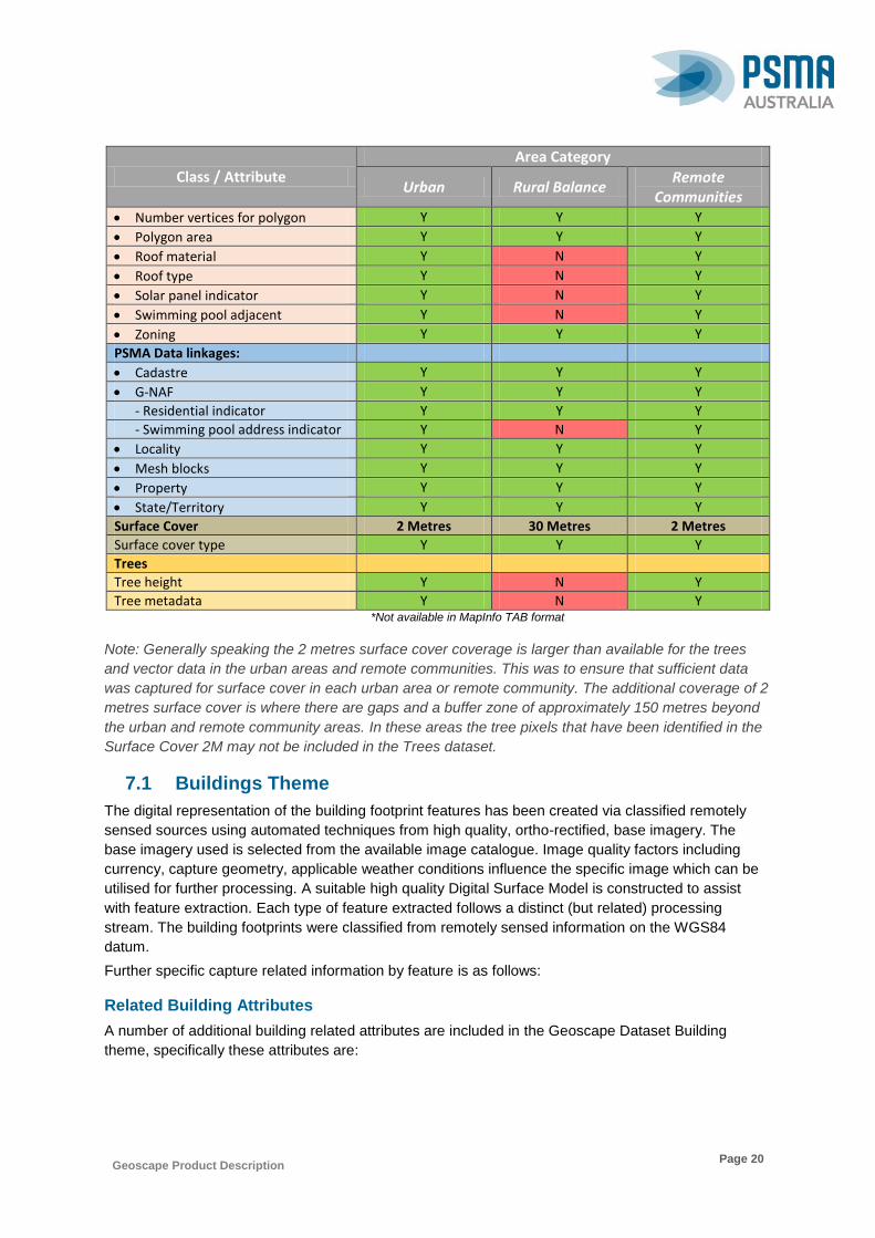
Geoscape Product Description
Page 20
Class / Attribute Area Category
Urban Rural Balance Remote
Communities Number vertices for polygon Y Y Y
Polygon area Y Y Y
Roof material Y N Y
Roof type Y N Y
Solar panel indicator Y N Y
Swimming pool adjacent Y N Y
Zoning Y Y Y
PSMA Data linkages:
Cadastre Y Y Y
G-NAF Y Y Y
- Residential indicator Y Y Y
- Swimming pool address indicator Y N Y
Locality Y Y Y
Mesh blocks Y Y Y
Property Y Y Y
State/Territory Y Y Y
Surface Cover 2 Metres 30 Metres 2 Metres
Surface cover type Y Y Y
Trees
Tree height Y N Y
Tree metadata Y N Y *Not available in MapInfo TAB format
Note: Generally speaking the 2 metres surface cover coverage is larger than available for the trees
and vector data in the urban areas and remote communities. This was to ensure that sufficient data
was captured for surface cover in each urban area or remote community. The additional coverage of 2
metres surface cover is where there are gaps and a buffer zone of approximately 150 metres beyond
the urban and remote community areas. In these areas the tree pixels that have been identified in the
Surface Cover 2M may not be included in the Trees dataset.
7.1 Buildings Theme
The digital representation of the building footprint features has been created via classified remotely
sensed sources using automated techniques from high quality, ortho-rectified, base imagery. The
base imagery used is selected from the available image catalogue. Image quality factors including
currency, capture geometry, applicable weather conditions influence the specific image which can be
utilised for further processing. A suitable high quality Digital Surface Model is constructed to assist
with feature extraction. Each type of feature extracted follows a distinct (but related) processing
stream. The building footprints were classified from remotely sensed information on the WGS84
datum.
Further specific capture related information by feature is as follows:
Related Building Attributes
A number of additional building related attributes are included in the Geoscape Dataset Building
theme, specifically these attributes are:

Geoscape Product Description
Page 21
Area:
The area attribute value is a derived value calculated during processing. Area values are calculated
with features projected in a Transverse Mercator coordinate system.
Centroid Elevation:
This value represents the building ground surface height in meters with respect to the Australian
Height Datum (AHD). The centroid is the building point calculated as the geometric centroid of the
building polygon, for irregular shaped features the centroid is ensured to lie within the bounds of the
polygon. This centroid location is intersected with the best available data to assign building Z vertices
and centroid elevations.
Source of the data used for elevation for each building feature is contained within the SOURCE_AUT
table.
Eave Height:
Provided as an attribute on each building footprint by the supplier as a relative height in metres above
the ground surface. All efforts have been taken to identify an ‘eave’ for each building boundary,
multilevel buildings and irregular facades may impact the accuracy of this value. Source of the data
used for calculating the height is contained within the SOURCE_AUT table.
Has Residential:
The linkage table between address and building, features a separate attribute that has been included
to indicate if the address has been identified as currently or having previously thought to be
residential. The source of the residential indicator is currently derived from Commonwealth
Government sources, which PSMA considers reliable. No personal information is included in any data
supplied to PSMA Australia.
Max Height:
Provided as an attribute on each building footprint by the supplier as a relative height in metres above
the ground surface. This is the maximum height identified within the building boundary and may
include the height of plant rooms and building fixtures. Source of the data used for calculating the
height is contained within the SOURCE_AUT table.
Number Vertices:
A count of the number of vertices for all rings of the polygon feature representing a building. Users
should note that a typical rectangular polygon feature has four vertices.
Quality Indicator:
A quality flag has been included to identify spatial representation of buildings (points and polygons)
that have been modified during data correction processes, or that a quality issue was identified but an
automatic correction could not be made.
Overlaps
Buildings that are received in a significant number of cases abut or share a common
boundary. In some cases buildings are supplied that either have minor overlaps with
adjacent buildings or overlap buildings that have already been supplied. Where
possible and where a building has a small overlap (less than 5% of the buildings area)
the overlap will be removed. Where an overlap is able to be removed for a feature, a
code of “OR” is used. Where an overlap exists however are unable to be removed, or
has been introduced during further processing a code of “O” is used.

Geoscape Product Description
Page 22
Inner Rings
All buildings are assessed to find and remove small inner rings similar to the one
represented below. To identify only small inner rings rather than rings representing
courtyards etc., a diagonal length of the rings ‘Minimum Bounding Rectangle’ (MBR)
is measured and only rings with a diagonal MBR of less than approximately 2m are
removed. Features that have had an inner ring removed by this process are flagged
with a quality indicator of ‘IR’.
Self-Intersections
Where possible all contributed buildings geometry are checked and repaired to fix any
issues, this includes self-intersections. In some cases these are unable to be
automatically resolved and/or have been introduced by further processing. Buildings
in these cases may cause concern in loading into some applications therefore a
quality indicator is used to identify the buildings impacted the quality indicator value in
this case is ‘SI’.
Complex Geometries
When buildings are received each building is assessed to ensure it is not considered a
complex or multipart polygon. Where a polygon is a complex or a multipart polygon,
each part of the existing feature is separated into unique ‘simple’ segments. This may
mean each part has attributes that relate to the other adjoining portions, attributes like
height, roof material and roof type will be impacted where a building has been split into
multiple parts. Each building that has been split has a quality indicator value of ‘S’.
Invalid Relationships
During the process of assigning relationships to other PSMA products there are
occasions where the spatial relationship has not been able to successfully be created
due to invalid geometries. Where there is an invalid CAD Polygon this will impact the
Building CAD relationships. Where there is an invalid Property Polygon this will impact
the Building Property relationships, and also may impact the Building Address
relationship. Any buildings that do intersect these invalid features are flagged with a
quality indicator of ‘IP’ or ‘IC’.
Varying State Relationships
Spatial representation of the Borders of the Australian States and Territories can vary
across spatial datasets and authoritative sources of information. For example there is
a variation between the State boundaries used for State allocation and the borders
used for Locality and Mesh Block linkages. Where a building is impacted by these
variations, and has linkages to data in other State/Territories, a quality indicator ‘VSR’
is assigned.

Geoscape Product Description
Page 23
Spike
Where possible all contributed buildings geometry are checked and repaired to fix any
issues, this includes spikes to ensure proper representation of the real world. Spikes
are identified and removed by altering the polygon geometry. Where a building is
impacted by a spike, a building quality indicator ‘SR’ is assigned.
Small Building
Geoscape considers a building to be small if it has an area of less than nine (9)
metres squared. Although features received that are less than three (3) metres
squared are removed from the product. However, any building area calculated as less
than 9 metres squared are flagged with a quality indicator ‘SB’.
Remediated Heights
A building height is calculated by identifying the intersection of the minimum ground
pixel within a buffer of the building. Processing has identified that smoothing, ‘spill
over’ or lack of sharpness between buildings has impacted the method of calculating
ground elevations used in this process. As a result, both building height and eave
height have been adjusted by intersecting each affected building polygon to an
alternative source of ground height. Buildings that are impacted are assigned with a
quality indicator ‘RH’.
No Ground Centroids
All buildings that intersect a supplied source for elevation are assigned a ground
centroid elevation. Where no there is no known or suitable source of elevation is
available buildings will have no Z values and no ground centroid elevations assigned.
To identify these buildings a quality indicator of ‘NE’ will be assigned.
Roof Material Type:
Provided as an attribute on each building roof feature is the classification of the primary roof material
and is the statistical assessment of the roof material found across the building surface. As a large
majority of buildings do not have an individual roof material, each roof material type (Metal, Tile, Flat
Concrete etc.) is identified and the roof material with the most coverage is identified has been used to
identify where various roof materials may be present.
The Building Roof Type attribute is classified from a combination of short wave infrared (SWIR) and
visible and near infrared (VNIR) imagery bands which through a co-registration process are aligned to
provide a common pixel spatial resolution. The resulting stack of bands are processed through a
spectral matching algorithm to identify unique signatures of each surface present. Spectral analysis is
performed only on image pixels that intersect with the Building Polygon. The signatures are matched
to a spectral library of known material compositions to determine the best matching material for each
pixel.
Roof Type:
Provided as an attribute on each building feature is the classification of the shape type of a roof
structure, indicating whether a roof is flat, has a moderate pitch or complexity, or has a steep pitch or
is highly complex. This attribute has been classified using a statistical assessment of the roof heights
found across the building surface.
Solar Panel:
Provided as an attribute on each building feature is an indicator of the presence or absence of a solar
panel on the roof surface. Solar Panels have been identified using crowd sourcing and machine

Geoscape Product Description
Page 24
learning techniques and provided to PSMA. Various types of solar panels may have been identified
and may contribute to a positive indication of their presence, these may include both photo-voltaic and
solar hot water.
Swimming Pool:
Properties that contain swimming pools have been identified using crowd sourcing techniques and
provided to PSMA. A derived property boundary dataset has been used to identify what properties
contain a swimming pool. More information on the process used is explained in the next section on
linkages.
Tree:
Provided as an attribute on each building feature for the maximum height of all trees that intersect with
the building.
Z Values:
Provided as an additional Z coordinate for each vertex as part of the geometry of a feature. This Z
coordinate represents the ground elevation at this XY location. MapInfo TAB formats are unable to
store Z coordinates with the geometry, therefore each vertex of a building will be represented by a XY
coordinate only.
Linkages
Geoscape uses following PSMA products for inputs into the processing:
G-NAF.
CadLite (Property and Cadastre).
Administrative Boundaries (Suburbs/Localities and ABS mesh blocks).
The linkages with buildings are explained in detail below.
Building Mesh Block Linkage
The building / mesh block relationship has been captured in the BUILDING_MESH_BLOCK table via a
spatial intersection between building feature geometries and the 2011 and 2016 mesh block polygon
datasets from the Australian Bureau of Statistics (ABS).
A building is related to every mesh block that a building intersects greater than or equal to 5% of the
buildings area.

Geoscape Product Description
Page 25
Building State/Territory Linkage
The building / state relationship has been captured in the BUILDING table via a spatial intersection
between building polygon and a state/territory coastline boundaries dataset. There is an ongoing issue
of alignment between State/Territory borders which may impact on the allocation of a State/Territory.
A building will be allocated to the State or Territory boundary that the majority of the building’s polygon
area intersects.
Building Suburb/Locality Linkage
The building’s relationship with Suburbs/Localities has been captured in the BUILDING table via a
spatial intersection between building polygon and PSMA’s Suburbs/Localities product. There is an
ongoing issue of alignment at State/Territory borders which may impact on the allocation of a
Suburb/Locality.
A building will be allocated to the GAZETTED Suburb/Locality where the building’s area intersects a
single GAZETTED Suburb/Locality.
If a building’s area intersects more than one GAZETTED Suburb/Locality, the building will be allocated
to the GAZETTED Suburb/Locality that the majority of the building’s area falls within.

Geoscape Product Description
Page 26
If a building has not been allocated a GAZETTED Suburb/Locality, the building will be assessed
against HUNDRED and DISTRICT boundaries. A building will be allocated to the HUNDRED or
DISTRICT where the building’s area intersects a single HUNDRED or DISTRICT.
If a building has not been allocated a GAZETTED Suburb/Locality, the building will be assessed
against HUNDRED and DISTRICT boundaries. If a building’s area intersects with more than one
HUNDRED or DISTRICT, the building will be allocated to the HUNDRED or DISTRICT that the
majority of the building’s area falls within.
Building Swimming Pool Adjacent
The BUILDING table’s SWIMMING_POOL_ADJACENT attribute will be assigned a ‘YES’ if a building
intersects, by more than 10% of the buildings area, a property that has been identified as containing a
swimming pool. If the building intersects, by more than 10% of a building’s area, a property that has
been identified as NOT containing a swimming pool the SWIMMING_POOL_ADJACENT attribute will
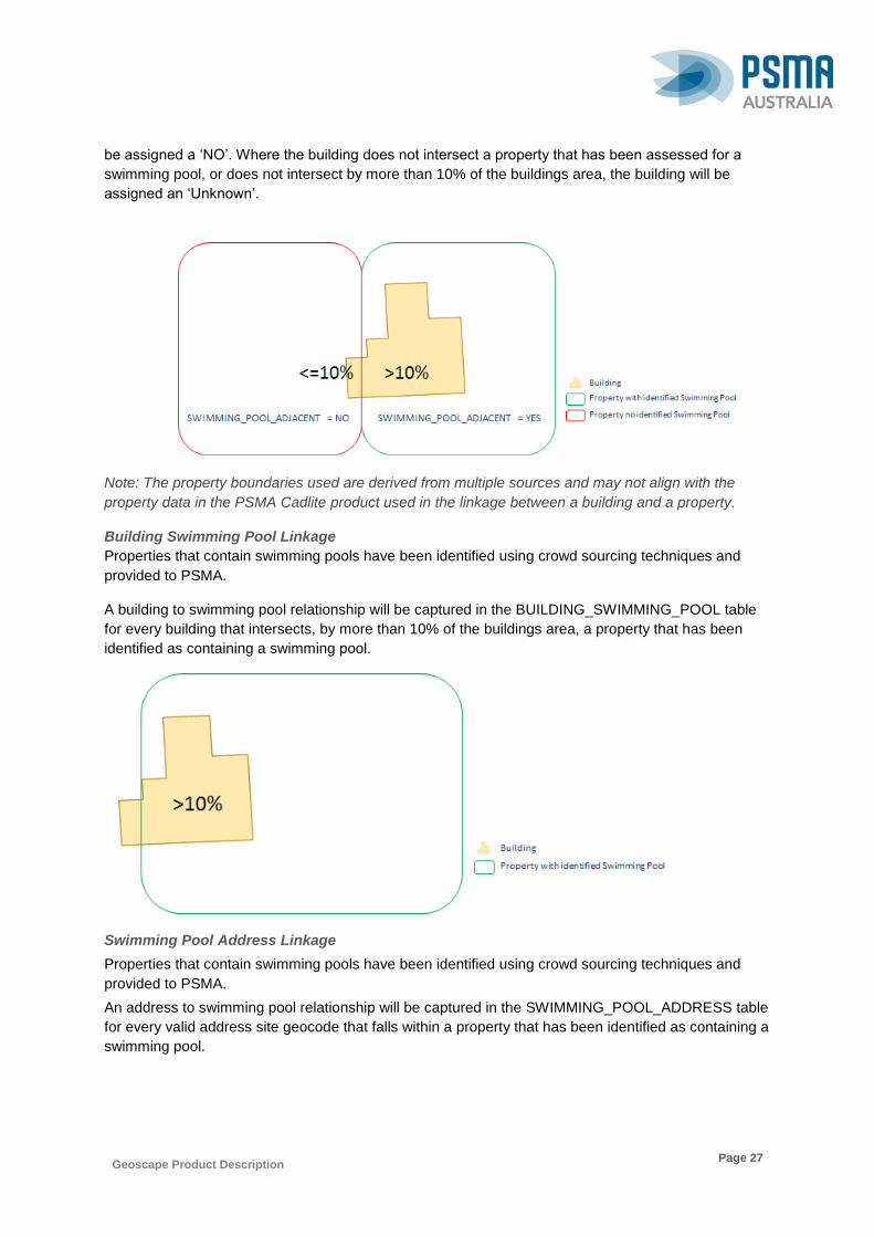
Geoscape Product Description
Page 27
be assigned a ‘NO’. Where the building does not intersect a property that has been assessed for a
swimming pool, or does not intersect by more than 10% of the buildings area, the building will be
assigned an ‘Unknown’.
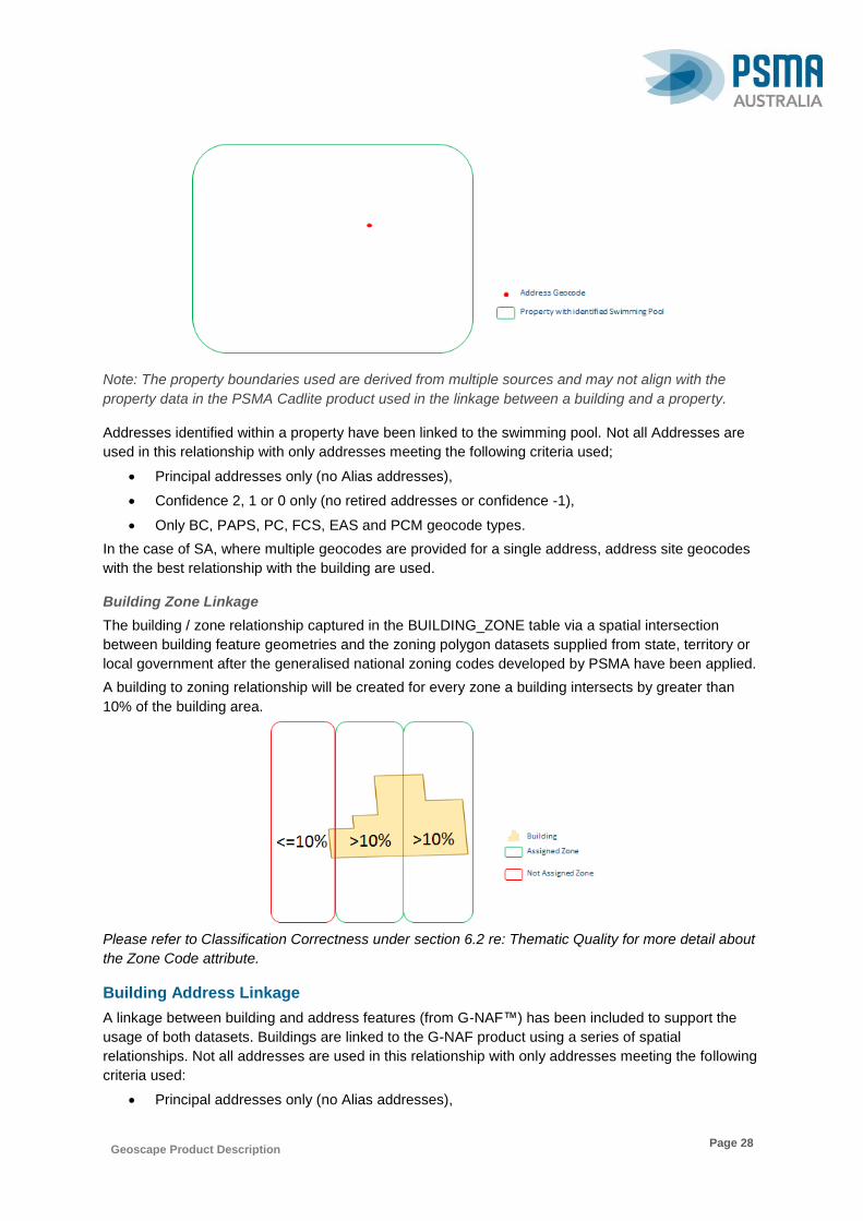
Note: The property boundaries used are derived from multiple sources and may not align with the
property data in the PSMA Cadlite product used in the linkage between a building and a property.
Building Swimming Pool Linkage
Properties that contain swimming pools have been identified using crowd sourcing techniques and
provided to PSMA.
A building to swimming pool relationship will be captured in the BUILDING_SWIMMING_POOL table
for every building that intersects, by more than 10% of the buildings area, a property that has been
identified as containing a swimming pool.
Swimming Pool Address Linkage
Properties that contain swimming pools have been identified using crowd sourcing techniques and
provided to PSMA.
An address to swimming pool relationship will be captured in the SWIMMING_POOL_ADDRESS table
for every valid address site geocode that falls within a property that has been identified as containing a
swimming pool.
Geoscape Product Description
Page 28
Note: The property boundaries used are derived from multiple sources and may not align with the
property data in the PSMA Cadlite product used in the linkage between a building and a property.
Addresses identified within a property have been linked to the swimming pool. Not all Addresses are
used in this relationship with only addresses meeting the following criteria used;
Principal addresses only (no Alias addresses),
Confidence 2, 1 or 0 only (no retired addresses or confidence -1),
Only BC, PAPS, PC, FCS, EAS and PCM geocode types.
In the case of SA, where multiple geocodes are provided for a single address, address site geocodes
with the best relationship with the building are used.
Building Zone Linkage
The building / zone relationship captured in the BUILDING_ZONE table via a spatial intersection
between building feature geometries and the zoning polygon datasets supplied from state, territory or
local government after the generalised national zoning codes developed by PSMA have been applied.
A building to zoning relationship will be created for every zone a building intersects by greater than
10% of the building area.
Please refer to Classification Correctness under section 6.2 re: Thematic Quality for more detail about
the Zone Code attribute.
Building Address Linkage
A linkage between building and address features (from G-NAF™) has been included to support the
usage of both datasets. Buildings are linked to the G-NAF product using a series of spatial
relationships. Not all addresses are used in this relationship with only addresses meeting the following
criteria used:
Principal addresses only (no Alias addresses),
Geoscape Product Description
Page 29
Confidence 2, 1 or 0 only (no retired addresses or confidence -1),
Geocode types BC, PAPS, PC, FCS, EAS and PCM in ADDRESS_SITE_GEOCODE table.
Where the relationship between Building and an Address has been made using CAD polygons, the
cadastral parcels used meeting the following criteria are matched first:
Parcel Status of Registered
Parcel Type of Lot Parcel, Strata (including Horizontal and Vertical, and Stratum)
Properties and cadastre parcels that were 10,000sqkm or above are not included in the building
address assignment process. The removal of these areas results in buildings in these rural areas
being assigned only address geocodes that fall directly inside the building extent. Although this means
there are less relationships made in these areas, the relationships built are considered more reliable.
The ‘Base’ properties in Victoria have been removed prior to assigning building address relationships
due the large number of building address relationships being made. This prevents addresses that fall
within complex sites from being assigned to all buildings that are in the same property.
The process types use different geocode types and for the purposes of creating the relationships
between addresses and buildings the geocode types have been placed into three category types
when explaining the process that is used. The three categories are building, property and gap and
their relationship to the geocode type from G-NAF is shown in the table below.
Geocode Type Code Name Geocode Category
BC Building Centroid Building
PAPS Property Access Point Setback Property
PC Property Centroid Property
PCM Property Centroid Manual Property
FCS Frontage Centre Setback Property
GG Gap Geocode Gap
EAS Emergency Access Secondary Property
Some jurisdictions have multiple geocodes for an address, to reduce the effect these additional
geocodes have on relationships within Geoscape and to ensure the most applicable address site
geocode is used the geocodes are filtered to ensure there was only one geocode for any particular
address. This filter orders the geocode types to obtain the address likely to have the best relationship
with a building. As different States/Territories have different geocodes and ways of addressing, the
following priority is applied:
ACT 1. BC (Building Centroid)
2. PC (Property Centroid)
3. FCS (Front Centre Setback)
4. PCM (Property Centroid Manual)
SA 1. PC (Property Centroid)
2. PAPS (Property Access Point Setback)
3. EAS (Emergency Access Setback)
VIC 1. PC (Property Centroid)
2. FCS (Front Centre Setback)
3. PAPS (Property Access Point Setback)
Geoscape Product Description
Page 30
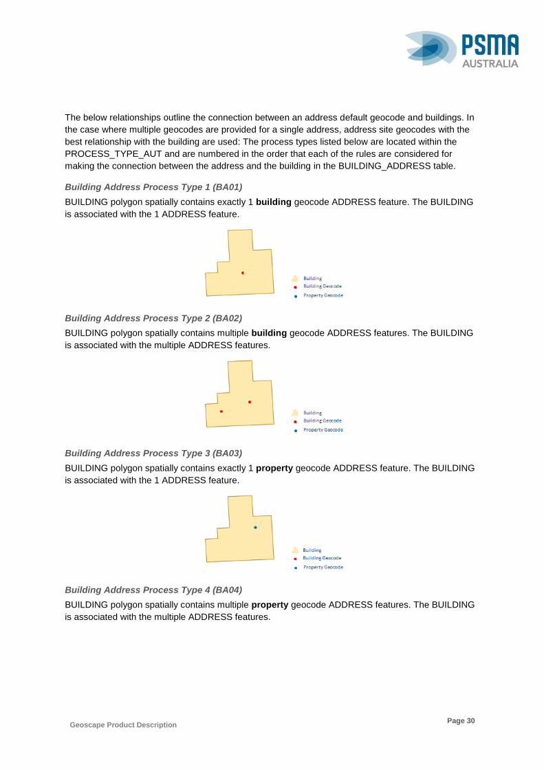
The below relationships outline the connection between an address default geocode and buildings. In
the case where multiple geocodes are provided for a single address, address site geocodes with the
best relationship with the building are used: The process types listed below are located within the
PROCESS_TYPE_AUT and are numbered in the order that each of the rules are considered for
making the connection between the address and the building in the BUILDING_ADDRESS table.
Building Address Process Type 1 (BA01)
BUILDING polygon spatially contains exactly 1 building geocode ADDRESS feature. The BUILDING
is associated with the 1 ADDRESS feature.
Building Address Process Type 2 (BA02)
BUILDING polygon spatially contains multiple building geocode ADDRESS features. The BUILDING
is associated with the multiple ADDRESS features.
Building Address Process Type 3 (BA03)
BUILDING polygon spatially contains exactly 1 property geocode ADDRESS feature. The BUILDING
is associated with the 1 ADDRESS feature.
Building Address Process Type 4 (BA04)
BUILDING polygon spatially contains multiple property geocode ADDRESS features. The BUILDING
is associated with the multiple ADDRESS features.

Geoscape Product Description
Page 31
Building Address Process Type 5 (BA05)
PROPERTY polygon contains or intersects greater than 80% with a single BUILDING polygon feature
and spatially contains exactly 1 property geocode ADDRESS feature. A single BUILDING is
associated with the 1 ADDRESS feature.
Building Address Process Type 6 (BA06)
PROPERTY polygon contains or intersects greater than 80% with multiple BUILDING polygon
features and spatially contains exactly 1 property geocode ADDRESS feature. Multiple BUILDINGS
are associated with the 1 ADDRESS feature.
Building Address Process Type 7 (BA07)
PROPERTY polygon contains or intersects greater than 80% with BUILDING polygon feature and
spatially contains multiple property geocode ADDRESS features. A single BUILDING is associated
with multiple ADDRESS features.
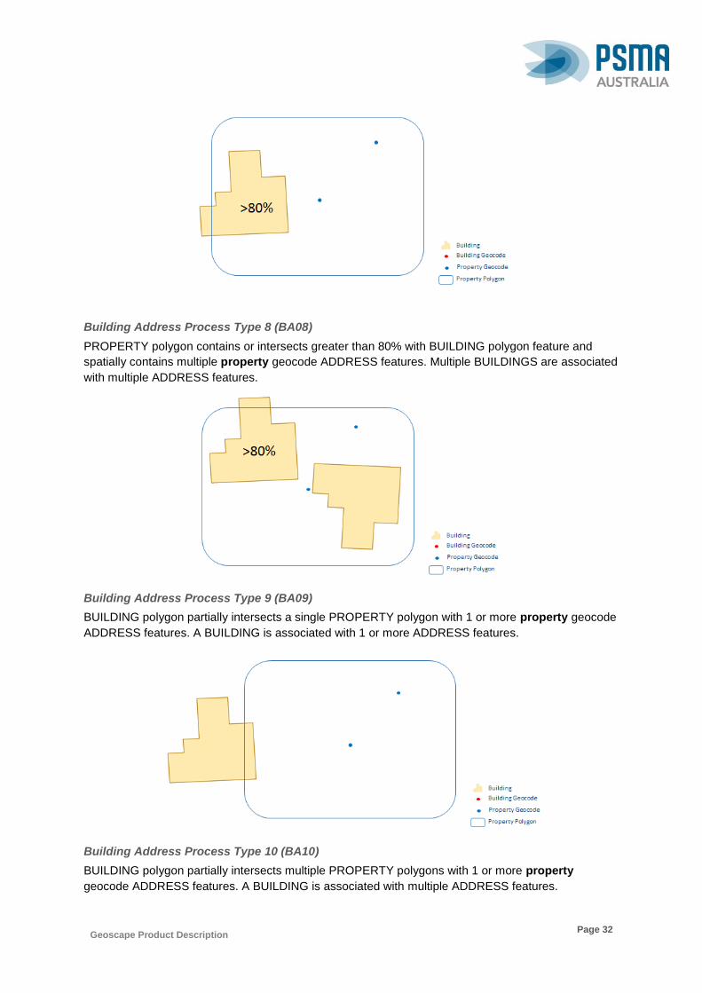
Geoscape Product Description
Page 32
Building Address Process Type 8 (BA08)
PROPERTY polygon contains or intersects greater than 80% with BUILDING polygon feature and
spatially contains multiple property geocode ADDRESS features. Multiple BUILDINGS are associated
with multiple ADDRESS features.
Building Address Process Type 9 (BA09)
BUILDING polygon partially intersects a single PROPERTY polygon with 1 or more property geocode
ADDRESS features. A BUILDING is associated with 1 or more ADDRESS features.
Building Address Process Type 10 (BA10)
BUILDING polygon partially intersects multiple PROPERTY polygons with 1 or more property
geocode ADDRESS features. A BUILDING is associated with multiple ADDRESS features.

Geoscape Product Description
Page 33
Building Address Process Type 11 (BA11)
PROPERTY polygon spatially contains 1 or more building geocode ADDRESS features allocated a
BUILDING feature and 1 or more BUILDING polygons intersect PROPERTY polygon not allocated
ADDRESS. Multiple BUILDINGS associated with 1 or more ADDRESS features.
Building Address Process Type 12 (BA12)
ADDRESS has not been allocated a BUILDING. The BUILDING polygon area intersects by more than
10% a single PROPERTY polygon with 1 or more ADDRESS features allocated a BUILDING. A single
BUILDING is associated with multiple ADDRESS features.
Building Address Process Type 13 (BA13)
BUILDING not allocated an ADDRESS and BUILDING polygon spatially contains or intersects
PROPERTY polygon that has an ADDRESS within 15 metres and the closest PROPERTY to the
ADDRESS. A single BUILDING is associated with a single ADDRESS feature.
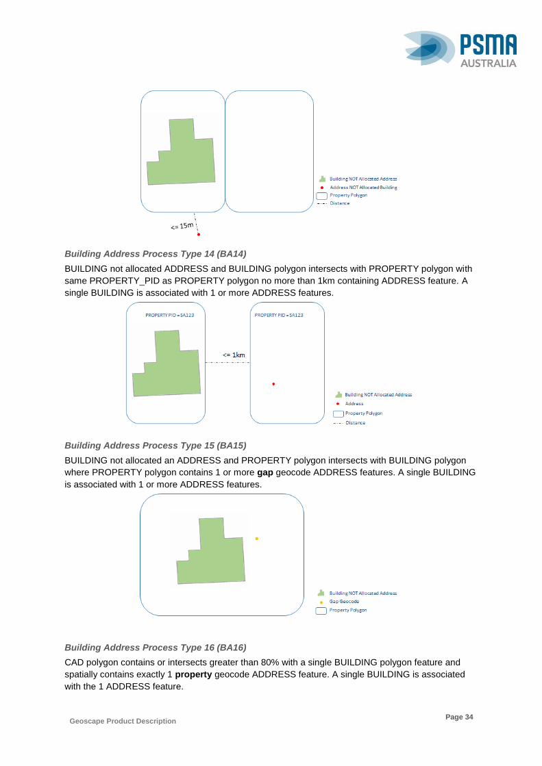
Geoscape Product Description
Page 34
Building Address Process Type 14 (BA14)
BUILDING not allocated ADDRESS and BUILDING polygon intersects with PROPERTY polygon with
same PROPERTY_PID as PROPERTY polygon no more than 1km containing ADDRESS feature. A
single BUILDING is associated with 1 or more ADDRESS features.
Building Address Process Type 15 (BA15)
BUILDING not allocated an ADDRESS and PROPERTY polygon intersects with BUILDING polygon
where PROPERTY polygon contains 1 or more gap geocode ADDRESS features. A single BUILDING
is associated with 1 or more ADDRESS features.
Building Address Process Type 16 (BA16)
CAD polygon contains or intersects greater than 80% with a single BUILDING polygon feature and
spatially contains exactly 1 property geocode ADDRESS feature. A single BUILDING is associated
with the 1 ADDRESS feature.
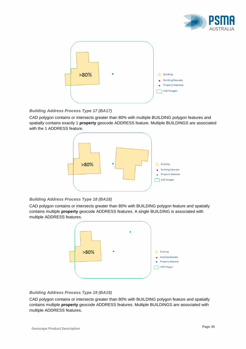
Geoscape Product Description
Page 35
Building Address Process Type 17 (BA17)
CAD polygon contains or intersects greater than 80% with multiple BUILDING polygon features and
spatially contains exactly 1 property geocode ADDRESS feature. Multiple BUILDINGS are associated
with the 1 ADDRESS feature.
Building Address Process Type 18 (BA18)
CAD polygon contains or intersects greater than 80% with BUILDING polygon feature and spatially
contains multiple property geocode ADDRESS features. A single BUILDING is associated with
multiple ADDRESS features.
Building Address Process Type 19 (BA19)
CAD polygon contains or intersects greater than 80% with BUILDING polygon feature and spatially
contains multiple property geocode ADDRESS features. Multiple BUILDINGS are associated with
multiple ADDRESS features.

Geoscape Product Description
Page 36
Building Address Process Type 20 (BA20)
BUILDING polygon partially intersects a single CAD polygon with 1 or more property geocode
ADDRESS features. A BUILDING is associated with 1 or more ADDRESS features.
Building Address Process Type 21 (BA21)
BUILDING polygon partially intersects multiple CAD polygons with 1 or more property geocode
ADDRESS features. A BUILDING is associated with multiple ADDRESS features.
Building Address Process Type 22 (BA22)
CAD polygon spatially contains 1 or more building geocode ADDRESS features allocated a
BUILDING feature and 1 or more BUILDING polygons intersect CAD polygon not allocated
ADDRESS. Multiple BUILDINGS associated with 1 or more ADDRESS features.
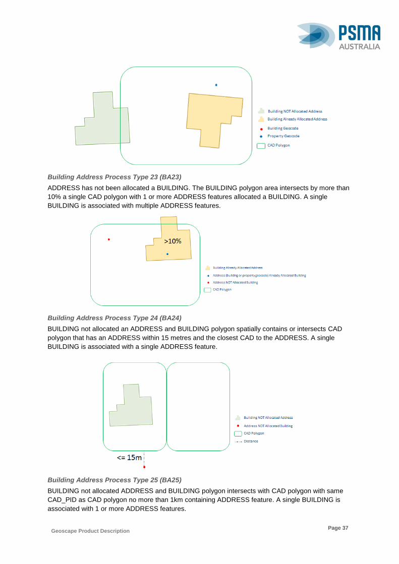
Geoscape Product Description
Page 37
Building Address Process Type 23 (BA23)
ADDRESS has not been allocated a BUILDING. The BUILDING polygon area intersects by more than
10% a single CAD polygon with 1 or more ADDRESS features allocated a BUILDING. A single
BUILDING is associated with multiple ADDRESS features.
Building Address Process Type 24 (BA24)
BUILDING not allocated an ADDRESS and BUILDING polygon spatially contains or intersects CAD
polygon that has an ADDRESS within 15 metres and the closest CAD to the ADDRESS. A single
BUILDING is associated with a single ADDRESS feature.
Building Address Process Type 25 (BA25)
BUILDING not allocated ADDRESS and BUILDING polygon intersects with CAD polygon with same
CAD_PID as CAD polygon no more than 1km containing ADDRESS feature. A single BUILDING is
associated with 1 or more ADDRESS features.

Geoscape Product Description
Page 38
Building Address Process Type 26 (BA26)
BUILDING not allocated an ADDRESS and CAD polygon intersects with BUILDING polygon where
CAD polygon contains 1 or more gap geocode ADDRESS features. A single BUILDING is associated
with 1 or more ADDRESS features.
Building CAD Linkage
A linkage between building and cadastre features (from CadLite™) has been included to support the
usage of both datasets. Buildings are linked to the cadastre dataset using a series of spatial
relationships. Not all cadastral parcels are used in this relationship with cadastral parcels meeting the
following criteria being matched first:
Parcel Status of Registered
Parcel Type of Lot Parcel, Strata (including Horizontal and Vertical, and Stratum)
Any building not assigned will then be matched based on cadastral parcels that have the following
criteria:
Parcel Status of Unregistered
Parcel type of Lot Parcel, Strata (including Horizontal, Vertical and Stratum).
The below relationships outline the connection between the cadastre (CAD) and buildings captured in
the BUILDING_CAD table. The process types listed below are located within the
PROCESS_TYPE_AUT and are numbered in the order that each of the rules are considered for
making the connection between the cadastre (CAD) and the building.
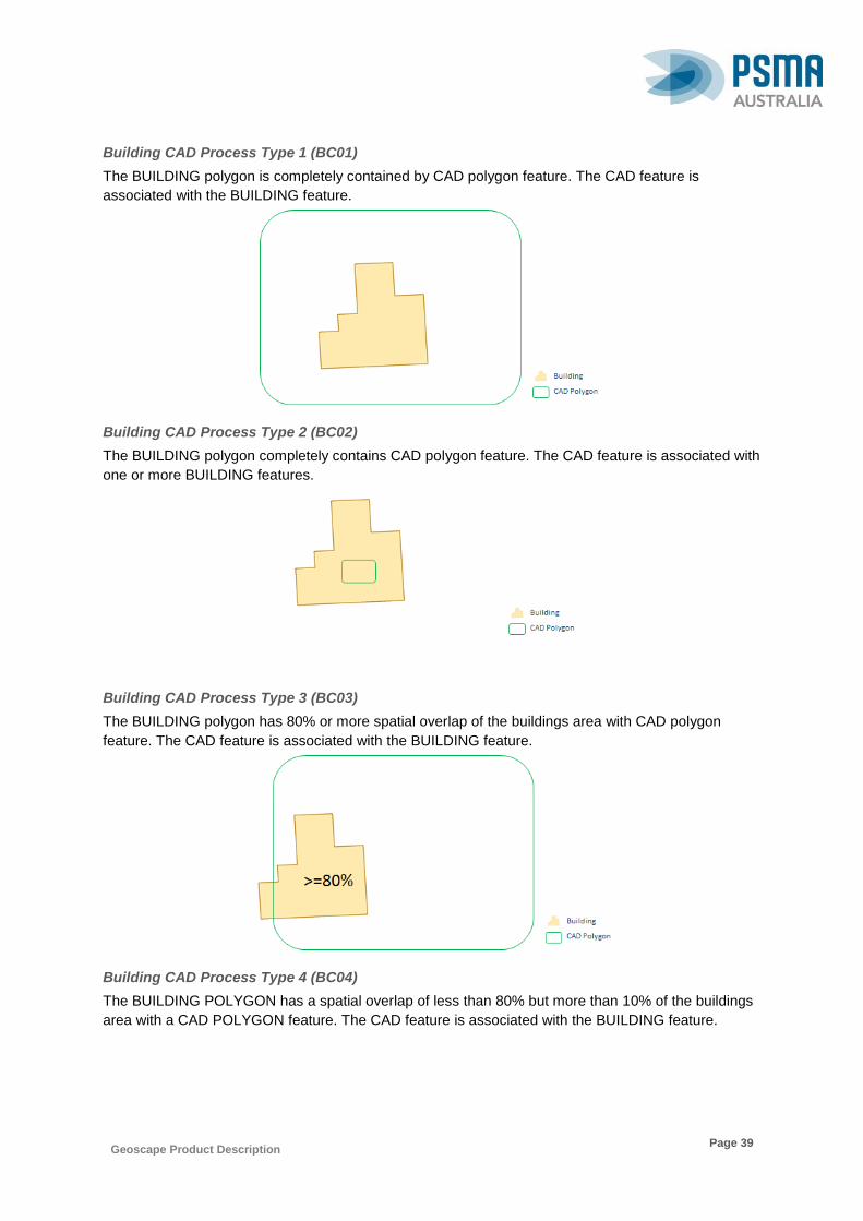
Geoscape Product Description
Page 39
Building CAD Process Type 1 (BC01)
The BUILDING polygon is completely contained by CAD polygon feature. The CAD feature is
associated with the BUILDING feature.
Building CAD Process Type 2 (BC02)
The BUILDING polygon completely contains CAD polygon feature. The CAD feature is associated with
one or more BUILDING features.
Building CAD Process Type 3 (BC03)
The BUILDING polygon has 80% or more spatial overlap of the buildings area with CAD polygon
feature. The CAD feature is associated with the BUILDING feature.
Building CAD Process Type 4 (BC04)
The BUILDING POLYGON has a spatial overlap of less than 80% but more than 10% of the buildings
area with a CAD POLYGON feature. The CAD feature is associated with the BUILDING feature.

Geoscape Product Description
Page 40
Building CAD Process Type 5 (BC05)
The BUILDING POLYGON has a spatial overlap of less than 10% of the buildings area with a CAD
POLYGON feature. The CAD feature is associated with the BUILDING feature.
Building CAD Process Type 6 (BC06)
The BUILDING polygon is completely contained by a CAD polygon feature that also contains CAD
point feature. The CAD feature is associated with the BUILDING feature.
Building CAD Process Type 7 (BC07)
The BUILDING polygon has spatial overlap of more than 80% of the buildings area with CAD polygon
feature that also contains CAD point feature. The CAD feature is associated with the BUILDING
feature.
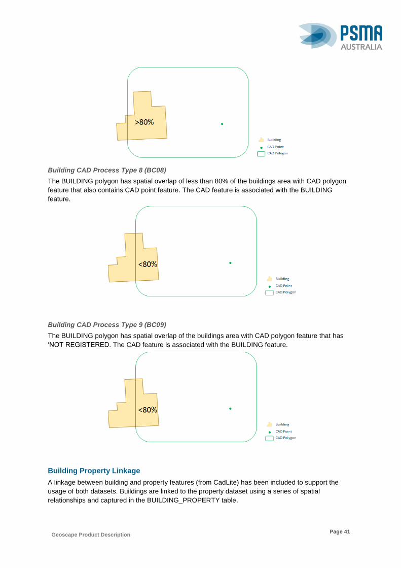
Geoscape Product Description
Page 41
Building CAD Process Type 8 (BC08)
The BUILDING polygon has spatial overlap of less than 80% of the buildings area with CAD polygon
feature that also contains CAD point feature. The CAD feature is associated with the BUILDING
feature.
Building CAD Process Type 9 (BC09)
The BUILDING polygon has spatial overlap of the buildings area with CAD polygon feature that has
‘NOT REGISTERED. The CAD feature is associated with the BUILDING feature.
Building Property Linkage
A linkage between building and property features (from CadLite) has been included to support the
usage of both datasets. Buildings are linked to the property dataset using a series of spatial
relationships and captured in the BUILDING_PROPERTY table.

Geoscape Product Description
Page 42
Some States/Territories do not supply property points therefore no relationships will be created for
these States using the below relationship process types of 6, 7 or 8. The below relationships outline
the connections between property and buildings features. The process types listed below are located
within the PROCESS_TYPE_AUT and are numbered in the order that each of the rules are
considered for making the connection between the property and the building.
Building Property Process Type 1 (BP01)
The BUILDING polygon is completely contained by non-proposed PROPERTY polygon feature. The
PROPERTY feature is associated with the BUILDING feature.
Building Property Process Type 2 (BP02)
The BUILDING polygon completely contains PROPERTY polygon feature. The PROPERTY feature is
associated with one or more BUILDING features.
Building Property Process Type 3 (BP03)
The BUILDING polygon has 80% or more spatial overlap of the buildings area with PROPERTY
polygon feature. The PROPERTY feature is associated with the BUILDING feature.
Building Property Process Type 4 (BP04)
The BUILDING polygon has spatial overlap of less than 80% but 10% or more of the buildings area
with PROPERTY polygon feature. The PROPERTY feature is associated with the BUILDING feature.

Geoscape Product Description
Page 43
Building Property Process Type 5 (BP05)
The BUILDING polygon has spatial overlap of less than 10% of the buildings area with PROPERTY
polygon feature. The PROPERTY feature is associated with the BUILDING feature.
Building Property Process Type 6 (BP06)
The BUILDING polygon completely contained by PROPERTY polygon feature that also contains
PROPERTY point feature. The PROPERTY feature is associated with the BUILDING feature.
Building Property Process Type 7 (BP07)
The BUILDING polygon has a spatial overlap of more than 80% of the buildings area with PROPERTY
polygon feature that also contains PROPERTY point feature. The PROPERTY feature is associated
with the BUILDING feature.
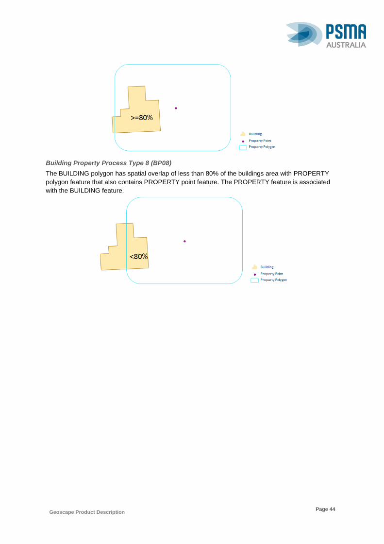
Geoscape Product Description
Page 44
Building Property Process Type 8 (BP08)
The BUILDING polygon has spatial overlap of less than 80% of the buildings area with PROPERTY
polygon feature that also contains PROPERTY point feature. The PROPERTY feature is associated
with the BUILDING feature.

Geoscape Product Description
Page 45
7.2 Trees Theme
Trees are a pixel representation of areas identified as having a tree coverage in remotely sensed
source imagery.
Trees have been identified by their spectral signature using remotely sensed information and are also
represented as raster cells within the surface cover dataset. Areas classified as Trees have been
integrated with Digital Surface Model (DSM) and Digital Elevation Model (DEM) Information to extract
a height value for every cell.
Although all efforts to provide an accurate height for all tree pixels have been undertaken, due to
proximity to other features, resolution and anomalies within the Digital Surface Model (DSM) and/or
the Digital Elevation Model (DEM) heights for a small portion of pixels are higher than the real world
feature they represent. To reduce the impact of these on the user, PSMA has assigned all trees that
are higher than plausible tree heights (100 metres) in the area to a height of 25m. The tree metadata
dataset identifies pixels that have been modified, the Tree Metadata AUT table describes the reason a
tree pixel has been modified and any treatment that has occurred.
PSMA has undertaken research to identify the likely maximum tree heights for each zone (region) across
Australia. This has resulted in four new codes listed in the table below.
CODE NAME DESCRIPTION
50 Trees above 50m Trees pixel exceeded the expected max tree height of 50m for this region. Tree height remains unaltered.
60 Trees above 60m Trees pixel exceeded the expected max tree height of 60m for this region. Tree height remains unaltered.
75 Trees above 75m Trees pixel exceeded the expected max tree height of 75m for this region. Tree height remains unaltered.
80 Trees above 80m Trees pixel exceeded the expected max tree height of 80m for this region. Tree height remains unaltered.
The expected maximum tree heights for the zones across Australia are shown in the diagram below.
The trees in red (100m) and hatched black regions where the tree heights are above 100m or below
25m will not have any trees identified in the TREES_METADATA table.
Diagram showing the zones used as regions with the expected maximum tree heights
50
m
50
m
50
m
50
m
50
m
50
m
50
m
50
m 50
m
60
m
7580
100
m
80

Geoscape Product Description
Page 46
7.3 Surface Cover Theme
Surface cover features are contiguous pixel representations of basic surfaces as identified and
classified via automatic feature extraction routines over satellite imagery.
This theme contains 2 variations; one a high resolution (2m) dataset representing surface cover within
urban areas, the other a national resolution (30m) dataset representing surface coverage nationally.
Geoscape Product Description
Page 47
8. Data Maintenance
Maintenance of the data is carried out at PSMA Australia using data supplied by third party providers,
Australian State, Local, Federal and Territory Governments and PSMA. Several applications and
database technologies are utilised during production processes. PSMA has commenced delivery of
the national Geoscape product and is planning to cover all areas of Australia by 2018. Details of the
delivery are described in the release schedule available from the PSMA website.
8.1 Update Frequency
Updates to Geoscape are applied and released on a quarterly schedule. Updates to the product
include:
1. The inclusion of any new capture of Buildings, Swimming Pools, Surface Cover, or Trees
received from third party partners for inclusion within Geoscape covering new or existing
geographic coverage.
2. All Geoscape relationships to other PSMA products (e.g. address, property, suburb/locality
etc.) are refreshed quarterly to account for any changes in the either product.
3. Corrections, or improvements to production processes in generating Geoscape.
8.2 Maintenance Scope
PSMA Australia’s data maintenance occurs for all existing objects with changed geometry, attributes
and/or metadata, as well as data for new objects within the release time period.
8.3 Release Schedule
The Geoscape product is currently being released quarterly. Please refer to the National Rollout
Schedule for updates.
8.4 Maintenance Rules
The following describes the maintenance rules that will be applied to features that are updated or
retired, and where applicable the creation of new relationships with features, for example, the
BUILDING features have updated relationships with PROPERTY features that require the creation of
BUILDING_PROPERTY features.
Where the source data for an attribute has not changed then the attribute will not be assessed for
persistency. Small changes to geometry for a feature that fall within a suitable tolerance will not cause
the feature to be retired.
A combination of fields may all need to be changed to cause a feature to be retired, for example,
BUILDING_ROOF requires both the ROOF_TYPE_CODE and PRIMARY_ROOF_MATERIAL to
change to retire a record.
The following table lists each table in the Buildings theme showing the attributes that are used for
assessing persistency.

Geoscape Product Description
Page 48
TABLE NAME ATTRIBUTES USED FOR PERSISTENCY
ELEVATION BUILDING_PID, SOURCE_CODE
BULDING_ZONE BUILDING_PID, ZONE_CODE
BUILDING_QUALITY BUILDING_GEOMETRY_PID,QUALITY_INDICATOR_CODE
BUILDING_SWIMMING_POOL BUILDING_PID, SWIMMING_POOL_PID
SWIMMING_POOL_ADDRESS SWIMMING_POOL_PID, ADDRESS_DETAIL_PID
BUILDING_TREE BUILDING_PID, MAX_TREE_HEIGHT
BUILDING_PROPERTY BUILDING_PID, PROPERTY_PID
BUILDING_CAD BUILDING_PID, CAD_PID
BUILDING_ADDRESS BUILDING_PID, ADDRESS_DETAIL_PID
Not all attributes have been assessed for updates as the source data for that attribute may not have
changed. The updates that have occurred are based on dependent data changes.
The following describes the process for the updating of features in the Buildings Theme.
Updating Building Locality
For all BUILDING_POLYGON records from the previous release are compared with the latest
LOCALITY boundaries for a match with the corresponding BUILDING record. If the records match,
then the record is not updated, but if the records do not match, the LOCALITY_PID and the
DATE_LAST_MODIFIED attributes in the BUILDING table will be updated.
Create, Retire and Update Building Address Relationships
The process takes all Building and all Address records and assigns relationships into a Lookup Table,
which is then compared with the previous release. Then three steps are undertaken to review and
update features for the building address relationships:
1. Retire and update the Building Address relationships
2. Create new Building Address relationships
3. Update Address count for each Building
These three steps are captured in more detail below.
Retire and Update Building Address Relationships
The previous release records are compared with records in the lookup table for matching
attributes for BUILDING_PID and ADDRESS_DETAIL_PID. If no match, the record will be
retired. Where records do match, the PROCESS_TYPE_CODE and HAS_RESIDENTIAL
attributes are compared, where a one or both of these attributes are not the same, the
attribute/s are updated.

Geoscape Product Description
Page 49
Create New Building Address Relationships
For all lookup table records where there is NO matching existing records for the
BUILDING_PID and ADDRESS_DETAIL_PID attributes, then a new BUILDING_ADDRESS
record will be created.
Update Address Count
Each BUILDING record is linked with the corresponding BUILDING_ADDRESS record/s.
Where there is a new building, the ADDRESS_COUNT is added. The count of all of the
addresses for the corresponding BUILDING is compared to the BUILDING’s
ADDRESS_COUNT attribute, if these do not equal the ADDRESS_COUNT and
DATE_LAST_MODIFIED attributes are updated.
Create, Retire and Update Building CAD Relationships
The process takes all Building and all CAD records and assigns relationships into a Lookup Table,
which is then compared with the previous release. Then two steps are undertaken to review and
update features for the Building CAD relationships:
1. Retire and update Building CAD relationships
2. Create new Building CAD relationships
Retire and Update Building CAD Relationships
The existing records are compared with records in the lookup table to match both the
BUILDING_PID and CAD_PID attributes. If no match, the record will be retired. Where records
do match, the PROCESS_TYPE_CODE attribute is compared, where this is not the same, the
PROCESS_TYPE_CODE attribute is updated.
Create New Building CAD Relationships
For all lookup table records where there is NO matching existing records for the
BUILDING_PID and CAD_PID attributes, then a new BUILDING_CAD record will be created.
Create, Retire and Update Building Property Relationships
The process takes all Building and all Property records and assigns relationships into a Lookup Table,
which is then compared with the previous release. Then two steps are undertaken to review and
update features for the Building Property relationships:
1. Retire and update Building Property relationships
2. Create new Building Property relationships
Retire and Update Building Property Relationships
The previous release records are compared with records in the lookup table to match both the
BUILDING_PID and PROPERTY_PID attributes. If no match, the record will be retired. Where
records do match, the PROCESS_TYPE_CODE attribute is compared, where this is not the
same, the PROCESS_TYPE_CODE attribute is updated.
Create New Building Property Relationships
For all lookup table records where there is NO matching existing records for the
BUILDING_PID and PROPERTY_PID attributes, then a new BUILDING_PROPERTY record
will be created.
Geoscape Product Description
Page 50
Retire and Create Building Zone
The BUILDING_POLYGON records in the existing database are checked where they intersect a
ZONE POLYGON (not part of Geoscape product) and checks it matches both BUILDING_PID and
ZONE_CODE. If it does NOT match, the record gets retired. If it does match, it is then checked that for
all ZONE POLYGON’s records that intersect with BUILDING_POLYGON features there is an existing
record in the BUILDING_ZONE table that matches both BUILDING_PID and ZONE_CODE. If there is
no record, then a new BUILDING_ZONE record is created.
Retire and Create Building Quality
All the geometry check results are stored in a lookup table. The existing database is then compared to
all records in the lookup table, if both the BUILDING_GEOMETRY PID and
QUALITY_INDICATOR_CODE attributes are no longer in the lookup table, the record will be retired. If
there is NO existing record with the matching BUILDING_GEOMETRY PID and
QUALITY_INDICATOR_CODE attributes, a new BUILDING_QUALITY record is created.
Create, Retire and Update Swimming Pool Address Relationships
The process takes all Address and all Swimming Pool records and assigns relationships into a lookup
table, which is then compared with the previous release. Then three steps are undertaken to review
and update features for the Swimming Pool Address relationships:
1. Retire Swimming Pool Address relationships
2. Create new Swimming Pool Address relationships
3. Update Address count for each Swimming Pool
These three steps are captured in more detail below.
Retire Swimming Pool Address Relationships
The existing records are compared with records in the lookup table to match both the
SWIMMING_POOL_PID and ADDRESS_DETAIL_PID attributes. If no match, the record will
be retired.
Create New Swimming Pool Address Relationships
For all lookup table records where there is NO matching existing records matching both the
SWIMMING_POOL_PID and ADDRESS_DETAIL_PID attributes, then a new
SWIMMING_POOL_ADDRESS record will be created.
Update Address Count
Each SWIMMING _POOL record is linked with the corresponding
SWIMMING_POOL_ADDRESS record/s. Where there is a new swimming pool, the
ADDRESS_COUNT is added. The count of all of the addresses for the corresponding
SWIMMING POOL is compared to the SWIMMING POOL’s ADDRESS_COUNT attribute, if
these do not equal the ADDRESS_COUNT and DATE_LAST_MODIFIED attributes are
updated.
Retire and Create Building Tree
All BUILDING_POLYGON records in the existing database are intersected with all TREE pixels to find
the maximum height of trees that intersect each building. If there is no intersecting TREE pixel the
record is retired. If the maximum height is not the same as the existing BUILDING_TREE height the
record is retired and a new record is created.
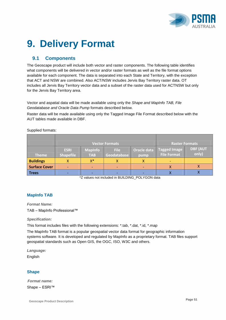
Geoscape Product Description
Page 51
9. Delivery Format
9.1 Components
The Geoscape product will include both vector and raster components. The following table identifies
what components will be delivered in vector and/or raster formats as well as the file format options
available for each component. The data is separated into each State and Territory, with the exception
that ACT and NSW are combined. Also ACT/NSW includes Jervis Bay Territory raster data. OT
includes all Jervis Bay Territory vector data and a subset of the raster data used for ACTNSW but only
for the Jervis Bay Territory area.
Vector and aspatial data will be made available using only the Shape and MapInfo TAB, File
Geodatabase and Oracle Data Pump formats described below.
Raster data will be made available using only the Tagged Image File Format described below with the
AUT tables made available in DBF.
Supplied formats:
Vector Formats Raster Formats
Theme ESRI
Shapefile MapInfo
TAB File
Geodatabase Oracle data
pump
Tagged Image File Format
DBF (AUT only)
Buildings X X* X X -
Surface Cover - - - - X X
Trees - - - - X X *Z values not included in BUILDING_POLYGON data
MapInfo TAB
Format Name:
TAB – MapInfo Professional™
Specification:
This format includes files with the following extensions: *.tab, *.dat, *.id, *.map
The MapInfo TAB format is a popular geospatial vector data format for geographic information
systems software. It is developed and regulated by MapInfo as a proprietary format. TAB files support
geospatial standards such as Open GIS, the OGC, ISO, W3C and others.
Language:
English
Shape
71BFormat name:
Shape – ESRI™

Geoscape Product Description
Page 52
72BSpecification:
This format includes files with the following extensions: *.shp, *.shx, *.dbf
ESRI Shapefile Technical Description, an ESRI White Paper, July 1998. Follow this link:
www.esri.com/library/whitepapers/pdfs/shapefile.pdf
73BLanguage:
English
File Geodatabase
Format name:
File Geodatabase – ESRI™
Specification:
This format includes files with the following extensions: *.gdb
ESRI File Geodatabase Technical Description. Follow this link:
http://desktop.arcgis.com/en/desktop/latest/manage-data/administer-file-gdbs/file-geodatabases.htm
Language:
English
Oracle Data Pump
104BFormat Name:
Oracle 11g Data Pump Format
Specification:
The Data Pump (dump) file set is made up of one or more files that contain table data, database
object metadata, and control information. More information is available from Oracle
Language:
English
Tiff
Format name: Tagged Image File Format
Specification:
This format includes files with the following extensions: *.tif
A popular image format for storing and manipulating raster graphic images. The latest specification 6.0
was published in 1992 and maintained by Adobe Systems.
Language:
English
DBF
Format name: dBase Format (DBF)
Specification: This format includes files with the following extensions: *.dbf

Geoscape Product Description
Page 53
DBF files are formatted according to the dBase III specification and defines a single table within a
database.
Language: English

Geoscape Product Description
Page 54
10. PSMA Partner Network
The value of PSMA’s products is in the richness of the partner networks who have specialist skills and
knowledge to provide business-ready solutions. Our network includes traditional geospatial specialists,
data engineers, software developers, marketing service providers, system integrator, independent
software vendors, research organisations and consultancies

Geoscape Product Description
Page 55
11. PSMA Data
DATASET ACCESS THEME LAYER
Administrative Boundaries
Open Data (www.data.gov.au) PSMA Partner Network
ABS Boundaries 2011
2011 ABS Mesh Blocks
Indigenous Location (ILOC)
Indigenous Areas (IARE)
Indigenous Region (IREG)
Remoteness Areas (RA)
Socio-Economic Indexes for Areas (SEIFA)
Urban Centre Localities /Section of State
Significant Urban Areas (SUA)
ABS Boundaries 2016
2016 ABS Mesh Blocks and Statistical Areas
2016 ABS Indigenous Regions, Areas and Locations
2016 Urban Centre and Locality - Section of State - Significant Urban Area
2016 Remoteness Areas (RA)
2016 Socio-Economic Indexes for Areas (SEIFA)
Electoral Boundaries Commonwealth Electoral Boundaries
State Electoral Boundaries
Local Government Areas (LGAs)
Suburbs/Localities
State Boundaries
Town Points
Wards
CadLite PSMA Partner Network Cadastre
Property
Geoscape PSMA Partner Network
Buildings
Surface Cover 2 Metres
30 Metres
Trees
G-NAF
Open Data (www.data.gov.au) Geocoded physical addresses
PSMA Partner Network
Land Tenure PSMA Partner Network Land Tenure
Features of Interest
PSMA Partner Network Features of Interest
Postcodes PSMA Partner Network Postcode Boundaries
Transport & Topography
PSMA Partner Network
Transport
Roads
Rail
Rail Stations
Airports
Hydrology
Greenspace

Geoscape Product Description
Page 56
Contact us to provide feedback on the Geoscape product or for further information on accessing
PSMA Data:
PSMA Australia Limited
Unit 6, 113 Canberra Avenue, Griffith ACT 2603
T: 02 6260 9000
F: 02 6260 9001
U12TW: 12TUwww.psma.com.au
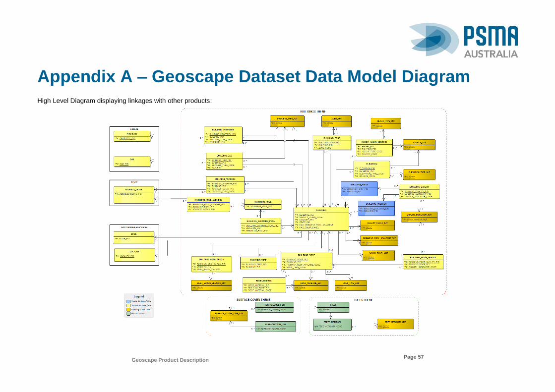
Geoscape Product Description
Page 57
Appendix A – Geoscape Dataset Data Model Diagram
High Level Diagram displaying linkages with other products:

Geoscape Product Description
Page 58
The data model for Buildings Theme (vector data):

Geoscape Product Description
Page 59
The data model for Surface Cover and Trees (raster data):
Geoscape Product Description
Page 60
Appendix B – Data Dictionary
The following table refers to the columns used in all tables that form part of the data dictionary, with the exception of tables for the authority code tables.
Column Abbreviation Description
Name Name The name of the column in the Integrated Database (UPPERCASE).
Data Type Data type The data type of the column based on the types defined in ISO 19103:2015. Parentheses capture Scale, Precision and Maximum
Length, where applicable.
Description Description A description of the column and what the expected contents are.
Primary Key Prim Key If 'Y' then this column must always have a unique value. (has # entry in the data model tables).
Obligation Man Y = mandatory. If 'Y' (mandatory), this column is populated with data.
That is, all ACTIVE records must have values in this column.
Foreign Key Table F K TABLE Represents a column in the 'Foreign Key Table' that this column is referred to by another table. (has * entry in the data model tables).
Foreign Key Column F K Col Represents a table in the Integrated Database that this column is referred to.
10 Character Alias 10 Char Alias An alias for this column name - up to 10 characters maximum. Used to define the name of the column when in ESRI Shapefile format.
The name will be UPPERCASE.
BUILDINGS
Table 1: BUILDING
Name Data Type Description Prim Key
Man F K TABLE F K Col 10 Char Alias
BUILDING_PID CharacterString (16) The persistent identifier is unique to the building feature this record represents.
Y Y - - BLD_PID
DATE_CREATED Date Date this record was created. N Y - - DT_CREATE
DATE_LAST_MODIFIED Date Date this record was last modified from its previous state.
N N - - DT_LT_MOD
Geoscape Product Description
Page 61
DATE_RETIRED Date Date this record was retired. N N - - DT_RETIRE
QUALITY_CLASS_CODE CharacterString (4) The quality class is based on the coverage of the building when processing the data (e.g. Urban, Rural or Remote).
N N QUALITY_CLASS_AUT CODE QUAL_CL_CD
LOCALITY_PID CharacterString (15) The persistent identifier for the Suburb or Locality*.
N N LOCALITY* LOCALITY_PID LOC_PID
STATE_PID CharacterString (15) The persistent identifier for the State or Territory*.
N Y STATE* STATE_PID STATE_PID
ADDRESS_COUNT number (5) The count of addresses (principal > -1 confidence and address default geocodes not ‘UNK’ ‘LOC’ or ‘STL’) within the same spatial property as the building geometry.
N Y - - ADD_COUNT
HAS_SWIMMING_POOL_ADJACENT CharacterString (4) A code allocated based on if a swimming pool has been identified to be more than 10% within a boundary associated with the building.
N N SWIMMING_POOL_ADJACENT_AUT
CODE HAS_SP_ADJ
SWIMMING_POOL_REVIEW_DATE Date The date of the last assessment of the has_swimming_pool_adjacent attribute.
N N - - SWMP_REVDT
HAS_SOLAR_PANEL CharacterString (4) A code allocated based on if a visible solar panel is identified for the building.
N N SOLAR_PANEL_AUT CODE SOLAR_P
SOLAR_PANEL_REVIEW_DATE Date The date of the last assessment of the has_solar_panel attribute.
N N - - SOLP_REVDT
*LOCALITY and STATE tables are NOT IN Geoscape, they are located in PSMA’s Administrative Boundaries product.
Table 2: BUILDING_ADDRESS
ADDRESS_DETAIL records are joined to BUILDING based on them having ADDRESS_DETAIL.CONFIDENCE > -1, ALIAS_PRINCIPAL not having a value of ‘A’
(alias) and ADDRESS_SITE_GEOCODE.GEOCODE_TYPE_CODE not having a value of ‘UNK’ (unknown), ‘LOC’ (locality) or ‘STL’ (street locality).
Name Data Type Description Prim Key
Man F K TABLE F K Col 10 Char Alias
BUILDING_ADDRESS_PID CharacterString (16) This is the unique persistent identifier for each building address relationship.
Y Y - - BLD_AD_PID
BUILDING_PID CharacterString (16) The persistent identifier is unique to the building feature this record represents.
N Y BUILDING BUILDING_PID BLD_PID
Geoscape Product Description
Page 62
Name Data Type Description Prim Key
Man F K TABLE F K Col 10 Char Alias
DATE_CREATED Date Date this record was created. N Y - - DT_CREATE
DATE_LAST_MODIFIED Date Date this record was last modified from its previous state.
N N - - DT_LT_MOD
DATE_RETIRED Date Date this record was retired. N N - - DT_RETIRE
ADDRESS_DETAIL_PID CharacterString (15) This is the unique persistent identifier for each ADDRESS_DETAIL record*.
N Y ADDRESS_DETAIL* ADDRESS_DETAIL_PID ADD_DT_PID
PROCESS_TYPE_CODE CharacterString (4) Processing value indicating reliability of association between the building and an address.
N Y PROCESS_TYPE_AUT CODE PROC_TYPE
HAS_RESIDENTIAL CharacterString (1) A value of Y allocated where address information has identified the land use as residential.
N N - - HAS_RESI
78B* ADDRESS_DETAIL table is not included in this product, it is available in PSMA’s G-NAF product.
Table 3: BUILDING_CAD
The CAD_POLYGON_PID records are joined to BUILDING based on having CAD.PARCEL_STATUS of ‘1’ (registered), PARCEL_TYPE having a value of either ‘1’
(Lot Parcel), ‘2’ (Strata), ‘201’ (Horizontal Strata), ‘202’ (Vertical Strata) or 3 (Stratum). Any BUILDING not assigned will be joined based on having
CAD.PARCEL_STATUS of ‘2’ (unregistered), PARCEL_TYPE having a value of either ‘1’ (Lot Parcel), ‘2’ (Strata), ‘201’ (Horizontal Strata), ‘202’ (Vertical Strata) or
3 (Stratum). The CAD_PID is derived from the CAD_POLYGON_PID.
Name Data Type Description Prim Key
Man F K TABLE F K Col 10 Char Alias
BUILDING_CAD_PID CharacterString (16) This is the unique persistent identifier for each building cad relationship.
Y Y - - BLD_CD_PID
BUILDING_PID CharacterString (16) The persistent identifier is unique to the building feature that this record represents.
N Y BUILDING BUILDING_PID BLD_PID
DATE_CREATED Date Date this record was created. N Y - - DT_CREATE
DATE_LAST_MODIFIED Date Date this record was last modified from its previous state.
N N - - DT_LT_MOD
DATE_RETIRED Date Date this record was retired. N N - - DT_RETIRE
PROCESS_TYPE_CODE CharacterString (4) Processing value indicating reliability of association between the building and a cad record.
N Y PROCESS_TYPE_AUT CODE PROC_TYPE
Geoscape Product Description
Page 63
Name Data Type Description Prim Key
Man F K TABLE F K Col 10 Char Alias
CAD_PID CharacterString (15) This is the unique persistent identifier for each CAD record*.
N Y CAD* CAD_PID CAD_PID
78B* CAD table is not included in this product. It is available in the CadLite product.
Table 4: BUILDING_MESH_BLOCK
Name Data Type Description Prim Key
Man F K TABLE F K Col 10 Char Alias
BUILDING_MESH_BLOCK_PID CharacterString (16)
The unique persistent identifier for each building mesh block relationship.
Y Y - - BLD_MB_PID
BUILDING_PID CharacterString (16)
The persistent identifier is unique to the building feature that this record represents.
N Y BUILDING BUILDING_PID BLD_PID
DATE_CREATED Date Date this record was created. N Y - - DT_CREATE
DATE_RETIRED Date Date this record was retired. N N - - DT_RETIRE
MESH_BLOCK_VERSION CharacterString (6)
The year of release and version of mesh block code attributed to a building.
N Y MESH_BLOCK_RELEASE_AUT CODE MB_VERS
MESH_BLOCK_CODE CharacterString (15)
The ABS mesh block code assigned to a building. N Y - - MB_CODE
Table 5: BUILDING_POINT
Name Data Type Description Prim Key
Man F K TABLE F K Col 10 Char Alias
BUILDING_POINT_PID CharacterString (16) The unique persistent identifier for each building point feature.
Y Y - - BLD_PT_PID
BUILDING_PID CharacterString (16) The persistent identifier is unique to the building feature this record represents.
N Y BUILDING BUILDING_PID BLD_PID
DATE_CREATED Date Date this record was created. N Y - - DT_CREATE
DATE_LAST_MODIFIED Date Date this record was last modified from its previous state.
N N - - DT_LT_MOD
DATE_RETIRED Date Date this record was retired. N N - - DT_RETIRE
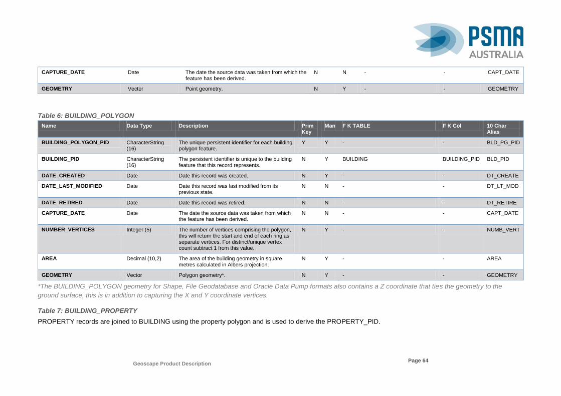
Geoscape Product Description
Page 64
CAPTURE_DATE Date The date the source data was taken from which the feature has been derived.
N N - - CAPT_DATE
GEOMETRY Vector Point geometry. N Y - - GEOMETRY
Table 6: BUILDING_POLYGON
Name Data Type Description Prim Key
Man F K TABLE F K Col 10 Char Alias
BUILDING_POLYGON_PID CharacterString (16)
The unique persistent identifier for each building polygon feature.
Y Y - - BLD_PG_PID
BUILDING_PID CharacterString (16)
The persistent identifier is unique to the building feature that this record represents.
N Y BUILDING BUILDING_PID BLD_PID
DATE_CREATED Date Date this record was created. N Y - - DT_CREATE
DATE_LAST_MODIFIED Date Date this record was last modified from its previous state.
N N - - DT_LT_MOD
DATE_RETIRED Date Date this record was retired. N N - - DT_RETIRE
CAPTURE_DATE Date The date the source data was taken from which the feature has been derived.
N N - - CAPT_DATE
NUMBER_VERTICES Integer (5) The number of vertices comprising the polygon, this will return the start and end of each ring as separate vertices. For distinct/unique vertex count subtract 1 from this value.
N Y - - NUMB_VERT
AREA Decimal (10,2) The area of the building geometry in square metres calculated in Albers projection.
N Y - - AREA
GEOMETRY Vector Polygon geometry*. N Y - - GEOMETRY
*The BUILDING_POLYGON geometry for Shape, File Geodatabase and Oracle Data Pump formats also contains a Z coordinate that ties the geometry to the
ground surface, this is in addition to capturing the X and Y coordinate vertices.
Table 7: BUILDING_PROPERTY
PROPERTY records are joined to BUILDING using the property polygon and is used to derive the PROPERTY_PID.
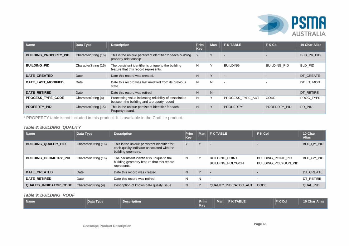
Geoscape Product Description
Page 65
Name Data Type Description Prim Key
Man F K TABLE F K Col 10 Char Alias
BUILDING_PROPERTY_PID CharacterString (16) This is the unique persistent identifier for each building property relationship.
Y Y - - BLD_PR_PID
BUILDING_PID CharacterString (16) The persistent identifier is unique to the building feature that this record represents.
N Y BUILDING BUILDING_PID BLD_PID
DATE_CREATED Date Date this record was created. N Y - - DT_CREATE
DATE_LAST_MODIFIED Date Date this record was last modified from its previous state.
N N - - DT_LT_MOD
DATE_RETIRED Date Date this record was retired. N N - - DT_RETIRE
PROCESS_TYPE_CODE CharacterString (4) Processing value indicating reliability of association between the building and a property record
N Y PROCESS_TYPE_AUT CODE PROC_TYPE
PROPERTY_PID CharacterString (15) This is the unique persistent identifier for each Property record.
N Y PROPERTY* PROPERTY_PID PR_PID
* PROPERTY table is not included in this product. It is available in the CadLite product.
Table 8: BUILDING_QUALITY
Name Data Type Description Prim Key
Man F K TABLE F K Col 10 Char Alias
BUILDING_QUALITY_PID CharacterString (16) This is the unique persistent identifier for each quality indicator associated with the building geometry.
Y Y - - BLD_QY_PID
BUILDING_GEOMETRY_PID CharacterString (16) The persistent identifier is unique to the building geometry feature that this record represents.
N Y BUILDING_POINT
BUILDING_POLYGON
BUILDING_POINT_PID
BUILDING_POLYGON_PID
BLD_GY_PID
DATE_CREATED Date Date this record was created. N Y - - DT_CREATE
DATE_RETIRED Date Date this record was retired. N N - - DT_RETIRE
QUALITY_INDICATOR_CODE CharacterString (4) Description of known data quality issue. N Y QUALITY_INDICATOR_AUT CODE QUAL_IND
Table 9: BUILDING_ROOF
Name Data Type Description Prim Key
Man F K TABLE F K Col 10 Char Alias
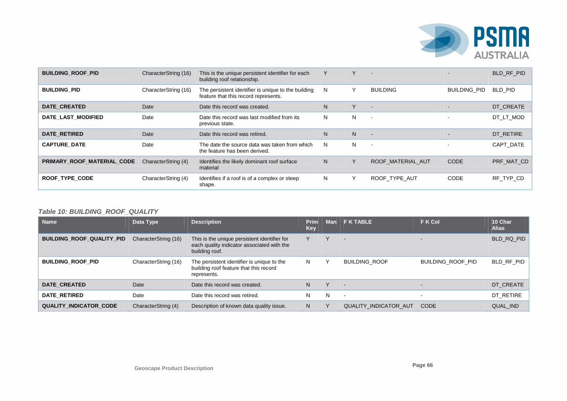
Geoscape Product Description
Page 66
BUILDING_ROOF_PID CharacterString (16) This is the unique persistent identifier for each building roof relationship.
Y Y - - BLD_RF_PID
BUILDING_PID CharacterString (16) The persistent identifier is unique to the building feature that this record represents.
N Y BUILDING BUILDING_PID BLD_PID
DATE_CREATED Date Date this record was created. N Y - - DT_CREATE
DATE_LAST_MODIFIED Date Date this record was last modified from its previous state.
N N - - DT_LT_MOD
DATE_RETIRED Date Date this record was retired. N N - - DT_RETIRE
CAPTURE_DATE Date The date the source data was taken from which the feature has been derived.
N N - - CAPT_DATE
PRIMARY_ROOF_MATERIAL_CODE CharacterString (4) Identifies the likely dominant roof surface material
N Y ROOF_MATERIAL_AUT CODE PRF_MAT_CD
ROOF_TYPE_CODE CharacterString (4) Identifies if a roof is of a complex or steep shape.
N Y ROOF_TYPE_AUT CODE RF_TYP_CD
Table 10: BUILDING_ROOF_QUALITY
Name Data Type Description Prim Key
Man F K TABLE F K Col 10 Char Alias
BUILDING_ROOF_QUALITY_PID CharacterString (16) This is the unique persistent identifier for each quality indicator associated with the building roof.
Y Y - - BLD_RQ_PID
BUILDING_ROOF_PID CharacterString (16) The persistent identifier is unique to the building roof feature that this record represents.
N Y BUILDING_ROOF BUILDING_ROOF_PID
BLD_RF_PID
DATE_CREATED Date Date this record was created. N Y - - DT_CREATE
DATE_RETIRED Date Date this record was retired. N N - - DT_RETIRE
QUALITY_INDICATOR_CODE CharacterString (4) Description of known data quality issue. N Y QUALITY_INDICATOR_AUT CODE QUAL_IND
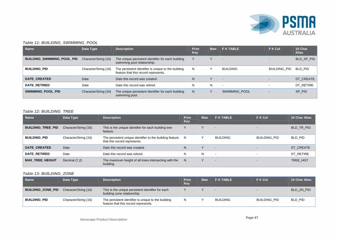
Geoscape Product Description
Page 67
Table 11: BUILDING_SWIMMING_POOL
Name Data Type Description Prim Key
Man F K TABLE F K Col 10 Char Alias
BUILDING_SWIMMING_POOL_PID CharacterString (16) The unique persistent identifier for each building swimming pool relationship.
Y Y - - BLD_SP_PID
BUILDING_PID CharacterString (16) The persistent identifier is unique to the building feature that this record represents.
N Y BUILDING BUILDING_PID BLD_PID
DATE_CREATED Date Date this record was created. N Y - - DT_CREATE
DATE_RETIRED Date Date this record was retired. N N - - DT_RETIRE
SWIMMING_POOL_PID CharacterString (16) The unique persistent identifier for each building swimming pool.
N Y SWIMMING_POOL - SP_PID
Table 12: BUILDING_TREE
Name Data Type Description Prim Key
Man F K TABLE F K Col 10 Char Alias
BUILDING_TREE_PID CharacterString (16) This is the unique identifier for each building tree feature.
Y Y - - BLD_TR_PID
BUILDING_PID CharacterString (16) The persistent unique identifier to the building feature that this record represents.
N Y BUILDING BUILDING_PID BLD_PID
DATE_CREATED Date Date this record was created. N Y - - DT_CREATE
DATE_RETIRED Date Date this record was retired. N N - - DT_RETIRE
MAX_TREE_HEIGHT Decimal (7,2) The maximum height of all trees intersecting with the building.
N Y - - TREE_HGT
Table 13: BUILDING_ZONE
Name Data Type Description Prim Key
Man F K TABLE F K Col 10 Char Alias
BUILDING_ZONE_PID CharacterString (16) This is the unique persistent identifier for each building zone relationship.
Y Y - - BLD_ZN_PID
BUILDING_PID CharacterString (16) The persistent identifier is unique to the building feature that this record represents.
N Y BUILDING BUILDING_PID BLD_PID

Geoscape Product Description
Page 68
Name Data Type Description Prim Key
Man F K TABLE F K Col 10 Char Alias
DATE_CREATED Date Date this record was created. N Y - - DT_CREATE
DATE_RETIRED Date Date this record was retired. N N - - DT_RETIRE
ZONE_CODE CharacterString (4) A code relating to identifying the zone that the building relates to.
N Y ZONE_AUT CODE ZONE_CODE
Table 14: ELEVATION
Name Data Type Description Prim Key
Man F K TABLE F K Col 10 Char Alias
ELEVATION_PID CharacterString (16) This is the unique persistent identifier for each elevation feature.
Y Y - - ELEV_PID
BUILDING_PID CharacterString (16) The persistent identifier is unique to the building feature that this record represents.
N Y BUILDING BUILDING_PID BLD_PID
DATE_CREATED Date Date this record was created. N Y - - DT_CREATE
DATE_RETIRED Date Date this record was retired. N N - - DT_RETIRE
CAPTURE_DATE Date Where available, the date the source data was taken from which the feature has been derived.
N N - - CAPT_DATE
ELEVATION Decimal (7,2) The elevation in metres on the Australian Height Datum (AHD).
N Y - - ELEV
ELEVATION_TYPE_CODE CharacterString (4) The type of elevation being measured (e.g. building elevation).
N Y ELEVATION_TYPE_AUT CODE ELEV_TY_CD
SOURCE_CODE CharacterString (4) Source for calculating elevation values. N Y SOURCE_AUT CODE SOURCE_CD
Table 15: ELEVATION_TYPE_AUT
Name Data Type Description Prim Key
Man
F K TABLE
F K Col 10 Char Alias
CODE CharacterString (4) Code identifying unique elevation types. Y Y - - CODE
NAME CharacterString (50) Name of the elevation type. N Y - - NAME
DESCRIPTION CharacterString (254) Description of the elevation type. N N - - DESCRIPTN
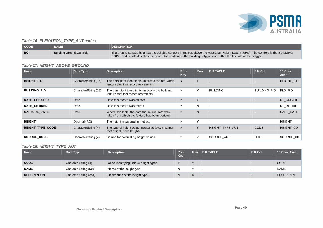
Geoscape Product Description
Page 69
Table 16: ELEVATION_TYPE_AUT codes
CODE NAME DESCRIPTION
BC Building Ground Centroid The ground surface height at the building centroid in metres above the Australian Height Datum (AHD). The centroid is the BUILDING POINT and is calculated as the geometric centroid of the building polygon and within the bounds of the polygon.
Table 17: HEIGHT_ABOVE_GROUND
Name Data Type Description Prim Key
Man F K TABLE F K Col 10 Char Alias
HEIGHT_PID CharacterString (16) The persistent identifier is unique to the real world feature that this record represents.
Y Y - - HEIGHT_PID
BUILDING_PID CharacterString (16) The persistent identifier is unique to the building feature that this record represents.
N Y BUILDING BUILDING_PID BLD_PID
DATE_CREATED Date Date this record was created. N Y - - DT_CREATE
DATE_RETIRED Date Date this record was retired. N N - - DT_RETIRE
CAPTURE_DATE Date Where available, the date the source data was taken from which the feature has been derived.
N N - - CAPT_DATE
HEIGHT Decimal (7,2) The height measured in metres. N Y - - HEIGHT
HEIGHT_TYPE_CODE CharacterString (4) The type of height being measured (e.g. maximum roof height, eave height)
N Y HEIGHT_TYPE_AUT CODE HEIGHT_CD
SOURCE_CODE CharacterString (4) Source for calculating height values. N Y SOURCE_AUT CODE SOURCE_CD
Table 18: HEIGHT_TYPE_AUT
Name Data Type Description Prim Key
Man
F K TABLE
F K Col 10 Char Alias
CODE CharacterString (4) Code identifying unique height types. Y Y - - CODE
NAME CharacterString (50) Name of the height type. N Y - - NAME
DESCRIPTION CharacterString (254) Description of the height type. N N - - DESCRIPTN
Geoscape Product Description
Page 70
Table 19: HEIGHT_TYPE_AUT codes
CODE NAME DESCRIPTION
E1 Average Eave Height The average eave height is the relative height of the eave elevation to the ground elevation and is calculated by taking the median eave elevation minus the minimum ground elevation.
R1 Maximum Roof Height The maximum roof height is the relative height of the roof elevation to the ground elevation and is calculated by taking the maximum roof elevation minus the minimum ground elevation.
Table 20: MESH_BLOCK_VERSION_AUT
Name Data Type Description Prim Key
Man
F K TABLE
F K Col 10 Char Alias
CODE CharacterString (6) Code identifying the unique ABS mesh block version.
Y Y - - CODE
NAME CharacterString (50) Name of the ABS mesh block version. N Y - - NAME
DESCRIPTION CharacterString (254) Description of the ABS mesh block version. N N - - DESCRIPTN
Table 21: MESH_BLOCK_VERSION_AUT Codes
CODE NAME DESCRIPTION
201101 2011 ABS mesh blocks version 1 The 1st version release of the 2011 ABS mesh blocks.
201601 2016 ABS mesh blocks version 1 The 1st version release of the 2016 ABS mesh blocks.
Table 22: PROCESS_TYPE_AUT
Name Data Type Description Prim Key
Man
F K TABLE
F K Col 10 Char Alias
CODE CharacterString (4) Code identifying unique process types. Y Y - - CODE
NAME CharacterString (50) Name of the process type. N Y - - NAME
DESCRIPTION CharacterString (254) Description of the process type. N N - - DESCRIPTN
Table 23: PROCESS_TYPE_AUT Codes
CODE NAME DESCRIPTION
BA01 Building Address Process Type 1 BUILDING polygon spatially contains exactly 1 building geocode ADDRESS feature. The BUILDING is associated with the 1 ADDRESS feature.

Geoscape Product Description
Page 71
CODE NAME DESCRIPTION
BA02 Building Address Process Type 2 BUILDING polygon spatially contains multiple building geocode ADDRESS features. The BUILDING is associated with the multiple ADDRESS features.
BA03 Building Address Process Type 3 BUILDING polygon spatially contains exactly 1 property geocode ADDRESS feature. The BUILDING is associated with the 1 ADDRESS feature.
BA04 Building Address Process Type 4 BUILDING polygon spatially contains multiple property geocode ADDRESS features. The BUILDING is associated with the multiple ADDRESS features.
BA05 Building Address Process Type 5 PROPERTY polygon contains or intersects greater than 80% with a single BUILDING polygon feature and spatially contains exactly 1 property geocode ADDRESS feature. A single BUILDING is associated with the 1 ADDRESS feature.
BA06 Building Address Process Type 6 PROPERTY polygon contains or intersects greater than 80% with multiple BUILDING polygon features and spatially contains exactly 1 property geocode ADDRESS feature. Multiple BUILDINGS are associated with the 1 ADDRESS feature.
BA07 Building Address Process Type 7 PROPERTY polygon contains or intersects greater than 80% with BUILDING polygon feature and spatially contains multiple property geocode ADDRESS features. A single BUILDING is associated with multiple ADDRESS features.
BA08 Building Address Process Type 8 PROPERTY polygon contains or intersects greater than 80% with BUILDING polygon feature and spatially contains multiple property geocode ADDRESS features. Multiple BUILDINGS are associated with multiple ADDRESS features.
BA09 Building Address Process Type 9 BUILDING polygon partially intersects a single PROPERTY polygon with 1 or more property geocode ADDRESS features. A BUILDING is associated with 1 or more ADDRESS features.
BA10 Building Address Process Type 10 BUILDING polygon spatially contains multiple PROPERTY polygons with 1 or more property geocode ADDRESS features. A BUILDING is associated with multiple ADDRESS features.
BA11 Building Address Process Type 11 PROPERTY polygon spatially contains 1 or more building geocode ADDRESS features allocated a BUILDING feature and 1 or more BUILDING polygons intersect PROPERTY polygon not allocated ADDRESS. Multiple BUILDINGS associated with 1 or more ADDRESS features.
BA12 Building Address Process Type 12 ADDRESS has not been allocated a BUILDING. The BUILDING polygon area intersects by more than 10% a single PROPERTY polygon with 1 or more ADDRESS features allocated a BUILDING. A single BUILDING is associated with multiple ADDRESS features.
BA13 Building Address Process Type 13 BUILDING not allocated an ADDRESS and BUILDING polygon spatially contains or intersects PROPERTY polygon that has an ADDRESS within 15 metres and the closest PROPERTY to the ADDRESS. A single BUILDING is associated with a single ADDRESS feature.
BA14 Building Address Process Type 14 BUILDING not allocated ADDRESS and BUILDING polygon intersects with PROPERTY polygon with same PROPERTY_PID as PROPERTY polygon no more than 1km containing ADDRESS feature. A single BUILDING is associated with 1 or more ADDRESS features.
BA15 Building Address Process Type 15 BUILDING not allocated an ADDRESS and PROPERTY polygon intersects with BUILDING polygon where PROPERTY polygon contains 1 or more gap geocode ADDRESS features. A single BUILDING is associated with 1 or more ADDRESS features.
BA16 Building Address Process Type 16 CAD polygon contains or intersects greater than 80% with a single BUILDING polygon feature and spatially contains exactly 1 property geocode ADDRESS feature. A single BUILDING is associated with the 1 ADDRESS feature.
BA17 Building Address Process Type 17 CAD polygon contains or intersects greater than 80% with multiple BUILDING polygon features and spatially contains exactly 1 property geocode ADDRESS feature. Multiple BUILDINGS are associated with the 1 ADDRESS feature.
BA18 Building Address Process Type 18 CAD polygon contains or intersects greater than 80% with BUILDING polygon feature and spatially contains multiple property geocode ADDRESS features. A single BUILDING is associated with multiple ADDRESS features.
BA19 Building Address Process Type 19 CAD polygon contains or intersects greater than 80% with BUILDING polygon feature and spatially contains multiple property geocode ADDRESS features. Multiple BUILDINGS are associated with multiple ADDRESS features.
BA20 Building Address Process Type 20 BUILDING polygon partially intersects a single CAD polygon with 1 or more property geocode ADDRESS features. A BUILDING is associated with 1 or more ADDRESS features.
BA21 Building Address Process Type 21 BUILDING polygon partially intersects multiple CAD polygons with 1 or more property geocode ADDRESS features. A BUILDING is associated with multiple ADDRESS features.

Geoscape Product Description
Page 72
CODE NAME DESCRIPTION
BA22 Building Address Process Type 22 CAD polygon spatially contains 1 or more building geocode ADDRESS features allocated a BUILDING feature and 1 or more BUILDING polygons intersect CAD polygon not allocated ADDRESS. Multiple BUILDINGS associated with 1 or more ADDRESS features.
BA23 Building Address Process Type 23 ADDRESS has not been allocated a BUILDING. The BUILDING polygon area intersects by more than 10% a single CAD polygon with 1 or more ADDRESS features allocated a BUILDING. A single BUILDING is associated with multiple ADDRESS features.
BA24 Building Address Process Type 24 BUILDING not allocated an ADDRESS and BUILDING polygon spatially contains or intersects CAD polygon that has an ADDRESS within 15 metres and the closest CAD to the ADDRESS. A single BUILDING is associated with a single ADDRESS feature.
BA25 Building Address Process Type 25 BUILDING not allocated ADDRESS and BUILDING polygon intersects with CAD polygon with same CAD_PID as CAD polygon no more than 1km containing ADDRESS feature. A single BUILDING is associated with 1 or more ADDRESS features.
BA26 Building Address Process Type 26 BUILDING not allocated an ADDRESS and CAD polygon intersects with BUILDING polygon where CAD polygon contains 1 or more gap geocode ADDRESS features. A single BUILDING is associated with 1 or more ADDRESS features.
BC01 Building CAD Process Type 1 The BUILDING polygon is completely contained by CAD polygon feature. The CAD feature is associated with the BUILDING feature.
BC02 Building CAD Process Type 2 The BUILDING polygon completely contains CAD polygon feature. The CAD feature is associated with one or more BUILDING features.
BC03 Building CAD Process Type 3 The BUILDING polygon has 80% or more spatial overlap of the buildings area with CAD polygon feature. The CAD feature is associated with the BUILDING feature.
BC04 Building CAD Process Type 4 The BUILDING polygon has spatial overlap of less than 80% but 10% or more of the buildings area with CAD polygon feature. The CAD feature is associated with the BUILDING feature.
BC05 Building CAD Process Type 5 The BUILDING polygon has spatial overlap of less than 10% of the buildings area with CAD polygon feature. The CAD feature is associated with the BUILDING feature.
BC06 Building CAD Process Type 6 The BUILDING polygon is completely contained by a CAD polygon feature that also contains CAD point feature. The CAD feature is associated with the BUILDING feature.
BC07 Building CAD Process Type 7 The BUILDING polygon has spatial overlap of more than 80% of the buildings area with CAD polygon feature that also contains CAD point feature. The CAD feature is associated with the BUILDING feature.
BC08 Building CAD Process Type 8 The BUILDING polygon has spatial overlap of less than 80% of the buildings area with CAD polygon feature that also contains CAD point feature. The CAD feature is associated with the BUILDING feature.
BC09 Building CAD Process Type 9 The BUILDING polygon has a spatial overlap with ‘NOT REGISTERED’ CAD polygon feature.
BP01 Building Property Process Type 1 The BUILDING polygon is completely contained by non-proposed PROPERTY polygon feature. The PROPERTY feature is associated with the BUILDING feature.
BP02 Building Property Process Type 2 The BUILDING polygon completely contains PROPERTY polygon feature. The PROPERTY feature is associated with one or more BUILDING features.
BP03 Building Property Process Type 3 The BUILDING polygon has 80% or more spatial overlap of the buildings area with PROPERTY polygon feature. The PROPERTY feature is associated with the BUILDING feature.
BP04 Building Property Process Type 4 The BUILDING polygon has spatial overlap of less than 80% but 10% or more of the buildings area with PROPERTY polygon feature. The PROPERTY feature is associated with the BUILDING feature.
BP05 Building Property Process Type 5 The BUILDING polygon has spatial overlap of less than 10% of the buildings area with PROPERTY polygon feature. The PROPERTY feature is associated with the BUILDING feature.
BP06 Building Property Process Type 6 The BUILDING polygon completely contained by PROPERTY polygon feature that also contains PROPERTY point feature. The PROPERTY feature is associated with the BUILDING feature.
BP07 Building Property Process Type 7 The BUILDING polygon has a spatial overlap of more than 80% of the buildings area with PROPERTY polygon feature that also contains PROPERTY point feature. The PROPERTY feature is associated with the BUILDING feature.
Geoscape Product Description
Page 73
CODE NAME DESCRIPTION
BP08 Building Property Process Type 8 The BUILDING polygon has spatial overlap of less than 80% of the buildings area with PROPERTY polygon feature that also contains PROPERTY point feature. The PROPERTY feature is associated with the BUILDING feature.
Table 24: QUALITY_CLASS_AUT
Name Data Type Description Prim Key
Man
F K TABLE
F K Col 10 Char Alias
CODE CharacterString (4) Code identifying unique quality class types. Y Y - - CODE
NAME CharacterString (50) Name of the quality class type. N Y - - NAME
DESCRIPTION CharacterString (254) Description of the quality class type. N N - - DESCRIPTN
Table 25: QUALITY_CLASS_AUT codes
CODE NAME DESCRIPTION
1 Urban Areas with a population greater than 200 or with significant industrial/commercial activity in a visual assessment with no known cultural or accessibility sensitivities.
2 Rural Balance All other areas not defined as Urban or Remote Communities.
3 Remote Communities Areas with a population greater than 200 or with significant industrial/commercial activity in a visual assessment with known cultural or accessibility sensitivities.
Table 26: QUALITY_INDICATOR_AUT
Name Data Type Description Prim Key
Man
F K TABLE
F K Col 10 Char Alias
CODE CharacterString (4) Code identifying unique quality indicator. Y Y - - CODE
NAME CharacterString (50) Name of the cleansing activity performed on the feature.
N Y - - NAME
DESCRIPTION CharacterString (254) Description of the cleansing activity performed on the feature.
N N - - DESCRIPTN
Table 27: QUALITY_INDICATOR_AUT Codes
CODE NAME DESCRIPTION
IC Invalid CAD Polygon A relationship between the building geometry and the CAD polygon was unable to be made due to invalid geometries.
IP Invalid Property Polygon A relationship between the building geometry and the property polygon was unable to be made due to invalid geometries.

Geoscape Product Description
Page 74
CODE NAME DESCRIPTION
IR Inner Rings Small inner ring/s less than 9 square metres that have been removed.
NE No Ground Centroid Elevation A building that does not intersect a source of ground elevation and will have no ground centroid elevation and each vertex will have a z value of 0.
O Overlap A section of the feature may overlap another feature.
OR Overlap Removed A section of the feature that has been removed due to an overlap with another feature.
RH Remediated Height A building in a high density and or high rise area that has been reviewed and remediated to improve source ground elevations. The Roof Height and Eave Height have been altered.
S Split Complex Polygon A complex polygon that has been split into multiple simple parts.
SB Small Building A building that has a total area of less than 9 metres squared.
SI Self-Intersection Vertices of the polygon self-intersect.
SR Spike Removed A feature with geometry that has an identified 'spike' has been altered to remove the portion of the geometry containing the spike.
URF Unknown Roof Material A building roof material reclassified to another identified roof material.
VSR Varying State Relationship A building that has relationships to Localities or Mesh Blocks in another State / Territory.
Table 28: ROOF_MATERIAL
Name Data Type Description Prim Key
Man F K TABLE F K Col 10 Char Alias
ROOF_MATERIAL_PID CharacterString (16) This is the unique persistent identifier for each roof material feature.
Y Y - - RF_MAT_PID
BUILDING_ROOF_PID CharacterString (16) The persistent identifier is unique to the building roof feature that this record represents.
N Y BUILDING_ROOF BUILDING_ROOF_PID BLD_RF_PID
DATE_CREATED Date Date this record was created. N Y - - DT_CREATE
DATE_RETIRED Date Date this record was retired. N N - - DT_RETIRE
CAPTURE_DATE Date The date when the source data was taken from which the feature has been derived.
N N - - CAPT_DATE
ROOF_MATERIAL_CODE CharacterString (4) The code that reflects the most likely roof surface material.
N Y ROOF_MATERIAL_AUT CODE RF_MAT_CD
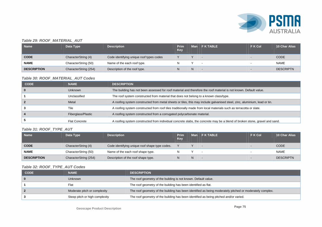
Geoscape Product Description
Page 75
Table 29: ROOF_MATERIAL_AUT
Name Data Type Description Prim Key
Man
F K TABLE
F K Col 10 Char Alias
CODE CharacterString (4) Code identifying unique roof types codes Y Y - - CODE
NAME CharacterString (50) Name of the each roof type. N Y - - NAME
DESCRIPTION CharacterString (254) Description of the roof type. N N - - DESCRIPTN
Table 30: ROOF_MATERIAL_AUT Codes
CODE NAME DESCRIPTION
0 Unknown The building has not been assessed for roof material and therefore the roof material is not known. Default value.
1 Unclassified The roof system constructed from material that does not belong to a known class/type.
2 Metal A roofing system constructed from metal sheets or tiles, this may include galvanised steel, zinc, aluminium, lead or tin.
3 Tile A roofing system constructed from roof tiles traditionally made from local materials such as terracotta or slate.
4 Fiberglass/Plastic A roofing system constructed from a corrugated polycarbonate material.
5 Flat Concrete A roofing system constructed from individual concrete slabs, the concrete may be a blend of broken stone, gravel and sand.
Table 31: ROOF_TYPE_AUT
Name Data Type Description Prim Key
Man
F K TABLE
F K Col 10 Char Alias
CODE CharacterString (4) Code identifying unique roof shape type codes. Y Y - - CODE
NAME CharacterString (50) Name of the each roof shape type. N Y - - NAME
DESCRIPTION CharacterString (254) Description of the roof shape type. N N - - DESCRIPTN
Table 32: ROOF_TYPE_AUT Codes
CODE NAME DESCRIPTION
0 Unknown The roof geometry of the building is not known. Default value.
1 Flat The roof geometry of the building has been identified as flat.
2 Moderate pitch or complexity The roof geometry of the building has been identified as being moderately pitched or moderately complex.
3 Steep pitch or high complexity The roof geometry of the building has been identified as being pitched and/or varied.

Geoscape Product Description
Page 76
Table 33: SOLAR_PANEL_AUT
Name Data Type Description Prim Key
Man
F K TABLE
F K Col 10 Char Alias
CODE CharacterString (4) A code identifying unique solar panel codes. Y Y - - CODE
NAME CharacterString (50) Name of the solar panel type. N Y - - NAME
DESCRIPTION CharacterString (254) Description of the solar panel type. N N - - DESCRIPTN
Table 34: SOLAR_PANEL_AUT Codes
CODE NAME DESCRIPTION
0 Unknown The building has not been assessed and therefore is not known if the building has solar panels or not. Default value.
1 Yes The building has been identified as having solar panels.
2 No The building has been identified as not having solar panels.
3 Unclassified The building could not be determined as either having or not having solar panels.
Table 35: SOURCE_AUT
Name Data Type Description Prim Key
Man
F K TABLE
F K Col 10 Char Alias
CODE CharacterString (4) Code identifying unique source codes. Y Y - - CODE
NAME CharacterString (50) Name of the source type. N Y - - NAME
DESCRIPTION CharacterString (254) Description of the source type. N N - - DESCRIPTN
Table 36: SOURCE_AUT Codes
CODE NAME DESCRIPTION
0 1 Second SRTM Hydro (DEM-H) Version 1.0
DEM representing hydro enforced smoothed ground surface topography derived from SRTM data acquired by NASA in Feb 2000. Full metadata http://www.ga.gov.au/metadata-gateway/metadata/record/gcat_72759
1 ACT 5m DEM GA produced 5 metre (bare earth) DEM which has been derived from ACT LIDAR survey 2015-2016.
2 NSW 25m DEM (z55) NSW Spatial Services produced, NSW DTDB Landform Theme 50 k x 50 k Digital Terrain Models is a data series of 25m grid large scale Digital Terrain Models for NSW.
3 SA State 5m DEM Mosaic GA produced national 5 metre (bare earth) DEM which has been derived from LIDAR surveys between 2001 and 2015. Metadata http://www.ga.gov.au/metadata-gateway/metadata/record/gcat_22be4b55-2465-4320-e053-10a3070a5236
4 0.5m Digital Surface Model DigitalGlobe produced DSM derived from high quality satellite imagery.
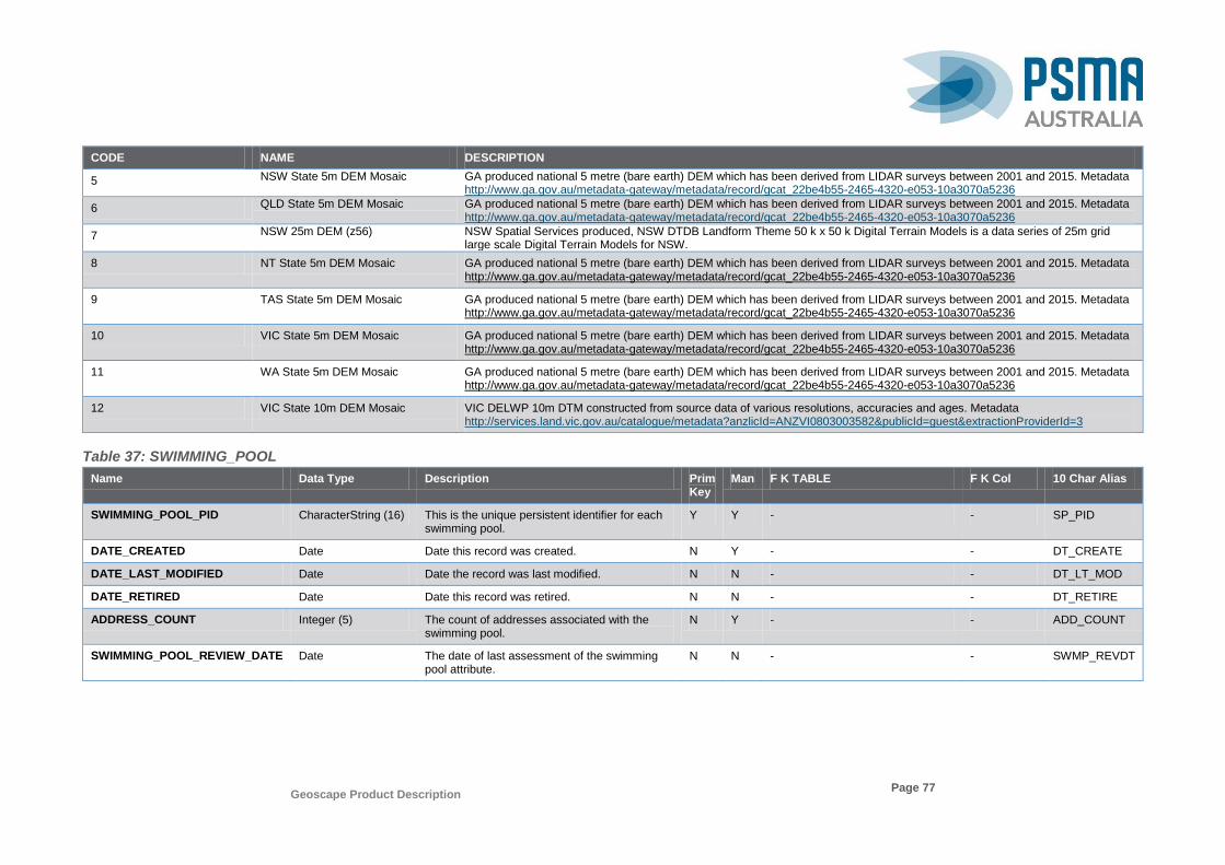
Geoscape Product Description
Page 77
CODE NAME DESCRIPTION
5 NSW State 5m DEM Mosaic GA produced national 5 metre (bare earth) DEM which has been derived from LIDAR surveys between 2001 and 2015. Metadata http://www.ga.gov.au/metadata-gateway/metadata/record/gcat_22be4b55-2465-4320-e053-10a3070a5236
6 QLD State 5m DEM Mosaic GA produced national 5 metre (bare earth) DEM which has been derived from LIDAR surveys between 2001 and 2015. Metadata http://www.ga.gov.au/metadata-gateway/metadata/record/gcat_22be4b55-2465-4320-e053-10a3070a5236
7 NSW 25m DEM (z56) NSW Spatial Services produced, NSW DTDB Landform Theme 50 k x 50 k Digital Terrain Models is a data series of 25m grid large scale Digital Terrain Models for NSW.
8 NT State 5m DEM Mosaic GA produced national 5 metre (bare earth) DEM which has been derived from LIDAR surveys between 2001 and 2015. Metadata http://www.ga.gov.au/metadata-gateway/metadata/record/gcat_22be4b55-2465-4320-e053-10a3070a5236
9 TAS State 5m DEM Mosaic GA produced national 5 metre (bare earth) DEM which has been derived from LIDAR surveys between 2001 and 2015. Metadata http://www.ga.gov.au/metadata-gateway/metadata/record/gcat_22be4b55-2465-4320-e053-10a3070a5236
10 VIC State 5m DEM Mosaic GA produced national 5 metre (bare earth) DEM which has been derived from LIDAR surveys between 2001 and 2015. Metadata http://www.ga.gov.au/metadata-gateway/metadata/record/gcat_22be4b55-2465-4320-e053-10a3070a5236
11 WA State 5m DEM Mosaic GA produced national 5 metre (bare earth) DEM which has been derived from LIDAR surveys between 2001 and 2015. Metadata http://www.ga.gov.au/metadata-gateway/metadata/record/gcat_22be4b55-2465-4320-e053-10a3070a5236
12 VIC State 10m DEM Mosaic VIC DELWP 10m DTM constructed from source data of various resolutions, accuracies and ages. Metadata http://services.land.vic.gov.au/catalogue/metadata?anzlicId=ANZVI0803003582&publicId=guest&extractionProviderId=3
Table 37: SWIMMING_POOL
Name Data Type Description Prim Key
Man F K TABLE F K Col 10 Char Alias
SWIMMING_POOL_PID CharacterString (16) This is the unique persistent identifier for each swimming pool.
Y Y - - SP_PID
DATE_CREATED Date Date this record was created. N Y - - DT_CREATE
DATE_LAST_MODIFIED Date Date the record was last modified. N N - - DT_LT_MOD
DATE_RETIRED Date Date this record was retired. N N - - DT_RETIRE
ADDRESS_COUNT Integer (5) The count of addresses associated with the swimming pool.
N Y - - ADD_COUNT
SWIMMING_POOL_REVIEW_DATE Date The date of last assessment of the swimming pool attribute.
N N - - SWMP_REVDT

Geoscape Product Description
Page 78
Table 38: SWIMMING_POOL_ADDRESS
Name Data Type Description Prim Key
Man F K TABLE F K Col 10 Char Alias
SWIMMING_POOL_ADDRESS
_PID
CharacterString (16) This is the unique persistent identifier for each swimming pool address relationship.
Y Y - - SP_AD_PID
SWIMMING_POOL_PID CharacterString (16) This is the unique persistent identifier for each instance of swimming pool site.
N Y - - SP_PID
DATE_CREATED Date Date this record was created. N Y - - DT_CREATE
DATE_RETIRED Date Date this record was retired. N N - - DT_RETIRE
ADDRESS_DETAIL_PID CharacterString (15) ADDRESS_DETAIL persistent Identifier. N Y ADDRESS_DETAIL* ADDRESS_DETAIL_PID ADD_DT_PID
* ADDRESS_DETAIL table is not included in this product. It is available in G-NAF.
Table 39: SWIMMING_POOL_ADJACENT_AUT
Name Data Type Description Prim Key
Man
F K TABLE
F K Col 10 Char Alias
CODE CharacterString (4) Code identifying unique swimming pool adjacent codes.
Y Y - - CODE
NAME CharacterString (50) Name of the swimming pool adjacent type. N Y - - NAME
DESCRIPTION CharacterString (254) Description of the swimming pool adjacent type. N N - - DESCRIPTN
Table 40: SWIMMING_POOL_ADJACENT_AUT Codes
CODE NAME DESCRIPTION
0 Unknown The building has not been assessed and therefore it is not known if the building has a swimming pool adjacent or not. Default value.
1 Yes The building has been identified as having a swimming pool adjacent.
2 No The building has been identified as not having a swimming pool adjacent.
3 Unclassified The building could not be determined as either having or not having a swimming pool adjacent.

Geoscape Product Description
Page 79
Table 41: ZONE_AUT
Name Data Type Description Prim Key
Man
F K TABLE
F K Col 10 Char Alias
CODE CharacterString (4) Code identifying unique zone codes. Y Y - - CODE
NAME CharacterString (50) Name of the zone type. N Y - - NAME
DESCRIPTION CharacterString (254) Description of the zone type. N N - - DESCRIPTN
Note: Please refer to section 6.2 re: Thematic Quality for further information about the reliability of the Zone Code attribute
Table 42: ZONE_AUT Codes
CODE NAME DESCRIPTION
0 Unknown Areas where the planning zone is not known.
1 Commercial/Business Areas where the state, territory or local government planning scheme generally indicate a commercial or business focus.
2 Community Use Areas where the state, territory or local government planning scheme generally indicate community use.
3 Conservation/National Park Areas where the state, territory or local government planning scheme generally indicate National Park or a conservation requirement.
4 Industrial/Utilities Areas where the state, territory or local government planning scheme generally indicate industrial activities and/or utility facilities.
5 Mixed Use Areas where the state, territory or local government planning scheme generally indicate mixed use.
6 Recreational/Open Space Areas where the state, territory or local government planning scheme generally indicate recreational activities and or open space.
7 Residential Areas where the state, territory or local government planning scheme generally indicate residential.
8 Rural/Primary Production Areas where the state, territory or local government planning scheme generally indicate rural and/or primary production activities.
9 Special Use Areas where the state, territory or local government planning scheme generally indicate special use.
10 Transport/Infrastructure Areas where the state, territory or local government planning scheme generally indicate transport and/or other infrastructure.
11 Water Areas where the state, territory or local government planning scheme generally indicate waterways or other water areas.
Note: Please refer to section 6.2 re: Thematic Quality for further information about the reliability of the Zone Code attribute

Geoscape Product Description
Page 80
SURFACE COVER
The Surface Cover for both 2 Metres and 30 Metres layers are raster data and are not joined with any tables. The SURFACE_COVER_2M TYPE_AUT and
SURFACE_COVER_30M TYPE_AUT tables are lookup tables used for referring to the values in the raster data.
Table 43: SURFACE_COVER_TYPE_AUT
Name Data Type Description Prim Key
Man
F K TABLE
F K Col 10 Char Alias
CODE CharacterString (4) Code identifying unique surface_cover_type_code.
Y Y - - CODE
NAME CharacterString (50) Name of the surface cover type. N Y - - NAME
DESCRIPTION CharacterString (254) Description of the surface cover type. N N - - DESCRIPTN
Table 44: SURFACE_COVER_2M_TYPE_AUT Codes
CODE NAME DESCRIPTION Red* Green* Blue*
2 Bare Earth Includes sand dunes, desert, rock outcrops, bare soil other than bare agricultural land, and sparsely vegetated areas of grass and shrub. Non-vegetated strip mines and quarries except where covered by development or water.
215 194 158
3 Road and Path Roads and parking lots covered in a man-made material excluding hard packed dirt trails. 156 156 156
4 Grass Grass and herbaceous areas. Category may include herbaceous wetlands if images are collected during dry season or periods of drought.
152 230 0
5 Trees All trees including deciduous and evergreen woody vegetation. 38 115 0
6 Unspecified Vegetation Any other vegetative material not included within the Grass or Tree class. This may include, but is not limited to, shrub, scrub, agriculture, and aquatic plants.
114 137 68
7 Built-up Areas Any areas of man-made environments and infrastructure excluding road and paths and buildings. 255 190 190
8 Water Depending on the resolution quality of the imagery used, natural water will include streams, canals, ponds, lakes, reservoirs, estuaries and bays.
158 170 215
9 Buildings Where the majority of a pixel intersects a PSMA Geoscape vector building polygon representation. 137 90 68
10 Cloud Area covered with cloud on Date of collection. 225 225 225
11 Shadow Area covered with shadow on Date / time of collection. 78 78 78
12 Swimming Pool An area identified as a swimming pool. 0 77 168
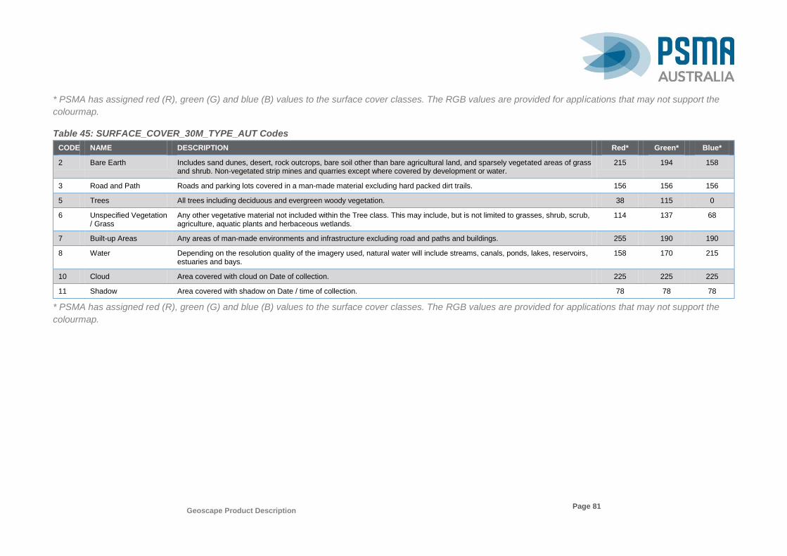
Geoscape Product Description
Page 81
* PSMA has assigned red (R), green (G) and blue (B) values to the surface cover classes. The RGB values are provided for applications that may not support the
colourmap.
Table 45: SURFACE_COVER_30M_TYPE_AUT Codes
CODE NAME DESCRIPTION Red* Green* Blue*
2 Bare Earth Includes sand dunes, desert, rock outcrops, bare soil other than bare agricultural land, and sparsely vegetated areas of grass and shrub. Non-vegetated strip mines and quarries except where covered by development or water.
215 194 158
3 Road and Path Roads and parking lots covered in a man-made material excluding hard packed dirt trails. 156 156 156
5 Trees All trees including deciduous and evergreen woody vegetation. 38 115 0
6 Unspecified Vegetation / Grass
Any other vegetative material not included within the Tree class. This may include, but is not limited to grasses, shrub, scrub, agriculture, aquatic plants and herbaceous wetlands.
114 137 68
7 Built-up Areas Any areas of man-made environments and infrastructure excluding road and paths and buildings. 255 190 190
8 Water Depending on the resolution quality of the imagery used, natural water will include streams, canals, ponds, lakes, reservoirs, estuaries and bays.
158 170 215
10 Cloud Area covered with cloud on Date of collection. 225 225 225
11 Shadow Area covered with shadow on Date / time of collection. 78 78 78
* PSMA has assigned red (R), green (G) and blue (B) values to the surface cover classes. The RGB values are provided for applications that may not support the
colourmap.

Geoscape Product Description
Page 82
TREES
The Trees are raster data and are not joined with any tables. The TREE_METADATA_AUT table is a lookup table used for referring to the values in the
TREES_METADATA raster data. The trees identified by this process are for information purposes only and the height or classification of these trees will remain
unaltered.
Table 46: TREE_METADATA_AUT
Name Data Type Description Prim Key
Man
F K TABLE
F K Col 10 Char Alias
CODE CharacterString (4) Code identifying unique tree metadata code. Y Y - - CODE
NAME CharacterString (50) Name of the tree metadata type. N Y - - NAME
DESCRIPTION CharacterString (254) Description of the tree metadata type. N N - - DESCRIPTN
Table 47: TREE_METADATA_AUT Codes
CODE NAME DESCRIPTION
1 Low Trees Tree pixel did not meet minimum height requirement. Set to unspecified vegetation or building in SURFACE COVER 2M dataset.
2 High Trees Tree pixel did not meet maximum height restriction. Tree height set to 25m.
50 Trees above 50m Trees pixel exceeded the expected max tree height of 50m for this region. Tree height remains unaltered.
60 Trees above 60m Trees pixel exceeded the expected max tree height of 60m for this region. Tree height remains unaltered.
75 Trees above 75m Trees pixel exceeded the expected max tree height of 75m for this region. Tree height remains unaltered.
80 Trees above 80m Trees pixel exceeded the expected max tree height of 80m for this region. Tree height remains unaltered.
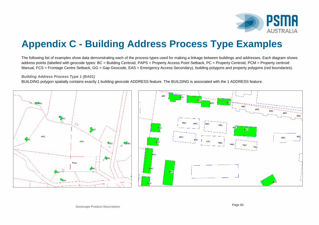
Geoscape Product Description
Page 83
Appendix C - Building Address Process Type Examples
The following list of examples show data demonstrating each of the process types used for making a linkage between buildings and addresses. Each diagram shows
address points (labelled with geocode types: BC = Building Centroid, PAPS = Property Access Point Setback, PC = Property Centroid, PCM = Property centroid
Manual, FCS = Frontage Centre Setback, GG = Gap Geocode, EAS = Emergency Access Secondary), building polygons and property polygons (red boundaries).
Building Address Process Type 1 (BA01)
BUILDING polygon spatially contains exactly 1 building geocode ADDRESS feature. The BUILDING is associated with the 1 ADDRESS feature.

Geoscape Product Description
Page 84
Building Address Process Type 2 (BA02)
BUILDING polygon spatially contains multiple building geocode ADDRESS features. The BUILDING is associated with the multiple ADDRESS features.
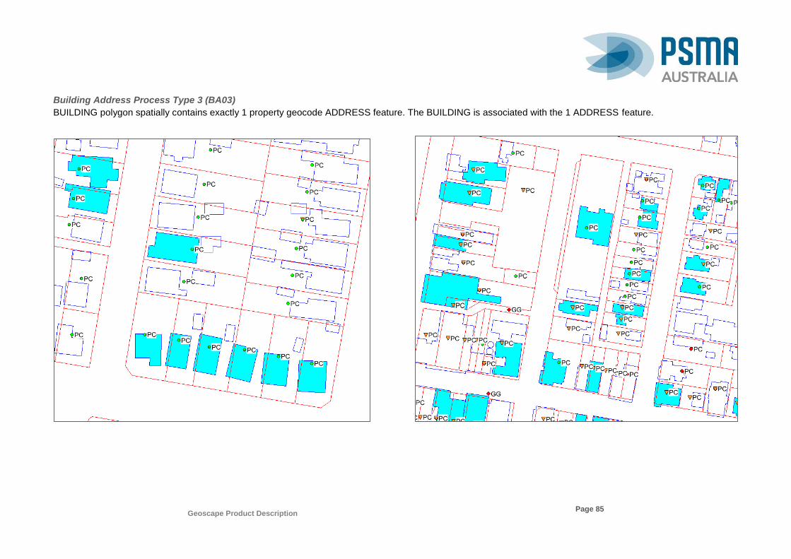
Geoscape Product Description
Page 85
Building Address Process Type 3 (BA03)
BUILDING polygon spatially contains exactly 1 property geocode ADDRESS feature. The BUILDING is associated with the 1 ADDRESS feature.
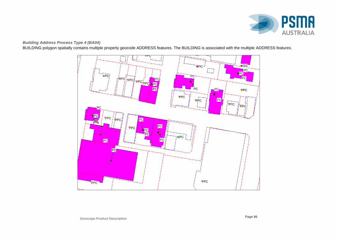
Geoscape Product Description
Page 86
Building Address Process Type 4 (BA04)
BUILDING polygon spatially contains multiple property geocode ADDRESS features. The BUILDING is associated with the multiple ADDRESS features.
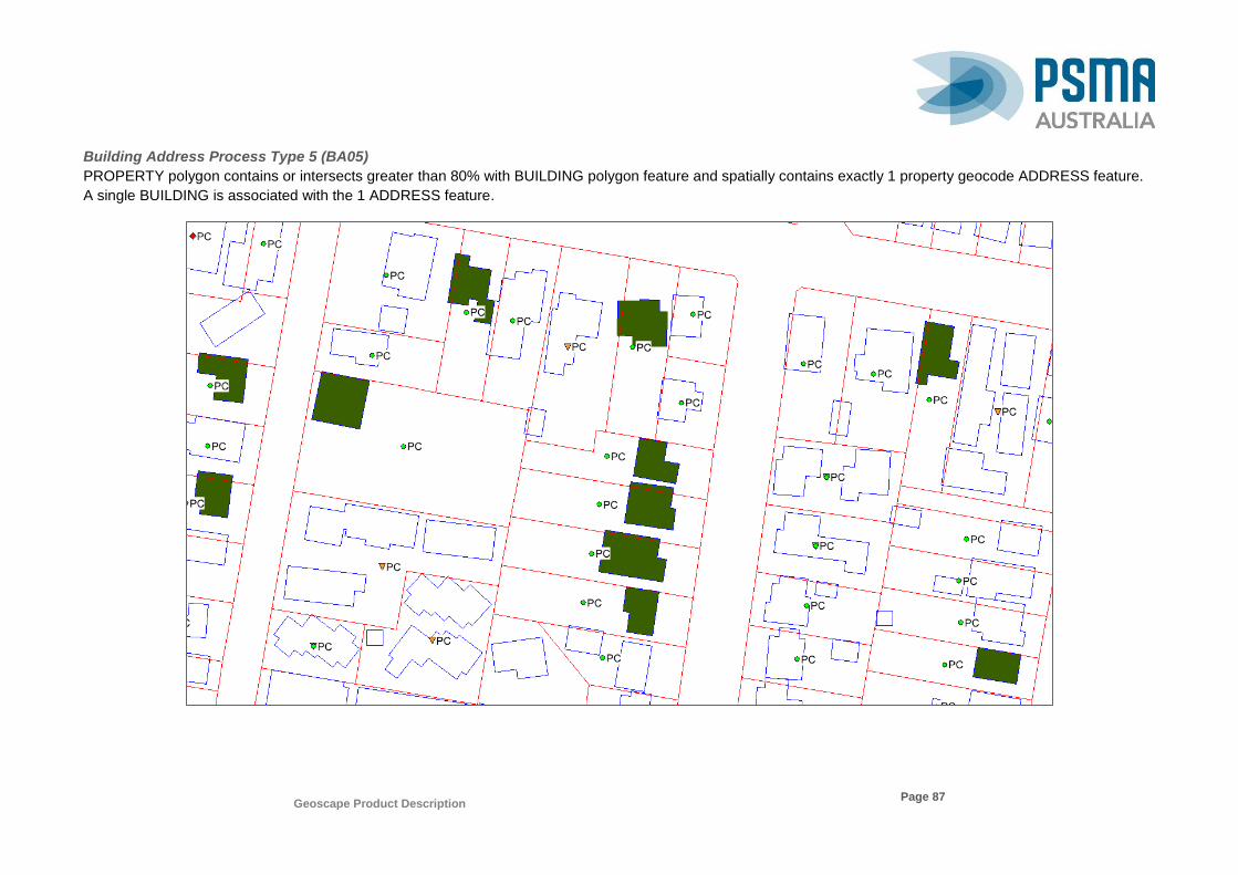
Geoscape Product Description
Page 87
Building Address Process Type 5 (BA05)
PROPERTY polygon contains or intersects greater than 80% with BUILDING polygon feature and spatially contains exactly 1 property geocode ADDRESS feature.
A single BUILDING is associated with the 1 ADDRESS feature.
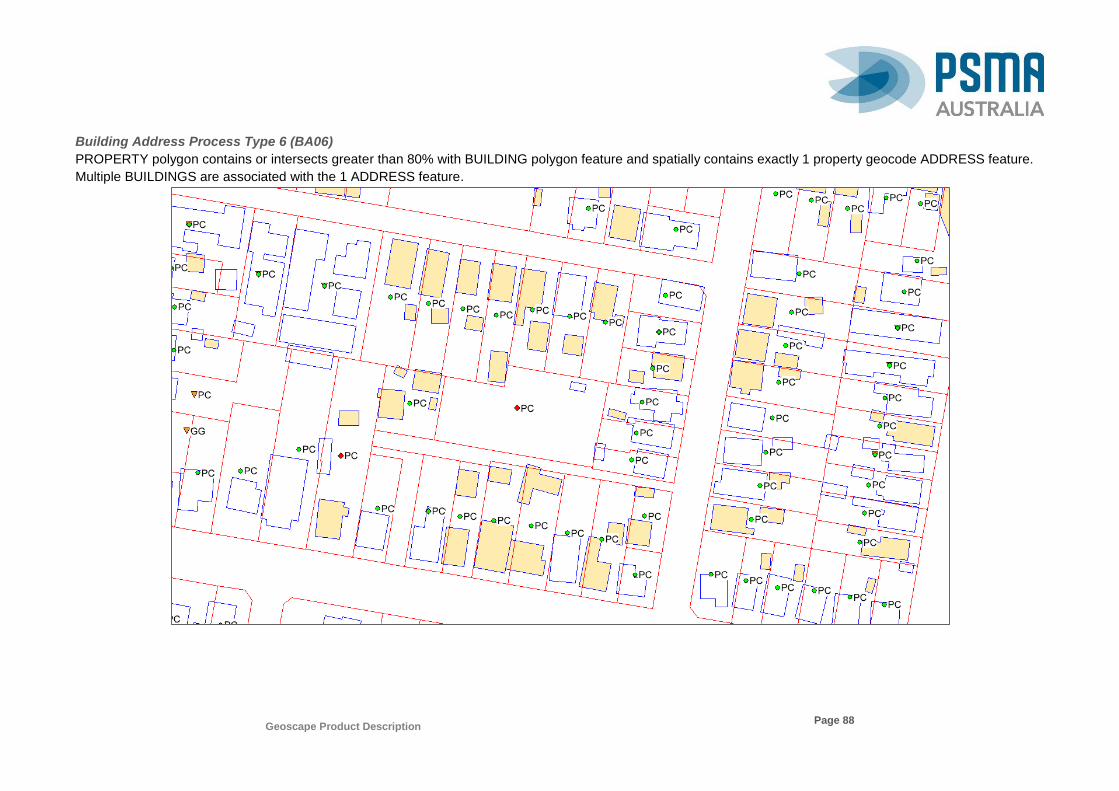
Geoscape Product Description
Page 88
Building Address Process Type 6 (BA06)
PROPERTY polygon contains or intersects greater than 80% with BUILDING polygon feature and spatially contains exactly 1 property geocode ADDRESS feature.
Multiple BUILDINGS are associated with the 1 ADDRESS feature.
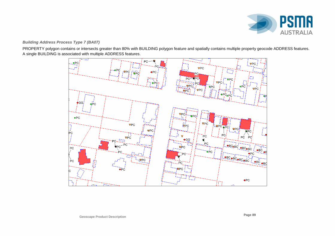
Geoscape Product Description
Page 89
Building Address Process Type 7 (BA07)
PROPERTY polygon contains or intersects greater than 80% with BUILDING polygon feature and spatially contains multiple property geocode ADDRESS features.
A single BUILDING is associated with multiple ADDRESS features.
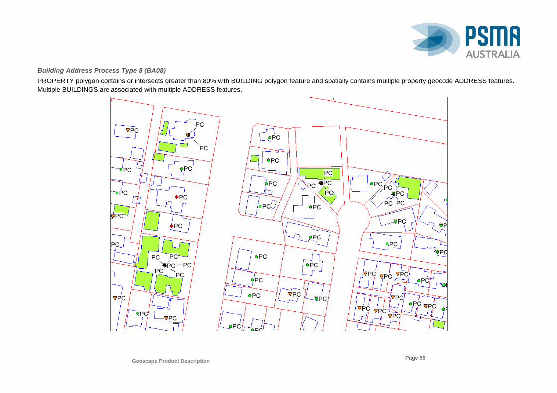
Geoscape Product Description
Page 90
Building Address Process Type 8 (BA08)
PROPERTY polygon contains or intersects greater than 80% with BUILDING polygon feature and spatially contains multiple property geocode ADDRESS features.
Multiple BUILDINGS are associated with multiple ADDRESS features.

Geoscape Product Description
Page 91
It is known that where a large number of addresses fall within a property with a large number of unassigned buildings this relationship code will produce a significant
number of building address records. An example of this is shown below where the property contains 85 geocodes, each of the 207 buildings have a building address
record for each of the 85 geocodes within the property.

Geoscape Product Description
Page 92
Building Address Process Type 9 (BA09)
BUILDING polygon partially intersects a single PROPERTY polygon with 1 or more property geocode ADDRESS features. A single BUILDING is associated with 1
or more ADDRESS features.

Geoscape Product Description
Page 93
Building Address Process Type 10 (BA10)
BUILDING polygon partially intersects multiple PROPERTY polygons with 1 or more property geocode ADDRESS features. A single BUILDING is associated with
multiple ADDRESS features.
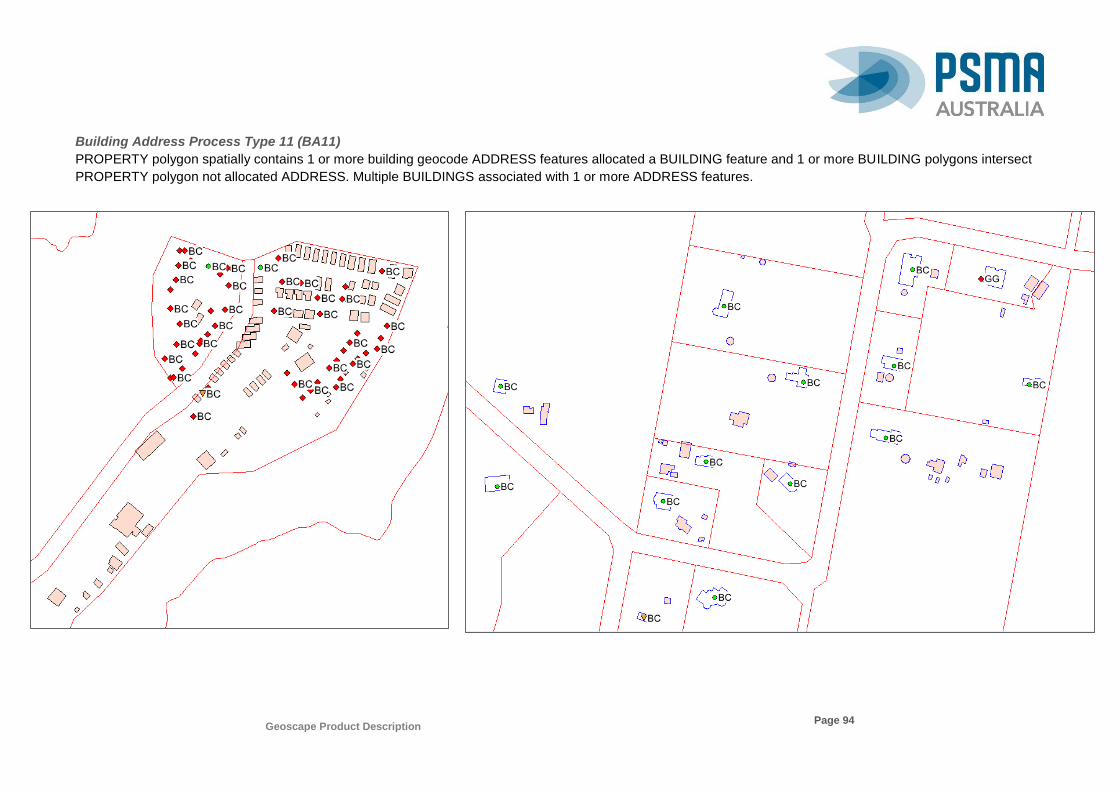
Geoscape Product Description
Page 94
Building Address Process Type 11 (BA11)
PROPERTY polygon spatially contains 1 or more building geocode ADDRESS features allocated a BUILDING feature and 1 or more BUILDING polygons intersect
PROPERTY polygon not allocated ADDRESS. Multiple BUILDINGS associated with 1 or more ADDRESS features.

Geoscape Product Description
Page 95
Building Address Process Type 12 (BA12)
ADDRESS has not been allocated a BUILDING. The BUILDING polygon area intersects by more than 10% a single PROPERTY polygon with 1 or more ADDRESS
features allocated a BUILDING. A single BUILDING is associated with multiple ADDRESS features.

Geoscape Product Description
Page 96
Building Address Process Type 13 (BA13)
BUILDING not allocated an ADDRESS and BUILDING polygon spatially contains or intersects PROPERTY polygon that has an ADDRESS within 15 metres and the
closest PROPERTY to the ADDRESS. A single BUILDING is associated with a single ADDRESS feature.
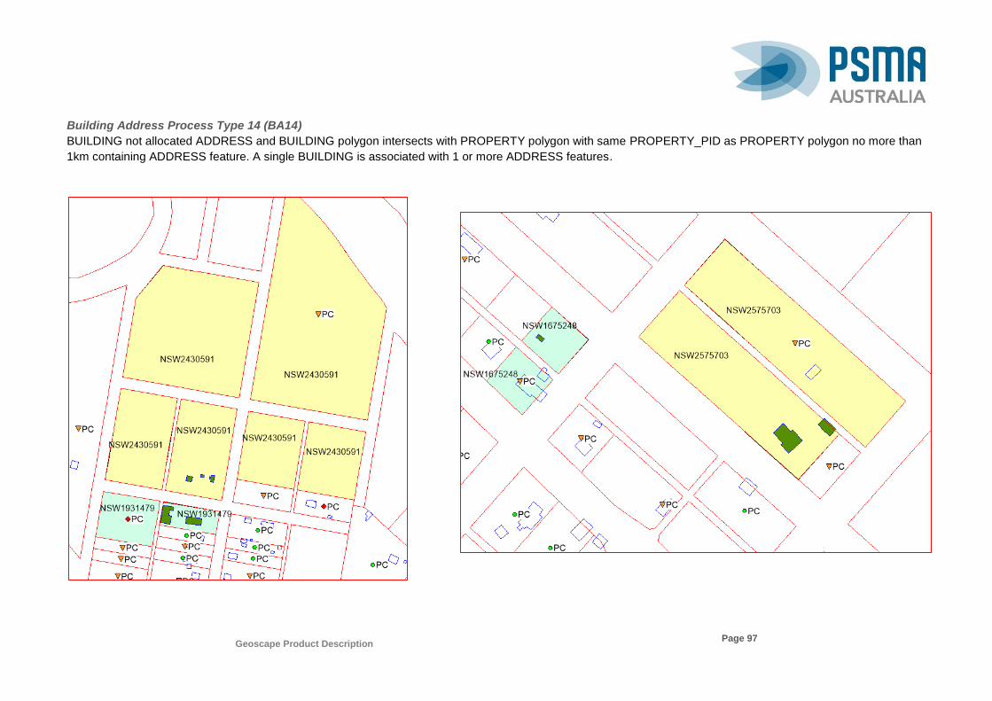
Geoscape Product Description
Page 97
Building Address Process Type 14 (BA14)
BUILDING not allocated ADDRESS and BUILDING polygon intersects with PROPERTY polygon with same PROPERTY_PID as PROPERTY polygon no more than
1km containing ADDRESS feature. A single BUILDING is associated with 1 or more ADDRESS features.

Geoscape Product Description
Page 98
Building Address Process Type 15 (BA15)
BUILDING not allocated an ADDRESS and PROPERTY polygon intersects with BUILDING polygon where PROPERTY polygon contains 1 or more gap geocode
ADDRESS features. A single BUILDING is associated with 1 or more ADDRESS features.

Geoscape Product Description
Page 99
Appendix D - Building CAD Process Type Examples
The following list of examples show data demonstrating each of the process types used for making a linkage between buildings and CAD. Each diagram shows the
CAD boundaries in black.
Building CAD Process Type 1 (BC01)
The BUILDING polygon is completely contained by CAD polygon feature. The CAD feature is associated with the BUILDING feature.
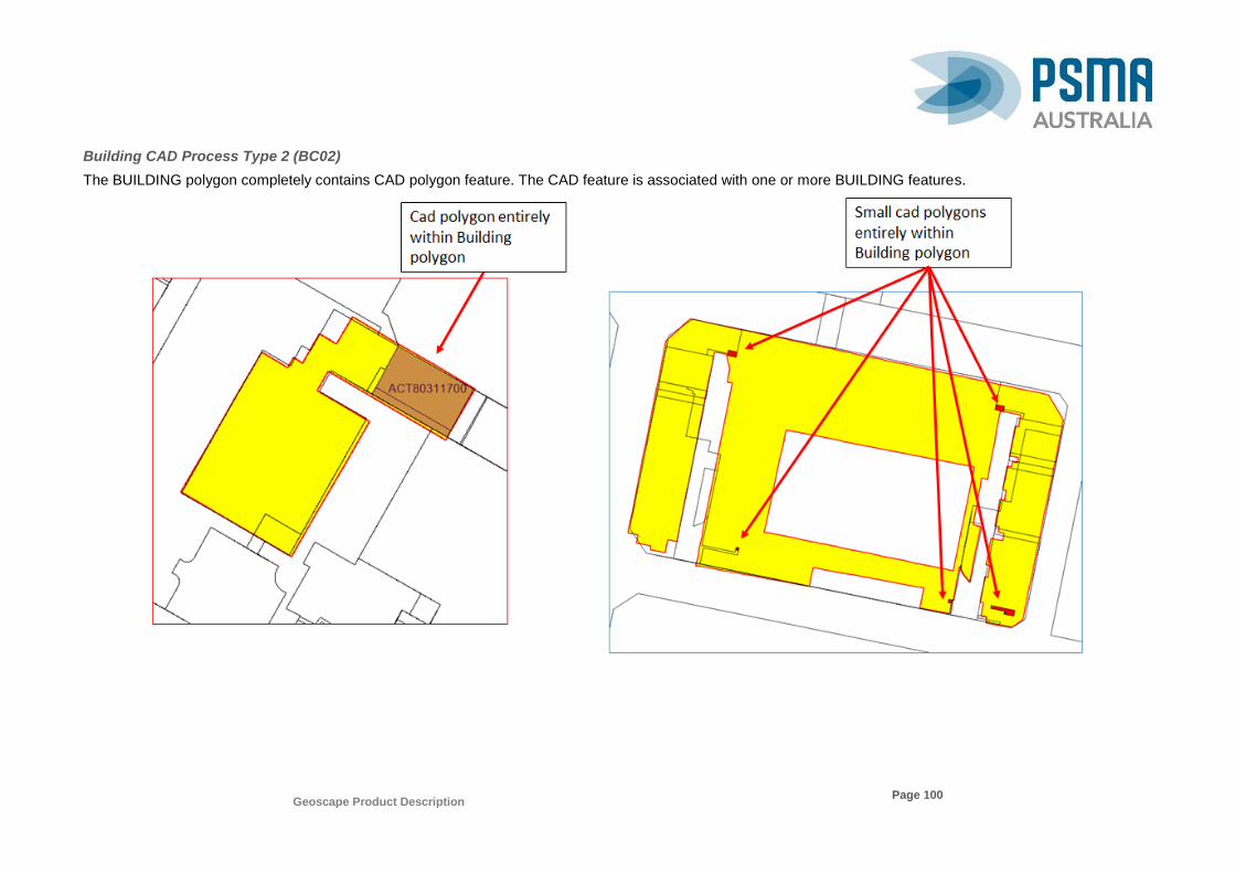
Geoscape Product Description
Page 100
Building CAD Process Type 2 (BC02)
The BUILDING polygon completely contains CAD polygon feature. The CAD feature is associated with one or more BUILDING features.

Geoscape Product Description
Page 101
Building CAD Process Type 3 (BC03)
The BUILDING polygon has 80% or more spatial overlap of the buildings area with CAD polygon feature. The CAD feature is associated with the BUILDING feature.

Geoscape Product Description
Page 102
Building CAD Process Type 4 (BC04)
The BUILDING polygon has spatial overlap of less than 80% but 10% or more of the buildings area with CAD polygon feature. The CAD feature is associated with
the BUILDING feature.

Geoscape Product Description
Page 103
Building CAD Process Type 5 (BC05)
The BUILDING polygon has spatial overlap of less than 10% of the buildings area with CAD polygon feature. The CAD feature is associated with the BUILDING
feature.
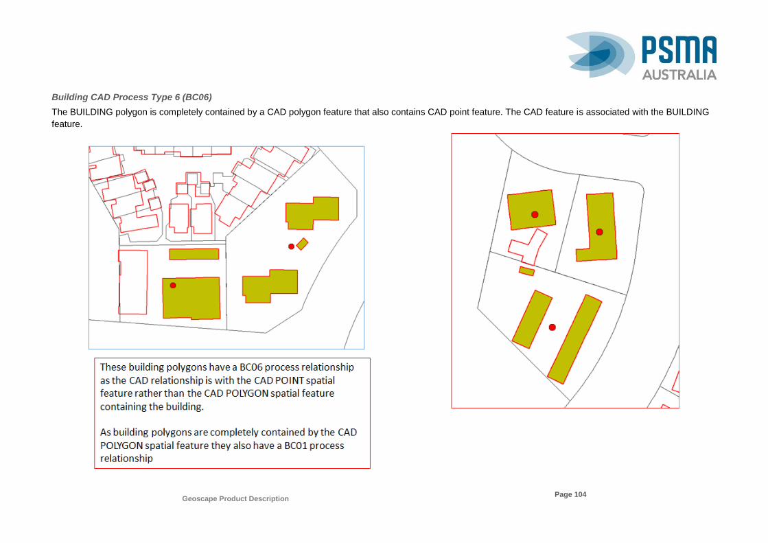
Geoscape Product Description
Page 104
Building CAD Process Type 6 (BC06)
The BUILDING polygon is completely contained by a CAD polygon feature that also contains CAD point feature. The CAD feature is associated with the BUILDING
feature.
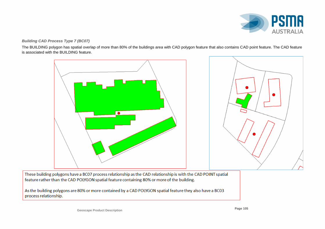
Geoscape Product Description
Page 105
Building CAD Process Type 7 (BC07)
The BUILDING polygon has spatial overlap of more than 80% of the buildings area with CAD polygon feature that also contains CAD point feature. The CAD feature
is associated with the BUILDING feature.
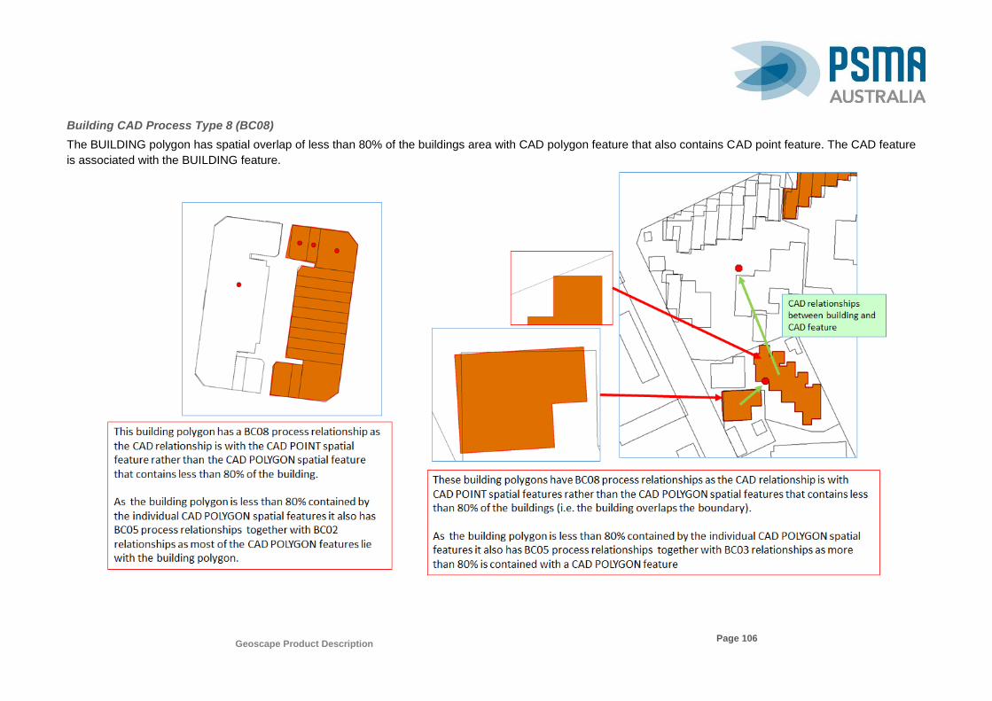
Geoscape Product Description
Page 106
Building CAD Process Type 8 (BC08)
The BUILDING polygon has spatial overlap of less than 80% of the buildings area with CAD polygon feature that also contains CAD point feature. The CAD feature
is associated with the BUILDING feature.

Geoscape Product Description
Page 107
Building CAD Process Type 9 (BC09)
The BUILDING polygon has a spatial overlap with ‘NOT REGISTERED’ CAD polygon feature.