Embed Size (px)
Citation preview
Technical Standard ‐ Public rights of way Document no.: HS2‐HS2‐HW‐STD‐000‐000002
Revision Author Date Issued for/Revision details
P01 James Fearnley 18/06/2015 Initial issue (based on HS2‐HS2‐HW‐MST‐000‐000001 P03)
SECURITY CLASSIFICATION: OFFICIAL
Technical Standard ‐ Public rights of way
Document no.: HS2‐HS2‐HW‐STD‐000‐000002
Revision: P01
Template no.: HS2‐HS2‐QY‐TEM‐000‐000008
Uncontrolled when printed
Page ii
OFFICIAL
Contents
1 Executive summary 1
2 Introduction 1
2.1 Background 1
2.2 Legislation 1
2.3 Definition 2
2.4 Types of public rights of way 2
2.5 Records 3
2.6 Other routes with public access by non‐motorised users 5
2.7 Maintenance and obstructions 9
2.8 Stakeholders 10
3 Environmental considerations 12
3.1 Environmental Statement 12
3.2 Transport Assessment 12
4 Design considerations 12
4.1 Function of public rights of way 12
4.2 Users of public rights of way 13
4.3 Public rights of way coincident with an access 14
4.4 Crime Prevention Through Environmental Design (CPTED) 15
4.5 Integration with the landscape 15
4.6 Land ownership 16
4.7 Provision for future development 16
4.8 Promoted routes 17
4.9 Temporary impacts during construction 18
4.10 HS2 nomenclature 18
5 Alignment and crossings 19
5.1 Guiding principles for alignment design 19
5.1 Realignments and diversions 19
5.2 Crossing types 21
5.1 Public right of way crossings remote from other highways 22
5.2 Combined public right of way crossings 23
5.3 Diversion to a road crossing 24
5.4 Permanent closures 25
6 Legal width 26
Technical Standard ‐ Public rights of way
Document no.: HS2‐HS2‐HW‐STD‐000‐000002
Revision: P01
Template no.: HS2‐HS2‐QY‐TEM‐000‐000008
Uncontrolled when printed
Page iii
OFFICIAL
7 Engineering aspects 28
7.1 Guiding principles for engineering design 28
7.2 Surfacing 28
7.3 Gradient 29
7.4 Other geometric parameters 30
7.5 Structures 30
7.6 Earthworks 32
7.7 Boundary features 32
7.8 Signs 33
7.9 Street furniture 33
7.10 Errant vehicle protection 33
7.11 Drainage 33
7.12 Lighting 33
7.13 Safety 34
8 Further sources of information 34
Appendix A – Typical public rights of way 35
List of figures Figure 1: Realignment versus diversion 19
Figure 2: Aerial image of Hyde Park 20
Figure 3: Combined crossing – centred 23
Figure 4: Combined crossing – offset 24
Figure 5: Diversion to a road crossing 25
Figure 6: Permanent closure 26
Figure 7: Approach embankment to a public right of way overbridge 30
List of tables Table 1 ‐ Permitted users of public rights of way 2
Table 2: On‐line crossing – HS2 in deep cutting 22
Table 3: Comparison of typical scenarios and associated crossing types 22
Table 4: Use of other crossings – simple diversions 24
Table 5: Permanent closure 25
Technical Standard ‐ Public rights of way
Document no.: HS2‐HS2‐HW‐STD‐000‐000002
Revision: P01
Template no.: HS2‐HS2‐QY‐TEM‐000‐000008
Uncontrolled when printed
Page iv
OFFICIAL
List of acronyms BOAT Byway Open to All Traffic CILT Chartered Institute of Logistics and Transport CPTED Crime Prevention Through Environmental Design EMR Environmental Minimum Requirements DAS Deliverable approach statement GLA Greater London Authority RUPP Road Used as a Public Path TfL Transport for London TRO Traffic Regulation Order TTRO Temporary Traffic Regulation Order
References Title Reference
HS2 Technical Standards
Technical Standard – Highway and access drainage HS2‐HS2‐DR‐STD‐000‐000002
Technical Standard – Roads HS2‐HS2‐HW‐STD‐000‐0000001
Technical Standard – Earthworks HS2‐HS2‐GT‐STD‐000‐000001
Technical Standard – Fencing HS2‐HS2‐CV‐STD‐000‐000002
Technical Standard – Overbridges (post‐hybrid Bill only) HS2‐HS2‐BR‐STD‐000‐000003
Technical Standard – Viaducts (post‐hybrid Bill only) HS2‐HS2‐BR‐STD‐000‐000001
Technical Standard – Underbridges (post‐hybrid Bill only) HS2‐HS2‐BR‐STD‐000‐000002
Technical Standard – Culverts and underpasses (post‐hybrid Bill only) HS2‐HS2‐BR‐STD‐000‐000005
HS2 Deliverable Approach Statements (applicable to hybrid Bill design only)
Deliverable approach statement – Overbridges HS2‐HS2‐BR‐DAS‐000‐000001
Deliverable approach statement – Viaducts and underbridges HS2‐HS2‐BR‐DAS‐000‐000002
HS2 Phase One Information Papers
D11 – Maintaining access to residential and commercial property
during construction
gov.uk
E5 – Roads and Public Rights of Way gov.uk
E13 – Management of traffic during construction gov.uk
E14 – Highways and traffic during construction – legislative
provisions
gov.uk
E28 – Future highway maintenance responsibilities gov.uk

Technical Standard ‐ Public rights of way
Document no.: HS2‐HS2‐HW‐STD‐000‐000002
Revision: P01
Template no.: HS2‐HS2‐QY‐TEM‐000‐000008
Uncontrolled when printed
Page v
OFFICIAL
Title Reference
Standard detail drawings
Highway standard detail drawings HS2‐CSI‐HW‐STD‐000‐XXXXXX‐FD, where
XXXXXX represents all drawing numbers
Other HS2 documents
Guidance Document – Landscape Design Approach C224‐ARP‐CV‐REP‐040‐000090
Project dictionary HS2‐HS2‐PM‐GDE‐000‐000002
Legislation
Highway Act 1835 legislation.gov.uk
Inclosure Act 1857 legislation.gov.uk
Commons Act 1876 legislation.gov.uk
National Parks and Access to the Countryside Act 1949 legislation.gov.uk
Commons Registration Act 1965 legislation.gov.uk
Countryside Act 1968 legislation.gov.uk
Highways Act 1980 legislation.gov.uk
Acquisition of Land Act 1981 legislation.gov.uk
Wildlife and Countryside Act 1981 legislation.gov.uk
Cycle Tracks Act 1984 legislation.gov.uk
Road Traffic Regulation Act 1984 legislation.gov.uk
Rights of Way Act 1990 legislation.gov.uk
Town and Country Planning Act 1990 legislation.gov.uk
Transport and Works Act 1992 legislation.gov.uk
Countryside and Rights of Way Act 2000 legislation.gov.uk
Commons Act 2006 legislation.gov.uk
DMRB
DMRB standard TD 19 ‘Requirement for Road Restraint Systems’ gov.uk/standards‐for‐highways‐online‐resources
DMRB standard BD 29 ‘Design Criteria for Footbridges’ gov.uk/standards‐for‐highways‐online‐resources
DMRB standard TD 36 ‘Subways for Pedestrians and Pedal Cyclists.
Layout and Dimensions’
gov.uk/standards‐for‐highways‐online‐resources
DMRB standard HD 42 ‘Non‐motorised User Audits’ gov.uk/standards‐for‐highways‐online‐resources
DMRB advice note TA 90 ‘The Geometric Design of Pedestrian, Cycle
and Equestrian Routes’
gov.uk/standards‐for‐highways‐online‐resources
Technical Standard ‐ Public rights of way
Document no.: HS2‐HS2‐HW‐STD‐000‐000002
Revision: P01
Template no.: HS2‐HS2‐QY‐TEM‐000‐000008
Uncontrolled when printed
Page vi
OFFICIAL
Title Reference
DMRB advice note TA 91 ‘Provision for Non‐Motorised Users’ gov.uk/standards‐for‐highways‐online‐resources
Further sources of information
Countryside, Access and Environmental Casework http://www.planningportal.gov.uk/planning/count
ryside/
‘Practice Guidance Note 1 – Consultation on changes to public rights
of way and definitive maps’, by the Rights of Way Review Committee
iprow.co.uk
Rights of way and accessing land gov.uk/right‐of‐way‐open‐access‐land
‘Rights Of Way: a guide to law and practice’ (also known as the ‘Blue
Book’), by John Riddall and John Trevelyan
Published by Ramblers and Open Spaces Society
‘Advice on Specifications and Standards recommended for
equestrian routes in England and Wales’, by the British Horse Society
bhs.org.uk
Project terminology
The project terminology used within this document can be found in the HS2 project dictionary (HS2‐HS2‐
PM‐GDE‐000‐000002).
Conventions
Mandatory clauses
The following convention is used to indicate mandatory clauses.
Mandatory clauses are differentiated from the main text of this document by use of a ‘black box’. They
contain the word ‘shall’ to indicate their status as a requirement.
Departures
Any intention to not comply with a mandatory clause is considered to be a departure from this Technical
Standard.
It is recommended that the designer discusses any proposed departures with HS2’s Technical Directorate
at an early stage.
Guidance
The following convention is used to indicate guidance.
NOTE – Guidance is differentiated from the paragraph to which it relates by use of italic type and use of the
words ‘should’ or ‘may’.
Technical Standard ‐ Public rights of way
Document no.: HS2‐HS2‐HW‐STD‐000‐000002
Revision: P01
Template no.: HS2‐HS2‐QY‐TEM‐000‐000008
Uncontrolled when printed
Page 1
OFFICIAL
1 Executive summary 1.1.1 This technical standard provides the technical requirements and associated guidance for the
design of any works to public rights of way potentially affected by the HS2 project. It also
covers similar issues regarding other routes with public access by non‐motorised users and is a
companion document to Technical Standard – Roads (HS2‐HS2‐HW‐STD‐000‐000001).
1.1.2 Adoption of this technical standard will help ensure a consistent approach to public rights of
way issues across the whole project.
1.1.3 This technical standard is intended for use during all phases of design, from hybrid Bill design
to detailed design.
2 Introduction 2.1 Background
2.1.1 Public rights of way are a type of highway, and in many respects the smallest country footpath
has the same legal status as the busiest dual carriageway.
2.2 Legislation
HS2 hybrid Bills
2.2.1 The Hs2 hybrid Bills give powers to a ‘Nominated Undertaker’ to stop‐up, realign, divert and
create new public rights of way. Refer to Information Paper ‘E14 – highways and traffic during
construction – legislative provision’ for further details.
Other legislation
2.2.2 The main statutes covering the creation (dedication), use, maintenance, diversion and
stopping up (extinguishment) of public rights of way are:
Highways Act 1980
Wildlife and Countryside Act 1981
Town and Country Planning Act 1990
Countryside and Rights of Way Act 2000
2.2.3 However, there is also a considerable body of case law dating back over several centuries that
also needs to be taken into account when developing proposals which may affect public rights
of way.
NOTE – Refer to References section for other legislation referenced in this document.
Technical Standard ‐ Public rights of way
Document no.: HS2‐HS2‐HW‐STD‐000‐000002
Revision: P01
Template no.: HS2‐HS2‐QY‐TEM‐000‐000008
Uncontrolled when printed
Page 2
OFFICIAL
2.3 Definition
2.3.1 A public right of way is a type of highway that is not a road. A highway can either be a road or
a public right of way, never both.
2.4 Types of public rights of way
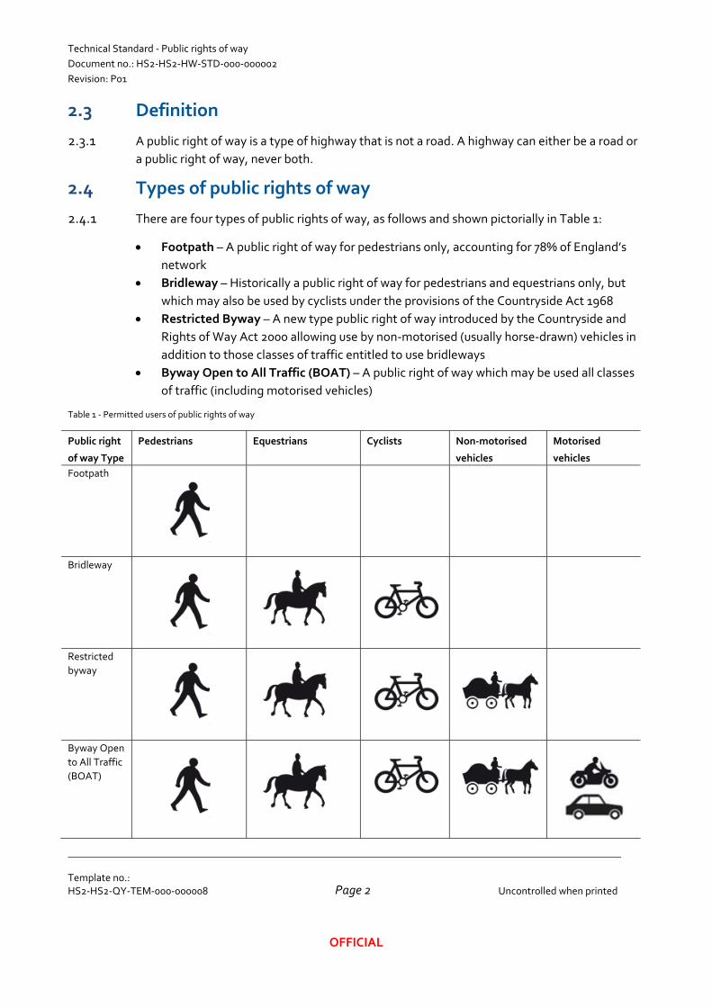
2.4.1 There are four types of public rights of way, as follows and shown pictorially in Table 1:
Footpath – A public right of way for pedestrians only, accounting for 78% of England’s
network
Bridleway – Historically a public right of way for pedestrians and equestrians only, but
which may also be used by cyclists under the provisions of the Countryside Act 1968
Restricted Byway – A new type public right of way introduced by the Countryside and
Rights of Way Act 2000 allowing use by non‐motorised (usually horse‐drawn) vehicles in
addition to those classes of traffic entitled to use bridleways
Byway Open to All Traffic (BOAT) – A public right of way which may be used all classes
of traffic (including motorised vehicles)
Table 1 ‐ Permitted users of public rights of way
Public right
of way Type
Pedestrians Equestrians Cyclists Non‐motorised
vehicles
Motorised
vehicles
Footpath
Bridleway
Restricted
byway
Byway Open
to All Traffic
(BOAT)
Technical Standard ‐ Public rights of way
Document no.: HS2‐HS2‐HW‐STD‐000‐000002
Revision: P01
Template no.: HS2‐HS2‐QY‐TEM‐000‐000008
Uncontrolled when printed
Page 3
OFFICIAL
2.4.2 Reference may also be seen to a former type of public right of way, Road Used as a Public
Path (RUPP), established by the National Parks and Access to the Countryside Act 1949.
However, there was widespread confusion about the exact status of RUPPs and the Wildlife
and Countryside Act required these to be reclassified; generally as bridleways, but also as
BOATs where established use by motorised vehicles could be proved. As this process had not
been fully completed in some areas, all remaining RUPPs were reclassified as restricted
byways in 2006 under the Countryside and Rights of Way Act 2000.
2.4.3 If a public right of way described as a RUPP is encountered, the actual status of the route shall
be established with the highway authority.
2.5 Records
General
2.5.1 The National Parks and Access to the Countryside Act 1949 required surveying authorities
(local highway authorities) to prepare a Definitive Map of public rights of way in all non‐
metropolitan areas. This requirement was later extended to all local authority areas apart
from the 12 Inner London boroughs.
NOTE – Refer to Section 2.8 for details on local highway authorities.
NOTE – In the Inner London Boroughs, public rights of way may be recorded in the ‘List of
Streets’ that the local highway authority is required to maintain or otherwise shown on highway
boundary maps or maintenance plans.
2.5.2 In each case, the Definitive Map is accompanied by a statement giving additional details such
as connections to other highways and (in some cases) widths. In rare cases, limitations or
conditions attached to the public’s rights will also be recorded in the statement.
2.5.3 Definitive Maps and statements have to be made available for inspection in person at the
council’s offices, but are not usually published online. However, some local authorities do
publish material derived from the Definitive Map in various forms, and the public right of way
network (at the time of publication) is shown on 1:25000 and 1:50000 scale Ordnance Survey
mapping in green and red respectively.
NOTE – The Definitive Map can only be modified by an order made under the Wildlife and
Countryside Act, although the change may be initiated by a ‘legal event’ arising from an order
made under another piece of legislation (which will occur when the HS2 hybrid Bills are enacted).
2.5.4 As the public right of way network is subject to change, there is no guarantee that information
shown on Ordnance Survey mapping or other published sources is still current so reference
must be made to the Definitive Map for up‐to‐date details.
Technical Standard ‐ Public rights of way
Document no.: HS2‐HS2‐HW‐STD‐000‐000002
Revision: P01
Template no.: HS2‐HS2‐QY‐TEM‐000‐000008
Uncontrolled when printed
Page 4
OFFICIAL
NOTE – Data has been added to the HS2 Geographic Information System (GIS) as provided by
each surveying authority. However, a check against the Definitive Map still should be
undertaken to validate this information.
Unrecorded public rights of way
2.5.5 Whilst there is no doubt about the status of a public right of way shown on the Definitive Map,
the fact that a route is not shown does not mean that a public right of way does not exist. Any
person who has evidence that public rights exist (e.g. through unchallenged use of a way for a
minimum period of 20 years or documentary proof) can ask the surveying authority (i.e. local
highway authority) to modify the Definitive Map at any time.
NOTE – Each surveying authority is required to maintain a register of claimed public rights of way
and these should be available online.
NOTE – Major development schemes sometimes prompt claims for unrecorded public rights of
way to be added to the Definitive Map (although these may, of course, ultimately prove
unsuccessful).
2.5.6 Where a suspected unrecorded public right of way is encountered, the exact status of the
claimed rights and whether it is expected to be included in the Definitive Map shall be
established with the surveying authority.
2.5.7 Where an unrecorded public right of way is confirmed by the surveying authority, it shall be
assessed on a case by case basis to determine an appropriate level of mitigation.
‘Dead end’ public rights of way
2.5.8 As for roads, public rights of way exist for persons to travel without let or hindrance from one
place to another. As such, they comprise a network with connections to other highways at
each end (and often at intermediate points as well). It is therefore unusual for a ‘dead end’
route to exist, with exceptions for cases such as public rights of way leading to the coast or a
river crossing (even though the bridge, ford or ferry may have long since disappeared).
2.5.9 However, the Definitive Maps are full of anomalies where ‘dead end’ public rights of way stop
for no apparent reason. This frequently occurs at parish boundaries, where adjacent parish
councils took a different approach to what they considered to be a public right of way when
the Definitive Maps were being first drafted. It may also occur where a public right of way
joins a green lane or what appears to be a private access which is actually public road but is
not shown as such on the Ordnance Survey mapping.
2.5.10 The possibility always needs to be considered that an apparently ‘dead end’ route may
continue as an unrecorded public right of way and where encountered the situation shall be
clarified with the surveying authority.
Technical Standard ‐ Public rights of way
Document no.: HS2‐HS2‐HW‐STD‐000‐000002
Revision: P01
Template no.: HS2‐HS2‐QY‐TEM‐000‐000008
Uncontrolled when printed
Page 5
OFFICIAL
2.6 Other routes with public access by non‐motorised users
2.6.1 There are also many other types of route with public access by non‐motorised users. These
include:
Green lanes
2.6.2 This is a term with a variety of meanings, but for the purposes of this document it is taken to
mean an unclassified road maintained by the local highway authority. Whilst usually
unsurfaced – and often narrow and possibly wholly or partially overgrown – green lanes can
legally be used by all classes of traffic (including motorised vehicles). In practice, there is little
significant difference between a BOAT and a green lane and design considerations and
mitigation measures are likely to be similar.
2.6.3 Where potential green lanes are identified, the exact status of the route shall be confirmed
with the local highway authority.
NOTE – Also refer to Technical Standard – Roads (HS2‐HS2‐HW‐STD‐000‐000001) regarding
any potentially affected green lanes.
Permissive routes
2.6.4 Landowners may agree to public access on a basis usually equivalent to a footpath or
bridleway but this permission may be withdrawn at any time. Landowners may also allow use
of a public right of way by more classes of traffic than the type would normally permit (e.g.
cyclist and pedestrian use of a public footpath). Permissive paths may also be closed
temporarily (e.g. one day per year in order to prevent public rights from becoming
established, or for periods to allow for agricultural or forestry operations, wildlife breeding
seasons, etc.). A number of established permissive routes are shown in orange on 1:25000
scale Ordnance Survey maps. An example of permissive route is the Forest Trail network to
be found in most Forestry Commission woodlands.
NOTE – There are various sources of information about permissive routes, some of which will be
known to the local highway authority, but in most cases it will be necessary to obtain full details
directly from the landowners concerned.
Canal towpaths
2.6.5 Many canal towpaths are recorded on the Definitive Maps as public rights of way, but nearly
all others provide de facto public access to pedestrians. Access may also be available to
cyclists and/or equestrians, but this tends to be more tightly controlled through the use of
barriers and gates.
2.6.6 The exact status of canal towpaths not recorded as public rights of way shall be established
with the owner (usually Canal and River Trust).
Technical Standard ‐ Public rights of way
Document no.: HS2‐HS2‐HW‐STD‐000‐000002
Revision: P01
Template no.: HS2‐HS2‐QY‐TEM‐000‐000008
Uncontrolled when printed
Page 6
OFFICIAL
NOTE – In some cases, public rights may have become established over time (and thus the
towpath ought to be considered as an unrecorded public right of way – see Section 2.5 for details)
whilst others are only permissive routes.
Roads where use by certain classes of traffic is restricted by a Traffic Regulation
Order (TRO)
2.6.7 Traffic management measures sometimes result in Traffic Regulation Orders (TROs) being
made under the Road Traffic Regulation Act 1984, which restrict usage by certain classes of
traffic (e.g. motorised vehicles) on either a temporary or permanent basis. Physical
restrictions are usually supported by traffic signs and/or road markings, but these may fall into
disrepair or disappear completely over time. In many cases, there will be exceptions to the
general restrictions imposed by a TRO (permitting access by the emergency services and
adjacent landowners, for example).
2.6.8 The exact nature of the restrictions imposed by a TRO shall be established with the local
highway authority.
NOTE – Restrictions imposed by temporary orders can usually be disregarded after the stated
expiry date (although it has to be borne in mind that this may be extended).
Footways
2.6.9 A path for pedestrian use only, located within the boundaries of a public road (i.e. ‘pavements’
in common usage). These are not highways in their own right, and are simply another
component of the road together with the carriageway(s), verge(s), etc. Where used by
pedestrians, traffic islands and paved areas on bridges also have the same status.
NOTE – Under the Highway Act 1835, it is a criminal offence to cycle or drive a vehicle on a
footway (except at an official crossover to a private access).
NOTE – Refer to Technical Standard – Roads (HS2‐HS2‐HW‐STD‐000‐000001) for requirements
and guidance relating to footways.
Combined footway / cycleways
2.6.10 Similar to a footway, but provided as a path for use by both pedestrians and cyclists. They
exist in two forms:
Segregated – where the route is divided into two separate parts, one for pedestrians and
the other for cyclists, divided by a white line
Unsegregated – where pedestrians and cyclists share the full width of the route
NOTE – Combined footway / cycleways have to be specifically signed as such in order to allow
use by cyclists without an offence being committed under the Highway Act 1835.
Technical Standard ‐ Public rights of way
Document no.: HS2‐HS2‐HW‐STD‐000‐000002
Revision: P01
Template no.: HS2‐HS2‐QY‐TEM‐000‐000008
Uncontrolled when printed
Page 7
OFFICIAL
NOTE – Refer to Technical Standard – Roads (HS2‐HS2‐HW‐STD‐000‐000001) for requirements
and guidance relating to combined footway/cycleways.
Cycle lanes
2.6.11 Cycle lanes form part of the road carriageway, adjacent to (and usually on the nearside of)
main traffic lanes. They exist in two forms:
With‐flow – where cyclists are travelling in the same direction as the other traffic
Contra‐flow – where cyclists are travelling in the opposite direction to the other traffic
NOTE – Cyclists have the right to use all traffic lanes on all roads (excluding motorways) except
where a Traffic Regulation Order prohibits their use (accompanied with the relevant regulatory
signs). Most bus lanes allow for usage by cyclists as indicated on signs.
NOTE – Refer to Technical Standard – Roads (HS2‐HS2‐HW‐STD‐000‐000001) for requirements
and guidance relating to cycle lanes.
Cycle tracks created under the Cycle Tracks Act 1984
2.6.12 A special type of off‐road route either provided for cyclists alone or also permitting use by
pedestrians. Cycle tracks should not be confused with on‐road cycle lanes, roadside
segregated cycleways or roadside unsegregated cycleway/footways.
2.6.13 Where potential off‐road cycle tracks are identified, the status of the route shall be confirmed
with the highway authority.
Greenways
2.6.14 The term ‘greenway’ is often used to describe a former railway line that has been converted to
allow public access by non‐motorised users. Greenways have traditionally been established
primarily for pedestrians and/or cyclists however some also allow equestrian access.
Greenways may be either a type of public right of way (such as a bridleway or restricted
byway) or a linear country park with permissive access rights for defined user types.
2.6.15 The status of greenways shall be confirmed with the local highway authority, or landowner
where not a public right of way.
Housing estate paths
2.6.16 A path for pedestrian use only, located within a housing estate but remote from roads. These
are not usually highways in their own right, but may either be maintained by the local highway
authority (in which case public use is generally permitted) or by the housing estate owner (in
which case the intention may be that it is not, although public rights may have become
established over time).
2.6.17 The status of housing estate paths shall be confirmed with both the local highway authority
and the housing estate owner
Technical Standard ‐ Public rights of way
Document no.: HS2‐HS2‐HW‐STD‐000‐000002
Revision: P01
Template no.: HS2‐HS2‐QY‐TEM‐000‐000008
Uncontrolled when printed
Page 8
OFFICIAL
NOTE – The possibility of a housing estate path being an unrecorded public right of way also
needs to be considered (refer to Section 2.5 for further information).
Open access land (‘right to roam’)
2.6.18 Under the Countryside and Rights of Way Act 2000, pedestrians have a ‘right to roam’ on
mapped areas of mountain, moor, heath, downland and registered common land without
having to stick to a public right of way. However, landowners and tenants have the discretion
to suspend or restrict public access for up to 28 days each year for any reason. They may also
apply for additional restrictions or closures for purposes such as land management, safety or
fire prevention reasons.
NOTE – Where areas of open access land are crossed, careful consideration will have to be given
to the location of any proposed overbridges, underbridges or underpasses as it will not necessarily
be obvious where the pedestrian desire lines are. For larger areas, it will be necessary to consider
more than one crossing point.
NOTE – Open access land data is available on the HS2 Geographic Information System and
online mapping is also accessible from the Natural England website.
2.6.19 Registered common land is protected from development by statutory controls. These are
principally contained in the Commons Act 2006 and the Acquisition of Land Act 1981, but
other controls are contained in various public and local Acts and Orders. Furthermore, any
application to deregister an area of common land exceeding 200 square metres will require an
equivalent area of suitable ‘replacement land’ to be provided.
2.6.20 In the event that an area identified as common land is potentially affected, the commons
registration authority (normally the county council, unitary authority, metropolitan district
council or London Borough council) shall be consulted to confirm the status and extent of the
site.
Town and village greens
2.6.21 Town and village greens developed under customary law as areas of land where local people
indulged in lawful sports and pastimes. Most greens were registered in the late 1960s under
the Commons Registration Act 1965 but anyone can apply under the Commons Act 2006 to
register land as a town or village green if it has been used by local people for lawful sports and
pastimes ‘as of right’ (i.e. without permission, force or secrecy) for at least 20 years.
NOTE – A town or village green does not have to be an area of neatly‐mown grass; woodlands,
ponds and even golf courses have previously been registered where they have met the statutory
test.
NOTE – Strictly speaking, only inhabitants of the ‘locality’ (rather than the public at large) have
the right to indulge in lawful sports and pastimes on a town or village green. However, in
practice, they can be considered to be public open spaces for most purposes.
Technical Standard ‐ Public rights of way
Document no.: HS2‐HS2‐HW‐STD‐000‐000002
Revision: P01
Template no.: HS2‐HS2‐QY‐TEM‐000‐000008
Uncontrolled when printed
Page 9
OFFICIAL
NOTE – Town and village green data is available on the HS2 Geographic Information System, but
online maps are not generally available so it may be necessary to contact the registration
authority (normally the county council, unitary authority, metropolitan district council or London
Borough council) for up‐to‐date information.
2.6.22 Town and village greens have a high degree of statutory protection under the Inclosure Act
1857 and the Commons Act 1876, and permission is usually required from the local authority
or the Secretary of State to carry out any potentially disruptive works to them. As for common
land, any application to deregister an area of green exceeding 200 square metres will require
an equivalent area of suitable ‘replacement land’ to be provided.
2.6.23 In the event that an area identified as a town or village green is potentially affected, the
registration authority shall be consulted to confirm the status and extent of the site.
NOTE – Major development schemes sometimes prompt applications to register new town or
village greens by those opposed to the scheme (although these may, of course, ultimately prove
unsuccessful).
2.7 Maintenance and obstructions
2.7.1 Local highway authorities are legally responsible for public rights of way, including most
aspects of maintenance and dealing with obstructions. The same applies to certain other
routes with public access by non‐motorised users (such as green lanes, roads with TROs, cycle
tracks and footways). However, certain legal obligations are placed on owners with public
rights of way crossing their land regarding matters such as the reinstatement of ploughed
surfaces and the installation of gates.
NOTE – The fact that a public right of way (or similar route) may be rendered impassable by
obstruction or neglect has no bearing on its status, no matter how long that situation has
persisted.
2.7.2 When planning mitigation measures, it must be assumed that the local highway authority will
fulfil its statutory duty to secure removal of any obstructions and restore the route to a usable
condition consistent with its status.
2.7.3 Landowners are legally responsible for permissive routes, but may sometimes receive public
funding for activities such as maintenance and improvements in return for allowing public
access.
NOTE – For further details on highway maintenance responsibilities, refer to Information Paper
E28 ‘Future highway maintenance responsibilities’.
Technical Standard ‐ Public rights of way
Document no.: HS2‐HS2‐HW‐STD‐000‐000002
Revision: P01
Template no.: HS2‐HS2‐QY‐TEM‐000‐000008
Uncontrolled when printed
Page 10
OFFICIAL
2.8 Stakeholders
Highway Authorities
2.8.1 Under English law, there are three main types of highway authority, as follows:
Highways England, a government owned company (formally known as the Highways
Agency until March 2015)
Transport for London (TfL), part of the Greater London Authority (GLA)
Local highway authorities – being the county council, unitary authority, London
Borough or metropolitan borough for the area
2.8.2 Local highway authorities are the only highway authorities that are responsible for public
rights of way.
2.8.3 While Highways England and Transport for London (TfL) are not responsible for public rights
of way, they may be responsible for other routes with public access by non‐motorised users
(such as footways and cycleways).
NOTE – Local highway authorities often have a team dedicated to the management of public
rights of way. They can be a useful source of information when designing new, realigned or
diverted public rights of way.
Prescribed organisations
2.8.4 The bodies listed below are ‘prescribed organisations’ for notices about public rights of way
orders being made under the Highways Act, the Town and Country Planning Act and Wildlife
and Countryside Act. Although the HS2 project obtains powers for the project by means of
the hybrid Bill process rather than one of the three above‐mentioned acts, the prescribed
organisations are likely to take a very detailed interest in the proposals.
All notices
o Auto Cycle Union
o British Horse Society
o Byways and Bridleways Trust
o Cyclists’ Touring Club
o Open Spaces Society
o Ramblers (see Clause 2.8.7 for more details)
Notices about orders affecting land in districts including Chiltern, Wycombe, South
Bucks, Aylesbury Vale and Three Rivers
o Chiltern Society
Notices about orders affecting land in Cheshire, Derbyshire, Greater Manchester,
Lancashire, Merseyside, South Yorkshire, Staffordshire and West Yorkshire
o Peak and Northern Footpaths Society
Notices about Wildlife and Countryside Act orders
o British Driving Society
Technical Standard ‐ Public rights of way
Document no.: HS2‐HS2‐HW‐STD‐000‐000002
Revision: P01
Template no.: HS2‐HS2‐QY‐TEM‐000‐000008
Uncontrolled when printed
Page 11
OFFICIAL
Notices about orders creating footpaths, bridleways or restricted byways on land
adjacent to operational railway lines
o Network Rail
Other consultees
2.8.5 The document ‘Practice Guidance Note 1 – Consultation on changes to public rights of way
and definitive maps’, published by the national Rights of Way Review Committee, identifies
the following additional consultees about public rights of way orders:
Local Access Forums – statutory bodies created by the Countryside and Rights of Way
Act 2000
Local authorities, including parish or community councils and chairmen of parish
meetings
Statutory undertakers (as some may have apparatus under or over the public right of way
concerned)
Local organisations with an interest in public rights of way in the district concerned
Natural England
The owner and occupier of any land affected by a proposal
Canal and Rivers Trust
2.8.6 Canal and Rivers Trust is a registered charity that is responsible for canals and inland
waterways in England, and any associated tow‐paths. Refer to Clause 2.6.5 for details on the
status of canal tow‐paths.
Ramblers
2.8.7 Ramblers is a registered charity that represents the rights of walkers. The stated aims of the
Ramblers are to promote walking, to safeguard paths, to increase access for walkers, to
protect the countryside and to educate the public. Rambler groups are associated with a
particular locality and are often a good source of information about public rights of way in
their local area.
Sustrans
2.8.8 Sustrans is a registered charity that manages the National Cycle Network, which comprises a
mixture of ‘greenways’ and quiet roads. As a result, they are likely to be interested in any
changes to the National Cycle Network including impacts during construction. Refer to Clause
2.6.14 for details on greenways.
Other interested parties
2.8.9 Other user groups may have an interest in the design of public rights of way, such as:
The National Farmers Union – which represents farmers and may have an interest where
public rights of way cross agricultural land
Technical Standard ‐ Public rights of way
Document no.: HS2‐HS2‐HW‐STD‐000‐000002
Revision: P01
Template no.: HS2‐HS2‐QY‐TEM‐000‐000008
Uncontrolled when printed
Page 12
OFFICIAL
Fishing user groups – which may have an interest where changes to canal tow‐paths and
public rights of way adjacent to watercourses may impact on fishing
Mountain biking groups – which may have an interest in changes to bridleway, restricted
byways and Byways Open to All Traffic (BOATs)
Four‐wheel drive and off‐road motorcycling groups – which may have an interest in
changes to Byways Open to All Traffic (BOATs)
3 Environmental considerations 3.1 Environmental Statement
3.1.1 Environmental impacts, including the impacts on public rights of way, are assessed prior to
and during the hybrid Bill stage and are reported by means of an Environmental Statement.
Examples of temporary and permanent effects include:
Impacts on journey times to public right of way users;
Severance to communities; and
Visual impact of the works.
3.1.2 Following Royal Assent, the project is obliged to comply with the Environmental Minimum
Requirements (EMR), which amongst other things state that the project cannot introduce any
significant effects beyond those already addressed in the Environmental Statement. Design
development for all aspects, including for public rights of way, need to ensure that no new
significant effects are introduced. Refer to the Scope and Methodology Report in the Phase
One Environmental Statement for the definition of a significant effect.
3.2 Transport Assessment
3.2.1 Potential impacts on public rights of way are reported on in detail in the Transport
Assessment supporting the Environmental Statement.
NOTE – The assessment is not just restricted to pedestrians – all non‐motorised users are
considered.
4 Design considerations 4.1 Function of public rights of way
4.1.1 Public rights of way may serve one of more functions, depending on the user, geography, links
to other public rights of way and roads and other factors such as its condition. Below are some
common functions that public rights of way serve, however this is not an exhaustive list.
NOTE – Consultation with the community, as well as interest groups such as Ramblers can help
determine how public rights of way are currently being used.
Technical Standard ‐ Public rights of way
Document no.: HS2‐HS2‐HW‐STD‐000‐000002
Revision: P01
Template no.: HS2‐HS2‐QY‐TEM‐000‐000008
Uncontrolled when printed
Page 13
OFFICIAL
Link to local destinations
4.1.2 Some public rights of way provide important connections between residential areas and local
destinations such as health and social services, retail facilities, schools and educational
facilities, community and leisure centres and faith centres. People who use public rights of
way to access local destinations may be more sensitive to any increased distances associated
with realigned or diverted public rights of way. Users of these public rights way could form a
broad cross‐section of the community and may include people with reduced mobility or
people with push‐chairs or trolleys.
Local recreation routes
4.1.3 Many public rights of way are used to access the countryside for recreational purposes.
Informal circular routes (which may include sections on quiet roads) near villages and towns
are often highly regarded with local residents including dog‐walkers, people with reduced
mobility and people with buggies, and specific accommodation for these may be required
(such as in the design of gates).
Regional or national recreational routes
4.1.4 Recreational use of public rights of way may not just be for local journeys – public rights of
way can also be used for longer journeys that may take several hours (or even days or weeks).
These may also form part of promoted routes or other national networks (such as the National
Cycle Network and the National Bridleroute Network).
4.2 Users of public rights of way
4.2.1 Section 2.4 discusses the types of users (such as pedestrian, equestrian, etc.) that are
permitted to use public rights of way; however a good public right of way design requires a
greater understanding as to who and why a particular public right of way is being used.
4.2.2 It is essential to ensure that adequate provision for disabled people and people with reduced
mobility is made in design.
4.2.3 Examples of people who may use a particular public right of way, include:
Footpath
Disabled people
People with reduced mobility
People pushing buggies
People walking dogs
Recreational fishermen accessing waterways or canals
People walking with small children
Able‐bodied people
Hikers / ramblers
Technical Standard ‐ Public rights of way
Document no.: HS2‐HS2‐HW‐STD‐000‐000002
Revision: P01
Template no.: HS2‐HS2‐QY‐TEM‐000‐000008
Uncontrolled when printed
Page 14
OFFICIAL
Bridleway
4.2.4 As for footpath plus the following:
People cycling with children
People cycling on tandem bikes
Mountain bikers
Disabled cyclists
Able‐bodied cyclists
Children learning to ride horses (such as members of a Pony Club)
Disabled equestrian riders
Able‐bodied equestrian riders
Restricted byway
4.2.5 As for bridleway plus the following:
Horse‐drawn vehicles
Byway Open to All Traffic (BOAT)
4.2.6 As for restricted byway plus the following:
Trail (dirt) bikes
Four‐wheel drive vehicles
Two‐wheel drive vehicles
4.3 Public rights of way coincident with an access
4.3.1 Many public rights of way are coincident with existing private means of access or new
accommodation accesses such as driveways or farm tracks. Whilst such accesses may be used
by other classes of traffic (e.g. motorised vehicles) with permission of the landowner, public
use is governed by the public right of way type. Refer to Technical Standard –
Accommodation accesses (HS2‐HS2‐HW‐STD‐000‐000004) for further details.
NOTE – When designing mitigation works for affected public rights of way – such as overbridges,
underbridges, underpasses and diversions – it is also necessary to take account of any permitted
private usage (unless this will cease through compulsory purchase or by accommodation works
providing an alternative private means of access).
NOTE – There is no definitive source of private use arrangements, so it is important that as much
information as possible is gleaned from sources such as community engagement and direct
contact with landowners.
4.3.2 Besides accommodation accesses, HS2 accesses may also be coincident with public rights of
way. Refer to Technical Standard – HS2 accesses (HS2‐HS2‐HW‐STD‐000‐000003) for further
details.
Technical Standard ‐ Public rights of way
Document no.: HS2‐HS2‐HW‐STD‐000‐000002
Revision: P01
Template no.: HS2‐HS2‐QY‐TEM‐000‐000008
Uncontrolled when printed
Page 15
OFFICIAL
4.3.3 A public right of way is considered ‘coincident’ with an access where the public right of way
and access share the same alignment. In these instances users of the public right of way
(pedestrians, cyclists and or equestrians, as permitted) walk/ride along the access in an
informal shared‐use basis with vehicles using the access. This arrangement is often
appropriate given the infrequent and low‐speeds of vehicles typically using accesses.
4.3.4 There may be instances at very busy accesses where a separate unbound surface for non‐
motorised users is preferred, as opposed to having an informal shared‐use arrangement.
Where this occurs, the public right of way is no longer considered coincident with the access.
Refer to Appendix C of Technical Standard – Roads (HS2‐HS2‐HW‐STD‐000‐000001) for
details of the similar case of paths being provided in the verge adjacent to busier roads.
4.4 Crime Prevention Through Environmental Design (CPTED)
4.4.1 Crime Prevention Through Environmental Design (CPTED, also known as Designing Out
Crime) is a multi‐disciplinary approach to deterring criminal activities through environmental
design. This is based on research into criminal behaviour which shows that the decision to
offend or not to offend is often related to the risk of being caught. Many aspects of CPTED
relate to perceived risks and perceived safety, which are difficult to quantify.
4.4.2 The following list is a selection of CPTED issues that should be considered for non‐motorised
users in urban areas or on the urban fringe, however the designer should consider all relevant
CPTED issues based on industry good‐practice and guidance:
Will the route feel ‘safe’?
Does the route encourage ‘legitimate’ use or ‘illegitimate’ use, such as anti‐social
behaviour?
Will users of the route feel ‘threatened’?
How well can users see what is ahead or behind, so that threatening behaviour can be
identified? Are there places where an attacker could hide (for example, behind a wall, in
bushes or in a dark place)?
If a person felt threatened, are there likely to be people nearby who could see or hear
that person in distress? This is known as ‘passive surveillance’ and could be provided by
adjacent residences or businesses, nearby roads or public rights of way, or from other
non‐motorised users.
Should usage of a route be encouraged at night (such as by providing street lighting), or
would this lead to encourage use in areas that may be ‘unsafe’?
4.5 Integration with the landscape
4.5.1 Public rights of way, as with all aspects of the project, should be sensitive to the unique
patterns, subtleties and diverse character of the surrounding landscape. Refer to the Guidance
Document – Landscape Design Approach (HS2‐HS2‐EV‐GDE‐000‐000002) for requirements
and guidance relating to landscape integration.
Technical Standard ‐ Public rights of way
Document no.: HS2‐HS2‐HW‐STD‐000‐000002
Revision: P01
Template no.: HS2‐HS2‐QY‐TEM‐000‐000008
Uncontrolled when printed
Page 16
OFFICIAL
4.6 Land ownership
4.6.1 Almost all public rights of way are located on private land, but this has no bearing on the
public’s right to use the route without let or hindrance.
NOTE – No landowner or member of the public can obstruct or otherwise cause an unlawful
interference to a public right of way, and to do so is a criminal offence under the Highways Act
1980.
Private access rights
4.6.2 In the event that a public right of way along a track or lane is stopped up (extinguished), any
existing private rights of access will remain. However, great care needs be taken to ensure
that no other party relies on the public right of way to access land or other property further
along the route. If they do, new private rights – either along this route or by means of another
– will have to be secured for them.
NOTE – The same would apply to any new private accesses required (e.g. for a nearby landowner
or an HS2 vehicular access for the future operation / maintenance of HS2) where it is intended
that this would follow the alignment of a public right of way to be stopped up.
Construction sites
4.6.3 Consideration should be given at an early stage to the need for construction sites required for
any overbridges, underbridges, underpasses or other structures associated with public rights
of way works.
4.7 Provision for future development
4.7.1 New, realigned or diverted public rights of way should only be designed where required to
mitigate the impacts of the scheme. It is not within the scope of HS2 to provide ‘betterment’
to the existing highway network.
4.7.2 When designing public right of way mitigation, the highway network should be considered as
the existing network plus any committed schemes.
4.7.3 Where highway authorities or third parties have planned future developments or aspirations
that will impact on public rights of way and are not yet committed, consideration should be
given to ensuring – where reasonably practicable ‐ that the design does not preclude these
plans from occurring. However any provision over and above what is required to mitigate the
scheme should be considered only where the cost and programme impact to HS2 is minimal.
NOTE – Where in doubt as to whether a development is ‘committed’ or not, please consult with
HS2 Technical Directorate.
Technical Standard ‐ Public rights of way
Document no.: HS2‐HS2‐HW‐STD‐000‐000002
Revision: P01
Template no.: HS2‐HS2‐QY‐TEM‐000‐000008
Uncontrolled when printed
Page 17
OFFICIAL
4.8 Promoted routes
4.8.1 A large number of different types of promoted routes exist. Whilst many of the historically
popular long‐distance routes have become promoted routes, other routes have become
popular largely as a result of becoming a promoted route.
NOTE – Being a promoted route confers no extra status to a public right of way, but because of
their greater public awareness they can become more sensitive issues if any changes are
proposed.
European Long Distance Paths (E‐paths)
4.8.2 A network of 12 international European Long Distance Paths (E‐paths) has been established
by walkers’ and ramblers’ groups who are members of the European Ramblers Association.
Three of these routes (E‐2, E‐8 and E‐9) have lengths within the UK which run along a chain of
public rights of way.
National Trails
4.8.3 National Trails are a network of 15 long distance routes in England and Wales (with the
Scottish equivalent being called Long Distance Routes). Starting with the Pennine Way, this
network now includes the Ridgeway and the Thames Path and is mainly funded by Natural
England and the Countryside Council for Wales. In addition to linking public footpaths,
increasing provision for cyclists and equestrians is being made in the network.
Recreational routes
4.8.4 In addition to the National Trails, there is a much larger network of recreational routes (often
developed by local authorities in association with user groups). Most recreational routes are
intended for walkers, but routes for cyclists and equestrians have also been developed.
Recreational routes are usually waymarked with a special logo or the route name, and many
of them (such as the Icknield Way and the Aylesbury Ring) are shown on Ordnance Survey
maps.
Unwaymarked routes
4.8.5 There are also a number of widely known, but unofficial, unwaymarked routes using the public
rights of way network with the most famous perhaps being Wainwright's Coast to Coast
route. Other examples of off‐road routes developed (controversially in some cases) by four‐
wheeled‐drive clubs. Despite not being shown on Ordnance Survey maps, such routes are
often featured in other publications and can be very popular.
Community routes
4.8.6 At a more local level, many parish councils and local user or amenity groups have developed
their own circular routes – often with a nature or history theme – using footpaths or
bridleways (usually public, but sometimes with permissive sections as well). Although not
Technical Standard ‐ Public rights of way
Document no.: HS2‐HS2‐HW‐STD‐000‐000002
Revision: P01
Template no.: HS2‐HS2‐QY‐TEM‐000‐000008
Uncontrolled when printed
Page 18
OFFICIAL
widely promoted outside the locality, guides can often be found in Tourist Information Offices
or public libraries and community routes can be well used by visitors and residents alike.
National Cycle Network
4.8.7 Since 1995, a national network of some 13,400 miles of cycle‐friendly routes has been
developed by Sustrans. In addition to bridleways and other public rights of way and
permissive off‐road routes where cycling is allowed, the network also includes many lengths
of quieter urban roads and country lanes.
National Bridleroute Network
4.8.8 The British Horse Society is promoting a National Bridleroute Network which aims to offer
similar benefits for horse riders to those enjoyed by cyclists using the National Cycle Route.
4.9 Temporary impacts during construction
General
4.9.1 Refer to the following information papers for the management of temporary impacts on
public rights of way during construction:
D11 – Maintaining access to residential and commercial property during construction
E13 – Management of traffic during construction
E14 – Highways and traffic during construction – legislative provisions
4.9.2 Information Paper E14 explains that the hybrid Bill allows the Nominated Undertaker to
temporarily interfere with highways, including public rights of way. This power means that the
need for a Temporary Traffic Regulation Order (TTRO) made under the Road Traffic
Regulation Act 1984 is unlikely for works affecting public rights of way.
4.10 HS2 nomenclature
4.10.1 The following terms should be used when referring to highway alterations (including for public
rights of way):
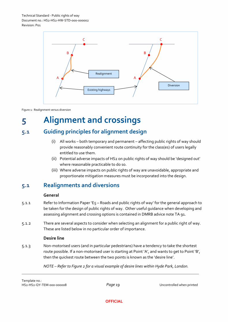
Realignment – where a new alignment is to be provided between points ‘A’ and ‘B’ on
the same route (refer to Figure 1)
Diversion – where the existing route between points ‘A’ and ‘B’ is to be replaced by a new
route from point ‘A’ to a different point ‘C’, no longer passing through point ‘B’ (refer to
Figure 1)
Reinstatement – where a route is to be re‐provided more‐or‐less on the same alignment,
e.g. over a green tunnel
Closure – where all or part of a route is to be stopped up without replacement
Technical Standard ‐ Public rights of way
Document no.: HS2‐HS2‐HW‐STD‐000‐000002
Revision: P01
Template no.: HS2‐HS2‐QY‐TEM‐000‐000008
Uncontrolled when printed
Page 19
OFFICIAL
Figure 1: Realignment versus diversion
5 Alignment and crossings 5.1 Guiding principles for alignment design
(i) All works – both temporary and permanent – affecting public rights of way should
provide reasonably convenient route continuity for the class(es) of users legally
entitled to use them.
(ii) Potential adverse impacts of HS2 on public rights of way should be ‘designed out’
where reasonable practicable to do so.
(iii) Where adverse impacts on public rights of way are unavoidable, appropriate and
proportionate mitigation measures must be incorporated into the design.
5.1 Realignments and diversions
General
5.1.1 Refer to Information Paper ‘E5 – Roads and public rights of way’ for the general approach to
be taken for the design of public rights of way. Other useful guidance when developing and
assessing alignment and crossing options is contained in DMRB advice note TA 91.
5.1.2 There are several aspects to consider when selecting an alignment for a public right of way.
These are listed below in no particular order of importance.
Desire line
5.1.3 Non‐motorised users (and in particular pedestrians) have a tendency to take the shortest
route possible. If a non‐motorised user is starting at Point ‘A’, and wants to get to Point ‘B’,
then the quickest route between the two points is known as the ‘desire line’.
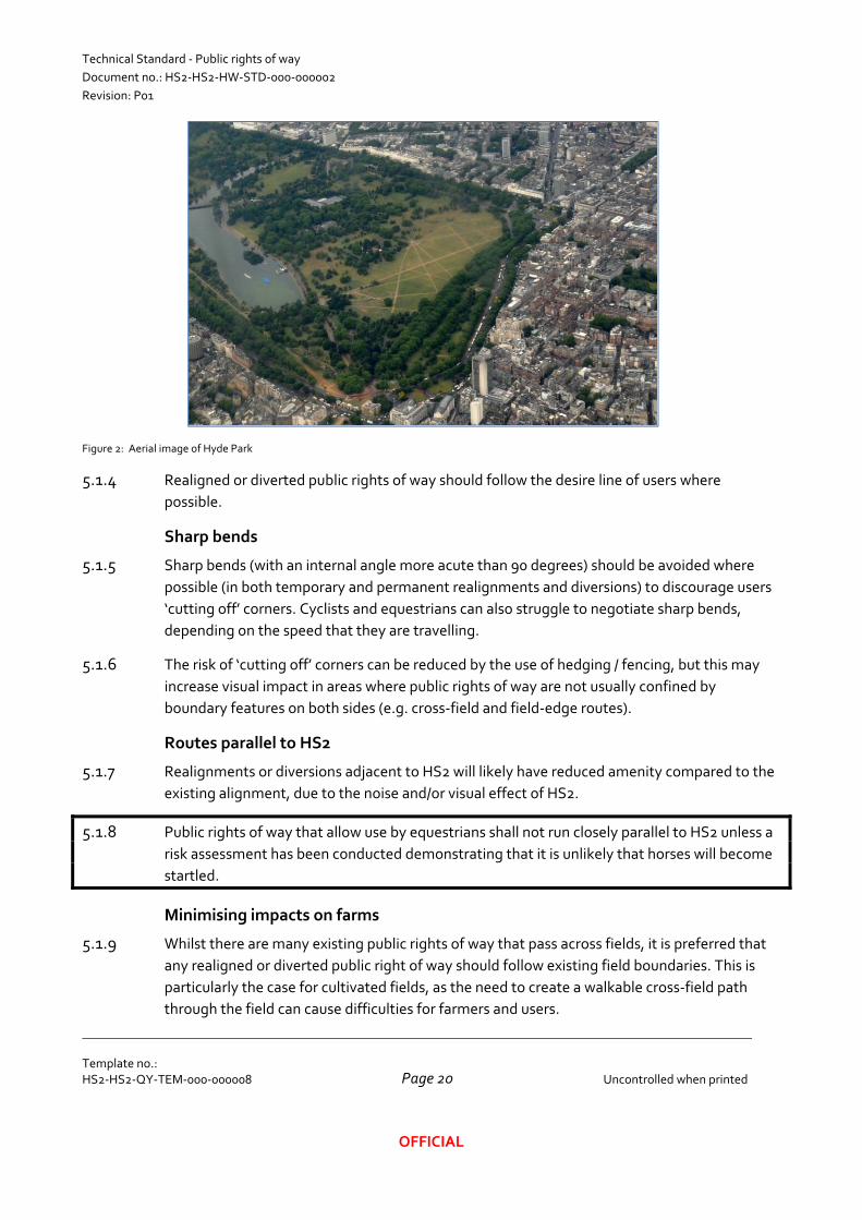
NOTE – Refer to Figure 2 for a visual example of desire lines within Hyde Park, London.
A
B
C
Existing highways
Realignment
A
B
C
Diversion
Technical Standard ‐ Public rights of way
Document no.: HS2‐HS2‐HW‐STD‐000‐000002
Revision: P01
Template no.: HS2‐HS2‐QY‐TEM‐000‐000008
Uncontrolled when printed
Page 20
OFFICIAL
Figure 2: Aerial image of Hyde Park
5.1.4 Realigned or diverted public rights of way should follow the desire line of users where
possible.
Sharp bends
5.1.5 Sharp bends (with an internal angle more acute than 90 degrees) should be avoided where
possible (in both temporary and permanent realignments and diversions) to discourage users
‘cutting off’ corners. Cyclists and equestrians can also struggle to negotiate sharp bends,
depending on the speed that they are travelling.
5.1.6 The risk of ‘cutting off’ corners can be reduced by the use of hedging / fencing, but this may
increase visual impact in areas where public rights of way are not usually confined by
boundary features on both sides (e.g. cross‐field and field‐edge routes).
Routes parallel to HS2
5.1.7 Realignments or diversions adjacent to HS2 will likely have reduced amenity compared to the
existing alignment, due to the noise and/or visual effect of HS2.
5.1.8 Public rights of way that allow use by equestrians shall not run closely parallel to HS2 unless a
risk assessment has been conducted demonstrating that it is unlikely that horses will become
startled.
Minimising impacts on farms
5.1.9 Whilst there are many existing public rights of way that pass across fields, it is preferred that
any realigned or diverted public right of way should follow existing field boundaries. This is
particularly the case for cultivated fields, as the need to create a walkable cross‐field path
through the field can cause difficulties for farmers and users.
Technical Standard ‐ Public rights of way
Document no.: HS2‐HS2‐HW‐STD‐000‐000002
Revision: P01
Template no.: HS2‐HS2‐QY‐TEM‐000‐000008
Uncontrolled when printed
Page 21
OFFICIAL
NOTE – Where public rights of way are proposed to be realigned or diverted adjacent to or
through fields, the local farmer should be consulted at an early stage to determine the land
usage.
Minimising impacts on residents
5.1.10 Consideration should also be given to potential impacts of realigning or diverting public rights
of way close to existing residents, as public rights of way that pass by the back fence of
properties can pose privacy issues.
5.2 Crossing types
General
5.2.1 Public rights of way can cross the alignment of HS2 via an overbridge, underbridge,
underpass, or by following the existing ground level where HS2 is on a viaduct or in a tunnel.
5.2.2 Overbridges, underbridges and underpasses can either be provided solely for the public right
of way, or can be designed to cater for other purposes as well, such as:
Being coincident with accommodation accesses (overbridges, underbridges and
underpasses)
Being coincident with HS2 accesses (overbridges, underbridges and underpasses)
Combining with watercourse crossings (underbridges and underpasses)
5.2.3 The type and location of public right of way crossings is often influenced by factors such as
the:
Need to provide accommodation access across HS2 in a similar location (e.g. to link up
two fields of a farm)
Need to provide HS2 access across HS2 in a similar location (so that HS2 assets can be
maintained)
Proximity to other public rights of way that cross HS2
Proximity to roads that cross HS2
Proximity to watercourses that cross HS2
Proximity to utilities that cross HS2
Environmental constraints
Land and property constraints
NOTE – Refer to Technical Standard – HS2 Accesses (HS2‐HS2‐HW‐STD‐000‐000004) and
Technical Standard – Accommodation Accesses (HS2‐HS2‐HW‐STD‐000‐000005) for further
details on requirements and guidance for accesses.
Skew
5.2.4 Overbridges, underbridges and underpasses can be either skewed or perpendicular to HS2.
Skewed crossings are generally not preferred due to their increased cost, however there may
Technical Standard ‐ Public rights of way
Document no.: HS2‐HS2‐HW‐STD‐000‐000002
Revision: P01
Template no.: HS2‐HS2‐QY‐TEM‐000‐000008
Uncontrolled when printed
Page 22
OFFICIAL
be cases where skewed crossings are appropriate (such as to avoid tight bends on busier
bridleways and byways, or for public rights of way that following an ancient route alignment).
On‐line versus off‐line crossings
5.2.5 Overbridges, underbridges and underpasses can either be designed as on‐line or off‐line
crossings. The potential advantages and disadvantages of each are described in Table 2.
Table 2: On‐line crossing – HS2 in deep cutting
On‐line crossing Off‐line crossing
Advantages Less permanent additional length for public right
of way users
No temporary realignment or closure required
Disadvantages Temporary realignment or closure required Additional permanent length for public right of way
users
NOTE – As most temporary public right of way realignments can be provided at minimal cost, on‐
line overbridges are often preferred in the absence of other constraints.
5.1 Public right of way crossings remote from other highways
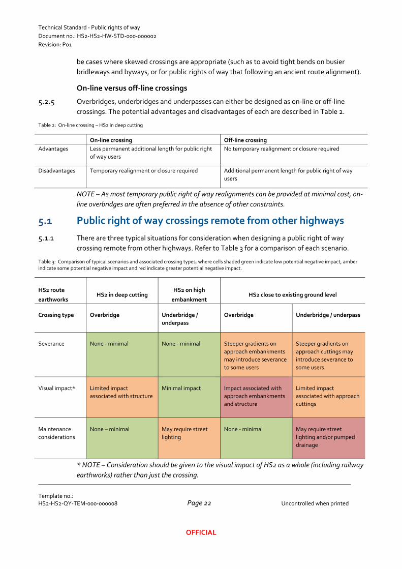
5.1.1 There are three typical situations for consideration when designing a public right of way
crossing remote from other highways. Refer to Table 3 for a comparison of each scenario.
Table 3: Comparison of typical scenarios and associated crossing types, where cells shaded green indicate low potential negative impact, amber indicate some potential negative impact and red indicate greater potential negative impact.
HS2 route
earthworks HS2 in deep cutting
HS2 on high
embankment HS2 close to existing ground level
Crossing type Overbridge Underbridge /
underpass
Overbridge Underbridge / underpass
Severance None ‐ minimal None ‐ minimal Steeper gradients on
approach embankments
may introduce severance
to some users
Steeper gradients on
approach cuttings may
introduce severance to
some users
Visual impact* Limited impact
associated with structure
Minimal impact Impact associated with
approach embankments
and structure
Limited impact
associated with approach
cuttings
Maintenance
considerations
None – minimal May require street
lighting
None ‐ minimal May require street
lighting and/or pumped
drainage
* NOTE – Consideration should be given to the visual impact of HS2 as a whole (including railway
earthworks) rather than just the crossing.
Technical Standard ‐ Public rights of way
Document no.: HS2‐HS2‐HW‐STD‐000‐000002
Revision: P01
Template no.: HS2‐HS2‐QY‐TEM‐000‐000008
Uncontrolled when printed
Page 23
OFFICIAL
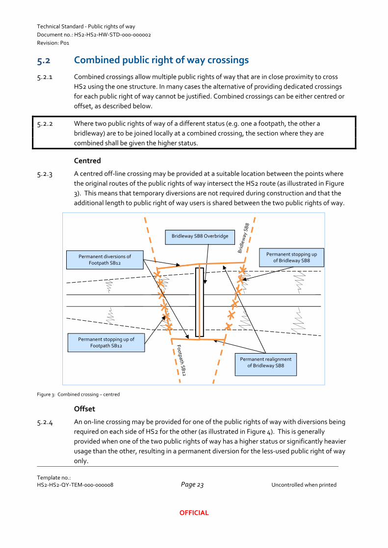
5.2 Combined public right of way crossings
5.2.1 Combined crossings allow multiple public rights of way that are in close proximity to cross
HS2 using the one structure. In many cases the alternative of providing dedicated crossings
for each public right of way cannot be justified. Combined crossings can be either centred or
offset, as described below.
5.2.2 Where two public rights of way of a different status (e.g. one a footpath, the other a
bridleway) are to be joined locally at a combined crossing, the section where they are
combined shall be given the higher status.
Centred
5.2.3 A centred off‐line crossing may be provided at a suitable location between the points where
the original routes of the public rights of way intersect the HS2 route (as illustrated in Figure
3). This means that temporary diversions are not required during construction and that the
additional length to public right of way users is shared between the two public rights of way.
Figure 3: Combined crossing – centred
Offset
5.2.4 An on‐line crossing may be provided for one of the public rights of way with diversions being
required on each side of HS2 for the other (as illustrated in Figure 4). This is generally
provided when one of the two public rights of way has a higher status or significantly heavier
usage than the other, resulting in a permanent diversion for the less‐used public right of way
only.
Bridleway SB8 Overbridge
Permanent stopping up of Footpath SB12
Permanent realignment of Bridleway SB8
Permanent diversions of Footpath SB12
Permanent stopping up of Bridleway SB8
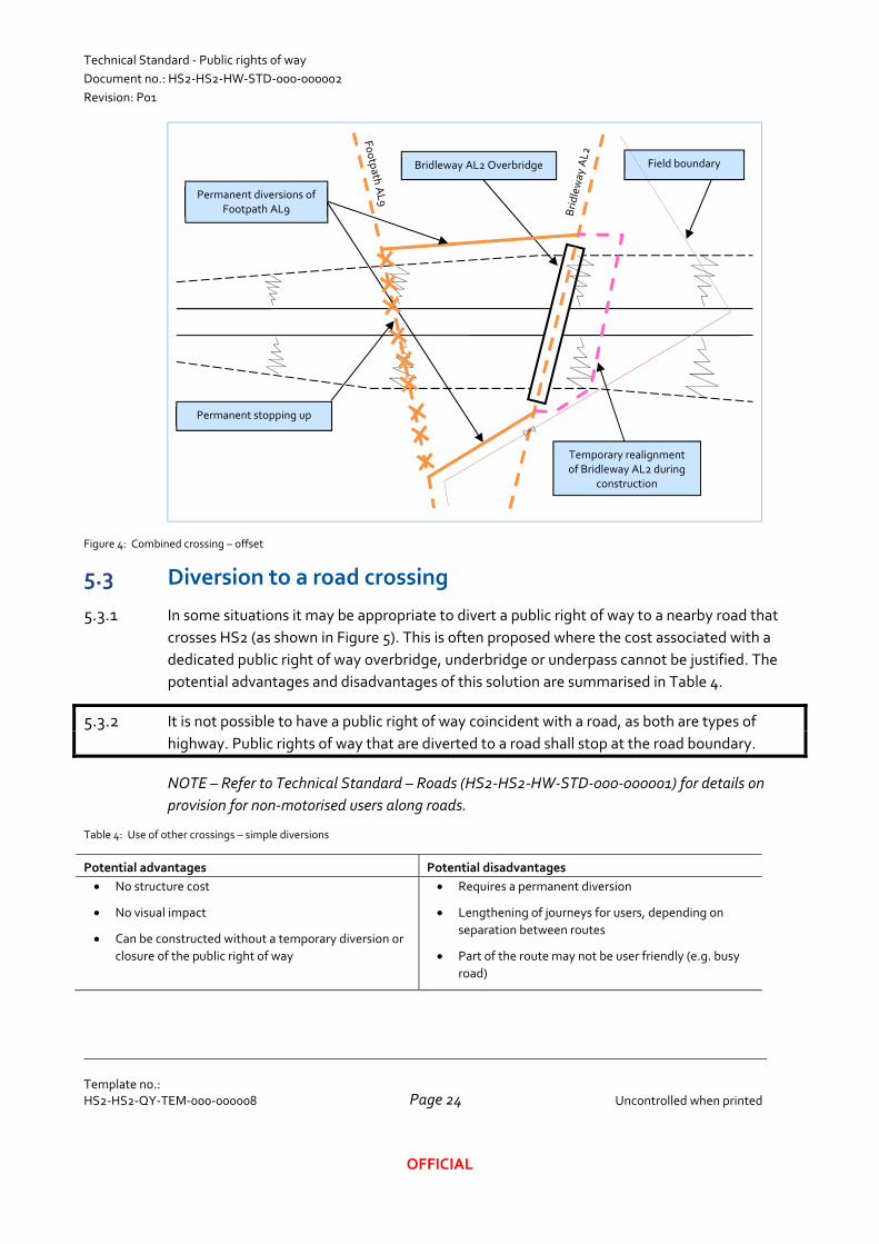
Technical Standard ‐ Public rights of way
Document no.: HS2‐HS2‐HW‐STD‐000‐000002
Revision: P01
Template no.: HS2‐HS2‐QY‐TEM‐000‐000008
Uncontrolled when printed
Page 24
OFFICIAL
Figure 4: Combined crossing – offset
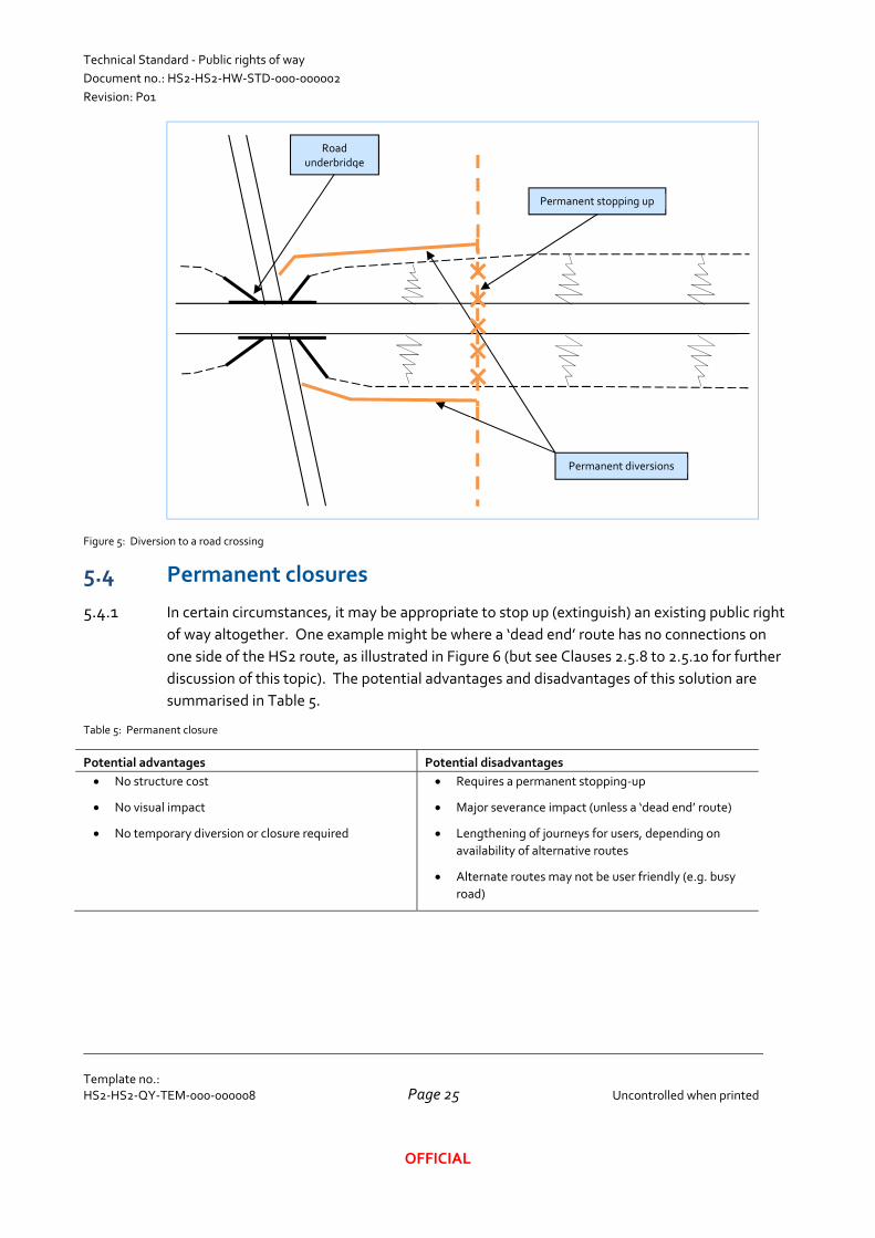
5.3 Diversion to a road crossing
5.3.1 In some situations it may be appropriate to divert a public right of way to a nearby road that
crosses HS2 (as shown in Figure 5). This is often proposed where the cost associated with a
dedicated public right of way overbridge, underbridge or underpass cannot be justified. The
potential advantages and disadvantages of this solution are summarised in Table 4.
5.3.2 It is not possible to have a public right of way coincident with a road, as both are types of
highway. Public rights of way that are diverted to a road shall stop at the road boundary.
NOTE – Refer to Technical Standard – Roads (HS2‐HS2‐HW‐STD‐000‐000001) for details on
provision for non‐motorised users along roads.
Table 4: Use of other crossings – simple diversions
Potential advantages Potential disadvantages
No structure cost
No visual impact
Can be constructed without a temporary diversion or
closure of the public right of way
Requires a permanent diversion
Lengthening of journeys for users, depending on
separation between routes
Part of the route may not be user friendly (e.g. busy
road)
Bridleway AL2 Overbridge
Permanent stopping up
Permanent diversions of Footpath AL9
Temporary realignment of Bridleway AL2 during
construction
Field boundary
Technical Standard ‐ Public rights of way
Document no.: HS2‐HS2‐HW‐STD‐000‐000002
Revision: P01
Template no.: HS2‐HS2‐QY‐TEM‐000‐000008
Uncontrolled when printed
Page 25
OFFICIAL
Figure 5: Diversion to a road crossing
5.4 Permanent closures
5.4.1 In certain circumstances, it may be appropriate to stop up (extinguish) an existing public right
of way altogether. One example might be where a ‘dead end’ route has no connections on
one side of the HS2 route, as illustrated in Figure 6 (but see Clauses 2.5.8 to 2.5.10 for further
discussion of this topic). The potential advantages and disadvantages of this solution are
summarised in Table 5.
Table 5: Permanent closure
Potential advantages Potential disadvantages
No structure cost
No visual impact
No temporary diversion or closure required
Requires a permanent stopping‐up
Major severance impact (unless a ‘dead end’ route)
Lengthening of journeys for users, depending on
availability of alternative routes
Alternate routes may not be user friendly (e.g. busy
road)
Road underbridge
Permanent stopping up
Permanent diversions
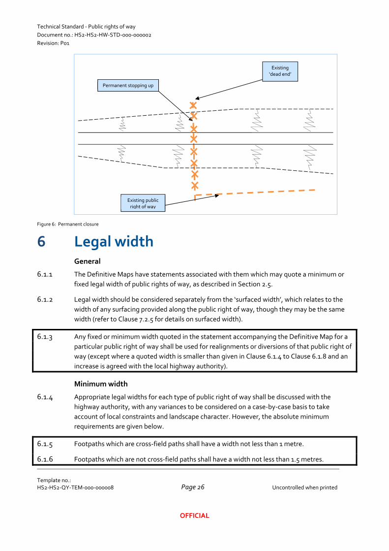
Technical Standard ‐ Public rights of way
Document no.: HS2‐HS2‐HW‐STD‐000‐000002
Revision: P01
Template no.: HS2‐HS2‐QY‐TEM‐000‐000008
Uncontrolled when printed
Page 26
OFFICIAL
Figure 6: Permanent closure
6 Legal width General
6.1.1 The Definitive Maps have statements associated with them which may quote a minimum or
fixed legal width of public rights of way, as described in Section 2.5.
6.1.2 Legal width should be considered separately from the ‘surfaced width’, which relates to the
width of any surfacing provided along the public right of way, though they may be the same
width (refer to Clause 7.2.5 for details on surfaced width).
6.1.3 Any fixed or minimum width quoted in the statement accompanying the Definitive Map for a
particular public right of way shall be used for realignments or diversions of that public right of
way (except where a quoted width is smaller than given in Clause 6.1.4 to Clause 6.1.8 and an
increase is agreed with the local highway authority).
Minimum width
6.1.4 Appropriate legal widths for each type of public right of way shall be discussed with the
highway authority, with any variances to be considered on a case‐by‐case basis to take
account of local constraints and landscape character. However, the absolute minimum
requirements are given below.
6.1.5 Footpaths which are cross‐field paths shall have a width not less than 1 metre.
6.1.6 Footpaths which are not cross‐field paths shall have a width not less than 1.5 metres.
Existing ‘dead end’
Permanent stopping up
Existing public right of way
Technical Standard ‐ Public rights of way
Document no.: HS2‐HS2‐HW‐STD‐000‐000002
Revision: P01
Template no.: HS2‐HS2‐QY‐TEM‐000‐000008
Uncontrolled when printed
Page 27
OFFICIAL
6.1.7 Bridleways which are cross‐field paths shall have a width not less than 2 metres.
6.1.8 Any other public right of way (e.g. a bridleway which is not a cross‐field path, a restricted
byway or a byway open to all traffic) shall have a width not less than 3 metres.
NOTE – The minimum widths given above are the values given in the Rights of Way Act 1990 for
the statutory minimum widths to be kept clear from interference by crops and for reinstatement
after disturbance (e.g. ploughing).
Public rights of way coincident with an access
6.1.9 The minimum width of a public right of way coincident with a private access should be the
greater of the width required for the public right of way and that required for the access.
NOTE – Refer to Technical Standard – HS2 Access (HS2‐HS2‐HW‐STD‐000‐000003) and
Technical Standard – Accommodation Access (HS2‐HS2‐HW‐STD‐000‐000004) for details of
width requirements for Hs2 and accommodation accesses respectively.
Public rights of way between two boundary features
6.1.10 Where a public right of way passes between two boundary features (such as hedges, fences
and/or walls), the legal width should be the full width between one boundary feature and the
other (except where this width is less than the minimum widths given in Clauses 6.1.4 to
6.1.9.
Overbridges
6.1.11 The legal width of public rights of way on overbridges (including those coincident with
accesses) should be the distance between parapets, except where the overbridge is divided
by a boundary feature (such as to separate livestock from non‐motorised users), in which case
the legal width should be the distance between the parapet and the boundary feature.
NOTE – The legal width of public rights of way on green bridges should only be the portion of the
bridge accessible to the public.
Underbridges and underpasses
6.1.12 The legal width of public rights of way passing through underbridges or underpasses
(including those coincident with accesses) should normally be the distance between the
adjacent abutments, piers or walls of the structure, except:
where the span is separated by a boundary feature (such as to separate livestock from
non‐motorised users) in which case the legal width should be the distance between the
boundary feature and the adjacent abutment, pier or wall
where the underbridge or underpass is shared with a watercourse in which case the legal
width should be the distance between the bank of the watercourse and the adjacent
abutment, pier or wall
Technical Standard ‐ Public rights of way
Document no.: HS2‐HS2‐HW‐STD‐000‐000002
Revision: P01
Template no.: HS2‐HS2‐QY‐TEM‐000‐000008
Uncontrolled when printed
Page 28
OFFICIAL
7 Engineering aspects 7.1 Guiding principles for engineering design
(i) All works – both temporary and permanent – affecting a public right of way should
aim to retain the existing character and distinctiveness of the route wherever
feasible.
(ii) Therefore, as a general rule, the starting point for design should be the existing
engineering parameters when a public right of way is diverted or reinstated.
(iii) For new routes, the requirements should be based on other similar public rights of
way of the same status in the area.
(iv) All works should be designed to minimise, as far as is reasonably practicable, future
maintenance requirements.
7.2 Surfacing
General
7.2.1 The majority of existing public rights of way are unsurfaced and may comprise of a path that is
visible due to the passage of other users. In some cases the public right of way may not be
visible on the ground at all, except for signage or way‐marker posts where provided. Other
public rights of way do have some form of surfacing.
NOTE – Refer to Appendix A for photos of some typical public rights of way.
7.2.2 Apart from on overbridges or inside underpasses, application of guiding principle (ii) (see
Section 7.1) means that any unbound or paved surfacing should only be provided on a ‘like for
like’ basis.
Public rights of way coincident with an access
7.2.3 The surfacing of public right of way coincident with an access is normally determined by the
requirements for the access.
NOTE – Refer to Technical Standard – HS2 Access (HS2‐HS2‐HW‐STD‐000‐000003) and
Technical Standard – Accommodation Access (HS2‐HS2‐HW‐STD‐000‐000004) for details of
surfacing requirements for Hs2 and accommodation accesses respectively.
Surfacing
7.2.4 Where surfacing is provided (either unbound or paved), the surfacing material shall respond to
the local landscape character and be of a type suitable for the usage allowed by the status of
the public right of way, including during periods of inclement weather.
Technical Standard ‐ Public rights of way
Document no.: HS2‐HS2‐HW‐STD‐000‐000002
Revision: P01
Template no.: HS2‐HS2‐QY‐TEM‐000‐000008
Uncontrolled when printed
Page 29
OFFICIAL
7.2.5 The width of surfacing shall be the same as the legal width as detailed in Section 6, except
where a lesser width is agreed with the highway authority (e.g. where a grass verge on one or
both sides is deemed appropriate).
7.3 Gradient
General
7.3.1 The existing topography has a significant influence on the gradient of pubic rights of way, as
they generally follow the natural ground level. However gradients steeper than the existing
may be required where they pass over or under HS2.
Footpaths
7.3.2 Footpaths preferably should not exceed 1:20, unless steeper gradients are already a feature of
the route. An increase in gradient to 1:15 may be appropriate in situations where the footpath
alignment is constrained or to reduce environmental impacts.
7.3.3 Footpaths shall not be steeper than 1:12 unless gradients steeper than this are already a
feature of the route, in which case the gradient shall not exceed the existing maximum
prevailing gradient.
Bridleways, restricted byways and byways open to all traffic
7.3.4 Bridleways, restricted byways and byways open to all traffic preferably should not exceed 3%,
unless steeper gradients are already a feature of the route.
7.3.5 Bridleways, restricted byways and byways open to all traffic shall not be steeper than 5% (100
metres maximum) or 7% (30 metres maximum) unless gradients steeper than this are already
a feature of the route, in which case the gradient shall not exceed the existing maximum
prevailing gradient.
NOTE – The gradients given above are governed by the needs of cyclists, as equestrians and
vehicles can typically accommodate steeper gradients than cyclists. The British Horse Society
advice on specifications and standards for equestrian routes states that “for general purposes, a
gradient of 1 in 12 is the ideal maximum for ridden use.”
NOTE – The former Cycling England, an independent body funded by the Department for
Transport to promote cycling in England, provided detailed design guidance for maximum
gradient. This, together with other useful guidance, is available from the Chartered Institute of
Logistics and Transport (CILT) and Sustrans websites.
Approaches to overbridges
7.3.6 Approaches to overbridges should generally be designed as embankments as opposed to
steel or concrete structures, as embankments are more in‐keeping with a rural setting and
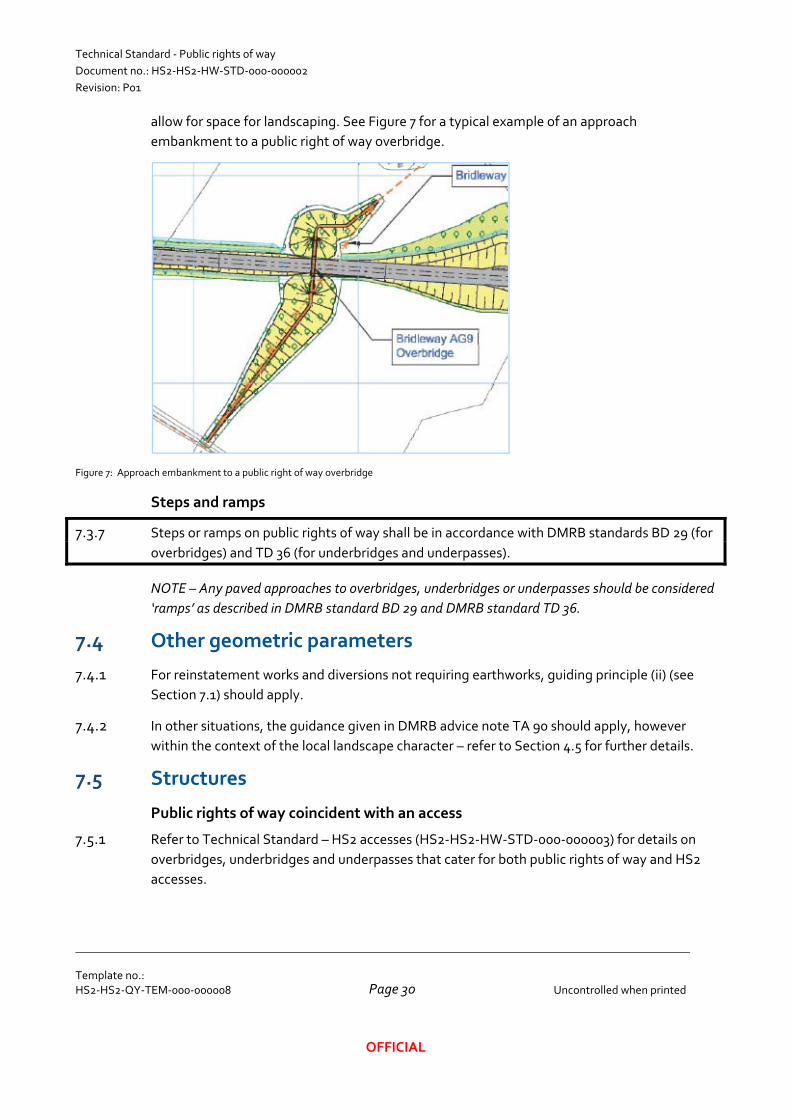
Technical Standard ‐ Public rights of way
Document no.: HS2‐HS2‐HW‐STD‐000‐000002
Revision: P01
Template no.: HS2‐HS2‐QY‐TEM‐000‐000008
Uncontrolled when printed
Page 30
OFFICIAL
allow for space for landscaping. See Figure 7 for a typical example of an approach
embankment to a public right of way overbridge.
Figure 7: Approach embankment to a public right of way overbridge
Steps and ramps
7.3.7 Steps or ramps on public rights of way shall be in accordance with DMRB standards BD 29 (for
overbridges) and TD 36 (for underbridges and underpasses).
NOTE – Any paved approaches to overbridges, underbridges or underpasses should be considered
‘ramps’ as described in DMRB standard BD 29 and DMRB standard TD 36.
7.4 Other geometric parameters
7.4.1 For reinstatement works and diversions not requiring earthworks, guiding principle (ii) (see
Section 7.1) should apply.
7.4.2 In other situations, the guidance given in DMRB advice note TA 90 should apply, however
within the context of the local landscape character – refer to Section 4.5 for further details.
7.5 Structures
Public rights of way coincident with an access
7.5.1 Refer to Technical Standard – HS2 accesses (HS2‐HS2‐HW‐STD‐000‐000003) for details on
overbridges, underbridges and underpasses that cater for both public rights of way and HS2
accesses.

Technical Standard ‐ Public rights of way
Document no.: HS2‐HS2‐HW‐STD‐000‐000002
Revision: P01
Template no.: HS2‐HS2‐QY‐TEM‐000‐000008
Uncontrolled when printed
Page 31
OFFICIAL
7.5.2 Refer to Technical Standard – Accommodation accesses (HS2‐HS2‐HW‐STD‐000‐000004) for
details on widths of overbridges, underbridges and underpasses that cater for both public
rights of way and accommodation accesses.
Width
7.5.3 The width of an overbridge carrying a footpath or bridleway shall be in accordance with DMRB
standard BD 29.
7.5.4 The width of an underpass carrying a footpath or bridleway shall be in accordance with DMRB
standard TD 36.
7.5.5 The width of an overbridge, underbridge or underpass carrying a restricted byway or byway
open to all traffic shall be, as a minimum, that of the associated route on each approach (and
in no case less than that for a bridleway).
Headroom
7.5.6 The headroom for a pedestrian or bridleway underpass shall be in accordance with DMRB
standard TD 36.
7.5.7 The appropriate headroom for an underbridge or underpass carrying a restricted byway or
byway shall be considered on a case‐by‐case basis, taking account of the size of any vehicles
that may reasonably be expected to use the bridge (but in no case less than that for a
bridleway, where an equestrian does not have to dismount to pass through the underbridge or
underpass).
7.5.8 Where public rights of way are coincident with accesses, the headroom shall be the greater of
that required for the public right of way and that required for the accommodation access or
HS2 access.
Other aspects
7.5.9 Refer to the following documents for all other requirements relating to public right of way
overbridges:
Hybrid Bill design – Deliverable Approach Statement – Overbridges (HS2‐HS2‐BR‐DAS‐
000‐000001)
Post‐hybrid Bill design ‐ Technical Standard – Overbridges (HS2‐HS2‐BR‐STD‐000‐
000003)
7.5.10 Refer to the following documents for all other requirements relating to public right of way
underbridges:
Hybrid Bill design – Deliverable Approach Statement – Viaducts and underbridges (HS2‐
HS2‐BR‐DAS‐000‐000002)
Technical Standard ‐ Public rights of way
Document no.: HS2‐HS2‐HW‐STD‐000‐000002
Revision: P01
Template no.: HS2‐HS2‐QY‐TEM‐000‐000008
Uncontrolled when printed
Page 32
OFFICIAL
Post‐hybrid Bill design ‐ Technical Standard – Underbridges and viaducts (HS2‐HS2‐BR‐
STD‐000‐000002)
7.5.11 Refer to the following documents for all other requirements relating to public right of way
underpasses:
Hybrid Bill design – Deliverable Approach Statement – Viaducts and underbridges (HS2‐
HS2‐BR‐DAS‐000‐000002)
Post‐hybrid Bill design ‐ Technical Standard – Culverts and underpasses (HS2‐HS2‐BR‐
STD‐000‐000005)
7.6 Earthworks
7.6.1 Refer to Technical Standard – Earthworks (HS2‐HS2‐GT‐STD‐000‐000001) for details of
engineering earthworks associated with public rights of way.
7.7 Boundary features
7.7.1 Public rights of way are not required to have boundary features, such as fences, walls or
hedges. However many public rights of way have some form of boundary feature, which is the
responsibility of the land owner. Typical functions that boundary features serve where
adjacent to public rights of way include:
To demarcate the extent of the public’s right of way (to discourage trespass by the
public)
To provide privacy (particularly to back‐yards of residential properties)
To restrict the movement of livestock
7.7.2 A public right of way can pass through boundary feature in one of the following ways –
through a gap, through a gate or over a stile.
Gates
7.7.3 Gates on public rights of way shall only be installed where necessary to control livestock, and
shall be of a type suitable for operation by disabled people.
7.7.4 The guidance ‘Advice on Gaps, Gates and Vehicles Barriers’ by the British Horse Society
should be followed for all public right of way gates where equestrians are permitted.
Motorbike inhibitors
7.7.5 Motorbike inhibitors shall only be provided where there is a demonstrable history of illegal use
of public rights of way by motorbikes.
Stiles
7.7.6 Pedestrian stiles shall not be used.
Technical Standard ‐ Public rights of way
Document no.: HS2‐HS2‐HW‐STD‐000‐000002
Revision: P01
Template no.: HS2‐HS2‐QY‐TEM‐000‐000008
Uncontrolled when printed
Page 33
OFFICIAL
7.7.7 Equestrian stiles (also known as ‘hop‐over gates’) are not preferred since they are
inconvenient to cyclists and difficult to negotiate for some equestrians, and should only be
installed where the use of a conventional gate is not appropriate. Refer to the guidance
‘Advice on Gaps, Gates and Vehicles Barriers’ for more details.
7.8 Signs
7.8.1 A ‘finger post’ sign indicating the presence of a public right of way shall be provided at each
junction of a new, realigned or diverted public right of way with another highway (road or
public right of way).
7.8.2 Refer to standard detail drawings HS2‐CSI‐HW‐DDE‐000‐007001‐FD to HS2‐CSI‐HW‐DDE‐
000‐007003‐FD for details of signs and waymarkers for public right of way.
7.8.3 Other signs, such as signs identifying promoted routes, should be identified in collaboration
with the local highway authority.
7.9 Street furniture
7.9.1 Whilst public rights of way are exactly that – rights of access for the public to pass on private
land – the landowner may agree to street furniture being placed on their land to cater for
public right of way users. This may include resting points, litter bins and information boards.
NOTE – Typically street furniture for public right of way users is only appropriate where the land
owner is a local authority or highway authority, unless alternative arrangements are made with
the landowner for the maintenance of the street furniture.
7.10 Errant vehicle protection
7.10.1 Public rights of way that pass near or over HS2 and permit the usage of non‐motorised or
motorised vehicles may require errant vehicle protection. Refer to Technical Standard – Errant
vehicle protection (HS2‐HS2‐HW‐STD‐000‐000005) for further details.
7.11 Drainage
7.11.1 Refer to Technical Standard – Highway and access drainage (HS2‐HS2‐DR‐STD‐000‐000002)
for requirements and guidance for highway drainage.
7.12 Lighting
General
7.12.1 Application of guiding principle (ii) (see Section 7.1) means that lighting should only be
provided on a ‘like for like’ basis.
NOTE – In the countryside, usage of public rights of way during the hours of darkness is likely to
be minimal (and where it occurs, users are likely to be using torches anyway)
Technical Standard ‐ Public rights of way
Document no.: HS2‐HS2‐HW‐STD‐000‐000002
Revision: P01
Template no.: HS2‐HS2‐QY‐TEM‐000‐000008
Uncontrolled when printed
Page 34
OFFICIAL
NOTE – Particular difficulties can arise in the urban fringes where structures such as underpasses
may be perceived (rightly or wrongly) as a source of anti‐social behaviour.
Underpasses and underbridges
7.12.2 The only potential exception to the guiding principle (ii) (see Section 7.1) is at new
underpasses and underbridges.
7.12.3 A risk assessment shall be carried out for each underpass and underbridge to determine
whether the provision of lighting is justified.
7.13 Safety
7.13.1 Non‐motorised user audits shall be undertaken in accordance with DMRB standard HD 42 for
all public rights of way
NOTE – In the case of diversions requiring public rights of way users to walk / ride along a length
of road (see example in Section 8.5.2), non‐motorised user safety will also be considered during
the road safety audits carried out in accordance with DMRB standard HD 19; refer to Technical
Standard – Roads (HS2‐HS2‐HW‐STD‐000‐0000001) for further details.
8 Further sources of information 8.1.1 Refer to the ‘Rights of way and accessing land’ pages on the gov.uk website for further
information on public rights of way, ‘right to roam’ and access to private land.
8.1.2 The Planning Inspectorate’s ‘Countryside, Access and Environmental Casework’ pages on the
Planning Portal website provide useful further information on public rights of way.
8.1.3 The ‘Blue Book’ – ‘Rights Of Way: a guide to law and practice’ by John Riddall and John
Trevelyan, published by the Ramblers’ Association and the Open Spaces Society also provides
useful guidance.
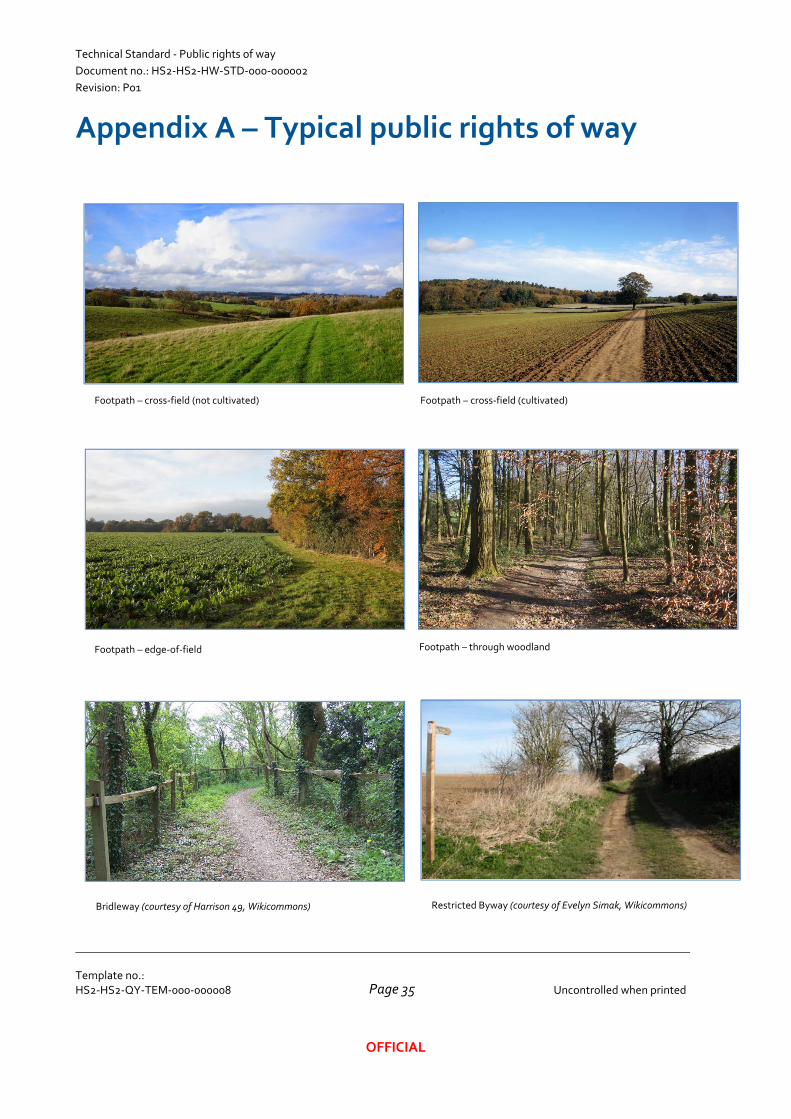
Technical Standard ‐ Public rights of way
Document no.: HS2‐HS2‐HW‐STD‐000‐000002
Revision: P01
Template no.: HS2‐HS2‐QY‐TEM‐000‐000008
Uncontrolled when printed
Page 35
OFFICIAL
Appendix A – Typical public rights of way
Footpath – cross‐field (not cultivated) Footpath – cross‐field (cultivated)
Footpath – edge‐of‐field Footpath – through woodland
Bridleway (courtesy of Harrison 49, Wikicommons) Restricted Byway (courtesy of Evelyn Simak, Wikicommons)
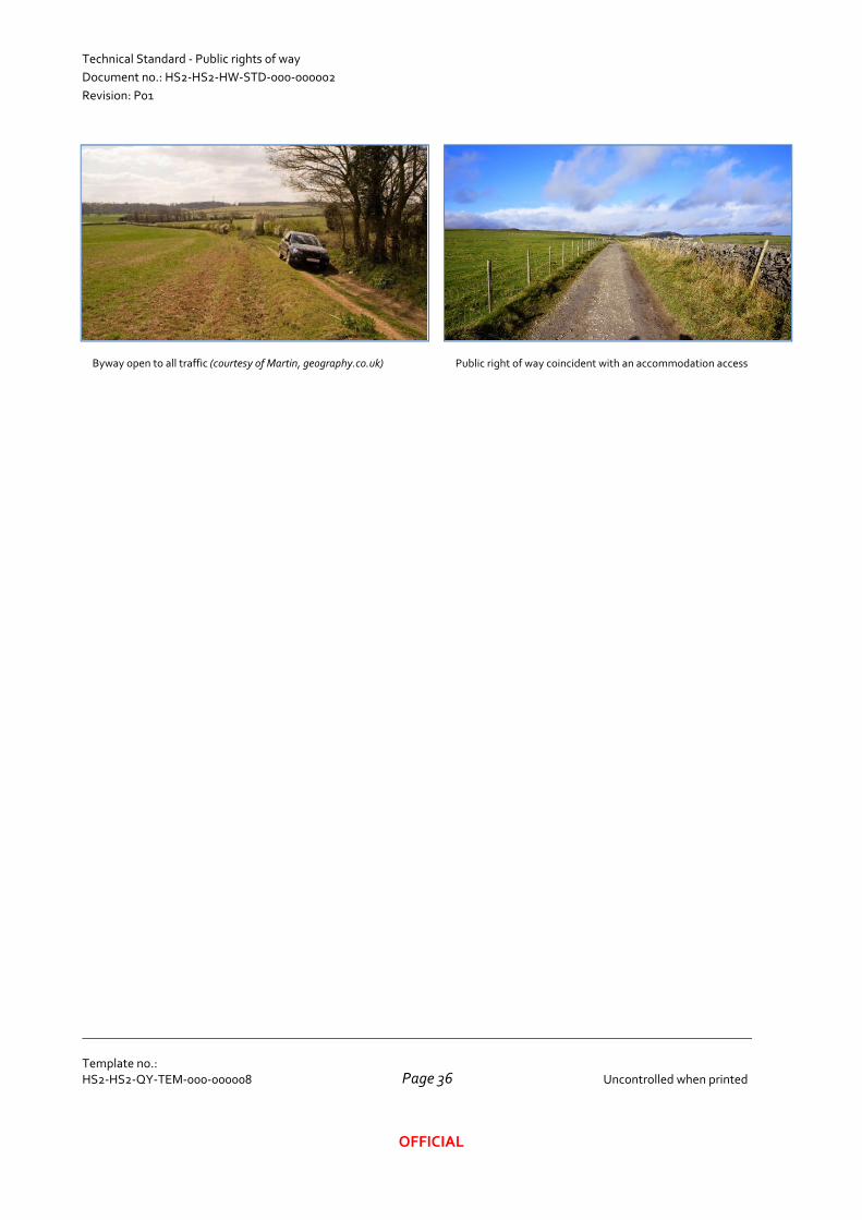
Technical Standard ‐ Public rights of way
Document no.: HS2‐HS2‐HW‐STD‐000‐000002
Revision: P01
Template no.: HS2‐HS2‐QY‐TEM‐000‐000008
Uncontrolled when printed
Page 36
OFFICIAL
Byway open to all traffic (courtesy of Martin, geography.co.uk) Public right of way coincident with an accommodation access