Embed Size (px)
Citation preview
Directorate of Urban Land Transport i
Directorate of Urban Land Transport
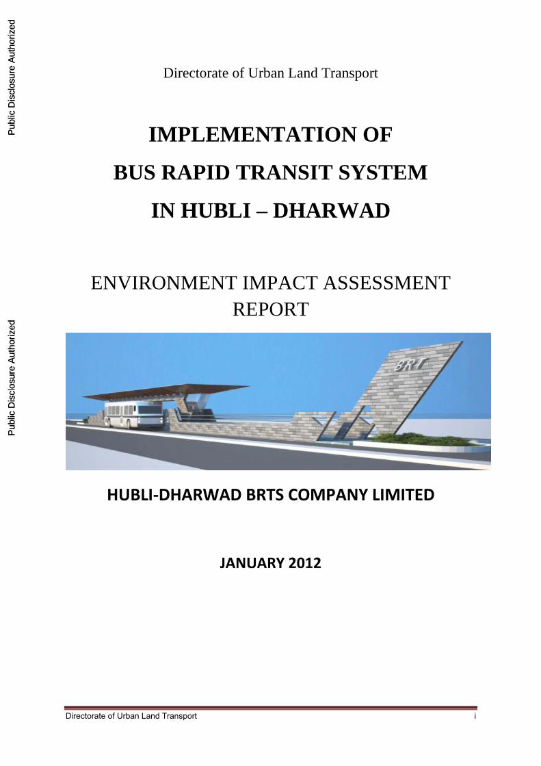
IMPLEMENTATION OF
BUS RAPID TRANSIT SYSTEM
IN HUBLI – DHARWAD
ENVIRONMENT IMPACT ASSESSMENT
REPORT
HUBLI-DHARWAD BRTS COMPANY LIMITED
JANUARY 2012
Pub
lic D
iscl
osur
e A
utho
rized
Pub
lic D
iscl
osur
e A
utho
rized
Pub
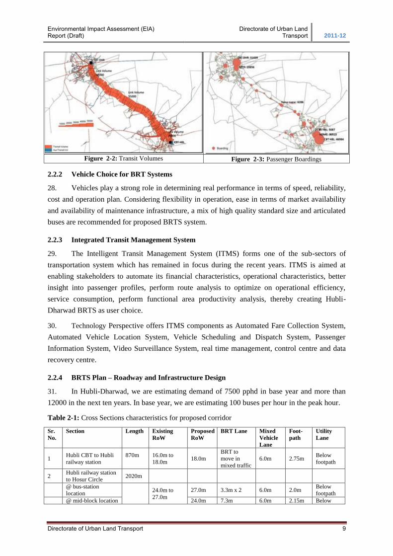
lic D
iscl
osur
e A
utho
rized
Pub
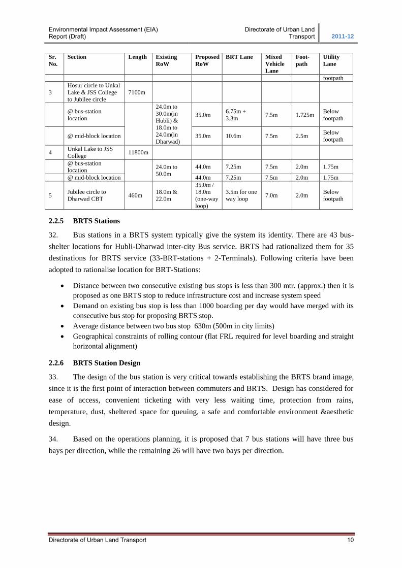
lic D
iscl
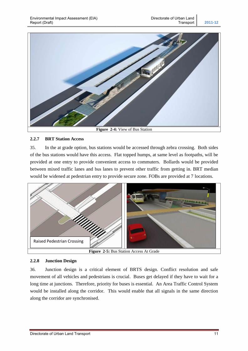
osur
e A
utho
rized
Pub
lic D
iscl
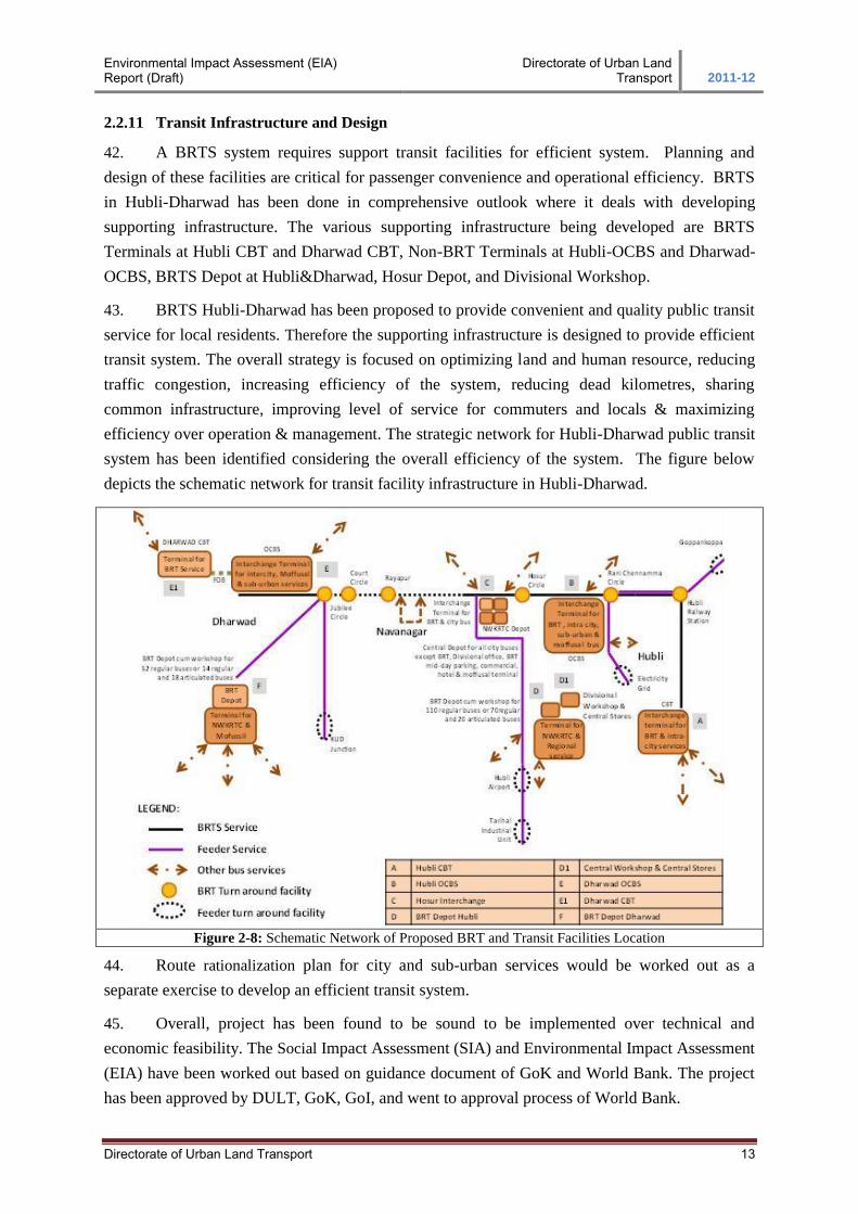
osur
e A
utho
rized
Pub
lic D
iscl
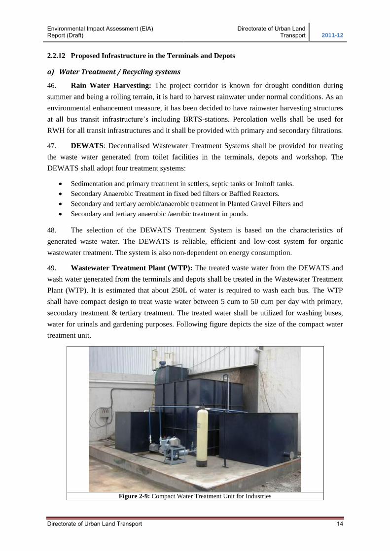
osur
e A
utho
rized
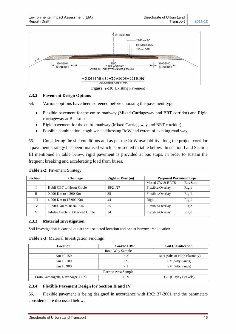
Pub
lic D
iscl
osur
e A
utho
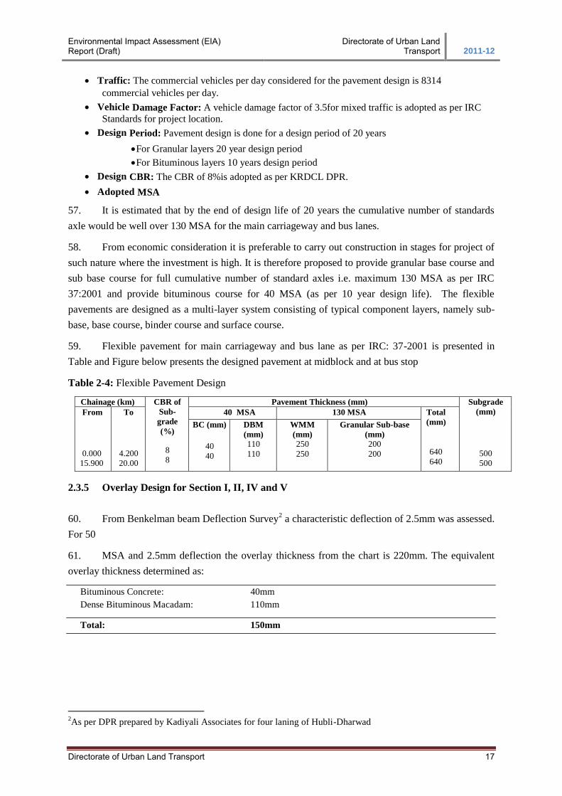
rized
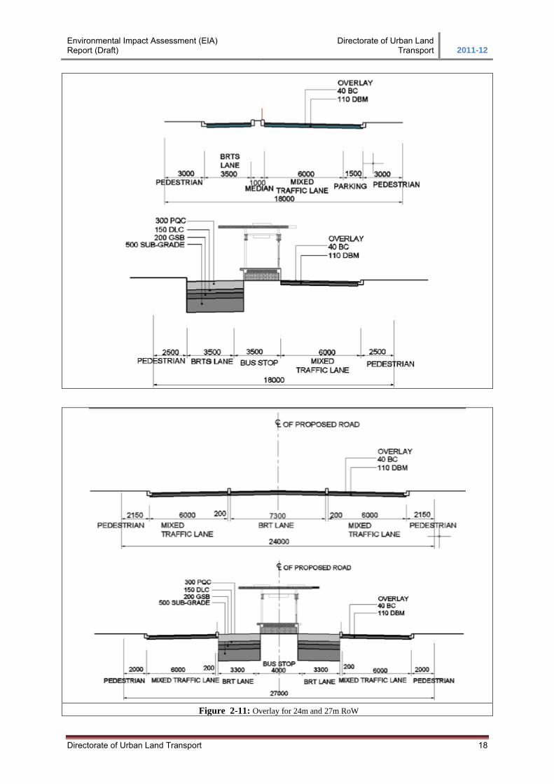
Pub
lic D
iscl
osur
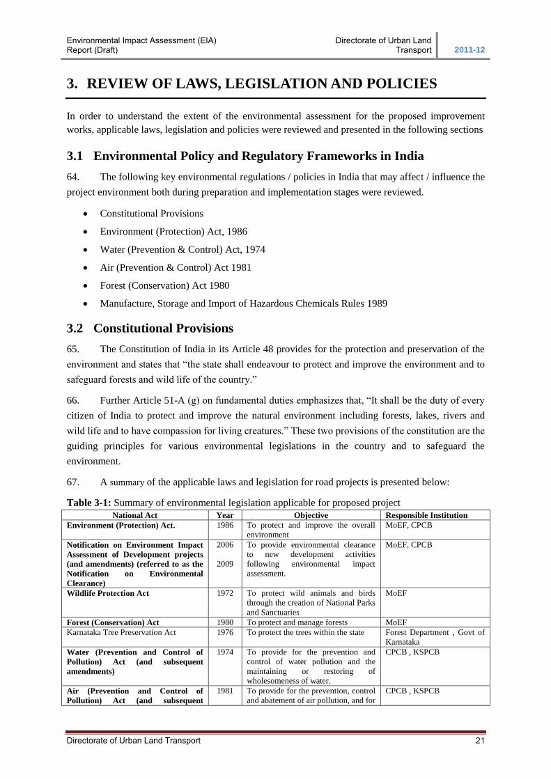
e A
utho
rized
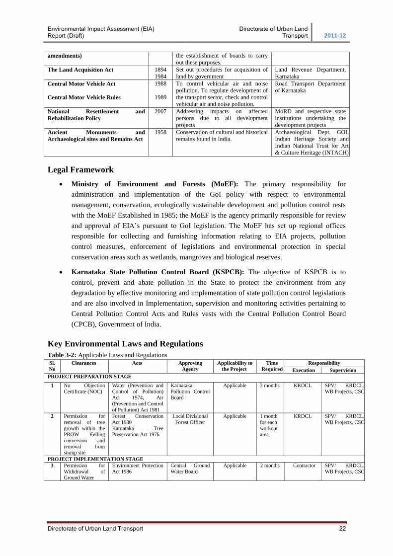
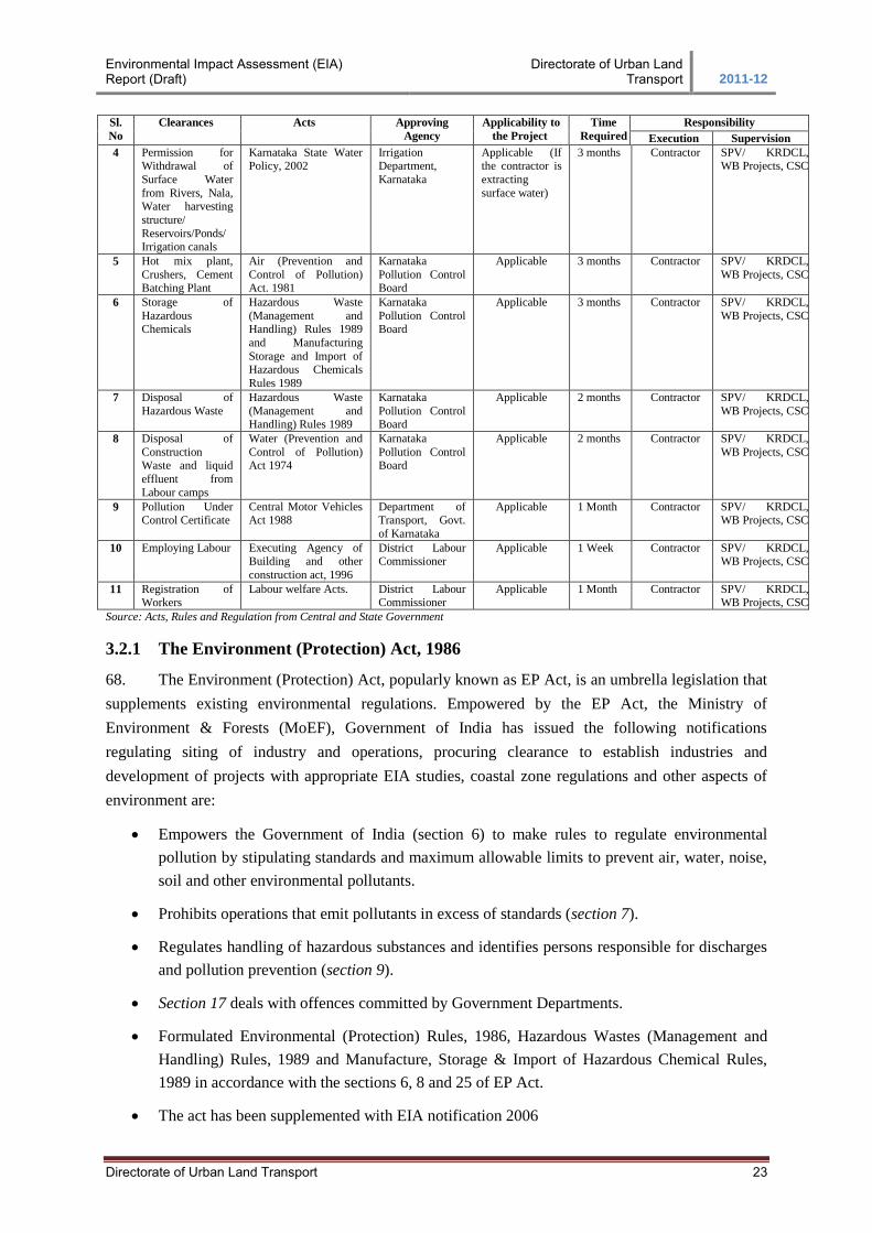
Directorate of Urban Land Transport ii
Table of Contents
1. INTRODUCTION .................................................................................................................... 1
1.1 Project Background ....................................................................................................... 1 1.2 Project Corridor ............................................................................................................. 1 1.5 Scope and Methodology ................................................................................................. 4 1.6 Structure of the Report ................................................................................................... 5
2. PROJECT DESCRIPTION ...................................................................................................... 6
2.1 Project Background ....................................................................................................... 6 2.2 BRT System: Concept, Evolution, Elements .................................................................... 7 2.3 Road Component ......................................................................................................... 15
3. REVIEW OF LAWS, LEGISLATION AND POLICIES ......................................................... 21
3.1 Environmental Policy and Regulatory Frameworks in India ............................................ 21 3.2 Constitutional Provisions .............................................................................................. 21 3.3 Operational Policies and Directives of the World Bank ................................................... 27 3.4 Environmental and Social Framework (GEF SUTP) ....................................................... 28 3.5 MORTH & IRC SPECIFICATIONS ............................................................................. 29 3.6 Environmental Clearance Procedure .............................................................................. 30
4. ENVIRONMENTAL DESCRIPTION .................................................................................... 31
4.1 Study Area .................................................................................................................. 31 4.2 Land Environment ....................................................................................................... 31 4.3 Socio Economic Profile ................................................................................................ 37 4.4 Cultural and Historic Places .......................................................................................... 38
5. ANALYSES OF ALTERNATIVES ......................................................................................... 40
5.1 No Project Scenario ..................................................................................................... 40
6. STAKE HOLDER CONSULTATIONS AND PLANNING ..................................................... 46
6.1 Consultation with stake holders ..................................................................................... 46 6.2 Consultations with the Affected Community .................................................................. 47
7. POTENTIAL ENVIRONMENTAL IMPACT AND MITIGATION MEASURES .................. 54
7.1 Project Impacts and Issues ............................................................................................ 54 7.2 Project Intervention ..................................................................................................... 54 7.3 Land Environment ....................................................................................................... 57 7.4 Air Environment .......................................................................................................... 62 7.5 Water Environment ...................................................................................................... 64 7.6 Noise Environment ...................................................................................................... 71 7.7 Biological Environment ............................................................................................... 77 7.8 Socio-Economic Environment ...................................................................................... 78 7.9 Solid Waste Management ............................................................................................. 87
8. ENVIRONMENTAL MONITORING PLAN .......................................................................... 91
8.1 Performance Indicators ................................................................................................ 91 8.2 Monitoring Parameters and Standards............................................................................ 92
Environmental Impact Assessment (EIA) Report (Draft)
Directorate of Urban Land Transport 2011-12
Directorate of Urban Land Transport ii
List of Figures
Figure 1-1: Proposed BRT Corridor ...................................................................................................................................... 2
Figure 4-1:Elevation Profile from Hubli to Dharwad ........................................................................................................... 31
Figure 4-2:Seismic Zone Map ........................................................................................................................................... 32
Figure 4-3:Windrose Diagram of Dharwad District (0830 Hrs and 1730 Hrs) ......................................................................... 34
Figure 4-4:NAAQM for Hubli and Dharwad ...................................................................................................................... 36
Figure 4-5:Anjaneya Temple @ 3/200 ............................................................................................................................... 39
Figure 4-6:Iskcon Temple @ 9/200 ................................................................................................................................... 39
Figure 5-1:Unkal cross VUP at Ch 2/320 to 2/960 (640 mts) ................................................................................................ 42
Figure 5-2:Unkal Village VUP at Ch 3/180 to 3/550 ............................................................................................................ 42
Figure 5-3:Bairikoppa VUP at Ch 4/450 to 4/990 ................................................................................................................ 42
Figure 5-4:Navanagar VUP at Ch 6/910 to 7/480 ................................................................................................................ 42
Figure 5-5: Kerb side Bus station location option ................................................................................................................. 43
Figure 5-6: Median side Bus station location option ............................................................................................................. 43
Figure 5-7: Raised Pedestrian Access to BRT Station .................................................................................................... 44
Figure 5-8:Typical BRT-station design for Hubli-Dharwad BRTS ......................................................................................... 45
Figure 6-1: Stakeholder meeting in Dharwad ....................................................................................................................... 47
Figure 6-2: Public Consultation along the Project Corridor ................................................................................................... 52
Figure 7-1: Cracks in the Pavement @ 4/200 .................................................................................................................... 55
Figure 7-2: Weathered pavement @8/400 ........................................................................................................................ 55
Figure 7-3: View of avenue trees @ 16/200 ....................................................................................................................... 56
Figure 7-4: View of avenue trees @ 14/800 ....................................................................................................................... 56
Figure 7-5: Silt Fencing ............................................................................................................................................... 70
Figure 7-6: Oil and Grease Interceptor ............................................................................................................................... 70
Figure 7-7: Typical Concept behind the provision of Green Barrier and Concrete Barrier ............................................. 75
Figure 7-8: Noise Barrier for Sensitive Locations along BRTS .............................................................................................. 76
Figure 7-9: Temple at Km 3/200 ....................................................................................................................................... 81
Figure 7-10: Mosque at Km5/300 ...................................................................................................................................... 81
Environmental Impact Assessment (EIA) Report (Draft)
Directorate of Urban Land Transport 2011-12
Directorate of Urban Land Transport ii
List of Table
Table 2-1: Cross Sections characteristics for proposed corridor ............................................................ 9
Table 2-2: Pavement Strategy .............................................................................................................. 16
Table 2-3: Material Investigation Findings .......................................................................................... 16
Table 2-4: Flexible Pavement Design .................................................................................................. 17
Table 3-1: Summary of environmental legislation applicable for proposed project ............................. 21
Table 3-2: Applicable Laws and Regulations ....................................................................................... 22
Table 4-1: Mean Maximum and Mean Minimum Temperature in Gadag Observatory ....................... 33
Table 4-2: Climatological characteristic of Dharwad District .............................................................. 33
Table 4-3: Surface water Bodies along proposed BRT ........................................................................ 34
Table 4-4: Details of workers, non-workers and other workers ........................................................... 38
Table 4-5: Cultural properties along the proposed BRT ...................................................................... 39
Table 5-1: Comparison of alternatives in term of Environmental Aspects........................................... 40
Table 5-2: Comparison of Alternatives in term of VUP’s .................................................................... 41
Table 6-1: Meetings/Discussions between various stake holders ......................................................... 46
Table 6-2: Details of Consultation Meetings Key Outcomes of Public Consultations ......................... 48
Table 6-3: Key Outcomes of Public Consultations .............................................................................. 51
Table 7-1: Land Acquisition for BRTS ................................................................................................ 54
Table 7-2: Machinery and plant for construction activity .................................................................... 56
Table 7-3: Fuel Consumption Rates for Construction Machinery ........................................................ 62
Table 7-4: Rate of Emissions of Various Types of Vehicles ................................................................ 63
Table 7-5: Impacts on water resources due to construction activities .................................................. 64
Table 7-6: Surface water Bodies along proposed BRT ........................................................................ 65
Table 7-7: Water Requirement for Construction works ....................................................................... 66
Table 7-8: Mitigation measure at Rayapura Tank ................................................................................ 67
Table 7-9: Sensitive Receptors location along Hubli – Dharwad Road ............................................... 73
Table 7-10: Noise Barrier required at Sensitive Location .................................................................... 75
Table 7-11: Trees Species Identified to act as Green Barrier ............................................................... 76
Table 7-12: Cultural Properties along the project corridor ................................................................... 81
Table 8-1: Performance Indicators for Project Implementation ........................................................... 91
Table 8-2: National Ambient Air Quality Standards ............................................................................ 93
Table 8-3: National Ambient Noise Quality Standards ........................................................................ 93
Table 8-4: National Standard of Water ................................................................................................ 94
Table 8-5: Environmental Monitoring Plan.......................................................................................... 95
Table 8-6: Summary details of Reporting ............................................................................................ 97
Table 8-7: Institutional Responsibilities ............................................................................................... 98
Table 8-8: Budgetary Provisions for Environmental Management Measures for Road Component ... 99
Table 8-9: Budgetary Provisions for Environmental Management Measures for BRTS Component 100
Environmental Impact Assessment (EIA) Report (Draft)
Directorate of Urban Land Transport 2011-12
Directorate of Urban Land Transport iii
List of Abbreviation
AAQM : Ambient Air Quality Monitoring
BRTS : Bus Rapid Transit System
BSNL : Bharat Sanchar Nigam Ltd
CBT : Central Bus Terminal
CPCB : Central Pollution Control Board
CSC : Construction Supervision Consultant
CO : Carbon Monoxide
CoI : Corridor of Impact
DPR : Detailed Project Report
DULT : Directorate of Urban Land Transport
EA : Environmental Assessment
EMP : Environmental Management Plan
ESMF : Environmental and Social Framework
FGDs : Focus Group Discussions
GEF : Global Environment Facility
GPS : Global Positioning Systems
GoI : Government of India
HC : Hydro Carbon
HDMC : Hubli Dharwad Municipal Corporation
ITS : Intelligent Transport System
IRC : Indian Roads Congress
KRDCL : Karnataka Road development Corporation Ltd
KSPCB : Karnataka State Pollution Control Board
LMV’s : Light Motor Vehicle
MoEF : Ministry of Environment and Forest
MSL : Mean Sea Level
MLD : Million Litres Per Day
NAQMP : National Air Quality Monitoring Programme
NGO : Non-Government Organisation
NWKRTC : North West Karnataka Road Transport Corporation
NoC : No Objection Certificate
NO2 : Nitrogen Oxide
OCBS : Old Central Bus Stand
PAP’s : Project Affected People
PUC : Pollution under Control Certificate
PWD : Public Works Department
RAP : Resettlement Action Plan
RoW : Right of Way
RTO : Regional Transport Office
SPV : Special Purpose Vehicle
SUTP : Sustainable Urban Transport Project
SEIAA : State/Union territory Environment Impact Assessment Authority
VUP’s : Vehicle Under Pass
Environmental Impact Assessment (EIA) Report (Draft)
Directorate of Urban Land Transport 2011-12
Directorate of Urban Land Transport 1
1. INTRODUCTION
1.1 Project Background
1. Hubli – Dharwad state highway is the one of the most congested road stretches in North West
Karnataka region. To ease the growing traffic from Hubli – Dharwad, the Government of Karnataka,
through the Karnataka Road Development Corporation Limited has taken up the widening of the
existing two lane state highway to a divided four lane carriageway. To provide better transportation
facilities between the two urban areas of Hubli and Dharwad, and with an objective to improve travel
speeds, reliability, and quality of public transport services, a BRT facility is proposed along the
corridor.
2. A SPV- ‘Hubli-Dharwad BRTS Company Limited’ has been formed under the companies act
to take up the construction of proposed infrastructure facilities for the BRTS. As a part of the BRTS,
some of the existing facilities like workshop, depots, terminals etc are proposed to be upgraded.
1.2 Project Corridor
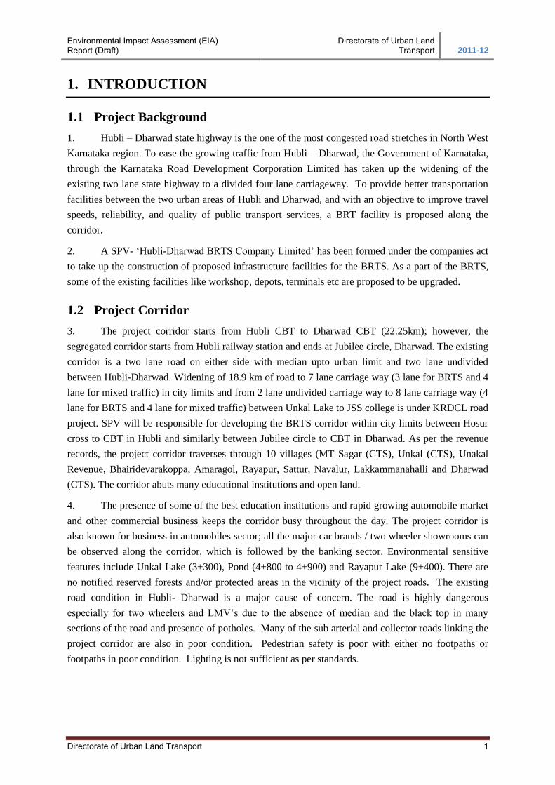
3. The project corridor starts from Hubli CBT to Dharwad CBT (22.25km); however, the
segregated corridor starts from Hubli railway station and ends at Jubilee circle, Dharwad. The existing
corridor is a two lane road on either side with median upto urban limit and two lane undivided
between Hubli-Dharwad. Widening of 18.9 km of road to 7 lane carriage way (3 lane for BRTS and 4
lane for mixed traffic) in city limits and from 2 lane undivided carriage way to 8 lane carriage way (4
lane for BRTS and 4 lane for mixed traffic) between Unkal Lake to JSS college is under KRDCL road
project. SPV will be responsible for developing the BRTS corridor within city limits between Hosur
cross to CBT in Hubli and similarly between Jubilee circle to CBT in Dharwad. As per the revenue
records, the project corridor traverses through 10 villages (MT Sagar (CTS), Unkal (CTS), Unakal
Revenue, Bhairidevarakoppa, Amaragol, Rayapur, Sattur, Navalur, Lakkammanahalli and Dharwad
(CTS). The corridor abuts many educational institutions and open land.
4. The presence of some of the best education institutions and rapid growing automobile market
and other commercial business keeps the corridor busy throughout the day. The project corridor is
also known for business in automobiles sector; all the major car brands / two wheeler showrooms can
be observed along the corridor, which is followed by the banking sector. Environmental sensitive
features include Unkal Lake (3+300), Pond (4+800 to 4+900) and Rayapur Lake (9+400). There are
no notified reserved forests and/or protected areas in the vicinity of the project roads. The existing
road condition in Hubli- Dharwad is a major cause of concern. The road is highly dangerous
especially for two wheelers and LMV’s due to the absence of median and the black top in many
sections of the road and presence of potholes. Many of the sub arterial and collector roads linking the
project corridor are also in poor condition. Pedestrian safety is poor with either no footpaths or
footpaths in poor condition. Lighting is not sufficient as per standards.
Environmental Impact Assessment (EIA) Report (Draft)
Directorate of Urban Land Transport 2011-12
Directorate of Urban Land Transport 2
Figure 1-1: Proposed BRT Corridor
Components of a Bus Rapid Transit System
5. A BRTS system combines flexible service and new technologies to improve customer
convenience and reduce delays. While specific BRTS applications vary, the components include:
Road way: Exclusive guide ways or dedicated lanes generally along existing carriageways
that allow BRTS vehicles to be free of conflicting automobile traffic, parked or stopped
vehicles, and other obstructions – maximizing BRTS operating speeds.
Vehicles: Modern, high capacity rubber-tired vehicles that accommodate a high volume of
riders and allow fast boarding and alighting form another crucial component of the BRTS
system.
Route Structure and Scheduling: Involves strong technical skills for planning of service, its
routing and scheduling, based on travel demand assessment.
BRTS operations: Includes running of buses, driver management, routing and operational
techniques form other important components of a BRTs.
Fare collection: An advanced system of automated fare collection is a critical component of a
BRTS system. Generally designed to make fare collection fast and easy to pay, often before
boarding the vehicle. Collection system could be pre-paid or by the use of integrated smart
cards.
Intelligent Transport System (ITS) and control systems/passenger information systems:
The use of advanced technologies or ITS is to improve customer convenience, speed,
reliability and safety. Examples include systems that provide traffic signal preference for
buses at intersections and cross streets, as well as Global Positioning Systems (GPS) to
provide passenger information such as real-time bus arrival information.
Environmental Impact Assessment (EIA) Report (Draft)
Directorate of Urban Land Transport 2011-12
Directorate of Urban Land Transport 3
Bus stops and terminals: Ranging from protected shelters to large transit stations. BRTS
stations need space along the corridor generally at a distance of 500m-750m. Transit stations
require slightly larger areas as they act as interchange points for more than one route.
Terminals need added turn around space and longer halting/parking space availability.
Depots: Depots are larger areas that are used for parking and maintenance facilities or
workshop for the BRTS bus fleet. Usually they are dedicated for the BRTS buses alone and
other buses do not use these facilities.
Last mile connectivity: Footpaths for pedestrians and infrastructure for NMT would also be
improved as a part of this project.
6. In addition to the above components which would be part of the BRTS project taken up with
World Bank - GEF- assisted SUTP, there will also be focus on integrating feeder services with the
BRTS, implementing a parking policy and landuse transport integration.
1.3 Project Benefits
7. The proposed BRT system will offer the following advantages:
Reduction in time of travel;
Increase in economic productivity;
Reduced air and noise emissions;
Increased passenger safety;
Increased safety on mixed traffic lane;
Optimum utilization of infrastructure;
Equitable access between the twin cities;
1.4 Objectives of Present Study
The key objective of the present study is to prepare an Environmental Assessment for the
proposed BRT corridor, including preparation of individual EMP’s with mitigation measures
for the identified impacts and environmental budget for (i) Road components and (ii) BRTS
components.
Any infrastructure projects within India have to undergo the environmental clearance from
the Ministry of Environment and Forest (MoEF). The Ministry has stipulated its guideline for
various types of projects; development of roads (State and National highways) is considered
as one of the infrastructure project and it demands environmental clearance from the Ministry.
However, later the EC has been relaxed for the existing state highways undergoing
expansions / modernisation. Since the Hubli – Dharwad road falls in the state highways
category it doesn’t required EC from the ministry. However, as per the GEF STUP’s
Environmental and Social Framework (ESMF) and World Bank guidelines, the project
requires Environmental Assessment. The Environmental and Social Management Framework
(ESMF) of the operations manual of SUTP lays down the principles for addressing
environmental and social impacts due to the implementation of demonstration project of
SUTP. The environmental and social safeguard policies that are part of the ESMF will be
applied in this case.
Based on the policies, the project requires an Environmental Assessment (EA) report with
effective Environmental Management Plan (EMP) for implementation along the project
construction and operation.
Environmental Impact Assessment (EIA) Report (Draft)
Directorate of Urban Land Transport 2011-12
Directorate of Urban Land Transport 4
8. Since the road component (widening of two lanes to four lanes) work has already been
allocated to the contractor and on ground implementation for four lanes had already started before the
BRTS project was initiated. Due to this, it has been decided to prepare (i) a common Environmental
Impact Assessment Report (Road and BRT Infrastructure Component) with two separate EMP’s (ii)
Road Component EMP and (iii) BRT Infrastructure component EMP totalling 3 volumes.
1.5 Scope and Methodology
9. As part of the DPR, environmental and social assessment of the proposed project
interventions was carried out to identify the environmental and social issues due to the proposed
improvement works.
TASK 1: Secondary Data Collection
10. This task include collection of secondary data related to the project area in terms of
demography, environmental features along the project roads, existing laws, legislations and policies,
design reports and other studies.
TASK 2: Literature Review
11. Review of the secondary data collected was undertaken to understand the project area and
identify sensitive environmental and social features along the project road. The existing Central and
State level laws and legislations were reviewed to understand the requirements and level of
environmental sensitivity of the proposed works. Policies related to environmental and social issues
laid down by the lending agencies were also reviewed.
TASK 3: Reconnaissance Surveys
12. Field visits were undertaken to establish the authenticity of the secondary information and to
establish the baseline environmental and social features of the project area. Discussions were also
carried out with the local people who are likely to be affected by the project as per the preliminary
surveys.
TASK 4: Identification of Impacts
13. Based on the analysis of the secondary information and the outcomes of the reconnaissance
surveys and field discussions the environmental and social impacts of the proposed improvement
works were identified. The task also includes the extent of land acquisition, identification of the
project affected people (PAP’s) and the status of land ownership.
TASK 5: Formulation of Environmental Management Plan
14. The task involves the formulation of the environmental management plan in order to
mitigate/minimize the identified impacts. Scope for possible environmental enhancement measures
was also studied.
Environmental Impact Assessment (EIA) Report (Draft)
Directorate of Urban Land Transport 2011-12
Directorate of Urban Land Transport 5
TASK 6: Formulation of Resettlement Action Plan
15. The task involves the formulation of a Resettlement Action Plan (RAP) for the identified
social impacts due to the proposed project and in finalizing the compensation to the identified project
affected people (refer Resettlement Action Plan (RAP) for further details).
1.6 Structure of the Report
16. The Environmental Impact Assessment Report is based on field data generated at the site
and data collected from secondary sources. The report has been organised as following sections:
Chapter 1: Gives a brief introduction of the proposed BRT project and its interventions
Chapter 2: Provides a brief description of the proposed project and its components
Chapter 3: Reviews the laws, legislation and policies to understand the requirements and level of the
environmental assessment
Chapter 4: Presents the baseline environmental profile of the project area
Chapter 5: Discusses various analysis of alternative approach adopted
Chapter 6: Details the discussions and interviews conducted with various stakeholders
Chapter 7: Highlight the impacts of the proposed improvement works on the physical resources,
environmental resources, ecological resources and the human use values and the environmental
mitigation measures for the identified impact during the project construction and operation.
Chapter 8: Details the Environmental Monitoring Plan (EMP) and institutional mechanism for
implementing the EMP.
Environmental Impact Assessment (EIA) Report (Draft)
Directorate of Urban Land Transport 2011-12
Directorate of Urban Land Transport 6
2. PROJECT DESCRIPTION
2.1 Project Background
17. In 1962, Hubli and Dharwad were combined and recognized as twin cities. It is now an
important commercial, industrial and educational centre in Karnataka. The present population of
HDMC is 9.6 lakh and covers an area of 202 sq.km. Hubli is headquarters of the South West Railway
Division. Dharwad is pre-dominantly an educational town and is the district quarter. Both centres are
approximately 20 km apart and linked through a State Highway (PB road), National Highway (NH4)
and the Mumbai Bangalore Railway Line. Hubli being the centre for trade and commerce and
Dharwad, the educational seat, continue to attract large volumes of traffic both from outside and
within the region. There is already a high volume of traffic between the two towns. Currently, this
demand is catered to by the NWKRTC through a bus based system.
18. Several formal/informal consultations with each stakeholder to understand issues and cross
cutting themes have been conducted during the past one and half year. The elected representatives
opined that the BRTS would be truly successful if travel time between the two cities could be brought
down to 30 minutes by BRTS. A SPV- Hubli - Dharwad BRTS Company Limited has been formed
for managing BRTS planning, implementation and operations.
19. Hubli-Dharwad is growing at a moderate pace. The landuse proposed indicates many new
activity areas and interaction between the two cities. Vacant land between the two cities will develop.
The new upcoming activity areas will have implication on travel demand on the city for future.
2.1.1 Existing Transportation System
20. Hubli, being the commercial hub, has registered a higher vehicle growth rate compared to
Dharwad. Two wheelers constitute 71% of the total vehicles in Hubli-Dharwad. The number of
registered vehicles has grown by 20% from 309,455 in 2010 to 338,481 in 2011.
2.1.2 Travel Characteristics
21. Trip rates, trip length, trip purpose and travel modes are critical household choice elements
influencing overall transport situation in the city. The characteristics and trends have been
summarized based on the survey of 8800 households carried out by IMaCS as part of CTTS (year
2009). Per capita trip rate tends to be higher (i.e 1.48). Two wheelers dominate with a mode share of
67%. The bus passenger patronage is relatively high for the city size and the challenge is to maintain
this share since the proportion of private vehicles is also considerably high. Given the typical
characteristic of both cities, work and education trips dominate. The average trip length, including
walking is about 5.1 km. However, the average trip length of motorised trips is high at 8.6, which is
expected in linear cities. These trip lengths are suitable for bus based transit nodes. As part of the
surveys, it was observed that while the bus accounts for 7% of the total passenger vehicles, its share in
terms of passengers are over 70%. This clearly establishes the need for according priority to the bus in
terms of space and operations.
Environmental Impact Assessment (EIA) Report (Draft)
Directorate of Urban Land Transport 2011-12
Directorate of Urban Land Transport 7
22. Functionally, the twin cities of Hubli and Dharwad operate like three sub-systems managed
by NWKRTC. The first and the second are Hubli city and Dharwad city systems. The third is the
Hubli-Dharwad sub-system. Each of these sub-systems shows distinct operational characteristics. The
speeds are generally low. Buses carry about 70-75% of people on this corridor. That justifies the
decision of Government of Karnataka to implement BRTS.
2.2 BRT System: Concept, Evolution, Elements
23. Bus rapid transit system is a bus priority system that provides affordable, safe, and faster
public transit. The system design can be flexible based on city context and demand. BRTS is
affordable and is socially and economically viable choice for every city. The system can be expanded
based on the city’s growth directions and movement patterns. Several other successful ‘BRTS’ cities
have demonstrated that political will and vision, stakeholder involvement, strong urban planning
principles and innovations to meet local requirements are crucial ingredients for successful BRTS
systems. The following principles have been followed for the final selection of BRTS corridors.
It should connect important existing nodes in the city as well as serve potential future nodes
It should reduce travel time for a large segment of people
It should serve existing demand with higher quality infrastructure
It should provide the most convenient and direct access to activity areas
It should reduce road accidents and significantly increase safety
It should accommodate BRTS treatment and be implemented quickly
24. Each potential corridor was assessed for connectivity and link to major nodes and possibility
of taking BRTS infrastructure (RoW). The corridors were ranked based on their connectivity to
destinations, right-of-way, spatial analysis considering wise density, employment density, trip
attraction and production and demand assessment. It is recommend Hubli-CBT to Dharwad-CBT to
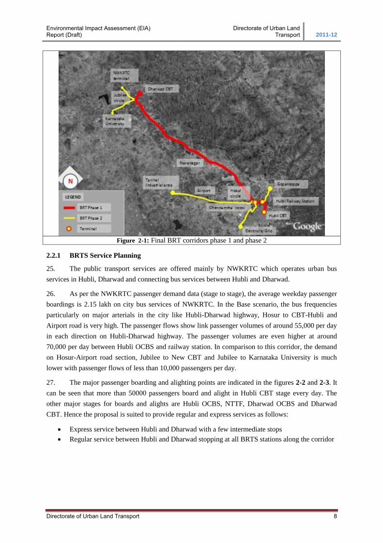
be developed as final BRTS corridors for phase 1. The length of the corridor is 22.25 km.
Environmental Impact Assessment (EIA) Report (Draft)
Directorate of Urban Land Transport 2011-12
Directorate of Urban Land Transport 8
Figure 2-1: Final BRT corridors phase 1 and phase 2
2.2.1 BRTS Service Planning
25. The public transport services are offered mainly by NWKRTC which operates urban bus
services in Hubli, Dharwad and connecting bus services between Hubli and Dharwad.
26. As per the NWKRTC passenger demand data (stage to stage), the average weekday passenger
boardings is 2.15 lakh on city bus services of NWKRTC. In the Base scenario, the bus frequencies
particularly on major arterials in the city like Hubli-Dharwad highway, Hosur to CBT-Hubli and
Airport road is very high. The passenger flows show link passenger volumes of around 55,000 per day
in each direction on Hubli-Dharwad highway. The passenger volumes are even higher at around
70,000 per day between Hubli OCBS and railway station. In comparison to this corridor, the demand
on Hosur-Airport road section, Jubilee to New CBT and Jubilee to Karnataka University is much
lower with passenger flows of less than 10,000 passengers per day.
27. The major passenger boarding and alighting points are indicated in the figures 2-2 and 2-3. It
can be seen that more than 50000 passengers board and alight in Hubli CBT stage every day. The
other major stages for boards and alights are Hubli OCBS, NTTF, Dharwad OCBS and Dharwad
CBT. Hence the proposal is suited to provide regular and express services as follows:
Express service between Hubli and Dharwad with a few intermediate stops
Regular service between Hubli and Dharwad stopping at all BRTS stations along the corridor
Environmental Impact Assessment (EIA) Report (Draft)
Directorate of Urban Land Transport 2011-12
Directorate of Urban Land Transport 9
Figure 2-2: Transit Volumes Figure 2-3: Passenger Boardings
2.2.2 Vehicle Choice for BRT Systems
28. Vehicles play a strong role in determining real performance in terms of speed, reliability,
cost and operation plan. Considering flexibility in operation, ease in terms of market availability
and availability of maintenance infrastructure, a mix of high quality standard size and articulated
buses are recommended for proposed BRTS system.
2.2.3 Integrated Transit Management System
29. The Intelligent Transit Management System (ITMS) forms one of the sub-sectors of
transportation system which has remained in focus during the recent years. ITMS is aimed at
enabling stakeholders to automate its financial characteristics, operational characteristics, better
insight into passenger profiles, perform route analysis to optimize on operational efficiency,
service consumption, perform functional area productivity analysis, thereby creating Hubli-
Dharwad BRTS as user choice.
30. Technology Perspective offers ITMS components as Automated Fare Collection System,
Automated Vehicle Location System, Vehicle Scheduling and Dispatch System, Passenger
Information System, Video Surveillance System, real time management, control centre and data
recovery centre.
2.2.4 BRTS Plan – Roadway and Infrastructure Design
31. In Hubli-Dharwad, we are estimating demand of 7500 pphd in base year and more than
12000 in the next ten years. In base year, we are estimating 100 buses per hour in the peak hour.
Table 2-1: Cross Sections characteristics for proposed corridor
Sr.
No.
Section Length Existing
RoW
Proposed
RoW
BRT Lane Mixed
Vehicle
Lane
Foot-
path
Utility
Lane
1 Hubli CBT to Hubli
railway station
870m
16.0m to
18.0m 18.0m
BRT to
move in
mixed traffic
6.0m 2.75m Below
footpath
2 Hubli railway station
to Hosur Circle 2020m
@ bus-station
location 24.0m to
27.0m
27.0m 3.3m x 2 6.0m 2.0m Below
footpath
@ mid-block location 24.0m 7.3m 6.0m 2.15m Below
Environmental Impact Assessment (EIA) Report (Draft)
Directorate of Urban Land Transport 2011-12
Directorate of Urban Land Transport 10
Sr.
No.
Section Length Existing
RoW
Proposed
RoW
BRT Lane Mixed
Vehicle
Lane
Foot-
path
Utility
Lane
footpath
3
Hosur circle to Unkal
Lake & JSS College
to Jubilee circle
7100m
@ bus-station
location
24.0m to
30.0m(in
Hubli) &
18.0m to
24.0m(in
Dharwad)
35.0m 6.75m +
3.3m 7.5m 1.725m
Below
footpath
@ mid-block location 35.0m 10.6m 7.5m 2.5m Below
footpath
4 Unkal Lake to JSS
College 11800m
@ bus-station
location 24.0m to
50.0m
44.0m 7.25m 7.5m 2.0m 1.75m
@ mid-block location 44.0m 7.25m 7.5m 2.0m 1.75m
5 Jubilee circle to
Dharwad CBT 460m
18.0m &
22.0m
35.0m /
18.0m
(one-way
loop)
3.5m for one
way loop 7.0m 2.0m
Below
footpath
2.2.5 BRTS Stations
32. Bus stations in a BRTS system typically give the system its identity. There are 43 bus-
shelter locations for Hubli-Dharwad inter-city Bus service. BRTS had rationalized them for 35
destinations for BRTS service (33-BRT-stations + 2-Terminals). Following criteria have been
adopted to rationalise location for BRT-Stations:
Distance between two consecutive existing bus stops is less than 300 mtr. (approx.) then it is
proposed as one BRTS stop to reduce infrastructure cost and increase system speed
Demand on existing bus stop is less than 1000 boarding per day would have merged with its
consecutive bus stop for proposing BRTS stop.
Average distance between two bus stop 630m (500m in city limits)
Geographical constraints of rolling contour (flat FRL required for level boarding and straight
horizontal alignment)
2.2.6 BRTS Station Design
33. The design of the bus station is very critical towards establishing the BRTS brand image,
since it is the first point of interaction between commuters and BRTS. Design has considered for
ease of access, convenient ticketing with very less waiting time, protection from rains,
temperature, dust, sheltered space for queuing, a safe and comfortable environment &aesthetic
design.
34. Based on the operations planning, it is proposed that 7 bus stations will have three bus
bays per direction, while the remaining 26 will have two bays per direction.
Environmental Impact Assessment (EIA) Report (Draft)
Directorate of Urban Land Transport 2011-12
Directorate of Urban Land Transport 11
Figure 2-4: View of Bus Station
2.2.7 BRT Station Access
35. In the at grade option, bus stations would be accessed through zebra crossing. Both sides
of the bus stations would have this access. Flat topped humps, at same level as footpaths, will be
provided at one entry to provide convenient access to commuters. Bollards would be provided
between mixed traffic lanes and bus lanes to prevent other traffic from getting in. BRT median
would be widened at pedestrian entry to provide secure zone. FOBs are provided at 7 locations.
Figure 2-5: Bus Station Access At Grade
2.2.8 Junction Design
36. Junction design is a critical element of BRTS design. Conflict resolution and safe
movement of all vehicles and pedestrians is crucial. Buses get delayed if they have to wait for a
long time at junctions. Therefore, priority for buses is essential. An Area Traffic Control System
would be installed along the corridor. This would enable that all signals in the same direction
along the corridor are synchronised.
Raised Pedestrian Crossing
Environmental Impact Assessment (EIA) Report (Draft)
Directorate of Urban Land Transport 2011-12
Directorate of Urban Land Transport 12
37. Out of the 42 junctions identified, 4 junctions are grade separated. This is done by
designing vehicle underpasses boxes at these locations. These locations have been identified by
assessing the existing road profile. (Refer: Section 9.3.4 of HDBRTS DFR)
2.2.9 BRTS Feeder
38. To increase the catchment for BRTS, feeder services will enable transfers from trunk
services. Feeder service will typically be of short lengths (6-10 km) and will offer the last mile
connectivity. Buses will run in mixed traffic with no segregation. Physical integration will
happen at terminals only. 3-routes have been identified as BRT Feeder corridors which will be
upgraded to BRTS in second phase (figure 2.1).
2.2.10 Last Mile Connectivity
39. Last mile connectivity proposal includes providing high quality pedestrian infrastructure
near all terminals, interchanges and important bus stations. It focuses on disabled friendly
elements, comfortable walking environment for all and enhanced quality of life. It will feature
use of paver blocks, street furniture, road signage’s, dust bins, lane markings, designated parking
etc. The figures below show the kind of infrastructure envisioned for these streets.
Figure 2-6: Seating spaces near Kankaria BRT Figure2-7: Pedestrian facilities
40. Street furniture will include elements such as benches and dust bins, pedestrian signages,
space and design for kiosks, stands for bicycle parking, landscaping etc. Tree pits will be
provided at an interval of 6 to 8m c/c on the pedestrian path. Landscaping options would be
provided wherever possible such as junction corners, public spaces, approaches to bus stops etc.
41. Street lighting design of the proposed BRT corridor assumes special significance as it has
to cater to various lighting requirement such as BRT buses plying on BRT lane, other motorized
traffic on mixed lane, slow moving and motorized traffic on service lanes and pedestrians on
footpath. The lighting design therefore should cater to all these users simultaneously taking care
of the basic design parameters of luminous intensity, the contrast, glare, light uniformity over the
pavements and aesthetic.
Environmental Impact Assessment (EIA) Report (Draft)
Directorate of Urban Land Transport 2011-12
Directorate of Urban Land Transport 13
2.2.11 Transit Infrastructure and Design
42. A BRTS system requires support transit facilities for efficient system. Planning and
design of these facilities are critical for passenger convenience and operational efficiency. BRTS
in Hubli-Dharwad has been done in comprehensive outlook where it deals with developing
supporting infrastructure. The various supporting infrastructure being developed are BRTS
Terminals at Hubli CBT and Dharwad CBT, Non-BRT Terminals at Hubli-OCBS and Dharwad-
OCBS, BRTS Depot at Hubli&Dharwad, Hosur Depot, and Divisional Workshop.
43. BRTS Hubli-Dharwad has been proposed to provide convenient and quality public transit
service for local residents. Therefore the supporting infrastructure is designed to provide efficient
transit system. The overall strategy is focused on optimizing land and human resource, reducing
traffic congestion, increasing efficiency of the system, reducing dead kilometres, sharing
common infrastructure, improving level of service for commuters and locals & maximizing
efficiency over operation & management. The strategic network for Hubli-Dharwad public transit
system has been identified considering the overall efficiency of the system. The figure below
depicts the schematic network for transit facility infrastructure in Hubli-Dharwad.
Figure 2-8: Schematic Network of Proposed BRT and Transit Facilities Location
44. Route rationalization plan for city and sub-urban services would be worked out as a
separate exercise to develop an efficient transit system.
45. Overall, project has been found to be sound to be implemented over technical and
economic feasibility. The Social Impact Assessment (SIA) and Environmental Impact Assessment
(EIA) have been worked out based on guidance document of GoK and World Bank. The project
has been approved by DULT, GoK, GoI, and went to approval process of World Bank.
Environmental Impact Assessment (EIA) Report (Draft)
Directorate of Urban Land Transport 2011-12
Directorate of Urban Land Transport 14
2.2.12 Proposed Infrastructure in the Terminals and Depots
a) Water Treatment / Recycling systems
46. Rain Water Harvesting: The project corridor is known for drought condition during
summer and being a rolling terrain, it is hard to harvest rainwater under normal conditions. As an
environmental enhancement measure, it has been decided to have rainwater harvesting structures
at all bus transit infrastructure’s including BRTS-stations. Percolation wells shall be used for
RWH for all transit infrastructures and it shall be provided with primary and secondary filtrations.
47. DEWATS: Decentralised Wastewater Treatment Systems shall be provided for treating
the waste water generated from toilet facilities in the terminals, depots and workshop. The
DEWATS shall adopt four treatment systems:
Sedimentation and primary treatment in settlers, septic tanks or Imhoff tanks.
Secondary Anaerobic Treatment in fixed bed filters or Baffled Reactors.
Secondary and tertiary aerobic/anaerobic treatment in Planted Gravel Filters and
Secondary and tertiary anaerobic /aerobic treatment in ponds.
48. The selection of the DEWATS Treatment System is based on the characteristics of
generated waste water. The DEWATS is reliable, efficient and low-cost system for organic
wastewater treatment. The system is also non-dependent on energy consumption.
49. Wastewater Treatment Plant (WTP): The treated waste water from the DEWATS and
wash water generated from the terminals and depots shall be treated in the Wastewater Treatment
Plant (WTP). It is estimated that about 250L of water is required to wash each bus. The WTP
shall have compact design to treat waste water between 5 cum to 50 cum per day with primary,
secondary treatment & tertiary treatment. The treated water shall be utilized for washing buses,
water for urinals and gardening purposes. Following figure depicts the size of the compact water
treatment unit.
Figure 2-9: Compact Water Treatment Unit for Industries
Environmental Impact Assessment (EIA) Report (Draft)
Directorate of Urban Land Transport 2011-12
Directorate of Urban Land Transport 15
b) Utilising Solar Energy
50. Harvesting of Solar energy was evaluated for transit infrastructure and concluded that
it is not viable due to the following reasons:
Roof panel area is not sufficient to provide required electrical energy to transit infrastructure;
High amount of battery and its storage is required as depot infrastructure will be operational
@ night, and
it is not economically viable.
51. However as an alternative energy saving electrical system, the following approach
shall be adopted for all the terminals and depot:
Electrical fitting with low energy consumption is proposed to be installed in transit
infrastructure.
Natural light and ventilation is maximised to reduce energy consumption load on
infrastructure site.
c) Landscaping
52. Tree plantation is suggested as part of the landscape at all infrastructure sites (except CBT
due to space constraints). The details of tree plantations are given in the following table.
Sl.no Infrastructure Site Trees to be planted within proposed
landscape area
1. CBT Hubli 0
2. Hubli OCBS - Ranichennamma 239
3. BRTS Deport Hubli – Airport Road 260
4. Divisional Workshop - Hubli 210
5. Depot and Regional Terminal at Hosur Circle 342
6. BRT Depot Dharwad 167
7. OCBS Dharwad 78
Total 1296
2.3 Road Component
2.3.1 Evaluation of Existing Pavement
53. The existing pavement is of two lane1 configuration (7m wide) with hard shoulder of 1.5-
2.0m width on either side. The crust thickness of existing pavement as per DPR was verified,
though most of the length is getting consideration for construction as rigid pavement and needs
dismantling. The average thickness of the existing pavement is about 300mm.
1 Section near Unkal Lake is recorded as having Four Lane road configuration.
Environmental Impact Assessment (EIA) Report (Draft)
Directorate of Urban Land Transport 2011-12
Directorate of Urban Land Transport 16
Figure 2-10: Existing Pavement
2.3.2 Pavement Design Options
54. Various options have been screened before choosing the pavement type:
Flexible pavement for the entire roadway (Mixed Carriageway and BRT corridor) and Rigid
carriageway at Bus stops
Rigid pavement for the entire roadway (Mixed Carriageway and BRT corridor)
Possible combination length wise addressing RoW and extent of existing road way.
55. Considering the site conditions and as per the RoW availability along the project corridor
a pavement strategy has been finalised which is presented in table below. In section I and Section
III mentioned in table below, rigid pavement is provided at bus stops, in order to sustain the
frequent breaking and accelerating load from buses.
Table 2-2: Pavement Strategy
Section Chainage Right of Way (m) Proposed Pavement Type
Mixed CW & BRTS Bus Stop
I Hubli CBT to Hosur Circle 18/24/27 Flexible/Overlay Rigid
II 0.000 Km to 4.200 Km 35 Flexible/Overlay Rigid
III 4.200 Km to 15.900 Km 44 Rigid Rigid
IV 15.900 Km to 18.840Km 35 Flexible/Overlay Rigid
V Jubilee Circle to Dharwad Circle 24 Flexible/Overlay Rigid
2.3.3 Material Investigation
Soil Investigation is carried out at three selected location and one at borrow area location
Table 2-3: Material Investigation Findings
Location Soaked CBR Soil Classification Road Way Sample
Km 10.150 3.3 MH (Silts of High Plasticity) Km 13.100 6.9 SM(Silty Sands) Km 15.900 7.1 SM(Silty Sands)
Barrow Area Sample From Gamangatti, Navanagar, Hubli 10.9 GC (Clayey Gravels)
2.3.4 Flexible Pavement Design for Section II and IV
56. Flexible pavement is being designed in accordance with IRC: 37-2001 and the parameters
considered are discussed below:
Environmental Impact Assessment (EIA) Report (Draft)
Directorate of Urban Land Transport 2011-12
Directorate of Urban Land Transport 17
Traffic: The commercial vehicles per day considered for the pavement design is 8314
commercial vehicles per day.
Vehicle Damage Factor: A vehicle damage factor of 3.5for mixed traffic is adopted as per IRC
Standards for project location.
Design Period: Pavement design is done for a design period of 20 years
For Granular layers 20 year design period
For Bituminous layers 10 years design period
Design CBR: The CBR of 8%is adopted as per KRDCL DPR.
Adopted MSA
57. It is estimated that by the end of design life of 20 years the cumulative number of standards
axle would be well over 130 MSA for the main carriageway and bus lanes.
58. From economic consideration it is preferable to carry out construction in stages for project of
such nature where the investment is high. It is therefore proposed to provide granular base course and
sub base course for full cumulative number of standard axles i.e. maximum 130 MSA as per IRC
37:2001 and provide bituminous course for 40 MSA (as per 10 year design life). The flexible
pavements are designed as a multi-layer system consisting of typical component layers, namely sub-
base, base course, binder course and surface course.
59. Flexible pavement for main carriageway and bus lane as per IRC: 37-2001 is presented in
Table and Figure below presents the designed pavement at midblock and at bus stop
Table 2-4: Flexible Pavement Design
Chainage (km) CBR of
Sub-
grade
(%)
8
8
Pavement Thickness (mm) Subgrade
(mm)
500
500
From
0.000
15.900
To
4.200
20.00
40 MSA 130 MSA Total
(mm)
640
640
BC (mm)
40
40
DBM
(mm) 110
110
WMM
(mm) 250
250
Granular Sub-base
(mm) 200
200
2.3.5 Overlay Design for Section I, II, IV and V
60. From Benkelman beam Deflection Survey2 a characteristic deflection of 2.5mm was assessed.
For 50
61. MSA and 2.5mm deflection the overlay thickness from the chart is 220mm. The equivalent
overlay thickness determined as:
Bituminous Concrete: 40mm
Dense Bituminous Macadam: 110mm
Total: 150mm
2As per DPR prepared by Kadiyali Associates for four laning of Hubli-Dharwad
Environmental Impact Assessment (EIA) Report (Draft)
Directorate of Urban Land Transport 2011-12
Directorate of Urban Land Transport 18
Figure 2-11: Overlay for 24m and 27m RoW
Environmental Impact Assessment (EIA) Report (Draft)
Directorate of Urban Land Transport 2011-12
Directorate of Urban Land Transport 19
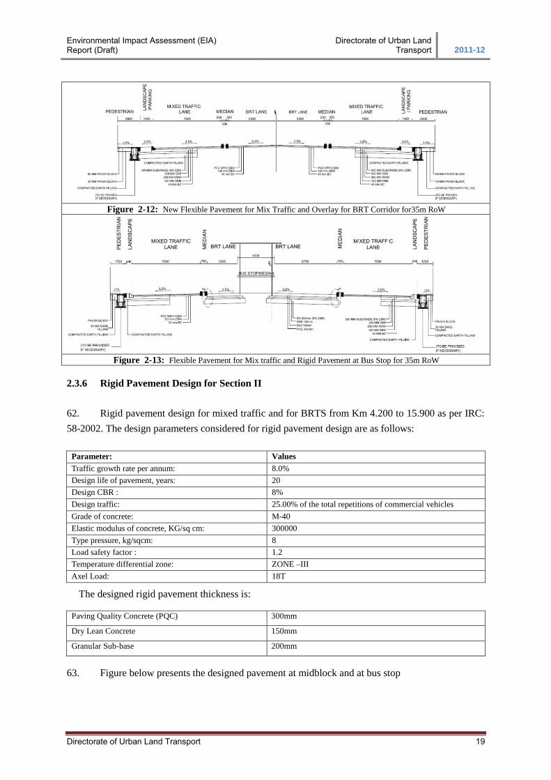
Figure 2-12: New Flexible Pavement for Mix Traffic and Overlay for BRT Corridor for35m RoW
Figure 2-13: Flexible Pavement for Mix traffic and Rigid Pavement at Bus Stop for 35m RoW
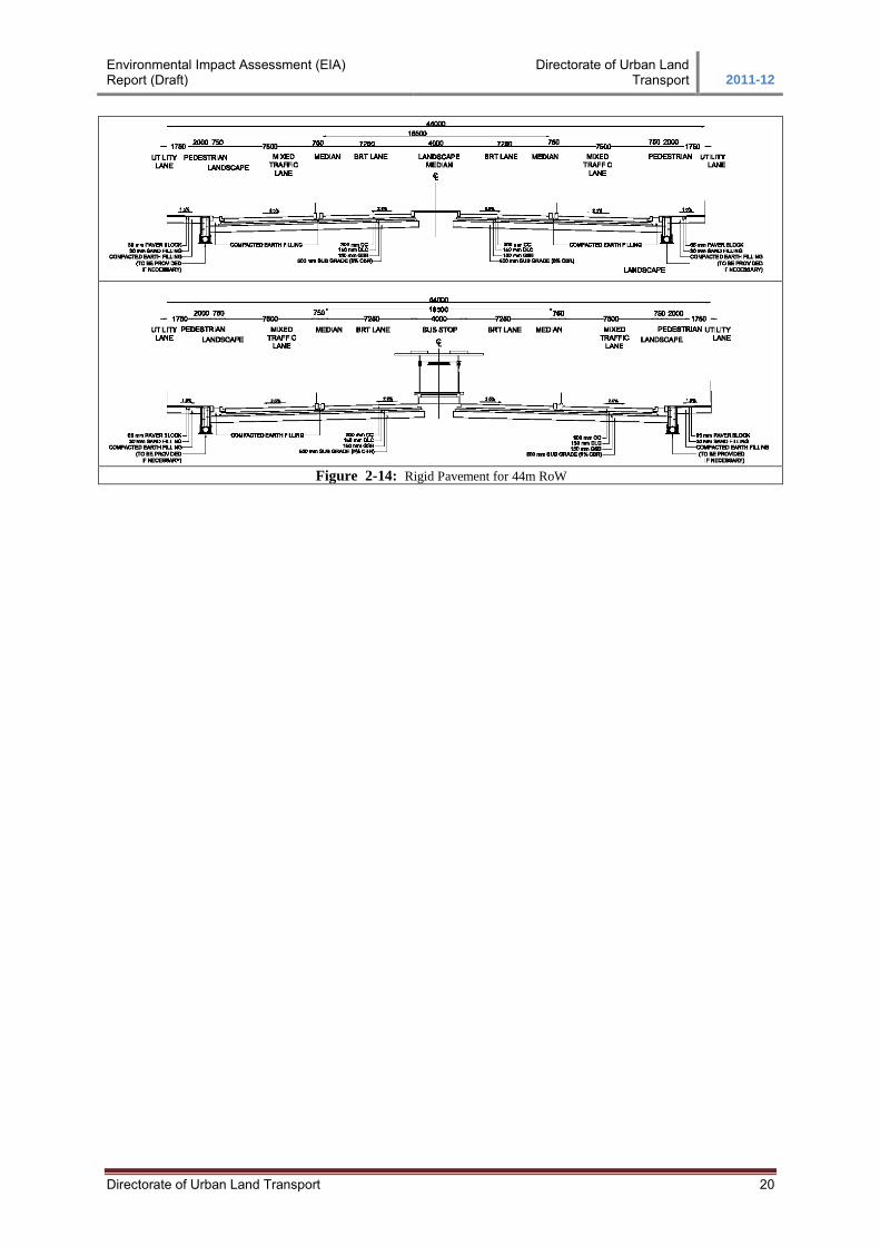
2.3.6 Rigid Pavement Design for Section II
62. Rigid pavement design for mixed traffic and for BRTS from Km 4.200 to 15.900 as per IRC:
58-2002. The design parameters considered for rigid pavement design are as follows:
Parameter: Values Traffic growth rate per annum: 8.0% Design life of pavement, years: 20 Design CBR : 8% Design traffic: 25.00% of the total repetitions of commercial vehicles Grade of concrete: M-40 Elastic modulus of concrete, KG/sq cm: 300000 Type pressure, kg/sqcm: 8 Load safety factor : 1.2 Temperature differential zone: ZONE –III Axel Load: 18T
The designed rigid pavement thickness is:
Paving Quality Concrete (PQC) 300mm
Dry Lean Concrete 150mm
Granular Sub-base 200mm
63. Figure below presents the designed pavement at midblock and at bus stop
Environmental Impact Assessment (EIA) Report (Draft)
Directorate of Urban Land Transport 2011-12
Directorate of Urban Land Transport 20
Figure 2-14: Rigid Pavement for 44m RoW
Environmental Impact Assessment (EIA) Report (Draft)
Directorate of Urban Land Transport 2011-12
Directorate of Urban Land Transport 21
3. REVIEW OF LAWS, LEGISLATION AND POLICIES
In order to understand the extent of the environmental assessment for the proposed improvement
works, applicable laws, legislation and policies were reviewed and presented in the following sections
3.1 Environmental Policy and Regulatory Frameworks in India
64. The following key environmental regulations / policies in India that may affect / influence the
project environment both during preparation and implementation stages were reviewed.
Constitutional Provisions
Environment (Protection) Act, 1986
Water (Prevention & Control) Act, 1974
Air (Prevention & Control) Act 1981
Forest (Conservation) Act 1980
Manufacture, Storage and Import of Hazardous Chemicals Rules 1989
3.2 Constitutional Provisions
65. The Constitution of India in its Article 48 provides for the protection and preservation of the
environment and states that “the state shall endeavour to protect and improve the environment and to
safeguard forests and wild life of the country.”
66. Further Article 51-A (g) on fundamental duties emphasizes that, “It shall be the duty of every
citizen of India to protect and improve the natural environment including forests, lakes, rivers and
wild life and to have compassion for living creatures.” These two provisions of the constitution are the
guiding principles for various environmental legislations in the country and to safeguard the
environment.
67. A summary of the applicable laws and legislation for road projects is presented below:
Table 3-1: Summary of environmental legislation applicable for proposed project
National Act Year Objective Responsible Institution
Environment (Protection) Act. 1986 To protect and improve the overall
environment
MoEF, CPCB
Notification on Environment Impact
Assessment of Development projects
(and amendments) (referred to as the
Notification on Environmental
Clearance)
2006
2009
To provide environmental clearance
to new development activities
following environmental impact
assessment.
MoEF, CPCB
Wildlife Protection Act 1972 To protect wild animals and birds
through the creation of National Parks
and Sanctuaries
MoEF
Forest (Conservation) Act 1980 To protect and manage forests MoEF
Karnataka Tree Preservation Act 1976 To protect the trees within the state Forest Department , Govt of
Karnataka
Water (Prevention and Control of
Pollution) Act (and subsequent
amendments)
1974 To provide for the prevention and
control of water pollution and the
maintaining or restoring of
wholesomeness of water.
CPCB , KSPCB
Air (Prevention and Control of
Pollution) Act (and subsequent
1981 To provide for the prevention, control
and abatement of air pollution, and for
CPCB , KSPCB
Environmental Impact Assessment (EIA) Report (Draft)
Directorate of Urban Land Transport 2011-12
Directorate of Urban Land Transport 22
amendments) the establishment of boards to carry
out these purposes.
The Land Acquisition Act 1894
1984
Set out procedures for acquisition of
land by government
Land Revenue Department,
Karnataka
Central Motor Vehicle Act
Central Motor Vehicle Rules
1988
1989
To control vehicular air and noise
pollution. To regulate development of
the transport sector, check and control
vehicular air and noise pollution.
Road Transport Department
of Karnataka
National Resettlement and
Rehabilitation Policy
2007 Addressing impacts on affected
persons due to all development
projects
MoRD and respective state
institutions undertaking the
development projects
Ancient Monuments and
Archaeological sites and Remains Act
1958 Conservation of cultural and historical
remains found in India.
Archaeological Dept. GOI,
Indian Heritage Society and
Indian National Trust for Art
& Culture Heritage (INTACH)
Legal Framework
Ministry of Environment and Forests (MoEF): The primary responsibility for
administration and implementation of the GoI policy with respect to environmental
management, conservation, ecologically sustainable development and pollution control rests
with the MoEF Established in 1985; the MoEF is the agency primarily responsible for review
and approval of EIA’s pursuant to GoI legislation. The MoEF has set up regional offices
responsible for collecting and furnishing information relating to EIA projects, pollution
control measures, enforcement of legislations and environmental protection in special
conservation areas such as wetlands, mangroves and biological reserves.
Karnataka State Pollution Control Board (KSPCB): The objective of KSPCB is to
control, prevent and abate pollution in the State to protect the environment from any
degradation by effective monitoring and implementation of state pollution control legislations
and are also involved in Implementation, supervision and monitoring activities pertaining to
Central Pollution Control Acts and Rules vests with the Central Pollution Control Board
(CPCB), Government of India.
Key Environmental Laws and Regulations
Table 3-2: Applicable Laws and Regulations
Sl.
No
Clearances Acts Approving
Agency
Applicability to
the Project
Time
Required
Responsibility
Execution Supervision
PROJECT PREPARATION STAGE
1 No Objection
Certificate (NOC)
Water (Prevention and
Control of Pollution) Act 1974, Air
(Prevention and Control
of Pollution) Act 1981
Karnataka
Pollution Control Board
Applicable 3 months KRDCL SPV/ KRDCL,
WB Projects, CSC
2 Permission for
removal of tree
growth within the PROW Felling
conversion and
removal from stump site
Forest Conservation
Act 1980
Karnataka Tree Preservation Act 1976
Local Divisional
Forest Officer
Applicable 1 month
for each
workout area
KRDCL SPV/ KRDCL,
WB Projects, CSC
PROJECT IMPLEMENTATION STAGE
3 Permission for
Withdrawal of Ground Water
Environment Protection
Act 1986
Central Ground
Water Board
Applicable 2 months Contractor SPV/ KRDCL,
WB Projects, CSC
Environmental Impact Assessment (EIA) Report (Draft)
Directorate of Urban Land Transport 2011-12
Directorate of Urban Land Transport 23
Sl.
No
Clearances Acts Approving
Agency
Applicability to
the Project
Time
Required
Responsibility
Execution Supervision
4 Permission for Withdrawal of
Surface Water
from Rivers, Nala, Water harvesting
structure/
Reservoirs/Ponds/ Irrigation canals
Karnataka State Water Policy, 2002
Irrigation Department,
Karnataka
Applicable (If the contractor is
extracting
surface water)
3 months Contractor SPV/ KRDCL, WB Projects, CSC
5 Hot mix plant,
Crushers, Cement Batching Plant
Air (Prevention and
Control of Pollution) Act. 1981
Karnataka
Pollution Control Board
Applicable 3 months Contractor SPV/ KRDCL,
WB Projects, CSC
6 Storage of
Hazardous Chemicals
Hazardous Waste
(Management and Handling) Rules 1989
and Manufacturing
Storage and Import of Hazardous Chemicals
Rules 1989
Karnataka
Pollution Control Board
Applicable 3 months Contractor SPV/ KRDCL,
WB Projects, CSC
7 Disposal of
Hazardous Waste
Hazardous Waste
(Management and Handling) Rules 1989
Karnataka
Pollution Control Board
Applicable 2 months Contractor SPV/ KRDCL,
WB Projects, CSC
8 Disposal of
Construction Waste and liquid
effluent from
Labour camps
Water (Prevention and
Control of Pollution) Act 1974
Karnataka
Pollution Control Board
Applicable 2 months Contractor SPV/ KRDCL,
WB Projects, CSC
9 Pollution Under Control Certificate
Central Motor Vehicles Act 1988
Department of Transport, Govt.
of Karnataka
Applicable 1 Month Contractor SPV/ KRDCL, WB Projects, CSC
10 Employing Labour Executing Agency of Building and other
construction act, 1996
District Labour Commissioner
Applicable 1 Week Contractor SPV/ KRDCL, WB Projects, CSC
11 Registration of Workers
Labour welfare Acts. District Labour Commissioner
Applicable 1 Month Contractor SPV/ KRDCL, WB Projects, CSC
Source: Acts, Rules and Regulation from Central and State Government
3.2.1 The Environment (Protection) Act, 1986
68. The Environment (Protection) Act, popularly known as EP Act, is an umbrella legislation that
supplements existing environmental regulations. Empowered by the EP Act, the Ministry of
Environment & Forests (MoEF), Government of India has issued the following notifications
regulating siting of industry and operations, procuring clearance to establish industries and
development of projects with appropriate EIA studies, coastal zone regulations and other aspects of
environment are:
Empowers the Government of India (section 6) to make rules to regulate environmental
pollution by stipulating standards and maximum allowable limits to prevent air, water, noise,
soil and other environmental pollutants.
Prohibits operations that emit pollutants in excess of standards (section 7).
Regulates handling of hazardous substances and identifies persons responsible for discharges
and pollution prevention (section 9).
Section 17 deals with offences committed by Government Departments.
Formulated Environmental (Protection) Rules, 1986, Hazardous Wastes (Management and
Handling) Rules, 1989 and Manufacture, Storage & Import of Hazardous Chemical Rules,
1989 in accordance with the sections 6, 8 and 25 of EP Act.
The act has been supplemented with EIA notification 2006
Environmental Impact Assessment (EIA) Report (Draft)
Directorate of Urban Land Transport 2011-12
Directorate of Urban Land Transport 24
3.2.2 Environmental Impact Assessment Notification, 2006
69. EIA notification of the MoEF dated the 14th September 2006 provides for the following:
All projects and activities are broadly categorized into two categories - Category A and
Category B, based on the spatial extent of potential impacts and potential impacts on human
health and natural and manmade resources.
All projects or activities included as Category ‘A’ in the schedule, including expansion and
modernization of existing projects or activities and change in product mix, shall require prior
environmental clearance from the Central Government in the Ministry of Environment and
Forests (MoEF) on the recommendations of an Expert Appraisal Committee (EAC) to be
constituted by the Central Government for the purposes of this notification;
All projects or activities included as Category ‘B’ in the Schedule, including expansion and
modernization of existing projects or activities as specified in sub paragraph (ii) of paragraph
2, or change in product mix as specified in sub paragraph (iii) of paragraph 2, but excluding
those which fulfill the General Conditions (GC) stipulated in the Schedule, will require prior
environmental clearance from the State/Union territory Environment Impact Assessment
Authority (SEIAA). The SEIAA shall base its decision on the recommendations of a State or
Union territory level Expert Appraisal Committee (SEAC) as to be constituted for in this
notification.
Environmental Impact Assessment Notification - 2006, amendment 2009
70. EIA notification 2006 amendment 2009 explicates ‘All state Highways and State expansion
projects in hilly terrain (above 1,000m AMSL) and or ecologically sensitive areas’ will be categorized
as ‘B’ type project and demands for environmental clearance from SEIAA.
Environmental Impact Assessment Notification - 2006, amendment 2011
71. Amendment 2011 to EIA notification 2006 explains “All new state highway projects should
obtain environmental clearance from SEIAA”. The new amendment allows carrying out widening,
strengthening and improvement works on the existing state highways (Refer Annexure -1).
3.2.3 Water (Prevention and Control of Pollution) Act, 1974
72. Water Act is the first environmental regulation that brought at the state and centre levels,
pollution control boards to control / regulate environmental pollution in India. Amended twice in 1978
and 88, the Act vests regulatory authority on the State Pollution Control Boards and empowers them
to establish and enforce effluent standards for industries and local authorities discharging effluents.
73. Vests regulatory authority on the State Pollution Control Boards and empowers them to
enforce effluent discharge standards to prevent water pollution (both for industries and local
authorities)
Section 24 of the act prohibits use of stream or well or on land disposal for polluting
substances that violate disposal standards laid down by the board
Section 25 of the act requires an application to be made to the state board to establish any
Environmental Impact Assessment (EIA) Report (Draft)
Directorate of Urban Land Transport 2011-12
Directorate of Urban Land Transport 25
treatment and disposal system that is likely to discharge sewage or trade effluent in to a
stream or well or sewer on land
Sections 41 and 44 provide for penalties for not complying with the various provisions or
directives of the board
Section 48 deals with offences committed by Government Departments
Section 55 asserts that all local authorities shall render help & assistance and furnish
information to the board as required for discharge of functions, and shall make available to
the board, for inspection and examination, such records, maps, plans and other documents as
may be necessary
74. The act empowers the board to levy and collect cess on water consumed by the industry or
local authority and to utilise and augment resources for the Pollution Control Boards. In line with this
provision, The Water (Prevention & Control of Pollution) Rules, 1975 were formulated
3.2.4 Air (Prevention and Control of Pollution) Act, 1981
75. Similar to Water Act, the Air Act vests regulatory authority on the State Pollution Control
Boards and empowers them to enforce air quality standards to prevent air pollution in the
country. Section 21 of the act requires an application to be made to the state board to establish or
operate any industrial operation.
3.2.5 Forest (Conservation) Act, 1980(as Amended In 1988)
76. As per Section 26 of Indian Forest Act, 1927 a number of activities are prohibited in forest
areas and prior approval is required from the Central government to use forest land for non-forest
purposes.
77. The Forest (Conservation) Act, 1980 prohibits large-scale diversion of forestland for non-
forest use. As amended in 1988, no State Government or authority shall make such diversions except
with the prior approval of the Central Government. Salient features of the act are summarised in the
box below.
Environmental Impact Assessment (EIA) Report (Draft)
Directorate of Urban Land Transport 2011-12
Directorate of Urban Land Transport 26
3.2.6 Wildlife Protection Act, 1972
78. This act is promulgated to provide for the protection of wild animals, birds and plants and for
matters connected therewith. The provisions under this act are as below:
Section 9 of the Act mentions that no person shall hunt any wild animal specified in Schedule
The act prohibits picking, uprooting, damaging, destroying, acquiring any specified plant
from any forestland
It bans the use of injurious substances, chemicals, explosives that may cause injury or
endanger wildlife in a sanctuary
No alteration of the boundaries of a National Park shall be made except on a resolution passed
by the Legislature of State
Destruction or damage of wildlife property in a National Park is prohibited
3.2.7 Manufacture, Storage and Import of Hazardous Chemical Rules, 1989
79. These rules aim at controlling the generation, storage and import of hazardous chemicals.
According to these rules, the user of hazardous chemicals has to perform the following and dispose
hazardous waste as mentioned in the rules:
Identify the potential hazards of the chemicals and take adequate steps to prevent and control
such hazards
Develop or provide information about the chemical in the form of safety data sheets
Label the specified information on the container of the hazardous chemical
Box 3-1Salient features of the Forest act
The Indian Forest Act, 1927: Section 5 states that after declaring a particular land as reserved forest, no fresh
clearings for any purpose shall be made, except in accordance with such rules as made by the state government.
Section 26 states the acts prohibited in such forests, in addition to section 5.
Sections 30, 32 furnish power to the State government to regulate certain acts (clearing for cultivation, building or
any other purpose) in such forests as specified in the section
Section 35 furnishes power to the State government to prohibit certain acts (clearing of vegetation etc) in lands not
being the property of the government.
The Forest (Conservation) Act, 1980: Section 2 of the Act restricts the state government on the de-reservation of
forests or use of forestland for non-forest purposes
The Forest (Conservation) Rules, 1981: Rule 4 states that the procedure for state governments to make a proposal
seeking prior approval to de-reserve a forest for non-forest purposes (section 2 of Forest Act, 1980), provided all
proposals involving clearing of naturally grown trees in forest land or portion thereof, for the purpose of using it for
afforestation, shall be sent in the form of a working plan / management plan
Environmental Impact Assessment (EIA) Report (Draft)
Directorate of Urban Land Transport 2011-12
Directorate of Urban Land Transport 27
3.2.8 The Motor Vehicles Act, 1988
80. In 1988, the Indian Motor Vehicles Act empowered the State Transport Authority (usually the
Road Transport Office) to enforce standards for vehicular pollution prevention and control. The
authority also checks the emission standards of registered vehicles, collects road taxes and issues
licenses. In August 1997, the Pollution Under Control certificate (PUC) programme was launched as
an attempt to crackdown on the vehicular emissions in the States. Since this act is applicable for all
states, this will be applicable for this project.
3.2.9 Ancient Monuments and Archaeological sites and Remains Act, 1958
81. An Act formulated for the preservation of ancient and historical monuments and
archaeological sites and remains of national importance, for the regulation of archaeological
excavations and for the protection of sculptures, carvings and other like objects.
3.2.9.1 Ancient Monuments and Archaeological sites and Remains (Amendment and
Validation) Act, 2010
82. This act clearly demarcates the buffer area surrounding the protected monument into
prohibited area (100m) and regulated area (200m). Thus, the construction related activities shall be
prohibited within the buffer area.
3.3 Operational Policies and Directives of the World Bank
83. A review of all applicable operational policies / directives of The World Bank and
environmental laws / regulations in India, was carried out in this task. This included review of the
following operational policies of The World Bank.
OP 4.01 - Environmental Assessment
OP 4.04 – Natural Habitats
OP 4.11 – Cultural Properties
OP 4.36 – Forests
3.3.1 OP/BP 4.01 - Environmental Assessment
84. Operational Policy 4.01 (OP 4.01) is one of the ten safeguard policies of the World Bank,
which provides the Environmental Assessment (EA) guidance for the lending operations. The OP
4.01 requires the borrower to screen projects upstream in the project cycle for potential impacts.
Thereafter, an appropriate EA approach to assess, minimize / enhance and mitigate potentially adverse
impacts is selected depending on nature and scale of project. The EA needs to be integrated in the
project development process such that timely measures can be applied to address identified impacts.
The policy requires consultation with affected groups and NGOs to recognise community concerns
and the need to address the same as part of EA. DULT has adopted the principles of the above policy
and has evolved a management framework to address the environmental issues in its lending
operations
Environmental Impact Assessment (EIA) Report (Draft)
Directorate of Urban Land Transport 2011-12
Directorate of Urban Land Transport 28
3.3.2 OP 4.04 - Natural Habitats
85. OP 4.04 sets out the World Bank’s policy on supporting and emphasizing the precautionary
approach to natural resource management and ensuring opportunities for environmentally sustainable
development. As per this policy, the Bank does not support projects that involve significant
conversion or degradation of critical natural habitats. As per this policy, the Bank does not support
projects that involve significant conversion or degradation of critical natural habitats. Projects
involving non-critical habitats are supported if no alternatives are available and if acceptable
mitigation measures are in place.
3.3.3 OP 4.11 - Cultural Property
86. Guided by Operational Policy Note 11.03, this OP sets out the Bank’s policy to assist in
preservation and avoiding elimination of cultural properties with archaeological (prehistoric),
paleontological, historical, religious and other unique natural values. Projects that could
significantly damage non-replicable cultural properties are declined for funding and the Bank will
in turn assist protection and enhancement of cultural properties encountered in the project rather
than leave that protection to chance.
3.3.4 OP 4.36 - Forests
87. This policy of the bank aims to harness the potential of forests to reduce poverty in a
sustainable manner, integrate forests effectively for sustainable economic development and
protect vital local and global environmental services and values of forests. According to this
policy, the bank does not finance projects involving significant conversion or degradation of
critical forest areas or critical natural habitats. The potential impacts on forests resources are
addressed as per OP/BP 4.01 and projects are financed only after incorporating appropriate
mitigation measures.
3.4 Environmental and Social Framework (GEF SUTP)
88. In line with the requirements of the World Bank, the Bank’s environmental and social
safeguards policies shall be applied to all projects to be taken up under GEF-SUTP. The ESMF
spells out the potential impacts in the project cities due to the planning, design, implementation
and operation of the Green Transport projects and outlines the management measures required for
an effective addressal of the same. Appropriate institutional arrangements towards implementing
the measures proposed and the capacity building efforts required have been detailed in the
framework. The adoption of this framework shall ensure that the projects meet the national and
state level environmental and social requirements and are also consistent with the applicable
safeguards policies and provisions of the World Bank.
89. The key objectives of the ESMF are to:
Provide a framework for the integration of social and environmental aspects at all stages of
the project planning, design, execution and operation of various sub-components
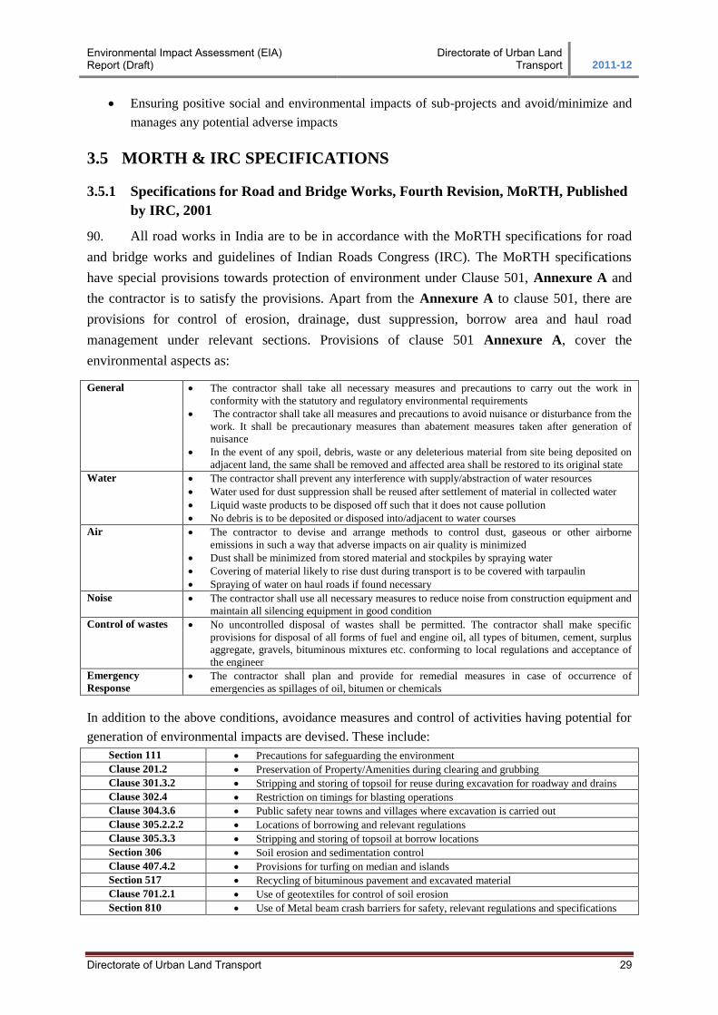
Environmental Impact Assessment (EIA) Report (Draft)
Directorate of Urban Land Transport 2011-12
Directorate of Urban Land Transport 29
Ensuring positive social and environmental impacts of sub-projects and avoid/minimize and
manages any potential adverse impacts
3.5 MORTH & IRC SPECIFICATIONS
3.5.1 Specifications for Road and Bridge Works, Fourth Revision, MoRTH, Published
by IRC, 2001
90. All road works in India are to be in accordance with the MoRTH specifications for road
and bridge works and guidelines of Indian Roads Congress (IRC). The MoRTH specifications
have special provisions towards protection of environment under Clause 501, Annexure A and
the contractor is to satisfy the provisions. Apart from the Annexure A to clause 501, there are
provisions for control of erosion, drainage, dust suppression, borrow area and haul road
management under relevant sections. Provisions of clause 501 Annexure A, cover the
environmental aspects as:
General
The contractor shall take all necessary measures and precautions to carry out the work in
conformity with the statutory and regulatory environmental requirements
The contractor shall take all measures and precautions to avoid nuisance or disturbance from the
work. It shall be precautionary measures than abatement measures taken after generation of
nuisance
In the event of any spoil, debris, waste or any deleterious material from site being deposited on
adjacent land, the same shall be removed and affected area shall be restored to its original state
Water
The contractor shall prevent any interference with supply/abstraction of water resources
Water used for dust suppression shall be reused after settlement of material in collected water
Liquid waste products to be disposed off such that it does not cause pollution
No debris is to be deposited or disposed into/adjacent to water courses
Air
The contractor to devise and arrange methods to control dust, gaseous or other airborne
emissions in such a way that adverse impacts on air quality is minimized
Dust shall be minimized from stored material and stockpiles by spraying water
Covering of material likely to rise dust during transport is to be covered with tarpaulin
Spraying of water on haul roads if found necessary
Noise
The contractor shall use all necessary measures to reduce noise from construction equipment and
maintain all silencing equipment in good condition
Control of wastes
No uncontrolled disposal of wastes shall be permitted. The contractor shall make specific
provisions for disposal of all forms of fuel and engine oil, all types of bitumen, cement, surplus
aggregate, gravels, bituminous mixtures etc. conforming to local regulations and acceptance of
the engineer
Emergency
Response
The contractor shall plan and provide for remedial measures in case of occurrence of
emergencies as spillages of oil, bitumen or chemicals
In addition to the above conditions, avoidance measures and control of activities having potential for
generation of environmental impacts are devised. These include:
Section 111 Precautions for safeguarding the environment
Clause 201.2 Preservation of Property/Amenities during clearing and grubbing
Clause 301.3.2 Stripping and storing of topsoil for reuse during excavation for roadway and drains
Clause 302.4 Restriction on timings for blasting operations
Clause 304.3.6 Public safety near towns and villages where excavation is carried out
Clause 305.2.2.2 Locations of borrowing and relevant regulations
Clause 305.3.3 Stripping and storing of topsoil at borrow locations
Section 306 Soil erosion and sedimentation control
Clause 407.4.2 Provisions for turfing on median and islands
Section 517 Recycling of bituminous pavement and excavated material
Clause 701.2.1 Use of geotextiles for control of soil erosion
Section 810 Use of Metal beam crash barriers for safety, relevant regulations and specifications
Environmental Impact Assessment (EIA) Report (Draft)
Directorate of Urban Land Transport 2011-12
Directorate of Urban Land Transport 30
Clause 1010 Quality of water for curing and construction
Clause 2501 Precaution during river training works
3.5.2 Guidelines for Environmental Impact Assessment, IRC: 104-1988
91. The guidelines endorse application of Environmental Protection Act, 1986 for highway
projects. It recommends that the methods of measuring air pollution should be in conformance
with IS: 5182-1977 and in case of noise pollution: IS: 3028-1980, Measurement of noise emitted
by moving road vehicles; IS: 4758-1968, Method of measurement of noise emitted by machines;
IS: 10399-1982, Method of measurement of noise emitted by stationary road vehicles are to be
followed. As regards Highway aesthetics, use of provisions made in IRC: SP: 21-1979, Manual
on landscaping of roads are to be followed.
3.6 Environmental Clearance Procedure
92. As per the new amendment dated 6th April, 2011 to EIA notification 2006, environmental
clearance has been made mandatory only for new state highways. Hence, the widening /
strengthening and improvement works on existing state highways are not covered under the ambit
of the notification and are not categorized either as Category A or Category B.
93. However, the project shall require obtaining consent from competent authorities such as
the KSPCB, for ‘Consent to Establish’ by submitting a Common Application (as per Schedule-
I), under Water (Prevention and Control of Pollution) Act, 1974, Air (Prevention and Control of
Pollution) Act, 1981) and authorization under Hazardous Wastes (Management and Handling)
Rules, 1989, as amended.
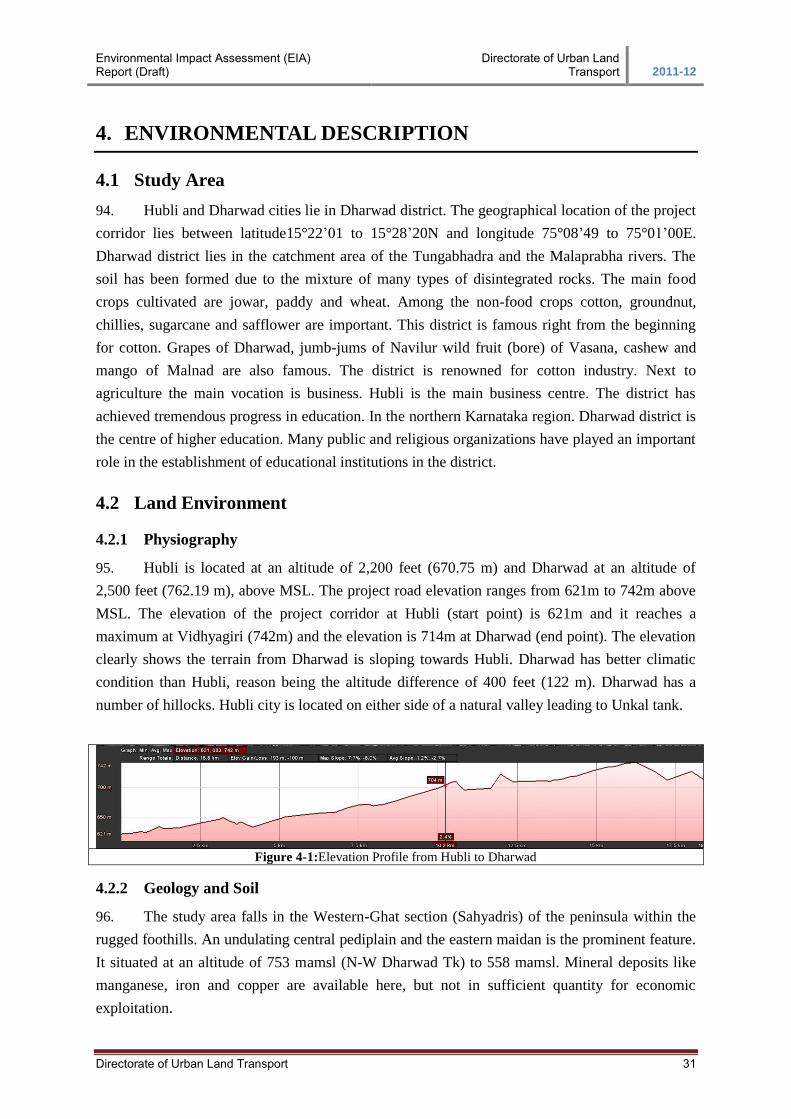
Environmental Impact Assessment (EIA) Report (Draft)
Directorate of Urban Land Transport 2011-12
Directorate of Urban Land Transport 31
4. ENVIRONMENTAL DESCRIPTION
4.1 Study Area
94. Hubli and Dharwad cities lie in Dharwad district. The geographical location of the project
corridor lies between latitude15°22’01 to 15°28’20N and longitude 75°08’49 to 75°01’00E.
Dharwad district lies in the catchment area of the Tungabhadra and the Malaprabha rivers. The
soil has been formed due to the mixture of many types of disintegrated rocks. The main food
crops cultivated are jowar, paddy and wheat. Among the non-food crops cotton, groundnut,
chillies, sugarcane and safflower are important. This district is famous right from the beginning
for cotton. Grapes of Dharwad, jumb-jums of Navilur wild fruit (bore) of Vasana, cashew and
mango of Malnad are also famous. The district is renowned for cotton industry. Next to
agriculture the main vocation is business. Hubli is the main business centre. The district has
achieved tremendous progress in education. In the northern Karnataka region. Dharwad district is
the centre of higher education. Many public and religious organizations have played an important
role in the establishment of educational institutions in the district.
4.2 Land Environment
4.2.1 Physiography
95. Hubli is located at an altitude of 2,200 feet (670.75 m) and Dharwad at an altitude of
2,500 feet (762.19 m), above MSL. The project road elevation ranges from 621m to 742m above
MSL. The elevation of the project corridor at Hubli (start point) is 621m and it reaches a
maximum at Vidhyagiri (742m) and the elevation is 714m at Dharwad (end point). The elevation
clearly shows the terrain from Dharwad is sloping towards Hubli. Dharwad has better climatic
condition than Hubli, reason being the altitude difference of 400 feet (122 m). Dharwad has a
number of hillocks. Hubli city is located on either side of a natural valley leading to Unkal tank.
Figure 4-1:Elevation Profile from Hubli to Dharwad
4.2.2 Geology and Soil
96. The study area falls in the Western-Ghat section (Sahyadris) of the peninsula within the
rugged foothills. An undulating central pediplain and the eastern maidan is the prominent feature.
It situated at an altitude of 753 mamsl (N-W Dharwad Tk) to 558 mamsl. Mineral deposits like
manganese, iron and copper are available here, but not in sufficient quantity for economic
exploitation.
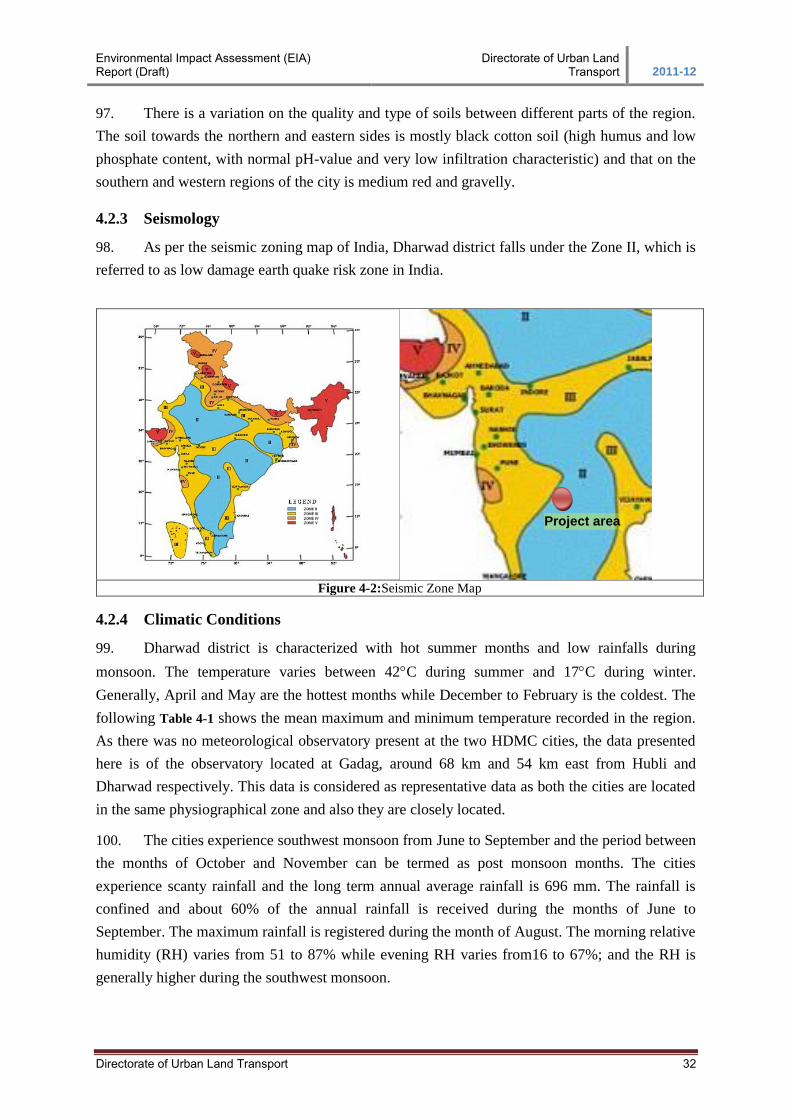
Environmental Impact Assessment (EIA) Report (Draft)
Directorate of Urban Land Transport 2011-12
Directorate of Urban Land Transport 32
97. There is a variation on the quality and type of soils between different parts of the region.
The soil towards the northern and eastern sides is mostly black cotton soil (high humus and low
phosphate content, with normal pH-value and very low infiltration characteristic) and that on the
southern and western regions of the city is medium red and gravelly.
4.2.3 Seismology
98. As per the seismic zoning map of India, Dharwad district falls under the Zone II, which is
referred to as low damage earth quake risk zone in India.
Figure 4-2:Seismic Zone Map
4.2.4 Climatic Conditions
99. Dharwad district is characterized with hot summer months and low rainfalls during
monsoon. The temperature varies between 42C during summer and 17C during winter.
Generally, April and May are the hottest months while December to February is the coldest. The
following Table 4-1 shows the mean maximum and minimum temperature recorded in the region.
As there was no meteorological observatory present at the two HDMC cities, the data presented
here is of the observatory located at Gadag, around 68 km and 54 km east from Hubli and
Dharwad respectively. This data is considered as representative data as both the cities are located
in the same physiographical zone and also they are closely located.
100. The cities experience southwest monsoon from June to September and the period between
the months of October and November can be termed as post monsoon months. The cities
experience scanty rainfall and the long term annual average rainfall is 696 mm. The rainfall is
confined and about 60% of the annual rainfall is received during the months of June to
September. The maximum rainfall is registered during the month of August. The morning relative
humidity (RH) varies from 51 to 87% while evening RH varies from16 to 67%; and the RH is
generally higher during the southwest monsoon.
Project area
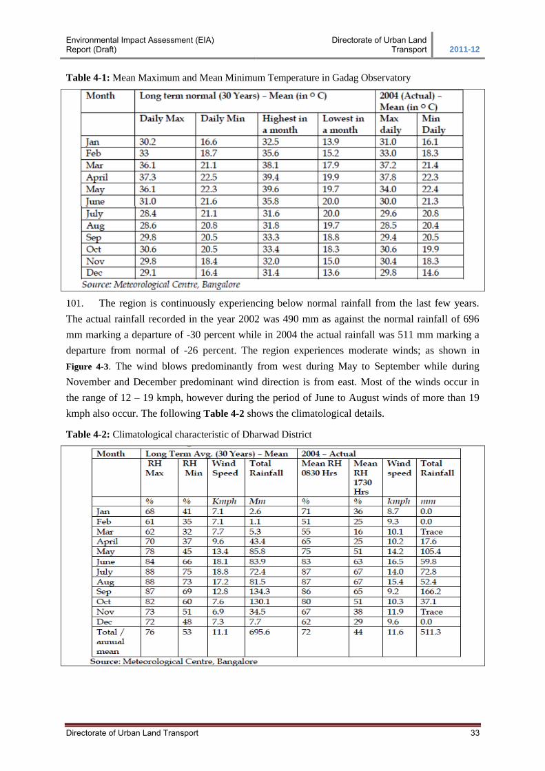
Environmental Impact Assessment (EIA) Report (Draft)
Directorate of Urban Land Transport 2011-12
Directorate of Urban Land Transport 33
Table 4-1: Mean Maximum and Mean Minimum Temperature in Gadag Observatory
101. The region is continuously experiencing below normal rainfall from the last few years.
The actual rainfall recorded in the year 2002 was 490 mm as against the normal rainfall of 696
mm marking a departure of -30 percent while in 2004 the actual rainfall was 511 mm marking a
departure from normal of -26 percent. The region experiences moderate winds; as shown in
Figure 4-3. The wind blows predominantly from west during May to September while during
November and December predominant wind direction is from east. Most of the winds occur in
the range of 12 – 19 kmph, however during the period of June to August winds of more than 19
kmph also occur. The following Table 4-2 shows the climatological details.
Table 4-2: Climatological characteristic of Dharwad District
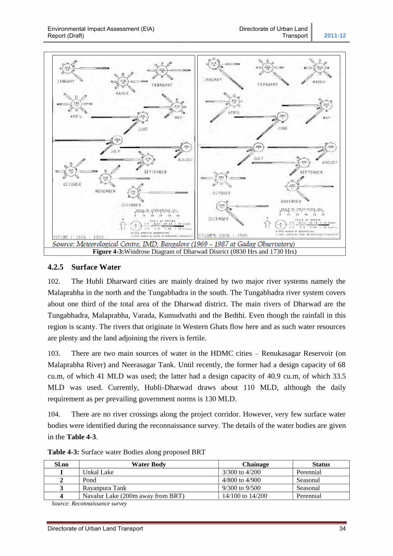
Environmental Impact Assessment (EIA) Report (Draft)
Directorate of Urban Land Transport 2011-12
Directorate of Urban Land Transport 34
Figure 4-3:Windrose Diagram of Dharwad District (0830 Hrs and 1730 Hrs)
4.2.5 Surface Water
102. The Hubli Dharward cities are mainly drained by two major river systems namely the
Malaprabha in the north and the Tungabhadra in the south. The Tungabhadra river system covers
about one third of the total area of the Dharwad district. The main rivers of Dharwad are the
Tungabhadra, Malaprabha, Varada, Kumudvathi and the Bedthi. Even though the rainfall in this
region is scanty. The rivers that originate in Western Ghats flow here and as such water resources
are plenty and the land adjoining the rivers is fertile.
103. There are two main sources of water in the HDMC cities – Renukasagar Reservoir (on
Malaprabha River) and Neerasagar Tank. Until recently, the former had a design capacity of 68
cu.m, of which 41 MLD was used; the latter had a design capacity of 40.9 cu.m, of which 33.5
MLD was used. Currently, Hubli-Dharwad draws about 110 MLD, although the daily
requirement as per prevailing government norms is 130 MLD.
104. There are no river crossings along the project corridor. However, very few surface water
bodies were identified during the reconnaissance survey. The details of the water bodies are given
in the Table 4-3.
Table 4-3: Surface water Bodies along proposed BRT
Sl.no Water Body Chainage Status
1 Unkal Lake 3/300 to 4/200 Perennial
2 Pond 4/800 to 4/900 Seasonal
3 Rayanpura Tank 9/300 to 9/500 Seasonal
4 Navalur Lake (200m away from BRT) 14/100 to 14/200 Perennial Source: Reconnaissance survey
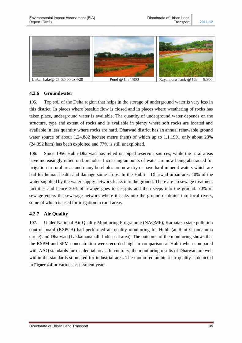
Environmental Impact Assessment (EIA) Report (Draft)
Directorate of Urban Land Transport 2011-12
Directorate of Urban Land Transport 35
Unkal Lake@ Ch 3/300 to 4/20 Pond @ Ch 4/800 Rayanpura Tank @ Ch 9/300
4.2.6 Groundwater
105. Top soil of the Delta region that helps in the storage of underground water is very less in
this district. In places where basaltic flow is closed and in places where weathering of rocks has
taken place, underground water is available. The quantity of underground water depends on the
structure, type and extent of rocks and is available in plenty where soft rocks are located and
available in less quantity where rocks are hard. Dharwad district has an annual renewable ground
water source of about 1,24.882 hectare metre (ham) of which up to 1.1.1991 only about 23%
(24.392 ham) has been exploited and 77% is still unexploited.
106. Since 1956 Hubli-Dharwad has relied on piped reservoir sources, while the rural areas
have increasingly relied on boreholes. Increasing amounts of water are now being abstracted for
irrigation in rural areas and many boreholes are now dry or have hard mineral waters which are
bad for human health and damage some crops. In the Hubli – Dharwad urban area 40% of the
water supplied by the water supply network leaks into the ground. There are no sewage treatment
facilities and hence 30% of sewage goes to cesspits and then seeps into the ground. 70% of
sewage enters the sewerage network where it leaks into the ground or drains into local rivers,
some of which is used for irrigation in rural areas.
4.2.7 Air Quality
107. Under National Air Quality Monitoring Programme (NAQMP), Karnataka state pollution
control board (KSPCB) had performed air quality monitoring for Hubli (at Rani Channamma
circle) and Dharwad (Lakkamanahalli Industrial area). The outcome of the monitoring shows that
the RSPM and SPM concentration were recorded high in comparison at Hubli when compared
with AAQ standards for residential areas. In contrary, the monitoring results of Dharwad are well
within the standards stipulated for industrial area. The monitored ambient air quality is depicted
in Figure 4-4for various assessment years.
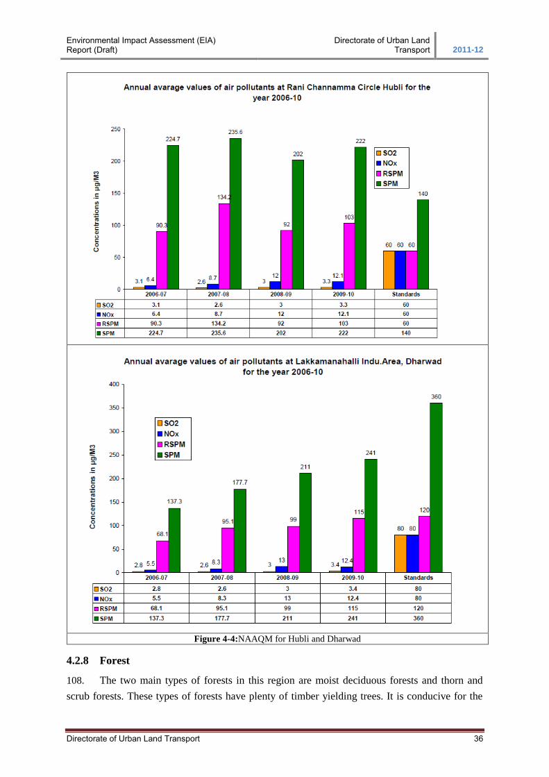
Environmental Impact Assessment (EIA) Report (Draft)
Directorate of Urban Land Transport 2011-12
Directorate of Urban Land Transport 36
Figure 4-4:NAAQM for Hubli and Dharwad
4.2.8 Forest
108. The two main types of forests in this region are moist deciduous forests and thorn and
scrub forests. These types of forests have plenty of timber yielding trees. It is conducive for the

Environmental Impact Assessment (EIA) Report (Draft)
Directorate of Urban Land Transport 2011-12
Directorate of Urban Land Transport 37
growth of timber yielding trees like Rose wood, Teak, Honne, and Nandi. These forests are
important from the point of view of timber. Scrub and thorn forests are also more in the district.
Sandalwood and other trees yielding minor forest products. The requirements here put
tremendous pressure on the limited forest resources available. None of the forests within the
Dharwad district falls within the HDMC limits.
4.2.9 Flora and Fauna
109. The forest areas include big trees such as Teak, Bamboo, Banyan etc. Because of dry
weather and poor soil quality trees and herbs grow sparsely. Along the roadsides Neem trees are
common. In sandy soil Toddy Palm and in gardens Banana, Guava, Sapota, Mango, Jackfruit.
Custard apple, Lime, Coconut and Arecanut trees grow usually.
110. The district has a very rich fauna especially in its western portion. Although the district is
rich in flora and fauna, none of the sensitive environmental features such as National Parks,
Wetlands, and Biosphere Reserves fall within or nearby the HDMC limits. However, significant
number of avenue trees belongs to Banyan (Ficus benghalensis); Neem (Azadirachta indica) and
Acacia (Acacia pennata) are observed along the project corridor.
Avenue trees @ Ch 14/700 Avenue trees @ Ch 15/800
4.3 Socio Economic Profile
4.3.1 Demography
111. As per the Census 2011, the total population of HDMC was 9,60,824. In spite of being
the second largest urban centre, the city has experienced a low population growth during the past
two decades when compared with the decades 1961-81. The population growth rate was the
highest during the decade 1961-71 due to increased migration. Since 1981, growth rate has been
declining primarily due to lack of new economic activities and development of other district
centres in the region.
4.3.2 Population density
112. The population density has shown consistent growth during the past three decades in
Hubli- Dharwad. The density has increased from 1837 persons/sq. km in 1971 to 4756
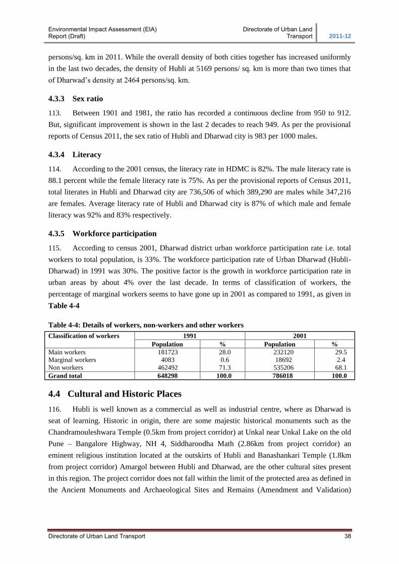
Environmental Impact Assessment (EIA) Report (Draft)
Directorate of Urban Land Transport 2011-12
Directorate of Urban Land Transport 38
persons/sq. km in 2011. While the overall density of both cities together has increased uniformly
in the last two decades, the density of Hubli at 5169 persons/ sq. km is more than two times that
of Dharwad’s density at 2464 persons/sq. km.
4.3.3 Sex ratio
113. Between 1901 and 1981, the ratio has recorded a continuous decline from 950 to 912.
But, significant improvement is shown in the last 2 decades to reach 949. As per the provisional
reports of Census 2011, the sex ratio of Hubli and Dharwad city is 983 per 1000 males.
4.3.4 Literacy
114. According to the 2001 census, the literacy rate in HDMC is 82%. The male literacy rate is
88.1 percent while the female literacy rate is 75%. As per the provisional reports of Census 2011,
total literates in Hubli and Dharwad city are 736,506 of which 389,290 are males while 347,216
are females. Average literacy rate of Hubli and Dharwad city is 87% of which male and female
literacy was 92% and 83% respectively.
4.3.5 Workforce participation
115. According to census 2001, Dharwad district urban workforce participation rate i.e. total
workers to total population, is 33%. The workforce participation rate of Urban Dharwad (Hubli-
Dharwad) in 1991 was 30%. The positive factor is the growth in workforce participation rate in
urban areas by about 4% over the last decade. In terms of classification of workers, the
percentage of marginal workers seems to have gone up in 2001 as compared to 1991, as given in
Table 4-4
Table 4-4: Details of workers, non-workers and other workers
Classification of workers 1991 2001
Population % Population %
Main workers
Marginal workers
Non workers
181723
4083
462492
28.0
0.6
71.3
232120
18692
535206
29.5
2.4
68.1
Grand total 648298 100.0 786018 100.0
4.4 Cultural and Historic Places
116. Hubli is well known as a commercial as well as industrial centre, where as Dharwad is
seat of learning. Historic in origin, there are some majestic historical monuments such as the
Chandramouleshwara Temple (0.5km from project corridor) at Unkal near Unkal Lake on the old
Pune – Bangalore Highway, NH 4, Siddharoodha Math (2.86km from project corridor) an
eminent religious institution located at the outskirts of Hubli and Banashankari Temple (1.8km
from project corridor) Amargol between Hubli and Dharwad, are the other cultural sites present
in this region. The project corridor does not fall within the limit of the protected area as defined in
the Ancient Monuments and Archaeological Sites and Remains (Amendment and Validation)
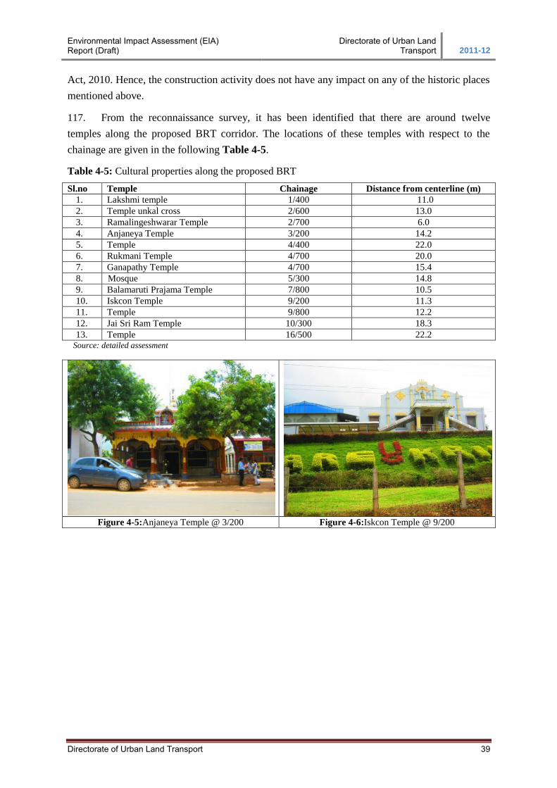
Environmental Impact Assessment (EIA) Report (Draft)
Directorate of Urban Land Transport 2011-12
Directorate of Urban Land Transport 39
Act, 2010. Hence, the construction activity does not have any impact on any of the historic places
mentioned above.
117. From the reconnaissance survey, it has been identified that there are around twelve
temples along the proposed BRT corridor. The locations of these temples with respect to the
chainage are given in the following Table 4-5.
Table 4-5: Cultural properties along the proposed BRT
Sl.no Temple Chainage Distance from centerline (m)
1. Lakshmi temple 1/400 11.0
2. Temple unkal cross 2/600 13.0
3. Ramalingeshwarar Temple 2/700 6.0
4. Anjaneya Temple 3/200 14.2
5. Temple 4/400 22.0
6. Rukmani Temple 4/700 20.0
7. Ganapathy Temple 4/700 15.4
8. Mosque 5/300 14.8
9. Balamaruti Prajama Temple 7/800 10.5
10. Iskcon Temple 9/200 11.3
11. Temple 9/800 12.2
12. Jai Sri Ram Temple 10/300 18.3
13. Temple 16/500 22.2 Source: detailed assessment
Figure 4-5:Anjaneya Temple @ 3/200 Figure 4-6:Iskcon Temple @ 9/200
Environmental Impact Assessment (EIA) Report (Draft)
Directorate of Urban Land Transport 2011-12
Directorate of Urban Land Transport Page 40
5. ANALYSES OF ALTERNATIVES
5.1 No Project Scenario
118. The ‘No project scenario’ is analyzed with respect to the development of the city by the
backdrop of requirement of reliable quality infrastructure for sustained growth economy and
consequent wellbeing of its citizens. Providing better connectivity between Hubli and Dharwad
will ensure that goods and people from areas covered by the road can commute quicker and save
time. Increase in trade and commerce activity is expected. The savings in the Vehicle Operating
Costs (VOC) makes the project viable.
119. The commercial activity will be getting a good boost due to proposed BRT roads. The
commercial activity will give rise to employment potential for people in and around these places.
However, there would be an increase in the vehicular pollution-air and noise, in the vicinity of the
road. Some agricultural lands have been diverted for BRT road to accommodate the proposed
widening. However, for the acquired land; suitable compensation shall be paid as per the
entitlement framework.
120. If the project is not implemented, there is every likelihood that the existing road network
roads will deteriorate further. In the absence of the proposed BRT project, the both cities (Hubli
and Dharwad) will also find it difficult to have good transportation. Increased air pollution, due to
slow moving traffic and congestion, will follow. Noise levels will rise due to traffic congestion
with increased honking. Without the project, the traffic would continue to pose a safety risk for
the road users.
121. Therefore, the ‘project with scenarios’, with its minor impacts is more acceptable than the
‘without project scenario’ which would mean slow down development in these cities. Hence, it is
clear that the implementation of the project will be a definite advantage to these cities in order to
achieve all-round development of its economy and progress for its people.
5.1.1 Project with Alternatives
122. In this project, the project alternatives in terms of location, option are very limited, as the
BRT project is coming on the existing road network, which is already in use. However, options
with respect to having at-grade corridor or elevated corridor are studied in detail and elaborated in
the DPR. With respect to the environmental impact of the proposed options; both the options are
taken for study. The comparison study is detailed in the following Table 5-1. From the analysis,
Option -1 has more advantages and less negative impacts than Option -2.
Table 5-1: Comparison of alternatives in term of Environmental Aspects
Item Option 1 – At-grade Option 2 – Elevated
Aesthetic
view and
landscape
Good Not good due to the view will be limited by
high elevation of the road
Environmental Impact Assessment (EIA) Report (Draft)
Directorate of Urban Land Transport 2011-12
Directorate of Urban Land Transport Page 41
Item Option 1 – At-grade Option 2 – Elevated
Working
conditions
Low risk of accidents for the worker and
surrounding areas due to work at ground
level.
High risk of accidents for the worker and
surrounding areas due to work at high
elevation.
Air Pollution
Construction phase: Medium impacts causes
dust concentration caused by during the
demolition activities, material transportation,
the earth works and other construction
activities; Impacts CO, NO2 emission from
transport trucks, vehicles and construction
machinery.
Construction phase: Major impacts caused
by dust concentration during the piling,
transportation of construction material ; CO,
NO2 emission from transport trucks, vehicles
and construction machinery
Operation phase: CO, NO2, HC
concentration due to increasing of traffic flow
Operation phase: Impacts by CO, NO2, HC
increasing of traffic flow.
Noise
Pollution
Construction phase: Increasing of noise
levels during the transportation of
construction material ;
Construction phase: Increasing of noise
levels during the piling, transportation of
construction material ;
Operation phase: Impacts by noise levels due
to increasing of traffic flow.
Operation phase: Impacts by noise levels due
to increasing of traffic flow.
Vibration
Construction phase: Less impact due to
construction activities will be at ground level
(max. noise level 64 dB(A) at 10 m from the
source).
Construction phase: In case of using bored
pile industry, heavy truck is likely to cause
biggest vibration (about 79dB(A) at 10 m far
from source).
Operation phase: Impact level can be
neglected
Operation phase: Impact level is not
significant
Water quality Limited impact on water quality Limited impact on water quality
5.1.2 Vehicular under Passes (VUP’s)
123. Safety for the road users is an important aspect that needs to be fulfilled in all road
infrastructure projects. For this BRTS project, four VUP’s have been recommended based on the
settlements abutting the project road, number of vehicle crossings, pedestrian crossing etc. The
existing topography of the project corridor adds advantage for finalizing the VUP designs.
124. Two options were considered before finalizing the VUP’s i.e. BRTS with VUP’s (Grade
Separated Crossing) and BRTS without VUP’s (At-grade Crossing). The following table
distinguishes the advantage and the disadvantage of both the options.
Table 5-2: Comparison of Alternatives in term of VUP’s
Sl.no BRTS with VUP’s (Grade Separated
Crossing)
BRTS without VUP’s (At-grade Crossing)
1. Pedestrian and vehicular traffic are channelized
separately allowing traffic to move freely, with
less interruption.
Disrupts the flow of both pedestrian and vehicular
traffic by making them to wait for traffic signal
changes
2. Conflicts between modes are eliminated; the
potential for accidents are reduced.
Potential conflict will exist between pedestrians and
vehicular traffic making it less safe than a grade
separated crossing.
3. Expensive because of new grade separator
constructions
Typically will have a substantially lower
construction cost than above grade facilities
4. Impacts on road network and likely disruption
of access to businesses during construction
Construction time is much less than other crossing
types. This will mean less impact on existing traffic,
on both pedestrian and vehicular
5. Safety fear will be less among the pedestrians
using VUP’s during project operation
Potential safety concerns to the pedestrians during
the project operation
6. Drainage/ storm water handling requires Minimal or no impact on existing in-ground utilities
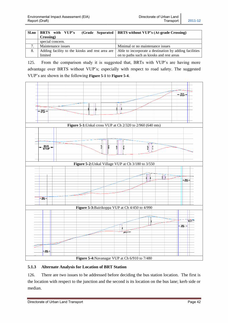
Environmental Impact Assessment (EIA) Report (Draft)
Directorate of Urban Land Transport 2011-12
Directorate of Urban Land Transport Page 42
Sl.no BRTS with VUP’s (Grade Separated
Crossing)
BRTS without VUP’s (At-grade Crossing)
special concern.
7. Maintenance issues Minimal or no maintenance issues
8. Adding facility to the kiosks and rest area are
limited
Able to incorporate a destination by adding facilities
on to paths such as kiosks and rest areas
125. From the comparison study it is suggested that, BRTs with VUP’s are having more
advantage over BRTS without VUP’s; especially with respect to road safety. The suggested
VUP’s are shown in the following Figure 5-1 to Figure 5-4.
Figure 5-1:Unkal cross VUP at Ch 2/320 to 2/960 (640 mts)
Figure 5-2:Unkal Village VUP at Ch 3/180 to 3/550
Figure 5-3:Bairikoppa VUP at Ch 4/450 to 4/990
Figure 5-4:Navanagar VUP at Ch 6/910 to 7/480
5.1.3 Alternate Analysis for Location of BRT Station
126. There are two issues to be addressed before deciding the bus station location. The first is
the location with respect to the junction and the second is its location on the bus lane; kerb side or
median.
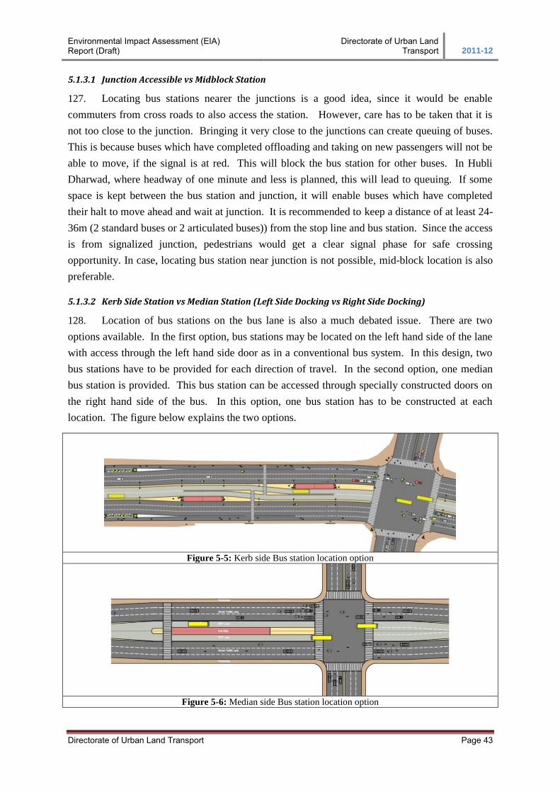
Environmental Impact Assessment (EIA) Report (Draft)
Directorate of Urban Land Transport 2011-12
Directorate of Urban Land Transport Page 43
5.1.3.1 Junction Accessible vs Midblock Station
127. Locating bus stations nearer the junctions is a good idea, since it would be enable
commuters from cross roads to also access the station. However, care has to be taken that it is
not too close to the junction. Bringing it very close to the junctions can create queuing of buses.
This is because buses which have completed offloading and taking on new passengers will not be
able to move, if the signal is at red. This will block the bus station for other buses. In Hubli
Dharwad, where headway of one minute and less is planned, this will lead to queuing. If some
space is kept between the bus station and junction, it will enable buses which have completed
their halt to move ahead and wait at junction. It is recommended to keep a distance of at least 24-
36m (2 standard buses or 2 articulated buses)) from the stop line and bus station. Since the access
is from signalized junction, pedestrians would get a clear signal phase for safe crossing
opportunity. In case, locating bus station near junction is not possible, mid-block location is also
preferable.
5.1.3.2 Kerb Side Station vs Median Station (Left Side Docking vs Right Side Docking)
128. Location of bus stations on the bus lane is also a much debated issue. There are two
options available. In the first option, bus stations may be located on the left hand side of the lane
with access through the left hand side door as in a conventional bus system. In this design, two
bus stations have to be provided for each direction of travel. In the second option, one median
bus station is provided. This bus station can be accessed through specially constructed doors on
the right hand side of the bus. In this option, one bus station has to be constructed at each
location. The figure below explains the two options.
Figure 5-5: Kerb side Bus station location option
Figure 5-6: Median side Bus station location option
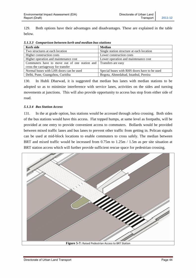
Environmental Impact Assessment (EIA) Report (Draft)
Directorate of Urban Land Transport 2011-12
Directorate of Urban Land Transport Page 44
129. Both options have their advantages and disadvantages. These are explained in the table
below.
5.1.3.3 Comparison between kerb and median bus stations
Kerb side Median
Two structures at each location Single station structure at each location
Higher construction costs Lower construction costs
Higher operation and maintenance cost Lower operation and maintenance cost
Commuters have to move out of one station and
cross the carriageway for transfer
Transfers are easy
Normal buses with LHS doors can be used Special buses with RHS doors have to be used
Delhi, Pune, Guangzhou, Curitiba Bogota, Ahmedabad, Istanbul, Pereira
130. In Hubli Dharwad, it is suggested that median bus lanes with median stations to be
adopted so as to minimize interference with service lanes, activities on the sides and turning
movements at junctions. This will also provide opportunity to access bus stop from either side of
road.
5.1.3.4 Bus Station Access
131. In the at grade option, bus stations would be accessed through zebra crossing. Both sides
of the bus stations would have this access. Flat topped humps, at same level as footpaths, will be
provided at one entry to provide convenient access to commuters. Bollards would be provided
between mixed traffic lanes and bus lanes to prevent other traffic from getting in. Pelican signals
can be used at mid-block locations to enable commuters to cross safely. The median between
BRT and mixed traffic would be increased from 0.75m to 1.25m / 1.5m as per site situation at
BRT station access which will further provide sufficient rescue space for pedestrian crossing.
Figure 5-7: Raised Pedestrian Access to BRT Station
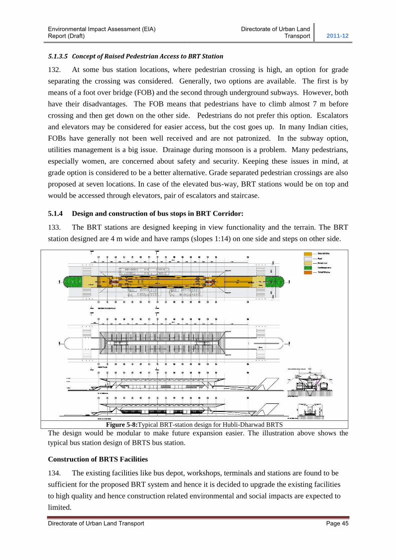
Environmental Impact Assessment (EIA) Report (Draft)
Directorate of Urban Land Transport 2011-12
Directorate of Urban Land Transport Page 45
5.1.3.5 Concept of Raised Pedestrian Access to BRT Station
132. At some bus station locations, where pedestrian crossing is high, an option for grade
separating the crossing was considered. Generally, two options are available. The first is by
means of a foot over bridge (FOB) and the second through underground subways. However, both
have their disadvantages. The FOB means that pedestrians have to climb almost 7 m before
crossing and then get down on the other side. Pedestrians do not prefer this option. Escalators
and elevators may be considered for easier access, but the cost goes up. In many Indian cities,
FOBs have generally not been well received and are not patronized. In the subway option,
utilities management is a big issue. Drainage during monsoon is a problem. Many pedestrians,
especially women, are concerned about safety and security. Keeping these issues in mind, at
grade option is considered to be a better alternative. Grade separated pedestrian crossings are also
proposed at seven locations. In case of the elevated bus-way, BRT stations would be on top and
would be accessed through elevators, pair of escalators and staircase.
5.1.4 Design and construction of bus stops in BRT Corridor:
133. The BRT stations are designed keeping in view functionality and the terrain. The BRT
station designed are 4 m wide and have ramps (slopes 1:14) on one side and steps on other side.
Figure 5-8:Typical BRT-station design for Hubli-Dharwad BRTS
The design would be modular to make future expansion easier. The illustration above shows the
typical bus station design of BRTS bus station.
Construction of BRTS Facilities
134. The existing facilities like bus depot, workshops, terminals and stations are found to be
sufficient for the proposed BRT system and hence it is decided to upgrade the existing facilities
to high quality and hence construction related environmental and social impacts are expected to
limited.
Environmental Impact Assessment (EIA) Report (Draft)
Directorate of Urban Land Transport 2011-12
Directorate of Urban Land Transport Page 46
6. STAKE HOLDER CONSULTATIONS AND PLANNING
6.1 Consultation with stake holders
135. Several formal/informal consultations with each stakeholder to understand issues and
cross cutting themes have been conducted during the past one year. The table below lists out
various meetings/ discussions between various stakeholders over the last one year.
Table 6-1: Meetings/Discussions between various stake holders
Sl.no Date Details
1 29-30 July, 2010 Visit to Ahmedabad by a team of DULT led by the Commissioner, DULT to see
the BRT system being implemented by Janmarg. Discussions with CEPT for a
pre-feasibility report for a BRT corridor between Hubli and Dharwad.
2 27/8/2010 Proposal of NWKRTC for assistance for improvements to public transport (bus
fleet augmentation, modernization of depots/terminals, ITS) under the SUTP
recommended to MOUD.
3 15-09-2010 CEPT initiates pre-feasibility study of BRT corridor between Hubli and Dharwad.
4 16-12-2010 Meeting under the chairmanship of Chief Secretary, Govt. of Karnataka on
implementation of BRT in Karnataka. Decisions taken include creating a separate
budget head for BRT; expediting the proposals for BRT in Mysore, Bangalore
and Hubli-Dharwad.
5 21-12-2010 CEPT completes the pre-feasibility report and present the findings to
Commissioner, DULT, NWKRTC and HDMC.
6 29-12-2010 Meeting with World Bank and Project Management Unit (PMU) of Sustainable
Urban Transport Project (SUTP), MoUD on the proposal sent by NWKRTC.
Decision taken to make it an integrated project including BRT.
7 07-02-2011 &
08-02-2011
Visit of World Bank SUTP mission to Hubli – Dharwad and meeting with all the
concerned stake holders.
8 17-02-2011 Meeting under the chairmanship of Commissioner DULT with Managing
Director, KRDCL to decide on the cross-sections for BRT.
9 28-02-2011 Meeting under the chairmanship of Hon’ble District In-charge minister, Dharwad.
Cross-sections discussed and approved.
10 09-03-2011 10th
Meeting of the steering Committee of World Bank GEF-UNDP assisted
sustainable project, wherein approval in principle was accorded for the proposal
of preparation of DFR for Hubli-Dharwad.
11 10-03-2011 Submissions of draft GAD to KRDCL and discussion with officials of KRDCL.
12 14-03-2011 TOR submitted to MoUD for approval and sanction of 80% of the project cost for
DFR preparation.
13 22-03-2011 &
23-03-20011
Meeting of the team of consultant from UMTC with all stakeholders in Bangalore
and Hubli – Dharwad for planning of institutional arrangements for
implementation of BRT.
14 26/5/2011 Meeting in Delhi for presentation on the draft report submitted on institutional
arrangements.
15 28/6/2011 Stakeholder consultation meeting in Hubli Dharwad to present preliminary plan
136. As part of the effort to make the planning process more transparent, a major city level
consultation was organised in Hubli Dharwad on June 28, 2011. The meeting was chaired by the
District in charge Minister and also had the local MP, local MLAs, mayor and local leaders.
Other participants included representatives from the DULT, District Administration, HDMC,
traffic police, HDUDA, KRDCL, RTO, PWD, NWKRTC, Chamber of Commerce and the truck
owners association.
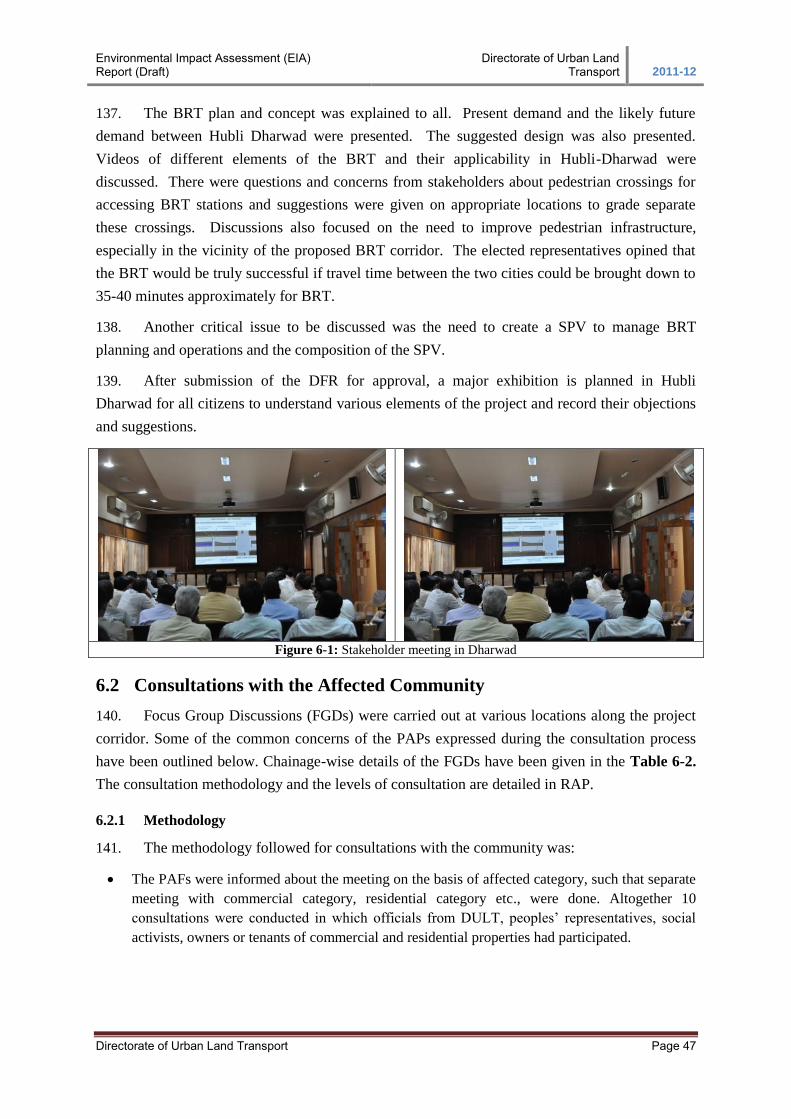
Environmental Impact Assessment (EIA) Report (Draft)
Directorate of Urban Land Transport 2011-12
Directorate of Urban Land Transport Page 47
137. The BRT plan and concept was explained to all. Present demand and the likely future
demand between Hubli Dharwad were presented. The suggested design was also presented.
Videos of different elements of the BRT and their applicability in Hubli-Dharwad were
discussed. There were questions and concerns from stakeholders about pedestrian crossings for
accessing BRT stations and suggestions were given on appropriate locations to grade separate
these crossings. Discussions also focused on the need to improve pedestrian infrastructure,
especially in the vicinity of the proposed BRT corridor. The elected representatives opined that
the BRT would be truly successful if travel time between the two cities could be brought down to
35-40 minutes approximately for BRT.
138. Another critical issue to be discussed was the need to create a SPV to manage BRT
planning and operations and the composition of the SPV.
139. After submission of the DFR for approval, a major exhibition is planned in Hubli
Dharwad for all citizens to understand various elements of the project and record their objections
and suggestions.
Figure 6-1: Stakeholder meeting in Dharwad
6.2 Consultations with the Affected Community
140. Focus Group Discussions (FGDs) were carried out at various locations along the project
corridor. Some of the common concerns of the PAPs expressed during the consultation process
have been outlined below. Chainage-wise details of the FGDs have been given in the Table 6-2.
The consultation methodology and the levels of consultation are detailed in RAP.
6.2.1 Methodology
141. The methodology followed for consultations with the community was:
The PAFs were informed about the meeting on the basis of affected category, such that separate
meeting with commercial category, residential category etc., were done. Altogether 10
consultations were conducted in which officials from DULT, peoples’ representatives, social
activists, owners or tenants of commercial and residential properties had participated.
Environmental Impact Assessment (EIA) Report (Draft)
Directorate of Urban Land Transport 2011-12
Directorate of Urban Land Transport Page 48
6.2.2 Key Findings of the Consultation
142. The consultations have helped in not only achieving the social assessment objectives, but
also assisted in gathering suggestions for mitigation of adverse impacts, improvement in designs
and facilitating inputs for the resettlement plan preparation and implementation.
In general, the community welcomed the proposed project and was of the opinion that they have
the obligation to part with their land or structures for a public cause. PAPs have requested for
adequate time in case if the structure requires to be removed.
The people wanted to know more details about the project, the likely time of land and structure
acquisition, the probable time of project initiation and completion and also more about
compensation for affected structures.
Owners of land/structure have expressed their doubt whether the compensation amount would
be sufficient to meet the actual loss. Owners of commercial buildings near Jubilee Circle
suggested constructing a fly-over to avoid dense shop areas and also suggested to reduce the
proposed road width as an alternative.
Table 6-2: Details of Consultation Meetings Key Outcomes of Public Consultations
Sl. No Details
1 Hubli-Dharwad City Level Consultation
Date: 28.06.2011; Participants: District-in-charge Minister, MP, MLAs, Mayor and local leaders
2 Chainage 0+080; Near Hosur Circle, Hubli
Date: 29.09.2011; Number of Participants: 16
3 Chainage 1+400; Near Sushruta Hospital
Date: 29.09.2011; Number of Participants: 26
4 Chainage 1+200; Opposite HDMC Park
Date: 29.09.2011; Number of Participants: 11
5 Chainage 3+100; Opposite Sidheswar Swamy Temple
Date: 29.09.2011; Number of Participants: 16
6 Chainage 4+700; Bhairidevarakoppa
Date: 29.09.2011; Number of Participants: 18
7 Chainage 5+400; Bhairidevarakoppa
Date: 29.09.2011; Number of Participants: 12
8 Chainage 12+400; Near Sattur Cross
Date: 30.09.2011; Number of Participants: 38
9 Chainage 17+400; Near Tolnaka
Date: 30.09.2011; Number of Participants: 21
10 Chainage 18+800; Near Jubilee Circle, Dharwad
Date: 30.09.2011; Number of Participants: 32
Chainage/
Location Key Outcomes
Integration into
Project Design
and Action Plan
0+080
Near Hosur Circle,
Hubli
[commercial
category]
Owner of the building expressed his concern about demolishing the front
portion of building. Age of the structure is about 16 years and tearing down a
portion would affect the entire building. Owner opined that compensation be
given at market rate rather than based on government rate which is usually
very low and would not be sufficient to make up the actual loss.
About two years before, as per the instruction from Hubli-Dharwad Municipal
Corporation (HDMC), the boundary wall of the present building was
removed. The building has been built about 16ft away from the footpath.
Small shops like pan shops, electric shops, telephone booths, eatery shops
could continue even if a portion is acquired. However, one restaurant
functioning on G+1 level would not be able to continue with their business.
The price of land
based on consent
award will be
negotiated and is
expected to
compensate for
the actual loss to
the PAPs.
Affected
structures will be
compensated
Environmental Impact Assessment (EIA) Report (Draft)
Directorate of Urban Land Transport 2011-12
Directorate of Urban Land Transport Page 49
For the restaurant, the margin of profit reduces with the reduction in business
area and he pays a rent of Rs.15000 per month. All other shops pay a rent
between Rs.4000 and Rs.6000.
Majority of the shops are occupied by tenants and they are aware that they are
not entitled for any compensation and only owners of the building are
eligible. However, they request for providing adequate notice period. Notice
should be served at least 3 months prior to the actual acquisition.
based on PWD
Schedule of
Rates.
Owners/Tenants
will be given the
right to salvage
material from
structure and
land
Notice period of
3 months will be
provided to
PAPs and the
notices will be
served together
to all respective
PAPs
Construction of
drainage is
considered as
part of the
proposed project
All categories of
Affected
Households will
get shifting
allowance.
For those who
are losing
livelihood (one
male/female of
the affected
family) will
receive a
Livelihood
Restoration
Allowance of
Rs.15000, if the
affected person
is interested,
then necessary
training will be
provided for
development of
entrepreneurship
skills by
coordinating
with
HDMC/other
government
departments to
take up self-
employment
projects
It was explained
that design was
based on
technical
feasibility. In
some cases, the
design will
impact structures
and land and it is
1+400
Near Sushruta
Hospital
[commercial
category]
Owner of an affected G+3 building opined that he had constructed the
building after following all the standard formalities of the Corporation and
have even renovated the building in 2010. At the time of construction of these
types of structures the concerned authorities would have given adequate
awareness or clear instructions about the actual width to be kept from the road
side, many losses could have been avoided.
All the shops could continue functioning in the same building as about 1m
front portion of the shops will be affected.
A Reliance Telephone Tower fixed atop the G+3 building, will also be
affected.
The community suggested straightening the curve at chainage 1+200 and
acquiring more land along LHS since more government land is available on
LHS. This could save many shops on RHS.
Construction and maintenance of a proper drainage system shall be
considered as part of the proposed project.
At least 3-months notice period should be given to shop owners and tenants.
One restaurant owner opined that notice should be served together to every
affected person.
1+200
Opposite HDMC
Park
[residential
category]
Owner and tenants of 4 residential buildings have asked details of the
compensation packages and likely commencement of the project. The owners
acknowledged that the residential property is under litigation and enquired
whether they are eligible for any sort of compensation.
Out of the six blocks of the continuous stretch of building two are abandoned.
The building is about 70 years old and the participants opined that it wouldn’t
be liveable even if only front portion is demolished.
A tenant enquired whether any additional benefits available for widow and
aged people.
The participants demanded for one-month notice period prior to acquisition.
3+100
Opposite
Sidheswar Swamy
Temple
[residential
category]
The participants welcomed the proposed development project and enquired
about the likely initiation of the project and also asked about the
compensation packages. Some participants opined that they will abide by
government rules with respect to compensation and assistance.
The front room of four houses in the building block would be affected. Of
this, owners reside in 2 houses and they enquired about the exact area of
acquisition and the likely date of acquisition. One household opined that he
would shift to the back row. The other households could continue living in the
same house, if the impact is less than 2 meter from the edge of the house.
The participants requested for three-month notice period.
4+700
Bhairidevara-
koppa
[commercial and
residential-cum-
commercial
category]
People asked for safety measures in the school zone. Two schools are located
in the vicinity.
The semi-pucca structures include grocery shops, hair-cutting saloons, tea-
shop, cement trading, restaurant, and open land area of several vehicle repair
shops. The repair-shop owners opined that their business would be drastically
affected due to the project. If the parking area in front of the repair shops is
acquired, vehicles cannot park for repair works thereby reduce their business.
Three repair shops each having about 5 employees will face the same
problem.
Majority of the participants were tenants and they pay on average
Rs.4000/monthly (repair shops) and Rs.2500/monthly for other shops. The
participants enquired whether the project gives compensation to anybody
other than owners.
One restaurant owner who resides beside his shop itself said that he will
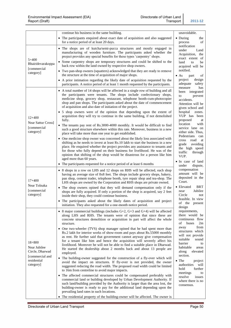
Environmental Impact Assessment (EIA) Report (Draft)
Directorate of Urban Land Transport 2011-12
Directorate of Urban Land Transport Page 50
continue his business in the same building.
The participants enquired about exact date of acquisition and also suggested
for a notice period of at least 20 days.
unavoidable.
During the
process of
notification
under Land
Acquisition, the
exact extent of
land to be
acquired will be
notified.
As part of
project design
adequate safety
measure has
been integrated
to prevent
accidents.
Attention will be
given school and
hospital zones.
VUP has been
proposed at
location with
service lane on
either side. Thus,
Pedestrians can
cross road at
grade avoiding
the high speed
traffic through
VUP.
In case of land
under dispute,
compensation
amount will be
deposited in the
Court.
Elevated BRT
near Jubilee
Circle not
feasible. In view
of the present
design
requirements,
there would be
continuous flow
of buses 2m
away from
structures which
will not provide
suitable sound
barrier to
habitable areas
along elevated
section.
The project
authorities will
hold further
meetings to
resolve issues
where there is no
consensus.
5+400
Bhairidevarakoppa
[commercial
category]
The shops are of kutcha/semi-pucca structures and mostly engaged in
manufacturing of wooden furniture. The participants asked whether the
project provides any special benefits for these types ‘carpentry’ shops.
Some carpentry shops are temporary structures and could be shifted to the
back row within the land owned by respective shop owners.
Two pan-shop owners (squatters) acknowledged that they are ready to remove
the structure at the time of acquisition of major shops.
A prior intimation regarding the likely date of acquisition requested by the
participants. A notice period of at least 1 month requested by the participants.
12+400
Near Sattur Cross]
[commercial
category]
A total number of 14 shops will be affected in a single row of building and all
the participants were tenants. The shops include confectionary shops,
medicine shop, grocery shop, restaurant, telephone booth-cum-photocopier
shop and pan shops. The participants asked about the date of commencement
of acquisition and also date of initiation of the project.
5 shop owners were of the opinion that depending upon the extent of
acquisition they will try to continue in the same building, if not demolished
fully.
The tenants pay rent of Rs.3000-4000 monthly. It would be difficult to find
such a good structure elsewhere within this rate. Moreover, business in a new
place will take more than one year to get established.
One medicine shop owner was concerned about the likely loss associated with
shifting as he needs to invest at least Rs.10 lakh to start the business in a new
place. He enquired whether the project provides any assistance to tenants and
for those who fully depend on their business for livelihood. He was of the
opinion that shifting of the shop would be disastrous for a person like him
aged more than 60 years.
The participants requested for a notice period of at least 6 months
17+400
Near Tolnaka
[commercial
category]
8 shops in a row on LHS and 12 shops on RHS will be affected, each shop
having an average size of 8x8 feet. The shops include grocery shops, bakery,
pan shop, cement trader, telephone booth, tyre repair shop and tea-shop. The
LHS shops are owned by the Corporation and RHS shops are private owned.
The shop owners opined that they will demand compensation only if the
shops are fully acquired. If only a portion of the shop is acquired, say 2 feet
inside their shop, they could continue business.
The participants asked about the likely dates of acquisition and project
initiation. They also requested for a one-month notice period.
18+800
Near Jubilee
Circle, Dharwad
[commercial and
residential
category]
8 major commercial buildings (includes G+2, G+3 and G+4) will be affected
along LHS and RHS. The tenants were of opinion that since these are
concrete structures demolition or acquisition in part will affect the whole
structure.
One two-wheeler (TVS) shop manager opined that he had spent more than
Rs.2 lakh for interior works of show-room and pays about Rs.55000 monthly
as rent. He further said that government cannot anyway give compensation
for a tenant like him and hence the acquisition will severely affect his
livelihood. Moreover he will not be able to find a suitable place in Dharwad.
He started the dealership about 2 months back and about 13 people are
employed.
The building-owner suggested for the construction of a fly-over which will
avoid the impact on structures. If fly-over is not provided, the owner
suggested reducing the road width. The proposed road width could be limited
to 16m from centreline to avoid major impacts.
The affected commercial structures could be compensated preferably with
commercial land or building developed by Urban Development Authority. If
such land/building provided by the Authority is larger than the area lost, the
building-owner is ready to pay for the additional land depending upon the
prevailing land rates in such locations.
The residential property of the building-owner will be affected. The owner is
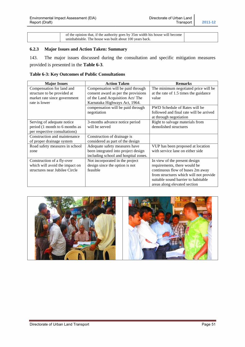
Environmental Impact Assessment (EIA) Report (Draft)
Directorate of Urban Land Transport 2011-12
Directorate of Urban Land Transport Page 51
of the opinion that, if the authority goes by 35m width his house will become
uninhabitable. The house was built about 100 years back.
6.2.3 Major Issues and Action Taken: Summary
143. The major issues discussed during the consultation and specific mitigation measures
provided is presented in the Table 6-3.
Table 6-3: Key Outcomes of Public Consultations
Major Issues Action Taken Remarks
Compensation for land and
structure to be provided at
market rate since government
rate is lower
Compensation will be paid through
consent award as per the provisions
of the Land Acquisition Act/ The
Karnataka Highways Act, 1964.
The minimum negotiated price will be
at the rate of 1.5 times the guidance
value
compensation will be paid through
negotiation
PWD Schedule of Rates will be
followed and final rate will be arrived
at through negotiation
Serving of adequate notice
period (1 month to 6 months as
per respective consultations)
3-months advance notice period
will be served
Right to salvage materials from
demolished structures
Construction and maintenance
of proper drainage system
Construction of drainage is
considered as part of the design
Road safety measures in school
zone
Adequate safety measures have
been integrated into project design
including school and hospital zones.
VUP has been proposed at location
with service lane on either side
Construction of a fly-over
which will avoid the impact on
structures near Jubilee Circle
Not incorporated in the project
design since the option is not
feasible
In view of the present design
requirements, there would be
continuous flow of buses 2m away
from structures which will not provide
suitable sound barrier to habitable
areas along elevated section
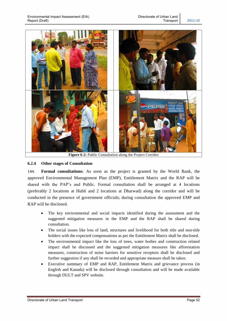
Environmental Impact Assessment (EIA) Report (Draft)
Directorate of Urban Land Transport 2011-12
Directorate of Urban Land Transport Page 52
Figure 6-2: Public Consultation along the Project Corridor
6.2.4 Other stages of Consultation
144. Formal consultations: As soon as the project is granted by the World Bank, the
approved Environmental Management Plan (EMP), Entitlement Matrix and the RAP will be
shared with the PAP’s and Public. Formal consultation shall be arranged at 4 locations
(preferably 2 locations at Hubli and 2 locations at Dharwad) along the corridor and will be
conducted in the presence of government officials; during consultation the approved EMP and
RAP will be disclosed.
The key environmental and social impacts identified during the assessment and the
suggested mitigation measures in the EMP and the RAP shall be shared during
consultation.
The social issues like loss of land, structures and livelihood for both title and non-title
holders with the expected compensations as per the Entitlement Matrix shall be disclosed.
The environmental impact like the loss of trees, water bodies and construction related
impact shall be discussed and the suggested mitigation measures like afforestation
measures, construction of noise barriers for sensitive receptors shall be disclosed and
further suggestion if any shall be recorded and appropriate measure shall be taken.
Executive summary of EMP and RAP, Entitlement Matrix and grievance process (in
English and Kanada) will be disclosed through consultation and will be made available
through DULT and SPV website.
Environmental Impact Assessment (EIA) Report (Draft)
Directorate of Urban Land Transport 2011-12
Directorate of Urban Land Transport Page 53
145. Public Consultations with land losers/PAPs post land acquisition notification: The
public consultations with the project affected persons were organised in Hubli and Dharwad on
28-11-2012 and 29-11-2012 respectively. The objective of the consultations was to explain to the
public about the project and its benefits, the land acquisition details, RAP, EIA and EMP. A
paper notification was issued in local newspapers to inform the public about the scheduled public
consultations. The local revenue department officers were requested to publicise the meetings
through tom-tom in the concerned villages. A copy of the public notice was also put on the notice
boards of important offices like Office of the Deputy Commissioner, Dharwad; Office of the
Executive Engineer, KRDCL, HDMC etc.
The attendance of the people who participated in the public consultation meetings has been duly
taken and the details of the same are available in the project file. 175 people attended public
consultations meeting in Dharwad and 200 people attended in Hubli. The participation of
women in public consultation meetings is on a lower side. However, it is planned to have
separate focus group discussions with women during the implementation of the project.
During the Public Consultation Meetings, the following issues were raised:
There was a request that safe crossings for pedestrians should be provided as a number of
schools, colleges have been located along the road.
It was explained to the participants that pedestrian cycle will be part of signal cycle along
all junctions and adequate signage, table top crossings etc would also be incorporated in
the design to ensure pedestrian safety.
The participants wanted to know whether Unkal lake would be affected and brought to
the notice of the authorities that a park has already been developed adjoining the lake.
It was clarified that there is no impact on Unkal lake, and that measures would be taken
to minimize the acquisition impact, if any, of land adjoining Unkal lake through design
interventions.
The minutes of the public consultation meetings held at Hubli and Dharwad are enclosed in
Annexure 3 and 4 respectively. The list of officers present during the public consultations is in
Annexure 5.
A list of frequently asked questions on BRT including resettlement plan was compiled in
Kannada and circulated in the meetings. Copies of the same in English is placed in the Annexure
6.
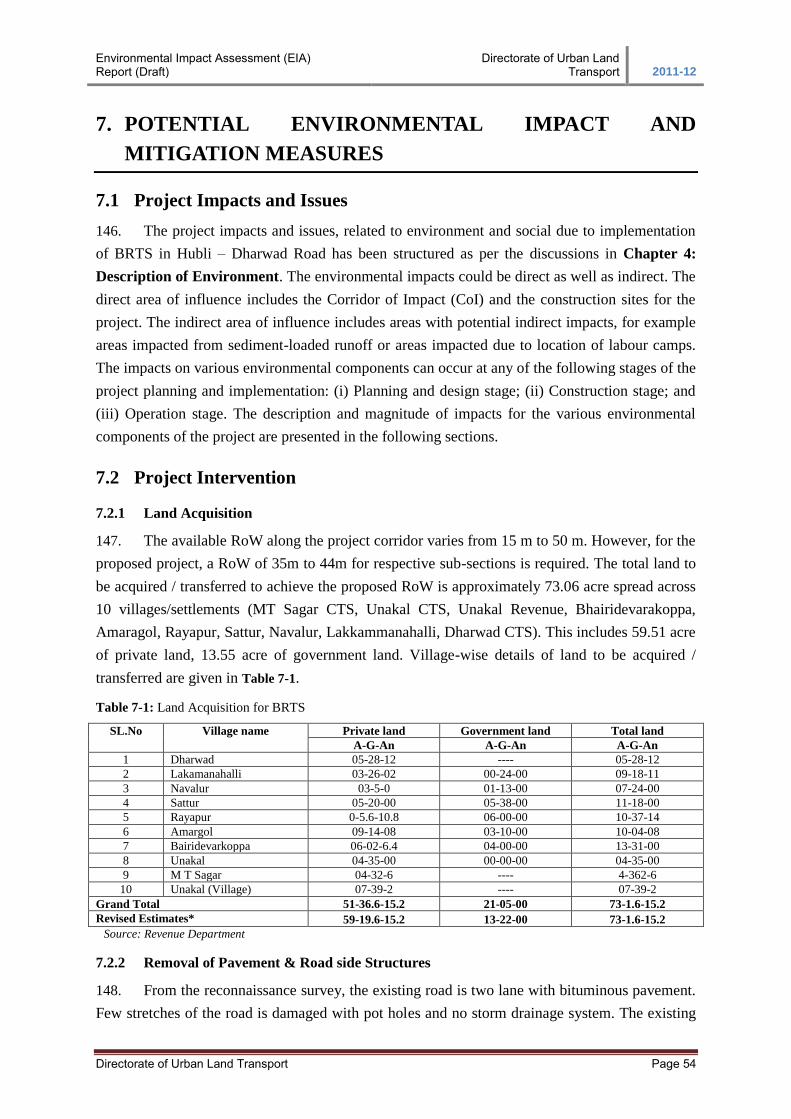
Environmental Impact Assessment (EIA) Report (Draft)
Directorate of Urban Land Transport 2011-12
Directorate of Urban Land Transport Page 54
7. POTENTIAL ENVIRONMENTAL IMPACT AND
MITIGATION MEASURES
7.1 Project Impacts and Issues
146. The project impacts and issues, related to environment and social due to implementation
of BRTS in Hubli – Dharwad Road has been structured as per the discussions in Chapter 4:
Description of Environment. The environmental impacts could be direct as well as indirect. The
direct area of influence includes the Corridor of Impact (CoI) and the construction sites for the
project. The indirect area of influence includes areas with potential indirect impacts, for example
areas impacted from sediment-loaded runoff or areas impacted due to location of labour camps.
The impacts on various environmental components can occur at any of the following stages of the
project planning and implementation: (i) Planning and design stage; (ii) Construction stage; and
(iii) Operation stage. The description and magnitude of impacts for the various environmental
components of the project are presented in the following sections.
7.2 Project Intervention
7.2.1 Land Acquisition
147. The available RoW along the project corridor varies from 15 m to 50 m. However, for the
proposed project, a RoW of 35m to 44m for respective sub-sections is required. The total land to
be acquired / transferred to achieve the proposed RoW is approximately 73.06 acre spread across
10 villages/settlements (MT Sagar CTS, Unakal CTS, Unakal Revenue, Bhairidevarakoppa,
Amaragol, Rayapur, Sattur, Navalur, Lakkammanahalli, Dharwad CTS). This includes 59.51 acre
of private land, 13.55 acre of government land. Village-wise details of land to be acquired /
transferred are given in Table 7-1.
Table 7-1: Land Acquisition for BRTS
SL.No Village name Private land Government land Total land
A-G-An A-G-An A-G-An
1 Dharwad 05-28-12 ---- 05-28-12
2 Lakamanahalli 03-26-02 00-24-00 09-18-11
3 Navalur 03-5-0 01-13-00 07-24-00
4 Sattur 05-20-00 05-38-00 11-18-00
5 Rayapur 0-5.6-10.8 06-00-00 10-37-14
6 Amargol 09-14-08 03-10-00 10-04-08
7 Bairidevarkoppa 06-02-6.4 04-00-00 13-31-00
8 Unakal 04-35-00 00-00-00 04-35-00
9 M T Sagar 04-32-6 ---- 4-362-6
10 Unakal (Village) 07-39-2 ---- 07-39-2
Grand Total 51-36.6-15.2 21-05-00 73-1.6-15.2
Revised Estimates* 59-19.6-15.2 13-22-00 73-1.6-15.2
Source: Revenue Department
7.2.2 Removal of Pavement & Road side Structures
148. From the reconnaissance survey, the existing road is two lane with bituminous pavement.
Few stretches of the road is damaged with pot holes and no storm drainage system. The existing
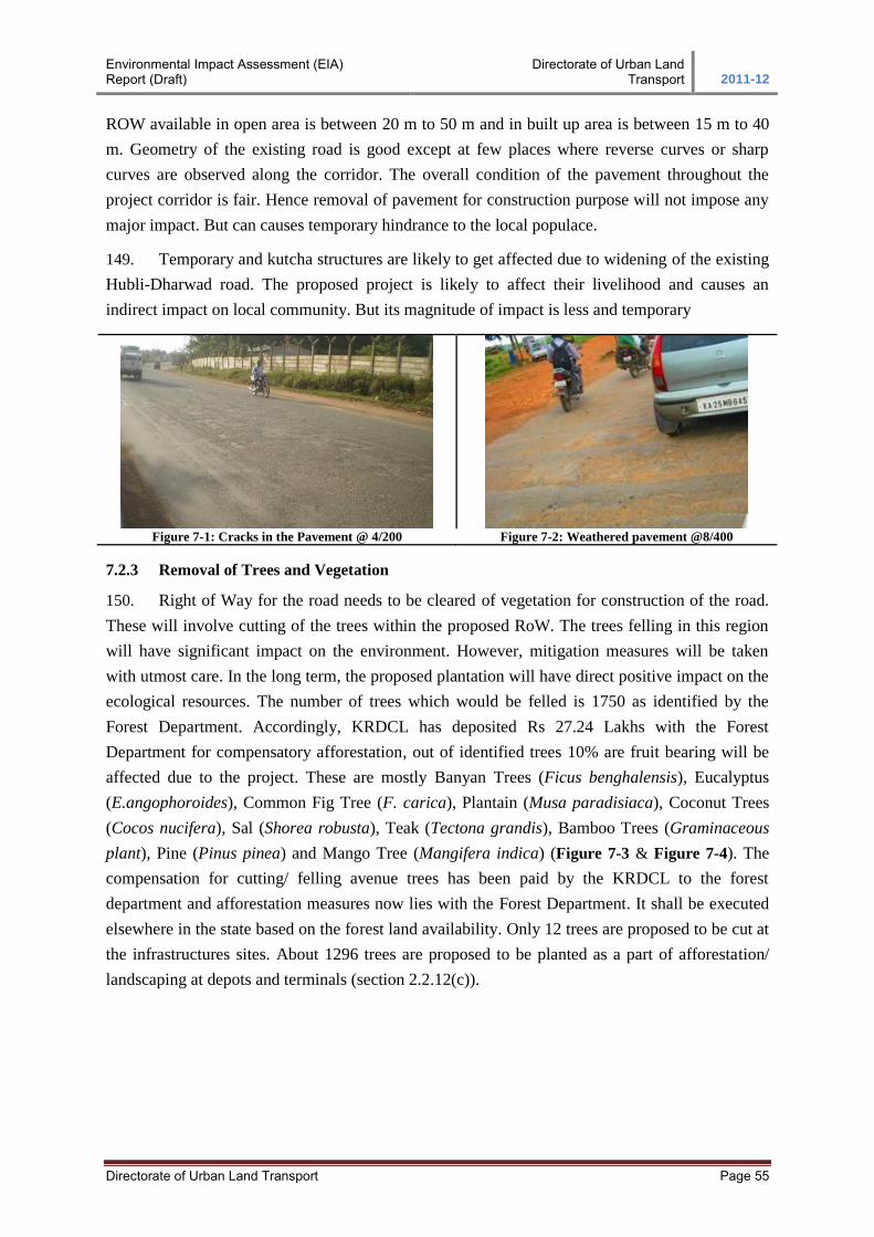
Environmental Impact Assessment (EIA) Report (Draft)
Directorate of Urban Land Transport 2011-12
Directorate of Urban Land Transport Page 55
ROW available in open area is between 20 m to 50 m and in built up area is between 15 m to 40
m. Geometry of the existing road is good except at few places where reverse curves or sharp
curves are observed along the corridor. The overall condition of the pavement throughout the
project corridor is fair. Hence removal of pavement for construction purpose will not impose any
major impact. But can causes temporary hindrance to the local populace.
149. Temporary and kutcha structures are likely to get affected due to widening of the existing
Hubli-Dharwad road. The proposed project is likely to affect their livelihood and causes an
indirect impact on local community. But its magnitude of impact is less and temporary
Figure 7-1: Cracks in the Pavement @ 4/200 Figure 7-2: Weathered pavement @8/400
7.2.3 Removal of Trees and Vegetation
150. Right of Way for the road needs to be cleared of vegetation for construction of the road.
These will involve cutting of the trees within the proposed RoW. The trees felling in this region
will have significant impact on the environment. However, mitigation measures will be taken
with utmost care. In the long term, the proposed plantation will have direct positive impact on the
ecological resources. The number of trees which would be felled is 1750 as identified by the
Forest Department. Accordingly, KRDCL has deposited Rs 27.24 Lakhs with the Forest
Department for compensatory afforestation, out of identified trees 10% are fruit bearing will be
affected due to the project. These are mostly Banyan Trees (Ficus benghalensis), Eucalyptus
(E.angophoroides), Common Fig Tree (F. carica), Plantain (Musa paradisiaca), Coconut Trees
(Cocos nucifera), Sal (Shorea robusta), Teak (Tectona grandis), Bamboo Trees (Graminaceous
plant), Pine (Pinus pinea) and Mango Tree (Mangifera indica) (Figure 7-3 & Figure 7-4). The
compensation for cutting/ felling avenue trees has been paid by the KRDCL to the forest
department and afforestation measures now lies with the Forest Department. It shall be executed
elsewhere in the state based on the forest land availability. Only 12 trees are proposed to be cut at
the infrastructures sites. About 1296 trees are proposed to be planted as a part of afforestation/
landscaping at depots and terminals (section 2.2.12(c)).
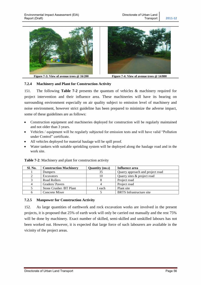
Environmental Impact Assessment (EIA) Report (Draft)
Directorate of Urban Land Transport 2011-12
Directorate of Urban Land Transport Page 56
Figure 7-3: View of avenue trees @ 16/200 Figure 7-4: View of avenue trees @ 14/800
7.2.4 Machinery and Plant for Construction Activity
151. The following Table 7-2 presents the quantum of vehicles & machinery required for
project intervention and their influence area. These machineries will have its bearing on
surrounding environment especially on air quality subject to emission level of machinery and
noise environment, however strict guideline has been prepared to minimize the adverse impact,
some of these guidelines are as follows:
Construction equipment and machineries deployed for construction will be regularly maintained
and not older than 3 years.
Vehicles / equipment will be regularly subjected for emission tests and will have valid “Pollution
under Control” certificate.
All vehicles deployed for material haulage will be spill proof.
Water tankers with suitable sprinkling system will be deployed along the haulage road and in the
work site.
Table 7-2: Machinery and plant for construction activity
Sl. No. Construction Machinery Quantity (no.s) Influence area
1 Dumpers 35 Quarry approach and project road
2 Excavators 10 Quarry sites & project road
3 Road Rollers 8 Project road
4 Graders/ Pavers 4 Project road
5 Stone Crusher /BT Plant 1 each Plant site
6 Concrete Mixer 5 BRTS Infrastructure site
7.2.5 Manpower for Construction Activity
152. As large quantities of earthwork and rock excavation works are involved in the present
projects, it is proposed that 25% of earth work will only be carried out manually and the rest 75%
will be done by machinery. Exact number of skilled, semi-skilled and unskilled labours has not
been worked out. However, it is expected that large force of such labourers are available in the
vicinity of the project areas.
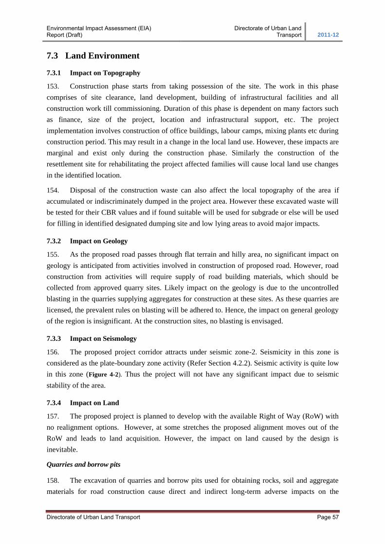
Environmental Impact Assessment (EIA) Report (Draft)
Directorate of Urban Land Transport 2011-12
Directorate of Urban Land Transport Page 57
7.3 Land Environment
7.3.1 Impact on Topography
153. Construction phase starts from taking possession of the site. The work in this phase
comprises of site clearance, land development, building of infrastructural facilities and all
construction work till commissioning. Duration of this phase is dependent on many factors such
as finance, size of the project, location and infrastructural support, etc. The project
implementation involves construction of office buildings, labour camps, mixing plants etc during
construction period. This may result in a change in the local land use. However, these impacts are
marginal and exist only during the construction phase. Similarly the construction of the
resettlement site for rehabilitating the project affected families will cause local land use changes
in the identified location.
154. Disposal of the construction waste can also affect the local topography of the area if
accumulated or indiscriminately dumped in the project area. However these excavated waste will
be tested for their CBR values and if found suitable will be used for subgrade or else will be used
for filling in identified designated dumping site and low lying areas to avoid major impacts.
7.3.2 Impact on Geology
155. As the proposed road passes through flat terrain and hilly area, no significant impact on
geology is anticipated from activities involved in construction of proposed road. However, road
construction from activities will require supply of road building materials, which should be
collected from approved quarry sites. Likely impact on the geology is due to the uncontrolled
blasting in the quarries supplying aggregates for construction at these sites. As these quarries are
licensed, the prevalent rules on blasting will be adhered to. Hence, the impact on general geology
of the region is insignificant. At the construction sites, no blasting is envisaged.
7.3.3 Impact on Seismology
156. The proposed project corridor attracts under seismic zone-2. Seismicity in this zone is
considered as the plate-boundary zone activity (Refer Section 4.2.2). Seismic activity is quite low
in this zone (Figure 4-2). Thus the project will not have any significant impact due to seismic
stability of the area.
7.3.4 Impact on Land
157. The proposed project is planned to develop with the available Right of Way (RoW) with
no realignment options. However, at some stretches the proposed alignment moves out of the
RoW and leads to land acquisition. However, the impact on land caused by the design is
inevitable.
Quarries and borrow pits
158. The excavation of quarries and borrow pits used for obtaining rocks, soil and aggregate
materials for road construction cause direct and indirect long-term adverse impacts on the
Environmental Impact Assessment (EIA) Report (Draft)
Directorate of Urban Land Transport 2011-12
Directorate of Urban Land Transport Page 58
environment. The proposed project envisages use of significant quantities of earth, stone and grit
and sand along with bitumen. The principal construction materials required for the corridor
includes:
Quarry materials, used in asphalt and aggregate for upper pavement layers
Sand, gravel, laterite, clay and other materials for fill and lower pavement layers
159. Contract documents specify the materials to be used, but not specific quarries, pits or
borrow sites for obtaining the various materials. The contractor shall identify the source of
materials and use them with the consent of the Engineer. The principal sources of construction
material the contractor needs to tap include:
Quarry materials from licensed existing quarries
Sand from riverbeds, normally dry and accessible except during the northeast monsoon
(approvals for this extraction are necessary, as it is not permissible everywhere)
Clays from tanks, many of which are near the project area
Laterites available in the vicinity of project area
7.3.5 Contamination of Soil
160. In this project contamination of the soil may take place, from the following activities at
the construction zones, construction labour camps, construction plant sites and other auxiliary
facilities required for the construction. Details of the activities from which the contamination can
occur are presented below;
Scarified bitumen wastes, over production of bituminous product,
Debris generation due to dismantling of structures,
Maintenance of the machinery and operation of the diesel generator sets on site,
Oil spill from the operation of the diesel pumps and diesel storage, during transportation and
transfer, parking places, and diesel generator sets,
Operation of the emulsion sprayer and laying of hot mix,
Operation of the residential facilities for the labor and officers,
Storage and stock yards of bitumen and emulsion,
Excess production of hot mix and rejected materials
MITIGATION MEASURES
7.3.6 Change in Topography
161. As indicated in section 7.3.1 Impact on topography, there is not much impact on
topography though cutting and filling is anticipated. Blasting activity will induce a local impact
on topography.
7.3.7 Change in Geology
162. Though no major impacts on geological profile of the project area are anticipated,
requirement of construction material from quarries will induce pressure on the local geological
Environmental Impact Assessment (EIA) Report (Draft)
Directorate of Urban Land Transport 2011-12
Directorate of Urban Land Transport Page 59
deposits. The contractor is to ensure procurement of the construction material from licensed
quarries only. It is envisaged that no new quarries will be proposed.
163. The quarries that would be used for procuring construction material should be established
under “Mines and Mineral Concession Rules, 1959”. The act lays down guidelines for
establishing quarries and obtaining quarry lease. It also specifies the conditions to be maintained
for operating the quarry or for obtaining renewal of quarry lease. In respect of quarrying in
environmentally sensitive areas certain restrictions have been imposed to avoid any detrimental
impact due to irresponsible quarrying. The rules lay down various precautionary measures during
blasting, safety of workers, management measures within quarries, approval of the village heads
prior to material leaving the village, precautionary measures to avoid spillage during transport of
quarry materials.
164. The contractor is free to choose the quarries from amongst this list of quarries or any
other existing quarry, which is already operational with the relevant clearances and compliance to
environmental requirements. In case the whole quarry is taken up by the contractor then the
contractor will be responsible for environmental management.
7.3.8 Change in Seismology
165. As discussed in section 7.3.7 and section 4.2.2, the project corridor falls under zone-2
indicating low intensity of earthquake; hence changes in seismology due to proposed BRTS
project is not envisaged.
7.3.9 Change in Land Environment
166. As far as possible the land acquisition has been kept to the minimum, by restricting the
geometric improvement within the available right of way (RoW). The same can be seen as only
73.06 hectare land is required for project road upgradation. However the land acquisition will be
done at sections having width, insufficient to accommodate the approved cross-sections &
geometric improvements. For Land acquisition sections refer RAP (Resettlement Action Plan).
Quarries and borrow pits
167. Specific locations of borrow areas to be used will be identified by contractor. The
selection and recommendations for borrow areas will be based on environmental as well as civil
engineering considerations. Location and source of material for embankment or sub-grade and the
procedure for excavation or transport of material shall be in compliance with the environmental
requirements of the MoRTH and as specified in IRC: 10-1961 areas to mitigate the impacts will
be the responsibility of the contractor. Redevelopment of the borrow, the contractor shall evolve
site-specific redevelopment plan for each borrow area location, which shall be implemented after
the approval of the Engineer (Refer Annexure-7 (OP-2)).
168. Precautionary measures as the covering of vehicles will be taken to avoid spillage during
transport of borrow materials. The unpaved surfaces used for the haulage of borrow materials will
be maintained properly. The haul roads and borrow areas will be managed and maintained by the
Environmental Impact Assessment (EIA) Report (Draft)
Directorate of Urban Land Transport 2011-12
Directorate of Urban Land Transport Page 60
contractor. Since dust rising is the only impact along the haul roads sprinkling of water will be
carried out twice a day along such roads during their period of use.
169. Borrowing of earth shall be avoided on productive lands and within or 1 km of settlement
areas. However, in the event of borrowing from productive lands, under circumstances as
described above, topsoil shall be preserved in stockpiles. At such locations, the depth of borrow
pits shall not exceed 45 cm and it may be dug out to a depth of not more than 30 cm after
stripping the 15 cm top soil aside. At locations where private owners desire their fields to be
levelled, the borrowing shall be done to a depth of not more than 2 m or up to the level of
surrounding fields.
7.3.10 Contamination of Soil
170. Soil contamination is likely due to the possible leakage of fuel/lubricants and dumping of
construction wastes during construction stage. The contractor will be required to initiate measures
to reduce/prevent waste generation from all activities. The measures would include
Identifying landfill sites for disposal of debris and a plan for disposal needs to be prepared by
the contractor with approval of Project Management Consultant (PMC)
Undertake measures for minimization of waste and recycling of surplus materials for use by
local communities
Methods of collection and disposal of domestic waste
Follow established procedures for storage of hazardous goods and chemicals
Prepare plans for cleanup of any accidental spillage
Checks for ensuring erosion control structures are in place before earthworks are started
7.3.11 Soil Quality – Mitigation
171. All arrangement for transportation during construction including provision, maintenance,
and clearing debris, where necessary will be considered incidental to the work and should be
planned and implemented by the contractor as approved and directed by the Engineer. Disposal of
all waste materials is responsibility of the contractor and provisions to this effect are provided in
the engineering budget.
172. At various construction sites, the vehicles and equipment will be maintained and refuelled
in such a fashion that oil/diesel spillage does not contaminate the soil. It will be ensured that the
fuel storage and refuelling sites are kept away from drainage channels and important water
bodies. At the wash down and refuelling areas, “oil interceptors” shall be provided. All spills and
petroleum products shall be disposed off in accordance to the KSPCB Guidelines. Fuel storage
and fuelling areas will be located at least 300m from all cross drainage structures and significant
water bodies. In all fuel storage and refuelling areas located on agricultural lands or productive
lands, the topsoil preservation shall be carried out.
173. To minimize the dumping of construction wastes from the project, the debris generated
due excavation and site preparation shall be suitably reused in the proposed construction, subject
to the suitability of the material and the approval of the Engineer.
Environmental Impact Assessment (EIA) Report (Draft)
Directorate of Urban Land Transport 2011-12
Directorate of Urban Land Transport Page 61
174. Unusable debris material shall be suitably disposed off by the contractor at pre-designated
disposal locations, subject to the approval of the Engineer. The bituminous wastes shall be
dumped in secure landfill sites only. At such locations dumping will be carried out over a 60 mm
thick layer of rammed clay so as to eliminate any chances of leaching. The identification of such
landfill sites shall be carried out by the Contractor (before start of construction activity) and duly
approved by the SPV/ KRDCL.
175. During the operation stage, the probability of contamination of soil is only from the road
runoff. The design of the road has been worked out such that the runoff is directed into nearest
water bodies through well-designed drains. Impacts are anticipated only in case of accidents
involving large spill over of hazardous materials or petroleum products. Monitoring shall be done
at the locations where these have occurred and further course of action to reduce the pollution
shall be worked out.
Productive Agriculture lands
176. As part of the finalization of the design for the project, efforts have been made to
minimize the intake of productive lands. The borrow areas; construction camp locations; traffic
detours and other construction sites shall be selected carefully in consultation with the engineer to
minimize the agricultural land acquisition. To conserve the productive topsoil of all areas affected
due to project, the following measures have been proposed:
The topsoil from all areas to be permanently covered shall be stripped to a specified depth of
150mm and stored in stockpiles. At least 10% of the temporarily acquired area shall be
earmarked for storing topsoil
The stockpile shall be designed such that the slope does not exceed 1:2 (vertical to
horizontal), and the height of the pile will be restricted to 2m
Stockpiles will not be surcharged or otherwise loaded and multiple handling will be kept to a
minimum and shall be covered with gunny bags or tarpaulin
It shall be ensured by the contractor that the topsoil will not be unnecessarily trafficked either
before stripping or when in stockpiles
To prevent any compaction of soil in the adjoining productive lands, the movement of
construction vehicles, machinery and equipment will be restricted to CoI
177. The stored topsoil will be utilized for:
Covering all disturbed areas including for the redevelopment of borrow areas
Top dressing of the road embankments and fill slopes
Filling up of tree pits, proposed as part of compensatory plantation
178. The contractor shall be responsible for working out haul roads with the minimal loss of
productive soils, in consultation with the Engineer (Refer Annexure-7 Environmental monitoring
Format, EM-6).
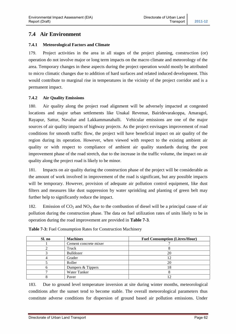
Environmental Impact Assessment (EIA) Report (Draft)
Directorate of Urban Land Transport 2011-12
Directorate of Urban Land Transport Page 62
7.4 Air Environment
7.4.1 Meteorological Factors and Climate
179. Project activities in the area in all stages of the project planning, construction (or)
operation do not involve major or long term impacts on the macro climate and meteorology of the
area. Temporary changes in these aspects during the project operation would mostly be attributed
to micro climatic changes due to addition of hard surfaces and related induced development. This
would contribute to marginal rise in temperatures in the vicinity of the project corridor and is a
permanent impact.
7.4.2 Air Quality Emissions
180. Air quality along the project road alignment will be adversely impacted at congested
locations and major urban settlements like Unakal Revenue, Bairidevarakoppa, Amaragol,
Rayapur, Sattur, Navalur and Lakkammanahalli. Vehicular emissions are one of the major
sources of air quality impacts of highway projects. As the project envisages improvement of road
conditions for smooth traffic flow, the project will have beneficial impact on air quality of the
region during its operation. However, when viewed with respect to the existing ambient air
quality or with respect to compliance of ambient air quality standards during the post
improvement phase of the road stretch, due to the increase in the traffic volume, the impact on air
quality along the project road is likely to be minor.
181. Impacts on air quality during the construction phase of the project will be considerable as
the amount of work involved in improvement of the road is significant, but any possible impacts
will be temporary. However, provision of adequate air pollution control equipment, like dust
filters and measures like dust suppression by water sprinkling and planting of green belt may
further help to significantly reduce the impact.
182. Emission of CO2 and NOX due to the combustion of diesel will be a principal cause of air
pollution during the construction phase. The data on fuel utilization rates of units likely to be in
operation during the road improvement are provided in Table 7-3.
Table 7-3: Fuel Consumption Rates for Construction Machinery
Sl. no Machines Fuel Consumption (Litres/Hour)
1 Cement concrete mixer 7
2 Truck 8
3 Bulldozer 20
4 Grader 12
5 Roller 20
6 Dumpers & Tippers 18
7 Water Tanker 8
8 Paver 12
183. Due to ground level temperature inversion at site during winter months, meteorological
conditions after the sunset tend to become stable. The overall meteorological parameters thus
constitute adverse conditions for dispersion of ground based air pollution emissions. Under

Environmental Impact Assessment (EIA) Report (Draft)
Directorate of Urban Land Transport 2011-12
Directorate of Urban Land Transport Page 63
adverse meteorological conditions, it may be possible that the NOX standards (80 μg/m3 for 24
hourly average) may be violated only if the construction work is carried out round the clock.
However, this scenario is not envisaged, as the construction is not proposed to be carried out
throughout the day. There will also be a rise in SPM levels due to construction activities. The
SPM standards, however, are not expected to be exceeding the permissible limits as the
background levels are very low and the particulates tend to settle during low wind and stable
conditions. However, implementation of mitigation measures as given in the EMP will mitigate
or minimize these impacts.
184. After improvement of the existing road, the traffic is expected to move smoothly at higher
designed speeds, which will assure lower emissions of gaseous pollutants, further improving air
quality in the region and hence not expected to affect the air quality adversely.
185. The rate of emissions of various types of vehicles is presented in Table 7-4. However,
the extent of these impacts, at any given time will depend upon the rate of vehicular emission
within a given stretch of the road; and the prevailing meteorological conditions. The impacts will
have strong temporal dependence as both of these factors vary with time. The temporal
dependence would have diurnal, seasonal, as well as long-term components.
Table 7-4: Rate of Emissions of Various Types of Vehicles
Emissions Emission Factors in gm/km/Vehicle
Speed (km/hr) 30 40 50 60 70 80
1. For Diesel Vehicles
CO 12.53 9.40 7.52 6.27 5.37 4.70
NOX 22.28 16.71 13.37 11.14 9.55 8.36
2. For Petrol Vehicles
Car 2 Wheeler 3 Wheeler
CO 2.72 2.0 4.0
NOX 0.58 0.5 0.5 Source: Indian Institute of Petroleum
MITIGATION MEASURES
7.4.3 Meteorological Factors and Climate
186. Marginal changes in micro climatic conditions of the project area as increase in
temperature due to introduction of additional pavement surfaces etc. will be offset through
developing roadside plantation in the road RoW. Plantation scheme adopted for the section is
discussed in subsequent sections of the report. Tree plantation will bring about lowering of
temperature levels offsetting any rise in temperature due to introduction of pavement surface and
other constructions.
7.4.4 Air Quality Emissions
187. During construction stage, the asphalt plants, crushers and the batching plants will be
sited at least 1 km in the downwind direction from the nearest human settlement. All precautions
to reduce the level of dust emissions from the hot mix plants, crushers and batching plants and
other transportation of materials will be taken up including:
Environmental Impact Assessment (EIA) Report (Draft)
Directorate of Urban Land Transport 2011-12
Directorate of Urban Land Transport Page 64
188. Vehicles delivering loose and fine materials like sand and fine aggregates shall be
covered to reduce spills on existing roads.
189. Water will be sprayed on earthworks, temporary haulage and detour roads on a regular
basis. During and after compaction of the sub-grade, water will be sprayed at regular intervals to
prevent dust generation.
190. The hot mix plant will be fitted with dust extraction units. It shall be ensured that the dust
emissions from the crusher and vibrating screen from the stone quarries do not exceed the
standards.
191. To ensure the control of exhaust gas emissions from various construction activities, the
contractor shall take up the following mitigation measures:
An adequate cyclone/scrubber to control emissions from the stack of hot mix plants will be
provided in the event of the emissions exceeding the KSPCB norms.
To ensure the efficiency of the mitigation measures suggested, air quality monitoring shall be
carried out at least once every season during the period for which the plant is in operation.
All vehicles, equipment and machinery used for construction will be regularly maintained to
ensure that the pollution emission levels conform to the KSPCB norms. A vehicle
management schedule prepared by the contractor and approved by the Engineer shall be
adhered to.
192. Some of the measures during operation stage would be to planting of pollution resistant
species; which can grow in high pollutant concentrations or even absorb pollutants, can be
planted in the first row. Broad-leaved tree species can help settle particulates with their higher
surface areas along with thick foliage, which can reduce the distance for which particulates are
carried from the road itself.
193. Other measures: Other measures such as the reduction of vehicular emissions, ensuring
vehicular maintenance and up-keep, educating drivers about driving behaviour/methods that will
reduce emissions are beyond the scope of the project but will be far more effective in reducing
the pollutant levels. The project could assist implementation of these programmes only by putting
up signboards and drawing attention to air pollution problems.
194. Apart from provision of the mitigation measures, their effectiveness and further
improvement in designs to reduce the pollutant levels with increase in traffic shall be monitored.
A monitoring plan has been prepared (Table 8-5).
7.5 Water Environment
7.5.1 Loss of Water Bodies
195. The typical impacts on water quality during road construction are summarized in Table
7-5.
Table 7-5: Impacts on water resources due to construction activities
Sl. No Impacts Due To Construction Indicators
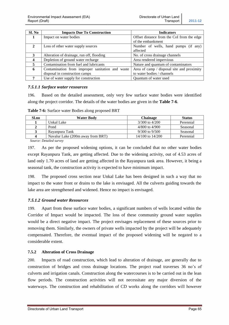
Environmental Impact Assessment (EIA) Report (Draft)
Directorate of Urban Land Transport 2011-12
Directorate of Urban Land Transport Page 65
Sl. No Impacts Due To Construction Indicators
1 Impact on water bodies Offset distance from the CoI from the edge
of the embankment
2 Loss of other water supply sources Number of wells, hand pumps (if any)
affected
3 Alteration of drainage, run off, flooding No. of cross drainage channels
4 Depletion of ground water recharge Area rendered impervious
5 Contamination from fuel and lubricants Nature and quantum of contaminators
6 Contamination from improper sanitation and waste
disposal in construction camps
Area of camp / disposal site and proximity
to water bodies / channels
7 Use of water supply for construction Quantum of water used
7.5.1.1 Surface water resources
196. Based on the detailed assessment, only very few surface water bodies were identified
along the project corridor. The details of the water bodies are given in the Table 7-6.
Table 7-6: Surface water Bodies along proposed BRT
Sl.no Water Body Chainage Status
1 Unkal Lake 3/300 to 4/200 Perennial
2 Pond 4/800 to 4/900 Seasonal
3 Rayanpura Tank 9/300 to 9/500 Seasonal
4 Navalur Lake (200m away from BRT) 14/100 to 14/200 Perennial Source: Detailed survey
197. As per the proposed widening options, it can be concluded that no other water bodies
except Rayanpura Tank, are getting affected. Due to the widening activity, out of 4.53 acres of
land only 1.70 acres of land are getting affected in the Rayanpura tank area. However, it being a
seasonal tank, the construction activity is expected to have minimum impact.
198. The proposed cross section near Unkal Lake has been designed in such a way that no
impact to the water front or drains to the lake is envisaged. All the culverts guiding towards the
lake area are strengthened and widened. Hence no impact is envisaged.
7.5.1.2 Ground water Resources
199. Apart from these surface water bodies, a significant numbers of wells located within the
Corridor of Impact would be impacted. The loss of these community ground water supplies
would be a direct negative impact. The project envisages replacement of these sources prior to
removing them. Similarly, the owners of private wells impacted by the project will be adequately
compensated. Therefore, the eventual impact of the proposed widening will be negated to a
considerable extent.
7.5.2 Alteration of Cross Drainage
200. Impacts of road construction, which lead to alteration of drainage, are generally due to
construction of bridges and cross drainage locations. The project road traverses 36 no’s of
culverts and irrigation canals. Construction along the watercourses is to be carried out in the lean
flow periods. The construction activities will not necessitate any major diversion of the
waterways. The construction and rehabilitation of CD works along the corridors will however
Environmental Impact Assessment (EIA) Report (Draft)
Directorate of Urban Land Transport 2011-12
Directorate of Urban Land Transport Page 66
involve some minor temporary diversion of waterways, which can impact the existing aquatic
habitat. However, the impact will last as long as construction continues.
7.5.3 Run-off and Drainage
201. One of the unavoidable aftermaths of road construction is the increased surface run off.
The addition of hard paved shoulders, which essentially increase paved impervious surface, will
cause increased surface runoff along the roadsides. Increase in surface run-off is due to the
creation of impervious surfaces that prevent the flow of water into the ground. The increased
runoff from the project has been worked out as follows:
202. Increase in runoff (cum.) = increase in runoff co-efficient due to construction * annual
rainfall in the area (m) * area of the newly constructed surface.
203. The increase of the black top width has been considered as per the cross section proposed.
The runoff coefficient used for the calculations are 0.2 for red sandy and reddish brown loam,
0.15 for recent sandy and 0.55 for black cotton soil. The black top has a run-off coefficient of
0.95. Increase in the runoff co-efficient has been worked out as the difference between the runoff
co-efficient of black top surface and different soil types. The increased run-off so calculated is
estimated to be 1,224.00 cum.
204. Impacts due to surface runoff include increased soil erosion and local flooding or water
logging. However, as the proposed corridor has been designed with drains to take care of runoff,
surface runoff shall be drained to the nearest cross drainage structure. The engineering design
includes design of cross drainage structures, which shall take care of the increased runoff.
7.5.4 Water Requirement for Project
205. The water requirement for construction depends on the climatic conditions, type of
equipment, type of material available, mix design, type of construction plant and number of
people working on the project. With the following assumptions the approximate water quantity
required for the project has been calculated.
8-10% of weight of soil for the embankment construction
7-8% of weight of soil for sub grade construction
5-6% of weight of GSB materials for GSB and WMM
150 liters/ cum for concrete
206. The water requirement has been assumed based on past project experiences and on the
strict quality control basis. Domestic requirement of 100 liters per worker has been assumed. For
this project about 140 resident workers have been considered. Details of the water requirement
assessed for the project are presented in Table 7-7.
Table 7-7: Water Requirement for Construction works
Sl. No Water Requirement Cum/day
1 Permanent works (cum/day) 25
2 Dust Suppression at work zone in (cum/day) 40
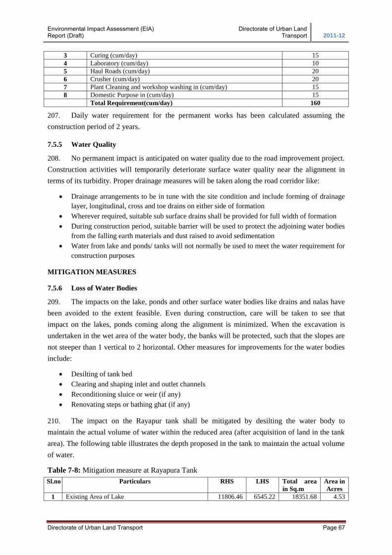
Environmental Impact Assessment (EIA) Report (Draft)
Directorate of Urban Land Transport 2011-12
Directorate of Urban Land Transport Page 67
3 Curing (cum/day) 15
4 Laboratory (cum/day) 10
5 Haul Roads (cum/day) 20
6 Crusher (cum/day) 20
7 Plant Cleaning and workshop washing in (cum/day) 15
8 Domestic Purpose in (cum/day) 15
Total Requirement(cum/day) 160
207. Daily water requirement for the permanent works has been calculated assuming the
construction period of 2 years.
7.5.5 Water Quality
208. No permanent impact is anticipated on water quality due to the road improvement project.
Construction activities will temporarily deteriorate surface water quality near the alignment in
terms of its turbidity. Proper drainage measures will be taken along the road corridor like:
Drainage arrangements to be in tune with the site condition and include forming of drainage
layer, longitudinal, cross and toe drains on either side of formation
Wherever required, suitable sub surface drains shall be provided for full width of formation
During construction period, suitable barrier will be used to protect the adjoining water bodies
from the falling earth materials and dust raised to avoid sedimentation
Water from lake and ponds/ tanks will not normally be used to meet the water requirement for
construction purposes
MITIGATION MEASURES
7.5.6 Loss of Water Bodies
209. The impacts on the lake, ponds and other surface water bodies like drains and nalas have
been avoided to the extent feasible. Even during construction, care will be taken to see that
impact on the lakes, ponds coming along the alignment is minimized. When the excavation is
undertaken in the wet area of the water body, the banks will be protected, such that the slopes are
not steeper than 1 vertical to 2 horizontal. Other measures for improvements for the water bodies
include:
Desilting of tank bed
Clearing and shaping inlet and outlet channels
Reconditioning sluice or weir (if any)
Renovating steps or bathing ghat (if any)
210. The impact on the Rayapur tank shall be mitigated by desilting the water body to
maintain the actual volume of water within the reduced area (after acquisition of land in the tank
area). The following table illustrates the depth proposed in the tank to maintain the actual volume
of water.
Table 7-8: Mitigation measure at Rayapura Tank
Sl.no Particulars RHS LHS Total area
in Sq.m
Area in
Acres
1 Existing Area of Lake 11806.46 6545.22 18351.68 4.53
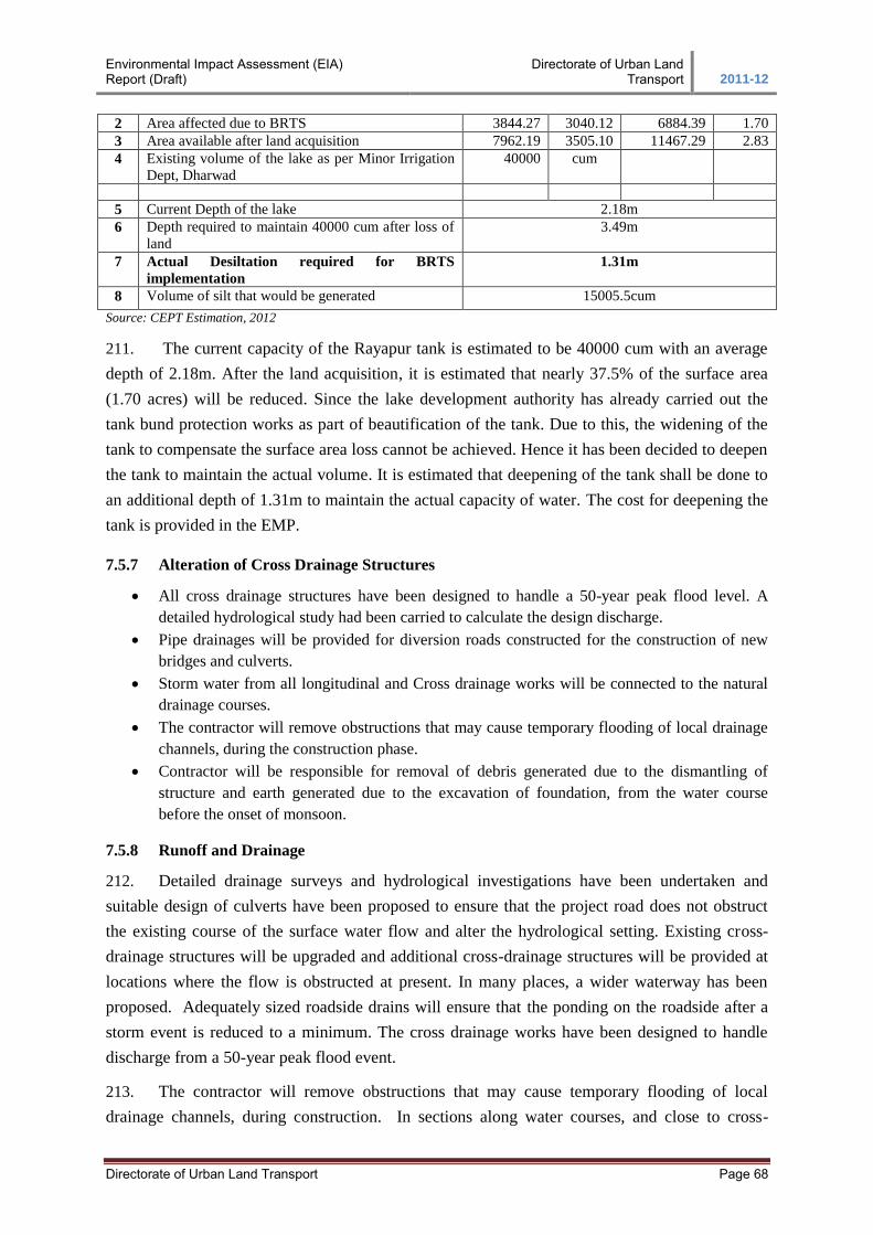
Environmental Impact Assessment (EIA) Report (Draft)
Directorate of Urban Land Transport 2011-12
Directorate of Urban Land Transport Page 68
2 Area affected due to BRTS 3844.27 3040.12 6884.39 1.70
3 Area available after land acquisition 7962.19 3505.10 11467.29 2.83
4 Existing volume of the lake as per Minor Irrigation
Dept, Dharwad
40000 cum
5 Current Depth of the lake 2.18m
6 Depth required to maintain 40000 cum after loss of
land
3.49m
7 Actual Desiltation required for BRTS
implementation
1.31m
8 Volume of silt that would be generated 15005.5cum
Source: CEPT Estimation, 2012
211. The current capacity of the Rayapur tank is estimated to be 40000 cum with an average
depth of 2.18m. After the land acquisition, it is estimated that nearly 37.5% of the surface area
(1.70 acres) will be reduced. Since the lake development authority has already carried out the
tank bund protection works as part of beautification of the tank. Due to this, the widening of the
tank to compensate the surface area loss cannot be achieved. Hence it has been decided to deepen
the tank to maintain the actual volume. It is estimated that deepening of the tank shall be done to
an additional depth of 1.31m to maintain the actual capacity of water. The cost for deepening the
tank is provided in the EMP.
7.5.7 Alteration of Cross Drainage Structures
All cross drainage structures have been designed to handle a 50-year peak flood level. A
detailed hydrological study had been carried to calculate the design discharge.
Pipe drainages will be provided for diversion roads constructed for the construction of new
bridges and culverts.
Storm water from all longitudinal and Cross drainage works will be connected to the natural
drainage courses.
The contractor will remove obstructions that may cause temporary flooding of local drainage
channels, during the construction phase.
Contractor will be responsible for removal of debris generated due to the dismantling of
structure and earth generated due to the excavation of foundation, from the water course
before the onset of monsoon.
7.5.8 Runoff and Drainage
212. Detailed drainage surveys and hydrological investigations have been undertaken and
suitable design of culverts have been proposed to ensure that the project road does not obstruct
the existing course of the surface water flow and alter the hydrological setting. Existing cross-
drainage structures will be upgraded and additional cross-drainage structures will be provided at
locations where the flow is obstructed at present. In many places, a wider waterway has been
proposed. Adequately sized roadside drains will ensure that the ponding on the roadside after a
storm event is reduced to a minimum. The cross drainage works have been designed to handle
discharge from a 50-year peak flood event.
213. The contractor will remove obstructions that may cause temporary flooding of local
drainage channels, during construction. In sections along water courses, and close to cross-
Environmental Impact Assessment (EIA) Report (Draft)
Directorate of Urban Land Transport 2011-12
Directorate of Urban Land Transport Page 69
drainage channels, earth, stone or any other construction materials must be properly disposed off
so as not to block the flow of water. All necessary measures will be taken to prevent earthwork,
stonework and other debris from impeding cross-drainage streams and water canals. Covered
drains will be provided, which can also be utilized as foot path. Provision of cost for cross
drainage structures and road side structures are included as part of engineering cost. Recharging
pits for road side drains will be provided and the construction cost is included as part of
Environmental Management Plan.
7.5.9 Water Requirement for Project
214. The contractor will arrange for water required for construction in such a way that the
water availability and supply to nearby communities remain unaffected. The total requirement of
water has been worked out as 160 to 170 cum/day. Wastage of water during the construction will
be minimized. While working across or close to perennial water bodies, the Contractor will not
impede or block any flow of water. Construction over and close to any non-perennial streams
shall be carried out in the dry season. Construction over irrigation canals will be undertaken with
prior permission. Care should be taken to minimise any disruption to the flows and to ensure that
a high quality of water is maintained. The Contractor may use the natural sources of water subject
to the provision that any claim arising out of conflicts with other users of the said natural sources
will be his responsibility.
7.5.10 Water Quality
215. All wastes arising from the project will be disposed off, as per KSPCB norms, so as not to
block the flow of water in the channels. The wastes will be collected, stored and transported to
the approved disposal sites. To avoid contamination of the various surface water bodies and
drainage channels in the vicinity of the construction site, construction work close to the rivers or
other water bodies will be avoided, especially during monsoon period. It will be ensured that any
liquid construction waste discharged into the existing waterways is treated to the required
standard. Construction of temporary or permanent devices to prevent water pollution due to
increased siltation and turbidity shall be ensured. It will be ensured that no sanitary wastes from
the labour camps are discharged into the nearby watercourses. Adequate sanitary measures in
labour camps are essential in this regard. Various measures that have been proposed for the
protection of water quality along the corridor have been detailed in the following sections.
216. Silt Fencing: Silt fencing will be provided to prevent sediments from the construction
site entering into the nearby watercourses (refer section 4.2.5). The silt fencing consists of
geotextile (MIRAFI 140N or equal) with extremely small openings supported by a wire-mesh
mounted on a panel made up of angle frame (Refer Figure 7-5). Modules of 625 mm each are
designed to allow ease of handling and construction. It is expected a single person will be able to
drive the angles 300 mm into the ground by pressing from the top. The frame will be installed
around stockpiles close to water bodies. The wire-mesh will provide structural stability and the
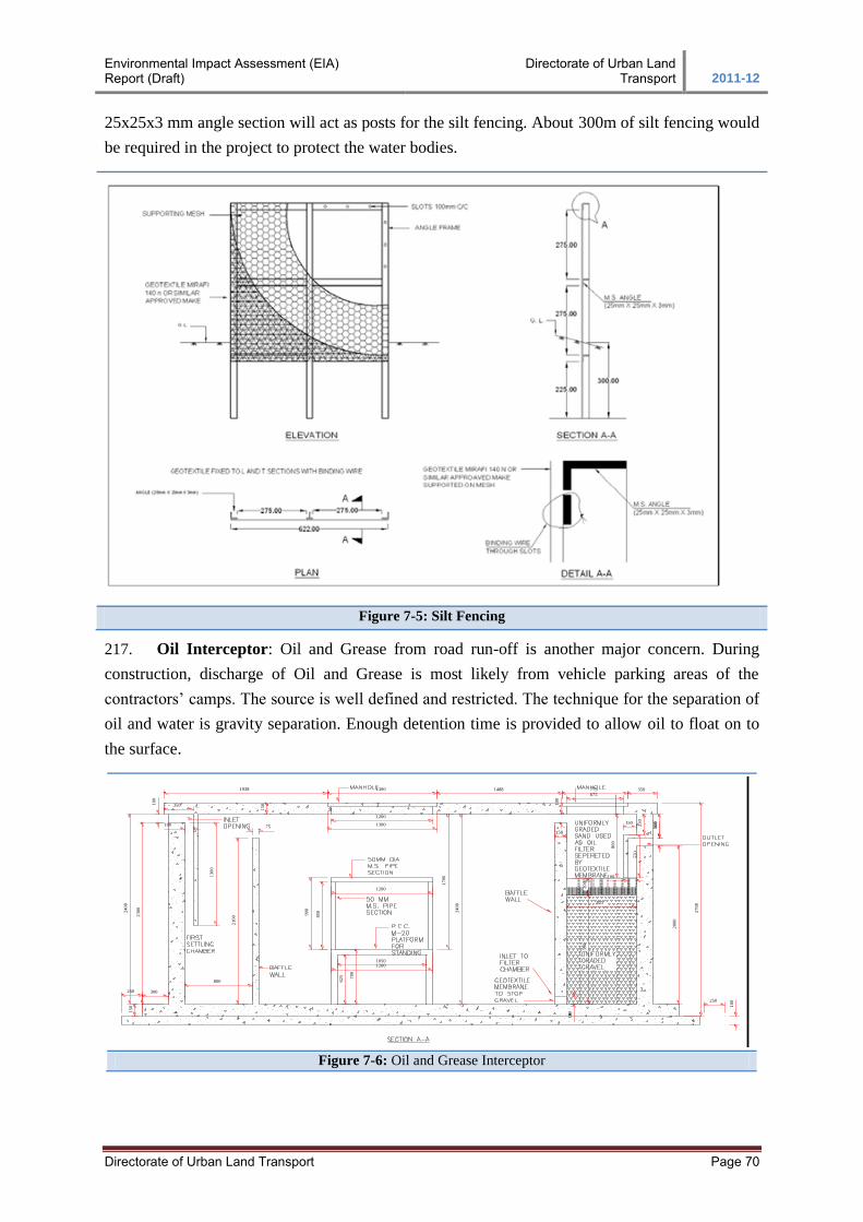
Environmental Impact Assessment (EIA) Report (Draft)
Directorate of Urban Land Transport 2011-12
Directorate of Urban Land Transport Page 70
25x25x3 mm angle section will act as posts for the silt fencing. About 300m of silt fencing would
be required in the project to protect the water bodies.
Figure 7-5: Silt Fencing
217. Oil Interceptor: Oil and Grease from road run-off is another major concern. During
construction, discharge of Oil and Grease is most likely from vehicle parking areas of the
contractors’ camps. The source is well defined and restricted. The technique for the separation of
oil and water is gravity separation. Enough detention time is provided to allow oil to float on to
the surface.
10
0
15
0350
100
13
00
800
21
00
75
70
0
1200
85
0
90
0
1200
1200
1300
10
0
10
0
775675
25
0
150
55
0
10
03
00
100
20
00
15
0
300
23
00
24
00
24
00
17
00
27
00
62
5
1050
250
10
0
250
3501488
80
0
13001938
150
13
90
20
0
825
FIGURE 8.2: OIL AND GREASEINTERCEPTOR
Figure 7-6: Oil and Grease Interceptor
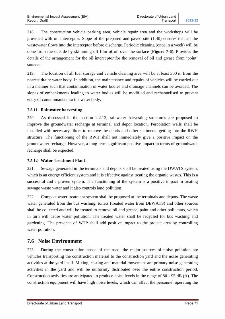
Environmental Impact Assessment (EIA) Report (Draft)
Directorate of Urban Land Transport 2011-12
Directorate of Urban Land Transport Page 71
218. The construction vehicle parking area, vehicle repair area and the workshops will be
provided with oil interceptor. Slope of the prepared and paved site (1:40) ensures that all the
wastewater flows into the interceptor before discharge. Periodic cleaning (once in a week) will be
done from the outside by skimming off film of oil over the surface (Figure 7-6). Provides the
details of the arrangement for the oil interceptor for the removal of oil and grease from ‘point’
sources.
219. The location of all fuel storage and vehicle cleaning area will be at least 300 m from the
nearest drain/ water body. In addition, the maintenance and repairs of vehicles will be carried out
in a manner such that contamination of water bodies and drainage channels can be avoided. The
slopes of embankments leading to water bodies will be modified and rechannelised to prevent
entry of contaminants into the water body.
7.5.11 Rainwater harvesting
220. As discussed in the section 2.2.12, rainwater harvesting structures are proposed to
improve the groundwater recharge at terminal and depot location. Percolation wells shall be
installed with necessary filters to remove the debris and other sediments getting into the RWH
structure. The functioning of the RWH shall not immediately give a positive impact on the
groundwater recharge. However, a long-term significant positive impact in terms of groundwater
recharge shall be expected.
7.5.12 Water Treatment Plant
221. Sewage generated in the terminals and depots shall be treated using the DWATS system,
which is an energy efficient system and it is effective against treating the organic wastes. This is a
successful and a proven system. The functioning of the system is a positive impact in treating
sewage waste water and it also controls land pollution.
222. Compact water treatment system shall be proposed at the terminals and depots. The waste
water generated from the bus washing, toilets (treated water from DEWATS) and other sources
shall be collected and will be treated to remove oil and grease, paint and other pollutants, which
in turn will cause water pollution. The treated water shall be recycled for bus washing and
gardening. The presence of WTP shall add positive impact to the project area by controlling
water pollution.
7.6 Noise Environment
223. During the construction phase of the road, the major sources of noise pollution are
vehicles transporting the construction material to the construction yard and the noise generating
activities at the yard itself. Mixing, casting and material movement are primary noise generating
activities in the yard and will be uniformly distributed over the entire construction period.
Construction activities are anticipated to produce noise levels in the range of 80 - 95 dB (A). The
construction equipment will have high noise levels, which can affect the personnel operating the
Environmental Impact Assessment (EIA) Report (Draft)
Directorate of Urban Land Transport 2011-12
Directorate of Urban Land Transport Page 72
machines. Use of proper Personal Protective Equipment (PPE) such as earmuffs will mitigate any
adverse impact of the noise generated by such equipment.
224. The noise levels in the working environment are compared with the standards prescribed
by Occupational Safety and Health Administration (OSHA-USA) which in-turn are being
enforced by Government of India through model rules framed under the Factories Act. The
acceptable limit for each shift being of 8-hour duration; the equivalent noise level exposure
during the shift is 90dB (A). Hence, noise generated due to various activities in the construction
camps may affect workers, if equivalent 8-hour exposure is more than the safety limit. ACGIH
(American Conference of Government Industrial Hygienists) proposed an 8-hour Leq limit of 85
dB (A). Exposure to impulses or impact noise should not exceed 140 dB (A) (Peak acoustic
pressure). Exposure to 10,000 impulses of 120 dB (A) is permissible per day.
225. The noise likely to be generated during excavation, loading and transportation of material
will be in the range of 90 to 105 dB (A) and this will occur only when all the equipment operate
together and simultaneously. This is however, is a remote possibility. The workers in general are
likely to be exposed to an equivalent noise level of 80 to 90 dB (A) in an 8-hour shift, for which
all statutory precautions should be taken into consideration. However, careful planning of
machinery selection, operations and scheduling of operations can reduce these levels.
226. As the project road passes through populated areas at villages and urban areas and several
sensitive receptors such as colleges and religious institutions are located along the road, people in
these places will be exposed to the high noise levels. To avoid significant impacts on human
health, it is recommended to avoid construction work at these sections during night times and
ensure that only minimum required machinery is deployed on the site.
227. Uninterrupted movement of heavy and light vehicles at high speeds may cause increase in
ambient noise levels on the project road. It may have negative environmental impacts on the
sensitive receptors close to the project road.
228. The existing noise level along the mixed traffic is between 64dB (A) - 68dB (A) in peak
hours. During the operation phase, the traffic is expected to increase by 2.77 times by 2031. As
the sound level is measured in logarithmic scale this increase in traffic will induce a minor
increase of 0.44dB(A) of noise level. The recorded sound levels near the sensitive locations are
observed to be high in comparison with the CPCB noise standards, hence provision of noise
barriers are required as an mitigation measure to control the noise levels.
MITIGATION MEASURES
7.6.1 Sensitive Receptors
229. In environmental assessment, the presence of water bodies, settlements, hospitals, temples
and institutional areas are considered as sensitive areas and suggests noise environment
mitigations during the project construction and operation to be performed. The detail of the
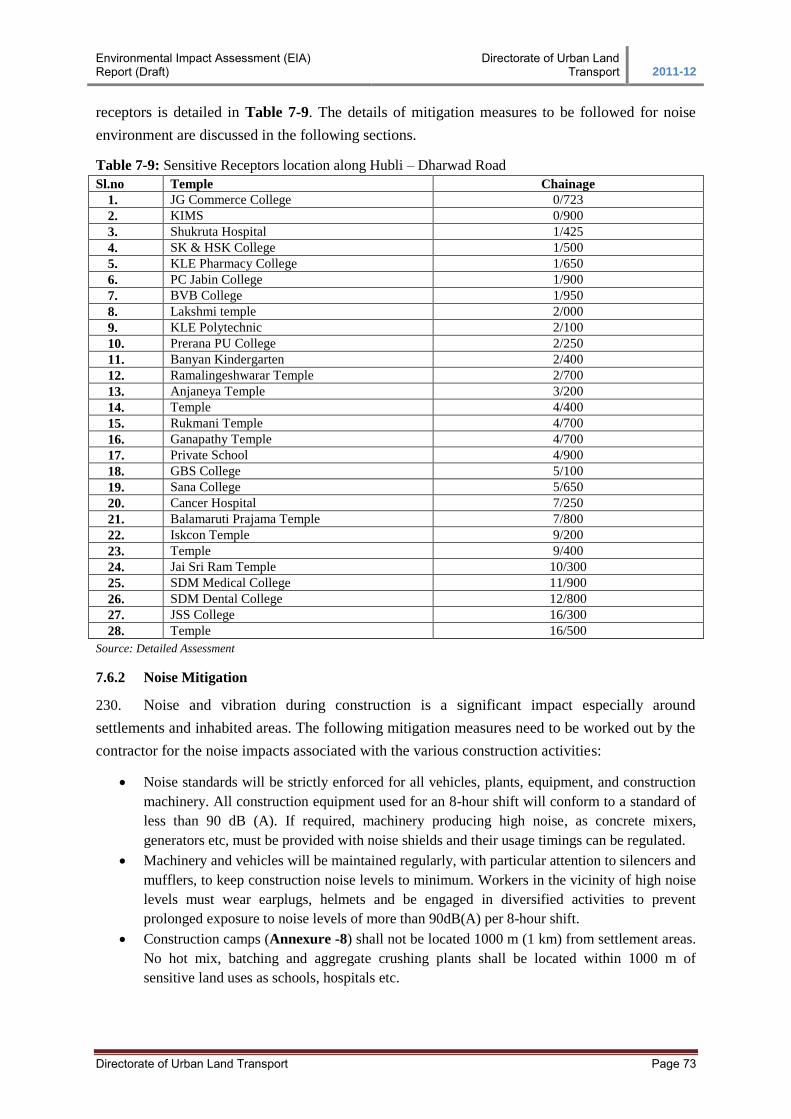
Environmental Impact Assessment (EIA) Report (Draft)
Directorate of Urban Land Transport 2011-12
Directorate of Urban Land Transport Page 73
receptors is detailed in Table 7-9. The details of mitigation measures to be followed for noise
environment are discussed in the following sections.
Table 7-9: Sensitive Receptors location along Hubli – Dharwad Road
Sl.no Temple Chainage
1. JG Commerce College 0/723
2. KIMS 0/900
3. Shukruta Hospital 1/425
4. SK & HSK College 1/500
5. KLE Pharmacy College 1/650
6. PC Jabin College 1/900
7. BVB College 1/950
8. Lakshmi temple 2/000
9. KLE Polytechnic 2/100
10. Prerana PU College 2/250
11. Banyan Kindergarten 2/400
12. Ramalingeshwarar Temple 2/700
13. Anjaneya Temple 3/200
14. Temple 4/400
15. Rukmani Temple 4/700
16. Ganapathy Temple 4/700
17. Private School 4/900
18. GBS College 5/100
19. Sana College 5/650
20. Cancer Hospital 7/250
21. Balamaruti Prajama Temple 7/800
22. Iskcon Temple 9/200
23. Temple 9/400
24. Jai Sri Ram Temple 10/300
25. SDM Medical College 11/900
26. SDM Dental College 12/800
27. JSS College 16/300
28. Temple 16/500
Source: Detailed Assessment
7.6.2 Noise Mitigation
230. Noise and vibration during construction is a significant impact especially around
settlements and inhabited areas. The following mitigation measures need to be worked out by the
contractor for the noise impacts associated with the various construction activities:
Noise standards will be strictly enforced for all vehicles, plants, equipment, and construction
machinery. All construction equipment used for an 8-hour shift will conform to a standard of
less than 90 dB (A). If required, machinery producing high noise, as concrete mixers,
generators etc, must be provided with noise shields and their usage timings can be regulated.
Machinery and vehicles will be maintained regularly, with particular attention to silencers and
mufflers, to keep construction noise levels to minimum. Workers in the vicinity of high noise
levels must wear earplugs, helmets and be engaged in diversified activities to prevent
prolonged exposure to noise levels of more than 90dB(A) per 8-hour shift.
Construction camps (Annexure -8) shall not be located 1000 m (1 km) from settlement areas.
No hot mix, batching and aggregate crushing plants shall be located within 1000 m of
sensitive land uses as schools, hospitals etc.
Environmental Impact Assessment (EIA) Report (Draft)
Directorate of Urban Land Transport 2011-12
Directorate of Urban Land Transport Page 74
Blasting when required shall be restricted to daytime hours. All the statutory laws,
regulations, rules etc, pertaining to acquisition, transport, storage, handling and use of
explosives will be strictly followed. Blasting will be carried out during fixed hours as
permitted by the Engineer.
231. Mitigation of the noise effects during the operation of the project can be effected by the
following options: (i) Modifications of the characteristics of the sources of noise generation or
(ii) Introduction of an obstruction between source and receptor.
232. As the modification of the characteristics of the vehicles / vehicle components etc, does
not fall under the purview of this project, the second option of the introduction of an obstruction
in the form of a noise barrier between the source of noise and the receptor along the road will be
adopted.
7.6.2.1 Provision of Noise Barrier
233. All the identified sensitive receptors viz. education institutions and hospitals are having
compound wall at the edge of the footpath/ road. It can be conclude that for most of the identified
sensitive receptors the existing compound wall will be lost during the land acquisition for the
proposed widening. Due to this, the sensitive receptors will be exposed to the direct sound
generated from the construction site. For construction related noise impacts, mitigation measures
are suggested in the section 7.6.2. Once the construction stage is over, the project corridor is
exposed to increasing traffic. This in turn increases the noise intensity and cause noise pollution
to the sensitive receptors. To mitigate the noise pollution, permanent noise barriers are suggested.
7.6.2.2 Type of Noise Barrier
234. It has been decided to have green barriers in addition to concrete barrier3 (compound
wall). Survey conducted at 16 different locations along the existing mixed traffic corridor shows
an intensity of 64dB (A) to 68dB (A). By 2031, with a rise of 177% of traffic as projected the
noise intensity will vary between 64.5dB (A) to 68.5dB (A). As per CPCB, the suggested noise
level at the sensitive location is 50dB (A) in day time and 40dB (A) in night time. Hence, there is
a need to attenuate the noise level ranging from 14.5 dB (A) to 18.5 dB (A).
235. Attenuation of sound can be achieved by selection of type of noise barrier and exact
height. To estimate the height of the noise barrier, Fresnel principle/ numbers and Pythagorean
theory are used for calculation. Following Table 7-10 depicts the actual height required near the
sensitive receptors to attenuate the noise level. The formula used for calculating barrier height is
N = 2 d / λ and Pythagorean theory : a2+b
2=c
2.
3 As per the discussion/ consultation had with the key members of the education institutions and hospitals, it can be
concluded that all the sensitive receptors shall have new compound wall (loss of existing compound wall due to Land
Acquisition). This has been decided in due care of safety of the students and local people visiting hospitals.

Environmental Impact Assessment (EIA) Report (Draft)
Directorate of Urban Land Transport 2011-12
Directorate of Urban Land Transport Page 75
Table 7-10: Noise Barrier required at Sensitive Location
Sr.
No. Location Name
Chainage
(L/R)
Setback
Proposed RoW
Edge (m)
Predicted
Noise levels
dB (A)
Noise level for
Sensitive
location dB (A)
Noise to be
attenuated
dB (A)
Height of the
Noise barrier
required (m)
1 JG Commerce College 0+723 - L 25.0 66.44 50 16.44 1.14
2 KIMS 0+900 - R 356.0 64.44 50 14.44 1.00
3 Shukruta Hospital 1+425 - L 6.0 66.44 50 16.44 1.63
4 SK & HSK College 1+500 - R 19.5 65.44 50 15.44 1.16
5 KLE Pharmacy College 1+650 - R 22.0 65.44 50 15.44 1.15
6 P C Jabin College 1+800 - R 35.0 66.44 50 16.44 1.00
7 BVB College 1+950 - R 125.0 68.44 50 18.44 1.00
8 KLE Polytechnic 2+100 - R 56.0 67.44 50 17.44 1.00
9 Prerana PU College 2+250 - R 51.0 64.44 50 14.44 1.00
10 Banyan Kindergarten 2+400 - R 30.0 64.44 50 14.44 1.10
11 Sana College 5+650 - L 26.0 64.44 50 14.44 1.12
12 Cancer Hospital 7+250 - L 57.0 66.44 50 16.44 1.05
13 SDM Medical College 11+900 - R 38.0 64.44 50 14.44 1.07
14 SDM Dental 12+800 - L 59.0 66.44 50 16.44 1.05
15 JSS College 16+300 - R 33.0 66.44 50 16.44 1.10
Source: CEPT Estimation, 2012
236. From the observation, it can be concluded that concrete wall of 1.0 to 2.0m is found to be
more than sufficient in attenuating the increased noise level. In addition to this, green barrier
(avenue trees, shurbs etc.,) are suggested as a landscaping measure along the sensitive location.
The following Figure 7-7 and Figure 7-8 shows the concept behind the selection of noise barrier.
The cost of the green barriers forms part of the project cost. Hence, not reflected in the EMP cost.
Figure 7-7: Typical Concept behind the provision of Green Barrier and Concrete Barrier
237. Species of trees recommended for landscaping considering local climate, soil condition
and to reduce noise intensity are:
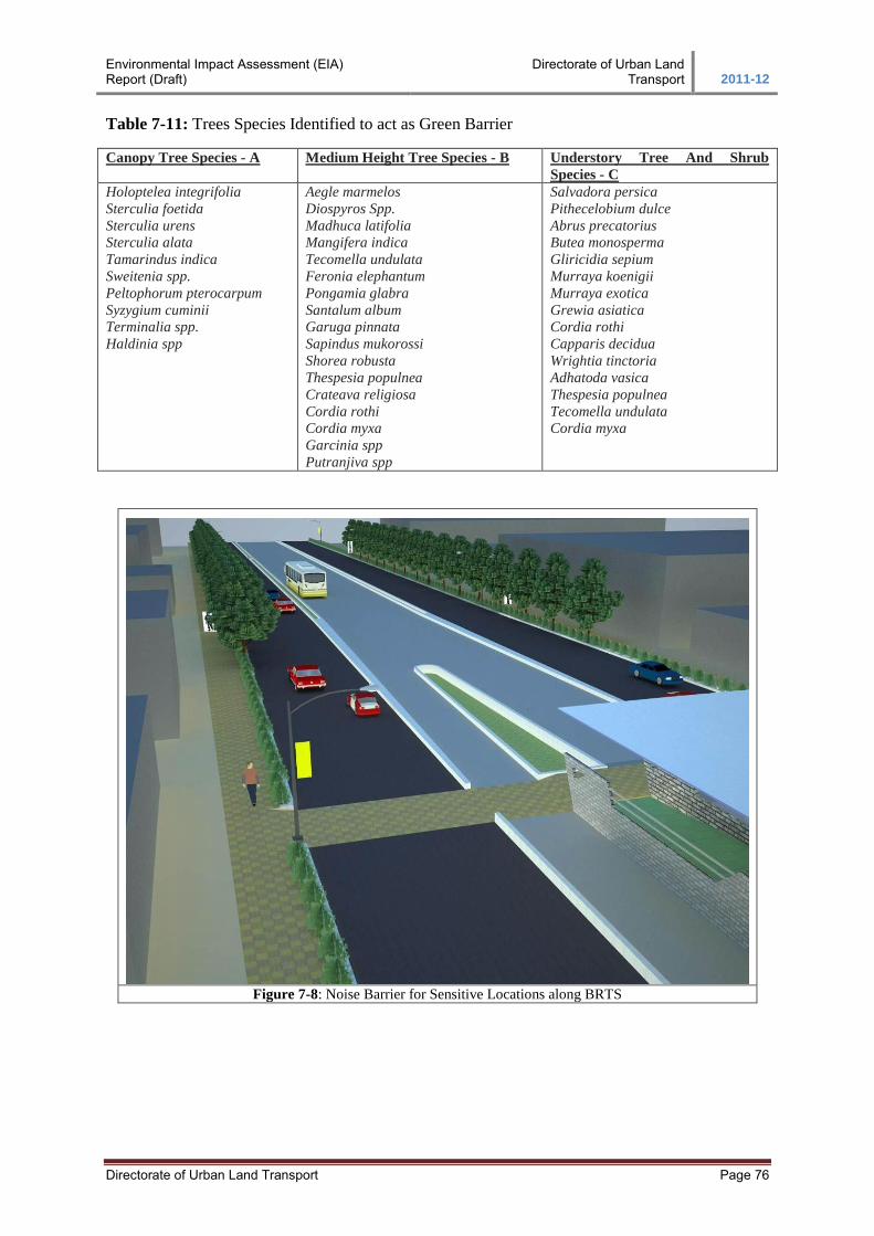
Environmental Impact Assessment (EIA) Report (Draft)
Directorate of Urban Land Transport 2011-12
Directorate of Urban Land Transport Page 76
Table 7-11: Trees Species Identified to act as Green Barrier
Canopy Tree Species - A Medium Height Tree Species - B Understory Tree And Shrub
Species - C
Holoptelea integrifolia
Sterculia foetida
Sterculia urens
Sterculia alata
Tamarindus indica
Sweitenia spp.
Peltophorum pterocarpum
Syzygium cuminii
Terminalia spp.
Haldinia spp
Aegle marmelos
Diospyros Spp.
Madhuca latifolia
Mangifera indica
Tecomella undulata
Feronia elephantum
Pongamia glabra
Santalum album
Garuga pinnata
Sapindus mukorossi
Shorea robusta
Thespesia populnea
Crateava religiosa
Cordia rothi
Cordia myxa
Garcinia spp
Putranjiva spp
Salvadora persica
Pithecelobium dulce
Abrus precatorius
Butea monosperma
Gliricidia sepium
Murraya koenigii
Murraya exotica
Grewia asiatica
Cordia rothi
Capparis decidua
Wrightia tinctoria
Adhatoda vasica
Thespesia populnea
Tecomella undulata
Cordia myxa
Figure 7-8: Noise Barrier for Sensitive Locations along BRTS
Environmental Impact Assessment (EIA) Report (Draft)
Directorate of Urban Land Transport 2011-12
Directorate of Urban Land Transport Page 77
7.7 Biological Environment
7.7.1 Forest Area
238. As discussed in section 4.2.8, the proposed BRTS project doesn’t have forest / reserved
forest areas in the corridor. Hence anticipating impact on Forest area is not envisaged.
7.7.2 Wild Life
239. There are no threatened / endangered animals in the project corridor. The public
consultation and the secondary information reveals that few animals namely cat - Felis chaus,
squirrels - Funambulus pennant, Hare - Lepus nigricollis nigricollis, Common mongoose -
Harpestes edwardsi, Common rat snake - Ptyas mucosus and Green whip snake - Ahaetulla
nasutus are the common seen/ available in the project area. Most of the listed animals are night
dwellers, hence construction activities in day time doesn’t have any impact on animals of project
corridor.
7.7.3 Tree Cutting
240. Trees falling within the RoW shall be cut. As per detailed assessment 1750 trees, out of
which 10% are fruit bearing will be affected due to the project. The tree species are mostly
Banyan trees (Ficus benghalensis), Eucalyptus (E.angophoroides), Common Fig tree (F. carica),
Plantain (Musa paradisiaca), coconut trees (Cocos nucifera), sal (Shorea robusta), Teak (Tectona
grandis), bamboo trees (graminaceous plant), Pine (Pinus pinea) and Mango tree (Mangifera
indica).
7.7.4 Removal of Vegetation
241. Existing road side vegetation and agriculture area are likely to get impact due to the
BRTS proposal. The portion falling within the RoW will be fully utilised for widening purpose,
which leads to a permanent impact on vegetation. However, the suggested landscaping will
mitigate the loss of vegetation.
MITIGATION MEASURES
7.7.5 Forest Area
242. There is no forest area identified within/ surrounding project corridor, it is evident from
the reconnaissance survey and secondary information’s collected from Forest Department and
Survey of India.
7.7.6 Wild Life
243. There is no wildlife recorded in the project area, however, the construction and operation
phase of the project doesn’t possess threat to other faunal population available. There are no
endangered species reported in the site and hence, no impacts are anticipated and mitigation
measures are not required.
Environmental Impact Assessment (EIA) Report (Draft)
Directorate of Urban Land Transport 2011-12
Directorate of Urban Land Transport Page 78
7.7.7 Trees and Vegetation
244. Though no endangered flora exists within the project area, trees within the road Right of
Way need to be cleared for construction of the road. As per assessment and inventory
approximately 1750 trees, out of which 10% are fruit bearing trees will be affected due to the
project. As a compensatory measure, 200 trees per km are proposed to be planted along the
corridor. Accordingly, KRDCL has deposited Rs 27.24 Lakhs with Forest Department for the
said purpose.
245. The roadside landscaping suggested aims at not only providing shade but also improving
the aesthetic quality of the road. 1296 trees are suggested for all infrastructure sites (except CBT
due to space constraints) so as to maintain visual characteristics and uniformity in terms of
landscape.
Sl.no Infrastructure Site Trees to be planted within proposed
landscape area
1. CBT Hubli 0
2. Hubli OCBS - Ranichennamma 239
3. BRTS Deport Hubli – Airport Road 260
4. Divisional Workshop - Hubli 210
5. Depot and Regional Terminal at Hosur Circle 342
6. BRT Depot Dharwad 167
7. OCBS Dharwad 78
Total 1296 Source: Design
7.8 Socio-Economic Environment
7.8.1 Fear of Uncertainties Regarding Future
246. These normally become long lived, given the length of time, which elapses between
initial surveys and commencement of construction. Land and property owners are subjected to
sufferings regarding uncertainties of the extent of loss and the nature of compensation. These
involve:
Uncertainty of the amount of land/property to be acquired,
Time of acquisition and evacuation,
Extent and amount compensation,
Provision of alternative land or job, etc.
7.8.2 Inducement of Land Prices
247. Once the project becomes common knowledge, there may be an incidence of
unscrupulous speculators moving in to purchase land at what might seem to be advantageous
prices, prior to the commencement of the official procedures. Such impact is more likely to occur
in the case of urban fringe areas during the design and pre-construction phase.
Environmental Impact Assessment (EIA) Report (Draft)
Directorate of Urban Land Transport 2011-12
Directorate of Urban Land Transport Page 79
7.8.3 Inducement of Squatter Influx
248. Squatters may attempt to occupy land along and adjacent to the proposed alignments, in
the hope of receiving compensation or some other inducements to leave when construction
commences. Such squatters could cause undue pressure on local resources such as water and
firewood, which could result in conflicts with those who are harvesting the resources presently.
7.8.4 Loss of Utilities and Amenities
249. Site clearance involves removal of various assets, utilities and amenities that are:
Natural (trees, bushes and grasslands), and
Physical structures (public or private assets and utilities)
Relocation of utilities like electricity, water and telephone lines
250. For people dependent on the above, this constitutes economic loss for some time before
these are restored to their previous status. These have been further discussed in the RAP.
7.8.5 Public Health and Safety
251. Impacts on Public health and safety may arise during the phases of pre-construction,
construction and operation phases. During the pre-construction and construction phases,
dismantling of the structures for CoI clearance and road construction activities may result in the
following health hazards:
Dismantling of properties has psychological impacts on their owners and others associated
with them.
Debris generated on account of the above mentioned activities.
Labour Camps during construction period can bring the following problems.
In the case of non-local labour (if so is arranged by the contractor), labour camps are set up at
one or more sites adjacent to the alignment, and at some ancillary sites, like aggregate
quarries. These labourers hired from outside can have clashes with the local population on
account of cultural and religious differences. The influx of a large work force to an area,
already hard pressed for basic services (medical services, power, water supply, etc.), can
impose additional stress on these facilities.
If alternative fuels are not made available to the workforce, there is a likelihood that trees will
be cut down for cooking or heating purposes.
In sanitary conditions in the labour camps might also result in impact on health of labourers
as well as the local population. Transmission of diseases is also facilitated by the migration of
people. During the construction phase work, crews and their dependents may bring with them
a multitude of communicable diseases including sexually transmitted diseases (STDs) like
AIDS. This is more so if the nature of the project requires more male-workers, who have
migrated from other parts of the state or country.
252. Allied activities during construction period may cause local disruption.
During road construction allied activities like quarrying and crushing operations, traffic
diversions, etc., may cause disruption of social and economic life of the local population of
the nearby areas.
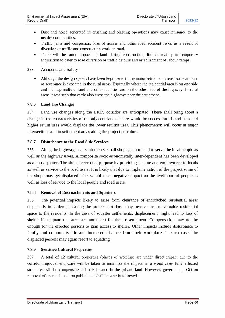
Environmental Impact Assessment (EIA) Report (Draft)
Directorate of Urban Land Transport 2011-12
Directorate of Urban Land Transport Page 80
Dust and noise generated in crushing and blasting operations may cause nuisance to the
nearby communities.
Traffic jams and congestion, loss of access and other road accident risks, as a result of
diversion of traffic and construction work on road.
There will be some impact on land during construction, limited mainly to temporary
acquisition to cater to road diversion or traffic detours and establishment of labour camps.
253. Accidents and Safety
Although the design speeds have been kept lower in the major settlement areas, some amount
of severance is expected in the rural areas. Especially where the residential area is on one side
and their agricultural land and other facilities are on the other side of the highway. In rural
areas it was seen that cattle also cross the highways near the settlement.
7.8.6 Land Use Changes
254. Land use changes along the BRTS corridor are anticipated. These shall bring about a
change in the characteristics of the adjacent lands. There would be succession of land uses and
higher return uses would displace the lower returns uses. This phenomenon will occur at major
intersections and in settlement areas along the project corridors.
7.8.7 Disturbance to the Road Side Services
255. Along the highway, near settlements, small shops get attracted to serve the local people as
well as the highway users. A composite socio-economically inter-dependent has been developed
as a consequence. The shops serve dual purpose by providing income and employment to locals
as well as service to the road users. It is likely that due to implementation of the project some of
the shops may get displaced. This would cause negative impact on the livelihood of people as
well as loss of service to the local people and road users.
7.8.8 Removal of Encroachments and Squatters
256. The potential impacts likely to arise from clearance of encroached residential areas
(especially in settlements along the project corridors) may involve loss of valuable residential
space to the residents. In the case of squatter settlements, displacement might lead to loss of
shelter if adequate measures are not taken for their resettlement. Compensation may not be
enough for the effected persons to gain access to shelter. Other impacts include disturbance to
family and community life and increased distance from their workplace. In such cases the
displaced persons may again resort to squatting.
7.8.9 Sensitive Cultural Properties
257. A total of 12 cultural properties (places of worship) are under direct impact due to the
corridor improvement. Care will be taken to minimize the impact, in a worst case/ fully affected
structures will be compensated, if it is located in the private land. However, governments GO on
removal of encroachment on public land shall be strictly followed.
Environmental Impact Assessment (EIA) Report (Draft)
Directorate of Urban Land Transport 2011-12
Directorate of Urban Land Transport Page 81
Figure 7-9: Temple at Km 3/200 Figure 7-10: Mosque at Km5/300
Table 7-12: Cultural Properties along the project corridor
Sl.no Temple Chainage
1. Lakshmi Temple 2/000
2. Ramalingeshwarar Temple 2/700
3. Anjaneya Temple 3/200
4. Temple 4/400
5. Rukmani Temple 4/700
6. Ganapathy Temple 4/700
7. Mosque 5/300
8. Balamaruti Prajama Temple 7/800
9. Iskcon Temple 9/200
10. Temple 9/400
11. Jai Sri Ram Temple 10/300
12. Temple 16/500 Source: socio- economic survey
MITIGATION MEASURES
7.8.10 Fear of Uncertainties Regarding Future
258. The project is only of upgradation of the existing road, and within the confines of the
existing RoW, the fear of uncertainties is most likely limited to the people squatting and
encroaching in the RoW. At places where the community utilities are to be affected a certain
amount of anxiety will be among the people in that particular community. To remove such fear
from the people, public participation sessions were/will be conducted in different stages of
project, viz. pre-design, design, pre-construction and construction.
259. In the pre-design stage, a comprehensive socio-economic survey (Annexure - 9) was
conducted to prepare baseline status of the households squatting or encroached upon the RoW.
During the survey each households were contacted/interviewed and they were explained about
the purpose of the survey, need of the project and benefits associated with the project etc.
260. The second stage of public participation was in the form of village meetings, focus group
discussion, individual interviews, voluntary and academic institution consultation. The third stage
of participation session will start before pre-construction. The SPV/ KRDCL will verify and
consult the individual PAPs with the help of RAP consultant for distribution of ID card. At this
stage the PAPs will be explained about their entitlement and R&R framework.
Environmental Impact Assessment (EIA) Report (Draft)
Directorate of Urban Land Transport 2011-12
Directorate of Urban Land Transport Page 82
261. People likely to be displaced will be informed in advance through RAP consultant by a
time bound programme about resettlement to remove fear of uncertainty. During the construction
stage the consultation process will continue to avoid any inconvenience to the community at any
point of time.
7.8.11 Inducement of Land Prices
262. As the project becomes common knowledge, the land prices along the corridor will
increase to some extent. For geometric improvement of highway, extra additional land may be
required; KRDCL will decide the actual cost of such land. The actual cost of land may be
different from induced land cost.
7.8.12 Inducement of Squatter Influx
263. Once the project becomes common knowledge, people may attempt to occupy the land
along the corridor in anticipation of compensation. To avoid such, the dates of base-line socio-
economic survey have been considered as cutoff date for identification of project affected people,
who are eligible for compensation. The cut off dates will be used to establish whether a person
located in the right way qualifies as a PAP for the disbursement of compensation. All the PAPs
recorded during socio-economic baseline survey are eligible for compensation after verification
by SPV/ KRDCL.
7.8.13 Loss of Utilities and Amenities
264. The site clearance for construction of road may result in loss or relocation of certain
utilities and amenities, viz. electricity, water and telephone line etc. People dependent upon these
utilities and amenities may experience inconvenience and economic loss. Though such impacts
are unavoidable keeping in mind the scale of work, but every care will be taken in co-ordination
with concerned departments, to restore the facility within shortest possible time to avoid any
prolonged hardship or inconvenience to the community. Similarly other utilities like water source
etc. will be constructed or replaced at appropriate place with the consent of community prior to
dismantling the existing one.
7.8.14 Public Health and Safety
265. During the Pre-construction and Construction Phases dismantling of the structures for CoI
clearance and road construction may result in health hazards. To minimise this potential negative
impact the following recommendations should be adopted:
To avoid the psychological impacts due to the demolition of properties on the owners and
other tenants. The advance notice as per RAP will be given to the owners of the affected
properties. An advance notice will be served at least four months before construction
commences. For squatters needing relocation, all R&R activities will be undertaken and
entitlements will be completed before construction starts.
Debris generated from the demolition of properties will be properly disposed of to avoid the
health problems in the safeties. Earth material, if required will be dumped in borrow areas as
Environmental Impact Assessment (EIA) Report (Draft)
Directorate of Urban Land Transport 2011-12
Directorate of Urban Land Transport Page 83
approved by the engineer. Borrow areas will be filled to avoid health hazards from stagnant
water collecting in these areas. The contractor will make all arrangements for dismantling and
cleaning up of debris. Implementation will be as per the approval and direction of the
engineer.
266. During the construction period the potential negative community impacts arising from
imported labour in the labour camps will be avoided as per following: -
All contractors will be encouraged to recruit the local people as labourer at least for unskilled
and semi-skilled jobs. This would automatically reduce the magnitude of impact expected due
to outside labour. Wherever the local labourers are not available the contractor should ensure
the following provision for imported labour
The additional stress on the facilities like medical services, power, water supply due to a
labour camp in a local area will be avoided by the contractor providing these facilities for the
labourers as per the direction of the Engineer
In areas where environment resources are abundant, construction workers shall be instructed
how to protect natural resources, fauna, flora and aquatic life. In such areas hunting and
unauthorised fishing are prohibited
In the labour camps, all temporary accommodation must be constructed and maintained in
such a fashion that uncontaminated water is available for drinking, cooking and washing
267. Allied activities during construction period may cause local disruption:
In the construction phase, there may be inconvenience to the local people as well as the
highway passengers due to traffic jams and congestion, loss of access and other road accident
risk as a result of construction. Detailed traffic control plans shall be prepared and submitted
to the engineer for approval 5 days prior to commencement of work on any section of road. In
the preparation of the traffic control plan special consideration shall be given to the safety of
pedestrians and workers at night.
268. Accidents and Safety
To avoid the accidents during construction phase, contractor shall take all necessary measures
to ensure traffic safety. The contractor will provide, erect and maintain barricades, including
signs marking flags lights and flagmen as required by the Engineer.
In the operation phase, traffic control measures such as speed breakers and sign boards
(including speed limits) will be provided and strictly enforced in residential areas, near
schools and water bodies like ponds and wells.
7.8.15 Landuse of Changes
269. As regards land use changes, it is likely that the impact would be very minimal. Since the
project is upgradation/ widening of road within the available ROW, the possibility of major land
acquisition is not envisaged. In design stage utmost care has been taken to keep the land
acquisition at minimal for road realignment and geometric purpose. The probable impact on road-
side business and trees within ROW has been reduced and avoided through design.
Environmental Impact Assessment (EIA) Report (Draft)
Directorate of Urban Land Transport 2011-12
Directorate of Urban Land Transport Page 84
7.8.16 Disturbance to the Road Side services
270. Along the highway, near settlements, small shops serve the local people as well as
highway users. Some of these shops are within the RoW. To avoid any impact on livelihood of
people dependent on roadside business, the cleaning of such informal establishment will be
carried out as phase-wise resettlement programme. Loss of livelihood of the displaced shop
owners will be compensated as per assistance or entitlements in Entitlement Framework.
7.8.17 Removal of Encroachments and Squatters
271. The impact due to removal of encroachments and squatters will be avoided by
implementation of phase-wise resettlement action programme. To avoid the severance of impact,
advance notice will be given to the encroachers and squatters. The notice will be given three
months prior to construction phase starts. Relocation of all such impacted persons will be as per
R&R schedule.
7.8.18 Sensitive Culture Properties
272. The impacts due to project on the sensitive community facilities or institution along the
project corridor such as education institution, health facilities and others like ponds and cultural
community assets are avoided to maximum extent in the design phase of the project. For affected
sensitive communities, compensation as per assistance (or) entitlements in Entitlement
Framework.
7.8.19 Avoidance of Disruption and Safety Risks during the Construction Stage
7.8.19.1 Loss of Access
273. At all times, the Contractor will provide safe and convenient passage for vehicles,
pedestrians and livestock to and from side roads and property accesses connecting the project
road. Work that affects the use of side roads and existing accesses will not be undertaken without
providing adequate provisions.
274. The works will not interfere unnecessarily or improperly with the convenience of public
or the access to, use and occupation of public or private roads, railways and any other access
footpaths to or of properties whether public or private.
7.8.19.2 Traffic Jams, Congestion and Safety
275. Detailed Traffic Control Plans will be prepared prior to commencement of works on any
section of road. The traffic control plans will contain details of temporary diversions, details of
arrangements for construction under traffic and details of traffic arrangement after cessation of
work each day.
276. Temporary diversion (including scheme of temporary and acquisition) will be constructed
with the approval of the Engineer. Special consideration will be given in the preparation of the
traffic control plan to the safety of pedestrians and workers at night.
Environmental Impact Assessment (EIA) Report (Draft)
Directorate of Urban Land Transport 2011-12
Directorate of Urban Land Transport Page 85
277. The Contractor will ensure that the running surface is always properly maintained,
particularly during the monsoon so that no disruption to the traffic flow occurs. The temporary
traffic detours will be kept free of dust by frequent application of water, if necessary.
278. The Contractor will take all necessary measures for the safety of traffic during
construction and provide, erect and maintain such barricades, including signs, markings, flags,
lights and flagmen as may be required by the Engineer for the information and protection of
traffic approaching or passing through the section of the highway under improvement.
7.8.20 Safety of the Workers
279. Risk from operations: The Contractor is required to comply with all the precautions as
required for the safety of the workmen as per the International Labour Organisation (ILO)
Convention No. 62 as far as applicable to the contract. The contractor will supply all necessary
safety appliances such as safety goggles, helmets, masks, etc., to the workmen. The contractor
has to comply with all regulation regarding safe scaffolding, ladders, working platforms,
gangway, stairwells, excavations, trenches and safe means of entry and egress.
280. Risk from electrical equipment: Adequate precautions will be taken to prevent danger
from electrical equipment. No material at any of the sites will be so stacked or placed so as to
cause danger or inconvenience to any person or the public. All necessary fencing and lights will
be provided to protect the public. All machines to be used in the construction will conform to the
relevant Indian Standards (IS) codes, be free from patent defect, in good working order and will
be regularly inspected and properly maintained as per IS provisions and to the satisfaction of the
Engineer.
281. Risk at hazardous activity: All workers employed on mixing asphaltic material, cement,
concrete etc., will be provided with protective footwear and protective goggles. Workers, who are
engaged in welding works, would be provided with welder’s protective eye-shields. Workers
engaged in stone breaking activities, will be provided with protective goggles and clothing and
will be seated at sufficiently safe intervals.
282. The use of any herbicide or other toxic chemical will be strictly in accordance with the
manufacturer’s instructions. The Engineer will be given at least 6 working days’ notice of the
proposed use of any herbicide or toxic chemical. A register of all herbicides and other toxic
chemicals delivered to the site will be kept and maintained up to date by the Contractor. The
register will include the trade name, physical properties and characteristics, chemical ingredients,
health and safety hazard information, safe handling and storage procedures, and emergency and
first aid procedures for the product.
283. Risk of lead pollution: No man below the age of 18 years and no woman will be
employed on the work of painting with products containing lead in any form. No paint containing
lead or lead products will be used except in the form of paste or readymade paint. Face masks
Environmental Impact Assessment (EIA) Report (Draft)
Directorate of Urban Land Transport 2011-12
Directorate of Urban Land Transport Page 86
will be supplied for use by the workers when paint is applied in the form of spray or a surface
having lead paint is dry rubbed and scrapped.
284. Risk caused by force de majure: All reasonable precaution will be taken to prevent
danger of the workers and the public from fire, flood, drowning, etc. All necessary steps will be
taken for prompt first aid treatment of all injuries likely to be sustained during the course of work.
285. Risk from explosives: Except as may be provided in the contract or ordered or authorized
by the Engineer, the Contractor will not use explosives. Where the use of explosives is so
provided or ordered or authorized, the Contractor will take every possible precaution. He will
comply with appropriate laws and regulations relating to the import, handling, transportation,
storage and use of explosives and will, at all times when engaged in blasting operations, post
sufficient warning flagmen, to the full satisfaction of the Engineer.
286. The Contractor will at all times make full liaison with and inform well in advance and
obtain such permission as is required from all government authorities, public bodies and private
parties who so ever concerned or affected or likely to be concerned or affected by blasting
operations.
287. Malarial risk: The Contractor will, at his own expense, conform to all anti-malarial
instructions given to him by the Engineer; including filling up any borrow pits which may have
been dug by him. Gravid, blood-laden mosquitoes cannot fly very far, so they generally bite
within a kilometer or so of their breeding place. Thus borrow pits and any other water bodies
created during the construction process should be situated 1 to 2 km away from the human
settlements. Pits dug up closer than these will be adequately drained to prevent water logging.
288. Similarly compensatory measures for filling up part of the water bodies situated adjacent
to the project corridors will be directed towards deepening of the water bodies concerned. This
way the capacity of the water body remains the same, while water surface available for breeding
of mosquitoes is reduced. This will have an additional advantage of decreased evaporation losses.
289. First aid: At every workplace, a readily available first aid unit including an adequate
supply of sterilized dressing material and appliances will be provided as per the Factory Rules of
Tamil Nadu. Workplaces remote and far away from regular hospitals will have indoor heath units
with one bed for every 250 workers. Suitable transport will be provided to take injured or ill
person(s) to the nearest hospital. At every workplace an ambulance room containing the
prescribed equipment and nursing staff will be provided.
290. Potable water: In every workplace, at suitable and easily accessible places, a sufficient
supply of cold potable water (as per IS) will be provided and maintained. If the drinking water is
obtained from an intermittent public water supply then, storage tanks will be provided. All water
supply storage will be at a distance of not less than 15m from any latrine, drain or other source of
pollution.
Environmental Impact Assessment (EIA) Report (Draft)
Directorate of Urban Land Transport 2011-12
Directorate of Urban Land Transport Page 87
291. Where water has to be drawn from an existing well, which is within such proximity of
any latrine, drain or any other source of pollution, the well will be properly chlorinated before
water is drawn from it for drinking water. All such wells will be entirely closed in and be
provided with a trap door, which will be dust proof and waterproof. A reliable pump will be fitted
to each covered well. The trap door will be kept locked and opened only for cleaning or
inspection, which will be done at least once a month.
292. Sanitation Facilities: There will be provided within the precincts of every workplace,
latrines and urinals in an accessible place, and the accommodation, separately for each for these,
as per standards set by the Building and other Construction Workers (regulation of Employment
and Conditions of Service) Act, 1996. Except in workplaces provided with water-flushed latrines
connected with a water borne sewage system, all latrines will be provided with dry-earth system
(receptacles) which will be cleaned at least four times daily and at least twice during working
hours and kept in a strict sanitary condition. Receptacles will be tarred inside and outside at least
once a year. If women are employed, separate latrines and urinals, screened from those for men
and marked in the vernacular language will be provided. There will be adequate supply of water,
close to latrines and urinals.
293. Unless otherwise arranged for by the local sanitary authority, arrangement for disposal of
excreta will be made through anaerobic decomposition. Excreta will be disposed of by putting a
layer of night soils at the bottom of a permanent tank prepared for the purpose and covering it
with 15 cm layer of waste or refuse and then covering it with a layer of earth for a fortnight (by
then it will turn into manure).
7.8.21 Safety Measures during Operation Stage
294. Traffic safety measures are inbuilt into the project design and specifications. These would
take care of the safety aspects in the operation stage. Following components are provided with
safety aspects in view.
Foot paths are provided throughout the cross section for urban area
Non-motorized vehicles are stream lined to travel in a separate lane
Local traffic will be stream lined to travel in service road
Specify speed limit and de-restriction signs at the entry and exit to each urban or village area,
which has street lighting. These signs will be shown on the road plans and will be subject to
local agreement or modification prior to erection.
Provide cattle crossings where there is a need for a cattle crossing
7.9 Solid Waste Management
295. Waste materials have the potential to cause adverse environmental impacts during
generation, storage, transport and disposal. The principal adverse effects relate to dust, water
quality, general health and safety and visual impacts. It is estimated that about 9,837cu.m of
Spoil, overburden or mine wastes, 15005.5 cu.m of silt (tank deepening) from Rayapura Tank and
about 11,862 cu.m of Construction or demolition wastes debris will be generated during the entire
Environmental Impact Assessment (EIA) Report (Draft)
Directorate of Urban Land Transport 2011-12
Directorate of Urban Land Transport Page 88
road construction period. The municipal solid waste generated from the construction camp and
labour camp is estimated to be 100kg/day. For each anticipated waste category, the potential
environmental impacts are highlighted and appropriate mitigation measures/disposal options
recommended below.
Avoiding and/or minimising waste generation where practical by improvements or changes in
the project design or site procedures;
Reusing/recycling/recovering materials where possible and thereby negating / minimising
disposal requirements (e.g. by waste segregation according to type, separation of recyclable
materials such as metal, reuse of wood from site hoarding/concrete formwork, utilisation of
excavated material for filling or landscaping)
Ensuring that all treatment and disposal options comply with best practice and all relevant
guidelines and legislation.
296. The following specific measures should therefore be adopted during the detailed design
and construction stages of the project to minimise waste generation:
Detailed Design
Minimizing excavation requirements as far as possible.
Balancing cut and fill requirements.
Evaluating the potential for maximizing the re-use of excavated materials for example, within
landscape mounds.
Considering treatments for unsuitable excavated materials e.g. upgrading of subsoil to top
soils by mixing with compost.
Providing an area within the construction site to allow for sorting and segregation of
materials.
Construction
Segregating waste materials according to type to facilitate re-use and recycling.
Separation of inert construction and demolition materials for either re-use on-site or use as
public fill.
During demolition works, segregating materials at source as far as practical.
Co-ordinate material deliveries to site in order to minimize storage times on site and the
likelihood of causing damage.
Consider on site mulching of vegetation to reduce bulk and review opportunities for possible
use within landscaping areas.
Training site staff in waste minimization practices.
297. In accordance with good practice, accurate site records should be maintained throughout
the construction works detailing the quantities of materials; a) generated on site; b) reused on site;
and c) disposed off site, together with disposal routes/locations.
7.9.1 Wastes Generated from Site Clearance and Excavated Materials
298. All materials should be re-used or transported off site as soon as possible to minimize the
potential for adverse environmental impacts. It is recognized that some stockpiling of materials
Environmental Impact Assessment (EIA) Report (Draft)
Directorate of Urban Land Transport 2011-12
Directorate of Urban Land Transport Page 89
will be required in some instances although these should be segregated in terms of material type
as far as practical to facilitate material re-use (i.e. top soil for landscaping, suitable fill for
engineering works).
299. All excavated material should be handled in a manner that minimises the release of
fugitive dust (especially during hot and dry weather) and where possible the movement of
material should be kept to a minimum. Within the stockpile area, the following measures should
be in place to control potential impacts.
Covering material during heavy rainfall;
Using dust suppression techniques (such as dampening with fine water spray and covering
with tarpaulin);
Controlling the excessive use of water during spraying to prevent the generation of runoff
contaminated with elevated levels of suspended solids;
Segregation of the surface water system for the stockpile area and the fitting of silt traps
where appropriate;
Locating stockpiles to minimize potential visual impacts;
Minimizing land intake of stockpile areas as far as possible;
Provide fencing within designated areas to separate sensitive habitats and prevent stockpiling
in unsuitable locations; and designate appropriate haulage roads.
300. A reduction in the total volume of excavated materials requiring offsite disposal will be
achieved as far as possible by optimizing the re-use of suitable material on-site. Both excavated
material which cannot be re-used on site and inert construction and demolition materials will
require disposal at low lying areas.
7.9.2 Inert Construction and Demolition Material
301. Inert construction and demolition materials such as wood and metal should be separated
out from other materials for recycling. All recyclable material should be clearly segregated and
stored in appropriate skips/containers or stockpiled. Segregation of material will aid in the
potential for re-use of material and in final disposal, if necessary. Material recycling or re-use
reduces both the need for new construction materials and subsequent collection, transportation
and disposal costs. Only when materials cannot be reused should they be disposed of to filling
areas.
7.9.3 Chemical Wastes
302. Chemical waste, as defined in the Hazardous Wastes (Management and Handling)
Amendment Rules, 2000, will require disposal by appropriate and approved means. Potential
hazards associated with the inappropriate handling of these materials include:
Effects on human health (i.e. dermal and toxic effects with respect to site workers);
Phototoxic effects to vegetation;
Contamination of the soil, groundwater’s and surface water following spillage;
Risk of fire or explosions; and
Environmental Impact Assessment (EIA) Report (Draft)
Directorate of Urban Land Transport 2011-12
Directorate of Urban Land Transport Page 90
Discharge of chemical wastes to sewer and potential disruption of the sewage treatment
works.
303. Chemical wastes should be stored in a locked, fully bunded area which is impermeable to
both water and the waste being stored. The waste storage area should also be covered to prevent
rainfall from accumulating within the bunded areas. The bunded area must have a volume of
either 110% of the largest container or 20% by volume of the chemical waste stored in that area.
Appropriate spill absorption material should be stored near the storage area in order to clean up
any minor spill events. The risks associated with chemical waste storage and handling can be
further minimized by:
Designation of an appropriate, well ventilated storage area;
Minimization of waste production and recycling/reprocessing for certain waste liquids where
appropriate (e.g. oils, solvents);
Careful handling of waste fuel and oil residues;
Use of appropriate and labelled (Hindi and English) storage containers;
Storage of wastes remote from sensitive receivers (e.g. drains, residential properties and water
bodies); and
Education of workers on the concepts of site cleanliness and appropriate waste management
procedures.
7.9.4 Municipal Waste
304. Municipal wastes generated by site workers have a potential to cause impacts in terms of
nuisance, insects and vermin. This may give rise to adverse environmental impacts for both site
workers and site neighbours which could include:
Odour nuisance if putrescible material is not collected on a frequent basis;
Wind-blown material causing litter problems;
Vermin and pests in the waste storage area if it is not well maintained and cleaned regularly;
and
Adverse visual impacts.
305. A temporary refuse collection facility should be set-up by the contractor and wastes
should be stored in appropriate containers prior to collection and disposal. A private waste
collection firm may be commissioned by the site contractor to remove the waste regularly (daily
basis), to the satisfaction of the Engineer.
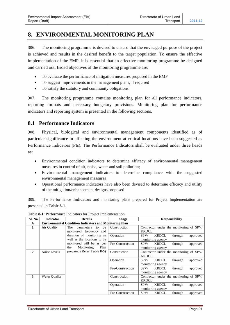
Environmental Impact Assessment (EIA) Report (Draft)
Directorate of Urban Land Transport 2011-12
Directorate of Urban Land Transport Page 91
8. ENVIRONMENTAL MONITORING PLAN
306. The monitoring programme is devised to ensure that the envisaged purpose of the project
is achieved and results in the desired benefit to the target population. To ensure the effective
implementation of the EMP, it is essential that an effective monitoring programme be designed
and carried out. Broad objectives of the monitoring programme are:
To evaluate the performance of mitigation measures proposed in the EMP
To suggest improvements in the management plans, if required
To satisfy the statutory and community obligations
307. The monitoring programme contains monitoring plan for all performance indicators,
reporting formats and necessary budgetary provisions. Monitoring plan for performance
indicators and reporting system is presented in the following sections.
8.1 Performance Indicators
308. Physical, biological and environmental management components identified as of
particular significance in affecting the environment at critical locations have been suggested as
Performance Indicators (PIs). The Performance Indicators shall be evaluated under three heads
as:
Environmental condition indicators to determine efficacy of environmental management
measures in control of air, noise, water and soil pollution;
Environmental management indicators to determine compliance with the suggested
environmental management measures
Operational performance indicators have also been devised to determine efficacy and utility
of the mitigation/enhancement designs proposed
309. The Performance Indicators and monitoring plans prepared for Project Implementation are
presented in Table 8-1.
Table 8-1: Performance Indicators for Project Implementation
Sl. No. Indicator Details Stage Responsibility
A Environmental Condition Indicators and Monitoring Plan
1 Air Quality The parameters to be
monitored, frequency and
duration of monitoring as
well as the locations to be
monitored will be as per
the Monitoring Plan
prepared (Refer Table 8-5)
Construction Contractor under the monitoring of SPV/
KRDCL
Operation SPV/ KRDCL through approved
monitoring agency
Pre-Construction SPV/ KRDCL through approved
monitoring agency
2 Noise Levels Construction Contractor under the monitoring of SPV/
KRDCL
Operation SPV/ KRDCL through approved
monitoring agency
Pre-Construction SPV/ KRDCL through approved
monitoring agency
3 Water Quality Construction Contractor under the monitoring of SPV/
KRDCL
Operation SPV/ KRDCL through approved
monitoring agency
Pre-Construction SPV/ KRDCL through approved
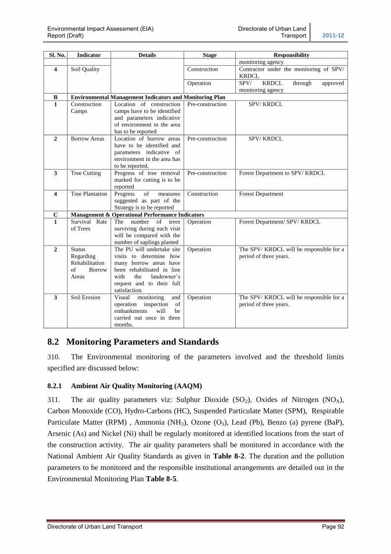
Environmental Impact Assessment (EIA) Report (Draft)
Directorate of Urban Land Transport 2011-12
Directorate of Urban Land Transport Page 92
Sl. No. Indicator Details Stage Responsibility
monitoring agency
4 Soil Quality Construction Contractor under the monitoring of SPV/
KRDCL
Operation SPV/ KRDCL through approved
monitoring agency
B Environmental Management Indicators and Monitoring Plan
1 Construction
Camps
Location of construction
camps have to be identified
and parameters indicative
of environment in the area
has to be reported
Pre-construction SPV/ KRDCL
2 Borrow Areas Location of borrow areas
have to be identified and
parameters indicative of
environment in the area has
to be reported.
Pre-construction SPV/ KRDCL
3 Tree Cutting Progress of tree removal
marked for cutting is to be
reported
Pre-construction Forest Department to SPV/ KRDCL
4 Tree Plantation Progress of measures
suggested as part of the
Strategy is to be reported
Construction Forest Department
C Management & Operational Performance Indicators
1 Survival Rate
of Trees
The number of trees
surviving during each visit
will be compared with the
number of saplings planted
Operation Forest Department/ SPV/ KRDCL
2 Status
Regarding
Rehabilitation
of Borrow
Areas
The PU will undertake site
visits to determine how
many borrow areas have
been rehabilitated in line
with the landowner’s
request and to their full
satisfaction.
Operation The SPV/ KRDCL will be responsible for a
period of three years.
3 Soil Erosion Visual monitoring and
operation inspection of
embankments will be
carried out once in three
months.
Operation The SPV/ KRDCL will be responsible for a
period of three years.
8.2 Monitoring Parameters and Standards
310. The Environmental monitoring of the parameters involved and the threshold limits
specified are discussed below:
8.2.1 Ambient Air Quality Monitoring (AAQM)
311. The air quality parameters viz: Sulphur Dioxide (SO2), Oxides of Nitrogen (NOX),
Carbon Monoxide (CO), Hydro-Carbons (HC), Suspended Particulate Matter (SPM), Respirable
Particulate Matter (RPM) , Ammonia (NH3), Ozone (O3), Lead (Pb), Benzo (a) pyrene (BaP),
Arsenic (As) and Nickel (Ni) shall be regularly monitored at identified locations from the start of
the construction activity. The air quality parameters shall be monitored in accordance with the
National Ambient Air Quality Standards as given in Table 8-2. The duration and the pollution
parameters to be monitored and the responsible institutional arrangements are detailed out in the
Environmental Monitoring Plan Table 8-5.
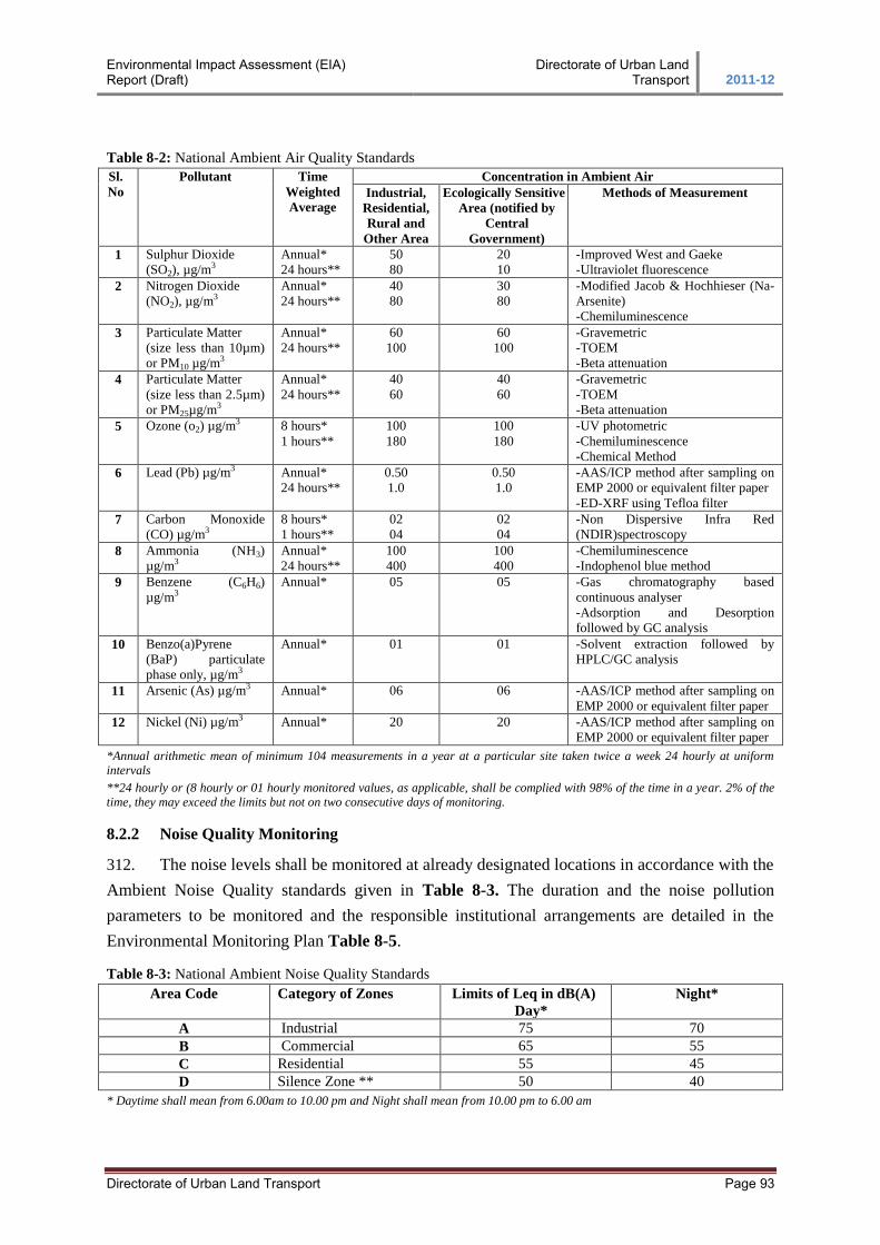
Environmental Impact Assessment (EIA) Report (Draft)
Directorate of Urban Land Transport 2011-12
Directorate of Urban Land Transport Page 93
Table 8-2: National Ambient Air Quality Standards
Sl.
No
Pollutant Time
Weighted
Average
Concentration in Ambient Air
Industrial,
Residential,
Rural and
Other Area
Ecologically Sensitive
Area (notified by
Central
Government)
Methods of Measurement
1 Sulphur Dioxide
(SO2), µg/m3
Annual*
24 hours**
50
80
20
10
-Improved West and Gaeke
-Ultraviolet fluorescence
2 Nitrogen Dioxide
(NO2), µg/m3
Annual*
24 hours**
40
80
30
80
-Modified Jacob & Hochhieser (Na-
Arsenite)
-Chemiluminescence
3 Particulate Matter
(size less than 10µm)
or PM10 µg/m3
Annual*
24 hours**
60
100
60
100
-Gravemetric
-TOEM
-Beta attenuation
4 Particulate Matter
(size less than 2.5µm)
or PM25µg/m3
Annual*
24 hours**
40
60
40
60
-Gravemetric
-TOEM
-Beta attenuation
5 Ozone (o2) µg/m3 8 hours*
1 hours**
100
180
100
180
-UV photometric
-Chemiluminescence
-Chemical Method
6 Lead (Pb) µg/m3 Annual*
24 hours**
0.50
1.0
0.50
1.0
-AAS/ICP method after sampling on
EMP 2000 or equivalent filter paper
-ED-XRF using Tefloa filter
7 Carbon Monoxide
(CO) µg/m3
8 hours*
1 hours**
02
04
02
04
-Non Dispersive Infra Red
(NDIR)spectroscopy
8 Ammonia (NH3)
µg/m3
Annual*
24 hours**
100
400
100
400
-Chemiluminescence
-Indophenol blue method
9 Benzene (C6H6)
µg/m3
Annual*
05 05 -Gas chromatography based
continuous analyser
-Adsorption and Desorption
followed by GC analysis
10 Benzo(a)Pyrene
(BaP) particulate
phase only, µg/m3
Annual*
01 01 -Solvent extraction followed by
HPLC/GC analysis
11 Arsenic (As) µg/m3 Annual* 06 06 -AAS/ICP method after sampling on
EMP 2000 or equivalent filter paper
12 Nickel (Ni) µg/m3 Annual* 20 20 -AAS/ICP method after sampling on
EMP 2000 or equivalent filter paper
*Annual arithmetic mean of minimum 104 measurements in a year at a particular site taken twice a week 24 hourly at uniform
intervals
**24 hourly or (8 hourly or 01 hourly monitored values, as applicable, shall be complied with 98% of the time in a year. 2% of the
time, they may exceed the limits but not on two consecutive days of monitoring.
8.2.2 Noise Quality Monitoring
312. The noise levels shall be monitored at already designated locations in accordance with the
Ambient Noise Quality standards given in Table 8-3. The duration and the noise pollution
parameters to be monitored and the responsible institutional arrangements are detailed in the
Environmental Monitoring Plan Table 8-5.
Table 8-3: National Ambient Noise Quality Standards
Area Code Category of Zones Limits of Leq in dB(A)
Day*
Night*
A Industrial 75 70
B Commercial 65 55
C Residential 55 45
D Silence Zone ** 50 40
* Daytime shall mean from 6.00am to 10.00 pm and Night shall mean from 10.00 pm to 6.00 am
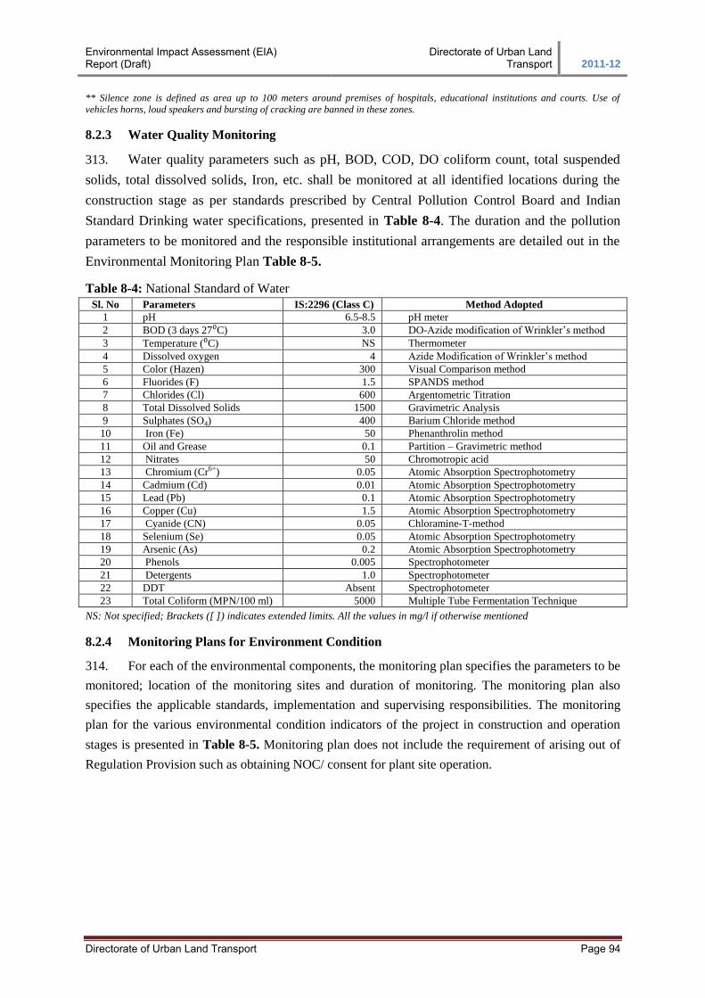
Environmental Impact Assessment (EIA) Report (Draft)
Directorate of Urban Land Transport 2011-12
Directorate of Urban Land Transport Page 94
** Silence zone is defined as area up to 100 meters around premises of hospitals, educational institutions and courts. Use of
vehicles horns, loud speakers and bursting of cracking are banned in these zones.
8.2.3 Water Quality Monitoring
313. Water quality parameters such as pH, BOD, COD, DO coliform count, total suspended
solids, total dissolved solids, Iron, etc. shall be monitored at all identified locations during the
construction stage as per standards prescribed by Central Pollution Control Board and Indian
Standard Drinking water specifications, presented in Table 8-4. The duration and the pollution
parameters to be monitored and the responsible institutional arrangements are detailed out in the
Environmental Monitoring Plan Table 8-5.
Table 8-4: National Standard of Water
Sl. No Parameters IS:2296 (Class C) Method Adopted
1 pH 6.5-8.5 pH meter
2 BOD (3 days 27⁰C) 3.0 DO-Azide modification of Wrinkler’s method
3 Temperature (⁰C) NS Thermometer
4 Dissolved oxygen 4 Azide Modification of Wrinkler’s method
5 Color (Hazen) 300 Visual Comparison method
6 Fluorides (F) 1.5 SPANDS method
7 Chlorides (Cl) 600 Argentometric Titration
8 Total Dissolved Solids 1500 Gravimetric Analysis
9 Sulphates (SO4) 400 Barium Chloride method
10 Iron (Fe) 50 Phenanthrolin method
11 Oil and Grease 0.1 Partition – Gravimetric method
12 Nitrates 50 Chromotropic acid
13 Chromium (Cr6+) 0.05 Atomic Absorption Spectrophotometry
14 Cadmium (Cd) 0.01 Atomic Absorption Spectrophotometry
15 Lead (Pb) 0.1 Atomic Absorption Spectrophotometry
16 Copper (Cu) 1.5 Atomic Absorption Spectrophotometry
17 Cyanide (CN) 0.05 Chloramine-T-method
18 Selenium (Se) 0.05 Atomic Absorption Spectrophotometry
19 Arsenic (As) 0.2 Atomic Absorption Spectrophotometry
20 Phenols 0.005 Spectrophotometer
21 Detergents 1.0 Spectrophotometer
22 DDT Absent Spectrophotometer
23 Total Coliform (MPN/100 ml) 5000 Multiple Tube Fermentation Technique
NS: Not specified; Brackets ([ ]) indicates extended limits. All the values in mg/l if otherwise mentioned
8.2.4 Monitoring Plans for Environment Condition
314. For each of the environmental components, the monitoring plan specifies the parameters to be
monitored; location of the monitoring sites and duration of monitoring. The monitoring plan also
specifies the applicable standards, implementation and supervising responsibilities. The monitoring
plan for the various environmental condition indicators of the project in construction and operation
stages is presented in Table 8-5. Monitoring plan does not include the requirement of arising out of
Regulation Provision such as obtaining NOC/ consent for plant site operation.
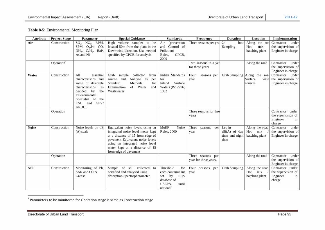
Environmental Impact Assessment (EIA) Report (Draft) Directorate of Urban Land Transport 2011-12
Directorate of Urban Land Transport Page 95
Table 8-5: Environmental Monitoring Plan
Attribute Project Stage Parameter Special Guidance Standards Frequency Duration Location Implementation
Air Construction SO2, NOx, RPM,
SPM, O3,Pb, CO,
NH3, C6H6, BaP,
As and Ni
High volume sampler to be
located 50m from the plant in the
Downwind direction. Use method
specified by CPCB for analysis
Air (prevention
and Control of
Pollution)
Rules, CPCB,
2009
Three seasons per year 24 hours
Sampling
Along the road
Hot mix /
batching plant
Contractor under
the supervision of
Engineer in charge
Operation4 Two seasons in a year
for three years
Along the road Contractor under
the supervision of
Engineer in charge
Water Construction All essential
characteristics and
some of desirable
characteristics as
decided by the
Environmental
Specialist of the
CSC and SPV/
KRDCL
Grab sample collected from
source and Analyse as per
Standard Methods for
Examination of Water and
Wastewater
Indian Standards
for
Inland Surface
Waters (IS: 2296,
1982
Four seasons per
year
Grab Sampling Along the road
Surface water
sources
Contractor under
the supervision of
Engineer in charge
Operation Three seasons for three
years
Contractor under
the supervision of
Engineer in
charge Noise Construction Noise levels on dB
(A) scale
Equivalent noise levels using an
integrated noise level meter kept
at a distance of 15 from edge of
pavement Equivalent noise levels
using an integrated noise level
meter kept at a distance of 15
from edge of pavement
MoEF Noise
Rules, 2000
Three seasons per
year
Leq in
dB(A) of day
time and night
time
Along the road
Hot mix /
batching plant
Contractor under
the supervision of
Engineer in charge
Operation Three seasons per
year for three years.
Along the road Contractor under
the supervision of
Engineer in charge Soil Construction Monitoring of Pb,
SAR and Oil &
Grease
Sample of soil collected to
acidified and analysed using
absorption Spectrophotometer
Threshold for
each contaminant
set by IRIS
database of
USEPA until
national
Four seasons per
year
Grab Sampling Along the road
Hot mix /
batching plant
Contractor under
the supervision of
Engineer in
charge
4 Parameters to be monitored for Operation stage is same as Construction stage
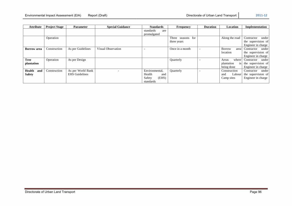
Environmental Impact Assessment (EIA) Report (Draft) Directorate of Urban Land Transport 2011-12
Directorate of Urban Land Transport Page 96
Attribute Project Stage Parameter Special Guidance Standards Frequency Duration Location Implementation
standards are
promulgated
Operation Three seasons for
three years
Along the road Contractor under
the supervision of
Engineer in charge Borrow area Construction As per Guidelines Visual Observation - Once in a month - Borrow area
location
Contractor under
the supervision of
Engineer in charge Tree
plantation
Operation As per Design Quarterly - Areas where
plantation is
being done
Contractor under
the supervision of
Engineer in charge Health and
Safety
Construction As per World Bank
EHS Guidelines
- Environmental,
Health and
Safety (EHS)
standards
Quarterly - Construction
and Labour
Camp sites
Contractor under
the supervision of
Engineer in charge
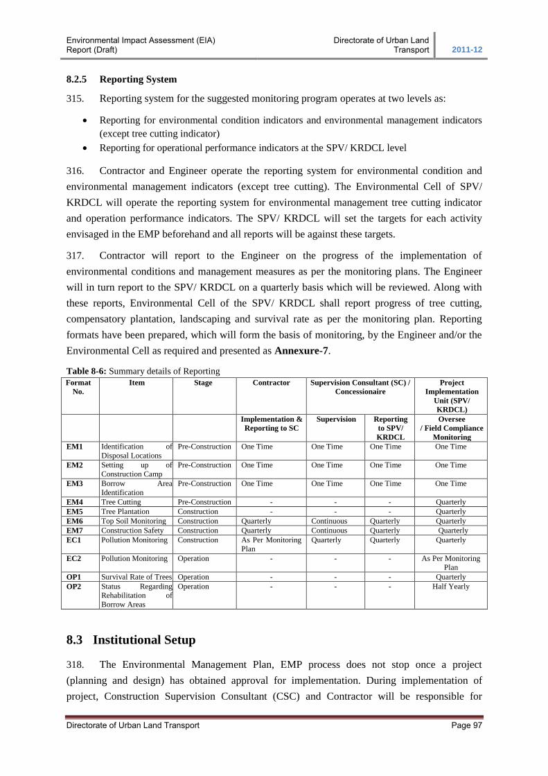
Environmental Impact Assessment (EIA) Report (Draft)
Directorate of Urban Land Transport 2011-12
Directorate of Urban Land Transport Page 97
8.2.5 Reporting System
315. Reporting system for the suggested monitoring program operates at two levels as:
Reporting for environmental condition indicators and environmental management indicators
(except tree cutting indicator)
Reporting for operational performance indicators at the SPV/ KRDCL level
316. Contractor and Engineer operate the reporting system for environmental condition and
environmental management indicators (except tree cutting). The Environmental Cell of SPV/
KRDCL will operate the reporting system for environmental management tree cutting indicator
and operation performance indicators. The SPV/ KRDCL will set the targets for each activity
envisaged in the EMP beforehand and all reports will be against these targets.
317. Contractor will report to the Engineer on the progress of the implementation of
environmental conditions and management measures as per the monitoring plans. The Engineer
will in turn report to the SPV/ KRDCL on a quarterly basis which will be reviewed. Along with
these reports, Environmental Cell of the SPV/ KRDCL shall report progress of tree cutting,
compensatory plantation, landscaping and survival rate as per the monitoring plan. Reporting
formats have been prepared, which will form the basis of monitoring, by the Engineer and/or the
Environmental Cell as required and presented as Annexure-7.
Table 8-6: Summary details of Reporting
Format
No.
Item Stage Contractor Supervision Consultant (SC) /
Concessionaire
Project
Implementation
Unit (SPV/
KRDCL)
Implementation &
Reporting to SC
Supervision Reporting
to SPV/
KRDCL
Oversee
/ Field Compliance
Monitoring
EM1 Identification of
Disposal Locations
Pre-Construction One Time One Time One Time One Time
EM2 Setting up of
Construction Camp
Pre-Construction One Time One Time One Time One Time
EM3 Borrow Area
Identification
Pre-Construction One Time One Time One Time One Time
EM4 Tree Cutting Pre-Construction - - - Quarterly
EM5 Tree Plantation Construction - - - Quarterly
EM6 Top Soil Monitoring Construction Quarterly Continuous Quarterly Quarterly
EM7 Construction Safety Construction Quarterly Continuous Quarterly Quarterly
EC1 Pollution Monitoring Construction As Per Monitoring
Plan
Quarterly Quarterly Quarterly
EC2 Pollution Monitoring Operation - - - As Per Monitoring
Plan
OP1 Survival Rate of Trees Operation - - - Quarterly
OP2 Status Regarding
Rehabilitation of
Borrow Areas
Operation - - - Half Yearly
8.3 Institutional Setup
318. The Environmental Management Plan, EMP process does not stop once a project
(planning and design) has obtained approval for implementation. During implementation of
project, Construction Supervision Consultant (CSC) and Contractor will be responsible for
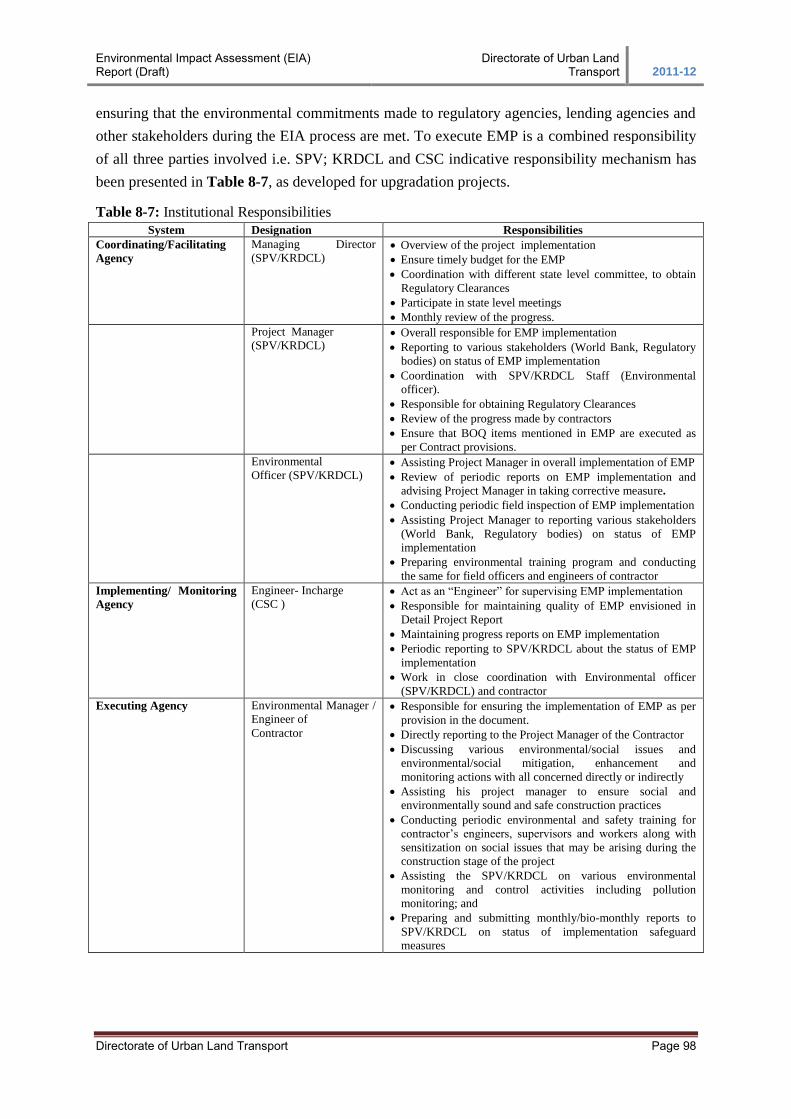
Environmental Impact Assessment (EIA) Report (Draft)
Directorate of Urban Land Transport 2011-12
Directorate of Urban Land Transport Page 98
ensuring that the environmental commitments made to regulatory agencies, lending agencies and
other stakeholders during the EIA process are met. To execute EMP is a combined responsibility
of all three parties involved i.e. SPV; KRDCL and CSC indicative responsibility mechanism has
been presented in Table 8-7, as developed for upgradation projects.
Table 8-7: Institutional Responsibilities
System Designation Responsibilities
Coordinating/Facilitating
Agency
Managing Director
(SPV/KRDCL)
Overview of the project implementation
Ensure timely budget for the EMP
Coordination with different state level committee, to obtain
Regulatory Clearances
Participate in state level meetings
Monthly review of the progress.
Project Manager
(SPV/KRDCL) Overall responsible for EMP implementation
Reporting to various stakeholders (World Bank, Regulatory
bodies) on status of EMP implementation
Coordination with SPV/KRDCL Staff (Environmental
officer).
Responsible for obtaining Regulatory Clearances
Review of the progress made by contractors
Ensure that BOQ items mentioned in EMP are executed as
per Contract provisions.
Environmental
Officer (SPV/KRDCL) Assisting Project Manager in overall implementation of EMP
Review of periodic reports on EMP implementation and
advising Project Manager in taking corrective measure.
Conducting periodic field inspection of EMP implementation
Assisting Project Manager to reporting various stakeholders
(World Bank, Regulatory bodies) on status of EMP
implementation
Preparing environmental training program and conducting
the same for field officers and engineers of contractor
Implementing/ Monitoring
Agency
Engineer- Incharge
(CSC ) Act as an “Engineer” for supervising EMP implementation
Responsible for maintaining quality of EMP envisioned in
Detail Project Report
Maintaining progress reports on EMP implementation
Periodic reporting to SPV/KRDCL about the status of EMP
implementation
Work in close coordination with Environmental officer
(SPV/KRDCL) and contractor
Executing Agency Environmental Manager /
Engineer of
Contractor
Responsible for ensuring the implementation of EMP as per
provision in the document.
Directly reporting to the Project Manager of the Contractor
Discussing various environmental/social issues and
environmental/social mitigation, enhancement and
monitoring actions with all concerned directly or indirectly
Assisting his project manager to ensure social and
environmentally sound and safe construction practices
Conducting periodic environmental and safety training for
contractor’s engineers, supervisors and workers along with
sensitization on social issues that may be arising during the
construction stage of the project
Assisting the SPV/KRDCL on various environmental
monitoring and control activities including pollution
monitoring; and
Preparing and submitting monthly/bio-monthly reports to
SPV/KRDCL on status of implementation safeguard
measures
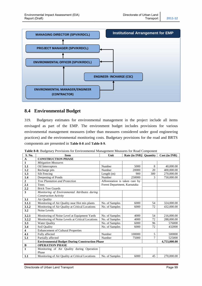
Environmental Impact Assessment (EIA) Report (Draft)
Directorate of Urban Land Transport 2011-12
Directorate of Urban Land Transport Page 99
8.4 Environmental Budget
319. Budgetary estimates for environmental management in the project include all items
envisaged as part of the EMP. The environment budget includes provisions for various
environmental management measures (other than measures considered under good engineering
practices) and the environmental monitoring costs. Budgetary provisions for the road and BRTS
components are presented in Table 8-8 and Table 8-9.
Table 8-8: Budgetary Provisions for Environmental Management Measures for Road Component
S. No. Item Unit Rate (in INR) Quantity Cost (in INR)
A CONSTRUCTION PHASE
1 Mitigation Measures
1.1 Oil Interceptors Number 5000 8 40,000.00
1.2 Recharge pits Number 20000 20 400,000.00
1.3 Silt Fencing Length (m) 900 300 270,000.00
1.4 Deepening of Ponds Number 250000 3 750,000.00
2 Tree Plantation and Protection Afforestation is taken care by
Forest Department, Karnataka
2.1 Trees
2.2 Brick Tree Guards
3 Monitoring of Environmental Attributes during
Construction Activity
3.1 Air Quality
3.1.1 Monitoring of Air Quality near Hot mix plants No. of Samples 6000 54 324,000.00
3.1.2 Monitoring of Air Quality at Critical Locations No. of Samples 6000 72 432,000.00
3.2 Noise Levels
3.2.1 Monitoring of Noise Level at Equipment Yards No. of Samples 4000 54 216,000.00
3.2.2 Monitoring of Noise Levels at Critical Locations No. of Samples 4000 72 288,000.00
3.3 Water Quality No. of Samples 6000 96 576000
3.4 Soil Quality No. of Samples 6000 72 432000
4 Enhancement of Cultural Properties
4.1 Fully affected Number 100000 5 500000
5.1 Partially affected Number 75000 7 525000
Environmental Budget During Construction Phase 4,753,000.00
B OPERATION PHASE
1 Monitoring of Air Quality during Operation
Phase
1.1 Monitoring of Air Quality at Critical Locations No. of Samples 6000 45 270,000.00
MANAGING DIRECTOR (SPV/KRDCL)
PROJECT MANAGER (SPV/KRDCL)
ENVIRONMENTAL OFFICER (SPV/KRDCL)
ENGINEER- INCHARGE (CSC)
ENVIRONMENTAL MANAGER/ENGINEER
(CONTRACTOR)
Institutional Arrangement for EMP
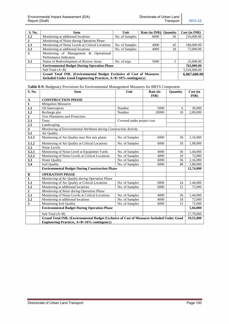
Environmental Impact Assessment (EIA) Report (Draft)
Directorate of Urban Land Transport 2011-12
Directorate of Urban Land Transport Page 100
S. No. Item Unit Rate (in INR) Quantity Cost (in INR)
1.2 Monitoring at additional locations No. of Samples 6000 36 216,000.00
2 Monitoring of Noise during Operation Phase
2.1 Monitoring of Noise Levels at Critical Locations No. of Samples 4000 45 180,000.00
2.2 Monitoring at additional locations No. of Samples 4000 18 72,000.00
3 Monitoring of Management & Operational
Performance Indicators
3.1 Status of Redevelopment of Borrow Areas No. of trips 5000 5 25,000.00
Environmental Budget During Operation Phase 763,000.00
Sub Total (A+B) 5,516,000.00
Grand Total INR. (Environmental Budget Exclusive of Cost of Measures
Included Under Good Engineering Practices, A+B+10% contingency)
6,067,600.00
Table 8-9: Budgetary Provisions for Environmental Management Measures for BRTS Component
S. No. Item Unit Rate (in
INR)
Quantity Cost (in
INR)
A CONSTRUCTION PHASE
1 Mitigation Measures
1.1 Oil Interceptors Number 5000 6 30,000
1.2 Recharge pits Number 20000 10 2,00,000
2 Tree Plantation and Protection
2.1 Trees Covered under project cost
2.2 Landscaping
3 Monitoring of Environmental Attributes during Construction Activity
3.1 Air Quality
3.1.1 Monitoring of Air Quality near Hot mix plants No. of Samples 6000 36 2,16,000
3.1.2 Monitoring of Air Quality at Critical Locations No. of Samples 6000 18 1,08,000
3.2 Noise Levels
3.2.1 Monitoring of Noise Level at Equipment Yards No. of Samples 4000 36 1,44,000
3.2.2 Monitoring of Noise Levels at Critical Locations No. of Samples 4000 18 72,000
3.3 Water Quality No. of Samples 6000 36 2,16,000
3.4 Soil Quality No. of Samples 6000 48 2,88,000
Environmental Budget During Construction Phase 12,74,000
B OPERATION PHASE
1 Monitoring of Air Quality during Operation Phase
1.1 Monitoring of Air Quality at Critical Locations No. of Samples 6000 24 1,44,000
1.2 Monitoring at additional locations No. of Samples 6000 12 72,000
2 Monitoring of Noise during Operation Phase
2.1 Monitoring of Noise Levels at Critical Locations No. of Samples 4000 36 1,44,000
2.2 Monitoring at additional locations No. of Samples 4000 18 72,000
3 Monitoring Soil Quality No. of Samples 6000 12 72,000
Environmental Budget During Operation Phase 5,04,000
Sub Total (A+B) 17,78,000
Grand Total INR. (Environmental Budget Exclusive of Cost of Measures Included Under Good
Engineering Practices, A+B+10% contingency)
19,55,800