Embed Size (px)
Citation preview

Information Viewpoints and Geoscience Service Architectures
Simon Cox
Research Scientist
13 December 2007

CSIRO AGU Fall 2007 – IN43C-07 Cox
Outline
• Key viewpoints for earth science information• Feature, field, observation
• The value-adding cycle• Mapping the viewpoints to OGC services and chains

CSIRO AGU Fall 2007 – IN43C-07 Cox
Fields vs. objects
classic geology: “feature”
classic earth-observations:“field” or “coverage”

CSIRO AGU Fall 2007 – IN43C-07 Cox
Conceptual object model: features
• Digital object corresponding with identifiable, typed, object in the real world
• mountain, road, specimen, event, tract, catchment, wetland, farm, bore, reach, property, license-area, station
• Feature-type characterised by specific set of properties
• Specimen• ID (name)
• description
• mass
• processing details
• sampling location
• sampling time
• related observation
• material
• …

CSIRO AGU Fall 2007 – IN43C-07 Cox
Mapped features

CSIRO AGU Fall 2007 – IN43C-07 Cox
Spatial function or field – “coverage”
(x1,y1)
(x2,y2)
• Variation of a property in domain of interest• Property may be multi-component• Domain is often sampled on a grid
• Domain extent is scoped by shape/lifetime of feature of interest
• Range-type is scoped by type of feature-of-interest

CSIRO AGU Fall 2007 – IN43C-07 Cox
Different cross-sections through same dataset
Specimen Au (ppm) Cu-a (%) Cu-b (%) As (ppm) Sb (ppm)
ABC-123 1.23 3.45 4.23 0.5 0.34 • A Row summarizes the properties of one feature
• A Column = variation of a single property across a domain (i.e. set of locations)

CSIRO AGU Fall 2007 – IN43C-07 Cox
Assignment of property values
• For each field in the table the value is eitheri. asserted
• E.g. name, owner, price, boundary (cadastral feature types)
ii.observed/estimated• E.g. colour, mass, shape (natural feature types)
• i.e. error is of interest
CSIRO AGU Fall 2007 – IN43C-07 Cox
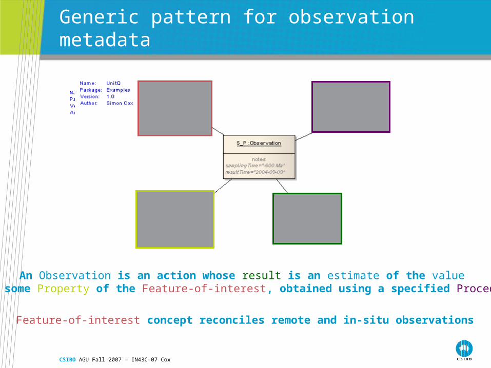
Generic pattern for observation metadata
An Observation is an action whose result is an estimate of the value of some Property of the Feature-of-interest, obtained using a specified Procedure
Feature-of-interest concept reconciles remote and in-situ observations

CSIRO AGU Fall 2007 – IN43C-07 Cox
Three viewpoints: Feature, Coverage, Observation
Specimen Au (ppm) Cu-a (%) Cu-b (%) As (ppm) Sb (ppm)
ABC-123 1.23 3.45 4.23 0.5 0.34 • A Row gives properties of one feature
• A Column = variation of a single property across a domain (i.e. set of locations)
• A Cell reflects the result of a single observation

CSIRO AGU Fall 2007 – IN43C-07 Cox
Value-adding chain
• Observation/result• estimate of value of a property for a single specimen/station/location• data-capture, with metadata concerning procedure, operator, etc
• Coverage• compilation of values of a single property across the domain of interest• data prepared for analysis/pattern detection
• Feature• object having geometry & values of several different properties• 1. classified object, snapshot for transport
• geological map elements
• 2. object created by human activity, artefact of investigation• borehole, mine, specimen

CSIRO AGU Fall 2007 – IN43C-07 Cox
OGC Service stack
• Different information-types accessed using different interfaces• Maps – WMS
• Features – WFS
• Coverages – WCS
• Observations – SOS
• Each interface is composed of a “set of operations”

CSIRO AGU Fall 2007 – IN43C-07 Cox
SOS
getObservation
getResult
describeSensor
getFeatureOfInterest
Accessing data using the “Observation” viewpoint
WFS/Obs
getFeature, type=Observation
WCS
getCoverage
getCoverage(result)
Sensor Register
getRecordById
WFSgetFeature
e.g. SOS::getResult == “convenience” interface for WCS

CSIRO AGU Fall 2007 – IN43C-07 Cox
WFS/SFS
The “Sampling Feature Service” viewpoint
WFSgetFeature
WCSgetCoverage
getCoverage(property value)
SOSgetObservation
Commondata
source
getFeature(sampling Feature)
getFeature(relatedObs/result value)
getFeature(relatedObservation)
getCoverage(result)
SensorRegister
getRecordById (procedure)
getFeature(featureOfInterest)
getObservation(relatedObs)
getResult(property value)

CSIRO AGU Fall 2007 – IN43C-07 Cox
WFS
The “Domain Feature” viewpoint
WCSgetCoverage(property value)
getFeatureSOS
getResult(property value)
The “Observations are the most primitive” viewpoint #1– observations are property-value-providers for features
??

CSIRO AGU Fall 2007 – IN43C-07 Cox
WCS
Accessing data using the “just the data” viewpoint
WFSgetFeature/geometry(domain exent)
getCoverageSOS
getResult (lots of ‘em)(range values)
The “Observations are the most primitive” viewpoint #2 – observations are range-value-providers for coverages

CSIRO AGU Fall 2007 – IN43C-07 Cox
Key points
• Earth scientists use multiple viewpoints onto their data• These can be reconciled through a robust data model• Service interfaces to the different viewpoints can be composed
in various ways, based on a simple set of OGC components

Contact UsPhone: 1300 363 400 or +61 3 9545 2176
Email: [email protected] Web: www.csiro.au
Thank you
Exploration & MiningSimon CoxResearch Scientist
Phone: 08 6436 8639Email: [email protected]: www.seegrid.csiro.au

CSIRO AGU Fall 2007 – IN43C-07 Cox
RockSample-A :Specimen
DensityItA :Observ ation
Density :Phenomenon
Densitometry :Observ ationProcedure
2610 kg/T :Measure
2006-11-23 :TM_Instant
Leederv ille, WA :Location
RockSample-B :Specimen
DensityItB :Observ ation
2580 kg/T :Measure
2005-12-23 :TM_Instant
West Leederv ille, WA :Location
+time+result
+procedure+observedProperty
+featureOfInterest
+sampl ingLocation
+density
+sampl ingLocation
+time
+procedure+observedProperty
+featureOfInterest
+result
+density
ProbeItA :Observ ation
Material :Phenomenon
Microprobe :Observ ationProcedure
MineralDistribution :CV_Cov erage
2006-11-24/2006-11-26 :TM_Period
RockSample-A :Specimen
Leederv ille, WA :Location
+observedProperty +procedure
+result+time
+material
+featureOfInterest
+sampl ingLocation RockSample-A :Specimen
2610 kg/T :Measure
Leederv ille, WA :Location
+density
+sampl ingLocation RockSample-A :Specimen
DensityItA :Observ ation
Density :Phenomenon
Densitometry :Observ ationProcedure
2610 kg/T :Measure
2006-11-23 :TM_Instant
Leederv ille, WA :Location
+featureOfInterest
+observedProperty +procedure
+result
+density
+time
+sampl ingLocation RockSample-A :Specimen
2610 kg/T :Measure
Leederv ille, WA :Location
RockSample-B :Specimen
2580 kg/T :Measure
West Leederv ille, WA :Location
+density
+sampl ingLocation
+density
+sampl ingLocation
ProbeItA :Observ ation
Material :Phenomenon
Microprobe :Observ ationProcedure
MineralDistribution :CV_Cov erage
2006-11-24/2006-11-26 :TM_Period
RockSample-A :Specimen
DensityItA :Observ ation
Density :Phenomenon
Densitometry :Observ ationProcedure
2610 kg/T :Measure
2006-11-23 :TM_Instant
Leederv ille, WA :Location
+procedure+observedProperty
+result+time
+featureOfInterest
+material
+featureOfInterest
+observedProperty +procedure
+result
+density
+time
+sampl ingLocation
MineralDistribution :CV_Cov erage
RockSample-A :Specimen
2610 kg/T :Measure
Leederv ille, WA :Location
+material
+density
+sampl ingLocation
Observations, features and coverages
Feature summary
Property-valueevidence
Multiple observations one feature, different properties:feature summary evidence
A property-valuemay be a coverage
Same property onmultiple samplesis a another kindof coverage
Multiple observations different features, one property:coverage evidence

CSIRO AGU Fall 2007 – IN43C-07 Cox
WFS Operation
WFS-Client WFS
GetCapabilities()
Capabil ities()
DescribeFeatureType(FeatureType)
XML Schema()
GetFeature(FeatureType, FilterExpression)
Feature Collection ()
GetGmlObject(ObjectID)
Object()
Transaction(...)
TransactionResponse()
Name:Package:Version:Author:
WFS-S1OWS1.0Simon Cox

CSIRO AGU Fall 2007 – IN43C-07 Cox
Multiple interfaces to same information?
• SOS::GetObservation == WFS::GetFeature(type=Observation)• SOS::GetResult == WCS::GetCoverage• SOS::DescribeSensor == WFS::GetFeature(type=Sensor)
or CSW::GetRecordById
• “Profile” generic operations• fix one or more parameters

CSIRO AGU Fall 2007 – IN43C-07 Cox
Service profiles
• WFS is “soft-typed”• Any feature-type• Query scoped by response model
• Strong-typed service = profile of generic service-type• Limit response model
• SOS = WFS(feature-type=Observation)• GeoSciML-service = WFS(feature-type=gsml:*)• Spectral Data Service = WCS(domain=wavelength)
• Limit query model• Queriable properties = subset of response model
• Conformance-levels?• Level 0 – spatial queries only• Level 1 – only these props• Level 2 – complete WFS