Embed Size (px)
Citation preview
Institut für Ländliche Räume
Paper presented at the 122th EAAE Seminar17./18.02.20011 Ancona
MUNICIPALITY DISAGGREGATION OF GERMAN'S AGRICULTURAL SECTOR MODEL RAUMIS
Norbert Röder & Alexander Gocht
Röder & Gocht, 2-2011
Outline
Motivation
Aim
Method
Results
Discussion
Röder & Gocht, 2-2011
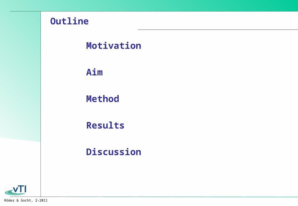
Need for high resolution data
RAUMIS: German sector model for agricultural environmental impact assessment County as highest spatial resolution(>15 years of history)
For environmental impact assessment frequently data with a higher spatial resolution needed:
• Phytosanitary issues• Erosion• Biodiversity• Water protection• Greenhouse gas emissions
Motivation
Aim
Method
Results
Discussion
Röder & Gocht, 2-2011
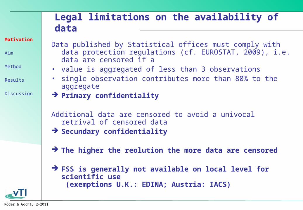
Legal limitations on the availability of data
Data published by Statistical offices must comply with data protection regulations (cf. EUROSTAT, 2009), i.e. data are censored if a
• value is aggregated of less than 3 observations• single observation contributes more than 80% to the aggregate Primary confidentiality
Additional data are censored to avoid a univocal retrival of censored data
Secundary confidentiality
The higher the reolution the more data are censored
FSS is generally not available on local level for scientific use (exemptions U.K.: EDINA; Austria: IACS)
Motivation
Aim
Method
Results
Discussion
Röder & Gocht, 2-2011
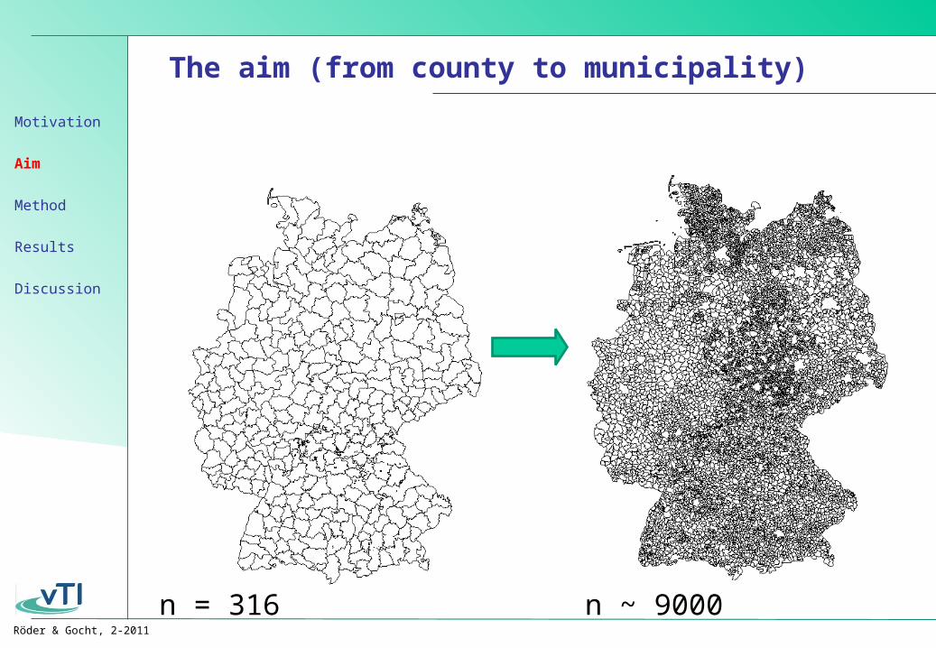
The aim (from county to municipality)
Build a data set for 31 agricultural activities on local level Data should be consistent to the agriculural statistics on county
level Not only distribute already published agricultural activities
according to a priory rules Extract as much information from the Statistical office as legally
feasible
Motivation
Aim
Method
Results
Discussion
Röder & Gocht, 2-2011
The aim (from county to municipality)
n = 316 n ~ 9000
Motivation
Aim
Method
Results
Discussion
Röder & Gocht, 2-2011
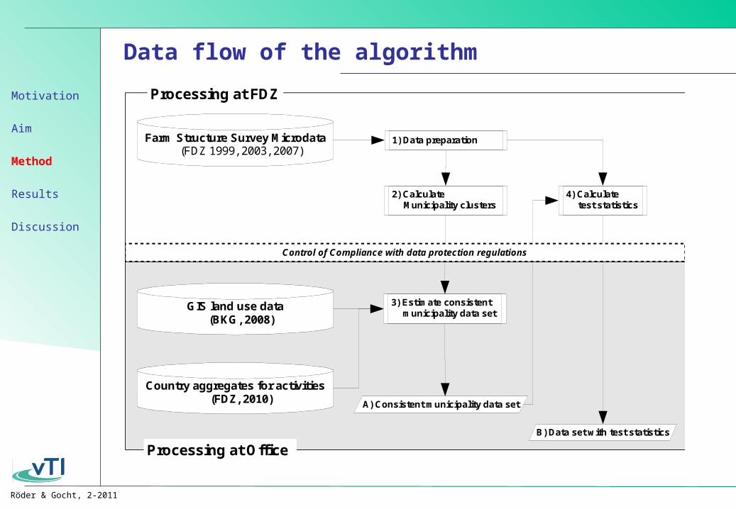
Data flow of the algorithm
A) Consistent municipality data set
B) Data set with test statistics
1) Data preparation
4) Calculate test statistics
3) Estimate consistent municipality data set
Farm Structure Survey Microdata(FDZ 1999, 2003, 2007)
GIS land use data(BKG, 2008)
Control of Compliance with data protection regulations
Processing at FDZ
Processing at Office
2) Calculate Municipality clusters
Country aggregates for activities(FDZ, 2010)
Motivation
Aim
Method
Results
Discussion
Röder & Gocht, 2-2011
The Clustering Step
Calculate 3 independent kMeans-cluster models (general landuse; arable farming livestock husbandry)
Clustering based on relative data
Each model has 8 to 13 Variables
In each Model ~ 9,000 municipalities are atttributed to ~ 180 clusters
Median and std. of the clusters are used as parameters in the further processing
Problem
Sum(Cluster(median) * GIS(extent))
≠
County data
Estimation of a consistent data set
Motivation
Aim
Method
Results
Discussion
Röder & Gocht, 2-2011
Estimation (Highest Posterior Density (HPD))
Algorithm
Search production level that comply with the constraints and mimize the deviation to the prior information
Prior Information
Relative values for 31 groups of Activities from (Cluster)
(Median and Std.)
Size of some types of land use (arable land, grass land …)(GIS)
Constraints
Aggregated activity levels per county (published statistic)
Motivation
Aim
Method
Results
Discussion
Röder & Gocht, 2-2011
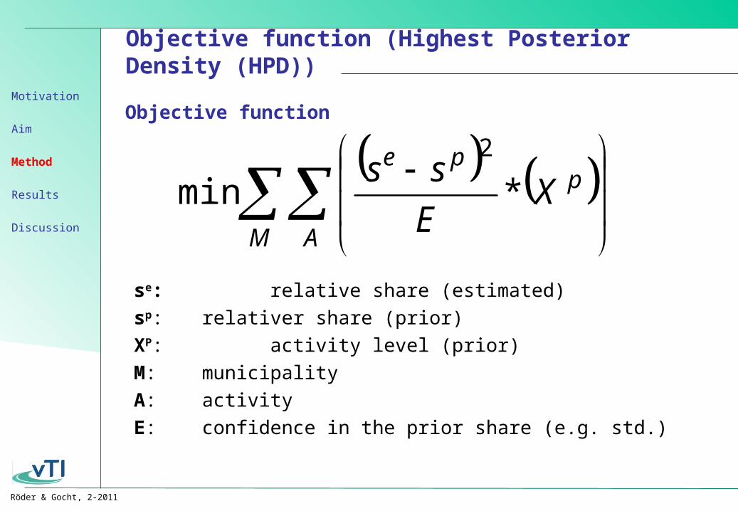
Objective function (Highest Posterior Density (HPD))
Objective function
M A
ppe
XE
ss*min
2
se: relative share (estimated)
sp: relativer share (prior)
XP: activity level (prior)
M: municipality
A: activity
E: confidence in the prior share (e.g. std.)
Motivation
Aim
Method
Results
Discussion
Röder & Gocht, 2-2011
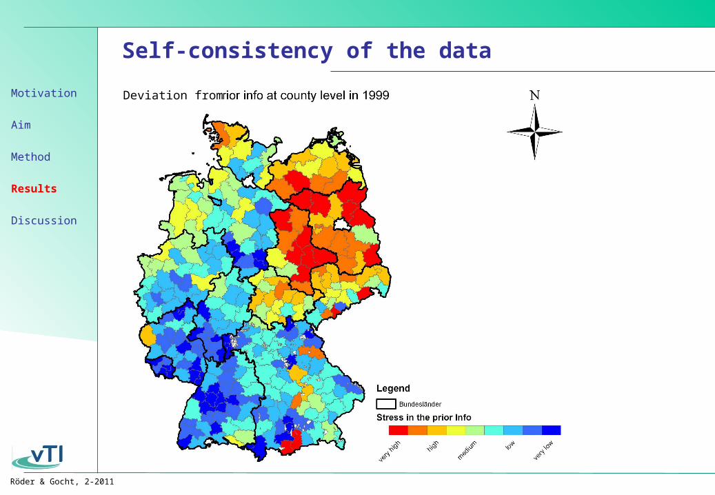
Self-consistency of the data
Deviation fromMotivation
Aim
Method
Results
Discussion

Röder & Gocht, 2-2011
Deviation from the observed values
Deviation weighted with the observed stocks on municipality level
CALV
BULL
HEIT
DCOW
SCOW
SHGM
OANI
SOWS
PIGF
HENS
POUF
LU
/ h
a
-0.1
0
0.1
-0.05
-0.15
0.05
0.15
+0.29 +0.36 +0.24
-0.36 -0.88
Motivation
Aim
Method
Results
Discussion
Röder & Gocht, 2-2011
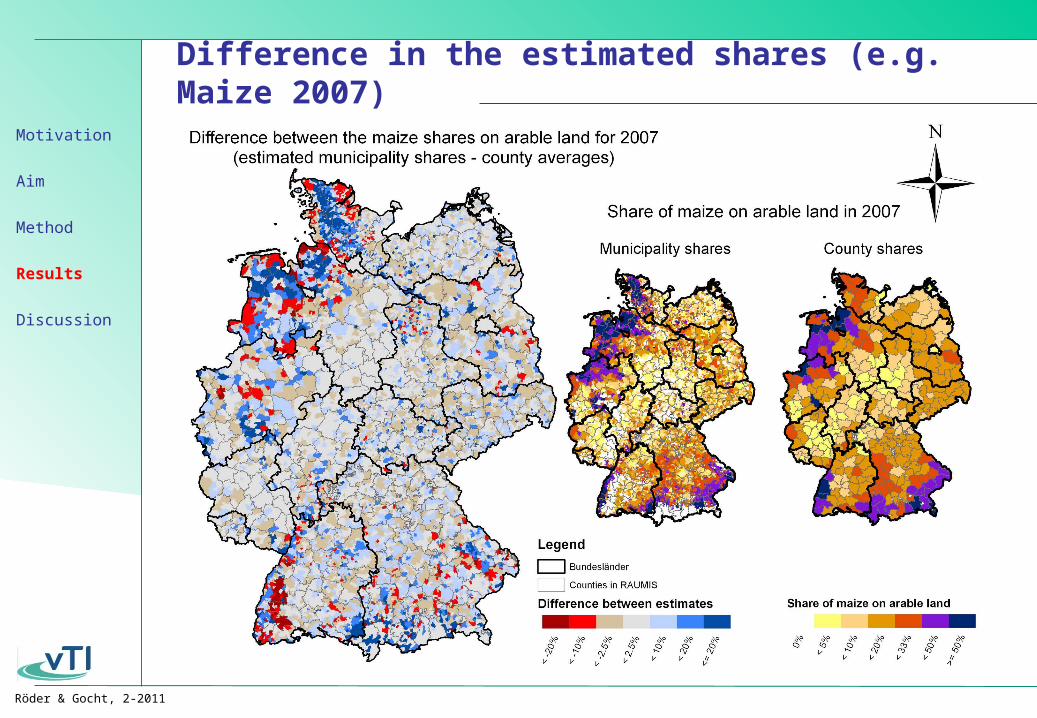
Difference in the estimated shares (e.g. Maize 2007)
Motivation
Aim
Method
Results
Discussion
Röder & Gocht, 2-2011
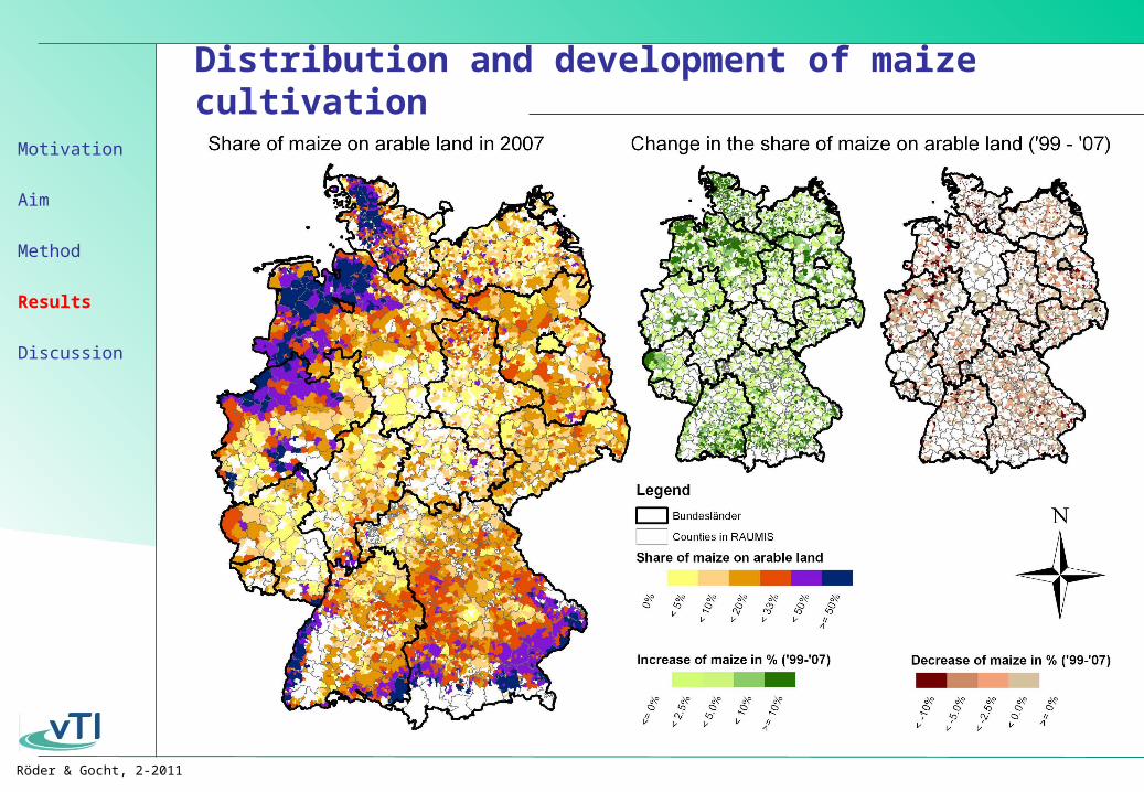
Distribution and development of maize cultivation
Motivation
Aim
Method
Results
Discussion

Röder & Gocht, 2-2011
Summary
• Validated map of agriculture on municipality level from ’99 till ’07
• Data set consistent to agricultural census (county)
• Compared to GIS complete mapping of livestock husbandry
• Better estimates compared to county averages
• In most cases the deviation to the censored data on local level is negligible
• The approach allows disaggregation of RAUMIS-modelling results to the local level
• Particular relevance for environmental indicators
• Analysis of land use change with high resolution
Motivation
Aim
Method
Results
Discussion
Röder & Gocht, 2-2011
Outlook
• Include computation of envrionmental indicators
• Modification of the symetric penalty function (distribution of municipalities in the clusters frequently skewed)
• Modify GIS confidence estimator(Currently ad-hoc approach)
• Use in information of the other years in the estimation framework
Motivation
Aim
Method
Results
Discussion