Embed Size (px)
Citation preview

LAK 175-Middletown Shoulders
LAKE COUNTY, CALIFORNIA DISTRICT 1 – LAK – 175 (PM R25/27.5)
0A040/0100020013
Initial Study with Proposed Mitigated Negative Declaration/Environmental Assessment and
Section 4(f) Evaluation
Prepared by the State of California Department of Transportation
The environmental review, consultation, and any other action required in accordance with applicable
federal laws for this project is being, or has been, carried-out by Caltrans under its assumption of responsibility pursuant to 23 USC 327.
December 2016

General Information about This Document
What’s in this document? The California Department of Transportation (Caltrans), as California Environmental Quality Act (CEQA) lead agency, has prepared this Initial Study (IS) to examine the potential environmental impacts associated with the proposed project located in Lake County, California. The document will present any potential environmental impacts related to the project and illustrate how to avoid, minimize, and/or possibly mitigate those impacts.
What you should do?
• Please read through this document to understand what is planned and contact Caltrans with any possible concerns you might have. We would like to hear your thoughts. Hard copies of this document can be found at the:
o Middletown Public Library located at 21256 Washington St, Middletown, CA 95461
o Caltrans District 1 located at 1656 Union Street, Eureka, CA 95501
o Caltrans District 3 located at 703 B Street, Marysville, CA 95901
• This document is also available electronically at
http://www.dot.ca.gov/dist3/departments/envinternet/lakeco.htm
• Submit Comments via postal mail service to the following address:
Caltrans – District 3 Office of Environmental Management, EM-2 Attn: Thaleena Bhattal 703 B Street Marysville, CA 95901
• Or you can submit comments via email to [email protected] • Please submit your comments by the deadline: January 23, 2017 What happens next? After comments are received from the public and reviewing agencies, Caltrans, as assigned by the Federal Highway Administration (FHWA), may: (1) give environmental approval to the proposed project, (2) do additional environmental studies, or (3) abandon the project. If the project is given environmental approval and funding is obtained, Caltrans could design and construct all or part of the project.
For individuals with sensory disabilities, this document is available in Braille, in large print, on audiocassette, or on computer disk. To obtain a copy in one of these alternate formats, please call or write to Caltrans, Attn: Phil Frisbie, Public Information Officer, (707) 441-4678, or use the California Relay Service TTY number, 1-800-735-2929.

PROPOSED MITIGATED NEGATIVE DECLARATION Pursuant to: Division 13, Public Resources Code
Project Description The California Department of Transportation (Caltrans) is proposing this safety improvement project located on State Route (SR) 175 in Lake County near the town of Middletown, between post miles (PM) R25.0 to 27.5. The project proposes to widen shoulders, improve the existing curvatures of the roadway and the clear recovery zone (CRZ), reconstruct driveways and intersections, and install shoulder/centerline rumble strips along the edge of the traveled way (ETW).
Determination This proposed Mitigated Negative Declaration (MND) is included to give notice to interested agencies and the public that it is Caltrans’ intent to adopt a MND for this project. This does not mean that Caltrans’ decision regarding the project is final. This MND is subject to change based on comments received by interested agencies and the public.
Caltrans has prepared an Initial Study for this project and, pending public review, expects to determine from this study that the proposed project would not have a significant effect on the environment for the following reasons:
The proposed project would have no effect on air quality, geology and soils, hazards and hazardous materials, hydrology and water quality, land use planning, mineral resources, noise, population and housing, and transportation/traffic and tribal cultural resources.
In addition, the proposed project would have less than significant effects to aesthetics, agriculture and forest resources, biological resources, cultural resources, utilities, public services, and recreation with incorporation of avoidance, minimization, and mitigation measures.
________________________________ ______________________ Suzanne Melim, Chief Date North Region Environmental Services, South California Department of Transportation

LAK 175 Middletown Shoulders 1
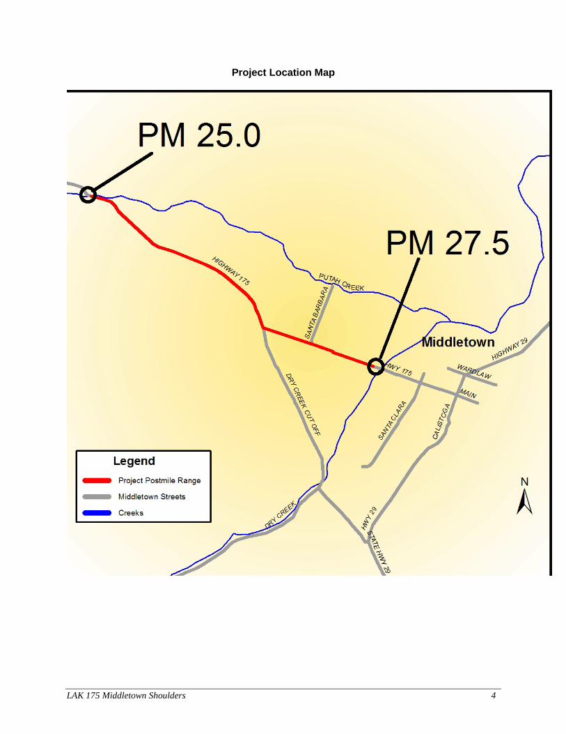
Chapter 1 Proposed Project Project Title Lake 175 Middletown Shoulders Lead Agency Name, Address and Contact Information California Department of Transportation Attn: Liza Walker 703 B Street Marysville CA, 95901 Project Location This project is located on State Route (SR) 175 between post miles R25.0/27.5 through Lake County and is a two-lane conventional highway on its existing alignment. This rural minor arterial portion of SR 175 between the community of Cobb and SR 29 at the community of Middletown, serves local and recreational traffic and through trips between Middletown and Kelseyville.
Purpose and Need The purpose of this project is to reduce the number and severity of collisions on the existing highway. Within the project limits, the existing highway has 11 to 12-foot lanes with zero to four-foot shoulders. Additionally, the existing roadway does not meet the current Caltrans standards for a two-lane conventional highway. This segment of SR 175 is experiencing a pattern of run-off-road collisions where drivers are losing control and leaving the roadway where they strike a fixed object such as a tree, power pole, or embankment. The purpose of the proposed project is to improve safety and operations for all users, including bicyclists and pedestrians, by improving the horizontal and vertical alignments, widening shoulders, and improving the Clear Recovery Zone (CRZ). Description of Project The project proposes to:
• Widen the roadway shoulders to six feet on the eastbound side and four feet on the westbound side from PM R25.0 to Dry Creek Bridge. Right of Way acquisition will be required.
• Improve the existing horizontal and vertical curvature of the roadway by increasing the radius of the horizontal curves and the sight distance associated with the vertical alignment.
• Improve the CRZ by removing/relocating unyielding objects such as trees, utility poles, etc. The CRZ is an unobstructed, passable roadside area that allows a driver to stop safely, or regain control of a vehicle that has the left the roadway.
• Additional work includes reconstructing driveways and intersections, installing shoulder/centerline rumble strips along the edge of the traveled way and along the center median, and extend/replace existing drainage culverts.
LAK 175 Middletown Shoulders 2
Alternative 1, Build Alternative
• This alternative will widen the existing 28 feet by 32 feet roadbed to 34 feet within the project limits. The alignment is proposed to be shifted south of the existing highway in order to avoid major impacts to the houses and possible condemnation issues on the north side of the highway.
• The proposed typical section will include two 12-foot travel lanes and six-foot shoulders on the eastbound side and four-foot shoulders on the westbound side. The project scope includes centerline and edge-line rumble strips as well as “safety edge” paving.
• All of the existing metal beam guard rail will be removed and replaced with an updated system where necessary. Vegetation control will be placed under these guard railings.
• Dig out areas will be repaired with Hot Mix Asphalt. • Cracks that are wider than 0.25 inches will be sealed. • Shoulder backing will be replaced or installed where needed. • Slopes will be graded to 4:1, or flatter where possible. • Private driveways will be reconstructed and fencing will either be removed or replaced. • Public road connections will be reconstructed. • Relocate, shield or remove any utilities, drainage ditches or fixed objects that encroach in
the CRZ, as feasible. • Existing drainage culverts will be extended or replaced. Also, new drainage culverts will
be added. Alternative 2, or the No-Build Alternative The no-build alternative would result in no improvement to the existing highway facility, which would not meet the safety improvement need and purpose of the project. Additionally, the no-build alternative would not address the problem of run-off-road collisions along this segment of the highway, and, therefore, is not recommended. Rejected Alternative There was another alternative considered, but was rejected through the project development process. This alternative originally proposed widening the project limits between PM 25.0 – 27.50 to accommodate an eight foot widening of the shoulders. This eight-foot wide alternative was rejected because in 2015 the catastrophic Valley Fire destroyed approximately 76,067 acres, and which included considerable damage to the unincorporated nearby communities including Middletown, Hidden Valley Lake, and Cobb, as well as a considerable portion of the project area for the proposed Lake 175 Safety project. Because the 2015 Valley Fire caused significant property loss and resulted in the loss of many mature trees along SR 175, Caltrans took a second look at the proposed project’s work scope, and after discussions with local Lake County officials and local residents, and further design analysis, Caltrans updated the project scope. Rather than the originally-proposed eight-foot wide shoulder widening, it was determined that a six-foot wide shoulder widening would meet the goals of the Lake 175 Safety Improvement project, and that the six-foot shoulder widening would result in less permanent right of way (ROW) acquisition from adjacent property owners and that fewer remaining surviving trees would require removal. The CRZ will be widened in only those specific areas within the project limits, where Caltrans’ Office of Traffic Safety deems it is safe to do so.

LAK 175 Middletown Shoulders 3
In addition, the eight-foot shoulder widening was rejected during the preliminary design because the theoretical collision reduction (that is attainable by widening alone) is considerably less than designing the shoulder widening in conjunction with correcting the horizontal alignment. Restricting the widening portion of the roadway improvements also limits the ability to considerably improve the highway’s “super elevation” (maximum slope of the road based on the speed and radius) because the existing tangential grades (straight lines in the vertical plane and the vertical curves) on SR 175 within the project limits do not consistently meet current Caltrans’ standards. Permits and Approvals Needed This project will require the following permits:
Agency Permit/Approval Status United States Army Corps of Engineers (USACE)
Section 404 Permit Application for Section 404 permit expected after final environmental approval.
North Coast Regional Water Quality Control Board (NCRWQCB)
Section 401 Water Quality Certification Application for Section 401 Water Quality Certification expected after final environmental approval.
California Department of Fish and Wildlife (CDFW) (North-Central Regional Office)
1602 Agreement for Streambed Alteration
Application for 1602 permit expected after the final environmental approval.
LAK 175 Middletown Shoulders 4
Project Location Map

LAK 175 Middletown Shoulders 5
Chapter 2-Affected Environment, Environmental Consequences, and Avoidance, Minimization and/or Mitigation Measures As part of the scoping and environmental analysis conducted for this project, the following environmental issues were considered but no impacts were identified: air quality, coastal zones, community character and cohesion, wild and scenic rivers, floodplains, geology and soils, growth, hazardous and hazardous materials, hydrology and water quality, land use planning, mineral resources, noise, population and housing, paleontology, pedestrian and bicycle facilities, transportation/traffic, tribal cultural resources, and timberlands. Consequently, there is no further discussion regarding these issues in this document. Human Environment Parks and Recreational Facilities Regulatory Setting
This project will affect facilities that are protected by the Park Preservation Act (California Public Resources Code [PRC] Sections 5400-5409). The Park Preservation Act prohibits local and state agencies from acquiring any property which is in use as a public park at the time of acquisition unless the acquiring agency pays sufficient compensation or land, or both, to enable the operator of the park to replace the park land and any park facilities on that land.
Affected Environment Caltrans will acquire some permanent right of way from Middletown Trailside Park, which is publicly owned and operated by Lake County. A 4(f) use is occurring because parkland is permanently being incorporated into a transportation facility. Please see Appendix B for further discussion.
Environmental Consequences To assess the impacts to recreation caused by acquiring recreational land and converting it to a transportation facility, Caltrans analyzed the relative harm, damage, or interference to either recreational activities, features, or attributes within Middletown Trailside Park. The primary features and attributes within the park include a picnic area and an annual sculpture display that occurs from April to October each year. The recreational activities associated with these features include biking, bird watching, walking dogs, an equestrian trail and a picnic area. The Middletown Trailside Park currently consists of approximately 107 acres comprised of oak woodland habitat, grassland, and some seasonal wetlands. Caltrans will be acquiring approximately 1.27 acres of a narrow strip of parkland that is located on the eastern edge and affect some oak trees and other vegetation. A small segment of the trail will be temporarily closed, but hikers and/or riders will be able to access the trail from several other locations. Therefore, there will not be any adverse affects to the park features, attributes or activities.

LAK 175 Middletown Shoulders 6
Avoidance, Minimization, and/or Mitigation Measures
• The least amount of park property will be acquired for the proposed project to be constructed.
• Monetary compensation will be given to the park in exchange for parkland. Caltrans will pay fair market value.
• Early coordination with the official with jurisdiction to consider their input and make design adjustments where feasible was completed.
• Avoidance of key portions of park property was done so that the key attributes, features, or activities were not affected.
Farmland
Regulatory Setting
The National Environmental Policy Act (NEPA) and the Farmland Protection Policy Act (FPPA, 7 United States Code [USC] 4201-4209; and its regulations, 7 Code of Federal Regulations [CFR] Part 658) require federal agencies, such as the Federal Highway Administration (FHWA), to coordinate with the Natural Resources Conservation Service (NRCS) if their activities may irreversibly convert farmland (directly or indirectly) to nonagricultural use. For purposes of the FPPA, farmland includes prime farmland, unique farmland, and land of statewide or local importance.
The California Environmental Quality Act (CEQA) requires the review of projects that would convert Williamson Act contract land to non-agricultural uses. The main purposes of the Williamson Act are to preserve agricultural land and to encourage open space preservation and efficient urban growth. The Williamson Act provides incentives to landowners through reduced property taxes to discourage the early conversion of agricultural and open space lands to other uses.
Affected Environment
According to the Lake County General Plan, in the early 1900s a fire destroyed most of the original town of Middletown. The existing town is developed with numerous small shops fronting along Highway 29; however, for the most part, the community is surrounded by livestock ranches and vineyards. This proposed project will impact about 36 agriculture parcels; however, none of these are Williamson Act parcels. In addition to impacting these parcels, the project proposes to acquire two parcels for temporary construction easements (TCE). During construction, a TCE allows the contractor to access the property to complete the required work. After the contractor finishes the work, the property is vacated by all working crews. At the planning stage of the project, three alternatives were discussed, including the no build alternative. One of the alternatives originally proposed to widen the project limits between post mile (PM) 25.0 – 27.50 to accommodate an eight foot to six foot widening of the shoulders. It was determined in 2015 that eight foot shoulders were not needed to address safety. This rejected alternative would have resulted in the same or more number of farmland acquisitions. Alternative 1, the build alternative would result in less permanent right of way acquisition from adjacent property owners, require less conversion of farmland, and fewer remaining trees.

LAK 175 Middletown Shoulders 7
Environmental Consequences
The proposed project would require acquisition of approximately 15.13 acres of prime farmland and 3.49 acres of non-prime farmland out of a total 2,688 acres within the project site. The project would require taking slivers of 27 prime farmland parcels and nine non-prime farmland parcels. Out of these parcels, TCEs would require the use of approximately 0.06 acres of farmland from two parcels. These small impacts to each parcel are not expected to reduce the amount of farmed area, change the ways in which the parcel is farmed or impact the annual output of products from these parcels; therefore, the acquisition of slivers of farmland in order to create a safer highway would not affect farming in this area. Some areas outside of the new right of way not needed for highway maintenance or safety may be returned to adjacent property owners pending negotiations with Caltrans right of way staff after project construction.
The Natural Resources Conservation Service (NRCS) and the California Department of Conservation were consulted about the proposed project and its potential impacts to farmland. Neither department had any concerns with the proposed project.
Regular business farming practices for harvesting will continue to occur during construction. In addition, access to parcels and driveways will be maintained during construction. The final design is not expected to adversely affect the farmland use of the properties nor the access to these parcels. Avoidance, Minimization, and/or Mitigation Measures
• Farmland acquisition will be minimized as much as possible during the design phase of the project.
• Access will be maintained during construction. • Final design of driveways and other access points will consider current equipment
needs identified by the property owners.
Utilities
Affected Environment A preliminary utility analysis was prepared to identify possible utility conflicts within the proposed work area of the project limits. There are 25 PG&E Electric poles, 43 AT&T Communication poles and 19 joint poles that carry both PG&E Electric and AT&T Communications that will need to be relocated due to the proposed footprint of the work and to meet the minimum CRZ requirements. Currently the poles are located within the Caltrans right of way. Additionally there are underground sewer (Lake County Sanitation District) and underground fiber optics (AT&T) that run parallel to SR 175 throughout the project limits. Potholing will be required at certain locations to positively identify the location and depth of these underground utilities to determine if relocation is necessary.
Current Parcel Size (acres) Amount Required (acres) Farmland Type
About 1,569.23 15.13 Prime Farmland, if irrigated About 1,119.31 3.49 Not Prime Farmland

LAK 175 Middletown Shoulders 8
Based upon the current design plans, there seems to be enough room for the poles to be placed within the proposed right of way and outside of the cut and fill area. Many of the utility poles identified for relocation will also need to be raised so their overhead lines meet the minimum vertical clearance requirements due to the proposed raised profile at these locations. Environmental Consequences There are no expected long term impacts to utilities. Temporary impacts will be due to relocation efforts by Lake County Sanitation District, PG&E and AT&T. It is anticipated that the aerial utility relocations will be minor in nature and short term. Typically, the new poles are installed while the existing poles are still active. This limits the amount of time the utilities are shut off because they can be moved immediately onto the new poles. No disruption is expected for the homeowners. Once potholing data is received, relocation or protect-in-place efforts will be coordinated between the affected utility companies and Caltrans. If a disruption in service is anticipated all parties involved (such as homeowners) will be notified via letters, door tags (fliers), and door to door contact. Avoidance, Minimization, and/or Mitigation Measures
No service interruptions are expected outside of the relocations. Visual/Aesthetics
Regulatory Setting
The National Environmental Policy Act of 1969 as amended (NEPA) establishes that the federal government use all practicable means to ensure all Americans safe, healthful, productive, and aesthetically (emphasis added) and culturally pleasing surroundings (42 United States Code [USC] 4331[b][2]). To further emphasize this point, the Federal Highway Administration (FHWA) in its implementation of NEPA (23 USC 109[h]) directs that final decisions on projects are to be made in the best overall public interest taking into account adverse environmental impacts, including among others, the destruction or disruption of aesthetic values.
The California Environmental Quality Act (CEQA) establishes that it is the policy of the state to take all action necessary to provide the people of the state “with…enjoyment of aesthetic, natural, scenic and historic environmental qualities” (CA Public Resources Code [PRC] Section 21001[b]).
Affected Environment
The visual setting of the location is in an area that has very little urban development. There is open space and surrounding views of the foothills. There are pastures and farm land in the surrounding area. The view shed within the project limits from the traveler’s perspective includes agricultural landscapes, rural home sites, oak and pine woodlands, grasslands, riparian corridors, and the surrounding mountains. The visual quality of the area is considered scenic in some areas, especially where there is little development.

LAK 175 Middletown Shoulders 9
Views of surrounding developments are often screened by roadside vegetation and local topography, thus the highway appears to be rural in character. There are visible existing road cut and fill slopes of varying heights. These cut and fill slopes are mostly covered with oak trees and grasses. Native vegetation, including trees and shrubs, have pioneered on many of the cut and fill slopes. The visual backdrop from the highway is rolling foothills with dense groups of mature, native oak and coniferous trees punctuated by sparse understory vegetation.
Viewer Sensitivity
Viewer sensitivity and overall resource change at the project is considered moderate with regards to the new roadway work. Currently, the project corridor is a mix of roadway facility, residential, and open space. Although the proposed project will be widening and realigning the roadway, the visual character and quality of the proposed project will be compatible with the visual character and quality of the existing roadway corridor after visual mitigation measures are implemented.
The viewshed within the project limits, from the traveler’s perspective, include agricultural landscapes, rural homesites, oak and pine woodlands, grasslands, riparian corridors, the Callayomi Valley, and the surrounding mountains. This section of highway is a winding, two-lane roadway with shoulders up to three feet in width. Three small bridges are located within the project limits.
Viewers from the Road
This viewer from the road is comprised of the highway user. For viewers travelling SR 175 through the project area’s foreground and middle ground views along the highway are dominant. The highway corridor is open in some locations to distant views which consist primarily of rural and agricultural land uses as well as natural undeveloped land.
During the week the viewers are local travelers, business owners and operators, and truck drivers transporting goods. During the weekend hours the viewers are less business/commuter oriented and more recreational tourist type motorists visiting the local recreational areas
The awareness of visual resources by these highway users is expected to vary with their specific activity. In general, highway users in vehicles will experience the area as a cumulative sequence of views and may not focus on specific roadway features. Local residents and business owners are the most sensitive to aesthetic issues due to their familiarity as well as their personal investment in the area.
Viewers of the Road
This viewer group is made of all those who can see the road project or any of its components from off-site locations. In the case of this project, the number of people with views to the specific project location is limited. Views of the project area are available from locations along SR 175. However, the viewers of the road are few due to the area being undeveloped in many areas along this route.

LAK 175 Middletown Shoulders 10
Environmental Consequences
The California Environmental Quality Act (CEQA) Checklist requires that the following issues be considered in determining the level of project impacts:
Will the project:
A). Have a substantial adverse effect on a scenic vista?
Scenic vistas are often panoramic views that have high quality compositional and picturesque value. Within the project vicinity scenic vistas are available primarily from SR 175 mainline, where the roadway viewing position allows visual access to the hillsides, ridgelines, and open fields. The visual environment and scenic resources along this section of highway are quite memorable. The area is rural and agricultural with large mature trees lining the roadway in numerous locations. The area has a high scenic threshold due to its natural landscape and established mature vegetation and trees.
The addition of the roadway widening will have a moderate to high impact on the scenic quality of the project location. The vegetation and tree removal that is required to facilitate the upgrades will be kept to the minimum required, but any removal of the communities’ trees that line the roadway will have an impact. As such, the project will have an effect on scenic vistas. It is possible that the impact will lessen as the project is finished and the roadway is replanted, but the initial impact may be high.
Middletown’s web site describes its town as, “Tree lined streets, which is framed into the Coastal Mountain Range by beautiful views of Mt. St. Helena and Cobb Mountain.” The community “is not just the town of Middletown, California” but, “part of Cobb Mountain and the community of Anderson Springs, and encompasses Coyote Valley that includes the Hidden Valley Lake area.” This brief description gives an overview of the community and its sense of itself. One which is proud of its environment and surrounding attributes.
B) Substantially damage scenic resources, including, but not limited to, trees, rock outcroppings, and historic buildings within a state scenic highway?
This highway corridor is not eligible for designation as a State Scenic Highway. The proposed project described in this visual analysis will create ground disturbance with the removal of trees. The exact amount of replacement planting, for the highway tree removal, and possible erosion control will be determined during the design phase.
The widening of the roadway and removal of trees and vegetation will have a moderate to high visual effect on the scenic resources. The effect will be higher in the beginning as the removal process starts. After the replanting of trees and vegetation, the impact should begin to lessen and at that time the project will not degrade the existing visual character or quality of the site and its surrounding community.
C) Substantially degrade the existing visual character or quality of the site and its surroundings?
The most noticeable aspects of the completed project will be any loss of vegetation, such as the mature oak trees, that are required to be cleared around the roadway widening work. The loss

LAK 175 Middletown Shoulders 11
of vegetation would have a moderate effect on the spatial character adjacent to the roadsides. The removal of large, established trees, shrubs, and ground cover to facilitate the project would cause a moderate adverse effect on the visual character of the site and its surroundings. With appropriate replanting beyond the CRZ, the vegetated character of the roadway would be re-established over-time.
D) Create a new source of substantial light or glare which would adversely affect day or nighttime views in the area?
No new source of lighting or glare is proposed as part of the project.
Avoidance, Minimization, and/or Mitigation Measures
As the project evolves through the various phases of its development there is a possibility that more environmental issues will surface and most likely will need to be addressed through minimization measures. However, during this early phase of development it is difficult to precisely assess which minimization or mitigation measures will be required. The standard recommendation used to minimize impacts will be required. The measures, which are typically applied during construction projects to restore and rectify disturbed areas, can include erosion control measures; implementation of Best Management Practices (BMPs) and to re-contour cut and filled slopes. As well the project development process should include consideration of measures to preserve and/or enhance the quality of cultural and natural scenic resources identified within the limits of the proposed project. This project may also include additional landscaping to areas that will be reconfigured due to widening the highway and removing large trees.
The implementation of the following minimization measures will help to diminish any possible visual impacts that may occur as a result of this work.
• Areas that will require ground disturbance by removing vegetation should be restored and rectified respectively before completion of the construction project. The trees and vegetation should be protected, where feasible. Vegetation removal should be limited to the extent necessary to construct the project.
• Any vegetation of visual quality that is removed will need to be replaced with appropriate vegetation that is indigenous to the area. Caltrans Environmental staff will need to be involved.
• Special care will need to be given to any work that is done near the stream channel, and any vegetation that is removed will need to be replaced with appropriate vegetation that is indigenous to the area.
• All disturbed areas, including access roads, shall be re-graded to their pre-construction profiles and contours.
• Where there may be mature trees and vegetation, design efforts should be given to save this landscaping. Large trees that frame the roadway should be preserved and protected. These areas where vegetation is present should be protected in such a way as to reduce damage to the landscape, if possible. If mature trees and landscaping is to be removed or eliminated a replacement strategy should be developed with community input.
• Drainage work for culvert extensions and ditch relocation may require some channel restoration work. This will require BMPs and soil stabilization. This work shall be conducted under the guidance of the District’s Landscape Architect.

LAK 175 Middletown Shoulders 12
• If the project requires equipment/staging areas per our Special Provision, Section 5.1 indicates that the contractor will be responsible for securing locations for staging and storage. At the end of construction all areas used for staging, access, or other construction activities shall be repaired pursuant to Section 5-1.36 “Property and Facility Preservation.”
Cultural Resources Regulatory Setting The term “cultural resources” as used in this document refers to all “built environment” resources (structures, bridges, etc.), culturally important resources, and archaeological resources (both prehistoric and historic), regardless of significance. Laws and regulations dealing with cultural resources include:
The National Historic Preservation Act (NHPA) of 1966, as amended, sets forth national policy and procedures for historic properties, defined as districts, sites, buildings, structures, and objects included in or eligible for the National Register of Historic Places (NRHP). Section 106 of the NHPA requires federal agencies to take into account the effects of their undertakings on such properties and to allow the Advisory Council on Historic Preservation (ACHP) the opportunity to comment on those undertakings, following regulations issued by the ACHP on Historic Preservation (36 Code of Federal Regulations [CFR] 800).
On January 1, 2004, a Section 106 Programmatic Agreement (PA) between the ACHP, the Federal Highway Administration (FHWA), State Historic Preservation Officer (SHPO), and the California Department of Transportation (Caltrans) went into effect for Caltrans projects, both state and local, with FHWA involvement. The PA implements the ACHP’s regulations, 36 CFR 800, streamlining the Section 106 process and delegating certain responsibilities to Caltrans. The FHWA’s responsibilities under the PA have been assigned to Caltrans as part of the Surface Transportation Project Delivery Program (23 United States Code [USC] 327). The Section 106 PA was amended in January of 2014 and is now identified as the First Amended Programmatic Agreement Among the Federal Highway Administration, the Advisory Council on Historic Preservation, The California State Historic Preservation Officer, and the California Department of Transportation Regarding Compliance with Section 106 of the National Historic Preservation Act as it Pertains to the Administration of the Federal-Aid Highway Program in California.
Additionally, historic properties may be covered under Section 4(f) of the U.S. Department of Transportation Act, which regulates the “use” of land from historic properties.
Historical resources are also considered under the California Environmental Quality Act (CEQA), as well as CA Public Resources Code (PRC) Section 5024.1, which established the California Register of Historical Resources (CRHR). PRC Section 5024 requires state agencies to identify and protect state-owned resources that meet NRHP listing criteria. It further specifically requires Caltrans to inventory state-owned structures in its right of way. Sections 5024(f) and 5024.5 require state agencies to provide notice to and consult with the SHPO before altering, transferring, relocating, or demolishing state-owned historical resources that are listed on or are eligible for inclusion in the NRHP or are registered or eligible for registration as California Historical Landmarks.
LAK 175 Middletown Shoulders 13
Affected Environment The study area for cultural resources is identified as the Area of Potential Effects (APE). As defined in 36 CFR § 800.16(d), an APE is “the geographic area or areas within which an undertaking may directly or indirectly cause alterations in the character or use of historic properties, if any such properties exist.”
The APE for the proposed project follows the guidelines of Attachment 3 of the Programmatic Agreement (PA) and encompasses the area within which direct and indirect effects associated with the proposed project could cause alterations in the character or use of any historic property, if present. In cases where any part of an archaeological property could be affected, the entire site boundary was included in the archaeological APE. The APE was established through consultation between the Caltrans Project Manager and the Project Archaeologist (Professionally Qualified Staff). The APE for built environment resources includes parcels containing buildings, structures, and/or objects which may warrant consideration under state and/or federal laws and have the potential to be either directly or indirectly affected by the proposed project. An Area of Direct Impact (ADI) was delineated to define the area within the APE that would be directly affected during the construction of this project.
Method of Analysis Prior to conducting field surveys, a records search and literature review were conducted to identify previously recorded cultural resources within and/or adjacent to the proposed project area. Sources consulted included, but were not limited to, the Northwest Information Center of the California Historical Resources Information System at Sonoma State University, and the Sacred Lands File of the Native American Heritage Commission. Local historical societies and preservation groups were also contacted regarding information or concerns related to potential historic resources within the project area. Similarly, local Native American groups were contacted regarding potential heritage values associated with the project location. Caltrans staff conducted field reviews with representatives of the Middletown Rancheria Band of Pomo Indians on June 6, 2013 and December 8, 2014. Caltrans staff also met with representatives from the Big Valley Band of Pomo Indians for a field review on August 8, 2013. The Middletown Rancheria provided a monitor during Phase II field investigation within site CA-LAK-787 and their Tribal Historic Preservation Officer reviewed the draft Phase II evaluation report and Finding of No Adverse Effect/ESA Action Plan. A formal tribal meeting between Caltrans staff, including the Project Manager, and members of the Middletown Rancheria, including their Chairperson and Tribal Council members, took place on March 23, 2015. Tribal attendees did not identify any other cultural resources within the project area of concern to them as shown on the layout sheets. Caltrans staff and tribal members discussed an opportunity for the tribe to harvest plants before construction and continued consultation as the project moves forward. Caltrans conducted an intensive pedestrian survey to locate and document previously recorded and newly identified cultural resources. Field methods involved surveyors who inspected the ground surface while walking a series of linear transects. One prehistoric archaeological site (CA-LAK-787) was identified within the project’s APE. Additionally, an abandoned segment of an old county road (P-17-001382) intersects SR 175 at P.M. 25.35. This resource meets criteria within Attachment 4 of the PA (Properties Exempt from Evaluation) as Property Type 1. No additional cultural resources were identified through consultation with the Middletown Rancheria. Built cultural resources identified within the project’s APE were exempted from

LAK 175 Middletown Shoulders 14
evaluation by the project’s Architectural Historian (Professional Qualified Staff) per Attachment 4 of the PA. Caltrans conducted Phase II test excavations within the portion of site CA-LAK-787 in the ADI. The site will be considered eligible for inclusion in the NRHP for the purposes of this project only per Stipulation VIII.C.4 of the PA because evaluation of the entire site was not possible due to the limited potential for effects. The portion of the site within the ADI contains limited data potential and would therefore not be adversely affected by the project. Additionally, the site does not indicate that any singularly important event occurred at the location and no evidence indicates that the site is associated with important or significant people. Nor does it possess outstanding qualities representative of a specific type of time-period. For the purposes of this project only, the site is also considered eligible for registration in the California Register of Historic Places. Environmental Consequences The site within the ADI will be impacted by the realignment of a compound curve requiring excavation into the eastern margin of the site. Additionally, a portion of the site within the ADI will be used to stage construction materials and equipment. However, Phase II testing of the ADI revealed that this area contains limited data potential resulting in a finding of No Adverse Effect with non-standard conditions per Stipulation X.B(2) of the PA. The State Historic Preservation Office (SHPO) concurred on July 14, 2015. Avoidance, Minimization, and/or Mitigation Measures The portion of the assumed eligible site outside of the ADI will be avoided by the implementation of an Environmentally Sensitive Area (ESA) Action Plan. The ESA Action Plan will minimize the potential for inadvertent damage to the portion of the site outside of the ADI during construction. If human remains are discovered during project construction, State Health and Safety Code Section 7050.5 states that further disturbances and activities shall stop in any area or nearby area suspected to overlie remains, and the County Coroner contacted. Pursuant to CA Public Resources Code (PRC) Section 5097.98, if the remains are thought to be Native American, the coroner would notify the Native American Heritage Commission (NAHC), which would then notify the Most Likely Descendent (MLD). At this time, the person who discovered the remains would contact the Caltrans Resident Engineer and cultural staff so that they may work with the MLD on the respectful treatment and disposition of the remains. Further provisions of PRC 5097.98 are to be followed as applicable. Biological Environment Biological Environment
NATURAL COMMUNITIES
This section of the document discusses natural communities of concern. The focus of this section is on biological communities, not individual plant or animal species. The emphasis of the section should be on the ecological function of the natural communities within the area.
California State Senate Concurrent Resolution No. 17 – Oak Woodlands (SCR-17) is legislation that requests State agencies having land use planning duties and responsibilities to assess and determine the effects of their decisions or actions within any oak woodlands containing Blue,

LAK 175 Middletown Shoulders 15
Engleman, Valley, or Coast Live Oak. The measure requests those state agencies to preserve and protect native oak woodlands to the maximum extent feasible or provide replacement plantings where designated oak species are removed from oak woodlands. For the purposes of SCR-17, “oak woodlands” means a five-acre circular area containing five or more oak trees per acre. Wetlands and other waters are also discussed below in this document.
Expanded discussions are provided in this section for sensitive biological resources that have been recorded within the general vicinity of the project ESL or for those resources which may be affected by the project.
Affected Environment
Central Valley Drainage RainbowTrout/Cyprinid Stream Putah Creek is considered a Central Valley Drainage Rainbow Trout/Cyprinid Stream by the California Natural Diversity Database (CNDDB). All areas qualifying as Waters of the State along Putah Creek to the top of bank or to the greatest lateral extent of riparian vegetation will be considered as components of “Central Valley Drainage Rainbow Trout/Cyprinid Stream.”
Oak Woodlands Prior to the Valley Fire of September 2015, Caltrans survey crews recorded the location and species, and estimated the trunk diameter breast height (DBH) and “drip line diameter” (DLD) of all trees, including oak trees, with greater than six-inches DBH within the ESL and transferred the resulting data into the project plans and GIS database. The canopy coverage of each oak tree within the ESL was estimated using the DLD, and the total canopy coverage by oak tree trunks falling within the ESL was determined by merging any overlapping canopy coverage areas. In many cases, the canopy provided by trees within the ESL extends beyond the ESL limits. The entire canopy coverage of each oak tree trunk falling within the ESL limits was mapped.
For the purposes of preliminary impact analysis, impacts to oak woodlands will be expressed as the number of oak trees and area of canopy coverage associated with each oak tree, excluding those oak trees that fall within riparian zones, which will be analyzed and compensated as “riparian waters of the State of California” (see below).
Prior to the Valley Fire of September 2015, the ESL contained approximately 540 oak trees ranging from 0.2-ft. to 6.0-ft. DBH, which provided an estimated 14.16 acres of associated oak canopy coverage. Of these, six oak trees with an associated 0.42-acre of riparian canopy coverage occurred within riparian waters of the State. Therefore, prior to the Valley Fire of 2015, non-riparian oak woodlands within the ESL was comprised of 534 oak trees with an estimated 13.74 acres of oak woodland canopy coverage.
A follow-up survey to identify and quantify the remaining individual mature trees identified during the original survey was conducted on May 31st 2016. Subsequent to the Valley Fire of September 2015, the ESL now contains approximately 376 oak trees ranging from 0.2-ft. to 6.0-ft. DBH which provides an estimated 10.50 acres of associated oak canopy coverage. Of these, four oak trees with an associated 0.28-acre of riparian canopy coverage occurs within riparian waters of the State. Therefore, non-riparian oak woodlands within the ESL is currently comprised of 372 oak trees with an estimated 10.22 acres of oak woodland canopy coverage.
The ESL also currently contains approximately seven surveyed Douglas fir trees ranging from 0.8-2.5-ft. DBH, two madrone trees ranging from 1.0-1.1-ft. DBH, two olive trees ranging in size

LAK 175 Middletown Shoulders 16
from 1.0-1.4-ft. DBH, one palm tree of 1.2-ft. DBH, 79 pine trees ranging in size from 0.7-4.2-ft. DBH, and nine English walnut trees ranging in size from 0.8-5.0-ft. DBH.
Jurisdictional Waters of the State The California Fish and Game Code, Sections 1600-1616, regulates activities that would alter the flow, bed, banks, channel or associated riparian areas of a river, stream or lake; all considered waters of the state. Guidance provided by California Department of Fish and Wildlife (CDFW) requires project proponents to describe any impacts to the flow, bed, channel and bank of the river, stream, or lake as well as any foreseeable impacts to the riparian zone on or adjacent to the bank of the river, stream or lake. The riparian zone is the area that surrounds a channel or lake and supports (or can support) vegetation that is dependent on surface or subsurface water.
All areas qualifying as waters of the U.S. under Clean Water Act Section 404 also qualify as WCA; however, some areas considered as WCA do not qualify as “waters of the United States.” WCA jurisdiction at streams, lakes, and ponds considered as OWUS extends beyond the OHWM to the top of bank or to the greatest lateral extent of riparian vegetation, whichever is greater. This extent of WCAs described above will also be used for the purposes of consultation under CWA Section 401 Certification with the Central Valley Regional Water Quality Control Board (CVRWQCB).
Excluding any riparian oak trees, woody riparian vegetation occurring within the ESL considered as WCA was mapped and analyzed as tree and shrub canopy coverage digitized from aerial photography using pre- Valley Fire tree survey data, and was ground-truthed to post-Valley Fire conditions during a site visit conducted on May 31st, 2016. For the purposes of preliminary impact analysis, impacts to non-oak riparian vegetation will be expressed as the area of expected riparian canopy coverage loss. Losses of mature woody riparian vegetation, including riparian oak trees, occurring in riparian areas will be analyzed and compensated as “riparian WCA”.
Oak trees occurring with riparian WCAs were mapped and analyzed according to the convention for oak woodland using the location of the trunk, and the canopy was estimated using the DLD as described above. Losses of riparian oak trees and riparian oak tree canopy occurring in riparian areas (“riparian oak canopy”) will be analyzed and compensated as “riparian WCA”. Prior to the Valley Fire of September 2015, the ESL contained approximately 1.04 acres of riparian WCA canopy coverage along approximately 1284.7 linear feet of stream; approximately 0.32-acre of this total acreage was provided by riparian oak trees. Subsequent to the Valley Fire of September 2015, the ESL currently contains approximately 0.91 acres of riparian WCA canopy coverage along approximately 1207.0 linear feet of stream; approximately 0.19-acre of this total acreage is provided by riparian oak trees.
Prior to the Valley Fire of September 2015, and currently, the ESL also contains approximately 0.15 acre of non-riparian in-channel habitat occurring above the ordinary high water mark (OHWM) and below the top of bank along approximately 122.3 linear feet of stream.
Additionally, a total of 0.12 acre of potentially non-jurisdictional wetlands or other drainage features (isolated, non-navigable, intrastate waters) were delineated within the ESL.

LAK 175 Middletown Shoulders 17
Environmental Consequences
Central Valley Drainage Rainbow Trout/Cyprinid Stream: The project may require the removal of approximately 0.13-acre (5,682.25 square feet) of mature riparian vegetation adjacent to 396.8 linear feet of Putah Creek, which could have a temporary adverse effect to Central Valley Drainage Rainbow Trout/Cyprinid Stream through the removal of mature woody riparian vegetation that provides shaded riverine habitat.
Oak Woodlands The proposed project is expected to result in the permanent removal of 239 blue oak, valley oak, and/or interior live oak trees ranging from 0.6-ft. to 6.0-ft. DBH that provide 7.17 acres of oak canopy coverage. None of the oak trees expected to be removed during construction were considered as components of “riparian WCA”.
The proposed project is also expected to result in the removal of six Douglas fir trees ranging from 0.8-2.5-ft. DBH, one palm tree of 1.2-ft. DBH, and 64 pine trees ranging in size from 0.7-3.0-ft. DBH.
Jurisdictional Waters of the State The determination of permanent and temporary adverse impacts to jurisdictional waters of the State were based upon any “discharges of dredged or fill material,” and were calculated as discussed below:
Permanent Impacts Permanent Fills: Any jurisdictional WCA receiving a new permanent fill including, but not limited to any new permanent fills placed for roadways and associated embankments (cut and fill areas), as well as any new permanent fills associated with any other new drainage features/structures including the extension of existing culverts, as well as any permanent instream structures including culvert end treatments such as rock slope protection, flared end sections, headwalls and endwalls, were considered permanent impacts. Riparian Vegetation Removal: Areas where the removal of riparian vegetation considered as WCA will occur due to the placement of permanent fills placed for roadways and associated embankments are not expected to support riparian vegetation subsequent to project construction and will therefore be considered as permanent impacts. Temporary Impacts Temporary Fills: Any jurisdictional waters receiving any fill that will be removed from the jurisdictional waters before or upon project completion, including, but not limited to any coffer-dams or temporary diversion structures that may be required for de-watering activities when working in a flowing stream were considered as temporary impacts. Riparian Vegetation Removal: Areas where the removal of riparian vegetation considered as WCA will occur due to temporary equipment and construction crew access, or in any other areas that will not receive permanent fills, are expected to support riparian vegetation subsequent to project construction and revegetation/restoration efforts and will therefore be considered as temporary impacts.
Due to the placement of permanent fills associated with highway widening activities and drainage improvements (extended culverts and drainage end treatments including rock slope
LAK 175 Middletown Shoulders 18
protection), it is estimated that approximately 0.19 acre of permanent impacts along approximately 539.8.8 linear feet of stream will occur within non-wetland WCA; of this acreage 0.18 acre of riparian WCA and 0.01 acre of non-riparian WCA will be permanently affected. Due to temporary disturbance by construction activities or by equipment access and operation, it is estimated that approximately 0.10 acre of temporary impacts along approximately 413.5 linear feet of stream will occur within non-wetland WCA; of this acreage 0.10 acre of riparian WCA and 0.001 acre of non-riparian WCA will be temporarily affected. Due to the placement of permanent fills associated with highway widening activities and drainage improvements (extended culverts and drainage end treatments including rock slope protection), it is estimated that approximately 0.002 acre of permanent impacts will occur within non-jurisdictional wetlands. Due to temporary disturbance by construction activities or by equipment access and operation, it is estimated that approximately 0.001 acre of temporary impacts will occur within non-jurisdictional wetlands.
Avoidance, Minimization, and/or Mitigation Measures
• Caltrans proposes to provide on-site replacement oak plantings within the right of way beyond the “clear recovery zone (CRZ)” where feasible.
- Establish Environmentally Sensitive Areas - Containment Measures / Construction Site Best Management Practices - Environmental Awareness Training for Construction Personnel - Restore Temporarily Affected Areas Onsite - Limit Vegetation Removal - Restrict Timing of Woody Vegetation Removal: It is recommended that the removal of any
woody vegetation (trees and shrubs) required for the project is completed between August 16th and February 28th prior to project construction, outside of the predicted nesting season for raptors and migratory birds in this area. Vegetation removal outside this time period may not proceed until a survey by a qualified biologist determines no migratory bird nests are present or in use.
- Weed Free Construction Equipment - Equipment Staging in Weed Free Areas - Weed Free Erosion Control and Revegetation Treatments
Compensatory Mitigation Compensate Permanent Loss of WCA Riparian Vegetation: To compensate for the permanent project impacts on riparian WCA, Caltrans will purchase credits at a CDFW and CVRWQCB-approved mitigation bank. If an approved riparian mitigation bank is available, the minimum compensation ratio is expected to be 1:1 (one acre of riparian habitat credit for every one acre of impact). The project proponent also will implement the conditions and requirements of state and federal permits that will be obtained for the proposed project. WETLANDS AND OTHER WATERS
Regulatory Setting
Wetlands and other waters are protected under a number of laws and regulations. At the federal level, the Federal Water Pollution Control Act, more commonly referred to as the Clean

LAK 175 Middletown Shoulders 19
Water Act (CWA) (33 United States Code [USC] 1344), is the primary law regulating wetlands and surface waters. One purpose of the CWA is to regulate the discharge of dredged or fill material into waters of the U.S., including wetlands. Waters of the U.S. include navigable waters, interstate waters, territorial seas and other waters that may be used in interstate or foreign commerce. To classify wetlands for the purposes of the CWA, a three-parameter approach is used that includes the presence of hydrophytic (water-loving) vegetation, wetland hydrology, and hydric soils (soils formed during saturation/inundation). All three parameters must be present, under normal circumstances, for an area to be designated as a jurisdictional wetland under the CWA.
Section 404 of the CWA establishes a regulatory program that provides that discharge of dredged or fill material cannot be permitted if a practicable alternative exists that is less damaging to the aquatic environment or if the nation’s waters would be significantly degraded. The Section 404 permit program is run by the U.S. Army Corps of Engineers (USACE) with oversight by the United States Environmental Protection Agency (U.S. EPA).
The USACE issues two types of 404 permits: General and Standard permits. There are two types of General permits: Regional permits and Nationwide permits. Regional permits are issued for a general category of activities when they are similar in nature and cause minimal environmental effect. Nationwide permits are issued to allow a variety of minor project activities with no more than minimal effects.
Ordinarily, projects that do not meet the criteria for a Nationwide Permit may be permitted under one of USACE’s Standard permits. There are two types of Standard permits: Individual permits and Letters of Permission. For Standard permits, the USACE decision to approve is based on compliance with U.S. EPA’s Section 404(b)(1) Guidelines (U.S. EPA 40 Code of Federal Regulations [CFR] Part 230), and whether permit approval is in the public interest. The Section 404 (b)(1) Guidelines (Guidelines) were developed by the U.S. EPA in conjunction with the USACE, and allow the discharge of dredged or fill material into the aquatic system (waters of the U.S.) only if there is no practicable alternative which would have less adverse effects. The Guidelines state that the USACE may not issue a permit if there is a least environmentally damaging practicable alternative (LEDPA) to the proposed discharge that would have lesser effects on waters of the U.S., and not have any other significant adverse environmental consequences.
The Executive Order for the Protection of Wetlands (EO 11990) also regulates the activities of federal agencies with regard to wetlands. Essentially, this EO states that a federal agency, such as the FHWA and/or Caltrans, as assigned, cannot undertake or provide assistance for new construction located in wetlands unless the head of the agency finds: 1) that there is no practicable alternative to the construction and 2) the proposed project includes all practicable measures to minimize harm.
At the state level, wetlands and waters are regulated primarily by the State Water Resources Control Board (SWRCB), the Regional Water Quality Control Boards (RWQCB) and the California Department of Fish and Wildlife (CDFW). In certain circumstances, the Coastal Commission (or Bay Conservation and Development Commission or Tahoe Regional Planning Agency) may also be involved. Sections 1600-1607 of the California Fish and Game Code require any agency that proposes a project that will substantially divert or obstruct the natural flow of or substantially change the bed or bank of a river, stream, or lake to notify CDFW before beginning construction. If CDFW determines that the project may substantially and adversely affect fish or wildlife resources, a Lake or Streambed Alteration Agreement will be required.

LAK 175 Middletown Shoulders 20
CDFW jurisdictional limits are usually defined by the tops of the stream or lake banks, or the outer edge of riparian vegetation, whichever is wider. Wetlands under jurisdiction of the USACE may or may not be included in the area covered by a Streambed Alteration Agreement obtained from the CDFW.
The RWQCBs were established under the Porter-Cologne Water Quality Control Act to oversee water quality. Discharges under the Porter-Cologne Act are permitted by Waste Discharge Requirements (WDRs) and may be required even when the discharge is already permitted or exempt under the CWA. In compliance with Section 401 of the CWA, the RWQCBs also issue water quality certifications for activities which may result in a discharge to waters of the U.S. This is most frequently required in tandem with a Section 404 permit request.
Affected Environment
Discussion of Potentially Jurisdictional Waters of the U.S. - Wetlands
The methodology described in the 1987 Corps of Engineers Wetlands Manual and the Regional Supplement to the Corps of Engineers Wetland Delineation Manual: Western Mountains, Valleys, and Coast Region, May 2010 from the USACE to delineate wetlands in the ESL. A total of 0.05 acre of potentially jurisdictional wetlands was delineated within the ESL. A “Preliminary Jurisdictional Determination (PJD)” was issued by the USACE in accordance with USACE Regulatory Guidance Letter RGL-08-02 for the project on April 6, 2015. Discussion of Potentially Jurisdictional “Other” Waters of the U.S. The methodology described in the 1987 Corps of Engineers Wetlands Manual as well as the methodology described in USACE’s 2005 Regulatory Guidance Letter (“Ordinary High Water Mark Identification”) was used to delineate jurisdictional OWUS in the form of intermittent and perennial streams. Streams within the project study area possess bed and bank, and riparian vegetation. A total of 1.31 acres of jurisdictional OWUS was delineated within the ESL.
Environmental Consequences
Wetlands
The project design was analyzed against biological resources that were surveyed and mapped during the 2013 and 2014 survey seasons.
Consistent with the regulations under Section 404 of the Clean Water Act, the determination of permanent and temporary adverse impacts to jurisdictional waters of the United States were based upon any “discharges of dredged or fill material”, and were calculated as discussed below:
Permanent Fills: Any jurisdictional waters receiving a new permanent fill including, but not limited to, any new permanent fills placed for roadways and associated embankments (cut and fill areas), as well as any new permanent fills associated with any other new drainage features/structures including the extension of existing culverts, as well as any permanent instream structures including culvert end treatments such as rock slope protection, flared end sections, headwalls and endwalls, were considered permanent impacts.

LAK 175 Middletown Shoulders 21
Temporary Fills: Any jurisdictional waters receiving any fill that will be removed from the jurisdictional waters before or upon project completion, including, but not limited to any coffer-dams or temporary diversion structures that may be required for de-watering activities when working in a flowing stream were considered as temporary impacts.
Additionally, any jurisdictional waters that will be temporarily disturbed by construction activities or by equipment access and operation that will be re-contoured to as close to pre-project condition, stabilized and re-vegetated with appropriate native species as soon as feasible at the conclusion of construction activities will be considered as temporary impacts. For the purposes of preliminary analysis, a temporary disturbance area of 10 feet from the cut/fill catch point is assumed.
Due to the placement of permanent fills associated with highway widening activities and drainage improvements (extended culverts and drainage end treatments), it is estimated that approximately 0.007 acre of permanent impacts will occur within potentially jurisdictional wetlands. Due to temporary disturbance by construction activities or by equipment access and operation, it is estimated that approximately 0.01 acre of temporary impacts will occur within potentially jurisdictional wetlands.
OWUS
Consistent with the regulations under Section 404 of the Clean Water Act, the determination of permanent and temporary adverse impacts to jurisdictional waters of the United States were based upon any “discharges of dredged or fill material”, and were calculated as discussed below:
Permanent Fills: Any jurisdictional waters receiving a new permanent fill including, but not limited to any new permanent fills placed for roadways and associated embankments (cut and fill areas), as well as any new permanent fills associated with any other new drainage features/structures including the extension of existing culverts to compensate for widenened highway sections, as well as any permanent instream structures including culvert end treatments such as rock slope protection, flared end sections, headwalls and endwalls, were considered permanent impacts. Temporary Fills: Any jurisdictional waters receiving any fill that will be removed from the jurisdictional waters before or upon project completion, including, but not limited to any coffer-dams or temporary diversion structures that may be required for de-watering activities when working in a flowing stream were considered as temporary impacts. Temporary Disturbance Areas: Additionally, any jurisdictional waters that will be temporarily disturbed by construction activities or by equipment access and operation that will be re-contoured to as close to pre-project condition, stabilized and re-vegetated with appropriate native species as soon as feasible at the conclusion of construction activities will be considered as temporary impacts. For the purposes of preliminary analysis, a temporary disturbance area of 10 feet from the cut/fill catch point is assumed. Existing Culverts: Impacts associated with replacing an existing culvert on the same footprint without resulting in culvert extension will be analyzed as temporary impacts but will not be included in the measurement of loss of waters of the United States for the purposes of

LAK 175 Middletown Shoulders 22
determing compensation mitigation because these features are considered "previously authorized structures", and the servicing or replacement of these features is not considered net fill. As described above, culvert extensions or the installation of new culverts resulting in culvert extensions will be considered as permanent impacts.
Due to the placement of permanent fills associated with highway widening activities and drainage improvements (extended culverts and drainage end treatments), it is estimated that approximately 0.31 acre of permanent impacts along 3076.6 linear feet will occur within potentially jurisdictional “other waters” of the U.S.
Due to temporary disturbance by construction activities or by equipment access and operation, it is estimated that approximately 0.04 acre of temporary impacts along 282.5 linear feet will occur within potentially jurisdictional “other waters” of the U.S.
Avoidance, Minimization, and/or Mitigation Measures
Wetlands and Other Waters of the US - Establish Environmentally Sensitive Areas: Additional direct and indirect impacts to sensitive
biological resources throughout the project area will be avoided or minimized by designating these features outside of the construction impact area as “Environmentally Sensitive Areas” (ESAs) on project plans and in project specifications. ESA information will be shown on contract plans and discussed in the project contract Special Provisions. ESA provisions may include, but are not necessarily limited to, the use of temporary orange fencing to identify the proposed limit of work in areas adjacent to sensitive resources or to locate and exclude sensitive resources from potential construction impacts. Contractor encroachment into ESAs will be prohibited (including the staging/operation of heavy equipment or casting of excavated materials). ESA provisions will be implemented as a first order of work and remain in place until all construction activities are complete.
- Containment Measures / Construction Site Best Management Practices: Measures will be employed to prevent any construction material or debris from entering surface waters or their channels. BMPs for erosion control will be implemented and in place prior to, during, and after construction in order to ensure that no silt or sediment enters surface waters. The project is subject to storm water quality regulations established under the National Pollutant Discharge Elimination System (NPDES), described in Section 402 of the federal CWA. In California, the NPDES program requires that any construction activity disturbing one or more acres comply with the statewide General Permit, as authorized by the State Water Board. The General Permit requires elimination or minimization of non-storm water discharges from construction sites and development and implementation of a Storm Water Pollution Prevention Plan (SWPPP) for the site. Caltrans and its contractors will comply with all construction site BMPs specified in the SWPPP and any other permit conditions to minimize the introduction of construction-related contaminants and mobilization of sediment in wetlands and other waters in and adjacent to the project area. These BMPs will address soil stabilization, sediment control, wind erosion control, vehicle tracking control, non-storm water management, and waste management practices. The BMPs will be based on the best conventional and best available technology.

LAK 175 Middletown Shoulders 23
The BMPs will include, but are not limited to, the following: 1) Conduct all drainage, earthwork, or foundation activities involving wetlands and other
waters in the dry season (generally between June 15 and October 15, may vary based on weather).
2) Where working areas encroach on live or dry streams, lakes, or wetlands, RWQCB-approved physical barriers adequate to prevent the flow or discharge of sediment into these systems shall be constructed and maintained between working areas and streams, lakes, and wetlands. During construction of the barriers, discharge of sediment into streams shall be held to a minimum. Discharge will be contained through the use of RWQCB-approved measures that will keep sediment from entering protected waters.
3) Oily or greasy substances originating from the Contractor's operations shall not be allowed to enter or be placed where they will later enter a live or dry stream, pond, or wetland.
4) Asphalt concrete shall not be allowed to enter a live or dry stream, pond, or wetland.
- Environmental Awareness Training for Construction Personnel: Before any work occurs in the project area, including grading and tree removal, Caltrans’ contractors will retain a qualified biologist (familiar with the resources to be protected) to conduct a mandatory contractor/worker environmental awareness training for construction personnel.
- Restore/Revegetate Temporarily Affected Areas Onsite:
Disturbed areas within the construction limits will be graded to minimize surface erosion and siltation into receiving waters. The streambeds and banks will be re-contoured to as close to pre-project condition as possible. Stream-banks and adjacent areas that are disturbed by construction activities will be stabilized as soon as feasible as (and no later than October 15th of each construction season) to avoid erosion during subsequent storms and runoff. An onsite restoration and revegetation plan will be prepared by the District Biologist and Restoration Specialist and submitted to the permitting agencies for review and approval prior to project construction. Once construction is complete, a final site review will be performed by the District Biologist and Restoration Specialist to ensure channel topography is restored and appropriate for seeding/planting. Bare areas will be covered with mulch and re-vegetated with appropriate native species to pre-project conditions. Construction site BMPs will be utilized to prevent contamination of the stream-bank and watercourse from construction material and debris. Permanent erosion control seeding will be performed at all disturbed sites by hydro-seeding with an application of native grass straw mulch over the course of construction as each site is completed, with all sites seeded by the completion of construction activities. Additional riparian restoration planting using container plants will be conducted the first fall following the first growing season post construction. Any seed or container plants will be generated from materials collected from the vicinity of the project or of similar elevation and habitat characteristics. Willow cuttings for use in biotechnical bank stabilization will be obtained from the vicinity of the project from along the existing Caltrans right of way or from sites approved by the Resident Engineer in coordination with the Revegetation Specialist/Project Biologist.

LAK 175 Middletown Shoulders 24
Compensatory Mitigation Compensate for Permanent Impacts to Wetlands: To compensate for the permanent project impacts on potentially jurisdictional wetlands, Caltrans will purchase credits at an approved mitigation bank or through the participation in the USACE- National Fish and Wildlife Foundation (NFWF) in-lieu fee program to ensure no net loss of wetland functions and values. If an approved wetland mitigation bank is available, the minimum wetland compensation ratio is expected to be 1:1 (one acre of wetland habitat credit for every one acre of impact). At the time of this document, no USACE-approved wetland mitigation bank has a “service area” that includes the Middletown – Collayomi Valley area of Lake County, California. If in-lieu fees are based on USACE methodology, the in-lieu fee wetland compensation ratio is expected to be between 3.3:1 and 6:1 (3.3 to six acres of wetland habitat credit for every one acre of impact) to compensate for “temporal” losses of wetland functions and values between the project impact and the implementation of wetland establishment projects within the identified watershed, and to ensure no-net-loss of wetland habitat functions and values. The project proponent also will implement the conditions and requirements of state and federal permits that will be obtained for the proposed project. PLANT SPECIES
Regulatory Setting
The U.S. Fish and Wildlife Service (USFWS) and California Department of Fish and Wildlife (CDFW) have regulatory responsibility for the protection of special-status plant species. “Special-status” species are selected for protection because they are rare and/or subject to population and habitat declines. Special status is a general term for species that are provided varying levels of regulatory protection. The highest level of protection is given to threatened and endangered species; these are species that are formally listed or proposed for listing as endangered or threatened under the Federal Endangered Species Act (FESA) and/or the California Endangered Species Act (CESA). Please see the Threatened and Endangered Species section in this document for detailed information about these species.
This section of the document discusses all the other special-status plant species, including CDFW species of special concern, USFWS candidate species, and California Native Plant Society (CNPS) rare and endangered plants.
The regulatory requirements for FESA can be found at United States Code 16 (USC), Section 1531, et seq. See also 50 Code of Federal Regulations (CFR) Part 402. The regulatory requirements for CESA can be found at California Fish and Game Code, Section 2050, et seq. Department projects are also subject to the Native Plant Protection Act, found at California Fish and Game Code, Section 1900-1913, and the California Environmental Quality Act (CEQA), CA Public Resources Code, Sections 2100-21177.
Expanded discussions are provided in this section for sensitive plant species that have been recorded within the general vicinity of the project ESL or for those resources which may be affected by the project.

LAK 175 Middletown Shoulders 25
Affected Environment
Konocti Manzanita (Arctostaphlos manzanita elegans) Konocti Manzanita is a CNPS List 1B.3 species (List 1B: California Native Plant Society list of plants rare, threatened or endangered in California; 0.3-Not very threatened in California). Konocti Manzanita inhabits chaparral, cismontane woodland, and lower montane coniferous forests, usually on volcanic soils. This species was not detected within the ESL during focused botanical surveys. Jepson’s Milkvetch (Astragalus rattanii jepsonianus) Jepson’s milk-vetch is a CNPS List 1B.2 species (List 1B: California Native Plant Society list of plants rare, threatened or endangered in California; 0.2-Fairly threatened in California). Jepson’s milk-vetch inhabits chaparral, cismontane woodland, and valley and foothill grasslands, usually on serpentinite soils. This species was not detected within the ESL during focused botanical surveys. Greene’s Narrow-Leaved Daisy (Erigeron greenei) Greene’s narrow-leaved daisy is a CNPS List 1B.2 species (List 1B: California Native Plant Society list of plants rare, threatened or endangered in California; 0.2-Fairly threatened in California). Greene’s narrow leaved daisy inhabits chaparral usually on serpentinitic or volcanic soils. This species was not detected within the ESL during focused botanical surveys. Two-Carpellate Western Flax (Hesperolinon bicarpellatum) Two-Carpellate Western Flax is a CNPS List 1B.2 species (List 1B: California Native Plant Society list of plants rare, threatened or endangered in California; 0.2-Fairly threatened in California). Two-Carpellate Western Flax inhabits serpentine barrens at the edges of chaparral habitat. This species was not detected within the ESL during focused botanical surveys. Lake County Western Flax (Hesperolinon didymocarpum) Lake County Western Flax is a CNPS List 1B.2 species (List 1B: California Native Plant Society list of plants rare, threatened or endangered in California; 0.2-Fairly threatened in California). Lake County Western Flax inhabits chaparral, cis-montane woodland and valley-foothill grasslands on serpentinitic soils. This species was not detected within the ESL during focused botanical surveys. Jepson’s Leptosiphon (Leptosiphon jepsonii) Jepson’s Leptosiphon is a CNPS List 1B.2 species (List 1B: California Native Plant Society list of plants rare, threatened or endangered in California; 0.2-Fairly threatened in California). Jepson’s Leptosiphon inhabits chaparral and cis-montane woodlands on volcanic soils. This species was not detected within the ESL during focused botanical surveys. Freed’s Jewel Flower (Strepanthus brachiatus hoffmanii) Freed’s Jewel Flower is a CNPS List 1B.2 species (List 1B: California Native Plant Society list of plants rare, threatened or endangered in California; 0.2-Fairly threatened in California). Freed’s Jewel Flower inhabits chaparral and cis-montane woodland on serpentine rock outcrops, primarily in geo-thermal development areas. This species was not detected within the ESL during focused botanical surveys. Green Jewel Flower (Strepanthus hesperidus) Green Jewel Flower is a CNPS List 1B.2 species (List 1B: California Native Plant Society list of plants rare, threatened or endangered in California; 0.2-Fairly threatened in California). Green

LAK 175 Middletown Shoulders 26
jewel flower inhabits openings in chaparral and cis-montane woodlands at rocky sites on serpentine soils. This species was not detected within the ESL during focused botanical surveys.
Environmental Consequences
Due to the project area being outside the range of the species, the lack of suitable habitat or habitat components in the project area, the lack of detection during recent Caltrans surveys or because the project would not harm individuals or alter the species’ habitat, it is Caltrans’ determination that the proposed project will have “no effect” on Federally or State listed species, California “rare” plant species, or plant species protected by the California Native Plant Protection Act. Avoidance, Minimization, and/or Mitigation Measures
To prevent or minimize the threat of invasive species, Caltrans will implement the following measures:
Limit Vegetation Removal: Vegetation removal shall be limited to the absolute minimum amount required for construction.
Weed Free Construction Equipment: All off-road construction equipment will be cleaned of potential noxious weed sources (mud, vegetation) before entry into the project area, and after entering a potentially infested area before moving on to another area to help ensure noxious weeds are not introduced into the project area. The contractor shall employ whatever cleaning methods (typically with the use of a high-pressure water hose) are necessary to ensure that equipment is free of noxious weeds. Equipment shall be considered free of soil, seeds, and other such debris when a visual inspection does not disclose such material. Disassembly of equipment components or specialized inspection tools is not required. Equipment washing stations shall be placed in areas that afford easy containment and monitoring and that do not drain into sensitive (riparian, streams, wetlands, etc.) areas. Equipment Staging in Weed Free Areas: Staging and storage of equipment should only be done in weed free areas. Infestations of noxious and/or highly invasive weeds were mapped as part of the project planning effort to determine if pre-construction hand, mechanical, or chemical eradication treatments are feasible, or if it is feasible to designate these areas as excluded from contractor’s use. Weed Free Erosion Control and Revegetation Treatments: To further minimize the risk of introducing additional non-native species into the area, only locally adapted plant species appropriate for the project area will be used in any erosion control or revegetation seed mix or stock. No dry-farmed straw will be used, and certified weed-free straw shall be required where erosion control straw is to be used. In addition, any hydro-seed mulch used for revegetation activities must also be certified weed-free.

LAK 175 Middletown Shoulders 27
ANIMAL SPECIES
Regulatory Setting
Many state and federal laws regulate impacts to wildlife. The U.S. Fish and Wildlife Service (USFWS), the National Oceanic and Atmospheric Administration’s National Marine Fisheries Service (NOAA Fisheries Service) and the California Department of Fish and Wildlife (CDFW) are responsible for implementing these laws. This section discusses potential impacts and permit requirements associated with animals not listed or proposed for listing under the federal or state Endangered Species Act. Species listed or proposed for listing as threatened or endangered are discussed in the section below. All other special-status animal species are discussed here, including CDFW fully protected species and species of special concern, and USFWS or NOAA Fisheries Service candidate species.
Federal laws and regulations relevant to wildlife include the following:
• National Environmental Policy Act
• Migratory Bird Treaty Act
• Fish and Wildlife Coordination Act
State laws and regulations relevant to wildlife include the following:
• California Environmental Quality Act
• Sections 1600 – 1603 of the California Fish and Game Code
• Sections 4150 and 4152 of the California Fish and Game Code
Expanded discussions are provided in this section for sensitive biological resources that have been recorded within the general vicinity of the project ESL or for those resources which may be affected by the project.
Affected Environment
Foothill Yellow-Legged Frog (Rana boylii) The foothill yellow-legged frog is considered a Species of Concern by the State of California. Several CNDDB records for this species occur in Lake County and nearby Sonoma County, including three records from within five miles of the project ESL:
- Coyote Creek along SR-53 and Putah Creek just downstream from the confluence (1956 and 2007), approximately 4.3 miles northeast of the project ESL.
- Harbin Creek and an unnamed tributary, along Harbin Springs Road (2006), approximately 1.2 miles northeast of the project ESL.
- Big Canyon Creek, along Big Canyon Road, 5.4 road miles north of Harbin Springs Road, north of Collayomi Valley (1994), approximately 4.3 mi northeast of the project ESL.
Suitable habitat for this species occurs within the ESL along Putah Creek. Although not considered appropriate breeding habitat, foothill yellow legged frogs may also be expected to

LAK 175 Middletown Shoulders 28
occur within Dry Creek and other intermittent streams within the ESL on a seasonal basis, when water is present. Focused surveys for this species within the ESL at Putah Creek, Dry Creek, and un-named tributaries did not detect the presence of this species; however, the foothill yellow legged frog is known to inhabit appropriate aquatic habitats in the Putah Creek watershed in Lake County. All jurisdictional “other waters” of the U.S. and associated non-wetland WCAs will be considered as seasonally occupied by this species when water is present. Western Pond Turtle (Emys marmorata) The western pond turtle is considered a Species of Concern by the State of California. Several CNDDB records for this species occur in Lake County and nearby Sonoma County, including two records from within five miles of the project ESL:
- Vicinity of Highway 29, ~1 mile south of Middletown (2005), approximately 1.4 miles south of
project ESL. - Putah Creek 0.8 mile downstream from the confluence with Coyote Creek, northeast of
Middletown (2007), approximately 4.9 miles northeast of project ESL
Suitable habitat for this species occurs within the ESL along Putah Creek. Although not considered appropriate breeding habitat, western pond turtles may also be expected to occur within Dry Creek and other intermittent streams within the ESL on a seasonal basis, when water is present. Focused surveys for this species within the ESL at Putah Creek, Dry Creek, and un-named tributaries did not detect the presence of this species, however, the western pond turtle is known to inhabit appropriate aquatic habitats in the Putah Creek watershed in Lake County. All jurisdictional “other waters” of the U.S. and associated non-wetland WCAs will be considered as seasonally occupied by this species when water is present.
Purple Martin (Progne subis) The purple martin is considered a Species of Concern by the State of California. A CNDDB record for purple martin occurs along Butts Canyon Road, in tree snags at the bridge crossing over the north end of Detert Reservoir, approximately 4.5 miles east of Middletown, reported in 1986.
No formal surveys to determine the presence of this species within the ESL have been conducted; however, mature trees with cavities suitable for purple martin nesting occur within the ESL. Due to the proximity of recorded occurrences, this species may be expected to occupy appropriate nesting habitat in the project vicinity. Migratory Birds The Migratory Bird Treaty Act (“MBTA”; 16 USC §§ 703 - 711; 50 CFR Subchapter B) makes it unlawful to pursue, take, or kill any migratory bird, or any part, nest, or egg of any such bird.
Migratory birds are expected to occupy the project ESL and may be expected to nest within the project ESL in trees, snags, and shrubs, and on the ground or on existing structures (including bridges) between March 1st and August 15th.
Bats Several species of bats are considered Species of Concern by the State of California. In addition to bat species listed as sensitive by the resource agencies, state laws protect bats and their occupied roosts from harassment and destruction. Protection under California Law is found in the Fish Game code Section 2000, 2002, 2014 and 4150, and under California Code of Regulations section 251.1. CNDDB records for the hoary bat (Lasiurus cinereus), the silver
LAK 175 Middletown Shoulders 29
haired bat (Lasionycteris noctivagans), the pallid bat (Antrozous pallidus), Townsend’s big-eared bat (Corynorhinus townsendii), long eared myotis bat (Myotis evotis), and fringed myotis bat (Myotis thysanodes), have all been recorded within five miles of the project ESL, and may be expected to occur and roost at appropriate sites within the project ESL. The removal of mature trees within the project ESL will be necessary to incorporate the proposed shoulder widening, which may potentially result in the loss of bat day roosts or have the potential result in adverse effects to bats within the project ESL and project vicinity.
Environmental Consequences
Foothill Yellow-Legged Frog Due to the placement of permanent fills associated with highway widening activities and drainage improvements (extended culverts and drainage end treatments), it is estimated that approximately 0.31 acre of permanent impacts along 3,076.6 linear feet will occur within potentially jurisdictional “other waters” of the U.S. considered as seasonal FYLF habitat. Due to the placement of permanent fills associated with highway widening activities and drainage improvements (extended culverts and drainage end treatments), it is estimated that approximately 0.19 acre of permanent impacts along approximately 539.8 linear feet of stream will occur within non-wetland WCA considered as seasonal FYLF habitat.
Due to temporary disturbance by construction activities or by equipment access and operation, it is estimated that approximately 0.04 acre temporary impacts along 282.5 linear feet will occur within potentially jurisdictional “other waters” of the U.S. considered as seasonal FYLF habitat. Due to temporary disturbance by construction activities or by equipment access and operation, it is estimated that approximately 0.10 acre of temporary impacts along approximately 413.5 linear feet of stream will occur within non-wetland WCA considered as seasonal FYLF habitat.
The proposed project is very unlikely to result in take of FYLF eggs, tadpoles, or adults because all drainage, earthwork or foundation construction activities occurring with wetlands and other waters will occur during the dry season (generally between June 15 and October 15, may vary based on weather). The potential for additional adverse effects to this species will be reduced by implementing the avoidance and minimization measures below.
Western Pond Turtle Due to the placement of permanent fills associated with highway widening activities and drainage improvements (extended culverts and drainage end treatments), it is estimated that approximately 0.31 acre of permanent impacts along 3,076.6 linear feet will occur within potentially jurisdictional “other waters” of the U.S. considered as seasonal WPT habitat. Due to the placement of permanent fills associated with highway widening activities and drainage improvements (extended culverts and drainage end treatments), it is estimated that approximately 0.19 acre of permanent impacts along approximately 539.8 linear feet of stream will occur within non-wetland WCA considered as seasonal WPT habitat.
Due to temporary disturbance by construction activities or by equipment access and operation, it is estimated that approximately 0.04 acre temporary impacts along 282.5 linear feet will occur within potentially jurisdictional “other waters” of the U.S. considered as seasonal WPT habitat. Due to temporary disturbance by construction activities or by equipment access and operation,

LAK 175 Middletown Shoulders 30
it is estimated that approximately 0.10 acre of temporary impacts along approximately 413.5 linear feet of stream will occur within non-wetland WCA considered as seasonal WPT habitat.
The proposed project is very unlikely to result in take of WPT eggs, juveniles, or adults because all drainage, earthwork or foundation construction activities occurring with wetlands and other waters will occur during the dry season (generally between June 15 and October 15, may vary based on weather).
The potential for additional adverse effects to this species will be reduced by implementing the avoidance and minimization measures below.
Migratory Birds Migratory birds are expected to occupy the project ESL and may be expected to nest within the project ESL in trees, snags, and shrubs, and on the ground or on existing structures (including bridges) between March 1st and August 15th.
Tree removal and ground disturbance will be necessary to incorporate the proposed shoulder widening, which may result in the loss of potential migratory bird nesting habitat or have the potential result in adverse affects to migratory birds within the project ESL and project vicinity. Because avoidance and minimization measures will be implemented to ensure project compliance with the MBTA, the proposed project is not expected to result in the pursuit, take, or killing of any migratory bird, or any part, nest, or egg of any migratory bird.
Bats The widening of the Dry Creek Bridge within the project ESL is proposed. This bridge was surveyed to determine the potential for bats to use these structures as day roosts or night roosts. Features appropriate for bat day roosting or maternity roosting (such as expansion joints between bridge deck sections, or any structural features providing a ½” to 1” wide vertical gaps are not available on the Dry Creek bridge structure; however, these structures provide features appropriate for night roosting. Construction activities conducted at bridges within the project ESL therefore have the potential to temporarily disturb or temporarily exclude potential bat night roost sites, but are not expected to result in adverse affects to bridge roosting bat species.
Avoidance, Minimization, and/or Mitigation Measures
- Establish Environmentally Sensitive Areas - Containment Measures / Construction Site Best Management Practices - Environmental Awareness Training for Construction Personnel - Restore Temporarily Affected Areas Onsite - Limit Vegetation Removal - Restrict Timing of Woody Vegetation Removal
- Nesting Bird Avoidance
Vegetation Removal and Ground Disturbance: The contractor shall take such measures as necessary to prevent disturbing any areas that will cause conflict between performing necessary work and nesting migratory birds. Birds shall be allowed to nest in any areas where conflicts with construction are not anticipated. If contractors work does not conflict with bird nesting, then no further measures are required

LAK 175 Middletown Shoulders 31
If woody vegetation removal, structures construction, grading, or other project-related improvements are scheduled during the nesting season of protected raptors and migratory birds (March 1st to August 15th), a focused survey for active nests of such birds shall be conducted by a qualified biologist within 15 days prior to the beginning of project-related activities. If active nests are found, Caltrans shall consult with USFWS regarding appropriate action to comply with the Migratory Bird Treaty Act of 1918 and with CDFW to comply with provisions of the Fish and Game Code of California. If a lapse in project related work of 15 days or longer occurs, another survey and, if required, consultation with USFWS and CDFW will be required before the work can be reinitiated. If contractors perform woody vegetation removal or other construction activities outside the nesting bird habitat between August 16th and February 28th, then no further measures are required. Bridge/ Structures Work: The contractor shall take such measures as necessary to prevent disturbing portions of the bridge structure that will cause conflict between performing necessary work and nesting migratory birds. Birds shall be allowed to nest on portions of the bridge where conflicts with construction are not anticipated. If contractors work does not conflict with bird nesting, then no further measures are required. If work interfering with bird nesting sites is proposed to occur between March 1st and August 15th, then: - Exclusionary devices such as netting shall be used to block access to bird nesting sites
where work will be performed. Exclusionary devices shall be installed. After August 15th, but before March 1st, and left in place until work is completed; or
- A focused survey for active nests of such birds shall be conducted by a qualified biologist within 15 days prior to the beginning to project-related activities. If active nests are found, Caltrans shall consult with USFWS regarding appropriate action to comply with the Migratory Bird Treaty Act of 1918 and with CDFW to comply with provisions of the Fish and Game Code of California. If a lapse in project related work of 15 days or longer occurs, another survey and, if required, consultation with USFWS and CDFW will be required before the work can be reinitiated.
If contractors work on the bridge structures between August 16th and February 28th, then no further measures are required.
- Roosting Bat Avoidance
Vegetation Removal: The contractor shall take such measures as necessary to prevent disturbing vegetation that will cause conflict between performing necessary work and day-roosting bats. Bats shall be allowed to roost in trees where conflicts with construction are not anticipated. If contractors work does not conflict with bat roosting, then no further measures are required. If work interfering with known bat day-roosts or potential bat day-roosting habitat is proposed to occur between March 1st and August 15th, exclusionary devices shall be used to

LAK 175 Middletown Shoulders 32
block access to bat day-roosting sites where work will be performed. Exclusionary devices shall be installed after August 16th but before February 28th and left in place until work is completed. If tree removal occurs between August 16 and February 28th, then no further measures are required. If bat day-roosting areas cannot be excluded, and work potentially interfering with known bat day-roosts or potential bat day-roosting vegetation is proposed to occur between March 1st and August 15, then: - A qualified biologist shall perform a pre-construction roosting bat survey. If bat day-roosts
are found, project related work interfering with bat day-roosts will not occur until Caltrans performs consultation with CDFW regarding appropriate action to comply with provisions of the Fish and Game Code of California, and California Code of Regulations. If a lapse in project related work of fifteen days or longer occurs, another survey and, if required, consultation with CDFW will be required before the work can be reinitiated.
Bridges/Structures Work: The contractor shall take such measures as necessary to prevent disturbing portions of the bridge structure that will cause conflict between performing necessary work and day-roosting bats. Bats shall be allowed to roost on portions of the bridge where conflicts with construction are not anticipated. If contractors work does not conflict with bat roosting, then no further measures are required. If work interfering with known bat day-roosts or potential bat day-roosting structures is proposed to occur between March 1st and August 15th, exclusionary devices shall be used to block access to bat day-roosting sites where work will be performed. Exclusionary devices shall be installed after August 16th but before February 28th and left in place until work is completed. If contractors work on the bridge structure occurs between August 16 and February 28th, then no further measures are required. If bat day-roosting areas cannot be excluded, and work potentially interfering with known bat day-roosts or potential bat day-roosting structures is proposed to occur between March 1st and August 15, then: - A qualified biologist shall perform a pre-construction roosting bat survey. If bat day-roosts
are found, project related work interfering with bat day-roosts will not occur until Caltrans performs consultation with CDFW regarding appropriate action to comply with provisions of the Fish and Game Code of California, and California Code of Regulations. If a lapse in project related work of fifteen days or longer occurs, another survey and, if required, consultation with CDFW will be required before the work can be reinitiated.

LAK 175 Middletown Shoulders 33
THREATENED AND ENDANGERED SPECIES
Regulatory Setting
The primary federal law protecting threatened and endangered species is the Federal Endangered Species Act (FESA): 16 United States Code (USC) Section 1531, et seq. See also 50 Code of Federal Regulations (CFR) Part 402. This act and later amendments provide for the conservation of endangered and threatened species and the ecosystems upon which they depend. Under Section 7 of this act, federal agencies, such as the Federal Highway Administration (FHWA), are required to consult with the U.S. Fish and Wildlife Service (USFWS) and the National Oceanic and Atmospheric Administration’s National Marine Fisheries Service (NOAA Fisheries Service) to ensure that they are not undertaking, funding, permitting, or authorizing actions likely to jeopardize the continued existence of listed species or destroy or adversely modify designated critical habitat. Critical habitat is defined as geographic locations critical to the existence of a threatened or endangered species. The outcome of consultation under Section 7 may include a Biological Opinion with an Incidental Take statement, a Letter of Concurrence and/or documentation of a No Effect finding. Section 3 of FESA defines take as “harass, harm, pursue, hunt, shoot, wound, kill, trap, capture or collect or any attempt at such conduct.”
California has enacted a similar law at the state level, the California Endangered Species Act (CESA), California Fish and Game Code Section 2050, et seq. CESA emphasizes early consultation to avoid potential impacts to rare, endangered, and threatened species and to develop appropriate planning to offset project-caused losses of listed species populations and their essential habitats. The California Department of Fish and Wildlife (CDFW) is the agency responsible for implementing CESA. Section 2081 of the Fish and Game Code prohibits "take" of any species determined to be an endangered species or a threatened species. Take is defined in Section 86 of the Fish and Game Code as "hunt, pursue, catch, capture, or kill, or attempt to hunt, pursue, catch, capture, or kill." CESA allows for take incidental to otherwise lawful development projects; for these actions an incidental take permit is issued by the CDFW. For species listed under both the FESA and CESA requiring a Biological Opinion under Section 7 of the FESA, the CDFW may also authorize impacts to CESA species by issuing a Consistency Determination under Section 2080.1 of the California Fish and Game Code.
Another federal law, the Magnuson-Stevens Fishery Conservation and Management Act of 1976, was established to conserve and manage fishery resources found off the coast, as well as anadromous species and Continental Shelf fishery resources of the United States, by exercising (A) sovereign rights for the purposes of exploring, exploiting, conserving, and managing all fish within the exclusive economic zone established by Presidential Proclamation 5030, dated March 10, 1983, and (B) exclusive fishery management authority beyond the exclusive economic zone over such anadromous species, Continental Shelf fishery resources, and fishery resources in special areas.
Affected Environment
WesternYellow-Billed Cuckoo (Coccyzus americanus occidentalis) The yellow-billed cuckoo in the western United States was accorded FESA candidate status in July 2001. An annual review was conducted in December 2007. Historically, the yellow-billed cuckoo bred throughout much of North America. Available data suggests that within the last 50 years the species' distribution west of the Rocky Mountains has declined substantially. Loss of

LAK 175 Middletown Shoulders 34
streamside habitat is regarded as the primary reason for the population decline. A single CNDDB record in Lake County for a single (non-nesting) western yellow-billed cuckoo occurs at “the south end of Clear Lake”, collected in 1973.
Environmental Consequences
No formal surveys to determine the presence of this species within the ESL have been conducted, however, mature riparian habitat along Putah Creek provides potentially suitable habitat for western yellow-billed cuckoo nesting within the ESL. As mentioned above, Western yellow-billed cuckoos appear to require large blocks of riparian habitat for nesting. The extent of the riparian vegetation available along Putah Creek within the ESL is very limited and is therefore not considered as suitable nesting habitat for the western yellow-billed cuckoo. The sparse riparian vegetation available at Dry Creek is not capable of supporting yellow-billed cuckoo foraging or nesting. Western yellow-billed cuckoos are very unlikely to inhabit or breed within the project ESL or project vicinity. The project will have no affect on Federally Threatened or Endangered species. Avoidance, Minimization, and/or Mitigation Measures
None
INVASIVE SPECIES
Regulatory Setting
On February 3, 1999, President William J. Clinton signed Executive Order (EO) 13112 requiring federal agencies to combat the introduction or spread of invasive species in the United States. The order defines invasive species as “any species, including its seeds, eggs, spores, or other biological material capable of propagating that species, that is not native to that ecosystem whose introduction does or is likely to cause economic or environmental harm or harm to human health." Federal Highway Administration (FHWA) guidance issued August 10, 1999 directs the use of the State’s invasive species list maintained by the California Invasive Species Council to define the invasive species that must be considered as part of the National Environmental Policy Act (NEPA) analysis for a proposed project.
Affected Environment
Because ground disturbing action or activity is proposed, the risk of introducing or spreading noxious or invasive weeds associated with the proposed action was determined. Surveys for target noxious and invasive weed species were conducted in conjunction with botanical inventory surveys and focused sensitive plant surveys conducted in the 2013 and 2014 season.
Environmental Consequences
Impacts to native vegetation or vegetation communities, wetlands, agriculture, or silviculture within the project area due to an increase in noxious weed spread as a result of the proposed project are possible, but not likely given that relatively few noxious weeds are known from the

LAK 175 Middletown Shoulders 35
project area by implementing avoidance strategies and design features for reducing the spread of noxious weeds as described below. In general, the amount of additional disturbance associated with road widening, bridge widening, and drainage improvement activities is relatively low, given the limited extent of impacts adjacent to the existing roadway, so the habitat changes due to construction activities (reduced shade and soil cover) that could increase noxious weed growth are also relatively low.
Avoidance, Minimization, and/or Mitigation Measures
In compliance with the Executive Order on Invasive Species, EO 13112, and guidance from the Federal Highway Administration (FHWA), the landscaping and erosion control included in the project will not use species listed as invasive. In areas of particular sensitivity, extra precautions will be taken if invasive species are found in or next to the construction areas. These include the inspection and cleaning of construction equipment and eradication strategies to be implemented should an invasion occur.
Establish Environmentally Sensitive Areas Containment Measures / Construction Site Best Management Practices Environmental Awareness Training for Construction Personnel Restore Temporarily Affected Areas Onsite Limit Vegetation Removal Weed Free Construction Equipment Equipment Staging in Weed Free Areas Weed Free Erosion Control and Revegetation Treatments
- Invasive/Noxious Plant Species Eradication/Abatement: Caltrans will investigate the feasibility of abating the spread of giant reed (Arundo donax) within highway right of way and will investigate the feasibility of eradicating the stand of giant reed adjacent to the highway right of way at the southwest bank of Dry Creek upstream of the Dry Creek Bridge. Coordination with the adjacent landowner would be necessary in order to fully eradicate this stand. A plan detailing the methods used for giant reed abatement and/or eradication would be prepared for regulatory agency approval prior to project implementation.
Climate Change Climate change refers to long-term changes in temperature, precipitation, wind patterns, and other elements of the earth's climate system. An ever-increasing body of scientific research attributes these climatological changes to greenhouse gas (GHG) emissions, particularly those generated from the production and use of fossil fuels. Research from such establishments as the Intergovernmental Panel on Climate Change (IPCC) are primarily concerned with the emissions of GHGs generated by human activity including carbon dioxide (CO2), methane (CH4), nitrous oxide (N2O), tetrafluoromethane, hexafluoroethane, sulfur hexafluoride (SF6), HFC-23 (fluoroform), HFC-134a (s, s, s, 2-tetrafluoroethane), and HFC-152a (difluoroethane).
In the U.S., the main source of GHG emissions is electricity generation, followed by transportation. In California, however, transportation sources (including passenger cars, light duty trucks, other trucks, buses, and motorcycles) make up the largest source (second to electricity generation) of GHG emitting sources. The dominant GHG emitted is CO2, mostly from fossil fuel combustion.

LAK 175 Middletown Shoulders 36
There are four primary strategies for reducing GHG emissions from transportation sources: 1) improving the transportation system and operational efficiencies, 2) reducing growth of vehicle miles traveled (VMT), 3) transitioning to lower GHG emitting fuels, and 4) improving vehicle technologies. To be most effective all four strategies should be pursued collectively. The following Regulatory Setting section outlines state and federal efforts to comprehensively reduce GHG emissions from transportation sources.
Regulatory Setting
State With the passage of several pieces of legislation including State Senate and Assembly bills and Executive Orders, California launched an innovative and pro-active approach to dealing with GHG emissions and climate change. Relevant legislation include the following policies: • Assembly Bill 1493 (AB 1493), Pavley. • Executive Order (EO) S-3-05: (signed on June 1, 2005, by former Governor Arnold
Schwarzenegger) • AB 32, the Global Warming Solutions Act of 2006, Núñez and Pavley • Executive Order S-20-06: (signed on October 18, 2006 by former Governor Arnold
Schwarzenegger) • Executive Order S-01-07: (signed on January 18, 2007 by former Governor Arnold
Schwarzenegger) • Senate Bill 97 (SB 97) Chapter 185, 2007 • Senate Bill 375 (SB 375), Chapter 728, 2008 • Senate Bill 391 (SB 391) Chapter 585, 2009 • Executive Order B-16-12 (March 2012) • Executive Order B-30-15 (April 2015) Federal Although climate change and GHG reduction is a concern at the federal level, currently there are no regulations or legislation that have been enacted specifically addressing GHG emissions reductions and climate change at the project level. Neither the United States Environmental Protection Agency (U.S. EPA) nor the Federal Highway Administration (FHWA) has promulgated explicit guidance or methodology to conduct project-level GHG analysis. As stated on FHWA’s climate change website (http://www.fhwa.dot.gov/hep/climate/index.htm), climate change considerations should be integrated throughout the transportation decision-making process–from planning through project development and delivery. Despite the lack of Federal GHG regulations and legislation, FHWA as well as the National Highway Traffic Safety Administration (NHTSA) and U.S. EPA are taking steps to lessen climate change impacts by improving transportation system efficiency, creating cleaner fuels, reducing the growth of vehicle hours travelled, and enabling the production of a new generation of clean vehicles with reduced GHG emissions and improved fuel efficiency from on-road vehicles and engines. • Council on Environmental Quality (CEQ) final guidance released August 1, 2016 • The Energy Policy Act of 1992 (102nd Congress H.R.776.ENR, abbreviated as EPACT92) • Energy Policy Act of 2005(109th Congress H.R.6 (2005-2006) • Energy Policy and Conservation Action of 1975 and Corporate Average Fuel Standards • Executive Order 13514, Federal Leadership in Environmental, Energy, and Economic
Performance 74 Federal Register 52117 (October 8, 2009).

LAK 175 Middletown Shoulders 37
• Executive Order 13653 Preparing the United States for the Impacts of Climate Change (78 Federal Register 66817,November 6, 2013)
• President Obama’s Climate Action Plan, June 2013. • Executive Order 13693 Planning for Federal Sustainability (80 Federal Register 15869,
March 2015). Project Analysis An individual project does not generate enough GHG emissions to significantly influence global climate change. Rather, global climate change is a cumulative impact. This means that a project may contribute to a potential impact through its incremental change in emissions when combined with the contributions of all other sources of GHG.1 In assessing cumulative impacts, it must be determined if a project’s incremental effect is “cumulatively considerable” (CEQA Guidelines sections 15064(h)(1) and 15130). To make this determination the incremental impacts of the project must be compared with the effects of past, current, and probable future projects. To gather sufficient information on a global scale of all past, current, and future projects in order to make this determination is a difficult, if not impossible, task. The AB 32 Scoping Plan mandated by AB 32 contains the main strategies California will use to reduce GHG emissions. As part of its supporting documentation for the Draft Scoping Plan, ARB released the GHG inventory for California (forecast last updated: October 28, 2010). The forecast is an estimate of the emissions expected to occur in the year 2020 if none of the foreseeable measures included in the Scoping Plan were implemented. The base year used for forecasting emissions is the average of statewide emissions in the GHG inventory for 2006, 2007, and 2008.
FIGURE: 2020 Business as Usual (BAU) Emissions Projection 2014 Edition
1 This approach is supported by the AEP: Recommendations by the Association of Environmental Professionals on How to Analyze GHG Emissions and Global Climate Change in CEQA Documents (March 5, 2007), as well as the South Coast Air Quality Management District (Chapter 6: The CEQA Guide, April 2011) and the US Forest Service (Climate Change Considerations in Project Level NEPA Analysis, July 13, 2009).

LAK 175 Middletown Shoulders 38
Caltrans and its parent agency, the California State Transportation Agency (CalSTA), have taken an active role in addressing GHG emission reduction and climate change. Recognizing that 98 percent of California’s GHG emissions are from the burning of fossil fuels and 40 percent of all human made GHG emissions are from transportation, Caltrans has created and is implementing the Climate Action Program at Caltrans that was published in December 2006.2 The purpose of the proposed project is to improve safety by widening the roadway shoulders, improving the existing curvature of the roadway and the CRZ and reconstructing driveways. The proposed project is not expected to result in an increase of operation GHG emissions. The proposed project would not increase overall roadway capacity, therefore it is not expected to increase CO2 operational emissions. Temporary construction emissions would be unavoidable but there would be likely long-term GHG benefits because of improved roadway surfaces. Construction Emissions Greenhouse gas emissions for transportation projects can be divided into those produced during construction and those produced during operations. Construction GHG emissions include emissions produced as a result of material processing, emissions produced by onsite construction equipment, and emissions arising from traffic delays due to construction. These emissions will be produced at different levels throughout the construction phase; their frequency and occurrence can be reduced through innovations in plans and specifications and by implementing better traffic management during construction phases.
In addition, with innovations such as longer pavement lives, improved traffic management plans, and changes in materials, the GHG emissions produced during construction can be mitigated to some degree by longer intervals between maintenance and rehabilitation events.
CEQA Conclusion Although construction emissions are unavoidable and are expected to be minimal, it is Caltrans determination that in the absence of further regulatory or scientific information related to greenhouse gas emissions and CEQA significance it is too speculative to make a determination regarding significance of the project’s direct impact and its contribution on the cumulative scale to climate change. However, Caltrans is firmly committed to implementing measures to help reduce the potential effects of the project. These measures are outlined in the following section. Greenhouse Gas Reduction Strategies There are typically two terms used when discussing the impacts of climate change. "Greenhouse Gas Mitigation" is a term for reducing GHG emissions in order to reduce or "mitigate" the impacts of climate change. “Adaptation," refers to the effort of planning for and adapting to impacts resulting from climate change (such as adjusting transportation design standards to withstand more intense storms and higher sea levels)3.
2 Caltrans Climate Action Program is located at the following web address: http://www.dot.ca.gov/hq/tpp/offices/ogm/key_reports_files/State_Wide_Strategy/Caltrans_Climate_Action_Program.pdf 3 http://climatechange.transportation.org/ghg_mitigation/

LAK 175 Middletown Shoulders 39
Greenhouse Gas Mitigation AB 32 Compliance Caltrans continues to be actively involved on the Governor’s Climate Action Team as ARB works to implement Executive Orders S-3-05 and S-01-07 and help achieve the targets set forth in AB 32. Many of the strategies Caltrans is using to help meet the targets in AB 32 come from the California Strategic Growth Plan, which is updated each year.
The following measures will be included in the project to reduce the GHG emissions and potential climate change impacts from the project:
1) According to Caltrans’ Standard Specifications, the contractor to comply with all pertinent rules, regulations, ordinances, and statutes of the local air district, Section 14-9.02, “Air Pollution Control.”
2) Caltrans’ Standard Specifications, a required part of all construction contracts, should effectively reduce and control emission impacts during construction under the provisions of Section 7-1.02C “Emission Reduction” and Section 14-9.03 “Dust Control”.
Adaptation Strategies
“Adaptation strategies” refer to how Caltrans and others can plan for the effects of climate change on the state’s transportation infrastructure and strengthen or protect the facilities from damage. Climate change is expected to produce increased variability in precipitation, rising temperatures, rising sea levels, variability in storm surges and intensity, and the frequency and intensity of wildfires. These changes may affect the transportation infrastructure in various ways, such as damage to roadbeds from longer periods of intense heat; increasing storm damage from flooding and erosion; and inundation from rising sea levels. These effects will vary by location and may, in the most extreme cases, require that a facility be relocated or redesigned. There may also be economic and strategic ramifications as a result of these types of impacts to the transportation infrastructure. Interim guidance has been released by The Coastal Ocean Climate Action Team (CO-CAT) as well as Caltrans as a method to initiate action and discussion of potential risks to the states infrastructure due to projected sea level rise. All projects that have filed a Notice of Preparation as of the date of EO S-13-08, and/or are programmed for construction funding from 2008 through 2013, or are routine maintenance projects may, but are not required to, consider these planning guidelines. The proposed project is outside the coastal zone and direct impacts to transportation facilities due to projected sea level rise are not expected. Executive Order S-13-08 also directed the Business, Transportation, and Housing Agency to prepare a report to assess vulnerability of transportation systems to sea level rise affecting safety, maintenance and operational improvements of the system, and economy of the state. Caltrans continues to work on assessing the transportation system vulnerability to climate change, including the effect of sea level rise.

LAK 175 Middletown Shoulders 40
Chapter 3- Comments and Coordination

LAK 175 Middletown Shoulders 41
ENVIRONMENTAL FACTORS POTENTIALLY AFFECTED: The environmental factors checked below would be potentially affected by this project. Please see the checklist for additional information.
Aesthetics Agriculture and Forestry Air Quality Biological Resources Cultural Resources Geology/Soils Greenhouse Gas
Emissions Hazards and Hazardous
Materials Hydrology/Water Quality
Land Use/Planning Mineral Resources Noise Population/Housing Public Services Recreation Transportation/Traffic Tribal Cultural Resources Utilities/Service Systems Mandatory Findings of
Significance

LAK 175 Middletown Shoulders 42
CEQA Environmental Checklist 01-LAK-175 R25/27.5 01-0A040 Dist.-Co.-Rte. P.M/P.M. E.A. This checklist identifies physical, biological, social and economic factors that might be affected by the proposed project. In many cases, background studies performed in connection with the projects indicate no impacts. A NO IMPACT answer in the last column reflects this determination. Where there is a need for clarifying discussion, the discussion is included either following the applicable section of the checklist or is within the body of the environmental document itself. The words "significant" and "significance" used throughout the following checklist are related to CEQA, not NEPA, impacts. The questions in this form are intended to encourage the thoughtful assessment of impacts and do not represent thresholds of significance.
Potentially
Significant Impact
Less Than Significant with Mitigation
Less Than Significant Impact
No Impact
I. AESTHETICS: Would the project:
a) Have a substantial adverse effect on a scenic vista?
b) Substantially damage scenic resources, including, but not limited to, trees, rock outcroppings, and historic buildings within a state scenic highway?
c) Substantially degrade the existing visual character or quality of the site and its surroundings?
d) Create a new source of substantial light or glare which would adversely affect day or nighttime views in the area?
“No Impact,” “Less than Significant Impact,” and “Less than Significant with Mitigation” determinations are based on the project’s scope and the visual assessment prepared by the Landscape Architect dated April 2016.
II. AGRICULTURE AND FOREST RESOURCES: In determining whether impacts to agricultural resources are significant environmental effects, lead agencies may refer to the California Agricultural Land Evaluation and Site Assessment Model (1997) prepared by the California Dept. of Conservation as an optional model to use in assessing impacts on agriculture and farmland. In determining whether impacts to forest resources, including timberland, are significant environmental effects, lead agencies may refer to information compiled by the California Department of Forestry and Fire Protection regarding the state’s inventory of forest land, including the Forest and Range Assessment Project and the Forest Legacy Assessment Project; and the forest carbon measurement methodology provided in Forest Protocols adopted by the California Air Resources Board. Would the project:
a) Convert Prime Farmland, Unique Farmland, or Farmland of Statewide Importance (Farmland), as shown on the maps prepared pursuant to the Farmland Mapping and Monitoring Program of the California Resources Agency, to non-agricultural use?
b) Conflict with existing zoning for agricultural use, or a Williamson Act contract?

LAK 175 Middletown Shoulders 43
Potentially Significant Impact
Less Than Significant with Mitigation
Less Than Significant Impact
No Impact
c) Conflict with existing zoning for, or cause rezoning of, forest land (as defined in Public Resources Code section 12220(g)), timberland (as defined by Public Resources Code section 4526), or timberland zoned Timberland Production (as defined by Government Code section 51104(g))?
d) Result in the loss of forest land or conversion of forest land to non-forest use?
e) Involve other changes in the existing environment which, due to their location or nature, could result in conversion of Farmland, to non-agricultural use or conversion of forest land to non-forest use?
“No Impact” and “Less than Significant Impact” determinations in this section are based on the project scope and coordination with NRCS.
III. AIR QUALITY: Where available, the significance criteria established by the applicable air quality management or air pollution control district may be relied upon to make the following determinations. Would the project:
a) Conflict with or obstruct implementation of the applicable air quality plan?
b) Violate any air quality standard or contribute substantially to an existing or projected air quality violation?
c) Result in a cumulatively considerable net increase of any criteria pollutant for which the project region is non- attainment under an applicable federal or state ambient air quality standard (including releasing emissions which exceed quantitative thresholds for ozone precursors)?
d) Expose sensitive receptors to substantial pollutant concentrations?
e) Create objectionable odors affecting a substantial number of people?
“No Impact” determinations in this section are based on the project scope and the air quality analysis dated May 2016.
IV. BIOLOGICAL RESOURCES: Would the project:
a) Have a substantial adverse effect, either directly or through habitat modifications, on any species identified as a candidate, sensitive, or special status species in local or regional plans, policies, or regulations, or by the California Department of Fish and Game or U.S. Fish and Wildlife Service?
b) Have a substantial adverse effect on any riparian habitat or other sensitive natural community identified in local or regional plans, policies, regulations or by the California Department of Fish and Game or US Fish and Wildlife Service?
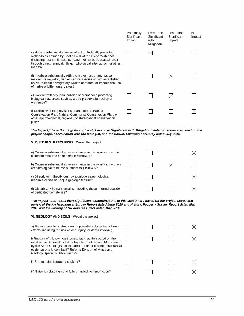
LAK 175 Middletown Shoulders 44
Potentially Significant Impact
Less Than Significant with Mitigation
Less Than Significant Impact
No Impact
c) Have a substantial adverse effect on federally protected wetlands as defined by Section 404 of the Clean Water Act (including, but not limited to, marsh, vernal pool, coastal, etc.) through direct removal, filling, hydrological interruption, or other means?
d) Interfere substantially with the movement of any native resident or migratory fish or wildlife species or with established native resident or migratory wildlife corridors, or impede the use of native wildlife nursery sites?
e) Conflict with any local policies or ordinances protecting biological resources, such as a tree preservation policy or ordinance?
f) Conflict with the provisions of an adopted Habitat Conservation Plan, Natural Community Conservation Plan, or other approved local, regional, or state habitat conservation plan?
“No Impact,” Less than Significant,” and “Less than Significant with Mitigation” determinations are based on the project scope, coordination with the biologist, and the Natural Environment Study dated July 2016.
V. CULTURAL RESOURCES: Would the project:
a) Cause a substantial adverse change in the significance of a historical resource as defined in §15064.5?
b) Cause a substantial adverse change in the significance of an archaeological resource pursuant to §15064.5?
c) Directly or indirectly destroy a unique paleontological resource or site or unique geologic feature?
d) Disturb any human remains, including those interred outside of dedicated cemeteries?
“No Impact” and “Less than Significant” determinations in this section are based on the project scope and review of the Archaeological Survey Report dated June 2015 and Historic Property Survey Report dated May 2016 and the Finding of No Adverse Effect dated May 2016.
VI. GEOLOGY AND SOILS: Would the project:
a) Expose people or structures to potential substantial adverse effects, including the risk of loss, injury, or death involving:
i) Rupture of a known earthquake fault, as delineated on the most recent Alquist-Priolo Earthquake Fault Zoning Map issued by the State Geologist for the area or based on other substantial evidence of a known fault? Refer to Division of Mines and Geology Special Publication 42?
ii) Strong seismic ground shaking?
iii) Seismic-related ground failure, including liquefaction?

LAK 175 Middletown Shoulders 45
Potentially Significant Impact
Less Than Significant with Mitigation
Less Than Significant Impact
No Impact
iv) Landslides?
b) Result in substantial soil erosion or the loss of topsoil?
c) Be located on a geologic unit or soil that is unstable, or that would become unstable as a result of the project, and potentially result in on- or off-site landslide, lateral spreading, subsidence, liquefaction or collapse?
d) Be located on expansive soil, as defined in Table 18-1-B of the Uniform Building Code (1994), creating substantial risks to life or property?
e) Have soils incapable of adequately supporting the use of septic tanks or alternative waste water disposal systems where sewers are not available for the disposal of waste water?
“No Impact” determinations in this section are based on the project scope and coordination with the project engineer.
VII. GREENHOUSE GAS EMISSIONS: Would the project:
a) Generate greenhouse gas emissions, either directly or indirectly, that may have a significant impact on the environment?
An assessment of the greenhouse gas emissions and climate change is included in the body of environmental document. While Caltrans has included this good faith effort in order to provide the public and decision-makers as much information as possible about the project, it is Caltrans determination that in the absence of further regulatory or scientific information related to GHG emissions and CEQA significance, it is too speculative to make a significance determination regarding the project’s direct and indirect impact with respect to climate change. Caltrans does remain firmly committed to implementing measures to help reduce the potential effects of the project. These measures are outlined in the body of the environmental document.
b) Conflict with an applicable plan, policy or regulation adopted for the purpose of reducing the emissions of greenhouse gases?
VIII. HAZARDS AND HAZARDOUS MATERIALS: Would the project:
a) Create a significant hazard to the public or the environment through the routine transport, use, or disposal of hazardous materials?
b) Create a significant hazard to the public or the environment through reasonably foreseeable upset and accident conditions involving the release of hazardous materials into the environment?
c) Emit hazardous emissions or handle hazardous or acutely hazardous materials, substances, or waste within one-quarter mile of an existing or proposed school?

LAK 175 Middletown Shoulders 46
Potentially Significant Impact
Less Than Significant with Mitigation
Less Than Significant Impact
No Impact
d) Be located on a site which is included on a list of hazardous materials sites compiled pursuant to Government Code Section 65962.5 and, as a result, would it create a significant hazard to the public or the environment?
e) For a project located within an airport land use plan or, where such a plan has not been adopted, within two miles of a public airport or public use airport, would the project result in a safety hazard for people residing or working in the project area?
f) For a project within the vicinity of a private airstrip, would the project result in a safety hazard for people residing or working in the project area?
g) Impair implementation of or physically interfere with an adopted emergency response plan or emergency evacuation plan?
h) Expose people or structures to a significant risk of loss, injury or death involving wildland fires, including where wildlands are adjacent to urbanized areas or where residences are intermixed with wildlands?
“No Impact” determination in this section based on the project scope, coordination with the hazardous waste specialist and the Initial Site Assessment dated September 2011.
IX. HYDROLOGY AND WATER QUALITY: Would the project:
a) Violate any water quality standards or waste discharge requirements?
b) Substantially deplete groundwater supplies or interfere substantially with groundwater recharge such that there would be a net deficit in aquifer volume or a lowering of the local groundwater table level (e.g., the production rate of pre-existing nearby wells would drop to a level which would not support existing land uses or planned uses for which permits have been granted)?
c) Substantially alter the existing drainage pattern of the site or area, including through the alteration of the course of a stream or river, in a manner which would result in substantial erosion or siltation on- or off-site?
d) Substantially alter the existing drainage pattern of the site or area, including through the alteration of the course of a stream or river, or substantially increase the rate or amount of surface runoff in a manner which would result in flooding on- or off-site?
e) Create or contribute runoff water which would exceed the capacity of existing or planned stormwater drainage systems or provide substantial additional sources of polluted runoff?
f) Otherwise substantially degrade water quality?

LAK 175 Middletown Shoulders 47
Potentially Significant Impact
Less Than Significant with Mitigation
Less Than Significant Impact
No Impact
g) Place housing within a 100-year flood hazard area as mapped on a federal Flood Hazard Boundary or Flood Insurance Rate Map or other flood hazard delineation map?
h) Place within a 100-year flood hazard area structures which would impede or redirect flood flows?
i) Expose people or structures to a significant risk of loss, injury or death involving flooding, including flooding as a result of the failure of a levee or dam?
j) Inundation by seiche, tsunami, or mudflow
“No Impact” determinations are based on the project scope, coordination with water quality specialist and the Water Quality Assessment Exemption dated September 2016.
X. LAND USE AND PLANNING: Would the project:
a) Physically divide an established community?
b)Conflict with any applicable land use plan, policy, or regulation of an agency with jurisdiction over the project (including, but not limited to the general plan, specific plan, local coastal program, or zoning ordinance) adopted for the purpose of avoiding or mitigating an environmental effect?
c) Conflict with any applicable habitat conservation plan or natural community conservation plan?
“No Impact” determinations in this section are based on the project scope and review of the Lake County General Plan.
XI. MINERAL RESOURCES: Would the project:
a) Result in the loss of availability of a known mineral resource that would be of value to the region and the residents of the state?
b) Result in the loss of availability of a locally-important mineral resource recovery site delineated on a local general plan, specific plan or other land use plan?
“No Impact” determinations in this section are based on the project scope and coordination with the project engineer.
XII. NOISE: Would the project result in:
a) Exposure of persons to or generation of noise levels in excess of standards established in the local general plan or noise ordinance, or applicable standards of other agencies?
b) Exposure of persons to or generation of excessive groundborne vibration or groundborne noise levels?
c) A substantial permanent increase in ambient noise levels in the project vicinity above levels existing without the project?

LAK 175 Middletown Shoulders 48
Potentially Significant Impact
Less Than Significant with Mitigation
Less Than Significant Impact
No Impact
d) A substantial temporary or periodic increase in ambient noise levels in the project vicinity above levels existing without the project?
e) For a project located within an airport land use plan or, where such a plan has not been adopted, within two miles of a public airport or public use airport, would the project expose people residing or working in the project area to excessive noise levels?
f) For a project within the vicinity of a private airstrip, would the project expose people residing or working in the project area to excessive noise levels?
“No Impact” determinations in this section are based on the project scope and review of the Noise Analysis document dated May 2016.
XIII. POPULATION AND HOUSING: Would the project:
a) Induce substantial population growth in an area, either directly (for example, by proposing new homes and businesses) or indirectly (for example, through extension of roads or other infrastructure)?
b) Displace substantial numbers of existing housing, necessitating the construction of replacement housing elsewhere?
c) Displace substantial numbers of people, necessitating the construction of replacement housing elsewhere?
“No Impact” determinations in this section are based on the project scope, location and coordination review of the Lake County General Plan.
XIV. PUBLIC SERVICES:
a) Would the project result in substantial adverse physical impacts associated with the provision of new or physically altered governmental facilities, need for new or physically altered governmental facilities, the construction of which could cause significant environmental impacts, in order to maintain acceptable service ratios, response times or other performance objectives for any of the public services:
Fire protection?
Police protection?
Schools?
Parks?
Other public facilities?
“No Impact” and “Less than Significant with Mitigation” determinations in this section are based on the project scope, location and communication with Lake County Parks and Recreation Department.

LAK 175 Middletown Shoulders 49
Potentially Significant Impact
Less Than Significant with Mitigation
Less Than Significant Impact
No Impact
XV. RECREATION:
a) Would the project increase the use of existing neighborhood and regional parks or other recreational facilities such that substantial physical deterioration of the facility would occur or be accelerated?
b) Does the project include recreational facilities or require the construction or expansion of recreational facilities which might have an adverse physical effect on the environment?
“No Impact” determinations in this section are based on the project scope, location and communication with Lake County Parks and Recreation Department.
XVI. TRANSPORTATION/TRAFFIC: Would the project:
a) Conflict with an applicable plan, ordinance or policy establishing measures of effectiveness for the performance of the circulation system, taking into account all modes of transportation including mass transit and non-motorized travel and relevant components of the circulation system, including but not limited to intersections, streets, highways and freeways, pedestrian and bicycle paths, and mass transit?
b) Conflict with an applicable congestion management program, including, but not limited to level of service standards and travel demand measures, or other standards established by the county congestion management agency for designated roads or highways?
c) Result in a change in air traffic patterns, including either an increase in traffic levels or a change in location that results in substantial safety risks?
d) Substantially increase hazards due to a design feature (e.g., sharp curves or dangerous intersections) or incompatible uses (e.g., farm equipment)?
e) Result in inadequate emergency access?
f) Conflict with adopted policies, plans or programs regarding public transit, bicycle, or pedestrian facilities, or otherwise decrease the performance or safety of such facilities?
“No Impact” determinations in this section are based on the project scope and coordination with project engineers.
XVII. TRIBAL CULTURAL RESOURCES: Would the project cause a substantial adverse change in the significance of a tribal cultural resource, defined in Public Resources Code section 21074 as either a site, feature, place, cultural landscape that is geographically defined in terms of the size and scope of the landscape, sacred place, or object with cultural value to a California Native American tribe, and that is:
a) Listed or eligible for listing in the California Register of Historical Resources, or in a local register of historical resources as defined in Public Resources Code section 5020.1(k), or

LAK 175 Middletown Shoulders 50
Potentially Significant Impact
Less Than Significant with Mitigation
Less Than Significant Impact
No Impact
b) A resource determined by the lead agency, in its discretion and supported by substantial evidence, to be significant pursuant to criteria set forth in subdivision (c) of Public Resources Code Section 5024.1. In applying the criteria set forth in subdivision (c) of Public Resource Code Section 5024.1, the lead agency shall consider the significance of the resource to a California Native American tribe.
“No impact” determinations are based upon the project scope and coordination with local historical societies, preservation groups, and Native American groups.
XVIII. UTILITIES AND SERVICE SYSTEMS: Would the project:
a) Exceed wastewater treatment requirements of the applicable Regional Water Quality Control Board?
b) Require or result in the construction of new water or wastewater treatment facilities or expansion of existing facilities, the construction of which could cause significant environmental effects?
c) Require or result in the construction of new storm water drainage facilities or expansion of existing facilities, the construction of which could cause significant environmental effects?
d) Have sufficient water supplies available to serve the project from existing entitlements and resources, or are new or expanded entitlements needed?
e) Result in a determination by the wastewater treatment provider which serves or may serve the project that it has adequate capacity to serve the project’s projected demand in addition to the provider’s existing commitments?
f) Be served by a landfill with sufficient permitted capacity to accommodate the project’s solid waste disposal needs?
g) Comply with federal, state, and local statutes and regulations related to solid waste?
“No impact” determinations are based on the project scope and coordination with the utilities engineer.

LAK 175 Middletown Shoulders 51
Potentially Significant Impact
Less Than Significant with Mitigation
Less Than Significant Impact
No Impact
XIX. MANDATORY FINDINGS OF SIGNIFICANCE
a) Does the project have the potential to degrade the quality of the environment, substantially reduce the habitat of a fish or wildlife species, cause a fish or wildlife population to drop below self-sustaining levels, threaten to eliminate a plant or animal community, substantially reduce the number or restrict the range of a rare or endangered plant or animal or eliminate important examples of the major periods of California history or prehistory?
b) Does the project have impacts that are individually limited, but cumulatively considerable? ("Cumulatively considerable" means that the incremental effects of a project are considerable when viewed in connection with the effects of past projects, the effects of other current projects, and the effects of probable future projects)?
c) Does the project have environmental effects which will cause substantial adverse effects on human beings, either directly or indirectly?

LAK 175 Middletown Shoulders 52
Appendix B- Section 4(f) Regulatory Setting
Section 4(f) of the Department of Transportation Act of 1966, codified in federal law at 49 United States Code (USC) 303, declares that “it is the policy of the United States Government that special effort should be made to preserve the natural beauty of the countryside and public park and recreation lands, wildlife and waterfowl refuges, and historic sites.” Section 4(f) specifies that the Secretary [of Transportation] may approve a transportation program or project requiring the use of publicly owned land of a public park, recreation area, or wildlife and waterfowl refuge of national, state, or local significance, or land of an historic site of national, state, or local significance (as determined by the federal, state, or local officials having jurisdiction over the park, area, refuge, or site) only if: • there is no prudent and feasible alternative to using that land; and
• the program or project includes all possible planning to minimize harm to the park, recreation area, wildlife and waterfowl refuge, or historic site resulting from the use.
Section 4(f) further requires consultation with the Department of the Interior and, as appropriate, the involved offices of the Department of Agriculture and the Department of Housing and Urban Development in developing transportation projects and programs that use lands protected by Section 4(f). If historic sites are involved, then coordination with the State Historic Preservation Officer (SHPO) is also needed. Section 6009(a) of the Safe, Accountable, Flexible, Efficient Transportation Equity Act: A Legacy for Users (SAFETEA-LU) amended Section 4(f) legislation at 23 United States Code (USC) 138 and 49 USC 303 to simplify the processing and approval of projects that have only de minimis impacts on lands protected by Section 4(f). This revision provides that once the U.S. Department of Transportation (USDOT) determines that a transportation use of Section 4(f) property, after consideration of any impact avoidance, minimization, and mitigation or enhancement measures, results in a de minimis impact on that property, an analysis of avoidance alternatives is not required and the Section 4(f) evaluation process is complete. FHWA’s final rule on Section 4(f) de minimis finding is codified in 23 Code of Federal Regulations (CFR) 774.3 and CFR 774.17. Responsibility for compliance with Section 4(f) has been assigned to the California Department of Transportation (Caltrans) pursuant to 23 USC 326 and 327, including determinations and approval of Section 4(f) evaluations, as well as coordination with those agencies that have jurisdiction over a Section 4(f) resource that may be affected by a project action.
Description of the Use
A use is occurring because parkland is permanently being incorporated into a transportation facility. Caltrans will permanently acquire approximately 1.27 acres by purchasing the land outright as transportation right of way.

LAK 175 Middletown Shoulders 53
Section 4(f) De Minimis Finding/Why De Minimis?
To accommodate the shoulder widening and realignment of the highway, Caltrans will acquire some permanent right of way property from Middletown Trailside Park, which is publicly owned and operated by Lake County. This park is open to the public and is mostly frequented by local residents who live near SR 175, the surrounding neighborhood and from local visitors who live in the nearby towns/communities in southern Lake County.
To assess the impacts to recreation caused by acquiring recreational land and converting it to a transportation facility, Caltrans analyzed the relative harm, damage, or interference to either recreational activities, features, or attributes within Middletown Trailside Park. The primary features and attributes within the park include a picnic area and an annual sculpture display that occurs from April to October each year. The recreational activities associated with these features include biking, bird watching, walking dogs, an equestrian trail and a picnic area. The Middletown Trailside Park currently consists of approximately 107 acres comprised of oak woodland habitat, grassland, and some seasonal wetlands. Several key factors, such as the size and the location of the right of way acquisition, were considered when selecting the de minimis determination. One of the reasons why a Section 4(f) de minimis determination is an appropriate approval of the use of land is because the amount of right of way acquisition that would be purchased from the park is very limited. Caltrans will be acquiring 1.27 acres of a narrow strip of parkland that is located on the eastern edge and affect some oak trees and other vegetation. A small segment of the trail will be temporarily closed, but hikers and/or riders will be able to access the trail from several other locations. Therefore, there will not be any adverse effects to the park features, attributes or activities.
Coordination/Public Notice Process
Initial contact with Lake County Parks and Recreation Division personnel began in August 2015, with former director Christina Chavez and former superintendent, Dana Smalley. This contact was made to notify them of the future Lake 175 Safety Project and that a small amount of right of acquisition from Middletown Trailside Park would be required. Ms. Chavez and Ms. Smalley were also informed that more accurate information on the amount of necessary right of way and updated project description would be sent to their department once it became available. In summer 2016, communication resumed with Lake County Public Service Office/Parks and Recreation Division current personnel, Director Lars Ewing and Deputy Director, Kati Galvani. They were provided more refined information about the location and amount of requested permanent right of way acquisition from the Middletown Trailside Park. Most recently Project Manager Jaime Matteoli has been in communication with Mr. Ewing to ensure both parties are aware of the current project scope and affects to the park.
In compliance with the National Environmental Policy Act (NEPA), the public will have from December 22, 2016 through January 23, 2017 to comment on/review Caltrans intent to make a de minimis impact finding. All comments and responses will be considered and documented in the record for the proposed project.
Avoidance, Minimization, and/or Mitigation Measures
• The least amount of park property will be acquired for the proposed project to be constructed.

LAK 175 Middletown Shoulders 54
• Monetary compensation will be given to the park in exchange for park land. Caltrans will pay fair market value.
• Early coordination with the official with jurisdiction to consider their input and make design adjustments where feasible was completed.
• Avoidance of key portions of park property was done so that the key attributes, features, or activities were not affected.

LAK 175 Middletown Shoulders 55
Title VI Policy Statement

LAK 175 Middletown Shoulders 56
List of Preparers To assist in the identification and assessment of potential environmental impacts of the proposed project, Caltrans Environmental staff prepared the following technical reports:
Thaleena Bhattal – Environmental Coordinator and Environmental Document Preparer Liza Walker – Environmental Branch Chief Joan Fine – Architectural Historian, Historic Resources Evaluation Report Jennifer White – Landscape Architect and Visual Impact Assessment Preparer Jeff Haney – Cultural Resource Specialist, preparer of Archaeological Survey Report, Historic Property Survey Report, and Finding of No Adverse Effect Jason Meigs – Biologist and Natural Environment Study Preparer Mark Melani – Hazardous Waste Specialist and Preparer of Hazardous Waste Study Samantha Hadden – Water Quality Specialist and Preparer for Water Quality Assessment Saeid Zandian – Air and Noise Specialist, Preparer of Air/Noise Analysis