Embed Size (px)
DESCRIPTION
Land Use Planning. Geography of Canada www.CraigMarlatt.com/school. Land Use Planning. Types of Land Uses The Evolution of a City Local Government & Development Revitalizing the Local Community. Types of Land Uses. What colour was most prominent on the previous slide?. - PowerPoint PPT Presentation
Citation preview

Geography of Canadawww.CraigMarlatt.com/school
Land Use Planning

Land Use Planning
1. Types of Land Uses
2. The Evolution of a City
3. Local Government & Development
4. Revitalizing the Local Community
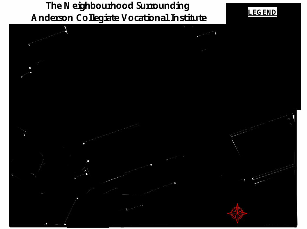
The Neighbourhood Surrounding Anderson Collegiate Vocational Institute
N
LEGEND
Residential
Commercial
Industrial
Institutional
Transportation
Open Space

Types of Land Uses
• What colour was most prominent on the previous slide?
• The land uses do not all appear evenly.

Types of Land Uses
• Specific land uses can be incredibly varied. In Canada, harsh climates have led to indoor shopping malls being built.
• And at that, those indoor malls have taken on extraordinary shapes and sizes!

Types of Land Uses
• As cities grow, they expand onto surrounding rural land, contributing to the loss of productive farmland and natural habitats.

Types of Land Uses
• The Golden Horseshoe Greenbelt has been established to protect land from urban development in southern Ontario.
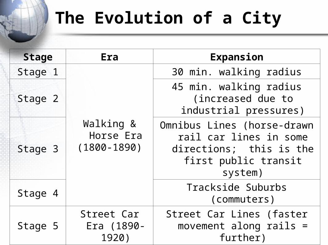
The Evolution of a City
Stage Era Expansion
Stage 1
Walking & Horse Era
(1800-1890)
30 min. walking radius
Stage 245 min. walking radius (increased
due to industrial pressures)
Stage 3Omnibus Lines (horse-drawn rail car
lines in some directions; this is the first public transit system)
Stage 4 Trackside Suburbs (commuters)
Stage 5Street Car Era
(1890-1920)Street Car Lines (faster movement
along rails = further)
Stage 6Car Era
(1920-1950)
30-45 min. driving radius
Stage 730-45 min. driving radius along
expressways (higher speeds = further in some directions)

The Evolution of a City
• As you add each stage of the evolution to your diagram, neatly label the reason for the expansion. Your final diagram will look like this but with labels

The Evolution of a City
The Evolution of a City

The Evolution of a City

The Evolution of a City

The Evolution of a City

The Evolution of a City

The Evolution of a City

Local Government & Development
• Town of Whitby Official Plan Map

LEGEND
1. Landscaped Stone Entrance Gate2. Neighbourhood Park3. Landscaped Stone Entrance Gate4. Community Park a) Future seperate elementary school b) Future public elementary school5. Pond with Gazebo6. Proposed Future Secondary School7. Neighbourhood Park8. Landscaped Stone Entrance Gate9. Pond and ravine lands10. Meanding creek and nature trails11. Landscaped Stone Entrance Gate
• Winchester Community Features
Local Government & Development
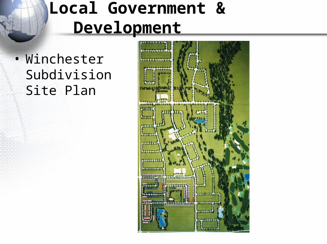
• Winchester Subdivision Site Plan
Local Government & Development

Residential Property Survey
Local Government & Development

“Brooklin Estate” Artist’s Concept
Local Government & Development

Roughed- in Washroom
CoolingCellar
Unexcavated
Lower Level
Unfinished Basement
Master Bedroom
Bedroom 2
Bedroom 3Laundry Room
Walk- inCloset
Ensuite
Bathroom
W
D
Cl.Cl.
Cl.
T
Upper Level
Family Room
Living Area
Dining Area
Garage
CoveredPorch
Porch
Foyer
Kitchen
Eating Area
Cl.
DWF
Main Level
“Brooklin Estate” Floor Plan
Local Government & Development

• YOU be the town planner!
Local Government & Development

Revitalizing the Local Community
• In-class Field Trip
• Select a Lot
• Create a Business Plan– proposal – costs – maintenance – impact
• Presentation