Embed Size (px)
Citation preview

TEXAS OOARD OF \lATER ENG INEERS
Durwood Manford, ChairmanR. M. Dixon, Membero F. Dent, Member
RECORDS OF \lATER-LEVEL MEAStJREMENrS INCROCKEI'T, GLASSCOCK, REAGAN, UPrON, AND
TERRELL COUNTIES J TEXAS1937 THROUGH 1957
Compiled by
Frank A. Rayner, Geological EngineerTexas Board of Water Engineers
Prepared in cooperation vith the Geological Survey,United States Department of the Interior
March 1959


CON TEN T S
Page
Introduction------------------------------------------------------- 1
Water-level measurements in Crockett County------------------------ 7
Water-level measurements in Terrell County------------------------- 9
Water-level measurements in Glasscock County----------------------- 17
Water-level measurements in Reagan County-------------------------- 27
Water-level measurements in Upton County--------------------------- 35
ILLUSTRATIONS
Observation wells in Crockett and Terrell Counties, Texas---------- 5
Hydrographs of water levels in wells 1 and 7, Crockett County,
and annual precipitation at Ozona, Texas------------------------- 11
Observation wells in Glasscock County, Texas----------------------- 15
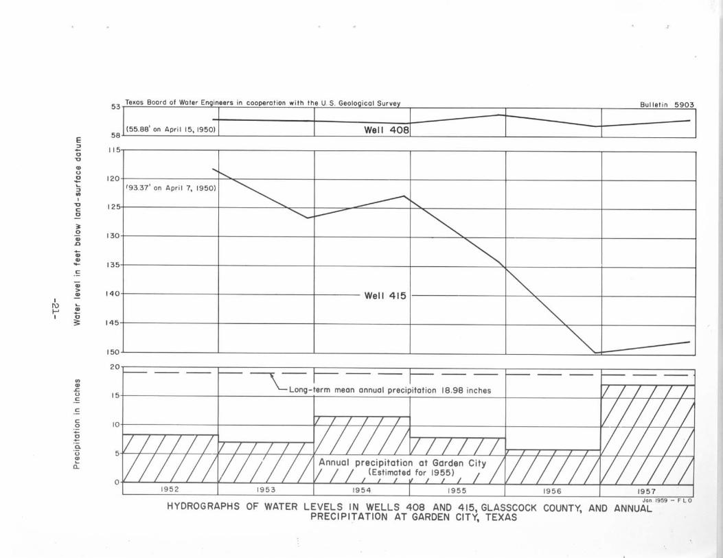
Hydrographs of water levels in wells 408 and 415, Glasscock
County, and annual precipitation at Garden City, Texas----------- 21
Observation wells in Reagan County, Texas-------------------------- 25
Hydrographs of water levels in wells 12, 14, and 6, Reagan
County, Texas---------------------------------------------------- 29
Observation wells in Upton County, Texas--------------------------- 33

,

RECORDS OF WATER-LEVEL MEASUREMENTS IN CROCKETT, GLASSCOCK, REAGAN,UPTON, AND TERRELL COUNTIES, TEXAS, 1937 TJ!ROUGH 1957
Compiled byFrank A. Rayner, Geological Engineer
Texas Board of Water Engineers
March 1959
INTRODUCTION
The Texas Board of Water Engineers is charged 'With making, independ-
ently or in cooperation with other State and Federal agencies, scientific
investigations of the source, amount, and quality of ground-'Water supplies.
To evaluate effects of ground-'Water development in relation to available
supply J periodic measurements of water levels are made in principal
reservoirs of the State through an observation well program conducted
cooperatively by the Texas Board or Water Engineers and the United States
Geological Survey.
This bulletin contains measurements of the depth to water in feet
below land-surface datum in 11 wells in Crockett County, 16 wells in
Glasscock County, 11 wells in Reagan County, 4 wells in Terrell County, and
3 wells in Upton County. The composite period of record covers measurements
made in observation 'Wells from 1937 through 1957.
Observation well location maps precede the corresponding table of
water-level measurements for each county. Hydrographs of water-level
fluctuations in selected wells in Crockett, Glasscock, and Reagan Counties
follow their associated table of water-level measurenents. Annual precipi-
tat ion charts for O~ona and Garden City are combined with their respective
hydrographs •

•

CROCKETT COUNTY

• ..
z2...~or
~o
~'"....,;'"...§-'
~~oz........'"~"z"1;;i~
•;
•E
,:
!
·!!g
i•
o
g >
,'" ;, .oo
•••
• :•
., i
•
•>
-, ,.L ".'o•
"I'i
(
•
•
•
•
•
•
•
!~I
j
!
•>
J1
·••
II
-5-

,

_7_

WATER-LEVEL MFASUREMENTS IN CROCKETr COONTY CONTINUED
13. Lat. 30·46' , long. 101°39'. Diameter 7 inches, depth 80 feet.
Date Water Date Water Date WaterLevel Level Level
Jan. 26, 1954 62.08 Dec. 9, 1955 59·73 Dec. 8, 1957 58.03Jan. 18 1955 60.10 Dec. 16 1956 61.95
14. Lat. 30°49' 1 long. 101°41'. Diameter 16 inches.
Jan. 26, 1954 144 .64 Dec. 9, 1955 144.15 Dec. 16, 1956 156 .05Jan. 18 1955 142. 0 0
15. Lat. 30°38', long. 101°39'. Diameter 18 inches, depth 101feet. Casing slotted below 19 feet.
Dec. 9, 1955 23·13 Dec. 16, 1956 23·44 Dec. 8, 1957 22.82
-8-
1
II
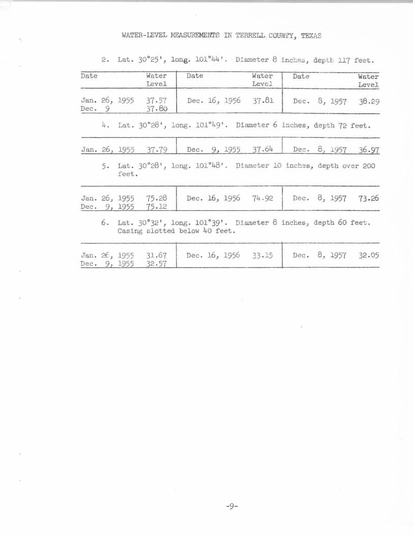
WATER-LEVEL MEASUREMENrS IN TERRELL cown, TEXAS
2. Lat. 30°25', long. 101°44' . D::"ameter 8 inc~e;;;, depth 117 feet.
Date Water Date Water Date WaterLevel Level Level
Jan. 26, 1955 37·57 Dec. 16, 1956 37.81 Dec. 8, 1957 38.29Dec. 9 37·80
4. Lat. 30°28' , long. 101°49' . Diameter 6 inches, depth 72 feet.
Jan. 26 1955 Dec. 9 1955 37·64 Dec. 8 1957 36.
5· Lat. 30°28', long. 101°48'. Diameter 10 inch~s, depth over 200feet.
Jan. 26, 1955 75·28 Dec. 16, 1956 74·92 Dec. 8, 1957 73.26Dec. 9. 1955 75.12
6. Lat. 30"'32' , long. 101°39'. Diameter 8 inches, depth 60 feet.Casing slotted belo~ 40 feet.
Jan. 2£, 1955 31.67 Dec. 16, 1956 33·15 Dec. 8, 1957 32.05Dec. 9 1955 32·57
-9-

,
•

, /, /", ./ ~ /", ./ ~ /", ./ Well 7 ~ V
, ./
," (lo.a 01 Wate, I:.na,n,.,. In COODlforlon w,rn Inl U ::; blOloou:OI :;ll'Vtv Du"."n "",v»
~,, ./ -- ~
./ ............ ./,V Well I,
,,, IIIIII IIIIII
1/ I I I I I 1/ I I I I I, / / / I I I I I I I I A~nua{ p!eCi{;ta{;o/at I Oz6n/ I I / I IIIIII,1//1// II / I I IIPartially e9timaled for 1953 and 1955-57) I I 1//111/
19 ~ 3 1954 1955 I 1956 1957
Jon ll:l:>l:l - L
o
"20
'0
,
36
39
36
37
99
96
30
97
0'
00
,.
'02
'03
'0
'00
E~-0'0..U0-~~0,'0c0
~0...c-....-C-.., >.... ...... -,~..-~
0..~
UC
C
c.'1-0-.0.u..~
Q.
HYDROGRAPHS OF WATER LEVELS IN WELLS I AND 7, CROCKETT COUNTY, AND ANNUALPRECIPITATION AT OZONA. TEXAS

•

GLASSCOCK COUNTY

•

•>.,.,....,,~.,I
o~,
"'.('.
lCOUll ••
>>••o•
••
• II... OS
•
! I I
OBSERVATION WELLS IN GLASSCOCK COUNTY, TEXAS
-15-

,
•
•

WATER-LEVEL MEASUREMENTS IN GLASSCOCK COUNTY, TEXAS
254. Lat. 31°51 ' , long .. 101°30 ' . Diameter 4 inches, depth 95 feet.
Date Water Date Water Date WaterLevel Level Level
Apr. 28, 1937 60.4 Dec. 4, 1953 57·64 Dec. 3, 1955 56.72Dec. 12 1953 59.56 Dec .. 7 1954 59·34 Dec. 10, 1956 61.65
400. Lat. 32°05', long. 101°45 1• Diameter 16 inches, ~th ~
feet. Casing slotted from 145 to 205 ~eet. 1;-)7:?~ ~:fJF~~ -~:?.i, ?J£f16:
110.48114.85
.r'- ... ''1;.:;- '-' :17Diameter 14 to 12' inC!l~s, d~th
2, 195510 1956
Dec.Dec.
Lat. 31°50', long. 101°30'.220 feet. Cased to 15 feet.
Lat. 31°54 1,
feet.
1950 g 1023 1953 106 .81
404.
405·
Apr.Dec.
,-Apr. 11, 1950 g 56 Dec. 7, 1954 58.68 Dec. 7, 1>57 59.Dec. 12, 1952 58·9 Dec. 3, 1955 58.88 .G- -'I :t:;;J ~~,• NJDec. 3 1953 58.97 Dec. 10 1956 59·44 ~'= 7 ,
I ., ' ..
.1)/ 5'::.:!2.
Apr. 5, 1950 67.27 Dec. 7, 1954 52.28 Dec. 4, 1957 47.0~""'c.Dec. 12, 1952 52.70 Dec. 3, 1955 ~9·90
.JJs<.C' -1 ;C/59 1?' ~,2.!W~62S":f"£,,,, . ? ''- "#.I'/.~"27t.
Dec. 4 1953 51.24 Dec. 10 1956 53.83 0, ,s, 13'~10.7'
~-,
~? R 'f!',e 7,;, 75"~;-406. Lat. 31 0 5l', lO:lg. 101°29' . Dia..lleter ::.2 inches, deoTh ~ trY- l)5"h) nl!.
feet, cased to 15 feet. - .1"- -~/;11 ~_~
'~::~Jo,,;,,:.I~ -'/7-;1.:J~?
Apr. 5, 1950 64.82 Dec. 4 1953 58. 7 Dec. 3, 1955 59·71,Dec. 12 1952 47.3 Dec. 7 1954 59.0 Dec. 4 1957 60.72
Dec. 12, 1952 27.35Dec. 4 '9:;3 ,1.66
Dec.Dec.
3, ~?557 1"56
27·7229.11
Dec.p~ .
4, 1957• 7
408. Lat. 31°48 1, long. 101°28'. Diameter 16 inches, depth 216
feet.
Apr.Dec.Dec.
5, 19509, 19524 1953
55·8855.3655.46
Dec.Dec.Dec ..
8, 19543, 19557 1956
,17,
55.7354.2356.20
Dec.. 4, 1957"7,:l/ :>-
",;
,SB',e-7$:- 7. .;;? ~..,..
~.- EG:.-O" ,/~~:' ;2.;LL /. 7..;5"" .",..

WATER - LEVEL MEASUREMENTS IN GLASSCOCK COUNTY - - CONUNIJEI)
,410. Lat. 31°44 1
, long. 101°30' . Diameter 12 inches, depth 192feet Cased to 12 feet.
Date Water Date Water Date WaterLevel Level Level
Apr. 7, 1950 128.87 Dec. 4, 1953 150.52 Dec. 7, 1954 154.11Dec. 9, 1952 14q.2
411. Lat. 31°43', long. 101°31'. Diameter 12 inches, depth 255 feet.Cased to 150 feet.
Apr. 7, 1950 83.56 Dec. 3, 1955 115·70 Dec. 4, 1957 128.44Dec. 8, 1954 107.44 Dec. 7 1956 130.08
415. Lat. 31°41', long. 101°34'. Diameter 10 inches, depth 214feet. Cased to 20 feet.
Apr. 7, 1950 93·37 Dec. 8, 1954 122.84 Dec. 4, 1957 147·62Dec. 9, 1952 118.85 Dec. 3, 1955 134.11Dec. 4 195' 126.65 Dec. 7 1956 149.72
421. Lat 31°40', long. 101°33'.
Dec. 8 1954 123.52 Dec. 3 1955 141.84 Dec. 4 1957 161.89 •
422. Lat. 31°40', long. 101°33'.
Dec. 7, 1956 1)8.82 I Dec. 4, 1957 162.09
423. Lat. 31°40', long. 101°33'.
Dec. 7, 1956 161.19 I Dec. 4, 1957 165.81
424, Lat. 31°58', long. 101°45 1•
Dec. 7, 1954 52·39 I Dec. 7, 1957 55.61
425. Lat. 31°54', long. 101·38' .
Dec. 7 1954 67.65 Dec. 3 1955 67·TI Dec. 10 1956 69.31
-18-
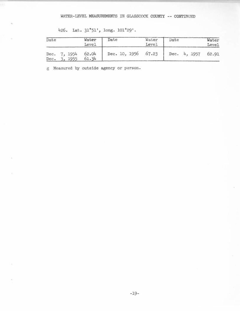
WATER-LEVEL MEASUREMENTS IN GLASSCOCK COUNTY -- CONTnnJED
426. Lat. 31°51 1, 1.008' 101'29'·
Date Water Date Water Date Waterlevel Level. Level
Dec.~~ i~~
62.04 Dec. 10, 1956 67.23 Dec. 4, 1957 62·91Dec. 61.14
g Measured by outside agency or person.
-19-

•
•
•
•
5903B'''~u" """,'u '" ....ur.' ",n ",,,.f. III """11'0'"'''''' ..... " ,,'.... ~ ...... ,U ,.... , "'I'." .... ,.•. ",
155.68' on April 15,19501 Well 406
5
,0
~19337' 011 April 7, 1950)
~
...........~
,0
~,5
""0 Well 415
""5
"",
5.
"
53
12
15'
20,=-.---==--===-r:===--===--==::-l,C=:-:==--===-l===--===---===-l===--===--===-"]:===--===--===-11~LOng-term meon annual precipitation 18.98 inches I v I I I I I !
lsI I I I r r r J r }
13
13
"
12
14
••UoS
e,-0~
•u0-•,•,~
c~
•0"~"•-.S
">",•'" •f-' a, ,.
o( { { I I I r / I ( ( t r I { I I { r I I ( { I r I { { I ( r I ( { I { I1952 1953 1954 1955 1956 1957
HYDROGRAPHS OF WATER LEVELS IN WELLS 406 AND 415, GLASSCOCKPRECIPITATION AT GARDEN CITY, TEXAS
COUNTY, ANDJ'~ IV~Il- Fl.O
ANNUAL
•
REAGAN COUNTY

•
•

, . '0 , I , , ,
•
•
", '0'
o•"•"'"•
L ~
o.0,
0,.
~"••0
~."
J, ""0'
•...--I1
,~,'
:~
:~o
"
1
11
)1°'0'1
-'-------- 10,'.0'
____1~~oe~lTT
?,__"-__'c,__,!__-,~ '" ILEI
OBSERVATION WELLS IN REAGAN COUNTY I TEXAS
-25_
•

WATER-LEVEL MEASUREMENTS IN REAGAN COwrY, TEXAS
1. Lat. 31°37', long. 101°33'. Diameter 15 to 12 lnche5~ depth320 feet.
Date WaterLevel
Apr. 10, 1950 87.6Dec. 8 1954 108.55
Date WaterLevel
Dec. 3, 1955 116.19Dec. 14, 1956 142.40
Date WaterLevel
Dec. 7, 1957 149.62
2. Lat. 31°38 1, long. 101°30 1
• Di~eter 14 inches, depth 340 teet.Cased to 14 feet.
Sept .19, 1949Apr. 10, 1950Dec. 9, 1952
96·62104·53102.22
Dec. 4, 1953Dec. 8, 1954Dec. 3, 1955
1l0.48107.461l0.75
Dec. 7, 1957 131. 54
3· Lat. 31°37', long. 101°30 1• Diameter 12 inches, depth 312 feet.
Cased to 12 feet.
Sept. 19, 1949 96.08 Dec. 4, 1953 109·00 Dec. 14, 1956 127.66Apr. 10, 1950 104.1 Dec.
~~1954 106.10 Dec. 7, 1957 128.83
Dec. 9 1952 100.90 Dec. 1955 109·07
6. Lat. 31°31', long. 101°23 I. Diameter 12 inches, depth 263 feet.
Apr.Dec.Dec.
10, 19509, ~~524 1~5'
Dec. 8, 1954Dec. 3, 1955Dec. 15 1956
142.27146.02148.16
Dec. 7, 1957 150.67
7. Lat. 31°31', long. 101°23'. Diameter 12 inches, depth 291 feet.
Apr. 10, 1950 136.~~Dec. 9 1952 141.YO
Dec. 4, 1953 141.68Dec. 8 1954 140.n
Dec. 15, 1956 145.68Dec. 7 1957 148.23
8. Lat. 31°31', long. 101°28'. Diameter 14 inches, depth 231 feet.
Sept.17, 1949 84.48ADr. 10 1<:'50 87.0
Dec. 9, 1952 86.78Dec. 4 1<:'5' 87.80
Dec. 15, 1956 89 .65Dec. 7 1957 84.16
9. Lat. 31°31 1, long. 101°28 1
• Diameter 12 inches, depth 225 feet.
Apr. 10, 1950 85.66Dec. 9 lQ52 85.28
Dec. 4, 1953Dec. 15 lQ56
-27-
86.2085.74
Dec. 7, 1957 82.87

WATER-LEVEL MEASUREME:NTS IN REAGAll COUNTY -- CONTINUED
10. Lat. 31°31', long. 101°27'. Diameter 14 inches, depth 300 feet.Cased to 10 feet.
Date Water Date Water Date WaterLevel Level Level
Sept.l?, 1949 85.89 Dec. 4, 1953 95·08 Dec. 7, 1957 84.""Apr. 10, 1950 88.42 Dec. 8, 1954 96.18Dec. 9, 1952 86.61 Dec. 15 1956 97.53
12. Lat. 31°37', long. 101°30'. Diameter 10 inches, depth 300 feet.Cased to 12 feet.
Dec. 9, 1952 89·71Dec. 4 lQ" 95.94
Dec. 8, 1954 97.46Dec. 3, 1955 101.64
Dec. 14, 1956 lio.04Dec. 7 1957 li5.ql
13. Lat. 31°37', long. 101°30'. Diameter 12 inches, depth 300 feet.
Dec. 9, 1952 95.78 Dec. 8, 1954 97.97 Dec. 14, 1956 111.19Dec. 4 195, 101.0, Dec. ,: 1955 103.26 Dec. 7 1957 li8. ,8
14. Lat. 31°32', long. 101°26'.
Dec. 9, 1952 li1.65 Dec. 8, 1954 112.00 Dec. 15, 1956 li6.12Dec. 4 lQ5' 112.20 Dec. 3. 1955 li3.18 Dec. 7 1957 112.68
-28-
•

en..J..JW;0
.<DoZ<l
,.:.
N
zen..JW>W..J
Q;W...<l;0U.oen:I:a.<lQ;
<0oa:o>:I:
,:...z:::>ouZ<l<0<lwQ;
en<lXW...
d
"~
1 II I,0~~, .• ~-
1/;; ~
~~-
1/ w~
~-
/II
~~
~-
/ N <t <D- -- - -- - -• ~ C C• ;0 ;0 ;0>•>
~.. •u
t ~
~-•~
~
~
•<-<"
c2
~e• ~
Q ~
8 -u
"
"• -• 0
~~
~-~ ,;.! -~ •.. d N
~C ~
~Q -
;n~ c
• ~
• ~• -~
g ~
oo o
No~
o•
-29-

•
•

UPTON COUNTY

•
•
•
•
,

•
•
•
•
•
•
•
••
,.~
"
I \.~~\
/
\,
,~'"-;.:0-- •.
u • , •
-
'0" 0, .,
I
~C\~~~~.
....----\
. ,
,".
•
•
•
••
•
.,'
.."
• • ... uL~~~_'L~"'L~"
••_ 'n~ . no
OBSERVATION WELLS IN UPTON COUNTY. TEXAS
-33-

•
•

------_.- -
WATER - LEVEL MEASUREMENTS IN UPrON COUNTY, TEXAS
1. Lat. 31 0 28' , long. 1010 56'. Diameter 18 inches, depth 175 feet.
Date Water Date Water Date WaterLevel Level Level
Jan. 25 1954 154.4 Dec. 15 1956 159.52 Dec. 5 1957 155.23
2. Lat. 31 0 26', long. 101 0 56'. Diameter 13 inches, depth over300 feet.
Jan. 25, 1954 162.63 Dec. 5, 1955 161. 72 Dec. 5, 1957 162.74Dec. 4 161.85 Dec. 15 1956 163·95
3. Lat. 31 0 27', long. 101 0 56'. Diameter 13 inches, depth over300 feet.
Jan. 25, 1954 160.64 Dec. 5, 1955 164.14 Dec. 5, 1957 160.66Dec. 4 160.20 Dec. 15 1956 161.80
-35-
•