Embed Size (px)
Citation preview
Arquipelago - Life and Marine Sciences ISSN: 0873-4704
21
Long–term monitoring across elevational gradients (II):
vascular plants on Pico Island (Azores) transect
COELHO, M.C.M., R.B. ELIAS, J. KLUGE, F. PEREIRA, D.S.G. HENRIQUES, S.C. ARANDA,
P.A.V. BORGES, C. AH-PENG & R. GABRIEL
Coelho, M.C.M., R.B. Elias, J. Kluge, F. Pereira, D.S.G. Henriques, S.C. Aranda,
P.A.V. Borges, C. Ah-Peng & R. Gabriel 2016. Long–term monitoring across
elevational gradients (II): vascular plants on Pico Island (Azores) transect.
Arquipelago. Life and Marine Sciences 33: 21 – 44.
Pico Island remains one of the last remnants of natural vegetation in the Azores, including
the largest natural protected area; nevertheless, habitat change and the spread of exotic
plants are visible, especially in those areas where human presence prevails. Currently, the
lowlands are vastly occupied by pastures dominated by exotic herbs/grasses and most for-
ests are dominated by Pittosporum undulatum. This paper aims to: i) review previous bo-
tanical studies related to elevational gradients; ii) investigate vascular plants composition
and abundance in native vegetation, following an elevational transect (from 10 to 2200 m);
and iii) investigate some patterns of the recorded diversity and distribution of vascular
plants. Methodology follows a standardized protocol with observations in 100 m2 plots. A
total of 88 species were recorded, representing 35% of the indigenous but only 5% of the
exotic species previously known from Pico. The richest areas were found between 600 and
1000 m and the areas with the lowest proportion of indigenous species occurred between
1800 and 2200 m. The recorded composition and richness values of endemic and native
vascular plants support the high ecological and conservation value of the studied areas and
constitute a good basis for long–term monitoring projects.
Key words: elevation, exotic species, indigenous vegetation, monitoring, vascular plants
Márcia C.M. Coelho (email: [email protected]), Rui B. Elias, Fernando Pereira,
Débora S.G. Henriques, Paulo A.V. Borges & Rosalina Gabriel, CE3C, Centre for Ecolo-
gy, Evolution and Environmental Changes / Azorean Biodiversity Group and University of
the Azores, Department of Agricultural Sciences, PT- 9700–042 Angra do Heroísmo, Por-
tugal; and CITA–A and Portuguese Platform for Enhancing Ecological Research & Sus-
tainability (PEERS). Jürgen Kluge, Faculty of Geography, Philipps University of Marburg,
Deutschhausstrasse 10, DE- 35032 Marburg, Germany. Silvia C. Aranda, Museo Nacional
de Ciencias Naturales, C/José Gutiérrez Abascal, 2, ES- 28006 Madrid, Spain. Claudine
Ah-Peng, Université de La Réunion, UMR PVBMT, Pôle de Protection des Plantes, 7
Chemin de l'IRAT, 97410 Saint–Pierre, Ile de La Réunion, France.
INTRODUCTION
The Azores archipelago, in the middle North
Atlantic, is formed by nine isolated islands,
colonized since the 15th century and currently
bearing a small fraction of their original primary
forest habitats (estimated at less than 3%; Triantis
et al. 2010; Gaspar et al. 2011). Even if about a
fifth (21%) of the Azores terrestrial territory is
currently under some level of protection, native
forest communities are restricted to much smaller
fragments, more consentaneous with the areas
categorized as natural reserves (8%) and the
islands of Terceira, Pico and Flores are the largest
contributors to that percentage (PNA [cited
2016]).
Coelho et al.
22
In the Azores, the known vascular flora comprises
1110 species and subspecies: 881 exotic (79%)
(including 328 casuals); 73 endemic (7%) and
136 (12%) native non–endemic plants to the
archipelago (Silva et al. 2010); the remaining 20
species have a doubtful/undetermined origin. The
proportion of endemic vascular plants in the
Azores is low, if compared with other
archipelagos of Macaronesia, as Madeira
(154/1204) (Borges et al. 2008) and Canary
Islands (539/2091) (Arechavaleta et al. 2010), but
relatively high if compared with most European
regions, such as mainland Portugal (150/3314)
(Menezes de Sequeira et al. 2012). If only
indigenous species are considered, the endemism
rate of Azorean flora, reaches about one third
(35%), a value higher than in Madeira (20%).
Moreover, there is a recent recognition that
current number of endemic angiosperms in
Azores is underestimated (Schäfer et al. 2011).
Within this context, of high level of both
exotic/invasive species, and endemic biodiversity,
it is important to monitor the remaining fragments
of native vegetation, to be able to evaluate the
trends of habitat and climate change, invasion by
exotics and the success of conservation programs
(Gabriel et al. 2014).
CHARACTERIZATION OF PICO ISLAND Pico Island is located between the coordinates
38°33'57'' and 38°33'44'' N of latitude and
28°01'39'' and 28°32'33'' W of longitude (França
et al. 2003). With a surface of 445 km2 and a
coastal perimeter of 126 km (Forjaz 2004), it is
the largest of the five islands of the Central
Group. Pico is shaped roughly as an oval,
elongated in the WNW–ESE axis (45 to 50 km
from “Madalena” to “Ponta da Ilha”), with a
maximum width in the NNE–SSW axis (16 km
from “Arcos” to “Ponta de S. Mateus”)
(Zbyszewski et al. 1963).
This is the youngest of the nine Azorean
islands, holding the highest mountain of Portugal
(2351 m a.s.l.), an active stratovolcano that
created the island 250 000 years ago (França et al.
2003). Its cone rises abruptly from the sea, with a
wide base that narrows from 1200 m elevation
and terminates in a shallow caldera (c. 3 km
wide), from the centre of which a secondary cone,
called “Piquinho” rises over 60 m (Forjaz 2004,
França et al. 2014). Due to its volcanic origin,
Pico Island is mostly formed by basaltic rocks
(basalts, mugearite, hawaiite) and pyroclastic
materials of basaltic composition (Madeira et al.
2007). Unlike other Azorean islands, such as São
Jorge, the coastal areas have almost no high cliffs,
and are characterized by the low lava flows and a
few sandy beaches of basaltic origin (Nunes
1999).
Pico Island is quite near its neighbouring
islands, Faial and São Jorge, separated only by
two narrow channels, the first with 6 km width
and 95 m of depth, and the second with 18 km
width and 1200 m of depth (Nunes 1999). During
the last glacial maximum (20 000 years ago) Pico
and Faial Islands were connected (Rijsdijk et al.
2014) which may have been of great biological
value allowing the exchange of several species.
Pico Island has a very low urban density (32
inhabitants/km2) compared with the islands of
Terceira (141 inhabitants/km2) and São Miguel
(185 inhabitants/km2) (INE [cited 2015]).
Pastures for dairy cattle (40%) and exotic forests
(33%) of Cryptomeria japonica, Pinus pinaster
and Acacia melanoxylon dominate the land use of
Pico Island (Cruz et al. 2007), while agriculture
(8%; including viticulture and maize), is much
less predominant. The economy of the island is
mainly based on livestock (with an important
production of cheese), fishery, agriculture
(mainly winery), and tourism (Lima et al. 2014;
Silva 2015).
The climate of Pico Island is considered humid
mesothermal with oceanic characteristics. Annual
precipitation varies between 974 mm at low
elevations and 4834 mm at 1200 m, and decreases
for 2025 mm at summit (Azevedo 1996; Azevedo
et al. 1999a,b). The average air temperature of
February (the coldest month) ranges from 15º C
(in the coastal areas) to 6º C (in the top of the
mountain) and in August (the warmest month)
from 23º C to 13º C, respectively (Azevedo et al.
2004; Barceló & Nunes 2011). This island is the
only that presents snowfall in its higher lands,
persisting for more or less extended periods of
time, during the winter months (Azevedo et al.
2004). The annual relative air humidity in Pico is
below 80% along the coastal areas, increasing in
Vascular plants on Pico Island transect
23
the remaining elevations (80–100%) (Azevedo et
al. 2004). However, exceptional conditions of air
dryness occur, with the relative humidity reaching
values lower than 10% at the summit of Pico
Mountain (França et al. 2014). The annual
average wind speed in coastal areas, during
winter months, reaches 20 km/h but gusts
commonly attain speeds of 100 km/h; in summer
months the wind velocity values decrease to
under 10 km/h (França et al. 2014).
Pico’s Natural Park is the largest of the
archipelago, covering more than one third of the
island’s area, and aiming to shelter the endemic
fauna and flora of the Azores, including their
unique subalpine and alpine habitats (Leuschner
1996). However, land categorized as Strict Nature
Reserve (IUCN category Ia) covers only 5,2% of
the island, including the mountain of Pico,
“Caveiro”, “Mistério da Prainha” and “Furnas de
Santo António” (DLR 20/2008/A).
The island hosts more than four fifths of all
indigenous vascular plants found in the Azores
(N=173; 83%) (Silva et al. 2010) but, among its
616 taxa, it also includes 430 exotic taxa
(naturalized and casual), that are considered
introduced and 13 taxa with doubtful colonization
status (Borges et al. 2010; Silva et al 2010). The
invasive Pittosporum undulatum Vent. has been
occupying large areas of Azorean forest, about a
third of all forest surface of the nine islands (Silva
et al. 2008c), but that increase is more prominent
in Pico Island since that species occupies 61% of
all forest surface (REAA 2014). However, the
climatic optimum of this species is at mid–
altitudes being unable to live in the colder and
much more humid altitudes (Hortal et al. 2010).
VEGETATION ZONATION STUDIES IN PICO ISLAND
Since the settlement of Portuguese in the Azores,
the vegetation suffered significant alterations,
mainly due to land–use change and the
introduction of exotic species. In the 16th century,
Gaspar Frutuoso (1998), in the series “Saudades
da Terra” described the Azorean vegetation as
composed of “tall and dense forests”, without
mentioning any particular stratification according
to elevation. Among the woody species assigned
to Pico Island by that author, it is possible to
recognize Juniperus brevifolia (Seub.) Antoine
(“Zimbro, Cedro”/Azorean cedar), Taxus baccata
L. (“Teixo”/Yew), Erica azorica Hochst. ex
Seub. (“Urze”/Azorean Heather), Frangula
azorica V. Grubov (“Sanguinho”/Buckthorn),
Laurus azorica (Seub.) Franco (“Louro”/Azorean
sweet bay), Morella faya (Aiton) Wilbur
(“Faia”/Firetree), Myrsine africana L.
(“Tamujo”/Cape myrtle), Picconia azorica
(Tutin) Knobl. (“Pau–branco”), and Viburnum
treleasei Gand. (“Folhado”/Azorean laurustinus)
(Frutuoso 1998).
Much later, several botanists attempted to de-
scribe the Azorean vegetation. Many of these
early endeavours used different elevation belts
and focused on the highest island of the archipel-
ago (cf. Table 1). In fact, its wide range of eleva-
tions (more than twice the elevation of the second
highest point in the Azores — São Miguel, 1105
m elevation [Forjaz 2004]) allows the presence of
more vegetation belts and comparisons with other
mountain regions, either in Macaronesia or else-
where.
Table 1, adapted and updated from Lüpnitz
(1975), summarizes the works of previous authors
that explicitly used elevation as an important
descriptive variable in the delimitation of vegeta-
tion belts in the Azores, such as Seubert &
Hochstetter (1843), Morelet (1860), Guppy
(1917), Allorge & Allorge (1946), Marler &
Boatman (1952), Tutin (1953), Dansereau (1966),
Lüpnitz (1975), Purvis et al. (1994, 1995). How-
ever, other very important works, namely by
Sjögren (1973, 1978), Dias (1996), Elias (2001,
2007), Dias et al. (2004) and Elias et al. (2011)
followed a different approach to describe Azorean
plant communities, the first by using a phytosoci-
ological perspective, the others a more quantita-
tive multivariate analysis, focusing on the com-
munities without restricting their analysis to the
finding of elevation belts.
Since the pioneer work by Seubert &
Hochstetter (1843), more than 150 years separate
these visions of the Azorean vegetation, and this
was a dynamic period regarding land use (e.g.
Triantis et al. 2010; Silveira 2013), with massive
loss of native habitats.
Considering Table 1 (in the following page), it
is possible to recognize some consensus towards
a vegetation change around 500–600 m and an-
other around 1500 m, but the descriptions of the
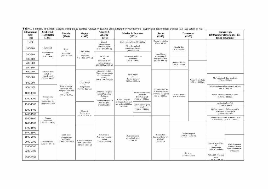
Table 1. Summary of different systems attempting to describe Azorean vegetation, using different elevational belts (adapted and updated from Lüpnitz 1975; see details in text)
Elevational
belt
(m)
Seubert &
Hochstetter
(1843)
Morelet
(1860)
Guppy
(1917)
Allorge &
Allorge
(1946)
Marler & Boatman
(1952)
Tutin
(1953)
Dansereau
(1970)
Purvis et al.
(1994:upper elevations; 1995:
lower elevations)
1-100
Cultivated
or
Mediterranean
zone
(0 m - 500 m)
Zone
of
cultivation
(0 m - 500 m)
Lower woods
or
Faya zone
(0 m – 610 [800] m)
Littoral,
Mediterranean
or Riccia region
(0 m - 200 [300] m)
Rocky slopes (0 m - 50 [100] m) Coastal vegetation
(0 m - 100 m)
Morella faya
(0 m - 300 m)
100-200 Cleared woodland
with Pinus pinaster
(50 m - 150 m)
Laurel forest
(broad-leaved
evergreen trees)
(100 m - 600 m)
200-300 Myrica faya
or
Echinodium and
Neckera region
(200 [300] m - 600 m)
Pittosporum undulatum
woodland
(150 m - 500 m) 300-400
Laurus azorica
(300 m – 650 m) 400-500
Juniperus brevifolia
(450 m – 1100 m)
500-600
Canarian zone
or belt of
laurel wood
(500 m - 850 m)
Zone of woods:
laurels and other
evergreen trees and
shrubs
(500 m - 1500 m)
Myrica faya
and
Persea azorica
(500 m - 1000 m)
600-700
Upper woods
or
Juniper zone
(610 m - 1237 m)
Sphagnum region
(Juniperrus brevifolia
and Persea indica
forests)
(600 m -700 [800] m)
Ericetum azoricae
(Erica azorica and
Juniperus brevifolia)
(600 m - 1500 m) Erica azorica
(650 m-1600 m)
700-800 Mid-elevation lichen-rich forest
(700 m - 900 m)
800-900
Juniperus brevifolia
region (Adelanthus
decipiens
and
Daltonia stenophylla)
(800 [900] m -
1400 [1500] m)
900-1000
Azorean zone
or
region of shrubs
(850 m - 1500 m)
Mid-elevation wet bryophyte-rich forest
(900 m -1000 m)
1000-1100
Calluna vulgaris
heath grasslands and
wet hollows (1000 m
- 1500 m)
Mixed Erica azorica
–Juniperus
brevifolia scrub
(1000 m - 1200 m)
Upper elevation lichen-rich forest
(1050 m - 1150 m) 1100-1200
1200-1300
Shrubs or
Juniper zone
(1237 m - 1676 m)
Juniperus brevifolia
scrub
(1200 m - 1400 m)
Juniperion brevifolii
(1200m-1300m)
1300-1400 Calluna vulgaris - Daboecia azorica
heath land; Erica - sparse
(1340 m - 1500 m) 1400-1500
1500-1600 Bush or
scrub zone
(1500 m - 1700 m)
Upper zone:
more pastures
and heaths
(1500 m - 2351 m)
Subalpine or
Andreaea rupestris
region
(1500 m - 2351 m)
Barren screes on
the volcanic cone
(>1500 m)
Callunetum
(bushes of Erica and
Calluna)
(>1500 m)
Calluna/Thymus heath (scattered, dwarf
Erica clumps) (1520 m - 1600 m)
1600-1700
Calluna vulgaris
(1600 m – 2200 m)
1700-1800
Summit zone
(1700 m - 2351 m)
Calluna, Menziesia
and Thymus zone
(1676 m - 2351 m)
1800-1900
1900-2000
Prostrate mats of
Calluna/Thymus
with Racomitrium
(>1900 m)
2000-2100 Stunted assemblage
of
Stereocaulon
(2000 m - 2300 m)
2100-2200
2200-2300 Lichens
(2200m-2350m) 2300-2351
At least 50 % of bare
rock
(2300 m - 2351 m)
Vascular plants on Pico Island transect
25
communities differ considerably among the au-
thors. Nevertheless, Guppy (1917), Allorge &
Allorge (1946), Tutin (1953), Dansereau (1966)
and Lüpnitz (1975) separate the lower elevation
vegetation belts, dominated by broadleaf species
(generally below 600 m), from the higher eleva-
tion Juniperus zone.
From 600 to 1500 m, Tutin (1953) described
Ericetum azoricae. However, it is the endemic
conifer Juniperus brevifolia that is generally
recognized as the main architect species in the
Azores montane vegetation. Guppy (1917) de-
scribed forests of Juniperus brevifolia and Laurus
azorica (832–1485 m), while Allorge & Allorge
(1946) mentioned pure stands of Juniperus brevi-
folia between 850 and 1500 m. Sjögren (1973),
divided the plant communities of the Azores into
four alliances, defining the broad alliance Junipe-
rion around the presence of Juniperus brevifolia;
the importance of this gymnosperm is lately em-
phasized by Elias (2007).
It seems to be consensual that Calluna vulgaris
(L.) Hull and Thymus caespititius Brot. dominate
the vegetation above 1500 m, but Purvis and
colleagues (1994, 1995), working with lichens,
were able to describe a zonation, even above that
elevation. It is worth mentioning that the Callune-
tum put forward by Tutin (1953) was later ques-
tioned by Sjögren (1973), who proposed an im-
poverished Juniperion for all the mountainous
area of Pico.
The strong influence of the human presence
was already noted in the 19th century by Seubert
& Hochstetter (1843), which referred an “area of
cultures” to the elevations below 500 m. That
same idea is reinforced by Marler & Boatman
(1952), who introduced Pittosporum undulatum
as a differential species of Pittosporetum, a phy-
tosociological association, claiming that “the
vegetation of the northern slopes of Pico has been
affected by the recently assumed dominance of an
introduced tree Pittosporum undulatum”, with the
consequent disappearance of natural vegetation
(1952, p. 143–144).
This is the second paper on the series “Long–
term monitoring across elevational gradients” that
aims to identify and characterize the biodiversity
of native flora in several Azorean islands along an
elevational transect. This paper presents the
results of the MOVECLIM field study concerning
the vascular flora of Pico Island (further details in
Gabriel et al. 2014). The main goals of this work
are to i) review previous botanical studies related
to elevational gradients — focusing on Pico
Island, since it has the widest elevational range;
ii) investigate vascular plants composition and
abundance in key areas of native vegetation,
following an elevational transect (from 10 to
2200 m); and iii) investigate some patterns of the
recorded diversity and distribution of vascular
plants.
METHODS
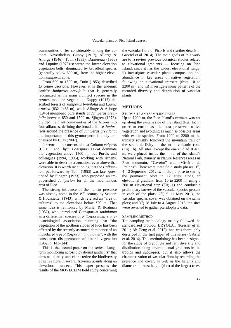
STUDY SITE AND SAMPLING DATES Up to 1000 m, the Pico Island’s transect was set
up along the eastern side of the island (Fig. 1a) in
order to encompass the best preserved native
vegetation and avoiding as much as possible areas
with exotic species. From 1200 to 2200 m the
transect roughly followed the mountain trail on
the south declivity of the main volcanic cone
(Fig. 1b). All sites, except the one studied at 400
m, were placed inside the limits of the island’s
Natural Park, namely in Nature Reserves areas as
Pico mountain, “Caveiro” and “Mistério da
Prainha”. There were three field study phases: 1st)
4–12 September 2012, with the purpose to setting
the permanent plots in 12 sites, along an
elevational gradient, from 10 to 2200 m, using a
200 m elevational step (Fig. 1) and conduct a
preliminary survey of the vascular species present
in each of the plots; 2nd) 5–11 May 2013, the
vascular species cover was obtained on the same
plots; and 3rd) 28 July to 4 August 2013, the sites
were revisited to gather pteridophyte data.
SAMPLING METHOD
The sampling methodology mainly followed the
standardized protocol BRYOLAT (Kessler et al.
2011; Ah–Peng et al. 2012), and was thoroughly
described in the first paper of this series (Gabriel
et al. 2014). This methodology has been designed
for the study of bryophyte and fern diversity and
distribution along environmental gradients in the
tropics and subtropics, but it also allows the
characterization of vascular flora by recording the
presence and cover, as well as the heights and
diameter at breast height (dbh) of the largest trees.
Coelho et al.
Fig. 1. Location of Pico Island (a) and of the transect, showing 12 sites, sampled with 200 m elevational steps (b,
c). (b) Lower elevation sites, from 10 to 1000 m and (c) Mountainous sites, from 1200 to 2200 m (surveys in 2012
and 2013).
Vascular plants were identified and
cover percentage visually estimated in two 100m2
plots per each site (species identified to genera
did not have reproductive structures available in
the field to assist in further identifi-cation). The taxonomical classification of the
vascular flora follows Silva et al. (2010).
CLIMATE DATA IN THE MOVECLIM TRANSECT
Climate data was obtained from the CIELO
Model (Azevedo 1996, Azevedo et al. 1999a,b).
CIELO is a physically based model that simulates
the climatic variables on an island using data
from the synoptic reference of a meteorological
site. For this work, the used variables were:
precipitation (total annual), relative humidity
(maximum and minimum) and temperature
(maximum and minimum), obtained from an
estimate of the values from the previous 30 years
(Table 2).
26
DATA ANALYSIS Species richness and cover–abundance were
analysed for each plot. The occurrence of a Mid
Domain Effect (MDE) (Colwell & Hurtt 1994;
Colwell & Lees 2000) was tested, using
indigenous and total richness of vascular plants.
When the MDE is confirmed, species distribution
ranges overlap more towards the middle of the
elevational gradient, due to topographical and/or
geographical constraints.
The disturbance index (D) (Cardoso et al.
2013) was obtained to determinate the landscape
disturbance accounting specifically for landscape
composition and configuration. This index re-
flects an anthropogenic disturbance gradient,
ranging from zero (no disturbance at all) to 100
(maximum possible disturbance, like an ur-
ban/industrial area) (Table 2).
Vascular plants on Pico Island transect
27
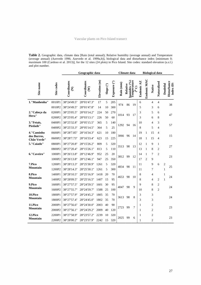
Table 2. Geographic data, climate data [Rain (total annual); Relative humidity (average annual) and Temperature (average annual) (Azevedo 1996; Azevedo et al. 1999a,b)], biological data and disturbance index [minimum 0; maximum 100 (Cardoso et al. 2013)], for the 12 sites (24 plots) in Pico Island. Site codes: standard elevation (a.s.l.) and plot number.
Geographic data Climate data Biological data
Site
nam
e
Site
cod
es
Coo
rdin
ates
(N
)
Coo
rdin
ates
(W
)
Ele
vatio
n (m
)
Slop
e (°
)
Exp
osur
e (°
)
Rai
n (m
m)
Rel
ativ
e hu
mid
ity (%
) T
empe
ratu
re
(⁰ C
) E
ndem
ic A
Z
End
emic
MA
C
Nat
ive
Nat
ural
ized
Dou
btfu
l D
istu
rban
ce
inde
x (D
)
1."Manhenha" 0010P1 38°24'49.5'' 28°01'47.3'' 17 5 205 974 86 19
6 4 4 38
0010P2 38°24'49.5'' 28°01'47.8'' 14 10 300 5 3 6 2."Cabeço da Hera"
0200P1 38°25'05.5'' 28°03'14.2'' 224 50 270 1014 93 17
3 5 6 47
0200P2 38°25'05.4'' 28°03'13.1'' 226 50 60 3 6 8 3."Fetais, Piedade"
0400P1 38°25'32.8'' 28°05'15.5'' 365 5 140 1292 94 16
10 4 3 57
0400P2 38°25'33.3'' 28°05'14.5'' 364 5 25 8 5 4 4."Caminho dos Burros, Chão Verde"
0600P1 38°28'7.85'' 28°16'34.3'' 621 10 180 3066 96 14
19 1 15 4 15
0600P2 38°28'7.73'' 28°16'33.4'' 623 15 225 18 1 15 4
5."Caiado" 0800P1 38°27'20.8'' 28°15'26.2'' 809 5 320 3513 98 13
12 1 9 1 27
0800P2 38°27'20.4'' 28°15'26.1'' 813 5 110 13 1 8 2 6."Caveiro" 1000P1 38°26'13.8'' 28°12'46.9'' 952 25 20
3812 99 12 14 1 7 2
23 1000P2 38°26'13.8'' 28°12'46.1'' 947 25 350 17 2 9
7.Pico Mountain
1200P1 38°28'13.3'' 28°25'30.9'' 1261 5 320 4834 98 11
11 9 6 2 25
1200P2 38°28'14.3'' 28°25'30.1'' 1261 5 300 11 7 1 8.Pico Mountain
1400P1 38°28'10.5'' 28°25'16.9'' 1418 20 70 4653 98 10
8 4 1 24
1400P2 38°28'09.5'' 28°25'16.5'' 1407 15 95 8 4 2 1 9.Pico Mountain
1600P1 38°27'57.5'' 28°24'59.5'' 1601 30 95 4047 98 9
9 8 2 24
1600P2 38°27'55.7'' 28°24'59.7'' 1588 25 100 10 8 2 10.Pico Mountain
1800P1 38°27'57.9'' 28°24'45.2'' 1805 35 70 3613 98 8
3 3 24
1800P2 38°27'57.4'' 28°24'45.0'' 1802 35 70 3 3 11.Pico Mountain
2000P1 38°27'56.6'' 28°24'30.0'' 2003 40 90 2723 99 7
1 2 23
2000P2 38°27'56.1'' 28°24'29.2'' 2009 40 120 1 2 12.Pico Mountain
2200P1 38°27'58.9'' 28°23'57.2'' 2239 10 320 2025 99 6
1 2 23
2200P2 38°28'00.2'' 28°23'57.9'' 2242 15 320 1 2
Coelho et al.
28
RESULTS
PLOT DESCRIPTION
Twelve elevation sites were sampled on Pico
Island, comprising 24 plots (Fig. 1, 2 and 3; Table
2). Climate becomes harsher along the elevational
gradient. Around 1600 m there is a clear change
of conditions (inversion layer), where precipi-
tation values decrease (Table 2).
The list of vascular plant species registered in
each plot, and their average percentage cover may
be observed in Table 3. Regarding the species
origin (indigenous or exotic), the vascular flora
present in these plots fall into five categories:
Azores endemic (END), Macaronesia endemic
(MAC), native non–endemic (N) (which,
together, are the indigenous species), naturalized
species (NATU) (including exotic and invasive
species) and some species with doubtful
colonization status (D) (Silva et al. 2010).
In order to characterize the vegetation
communities a brief description of the 12 sampled
sites is presented in the following section; the
plots are illustrated on Figure 2 (sites 1–6) and
Figure 3 (sites 7–12).
Site 1 (~10 m) — “Ponta da Ilha, Manhenha”
— Coastal scrubland around the lighthouse of
“Manhenha”, near “Piedade” village. A lava field
divided by some stone walls, probably, the area
was earlier used for orchards, which were
abandoned from the middle of the 20th century.
Presently, the plots are dominated by Morella
faya which reached a cover of 75% (Table 3) and,
at the herbaceous level, by Pteridium aquilinum
(average about 60%). Among others, the endemic
species Erica azorica, Picconia azorica,
Juniperus brevifolia, Euphorbia azorica were
also registered in the area. M. faya was the tallest
tree registered on the plots, reached almost 6 m
(height=580 cm; dbh=22 cm). The naturalized
Salpichroa origanifolia (Lam.) Baill. (Silva et al.
2008d), was registered for Plot 2, and is now
documented in the entire archipelago except in
Corvo Island (Silva et al. 2010).
Site 2 (~200 m) — “Cabeço da Hera” —
lowland forest located near “Piedade” village.
The surrounding area of “Cabeço da Hera” is
occupied by a quarry, pastures for cattle, and
farmland with some maize cultivation. Both plots
had a very steep slope, of about 50º (Table 2).
More than a third of all species (N=9; 39%) were
exotic, and Pittosporum undulatum exhibited the
highest cover (Table 3); this is in line with the
Disturbance Index, which presents the second
highest value observed in the transect (D=47;
Table 2). Nevertheless, the tallest trees recorded
on site were the endemics Picconia azorica
(height=600 cm; dbh=11 cm) and Morella faya
(height=590 cm; dbh=20 cm).
Site 3 (~400 m) — “Fetais, Piedade” — forest.
The plots are close to a secondary road, and
grasslands, interspersed with forested hills
covered with Morella faya, Laurus azorica and
Pittosporum undulatum dominate the surrounding
area. These plots proved to be the most affected
by anthropogenic influence, presenting also the
highest Disturbance Index of the transect (D=57;
Table 2). In fact this site is dominated by the
presence of Pittosporum undulatum (c. 80%)
(Table 3) reaching more than 8 m height (dbh=18
cm), but endemic species such as Picconia
azorica, Laurus azorica, Erica azorica, Ilex
perado subsp. azorica and the orchid Platanthera
micrantha (Hochst. ex Seub.) Schlecht. were also
present. And for other plant groups, the very rare
endemic moss Echinodium renauldii (Cardot)
Broth. was also found in this site (Coelho et al.
2013a).
Site 4 (~600 m) — “Caminho dos Burros, Chão
Verde” — Laurus azorica and Ilex perado subsp.
azorica dominate the vegetation (c. 50%). A
specimen of Erica azorica was the tallest tree in
the plots (height=640 cm; dbh=12 cm) and a
specimen of Laurus azorica presented the largest
diameter (dbh=18 cm). These plots showed the
lowest Disturbance Index (D=15) of the entire
gradient (Table 2). With 42 plant species (four
naturalized), this is the richest site of the
elevational gradient. It is possible to observe 23
out of the 25 differential species of the alliance
Juniperion brevifolii Sjögren (1973), including:
the ferns Culcita macrocarpa C. Presl, Dryopteris
aemula (Aiton) O. Kuntze, Hymenophyllum
tunbrigense (L.) Sm; the shrubs Vaccinium
cylindraceum Sm., Myrsine africana; and the
plant rarities Platanthera micrantha and Sanicula
azorica Guthn. ex Seub.

Vascular plants on Pico Island transect
29
Fig 2. Illustration of plots at different standard elevations in Pico Island (a) 10 m [P2]; b) 200 m
[P1]; c) 400 m [entrance]; d) 600 m [P1]; e) 800 m [entrance]; f) 1000 m [P1]).
Coelho et al.
30
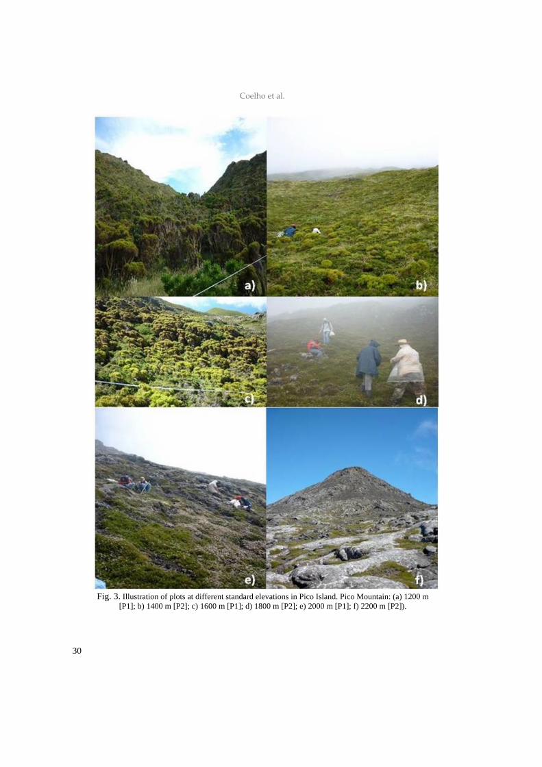
Fig. 3. Illustration of plots at different standard elevations in Pico Island. Pico Mountain: (a) 1200 m
[P1]; b) 1400 m [P2]; c) 1600 m [P1]; d) 1800 m [P2]; e) 2000 m [P1]; f) 2200 m [P2]).
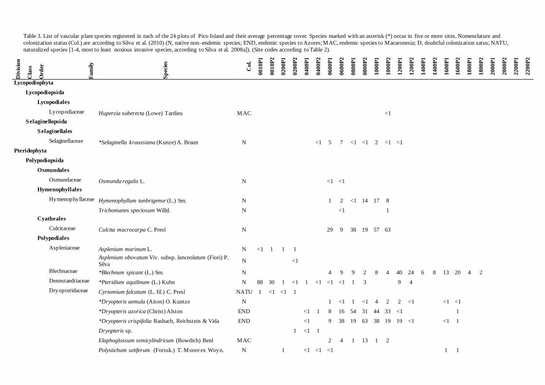
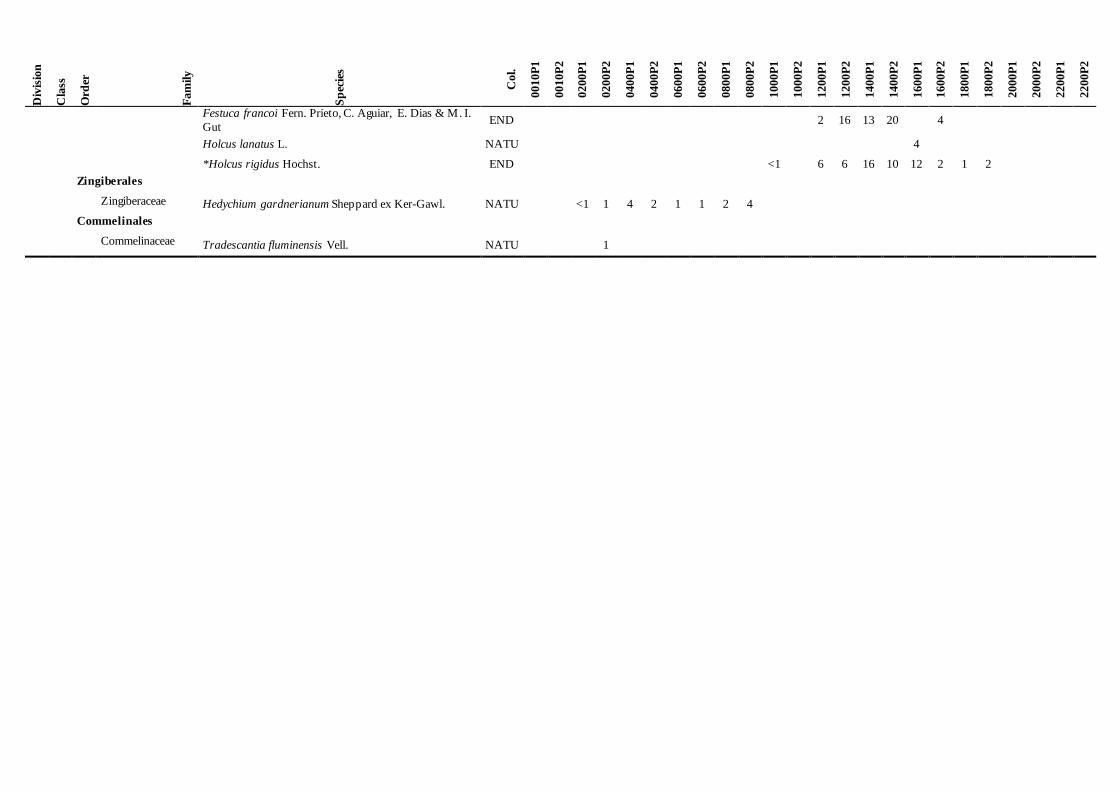
Table 3. List of vascular plant species registered in each of the 24 plots of Pico Island and their average percentage cover. Species marked with an asterisk (*) occur in five or more sites. Nomenclature and
colonization status (Col.) are according to Silva et al. (2010) (N, native non–endemic species; END, endemic species to Azores; MAC, endemic species to Macaronesia; D, doubtful colonization satus; NATU,
naturalized species [1-4, most to least noxious invasive species, according to Silva et al. 2008a]). (Site codes according to Table 2).
Div
isio
n
Cla
ss
Ord
er
Fam
ily
Sp
ecie
s
Col.
0010P
1
0010P
2
0200P
1
0200P
2
0400P
1
0400P
2
0600P
1
0600P
2
0800P
1
0800P
2
1000P
1
1000P
2
1200P
1
1200P
2
1400P
1
1400P
2
1600P
1
1600P
2
1800P
1
1800P
2
2000P
1
2000P
2
2200P
1
2200P
2
Lycopodiophyta
Lycopodiopsida
Lycopodiales
Lycopodiaceae Huperzia suberecta (Lowe) Tardieu MAC
<1
S elaginellopsida
Selaginellales
Selaginellaceae *Selaginella kraussiana (Kunze) A. Braun N
<1 5 7 <1 <1 2 <1 <1
Pteridophyta
Polypodiopsida
Osmundales
Osmundaceae Osmunda regalis L. N
<1 <1
Hymenophyllales
Hymenophyllaceae Hymenophyllum tunbrigense (L.) Sm. N
1 2 <1 14 17 8
Trichomanes speciosum Willd. N
<1
1
Cyatheales
Culcitaceae Culcita macrocarpa C. Presl N
29 9 38 19 57 63
Polypodiales
Aspleniaceae Asplenium marinum L. N <1 1 1 1
Asplenium obovatum Viv. subsp. lanceolatum (Fiori) P.
Silva N
<1
Blechnaceae *Blechnum spicant (L.) Sm. N
4 9 9 2 8 4 40 24 6 8 13 20 4 2
Dennstaedtiaceae *Pteridium aquilinum (L.) Kuhn N 88 30 1 <1 1 <1 <1 <1 1 3
9 4
Dryopteridaceae Cyrtomium falcatum (L. fil.) C. Presl NATU 1 <1 <1 1
*Dryopteris aemula (Aiton) O. Kuntze N
1 <1 1 <1 4 2 2 <1
<1 <1
*Dryopteris azorica (Christ) Alston END
<1 1 8 16 54 31 44 33 <1
1
*Dryopteris crispifolia Rasbach, Reichstein & Vida END
<1
9 38 19 63 38 19 19 <1
<1 1
Dryopteris sp.
1 <1 1
Elaphoglossum semicylindricum (Bowdich) Benl MAC
2 4 1 13 1 2
Polystichum setiferum (Forssk.) T. Moore ex Woyn. N
1
<1 <1 <1
1 1

Div
isio
n
Cla
ss
Ord
er
Fam
ily
Sp
ecie
s
Col.
0010P
1
0010P
2
0200P
1
0200P
2
0400P
1
0400P
2
0600P
1
0600P
2
0800P
1
0800P
2
1000P
1
1000P
2
1200P
1
1200P
2
1400P
1
1400P
2
1600P
1
1600P
2
1800P
1
1800P
2
2000P
1
2000P
2
2200P
1
2200P
2
Polypodiaceae Polypodium azoricum (Vasc) R. Fern. END <1
<1 <1 <1 <1 1
Thelypteridaceae *Christella dentata (Forssk.) Brownsey & Jermy NATU
1
4 9
<1 <1
<1
<1
Oreopteris limbosperma (All.) Holub N
<1
<1 <1 <1
Stegnogramma pozoi (Lag.) K. Iwats. N
9
Woodsiaceae Deparia petersenii (Kunze) M. Kato NATU
<1
Diplazium caudatum (Cav.) Jermy N
<1 19 <1
Pinophyta
Pinopsida
Pinales
Cupressaceae *Juniperus brevifolia (Seub.) Antoine END 17 1
3 14 13 18 35 41 <1 11
Magnoliophyta
Magnoliopsida
Laurales
Lauraceae Laurus azorica (Seub.) Franco END
18 15 60 36 7 4 6 7
Ranunculales
Papaveraceae Fumaria muralis Sonder ex Koch subsp. muralis NATU
<1
Fagales
Myricaceae Morella faya (Aiton) Wilbur N 75 76 41 37
<1 4
Rosales
Rhamnaceae Frangula azorica V. Grubov END
9 2
1
Rosaceae Duchesnea indica (Andr.) Focke NATU
2
2 4
Fragaria vesca L. D
1
Potentilla anglica Laich. N
3 <1 10 20 <1 4
Rubus hochstetterorum Seub. END
<1 3
Rubus ulmifolius Schott NATU
2 <1 2 1 4
Malpighiales
Euphorbiaceae Euphorbia azorica Seub. END 2
Euphorbia stygiana H. C. Watson subsp. stygiana END
37 9
Hypericaceae Hypericum foliosum Aiton END
1
<1
1
Violaceae Viola odorata L. NATU
<1
Viola palustris L. subsp. juresii (Link ex K. Wein) Cout. N
<1
Malvales

D
ivis
ion
Cla
ss
Ord
er
Fam
ily
Sp
ecie
s
Col.
0010P
1
0010P
2
0200P
1
0200P
2
0400P
1
0400P
2
0600P
1
0600P
2
0800P
1
0800P
2
1000P
1
1000P
2
1200P
1
1200P
2
1400P
1
1400P
2
1600P
1
1600P
2
1800P
1
1800P
2
2000P
1
2000P
2
2200P
1
2200P
2
Thymelaeaceae Daphne laureola L. N
<1 <1
1
Saxifragales
Crassulaceae Umbilicus horizontalis (Guss.) DC. N <1
Umbilicus rupestris (Salisb.) Dandy N
1
<1
Santalales
Santalaceae Arceuthobium azoricum Wiens & F.G. Hawksworth END
<1
2 2
Caryophyllales
Caryophyllaceae Cerastium sp.
1 2
Cerastium fontanum Baumg. subsp. vulgare (Hartm.) Greuter & Burd.
NATU
1
Silene uniflora Roth subsp. cratericola (Franco) Franco END
1 <1
Phytolaccaceae Phytolacca americana L. NATU 19 4
Polygonaceae Polygonum aviculare L. NATU
20
Ericales
Ericaceae *Calluna vulgaris (L.) Hull N
11 22 50 57 50 66 84 81 84 81 31 36
*Daboecia azorica Tutin & Warb. END
<1 <1 2 3 3 11 25 4 7
*Erica azorica Hochst. ex Seub. END 28 33
14 19 9 2 18 15
57 38 26 27 41 54
*Vaccinium cylindraceum Sm. END
4 1 21 29 19 27 31 13 12 13 2 4 4 2
Myrsinaceae Myrsine africana L. N
33 19 15 16 7 7
Primulaceae *Lysimachia azorica Hornem. ex Hook. END
3 3 <1 <1 4 2 3 1 3 2 1 2 4 1
Gentianales
Rubiaceae *Rubia agostinhoi Dans. & P. Silva N
8 5 1 3 5 6 2 1
4 1
Lamiales
Lamiaceae *Thymus caespititius Brot. N
3 6 3 4 23 25 12 24 2 4
Oleaceae Picconia azorica (Tutin) Knobl. END 19 6 12 35 19 11
Plantaginaceae Plantago lanceolata L. NATU
1
Plantago sp.
1
Scrophulariaceae Sibthorpia europaea L. N
<1 <1
<1
<1
<1 9
Solanales
Solanaceae Physalis peruviana L. NATU
<1 <1
Salpichroa origanifolia (Lam.) Baill. NATU
<1
Solanum nigrum L. NATU
9
Div
isio
n
Cla
ss
Ord
er
Fam
ily
Sp
ecie
s
Col.
0010P
1
0010P
2
0200P
1
0200P
2
0400P
1
0400P
2
0600P
1
0600P
2
0800P
1
0800P
2
1000P
1
1000P
2
1200P
1
1200P
2
1400P
1
1400P
2
1600P
1
1600P
2
1800P
1
1800P
2
2000P
1
2000P
2
2200P
1
2200P
2
Aquifoliales
Aquifoliaceae *Ilex perado Aiton subsp. azorica (Loes.) Tutin END
8
36 57 44 69 50 51 17 11
<1 1
Asterales
Asteraceae Bellis azorica Hochst. ex Seub. END
1
Leontodon saxatilis Lam. subsp. longirostris (Finch & P. D. Sell) P. Silva
D
2 2 2 2
Sonchus oleraceus L. NATU
2
2
*Tolpis azorica (Nutt.) P. Silva END
<1
14 3 6 1 <1 <1
Dipsacales
Adoxaceae Viburnum treleasei Gand. END
1 3
Apiales
Apiaceae Angelica lignescens Reduron & Danton END
1
Sanicula azorica Guthn. ex Seub. END
<1 <1
Araliaceae *Hedera azorica Carrière END 1 2 <1
2 6 2 4 4 3 <1 3
Pittosporaceae Pittosporum undulatum Vent. NATU 9 11 81 73 75 84 <1 <1
Liliopsida
Alismatales
Araceae Zantedeschia aethiopica (L.) Spreng. NATU <1
2 <1
9
Liliales
Smilacaceae Smilax azorica H. Schaef. & P. Schoenfelder END
<1
9 1
Asparagales
Orchidaceae Platanthera micrantha (Hochst. ex Seub.) Schlecht. END
<1
<1
<1 <1
Poales
Cyperaceae
Carex hochstetteriana Gay ex Seub. END
2 1
<1
Carex peregrina Link N
<1 <1
Carex sp.
4
Carex vulcani Hochst. ex Seub. END
<1 2
4 10
Juncaceae *Luzula purpureosplendens Seub. END
<1 2 5 2 16 15 4 3 3 3 12 6
Poaceae Agrostis sp.
9
4
<1 2 2 1
<1 <1
Anthoxanthum odoratum L. NATU
7
Deschampsia foliosa Hack. END
2 1
D
ivis
ion
Cla
ss
Ord
er
Fam
ily
Sp
ecie
s
Col.
0010P
1
0010P
2
0200P
1
0200P
2
0400P
1
0400P
2
0600P
1
0600P
2
0800P
1
0800P
2
1000P
1
1000P
2
1200P
1
1200P
2
1400P
1
1400P
2
1600P
1
1600P
2
1800P
1
1800P
2
2000P
1
2000P
2
2200P
1
2200P
2
Festuca francoi Fern. Prieto, C. Aguiar, E. Dias & M. I.
Gut END
2 16 13 20
4
Holcus lanatus L. NATU
4
*Holcus rigidus Hochst. END
<1
6 6 16 10 12 2 1 2
Zingiberales
Zingiberaceae Hedychium gardnerianum Sheppard ex Ker-Gawl. NATU
<1 1 4 2 1 1 2 4
Commelinales
Commelinaceae Tradescantia fluminensis Vell. NATU 1

Coelho et al.
36
Site 5 (~800 m) — “Caiado” — Forest dominated
by Ilex perado subsp. azorica (Table 3) where it
reaches the highest height and dbh values
(height=480 cm; dbh=16 cm). Among the tree
species there are also Juniperus brevifolia and
Laurus azorica while Euphorbia stygiana is
distinguished by its large size, reaching heights of
270 cm. The ferns Dryopteris crispifolia Rasbach,
Reichstein & Vida, D. azorica (Christ) Alston (c.
40% cover) and Culcita macrocarpa are also
quite frequent. Surrounding this area, there is a
lagoon, “Lagoa do Caiado”, forest areas
(production, protection, recreation) and low
intensity pastures (DROTRH 2008). Site 6 (~1000 m) — “Caveiro” — Mountain
cloud forest; system dominated by Ilex perado
subsp. azorica and Juniperus brevifolia (Table
3). Ilex perado subsp. azorica was the tallest tree
(height=370 cm) and Juniperus brevifolia the
broadest one (dbh=17 cm); both species had high
percentage covers (average 50% and 38%,
respectively). Many other plants are considered
differential species in the alliance Juniperion
brevifolii (Sjögren 1973). The fern Culcita
macrocarpa reached the highest abundance (60%
cover). This site is part of the Natural Reserve of
“Caveiro”, which includes both forests and bogs,
but the presence of cattle is notorious in the semi–
natural pastures surrounding the plots.
Sites 7 to 9 (~1200 to ~1600 m) — Pico
Mountain — from this point on, the transect
follows the mountain trail, which starts around
1200 m and extends up to the crater of Pico
Mountain. Plants reaching more than 2 m were
not present in the trail. The first site (site 7) is
covered by an Erica scrub (c. 50% cover)
reaching up to 200 cm. The fern Blechnum
spicant (L.) Sm. occupied about a third of the
area of the plot but Calluna vulgaris, Ilex perado
subsp. azorica and Vaccinium cylindraceum did
not reached 15% of cover. At 1400 m (site 8),
vegetation stature is lower, with the tallest species
reaching up to 75 cm high; Calluna vulgaris
dominates the vegetation (> 50% cover) while
short shrubs of Erica azorica cover about a
quarter of the area and the endemic Holcus
rigidus about a tenth (Table 3). At 1600 m (site 9)
Calluna vulgaris (c. 60% cover) and Erica
azorica (c. 50% cover) predominated, the latter
reaching a canopy’s maximum height of 120 cm.
Site 10 to 12 (~1800 to ~2200 m) — Pico
Mountain — these last three sites are dominated
mainly by C. vulgaris, but Daboecia azorica and
Thymus caespititius (Table 3) are also present.
These plots present a low number of species, and
no naturalized plants were recorded. At 1800 m
(site 10), the canopy’s maximum height was 29
cm, in the remaining elevations, the species were
even shorter, reaching up to 12–22 cm height.
The endemic species, Silene uniflora Roth subsp.
cratericola (Franco) Franco described from the
crater of the mountain was recorded at 2200 m
(site 12).
PATTERNS OF RICHNESS AND DISTRIBUTION OF VASCULAR PLANTS
The twelve elevational sites surveyed resulted in
a list of 88 taxa — one species new to the flora of
the island and five identified only to the genus
level — which represent circa 14% of all vascular
taxa present in this island. A total of 60
indigenous species (32 END, 2 MAC and 26 N),
21 exotic species, two species with doubtful
colonization status and five species identified to
genera were found in the surveyed sites.
About a fifth of the species (N=20; 23%)
presented a broad distribution range and were
present in five or more elevations (Table 3,
species marked with an asterisk): six ferns, the
Azorean cedar, 10 Magnoliopsida, two Liliopsida
and one Selaginellopsida. Except for the fern
Christella dentata, all species were indigenous.
Most of the species (N=51; 58%) occur up to
1000 m, while about a fifth (N=18; 21%) were
only recorded above that altitude, including
Calluna vulgaris, Daboecia azorica, Thymus
caespititius, Festuca francoi Fern. Prieto, C.
Aguiar, E. Dias & M. I. Gut and Silene
uniflora subsp. cratericola (Table 3).
In the transect, eudicotyledons’ richness (Class
Magnoliopsida) is irregularly distributed among
the different elevations surveyed, ranging from
three to 20 species, with the highest sites (1800 to
2200 m) showing fewer species (Table 3; Fig. 4).
Maximum diversity is achieved by
Magnoliopsida at 600 and 1200 m, with the
presence of 20 and 18 species, respectively.
Monocotyledons’ richness (Class Liliopsida)
ranges between one to six species. Liliopsidas’
highest diversity is reached at 600 and 1000 m

Vascular plants on Pico Island transect
37
(Fig. 4). The only gymnosperm found in the
transect, the endemic species Juniperus brevifolia
(Division Pinophyta, Class Pinopsida), occurs in
both plots of five sites (10, 600, 800, 1000 and
1200 m) (Table 3). Ferns’ richness (Class
Polypodiopsida) reaches 14 species at 600 m and
10 species at 200 and 800 m (Fig. 4). Huperzia
suberecta and Selaginella kraussiana are the two
representatives of the Classes Lycopodiopsida
and Selaginallopsida, respectively; the first is
present only at 1000 m while the second is
common between 400 and 1200 m (Table 3; Fig.
4).
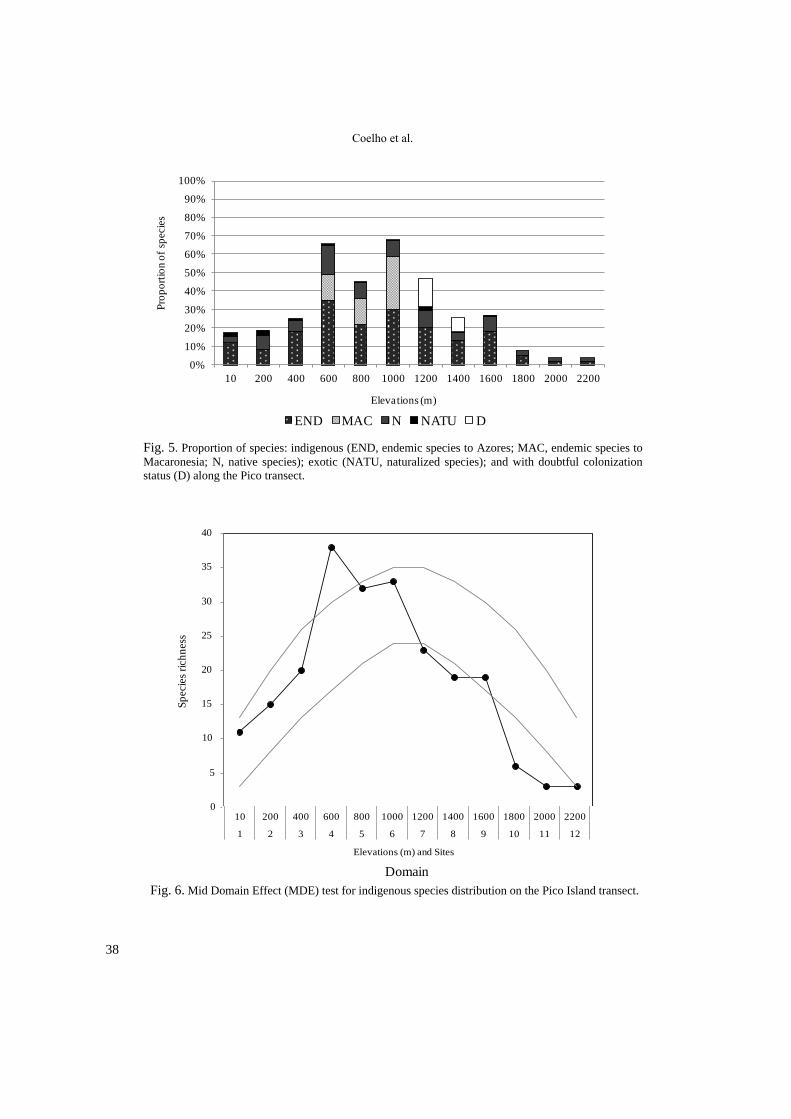
The number of indigenous species (END,
MAC and N) was always higher than the number
of exotic species (NATU). The maximum relative
richness of indigenous species was recorded
around the middle of the elevational gradient at
600, 800 and 1000 m (Fig. 5). These altitudes
correspond to the most complex forests present in
the transect, including the trees Laurus azorica,
Ilex perado subsp. azorica and Juniperus
brevifolia and many other woody species. Exotic
species richness reaches its maximum value at 10
and 200 m. At the remaining elevation levels the
relative richness of exotic species is minimal, less
than 2%, and they are completely absent in the
highest elevations, between 1800 and 2200 m
(Table 2; Fig. 5).
The distribution of species richness seems to
follow a parabolic pattern (Fig. 4 and 5).
Nevertheless, the indigenous vascular plant
species distribution does not fit the Mid Domain
Effect (MDE) (Fig. 6), since both the peak of
richness is reached below the middle of the
gradient and the number of species in the highest
elevations is lower than expected. Similar results
were obtained for all the species including exotics
(not shown).
Fig. 4. Number of vascular plants per class at each studied standard elevation.
0
10
20
30
40
50
10 200 400 600 800 1000 1200 1400 1600 1800 2000 2200
Nu
mb
er o
f v
ascu
lar
pla
nts
Elevations (m)
Lycopodiopsida Selaginellopsida Polypodiopsida Pinopsida Magnoliopsida Liliopsida
Coelho et al.
38
Fig. 5. Proportion of species: indigenous (END, endemic species to Azores; MAC, endemic species to
Macaronesia; N, native species); exotic (NATU, naturalized species); and with doubtful colonization
status (D) along the Pico transect.
Fig. 6. Mid Domain Effect (MDE) test for indigenous species distribution on the Pico Island transect.
0%
10%
20%
30%
40%
50%
60%
70%
80%
90%
100%
10 200 400 600 800 1000 1200 1400 1600 1800 2000 2200
Pro
po
rtio
n o
f sp
ecie
s
Elevations (m)
END MAC N NATU D
0
5
10
15
20
25
30
35
40
1 2 3 4 5 6 7 8 9 10 11 12
Sp
ecie
s R
ich
nes
s
Domain
86 92 94 96 98 99 98 98 98 98 99 99
0
50
100
150
200
250
300
350
400
450
500
0
2
4
6
8
10
12
14
16
18
20
10 200 400 600 800 1000 1200 1400 1600 1800 2000 2200
1 2 3 4 5 6 7 8 9 10 11 12
Rai
n (
mm
)
Tem
per
atu
re (
ºC)
Elevations (m) and Sites
Rain (mm) T (ºC) RH (%)Domain
Sp
ecie
s ri
ch
ness
0
5
10
15
20
25
30
35
40
Vascular plants on Pico Island transect
39
DISCUSSION
Among the classification systems describing the
Azorean vegetation, many used elevation to
explain biodiversity patterns (see Table 1 and
references therein). This is understandable since
not only does biodiversity respond to elevation in
a number of ways (Rahbek 1995) but, in general,
it is also considered a good surrogate of habitat
diversity and climatic variables, i.e.
“environmental heterogeneity” (e.g. Hortal et al.
2009; Kessler et al. 2011; Ah–Peng et al. 2012;
Gabriel et al. 2014). In the Azores, some authors
have proposed exposure to winds and soil’s
humidity as the main factors explaining the
distribution of plant communities (e.g. Dias 1996;
Dias et al. 2005), nevertheless, the elevational
approach used in this study, analysing only a
minimum fraction of the available area of the
island (24 plots of 100 m2), resulted in a list of
more than a third of the indigenous species
(N=60; 35%), although intermixed with some of
the exotic species (N=21; 5%) present in Pico
Island. This transect and the permanent marked
plots, thus represents a good start for future
monitoring studies.
The composition found in the surveyed plots
roughly agrees with the studies of Dansereau
(1966), since this author places a prominent value
on species such as Morella faya (0–300 m),
Laurus azorica (300–650 m) and Juniperus
brevifolia (450–1100 m). There are also striking
resemblances with the Alliance Juniperion
brevifolii described by Sjögren (1973), since a
large number of differential species was also
retrieved within the plots, especially above 400
m, where the proportion of species belonging to J.
brevifolii and their average cover is always higher
than the species with no differential value (data
not shown).
The richness of species steadily rises from the
coast (N=18: 11 indigenous and 7 exotic) until the
600 m (N=42: 38 indigenous and 4 exotic) where
it peaks, declining afterwards to a very low num-
ber of species inside the caldera of Pico Mountain
(Table 2; Fig. 5). Although the species distribu-
tion resembles a normal curve, it does not support
the Mid Domain Effect hypothesis (Fig. 6), since
the peak of richness appears much lower than the
middle of the domain (1200 m). A similar devia-
tion from the predictions was also found with the
epiphytic bryophytes of Réunion Island–
Mascarene archipelago (Ah–Peng et al. 2012).
Many Azorean endemic plants are
characterised by a wide ecological and elevational
range (e.g. Sjögren 1973; Schäfer 2005; Table 1)
and these modern times’ observations are also
corroborated by palaeoclimatic studies (Connor et
al. 2012, 2013). In fact, the Pico stratified
sampling showed 20 species with ranges equal or
higher than 1000 m (Table 3); the widest range
belongs to Erica azorica (c. 1600 m range), a
species considered as a cornerstone of the
Azorean native vegetation (e.g. Ribeiro & Borges
2010). Other endemics species, such as Juniperus
brevifolia, still present a wide range (c. 1200 m),
but was missing from the sites of 200–400 m.
This means that some species are becoming rarer,
and that the indigenous communities are
fragmented which agrees with the idea put
forward by many authors (Table 1), for instance
Purvis & James (1993: 2) who stated that in the
Azores “virtually no natural forests with native
trees exist below 500 m, having been replaced
almost completely by the exotic Pittosporum
undulatum (…)”. Indeed the sites surveyed at
lower elevations (200 and 400 m), were
impoverished and fragmented, dominated by P.
undulatum (Table 3).
In fact, invasion pressure continues in the
Azores, as is exemplified by the new record for
Pico Island of the naturalized Salpichroa
origanifolia (10 m site), a species considered
among the Top 100 invasive species of
Macaronesia (Silva et al. 2008d).
As expected (e.g. Silva et al. 2005) exotic spe-
cies richness was higher in the sites where human
action is dominant. Nevertheless, it was possible
to find eight exotic plant species along the moun-
tain trail (1200–1600 m), all presenting low co-
vers (below 5% except A. Odoratum L., with 7%)
(Table 3) and only one (D. Indica (Andr.) Focke)
currently considered invasive (Fernandes et al.
2008). Although these species were introduced a
long time ago in the Azores (cf. Schäfer 2003),
and the nature of invasive species promote their
installation, its presence above 1000 m could be
exacerbated by the intensity of visitors arriving in
Coelho et al.
40
the lowland, ready to hike to the top of the moun-
tain, stepping into the natural vegetation and
accidentally transporting propagules of exotic
species (it is possible to find seedlings or young
trees of apple, peach and apricot along the trail up
to the Pico summit, clearly indicating that visitors
do have an effect in vegetation). Similarly to
other touristic areas (e.g. Huiskes et al. 2014), this
ecotourism pressure may promote the spread of
additional invasive species to higher altitudes in
Pico, calling to urgent measures of tourists self–
regulation or special measures of education by the
park rangers in order to reduce propagule transfer
of plants.
Invasions and habitat loss (Martín et al. 2008)
are serious threats to the indigenous flora (e.g.
Schäfer 2005; Heleno 2008; Silva et al. 2008a,
2009), hindering both natural evolutionary
processes and ecosystem services. Besides,
changes in the dynamics of the vegetation from
the Azores may be reinforced by the foreseen
climatic changes (Harter et al. 2015).
Notwithstanding it is worth reinforcing that
forests at medium–higher elevations (600–1000
m) harbour an impressive number of endemic
vascular plant species (Table 2, Fig. 5)
establishing native communities similar to the
ones described in the past (e.g. Seubert &
Hochstetter 1843; Morelet 1860; Tutin 1953;
Dansereau 1966; Sjögren 1973; Dias 1996). This
richness was also confirmed for other plant
groups, such as bryophytes (Coelho et al. 2013b).
At the lower altitude sites, and in spite of their
obvious alterations, it was possible to list a
relatively high number of woody endemic species
along with Platanthera micrantha and endemic
ferns, while the disturbance index of subalpine
and alpine habitats remains quite low.
Currently, the native vegetation of Pico Island
remains very rich and important for conservation
and, although all sites but one (400 m) are well
within the boundaries of the Pico Natural Park, it
is necessary to monitor them to validate and/or
adjust eventual conservation measures, such as
the control of invasive species — PRECEFIAS
Program for Control or Eradication of Invasive
Plants in Sensitive Areas (Silva et al. 2008b) —
or the restauration of habitats using local species
to better guarantee the survival of populations and
preserve their evolutionary potential (e.g. Rumeu
et al. 2011). Monitoring and management of these
sites will be very important to prevent future
threats to native areas. Furthermore the ongoing
fragmentation (REAA 2005) and degradation of
habitats due to trampling (e.g. Silva et al. 2005),
expansion of exotic flora (e.g. Silva et al. 2008b)
and replacement of indigenous vegetation by
grasslands or plantation of non–endemic trees
(e.g. Triantis et al. 2010) are threats to the
Azorean biodiversity (Borges et al. 2009) that
may change the quality of the studied ecosystems
in the near future.
ACKNOWLEDGMENTS
The authors would like to acknowledge the
financial support granted by the research project
MOVECLIM (M2.1.2/F/04/2011/NET) and also
by projects ISLANDBIODIV (NETBIOME/0003
/2011), IMPACTBIO (DRCT–M2.1.2/I/005/
2011) and ATLANTISMAR (DRCT–M2.1.2
/I/027/2011). Besides, MCMC and DSGH were
funded by Ph.D. grants M3.1.2/F/051/2011 and
M3.1.2/F/051/2011, from the “Fundo Regional
Ciência e Tecnologia”, Regional Government of
the Azores and PROEMPREGO. The team are
grateful to the Director of the Natural Park of
Pico Island, Dr. Paulino Costa, and to the
Director of the research group CITA–A —
“Centro de Investigação e Tecnologias Agrárias–
Açores”, Doutor João Madruga, for logistic
assistance. The authors wish to thank Pedro
Cardoso for estimating disturbance data for each
site and the referees, Hanno Schäfer and Mónica
Moura, for their valuable comments on an earlier
version of the manuscript.
REFERENCES
Ah–Peng, C., N. Wilding, J. Kluge, B. Descamps–
Julien, J. Bardat, M. Chuah–Petiot, D. Strasberg et
al. 2012. Bryophyte diversity and range size
distribution along two altitudinal gradients:
Continent vs. Island. Acta Oecologica 42: 58–65.
Allorge, P. & V. Allorge 1946. Les étages de la
végétation muscinale aux îles Açores et leurs
elements. Mémoires de la Societé de
Vascular plants on Pico Island transect
41
Biogéographie 8: 369–386. [The stages of the
bryophytic vegetation in the Azores islands and
their elements; in French]
Arechavaleta, M., S. Rodríguez, N. Zurita & A. García
2010. Lista de Especies Silvestres de Canarias.
Hongos, Plantas y Animales Terrestres (1a
edición). Gobierno de Canarias. 579 pp. [List of
Wild Species of Canaries. Fungi, Plants and
Terrestrial Animals; in Spanish]
Azevedo, E.B. 1996. Modelação do clima insular à
escala local. Modelo CIELO aplicado à ilha
Terceira. PhD Thesis, Universidade dos Açores.
247 pp. [Insular climate modeling at the local scale.
CIELO model applied to Terceira Island; in
Portuguese]
Azevedo, E.B., L.S. Pereira & B. Itier 1999a.
Simulation of local climate in islands environments
using a GIS interated model. In: Musy A., L.S.
Pereira & M. Fritsch (Eds.) Emerging Technologies
for Sustainable land Use and Water Management
2nd Inter–Regional Conference Environment-
Water, Lausanne Switzerland. CD–ROM Paper
7.4.
Azevedo, E.B., L.S. Pereira & B. Itier 1999b.
Modelling the local climate in island environments:
water balance applications. Agricultural Water
Management 40: 393–403.
Azevedo, E.B., M.C. Rodrigues & J.F. Fernandes 2004.
Climatologia. Pp. 25–48 in: Forjaz, V. H. (Eds).
Atlas Básico dos Açores. Observatório
Vulcanológico e Geotérmico dos Açores, Ponta
Delgada. 112 pp. [Climatology; in Portuguese]
Barceló, A.M. & L.F. Nunes 2011. Atlas Climático dos
Arquipélagos das Canárias, da Madeira e dos
Açores. Departamento de Produção da Agência
Estatal de Meteorologia de Espanha e
Departamento de Meteorologia e Clima do Instituto
de Meteorologia de Portugal. 78 pp. [Climatic
Atlas of the Canaries, Madeira and the Azores
Archipelagos; in Portuguese]
Borges, P.A.V., C. Abreu, A.M.F. Aguiar, P. Carvalho,
S. Fontinha, R. Jardim, I. Melo, et al. 2008.
Terrestrial and freshwater biodiversity of the
Madeira and Selvagens archipelagos. Pp. 13–25 in:
Borges, P.A.V., C. Abreu, A.M.F. Aguiar, P.
Carvalho, R. Jardim, I. Melo, P. Oliveira, et al.
(Eds). A List of the Terrestrial Fungi, Flora and
Fauna of Madeira and Selvagens Archipelagos.
Direcção Regional do Ambiente da Madeira e
Universidade dos Açores, Funchal e Angra do
Heroísmo. 440 pp.
Borges, P.A.V., I.R. Amorim, R. Cunha, R. Gabriel,
A.F. Martins, L. Silva, A. Costa & V. Vieira 2009.
Azores. Pp 70–75 in: Gillespie, R.G. & D. Clagu
(Eds). Encyclopedia of Islands. University of
California Press, California. 1074 pp.
Borges, P.A.V., J. Bried, A. Costa, R. Cunha, R.
Gabriel, V. Gonçalves, A.F. Martins et al. 2010.
Description of the terrestrial and marine Azorean
biodiversity. Pp. 9–33 in: Borges, P.A.V., A. Costa,
R. Cunha, R. Gabriel, V. Gonçalves, A.F. Martins,
I. Melo et al. (Eds). A List of the Terrestrial and
Marine Biota from the Azores. Princípia, Cascais.
432 pp.
Cardoso, P., F. Rigal, S. Fattorini, S. Terzopoulou &
P.A.V. Borges 2013. Integrating landscape
disturbance and indicator species in conservation
studies. PLoS ONE 8: e63294.
Coelho, M., R. Gabriel, D. Henriques & C. Ah–Peng
2013a. Espécies raras de briófitos ao longo do
gradiente altitudinal de floresta nativa na ilha do
Pico (Açores): o caso de Echinodium renauldii
(Cardot) Broth.. Pp. 129–134 in: Livro de Atas —
Jornadas Ciência nos Açores. Que Futuro?, São
Miguel–Açores, Junho 2013. 157 pp. [Rare
bryophyte species along an altitudinal gradient of
native forest in Pico Island (Azores): the species
Echinodium renauldii; in Portuguese]
Coelho, M., R. Gabriel, D. Henriques & P.A.V. Borges
2013b. Distribuição de briófitos epífitos raros na
floresta nativa da ilha do Pico: Resultados
preliminares. Pp. 68–73 in: Livro de Actas do I
Congresso de Ciência e Desenvolvimento dos
Açores: Crise, Território e Paisagem. ACDA–
Associação para a Ciência e Desenvolvimento dos
Açores, Terceira–Açores, Julho 2013. 291pp.
[Distribution of rare epiphytic bryophytes in native
forest of Pico Island: preliminary results; in
Portuguese]
Colwell, R.K. & G.C. Hurtt 1994. Nonbiological
Gradients in Species Richness and a Spurious
Rapoport Effect. The American Naturalist 144:
570–595.
Colwell, R.K. & D.C. Lees 2000. The mid–domain
effect: geometric constraints on the geography of
species richness. Trends in Ecology & Evolution
15: 70–76.
Connor, S.E., J.F.N. van Leeuwen, T.M. Rittenour,
W.O. van der Knaap, B. Ammann & S. Björck
2012. The ecological impact of oceanic island
colonization — a palaeoecological perspective
from the Azores. Journal of Biogeography 39:
1007–1023.
Connor, S.E., W.O. van der Knaap, J.F.N. van
Leeuwen & P. Kuneš 2013. Holocene
palaeoclimate and palaeovegetation on the islands
of Flores and Pico. Pp: 149–162 in: Fernández–
Palacios, J.M., L. Nascimento, J.C. Hernández, S.
Clemente, A. González & J.P. Díaz–González
(Eds). Climate change perspectives from the
Coelho et al.
42
Atlantic: Past, present and future. Servicio de
Publicaciones, Universidad de La Laguna.
Tenerife, Canárias. 727 Pp.
Cruz, J.V., R. Pereira, A. Moreira 2007. Carta de
Ocupação do Solo da Região Autónoma dos
Açores. Ed. Secretaria Regional do Ambiente e do
Mar, Direcção Regional do Ordenamento do
Território e dos Recursos Hídricos. 56pp. [Azorean
Soil Occupation Chart; in Portuguese]
Dansereau, P. 1966. Études Macaronésiennes III. La
zonation altitudinale. Naturaliste Canadien 93:
779–795 [Macaronesian Studies III. The altitudinal
zonation; in French].
Dias, E. 1996. Vegetação natural dos Açores. Ecologia
e sintaxonomia das florestas naturais. PhD Thesis,
University of Azores. 302 pp. [Natural vegetation
of the Azores; in Portuguese]
Dias, E., R.B. Elias & V. Nunes 2004. Vegetation
mapping and nature conservation: a case study in
Terceira Island (Azores). Biodiversity and
Conservation 13: 1519–1539.
Dias E., C. Mendes, C. Melo, D. Pereira & R.B. Elias
2005. Azores central Islands vegetation and flora
field guide. Quercetea 7: 123–173.
DLR, Decreto Legislativo Regional n.º 20/2008/A de 9
de Julho. Diário da República, 1.ª série–N.º 131–9
de Julho de 2008.
DROTRH 2008. Direcção Regional do Ordenamento
do Território e Recursos Hídricos. Carta de
ocupação do solo da Região Autónoma dos Açores.
Secretaria Regional do Ambiente. Direcção
Regional do Ordenamento do Território e dos
Recursos Hídricos. Ponta Delgada. [Azorean Soil
Occupation Chart; in Portuguese]
Elias, R.B. 2001. Sucessão primária em domas
traquíticos. MSc Thesis, University of Azores. 167
pp. [Primary succession on lava domes; in
Portuguese]
Elias, R.B. 2007. Ecologia das florestas de Juniperus
dos Açores. PhD Thesis, University of Azores. 179
pp. [Ecology of Azorean Juniperus forests; in
Portuguese]
Elias, R.B., E. Dias & F. Pereira 2011. Disturbance,
regeneration and the spatial pattern of tree species
in Azorean mountain forests. Community Ecology
12: 23–30.
Fernandes, F.M., E. Ojeda & L. Silva 2008. Duchesnea
indica (Andr.) Focke. Pp. 490–492 in: Silva, L.,
E.L. Ojeda, & J.L. Rodriguez–Luengo (Eds).
Invasive Terrestrial Flora & Fauna of
Macaronesia. TOP 100 in Azores, Madeira and
Canaries. ARENA, Ponta Delgada. 546 pp.
Forjaz, V.H. 2004. Atlas Básico dos Açores.
Observatório Vulcanológico e Geotérmico dos
Açores. Ponta Delgada. 112 pp. [Basic Atlas of the
Azores; in Portuguese]
França, Z., J.V. Cruz, J.C. Nunes & V.H. Forjaz 2003.
Geologia dos Açores: uma perspectiva actual.
Açoreana 10: 11–140. [Azores Geology: an actual
perspective; in Portuguese]
França, Z., V.H. Forjaz, C.A. Ribeiro, A.M. Vaz, E.
Ribeiro, E.B. Azevedo, J.M. Tavares & L.M.
Almeida 2014. Guia de História Natural da Ilha do
Pico. Observatório Vulcanológico e Geotérmico
dos Açores. 400 pp. [Pico Island Natural History
Handbook; in Portuguese]
Frutuoso, G. 1998. Saudades da Terra: livro VI.
Instituto Cultural de Ponta Delgada, Açores,
Portugal. 165 pp. [Longing for the Land: book VI;
Originally published in 1589; in Portuguese]
Gabriel, R., M.M.C. Coelho, D.S.G. Henriques, P.A.V.
Borges, R.B. Elias, J. Kluge & C. Ah–Peng 2014.
Long–term monitoring across elevational gradients
to assess ecological hypothesis: a description of
standardized sampling methods in oceanic islands
and first results. Arquipelago. Life and Marine
Sciences 31: 45–67.
Gaspar, C., K.J. Gaston, P.A.V. Borges & P. Cardoso
2011. Selection of priority areas for arthropod
conservation in the Azores archipelago. Journal of
Insect Conservation 15: 671–684.
Guppy, H.B. 1917. Plants, Seeds and Currents in the
West Indies and the Azores. Williams and Norgate.
London. 531 pp.
Harter D.E., S.D. Irl, B. Seo, M.J. Steinbauer, R.G.
Gillespie, K.A. Triantis, J.M. Fernández–Palacios
& C. Beierkuhnlein 2015. Impacts of global
climate change on the floras of oceanic islands–
projections, implications and current knowledge.
Perspectives in Plant Ecology, Evolution and
Systematics 17: 160–183.
Heleno, R.H. 2008. The impact of alien plants on
native biota in the Azores: a food web approach.
PhD Thesis, Bristol: Faculty of Science, University
of Bristol. 179 pp.
Hortal J., K.A. Triantis, S. Meiri, E. Thébault & S.
Sfenthourakis 2009. Island species richness
increases with habitat diversity. The American
Naturalist 174: E205–217.
Hortal, J., P.A.V. Borges, A. Jiménez–Valverde, E.B.
Azevedo & L. Silva 2010. Assessing the areas
under risk of invasion within islands through
potential distribution modelling: the case of
Pittosporum undulatum in São Miguel, Azores.
Journal for Nature Conservation 18: 247–257.
Huiskes, A.H., N.J. Gremmen, D.M. Bergstrom, Y.
Frenot, K.A. Hughes, S. Imura & S.L. Chown
2014. Aliens in Antarctica: Assessing transfer of
plant propagules by human visitors to reduce
invasion risk. Biological Conservation 171: 278–
Vascular plants on Pico Island transect
43
284.
INE (Internet). Instituto Nacional de Estatística. (cited
March 2015). Available from:
http://www.ine.pt/scripts/flex_definitivos/Main.htm
l [Nacional Statistic Institute; in Portuguese]
Kessler, M., J. Kluge, A. Hemp, & R. Ohlemüller
2011. A global comparative analysis of elevational
species richness patterns of ferns. Global Ecology
and Biogeography 20: 868–880.
Leuschner, C. 1996. Timberline and alpine vegetation
on the tropical and warm temperate oceanic islands
of the world. Vegetatio 123: 193–206.
Lima, E.A., J.C. Nunes, M.P. Costa & M. Machado
2014. Basis for the geological heritage
management in the Azores Archipelago (Portugal).
Journal of Integrated Coastal Zone Management
14: 301–319.
Lüpnitz, D. 1975. Die vertikale Vegetationsgliederung
auf der Insel Pico–Azoren. Cuadernos de Botánica
Canaria XXIII/XXIV: 15–24. [The classification
of the vertical vegetation of the Pico Island–
Azores; in German]
Madeira, M., J. Pinheiro, J. Madruga & F. Monteiro
2007. Soils of volcanic systems in Portugal. Pp.
69–81 in: Arnalds, O., F. Bartoli, P. Buurman, H.
Oskarsson, G. Stoops & E. Garcia–Rodeja (Eds).
Soils of Volcanic Regions in Europe. Springer–
Verlag, Berlin. 645 pp.
Marler, P. & D.J. Boatman 1952. An Analysis of the
Vegetation of the Northern Slopes of Pico–The
Azores. Journal of Ecology 40: 143–155.
Martín, J.L., M. Arechavaleta, P.A.V. Borges & B.
Faria (Eds). 2008. TOP 100 As Cem Espécies
Ameaçadas Prioritárias em Termos de Gestão na
Região Europeia Biogeográfica da Macaronésia.
Consejería de Medio Ambiente y Ordenación
Territorial, Gobierno de Canarias, 500 pp. [Top
Hundred Priority Endangered Species in Managing
Terms in the Biogeographical European Region of
Macaronesia; in Portuguese]
Menezes de Sequeira, M., D. Espírito–Santo, C.
Aguiar, J. Capelo & J. Honrado 2012. Checklist da
Flora de Portugal (Continental, Açores e
Madeira). Associação Lusitana de Fitossociologia.
Lisboa, 74 pp. [Checklist of the Flora of Portugal
(Mainland, Azores and Madeira); in Portuguese]
Morelet, A. 1860. Iles Açores. Notice sur l'Histoire
Naturelle des Açores Suivie d'une Description des
Mollusques Terrestres de cet Archipel. J.–B.
Bailliere et Fils, Paris, 216 pp. [Information on the
Natural History of the Azores Followed by a
Description of Terrestrial Molluscs of the
Archipelago; in French]
Nunes, J.C. 1999. A actividade vulcânica na ilha do
Pico do Plistocénio Superior ao Holocénio:
Mecanismo eruptivo e hazard vulcânico. PhD
Thesis, University of Azores. 357 pp. [Volcanic
activity in Pico Island from the Upper Pleistocene
to the Holocene: eruptive mechanism and volcanic
hazard; in Portuguese]
PNA (internet). Parques Naturais dos Açores. (cited
January 2016). Available from:
http://parquesnaturais.azores.gov.pt/pt/ [Azorean
Natural Parks; in Portuguese]
Purvis, O.W. & P.W. James 1993. Studies on the
lichens of the Azores. Part 1 — Caldeira do Faial.
Arquipelago. Life and Marine Sciences 11A: 1–15.
Purvis, O.W., C.W. Smith & P.W. James 1994. Studies
in the lichens of the Azores. Part 2–lichens of the
upper slopes of Pico mountain. A comparison
between the lichen floras of the Azores, Madeira
and the Canary Islands at high altitudes.
Arquipelago. Life and Marine Sciences 12A: 35–
50.
Purvis, O.W., James, P.W. & C.W. Smith 1995.
Studies on the lichens of the. Azores. Part 3 —
Macrolichens of relict cloud forests. Boletim do
Museu Municipal do Funchal 4: 599–619.
Rahbek, C. 1995. The elevational gradient of species
richness: a uniform pattern? Ecography 18: 200–
205.
REAA 2005. Relatório do estado do ambiente dos
Açores 2005. Secretaria Regional do Ambiente e
do Mar. [Status Report of the Azorean
Environment; in Portuguese]
REAA 2014. Relatório do estado do ambiente dos
Açores 2011–2013. Secretaria Regional da
Agricultura e Ambiente, Direcção Regional do
Ambiente. [Status Report of the Azorean
Environment; in Portuguese]
Ribeiro, S.P. & P.A.V. Borges 2010. Canopy habitat
area effect on the arthropod species densities in the
Azores: pondering the contribution of tourist
species and other life histories. Pp. 89–114 in:
Serrano, A.R.M., P.A.V. Borges, M. Boieiro & P.
Oromí (Eds.). Terrestrial Arthropods of
Macaronesia — Biodiversity, Ecology and
Evolution. Sociedade Portuguesa de Entomologia,
Lisboa. 327 pp.
Rijsdijk, K.F., T. Hengl, S. Norder, R. Otto, B.C.
Emerson, S.P. Ávila, H. López, E. van Loon, E.
Tjorve & J.M. Fernández–Palacios 2014.
Quantifying surface area changes of volcanic
islands driven by Pleistocene sea level cycles:
biogeographic implications for Macaronesian
archipelagos, Atlantic Ocean. Journal of
Biogeography 41: 1227–1439.
Rumeu, B., J. Caujapé–Castells, J.L. Blanco–Pastor, R.
Jaén–Molina, M. Nogales, R.B. Elias & P. Vargas
2011. The colonization history of Juniperus
Coelho et al.
44
brevifolia (Cupressaceae) in the Azores Islands.
PLoS ONE 6: e27697. Schäfer, H. 2003. Chorology and diversity of the
Azorean flora. Dissertationes Botanicae 374: 1–
130.
Schäfer, H. 2005. Endemic vascular plants of the
Azores: an updated list. Hoppea–Denkschriften der
Regensburgischen Botanischen Gesellschaft 66:
275–283.
Schäfer, H., M. Moura, M.G.B. Maciel, L. Silva, F.
Rumsey & M.A. Carine 2011 The Linnean shortfall
in oceanic island biogeography: a case study in the
Azores. Journal of Biogeography 38: 1345–1355
Seubert, M. & C. Hochstetter 1843. Übersicht der Flora
der azorischen Inseln. Archiv für Naturgeschichte
9: 1–24. [Overview of the Flora of the Azorean
Islands; in German]
Silva, L., N. Cordeiro, X. Illas & A. Martinez 2005.
Amostragem altitudinal da flora vascular e da
vegetação na montanha do Pico. XII Expedição
Cientifica do Departamento de Biologia —
Universidade dos Açores. Relatórios e
Comunicações do Departamento de Biologia 34:
212–218. [Altitudinal sampling of the vascular
flora and vegetation of Pico Mountain; in
Portuguese]
Silva, L., E. Ojeda Land & J.L. Rodríguez–Luengo
(Eds) 2008a. Invasive Terrestrial Flora & Fauna of
Macaronesia. TOP 100 in Azores, Madeira and
Canaries. ARENA, Ponta Delgada. 546 pp.
Silva, L., E. Ojeda Land, J.L. Rodriguez–Luengo,
P.A.V. Borges, P. Oliveira & R. Jardim 2008b.
Invasive alien species in Macaronesia. Pp. 159–165
in: Silva, L., E. Ojeda Land, & J.L. Rodriguez–
Luengo (Eds) Invasive Terrestrial Flora & Fauna
of Macaronesia. TOP 100 in Azores, Madeira and
Canaries. ARENA, Ponta Delgada. 546 pp.
Silva, L., R. Corvelo, M. Moura, R. Mesa Coello &
J.A. Carvalho 2008c. Pittosporum undulatum Vent.
Pp. 225–228 in: Silva, L., E. Ojeda Land, & J.L.
Rodriguez–Luengo (Eds.) Invasive Terrestrial
Flora & Fauna of Macaronesia. TOP 100 in
Azores, Madeira and Canaries. ARENA, Ponta
Delgada. 546 pp.
Silva, L., R. Corvelo, M. Moura, R. Mesa Coello &
J.A. Carvalho 2008d. Salpichroa origanifolia
(Lam.) Thell. Pp. 233–235 in: Silva, L., E.L. Ojeda,
& J.L. Rodriguez–Luengo (Eds). Invasive
Terrestrial Flora & Fauna of Macaronesia. TOP
100 in Azores, Madeira and Canaries. ARENA,
Ponta Delgada. 546 pp.
Silva, L., M. Martins, M. Moura & G.B. Maciel 2009.
Azorean Vascular Flora: Priorities in
Conservation. Amigos dos Açores & CCPA, Ponta
Delgada. 116 pp.
Silva, L., M. Moura, H. Schäfer, F. Rumsey, E.F. Dias
2010. List of Vascular Plants (Tracheobionta). Pp.
117–146 in: Borges, P.A.V., A. Costa, R. Cunha,
R. Gabriel, V. Gonçalves, A. F. Martins, I. Melo, et
al. A List of the Terrestrial and Marine Biota from
the Azores. Princípia, Cascais. 432 pp.
Silva, L. 2015. How ecotourism works at the
community–level: the case of whale–watching in
the Azores. Current Issues in Tourism 18: 196–
211.
Silveira, L. 2013. Aprender com a História — Modos
de Interacção com a Natureza na Ilha Terceira (Do
Povoamento ao século XX). Princípia. 357 pp.
[Learning from History — Ways of interacting with
Nature in Terceira Island (From settlement to the
20th century; in Portuguese]
Sjögren, E. 1973. Recent changes in the vascular flora
and vegetation of the Azores Islands. Memórias da
Sociedade Broteriana 22: 1–453.
Sjögren, E. 1978. Bryophyte vegetation in the Azores
islands. Memórias da Sociedade Broteriana 26: 1–
273.
Triantis, K.A., P.A.V. Borges, , R.J. Ladle, J. Hortal, P.
Cardoso, C. Gaspar, F. Dinis, et al. 2010.
Extinction debt on oceanic islands. Ecography 33:
285–294.
Tutin, T.G. 1953. The vegetation of the Azores.
Journal of Ecology 41: 53–61.
Zbyszewski, G., C.R. Frreira & O.V. Ferreira 1963.
Carta Geológica de Portugal — Ilha do Pico
(Açores), Notícia Explicativa. Serviços Geológicos
de Portugal. Lisboa. [Geological map of Portugal
— Pico Island (Azores), explanatory notes; in
Portuguese]
Received 13 Nov 2015, Accepted 19 Feb 2016,
Published online 28 July 2016