Embed Size (px)
Citation preview
Kalmiopsis Volume 19, 2012 21
At 4,097 ft, Marys Peak1 is the highest mountain in the Coast Range of Oregon and is a prominent landmark in the central Willamette Valley. Its summit offers panoramic
views of the Cascade Mountains, Willamette Valley and the Pacific Ocean. The paved roads and extensive trails allow easy access for recreation on the peak. Marys Peak is located 15 miles southwest of Corvallis at the western edge of the Willamette Valley and 25 miles from the Pacific Ocean. It is about an hour drive from Philomath and Corvallis by U.S. Highway 34 and the Marys Peak Forest Roads 30 and 3010. It is less than three hours driving time from the large metropolitan centers of Portland, Eugene, and Salem.
In 1989 the Siuslaw National Forest established the Marys Peak Scenic Botanical Special Interest Area (SBSIA) in recognition of its
1 Place names in the United States generally do not use the possessive apostrophe on federal maps and signs. The United States Board on Geographic Names, which has responsibility for formal naming of municipalities and geographic features, has deprecated the use of possessive apostrophes since 1890 so as not to show ownership of the place.
scenic, botanical and recreational values. The 924-acre SBSIA is located on the higher elevations of the peak. There are about 130 acres of grass meadows on the top of the mountain. A xeric rock garden is to the southwest of the summit and pure stands of noble fir (Abies procera) grow on the peak. The headwaters of Parker Creek start as a spring in the dense noble fir forest just below the summit.
Vegetation
Marys Peak is on the eastern edge of the Coast Range Physiographic Province (Baldwin 1992, Franklin and Dyrness 1988) and located in the Coast Range Ecoregion (Loy et al. 2001). The vegetation of the lower elevations of Marys Peak is typical of the Coast Range Province, however the higher elevation plant communities on the peak are unusual in the Coast Range. The SBSIA encompasses several vegetation types, including noble fir forest, Douglas fir forest, riparian, grassland and rock garden.
OregOn Plants, OregOn Places
Marys Peak Scenic Botanical Area
Phillip R. Hays919 NW 34th St. Corvallis, OR 97330
Robert E. Frenkel4954 SW Hollyhock Circle, Corvallis, OR 97333
Esther H. G. McEvoy3290 SW Willamette Ave., Corvallis, OR 97333
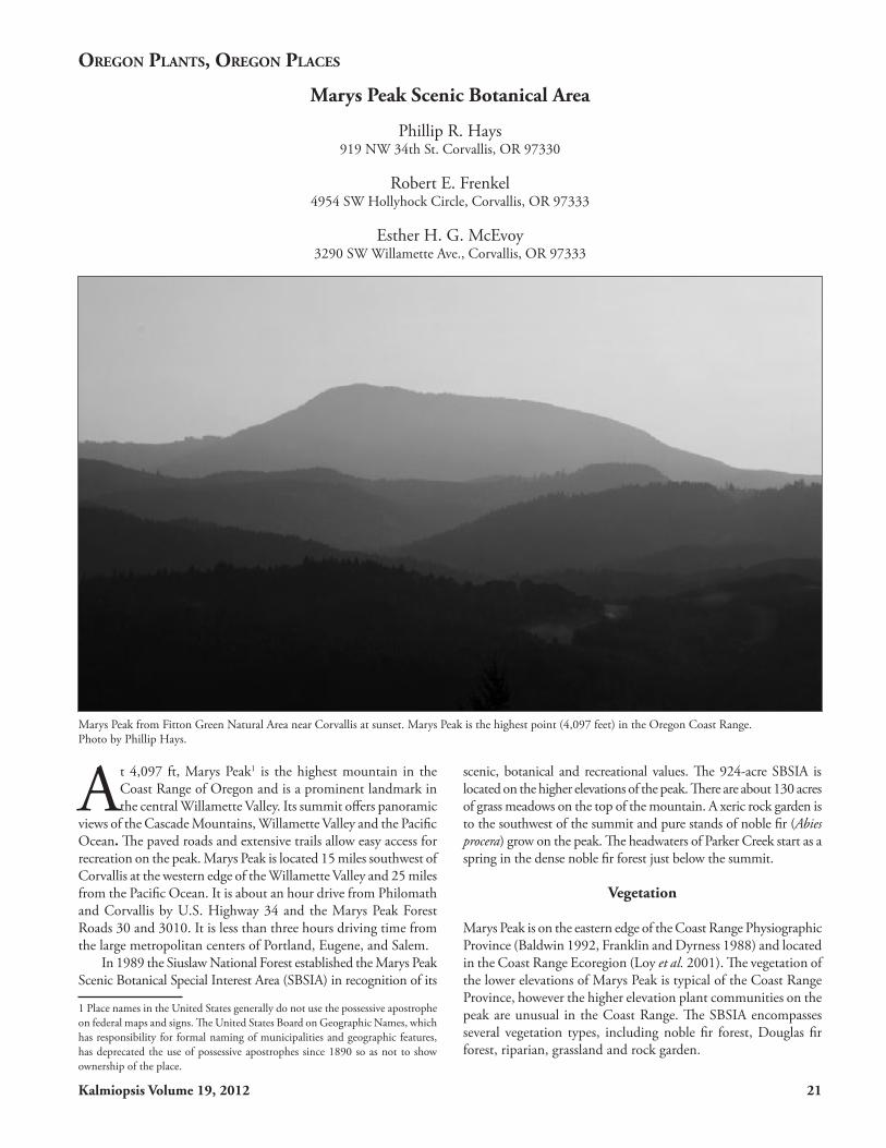
Marys Peak from Fitton Green Natural Area near Corvallis at sunset. Marys Peak is the highest point (4,097 feet) in the Oregon Coast Range. Photo by Phillip Hays.

22 Kalmiopsis Volume 19, 2012
Floristics
Marys Peak is of special botanical interest because of its many diverse plant communities. In a study of disjunct species with xeric affinities west of the Cascades, Detling (1953) examined several Coast Range and western Cascade mountains, including Marys Peak. He hypothesized that during the warm dry period that prevailed between 6,000 and 4,000 years ago, a xeric flora advanced from southern and eastern Oregon into more mesic northwestern Oregon. Subsequently, when conditions became moister and cooler, these xeric species persisted in thin-soil habitats on mountain tops. For example, prostrate lupine (Lupinus lepidus) was thought to have originated in central Oregon, and sulphur flowered buckwheat (Eriogonum umbellatum) from the Rogue area. The affinities of the flora with more northern and more montane elements is evident in the dominance of noble fir and small assemblages of plants that emerge at the edge of melting snow, such as glacier lily (Erythronium grandiflorum).
Plant Communities
Forest TypesThe moist north slopes are dominated by noble fir near the top, and by Douglas fir (Pseudostuga menziesii) and western hemlock (Tsuga heterophylla) at lower elevations. Trees on the lower ridges are younger because of past fires, but some larger trees have survived in the valleys. The drier east slopes support old growth Douglas fir at lower elevations, which is gradually replaced by noble fir near the top. Douglas fir also dominates the south-facing slopes at lower elevations, with a band of vine maple at the border with the meadows near the top. The windward west slopes, wet in winter and dry in summer, sustain forests of hemlock and Douglas fir.
Although the lower slopes of the mountain have been logged extensively, the only logging in the summit area was a small salvage operation in the 1980s to remove wind-thrown trees from a campground. The mountain has been burned occasionally as evidenced by tree age structure, snags, charcoal and fire scars. Two
Marys Peak is located 15 miles southwest of Corvallis and about 25 miles from the Pacific Ocean. At the top of the mountain is the Marys Peak Scenic Botanical Special Interest Area. Map prepared by Phillip Hays.

Kalmiopsis Volume 19, 2012 23
fires, one on the north-facing slope in 1908 and another on the west-facing slope in 1932, did not reach the summit (Merkle 1951).
The almost pure noble fir forest at the summit of Marys Peak is the most extensive stand of this species in the Coast Range. First described by Merkle (1951), this stand extends in elevation slightly above the Western Hemlock Zone. The noble fir forest is about 150 to 200 years old with only a few sentinels of 250 years. These huge trees form a closed canopy high above a dense carpet of Oregon woodsorrel (Oxalis oregana) and other herbaceous flowering plant species. Wind damage to the forest is apparent, especially as gaps created by windfalls at the forest-meadow edge.
Noble fir rarely forms extensive stands and its distribution is limited to elevations above 3,500 ft (Franklin and Dyrness 1988) in the Cascade and Coast ranges in the Pacific Northwest and northern California. It is found mostly in the Cascade Range with isolated populations on peaks in the Willapa Hills of southwestern Washington extending south into the Coast Range of Oregon.
RiparianParker Creek originates in the noble fir forest on the north slope of the peak. A narrow riparian strip lines the creek which plunges west and southward from the summit. Many species grow only in or near the stream, including slender bog orchid (Platanthera stricta), star-shaped mitrewort (Mitella caulescens), false bugbane (Trautvetteria carolinensis), twisted stalk (Streptopus amplexifolius), and trillium-leaved oxalis (Oxalis trilliifolia). The creek cascades down to Parker Creek Falls, bordered in the summer with the yellow flowers of clasping arnica (Arnica amplexicaulis).
Grassland TypesA grass bald of about 130 acres forms a prominent feature at the top of the mountain. Growing among the dense grasses are many showy forbs, including an extensive population of tiger lilies (Lilium columbianum) that color the meadow orange in summer. Western fritillaries, swallowtails and blue butterflies gather nectar from lilies, violets, yarrow and other perennials in the meadows.
Snow (1984) identified three grass and forb associations in the bald: a Festuca roemeri/Agrostis diegoensis/Carex californica community, an arrowleaf groundsel (Senecio triangularis) community and an Oregon iris (Iris tenax) community. The fescue/bentgrass/sedge community dominates most of the bald area; prominent forbs in it include tiger lily and western longspur violet (Viola adunca). This community has three phases: a species-poor dry phase on south slopes, a forb-rich assemblage on west slopes that is dominated by bracken fern (Pteridium aquilinum), and a disturbed phase with forbs, grasses and some ruderal species. The arrowleaf groundsel community grows on the north-facing slopes and in sheltered areas at meadow edges. In this type, areas around deep snowbanks have large populations of glacier lily, which is unusual in the Coast Range. These meadows are dotted with these bright yellow lilies in late spring just after the snow melts. The iris meadow in the saddle between the peak and the west point is home to wild strawberry (Fragaria virginiana) and field chickweed (Cerastium arvense).
The originally expansive, inter-connected meadow system has been significantly reduced in size by the encroachment of noble fir. This trend of shrinking grassland/meadow extent has been observed over the entire Pacific Northwest region during the past
century. Five open grassy meadows in the Oregon Coast Range, including those on Marys Peak, decreased by 66% during the past 50 years, primarily from trees establishing along the margins (Zald 2009). Even so, among the mountains studied, Marys Peak had the smallest relative decline in grass bald area (~34%). Recently, this forest encroachment has been relatively rapid, at 0.3 to 1.6 feet per year (Hadley and Savage 1996).
Tree invasion is controlled by environmental factors (soil, light and moisture) as well as by plant competition factors. Peak years for tree seedling establishment coincide with abundant rain during the growing season, mineral soil exposure, deep snow, reduced meadow vegetation and proximity to already established trees (a seed source). In a study of the stability of the boundary between the noble fir forest and grassland on Marys Peak, Magee and Antos (1992) recognized four ecotones in which noble fir trees are actively invading the meadows. The type most susceptible to tree invasion was the moist forb/grass type, Festuca roemeri/Elymus glaucus/Agrostis diegoensis, in which forbs and graminoids share dominance almost equally. Also fairly susceptible were a red fescue/sedge type with Maianthemum stellatum and Viola glabella, and the grass-dominated meadow with bracken fern and Cardwell’s penstemon (Penstemon cardwellii). The type least susceptible to tree invasion was the grass/sedge type dominated by Festuca roemeri/Carex californica, likely because a deep accumulation of graminoid litter formed a thatch over the soil surface. However,
The almost pure forest of noble fir (Abies procera) on Marys Peak is the largest stand in the Coast Range. Photo by Bob Frenkel.

24 Kalmiopsis Volume 19, 2012
distance to seed sources and plant competition also play a role.Although tree invasion increased during the past 100 years of fire
suppression, the role of fire in maintaining the distinctiveness of the grassland is unclear, because it can’t be separated from other factors (e.g., reduced ignitions by Native Americans, grazing and cessation of grazing associated with European settlement). It is believed that “even infrequent fires. . . could maintain the meadow” (Magee and Antos 1992). Federal land management agencies (Forest Service and BLM) are removing small trees to restore the meadows to what is believed to be the size before fire suppression and to improve the area for scenic viewing. Where the meadows have been segmented by narrow strips of forest, the infilling trees will be removed (McCain 2011, pers. comm.).
Rock GardenOne of the most botanically inter-esting features of Marys Peak is the summit rock garden of subalpine wildflowers, a lithosolic commu-nity on thin gravelly soil with a south to southwestern exposure. The rock garden is an area of steep slopes just below the summit that is exposed to direct hot sunlight and steady westerly breezes in summer that produce arid condi-tions. Winter storms blow away most of the snow, leaving scant snowpack to moisten the ground in spring. Vegetation is sparse on the gravelly soil and includes spreading phlox (Phlox diffusa),
harsh Indian paintbrush (Castilleja hispida), scalloped onion (Allium crenulatum), cascade desert parsley (Lomatium martindalei), prostrate lupine and Cardwell’s penstemon. Paintbrush and penstemon display splashes of vivid scarlet and purple among the rocks.
In contrast to the rock garden, a particularly lush community of native forbs and grasses thrives in the area around the rock garden and extending to the top of the peak. In late spring and early summer the area around the summit is a breath-taking display of colorful flowers, abounding with bluefield gilia (Gilia capitata), rough wallflower (Erysimum capitatum), Menzies’ larkspur (Delphinium menziesii), spreading phlox, Douglas’ silene (Silene douglasii), sickle keeled lupine (Lupinus albicaulis), western
woolly sunflower (Eriophyllum lanatum), western groundsel (Senecio integerrimus), Oregon fescue (Festuca roemeri) and many others. On warm sunny days, blooming wallflowers fill the air with a fragrant scent.
Botanists
Many botanists have collected on Marys Peak. In July 1881 Louis Henderson wrote that he was surprised to find many of
Allium crenulatum in the rock garden. Photo by Phillip Hays.
Lomatium martindalei in the rock garden. Photo by Phillip Hays.

Kalmiopsis Volume 19, 2012 25
the grasses and some flowers of eastern Oregon on top of Marys Peak (Henderson 1881). Morton Peck who wrote the only flora of Oregon, A Manual of the Higher Plants of Oregon, collected on Marys Peak as did Helen Gilkey who wrote the Handbook of Northwestern Plants with LaRea Dennis. Other botanists who have visited and collected on the peak include Francis Ownbey, a specialist in Calochortus and Allium, Judith Jernstedt who specializes in the systematics of Liliaceae and Kenton Chambers, a taxonomist at Oregon State University who specializes in the Asteraceae.
History
The stories and original name of Marys Peak used by the early American Indians are not well documented. Marys Peak was a sacred place for spirit quests for the Kalapuya tribe, a native people of western Oregon (Juntunen et al. 2005). Early European settlers drove cattle, sheep and goats to the meadows on the peak for summer forage.
In 1906 Corvallis started using water from the Rock Creek watershed on the eastern side of Marys Peak. This watershed area was almost all private land; logging operations threatened the water quality so after World War I the city of Corvallis began purchasing land in the watershed to ensure a clean water supply for the future. The lands in the Marys Peak area were added to the Siuslaw National Forest in 1940 following a purchase and land exchange. The Rock Creek Municipal Watershed on the east slope of the mountain currently supplies 40% of the city’s water. The watershed encompasses about 10,000 acres and is publicly owned; it is managed by the city of Corvallis, the Forest Service and the Bureau of Land Management (BLM). The BLM portion within the SBSIA is designated an Area of Critical Environmental Concern (ACEC).
A three-level log fire lookout constructed in 1942 at the summit of Marys Peak was replaced with a newer structure in 1959. The Air Force extended the road to the summit in 1958 and built a radar station as part of the Cold War Continental Air Defense System. The site was completed in 1959, but before the radar could be put into operation a storm blew away the antenna, so the site was abandoned in early 1960. The Air Force removed all the equipment and transferred the building to the Forest Service. This was the start of the current electronics site on the peak. The fire lookout structure was removed and two structures remain on the peak for radio communications. Currently there are two primary users of the buildings on the summit, Bonneville Power Administration (BPA) and the Forest Service. BPA operates their own equipment and the Forest Service building houses a number of permit users. Two other electronic sites on the mountain are
visible from the summit: a Federal Aviation Administration site near the campground and one owned by the City of Corvallis on the west point.
In the fall of 2011 the Forest Service installed a fence and lightning protection around the communication site on the summit. They trenched and bulldozed a large area of the protected native plant community on the peak, enlarging the disturbed area by about four times. Removal of topsoil and native vegetation has opened the area to erosion and weed invasion. The work ignored the goals of minimal disturbance to the native plant communities that are stated in all applicable management plans (USDA Forest Service 1989). The Forest Service now promises to restore the fragile habitat. We hope that they are successful, so that future visitors will be able to enjoy the native wildflowers as we have for so many years.
Recreation
Throughout the year Marys Peak SBSIA is used by a variety of recreationists. There are an estimated 93,900 visitor days to the area annually. A road initiated by the crews of Work Projects Administration (WPA) and the Civilian Conservation Corps
(CCC) was completed in 1941 and provides public access to a campground, a trail complex and a parking area below the summit. Four established trails on the mountain top provide hiking, biking and access for the public through the forests and native plant communities. Bikes are restricted in the summit area.
In 1981 extreme wind storms struck the Coast Range and buried the old campground under fallen trees. The campground and picnic area were moved to the present site. A local group called the Helonskis Ski Club operated a ski tow on the summit from 1942 to 1952 but abandoned it because the snow pack is unpredictable from year to year. Between 1946 and 1984 the Shriners held an “Annual Trek to Marys Peak” each August. The
Phlox diffusa grows on the rocks in the rock garden at the top of Marys Peak. Photo by Bob Frenkel.

26 Kalmiopsis Volume 19, 2012
event eventually became a fund raiser to help support the Shriners Crippled Children Hospitals. Estimates of up to 12,000 people attended this event and there is still evidence of barbecue pits and other uses from the past in the meadow below the parking area at the top. Special use permits have been issued for different activities including research projects, noble fir cone collection and recreation events. In order to protect the sensitive scenic and botanical values the Forest Service created the Meadow Edge Trail to minimize the impacts on the fragile plant communities in the meadow area. In 1986, snowmobile use was restricted on Marys Peak. Activities on the summit such as unauthorized off road vehicles and vandalism constitute major disturbances to the area today.
Geology and Soils
The geology of Marys Peak creates the environment for the plant communities on the mountain. The determining factor is the position of the Oregon Coast
Range at the western edge of the North American Tectonic Plate. The tectonic plates that form the Pacific Ocean floor and the Juan de Fuca Plate to the west of the Coast Range are moving northeastward. As these oceanic plates collide with the North American plate they plunge beneath it, causing uplift and generating volcanic activity.
A string of undersea volcanoes (seamounts) and volcanic islands that had formed offshore about 60 to 50 million years ago collided with and were accreted to the North American plate to produce the core of today’s Coast Range. These newly arrived oceanic rocks had formed as thick basalt lava flows on the ocean floor. Today, they include the Siletz River volcanics that compose much of the base of Marys Peak (Baldwin 1955, 1992). Erosion of onshore rocks produced sediments that flowed into the ocean to form thick layers on the ocean floor that overlie the older basalts and appear today as the sandstone and siltstone beds of the Tyee Formation (Fluornoy Formation) and Kings Valley Siltstone (Ryu et al. 1996, Wells et al. 2000).
Uplifting and faulting of the Oregon Coast Range began about 40 million years ago as it was accreted to North America. By 30 million years ago, this subduction process also produced magma that was injected as younger basalt intrusions (e.g., sills and dikes) into the Coast Range sedimentary rocks and older oceanic basalt. Differential erosion of the softer Tyee Formation sandstones and Kings Valley siltstones from around the resistant basalts of the ancient sea floor and younger intrusions have formed the Coast Range peaks. Marys Peak is the highest of these mountains, with an approximately 1,000-foot thick cap of erosion resistant coarsely crystalline basalt or gabbro sill of one of these intrusions. The sill that forms the upper part of Marys Peak is about 30 million years old (Orr et al. 1992).
Baldwin (1993) examined the Oregon Coast Range for evidence of glaciations and on Marys Peak he identified four cirque-like features in the gabbro of the summit with unconsolidated debris
Lilium columbianum in the meadows at the top of Marys Peak. Photo by Phillip Hays.
Erythronium grandiflorum var. grandiflorum growing in the meadows at the top of Marys Peak. Common in the Cascades, this species is found only on a few of the highest peaks in the Coast Range. Photo by Esther McEvoy.

Kalmiopsis Volume 19, 2012 27
accumulation at the base of each. He speculated that this topography on the northeast exposure was probable early stages of glaciation, during the end of the last ice age about 12,000 years ago. However, no clear evidence of glaciation on Marys Peak has been reported.
The older Siletz River volcanic rocks can be observed as pillow basalt, basaltic breccia, and some columnar-jointed basalt sills and dikes in cuts along the first few miles of the Marys Peak Road. An example of thick-bedded fine-grained Tyee Formation sandstone and intervening thin-bedded siltstone is exposed 6.5 mi. from the beginning of the Marys Peak Road. Parker Creek waterfall (at 6.7 mi.) displays the erosion resistant gabbro cap of Marys Peak. The intrusive gabbro elsewhere grades into a granophyric diorite comprising the coarse parent material for the soils of the grassland and rock garden (Lawrence et al. 1980).
The two primary soil series in the SBSIA are the Mulkey Series in the open meadows and the Maryspeak Series on the slopes (Fillmore 2009). The Mulkey Series are moderately deep well-drained loamy soils derived from coarse-grained intrusive igneous rock. These soils are rich in organic matter because they developed under grasslands, but contain gravels and cobbles from rocks disintegrating in place or sliding downslope (residuum and colluvium).
The Maryspeak Series are well-drained sandy loams that formed on ancient deposits from sandy colluviums derived from a mixture of sandstone and coarse-grained intrusive igneous rock. Maryspeak soils are found under forests surrounding the meadows and on mountain slopes (Fillmore 2009).
Climate
The high elevation and proximity to the Pacific Ocean are the dominant features influencing the climate and weather on Marys Peak. The climate is maritime with an annual precipitation of 100 to 120 inches; mostly falling as rain or snow and rain from October to May. Less than 5% of the yearly precipitation arrives in the summer. Winter temperatures range between 20 and 50°F and snow falls occasionally from November to June, but there is no such thing as a normal snow year on the Peak. Summer temperatures range between 40 to 90°F with winds typically no more than 20 mph.
The elevation of Marys Peak causes extremes in weather conditions that affect the distribution of the vegetation. Powerful winds up to 100 mph and periods of winter thaw prevent snow accumulation on the south and west slopes, but snowdrifts up to 10 feet deep pile up on sheltered north and east slopes. Some plants are found only where the deepest snow packs melt late in
the spring. Thick rime accumulations build up on objects near the summit in winter. The upper reaches of the noble fir forests on the north side of the peak show stunted growth caused by significant breakage due to strong winds and heavy accumulations of snow and ice. Magnificent old growth Douglas fir trees on the relatively sheltered eastern slopes benefit from heavy rainfall in the winter and collect moisture from frequent fogs and clouds in the summer. All around the top of the peak variations of exposure to wind, sun and moisture create numerous micro habitats each with its own distinct assemblage of plants. For example, xeric conditions prevail on shallow soils on the southwest side of the summit that are exposed to direct summer sunlight and constant desiccating breezes from the west.
Planning a Wildflower Walk on Marys Peak
Marys Peak has four primary trails for access to different parts of the mountain (shown on map). The shortest and easiest route is from the parking area near the top of the mountain along a dirt road to the summit. This trail gains 350 feet in two thirds of a mile to the top, where there are many beautiful native wildflower gardens in June and July.
The Meadow Edge trail starts at the parking area of the Marys Peak Campground 8.6 miles from the junction of Highway 34. It is a fairly easy loop of 1.6 miles with an elevation gain of about 500 feet. The trail crosses Parker Creek and climbs through the almost pure noble fir stand. A short side trail leads to the summit. You can also access this trail from the dirt road leading up from the parking lot at the top.
The East Ridge trail starts from Connors Camp parking lot on Marys Peak Road 5.5 miles from the junction with Highway 34. The trail is 3.5 miles with a 1400-foot elevation gain. The trail climbs through old growth Douglas fir forests at low elevations into noble fir forest at the top. Part way up the Tie Trail forks to the
Noble fir (Abies procera) is slowly encroaching into the meadows at the top of Marys Peak. The Forest Service is removing young trees at the edge of the meadows to preserve the open habitat. Photo by Esther McEvoy.
28 Kalmiopsis Volume 19, 2012
north and crosses the steep east face of the mountain to connect to the upper end of the North Ridge Trail. Near the top of the East Ridge Trail a side trail leads to the parking area, or one can continue to the summit.
The North Ridge Trail is accessed from the Woods Creek Road by proceeding west on US 20 (Corvallis-Newport Highway) for 1.7 miles from the junction of US 20 and Highway 34 at the west end of Philomath, turning south on the Woods Creek Road and continuing 7.5 miles to a parking area at the gated trailhead. The trail gains 2,200 feet in elevation over 5.5 miles to the parking lot near the top. This is a more difficult trail, but it climbs through a beautiful old growth Douglas fir forest.
Sunny days from spring through summer are the best times to visit the mountain to observe the diversity of plants in the Scenic Botanical Area. Keep in mind, however, that the weather varies greatly from year to year, so the flowering periods can shift by a month or more, and sometimes the peak is sunny when it is raining or snowing at lower elevations
There are three periods during the spring and summer that provide the best floral displays. The first is in late spring from early May to late June. Most of the snow will have melted and the roads will be open, but the last snow banks usually remain on the northeastern slopes of the peak. As the snow pack recedes,
glacier lilies emerge by pushing through the thin snow and ice. This display lasts barely a week. This is a good time to walk the East Ridge Trail, Tie Trail and North Ridge Trail loop to view the early spring flowers. It can be very chilly and windy at the top with snow flurries and chilling winds, so come prepared with warm clothing, raingear, waterproof boots, food and water.
The second is from the middle to late June through July which has spectacular flowering, especially in the meadows around the very top of the peak. This is when the rock garden is at its best with plants such as scalloped onion, harsh Indian paintbrush, Cardwell’s penstemon, and spreading phlox. The noble fir forest floor along Parker Creek is lush with a carpet of Oregon wood sorrel and many other plant species. Parker Creek is lined with a variety of flowering plants including arrowleaf grounsel. This is a good time to walk the Meadow Edge Trail. There is an illustrated pocket guide to the wildflowers of Marys Peak with colored photos of some of the common plants (Carpenter 2009).
The third display is a bit later in July, when the meadows may be filled with tiger lilies and other summer flowers. The abundance of tiger lily flowers appears to depend on an interaction of spring weather and deer populations: during nice springs large deer populations eat the lily buds, while inclement spring weather keeps the deer lower on the mountain. On a really clear day one can see the major Cascades peaks from Mt. Rainier in Washington to Mt. Thielsen in southern Oregon. To the west you can see the Pacific Ocean and maybe even waves crashing on the beaches.
Acknowledgements
The plant list was compiled from lists of Teresa Magee, Billy Snow, Dave Danley, Alcetta Campbell and Wilbur Bluhm. Bob Frenkel, Phil Hays and Esther McEvoy have been annotating the plant list for many years. Rhoda Love helped review the plant list for name changes. Thea Cook of the Oregon Flora Project at Oregon State University provided us with herbarium records from the top of Marys Peak and we made extensive use of the Oregon Flora Project. We would like to thank Cindy McCain with the Siuslaw National Forest for her support and help with our work on this project and Mary Gallagher with the Benton County Historical Society and Museum, Philomath, Oregon for her historical information about Marys Peak. George Taylor provided us with weather information and Dr. E. M. Bishop and Dr. W. A. Niem reviewed our geology section. Drs. Ken Chambers and Harold Zald also reviewed the manuscript.
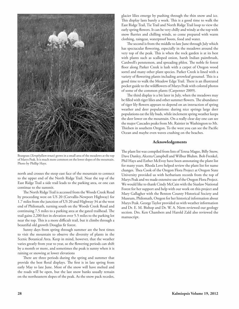
Beargrass (Xerophyllum tenax) grows in a small area of the meadows at the top of Marys Peak. It is much more common on the lower slopes of the mountain. Photo by Phillip Hays.

Kalmiopsis Volume 19, 2012 29
References
Baldwin EM. 1955. Geology of the Marys Peak and Alsea quadrangles, Oregon: US Geological Survey Map OM-162, scale 1:62,500.
Baldwin E. 1992. Geology of Oregon. Dubuque (IA): Kendall Hunt Publishing Company.
Baldwin E. 1993. Glaciations in the Central Coast Range of Oregon. Oregon Geology 55:87-89.
Carpenter SE. 2009 Wildflowers of Marys Peak Meadows. Philomath (OR): Abbey Lane Laboratory, LLC.
Detling LE. 1953. Relict islands of xeric flora west of the Cascade Mountains in Oregon. Madroño 12:39-47.
Fillmore MH. 2009. Soil Survey of Benton County Oregon. USDA Natural Resources Conservation Service.
Franklin JF, Dyrness CT. 1988. Natural Vegetation of Oregon and Washington. Corvallis (OR): Oregon State University Press.
Hadley KS, Savage M. 1996. Wind disturbance and development of a near-edge forest interior, Marys Peak, Oregon Coast Range. Physical Geogr. 17(1):47-61.
Henderson, LF. 1881. Early experiences of a botanist. NPSO Bulletin 14(11):4-7.
Juntunen JR, Dasch M, Rogers AN. 2005. The World of the Kalapuya: a Native People of Western Oregon. Philomath (OR): Benton County Historical Society and Museum. 128 pp.
Lawrence RD, Rosenfeld CL, Ruddiman W. 1980. Marys Peak field trip: structure of the eastern flank of the central Coast Range, Oregon. Pp. 121-131 in Geologic Field Trips in Western Oregon and Southwestern Washington. Oregon Dept. Geology and Mineral Industries Bull. 101.
Loy WG, Allan S, Buckley AR, Meacham JE. 2002. Atlas of Oregon. Eugene (OR): Univ. Oregon Press. 301 pp.
Magee TK, Antos JA. 1992. Tree invasion into a mountain-top meadow in the Oregon Coast Range, USA. Jour. Veg. Sci. 3:485-494.
Merkle J. 1951. An analysis of the plant communities of Marys Peak, western Oregon. Ecol. 32:618-640.
Orr EL, Orr WN, Baldwin E. 1992. Geology of Oregon. Dubuque (IA): Kendall/Hunt Publ. Co. 254 pp.
Ryu I, Niem AR, Niem WA. 1966. Oil and gas potential of the southern Tyee basin, southern Oregon Coastal Range: Oregon Dept. Geology and Mineral Industries Oil and Gas Investigation 19. 141 pp.
Snow BD. 1984. Plant Communities of the Grassy Balds of Marys Peak, Oregon. MS Thesis, Oregon State University, Corvallis, OR.
USDA Forest Service. 1989. Marys Peak Scenic Botanical Plan. USDA Forest Service, Siuslaw National Forest. Corvallis.
Wells RE, Jayko AS, Niem AR, Black G, Wiley T, Baldwin E, Molemnaar KM, Wheeler KL, DuRoss CB, Givler RW. 2000. Geologic map and database of the Roseburg 30x60”quadrangle. Douglas and Coos counties, Oregon. USGS Open File Report 00-376, 2 plates + 55p.
Zald H. 2009. Extent and spatial patterns of grass bald land cover change (1948-2000), Oregon Coast Range, USA. Plant Ecol. 201:517-529.
Phillip R. Hays has a BS in Bacteriology from the University of Arkansas in 1968 and a PhD in Microbiology from Oregon State University in 1978. He became interested in the botany of the Corvallis area in the 1980s and since then has been photographing and drawing the plants of Benton County, Oregon. He has been a member of NPSO since the late 1980s. He wrote “A Guide to Trails in the Corvallis Area” and often leads hikes for the Corvallis Chapter. Phil is Chair of the Benton County Natural Areas and Parks Advisory Board and is a member of the Corvallis Parks, Natural Areas and Recreation Advisory Board. He was a founding member of the Greenbelt Land Trust in Corvallis and currently serves on the Lands Committee.
Robert E. Frenkel has a BA in chemistry from Kenyon College, Ohio 1950; MS in metallurgy in 1954 and PhD in geography 1967 from UC Berkeley, and taught geography at OSU since 1965. He retired as Emeritus Professor in 1997. Bob joined NPSO in the early seventies, working with Jean Sidall and Ken Chambers. He was appointed by Governor McCall as Chair of the Natural Preserves Advisory Committee whose mission was to recommend potential natural areas to the State Land Board. He became fascinated in the flora and vegetation of Marys Peak after first climbing the old ungraded north trail in 1965.
Esther Gruber McEvoy joined NPSO while working for the Bureau of Land Management as a botanist on rare plants in Burns Oregon in 1979. She has a BA in Art from Lewis and Clark College and a BA in Science from Portland State University. In 1980 she helped start the Corvallis Chapter and remains active in the chapter. She worked for the Willamette National Forest in 1981 documenting old growth forests in the coast range. In 1983 and 1984 she worked with Bob Frenkel at Finley National Wildlife Refuge monitoring vegetation changes of a Willamette prairie after burning. In 1994 and 1995 she worked on the dynamics of a Sidalcea hirtipes population on the Oregon coast. In 2000 she started Willamette Gardens, a native plant nursery in Corvallis, Oregon which specializes in container grown native plants.
(L to R) Bob Frenkel, Esther McEvoy and Phillip Hays at the rock garden at the top of Marys Peak. Photographer unknown.

30 Kalmiopsis Volume 19, 2012
FERNS AND FERN RELATIVES BLECHNACEAE DEER FERN FAMILY Blechnum spicant Deer fern Forest DENNSTAEDTIACEAE BRACKEN FAMILY Pteridium aquilinum Bracken fern Forest, Moist Meadows DRYOPTERIDACEAE WOOD FERN FAMILY Polystichum munitum Swordfern Forest LYCOPODIACEAE CLUB-MOSS FAMILY Lycopodium clavatum var. integrifolium Common clubmoss Forest OPHIOLGLOSSACEAE ADDER’S TONGUE FAMILY Botrychium multifidum Leathery grapefern Riparian PTERIDACEAE MAIDENHAIR FERN Adiantum aleuticum Western maidenhair fern Riparian Adiantum pedatum Cryptogramma acrostichoides Rock brake Rock cliffs Cryptogramma crispa WOODSIACEAE CLIFF FERN FAMILY Athyrium filix-femina Lady fern Forest CONIFERS CUPRESSACEAE CYPRESS FAMILY Thuja plicata Western red cedar Forest PINACEAE PINE FAMILY Abies grandis Grand fir Forest Abies procera Noble fir Forest Pseudotsuga menziesii var. menziesii Douglas fir Forest Tsuga heterophylla Western hemlock Forest TAXACEAE YEW FAMILY Taxus brevifolia Western yew Forest FLOWERING PLANTS:DICOTS ADOXACEAE MUSKROOT FAMILY Sambucus mexicana Blue elderberry Forest Sambucus racemosa var. arborescens Red elderberry Riparian APIACEAE CARROT FAMILY Ligusticum apiifolium Clery-leaved lovage Meadow Lomatium martindalei Cascade desert parsley Rock Garden Lomatium utriculatum Spring gold Meadow Osmorhiza purpurea Purple sweet cicely Open Forest Sanicula crassicaulis Snakeroot Open Forest APOCYNACEAE DOGBANE FAMILY Apocynum androsaemifolium var. pumilum Dwarf dogbane Rock Garden, Meadow ARALIACEAE GINSENG FAMLY Oplopanax horridus Devils club Forest ARISTOLOCHIACEAE DUTCHMAN’S PIPE FAMILY Asarum caudatum Wild ginger Forest, Riparian ASTERACEAE SUNFLOWER FAMILY Achillea millefolium Yarrow Meadow Adenocaulon bicolor Pathfinder Forest Agoseris grandiflora Agroseris Open Forest, Meadow Anaphalis margaritacea Pearly everlasting Meadow Anisocarpus madioides Woodland tarweed Forest Madia madioides Arnica amplexicaulis Clasping arnica Riparian
MARYS PEAK SCENIC BOTANICAL AREA PLANT SPECIES LIST
FAMILY: GENUS AND SPECIES FAMILY: COMMON NAME HABITAT NOTES

Kalmiopsis Volume 19, 2012 31
* Bellis perennis English lawndaisy Meadow Cirsium edule var. edule Indian thistle Meadow Cirsium hallii * Cirsium vulgare Bull thistle Meadow * Crepis capillaris Smooth hawksbeard Meadow Eriophyllum lanatum var. leucophyllum Western woolly sunflower Meadow, Rocky Euribia radulina Rough leaved aster Dry Forest Aster radulinus Hieracium albiflorum White flowered hawkweed Open Forest * Hypochaeris radicata Hairy catsear Meadow Lactuca biennis Tall blue lettuce Moist Areas * Lapsana communis Nipplewort Forest * Leucanthemum vulgare Oxeye daisy Meadow Chrysanthemum leucanthemum* Matricaria discoidea Pineapple weed Roadside Matricaria matricarioides Petasites frigidus var. palmatus Western coltsfoot Moist Woods Senecio integerrimus var. exaltatus Tall western groundsel Meadow, Rock Garden * Senecio jacobea Tansy ragwort Meadow * Senecio sylvaticus Wood groundsel Roadside Senecio triangularis var. triangularis Arrowleaf groundsel Forest, Meadow * Tanacetum vulgare Common tansy Meadow * Taraxacum officinale Common dandelion Meadow BERBERIDACEAE BARBERRY FAMILY Achlys triphylla Vanilla leaf Forest Berberis aquifolium Tall Oregon grape Forest Mahonia aquifolium Berberis nervosa Cascade Oregon grape Forest Mahonia nervosa Vancouveria hexandra White inside out flower Forest BETULACEAE BIRCH FAMILY Alnus rubra Oregon alder, red Alder Riparian Corylus cornuta var. californica California hazelnut Forest BORAGINACEAE BORAGE FAMILY Hydrophyllum occidentale Western waterleaf Forest, Riparian Hydrophyllum tenuipes Pacific waterleaf Forest, Riparian Nemophila parviflora var. parviflora Wood nemophila Forest Phacelia heterophylla ssp. virgata Varileaf phacelia Roadside, Rocky Phaceilia nemoralis Woodland phacelia Moist Forest Romanzoffia sitchensis Sitka mistmaiden Rocky BRASSICEAE MUSTARD FAMILY Cardamine nuttallii Spring beauty Forest Cardamine pulcherrima Cardamine oligosperma Little western bittercress Moist Meadows Draba verna Spring whitlow grass Meadow Erysimum capitatum var. capitatum Rough wallflower Rock Garden Turritis glabra Tower mustard Roadside Arabis glabra CAMPANULACEAE HAREBELL FAMILY Campanula scouleri Scouler’s harebell Forest, Riparian CAPRIFOLIACEAE HONEYSUCKLE FAMILY Lonicera ciliosa Orange honeysuckle Open Forest Symphoricarpus albus var. laevigatus Common snowberry Forest Symphoricarpos mollis Creeping snowberry Open Forest CARYOPHYLLACEAE PINK FAMILY Cerastium arvense ssp. strictum Field chickweed Meadow * Cerastium fontatum spp. vulgare Big chickweed Meadow Cerastium vulgatum, misapplied* Dianthus armeria ssp. armeria Deptford pink Roadside Moehringia macrophylla Bigleaf sandwort Forest Arenaria macrophylla Silene douglasii var. douglasii Douglas silene Rock Garden, Meadow
FAMILY: GENUS AND SPECIES FAMILY: COMMON NAME HABITAT NOTES

32 Kalmiopsis Volume 19, 2012
* Spergularia rubra Red sandspurry Roadside Stellaria crispa Crisped starwort Moist Forest ERICACEAE HEATH FAMLY Arctostaphylos uva-ursi Kinnikinnick Forest Chimaphila umbellata var. occidentalis Prince’s pine Forest Gaultheria shallon Salal Forest Monotropa hypopitys Pinesap Forest Hypopitys monotropa Monotropa uniflora Indian pipe Forest Pyrola asarifolia Alpine pyrola Moist Forest Pyrola picta White-vein pyrola Forest Pyrola aphylla Vaccinium membranaceum Big huckleberry Forest Vaccinium parvifolium Red huckleberry Forest Vaccinium scoparium Grouse whortleberry Open Forest FABACEAE PEA FAMILY * Cytisus scoparius Scots broom Meadow Lathyrus nevadensis var. nevadensis Sierra peavine Open Forest Lathyrus polyphyllus Leafy peavine Roadside, Open Forest Lotus crassifolius var. crassifolius Big deervetch Forest, Roadside Lotus micranthus Small flowered lotus Roadside Lupinus albicaulis var. albicaulis Sickle keeled lupine Forest Lupinus latifolius var. latifolius Broad leaved lupine Open Forest Lupin us lepidus var. lobbii Prostrate lupine Rock Garden Lupinus rivularis Riverbank lupine Riparian, Roadside * Melilotus officinalis Common yellow sweetclover Roadside Rupertia physodes California tea Roadside * Trifolium dubium Least hopclover Roadside, Meadow * Trifolium pratense Red clover Meadow * Trifolium repens White clover Meadow * Trifolium subterraneum Subterraneum clover Meadow, Open Forest Vicia americana var. americana American vetch Roadside, Open Forest FAGACEAE OAK FAMILY Chrysolepis chrysophylla var. chrysophylla Golden chinquapin Open Forest Castanopsis chrysophylla GROSSULARICEAE GOOSEBERRY FAMILY Ribes sangineum var. sangineum Red flowering currant Open Forest IRIDACEAE IRIS FAMILY Iris tenax var. tenax Oregon iris Meadow LAMIACEAE MINT FAMILY Prunella vulgaris var. lanceolata Native heal all Meadow Satureja douglasii Yerba buena Forest Stachys mexicana Mexican betony Moist Forest Stachys rigida Rigid betony Moist to drier sites LINNAEAEAE LINNAEA FAMILY Linnaea borealis var. longiflora Western twinflower Forest MONTIACEAE PURSLANE FAMILY Claytonia sibirica Candy flower Forest, Riparian Montia sibirica Claytonia perfoliata ssp. perfoliata Miner’s lettuce Forest, Riparian Montia perfoliata ONAGRACEAE EVENING PRIMROSE FAMILY Chamaenerion angustifolium var. canescens Fireweed Meadow, Roadside Epilobium angustifolium Epilobium ciliatum var. ciliatum Purple leaved willowherb Riparian , Open Forest Epilobium watsonii OROBANCHACEAE BROOMRAPE FAMILY Castilleja hispida var. hispida Harsh Indian paintbrush Rock Garden, Roadside OXALIDACEAE OXALIS FAMILY
FAMILY: GENUS AND SPECIES FAMILY: COMMON NAME HABITAT NOTES

Kalmiopsis Volume 19, 2012 33
Oxalis oregana Oregon wood sorrel Forest Oxalis trilliifolia Trillium leaved oxalis Riparian PAPAVERACEAE POPPY FAMILY Dicentra formosa ssp. formosa Bleedingheart Forest, Riparian PHRYMACEAE LOPSEED FAMILY Mimulus alsinoides Chickweed monkeyflower Rocky Mimulus dentatus Tooth leaved monkeyflower Meadow, Riparian PLANTAGINACEAE PLAINTAIN FAMILY Collinsia grandiflora Large flowered blue-eyed Mary Meadow Collinsia parviflora Small flowered blue-eyed Mary Roadside, Meadow * Digitalis purpurea Foxglove Roadside, Meadow Nothochelone nemorosa Woodland beardtongue Forest Penstemon cardwellii Cardwell’s penstemon Rock Garden, Roadside Penstemon rattanii var. rattanii Rattan’s penstemon Roadside * Plantago lanceolata English plantain Meadow, Roadside * Plantago major Common plantain Meadow, Roadside Synthyris reniformis Snowqueen Forest Veronica americana Common speedwell Riparian Veronica arvensis Small speedwell Meadow Veronica serpyllifolia var. humifusa Thyme-leaved speedwell Meadow POLEMONIACEAE PHLOX FAMILY Collomia heterophylla Varied leaf collomia Riparian, Open Forest Gilia capitata ssp.capitata Bluefield gilia Rock Garden Microsteris gracilis Slender phlox Riparian, Rocky Phlox gracilis Phlox diffusa Spreading phlox Rock Garden, Meadow POLYGONACEAE BUCKWHEAT FAMILY Eriogonum nudum var. nudum Barestem buckwheat Roadside Eriogonum umbellatum var. haussknechtii Haussknecht’s buckwheat Rocky * Polygonum aviculare Knotweed Roadside Polygonum minimum Broad leaved knotweed Moist Areas * Rumex acetosella Sour dock Meadow PRIMULACEAE PRIMROSE FAMILY Trientalis latifolia Western starflower Forest RANUNCULACEAE BUTTERCUP FAMILY Actea rubra Western red baneberry Forest Anemone deltoidea Threeleaf anemone Forest Anemone lyallii Lyall’s anemone Meadow Anemone oregana var. oregana Blue windflower Forest Aquilegia formosa Red columbine Moist Forest Coptis laciniata Oregon goldthread Forest Delphinium menziesii Menzies’ larkspur Meadow, Rock Garden Ranunculus occidentalis Western buttercup Meadow Ranunculus uncinatus Little buttercup Forest Thalictrum occidentale Western meadowrue Forest Trautvetteria carolinensis False bugbane Riparian RHAMNACEAE BUCKTHORN FAMILY Rhamnus purshiana Cascara Forest ROSACEAE ROSE FAMILY Amelanchier alnifolia var. semiintegrifolia Pacific serviceberry Open Forest Fragaria vesca ssp. bracteata Woodland strawberry Meadow Fragaria virginiana var. platypetala Wild strawberry Meadow Holodiscus discolor var. discolor Oceanspray Forest
FAMILY: GENUS AND SPECIES FAMILY: COMMON NAME HABITAT NOTES
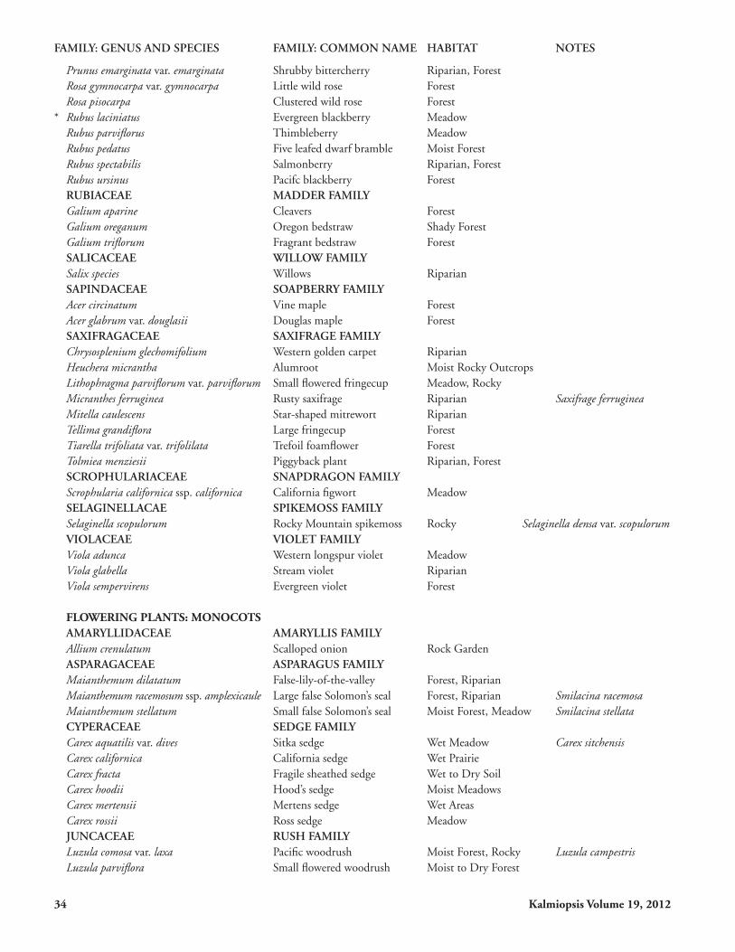
34 Kalmiopsis Volume 19, 2012
Prunus emarginata var. emarginata Shrubby bittercherry Riparian, Forest Rosa gymnocarpa var. gymnocarpa Little wild rose Forest Rosa pisocarpa Clustered wild rose Forest * Rubus laciniatus Evergreen blackberry Meadow Rubus parviflorus Thimbleberry Meadow Rubus pedatus Five leafed dwarf bramble Moist Forest Rubus spectabilis Salmonberry Riparian, Forest Rubus ursinus Pacifc blackberry Forest RUBIACEAE MADDER FAMILY Galium aparine Cleavers Forest Galium oreganum Oregon bedstraw Shady Forest Galium triflorum Fragrant bedstraw Forest SALICACEAE WILLOW FAMILY Salix species Willows Riparian SAPINDACEAE SOAPBERRY FAMILY Acer circinatum Vine maple Forest Acer glabrum var. douglasii Douglas maple Forest SAXIFRAGACEAE SAXIFRAGE FAMILY Chrysosplenium glechomifolium Western golden carpet Riparian Heuchera micrantha Alumroot Moist Rocky Outcrops Lithophragma parviflorum var. parviflorum Small flowered fringecup Meadow, Rocky Micranthes ferruginea Rusty saxifrage Riparian Saxifrage ferruginea Mitella caulescens Star-shaped mitrewort Riparian Tellima grandiflora Large fringecup Forest Tiarella trifoliata var. trifolilata Trefoil foamflower Forest Tolmiea menziesii Piggyback plant Riparian, Forest SCROPHULARIACEAE SNAPDRAGON FAMILY Scrophularia californica ssp. californica California figwort Meadow SELAGINELLACAE SPIKEMOSS FAMILY Selaginella scopulorum Rocky Mountain spikemoss Rocky Selaginella densa var. scopulorum VIOLACEAE VIOLET FAMILY Viola adunca Western longspur violet Meadow Viola glabella Stream violet Riparian Viola sempervirens Evergreen violet Forest FLOWERING PLANTS: MONOCOTS AMARYLLIDACEAE AMARYLLIS FAMILY Allium crenulatum Scalloped onion Rock Garden ASPARAGACEAE ASPARAGUS FAMILY Maianthemum dilatatum False-lily-of-the-valley Forest, Riparian Maianthemum racemosum ssp. amplexicaule Large false Solomon’s seal Forest, Riparian Smilacina racemosa Maianthemum stellatum Small false Solomon’s seal Moist Forest, Meadow Smilacina stellata CYPERACEAE SEDGE FAMILY Carex aquatilis var. dives Sitka sedge Wet Meadow Carex sitchensis Carex californica California sedge Wet Prairie Carex fracta Fragile sheathed sedge Wet to Dry Soil Carex hoodii Hood’s sedge Moist Meadows Carex mertensii Mertens sedge Wet Areas Carex rossii Ross sedge Meadow JUNCACEAE RUSH FAMILY Luzula comosa var. laxa Pacific woodrush Moist Forest, Rocky Luzula campestris Luzula parviflora Small flowered woodrush Moist to Dry Forest
FAMILY: GENUS AND SPECIES FAMILY: COMMON NAME HABITAT NOTES

Kalmiopsis Volume 19, 2012 35
LILIACEAE LILY FAMILY Calochortus tolmiei Oregon mariposa lily Meadow Clintonia uniflora Queencup beadlily Forest Erythronium grandiflorum var. grandiflorum Yellow fawnlily, glacier lily Meadow Erythronium oregonum Giant fawnlily Meadow, Forest Erythronium oreganum var. oreganum Fritillaria affinis Checker lily Meadow Fritillaria lanceolata Lilium columbianum Columbia or tiger lily Meadow Prosartes hookeri Hooker’s fairybells Forest Disporum hookeri Prosartes smithii Fairy lanterns Forest Disporum smithii Streptopus amplexifolius Twisted stalk Riparian MELANTHIACEAE Anticlea occidentalis Western stenanthium Forest Stenathium occidentale Trillium ovatum ssp. ovatum Western trillium Forest Xerophyllum tenax Beargrass Meadow ORCHIDACEAE ORCHID FAMILY Cephalanthera austiniae Phantom orchid Forest Corallorhiza maculata Spotted coralroot Forest Goodyera oblongifolia Western rattlesnake plantain Forest Platanthera stricta Slender bog orchid Riparian Habenaria saccata Listera caurina Northwestern twayblade Forest Listera cordata Heartleaf twayblade Forest POACEAE GRASS FAMILY Agrostis hallii Hall’s bentgrass Forest Agrostis pallens Dune bentgrass Forest Agrostis diegoensis * Aira caryophyllea Hairgrass Gravelly Soil Aira praecox Early hairgrass Gravelly Soil Bromus carinatus California brome Moist Forest, Meadow Bromus hordeaceus Soft brome Moist Meadow Bromus sitchensis Alaska brome Meadow Bromus vulgaris Common brome Open Forest, Moist Banks, Rocky Slopes * Cynosurus echinatus Hedgehog dogtailgrass Open Ground * Dactylis glomerata Orchardgrass Meadow Danthonia californica California oatgrass Meadow, Open Forest * Elymus elymoides Bottlebrush squirreltail Open Forest, Rocky Slopes Sitanion hystrix Elymus glaucus ssp. glaucus Blue wildrye Open Forest Festuca occidentalis Western fescue Moist to Dry Forest Festuca roemeri var. roemeri Oregon Fescue Meadow * Festuca rubra ssp. commutata Chewings red fescue Meadow Festuca subulata Bearded fescue Moist, Dry Forest Koeleria macrantha Prairie junegrass Meadow Koeleria cristata * Lolium perenne English ryegrass Meadow Melica bulbosa Oniongrass Meadow Melica spectabilis Purple oniongrass Meadow Melica subulata Alaska oniongrass Dry, Moist Forest Phleum alpinum Alpine timothy Meadow * Poa annua Annual bluegrass Meadow Poa laxiflora Loose flowered bluegrass Moist Forest, Meadow Poa pratensis Kentucky bluegrass Moist Forest, Meadow
* Indicates a non-native, introduced species
FAMILY: GENUS AND SPECIES FAMILY: COMMON NAME HABITAT NOTES