Embed Size (px)
Citation preview
Published in the Proceedings of the MERIS Users workshop held in Frascati, 10-13 November 2003, ESA Special Publication SP-549
MERIS IMAGERY OF BELGIAN COASTAL WATERS: MAPPING OF SUSPENDED PARTICULATE MATTER AND CHLOROPHYLL-A
K. Ruddick(1) , Y. Park(1) and B. Nechad(1)
(1) Management Unit of the North Sea Mathematical Models (MUMM), Royal Belgian Institute for Natural Sciences (RBINS), 100 Gulledelle, B-1200 Brussels, Belgium. Email : [email protected]
ABSTRACT This paper describes a first application-oriented analysis of MERIS products for Suspended Particulate Matter (SPM) and Chlorophyll-a (CHL) concentration in Belgian coastal waters. Regional algorithms designed for Belgian waters have been implemented and compared with the standard MERIS products, termed Total Suspended Matter and Algal2 respectively. The standard and regional SPM products seem robust and give similar data. Notwithstanding a more complete match-up validation analysis, these products seem sufficiently mature for use in applications such as sediment transport model validation. Results for CHL products are less convincing and further analysis is required before this data can be reliably used. In particular the MERIS Product Confidence flags have not yet been validated. The red and near infrared bands are particularly important in turbid coastal waters and should be considered a priority for further validation. MERIS full resolution mode is attractive for SPM mapping when compared with other sensors. For CHL mapping in coastal waters the superior spectral resolution and algorithm design give MERIS a distinct advantage over other ocean colour sensors. The disadvantages of MERIS, particularly for SPM mapping, are the reduced frequency (related to swath and sunglint) and availability of data. 1 INTRODUCTION 1.1 Motivation and historical background – Suspended Particulate Matter Interest in the MERIS product for Suspended Particulate Matter (SPM) concentration in Belgian coastal waters is associated with the need to provide boundary, initial and validation data for sediment transport models. Such models are used, for example, to study the dispersion of particulate matter dumped at sea after dredging from ports and navigation channels and, hence, determine the efficiency and optimise the location of dumping sites [1]. However, models cannot confidently be used as environmental management tools unless their results are in some way validated against measurements from seaborne or satellite sensors. SPM maps from sensors such as MERIS are very well suited to providing boundary, initial and validation data for sediment transport models, provided that the satellite data itself is suitably validated.
Studies on SPM mapping in Belgian waters started by considering the reflectance in channel 1 (590-690nm) of AVHRR, following the work of [2, 3]. While rather broadband and of limited radiometric resolution the AVHRR sensors remain useful for SPM mapping because of the good temporal coverage (2-3 times/day if cloud-free). More recently, SPM mapping has been achieved for Belgian waters [4] from SeaWiFS. The launch of many other ocean colour sensors, including MODIS-Terra (1999), MODIS-Aqua (2002) and Envisat-MERIS (2002), has enlarged considerably the satellite data supply for SPM mapping applications. The niche for MERIS is described in this paper. 1.2 Motivation and historical background – Chlorophyll-a Interest in the MERIS product for chlorophyll-a (CHL) concentration in Belgian waters arises from the need of environmental managers to assess eutrophication status [5, 6] in the framework of the Oslo and Paris Conventions for the Prevention of Marine Pollution. Further interest comes from marine scientists, for whom CHL maps would provide information on the marine ecosystem, and especially for ecosystem modellers [7] who require data for model validation.
While satellite-derived CHL maps for the open ocean can be considered as relatively reliable, CHL mapping for coastal waters with high particulate or dissolved yellow substance remains problematic. Moreover, errors in atmospheric correction of ocean colour imagery can contaminate significantly derived CHL maps. For Belgian waters, research into CHL algorithms has focussed primarily on algorithms using red/near infrared (NIR) band ratios [8, 9] following earlier work mainly in inland waters [10, 11]. It has been established from seaborne reflectance measurements in Dutch and Belgian waters [6, 12] that such algorithms can detect CHL with reasonable accuracy at least in the case of high concentration blooms, e.g. > 10mgm-3. The actual performance of MERIS is discussed here. 1.3 Overview of paper
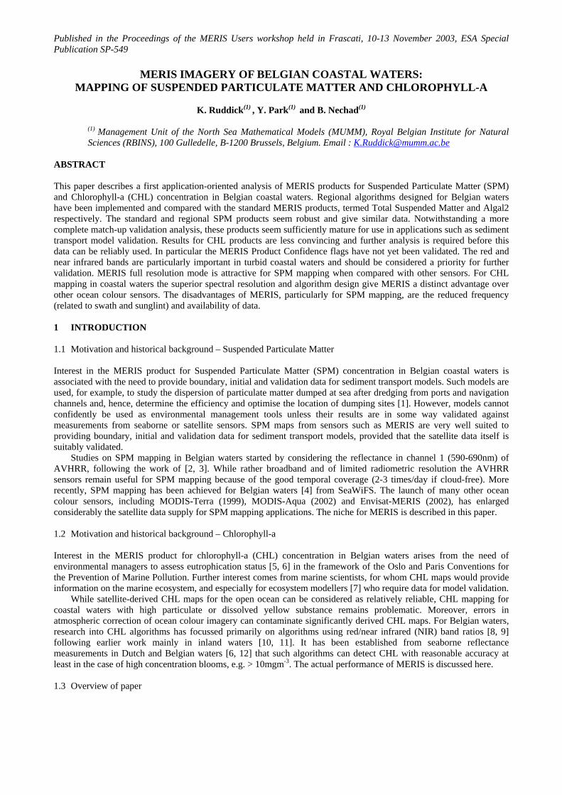
The objective of this paper is to describe applications of MERIS SPM and CHL imagery for Belgian coastal waters. Both the MERIS standard products and regional products designed specifically for Belgian waters are assessed here. The algorithms are described as well as the processing chain used to produce images. Examples of MERIS data, as currently available, are shown for the standard and the regional MERIS SPM and CHL products. These results are then discussed and assessed in the framework of the applications described in sections 1.1 and 1.2. 1.4 Description of the region The Belgian coastal waters (Fig. 1) have been monitored intensively for over 30 years in the framework of national water quality monitoring programmes and numerous research initiatives. Over the last 5 years the optical properties of these waters have been studied in detail as support for remote sensing activities [13]. Owing to the shallow water depths (0-40m), strong tidal currents (e.g. 1.2 m/s amplitude) and frequent strong wind events (e.g. 10 m/s at 10m above sea level), resuspension of bottom sediments yields high suspended matter concentrations. These range from ~1 g/m3 in clearer offshore waters to ~50 g/m3 closer to shore (e.g. 3 km offshore, 10m water depth). Concentrations as high as 500 g/m3 have been measured on occasions near Zeebrugge.
Fig. 1. MERIS full resolution image of Belgian waters on 14th July 2003 plotted as top-of-atmosphere RGB composite. Chlorophyll-a concentrations are typically low (< 1 mg/m3) in winter, reaching a peak of 15-50 mg/m3 during the spring bloom [14], with mainly intermediate concentrations (1-10 mg/m3) during summer and autumn though occasional higher concentrations (10-20 mg/m3) within a few km of the coast. Secchi depths range from only a few cm in the most turbid waters to a few metres in clearer, offshore waters. The water column is generally well-mixed vertically by the turbulence caused by strong tide- and wind-driven currents. 2 METHOD 2.1 Preprocessing of imagery MERIS imagery has been received from the European Space Agency via the MERIS Validation Team channel (via ACRI and Brockmann Consulting) for Reduced Resolution (RR) imagery and, for a limited number of Full Resolution (FR) images via the Payload Data Segment. The RR imagery has been received at level 2 after processing with the “200308” MERIS ground segment version. The algorithms used, including the atmospheric correction for case 1 waters [15] and its extension to case 2S waters [16] and the neural network algorithm [17] for retrieval of TSM and Algal2 from water-leaving reflectances, are based on the MERIS Advanced Theoretical Basis Documents available from http://envisat.esa.int/instruments/meris/pdf/. The implementation of these algorithms and practical information on the MERIS products can be found in the MERIS product handbook [18], though it is noted that certain algorithms are being updated and documentation may not be up to date.
Details of the validation of MERIS products in general can be found in the proceedings of the MERIS validation workshop held in October 2003 [19], and specifically for Belgian waters in the contribution of [20] which focuses primarily on the water-leaving reflectances. 2.2 Processing of imagery Imagery has been further processed at MUMM using the BEAM/VISAT software and IDL. The MERIS standard products for SPM and CHL are obtained directly from the corresponding level 2 products for Total Suspended Matter (TSM) and “Algal pigment index in case 2S waters” (Algal2) respectively.
Regarding product terminology, the MERIS-TSM product is defined to represent the concentration of total suspended particulates in gm-3. The particulate backscatter at 442nm is deduced from the water-leaving reflectance spectrum and converted from optical units (backscatter in m-1) to geophysical units (concentration in gm-3) using a fixed conversion factor [18] derived for measurements on water samples using a GF/F filter. In the Belgian monitoring programme, measurements have traditionally been made on water samples taken from 3m depth after filtration with a coarser GF/C filter and the terminology Suspended Particulate Matter (SPM) is often used instead of TSM. Thus, for the present study a regional product, termed MUMM-SPM, has been calibrated for GF/C based measurements in mainly
Belgian waters. This product is obtained from the MERIS water-leaving reflectance at 753nm, 753nmwρ , using a robust
one band algorithm [21]:
753
-3753
MUMM-SPM (gm ) 422* 3.70.187
nmw
nmw
ρρ
= +−
(1)
The MERIS “Algal pigment index 2” product is defined to represent the concentration of chlorophyll-a in gm-3 and is derived by estimating pigment absorption at 442nm from the water-leaving reflectance spectrum and converting from optical units (absorption in m-1) to geophysical units (concentration in mgm-3) using a fixed conversion formula [18]. Since this product has been developed with the constraint of being globally valid it is probable that improved products could be developed for regional purposes either by adapting the conversion formula according to regional measurements of inherent optical properties and corresponding concentrations [22], thereby taking account of possible region-, season- and/or species-dependencies of the absorption of phytoplankton pigments, or by considering an alternative algorithm to the multi-band neural network approach behind the MERIS standard product. Thus, for the present study a regional product, termed MUMM-CHL, has been developed based on previous red/near infrared band ratios algorithms that have proven successful for high CHL in Belgian waters [12]:
( )
708-3 708 664
664
1MUMM-CHL (mgm )=
0.0146
nmnm nmw
w b w bnmw
a b a bρρ
+ − −
(2)
778 778
778where 1.20*
0.187
nm nmw w
b nmw
ab
ρρ
=−
(3)
and using pure water absorption data from [23] 664 708 778 1( , , ) (0.402,0.699,2.690)nm nm nmw w wa a a m−= .
3 MERIS imagery The present study looks qualitatively at the standard products for TSM and Algal2 and the corresponding regional products termed MUMM-SPM and MUMM-CHL. This analysis considers three images from 2003: 14.7.2003, 22.4.2003 and 16.6.2003. For all imagery the following products are shown: a) An RGB composite using top-of-atmosphere radiances from bands 665nm, 560nm and 443nm. This gives an
impression of atmospheric conditions which may affect product quality, especially haze and scattered clouds, and of water conditions, such as regions of high turbidity.
b) Aerosol optical thickness (AOT) at 865nm. Regions of high AOT correspond to thin clouds and/or strong atmospheric haze, for which water products may be less reliable or totally unusable.
c,d) The standard MERIS-TSM and regional MUMM-SPM products e,f) The standard MERIS-Algal2 and regional MUMM-CHL products
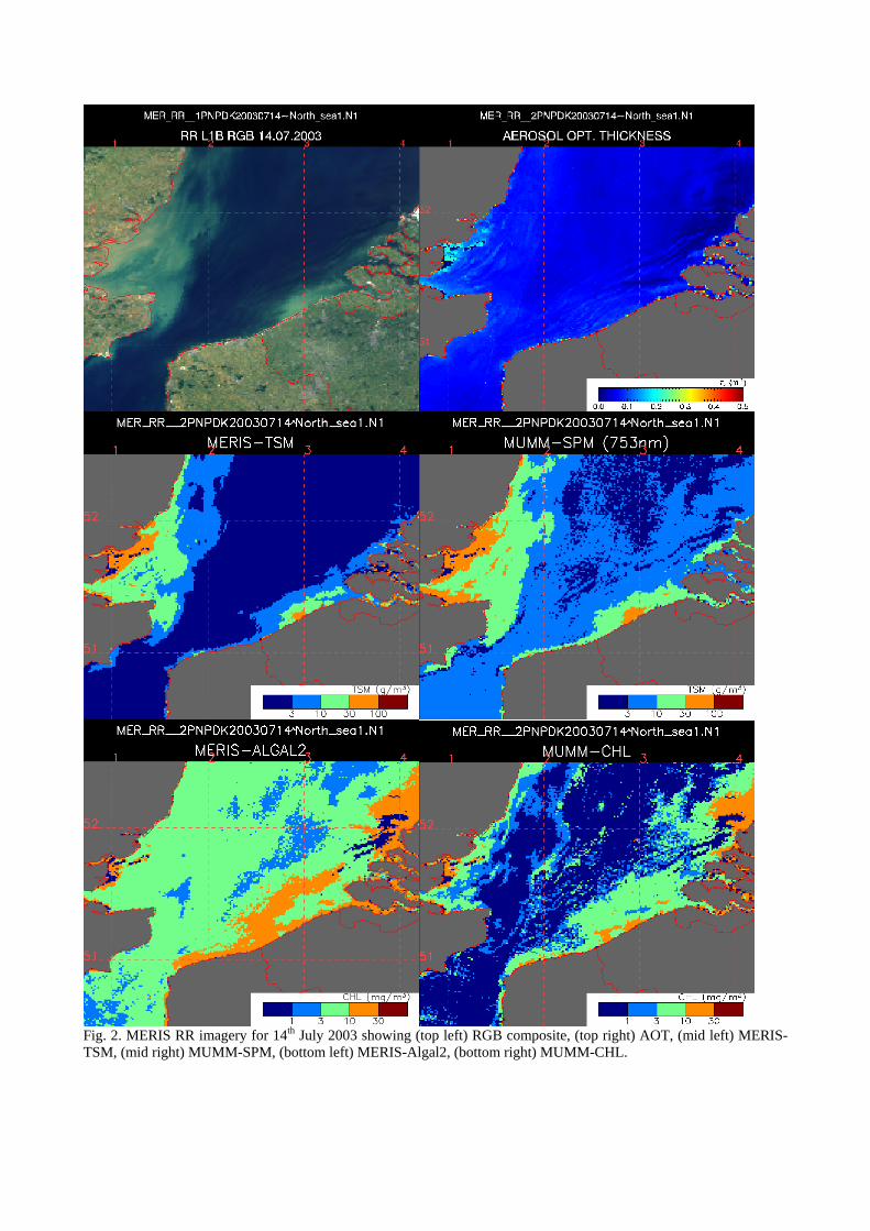
Fig. 2. MERIS RR imagery for 14th July 2003 showing (top left) RGB composite, (top right) AOT, (mid left) MERIS-TSM, (mid right) MUMM-SPM, (bottom left) MERIS-Algal2, (bottom right) MUMM-CHL.
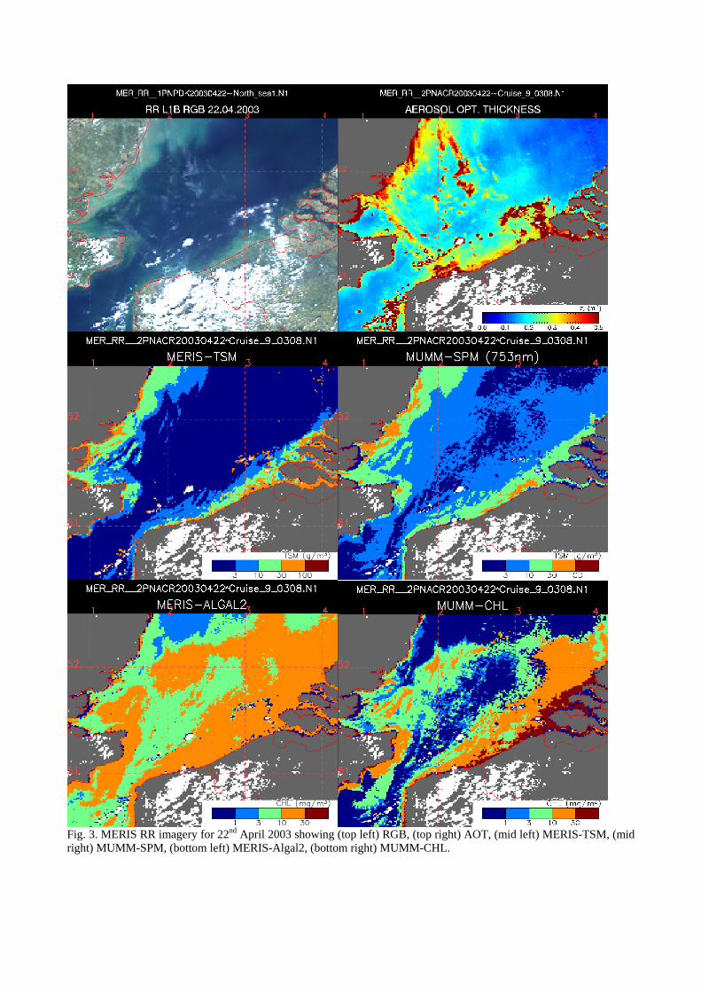
Fig. 3. MERIS RR imagery for 22nd April 2003 showing (top left) RGB, (top right) AOT, (mid left) MERIS-TSM, (mid right) MUMM-SPM, (bottom left) MERIS-Algal2, (bottom right) MUMM-CHL.
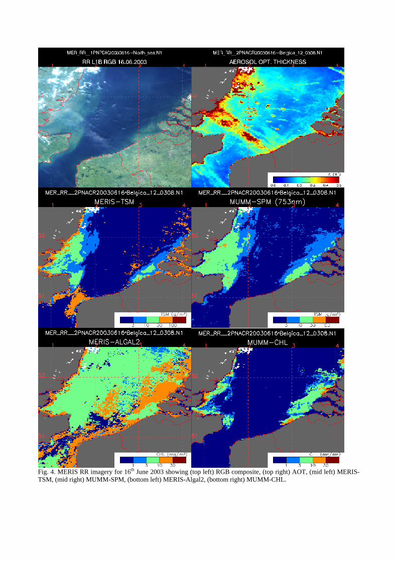
Fig. 4. MERIS RR imagery for 16th June 2003 showing (top left) RGB composite, (top right) AOT, (mid left) MERIS-TSM, (mid right) MUMM-SPM, (bottom left) MERIS-Algal2, (bottom right) MUMM-CHL.
3.1 The 14.7.2003 image Fig. 2 shows the MERIS image for the 14th July 2003. This image was taken in perfectly clear atmospheric conditions and is one of the best so far acquired by MERIS for this region. Regions of high turbidity close to the coast in Belgian, UK and to a lesser extent Dutch waters can be clearly seen at the top of atmosphere as brown patches in this RGB composite as contrasted to the clearer waters further offshore (blue). The regions of high turbidity are highly correlated with bathymetric features [24], including the Flemish Banks, a series of elongated submerged sandbanks approximately coast-parallel and with an apparent periodicity in space. On rare occasions (low water, Spring tide, possibly combined with negative meteorological surge) the Southernmost sandbanks may be exposed above water. However, in general these sandbanks are submerged by a few Secchi depths. Their appearance in optical imagery occurs, with few exceptions, because of very high concentrations of suspended sediments resulting from erosion and/or resuspension of bottom sediments by strong tidal current and wind events. These high turbidity structures are clearly visible in the AOT image. This is clearly unphysical, since there is no process linking suspended sediments with atmospheric aerosols with variability at such small spatial scales, however it is noted that for assessing the impact of such artefacts on the atmospheric correction of water-leaving reflectances it would be more appropriate to consider the aerosol reflectance spectrum (not available in the MERIS product). This is discussed further in the validation report for Belgian waters [20].
Comparison of the MERIS-TSM and MUMM-SPM products for this image shows similar qualitative patterns, clearly related to corresponding patterns in the RGB image. The main difference is a systematically higher concentration reported for MUMM-SPM, especially in the waters further offshore where this algorithm is less optimally calibrated.
Comparison of the MERIS-CHL and MUMM-CHL products for this image show much greater differences and less spatial correlation. Seaborne measurements in Belgian waters for the preceding week gave concentrations mainly in the range 3-10 mgm-3, though such values cannot easily be used to distinguish between these two products because of problems of non-simultaneity. It is noted that the MUMM-CHL product suffers from a discontinuity, presumed unrealistic, at the edge of the high suspended matter region offshore of the UK coast (compare the 3 gm-3 contour in the MERIS-TSM image with the MUMM-CHL image in Fig. 2). This front is an artefact of the switching of atmospheric correction between a case 1 and a case 2S algorithm, to which the MUMM-CHL algorithm is more sensitive. Such fronts in the MERIS water products have been previously reported [20, 25] and it is hoped that the MERIS atmospheric correction algorithm will be improved in this respect. 3.2 The 22.4.2003 image Fig. 3 shows the MERIS image for the 22nd April 2003 at 10:39. This image was taken in less optimal atmospheric conditions. The RGB and AOT images show scattered clouds and/or strong haze over much of the Belgian coastal waters. There is no apparent correlation between the AOT and MUMM-SPM images despite the high spatial variability of AOT. This suggests that the MUMM-SPM (and MERIS-TSM) product(s) are not very sensitive to atmospheric correction errors.
Comparison of the MERIS-TSM and MUMM-SPM images shows again rather similar products except for the clearer offshore waters. This similarity is encouraging since the algorithms in question have a very different basis in terms of bands used – MERIS-TSM uses the full spectrum, MUMM-SPM uses only the 753nm band – and algorithm calibration – MERIS-TSM is calibrated using reflectance and TSM values simulated by a multi-component forward model, whereas MUMM-SPM is calibrated using seaborne measurements of reflectance and SPM.
Comparison of the MERIS-Algal2 and MUMM-CHL shows in this case strong similarities except for the regions where MUMM-CHL returns low concentrations (<1 mg m-3). It is noted that this period corresponds to the spring bloom of Phaeocystis Globosa [26], as visible during seaborne measurements as lines of white foam on the sea surface. 3.3 The 16.6.2003 image Fig. 4 shows the MERIS image for the 16th June 2003 at 10:39 UTC. Atmospheric conditions are reasonable though some patchy clouds are noted as well as lines in the AOT image relating presumably to aircraft contrails. In this case similarity between the MERIS-TSM and MUMM-SPM imagery extends to the clearer offshore waters, though the near infrared water leaving reflectances are erroneously zero there and thus the MUMM-SPM algorithm reverts to a zero value. There is again significant difference between the MERIS-Algal2 and MUMM-CHL products. In this case the

input water-leaving reflectances are suspect, especially for the near infrared and blue bands so neither CHL product is expected to perform well. 4 CONCLUSIONS AND RECOMMENDATIONS 4.1 Summary of scientific results In this study regional products developed for SPM and CHL concentration in the turbid Belgian waters are described and implemented for MERIS data from three images in 2003 and compared with the standard MERIS products.
Despite the very different basis (multiband vs single band) and calibration data set (simulated vs seaborne measurements), the regional MUMM-SPM and the standard MERIS-TSM products return rather similar data except for the low reflectance region found offshore where the MUMM-SPM algorithm is not appropriately calibrated. Since these two algorithms are independent except for the input reflectance data set, which has itself been independently validated against seaborne reflectance measurements, this gives some confidence in both products. The regional product MUMM-SPM, based on a near linear inversion from the reflectance at the single band 753nm, was expected a priori to be more robust because of its independence from any difficulties in retrieval of other parameters such as chlorophyll-a concentration or yellow substance absorption. However, in this respect the multi-band MERIS-TSM product has proved similarly robust and probably better adapted to covering a wide range of concentrations, including the clearer waters further from the coast. While it is important to perform a more extensive validation of the MERIS-TSM and MUMM-SPM products, it seems reasonable to consider both these products as relatively mature and suitable for use in applications.
More significant differences are found between the regional MUMM-CHL and the standard MERIS-Algal2 products with the implication that (at least!) one of these products is giving unacceptable results in some cases. From previous studies [6] it is known that the MUMM-CHL algorithm is less reliable in low CHL waters. Similarly it is expected that performance of MERIS-Algal2 will be less reliable in high yellow substance, low CHL waters [22]. Both algorithms are expected to be sensitive to errors in the water-leaving reflectances, arising, for example, from imperfect atmospheric correction. In this respect the validation analysis for the turbid Belgian waters [20] shows greater relative errors for the blue bands, which are used by the MERIS standard algorithm, and for the NIR bands, which are used by both algorithms.
The use of the MERIS red and NIR bands is crucial for SPM and CHL products in turbid coastal waters. This spectral range, gives a near-linear dependence of SPM on water-leaving reflectance with little uncertainty from other optical components such as phytoplankton or particulate or dissolved yellow substance because of relatively larger pure water absorption. This is seen clearly from the one band algorithm (1) but is also exploited implicitly by multi-band algorithms such as the standard MERIS algorithm. For CHL retrieval spectral resolution of the red chlorophyll absorption feature is crucial both for the regional band ratio algorithm which uses primarily the 664nm and 708nm bands, and for the MERIS standard algorithm where the quality of the 708nm band can impact directly the MERIS-Algal2 product [Private Communication, H. Schiller].
4.2 Comparison with other ocean colour sensors in an application perspective
There exist now a number of ocean colour sensors capable of providing SPM maps. These sensors are
complementary in scientific terms, giving data for different times of day, viewing geometries, spectral bands, spatial resolutions, etc. However, for use in applications, because of resource constraints it is often necessary to focus on a limited number of sensors, that number being typically one or perhaps two (or zero!). In this context, MERIS must be considered in competition with other sensors such as SeaWiFS/Orbimage-1, MODIS-Terra, MODIS-Aqua, AVHRR, etc. When choosing between the possible data sources, the user will consider, with appropriate weights, factors including data frequency, quality, spatial resolution, availability (catalogue and search facilities, time for receipt) as well as costs for purchase of data and for data processing. In this respect the advantages of MERIS for SPM mapping in support of sediment transport models are: • The data quality, thanks to better instrument and algorithm design for coastal waters, and • The spatial resolution of the FR imagery, which opens up new or improved possibilities of SPM mapping for
estuaries, inland waters, submerged sandbanks, dredged shipping lanes, etc. FR images have not yet been validated. The main disadvantages of MERIS for this application are: • The frequency of data which is less than for SeaWiFS/Orbimage, which is tilted and thus does not suffer data loss
from sunglint, and MODIS, which has larger swath and is mounted on two different satellites.
• The availability of data: at the time of ordering data for this study (October 2003) severe problems were encountered when attempting to order data via the online catalogue, giving an unfavourable comparison with MODIS where data is available by Internet within a few days of acquisition.
• Depending on data policy and the nature of the application the cost of data may also be an issue, particularly compared to MODIS where data is free.
While the disadvantages are similar for the CHL mapping application the importance of data quality is here more crucial. Reliable CHL retrieval for Belgian coastal waters has not yet been proven for any satellite-based ocean colour sensor. However, the design of the MERIS algorithms for both CHL retrieval and atmospheric correction and the superior spectral resolution of MERIS, particularly around the red chlorophyll absorption feature, give a distinct competitive advantage compared to other ocean colour sensors.
4.3 Recommendations
As follow up to this study the following actions are recommended for MUMM and other researchers: • The regional SPM algorithm should be extended into the lower concentration range. • Extensions of the one band SPM approach should be considered by adapting the band(s) according to retrieved
SPM concentration (or water-leaving reflectance) to optimise signal:noise ratio and minimise uncertainty from variability of absorption. In this respect, a weighted average over a number of bands of algorithms of the type (1) could be envisaged [Private Communication, Hans Van Der Woerd and Reinold Pasterkamp].
• Algorithms with a limited number of bands should be further compared with the general multi-band approach of the standard MERIS algorithm to determine whether any advantage can be drawn from limiting the bands used to those where data is known to be strongly related to SPM.
• Improvement of retrieval in a regional context could also be achieved by tailoring the conversion formula used when deriving the MERIS standard SPM and Algal2 products from particulate backscatter and pigment absorption.
• More validation data is required for both the SPM and CHL products. In particular, the performance of the CHL retrievals, particularly for lower concentrations, needs to be clarified and further work on algorithm design may be needed in this respect.
• Investigation of product quality indicators becomes an issue when the product itself is thought to be usable. In this respect the MERIS standard product is supplied with pixel-based Product Confidence (PCD) flags taking value 0 or 1. These have not yet been considered in this study but should now be validated. A more detailed indication of product quality, e.g. covering a continuous range, could also be developed.
The following actions are recommended for the European Space Agency and contractors: • The global match-up data set for TSM and Algal2 should be presented for the entire MERIS Validation Team to
enable a more conclusive statement of product quality than is available with the very limited datasets collected for each region. Validation of the PCD flags should also be performed.
• Further improvements to algorithms should be considered, particularly regarding the key issues of atmospheric correction and sunglint correction. Circulation to researchers of the processing algorithms in computer source form (e.g. in the BEAM environment) could accelerate greatly this process.
• Access to data should be improved both in technical terms (functioning of online catalogue for data ordering, electronic rather than postal transfer of data, etc.) and, where possible, data policy (cf. MODIS).
5 ACKNOWLEDGEMENTS This study was funded by the Belgian Science Policy Office’s STEREO programme in the framework of the BELCOLOUR project SR/00/03, and by the European Space Agency under PRODEX contract 15190/01. MERIS data used here was supplied by the European Space Agency under Envisat AOID698. Vera De Cauwer and the scientists of the REVAMP project, the DUP-POWERS project and the BELCOLOUR steering committee are acknowledged for many interesting discussions on chlorophyll retrieval from MERIS, use of SPM imagery and algorithm design. 6 REFERENCES 1. Fettweis, M. and D. Van den Eynde, The mud deposits and the high turbidity in the Belgian-Dutch coastal
zone, Southern Bight of the North Sea. Continental Shelf Research, 23, 669-691, 2003. 2. Stumpf, R.P. and J.R. Pennock, Calibration of a general optical equation for remote sensing of suspended
sediments in a moderately turbid estuary. Journal of Geophysical Research, 94(10), 14363-14371, 1989.
3. Roozekrans, J.N. and G.J. Prangsma, Processing and application of digital AVHRR imagery for land- and sea- surfaces, KNMI Beleidscommissie Remote Sensing (BCRS) Report TO-3.1, 1988.
4. Woerd, H.J.v.d., et al., Towards an operational monitoring system for turbid waters, Institute for Environmental Studies IVM report O-00/16, 2000.
5. Ruddick, K.G., et al., Optical remote sensing in support of eutrophication monitoring in Belgian waters, in 18th EARSEL symposium on Operational remote sensing for sustainable development, G.J.A. Nieuwenhuis, R.A. Vaughan, and M. Molenaar, Editors. A.A. Balkema, Rotterdam: Enschede. 445-452 1999.
6. De Cauwer, V., K. Ruddick, Y. Park, B. Nechad, and M. Kyramarios. Optical remote sensing in support of eutrophication monitoring in the Southern North Sea, in EARSEL workshop on remote sensing of the coastal zone, held in Gent. EARSEL eProceedings (submitted), 2003.
7. Lancelot, C., V. Rousseau, G. Billen, and D.V. Eeckhout, Coastal eutrophication of the Southern Bight of the North Sea: Assessment and modelling, in Sensitivity to change: Black Sea, Baltic Sea and North Sea, E. Ozsoy and A. Mikaelyan, Editors. Kluwer: Netherlands. 437-454 1997.
8. Gons, H.J., Optical teledetection of chlorophyll-a in turbid inland waters. Environmental Science and Technology, 33, 1127-1133, 1999.
9. Gons, H.J., M. Rijkeboer, S. Bagheri, and K.G. Ruddick, Optical teledetection of chlorophyll-a in estuarine and coastal waters. Environmental Science and Technology, 34(24), 5189-5192, 2000.
10. Gitelson, A., The peak near 700 nm on radiance spectra of algae and water: Relationships of its magnitude and position with chlorophyll concentration. Int. J. Remote Sens., 13(17), 3367-3373, 1992.
11. Dekker, A.G., Detection of water quality parameters for eutrophic waters by high resolution remote sensing. PhD thesis, Vrije Universiteit Amsterdam, 1993.
12. Gons, H.J., M. Rijkeboer, and K.G. Ruddick, A chlorophyll-retrieval algorithm for satellite imagery (Medium Resolution Imaging Spectrometer) of inland and coastal waters. Journal of Plankton Research, 24(9), 947-951, 2002.
13. Tilstone, G.H., The inherent optical properties of seawater in Belgian coastal waters, Université Libre de Bruxelles MULTICOLOR report, 2000.
14. Rousseau, V., Dynamics of Phaeocystis and diatom blooms in the eutrophicated coastal waters of the Southern Bight of the North Sea. PhD Thesis, Université Libre de Bruxelles, 2000.
15. Antoine, D. and A. Morel, A multiple scattering algorithm for atmospheric correction of remotely sensed ocean colour (MERIS instrument): principle and implementation for atmospheres carrying various aerosols including absorbing ones. International Journal of Remote Sensing, 20(9), 1875-1916, 1999.
16. Moore, G.F., J. Aiken, and S.J. Lavender, The atmospheric correction of water colour and the quantitative retrieval of suspended particulate matter in Case II waters: application to MERIS. International Journal of Remote Sensing, 20(9), 1713-1734, 1999.
17. Schiller, H. and R. Doerffer, Neural network for emulation of an inverse model operational derivation of Case II water properties from MERIS data. International Journal of Remote Sensing, 20(9), 1735-1746, 1999.
18. European Space Agency, MERIS product handbook,, from http://envisat.esa.int/envisat/dataproducts/, 2002. 19. European Space Agency. Proceedings of the MERIS and AATSR Calibration and Geophysical Validation
workshop, held in Frascati. European Space Agency, 2003. 20. Park, Y., V. De Cauwer, B. Nechad, and K. Ruddick. Validation of MERIS water products for Belgian coastal
waters: 2002-2003, in MERIS and AATSR Calibration and Geophysical Validation workshop, 20-24th October 2003, held in Frascati. European Space Agency, 2003.
21. Nechad, B., V. De Cauwer, Y. Park, and K. Ruddick. Suspended Particulate Matter (SPM) mapping from MERIS imagery. Calibration of a regional algorithm for the Belgian coastal waters, in MERIS user workshop, 10-13th November 2003, held in Frascati. European Space Agency, 2003.
22. Doerffer, R. and H. Schiller, Pigment index, sediment and gelbstoff retrieval from directional water leaving radiance reflectance using inverse modelling technique, GKSS Forschungszentrum Geesthaacht MERIS ATBD 2.12 PO-TN-MEL-GS-0005, 1997.
23. Buiteveld, H., J.M.H. Hakvoort, and M. Donze, The optical properties of pure water, in Proceedings of Ocean Optics XII, J.S. Jaffe, Editor. SPIE. 174-183 1994.
24. Ruddick, K.G., F. Ovidio, and M. Rijkeboer, Atmospheric correction of SeaWiFS imagery for turbid coastal and inland waters. Applied Optics, 39(6), 897-912, 2000.
25. Ruddick, K., et al. Preliminary validation of MERIS water products for Belgian coastal waters, in Envisat Validation workshop, 9-13th December 2002, held in Frascati. European Space Agency, 2002.
26. Lancelot, C., et al., Phaeocystis blooms and nutrient enrichment in the continental coastal zones of the North Sea. Ambio, 16(1), 38-46, 1987.

![SUSPENDED PARTICULATE MATTER ON A REGIONAL SCALE …earth.esa.int/workshops/meris_aatsr2005/... · Fig.3. - Chlorophyll-“a” concentration [mg m-3] on the sea obtained from MERIS](https://img.pdfslide.net/doc/110x75/5f0cc6ec7e708231d4371445/suspended-particulate-matter-on-a-regional-scale-earthesaintworkshopsmerisaatsr2005.jpg)


![A MERIS 7‰. gij–†abahnykx.com/upload/2017-11/2017110236631717.pdf · 2017-11-02 · A\ MERIS]^7‰._‘gij–†ab!34,!56 (‰m\þy&Ayœyz’¶&’,=>‰m 210003)](https://img.pdfslide.net/doc/110x75/5f1a58f8f32fa1570731e252/a-meris-7a-gijaa-2017-11-02-a-meris7aagijaaab34ioe56-iamyayyzaaioeam.jpg)