Embed Size (px)
Citation preview
223
ACE© AÑO V, núm.13, JUNIO 2010 | METHODOLOGY TO RECONSTRUCT VIRTUAL CITIES FROM THE PAST
Francisco Muñoz Salinas, Pilar García Almirall
METHODOLOGY TO RECONSTRUCT VIRTUAL CITIES FROM THE
PAST
MUÑOZ SALINAS, Francisco1
GARCIA ALMIRALL, Pilar
Remisión inicial: 02-03-2010 Remisión definitiva: 03-05-2010
Key words: Urbanism, Architecture, Virtual Reconstruction, Virtual Simulation.
Abstract
The project dealing with the construction of a virtual model of 1714 Barcelona was
commissioned to the LMVC (City Virtual Modeling Laboratory) by the Catalan Public Television
(TV3), in an attempt to reproduce the events of the battle fought in September 11th of that same
year. The main objective of this project was to generate a virtual model of an urban area and
particularly the area of Old City of Barcelona (Roca and Muñoz, 2004). Among the considered
applications the following can be mentioned: a) The visualization of areas of interest; b) The
analysis of urban and architectural environments as a tool for planning and urban design; c) The
rehabilitation of buildings to the extent that virtual environments allow the analysis of structural
and constructive behavior and, therefore, to deal with their conservation and recovery. But all
this requires a process of geometric generation, sometimes with a high degree of complexity,
and a perfectly timed work methodology. It also requires a research in historical and
architectural contexts to reach even the virtual recovery of non existing buildings. This paper
explains the main decisions taken during the course of these works with special emphasis on
those aspects related to the organization of different kinds of data in a unified whole that had to
be sent to other professionals and had to be, for that reason, organized in a clear and
comprehensible way for its further development.
1. Methodology
This methodology started off by gathering a wide variety of data through a historical
investigation of the city‟s growth. All the cartographic plans from the 16th to the 19th century
were approved to be used by recognized Catalan historians (Ajuntament de Barcelona).
1 Muñoz Salinas, Francisco: Department of Architectural Technology I, ETSAB, UPC, Av. Diagonal 649, 08028,
Barcelona, Spain. Contact email: [email protected]
224
ACE© AÑO V, núm.13, JUNIO 2010 | METHODOLOGY TO RECONSTRUCT VIRTUAL CITIES FROM THE PAST
Francisco Muñoz Salinas, Pilar García Almirall
1.1 Gathering of historical data
There were three main sources used to gather information from the late 17th century to the
18th century.
The first source was TV3 (Catalan Television), who provided most of the information of the
singular buildings and their urban surroundings to be modeled as to form part of the city
complex.
The second source was based on a proper investigation directed by the LMVC team, based
on the existing documentation of the E.T.S.A.B. library (Amades, 1984), (Duran, 1975)
(Hernández-Cros, 1990), (Sobreques, 1991).
Finally all the information gathered using both sources mentioned above were approved and
certified by Albert García Espuche, a well known architect and historian, expert on this
theme.
All this information was used as a basis in the construction of the virtual model of Barcelona
in the 18th century.
1.2 Gathering cartographical data
During the investigation it encountered several city plans dating 17142 (Espuche 1993),
providing the urban morphology of Barcelona at the beginning of the 18th century. Since
though the proportion of these plans that had been drawn by hand were not exact, they
were placed over precise cartographic 21st century maps and modified using Adobe
Photoshop, in order to obtain correct proportions and scale, using the prevailing blocks as a
reference.
After obtaining a reliable urban plan of Barcelona in the 18th century, it proceeded to
generate a mesh out of the territory corresponding to today‟s topographical site.
1.3 Mesh generation
The mesh that defines the territory was created using DTM3 (Digital Terrain Model) (library
ETSAB) files provided by the Cartographic Institute of Catalonia.
This information was introduced in Rhinoceros, where the mesh (composed mainly as a 2D
faced manifold) was generated from hundreds of existing points that were interpolated by
this software in order to create a high fidelity 3D Model.
4 “Barcelona 1714-1940; 10 Historical Maps selection and texts”. Albert Garcia Espuche, Manuel Guardia Bassols. Date
of plan 1842. 3 This file contains all the information in points (X, Y, Z) in space with a 30m separation between them.

225
ACE© AÑO V, núm.13, JUNIO 2010 | METHODOLOGY TO RECONSTRUCT VIRTUAL CITIES FROM THE PAST
Francisco Muñoz Salinas, Pilar García Almirall
1.4 Terrain generation
The generation of the territory underwent two main processes: The first step was the
geometric production of the mesh as described above, to farther proceed to the generation
of the texture and the exact city plan that was to be laid onto the mesh as a solid base to
virtually construct the entire city, with its non existing defensive walls among other
architectural elements that either remain or not, in today‟s city.
During this second process, as it placed 18th century drawn plans and adjusted them over
precise cartographical plans, it projected nonexistent blocks and isolate buildings along
those blocks that remained along the centuries in the precise 21st century city plan. with this
process it was able to obtain a complete vector drawing (digitized in CAD) of Barcelona‟s
urban disposition in the 18th century, as can be appreciated in the following figures. (See
figures 1 to 3).
Figure 1. Superposition of a 19th Century City Plan adjusted and
Modified to meet the precision of today’s cartographic plans
Source: ETSAB library.
Figure 2. 2D CAD drawing of Century Barcelona in the 19th
Source: Instituto Cartográfico de Barcelona.
226
ACE© AÑO V, núm.13, JUNIO 2010 | METHODOLOGY TO RECONSTRUCT VIRTUAL CITIES FROM THE PAST
Francisco Muñoz Salinas, Pilar García Almirall
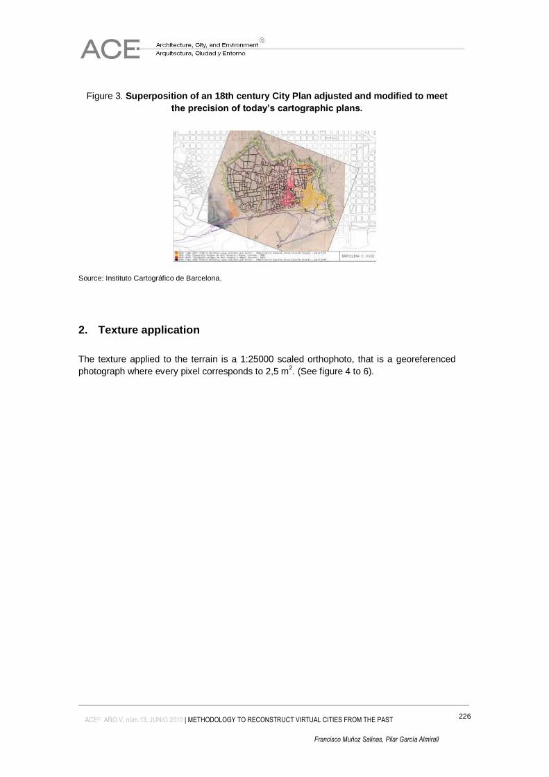
Figure 3. Superposition of an 18th century City Plan adjusted and modified to meet
the precision of today’s cartographic plans.
Source: Instituto Cartográfico de Barcelona.
2. Texture application
The texture applied to the terrain is a 1:25000 scaled orthophoto, that is a georeferenced
photograph where every pixel corresponds to 2,5 m2. (See figure 4 to 6).
227
ACE© AÑO V, núm.13, JUNIO 2010 | METHODOLOGY TO RECONSTRUCT VIRTUAL CITIES FROM THE PAST
Francisco Muñoz Salinas, Pilar García Almirall
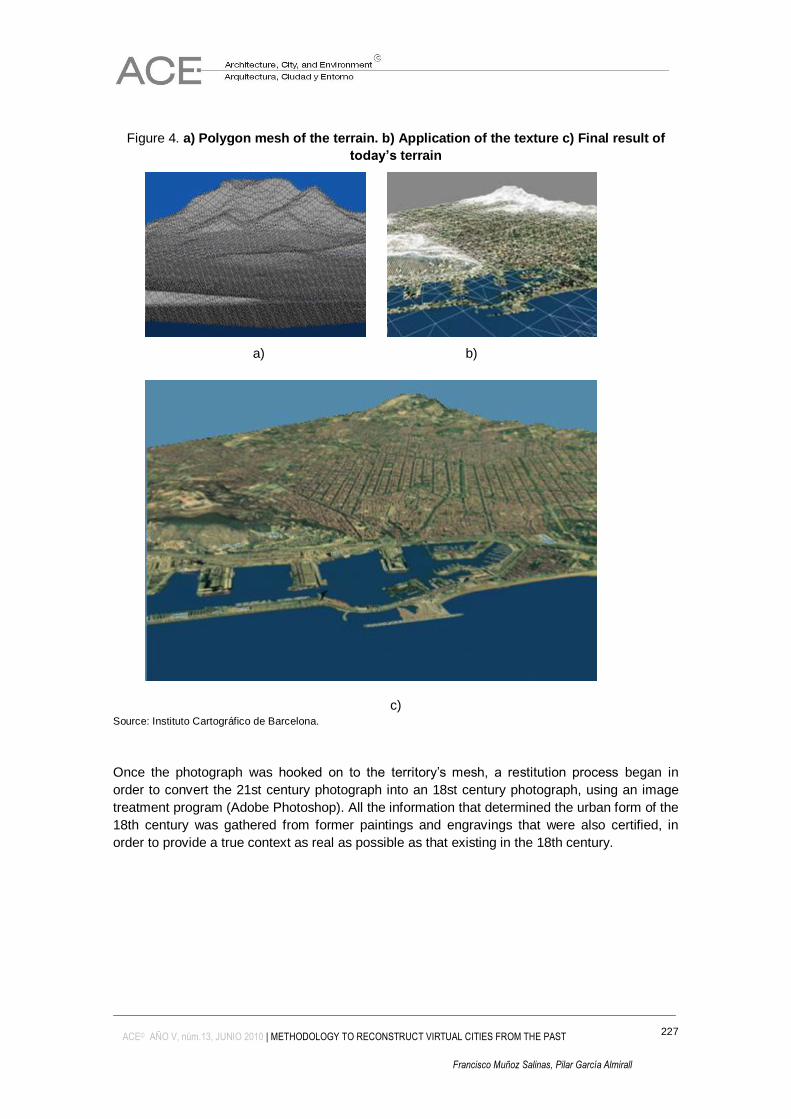
Figure 4. a) Polygon mesh of the terrain. b) Application of the texture c) Final result of
today’s terrain
a) b)
c) Source: Instituto Cartográfico de Barcelona.
Once the photograph was hooked on to the territory‟s mesh, a restitution process began in
order to convert the 21st century photograph into an 18st century photograph, using an image
treatment program (Adobe Photoshop). All the information that determined the urban form of the
18th century was gathered from former paintings and engravings that were also certified, in
order to provide a true context as real as possible as that existing in the 18th century.
228
ACE© AÑO V, núm.13, JUNIO 2010 | METHODOLOGY TO RECONSTRUCT VIRTUAL CITIES FROM THE PAST
Francisco Muñoz Salinas, Pilar García Almirall
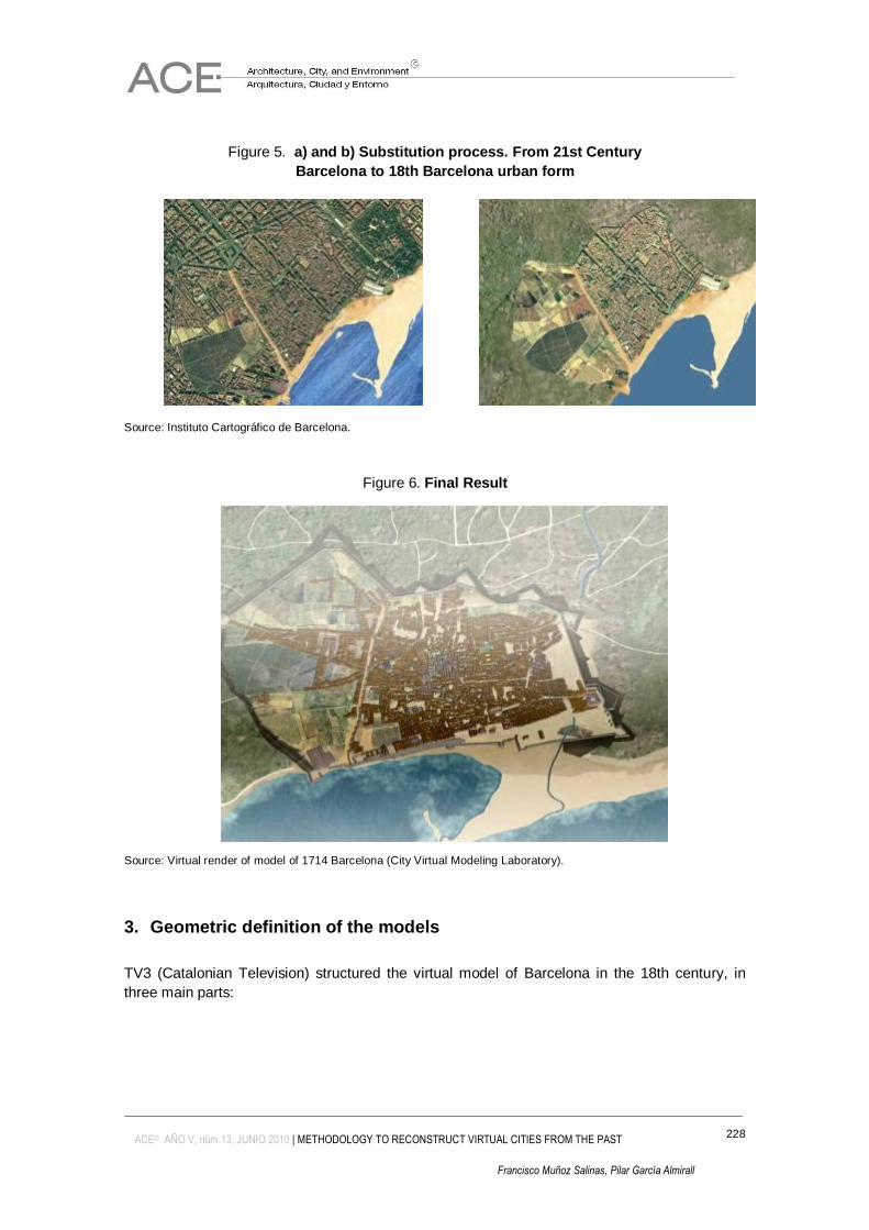
Figure 5. a) and b) Substitution process. From 21st Century
Barcelona to 18th Barcelona urban form
a) b)
Source: Instituto Cartográfico de Barcelona.
Figure 6. Final Result
Source: Virtual render of model of 1714 Barcelona (City Virtual Modeling Laboratory).
3. Geometric definition of the models
TV3 (Catalonian Television) structured the virtual model of Barcelona in the 18th century, in
three main parts:
229
ACE© AÑO V, núm.13, JUNIO 2010 | METHODOLOGY TO RECONSTRUCT VIRTUAL CITIES FROM THE PAST
Francisco Muñoz Salinas, Pilar García Almirall
3.1 Part A
A simple volumetric model with low resolution textures and geometries of the entire city, where it
would be possible to visualize the urban form of Barcelona in the 18th century, as well as the
skyline of that specific period of time. In order to obtain the adequate „skyline‟ it was necessary
to elaborate a 3D model for several singular buildings (Paricio, 1982):
Muralla romana, Catedral (Martorell, 1929), Plaça del Rei, l'Església de Santa Maria del Pi,
Plaça de Sant Jaume, Palau de la Generalitat, Ajuntament de Barcelona, Muro del Barranc,
Convent de la Mercè, l'Església de Sant Pau del Camp, Monestir de Sant Pere d'Ells Puel.les,
Convent de Sant Francesc, Castell de Montjuïc (Voltes,1960).
3.2 Part B
A 3D model of an intermediate level of detail, of the City defensive walls and the Ribera
neighbourhood was made. There were also several singular buildings that were included in this
part:
Mur del Raval i la porta de Santa Madrona, Drassanes (Florensa, 1959), Llotja, el Palau del
Virrei, Porta del Mar, Església de Santa Maria del Mar, Passeig del Born, Rec Comtal, el
Monestir de Santa Clara , Torre de Sant Joan, Rampart d'ell / ella s'aixeca, el Convent de Sant
Agustí Vell, Porta Nova, Ciutadella (a mig omplir del segle XVIII).
3.3 Part C
A model of great precision of the houses and its corresponding public spaces (adjacent streets
and squares) of the archeological remains of the antic Born marketplace was made
4. Generation of the models
Once the terrain model was generated, a new process began by gathering and selecting all the
historical information of the singular models defined in the list, and its localization was identified
in its proper space. Then was to determine if the buildings had suffered any modifications since
the time of their construction until the current year. All this allowed the reconstruction of the
modifications that the buildings had undergone during such a long period of time. It is necessary
to take into account that some of the buildings no longer exist and therefore the historical
information is fundamental.
As soon as that it determinate the geometry of the buildings in the 18th century, it continued by
determining not only the constructive system but also the materials used in each of them in that
specific period of time, in order to apply the correct texture to each 3D model.
230
ACE© AÑO V, núm.13, JUNIO 2010 | METHODOLOGY TO RECONSTRUCT VIRTUAL CITIES FROM THE PAST
Francisco Muñoz Salinas, Pilar García Almirall
Once the models with their corresponding textures were made, we used a precise CAD drawing
containing the exact urban form to fit in the buildings and slightly adjust them plan view, always
respecting its proportions. In the case of low resolution models, their geometry was defined from
simple extrusions of this CAD base.
Buildings with complex volumetric parameters, such as gothic churches, that needed an
medium or a high level of resolution, were generated using a different methodology: the
architectural elements composing these buildings were reduced to their initial geometric
formulae, such as parabolas, to construct a harmonic volumetric models of the buildings.
80% of the entire model was carried out in 3D Studio Max version 5.00, 15% by means of
AutoCAD 2000, and the remaining percentage was elaborated using complex surface
generation software developed in the E.T.S.A.B, with the use of Lisp programming.
The methodology used to generate models with a low level of detail is summarized in the
process used to model King‟s Square.
4.1 Modeling of low or simple resolution buildings
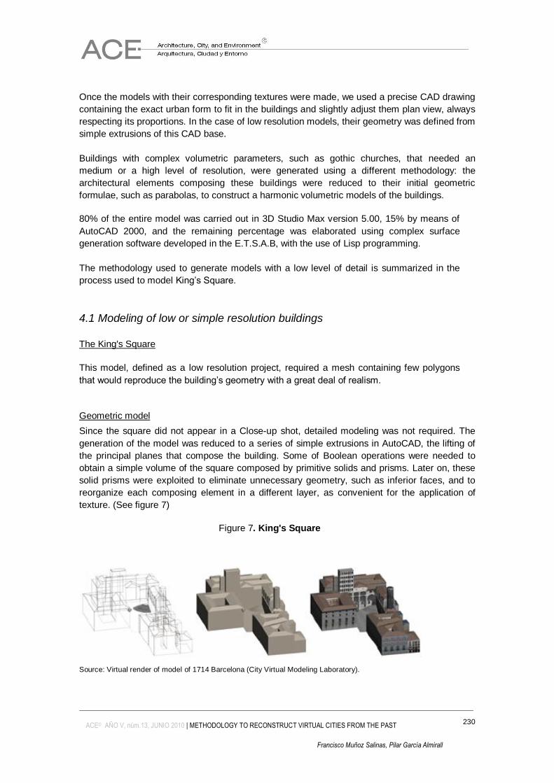
The King's Square
This model, defined as a low resolution project, required a mesh containing few polygons
that would reproduce the building‟s geometry with a great deal of realism.
Geometric model
Since the square did not appear in a Close-up shot, detailed modeling was not required. The
generation of the model was reduced to a series of simple extrusions in AutoCAD, the lifting of
the principal planes that compose the building. Some of Boolean operations were needed to
obtain a simple volume of the square composed by primitive solids and prisms. Later on, these
solid prisms were exploited to eliminate unnecessary geometry, such as inferior faces, and to
reorganize each composing element in a different layer, as convenient for the application of
texture. (See figure 7)
Figure 7. King's Square
Source: Virtual render of model of 1714 Barcelona (City Virtual Modeling Laboratory).
231
ACE© AÑO V, núm.13, JUNIO 2010 | METHODOLOGY TO RECONSTRUCT VIRTUAL CITIES FROM THE PAST
Francisco Muñoz Salinas, Pilar García Almirall
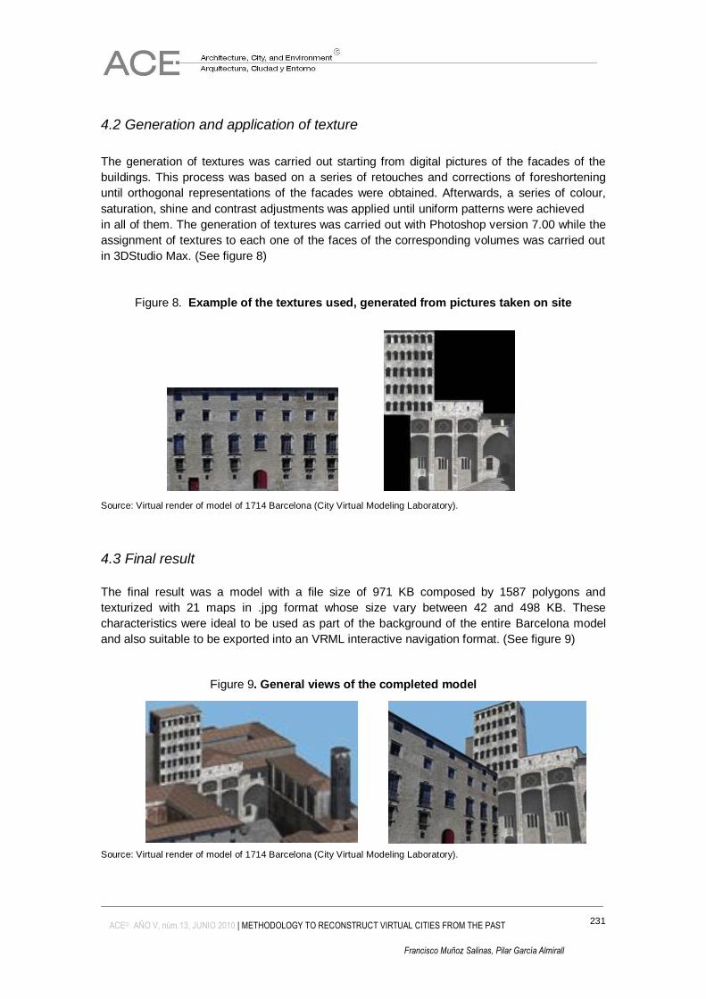
4.2 Generation and application of texture
The generation of textures was carried out starting from digital pictures of the facades of the
buildings. This process was based on a series of retouches and corrections of foreshortening
until orthogonal representations of the facades were obtained. Afterwards, a series of colour,
saturation, shine and contrast adjustments was applied until uniform patterns were achieved
in all of them. The generation of textures was carried out with Photoshop version 7.00 while the
assignment of textures to each one of the faces of the corresponding volumes was carried out
in 3DStudio Max. (See figure 8)
Figure 8. Example of the textures used, generated from pictures taken on site
Source: Virtual render of model of 1714 Barcelona (City Virtual Modeling Laboratory).
4.3 Final result
The final result was a model with a file size of 971 KB composed by 1587 polygons and
texturized with 21 maps in .jpg format whose size vary between 42 and 498 KB. These
characteristics were ideal to be used as part of the background of the entire Barcelona model
and also suitable to be exported into an VRML interactive navigation format. (See figure 9)
Figure 9. General views of the completed model
Source: Virtual render of model of 1714 Barcelona (City Virtual Modeling Laboratory).
232
ACE© AÑO V, núm.13, JUNIO 2010 | METHODOLOGY TO RECONSTRUCT VIRTUAL CITIES FROM THE PAST
Francisco Muñoz Salinas, Pilar García Almirall
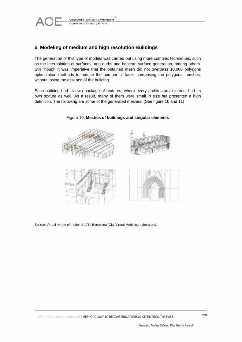
5. Modeling of medium and high resolution Buildings
The generation of this type of models was carried out using more complex techniques, such
as the interpolation of surfaces, and nurbs and boolean surface generation, among others.
Still, hough it was imperative that the obtained mesh did not overpass 10,000 polygons
optimization methods to reduce the number of faces composing the polygonal meshes,
without losing the essence of the building.
Each building had its own package of textures, where every architectural element had its
own texture as well. As a result, many of them were small in size but presented a high
definition. The following are some of the generated meshes. (See figure 10 and 11)
Figure 10. Meshes of buildings and singular elements
Source: Virtual render of model of 1714 Barcelona (City Virtual Modeling Laboratory).
233
ACE© AÑO V, núm.13, JUNIO 2010 | METHODOLOGY TO RECONSTRUCT VIRTUAL CITIES FROM THE PAST
Francisco Muñoz Salinas, Pilar García Almirall
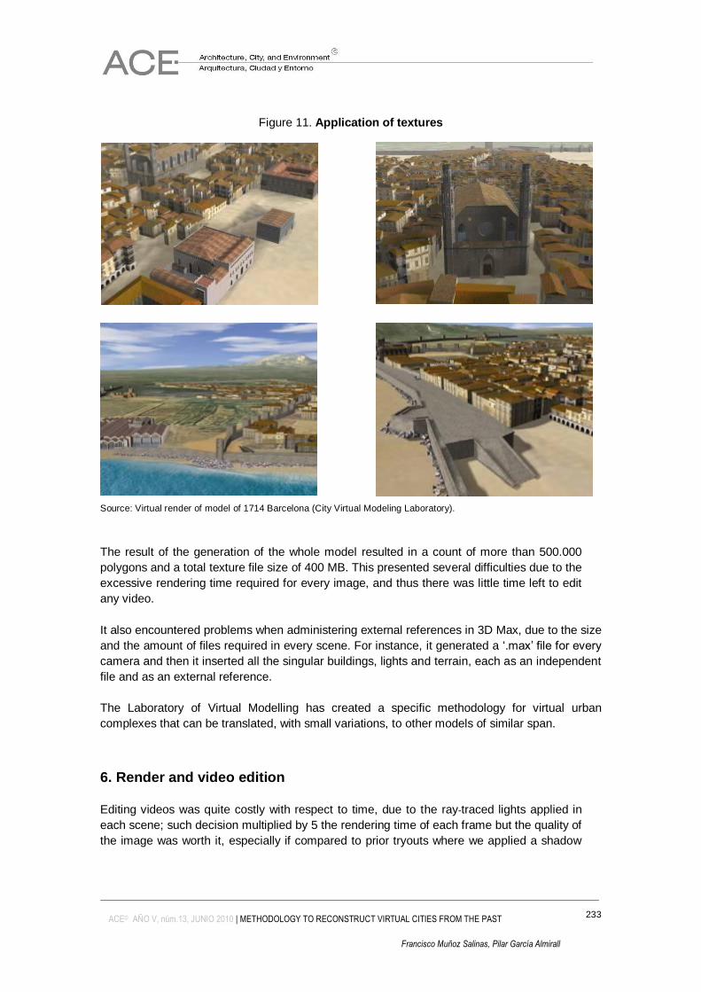
Figure 11. Application of textures
Source: Virtual render of model of 1714 Barcelona (City Virtual Modeling Laboratory).
The result of the generation of the whole model resulted in a count of more than 500.000
polygons and a total texture file size of 400 MB. This presented several difficulties due to the
excessive rendering time required for every image, and thus there was little time left to edit
any video.
It also encountered problems when administering external references in 3D Max, due to the size
and the amount of files required in every scene. For instance, it generated a „.max‟ file for every
camera and then it inserted all the singular buildings, lights and terrain, each as an independent
file and as an external reference.
The Laboratory of Virtual Modelling has created a specific methodology for virtual urban
complexes that can be translated, with small variations, to other models of similar span.
6. Render and video edition
Editing videos was quite costly with respect to time, due to the ray-traced lights applied in
each scene; such decision multiplied by 5 the rendering time of each frame but the quality of
the image was worth it, especially if compared to prior tryouts where we applied a shadow
234
ACE© AÑO V, núm.13, JUNIO 2010 | METHODOLOGY TO RECONSTRUCT VIRTUAL CITIES FROM THE PAST
Francisco Muñoz Salinas, Pilar García Almirall
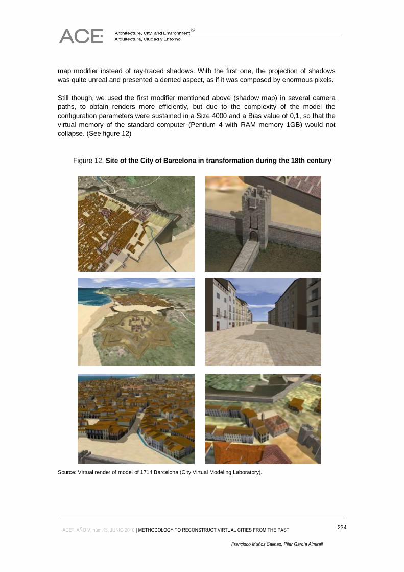
map modifier instead of ray-traced shadows. With the first one, the projection of shadows
was quite unreal and presented a dented aspect, as if it was composed by enormous pixels.
Still though, we used the first modifier mentioned above (shadow map) in several camera
paths, to obtain renders more efficiently, but due to the complexity of the model the
configuration parameters were sustained in a Size 4000 and a Bias value of 0,1, so that the
virtual memory of the standard computer (Pentium 4 with RAM memory 1GB) would not
collapse. (See figure 12)
Figure 12. Site of the City of Barcelona in transformation during the 18th century
Source: Virtual render of model of 1714 Barcelona (City Virtual Modeling Laboratory).
235
ACE© AÑO V, núm.13, JUNIO 2010 | METHODOLOGY TO RECONSTRUCT VIRTUAL CITIES FROM THE PAST
Francisco Muñoz Salinas, Pilar García Almirall
7. Conclusions
The project of reproducing a virtual and realistic 3D model of Barcelona in the year 1714, was
quite a challenging task due to the difficulty of gathering valid information (specially architectural
plans and drawings of the buildings) form a historical point of view. Thus it created a complete
database conformed by a wide variety of information, starting off with the cartographic plans,
maps, drawings, engravings and documents from past times, until arriving to images taken at
the present time.
During the first stage of the project, the information obtained from the bibliography contributed
by the library of school Architecture of the Polytechnic University of Catalonia, as well as the
graphic data provided by the TV3 team, was essential to conform a solid basis to support the
reconstruction of the virtual model of Barcelona in the 18th century.
Maps, engravings and diverse drawings were necessary to have a clear vision of the buildings‟
and their surrounding typology. These singular architectural elements contributed in the
identification of city areas that had changed dramatically during these Centuries.
Acknowledgments
For the fellows who worked on this project: Josep Roca Cladera, TV3 Marc Pujol, Carolina Ruiz,
Arcadio Echeverria.
Bibliography
AJUNTAMENT de Barcelona. Catàleg del patrimoni arquitectònic històrico-artístic de la ciutat
de Barcelona. Servei de Protecció del Patrimoni Monumental, 1987. pp: 479-496.
AMADES, Joan. Històries i llegendes de Barcelona: passejada pels carrers de la ciutat vella.
Barcelona, Edicions 62, 1984.
DURAN, Agustí. Historia de Barcelona. Barcelona, Aedos, 1975.
FLORENSA, Adolf. La "Drassana" ou chantier de Constructions navales à Barcelone
Paris, Societé Française d'Archéologie, 1959. pp: 64-69.
GARCÍA, Albert. La Ciutat de les Ciutats: Historia de Barcelona. Barcelona, Lunwerg editores,
1993.
HERNÁNDEZ-CROS, Josep Emili; MORA, Gabriela and POUPLANA, Xavier. Arquitectura de
Barcelona. Barcelona, Col·legi d'Arquitectes de Catalunya, 1990. 678 p.
236
ACE© AÑO V, núm.13, JUNIO 2010 | METHODOLOGY TO RECONSTRUCT VIRTUAL CITIES FROM THE PAST
Francisco Muñoz Salinas, Pilar García Almirall
MARTORELL, Francesc. La Catedral de Barcelona: Seixanta-quatre il·lustracions amb text de
Francesc Martorell. Barcelona, Verdaguer, 1929, 64 p.
PATRICIO, Ignacio. Anàlisi tècnica i funcional del patrimoni immobiliari municipal. Barcelona,
Institut de Tecnologia de la Construcció de Catalunya (ITEC), Ajuntament de Barcelona, 1982-
1986.
ROCA, Josep; MUÑOZ, Francisco; RUIZ, Carolina; LUPIAÑEZ, Andres and PUJOL, Marc.
Maqueta Virtual 3D de la Barcelona de siglo XVIII. Metodología para la reconstrucción Virtual
de ciudades del pasado. In: Autocad Magazine, (88): 54-60, 2004.
SOBREQUES, Jaume. Història de Barcelona. Barcelona, Enciclopèdia Catalana [etc.], 1991-
2001.
VOLTES, Pedro. Historia de Montjuich y su castillo. Barcelona, Ayuntamiento de Barcelona,
1926-2009. 214 p.
AutoCAD 88 diciembre 2003-enero 2004. GO.


![Reconstruct Market Boundaries[1][1]](https://img.pdfslide.net/doc/110x75/577d36401a28ab3a6b929b6a/reconstruct-market-boundaries11.jpg)