Embed Size (px)
Citation preview
GEORGIAMAP AREA
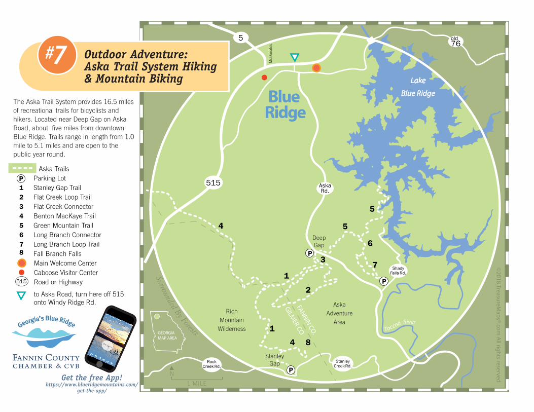
Aska Trails P Parking Lot 1 Stanley Gap Trail 2 Flat Creek Loop Trail 3 Flat Creek Connector 4 Benton MacKaye Trail 5 Green Mountain Trail 6 Long Branch Connector 7 Long Branch Loop Trail 8 Fall Branch Falls Main Welcome Center Caboose Visitor Center Road or Highway
to Aska Road, turn here off 515 onto Windy Ridge Rd.
P
The Aska Trail System provides 16.5 miles of recreational trails for bicyclists and hikers. Located near Deep Gap on Aska Road, about five miles from downtown Blue Ridge. Trails range in length from 1.0 mile to 5.1 miles and are open to the public year round.
RichMountain
Wilderness
AskaAdventure
Area
DeepGap
4
1
2
3
5
6
7
8
5
4
P
1
©2018 Treasu
reMap
s®.com
All rig
hts reserved
Surrounded By Forests
N
Blue Ridge
Toccoa River
1 MILE
FANN
IN CO
.
GILM
ER CO
Get the free App! https://www.blueridgemountains.com/
get-the-app/
AskaRd.
515
76old5
McD
onal
ds7# Outdoor Adventure:Aska Trail System Hiking & Mountain Biking Lake
Blue Ridge
StanleyGap
P
P
515
ShadyFalls Rd.
StanleyCreek Rd.
RockCreek Rd.

1 Stanley Gap Trail #165Length: 4.8 miles Difficulty: StrenuousSingle track through mixed hardwood forest with strenous climbs. The trail intersects with the Benton MacKaye Trail and continues north for hikers, or hikers and bikers can take the trail to the south to Stanley Gap and Fall Branch Falls.
2 Flat Creek Loop #165BLength: 5.1 miles Difficulty: ModerateThe trail starts approximately 100 yards from the Deep Gap parking lot. Left fork is Flat Creek Loop trail, and the right fork is Stanley Gap trail. At about 0.4 miles, the trail will fork to begin the loop.
3 Flat Creek Connector #165ALength: 0.2 miles Difficulty: ModerateShort trail that connects the Stanley Gap trail with the Flat Creek trail.
4 Benton MacKaye TrailThe Benton MacKaye Trail (BMT) is a footpath of nearly 300 miles (480 km) through the Appalachian mountains of the southeastern United States. It is designed for foot travel in the tradition of the Appalachian Trail (AT). For detailed info consult the excellent Benton MacKaye Trail Association website at www.bmta.org for maps, mileages and important information.
5 Green Mountain #165DLength: 3.7 miles Difficulty: ModerateThe trail begins across Aska Road from the Deep Gap Parking Lot. It is a gradual climb to the summit of Green Mountain. On the trail there are five short, relatively steep ascents but they are not strenuous. The trail then descends for 2.4 miles to its terminus on Forest Road 711.
6 Long Branch Connector #165FLength: 0.5 miles Difficulty: Moderate
7 Long Branch Loop Trail #165GLength: 2.1 Miles Difficulty: EasyThe trail begins at corner of the Shady Falls parking lot. Trail leaves parking area and enters onto the old logging road. Within 300 yards, the trail forks to make the loop. The right fork goes gradually downhill on the roadbed, crosses the creek, and ascends gently on a grassy road. At 0.75 miles the Long Branch Connector trail leads off to the right. The left fork, continues the Long Branch Loop, which descends to the branch, crosses the creek and ascends on old road back, to the parking lot.
8 Fall Branch Falls A double waterfall with mountain laurel and rhododendron
Easiest More Difficult Most Difficult GPS Fix
A favorite destination among many Georgia hikers and mountain bikers, Aska Adventure Trail Area offers 17 miles of interconnected trails winding through Chattahoochee National Forest. Open year round, this Blue Ridge trail system boasts a range of difficulty levels from easy-moderate to very strenuous along trails that vary in distance from one to six miles. Trails in the system ascend to over 3,000 ft, some offering creek crossings and a portion of trail runs along the shores of Lake Blue Ridge.
Trail Markings (trail blaze colors) The Aska Trail System is blazed with lime green rectanglesfor hiking and yellow diamonds for mountain bicycles. TheBenton MacKaye Trail is blazed with white diamonds.
Use Restrictions No motorized vehicles or pack stock, including horses,are allowed on the trail system. Mountain bikes are not permitted on the Benton MacKaye Trail (foot travel only).
Directions to Trailheads/Parking Areas Deep Gap - The main trailhead location is at Deep Gap, ashort 15-minute drive from the Welcome Center. From Blue Ridge, GA, go south on Aska Road 4.4 miles to Deep Gap parking area below gap and on right side of road. Parking Lot - N34°48.995' W084°17.989'
Stanley Gap - Go south on Aska Road 8 miles. Turn right on Stanley Creek Road (Toccoa Riverside Restaurant on left). Parking area for trail is 4.1 miles on right.
Shady Falls - Follow Aska Road south 5.9 miles to Shady Falls Road. Turn left, go 0.2 miles, parking area on left.
Hiking and Bicycling TimesTimes can range from as short as 15-20 minutes to a 3-5 hour round trip hike or ride from one end of the system to the other. It is the various combinations of trails that providethe diversity of cycling and hiking experiences. See individual trail descriptions on trailhead boards for details of mileage, challenge, general layout and other unique features.
Additional Trail InformationBlue Ridge Ranger District Office, 2042 Highway 515 WestBlairsville, GA 30512, (706)745-6928, For detailed info consult the US Forest Service website at www.fs.fed.us/conf/ & Benton MacKaye Trail Association web site www.bmta.org.
growing along the trail and creek bank. From Stanley Creek Road the hike to the falls is about 30 minutes round trip. In Blue Ridge, follow Aska Road south for eight miles. Turn right on Stanley Creek Rd. (Toccoa Riverside Restaurant is on the left). The trailhead is about three miles on the right (.2 miles from where pavement ends). TIPS: never climb on a waterfall. It is very slippery and dangerous. There is a nice platform in front of the falls. N34°47.017' W084°18.166'
A Word to the Wise … Be prepared for wilderness and carry the 10 Essentials. The emergency telephone number is 911. Hunting is allowed on National Forest Lands. This includes the Aska Trail System. See the US Forest Service (USFS) website at www.fs.fed.us/conf/. The law of the forest is “leave no trace”. See www.LNT.org for info. Please pack in all you will need and pack out all your trash. If you build a fire, never leave it unattended. Use good judgment when hiking and biking, particularly around waterfalls where rocks are often wet, moss covered and slippery. If hiking or biking during hunting season, wear a brightly colored vest. Pick up a copy of the detailed Trails Illustrated Map #777.
Hiking & Biking Checklist 10 Essentials (safety systems) Navigation (detailed map and compass) Sun protection (sunglasses and sunscreen) Insulation (extra clothing) Illumination (headlamp/flashlight) First-aid supplies Fire (waterproof matches/lighter/candles) Repair kit and tools Nutrition (extra food) Hydration (extra water) Emergency shelter
Main Welcome Center: 152A Orvin Lance Drive, Blue Ridge, GA 30513 1-800-899-MTNS Caboose Visitor Center: 230 Roberts Way, Blue RIdge Downtown McCaysville Visitor Center: 53 East Market St.
www.BlueRidgeMountains.comwww.facebook.com/blueridgegeorgia
7# Outdoor Adventure: Aska Trail System Hiking & Mountain Biking
P
P
P


![Southern Outdoor Adventure Program [Winter '14]](https://img.pdfslide.net/doc/110x75/577cd4fa1a28ab9e7899a1a2/southern-outdoor-adventure-program-winter-14.jpg)