Embed Size (px)
Citation preview

FGDC-STD-014.7c-2008
Geographic Information Framework Data Content Standard
Part 7c: Transportation - Roads May 2008

ii
Federal Geographic Data Committee Established by Office of Management and Budget Circular A-16, the Federal Geographic Data Committee (FGDC) promotes the coordinated development, use, sharing, and dissemination of geographic data. The FGDC is composed of representatives from the Departments of Agriculture, Commerce, Defense, Education, Energy, Health and Human Services, Homeland Security, Housing and Urban Development, the Interior, Justice, Labor, State, and Transportation, the Treasury, and Veteran Affairs; the Environmental Protection Agency; the Federal Communications Commission; the General Services Administration; the Library of Congress; the National Aeronautics and Space Administration; the National Archives and Records Administration; the National Science Foundation; the Nuclear Regulatory Commission; the Office of Personnel Management; the Small Business Administration; the Smithsonian Institution; the Social Security Administration; the Tennessee Valley Authority; and the U.S. Agency for International Development. Additional Federal agencies participate on FGDC subcommittees and working groups. The Department of the Interior chairs the committee. FGDC subcommittees work on issues related to data categories coordinated under the circular. Subcommittees establish and implement standards for data content, quality, and transfer; encourage the exchange of information and the transfer of data; and organize the collection of geographic data to reduce duplication of effort. Working groups are established for issues that transcend data categories. For more information about the committee, or to be added to the committee's newsletter mailing list, please contact:
Federal Geographic Data Committee Secretariat c/o U.S. Geological Survey
590 National Center Reston, Virginia 22092
Facsimile: (703) 648-5755 Internet (electronic mail): [email protected]
World Wide Web: http://www.fgdc.gov
Federal Geographic Data Committee FGDC-STD-014.7c-2008 Geographic Information Framework Data Content Standard Part 7c: Transportation - Roads
iii
Contents
Introduction................................................................................................................................... vi 1 Scope ........................................................................................................................................... 1 2 Conformance............................................................................................................................... 2 3 Normative references................................................................................................................. 2 4 Maintenance authority ............................................................................................................... 2 4.1 Level of responsibility...................................................................................................... 2 4.2 Contact information ......................................................................................................... 2 5 Terms and definitions ................................................................................................................ 2 6 Symbols, abbreviated terms, and notations............................................................................ 3 7 Road system model.................................................................................................................... 3 7.1 Road system ..................................................................................................................... 3 7.2 Road segmentation model............................................................................................... 4 7.2.1 Introduction....................................................................................................................... 4 7.2.2 RoadPoint.......................................................................................................................... 5 7.2.3 Anchor point ..................................................................................................................... 5 7.2.4 RoadSeg ............................................................................................................................ 5 7.2.5 Road segment equivalence ............................................................................................. 6 7.2.6 Anchor section ................................................................................................................. 6 7.2.7 RoadPath........................................................................................................................... 6 7.2.8 Attributes for road system............................................................................................... 7 7.3 The event model ............................................................................................................. 11 7.3.1 Introduction..................................................................................................................... 11 7.3.2 RoadAttributeEvent........................................................................................................ 11 7.3.3 RoadFeatureEvent.......................................................................................................... 12 7.3.4 RoadAttributeEvent data dictionary ............................................................................. 15 7.4 Code lists......................................................................................................................... 17 7.4.1 RoadLinearEventType code list .................................................................................... 18 7.4.2 RoadPointEventType code list...................................................................................... 21 Annex A (informative) Road example........................................................................................ 22 Annex B (informative) Bibliography .......................................................................................... 29 Figures Figure 1 – Relationship of road features to Transportation Base (Part 7) model................... 4 Figure 2 – RoadPoints bounding a RoadSeg (A, B) and non-RoadPoints (C, D).................... 5 Figure 3 – Road segment equivalence ........................................................................................ 6 Figure 4 – RoadAttributeEvent model ....................................................................................... 11 Figure 5 – RoadFeatureEvent model ......................................................................................... 13 Figure 6 – RoadPointEventType and RoadLinearEventType code lists................................ 17 Figure A.1 – Road example......................................................................................................... 22 Figure A.2 – Road points and road segments .......................................................................... 22 Figure A.3 – Approximate GIS linestring geometry ................................................................. 23 Figure A.4 – More precise engineering curve geometry ......................................................... 23 Figure A.5 – Road paths ............................................................................................................. 24
Federal Geographic Data Committee FGDC-STD-014.7c-2008 Geographic Information Framework Data Content Standard Part 7c: Transportation - Roads
iv
Figure A.6 – Routes with milepoint values ............................................................................... 25 Figure A.7 – Speed limit road linear attribute events .............................................................. 26 Figure A.8 – Road segment point events.................................................................................. 27
Tables Table 1 – Data dictionary for road system.................................................................................. 7 Table 2 – Data dictionary for RoadAttributeEvent ................................................................... 15 Table 3 – CodeList for RoadLinearEventType.......................................................................... 18 Table 4 – CodeList for RoadPointEventType............................................................................ 21 Table A.1 – Road path to road segment mappings.................................................................. 25 Table A.2 – Road path speed limit linear attribute events ...................................................... 26 Table A.3 – Road segment speed limit linear attribute events ............................................... 27

Federal Geographic Data Committee FGDC-STD-014.7c-2008 Geographic Information Framework Data Content Standard Part 7c: Transportation - Roads
v
Foreword
Geographic information, also known as geospatial information, both underlies and is the subject of much of the political, economic, environmental, and security activities of the United States. In recognition of this, the United States Office of Management and Budget issued Circular A-16 (revised 2002), which established the Federal Geographic Data Committee (FGDC) as a coordinating organization.
Work on this standard started under the Geospatial One-Stop e-Government initiative. The standard was developed with the support of the member agencies and organizations of the FGDC and aids in fulfilling a primary objective of the National Spatial Data Infrastructure (NSDI), that is, creation of common geographic base data for seven critical data themes. The seven core data themes are considered framework data of critical importance to the geographic data infrastructure.
As the Geographic Information Framework Data Content Standard was developed using public funds, the U.S. Government will be free to publish and distribute its contents to the public, as provided through the Freedom of Information Act (FOIA), Part 5 United States Code, Section 552, as amended by Public Law No. 104-231, “Electronic Freedom of Information Act Amendments of 1996”.

Federal Geographic Data Committee FGDC-STD-014.7c-2008 Geographic Information Framework Data Content Standard Part 7c: Transportation - Roads
vi
Introduction The primary purpose of this part of the Geographic Information Framework Data Content Standard is to support the exchange of road transportation data. This part seeks to establish a common baseline for the semantic content of road transportation databases for public agencies and private enterprises. It also seeks to decrease the costs and simplify the exchange of road transportation data among local, Tribal, State, and Federal users and producers. That, in turn, discourages duplicative data collection. Benefits of adopting this part of the standard also include the long-term improvement of the geospatial road transportation data within the community, improved integration of safety, emergency response, and enforcement data, and streamlined maintenance procedures.
This part of the Framework Data Content Standard was preceded in development by the FGDC NSDI Framework Transportation Identification Standard and the National Cooperative Highway Research Program (NCHRP) 20-27(2).

Federal Geographic Data Committee FGDC-STD-014.7c-2008 Geographic Information Framework Data Content Standard Part 7c: Transportation - Roads
1
1 Scope The Geographic Information Framework Data Content Standard, Part 7c: Roads defines the components of a model for describing roads which, along with Air (Part 7a), Rail (Part 7b), Transit (Part 7d), and Inland Waterways (Part 7e), is one of five modes that compose the Transportation theme of the digital geospatial data framework. The primary purpose of this part of the standard is to support the exchange of transportation data related to road systems. It is the intent of the Roads part to develop a consensus around a set of common definitions for real world features in order to advance the goals of the NSDI. It is the intent of the part to set a common baseline that will foster the widest possible set of applications of road data for both user and producer. It is also intended to foster improvements in the common spatial data infrastructure through enhanced data sharing and the reduction of redundant data production.
There are a number of issues common to the transportation domain that are covered in the Transportation Base (Part 7) part of the standard because of their broader applications. Some of these issues and their relevance for the Roads part are discussed in Annex A of the Transportation Base.
At a high level, the road model described in the standard is made up of features that can have geographic locations and characteristics. These features can be interconnected in various ways to represent road networks for path finding/routing applications. While the design team has considered the need for path finding applications, the level of data required by such applications is beyond the scope of many organizations. Specifically, many State and local government agencies do not have adequate data for routing purposes and they do not have the budget to create and maintain this data. It is expected that the content in the Roads part will support the development of specialized networks for routing applications, but this level of information is not a requirement.
This part of the Framework Data Content Standard can be implemented using a variety of software packages and is designed to accommodate data with or without geometry. While this document touches on implementation issues, it is not intended to serve as an implementation specification. It is designed to accommodate data associated with the complete road system at all levels of service and all functional classes that may be defined by a data-providing agency. It also accommodates assets associated with roads that are typically used for navigation, safety, and measurement.
The Roads part of the standard applies to NSDI framework transportation data produced or disseminated by or for the Federal Government. According to Executive Order 12906, Coordinating Geographic Data Acquisition and Access: The National Spatial Data Infrastructure, Federal agencies collecting or producing geospatial data, either directly or indirectly (for example, through grants, partnerships, or contracts with other entities), shall ensure, prior to obligating funds for such activities, that data will be collected in a manner that meets all relevant standards adopted through the Federal Geographic Data Committee (FGDC) process.
The Roads part relies extensively on ISO 19133 for linear referencing. Linear reference systems (LRS) are, in the strictest sense, not central to this part of the standard and also are complex enough to warrant separate treatment. Users should refer to Annex B of the Transportation Base (Part 7) part of the standard for information on linear reference systems. The use of LRS is not added simply to support the requirements of departments of transportation; LRS is used as a technique to transfer road information between systems in a simple, flexible data structure that does not impose a specific segmentation scheme on the data being exchanged. LRS is used in this part of the standard to support the exchange of asset information such as sign locations and pavement condition, as well as to support the placement of transportation statistics such as traffic counts or accident data along the roads, or the number of lanes, or speed limits.
A linkage between this part of the standard and appropriate ISO standards for representing spatial features using the Unified Modeling Language (UML) has been developed. These upper-level classes are not necessarily unique to roads, or even to transportation. A specific road
Federal Geographic Data Committee FGDC-STD-014.7c-2008 Geographic Information Framework Data Content Standard Part 7c: Transportation - Roads
2
profile of those standards has been assembled as the base classes for this model, primarily to take advantage of geometry, topology, and metadata standards. Additional work by ISO TC211 and TC204 to harmonize Geographic Data Files (GDF) and linear referencing standards is in progress in parallel with the development of this standard. Annex B in the Base Document (Part 0) contains a brief explanation of UML diagrams.
2 Conformance This thematic part includes a data dictionary/model based on the conceptual schema presented below. To conform to this part, the user shall satisfy the requirements of the data dictionary/model. The user's conforming dataset shall include a value for each mandatory element and a value for each conditional element for which the condition is true. It may contain values for any optional element. The data type of each value shall be that specified for the element in the data dictionary/model and the value shall lie within the specified domain. This part only specifies the special requirements of conformance for a dataset containing information on the road system. Conformance to this part requires additional actions specified in the Base Document (Part 0) and Transportation Base (Part 7).
3 Normative references Annex A of the Base Document (Part 0) lists normative references applicable to two or more parts of the standard, including those other than the transportation parts. No additional normative references are specified in the Transportation Base (Part 7). Informative references applicable to the Roads part only are listed in Annex B. Informative references applicable to two or more transportation parts only are listed in Annex C of the Transportation Base. Annex D of the Base Document lists informative references applicable to two or more of the parts, including those other than the transportation parts.
4 Maintenance authority 4.1 Level of responsibility The FGDC is the responsible organization for coordinating work on all parts of the Geographic Information Framework Data Content Standard. The United States Department of Transportation (USDOT), working with the FGDC, is the responsible organization for coordinating work on the Geographic Information Framework Data Content Standard, Part 7: Transportation Base and subparts (Parts 7a, 7b, 7c, and 7d, excluding 7e) and is directly responsible for development and maintenance of the transportation parts (excluding 7e) of the Framework Data Content Standard.
4.2 Contact information Address questions concerning this part of the standard to:
Federal Geographic Data Committee Secretariat c/o U.S. Geological Survey 590 National Center Reston, Virginia 20192 USA
Telephone: (703) 648-5514 Facsimile: (703) 648-5755 Internet (electronic mail): [email protected] WWW Home Page: http://fgdc.gov
5 Terms and definitions Definitions applicable to the Roads part are listed here. Other terms and definitions applicable to multiple transportation parts of the standard are listed in the Transportation Base (Part 7). More general terms and definitions can be found in the Base Document (Part 0) part of the standard. Users are advised to consult these documents for a complete set of definitions.

Federal Geographic Data Committee FGDC-STD-014.7c-2008 Geographic Information Framework Data Content Standard Part 7c: Transportation - Roads
3
5.1 anchor section
section of road between two anchor points
NOTE Anchor sections state the official surface length of a road segment [NCHRP 20-27(2)]
5.2 equivalence relationship (between road points)
correlation used to indicate that a road point in one dataset is equivalent to (that is to say, has the same physical location as) one or more road points in another dataset
5.3 equivalence relationship (between road segments)
correlation used to indicate that a road segment in one dataset is equivalent to (that is to say, represents the same part of the physical road system as) one or more, whole or partial, road segments in another dataset
5.4 road feature
entity that constitutes the road system
NOTE A road feature is any type of transportation feature that is part of the road system. It is a type of transportation feature.
5.5 road path
ordered list of whole or partial sections of physical road (that is to say, road segments)
EXAMPLE An administrative route, such as Interstate 95, or a delivery route.
6 Symbols, abbreviated terms, and notations Symbols, abbreviations, and notations common to two or more transportation parts are listed in the Transportation Base (Part 7). Symbols, abbreviations, and notations applicable to multiple parts, including the transportation parts, are listed in the Base Document (Part (0).
7 Road system model 7.1 Road system The road system model describes the geographic locations, interconnectedness, and characteristics of the street and roads in the larger transportation system. The transportation system includes physical and non-physical components representing all modes of travel that allow the movement of goods, services, and people between locations.
The road infrastructure is comprised of physical components of the entire transportation system, generally consisting of public ways with perhaps a number of carriageways that are possibly paved.
The focus of this part of the standard is to define a way to encode segments, their start and end points, and their attributes, which may have different values associated with different parts of a segment. The model has three main components:
• A road segmentation model, which defines the representation of the physical segments of the road network (road segments), their connectivity (road points), and their usage (road paths)

Federal Geographic Data Committee FGDC-STD-014.7c-2008 Geographic Information Framework Data Content Standard Part 7c: Transportation - Roads
4
• An event model, which defines a method to model attributes that may have values that change from one part of a segment to another and to linearly locate features along road segments or paths
• A linear reference model, which defines how locations are specified along linear features. Strictly speaking, the linear reference model is not a part of this model, but is referenced because of the part it plays in handling the attribution for road features. The linear reference model is described in full in Annex B of the Transportation Base
7.2 Road segmentation model 7.2.1 Introduction
Figure 1 – Relationship of road features to Transportation Base (Part 7) model
To ensure maximum utility in a variety of contexts, this road model does not prescribe any specific business rules for the segmentation of the road system. The road network is the set of road features and their topological relationships which together define all possible movements through the road system. The road network can be broken up into segments called RoadSegs. RoadSegs represent individual pieces of the physical road network, such as that part of Main Street which exists between First Avenue and Second Avenue. It is highly recommended that RoadSegs be topologically connected by RoadPoints. RoadPoints serve to connect two RoadSegs. RoadPaths prescribe a usage of part of the road network, such as Route 66 or Washington Avenue. They represent a path through a set of whole or partial RoadSegs. RoadSeg, RoadPoint, and RoadPath are specializations of the transportation feature classes TranSeg, TranPoint, and TranPath, respectively (see Figure 1). All other real world entities comprising the road system are represented as road features.

Federal Geographic Data Committee FGDC-STD-014.7c-2008 Geographic Information Framework Data Content Standard Part 7c: Transportation - Roads
5
7.2.2 RoadPoint
RoadPoint is the specified location of an endpoint of a RoadSeg. This relationship is illustrated in Figure 2, where two RoadPoints, A and B, bound a RoadSeg. Point C represents the location of some real world entity such as an intersection or a bridge somewhere along the RoadSeg. Point D represents the location of another entity along the RoadSeg, but offset a lateral distance to one side. Because C and D do not terminate or represent the topological connection between RoadSegs, they shall not be represented as RoadPoints. Instead, if they represent real world entities (with attributes), they shall be represented as road features. FeatureEvents can be used to define their location along and optionally offset from a RoadSeg. Alternatively, Points C and D can be represented as AttributeEvents if they represent attributes instead of entities, such as the start of a bridge. This is explained further in the event model section below.
Figure 2 – RoadPoints bounding a RoadSeg (A, B) and non-RoadPoints (C, D)
RoadPoints can have geometry of type GM_Point and topology attribute of type TP_Node. Both GM_Point and TP_Node are inherited from TranPoint and defined in ISO 19107.
7.2.3 Anchor point
An anchor point represents a physical location in the field that can be unambiguously described so that it can be clearly located in the real world using the point description. An anchor point is a link between the computer representation of the road system and the real world. An anchor point shall occur at the ends of an anchor section. There is no requirement to include anchor points in the dataset being transferred, so all RoadPoints are not necessarily anchor points. Figure 1 shows that RoadPoint has a Boolean attribute (isAnchorPoint) indicating whether the point is considered an anchor point.
7.2.4 RoadSeg
RoadSeg represents a continuous nonbranching linear section of a road, which means that RoadSeg represents a road segment. RoadSeg is a specified directed path between two RoadPoints along a physical road that identifies a unique segment of that system. Each segment has an identifier, with points used to start and end segments. It is important to note here that a RoadSeg does not necessarily have to be an entire road. It could be a single lane or a carriageway. Furthermore, a segment is not defined as a line on a map, but as a segment of physical road, of which the beginning, end, and length are determined by transportation agencies based on their business needs. The agencies determine where the junctions of segments are placed.
RoadSeg extends TranSeg and is depicted in Figure 1. Because it extends TranSeg, RoadSeg inherits all properties from TranSeg including optional geometry of type GM_Curve as defined in ISO 19107. According to ISO 19107, GM_Curve extends GM_OrientableCurve and therefore has direction. RoadSeg also can have a topology of type TP_DirectedEdge, as defined in ISO 19107. The reason TP_DirectedEdge has been introduced is to facilitate the representation of feature topology through its combinatorial structures independent of its geometry. For example, in the implementation of this model, a data provider may choose to represent only the geometry
A BC
D
offset
Federal Geographic Data Committee FGDC-STD-014.7c-2008 Geographic Information Framework Data Content Standard Part 7c: Transportation - Roads
6
of a RoadSeg, which implies a direction inherited from GM_OrientableCurve. Another data provider may choose not to supply road feature geometry and only provide the orientation of the RoadSeg using its topology attribute.
7.2.5 Road segment equivalence
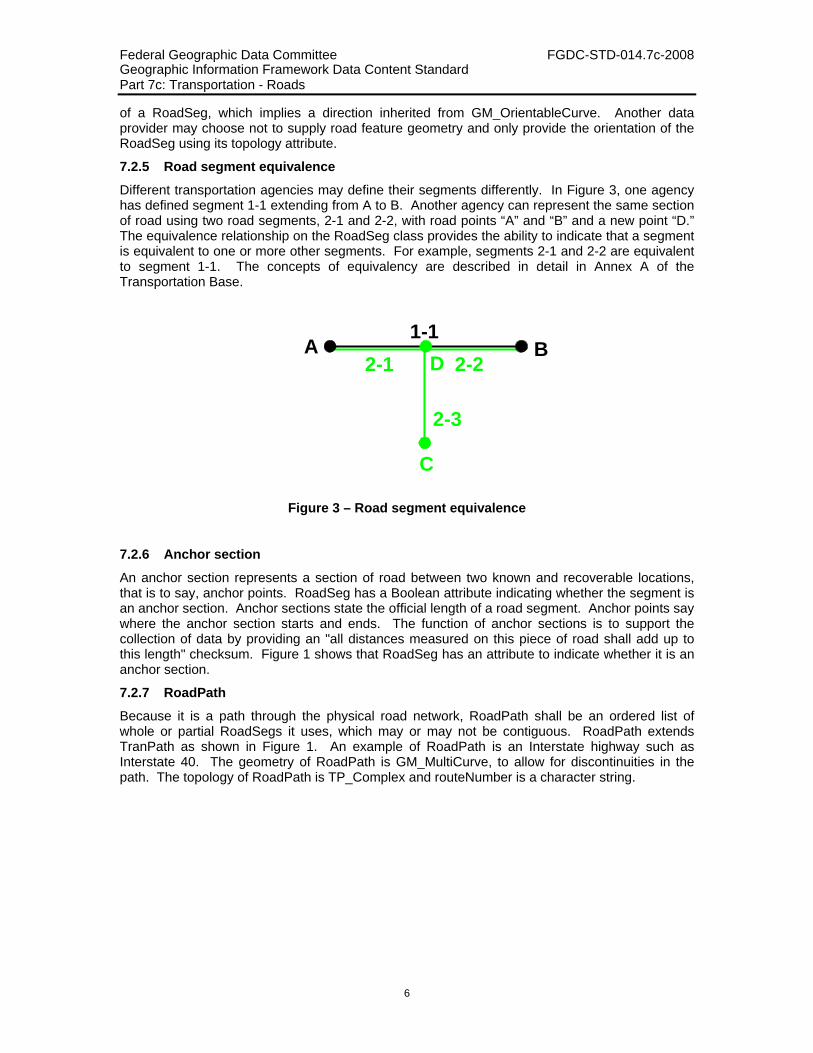
Different transportation agencies may define their segments differently. In Figure 3, one agency has defined segment 1-1 extending from A to B. Another agency can represent the same section of road using two road segments, 2-1 and 2-2, with road points “A” and “B” and a new point “D.” The equivalence relationship on the RoadSeg class provides the ability to indicate that a segment is equivalent to one or more other segments. For example, segments 2-1 and 2-2 are equivalent to segment 1-1. The concepts of equivalency are described in detail in Annex A of the Transportation Base.
Figure 3 – Road segment equivalence
7.2.6 Anchor section
An anchor section represents a section of road between two known and recoverable locations, that is to say, anchor points. RoadSeg has a Boolean attribute indicating whether the segment is an anchor section. Anchor sections state the official length of a road segment. Anchor points say where the anchor section starts and ends. The function of anchor sections is to support the collection of data by providing an "all distances measured on this piece of road shall add up to this length" checksum. Figure 1 shows that RoadSeg has an attribute to indicate whether it is an anchor section.
7.2.7 RoadPath
Because it is a path through the physical road network, RoadPath shall be an ordered list of whole or partial RoadSegs it uses, which may or may not be contiguous. RoadPath extends TranPath as shown in Figure 1. An example of RoadPath is an Interstate highway such as Interstate 40. The geometry of RoadPath is GM_MultiCurve, to allow for discontinuities in the path. The topology of RoadPath is TP_Complex and routeNumber is a character string.
1-12-1 2-2
A B
2-3
C
D

Federal Geographic Data Committee FGDC-STD-014.7c-2008 Geographic Information Framework Data Content Standard Part 7: Transportation - Roads
7
7.2.8 Attributes for road system
Listed below in Table 1 are the road system objects and their attributes.
Table 1 – Data dictionary for road system
Line Name/Role Name Definition Obligation/ Condition
Maximum Occurrence Data Type Domain
1 RoadPath
Linear, possibly discontinuous portion of the road system that may be a collection of RoadSeg instances
<<Feature>> Lines 2-11
2 Framework::Feature::identifier Feature identifier for the RoadPath M 1 <<DataType>> Framework::Identifier Unrestricted
3 Framework::Feature::metadata Structured or unstructured metadata as defined by the community of practice
O 1 CharacterString May be text or structured metadata fragment
4 Framework::Feature::attribute Producer-defined attribute for inclusion in transfer O *
<<DataType>> Framework::ExtendedAttribute
Unrestricted
5 Transportation Base:: TranFeature::lastUpdateDate
Timestamp indicating when the RoadPath object was last edited M 1 DateTime Valid historical or current
date and time
6 Transportation Base:: TranPath::geometry
Geometric representation of the instantiated RoadPath entity O * <<Type>>
GM_MultiCurve Defined in ISO 19107
7 Transportation Base:: TranPath::topology Topological representation O * <<Type>>
TP_Complex Defined in ISO 19107
8 Transportation Base:: TranPath::routeNumber Public RoadPath identifier M 1 CharacterString Unrestricted
9 Role name: segment Road segment feature used by the RoadPath M *
<<Abstract>> TransportationBase:: TranSeg
Whole or partial RoadSeg

Federal Geographic Data Committee FGDC-STD-014.7c-2008 Geographic Information Framework Data Content Standard Part 7: Transportation - Roads
8
Line Name/Role Name Definition Obligation/ Condition
Maximum Occurrence Data Type Domain
10 Role name: from Source RoadPath in equivalency C/part of equivalency? *
<<Feature>> TransportationBase:: TranPath
Whole or partial RoadPaths
11 Role name: to Destination RoadPath in equivalency
C/part of equivalency? *
<<Feature>> TransportationBase:: TranPath
Whole or partial RoadPaths
12 RoadPoint RoadSeg terminus (start, end) <<Feature>> Lines 13-23
13 Framework::Feature::identifier Feature identifier for the RoadPoint M 1 <<DataType>> Framework::Identifier Unrestricted
14 Framework::Feature::metadata Structured or unstructured metadata as defined by the community of practice
O 1 CharacterString May be text or structured metadata fragment
15 Framework::Feature::attribute Producer-defined attribute for inclusion in transfer O *
<<DataType>> Framework:: ExtendedAttribute
Unrestricted
16 Transportation Base:: TranFeature::lastUpdateDate
Timestamp indicating when the RoadPoint object was last edited. M 1 DateTime Valid historical or current
date and time
17 Transportation Base:: TranFeature:geometry
Geometric representation of the instantiated road point entity O * <<Type>>
GM_Point Defined in ISO 19107
18 Transportation Base:: TranFeature:topology Topological representation O * <<Type>>
TP_Node Defined in ISO 19107
19 isAnchorPoint Indicates whether RoadPoint is an anchor point M 1 Boolean True/False, Yes/No, 1/0;
default = False
20 Role name: startedSegment Segment that starts at the road point
C/RoadSeg starts at
RoadPoint? *
<<Abstract>> TransportationBase:: TransSeg
Unrestricted
21 Role name: endedSegment Segment that ends at the road point C/RoadSeg ends at RoadPoint? *
<<Abstract>> TransportationBase:: TransSeg
Unrestricted

Federal Geographic Data Committee FGDC-STD-014.7c-2008 Geographic Information Framework Data Content Standard Part 7: Transportation - Roads
9
Line Name/Role Name Definition Obligation/ Condition
Maximum Occurrence Data Type Domain
22 Role name: from Source RoadPoint in equivalency C/part of equivalency? *
<<Feature>> TransportationBase:: TranPoint
Unrestricted
23 Role name: to Destination RoadPoint in equivalency
C/part of equivalency? *
<<Feature>> TransportationBase:: TranPoint
Unrestricted
24 RoadSeg Linear, continuous, non-branching portion of the road system <<Feature>> Lines 25-38
25 Framework::Feature::identifier Feature identifier for the RoadSeg M 1 <<DataType>> Framework::Identifier Unrestricted
26 Framework::Feature::metadata Structured or unstructured metadata as defined by the community of practice
O 1 CharacterString May be text or structured metadata fragment
27 Framework::Feature::attribute Producer-defined attribute for inclusion in transfer O *
<<DataType>> Framework:: ExtendedAttribute
Unrestricted
28 Transportation Base:: TranFeature::lastUpdateDate
Timestamp indicating when the RoadSeg object was last edited M 1 DateTime Valid historical or current
date and time
29 Transportation Base:: TranSeg::status
Status of segment entity; for example, proposed, under construction, open to traffic, abandoned, and so on
M 1 CharacterString Unrestricted
30 Transportation Base:: TranSeg::fieldMeasure
Length of segment, as determined in the field; if isAnchorSection = True, then this is the official length of the segment for the LRS
M 1 Measure Defined in ISO 19103
31 Transportation Base:: TranSeg::length
Length of the RoadSeg feature, which may differ from the field measured length due to differences in calculation
M 1 Measure Unrestricted
Federal Geographic Data Committee FGDC-STD-014.7c-2008 Geographic Information Framework Data Content Standard Part 7: Transportation - Roads
10
Line Name/Role Name Definition Obligation/ Condition
Maximum Occurrence Data Type Domain
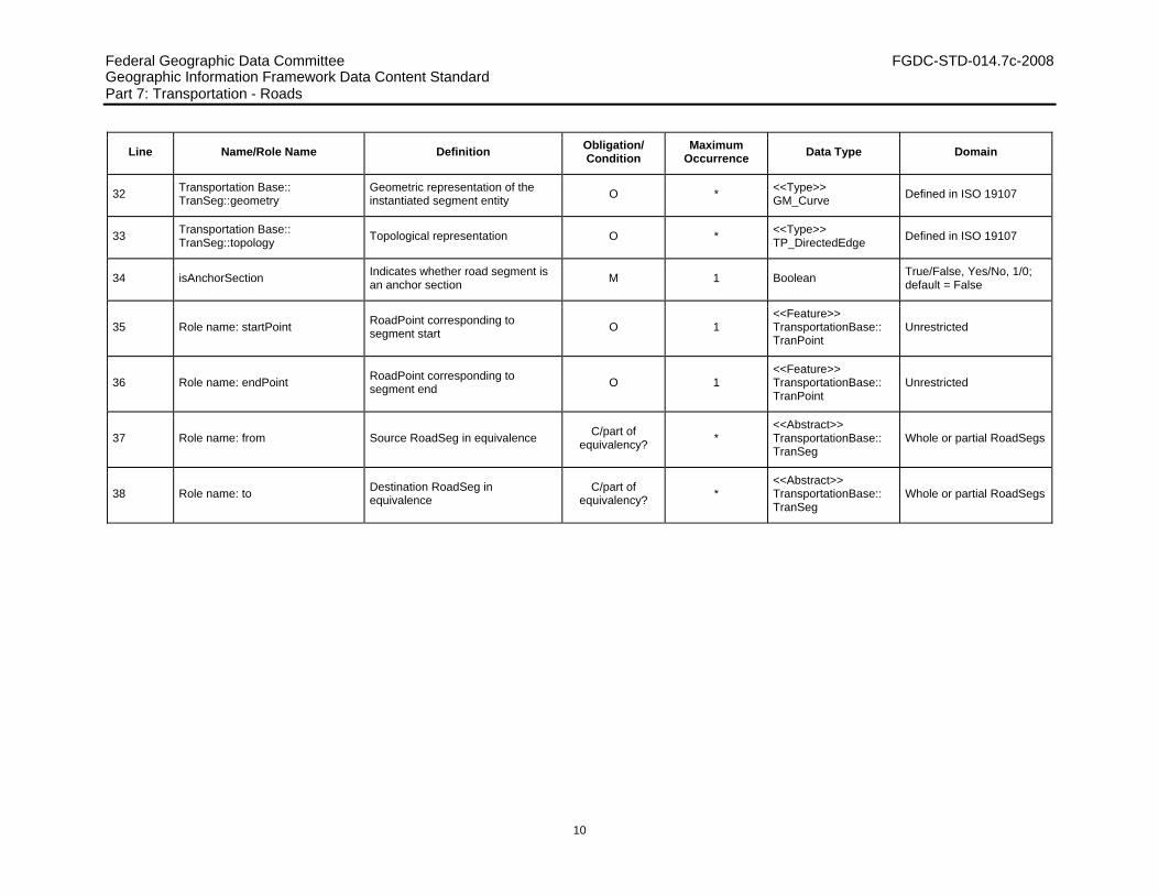
32 Transportation Base:: TranSeg::geometry
Geometric representation of the instantiated segment entity O * <<Type>>
GM_Curve Defined in ISO 19107
33 Transportation Base:: TranSeg::topology Topological representation O * <<Type>>
TP_DirectedEdge Defined in ISO 19107
34 isAnchorSection Indicates whether road segment is an anchor section M 1 Boolean True/False, Yes/No, 1/0;
default = False
35 Role name: startPoint RoadPoint corresponding to segment start O 1
<<Feature>> TransportationBase:: TranPoint
Unrestricted
36 Role name: endPoint RoadPoint corresponding to segment end O 1
<<Feature>> TransportationBase:: TranPoint
Unrestricted
37 Role name: from Source RoadSeg in equivalence C/part of equivalency? *
<<Abstract>> TransportationBase:: TranSeg
Whole or partial RoadSegs
38 Role name: to Destination RoadSeg in equivalence
C/part of equivalency? *
<<Abstract>> TransportationBase:: TranSeg
Whole or partial RoadSegs

Federal Geographic Data Committee FGDC-STD-014.7c-2008 Geographic Information Framework Data Content Standard Part 7c: Transportation - Roads
11
7.3 The event model 7.3.1 Introduction
Transportation events are the mechanism by which attributes or entities can be linearly located along either a TranSeg or a TranPath linear feature. Refer to the transportation event model in the Transportation Base for a more detailed overview of the transportation event model. Transportation events can be either attribute events or feature events. Within the Roads part, events specific to the road system are supported as specializations of transportation attribute and feature events.
7.3.2 RoadAttributeEvent
If an attribute value of a linear feature has a single, constant value along the entire length of the feature (for example, status and fieldMeasure), the attribute exists at the feature (RoadSeg or RoadPath) level and it is sufficient to store this single value with the feature. If the value of the attribute can change along the length of the linear feature (for example, speed limit, number of lanes); the location where each change occurs must also be specified. To accomplish this, RoadAttributeEvents are used.
cd Context Diagram: Road Attribute Ev ents
«DataType»RoadLinearAttributeEv ent
+ endPosi tion: LR_PositionExpression+ l inearEventType: RoadLinearEventType+ startPosi tion: LR_PositionExpression
«DataType»RoadPointAttributeEv ent
+ atPosition: LR_Posi tionExpression+ pointEventType: RoadPointEventType
«Abstract»Transportation Base::TranEvent
+ source: CharacterString
«DataType»RoadAttributeEv ent
+ attributeValue: CharacterString
«Abstract»RoadEvent
«Union»LocatingRoadFeature
+ path: RoadPath+ segment: RoadSeg
+event
1..*
+locatingFeature
Figure 4 – RoadAttributeEvent model

Federal Geographic Data Committee FGDC-STD-014.7c-2008 Geographic Information Framework Data Content Standard Part 7c: Transportation - Roads
12
Each RoadAttributeEvent specifies a particular value for an attribute of a linear feature along with the location along that feature for which the value applies. RoadAttributeEvents are subtyped into point and linear events. A RoadPointAttributeEvent event occurs at a single position along a RoadSeg or RoadPath. This position is called an “at” position. RoadLinearAttributeEvents apply to a length of the RoadSeg or RoadPath. This interval is defined by a “start” and an “end” position on the RoadSeg or RoadPath. The “at”, “start”, and “end” positions used to locate an event are specified using a linearly referenced position expression. This expression specifies the linear reference method used to perform the measurement, the linear feature (RoadSeg or RoadPath) being measured, the measurement along the feature, and optionally the measurement laterally offset to either side. See Annex B of the Transportation Base for more details.
7.3.2.1 RoadLinearAttributeEvent
RoadLinearAttributeEvents provide the means of specifying the value and location of a single segment or path attribute that may apply only to part of the segment or path. The value of the segment or path attribute is specified as the attributeValue, inherited from RoadAttributeEvent. The location interval along which the value applies is specified by a “start” and “end” position along the segment or path, using linearly referenced position expressions explained in Annex B of the Transportation Base. The name of the attribute is specified by the linearEvent attribute of RoadLinearAttributeEvent. A code list of RoadLinearEventType values is supplied (see Figure 6). An example of a RoadLinearAttributeEvent is the speed limit of a road. The RoadLinearEventType value is “speedRestriction”. An attributeValue of 55 MPH might apply for only part of the road segment, delineated by “start” and “end” positions along the road segment. RoadLinearAttributeEvents have no geometry of their own but instead inherit any geometry which may have been defined for the segment or path to which they apply.
7.3.2.2 RoadPointAttributeEvent
RoadPointAttributeEvent provides the means of specifying the value and location of a single segment or path attribute that has a particular value only at a single point along the segment or path. The value of the segment or path attribute is specified as the attributeValue, inherited from RoadAttributeEvent. The point location is specified by an “at” position along the segment or path, using a linearly referenced position expression explained in Annex B of the Transportation Base. The name of the attribute is specified by the pointEvent attribute of RoadPointAttributeEvent. A code list of RoadPointEventType values is supplied (see Figure 6). An example of a RoadPointAttributeEvent is a stop sign along a road. The RoadPointEventType value is “sign”. An attributeValue of “stop” specifies the type of sign. The sign is located at a position along the road segment. The position expression allows the sign to be located at a position laterally offset from the center of the road. If more information is needed about the sign, the sign shall instead be represented as a feature and then linearly located with a RoadPointFeatureEvent. RoadPointAttributeEvents can also be used to specify where something like a pedestrian cross walk crosses the segment or path. RoadPointAttributeEvents have a linear location along a segment or path but have no explicit geospatial coordinate location of their own. This can be obtained from any geometry which may have been defined for the segment or path to which the RoadPointAttributeEvent applies.
7.3.3 RoadFeatureEvent
Features can have attributes, each with a single, constant value. One of these attributes can be the geometry of the feature. For example, a street sign road feature can have a height attribute and a point geometry. This feature can also be linearly located along one or more RoadSegs or RoadPaths. Each such linear location is specified by a RoadFeatureEvent. The RoadFeatureEvent linearly locates any feature along a RoadSeg or RoadPath. RoadFeatureEvents are subtyped into RoadPointFeatureEvents and RoadLinearFeatureEvents. A RoadPointFeatureEvent occurs at a single position along a RoadSeg or RoadPath. This position is called an “at” position. RoadLinearFeatureEvents apply to a length of the RoadSeg or

Federal Geographic Data Committee FGDC-STD-014.7c-2008 Geographic Information Framework Data Content Standard Part 7c: Transportation - Roads
13
RoadPath. This interval is defined by a “start” and an “end” position on the RoadSeg or RoadPath. The “at”, “start”, and “end” positions used to locate an event are specified using a linearly referenced position expression. This expression specifies the linear reference method used to perform the measurement, the linear feature (RoadSeg or RoadPath) being measured, the measurement along the feature, and optionally the measurement laterally offset to either side. See Annex B of the Transportation Base for more details.
Figure 5 – RoadFeatureEvent model
7.3.3.1 RoadLinearFeatureEvent
A RoadLinearFeatureEvent provides the means of specifying a linear location for a feature as a length along a segment or path. All of the feature’s attributes, including optional geometry, are included with the feature. The RoadLinearFeatureEvent is only attributed with the linear location. There are no restrictions on the type of feature being located. The feature can be linear, like guardrail. Guardrail attributes, like date installed or manufacturer, are kept with the guardrail feature. The location where the guardrail begins along the roadway is kept with the RoadLinearFeatureEvent, specified as the “start” position; the location where the guardrail ends is specified by the “end” position. The “start” and “end” positions each use a linearly referenced position expression explained in Annex B of the Transportation Base. The guardrail feature may not have geometry of its own, but instead rely on the geometry of the locating segment or path. Features with area geometries, like a county, are also supported. In this case, the RoadLinearFeatureEvent depicts what part of the segment or path is in the county.
7.3.3.2 RoadPointFeatureEvent
A RoadPointFeatureEvent provides the means of specifying a linear location for a feature as a single point location along a segment or path. All of the feature’s attributes, including optional geometry, are included with the feature. The RoadPointFeatureEvent is only attributed with the linear location of the feature along a segment or path, specified by a single “at” position along the segment or path using a linearly referenced position expression explained in Annex B of the Transportation Base. There are no restrictions on the type of feature being located. The feature can have a point footprint, like a stop sign. Sign attributes, like date installed or height, are kept

Federal Geographic Data Committee FGDC-STD-014.7c-2008 Geographic Information Framework Data Content Standard Part 7c: Transportation - Roads
14
with the sign feature. The sign feature may not have geometry of its own, but instead rely on the geometry of the locating segment or path. Features with linear geometries, like a county boundary, are also supported. In this case, the RoadPointFeatureEvent depicts where the segment or path crosses the county boundary (that is to say, where the county changes).
Federal Geographic Data Committee FGDC-STD-014.7c-2008 Geographic Information Framework Data Content Standard Part 7c: Transportation - Roads
15
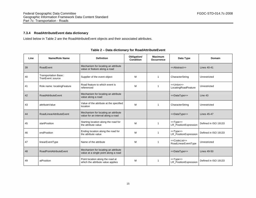
7.3.4 RoadAttributeEvent data dictionary
Listed below in Table 2 are the RoadAttributeEvent objects and their associated attributes.
Table 2 – Data dictionary for RoadAttributeEvent
Line Name/Role Name Definition Obligation/ Condition
Maximum Occurrence Data Type Domain
39 RoadEvent Mechanism for locating an attribute value or feature along a road <<Abstract>> Lines 40-41
40 Transportation Base:: TranEvent::source Supplier of the event object M 1 CharacterString Unrestricted
41 Role name: locatingFeature Road feature to which event is referenced M 1 <<Union>>
LocatingRoadFeature Unrestricted
42 RoadAttributeEvent Mechanism for locating an attribute value along a road <<DataType>> Line 43
43 attributeValue Value of the attribute at the specified location M 1 CharacterString Unrestricted
44 RoadLinearAttributeEvent Mechanism for locating an attribute value for an interval along a road <<DataType>> Lines 45-47
45 startPosition Starting location along the road for the attribute value M 1 <<Type>>
LR_PositionExpression Defined in ISO 19133
46 endPosition Ending location along the road for the attribute value M 1 <<Type>>
LR_PositionExpression Defined in ISO 19133
47 linearEventType Name of the attribute M 1 <<CodeList>> RoadLinearEventType Unrestricted
48 RoadPointAttributeEvent Mechanism for locating an attribute value at a single point along a road <<DataType>> Lines 49-50
49 atPosition Point location along the road at which the attribute value applies M 1 <<Type>>
LR_PositionExpression Defined in ISO 19133

Federal Geographic Data Committee FGDC-STD-014.7c-2008 Geographic Information Framework Data Content Standard Part 7c: Transportation - Roads
16
Line Name/Role Name Definition Obligation/ Condition
Maximum Occurrence Data Type Domain
50 pointEvent Name of the attribute M 1 <<CodeList>> RoadPointEventType Unrestricted
51 RoadFeatureEvent Mechanism for locating a feature along a road <<Abstract>> Line 52
52 Role name: linearlyLocatedFeature
Feature that is located along the road M 1 <<Feature>>
Framework:: Feature Unrestricted
53 RoadLinearFeatureEvent Mechanism for locating a feature along an interval along a road <<DataType>> Lines 54-55
54 startPosition Starting location along the road for the feature M 1 <<Type>>
LR_PositionExpression Defined in ISO 19133
55 endPosition Ending location along the road for the feature M 1 <<Type>>
LR_PositionExpression Defined in ISO 19133
56 RoadPointFeatureEvent Mechanism for locating a feature at a single point along a road <<DataType>> Line 57
57 atPosition Point location along the road at which the feature is located M 1 <<Type>>
LR_PositionExpression Defined in ISO 19133
58 LocatingRoadFeature Road feature used to locate a road event <<Union>> Lines 59-61
59 segment RoadSeg used to locate a road event
C/if path is notspecified 1 RoadSeg Unrestricted
60 path RoadPath used to locate a road event
C/if segment is not specified 1 RoadPath Unrestricted
61 Role name: event Road event located by the feature M * <<Abstract>> RoadEvent Unrestricted
Federal Geographic Data Committee FGDC-STD-014.7c-2008 Geographic Information Framework Data Content Standard Part 7c: Transportation - Roads
17
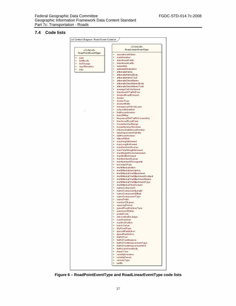
7.4 Code lists
Figure 6 – RoadPointEventType and RoadLinearEventType code lists

Federal Geographic Data Committee FGDC-STD-014.7c-2008 Geographic Information Framework Data Content Standard Part 7c: Transportation - Roads
18
7.4.1 RoadLinearEventType code list
RoadLinearEventType is a CodeList of values for the attribute linearEventType.
Table 3 – CodeList for RoadLinearEventType
Name Definition
operationalStatus Status of a roadway or part of a roadway; for example, proposed, under construction, open to traffic, abandoned, and so on
routeNumber
The route number of a road element, ferry element or chainage referencing section. The ID-number of a particular route in a given road network as Attributed by a national, sub-national or international organization (for example, the numbering of the departmental roads in France or the E-roads in Europe)
directionalPrefix
A geographic direction which is part of the official/alternate street name or route number of a road element or address area boundary element and which precedes the official/alternate street name body, route number body, street type prefix, or route type prefix
directionalSuffix
A geographic direction which is part of the official/alternate street name or route number of a road element or address area boundary element and which succeeds the official/alternate street name body, route number body, street type prefix, or route type prefix
ownership Whether a road element is publicly or privately owned
addressInformation The essential components of a street address
alternateName The name of a feature that has no official status but is used or known by the general public
alternateNameBody The part of the alternate name which has, compared to the prefix, most identifying power
alternateNameText (A part of) an alternate name
alternateStreetName The name of a road element or address area which has no official status but is used or known by the general public
alternateStreetNameBody The part of the alternate name which has, compared to the prefix, most identifying power
alternateStreetNameText (A part of) an alternate street name
averageVehicleSpeed The average speed of vehicles traveling along a road element
directionOfTrafficFlow The direction(s) of traffic flow allowed on a road element or ferry element or chainage referencing section
dividedRoadElement An indication of the presence of a physical or legal divider which separates opposing lanes of traffic
divider Information about the existence of a physical or legal divider along a road element which is not expressed by the individual features
dividerType Classification of the divider along the road element
dividerWidth The width of the divider along the road element

Federal Geographic Data Committee FGDC-STD-014.7c-2008 Geographic Information Framework Data Content Standard Part 7c: Transportation - Roads
19
Name Definition
emergencyVehicleLane Indicates whether the associated road element has a separate emergency vehicle lane
externalIdentifier A unique alphanumeric identifier ascribed to a particular feature
firstHouseNumber The first house number along the road element or the address area boundary element
formOfWay Certain aspects of the physical form that a road element takes. It is based on a number of certain physical and traffic properties
frequencyOfATrafficConnection The time interval between two departures of a traffic connection
functionalRoadClass A classification based on the importance of the role that the road element or ferry connection performs in the connectivity of the total road network
houseNumberRange The set of house numbers that is related to one side of a particular road element or to a particular address area boundary element
houseNumberStructure The type of house numbering method that is applied to one side of a particular Road Element or to a particular address area boundary element
intermediateHouseNumber A house number along the road element or the address area boundary element, which is not the first or the last house number along that road or address area boundary element
laneDependentValidity For which of the lanes of an associated road element the associated sub-attribute or relationship holds or does not hold
lastHouseNumber The last house number along the road element or the address area boundary element
lateralOffset An indication of the lateral position of a road furniture or structure feature
maxHeightAllowed The maximum height limit of a vehicle that may use the road element, ferry connection or chainage referencing section. The limit is normally set by a physical obstruction such as a bridge or tunnel, or a legal restriction
maxLengthAllowed The legal maximum length of a vehicle that may use the road element, ferry connection or chainage referencing section
maxNumberOfLanes The maximum number of lanes existing on a road element
maxTotalWeightAllowed The legal maximum total weight of a vehicle that may use the road element, ferry connection or chainage referencing section
maxWeightPerAxleAllowed The legal maximum weight per axle of a vehicle that may use the road element, ferry connection or chainage referencing section
maxWidthAllowed The maximum width limit of a vehicle that may use the road element, ferry connection or chainage referencing section. The limit is normally set by a physical obstruction such as a bridge or a legal restriction
minNumberOfLanes The minimum number of lanes existing on a road element
minNumberOfOccupents The minimum number of occupants of a vehicle which are required by traffic restriction
mountainPass The existence, height and opening period of a road element which is considered as a mountain pass
multiMediaAction A specification of what to do with the multi-media object
multiMediaDescription A description of the multi-media object

Federal Geographic Data Committee FGDC-STD-014.7c-2008 Geographic Information Framework Data Content Standard Part 7c: Transportation - Roads
20
Name Definition
multiMediaFileAttachment A multi-media file containing multi-media objects “decorating” the associated feature
multiMediaFileAttachmentContext The context of the multi-media file attached to the feature
multiMediaFileAttachmentName Name of the multi-media file attached to the feature
multiMediaFileAttachmentType The type of the multi-media file attached to the feature
multiMediaTimeDomain A specification when to perform the action indicated in the associated sub-attribute multi media action
nameComponent The specification of a portion of a name which has a specific meaning
nameComponentLength The length of a name component
nameComponentOffset The offset of a name that represents the beginning of a name component
nameComponentType The type of a name component
namePrefix A part of the official or alternate name not belonging to the official/alternate name body, usually indicating the type of object the name refers to and which comes prior to the official/alternate name body
numberOfLanes The number of lanes existing on a road element or chainage referencing section
openingPeriod The period in which the function of an associated feature is available to the public
pavedRoadSurfaceType The type of surface a paved road element has
pavementStatus An indication of improvement applied to a road surface
postalCode The official code of a postal area as defined by the national postal organization
removableBlockage The way in which a removable barrier is to be removed
roadGradient The road gradient percentage value on the road element
roadInclination The transverse gradient of a road element
scenicValue Whether a road element is regarded as scenic or not
slipRoadType The type of slip road
specialRestriction Special legal restrictions placed upon the use of a particular road element
speedRestriction The maximum speed limit allocated to a road element
trafficFlow Information about the traffic flow on road elements or chainage referencing sections
trafficFlowMeasure The traffic flow on road elements or chainage referencing sections, expressed for instance by number of vehicles per day
trafficFlowMeasurementType Classification of traffic flow measurement on road elements or chainage referencing sections
trafficFlowMeasurementUnit Time unit over which the traffic flow measurement is recorded
trafficJamSensitivity Probability of a traffic jam on a road element

Federal Geographic Data Committee FGDC-STD-014.7c-2008 Geographic Information Framework Data Content Standard Part 7c: Transportation - Roads
21
Name Definition
travelTime The one-way travel time that a ferry connection takes to complete a journey
validityDirection The direction for which the value defined in an associated sub-attribute attached at the line feature is valid
validityPeriod The period, for which a value defined in an associated sub-attribute or relationship, is valid
vehicleType The type of vehicle for which the information contained in an associated sub-attribute or relationship holds
width The width of a road element or chainage referencing section, a lane or a road furniture or structure feature
7.4.2 RoadPointEventType code list
RoadPointEventType is a CodeList of values for the attribute pointEventType.
Table 4 – CodeList for RoadPointEventType
Name Definition
pass Whether a road element is regarded as a mountain pass
tollbooth Location where tolls are collected for the use of a transportation facility
tollCharge Fee to be paid to travel on (a section of) a toll road
maxElevation The height above sea level of the road at the crest of a hill or mountain pass
sign A device at an identified location used to convey information to the reader
Federal Geographic Data Committee FGDC-STD-014.7c-2008 Geographic Information Framework Data Content Standard Part 7c: Transportation – Roads Annex A (informative): Road example
22
Annex A (informative)
Road example
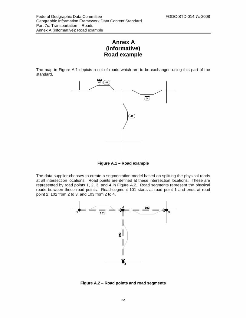
The map in Figure A.1 depicts a set of roads which are to be exchanged using this part of the standard.
4266
66
42
Figure A.1 – Road example
The data supplier chooses to create a segmentation model based on splitting the physical roads at all intersection locations. Road points are defined at these intersection locations. These are represented by road points 1, 2, 3, and 4 in Figure A.2. Road segments represent the physical roads between these road points. Road segment 101 starts at road point 1 and ends at road point 2; 102 from 2 to 3; and 103 from 2 to 4.
101
102
103
1
2
3
4
Figure A.2 – Road points and road segments
Federal Geographic Data Committee FGDC-STD-014.7c-2008 Geographic Information Framework Data Content Standard Part 7c: Transportation – Roads Annex A (informative): Road example
23
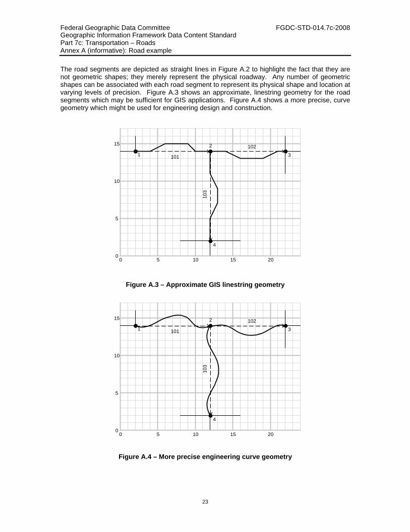
The road segments are depicted as straight lines in Figure A.2 to highlight the fact that they are not geometric shapes; they merely represent the physical roadway. Any number of geometric shapes can be associated with each road segment to represent its physical shape and location at varying levels of precision. Figure A.3 shows an approximate, linestring geometry for the road segments which may be sufficient for GIS applications. Figure A.4 shows a more precise, curve geometry which might be used for engineering design and construction.
0 5 10 15 20
101
102
103
2
3
4
0
5
10
15
1
Figure A.3 – Approximate GIS linestring geometry
0 5 10 15 20
101
102
103
2
3
4
0
5
10
15
1
Figure A.4 – More precise engineering curve geometry
Federal Geographic Data Committee FGDC-STD-014.7c-2008 Geographic Information Framework Data Content Standard Part 7c: Transportation – Roads Annex A (informative): Road example
24
Regardless of the associated geometry, each road segment is attributed with a length value for use in linearly referenced calculations. Additionally, each road segment has a field measure value equal to the actual length of the physical road in the field.
The rationale for segmentation is up to the data provider. It would have been acceptable to have alternatively defined a single road segment, 100, between road points 1 and 3 in a different dataset. Road segment 100 could then be equivalenced to segments 101 and 102. Alternative road points could have been defined at locations other than intersections, if the segmentation strategy was something other than intersection to intersection.
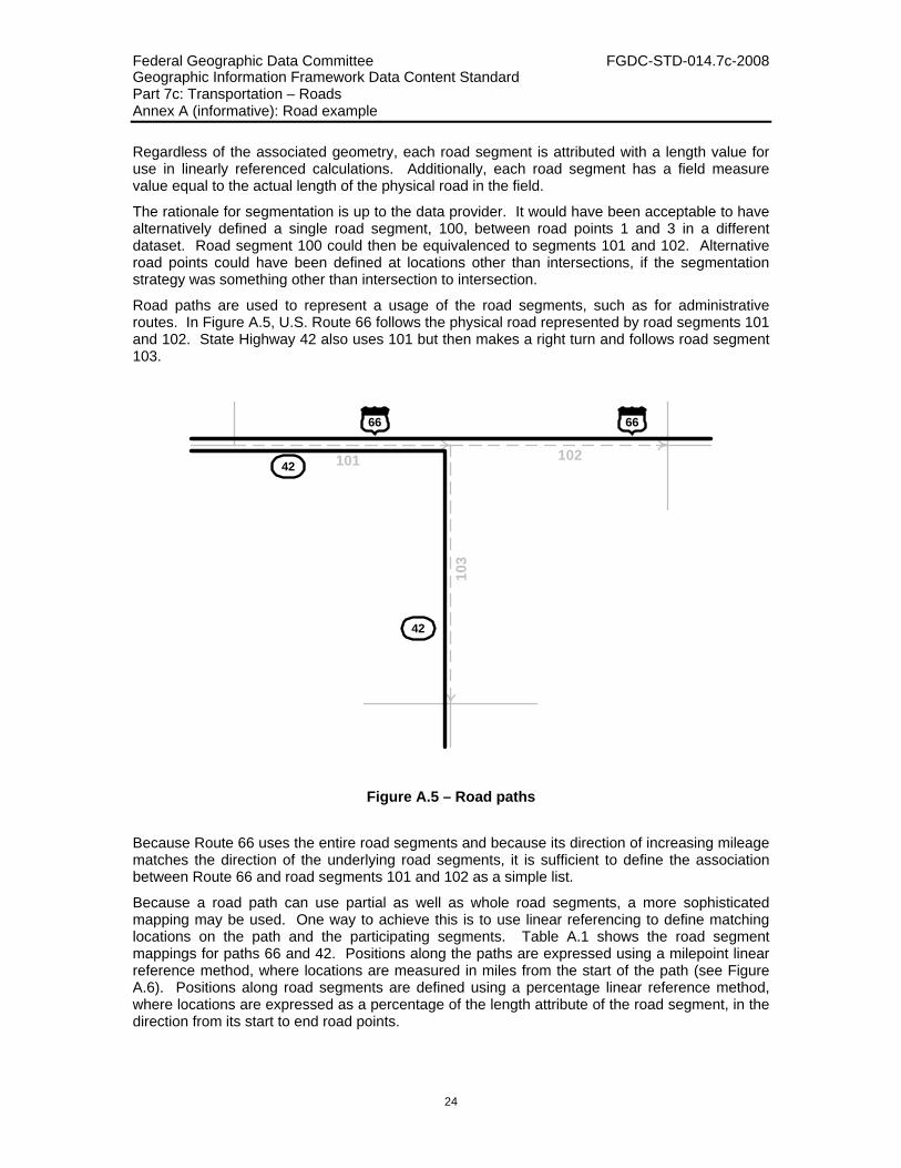
Road paths are used to represent a usage of the road segments, such as for administrative routes. In Figure A.5, U.S. Route 66 follows the physical road represented by road segments 101 and 102. State Highway 42 also uses 101 but then makes a right turn and follows road segment 103.
101 10210
342
42
66 66
Figure A.5 – Road paths
Because Route 66 uses the entire road segments and because its direction of increasing mileage matches the direction of the underlying road segments, it is sufficient to define the association between Route 66 and road segments 101 and 102 as a simple list.
Because a road path can use partial as well as whole road segments, a more sophisticated mapping may be used. One way to achieve this is to use linear referencing to define matching locations on the path and the participating segments. Table A.1 shows the road segment mappings for paths 66 and 42. Positions along the paths are expressed using a milepoint linear reference method, where locations are measured in miles from the start of the path (see Figure A.6). Positions along road segments are defined using a percentage linear reference method, where locations are expressed as a percentage of the length attribute of the road segment, in the direction from its start to end road points.

Federal Geographic Data Committee FGDC-STD-014.7c-2008 Geographic Information Framework Data Content Standard Part 7c: Transportation – Roads Annex A (informative): Road example
25
Table A.1 – Road path to road segment mappings
Road Path Milepoint Road Segment Percentage
Route 66 52.0 101 0
64.6 101 100
64.6 102 0
75.0 102 100
Highway 42 10.0 101 0
22.6 101 100
22.6 103 0
35.0 103 100
42
66 66
42
101 102
103
10.0 22.6
35.0
52.0 64.6 75.0
Figure A.6 – Routes with milepoint values
Attributes can be defined directly for segments and paths if they apply to the entire segment or path, respectively. Examples of these are road segment length and road path route number. Often, attributes can change value along the length of the segment or path. This is encoded as road attribute events.
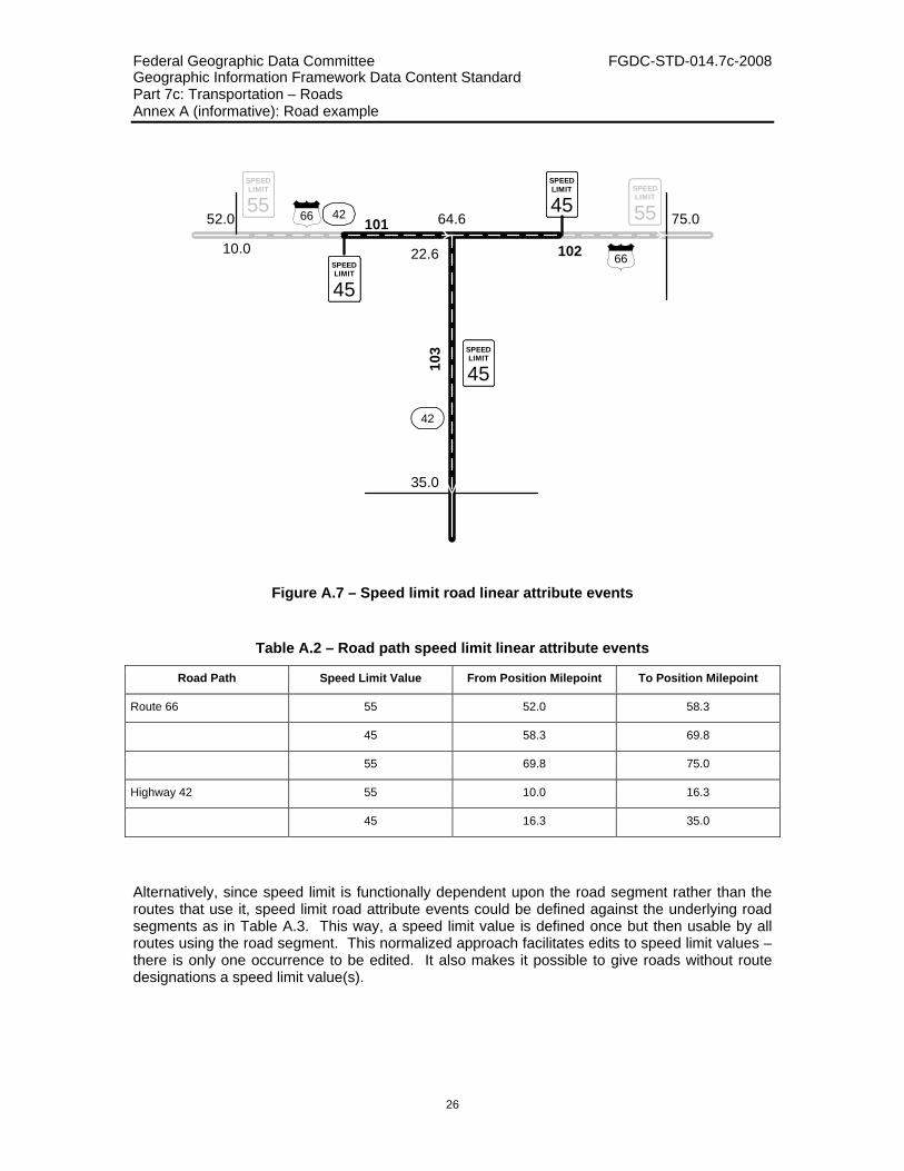
Speed limit is an example of the linear type of road attribute event; the speed limit can have different values at different locations along a road segment or road path (see Figure A.7). The speed limit attribute events can be defined against road paths using a milepoint linear reference method as in Table A.2.
Federal Geographic Data Committee FGDC-STD-014.7c-2008 Geographic Information Framework Data Content Standard Part 7c: Transportation – Roads Annex A (informative): Road example
26
4266
66
42
101
102
103
10.0 22.6
35.0
52.0 64.6 75.0
SPEEDLIMIT
55SPEEDLIMIT
55
SPEEDLIMIT
45
SPEEDLIMIT
45
SPEEDLIMIT
45
Figure A.7 – Speed limit road linear attribute events
Table A.2 – Road path speed limit linear attribute events
Road Path Speed Limit Value From Position Milepoint To Position Milepoint
Route 66 55 52.0 58.3
45 58.3 69.8
55 69.8 75.0
Highway 42 55 10.0 16.3
45 16.3 35.0
Alternatively, since speed limit is functionally dependent upon the road segment rather than the routes that use it, speed limit road attribute events could be defined against the underlying road segments as in Table A.3. This way, a speed limit value is defined once but then usable by all routes using the road segment. This normalized approach facilitates edits to speed limit values – there is only one occurrence to be edited. It also makes it possible to give roads without route designations a speed limit value(s).

Federal Geographic Data Committee FGDC-STD-014.7c-2008 Geographic Information Framework Data Content Standard Part 7c: Transportation – Roads Annex A (informative): Road example
27
Table A.3 – Road segment speed limit linear attribute events
Road Segment Speed Limit Value From Position Percentage To Position Percentage
101 55 0 50
45 50 100
102 45 0 50
55 50 100
103 45 0 100
Road attribute events may occur at a single point along the road. An example of this point type of road attribute event is “sign”. This event is characterized by the value of the attribute, in this case the type of sign, and an “at” position defining its linearly referenced location. For the stop sign in Figure A.8, the value is “stop” and the “at” position is {road segment 103, percentage/feet, 0.1, left curb, -5.0}. The position expression shown within the curly braces is, in accordance with ISO 19133, comprised of the linear element being measured (road segment 103), the linear referencing method (percentage with offsets measured in feet), a distance of 0.1% along the length of road segment 103 in the direction from road point 2 to 4, an offset referent equal to “left curb”, and an offset distance of 5.0 feet to the left of, that is, from the back of the curb.
101 102
103
R R
Figure A.8 – Road segment point events
If more information needs to be exchanged about the stop sign, then it can be encoded with a point feature (rather than attribute) event. This event has the same at position as defined above. Instead of an attribute value, it has an association to a sign feature. This feature can have

Federal Geographic Data Committee FGDC-STD-014.7c-2008 Geographic Information Framework Data Content Standard Part 7c: Transportation – Roads Annex A (informative): Road example
28
whatever attributes are appropriate, for example authority = “DOT”, identifier = 1073625, description = “stop sign”, last update date = 1992-1-9, installed date = 1991-7-11, height = 5’6”, and GM_Point = (12.01, 13.99). Notice that, as a feature, the stop sign can have its own geometry, independent of its linearly referenced location along road segment 103.
Figure A.8 has additional point attribute or feature events, such as a pedestrian crosswalk or a railroad crossing. School zones and no parking areas would more likely be encoded as linear attribute or feature events.

Federal Geographic Data Committee FGDC-STD-014.7c-2008 Geographic Information Framework Data Content Standard Part 7c: Transportation – Roads Annex B (informative): Bibliography
29
Annex B (informative) Bibliography
The following documents contain provisions that are relevant to this part of the Framework Data Content Standard. Informative references applicable to two or more transportation parts only are listed in Annex C of the Transportation Base (Part 7). Annex D of the Base Document (Part 0) lists informative references applicable to two or more of the parts of the standard, including the transportation parts. For dated references, only the edition cited applies. For undated references, the latest edition of the referenced document applies.
ANSI and ISO standards may be purchased through the ANSI eStandards Store at http://webstore.ansi.org/ansidocstore/default.asp, accessed October 2006.
Federal Geographic Data Committee, NSDI framework transportation identification standard, http://www.fgdc.gov/standards/projects/FGDC-standards-projects/fr_trans_id/?searchterm=identification%20standard, accessed October 2006, (suspended)