Embed Size (px)
Citation preview
SLR Consulting (South Africa) (Pty) Ltd Page i
Proposed new access roads to the Saldanha Bay Industrial Development Zone
BASIC ASSESSMENT REPORT AND
ENVIRONMENTAL MANAGEMENT PROGRAMME
SLR Project No.: 720.19083.00005
Report No.: 1
Revision No.: 0
March 2017
SMEC South Africa (Pty) Ltd on behalf of the
Saldanha Bay IDZ Licencing Company SOC Ltd
SLR Consulting (South Africa) (Pty) Ltd Page i
SLR Ref. 720.19083.00005 Report No. 1
Proposed new access roads to the Saldanha Bay IDZ BAR and EMPR March 2017
DOCUMENT INFORMATION Title Proposed new access roads to the Saldanha Bay Industrial Development Zone:
Basic Assessment Report and Environmental Management Programme
Project Manager Eloise Costandius
Project Manager e-mail [email protected]
Authors Ena de Villiers and Eloise Costandius
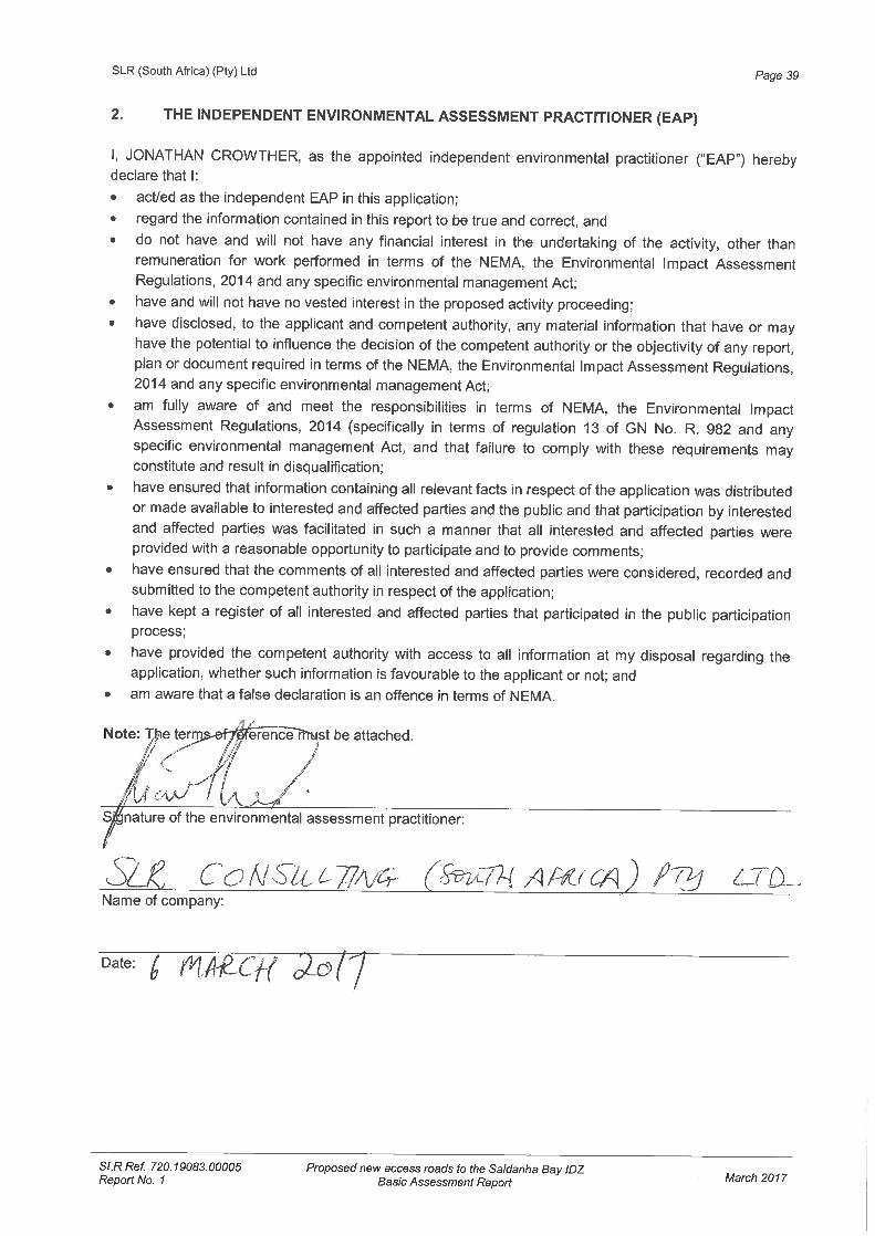
Reviewer Jonathan Crowther
Client SMEC South Africa (Pty) Ltd
Date last printed 2017/03/07 11:42:00 AM
Date last saved 2017/03/07 11:42:00 AM
Comments
Keywords Access road, Saldanha, Industrial development zone
Project Number 720.19083.00005
Report Number 1
Revision Number 0
Status Report for I&AP review and comment
Issue Date 7 March 2017
This report has been prepared by an SLR Group company with all reasonable skill, care and diligence, taking into
account the manpower and resources devoted to it by agreement with the client. Information reported herein is based on the interpretation of data collected, which has been accepted in good faith as being accurate and valid.
No warranties or guarantees are expressed or should be inferred by any third parties. This report may not be relied upon by other parties without written consent from SLR.
SLR disclaims any responsibility to the Client and others in respect of any matters outside the agreed scope of the
work.
SLR Consulting (South Africa) (Pty) Ltd Page ii
SLR Ref. 720.19083.00005 Report No. 1
Proposed new access roads to the Saldanha Bay IDZ BAR and EMPR March 2017
EXPERTISE OF ENVIRONMENTAL ASSESSMENT PRACTITIONER
NAME Jonathan Crowther
RESPONSIBILITY ON PROJECT Project director and quality control.
DEGREE B.Sc. Hons (Geol.), M.Sc. (Env. Sci.)
PROFESSIONAL REGISTRATION Pr.Sci.Nat., CEAPSA
EXPERIENCE IN YEARS 29
EXPERIENCE
Jonathan Crowther has been involved in environmental consulting since 1988 and is currently the Managing Director of CCA Environmental (Pty) Ltd. He has expertise in a wide range of environmental disciplines, including Environmental Impact Assessments (EIA), Environmental Management Plans/Programmes, Environmental Planning & Review, Environmental Control Officer services, and Public Consultation & Facilitation. He has project managed a number of offshore oil and gas EIAs for various exploration and production activities in South Africa and Namibia. He also has extensive experience in projects related to roads, property developments and landfill sites.
NAME Eloise Costandius
RESPONSIBILITY ON PROJECT Project management and quality control.
DEGREE B.Sc. Hons (Zoology); MSc (Environmental Assessment)
PROFESSIONAL REGISTRATION Pr.Sci.Nat., CEAPSA
EXPERIENCE IN YEARS 12
EXPERIENCE
Eloise Costandius has worked as an environmental assessment practitioner since 2005 and has been involved in a number of projects covering a range of environmental disciplines, including Basic Assessments, Environmental Impact Assessments and Environmental Management Programmes. She has gained experience in a wide range of projects relating to oil and gas exploration (South Africa and Namibia), road infrastructure projects (South Africa and Mauritius), and housing and industrial developments (South Africa). In addition, she has also undertaken a number of terrestrial fauna specialist studies.
NAME Ena de Villiers
RESPONSIBILITY ON PROJECT Project consultant and quality control.
DEGREE B.A. Hons (Philosophy), B.A. Hons (Demography), M.Phil (Environmental Ethics)
PROFESSIONAL REGISTRATION -
EXPERIENCE IN YEARS 8
EXPERIENCE
Ena de Villiers has worked as an environmental assessment practitioner since 2008 and has been involved in a number of projects covering a range of environmental disciplines, including Basic Assessments (BA), Environmental Impact Assessments and Environmental Management Plans/Programmes and Environmental Control Officer. She has been exposed to a range of projects relating to mining (e.g. mineral prospecting and borrow pit development), property development and infrastructure (e.g. bridges, roads, waste water treatment works).
SLR Consulting (South Africa) (Pty) Ltd Page iii
SLR Ref. 720.19083.00005 Report No. 1
Proposed new access roads to the Saldanha Bay IDZ BAR and EMPR March 2017
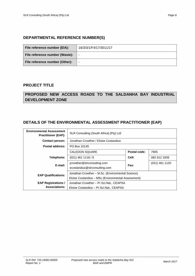
DEPARTMENTAL REFERENCE NUMBER(S)
File reference number (EIA): 16/3/3/1/F4/17/3011/17
File reference number (Waste): -
File reference number (Other): -
PROJECT TITLE PROPOSED NEW ACCESS ROADS TO THE SALDANHA BAY INDUSTRIAL DEVELOPMENT ZONE
DETAILS OF THE ENVIRONMENTAL ASSESSMENT PRACTITIONER (EAP)
Environmental Assessment Practitioner (EAP): SLR Consulting (South Africa) (Pty) Ltd
Contact person: Jonathan Crowther / Eloise Costandius
Postal address: PO Box 10145
CALEDON SQUARE Postal code: 7905
Telephone: (021) 461 1118 / 9 Cell: 082 612 1939
E-mail: [email protected] [email protected]
Fax: (021) 461 1120
EAP Qualifications: Jonathan Crowther – M.Sc. (Environmental Science) Eloise Costandius – MSc (Environmental Assessment)
EAP Registrations / Associations:
Jonathan Crowther – Pr.Sci.Nat., CEAPSA Eloise Costandius – Pr.Sci.Nat., CEAPSA
SLR Consulting (South Africa) (Pty) Ltd Page iv
SLR Ref. 720.19083.00005 Report No. 1
Proposed new access roads to the Saldanha Bay IDZ BAR and EMPR March 2017
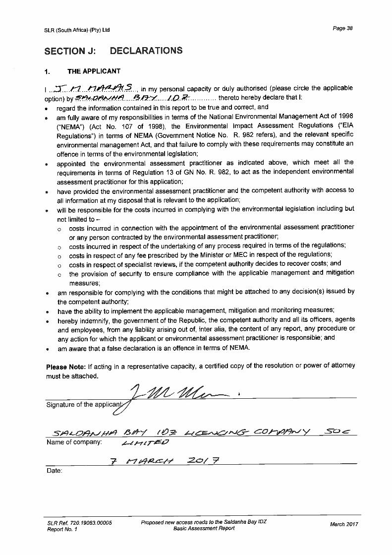
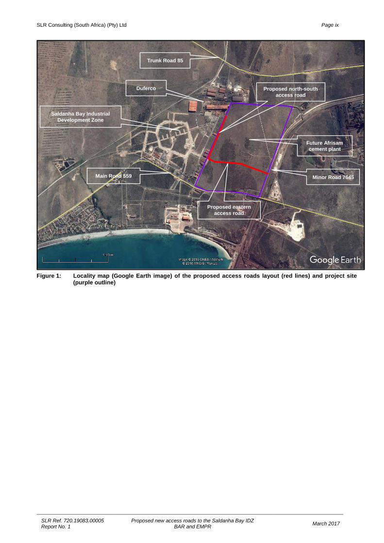
EXECUTIVE SUMMARY 1. INTRODUCTION The Applicant, Saldanha Bay IDZ Licencing Company SOC Ltd (SBIDZ-LC), is proposing to develop two new access roads to the Saldanha Bay Industrial Development Zone (SBIDZ) (see Figure 1). The proposed additions to the road network for the SBIDZ would entail the following: • A new eastern access road and new intersection on Minor Road (OP) 7645 in order to provide
access to the SBIDZ area to the north of Main Road (MR) 559 as well as to a new Afrisam cement plant; and
• A new north-south access road along the SBIDZ eastern boundary to provide an alternative access to the Duferco steel processing plant.
SMEC South Africa (Pty) Ltd (SMEC) has been appointed to undertake the design and construction supervision of the access road. In turn, SMEC appointed SLR Consulting (South Africa) (Pty) Ltd (SLR) as the independent environmental assessment practitioner responsible for undertaking the required Environmental Authorisation (EA) process for the proposed project. This Basic Assessment Report (BAR) and Environmental Management Programme Report (EMPR) has been distributed for a 30-day public review and comment period from 10 March to 10 April 2017 (including an additional day to cover the public holiday on 21 March 2017). Copies of the report have been made available at the following locations: • Saldanha Public Library; • Offices of SLR; and • On the following website: www.slrconsulting.com/za. Any written comments on the BAR and EMPR must reach SLR at the following contact details by no later than 10 April 2017:
SLR Consulting (Pty) Ltd Unit 39, Roeland Square
30 Drury Lane, Cape Town, 8001
Attention: Ena de Villiers
Tel: (021) 461 1118 / 9 Fax: (021) 461 1120
E-mail: [email protected]
After the comment period, the BAR and EMPR will be submitted to the Department of Environmental Affairs and Development Planning (DEA&DP) for consideration of the application. All comments received will be collated into a Comments and Responses Report, which will be submitted to DEA&DP together with the report. After DEA&DP has reached a decision, all registered Interested and Affected Parties (I&APs) will be notified of the outcome of the application and the reasons for the decision. A statutory Appeal Period in terms of the National Appeal Regulations, 2014 will follow the issuing of the decision. 2. APPLICABILITY OF THE NEMA EIA REGULATIONS A Basic Assessment is required in terms of the Environmental Impact Assessment (EIA) Regulations 2014 (Government Notice (GN) R982), promulgated in terms of the National Environmental Management Act No. 107 of 1998 (NEMA), as amended, as the proposed project triggers the following listed activities in terms of GN R983 and GN R985 of the regulations:
SLR Consulting (South Africa) (Pty) Ltd Page v
SLR Ref. 720.19083.00005 Report No. 1
Proposed new access roads to the Saldanha Bay IDZ BAR and EMPR March 2017
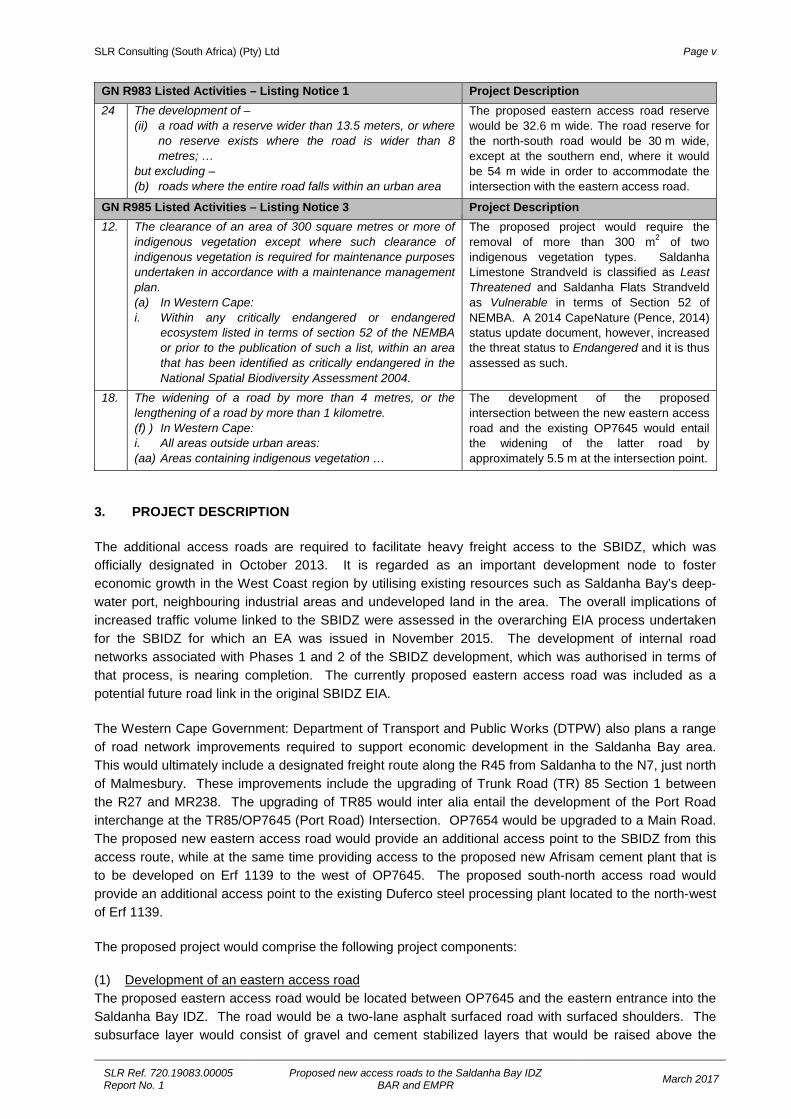
GN R983 Listed Activities – Listing Notice 1 Project Description 24 The development of –
(ii) a road with a reserve wider than 13.5 meters, or where no reserve exists where the road is wider than 8 metres; …
but excluding – (b) roads where the entire road falls within an urban area
The proposed eastern access road reserve would be 32.6 m wide. The road reserve for the north-south road would be 30 m wide, except at the southern end, where it would be 54 m wide in order to accommodate the intersection with the eastern access road.
GN R985 Listed Activities – Listing Notice 3 Project Description 12. The clearance of an area of 300 square metres or more of
indigenous vegetation except where such clearance of indigenous vegetation is required for maintenance purposes undertaken in accordance with a maintenance management plan. (a) In Western Cape: i. Within any critically endangered or endangered
ecosystem listed in terms of section 52 of the NEMBA or prior to the publication of such a list, within an area that has been identified as critically endangered in the National Spatial Biodiversity Assessment 2004.
The proposed project would require the removal of more than 300 m2 of two indigenous vegetation types. Saldanha Limestone Strandveld is classified as Least Threatened and Saldanha Flats Strandveld as Vulnerable in terms of Section 52 of NEMBA. A 2014 CapeNature (Pence, 2014) status update document, however, increased the threat status to Endangered and it is thus assessed as such.
18. The widening of a road by more than 4 metres, or the lengthening of a road by more than 1 kilometre. (f) ) In Western Cape: i. All areas outside urban areas: (aa) Areas containing indigenous vegetation …
The development of the proposed intersection between the new eastern access road and the existing OP7645 would entail the widening of the latter road by approximately 5.5 m at the intersection point.
3. PROJECT DESCRIPTION The additional access roads are required to facilitate heavy freight access to the SBIDZ, which was officially designated in October 2013. It is regarded as an important development node to foster economic growth in the West Coast region by utilising existing resources such as Saldanha Bay’s deep-water port, neighbouring industrial areas and undeveloped land in the area. The overall implications of increased traffic volume linked to the SBIDZ were assessed in the overarching EIA process undertaken for the SBIDZ for which an EA was issued in November 2015. The development of internal road networks associated with Phases 1 and 2 of the SBIDZ development, which was authorised in terms of that process, is nearing completion. The currently proposed eastern access road was included as a potential future road link in the original SBIDZ EIA. The Western Cape Government: Department of Transport and Public Works (DTPW) also plans a range of road network improvements required to support economic development in the Saldanha Bay area. This would ultimately include a designated freight route along the R45 from Saldanha to the N7, just north of Malmesbury. These improvements include the upgrading of Trunk Road (TR) 85 Section 1 between the R27 and MR238. The upgrading of TR85 would inter alia entail the development of the Port Road interchange at the TR85/OP7645 (Port Road) Intersection. OP7654 would be upgraded to a Main Road. The proposed new eastern access road would provide an additional access point to the SBIDZ from this access route, while at the same time providing access to the proposed new Afrisam cement plant that is to be developed on Erf 1139 to the west of OP7645. The proposed south-north access road would provide an additional access point to the existing Duferco steel processing plant located to the north-west of Erf 1139. The proposed project would comprise the following project components: (1) Development of an eastern access road The proposed eastern access road would be located between OP7645 and the eastern entrance into the Saldanha Bay IDZ. The road would be a two-lane asphalt surfaced road with surfaced shoulders. The subsurface layer would consist of gravel and cement stabilized layers that would be raised above the
SLR Consulting (South Africa) (Pty) Ltd Page vi
SLR Ref. 720.19083.00005 Report No. 1
Proposed new access roads to the Saldanha Bay IDZ BAR and EMPR March 2017
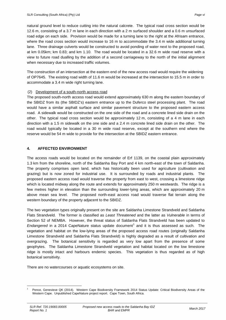
natural ground level to reduce cutting into the natural calcrete. The typical road cross section would be 12.6 m, consisting of a 3.7 m lane in each direction with a 2 m surfaced shoulder and a 0.6 m unsurfaced road edge on each side. Provision would be made for a turning lane to the right at the Afrisam entrance, where the road cross section would increase to 16 m to accommodate the 3.4 m wide additional turning lane. Three drainage culverts would be constructed to avoid ponding of water next to the proposed road, at km 0.05km; km 0.83; and km 1.10. The road would be located in a 32.6 m wide road reserve with a view to future road dualling by the addition of a second carriageway to the north of the initial alignment when necessary due to increased traffic volumes. The construction of an intersection at the eastern end of the new access road would require the widening of OP7645. The existing road width of 11.6 m would be increased at the intersection to 15.5 m in order to accommodate a 3.4 m wide right turning lane. (2) Development of a south-north access road The proposed south-north access road would extend approximately 630 m along the eastern boundary of the SBIDZ from its (the SBIDZ’s) eastern entrance up to the Duferco steel processing plant. The road would have a similar asphalt surface and similar pavement structure to the proposed eastern access road. A sidewalk would be constructed on the one side of the road and a concrete lined side drain on the other. The typical road cross section would be approximately 12 m, consisting of a 4 m lane in each direction with a 1.5 m sidewalk on the one side and a 2.4 m concrete lined side drain on the other. The road would typically be located in a 30 m wide road reserve, except at the southern end where the reserve would be 54 m wide to provide for the intersection at the SBIDZ eastern entrance. 4. AFFECTED ENVIRONMENT The access roads would be located on the remainder of Erf 1139, on the coastal plain approximately 1.3 km from the shoreline, north of the Saldanha Bay Port and 4 km north-east of the town of Saldanha. The property comprises open land, which has historically been used for agriculture (cultivation and grazing) but is now zoned for industrial use. It is surrounded by roads and industrial plants. The proposed eastern access road would traverse the property from east to west, crossing a limestone ridge which is located midway along the route and extends for approximately 250 m westwards. The ridge is a few metres higher in elevation than the surrounding lower-lying areas, which are approximately 20 m above mean sea level. The proposed north-east access road would traverse flat terrain along the western boundary of the property adjacent to the SBIDZ. The two vegetation types originally present on the site are Saldanha Limestone Strandveld and Saldanha Flats Strandveld. The former is classified as Least Threatened and the latter as Vulnerable in terms of Section 52 of NEMBA. However, the threat status of Saldanha Flats Strandveld has been updated to Endangered in a 2014 CapeNature status update document1 and it is thus assessed as such. The vegetation and habitat on the low-lying areas of the proposed access road routes (originally Saldanha Limestone Strandveld and Saldanha Flats Strandveld) is highly degraded as a result of cultivation and overgrazing. The botanical sensitivity is regarded as very low apart from the presence of some geophytes. The Saldanha Limestone Strandveld vegetation and habitat located on the low limestone ridge is mostly intact and harbours endemic species. This vegetation is thus regarded as of high botanical sensitivity. There are no watercourses or aquatic ecosystems on site.
1 Pence, Genevieve QK (2014). Western Cape Biodiversity Framework 2014 Status Update: Critical Biodiversity Areas of the
Western Cape. Unpublished CapeNature project report. Cape Town, South Africa.
SLR Consulting (South Africa) (Pty) Ltd Page vii
SLR Ref. 720.19083.00005 Report No. 1
Proposed new access roads to the Saldanha Bay IDZ BAR and EMPR March 2017
5. ENVIRONMENTAL IMPACT STATEMENT A summary of the potential impact of the proposed project is provided in Table 1. The proposed new access roads, which would improve access to industrial sites in the SBIDZ and its immediate surrounds, would form part of a larger road network upgrade and development project undertaken in the area in support of the SIP5: Saldanha-Northern Cape Development Corridor project. As such, the proposed project would contribute to economic growth and development in the area, resulting in an impact of LOW (positive) significance. Table 1: Impacts during the construction phase (all impacts are negative unless stated otherwise)
Impact Significance without mitigation
Significance with mitigation
Geographical and Physical Aspects NO IMPACT Biological Aspects: Vegetation Loss of vegetation and habitat – low-lying areas
Low VERY LOW
Loss of vegetation and habitat – limestone ridge
High MEDIUM
Socio-economic Aspects: Employment Very Low (Positive) VERY LOW (POSITIVE) Construction-related dust, noise and visual Low VERY LOW Cultural-historical Aspects: Archaeology and Heritage NO IMPACT Palaeontology High HIGH (POSITIVE) Table 8.2: Impacts during the operational phase
Impact Significance without mitigation
Significance with mitigation
Geographical and Physical Aspects NO IMPACT Biological Aspects: Vegetation NO IMPACT Socio-economic Aspects: Contribution to economic growth and development Low (Positive) LOW (POSITIVE)
Cultural-historical aspects NO IMPACT Table 8.3: Impacts associated with the No-Go Option
Impact Significance without mitigation
Significance with mitigation
Transport infrastructure Low LOW The proposed mitigation measures would reduce the impacts on biological aspects to a VERY LOW to MEDIUM significance. The loss of an area of mostly intact Saldanha Limestone Strandveld of high botanical sensitivity located on the limestone ridge as a result of the development of the eastern access road would be contained to a MEDIUM significance impact after mitigation. A crucial aspect of the mitigation was already implemented at the design phase, namely amending the horizontal alignment of the road to coincide with an existing footpath along the limestone ridge in order to minimise this potential impact (refer to Section E(c) in this regard). The botanical specialist concluded that the overall impacts would be within acceptable limits if adequate mitigation is applied and indicated that the proposed road is supported from a botanical perspective. The only other negative impacts of the proposed project relate to noise, dust and visual impacts associated with construction phase activities. These have been rated as of VERY LOW significance after mitigation. The No-Go Option would mean that there would be no development of new access roads to the SBIDZ and thus no provision for the road network to support the expected industrial development projects and
SLR Consulting (South Africa) (Pty) Ltd Page viii
SLR Ref. 720.19083.00005 Report No. 1
Proposed new access roads to the Saldanha Bay IDZ BAR and EMPR March 2017
economic development potential related to SIP5. The No-Go Option is not considered to be a sustainable or desirable option and would result in an impact of LOW significance. All recommended mitigation measures are deemed feasible for implementation and the proposed project is deemed to be socially, environmentally and economically acceptable. 6. RECOMMENDATIONS It is recommended that the following mitigation measures be implemented if an Environmental Authorisation is issued for the proposed project: Vegetation: • Restrict construction activities to the construction zone. • Demarcate as a No-go area the remnant of Saldanha Flats Strandveld south of the eastern/north-
south access roads intersection and prohibit any movement of construction vehicles and workers in these areas.
• Demarcate the vegetation north and south of the construction zone on the limestone ridge as No-go areas and prohibit any movement of construction vehicles and workers in these areas.
• Locate, lift and relocate the geophytes occurring on the footprint of the road to a designated safe receptor area, particularly Boophone haemanthoides and Brunsvigia orientalis.
• Relocate any Aloe perfoliata that falls within the proposed road reserve area to a safe site on the limestone ridge outside of the development footprint.
• Undertake a revegetation programme to re-instate vegetation on the limestone ridge in the road reserve adjacent to the new eastern access road.
• Retain and mulch all vegetation removed on the limestone ridge and use the mulched material for rehabilitation post-construction.
Employment: • Local BEE services and providers and local labour from the local community should be employed as
far as possible. • The appointed contractor must comply with the Proponent’s labour and procurement specifications. • Ensure appropriate training is provided, where required. Compliance with environmental specifications listed in the Construction EMP • The proposed project must comply with the environmental specifications listed in the Construction
EMP. Where appropriate, the proposed mitigation measures have been incorporated in the Construction EMP. Key mitigation includes: o Site demarcation; o No-go areas; o Palaeontological monitoring at cuttings; and o Rehabilitation of disturbed areas.
SLR Consulting (South Africa) (Pty) Ltd Page ix
SLR Ref. 720.19083.00005 Report No. 1
Proposed new access roads to the Saldanha Bay IDZ BAR and EMPR March 2017
Figure 1: Locality map (Google Earth image) of the proposed access roads layout (red lines) and project site (purple outline)
Proposed north-south access road
Proposed eastern access road
Trunk Road 85
Main Road 559 Minor Road 7645
Saldanha Bay Industrial Development Zone
Duferco
Future Afrisam cement plant
Proposed north-south access road
Proposed eastern access road
SLR Consulting (South Africa) (Pty) Ltd Page x
SLR Ref. 720.19083.00005 Report No. 1
Proposed new access roads to the Saldanha Bay IDZ BAR and EMPR March 2017
TABLE OF CONTENTS DOCUMENT INFORMATION......................................................................................................................... i EXPERTISE OF ENVIRONMENTAL ASSESSMENT PRACTITIONER ...................................................... ii EXECUTIVE SUMMARY .............................................................................................................................. iv SECTION A: ACTIVITY INFORMATION ...................................................................................................... 1 1. Project description .............................................................................................................................. 1 2. Physical size of the acitivty ................................................................................................................ 4 4. Description of the property on which the acitivity is to be undertaken and the location of
the activity on the property ................................................................................................................. 4 5. Site photographs ................................................................................................................................ 5 SECTION B: DESCRIPTION OF RECEIVING ENVIRONMENT ................................................................. 6 1. Gradient of the site ............................................................................................................................. 6 2. Location in landscape......................................................................................................................... 6 3. Groundwater, soil and geological stability of the site ......................................................................... 6 4. Surface water ..................................................................................................................................... 7 5. Biodiversity ......................................................................................................................................... 7 6. Land use of the site ............................................................................................................................ 9 7. Land use character of surrounding area .......................................................................................... 10 8. Socio-economic aspects .................................................................................................................. 10 9. Historical and cultural aspects ......................................................................................................... 11 10. Applicable legislation, policies and / or guidelines ........................................................................... 12 SECTION C: PUBLIC PARTICIPATION .................................................................................................... 13 SECTION D: NEED AND DESIRABILITY .................................................................................................. 15 SECTION E: ALTERNATIVES ................................................................................................................... 19 SECTION F: IMPACT ASSESSMENT, MANAGEMENT, MITIGATION AND
MONITORING MEASURES ............................................................................................................. 22 1. Please describe the manner in which the development will impact on the following aspects ......... 22 2. Waste and emissions ....................................................................................................................... 23 3. Water use ......................................................................................................................................... 24 4. Power supply .................................................................................................................................... 25 5. Energy efficiency .............................................................................................................................. 25 6. Description and assessment of the significance of impacts prior to and after mitigation ................ 25 7. Specialist inputs / studies and recommendations ............................................................................ 31 8. Impact summary ............................................................................................................................... 32 9. Other management, mitigation and monitoring measures ............................................................... 33 SECTION G: ASSESSMENT METHODOLOGIES AND CRITERIA, GAPS IN KNOWLEDGE,
UNDERLYING ASSUMPTIONS AND UNCERTAINTIES................................................................ 34 SECTION H: RECOMMENDATION OF THE EAP .................................................................................... 35 SECTION I: APPENDICES ........................................................................................................................ 37 SECTION J: DECLARATIONS ................................................................................................................... 38 1. The applicant .................................................................................................................................... 38 2. The independent environmental assessment practitioner (EAP) ..................................................... 39
SLR Consulting (South Africa) (Pty) Ltd Page xi
SLR Ref. 720.19083.00005 Report No. 1
Proposed new access roads to the Saldanha Bay IDZ BAR and EMPR March 2017
LIST OF ACRONYMS BAR: Basic Assessment Report CBA: Critical Biodiversity Area CoCT: City of Cape Town DEA&DP: Department of Environmental Affairs and Development Planning DWS: Department of Water and Sanitation EA Environmental Authorisation EAP: Environmental Assessment Practitioner EIA: Environmental Impact Assessment EIA Regulations 2014: Environmental Impact Assessment Regulations (GN R982 to R985 of
4 December 2014) EMPR: Environmental Management Programme ESA: Ecological Support Area GN: Government Notice HWC: Heritage Western Cape mamsl: meters above mean sea level NEMA: National Environmental Management Act, 1998 (Act No. 107 of 1998), as
amended SANBI: South African National Biodiversity Institute
SLR (South Africa) (Pty) Ltd Page 1
SLR Ref. 720.19083.00005 Report No. 1
Proposed new access roads to the Saldanha Bay IDZ Basic Assessment Report March 2017
SECTION A: ACTIVITY INFORMATION 1. PROJECT DESCRIPTION
(a) Is the project a new development? YES NO
(b) Provide a detailed description of the development project and associated infrastructure.
The Applicant, Saldanha Bay IDZ Licencing Company SOC Ltd (SBIDZ-LC), is proposing to develop two new access roads to the Saldanha Bay Industrial Development Zone (SBIDZ). The proposed additions to the road network for the SBIDZ would entail the following: • A new eastern access road and new intersection on Minor Road (OP) 7645 in order to provide access to the
SBIDZ area to the north of Main Road (MR) 559 as well as to a new Afrisam cement plant; and • A new north-south access road along the SBIDZ eastern boundary to provide an alternative access to the
Duferco steel processing plant (see Figures A1 to A3 in Appendix A and Figure B1 in Appendix B). SMEC South Africa (Pty) Ltd (SMEC) has been appointed to undertake the design and construction supervision of the access road. In turn, SMEC appointed SLR Consulting (South Africa) (Pty) Ltd (SLR) as the independent environmental assessment practitioner responsible for undertaking the required environmental authorisation process for the proposed project. The additional access roads are required to facilitate heavy freight access to the SBIDZ. The SBIDZ was officially designated in October 2013. It is regarded as an important development node to foster economic growth in the West Coast region by utilising existing resources such as Saldanha Bay’s deep-water port, neighbouring industrial areas and undeveloped land in the area. The overall implications of increased traffic volume linked to the SBIDZ were assessed in the overarching Environmental Impact Assessment (EIA) process undertaken for the SBIDZ for which an Environmental Authorisation (EA) was issued in November 2015. The development of internal road networks associated with Phases 1 and 2 of the SBIDZ development, which was authorised in terms of that process, is nearing completion. The currently proposed eastern access road was included as a potential future road link in the original SBIDZ EIA. The Western Cape Government: Department of Transport and Public Works (DTPW) also plans a range of road network improvements required to support economic development in the Saldanha Bay area. This would ultimately include a designated freight route along the R45 from Saldanha to the N7, just north of Malmesbury. These improvements include the upgrading of Trunk Road (TR) 85 Section 1 between the R27 and MR238. The upgrading of TR85 would inter alia entail the development of the Port Road interchange at the TR85/OP7645 (Port Road) Intersection. OP7654 would be upgraded to a Main Road. The proposed new eastern access road would provide an additional access point to the SBIDZ from this access route, while at the same time providing access to the proposed new Afrisam cement plant that is to be developed on Erf 1139 to the west of OP7645. The proposed south-north access road would provide an additional access point to the existing Duferco steel processing plant located to the north-west of Erf 1139. The proposed project would comprise the following project components: (1) Development of an eastern access road The proposed eastern access road would be located between OP7645 and the eastern entrance into the Saldanha Bay IDZ. The road would be a two-lane asphalt surfaced road with surfaced shoulders. The subsurface layer would consist of gravel and cement stabilized layers that would be raised above the natural ground level to reduce cutting into the natural calcrete. The typical road cross section would be 12.6 m, consisting of a 3.7 m lane in each direction with a 2 m surfaced shoulder and a 0.6 m unsurfaced road edge on each side. Provision would be made for a turning lane to the right at the Afrisam entrance, where the road cross section would increase to 16 m to accommodate the 3.4 m wide additional turning lane. Three drainage culverts would be constructed to avoid ponding of water next to the proposed road, at km 0.05km; km 0.83; and km 1.10 (see Figures B2 to B4 in Appendix B). The road would be located in a 32.6 m wide road reserve with a view to future road dualling by the addition of a

SLR (South Africa) (Pty) Ltd Page 2
SLR Ref. 720.19083.00005 Report No. 1
Proposed new access roads to the Saldanha Bay IDZ Basic Assessment Report March 2017
second carriageway to the north of the initial alignment when necessary due to increased traffic volumes (see Figure B1). The construction of an intersection at the eastern end of the new access road would require the widening of OP7645. The existing road width of 11.6 m would be increased at the intersection to 15.5 m in order to accommodate a 3.4 m wide right turning lane (see Figures B3 and B5). (2) Development of a south-north access road The proposed south-north access road would extend approximately 630 m along the eastern boundary of the SBIDZ from its (the SBIDZ’s) eastern entrance up to the Duferco steel processing plant. The road would have a similar asphalt surface and similar pavement structure to the proposed eastern access road. A sidewalk would be constructed on the one side of the road and a concrete lined side drain on the other. The typical road cross section would be approximately 12 m, consisting of a 4 m lane in each direction with a 1.5 m sidewalk on the one side and a 2.4 m concrete lined side drain on the other (see Figures B6 and B7). The road would typically be located in a 30 m wide road reserve, except at the southern end where the reserve would be 54 m wide to provide for the intersection at the SBIDZ eastern entrance (see Figure B1).
(c) List all the activities assessed during the Basic Assessment process: All activities listed in GN No. R. 983, GN No. R. 984 and GN No. R. 985 that are associated with the proposed project must be provided below.
GN R983 Listed Activities – Listing Notice 1 Project Description
24 The development of – (ii) a road with a reserve wider than 13.5 meters, or where
no reserve exists where the road is wider than 8 metres; …
but excluding – (b) roads where the entire road falls within an urban area
The proposed eastern access road reserve would be 32.6 m wide. The road reserve for the north-south road would be 30 m wide, except at the southern end, where it would be 54 m wide in order to accommodate the intersection with the eastern access road.
GN R985 Listed Activities – Listing Notice 3 Project Description
12. The clearance of an area of 300 square metres or more of indigenous vegetation except where such clearance of indigenous vegetation is required for maintenance purposes undertaken in accordance with a maintenance management plan. (a) In Western Cape: i. Within any critically endangered or endangered
ecosystem listed in terms of section 52 of the NEMBA or prior to the publication of such a list, within an area that has been identified as critically endangered in the National Spatial Biodiversity Assessment 2004.
The proposed project would require the removal of more than 300 m2 of two indigenous vegetation types. Saldanha Limestone Strandveld is classified as Least Threatened and Saldanha Flats Strandveld as Vulnerable in terms of Section 52 of NEMBA. A 2014 CapeNature (Pence, 2014) status update document, however, increased the threat status to Endangered and it is thus assessed as such.
18. The widening of a road by more than 4 metres, or the lengthening of a road by more than 1 kilometre. (f) ) In Western Cape: i. All areas outside urban areas: (aa) Areas containing indigenous vegetation …
The development of the proposed intersection between the new eastern access road and the existing OP7645 would entail the widening of the latter road by approximately 5.5 m at the intersection point.
If the application is also for activities as per Listing Notice 2 and permission was granted to subject the application to Basic Assessment, also indicate the applicable Listing Notice 2 activities:
GN R984 Listed Activities Project Description
N/A.
SLR (South Africa) (Pty) Ltd Page 3
SLR Ref. 720.19083.00005 Report No. 1
Proposed new access roads to the Saldanha Bay IDZ Basic Assessment Report March 2017
Waste management activities in terms of the NEM: WA (Government Gazette No. 32368):
GN R718 – Category A Activity No(s): Category A Waste Management Activity Description
N/A. If the application is also for waste management activities as per Category B and permission was granted to subject the application to Basic Assessment, also indicate the applicable Category B activities:
GN R718 – Category B Activity No(s): Category B Waste Management Activity Description
N/A. Atmospheric emission activities in terms of the NEM: AQA (Government Gazette No. 33064):
GN R248 Activity No(s): Atmospheric Emission Activity Description N/A.
(d) Please provide details of all components of the proposed project and attach diagrams (e.g. architectural drawings or perspectives, engineering drawings, process flow charts etc.).
Buildings. Provide brief description: YES NO
No buildings are required.
Infrastructure (e.g. roads, power and water supply/storage). Provide brief description: YES NO
Refer to Section A1(b) above for a description of the proposed project.
Processing activities (e.g. manufacturing, storage, distribution). Provide brief description: YES NO
No processing will take place.
Storage facilities for raw materials and products (e.g. volume and substances to be stored). Provide brief description: YES NO
No storing of raw materials will occur.
Storage and treatment facilities for solid waste and effluent generated by the project. Provide brief description: YES NO
No solid waste or effluent would be generated by the proposed project.
Other activities (e.g. water abstraction activities, crop planting activities). Provide brief description: YES NO
No other activities apply.
2. PHYSICAL SIZE OF THE ACTIVITY
Size of the property:
Indicate the size of the property (cadastral unit) on which the activity is to be undertaken. 1 962 000 m² (196.2 ha)
Note: This is the size of the Remainder of Erf 1139. The Saldanha Bay Municipality has requested that the road reserve should be registered as a separate erf, which would be a portion of this property.
SLR (South Africa) (Pty) Ltd Page 4
SLR Ref. 720.19083.00005 Report No. 1
Proposed new access roads to the Saldanha Bay IDZ Basic Assessment Report March 2017
Size of the facility:
Indicate the size of the facility (development area) on which the activity is to be undertaken.
Eastern access road: Approximately (~) 35 860 m² (3.5860 ha) Upgrade to OP7645: ~ 8 190 m² (0.8190 ha) North-south access road: ~ 20 815 m² (2.0815 ha) Total for proposed project: ~ 64 865 m2 (6.4865 ha)
Note: The development area has been interpreted as the size of the road reserve.
Size of the activity:
Indicate the physical size (footprint) of the activity together with its associated infrastructure
Eastern access road: ~ 16 220 m² (1.6220 ha) Upgrade to OP7645: ~ 1 260 m² (0.1260 ha) North-south access road: ~ 7 516 m² (0.7516 ha) Total for proposed project: ~ 24 996 m² (2.4996 ha)
Indicate the physical size (footprint) of the activity
Eastern access road: ~ 15 100 m² (1.5100 ha) Upgrade to OP7645: ~ 1 260 m² (0.1260 ha) North-south access road: ~ 6 760 m² (0.6760 ha) Total for proposed project: ~ 23 120 m² (2.3120 ha)
Indicate the physical size (footprint) of the associated infrastructure
Eastern access road: ~ 1 120 m² (0.1120 ha) Upgrade to OP7645: ~ 0 m² (0 ha) North-south access road: ~ 756 m² (0.7560 ha) Total for proposed project: ~ 1 876 m² (0.1876 ha)
Note: The associated infrastructure refers to drainage structures in the form of side drains and culverts.
and, for linear activities: Length of the activity:
Indicate the length of the activity Eastern access road: 1.1 km Upgrade to OP7645: 0.5 km North-south access road: 0.6 km Total for proposed project: 2.2 km
3. SITE ACCESS
(a) Is there an existing access road? YES NO (b) If no, what is the distance over which a new access road will be built? N/A (c) Describe the type of access road planned: The proposed project entails the development of new access roads to the SBIDZ. OP7645 provides access to the proposed new eastern access road site, while the existing eastern access to the SBIDZ provides access to the proposed north-south access road site.
4. DESCRIPTION OF THE PROPERTY ON WHICH THE ACTIVITY IS TO BE UNDERTAKEN AND
THE LOCATION OF THE ACTIVITY ON THE PROPERTY (a) Provide a description of the property on which the activity is to be undertaken and the location of the
activity on the property.
The Remainder of Erf 1139 is located in the Saldanha Bay industrial area, approximately 4 km north-east of the town of Saldanha. The property is bordered by MR559 and the port of Saldanha to the south; OP7645 (Port Road) and the Sishen-Saldanha Iron Ore railway line to the east, with Saldanha Steel to the north-east; and the SBIDZ to the west, with the Duferco steel processing plant to the north-west. TR85 is located approximately 500 m to the north of the property. The proposed new eastern access road would traverse the property from east to west approximately 500 m north of its southern boundary. The proposed new north-south access road would be located along the eastern border of the property.
SLR (South Africa) (Pty) Ltd Page 5
SLR Ref. 720.19083.00005 Report No. 1
Proposed new access roads to the Saldanha Bay IDZ Basic Assessment Report March 2017
(b) Please provide a location map (see below) as Appendix A to this report which shows the location of the property and the location of the activity on the property; as well as a site map (see below) as Appendix B to this report; and if applicable all alternative properties and locations.
Locality Maps: See Appendix A Site Plan: See Appendix B
(c) For a linear activity, please also provide a description of the route.
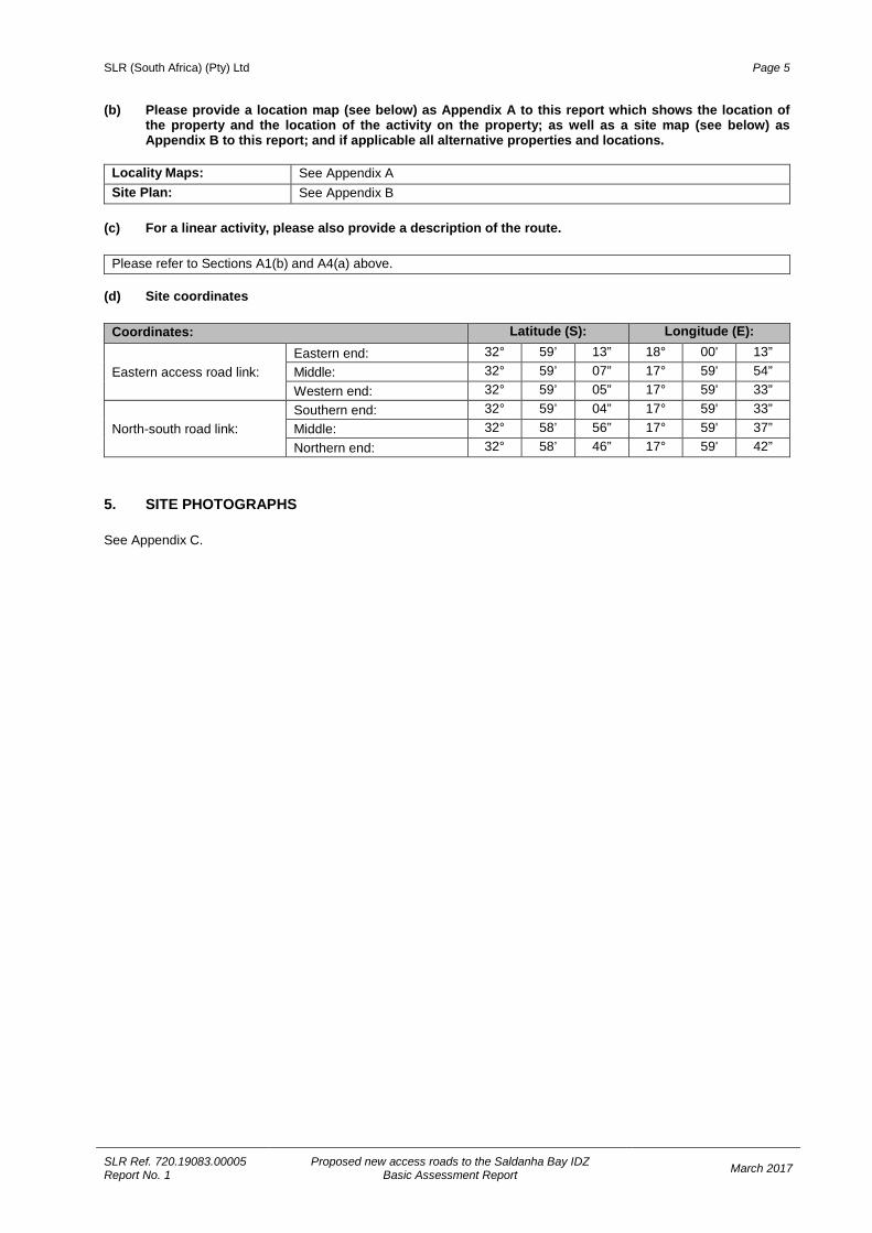
Please refer to Sections A1(b) and A4(a) above. (d) Site coordinates
Coordinates: Latitude (S): Longitude (E):
Eastern access road link: Eastern end: 32° 59’ 13” 18° 00' 13” Middle: 32° 59’ 07” 17° 59' 54” Western end: 32° 59’ 05” 17° 59' 33”
North-south road link: Southern end: 32° 59’ 04” 17° 59' 33” Middle: 32° 58’ 56” 17° 59' 37” Northern end: 32° 58’ 46” 17° 59' 42”
5. SITE PHOTOGRAPHS See Appendix C.
SLR (South Africa) (Pty) Ltd Page 6
SLR Ref. 720.19083.00005 Report No. 1
Proposed new access roads to the Saldanha Bay IDZ Basic Assessment Report March 2017
SECTION B: DESCRIPTION OF RECEIVING ENVIRONMENT The following specialist studies have been undertaken:
SPECIALIST STUDY SPECIALIST APPENDIX
Vegetation Bergwind Botanical Surveys & Tours CC – Dr D McDonald D1
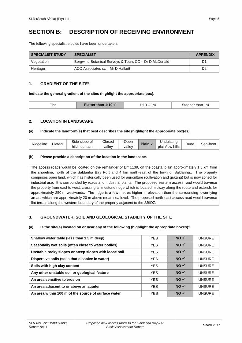
Heritage ACO Associates cc – Mr D Halkett D2 1. GRADIENT OF THE SITE* Indicate the general gradient of the sites (highlight the appropriate box).
Flat Flatter than 1:10 1:10 – 1:4 Steeper than 1:4
2. LOCATION IN LANDSCAPE (a) Indicate the landform(s) that best describes the site (highlight the appropriate box(es).
Ridgeline Plateau Side slope of hill/mountain
Closed valley
Open valley
Plain Undulating plain/low hills
Dune Sea-front
(b) Please provide a description of the location in the landscape.
The access roads would be located on the remainder of Erf 1139, on the coastal plain approximately 1.3 km from the shoreline, north of the Saldanha Bay Port and 4 km north-east of the town of Saldanha.. The property comprises open land, which has historically been used for agriculture (cultivation and grazing) but is now zoned for industrial use. It is surrounded by roads and industrial plants. The proposed eastern access road would traverse the property from east to west, crossing a limestone ridge which is located midway along the route and extends for approximately 250 m westwards. The ridge is a few metres higher in elevation than the surrounding lower-lying areas, which are approximately 20 m above mean sea level. The proposed north-east access road would traverse flat terrain along the western boundary of the property adjacent to the SBIDZ.
3. GROUNDWATER, SOIL AND GEOLOGICAL STABILITY OF THE SITE (a) Is the site(s) located on or near any of the following (highlight the appropriate boxes)?
Shallow water table (less than 1.5 m deep) YES NO UNSURE
Seasonally wet soils (often close to water bodies) YES NO UNSURE
Unstable rocky slopes or steep slopes with loose soil YES NO UNSURE
Dispersive soils (soils that dissolve in water) YES NO UNSURE
Soils with high clay content YES NO UNSURE
Any other unstable soil or geological feature YES NO UNSURE
An area sensitive to erosion YES NO UNSURE
An area adjacent to or above an aquifer YES NO UNSURE
An area within 100 m of the source of surface water YES NO UNSURE
SLR (South Africa) (Pty) Ltd Page 7
SLR Ref. 720.19083.00005 Report No. 1
Proposed new access roads to the Saldanha Bay IDZ Basic Assessment Report March 2017
(b) If any of the answers to the above are “YES” or “unsure”, specialist input may be requested by the Department.
N/A. (c) Please indicate the type of geological formation underlying the site.
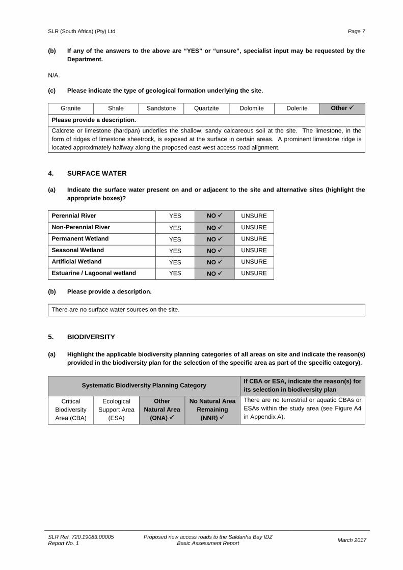
Granite Shale Sandstone Quartzite Dolomite Dolerite Other
Please provide a description.
Calcrete or limestone (hardpan) underlies the shallow, sandy calcareous soil at the site. The limestone, in the form of ridges of limestone sheetrock, is exposed at the surface in certain areas. A prominent limestone ridge is located approximately halfway along the proposed east-west access road alignment.
4. SURFACE WATER (a) Indicate the surface water present on and or adjacent to the site and alternative sites (highlight the
appropriate boxes)?
Perennial River YES NO UNSURE
Non-Perennial River YES NO UNSURE
Permanent Wetland YES NO UNSURE
Seasonal Wetland YES NO UNSURE
Artificial Wetland YES NO UNSURE
Estuarine / Lagoonal wetland YES NO UNSURE
(b) Please provide a description.
There are no surface water sources on the site.
5. BIODIVERSITY (a) Highlight the applicable biodiversity planning categories of all areas on site and indicate the reason(s)
provided in the biodiversity plan for the selection of the specific area as part of the specific category).
Systematic Biodiversity Planning Category If CBA or ESA, indicate the reason(s) for its selection in biodiversity plan
Critical Biodiversity Area (CBA)
Ecological Support Area
(ESA)
Other Natural Area
(ONA)
No Natural Area Remaining
(NNR)
There are no terrestrial or aquatic CBAs or ESAs within the study area (see Figure A4 in Appendix A).
SLR (South Africa) (Pty) Ltd Page 8
SLR Ref. 720.19083.00005 Report No. 1
Proposed new access roads to the Saldanha Bay IDZ Basic Assessment Report March 2017
(b) Highlight and describe the habitat condition on site.
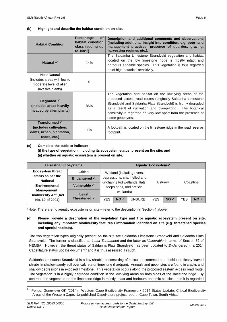
Habitat Condition
Percentage of habitat condition class (adding up to 100%)
Description and additional comments and observations (including additional insight into condition, e.g. poor land management practises, presence of quarries, grazing, harvesting regimes etc.).
Natural 14%
The Saldanha Limestone Strandveld vegetation and habitat located on the low limestone ridge is mostly intact and harbours endemic species. This vegetation is thus regarded as of high botanical sensitivity.
Near Natural (includes areas with low to
moderate level of alien invasive plants)
0 -
Degraded (includes areas heavily invaded by alien plants)
86%
The vegetation and habitat on the low-lying areas of the proposed access road routes (originally Saldanha Limestone Strandveld and Saldanha Flats Strandveld) is highly degraded as a result of cultivation and overgrazing. The botanical sensitivity is regarded as very low apart from the presence of some geophytes.
Transformed (includes cultivation,
dams, urban, plantation, roads, etc.)
1% A footpath is located on the limestone ridge in the road reserve footprint.
(c) Complete the table to indicate:
(i) the type of vegetation, including its ecosystem status, present on the site; and (ii) whether an aquatic ecosystem is present on site.
Terrestrial Ecosystems Aquatic Ecosystems*
Ecosystem threat status as per the
National Environmental Management:
Biodiversity Act (Act No. 10 of 2004)
Critical Wetland (including rivers, depressions, channelled and unchannelled wetlands, flats,
seeps pans, and artificial wetlands)
Estuary Coastline Endangered
Vulnerable
Least Threatened YES NO UNSURE YES NO YES NO
*Note: There are no aquatic ecosystems on site – refer to the description in Section 4 above. (d) Please provide a description of the vegetation type and / or aquatic ecosystem present on site,
including any important biodiversity features / information identified on site (e.g. threatened species and special habitats).
The two vegetation types originally present on the site are Saldanha Limestone Strandveld and Saldanha Flats Strandveld. The former is classified as Least Threatened and the latter as Vulnerable in terms of Section 52 of NEMBA. However, the threat status of Saldanha Flats Strandveld has been updated to Endangered in a 2014 CapeNature status update document1 and it is thus assessed as such. Saldanha Limestone Strandveld is a low shrubland consisting of succulent-stemmed and deciduous fleshy-leaved shrubs in shallow sandy soil over calcrete or limestone (hardpan). Annuals and geophytes are found in cracks and shallow depressions in exposed limestone. This vegetation occurs along the proposed eastern access road route. The vegetation is in a highly degraded condition in the low-lying areas on both sides of the limestone ridge. By contrast, the vegetation on the limestone ridge is mostly intact and harbours endemic species, thus it is regarded
1 Pence, Genevieve QK (2014). Western Cape Biodiversity Framework 2014 Status Update: Critical Biodiversity
Areas of the Western Cape. Unpublished CapeNature project report. Cape Town, South Africa.
SLR (South Africa) (Pty) Ltd Page 9
SLR Ref. 720.19083.00005 Report No. 1
Proposed new access roads to the Saldanha Bay IDZ Basic Assessment Report March 2017
as of high botanical sensitivity. The following species of conservation concern were identified: Diosma guthriei (Near Threatened), Ferraria cf. densepunctulata (Vulnerable) and Limonium capense (Near threatened). Saldanha Flats Strandveld is a sclerophyllous shrubland with a low open shrub layer and emergent mid-high shrub stratum. It is species-rich and well-known for colourful displays of annuals in spring. Geophytes are common but are also usually only seen during the winter and spring season when they are growing and flowering. A wide array of low succulent “vygies”, annual Asteraceae and geophytic herbs make up the greater proportion of the species complement. Aloe perfoliata occurs in occasional patches in Saldanha Flats Strandveld. Other endemic and rare species such as Limonium capense (Near Threatened) also occur in this vegetation type. The botanical assessment specifically noted the following: • A population of old plants of Boophone haemanthoides (gifbol), which should be relocated to a safe area,
together with Brunsvigia orientalis (location: S 32° 59’ 12.9”; E 18° 00’ 12.4”); • A stand of Aloe perfoliata close to the boundary between the limestone ridge and the cultivated lands to the
west (location: S 32° 59’ 06.0”; E 17° 59’ 42.0”). This stand of aloes should be relocated to a safe site on the limestone ridge outside of the development footprint if it were to fall within the proposed road reserve area; and
• A remnant of relatively intact Saldanha Flats Strandveld south of the intersection of the eastern and north-south access road route and northern access road route, which should be demarcated as a “No-go” area where no construction machinery or workers should be permitted (refer to Figure A5 in Appendix A).
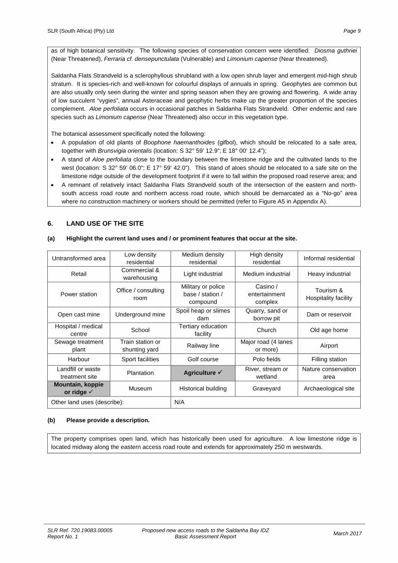
6. LAND USE OF THE SITE (a) Highlight the current land uses and / or prominent features that occur at the site.
Untransformed area Low density residential
Medium density residential
High density residential Informal residential
Retail Commercial & warehousing Light industrial Medium industrial Heavy industrial
Power station Office / consulting room
Military or police base / station /
compound
Casino / entertainment
complex
Tourism & Hospitality facility
Open cast mine Underground mine Spoil heap or slimes dam
Quarry, sand or borrow pit Dam or reservoir
Hospital / medical centre School Tertiary education
facility Church Old age home
Sewage treatment plant
Train station or shunting yard Railway line Major road (4 lanes
or more) Airport
Harbour Sport facilities Golf course Polo fields Filling station Landfill or waste
treatment site Plantation Agriculture River, stream or wetland
Nature conservation area
Mountain, koppie or ridge Museum Historical building Graveyard Archaeological site
Other land uses (describe): N/A (b) Please provide a description.
The property comprises open land, which has historically been used for agriculture. A low limestone ridge is located midway along the eastern access road route and extends for approximately 250 m westwards.
SLR (South Africa) (Pty) Ltd Page 10
SLR Ref. 720.19083.00005 Report No. 1
Proposed new access roads to the Saldanha Bay IDZ Basic Assessment Report March 2017
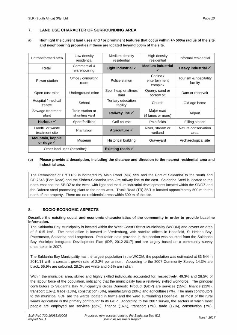
7. LAND USE CHARACTER OF SURROUNDING AREA a) Highlight the current land uses and / or prominent features that occur within +/- 500m radius of the site
and neighbouring properties if these are located beyond 500m of the site.
Untransformed area Low density residential
Medium density residential
High density residential Informal residential
Retail Commercial & warehousing
Light industrial Medium industrial Heavy industrial
Power station Office / consulting room Police station
Casino / entertainment
complex
Tourism & hospitality facility
Open cast mine Underground mine Spoil heap or slimes dam
Quarry, sand or borrow pit Dam or reservoir
Hospital / medical centre School Tertiary education
facility Church Old age home
Sewage treatment plant
Train station or shunting yard
Railway line Major road (4 lanes or more)
Airport
Harbour Sport facilities Golf course Polo fields Filling station
Landfill or waste treatment site Plantation Agriculture River, stream or
wetland Nature conservation
area Mountain, koppie
or ridge Museum Historical building Graveyard Archaeological site
Other land uses (describe): Existing roads
(b) Please provide a description, including the distance and direction to the nearest residential area and industrial area.
The Remainder of Erf 1139 is bordered by Main Road (MR) 559 and the Port of Saldanha to the south and OP 7645 (Port Road) and the Sishen-Saldanha Iron Ore railway line to the east. Saldanha Steel is located to the north-east and the SBIDZ to the west, with light and medium industrial developments located within the SBIDZ and the Duferco steel processing plant to the north-west. Trunk Road (TR) 85/1 is located approximately 500 m to the north of the property. There are no residential areas within 500 m of the site.
8. SOCIO-ECONOMIC ASPECTS Describe the existing social and economic characteristics of the community in order to provide baseline information.
The Saldanha Bay Municipality is located within the West Coast District Municipality (WCDM) and covers an area of 2 015 km². The head office is located in Vredenburg, with satellite offices in Hopefield, St Helena Bay, Paternoster, Saldanha and Langebaan. Population data provided in this section was sourced from the Saldanha Bay Municipal Integrated Development Plan (IDP, 2012-2017) and are largely based on a community survey undertaken in 2007. The Saldanha Bay Municipality has the largest population in the WCDM, the population was estimated at 83 644 in 2010/11 with a constant growth rate of 2.2% per annum. According to the 2007 Community Survey 14.3% are black, 56.9% are coloured, 28.2% are white and 0.6% are indian. Within the municipal area, skilled and highly skilled individuals accounted for, respectively, 49.3% and 28.5% of the labour force of the population, indicating that the municipality has a relatively skilled workforce. The principal contributors to Saldanha Bay Municipality’s Gross Domestic Product (GDP) are services (15%), finance (12%), transport (16%), trade (13%), construction (5%), manufacturing (30%) and agriculture (7%). The main contributors to the municipal GDP are the wards located in towns and the ward surrounding Hopefield. In most of the rural wards agriculture is the primary contributor to its GDP. According to the 2007 survey, the sectors in which most people are employed are services (22%), finance (16%), transport (7%), trade (17%), construction (7%),
SLR (South Africa) (Pty) Ltd Page 11
SLR Ref. 720.19083.00005 Report No. 1
Proposed new access roads to the Saldanha Bay IDZ Basic Assessment Report March 2017
manufacturing (11%) and agriculture (14%). In 2007 the unemployment level was estimated at 18%. Unique features of the municipality include the naval base, Langebaanweg Airforce Base and the commercial and fishing port in Saldanha Bay, which is at the heart of the South African fishing industry and a major port for the export of commodities (WCDM IDP, 2009). The port is also classified as the largest natural port in Africa and the area is earmarked as a regional engine for the development of the Western Cape Province (IDP, 2012-2017).
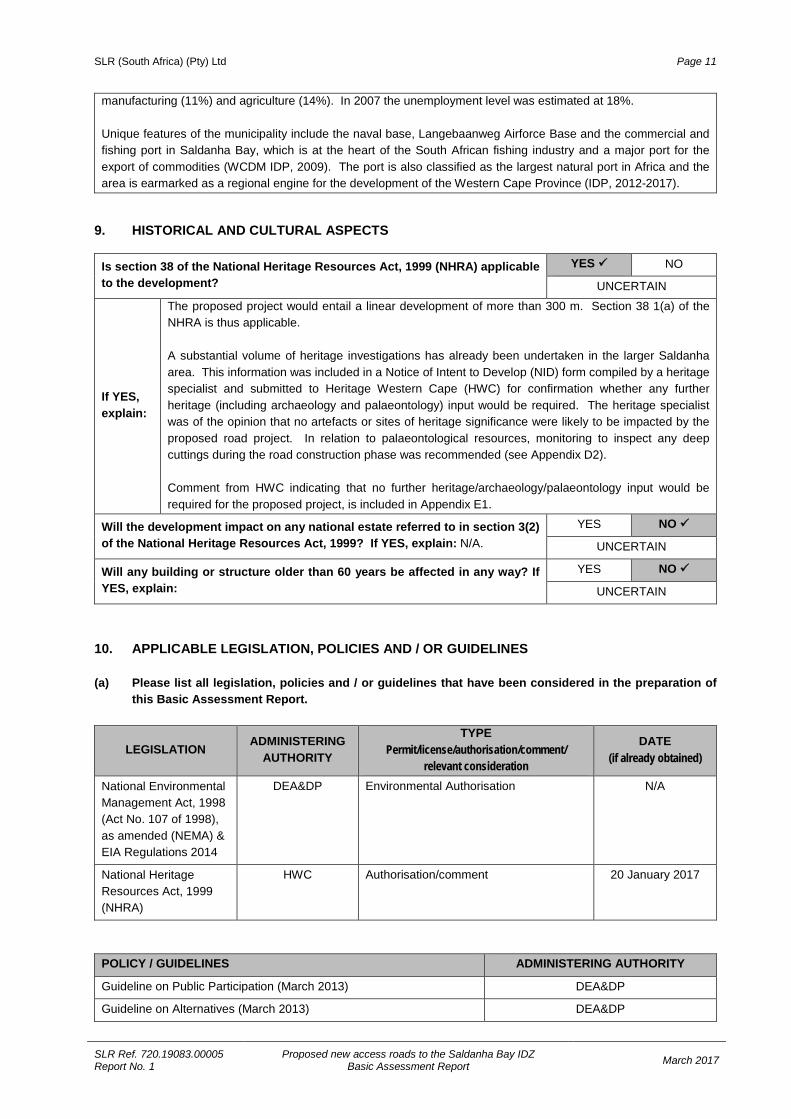
9. HISTORICAL AND CULTURAL ASPECTS
Is section 38 of the National Heritage Resources Act, 1999 (NHRA) applicable to the development?
YES NO
UNCERTAIN
If YES, explain:
The proposed project would entail a linear development of more than 300 m. Section 38 1(a) of the NHRA is thus applicable. A substantial volume of heritage investigations has already been undertaken in the larger Saldanha area. This information was included in a Notice of Intent to Develop (NID) form compiled by a heritage specialist and submitted to Heritage Western Cape (HWC) for confirmation whether any further heritage (including archaeology and palaeontology) input would be required. The heritage specialist was of the opinion that no artefacts or sites of heritage significance were likely to be impacted by the proposed road project. In relation to palaeontological resources, monitoring to inspect any deep cuttings during the road construction phase was recommended (see Appendix D2). Comment from HWC indicating that no further heritage/archaeology/palaeontology input would be required for the proposed project, is included in Appendix E1.
Will the development impact on any national estate referred to in section 3(2) of the National Heritage Resources Act, 1999? If YES, explain: N/A.
YES NO
UNCERTAIN
Will any building or structure older than 60 years be affected in any way? If YES, explain:
YES NO
UNCERTAIN
10. APPLICABLE LEGISLATION, POLICIES AND / OR GUIDELINES (a) Please list all legislation, policies and / or guidelines that have been considered in the preparation of
this Basic Assessment Report.
LEGISLATION ADMINISTERING AUTHORITY
TYPE Permit/license/authorisation/comment/
relevant consideration
DATE (if already obtained)
National Environmental Management Act, 1998 (Act No. 107 of 1998), as amended (NEMA) & EIA Regulations 2014
DEA&DP Environmental Authorisation N/A
National Heritage Resources Act, 1999 (NHRA)
HWC Authorisation/comment 20 January 2017
POLICY / GUIDELINES ADMINISTERING AUTHORITY
Guideline on Public Participation (March 2013) DEA&DP
Guideline on Alternatives (March 2013) DEA&DP
SLR (South Africa) (Pty) Ltd Page 12
SLR Ref. 720.19083.00005 Report No. 1
Proposed new access roads to the Saldanha Bay IDZ Basic Assessment Report March 2017
POLICY / GUIDELINES ADMINISTERING AUTHORITY
Guideline on Need and Desirability (March 2013) DEA&DP
Guideline on Environmental Management Plans (June 2005) DEA&DP
Guideline on Specialist Studies (October 2011) DEA&DP
Western Cape Provincial Spatial Development Framework (PSDF) (2014)
DEA&DP
Saldanha Bay Integrated Development Plan (IDP) (2012-2017) Saldanha Bay Municipality
Saldanha Bay Spatial Development Framework (SDF) (2011) Saldanha Bay Municipality (b) Please describe how the legislation, policies and / or guidelines were taken into account in the
preparation of this Basic Assessment Report.
LEGISLATION / POLICY / GUIDELINE
DESCRIBE HOW THE LEGISLATION / POLICY / GUIDELINE WERE TAKEN INTO ACCOUNT
(e.g. describe the extent to which it was adhered to, or deviated from, etc.). NEMA EIA Regulations 2014 This BAR was compiled in terms of the NEMA EIA Regulations of 2014. The
applicable requirements of the EIA Regulations 2014 were adhered to during the compilation of this report.
NHRA As mentioned in Section B9 above, HWC indicated that no further heritage/archaeology/palaeontology input would be required in response to the NID regarding the proposed project submitted in December 2016.
Guideline on Public Participation (March 2013)
The public participation guideline was consulted to ensure that an adequate public participation process was undertaken during the Basic Assessment Process.
Guideline on Alternatives (March 2013)
This guideline was consulted to inform the consideration of alternatives.
Guideline on Need and Desirability (March 2013)
This guideline was consulted to inform the consideration of the need and desirability aspects of the proposed project.
Guideline on Environmental Management Plans (June 2005)
The Environmental Management Plan guideline was consulted to ensure that the Environmental Management Programme (EMP) (attached in Appendix G) has been adequately compiled.
Guideline on Specialist Studies (October 2011)
Specialists were instructed to comply with DEA&DP’s guidelines on specialist study requirements.
Western Cape PSDF (2014) The PSDF was consulted to determine whether the proposed project is in line with the provincial policies regarding land use, infrastructure development and the protection of environmental, socio-economic and cultural and heritage resources.
Saldanha Bay IDP (2012-2017)
The IDP was consulted to determine whether the proposed project is in line with the local development policies and priorities.
Saldanha Bay SDF (2011)
The SDF was consulted to determine whether the proposed project is in line with the local policies and planning regarding land use, infrastructure development and the protection of environmental, socio-economic and cultural and heritage resources.
SLR (South Africa) (Pty) Ltd Page 13
SLR Ref. 720.19083.00005 Report No. 1
Proposed new access roads to the Saldanha Bay IDZ Basic Assessment Report March 2017
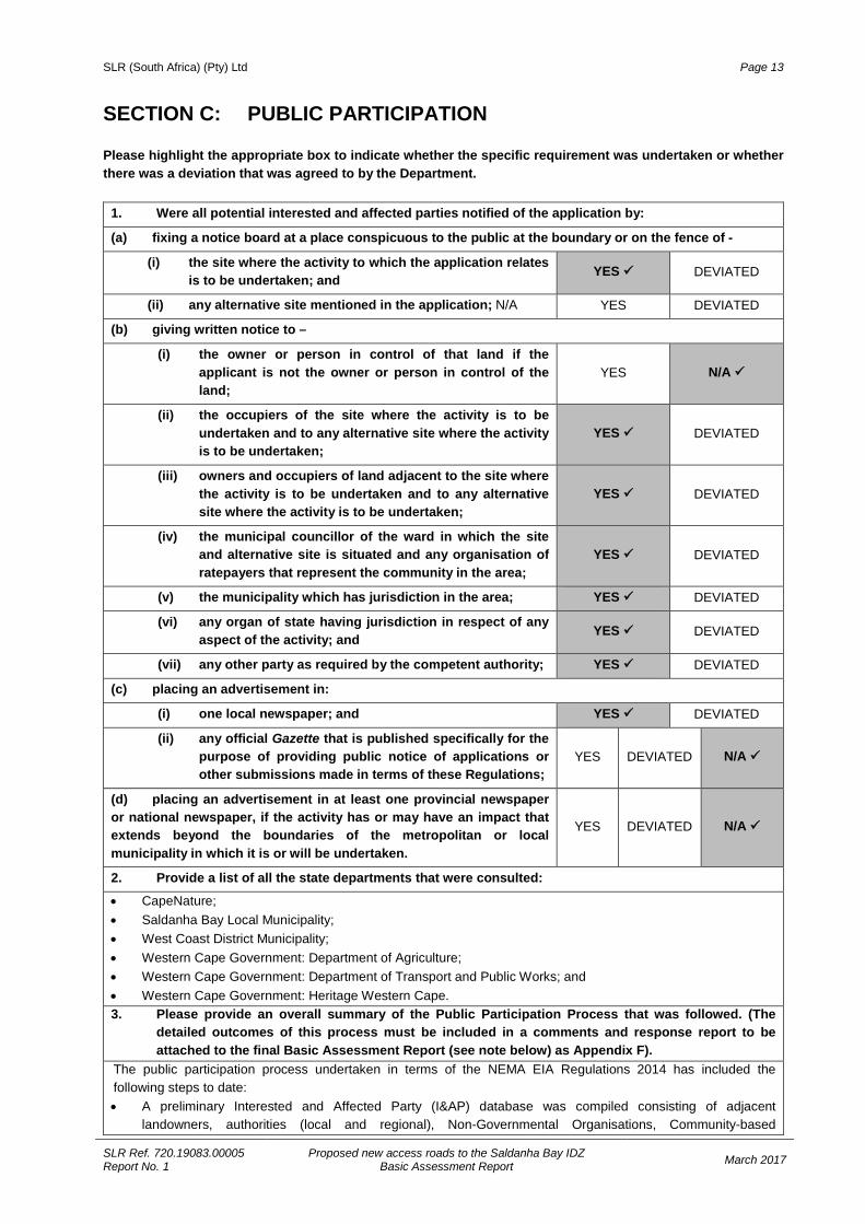
SECTION C: PUBLIC PARTICIPATION Please highlight the appropriate box to indicate whether the specific requirement was undertaken or whether there was a deviation that was agreed to by the Department.
1. Were all potential interested and affected parties notified of the application by:
(a) fixing a notice board at a place conspicuous to the public at the boundary or on the fence of -
(i) the site where the activity to which the application relates is to be undertaken; and YES DEVIATED
(ii) any alternative site mentioned in the application; N/A YES DEVIATED
(b) giving written notice to –
(i) the owner or person in control of that land if the applicant is not the owner or person in control of the land;
YES N/A
(ii) the occupiers of the site where the activity is to be undertaken and to any alternative site where the activity is to be undertaken;
YES DEVIATED
(iii) owners and occupiers of land adjacent to the site where the activity is to be undertaken and to any alternative site where the activity is to be undertaken;
YES DEVIATED
(iv) the municipal councillor of the ward in which the site and alternative site is situated and any organisation of ratepayers that represent the community in the area;
YES DEVIATED
(v) the municipality which has jurisdiction in the area; YES DEVIATED
(vi) any organ of state having jurisdiction in respect of any aspect of the activity; and YES DEVIATED
(vii) any other party as required by the competent authority; YES DEVIATED
(c) placing an advertisement in:
(i) one local newspaper; and YES DEVIATED
(ii) any official Gazette that is published specifically for the purpose of providing public notice of applications or other submissions made in terms of these Regulations;
YES DEVIATED N/A
(d) placing an advertisement in at least one provincial newspaper or national newspaper, if the activity has or may have an impact that extends beyond the boundaries of the metropolitan or local municipality in which it is or will be undertaken.
YES DEVIATED N/A
2. Provide a list of all the state departments that were consulted:
• CapeNature; • Saldanha Bay Local Municipality; • West Coast District Municipality; • Western Cape Government: Department of Agriculture; • Western Cape Government: Department of Transport and Public Works; and • Western Cape Government: Heritage Western Cape. 3. Please provide an overall summary of the Public Participation Process that was followed. (The
detailed outcomes of this process must be included in a comments and response report to be attached to the final Basic Assessment Report (see note below) as Appendix F).
The public participation process undertaken in terms of the NEMA EIA Regulations 2014 has included the following steps to date: • A preliminary Interested and Affected Party (I&AP) database was compiled consisting of adjacent
landowners, authorities (local and regional), Non-Governmental Organisations, Community-based
SLR (South Africa) (Pty) Ltd Page 14
SLR Ref. 720.19083.00005 Report No. 1
Proposed new access roads to the Saldanha Bay IDZ Basic Assessment Report March 2017
Organisations and other key stakeholders. To date 68 I&APs have been registered on the project database (see Appendix F1).
• Two site notices notifying potential Interested and Affected Parties of the proposed application was erected at two locations on site on 18 January 2017 (see Appendix F2).
• An Application Form for Environmental Authorisation was submitted to and received by DEA&DP on 20 February 2017.
• Arrangements have been made to place an advertisement (in English) in a local newspaper, the Weslander, on 9 March 2017 (see Appendix F2).
• A notification letter has been sent to all registered I&APs on the project database to inform them of the NEMA EIA Regulations 2014 compliance process (see Appendix F3). The letter also announces the availability of the BAR for a 30-day public review and comment period from 10 March to 10 April 2017 (including an additional day to cover the intervening public holiday on 21 March 2017) and invites IA&Ps to submit comments on any aspect of the Basic Assessment process and the proposed project.
• Copies of the full report are available at the Saldanha Public Library and at the offices and on SLR’s website. • Copies of the BAR have been provided to representatives of the relevant Organs of State for their review and
comment, as described in Section C2. • A copy of the BAR has also been submitted to DEA&DP to request their comment as required in terms of
Regulations 32(1)(i) and (ii) and 40(3) of GN R. 982 of 4 December 2014. Tasks envisaged for the completion of the Basic Assessment process include the following: • All comments received on the BAR will be collated into a Comments and Responses Report which will be
appended to the final BAR. • This BAR will be updated into a final BAR as necessary and will be submitted to DEA&DP for consideration
and decision-making. The Final BAR will also be made available to registered I&APs for information purposes.
• Once DEA&DP has issued a decision, all I&APs on the project database will be notified of the outcome of the application, the reasons for the decision and the associated appeal process.
SLR (South Africa) (Pty) Ltd Page 15
SLR Ref. 720.19083.00005 Report No. 1
Proposed new access roads to the Saldanha Bay IDZ Basic Assessment Report March 2017
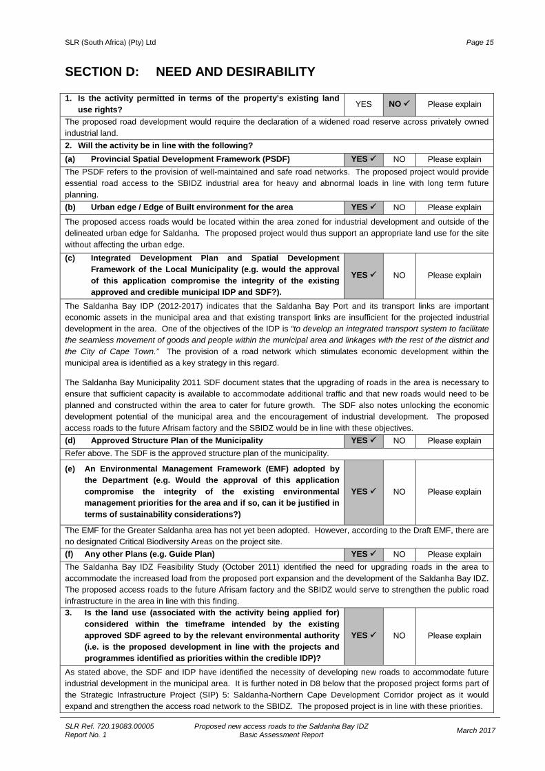
SECTION D: NEED AND DESIRABILITY 1. Is the activity permitted in terms of the property’s existing land
use rights? YES NO Please explain
The proposed road development would require the declaration of a widened road reserve across privately owned industrial land. 2. Will the activity be in line with the following? (a) Provincial Spatial Development Framework (PSDF) YES NO Please explain The PSDF refers to the provision of well-maintained and safe road networks. The proposed project would provide essential road access to the SBIDZ industrial area for heavy and abnormal loads in line with long term future planning. (b) Urban edge / Edge of Built environment for the area YES NO Please explain
The proposed access roads would be located within the area zoned for industrial development and outside of the delineated urban edge for Saldanha. The proposed project would thus support an appropriate land use for the site without affecting the urban edge. (c) Integrated Development Plan and Spatial Development
Framework of the Local Municipality (e.g. would the approval of this application compromise the integrity of the existing approved and credible municipal IDP and SDF?).
YES NO Please explain
The Saldanha Bay IDP (2012-2017) indicates that the Saldanha Bay Port and its transport links are important economic assets in the municipal area and that existing transport links are insufficient for the projected industrial development in the area. One of the objectives of the IDP is “to develop an integrated transport system to facilitate the seamless movement of goods and people within the municipal area and linkages with the rest of the district and the City of Cape Town.” The provision of a road network which stimulates economic development within the municipal area is identified as a key strategy in this regard.
The Saldanha Bay Municipality 2011 SDF document states that the upgrading of roads in the area is necessary to ensure that sufficient capacity is available to accommodate additional traffic and that new roads would need to be planned and constructed within the area to cater for future growth. The SDF also notes unlocking the economic development potential of the municipal area and the encouragement of industrial development. The proposed access roads to the future Afrisam factory and the SBIDZ would be in line with these objectives. (d) Approved Structure Plan of the Municipality YES NO Please explain Refer above. The SDF is the approved structure plan of the municipality.
(e) An Environmental Management Framework (EMF) adopted by the Department (e.g. Would the approval of this application compromise the integrity of the existing environmental management priorities for the area and if so, can it be justified in terms of sustainability considerations?)
YES NO Please explain
The EMF for the Greater Saldanha area has not yet been adopted. However, according to the Draft EMF, there are no designated Critical Biodiversity Areas on the project site. (f) Any other Plans (e.g. Guide Plan) YES NO Please explain The Saldanha Bay IDZ Feasibility Study (October 2011) identified the need for upgrading roads in the area to accommodate the increased load from the proposed port expansion and the development of the Saldanha Bay IDZ. The proposed access roads to the future Afrisam factory and the SBIDZ would serve to strengthen the public road infrastructure in the area in line with this finding. 3. Is the land use (associated with the activity being applied for)
considered within the timeframe intended by the existing approved SDF agreed to by the relevant environmental authority (i.e. is the proposed development in line with the projects and programmes identified as priorities within the credible IDP)?
YES NO Please explain
As stated above, the SDF and IDP have identified the necessity of developing new roads to accommodate future industrial development in the municipal area. It is further noted in D8 below that the proposed project forms part of the Strategic Infrastructure Project (SIP) 5: Saldanha-Northern Cape Development Corridor project as it would expand and strengthen the access road network to the SBIDZ. The proposed project is in line with these priorities.
SLR (South Africa) (Pty) Ltd Page 16
SLR Ref. 720.19083.00005 Report No. 1
Proposed new access roads to the Saldanha Bay IDZ Basic Assessment Report March 2017
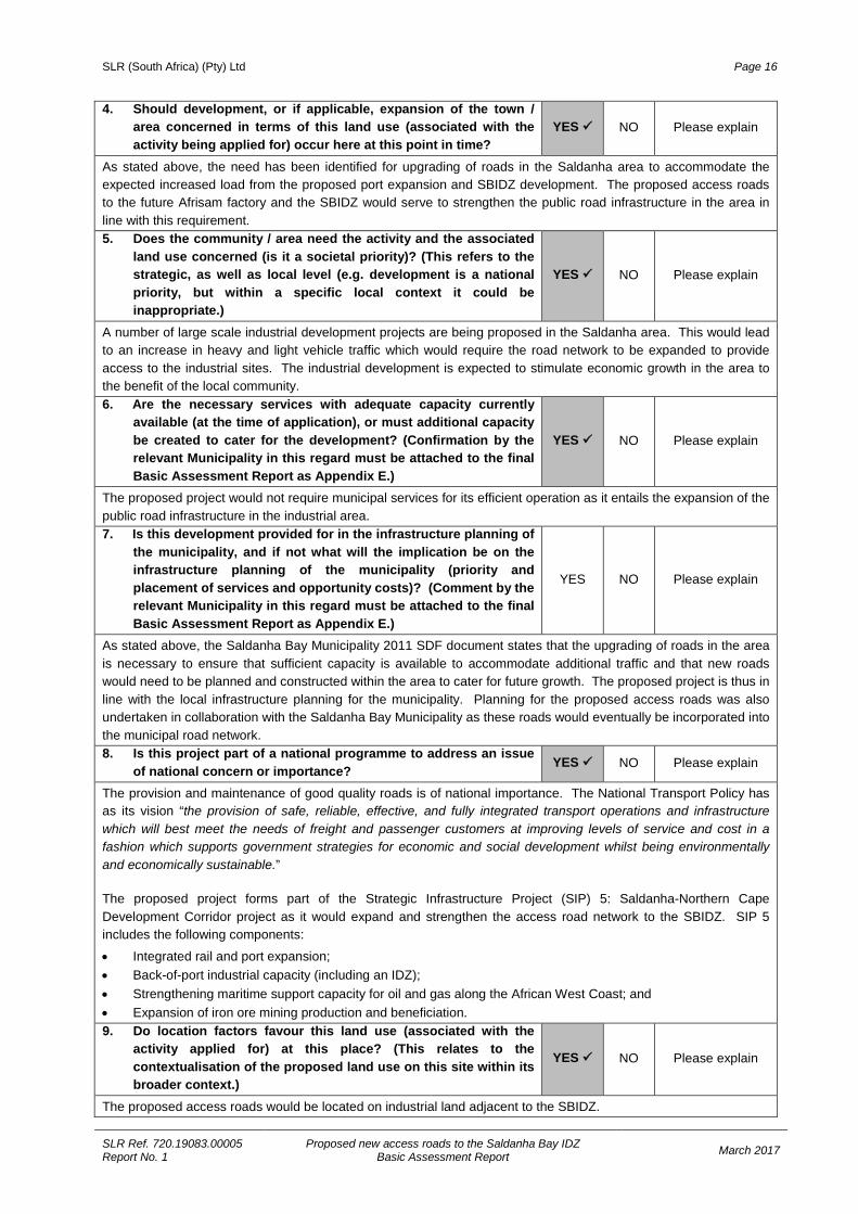
4. Should development, or if applicable, expansion of the town / area concerned in terms of this land use (associated with the activity being applied for) occur here at this point in time?
YES NO Please explain
As stated above, the need has been identified for upgrading of roads in the Saldanha area to accommodate the expected increased load from the proposed port expansion and SBIDZ development. The proposed access roads to the future Afrisam factory and the SBIDZ would serve to strengthen the public road infrastructure in the area in line with this requirement. 5. Does the community / area need the activity and the associated
land use concerned (is it a societal priority)? (This refers to the strategic, as well as local level (e.g. development is a national priority, but within a specific local context it could be inappropriate.)
YES NO Please explain
A number of large scale industrial development projects are being proposed in the Saldanha area. This would lead to an increase in heavy and light vehicle traffic which would require the road network to be expanded to provide access to the industrial sites. The industrial development is expected to stimulate economic growth in the area to the benefit of the local community. 6. Are the necessary services with adequate capacity currently
available (at the time of application), or must additional capacity be created to cater for the development? (Confirmation by the relevant Municipality in this regard must be attached to the final Basic Assessment Report as Appendix E.)
YES NO Please explain
The proposed project would not require municipal services for its efficient operation as it entails the expansion of the public road infrastructure in the industrial area. 7. Is this development provided for in the infrastructure planning of
the municipality, and if not what will the implication be on the infrastructure planning of the municipality (priority and placement of services and opportunity costs)? (Comment by the relevant Municipality in this regard must be attached to the final Basic Assessment Report as Appendix E.)
YES NO Please explain
As stated above, the Saldanha Bay Municipality 2011 SDF document states that the upgrading of roads in the area is necessary to ensure that sufficient capacity is available to accommodate additional traffic and that new roads would need to be planned and constructed within the area to cater for future growth. The proposed project is thus in line with the local infrastructure planning for the municipality. Planning for the proposed access roads was also undertaken in collaboration with the Saldanha Bay Municipality as these roads would eventually be incorporated into the municipal road network. 8. Is this project part of a national programme to address an issue
of national concern or importance? YES NO Please explain
The provision and maintenance of good quality roads is of national importance. The National Transport Policy has as its vision “the provision of safe, reliable, effective, and fully integrated transport operations and infrastructure which will best meet the needs of freight and passenger customers at improving levels of service and cost in a fashion which supports government strategies for economic and social development whilst being environmentally and economically sustainable.” The proposed project forms part of the Strategic Infrastructure Project (SIP) 5: Saldanha-Northern Cape Development Corridor project as it would expand and strengthen the access road network to the SBIDZ. SIP 5 includes the following components:
• Integrated rail and port expansion; • Back-of-port industrial capacity (including an IDZ); • Strengthening maritime support capacity for oil and gas along the African West Coast; and • Expansion of iron ore mining production and beneficiation. 9. Do location factors favour this land use (associated with the
activity applied for) at this place? (This relates to the contextualisation of the proposed land use on this site within its broader context.)
YES NO Please explain
The proposed access roads would be located on industrial land adjacent to the SBIDZ.
SLR (South Africa) (Pty) Ltd Page 17
SLR Ref. 720.19083.00005 Report No. 1
Proposed new access roads to the Saldanha Bay IDZ Basic Assessment Report March 2017
10. How will the activity or the land use associated with the activity applied for, impact on sensitive natural and cultural areas (built and rural / natural environment)?
The proposed project would result in the loss of an area of mostly intact Saldanha Limestone Strandveld of high botanical sensitivity on the limestone ridge along the eastern access road route. Removal of the vegetation would result in an impact of Medium negative significance with mitigation (see Section F). Along the rest of the road alignment the natural vegetation has largely been disturbed and the impact would be of Very Low negative significance with mitigation. No sensitive cultural areas were identified on or in close proximity to the proposed access road routes. 11. How will the development impact on people’s health and well-being (e.g. in terms of noise, odours,
visual character and sense of place, etc.)? In the long term the proposed project would contribute to local economic growth and development by providing ready access to the SBIDZ and large industrial plant in the vicinity. In the short term during construction, noise and dust levels may increase locally, but this is considered of low significance as there are no residential dwellings in close proximity to the site. These construction-related impacts would be further managed through the implementation of an approved Construction Environmental Management Programme (EMP) (refer to Appendix G). 12. Will the proposed activity or the land use associated with the
activity applied for, result in unacceptable opportunity costs? YES NO Please explain
The proposed project is in line with the land use planning for the area and will serve to support the stated national and provincial industrial development objectives articulated in SIP5. 13. What will the cumulative impacts (positive and negative) of the proposed land use associated with the
activity applied for, be? The proposed project aims to strengthen the road network in the vicinity of the SBIDZ with a view to contributing positively to the envisaged industrial development and economic growth objectives stated in the PSDF and SIP5. Saldanha Limestone Strandveld is negatively impacted at various places around Saldanha due to industrial and residential development. The proposed eastern access road would have a small but measurable and meaningful cumulative impact as a result of loss and fragmentation of Saldanha Limestone Strandveld. 14. Is the development the best practicable environmental option for
this land / site? YES NO Please explain
The proposed access roads would be located on industrial land adjacent to the SBIDZ and would provide access to existing industrial development within the SBIDZ as well as a large cement plant proposed for development on the land. The proposed new access roads also form part of a larger road network upgrade and development project supporting the SIP5: Saldanha-Northern Cape Development Corridor project. 15. What will the benefits be to society in general and to the local communities? The planned increase in industrial developments in the Saldanha Bay municipal area would play a significant role in generating additional traffic. Road freight movement into and from the area, the presence of heavy vehicles and abnormal loads are expected to become more frequent. The proposed provision of new access roads to the SBIDZ would support the planned industrial developments which would in turn be of benefit to society in general and local communities due to the economic growth potential it would create. The proposed project may also create some employment opportunities for members of the local community during the construction phase of the project. 16. Any other need and desirability considerations related to the proposed activity? Please explain None identified to date. 17. Please describe how the general objectives of Integrated Environmental Management as set out in
Section 23 of NEMA have been taken into account: The general objectives of Integrated Environmental Management were taken into account by considering all the potential negative and positive impacts of the proposed project on both the biophysical and socio-economic environments. The public and authorities will be given adequate opportunity to comment on the proposed project and to participate in the Basic Assessment Process.

SLR (South Africa) (Pty) Ltd Page 18
SLR Ref. 720.19083.00005 Report No. 1
Proposed new access roads to the Saldanha Bay IDZ Basic Assessment Report March 2017
18. Please describe how the principles of environmental management as set out in Section 2 of NEMA hhave been taken into account:
The basic needs of landowners and the public were taken into account during the planning phase of the proposed project, which aims to provide essential road infrastructure to access industrial sites for the movement of freight. In general, the proposed project would improve access and safety for all road users in the area. The landowners would directly benefit from the provision of an access road to the Afrisam cement plant that would be developed on the property. The proposed project is deemed to be socially, environmentally and economically sustainable. Minimisation of potential negative impacts and optimisation of potential positive impacts will be ensured by way of effective implementation of an approved Construction EMP (see Appendix G).
As mentioned in Section A1(b), the overall implications of increased traffic volume linked to the SBIDZ were already assessed in the overarching EIA process undertaken for the SBIDZ for which an EA was issued in November 2015. The currently proposed eastern access road was included as a potential future road link in the original SBIDZ EIA.
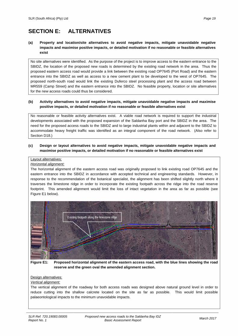
SLR (South Africa) (Pty) Ltd Page 19
SLR Ref. 720.19083.00005 Report No. 1
Proposed new access roads to the Saldanha Bay IDZ Basic Assessment Report March 2017
SECTION E: ALTERNATIVES (a) Property and location/site alternatives to avoid negative impacts, mitigate unavoidable negative
impacts and maximise positive impacts, or detailed motivation if no reasonable or feasible alternatives exist
No site alternatives were identified. As the purpose of the project is to improve access to the eastern entrance to the SBIDZ, the location of the proposed new roads is determined by the existing road network in the area. Thus the proposed eastern access road would provide a link between the existing road OP7645 (Port Road) and the eastern entrance into the SBIDZ as well as access to a new cement plant to be developed to the west of OP7645. The proposed north-south road would link the existing Duferco steel processing plant and the access road between MR559 (Camp Street) and the eastern entrance into the SBIDZ. No feasible property, location or site alternatives for the new access roads could thus be considered.
(b) Activity alternatives to avoid negative impacts, mitigate unavoidable negative impacts and maximise
positive impacts, or detailed motivation if no reasonable or feasible alternatives exist
No reasonable or feasible activity alternatives exist. A viable road network is required to support the industrial developments associated with the proposed expansion of the Saldanha Bay port and the SBIDZ in the area. The need for the proposed access roads to the SBIDZ and to large industrial plants within and adjacent to the SBIDZ to accommodate heavy freight traffic was identified as an integral component of the road network. (Also refer to Section D18.)
(c) Design or layout alternatives to avoid negative impacts, mitigate unavoidable negative impacts and
maximise positive impacts, or detailed motivation if no reasonable or feasible alternatives exist
Layout alternatives: Horizontal alignment: The horizontal alignment of the eastern access road was originally proposed to link existing road OP7645 and the eastern entrance into the SBIDZ in accordance with accepted technical and engineering standards. However, in response to the recommendation of the botanical specialist, the alignment has been shifted slightly north where it traverses the limestone ridge in order to incorporate the existing footpath across the ridge into the road reserve footprint. This amended alignment would limit the loss of intact vegetation in the area as far as possible (see Figure E1 below).
Figure E1: Proposed horizontal alignment of the eastern access road, with the blue lines showing the road
reserve and the green oval the amended alignment section. Design alternatives: Vertical alignment: The vertical alignment of the roadway for both access roads was designed above natural ground level in order to reduce cutting into the shallow calcrete located on the site as far as possible. This would limit possible palaeontological impacts to the minimum unavoidable impacts.
Existing footpath along the limestone ridge
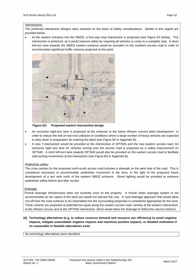
SLR (South Africa) (Pty) Ltd Page 20
SLR Ref. 720.19083.00005 Report No. 1
Proposed new access roads to the Saldanha Bay IDZ Basic Assessment Report March 2017
Intersections: The preferred intersection designs were selected on the basis of safety considerations. Details in this regard are provided below. • At the eastern entrance into the SBIDZ, a four-way stop intersection is proposed (see Figure E2 below). This
intersection is preferred, as it would improve safety by requiring all vehicles to come to a complete stop. A short left-turn lane towards the SBIDZ eastern entrance would be provided on the southern access road in order to accommodate significant traffic volumes projected at this point.
Figure E2: Proposed eastern intersection design
• An exclusive right-turn lane is proposed at the entrance to the future Afrisam cement plant development in order to reduce the risk of rear-end collisions in conditions where a large number of heavy vehicles are expected to slow down in preparation for entering the plant (see Figure B2 in Appendix B)..
• A new T-intersection would be provided at the intersection of OP7645 and the new eastern access road. An exclusive right turn lane for vehicles turning onto the access road is proposed as a safety improvement on OP7645. A short left-turn lane towards OP7645 would also be provided on the eastern access road to facilitate safe turning movements at the intersection (see Figure B3 in Appendix B).
Pedestrian safety: The cross section for the proposed north-south access road includes a sidewalk on the west side of the road. This is considered necessary to accommodate pedestrian movement in the area, in the light of the proposed future development of a taxi rank north of the eastern SBIDZ entrance. Street lighting would be provided to enhance pedestrian safety before and after sunset. Drainage: Formal drainage infrastructure does not currently exist on the property. A formal urban drainage system is not recommended as the nature of the land use would not warrant the cost. A rural drainage approach that would allow run-off from the road surfaces to be channelled into the surrounding properties is considered appropriate for the area. Three culverts are proposed at potential low spots along the eastern access road, namely at the eastern intersection; at the Afrisam access and at the OP7645 intersection, which would allow the drainage to follow the natural contours.
(d) Technology alternatives (e.g. to reduce resource demand and resource use efficiency) to avoid negative
impacts, mitigate unavoidable negative impacts and maximise positive impacts, or detailed motivation if no reasonable or feasible alternatives exist:
No technology alternatives were identified.
SLR (South Africa) (Pty) Ltd Page 21
SLR Ref. 720.19083.00005 Report No. 1
Proposed new access roads to the Saldanha Bay IDZ Basic Assessment Report March 2017
(e) Operational alternatives to avoid negative impacts, mitigate unavoidable negative impacts and maximise positive impacts, or detailed motivation if no reasonable or feasible alternatives exist:
No operational alternatives were identified.
(f) The option of not implementing the activity (the No-Go Option):
As mentioned, the proposed new access roads would form part of a larger road network upgrade and expansion project and would support the SIP5: Saldanha-Northern Cape Development Corridor project. The No-Go Option would mean that the proposed new access roads to the SBIDZ would not be developed and would thus not contribute to the provision of transport infrastructure to support the expected industrial development projects and economic development potential related to the SIP5 project. The No-Go Option would also mean that the anticipated temporary employment opportunities, that could potentially be offered to residents from the surrounding area, would not be created. The No-Go Option would not be environmentally, socially or economically feasible in the long-term and is thus not deemed feasible. However, the No-Go Option is nevertheless considered and assessed in relation to the potential implications of the proposed project, as required in terms of NEMA and its EIA Regulations.
(g) Other alternatives to avoid negative impacts, mitigate unavoidable negative impacts and maximise
positive impacts, or detailed motivation if no reasonable or feasible alternatives exist:
No other alternatives have been identified. (h) Please provide a summary of the alternatives investigated and the outcomes of such investigation:
Site alternatives: No site alternatives were considered as the location of the new access roads is determined by the existing road network in the area.
Activity alternatives: No reasonable or feasible activity alternatives exist. The proposed access roads were identified as an integral component of the road network required to support the expansion of the Saldanha Bay port and the SBIDZ in the area.
Layout alternatives: The horizontal alignment of the eastern access road was amended in order to limit the loss of intact natural vegetation in the area as far as possible.
Design alternatives: The following design elements were incorporated to minimise potential negative impacts: • The vertical alignment of the roadway for both access roads was designed above natural ground level in order
to limit possible palaeontological impacts to the minimum unavoidable impacts. • The preferred intersection designs were selected on the basis of safety considerations, namely:
o Requiring all vehicles to come to a complete stop at a four-way stop intersection at the eastern entrance into the SBIDZ;
o Reducing the risk of rear-end collisions by providing an exclusive right-turn lane at the entrance to the future Afrisam cement plant development; and
o Providing an exclusive right turn lane for vehicles turning onto the eastern access road as a safety improvement on OP7645.
• A sidewalk and street lighting would be provided on the proposed north-south access road to enhance pedestrian safety in the light of the proposed future development of a taxi rank in the area.
• A rural drainage approach is considered appropriate for the area as opposed to a more costly formal urban drainage system.
No-Go Option The No-Go Option would mean that the proposed new access roads to the SBIDZ would not be developed and would thus not contribute to the provision of transport infrastructure to support the expected industrial development projects and economic development potential related to the SIP5 project. The No-Go Option is not deemed feasible, but is nevertheless assessed, as required in terms of NEMA and its EIA Regulations. In light of the above, only one project proposal is assessed further in this Basic Assessment Report, together with the No-Go Option.
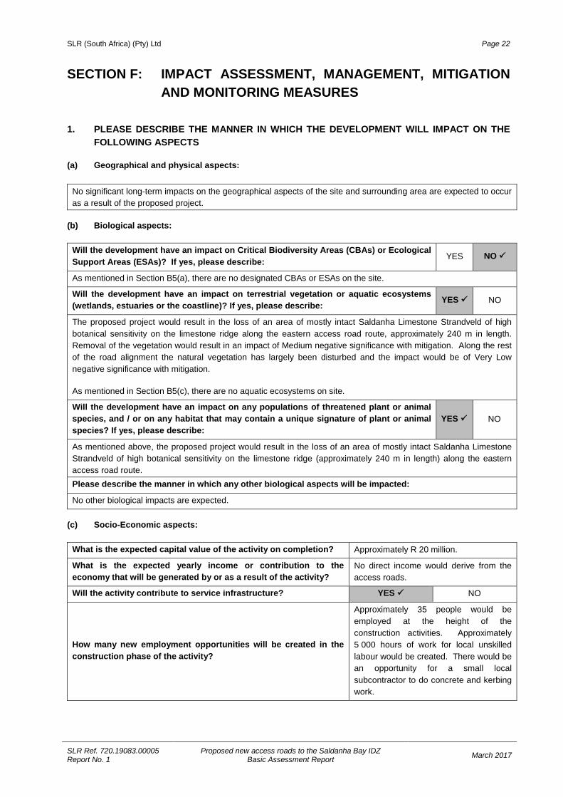
SLR (South Africa) (Pty) Ltd Page 22
SLR Ref. 720.19083.00005 Report No. 1
Proposed new access roads to the Saldanha Bay IDZ Basic Assessment Report March 2017
SECTION F: IMPACT ASSESSMENT, MANAGEMENT, MITIGATION AND MONITORING MEASURES
1. PLEASE DESCRIBE THE MANNER IN WHICH THE DEVELOPMENT WILL IMPACT ON THE
FOLLOWING ASPECTS (a) Geographical and physical aspects:
No significant long-term impacts on the geographical aspects of the site and surrounding area are expected to occur as a result of the proposed project.
(b) Biological aspects:
Will the development have an impact on Critical Biodiversity Areas (CBAs) or Ecological Support Areas (ESAs)? If yes, please describe: YES NO
As mentioned in Section B5(a), there are no designated CBAs or ESAs on the site.
Will the development have an impact on terrestrial vegetation or aquatic ecosystems (wetlands, estuaries or the coastline)? If yes, please describe: YES NO
The proposed project would result in the loss of an area of mostly intact Saldanha Limestone Strandveld of high botanical sensitivity on the limestone ridge along the eastern access road route, approximately 240 m in length. Removal of the vegetation would result in an impact of Medium negative significance with mitigation. Along the rest of the road alignment the natural vegetation has largely been disturbed and the impact would be of Very Low negative significance with mitigation.
As mentioned in Section B5(c), there are no aquatic ecosystems on site.
Will the development have an impact on any populations of threatened plant or animal species, and / or on any habitat that may contain a unique signature of plant or animal species? If yes, please describe:
YES NO
As mentioned above, the proposed project would result in the loss of an area of mostly intact Saldanha Limestone Strandveld of high botanical sensitivity on the limestone ridge (approximately 240 m in length) along the eastern access road route. Please describe the manner in which any other biological aspects will be impacted:
No other biological impacts are expected. (c) Socio-Economic aspects:
What is the expected capital value of the activity on completion? Approximately R 20 million.
What is the expected yearly income or contribution to the economy that will be generated by or as a result of the activity?
No direct income would derive from the access roads.
Will the activity contribute to service infrastructure? YES NO
How many new employment opportunities will be created in the construction phase of the activity?
Approximately 35 people would be employed at the height of the construction activities. Approximately 5 000 hours of work for local unskilled labour would be created. There would be an opportunity for a small local subcontractor to do concrete and kerbing work.
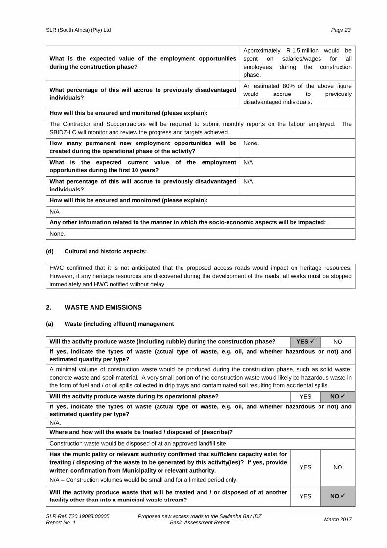
SLR (South Africa) (Pty) Ltd Page 23
SLR Ref. 720.19083.00005 Report No. 1
Proposed new access roads to the Saldanha Bay IDZ Basic Assessment Report March 2017
What is the expected value of the employment opportunities during the construction phase?
Approximately R 1.5 million would be spent on salaries/wages for all employees during the construction phase.
What percentage of this will accrue to previously disadvantaged individuals?
An estimated 80% of the above figure would accrue to previously disadvantaged individuals.
How will this be ensured and monitored (please explain):
The Contractor and Subcontractors will be required to submit monthly reports on the labour employed. The SBIDZ-LC will monitor and review the progress and targets achieved.
How many permanent new employment opportunities will be created during the operational phase of the activity?
None.
What is the expected current value of the employment opportunities during the first 10 years?
N/A
What percentage of this will accrue to previously disadvantaged individuals?
N/A
How will this be ensured and monitored (please explain):
N/A
Any other information related to the manner in which the socio-economic aspects will be impacted:
None.
(d) Cultural and historic aspects:
HWC confirmed that it is not anticipated that the proposed access roads would impact on heritage resources. However, if any heritage resources are discovered during the development of the roads, all works must be stopped immediately and HWC notified without delay.
2. WASTE AND EMISSIONS (a) Waste (including effluent) management
Will the activity produce waste (including rubble) during the construction phase? YES NO If yes, indicate the types of waste (actual type of waste, e.g. oil, and whether hazardous or not) and estimated quantity per type? A minimal volume of construction waste would be produced during the construction phase, such as solid waste, concrete waste and spoil material. A very small portion of the construction waste would likely be hazardous waste in the form of fuel and / or oil spills collected in drip trays and contaminated soil resulting from accidental spills.
Will the activity produce waste during its operational phase? YES NO
If yes, indicate the types of waste (actual type of waste, e.g. oil, and whether hazardous or not) and estimated quantity per type? N/A. Where and how will the waste be treated / disposed of (describe)?
Construction waste would be disposed of at an approved landfill site.
Has the municipality or relevant authority confirmed that sufficient capacity exist for treating / disposing of the waste to be generated by this activity(ies)? If yes, provide written confirmation from Municipality or relevant authority. N/A – Construction volumes would be small and for a limited period only.
YES NO
Will the activity produce waste that will be treated and / or disposed of at another facility other than into a municipal waste stream? YES NO
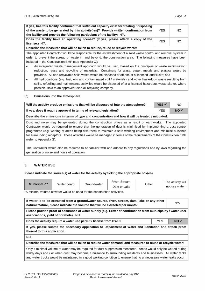
SLR (South Africa) (Pty) Ltd Page 24
SLR Ref. 720.19083.00005 Report No. 1
Proposed new access roads to the Saldanha Bay IDZ Basic Assessment Report March 2017
If yes, has this facility confirmed that sufficient capacity exist for treating / disposing of the waste to be generated by this activity(ies)? Provide written confirmation from the facility and provide the following particulars of the facility: N/A.
YES NO
Does the facility have an operating license? (If yes, please attach a copy of the license.) N/A.
YES NO
Describe the measures that will be taken to reduce, reuse or recycle waste: The appointed Contractor would be responsible for the establishment of a solid waste control and removal system in order to prevent the spread of waste in, and beyond, the construction area. The following measures have been included in the Construction EMP (see Appendix G): • An integrated waste management approach would be used, based on the principles of waste minimisation,
reduction, reuse and recycling of materials. Containers for glass, paper, metals and plastics would be provided. All non-recyclable solid waste would be disposed of off-site at a licenced landfill site; and
• All hydrocarbons (e.g. fuel, oils and contaminated soil / materials) and other hazardous waste resulting from spills, refuelling and maintenance activities would be disposed of at a licenced hazardous waste site or, where possible, sold to an approved used-oil recycling company.
(b) Emissions into the atmosphere
Will the activity produce emissions that will be disposed of into the atmosphere? YES NO
If yes, does it require approval in terms of relevant legislation? YES NO
Describe the emissions in terms of type and concentration and how it will be treated / mitigated:
Dust and noise may be generated during the construction phase as a result of earthworks. The appointed Contractor would be required to ensure that the generation of dust is minimised by implementing a dust control programme (e.g. wetting of areas being disturbed) to maintain a safe working environment and minimise nuisance for surrounding receptors. These activities would be managed in terms of the requirements of the Construction EMP (refer to Appendix G).
The Contractor would also be required to be familiar with and adhere to any regulations and by-laws regarding the generation of noise and hours of operation.
3. WATER USE Please indicate the source(s) of water for the activity by ticking the appropriate box(es)
Municipal * Water board Groundwater River, Stream, Dam or Lake
Other The activity will not use water
*A minimal volume of water would be used for the construction activities.
If water is to be extracted from a groundwater source, river, stream, dam, lake or any other natural feature, please indicate the volume that will be extracted per month: N/A
Please provide proof of assurance of water supply (e.g. Letter of confirmation from municipality / water user associations, yield of borehole). N/A
Does the activity require a water use permit / license from DWS? YES NO
If yes, please submit the necessary application to Department of Water and Sanitation and attach proof thereof to this application.
N/A
Describe the measures that will be taken to reduce water demand, and measures to reuse or recycle water:
Only a minimal volume of water may be required for dust suppression measures. Areas would only be wetted during windy days and / or when dust may become a nuisance to surrounding residents and businesses. All water tanks and water trucks would be maintained in a good working condition to ensure that no unnecessary water leaks occur.
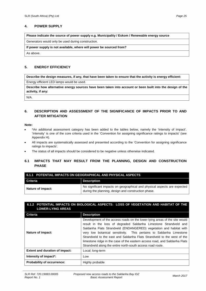
SLR (South Africa) (Pty) Ltd Page 25
SLR Ref. 720.19083.00005 Report No. 1
Proposed new access roads to the Saldanha Bay IDZ Basic Assessment Report March 2017
4. POWER SUPPLY
Please indicate the source of power supply e.g. Municipality / Eskom / Renewable energy source
Generators would only be used during construction.
If power supply is not available, where will power be sourced from?
As above.
5. ENERGY EFFICIENCY
Describe the design measures, if any, that have been taken to ensure that the activity is energy efficient: Energy efficient LED lamps would be used. Describe how alternative energy sources have been taken into account or been built into the design of the activity, if any:
N/A. 6. DESCRIPTION AND ASSESSMENT OF THE SIGNIFICANCE OF IMPACTS PRIOR TO AND
AFTER MITIGATION Note: • *An additional assessment category has been added to the tables below, namely the ‘Intensity of Impact’.
‘Intensity’ is one of the core criteria used in the ‘Convention for assigning significance ratings to impacts’ (see Appendix H).
• All impacts are systematically assessed and presented according to the ‘Convention for assigning significance ratings to impacts’.
• The status of all impacts should be considered to be negative unless otherwise indicated.
6.1 IMPACTS THAT MAY RESULT FROM THE PLANNING, DESIGN AND CONSTRUCTION PHASE
6.1.1 POTENTIAL IMPACTS ON GEOGRAPHICAL AND PHYSICAL ASPECTS
Criteria Description
Nature of impact: No significant impacts on geographical and physical aspects are expected during the planning, design and construction phase.
6.1.2 POTENTIAL IMPACTS ON BIOLOGICAL ASPECTS: LOSS OF VEGETATION AND HABITAT OF THE LOWER-LYING AREAS
Criteria Description
Nature of impact:
Development of the access roads on the lower-lying areas of the site would result in the loss of degraded Saldanha Limestone Strandveld and Saldanha Flats Strandveld (ENDANGERED) vegetation and habitat with very low botanical sensitivity. This pertains to Saldanha Limestone Strandveld to the east and Saldanha Flats Strandveld to the west of the limestone ridge in the case of the eastern access road, and Saldanha Flats Strandveld along the entire north-south access road route.
Extent and duration of impact: Local; long-term
Intensity of impact*: Low
Probability of occurrence: Highly probable
SLR (South Africa) (Pty) Ltd Page 26
SLR Ref. 720.19083.00005 Report No. 1
Proposed new access roads to the Saldanha Bay IDZ Basic Assessment Report March 2017
Degree to which the impact can be reversed: Irreversible
Degree to which the impact may cause irreplaceable loss of resources:
Low
Cumulative impact prior to mitigation:
Low due to the fact that the vegetation in the low-lying areas is heavily disturbed and degraded.
Significance rating of impact prior to mitigation: Low
Degree to which the impact can be mitigated: Low
Proposed mitigation:
• Locate, lift and relocate the geophytes occurring on the footprint of the road to a designated safe receptor area, particularly Boophone haemanthoides and Brunsvigia orientalis.
• Restrict construction activities to the construction zone. • Demarcate as a No-go area the remnant of Saldanha Flats Strandveld
south of the eastern/north-south access roads intersection and prohibit any movement of construction vehicles and workers in these areas (refer to Figure A5 in Appendix A).
Cumulative impact post mitigation: Very low
Significance rating of impact after mitigation: VERY LOW
6.1.3 POTENTIAL IMPACTS ON BIOLOGICAL ASPECTS: LOSS OF VEGETATION AND HABITAT OF THE LIMESTONE RIDGE
Criteria Description
Nature of impact:
The development of the eastern access road would result in the loss of approximately 1.22 ha of mostly intact Saldanha Limestone Strandveld of high botanical sensitivity located on the limestone ridge section of the eastern access road route.
Extent and duration of impact: Local; long-term
Intensity of impact*: High
Probability of occurrence: Highly probable
Degree to which the impact can be reversed: Irreversible
Degree to which the impact may cause irreplaceable loss of resources:
High
Cumulative impact prior to mitigation:
High due to the loss and fragmentation of mostly intact Saldanha Limestone Strandveld located on the limestone ridge.
Significance rating of impact prior to mitigation: High
Degree to which the impact can be mitigated: Low
Proposed mitigation:
• Locate, lift and relocate the geophytes occurring on the footprint of the road to a designated safe receptor area, particularly Boophone haemanthoides and Brunsvigia orientalis.
• Relocate any Aloe perfoliata that falls within the proposed road reserve area to a safe site on the limestone ridge outside of the development footprint.
SLR (South Africa) (Pty) Ltd Page 27
SLR Ref. 720.19083.00005 Report No. 1
Proposed new access roads to the Saldanha Bay IDZ Basic Assessment Report March 2017
• Restrict construction activities to the construction zone. • Demarcate the vegetation north and south of the construction zone on
the limestone ridge as No-go areas and prohibit any movement of construction vehicles and workers in these areas (refer to Figure A5 in Appendix A).
• Undertake a revegetation programme to re-instate vegetation on the limestone ridge in the road reserve adjacent to the new eastern access road.
• Retain and mulch all vegetation removed on the limestone ridge and use the mulched material for rehabilitation post-construction.
Cumulative impact post mitigation: Medium
Significance rating of impact after mitigation: MEDIUM
6.1.4 POTENTIAL IMPACTS ON SOCIO-ECONOMIC ASPECTS: EMPLOYMENT
Criteria Description
Nature of impact: The proposed project would create a limited number of temporary employment opportunities for the local community (approximately 5 000 working hours) during the construction phase.
Extent and duration of impact: Local; short-term
Intensity of impact*: Very low
Probability of occurrence: Highly probable
Degree to which the impact can be reversed: N/A
Degree to which the impact may cause irreplaceable loss of resources:
N/A
Cumulative impact prior to mitigation: Very low
Significance rating of impact prior to mitigation: Very Low (positive)
Degree to which the impact can be enhanced: Very low
Proposed enhancement:
• Local BEE services and providers and local labour from the local community should be employed as far as possible.
• The appointed contractor must comply with the Proponent’s labour and procurement specifications.
• Ensure appropriate training is provided, where required.
Cumulative impact post mitigation: Very low (positive)
Significance rating of impact after mitigation: VERY LOW (POSITIVE)
6.1.5 POTENTIAL IMPACTS ON SOCIO-ECONOMIC ASPECTS: DUST, NOISE AND VISUAL
Criteria Description
Nature of impact:
A minimum volume of dust may be generated during the construction phase which may impact on local air quality. Construction activities could increase noise levels which may be a nuisance to local receptors.
SLR (South Africa) (Pty) Ltd Page 28
SLR Ref. 720.19083.00005 Report No. 1
Proposed new access roads to the Saldanha Bay IDZ Basic Assessment Report March 2017
Construction activities would also have a temporary visual impact on local receptors due to the presence of construction vehicles, material stockpiles, etc.
Extent and duration of impact: Local; short-term
Intensity of impact*: Medium
Probability of occurrence: Highly probable
Degree to which the impact can be reversed: Fully reversible
Degree to which the impact may cause irreplaceable loss of resources:
N/A
Cumulative impact prior to mitigation: None
Significance rating of impact prior to mitigation: Low
Degree to which the impact can be mitigated: Low
Proposed mitigation:
• Maintain all construction machinery and vehicles in good working order. • The appointed Contractor shall be familiar with and adhere to, any local
by-laws and regulations regarding the generation of noise and hours of operation.
• The Contractor shall avoid construction activities outside of “normal working hours”.
• The Contractor shall ensure that the generation of dust is minimised and shall implement a dust control programme (e.g. wetting of disturbed areas) to maintain a safe working environment and minimise nuisance for local residents and road users.
• The Contractor shall ensure that the exposed soil and material stockpiles are adequately protected against the wind.
• The Contractor shall implement litter control measures and appropriate measures for visual screening.
Cumulative impact post mitigation: None
Significance rating of impact after mitigation: VERY LOW
6.1.6 POTENTIAL IMPACTS ON CULTURAL-HISTORICAL ASPECTS: ARCHAEOLOGY AND HERITAGE
Criteria Description
Nature of impact: No impacts on archaeological and historical resources are anticipated.
6.1.7 POTENTIAL IMPACTS ON CULTURAL-HISTORICAL ASPECTS: PALAEONTOLOGY
Nature of impact:
It is possible that there may be palaeontological resources beneath the top sands of the Langebaan Formation capping calcrete material and bones in the calcrete. An alert for bones and marine shell finds and inspection of any deeper cutting into the top of the calcrete is thus recommended, even though the road design aims to reduce cutting into the natural calcrete. With the implementation of mitigation measures, the impact of any fossil finds would be positive as there would be a possibility of uncovering fossil material for further study and contribution to the scientific community.
Extent and duration of impact: Local and permanent
Intensity of impact*: Medium
SLR (South Africa) (Pty) Ltd Page 29
SLR Ref. 720.19083.00005 Report No. 1
Proposed new access roads to the Saldanha Bay IDZ Basic Assessment Report March 2017
Probability of occurrence: Improbable
Degree to which the impact can be reversed: Partially reversible with mitigation
Degree to which the impact may cause irreplaceable loss of resources:
Medium
Cumulative impact prior to mitigation: Medium
Significance rating of impact prior to mitigation: High
Degree to which the impact can be mitigated: High
Proposed mitigation:
• Ensure that the Contractor is aware that fossil remains could be uncovered during site excavations.
• Undertake on-site monitoring for fossil material in accordance with fossil monitoring procedures (as contained in the EMP), should any road cutting be undertaken where the capping calcrete of the Langebaan Formation may be encountered.
• It is suggested that the West Coast Fossil Park be approached to play a role in the monitoring exercise, given their proximity to the proposed works area.
• Fossil finds must be retrieved in accordance with the fossil find procedures outlined in the EMP.
• Ensure that a permit is obtained by a palaeontologist from HWC for the excavation of any fossils.
• In the event that fossil finds are made, a detailed report must be compiled by an appointed palaeontologist and submitted to HWC and the IZIKO SA Museum.
Cumulative impact post mitigation: Low
Significance rating of impact after mitigation: HIGH (POSITIVE)
6.2 IMPACTS THAT MAY RESULT FROM THE OPERATIONAL PHASE
6.2.1 POTENTIAL IMPACTS ON GEOGRAPHICAL AND PHYSICAL ASPECTS
Criteria Description
Nature of impact: No impacts on geographical and physical aspects are expected during the operational phase.
6.2.2 POTENTIAL IMPACTS ON BIOLOGICAL ASPECTS: LOSS OF VEGETATION AND HABITAT S
Criteria Description
Nature of impact: No additional impacts on vegetation and habitat are expected during the operational phase.
6.2.3 POTENTIAL IMPACTS ON SOCIO-ECONOMIC ASPECTS: CONTRIBUTION TO ECONOMIC GROWTH AND DEVELOPMENT
Nature of impact: The proposed project would provide access to industrial sites in the SBIDZ and its immediate surrounds. Transport infrastructure capable of accommodating increased traffic volumes, including heavy and freight
SLR (South Africa) (Pty) Ltd Page 30
SLR Ref. 720.19083.00005 Report No. 1
Proposed new access roads to the Saldanha Bay IDZ Basic Assessment Report March 2017
traffic, is a prerequisite for the large scale industrial development projects being undertaken in the Saldanha Bay area. The proposed project would thus contribute to economic growth and development in the area.
Extent and duration of impact: Local; long term
Probability of occurrence: Probable
Degree to which the impact can be reversed: N/A
Degree to which the impact may cause irreplaceable loss of resources:
N/A
Intensity of impact*: Low
Cumulative impact prior to enhancement: None
Significance rating of impact prior to enhancement: Low (Positive)
Degree to which the impact can be enhanced: Very low
Proposed enhancement: Provide adequate signage to make road users aware of the new access roads.
Cumulative impact after enhancement None
Significance rating of impact after enhancement: LOW (Positive)
6.2.5 POTENTIAL IMPACTS ON CULTURAL-HISTORICAL ASPECTS
Criteria Description
Nature of impact: No impacts on cultural-historical aspects are expected during the operational phase.
6.3 IMPACTS THAT MAY RESULT FROM THE DECOMMISSIONING AND CLOSURE PHASE Not applicable because the proposed access roads would not be decommissioned in the foreseeable future. 6.4 IMPACTS THAT MAY RESULT FROM THE NO-GO ALTERNATIVE
6.4.1 POTENTIAL IMPACTS ON SOCIO-ECONOMIC ASPECTS: TRANSPORT INFRASTRUCTURE
Criteria Description
Nature of impact:
The No-Go Option would mean that the proposed new access roads to the SBIDZ would not be developed and would thus not contribute to the provision of transport infrastructure to support the expected industrial development projects and economic development potential related to the SIP5 project.
The No-Go Option would also mean that the anticipated temporary employment opportunities, that could potentially be offered to residents from the surrounding area, would not be created.
The No-Go Option is not considered to be a sustainable or desirable option.
SLR (South Africa) (Pty) Ltd Page 31
SLR Ref. 720.19083.00005 Report No. 1
Proposed new access roads to the Saldanha Bay IDZ Basic Assessment Report March 2017
6.4.1 POTENTIAL IMPACTS ON SOCIO-ECONOMIC ASPECTS: TRANSPORT INFRASTRUCTURE
Criteria Description
Extent and duration of impact: Local; long term
Intensity of impact*: Low
Probability of occurrence: Probable
Degree to which the impact can be reversed: Fully reversible
Degree to which the impact may cause irreplaceable loss of resources:
N/A
Cumulative impact prior to mitigation: Low
Significance rating of impact prior to mitigation: Low
Degree to which the impact can be mitigated: N/A
Proposed mitigation: N/A
Cumulative impact post mitigation: N/A
Significance rating of impact after mitigation: LOW
7. SPECIALIST INPUTS / STUDIES AND RECOMMENDATIONS Specialist inputs / studies and recommendations are described below.
Vegetation A botanical assessment was undertaken (see Appendix D1). The specialist’s conclusions and recommendations are as follows: • The natural vegetation types mapped for the site are Saldanha Flats Strandveld (Endangered) and Saldanha
Limestone Strandveld (Least Threatened). • The Saldanha Flats Strandveld and areas of Saldanha Limestone Strandveld have been heavily grazed. The
disturbance has transformed the vegetation on the low-lying areas to a very poor, degraded condition with very low botanical sensitivity.
• The impact of the proposed road on the low-lying areas where both Saldanha Flats Strandveld and Saldanha Limestone Strandveld originally occurred, both to the east and west of the limestone ridge, would be Low without mitigation and Very Low with mitigation.
• Recommended mitigation would be to locate, lift and relocate the geophytes occurring within the footprint of the road. Those of particular note are Boophone haemanthoides and Brunsvigia orientalis.
• The Saldanha Limestone Strandveld on the limestone ridge is in good condition and harbours a number of endemic species and plant species of conservation concern. For this reason, the vegetation is considered to have high sensitivity. Construction of the proposed eastern access road over the ridge would result in a High negative impact without mitigation and a Medium negative impact with mitigation.
• It is recommended that the proposed road should follow the existing farm track across the limestone ridge. This would limit negative impact on intact vegetation on the ridge.
• Despite the possible loss of some endemic shrubs on the limestone ridge, the overall negative impact is not anticipated to be high for the greater part of the access road route. If adequate mitigation is applied the impacts would be within acceptable limits and the proposed road is supported from a botanical perspective.
Heritage/Archaeology/Palaeontology A NID form with input from a heritage specialist was submitted to Heritage Western Cape (see Appendix D2). The heritage specialist was of the opinion that no artefacts or sites of heritage significance were likely to be impacted by
SLR (South Africa) (Pty) Ltd Page 32
SLR Ref. 720.19083.00005 Report No. 1
Proposed new access roads to the Saldanha Bay IDZ Basic Assessment Report March 2017
the proposed road upgrade project. Specialist palaeontological input obtained for the NID indicated that “It is possible that there might be material beneath the top sands on the Langebaan Formation capping calcrete, and bones in the calcrete, such as found in the SALKOR railhead areas (just to the east alongside the railway). A recommendation would be an alert for bones and marine shell and inspection of any deeper cuttings into the top of the calcrete.”
8. IMPACT SUMMARY Please provide a summary of all the above impacts.
Table 8.1: Impacts during the construction phase (all impacts are negative unless stated otherwise) Impact Significance without mitigation Significance with mitigation
Geographical and Physical Aspects NO IMPACT
Biological Aspects: Vegetation
Loss of vegetation and habitat – low-lying areas Low VERY LOW
Loss of vegetation and habitat – limestone ridge High MEDIUM
Socio-economic Aspects: Employment Very Low (Positive) VERY LOW (POSITIVE)
Construction-related dust, noise and visual Low VERY LOW
Cultural-historical Aspects:
Archaeology and Heritage NO IMPACT
Palaeontology High HIGH (POSITIVE) Table 8.2: Impacts during the operational phase
Impact Significance without mitigation Significance with mitigation
Geographical and Physical Aspects NO IMPACT Biological Aspects: Vegetation NO IMPACT Socio-economic Aspects: Contribution to economic growth and development
Low (Positive) LOW (POSITIVE)
Cultural-historical aspects NO IMPACT
Table 8.3: Impacts associated with the No-Go Option
Impact Significance without mitigation Significance with mitigation
Transport infrastructure Low LOW Design and Construction According to the botanical specialist, vegetation along the lower-lying areas of the route has been disturbed and completely transformed in places. The expected impact of the proposed access roads on the vegetation and habitat on these lower-lying areas of the site would be of VERY LOW significance with the implementation of the recommended mitigation measures. The loss of approximately 1.22 ha of mostly intact Saldanha Limestone Strandveld of high botanical sensitivity located on the limestone ridge as a result of the development of the eastern access road would result in an impact of MEDIUM significance after mitigation. It should be noted that the recommendation to amend the road’s horizontal alignment to coincide with an existing footpath along the limestone ridge has been incorporated into the road design (refer to Section E(c) in this regard) in order to minimise this potential impact. The botanical specialist concluded that the overall impacts would be within acceptable limits if adequate mitigation is applied and indicated that the proposed road is supported from a botanical perspective. The only other negative impacts of the proposed project relate to noise, dust and visual impacts associated with construction phase activities. These have been rated as of VERY LOW significance after mitigation. Potential positive impacts that may occur during the construction phase relate to: • The provision of employment opportunities, which has been rated as of VERY LOW (Positive) significance. • The possibility of uncovering new fossil finds, which has been rated as of HIGH (Positive) significance should
the correct procedure for handling these finds be followed.
SLR (South Africa) (Pty) Ltd Page 33
SLR Ref. 720.19083.00005 Report No. 1
Proposed new access roads to the Saldanha Bay IDZ Basic Assessment Report March 2017
Operation Operational phase impacts relate to the positive impact of contributing to economic growth and development by providing access to industrial sites in the SBIDZ and its immediate surrounds as part of the transport infrastructure required for the large scale industrial development projects being undertaken in the Saldanha Bay area. This positive impact has been rated as of LOW (Positive) significance. The No-Go Option would mean that the proposed new access roads to the SBIDZ would not be developed and would thus not contribute to the provision of transport infrastructure to support the expected industrial development projects and economic development potential related to SIP5. The impact of implementing the No-Go option was rated of LOW negative significance. The No-Go option is thus not considered to be a sustainable or desirable option.
9. OTHER MANAGEMENT, MITIGATION AND MONITORING MEASURES (a) Over and above the mitigation measures described in Section 6 above, please indicate any additional
management, mitigation and monitoring measures.
The requirements set out in the Construction EMP should be adhered to (see Appendix G). (b) Describe the ability of the applicant to implement the management, mitigation and monitoring
measures.
All the mitigation measures proposed are deemed realistic and feasible to implement. The applicant and any appointed contractor would be able to implement the proposed mitigation measures. Where applicable, the mitigation measures have been included in the Construction EMP.
SLR (South Africa) (Pty) Ltd Page 34
SLR Ref. 720.19083.00005 Report No. 1
Proposed new access roads to the Saldanha Bay IDZ Basic Assessment Report March 2017
SECTION G: ASSESSMENT METHODOLOGIES AND CRITERIA, GAPS IN KNOWLEDGE, UNDERLYING ASSUMPTIONS AND UNCERTAINTIES
(a) Please describe adequacy of the assessment methods used.
The assessment of potential impacts of the proposed project and compilation of this report were undertaken in compliance with the requirements of NEMA and the EIA Regulations 2014. The EIA Regulations Guideline Series (March 2013) was also consulted for guidance on the assessment and public participation process to be followed. SLR is confident that all potential impacts have been assessed as part of this Basic Assessment process and that this report should provide DEA&DP with sufficient information to make an informed decision on the application.
(b) Please describe the assessment criteria used.
All impacts have been systematically assessed and presented according to the ‘Convention for assigning significance ratings to impacts’ (see Appendix H2).
(c) Please describe the gaps in knowledge.
No gaps in knowledge have been identified. (d) Please describe the underlying assumptions.
SLR assumes that there would not be any significant change to the project description or change in the nature of the receiving environment, which would require a re-assessment of the potential impacts as assessed in this report. SLR also assumes that all the data and information provided by the applicant and project consulting engineer were accurate and unbiased.
(e) Please describe the uncertainties.
No uncertainties have been identified.
SLR (South Africa) (Pty) Ltd Page 35
SLR Ref. 720.19083.00005 Report No. 1
Proposed new access roads to the Saldanha Bay IDZ Basic Assessment Report March 2017
SECTION H: RECOMMENDATION OF THE EAP
In my view (EAP), the information contained in this application form and the documentation attached hereto is sufficient to make a decision in respect of the activity applied for.
YES NO
If “NO”, list the aspects that should be further assessed through additional specialist input / assessment or whether this application must be subjected to a Scoping & EIR process before a decision can be made:
N/A.
If “YES”, please indicate below whether in your opinion the activity should or should not be authorised:
Activity should be authorised: YES NO
Please provide reasons for your opinion: The proposed new access roads, which would improve access to industrial sites in the SBIDZ and its immediate surrounds, would form part of a larger road network upgrade and development project undertaken in the area in support of the SIP5: Saldanha-Northern Cape Development Corridor project. As such, the proposed project would contribute to economic growth and development in the area, resulting in an impact of LOW (positive) significance. The proposed mitigation measures would reduce the impacts on biological aspects to a VERY LOW to MEDIUM significance. The loss of an area of mostly intact Saldanha Limestone Strandveld of high botanical sensitivity located on the limestone ridge as a result of the development of the eastern access road would be contained to a MEDIUM significance impact after mitigation. A crucial aspect of the mitigation was already implemented at the design phase, namely amending the horizontal alignment of the road to coincide with an existing footpath along the limestone ridge in order to minimise this potential impact (refer to Section E(c) in this regard). The botanical specialist concluded that the overall impacts would be within acceptable limits if adequate mitigation is applied and indicated that the proposed road is supported from a botanical perspective. The only other negative impacts of the proposed project relate to noise, dust and visual impacts associated with construction phase activities. These have been rated as of VERY LOW significance after mitigation.
The No-Go Option would mean that there would be no development of new access roads to the SBIDZ and thus no provision for the road network to support the expected industrial development projects and economic development potential related to SIP5. The No-Go Option is not considered to be a sustainable or desirable option and would result in an impact of LOW significance. All recommended mitigation measures are deemed feasible for implementation and the proposed project is deemed to be socially, environmentally and economically acceptable. If you are of the opinion that the activity should be authorised, then please provide any conditions, including mitigation measures that should in your view be considered for inclusion in an authorisation. It is recommended that the following mitigation measures be implemented if an Environmental Authorisation is issued for the proposed project: Vegetation: • Restrict construction activities to the construction zone. • Demarcate as a No-go area the remnant of Saldanha Flats Strandveld south of the eastern/north-south
access roads intersection and prohibit any movement of construction vehicles and workers in these areas. • Demarcate the vegetation north and south of the construction zone on the limestone ridge as No-go areas
and prohibit any movement of construction vehicles and workers in these areas. • Locate, lift and relocate the geophytes occurring on the footprint of the road to a designated safe receptor
area, particularly Boophone haemanthoides and Brunsvigia orientalis. • Relocate any Aloe perfoliata that falls within the proposed road reserve area to a safe site on the limestone
ridge outside of the development footprint. • Undertake a revegetation programme to re-instate vegetation on the limestone ridge in the road reserve
adjacent to the new eastern access road. • Retain and mulch all vegetation removed on the limestone ridge and use the mulched material for
rehabilitation post-construction.
SLR (South Africa) (Pty) Ltd Page 36
SLR Ref. 720.19083.00005 Report No. 1
Proposed new access roads to the Saldanha Bay IDZ Basic Assessment Report March 2017
Employment: • Local BEE services and providers and local labour from the local community should be employed as far as
possible. • The appointed contractor must comply with the Proponent’s labour and procurement specifications. • Ensure appropriate training is provided, where required. Compliance with environmental specifications listed in the Construction EMP • The proposed project must comply with the environmental specifications listed in the Construction EMP.
Where appropriate, the proposed mitigation measures have been incorporated in the Construction EMP. Key mitigation includes: o Site demarcation; o No-go areas; o Palaeontological monitoring at cuttings; and o Rehabilitation of disturbed areas.
Duration and Validity: The applicant would be satisfied with a five-year validity period.
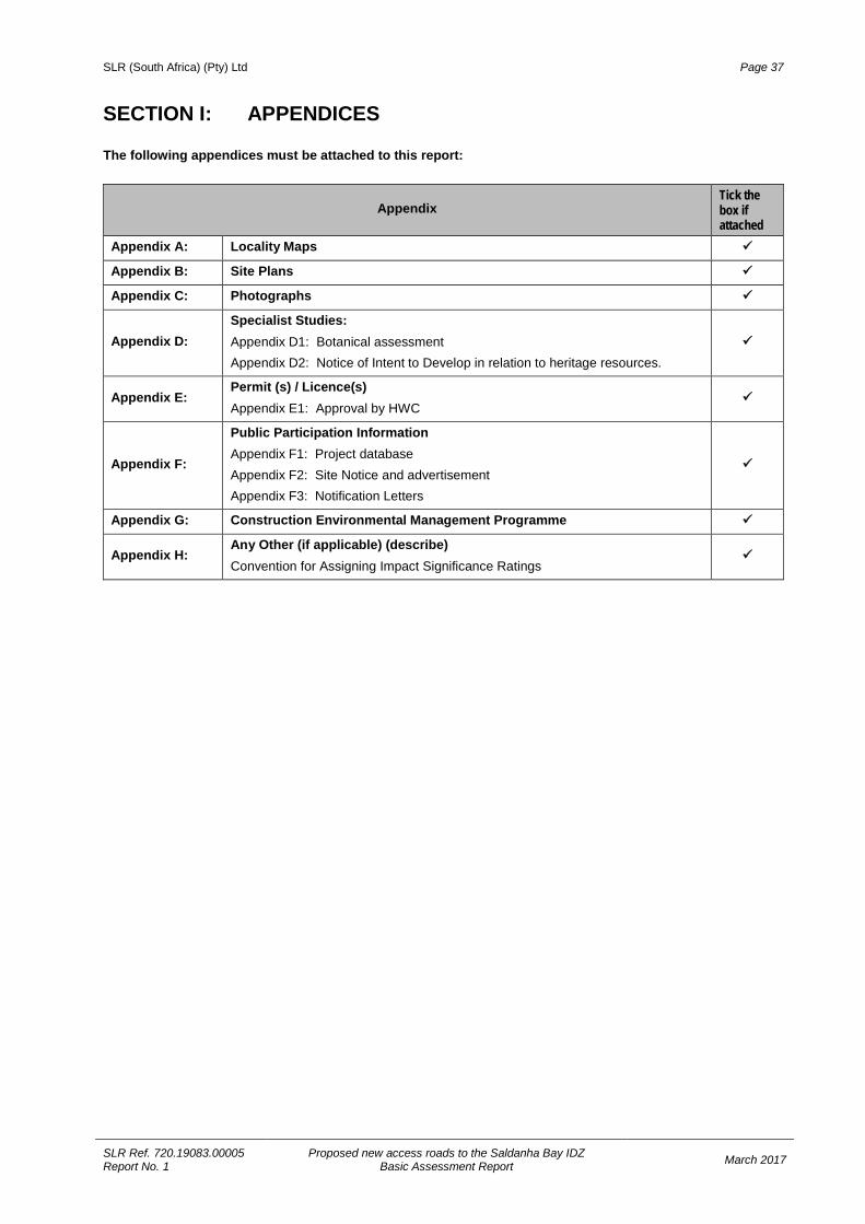
SLR (South Africa) (Pty) Ltd Page 37
SLR Ref. 720.19083.00005 Report No. 1
Proposed new access roads to the Saldanha Bay IDZ Basic Assessment Report March 2017
SECTION I: APPENDICES The following appendices must be attached to this report:
Appendix Tick the box if attached
Appendix A: Locality Maps
Appendix B: Site Plans
Appendix C: Photographs
Appendix D: Specialist Studies: Appendix D1: Botanical assessment Appendix D2: Notice of Intent to Develop in relation to heritage resources.
Appendix E: Permit (s) / Licence(s) Appendix E1: Approval by HWC
Appendix F:
Public Participation Information Appendix F1: Project database Appendix F2: Site Notice and advertisement Appendix F3: Notification Letters
Appendix G: Construction Environmental Management Programme
Appendix H: Any Other (if applicable) (describe) Convention for Assigning Impact Significance Ratings