Embed Size (px)
Citation preview
QUALITY INFORMATION DOCUMENT
Mediterranean Sea and Black Sea
Surface Temperature NRT data
SST-MED-SST-L4-NRT-OBSERVATIONS-010-004
SST-BS-SST-L4-NRT-OBSERVATIONS-010-006
SST_MED_SST_L3S_NRT_OBSERVATIONS_010_012
SST_BS_SST_L3S_NRT_OBSERVATIONS_010_013
Issue: 1.2
Contributors: Bruno Buongiorno Nardelli (CNR), Andrea Pisano (CNR), Cristina Tronconi (CNR).
Approval Date by Quality Assurance Review Group : 10 March 2015
QUID for Mediterranean Sea and Black Sea Surface Temperature Reprocessing
SST-MED-SST-L4-NRT-OBSERVATIONS-010-004
SST-BS-SST-L4-NRT-OBSERVATIONS-010-006
SST-MED-SST-L3S-NRT-OBSERVATIONS-010-012
SST-BS-SST-L3S-NRT-OBSERVATIONS-010-013
Ref: CMEMS-OSI-QUID-010-004-006-012-013
Date : 05/03/2015
Issue : 1.2
© EU Copernicus Marine Service – Public Page 2/ 18
CHANGE RECORD
Issue Date § Description of Change Author Validated By
1.0 09/02/2015 all First version of document B.Buongiorno Nardelli, A. Pisano, C.Tronconi
1.1 05/03/2015 2,3,5 Modified after QUARG review B.Buongiorno Nardelli, A.Pisano
1.2 May 1 2015 all Change format to fit CMEMS graphical rules. Introduce references to CMEMS.
B. Hackett L. Crosnier
QUID for Mediterranean Sea and Black Sea Surface Temperature Reprocessing
SST-MED-SST-L4-NRT-OBSERVATIONS-010-004
SST-BS-SST-L4-NRT-OBSERVATIONS-010-006
SST-MED-SST-L3S-NRT-OBSERVATIONS-010-012
SST-BS-SST-L3S-NRT-OBSERVATIONS-010-013
Ref: CMEMS-OSI-QUID-010-004-006-012-013
Date : 05/03/2015
Issue : 1.2
© EU Copernicus Marine Service – Public Page 3/ 18
TABLE OF CONTENTS
I Executive summary ........................................................................................................................................ 4
I.1 Products covered by this document ............................................................................................................. 4
I.2 Summary of the results ................................................................................................................................. 4
I.3 Estimated Accuracy Numbers ....................................................................................................................... 5
II Production Subsystem description ................................................................................................................ 6
II.1 Processing chain at CNR-ISAC-GOS .............................................................................................................. 6
Sensor bias adjustment, super-collating and additional cloud screening (M3) ............................................. 7
III Validation frameworK ................................................................................................................................. 10
IV Validation results ......................................................................................................................................... 11
IV.1 Multi-sensor (level 3) and analysis (level 4) SST products over the Mediterranean Sea (010-
012/010-004) .................................................................................................................................................... 11
IV.2 Multi-sensor (level 3) and analysis (level 4) SST products over the Black Sea (010-013/010-006) .. 14
V Quality changes since previous version ...................................................................................................... 17
VI References .................................................................................................................................................... 18
QUID for Mediterranean Sea and Black Sea Surface Temperature Reprocessing
SST-MED-SST-L4-NRT-OBSERVATIONS-010-004
SST-BS-SST-L4-NRT-OBSERVATIONS-010-006
SST-MED-SST-L3S-NRT-OBSERVATIONS-010-012
SST-BS-SST-L3S-NRT-OBSERVATIONS-010-013
Ref: CMEMS-OSI-QUID-010-004-006-012-013
Date : 05/03/2015
Issue : 1.2
© EU Copernicus Marine Service – Public Page 4/ 18
I EXECUTIVE SUMMARY
I.1 Products covered by this document
This document describes the quality of the four regional ocean SST reprocessing products:
Product Name Production Unit
SST_MED_SST_L4_NRT_OBSERVATIONS_010_004 CNR-ISAC-GOS (Roma)
SST_BS_SST_L4_NRT_OBSERVATIONS_010_006 CNR-ISAC-GOS (Roma)
SST_MED_SST_L3S_NRT_OBSERVATIONS_010_012 CNR-ISAC-GOS (Roma)
SST_BS_SST_L3S_NRT_OBSERVATIONS_010_013 CNR-ISAC-GOS (Roma)
The L3S data correspond to supercollated (merged-multisensor) L3P SST data remapped over the Mediterranean and Black Seas, at high (HR=1/16°) and ultra-high (UHR=1/100°) spatial resolution, keeping only night SST values.
The L3S data are produced selecting only the highest quality input data from input L2P images within a short temporal window (local night-time), to avoid diurnal cycle and cloud contamination. Consequently, the L3S processing is run daily, but L3S files are produced only if valid SST measurements are present on the area considered.
The L4 products correspond to daily (night-time) gridded optimally interpolated satellite estimates of the foundation SST over the Mediterranean and Black Seas, respectively, at high (HR=1/16°) and ultra-high (UHR=1/100°) spatial resolution and are representative of night SST values (00:00 UTC). They are produced daily and reprocessed after one month to guarantee the maximum quality in the archived datasets (using a symmetrical temporal window in the interpolation algorithm).
The data used as input to the optimal interpolation are the regional night-time L3S described above. When no L3S data for the analysis day are present, the L4 is produced combining a first guess field with available L3S data from previous days.
I.2 Summary of the results
The accuracy of the SST NRT L4 products has been assessed using a comparison to independent drifter data for the period January-December 2014. Drifter data were provided by the CMEMS-OSI-QUID-010-001-V1.2 INSITU TAC. The mean bias and standard deviation error for the MED HR NRT L4 product are -0.07 K and 0.44 K (-0.05 K and 0.43 K for the MED UHR NRT L4), respectively. The mean
QUID for Mediterranean Sea and Black Sea Surface Temperature Reprocessing
SST-MED-SST-L4-NRT-OBSERVATIONS-010-004
SST-BS-SST-L4-NRT-OBSERVATIONS-010-006
SST-MED-SST-L3S-NRT-OBSERVATIONS-010-012
SST-BS-SST-L3S-NRT-OBSERVATIONS-010-013
Ref: CMEMS-OSI-QUID-010-004-006-012-013
Date : 05/03/2015
Issue : 1.2
© EU Copernicus Marine Service – Public Page 5/ 18
bias and standard deviation error for the BS NRT L4 product are -0.14 K and 0.59 K (-0.17 K and 0.58 K for BS UHR L4), respectively.
The accuracy of the SST NRT HR/UHR L4 over the Black Sea is only slightly worse (in terms of standard deviation) than the Mediterranean ones. However, the statistics for the BS are based on a much lower number of in-situ SST measurements than over the MED for the period considered.
Both for MED and BS L4 products, the formal optimal interpolation error (analysis_error variable) results to slightly overestimate the standard deviation of the difference between corresponding interpolated data and insitu measurements, evaluated at fixed bins. However, it also appears to remain almost constant at all interpolation error levels.
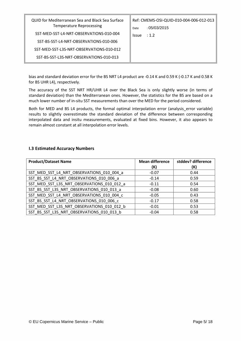
I.3 Estimated Accuracy Numbers
Product/Dataset Name Mean difference (K)
stddev? difference (K)
SST_MED_SST_L4_NRT_OBSERVATIONS_010_004_a -0.07 0.44
SST_BS_SST_L4_NRT_OBSERVATIONS_010_006_a -0.14 0.59
SST_MED_SST_L3S_NRT_OBSERVATIONS_010_012_a -0.11 0.54
SST_BS_SST_L3S_NRT_OBSERVATIONS_010_013_a -0.08 0.60
SST_MED_SST_L4_NRT_OBSERVATIONS_010_004_c -0.05 0.43
SST_BS_SST_L4_NRT_OBSERVATIONS_010_006_c -0.17 0.58
SST_MED_SST_L3S_NRT_OBSERVATIONS_010_012_b -0.01 0.53
SST_BS_SST_L3S_NRT_OBSERVATIONS_010_013_b -0.04 0.58
QUID for Mediterranean Sea and Black Sea Surface Temperature Reprocessing
SST-MED-SST-L4-NRT-OBSERVATIONS-010-004
SST-BS-SST-L4-NRT-OBSERVATIONS-010-006
SST-MED-SST-L3S-NRT-OBSERVATIONS-010-012
SST-BS-SST-L3S-NRT-OBSERVATIONS-010-013
Ref: CMEMS-OSI-QUID-010-004-006-012-013
Date : 05/03/2015
Issue : 1.2
© EU Copernicus Marine Service – Public Page 6/ 18
II PRODUCTION SUBSYSTEM DESCRIPTION
II.1 Processing chain at CNR-ISAC-GOS
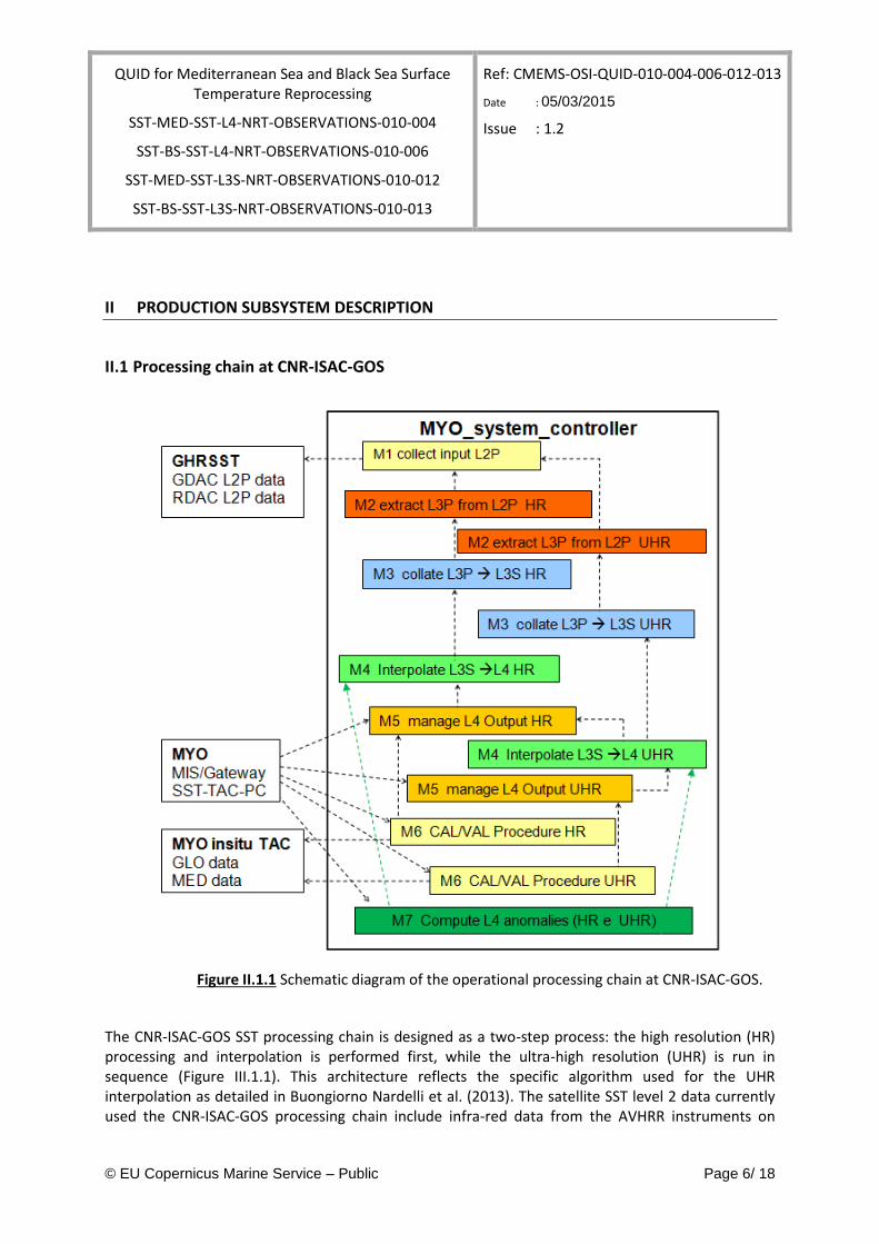
Figure II.1.1 Schematic diagram of the operational processing chain at CNR-ISAC-GOS.
The CNR-ISAC-GOS SST processing chain is designed as a two-step process: the high resolution (HR) processing and interpolation is performed first, while the ultra-high resolution (UHR) is run in sequence (Figure III.1.1). This architecture reflects the specific algorithm used for the UHR interpolation as detailed in Buongiorno Nardelli et al. (2013). The satellite SST level 2 data currently used the CNR-ISAC-GOS processing chain include infra-red data from the AVHRR instruments on
QUID for Mediterranean Sea and Black Sea Surface Temperature Reprocessing
SST-MED-SST-L4-NRT-OBSERVATIONS-010-004
SST-BS-SST-L4-NRT-OBSERVATIONS-010-006
SST-MED-SST-L3S-NRT-OBSERVATIONS-010-012
SST-BS-SST-L3S-NRT-OBSERVATIONS-010-013
Ref: CMEMS-OSI-QUID-010-004-006-012-013
Date : 05/03/2015
Issue : 1.2
© EU Copernicus Marine Service – Public Page 7/ 18
board NOAA and MetOp-A satellites, from SEVIRI on board the MSG satellite. These data are collected in near real-time from various satellite SST producers (NOAA, EUMETSAT SAF on Ocean and Sea Ice, ESA) in GHRSST L2P format.
The whole chain is organized in different modules/packages described here as ‘logical’ steps, that apply to both the HR and the UHR L4 processing.
Data selection and quality control
SST data are thus first extracted basing on the geographical coverage and local time of the observations, on pixel basis. To avoid diurnal warming contamination (Buongiorno Nardelli et al., 2005), the ISAC-GOS system only selects the observations collected between 9 p.m. and 6 a.m. (local pixel time), i.e. the night-time L3C PFV52 data. L3P data preliminary selection is then performed, starting from the quality flags and confidence values associated to each pixel. Only highest quality flag data are retained. Selected valid data are then remapped over the final interpolation grids (L3P). The Mediterranean HR grid corresponds to the first level of the CMEMS Mediterranean Modelling and Forcasting Centre (MFC) 1/16° grid. A similar grid has been developed for the Black sea (at 1/16°). All UHR grids have been generated from the global land/sea tag file NAVOCEANO (http://www.ghrsst-pp.org/GHRSST-PP-NAVO-Land-and-sea-Mask.html).
Sensor bias adjustment, super-collating and additional cloud screening (M3)
The different L3P images (if present) are merged into a single daily super-collated image (L3S). However, the SST estimated from one sensor might significantly differ from that retrieved by another, mainly as a consequence of the differences among the sensors (number of bands, spectral resolution, scanning/viewing geometry, etc.) and/or of the different algorithms applied, which, in particular, might correct very differently the atmospheric contribution to the measured brightness temperature. Consequently, a bias adjustment procedure is applied to L3P data before super-collating. Two different algorithms are used in the CNR HR and UHR processing.
The HR scheme selects the ‘best’ measure available for each pixel and corrects the biases among the images by adjusting them to a reference SST (which is updated every time a corrected image is added to the merged map). Here, ‘best’ is defined through a pre-determined sensor validation statistics, and a simple hierarchy of sensors is identified coherently. During the collating procedure, before adding the new data to the merged map, the large scale bias between each new image and the pixels that have already been merged is estimated and removed. In this phase, an additional check on cloud contamination is performed by flagging the pixels that result to be colder (by a fixed threshold) than the previous day value, as measured in the corresponding L3S.
The UHR scheme is based on a different definition of ‘best’ measure, which keeps into account the continuity of the data present in the single image. The bias is not estimated with respect to the higher accuracy sensor data but between each image and the first guess field, which is build directly from the HR L4 SST (see section III.2.3). This bias is estimated and removed locally (50 km). The ‘best’ data are then selected based on a measure of each image data ‘sparseness’ (spotty/scattered data being qualified as ‘worse’).
QUID for Mediterranean Sea and Black Sea Surface Temperature Reprocessing
SST-MED-SST-L4-NRT-OBSERVATIONS-010-004
SST-BS-SST-L4-NRT-OBSERVATIONS-010-006
SST-MED-SST-L3S-NRT-OBSERVATIONS-010-012
SST-BS-SST-L3S-NRT-OBSERVATIONS-010-013
Ref: CMEMS-OSI-QUID-010-004-006-012-013
Date : 05/03/2015
Issue : 1.2
© EU Copernicus Marine Service – Public Page 8/ 18
Optimal interpolation algorithm
Different optimal interpolation (OI) schemes have been adopted for the Mediterranean and Black Sea CMEMS SST data reprocessing.
L4 analyses are obtained as a linear combination of the observations (namely, of the SST anomalies with respect to a background field), weighted directly with their correlation to the interpolation point and inversely with their cross-correlation and error. OI theory assumes the statistical characteristics of the parameter variability are known (background error covariance and observation error covariance). While several operational systems are based on purely spatial OI algorithms, using daily increments as input data (i.e. using previous day analysis as a first guess, and eventually relaxating to a climatology in the absence of new observations, e.g. Donlon et al., 2012, and references therein), CNR schemes directly apply a space-time OI.
The CMEMS CNR statistical interpolation schemes use different background fields and covariance models depending on the product.
BLK HR L4 processing uses a daily pentad climatology as first guess (built from 21 years of AVHRR Pathfinder data), and all its characteristics (first guess computation, covariance model, data sub-sampling strategy, inversion technique, etc.) are fully documented in Buongiorno Nardelli et al. (2010).
Until MyOcean V4 service release, MED HR L4 processing used a daily pentad climatology as first guess (built from 21 years of AVHRR Pathfinder data), and all its characteristics (first guess computation, covariance model, data sub-sampling strategy, inversion technique, etc.) are described in Buongiorno Nardelli et al. (2013).
Since the V4 (operational in April 2014) MED HR L4 processing has been upgraded by using the previous day analysis as first guess and introducing a new covariance function model (new analytical function, spatially variable parameters). A complete description of the algorithm development and validation are described in Buongiorno Nardelli et al. (2015)
The approach used to interpolate the SST at UHR is based on a simple concept concerning scales separation/decomposition. In practice, the lower resolution (HR) L4 map, properly re-binned on the UHR grid (through a simple bilinear algorithm), is used as first guess for a second interpolation step, where the SST anomalies, estimated now at 1 km, only contain the small scale signals.
Both HR and UHR schemes, however, are sub-optimal, in the sense that for each interpolation point the input data are selected only within a limited sub-domain (within a space-time influential radius). In practice, the super-collated L3S data at HR are collected within a temporal window of ten days, while at UHR only the measurements relative to the same day and two previous days are used. The spatial influential radius ranges between 300 and 900 km at HR and is limited to 20 km at UHR.
Before entering the influential data selection within each analysis, super-collated L3 images are checked for residual cloudy pixels at both resolutions. In practice, cloud margins are first eroded, flagging all values within a distance of two pixels to a pixel already flagged as cloudy. A second check is then performed through the comparison to the closer (in time) L4 analysis available, which is used as a reference only if the analysis error is lower than a fixed value.
QUID for Mediterranean Sea and Black Sea Surface Temperature Reprocessing
SST-MED-SST-L4-NRT-OBSERVATIONS-010-004
SST-BS-SST-L4-NRT-OBSERVATIONS-010-006
SST-MED-SST-L3S-NRT-OBSERVATIONS-010-012
SST-BS-SST-L3S-NRT-OBSERVATIONS-010-013
Ref: CMEMS-OSI-QUID-010-004-006-012-013
Date : 05/03/2015
Issue : 1.2
© EU Copernicus Marine Service – Public Page 9/ 18
The background UHR covariance model has been defined as a result of empirical tests. The spatial decorrelation lengths have been varied between 5 and 15 km, but very little differences have been found on the interpolated maps in the whole range considered. The smaller value is currently used in the operational chain. On the opposite, the time scale has been set to 1 day, in order to avoid the sudden growth of fake spatial SST gradients in areas differently covered by satellite observations during successive days.
To avoid data propagation across land, the OI scheme adopts a specific input data selection check. In particular, given the interpolation point and the input point selected within the sub-domain, the latter is taken into account for the interpolation only if there is no a land pixel between the straight line connecting the two points.
The interpolation error is obtained from the formal definition of the error variance derived from OI theory (e.g. Bretherton et al. 1976).
QUID for Mediterranean Sea and Black Sea Surface Temperature Reprocessing
SST-MED-SST-L4-NRT-OBSERVATIONS-010-004
SST-BS-SST-L4-NRT-OBSERVATIONS-010-006
SST-MED-SST-L3S-NRT-OBSERVATIONS-010-012
SST-BS-SST-L3S-NRT-OBSERVATIONS-010-013
Ref: CMEMS-OSI-QUID-010-004-006-012-013
Date : 05/03/2015
Issue : 1.2
© EU Copernicus Marine Service – Public Page 10/ 18
III VALIDATION FRAMEWORK
The baseline for the validation of SST TAC products is to use drifting buoy measurements only, as recommended currently by the GHRSST group on satellite SST validation (STVAL).
More in details, the validation activities carried out at CNR-ISAC-GOS are based on the compilation of a match-up database between satellite SST products and surface drifting buoys measurements. More specifically, the in-situ SST data used are those made available by the CMEMS INSITU TAC.
Before computing the statistics of the differences between satellite and in-situ SST estimates, specific quality control (QC) procedures and match-up protocols are applied. In fact, drifting buoy sensor may be affected by significant systematic errors or may experience malfunctioning as a consequence of a variety of factors (lost drogue, broken sensor, etc.). As a consequence, only the data that passed all QC test were included in the match-up database. Additional tests include a comparison with the daily climatological SST field that is used to compute the SST L4 anomalies (rejecting all values exceeding a difference of 5°C), and a comparison with the previous day L4 product (rejecting all values exceeding a difference of 1.5°C, which is the same criterion used for satellite L2P data rejection in the CNR-ISAC-GOS operational NRT L4 processing chain).
The match-up has been restricted to night-time data, keeping only one value per buoy. In facts, the drifting buoys collect SST data at regular time intervals (based on an internal clock), while position measurements are recorded at longer time intervals, according to the satellite positioning system. The single SST value per buoy/day used here is the one collected closest (in time) to the position time.
Formal interpolation errors obtained through the OI have also been compared with matchup SST differences.
QUID for Mediterranean Sea and Black Sea Surface Temperature Reprocessing
SST-MED-SST-L4-NRT-OBSERVATIONS-010-004
SST-BS-SST-L4-NRT-OBSERVATIONS-010-006
SST-MED-SST-L3S-NRT-OBSERVATIONS-010-012
SST-BS-SST-L3S-NRT-OBSERVATIONS-010-013
Ref: CMEMS-OSI-QUID-010-004-006-012-013
Date : 05/03/2015
Issue : 1.2
© EU Copernicus Marine Service – Public Page 11/ 18
IV VALIDATION RESULTS
IV.1 Multi-sensor (level 3) and analysis (level 4) SST products over the Mediterranean Sea (010-012/010-004)
Product Name start date end date sel. area parameter value
SST_MED_SST_L4_NRT_OBSERVATIONS_010_004_a_V2 2014-01-03T00:00 2014-12-31T00:00 med mean -0.07
SST_MED_SST_L4_NRT_OBSERVATIONS_010_004_a_V2 2014-01-03T00:00 2014-12-31T00:00 med stddev 0.44
SST_MED_SST_L4_NRT_OBSERVATIONS_010_004_a_V2 2014-01-03T00:00 2014-12-31T00:00 med nbsamples 6318
SST_MED_SST_L4_NRT_OBSERVATIONS_010_004_c_V2 2014-01-03T00:00 2014-12-31T00:00 med mean -0.05
SST_MED_SST_L4_NRT_OBSERVATIONS_010_004_c_V2 2014-01-03T00:00 2014-12-31T00:00 med stddev 0.43
SST_MED_SST_L4_NRT_OBSERVATIONS_010_004_c_V2 2014-01-03T00:00 2014-12-31T00:00 med nbsamples 6371
SST_MED_SST_L3S_NRT_OBSERVATIONS_010_012_a 2014-01-03T00:00 2014-12-31T00:00 med mean -0.11
SST_MED_SST_L3S_NRT_OBSERVATIONS_010_012_a 2014-01-03T00:00 2014-12-31T00:00 med stddev 0.54
SST_MED_SST_L3S_NRT_OBSERVATIONS_010_012_a 2014-01-03T00:00 2014-12-31T00:00 med nbsamples 4144
SST_MED_SST_L3S_NRT_OBSERVATIONS_010_012_b 2014-01-03T00:00 2014-12-31T00:00 med mean -0.01
SST_MED_SST_L3S_NRT_OBSERVATIONS_010_012_b 2014-01-03T00:00 2014-12-31T00:00 med stddev 0.53
QUID for Mediterranean Sea and Black Sea Surface Temperature Reprocessing
SST-MED-SST-L4-NRT-OBSERVATIONS-010-004
SST-BS-SST-L4-NRT-OBSERVATIONS-010-006
SST-MED-SST-L3S-NRT-OBSERVATIONS-010-012
SST-BS-SST-L3S-NRT-OBSERVATIONS-010-013
Ref: CMEMS-OSI-QUID-010-004-006-012-013
Date : 05/03/2015
Issue : 1.2
© EU Copernicus Marine Service – Public Page 12/ 18
SST_MED_SST_L3S_NRT_OBSERVATIONS_010_012_b 2014-01-03T00:00 2014-12-31T00:00 med nbsamples 2945
Table IV.1.1 Mean (K), standard deviation (K), and number of match-ups for differences between High (SST_MED_SST_L3S_NRT_OBSERVATIONS_010_012_a/
SST_MED_SST_L4_NRT_OBSERVATIONS_010_004_a_V2) and Ultra High (SST_MED_SST_L3S_NRT_OBSERVATIONS_010_012_b/
SST_MED_SST_L4_NRT_OBSERVATIONS_010_004_a_V2) Resolution Med Sea SST L3S/L4 and in-situ SST measurements provided by IN-Situ TAC. The statistics were computed over the Mediterranean
Sea area from 2014-01-03 to 2014-12-31.
QUID for Mediterranean Sea and Black Sea Surface Temperature Reprocessing
SST-MED-SST-L4-NRT-OBSERVATIONS-010-004
SST-BS-SST-L4-NRT-OBSERVATIONS-010-006
SST-MED-SST-L3S-NRT-OBSERVATIONS-010-012
SST-BS-SST-L3S-NRT-OBSERVATIONS-010-013
Ref: CMEMS-OSI-QUID-010-004-006-012-013
Date : 05/03/2015
Issue : 1.2
© EU Copernicus Marine Service – Public Page 13/ 18
a)
b)
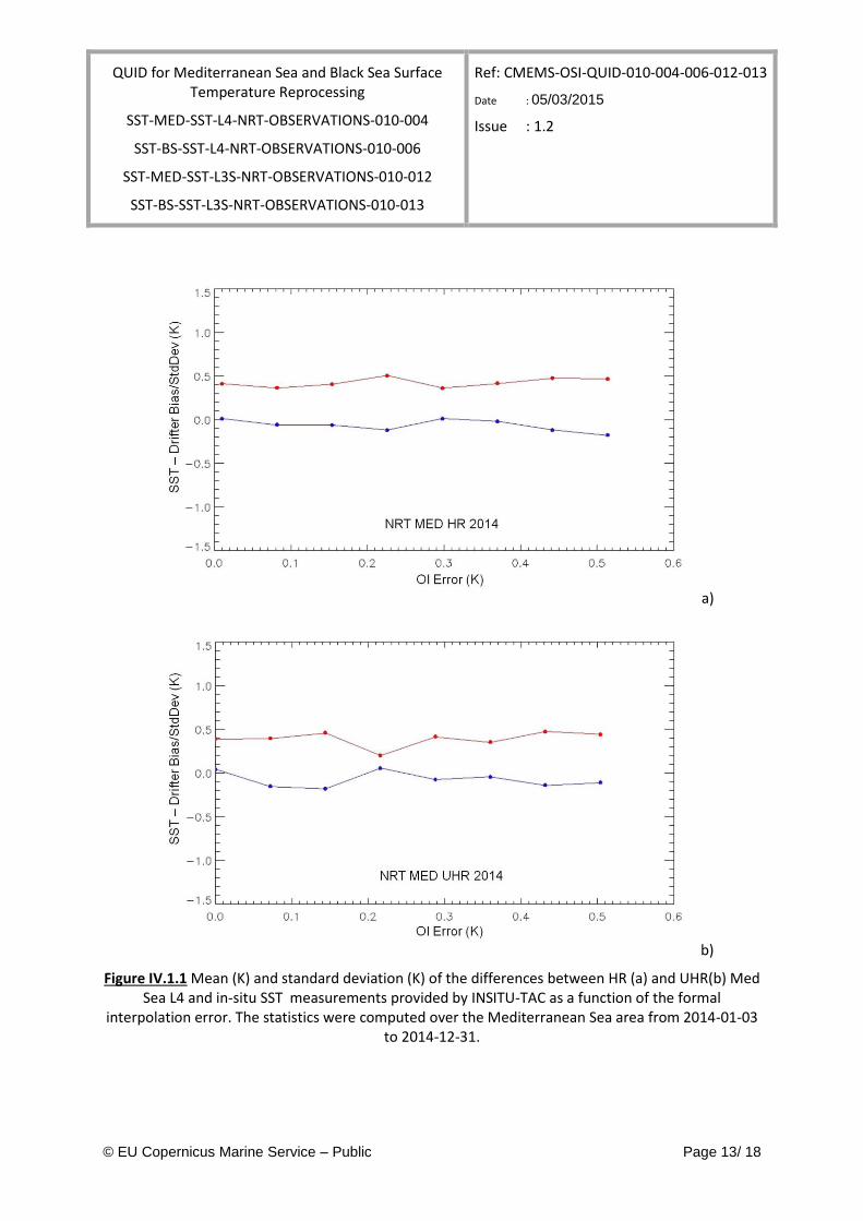
Figure IV.1.1 Mean (K) and standard deviation (K) of the differences between HR (a) and UHR(b) Med Sea L4 and in-situ SST measurements provided by INSITU-TAC as a function of the formal
interpolation error. The statistics were computed over the Mediterranean Sea area from 2014-01-03 to 2014-12-31.
QUID for Mediterranean Sea and Black Sea Surface Temperature Reprocessing
SST-MED-SST-L4-NRT-OBSERVATIONS-010-004
SST-BS-SST-L4-NRT-OBSERVATIONS-010-006
SST-MED-SST-L3S-NRT-OBSERVATIONS-010-012
SST-BS-SST-L3S-NRT-OBSERVATIONS-010-013
Ref: CMEMS-OSI-QUID-010-004-006-012-013
Date : 05/03/2015
Issue : 1.2
© EU Copernicus Marine Service – Public Page 14/ 18
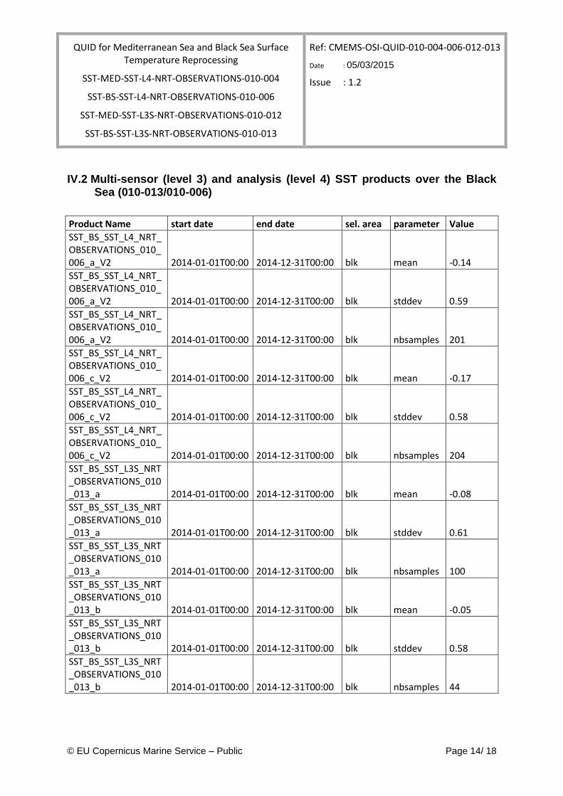
IV.2 Multi-sensor (level 3) and analysis (level 4) SST products over the Black Sea (010-013/010-006)
Product Name start date end date sel. area parameter Value
SST_BS_SST_L4_NRT_OBSERVATIONS_010_006_a_V2 2014-01-01T00:00 2014-12-31T00:00 blk mean -0.14
SST_BS_SST_L4_NRT_OBSERVATIONS_010_006_a_V2 2014-01-01T00:00 2014-12-31T00:00 blk stddev 0.59
SST_BS_SST_L4_NRT_OBSERVATIONS_010_006_a_V2 2014-01-01T00:00 2014-12-31T00:00 blk nbsamples 201
SST_BS_SST_L4_NRT_OBSERVATIONS_010_006_c_V2 2014-01-01T00:00 2014-12-31T00:00 blk mean -0.17
SST_BS_SST_L4_NRT_OBSERVATIONS_010_006_c_V2 2014-01-01T00:00 2014-12-31T00:00 blk stddev 0.58
SST_BS_SST_L4_NRT_OBSERVATIONS_010_006_c_V2 2014-01-01T00:00 2014-12-31T00:00 blk nbsamples 204
SST_BS_SST_L3S_NRT_OBSERVATIONS_010_013_a 2014-01-01T00:00 2014-12-31T00:00 blk mean -0.08
SST_BS_SST_L3S_NRT_OBSERVATIONS_010_013_a 2014-01-01T00:00 2014-12-31T00:00 blk stddev 0.61
SST_BS_SST_L3S_NRT_OBSERVATIONS_010_013_a 2014-01-01T00:00 2014-12-31T00:00 blk nbsamples 100
SST_BS_SST_L3S_NRT_OBSERVATIONS_010_013_b 2014-01-01T00:00 2014-12-31T00:00 blk mean -0.05
SST_BS_SST_L3S_NRT_OBSERVATIONS_010_013_b 2014-01-01T00:00 2014-12-31T00:00 blk stddev 0.58
SST_BS_SST_L3S_NRT_OBSERVATIONS_010_013_b 2014-01-01T00:00 2014-12-31T00:00 blk nbsamples 44
QUID for Mediterranean Sea and Black Sea Surface Temperature Reprocessing
SST-MED-SST-L4-NRT-OBSERVATIONS-010-004
SST-BS-SST-L4-NRT-OBSERVATIONS-010-006
SST-MED-SST-L3S-NRT-OBSERVATIONS-010-012
SST-BS-SST-L3S-NRT-OBSERVATIONS-010-013
Ref: CMEMS-OSI-QUID-010-004-006-012-013
Date : 05/03/2015
Issue : 1.2
© EU Copernicus Marine Service – Public Page 15/ 18
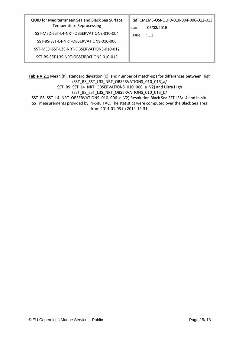
Table V.2.1 Mean (K), standard deviation (K), and number of match-ups for differences between High (SST_BS_SST_L3S_NRT_OBSERVATIONS_010_013_a/
SST_BS_SST_L4_NRT_OBSERVATIONS_010_006_a_V2) and Ultra High (SST_BS_SST_L3S_NRT_OBSERVATIONS_010_013_b/
SST_BS_SST_L4_NRT_OBSERVATIONS_010_006_c_V2) Resolution Black Sea SST L3S/L4 and in-situ SST measurements provided by IN-Situ TAC. The statistics were computed over the Black Sea area
from 2014-01-03 to 2014-12-31.
QUID for Mediterranean Sea and Black Sea Surface Temperature Reprocessing
SST-MED-SST-L4-NRT-OBSERVATIONS-010-004
SST-BS-SST-L4-NRT-OBSERVATIONS-010-006
SST-MED-SST-L3S-NRT-OBSERVATIONS-010-012
SST-BS-SST-L3S-NRT-OBSERVATIONS-010-013
Ref: CMEMS-OSI-QUID-010-004-006-012-013
Date : 05/03/2015
Issue : 1.2
© EU Copernicus Marine Service – Public Page 16/ 18
a)
b)
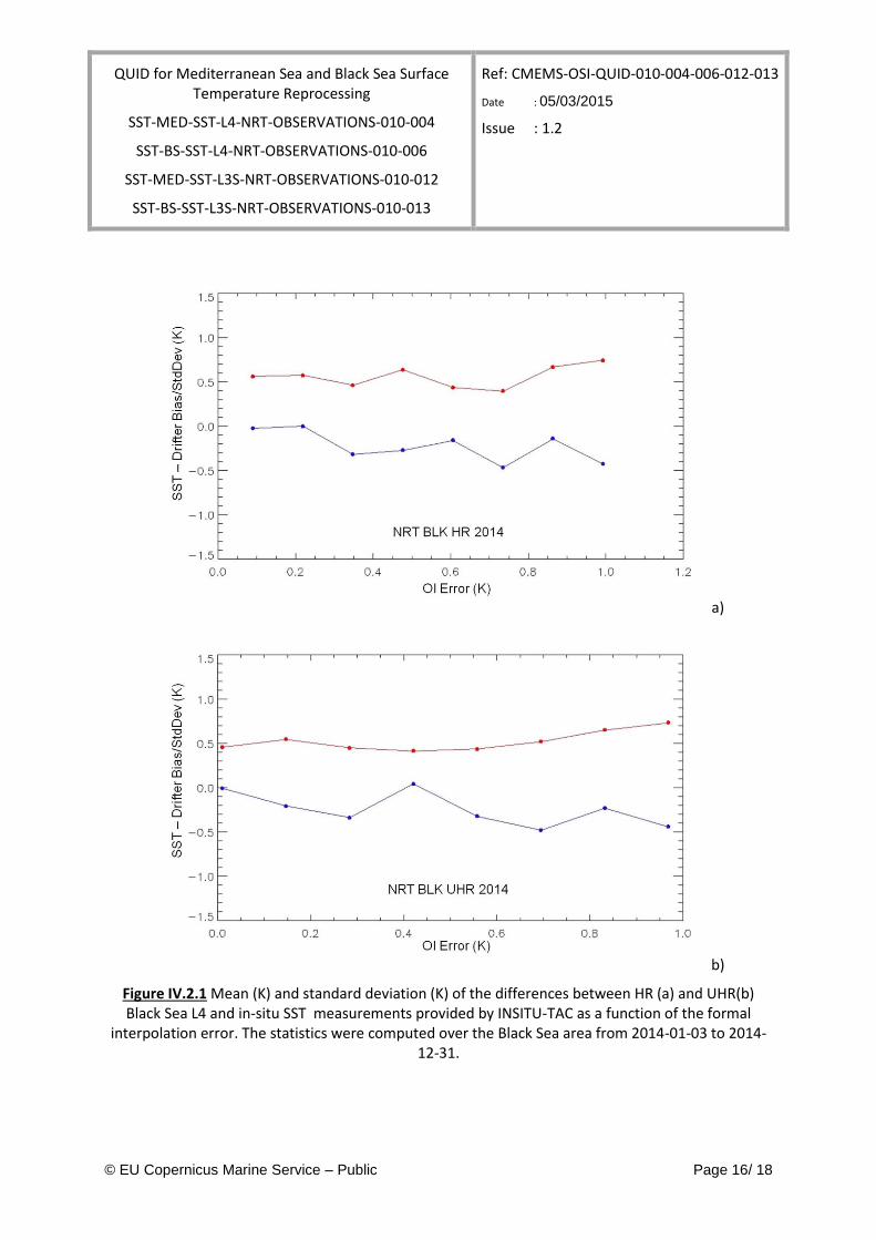
Figure IV.2.1 Mean (K) and standard deviation (K) of the differences between HR (a) and UHR(b) Black Sea L4 and in-situ SST measurements provided by INSITU-TAC as a function of the formal
interpolation error. The statistics were computed over the Black Sea area from 2014-01-03 to 2014-12-31.
QUID for Mediterranean Sea and Black Sea Surface Temperature Reprocessing
SST-MED-SST-L4-NRT-OBSERVATIONS-010-004
SST-BS-SST-L4-NRT-OBSERVATIONS-010-006
SST-MED-SST-L3S-NRT-OBSERVATIONS-010-012
SST-BS-SST-L3S-NRT-OBSERVATIONS-010-013
Ref: CMEMS-OSI-QUID-010-004-006-012-013
Date : 05/03/2015
Issue : 1.2
© EU Copernicus Marine Service – Public Page 17/ 18
V QUALITY CHANGES SINCE PREVIOUS VERSION
QUID for Mediterranean Sea and Black Sea Surface Temperature Reprocessing
SST-MED-SST-L4-NRT-OBSERVATIONS-010-004
SST-BS-SST-L4-NRT-OBSERVATIONS-010-006
SST-MED-SST-L3S-NRT-OBSERVATIONS-010-012
SST-BS-SST-L3S-NRT-OBSERVATIONS-010-013
Ref: CMEMS-OSI-QUID-010-004-006-012-013
Date : 05/03/2015
Issue : 1.2
© EU Copernicus Marine Service – Public Page 18/ 18
VI REFERENCES
Bretherton, F.P., Davis, R.E. & Fandry, C.B., 1976: A technique for objective analysis and design of oceanographic experiments applied to MODE-73. Deep Sea Res., 23, 559–582.
Buongiorno Nardelli B., Marullo S. and R Santoleri, 2005. Diurnal variations in AVHRR SST fields: a strategy for removing warm layer effects from daily images., Rem. Sens. Env., 95, 47-56, doi:10.1016/j.rse.2004.12.005.
Buongiorno Nardelli B., S. Colella, R. Santoleri, M. Guarracino, A. Kholod, 2010: A re-analysis of Black Sea Surface Temperature, J. Mar. Sys., 79, 1-2, 50-64, doi:10.1016/j.jmarsys.2009.07.001.
Buongiorno Nardelli B., C.Tronconi, A. Pisano, R.Santoleri, 2013: High and Ultra-High resolution processing of satellite Sea Surface Temperature data over Southern European Seas in the framework of MyOcean project, Rem. Sens. Env., 129, 1-16, doi:10.1016/j.rse.2012.10.012.
Buongiorno Nardelli B., A.Pisano, C.Tronconi, Santoleri R., 2015: Evaluation of different covariance models for the operational interpolation of high resolution satellite Sea Surface Temperature data over the Mediterranean Sea, accepted subject to minor revisions on Rem. Sens. Env.
Donlon, C. J., M. Martin, J. Stark, J. Roberts-Jones, E. Fiedler, and W. Wimmer, 2012: The Operational Sea Surface Temperature and Sea Ice Analysis (OSTIA) system. Rem. Sens. Env., 116, 140–158, doi:10.1016/j.rse.2010.10.017.
.