Embed Size (px)
Citation preview

https://ntrs.nasa.gov/search.jsp?R=19690018862 2018-06-10T02:41:32+00:00Z

AppliCatirms of Earth-Oriented Satellites
SUMMARIES OF PANEL REPORTS
SUMMER STUDY ON SPACE APPLICATIONS Division of Engineering National Research Council for the NATIONAL AERONAUTICS AND SPACE ADMINISTRATION
Published by NATIONAL ACADEMY OF SCIENCES Washington,D.C. I 1969

This is a report of work under Contract No. NSR 09-012-909 (1967) between the Nationd Aeronautics and Space Administration and the Nationd Academy of Sciences
Available from Printing and Publishing Office National Academy of Sciences 2101 Constitution Avenue Washington, D.C. 20418

PREFACE
In the fall of 1966, the National Aeronautics and Space Administration asked the National Academy of Sciences to conduct a study on “the probable future usefulness of satellites in practical Earth-oriented applications.” Over a period of two years, the study would obtain the recommendations of highly qualified scientists and engineers on the nature and scope of the research and development program believed necessary to provide the technology required to exploit these applications. NASA subsequently asked that the study include a consideration of economic factors.
Work began on the project, designated the “Summer Study on Space Applications,” in January 1967, guided by a Central Review Committee (CRC) appointed by the Academy. The Study’s chairman was Dr. W. Deming Lewis, President of Lehigh University.
Technical Panels were convened to scrutinize practical space applications in the following fields, and to prepare reports on their findings.
Panel 1 : Forestry-Agriculture-Geography Panel 2: Geology Panel 3: Hydrology Panel 4: Meteorology Panel 5 : Oceanography Panel 6: Sensors and Data Systems Panel 7: Points-To-Point Communication Panel 8 : Systems for Remote-Sensing Information
and Distribution Panel 9 : Point-to-Point Communications Panel 10: Broadcasting Panel 1 1 : Navigation and Traffic Control Panel 12 : Economic Analysis Panel 13 : Geodesy and Cartography

During the summer of 1968, the Central Review Committee reviewed all the Panel Reports and used these extensively in preparing its own final report. The major part of the Study was accomplished by the Panels; the function of CRC was to review their work, to evaluate their findings, and, in the context of the total national picture, to derive certain conclusions and recommendations. The Committee was impressed by the quality of the Panels’ work and has asked that the Panel Reports be made available to specialized audiences. While the Committee is in general accord with the final Panel Reports, it does not necessarily endorse them or the conclusions and recommendations in every detail. It chose to emphasize certain recommendations in its own overall conclusions and recommendations, which have been presented in “Useful Applications of Earth-Oriented Satellites: Report of the Central Review Committee.”
The Committee felt that readers of its report would be interested in a synopsis of each Panel’s activity. Accordingly, the Panel Reports (which are available separately) have been summarized, and the summaries have been assembled in this volume, to accompany the CRC Report. Included also is a report by Dr. Thomas F. Malone, who headed an ad hoc group that considered the international aspects of space applications. In concluding this preface, it is emphasized that the conclusions and recommendations of these Panel Reports should be considered within the context of the overall report of the Central Review Committee.

CONTENTS
Page THE SUMMER STUDY ON SPACE APPLICATIONS
SUMMARY. Panel 1 SUMMARY. Panel 2 SUMMARY. Panel 3 SUMMARY. Panel 4 SUMMARY. Panel 5 SUMMARY. Panel 6 SUMMARY. Panel 7 SUMMARY. Panel 8
SUMMARY. Panel 9 SUMMARY. Panel 10 SUMMARY. Panel 1 1 SUMMARY. Panel 12
Forestry-Agriculture-Geography ........ 1 Geology .......................... 7 Hydrology ........................ 13 Meteorology ....................... 16 Oceanography ..................... 21 Sensors and Data Systems ............ 28 Points-to-Point Communications . . . . . . . 31 Systems for Remote-Sensing Information and Distribution . . . . . . . . . . 35 Point-to-Point Communications . . . . . . . . 40 Broadcasting ....................... 47 Navigation and Traffic Control ......... 53 Economic Analysis . . . . . . . . . . . . . . . . . . 57
INTERNATIONAL CONSIDERATIONS IN SPACE APPLICATIONS byThomasF.Malone ................................. 73
SUMMER STUDY PARTICIPANTS ............................ 87

PANEL 1 : FORESTRY-AGRICULTUREGEOGRAPHY
SUMMARY
DESCRIPTION OF THE FIELD
The United States has the most efficiently operated agricultural business in the world. One of the factors that has contributed to this success is an efficient crop-reporting and land-use system that has been developed by U. S. farmers and the Department of Agriculture. This information system has been of value to the government in establishing agricultural policy, and to individual farmers in the conduct of their daily business. As the world enters a period of increasing population and potential food shortages, the necessity of applying new technology for the improvement of such information systems, in the United States and worldwide, becomes apparent .
As the world’s population continues to grow, there is an accelerating shift to dense urban megalopolises; man’s urban, rural and wildland environments deteriorate; and critical questions arise about the world’s capacity to provide and distribute food-particularly to adjust to changing seasonal crop conditions. The earth is now recognized as one large spacecraft whose self-contained environment must be maintained indefinitely by wise management of its food, fiber, water, air and other natural-resource systems. To do so requires near real-time knowledge of man’s interaction with many of these factors.
Urbanization as a process in the United States, as well as in developing countries, is little understood; and its spread is so rapid that information available to local, state, and federal governments is neither accurate nor timely enough for effective management and planning.
Maps and statistical summaries and analyses are published two to ten years after data are collected. Small-scale maps are neither
1

uniform nor current-in fact, 70 percent of the world’s present maps (at scale of 1:600,000 or smaller) are deemed inadequate, and the remaining 30 percent are obsolete.
Information that requires up-dating at frequent intervals (e.g., snow-pack changes for predicting water yield, air- and water-pollution states, seasonal crop-condition reports for agribusiness, surveys of natural and man-made disasters, transportation studies, and urban-area changes) still, for the most part, has to be gathered by on-the-spot surveys by some combination of air photography and ground visits. These conventional methods are too costly for repeated coverage, and the information thus obtained cannot be analyzed in time for user applications.
STATE OF THE ART
Experiments conducted in recent years by NASA, the Department of Agriculture, and universities have demonstrated the power of multi-spectral sensing techniques and multi-spectral photography for applications in the agriculture-forestry-geography area. Various kinds of trees and crops reflect light in the bands of the visible and infrared spectral ranges, in differing degrees. Imagery made in this way and combined in a special manner can reveal, within limits, the identity of the types of vegetation observed. Heretofore, this work has been conducted mostly from aircraft, but there appears to be no fundamental reason why such techniques could not be used from more distant space.
With the improvement of agricultural efficiency has come increased urbanization. The geographers of our Study have indicated that the new multi-spectral techniques can provide information useful for urban and suburban planning. For example, imagery taken at yearly intervals can make apparent the patterns of urban growth and changing land uses, on national and international scales. The new technology can be of great use in this area because of its scale economies in data collection,
BENEFITS
The Report of the Forestry-Agriculture-Geography Panel contains conservative estimates of the value satellite reporting
2
systems might have to the agriculture and forestry industry, United States and world-wide. These add up to many tens of millions of dollars per year. A comparable analysis was not made for urban and regional planning, or for management and policy questions about large area systems such as river basins; but it is likely that these benefits could equal or surpass those projected for agriculture and forestry.
No attempt was made to anticipate potential benefits that might stem from associated new technological or management systems. However, the more intangible effects of increasing the efficiency of farming and forestry through new satellite technology are potentially significant, particularly as population pressures will require that the earth be treated as one agricultural cooperative. Modest improvements in agricultural efficiencies in developing countries, for example, can often mean the difference between subsistence and starvation, between stable and unstable governments. Crop- and forestry-information systems in themselves will not solve world food problems. Nevertheless, efficient agriculture and forestry practices, in the modern sense, cannot proceed without such information.
GOALS
At the beginning of its study, the Forestry-Agriculture- Geography Panel verified three general assumptions:
That increased knowledge of earth resources will benefit society and contribute significantly to the progress desired by both the developed and undeveloped segments of society
That data obtained by remote sensing can contribute to earth-resources knowledge
That space technology developed by NASA and others can be effectively applied to provide the space-borne platforms, sensors, and communication links required
In fact there is little doubt that there is immediate need for a
3

program that utilizes space technology to collect earth-resources data in the following two areas where remote sensing is now technically feasible for:
Inventory and productivity evaluation of the world’s food, fiber, and other natural resources
Assessment of environmental conditions and of man-environ- ment interactions
The focus of the Panel then shifted to the problem of how to establish and implement an earth-resources information program. Many technical and non-technical considerations are involved in this problem, including the criteria to be used in formulating a program and organization to:
Provide the earliest possible benefits, by initiating operations in appropriate aircraft and spacecraft with state-of-the-art sensors, to deliver earth-resources data to skilled interpreters and analysts in existing organizations;
Provide optimum long-term benefits, by initiating appropriate R&D programs to improve the ability and capability to obtain and interpret greater quantities and better qualities of data;
Accomplish the steps above at an acceptable budgetary level and within a reasonable time-frame.
POSTULATED PROGRAMS
The systems visualized by the Panel are designed to collect appropriate synoptic data on a timely basis, and to interpret, analyze, and present them in the form of useful information in four broad categories:
Synoptic information for management activities such as planning programs, predicting crop yields, manipulating snow packs and regulating water flows, and planning game harvests
Spot information required for on-the-ground management decisions such as planting plans and pest-control measures
4

Emergency information to determine the extent of disaster damages and to plan relief and rehabilitation measures
Scientific information for research and education
Within three years, a Global Land Use satellite system that provides imagery could be made operational. It would give synoptic coverage in 10,000-square mile thematic photographs leading to: land-use maps; indirect yield estimates for major food and forage crops; area measurements of water, snow, ice, vegetation types and conditions; surveys of urban areas and condition changes, cultural features, and transportation nets.
This first-generation system, though separately identified, is envisaged as part of a major R&D program aimed at developing a multi-channel, multi-sensor aerospace system linked to a national System for Earth Resources Information (SERI) which could be completely operational in 12 years. Such a system would produce synoptic, timely information in formats required for direct use by agribusiness and resource industries; by local, state, regional, and federal agencies responsible for planning and action programs; and by other countries and international agencies.
The characteristics of that R&D program must include a selection of the most important problems and priorities, a dedicated effort to prove feasibility of solution by the combined talents of scientists and engineers who carry the solution to a test-operational phase, and the organization of these efforts around data-processing, ground-truth, and test-platform facilities. The R&D program must be evaluated in terms of its demonstrated and proven implementable programs. These programs will be a marriage of skills in earth-resources sciences for signature analysis (including temporal, spatial, and spectral signatures), data-analysis and sensor skills, and experiment design.
A major recognition of this Panel is that basic sensor-signature research and development has the potential of yielding disproportionately great returns for a relatively modest investment. Such basic sensor-signature research is fundamental to the establishment of reliable ground truth for aerospace sensing, and is considered the likely pacing element in extending the earth-resources applications of space science, especially in the field of spectrometry.
5

RECOMMENDATIONS
We recommend that a satellite program to supply pictorial information be initiated immediately. This early implementation will afford a means to solve many of the future operational problems, and will provide much of the understanding required for future, more sophisticated systems.
We recommend that planning, with appropriate check-points, be initiated for the evolution of that early system to a substantially broader system, using more sophisticated sensors, over a period of the next 10-12 years. Responsibility for the planning and coordination is a critical element of this program; the responsibility should be assigned early and should be clearly defined.
We recommend that the R&D program for this evolution include substantial, focused efforts directed at carrying applications through to the test-operational phase. These efforts are required to prove-in new applications and techniques in a timely manner for incorporation into the evolving system. It is essential that these efforts be exerted according to priority and closely coordinated with the planning of that system.
The broad field of earth resources offers a rich potential for new understanding though-and uses for-the application of remote-sensing and data-handling techniques. Research in these areas is essential to education and training, and to the development of future systems. We recommend significant expansion of the present broad-scope research program.
6

PANEL 2: GEOLOGY
SUMMARY
DESCRIPTION OF THE FIELD
The principal fields of applied geology are exploration for minerals, oil, and gas, and engineering construction.
For many years geologists have made use of aerial photography in their search for oil and minerals, and have become expert in its use. Space imagery is new and has not been available in a systematic way to geologists. Some Gemini photographs have been interpreted by geologists, and have indicated some very promising possibilities. The Gemini photographs in general were not made with optimum sun angles to provide the type of illumination that the geologists would like. Nevertheless, certain types of lineament structures on the earth often associated with mineralization could be identified.
The vast areas of the earth covered by cameras in space, giving photographs with approximately the same conditions of exposure and sun angle, make space photography different from imagery that can be obtained from aircraft. This difference is important to geologists in their search for subtle features of the earth that can give clues as to preferred areas for conducting searches for minerals.
Another recent development of interest to geologists in their search for minerals is the side-looking radar. Imagery made by this means from aircraft reveals earth structures that have geological significance. Aircraft may prove to be the most suitable vehicles from which to make observations of this kind, but space applications may become feasible in the future.
Much still remains to be done in relating remote sensing to classical geologic practice. Geology has many remote-sensing
7

requirements in common with cartography, agriculture, and hydrology; but the need for viewing with low-angle illumination to reveal geologic features in relief may require a special launch characteristic. Such low-angle illuminations may require double coverage to view both sides of mountain ranges.
GOALS OF THE FIELD
The field has two primary goals. The first is to provide, by means of color photography from spacecraft and radar imagery from aircraft, regional geologic photo-maps that will serve immediately as an aid to the exploration geologist in the search for new deposits of minerals and petroleum. The other is to learn the spectral properties of minerals and rocks at various wavelengths, and to understand more completely how remotely sensed surface information may be used to determine rock identity and geologic structure and to recognize lithologic and structural conditions favorable for the occurrence of economic deposits of minerals and petroleum.
POSTULATED SYSTEMS
To achieve the goals described above, the Panel postulated a two-phase program which meshes with that for forestry, agriculture, and geography and one which agrees in many aspects with that for hydrology and oceanography.
Phase I
As an example of the applications of earth-oriented satellites, a geological resource study of North and South America is proposed. The initial simple system, to be put into operation in two or three years, would embody a combined satellite-aircraft approach designed to provide useful geologic photomaps of North and South America. Color photography at a sun angle of 30" or less would be obtained from a sun-synchronous satellite, using
8

either capsule-dropped film or TV (return-beam vidicon), if the resolution requirements can be met, and side-looking radar imagery (from two aspects) provided by use of aircraft. The aircraft-radar technique is recommended because (a) it is an already-established practice, and (b) it is believed that radar imagery of high resolution can be obtained at much lower cost from aircraft than from satellites for the immediately foreseeable future .
The data output would be in the form of photographic imagery which would be distributed directly to the thousands of ultimate users in the exploration sector of both industry and ggvernment. Since these users are already trained and competent in analyzing such photographs, the data processing required is minimal.
Geology per se does not need frequent, repeated sensing, although a good secondary argument can be made for repeat viewing because of seasonal variations in soil-vegetation relationships. Once good imagery has been obtained (which requires several passes to allow for cloud-cover, and perhaps for viewing in two directions), further repetition may be unnecessary for years. Therefore, higher-resolution, capsule-dropped, hard film (in contra-distinction to telemetry), from one or two satellites only, may be justified in the singular case of geology.
Phase 11
Between Phases I and 11, an extensive 10-12 year program of software R&D is essential. The ultimate system postulated entails the use of as-yet-untried sensing techniques, which are more sophisticated than photography and radar, to determine detailed geological structure and rock identity. This system would be closely compatible with the System for Earth Resources Information which is recommended as the later phase of the Forestry-Agriculture-Geography program.
By far the most significant long-range R&D needs are for the interpretational process-the software of the advanced system. These include:
Better understanding of the physics of the coupling between
9
geology and the sensing process, involving parameters such as sun angle, polarization, spectral properties of minerals, vegetation, and soil structure in the surface layer
Development of the theory of “interfacial geology,” that is, improved understanding of how the remotely sensed information of the air-rock interface relates to geological exploration practices in actual mineral provinces
Initial compilation of the available information for rock and’ mineral identification, under various environments at various wavelengths
Additional effort devoted to narrowing the list of significant ground-truth parameters that operate at the ground-air interface
The problems foreseen are dominantly interpretational, not hardware development.
POSSIBLE BENEFITS
Information obtainable from the Phase I program would assist in the discovery of oil, gas, and minerals through more rapid delineation of promising areas for prospecting, and would aid markedly in the planning of large engineering operations.
Several methods were used in an attempt to quantify the benefits that might accrue from the postulated system, but none was especially successful. One approach tried to examine the extent to which present exploration and regional mapping costs might be affected were data available from the postulated system. Present annual exploration costs for U. S. oil were estimated at $2.05 billion, of which approximately $345 million were directly attributable to geology and geophysics in exploration. Although mining-industry exploration costs are difficult to obtain, these are about $200 million for U. S. and Canadian metal exploration, of which about 25 per cent @e., $50 million) relate to geology and geophysics. U. S., state and federal regional geologic mapping and geophysical studies total $100-150 million. Thus a total geology, geophysical, and mapping expenditure of about $500 million annually is estimated.
10

Assuming the collected data have at least a 10-year useful life, the system need but contribute a slightly better than one-percent saving or efficiency increase toward present exploration and mapping costs to warrant its operation. (The USGS has estimated that data from the proposed EROS system would contribute a seven-percent efficiency increase to its geologic and geophysical operations.)
Another approach attempted to estimate the possible benefits from an accelerated production of oil and metals. No increase in total reserves was predicated, but even a small acceleration could yield significant revenue increments. The quantitative results are difficult to defend since they assume an inevitable relationship between the collected data and the realization of discovery. The qualitative aspects of the argument, however, appear justified in that the availability and follow-up of the collected data lead to stimulation of exploration and, therewith, new discoveries.
RECOMMENDATIONS
The Panel recommends:
An immediate program, using sensors and equipment now available, of low sun-angle color photography from a sun-synchronous satellite and of side-looking radar from aircraft, to give synoptic coverage of North and South America. Restriction of the coverage to these two continents is recommended because the quantity of data that can be assimilated by exploration geologists in a reasonable time is limited and also because of the need to cover geologically well-known areas (for ground truth) and lesser-known areas where the prospects of discovering new mineral deposits seem promising.
An immediate ground-based and field-oriented project, estimated at five years’ duration, devoted to spectral-signature research on minerals, rocks, and soils at various wavelengths.
A longer-term, 10-1 2 year program, progressing logically from laboratory and field research on spectral signatures to
11

controlled experimentation and testing from low-flying, then high-altitude aircraft, and eventually spacecraft, in order to ascertain the usefulness and dependability of remotely sensed data in the recognition of lithologic, structural, and geomorphic features that may serve as guides in the search for new deposits of minerals, gas, and oil.
12

PANEL 3: HYDROLOGY
SUMMARY
DESCRIPTION OF THE FIELD
Hydrology is concerned with the entire water cycle. Applied hydrology concerns all practical uses of terrestrial waters, notably for industrial, agricultural, and domestic purposes.
Present engineering hydrology know-how could mitigate man’s water problems almost anywhere, but at prohibitive costs. Although engineering knowledge of hydrology has been sufficient to meet past needs, the current level of understanding is considered to be grossly inadequate to meet many present and future complex problems of water planning and development in this country and on this planet. Unknown and possibly irreversible environmental changes could result from many schemes now proposed.
There are huge gaps in hydrologic theory and in observational data. For example, there exists no physical-mathematical model of the general hydrologic cycle analogous to the meteorologists’ general circulation model of the atmosphere. Hydrologists have only limited knowledge of the discharge of the major rivers of the world. The number of lakes (greater than 200 square kilometers surface area), the amounts of perennial or annual snow, world precipitation, evaporation, soil moisture, and other hydrologic components are not known with confidence. The International Hydrologic Decade (IHD) is beginning to undertake such basic studies.
T H E PRESENT SOCIOECONOMIC TECHNOLOGIC ENVIRONMENT
Many billions of dollars are spent annually for water-resources development of all kinds in the United States, yet water problems
13

continue to mount. For example, more than one quarter of the nation in recent years has been forced to restrict the use of water because of drought-caused conditions. Concurrently, the problem of water pollution is now recognized as a high-priority national and international problem.
Fractionation is the single word that may best describe this nation’s efforts in hydrology and water resources. Dozens of federal agencies have programs and responsibilities in the water field.
Only a handful of hydrologists has had any real experience in space applications. The successful implementation of space-applications programs will require hydrologists to adopt a “big science” posture characterized by an integrated “systems approach.”
GOALS OF HYDROLOGY
The broad goal of hydrology is to attain sufficient knowledge of the environment for understanding, prediction, and management at appropriate time and space scales. Very simply, hydrologists seek to provide enough water of sufficient quality distributed to places of need, when needed, at low cost, and to minimize the detrimental effects of man-made or natural events such as water pollution or floods. To achieve these goals would require:
A vastly upgraded scientific hydrology on which can be based practical engineering works and water-management schemes
Construction and engineering of unprecedented scope
An upgraded supportive program comprising: (1) a global water-information system (observations, communications, data handling, analysis) analogous to the World Weather Watch, to provide the engineering management and scientific data; and (2) educational and training programs
E ar t h-oriented satellites can contribute technically to achievement of these goals by providing hydrologic data of various types that are too costly to obtain repetitively-on a global scale,
14

and with adequate resolution-by ‘current observational ‘techniques. Such satellite systems would use both remote-sensing- and data-relay capabilities. The Panel believes that hydrologic applications of space technology can lead to immediate and significant benefits.
The practical benefits of eventually controlling man’s ancient scourges of flood and drought and of abating the mounting pollution-although not quantifiable-would be enormous.
POSTULATED SATELLITE SYSTEMS FOR HYDROLOGY
The Panel has postulated a satellite program for hydrology for implementation before 1975 with capabilities for data-relay of ground-station and remotely sensed information. This would comprise a communications relay satellite and a sensing satellite now considered feasible. The program would lead toward an advanced sensing satellite requiring further R&D.
The Panel recognizes that these satellite facilities may have common use with other disciplines, and that costs can be shared with other applications.
The sensing satellite (HSS-1) would provide:
Panchromatic and color photography
Infrared and radar imagery
These sensors could also be used from aircraft (in conjunction with a satellite program) in which only local coverage is needed. Data from these instruments would provide information on:
Snow cover and ice occurrence in rivers and glaciers
Near-shore underwater detail in coastal waters, estuaries, large lakes, and major reservoirs
Details of saline intmsion, circulation patterns, and visible pollutant distribution in coastal waters, estuaries, and lakes
Geomorphology of river basins, and changes in shore lines
Land use as regards forestry or other natural vegetation, agricultural and urban
15

PANEL 4: METEOROLOGY
SUMMARY
DESCRIPTION OF THE FIELD
The use of satellites as platforms to observe the earth’s weather is one of the first and best known earth-oriented applications of space technology. NASA’s TIROS program has developed the ESSA Series spacecraft used operationally by the Environmental Science Services Administration (ESSA), and NASA’s Nimbus and Applications Technology Satellite (ATS) programs are providing the R&D required for the next generation of polar-orbiting and geostationary meteorological satellites. The great utility of being able to depict weather patterns qualitatively through TV photographs for day-to-day forecasting has been established. However, longer-range forecasts of considerable economic and social value are possible through further use of space platforms to observe global weather.
Recent advances in the ability to model the behavior of the large-scale atmospheric motion, using numerical methods, together with the availability of much larger, higher-speed electronic computers make it possible, within the next decade, to produce operationally useful forecasts of large-scale weather patterns up to a week or more in advance. The data requirements for such a program have been found to be less stringent than was previously suspected. Indeed, these possibilities look so promising that the scientific community and government weather agencies in many other countries besides the United States are formulating and coordinating research directed to these ends under the umbrella of the Global Atmospheric Research Program (GARP). The pace of these activities is such that GARP is now an official program in many countries.
16

The goal of GARP is to place long-range forecasts of the global weather on a sound scientific basis, by means of research directed toward further improvements in the physics of the model and in observations of the global weather required by the model. Remote sensing is technically feasible now to depict in real time, day and night, detailed “live images” of the cloud patterns of the small-scale weather including severe storms and, on a coarser scale, wind, temperature, moisture and other parameters needed for GARP and the numerical model of the atmosphere.
ECONOMIC BENEFITS
The Meteorology Panel was pleased to learn that some of the earliest (yet substantial) economic benefits to other disciplines considered by the Summer Study, such as agriculture, hydrology, forestry, and oceanography, could be realized through improved weather forecasts achievable through earth-oriented satellite applications.
The proposed meteorological satellite system is configured to provide ultimately a relatively accurate 5-7 day weather forecast comparable in accuracy to the currently available 1-2 day forecast. The 3-6 day foreshortening in weather prediction will yield substantial economic benefits (both cost savings and revenue increases) to several weather-sensitive activities and industries in the United States and throughout the world. However, the Panel did not quantify and translate these benefits into dollars per annum by specific industrial sector for several reasons. First, insufficient research has been directed to this critical question: “What are the quantifiable dollar-benefits that would accrue to selected industrial sectors in the United States from a system that would provide a 5-7 day weather forecast with accuracy comparable to the currently available 1-2 day forecast within a 2-country wide area?” Second, to quantify and then disseminate numbers that are, at best, tenuous would only lead to confusion. Third, the effort, time, money and personnel required to undertake the necessary research would have been substantial. Hence, the Panel decided to direct its energies toward a subjective appraisal in certain benefit areas.
17

We believe substantial benefits would accrue to society were an accurate 5-7 day weather forecast forthcoming. I t would mean, for example:
More efficient management of the routing and scheduling of air, highway, and water traffic
Decreased spoilage of perishable commodities in transit or at terminal facilities
More efficient scheduling of on-site filming in the movie industry
Improved planning of recreational activities, e.g. , certain sporting events
More significant, however, are the far higher economic benefits that would flow to the following industrial or public sectors:
Agriculture (e.g. , savings from unnecessary reseeding, fertilizing or spraying operations, or from improved timing of hay, grain, or fruit, or accelerating harvests)
Construction (e.g., optimum scheduling of the work force, materials and equipment at construction sites)
Water management and conservation, e.g., flood control (advanced warning, and where possible, avoidance), and irrigation (saving unnecessary irrigation of a vast area)
Public utilities (electric and gas), e.g., more efficient methods of facility repair, maintenance and replacement, and switch-over
THE PROBLEM
The mathematical model treats the atmosphere and its heat exchange with the sun and with space as a closed physical system. It requires quantitative description of the mass-and kinetic-energy distribution of the atmosphere over the entire globe on a geographic grid scale, and on 4 time scale appropriate to the grid
18
scale used in the model. The variables-atmospheric temperature, moisture, winds and clouds-are the very ones that can be determined over the globe most easily and directly, on the appropriate grid scales, from geosynchronous and polar-orbiting satellites. The Panel believes that developments in the Nimbus and ATS programs are encouraging enough to warrant a determined effort by NASA to assemble the techniques of measuring these variables, together with the existing TIROS Operational Satellite (TOS) capability, into the first version of a global observing system for use in the early 1970’s.
POSTULATED PROGRAMS
The satellite system require1 for GARP anc, the WOI L Weather System which should follow in the late 1970’s or early 1980’s consists of four geostationary meteorological satellites; one or two sun-synchronous, near-earth, polar-orbiting satellites, and associated ground and airborne equipment.
The spacecraft would form an integrated system capable of providing the day and night images needed for observation of (1) synoptic and meso-scale and severe-storm cloud observations in real time; (2) infrared and microwave remote sounding, and balloon and buoy in situ sounding of the atmosphere and ocean on a much more coarse scale, but sufficient to meet the needs of the numerical weather-prediction model; and (3) communication capability needed to collect in situ data, to enable appropriate and timely dissemination of warnings and forecasts, and to effect large-volume data and computer exchange between world forecast centers. Details of these postulated systems are given in the Panel Report.
The balloon component of the postulated system can be a major cost item and a highly variable one as well; that cost depends directly on balloon numbers and electronics-package costs and inversely on balloon lifetime. The in situ data-collection communication system, if it is to be cost-effective, must be carefully tailored to the severe requirements of low cost, light weight, and frangibility dictated by the balloon carrier.
19

RECOMMENDATIONS
The Panel recommends that NASA continue to direct its meteorological satellite program to meeting the observational requirements of the GARP and the World Weather programs.
The geosynchronous meteorological satellite is a more effective platform than it was first considered to be. The Panel recommends that NASA proceed to develop a fully integrated meteorological geosynchronous satellite to be available by 197 1. Both visible and infrared images should be available in real time. Display equipment to present time-lapse views of these data should be developed.
NASA’s infrared and microwave vertical temperature sounding programs should be reoriented to include both polar and geosynchronous satellites, and be developed into integrated systems capable of satisfying known data requirements for long-range numerical weather forecasting.
A high priority should be assigned to development of a suitable balloon electronics package that fully meets the light-weight requirements needed to prevent its being a hazard to aviation. A simple, light-weight, low-cost, yet meteorologically useful balloon package must be developed.
Research and development should be started immediately on techniques that show promise for obtaining soundings of the atmosphere below clouds, such as microwave radiometry, and the radio occultation technique.
20

PANEL 5 : OCEANOGRAPHY
SUMMARY
DESCRIPTION OF THE FIELD
Oceanography is concerned with the physical, chemical, and biological character of the ocean at all depths, its behavior as a dynamic global system, and its interactions with the atmosphere, the coasts, and the inhabitants of the coasts. The oceans affect the lives of all mankind in three important ways: through weather, transportation, and food. Nearly all the moisture in rain clouds and the energy of tropical storms originate in the sea. More than 95 percent of the tonnage of commerce transported abroad goes by ship. The ocean is a significant source of food protein, not only for direct human consumption, but for the food of land animals ultimately consumed by people.
The science of oceanography has been developed over the years by the hard work of a comparatively few people operating largely from ships. The deep waters of a few selected areas have been probed with instruments. On a limited sampling basis, biologists have studied the zone near the surface where sunlight prevails and where primary food is produced. Much has been learned, but the oceans are vast and varied in character. Space technology promises to bring to bear new and powerful tools for use in the study.
Geometrically, the global ocean has the approximate relative proportions of a sheet of letter paper, and, like a sheet of paper, much of its information content is written on its face, exposed to view from afar. While satellites will sample, at most, only the top few hundred feet (or about one percent) of the ocean’s depth, this is just the portion that is most important to man in his fishing, shipping, and coastal activities. It is also of special importance to oceanographers in that it includes:
21

The photo-synthesis zone that provides the nutritional basis for the entire biological resource of the sea
The air-sea interface across which the major energy exchanges occur
Furthermore, the ocean tends to be stratified, and strata that are located well below the surface in some latitudes often reach the surface in others, so that surface observations yield also some information on sub-surface conditions.
STATE OF THE ART
To date, space technology has had very little impact upon oceanography. I t has been demonstrated that surface temperatures of oceans can be measured from satellites in clear weather with infrared techniques. Color photographs taken from space have, in some instances, shown patterns of effluent flow from rivers and estuaries. This type of imagery will probably be of use to coastal engineers and to those charged with the design of waste-disposal plants.
The Applications Technology Satellite (ATS) program of NASA provides, (among other features) an engineering basis for the development of a data-collection communication system. Such a system can be a valuable tool for oceanographers for rapid communication of information from remote ships, aircraft, and ocean instrument buoys to central locations.
MAJOR GOALS O F OCEANOGRAPHY AND SPACE APPLICATIONS
Satellite observation offers particular promise in many specific application areas. Prediction of fish location and assessment of basic biological productivity may be greatly assisted by measurement of sea-surface temperature with infrared sensing (already demonstrated) and (possibly) passive microwave radiometry, and by measurement of chlorophyll content by absorption spectroscopy (still to be demonstrated).
22
Satellite or aircraft surveillance of coastal waters can provide significant savings to shore users and to coastal-engineering industries. By means of radar and visible and infrared imagery, temperature changes, storm surges, wave and current conditions, visible pollutant patterns, river run-off, sedimentation, and shore erosion can all be monitored, either continuously or on an alert.
Surveillance of the oceans on a global scale by satellites may offer a major service to shipping by facilitating more effective ship routing. Frequent monitoring of sea state, ocean currents, floating ice, and ice cover (in high northern latitudes) is needed.
A major contribution to oceanography can be made if satellite-borne altimeters can record regularly the height of the ocean over the globe to an accuracy of at least 10 centimeters. As knowledge of the true shape of the geoid improves, this altimetry data will permit calculation of the tidal, current, and circulatory dynamics of the ocean.
Many of the applications of an oceanography program are useful only to the extent that they permit prediction of events well in advance, e.g., fish location or dangerous ocean states. Hence, data must be fed into models to permit optimum use in prediction.
PROGRAM RECOMMENDATIONS
A satellite-applications program in oceanography must take account of two facts:
Oceanography from space is in a very early research stage.
Sensor capabilities in many cases already exceed the knowledge and organization required to interpret and use the sensed data.
The seven oceanographic parameters that appear to have the most significance for satellite applications are:
Sea-surface temperature (by infrared, microwave, telemetry)
Imagery (by photography, imaging radar, infrared)
23

Drift rate of floating objects (by Interrogation-Recording- Location-Systems and buoys, for example)
Sea ice and icebergs (by radar imagery)
Spectrograms (by chlorophyll detection, sea color, bioluminescence, fluorescence)
Sea state (by radar roughness)
Dynamic topography of sea surface (by radar or laser altimeter)
The greatest benefit to oceanography should eventually result from a combined system using (a) satellites with various sensors, (b) satellite collection and relay of data from ships, aircraft, and buoys, and (c) central oceanographic data-handling banks.
The buoy program appears to be essential, at least for the present, to provide “ground truth” for the satellite program and oceanographic data not yet obtainable from remote sensors.
While the Panel has not attempted to recommend a single overall oceanographic satellite program, primary requirements in certain areas can be specified.
Sea-surface temperature, of use to several fields, can be monitored by an infrared system with the following general features:
Sensors will be in polar orbit at an altitude of several hundred nautical miles.
Measurements will be made day and night in the 10- to 12-micron band.
Information will be available from other wavelengths to facilitate distinguishing cloud-free areas.
An accuracy of at least k 1”C, on an absolute scale, is required.
Ground resolution (individual measurement) of 10 km is required.
This system would be cloud-cover-limited, although development of microwave measurements may eventually lead to an all-weather system.
24

To improve the prediction services to the fishing industry, synoptic data could be obtained directly or communicated by satellites. Four types of measurements would be useful:
Weekly sea-surface surveillance of temperatures, with an accuracy of 1°C (from 0-25°C) with a coverage of a half-degree square (infrared and possibly microwave sensing) Weekly sea-surface surveillance of phytoplankton chlorophyll, with an accuracy of 0.1 mg/m3 with a range of 0 to 10 mg/m3 over a half-degree square (spectrometry with emphasis on the chlorophyll band near 6700 A)
Weekly surveillance of large areas of the world’s oceans for fishing-vessel counts to ascertain fishing effort (photographic or radar imagery)
Observations concerning the scouting of fish populations by direct and indirect indices, methodology still to be developed (such as surface oil slicks or vapor).
For providing sea-surface-roughness data, a coverage is desired giving wave-height spectra averaged over swaths of about 500 nautical miles in width on each side of the ground track, points every six nautical miles, with global coverage twice a day. No single remote-sensing technique to provide the above has yet been fully demonstrated. Likely candidates are: (a) radar scatterometry, (b) side-looking synthetic-aperture radar, (c) other more sophisticated radar systems to give directional wave spectra, and (d) high-resolu tion photography (limited by clouds).
RECOMMEND ED RE SEARCH AN D DEVELOPMENT PROGRAMS
A vigorous program is warranted to assess and develop, if feasible, a chlorophyll-spectroscopy system suitable for satellite use.
In the area of surface temperature, further development of infrared and microwave sensors is required, along with methods of correcting for surface and transmission-path effects, to permit accuracy to k 1°C.
25

A primary need for dynamic topography is the development of a suitable precision microwave altimeter for satellite use. The desired accuracy is i: 10 cm or better, a substantial improvement over the best accuracy believed available to date.
A research program on the correlation of radar-scatterometer data with ocean-wave height, together with an ambitious ground-truth testing program, is needed.
The program to assess and develop a two-frequency radiometer, measuring surface temperature at two different depths, to derive temperature gradient and hence heat flux through the surface, deserves strong support.
As yet, the oceanographic community is relatively unaware of satellite oceanography. A new generation of oceanographers, trained in using and interpreting the surface data available from satellites, is needed. Extensive mathematical models of ocean behavior, using surface parameters, must be developed and tested.
Ground-truth testing programs must be given much greater emphasis, and be closely related to research programs at active oceanographic centers.
PROGRAM COSTS
Detailed costs for the conceptual system have not been estimated, since they would be far too speculative. It should be noted that much of the remote-sensing program required for oceanography could be a joint program with meteorology and hydrology, so that cost-sharing is possible.
BENEFITS
In the long run, benefits from satellite oceanographic techniques can be expected in many large sectors of the economy, such as fisheries, coastal engineering, recreation, and ocean transportation. Since these benefits are so far in the future and depend on concepts still speculative (both in feasibility and application), there has been a valid reluctance to estimate tangible values. However, one example may be noted:
26

In 1965, the world fishing catch was about $4.2 billion. In 1964 the U.S. in-shore ocean market was $4.0 billion. Hence, it seems safe to assume that any small-percentage savings accruing to industries would quickly give benefits many times greater than the cost of a satellite program.
27

PANEL 6: SENSORS AND DATA SYSTEMS
SUMMARY
v
Sensor - On-Board Data Processing Return
It was the assigned function of the Sensors and Data Systems Panel to assess the state of the art and to provide technical information to the various other Panels of the Study on the hardware (and software) portions of an earth-observation system. This type of system, from an engineering standpoint, can be represented by the diagram above. The competence of this Panel was necessarily broad and diverse and was relatively strong in the sensors area.
Individual members of the Sensors Panel worked intimately with the disciplinary groups in formulating system concepts, appraising sensor capabilities, and specifying sensor requirements. The main output of this Panel is, therefore, incorporated in the reports of the other Panels. In addition, members of the Sensors Panel have prepared a series of papers, largely tutorial in nature, that provide background material and some expansion of the concepts incorporated in the various reports. These papers have been assembled into a single volume (Panel Report No. 6) for ready reference.
28

It seems clear at this point that multi-sensor and, in particular, multi-spectral imaging sensor systems will form the backbone of future earth-observation information systems and will provide the greatest information return per dollar invested. The capability for identification of scene elements is increased many times when data are available in several portions of the spectrum, as compared to a single portion. In most cases, suitable multi-band systems for spacecraft (and even for aircraft in many cases) have not yet been designed. This development should be given priority status.
The advent of multi-sensor systems tends to aggravate an already troublesome data-rate and data-handling situation. New and emerging methods for handling large quantities of multi-band data, particularly data in image form, therefore require immediate additional attention. The problem of data rate on the down-link of such systems will certainly sharpen the question of on-board data processing vs ground processing. A critical need is the development of new techniques for the storage of massive amounts of quantitative data, especially on-board.
It is important at this time to pursue the development of the interface between the output of the data-analysis algorithms and the consumer’s use of the resulting information. It is generally possible now to produce more information than can be assimilated into the socioeconamic system. This is largely due to the fact that this system has previously not taken space systems into consideration as sources of information. The reports of the other Panels are expected to point the way in this regard.
The first-generation systems recommended by most of the discipline-oriented Panels are intended to produce photographic prints of the sensor outputs. In view of the need for interface development between information supplier and consumer, this seems to be a suitably conservative but particularly appropriate approach. Since information consumers are already knowledgeable of this data format, early economic benefits may be expected; meanwhile, experience valuable in implementing the more ambitious second-generation systems is gained.
The second-generation systems proposed are generally more sophisticated, relying more heavily on analytical techniques for extracting the ultimate information from data. This seems justified at this point, although a considerable research effort will be
29

necessary to develop such analysis techniques. The channels for information dissemination established for first-generation systems can serve the additional function of helping to build user confi- dence in these new algorithms through gradual implementation.
30
PANEL 7: POINTS-TO-POINT COMMUNICATIONS
SUMMARY \
DESCRIPTION OF THE FIELD
In the closing third of the twentieth century, man’s control of the earth‘s environment and resources has become a sophisticated activity, heavily dependent upon timely technical data. Environmental and resource services provided by the U. S . De- partments of Agriculture, Commerce, and Interior have long in- cluded the acquisition and use of such data.
Data-gathering platforms are widely distributed, among remote as well as accessible land and water regions, in the atmosphere and in earth orbits; but many are difficult to reach to retrieve the data they have gathered. The lack of complete, regularly retrieved, synoptic, and timely data prevents effective resource management, which such data would make possible. Existing communication means have not provided, and in 1968 do not provide, a remedy for this deficiency.
As the planet’s human population expands and the technological processes of socioeconomic activities make inroads on our planetary resources, the need for national (if not global) environmental and resource control becomes increasingly urgent.
A communication satellite able to interrogate and to collect data from large numbers and types of widely distributed data platforms, together with data-processing centers geared to the requirements of particular services, was considered by the Points-to-Point Communications Panel to offer an attractive solution. The Panel did much of its work in collaboration with members of earth-resources Panels and with the Panel on Systems for Remote-Sensing Information and Distribution.
31

DATA PLATFORMS
Large fixed buoys, instrumented floating buoys, ocean-station vessels, and government research ships are examples of platforms that collect atmospheric data, surface data, and subsurface data. This complex of platforms gathers data ensembles of interest to meteorological, oceanographic, and marine data services. Similar overlap of meteorological and hydrologic services may be found in the complex of off-shore platforms, land (weather) stations, and hydrologic stations.
Of the 26,000 separate, small data platforms estimated to be operational in 1975, 14,300 are in place today. Most of these remote platforms handle little data; 1500 bits is a typical message size, but the total data of lo’ bits must be collected approximately every six hours. ESSA services alone are expected by 1975 to encompass 4100 land stations, 885 marine vessels and weather ships, 500 buoys, and one or more satellites; and, if the Global Atmospheric Research Program (envisioning 4500 balloons) is carried forward, the total number of platforms to be covered for ESSA in 1975 would be nearly 10,000.
Traffic requirements for points-to-point communication divide quite clearly into two classes: the small, essentially earth-bound -data platform, including balloons; and earth-orbiting satellites. The dominant traffic requirement is that of position location of horizontal sounding balloons.
CONCLUSIONS
Points-to-point communication service by satellite relay can provide operating advantages to several kinds of earth-resource services. A Data-Collecting Relay Satellite (DCRS), such as was envisioned by the Hydrology Panel, may transmit complete, real-time, synoptic data to a single, national Ground Data Handling (GDH) center, or may transmit portions of regional interest directly to regional centers, or both. If certain data-gathering platforms (e.g., meteorological satellites or balloons) are “on” continuously, the DCRS may also have to track in order to satisfy the service’s operating requirements. It is
32

feasible to locate and collect data from 4500 balloons within an hour, using the Omega Position Location System with a band-width-compressing signal processing and a DCRS system.
The state of the art in 1968 permits these functions to be performed; techniques are known and some hardware is established. Sheer numbers of platforms, however, pose questions of frequency-spectrum occupancy, technical effectiveness, cost effectiveness, and on-going R&D to improve the situation.
Cost-effectiveness comparisons between direct means of acquiring global earth-resources data and real-time relaying through wide-band DCRS strongly favor the direct data acquisition. Operational and cost advantages might, however, be realized if data-collection relay satellites could be used to replace the present NASA ground-tracking-station net.
Existing frequency allocations in the VHF band for space telemetry and command can easily accommodate a DCRS-type system-including capacity for growth-and will do so without forcing violation of the CCIR restrictions on allowable radiation for controlling interference in shared bands.
RECOMMENDATIONS
Because 60 percent or more of the globally distributed, small data platforms expected for 1975 are currently in place and operating; because only restricted synoptic, real-time, data-collection service now exists; and because the hypothetical DCRS system for providing this needed service has been estimated to be cost-effective, the Panel recommends that development, acquisition, and operational deployment of this type of system be planned and supported. As first steps, detailed studies should be conducted to define the traffic in more detail and to develop standard specifications for the data-platform electronics.
Support is recommended for means to acquire global earth-resources data directly from earth-resources satellites. This recommendation requires R&D in: data-storage technology, both magnetic-tape and electro-optical; highly linear, wide-band, signal-processing techniques; and wide-band transmission and reception techniques, possibly in S-band. Perhaps in the future a
33
wide-band, S-band receiver and 85-foot S-band dish should be added to the Mojave ATS station.
If increased earth-resources data requirements are to be supported, a grave need exists for developing frequency allocations and assignments broad enough to sustain RF bandwidths up to 1 GHz. We recommend commencement of effort to develop such allocations and assignments, preferably in the microwave region at 10.7 to 11.7 GHz.
As more and more operational, geostationary satellite applications are shown to be cost-beneficial, the potential strain on the limits of orbital parking space becomes important. The Panel finds a need now for resource planning to include allocation of orbital stations for space applications in priority order.
The Panel finds a need for centralized data-management authority, which would be responsible for the integrated data collection, relay, processing and distribution of all environmental and earth-resources data to the various resource services in government departments.
The Panel finds a need for examination of our environmental and earth-resources management policy, aimed at developing an overall responsible agency for resource management.
34
PANEL 8: SYSTEMS FOR REMOTE-SENSING INFORMATION AND DISTRIBUTION
SUMMARY
DESCRIPTION OF THE FIELD
This Panel was established to consider the problems and potential fo r the use of data gathered by remote-sensing or distributed-collection devices, with collection from satellite or aircraft. The considerations included the collection, processing, storage, and distribution of these data in both' processed and raw form. In general, the problems considered focused primarily on those data-processing aspects of the total system that lie between the receiving ground station and the user. Inevitably, however, broader judgments were reached on over-all systems aspects, partly because of the need for mission planning and control in the data-processing system, partly because of the inevitable need to designate operational priorities for the collection and dissemination of data.
PHILOSOPHY OF PANEL OPERATION
With the very large number of potential applications and agencies involved, this Panel had difficulty defining the magnitude of the user distribution net, its requirements, and the range of potential extension of the data-processing needs. We early chose to use detailed studies of illustrative current operations to size the likely requirements for various types of data handling; we then evolved methods for scaling the system requirements. Fortunately, substantial efforts in image handling, filing, and flexible space experimentation are in progress, and these programs provide readily available guides.
35

STATE OF THE ART
The handling of data from space to produce tables, tapes, lists, charts and images has reached a high level of sophistication, as illustrated by the satellite programs of NASA and ESSA and by the diverse scientific programs of NASA. Data can be relayed, recorded, and processed to image form with either analog or analog-digital processing; film can be obtained from either aircraft or satellite missions; images can be rectified, processed, and converted in a variety of sophisticated forms; and collection from distributed ground sensors can clearly be handled. The state of the art, it is fair to say, is advanced in the hardware and some of the software for the processing of such data.
Less developed, but showing very rapid progress over the past decade, has been the sensor art. In this case, a wide variety of potentially useful sensing systems is available; in most cases, the devices have neither been engineered for field operations nor proven in civilian applications.
The techniques for the use of the gathered data have developed variously. For distributed ground-sensor data, measuring variables that have been measured by man for years (e.g., river height), it appears to be clear what to do with the data and how to use them. For data in conventional image format and color-and under the assumption that skilled interpreters already know how to interpret aircraft photography and will interpret these data-the preparation of the image data in image form appears readily feasible and can be done relatively quickly, either from video tape to hard copy or by reproduction of film photography. An extensive experience exists in this country for preparing these data in appropriate form for filing, retrieval and reproduction. One would have to handle most of the image data in analog form, since the users are not prepared to handle it otherwise.
It is probable that additional training will be required if these new data are to be skillfully utilized. This will be particularly true as additional new techniques (pseudo-color presentation and image enhancement, for example) are added. The need for additional training and the development of new interpretive skills could be a serious limitation to data use unless timely provisions are made.
For the preparation of image data and its reduction in
36
automatic form, however, the state of the art in techniques and proven applications presents a serious barrier to progress. To combine a study of, for example, signature characteristics with data-processing and sampling techniques in a feasible and economical form, new application research technology is required; and the effort must be of significant size for timely use.
ENVIRONMENT
The electronic data-processing field operates within an environment of rapid technological progress with rapid spread of the performance/cost benefits to the users. We anticipate hardware and software developments in the next 10 years to continue at a rate similar to past performance, with greatly improved storage densities, display capabilities, image-processing functions, and file-archive capabilities. Similarly, we expect a continued evolution of the technology for video-analog data processing and for the continuation of past progress in film handling, reproduction, and measurement.
The sensor technologies are evolving at a rapid pace, although primarily for highly specific applications. Continued progress here is also anticipated as a result of programs beyond the civilian sphere; the progress in development of sensors seems assured if these advances are promptly transferred to civilian uses.
We conclude, therefore, that the technological environment for the development of the data-collection and data-processing tools is one of rapid evolution and that, except for money to buy the tools, this is not the pacing element for application to new tasks.
If one reviews the applications, their technological status falls into two broad bands. In the first of these, the application of the data is a straightforward supplement to existing interpretive procedures, without changes of those established procedures. This by no means implies that the importance of that supplement is insignificant-the studies performed, in fact, indicate it can be very substantial. In the second case, the direct application of the data is primarily a matter of potential, with substantial effort required to prove it in through combined field and laboratory work. This second area includes a substantial potential for a revolutionary
37

change in the way in which the data are processed, in the range of applications that can be handled, and in the introduction of new scientific and management methods for our natural resources. At the same time, and despite the large potential benefits, no focused, critical-sized activity is under way.
The consequence of this technological status and environment is that fairly straightforward operating applications could be effected rapidly. In such case, image data would be distributed by mail-as hard -eo py imagery- for interpretation by skilled human interpreters. This bypasses serious, near-term problems of information distribution and interpretation but at the expense of the agencies involved and the timelessness of the data.
The realization of the full potential for remote sensing, including dramatic new methods and applications, will require a substantial, continued, and coordinated evolutionary applied- research program.
GOALS
The goals for this Panel were to consider:
A near-term operational data-processing system to meet operational needs
A data-processing capability for support of new applications-technology R&D
A logical path for development of the data-processing system to provide a continuing capability for operational and R&D needs
Identification of the problems, and their potential for solution, which limit broad application of remotely sensed data
ILLUSTRATIVE SYSTEM
Assuming no socioeconomic constraints, we envision a first-generation operational data-processing facility which would be in operation in 2-3 years, and would then evolve into a
38

second-generation operational data-processing system operating in 10 years.
In parallel with this evolution of the data-processing system, we envision an applications research and development program of broad scope, dedicated to proving-in new techniques for subsequent use in operational earth-resource applications. This program would include a heavy emphasis on what might be called earth-resources engineering-for example, signature-analysis studies combined with ground truth and pilot programs to demonstrate that certain species of resources can be consistently identified and measured by remote sensing in a timely and economical way. We envision that this R&D program would provide the required base for the evolution from the first-generation to the second-generation data-processing system.
CONCLUSIONS AND RECOMMENDATIONS
We conclude that relatively straightforward first-generation processing of data (in images and in the form as collected from distributed sensors) can be done quickly, and we so recommend.
We conclude that, for full realization of the benefits of data-handling techniques, a significant applications R&D program is required. We recommend its establishment.
We conclude tha t a significant second-generation data-processing system can be developed through the evolution of the first-generation system and through the aggressive R&D program. We recommend that this system be planned and subsequently built.
39

PANEL 9 : POINT-TO-POINT COMMUNICATIONS
SUMMARY
DESCRIPTION OF THE FIELD
In terms of reference are point-to-point (fixed) applications of satellite communication, for voice and record traffic, program and data relaying (but not multi-point distribution). Excluded are points-to-point (data collection), point-to-points (broadcast, distribution), and mobile services (with aircraft, land vehicles, and ships). Little attention was given to inter-satellite relaying, and even less to space-research applications. Commercial systems have been assumed but with implicit recognition that most of the principles also will be applicable to non-commercial systems, except that the latter may have different requirements and value considerations.
STATE OF THE ART
Except for Russia’s use of subsynchronous, highly elliptic orbits with high northern apogees (Le., Molniyas), geostationary satellites have achieved clear preference.
Spin-stabilization is operational, although gravity-gradient and other 3-axis attitude-control techniques are being developed and evaluated in NASA’s Applications Technology Satellite (ATS) program.
Satellite antenna technology has entered the long-foreseen earth-subtending beam era, via the ATS program, and will become commercial with INTELSAT-111.
Preassigned multiple access (PMA) via the frequency modulation-frequency division multiplex (FM-FDM)
40

multi-destination carrier (MDC) technique started with INTELSAT-11, but the more versatile demand-assigned multiple access (DAMA), though badly needed by the developing nations for their lighter routes, is still being studied.
Studies of a domestic system, providing point-to-point and program-distribution services, have been filed with the Federal Communications Commission (FCC), and the state of the art appears t o have become policy-limited rather than technology-limited. Meanwhile, Russia has started both these services, and other nations have established policies and are proceeding toward domestic and regional systems.
Except for certain temporary or non-economic applications, the INTELSAT “standard” earth station, with a large (approximately 85-ft) antenna and helium-cooled low-noise amplifier has won acceptance. Fully steerable antennas with automatic-tracking facilities suitable for use with TELSTAR or Relay still seem to constitute the state of the art for these “standard” stations.
SOCIOECONOMIC-TECHNOLOGIC ENVIRONMENT
The “environment” of commercial, international satellite communication is that 6f COMSAT-managed INTELSAT. NASA supports and conducts programs directed toward major technological advances in satellite communication, with such advances serving to maintain the U.S. position of technological leadership in satellite communication.
The basic economic principles of point-to-point communication, via satellite or via terrestrial systems, are relatively clear and firm. Consequently, if there were free and open competition, route by route, satellite communication would be chosen only for the most advantageous routes, those for which terrestrial communication of comparable quality would be more costly. Such determinations can be made readily by reference to break-even relations, which will be functions of the length and traffic volume of the route in question. The panel recognized that in general satellite communication acquired increasing “leverage,” relative to terrestrial systems, for longer distances and lighter routes (fewer circuits), assuming that such routes are between
41
multi-route earth stations with reasonably heavy traffic loads and that the surface system could not use some less direct but more economic routing. The demand-assigned forms of multiple access will permit earth-stations to build up economic traffic loads as the total from many routes, though the traffic from some be very light.
The introduction and analysis of these break-even relations, and the use of a simple graphic technique for clarifying them, has been a recent contribution to the work of this Panel. This break-even study also seems to permit clarification of the point-to-point goals, and of potential practical benefits.
Unfortunately, the actual “environment” is not entirely one of “free and open competition, route by route,” as is well known. Although satellite communication cannot expand except when its costs are less than those of comparable terrestrial facilities, such expansion can be delayed by certain rate-making procedures, by “protection” of existing heavily capitalized terrestrial facilities, by “established practices” and other forms of inertia. Nonetheless, improved knowledge of the potential advantages of satellite communication, via these break-even relations, may help to lessen the above delays.
GOALS OF POINT-TO-POINT SATELLITE COMMUNICATION
Heretofore, the goal of this field, broadly stated, has been the improvement of international telecommunication capability throughout the world, making available, as needed, direct, high-quality circuits between any two earth stations that can use the same satellite. This still holds, but added is a somewhat simpler objective-that of improving the break-even relationship relative to terrestrial communication by lowering the cost and increasing the capacity and utility of satellite communication.
Studies of domestic systems show that the shorter routes account for much more total traffic. Shorter routes, moreover, lead to many more earth stations, closer together, hence to greater total traffic and therefore to more and larger satellites with lowering of space-segment rates and further improvement of break-evens. Qualitatively, neglecting “policy,” rate-making
42

constraints, and less foreseeable socioeconomic constraints, the practical benefits from approaching this goal would be better telecommunication for more people to more places at greater distances with lower costs per call-minute. New or previously non-economic services could be introduced, providing a great economic stimulus. To the developing nations, the realization of this objective should be even easier and bring greater benefits; their lack of heavy terrestrial communication routes should ease break-even decisions and permit rapid linking of major cities by satellite circuits with less investment. Analogies with the benefits from air transportation are obvious.
NEEDS FOR FURTHER NASA RESEARCH AND DEVELOPMENT
Although point-to-point satellite communication is now an international commercial enterprise, with an assured future, it would be wrong to assume that NASA should transfer all R&D responsibilities in this area to INTELSAT or to other commercial interests. There are no alternatives to NASA’s accepting responsibilities for further R&D because NASA has a statutory obligatian, under the Communications Satellite Act of 1962, to provide the technological support for the pertinent policy-making agencies of the government, such as the FCC and the Office of Telecommunications Management. Furthermore, continuation and strengthening of NASA’s ATS program, along lines delineated below, seem essential for maintaining U S leadership in this international enterprise, and for fulfilling an important phase of U.S. space policy, i.e., making satellite communication more useful to all nations, including the less-developed ones.
RECOMMENDATIONS
Orbit- Utilization Principles
Thus far, there seems to have been little international recognition of the. value of sectors of the geostationary orbit, in
43

relation to criteria for efficient use of the orbit. For example, orbital use can be measured in equivalent voice channels per degree of orbit, within a specified bandwidth and without harmful interference. This situation and its importance was recognized by this Panel, and Appendix D of Panel Report No. 9 is an exploratory study of the dependence of orbit-utilization efficiency upon modulation “hardness” (i.e. , frequency-modulation index, pulse-code modulation “levels” or phase-states, error-correcting coding, etc.), and upon antenna beamwidths. Further work is needed toward clarifying the effects of inequalities of signal strengths (effective isotopic radiated power, EIRP) of adjacent satellites and of the use of higher EIRP for redistribution of the noise/interference budget. Another obviously important factor is the beam width and beam shape of the earth antennas. In addition, studies should be made of techniques for spectrum reuse, by means of independent multiple earthward beams, by use of orthogonal polarization, by supplementary use of non-equatorial orbits, etc.
The common objective of the studies recommended above is that of providing better knowledge of the various possible means of increasing the total traffic capacity and the relative cost-effectiveness of these means. This knowledge may, on one hand, show that exhaustion of certain orbital capabilities (such as orbit stations for certain kinds of satellites) is foreseeable and that efficient utilization practices are needed. On the other hand, this knowledge may show that the various spectrum reuse techniques can provide such enormous capacity that attention can be shifted from optimization problems to the making of intelligent trade-offs toward cost and reduction. Altogether, this field of knowledgeable orbit utilization offers important engineering opportunities.
Millimeter- Wave Technology
The allocation of at least two relatively broad bands in the vicinity of 15 GHz and 35 GHz for space communications should be achieved by the 1970 International Telecommunication Union Space Conference. This establishes the urgency for programs in support of millimeter-wave technology and frequency management. For the most effective use of these bands, more data
44

on propagation through rain (and scattering by rain) are needed, along with the development of space-qualified millimeter-wave components. A logical application for this technology is to the many relatively short and heavy routes, at lower latitudes, as in a U. S. domestic system, for which all stations would see their satellites at relatively high angles, with short paths through the atmosphere. A major question will be whether these new bands should be divided between or be shared with, the foreseeable terrestrial services. Multi-Beam Technology for Satellites
The future use of multiple earthward beams is attractive for achieving spectrum re-use and (with restrictions to point-coverage applications) for achieving higher EIRP in these beams.
However, the choice of methods for generating and controlling these very narrow multiple earthward beams is far from clear today. Recognizing that a satellite may need to direct dozens of such beams at terrestrial traffic nodes, can multiple feeds be used, with either parabolic or spherical reflectors? What about phased-array us lens-imaging schemes? Development effort toward multi-beam satellites needs prompt and strong NASA support. These multi-beam satellites will be needed soon.
Inter-Satellite Relay Technology
A foreseeable solution to the problems of using multiple satellites in heavy-traffic systems, without requiring multiple beams from all or most earth stations, lies in the interconnection of a cluster of satellites via space-relay links. Thus, a call might go to satellite A from one of its stations, then across a short relay link to satellite 3 and then down to the called station, much as a metropolitan telephone call is completed by the interconnection of A and B exchanges. Except €or the rather long arcs to far eastern or western satellites, the delay added by such inter-satellite relays should not be troublesome. It is recommended that NASA explore this relay technology, because of its potential advantages.
‘Systemology ” Studies
The title “systemology” studies has been applied to a remaining class of problems which relate to overall point-to-point systems
45

and their traffic aspects, break-even factors, frequency-sharing constraints, and cost-effectiveness of components such as the satellites and earth stations. It is recommended that NASA pursue studies and essential developments in these and other system-type problems so as to maintain the expertise needed to advise when such problems or proposals involving these factors must be acted upon. A possibly too-familiar example of such problems is that of “cheapening” earth stations via small low-gain antennas, as contrasted to “improving their cost-effectiveness” by use of fixed reflectors, unattended operation, and other means. DAMA may offer an even better example. Here, it seems important that NASA be able to advise the policy-making agencies concerning the needs, advantages, possible techniques, and cost-factors involved, recognizing that the selection and implementation of the specific system must be made by the satellite system operator.
46

PANEL 10: BROADCASTING
SUMMARY
DESCRIPTION OF THE FIELD
Broadcasting, as used here, refers mainly to television broadcasting. Voice broadcasting has been considered also, but a need for this has not been so clearly established.
The Panel, wanting to contribute something useful in a short period, limited its objectives. They were:
To identify potential uses and users of satellite broadcasting
To define several types of systems that meet broadcasting needs, assuming the predicted technology of 1975
To appraise technology and to highlight those areas requiring improvement
The advantage of a fixed satellite in permitting simplicity in the earth complex is so great that the use of any orbit other than synchronous-equatorial needs exceptional justification. We believe that, lacking a compelling need for northern coverage, the advantages remain overwhelmingly with synchronous-equatorial orbits, and this Panel study has been restricted correspondingly.
A satellite-broadcast system has the built-in advantage of reaching any location within a coverage area. This area can easily be made equal to the total required, be it a time zone, a whole country, or an entire region of the earth. Once the satellite system is set up, no further satellite costs are incurred as ground terminals are added. Direct and limited-distribution broadcast systems seem to offer significant economic advantages, especially in countries that have little or no existing communications infrastructure.
47

STATE OF THE ART
The transmission of television programs is presently accomplished over the trans-Atlantic and trans-Pacific point-to-point satellite links. In this case, the diffusion to home receivers takes place through conventional distribution systems and television broadcast stations.
The Panel identified as possible applications for satellites a long list of services including television networking, educational television in less developed countries, United Nations worldwide voice broadcasting, and direct public television in industrial areas. The Panel was able to categorize this multiplicity of services into four classes and to determine that it is well within the state of the art to construct progressively higher-powered synchronous satellite relays so that the following can be accomplished:
Class A, Distribution: A television service providing for distribution of program material to elaborate ground stations for rebroadcast by conventional terrestrial radio systems
Class B, Community: A television service to many points with rather simple ground stations, where programs may be viewed directly by groups or distributed over short distances by cable or low-power radio to conventional receivers
Class C, Direct: A television service providing signals directly to a home receiver equipped with a simple supplementary antenna and preamplifier
Class VC, Voice: A service providing voice broadcast only to conventional frequency-modulation receivers in the home without supplementary equipment
POSTULATED SYSTEMS
This Panel examined Class A distributional systems with modest terminals using 20-foot-diameter antennas and nitrogen-cooled
48

receivers. They could be located at existing television transmitters or used as networking devices, depending on the economics. It turns out that a 630-pound satellite at 12,000 MHz can produce eight channels in each of three time zones. Such a system would be excellent for domestic U.S. distribution or for any country in which there was an existing television network. The locd television standards would be satisfied since rebroadcast is necessary anyway.
The postulated system in Class B is a 2500-MHz frequency-modulation system with an 8-foot antenna and a good, but uncooled , parametric amplifier receiver. A satellite of 975 pounds could provide six channels to an area of 7-1/2 square degrees plus three channels to an additional area of 1" X 1 O .
The Class C system examined by the Panel uses 5800-pound satellites, each of which could supply one channel of 525-line compatible color in a vestigial side-band (VSB) transmission to an area of 9 square degrees if the receiver adapter kit cost were about $125. If this differential cost were zero, the spacecraft weight would have to increase from 5800 to over 20,000 pounds to accomplish the same job. This would require a Saturn V-class launch at a probable cost in excess of $150 million.
In Class VC, the choice was a 100-MHz good-quality system to all environments with only a $10 increase in receiver cost. A satellite of 60 dBW and 2300 pounds would be optimum, and would provide 10 modest-quality channels or one top-quality channel, to an area as large as Africa.*
SOCIOECONOMIC ENVIRONMENT
The matter of broadcast-satellite economics is extraordinarily complicated . Economic comparisons with conventional broadcasting are possible but controversial because costs in the various schemes are paid by different groups of people or entities.
Conventional television stations have difficulty operating profitably if they are devoted to educational and instructional programming in the broadest sense. By extending the coverage
*Calculations of power and weight have been based on the likely state of technology in 1975-e.g., thin film solar cells.
49
cheaply, and thus the audience to which the program material is directed, a satellite system appeiws to be practical for the complex of programming called “public television.” Included within this elusively defined class would be public-interest broadcasting, cultural and educational material, and even instruction in the scholastic sense. Such a system is technically realizable in a variety of ways. The obstacles are largely social and political. Who would originate and control program material is a thorny point that has not been treated by this Panel.
A decision as to what type of television-distribution system a given developing country should construct would require a detailed engineering study of each particular situation. A satellite television system has the advantage that a large area-coverage capability could be realized rather promptly after a decision to go ahead is reached.
In the United States the pacing elements lie in the domain of public policy: ( 1 ) identification of the responsible operating and ownership agencies; and (2) definition of the fields of application, e.g., educational, public services, television.
CONCLUSIONS
The Panel reached certain conclusions:
Technology has outstripped policy. There is no doubt that many kinds of broadcast satellites are possible now or in the near future, and we believe that their deployment and use will be limited not by technical restraints, but by lack of economic, political, and demographic planning.
One can draw only the most general sort of economic conclusion so long as one is dealing with abstract problems; for instance, the larger the under-developed area, the more likely it is that satellites will be cheaper than terrestrial microwave relay. Precise, conclusions can be arrived at only through careful analysis in breadth and depth and, above all, in specific real situations. In general, however, it seems that highly developed
50

areas such as the United States, Western Europe, and Japan favor the use of Class A systems; the less-developed areas favor Class B and mixed systems; and the remote and far-flung services favor Class C. It is important to remember that a service can be “remote” even in a densely populated area. For instance, broadcasting to the members of a particular profession in the United States is similar technically and operationally to broadcasting to sparsely settled areas. Physicians, lawyers and engineers may well form such a group with educational needs so pressing that they would and could support an educational satellite system of their own.
The direct broadcast of frequency-modulation voice is easy to achieve technically, but the Panel did not find any overwhelming need for it. Emergency service in the continental United States might be a possibility, but further study is required.
The lack of availability of radio-frequency-spectrum space is already a grave problem and, if active steps are not taken, it could become hopeless.
The assignment of parking space in synchronous orbit is potentially serious. It is not so today, but it requires little imagination to realize that, without technical study and regulation, it could be grave tomorrow.
Of all the uses and users that we find for the different classes of satellites, two seem so easy technically, so reasonable economically, and so potentially desirable, that we think steps should be taken to put them into effect. They are: (1) a multi-channel Class A distribution system for the use of American network TV, including both the present networks and public TV; and (2) a multi-channel Class B system of the “teleclub” type for educational, instructional, and informational TV for India.
Direct broadcast to unmodified home receivers is technically quite possible but will require a huge satellite. We mean here the completely unmodified receivers with “rabbit ear” antennas inside concrete buildings in an urban environment. As of today,
51

the only possible launch vehicle is the Saturn V. The need for such service is questionable in view of easier means, e.g., cable distribution systems for accomplishing most of the same purpose.
RECOMMENDATIONS
Detailed recommendations have been made in the Panel Report for studies and experimental work on primary power supplies, batteries, improved sensors and attitude control, deployable antennas, and suitable transmitter and receiver stations.
The Panel recommends a series of launch-vehicle combinations to be effected using the Titan 111, Atlas, and Saturn families. The Titan 111 family seemed particularly attractive because of the maneuverable attitude-controlled transtage.
Because the availability of frequency spectrum may pace the whole field of broadcast-satellite applications, and considering the long development and coordination lead times, the Panel recommends immediate action by the FCC and the ITU in order to secure frequency assignments within the following bands for space broadcasting use:
108 MHz for FM direct broadcast
470-890 MHz for direct-to-home broadcast (possibly restricted to the upper end of the band)
2500 MHz band for ETV and other public TV services
12,000 MHz for distribution service
Allocations in the 18-GHz and 35GHz bands which may have important future uses
The Panel recommends the allocation of clear channels for space broadcast use, especially in the UHF band.
52

PANEL 11: NAVIGATION AND TRAFFIC CONTROL
SUMMARY
DESCRIPTION OF THE FIELD
The rapid growth of air, sea, and land transportation has been accompanied by acute problems in navigation and traffic control, in this country and abroad. Existing systems for solving these problems are marginally satisfactory in some applications and inadequate in others.
The Panel examined and evaluated 41 possible applications of earth satellites to the national and international problems of all forms of navigation and traffic control. To this end, NASA’s programs-e.g., various system studies and ATS experiments-have been effective in determining the feasibility of a prototype satellite system.
Earth-orbiting satellites offer possible solutions to some of these problems.
Satellite systems can determine the positions of cooperating vehicles on the surface and in the air with high accuracy and promptness, which is useful in many applications.
Satellites have one undisputed and unique advantage over other systems for navigation and traffic control, namely, the satellite is geometricially situated so that it has direct lines-of-sight with vehicles and ground stations over a wide area of the globe.
CONCLUSIONS
It is feasible, with present technology, to establish satellite systems for navigation and traffic control of ships and aircraft. Nevertheless, research and development are needed on a
53
continuing basis to improve the technology and to reduce the cost of future systems.
The applications that are most practical and most urgent are:
En route traffic control of aircraft over the North Atlantic Ocean
Traffic control of surface vessels in confluence areas
Search and rescue at sea (air as well as marine)
On technical and engineering grounds, satellite systems are superior to systems now in use in the above applications. However, satellite systems are not better for terminal air traffic control and harbor traffic control.
The principal benefits that would ensue from the use of a satellite navigation and traffic control system are:
Faster search and rescue at sea
Improved traffic flow of aircraft over high-density transoceanic routes
Reduction in ship collisions and strandings
Savings in operating costs of shipping lines
Increased efficiency in commercial fishing
The earliest realizable operating system would employ a single geostationary satellite over the North Atlantic, using VHF channels for ranging, to monitor the positions of aircraft approximately at right angles to their lanes. This system would use roll-call access, with an emergency channel. This system could be followed by additional similar satellites to determine positions along-track as well as cross-track. UHF satellites of the same type might follow. Eventually, satellite systems that use angle-measurement techniques could replace the ranging systems.
The costs of a satellite system to provide only en route trans-oceanic air traffic control would exceed the presently quantifiable benefits to be gained for many years. On the other hand, such a satellite could also provide improved operational and
54

management communication services to aircraft; and these benefits might make the satellite system cost-effective at an earlier period.
The benefits received by the overall marine community from a satellite system to provide traffic control (in confluence areas) and en route navigation for ships would exceed the costs of such a system. Most of these benefits would accrue to foreign-owned ships, because the U. S . owned fleet is relatively small.
In general, the cost-betlefit advantages to the maritime industry greatly exceed those to the aviation industry. However, these advantages can accrue to the marine and aviation industries simultaneously from the same satellite system.
The last three conclusions are conservative in the following respects :
These cost-benefit relationships are based upon present technology, without taking into account future technical developments which may reduce costs.
These cost-benefit relationships use only those benefits that are quantifiable. In addition, there are significant non-quantifiable benefits.
RECOMMENDATIONS
System Development
A developmental system to provide traffic-control service to en route trans-oceanic air traffic, confluence-area marine traffic, and en route navigation for ships should be designed, built, and tested; it should use geostationary satellites, and ranging measurements for position determination. The principal objectives of such a system would be to demonstrate operational feasibility and to seek ways of reducing costs.
Research and Development
pursued concurrently with the system implementation. The following areas of research and development should be
55

Improved aircraft-satellite antenna systems: Aerodynamically clean VHF antennas for supersonic aircraft should be developed, as well as UHF antennas for all types of aircraft. The practical limits on the gains of UHF antennas* need to be determined.
Radio propagation: Propagation research is needed in two areas. The first involves a determination of the statistics of uncorrectable range errors induced by the ionosphere in the VHF and UHF bands. The second involves the experimental determination of the effects of seawater multipath on satellite-to-aircraft links.
Angle-measuremen t techniques: Research and development should explore the advantages of angle-measurement systems for precise position location.
Implementation Planning
The following are recommended to ensure the timely implementation of satellite systems for navigation and traffic control.
A national policy statement of objectives, roles, and responsibilities in planning, implementation, and operation, and a supporting plan
A determination of frequency requirements in adequate detail to permit initiation of all necessary national and international coordination activities
Init iation of necessary international negotiations and arrangements
56
PANEL 12: ECONOMIC ANALYSIS
SUMMARY
The 1968 Economic Analysis Panel (EAP) worked closely with the Senior Economists of the Central Review Committee and the members of the several technical panels in identifying and analyzing the likely economic costs and benefits of the hypothetical systems configured by the technical panels.
Due to the number of technical panels and the diversity of their disciplines, EAP ’ presents the results of its endeavors in several locations. Summary cost of the hypothetical systems configured by the panels which dealt with the collection or processing of “earth resources-type” information are reflected in Tables 12.1 and 12.2. In most cases detailed costs are reflected in the respective Panel Reports. Characteristics of the hypothetical system configured by each of the three “communications-type” panels were so distinctive that EAP found it desirable to incorporate and present both the costing and the benefit analysis for each system in the relevant Panel Report.
Hence, this summary of EAP presents the following information in this sequence:
A statement concerning costing methodology, standards, and cautions which are relevant to all technical panels.
Costing summaries related to the systems hypothecated by Panels 1-5 if they operate as separate disciplines; and if they use satellites in common. The savings that result from a commonality approach approximate $83 million over a 7-year period.
General remarks concerning benefit-analysis methodology, and
57

recommendations for additional research needed in benefit analysis.
COST METHODOLOGY, STANDARDS, AND CAUTIONS
The Panel reviewed the costing of the hypothetical systems configured during the 1967 Summer session. The group then undertook to clarify assumptions, methodology, and standards, and to apply the resultant philosophy in updating both the hypothetical systems configured during 1967 and those generated during the 1968 summer session. The objective was to achieve maximum internal consistency and comparability.
The group developed a set of major time-cycle and functional categories so that its members and those of the technical panels would remain continuously aware of and consistently segregate the important costing elements. The major time-cycle categories were:
Research, development, engineering, integration, and testing (R&D) Initial investment in capital equipment
Annual operations and maintenance
The primary functional categories were divided into (a) collecting data from space; and (b) processing and distributing these data to user agencies:
Space-Segment Costs:
Spacecraft (satellite) and sensors
Launch (launch vehicle, launching-pad costs)
Ground system (in general, ground stations, communication links, and tracking used to monitor, track, and control the satellite)
System management and administration of the space system
58

Processing-and-Distribution-Segment Costs
Spectral-signature analysis and ground truth
Ground system (in general, ground stations, communication links, and tracking needed to read out imagery and other information collected)
Processing (equipment for processing and organizing collected data into a form suitable to the user agencies, and distributing the data)
System management and administration of the processing and distribution segment
Platform equipment, such as buoys, balloons, and various types of ground collection-transmitter stations
Several cost factors were adopted as standard by the panel to estimate the hypothetical systems configured. For example, $5 million was selected as the standard cost of a Thor-Delta type launch, ($3 million for capital investment in the launching vehicle and $2 million for launch-pad operations and maintenance); $15 million was used as standard for an Atlascentaur type launch ($9 million for capital investment in the launching vehicle and $6 million for launch-pad operations and maintenance). Spacecraft cost, including sensors, varied from $4 million to $15 million, depending on complexity and instrumentation. Where necessary or warranted, standard guidelines were modified to accommodate an unusual or unique system configuration, for example, location of an inexpensive ground station in another nation and manning it with indigenous personnel.
Generally, systems-management and -administration costs were added to the space segment at the rate of 15-30 percent of total space-segment costs, less launch-vehicle, launch-pad and spacecraft costs. In the processing and distribution segment, approximately 15-30 percent of processing plus ground system costs was added for systems management and administration. Where conditions warranted, the above standards were modified. For example, some specific line-item costs contain some systems-management expenses that are not easily separable.
59

To ensure a uniform understanding regarding the degree of accuracy and absoluteness of the costing estimates, the reader's attention is invited to the following general considerations on which cost estimates were based:
Primary objectives of the cost-benefits methodology were to identify the major cost components of the system hypothesized by each technical panel and to maintain consistent coverage and treatment of these cost components among the several technical panels. Hopefully, the pursuit of this objective served to make more comparable the system costs presented for each panel.
Costs were estimated only to the detail deemed necessary to permit program comparisons and evaluations on a consistent basis.
This costing process reflects neither the extensive nor the intensive tradeoff analyses that might be considered for each system. Furthermore, costs (and quantifiable benefits) were not discounted, nor was the impact of the inflation question specifically addressed in view of the approximate nature of the estimates. In short, although costing was performed within a relatively consistent framework, the dollar quantities (like the system configured) must be viewed as approximate.
Generally, the elements included in the costing procedure were incremental costs only, i.e., those costs that would be incurred by implementing the hypothetical satellite system." It is important to note, however, that the estimates presented do not include the following major cost items that undoubtedly would be incurred because of implementation of a particular system:
a. Costs incurred by user agencies for education or extensive training and upgrading of personnel and procedures -
*Exceptions were made in some instances to promote equitable comparisons. For example, for the Earth Resource Satellite it would probably be possible to use presently unused capability at Fairbanks and Rosman and, by adding an 85-ft antenna and S-band receiving capability at Mojave, and including Mojave in the existing ERTS ground net, to save considerable funds. However, since we were comparing separate disciplines with a common-use approach, and each separate discipline provided its own ground station, this costing procedure was used for the Earth Resource Satellite also.
60

b. Costs of analysis and interpretation (e.g., photographic interpretation) of the data received by user agencies
c. Any costs incurred by individuals or organizations “downstream” from the user agencies, e.g., costs to a farmer to revise his farming methods or to replace machinery due to new information provided by the satellite system
These non-includables are admittedly important and probably quite costly elements in making a total system operational. The Economic Analysis Panel believed, nonetheless, that in view of the approximate nature of the system’s configuration at this stage, any attempt to attach specific dollar values to uncertainties (a), (b), and (c) above might prove ill-advised and counter-productive. In short, the costs presented below are believed to reflect less than the total system’s incremental costs that would be incurred by virtue of implementing one or more of the earth-resource discipline systems.
COSTING THE EARTH-RESOURCES DISCIPLINES
Two approaches were taken to costing the hypothetical systems proposed by the earth-resources disciplines. Unless otherwise indicated the time frame for all was 3 years R&D followed by 4 years proto-operational.
APPROACH I: The costing of a system hypothecated by each of Panels 1 through 4 as a separate discipline, with each operating virtually independent of the other four. Although Panel 5, Oceanography, did not propose a system, the Economic Analysis Panel (for comparison purposes) hypothecated a system that was considered capable of meeting the probable requirements of oceanography during the time-frame.
APPROACH 11: The costing of the system requirements of Panels 1 through 5, on a common-use basis. Rather than configuring and operating a separate and distinct satellite
61

system for each of the five earth-resource disciplines, the various panels discovered, shortly before the close of the 1967 summer session, that fewer satellite systems operated in common might provide each discipline with its critically required information, with little sacrifice to any one discipline’s objectives. During the 1968 summer session, the common-use approach was configured, comprising two hypothetical satellite systems: one for Forestry-Agriculture-Geography (FAG), Geology, Hydrology, and Oceanography; and, because of certain unique requirements, a separate system for Meteorology. Even here, however, the Meteorology Panel found that it could advantageously participate to some extent in the common-use approach by utilizing the single Data-Collection Relay Satellite (DCRS or “vacuum cleaner”) system to interrogate its balloon platforms.
The total quantifiable savings that result from replacing the separate-discipline approach with the common-use approach over the 7-year time frame is approximately $83 million. The separate-discipline approach is summarized in Table 12.1 and the common-use approach in Table 12.2. -
In many instances these common-use systems increased the range of coverage and information obtainable for several of the disciplines. Thus, such qualitative benefits appeared to augment the quantitative savings in cost obtained by the common-use approach.
SEPARATE-DISCIPLINE APPROACH
In all cases, numbers of satellites refer to the number in orbit at the same time. Fuller expositions are provided in the respective Panel Reports.
Forestry-Agriculture-Geography - Panel 1
One near-polar orbiter, with a 1-year life, providing photographic imagery with a three channel vidicon system plus peripheral equipment.
62

Geology
One year R&D followed by 1-year operational for satellites which would contain three color cameras, plus peripheral equipment, and which would provide for the return of the film capsules to earth. Two spacecraft in time sequence would be provided, in sun-synchronous near-polar orbit, providing two series of photographs.
In addition an aircraft system providing coverage of both North and South America with both photography and side-looking radar over two seasons. This would require between two and three years.
Hydrology
One near-polar orbiter, with a 1-year life containing a three-color camera plus peripheral equipment. One geosynchronous satellite with 4- to 5-year life collecting data from 10,000 ground transmitters and transmitting these data to an earth station. Provides for satellite-adapted transmitters for the 10,000 ground sensors.
Meteorology
One near-polar orbiter with 1-year life containing an infrared strip-mapper and an infrared sounder. Four geosynchronous
. orbiters with 2-year lives, each containing a spin-scan color camera, polarizer, infrared imager and sounder, and communications equipment to edllect data transmitted from 1000 meteorological balloons.
Oceanography
One near-polar orbiter with 1-year life providing six sensing elements, an infrared capability to measure surface temperature, a radar scatterometer for sea state, a radio altimeter, a spectrophotometer, a low light-level intensity mapper, and a passive microwave measuring system. One geosynchronous satellite with 4- to 5-year life equipped to correlate and verify the surface temperature obtained with infrared measurements. This segment provides ground truth
63

rather than being a major portion of the system. Ten operational sea buoys are in simultaneous use. This system was hopothecated by the EAP and not by the Oceanographic Panel. See Appendix A for further details.
COMMON-USE APPROACH
Earth-Resource Satellite (ERS)
This system consists of three sun-synchronous remote-sensing near-polar orbiters spaced at appropriate intervals. The system provides direct/delayed real-time readout for total land and near-land coverage with the exception of the China and U.S.S.R. landmasses. The ERS replaces one FAG, one Hydrology, one Geology, and one 6-element Oceanography polar-orbiter contained in the separate-discipline approach. Because of unique requirements Meteorology retains its polar orbiter.
Data-Collecting Relay Satellite (DCRS) or “Vacuum Cleaner’’
This system consists of four geosynchronous orbiters. I t can collect data from approximately 26,000 platforms scattered throughout the world (buoys, balloons, hydrologic gauges, and similar devices).
The DCRS replaces the one Hydrology and the two Oceanography geosynchronous satellites contained in the separate-discipline approach. The cost of Meteorology’s geosynchronous segment is decreased because of the less-expensive satellite required (collection of data from balloons is performed by the vacuum cleaner).
An aircraft radar system which is the same as that in the Geology separate-discipline system.
The processing and distribution segment costs in each discipline remain approximately the same as those reflected in the separate-discipline approach (Table 12.1).
64

c 8 m 5 $ 2 f i
a 08 m
b 0 c
c
8 3 m 0 0 m a m
65

The costs of these systems are covered in some detail in the Panel 7 (Points-to-Point Communications) Report, and are summarized in Table 12.2.
BENEFIT METHODOLOGY AND RECOMMENDATIONS FOR ADDITIONAL RESEARCH
The benefit analyses conducted during the 1967 summer session demonstrated a first approach to pinpointing benefits within the several disciplinary areas. However, review of these analyses indicated problem areas that ungoubtedly arose as a result of the conditions and time limitations under which the analyses were conducted.
Table 12.2 Summary - Commonality
(Millions of Dollars)
Element Time Frame Research & Initial Operations & Total (years) Development Investment Maintenance
Earth-Resource 3 R&D
Da$a Collection 3 R&D
Aircraft Radar 0.25 R&D (Geology) 2.25 Operation 0 2 12 14 Meteorology" 3 R&D
Satellite 4 Operation 14 117 62 193
Relay Satellite 4 Operation 7 35 32 74
-- 4 Operation 27 152"" 65 244
Processingand 3 R&D Distribution 4 Operation 41 27 343 411 (All disciplines, see Table 12.1)
Grand Total 89 333 514 936
Over the seven-year time frame, approximately $83 million is saved by adopting the commonality approach here hypothecated!
*Of the grand total of $936 million, $93 million is funded or is expected to be funded within the Meteorology discipline.
** This shows reduction of $30 million because of a less-;expensive geosynchronous satellite required under the common-use systems. Data collection in part is provided by the DataCollection Relay Satellite.
66

During the period between the 1967 and 1968 summer sessions, some credible benefit analyses of space applications were accomplished elsewhere. These studies (each undertaken by a large team of experts and requiring approximately a 6-8 month effort), demonstrate preliminary steps in establishing a methodology to pursue valid benefit analysis on a quantifiable basis. The best on-going work encompassed close communication with the user community in the identification and assessment of user needs, and the derivation of benefits from the use of a specified hardware system. These studies involved the cuse study-personal interview approach in specific areas of industrial and agricultural activity.
GUIDELINES
The following guidelines were adopted for the Summer Study’s benefit-analysis efforts. They are also recommended as a basis for the construction of realistic future-benefit analyses.
Benefit analysis should be thought of as an iterative process; the detail to be treated should be related to the evolutionary phase of the system development. During the early stages of a system configuration, quantitative treatment (if attempted at all) should be thought of as yielding magnitude indicators rather than absolute values. (See Table 12.3.)
T o avoid unnecessary controversy, areas selected for quantification should be clearly defined and amenable to sound supportive treatment. Assumptions, objectives, and limitations should be clearly specified. Specific detailed questions must be constructed and addressed.
Cost-effectiveness comparisons should be clearly designated as such and should not be treated as benefit analyses. In the fomier, policy decisions are assumed to have been made regarding the need for a particular technique, and what remains to be done is the selection of the most economical system to accomplish the task. In benefit analysis, by contrast, a justification is being sought for the application of a particular technique.
Where possible, it is advisable to direct attention toward cost savings related to the application of a particular technique. Cost-savings analysis lends itself more easily to relatively
67

Table 12.3 Phase of System Development vs Degree of Benefit Identification
1
2
3
4
5
6
Conceptualization
Necessary R&D Specified and Preliminary System Configuration Conceived R&D, Testing Completed, Feasibility Demonstrated
System Design Finalized Program Cost Estimated
Detailed Engineering Design, Prototype Test & Checkout Operational System Installation
I
Degree of Benefit Identification
Identification of Benefit Areas (Qualitative)
Probability of Benefits Assessed, but Most Benefits Still Non-Quantifiable
First Attempt at Quantification Made, User Studies Initiated, Limitations Sharply Defined
Quantification of Benefits Based on Case-Study Approach, Discounting Applied Where Appropriate*
Costs Firm and Benefits Quantified
Demonstration of CostIBenefit Relationships
*The discounting approach may warrant the use of the following discount-rate scheme
Years 1-3 Y e a r s 4 4 Years 7-10 Yearsll-IS
(for illustrative purposes only):
Costs & Expenses. . . . . 6% 8% 12% 15% Benefits ............ 8% 10% 15% 20%
uncomplicated quantification, compared to benefit analysis. The latter must deal with highly complex supply and demand conditions in both factor and commodity markets.
Benefits may be broken into several categories, such as: (1) degree of quantification; (2) benefits accruing to the government sector and those identifiable with the private sector; (3) geographical distribution of benefits, from national to global; and (4) benefits attainable as a function of time.
In treating benefits, consideration must be given to the cost of community and industrial education, and to a reassessment of benefits as these needs are met. Attention should be directed to both the resulting benefit-cost ratio and the absolute dollqr differential (“profit”) between benefits and costs.
The ultimate value of benefit-cost analysis is not in the construction of a benefit-cost ratio, however. Rather, the
68

relevant costs, pos they may be cri process of system committing funds that must be made. In short, benefit-cost analysis (like the disco s), is a discipli me thodological approach to sis. It does not pro the quantitative answer. Furthermore, a benefit-cost ratio, if calculated, should not be the sole criterion on which a project is judged-particularly at the research and development stage of configuration.
69

APPENDIX A TO ECONOMIC ANALYSIS PANEL REPORT
SATELLITE SENSING SYSTEM FOR OCEANOGRAPHY
The Oceanography Panel, Panel 5, met during the summer of 1967 and did not choose to hypothecate a satellite system for collecting oceanographic data by remote sensing from space. The Panel did not meet during the summer of 1968. In order to include oceanography in a proposed common-use system, the Economic Analysis Panel conferred with several oceanographers and proposed the system described below. There were many opinions as to the components of such systems. While this system was discussed with some members of the Panel, this does not necessarily mean that the Panel would concur that it meets oceanography’s needs. The general considerations discussed earlier apply in this study. Cost estimates were made under the following specific assumptions:
1. Time frame: Three years R&D followed by 4 years proto-operational
2. Spacecraft (satellite)
a. Near-polar orbiter with a 1-year sensing life costing $4 million each. One in orbit at all times. Provides six sensing elements; an ir capability to measure surface temperature, a radar scatterometer for sea state, a radio altimeter, a spectrophotometer, a low light-level intensity mapper and a passive microwave measuring system.
b. Geosynchronous satellite with 4- to 5-year life costing $4 million per spacecraft. Two in orbit at all times. Equipped to correlate and verify the surface temperature obtained with ir. This segment provides ground truth rather than being a major portion of the system.
70

3. Launch vehicles
a. Thor-Delta type vehicle is used to launch polar orbiter. The launch vehicle is priced at $3 million. Launching-pad operational costs are $2 million.
b. An Atlas-Centaur type vehicle is used to launch two geosynchronous satellites at a time. The launch vehicle is priced at $9 million each. Launching-pad operational costs are $6 million.
4. Contingencies
a. One spare satellite and launch vehicle are provided for the polar orbiter. Its launching costs are included in the total costs.
b. One spare satellite and one space launching vehicle are provided for the geosynchronous mission. A total of two launches is required.
5. Other
a. Ten buoys at $150,000 initially, with replacement annually. Total 40 buoys. Annual operation and maintenance'costs are $100,000 per buoy per year.
6. Data interpretation will be performed by photo interpreters and other trained persons now engaged in agencies.
71
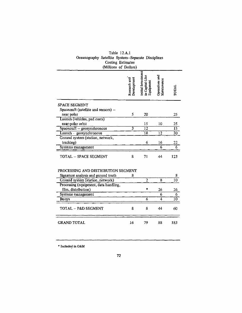
Table 12.A.1 Oceanography Satellite System-Separate Disciplines
Costing Estimates (Millions of Dollars)
SPACE SEGMENT Spacecraft (satellite and sensors) - near polar 5 20 25
Launch (vehicles, pad costs) near-polar orbit 15 10 25
Suacecraft - geosvnchronous 3 12 15 Launch - geosynchronous 18 12 30 Ground system (station, network,
tracking) 6 16 22 Systems management 6 6
TOTAL - SPACE SEGMENT 8 71 44 123
PROCESSING AND DISTRIBUTION SEGMENT Signature analysis and ground truth 8 8 Ground system (station, network) 2 8 10 Processing (equipment, data handling, film, distribution) * 26 26
Systems management 6 6 Buoys 6 4 10
TOTAL - P&D SEGMENT 8 8 44 60
GRAND TOTAL 16 79 88 183
* Included in O&M
72

INTERNATIONAL CONSIDERATIONS IN SPACE APPLICATIONS
Thomas F. Malone
Introduction
The international implications of space activities were clearly recognized in the Space Act of 1958, which designated a civilian agency to conduct our national space program and authorized that agency to engage in a program of international cooperation consistent with the intent of Congress:
“The Congress hereby declares that it is the policy of the United States that activities in space should be devoted to peaceful purposes for the benefit of all mankind.” (Sec. 102 (a) 1.
In its report on post-Apollo space programs nine years later, the President‘s Science Advisory Committee included this comment:
“Space exploration, space science, and space applications all constitute areas where international cooperation is particularly appropriate. . . . NASA’s own efforts toward international space programs should be expanded. In addition there should be continued encouragement to other agencies, notably the State Department, the Arms Control and Disarmament Agency, the National Science Foundation and the National Academy of Sciences to study and, where possible, actively support international programs in space, including the fostering of cooperative efforts through organizations such as the International Council of Scientific Unions.”
It is therefore not surprising that the Central Review Committee of the Summer Study on Space Applications noted, in its 1967
73

Interim Report, that the international development of useful satellites offered “an array of remarkable opportunities, public and private,” and recommended that the 1968 continuation of the Study emphasize the international aspects of space applications.
To implement this recommendation, the Central Review Committee named an ad hoc group early in 1968 to consider the international aspects of space applications; it comprised E. A. Ackerman, A. G. Anderson, H. G. Busignies, B. Graham, E. Istvan, W. D. Lewis (ex officio), T. F. Malone, R. Marsten, E. R. Piore, P. Rosenberg, and J. R. Shay.
The group met in Washington, D.C., on June 18 with interested individuals and representatives of government agencies. Informal discussions were held with Panel chairmen and members at Woods Hole during the week of July 22.
This report was prepared by the group’s chairman, T. F. Malone, who also presented some of these findings to government officials at the Woods Hole presentation on July 3 1.
The Context
It is generally agreed that Spaceship Earth was launched about five billion years ago. Life first appeared on Planet Earth approximately three billion years ago. Evidence of human life goes back, say, three million years. Modern man emerged about fifty thousand years ago.
Informed conjecture on the solar energy still available and on the probability of cosmic accidents encourages us to believe that it should be possible-barring man-made catastrophes-to sustain life on our planet for at least three million more years. If this desideratum is actually to be realized, it is clear that some planning may be required.
These plans should take account of two phenomena that are beginning to pose serious problems of a global nature in this latter part of the twehtieth century. A population growth of two to three percent and a real economic growth of, say, four percent per year, when cast against a physical environment of rapidly constrained dimensions and natural resources of absolutely limited
74

quantity, are presenting mankind with two formidable management problems of a global nature:
First, management of the quality and the utility of our physical environment (Le., air, land, water; the integrity of the volume of space required for transportation corridors of land, air, and water; the integrity of the bands of the electromagnetic spectrum used for communications).
Second, management of the mineral and other productive resources of the earth that in total are required to meet the basic needs of mankind: food, clothing, shelter, and health as well as those amenities that give meaning to life.
Indicative of the growing concern over these matters are (a) the rapidly growing support, within the scientific community, of many nations for the International Biological Program, (b) the action of the Economic and Social Council of the United Nations in July 1968, calling on the international community to take action to preserve and restore our natural surroundings in the interests of man, and (c) the unique colloquium jointly sponsored by the House Committee on Science and Astronautics (George P. Miller, Chairman) and the Senate Committee on Interior and Insular Affairs (Henry M. Jackson, Chairman) to develop the elements of a national policy for the environment.
Earth-oriented satellites appear to have unique applications to the inherently international task of managing our physical environment and natural resources.
Patterns of International Cooperation
To some, the international character of earth-oriented satellites and associated systems brings to mind an array of extremely complex international-or semi-international-institutions, each smoothly performing functions such as point-to-point communications, broadcasting, navigation and traffic control, earth-resources surveys and the collection of synoptic data for meteorological, oceanographic, and hydrologic purposes.
To others, the international aspects of these space applications
75

are concerned with a loosely structured, informal, but frequently highly effective and synergistic arrangement by which individuals from several nations cooperate in programs that advance their respective national interests. Examples of these patterns of international cooperation range from the established mechanisms now operating in the communications field to the type of system postulated by the Panel for Navigation and Traffic Control. Currently under development is still another kind of international cooperation, the World Weather Watch, in which the global system, as presently envisaged, consists of an elaborate and highly cocrdinated set of national data-gathering and data-processing systems, as contrasted with a centralized, internationally managed system.
From an examination of existing and suggested patterns of international cooperation, three points emerge:
First, institutional mechanisms and arrangements should vary with functional needs.
Second, an approach characterized by considerable pragmatism-generously laced with imaginative thinking and innovation-will be required to arrive at the optimum array of institutional arrangements to meet these functional needs.
Third, for the next few years, flexibility and adaptability should be important characteristics of national systems that sooner or later must interact in an intimate fashion with other national systems, or with an international system.
Practical Steps
Practical steps that should now be taken-or, in some cases, augmented-can be discussed under four categories: technical considerations; guiding principles for the short term ; special issues for the long term; and recommendations.
With respect to the first category, six technical considerations are relevant to the international aspects of space applications. For the most part, these considerations are discussed in detail in the Panel Reports, so only a summary will be given here.
76

Data Considerations
The first, and perhaps the most fundamental, consideration has to do with the volume, type, and complexity of data that will confront data users. Of especial interest are earth-resources data which will comprise photography from satellite and aircraft, imagery from satellite and aircraft, other forms of sensed data from satellite and aircraft, and relayed data from ground-based sensors, or from sensors attached to freely floating balloons in the atmosphere or buoys on the ocean surface. The user can be given these data in either raw or reduced form, and can get them in the form of pictures, maps, tables, tapes, or reports.
Satellite Imagery
The easiest way for image-oriented data to be put broadly to operational use throughout the world will be as presentations that look like pictures. This is so because of the present level of skills in the world, because of the facility which pictures provide for presenting a lot of data for interpretation, and because of the status and cost of automatic image interpretation. (The “pictures” may contain some image processing, such as feature enhancement, as techniques are developed; but, for a substantial period of time, the final interpretation will be largely done with photograph-like presentations and skilled interpreters.)
Where immediate access to those images is not required, the images can be provided cheaply. The major cost to the user will not be that involved in obtaining the image (the incremental cost to produce the additional desired images, excluding the cost of the satellite and ground equipment) but, rather, the costs of ground truth and skilled interpreters.
Where immediate access to image data is required, the costs can be substantial if wide-bandwidth and high-quality images are required. Alternative means of relaying information, studies of low-cost recording and receiving equipment, and remote stationing of skilled interpreters bear consideration here.
A substantial program of research and development in the techniques for image data processing makes good sense for the
77

United States. In those countries able to afford a substantial program in earth resources, similar programs may be set up. In less-affluent countries, there will nevertheless be a requirement to anticipate the use of such techniques and to gain experience in their application. For those cases, alternatives such as touring education programs, periods in the United States for work in a major image-processing center, and joint study programs would be worth consideration. Tapes (analog or digital) should, of course, be provided for those scientists and countries in a position to process such data.
The volume of images from early satellites to countries that are interested only in their own country’s imagery on an operational basis is not likely to be large. For example,,the imagery for the United States from earth-resource survey satellites would be of the order of tens of thousands of images per year. Of course, a given country might choose to produce and distribute a large number of copies.
Satellite Photography with Film Recovery
Copies of this photography can be distributed cheaply, will represent a low volume of photographs (one copy per country, not counting subsequent reproductions), will require skilled interpreters, and will cost little to the receiving country compared with ground and interpreter costs.
Aircraft Photography and Aircraft Imagery
The interpreters will still use the data in image form, except for R&D programs. The aircraft will be heavily oriented toward ground truth, training, R&D, and high resolution.
Cost of aircraft and associated sensors and equipment can be high. This illustrates once again the high cost of ground truth and other local data-gathering systems. Sharing of planes and processing facilities may reduce this cost. Some ground truth may always be required; it is not obvious that some aircraft use may not also always be required.
78

Ground-Based Sensor Data Collected by Satellite
The data rates here are generally low. Where urgency of reporting is not required, the data can be provided cheaply by providing copies on tape, or printed copy, or by low-bandwidth lines.
Where the data are required quickly, satellite broadcast appears to offer cheap receivers for the data rates involved.
Once these data have been collected at a central place (we assume this will be done in the United States for U.S. satellites), it is not an expensive matter to provide files of these data, summaries, reports, and tabulations. The United States might wish to offer this service at a reasonable cost for countries desiring it. Similar services could be provided to U.S. districts, regions, agencies, and other appropriate institutions, if such processing makes sense.
costs
Implicit in most of the discussion above was an assumption of a fairly simple first-generation system based on use of images and skilled interpreters. Low data-rate ground-sensor data would be fed into existing agencies. The build-up. of capability, through training and experience, would allow evolution to a more extensive second-generation system. The costs of obtaining the image data and of processing the ground-sensor data do not appear to be large (if image data are not needed immediately), compared to ground-truth and interpretation costs. However, heavy file and processing costs would be incurred if volumes of aircraft photography were kept and indexed in detail, if electronic processing of aircraft imagery had to be provided by the host country, or if extensive files and indexes of ground truth and imagery should develop. Over the approximately ten years between the first- and second-generation systems, countries that really gain benefits from remote sensing on a broad scale are likely to evolve to a position of wanting at least some of those capabilities.
79

Uncertainties in the cost as well as the complexity of digital data clearly await further study and resolution of several technical questions. For example:
The technical feasibility of the tropospheric balloon system in meteorology will have an important bearing on the data-acquisition and -handling characteristics of satellite platforms for that program.
An analysis of the cost-effectiveness of real-time data for hydrologic purposes will be an important determinant in the design of an observational system for the analysis of water resources.
A determination of the scientific utility of synoptic observations for oceanographic purposes will be required to specify the data needs for oceanographic purposes.
Data Users
A second technical consideration is concerned with the types of data users that can be expected in the developed and the developing countries. They likely will consist primarily of: government agencies, business and industry (operated by either the private or public sector), and the academic and research community.
Technical competence will generally be found indigenously, but will certainly require retraining and upgrading in the kind of program with which NASA already has had considerable experience. The pacing element is likely to be an awareness and commitment on the part of individuals at the policy level in national governments, rather than competence in the scientific and technological community. A minimum of three or four technical people in any country will be required to make a national program viable.
Trice of Admission”
A third question has to do with the so-called “price of admission.” In terms of human resources, the minimum
80
requirement is, as mentioned above, about three or four technically qualified people. In monetary terms, the “price of admission” varies from 1 Os to 1 O6 dollars.
Participation
A fourth question is concerned with alternative means by which prospective data-using countries can prepare themselves to participate in a program of space applications. An excellent example of how this can be accomplished effectively is found in the cooperative programs on the airborne phase of an earth-resources survey carried on by the United States and Mexico and Brazil. The immediate technical objective is to establish ground truth in order that information obtained from satellites can be properly interpreted. Another example exists in the Automatic Picture Transmission satellite program for meteorological purposes. Under this program, it is possible for any nation (at a cost not exceeding $30,000) to have direct access to pictures on local cloud environment over their part of the globe, and to make use of this information for local weather analysis and prediction. In both these programs, the original commitment of resources is not large, but the sense of participation and the actual involvement is high.
Feedback
A fifth consideration is related to c.tta “feedback” from user to supplier (as distinct from conventional “feedback,” which provides technical readjustments to the system). It seems clear that traditional patterns of data exchange in the environmental disciplines can be built upon without difficulty. In earth-resources survey work, the critical information to be communicated from the user is ground truth. Here, again, the precedent established in the Mexico and Brazil programs clearly indicates a productive method.
81
A1 terna tives
The sixth and final technical consideration is concerned with the several alternatives in systems concept and data handling. A succinct summary of possible alternatives follows.
Alternative No. I - Satellite Photography. It appears that the only realistic alternative would provide any user who wishes with duplicates of the original photography. Copy costs are cheap and interpretation by humans would be the feasible method and, in comparison, the major cost. Simultaneous disclosures to all participants is probably required.
Alternative No. 2(al - Satellite Imagery. Provide requesting countries with imagery. This provides a low-cost entry for those countries.
Alternative No. 2 (a)(l). As above, but provide also an opportunity for a scientist from that country to spend time in “the center” to study ways of enhancing the value of the imagery, including the opportunity to prescribe the form of operational imagery provided.
Alternative No. 2 (a)(2). As above, but provide copies of analog tapes to that country to allow.scientists there to experiment with analog signal processing for image enhancement (or provide digital tapes for experimentation).
Alternative No. 3 - Satellite Imagery. Provide wide-band broadcast to the country of the data. The country has then the choice implied in (2).
Alternative No. 4(a) - Satellite Collection of Ground-Sensor Data. Collection at a central location,- transmission of high-priority data to participant countries, distribution of tapes or reports by mail.
Alternative No. #(b). As above, but add broadcast of information for collection by any country desiring local information directly. Relatively low-cost.
Alternative No. 5(a) - Aircraft Imagery and Data. The country has its own aircraft and sensors.
82
Alternative No. 5(bl. The country shares aircraft and sensor packages with other participating countries.
Depending on the application and desires, the minimal requirements range from the low cost of No. 1 or No. 2(a) to the high costs of Nos. 3, 4(b), and 5(a).
From these preliminary technical considerations and from discussions with representatives of NASA, user agencies, the State Department, and other interested individuals, the following guiding principles for the short term emerge:
Overselling of potential benefits to participating nations should be meticulously avoided.
It is important to develop a climate of international cooperation with other countries. This is often accomplished by a series of small discrete steps (e.g., bilateral programs, information-sharing plans such as the Automatic Picture Transmission program).
Conscious efforts to stimulate demand in other countries are desirable and, in fact, probably necessary if we are to proceed vigorously with space applications.
Cost-sharing of space-applications programs is desirable to ensure a sense of participation as well as real involvement. This need not always involve a transfer of funds. Cooperative programs can be cost-sharing without an exchange of currency.
Among special issues for the long term are these three:
Continued acceptance by the nations of the world of measurement over their territory by overflight of satellites. This principle has been widely accepted-probably for two reasons: ( 1 ) ready accessibility by the nation overflown to the information collected during the overflight; and (2) information gathered in this manner serves the national self-interest of the nation. (Collection and exchange of meteorological data is an outstanding example of the utility to individual nations of a global data-collection program.)
83

Acceptance of international regulation for air and sea traffic movement on the part of the nations of the world. It is clear that the system proposed for navigation and traffic control by the Panel on this topic will be effective in direct proportion to the willingness of the nations of the world to accept the control implied by the adoption of the system.
The final issue is concerned with the mode of management for systems that are intrinsically international. The issue here is the question of national management in contrast to international management. I t is too early to reach a firm position on this matter. Critical determinants in arriving at a sound decision will include an evaluation of the technical, economic, and political trade-offs involved, as well as the development of a satisfactory plan for cost-sharing. It is likely that new institutional arrangements will have to be fashioned if the decision is to operate global systems in the international mode.
During the course of discussions, two recommendations emerged. First, at the international level:
Frequency allocations that anticipate rapidly growing needs must be made within the near future.
Similarly, orbital parking space needs to be allocated for geosynchronous satellites.
Agreement will soon be required on the standardization of equipment for navigation and traffic control.
Second, at the national level, NASA and other agencies, as appropriate, should:
Further- develop international programs, in spite of current budgetary pressures, as a sound investment in the potential of space applications. The kind of programs that need continuing and strengthening are: the agreements with Mexico and Brazil; the exploration of the potential of broadcast satellites over India; the development of the Global Atmospheric Research Program in cooperation with the World Meteorological
84

Organization and the International Council of Scientific Unions; and geodesic measurements from orbiting satellites.
Further strengthen the liaison and cooperation with the non-governmental and inter-governmental organizations at the international level. The effectiveness of the Committee on Space Research (COSPAR) of the International Council of Scientific Unions (ICSU) in fostering international cooperation in space sciences, and the contributions of COSPAR’s Working Group VI and the World Meteorological Organization to space applications in meteorology suggests the wisdom of an even greater participation by these organization. Interest in an Integrated Global Ocean Survey System (IGOSS) on the part of the Scientific Committee for Oceanographic Research (SCOR) in ICSU and the International Oceanographic Commission of UNESCO are indicative of the resources within these international organizations which could be profitably tapped.
Conclusion
As a concluding thought, it may not be out of place to remark on the potential benefits that might be expected from international cooperation in the development of space applications. The Study gave considerable attention to costs and benefits at the national level. Economic considerations at the international level were not, however, examined in detail. It is possible, however, to apply some subjective judgments. Perhaps the most advanced international program involving the applications of space technology is in the field of meteorology. Here, one can go back eight years to the point at which the decision was made to develop these applications-on an international scale. The impact of this decision on the development of international understanding, exchange of scientists, and international cooperative programs has been both dramatic and profound. An assessment of the impact of these developments on the climate of world opinion leads directly to the question, “What might have been lost if the decision to proceed
85
had not been made in the affirmative?” The loss would have been dramatic and possibly irretrievable. It can, however, be assessed and viewed retrospectively as the actual benefit which was implicit in the decision taken in 1961. Similar benefits are almost certain to exist in other, wide-ranging applications of space science and technology-if we could but see them clearly. Perhaps, most importantly, is the need pointed out over a decxde ago by John von Neumann in his article, “Can We Survive Technology?” He was modestly optimistic and remarked that it will depend upon a “long series of small, correct decisions.” The long winding road that lies ahead is marked by many milestones, each of which involves a small and, hopefully, correct decision.
REFERENCES
“Space Applications Summer Study, 1967 Interim Report,” Vol. 1, A Report of the National Academy of Sciences, published by the National Aeronautics and Space Administration, Washington, D.C., Jan. 1968.
“The Space Program in the Post-Apollo Period,” A Report by the President’s Science Advisory Committee, prepared by the Joint Space Panels, Superintendent of Documents, Washington, D.C., Feb. 1967.
“Can We Survive Technology?” by John von Neumann in FORTUNE, June 1955, p. 106 et seq.
86

SUMMER STUDY ON SPACE APPLICATIONS ORGANIZATION
Chairmun of Study
W. Deming Lewis Lehigh University Bethlehem , Pennsylvania
Executive Director of Study
Eugene T. Booth (1 967) Stevens Institute of Technology Hoboken, New Jersey
R. Adm. L. R. Daspit (1968) National Academy of Sciences Washington, D.C.
Central Review Committee Edward A. Ackerman Carnegie Institution of Washington Washington, D.C.
Henri G. Busignies International Telephone and
Telegraph Corporation New York, New York
Beardsley Graham (1 968) Columbia Plaza Washington, D.C.
JJarry H. Hess (1968) Princeton University Princeton, New Jersey
Edwin J. Istvan (1968) Communications Satellite
Corporation Washington, D.C.
AND PARTICIPANTS
Thomas F. Malone Travelers Insurance Company Hartford, Connecticut
Brian O'Brien North Woodstock Connecticut
Courtland D. Perkins Princeton University Princeton, New Jersey
Emanuel R. Piore International Business Machines
Corporation Armonk, New York
Allen E. Puckett Hughes Aircraft Company Culver City, California
J. Ralph Shay (1968) Oregon State University Corvallis, Oregon
H. Guyford Stever (1967) Carnegie Institute of Technology Pittsburgh, Pennsylvania
Senior Economists and Members Central Review Committee (1 968) Samuel Lenher (Chairman) E.I. du Pont de Nemours & Go.,
Wilmington, Delaware Inc.
87

Arthur E. Burns George Washington University Washington, D.C.
Raymond P. Genereaux 1018 Kent Road Wilmington, Delaware
John R. Menke United Nuclear Corporation Elmsford, New York
Donald C. Slichter The Northwestern Mutual Life
Milwaukee, Wisconsin Insurance Company
Group Chairmen Earth Resources
Ralph Shay 196768
Communications Beardsley Graham 1967-68
Assistdnt Group Chairman Edwin J. Istvan 1967
Panel 1 : Forestry-Agriculture-
R. Keith Arnold (Chairman) University of Michigan Ann Arbor, Michigan
Thomas J. Army International Minerals and
Chemical Corporation Libertyvdle, Illinois Clifford Hildreth University of Minnesota Minneapolis, Minnesota
Carl A. Newport Mason, Bruce, & Girard Portland, Oregon
Geography
Marion E. Marts University of Washington Seattle, Washington J. Warren Nystrom Association of American
Geographers Washington, D.C. T. Dudley Wallace North Carolina State University Raleigh, North Carolina
Panel 2: Geology Ron J.P. Lyon (Chairman) Stanford University Stanford, California Gordon Atwater 424 Whitney Bank Building New Orleans, Louisiana
John C. Maxwell Princeton University Princeton, New Jersey William W. Rubey University of California Los Angeles, California
Panel 3 : HydroZogv Paul Bock (Chairman) University of Connecticut Storrs, Connecticut Harvey 0. Banks Leeds, Hill & Jewett, Inc. San Francisco, California
Ven Te Chow University of Illinois Urbana, Illinois Richard R. Hazen Hazen and Sawyer New York, New York
88

Panel 4: Meteorology Verner E. Suomi (Chairman) University of Wisconsin Madison, Wisconsin Charles E. Anderson University of Wisconsin Madison, Wisconsin Richard D. Cadle National Center for Atmospheric
Boulder, Colorado Arnold H. Glaser Allied Research Associates, Inc. Concord, Massachusetts Lewis D. Kaplan California Institute of
Technology Pasadena, California
Panel 5 : Oceanography Gifford C. Ewing (Chairman) Woods Hole Oceanographic
Institution Woods Hole, Massachusetts Douglas L. Inman Scripps Institution of Oceanography La Jolla, California Leonard N. Liebermann University of California La Jolla, California Gerhard Neumann New York University Bronx, New York Daniel P. Petersen University of New Mexico Albuquerque, New Mexico Warren S. Wooster Scripps Institution of Oceanography La Jolla, California
Research
Charles S. Yentsch Nova University Fort Lauderdale, Florida
Panel 6: Sensors and &tu Systems David A. Landgrebe (Chairman) Purdue University West Lafayette, Indiana Gerald C. Brock W. Vinten Ltd. Suffolk, England Lou J. Cutrona KMS Industries Ann Arbor, Michigan John K. Galt Bell Telephone Laboratories Murray Hill, New Jersey Amrom H. Katz. RAND Corporation Santa Monica, California Donald S. Lowe University of Michigan Ann Arbor, Michigan
Richard K. Moore University of Kansas Lawrence, Kansas
Lloyd G. Mundie RAND Corporation Santa Monica, California
Allen R. Sims Aerospace Corporation El Segundo, California
Sam S. Viglione McDonald Douglas Corporation Newport Beach, California
Carl A. Wiley North American Aviation Anaheim, California
89

Panel 7: Points-to-Point Communications
Richard B. Marsten (Chairman) Radio Corporation of America Princeton, New Jersey
Steven D. Dorfman Hughes Aircraft Company El Segundo, California
Alan R. Garfinkel Radio Corporation of America Princeton, New Jersey
Panel 9: Point-to-Point Communications
Cole A. Armstrong (Chairman 1967) Office of Telecommunications
Management Washington, D.C.
Samuel Lutz (Chairman 1968) Hughes Research Laboratories Malibu, California F. J. Altman Communications and Systems, Inc. Falls Church, Virginia
Gaylord M. Northrop Travelers Research Center Hartford, Connecticut
Agis Valakos
Rockville , Maryland
William E. Bradley Institute for Defense Analyses Arlington , Virginia
Hayden W. Evans
Holmdel, New Jersey IBM Communications Systems Center ~ ~ 1 1 Telephone Laboratories, Inca
Panel 8: Systems for Remote- Sensing In formation and Distribution
Arthur G. Anderson (Chairman) IBM Corporation Yorktown Heights, New York
Marvin S . Cohen Radio Corporation of America Princeton, New Jersey
Sidney M. Foulks Mobile Oil Corporation Dallas, Texas
Harwood Kolsky IBM Corporation Palo Alto, California
George J. Zissis University of Michigan Ann Arbor, Michigan
James D. Rinehart Communications Satellite
Corporation Washington, D.C.
Dan C. Ross IBM Center for Exploratory Studies Rockville, Maryland
Spencer W. Spaulding Radio Corporation of America Princeton, New Jersey
Panel 10: Broadcasting
Wilbur L. Pritchard (Chairman) COMSAT Laboratories Washington, D.C.
Fred P. Adler Hughes Aircraft Company Culver City, California
90

William Bakemeyer Hughes Aircraft Company El Segundo, California
Peter C. Goldmark CBS Laboratories Stamford, Connecticut
Samuel Gubin Radio Corporation of America Princeton, New Jersey
Robert P. Haviland General Electric Company Philadelphia, Pennsylvania
William J . Kessler 3857 West University Avenue Gainemille, Florida
Richard B. Marsten Radio Corporation of America Princeton, New Jersey
Panel 1 1 : Navigation and
P. C. Sandretto (Chairman 1967) International Telephone and
Telegraph Corporation New York, New York
Paul Rosenberg (Chairman 1968) Paul Rosenberg Associates Pelham, New York
Roy E. Anderson General Electric Company Schenectady, New York
A. Fiore U. S. Merchant Marine Academy Kings Point, New York
Laurin G. Fischer Communications and Systems, Inc. Falls Church, Virginia
Traffic Control
E. S. Keats Westinghouse Electric Corporation Baltimore, Maryland
Robert E. Scott (1967) University of Michigan Ann Arbor, Michigan
George C. Weiffenbach Johns Hopkins University Silver Spring, Maryland
Vernon Weihe (1967) 4133 N. 33rd Road Arlington, Virginia
Special Consultant Edward J. Martin Communications Satellite
Corporation Washington, D.C.
Panel 12: Economic Analysis
James B. Hobbs (Chairman) Lehigh University Bethlehem, Pennsylvania Saul R. Levine Lockheed Space and Missiles
Company Sunnyvale, California
Michael B. Matteson General Electric Company Washington, D.C.
D. Stephen Mayer General Electric Company Washington, D.C.
Edgar M. Van Vleck Ames Research Center Moffett Field, California
(1 968)
91

Panel 1 3 : Geodesy-Cartography Frederick J. Doyle (Chairman) Raytheon Company Alexandria, Virginia
William M. Kaula University of California Los Angeles, California
Charles A. Lundquist Smithsonian Astrophysical
Observatory Cambridge, Massachusetts
Ivan I. Mueller Ohio State University Columbus, Ohio
John V. Sharp International Business Machines
Kingston, New York Corporation
Waldo R. Tobler University of Michigan Ann Arbor, Michigan
Consultants to the Central Review Committee (1967)
John W. Emling Hilltop Circle Morristown, New Jersey Alvin W. Dill (1967 and 1968) Lockheed Missiles and Space
Company Sunnyvale, California James B. Hobbs Lehigh University Bethlehem, Pennsylvania W. W. Neikirk Northrop Corporation Beverly Hills, California
92