Embed Size (px)
Citation preview
PROCEEDINGS OF THE ECS/ASCOBANS/ACCOBAMS
WORKSHOP
SELECTION CRITERIA FOR MARINE PROTECTED AREAS FOR CETACEANS
Held at the European Cetacean Society’s 21st Annual Conference, The Aquarium, San Sebastian, Spain, 22nd April 2007
Editor:
Peter G. H. Evans
ECS SPECIAL PUBLICATION SERIES NO. 48 FEB 2008

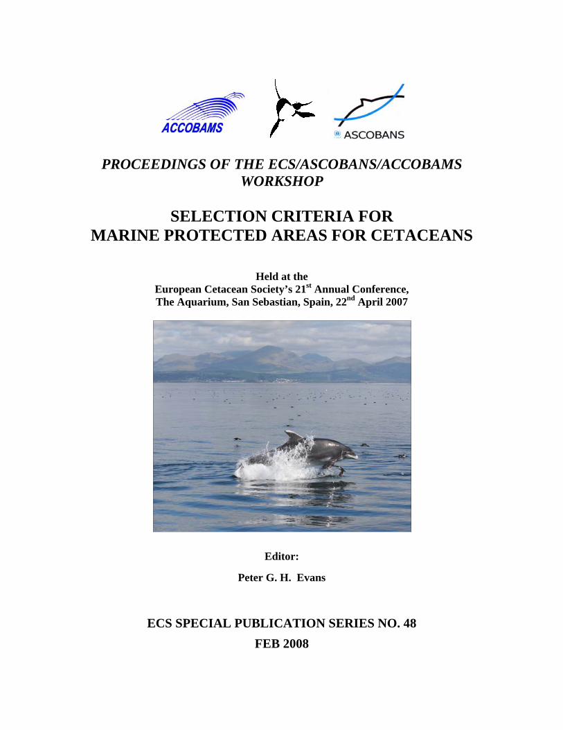
Front Cover Photo: Pia Anderwald
PROCEEDINGS OF THE WORKSHOP ON
SELECTION CRITERIA FOR
MARINE PROTECTED AREAS FOR CETACEANS
Held at the
European Cetacean Society’s 21st Annual Conference, The Aquarium, San Sebastian, Spain, 22nd April 2007
Editor:
Peter G. H. Evans
Sea Watch Foundation, Cynifryn, Llanfaglan, Caernarfon, Gwynedd LL54 5RA, UK
ECS SPECIAL PUBLICATION SERIES NO. 48 FEB 2008

2
CONTENTS
Workshop Programme 4 Evans, P.G.H. Introduction 5 Notarbartolo di Sciara, G. Marine Protected Areas for Cetaceans: basic concepts on selection, creation and management 7 Hedley, C. Establishing Marine Protected Areas: some Legal Issues 14 McMath, M.J. Criteria for selection of Marine Protected Areas 19 Donovan, G. Marine Protected Areas for large cetaceans 25 Panigada, S., Zanardelli, M., MacKenzie, M., Donovan, C., Mélin, F., and Hammond, P.S. Habitat modelling for large cetaceans 31 Cañadas, A., Sagarminaga, R., and Hammond, P.S. Spatial modelling as a tool for designing Marine Protected Areas for small cetaceans 39 Evans, P.G.H. and Wang, J. Harbour Porpoise spatial modelling to identify possible hotspots for Marine Protected Areas 44 Sveegaard, S. and Teilmann, J. Can satellite telemetry tell us the key habitats for harbour porpoises? 52 Wilson, B. The Moray Firth experience 58 Evans, P.G.H. and Pesante, G. Research for management: the Cardigan Bay experience 61 Bianchessi, A. Managing marine SACs: what can be learned from the Cardigan Bay experience? 70 Gilles, A., Scheidat, M. and Siebert, U. Harbour porpoises in German waters – evaluating proposed Natura 2000 sites 76 Aguilar de Soto, N. and Aparicio, C. Challenges in protecting deep diving cetaceans: example from the Canary Islands 83 Tejedor Arceredillo, A., Sagarminaga, R., de Stephanis, R., Cañadas, A., and Lago, A. Management of MPAs: options and challenges for the maritime transport sector. Spanish case studies. 93 Evans, P.G.H. Concluding Remarks 99 List of workshop participants 102
3

MPA WORKSHOP PROGRAMME 09:00-09:30 Registration 09:30-1009:40 Introduction 09:40-10:00 Background to MPAs for Cetaceans - Giuseppe Notarbartolo di Sciara 10:00-10:20 Legal Framework. Chris Hedley 10:20-10:40 UK Criteria for MPA Site Selection - Mandy McMath 10:40-11:00 MPAs for Large Cetaceans - Greg Donovan 11:00-11:30 REFRESHMENT BREAK 11:30-11:50 Habitat Modelling for Large Cetaceans - Simone Panigada 11:50-12:10 Spatial Modelling as a Tool for Designing Marine Protected Areas for Small Cetaceans -
Ana Cañadas 12:10-12:30 General Discussion 12:30-14:00 LUNCH 14:00-14:20 Harbour Porpoise Spatial Modelling to Identify Possible Hotspots for MPAs - Peter
Evans and Jianjun Wang 14:20-14:40 Can Satellite Telemetry show us the Key Habitats for Harbour Porpoise?.- Signe
Sveegaard and Jonas Teilmann 14:40-15:00 The Moray Firth SAC Experience - Ben Wilson, Ben Leyshon and Paul Thompson 15:00-15:30 The Cardigan Bay SAC Experience: a) Research - Peter Evans and Giovanna Pesante; b)
Management – Annalisa Bianchessi and Mandy McMath 15:30-15:40 BREAK 15:40-16:00 Harbour Porpoises in German waters - Evaluating Proposed Natura 2000 Sites: - Anita
Gilles, Meike Scheidat and Ursula Siebert 16:00-16:20 Challenges in Protecting Deep Diving Cetaceans: Examples from the Canary Islands -
Natacha Aguilar Soto and Christina. Aparicio 16:20-16:40 The Role of MPAs as a Mechanism to Protect Cetaceans from the Risk of Shipping:
Spanish Case Study - Ana Tejedor Arceredillo, Ricardo Sagarminaga, Renaud de Stephanis and Ana Cañadas
16:40-17:00 General Discussion 17:00-17:30 REFRESHMENT BREAK 17:30-17:50 Recommendations 17:50-18:00 Concluding Remarks
4
INTRODUCTION
Peter G.H. Evans
Sea Watch Foundation, Cynifryn, Llanfaglan, Caernarfon, Gwynedd LL54 5RA, UK ([email protected])
In European waters cetaceans and their habitats are covered under a number of different conventions, treaties or agreements, e.g. the UN Law of the Sea, the EU Habitats Directive, OSPAR, HELCOM, the Barcelona Convention, IWC, and the ASCOBANS and ACCOBAMS agreements under CMS. Certain of these international commitments require or strongly propose the establishment of marine protected areas (MPAs) for cetaceans. In April 1999, the European Cetacean Society held a workshop to consider the scope for establishing Marine Protected Areas for cetaceans in Europe (Evans & Urquiola Pascual, 2001). Since then, particularly through Natura 2000 of the EU Habitats Directive, a number of Special Areas of Conservation have been designated by European countries for two cetacean species, the bottlenose dolphin and harbour porpoise, whilst area-based protective measures have been formalized for other cetacean species (e.g. the Pelagos Sanctuary for Mediterranean Marine Mammals in the Ligurian Sea). Over the last ten years, much progress has been made in survey and monitoring techniques, and, in a few cases, these have been used to identify important areas for cetaceans. In addition, some MPAs have been in existence long enough to make at least some preliminary assessment of their efficacy desirable. However, no specific criteria/guidelines for the identification of sites important for small cetaceans (or the necessary management and monitoring measures) have been generally agreed such that the process remains largely ad hoc. Parties to the Agreement on the Conservation of Small Cetaceans of the Baltic and North Seas (ASCOBANS) at their 5th Meeting (2006) recommended holding a one-day workshop to establish criteria and guidelines for the identification of sites of importance for small cetaceans (Resolution 7). Accordingly, this workshop was jointly convened by ECS, the Agreement on the Conservation of Cetaceans in the Black Sea, Mediterranean Sea and contiguous Atlantic Area (ACCOBAMS), and ASCOBANS. The purpose of the workshop was to analyse and discuss the development, the scope and appropriateness of possible criteria for determining protected areas relevant to cetaceans (e.g. high-density areas, feeding or breeding sites, and migration corridors) including a discussion of potential methods to identify such sites. The workshop also aimed to explore the efficacy of MPAs as a tool in conserving cetaceans and how this could be improved. An organizing committee for the workshop was set up, comprising Peter Evans, Ana Cañadas, Erich Hoyt, Sonia Mendes, Mandy McMath, Simone Panigada and Giuseppe Notarbartolo di Sciara. We felt it important to invite a wide spectrum of speakers who
5
could not only address aspects of site selection but also consider how to make MPAs most effective, bearing in mind that different species have different ecological needs and face different threats. The workshop, held at the start of the 21st Annual ECS Conference in April 2007, was attended by around 125 persons from 22 countries. This publication distils the information presented at the meeting, and draws some general conclusions with specific recommendations arising from the discussions. Sponsorship for the Proceedings comes from UNEP/ASCOBANS to whom we are very grateful, and I would also like to thank Heidrun Frisch, Ana Berta García, Marco Barbieri, Sonia Mendes and Mark Tasker for their invaluable logistical support.
6
MARINE PROTECTED AREAS FOR CETACEANS: BASIC CONCEPTS ON SELECTION, CREATION AND MANAGEMENT
Giuseppe Notarbartolo-di-Sciara
Tethys Research Institute, Viale G.B. Gadio 2, 20121 Milano, Italy ([email protected])
INTRODUCTION Establishing marine protected areas (MPAs) is a lengthy process, and easier and faster means of conserving cetacean populations may be available in some cases. Protecting cetaceans from anthropogenic threats may be achieved in a number of different ways, and MPAs are just one of the many available tools. Given that establishing an MPA is an elaborate and labour-intensive process, it is important that a proposal for the creation of an MPA to protect cetaceans be buttressed by a solid rationale. This should include a description of the current, suspected or anticipated threats to cetaceans in the area, and a discussion of how the establishment of an MPA may enable the implementation of measures and regulations apt to mitigate or eliminate such threats. Designing an MPA to protect a cetacean species or species assemblage could help to effectively protect not only cetaceans, but also other species living under their umbrella (Hoyt, 2005). An ecosystem approach involving a thorough assessment of the nature and scale of the trophic interactions involved in a marine conservation area, is a desirable trait of rigorous conservation planning (Hooker et al., 2002). Careful consideration should be given to whether MPAs are likely to achieve the intended goals. Are MPAs appropriate to protect marine mammals? Cetaceans are highly mobile animals. Optimal design of a protected area intended to conserve a given population would need to encompass that population’s entire year-round distribution. While it may be possible to accomplish such a design for some resident or non-migratory species, the ranges of most cetacean populations are often too large for this to be practicable. On the other hand, when only a portion of a cetacean population’s range can be included within a protected area, there is obvious merit in selecting and designing MPAs in habitats that bear special importance for the species to be protected, such as key breeding and/or feeding areas (e.g., humpback whales, Megaptera novaeangliae, seasonally migrating between Hawaii and Alaska). Identifying and designating significant cetacean breeding areas may be rather straightforward, whereas the equally crucial need of identifying essential feeding areas can present significant challenges to protected area design, especially for marine mammals that depend on pelagic food webs. Hyrenbach et al. (2000) addressed this challenge by identifying three types of open-ocean “hotspots” – i.e. important feeding areas for top predators such as cetaceans - defined according to their dynamics and predictability in space and time: (a) static systems determined by topographic features, such as reefs, shelf breaks, submarine canyons, seamounts, and the lee shores of islands; (b) persistent hydrographic features, such as currents and frontal systems; and (c) ephemeral habitats shaped by wind- or current-driven upwelling and eddies. Static
7
systems are relatively stable hotspots that can be mapped, and are the easiest to define and manage. Persistent hydrographic features are more challenging because they are not stationary, thus either requiring that a very large area be placed under protection, or that the boundaries be flexible. Ephemeral habitats are the most challenging, and will require a rather futuristic MPA design based on real-time monitoring of ocean conditions using remote-sensing technology. Perhaps the best answer to the main critique of the use of MPAs to protect cetaceans, i.e. that cetaceans may have too large a range to be encompassed by a single protected area, could be provided by the establishment of a network of MPAs. MPA networks have various conservation benefits over single MPAs, by: (a) helping to maintain the natural range of species; (b) ensuring protection of unique, endemic, rare and threatened species spread over a fragmented habitat; (c) ensuring adequate mixing of the gene pool to maintain natural genetic characteristics of the population; (d) ensuring protection of ecological processes essential for ecosystem functioning e.g. breeding and feeding habitats, and large-scale processes such as gene flow, genetic variation and connectivity; (e) ensuring that the ecosystem-based approach to management is followed and that adequate attention is paid to ecological functions and processes; (f) ensuring the protection of an ecosystem or species that cannot be adequately protected in one country, e.g., species that migrate; (g) ensuring that transboundary protected areas are given adequate attention; (h) sharing effective conservation approaches across similar sites; (i) developing collaboration between neighbouring countries to address common challenges and issues; and (j) building capacity by sharing lessons learned, new technologies and management strategies, and by increasing access to relevant information. A corollary to the use of MPA networks to protect highly mobile species such as cetaceans concerns the establishment of conservation corridors to allow faunal exchanges between protected areas. The utility to cetaceans of corridors, however, will depend on whether they are likely to use them, i.e. if they can be designed to connect MPAs that protect separate critical habitats (e.g., breeding and feeding grounds) of the same population. Corridors in the marine environment, and particularly in the pelagic realm, may be intrinsically more difficult to design and manage than corridors linking land or freshwater protected areas. However, protection through corridors in the sea may not necessarily be analogous to its terrestrial equivalent. It can be conceived that marine protected sites be linked by virtual corridors based on conservation measures specifically addressing problems affecting the concerned species in transit, or the quality of their transiting habitat (T. Agardy, pers. comm.). SELECTION AND CREATION OF MPAs Creating MPAs is a complex process that normally involves, in sequence: (1) the rationale for the proposal, where the case is made for the establishment of an MPA as the most effective tool to counteract the known threats to cetaceans and thus to ensure the population(s)’ favourable conservation status; (2) the definition of goals of the prospective MPA, based on the existing knowledge of the presence of cetaceans in the area and of the existence of threats to their survival; (3) the compilation of all the pertinent bibliographic information (published as well as “grey” literature); (4) the collection of updated scientific information through dedicated research
8
targeting the species of concern, human activities in the area, and the existence, types and distribution of threats; (5) the analysis of data to identify the existence of critical habitats within the considered area, or sites where the target species concentrate for specific activities or purposes; (6) the drafting of an ecology-based MPA proposal, inclusive of maps to support decisions on conservation priorities based on links among cetacean populations, ecological processes and human activities, to be presented for consideration by the competent authorities and by all the stakeholders; and (7) the beginning of a consultation phase involving the building of consensus through awareness campaigns, stakeholder participation, socio-economic analysis and, wherever necessary, conflict solution. Rationale for proposals The discovery of an area with a particularly rich cetacean fauna is normally the first step in the mental process of deciding whether a special area should be designated to protect it. Research may reveal the existence of previously unknown sites having special importance for cetaceans, either because these contain critical habitats, or because negative interactions between cetacean and human activities are reported to occur and constitute threats or potential threats to cetaceans. Criteria to identify sites containing cetacean critical habitat may include: areas used by cetaceans for feeding, breeding, calving, nursing and social behaviour; migration routes and corridors and related resting areas; areas where there are seasonal concentrations of cetacean species; areas of importance to cetacean prey; natural processes that support continued productivity of cetacean foraging species (upwellings, fronts, etc.); topographic structures favourable for enhancing foraging opportunities for cetacean species (canyons, seamounts). These criteria can be applied to protect sites containing cetacean critical habitats from human interactions, where: conflicts between cetaceans and fishing activities have been reported; significant or frequent bycatch of cetaceans is reported; intensive whale watching or other marine tourism activities occur; navigation presents a potential threat to cetaceans; pollution runoff, outflow or other marine dumping occur; or military exercises are known to routinely occur. In every one of the above cases, one has to consider very carefully whether the threat can be the focus of regulatory action that is generic, or whether MPA creation would provide added value. Based on circumstances, the establishment of an MPA will address the different types of threats with different levels of effectiveness. Threats such as entanglement in fishing nets, competition for prey resources through fisheries, as well as mortality from direct takes and from military sonar, can all be effectively addressed by protection regimes enacted through MPA establishment, whereas wide-ranging impacts such as airborne toxic pollution, the diffusion in the environment of plastics and other debris, and climate change will require mitigation at a wider, even global level (Evans & Urquiola Pascual, 2001). The goal(s) of an MPA must be defined early in the process and will be used as guidelines for the definition of the objectives in the management phase. The main goals of MPAs include: conservation of biodiversity (minimizing extinction risk), protection of vulnerable species, ecosystem protection, re-establishment of ecosystem integrity,
9
segregating uses to avoid users’ conflicts, and enhancement of the size and productivity of harvested fish or invertebrate populations to help support fisheries outside the reserve. Each MPA may have just one of those goals, or may also have a combination of them, as they are not mutually exclusive. For example, even though the focus of a protected area may be on higher predators, multispecies or multipurpose reserves are also acceptable if conservation of higher predators is compatible with, e.g., fishery enhancement (or vice versa). In many cases fishery reserves and fishery no-take zones, established primarily for fishery management purposes, can be envisaged to achieve the double benefit of helping to rebuild depleted fish stocks and allow the recovery of predators which have been negatively affected by their prey’s depletion. When defining the goals of a prospective MPA for cetaceans, careful consideration should be given to the potential of the initiative for raising awareness about cetaceans and their habitat needs, or raise political will to protect cetaceans. Often, and particularly in their early life stages, MPAs may be seen as meaningless “paper parks” as far as the effective protection that they afford to cetaceans is concerned; in spite of this, however, they may serve the important role of allowing the public and decision makers to ground their conservation ethic in a sense of place. In such circumstances, tying cetacean conservation to specific sites may be a good conservation strategy, and the selection of these sites may have less to do with cetacean ecology than with the site’s awareness-raising potential. A science-based proposal should be based on the compilation and analysis of the necessary scientific information, and containing the key points of a conservation plan, a general definition of the goals of the MPA, and what will be the most appropriate type of MPA designation. It is usually important to resist the temptation of insisting that a “definitive” research programme be carried out on the cetacean fauna of the area prior to the establishment of the protected area. The required knowledge may be collected relatively rapidly, thus avoiding excessive commitment of financial and human resources, and time. An overly detailed data requirement should be avoided at this stage if there is a risk that the inevitable delays in implementation will compromise the outcome. The information needed is conceptually simple, consisting of baseline data on: (a) the distribution and abundance of the concerned species; (b) the type and intensity of human activities in the area likely to affect cetaceans, and (c) the known or likely impacts of such activities on these mammals. Such information should make it possible to evaluate the conservation benefits of the proposed MPA for the cetacean population(s) of concern, as well as to determine the area’s required size and boundaries. Often the marshalling of more sophisticated information (e.g. on population identity and structure, abundance, habitat use, distribution and dynamics), can be postponed to a later phase and be the responsibility of the MPA management body. The collected information can be analysed in different ways to support the preparation of an MPA proposal. One technique, which may be likened to the so-called Delphi method, involves for the scientists engaging in the search for a group position through an iterative process in which the different opinions (e.g., concerning the MPA area and boundaries, or the protection measures likely to be implemented) are compared and progressively
10

harmonised. A more rigorous approach, the use of which was recently recommended by the Scientific Committee of ACCOBAMS, involves the application of spatial modelling techniques to identify important cetacean habitats and generate data-based MPA proposals and maps. The process of establishing MPAs Whereas proposals may be prepared by any individual or organisation, the responsibility for formally establishing MPAs rests with the competent authorities. Proposals may be brought to the attention of the authorities by anybody; however, the process may be greatly facilitated by channelling proposals through recognised regional intergovernmental bodies. For example, as far as the Mediterranean is concerned such bodies may be the RAC/SPA and ACCOBAMS. If an MPA is proposed entirely within the territorial and internal waters of a nation, it will have to be established under the general domestic legislation of that nation, which covers both the substantial and institutional aspects of the matter. Once the MPA is established, the concerned nation may decide whether it could also be proposed as part of a wider protected areas network, such as the SPAMI network provided for by the SPA Protocol to the Barcelona Convention, the Natura 2000 network (if the nation is a European Union Member State), the Emerald network of the Council of Europe, or UNESCO’s World Heritage Convention Sites. The impetus for inscribing one’s MPA within an international network may derive from the nation’s political will of promoting international cooperation for the protection of what is considered by that nation as common natural heritage. The special case of the Mediterranean Considering the pelagic habits of most cetacean species found in the Mediterranean Sea, important portions of their critical habitat will be located beyond the 12 nautical mile-wide territorial waters of any nation, i.e. in the Mediterranean high seas. This will cause most prospective MPAs for cetaceans in the region to be located in waters beyond national jurisdiction. Nations have the possibility of declaring an MPA resting entirely or in part in international waters by requesting its inscription in the List of SPAMIs of the Barcelona Convention’s SPA Protocol. Once an MPA is adopted as a SPAMI by a Meeting of the Contracting Parties to the Barcelona Convention, its regulations will be binding not only for the citizens of the nation(s) which has (have) proposed it, but also for the citizens of all the nations which are party to the SPA Protocol. A classic precedent of such process was provided by the Pelagos Sanctuary for Mediterranean marine mammals, which consists largely of international waters (Notarbartolo di Sciara et al., in press). The Pelagos Sanctuary was established in 1999 by a treaty among France, Italy and Monaco, and adopted as a SPAMI in 2001 in recognition of its Mediterranean importance. It should also be noted that France and Italy have created ecological protection zones that may have an impact on high seas protection measures outside of their territorial waters. In addition to the Pelagos Sanctuary, other important high seas areas are likely to be identified in the future (e.g., the Alborán Sea). MANAGEMENT OF MPAs “An MPA without a management plan is like a ship without a rudder” (Reeves, 2000). Without an appropriate management plan enforced, the MPA will remain a “paper park” which will only serve to make decision makers look
11
good without any real conservation effect. Even with a management plan, a protected area will be ineffective unless a director is empowered to implement it, i.e. with the necessary legal authority, sufficient financial resources, and adequate staff to proceed with implementation. A management plan should be developed with adequate funding arrangements in place to support its implementation in its entirety. The management plan will detail the measures enacted to reach the objectives. These include: (a) zoning, to separate highly protected no-entry sites containing cetacean critical habitat from human-use sites where activities such as whale watching, tourism, moderate fishing and vessel traffic may occur in a regulated fashion; (b) regulations and mitigating measures to maintain potentially harmful human activities (e.g., fishing, vessel traffic, military exercises) within acceptable levels; (c) research activities to generate knowledge susceptible to allow management adaptiveness and increase management effectiveness; (d) enforcement and compliance monitoring to ensure that rules are respected and measures are correctly implemented; (e) monitoring of the status and trends of the target populations and relevant human activities as a feedback mechanism to the management plan, to ensure that the proposed mitigation measures are working as expected; (f) monitoring and periodic review to ensure that the stated objectives are being met; (g) development of risk assessment techniques to take cumulative impact into account and identify emergent risks; (h) promotion of fair decision-making and conflict resolution concerning access to ocean resources within the protected areas; (i) administration, financing and fund-raising; and (j) implementation of education and awareness programmes. Effective management of an MPA is founded on the articulation of clear and quantifiable objectives to attain the institutional goals, and the implementation of a monitoring system to assess whether these objectives are being met. A significant challenge to the effective management of MPAs dedicated to the protection of top predators such as cetaceans is the need for a framework to guide and assess effectiveness in the context of broader ecosystem-level objectives, which seek to extend conservation benefits from the protected species and their habitats to marine trophic webs and ecosystem-wide processes. Ecosystem-level management requires a clear rationale and a firm knowledge base.
Are the management objectives met? A fundamental step in the management process involves the monitoring and periodic review of activities to assess whether the objectives are being met. A practical way of achieving this result is to devise specific management indicators. Given the complexity involved in selecting appropriate indicators, planning and conducting the evaluation, and consequently adapting further management actions, the entire MPA management evaluation process should be the subject of specific training. Consensus building and maintenance The creation and maintenance of consensus and public favour is fundamental to the success of an MPA. A cooperative environment will be best achieved through the enrolment of all stakeholders, as well as governmental, intergovernmental and non-governmental organisations in the process as much as feasible.
12
ACKNOWLEDGEMENTS This contribution is condensed from Notarbartolo di Sciara (2007), with permission from the Regional Activity Centre, Specially Protected Areas (UNEP Mediterranean Action Plan), Tunis.
REFERENCES
Evans, P.G.H. and Uquiola Pascual, E. 2001. An Introduction to Marine Protected Areas: what are they designed to do and what criteria should be used in their selection? Pp. 4-11. In: Protected Areas for Cetaceans (Eds. P.G.H. Evans & E. Urquiola). Proceedings of ECS Workshop, 9 April 1999. European Cetacean Society Special Newsletter Issue No. 38: 1-49.
Hooker, S.K., Whitehead, H. and Gowans, S. 2002. Ecosystem consideration in conservation planning: energy demand of foraging bottlenose whales (Hyperoodon ampullatus) in a marine protected area. Biological Conservation, 104:51-58.
Hoyt, E. 2005. Marine Protected Areas for Whales, Dolphins and Porpoises. Earthscan, London & Sterling, VA. 492 pp.
Hyrenbach, K.D., Forney, K.A. and Dayton, P.K. 2000. Marine protected areas and ocean basin management. Aquatic Conservation: Marine and Freshwater Ecosystems, 10:435-458.
Notarbartolo di Sciara, G. 2007. Guidelines for the establishment and management of marine protected areas for cetaceans. Contract RAC/SPA, N° 03/2007. 29 pp.
Notarbartolo di Sciara, G., Agardy, T., Hyrenbach, D., Scovazzi, T., and Van Klaveren, P. In press. The Pelagos Sanctuary for Mediterranean marine mammals. Aquatic Conservation: Marine and Freshwater Ecosystems.
Reeves, R.R. 2000. The value of sanctuaries, parks, and reserves (protected areas) as tools for conserving marine mammals. Report prepared for the Marine Mammal Commission, 4340 East-West Highway, Room 905, Bethesda, Maryland 20814, USA. Contract Number T74465385, December 2000. 54 pp.
13
ESTABLISHING MARINE PROTECTED AREAS: SOME LEGAL ISSUES
Christopher Hedley
OceanLaw ICS, London, UK ([email protected])
INTRODUCTION The legal issues relating to the establishment of marine protected areas are many, varied and complex. Depending on where such areas are intended to be established (e.g. on the high seas, in overlapping EEZs, etc.), there may be differing questions concerning jurisdiction, competence, enforceability, rights of access, etc., among others, which need to be resolved even before the task of establishing detailed regulations can commence. However, when considering the practical development and implementation of MPA legislation, particularly at the national level (the terms of reference for this paper), many of these difficulties are not present. Indeed, in many respects, the establishment of domestic MPA legislation is no more or less complicated than it is for any other type of legislation. Nevertheless, there are some considerations of particular relevance to MPAs at each stage of the process of developing legislation, and the objective of this paper – within the space permitted – is to review some of these.
Two preliminary points should be made. First, there is no single common or appropriate approach. Although there is a growing body of national law concerning MPAs, there is as yet little that can be identified in terms of common approaches, and the process of drafting and implementing MPAs and any other natural resource conservation legislation is highly individualized (Young, 2007). Different countries have different constitutional systems, different law-making procedures and different legal cultures; each country will have situational differences in material and geographical scope of species and habitats they are trying to protect and their conservation needs; and each country will have different objectives for their MPAs and different ideas about the form, design and underlying policy concerns (by way of one example, in some cases specific legislation for individual MPAs has been preferred, whilst in other cases more generic “enabling” MPA legislation appears to be preferred). Second, it is important to bear in mind that legislation should be viewed as an enabling process and not a constraint. Although in domestic legal processes there are likely to be some legal hurdles, the general starting point is that – within their territorial seas and (to almost the same degree) their exclusive economic zones and continental shelf jurisdiction, coastal States have extensive authority to establish MPAs. Subject to any specific international agreements (bilateral or multilateral) that a State may be party to, there are few international rules and few domestic rules (since these can be re-written by the government of the day) which encumber the establishment of MPA legislation. The key problems are practical, rather than legal, in nature: e.g. what species and habitats need protecting, what activities are to be permitted, how are zones to be defined, etc. The primary role of the legislation is to facilitate the implementation of these objectives, once determined, rather than to constrain them.
14
Assessing legislative requirements Once policy objectives and management needs have been identified, the first task for a drafter of legislation is to assess what the legislative needs are, if any (which in part takes account of what is sometimes referred to as “efficiency of legislation” – e.g. Salm et al., 2000). In most instances, countries will already have some legislation relating to conservation, sustainable use and management in marine areas, and it may be that this can be applied to achieve some or all of the objectives of the MPA. As a general rule, continuing existing regulations and regulatory mechanisms should be considered when they are consistent with conservation objectives (although it is recognized that in some cases governments will prefer to adopt bespoke MPA legislation because it helps to promote and prioritise MPA policy). Even if existing legislation is considered inadequate, however, it may not be appropriate in every case to legislate further. For example, in some instances it might be determined that some or all of the objectives can be achieved by means of voluntary ‘regulations’ (e.g. codes of conduct). In some cases, a combination of approaches might be necessary. For example, if in a particular area the only activity threatening a particular habitat of species is fishing, then fisheries regulations establishing closed areas, combined with voluntary codes dealing with other matters (for example, recreational activities), may be sufficient. Compliance with civil, human and procedural rights A key element, and potential constraint, in the development of MPA legislation is the identification and resolution or protection of other rights that might be affected – these include the civil, human and procedural rights of people involved in or affected by an MPA. The extent to which such rights are provided for and protected will vary in each legal system, but might include rights such as due process of law, protection of property rights (e.g. right not to be deprived of possessions), transparency, proportionality and public participation, including access to information and consultation requirements. Public participation and consultation requirements are likely to be of particular importance in MPA legislation, given the number of different interests that may be affected when MPAs are established. These issues do not fall away once the legislation has been enacted. For example, as regards public participation and consultation, the active interest of the public, and particularly stakeholders directly affected by MPAs, in the monitoring, managing and development of MPAs is fundamental to long-term success (Salm et al., 2000). Furthermore, as the designation, management and functioning of MPAs are on-going processes, decisions made under MPA structures are going to have continuing impacts and so those decisions need to have the relevant procedural safeguards, including consultation and participation in decision-making and procedures for reviewing, and possibly appealing against, MPA decisions. Legislation can take account of these concerns by expressly setting out procedures providing for the relevant safeguards. Compatibility with existing use and ownership rights Closely related to ensuring that civil, human and procedural rights are assured is the need to ensure that any impact on or infringement of pre-existing use rights and rights of ownership are either avoided or are adequately addressed in the legislation. Such rights may arise in a number of ways, and can involve public as well as private rights, including rights given under other regulatory regimes. Given the large number of activities that might take place in an area
15
to be designated as an MPA, these rights could be quite extensive and the legal status, ownership and use rights of an area to be designated as an MPA are primary considerations in its establishment. Proper procedures for public participation and consultation should help to identify all such rights and to inform policy decisions on how to resolve them, but how they are dealt with through legislation will often require different approaches in different countries. Furthermore, the approach will vary depending on the nature of the right and/or activity, the objectives of the MPA, and the extent to which the use right or ownership right needs to be modified or prevented in order for the MPA objectives to be attained: those objectives might not be compatible with the exercise of the rights in question at all or, alternatively, might be achievable with no or little modification of the rights. In some cases, customary rights (e.g. traditional fishing rights) may need to be recognized and may need to be supported by special provisions in national law – however, legislation should link such recognitions to demonstrated management responsibility by user groups so as still to attain the objectives of the MPA. Where MPA objectives are incompatible with existing use rights, then – if alternatives cannot be found and offered (e.g. equivalent fishing opportunities in a different area) – the MPA legislation should contain specific measures to address the potential loss of rights, e.g. by containing appropriate acquisition or compensation procedures. Institutional mechanisms The establishment of effective institutional mechanisms to manage MPAs, together with appropriate rules on how they are to operate and/or coordinate, are key concerns for the functioning of any MPA system. To a large degree, the main issues here are political and managerial – in particular as regards questions such as whether new institutions need to be established, whether existing bodies can be expanded to manage new responsibilities, whether a single body to manage MPAs is preferred or whether the responsibilities can be distributed amongst multiple (existing or new) institutions. Nevertheless, whichever approach is selected, the legislation needs to provide the appropriate legal authorities to the institutions to enable them to function, and can assist the functioning of any institutions involved by clearly defining the relevant roles, responsibilities, powers and inter-linkages. If a new authority is to be established, the legislation should provide the formalities for its establishment, describe its composition and set out its functions, powers and responsibilities. If different authorities are to be accorded jurisdiction over different parts of a marine protected area, or over different activities within a protected area, new legislation should clearly identify its own relationship with existing legislation. The legislation should preferably also designate a lead agency with the primary responsibility for meeting the objectives of the MPA legislation. Processes for resolving conflicts and for consultation between relevant agencies should be defined in the legislation. Legal standards A key element in any conservation legislation is what standard or level of protection should be accorded. For example, protected areas law may be limited by provisions such as “without causing undue interference in existing commercial operations” or “using the best practical means” or “while recognizing the interests created under pre-existing agreements”, or may be promoted by provisions such as “shall ensure
16
a high level of environmental protection”, etc. This is an issue of practical impact, for several reasons. First, it gives a clear indication of both legal and political priority. Second, in many legal systems these concepts will have received consideration in domestic case law and have real legal substance and may be applied by the courts in later cases. Third, they inform the functioning of MPA institutions and create a standard for MPA decision-makers. Determining what any standard should be is a political, rather than a legal question, but it will usually be appropriate for the standard to be stated in the legislation. Specifying requirements within the MPA The main substance of what any MPA actually requires and allows must be specified in the legislation, or at least the criteria for (and limits of) making appropriate decisions on such questions of substance. The number of possible measures that may be included, and the scope of decisions, is almost endless but – although the development of individual regulations establishing the requirements, duties, restrictions and controls is likely to be complex – the more complex issues are determining what measures are actually required from technical, scientific and policy perspectives: the translating of an individual measure into legislation does not necessarily create any extraordinary difficulties. The challenge for legislative drafters comes in trying to resolve and coordinate a number of different types of regulatory activity normally having their own legislative areas – these may include, for example, the regulation of various commercial activities (fishing, shipping, oil, gas and mineral extraction, tourism, etc.), environmental regulations (pollution and discharges from ships or from land, species and habitat protection, etc.) and planning rules (including planning systems for establishing different categories of maritime zone and for integrated coastal and marine planning). Although MPA legislation does not need to include zoning, most legislation to date either allows or requires zoning as a means to accommodate all the different activities and uses. (In Canada, for example, one MPA law specifically requires that all MPAs must have at least one strict conservation zone and at least one sustainable utilization area: National Marine Conservation Areas Act 2002). Whatever method is chosen, the legislation needs to be sufficiently precise to establish (or enable institutions to establish) clearly delineated boundaries (both geographically and in relation to according different degrees of use and protection in different zones); to allow different use rights, access rights and conservation requirements to exist within the same zones and between zones; to provide adequate authority and resources for support of infrastructure; and to enable proper implementation and compliance. Again, it is difficult to see how these various aspects can be successfully resolved without proper provision for public participation and consultation. Enforcement A prerequisite for effective legislation is providing an adequate enforcement system. The issue of enforcement may have several layers, however. There is an institutional aspect – that is, setting up institutional enforcement structures and authorities, and providing those involved in the enforcement process (e.g. naval officers) with an appropriate range of powers to carry out control procedures, detect infringements and secure evidence. There is an operational aspect – for example, if some enforcement will be based on satellite monitoring of vessels then the legislation must specify the
17
reporting and other requirements imposed on those vessels. There is a practical aspect – i.e. considering what may or may not easily be proven. For example, a prohibition on capturing marine mammals may be more difficult to enforce than one that prohibits possession, sale or use of marine mammals or derivative products, as the former might require the authorities actually to have witnessed the capture. There is a procedural aspect, which in turn has two sides: providing appropriate procedures for the authorities, so that the scope and application of their powers are clearly defined; and providing adequate safeguards for individuals who may be subject to enforcement procedures, to ensure that their civil and other rights are protected. Finally, there is a sanctions aspect – enforcement provisions should be supported by graduated sanctions (whether criminal, administrative or both), depending on the seriousness of an offence, but which in all cases are sufficient to deter offenders and remove from them any benefit they may have gained from their illegal activity. CONCLUSION As with any item of environmental legislation, legislative development is complex. However, it is no more complex in the case of MPA legislation than it is for other types of environmental legislation. Furthermore, in domestic systems at least the legislation should be seen as an enabling and facilitating tool, rather than a constraint. Nevertheless, there are many legal issues to bear in mind when developing MPA legislation, the more important of which include the protection of the various rights which may be affected by an MPA which seek to constrain potentially many activities in large ocean areas; the need for public participation; and the establishment of appropriate, and consistent, institutional mechanisms.
REFERENCES Christie, P. and White, A.T. 2007. Best Practices in Governance and Enforcement of Marine Protected
Areas: An Overview. Report of the Expert Workshop on Marine Protected Areas and Fisheries Management: Review of Issues and Considerations. FAO, Rome.
Hoyt, E. 2005. Marine Protected Areas for Whales, Dolphins and Porpoises: A World Handbook for Cetacean Habitat Conservation. Earthscan, London.
Kelleher, G. 1999. Guidelines for Marine Protected Areas. World Conservation Union (IUCN), Gland, Switzerland.
NOAA Marine Protected Areas Center. 2006. Involving the Public, Legal Requirement for Public Participation (available at www.mpa.gov).
Salm, R.V., Clark, J.R., and Siirila, E. 2000. Marine and Coastal Protected Areas: A Guide for Planners and Managers. IUCN, Washington DC.
Young, T.R. 2007. The Legal Framework for MPAs, and Successes and Failures in their Incorporation into National Legislation. Report of the Expert Workshop on Marine Protected Areas and Fisheries Management: Review of Issues and Considerations. FAO, Rome.
18
CRITERIA FOR SELECTION OF MARINE PROTECTED AREAS
Mandy J. McMath
Countryside Council for Wales, Maes-y-Ffynnon, Penrhosgarnedd, Bangor, Gwynedd LL57 2DN, UK ([email protected])
INTRODUCTION Marine Protected Areas (MPAs) are one of a number of management tools that can be used to help deliver sustainable development in the marine environment. Criteria are widely used by managers to identify possible areas for the establishment of MPAs, and some will be relevant in focusing where to regulate human activities, for example, threats in functionally critical areas. They have been used in the selection of marine Special Areas of Conservation (SACs) and Sites of Special Scientific Interest (SSSI) in the UK and in international programmes, including IUCN, the Convention on Biological Diversity, and regional programmes such as OSPAR. Criteria for selection of MPAs and Highly Protected MPAs (HPMPAs) overlap, as described by Roberts et al. (2003).
The Convention on Biological Diversity has called for networks of highly protected and protected areas in addition to wider measures, and states very clearly that all are necessary components of sustainable use. Actions are applied wherever particular species occur and/or they are focused on regulating human activities. In all cases there may be a spatial and temporal dimension to the conservation actions. There is EC Guidance to support a system of strict protection that “aims to assist in devising pragmatic and flexible ways of applying provisions and making them effective and practical, while fully respecting the legal framework”. Here, criteria used in a number of different programmes are reviewed, and the degree to which they address ecological, social & economic issues relevant to MPAs, is discussed. Reference to EC Guidance on strict protection is made and extracts from the guidance that are considered to be guiding principles are listed. Finally, some of the many technical and legal challenges in establishing and operating effective MPAs in the pelagic environment are outlined.
The main objectives of selection criteria are to: identify potential MPAs for highly mobile and temporally variable pelagic species including high density areas, feeding or breeding grounds and migratory routes; provide a transparent and systematic approach to selection, and help determine priorities for action. Programmes Criteria to select MPAs have been used in regional, national and international programmes, including those shown in Table 1.
19
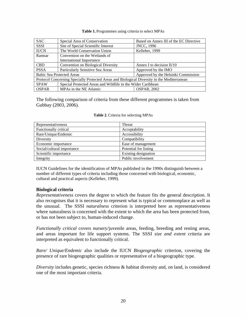
Table 1. Programmes using criteria to select MPAs
SAC Special Area of Conservation Based on Annex III of the EC Directive SSSI Site of Special Scientific Interest JNCC, 1996 IUCN The World Conservation Union Kelleher, 1999 Ramsar Convention on the Wetlands of
International Importance
CBD Convention on Biological Diversity Annex I to decision II/10 PSSA Particularly Sensitive Sea Areas Approved by the IMO Baltic Sea Protected Areas Approved by the Helsinki Commission Protocol Concerning Specially Protected Areas and Biological Diversity in the Mediterranean SPAW Special Protected Areas and Wildlife in the Wider Caribbean OSPAR MPAs in the NE Atlantic OSPAR, 2002 The following comparison of criteria from these different programmes is taken from Gubbay (2003, 2006).
Table 2. Criteria for selecting MPAs
Representativeness Threat Functionally critical Acceptability Rare/Unique/Endemic Accessibility Diversity Compatibility Economic importance Ease of management Social/cultural importance Potential for listing Scientific importance Existing designation Integrity Public involvement IUCN Guidelines for the identification of MPAs published in the 1990s distinguish between a number of different types of criteria including those concerned with biological, economic, cultural and practical aspects (Kelleher, 1999). Biological criteria Representativeness covers the degree to which the feature fits the general description. It also recognises that it is necessary to represent what is typical or commonplace as well as the unusual. The SSSI naturalness criterion is interpreted here as representativeness where naturalness is concerned with the extent to which the area has been protected from, or has not been subject to, human-induced change. Functionally critical covers nursery/juvenile areas, feeding, breeding and resting areas, and areas important for life support systems. The SSSI size and extent criteria are interpreted as equivalent to functionally critical. Rare/ Unique/Endemic also include the IUCN Biogeographic criterion, covering the presence of rare biogeographic qualities or representative of a biogeographic type. Diversity includes genetic, species richness & habitat diversity and, on land, is considered one of the most important criteria.
20
Economic/Cultural criteria Economic importance covers the existing or potential economic contribution afforded by protection. Social/cultural importance includes the existing or potential value to local or international communities because of cultural, educational or recreational qualities. Scientific importance covers the value for research and monitoring, and encompasses the SAC Global assessment criterion. Practical criteria Integrity is interpreted as encompassing areas in a large state of naturalness and the degree to which a complete ecosystem is covered, and will also cover aspects of the SAC Global assessment criterion. Threat covers sensitivity and vulnerability. The SSSI Fragility criterion is interpreted as threat and includes disturbance, particularly during periods of breeding, rearing & migration. This also includes indirect effects reducing survival chances, breeding success or reproductive ability. The new EU guidance on disturbance means this is not limited to deliberate acts. Acceptability covers the degree of community support. Accessibility covers the degree of access for education, tourism and recreation. Compatibility covers co-existence with existing uses particularly by the local population. Ease of management relates to relationship with existing management regimes. Potential for listing on an existing national or international system. Existing designation also encompasses SAC Global assessment criterion. Public involvement is a regional criterion of the Mediterranean not listed in the other programmes. Application of criteria Both quantitative and qualitative approaches are made in applying criteria, and often rely on a combination of expert opinion, stakeholder involvement, and analytical techniques. There may be guidance for some criteria to take precedence over others, for example, Roberts et al (2003) identify prerequisite, excluding and modifying criteria, whilst the CBD provide design principles for Highly Protected Marine Reserves or HPMRs (CBD, 2004). Guiding principles need to address ecological, social & economic issues relevant to MPAs, for example, size, precaution, boundaries, minima, variety & networks, complementarity, social costs & benefits, and promoting public understanding.
21
EC Guidance The EC 2007 Habitats Directive Article 12 Guidance system of strict protection contains the following extracts that can be considered as guiding principles:Components of sustainable use MPAs are one of a number of management tools that can be used to help deliver sustainable development in the marine environment. The Convention of Biological Diversity has called for a national framework for ensuring sustainable use where actions are applied, either wherever these species occur in protected and highly protected areas, or they are focused on regulating human activities through wider measures. The CBD states very clearly that all components are necessary. For protected areas, highly protected areas and wider measures, there may be spatial and temporal dimensions to the conservation actions where criteria to identify important areas are required. A coherent & complete network based on an exhaustive list of sites has to be established, in accordance with the procedure & criteria set out in Annex III. A species-by-species approach is required that considers implementation in the light of the intended objective, the species concerned, and the circumstances of each case. This proportionate approach is not a static concept and becomes an important factor for the flexible (in conservation status, social, economic and cultural terms) implementation of species conservation. Article 4 For wide-ranging species, sites will be proposed only where there is a clearly identifiable area representing the physical and biological factors essential to their life and reproduction. “Here it may be advisable to restrict the definition of a breeding and resting site to a locality that can be clearly delimited, e.g. the roosts for bats or the holt of an otter”. However, in the Caretta caretta case, Laganas Bay was identified as a vital breeding region representing the physical and biological factors essential to their life and reproduction (marine area and nesting beaches). Functionally critical Natural range describes roughly the spatial limits within which the habitat or species occurs, including migratory routes. Integrity The importance of an indicator role of some species in judging the health of ecosystems is noted. Favourable Conservation Status: Population dynamics, range, sufficient habitat, and prospects of long-term viability all need to be considered on a species-by-species basis when designing measures for certain species.
22
A good scientific knowledge is required in order to implement meaningful species conservation measures and use of best available information from all reliable sources (conservation agencies & NGOs, universities, etc). Threat Often animal species do not fit perfectly into those requiring protection and management of sites (1st pillar Annex II), and measures to address direct influences on the species themselves as well as their eggs, breeding sites and resting places (2nd pillar Annex IV). Animal species subject to a combination of threats will require a range of measures. A two-fold regime applies to Annex II/IV species (sites & measures). Establishment of a coherent legal framework and application of concrete measures to enforce these provisions on the ground are required to effectively implement a system of strict protection. Preventative measures based on the Precautionary Principle are also found in Article 174 of the EC Treaty. Challenges Scientific
• Natural dynamics - how large to make the areas and how to cope with temporal changes in distribution.
• To increase scientific knowledge of pelagic ecosystems, the physical, chemical and biological processes that support them, and how this affects pelagic wildlife.
Technical
• A challenge for all types of MPAs, but more extreme in remote pelagic areas. Practicality
• The feasibility of management measures.
Monitoring and enforcement • Satellite technology could provide a means of monitoring and enforcement.
Legal • Speed of response to change. • Design of MPAs. One option is to define core, buffer and transitional zones in
protected areas, a key feature of biosphere reserves as promoted by UNESCO and used in both terrestrial and marine environments, for example, up to 11 species of cetaceans in The Gully, Eastern Canada.
• Another option is to design MPAs with flexible or dynamic boundaries, which change according to the location of the feature of key importance, that is, by using Seasonal Management Areas and responding to the uncertainty by having Dynamic Management Areas, for example, Stellwagen Bank National
23
Marine Sanctuary, USA - important for a number of cetacean species including the humpback and northern right whales.
• Part of a network of MPAs, and marine spatial management measures for the marine environment as a whole.
Perception
• Getting the concept of using MPAs for the conservation of pelagic diversity taken seriously enough that it is given detailed consideration. This means raising awareness and overcoming a perception that they are of little value for the conservation of highly mobile species in a very dynamic environment.
• With a sound scientific underpinning to identify important areas, the next step is to demonstrate that MPAs will be a useful conservation tool.
CONCLUSIONS There is a lot of experience in the use of selection criteria for MPAs to draw upon. MPAs exist for cetaceans using Seasonal & Dynamic Management Areas that allows for the seasonality & extreme mobility of many species. In the UK, new legislation will be required to create HPMRs that could form part of the proposed Marine Bill. This also includes a proposal for sectoral management to be harmonised, simplified, and integrated with these new designations.
REFERENCES Andrews, J.W. 2006. Options for delivering Highly Protected Marine Areas in Wales. CCW Policy
Research Report No 06/42: 1-59. European Commission. 2007. EC Guidance document on the strict protection of animal species of
Community interest under the Habitats Directive 92/43/EEC, February 2007. European Commission, Brussels.
Gubbay, S. 2003. Protecting the Natural Resources of the High Seas. Scientific Background paper. IUCN, WCPA & WWF High Seas Marine Protected Area Workshop, Malaga, 15-17th Jan,2003.
Gubbay, S. 2006. Highly Protected Marine Reserves in Wales. CCW Contract Science Report No 762: 1-127.
Gubbay, S. 2007. Marine Nature Conservation in the Pelagic Environment: a Case for Pelagic Marine Protected Areas? WWF, Godalming. 47pp.
Hoyt, E. 2005. Marine Protected Areas for Whales, Dolphins and Porpoises. A World Handbook for Cetacean Habitat Conservation. Earthscan, London. 492pp.
IUCN 1999. Guidelines for Marine Protected Areas. World Commission on Protected Areas. Best Practice Protected Area Guidelines, Series No.3.
JNCC 1996. Guidelines for Selection of Biological SSSIs. JNCC, Peterborough.51pp. JNCC 1997. Selection of SACs in the UK. JNCC, Peterborough. OSPAR 2002. Fourth Workshop on Marine Protected Areas in the OSPAR Area. Roscoff: 8-12th July.
Summary Record. MPA 02/8/1 Annex 4. Roberts, C.M., Andelman, S., Branch, G., Bustamante, R.H., Castilla, J.C., Dugan, J., Halpern, B.S.,
Lafferty, K.D., Leslie, H., Lubchenco, J., McArdle, D., Possingham, HP., Ruckelshaus, M., and Warner, R.R., 2003. Ecological criteria for evaluating candidate sites for marine reserves. Ecological Applications, 13(1) Supplement: 119-214.
24
MARINE PROTECTED AREAS AND LARGE WHALES
Greg Donovan
International Whaling Commission, The Red House, 135 Station Road, Impington, Cambridge CB24 9NP, UK ([email protected])
INTRODUCTION The designation of ‘Marine Protected Areas’ or MPAs has become a fashionable goal in certain marine conservation quarters but there is no generally accepted definition of what comprises an MPA or the measures they may incorporate. In many ways this lack of a prescriptive approach is a positive thing – an MPA should be designed to achieve the specific goals of specific situations. The purpose of this short essay is to provide some thoughts on the value of MPAs of various kinds for the conservation of the whales; it is not a scientific paper and I have provided a general bibliography at the end rather than specific references. These should allow the interested reader to obtain more details should they so wish. Many of the considerations expressed here reflect the specific life history and threats faced by large whales, and others are more general; a number will be relevant to other species. In general, whales are migratory species, with most baleen whales migrating up to as much as 10,000 km between summer feeding grounds in polar and sub-polar regions and winter breeding grounds in tropical or semi-tropical waters (although the location of the breeding grounds are only known for the humpback Megaptera novaeangliae, and southern right whales Eubalaena australis). Little or no feeding occurs outside the feeding grounds so the animals have to build up vast energy reserves (stored as blubber) during the feeding season. The major exception to this is the Bryde’s whale Balaenoptera edeni, which does not enter colder (< about 16ºC) waters but can undertake large seasonal movements. Sperm whale migration is somewhat different with only older large males migrating to polar waters, with no evidence that they do not feed at other times of the year; other classes of sperm whales remain in tropical and sub-tropical waters but can undertake large movements. In general, the whales found in the polar waters spend only the summer there, taking advantage of the extremely high productivity at that time of the year. However, there is increasing evidence (e.g. from acoustics) that some animals remain in polar waters much longer and may not migrate in some years. In short, whale ranges can be extremely large and there is considerable temporal as well as geographical variation in distribution. These features of life history alone greatly influence any discussion of MPAs and large whales.
25
Critical Habitat In many cases, MPAs do not cover the complete range of the species but rather focus on what is termed ‘ critical habitat’ – once again however, this concept is not well-defined and/or requires detailed long-term information that is often not available. Traditionally, for the migratory species, the primary habitats are considered to be the ‘feeding grounds’, ‘breeding grounds’ and ‘migratory corridors’. Feeding grounds In several species, especially the rorquals, feeding grounds are believed to be more ‘concentrated’ geographically than breeding grounds (although the location of the breeding grounds is often unknown) but they can still cover huge areas. In the western North Atlantic, humpback whales return from a ‘mixed’ breeding ground in the Caribbean to relatively discrete feeding areas. This site fidelity has been revealed by long-term photo-identification studies, and, more recently, by genetic studies. It is believed to be due to the maternal influence on the calves. In the Antarctic baleen whale feeding grounds, there appears to be considerably more mixing, based on information from “Discovery” marks, photo-identification and genetic studies. There is also temporal variation by age- and reproductive classes in terms of arrival at and departure from the feeding grounds. Within feeding areas, there is still a great deal to be learnt about smaller scale temporal and geographical distribution. At the broader scale, what is the relationship between oceanography, food webs and prey distribution? From the whale perspective, what are the factors involved in their small-scale distribution? Some obvious candidates are prey species, overall prey density within a region, and the size/density of individual patches – an important implication of these factors is how do whales themselves collect and assimilate the information that determines their distribution on the feeding grounds, and what influence does interspecific competition have (if any) on the temporal and spatial distribution of species feeding on the same prey species (e.g. krill, Euphausia superba in the Antarctic)? From the perspective of MPAs, the question is how predictable is predictable and at what spatial and temporal scales? Breeding grounds and migratory corridors Our level of knowledge concerning breeding grounds varies considerably from species to species. In some species, such as the humpback and right whales, the locations of the breeding grounds are well-known and are often relatively concentrated; in some cases (e.g. southern right and eastern gray whales), the breeding grounds are coastal and relatively easily accessible. This is also true for all or part of the migratory corridors for some populations. In these circumstances, temporal and geographical distribution is relatively well-known and predictable. In other cases, such as the more pelagic rorquals, breeding grounds are poorly known and are suspected to be widespread. It should be noted that although the use of the term ‘breeding’ grounds is widespread in the literature, mating behaviour is not restricted to the breeding grounds and has also been observed along migratory corridors in some species (e.g. gray and right whales) – in fact ‘calving’ grounds may be a more appropriate general term.
26
Possible objectives of MPAs Establishment of an MPA should not be seen as an aim in itself – it must serve some purpose that can be monitored in terms of success. Thus first and foremost, the objectives of the proposed MPA must be established and quantified. There are four key potential (and inter-related) general objectives for MPAs:
(1) conservation and management; (2) promotion of scientific research; (3) public awareness; and (4) political issues.
A fifth potential category of objectives, outside the scope of this primarily scientifically based paper, is that society may decide that a particular activity is unacceptable and use an MPA as one means to achieve its banning (e.g. whaling, nuclear testing, etc). Before briefly examining each of the four categories outlined above, I would like to stress two points that are often overlooked: (1) we can only manage (or at least try to) human activities not whales; and (2) despite our best intentions, our attempts to manage human activity for the benefit of conservation can have unforeseen and negative effects as well as positive ones, making monitoring the effects of our activities essential rather than an optional extra. Conservation and management Threats to cetaceans can be said to incorporate two broad categories. The first are those that result in death in the short-term such as direct hunting (e.g. whaling) and indirect hunting (e.g. bycatches in fishing gear, ship strikes). At the level of the individual animal, this is of course always a problem; however, at the population level, for which conservation is normally said to apply, this is not necessarily so provided the level of mortality is sustainable. Ground-breaking conservative methods to establish sustainable levels of kills of large cetaceans have been developed by the IWC Scientific Committee for both commercial (The ‘Revised Management Procedure’) and aboriginal subsistence (the Aboriginal Subsistence Whaling Management Procedure) whaling. These take into account indirect hunting and environmental degradation (see below). However, there is another category of threats more difficult to identify and quantify – those that can be said to affect the ‘overall fitness’ of the population with respect to reproductive success and/or survivorship and that are generally related to environmental degradation. These include such factors as chemical pollution, noise pollution, overexploitation of prey, climate change, etc. At the level of the individual these may not always appear to be a problem (a female whose reproductive ability has been impaired may seem perfectly healthy), but at the population level they may represent a serious threat. As noted above, the management procedures developed by the IWC Scientific Committee also have to take these factors into account. These environmental factors can affect populations of all species; indeed the most vulnerable to such threats may be those populations for whom direct exploitation would not be allowed. In such cases, merely granting protection from direct hunting is clearly not enough to ensure their survival.
27
In terms of the conservation of whale stocks and the management of human activities to try to achieve this, it is important to decide what it is we are trying to conserve. This is effectively a human decision and must be spelt out in the first management objective; it can range from a whole ecosystem through a biological population to a smaller sub-group. The next stage is to examine and try to determine and quantify the actual and potential threats to the unit you are trying to conserve, both in terms of direct and indirect threats. Once this is done, then actual and potential mitigation measures to address those threats must be identified. An MPA (or series of MPAs) is one possible tool to achieve this but only if it includes a dedicated set of measures to address the identified threats (and of course a monitoring programme to ensure that the measures proposed are being carried out properly and that they are having the desired positive conservation effect. For example, if a major threat to a population is bycatch in fishing gear, then an MPA that does not address this factor is doomed to failure. If it is decided that an MPA is an appropriate strategy, then particularly for large whales with their enormous range, choice of appropriate boundaries is critical. Choice of boundaries is directly related to the management objectives and as we have seen can be complex for cetaceans: e.g. should the boundaries be geographically fixed (easiest to manage from a human perspective) or should they reflect oceanographic or other features (e.g. temperature contours, upwellings) that may better reflect the true distribution at any one time (but are difficult to manage) or even vary temporally (as whale distribution certainly does)? Deciding boundaries for management (MPAs or catch limit setting) requires considerable information collected over a long period from a number of sources, including genetic data, distributional data (from sightings or catch histories), morphometric data, pollutant data, parasite burden data etc. Experience has shown that, difficult as it may be, combining the information from a suite of techniques leads to the most reliable results. In fact, considerable progress has been made in developing a theoretical framework to incorporate such variable information, and ‘spatial modelling’ is becoming a valuable research tool. An excellent example in the context of MPAs is the work undertaken off the Spanish Mediterranean coast by Cañadas and colleagues (see this volume). It is particularly important that boundaries are based on a reasonably long period of data and that there is some degree of flexibility available to change them in the light of experience. Cetacean distribution can vary considerably from one year to the next; basing boundaries on only one or two surveys has the potential to cause serious problems. For example, if bycatch is a threat and boundaries to avoid the threat (i.e. by banning fishing gear in the area) are based on a single year’s cetacean distribution, then fishing effort is likely to increase near to the boundaries of the area. If the cetaceans occupy this area in a subsequent year, this may in fact increase bycatch (due to increased fishing effort) rather than decrease it. As pioneered by the IWC Scientific Committee in its work on management procedures, an important component of looking at the boundary problem (and other conservation-
28
related issues) is to investigate the implications of getting things wrong. This can be addressed initially by the use of computer simulation studies which can also identify (1) the chances of proposed measures working and (2) important research needs to assist in reducing the uncertainty surrounding proposed measures. In addition, it is also absolutely essential to ensure that monitoring is carried out in the field. Scientific research MPAs have the potential to assist scientific research in terms of providing ‘control’ areas, facilitating permit granting and even obtaining research funds. Of course, the usual rules of evaluating scientific programmes must apply: setting of clear objectives; specification of proposed methods to achieve the objectives; evaluation of the likely chance of success; and evaluation of the effects of the proposed research on the conservation of the animals. Public awareness If it is deemed necessary to consider establishing management measures, including designation of an MPA and associated management plan, it is essential that interested parties (industry, local government, conservation groups, etc) are involved in the process from the outset. The setting of management objectives can be informed by science but it is in effect a political process. The designation of appropriate management measures will almost certainly affect some stakeholders in a negative manner (e.g. loss of livelihood or reduction of income), at least in the short-term, and it is essential that such decisions are not taken lightly and that every effort is made to explain the need for particular management actions and to discuss how these can best be designed and initiated with those affected. While consensus may not always be possible, people are much more likely to observe rules if they see the need for them and have been consulted rather than if they are ‘imposed from on high’. An excellent example of the whole process from scientific research to determine if there was a need for management measures to a proposal for an MPA with an associated management and monitoring plan can be found in the EU-LIFE programme carried out in Spanish Mediterranean waters; throughout the process, every effort was made to engage and discuss the proposal with local stakeholders. Political issues There have been several examples from both the marine and terrestrial world in which MPAs have been seen as a way to ingratiate oneself with a constituency, irrespective of whether the necessary scientific and other work had been carried out and a suitable management and monitoring plan established. Establishing an MPA without defining associated management and monitoring measures achieves little in itself from a conservation perspective although it may provide some degree of political popularity for the instigator(s) and as a by-product begin to improve local awareness and encourage research. It is vital that any MPA addresses all of the identified important threats and has a suitable budget to ensure enforcement. In fact if it does not do so it can actually be a danger to good conservation by giving the impression that threats are being addressed when they are not – the fear of ‘paper’ parks is a real one. For whale populations, with often enormous ranges and a wide range of actual or potential threats, there are tremendous logistical and financial difficulties in developing management, monitoring and enforcement plans, even if the necessary scientific work has been carried out; added to that are the potential legal difficulties involved in developing measures to
29
address the many potential and actual threats in the high seas. These require international co-operation across conventions. For example, if overfishing of prey items is an identified threat, action would need to be taken by appropriate fishery bodies whose primary concern may not be the conservation of cetaceans; a body such as the International Whaling Commission only has the power to ban certain types of whaling, not matters related to environmental degradation. Similarly, difficulties may arise if the source of chemical pollution lies outside the boundaries of the identified MPA and the range of the affected animals. CONCLUSION The need to establish an MPA can in some ways be a sign of failure rather than something to be proud of; it often reflects a conservation crisis as a reflection of poor management. MPAs should not be seen as an end in themselves and whilst their establishment may be necessary in specific cases, they should not be seen as an excuse not to manage all areas and components of the oceans properly. In a world with many conservation problems, it is important that a priority framework for conservation actions is established that is based on sound science, a full evaluation of the most appropriate tool or tools to address the important problems, and an involvement of all stakeholders. A well-designed MPA with appropriate management, monitoring and enforcement can be a powerful tool for wise conservation and management; a poorly designed MPA that does not address the key threats may even have a negative effect.
BIBLIOGRAPHY
Agardy, T. 2004. The use of marine protected areas in cetacean conservation. European Cetacean Society Conference Guide and Abstracts 15: 125.
Cañadas, A., Sagarminaga, R., De Stephanis, R., Urquiola, E. and Hammond, P.S. 2005. Habitat selection modelling as a conservation tool: proposals for marine protected areas for cetaceans in southern Spanish waters. Aquat. Conserv. 15: 495-521.
Donovan, G. 2005. Cetaceans: can we manage to conserve them? The role of long-term monitoring. pp.161-74. In: Solbé, J. (eds). Long-term Monitoring - why, what, where, when and how? Sherkin Island Marine Station, Sherkin Island, Co. Cork, Ireland.
Hall, M.A. and Donovan, G.P. 2002. Environmentalists, fishermen, cetaceans and fish: is there a balance and can science find it? pp.491-521. In: Evans, P.G.H. and Raga, J.A. (eds). Marine Mammals: Biology and Conservation. Kluwer Academic/Plenum Publishers, New York.
Hoyt, E. 2005. Marine Protected Areas for Whales, Dolphins and Porpoises. A World Handbook for Cetacean Habitat Conservation. Earthscan, London, Sterling VA. 492 pp.
Hyrenbach, K.D., Forney, K.A. and Dayton, P.K. 2000. Marine protected areas and ocean basin management. Aquat. Conserv., 10: 437-58.
International Whaling Commission. 2004. Report of the Intersessional Meeting to Review the Southern Ocean Sanctuary, Sorrento, Italy, 30 June to 1 July 2004. J. Cetacean Res. Manage. (Suppl.) 7: 403-10.
Punt, A. E. and Donovan, G. P. 2007. Developing management procedures that are robust to uncertainty: lessons from the International Whaling Commission. – ICES Journal of Marine Science, 64: 603–612.
Zacharias, M.A., Gerber, L.R. and Hyrenbach, K.D. 2006. Review of the Southern Ocean Sanctuary: Marine Protected Areas in the comtext of the International Whaling Commission Sanctuary Programme. J. Cetacean Res. Manage. 8(1): 1-12.
30
HABITAT MODELLING FOR LARGE CETACEANS1
S. Panigada1,2, M. Zanardelli1, M. MacKenzie3, C. Donovan3,
F. Mélin4, and P.S. Hammond2
1Tethys Research Institute, c/o Acquario Civico, Viale G.B. Gadio 2, 20121 Milan, Italy
([email protected]) 2Sea Mammal Research Unit, Gatty Marine Laboratory, University of St. Andrews,
St. Andrews, Fife, KY16 8LB, UK 3Centre for Research into Environmental and Ecological Modelling, The Observatory, Buchanan Gardens,
University of St Andrews, St Andrews, Fife, KY169LZ, UK 4European Commission - Joint Research Centre - Institute for Environment and Sustainability,
T.P. 272 21020 Ispra (VA), Italy
INTRODUCTION This paper aims to provide insights on modelling habitat use and preference of fin whales (Balaenoptera physalus) in the Pelagos Sanctuary, using both physiographic (depth, slope, distance from the coast) and remotely sensed variables (Sea Surface Temperature SST, Chlorophyll-a concentration Chl-a), in order to assess areas of particular importance for this species. The Pelagos Sanctuary (Fig. 1) is a large Marine Protected Area (MPA) established in 2002 by a joint declaration between the Governments of France, Italy and Monaco (Notarbartolo di Sciara et al., in press). The Sanctuary was inscribed in the SPAMI list within the framework of the Barcelona Convention, after the ratification process of the three signatory States. This MPA lies between south-eastern France, Monaco, northern Sardinia and north-western Italy, covering an area of almost 90,000 km2. The area included in the Sanctuary comprises national waters of Italy, France and Monaco and adjacent international waters. The fin whale is the only mysticete species regularly occurring in the waters of the Pelagos Sanctuary (Notarbartolo di Sciara et al., 2003). Genetic analyses suggest that the Mediterranean and eastern North Atlantic populations of this species are isolated from each other, with little gene flow between the two geographical areas (Bérubé et al., 1998; Palsbøll et al., 2003). Fin whales in the Mediterranean are exposed to a number of anthropogenic threats, such as acoustic and chemical pollution (Fossi et al., 2003), and habitat degradation (Notarbartolo di Sciara and Gordon, 1997). In addition, fin whales are particularly threatened by collisions with vessels (Fig. 2), which represent the major cause of non-natural mortality for this species (Panigada et al., 2006), and disturbance by boats (Jahoda et al., 2003).
1 Text and figures adapted from: Panigada, S., Zanardelli, M., MacKenzie, M., Donovan, C., Mélin, F., Hammond, P.S. In press. Modelling habitat preferences for fin whales and striped dolphins in the Pelagos Sanctuary (Western Mediterranean Sea) with physiographic and remote sensing variables. Remote Sensing of the Environment.
31
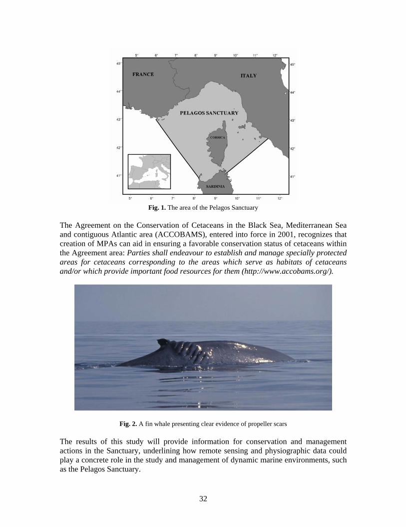
Fig. 1. The area of the Pelagos Sanctuary
The Agreement on the Conservation of Cetaceans in the Black Sea, Mediterranean Sea and contiguous Atlantic area (ACCOBAMS), entered into force in 2001, recognizes that creation of MPAs can aid in ensuring a favorable conservation status of cetaceans within the Agreement area: Parties shall endeavour to establish and manage specially protected areas for cetaceans corresponding to the areas which serve as habitats of cetaceans and/or which provide important food resources for them (http://www.accobams.org/).
Fig. 2. A fin whale presenting clear evidence of propeller scars The results of this study will provide information for conservation and management actions in the Sanctuary, underlining how remote sensing and physiographic data could play a concrete role in the study and management of dynamic marine environments, such as the Pelagos Sanctuary.
32
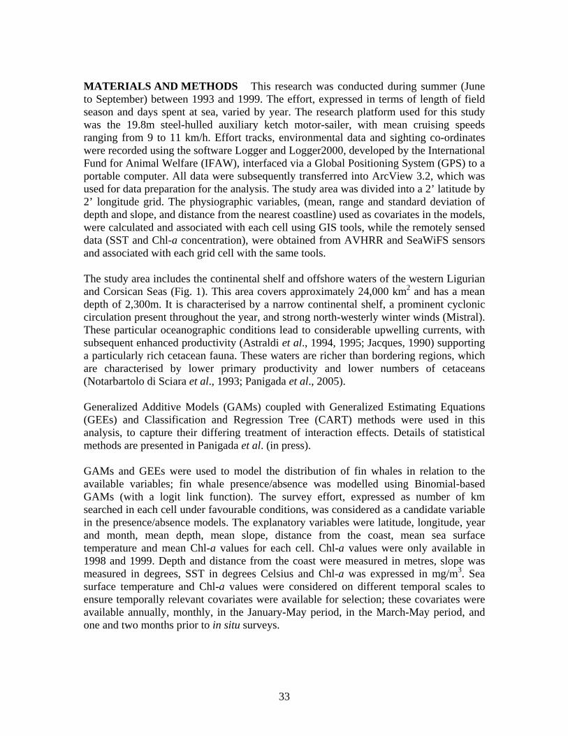
MATERIALS AND METHODS This research was conducted during summer (June to September) between 1993 and 1999. The effort, expressed in terms of length of field season and days spent at sea, varied by year. The research platform used for this study was the 19.8m steel-hulled auxiliary ketch motor-sailer, with mean cruising speeds ranging from 9 to 11 km/h. Effort tracks, environmental data and sighting co-ordinates were recorded using the software Logger and Logger2000, developed by the International Fund for Animal Welfare (IFAW), interfaced via a Global Positioning System (GPS) to a portable computer. All data were subsequently transferred into ArcView 3.2, which was used for data preparation for the analysis. The study area was divided into a 2’ latitude by 2’ longitude grid. The physiographic variables, (mean, range and standard deviation of depth and slope, and distance from the nearest coastline) used as covariates in the models, were calculated and associated with each cell using GIS tools, while the remotely sensed data (SST and Chl-a concentration), were obtained from AVHRR and SeaWiFS sensors and associated with each grid cell with the same tools. The study area includes the continental shelf and offshore waters of the western Ligurian and Corsican Seas (Fig. 1). This area covers approximately 24,000 km2 and has a mean depth of 2,300m. It is characterised by a narrow continental shelf, a prominent cyclonic circulation present throughout the year, and strong north-westerly winter winds (Mistral). These particular oceanographic conditions lead to considerable upwelling currents, with subsequent enhanced productivity (Astraldi et al., 1994, 1995; Jacques, 1990) supporting a particularly rich cetacean fauna. These waters are richer than bordering regions, which are characterised by lower primary productivity and lower numbers of cetaceans (Notarbartolo di Sciara et al., 1993; Panigada et al., 2005). Generalized Additive Models (GAMs) coupled with Generalized Estimating Equations (GEEs) and Classification and Regression Tree (CART) methods were used in this analysis, to capture their differing treatment of interaction effects. Details of statistical methods are presented in Panigada et al. (in press). GAMs and GEEs were used to model the distribution of fin whales in relation to the available variables; fin whale presence/absence was modelled using Binomial-based GAMs (with a logit link function). The survey effort, expressed as number of km searched in each cell under favourable conditions, was considered as a candidate variable in the presence/absence models. The explanatory variables were latitude, longitude, year and month, mean depth, mean slope, distance from the coast, mean sea surface temperature and mean Chl-a values for each cell. Chl-a values were only available in 1998 and 1999. Depth and distance from the coast were measured in metres, slope was measured in degrees, SST in degrees Celsius and Chl-a was expressed in mg/m3. Sea surface temperature and Chl-a values were considered on different temporal scales to ensure temporally relevant covariates were available for selection; these covariates were available annually, monthly, in the January-May period, in the March-May period, and one and two months prior to in situ surveys.
33
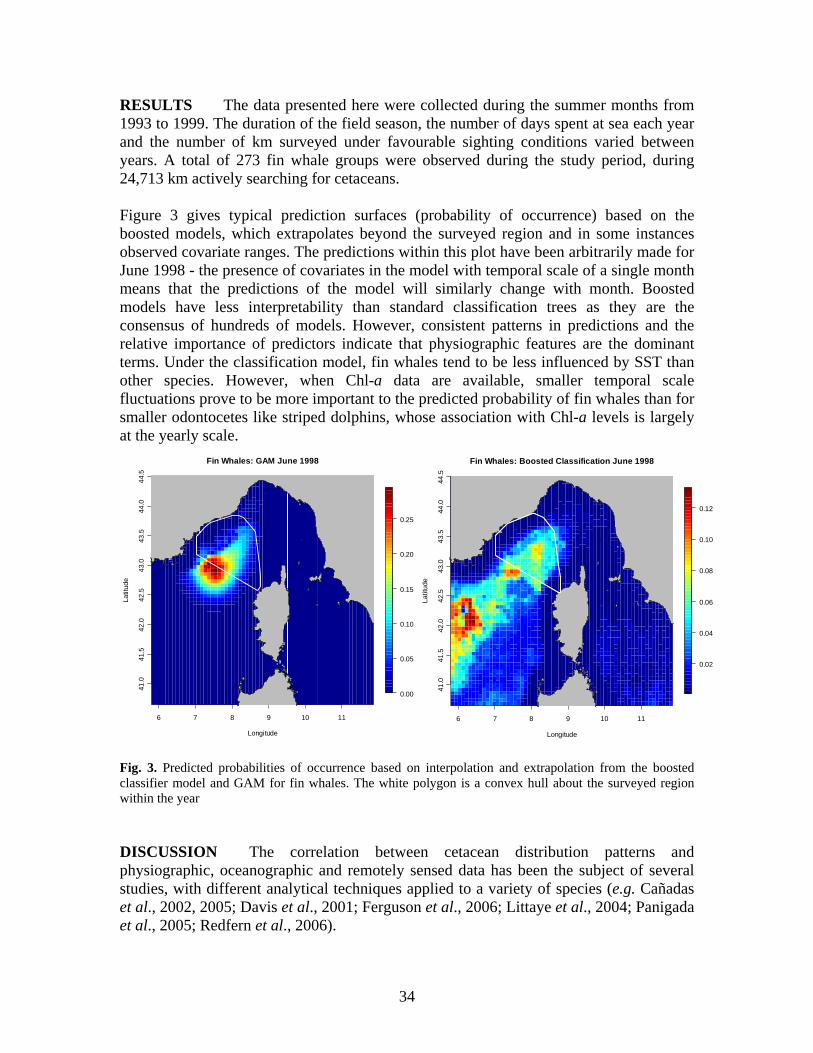
RESULTS The data presented here were collected during the summer months from 1993 to 1999. The duration of the field season, the number of days spent at sea each year and the number of km surveyed under favourable sighting conditions varied between years. A total of 273 fin whale groups were observed during the study period, during 24,713 km actively searching for cetaceans. Figure 3 gives typical prediction surfaces (probability of occurrence) based on the boosted models, which extrapolates beyond the surveyed region and in some instances observed covariate ranges. The predictions within this plot have been arbitrarily made for June 1998 - the presence of covariates in the model with temporal scale of a single month means that the predictions of the model will similarly change with month. Boosted models have less interpretability than standard classification trees as they are the consensus of hundreds of models. However, consistent patterns in predictions and the relative importance of predictors indicate that physiographic features are the dominant terms. Under the classification model, fin whales tend to be less influenced by SST than other species. However, when Chl-a data are available, smaller temporal scale fluctuations prove to be more important to the predicted probability of fin whales than for smaller odontocetes like striped dolphins, whose association with Chl-a levels is largely at the yearly scale.
6 7 8 9 10 11
41.0
41.5
42.0
42.5
43.0
43.5
44.0
44.5
Fin Whales: Boosted Classification June 1998
Longitude
Latit
ude
0.02
0.04
0.06
0.08
0.10
0.12
6 7 8 9 10 11
41.0
41.5
42.0
42.5
43.0
43.5
44.0
44.5
Fin Whales: GAM June 1998
Longitude
Latit
ude
0.00
0.05
0.10
0.15
0.20
0.25
Fig. 3. Predicted probabilities of occurrence based on interpolation and extrapolation from the boosted classifier model and GAM for fin whales. The white polygon is a convex hull about the surveyed region within the year DISCUSSION The correlation between cetacean distribution patterns and physiographic, oceanographic and remotely sensed data has been the subject of several studies, with different analytical techniques applied to a variety of species (e.g. Cañadas et al., 2002, 2005; Davis et al., 2001; Ferguson et al., 2006; Littaye et al., 2004; Panigada et al., 2005; Redfern et al., 2006).
34
This paper presents insights on the habitat preferences of fin whales in the Pelagos Sanctuary. Cetacean presence and encounter rates were modelled using GAMs and GEEs in order to select which covariate was mainly driving their presence and use of habitat in the area, and predictions were made to describe patterns in the density of striped dolphins and fin whales in the study area. Boosted classification trees were used to assess relative significance of covariates, potentially the result of complex interactions, and from predicted probabilities indicate areas of particular importance (critical habitats) for the species in the Sanctuary. The fin whale in the Mediterranean Sea has a marked offshore distribution but can be observed also on the continental shelf, where it may be occasionally driven by prey resources (Gannier et al., 2002; Notarbartolo di Sciara et al., 2003; Panigada et al., 2005). The main known prey item for Mediterranean fin whale in the Sanctuary area is the euphausiid Meganyctiphanes norvegica, found at great densities in association with areas of divergence of the Ligurian-Provencal front (Notarbartolo di Sciara et al., 2003; Panigada et al., 2005). The applied models selected principally physiographic variables when assessing fin whale presence in the Pelagos Sanctuary area. The mean depth relationship appears to be relatively consistent across years and fin whales were more likely to be seen in deep water, as previously described for this species in the area (Notarbartolo di Sciara et al., 2003; Panigada et al., 2005). Fin whale presence peaked in June and decreased steadily across months toward the end of summer, reaching lowest values in September. SST values were retained by the models at different time scales, including annual and seasonal averages, monthly and two months before in situ sampling; fin whales tended to prefer waters within the 21-24° C range. The classification models indicated the dominance of physiographic variables in the prediction of fin whale occurrence. However, seasonal scale Chl-a levels were indicated as important when the data were available to the model. Given that more fin whale sightings are predicted in deep water, the models also predict more fin whale sightings in the waters west of the coast of Corsica, in the deepest portion of the study area. Recent studies on Mediterranean fin whales have shown that one of the most important natural forces affecting their distribution is the availability and distribution of their primary food source (Goméz de Segura et al., 2006; Littaye et al., 2004; Panigada et al., 2005); the observed pelagic distribution of this species most likely reflects the distribution of northern krill (M. norvegica) This paper has tested and applied innovative methods in describing cetacean habitat use and preference, using both physiographic and remotely-sensed data. The physiographic variables used were significant predictors, as was SST in predicting striped dolphin and fin whale distribution. Chl-a levels were selected by the models when available. However, several weeks may separate peaks in chlorophyll and zooplankton, as well as
35
peaks in zooplankton and high concentrations of fin whales (Littaye et al., 2004; Notarbartolo di Sciara et al., in press). The regional scope of the analysis presented here, dictated by the availability of cetacean data, makes the identification of relationships with physical and biological spatial distributions more challenging. Indeed, as previously described, the Sanctuary area is a highly productive Mediterranean ecosystem associated with a regime of high abundance of cetaceans, thus a priori limiting the range of variation that the related variables might exhibit elsewhere in more oligotrophic areas. The ecological outputs of this work include a description of the main factors that influence fin whale distribution in the area. This will be of value when planning future research and monitoring programmes; in particular some covariates, such as physiographic features and, to a lesser extent, SST and Chl-a values deserve continuous monitoring since these appear to be associated with animal presence and abundance, while others found to be less statistically significant may merit further consideration because they may be influential at different spatial and/or temporal scales. Management and conservation issues are addressed by providing a preliminary identification of areas of particular importance for the species examined. These areas seem to be mainly concentrated in the western part of the Pelagos Sanctuary. However, these zones of importance may be identified either by physiographic and/or dynamic variables (Hooker et al., 1999) and therefore may change over a temporal as well as a geographical scale. A thorough understanding of the physical and ecological processes governing the waters of the Pelagos Sanctuary is still missing (Notarbartolo di Sciara et al., in press); improving this understanding will allow better implementation of the necessary mitigation and conservation tools and measures for this area, which is exposed to heavy anthropogenic pressure. Anthropogenic impacts, such as maritime and leisure traffic, should also be considered when analyzing critical habitats or areas of particular importance for cetaceans. Heavy traffic levels may displace animals from one area, characterized by high biomass concentration, to another one that may be less ecologically important (Fortuna, 2006). In light of this, we propose that the whole Sanctuary area, as well as western adjacent waters, be considered as a widespread critical habitat for the fin whale and the striped dolphin. Areas of particular ecological importance within the Sanctuary will be more accurately described once a deeper understanding of the biological and physical processes affecting cetacean presence and occurrence in the area is achieved. ACKNOWLEDGEMENTS Many thanks to the colleagues of the Tethys Research Institute for their support throughout the years. Our gratitude goes to the International Fund for Animal Welfare (IFAW), who provided the Logger Software, which was used for data logging during the cruises. We are thankful to Roberto Gramolini for the development of CR Tools. Thank you to Giuseppe Notarbartolo di Sciara for his editorial comments. Several people participated and allowed data
36
collection: we are particularly grateful to them. This research has been partly supported by a Marie Curie Fellowship (Cat. 30) of the European Community programme Quality of Life under contract number QLK5-CT-2002-51634 awarded to SP.
REFERENCES Astraldi, M., Gasparini, G.P. and Sparnocchia, S. 1994. The seasonal and interannual variability in the
Ligurian-Provencal Basin. Coastal and Estuarine Studies, 46: 93-113. Astraldi, M., Bianchi, C.N., Gasparini, G.P. and Morri, C. 1995. Climatic fluctuations, current variability
and marine species distribution: a case study in the Ligurian Sea (north-west Mediterranean). Oceanologica Acta, 18(2): 139-49.
Bérubé, M., Aguilar, A., Dendanto, D., Larsen, F., Notarbartolo di Sciara, G., Sears, R., Sigurjonsson, J., Urbàn Ramirez, J. and Palsbøll, P. 1998. Population genetic structure of North Atlantic, Mediterranean Sea and Sea of Cortez fin whales, Balaenoptera physalus (Linnaeus, 1758); analysis of mitochondrial and nuclear loci. Molecular Ecology, 7: 585-599.
Cañadas, A., Sagarminaga, R. and Garcia-Tíscar, S. 2002. Cetacean distribution related with depth and slope in the Mediterranean waters off southern Spain. Deep-Sea Research part I, 49: 2053-2073.
Cañadas, A., Sagarminaga, R., De Stephanis, R., Urquiola, E. and Hammond, P.S. 2005. Habitat preference modelling as a conservation tool: proposals for marine protected areas for cetaceans in southern Spanish waters. Aquatic Conservation: Marine and Freshwater Ecosystems, 15: 495-521.
Davis, R.W., Ortega-Ortiz, J.G., Ribic, C.A., Evans, W.E., Biggs, D.C., Ressler, P.H., Cady, R.B., Leben, R.R., Mullin, K.D. and Würsig, B. 2001. Cetacean habitat in the northern ocean Gulf of Mexico. Deep-Sea Research part I, 49: 121-42.
Ferguson, M.C., Barlow, J., Fiedler, P., Reilly, S.B. and Gerrodette, T. 2006. Spatial models of delphinid (family Delphidae) encounter rate and group size in the eastern tropical Pacific Ocean. Ecological Modelling, 193: 645-662.
Fortuna, C.M. 2006. Ecology and conservation of bottlenose dolphins (Tursiops truncatus) in the north-eastern Adriatic Sea. Ph.D. Thesis. University of St. Andrews, UK.
Fossi, M.C., Marsili, L., Neri, G., Natoli, A., Politi, E. and Panigada, S. 2003. The use of a non-lethal tool for evaluating toxicological hazard of organochlorine contaminants in Mediterranean cetaceans: new data 10 years after the first paper published in MPB. Marine Pollution Bulletin, 46(8) : 972-82.
Gannier, A., Bourreau, S., Drouot, V., Gannier, O. and Laran, S. 2002. Summer distribution of fin whale (Balaenoptera physalus) in the Mediterranean Sea. Mésogée, Bulletin du Muséum d’Histoire Naturelle de Marseille, 60: 17-25.
Gómez de Segura, A., Crespo, E.A., Pedraza, S.N., Hammond, P.S. and Raga, J.A. 2006. Abundance of small cetaceans in waters of the central Spanish Mediterranean. Marine Biology, 150: 149-160.
Hooker, S.K., Whitehead, H. and Gowns, S. 1999. Marine Protected Area design and the spatial and temporal distribution of cetaceans in a submarine canyon. Conservation Biology, 13(3) : 592-602.
Jacques, G. 1990. L’oligotrophie du milieau pélagique de Méditerranée occidentale: un paradigme qui s’éstompe? Bulletin de la Société Zoologique de France, 114: 17-30. [In French].
Jahoda, M., Lafortuna, C.L., Biassoni, N., Almirante, C., Azzellino, A., Panigada, S., Zanardelli, M. and Notarbartolo di Sciara, G. 2003. Mediterranean fin whale’s (Balaenoptera physalus) response to small vessels and biopsy sampling assessed through passive tracking and timing of respiration. Marine Mammal Science, 19(1): 96-110.
Littaye, A., Gannier, A., Laran, S. and Wilson, J.P.F. 2004. The relationship between summer aggregation of fin whales and satellite-derived environmental conditions in the northwestern Mediterranean Sea. Remote Sensing of the Environment, 90: 44-52.
Notarbartolo di Sciara, G., Venturino, M.C., Zanardelli, M., Bearzi, G., Borsani, F.J. and Cavalloni, B. 1993. Cetaceans in the central Mediterranean Sea: distribution and sighting frequencies. Italian Journal of Zoology, 60: 131-138.
Notarbartolo di Sciara, G. and Gordon, J. 1997. Bioacoustics: a tool for the conservation of cetaceans in the Mediterranean Sea. Marine and Freshwater Behaviour and Physiology, 30: 125-46.
Notarbartolo di Sciara, G., Zanardelli, M., Panigada, S., Jahoda, M. and Airoldi, S. 2003. Fin whale, Balaenoptera physalus (L., 1758), in the Mediterranean Sea. Mammal Review, 33(2): 105-150.
37
Notarbartolo di Sciara, G., Agardy, T., Hyrenbach, D., Scovazzi, T. and Van Klaveren, P. In press. The Pelagos sanctuary for Mediterranean marine mammals. Aquatic Conservation: Marine and Freshwater Ecosystems.
Palsbøll, P. J., Bérubé, M., Aguilar, A., Notarbartolo di Sciara, G. and Nielsen, R. 2004. Discerning between recurrent gene flow and recent divergence under a finite-site mutation model applied to North Atlantic and Mediterranean Sea fin whale (Balaenoptera physalus) populations. Evolution, 58(3): 670-675.
Panigada, S., Notarbartolo di Sciara, G., Zanardelli Panigada, M., Airoldi, S., Borsani, J. F. and Jahoda, M. 2005. Fin whales (Balaenoptera physalus) summering in the Ligurian Sea: distribution, encounter rate, mean group size and relation to physiographic variables. Journal of Cetacean Research and Management, 7(2): 137-145.
Panigada, S., Pesante, G., Zanardelli, M., Capoulade, F., Gannier, A. and Weinrich, M.T. 2006. Mediterranean fin whales at risk from fatal ship strikes. Marine Pollution Bulletin, 52: 1287-1298.
Panigada, S., Zanardelli, M., MacKenzie, M., Donovan, C., Mélin, F., Hammond, P.S. In press. Modelling habitat preferences for fin whales and striped dolphins in the Pelagos Sanctuary (Western Mediterranean Sea) with physiographic and remote sensing variables. Remote Sensing of the Environment.
Redfern, J.V., Ferguson, M.C., Becker, E.A., Hyrenbach, K.D., Good, C., Barlow, J., Kaschner, K., Baumgartner, M.F., Forney, K.A., Ballance, L.T., Fauchald, P., Halpin, P., Hamazaki, T., Pershing, A.J., Qian, S.S., Read, A., Reilly, S.B., Torres, L. and Werner F. 2006. Techniques for cetacean–habitat modelling. Marine Ecology Progress Series, 310: 271-295.
38
SPATIAL MODELLING AS A TOOL FOR DESIGNING MARINE PROTECTED AREAS FOR SMALL CETACEANS
Ana Cañadas1, Ricardo Sagarminaga1 and Philip S. Hammond2
1Alnitak. Nalon 16. 28240 Hoyo de Manzanares. Madrid. Spain ([email protected])
2Sea Mammal Research Unit. Gatty Marine Laboratory, University of St Andrews, St Andrews, Fife KY16 8LB, UK
Cetaceans are typically highly mobile and wide-ranging species and are potentially vulnerable to a range of threats, including the effects of fishing (direct - bycatch; indirect - habitat destruction and prey depletion). Developing appropriate and effective conservation measures is thus a considerable challenge. One advantage of this group of species is that they are highly ‘charismatic’ and can therefore be used as ‘flagship’ or ‘emblematic’ species for conservation of the marine environment in general, as well as the species themselves (Katona and Whitehead, 1988; Simberloff, 1998; Hoyt, 2005). One conservation tool that is increasingly seen as a useful way of protecting cetaceans from threats is the designation of Marine Protected Areas (MPAs) (e.g. Gubbay, 1995; Boersma and Parrish, 1999; Schwartz, 1999; Hyrenbach et al., 2000; Reeves, 2000; Hooker and Gerber, 2004). But how useful are they? It is important to consider whether the designation of MPAs is the most appropriate solution to the problems that cetaceans are facing. Clearly, the conservation of cetaceans requires the development of appropriate and effective conservation strategies. The creation of MPAs may represent one step in this process, and may serve the purpose of involving policy makers and the public - without which the probability of success will be small. However, without the appropriate implementation of management plans, MPAs only represent “paper parks” that provide a false impression of conservation success (Duffus and Dearden, 1995). As a general rule, we believe that the designation of MPAs should not be seen as the sole solution to the wise management and conservation of the whole ocean environment. But they can be valuable tools if conceived and implemented properly. Whether a particular MPA is effective will depend on the initial objectives, its design (especially its boundaries), and its enforcement. The critical steps are: a) to set clear quantified conservation objectives; b) develop a well-supported long-term management plan to achieve these objectives; and c) to establish an effective monitoring programme to assess whether or not the conservation objectives are being met (Gubbay, 1995; Salm et al., 2000). Salm and collaborators (2000) suggested an approach for a selection process for MPAs, which we followed when selecting the MPAs proposed in Southern Spain. The initial step is to define conservation objectives for the MPAs. Once these have been agreed, the selection process should include four steps:
• data collection (including both a literature search and collection of new data with respect to the target species, human activities, and threats);
39
• data analysis (to determine areas with concentrations of the target species, human activities, and threats to the species);
• data synthesis (to create maps to help to establish priorities for protection, and to better understand spatial relationships among the target species, ecological processes and human activities); and
• application of selection criteria (to ensure objectivity in the choice of the sites, based on the objectives and the legal framework in which they are based).
Spatial modelling incorporates data on the environment to generate a spatial prediction of relative density based on the preference for habitats defined by combinations of environmental covariates. The areas identified for the candidate MPAs thus provide the best description of distribution available, as informed by features of the habitat that are shown to be important. This represents a great improvement over using simple measures of animal occurrence such as simple distribution maps or encounter rates. When combined with line transect sampling (called the model-based method; Hedley et al., 1999), it is an alternative technique to conventional line transect sampling (design-based method; Buckland et al., 2001), suitable for estimating abundance of biological populations such as cetaceans from surveys that have not been designed to achieve equal coverage probability. The model approach allows the creation of contiguous areas of highest predicted relative densities and the generation of potential MPA boundaries that can incorporate given proportions of predicted relative abundance (Cañadas and Hammond, 2006). Another feature of the approach adopted here is that areas with apparently good habitat but few sightings can be identified, where this is due to low searching effort. It may be worth exploring these areas more intensively in future field studies to evaluate this prediction, and reconsider possible recommendations for those areas (Cañadas and Hammond, 2006). An advantage of the approach is that models can be re-fitted to incorporate both new sightings and expanded environmental data to clarify preferences (and associated mechanisms), and to explore whether habitat preference appears to be changing. Reassessing the relationships between relative abundance and environmental covariates is a useful way of monitoring how well the MPA is likely to be affording protection. As a case study, we present here the results of the modelling approach for bottlenose dolphins off Southern Spain (Cañadas et al., 2005). This map shows the habitat preference of this species in the study area, based on more than a decade of data.
40
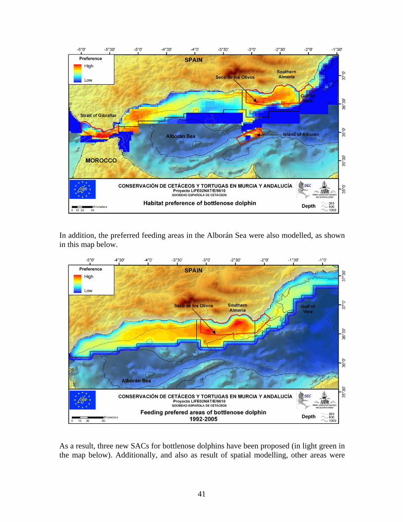
In addition, the preferred feeding areas in the Alborán Sea were also modelled, as shown in this map below.
As a result, three new SACs for bottlenose dolphins have been proposed (in light green in the map below). Additionally, and also as result of spatial modelling, other areas were
41
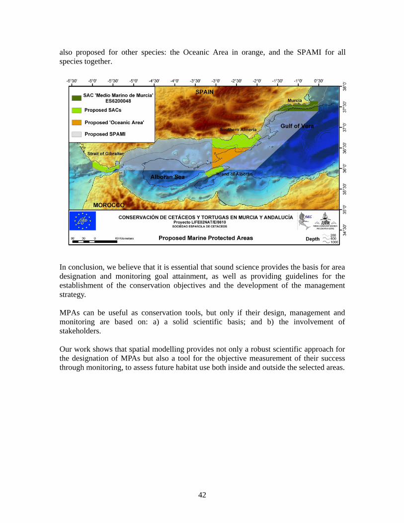
also proposed for other species: the Oceanic Area in orange, and the SPAMI for all species together.
In conclusion, we believe that it is essential that sound science provides the basis for area designation and monitoring goal attainment, as well as providing guidelines for the establishment of the conservation objectives and the development of the management strategy. MPAs can be useful as conservation tools, but only if their design, management and monitoring are based on: a) a solid scientific basis; and b) the involvement of stakeholders. Our work shows that spatial modelling provides not only a robust scientific approach for the designation of MPAs but also a tool for the objective measurement of their success through monitoring, to assess future habitat use both inside and outside the selected areas.
42
REFERENCES
Boersma, P.D. and Parrish, J.K. 1999. Limiting abuse: marine protected areas, a limited solution.
Ecological Economics, 31: 287-304. Buckland, S. T., Anderson, D. R., Burnham, K. P., Laake, J.L., Borchers, D.L. and Thomas, L. 2001.
Introduction to Distance Sampling. Estimating abundance of biological populations. Oxford University Press. Oxford. 432pp.
Cañadas, A. and Hammond, P. 2006. Model-based abundance estimate of bottlenose dolphins off Southern Spain: implications for conservation and management. Journal of Cetacean Research and Management, 8(1): 13-27.
Cañadas, A., Sagarminaga, R. de Stephanis, R. Urquiola, E. and Hammond, P.S. 2005. Habitat selection models as a conservation tool: proposal of marine protected areas for cetaceans in Southern Spain. Aquatic Conservation: Marine and Freshwater Ecosystems, 15: 495-521.
Duffus, D.A. and Dearden, P. 1995. Whales, science and protected area management in British Columbia, Canada. Pp. 53-61 In: Agardy, T. (Ed.) The science of conservation in the coastal zone. IUCN, Gland, Switzerland
Gubbay, S. (ed.) 1995. Marine Protected Areas. Principles and techniques for management. Chapman and Hall, London. 232 pp.
Hedley, S.L., Buckland, S.T. and Borchers, D.L. 1999. Spatial modelling from line transect data. Journal of Cetacean Research and Management, 1 (3): 255-264.
Hooker, S.K. and Gerber, L.R. 2004. Marine reserves as a tool for ecosystem-based management: The potential importance of megafauna. BioScience, 54 (1): 27-39.
Hoyt, E. 2005. Marine Protected Areas for whales, dolphins and porpoises. Earthscan, London. 492pp. Hyrenbach, K.D., Forney, K.A. and Dayton, P.K. 2000. Marine protected areas and ocean basin
management. Aquatic Conservation: Marine and Freshwater Ecosystems, 10: 437-458. Katona, S. and Whitehead, H. 1988. Are cetacea ecologically important? Oceanogr. Mar. Biol. Annu. Rev.,
26: 553-568. Reeves, R.R. 2000. The Value of Sanctuaries, Parks, and Reserves (Protected Areas) as Tools for
Conserving Marine Mammals. Final Report to the Marine Mammal Commission, contract number T74465385. Marine Mammal Commission, Bethesda, MD. 50pp.
Salm, R.V., Clark, J. and Siirla, E. 2000. Marine and Coastal Protected Areas: A Guide for Planners and Managers. IUCN – The World Conservation Union, Washington DC. xxi + 371pp.
Schwartz, M.W. 1999. Choosing the appropriate scale of reserves for conservation. Annual Review of Ecological Systems, 30: 83-108.
Simberloff, D. 1998. Flagships, umbrellas, and keystones: is single-species management passé in the landscape era? Biological Conservation, 83 (3). 247-257.
43
HARBOUR PORPOISE SPATIAL MODELLING TO IDENTIFY POSSIBLE HOTSPOTS FOR MARINE PROTECTED AREAS
Peter G.H. Evans1, 2 and J. Wang3
1Sea Watch Foundation, Cynifryn, Llanfaglan, Caernarfon, Gwynedd LL54 5RA, UK
2School of Ocean Sciences, University of Wales Bangor, Marine Science Laboratories, Menai Bridge, Anglesey, Gwynedd LL59 5AB, UK ([email protected])
3Department of Zoology, Univ. of Aberdeen, Tillydrone Avenue, Aberdeen AB24 2TZ, UK
INTRODUCTION Under Article 4 of the 1992 EC Habitats and Species Directive, member states of the European Union have been requested to submit to the European Commission a list of candidate Special Areas of Conservation (SACs) for the habitat types and species listed in Annexes I and II, respectively, of the Directive. One of the species listed is the harbour porpoise, Phocoena phocoena, but insufficient information has been available to identify sites in the UK that satisfied the requirements of Article 4.1, which requires that, for species, sites are proposed only where there is a clearly identifiable area representing the physical and biological factors essential to their life and reproduction. The list of candidate sites was reviewed by the EC in 1999 and considered insufficient, and following an experts’ meeting in Brussels in December 2000, a recommendation was made that at least some areas important for the species should be identified on the basis of: 1) the continuous or regular presence of the species (although subjected to seasonal variation); 2) Good population density (in relation to neighbouring areas); and 3) high ratio of young to adults during certain periods of the year. MATERIALS AND METHODS The Joint Cetacean Database, with contributions particularly from the Joint Nature Conservation Committee (JNCC), Sea Watch Foundation (SWF) and Sea Mammal Research Unit (SMRU), represents an important resource of effort-related cetacean data for North-west European waters, and has been used to produce maps of cetacean distributions for north-west European waters for a Cetacean Atlas at the scale of 1/4 ICES (International Council for the Exploration of the Sea) rectangles (c. 25 x 25 km – 625 km2) (Reid et al., 2003). However, the spatial analyses conducted to derive species distributions were at too coarse a scale to detect concentrations. The UK undertook to re-examine distribution data for harbour porpoise with a view to site selection for this species. Two approaches to data analysis were proposed, one involving Generalised Additive Modelling (conducted by the University of St Andrews) using a subset of data, and the other GIS analysis including continuous scaling of abundance values and variography (conducted by Sea Watch Foundation & University of Aberdeen). It was felt that each could complement the other. This paper reports on the latter approach, the analyses being conducted using effort-related data collected up to 2002. In 2002, the Joint Cetacean Database comprised over 100,000 hours of effort data and c. 17,000 associated sightings records of porpoises gathered over the period 1980 and 2002) (Table 1). First, a review was made of the data sources, necessary verification procedures, and potential sources of bias and how these could be addressed. For each year and each month of the year, the total amount of time spent observing during each sea
44
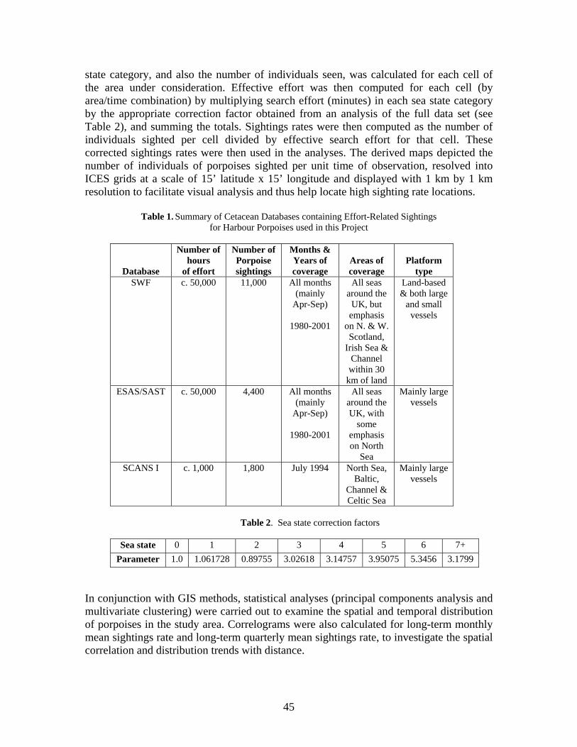
state category, and also the number of individuals seen, was calculated for each cell of the area under consideration. Effective effort was then computed for each cell (by area/time combination) by multiplying search effort (minutes) in each sea state category by the appropriate correction factor obtained from an analysis of the full data set (see Table 2), and summing the totals. Sightings rates were then computed as the number of individuals sighted per cell divided by effective search effort for that cell. These corrected sightings rates were then used in the analyses. The derived maps depicted the number of individuals of porpoises sighted per unit time of observation, resolved into ICES grids at a scale of 15’ latitude x 15’ longitude and displayed with 1 km by 1 km resolution to facilitate visual analysis and thus help locate high sighting rate locations.
Table 1. Summary of Cetacean Databases containing Effort-Related Sightings for Harbour Porpoises used in this Project
Database
Number of hours
of effort
Number of Porpoise sightings
Months & Years of coverage
Areas of coverage
Platform
type SWF c. 50,000 11,000 All months
(mainly Apr-Sep)
1980-2001
All seas around the
UK, but emphasis
on N. & W. Scotland,
Irish Sea & Channel within 30
km of land
Land-based & both large
and small vessels
ESAS/SAST c. 50,000 4,400 All months (mainly
Apr-Sep)
1980-2001
All seas around the UK, with
some emphasis on North
Sea
Mainly large vessels
SCANS I c. 1,000 1,800 July 1994 North Sea, Baltic,
Channel & Celtic Sea
Mainly large vessels
Table 2. Sea state correction factors
Sea state 0 1 2 3 4 5 6 7+
Parameter 1.0 1.061728 0.89755 3.02618 3.14757 3.95075 5.3456 3.1799
In conjunction with GIS methods, statistical analyses (principal components analysis and multivariate clustering) were carried out to examine the spatial and temporal distribution of porpoises in the study area. Correlograms were also calculated for long-term monthly mean sightings rate and long-term quarterly mean sightings rate, to investigate the spatial correlation and distribution trends with distance.
45
RESULTS The long-term presence of porpoises was examined and mapped, along with the distributions of the calf : adult ratios in the months of June, July, August, and September (the months following peak calving in this species). Distribution patterns were then interpreted taking account of limitations in the data sets (e.g. variable effort, possible partitioning errors particularly in low effort cells, and differences in sightings efficiencies). The period of the SCANS survey (July 1994) stands out for its wide-ranging coverage (Hammond et al., 2002). However, when the 22 years of data were combined, there was found to be generally good coverage every month of the year over the North-west European continental shelf, particularly within the UK sector (see APPENDIX 1). A separate analysis was conducted on standardized numbers of sightings for the month of July with and without SCANS data. These showed that the SCANS survey influenced sightings rates for the eastern sector of the North Sea but made little difference to the rest of the study area. Taking the pattern of effort overall, during the winter months (November-April) effort is greatest (>50 hours per grid cell per month) along the continental European coast in the southernmost North Sea and eastern portion of the Channel (see Appendix 1). During May-October, although those same areas tend to receive a relatively large amount of effort (30-50 hours per grid cell per month), some additional regions receive higher than average effort (>30 hours per grid cell) – off North-west Wales in May, South-west Wales in June, the western sector of the central and northern North Sea in July, coastal waters of Grampian region in North-east Scotland, the Minches in North-west Scotland, and around Humberside in August, and coastal waters of Grampian region and eastern England from Northumberland to Humberside in September. Whereas some of the highest sightings rates have occurred in South-west Wales (10 months >100/hr), Shetland (10 months >100/hr), and off North-west Scotland (5 months >100/hr), these do not appear to have received greater effort over the 22-year period as a whole compared with several other areas with low sightings rates (e.g. most of eastern England with sightings rates <30/hr, and most of southern England with sightings rates of 0-10/hr). This suggests that although it may have some influence on the findings (on the basis that cells with very low effort could give poor representation of the occurrence of porpoises, leading to Type I and Type II errors), effort alone does not account for the observed concentrations. CONCLUSIONS A number of areas were highlighted as having greater than average numbers of porpoises regularly present during an important period (April-September) in the annual cycle of the species (see APPENDIX 2). These are organised into three categories (in descending order of priority - see Fig. 1): Category 1 (four areas) (defined as locations where porpoises have been recorded over several years, with a presence in every month of the year, and concentrations (mean standardized sightings rates >50/hour) in at least four months during the important period April-September): Shetland Isles (particularly east coastal waters); coastal waters of western Scotland including the eastern sectors of the Minch and Sea of Hebrides (and incorporating waters around the Isle of Skye, Small Isles – Rum, Eigg, Muck and Canna,
46
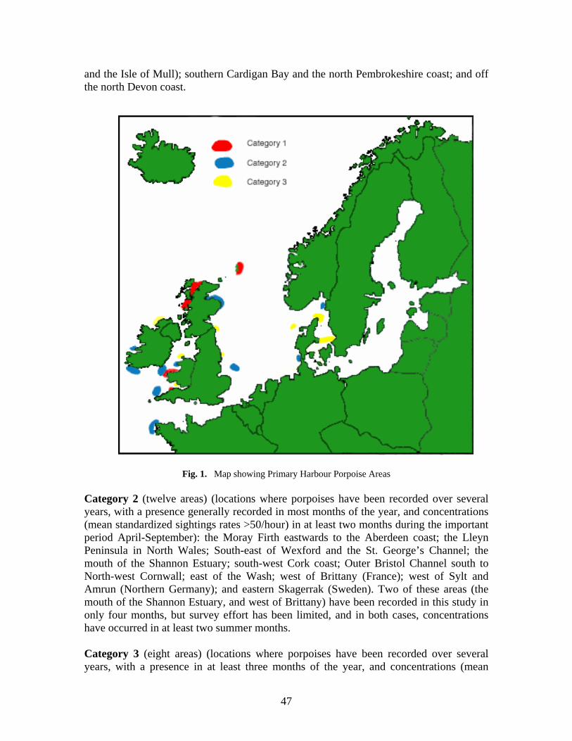
and the Isle of Mull); southern Cardigan Bay and the north Pembrokeshire coast; and off the north Devon coast.
Fig. 1. Map showing Primary Harbour Porpoise Areas Category 2 (twelve areas) (locations where porpoises have been recorded over several years, with a presence generally recorded in most months of the year, and concentrations (mean standardized sightings rates >50/hour) in at least two months during the important period April-September): the Moray Firth eastwards to the Aberdeen coast; the Lleyn Peninsula in North Wales; South-east of Wexford and the St. George’s Channel; the mouth of the Shannon Estuary; south-west Cork coast; Outer Bristol Channel south to North-west Cornwall; east of the Wash; west of Brittany (France); west of Sylt and Amrun (Northern Germany); and eastern Skagerrak (Sweden). Two of these areas (the mouth of the Shannon Estuary, and west of Brittany) have been recorded in this study in only four months, but survey effort has been limited, and in both cases, concentrations have occurred in at least two summer months. Category 3 (eight areas) (locations where porpoises have been recorded over several years, with a presence in at least three months of the year, and concentrations (mean
47
standardized sightings rates >50/hour) in at least two months, though not necessarily between April and September): two areas in Eastern England, off the coast of Northumberland and Yorkshire; North Anglesey in North Wales, and Gower Peninsula in South Wales; Co. Donegal (N.W. Ireland); off North-west Denmark; southern Skagerrak & North-west Kattegat (Denmark), and southern Kattegat. Survey effort in Co. Donegal and the Southern Kattegat had been more limited than in the other areas. It should be noted that those in category 3 may be as important as those in categories 1 and 2, but were assigned to this grouping either on the basis of limited long-term data or because concentrations were not recorded regularly over the summer period that was identified as of special importance to the annual cycle of the species. A number of areas have not been included because concentrations have been observed only in a single month. For most of these, there is insufficient effort-related survey data from a series of years to substantiate their importance. In some cases, they have been recorded in only one year, when there is the additional possibility that partitioning error has caused inflated sightings rate values. These include offshore areas west of the Wyville-Thomson Ridge and the Outer Hebrides, in the South-west Channel Approaches, and several isolated areas in the North Sea; the Fair Isle Channel, Orkney, outer Moray Firth, south of Mull (West Scotland), Co. Down coast, north and east of the Dutch Frisian Islands, in Støre Belt (inner Danish waters), and in the western English Channel. Although it is self-evident, it should be emphasized that the recommendations here are reflecting those regions for which at the time of the analysis, there had been a reasonable amount of survey effort. Since then, there has been much more effort in the eastern North Sea, particularly in German and Danish waters. As revealed by other contributions to this volume (Sveegaard & Teilmann, and Gilles et al.), a number of the areas indicated above from relatively small amounts of survey data as potential hotspots, have been substantiated as important by new data, whilst further areas have been identified. It is encouraging that a mix of methods - vessel & aerial surveys, and radio telemetry of individuals, are reaching similar conclusions. If SACs are to be established within harbour porpoise hotspot areas, it is important to use long-term data sets to ensure that concentrations are not ephemeral. However, even where some regions may have had higher than average numbers of porpoises for a decade or more, distributional changes can take place. A good example of this applies to the waters around Shetland where porpoises were abundant during the early 1980s and early 1990s but in the last few years have become relatively uncommon, probably reflecting the large scale changes observed in sandeel stocks in the region, where a series of poor spawning years has resulted in low densities of sandeels and widespread poor breeding success amongst breeding seabirds feeding upon them. This is reflected also in a general southerly shift in July porpoise densities between the two SCANS surveys of 1994 and 2005 (P.S. Hammond, pers. comm.). This highlights the challenge facing us when prescribing areas for special protection for mobile species such as cetaceans. ACKNOWLEDGEMENTS We would like to thank the following: Simon Northridge (Sea Mammal Research Unit, St Andrews) and Graham Pierce (University of Aberdeen) for their assistance at various stages of the project; Mick Baines, Jim
48
Heimlich-Boran, Barry Shepherd, and Caroline Weir for their help with the Sea Watch database; Andy Webb, Jim Reid and Mark Tasker for help in connection with the ESAS database; and Simon Northridge for help in connection with the SCANS database and Joint Cetacean Database. We also thank very many database inputters, especially Pia Anderwald, Mick Baines, Sarah Earl, Steve Gwenin, Natalie Hawkswell, Anna Riverola, and Caroline Weir. And finally thanks go to all the contributors to the Joint Cetacean Database, especially Biscay Dolphin Research Programme (Tom Brereton, Andy Williams, and Rolf Williams), Cornwall Wildlife Trust (Ray Dennis, Lance Peters, and Nick Tregenza), Earthkind (Gillian Bell, Christina Thomas, and Peter Todd), Friends of Cardigan Bay (Mick Green and Megan Morgan-Jenks), Joint Nature Conservation Committee’s Seabirds At Sea Team (Jim Reid, Mark Tasker, Andy Webb and observers), Chris Pierpoint, Plymouth-Santander ferry surveys (Neil Fletcher and Dave Curtis), Sea Mammal Research Unit (Phil Hammond, Simon Northridge, and observers), West Wales Chartering Company (Steve Hartley and observers), Western Isles Sailing (Christopher Swann and Teo Leyssen), Whale & Dolphin Conservation Society (Marijke de Boer and Mark Simmonds), and all the Sea Watch regional groups, co-ordinators and observers who have undertaken effort-related observations (especially Mick Baines, Cliff Benson, Ian Birks, Sarah Canning, Lesley Carrie, Rob Colley, Emily Dicks, Sarah Earll, Paul Fisher, Richard and Brennan Fairbairns, John Hartley, Kevin Hepworth, Ian Hotchin, Mike Innes, David Jenkins, Emily Lewis, Cathryn Owen, Robin Petch & Kris Simpson, Steve Savage, Frank Scampton, Scottish Wildlife Trust wardens, Richard Shucksmith, Colin Speedie, Karen Stockin, Caroline Weir, and Paul & Grace Yoxon).
REFERENCES Evans, P.G.H. and Wang, J. 2003. Re-examination of Distribution Data for the Harbour Porpoise around
Wales and the UK with a view to site selection for this species. CCW Contract Scienced Report No: 634. Countryside Council for Wales, Bangor. 116 pp.
Hammond, P.S., Berggren, P., Benke, H., Borchers, D.L., Collet, A., Heide-Jørgensen, M.-P., Heimlich, S., Hiby, A.R., Leopold, M.F., and Øien, N. 2002. Abundance of harbour porpoise and other cetaceans in the North Sea and adjacent waters. J. Appl. Ecol., 39: 361-376.
Reid, J.B., Evans, P.G.H., and Northridge, S.P. 2003. Atlas of Cetacean distribution in north-west European waters Joint Nature Conservation Committee, Peterborough. 76 pp, colour photos, maps. Paperback, ISBN 1 86107 550 2.
49
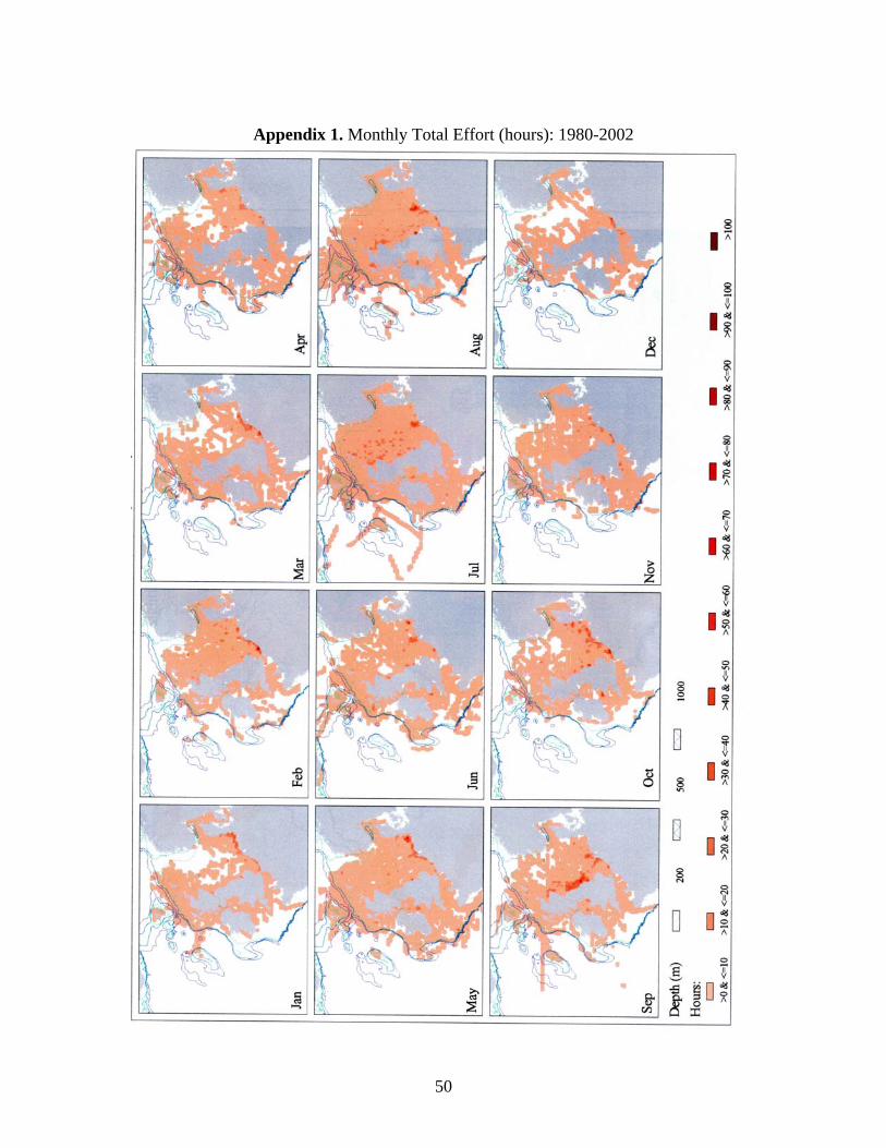
Appendix 1. Monthly Total Effort (hours): 1980-2002
50
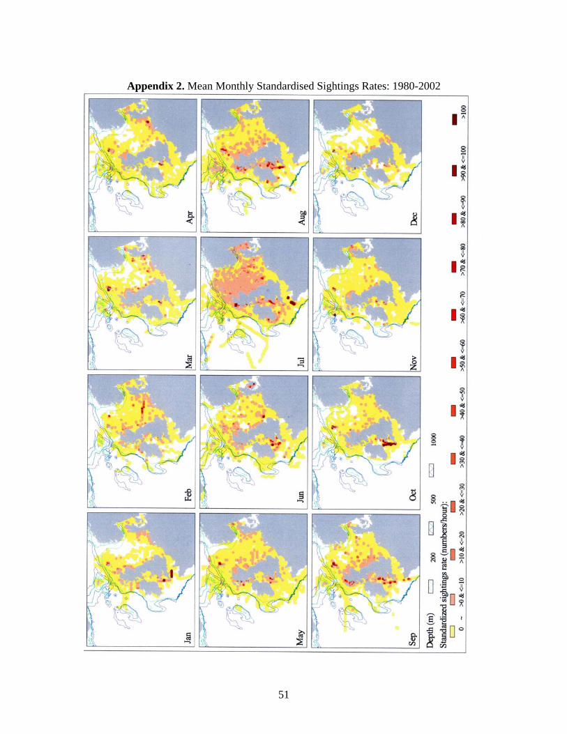
Appendix 2. Mean Monthly Standardised Sightings Rates: 1980-2002
51
CAN SATELLITE TELEMETRY SHOW US THE KEY HABITATS FOR HARBOUR PORPOISES?
Signe Sveegaard and Jonas Teilmann
National Environmental Research Institute, University of Aarhus,
Department of Arctic Environment, Frederiksborgvej 399, 4000 Roskilde, Denmark ([email protected])
INTRODUCTION During the last century the issue of how to protect nature and manage our surroundings in a sustainable way has become widely addressed at international, national and local levels. In all EU countries, a legal framework has been or is in the process of being implemented to protect endangered species and habitats and prevent further negative anthropogenic influences. The proper conservation of cetaceans depends on knowledge of several aspects of their population ecology. Ideally, information on population size, structure, and seasonal distribution as well as data on mortality, breeding productivity, and migration and emigration rates should be available. However, this is rarely the case. For a wide ranging species such as the harbour porpoise (Phocoena phocoena), knowledge on distribution and movements is limited due to their small size and shy behaviour making observations at sea difficult in anything but calm weather. A recent approach in the protection of small cetaceans is the designation of marine protected areas (MPAs or Special Areas of Conservation - SACs) as described in the European Habitat Directive (92/43/EEC). This Directive implies that all EU member states must designate SACs for harbour porpoises by 2012 (European Commission, 2007). The first step towards the selection and management of a protected area is identifying key habitats for harbour porpoises. Key habitat refers to those areas of a cetacean’s range that represent essential factors to their life and reproduction (Hoyt, 2005). For a wide ranging species such as the harbour porpoise that spends the majority of its time submerged, attaining knowledge of its key habitats is particularly difficult. This problem was addressed at a meeting convened by the European Commission in 2000 (European Commission, 2001). The meeting concluded that “it is possible to identify areas representing crucial factors for the life cycles of this species”. These areas should be selected on the basis of the following criteria:
1. The continuous or regular presence of the species (although subject to seasonal variations)
2. Good population density (in relation to neighbouring areas) 3. High ratio of young to adults during certain periods of the year
Thus, this study wished to identify key habitats by examining density and distribution of harbour porpoises. The current available methods are surveys (visual from aircraft or boat, and acoustic from boat), passive acoustic monitoring (PAM) e.g. using T-PODs, and satellite telemetry. However, since surveys only obtain an instantaneous view of the distribution and PAM has a limited spatial range (less than 300 m), we chose to focus on satellite telemetry. By analysing data from satellite tagged porpoises, this study aims to
52
identify key habitats for harbour porpoises in the inner Danish waters (IDW). Furthermore, we wanted to compare the results found by satellite telemetry to PAM on a smaller scale in order to validate PAM as a method of monitoring within MPAs. MATERIALS AND METHODS Satellite telemetry From 1997 to 2007, 38 harbour porpoises were tagged in the inner Danish waters. Porpoises were caught incidentally in pound nets and tagged within a maximum of 48 hours of entrapment. Satellite-linked transmitters (also called platform terminal transmitter; PTT) were attached to the dorsal fin (see details on method in Teilmann et al., 2007). The locations of satellite tagged animals are positioned according to the ARGOS system. The locations are saved and can be downloaded by the user. To remove implausible positions, the raw Argos data were filtered during download using the SAS-program, Argos_Filter v5.0 (Dave Douglas, USGS, Alaska Science Center, Alaska, USA). To standardize data, only one location per day was used in the analysis. To localize the key habitat for harbour porpoises, kernel density utilisation grids were produced in ArcMap using the fixed kernel density estimator (Hawth's Analysis Tool: www.spatialecology.com/tools/). Smoothing factor (or bandwidth) were set to 10.000 and output cell size to 1km2. The Kernel density estimator identifies the smallest area possible that includes X% of all positions, here 25%, 50%, 75% and 95%. This means that the 95% volume contour contains 95% of the locations that were used to generate the kernel density estimate and thus represent almost the entire range of the porpoises, while the 25% volume contour area represents the ‘core’ area with the highest density. Passive Acoustic Monitoring The T-POD (Time-POrpoise Detector, developed by N. Tregenza, Chelonia Ltd, UK) is a stationary acoustic data logger that detects and records echolocation clicks from porpoises (Chelonia Ltd). It can be used for obtaining continuous relative abundance on a small spatial scale of up to 300m (Tougaard et al., 2005). By applying user defined settings, it detects clicks using parameters such as bandwidth and frequency of porpoise echolocation clicks. A software program (TPOD.exe) analyses the data using an algorithm for detecting click trains characteristic for the species (see www.chelonia.demon.co.uk for more details). Two T-PODs were deployed in Flensborg Fjord from August 2005 to September 2006 at Helts Banke and Bredgrund, respectively. The T-PODs were inspected on average every sixth week: Data were downloaded, the batteries were changed, and the mooring and T-PODs cleaned and re-deployed. After download, the number of Porpoise Positive Days (PPD) per month was calculated. A PPD is a day of 24 hours with a least one porpoise encounter detected. All data were analyzed using the category “Cet all” (high and low probability cetacean click trains), which should exclude most noise from other sources. Relative density was calculated on both Helts Banke and Bredgrund for the whole year and for each season; winter (Dec-Feb), spring (Mar-May), summer (Jun-Aug) and autumn (Sep-Nov).
53
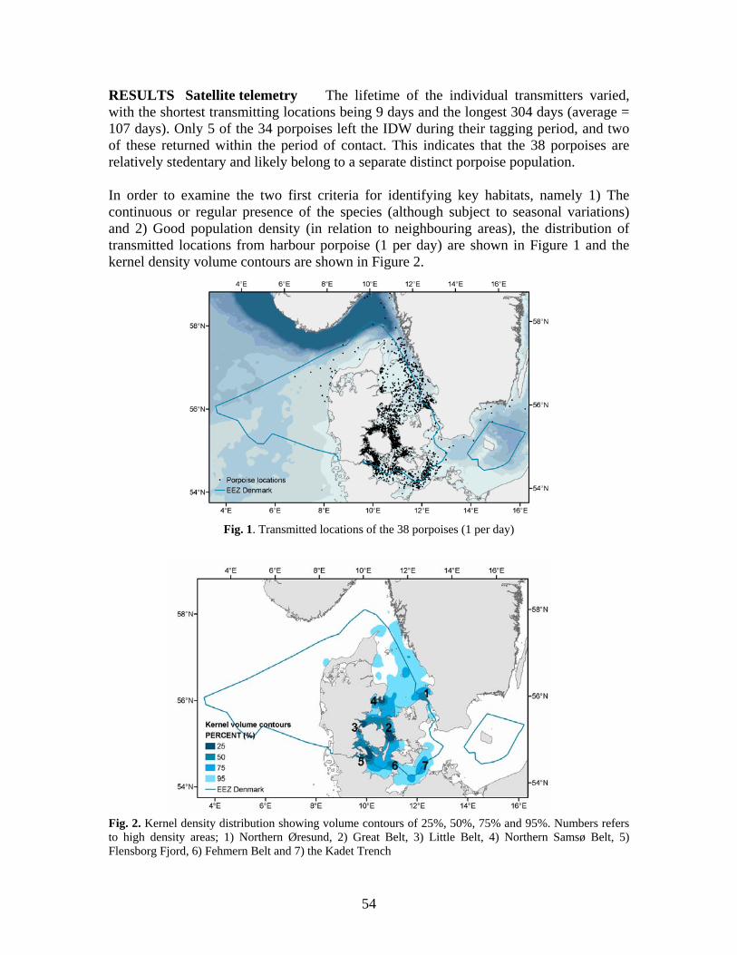
RESULTS Satellite telemetry The lifetime of the individual transmitters varied, with the shortest transmitting locations being 9 days and the longest 304 days (average = 107 days). Only 5 of the 34 porpoises left the IDW during their tagging period, and two of these returned within the period of contact. This indicates that the 38 porpoises are relatively stedentary and likely belong to a separate distinct porpoise population. In order to examine the two first criteria for identifying key habitats, namely 1) The continuous or regular presence of the species (although subject to seasonal variations) and 2) Good population density (in relation to neighbouring areas), the distribution of transmitted locations from harbour porpoise (1 per day) are shown in Figure 1 and the kernel density volume contours are shown in Figure 2.
Fig. 1. Transmitted locations of the 38 porpoises (1 per day)
Fig. 2. Kernel density distribution showing volume contours of 25%, 50%, 75% and 95%. Numbers refers to high density areas; 1) Northern Øresund, 2) Great Belt, 3) Little Belt, 4) Northern Samsø Belt, 5) Flensborg Fjord, 6) Fehmern Belt and 7) the Kadet Trench
54
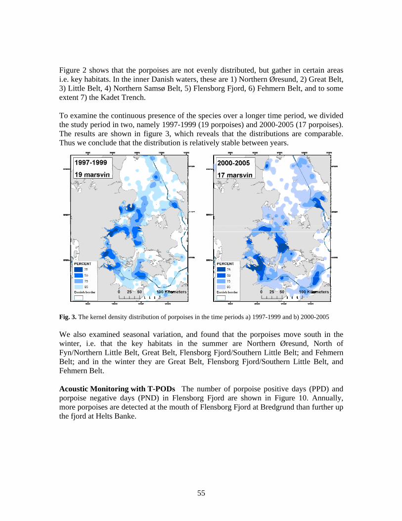
Figure 2 shows that the porpoises are not evenly distributed, but gather in certain areas i.e. key habitats. In the inner Danish waters, these are 1) Northern Øresund, 2) Great Belt, 3) Little Belt, 4) Northern Samsø Belt, 5) Flensborg Fjord, 6) Fehmern Belt, and to some extent 7) the Kadet Trench. To examine the continuous presence of the species over a longer time period, we divided the study period in two, namely 1997-1999 (19 porpoises) and 2000-2005 (17 porpoises). The results are shown in figure 3, which reveals that the distributions are comparable. Thus we conclude that the distribution is relatively stable between years.
Fig. 3. The kernel density distribution of porpoises in the time periods a) 1997-1999 and b) 2000-2005 We also examined seasonal variation, and found that the porpoises move south in the winter, i.e. that the key habitats in the summer are Northern Øresund, North of Fyn/Northern Little Belt, Great Belt, Flensborg Fjord/Southern Little Belt; and Fehmern Belt; and in the winter they are Great Belt, Flensborg Fjord/Southern Little Belt, and Fehmern Belt. Acoustic Monitoring with T-PODs The number of porpoise positive days (PPD) and porpoise negative days (PND) in Flensborg Fjord are shown in Figure 10. Annually, more porpoises are detected at the mouth of Flensborg Fjord at Bredgrund than further up the fjord at Helts Banke.
55
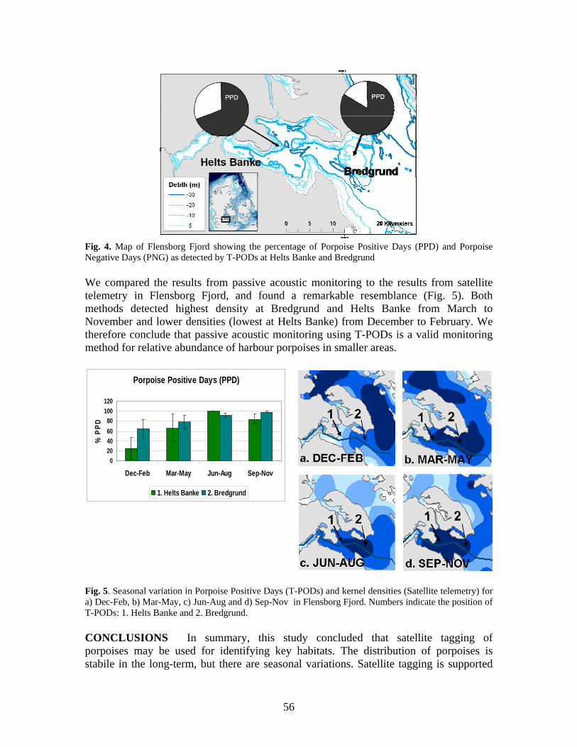
Fig. 4. Map of Flensborg Fjord showing the percentage of Porpoise Positive Days (PPD) and Porpoise Negative Days (PNG) as detected by T-PODs at Helts Banke and Bredgrund We compared the results from passive acoustic monitoring to the results from satellite telemetry in Flensborg Fjord, and found a remarkable resemblance (Fig. 5). Both methods detected highest density at Bredgrund and Helts Banke from March to November and lower densities (lowest at Helts Banke) from December to February. We therefore conclude that passive acoustic monitoring using T-PODs is a valid monitoring method for relative abundance of harbour porpoises in smaller areas.
Porpoise Positive Days (PPD)
020406080
100120
Dec-Feb Mar-May Jun-Aug Sep-Nov
% P
PD
1. Helts Banke 2. Bredgrund
Fig. 5. Seasonal variation in Porpoise Positive Days (T-PODs) and kernel densities (Satellite telemetry) for a) Dec-Feb, b) Mar-May, c) Jun-Aug and d) Sep-Nov in Flensborg Fjord. Numbers indicate the position of T-PODs: 1. Helts Banke and 2. Bredgrund. CONCLUSIONS In summary, this study concluded that satellite tagging of porpoises may be used for identifying key habitats. The distribution of porpoises is stabile in the long-term, but there are seasonal variations. Satellite tagging is supported
56
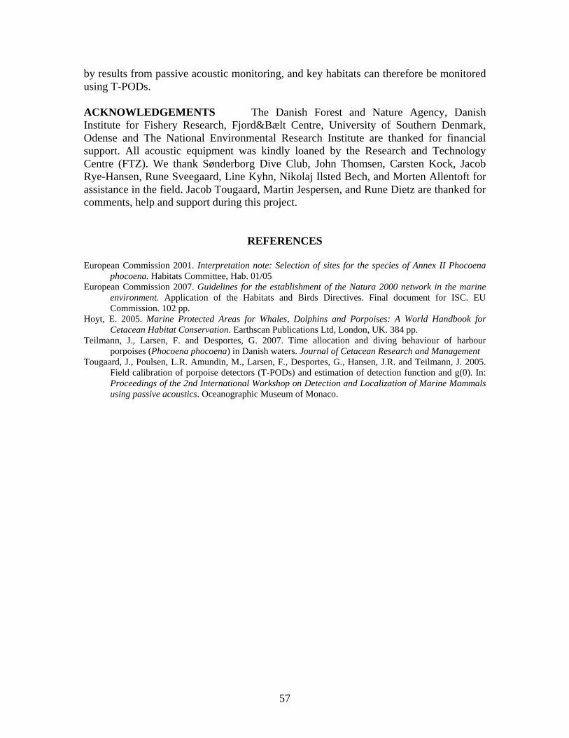
by results from passive acoustic monitoring, and key habitats can therefore be monitored using T-PODs. ACKNOWLEDGEMENTS The Danish Forest and Nature Agency, Danish Institute for Fishery Research, Fjord&Bælt Centre, University of Southern Denmark, Odense and The National Environmental Research Institute are thanked for financial support. All acoustic equipment was kindly loaned by the Research and Technology Centre (FTZ). We thank Sønderborg Dive Club, John Thomsen, Carsten Kock, Jacob Rye-Hansen, Rune Sveegaard, Line Kyhn, Nikolaj Ilsted Bech, and Morten Allentoft for assistance in the field. Jacob Tougaard, Martin Jespersen, and Rune Dietz are thanked for comments, help and support during this project.
REFERENCES European Commission 2001. Interpretation note: Selection of sites for the species of Annex II Phocoena
phocoena. Habitats Committee, Hab. 01/05 European Commission 2007. Guidelines for the establishment of the Natura 2000 network in the marine
environment. Application of the Habitats and Birds Directives. Final document for ISC. EU Commission. 102 pp.
Hoyt, E. 2005. Marine Protected Areas for Whales, Dolphins and Porpoises: A World Handbook for Cetacean Habitat Conservation. Earthscan Publications Ltd, London, UK. 384 pp.
Teilmann, J., Larsen, F. and Desportes, G. 2007. Time allocation and diving behaviour of harbour porpoises (Phocoena phocoena) in Danish waters. Journal of Cetacean Research and Management
Tougaard, J., Poulsen, L.R. Amundin, M., Larsen, F., Desportes, G., Hansen, J.R. and Teilmann, J. 2005. Field calibration of porpoise detectors (T-PODs) and estimation of detection function and g(0). In: Proceedings of the 2nd International Workshop on Detection and Localization of Marine Mammals using passive acoustics. Oceanographic Museum of Monaco.
57
MARINE PROTECTED AREAS FOR COASTAL SMALL CETACEANS: THE MORAY FIRTH BOTTLENOSE DOLPHIN EXPERIENCE
Ben Wilson
Scottish Association for Marine Science, Oban, Argyll PA34 4BF, UK ([email protected])
Small, geographically discrete, coastal populations are a common feature of bottlenose dolphin societies. Dolphins in European waters are no exception and several discrete communities have been identified, studied and increasingly received management efforts. One well-known example is the bottlenose dolphins that use the eastern coast of Scotland and in particular a large embayment known as the Moray Firth. These dolphins have been studied by a variety of research groups almost continuously since the late 1980s. Consequently many aspects of their basic ecology are now known. While photo-identification has been the primary research tool used, necropsies, genetic analyses, sighting surveys, acoustics and behavioural observations have also been applied. From these studies, we now know that the population is relatively discrete, both in the short-term (individual matches with neighbouring communities have not been observed - Wilson, et al., 1999) and in the longer term (low levels of mtDNA genetic variability compared with neighbouring populations suggest isolation - Parsons et al., 2002). The population is composed of around 130 individuals (Wilson et al., 1999) and appears to be relatively stable with no evidence of a significant increase or decline during 13 years of monitoring (Thompson et al., 2004). The vast majority of sightings, particularly in spring, summer and autumn, occur in near-shore waters, but the population’s distribution in late winter, early spring is less well known.
Though the population is composed of little more than a hundred individuals, this is a significant assemblage in a British and European context. The area that the dolphins occupy is also used by a variety of industries including oil and gas exploration, shipping, fishing, and activities associated with a growing human population. These, together, pose a number of potential threats although their actual impact on the dolphin population is unknown (Curran et al., 1996). In response to the EC Habitats Directive, the inner Moray Firth was put forward in 1996 as a candidate Special Area of Conservation (cSAC) for the bottlenose dolphin population. The area chosen was based on dolphin distribution data resulting from wide-scale seabird surveys in the 1980s (Mudge et al., 1984) and focused research in the inner Moray Firth in the early 1990s. The proposed area covered the inner Moray Firth and was bounded on the seaward side by a line running from the town of Helmsdale in the northwest to Lossiemouth in the southeast (Fig. 1). The area included areas that were known to be used by a substantial proportion of the population, appeared to be occupied year round, and was used for both breeding and feeding. Responsibility for managing the Moray Firth SAC has been shared by the 'relevant authorities' with statutory responsibilities through licensing or consenting the various
58
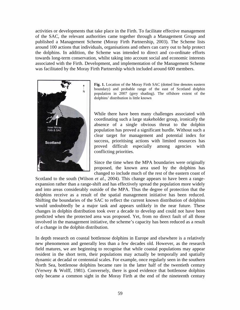
activities or developments that take place in the Firth. To facilitate effective management of the SAC, the relevant authorities came together through a Management Group and published a Management Scheme (Moray Firth Partnership, 2003). The Scheme lists around 100 actions that individuals, organisations and others can carry out to help protect the dolphins. In addition, the Scheme was intended to direct and co-ordinate efforts towards long-term conservation, whilst taking into account social and economic interests associated with the Firth. Development, and implementation of the Management Scheme was facilitated by the Moray Firth Partnership which included around 600 members.
Fig. 1. Location of the Moray Firth SAC (dotted line denotes eastern boundary) and probable range of the east of Scotland dolphin population in 2007 (grey shading). The offshore extent of the dolphins’ distribution is little known While there have been many challenges associated with coordinating such a large stakeholder group, ironically the absence of a single obvious threat to the dolphin population has proved a significant hurdle. Without such a clear target for management and potential index for success, prioritising actions with limited resources has proved difficult especially among agencies with conflicting priorities. Since the time when the MPA boundaries were originally proposed, the known area used by the dolphins has changed to include much of the rest of the eastern coast of
Scotland to the south (Wilson et al., 2004). This change appears to have been a range-expansion rather than a range-shift and has effectively spread the population more widely and into areas considerably outside of the MPA. Thus the degree of protection that the dolphins receive as a result of the spatial management initiative has been reduced. Shifting the boundaries of the SAC to reflect the current known distribution of dolphins would undoubtedly be a major task and appears unlikely in the near future. These changes in dolphin distribution took over a decade to develop and could not have been predicted when the protected area was proposed. Yet, from no direct fault of all those involved in the management initiative, the scheme’s capacity has been reduced as a result of a change in the dolphin distribution. In depth research on coastal bottlenose dolphins in Europe and elsewhere is a relatively new phenomenon and generally less than a few decades old. However, as the research field matures, we are beginning to recognise that while coastal populations may appear resident in the short term, their populations may actually be temporally and spatially dynamic at decadal or centennial scales. For example, once regularly seen in the southern North Sea, bottlenose dolphins became rare in the latter half of the twentieth century (Verwey & Wolff, 1981). Conversely, there is good evidence that bottlenose dolphins only became a common sight in the Moray Firth at the end of the nineteenth century
59
(Wilson, 1995). Going further back in time, archaeological and genetic evidence from middens suggests that middle-late Saxon people in the seventh to tenth centuries exploited another now extinct North Sea bottlenose dolphin population off eastern England (Nichols et al., 2007). Being at the northern periphery of the species’ range, we should perhaps not be surprised that bottlenose dolphin populations are either mobile or ephemeral. However, if spatial management approaches, such as the Moray Firth SAC, take as much as a decade to establish and are intended to last for several decades or longer, then a degree of spatial flexibility may be required from the outset. While range shifts can be dealt with by the not inconsiderable task of boundary alterations, the possibility of natural fluctuations in population survival, raises a more challenging dilemma. If populations are naturally ephemeral, then those that are small but increasing may be just as important and deserving of management effort in the long-term as the better known and currently more protected large populations.
REFERENCES
Curran, S., Wilson, B. and Thompson, P.M. 1996. Recommendations for the sustainable management of the bottlenose dolphin population in the Moray Firth. Scottish Natural Heritage Review. No 56.
Moray Firth Partnership 2003. The Moray Firth candidate Special Area of Conservation Management Scheme.Revision 1. The Moray Firth Partnership, Inverness, UK. 119 pp.
Mudge, G.P., Crooke, C.H., Barrett, C.F. 1984. The offshore distribution and abundance of seabirds in the Moray Firth. Unpublished report to Britoil, RSPB, Munlochy.
Nichols, C., Herman, J., Gaggiotti, O.E., Dobney, K.M., Parsons, K. and Hoelzel, A.R. 2007. Genetic isolation of a now extinct population of bottlenose dolphins (Tursiops truncatus). Proceedings of the Royal Society, B., 274: 1611-1616
Parsons, K.M., Noble, L.R., Reid, R.J. and Thompson, P.M. 2002. Mitochondrial diversity and population structuring of UK bottlenose dolphins (Tursiops truncatus): is the NE Scotland population demographically and geographically isolated? Biological Conservation, 108: 175-182.
Thompson, P.M, Lusseau, D., Corkrey, R. and Hammond, P.S. 2004. Moray Firth bottlenose dolphin monitoring strategy options. Scottish Natural Heritage Commissioned Report No. 079 (ROAME No. F02AA409).
Verwey, J. and Wolff, W.J. 1981. The bottlenose dolphin (Tursiops truncatus) Pp. 7/59-7/64. In: P.J.H. Reijnders and W.J. Wolff (eds.): Marine Mammals of the Wadden Sea. Leiden, the Netherlands.
Wilson, B. 1995. The ecology of bottlenose dolphins in the Moray Firth: a population at the extreme of the species’ range. PhD thesis, University of Aberdeen.
Wilson, B., Hammond, P.S. and Thompson, P.M. 1999. Estimating size and assessing status of a coastal bottlenose dolphin population. Ecological Applications, 9: 288-300.
Wilson, B., Reid, R.J., Grellier, K., Thompson, P.M. and Hammond, P.S. 2004. Considering the temporal when managing the spatial: a population range expansion impacts protected areas based management for bottlenose dolphins. Animal Conservation, 7: 331-338.
60
RESEARCH FOR MANAGEMENT: THE CARDIGAN BAY SAC EXPERIENCE
Peter G.H. Evans1,2 and Giovanna Pesante3
1Sea Watch Foundation, Cynifryn, Llanfaglan, Caernarfon, Gwynedd LL54 5RA, UK
2School of Ocean Sciences, University of Wales Bangor, Marine Science Laboratories, Menai Bridge, Anglesey, Gwynedd LL59 5AB, UK ([email protected])
3Sea Watch Foundation, Paragon House, Wellington Place, New Quay, Ceredigion SA45 9NR
INTRODUCTION Fifteen years ago, the European Commission established a major new initiative to protect wildlife throughout Europe, the Habitats Directive (1992). This gave special provision to a range of important terrestrial & marine habitats as well as particular plant and animal species considered to be specially vulnerable to human activities. The Directive has been very effective at providing a network of Special Areas of Conservation for particular wildlife species, referred to as Natura 2000. It was set up primarily by ecologists studying terrestrial animals, which have regular identifiable areas where they breed or gather to feed. However, its application to marine species has been less successful, mainly because those are often much more mobile and do not necessarily return to the same areas every year.
A particular challenge has been how to protect marine mammals like dolphins and porpoises. Under the Habitats Directive, two species are listed in a special Annex requiring the establishment of Marine Protected Areas. Those are the harbour porpoise (Phocoena phocoena) and the bottlenose dolphin (Tursiops truncatus). The porpoise is UK’s most common and widely distributed cetacean species, and a few hundred thousand live in the seas of the Northwest European continental shelf. On the other hand, the bottlenose dolphin, despite it being our most familiar dolphin, appears to form discrete coastal communities, which number from the low tens to the low hundreds of individuals. Both species are subject to a wide range of conservation threats – vessel disturbance, pollution, entanglement in fishing gear, and loss of food to large-scale commercial fisheries.
So far, in the UK, Special Areas of Conservation have been designated only for the bottlenose dolphin – and in just two areas: the Moray Firth off Northeast Scotland, and Cardigan Bay off West Wales. Both were proposed as candidates in 1996 and were officially designated in 2004. Ten years on from the first formal recognition of these two regions as important for the species, we now have an opportunity to assess how successful as protected areas they have been. This contribution reviews the criteria used in UK SAC site selection, examines the role that establishment of the Cardigan Bay SAC has played in conservation of the local bottlenose dolphin population, and summarises what we have learned from research, and how that can be used to inform management.
Criteria Used in Site Selection Special Areas of Conservation are demarcated by boundaries, within which the marine wildlife they are established to protect, receive special attention. Those boundaries are decided on the basis of information available to government agencies at the time. In the case of the two areas set aside for bottlenose dolphins, this information came primarily from studies conducted by Aberdeen
61
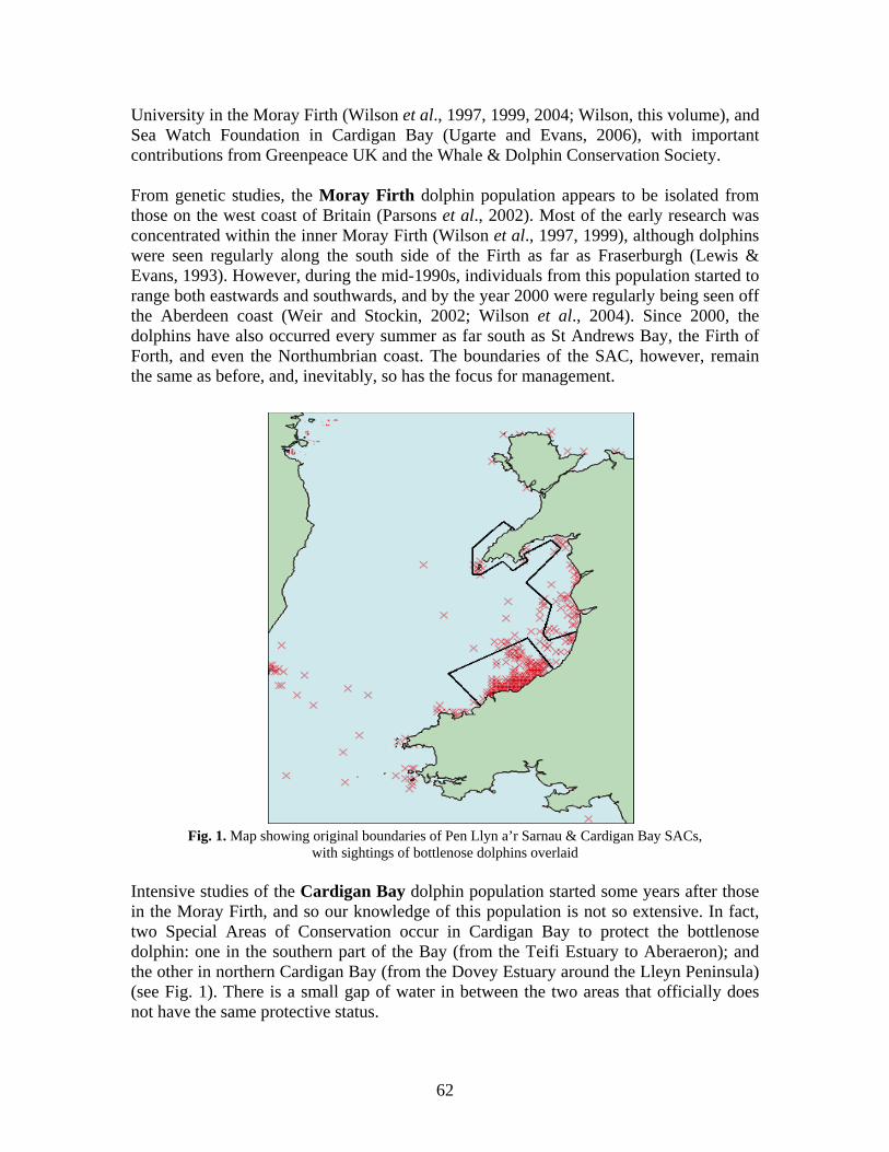
University in the Moray Firth (Wilson et al., 1997, 1999, 2004; Wilson, this volume), and Sea Watch Foundation in Cardigan Bay (Ugarte and Evans, 2006), with important contributions from Greenpeace UK and the Whale & Dolphin Conservation Society. From genetic studies, the Moray Firth dolphin population appears to be isolated from those on the west coast of Britain (Parsons et al., 2002). Most of the early research was concentrated within the inner Moray Firth (Wilson et al., 1997, 1999), although dolphins were seen regularly along the south side of the Firth as far as Fraserburgh (Lewis & Evans, 1993). However, during the mid-1990s, individuals from this population started to range both eastwards and southwards, and by the year 2000 were regularly being seen off the Aberdeen coast (Weir and Stockin, 2002; Wilson et al., 2004). Since 2000, the dolphins have also occurred every summer as far south as St Andrews Bay, the Firth of Forth, and even the Northumbrian coast. The boundaries of the SAC, however, remain the same as before, and, inevitably, so has the focus for management.
Fig. 1. Map showing original boundaries of Pen Llyn a’r Sarnau & Cardigan Bay SACs, with sightings of bottlenose dolphins overlaid
Intensive studies of the Cardigan Bay dolphin population started some years after those in the Moray Firth, and so our knowledge of this population is not so extensive. In fact, two Special Areas of Conservation occur in Cardigan Bay to protect the bottlenose dolphin: one in the southern part of the Bay (from the Teifi Estuary to Aberaeron); and the other in northern Cardigan Bay (from the Dovey Estuary around the Lleyn Peninsula) (see Fig. 1). There is a small gap of water in between the two areas that officially does not have the same protective status.
62
At the time that the SAC boundaries were established, only a portion of Cardigan Bay had been surveyed (mainly the coastal strip in the southern part of the Bay from Aberystwyth to Cardigan - Mayer et al. 1991; Lewis & Evans, 1993), and although there were many sightings of bottlenose dolphins in this area, coverage elsewhere in the Bay remained limited. On the basis of this information and other incidental sightings (see Fig. 1), the southern part of Cardigan Bay was proposed as an SAC. Pen Llyn a’r Sarnau was originally proposed as an SAC for its habitat features, notably reefs and sand banks, but bottlenose dolphins were then added as a secondary feature. We now have growing evidence that the dolphins range much more widely than Cardigan Bay. Although the same identified dolphins occur year after year in particular coastal areas within the Bay, during winter they range over wide areas, occurring both offshore and more than one hundred kilometres to the north in waters off the Isle of Anglesey (North Wales) eastwards towards Liverpool Bay. The photo-ID studies also reveal that each year new animals appear, while some others are not seen again. This means that for management to be successful, measures need to be applied over a much broader geographical area than the boundaries of either of the SACs. Has SAC Establishment Contributed to Favourable Conservation Status for the Cardigan Bay Bottlenose Dolphin Population? The first thing we can say is that SAC establishment has certainly been successful at drawing attention to the importance of Cardigan Bay for bottlenose dolphins. Tourist industries have developed around the dolphins, and thousands of people have travelled to see them, gaining much pleasure from the experience, and bringing income to local communities. Research and education programmes have started, raising awareness not just of this species, but also of marine wildlife in general, as well as general conservation issues facing the local marine environment. The size of a protected area has to be a balance between not being so large as to be ineffectively managed (and policed), yet not too small that it covers only a fraction of the range of the wildlife it aims to protect. In most cases, authorities have tended to err on the small size for fear of antagonizing local people. When Special Areas of Conservation were first proposed for the dolphins, there was some disquiet amongst various users of the sea, apprehensive that their activities might become curtailed. However, on the whole, that concern has not been realized, and indeed, it is probable that most people within these coastal communities have actually benefited from their establishment. One of the functions of these protected areas is to ensure that there are environmental impact assessments before potentially harmful offshore activities take place in the region. This might be the introduction of loud sounds from oil & gas exploration, or the presence of intensive commercial fisheries, or of recreational activities that could disturb animals in particularly sensitive spots. In the accompanying contribution, Annalisa Bianchessi (this volume) describes three case studies where the establishment of the SAC has supported conservation measures for the dolphins: 1) an Appropriate Assessment to evaluate the potential effect of oil & gas
63
exploration in licensed blocks adjacent to the SAC; 2) regulations on discards from a fish factory processing whelks at New Quay; and 3) monitoring and voluntary controls of recreational boating activities that potentially can disturb the dolphins. Mention is also made of regulatory and resource limitations that can inhibit successful management. It is probably still too early to know whether by having Special Areas of Conservation, the dolphin population has actually benefited. However, there are two measures that would go a long way to addressing the particular needs of a mobile species like the bottlenose dolphin. The first is the introduction of a system of zoning whereby critical habitats are identified and receive stringent protection, but there is some relaxation of regulations in less critical ones. This allows for management measures over much wider geographical areas, which represent a more realistic spatial scale for such mobile species. It is the basis for what is referred to as marine spatial planning, and it forms an important aspect of the newly proposed UK Marine Bill. The second measure is the ability to provide flexible management responses, as dolphin (and other marine wildlife) populations change their habits or ranges, or experience new threats. At present, the legislative procedure and associated regulatory input is relatively slow at responding. Once a site has been identified as a potential Special Area of Conservation, it may be nearly ten years before it is officially designated, so making changes to boundaries or to other key management aspects a cumbersome process. We need to modify that system so we can respond to changing conditions much more readily, at least every five years. This is even more important in the rapidly changing world that we live. Can Research Findings Inform Cardigan Bay SAC Management? Abundance estimates and monitoring for both bottlenose dolphin and harbour porpoise in Cardigan Bay were started by Sea Watch Foundation in 2001, concentrating upon the more southerly SAC, initially with funding from the European Commission’s INTERREG Programme, and subsequently from Countryside Council for Wales. These have indicated summer populations of 150-250 bottlenose dolphins (making it the largest inshore population of the species in the British Isles) and 150-300 harbour porpoises, with upward trends in both species, although changes in numbers are not statistically significant and show some fluctuation between years (Fig. 2). It will require some more years of monitoring before annual stochastic variation can be differentiated statistically from long-term trends, and there is an important need to adequately survey a wider area. Both are crucial if one is to understand the relative roles of competition/predation, anthropogenic activities and climate change in the population dynamics of the two species. Investigations are currently underway to determine whether the sharp increase in porpoise predation by bottlenose dolphins observed since the late 1990s is related to competition for space or food at times when both species co-occur in sizeable numbers. Line-transect surveys with DISTANCE sampling are used to derive absolute abundance estimates for the two species as well as to assess habitat preferences and any distributional changes. An independent measure of population size is possible for the bottlenose dolphin, using photo-identification of individuals and mark-recapture techniques. This measure is less constrained than line-transect methodologies and
64
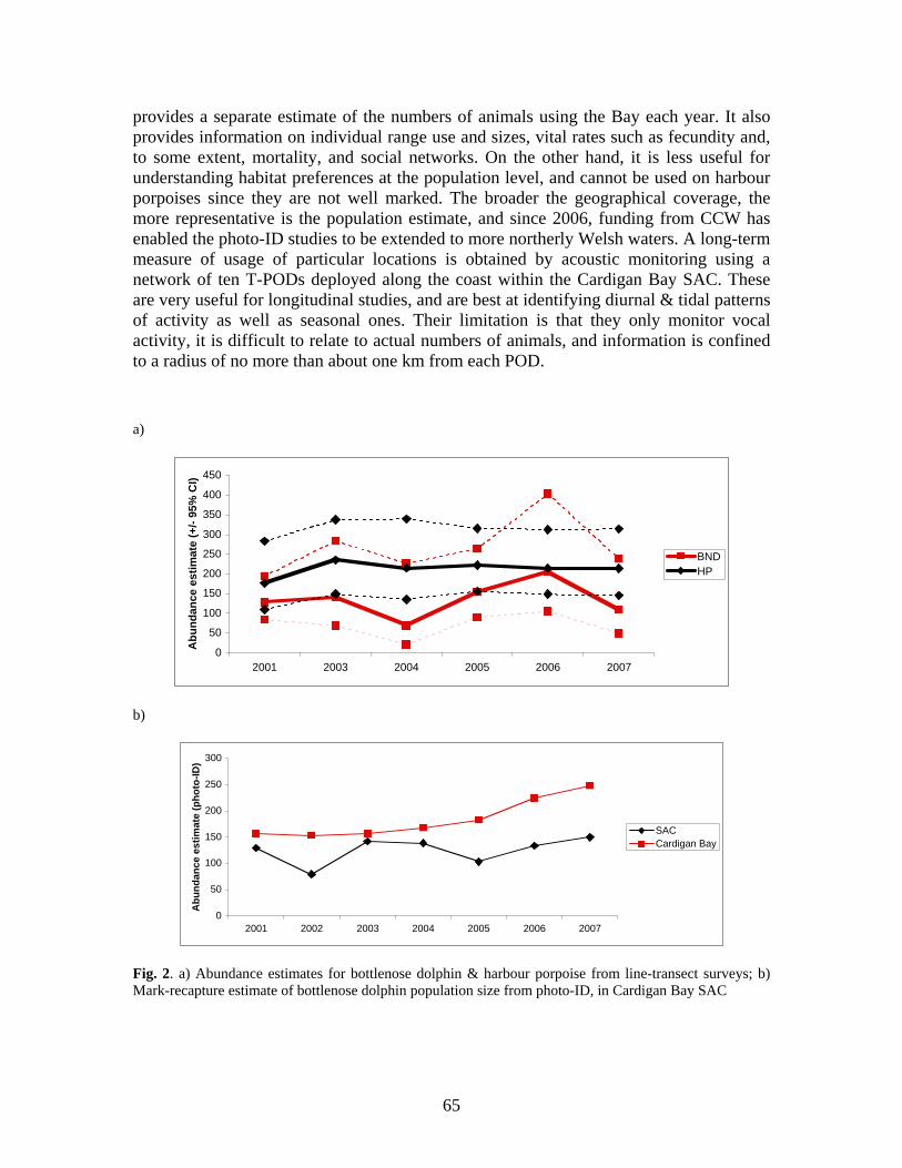
provides a separate estimate of the numbers of animals using the Bay each year. It also provides information on individual range use and sizes, vital rates such as fecundity and, to some extent, mortality, and social networks. On the other hand, it is less useful for understanding habitat preferences at the population level, and cannot be used on harbour porpoises since they are not well marked. The broader the geographical coverage, the more representative is the population estimate, and since 2006, funding from CCW has enabled the photo-ID studies to be extended to more northerly Welsh waters. A long-term measure of usage of particular locations is obtained by acoustic monitoring using a network of ten T-PODs deployed along the coast within the Cardigan Bay SAC. These are very useful for longitudinal studies, and are best at identifying diurnal & tidal patterns of activity as well as seasonal ones. Their limitation is that they only monitor vocal activity, it is difficult to relate to actual numbers of animals, and information is confined to a radius of no more than about one km from each POD.
a)
0
50
100
150
200
250
300
350
400
450
2001 2003 2004 2005 2006 2007
Abu
ndan
ce e
stim
ate
(+/-
95%
CI)
BNDHP
b)
0
50
100
150
200
250
300
2001 2002 2003 2004 2005 2006 2007
Abu
ndan
ce e
stim
ate
(pho
to-ID
)
SACCardigan Bay
Fig. 2. a) Abundance estimates for bottlenose dolphin & harbour porpoise from line-transect surveys; b) Mark-recapture estimate of bottlenose dolphin population size from photo-ID, in Cardigan Bay SAC
65
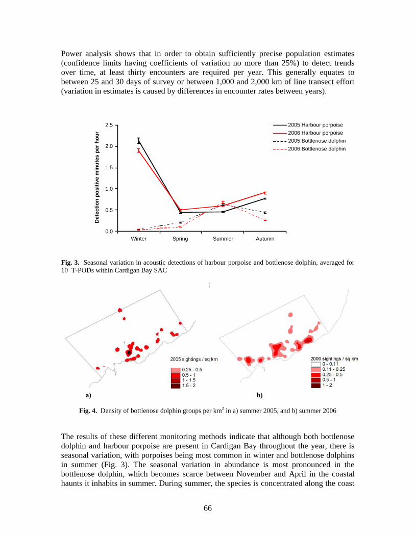
Power analysis shows that in order to obtain sufficiently precise population estimates (confidence limits having coefficients of variation no more than 25%) to detect trends over time, at least thirty encounters are required per year. This generally equates to between 25 and 30 days of survey or between 1,000 and 2,000 km of line transect effort (variation in estimates is caused by differences in encounter rates between years).
0.0
0.5
1.0
1.5
2.0
2.5
Winter Spring Summer Autumn
Det
ectio
n po
sitiv
e m
inut
es p
er h
our
2005 Harbour porpoise2006 Harbour porpoise2005 Bottlenose dolphin2006 Bottlenose dolphin
Fig. 3. Seasonal variation in acoustic detections of harbour porpoise and bottlenose dolphin, averaged for 10 T-PODs within Cardigan Bay SAC
a) b)
Fig. 4. Density of bottlenose dolphin groups per km2 in a) summer 2005, and b) summer 2006
The results of these different monitoring methods indicate that although both bottlenose dolphin and harbour porpoise are present in Cardigan Bay throughout the year, there is seasonal variation, with porpoises being most common in winter and bottlenose dolphins in summer (Fig. 3). The seasonal variation in abundance is most pronounced in the bottlenose dolphin, which becomes scarce between November and April in the coastal haunts it inhabits in summer. During summer, the species is concentrated along the coast
66
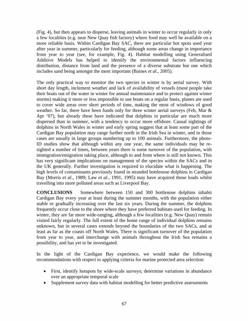
(Fig. 4), but then appears to disperse, leaving animals in winter to occur regularly in only a few localities (e.g. near New Quay fish factory) where food may well be available on a more reliable basis. Within Cardigan Bay SAC, there are particular hot spots used year after year in summer, particularly for feeding, although some areas change in importance from year to year (see, for example, Fig. 4). Habitat modelling using Generalised Additive Models has helped to identify the environmental factors influencing distribution, distance from land and the presence of a diverse substrate but one which includes sand being amongst the most important (Baines et al., 2005). The only practical way to monitor the two species in winter is by aerial survey. With
se dolphins inhabit
the light of the Cardigan Bay experience, we would make the following
• First, identify hotspots by wide-scale surveys; determine variations in abundance
• t modelling for better predictive assessments
short day length, inclement weather and lack of availability of vessels (most people take their boats out of the water in winter for annual maintenance and to protect against winter storms) making it more or less impossible to use boats on a regular basis, planes are used to cover wide areas over short periods of time, making the most of windows of good weather. So far, there have been funds only for three winter aerial surveys (Feb, Mar & Apr ’07), but already these have indicated that dolphins in particular are much more dispersed than in summer, with a tendency to occur more offshore. Casual sightings of dolphins in North Wales in winter and early spring suggest that at least some part of the Cardigan Bay population may range further north in the Irish Sea in winter, and in those cases are usually in large groups numbering up to 100 animals. Furthermore, the photo-ID studies show that although within any one year, the same individuals may be re-sighted a number of times, between years there is some turnover of the population, with immigration/emigration taking place, although to and from where is still not known. This has very significant implications on management of the species within the SACs and in the UK generally. Further investigation is required to elucidate what is happening. The high levels of contaminants previously found in stranded bottlenose dolphins in Cardigan Bay (Morris et al., 1989; Law et al., 1991, 1995) may have acquired those loads whilst travelling into more polluted areas such as Liverpool Bay.
USIONS Somewhere between 150 and 300 bottlenoCONCLCardigan Bay every year at least during the summer months, with the population either stable or gradually increasing over the last six years. During the summer, the dolphins frequently occur close to the shore where they have preferred habitats used for feeding. In winter, they are far more wide-ranging, although a few localities (e.g. New Quay) remain visited fairly regularly. The full extent of the home range of individual dolphins remains unknown, but in several cases extends beyond the boundaries of the two SACs, and at least as far as the coasts off North Wales. There is significant turnover of the population from year to year, and interchange with animals throughout the Irish Sea remains a possibility, and has yet to be investigated. Inrecommendations with respect to applying criteria for marine protected area selection:
over an appropriate temporal scale Supplement survey data with habita
67
• Use a variety of complementary survey and monitoring techniques to derive as much information as possible
• Identify key areas where special protective measures need to be taken, but keep a watching brief over wider areas
• Adopt a flexible management process that allows boundary changes at regular intervals (e.g. every five years).
To ascertain whether these two marine mammal species of conservation priority, the bottlenose dolphin and harbour porpoise, are at Favourable Conservation Status, it is necessary to monitor annual trends in status and distribution, and to do so over a sufficient time scale to test these for statistical significance. This will also help us understand what factors most influence population status, and thus be able to advise on where to take appropriate management action. ACKNOWLEDGEMENTS We would like to thank the Countryside Council for Wales and EU Interreg program for funding our work in Cardigan Bay; the various boatmen who have assisted us, notably Winston Evans, Alan Gray, Tim Harrison, Steve Hartley, Kit Lee, Dafydd Lewis, Roy Packer, and Damien Sidnell; all the volunteers & staff who helped in the research, particularly (in alphabetical order): Pia Anderwald, Mick Baines, Laura Barba Villaescusa, Helen Bates, Sarah Baulch, Lauren Beddia, Sharon Bond, Lucy Buckingham, Juliana Castrillón, Jenny Lamb, Tom Felce, Rob Lott, Edita Magileviciute, Hanna Nuuttila, Sergi Perez, Maren Reichelt, Malene Simon, Eleanor Stone, and Fernando Ugarte; and for other support: Janet Baxter, Mandy McMath, Nick Tregenza, and Ursula Verfuß.
REFERENCES Baines, M.E., Reichelt, M. and Evans, P.G.H. 2005. Investigation of harbour porpoise and bottlenose
dolphin ecology in Cardigan Bay, UK, using model based spatial analysis. Page 34. In: Abstracts, 19th Annual Conference of the European Cetacean Society, La Rochelle, France, 2-7 April 2005.
Law, R.J., Fileman, C.F., Hopkins, A.D., Baker, J.R., Harwood, J., Kennedy, S., Martin, A.R. and Morris, R.J. 1991. Concentrations of trace metals in the livers of marine mammals (seals, porpoises and dolphins) from waters around the British Isles. Mar. Poll. Bull., 22 (4): 183-191.
Law, R.J., Allchin, C.R. and Morris, R.J. 1995. Uptake of Organochlorines (Chlorophenyls, Dieldrin, Total PCG and DDT) in Bottlenose Dolphins (Tursiops truncatus) from Cardigan Bay, west Wales. Chemosphere, 30 (3): 547-560.
Lewis, E. and Evans, P.G.H. 1993. Comparative ecology of bottle-nosed dolphins (Tursiops truncatus) in Cardigan Bay and the Moray Firth. Pp. 57-62. In: European Research on Cetaceans - 7. (Editor P.G.H. Evans). European Cetacean Society, Cambridge, England. 306 pp.
Mayer, S., Arnold, H. and Evans, P.G.H. 1991. Preliminary Findings from a Photo-Identification Study of Bottle-nosed Dolphins (Tursiops truncatus) in Cardigan Bay, Wales, UK, during 1990. Pp. 45-46. In: European Research on Cetaceans - 5. (Editor P.G.H. Evans). European Cetacean Society, Cambridge, England. 148pp
Morris, R.J., Law, R.J., Allchin, C.R., Kelly, C.A. and Fileman, C.F. 1989. Metals and organochlorines in dolphins and porpoises of Cardigan Bay, West Wales. Marine Pollution Bulletin, 20: 512-523.
Parsons K.M., Noble, L.R., Reid, R.J. and Thompson, P.M. 2002. Mitochondrial genetic diversity and population structuring of UK bottlenose dolphins (Tursiops truncatus): is the NE Scotland population demographically and geographically isolated? Biological Conservation, 108: 175-182.
68
Ugarte, F. and Evans, P.G.H. 2006. Monitoring of marine mammals in the Cardigan Bay SAC: surveys from May 2003 to April 2005, and recommendations for future work. CCW Marine Monitoring Report No. 23 (Species Challenge Report No. 05/01/04). 38 pp.
Wilson, B., Hammond P.S. and Thompson P.M. 1999. Estimating size and assessing trends in a coastal bottlenose dolphin population. Ecological Applications, 9: 288-300
Wilson, B., Thompson, P.M. and Hammond, P.S. 1997. Habitat use by bottlenose dolphins: seasonal distribution and stratified movement patterns in the Moray Firth, Scotland. Journal of Applied Ecology, 34: 1365-1374
Wilson, B., Reid, R.J., Grellier, K., Thompson, P.S. and Hammond, P.S. 2004. Considering the temporal when managing the spatial: a population range expansion impacts protected areas-based management for bottlenose dolphins. Animal Conservation, 7: 331-338
69
MANAGING MARINE SACs: WHAT CAN BE LEARNED FROM THE CARDIGAN BAY EXPERIENCE
Annalisa Bianchessi
SAC Officer, Ceredigion County Council, Penmorfa, Aberaeron, Ceredigion SA46 OPA, UK
([email protected]; [email protected])
INTRODUCTION The management objective of Special Areas of Conservation (SACs) is to “maintain (or restore) the habitat and species features” for which they have been designated, “at (or to) Favourable Conservation Status (FCS) within the site”2. For species, this means maintaining a viable population, ensuring that population size, range and associated habitat quality do not decline over time. For habitats, this means ensuring that range and population constituents of the habitat are maintained over time. I shall briefly illustrate the management framework adopted for the Cardigan Bay SAC and proceed to look at some management case studies. I shall aim to illustrate some of the successes and challenges of meeting the SAC objectives given the current management and legislative framework. CARDIGAN BAY SAC MANAGEMENT FRAMEWORK The Cardigan Bay SAC, an area of 976 km2, which extends 12 nm out to sea, was first put forward as a candidate site in 1995 to protect a semi-resident population of bottlenose dolphins Tursiops truncatus. The Relevant Authorities Group (RAG) for the SAC comprises nine statutory authorities, including Ceredigion County Council as a lead authority and the Countryside Council for Wales (CCW) acting as both RA and advisory nature conservation authority. A management plan for the area was put in place in 2001, following the establishment of a liaison framework and wide consultation with Competent Authorities (CAs), key stakeholders, and the wider public. The liaison framework was later reviewed and simplified, but the consultation mechanism has essentially remained the same with key stakeholders invited to attend Liaison Group (LG) meetings with the RAG and anyone with an interest being able to attend and take part in public consultations. In 2001, through the EU moderation process, six additional features (Atlantic grey seal Halichoerus grypus, river lamprey Lampetra fluviatilis, sea lamprey Petromyzon marinus, reefs, sandbanks which are slightly covered by sea water at all times, and sea caves) were added for protection through the SAC, and the plan is currently in the final stages of being reviewed to take these into account. The underlying principles contained in the management plan, and the mechanism through which the SAC is managed, will remain the same. In principle, the SAC is not a strictly protected area. The aim is to protect the designated features of the SAC (ensuring their FCS is maintained or, where necessary, restored) 2 Habitats Directive 92/43/EEC
70
through a careful assessment of all new developments and management of any ongoing activities with a potential to adversely affect the features of the site, both within and beyond the boundaries of the SAC. The mechanism to assess and consent any new development is through the Plans and Project (P&P) procedure3. This stipulates that for any new development with the potential of having a significant effect (alone or in combination with other projects) on the FCS of features, the authority responsible for regulating the development (termed Competent Authority) has to carry out an Appropriate Assessment (AA) of the proposed development in consultation with the statutory nature conservation authorities (CCW or JNCC). If it is found that the proposal is likely to have a negative impact on the overall integrity of the site, the consultation will result in the statutory nature conservation body either advising against the proposal or suggesting conditions that will enable mitigation of the adverse effects. The management of ongoing activities within a site is also considered, although in this case, the application of P&P procedures is not always applicable, and management actions need to be identified in the management plan. CASE STUDIES Oil and gas exploration Licences for oil and gas exploration are issued by the Department for Business Enterprise & Regulatory Reform (BERR, former DTI), following two phases: 1) The issuing of a Strategic Environmental Assessment (SEA) under the Environmental Assessment Directive4, and 2) the carrying out of an Appropriate Assessment (AA), as outlined in the Habitats Directive5. Licences provide licensees with exclusive rights to a block and associated data. If after evaluating the data made available through the licence, a licensee wishes to proceed with a proposal, a detailed application has to be submitted to BERR, which will be evaluated by BERR in accordance with the P&P outlined above. The initial SEA report for the 24th Licensing Round identified blocks open for licence and the possible impacts of likely applications. It concluded that there was no need for any blocks to be excluded on conservation grounds at the SEA stage. Subsequently, two companies made a joint application for a licence in blocks within and adjacent to the Cardigan Bay SAC6. It is worth noting that this caused a lot of local concern, and the issue received repeated attention in the media, from politicians and local conservation groups, and was also the focus of a Liaison Group (LG) meeting where members of BERR were invited to present the forthcoming licensing procedures. During the following AA phase, a number of shortcomings were identified through consultation with CCW, such as some omissions with regards to the SAC features, the lack of a mechanism to regulate seismic surveys within 12 nm from the coast, and a presumption in the AA document in favour of subsequent applications. BERR subsequently addressed these
3 Plans and Projects Procedures are outlined in Article 6 of the Habitats Directive and Regulations 48 and 49 of the Conservation (Natural Habitats, &c) 1994 (SI 1994/2716) 4 Environmental Assessment Directive (2001/42/EC) 5 Habitats Directive (92/43/EEC) 6 Blocks 107/21, 107/22 and 106/30 of the SEA 6. Further details can be found at see http://www.offshore-sea.org.uk/site/index.php
71
shortcomings and an amended AA for Cardigan Bay, was expected by the end of 2007.7 In the meantime, licensing of blocks in Cardigan Bay has been put on hold. This case study is an example of how the SAC management framework can be effective in identifying and addressing conservation issues during the licensing process of new projects.8 It is worth noting that the attention given to the issue by local media and politicians may have influenced the authorities involved in the licensing process. Fish factory Since 1996, a fish factory, operating from a small town on the Cardigan Bay SAC coastline, has been licensed by the Marine and Fisheries Agency (M&FA, previously MCEU, DEFRA) to dispose of crushed whelk shells by discarding them into near-shore waters. The factory processes whelks caught in UK waters, and freezes them for export to Korea. The licence specifies that the shells have to be boiled and any organic matter removed prior to disposal. Shells also have to be crushed to a specified size to allow for quick dispersal in the sea. The licence was originally for disposal of 750 tons of shell a year, but in 2003 was extended to allow for disposal of 2000 t/yr, and in 2006 prolonged for a further three years. The presence and activity of the fish factory is not popular with the local community, and there have been a lot of complaints about the associated smell and lorry traffic as well as the deterioration of the town’s amenity value due to the accumulation of whelk shell on the local beach. Whilst it may be a matter of opinion whether the accumulation of white shell on the beach causes a deterioration of the amenity value of the beach, the smothering of surrounding rock pools and sea bed could have an impact on the FCS of the features of the site, especially since sandbanks and reefs have been added as features of the SAC. Furthermore, the smothering could potentially have an impact on the nursing grounds of some of the bottlenose dolphin and grey seal prey. A further impact could be the introduction of unwanted organic matter, affecting the overall productivity and turbidity of the water column. However, at the time the licence was first issued, the P&P procedures were followed and the advice given by the nature conservation authority (CCW) was that the licence could go ahead. It was believed that any shell accumulation would only occur on a very local scale, and not affect the overall integrity of the site. In 2001, prior to renewal of the licence, the fish factory was asked to commission a dive survey to ensure that the shell was indeed dispersing and not accumulating on the seabed. The dive survey found that there was no significant accumulation of shell beyond 50 m from the fish factory, and so the licence was extended. However, in 2007, some members of the local community took a dive video in the waters near the fish factory, showing substantial accumulation of organic matter on the seabed, interspersed with whelk operculums, suggesting that the shells were not being discharged
7 Post ECS note: An amended AA for Cardigan Bay went out for public consultation in December 2007. It states that “…applying the precautionary principle and on account of uncertainties about the size, distribution and location of the resident population of bottlenose dolphins within the Cardigan Bay “Natura 2000” site, this assessment does not presently support the granting of consent under the Habitats Directive…since there is not certainty, within the meaning of the ECJ Judgement in the Waddenzee case, that the plan will not adversely affect the integrity of Relevant European Sites 8 Post ECS note: given the outcome of the revised AA, it is also an example of how the Precautionary Principle may be applied in compliance with the Habitats Directive.
72
free of organic matter and may be affecting productivity and turbidity in the water column. Having viewed the video, the statutory nature conservation authority expressed concern to the M&FA (the CA responsible for issuing the licence), and advised that the matter should be investigated. The M&FA carried out an inspection of the factory and concluded that the conditions of the licence were being adhered to, and that the organic matter shown in the video could not at present be linked to the activities of the factory. The need for further investigation to assess whether the accumulation of organic matter was a regular occurrence, and whether it could be linked to the fish factory, was repeatedly raised and discussed at the RAG meetings of the SAC. The nature conservation authority (CCW) advised M&FA that further dive surveys were needed to investigate the matter. However, M&FA responded that it was satisfied that the licence conditions were being adhered to and would not be taking the investigations further, unless further evidence was to come to light. CCW looked into contracting someone to carry out the investigations but could not source funding to do so. This case study illustrates the lack of legislative power within SAC management, as the nature conservation authority can only act in an advisory role. Whilst the Liability Directive9 may provide a mechanism to address this, it is unlikely to be applied in cases such as these where the SAC management procedures were actually followed, and the scale of the issue is relatively small. The case study also raises the question of whose responsibility it is to carry out monitoring of licensed activities to ensure that the conditions identified during the P&P procedures continue to be adequate. It further illustrates the lack of a funding mechanism for appropriate monitoring activities, as and when required. Recreational boating activities The effect of recreational boating activities on the population of bottlenose dolphins through disturbance, harassment and noise pollution has been an issue of concern from the onset of the establishment of the SAC. Control of the activity is difficult as the legislative framework for doing so is not comprehensive. In terms of disturbance, deliberate and reckless disturbance of protected species is an offence under the Wildlife and Countryside Act10 and the CROW Act 200011. The addition of the word “reckless” to the CROW Act was actually achieved in part through the Cardigan Bay SAC management plan. However, even with this addition, it is difficult to gather enough evidence to prosecute anybody under this legislation. In terms of regulating boating activity, the local authority can control mooring and launching permits at local harbours along the SAC, and also create local byelaws to establish speed zones along the coast. Vessels can launch freely from unregulated slipways, so there is no mechanism for limiting the number of vessels out on the water. Enforcement is also an issue, as the local authority does not currently have a presence on the water. However, Ceredigion County Council has been very proactive in addressing the issue. Though the SAC liaison framework, it has worked together with local stakeholders, yacht clubs and boat operators to established two voluntary codes of conduct: one for 9 Liability Directive 2004/35/CE – 21 April 2004 10 Wildlife and Countryside Act 1981 11 Countryside Rights of Way Act 2000
73
recreational boat users and one for passenger boat operators. It has also worked hard at promoting these codes through the production of numerous publications and later through the SAC education and interpretation strategy. The Council has also taken on the co-ordination of a voluntary group set up by local people prior to the establishment of the SAC. The group monitors the interaction between boating activities and bottlenose dolphins through land watches from the shore. Data collected by the group ranges over a 12-year time-span and provides useful data on the intensity of boating activities, compliance with the codes of conduct, and the effects of boating activities on the bottlenose dolphins. Data analysis from 2004 and 2005 found 90% compliance with the code of conduct from recreational boat users, and 99% compliance by passenger boat operators12. Data also suggest that negative response to vessels by bottlenose dolphins is significantly less when vessels follow the code of conduct. The case study illustrates how much can be achieved through education and voluntary work. It also illustrates that targeted monitoring of the effects of activities on SAC features can at times be carried out effectively with a low budget. On the other hand, this example illustrates the challenges faced by RAs and CAs in complying with the Habitats Directive when the legislative tools at their disposal are fragmented. In the UK, the introduction of the Marine Bill will hopefully bring forward a comprehensive set of legislative tools, which will greatly aid SAC management. Fishing activities: The view taken during the establishment of the SAC management plan was that current fishing levels within the Bay were sustainable and, so long as fishing levels were not increased, these activities could continue to take place without an adverse effect on the bottlenose dolphins. Local fishing practices consist mainly of potting for crabs and lobsters, with some dredging for scallops, occasional trawling for bait, and netting for bass and salmon occurring seasonally. Within 6 nm, fishing activities are regulated by the Sea Fisheries Committees who are committed to a sustainable management of inshore fisheries. Whilst it may be argued that scallop dredging is a destructive method and so is unlikely to be a sustainable fishing method, it is not so much the small local dredgers that are of concern, but rather the larger Scottish and Belgian vessels who come and trawl on the boundary of the SAC (12 nm from the shore) or even within the SAC if they have historic rights to fish (under the sunset clause). As with all fisheries issues, enforcement of regulations is also difficult to achieve. The management of the 6-12 nm zone and the UK territorial waters is under the remit of the M&FA. In terms of SAC management, one of the issues is that M&FA is not one of the Cardigan Bay SAC relevant Authorities (RA). As a result, SAC liaison with M&FA has not been regular, and SAC management has not tended to focus on offshore fisheries management. In addition to fisheries management in UK waters, the management of international fishing fleets is also relevant since over-fishing in the Irish Sea is likely to have knock-on effects on the Cardigan Bay stocks. Again, SAC management in Cardigan Bay has so far not focused on this issue. When one considers that 53% of commercially assessed fish stocks in the Irish Sea are over-fished, and that these include many of
12 Pierpoint, C. & Allan, L.. Bottlenose dolphins and boat traffic on the Ceredigion Coast, West Wales. Available at http://www.cardiganbaysac.org.uk/pdf%20files/BND%202006%20report.pdf
74
bottlenose dolphin prey species such as whiting, pollock, cod, sole, haddock and mackerel, then this appear to be quite a substantial limitation of current SAC management. It is also the case that the bottlenose dolphins in Cardigan Bay are a semi-resident population and that their habitat range beyond Cardigan Bay is not well known, raising further questions as to the ability of SACs to protect its features across their range. This case study illustrates the challenges of protecting mobile species and associated mobile prey, and the resulting need for SAC management to address cross boundary issues across different statutory authorities and even countries. MARINE SAC MANAGEMENT CHALLENGES The management experience of the Cardigan Bay SAC can help us to identify some of the shortcomings and difficulties in the management of marine SACs. These can be summarised as follows: Law enforcement: Since the statutory nature conservation bodies operate within an advisory role, there appears to be a lack of legislative tools to enforce compliance with the Habitats Directive amongst Competent Authorities (CA). Whilst the Liability Directive appears to provide a mechanism to address this, it is a mechanism that can only deal with non-compliance issues after damage has occurred, and it is only likely to address those cases where damage has occurred on a very large scale. It is not a mechanism that allows for implementation of the Precautionary Principle. Further, where CAs are determined to comply fully with the Habitats Directive, they are limited by the legislative tools currently available to them, which are often fragmented and unsatisfactory. Funding: SAC management relies on Competent Authorities (CA) integrating SAC objectives into their procedures. However, additional funds to fulfil their obligations under the Habitats Directive are often lacking. As many CAs have very large remits and are often already under-resourced, this inevitably leads to work having to be prioritised often to the detriment of research, communication and enforcement work needed to address SAC issues properly. Political pressure: Competent and Relevant Authorities, including the nature conservation bodies charged with providing scientific advice on SAC issues, are often subject to a range of contrasting political pressures. They are therefore charged with the challenging task of achieving the right balance between political, economic, and conservation interests. Scientific uncertainty: There is still a substantial level of uncertainty on the effect of anthropogenic activities on the marine ecosystem. Lack of baseline data and funding to carry out necessary research and monitoring make compliance with the Habitats Directive a challenging task. One of the difficulties is the collection of baseline data. One argument in favour of the creation of a network of highly protected marine reserves in the UK is that it would enable the establishment of control sites for the collection of baseline data.
75
HARBOUR PORPOISES IN GERMAN WATERS – EVALUATING PROPOSED NATURA 2000 SITES
Anita Gilles, Meike Scheidat and Ursula Siebert
Research and Technology Centre West (FTZ), University of Kiel, Hafentörn 1, 25761 Büsum, Germany ([email protected])
INTRODUCTION & BACKGROUND The EU Habitats Directive entered into force in 1992, and all EU member states committed themselves to establishing a coherent network of (terrestrial & marine) protected areas. Together with the Special Protection Areas (SPAs) for birds classified under the EU Birds Directive, the Special Areas of Conservation (SACs), designated under the Habitats Directive, form the NATURA 2000 system of protected areas. In Germany, marine protection in the Exclusive Economic Zone (EEZ; 12-200 nm) is implemented through Article 38 of the German Federal Nature Conservation Act. The Federal Agency for Nature Conservation (BfN) and the German Environment Ministry (BMU) are responsible for selecting, designating and managing marine protected areas in the EEZ. Sites under the Habitats Directive should have been nominated to the EU within three years after entry into force of the Directive – i.e. by 1995. This deadline passed without any German sites having been proposed. Because of its insufficient site proposals, Germany was found to be in contravention of the Directive by the European Court of Justice in 2001. Finally, in May 2004, 10 new areas, approx. 31% of the German EEZ, and together with the existing nominations of the states in the 12 nm zone, approx. 38% of the total German marine area, were identified and proposed to the EU. Eight pSCIs (proposed Sites of Community Importance) under the Habitats Directive, and two SPAs (Special Protection Area) under the Birds Directive were proposed. NATURA 2000 site selection in Germany – chronological steps
• In 2001 and 2002, the BfN selected study areas of particular ecological importance. Identification was based on knowledge of previously conducted surveys and investigations by major research institutions (e.g. Alfred Wegener Institute, Bremer-haven & German Federal Research Centre for Fisheries, Hamburg) and thematic mapping (e.g. benthic communities, sediment).
• From May 2002 to September 2003, these sites were evaluated by our institute (FTZ) to assess their importance for harbour porpoises (see below; results of aerial surveys).
• November and December 2003: Internet presentation (www.habitatmarenatura2000.de) and public hearings, organised by the BfN.
• May 2004: Nomination of 8 pSCIs to EU. Assessing the importance of pSCIs for harbour porpoises Harbour porpoises (Phocoena phocoena) are protected under Annex II of the Habitats Directive. To evaluate the importance of the sites, selected by the BfN in 2001 and 2002,
76
for harbour porpoises, their distribution and density were studied. At first, all available data sources (European Seabirds at Sea (ESAS) database, incidental sightings, strandings) from previous years were assessed and summarised (Siebert et al., 2006). An enormous lack of data for all areas outside the 12 nm zone was recognised. Aerial surveys were then conducted in the German EEZ and 12 nm zone from May 2002 to September 2003. Densities in the study areas were compared between study years and selected areas. The importance of the sites was discussed, taking into account the overall distribution of porpoises in German waters. The surveys followed standard line-transect methodology for aerial surveys (Hiby & Hammond, 1989; Buckland et al., 2001). Flights were conducted along a pre-determined parallel track design, randomly superimposed on the study area. The direction of transect lines was either north-south or east-west to follow depth gradients. The aircraft used was a high-winged Partenavia 68, equipped with bubble windows, flying at an altitude of 600 ft and with a speed of 90 to 100 kn. Using line-transect and distance sampling methodology, as well as the Hiby and Lovell racetrack method, an effective strip width including g(0) for the different subjective sighting conditions ‘good’ and ‘moderate’, was calculated. Details about the method are provided by Hiby and Lovell (1998). The study area included the EEZ of Germany as well as the 12 nm zone along the coastline of the German North and Baltic Sea. It was divided into 7 sub-strata, four located in the North Sea and three in the Baltic Sea. These surveys in 2002 and 2003 were conducted within the framework of the project MINOS (Marine warm-blooded animals in the North and Baltic Seas: Foundations for assessment of offshore wind farms; Gilles et al., 2008). Additional surveys were conducted in the areas that had been selected before by the BfN as sites of special ecological importance. Further details on survey design in these selected areas are provided by Scheidat et al., 2006. Only the spring/summer flights (May-Aug.) were used for further analysis, as the coverage in autumn and winter was very low. Thus, the results presented here show the mean summer density of porpoises rather than a snapshot of abundance. Both data sets generated from survey flights in May to August 2002, and in May to August 2003, were pooled. RESULTS – Aerial surveys Figure 1 shows the distribution of harbour porpoises in the North Sea study area for the summer flights in 2002 and 2003. Porpoise density varied over the study area. The north-east of the survey area, off the North Friesian islands of Sylt and Amrum, showed the highest densities of porpoises. During the flights in May, large aggregations of porpoises were seen, indicated by locally high sighting rates of about 40 sightings per 10 km flown distance. There seems to be a north-south density gradient. But sighting conditions in the western part of the study area were unfavourable, both during 2002 and 2003. Thus, no sightings were obtained in ‘good’ or ‘moderate’ conditions. Figure 2 shows the estimated mean summer (May-Aug.) density of porpoises in the pSCIs in the North Sea. Highest density was estimated for Sylt Outer Reef with 2.7 indiv./km2 in the year 2002 and 3.7 indiv./km2 in the year 2003. Lowest densities (0.4 in
77
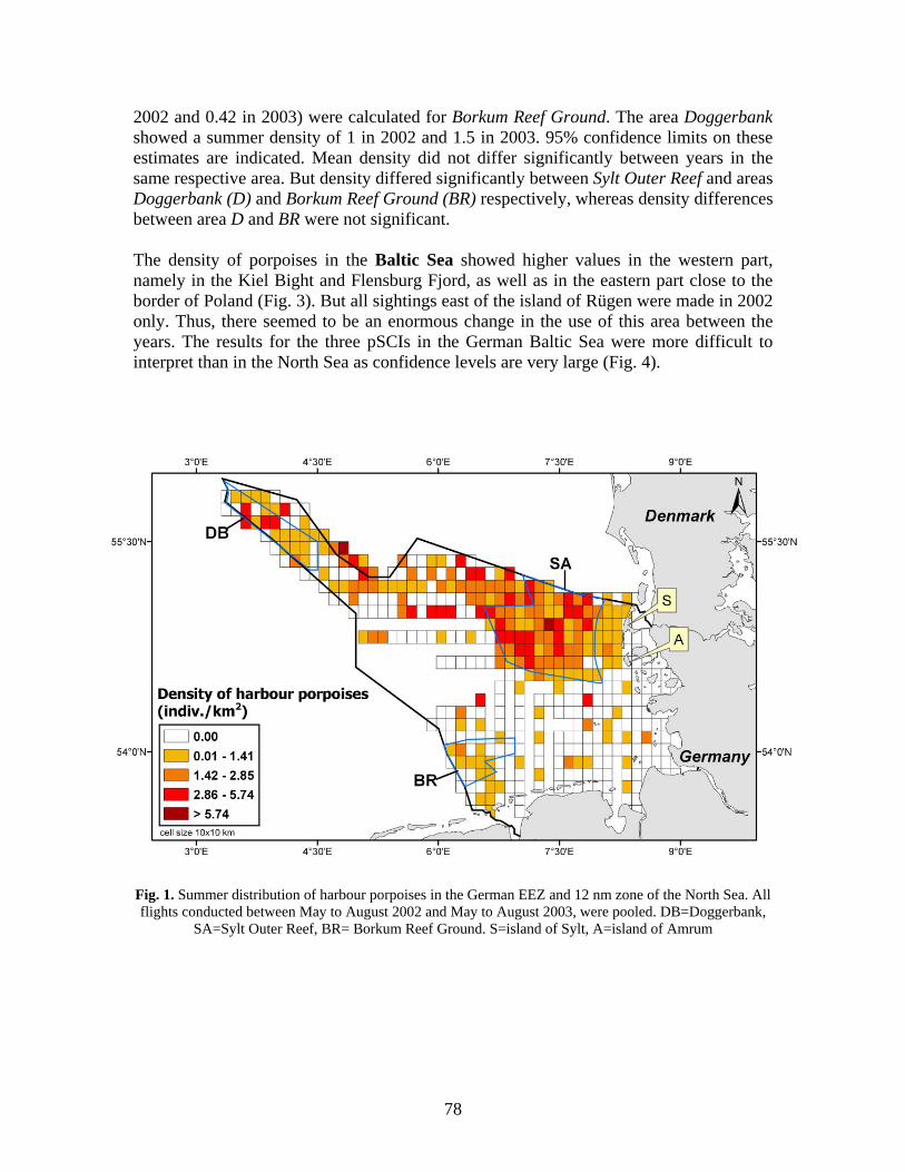
2002 and 0.42 in 2003) were calculated for Borkum Reef Ground. The area Doggerbank showed a summer density of 1 in 2002 and 1.5 in 2003. 95% confidence limits on these estimates are indicated. Mean density did not differ significantly between years in the same respective area. But density differed significantly between Sylt Outer Reef and areas Doggerbank (D) and Borkum Reef Ground (BR) respectively, whereas density differences between area D and BR were not significant. The density of porpoises in the Baltic Sea showed higher values in the western part, namely in the Kiel Bight and Flensburg Fjord, as well as in the eastern part close to the border of Poland (Fig. 3). But all sightings east of the island of Rügen were made in 2002 only. Thus, there seemed to be an enormous change in the use of this area between the years. The results for the three pSCIs in the German Baltic Sea were more difficult to interpret than in the North Sea as confidence levels are very large (Fig. 4).
Fig. 1. Summer distribution of harbour porpoises in the German EEZ and 12 nm zone of the North Sea. All flights conducted between May to August 2002 and May to August 2003, were pooled. DB=Doggerbank,
SA=Sylt Outer Reef, BR= Borkum Reef Ground. S=island of Sylt, A=island of Amrum
78
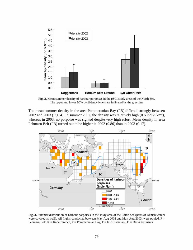
0.00.5
1.01.52.0
2.53.0
3.54.04.5
5.05.5
Doggerbank Borkum Reef Ground Sylt Outer Reef
mea
n hp
den
sity
(ind
iv./k
m²)
density 2002density 2003
Fig. 2. Mean summer density of harbour porpoises in the pSCI study areas of the North Sea. The upper and lower 95% confidence levels are indicated by the grey line
The mean summer density in the area Pommeranian Bay (PB) differed strongly between 2002 and 2003 (Fig. 4). In summer 2002, the density was relatively high (0.6 indiv./km2), whereas in 2003, no porpoise was sighted despite very high effort. Mean density in area Fehmarn Belt (FB) turned out to be higher in 2002 (0.86) than in 2003 (0.17).
KF
P
Fig. 3. Summer distribution of harbour porpoises in the study area of the Baltic Sea (parts of Danish waters were covered as well). All flights conducted between May-Aug 2002 and May-Aug 2003, were pooled. F = Fehmarn Belt, K = Kadet Trench, P = Pommeranian Bay, F = Is. of Fehmarn, D = Darss Peninsula
79
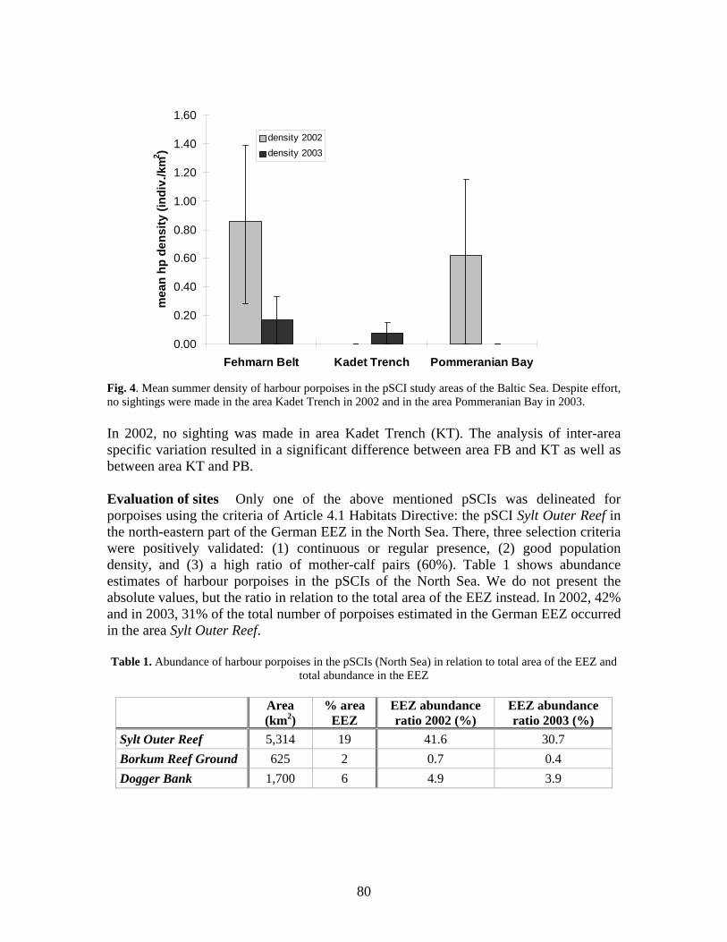
0.00
0.20
0.40
0.60
0.80
1.00
1.20
1.40
1.60
Fehmarn Belt Kadet Trench Pommeranian Bay
mea
n hp
den
sity
(ind
iv./k
m2 )
density 2002density 2003
Fig. 4. Mean summer density of harbour porpoises in the pSCI study areas of the Baltic Sea. Despite effort, no sightings were made in the area Kadet Trench in 2002 and in the area Pommeranian Bay in 2003. In 2002, no sighting was made in area Kadet Trench (KT). The analysis of inter-area specific variation resulted in a significant difference between area FB and KT as well as between area KT and PB. Evaluation of sites Only one of the above mentioned pSCIs was delineated for porpoises using the criteria of Article 4.1 Habitats Directive: the pSCI Sylt Outer Reef in the north-eastern part of the German EEZ in the North Sea. There, three selection criteria were positively validated: (1) continuous or regular presence, (2) good population density, and (3) a high ratio of mother-calf pairs (60%). Table 1 shows abundance estimates of harbour porpoises in the pSCIs of the North Sea. We do not present the absolute values, but the ratio in relation to the total area of the EEZ instead. In 2002, 42% and in 2003, 31% of the total number of porpoises estimated in the German EEZ occurred in the area Sylt Outer Reef. Table 1. Abundance of harbour porpoises in the pSCIs (North Sea) in relation to total area of the EEZ and
total abundance in the EEZ
Area (km2)
% area EEZ
EEZ abundance ratio 2002 (%)
EEZ abundance ratio 2003 (%)
Sylt Outer Reef 5,314 19 41.6 30.7 Borkum Reef Ground 625 2 0.7 0.4 Dogger Bank 1,700 6 4.9 3.9
80
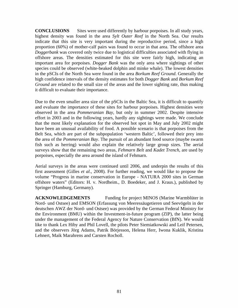
CONCLUSIONS Sites were used differently by harbour porpoises. In all study years, highest density was found in the area Sylt Outer Reef in the North Sea. Our results indicate that this site is very important during the reproductive period, since a high proportion (60%) of mother-calf pairs was found to occur in that area. The offshore area Doggerbank was covered only twice due to logistical difficulties associated with flying in offshore areas. The densities estimated for this site were fairly high, indicating an important area for porpoises. Dogger Bank was the only area where sightings of other species could be observed (white-beaked dolphin and minke whale). The lowest densities in the pSCIs of the North Sea were found in the area Borkum Reef Ground. Generally the high confidence intervals of the density estimates for both Dogger Bank and Borkum Reef Ground are related to the small size of the areas and the lower sighting rate, thus making it difficult to evaluate their importance. Due to the even smaller area size of the pSCIs in the Baltic Sea, it is difficult to quantify and evaluate the importance of these sites for harbour porpoises. Highest densities were observed in the area Pommeranian Bay, but only in summer 2002. Despite intensive effort in 2003 and in the following years, hardly any sightings were made. We conclude that the most likely explanation for the observed hot spot in May and July 2002 might have been an unusual availability of food. A possible scenario is that porpoises from the Belt Sea, which are part of the subpopulation ‘western Baltic’, followed their prey into the area of the Pommeranian Bay. The pursuit of an abundant food source (maybe swarm fish such as herring) would also explain the relatively large group sizes. The aerial surveys show that the remaining two areas, Fehmarn Belt and Kadet Trench, are used by porpoises, especially the area around the island of Fehmarn. Aerial surveys in the areas were continued until 2006, and underpin the results of this first assessment (Gilles et al., 2008). For further reading, we would like to propose the volume “Progress in marine conservation in Europe - NATURA 2000 sites in German offshore waters” (Editors: H. v. Nordheim., D. Boedeker, and J. Kraus.), published by Springer (Hamburg, Germany). ACKNOWLEDGEMENTS Funding for project MINOS (Marine Warmblüter in Nord- und Ostsee) and EMSON (Erfassung von Meeressäugetieren und Seevögeln in der deutschen AWZ der Nord- und Ostsee) was provided by the German Federal Ministry for the Environment (BMU) within the Investment-in-future program (ZIP), the latter being under the management of the Federal Agency for Nature Conservation (BfN). We would like to thank Lex Hiby and Phil Lovell, the pilots Peter Siemiatkowski and Leif Petersen, and the observers Jörg Adams, Patrik Börjesson, Helena Herr, Iwona Kuklik, Kristina Lehnert, Maik Marahrens and Carsten Rocholl.
81
REFERENCES
Buckland, S.T., Anderson, D.R., Burnham, K.P., Laake, J. and Thomas, L. 2001. Introduction to Distance
Sampling: Estimating abundance of biological populations. Oxford University Press, Oxford & New York.
Gilles, A., Herr, H., Lehnert, K., Scheidat, M. and Siebert, U. 2008. Harbour porpoises – abundance estimates and distribution. Chapter 2. Iin:. Marine mammals and seabirds in front of offshore wind energy (Eds. K. Wollny-Goerke & K. Eskildsen). Teubner Verlag, Wiesbaden. 200pp.
Hiby, A.R. and Hammond, P.S. 1989. Survey techniques for estimating the abundance of cetaceans. Reports of the IWC, Special Issue 11: 47–80.
Hiby, A.R. and Lovell, P. 1998. Using aircraft in tandem formation to estimate abundance of harbour porpoise. Biometrics, 54: 1280–1289.
Scheidat, M., Gilles. A. and Siebert. U. 2006. Evaluating the distribution and density of harbour porpoises (Phocoena phocoena) in selected areas in the German waters. Pp. 189-208. In: Progress in marine conservation in Europe - NATURA 2000 sites in German offshore waters (Eds. H. v. Nordheim, D. Boedeker and J. Krause). Springer Verlag, Hamburg.
Siebert, U., Gilles, A., Lucke, K., Ludwig, M., Benke, H., Kock, K.-H. and Scheidat, M. 2006. A decade of harbour porpoise occurrence in German waters - Analyses of aerial surveys, incidental sightings and strandings. J Sea Research, 56: 65-80.
82
CHALLENGES IN POPULATION, HABITAT PREFERENCE AND ANTHROPOGENIC IMPACT ASSESSMENT OF DEEP DIVING CETACEANS
Natacha Aguilar Soto1, Mark P. Johnson2, and Peter T. Madsen3
1BIOECOMAC. Dept. Animal Biology. La Laguna University, Tenerife, Canary Islands ([email protected])
2Woods Hole Oceanographic Institution, Woods Hole, Massachusetts, USA 3Zoophysiology, Department of Biological Sciences, Aarhus University, Denmark.
INTRODUCTION Around a third of all cetacean species dive deep to forage. This includes 20 species of beaked whales (family Ziphiidae) (e.g. Figure 1) (Mead, 1989; Hooker and Baird, 1999; Johnson et al., 2004; Baird et al. 2006), two species of pilot whales (Baird et al., 2002; Aguilar Soto et al., in press), sperm whales (Lockyer, 1977; Watwood et al., 2006), narwhals and belugas (Heide-Jorgensen et al., 2002; Heide-Jorgensen et al., 1998). Most of these species have offshore distributions that hamper assessment of their conservation status, and some, e.g. most beaked whales, count among the least known mammals on the planet due to the synergy between their offshore distribution and their elusive behaviour. Marine mammals have a slow growth rate (Barlow, 2002), typical of the life strategies of long-lived animals, that prevents rapid recovery of depleted populations (Whitehead et al., 1997). Most conservation efforts have been invested in coastal species due to the greater public visibility of these species and their accessibility for research. There is also a perception that coastal species will be more affected by adjacent human activities than will offshore species (viz, the recent apparent extinction of the Yangtze river dolphin (Lipotes vexillifer) (Turvey et al., 2007) and strong declines in other species such as the vaquita (Phocoena sinus) and finless porpoise (Neophocaena phocaenoides). However, offshore species are also subject to a wide range of potential human impacts but our ability to evaluate their effects on these species is very limited, rendering them unprotected. Impacts on offshore species include depletion of resources, interactions with fisheries, ship collisions, chemical pollution and anthropogenic noise. The degree to which human activities impact deep-diving inconspicuous species, such as beaked whales, is very difficult to document and assess although some evidence is available, e.g. mass strandings related to the use of military sonar (Frantzis, 1998; Balcomb and Claridge, 2001; Fernández et al., 2005), ship strikes (Carrillo, 2004) and fisheries bycatch (Julian and Beeson, 1998). Compared to shallow diving species, deep-diving marine mammals may operate closer to the limit of their physiological capabilities on a daily basis (Costa et al., 2004). Given this, and the increasing encroachment of anthropogenic activities into deep-water habitats, there is certainly no a priori reason to suppose that deep-diving mammals are less affected by humans than shallow-diving species. However, the lack of knowledge on basic population parameters, ecophysiology and ecology for most deep-diving cetacean species makes it difficult to assess their conservation status and so determine if they should receive protection under endangered species legislation. Selection criteria to determine the legal status of conservation of a species often relies on long-term population assessments. International and local examples are IUCN (2001) or the Canary Island Protected Species Catalogue (BOC, 2005). These regulations set strict conditions
83
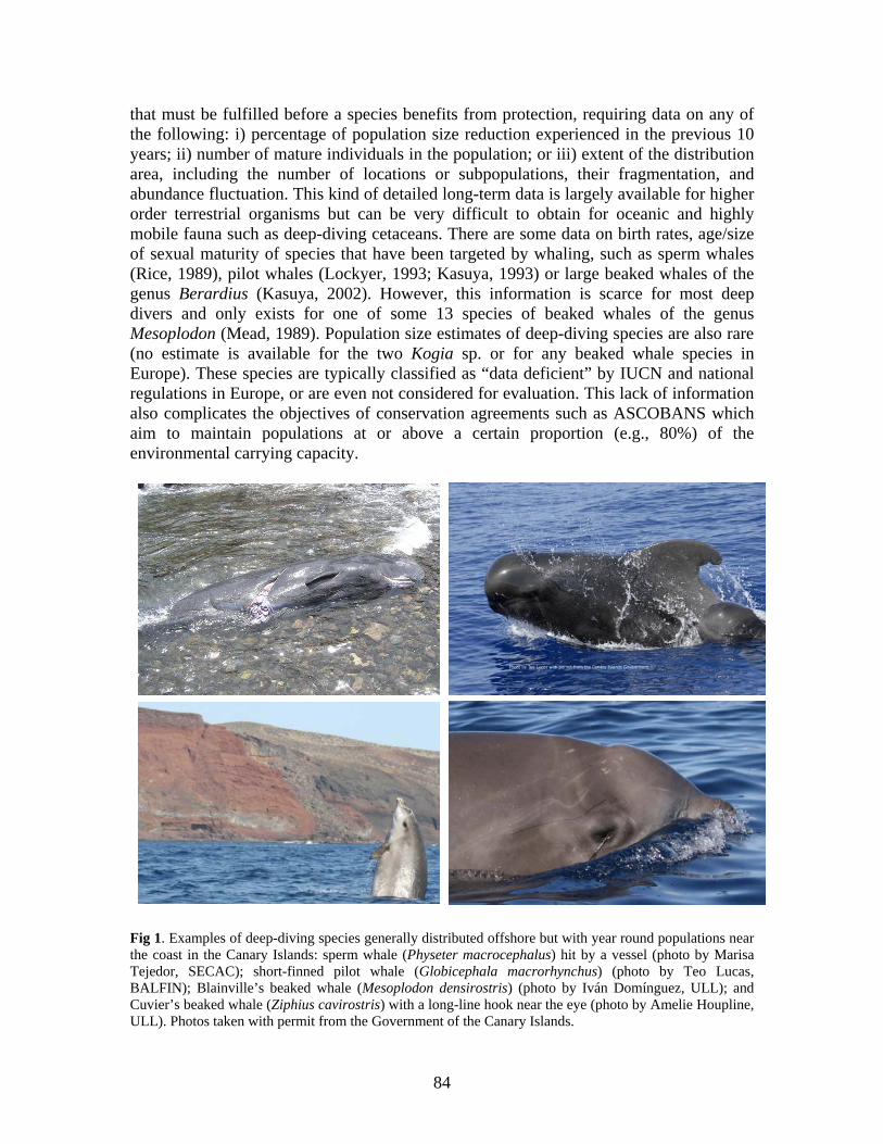
that must be fulfilled before a species benefits from protection, requiring data on any of the following: i) percentage of population size reduction experienced in the previous 10 years; ii) number of mature individuals in the population; or iii) extent of the distribution area, including the number of locations or subpopulations, their fragmentation, and abundance fluctuation. This kind of detailed long-term data is largely available for higher order terrestrial organisms but can be very difficult to obtain for oceanic and highly mobile fauna such as deep-diving cetaceans. There are some data on birth rates, age/size of sexual maturity of species that have been targeted by whaling, such as sperm whales (Rice, 1989), pilot whales (Lockyer, 1993; Kasuya, 1993) or large beaked whales of the genus Berardius (Kasuya, 2002). However, this information is scarce for most deep divers and only exists for one of some 13 species of beaked whales of the genus Mesoplodon (Mead, 1989). Population size estimates of deep-diving species are also rare (no estimate is available for the two Kogia sp. or for any beaked whale species in Europe). These species are typically classified as “data deficient” by IUCN and national regulations in Europe, or are even not considered for evaluation. This lack of information also complicates the objectives of conservation agreements such as ASCOBANS which aim to maintain populations at or above a certain proportion (e.g., 80%) of the environmental carrying capacity.
Fig 1. Examples of deep-diving species generally distributed offshore but with year round populations near the coast in the Canary Islands: sperm whale (Physeter macrocephalus) hit by a vessel (photo by Marisa Tejedor, SECAC); short-finned pilot whale (Globicephala macrorhynchus) (photo by Teo Lucas, BALFIN); Blainville’s beaked whale (Mesoplodon densirostris) (photo by Iván Domínguez, ULL); and Cuvier’s beaked whale (Ziphius cavirostris) with a long-line hook near the eye (photo by Amelie Houpline, ULL). Photos taken with permit from the Government of the Canary Islands.
84
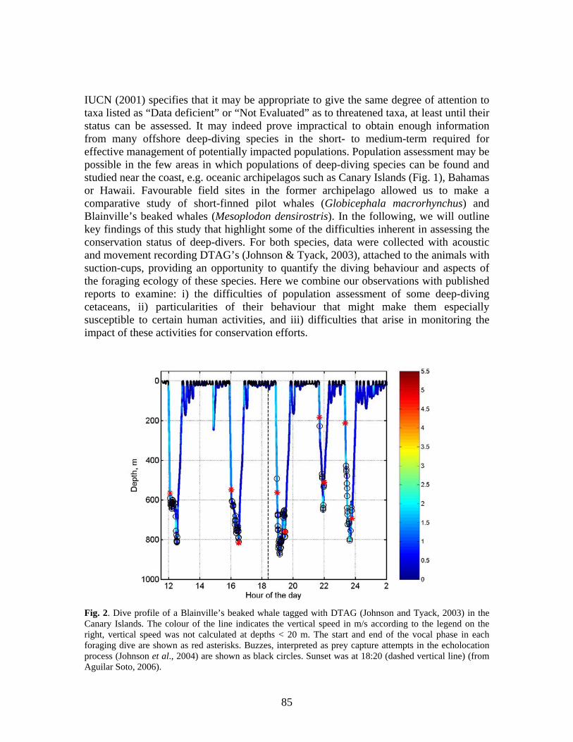
IUCN (2001) specifies that it may be appropriate to give the same degree of attention to taxa listed as “Data deficient” or “Not Evaluated” as to threatened taxa, at least until their status can be assessed. It may indeed prove impractical to obtain enough information from many offshore deep-diving species in the short- to medium-term required for effective management of potentially impacted populations. Population assessment may be possible in the few areas in which populations of deep-diving species can be found and studied near the coast, e.g. oceanic archipelagos such as Canary Islands (Fig. 1), Bahamas or Hawaii. Favourable field sites in the former archipelago allowed us to make a comparative study of short-finned pilot whales (Globicephala macrorhynchus) and Blainville’s beaked whales (Mesoplodon densirostris). In the following, we will outline key findings of this study that highlight some of the difficulties inherent in assessing the conservation status of deep-divers. For both species, data were collected with acoustic and movement recording DTAG’s (Johnson & Tyack, 2003), attached to the animals with suction-cups, providing an opportunity to quantify the diving behaviour and aspects of the foraging ecology of these species. Here we combine our observations with published reports to examine: i) the difficulties of population assessment of some deep-diving cetaceans, ii) particularities of their behaviour that might make them especially susceptible to certain human activities, and iii) difficulties that arise in monitoring the impact of these activities for conservation efforts.
Fig. 2. Dive profile of a Blainville’s beaked whale tagged with DTAG (Johnson and Tyack, 2003) in the Canary Islands. The colour of the line indicates the vertical speed in m/s according to the legend on the right, vertical speed was not calculated at depths < 20 m. The start and end of the vocal phase in each foraging dive are shown as red asterisks. Buzzes, interpreted as prey capture attempts in the echolocation process (Johnson et al., 2004) are shown as black circles. Sunset was at 18:20 (dashed vertical line) (from Aguilar Soto, 2006).
85
DEEP-DIVING BEHAVIOUR: IMPLICATIONS FOR POPULATION STUDIES Many deep-diving species perform frequent foraging dives both day and night. Examples are sperm whales (Watwood et al., 2006), pilot whales (Baird et al., 2003; Aguilar Soto et al., in press) and beaked whales (Hooker and Baird, 2003; Tyack et al., 2006). The dive profile in Figure 2 exemplifies the diving behaviour of studied beaked whales (Tyack et al., 2006) and their vocal activity during their long foraging dives. We will use this example to explain how the characteristics of the dive and vocal behaviour of a deep-diving species may complicate the application of methods generally used to monitor populations such as line-transect surveys, photo-identification, and acoustic monitoring.
i. Line-transect visual surveys Line-transect surveys are widely used to estimate density of cetacean populations (Hammond, 1987) and rely on knowing the probability of sighting the animals that are located within a strip width of the transect line. The size, behaviour and dive profile of different species will influence how likely they are to be sighted by observers and how long they are available for observation at the surface. Sperm whales, for example, spend around 20% of their time at the surface (Watwood et al., 2006) and pilot whales travel or rest during long intervals at the surface. By comparison, Blainville’s beaked whales are only visible above the water about 8% of the time (Aguilar Soto, 2006) and this number seems to apply broadly to other Ziphiid species as well (Barlow, 1999; Hooker and Baird, 1999; Tyack et al., 2006). Thus, the probability of missing a beaked whale in a transect, moving at typical speed and in the best visibility conditions, is 92%, and this worsens quickly with non-optimal weather. Barlow et al. (2006) reviewed abundance estimates of beaked whales using line-transect methods and corrected the data for the perception and availability bias. They found that pooled estimated densities of several small beaked whale species were comparable to worldwide estimated densities of one species (sperm whales) according to Whitehead (2002). In spite of this similarity, sperm whales as a single species are classified as vulnerable by the IUCN and other conservation bodies, while all small beaked whales are considered as data deficient, which should be revisited in the light of these new data. There is also the possibility that, with such a small visual detection rate, entire populations of beaked whales can be overlooked during transect surveys simply because no individual was sighted in an area. This means that potentially important areas of habitat may not qualify for any degree of protection.
ii. Photo-identification Photo-ID of natural markings in cetaceans can be used in mark-recapture studies to assess population size and structure, associations among individuals, percentage of calves and adult whales in groups, etc. (Whitehead, 1995). This method requires re-sampling the population which is difficult and costly in species distributed far offshore, especially in open populations where animals enter and leave the study areas. Even in species with populations near the coast (e.g. Blainville’s beaked whales off El Hierro, Bahamas or Hawaii), their elusive behaviour complicates the gathering of photo-ID data. Blainville’s beaked whales spend on average only 2 min at the surface between dives lasting a mean of 20 or 45 minutes (Tyack et al., 2006). The whales can cover a horizontal distance of between 500 and 2000 m in a dive and do not usually follow any predictable course. As a
86
result, photo-identification data are slow to acquire for this and other beaked whale species, and long-term studies, performed in a study area with a high encounter rate and easy accessibility, are required for mark-recapture methods. This point is exemplified by the length of data series that led to estimates of population site fidelity or abundance of Blainville’s beaked whales in the Bahamas (12 years – Claridge, 2006) or Hawaii (21 years - McSweeny et al., 2007, and 5 years - Baird et al., 2007). An additional imponderable is that the near-shore populations that can be studied may not necessarily behave in the same way nor be impacted by human activities in the same way as oceanic populations of the same species.
iii. Passive acoustic monitoring (PAM) Acoustic surveys are used as a complementary method to assess presence, and estimate instantaneous density of cetacean species. PAM has been successfully applied, for example, to study sperm whales which emit regular high source level clicks some 50% of the time (Leaper et al., 1992), but other species do not emit such powerful sounds nor are they so predictably vocal. The difficulties in sighting beaked whales make PAM a potential valuable tool to study their distribution and maybe even their abundance in an area. Acoustic surveys will need to take into account that beaked whales are mostly silent except for a vocal phase at the deep part of their foraging dives, where they echolocate for food (Fig. 2) (Johnson et al., 2004), i.e. they are vocal, on average, only 20% of the time. In addition, their ultrasonic clicks are highly directional and have a moderate source level (Johnson et al., 2004; Zimmer et al., 2005) that limits their effective detection range. Sampling protocols and instruments need to be developed and tested to suit the particularities of the vocal behaviour of beaked whales. Once this is achieved, PAM may be an effective method to learn about their distribution, mainly in areas where weather usually limits visual detection of the whales. DO DEEP-DIVERS HAVE ENHANCED SENSITIVITY TO DISTURBANCE? Influence of ecophysiology on population demographics Costa et al. (2004) compared the demographic development of five species of pinnipeds and showed that the populations of those foraging on deep benthic prey were declining. The authors explained this by the more demanding physiological requirements of foraging near the seabed, resulting in a lower ability to cope with variations in the environment. The foraging strategies of some cetacean species, such as beaked whales, might similarly require the species to work close to their physiological limits. Blainville’s beaked whales forage on mesopelagic and bentho-pelagic prey (Aguilar Soto, 2006), perform extremely long deep dives for their size and probably make use of hypometabolism to reduce the anaerobic phase of the foraging dives (Tyack et al., 2006). If the physiology of beaked whales is tightly suited to their foraging behaviour, they may have little ability to accommodate changes in their environment resulting in variations of prey distribution or abundance. The field metabolic rate (FMR) may be a useful indicator of the foraging strategy of a species. Blainville’s beaked whales appear to have a low FMR (Madsen et al., 2005; Aguilar Soto, 2006) as compared to deep-divers like sperm whales and pilot whales. There is a general rule linking metabolic and reproductive rates: animals with a low energetic expenditure will tend to have low rates of reproduction, and vice versa (McNab,
87
1980; Wiersma et al., 2007). If beaked whales follow this general rule, their low FMR may influence a low reproductive rate. Moreover, beaked whale calves are born bigger, with respect to the size of the adults, than other species of odontocete (MacLeod, 2006) and this probably requires a large energetic investment per calf. The synergy of a low metabolic rate and a large investment per reproductive event may reduce the number of calves that a female may have in a lifetime. Acoustic pollution Deep-diving cetaceans, foraging at depths below the photic layer, most likely rely on echolocation as their main way to find food. To be effective, an echolocating predator needs to detect and distinguish potential prey items at distances of 10s to 100s of metres. Despite the high source level of echolocation clicks produced by some deep-divers, the echoes returning from distant or low target-strength prey can be extremely weak and so are highly vulnerable to masking by elevated ambient noise. For example, it has been shown that ship noise has the potential to mask ultrasonic echolocation clicks of Cuvier’s beaked whales foraging at 700 m depth (Aguilar Soto et al., 2006), reducing the maximum range of echolocation and communication of the whales. Beaked whales seem to be especially sensitive to some sources of acoustic pollution, and tactical sonar or underwater charges have been related to mass strandings of several Ziphiid species in several places of the world (e.g. Frantzis, 1998; Balcomb and Claridge, 2001; Martín et al., 2003; Fernández et al., 2005). LIMITATIONS IN OUR ABILITY TO MONITOR IMPACTS ON DEEP DIVERS Quantification of direct impacts Some human impacts have a direct, immediate effect on the survival of individuals. Examples of this are mortalities of beaked whales related to naval exercises using tactical sonar (e.g. Frantzis, 1998; Balcomb and Claridge, 2001; Martín et al., 2003; Fernández et al. 2005). Mass strandings have been recorded when manoeuvres occur in areas with deep waters near the coast. However, not all affected whales may strand especially if naval exercises are performed far offshore. Deep oceanic waters have been described as the preferred habitat of beaked whales (Mead, 2002) and there is no reason to suppose that beaked whales far from the coast respond to sonar in a fundamentally different way than individuals near the coast. If mortalities recorded near the coast are indicative of a general sensitivity of Ziphiidae to sonar, the effect of naval exercises on beaked whales might be widespread, but unnoticed, in oceanic waters. Ship strikes are another example of direct mortalities that are difficult to evaluate. Their occurrence is monitored by the stranding of carcasses but animals that are hit offshore will probably not strand. Moreover, some deep-diving species such as pilot whales seem to have negative buoyancy with lungs collapsed (see an example in Figure 3) and thus will tend to sink if their lungs are damaged by the strike (Aguilar Soto, 2006).
88
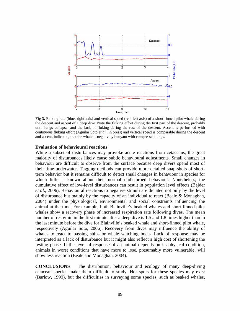
Fig 3. Fluking rate (blue, right axis) and vertical speed (red, left axis) of a short-finned pilot whale during the descent and ascent of a deep dive. Note the fluking effort during the first part of the descent, probably until lungs collapse, and the lack of fluking during the rest of the descent. Ascent is performed with continuous fluking effort (Aguilar Soto et al., in press) and vertical speed is comparable during the descent and ascent, indicating that the whale is negatively buoyant with compressed lungs. Evaluation of behavioural reactions While a subset of disturbances may provoke acute reactions from cetaceans, the great majority of disturbances likely cause subtle behavioural adjustments. Small changes in behaviour are difficult to observe from the surface because deep divers spend most of their time underwater. Tagging methods can provide more detailed snap-shots of short-term behavior but it remains difficult to detect small changes in behaviour in species for which little is known about their normal undisturbed behaviour. Nonetheless, the cumulative effect of low-level disturbances can result in population level effects (Bejder et al., 2006). Behavioural reactions to negative stimuli are dictated not only by the level of disturbance but mainly by the capacity of an individual to react (Beale & Monaghan, 2004) under the physiological, environmental and social constraints influencing the animal at the time. For example, both Blainville’s beaked whales and short-finned pilot whales show a recovery phase of increased respiration rate following dives. The mean number of resp/min in the first minute after a deep dive is 1.5 and 1.8 times higher than in the last minute before the dive for Blainville’s beaked whale and short-finned pilot whale, respectively (Aguilar Soto, 2006). Recovery from dives may influence the ability of whales to react to passing ships or whale watching boats. Lack of response may be interpreted as a lack of disturbance but it might also reflect a high cost of shortening the resting phase. If the level of response of an animal depends on its physical condition, animals in worst conditions that have more to lose, presumably more vulnerable, will show less reaction (Beale and Monaghan, 2004). CONCLUSIONS The distribution, behaviour and ecology of many deep-diving cetacean species make them difficult to study. Hot spots for these species may exist (Barlow, 1999), but the difficulties in surveying some species, such as beaked whales,
89
mean that apparent “biological deserts” in the deep oceans may simply reflect a lack of research effort or power to see. It is necessary to develop cost-effective methods to aid data collection on the distribution of elusive deep-diving species. There is growing evidence that at least some species of deep-diving cetaceans may be especially vulnerable to some human impacts and that our ability to detect population level effects is very limited. Unfortunately, the lack of information about distribution and abundance of many deep-diving species results in these species being ignored or classified as “data deficient” by most conservation bodies. There is a strong need to develop new techniques and to alleviate this lack of basic data regarding the conservation status of deep-diving toothed whales. In addition, the standards by which the vulnerability of deep-divers is assessed in conservation law should be adjusted to reflect the empirical difficulty in obtaining population data and evaluating human impacts, applying the precautionary principle as a scientific basis for management of cetacean populations (Thompson et al., 2000).
REFERENCES
Aguilar Soto, N., Johnson, M., Madsen, P., Díaz, F., Domínguez, I., Brito, A. and Tyack, P. In press.
Cheetahs of the deep sea: deeep foraging sprints in short-finned pilot whales off Tenerife (Canary Islands). J. Anim. Ecol.
Aguilar Soto, N. 2006. Acoustic and diving behaviour of pilot whales (Globicephala macrorhynchus) and Blainville´s beaked whales (Mesoplodon densirostris) off the Canary Islands, with implications for effects of man-made noise and ship strikes. PhD. La Laguna University. Tenerife. Canary Islands. 270 pp.
Aguilar Soto, N., Johnson, M., Madsen, P., Tyack, P, Bocconcelli, A. and Borsani, F. 2006. Does intense ship noise disrupt foraging in deep-diving Cuvier's beaked whales (Ziphius cavirostris)? Mar. Mam. Sci., 22: 690-699.
Baird, R., McSweeney, D., Schorn, G., Mahaffy, S., Webster, D., Barlow, J., Bradley Hanson, M., Turner, J., and Andrews, R 2007. Studies of beaked whales in Hawaii: population size, movements, trophic ecology, social organization and behaviour. In: Beaked whale research workshop. (Ed. S. Dolman). 21st Conference of the European Cetacean Society, 26th April.San Sebastian. 2007. European Cetacean Society, San Sebastian..
Baird, R.W., Obin, W., Webster, D.L., McSweeney, D.J., Ligon, A.D., Schorr, G.S. and Barlow, J. 2006. Diving behaviour of Cuvier’s (Ziphius cavirostris) and Blainville’s (Mesoplodon densirostris) beaked whales in Hawai'i. Canadian Journal of Zoology, 84: 1120-1128.
Baird, R.W., Borsani, J.F., Hanson, M.B. and Tyack, P.L. 2002. Diving and night-time behavior of long-finned pilot whales in the Ligurian Sea. Marine Ecology Progress Series, 237: 301-305.
Balcomb, K. C. and Claridge, D. 2001. A mass stranding of cetaceans caused by naval sonar in the Bahamas. Bahamas Journal of Science, 2: 2-12.
Barlow, J., Ferguson, M.C., Perrin, W., Balance. L., Gerrodette, T., Joyce, G., Macleod, C., Mullin, K., Palka, D.L. and Waring, G. 2006. Abundance and densities of beaked and bottlenose whales (family Ziphiidae). Journal of Cetacean Research and Management, 7(3):263-270.
Barlow, J. and Reeves, R. 2002. Population status and trends. Pp. 979-982 in Encyclopaedia of Marine Mammals. (Eds. W.F. Perrin, B. Wursig, and J.G.M. Thewissen). Academic Press, San Diego.
Barlow, J. 1999. Trackline detection probability for long-diving whales. Pp. 209-221 in Marine Mammal Survey and Assessment Methods. (Eds. G. W. Garner, S. C. Amstrup, J. L. Laake, B. F. J. Manly, L. L. McDonald and D. G. Robertson). A. A. Balkema, Rotterdam, Netherlands.
Beale, C.M. and Monaghan, P. 2004. Behavioural responses to human disturbance: a matter of choice? Animal Behaviour, 68, 1065–1069
Bedjer, L., Samuels, A., Whitehead, H. and Gales, N. 2006. Interpreting short-term behavioural responses to disturbance within a longitudinal perspective. Animal Behaviour 72(5):1149-1158.
90
BOC. 2005. Orden de 13 de julio de 2005, por la que se determinan los criterios que han de regir la evaluación de las especies de la flora y fauna silvestres amenazadas. Pp. 13849-13855. Boletín Oficial de Canarias.
Carrillo, 2004. Informe de cetáceos varados. Unpublished report to the Canary Islands Government. Costa, D.P., Kuhn, C.E., Weise, M.J., Shaffer, S.A. and Arnould, P.Y. 2004. When does physiology limit
the foraging behaviour of freely diving mammals? International Congress Series, 1275: 359–366. Fernández, A., Edwards, J. F., Rodríguez, F., Espinosa de los Monteros, A., Herráez, P. Castro, P., Jaber,
J.R., Martín, V. and Arbelo, M. 2005. "Gas and Fat Embolic Syndrome" involving a mass stranding of beaked whales (Family Ziphiidae) exposed to anthropogenic sonar signals. Veterinary Pathology, 42: 446–457.
Frantzis, A. 1998. Does acoustic testing strand whales? Nature, 392:29. Hammond, P.S. 1987. Techniques for estimating the size of whale populations. Pp. 225-245. In: Mammal
Population Studies. (Ed. S. Harris). Symposia of the Zoological Society of London 58. Oxford University Press.
Heide-Jørgensen, M.P., Dietz, R., Laidre, K.L.,Richard, P. 2002. Autumn movements, home ranges, and winter density of narwhals (Monodon monoceros) tagged in Tremblay Sound, Baffin Island. Polar Biology, 25: 331-341.
Heide-Jorgensen, M.P., Richard, P.R. and Rosing-Asvid, A. 1998. Dive patterns of belugas (Delphinapterus leucas) in waters near eastern Devon Island. Arctic, 51: 17-26.
Hooker, S.K. and Baird, R.W. 1999. Deep-diving behaviour of the northern bottlenose whale, Hyperoodon ampullatus (Cetacea: Ziphiidae). Proceedings of the Royal Society of London, B 266: 671-676.
IUCN (2001) IUCN Red List Categories and Criteria: Version 3.1. IUCN Species Survival Commission. (Ed. IUCN). Gland, Switzerland and Cambridge, UK. 30 pp.
Johnson, M.P., Madsen, P.T., Zimmer, W.M.X., Aguilar de Soto, N. and Tyack, P. 2004. Beaked whales echolocate on prey. Proceedings of the Royal Society of London, B , 271: S383-S386.
Johnson, M.P. and Tyack, P.L. 2003. A Digital Acoutic Recording Tag for Measuring the Response of Wild Marine Mammals to Sound. IEEE Journal of Oceanic Engineering, 28: 3-12.
Julian, F. and Beeson, M. 1998. Estimates of marine mammal, turtle, and seabird mortality for two California gillnet fisheries: 1990–1995. Fishery Bulletin, 96: 271-284.
Kasuya, T. 2002. Giant beaked whales (Berardius bairdii and B. arnuxii). Pp. 519-522. In: Encyclopaedia of Marine Mammals (Eds. W.F. Perrin, B. Wursig and J.G.M. Thewissen). Academic Press, San Diego.
Kasuya, T. and Tai, S. 1993. Life history of short finned pilot whale stocks off Japan and a description of the fishery. In: Biology of Pilot Whales (Eds. G. Donovan, C. Lockyer and A. Martin). IWC, Cambridge. 479 pp.
Leaper, R., Chappell, O. and Gordon, J. 1992. The development of practical techniques for surveying sperm whale populations acoustically. Report of the International Whaling Commission, 42: 549-560.
Lockyer, C. 1993. Seasonal changes in body fat condition of northeast Atlantic pilot whales, and their biological significance. Pp. 205-324. In: IWC Special Issue 14: Biology of the Northern Hemisphere Pilot Whales (Eds. G. P. Donovan, C. Lockyer and A.R. Martin). IWC, Cambridge.
Madsen P.T., Aguilar Soto N., Johnson M. and Tyack P.T. 2005. Field metabolic rate estimates in large, deep-diving toothed whales with implications for biomass turnover. European Research on Cetaceans-19. Proceedings of the 19th Ann. Conf. ECS. April 2005. La Rochelle, France..
Martín, V., Servidío, A. and García, S. 2004. Mass stranding of beaked whales in the Canary Islands. Workshop on Active Sonar and cetaceans (Eds P.G.H. Evans and L.A. Miller). 17th Ann. Conf. ECS. Gran Canaria. 78 pp.
MacLeod, C.D. 2006. How big is a beaked whale? A review of body length and sexual size dimorphism in the family Ziphiidae. Journal of Cetacean Research and Management, 7: 301-308.
McNab, B.K. 1980. Food habits, energetics and the population biology of mammals. Am. Nat., 116: 106–124.
McSweeney, D.J., Baird, R.W. and Mahaffy, S.D. 2007. Site fidelity, associations and movements of Cuvier’s (Ziphius cavirostris) and Blainville’s (Mesoplodon densirostris) beaked whales off the island of Hawai‘i. . Marine Mammal Science, 23: 666-687.
Mead, J.G. 2002 Beaked whales, overview. Pp. 81-84. In: Encyclopedia of marine mammals (Eds. W.F. Perrin, B. Würsig and J.G.M. Thewissen). Academic Press, San Diego.
91
Mead, J.G. 1989. Beaked whales of the genus Mesoplodon. Pp. 349-430. In: Handbook of Marine Mammals. (Eds. S. H. Ridgway and R. Harrison).Academic Press, London.
Rice, D.W. 1989. Sperm whale (Physeter macrocephalus) Linnaeus, 1758. Pp. 177-233. In: Handbook of Marine Mammals. (Eds. S.H. Ridgway and R. Harrison).Academic Press, London.
Thompson, P., Wilson, B., Grellier, K. and Hammond, P. 2000. Combining power analysis and population viability analysis to compare traditional and precautionary approaches to conservation of coastal cetaceans. Conservation Biology, 14(5): 1253-1263.
Turvey, S., Pitman, R., Taylor, T., Barlow, J., Akamatsu, T., Barrett, L., Zhao, X. and Reeves, R. 2007. First human-caused extinction of a cetacean species? Biology Letters, 3(5): 537-540
Watwood, S.L., Miller, P.J.O., Johnson, M.P., Madsen, P.T. and Tyack, P.L. 2006. Deep-diving foraging behavior of sperm whales (Physeter macrocephalus). Journal of Animal Ecology, 75: 814–825.
Whitehead, H. 1995. Investigating social structure and temporal scale in social organizations using identified individuals. Behavioural Ecology, 6: 199-208.
Whitehead, H., Christal, J. and Dufault, S. 1997. Past and distant whaling and the rapid decline of sperm whales off the Galapagos Islands. (Physeter macrocephalus). Conservation Biology, 11(6):1387-1396.
Whitehead, H. 2002. Estimates of the current global population size and historical trajectory for sperm whales. Marine Ecology Progress Series, 242: 295-304.
Wiersma, P., Muñoz Garcia, A., Walker, A. & Williams, J.B. 2007. Tropical birds have a slow pace of life. Proceedings of the National Academy of Sciences, 104: 9340-9345.
Zimmer, W.M.X., Johnson, M.P., Madsen, P.T. and Tyack, P.L. 2005. Echolocation clicks of free-ranging Cuvier's beaked whales (Ziphius cavirostris). Journal of the Acoustical Society of America, 117: 3919-3927.
92
MANAGEMENT OF MPAs: OPTIONS AND CHALLENGES FOR THE MARITIME TRANSPORT SECTOR.
SPANISH CASE STUDIES
Ana Tejedor Arceredillo1, Ricardo Sagarminaga2, Renaud de Stephanis3, Ana Cañadas2, and Alejandro Lago1
1 UNESCO Chair for the Environment. Universidad Rey Juan Carlos,
c/o Tulipán, s/n- 28933 Móstoles, Spain ([email protected]) 2 ALNITAK Marine Environment Research Centre, Nalón 16, 28240 Hoyo de Manzanares. Spain ([email protected])
3 CIRCE, Cabeza de Manzaneda 3, Algeciras 11390, Spain ([email protected])
INTRODUCTION This contribution seeks for new approaches to examine MPAs as an effective way to develop management measures to reduce threats of shipping; it also examines recent initiatives undertaken in Spanish waters both to improve navigational safety, and to protect sensitive marine species and habitats. BACKGROUND As significant harm to the world’s ocean ecosystems becomes more evident, MPAs are receiving increasing attention from governments, policymakers and scientists. Key issues for environmental authorities are the management of environmental pressures associated with a large and expanding tourism industry, commercial and recreational fishing, urban growth, coastal development, the downstream effects of land use, and shipping (Tejedor & Spinosa, 2006). The cumulative impacts of all these environmental threats enhance the critical importance of integrated management approaches, such as those offered by the establishment and management of MPAs, when compared with the lack of effectiveness for the management of environmental impacts of the classical sectoral approaches. In this sense, the shipping sector is an historical sector that is seeking for efficient management tools to address the new public demands, such as the minimisation of threats from its activities on marine biodiversity. Impacts coming from shipping include:
1) Operational Discharges13. These include oil and other harmful substances, ballast water and associated invasive aquatic organisms, antifouling substances, garbage, sewage, and air pollution.
2) Accidental Discharges of oil and other harmful substances from ships. 3) Physical Harm, including engine and machinery noise; physical damage to
organisms and habitats (including ship strikes); dredging and disposal of sediments; and wake and wash effects associated with high speed passage in narrow channels.
13 Pollution derives from the normal operation of a ship.
93
4) Large scale Coastal Development for Port Facilities Various strategies to reduce vessel-related risk to marine biodiversity are under consideration by the competent authorities such as the International Maritime Organization, the European Maritime Safety Agency, or in the context of the region discussed here, the Spanish Merchant Navy. Among these strategies we have found the following measures:
• Design, construction and equipment standards for tankers and other merchant vessels.
• Comprehensive survey and classification requirements for merchant vessels. • Standards application for regulating the discharge of harmful substances and
invasive aquatic species to the marine environment. • Application of routing of ships and other traffic management and navigation
safety measures. • Development of specific ship risk assessments. • Comprehensive planning and preparedness for oil and hazardous substance spills. • Development of international compensation frameworks to provide financial
assistance and compensation to those states that are affected by marine spills, arising from international shipping activities.
• Improvement of stakeholder involvement to address specific management concerns (i.e. monitoring and emergency-response programs).
• Development of special site requirements (i.e. specific permits, special rates, etc.) • Increase of marine conservation education programs and enhancement of
educational mariner awareness. Widening the scope: the use of Marine Protected Areas and other Specific Conservation Strategies In addition to the measures cited above, new business tools or mechanisms are being incorporated to keep improving this already complex system. One of these emergent mechanisms, that is being developed, is the acknowledgement in one form or another of Marine Protected Areas specifically devised to confront oil pollution and/or transportation problems.
The specific concept of an MPA for preventing pollution from ships, was first formally introduced by the International Maritime Organization (IMO). The IMO introduced Special Areas (SAs)14 and Particular Sensitive Sea Areas (PSSAs)15 to indicate the essential combination of environmental sensitivity and risk of pollution from ships
14 Special Areas are defined as a “sea area where for recognized technical reasons in relation to itsr oceanographic and ecological conditions and to the particular character of its traffic, the adoption of special mandatory methods for the prevention of sea pollution by oil, noxious liquid substances, or garbage, as applicable, is required”. See IMO Assembly Resolution: A.927(22) PSSA and Special Areas Guidelines. 15 A Particularly Sensitive Sea Area is defined as an “area that needs special protection through action by IMO because of its significance for recognized ecological, socio-economic, or scientific reasons and because it may be vulnerable to damage by international shipping activities”. The IMO developed this specific concept to help nations to protect significant marine areas that are specially vulnerable to the impacts of international shipping activities. See IMO Assembly Resolution: A.982(24) Revised guidelines for the identification and designation of Particularly Sensitive Sea Areas (PSSAs).
94
(Tejedor Arceredillo, 2006). Generally speaking, they are flexible tools that enable the enforcement of more stringent management measures and regulations according to the ecological, social and economic characteristics of the area. Subsequently, there have been different regional and national efforts and approaches to further develop this concept (see, as an example, the example of “water quality protection areas” in California or the example of “Marine Environmental High Risk Areas” in the United Kingdom). Alternatively, and although MPAs are usually established for purposes other than pollution control, their management practices have, in some cases, contributed to the reduction of marine pollution (see as an example the United States Monterey Bay National Marine Sanctuary or the Spanish Cabo de Gata MPA). Experiences gained within the Spanish perspective Despite the facts presented above, and because reducing vessel-related risk to marine biodiversity requires a very specific knowledge of both disciplines (marine conservation biology and maritime transport management), cooperation between these two “sectors” is a prerequisite for any success. This has been the experience gained by Spain, where MPAs and other pragmatic conservation strategies such as conservation management plans have played a key role on the better chances for achieving higher standards in already existing maritime sectoral instruments. Among these experiences, we will highlight the following two case studies: the new location for the “Cabo de Gata” Traffic Separation Scheme; and the Notice to Mariners to protect cetaceans from the risk of ship collisions in the Strait of Gibraltar. 1. REPOSITIONING OF THE “CABO DE GATA” TRAFFIC SEPARATION
SCHEME The initiative for the repositioning of the Traffic Separation Scheme “Off Cabo de Gata” came from the accomplishment of the European Commission LIFE Nature project “Conservation of cetaceans and sea turtles in Murcia and Andalusia” (LIFE02NAT/E/8610). More specifically, this initiative came about during the development of the Conservation Plans for the loggerhead turtle and the bottlenose dolphin, and the Management Plan for the Southern Almeria SAC, when the threats arising from the shipping sector were analysed. The waters off the Natural Park of Cabo de Gata – Nijar (South Almería, Andalusia) constitute an extremely valuable and sensitive coastal habitat and one of the most important Special Areas of Conservation (SAC) for the bottlenose dolphin (Tursiops truncatus) and the loggerhead turtle (Caretta caretta) in the Mediterranean within the framework of the European Union’s Habitat Directive (Natura 2000 Network). In addition, it protects an extremely valuable and sensitive coastal habitat designated as Natural Park, Biosphere Reserve and SPAMI Area (Alonso et al., 2005). However, this high biodiversity area represents also one of the busiest areas for the passage of large tonnage maritime traffic. According to the Mediterranean Action Plan, this area contains more than 25% of the world merchant maritime transport, which means a transit of 60.000 to 90.000 commercial ships per year.
95
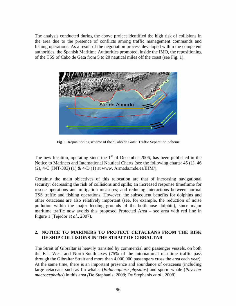
The analysis conducted during the above project identified the high risk of collisions in the area due to the presence of conflicts among traffic management commands and fishing operations. As a result of the negotiation process developed within the competent authorities, the Spanish Maritime Authorities promoted, inside the IMO, the repositioning of the TSS of Cabo de Gata from 5 to 20 nautical miles off the coast (see Fig. 1).
Fig. 1. Repositioning scheme of the “Cabo de Gata” Traffic Separation Scheme The new location, operating since the 1st of December 2006, has been published in the Notice to Mariners and International Nautical Charts (see the following charts: 45 (1), 46 (2), 4-C (INT-303) (1) & 4-D (1) at www. Armada.mde.es/IHM/). Certainly the main objectives of this relocation are that of increasing navigational security; decreasing the risk of collisions and spills; an increased response timeframe for rescue operations and mitigation measures; and reducing interactions between normal TSS traffic and fishing operations. However, the subsequent benefits for dolphins and other cetaceans are also relatively important (see, for example, the reduction of noise pollution within the major feeding grounds of the bottlenose dolphin), since major maritime traffic now avoids this proposed Protected Area – see area with red line in Figure 1 (Tejedor et al., 2007). 2. NOTICE TO MARINERS TO PROTECT CETACEANS FROM THE RISK
OF SHIP COLLISIONS IN THE STRAIT OF GIBRALTAR The Strait of Gibraltar is heavily transited by commercial and passenger vessels, on both the East-West and North-South axes (75% of the international maritime traffic pass through the Gibraltar Strait and more than 4,000,000 passengers cross the area each year). At the same time, there is an important presence and abundance of cetaceans (including large cetaceans such as fin whales (Balaenoptera physalus) and sperm whale (Physeter macrocephalus) in this area (De Stephanis, 2008; De Stephanis et al., 2008).
96
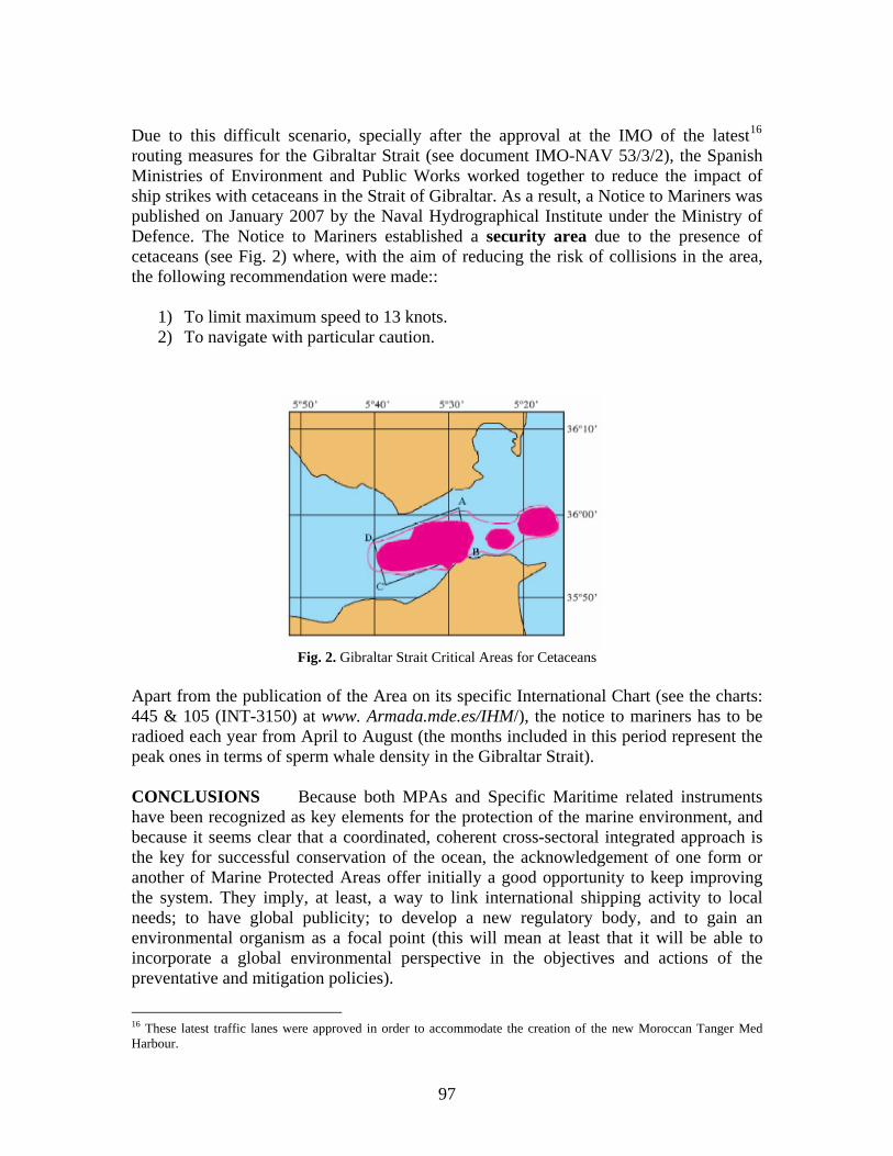
Due to this difficult scenario, specially after the approval at the IMO of the latest16 routing measures for the Gibraltar Strait (see document IMO-NAV 53/3/2), the Spanish Ministries of Environment and Public Works worked together to reduce the impact of ship strikes with cetaceans in the Strait of Gibraltar. As a result, a Notice to Mariners was published on January 2007 by the Naval Hydrographical Institute under the Ministry of Defence. The Notice to Mariners established a security area due to the presence of cetaceans (see Fig. 2) where, with the aim of reducing the risk of collisions in the area, the following recommendation were made::
1) To limit maximum speed to 13 knots. 2) To navigate with particular caution.
Fig. 2. Gibraltar Strait Critical Areas for Cetaceans
part from the publication of the Area on its specific International Chart (see the charts:
ONCLUSIONS Because both MPAs and Specific Maritime related instruments
preventative and mitigation policies).
A445 & 105 (INT-3150) at www. Armada.mde.es/IHM/), the notice to mariners has to be radioed each year from April to August (the months included in this period represent the peak ones in terms of sperm whale density in the Gibraltar Strait). Chave been recognized as key elements for the protection of the marine environment, and because it seems clear that a coordinated, coherent cross-sectoral integrated approach is the key for successful conservation of the ocean, the acknowledgement of one form or another of Marine Protected Areas offer initially a good opportunity to keep improving the system. They imply, at least, a way to link international shipping activity to local needs; to have global publicity; to develop a new regulatory body, and to gain an environmental organism as a focal point (this will mean at least that it will be able to incorporate a global environmental perspective in the objectives and actions of the
16 These latest traffic lanes were approved in order to accommodate the creation of the new Moroccan Tanger Med Harbour.
97
On the other hand, we further believe that cooperation and the use of combined uthorities in harmony will accomplish more in the long-term.
antoja (DG para la iodiversidad), Borja Heredia (DG para la Biodiversidad), Francisco Ramos (DG.
artín
REFERENCES
Alonso, E., Tejedor, A. and Sagarminaga f the benefits of the Cabo de Gata TSS Displacement. – UNESCO Chair of E eport 2005.
a ACKNOWLEDGEMENTS We thank Javier PBMarina Mercante), and Itziar M (DG Marina Mercante) for their support and advice.
, R. 2005. Report onvironment Annual R
De Stephanis, R.. 2008. Estrategias de alimentación de los diferentes grupos de calderón común en el Estrecho de Gibraltar, PhD thesis, University of Cadiz.
De Stephanis, R, Cornulier, T., Verborgh,P., Salazar Sierra, J, Perez, S., Gimeno, N, and Guinet, C. 2008. Summer spatial distribution of cetaceans in the Strait of Gibraltar in relation to the oceanographic context. Marine Ecology Progress Series, 353: 272-288.
Tejedor Arceredillo, A. 2006. Transporte Marítimo y Contaminación de las Aguas. In: Alonso García, E. and Lozano Cutanda, B. Diccionario de Derecho Ambiental, IUSTEL.
Tejedor, A. and Spinosa, L 2006. “Oil spill prevention and response: the U.S. institutional system in the coast of California”. Instituto Universitario de Investigación en Estudios Norteamericanos.
Tejedor, A., Sagarminaga, R., De Stephanis, R. and Cañadas, A. 2007. Information provided by Spain in Response to Circular Communication IWC.CCG. 594, requesting information in relation to ship strikes, in particular to recommendation 3. International Whaling Commission, Cambridge.
98
CONCLUDING REMARKS1
Peter G.H. Evans
Sea Watch Foundation, Cynifryn, Llanfaglan, Caernarfon, Gwynedd LL54 5RA, UK
The workshop was divided into three main sessions: the first introduced the concept of Marine Protected Areas, and aspects to consider in terms of legislation and management before one embarks upon a site selection process. While MPAs are widely accepted as a powerful tool to achieve marine conservation objectives, particularly for spatially limited populations, traditional MPAs may not be the most appropriate mechanism for some species and situations. Examples include cetacean populations that range very widely with no obvious regular feeding or breeding areas, or that face anthropogenic activities with large-scale impacts where focus upon the impact itself might be more effective. It is also important to bear in mind that establishment of an MPA takes some considerable time and may meet with resistance from local communities if they perceive it as restricting their activities. Thus if a conservation action is needed urgently, this should be applied independently of area protection. It is important to determine whether an MPA will provide added value or if a wider measure will be more efficient at conserving the species of concern. The identification of threats is an essential first step, followed by an assessment of what would be the most suitable conservation actions and if they require to be implemented within an MPA or more broadly. Goals of MPAs typically have included biodiversity protection, a multipurpose function (e.g. inclusive of fishery enhancement), re-establishment of the species, raising awareness and/or promoting scientific research. On some occasions, declaration of an MPA has been done simply for political popularity and has not been accompanied by the conservation actions necessary to make it work. Of crucial importance is that management and conservation objectives are clearly identified. They should be specific and quantifiable, accompanied by a realistic monitoring programme, and with management proposals involving all stakeholders since we must not forget that it is human activities rather than cetaceans themselves that are being managed. Both scientific data and information on present and possible future human activities should be considered in the site selection process, and there should be a transparent audit trail of justification for it. Although cetaceans in European seas do not generally appear to exhibit discrete identifiable breeding areas or migratory routes such as those found elsewhere in the world, especially for largely coastal species such as gray, right and humpback whales, several areas in Europe contain important high density areas or migratory routes. Examples can be found in the Macaronesian region with year-round populations of deep-diving species such as sperm whales, pilot whales and/or beaked whales; the richness of
1 These represent the overall conclusions of the workshop, reviewed and adopted by the organising committee and those who made presentations. Their input is gratefully acknowledged.
99
the Strait of Gibraltar-Alborán Sea, including a small population of killer whales and one of the few healthy populations of common dolphins in the Mediterranean Sea; or the Mediterranean Sea itself, that holds a genetically isolated population of fin whales. Generally, high-density areas are used both as feeding areas and breeding/nursery grounds, and it is difficult to establish their primary functions temporally and geographically. Thus in developing criteria for site selection of MPAs, a valuable first step will be to identify areas of high density for the particular species under consideration, and confirm its regular presence over a long time series (ideally decadal). With this in mind, the second session examined a variety of methods for identifying potential sites for selection as MPAs. A suite of survey approaches can be recommended since they complement one another:
• Aerial and vessel-based surveys provide density estimates that can be used to map hot spots; repeating these in different seasons and between years will allow one to establish trends and temporal variability. Where necessary, supplement this with opportunistic effort-related survey data as well as incidental sightings;
• Acoustic surveys can also provide valuable information, particularly in areas difficult to survey due to weather conditions or for more cryptic yet vocal species, like the harbour porpoise or beaked whales; static devices such as T-PODs, sonobuoys, or pop-up hydrophones are a cost-effective method for monitoring the presence of echo-locating or vocal species at specific locations over long periods of time (and in some cases may be used to identify the use of locations for feeding or mating);
• Individual ranging movements can be established through photo-identification for those species with recognizable individual features (e.g. bottlenose dolphin, fin whale, minke whale, some of the beaked whales, etc), or, in certain circumstances, by radio or satellite telemetry (e.g. harbour porpoises incidentally caught in pound nets); alternatively, short-term foraging behaviour can be investigated by suction cup tagging using time-depth recorders and other sensors including acoustic ones (as applied to deep diving species such as beaked whales and pilot whales, or to fin whales).
An important use of survey data, particularly in the context of potential MPAs, is incorporating them into spatial modelling approaches (e.g. generalised additive, generalised linear, or mixed models). Spatial modelling makes use of available environmental information and effort-related occurrence data in order to try to map and explain the regional distribution of a particular species and associations with these variables; it also enables one to make predictions about the importance of areas which otherwise may have received little or no survey coverage. Spatial modelling has recently played a major role in SAC site selection in various regions, for example for bottlenose dolphins in the Alborán Sea. Ideally, a variety of statistical models should be used in combination, and explanatory variables should be selected that are likely to reflect best the life history needs of the species concerned, using our best available knowledge (e.g. prey availability), where such data exist. Unfortunately, these are not necessarily parameters for which data are easily available or even obtainable. It is crucial that models
100
provide confidence intervals and clarify when there is a lack of data that could prevent a correct interpretation of the apparent absence of a given species. Where possible, it is valuable to use survey data from a number of sources/survey approaches comprising long time series gathered over a large area, taking into account different types of data, their quality and any potential biases. Identifying critical habitats may not be possible until there is a better understanding of the physical, biological and anthropogenic factors affecting the presence of cetaceans and of prey distribution and abundance. The final session considered further those instances where traditional visual survey approaches are not necessarily appropriate. Deep divers such as beaked whales are very difficult to survey since they may spend as little as 8% of their lives at the surface, and even then are rarely observed except in calm sea conditions. Thus, it may be necessary to employ other techniques (such as passive acoustics or telemetry) for studying those species. Following a number of case studies in a variety of locations, it may then be feasible to employ more refined spatial modelling to predict areas of importance for these species. However, it must be remembered that large areas of their potential habitat offshore have never been surveyed. Such cryptic species as deep divers should not be overlooked when considering their suitability for MPA establishment. The recent cases of mass-strandings of beaked whales linked to military mid-frequency active sonar might have been prevented if important habitat for those species had received protection. We should therefore adapt criteria to the biology of the species, considering the precautionary principle and increasing research effort on lesser- known species. Several important conservation and mitigation measures can be applied without necessarily resorting to setting aside specific localities as protected areas. The re-routing of marine traffic in the Strait of Gibraltar to avoid particularly sensitive areas and thus risk of ship strikes is a case in point. This is the basis for the concept of marine spatial planning, where different areas receive different levels of zoning of activities. Similarly, measures to mitigate against by-catch of cetaceans in fishing gear can be applied throughout a region, irrespective of MPA status. Simply identifying an area as important for one or more cetacean species, and defining appropriate boundaries is not sufficient. For an MPA to be meaningful as a conservation measure it is imperative that the declaration of an MPA is accompanied by a science based management plan, with clear objectives, identifiable targets, a means to implement these through prioritized actions, and a procedure for monitoring progress in achieving those targets (compliance monitoring). Continued work with stakeholders is essential for the success of MPAs in conserving the species for which they were designated. A mechanism must also be put in place for responding to change in terms of population status and distribution, as well as potential impacts. This requires long-term monitoring within the site and in adjacent areas so that one can understand the dynamics of animal movements in the long-term. To cater for temporal variation in range and distribution of the target species, it is prudent to incorporate buffer zones, with temporally flexible boundaries (e.g. seasonal MPAs or MPAs that have flexible boundaries for strict protection every 5-10 years), as well as
101

spatially dynamic boundaries. A network of MPAs across countries, linked where appropriate by corridors, will help to maintain the natural range of the species, whilst an ecosystem approach will be a more robust way of protecting critical habitat. Adopting these guidelines would go a long way to making Marine Protected Areas a more appropriate management tool for conserving a diversity of cetacean species.
102
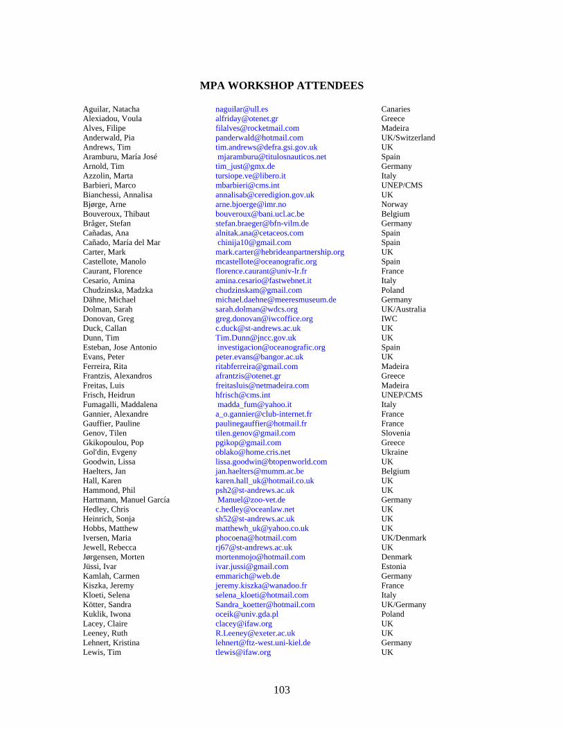
MPA WORKSHOP ATTENDEES
Aguilar, Natacha [email protected] Canaries Alexiadou, Voula [email protected] Greece Alves, Filipe [email protected] Madeira Anderwald, Pia [email protected] UK/Switzerland Andrews, Tim [email protected] UK Aramburu, María José [email protected] Spain Arnold, Tim [email protected] Germany Azzolin, Marta [email protected] Italy Barbieri, Marco [email protected] UNEP/CMS Bianchessi, Annalisa [email protected] UK Bjørge, Arne [email protected] Norway Bouveroux, Thibaut [email protected] Belgium Bråger, Stefan [email protected] Germany Cañadas, Ana [email protected] Spain Cañado, María del Mar [email protected] Spain Carter, Mark [email protected] UK Castellote, Manolo [email protected] Spain Caurant, Florence [email protected] France Cesario, Amina [email protected] Italy Chudzinska, Madzka [email protected] Poland Dähne, Michael [email protected] Germany Dolman, Sarah [email protected] UK/Australia Donovan, Greg [email protected] IWC Duck, Callan [email protected] UK Dunn, Tim [email protected] UK Esteban, Jose Antonio [email protected] Spain Evans, Peter [email protected] UK Ferreira, Rita [email protected] Madeira Frantzis, Alexandros [email protected] Greece Freitas, Luis [email protected] Madeira Frisch, Heidrun [email protected] UNEP/CMS Fumagalli, Maddalena [email protected] Italy Gannier, Alexandre [email protected] France Gauffier, Pauline [email protected] France Genov, Tilen [email protected] Slovenia Gkikopoulou, Pop [email protected] Greece Gol'din, Evgeny [email protected] Ukraine Goodwin, Lissa [email protected] UK Haelters, Jan [email protected] Belgium Hall, Karen [email protected] UK Hammond, Phil [email protected] UK Hartmann, Manuel García [email protected] Germany Hedley, Chris [email protected] UK Heinrich, Sonja [email protected] UK Hobbs, Matthew [email protected] UK Iversen, Maria [email protected] UK/Denmark Jewell, Rebecca [email protected] UK Jørgensen, Morten [email protected] Denmark Jüssi, Ivar [email protected] Estonia Kamlah, Carmen [email protected] Germany Kiszka, Jeremy [email protected] France Kloeti, Selena [email protected] Italy Kötter, Sandra [email protected] UK/Germany Kuklik, Iwona [email protected] Poland Lacey, Claire [email protected] UK Leeney, Ruth [email protected] UK Lehnert, Kristina [email protected] Germany Lewis, Tim [email protected] UK
103

Liro, Anna [email protected] Poland Lomoro, Pablo [email protected] UK/Colombia Lotric, Metka [email protected] Slovenia Magileviciute, Edita [email protected] Lithuania Marcos Ipiñ, Enara [email protected] Spain Marcos, Pilar [email protected] Spain McMath, Mandy [email protected] UK Mendes, Sonia [email protected] UK Miles, Yvonne [email protected] UK/Australia Morris, Ceri Wyn [email protected] UK Morse, Richard [email protected] Hong Kong Notarbartolo di Sciara, Giuseppe [email protected] Italy Nuuttila, Hanna [email protected] UK Page, Richard [email protected] UK Panigada, Simone [email protected] Italy Pérez Vallazza, Claudia [email protected] Canaries Perez, Sergi [email protected] Spain Pesante, Giovanna [email protected] UK Petersen, Katja Vinding [email protected] Denmark Pimentel, Maria [email protected] Portugal Ponzo, Alessandro [email protected] Italy Pope, Alice [email protected] UK Praca, Emilie [email protected] Belgium Raga, Toni [email protected] Spain Ramm, Carina [email protected] Germany Reid, Jim [email protected] UK Reijnders, Peter [email protected] The Netherlands Rye, Jacob [email protected], Germany/Denmark Rynekrova, Jitka [email protected] Czech Republic Schall, Oliver [email protected] Germany Schroeder, Cheryl [email protected] USA See, Jason [email protected] USA Simmonds, Mark [email protected] UK Skora, Krzysztof [email protected] Poland Souami, Yanis [email protected] France Sveegaard, Signe [email protected] Denmark Tasker, Mark [email protected] UK Tejedor, Ana Arceredillo [email protected] Spain Tsang, Anton [email protected] UK Urquiola Pascual, Erika [email protected] Canaries Vella, Adriana [email protected] Malta Verborgh, Philippe [email protected] France Verfuß, Ursula [email protected] Germany Vincent, Cecile [email protected] France Vingada, José [email protected] Portugal Walker, Dylan [email protected] UK Walker, Rebecca [email protected] UK Walters, Marcus [email protected] UK Werner, Stefanie [email protected] Germany Wilson, Ben [email protected] UK Würsig, Bernd [email protected] USA Zanderink, Frank [email protected] The Netherlands Zapponi, Livia [email protected] Italy Zardin, Francesca [email protected] Italy
104


![appraisal marine fisheries gujarat - [email protected] - Central Marine](https://img.pdfslide.net/doc/110x75/620624468c2f7b173004d426/appraisal-marine-fisheries-gujarat-emailprotected-central-marine.jpg)