Embed Size (px)
Citation preview

SFUND RECORDS CTR
2095952
HABITAT MANAGEMENT PLANFOR THE
LAS VEGAS BEARPOPPY(ARCTOMECON CALIFORNICA)
prepared by
Las Vegas Field OfficeU. S. Bureau of Land Management
Program Lead: Gayle Marrs-Smith
January 1998

Table of Contents
3.1 Goal 293.2 Objectives 29
3.2.1 Objective 1 293.2.2 Objective 2 30
3.3 Issues 303.3.1 Issue 1: Land-use Designation 303.3.2 Issue 2: Undesirable Activities 313.3.3 Issue 3: Livestock Grazing 323.3.4 Issue 4: Wild Horse and Burros 333.3.5 Issue 5: Minerals 343.3.6 Issue 6: Lands and Realty Actions 353.3.7 Issue 7: Recreation 363.3.8 Issue 8: Standardization of Inventory and Monitoring 383.3.9 Issue 9: Public Awareness 393.3.10 Issue 10: Research 40
4.0 COORDINATION 404.1 Other BLM Programs 40
4.1.1 Livestock 404.1.2 Wild Horses and Burros 404.1.3 Forest and Woodland Products and Desert Vegetation 414.1.4 Lands 414.1.5 Soil, Water, and Air Resources 414.1.6 Recreation 414.1.7 Cultural Resources 414.1.8 Energy and Minerals 424.1.9 Support Actions 42
4.2 Other Agencies and Organizations 424.2.1 Federal Agencies 42
4.2.1.1 National Park Service 424.2.1.2 Fish and Wildlife Service 424.2.1.3 Bureau of Reclamation 42
4.2.2 State and County Agencies 434.2.2.1 Nevada Division of Wildlife 434.2.2.2 Nevada Division of Forestry 434.2.2.3 Nevada State Parks 434.2.2.4 University of Nevada, Las Vegas 434.2.2.5 Clark County 43
11

List of Tables
Table 1. Global positioning system data dictionary 7
Table 2. Total area (acres) of populations of Arctomecon californica at various sites surveyedduring 1993 on the BLM land 10
Table 3. Acreages of Bearpoppy Management Areas 10
Table 4. List of Mining Notices and Mining Plans of Operation for the Sunrise BearpoppyManagement Area 17
Table 5. Las Vegas District grazing allotments in the Bearpoppy Management Areas 22
Table 6. Herd Management Areas in the Bearpoppy Management Areas(from census information, September, 1995) 25
Table 7. Wilderness Study Areas (from BLM, Las Vegas District files, 1991) that CrossBearpoppy Management Areas 28
Table 8. Resource constraints in each Bearpoppy Management Area 31
Table 9. Project activity implementation for fiscal years 1996-2000 45
Table 10. Costs ($'s in thousands) of implementing the Habitat Management Plan for fiscal years1996 through 1999 for BLM 46
APPENDIX 1 Locations of Las Vegas Bearpoppy on Public Land within the Las VegasDistrict. Figures 3a-x.
APPENDIX 2. Occurrences of Arctomecon californica on BLM lands (exceptions otherwisenoted) during the 1993 survey.
APPENDIX 3. List of Reviewers of the Las Vegas Bearpoppy HMP.
IV

Further impetus for developing a conservation strategy for A. californica involves the 1992settlement agreement by the Fish and Wildlife Service. Under this agreement. Fish and WildlifeService will be required to list Category 1 candidate plant species by September 1996 unlessmanagement actions make it unnecessary to do so. Should the Las Vegas bearpoppy be reclassifiedat a Category 1 candidate, it could be substituted for a lower priority species listed in the settlementagreement. A status report completed in 1996 recommended upgrading A. californica to category1 status, but suggested that formal listing be deferred if conservation measures to conserve thisspecies on Federal and County lands be successfully implemented (Mistretta et al. 1996).
The Federal Lands Policy and Management Act (Section 102,43 U.S.C. 1712) and Bureau of LandManagement (BLM) policies (Manuals 6500 and 6840) require that public lands be managed in amanner that will protect the quality of scientific, ecological and environmental values, certain publiclands in their natural condition, and to maintain viable populations of special status plants andnatural plant communities. Viable populations for a species involve the number of individuals,adequately distributed throughout their range, necessary to perpetuate the existence of the speciesin natural, genetically stable self-sustaining populations. The BLM is mandated to consider specialstatus plants needs in all management decisions and to implement special management for thosespecies listed as threatened, endangered, or otherwise sensitive2 in order to prevent future listing.
Arctomecon californica occurs on lands managed by Federal, State, and County agencies, thereforeinteragency coordination is essential to manage contiguous habitat and populations of this species,to standardize inventory and monitoring studies, and to insure that conservation is integrated intooverall multiple-use objectives. This HMP can be used toward the development of a conservationagreement between the BLM, National Park Service, the Fish and Wildlife Service, and ClarkCounty to make listing of this taxon unnecessary.
1.2 Biological Information
1.2.1 Taxonomy
The following is the taxonomic status of this species summarized from Phillips and Phillips (1988):
• Scientific Name: Arctomecon californica Torr. & Frem. The generic name is fromthe Greek, arctos, meaning bear, and mecon, a poppy.
• Common Names: Las Vegas Bearpoppy, California bearpoppy, California bearclaw(bearpaw) poppy; yellow-flowered desert poppy; golden bearpoppy.
• Family: Papaveraceae - Poppy Family.
2 Sensitive Plant Species - a plant taxon designated as sensitive by a BLM State Director. Itreceives at least the same attention as a candidate plant.

Figure 2. Nevada occurrences of the Las Vegas bearpoppy.

Table 1. Global positioning system data dictionary used to collect point feature data for the 1993survey.
POINT FEATURE
SPECIESSITEAGE CLASS
ALL CLASSESADULTSYEARLINGSSENESCENT
RELATIVE ABUNDANCECOMMON (>25)OCCASIONAL (10-25)INFREQUENT (<10)
CRYPTOGAMSPRESENTABSENT
PARENT SOIL MATERIALRED CLAYWHITE GYPSUMSHALELIMESTONE
SOIL DISTURBANCENONESLIGHT/MODERATEHEAVY
ASSOCIATED SPECIES 1ASSOCIATED SPECIES 2ASSOCIATED SPECIES 3ASSOCIATED SPECIES 4ASSOCIATED SPECIES 5
FEATURE TYPE
MENUSTRINGMENU
MENU CHOICEMENU CHOICE
MENU CHOICEMENU CHOICE
MENUMENU CHOICEMENU CHOICE
MENU CHOICEMENU
MENU CHOICEMENU CHOICEMENUMENU CHOICEMENU CHOICEMENU CHOICEMENU CHOICEMENUMENU CHOICEMENU CHOICEMENU CHOICE
STRINGSTRINGSTRINGSTRINGSTRING

Figures 4a and 4b showing percent distribution of A. californica plants uop; and area of habitat(bottom), with respect to land status (from Mistretta et al. 1996V
4a
4b
Figure 5. Bearpoppy Management Areas Solid black circlesdenote bearpoppy points mapped on BLM lands.
10

1.3.1.4 Bitter Spring Bearpoppy Management Area
The Bitter Spring population is located south of the Muddy Mountains and adjacent to Park Servicelands to the east and south. This population represents about 10 percent of the total area of A.califomica mapped on BLM land. The Bitter Spring Bearpoppy Management Area (see Fig. 5)incorporates part of Bitter Spring Valley and totals 6,080 acres. The Bitter Spring BearpoppyManagement Area is contiguous with the largest and densest bearpoppy population on Park Servicelands. A BLM Backcountry Byway crosses the area, connecting BLM and Park Service lands justwest of North Shore Road.
1.3.1.5 Gold Butte Bearpoppy Management Area
A significant population of A. califomica (24 percent of the total survey) lies about 50 miles east ofLas Vegas, along the western half of the Gold Butte Back Country Byway between Lime and TrampRidges, and continues on the northern side of Bitter Ridge (see Fig. 4). The populations make upa total of 1,800 acres and the area is denoted in this plan as the Gold Butte Bearpoppy ManagementArea. The major road through this remote area is the Gold Butte Back Country Byway. Thedistribution of A. califomica on Park Service land is unknown at this time, though gypsum depositsdo occur west of Lime Ridge.
1.3.2 Topography
Physiographically, Clark County belongs to the Basin and Range Province, characterized by parallelnorth-south trending ranges between broad valleys. The topography of Clark County is extremelycomplex and diverse with an altitudinal range from 3,633 meters (11,918 feet) at the summit of Mt.Charleston in the Spring Mountains to 137 meters (450 feet) along the Colorado River. Thetopography on the west side of Clark County is extremely steep and rugged, becoming relativelysmooth through the Las Vegas Valley, then progressively more rugged and diverse again to the east.Elevations within the Bearpoppy Management Areas range from: 500 -1,235 meters (1,600 - 4,050feet) in Sunrise; 540 - 600 meters (1,771- 1,968) in Lovell Wash; 500 - 700 meters (1,600 - 2,300feet) in Bitter Spring; and 550 - 1,600 meters (1,800 - 5,245 feet) in Gold Butte area. Elevationswithin bearpoppy habitat surveyed range from 500 to 950 meters (1,600 - 3,116 feet).
1.3.3 Geology and Minerals
The information for this section is summarized from Longwell et al. (1965). The common stratalinking all the sites together are the numerous gypsum layers. A diagram of the exposed gypsumlayers is shown in Figures 6 and 7. According to Longwell, "prior to the creation of Lake Mead,large beds and plugs of [gypsiferous] rock salt, included in the Muddy Creek Formation, wereexposed in several parts of Virgin Valley", thus indicating that a portion of at least potentialbearpoppy habitat was inundated by the lake.
12

Figure 7. Distribution oiArctomecon californica (solid black) on gypsum outcrops (hatched areas)(adapted from Longwell et al.. 1965).
14
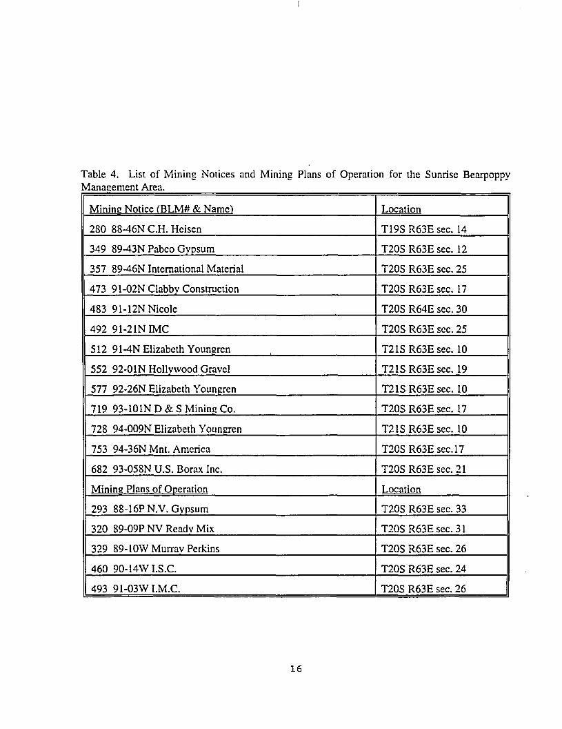
Table 4. List of Mining Notices and Mining Plans of Operation for the Sunrise BearpoppyManagement Area.
Mining Notice CBLM# & Name1)
280 88-46N C.H. Heisen
349 89-43N Pabco Gvpsum
357 89-46N International Material
473 9 l-02NClabbv Construction
483 91-12N Nicole
492 91-21NIMC
512 9 1-4N Elizabeth Youngren
552 92-0 IN Hollywood Gravel
577 92-26N Elizabeth Youngren
719 93-101ND&S Mining Co.
728 94-009N Elizabeth Youngren
753 94-36N Mnt. America
682 93-058N U.S. Borax Inc.
Mining Plans of Operation
293 88-16PN.V. Gvpsum
320 89-09P NV Readv Mix
329 89- lOWMurrav Perkins
460 90-14WI.S.C.
493 91-03WI.M.C.
Location
T19S R63E sec. 14
T20S R63E sec. 12
T20S R63E sec. 25
T20S R63E sec. 17
T20S R64E sec. 30
T20S R63E sec. 25
T21SR63Esec. 10
T21SR63Esec. 19
T21SR63Esec. 10
T20S R63E sec. 17
T21SR63Esec. 10
T20SR63Esec.l7
T20SR63Esec.21
Location
T20S R63E sec. 33
T20SR63Esec.31
T20S R63E sec. 26
T20S R63E sec. 24
T20S R63E sec. 26
16

1.3.3.4 Bitter Spring Bearpoppy Management Area
Geology of the Bitter Spring area south of the Muddy Mountains is mostly Tertiary gypsumdeposits, exposed sandstone, and alluvium. The American Borax Mine and a silica mine are themost important patented mines in the area. No mining claims and no Plans of Operation arecurrently on file at the Las Vegas District Office of the BLM for the Bitter Spring BearpoppyManagement Area; only one Mining Notice is on file: Mining Notice #235, 87-50N, GeorgiaPacific. T18SR66E sec 8.
1.3.3.5 Gold Butte Bearpoppy Management Area
Geology in Gold Butte is complex and diverse. The Gold Butte area is divided into two highlandland masses, the Virgin Mountains and South Virgin Mountains which are separated by an area oflow hills and ridges called the St. Thomas Gap. The entire complex of ranges extends southwestfrom the Arizona-Nevada border to the Overton arm of Lake Mead. The Gold Butte area includesSt. Thomas Gap and all of the South Virgin Mountains to the borders of Park Service lands.Exposed Mesozoic bedrock comprises the low hills of the St. Thomas Gap. The Gold Butte faultseparates Bitter, Tramp, and Lime Ridges from the rest of the land masses south to Lake Mead,making the two areas very different geologically. North of the fault, the formations are composedof Paleozoic and Precambrian rocks, with large outcrops of sandstone and gypsum of various ages.With the exception of Azure Ridge, which is of Paleozoic formation, the southern portion of GoldButte is composed mainly of Gold Butte granite, gneiss, and schist.
Currently no mining claims nor Plans of Operation are on file with the Las Vegas District for theGold Butte Bearpoppy Management Area. One Mining Notice is on file: Mining Notice #681,93-57N, U.S. Borax, T16S R69E sec. 36. Two patented mines are located on the east side of LimeRidge, but are not within bearpoppy habitat (see Fig. 4).
1.3.4 Soils
A strong edaphic control of vegetation patterning exists in the desert Southwest. Potential vegetationcommunity types can be derived from an evaluation of the soil characteristics of a given site. TheNatural Resources Conservation Service (formerly U.S. Soil Conservation Service) classifies soiltypes by temperature, precipitation, placement on the landform, and elevation. Soil characteristicsinclude available water capacity, soil genesis, soil consistence, depth to a limiting layer, rockfragment content, soil chemistry, soil temperature, and frequency of flooding.
The high-gypsum soils required by Arctomecon califomica are classified by the U.S. SoilConservation Service as "badlands", made up of weathered parent material with no development ofgenetic soil horizons (U.S. Soil Conservation Service, 1967). These gypsum "soils" are fine-textured, with low bulk density, high clay content, and high porosity. According to Meyer (1980),the high porosity of gypsum soils accounts for their excellent thermal insulating capacity whichhelps maintain subsurface moisture, thus affording A. califomica favorable water balance throughoutthe year.
18

Small mammals that occur in the eastern Mojave Desert include approximately 10 species of batsand over 20 species of rodents. Carnivores include coyote (Canis latrans), badger (Taxidea taxus),and kit fox (Vulpes macrons). Larger mammals include desert bighorn sheep (Ovis canadensis) andmule deer (Odocoileus hemionus).
A diversity of birds reside in the Mojave Desert, the most common of which include WesternKingbird (Tyrannus venicalus), Common Raven (Corvus corax). White-throated Swift (Aeronautessaxatalis), Gambel's Quail (Callipepla gambelii). Mourning Dove (Zenaida asiatica), and Black-throated Sparrow (Amphisiza bilineata). Larger birds include Red-tailed hawk (Buteojamaicensis),American Kestrel (Falco span'erius), Turkey Vulture (Cathartes aura), and Burrowing Owl (Athenecunicularia). Many reptiles occur in southern Nevada such as western whiptail lizard(Cnemidophorus tigris), side-blotched lizard (Uta stansburiana), and zebra-tailed lizard (Callisaurusdraconoides). Common snakes include gopher snake (Pituophis melanoleucus), Mojave rattlesnake(Crotalus scutulatus) and red coachwhip (Masticophis flagellum).
1.3.8 Threatened. Endangered, and Sensitive Species
The desert tortoise (Gopherus agassizi), a federally listed threatened species is known to occurwithin the Bearpoppy Management Areas. This species attains relatively high densities in the GoldButte area. Gypsum soils appear to unsuitable for tortoise burrows, thus the badlands that sustainpopulations of A. califomica are low density for desert tortoise. The threatened Bald Eagle(Haliaeetus leucocephalus) was recently sited in the Virgin Mountains. The Peregrine Falcon (Falcoperegrinus) occurs in good quality riparian habitat and near cliffs. This species is known fromnearby Lake Mead National Recreation Area but has not been documented in any of the BearpoppyManagement Areas, although its occurrence is possible in the nearby Virgin Mountains.
The following animal "species of special concern" occur in Clark County and may occur in theBearpoppy Management Areas:
Western burrowing owl (Athene cunicularia hypuged)Spotted bat (Eudenna macitlata)Banded Gila Monster (Heloderma siispectum cinctum)Greater western mastiff bat (Eumops perotis califomicus)Allen's (Mexican) big-eared bat (Idionycteris phyllotis)California leaf-nosed bat (Macrotus califomicus)Small-footed myotis (Myotis ciliolabrum)Long-eared myotis (Myotis evotis)Fringed myotis (Myotis thysanodes)Cave myotis (Myotis velifer)Long-legged myotis (Myotis volans)Yuma myotis (Myotis yumanensis)Big free-tailed bat (Nyctinomops macrotis)Pale Townsend's big-eared bat (Plecoius townsendii pallescens)
20

permittees of the Bunkerville Allotment. This 139,638-acre land-based allotment is open to horsesand cattle. A dozen past permittees have operated on this allotment before the present. Records donot show who established priority for the Bunkerville Allotment, although Vaughn Leavitt's originalbase was determined in 1937. Approximately 100 head of cattle have been run since 1985.Bearpoppies have been located in the southern portion of this allotment (T16S R70E sec. 30.31).The majority of this allotment falls under grazing Prescription 1 (U.S.BLM. 1991). The objectivesof Grazing Prescription 1 are:
• Manage the native ephemerals and perennials to ensure that plant species reach theirfull growth potential between spring and early fall, based on phonological stage (seeddissemination). Provide the tortoise with those plant portions that provide the bestsource of nutrition and provide optimum plant reproduction.
• Manage for a perennial native grass composition (by dry weight) of at least 15%,with no individual species exceeding 40 percent of the total perennial grasscomponent, and including 5 percent total dry weight of bush muhly, or as limited bypotential natural condition of the range site.
• Manage for at least 5 percent ground cover of perennial native grass species withwarm season grass species not greater than 60 percent of total, or as limited bypotential natural condition.
• Maintain a canopy cover of at least 20 percent or as limited by potential naturalcondition.
• Reserve a minimum of 150 Ibs. air dry spring ephemeral forage per acre, to ensuremaximum availability of desirable (native) ephemeral forage. (150 Ibs. of air dryspring ephemeral forage is only produced in normal to above normal precipitationyears at most range sites within the Mojave Desert.
Gold Butte Allotment
Established in 1943 by Lara Gentry, E.F. McGonigle, and A.S. McGonigle, the 172,859-acre GoldButte Allotment was adjudicated as a water-based allotment with 29 original base waters. Up to 330cattle per year were grazed on the allotment. The Gold Butte Allotment has gone through multipletransfers over the years from Hugh's Tool Co. (1968) to the Warm Spring Ranch (= MormonChurch) in 1978. In 1994, the grazing privileges were purchased from John Frei (Gold Butte Ranch,Inc.) with Fish and Wildlife Service Section 7 funding. It is now managed under voluntary non-useby The Nature Conservancy. The majority of the bearpoppy population in Gold Butte is on thisallotment.
1.3.9.2 Allotment in the Bitter Spring Bearpoppy Management Area:
White Basin Allotment
22

Name of AppropriateHerd Management Area Current Herd Management Levels*
Muddy Mountain 14 horses. 100 burros 0 horses. 50 burros
Gold Butte 525 burros 98 burros
*As stated in the draft Resource Management Plan.
1.3.12 Cultural Resources
The archaeological record in southern Nevada reflects the activities and lifeways of people who,during the past several thousand years, were experts in living in an arid environment. SouthernNevada is a unique region because it is situated at the interface of three distinct geographical zones:the Colorado Plateau. Mojave Desert and Great Basin. Each zone shows evidence of cultural groupswho skillfully utilized the natural resources of the area.
All prehistoric Native Americans hunted and gathered to obtain food. Collected foods includedseeds and pods from cacti, yucca, agave and various grasses, mesquite beans from trees in sand-dunehummocks, and pinon nuts from the higher altitudes. Hunted animals included rabbits, coyotes androdents from the lower elevations, and bighorn sheep and deer from surrounding ranges such as theVirgin and Spring Mountains. Hunter-gatherers lived in open camps, brush structures and caves.They moved in family groups throughout a selected territory collecting the seeds of maturing plantsand capturing animals on a seasonal basis. They camped in the mountains in summer and in thecooler winter months lived along the washes and sand dunes of the valleys.
The earliest, or Archaic, occupation in southern Nevada began about 11.000 B.C. at Tule Springsin northwest Las Vegas Valley. Excavation of Gypsum Cave, located 10 miles northeast of LasVegas, yielded evidence of continual use by different cultural groups from 1000 B.C. to presenttimes. The most intensive use of many areas in the region, such as Red Rock Canyon, occurredwithin the past 2000 years. The ancestries of the earliest Native Americans have not been traced tothe present, but the contemporary Paiutes, Shoshones, and Yuman-speaking peoples are considereddescendants of some of the last hunter-gatherers in southern Nevada.
As early as A.D. 500, the Virgin Anasazi settled along the Muddy and Virgin Rivers about 60 milesnorth of Las Vegas. They lived in semi-permanent pithouses or puebloan structures constructed ofbrush and adobe. Although they hunted animals and gathered seeds, much of their diet came fromcom, beans and squash grown along the rivers. They abandoned the region around A.D. 1150.Reasons for their exodus include of the same residents of an arid climate face today: an increasedpopulation and a heavy dependence on water.
The kinds of prehistoric artifacts that can be found are roasting pits, or prehistoric "dutch ovens,"
24

1.3.14.2 Muddy Mountains WSA (NV-050-229)
A small ponion of both the Bitter Spring and Lovell Wash Bearpoppy Management Areas fall intothe Muddy Mountains WSA. The Muddy Mountain WSA includes 96.170 acres of public land.36,850 acres of which are recommended for wilderness designation. About 450 acres of this WSAfalls into the Bitter Spring Bearpoppy Management Area.' This ponion is "not recommended forwilderness". However. 45.4 acres of the Lovell Wash Bearpoppy Management Area cross into thisWSA. These acres are classified as "recommended for wilderness".
1.3.14.3 Lime Canyon WSA (NV-050-231)
Of the five WS As that occur in the Gold Butte, only one contains populations of A. californica.Lime Canyon WSA is located in the Overton Arm region of Lake Mead on the eastern edge of theGold Butte area. The study area includes 34,680 acres of public land and surrounds 838 acres ofpatented mining claims. It is about 13 miles long and between 3 and 7 miles wide. Park Serviceland borders the WSA on the west and the eastern boundary is the Gold Butte Back Country Byway.The BLM recommended 13,895 acres be designated as wilderness, none of which overlaps A.californica habitat. Less than one-half of the population in Gold Butte occurs on recommended non-suitable wilderness acres within Lime Canyon WSA. For a list of the other WSAs that occur in theBearpoppy Management Areas, see Table 7.
1.3.15 Rights of Way
An existing 1400-foot wide right-of-way corridor runs through the Sunrise Instant Study Area. Noright-of-way would be authorized within corridors designated in WSAs or Instant Study Areas untilCongress releases them from further wilderness consideration and study. If the Sunrise Instant StudyArea is released from further consideration, the corridor running through that area would be limitedto transmission lines of 250 kv or greater.
Table 7. Wilderness Study Areas (from BLM, Las Vegas District files, 1991) that Cross BearpoppyManagement Areas
Wilderness Study Area Acres Management Area
Muddy Mountains (NV-050-229)
26

3.0 MANAGEMENT OBJECTIVES. ISSUES. AND ACTIONS
These objectives were developed using various planning documents, policies, and environmentallegislation, the most widely used of which include the following: the Clark County MFP; theEndangered Species Act of 1973, as amended: BLM's Fish and Wildlife 2000, Rare Plant andNatural Plant Communities; Federal Lands Policy Management Act, and various scientificdocuments. These objectives and planned actions in no way diminish the authority of the State ofNevada to own, control, and manage the State's wildlife, the BLM's mandate to manage habitat ofpublic lands, or Park Service's mandate to manage resources within the Lake Mead Recreation Area.Though management of special status plants is not directly addressed in the MFP, many of thefollowing actions can still be implemented. Some of the HMP actions are outside the scope of theMPF, but are still addressed in this document. Actions presented in this document that are consistentwith the MFP may be implemented upon approval of this HMP. Actions recommended in this planthat are inconsistent with the MFP, but addressed in the Resource Management Plan may beimplemented when that planning document is final. Finally, those actions that will requireamendments to the existing land use plan will be processed as soon as practicable.
3.1 Goal
Manage A. calif arnica habitat using an ecosystem approach to achieve all levels of biodiversity: (1)community diversity (habitat, ecosystem); (2) species diversity; and (3) genetic diversity. Sustainviable populations of A. calif arnica by implementing management actions with appropriate levelsof monitoring.
3.2 Objectives
3.2.1 Objective 1
Maintain or improve 45,750 acres of A. califomica habitat on four Bearpoppy Management Areas:Sunrise, Lovell Wash, Bitter Spring, and Gold Butte for the next 50 years. Take protective actionson the Apex populations.
3.2.2 Objective 2
Allow no net loss of bearpoppy habitat on public land from Federally-approved projects throughmitigative actions, including avoidance, rehabilitation, and recovery of surface disturbances.
3.3 Issues
The following are land-use issues that relate to the above objectives. Each issue is answered withrecommendations or management action(s) in order to meet the established goals and objectives.
28

Range
Recreation
Wild Horseand Burro
N/A Close to livestock grazing. N/A Close to livestock grazing.
Travel limited to designated roads and trails. No competitive OHV events. No competitivemountain bike events in bearpoppy habitat. In Sunrise, close to recreational shooting.
N/A Manage consistent with theHerd Management Area.
N/A Manage consistent with theHerd Management Area.
3.3.2 Issue 2: Undesirable Activities in the Bearpoppy Management Areas
Dumping and shooting in Sunrise have resulted in habitat degradation for A. califomica resultingin surface disturbance, erosion, soil compaction, and damage to cryptobiotic crusts.
Management Actions
Action 2-1
Close to shooting all BLM lands, consistent with Clark County's No Shooting Closure in theLas Vegas Valley. In FY 98, develop signs and designate areas to be signed in the SunriseBearpoppy Management Area to help deter illegal dumping and shooting. Develop similarsigns in the other Bearpoppy Management Areas on an as-needed basis.
Action 2-2
Provide law enforcement support to enforce land use controls in the Sunrise area beginningin FY 98. BLM will communicate with Park Service rangers and Las Vegas Metro Policeon law enforcement activities. Provide law enforcement for the other BearpoppyManagement Areas on an as-needed basis.
Action 2-3
Prepare an annual report of its law enforcement activities that occurred within the SunriseBearpoppy Management Area for the previous fiscal year. A summary of general activitiesand citations issued also will be in the report. The report will be submitted to the DistrictManager.
Action 2-4
To the extent allowable by BLM and Park Service policies, develop a Memorandum ofUnderstanding in FY 99 that would allow joint law enforcement patrol of adjoining publiclands administered by BLM and Park Service.
30

The BLM will coordinate with the Park Service to set appropriate management levels forwild burros in the Muddy Mountain and Gold Butte Herd Management Areas to insure thata thriving ecological balance is maintained and habitat for the bearpoppy is protected.
Management Actions
Action 4-1
The BLM will periodically remove wild burros from the Herd Management Areas tomaintain the appropriate management level and thriving ecological balance.
Action 4-2
The BLM will take appropriate action (e.g., setting new appropriate management levels,fencing bearpoppy populations, etc.) if impacts to the bearpoppy populations and habitatfrom wild horses and burros are compromising bearpoppy habitat.
Action 4-3
The BLM and Park Service will coordinate the removal of wild horses and burros foundoutside the Muddy Mountain and the Gold Butte Herd Management Areas as needed.Through appropriate interagency agreements, the BLM and Park Service will cooperativelymanage the herds which occur on both lands.
Monitoring
(a) Install bearpoppy monitoring plots in areas where the burro Herd Management Area andBearpoppy Management Areas overlap, and, if appropriate, where livestock grazing islicensed in FY 98.
(b) The BLM will cooperate with the Park Service and Nevada Division of Wildlifepersonnel in documenting the occurrences and distribution of burros found outside the HerdManagement Areas. Such animals will be removed as soon as possible.
3.3.5 Issue 5: Minerals
Mineral development, especially gypsum mining, has both indirect and direct impacts on A.californica through direct mortality and loss and fragmentation of habitat.
Recommendations
Recommendation 5-1
Withdraw bearpoppy habitat on 6.080 acres in Bitter Spring, 250 acres in Lovell Wash
32

(a) The BLM will work with the Nevada Department of Environmental Protection (ifapplicable) in monitoring reclamation efforts in bearpoppy habitat annually to insure thatsuch efforts are effective.
(b) Through the use of GPS, BLM will track loss of A. califomica habitat through all miningactivity.
3.3.6 Issue 6: Lands and Realty Actions
Lands actions including rights-of-way, exchanges, leases, and sales can impact A. califomica andits habitat by direct mortality during construction of projects, loss, or fragmentation of habitat,increased encroachment activities such as off-highway vehicle use, and rehabilitation of disturbedlands.
Management Actions
Action 6-1
Identify bearpoppy habitat within the Apex Land Sale Area that needs to be retained asundeveloped public land and make this information available to Clark County. Work withClark County under the Desert Conservation Plan to provide for the protection of thosepopulations identified.
Action 6-2
Discourage utility rights-of-way in habitat management areas except in designated corridorsand where other alternatives exist. Rights-of-way and other lands actions will be designedto minimize negative impacts to A. califomica so no net loss of habitat will occur, and off-site mitigation will be required when residual impacts occur.
Action 6-3
Discourage permanent access roads as part of new right-of-way permits. If a temporaryaccess road is needed, it will be reclaimed, revegetated, and physically closed uponcompletion of the project to prevent public access.
Action 6-4
No new landfills or expansion of existing landfills will be allowed within the BearpoppyManagement Areas. Existing landfills and sewage disposal plants within or adjacent to theBearpoppy Management Areas should be eliminated or replaced with transfer stations.
Action 6-5
34

Using GPS, all roads and trails in the Sunrise Bearpoppy Management Area were inventoriedin FY 97. In FY 98 propose which roads will be "closed" and which will remain asdesignated "open". Implement this action through an emergency closure, if necessary. BLMwill implement the same process for Bitter Spring and Lovell Wash, and Gold ButteBearpoppy Management Areas, starting in FY 99. The road designations will be periodicallyreviewed and modified if necessary.
Action 7-2
Bureau of Land Management will 1) close access and erect barriers or 2) rehabilitate the first100 yards of non-County claimed roads or trails that are identified as closed in the SunriseBearpoppy Management Area. Initiate rehabilitation of disturbed sites in FY 99.
Action 7-3
Request that Clark County relinquish RS2477 roads (if any) which are recommended asclosed to motor vehicles in each of the Bearpoppy Management Areas.
Action 7-4
Eliminate competitive off-highway vehicle events in the Bearpoppy Management Areas(including mountain bikes) that would have direct impacts4 to bearpoppy habitat.
Action 7-5
Permitted recreational activities and events in bearpoppy areas and in bearpoppy habitatoutside of these management areas may be allowed on a case-by-case basis consistent withBLM policies regarding approved Federal actions on candidate species.
Action 7-6
Fences will be constructed in the management areas only when necessary to protect thepopulations and then to the BLM's standards as specified in the BLM Fencing Handbook.Fences could be constructed in response to minerals, lands, or range activities as well asrecreation.
Action 7-7
BLM will avoid locating facilities or attracting users to areas that are heavily populated with
'direct impact = causes direct mortality to plants or increased habitat disturbance.
36

Action 8-4
BLM will work with the Park Service to develop a standardized method for monitoringrepresentative populations of A. californica. by the use of belt transects, photoplots, ortagging of individual plants in FY 98.
3.3.9 Issue 9: Public Awareness
An informed public will enhance conservation efforts, creating an awareness of the desert ecosystemwhich will reduce human-caused mortality, illegal collection and loss of habitat of A. californica.
Management Actions
Action 9-1
The BLM will cooperative with the Park Service, Fish and Wildlife Service, and The NatureConservancy to develop educational literature for public distribution in FY 2000.
Action 9-2
In FY 2000, BLM will develop and install at appropriate locations interpretive signsdescribing the ecology of the Las Vegas bearpoppy.
Action 9-3
In FY 2000, BLM will develop and install an interpretive kiosk in the Sunrise BearpoppyManagement Area, and will cooperatively work with the Park Service's interpretive efforts.
Action 9-4
In FY 2000, BLM will cooperate with Clark County, the Park Service, Fish and WildlifeService, and The Nature Conservancy to develop a video/slide program regarding A.californica, its habitat, and the Mojave Desert ecosystem.
3.3.10 Issue 10: Research
Limited data are available concerning pollination, germination, propagation, and the genetics of A.californica. This information is essential in developing effective management and mitigationactions.
Management Actions
Action 10-1
38

Management Area will be retained in public ownership. Attempts will be made to acquire privateor non-BLM parcels within or adjacent to the habitat management area on a willing-seller basis,through an exchange, or other means. Conservation of the Apex populations will be achievedthrough cooperation with Clark County. These actions will require the efforts of the BLM landsstaff.
4.1.5 Soil, Water, and Air Resources
The planned actions of this HMP and most projects initiated through watershed guidance aremutually beneficial. To insure protection of watershed values, a soil scientist or hydrologist will beconsulted in the design of botanical/wildlife projects initiated under this HMP.
4.1.6 Recreation
Both consumptive and non-consumptive recreational activities abound in all of the habitatmanagement areas. All of the four Bearpoppy Management Areas have been recommended as"limited to designated roads and trails". No competitive off-highway vehicle events will bepermitted in the Bearpoppy Management Areas. Mountain bike races will occur outside ofbearpoppy habitat on designated routes. The Sunrise area has been designated as a high-userecreation area in the Clark County MFP. This will not be inconsistent with this HMP as long ashabitat for A. califomica is left undeveloped and carefully monitored. BLM rangers will be able toadequately patrol once BLM has closed the Sunrise area to shooting and has designated roads.Cooperation with the recreation program will be essential for the success of this plan.
4.1.7 Cultural Resources
Section 106 of the National Historic Preservation Act of 1966 requires that Federal agencies takeinto account the effects of their undertakings on historic properties. Efforts to identify and evaluatecultural resource properties, and consult with the Nevada State Historic Preservation Office will beconducted prior to initiating any project involving surface disturbance.
4.1.8 Energy and Minerals
Potential for precious metal minerals in the Gold Butte area is moderate, although there are manyold mines in the area. By far, gypsum and quartz mining are the most lucrative in the BearpoppyManagement Areas. As of February 1994, 14 mining notices and 6 plans of operation have beenfiled at the BLM Las Vegas District Office. Oil, gas, and geothermal potential is low in theBearpoppy Management Areas. Although the Bearpoppy Management Areas are recommended tobe closed to further mineral development, actions which affect bearpoppies may still occur. Miningdevelopments in adjacent areas may affect Bearpoppy as well. The success of this plan will dependupon cooperation with the minerals program.
4.1.9 Support Actions
40

4.2.2.2 Nevada Division of Forestry
Arctomecon californica is a State protected species under Nevada Revised Statute 527.270. As such,this plan will be available for review by the Nevada Division of Forestry, as will actions involvingMining Plans of Operation, Allotment Management Plans, and Herd Management Area Plans thatare proposed or needed in the Bearpoppy Management Areas.
4.2.2.3 Nevada State Parks
The Valley of Fire State Park has a population of A. californica that is continuous with a majorpopulation on Park Service land. This plan will be reviewed by a representative of the Nevada StateParks.
4.2.2.4 University of Nevada, Las Vegas
The University of Nevada, Las Vegas owns two mineral patents in Sunrise Bearpoppy ManagementArea, one of which contains bearpoppy habitat. Efforts to coordinate this HMP with the Universitywill be critical for the success of this plan.
4.2.2.5 Clark County
Through the Desert Conservation Plan process, Clark County has identified species, including A.californica, which could potentially become listed should their numbers decline and/or their habitatdisappear, and which could impact development of lands and the lifestyle of citizens of ClarkCounty. Actions that lead to healthy, stabilized populations on public lands could be funded byClark County. Clark County will review this plan. The BLM will coordinate the management of theSunrise area with the County's wetland park in Las Vegas Wash. The BLM will coordinate with theCounty's Regional Transportation Commission to identify and link roads and trails on public landswith the urban center in the valley for recreational use.
4.2.3 Other Agencies
4.2.3.1 The Nature Conservancy
The Nature Conservancy is a reviewer of this plan. All approved actions in the BearpoppyManagement Areas will be reviewed by The Nature Conservancy.
4.2.3.2 Citizens for Active Management of Frenchman/Sunrise Mountain
This local citizens group is interested in enhancing and preserving the resource values of the Sunrisearea. This HMP will be reviewed by and appropriate actions, such as reclamation, will becoordinated with the Citizens for Active Management of Frenchman/Sunrise Mountain.
4.2.3.3 Nevada Trails Coalition and Other Off-Highway Vehicle Advocacy Groups
42

Public information
Establish monitoring plots andfrequency of reading
Road designations, signing
Management Plan for theSunrise Area
BLM, ParkService, TheNatureConservancv,Fish &WilklifeService
BLM, ParkService
BLM
BLM
X
X
X
X
X
X
X
X
Table 10. Costs ($'s in thousands) of implementing the Habitat Management Plan for fiscalyears 1996 through 1999 for BLM.
Planned Actions
Reclamation andrehabilitation
Identify potentialhabitat acquisition
Law enforcement
GPS roads, trails, andrights-of-way
GIS database - formatfor Arclnfo
Public information
FY96
8
FY97
2
8
2
FY98
15
6
2
FY99
15
40
2
FYOO
40
2
50
TOTAL
30
2
86
8
16
50
44

7.0 REFERENCES CITED
Longwell, C.R., E.H. Pampeyan, Ben Bowyer, and R.J. Roberts. 1965. Geology and mineraldeposits of Clark County, Nevada. Nevada Bureau of Mines and Geology. 218 pp.
Meyer, S.E. 1980. The ecology of gypsophily in the eastern Mojave Desert. PhD. Dissertation,Claremont Graduate School, California. 199 pp.
Meyer, S.E. in preparation. Life history of Arctomecon califomica (Papaveraceae), a Mojave Desertendemic perennial herb.
Mistretta, O., R. Pant, T. Ross, J. Porter, and J. Morefield. 1996. Current knowledge andconservation status of Arctomecon califomica Torrey & Fremont (Papaveraceae), the Californiabearpoppy.
Morefield, J.D. and T.A. Knight. 1991. Endangered, threatened, and sensitive vascular plants ofNevada. BLM, Nevada State Office. 46 pp.
Pinzl, A. 1984. Map atlas of threatened/endangered plants. Nevada State Museum. 93 pp. + inserts.•
Phillips, A.M. and B.G. Phillips. 1988. Arctomecon califomica Torr. & Frem., Status Report.Museum of Northern Arizona, Flagstaff, Arizona. 19 pp.
Sheldon, S. 1994. Life history, biology, and soil characteristics of the genus Arctomecon. M.S.thesis, University of Nevada, Las Vegas. 69 pp.
U.S. Bureau of Land Management. 1991. Biological evaluation for managing livestock grazing indesert tortoise habitat. Unpubl. Rept., Las Vegas District, Nevada, 43 pp.
U.S. Bureau of Land Management. 1993. Draft and Supplement to the Draft Stateline ResourceManagement Plan and Environmental Impact Statement, Las Vegas, NV. 601 pp. + Maps,Appendices.
U.S. Soil Conservation Service. 1967. Soil survey: Las Vegas and Eldorado Valleys area, Nevada.U.S. Soil Conservation Service Series (1957) 23:1-87.
WESTEC. 1980. Field research of rare plants in Las Vegas ES area, Clark County, Las Vegas,Nevada. WESTEC Sen-ices, Inc., Las Vegas, Nevada. 74 pp. + Appendices, Maps.
Zander, R. H., L. R. Stark, and G. Marrs-Smith. 7995. Didymodon nevadensis, a new species forNorth America, with comments of phenology. The Bryologist 98 (4).
46

ABSTRACT
The Las Vegas bearpoppy (Arctomecon califomica) is a perennial forb restricted in Nevada togypsum outcrops. This taxon is currently classified as a "species of special concern" by the Fishand Wildlife Service and "Critically Endangered" by the State of Nevada. Although most of the LasVegas bearpoppy distribution occurs on Federal lands managed by the Bureau of Land Managementand the National Park Service, populations on private lands in the Las Vegas Valley have beenlargely extirpated by urban development. This Habitat Management Plan (HMP) outlines objectives,recommendations, and actions for the Las Vegas Field Office to conserve the populations of LasVegas bearpoppy on public land, and to manage its habitat in a consistent manner with otheragencies so that listing of this species is not needed. This document will be used to develop aConservation Agreement with the U.S. Fish and Wildlife Service and others for this species.
Many of the actions can be implemented under the Clark County Management Framework Plan(MFP), under the MFP objectives for wildlife management. Some of the HMP actions are outsidethe scope of the MPF. Actions recommended in this plan that are inconsistent with the MFP, butaddressed in the Resource Management Plan, may be implemented when that planning documentis final. Finally, those actions that will require an amendment to the existing land use plan will bepursued, or suitable actions which accomplish the same goal will be found.
Appendix 1. Locations of Las Vegas Bearpoppy on Public Lands in the Las Vegas District.

Location Quad Elevation
LAS VEGAS
(n. of Craig Rd. and w. of Camino del None at Washburn Rd. Surveyed west side of del None.Large tract of land between 3 developments, separated by a deep wash; Centennial Pkwy. and 5thStreet NOTE: PRIVATE LAND).
T19SR61Esec. 33 (n.of Craig Rd.) Gass Peak 640 msec. 22 (Centennial & 5th) 1:24,000 628 m
(I-15/Craig Rd. with a large population on private land to the north which is owned by NevadaDepartment of Transportation. NOTE: PRIVATE LAND).
T19S R62Esec. 29 (sw'/4) Valley 591-604 msec. 31(e'/2) 1:24,000 591-604 m
(sw. comer of Lake Mead Drive/Jones. NOTE: PRIVATE LAND).
T20S R60Esec. 23 Las Vegas NW
1:24,000 695m
(s. of Alexander Rd. and between Martin Luther King and Commerce. NOTE: PRIVATE LAND).
T20SR61Esec. 4 (se'/4) Las Vegas NW 628-637 msec.9(e'/2) 1:24,000 640-646 m
APEX/NELLIS DUNESRECREATION AREA
(The following locations: hills south of 1-15 and west of the Radio Tower (facing the freeway);north of 1-15, along the railroad grade; hills 0.5 miles north of the Nellis/Apex exit off of 1-15;between 1-15 and Las Vegas Blvd. North; hills 0.4 miles s. of 1-15 in the Nellis Dunes RecreationArea).
Appendix 2. Continued.

T21S R62Esec. 13 Henderson 500-549 msec. 24 1:24,000 500-549 m
T21SR63Esec. 17 Henderson 500-549 msec. 18(wl/2) 1:24,000sec. 19 (wVi)
SUNRISE
(Various locations along Lake Mead Drive and west of Pabco Gypsum Mine).
T20S R63Esec. 14 (all) Frenchman Mnt. 549-524 msec. 15 (all) 1:24,000 536-561 msec. 16 (sett) 579 msec. 17 (sw'/4) 671msec. 18 (se>/4) 671-719m
T20S R63Esec. 19 (ne'/i) Frenchman Mnt. 719-732 msec. 20 (nwV4) 1:24,000 671msec. 21 (ne'/i) 573 m
T20S R63Esec. 22(n!/2) Frenchman Mnt. 549-561 msec. 23 (nw'/4) 1 -.24,000 512msec. 26 500-512m
(Locations within Sunrise)sec.27(nl/2) 512-537 msec. 28 (se'/4) 543-549 msec. 29(sl/2) 591-610msec.31(e'/2) 585-598 msec. 32(n'/2) 610msec. 33 (all) 549-573 m
Appendix 2. Continued.

sec. 16(s'/2") 580msec. 21 580m
BITTER SPRING
(Along Muddy Mountain Backcountry Byway and several locations in the Muddy Mountains)
T18SR66E Bitter Springsec. 35 (along north Byway) 1:24,000 690-720 m
T19S R66V2E Bitter Springsec. 18 (along south By way) 1:24,000 580m
T18S R67Esec. 19 (W.Longwell Ridge) Bitter Spring 750 m
1:24,000sec. 32 (E.Longwell Ridge) 660-690 m
T19S R67Esec. 8 (all) (Bitter Spr.) Bitter Spring 530-540 msec. 9 (all) (Bitter Spr.) 1:24,000 .460-490 msec. 17 (all) (Bitter Spr.) 540 m
T19S R67Esec. 18 (seVi) (Bitter Spr.) Bitter Spring 540 msec. 19 (s'/2) (Bitter Spr.) 1:24,000 540-550 msec. 20 (all) (Bitter Spr.) 540-550 msec. 29 (nw>4) (Bitter Spr.) 490-500 msec. 30 (n'/2) (Bitter Spr.) 490-500 m
sec. 9 (all) (Echo Wash) Echo Bay 500 msec. 10 (w'/2) (Echo Wash) 1:24,000 500 m
GOLD BUTTE
(Northernmost survey in Gold Butte, north of Black Butte, on dirt road 1.25 mi w. of Jet. of GoldButte Rd. and Whitney Pocket, 3 mi. se. of petroglyphs).
Appendix 2. Continued.

T18SR69Esec. 12 (ne'/4) Devil's Throat 760 m
T18SR69Esec. 24 (swl4) Gold Butte 890 msec. 25 1:24,000 920-950 msec. 36 940 m
sec. 34 (seV4) Lime Wash 825 m1:24,000
T19S R69Esec. 2 (nw'/4) Lime Wash 825 m
1:24,000